drafting team data specifications generic conceptual...
TRANSCRIPT

INSPIRE Infrastructure for Spatial Information in Europe
Drafting Team "Data Specifications" Generic Conceptual Model
Title Drafting Team "Data Specifications" – deliverable D2.5: Generic Conceptual Model
Status Draft
Creator Drafting Team "Data Specifications"
Date 2007-04-05
Subject Generic Conceptual Model of the INSPIRE data specifications
Publisher Drafting Team "Data Specifications"
Type Text
Description Draft of the Generic Conceptual Model of the INSPIRE data specifications
Contributor Members of the INSPIRE Drafting Team "Data Specifications"
Format MS Word (doc)
Source Drafting Team "Data Specifications"
Rights Open access; comments limited to registered SDICs and LMOs
Identifier D2.5_v2.0_submittedToCT.doc
Language en
Relation n/a
Coverage Project duration
Table of contents
Foreword ................................................................................................................................................ 5
Purpose of the document ..................................................................................................................... 7
1 Scope............................................................................................................................................... 8
2 Normative references..................................................................................................................... 9
3 Terms and abbreviations............................................................................................................. 10 3.1 Terms ................................................................................................................................... 10 3.2 Abbreviations ....................................................................................................................... 15 3.3 Verbal forms for the expression of provisions...................................................................... 15 3.4 References within the document.......................................................................................... 16
4 Background and principles......................................................................................................... 16 4.1 Requirements as stated in the INSPIRE Directive............................................................... 16
4.1.1 Articles of the Directive .................................................................................................... 16 4.1.2 Recitals in the Directive ................................................................................................... 20 4.1.3 Additional principles for data specifications..................................................................... 20
4.2 A standards-based approach............................................................................................... 21 4.3 Data harmonisation components ......................................................................................... 22
4.3.1 Principles ......................................................................................................................... 22 4.3.2 Components overview ..................................................................................................... 23
5 Overview ....................................................................................................................................... 28
6 Principles ...................................................................................................................................... 30
7 Terminology.................................................................................................................................. 30
8 Reference model .......................................................................................................................... 30
9 Rules for INSPIRE application schemas.................................................................................... 32 9.1 General Feature Model ........................................................................................................ 32 9.2 Feature concept dictionaries................................................................................................ 34 9.3 Feature catalogues .............................................................................................................. 34 9.4 Modelling application schemas ............................................................................................ 35 9.5 Conceptual schema language ............................................................................................. 37 9.6 Base application schema ..................................................................................................... 39
9.6.1 SpatialObject.................................................................................................................... 39 9.6.2 ObjectWithIdentifier ......................................................................................................... 39 9.6.3 SpatialDataSet................................................................................................................. 40 9.6.4 Versioned objects ............................................................................................................ 41 9.6.5 Gazetteers ....................................................................................................................... 46 9.6.6 Void.................................................................................................................................. 48 9.6.7 Extensions ....................................................................................................................... 49
10 Spatial and temporal aspects.................................................................................................. 49 10.1 Spatial and temporal characteristics of a spatial object....................................................... 49 10.2 Profile of the spatial schema................................................................................................ 51 10.3 Profile of the temporal schema ............................................................................................ 51 10.4 Rules for use of coverages .................................................................................................. 51 10.5 Profile of the coverage schema ........................................................................................... 52 10.6 Geographic identifiers .......................................................................................................... 52
11 Multi-lingual text and cultural adaptability ............................................................................ 53
INSPIRE data specifications Reference: D2_5v2.0.docGeneric Conceptual Model (draft) 2007-04-05 Page 3 of 93
11.1 Multilingual and multicultural requirements.......................................................................... 53 11.2 Multilingual extensions ......................................................................................................... 54
11.2.1 Multilingual text ................................................................................................................ 54 11.2.2 Multilingual feature concept dictionaries.......................................................................... 54 11.2.3 Multilingual feature catalogues ........................................................................................ 54 11.2.4 Other multilingual dictionaries.......................................................................................... 54
12 Coordinate referencing and units of measurement model .................................................. 55 12.1 Overview .............................................................................................................................. 55 12.2 Spatial coordinate reference systems and coordinate operations....................................... 55 12.3 Temporal reference systems................................................................................................ 56 12.4 Units of measurement .......................................................................................................... 57 12.5 Geographical grid systems................................................................................................... 57
13 Modelling object references .................................................................................................... 58 13.1 Overview .............................................................................................................................. 58 13.2 Requirements....................................................................................................................... 59
13.2.1 Overview.......................................................................................................................... 59 13.2.2 Referencing a spatial object in the ESDI ......................................................................... 59 13.2.3 Building spatial objects based on reference data ............................................................ 60 13.2.4 Enabling harmonised gazetteer services......................................................................... 62
13.3 Recommendations and methods ......................................................................................... 62 13.3.1 Object referencing in application schemas...................................................................... 62 13.3.2 Discussion of object referencing cases ........................................................................... 64
14 Data translation model / guidelines........................................................................................ 68
15 Portrayal model......................................................................................................................... 68
16 Identifier management ............................................................................................................. 68 16.1 General requirements .......................................................................................................... 68 16.2 Structure of unique identifiers .............................................................................................. 70 16.3 Lexical rules ......................................................................................................................... 71 16.4 Spatial datasets.................................................................................................................... 71 16.5 Coverages............................................................................................................................ 71 16.6 Versions of spatial objects ................................................................................................... 73
17 Registers and registries........................................................................................................... 73
18 Metadata .................................................................................................................................... 75
19 Maintenance .............................................................................................................................. 75
20 Data & Information quality....................................................................................................... 75
21 Data transfer.............................................................................................................................. 75
22 Consistency between data ...................................................................................................... 75
23 Multiple representations .......................................................................................................... 78
24 Data capturing rules................................................................................................................. 78
25 Conformance............................................................................................................................. 78
Annex A (normative) Abstract Test Suite ........................................................................................ 81 A.1 Test cases for mandatory conformance requirements for an INSPIRE data specification.. 81
A.1.1 General ............................................................................................................................ 81 A.1.2 Application schema.......................................................................................................... 81 A.1.3 Feature catalogue............................................................................................................ 81
INSPIRE data specifications Reference: D2_5v2.0.docGeneric Conceptual Model (draft) 2007-04-05 Page 4 of 93
A.1.4 Feature concept dictionaries............................................................................................ 81 A.2 Test cases for recommendations for INSPIRE data specifications ..................................... 82
A.2.1 Simple Feature profile...................................................................................................... 82 A.2.2 UML profile from ISO 19136 Annex E ............................................................................. 82 A.2.3 Versioning ........................................................................................................................ 82 A.2.4 Enumerations and codelists............................................................................................. 82 A.2.5 Void values with reasons ................................................................................................. 83 A.2.6 Reference systems .......................................................................................................... 83 A.2.7 Units................................................................................................................................. 83 A.2.8 Object referencing ........................................................................................................... 83 A.2.9 Unique identifiers ............................................................................................................. 83 A.2.10 Data consistency ......................................................................................................... 84
A.3 Test cases for mandatory conformance requirements for a spatial data set....................... 84 A.4 Test cases for recommendations for a spatial data set ....................................................... 84
A.4.1 Linguistic searches .......................................................................................................... 84 A.4.2 Geographical grids........................................................................................................... 84
Annex B (informative) Consistency between data......................................................................... 85 B.1 Assumptions......................................................................................................................... 85 B.2 Correctness and consistency............................................................................................... 85 B.3 Level of detail ....................................................................................................................... 86 B.4 Consistency, in the context of INSPIRE............................................................................... 86
B.4.1 Consistency within a data set .......................................................................................... 86 B.4.2 Consistency at the same level of detail between themes................................................ 87 B.4.3 Consistency between Levels of Detail ............................................................................. 88 B.4.4 Consistency along state boundaries................................................................................ 90
Bibliography......................................................................................................................................... 91

INSPIRE data specifications Reference: D2_5v2.0.docGeneric Conceptual Model (draft) 2007-04-05 Page 5 of 93
Foreword INSPIRE is a Directive proposed by the European Commission in July 2004 setting the legal framework for the establishment and operation of an Infrastructure for Spatial Information in Europe. The purpose of such infrastructure is to support the formulation, implementation, monitoring activities and evaluation of Community policies at all levels, European, national and local, and to provide public information. INSPIRE should be based on the infrastructures for spatial information that are created and maintained by the Member States. The components of those infrastructures include: metadata, spatial data themes (as described in Annexes I, II, III of the Directive), spatial data services; network services and technologies; agreements on data and service sharing, access and use; coordination and monitoring mechanisms, processes and procedures. The guiding principles of INSPIRE are that the infrastructures for spatial information in the Member States should be designed to ensure that spatial data are stored, made available and maintained at the most appropriate level; that it is possible to combine spatial data and services from different sources across the Community in a consistent way and share them between several users and applications; that it is possible for spatial data collected at one level of public authority to be shared between all the different levels of public authorities; that spatial data and services are made available under conditions that do not restrict their extensive use; that it is easy to discover available spatial data, to evaluate their fitness for purpose and to know the conditions applicable to their use. The text of the INSPIRE Directive is available from the INSPIRE web site (http://www.ec-gis.org/inspire). The Directive identifies what needs to be achieved, and Member States have two years from the date of adoption to bring into force national legislation, regulations, and administrative procedures that define how the agreed objectives will be met taking into account the specific situation of each Member State. To ensure that the spatial data infrastructures of the Member States are compatible and usable in a Community and transboundary context, the Directive requires that common Implementing Rules (IR) are adopted in a number of specific areas. Implementing Rules are adopted as Commission Decisions, and are binding in their entirety. The Commission is assisted in the process of adopting such rules by a regulatory committee composed by representatives of the Member States and European Parliament1. The committee is chaired by a representative of the Commission (this is known as the Comitology procedure). The committee will be established within three months from the entry in force of the Directive. The IR will be shaped in their legal structure and form by the Commission legal services on the basis of technical documents prepared by especially convened Drafting Teams, for each of the main components of INSPIRE: metadata, data specifications, network services, data and service sharing, and monitoring procedures. This document represents a contribution of the Data Specification Drafting Team, and is open for the review process described in section “Purpose of the document”. One of the main tasks of the INSPIRE programme is to harmonise the exchange of geographic information within Europe. Here, it is important to note that harmonisation has to go beyond any particular community, but take the various cross-community information needs into account. If one takes a look at the huge difference in the scope of the different themes (from reference systems to hydrography and from cadastral parcel to atmospheric conditions), the question does arise what does harmonisation of the geographic information mean and what is the purpose of harmonisation. These were also the questions faced by the Drafting Team "Data Specification" and probably a main contribution of the Drafting Team is the identification of a set of harmonisation components, which make the concept of harmonisation more tangible. Examples of harmonisation components addressed in this document are: rules for application schemas, coordinate referencing and units model, identifier management, multi-lingual text and cultural adaptability, object referencing modelling, multiple
1 The implementing rules are formally adopted through the comitology procedure that has been amended by Council Decision of 17 July 2006 (2006/512/EC). Under the new regulation, the Parliament and the Council are on equal footing for all comitology procedures related to co-decision acts. As a consequence, all measures must be ratified by all three institutions to come into force.

INSPIRE data specifications Reference: D2_5v2.0.docGeneric Conceptual Model (draft) 2007-04-05 Page 6 of 93
representations (levels of detail) and consistency, and more. All these components do apply to (nearly) all themes identified within INSPIRE and this document describes approaches to these shared components. The result is the so-called Generic Conceptual Model. Using the Generic Conceptual Model within the different themes will therefore result in a first level of harmonisation. This document represents the ‘Generic Conceptual Model’. It is important to note that the term “harmonisation“ is understood as providing access to data through network services in a representation that allows for combining it with other INSPIRE data in a coherent way. This includes agreements about the different harmonisation components. In other words, by enabling interoperability data can be used as if it had been harmonised. The Generic Conceptual Model is not a draft Implementing Rule, but a document that is targeted to help in the process of developing Data Specifications that will become Implementing Rules. Parts of the Generic Conceptual Model that need to be part of the Implementing Rules will be integrated into future Implementing Rule drafts. The first two components mentioned under Annex I (coordinate reference system and geographical grid systems) are special in that they are not represented by spatial objects, but provide basic concepts so that spatial objects in the other themes can be referenced spatially. As a result, core aspects of these two themes are already modelled as part of this document. The starting point for the development of the generic conceptual model is the input delivered by the LMOs and SDICs with their domain knowledge translated into requirements for the generic conceptual model. Further and more specifically the foundation is formed by the internationally accepted standards reflecting the collective state-of-the-art knowledge (such as the reference model described in ISO 19101). The individual themes (as defined in the Annexes I, II and III of the Directive and refined in D2.3 'Definition of Annex Themes and Scope') have to be modelled based on this Generic Conceptual Model. In D2.6 'Methodology for the development of data specifications' the process will be specified how this should be done. The result will then be data product specifications for the individual themes, i.e. conceptual information models that describe the relevant classes, their attributes, relationships, constraints, and possibly also operations as well as other as information as appropriate like data capturing information or data quality requirements. Care has to be taken that common or shared spatial object types relevant in multiple themes are identified and modelled in a consistent manner. This could then be considered a second level of harmonisation: agreement on the shared (formal) semantics between the different themes. Note that this covers both theme information / datasets based on the spatial object approach (often ‘vector data’) and the gridded approach (often ‘gridded/raster data’). How the geographic information should actually be encoded for the transfer process will be described in D2.7 ‘Guidelines for the encoding of spatial data’ (the third level of geographic information harmonisation).

INSPIRE data specifications Reference: D2_5v2.0.docGeneric Conceptual Model (draft) 2007-04-05 Page 7 of 93
Purpose of the document This document contains the proposal of the Drafting Team "Data Specifications" for the technical specification of the Generic Conceptual Model (D2.5). A preliminary version of this document (version 1) has already been revised in the light of comments from the other INSPIRE drafting teams, and the European Commission. This draft (version 2.0) is published on the INSPIRE web site for public view, but comments are restricted to registered SDICs and LMOs, through their contact person. The individuals concerned have been notified of the procedure to comment on this draft. The period to provide comments is set at 8 weeks from the day of publication, i.e. 6 July 2007 17:00 CET. After the comments have been received and processed, a revised draft (version 3) will be published on the INSPIRE web site by mid-October 2007.The methodology for data specification development defined in deliverable D 2.6 will be tested based on this updated version of Generic Conceptual Model. The results of testing will further refine this document, which will be used as the basis for the development of INSPIRE data specifications. It is expected that the Generic Conceptual Model will be updated during the Data Specification development process, if requirements for changes will be identified. It is important to note that this document is not a draft Implementing Rule, but a document that is targeted to help in the process of developing Data Specifications that will eventually become Implementing Rules. Parts of the Generic Conceptual Model that need to be part of the Implementing Rules will be integrated into future Implementing Rule drafts.

INSPIRE data specifications Reference: D2_5v2.0.docGeneric Conceptual Model (draft) 2007-04-05 Page 8 of 93
1 Scope This document addresses the definition of the generic conceptual model for the themes in the Annexes of the INSPIRE Directive including the definition of: - spatial and temporal representations of spatial objects across different levels of detail - spatial and temporal relationships between spatial objects - unique object identifiers - constraints - reference to common spatial and temporal reference systems as well as multilingual thesauri The generic conceptual model specifies the generic aspects of geometry, topology, time, thematic information, identifiers and relationships between spatial objects. The specification of spatial object types for specific real world entities or of specific thematic attributes of spatial objects is out of scope for the generic conceptual model. The first two components mentioned under Annex I (coordinate reference system and geographical grid systems) are special in that they are not represented by spatial objects, but provide basic concepts so that spatial objects in the other themes can be referenced spatially. As a result, core aspects of these two themes are already modelled as part of this document. The generic conceptual model will act as the reference point for further data specification and harmonisation processes, and will provide a common baseline for the representation of the spatial, topological and temporal characteristics of the modelled real world entities. This document does not provide a methodology and process for developing harmonised data specifications for INSPIRE. It also does not specify how data is to be encoded. This document is related to other INSPIRE documents:
- Glossary: The terms listed in 3.1 are all defined in the glossary. This document is currently an internal draft only.
- Application schemas: INSPIRE application schemas will be based on the Generic Conceptual Model. Every spatial object type in an INSPIRE application schema shall be a subtype of an appropriate abstract spatial object type specified in 9.6. INSPIRE application schemas will be developed for every theme listed in the annexes of the INSPIRE Directive.
- Methodology (D2.6): This document will provide guidelines on the use of the generic conceptual model and related methodology to develop INSPIRE data specifications. The document is currently an internal draft and not published yet.
- Metadata for spatial datasets (Drafting Team “Metadata”): See D1.3 v2.0. - Spatial data services (Drafting Team “Network Services”): The deliverables of the Drafting Team
“Network Services” are currently internal drafts only. - Encoding of spatial objects (D2.7): This document will provide guidelines for the encoding of
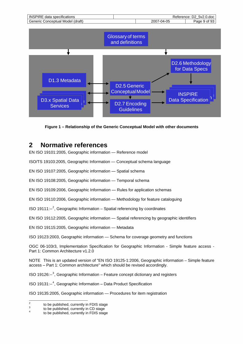
spatial data for data exchange. This document is currently an internal draft only. Figure 1 below illustrates the relationships from the point of view of the data specifications. The blue boxes denote INSPIRE Implementing Rule documents or auxiliary documents. The arrows denote that the target box is influenced by the source box. For example, the INSPIRE data specifications are based on the Generic Conceptual Model. NOTE The main goal of the document – in conjunction with the other deliverables mentioned above – is to provide a framework for the teams that will eventually develop the INSPIRE data specifications that will become part of the INSPIRE Implementing Rules by providing a common rule base. These supporting documents are intended to improve the ability of the teams to specify homogenous data specifications across the different themes. In addition, the document provides some recommendations for the implementation of the ESDI.
INSPIRE data specifications Reference: D2_5v2.0.docGeneric Conceptual Model (draft) 2007-04-05 Page 9 of 93
D2.5 Generic ConceptualModel Theme - specific
Data SpecificationTheme - specific
Data SpecificationThematic
Data SpecificationD2.7 Encoding
Guidelines
D2.6 Methodologyfor Data Specs
Theme - specific Data Specification Theme - specific
Data Specification D3.x Spatial Data
Services
D1.3 Metadata
Glossary of termsand definitions
D2.5 Generic ConceptualModel Theme - specific
Data SpecificationTheme - specific
Data SpecificationINSPIRE
Data SpecificationD2.7 Encoding
Guidelines
D2.6 Methodologyfor Data Specs
Theme - specific Data Specification Theme - specific
Data Specification D3.x Spatial Data
Services
D1.3 Metadata
Glossary of termsand definitions
Figure 1 – Relationship of the Generic Conceptual Model with other documents
2 Normative references EN ISO 19101:2005, Geographic information — Reference model ISO/TS 19103:2005, Geographic Information — Conceptual schema language EN ISO 19107:2005, Geographic information — Spatial schema EN ISO 19108:2005, Geographic information — Temporal schema EN ISO 19109:2006, Geographic Information — Rules for application schemas EN ISO 19110:2006, Geographic information — Methodology for feature cataloguing ISO 19111:--2, Geographic Information – Spatial referencing by coordinates EN ISO 19112:2005, Geographic information — Spatial referencing by geographic identifiers EN ISO 19115:2005, Geographic information — Metadata ISO 19123:2003, Geographic information — Schema for coverage geometry and functions OGC 06-103r3, Implementation Specification for Geographic Information - Simple feature access - Part 1: Common Architecture v1.2.0 NOTE This is an updated version of "EN ISO 19125-1:2006, Geographic information – Simple feature access – Part 1: Common architecture" which should be revised accordingly. ISO 19126:--3, Geographic Information – Feature concept dictionary and registers ISO 19131:--4, Geographic Information – Data Product Specification ISO 19135:2005, Geographic information — Procedures for item registration
2 to be published, currently in FDIS stage 3 to be published, currently in CD stage 4 to be published, currently in FDIS stage
INSPIRE data specifications Reference: D2_5v2.0.docGeneric Conceptual Model (draft) 2007-04-05 Page 10 of 93
ISO 19136:--5, Geographic Information – Geography Markup Language ISO/TS 19139:--6, Geographic Information – Metadata – XML Schema implementation ISO/IEC 19501:2005, Information technology — Open Distributed Processing — Unified Modelling Language (UML) Version 1.4.2 European Reference Grids, volume EUR 21494 EN, European Commission, Joint Research Centre, 2005 (http://gi-gis.jrc.it/publist/annoni2005eurgrids.pdf) EUREF - Information and Service System for European Coordinate Reference Systems, Bundesamt für Kartographie und Geodäsie, EuroGeographics (http://crs.bkg.bund.de/crs-eu/)
3 Terms and abbreviations
3.1 Terms The terms in this sub-clause are taken from the “Glossary of Generic Geographic Information Terms in Europe” that specifies the terminology used in the INSPIRE Implementing Rule documents. (1) application data data in support of user requirements NOTE The term is generally used as a complementary term to “reference data". For example, the road network objects is considered “reference data” and navigation information attached to the road network objects is considered “application data”. (2) application schema conceptual schema for data required by one or more applications [ISO 19101] (3) class description of a set of objects that share the same attributes, operations, methods, relationships, and semantics [ISO/IEC 19501] (4) codelist value domain including a code for each permissible value [ISO 19136] (5) conceptual model model that defines concepts of a universe of discourse [ISO 19101] (6) conceptual schema formal description of a conceptual model [ISO 19101] EXAMPLE ISO 19107 contains a formal description of geometrical and topological concepts using the conceptual schema language UML. (7) conceptual schema language formal language based on a conceptual formalism for the purpose of representing conceptual schemas [ISO 19101] EXAMPLE UML, EXPRESS, ORM and INTERLIS are examples of conceptual schema languages. (8) coordinate reference system systems for uniquely referencing spatial information in space as a set of coordinates (x,y,z)
5 to be published, sent to ISO Central Secretariat for publication 6 to be published, sent to ISO Central Secretariat for publication
INSPIRE data specifications Reference: D2_5v2.0.docGeneric Conceptual Model (draft) 2007-04-05 Page 11 of 93
and/or latitude and longitude and height, based on a geodetic horizontal and vertical datum [INSPIRE Directive] NOTE 1 ISO 19111 defines coordinate reference system as a coordinate system that is related to the real world by a datum. EXAMPLE 1 A national coordinate system with the datum ETRS89. NOTE 2 Although the definition in the ISO Directive is strictly seen restricted to spatial reference systems, temporal reference systems are understood as covered by the term coordinate reference systems as well, because temporal information has to be associated with a reference system just like spatial geometries. ISO 19111 also recognises temporal reference systems explicitly. EXAMPLE 2 The Gregorian calendar is a temporal reference system. (9) coverage spatial object that acts as a function to return values from its range for any direct position within its spatial, temporal or spatiotemporal domain [ISO 19123 - modified] EXAMPLE Orthoimage, digital elevation model (as grid or TIN), point grids etc (10) data harmonisation providing access to spatial data through network services in a representation that allows for combining it with other harmonised data in a coherent way by using a common set of data product specifications NOTE This includes agreements about coordinate reference systems, classification systems, application schemas, etc. (11) data harmonisation components structured collection of components that will be documented to support the interoperability and harmonisation of spatial data across Europe NOTE Rules for application schemas, identifier management, terminology, etc. are examples of the components. (12) data product specification detailed description of a dataset or dataset series together with additional information that will enable it to be created, supplied to and used by another party [ISO/FDIS 19131] (13) dataset identifiable collection of data [ISO 19115] (14) entity real-world phenomenon (15) exonym name used in a specific language for a spatial object situated outside the area where that language is spoken, and differing in its form from the name used in an official or well-established language of that area where the spatial object is located [UNGEGN Glossary of Terminology - modified] (16) external object identifier a unique object identifier which is published by the responsible body, which may be used by third parties to reference the spatial object (17) feature abstraction of real world phenomena [ISO 19101] NOTE The term “(geographic) feature” as used in the ISO 19100 series of International Standards and in this document is synonymous with spatial object as used in this document. Unfortunately
INSPIRE data specifications Reference: D2_5v2.0.docGeneric Conceptual Model (draft) 2007-04-05 Page 12 of 93
“spatial object” is also used in the ISO 19100 series of International Standards, however with a different meaning: a spatial object in the ISO 19100 series is a spatial geometry or topology. (18) feature catalogue catalogue(s) containing definitions and descriptions of the spatial object types, their attributes and associated components occurring in one or more spatial data sets, together with any operations that may be applied [ISO 19110 – modified] (19) feature concept dictionary dictionary containing definitions and descriptions of feature concepts and feature-related concepts [ISO/CD 19126] (20) gazetteer directory of instances of a class or classes of features containing some information regarding position [ISO 19112] NOTE A gazetteer can be considered as a geographical index or dictionary. (21) general feature model meta-model for spatial object types and their property types specified by ISO 19109 (22) geographic identifier spatial reference in the form of a label or code that identifies a location [ISO 19112] EXAMPLE 1 Place names: Paris, Rhine, Mont Blanc EXAMPLE 2 Postal codes: 53115, 01009, SW1, IV19 1PZ (23) geographical grid system harmonised multi-resolution grid with a common point of origin and standardised location and size of grid cells [INSPIRE Directive] NOTE 1 Geographical grid systems are not limited to rectified grids or grids using cell axes parallel to the meridians. NOTE 2 This document adopts the definition of the 2003 Workshop on European Reference Grids, which includes an associated property. Thus, a 'geographical grid' is equivalent to an ISO 19123 coverage. The unqualified term 'grid' may refer either to a grid geometry or a geographical grid (coverage) depending on the context. (24) homologous spatial objects set of spatial objects that correspond to the same real world entity, but are represented differently according to different levels of details or point of views (25) INSPIRE application schema application schema specified in an INSPIRE data specification (26) INSPIRE data specification data product specification for a theme adopted as an implementing rule (27) internal object identifier object identifier which is used internally and is not intended to be used to identify or reference the spatial object by third parties (28) interoperability possibility for spatial data sets to be combined, and for services to interact, without repetitive manual intervention, in such a way that the result is coherent and the added value of the data sets and services is enhanced [INSPIRE Directive] (29) linear reference system
INSPIRE data specifications Reference: D2_5v2.0.docGeneric Conceptual Model (draft) 2007-04-05 Page 13 of 93
reference system that identifies a location by reference to a segment of a linear spatial object and distance along that segment from a given point [ISO 19116 - modified] EXAMPLE kilometre markers along a motorway or railway, references along the centre line of a river object from the intersection with of a bridge object NOTE synonymous with linear referencing system (30) metadata information describing spatial data sets and spatial data services and making it possible to discover, inventory and use them [INSPIRE Directive] NOTE A more general definition provided by ISO 19115 is "data about data" (31) multicultural multiplicity in systems of values held by different groups: ethnic, regional, or professional [Hofstede G. 1980. Culture’s Consequences, Sage: London – modified] (32) multilingual in or using several languages [Oxford Dictionary] (33) multiple representation representation of the relationship between homologous spatial objects (34) object in this document used synonymous with spatial object (35) object identifier unique object identifier associated with a spatial object (36) object referencing method of referencing application data to existing reference data describing their location to ensure spatial consistency across the spatial objects associated in this way (37) profile set of one or more base standards or subsets of base standards, and, where applicable, the identification of chosen clauses, classes, options and parameters of those base standards, that are necessary for accomplishing a particular function [ISO 19106] NOTE A profile is derived from base standards so that by definition, conformance to a profile is conformance to the base standards from which it is derived. (38) reference data spatial objects that are used to provide location information in object referencing NOTE Typical reference data are topographic or cadastral data. (39) reference model architectural framework for a specific context, e.g. an application or an information infrastructure EXAMPLE ISO 19101 and the OGC Reference Model are reference models (40) register set of files containing identifiers assigned to items with descriptions of the associated items [ISO 19135] (41) registry information system on which a register is maintained [ISO 19135] (42) spatial data
INSPIRE data specifications Reference: D2_5v2.0.docGeneric Conceptual Model (draft) 2007-04-05 Page 14 of 93
data with a direct or indirect reference to a specific location or geographic area [INSPIRE Directive] NOTE The use of the word “spatial” in INSPIRE is unfortunate as in the everyday language its meaning goes beyond the meaning of “geographic” – which is considered by the Drafting Team as the intended scope – and includes subjects such as medical images, molecules, or other planets to name a few. However, since the term is used as a synonym for geographic in the draft Directive, this document uses the term “spatial data” as a synonym for the term “geographic information” used by the ISO 19100 series of International Standards. (43) spatial data set identifiable collection of spatial data [INSPIRE Directive] (44) spatial object abstract representation of a real-world phenomenon related to a specific location or geographical area [INSPIRE Directive] NOTE It should be noted that the term has a different meaning in the ISO 19100 series. It is also synonymous with "(geographic) feature" as used in the ISO 19100 series. (45) spatial object type classification of spatial objects EXAMPLE Cadastral parcel, road segment or river basin are all examples of potential spatial object types. NOTE In the conceptual schema language UML a spatial object type will be described by a class with stereotype <<FeatureType>>. (46) spatial reference systems system for identifying position in the real world, which does not necessarily use coordinates [ISO 19112 - modified] EXAMPLE Geographic coordinates describing positions on the Earth surface (coordinate reference system), linear measurements along a river centreline from the intersection of a bridge (linear reference system), postal codes identifying the extent of postal zones (gazetteer). (47) spatial schema conceptual schema of spatial geometries and topologies to be used in an application schema (48) temporal reference system reference system against which time is measured [ISO 19108] (49) temporal schema conceptual schema of temporal geometries and topologies to be used in an application schema (50) thematic identifier descriptive unique object identifier applied to spatial objects in a defined information theme EXAMPLE an administrative code for administrative area objects in the administrative units theme, a parcel code for parcel objects in a cadastral theme (51) theme grouping of spatial data according to Annex I, II and III of the INSPIRE Directive (52) unique object identifier piece of data, usually in the form of printable characters, that unequivocally identifies a spatial object (53) units of measurement defined quantity in which dimensioned parameters are expressed [ISO/TC 211/N1791]

INSPIRE data specifications Reference: D2_5v2.0.docGeneric Conceptual Model (draft) 2007-04-05 Page 15 of 93
(54) version particular form of something differing in certain respects from other forms of the same type of thing [Oxford dictionary] (55) versioning applying a process to ensure that one version of something can be distinguished from another
3.2 Abbreviations CRS Coordinate Reference System CSL Conceptual Schema Language DFDD DGIWG Feature Data Dictionary DGIWG Digital Geospatial Information Working Group DIS Draft International Standard DNS Domain Name System EPSG European Petroleum Survey Group (now OGP Surveying & Positioning Committee) ESDI European Spatial Data Infrastructure EU European Union EUREF REference Frame sub commission for Europe (IAG Commission I) FACC Feature and Attribute Coding Catalogue GI Geographic Information IAG International Association of Geodesy ICAO International Civil Aviation Organization ICT Information and Communication Technology INSPIRE INfrastructure for SPatial InfoRmation in Europe IR Implementing Rule ISO International Standardisation Organisation LMO Legally Mandated Organisation LoD Level of Detail NUTS Nomenclature of Territorial Units for Statistics OCL Object Constraint Language OGC Open Geospatial Consortium OGP international association of the Oil & Gas Producers SDI Spatial Data Infrastructure SDIC Spatial Data Interest Community SI International System of Units SOSI Samordnet Opplegg for Stedfestet Informasjon (Systematic Organisation of Spatial
Information) UML Unified Modelling Language URN Uniform Resource Name WMO World Meteorological Organization XML eXtensible Markup Language
3.3 Verbal forms for the expression of provisions In accordance with the ISO rules for drafting, the following verbal forms shall be interpretated in the given way:
- “shall” / “shall not”: a requirement, mandatory for every data specification - “should” / “should not”: a recommendation, but an alternative approach may be chosen for a
specific case if there are reasons to do so - “may” / “need not”: a permission To make it easier to identify the mandatory requirements and the recommendations in the text, they are highlighted and numbered.

INSPIRE data specifications Reference: D2_5v2.0.docGeneric Conceptual Model (draft) 2007-04-05 Page 16 of 93
3.4 References within the document In accordance with the ISO rules for drafting, references to highest level of the document structure include the word “Clause” (or “Annex” in case of an annex). EXAMPLE “Clause 2”, “Annex A” References to lower levels within the document structure are given without this qualifier. EXAMPLE 7.1, 7.1.8.4, A.1 References to ISO standards are given without the full title. EXAMPLE “ISO 19101” instead of “ISO 19101 – Geographic Information – Reference Model” or “ISO 19101 (Reference Model)
4 Background and principles
4.1 Requirements as stated in the INSPIRE Directive
4.1.1 Articles of the Directive This sub-clause provides an overview, which of the articles in the Directive are addressed by this proposal and how. To make this sub-clause easier to read, the articles from Chapter III “Interoperability of spatial data sets and services” are repeated in the text - in italics. Article 7 1. Implementing rules laying down technical arrangements for the interoperability and, where practicable, harmonisation of spatial data sets and services, designed to amend nonessential elements of this Directive by supplementing it, shall be adopted in accordance with the regulatory procedure with scrutiny referred to in Article 22(3). Relevant user requirements, existing initiatives and international standards for the harmonisation of spatial data sets, as well as feasibility and cost-benefit considerations shall be taken into account in the development of the implementing rules. Where organisations established under international law have adopted relevant standards to ensure interoperability or harmonisation of spatial data sets and services, these standards shall be integrated, and the existing technical means shall be referred to, if appropriate, in the implementing rules mentioned in this paragraph. This document, together with documents D2.3, D2.6 and D2.7, is intended to facilitate the drafting process of the implementing rules referenced above. In particular, this document and document D2.6 provide a common framework for developing the various INSPIRE data specifications in a harmonised way. The term “harmonisation“ is understood as providing access to data through network services in a representation that allows for combining it with other INSPIRE data in a coherent way. This includes agreements about coordinate reference systems, grids, classification systems, application schemas, etc. The relevant aspects to consider are documented in the data harmonisation components described in 4.3. In other words, by enabling interoperability data can be used as if it had been harmonised. This is explained in more detail in 4.3.1. The general issue about the lack of a clear definition of which pieces of information are part of INSPIRE and which are not has already been discussed in detail in conjunction with document D2.3. This applies also to this document. (Article 1(1) simply refers to “[spatial information] for the purposes of Community environmental policies and policies or activities which may have an impact on the environment.” )

INSPIRE data specifications Reference: D2_5v2.0.docGeneric Conceptual Model (draft) 2007-04-05 Page 17 of 93
In relation to the last sentence of Article 7(1), it is the understanding of the Drafting Team "Data Specifications" based on guidance by the Consolidation Team that organisations will also be required to provide INSPIRE compliant spatial data sets and services within the scope of the themes listed in the Annexes of the Directive, i.e. their offerings may need adaptation on the service interface level to the common technological framework for spatial data sets and services as specified in the Implementing Rules. However, the implementation of INSPIRE shall not require these organisations to adapt their data production workflows. Article 7 2. As a basis for developing the implementing rules provided for in paragraph 1, the Commission shall undertake analyses to ensure that the rules are feasible and proportionate in terms of their likely costs and benefits and shall share the results of such analyses with the committee referred to in Article 22(1). Member States shall, on request, provide the Commission with the information necessary to enable it to undertake such analyses. Article 7(2) will be addressed by the Commission, but it should be added that the Drafting Team has proposed to validate the proposal in parallel to the consultation process by testing the draft in one or more pilot projects. In addition, the review of documents is also an opportunity to raise any concerns about feasibility or proportionality of any decisions. Article 7 3. Member States shall ensure that all newly collected and extensively restructured spatial data sets and the corresponding spatial data services are available in conformity with the implementing rules referred to in paragraph 1 within two years of their adoption, and that other spatial data sets and services still in use are available in conformity with the implementing rules within seven years of their adoption. Spatial data sets shall be made available in conformity with the implementing rules either through the adaptation of existing spatial data sets or through the transformation services referred to point (d) of Article 11(1). Article 7(3) will not be addressed by the implementing rules but by the Member States. However, the transformation aspect is considered by this document (see, e.g., the support for existing identifier management schemes) and will be considered in more detail by document D2.6 describing a methodology for developing harmonised INSPIRE data specifications. Article 7 4. Implementing rules referred to in paragraph 1 shall cover the definition and classification of spatial objects relevant to spatial data sets related to the themes listed in Annex I, II or III and the way in which those spatial data are geo-referenced. Article 7(4) is addressed by using the rules of the ISO 19100 series and will be addressed in more detail in the data specification for each theme. In particular, the types of spatial objects that are relevant to INSPIRE will be defined in an INSPIRE feature concept dictionary. The feature concept dictionary will be established for all themes and will include a classification of all spatial objects into spatial object types. For each spatial object type, the dictionary will provide a definition. Spatial properties will be specified for each of the spatial object types in the INSPIRE application schemas following the rules of ISO 19109 (Rules for application schemas) and ISO 19107 (Spatial schema).

INSPIRE data specifications Reference: D2_5v2.0.docGeneric Conceptual Model (draft) 2007-04-05 Page 18 of 93
It is also possible that different application schemas may specify different bindings of a spatial object type (defined in the feature concept dictionary) to spatial properties depending on the application view or the required level of detail. EXAMPLE A building may be spatially referenced by a point in one application schema or by a surface in another application schema. In addition to specifying the spatial/temporal location of a spatial object using geometries with coordinates associated with a spatial/temporal coordinate reference system, the generic conceptual model supports two additional ways in which spatial objects may be geo-referenced: - using a geographic identifier which can be translated into a location in space by way of a
gazetteer; - referencing another spatial object and "inheriting" its location in space and time. Article 7 5. Representatives of Member States at national, regional and local level as well as other natural or legal persons with an interest in the spatial data concerned by virtue of their role in the infrastructure for spatial information, including users, producers, added value service providers or any coordinating body shall be given the opportunity to participate in preparatory discussions on the content of the implementing rules referred to in paragraph 1, prior to consideration by the Committee referred to in Article 22(1). Article 7(5) is addressed by the drafting and consultation process involving SDICs and LMOs. Article 8 1. In the case of spatial data sets corresponding to one or more of the themes listed in Annex I or II, the implementing rules provided for in Article 7(1) shall meet the conditions laid down in paragraphs 2, 3 and 4 of this Article. 2. The implementing rules shall address the following aspects of spatial data: (a) a common framework for the unique identification of spatial objects, to which identifiers under national systems can be mapped in order to ensure interoperability between them; (b) the relationship between spatial objects; (c) the key attributes and the corresponding multilingual thesauri commonly required for policies which may have an impact on the environment; (d) information on the temporal dimension of the data; (e) updates of the data. Article 8(2)(a) is addressed by data harmonisation component "identifier management" described in 4.3. The common system aims at supporting existing identifiers, but adds a namespace identifying the data provider. Article 8(2)(b) is addressed by using ISO 19109 (Rules for application schemas) as the basis. Note that relationships may be explicit associations or they may be implicit spatial or temporal relationships based on the values of the individual spatial and temporal properties of spatial objects. See also the sub-clause on modelling object references. Article 8(2)(c) is addressed by providing guidelines for capturing attributes based on ISO 19109 (Rules for application schemas) and will be addressed in more detail in the data specification for each theme. At this stage, document D2.3 gives a first idea of key attributes. Article 8(2)(d) is addressed by specifying temporal properties for each of the spatial object types in the INSPIRE application schemas following the rules of ISO 19109 (Rules for application schemas) and ISO 19108 (Temporal schema).

INSPIRE data specifications Reference: D2_5v2.0.docGeneric Conceptual Model (draft) 2007-04-05 Page 19 of 93
While Article 8(2)(e) is not specifically addressed by this document and will be addressed by document D2.7 and by the implementing rules on network services, it should be noted that unique object identifiers and versioning as discussed in this document play an important facilitating role in exchange of updates. Article 8 3. The implementing rules shall be designed to ensure consistency between items of information which refer to the same location or between items of information which refer to the same object represented at different scales. Article 8(3) is only addressed in a general sense by this document. The relevant constraints between spatial objects across different spatial object types or levels of detail will be specified in the INSPIRE data specifications. See also the description of data harmonisation components "consistency between data" and "multiple representation" described in 4.3. Article 8 4. The implementing rules shall be designed to ensure that information derived from different spatial data sets is comparable as regards the aspects referred to in Article 7(4) and in paragraph 2 of this Article. Article 8(4) is addressed by the data harmonisation components described in 4.3 and the uniform use of ISO 19131 (Data product specification) for the individual INSPIRE data specifications. Article 9 The implementing rules provided for in Article 7(1) shall be adopted in accordance with the following timetable: (a) no later than (two years following the date of entry into force of this Directive) in the case of the spatial data sets corresponding to the themes listed in Annex I; (b) no later than (five years following the date of entry into force of this Directive) in the case of the spatial data sets corresponding to the themes listed in Annex II or III. Article 9 is not addressed by this document, but by the INSPIRE work programme. Article 10 1. Member States shall ensure that any information, including data, codes and technical classifications, needed for compliance with the implementing rules provided for in Article 7(1) is made available to public authorities or third parties in accordance with conditions that do not restrict its use for that purpose. Article 10(1) is not addressed by this document, but by the implementing rules on data sharing. Article 10 2. In order to ensure that spatial data relating to a geographical feature, the location of which spans the frontier between two or more Member States, are coherent, Member States shall, where appropriate, decide by mutual consent on the depiction and position of such common features.

INSPIRE data specifications Reference: D2_5v2.0.docGeneric Conceptual Model (draft) 2007-04-05 Page 20 of 93
Article 10(2) is only partially addressed by this document. See the description of data harmonisation component "consistency between data" described in 4.3. In addition, guidelines on edge-matching will be provided in document D2.6.
4.1.2 Recitals in the Directive Of the 35 recitals of the Directive, recital (6) is partially relevant for the technical specification of implementing rules on data specifications: "The infrastructures for spatial information in the Member States should be designed to ensure - that spatial data are stored, made available and maintained at the most appropriate level; - that it is possible to combine spatial data from different sources across the Community in a
consistent way and share them between several users and applications; - that it is possible for spatial data collected at one level of public authority to be shared between
other public authorities […]." It is worth highlighting that in particular the data harmonisation component "object referencing" described in 4.3 is directly linked to these requirements. See also clause 13 of this document for additional details. Also, recital (16) and (28) state that "implementing rules should be based, where possible, on international standards […]" and that "in order to benefit from the state of the art and actual experience of information infrastructures, it is appropriate that the measures necessary for the implementation of this Directive should be supported by international standards and standards adopted by European standardisation bodies."
4.1.3 Additional principles for data specifications The main goal of this document is to support the development of INSPIRE data specifications for the themes so that the individual specifications are developed in a homogeneous way. It does not specify the methodology for developing INSPIRE data specifications (this is defined in the separate document D2.6 which is nearing completion). The Generic Conceptual Model specifies common modelling rules and elements that apply to all INSPIRE data specifications. This proposal tries to follow a “keep it simple” approach to developing rules for the wide thematic range of INSPIRE data specifications. Simplicity has been in the focus in particular for two aspects: a) The processing and use of INSPIRE data (it is assumed that INSPIRE data will typically be
accessed through download services which are assumed to provide direct access to spatial objects) should be as simple as possible for users and their software applications.
An example of a resulting rule is the definition of a well-documented set of coordinate reference systems which may be used in INSPIRE data so that an INSPIRE-aware software application is guaranteed to be able to spatially relate two different spatial objects from different data providers. Another example is the recommendation to use the Simple Feature specification as specified by OGC for geometries wherever feasible, because many software components dealing with spatial data sets are able to deal with geometry data following this specification. As a basic rule, INSPIRE has to support the user requirements as well as is feasible and thus the Data Specifications are based on their conceptual view and on the various existing/emerging spatial data infrastructures. I.e., limitations of software components are not in the main focus of this proposal. However, it also needs to be ensured that what is specified in the INSPIRE Implementing Rules is aligned with the ICT infrastructure of the data providers and the users that will be operational in the time frame of the implementation of the Directive. All this, of course, without locking INSPIRE into specific solutions/platforms or inhibiting the future development of the ESDI in the context of the general ICT development. Naturally, this is a grey area and to an extent it will eventually be up to the development process of the Implementing Rules to identify the right balance.
INSPIRE data specifications Reference: D2_5v2.0.docGeneric Conceptual Model (draft) 2007-04-05 Page 21 of 93
As a result, the general approach taken by this proposal is to provide strict rules only where absolutely necessary. Otherwise, general restrictions are avoided at this point, but recommendations are provided where the Drafting Team considers them as a useful guideline. The Simple Feature specification is a good example for a recommendation as it is standardised (and has gone through a consensus process) and is supported by many implementations and used in many operational systems (very likely meeting the conceptual requirements of the applications). There are, however, many applications that go way beyond what Simple Features provides/supports and in this case it is expected that the INSPIRE data specifications will do so, too. In a similar sense, while many spatial applications are based on this specification, a larger number of applications today go far beyond what Simple Feature supports. In this context it is worth to note that Article 12(1) of the draft Directive states that combining spatial data sets should be possible “without requiring specific efforts on the part of a human operator or a machine”.
b) For data providers the leveraging of their existing data sets should be as simple as possible.
An example is the structure of identifiers of spatial objects that has been specified with as few rules/parts as possible and supporting the reuse of already established object identifiers in existing spatial datasets while at the same time addressing all the INSPIRE requirements.
As noted above, in general some of these aspects can be conflicting goals and the proposal tries to find a reasonable compromise between them in case of conflict. In many cases this document specifies recommendations rather than strict rules as of today it is difficult to foresee all thematic requirements and the constraints that can reasonably be applied throughout the individual INSPIRE data specifications.
4.2 A standards-based approach An integral part of any SDI development is an agreement on the technical standards that form the basis for interoperability between the parties in the infrastructure. The generic conceptual model specifies the conceptual framework in which the INSPIRE data specifications will be defined. It is restricted to the conceptual level and does not provide or reference any specifications on the implementation level; this will be done by document D2.7 and the individual data specifications. The Drafting Team has decided to follow as much as possible a standards-based approach based on the ISO 19100 series, based on the following observations:
- The recitals (16) and (28) of the Directive (see 4.1.2) highlight the role of international standards for INSPIRE.
- The ISO 19100 series has undergone a consensus process that has already involved a large number of information communities.
- The analysis of the reference material (i.e. of data specification developments across information communities) indicates that many current data specification developments follow a standards-based approach.
- The recommendations in CEN/TR 15449 and the adoption of most international standards listed as a normative reference in this document by CEN indicate that the ISO 19100 series is considered sufficiently complete and mature to be used, for example, as the framework for the development of data specifications.
- Other non-European or global SDI approaches like, for example, the GSDI cookbook and the development of the Framework Data Content Standards in the United States also recommend or use the ISO 19100 series of International Standards at the conceptual foundation for developing data specifications.
- Since a common conceptual foundation for the development of the diverse data specifications is required in any case, a Europe-specific development would have been required to address the harmonisation requirements, if no international standards would be available for adoption.
However, there are also a number of issues that need to be recognised:
INSPIRE data specifications Reference: D2_5v2.0.docGeneric Conceptual Model (draft) 2007-04-05 Page 22 of 93
- A number of aspects that are needed for INSPIRE are known to be not yet covered by the ISO 19100 series and are noted as such in this document. Measures to close these gaps are required to support all requirements.
- The ISO 19100 series is a comprehensive and complex framework that has emerged over the past decade. Therefore many SDICs and LMOs will need to build the required expertise to understand and realise the standards-based implementing rules.
- Not all Member States and organisations have adopted the ISO 19100 series. As a result these communities will be required to understand the relationship between the concepts of the ISO 19100 series and their conceptual framework and develop a mapping between both conceptual frameworks. Based on the clarification by the Consolidation Team on the last sentence of Paragraph 7(1) this also applies to organisations established under international law (see also 4.1.1).
- ISO standards are not free of charge. Finally a few additional comments on the reference to international standards:
- The normative references to European and International Standards in Clause 3 are dated references. I.e., in case of a revision or amendment to an existing standard, the reference to the specific, dated version remains valid until a revision of the affected INSPIRE implementing rules has been processed.
- It is important to note that only parts of the complete ISO 19100 series are used - this document specifies which these parts are actually relevant.
NOTE The only known deviation from the ISO 19100 series is that the conceptual schema specified in ISO 19112 has not been used as the conceptual schema for gazetteers in INSPIRE for reasons that are discussed in 9.6.5.
4.3 Data harmonisation components
4.3.1 Principles INSPIRE data specifications will be the result of a harmonisation process based on existing data specifications and, where available, user requirements and use cases. While the methodology for creating such harmonised data specifications is subject of another document, the work on INSPIRE data specifications is based on a framework that identifies the components relevant to the data harmonisation process. The following description identifies the principles for data harmonisation that are guiding the process to an INSPIRE data specification. The framework is based on the following assumptions:
- All Member States and organisations start from different positions in terms of conceptual schemas, etc. Due to different political, economic, cultural and organisational drivers, we will not achieve and should not aim at achieving total harmonisation across every nation as part of the INSPIRE process. Regional diversity will and should continue to exist.
- A mechanism that provides a common language to support needs at European Union and other large cross-border and cross-sector levels is required.
- The trend towards the integration of geographic information into the information and technology mainstream will accelerate.
- The main goal at least for the foreseeable future will be to achieve a "virtual harmonisation“ by enabling interoperability in a service-based architecture rather then harmonisation of the underlying conceptual models. Two aspects of harmonisation need to be distinguished:
o a common process and methodology of developing data specifications in order to have an harmonised conceptual schema for all the themes involved in INSPIRE (this is addressed by this document as well as document D2.6);
o for every individual data specification a conceptual schema needs to be designed that is capable of representing data from the various data sources and providers that need to provide the content for the download services (this is addressed by the harmonisation approach in document D2.6).
INSPIRE data specifications Reference: D2_5v2.0.docGeneric Conceptual Model (draft) 2007-04-05 Page 23 of 93
- In this context data harmonisation requirements have to be considered on different levels:
o the application schema level (use of common application schemas independent of the application schemas of the base data)
o the data level (e.g. edge matching in border areas) The Generic Conceptual Model mainly addresses the application schema level. Harmonisation on the data level is partly addressed by 22, but will require organisational measures to address the requirements stated in Article 8(3) of the Directive.
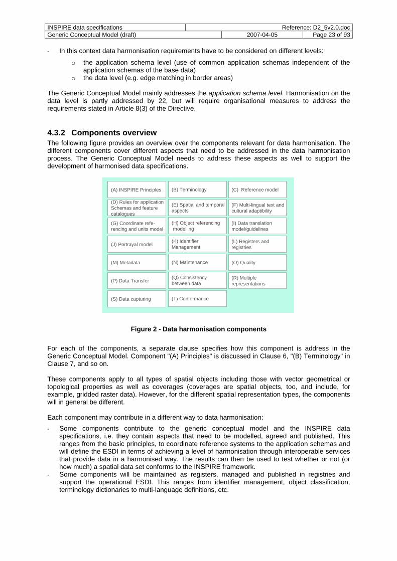
4.3.2 Components overview The following figure provides an overview over the components relevant for data harmonisation. The different components cover different aspects that need to be addressed in the data harmonisation process. The Generic Conceptual Model needs to address these aspects as well to support the development of harmonised data specifications.
(C) Reference model
(H) Object referencing modelling
(G) Coordinate refe-rencing and units model
(A) INSPIRE Principles (B) Terminology
(D) Rules for applicationSchemas and feature catalogues
(K) Identifier Management
(L) Registers and registries
(I) Data translation model/guidelines
(T) Conformance
(E) Spatial and temporalaspects
(F) Multi-lingual text andcultural adaptibility
(M) Metadata (N) Maintenance (O) Quality
(P) Data Transfer (R) Multiplerepresentations
(J) Portrayal model
(Q) Consistency between data
(S) Data capturing
Figure 2 - Data harmonisation components
For each of the components, a separate clause specifies how this component is address in the Generic Conceptual Model. Component "(A) Principles" is discussed in Clause 6, "(B) Terminology" in Clause 7, and so on. These components apply to all types of spatial objects including those with vector geometrical or topological properties as well as coverages (coverages are spatial objects, too, and include, for example, gridded raster data). However, for the different spatial representation types, the components will in general be different. Each component may contribute in a different way to data harmonisation: - Some components contribute to the generic conceptual model and the INSPIRE data
specifications, i.e. they contain aspects that need to be modelled, agreed and published. This ranges from the basic principles, to coordinate reference systems to the application schemas and will define the ESDI in terms of achieving a level of harmonisation through interoperable services that provide data in a harmonised way. The results can then be used to test whether or not (or how much) a spatial data set conforms to the INSPIRE framework.
- Some components will be maintained as registers, managed and published in registries and support the operational ESDI. This ranges from identifier management, object classification, terminology dictionaries to multi-language definitions, etc.
INSPIRE data specifications Reference: D2_5v2.0.docGeneric Conceptual Model (draft) 2007-04-05 Page 24 of 93
- Some components may provide guidelines and best practice to support the consistent implementation of the data specifications and underlying standards to promote data harmonisation.
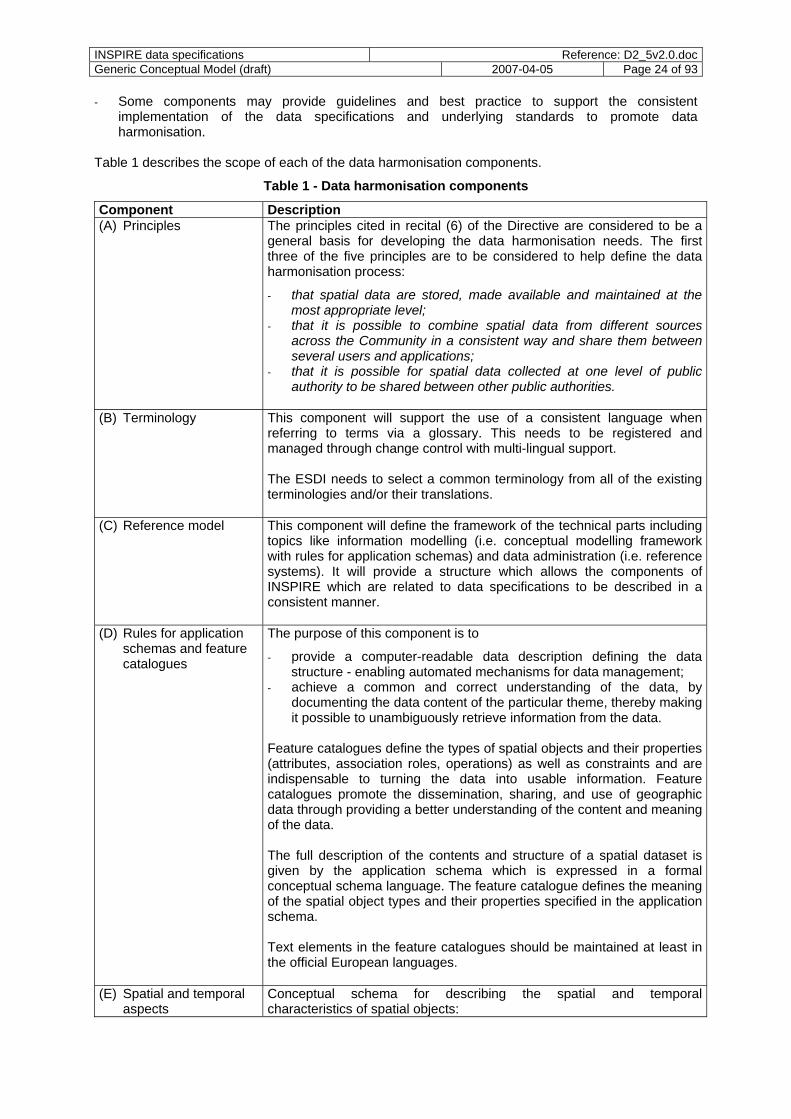
Table 1 describes the scope of each of the data harmonisation components.
Table 1 - Data harmonisation components
Component Description (A) Principles The principles cited in recital (6) of the Directive are considered to be a
general basis for developing the data harmonisation needs. The first three of the five principles are to be considered to help define the data harmonisation process:
- that spatial data are stored, made available and maintained at the most appropriate level;
- that it is possible to combine spatial data from different sources across the Community in a consistent way and share them between several users and applications;
- that it is possible for spatial data collected at one level of public authority to be shared between other public authorities.
(B) Terminology This component will support the use of a consistent language when
referring to terms via a glossary. This needs to be registered and managed through change control with multi-lingual support. The ESDI needs to select a common terminology from all of the existing terminologies and/or their translations.
(C) Reference model This component will define the framework of the technical parts including topics like information modelling (i.e. conceptual modelling framework with rules for application schemas) and data administration (i.e. reference systems). It will provide a structure which allows the components of INSPIRE which are related to data specifications to be described in a consistent manner.
(D) Rules for application schemas and feature catalogues
The purpose of this component is to
- provide a computer-readable data description defining the data structure - enabling automated mechanisms for data management;
- achieve a common and correct understanding of the data, by documenting the data content of the particular theme, thereby making it possible to unambiguously retrieve information from the data.
Feature catalogues define the types of spatial objects and their properties (attributes, association roles, operations) as well as constraints and are indispensable to turning the data into usable information. Feature catalogues promote the dissemination, sharing, and use of geographic data through providing a better understanding of the content and meaning of the data. The full description of the contents and structure of a spatial dataset is given by the application schema which is expressed in a formal conceptual schema language. The feature catalogue defines the meaning of the spatial object types and their properties specified in the application schema. Text elements in the feature catalogues should be maintained at least in the official European languages.
(E) Spatial and temporal aspects
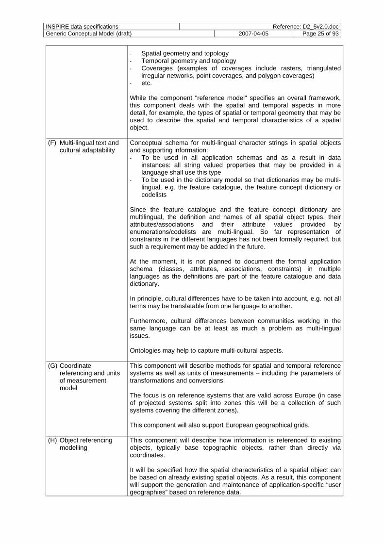
Conceptual schema for describing the spatial and temporal characteristics of spatial objects:
INSPIRE data specifications Reference: D2_5v2.0.docGeneric Conceptual Model (draft) 2007-04-05 Page 25 of 93
- Spatial geometry and topology - Temporal geometry and topology - Coverages (examples of coverages include rasters, triangulated
irregular networks, point coverages, and polygon coverages) - etc. While the component "reference model" specifies an overall framework, this component deals with the spatial and temporal aspects in more detail, for example, the types of spatial or temporal geometry that may be used to describe the spatial and temporal characteristics of a spatial object.
(F) Multi-lingual text and cultural adaptability
Conceptual schema for multi-lingual character strings in spatial objects and supporting information: - To be used in all application schemas and as a result in data
instances: all string valued properties that may be provided in a language shall use this type
- To be used in the dictionary model so that dictionaries may be multi-lingual, e.g. the feature catalogue, the feature concept dictionary or codelists
Since the feature catalogue and the feature concept dictionary are multilingual, the definition and names of all spatial object types, their attributes/associations and their attribute values provided by enumerations/codelists are multi-lingual. So far representation of constraints in the different languages has not been formally required, but such a requirement may be added in the future. At the moment, it is not planned to document the formal application schema (classes, attributes, associations, constraints) in multiple languages as the definitions are part of the feature catalogue and data dictionary. In principle, cultural differences have to be taken into account, e.g. not all terms may be translatable from one language to another. Furthermore, cultural differences between communities working in the same language can be at least as much a problem as multi-lingual issues. Ontologies may help to capture multi-cultural aspects.
(G) Coordinate referencing and units of measurement model
This component will describe methods for spatial and temporal reference systems as well as units of measurements – including the parameters of transformations and conversions. The focus is on reference systems that are valid across Europe (in case of projected systems split into zones this will be a collection of such systems covering the different zones). This component will also support European geographical grids.
(H) Object referencing modelling
This component will describe how information is referenced to existing objects, typically base topographic objects, rather than directly via coordinates. It will be specified how the spatial characteristics of a spatial object can be based on already existing spatial objects. As a result, this component will support the generation and maintenance of application-specific “user geographies” based on reference data.

INSPIRE data specifications Reference: D2_5v2.0.docGeneric Conceptual Model (draft) 2007-04-05 Page 26 of 93
The aim is to promote the easy and reliable exchange of data that is associated with spatial objects (e.g. river quality sample records) across several users who use a common base (thus avoiding spatial inconsistencies and massive data transfers to support regular reporting). The approach improve data integrity across distributed systems and services as well as more reliable data sharing. Object referencing is especially relevant in referencing spatial objects of Annex III themes to those of the themes in Annex I and II.
(I) Data translation model / guidelines
This component is about translating from a national/local application schema to the INSPIRE application schema and vice versa. Translations are required for data and for queries. NOTE No well-defined set of translation capabilities has been standardised in the GI community at this time. It is not yet clear, if there will be a need to specify translations also between different European application schemas, e.g. for different representations or for creating specific information products, e.g. for reports or from base data etc. Also, further research would be required to identify how consistent adoption of ontologies could be exploited here.
(J) Portrayal model This component will define a model for portrayal rules for data according to a data specification. It will clarify how standardised portrayal catalogues can be used to harmonise the portrayal of data.
(K) Identifier management Spatial objects from Annexes I and II should have an external object identifier. This component will define the role and nature of unique object identifiers (or other mechanisms) to support unambiguous object identification. To ensure uniqueness some form of management system will be required. This does not mean that all organisations need to adopt a common form of identifier or other mechanism but the identifier management mechanisms (e.g. registers) in use at national level will need to be synchronised/mapped to ensure pan European integration. Note that the same real-world phenomenon may be represented by different spatial objects (with their own identifiers).
(L) Registers and Registries
Registers will at least be required for
- all reference systems used in spatial data sets - all units of measurement used in spatial data sets - all codelists / thesauri used in the application schemas (multi-lingual,
at least in all official European languages) - the feature concept dictionary for elements used by application
schemas (multi-lingual, at least in all official European languages) - identifier namespaces - all feature catalogues - all application schemas The registries will be available through registry services. Metadata on dataset level will be available through catalogue services.
(M) Metadata This component will cover metadata on the following levels:
- Discovery - Evaluation

INSPIRE data specifications Reference: D2_5v2.0.docGeneric Conceptual Model (draft) 2007-04-05 Page 27 of 93
- Use Metadata associated with individual spatial objects will in general be described as part of the application schemas.
(N) Maintenance This component will define best practice in ensuring that application data can be managed against updates of reference information without interruption of services. This will require the definition of mechanisms by different stakeholder areas to manage where this is required and it is feasible
- change only updates - versioning of objects (and their properties) - object lifecycles Propagation of changes across scale and between dependent objects is required in general to maintain consistency of the data (automatic or manual processes).
(O) Data & information quality
This component will advise the need to publish quality levels of each spatial dataset using the criteria defined in the ISO 19100 series of standards, including completeness, consistency, currency and accuracy. This will include methods of best practice in publishing:
- Acceptable quality levels of each spatial dataset - Attainment against those levels for each spatial dataset Quality information associated with individual spatial objects is part of the metadata associated with the respective spatial object (see component "Metadata") and will in general be described as part of the application schemas.
(P) Data transfer This component will describe methods for encoding application and reference data as well as information products. The encoding of spatial objects will in general be model-driven, i.e. fully determined by the application schema in UML. To support network services that are implemented as web services, spatial objects are expected to be primarily encoded in XML/GML for the exchange of spatial data. Coverage data is expected to use existing encodings for the range part.
(Q) Consistency between data
This component will describe guidelines how the consistency between the representation of the same entity in different spatial datasets (for example along or across borders, themes, sectors or at different resolutions) shall be maintained. The custodians of such spatial datasets will decide by mutual consent on the depiction and position of such common spatial objects or they will agree on a general method for edge-matching or other automatic means to maintain data consistency.
(R) Multiple representations
This component will describe best practices how data can be aggregated
- across time and space - across different resolutions (“generalisation” of data) Such aggregation processes are used in particular to create the following results:
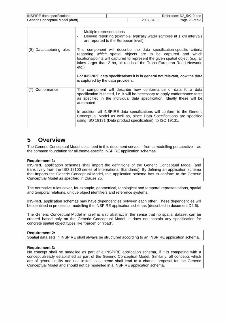
INSPIRE data specifications Reference: D2_5v2.0.docGeneric Conceptual Model (draft) 2007-04-05 Page 28 of 93
- Multiple representations - Derived reporting (example: typically water samples at 1 km intervals
are reported to the European level)
(S) Data capturing rules This component will describe the data specification-specific criteria regarding which spatial objects are to be captured and which locations/points will captured to represent the given spatial object (e.g. all lakes larger than 2 ha, all roads of the Trans European Road Network, etc.). For INSPIRE data specifications it is in general not relevant, how the data is captured by the data providers.
(T) Conformance This component will describe how conformance of data to a data specification is tested, i.e. it will be necessary to apply conformance tests as specified in the individual data specification. Ideally these will be automated. In addition, all INSPIRE data specifications will conform to the Generic Conceptual Model as well as, since Data Specifications are specified using ISO 19131 (Data product specification), to ISO 19131.
5 Overview The Generic Conceptual Model described in this document serves – from a modelling perspective – as the common foundation for all theme-specific INSPIRE application schemas. Requirement 1: INSPIRE application schemas shall import the definitions of the Generic Conceptual Model (and transitively from the ISO 19100 series of International Standards). By defining an application schema that imports the Generic Conceptual Model, this application schema has to conform to the Generic Conceptual Model as specified in Clause 25. The normative rules cover, for example, geometrical, topological and temporal representations, spatial and temporal relations, unique object identifiers and reference systems. INSPIRE application schemas may have dependencies between each other. These dependencies will be identified in process of modelling the INSPIRE application schemas (described in document D2.6). The Generic Conceptual Model in itself is also abstract in the sense that no spatial dataset can be created based only on the Generic Conceptual Model. It does not contain any specification for concrete spatial object types like “parcel” or “road”. Requirement 2: Spatial data sets in INSPIRE shall always be structured according to an INSPIRE application schema. Requirement 3: No concept shall be modelled as part of a INSPIRE application schema, if it is competing with a concept already established as part of the Generic Conceptual Model. Similarly, all concepts which are of general utility and not limited to a theme shall lead to a change proposal for the Generic Conceptual Model and should not be modelled in a INSPIRE application schema.
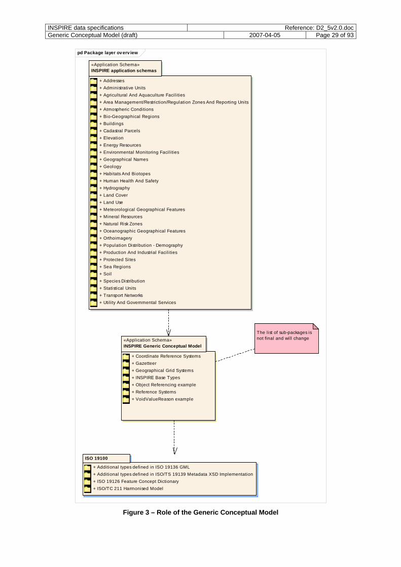
INSPIRE data specifications Reference: D2_5v2.0.docGeneric Conceptual Model (draft) 2007-04-05 Page 29 of 93
pd Package layer ov erv iew
ISO 19100
+ Additional types defined in ISO 19136 GML+ Additional types defined in ISO/TS 19139 Metadata XSD Implementation+ ISO 19126 Feature Concept Dictionary+ ISO/TC 211 Harmonised Model
«Application Schema»INSPIRE Generic Conceptual Model
+ Coordinate Reference Systems+ Gazetteer+ Geographical Grid Systems+ INSPIRE Base Types+ Object Referencing example+ Reference Systems+ VoidValueReason example
«Application Schema»INSPIRE application schemas
+ Addresses+ Administrative Units+ Agricultural And Aquaculture Facilities+ Area Management/Restriction/Regulation Zones And Reporting Units+ Atmospheric Conditions+ Bio-Geographical Regions+ Buildings+ Cadastral Parcels+ Elevation+ Energy Resources+ Environmental Monitoring Facil ities+ Geographical Names+ Geology+ Habitats And Biotopes+ Human Health And Safety+ Hydrography+ Land Cover+ Land Use+ Meteorological Geographical Features+ Mineral Resources+ Natural Risk Zones+ Oceanographic Geographical Features+ Orthoimagery+ Population Distribution - Demography+ Production And Industrial Facili ties+ Protected Sites+ Sea Regions+ Soil+ Species Distribution+ Statistical Units+ Transport Networks+ Util ity And Governmental Services
The l ist of sub-packages is not final and will change
Figure 3 – Role of the Generic Conceptual Model
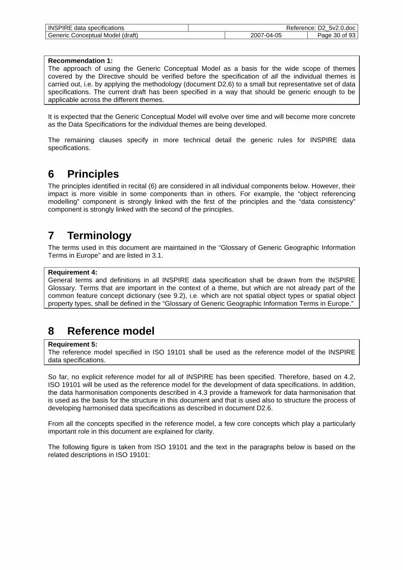
INSPIRE data specifications Reference: D2_5v2.0.docGeneric Conceptual Model (draft) 2007-04-05 Page 30 of 93
Recommendation 1: The approach of using the Generic Conceptual Model as a basis for the wide scope of themes covered by the Directive should be verified before the specification of all the individual themes is carried out, i.e. by applying the methodology (document D2.6) to a small but representative set of data specifications. The current draft has been specified in a way that should be generic enough to be applicable across the different themes. It is expected that the Generic Conceptual Model will evolve over time and will become more concrete as the Data Specifications for the individual themes are being developed. The remaining clauses specify in more technical detail the generic rules for INSPIRE data specifications.
6 Principles The principles identified in recital (6) are considered in all individual components below. However, their impact is more visible in some components than in others. For example, the “object referencing modelling” component is strongly linked with the first of the principles and the “data consistency” component is strongly linked with the second of the principles.
7 Terminology The terms used in this document are maintained in the “Glossary of Generic Geographic Information Terms in Europe” and are listed in 3.1. Requirement 4: General terms and definitions in all INSPIRE data specification shall be drawn from the INSPIRE Glossary. Terms that are important in the context of a theme, but which are not already part of the common feature concept dictionary (see 9.2), i.e. which are not spatial object types or spatial object property types, shall be defined in the “Glossary of Generic Geographic Information Terms in Europe.”
8 Reference model Requirement 5: The reference model specified in ISO 19101 shall be used as the reference model of the INSPIRE data specifications. So far, no explicit reference model for all of INSPIRE has been specified. Therefore, based on 4.2, ISO 19101 will be used as the reference model for the development of data specifications. In addition, the data harmonisation components described in 4.3 provide a framework for data harmonisation that is used as the basis for the structure in this document and that is used also to structure the process of developing harmonised data specifications as described in document D2.6. From all the concepts specified in the reference model, a few core concepts which play a particularly important role in this document are explained for clarity. The following figure is taken from ISO 19101 and the text in the paragraphs below is based on the related descriptions in ISO 19101:
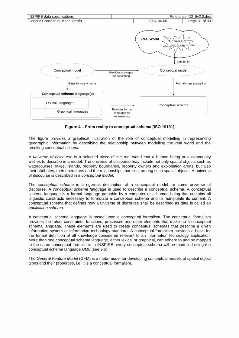
INSPIRE data specifications Reference: D2_5v2.0.docGeneric Conceptual Model (draft) 2007-04-05 Page 31 of 93
Real World
Universe ofdiscourse
Conceptual model
Conceptual schemaLexical Languages
Graphical languages
Conceptual schema language(s)
Provides formal language for representing
Conceptual modelProvides concepts
for describibg
Basis for one or more
defined in
Formally represented in
Figure 4 – From reality to conceptual schema [ISO 19101]
The figure provides a graphical illustration of the role of conceptual modelling in representing geographic information by describing the relationship between modelling the real world and the resulting conceptual schema. A universe of discourse is a selected piece of the real world that a human being or a community wishes to describe in a model. The universe of discourse may include not only spatial objects such as watercourses, lakes, islands, property boundaries, property owners and exploitation areas, but also their attributes, their operations and the relationships that exist among such spatial objects. A universe of discourse is described in a conceptual model. The conceptual schema is a rigorous description of a conceptual model for some universe of discourse. A conceptual schema language is used to describe a conceptual schema. A conceptual schema language is a formal language parsable by a computer or a human being that contains all linguistic constructs necessary to formulate a conceptual schema and to manipulate its content. A conceptual schema that defines how a universe of discourse shall be described as data is called an application schema. A conceptual schema language is based upon a conceptual formalism. The conceptual formalism provides the rules, constraints, functions, processes and other elements that make up a conceptual schema language. These elements are used to create conceptual schemas that describe a given information system or information technology standard. A conceptual formalism provides a basis for the formal definition of all knowledge considered relevant to an information technology application. More than one conceptual schema language, either lexical or graphical, can adhere to and be mapped to the same conceptual formalism. In INSPIRE, every conceptual schema will be modelled using the conceptual schema language UML (see 9.5). The General Feature Model (GFM) is a meta-model for developing conceptual models of spatial object types and their properties, i.e. it is a conceptual formalism.
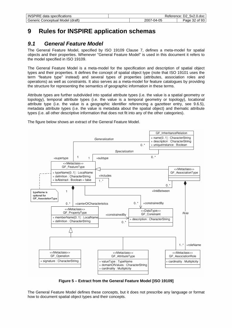
INSPIRE data specifications Reference: D2_5v2.0.docGeneric Conceptual Model (draft) 2007-04-05 Page 32 of 93
9 Rules for INSPIRE application schemas
9.1 General Feature Model The General Feature Model, specified by ISO 19109 Clause 7, defines a meta-model for spatial objects and their properties. Whenever "General Feature Model" is used in this document it refers to the model specified in ISO 19109. The General Feature Model is a meta-model for the specification and description of spatial object types and their properties. It defines the concept of spatial object type (note that ISO 19101 uses the term “feature type” instead) and several types of properties (attributes, association roles and operations) as well as constraints. It also serves as a meta-model for feature catalogues by providing the structure for representing the semantics of geographic information in these terms. Attribute types are further subdivided into spatial attribute types (i.e. the value is a spatial geometry or topology), temporal attribute types (i.e. the value is a temporal geometry or topology), locational attribute type (i.e. the value is a geographic identifier referencing a gazetteer entry, see 9.6.5), metadata attribute types (i.e. the value is metadata about the spatial object) and thematic attribute types (i.e. all other descriptive information that does not fit into any of the other categories). The figure below shows an extract of the General Feature Model.
Figure 5 – Extract from the General Feature Model [ISO 19109]
The General Feature Model defines these concepts, but it does not prescribe any language or format how to document spatial object types and their concepts.
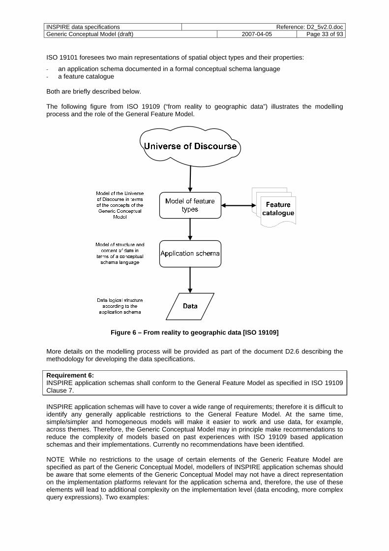
INSPIRE data specifications Reference: D2_5v2.0.docGeneric Conceptual Model (draft) 2007-04-05 Page 33 of 93
ISO 19101 foresees two main representations of spatial object types and their properties:
- an application schema documented in a formal conceptual schema language - a feature catalogue Both are briefly described below. The following figure from ISO 19109 (“from reality to geographic data”) illustrates the modelling process and the role of the General Feature Model.
Figure 6 – From reality to geographic data [ISO 19109]
More details on the modelling process will be provided as part of the document D2.6 describing the methodology for developing the data specifications. Requirement 6: INSPIRE application schemas shall conform to the General Feature Model as specified in ISO 19109 Clause 7. INSPIRE application schemas will have to cover a wide range of requirements; therefore it is difficult to identify any generally applicable restrictions to the General Feature Model. At the same time, simple/simpler and homogeneous models will make it easier to work and use data, for example, across themes. Therefore, the Generic Conceptual Model may in principle make recommendations to reduce the complexity of models based on past experiences with ISO 19109 based application schemas and their implementations. Currently no recommendations have been identified. NOTE While no restrictions to the usage of certain elements of the Generic Feature Model are specified as part of the Generic Conceptual Model, modellers of INSPIRE application schemas should be aware that some elements of the Generic Conceptual Model may not have a direct representation on the implementation platforms relevant for the application schema and, therefore, the use of these elements will lead to additional complexity on the implementation level (data encoding, more complex query expressions). Two examples:
INSPIRE data specifications Reference: D2_5v2.0.docGeneric Conceptual Model (draft) 2007-04-05 Page 34 of 93
- The use of multiple inheritance: ISO/TS 19103 states that "the use of multiple inheritance should be minimized or avoided unless it is a fundamental part of the semantics of the type hierarchy."
- Modelling operations: Operations which are modelled in an INSPIRE application schema will not be accessible to applications, because INSPIRE network services are not expected to support invocation of operations of spatial object types (the network services typically operate on a more coarse-grained level) and also encoding of spatial objects in data exchange (document D2.7) is not expected to support an encoding of operations. Therefore, operations should in general not be modelled as part of an INSPIRE application schema unless they are required for the proper understanding and documentation of the semantics and the intended behaviour of spatial objects.
9.2 Feature concept dictionaries Requirement 7: In order to provide a harmonised view to concepts of spatial object types, attribute types, association types and coded values a common feature concept dictionary as specified in ISO 19126 (Feature concept dictionaries and registers) shall be maintained for INSPIRE in an ISO 19135 conformant register. In addition, the name, definition and description of all themes shall be maintained in the feature concept dictionary. The conceptual schema of ISO 19126 shall be extended to include these items. NOTE Name and definition of the themes are given by the Directive and cannot be changed. The role of a common feature concept dictionary for all INSPIRE data specifications is in particular to support the harmonisation effort and to identify conflicts between the specifications of the spatial object type in the different themes. This will be specified in more detail in document D2.6 (methodology). Recommendation 2: ISO 19126 is currently in Committee Draft stage in the ISO standardisation process. Before establishing and implementing the common feature concept dictionary register, ISO 19126 should reach the Draft International Standard stage. It is expected that ISO 19126 will provide an XML encoding for a feature concept dictionary. In this case, this XML encoding should be used to encode the items in the feature concept dictionary.
9.3 Feature catalogues Requirement 8: The spatial object types of an INSPIRE application schema shall be expressed in a feature catalogue as specified in ISO 19110. An amendment of ISO 19110 is currently in Committee Draft stage in the ISO standardisation process. As soon as the amendment reaches the Draft International Standard stage, this version shall be used as the basis for feature catalogues in INSPIRE. The amendment will provide an XML encoding for feature catalogues. This XML encoding shall be used to encode feature catalogues. Requirement 9: Every feature catalogue shall contain the information for all spatial object types that are relevant for the particular application schema. Recommendation 3: To support the ESDI, an ISO 19135 conformant register and registry for INSPIRE feature catalogues should be established as part of INSPIRE.

INSPIRE data specifications Reference: D2_5v2.0.docGeneric Conceptual Model (draft) 2007-04-05 Page 35 of 93
This component is a key component of the INSPIRE data specifications. The specification of spatial object types will be dealt with in more detail in document D2.6 (methodology). NOTE 2 As described in ISO 19110 Annex D, a feature catalogue forms a repository for a set of definitions to classify real-world phenomena of significance to a particular universe of discourse. The catalogue provides a means for organising into categories the data that represent these phenomena, so that the resulting information is as unambiguous, comprehensible, and useful as possible. As such, the contents of a feature catalogue overlap with the information specified in the corresponding application schema, i.e. the application schema contains information that may not necessarily be represented in the corresponding feature catalogue and vice versa. Indeed, different approaches to dealing with both concepts are used in the submitted reference material. This ranges from specifying all relevant information in the application schema and deriving a feature catalogue from the schema up to the specification of the feature catalogue in a way that an application schema may be derived from the catalogue. The Generic Conceptual Model endorses both concepts as specified in ISO 19101 with the following understanding: As part of the modelling process, a conceptual model is being developed, this contains definitions and classifications. This will be documented in a feature catalogue, in particular to make the definitions and classifications contained in the model available to human readers. An application schema, on the other hand, contains a description of that conceptual model in a formal language; in the case of INSPIRE UML will be used as specified above. The methodology for the development of data specifications (document D2.6) will specify how catalogues and application schemas are developed, maintained and synchronised. NOTE 3 Due to the constraint within feature catalogues that every spatial object type name within a feature catalogue has to be unique, it is unlikely that it will be possible to create a single feature catalogue for all INSPIRE data specifications as the same concept from the feature concept dictionary, e.g. "road", may lead to several spatial object types of the same name in different INSPIRE application schemas with property patterns that reflect the specific application requirements.
9.4 Modelling application schemas Requirement 10: Each spatial object in a spatial data set shall be described in an application schema. The application schema defines the possible content and structure of the corresponding spatial object type on the conceptual level. Requirement 11: An application schema shall contain a complete and precise description of the semantic content of its spatial object types following the concepts and structure defined in the General Feature Model. I.e., the application schema shall contain concepts that can be mapped to the meta-model of the General Feature Model. EXAMPLE 1 Spatial object types are realisations of GF_FeatureType and are modelled as classes with the stereotype <<FeatureType>>. Constraints (realisations of GF_Constraint) are modelled in invariant OCL expressions in the context of the class representing the spatial object type and are additionally described in natural language. Etc. Requirement 12: Every INSPIRE data specification shall include an INSPIRE application schema that is modelled according to ISO 19109 8.2. NOTE 1 ISO 19109 8.2 specifies a number of requirements including:
- the use of a conceptual schema language; - the modelling data structures so that data transfer of all relevant information is supported;
INSPIRE data specifications Reference: D2_5v2.0.docGeneric Conceptual Model (draft) 2007-04-05 Page 36 of 93
- the provision of a name and a version of the application schema; - the provision of a corresponding feature catalogue; - the provision of sufficient documentation for all elements in the application schema; - the provision of references from a spatial object type to the type definition in the corresponding
feature catalogue; - the correct integration of the application schema with the standard schemas or other application
schemas. Requirement 13: The spatial object types and their properties specified in an application schema shall be drawn from the common feature concept dictionary. NOTE 2 The process of defining spatial object types will be specified in the methodology for developing data specification (document D2.6) in more detail. In short, the process is as follows: A relevant concept within a theme for a spatial object type is identified. The common feature concept dictionary is analysed to identify if the concept or a similar concept already exists. The further steps depend on the outcome of this analysis:
If it does not exist, the spatial object type is added to the common feature concept dictionary and used in the application schema.
a) If the same concept already exists, the other INSPIRE application schemas are analysed to identify if the relevant spatial object type is already used elsewhere. Depending on the result of the analysis
o a new spatial object type may be created in the application schema using the concept from the common feature concept dictionary,
o a spatial object type specified in another application schema may be amended to meet the current requirements and used in the current application schema, or
o a new spatial object type may be specified as a specialisation or generalisation of a spatial object type specified in another application schema.
If a similar concept exists it needs to be decided, if the concepts should be merged – amendments to other application schemas will in general be required – or if they should be treated as separate concepts. Depending on the outcome either b) or a) apply from then on. Requirement 14: Spatial object types shall be modelled according to ISO 19109 7.1-7.2, 8.1, 8.5-8.9 and according to the additional rules in Clauses 9, 10, 11, 13, and 22 of this document. NOTE 3 ISO 19109 7.1 and 7.2 describe principles for defining spatial objects and their relationship with application schemas. ISO 19109 8.1 specifies core aspects of the process of modelling application schemas. ISO 19109 8.5 to 8.9 specify the rules for the use of metadata, temporal and spatial characteristics, geographic identifiers as well as the relationship to feature catalogues. Details on the process of modelling spatial object types in INSPIRE application schemas will be provided in document D2.6. NOTE 4 The same real-world phenomenon may be represented by multiple spatial objects (with different unique object identifiers, see below). Requirement 15: The profile of the conceptual schema defined in the ISO 19100 series that is used in the application schema shall conform with ISO 19109 8.4. NOTE 5 ISO 19109 8.4 specifies how adjustments can be made to the standard schemas to add information to the types defined in the standard schemas, for example to specify a new curve segment type not foreseen in ISO 19107 (spatial schema), or to restrict elements of a standard schema as permitted by the conformance clause of the standard that specifies that schema.
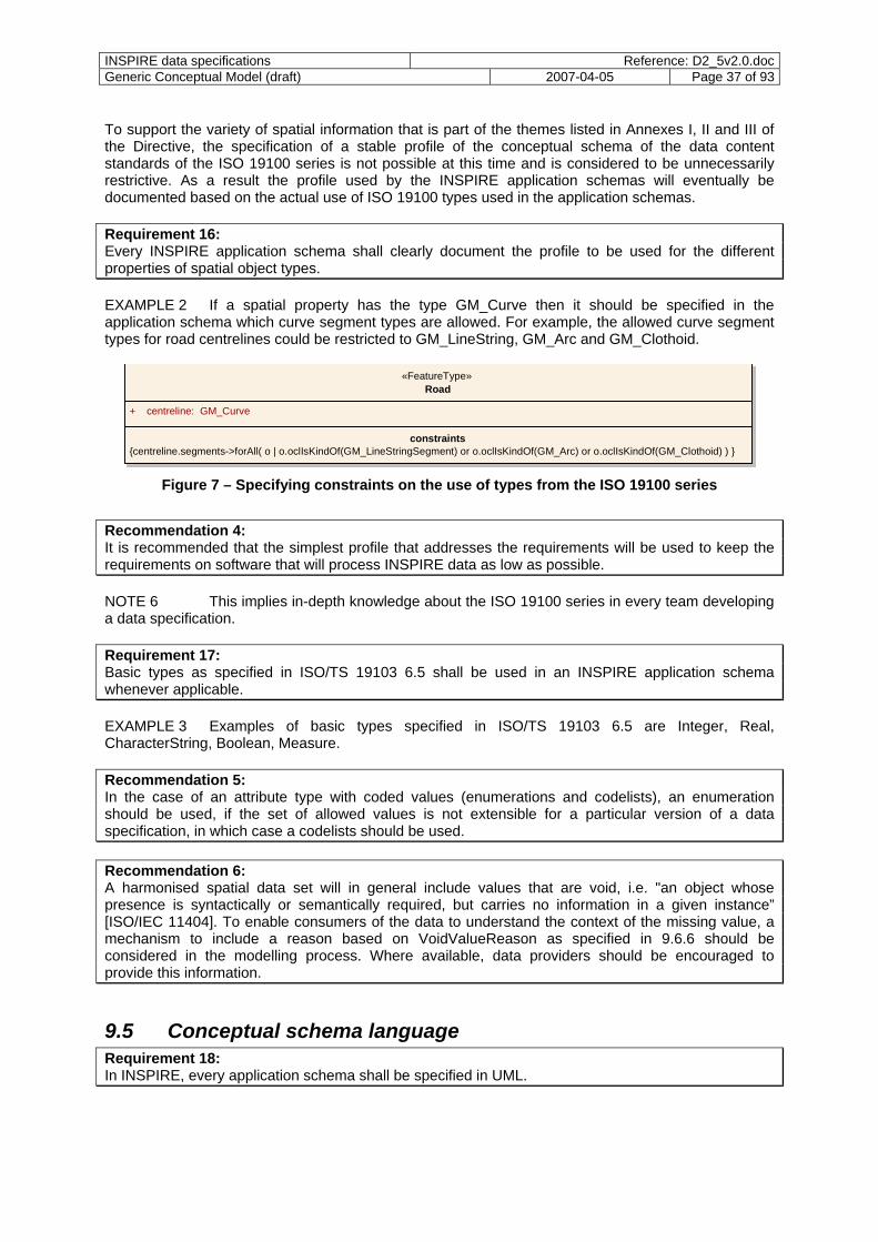
INSPIRE data specifications Reference: D2_5v2.0.docGeneric Conceptual Model (draft) 2007-04-05 Page 37 of 93
To support the variety of spatial information that is part of the themes listed in Annexes I, II and III of the Directive, the specification of a stable profile of the conceptual schema of the data content standards of the ISO 19100 series is not possible at this time and is considered to be unnecessarily restrictive. As a result the profile used by the INSPIRE application schemas will eventually be documented based on the actual use of ISO 19100 types used in the application schemas. Requirement 16: Every INSPIRE application schema shall clearly document the profile to be used for the different properties of spatial object types. EXAMPLE 2 If a spatial property has the type GM_Curve then it should be specified in the application schema which curve segment types are allowed. For example, the allowed curve segment types for road centrelines could be restricted to GM_LineString, GM_Arc and GM_Clothoid.
«FeatureType»Road
+ centreline: GM_Curve constraints
{centreline.segments->forAll( o | o.oclIsKindOf(GM_LineStringSegment) or o.oclIsKindOf(GM_Arc) or o.oclIsKindOf(GM_Clothoid) ) }
Figure 7 – Specifying constraints on the use of types from the ISO 19100 series
Recommendation 4: It is recommended that the simplest profile that addresses the requirements will be used to keep the requirements on software that will process INSPIRE data as low as possible. NOTE 6 This implies in-depth knowledge about the ISO 19100 series in every team developing a data specification. Requirement 17: Basic types as specified in ISO/TS 19103 6.5 shall be used in an INSPIRE application schema whenever applicable. EXAMPLE 3 Examples of basic types specified in ISO/TS 19103 6.5 are Integer, Real, CharacterString, Boolean, Measure. Recommendation 5: In the case of an attribute type with coded values (enumerations and codelists), an enumeration should be used, if the set of allowed values is not extensible for a particular version of a data specification, in which case a codelists should be used. Recommendation 6: A harmonised spatial data set will in general include values that are void, i.e. "an object whose presence is syntactically or semantically required, but carries no information in a given instance” [ISO/IEC 11404]. To enable consumers of the data to understand the context of the missing value, a mechanism to include a reason based on VoidValueReason as specified in 9.6.6 should be considered in the modelling process. Where available, data providers should be encouraged to provide this information.
9.5 Conceptual schema language Requirement 18: In INSPIRE, every application schema shall be specified in UML.
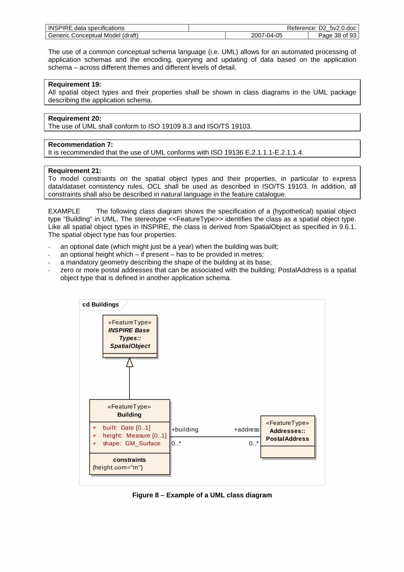
INSPIRE data specifications Reference: D2_5v2.0.docGeneric Conceptual Model (draft) 2007-04-05 Page 38 of 93
The use of a common conceptual schema language (i.e. UML) allows for an automated processing of application schemas and the encoding, querying and updating of data based on the application schema – across different themes and different levels of detail. Requirement 19: All spatial object types and their properties shall be shown in class diagrams in the UML package describing the application schema. Requirement 20: The use of UML shall conform to ISO 19109 8.3 and ISO/TS 19103. Recommendation 7: It is recommended that the use of UML conforms with ISO 19136 E.2.1.1.1-E.2.1.1.4. Requirement 21: To model constraints on the spatial object types and their properties, in particular to express data/dataset consistency rules, OCL shall be used as described in ISO/TS 19103. In addition, all constraints shall also be described in natural language in the feature catalogue. EXAMPLE The following class diagram shows the specification of a (hypothetical) spatial object type "Building" in UML. The stereotype <<FeatureType>> identifies the class as a spatial object type. Like all spatial object types in INSPIRE, the class is derived from SpatialObject as specified in 9.6.1. The spatial object type has four properties:
- an optional date (which might just be a year) when the building was built; - an optional height which – if present – has to be provided in metres; - a mandatory geometry describing the shape of the building at its base; - zero or more postal addresses that can be associated with the building; PostalAddress is a spatial
object type that is defined in another application schema.
cd Buildings
«FeatureType»Building
«FeatureType»INSPIRE Base
Types::SpatialObject
+ built: Date [0..1]+ height: Measure [0..1]+ shape: GM_Surface
constraints{height.uom="m"}
«FeatureType»Addresses::
PostalAddress+building +address
0..* 0..*
Figure 8 – Example of a UML class diagram
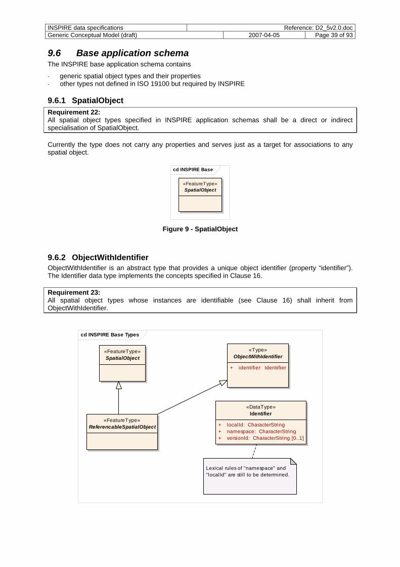
INSPIRE data specifications Reference: D2_5v2.0.docGeneric Conceptual Model (draft) 2007-04-05 Page 39 of 93
9.6 Base application schema The INSPIRE base application schema contains
- generic spatial object types and their properties - other types not defined in ISO 19100 but required by INSPIRE
9.6.1 SpatialObject Requirement 22: All spatial object types specified in INSPIRE application schemas shall be a direct or indirect specialisation of SpatialObject. Currently the type does not carry any properties and serves just as a target for associations to any spatial object.
cd INSPIRE Base
«FeatureType»SpatialObject
Figure 9 - SpatialObject
9.6.2 ObjectWithIdentifier ObjectWithIdentifier is an abstract type that provides a unique object identifier (property “identifier”). The Identifier data type implements the concepts specified in Clause 16. Requirement 23: All spatial object types whose instances are identifiable (see Clause 16) shall inherit from ObjectWithIdentifier.
cd INSPIRE Base Types
«Type»ObjectWithIdentifier
«FeatureType»SpatialObject
+ identifier: Identifier
«DataType»Identifier
«FeatureType»ReferencableSpatialObject + localId: CharacterString
+ namespace: CharacterString+ versionId: CharacterString [0..1]
Lexical rules of "namespace" and "localId" are stil l to be determined.
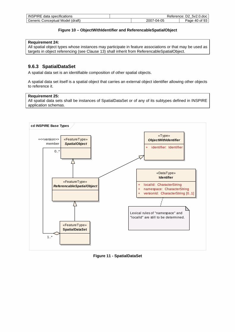
INSPIRE data specifications Reference: D2_5v2.0.docGeneric Conceptual Model (draft) 2007-04-05 Page 40 of 93
Figure 10 – ObjectWithIdentifier and ReferencableSpatialObject
Requirement 24: All spatial object types whose instances may participate in feature associations or that may be used as targets in object referencing (see Clause 13) shall inherit from ReferencableSpatialObject.
9.6.3 SpatialDataSet A spatial data set is an identifiable composition of other spatial objects. A spatial data set itself is a spatial object that carries an external object identifier allowing other objects to reference it. Requirement 25: All spatial data sets shall be instances of SpatialDataSet or of any of its subtypes defined in INSPIRE application schemas.
cd INSPIRE Base Types
«Type»ObjectWithIdentifier
+ identifier: Identifier
«DataType»Identifier
+ localId: CharacterString+ namespace: CharacterString+ versionId: CharacterString [0..1]
Lexical rules of "namespace" and "localId" are stil l to be determined.
«FeatureType»ReferencableSpatialObject
«FeatureType»SpatialDataSet
«FeatureType»SpatialObject
+<<version>>member
0..*
1..*
Figure 11 - SpatialDataSet
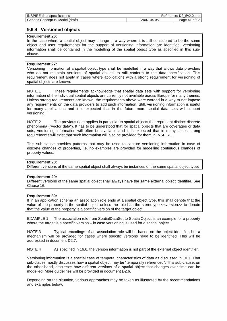
INSPIRE data specifications Reference: D2_5v2.0.docGeneric Conceptual Model (draft) 2007-04-05 Page 41 of 93
9.6.4 Versioned objects Requirement 26: In the case where a spatial object may change in a way where it is still considered to be the same object and user requirements for the support of versioning information are identified, versioning information shall be contained in the modelling of the spatial object type as specified in this sub-clause. Requirement 27: Versioning information of a spatial object type shall be modelled in a way that allows data providers who do not maintain versions of spatial objects to still conform to the data specification. This requirement does not apply in cases where applications with a strong requirement for versioning of spatial objects are known. NOTE 1 These requirements acknowledge that spatial data sets with support for versioning information of the individual spatial objects are currently not available across Europe for many themes. Unless strong requirements are known, the requirements above were worded in a way to not impose any requirements on the data providers to add such information. Still, versioning information is useful for many applications and it is expected that in the future more spatial data sets will support versioning. NOTE 2 The previous note applies in particular to spatial objects that represent distinct discrete phenomena ("vector data"). It has to be understood that for spatial objects that are coverages or data sets, versioning information will often be available and it is expected that in many cases strong requirements will exist that such information will also be provided for them in INSPIRE. This sub-clause provides patterns that may be used to capture versioning information in case of discrete changes of properties, i.e. no examples are provided for modelling continuous changes of property values. Requirement 28: Different versions of the same spatial object shall always be instances of the same spatial object type. Requirement 29: Different versions of the same spatial object shall always have the same external object identifier. See Clause 16. Requirement 30: If in an application schema an association role ends at a spatial object type, this shall denote that the value of the property is the spatial object unless the role has the stereotype <<version>> to denote that the value of the property is a specific version of the target object. EXAMPLE 1 The association role from SpatialDataSet to SpatialObject is an example for a property where the target is a specific version – in case versioning is used for a spatial object. NOTE 3 Typical encodings of an association role will be based on the object identifier, but a mechanism will be provided for cases where specific versions need to be identified. This will be addressed in document D2.7. NOTE 4 As specified in 16.6, the version information is not part of the external object identifier. Versioning information is a special case of temporal characteristics of data as discussed in 10.1. That sub-clause mostly discusses how a spatial object may be “temporally referenced”. This sub-clause, on the other hand, discusses how different versions of a spatial object that changes over time can be modelled. More guidelines will be provided in document D2.6. Depending on the situation, various approaches may be taken as illustrated by the recommendations and examples below.
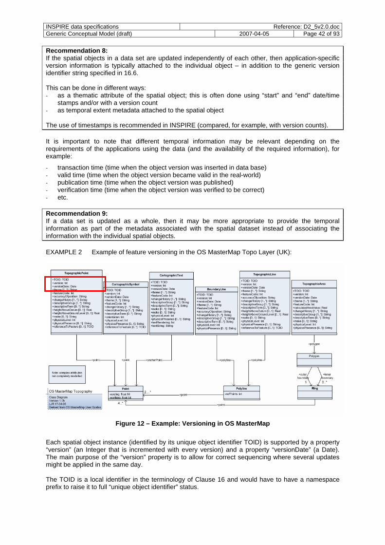
INSPIRE data specifications Reference: D2_5v2.0.docGeneric Conceptual Model (draft) 2007-04-05 Page 42 of 93
Recommendation 8: If the spatial objects in a data set are updated independently of each other, then application-specific version information is typically attached to the individual object – in addition to the generic version identifier string specified in 16.6. This can be done in different ways: - as a thematic attribute of the spatial object; this is often done using “start” and “end” date/time
stamps and/or with a version count - as temporal extent metadata attached to the spatial object The use of timestamps is recommended in INSPIRE (compared, for example, with version counts). It is important to note that different temporal information may be relevant depending on the requirements of the applications using the data (and the availability of the required information), for example:
- transaction time (time when the object version was inserted in data base) - valid time (time when the object version became valid in the real-world) - publication time (time when the object version was published) - verification time (time when the object version was verified to be correct) - etc. Recommendation 9: If a data set is updated as a whole, then it may be more appropriate to provide the temporal information as part of the metadata associated with the spatial dataset instead of associating the information with the individual spatial objects. EXAMPLE 2 Example of feature versioning in the OS MasterMap Topo Layer (UK):
Figure 12 – Example: Versioning in OS MasterMap
Each spatial object instance (identified by its unique object identifier TOID) is supported by a property “version” (an Integer that is incremented with every version) and a property “versionDate” (a Date). The main purpose of the “version” property is to allow for correct sequencing where several updates might be applied in the same day. The TOID is a local identifier in the terminology of Clause 16 and would have to have a namespace prefix to raise it to full “unique object identifier” status.
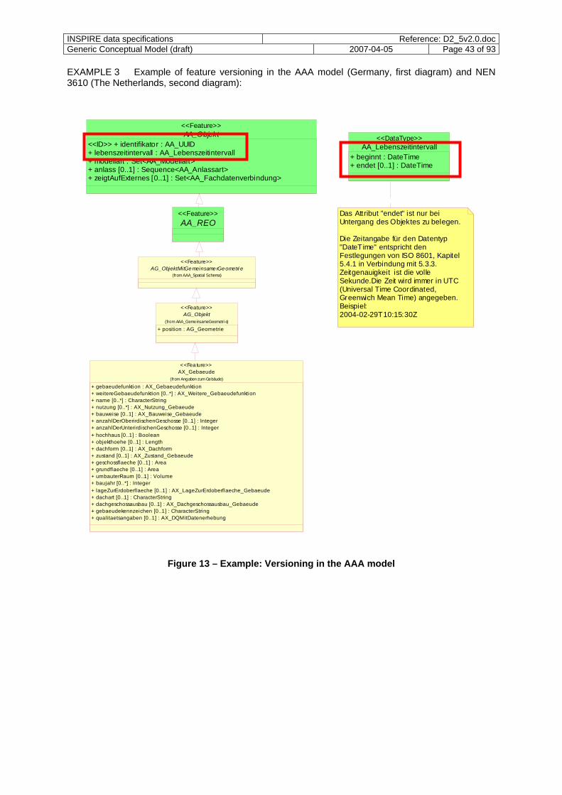
INSPIRE data specifications Reference: D2_5v2.0.docGeneric Conceptual Model (draft) 2007-04-05 Page 43 of 93
EXAMPLE 3 Example of feature versioning in the AAA model (Germany, first diagram) and NEN 3610 (The Netherlands, second diagram):
AA_Lebenszeitintervall+ beginnt : DateTime+ endet [0..1] : DateTime
<<DataType>>AA_Objekt<<ID>> + identifikator : AA_UUID+ lebenszeitintervall : AA_Lebenszeitintervall+ modellart : Set<AA_Modellart>+ anlass [0..1] : Sequence<AA_Anlassart>+ zeigtAufExternes [0..1] : Set<AA_Fachdatenverbindung>
<<Feature>>
AA_REO<<Feature>> Das Attribut "endet" ist nur bei
Untergang des Objektes zu belegen.
Die Zeitangabe für den Datentyp "DateTime" entspricht den Festlegungen von ISO 8601, Kapitel 5.4.1 in Verbindung mit 5.3.3. Zeitgenauigkeit ist die volle Sekunde.Die Zeit wird immer in UTC (Universal Time Coordinated, Greenwich Mean Time) angegeben. Beispiel:2004-02-29T10:15:30Z
AX_Gebaeude
+ gebaeudefunktion : AX_Gebaeudefunktion+ weitereGebaeudefunktion [0..*] : AX_Weitere_Gebaeudefunktion+ name [0..*] : CharacterString+ nutzung [0..*] : AX_Nutzung_Gebaeude+ bauweise [0..1] : AX_Bauweise_Gebaeude+ anzahlDerOberirdischenGeschosse [0..1] : Integer+ anzahlDerUnterirdischenGeschosse [0..1] : Integer+ hochhaus [0..1] : Boolean+ objekthoehe [0..1] : Length+ dachform [0..1] : AX_Dachform+ zustand [0..1] : AX_Zustand_Gebaeude+ geschossflaeche [0..1] : Area+ grundflaeche [0..1] : Area+ umbauterRaum [0..1] : Volume+ baujahr [0..*] : Integer+ lageZurErdoberflaeche [0..1] : AX_LageZurErdoberflaeche_Gebaeude+ dachart [0..1] : CharacterString+ dachgeschossausbau [0..1] : AX_Dachgeschossausbau_Gebaeude+ gebaeudekennzeichen [0..1] : CharacterString+ qualitaetsangaben [0..1] : AX_DQMitDatenerhebung
(from Angaben zum Gebäude)
<<Fea ture>>
AG_Objekt
+ position : AG_Geometrie(from AAA_GemeinsameGeometri e)
<<Feature>>
AG_ObjektMitGe meinsame rGe ometri e(from AAA_Spatial Schema)
<<Feature>>
Figure 13 – Example: Versioning in the AAA model
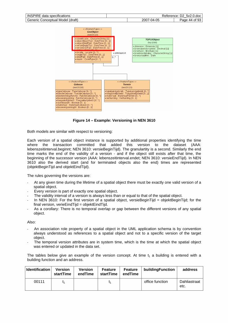
INSPIRE data specifications Reference: D2_5v2.0.docGeneric Conceptual Model (draft) 2007-04-05 Page 44 of 93
Figure 14 – Example: Versioning in NEN 3610
Both models are similar with respect to versioning: Each version of a spatial object instance is supported by additional properties identifying the time where the transaction committed that added this version to the dataset (AAA: lebenszeitinterval.beginnt; NEN 3610: versieBeginTijd). The granulartity is a second. Similarly the end time marks the end of the validity of a version - and if the object still exists after that time, the beginning of the successor version (AAA: lebenszeitinterval.endet; NEN 3610: versieEndTijd). In NEN 3610 also the derived start (and for terminated objects also the end) times are represented (objektBeginTijd and objektEindTijd). The rules governing the versions are:
- At any given time during the lifetime of a spatial object there must be exactly one valid version of a spatial object.
- Every version is part of exactly one spatial object. - The validity interval of a version is always less than or equal to that of the spatial object. - In NEN 3610: For the first version of a spatial object, versieBeginTijd = objektBeginTijd; for the
final version, verieEindTijd = objektEindTijd. - As a corollary: There is no temporal overlap or gap between the different versions of any spatial
object. Also:
- An association role property of a spatial object in the UML application schema is by convention always understood as references to a spatial object and not to a specific version of the target object.
- The temporal version attributes are in system time, which is the time at which the spatial object was entered or updated in the data set.
The tables below give an example of the version concept. At time t1 a building is entered with a building function and an address. Identification Version
startTime Version endTime
Feature startTime
Feature endTime
buildingFunction address
00111 t1 t1 office function Dahliastraat etc.
INSPIRE data specifications Reference: D2_5v2.0.docGeneric Conceptual Model (draft) 2007-04-05 Page 45 of 93
At time t2 the building is altered and acquires a residential function: Identification Version
startTime Version endTime
Feature startTime
Feature endTime
buildingFunction address
00111 t1 t2 t1 office function Dahliastraat etc.
00111 t2 t1 residential function Dahliastraat etc.
At time t3 the building is demolished and the spatial object is left with only a historical function. identification Version
startTime Version endTime
Feature startTime
Feature endTime
buildingFunction address
00111 t1 t2 t1 office function Dahliastraat etc.
00111 t2 t3 t1 t3 residential function Dahliastraat etc.
NOTE 5 In addition to the information required to differentiate two versions, additional metadata may be stored with the version, e.g. which user account was used to change the object. EXAMPLE 4 Unlike the previous examples which illustrated versioning on the object level, this examples illustrates versioning on the data set level. Currently, the typical way how information about the temporal validity and up-to-dateness of the objects in a spatial data set is provided is as part of the metadata (see D1.3, draft Implementing Rule on metadata). This information is in general provided for the whole dataset, by a spatial object type or by sub-region. An example is the metadata for the topographic ATKIS data in Germany where the up-to-dateness can also be viewed in a overview map (e.g.,http://www.geodatenzentrum.de/geodaten/gdztestload.gdztest_webmap?webmap_ueber=Aktualität%20Basis-DLM&webmap_name=metadaten/bdlm). The patterns and examples described above support versioning on the object level. In some cases, an even more fine-grained versioning approach could in principle be useful, i.e. versioning on the property level. However, since based on the reference material this is a rare case and therefore specific support for versioning of individual properties is currently not foreseen. EXAMPLE 5 The following class diagram shows a spatial object type “AdministrativeUnit” where every instance represents a version of the spatial object with the
- the unique object identifier of the spatial object; - the version identifier of the particular version (unique within the spatial object); the versionId
property has been made mandatory through a constraint; - properties to specify the begin (and, for a superseded or retired version, also the end) time of the
version; - derived properties to specify the begin (and, for retired objects, also the end) time of the spatial
object; - additional thematic and spatial properties.
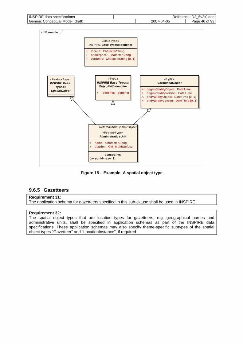
INSPIRE data specifications Reference: D2_5v2.0.docGeneric Conceptual Model (draft) 2007-04-05 Page 46 of 93
cd Example
ReferencableSpatialObject
«FeatureType»Administrativ eUnit
+ name: CharacterString+ position: GM_MultiSurface
constraints{versionId->size=1}
«Type»INSPIRE Base Types::
ObjectWithIdentifier
+ identifier: Identifier
«Type»VersionedObject
+/ beginValidityObject: DateTime+ beginValidityVersion: DateTime+/ endValidityObject: DateTime [0..1]+ endValidityVersion: DateTime [0..1]
«FeatureType»INSPIRE Base
Types::SpatialObject
«DataType»INSPIRE Base Types::Identifier
+ localId: CharacterString+ namespace: CharacterString+ versionId: CharacterString [0..1]
Figure 15 – Example: A spatial object type
9.6.5 Gazetteers Requirement 31: The application schema for gazetteers specified in this sub-clause shall be used in INSPIRE. Requirement 32: The spatial object types that are location types for gazetteers, e.g. geographical names and administrative units, shall be specified in application schemas as part of the INSPIRE data specifications. These application schemas may also specify theme-specific subtypes of the spatial object types "Gazetteer" and "LocationInstance", if required.
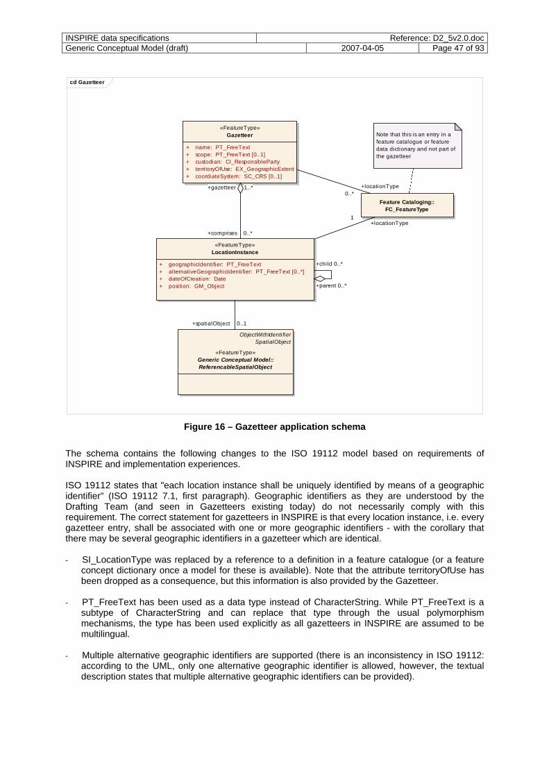
INSPIRE data specifications Reference: D2_5v2.0.docGeneric Conceptual Model (draft) 2007-04-05 Page 47 of 93
cd Gazetteer
«FeatureType»Gazetteer Note that this is an entry in a
feature catalogue or feature data dictionary and not part of the gazetteer
+ name: PT_FreeText+ scope: PT_FreeText [0..1]+ custodian: CI_ResponsibleParty+ territoryOfUse: EX_GeographicExtent+ coordiateSystem: SC_CRS [0..1]
«FeatureType»LocationInstance
+ geographicIdentifier: PT_FreeText+ alternativeGeographicIdentifier: PT_FreeText [0..*]+ dateOfCreation: Date+ position: GM_Object
+locationType
Feature Cataloging::FC_FeatureType
ObjectWithIdentifierSpatialObject
«FeatureType»Generic Conceptual Model::ReferencableSpatialObject
+spatialObject 0..1
+comprises 0..*
+gazetteer 1..*0..*
1+locationType
+child 0..*
+parent 0..*
Figure 16 – Gazetteer application schema
The schema contains the following changes to the ISO 19112 model based on requirements of INSPIRE and implementation experiences. ISO 19112 states that "each location instance shall be uniquely identified by means of a geographic identifier" (ISO 19112 7.1, first paragraph). Geographic identifiers as they are understood by the Drafting Team (and seen in Gazetteers existing today) do not necessarily comply with this requirement. The correct statement for gazetteers in INSPIRE is that every location instance, i.e. every gazetteer entry, shall be associated with one or more geographic identifiers - with the corollary that there may be several geographic identifiers in a gazetteer which are identical. - SI_LocationType was replaced by a reference to a definition in a feature catalogue (or a feature
concept dictionary once a model for these is available). Note that the attribute territoryOfUse has been dropped as a consequence, but this information is also provided by the Gazetteer.
- PT_FreeText has been used as a data type instead of CharacterString. While PT_FreeText is a
subtype of CharacterString and can replace that type through the usual polymorphism mechanisms, the type has been used explicitly as all gazetteers in INSPIRE are assumed to be multilingual.
- Multiple alternative geographic identifiers are supported (there is an inconsistency in ISO 19112:
according to the UML, only one alternative geographic identifier is allowed, however, the textual description states that multiple alternative geographic identifiers can be provided).
INSPIRE data specifications Reference: D2_5v2.0.docGeneric Conceptual Model (draft) 2007-04-05 Page 48 of 93
- Since the temporal extent is specified in ISO 19112 as “the date of creation of this version of the location instance”, a more appropriate data type and attribute name are used.
- ISO 19112 specifies that the geographic extent shall be defined in one of the following ways:
either as a collection of smaller spatial objects (for example the European Union, defined by its constituent countries) or by a bounding polygon. However, the data type EX_GeographicExtent is not appropriate for this as it does not support the first method while it supports additional methods that are not allowed (a rough bounding box or a geographic identifier).
At the same time the position attribute is restricted to a point. However, in INSPIRE it is expected that the positions/extents of locations are described by either points, curves, surfaces or even solids (or aggregates of these). Therefore, the attribute geographic extent has been dropped and position is of type GM_Object.
- The information about the location is one piece of information to be derived from a gazetteer. Another piece of information that is considered important in INSPIRE is the reference to a spatial object that is associated with the location. An association has been added to allow representing such information in an INSPIRE gazetteer.
NOTE This also allows the position attribute to be derived on demand (see the sub-clause on object referencing, 13). For example, the EuroGeoNames project will head in the same direction: coordinates are no longer stored (duplicated) in the gazetteer, but are referenced to and maintained in the national reference data set(s), at various scales.
- The attributes of Gazetteer (i.e. name, custodian, scope) could be represented by references to
registry entries.
9.6.6 Void The following values are pre-defined reasons for void values. INSPIRE application schemas may extend this codelist, if required. - Unpopulated
This value is used when the information about the property value exists, but is not available to the data producer. ‘Unpopulated’ is normally used for a group of objects in a spatial data set, not for single objects. Its usage should be documented in the metadata of the data set. Data producers should avoid this reason when the relevant property is mandatory. It may be used in the case of optional properties.
- Unknown
This value is used when it is not possible to determine the value of a property of a spatial object. For example when the “elevation of the water body above the sea level” of a certain lake has not been measured, then the reason for a void value of this property would be unknown. ‘Unknown’ is used normally on an object-by-object basis in a spatial data set.
- Not applicable
This value is used in the case where the property value does not really exist for that spatial object. This could be the case for the naming of small islands or lakes.
- No value
This value means that no value for the property may logically be provided for a spatial object, even if the property is part of the definition of the object according to the application schema. This
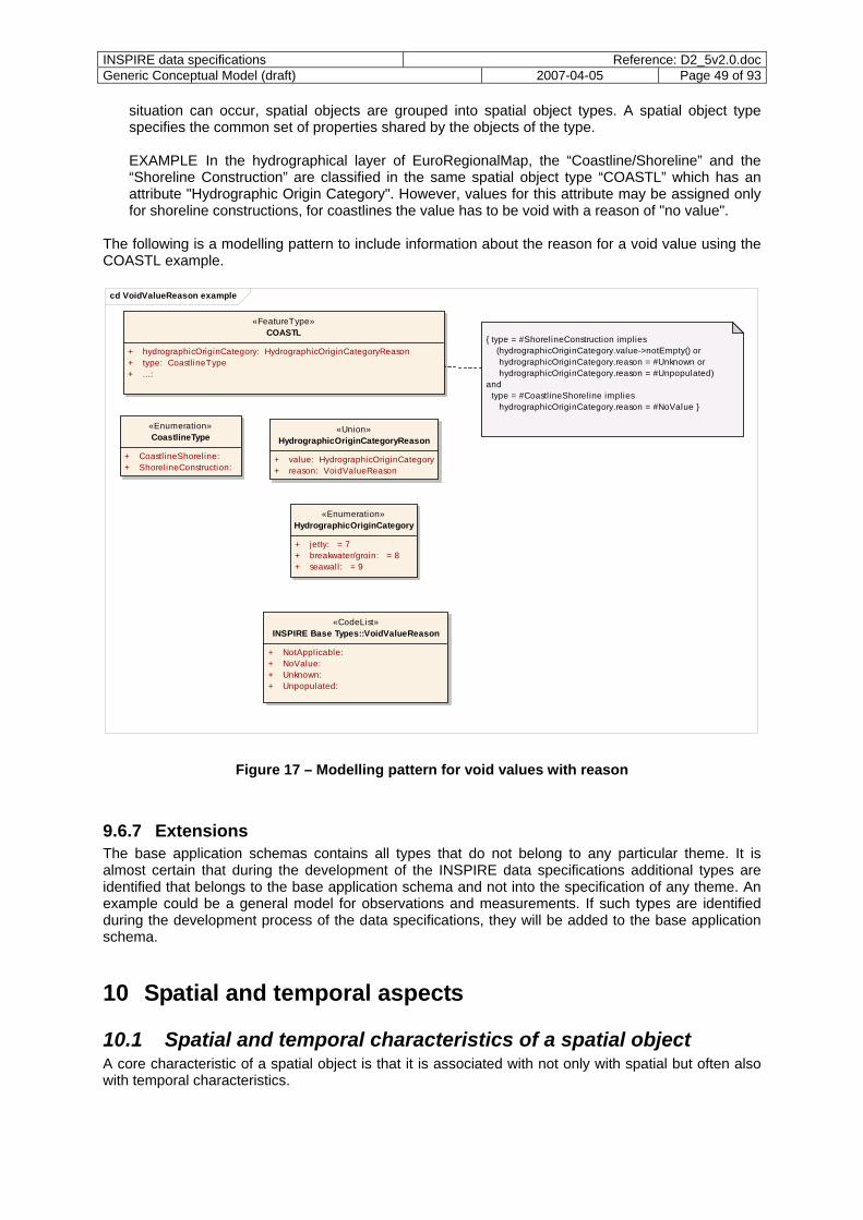
INSPIRE data specifications Reference: D2_5v2.0.docGeneric Conceptual Model (draft) 2007-04-05 Page 49 of 93
situation can occur, spatial objects are grouped into spatial object types. A spatial object type specifies the common set of properties shared by the objects of the type. EXAMPLE In the hydrographical layer of EuroRegionalMap, the “Coastline/Shoreline” and the “Shoreline Construction” are classified in the same spatial object type “COASTL” which has an attribute "Hydrographic Origin Category". However, values for this attribute may be assigned only for shoreline constructions, for coastlines the value has to be void with a reason of "no value".
The following is a modelling pattern to include information about the reason for a void value using the COASTL example.
cd VoidValueReason example
«CodeList»INSPIRE Base Types::VoidValueReason
«FeatureType»COASTL
{ type = #ShorelineConstruction implies (hydrographicOriginCategory.value->notEmpty() or hydrographicOriginCategory.reason = #Unknown or hydrographicOriginCategory.reason = #Unpopulated) and type = #CoastlineShoreline implies hydrographicOriginCategory.reason = #NoValue }
+ hydrographicOriginCategory: HydrographicOriginCategoryReason+ type: CoastlineType+ ...:
«Enumeration»CoastlineType
«Union»HydrographicOriginCategoryReason
+ CoastlineShoreline: + ShorelineConstruction:
+ value: HydrographicOriginCategory+ reason: VoidValueReason
«Enumeration»HydrographicOriginCategory
+ jetty: = 7+ breakwater/groin: = 8+ seawall: = 9
+ NotApplicable: + NoValue: + Unknown: + Unpopulated:
Figure 17 – Modelling pattern for void values with reason
9.6.7 Extensions The base application schemas contains all types that do not belong to any particular theme. It is almost certain that during the development of the INSPIRE data specifications additional types are identified that belongs to the base application schema and not into the specification of any theme. An example could be a general model for observations and measurements. If such types are identified during the development process of the data specifications, they will be added to the base application schema.
10 Spatial and temporal aspects
10.1 Spatial and temporal characteristics of a spatial object A core characteristic of a spatial object is that it is associated with not only with spatial but often also with temporal characteristics.
INSPIRE data specifications Reference: D2_5v2.0.docGeneric Conceptual Model (draft) 2007-04-05 Page 50 of 93
All spatial and temporal characteristics are directly or indirectly associated with a reference system describing the interpretation of, for example, coordinate values. This is essential to enabling services (e.g., a download service supporting spatial queries with access to coordinate transformation services) or other software applications to relating different spatial objects to each other – spatially and temporally. Requirement 33: Spatial characteristics of a spatial object shall be expressed in an application schema in one of the following ways depending on the requirements: - by specifying properties of the spatial object type with a value that is a spatial geometry or a
topology (see ISO 19109 8.7) - by specifying properties of the spatial object type with a value that is a geographic identifier in a
gazetteer (see 9.6.5 and ISO 19109 8.9) - by specifying spatial object types that are coverages (see 10.4) - by specifying references to other spatial objects (see Clause 13) Requirement 34: Temporal characteristics of a spatial object shall be expressed in an application schema in one of the following ways depending on the requirements: - by specifying properties of the spatial object type with a value that is a temporal geometry or a
temporal topology (see ISO 19109 8.6; note that time is a dimension analogous to any of the spatial dimensions and that time, like space, has geometry and topology);
- by specifying properties of the spatial object type with a value that is one of the basic types Date, DateTime and Time. However, this makes the attribute a “thematic attribute” instead of a “temporal attribute” in terms of the General Feature Model, as there is no temporal reference system connected to them (see note in ISO 19109 8.6.1). As a result, using this method is only allowed if these properties are not intended to relate two spatial objects temporally based on the values of this property. The Gregorian calendar shall be the default calendar, UTC the default time zone.
NOTE Time is a dimension analogous to any of the spatial dimensions. Like space, time has geometry and topology. A point in time occupies a position that can be identified in relation to a temporal reference system. Unlike space, however, time has a single dimension. See ISO 19108 5.2 for details. EXAMPLE 1 A time period is the 1-dimensional primitive of temporal geometry. When modelling temporal characteristics, it is important to take the diversity of temporal aspects into account that may be relevant to an individual spatial object. A special case are temporal characteristics that are relevant to distinguish different versions of the same spatial object, see 9.6.4. EXAMPLE 2 In meteorological simulations there are a number of temporal aspects that need to be considered:
- In numerical meteorological/ocean/climate simulation models, the time axis is not always based on a Gregorian calendar - e.g. a 360-day calendar of 30-day months is often used in climate models. A projection onto a Gregorian calendar may be possible, though not always straightforward.
- Other times associated with a numerical simulation, e.g. weather forecast (note all these times are with respect to the real Gregorian calendar and not the simulation calendar):
o datumTime: the initial (origin) time of the simulation o creationTime: time at which the simulation was executed o issueTime: time at which the results were published/issued o verificationTime: time at which the simulation should be verified, sometimes called
the validTime (e.g. a forecast may be for 'tomorrow midday') o validUsagePeriod: a period of time within which the simulation results should be
used; encompasses the verificationTime
INSPIRE data specifications Reference: D2_5v2.0.docGeneric Conceptual Model (draft) 2007-04-05 Page 51 of 93
- A forecast is a simulation where the verificationTime is in the future while a hindcast is a simulation where the verificationTime is in the past.
The crucial times in this example are the datumTime and the verificationTime. So there is the familiar situation of having successive forecasts for a specific time, say 06:00 (GMT), Thursday August 10 2006. (These might be regarded as different versions of a forecast dataset.) Normally, a weather forecast will extend out to between five and ten days ahead, and will be reissued each twelve hours. A different approach instead of treating spatial and temporal characteristics as separate would have been to specify a model for spatio-temporal characteristics. The ISO 19100 series, however, currently do not provide support for such models. However, in practice, assigning temporal characteristics to a spatial object or a spatial property is typically insufficient for atmospheric/oceanic models, and spatio-temporal characteristics need to be modelled as such. Other application examples for spatio-temporal characteristics are topography changes over time or town-planning analysis of urban growth.
10.2 Profile of the spatial schema Geometry and topology types as specified in ISO 19107 may be used in an INSPIRE application schema without restrictions. NOTE 1 In order to determine the feasibility of any restrictions, a SDIC/LMO on-line survey has been published at the same time as this document in http://www.ec-gis.org/inspire/gtt/survey.php Recommendation 10: The value domain of spatial properties should be restricted to the Simple Feature spatial schema as defined by OGC document 06-103r3 (Implementation Specification for Geographic Information - Simple feature access - Part 1: Common Architecture v1.2.0) whenever feasible. The specification restricts the spatial schema to 0-, 1-, 2-, and 2.5-dimensional geometries where all curve interpolations are linear. NOTE 2 The topological relations of two spatial objects based on their specific geometry and topology properties can in principle be investigated by invoking the operations of the types defined in ISO 19107 (or the methods specified in OGC 06-103r3).
10.3 Profile of the temporal schema Temporal geometry and topology types as specified in ISO 19108 may be used in an INSPIRE application schema without restrictions. NOTE 1 In order to determine the feasibility of any restrictions, a SDIC/LMO on-line survey has been published at the same time as this document in http://www.ec-gis.org/inspire/gtt/survey.php NOTE 2 The temporal relationship of two temporal objects based on specific geometry and topology properties of the objects can in principle be investigated by invoking the operations of the types defined in ISO 19108. However, ISO 19108 does not allow for a computation of relationships between two temporal objects where one of the objects is indeterminate such as “now”, whereas a real time datasets containing data for the last 3 days until "now" has a practical application and a length/duration.
10.4 Rules for use of coverages Coverages are used to describe real-world phenomena that vary over space and/or time. Typical examples are temperature, elevation, precipitation, imagery. A coverage contains a set of such values, each associated with one of the elements in a spatial, temporal or spatiotemporal domain. Typical spatial domains are point sets (e.g. sensor locations), curve sets (e.g. contour lines), grids (e.g. orthoimages, elevation models), etc. A coverage is usually associated with a method for interpolating values at spatial positions between the elements of a domain, e.g. between two points or contour lines.
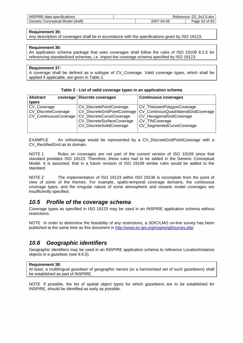
INSPIRE data specifications Reference: D2_5v2.0.docGeneric Conceptual Model (draft) 2007-04-05 Page 52 of 93
Requirement 35: Any description of coverages shall be in accordance with the specifications given by ISO 19123. Requirement 36: An application schema package that uses coverages shall follow the rules of ISO 19109 8.2.5 for referencing standardized schemas, i.e. import the coverage schema specified by ISO 19123. Requirement 37: A coverage shall be defined as a subtype of CV_Coverage. Valid coverage types, which shall be applied if applicable, are given in Table 2.
Table 2 - List of valid coverage types in an application schema
Abstract coverage types
Discrete coverages Continuous coverages
CV_Coverage CV_DiscreteCoverage CV_ContinuousCoverage
CV_DiscretePointCoverage CV_DiscreteGridPointCoverageCV_DiscreteCurveCoverage CV_DiscreteSurfaceCoverage CV_DiscreteSolidCoverage
CV_ThiessenPolygonCoverage CV_ContinousQuadrilateralGridCoverageCV_HexagonalGridCoverage CV_TINCoverage CV_SegmentedCurveCoverage
EXAMPLE An orthoimage would be represented by a CV_DiscreteGridPointCoverage with a CV_RectifiedGrid as its domain. NOTE 1 Rules on coverages are not part of the current version of ISO 19109 since that standard predates ISO 19123. Therefore, these rules had to be added in the Generic Conceptual Model. It is assumed, that in a future revision of ISO 19109 similar rules would be added to the standard. NOTE 2 The implementation of ISO 19123 within ISO 19136 is incomplete from the point of view of some of the themes. For example, spatio-temporal coverage domains, the continuous coverage types, and the irregular nature of some atmospheric and oceanic model coverages are insufficiently specified.
10.5 Profile of the coverage schema Coverage types as specified in ISO 19123 may be used in an INSPIRE application schema without restrictions. NOTE In order to determine the feasibility of any restrictions, a SDIC/LMO on-line survey has been published at the same time as this document in http://www.ec-gis.org/inspire/gtt/survey.php
10.6 Geographic identifiers Geographic identifiers may be used in an INSPIRE application schema to reference LocationInstance objects in a gazetteer (see 9.6.5). Requirement 38: At least, a multilingual gazetteer of geographic names (or a harmonised set of such gazetteers) shall be established as part of INSPIRE. NOTE If possible, the list of spatial object types for which gazetteers are to be established for INSPIRE, should be identified as early as possible.

INSPIRE data specifications Reference: D2_5v2.0.docGeneric Conceptual Model (draft) 2007-04-05 Page 53 of 93
11 Multi-lingual text and cultural adaptability
11.1 Multilingual and multicultural requirements Requirement 39: For all geographical names and exonyms the support for multilingual text shall be considered. Requirement 40: Geographical names shall not be translated. Only exonyms should be used, if any. EXAMPLE The name of the German city “Neu-Ulm” in French will still be “Neu-Ulm” and not “Nouveau-Ulm” (translation). However, “London” will become “Londres” in French (exonym). Recommendation 11: Exonyms should in general be maintained only for very important features on a European scale (e.g. those on a small or middle scale database). Requirement 41: There shall not be a limitation to the number of names in different languages for one spatial object. EXAMPLE 1 Names of cities (e.g. "Bruxelles", "Brussel", "Brussels", "Brüssel", etc.) or other spatial object names in a multilingual area ("Brussel-Zuid", "Bruxelles-Midi"). Requirement 42: The types specified in 11.2 shall be used in application schemas whenever the value of a property is linguistic text, i.e. text in one or more languages. Requirement 43: Mixing different languages in a single character string is not allowed. Requirement 44: Free text attributes in application schemas shall be avoided as far as possible; the use of controlled lists and thesauri is recommended whenever possible. NOTE 1 It will not be possible to avoid free texts completely (e.g. in addresses). Requirement 45: Object properties which are linguistic text shall be analysed, if the property needs to support a single language text or if the property is of 'multilingual' interest. NOTE 2 As prCEN/TR 15449 points out, “the solution to multi-lingual issues is not the translation of everything into a common language (e.g., English). Often, it is sufficient to obtain resources in their original production language, rather than in its translated version.” An example may be textual descriptions of a feature. However, in order to find spatial objects, certain service interfaces, portals or client applications should support translation capabilities. Requirement 46: Codelists in INSPIRE application schemas shall be multi-lingual and use short names for every entry in the codelist. EXAMPLE 2 A building feature may have a property specifying the usage of the building. The codelist values are maintained in a multilingual dictionary, so that the correct text value can be selected from the dictionary based on the codelist value ("Rathaus", "hôtel de ville", "Stadhuis", etc.) EXAMPLE 3 To denote a security classification with the meaning “kept or meant to be kept private, unknown, or hidden from all but a select group of people”, ISO 19115 specifies a short name (“secret”) and a numeric code (“005”).
INSPIRE data specifications Reference: D2_5v2.0.docGeneric Conceptual Model (draft) 2007-04-05 Page 54 of 93
Not all terms may be translatable from one language to another, and even in the same language different disciplinary communities may interpret the same word very differently. For example, computer scientists and psychologists would attach very different meanings to the word “schema”. Ontologies may in principle be used to help capturing multi-cultural aspects, but they must be rich enough to include the contextual information necessary for different communities to reach a shared understanding. The development of such ontologies is not within the scope of INSPIRE in its first version. Therefore, no formal requirements how cultural differences are to be taken into account when modelling an INSPIRE application schema will be specified. Requirement 47: In an INSPIRE application schema, English shall be used for class, attribute and association role names throughout the UML model.
11.2 Multilingual extensions
11.2.1 Multilingual text In the context of application schema, multilingual aspects are crucial with geographical names and spatial object and attribute classifications (feature catalogues, feature concept dictionaries, codelist values). Requirement 48: PT_FreeText from the conceptual model specified in ISO/TS 19139 shall be used as the data type for multilingual text and LocalisedCharacterString for linguistic text. LocalisedCharacterString is a character string with a locale. A locale is a combination of language, potentially a country, and a character encoding (i.e., character set) in which localised character strings are expressed. NOTE While these types have been developed in the context of metadata, in principle they should be basic data types (and belong in ISO/TS 19103 instead of ISO/TS 19139). Recommendation 12: It is recommended that in implementations the locale is directly associated with the text to facilitate language-dependent searches.
11.2.2 Multilingual feature concept dictionaries Feature concept dictionaries that conform to ISO 19126 are multilingual, i.e. there are no additional requirements.
11.2.3 Multilingual feature catalogues Feature catalogues modelled that conform to ISO 19110 Amd1 are multilingual, i.e. there are no additional requirements.
11.2.4 Other multilingual dictionaries Requirement 49: The conceptual model for multilingual dictionaries for coordinate reference systems, units of measurement, and codelists shall use the conceptual model for such dictionaries specified in ISO/TS 19139.
INSPIRE data specifications Reference: D2_5v2.0.docGeneric Conceptual Model (draft) 2007-04-05 Page 55 of 93
12 Coordinate referencing and units of measurement model
12.1 Overview This clause specifies the application schema of the first two themes in Annex I of the INSPIRE Directive: 1. Coordinate reference systems: Systems for uniquely referencing spatial information in space as a
set of coordinates (x,y,z) and/or latitude and longitude and height, based on a geodetic horizontal and vertical datum. See 12.2.
2. Geographical grid system: Harmonised multi-resolution grid with a common point of origin and
standardised location and size of grid cells. See 12.5.
In addition, the conceptual schemas for temporal reference systems and units of measurements, which are also required, are specified in 12.3 and 12.4.
12.2 Spatial coordinate reference systems and coordinate operations
Requirement 50: Spatial coordinate reference systems shall be described using the current revision of ISO 19111 where the spatial reference system falls within the scope of ISO 19111. It is known that ISO 19111 is not sufficient for some spatial reference systems that are frequently used:
- The meteorological/marine domain often uses data on spectral (e.g. spherical harmonics) coordinate reference system. Similarly, vertical coordinate reference systems are usually not length-based (e.g. instead based on pressure). A work item for such extensions has recently been added to the work programme of ISO/TC 211.
- Similarly, linear reference systems are used, for example, in the transportation domain. A work item for such extensions has recently been added to the work programme of ISO/TC 211.
Requirement 51: To support the ESDI, an ISO 19135 conformant register and registry for spatial reference systems and transformations between the systems shall be established as part of INSPIRE. Requirement 52: The register shall at least contain reference systems that are valid across Europe. The EUREF list of coordinate reference systems (see Clause 2) shall be part of the starting set of the register. NOTE The Surveying & Positioning Committee of the International Association of the Oil & Gas Producers (OGP) publishes the EPSG Geodetic Parameter Dataset and which is a commonly used register of coordinate references systems and related resources. This dataset may be used as a source for additional coordinate reference systems where needed. Requirement 53: Every INSPIRE data specification shall specify the list of coordinate reference systems that may be used in the encoding of spatial objects defined by that data specification.
INSPIRE data specifications Reference: D2_5v2.0.docGeneric Conceptual Model (draft) 2007-04-05 Page 56 of 93
Recommendation 13: For horizontal coordinates, whenever possible, the list of coordinate reference systems should be restricted to one of the following pan-European coordinate reference systems, all with Datum ETRS89:
- geodetic CRS with geodetic coordinates - geodetic CRS with 3D cartesian coordinates - projected CRS in European Lambert Conformal Conic Projection - projected CRS in European Transverse Mercator Projection (one CRS per zone) - projected CRS in European Lambert Azimuthal Equal Area Projection Recommendation 14: For vertical coordinates, whenever possible, the list of coordinate reference systems should be restricted to one of the following pan-European coordinate reference systems, all with Datum EVRF2000:
- normal heights of the UELN_95/98 - geopotential numbers of the UELN_95/98 Requirement 54: Every INSPIRE data specification shall specify the list of reference systems that may be used to query spatial objects defined by that data specification in a request to a download service.
12.3 Temporal reference systems Requirement 55: Temporal reference systems shall be described using the model specified in ISO 19108 5.3 (TM_ReferenceSystem). NOTE The relationship of temporal and spatial reference systems was discussed in the Editing Committee of the current revision of ISO 19111. There, it was agreed that the scope of ISO 19111 should be limited to spatial referencing by coordinates, except that a compound coordinate reference system may include a temporal coordinate reference system. It was assumed that ISO 19108 will be amended to change TM_TemporalCoordinateSystem as currently specified in ISO 19108 to TM_TemporalCoordinateReferenceSystem. Since ISO 19108 has not yet been amended, this type is currently specified in ISO 19136 D.3.10 to provide a temporary home. Requirement 56: To support the ESDI, an ISO 19135 conformant register and registry for temporal reference systems and conversions between the systems shall be established as part of INSPIRE. Requirement 57: The register shall contain as the base temporal coordinate reference system the current calendar (with support for the different time zones). INSPIRE data specifications shall define their required additional reference systems, if any. Requirement 58: Every INSPIRE data specification shall specify the list of temporal reference systems that may be used in the encoding of spatial objects defined by that data specification. Recommendation 15: Whenever possible and appropriate, the Gregorian calendar should be used as the temporal reference system.
INSPIRE data specifications Reference: D2_5v2.0.docGeneric Conceptual Model (draft) 2007-04-05 Page 57 of 93
12.4 Units of measurement Requirement 59: Units of measurements shall be described using the model contained in ISO 19136 D.3.15. Recommendation 16: Where feasible, property values of a spatial object type that are measures should use require the use of the same unit (e.g. metres) for all instances to simplify processing of data. Recommendation 17: In principle, the use of SI units is recommended. Where this is not feasible due to different practice in the member states, the unit associated with a specific property type may be kept open (e.g. metres, feet, centimetres, etc. would all be allowed) and user applications will have to convert these values, if different units are used. This should be avoided if possible. Requirement 60: To support the ESDI, an ISO 19135 conformant register and registry for units and conversions for commonly used units shall be established as part of INSPIRE. Requirement 61: Every unit that may be used in spatial data sets shall be registered during the development of the INSPIRE data specifications.
12.5 Geographical grid systems The 2003 JRC Workshop on European Reference Grids adopted the following definition for geographical grids: "A grid for representing thematic information is a system of regular and geo-referenced cells, with a specified shape and size, and an associated property." NOTE Thus a geographical grid - as recommended by the Workshop - is also an ISO 19123 coverage, restricted to a CV_RectifiedGrid domain. Recommendation 18: The following geographical grid system (based on the proposal in the document “European Reference Grids”, volume EUR 21494 EN, published by JRC, online available at http://gi-gis.jrc.it/publist/annoni2005eurgrids.pdf, see Clause 2) should be used whenever possible and appropriate for gridded spatial data:
- The coordinate reference system is a projected CRS with datum ETRS89 in European Lambert Azimuthal Equal Area projection using a metric coordinate system; the projection is centred on N 52°, E 10°.
- Grids are rectified grids of dimension 2. - The first grid axis is in direction east (axis name: "E"), the second grid axis is direction north (axis
name: "N"). - The cell size is any of the following: 1x1m, 2.5x2.5m, 5x5m, 10x10m, 25x25m, 50x50m,
100x100m, 250x250m, 500x500m, 1x1km, 2.5x2.5km, 5x5km, 10x10km, 25x25km, 50x50km, 100x100km, 250x250km, 500x500km, 1000x1000km (i.e. using a power of 10 with two quad tree subdivisions).
- The origin of a grid is at a direct position where each ordinate value divides evenly by the cell spacing. For example, the coordinates (578100,436200) may be used as the origin of grids with cell sizes 1x1m, 2.5x2.5m, 5x5m, 10x10m, 25x25m, 50x50m, and 100x100m, but none of the other grid cell sizes.
Such coverages shall be instances of the spatial object type CV_DiscreteGridPointCoverage. The grid itself shall be a CV_RectifiedGrid.

INSPIRE data specifications Reference: D2_5v2.0.docGeneric Conceptual Model (draft) 2007-04-05 Page 58 of 93
The recommendation above applies only to data where such grids are appropriate. Other types of gridded coverages are needed by some of the themes, too, for example coverages based on a referencable grid (CV_ReferencableGrid in ISO 19123) and/or a different domain than the horizontal surface of the earth. Requirement 62: Every INSPIRE data specification that specifies gridded coverages shall specify the geographical grids that may be used in the encoding of spatial objects defined by that data specification. Requirement 63: The coordinate reference system used in any grid shall be registered in the INSPIRE coordinate reference system register. A geographical grid typically uses a matrix of n x m cells spanned by 2 axes. As a result, a grid cell can be referenced by a sequence of integer values (one for each axis) that represent the position of the reference cell along each of the axes of the grid. See CV_GridCoordinates as specified in ISO 19123.
13 Modelling object references
13.1 Overview Object referencing addresses how information is spatially or temporally referenced to existing objects, typically topographic objects, rather than directly via coordinates. In turn it is also possible to reuse the referenced object by a third party. For example a road centreline might reference the base topographic objects maintained by a different organisation. In turn a third party might then reference their own application view eg highways maintenance programme to the centreline network and so on. A recommendation is specified in 13.3 how the spatial characteristics of a spatial object can be based on already existing spatial objects. As a result, the generation and maintenance of application-specific “user geographies” based on reference data can be supported. All examples in this clause use object referencing in a spatial context. However, the same guidelines apply as well to object referencing in a temporal context. The aim is to promote the easy and reliable exchange of application level data (e.g. river quality sample records) across several users who use an agreed common base dataset of spatial objects, thus avoiding spatial inconsistencies, data duplication and frequent high volume data transfers to support regular reporting commitments. Object referencing significantly enables improvements in data integrity and reliability. NOTE The object referencing topic has proven to be a complex subject, in particular because the use of object referencing is not widespread today. Most spatial data sets today are data sets that are self-contained; even in cases where geometries are reused from other spatial objects in other datasets, these geometries are often copied instead of referenced usually. The reasons have not been analysed in detail, but the following issues are understood to contribute to this:
- GIS tools provide better support for self-contained data sets and spatial objects, - limited availability of reference objects via reliable network services, - more complex life-cycle management, and - performance concerns.
To some extent, this is similar to the changes from self-contained documents to a document web connected by hyperlinks. As discussed below, the data harmonisation component "principles" can be understood as encouraging the use of object referencing. Therefore, this document does not contain any mandatory requirements on this subject at this time, but it is kept in the document as it provides recommendations. In addition, further feedback about the approach taken on this topic is solicited.

INSPIRE data specifications Reference: D2_5v2.0.docGeneric Conceptual Model (draft) 2007-04-05 Page 59 of 93
13.2 Requirements
13.2.1 Overview The INSPIRE Directive does not refer to this topic directly. However, there are requirements in INSPIRE where object referencing is an essential or at least useful methodology, namely: Article 7(4): "Implementing rules […] shall cover […] the way in which […] spatial data are geo-referenced." Article 8(3): "The implementing rules shall be designed to ensure consistency between items of information which refer to the same location […]." The principles in recital (6): - "[…] that spatial data are stored, made available and maintained at the most appropriate level; - that it is possible to combine spatial data from different sources across the Community in a
consistent way and share them between several users and applications; - that it is possible for spatial data collected at one level of public authority to be shared between
other public authorities […]." EXAMPLE In the UK, the Dudley Metropolitan Borough Council needed to share and integrate data held in disparate application databases while maintaining a corporate data system. As a result, data in spatial applications was associated to a single geometry database source, converting their existing polygon datasets to associate with spatial objects in the OS MasterMap dataset that is provided by the Ordnance Survey. Incomplete conversions were addressed separately to complete the data association. As a by-product, the process eliminated positional accuracy issues. This is because an application data boundary now refers to the unique object identifiers used in the OS MasterMap for its geography, if the base object is moved, the (coterminous) boundary can move as well. From the guidance documents of INSPIRE and the available reference material the following requirements have been identified related to this topic:
- referencing spatial objects in a way that allows to find and retrieve them in the ESDI; - building spatial objects based on reference data; - enabling harmonised gazetteer services, e.g., to make search of data easier. The different requirements are discussed in the following sub-clauses.
13.2.2 Referencing a spatial object in the ESDI The typical way to reference another spatial object is to reference it by means of the external identifier of the referenced spatial object. EXAMPLE 1 In Germany, spatial objects in datasets of the mapping agencies are in general referenced by means of its unique identifier. URNs are used to create a true unique identifier from the local identifier. In the GML encoding, this is expressed as follows:
<Building gml:id="DEXX123412345678"> <!-- some properties --> <owner xlink:href="urn:adv:oid:DEXX12341234abcd"/> <!-- more properties --> </Building> <Person gml:id="DEXX12341234abcd"> <!-- some properties --> </Person>
It is expected that in D2.7 URNs will be used to encode unique identifiers including the namespace and the local identifier part. Using the proposed INSPIRE register for identifier namespaces which
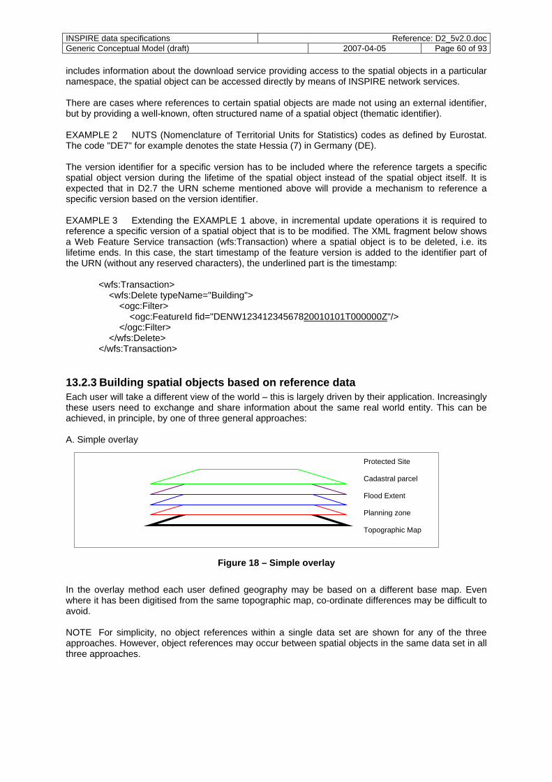
INSPIRE data specifications Reference: D2_5v2.0.docGeneric Conceptual Model (draft) 2007-04-05 Page 60 of 93
includes information about the download service providing access to the spatial objects in a particular namespace, the spatial object can be accessed directly by means of INSPIRE network services. There are cases where references to certain spatial objects are made not using an external identifier, but by providing a well-known, often structured name of a spatial object (thematic identifier). EXAMPLE 2 NUTS (Nomenclature of Territorial Units for Statistics) codes as defined by Eurostat. The code "DE7" for example denotes the state Hessia (7) in Germany (DE). The version identifier for a specific version has to be included where the reference targets a specific spatial object version during the lifetime of the spatial object instead of the spatial object itself. It is expected that in D2.7 the URN scheme mentioned above will provide a mechanism to reference a specific version based on the version identifier. EXAMPLE 3 Extending the EXAMPLE 1 above, in incremental update operations it is required to reference a specific version of a spatial object that is to be modified. The XML fragment below shows a Web Feature Service transaction (wfs:Transaction) where a spatial object is to be deleted, i.e. its lifetime ends. In this case, the start timestamp of the feature version is added to the identifier part of the URN (without any reserved characters), the underlined part is the timestamp:
<wfs:Transaction> <wfs:Delete typeName="Building"> <ogc:Filter> <ogc:FeatureId fid="DENW12341234567820010101T000000Z"/> </ogc:Filter> </wfs:Delete> </wfs:Transaction>
13.2.3 Building spatial objects based on reference data Each user will take a different view of the world – this is largely driven by their application. Increasingly these users need to exchange and share information about the same real world entity. This can be achieved, in principle, by one of three general approaches: A. Simple overlay
Protected Site Cadastral parcel Flood Extent Planning zone Topographic Map
Figure 18 – Simple overlay
In the overlay method each user defined geography may be based on a different base map. Even where it has been digitised from the same topographic map, co-ordinate differences may be difficult to avoid. NOTE For simplicity, no object references within a single data set are shown for any of the three approaches. However, object references may occur between spatial objects in the same data set in all three approaches.
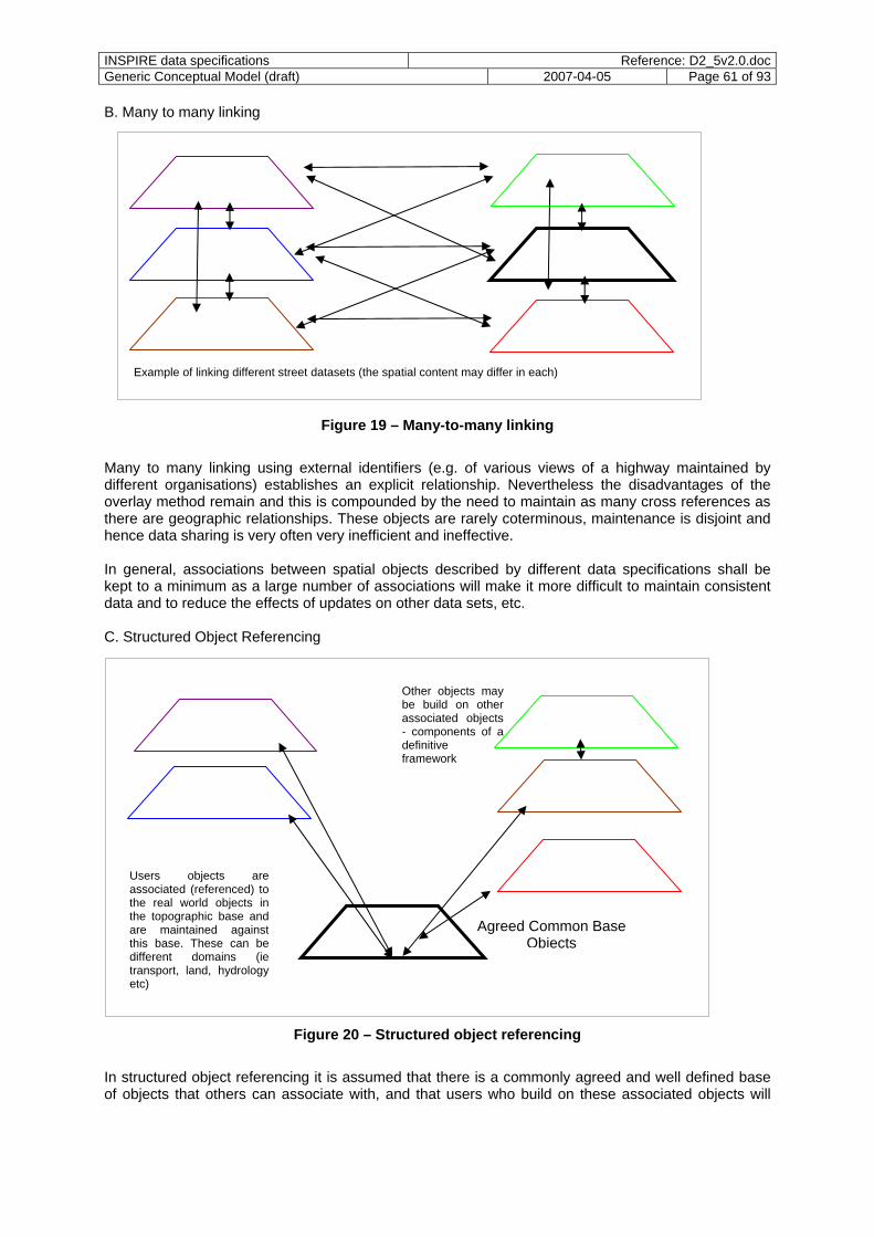
INSPIRE data specifications Reference: D2_5v2.0.docGeneric Conceptual Model (draft) 2007-04-05 Page 61 of 93
B. Many to many linking
Example of linking different street datasets (the spatial content may differ in each)
Figure 19 – Many-to-many linking
Many to many linking using external identifiers (e.g. of various views of a highway maintained by different organisations) establishes an explicit relationship. Nevertheless the disadvantages of the overlay method remain and this is compounded by the need to maintain as many cross references as there are geographic relationships. These objects are rarely coterminous, maintenance is disjoint and hence data sharing is very often very inefficient and ineffective. In general, associations between spatial objects described by different data specifications shall be kept to a minimum as a large number of associations will make it more difficult to maintain consistent data and to reduce the effects of updates on other data sets, etc. C. Structured Object Referencing
Users objects are associated (referenced) to the real world objects in the topographic base and are maintained against this base. These can be different domains (ie transport, land, hydrology etc)
Other objects may be build on other associated objects - components of a definitive framework
Agreed Common Base Objects
Figure 20 – Structured object referencing
In structured object referencing it is assumed that there is a commonly agreed and well defined base of objects that others can associate with, and that users who build on these associated objects will

INSPIRE data specifications Reference: D2_5v2.0.docGeneric Conceptual Model (draft) 2007-04-05 Page 62 of 93
inherit the links, continuity and integrity provided by the common base. The model supports the key INSPIRE principles of data sharing and information reuse across distributed spatial datasets. The different steps for achieving data integrity by structured object referencing are the following :
- at national level, find an agreement on which data forms part of the national reference data - each public organisation will build their data on the reference data, using the object referencing
methods described below - each public organisation will publish their data according to the user’s requirements The methods used at national levels will have to be documented. References databases are becoming well established across Europe through TOP10DK in Denmark, the AAA model in Germany, OS MasterMap Topo in Great Britain, RGE in France and more recently TOP10NL in the Netherlands. Likewise the International Hydrographic Organization/Bureau maintains the S-57 and future S-100 standards, both of these support object models and the linking of one object to another.
13.2.4 Enabling harmonised gazetteer services Gazetteers do associate locations with a geographic identifier and their role is to reference the spatial object representing the location. Gazetteer services provide access to information in gazetteers. See 9.6.5 for details. As a result, they provide a quick method for locating and retrieving spatial objects by name and allow for an identification of spatial objects, e.g. addresses or settlements, that lie within different areas, e.g. administrative areas or postal codes. For example, a user may launch a request with a geographic identifier (e.g. a geographical name such as “Milano”, a postal address or an administrative code). The search engine will then choose a relevant gazetteer to find this geographic identifier and the spatial object associated with it. This gazetteer will provide a location, for instance the geometry or the coordinates of a representative point of the spatial object.
13.3 Recommendations and methods
13.3.1 Object referencing in application schemas Recommendation 19: Recognising that approach C in 13.2.3 supports the principles in recital (6) best, it is recommended to install structured object referencing by means of reference data where possible. However, the situation in member states may be that
- the relevant spatial reference data sets are not yet available, - an agreement for such reference data sets might not be found e.g. for commercial or political
reasons, and/or - implementation of the reference sets usually implies costly and time-consuming data re-
engineering. Therefore, the INSPIRE implementation rules have to cater for object referencing and feature relationships such as aggregations from a modelling perspective, but not mandate approach C, allowing for other models as well. The issue of how to publish the data is another topic where there is no one-size-fits-all solution is available. On the one hand, most users may prefer to have directly the spatial object with its own (redundant, derived) geometry rather than a spatial object that simply references other spatial objects. Yet, to publish the spatial object with its own geometry and without the link to the reference spatial objects may imply a risk of losing data consistency.

INSPIRE data specifications Reference: D2_5v2.0.docGeneric Conceptual Model (draft) 2007-04-05 Page 63 of 93
Recommendation 20: To address the different requirements, the following modelling pattern should be used, if an application schema intends to allow that the spatial or temporal location of a spatial object may be provided directly, by a reference to a base spatial object or perhaps by providing a geographic identifier. Depending on the specific semantics and operational context of a spatial object type, this pattern may be adapted. Assume that road objects shall, in principle, be constructed based on road segment objects which may, for example, go from one junction to the next. The spatial object type “Road” has a property “position” whose value can be exactly one of the following as indicated by the <<Union>> stereotype (specified in ISO/TS 19103) of the data type DirectOrIndirectCurve:
- an object reference to zero, one or more RoadSegment objects (variant “indirect”, i.e. a reference using object identifiers)
- a redundant geometric aggregate (variant “direct”) - a collection of geographic identifiers (variant “roadSegmentName”, i.e. a reference using
geographic identifiers). The practical differences between the three alternatives are:
- The first option is an association role, an object reference, to another spatial object. To access the geometry the reference has to be resolved and the geometry has to be accessed from the referenced object (which in theory could again require resolving a reference).
- The second option is a geometry that would be typically be a copy of a geometry in some reference data set, or a geometry that would captured in some other way, e.g. digitising from a map or from an orthoimage. A common characteristic is that the consistency with the geography of a related spatial object is not maintained as their geometries are not "aware" of each other.
- The third option is a geographic identifier which may be translated into a location using a gazetteer as described in the gazetteer schema in 9.6.5.
NOTE For the example, the third option assumes that geographic identifiers for segments of the road network exist, which currently is not the case in some Member States. EXAMPLE To illustrate the differences of the approaches, a possible GML encoding of the three options could be as follows:
- Option 1: Two road segments are referenced by external object identifier. <Road gml:id="_1"> <!-- some properties --> <position> <DirectOrIndirectCurve> <objectRef xlink:href="urn:x-esdi:oid:NLdfshsd8328413"/> <objectRef xlink:href="urn:x-esdi:oid:NLdfshsd8333464"/> </DirectOrIndirectCurve> </position> <!-- more properties --> </Road>
- Option 2: The geometry is represented by a geometric aggregate with no link to any underlying road segments.
<Road gml:id="_2"> <!-- some properties --> <position> <DirectOrIndirectCurve> <direct> <gml:GM_MultiCurve gml:id="_a"> <!-- content of a multi curve --> </gml:GM_MultiCurve> </direct>
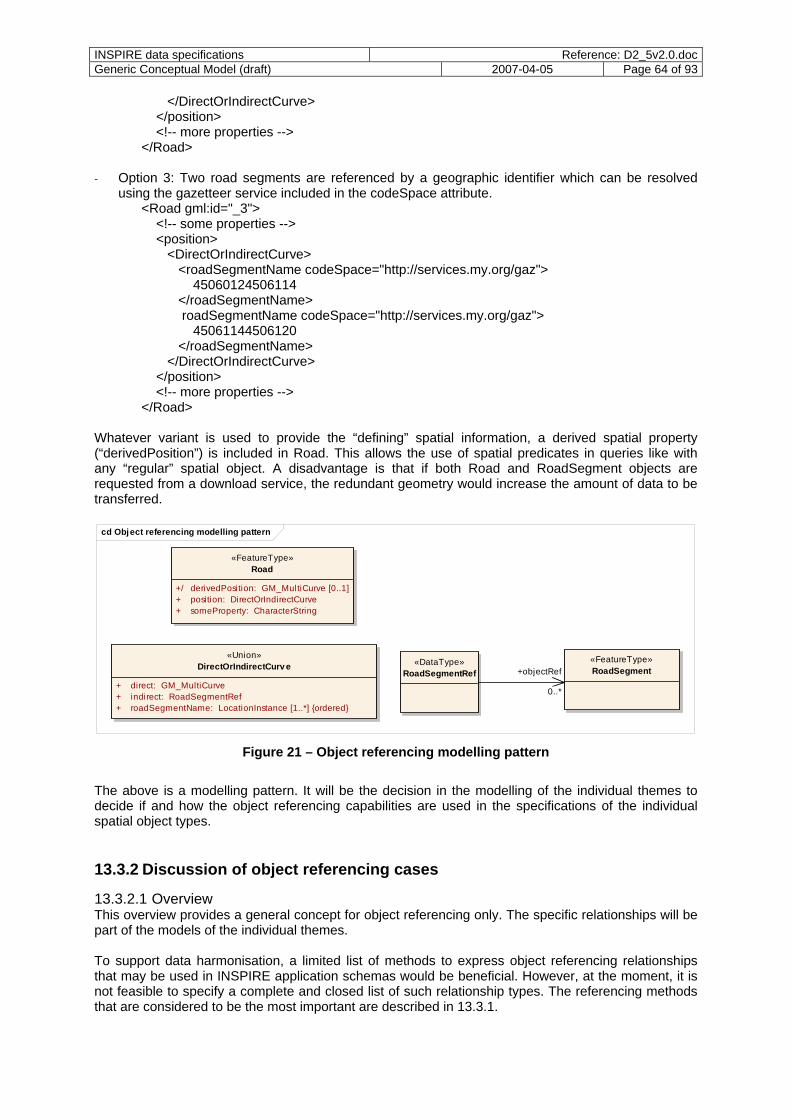
INSPIRE data specifications Reference: D2_5v2.0.docGeneric Conceptual Model (draft) 2007-04-05 Page 64 of 93
</DirectOrIndirectCurve> </position> <!-- more properties --> </Road>
- Option 3: Two road segments are referenced by a geographic identifier which can be resolved using the gazetteer service included in the codeSpace attribute.
<Road gml:id="_3"> <!-- some properties --> <position> <DirectOrIndirectCurve> <roadSegmentName codeSpace="http://services.my.org/gaz"> 45060124506114 </roadSegmentName> roadSegmentName codeSpace="http://services.my.org/gaz"> 45061144506120 </roadSegmentName> </DirectOrIndirectCurve> </position> <!-- more properties --> </Road>
Whatever variant is used to provide the “defining” spatial information, a derived spatial property (“derivedPosition”) is included in Road. This allows the use of spatial predicates in queries like with any “regular” spatial object. A disadvantage is that if both Road and RoadSegment objects are requested from a download service, the redundant geometry would increase the amount of data to be transferred.
cd Object referencing modelling pattern
«FeatureType»Road
+/ derivedPosition: GM_MultiCurve [0..1]+ position: DirectOrIndirectCurve+ someProperty: CharacterString
«FeatureType»RoadSegment
«Union»DirectOrIndirectCurv e «DataType»
RoadSegmentRef +objectRef+ direct: GM_MultiCurve+ indirect: RoadSegmentRef+ roadSegmentName: LocationInstance [1..*] {ordered}
0..*
Figure 21 – Object referencing modelling pattern
The above is a modelling pattern. It will be the decision in the modelling of the individual themes to decide if and how the object referencing capabilities are used in the specifications of the individual spatial object types.
13.3.2 Discussion of object referencing cases
13.3.2.1 Overview This overview provides a general concept for object referencing only. The specific relationships will be part of the models of the individual themes. To support data harmonisation, a limited list of methods to express object referencing relationships that may be used in INSPIRE application schemas would be beneficial. However, at the moment, it is not feasible to specify a complete and closed list of such relationship types. The referencing methods that are considered to be the most important are described in 13.3.1.
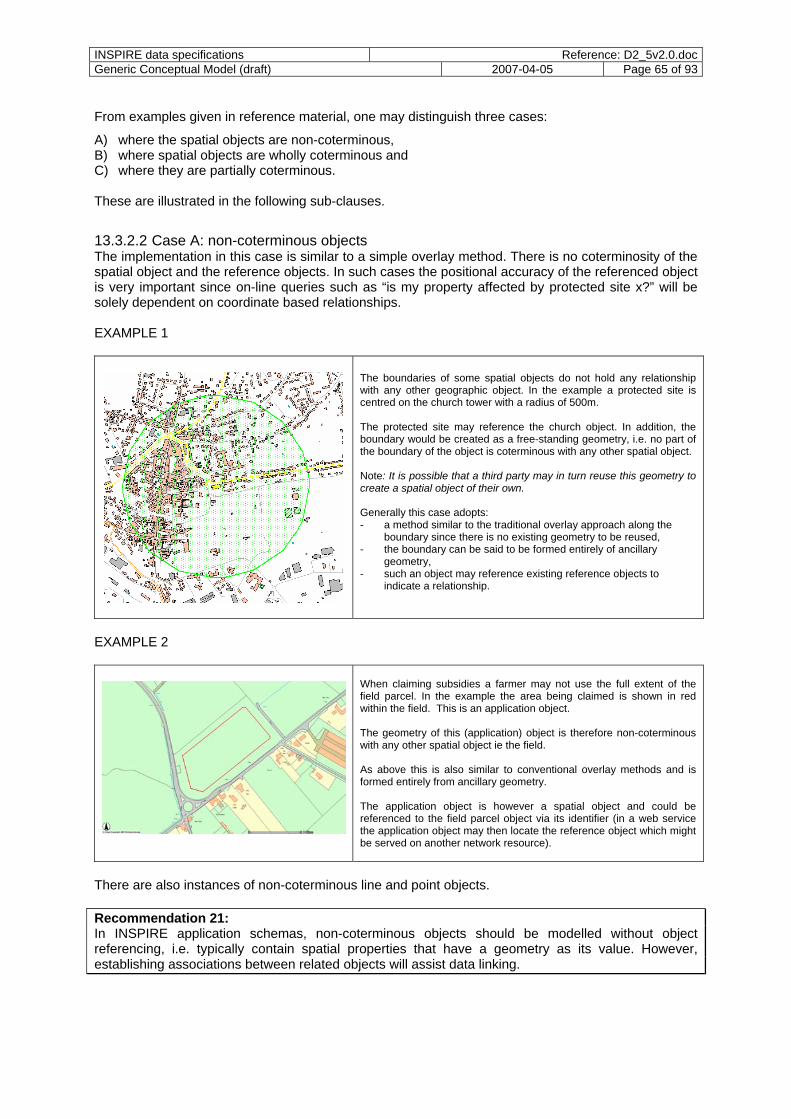
INSPIRE data specifications Reference: D2_5v2.0.docGeneric Conceptual Model (draft) 2007-04-05 Page 65 of 93
From examples given in reference material, one may distinguish three cases:
A) where the spatial objects are non-coterminous, B) where spatial objects are wholly coterminous and C) where they are partially coterminous. These are illustrated in the following sub-clauses.
13.3.2.2 Case A: non-coterminous objects The implementation in this case is similar to a simple overlay method. There is no coterminosity of the spatial object and the reference objects. In such cases the positional accuracy of the referenced object is very important since on-line queries such as “is my property affected by protected site x?” will be solely dependent on coordinate based relationships. EXAMPLE 1
The boundaries of some spatial objects do not hold any relationship with any other geographic object. In the example a protected site is centred on the church tower with a radius of 500m. The protected site may reference the church object. In addition, the boundary would be created as a free-standing geometry, i.e. no part of the boundary of the object is coterminous with any other spatial object. Note: It is possible that a third party may in turn reuse this geometry to create a spatial object of their own.
EXAMPLE 2
There are also instances of non-coterminous line and point objects. Recommendation 21: In INSPIRE application schemas, non-coterminous objects should be modelled without object referencing, i.e. typically contain spatial properties that have a geometry as its value. However, establishing associations between related objects will assist data linking.
Generally this case adopts: - a method similar to the traditional overlay approach along the
boundary since there is no existing geometry to be reused, - the boundary can be said to be formed entirely of ancillary
geometry, - such an object may reference existing reference objects to
indicate a relationship.
When claiming subsidies a farmer may not use the full extent of the field parcel. In the example the area being claimed is shown in red within the field. This is an application object. The geometry of this (application) object is therefore non-coterminous with any other spatial object ie the field. As above this is also similar to conventional overlay methods and is formed entirely from ancillary geometry. The application object is however a spatial object and could be referenced to the field parcel object via its identifier (in a web service the application object may then locate the reference object which might be served on another network resource).
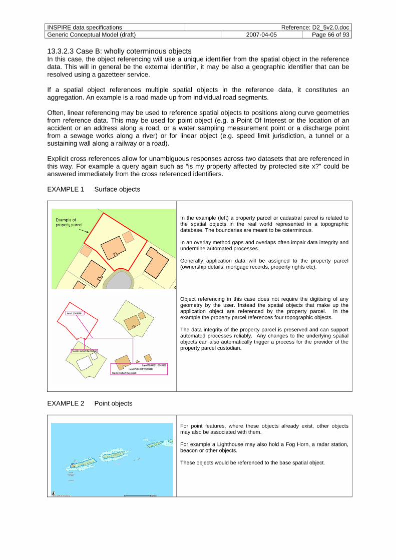
INSPIRE data specifications Reference: D2_5v2.0.docGeneric Conceptual Model (draft) 2007-04-05 Page 66 of 93
13.3.2.3 Case B: wholly coterminous objects In this case, the object referencing will use a unique identifier from the spatial object in the reference data. This will in general be the external identifier, it may be also a geographic identifier that can be resolved using a gazetteer service.
If a spatial object references multiple spatial objects in the reference data, it constitutes an aggregation. An example is a road made up from individual road segments.
Often, linear referencing may be used to reference spatial objects to positions along curve geometries from reference data. This may be used for point object (e.g. a Point Of Interest or the location of an accident or an address along a road, or a water sampling measurement point or a discharge point from a sewage works along a river) or for linear object (e.g. speed limit jurisdiction, a tunnel or a sustaining wall along a railway or a road). Explicit cross references allow for unambiguous responses across two datasets that are referenced in this way. For example a query again such as “is my property affected by protected site x?” could be answered immediately from the cross referenced identifiers. EXAMPLE 1 Surface objects
In the example (left) a property parcel or cadastral parcel is related to the spatial objects in the real world represented in a topographic database. The boundaries are meant to be coterminous. In an overlay method gaps and overlaps often impair data integrity and undermine automated processes. Generally application data will be assigned to the property parcel (ownership details, mortgage records, property rights etc). Object referencing in this case does not require the digitising of any geometry by the user. Instead the spatial objects that make up the application object are referenced by the property parcel. In the example the property parcel references four topographic objects. The data integrity of the property parcel is preserved and can support automated processes reliably. Any changes to the underlying spatial objects can also automatically trigger a process for the provider of the property parcel custodian.
EXAMPLE 2 Point objects
For point features, where these objects already exist, other objects may also be associated with them. For example a Lighthouse may also hold a Fog Horn, a radar station, beacon or other objects.
These objects would be referenced to the base spatial object.

INSPIRE data specifications Reference: D2_5v2.0.docGeneric Conceptual Model (draft) 2007-04-05 Page 67 of 93
EXAMPLE 3 Linear object / linear referencing
To date, road, railway and to a certain extent rivers are the most common form or object referencing examples. In the example (left) the road object is being used to reference speed limit data (in this case by linear referencing from the start node).
Recommendation 22: In INSPIRE application schemas, wholly coterminous objects should be modelled using the object referencing pattern specified in 13.3.1. Note that still the option to specify a spatial property (first option in 13.3.1) should be included to support data sets and data providers that currently do not support an object referencing framework.
13.3.2.4 Case C: partially coterminous objects This case is more complex since it is a hybrid of cases A and B where spatial objects are partially coterminous. The techniques and services to support this are relatively immature and still evolving. EXAMPLE 1
This case is similar to the case B above except that the property extent includes part of the land shown in green in the diagram. Therefore only part of the geometry is coterminous with the property land parcel. As the additional geometry (known as ancillary geometry) is not held by any other organisation the user creates it and uses it in the same way as the topographic objects. The Ancillary Geometry will normally be created to a specification commensurate with the topographic objects (so that others might in turn reuse it).
As in case B the property parcel then references (in this case) two topographic objects entirely as well as the ancillary geometry object.
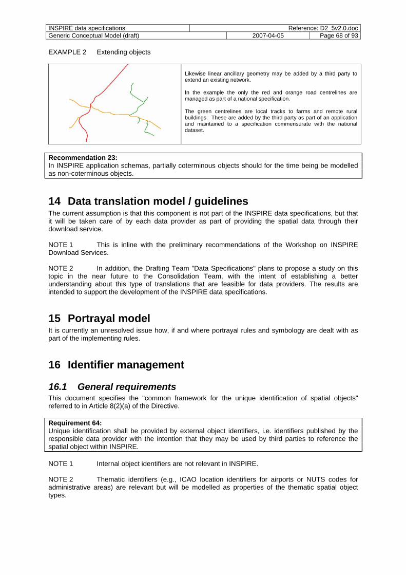
INSPIRE data specifications Reference: D2_5v2.0.docGeneric Conceptual Model (draft) 2007-04-05 Page 68 of 93
EXAMPLE 2 Extending objects
Likewise linear ancillary geometry may be added by a third party to extend an existing network. In the example the only the red and orange road centrelines are managed as part of a national specification.
The green centrelines are local tracks to farms and remote rural buildings. These are added by the third party as part of an application and maintained to a specification commensurate with the national dataset.
Recommendation 23: In INSPIRE application schemas, partially coterminous objects should for the time being be modelled as non-coterminous objects.
14 Data translation model / guidelines The current assumption is that this component is not part of the INSPIRE data specifications, but that it will be taken care of by each data provider as part of providing the spatial data through their download service. NOTE 1 This is inline with the preliminary recommendations of the Workshop on INSPIRE Download Services. NOTE 2 In addition, the Drafting Team "Data Specifications" plans to propose a study on this topic in the near future to the Consolidation Team, with the intent of establishing a better understanding about this type of translations that are feasible for data providers. The results are intended to support the development of the INSPIRE data specifications.
15 Portrayal model It is currently an unresolved issue how, if and where portrayal rules and symbology are dealt with as part of the implementing rules.
16 Identifier management
16.1 General requirements This document specifies the "common framework for the unique identification of spatial objects" referred to in Article 8(2)(a) of the Directive. Requirement 64: Unique identification shall be provided by external object identifiers, i.e. identifiers published by the responsible data provider with the intention that they may be used by third parties to reference the spatial object within INSPIRE. NOTE 1 Internal object identifiers are not relevant in INSPIRE. NOTE 2 Thematic identifiers (e.g., ICAO location identifiers for airports or NUTS codes for administrative areas) are relevant but will be modelled as properties of the thematic spatial object types.
INSPIRE data specifications Reference: D2_5v2.0.docGeneric Conceptual Model (draft) 2007-04-05 Page 69 of 93
Requirement 65: All spatial objects of Annexes I and II of the INSPIRE Directive shall carry a unique object identifier property, unless it is known that no requirement exists to identify or reference such object instances. Recommendation 24: It is strongly recommend to provide a unique identifier for each of the spatial objects of Annex I and II. This needs to be considered in the individual themes taking the feasibility and the user requirements into account. No unique object identifier will typically be required for spatial object types for which the underlying data sets do not maintain such identifiers and where no requirement is known to add such identifiers EXAMPLE 1 Spatial object types in the theme "Geology". Spatial objects of Annex III of the INSPIRE Directive may carry a unique identifier property. Recommendation 25: Annex III contains themes with spatial objects for which identifiers may be important, e.g. buildings. Where this is the case, identifier properties should be modelled in the application schema. NOTE 3 Coverages and spatial data sets are spatial objects, too. The four requirements for unique object identifiers are: uniqueness, persistence, traceability, and feasibility. Requirement 66: Uniqueness: No two spatial objects of spatial object types specified in INSPIRE application schemas shall have the same identifier.
NOTE 4 Different versions or copies of the same spatial object will still have the same identifier. NOTE 5 This implies that identifiers are not reused. Requirement 67: Persistence: The identifier shall remain unchanged during the life-time of an object. The definition of every spatial object type in an INSPIRE application schema shall state which modifications (e.g. attribute changes, merging with another spatial object) do or may change the identity of a spatial object, i.e. when the existing object is "retired" and a new object with a new identifier is created, and which changes do not change the identity of a spatial object.
The life-cycle rules vary from member state to member state and as a consequence no fixed rules will be possible in general in INSPIRE data specifications. Requirement 68: The life-cycle rules for spatial object types in a spatial dataset shall be documented in the metadata of the dataset. Requirement 69: Traceability: Since INSPIRE assumes a distributed, service-based SDI, a mechanism is required to find a spatial object based on its identifier. I.e. the identifier shall provide sufficient information to determine the download service that provides access to the spatial object. NOTE 6 The identifier itself does not provide sufficient information to determine the download service. See Requirement 76: Feasibility: The system has been designed to allow that identifiers under existing national identifier systems can be mapped.
INSPIRE data specifications Reference: D2_5v2.0.docGeneric Conceptual Model (draft) 2007-04-05 Page 70 of 93
Recommendation 26: Whenever possible, the use of unique identifiers should be limited to spatial objects. Unique identifiers for other objects, e.g. for geometrical or topological primitives should only be considered where multiple spatial objects use the same geometry or topology primitive and this information needs to be communicated to users. EXAMPLE 2 Sometimes, topology constraints should be used within a spatial dataset internally (for example, to increase performance or data consistency), but it may not be required to expose this information explicitly to the user. NOTE 7 Objects which do not have any spatial or temporal characteristics are outside the scope of INSPIRE. If such object types need to be modelled in an INSPIRE application schema, this document does not provide any guidance how such object types should be modelled.
16.2 Structure of unique identifiers Requirement 70: Unique identifiers of spatial objects shall consist of two parts:
- a namespace to identify the data source (owned by a data provider) - a local identifier, assigned by the data provider (must be unique within the namespace) Requirement 71: For all spatial objects, the namespace shall include all relevant information to guarantee uniqueness of the full identifier. Requirement 72: All namespaces shall start with a code that unambiguously identifies the data provider. NOTE 1 This is similar to top level domain in the internet DNS. Requirement 73: In case of a data provider associated with a member state this shall be the two letter ISO 3166 code which shall be registered in a register for object identifier namespaces in INSPIRE. EXAMPLE 1 FR for France, DE for Germany, NL for the Netherlands, etc. Requirement 74: In case of a multinational data provider it shall be a six letter code starting an underscore ("_") to avoid conflicts with ISO 3166. The codes shall be registered in a register for object identifier namespaces in INSPIRE. Requirement 75: All remaining characters of the namespace shall uniquely identify the data source within the member state (or multinational organisation). Often this will consist of two parts. The first part will identify the data provider within the member state and the second part will be used to distinguish between different data sources maintained and provided by the data provider. For example, if a data provider assigns unique object identifiers in the context of a product, then the namespaces registered by the data provider may include information about the data provider and the product. NOTE 2 The use of a product code/name in the namespace may create problems if the data provider changes the organisation of its data products - as it would be forced to maintain the product-specific identifiers with the spatial objects also after the product itself has been retired.
INSPIRE data specifications Reference: D2_5v2.0.docGeneric Conceptual Model (draft) 2007-04-05 Page 71 of 93
EXAMPLE 2 “FR.IGNF.BDCARTO” may be the namespace used by IGN France for spatial object in their BD CARTO product. “NL.TOP10NL” may be the namespace for spatial objects in the TOP10 NL product in the Netherlands. “_EGGR.ERM” may be the namespace for spatial objects in the EuroRegionalMap product of from EuroGeographics (assuming that “_EGGR” would be the registered abbreviation of EuroGeographics). This rule can accommodate the different current identifier assignment rules of data providers. If, for example, a data provider assigns local identifiers not per data product but per spatial object type, then the namespace will include the name of the spatial object type, i.e. the data provider will register a number of namespaces. Requirement 76: To support the ESDI, an ISO 19135 conformant register and registry for identifier namespaces shall be established as part of INSPIRE. The register shall provide sufficient information about the data provider and about the download service that provides access to these spatial objects. NOTE 3 Because of the use of the prefix this could be organised without a central register but with hierarchical registers maintained by the member states and the multinational organisations. On the European level only the list of the registries on the next hierarchy level would be required. Requirement 77: As a result, the identifier management will be co-ordinated in the sense that every data provider in INSPIRE
- shall register their identifier namespaces in the appropriate INSPIRE identifier namespace register,
- can assign local identifiers arbitrarily within namespaces owned by the data provider as long as each identifier is used only once.
16.3 Lexical rules Recognising the key role of identifiers and the need to allow for an easy processing of identifiers in software applications, it has been published at the same time as this document in http://www.ec-gis.org/inspire/ui/survey.php to restrict the lexical rules for both the namespace prefix and the local identifier. In order to determine the feasibility of any restrictions, a SDIC/LMO survey has been published at the same time as this document in http://www.ec-gis.org/inspire/ui/survey.php . Its results will be taken into account in a revision of this document. EXAMPLE If unrestricted, the identifier would be character strings of unlimited length with characters from the full Unicode character set. However, insufficient information is available, in how far the set of allowed characters or the length can be restricted taking the design goal into account that existing national identifiers must be mappable to a unique identifier in INSPIRE.
16.4 Spatial datasets Requirement 78: The rules for unique identifiers of spatial objects shall apply for spatial datasets, too. Spatial datasets are spatial objects themselves, see 9.6.3.
16.5 Coverages Requirement 79: The rules for unique identifiers of spatial objects shall apply for coverages, too. This sub-clause adds a few considerations about identifiers of coverages.
INSPIRE data specifications Reference: D2_5v2.0.docGeneric Conceptual Model (draft) 2007-04-05 Page 72 of 93
As a coverage is today typically represented by a file, current identifier conventions generally apply at file-level. Typically, identifiers are not opaque, but they incorporate 'metadata' (e.g. data product types, timestamps, data origin, sensor information, processing information). However, there is no uniform approach across agencies and data providers. In terms of the structure specified in 16.2 the file name is the local identifier. EXAMPLE 1 The BDORTHO product of IGN France is an orthophoto in colour at resolution 50 cm; it is produced by “department” (an administrative unit). It is provided in TIFF format, by tiles whose size is 1 km x 1 km. The namespace could be, for example, FR.IGN.BDORTHO and the local identifier the tile name. The tile is named: DD-AAAA-XXXX-YYYY-PPP.tif where : - DD is the number of the “department” - AAAA is the year when the photos were taken - XXXX is the X co-ordinate of the left upper side of the tile in km - YYYY is the Y co-ordinate of the left upper side of the tile in km - PPP is the projection acronym. For example, 56.2002.0256.2463.lA1 is the name of a tile from department 56, from photos taken in 2002, the area is a square km whose left upper corner coordinates are 256 km and 2463 km in Lambert 1. The BD ORTHO may be provided with other options (and with larger tiles) : - resampling: a suffix is added to explain the resampling nature, e.g. “5m” (size of the pixel) or “NB”
(for black and white) - in compressed format: a suffix is added to give the compression factor and the extension will be
“.ecw”. EXAMPLE 2 As an example of an operational archiving centre, the UK NERC Earth Observation Data Centre is developing a convention for unique identifiers across its holdings. The current proposal is to use the following naming convention for its datasets: NEODC_<PLATFORM/PROJECT>[_<INSTRUMENT/PROJECT>][_<PROCESSING LEVEL/NAME>] The last two parts are optional and are included only where appropriate. A small selection of examples is shown in the following table.
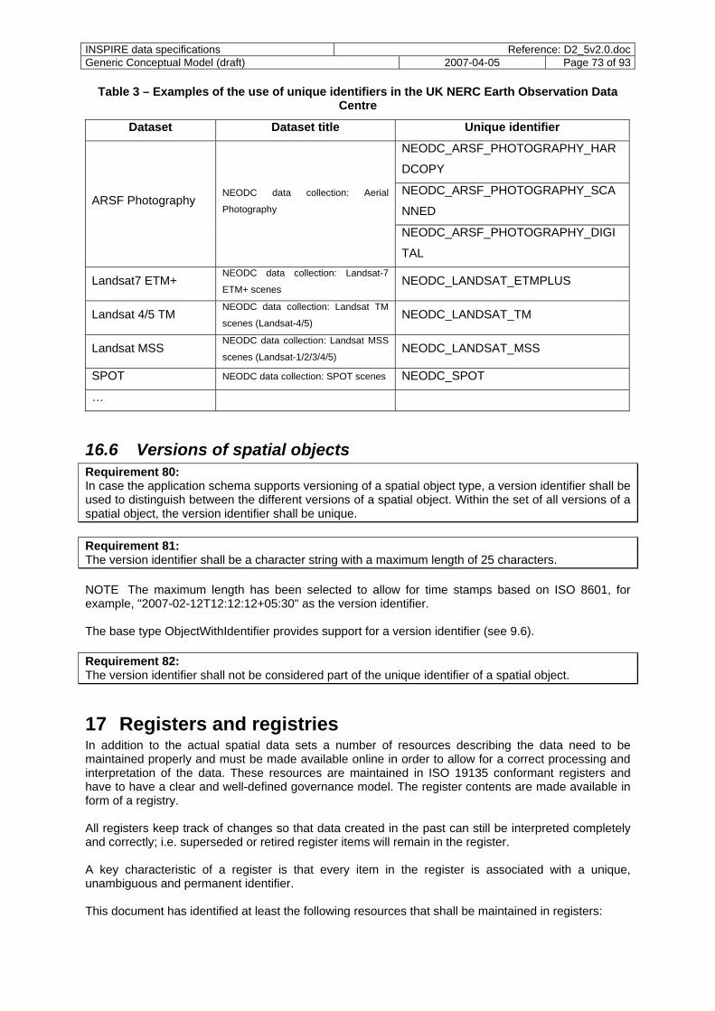
INSPIRE data specifications Reference: D2_5v2.0.docGeneric Conceptual Model (draft) 2007-04-05 Page 73 of 93
Table 3 – Examples of the use of unique identifiers in the UK NERC Earth Observation Data Centre
Dataset Dataset title Unique identifier
NEODC_ARSF_PHOTOGRAPHY_HAR
DCOPY
NEODC_ARSF_PHOTOGRAPHY_SCA
NNED ARSF Photography
NEODC data collection: Aerial
Photography
NEODC_ARSF_PHOTOGRAPHY_DIGI
TAL
Landsat7 ETM+ NEODC data collection: Landsat-7
ETM+ scenes NEODC_LANDSAT_ETMPLUS
Landsat 4/5 TM NEODC data collection: Landsat TM
scenes (Landsat-4/5) NEODC_LANDSAT_TM
Landsat MSS NEODC data collection: Landsat MSS
scenes (Landsat-1/2/3/4/5) NEODC_LANDSAT_MSS
SPOT NEODC data collection: SPOT scenes NEODC_SPOT
…
16.6 Versions of spatial objects Requirement 80: In case the application schema supports versioning of a spatial object type, a version identifier shall be used to distinguish between the different versions of a spatial object. Within the set of all versions of a spatial object, the version identifier shall be unique. Requirement 81: The version identifier shall be a character string with a maximum length of 25 characters. NOTE The maximum length has been selected to allow for time stamps based on ISO 8601, for example, "2007-02-12T12:12:12+05:30" as the version identifier. The base type ObjectWithIdentifier provides support for a version identifier (see 9.6). Requirement 82: The version identifier shall not be considered part of the unique identifier of a spatial object.
17 Registers and registries In addition to the actual spatial data sets a number of resources describing the data need to be maintained properly and must be made available online in order to allow for a correct processing and interpretation of the data. These resources are maintained in ISO 19135 conformant registers and have to have a clear and well-defined governance model. The register contents are made available in form of a registry. All registers keep track of changes so that data created in the past can still be interpreted completely and correctly; i.e. superseded or retired register items will remain in the register. A key characteristic of a register is that every item in the register is associated with a unique, unambiguous and permanent identifier. This document has identified at least the following resources that shall be maintained in registers:
INSPIRE data specifications Reference: D2_5v2.0.docGeneric Conceptual Model (draft) 2007-04-05 Page 74 of 93
Feature concept dictionary: Dictionary establishing a set of feature-related concepts that may be
used to describe geographic information. A common feature concept dictionary will be maintained for all INSPIRE application schemas and feature catalogues. See 9.2.
EXAMPLE 1 A well-known example of a feature concept dictionary is FACC, developed and maintained by DGIWG (http://www.dgiwg.org/). FACC has been deprecated and replaced by the DFDD which conforms to ISO 19126.
Feature catalogue: Catalogue containing definitions and descriptions of the spatial object types,
their attributes and associated components occurring in one or more data sets, together with any operations that may be applied. See 9.3.
EXAMPLE 2 Examples of ISO 19110 conformant feature catalogues are the GeoInfoDok feature catalogues in Germany or the SOSI feature catalogue in Norway.
Application schema: Conceptual schema for data required by one or more applications. Part of a
data specification and specified in UML. The Generic Conceptual Model and all INSPIRE application schemas are maintained in a consolidated UML model. See 9.
EXAMPLE 3 Examples of ISO 19109 conformant application schemas are NEN 3610 (The Netherlands), AFIS-ALKIS-ATKIS (Germany), SOSI (Norway), INTERLIS-based models (Switzerland), GeoSciML (Geological Surveys), and EuroRoadS (EuroRoads Forum).
Codelist: Dictionary describing the attribute value domains for selected property types in a feature
catalogue / application schema. The value domain is not fixed in the feature catalogue / application schema, but is managed separately. I.e. this establishes an extendable controlled vocabulary outside of the data specification itself.
EXAMPLE 4 Examples of codelist dictionaries are provided with the ISO/TS 19139 schema documents (http://www.iso.org/ittf/ISO_19139_Schemas/resources/CodeList/).
Coordinate reference systems and operations: Dictionary of coordinate reference systems,
datums, coordinate systems and coordinate operations which are used in data sets. See 12.
EXAMPLE 5 Examples of coordinate reference system dictionaries are the "EPSG Geodetic Parameter Dataset" (http://www.epsg.org/), the "Information and Service System for European Coordinate Reference Systems" (http://crs.bkg.bund.de/crs-eu/), a coordinate reference system catalogue prototype (http://crs.opengis.org/crsportal/), and examples provided with the ISO/TS 19139 schema documents (http://www.iso.org/ittf/ISO_19139_Schemas/resources/crs/).
Units of measurements: Dictionary of units of measurement which are used in data sets. See 12.
EXAMPLE 6 Units dictionaries are part of all coordinate reference system dictionaries referenced above.
Spatial object identifier namespaces: A mechanism is required to guarantee uniqueness of object
identifiers across various content providers. Identifier namespaces need to be managed. See 16.2.
The registries are expected to be available through registry services. NOTE As these registers and their use through registry services will form a key component of the operational infrastructure, it is considered important that the approach to registers and registry services for the various registers discussed in this document is tested as early as possible in a pilot.
INSPIRE data specifications Reference: D2_5v2.0.docGeneric Conceptual Model (draft) 2007-04-05 Page 75 of 93
18 Metadata Metadata for discovery and for first level evaluation of a data set or data series as required by the Directive, including issues of quality, validity, and conformity will be mandated by the Implementing Rules on Metadata. Requirement 83: Metadata associated with individual spatial objects shall be specified as part of the INSPIRE data specifications as required by the application and by ISO 19131. Requirement 84: The rules specified in ISO 19109 8.5.2 shall apply for INSPIRE application schemas.
19 Maintenance Requirement 85: Maintenance requirements shall be specified as part of every INSPIRE data specification as required by ISO 19131. Requirement 86: In particular, it shall be specified for every spatial object type by every data provider as part of the data set metadata which properties of a spatial object type are invariant for a spatial object type (if any); i.e., a change of these properties will lead to a new object instance with a new unique object identifier. It is expected that the interface of a download service will be capable of providing information about changed objects since a given point in time. Depending on the final capabilities of the download service, this paragraph will be revised. NOTE Of course, this capability of a download service can only be used, if the underlying spatial data maintains that allows to derive date/time of the last change.
20 Data & Information quality Requirement 87: Quality requirements for spatial data sets shall be specified as part of every INSPIRE data specification as required by ISO 19131. NOTE Data and information quality is often defined as “validity for purpose” in an environmental context. That includes a broader view than the definition of data quality for spatial data as currently defined in the ISO 19100 series. The validity for a specific purpose is depending on the specific use case / application.
21 Data transfer This component will be specified in document D2.7.
22 Consistency between data This clause lists the relevant requirements on regarding consistency between data from the INSPIRE Directive and provides recommendations, in order to minimise inconsistencies or to correct them. Consistency between data is a very complex subject to deal with. Even if data are harmonized according to very well defined rules, they rarely fit exactly for various reasons. Annex B provides a brief overview of the topic in general describing the general meaning of consistency (B.2) as well as of

INSPIRE data specifications Reference: D2_5v2.0.docGeneric Conceptual Model (draft) 2007-04-05 Page 76 of 93
Level of Detail (B.3). The annex also provides examples that illustrate inconsistency in the context of INSPIRE (B.4). Methods for ensuring data consistency often concern topographic data. In the context of INSPIRE, the complexity comes from the diversity of themes. A priori data coming from different data providers are never perfectly consistent one to another. Consistency between data as required by Articles 8(3) and 10(2) of the Directive concerns data described in all annexes of the Directive, namely from the following themes:
I. geographical names, administrative units, addresses, cadastral parcels, transport networks, hydrography, protected sites
II. elevation, land cover, orthoimagery, geology III. statistical units, buildings, soil, land use, human health and safety, utility and government
services, environmental monitoring facilities, production and industrial facilities, agricultural and aquaculture facilities, population distribution – demography, area management/restriction/regulation zones and reporting units; natural risk zones; atmospheric conditions; meteorological geographical features; oceanographic geographical features; sea regions; bio-geographical regions; habitats and biotopes; species distribution, energy resources, mineral resources.
Some themes of annex III like atmospheric conditions, meteorological geographical features, oceanographic geographical features or sea regions are not, or not much, concerned by this component, because of their cross-border, transitory or fuzzy nature. More generally, consistency should not be ensured between all themes together. An in-depth analysis of the themes based on the work already done in document D2.3 would be required to provide a more detailed understanding of the cross-theme relationships. The following recommendations for processes introducing and maintaining consistency between data, for further research studies as well as the development of INSPIRE data specifications are a summary of the discussion in Annex B which provides additional background information. Requirement 88: The first consistency to check is the conformance to data specifications including the data capturing rules. Before checking the consistency between different data sets, each data set shall be verified to conform to the corresponding INSPIRE application schema, in particular complying to the same set of constraints. Recommendation 27: Consistency should not be ensured between all themes together. An accurate study of related themes should be carried out, based on the work already done in document D2.3. Recommendation 28: The consistency between different themes should be checked only within same or close levels of detail. The advice would be to study the effective resolution of the data of each theme in the annex I, II and III and then to decide which couples (theme, LoD) should be consistent one to another. Recommendation 29: For a theme, different levels of detail may exist. In such a case, the number of levels should be as limited as possible and the representation should be consistent one to another. Multiple representations can be used to link the representation of different levels one to another but this will not be sufficient. Specific relationships, such as aggregation (partonomic relation or others), generalisation, selection or geometric simplification, should be described as accurately as possible to allow the automation of the consistency checking. Requirement 89: For the consistency checks, an interlinked and agreed vocabulary is needed. Therefore, the rules governing consistency shall be modelled as far as possible in the INSPIRE application schemas as constraints. The constraint language OCL shall be used to express these constraints, associated with
INSPIRE data specifications Reference: D2_5v2.0.docGeneric Conceptual Model (draft) 2007-04-05 Page 77 of 93
natural language to give the complementary explanation. The constraints shall be identified as part of the development of the INSPIRE data specifications. Recommendation 30: The harmonisation of data specifications is the best way to promote consistency. Specific studies related to the use of ontologies in data specifications should be encouraged and if possible funded. Recommendation 31: If the harmonisation of application schemas is rather simple, the harmonisation of data capturing rules between data producers would be very useful. The better the data capturing rules are defined and followed, the smaller the inconsistencies. The harmonisation of data capturing rules is complex for the following reasons:
- the rules often refer to underdefined concepts (the hidden ontology), - the rules are often not fully described, - the rules are not formally described, - the cost of transforming the data according to new data capturing rules is far more expensive than
the cost of transforming the data to a new application schema. A formal language to describe the acquisition rules would greatly simplify the harmonisation of acquisition rules and the detection of inconsistency. Some research studies for defining formal language are promising and should be mature for the effective beginning of INSPIRE data availability. Differences between data sets are a natural result of the acquisition process, the levels of detail and also from the nature of the entities. Some entities have well-defined boundaries (a building, a road) while others have a boundary that partially depends on human cognition (a city, a district, the North Sea, corridor for air traffic control, a mountain, a bay, etc.) (Smith and Varzi, 2000). However, it is also a result of the fact that some data specifications are under defined such as the selection rules that hide complex criteria (see Gesbert 2005). To improve the consistency between data coming from two different providers, one or both data sets will be slightly changed. These data transformations will require mutual approval from data providers and also a technical organisation (eventually by means of a service) to match the data together either before sending them to the user (an on-demand matching service) or once, before integrating them into INSPIRE. Whatever the case, the spatial data in INSPIRE will be slightly different from the original data of the provider. This situation has to be well understood and accepted by data providers, or other solutions would have to be elaborated. Recommendation 32: For the specific case of cross-border consistency, if data do not have at all the same level of detail on both sides, forcing data matching could be a very bad solution. Multiple representations associated with a mechanism based on corresponding points or edges might be far more efficient. Recommendation 33: In order to correct automatically small geometrical inconsistencies between two themes, either redundant objects or anchor points (so-called homologous points) are necessary. Redundant information represents a same theme (such as river network) that would be present in both data sets. When either redundant objects or anchor points exist, existing matching and stretching algorithms (such as rubber sheeting) can be used to match the data together. Recommendation 34: Specific studies on automated matching should be encouraged and if possible funded as soon as possible to have robust solution before the availability of INSPIRE data. Ensuring data consistency between themes and between levels of detail raises the problem of geometrical deformations: forcing data consistency lay on geometrical changes. As a consequence the INSPIRE data (globally coherent one to another) cannot be a strict copy of the data of data producers: for consistency, the geometry of some objects will be slightly different. This situation should
INSPIRE data specifications Reference: D2_5v2.0.docGeneric Conceptual Model (draft) 2007-04-05 Page 78 of 93
not be a technical problem, if object identifiers are managed well, for instance, by keeping the same identifier or by establishing links between the two identifiers. NOTE The required changes to data raise additional questions that may need to be addressed: How does this impact intellectual property rights? What is the “correct” version of a data set? Which one should be used in which case (“original” vs. “consistent” data)? Can general rules for responsibilities be specified?
23 Multiple representations Based on reference material and the findings and recommendations of a workshop on data consistency and multiple representations that was organised by JRC in November 2006, automatic generalisation methods are not mature enough to be considered as a service in INSPIRE. Therefore: Requirement 90: Multiple representations of the same real-world phenomenon shall be modelled explicitly in the application schemas. For consistency between the representations, the rules specified in Clause 22 shall apply. Requirement 91: In principle, as few levels of detail as necessary should be defined per theme. In cases where multiple levels of detail are required, the requirement for the different levels shall be justified and documented as part of the data specification.
24 Data capturing rules Requirement 92: Capturing rules describing the data specification-specific criteria which spatial objects are part of spatial data sets conforming to the data specification shall be specified for every spatial object type as part of every INSPIRE data specification in conformance with ISO 19131. NOTE 1 Data capturing rules are the main element to define the targeted level of detail. For instance, there may be a need for transport networks on two levels of detail (at the European level, scale about 1:1000000 and at the local level, scale about 1:10000) with very similar feature catalogues. However, the data will be very different. This difference is a result of different capturing rules / selection criteria for both levels of detail. EXAMPLE Typical selection criteria are minimum area or length or functional characteristics like the class of a road. NOTE 2 The data capturing processes used by a data provider, i.e. the "how", are not relevant for this component. Guidelines on this topic based on experience in SDICs and LMOs may be provided in document D2.6, if required.
25 Conformance Clauses 5 to 25 specify mandatory requirements and recommendations for INSPIRE data specifications and spatial data sets. NOTE The requirements and recommendations are highlighted in the text.
INSPIRE data specifications Reference: D2_5v2.0.docGeneric Conceptual Model (draft) 2007-04-05 Page 79 of 93
Requirement 93: Every INSPIRE data specification shall conform to all mandatory requirements in this document that relate to INSPIRE data specifications and pass all relevant test cases of the Abstract Test Suite in A.1. In addition, this document specifies a number of recommendations. If a data specification claims to conform to one or more of the recommendations which relate to INSPIRE data specifications, it shall pass the relevant test cases of the Abstract Test Suite in A.2. As a result, 11 conformance classes for INSPIRE data specifications are distinguished. Table 4 lists these classes and the corresponding sub-clause of the Abstract Test Suite.
Table 4 - Conformance classes for INSPIRE data specifications
Conformance class Subclause of the Abstract Test Suite
Basic conformance to the Generic Conceptual Model A.1
Support for the Simple Feature profile A.2.1
Support for the UML profile from ISO 19136 Annex E A.2.2
Support for versioning A.2.3
Support for enumerations and codelists A.2.4
Support for void values with reasons A.2.5
Support for reference systems A.2.6
Support for units A.2.7
Support for the object referencing A.2.8
Support for the unique identifiers A.2.9
Support for the data consistency A.2.10
Requirement 94: Every spatial data set shall conform to all mandatory requirements in this document that relate to data sets and pass all relevant test cases of the Abstract Test Suite in A.3. In addition, this document specifies a number of recommendations. If a spatial data set claims to conform to one or more of the recommendations which relate to data sets, it shall pass the relevant test cases of the Abstract Test Suite in A.4. As a result, 3 conformance classes are distinguished. Table 5 lists these classes and the corresponding sub-clause of the Abstract Test Suite.
Table 5 - Conformance classes for spatial data sets
Conformance class Subclause of the Abstract Test Suite
Basic conformance to the Generic Conceptual Model A.3
Support for linguistic searches A.4.1
Support for geographical grids A.4.2
NOTE All other requirements and recommendations are not relevant for conformance, but require or recommend additional measures and in principle are addressed to the European Commission and/or the Member States. These are: - Requirements: 38 (see 10.6), 51/52 (see 12.2), 56/57 (see 12.3), 60/61 (see 12.4), 63 (see 12.5),
69 (see 16.1), 71-77 (see 16.2);

INSPIRE data specifications Reference: D2_5v2.0.docGeneric Conceptual Model (draft) 2007-04-05 Page 80 of 93
- Recommendations: 1 (see Clause 5), 2 (see 9.1), 3 (see 9.2), 27/28/30/31/34 (see Clause 22).
INSPIRE data specifications Reference: D2_5v2.0.docGeneric Conceptual Model (draft) 2007-04-05 Page 81 of 93
Annex A (normative)
Abstract Test Suite
A.1 Test cases for mandatory conformance requirements for an INSPIRE data specification
A.1.1 General
a) Test Purpose: Verify that the INSPIRE data specification fulfils all mandatory general requirements.
b) Test Method: Inspect the data specification and check its against the following requirements: 4, 5, 49, 50, 53-55, 58, 59, 83, 85, 87, 91-93
c) Reference: D2.5 Clauses 7, 8, 11, 12, 18, 19, 20, 22, 23, 24, 25; ISO 19101 Clause 2, ISO 19111, ISO 19131 Clause 2, ISO 19136 Annex D.3, ISO/TS 19139
d) Test Type: Basic Test
A.1.2 Application schema
a) Test Purpose: Verify that the application schema in the INSPIRE data specification fulfils all mandatory requirements.
b) Test Method: Inspect the data specification and check the application schema against the following requirements: 1, 3, 6, 11-24, 26, 27, 30-37, 39-48, 62, 65, 67, 81-84, 89, 90
c) Reference: D2.5 Clauses 5, 9, 10, 12, 16, 18, 22, 23; ISO 19109 Clauses 7, 8, ISO/TS 19103 6.5, ISO 19107 Clause 2, ISO 19108 Clause 2, ISO 19123 Clause 2
d) Test Type: Basic Test
A.1.3 Feature catalogue
a) Test Purpose: Verify that the feature catalogue in the INSPIRE data specification fulfils all mandatory requirements.
b) Test Method: Inspect the data specification and check the feature catalogue against the following requirements: 8, 9
c) Reference: D2.5 9.2; ISO 19101 Clause 2, ISO 19110 Amd1
d) Test Type: Basic Test
A.1.4 Feature concept dictionaries
a) Test Purpose: Verify that the feature concept dictionary in the INSPIRE data specification fulfils all mandatory requirements.
b) Test Method: Inspect the data specification and check the feature concept dictionary against the following requirements: 5, 7
INSPIRE data specifications Reference: D2_5v2.0.docGeneric Conceptual Model (draft) 2007-04-05 Page 82 of 93
c) Reference: D2.5 8, 9.1; ISO 19101 Clause 2, ISO 19126
d) Test Type: Basic Test
A.2 Test cases for recommendations for INSPIRE data specifications
A.2.1 Simple Feature profile
e) Test Purpose: Verify that the application schema limits the use of spatial geometries to the simple feature profile.
f) Test Method: Verify that the data specification passes all test cases in A.1. Inspect the data specification and check the application schema against the following recommendation: 4, 10
g) Reference: D2.5 9.3, 10.2
h) Test Type: Capabilities Test
A.2.2 UML profile from ISO 19136 Annex E
a) Test Purpose: Verify that the application schema uses a UML profile as specified in ISO 19136 E.2.1.1.
b) Test Method: Verify that the data specification passes all test cases in A.1. Inspect the data specification and check the application schema against the following recommendation: 7
c) Reference: D2.5 Clause 9.4
d) Test Type: Capabilities Test
A.2.3 Versioning
a) Test Purpose: Verify that the application schema supports versioning inline with the recommendations.
b) Test Method: Verify that the data specification passes all test cases in A.1. Inspect the data specification and check the application schema against the following recommendations: 8, 9
c) Reference: D2.5 Clause 9.5.4
d) Test Type: Capabilities Test
A.2.4 Enumerations and codelists
a) Test Purpose: Verify that the application schema uses enumerations and codelists inline with the recommendations.
b) Test Method: Verify that the data specification passes all test cases in A.1. Inspect the data specification and check the application schema against the following recommendation: 5
c) Reference: D2.5 9.4
d) Test Type: Capabilities Test
INSPIRE data specifications Reference: D2_5v2.0.docGeneric Conceptual Model (draft) 2007-04-05 Page 83 of 93
A.2.5 Void values with reasons
a) Test Purpose: Verify that the application schema supports the use of void values with reasons where applicable.
b) Test Method: Verify that the data specification passes all test cases in A.1. Inspect the data specification and check the application schema against the following recommendation: 6
c) Reference: D2.5 9.4, 9.6.6
d) Test Type: Capabilities Test
A.2.6 Reference systems
a) Test Purpose: Verify that the data specification uses reference systems inline with the recommendations.
b) Test Method: Verify that the data specification passes all test cases in A.1. Inspect the data specification and check the specification against the following recommendations: 13-15
c) Reference: D2.5 12.2, 12.3
d) Test Type: Capabilities Test
A.2.7 Units
a) Test Purpose: Verify that the data specification uses units inline with the recommendations.
b) Test Method: Verify that the data specification passes all test cases in A.1. Inspect the data specification and check the specification against the following recommendations: 16, 17
c) Reference: D2.5 12.4
d) Test Type: Capabilities Test
A.2.8 Object referencing
a) Test Purpose: Verify that the application schema supports object referencing inline with the recommendations.
b) Test Method: Verify that the data specification passes all test cases in A.1. Inspect the data specification and check the application schema against the following recommendations: 19-23
c) Reference: D2.5 Clause 13
d) Test Type: Capabilities Test
A.2.9 Unique identifiers
a) Test Purpose: Verify that the application schema specifies unique identifiers inline with the recommendations.
b) Test Method: Verify that the data specification passes all test cases in A.1. Inspect the data specification and check the application schema against the following recommendations: 24-26
c) Reference: D2.5 Clause 16
d) Test Type: Capabilities Test

INSPIRE data specifications Reference: D2_5v2.0.docGeneric Conceptual Model (draft) 2007-04-05 Page 84 of 93
A.2.10 Data consistency
a) Test Purpose: Verify that the data specification supports data consistency inline with the recommendations.
b) Test Method: Verify that the data specification passes all test cases in A.1. Inspect the data specification and check the data specification against the following recommendations: 29, 33
c) Reference: D2.5 Clause 22
d) Test Type: Capabilities Test
A.3 Test cases for mandatory conformance requirements for a spatial data set
a) Test Purpose: Verify that the spatial data set fulfils all mandatory requirements.
b) Test Method: Inspect the spatial data set and check the spatial objects against the following requirements: 2, 10, 25, 28-29, 42, 64, 66-68, 70, 78-80, 86, 88
c) Reference: D2.5 Clause 5, 9, 11, 16, 19,22
d) Test Type: Basic Test
A.4 Test cases for recommendations for a spatial data set
A.4.1 Linguistic searches
a) Test Purpose: Verify that the spatial data set is prepared to support linguistic searches.
b) Test Method: Inspect the spatial data set and check the spatial objects against the following recommendation: 12
c) Reference: D2.5 11.2.1
d) Test Type: Capabilities Test
A.4.2 Geographical grids
a) Test Purpose: Verify that the spatial data set uses the recommended grids.
b) Test Method: Inspect the spatial data set and check the spatial objects against the following recommendation: 18
c) Reference: D2.5 12.5
d) Test Type: Capabilities Test
INSPIRE data specifications Reference: D2_5v2.0.docGeneric Conceptual Model (draft) 2007-04-05 Page 85 of 93
Annex B (informative)
Consistency between data
B.1 Assumptions
This annex assumes that all spatial objects use the same coordinate reference system and the harmonised INSPIRE application schemas. Also, inconsistencies coming from different actualities of different spatial data sets are not considered.
B.2 Correctness and consistency
In a very simple way data is correct (in the broad sense), if it depicts the real world well according to the data specifications. Specifications encompass the rules of selection and the rules of representation (i.e. how to represent what is selected from the real world). As a consequence, a way to check data correctness would be to control the respect of the specifications rules. Recent work (Gesbert 2004, 2005) proposes a formal model to describe these rules based on the idea of ontology. Unfortunately
- data specifications are not completely formalised; - no general mechanism exists yet to combine a posteriori different specifications, even if some
approaches to semantic mapping, such as the one followed in INTERLIS, do exist. The best solution to minimise inconsistency is to harmonise as far as possible the data specification (the selection rules and the application schema), and then to update each existing data according to this new and harmonised data base specification. This harmonisation can be built following a bottom-up approach starting from existing data sets and specifications, comparing them and building common and reasonable specification for each theme of each level of detail. Alternatively answering the question “does geographic data depict the reality well” can be decomposed into a set of questions:
- For each spatial object, does it represent its entity(ies) well? (positional and attribute accuracy, shape and size accuracy, attribute actuality, correctness and completeness)
- For each spatial object type or theme does the collection of objects of that type or theme (e.g. all hydrographic objects) represent the set of entities well (e.g. the hydrographic network)? (appropriate selection, appropriate distribution, actuality, completeness)
- Altogether, do the spatial objects have relationships that are coherent with the relationships of the entities they represent? (topology, superposition in case of 2.5D or 3D data, etc.)
If the two first points are supposed to be ensured by each data producer, the last point is particularly important in the context of INSPIRE as relationships between objects of different themes, coming from different data providers, are a priori not formalised and not checked at all. In classical GIS terminology, whereas correctness refers to the reality, consistency, focuses only on the representation. Egenhofer et al. (1994) distinguishes logical consistency (coherence of data with the model) and the inter-representation consistency (absence of contradictions between the different representations): “Consistency refers to the lack of any logical contradiction within a model of reality. This must not be confused with correctness, which excludes any contradiction with reality. […] In itself, each individual level may be consistent, however, when integrating and comparing the different levels, inconsistencies may be detected if the representations contradict.” From this definition we will retain the necessity of coherence between objects of the same theme at different levels of detail. To sum up, consistency encompasses
INSPIRE data specifications Reference: D2_5v2.0.docGeneric Conceptual Model (draft) 2007-04-05 Page 86 of 93
a) harmonisation of data specifications, b) conformance to this specification (including selection rules and application schema), c) coherence between objects of the same theme at different levels of detail and at least d) coherence between different objects within a same area and e) along state boundaries.
B.3 Level of detail
The level of detail (LoD) simply represents the quantity of information that portrays the real world. Previously described by scale for maps, the notion has been extended and adapted for geographic data base (Ruas and Bianchin 2002). As well as for maps different scales are necessary, different levels of detail are necessary for digital data, as our perception of entities depends on these levels of detail. “Geographers know for ages that what is true at a scale is not at another one and while changing the scale we change the nature of observation, the problem, the explanation, the analytical tool and the representation” (translated from Racine 1981). Although the LoD is often described by a metric number (e.g. “a metric DB”), the Level of Detail of a spatial dataset is defined by:
- the type of information (the spatial object type and its properties) - the selection rules (explaining which entities of the real world are represented in the dataset) - the accuracy of the attributes - the type of geometries (3D, 2.5D, or 2D; volume, surface, curve or point) - the accuracy of the geometries The number that defines the LoD (e.g. 1 meter) sums up all these information, while the LoD is accurately defined by the data specification. The bigger the resolution (10m, 100m, 1km) the more the information is either generalized (aggregated, simplified, abstracted) or deduced by computation from sample data (like geological or meteorological data). Of course these complex processes of generalisation and computation make hard the consistency between data having different resolutions. NOTE Some examples and guidelines about how to define the LoD in INSPIRE are given in document D2.6.
B.4 Consistency, in the context of INSPIRE
In the context of INSPIRE, spatial data is categorised by themes (see document D2.3) which will be described by data specifications specifying the different spatial object types. The spatial data will be provided by different producers, from different Member States, with different levels of detail. The value of INSPIRE is not only to define an architecture and services to provide spatial datasets, but it is also to ensure the coherence between these datasets. A part from the existence and the respect of harmonized data specification, we distinguish four types of consistencies to check:
- Consistency within a data set - Consistency between spatial objects of different themes at the same level of detail - Consistency of spatial objects of a theme at two different levels of detail - Consistency of spatial objects along a boundary B.4.1 Consistency within a data set
Before checking the consistency between different themes, each dataset of a theme has to conform to the INSPIRE application schema of the theme, in particular complying to the same set of constraints. EXAMPLE 1 Attribute values have to be inside predefined intervals
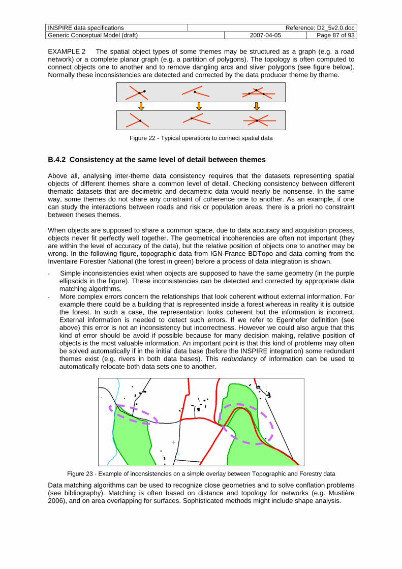
INSPIRE data specifications Reference: D2_5v2.0.docGeneric Conceptual Model (draft) 2007-04-05 Page 87 of 93
EXAMPLE 2 The spatial object types of some themes may be structured as a graph (e.g. a road network) or a complete planar graph (e.g. a partition of polygons). The topology is often computed to connect objects one to another and to remove dangling arcs and sliver polygons (see figure below). Normally these inconsistencies are detected and corrected by the data producer theme by theme.
Figure 22 - Typical operations to connect spatial data
B.4.2 Consistency at the same level of detail between themes
Above all, analysing inter-theme data consistency requires that the datasets representing spatial objects of different themes share a common level of detail. Checking consistency between different thematic datasets that are decimetric and decametric data would nearly be nonsense. In the same way, some themes do not share any constraint of coherence one to another. As an example, if one can study the interactions between roads and risk or population areas, there is a priori no constraint between theses themes. When objects are supposed to share a common space, due to data accuracy and acquisition process, objects never fit perfectly well together. The geometrical incoherencies are often not important (they are within the level of accuracy of the data), but the relative position of objects one to another may be wrong. In the following figure, topographic data from IGN-France BDTopo and data coming from the Inventaire Forestier National (the forest in green) before a process of data integration is shown.
- Simple inconsistencies exist when objects are supposed to have the same geometry (in the purple ellipsoids in the figure). These inconsistencies can be detected and corrected by appropriate data matching algorithms.
- More complex errors concern the relationships that look coherent without external information. For example there could be a building that is represented inside a forest whereas in reality it is outside the forest. In such a case, the representation looks coherent but the information is incorrect. External information is needed to detect such errors. If we refer to Egenhofer definition (see above) this error is not an inconsistency but incorrectness. However we could also argue that this kind of error should be avoid if possible because for many decision making, relative position of objects is the most valuable information. An important point is that this kind of problems may often be solved automatically if in the initial data base (before the INSPIRE integration) some redundant themes exist (e.g. rivers in both data bases). This redundancy of information can be used to automatically relocate both data sets one to another.
Figure 23 - Example of inconsistencies on a simple overlay between Topographic and Forestry data
Data matching algorithms can be used to recognize close geometries and to solve conflation problems (see bibliography). Matching is often based on distance and topology for networks (e.g. Mustière 2006), and on area overlapping for surfaces. Sophisticated methods might include shape analysis.
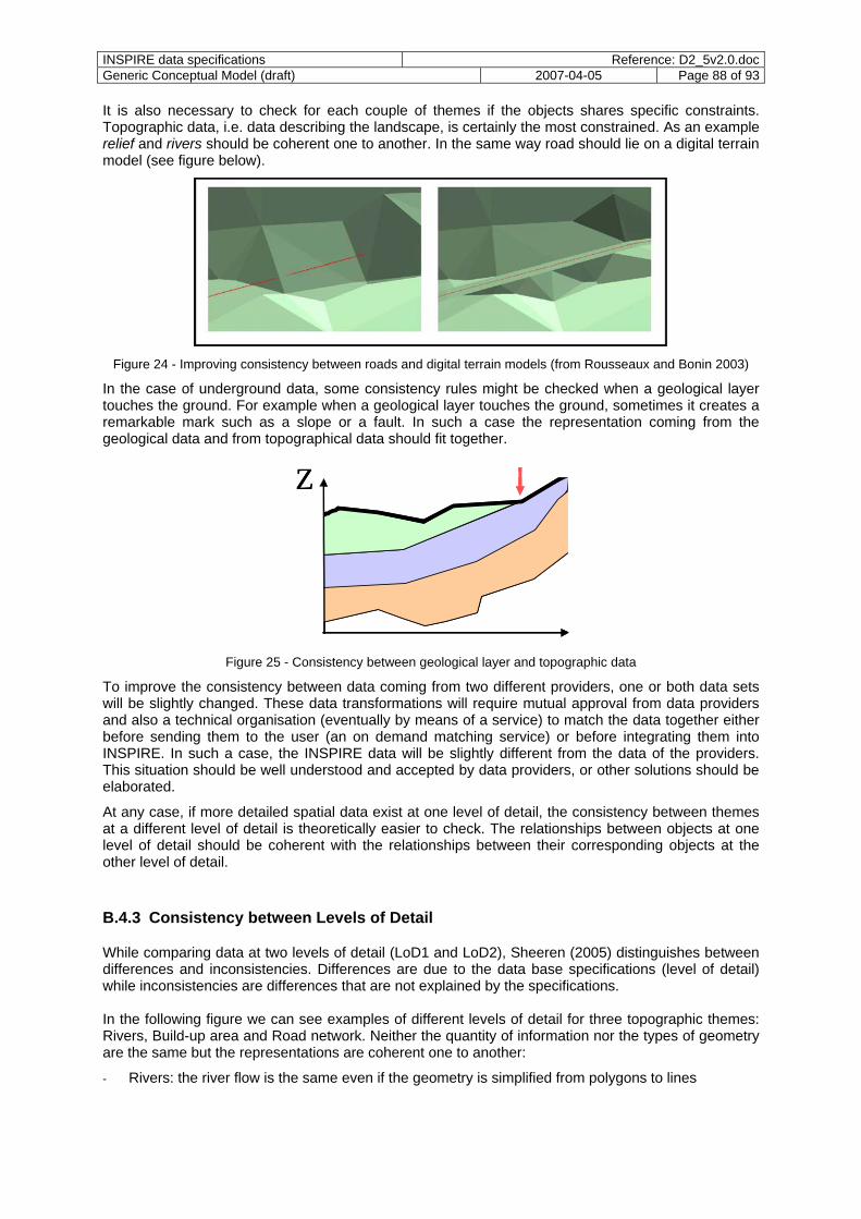
INSPIRE data specifications Reference: D2_5v2.0.docGeneric Conceptual Model (draft) 2007-04-05 Page 88 of 93
It is also necessary to check for each couple of themes if the objects shares specific constraints. Topographic data, i.e. data describing the landscape, is certainly the most constrained. As an example relief and rivers should be coherent one to another. In the same way road should lie on a digital terrain model (see figure below).
Figure 24 - Improving consistency between roads and digital terrain models (from Rousseaux and Bonin 2003)
In the case of underground data, some consistency rules might be checked when a geological layer touches the ground. For example when a geological layer touches the ground, sometimes it creates a remarkable mark such as a slope or a fault. In such a case the representation coming from the geological data and from topographical data should fit together.
ZZ
Figure 25 - Consistency between geological layer and topographic data
To improve the consistency between data coming from two different providers, one or both data sets will be slightly changed. These data transformations will require mutual approval from data providers and also a technical organisation (eventually by means of a service) to match the data together either before sending them to the user (an on demand matching service) or before integrating them into INSPIRE. In such a case, the INSPIRE data will be slightly different from the data of the providers. This situation should be well understood and accepted by data providers, or other solutions should be elaborated.
At any case, if more detailed spatial data exist at one level of detail, the consistency between themes at a different level of detail is theoretically easier to check. The relationships between objects at one level of detail should be coherent with the relationships between their corresponding objects at the other level of detail.
B.4.3 Consistency between Levels of Detail
While comparing data at two levels of detail (LoD1 and LoD2), Sheeren (2005) distinguishes between differences and inconsistencies. Differences are due to the data base specifications (level of detail) while inconsistencies are differences that are not explained by the specifications. In the following figure we can see examples of different levels of detail for three topographic themes: Rivers, Build-up area and Road network. Neither the quantity of information nor the types of geometry are the same but the representations are coherent one to another:
- Rivers: the river flow is the same even if the geometry is simplified from polygons to lines
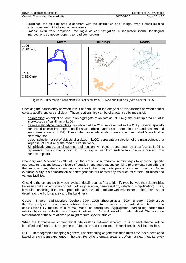
INSPIRE data specifications Reference: D2_5v2.0.docGeneric Conceptual Model (draft) 2007-04-05 Page 89 of 93
- Buildings: the build-up area is coherent with the distribution of buildings, even if small building extensions are not included in these areas
- Roads: even very simplified, the logic of car navigation is respected (some topological intersections do not correspond to road connection).
Rivers Buildings Roads
LoD1 © BDTopo
LoD2 © BDCarto
Figure 26 - Different but consistent levels of detail from BDTopo and BDCarto (from Sheeren 2005)
Checking the consistency between levels of detail lie on the analysis of relationships between spatial objects at different levels of detail. These relationships can be characterised by means of:
- aggregation: an object at LoD2 is an aggregate of objects at LoD1 (e.g. the build-up area at LoD2 is composed of buildings at LoD1)
- generalisation/type hierarchies: an object at LoD2 is represented in LoD1 by several spatially connected objects from more specific spatial object types (e.g. a forest in LoD2 and conifers and leafy trees areas in LoD1). These inheritance relationships are sometimes called “classification hierarchy”, too.
- object selection: a set of objects of a class in LoD2 represents a selection of the main objects of a larger set at LoD1 (e.g. the road or river network).
- Simplification/reduction of geometric dimension: An object represented by a surface at LoD1 is represented by a curve or point at LoD2 (e.g. a river from surface to curve or a building from surface to point).
Chaudhry and Mackaness (2006a) use the notion of partonomic relationships to describe specific aggregation relations between levels of detail. These aggregations combine phenomena from different themes when they share a common space and when they participate to a common function. As an example, a city is a combination of heterogeneous but related objects such as streets, buildings and various facilities. Checking the coherence between levels of detail requires first to identify type by type the relationships between spatial object types of both LoD (aggregation, generalisation, selection, simplification). Then, it requires checking, if the main properties at a level of detail are well maintained at the other level of detail (e.g. the build-up area and the buildings). Gesbert, Sheeren and Mustière (Gesbert, 2004, 2005; Sheeren at al., 2004, Sheeren, 2005) argue that the analysis of consistency between levels of detail requires an accurate description of data specifications by means of a formal model of description. Aggregation (particularly partonomic relationships) and selection are frequent between LoDs and are often underdefined. The accurate formalisation of these relationships might require specific studies. When the formalisation of theoretical relationships between different LoDs of each theme will be identified and formalised, the process of detection and correction of inconsistencies will be possible. NOTE In topographic mapping a general understanding of generalisation rules have been developed based on significant experience in the past. For other thematic areas it is often not clear, how far away
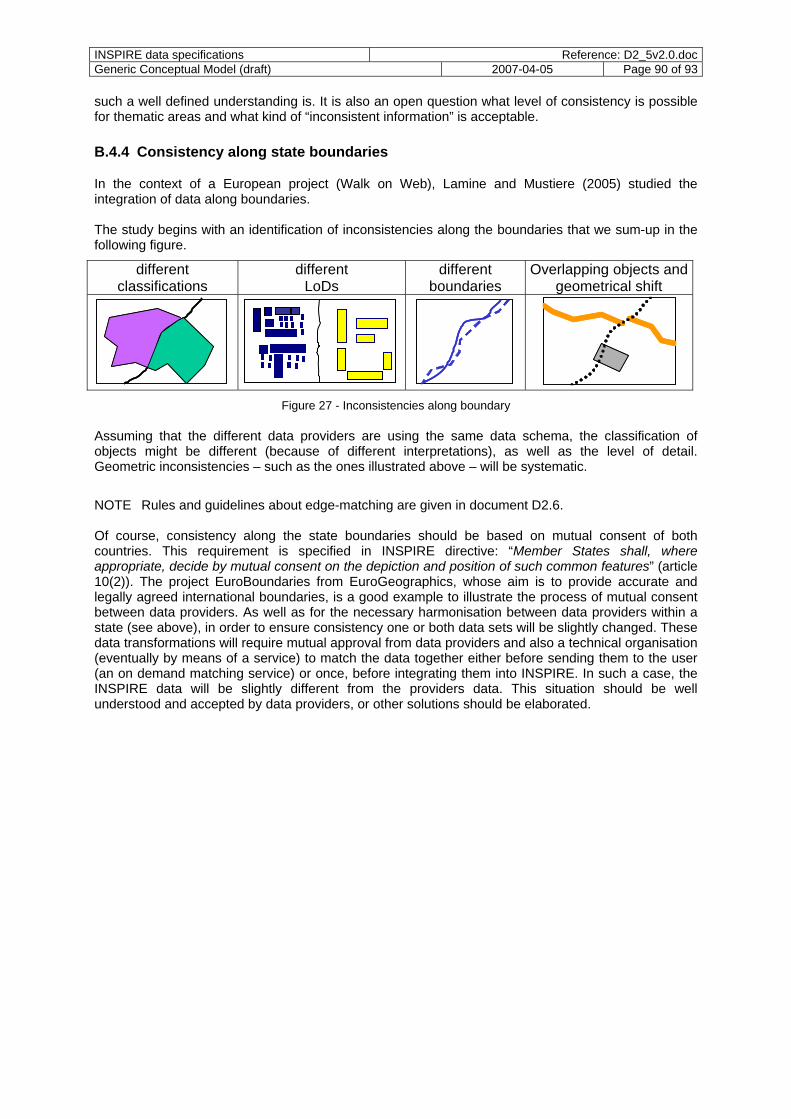
INSPIRE data specifications Reference: D2_5v2.0.docGeneric Conceptual Model (draft) 2007-04-05 Page 90 of 93
such a well defined understanding is. It is also an open question what level of consistency is possible for thematic areas and what kind of “inconsistent information” is acceptable. B.4.4 Consistency along state boundaries
In the context of a European project (Walk on Web), Lamine and Mustiere (2005) studied the integration of data along boundaries. The study begins with an identification of inconsistencies along the boundaries that we sum-up in the following figure.
different classifications
different LoDs
different boundaries
Overlapping objects and geometrical shift
Figure 27 - Inconsistencies along boundary
Assuming that the different data providers are using the same data schema, the classification of objects might be different (because of different interpretations), as well as the level of detail. Geometric inconsistencies – such as the ones illustrated above – will be systematic.
NOTE Rules and guidelines about edge-matching are given in document D2.6. Of course, consistency along the state boundaries should be based on mutual consent of both countries. This requirement is specified in INSPIRE directive: “Member States shall, where appropriate, decide by mutual consent on the depiction and position of such common features” (article 10(2)). The project EuroBoundaries from EuroGeographics, whose aim is to provide accurate and legally agreed international boundaries, is a good example to illustrate the process of mutual consent between data providers. As well as for the necessary harmonisation between data providers within a state (see above), in order to ensure consistency one or both data sets will be slightly changed. These data transformations will require mutual approval from data providers and also a technical organisation (eventually by means of a service) to match the data together either before sending them to the user (an on demand matching service) or once, before integrating them into INSPIRE. In such a case, the INSPIRE data will be slightly different from the providers data. This situation should be well understood and accepted by data providers, or other solutions should be elaborated.
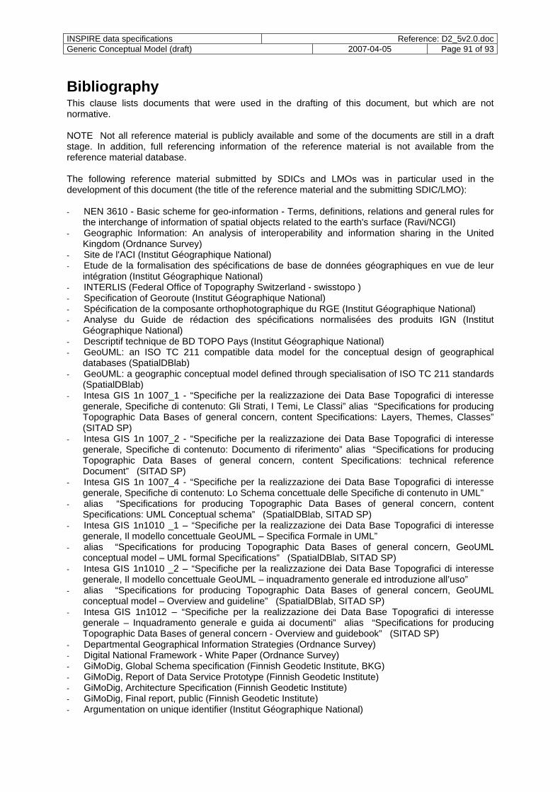
INSPIRE data specifications Reference: D2_5v2.0.docGeneric Conceptual Model (draft) 2007-04-05 Page 91 of 93
Bibliography This clause lists documents that were used in the drafting of this document, but which are not normative. NOTE Not all reference material is publicly available and some of the documents are still in a draft stage. In addition, full referencing information of the reference material is not available from the reference material database. The following reference material submitted by SDICs and LMOs was in particular used in the development of this document (the title of the reference material and the submitting SDIC/LMO): - NEN 3610 - Basic scheme for geo-information - Terms, definitions, relations and general rules for
the interchange of information of spatial objects related to the earth's surface (Ravi/NCGI) - Geographic Information: An analysis of interoperability and information sharing in the United
Kingdom (Ordnance Survey) - Site de l'ACI (Institut Géographique National) - Etude de la formalisation des spécifications de base de données géographiques en vue de leur
intégration (Institut Géographique National) - INTERLIS (Federal Office of Topography Switzerland - swisstopo ) - Specification of Georoute (Institut Géographique National) - Spécification de la composante orthophotographique du RGE (Institut Géographique National) - Analyse du Guide de rédaction des spécifications normalisées des produits IGN (Institut
Géographique National) - Descriptif technique de BD TOPO Pays (Institut Géographique National) - GeoUML: an ISO TC 211 compatible data model for the conceptual design of geographical
databases (SpatialDBlab) - GeoUML: a geographic conceptual model defined through specialisation of ISO TC 211 standards
(SpatialDBlab) - Intesa GIS 1n 1007_1 - “Specifiche per la realizzazione dei Data Base Topografici di interesse
generale, Specifiche di contenuto: Gli Strati, I Temi, Le Classi” alias “Specifications for producing Topographic Data Bases of general concern, content Specifications: Layers, Themes, Classes” (SITAD SP)
- Intesa GIS 1n 1007_2 - “Specifiche per la realizzazione dei Data Base Topografici di interesse generale, Specifiche di contenuto: Documento di riferimento” alias “Specifications for producing Topographic Data Bases of general concern, content Specifications: technical reference Document” (SITAD SP)
- Intesa GIS 1n 1007_4 - “Specifiche per la realizzazione dei Data Base Topografici di interesse generale, Specifiche di contenuto: Lo Schema concettuale delle Specifiche di contenuto in UML”
- alias “Specifications for producing Topographic Data Bases of general concern, content Specifications: UML Conceptual schema” (SpatialDBlab, SITAD SP)
- Intesa GIS 1n1010 _1 – “Specifiche per la realizzazione dei Data Base Topografici di interesse generale, Il modello concettuale GeoUML – Specifica Formale in UML”
- alias “Specifications for producing Topographic Data Bases of general concern, GeoUML conceptual model – UML formal Specifications” (SpatialDBlab, SITAD SP)
- Intesa GIS 1n1010 _2 – “Specifiche per la realizzazione dei Data Base Topografici di interesse generale, Il modello concettuale GeoUML – inquadramento generale ed introduzione all’uso”
- alias “Specifications for producing Topographic Data Bases of general concern, GeoUML conceptual model – Overview and guideline” (SpatialDBlab, SITAD SP)
- Intesa GIS 1n1012 – “Specifiche per la realizzazione dei Data Base Topografici di interesse generale – Inquadramento generale e guida ai documenti” alias “Specifications for producing Topographic Data Bases of general concern - Overview and guidebook” (SITAD SP)
- Departmental Geographical Information Strategies (Ordnance Survey) - Digital National Framework - White Paper (Ordnance Survey) - GiMoDig, Global Schema specification (Finnish Geodetic Institute, BKG) - GiMoDig, Report of Data Service Prototype (Finnish Geodetic Institute) - GiMoDig, Architecture Specification (Finnish Geodetic Institute) - GiMoDig, Final report, public (Finnish Geodetic Institute) - Argumentation on unique identifier (Institut Géographique National)

INSPIRE data specifications Reference: D2_5v2.0.docGeneric Conceptual Model (draft) 2007-04-05 Page 92 of 93
- Route 120 descriptif de contenu (Institut Géographique National) - Route 500 descriptif technique (Institut Géographique National) - BD Carto Descriptif technique (Institut Géographique National) - BD Carthage version 3.0 descriptif de contenu (Institut Géographique National) - BD Topo version 3.1 descriptif technique (Institut Géographique National) - BD Parcellaire version 1.1 descriptif technique (Institut Géographique National) - BD Ortho version 2 descriptif de contenu (Institut Géographique National) - BD Nyme descriptif technique (Institut Géographique National) - Spécifications BD Uni v0.1 (Institut Géographique National) - BD Adresse descriptif technique (Institut Géographique National) - BD Alti Descriptif technique (Institut Géographique National) - Link list to documents relating to: Framework for the WMO Information System (GRDC) - Documentation on the Modelling of Geoinformation of Official Surveying and Mapping GeoInfoDok
(Lenkungsgremium GDI-DE (Steering Committee GDI-DE), BKG) - CLIMATE SCIENCE MODELLING LANGUAGE: STANDARDS-BASED MARKUP FOR
METOCEAN DATA (ATMOS-DMC) - Using XML Technology for Marine Data Exchange: A Position Paper of the MarineXML Initiative
(ATMOS-DMC) - Report on Reference Data Sets and Feature types in Europe (EuroGeographics) - EDC-11031 EuroRegionalMap: Incremental Development of a Pan-European Database at
Medium Scale (Institut Géographique National) - EuroRegionalMap Specification and Data Catalogue (EuroGeographics, NGI Nationaal
Geografisch Insituut / IGN Institut Géographique National) - EuroGlobalMap data specification (EuroGeographics, National Land Survey of Finland) - SABE specification (EuroGeographics) - EUREF Publication No.13 (EUREF) - ATKIS Feature catalogue – chapter D4 : DLM1000 (Bundesamt für Kartographie und Geodäsie
(BKG)) - ATKIS Feature catalogue – chapter D3 : DLM250 (Bundesamt für Kartographie und Geodäsie
(BKG)) - EuroRoadS (EuroGeographics) Other documents that were used in the compilation of this document: - Katalin Tóth, INSPIRE Multiple-Representation and Data Consistency Workshop - Report, JRC
IES - DNF Expert Group, Technical Guide on Unique Object Identifiers - DNF Expert Group, Unique Object Identifiers within the Digital National Framework (DNF) - DNF Expert Group, Results of DNF Unique Identifier Consultation - Claudia Hess and Marian de Vries, From Models to Data: A Prototype Query Translator for the
Cadastral Domain Workshop Standardization in the Cadastral Domain, held by 'COST Action G9' and 'FIG Commission 7', Bamberg, December 9-10 2004, 14 p.
- Gazetteer Service (WFS-G), OGC Best practice document - Dudley MBC, Building a single-geometry land and property database at Dudley Metropolitan
Borough Council using the Digital National Framework - Geoscience markup language (GeoSciML), online at
https://www.seegrid.csiro.au/twiki/bin/view/CGIModel/GeoSciML - EuroGeoNames Consortium: Survey/Inventory on European Geographical Names data SI-EGN,
online at http://www.eurogeographics.org/eng/documents/051115_SI-EGN_final_report.pdf - EPSG Geodetic Paramater Dataset, online at http://www.epsg.org/Geodetic.html - Chaudhry O., and W. Mackaness, 2006a, Modelling Geographic Phenomena at Different Levels of
Detail, In Proceedings of Autocarto 2006, USA. - Gesbert N., 2004, Formalisation of Geographical Database Specifications, in proceeding of the
Conference on Advances in Databases and Information Systems (ADBIS), September 2004, Budapest, pp. 202-211
- Gesbert N., 2005, « Etude de la formalisation des spécifications de bases de données géographiques en vue de leur intégration ». PhD Thesis Université de Marne-La-Vallée, on line at ftp://ftp.ign.fr/ign/COGIT/THESES
INSPIRE data specifications Reference: D2_5v2.0.docGeneric Conceptual Model (draft) 2007-04-05 Page 93 of 93
- Mustière S. and van Smaalen J. 2007. Databases Requirements for Generalisation and Multiple Representations. To be published in “Generalisation of Geographic Information : Cartographic Modelling and Applications”, W. Mackaness, A. Ruas et T. Sarjakoski (eds), Elsevier.
- Racine JB, 1981, "Problématiques et méthodologie : de l'implicite à l'explicite" dans H. Isuard, JB Racine et H Raynard (ed.) Problématiques de la géographie Paris, PUF le géographe.
- Ruas A 2004 « Le changement de niveau de détail dans la représentation de l'information géographique » HDR University of Marne la Vallée (on line ftp://ftp.ign.fr/ign/COGIT/HDR/)
- Ruas A., Bianchin A., 2002, "Echelle et Niveau de détail" dans A. Ruas (ed.) Généralisation et représentation multiple, Paris, Hermes Lavoisier, Chapitre 1, p25-44.
- Egenhofer M.J., Clementini E. and Di Felice P. 1994. Evaluating inconsistencies among multiple representations, In Proceedings of the 6th International Symposium on Spatial Data Handling (SDH’94), pp. 901-920.
- Sheeren, D., Mustière, S., Zucker, J.-D. 2004, Consistency Assessment Between Multiple Representations of Geographical Databases: a Specification-Based Approach. Proc. of the 11th International Symposium on Spatial Data Handling, Leicester, UK.
- Sheeren D., 2005, « Méthodologie d'évaluation de la cohérence inter-représentations pour l'intégration de bases de données spatiales. Une approche combinant l'utilisation de métadonnées et l'apprentissage automatique. » PhD Thesis, University of Paris 6, 292 p. on line at ftp://ftp.ign.fr/ign/COGIT/THESES
- Haunert J.-H. 2005. Link based Conflation of Geographic Datasets. 8th ICA workshop on generalisation and multiple representation, A Coruña, Spain, July 2005.
- Lamine K. and S. Mustiere, 2005, “Integration de données transfrontalieres relatives à la randonnée pedestre” Laboratoire COGIT, Paris 6. European Project WoW: Walk on Web; IST-2-004688-STP.
- Mustière S. 2006. Results on experiments on automated matching of networks. Proceedings of the ISPRS Workshop on Multiple Representation and Interoperability of Spatial Data, Hanover, pp.92-100
- Rousseaux Frédéric, Bonin Olivier (2003) Toward a coherent integration of 2D linear data into a DTM . International Cartographic Conference 2003 (ACI), Durban, South Africa.
- Douglas D. Nebert (editor), The SDI Cookbook, January 2004, GSDI