drake stone the drake stone & harbottle 2 hours 30...
TRANSCRIPT
You can do this walk when
MOD RedFlags are
flying
Start OS Grid Ref: NT 925 049 Parking: Forestry Commission West Wood Car Park
Public Transport: Spirit Buses (www.spiritbuses.co.uk T: 01669 838349)
Local Services: Rothbury National Park Information Point: The Star Inn, Harbottle
Terrain: Footpaths, tracks and road - short steep inclines, stiles
Description: A lovely walk up to the ancient Drake Stone, a mythical place from where thereare stunning views over the surrounding countryside and over to the ruins of Harbottle Castle
D
C B
A
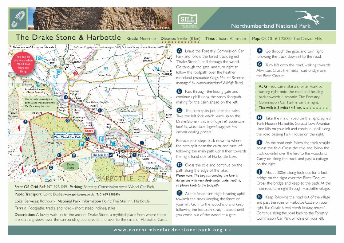
Please use an OS map on this walk
E
Start
Drake Stone
F
H
I
J
Shorter walk - turn right at point G and walk back to the Car Park along the road.
© Crown Copyright and database rights (2015) Ordnance Survey Licence Number 100022521
Drake Stone
Grade: Moderate Distance: 5 miles (8 km) Time: 2 hours 30 minutes Map: OS OL16 1:25000 The Cheviot HillsThe Drake Stone & Harbottle
A Leave the Forestry Commission CarPark and follow the forest track, signed‘Drake Stone,’ uphill through the wood. Go through the gate, and turn right to follow the footpath over the heather moorland (Harbottle Crags Nature Reserve,managed by Northumberland Wildlife Trust).
Pass through the kissing gate and continue uphill along the sandy footpath,making for the cairn ahead on the left.
The path splits just after the cairn. Take the left fork which leads up to theDrake Stone - this is a huge Fell Sandstoneboulder, which local legend suggests hasancient healing powers !
Retrace your steps back down to where the path split near the cairn, and turn left following the main path uphill then towardsthe right hand side of Harbottle Lake.
Cross the stile and continue on thepath along the edge of the lake. Please note: The bog surrounding the lake is dangerous with very deep water underneath it, so please keep to the footpath.
At the fence turn right, heading uphilltowards the trees, keeping the fence onyour left. Go into the woodland and keepfollowing the footpath straight ahead, untilyou come out of the wood at a gate.
B
C
D
G
H
E
F
w w w . n o r t h u m b e r l a n d n a t i o n a l p a r k . o r g . u k
I
J
K
K
Go through the gate, and turn rightfollowing the track downhill to the road.
Turn left onto the road, walking towardsAlwinton. Cross the metal road bridge overthe River Coquet.
At G - You can make a shorter walk by turning right onto the road and heading back towards Harbottle. The Forestry Commission Car Park is on the right. This walk is 3 miles / 4.8 km.
Take the minor road on the right, signed‘Park House / Harbottle. Go past Low AlwintonLime Kiln on your left and continue uphill alongthe road passing Park House on the right.
As the road ends follow the track straightacross the field. Cross the stile and follow thetrack downhill over the field to the woodland.Carry on along the track, and past a cottageon the right.
About 300m along look out for a foot-bridge on the right over the River Coquet.Cross the bridge and keep to the path. At themain road turn right through Harbottle village.
Keep following the road out of the villageand past the ruins of Harbottle Castle on yourright. The Castle is well worth looking around.Continue along the road back to the ForestryCommission Car Park which is on your left.
G
The Drake Stone & Harbottle
Wildlife to look out forThis area is a Special Area of Conservation(SAC) designated for its heather moorlandand blanket bog. Plants to look for includeCalluna or ling heather, cross leaved heath, bilberry, cowberry and sphagnum moss.
Birds flitting amongst the heather includewren, stonechat and wheatear whilst buzzard areoften seen overhead. Barn owls may be seensilently flying over the grassy fields near thecastle at dusk.
In the woodlands red squirrel and roe deermay be glimpsed. Bats roost in many of thebuildings and might be seen by the woodlandsand feeding over the river at dawn and dusk.
The underlying rocks are sandstone, part ofthe Fell Sandstone sequence that dominatesmid-Northumberland. They have been usedto make mill stones, some of which are abandoned in the old quarry near the DrakeStone.
Harbottle Castle
Getting thereFrom Rothbury: Leave Rothbury on the B6341 heading west. Go through Thropton. At Flotterton Farm junction turnright following the signpost to ‘Alwinton’. Go through Harbottle. 600m westof the village is the Forestry Commission West Wood Car Park.
From Elsdon: Leave the B6341 at the hamlet of Swindon, signed ‘Alwinton’ to the left. Follow this road through Holystone and Harbottle. 600m west of Harbottle is the Forestry Commission WestWood Car Park.
Spirit BusesSpirit buses run from Rothbury into Upper Coquetdale.T: 01669 838 349 www.spiritbuses.co.uk
The Star Inn &National Park Information PointThe Star Inn in Harbottle is the village puband National Park Information Point. The Innalso has a small shop where you can pick up some basic supplies.
Local facilitiesHarbottle is a lovely village situated in theheart of Coquetdale. The single street isoverlooked by the ruins of the 12th centuryHarbottle Castle, and, the Drake Stone. Theneighbouring village of Alwinton has a pub, the Rose & Thistle which is also a NationalPark Information Point.
Points of interestHarbottle Castle is well worth a visit, and canbe reached from the National Park Car Park.There has been a castle on the site since c.1157when Henry II ordered Odinel de Umfraville tobuild a ‘strong castle’ at Harbottle. HarbottleCastle consists of a motte (mound), with east
Drake Stone
Harbottle
and west bailey. It was built to form part of achain of such sites against the ‘auld enemy’ -Scotland. It towers over the major medievalhighway into Scotland (Clennell Street), makingit a point of strategic and tactical importance.
The Drake Stone has many stories and mythsconnected with it. One being that sick childrenpassed over the Stone would be cured; otherstell that it is seemingly not uncommon to heardisembodied voices coming from the Stoneand travellers who have safely spent the nightthere are unable to descend in the morning!
Ministry of Defence (MOD)Much of the land to the west of Harbottle isowned by the MOD. Called OtterburnRanges they are one of England’s remotestupland areas and have been used for militarytraining since 1911. This walk is outside theControlled Access Area and can thereforebe used all year round, giving spectacularviews into this remote part of the NationalPark. The 90 square miles of OtterburnRanges provide a realistic environment fortraining more than 300,000 NATO troopsevery year. For information log on to: www.gov.uk/government/publications/otterburn-firing-times
Drake Stonew w w . n o r t h u m b e r l a n d n a t i o n a l p a r k . o r g . u k