drl impact brief for web final 23rd march 2018 impact brief...microsoft word - drl impact brief for...
TRANSCRIPT

Issue 1, 2017
Impact Brief Achieving Water Neutrality
By adopting a Watershed Development Approach
Issue 1, December 2017
What Is this About! Climate Change is no more a hypothesis. IPCC predicts semi-
arid regions will become dryer and hotter – and the water crisis will
increase. In many nations, especially developing countries, water resource management tends to be supply driven. However, it is now well
recognized that, large-scale industrial/urban development affects the infiltration of water, increases runoff of rainwater, reduces groundwater
recharge and the availability of water for vegetation. Apart from the various socio-political externalities a company has to face several risks
while running its business operations, which includes environmental and geo-hydrological factors that exacerbates particularly water related
business risks. Due to this, corporate water accounting has transitioned from a primarily inward focus on production processes to an outward
focus that involves the social, political, environmental conditions of the watersheds in which companies operate.
In view of this, as all ecosystems are embedded in watershed, Dr.Reddys’ has initiated a pioneering initiative under their corporate
sustainability division of achieving water neutrality to some extent by adopting what is called a watershed development and management
approach. This initiative is being implemented at Bhudera, Medak District, Telangana with Watershed Organisation Trust as the technical
knowledge partner.
The water footprint is an indicator of water use that looks at both direct and indirect water use. Water neutrality is all about reducing and offsetting the impacts of water footprints. ‘Waterneutral’means - one reduces the water
footprint of an activity as much as possible and offsets the negative externalities of the remaining water footprint. (UNESCO-IHE Institute for Water Education, 2008)
Highlights
Water Footprints & Water Neutrality
v Total of 4,83,755 cu.m of water was captured v/s estimated 2,11,100 cu.m
Total of 14,480 trees have been planted - 40 native species and 10 exotic.
v
v
v
v
99 households benefitted from the work on the site from May to November 2017
Communities outside the site report raise in ground water levels in the wells and borewells
116 labours benefitted from this initiative out of which 35 are women labourers

2
Watershed Development and Management
1
A watershed is defined as a geo-hydrological unit comprising of all land and water resources within the confines of drainage divide. Watersheds provide a wide range of ecosystem services for humans, and one of which is ‘water’. Mismanagement of watersheds triggers a chain reaction resulting in severe degradation of natural resources impacting ground water tables and its recharging capacity inducing desertification. Hence sustainable management of a watershed is critical to ensure
Simple mud and stone structures built across the natural drainage lines of the landscape helps conserve soil and moisture!
2
that they continue to provide ecosystem services sustainably. Watershed development (WSD) is one of the most popular strategies to revitalise lanscapes and enhance the capture and storage of rainwater thus stabilizing the production base. This in turn results in increased availability of water and other basic needs of humans. While WSD encompases many aspects to improve livelihoods of humans, in this initiative it focusses only on :
• Conservation of soil, rainwater, and vegetation;
3
• Harvests the surplus water to create water sources in addition to groundwater recharge;
• Cover the non-arable area effectively through afforestation based on land capability class;
• Restore ecological balance.
Area Treatments Unit Nos. Drainage Treatments Unit Nos.
Trench Cum Bunds Rmt 15200 Loose boulder structure - 5 Nos. 5
Natural farm bunds Rmt 13050 Loose boulder structure -12 Nos. 14
Stone outlets Nos. 102 Rock Filled Dam - 10 Nos. 1
Rock Filled Dam - 12 Nos. 9
Mini Percolation Tank - 100 Nos. 1
Farm Ponds Nos. 3
Work done so far!
Illustration of watershed and its different natural features

3
Afforestation & Biodiversity
1
Afforestation, another key component of the project, has been done covering major part of the site where trench cum bunds were made. Apart from this, a dense forest is being developed in the central region of the site as well. For this, a new method called Miyawaki was adopted. This, in the future would develop into a dense forest increasing the biodiversity on the site. A total of 14,280 saplings were planted on site of which 40 are native species and 10 are exotic species. This
year 70% survival rate of these species is
Emergence of local flora and fauna at the site and the surrounding indicate the signs of ecosystem recovery and its health; if they cease to exist
then it’s a matter of CONCERN!
2
observed. Several birds, butterflies and terestrial crabs were spotted post monsoon indicating some positive signs of recovery.
The Result!
NDVI Imagery of the site showing extent of vegetation cover before and after project interventions for the year 2017. Image shows increase in medium and dense vegetation cover inside the site which over the years will help restore the ecological balance in the area provided there are no future changes in the land use at the site.

4
1
Spatial and Temporal Changes in ground water: The spatial variations of groundwater levels across the site are plotted below. The temporal variations in the plots indicate that there has been significant impact of WSD structures. The red regions in the plots depict the depressions (drop) and blue represents the mound (rise) of water levels under the ground. The January plot shows that the situation of groundwater
2
level post monsoon season of 2016 of the site was alarming as there is more area under red and most the bore wells are dry. This could be because the site did not have the capacity to capture the rainfall received considering the geology, soil characteristics and vegetation of the site. However, the September plot shows a significant difference where the plot has large areas under blue indicating increase in ground water levels. The plot also
3
shows that a few of the defunct wells have been revived.
This impact can be attributed to the WSD treatments done across the site that helped reduce the runoff converting more of red areas into blue indicating a raise in water level.
Water Captured at Bhudera
Extensive WSD treatments across the site captured 4,83,755.16 cum. of water,
reviving defunct bore wells inside the site as well as raised water levels in
wells and borewells within 2 km radius of the site!
Spatial response of Ground Water levels across the site from Jan 2017 (left) to Sep 2017 (right)
5
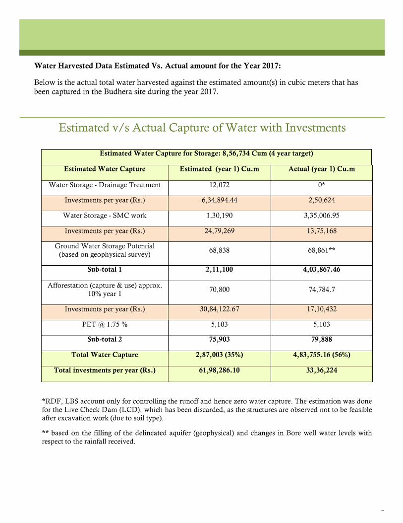
Estimated v/s Actual Capture of Water with Investments
Estimated Water Capture for Storage: 8,56,734 Cum (4 year target)
Estimated Water Capture Estimated (year 1) Cu.m Actual (year 1) Cu.m
Water Storage - Drainage Treatment 12,072 0*
Investments per year (Rs.) 6,34,894.44 2,50,624
Water Storage - SMC work 1,30,190 3,35,006.95
Investments per year (Rs.) 24,79,269 13,75,168
Ground Water Storage Potential (based on geophysical survey)
68,838 68,861**
Sub-total 1 2,11,100 4,03,867.46
Afforestation (capture & use) approx. 10% year 1
70,800 74,784.7
Investments per year (Rs.) 30,84,122.67 17,10,432
PET @ 1.75 % 5,103 5,103
Sub-total 2 75,903 79,888
Total Water Capture 2,87,003 (35%) 4,83,755.16 (56%)
Total investments per year (Rs.) 61,98,286.10 33,36,224
*RDF, LBS account only for controlling the runoff and hence zero water capture. The estimation was done for the Live Check Dam (LCD), which has been discarded, as the structures are observed not to be feasible after excavation work (due to soil type).
** based on the filling of the delineated aquifer (geophysical) and changes in Bore well water levels with respect to the rainfall received.
Water Harvested Data Estimated Vs. Actual amount for the Year 2017:
Below is the actual total water harvested against the estimated amount(s) in cubic meters that has been captured in the Budhera site during the year 2017.

6
1
The social impact around the project site was also significant. The project was able to provide income to labours from 99 households during the period from May to December 2017, residing in 8 villages around the project site. Each labourer earned a maximum of Rs. 31,584/- for the above mentioned period. Out of the 116 labourers who worked on the site 32 were women labourers. In addition to the unskilled labour work, four skilled labours from Kurnool district also benefitted from the project by undertaking specialised stone work on the watershed structures whose total earning is Rs.2,35,523.86/-. Details of the earning by Labours vs. Amount Spent on Labour work through the project:
Total amount spent on labour
Amount spent on
PF,ESI,GST
Average / person earning
(with Taxes)
maximum Earning full
period/person (With Taxes)
Rs.8,90,339 Rs.3,09,206 Rs.6,938.5 Rs.31,584
As a norm of the company, all labourers availed a free health
2
checkup before working on the site, which was an added benefit. Impact outside the Site:
Though watershed development techniques were applied only inside the Bhudera site, its impacts were seen beyond the boundary wall of the site. Water harvested inside the site had a positive impact on a larger scale, thus enhancing the resource availability in the surrounding villages. Availability of more natural resources has a good social impact on the rural poor residing outside the site as it enhances their monitory gains through enhanced irrigation of crop and livestcok production and general well being. Personal interviews were done with farmers and household members through random sampling within 2 kms radius around the site to identify the impact on wells and borewells. The survey has revealed two major inferences although quantitative data is not available. This year farmers have observed a greater raise in water levels in their wells. Thus, more crops were taken up for cultivation this Rabi season in terms of area and crop varieties. To conclude, the initiative has resulted in a greater impact apart from the original objectives of the project.
Social Impact:
99 households benefitted from the
work on the site from May to December
2017
Communities around the Bhudera site
were interviewed to check the impact of the project: rise in
water levels in wells and bore wells were
reported.

Regional Office – Hyderabad, Telangana
P.Kistaiah
G.Srujan Kumar
Jyothirmayee Kandula
K.Bhavana Rao
Headquarters – Pune, Maharashtra
Vijayasekaran Duraisamy
Renie Thomas
Sandeep Jadhav
Priyanka Mandal
Bhaskar Kumar Kunadharaju
Dhananjay Vijay Joshi
Alok Mehrothra
Issue 1, 2017
Watersheds provide life’s necessities, managing them is critical as climate change is a
reality!
While corporate sustainability recognizes that corporate growth and profitability are important, it also requires the corporation to pursue societal goals, specifically those relating to sustainable development and environmental protection in particular. Through this initiative, Dr. Reddy’s
is a forerunner in adopting the watershed approach as a path towards reducing its water
footprint.
Contact Us:
Head office: Watershed Organisation Trust (WOTR), 2nd floor,The Forum, Padmavati Corner, Pune - Satara road, Pune - 411009., Phone: +9120 24226211, Email: [email protected]
Hyderabad Regional Office : Sai GNR Residency, Flat 303, 4th floor, Bhaskar Rao Nagar, Secunderabad -500 094, Ph: 040- 64645045 emails for state specific enquiries : [email protected] & [email protected]