drones in your enterprise - gisworx
TRANSCRIPT

Drones in Your Enterprise
Kiran Kumar
gistec
The ArcGIS Platform, Drone2Map.

ArcGIS as a Platform for Drone Imagery

Professional Imagery & Geospatial
Analysts
Server
ArcGIS is a Comprehensive Imagery Platform, including Drones Drones Integrate into the Complete ArcGIS Platform
System of Record
To manage and process all your imagery
System of Insight
To extract Information from Imagery
System of Engagement
To share imagery products and information to those that need it
Esri also have multiple partners to provide best of breed solutions

ArcGIS as a System of Record Manage your imagery and make it accessible
• Content to manage your drone project planning
- Living Atlas and ArcGIS Online provide extensive content E.g. terrain models
• Processing to create imagery products
- Drone2Map – App optimized for drone imagery processing
- FMV – Add in for ArcGIS Desktop to Organized and work with Full Motion Video
- ArcGIS desktop & server – Tools for working with all forms of Satellite & Aerial imagery
• Manage and serve content from multiple projects & sensors
- Data management for massive collections
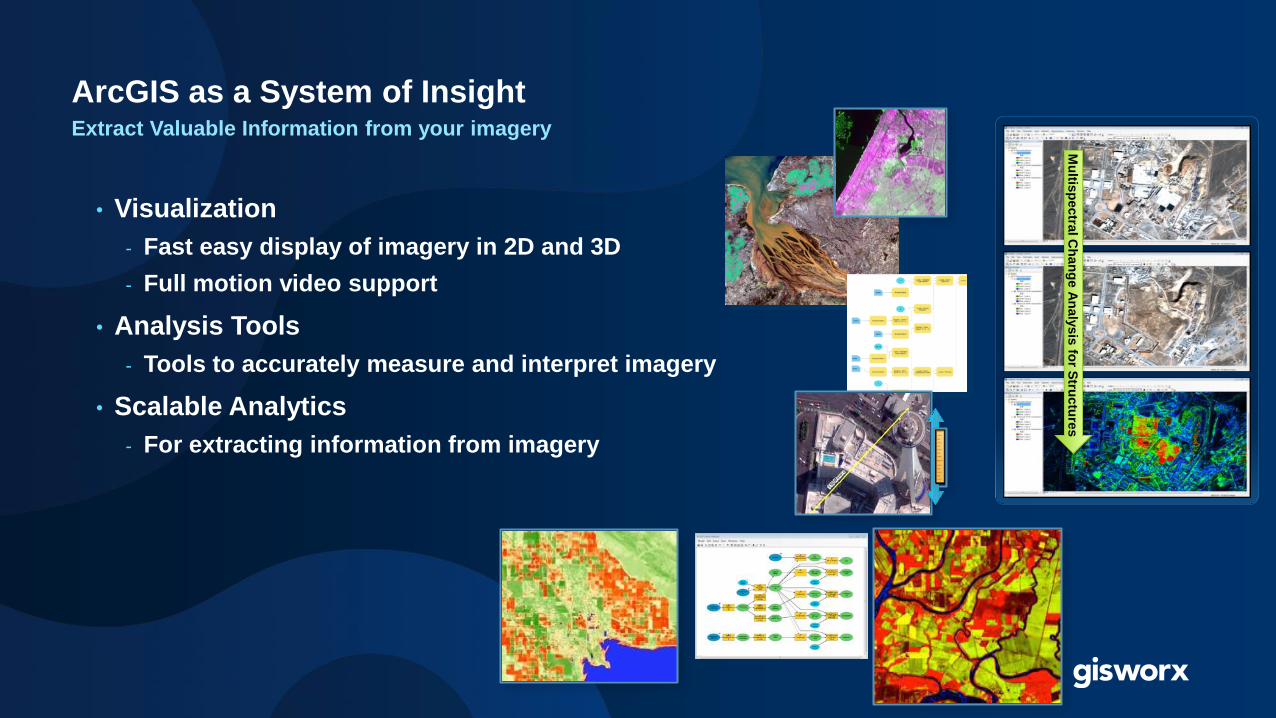
ArcGIS as a System of Insight Extract Valuable Information from your imagery
• Visualization
- Fast easy display of imagery in 2D and 3D
- Full motion video support
• Analysis Tools
- Tools to accurately measure and interpret imagery
• Scalable Analytics
- For extracting information from imagery
Mu
ltisp
ectra
l Ch
an
ge A
naly
sis
for S
tructu
res

ArcGIS as a System of Engagement Imagery as an integral component in your apps.
Accessible Simple
Highly Visual
• Integrate imagery into your enterprise
• Access from multiple devices in mobile, web and desktop applications
• Appropriate access control

Analyze
Share
Challenges
Manage Analyze Share
variety of formats
volume & velocity
redundancy
portability
scalability
reproducibility
integration
standards
accessibility

App for End-to-end workflow to process still frame drone imagery
Rapidly produce orthomosaics, point clouds, 3D meshes

What will your Drone do for you?
Drone2Map for ArcGIS
ArcGIS
Online
The App to Integrate Drones into Your Enterprise
Quickly Create Valuable Imagery Products from Drone Imagery
Achieve massive cost reduction in aerial imaging collection, processing and use
Easily share your results with others

Drone workflow
Esri
Extending Analytical
Capabilities Flight Planning
Collection Share Processing

F
Orthorec
Mosaics
tified
3D Point Clouds &
Meshes
Close range imagery
(inspection)
Drone2Map Close-range Inspection
Photos
Oblique imagery
Nadir imagery
ull Motion Video
Workflow for drone Imagery based on camera & operational mode

Desktop
Create Catalog of Imagery
spatially-indexed catalog
multi-resolution, multivariate, multidimensional
reduce storage redundancy & pixel resampling
defines information products
on-demand processing
Reference Sources Ingest & Define Metadata
Define Processing to be Applied Image collections
HDF, GRIB, netCDF
d-aware rasters
•
•
•
Apply:
• On-the-fly Processing
• Dynamic Mosaicking
Access as Image or Catalog
Image Management Using Mosaic Dataset
mosaic dataset
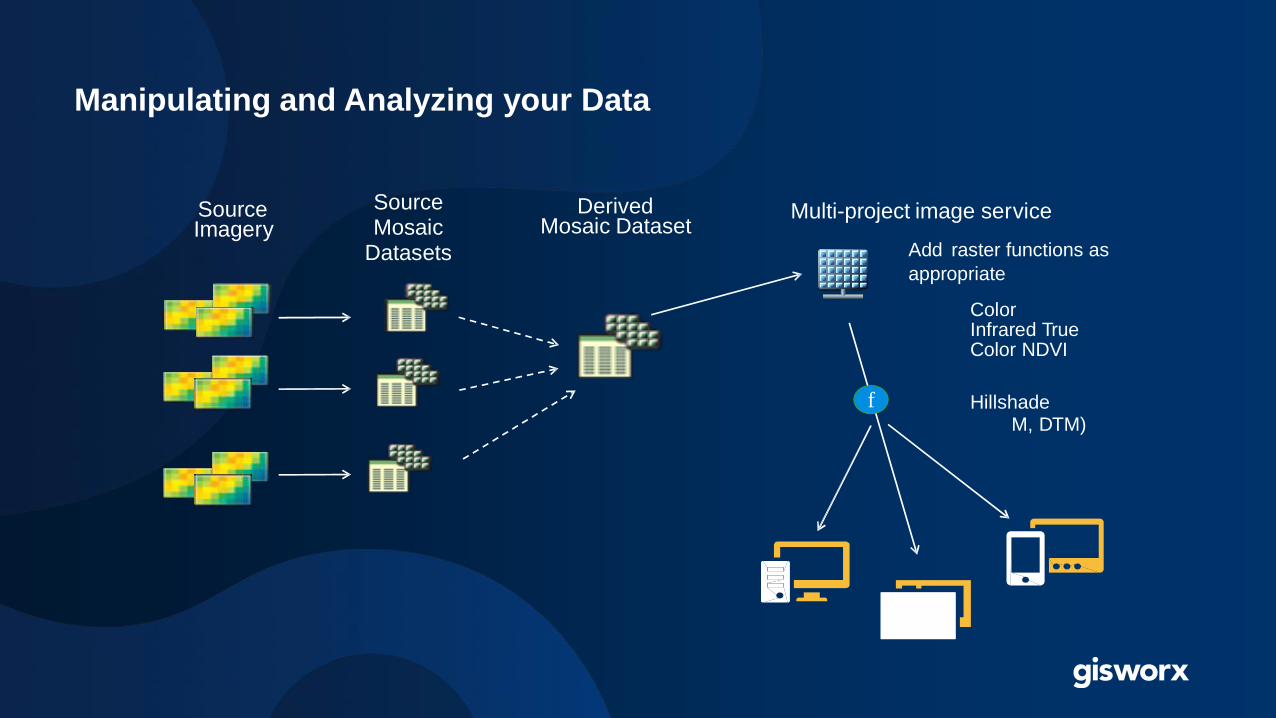
Source Mosaic
Datasets
Derived Mosaic Dataset
Source Imagery
Multi-project image service
Add raster functions as
appropriate
Color Infrared True Color NDVI
f Hillshade M, DTM)
Manipulating and Analyzing your Data

Drone2Map Supports Complete Workflows for:
• 2D Mapping
- For interpretation and analysis
E.g. Map updating, agriculture, site monitoring
• 3D Mapping
- For 3D visualization and modeling
E.g. Urban planning, building reconstruction
• Inspections
- For review of fine details
E.g. Industrial and utility management
Input is a folder of frame imagery with approx. GPS coordinates and sufficient overlap
All products integrate into the ArcGIS platform for further visualization and analysis

2D Mapping Workflows
• High Resolution Color Orthomosaics
- For interpretation and mapping
• Multispectral Analytic Imagery (with appropriate cameras)
- NDVI for vegetation analysis
• Quick Georeferenced Aligned Imagery
- For emergency response, fast interpretation
• Digital Surface Models
- For visualization and volumetric analysis
Output and Share:
- Image Web Layers on ArcGIS Online
- TIF image mosaics for use in desktop or enterprise applications
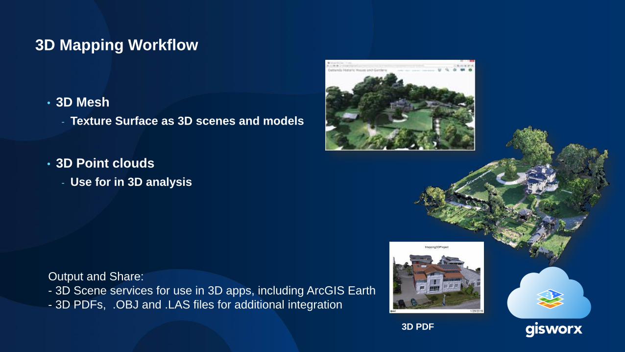
3D Mapping Workflow
• 3D Mesh
- Texture Surface as 3D scenes and models
• 3D Point clouds
- Use for in 3D analysis
Output and Share:
- 3D Scene services for use in 3D apps, including ArcGIS Earth
- 3D PDFs, .OBJ and .LAS files for additional integration
3D PDF

Inspection Workflows
• Oriented Imagery
- Imagery associated with 3D objects for detailed inspection
- Enable fine details on features to be reviewed and documented
- Smart Inspection Application on Web and Desktop to
Output and Share:
- Feature web service of geospatially linked high resolution imagery
- Feature class for additional integration
Oblique Imagery
Smart Inspection
on Web and Desktop

Consuming your services
• In any ArcGIS application or any WMS client
• In a web map
• Identify web services driven by maps or datasets
• Bring service layers into a web map
• In a map-based application
• Configurable apps
• Story Maps
• Web AppBuilder
• Custom web apps using ArcGIS API for JavaScript
