drone@uav@uas safety - mahfuzah.weebly.com · 11. pilot and aircraft log book ... icao unmanned...
TRANSCRIPT
DRONE@UAV@UAS
SAFETY

CONTENTS
1. Introduction
2. Aviation Authority
1. ICAO – International Civil Aviation Organisation, United Nations
2. CASA – Civil Aviation Safety Authority Australia
3. CAA – Civil Aviation Authority, United Kingdom
4. CAAS – Civil Aviation Authority Singapore, Singapore
5. FAA – Federal Aviation Administration, USA
6. EASA – European Aviation Safety Agency
3. Human Factor
4. Weather
Check list……………..
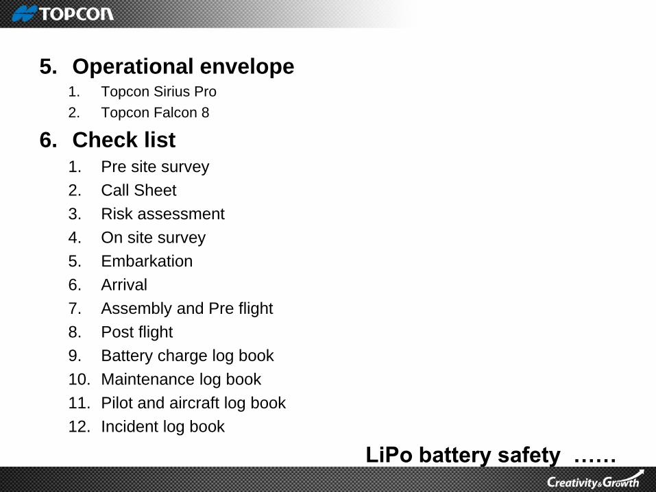
5. Operational envelope1. Topcon Sirius Pro
2. Topcon Falcon 8
6. Check list1. Pre site survey
2. Call Sheet
3. Risk assessment
4. On site survey
5. Embarkation
6. Arrival
7. Assembly and Pre flight
8. Post flight
9. Battery charge log book
10. Maintenance log book
11. Pilot and aircraft log book
12. Incident log book
LiPo battery safety ……
7. LiPo battery safety
8. Fail safe
9. Insurance for 3rd party liability
In
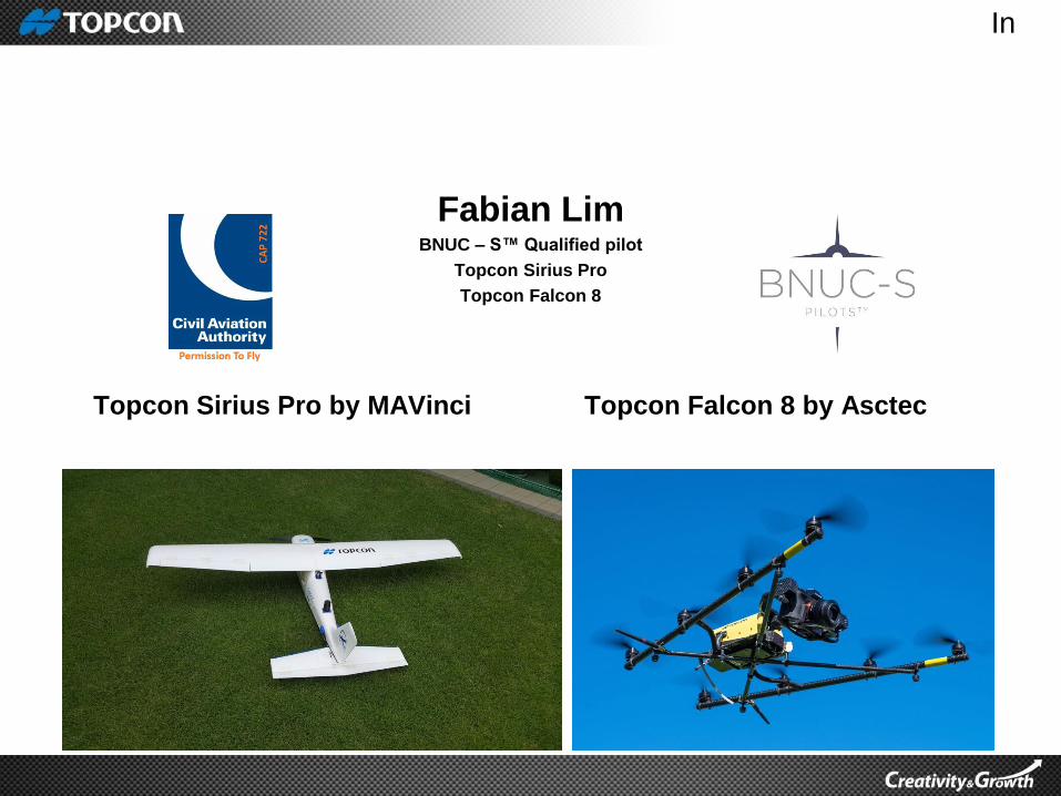
Fabian LimBNUC – S™ Qualified pilot
Topcon Sirius Pro
Topcon Falcon 8
Topcon Sirius Pro by MAVinci Topcon Falcon 8 by Asctec

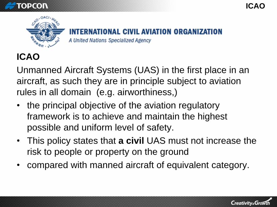
ICAO
ICAO
Unmanned Aircraft Systems (UAS) in the first place in an
aircraft, as such they are in principle subject to aviation
rules in all domain (e.g. airworthiness,)
• the principal objective of the aviation regulatory
framework is to achieve and maintain the highest
possible and uniform level of safety.
• This policy states that a civil UAS must not increase the
risk to people or property on the ground
• compared with manned aircraft of equivalent category.

Federal Aviation Administration - guidelines
• Follow community based safety guidelines as developed
by organizations such as the Academy of Model
Aeronautics
• Fly no higher than 400 feet and remain below any
surrounding obstacles when possible
• Keep your sUAS in eyesight at all times and use an
observer to assist if needed
• Remain well clear of and do not interfere with manned
aircraft operations, and you must see and avoid other
aircraft and obstacles at all times
• Do not intentionally fly over unprotected persons or
moving vehicles and remain at least 25 feet away from
individual and valuable property.
Federal Aviation Administration - guidelines
• Contact the airport or control tower before flying within
five miles of an airport
• Do not fly near or over sensitive infrastructure or
property such as power stations, water treatment
facilities, correctional facilities, heavily traveled
roadways, government facilities.
• Check and follow all local laws and ordinances before
flying over private property
• Do not conduct surveillance or photograph persons in
areas where there is an expectation of privacy without
the individual’s permission.

CASA
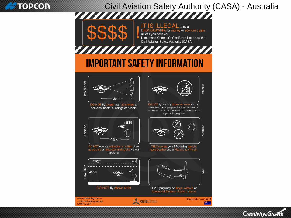
Civil Aviation Safety Authority (CASA) - Australia

CASA
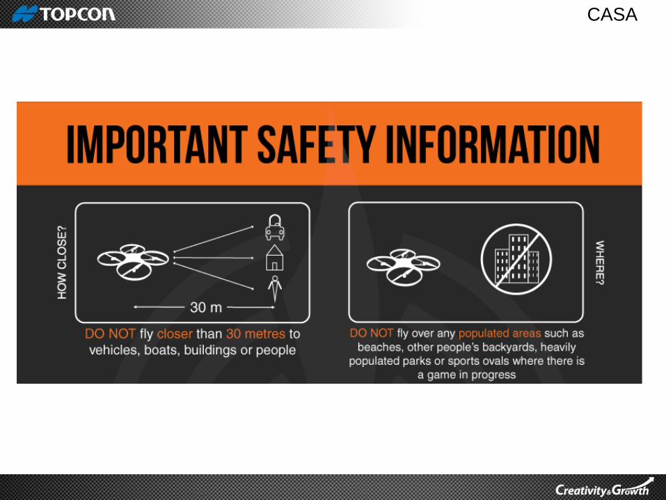
CASA
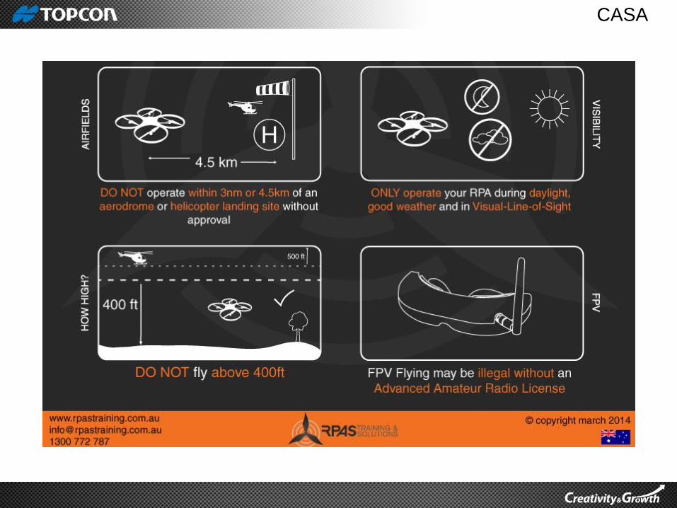
CASA
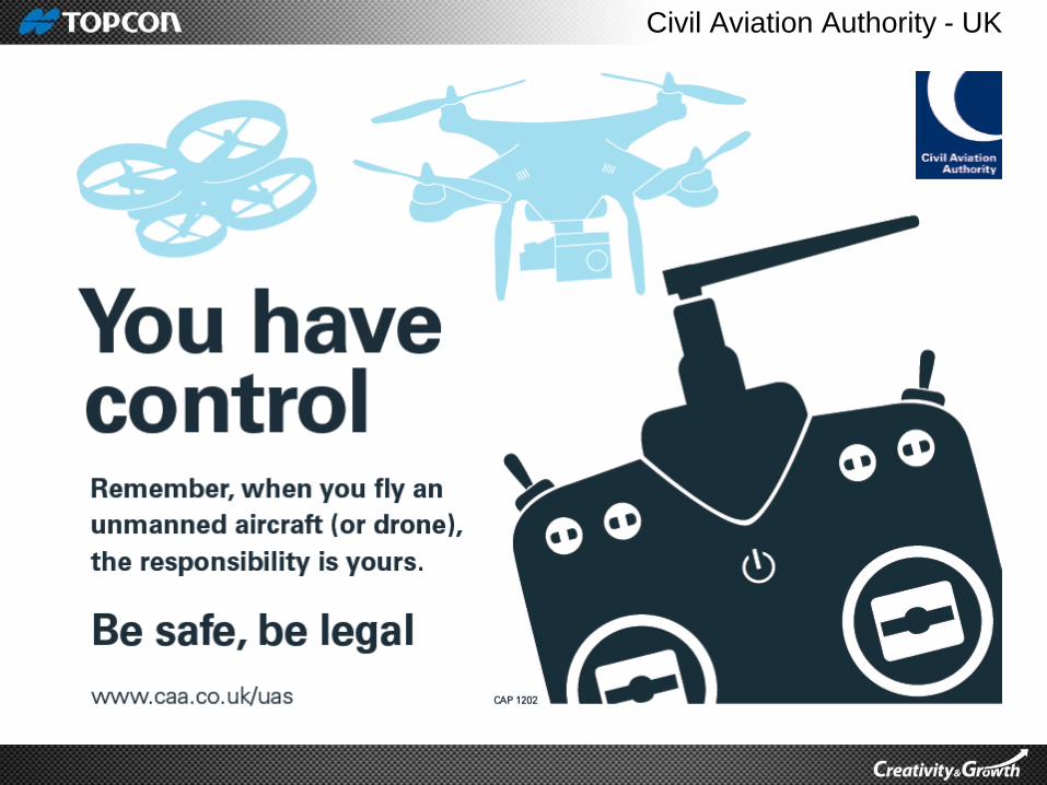
Civil Aviation Authority - UK

Civil Aviation Authority - UK
Drone flying – A short Guide – CAA UK
SINGAPORE
CAAS
(CIVIL AVIATION AUTHORITY
SINGAPORE)
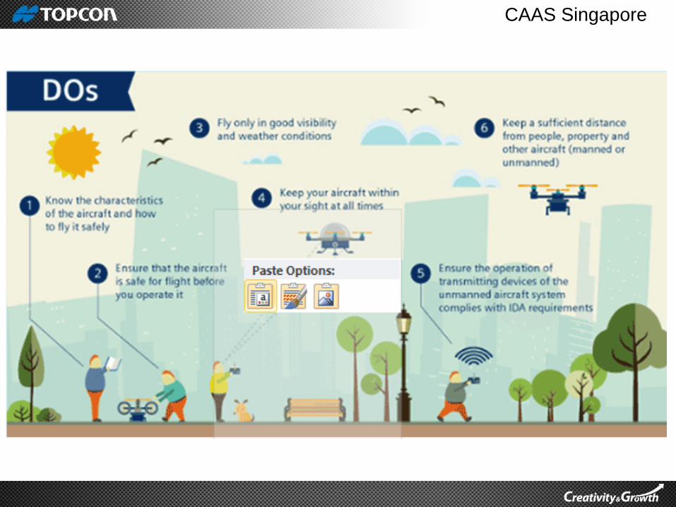
CAAS Singapore
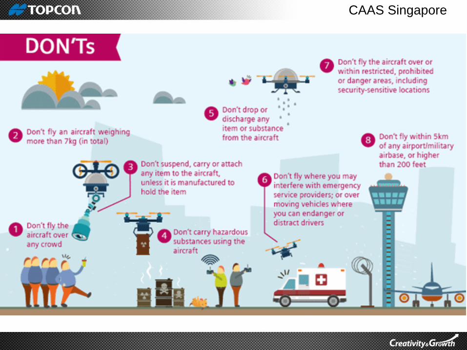
CAAS Singapore

Association of Unmanned Vehicle Systems
International
AUVSI – Association of Unmanned Vehicle Systems International


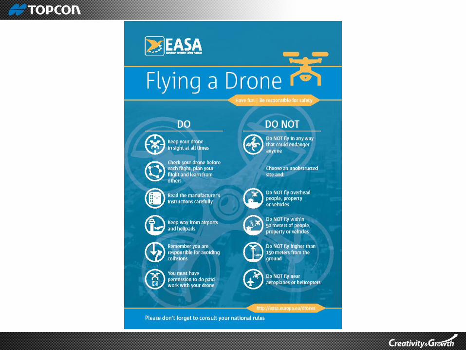
European Aviation Safety Agency
European Aviation Safety Agency
UAS
Safe to be flown
And Flown safely
https://www.youtube.com/watch?v=5Xs_eVx4nuw/

https://youtu.be/5Xs_eVx4nuw

HUMAN FACTOR
Safety Issues
Human Factors• Lack of standard training procedure (requires regulatory attentions).
– Safety dictates 2 primary requirements
• Must be proficient in controlling the aircraft.
• Interacting with other assets in the airspace.
– This highlight the need for appropriate automation and ground
training.
• So pilot can safely avoid mid air and ground impact.
• Potential impact of ground can be equally dangerous as mid- air
collision.
– Low altitude hazards
• Hazards are not limited to other craft
• Above 150m there are few things to run into
• Landing and takeoff and operating under 150m where many UAV
are design to spend most of the flight time poses many hazard
trees, buildings, wires etc.,
• GPS could be blocked by trees buildings etc.

WEATHER
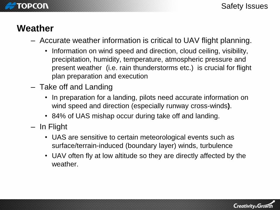
Safety Issues
Weather
– Accurate weather information is critical to UAV flight planning.
• Information on wind speed and direction, cloud ceiling, visibility,
precipitation, humidity, temperature, atmospheric pressure and
present weather (i.e. rain thunderstorms etc.) is crucial for flight
plan preparation and execution
– Take off and Landing
• In preparation for a landing, pilots need accurate information on
wind speed and direction (especially runway cross-winds).
• 84% of UAS mishap occur during take off and landing.
– In Flight
• UAS are sensitive to certain meteorological events such as
surface/terrain-induced (boundary layer) winds, turbulence
• UAV often fly at low altitude so they are directly affected by the
weather.
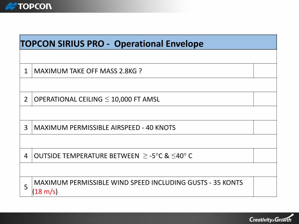
TOPCON SIRIUS PRO - Operational Envelope
1 MAXIMUM TAKE OFF MASS 2.8KG ?
2 OPERATIONAL CEILING ≤ 10,000 FT AMSL
3 MAXIMUM PERMISSIBLE AIRSPEED - 40 KNOTS
4 OUTSIDE TEMPERATURE BETWEEN ≥ -5°C & ≤40° C
5MAXIMUM PERMISSIBLE WIND SPEED INCLUDING GUSTS - 35 KONTS
(18 m/s)
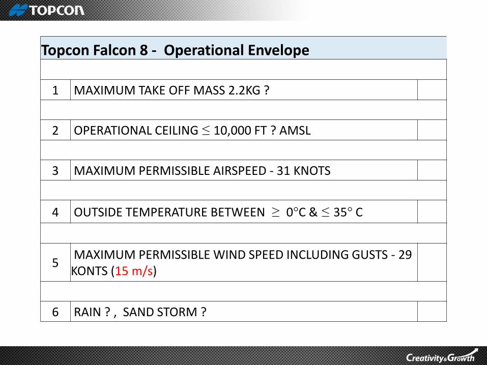
Topcon Falcon 8 - Operational Envelope
1 MAXIMUM TAKE OFF MASS 2.2KG ?
2 OPERATIONAL CEILING ≤ 10,000 FT ? AMSL
3 MAXIMUM PERMISSIBLE AIRSPEED - 31 KNOTS
4 OUTSIDE TEMPERATURE BETWEEN ≥ 0°C & ≤ 35° C
5MAXIMUM PERMISSIBLE WIND SPEED INCLUDING GUSTS - 29 KONTS (15 m/s)
6 RAIN ? , SAND STORM ?
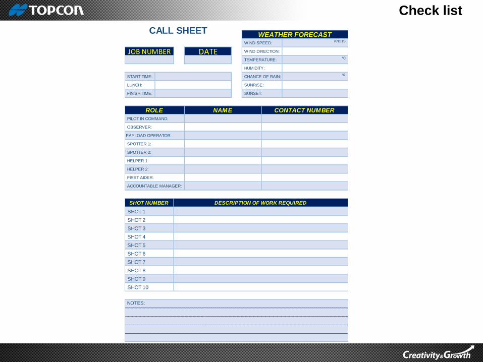
Check list
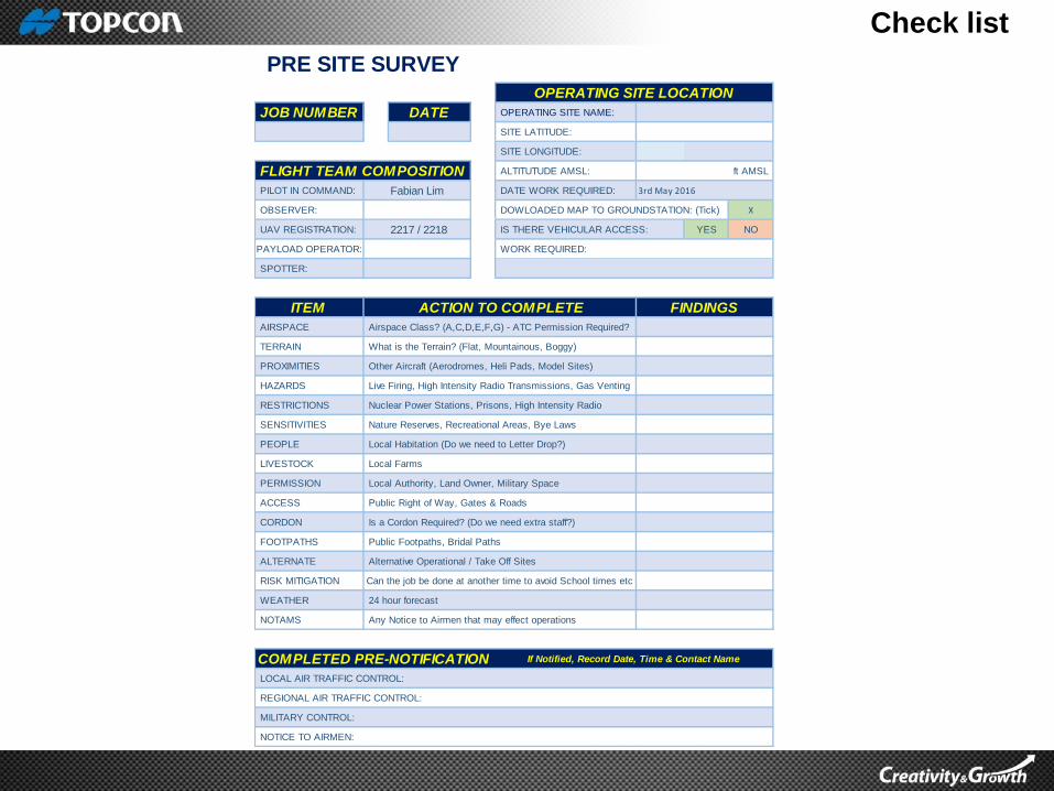
JOB NUMBER DATE OPERATING SITE NAME:
SITE LATITUDE:
SITE LONGITUDE:
ALTITUTUDE AMSL: ft AMSL
PILOT IN COMMAND: Fabian Lim DATE WORK REQUIRED: 3rd May 2016
OBSERVER: DOWLOADED MAP TO GROUNDSTATION: (Tick) X
UAV REGISTRATION: 2217 / 2218 IS THERE VEHICULAR ACCESS: YES NO
PAYLOAD OPERATOR: WORK REQUIRED:
SPOTTER:
ITEM
AIRSPACE Airspace Class? (A,C,D,E,F,G) - ATC Permission Required?
TERRAIN What is the Terrain? (Flat, Mountainous, Boggy)
PROXIMITIES Other Aircraft (Aerodromes, Heli Pads, Model Sites)
HAZARDS Live Firing, High Intensity Radio Transmissions, Gas Venting
RESTRICTIONS Nuclear Power Stations, Prisons, High Intensity Radio
SENSITIVITIES Nature Reserves, Recreational Areas, Bye Laws
PEOPLE Local Habitation (Do we need to Letter Drop?)
LIVESTOCK Local Farms
PERMISSION Local Authority, Land Owner, Military Space
ACCESS Public Right of Way, Gates & Roads
CORDON Is a Cordon Required? (Do we need extra staff?)
FOOTPATHS Public Footpaths, Bridal Paths
ALTERNATE Alternative Operational / Take Off Sites
RISK MITIGATION
WEATHER 24 hour forecast
NOTAMS Any Notice to Airmen that may effect operations
COMPLETED PRE-NOTIFICATION
LOCAL AIR TRAFFIC CONTROL:
REGIONAL AIR TRAFFIC CONTROL:
MILITARY CONTROL:
NOTICE TO AIRMEN:
If Notified, Record Date, Time & Contact Name
FLIGHT TEAM COMPOSITION
PRE SITE SURVEY
OPERATING SITE LOCATION
FINDINGS
Can the job be done at another time to avoid School times etc
ACTION TO COMPLETE
Check list
WIND SPEED: KNOTS
DATE WIND DIRECTION:
TEMPERATURE: *C
HUMIDITY:
START TIME: CHANCE OF RAIN: %
LUNCH: SUNRISE:
FINISH TIME: SUNSET:
PILOT IN COMMAND:
OBSERVER:
PAYLOAD OPERATOR:
SPOTTER 1:
SPOTTER 2:
HELPER 1:
HELPER 2:
FIRST AIDER:
ACCOUNTABLE MANAGER:
SHOT 1
SHOT 2
SHOT 3
SHOT 4
SHOT 5
SHOT 6
SHOT 7
SHOT 8
SHOT 9
SHOT 10
NOTES:
DESCRIPTION OF WORK REQUIREDSHOT NUMBER
ROLE
CALL SHEETWEATHER FORECAST
JOB NUMBER
NAME CONTACT NUMBER
Check list
4 S
EV
ER
ITY
5 P
RO
BA
BIL
ITY
6 R
ISK
8 S
EV
ER
ITY
9 P
RO
BA
BIL
ITY
10 R
ISK
AT RISK (Column 2)
E - Employees 1 1 MIN
C - Client 2 2 LOW
V - Visitors 3 3 MED
P - Public 4 4 HIGH
A - All 5
OBSERVER:PILOT-IN-COMMAND: Fabian Lim
PAYLOAD OPERATOR: AIRCRAFT: Topcon Sirius Pro & Topcon Falcon 8
(Something with the potential to
cause harm, how will it be realised
and what is the potential injury?)
2 - A
T R
ISK
3 - EXISTING CONTROL
MEASURES
SITE LOCATION:
FLIGHT OPERATION:
JOB NUMBER: -
JOB DATE:
FLIGHT TEAM:
N - Unacceptable Risk
Severity X Probability - 5 TO 10
Severity X Probability - 12 TO 15
Severity X Probability - 16 TO 20
RISK RATING (Columns 6 and 10)
Y - Acceptable Risk
RISK7 - FURTHER CONTROL
MEASURES
Severity X Probability - 1 to 5
Y - Acceptable Risk
? - Needs further consideration
ADDITIONAL COMMENTS (Actions identified by personnel on site, to make the operation safer)
SIGNED:
WILL PROBABLY OCCUR
ALMOST CERTAIN
NAME (Print):
PROBABILITY (Column 5 and 9)
EXTREMELY UNLIKELY
REMOTE POSSIBILITY
WILL POSSIBLY OCCUR
MAJOR INJURY OR FATALITIES
AUTHORISED BY THE
ACCOUNTABLE MANAGER
SEVERITY (Column 4 and 8)
RISK ASSESSMENT FORM
NO INJURY, PROPERTY DAMAGE
MINOR INJURY
REPORTABLE INJURY
RISK
1 - HAZARD
FURTHER ACTIONS (Further control measures which could be implemented at the planning stage to improve safety)

Check list
WIND SPEEDKNOTS
JOB NUMBER:
PILOT: Fabian Lim DIRECTION
OBSERVER:
ITEM
VISUAL LIMITATIONS Anything that May Impair Vision? (Up to 5KM)
CORDON Is a Cordon Required? (Do we need extra staff?)
LIVESTOCK Any Animals or Wildlife Present Nearby?
TERRAIN Flat Surface, Rough, Sloped, Wet, Trees?
PERMISSION Do We Have the Land Owners Permission?Signature:
PUBLIC Public Right of Way, Footpaths, Gates
AIR TRAFFIC Do We Need & or Have Clearance?
COMMUNICATION Are Two Way Radios Required?
PROXIMITY Are We Far Enough Away from Buildings?
TAKE OFF AREA Where is the Safest Convenient Position?
LANDING AREA Where is the Safest Convenient Position?
OPERATIONAL ZONE Are there Any Hazards or Obstructions?
EMERGENCY AREA Where is the Safest Convenient Position?
PRESENCE OF
TELECOMMUNICATION
EQUIPMENT
CONTACT NAME AND TELEPHONE NUMBERS
PILOT: Fabian Lim
OBSERVER:
CLIENT:
LOCAL POLICE:
LOCAL HOSPITAL: Queen’s Hospital, Burton Upon Trent (Hospital) b. Tel: +44 128 356 6333
LOCAL AIR TRAFFIC CONTROL: East Midlands Airport ATC Tel: +44 1332 852 993
EuroUSC: Cardinal Point, Park Road, Rickmansworth, Hertfordshire. WD3 1RE - Telephone: +44 (0) 203 005 5755
NOTES:
Are there cell phone repeaters?,
telecommunication towers?
DATE
TEMP.*C
ON SITE SURVEY
FINDINGSACTION TO COMPLETE
OBSTRUCTIONS
Masts, Power Lines, Buildings, Train Tracks,
Trees,
Lakes, Rivers, Canals or Industrial Hazards
Check list
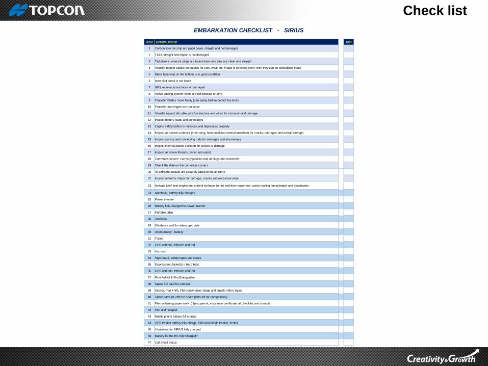
ITEM ACTION / CHECK TICK
1 Carbon fiber tail strip are glued down, straight and not damaged
2 Tail is straight and elapor is not damaged
3 Tail plane connector plugs are taped down and pins are clean and straight
4 Visually inspect cables on outside for cuts, wear etc. if tape is covering them, then they can be considered intact
5 Black tape/vinyl on the bottom is in good condition
6 Auto pilot board is not loose
7 GPS receiver is not loose or damaged
8 Active cooling system vents are not blocked or dirty
9 Propeller blades move freely (can easily fold in) but not too loose
10 Propeller and engine are not loose
11 Visually inspect all cable, pins/connectors and wires for corrosion and damage
12 Inspect battery leads and connectors
13 Engine safety button is not loose and depresses properly
14 Inspect all control surfaces (main wing, horizontal and vertical stabilizer) for cracks, damages and overall strength
15 Inspect servos and connecting rods for damages and secureness
16 Inspect internal plastic skeleton for cracks or damage
17 Inspect all screw threads ( inner and outer)
18 Camera is secure, correctly position and all plugs are connected
19 Check the date on the camera is correct
20 All airframe cutouts are securely taped to the airframe
22 Inspect airframe Elapor for damage, cracks and excessive wear
23 Activate UAV, test engine and control surfaces for full and free movement, active cooling fan activates and deactivates
24 Notebook, battery fully charged
25 Power inverter
26 Battery fully charged for power inverter
27 Portable table
28 Umbrella
29 Windsock and 5m telescopic pole
30 Anemometer, battery
31 Tripod
32 GPS antenna, tribrach and rod
33 Hammer
34 Sign board, safety tapes and cones
35 Fluorescent Jacket(s) / Hard Hats
36 GPS antenna, tribrach and rod
37 First Aid Kit & Fire Extinguisher
38 Spare SD card for camera
39 Sissior, Pen Knife, Flat screw driver (large and small), velcro tapes
40 Spare parts kit (refer to spare parts list for composition)
41 File containing paper work ( flying permit, insurance certificate, all checklist and manual)
42 Pen and notepad
43 Mobile phone battery full charge
44 GPS tracker battery fully charge, SIM card inside tracker, tested
45 4 batteries for SIRIUS fully charged
46 Battery for the RC fully charged?
47 Call sheet status
EMBARKATION CHECKLIST - SIRIUS
Check list
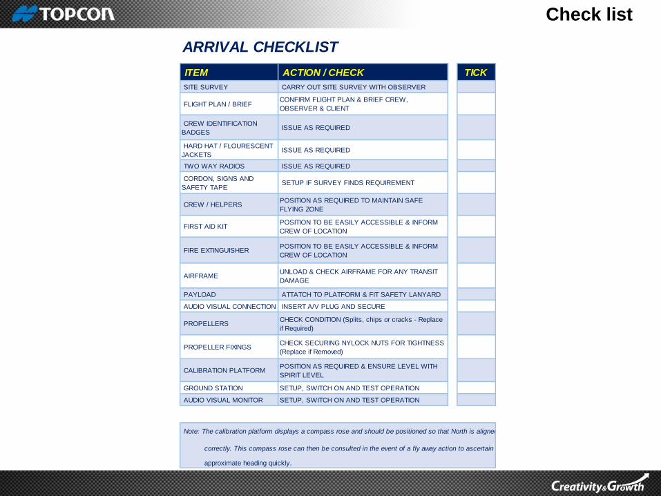
ITEM ACTION / CHECK TICK
SITE SURVEY CARRY OUT SITE SURVEY WITH OBSERVER
FLIGHT PLAN / BRIEFCONFIRM FLIGHT PLAN & BRIEF CREW,
OBSERVER & CLIENT
CREW IDENTIFICATION
BADGES ISSUE AS REQUIRED
HARD HAT / FLOURESCENT
JACKETS ISSUE AS REQUIRED
TWO WAY RADIOS ISSUE AS REQUIRED
CORDON, SIGNS AND
SAFETY TAPE SETUP IF SURVEY FINDS REQUIREMENT
CREW / HELPERSPOSITION AS REQUIRED TO MAINTAIN SAFE
FLYING ZONE
FIRST AID KITPOSITION TO BE EASILY ACCESSIBLE & INFORM
CREW OF LOCATION
FIRE EXTINGUISHERPOSITION TO BE EASILY ACCESSIBLE & INFORM
CREW OF LOCATION
AIRFRAMEUNLOAD & CHECK AIRFRAME FOR ANY TRANSIT
DAMAGE
PAYLOAD ATTATCH TO PLATFORM & FIT SAFETY LANYARD
AUDIO VISUAL CONNECTION INSERT A/V PLUG AND SECURE
PROPELLERSCHECK CONDITION (Splits, chips or cracks - Replace
if Required)
PROPELLER FIXINGSCHECK SECURING NYLOCK NUTS FOR TIGHTNESS
(Replace if Removed)
CALIBRATION PLATFORMPOSITION AS REQUIRED & ENSURE LEVEL WITH
SPIRIT LEVEL
GROUND STATION SETUP, SWITCH ON AND TEST OPERATION
AUDIO VISUAL MONITOR SETUP, SWITCH ON AND TEST OPERATION
approximate heading quickly.
ARRIVAL CHECKLIST
Note: The calibration platform displays a compass rose and should be positioned so that North is aligned
correctly. This compass rose can then be consulted in the event of a fly away action to ascertain

Check list
ITEM ACTION / CHECK TICK
1
Activate connector by connecting it to a battery. Connect GPS antenna
cable and Radio antenna. Place it somewhere it has clear view to the sky
and in every direction. Placing it on metal surfaces as a car could disturb
radio links
2
If you are using MAVinci Products out side of EU, the connector will have
a transmission power of up to 1 W. For health reasons make sure that
you have a distance of at least 3 m between you or other Humans and
the MAVinci Connector or MAVinci Autopilot Antenna during normal
operations
3 Place the connector close to the PC (about 2 m).
4
On rainy days: cover all front side openings of the UAV, also the Display.
Do not cover the cooling openings of the engine! These are on the
bottom side of the plane. Please make sure everything is dry, tape would
not stick very well on wet surfaces.
5 Also do not cover the can opening of the autopilot
6
Connect the elevator and rudder of the plane and fasten with T-pices. To
protect the propeller put the nose of the plane on your shoe or in the
case. Over tightening of the screws will damage the foam, only tighten as
much as necessary
7
Connect the wings with the carbon fiber rod and fix it at the body with T-
pieces. Over tightening of the screws will damage the foam, only tighten
as much as necessary
8 Center the wings. The gap should be fit in the middle.
9 Connect the servo cables for alerions, raddar and elevator.
10 Put the SD-Card in the plane. Make sure it is empty before…
11Insert the battery into the anterior plane chamber (WARNING: Do not
connect). In the chamber cover it with tape
12
Switch on the GPS tracker and insert into the plane, Test the GPS
tracker by sending SMS to 00000POS. You will receive an SMS giving
the location of the UAV
13 Close the case of the UAV.
14
Check the center of gravity of the aircraft by balancing it on two fingers,
touching the wings on the marked spots. The aircraft should be balanced.
The balance could be adjusted by moving the plane battery.
15Fix the cable in the engine compartment such that the cables would not
enter the engine.
16 Check that the the motor security lock is activated (elastic band).
17
Place the UAV uncovered under the open sky in sufficient distance to
cars, buildings etc., so that it has a good GPS signal reception. If
possible in shadow.
1 Switch RC to full manual mode
2Check that the throttle is zero (right handle of the remote control has to be
in zero position: completely down)
3 Switch on remote control
4 Activate UAV by connecting it to it's battery
5 Connect the laptop to Connector WIFI. Password ``mavinciconnector''
6Create new session or choose old (prepared) session in MAVinci
Desktop
7
The UAV with a customer specific name (e.g. ``Sirius'') appears in
MAVinci Desktop in the ``List of recently recognized Devices'' (Welcome
panel)
8If this does not happen check if you have a firewall that blocks the UAV
signals and switch all firewalls off.
9 Connect to the UAV in MAVinci Desktop
10
Please note: The radio link is not stable on too small distances. Ensure
connector and UAV has more than 3 m separation to have a good
connection
11Send your flight plan to the UAV. Without a loaded flight plan the camera
cannot be activated
1 Remove lens cover
2
Check the Compass: Near the magnetic poles problems with the
compass can occur. Test it by rotating SIRIUS around all axis and check
MAVinci Desktop show the correct orientation, pilot checks if the camera
takes pictures by rolling the UAV to a Roll angle of 60°.
3
Check the Rudder in all directions by using the RC: Move the rudders
carefully in all directions: pitch elevator, side rudder, roll-aileron. Check
the sense of the move direction.
4After a short time (max. 10 min) the UAV receives a good GPS signal
and the UAV position is displayed in MAVinci Desktop
5
If you do not see the UAV's position in MAVinci Desktop after 10 min
disconnect the UAV from the battery, reconnect it again after a short
waiting time and try the last steps again
6 Check if GPS position of connector is correct
7 Check if GPS position of plane is correct.
8Check that everything is ``green'' in the upper right corner of MAVinci
Desktop. E.g. compass quality, RC-link, GPS statys ...
9 Set the autopilot flight mode (click on ``Flight'')
10 Switch the RC to Automatic and Autopilot mode
11
Ensure the sky is clear and press the safety switch to turn on the engine.
Listen for any unusual sound and launch against the wind. The engine
can be disarm by simply pressing the safety switch.
Pre-flight checks
ASSEMBLY
Establish Connection
ASSEMBLY & PRE FLIGHT CHECKLIST
SIRIUS
Check list
ITEM ACTION / CHECK TICK
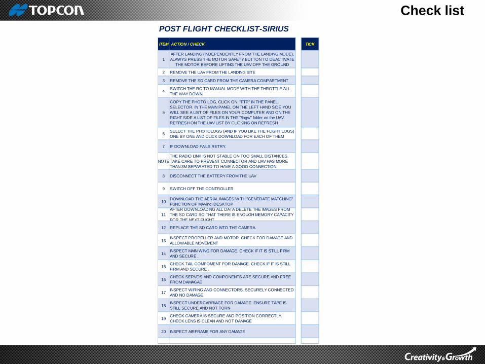
1
AFTER LANDING (INDEPENDENTLY FROM THE LANDING MODE),
ALAWYS PRESS THE MOTOR SAFETY BUTTON TO DEACTIVATE
THE MOTOR BEFORE LIFTING THE UAV OFF THE GROUND
2 REMOVE THE UAV FROM THE LANDING SITE
3 REMOVE THE SD CARD FROM THE CAMERA COMPARTMENT
4SWITCH THE RC TO MANUAL MODE WITH THE THROTTLE ALL
THE WAY DOWN
5
COPY THE PHOTO LOG. CLICK ON "FTP" IN THE PANEL
SELECTOR. IN THE MAIN PANEL ON THE LEFT HAND SIDE YOU
WILL SEE A LIST OF FILES ON YOUR COMPUTER AND ON THE
RIGHT SIDE A LIST OF FILES IN THE "/logs/" folder on the UAV.
REFRESH ON THE UAV LIST BY CLICKING ON REFRESH
6SELECT THE PHOTOLOGS (AND IF YOU LIKE THE FLIGHT LOGS)
ONE BY ONE AND CLICK DOWNLOAD FOR EACH OF THEM
7 IF DOWNLOAD FAILS RETRY.
NOTE
THE RADIO LINK IS NOT STABLE ON TOO SMALL DISTANCES.
TAKE CARE TO PREVENT CONNECTOR AND UAV HAS MORE
THAN 3M SEPARATED TO HAVE A GOOD CONNECTION
8 DISCONNECT THE BATTERY FROM THE UAV
9 SWITCH OFF THE CONTROLLER
10DOWNLOAD THE AERIAL IMAGES WITH "GENERATE MATCHING"
FUNCTION OF MAVinci DESKTOP
11
AFTER DOWNLOADING ALL DATA DELETE THE IMAGES FROM
THE SD CARD SO THAT THERE IS ENOUGH MEMORY CAPACITY
FOR THE NEXT FLIGHT
12 REPLACE THE SD CARD INTO THE CAMERA.
13INSPECT PROPELLER AND MOTOR. CHECK FOR DAMAGE AND
ALLOWABLE MOVEMENT
14INSPECT MAIN WING FOR DAMAGE. CHECK IF IT IS STILL FIRM
AND SECURE .
15CHECK TAIL COMPOMENT FOR DAMAGE. CHECK IF IT IS STILL
FIRM AND SECURE .
16CHECK SERVOS AND COMPONENTS ARE SECURE AND FREE
FROM DAMAGAE
17INSPECT WIRING AND CONNECTORS. SECURELY CONNECTED
AND NO DAMAGE
18INSPECT UNDERCARRIAGE FOR DAMAGE. ENSURE TAPE IS
STILL SECURE AND NOT TORN
19CHECK CAMERA IS SECURE AND POSITION CORRECTLY.
CHECK LENS IS CLEAN AND NOT DAMAGE
20 INSPECT AIRFRAME FOR ANY DAMAGE
POST FLIGHT CHECKLIST-SIRIUS
Check list
NOTES
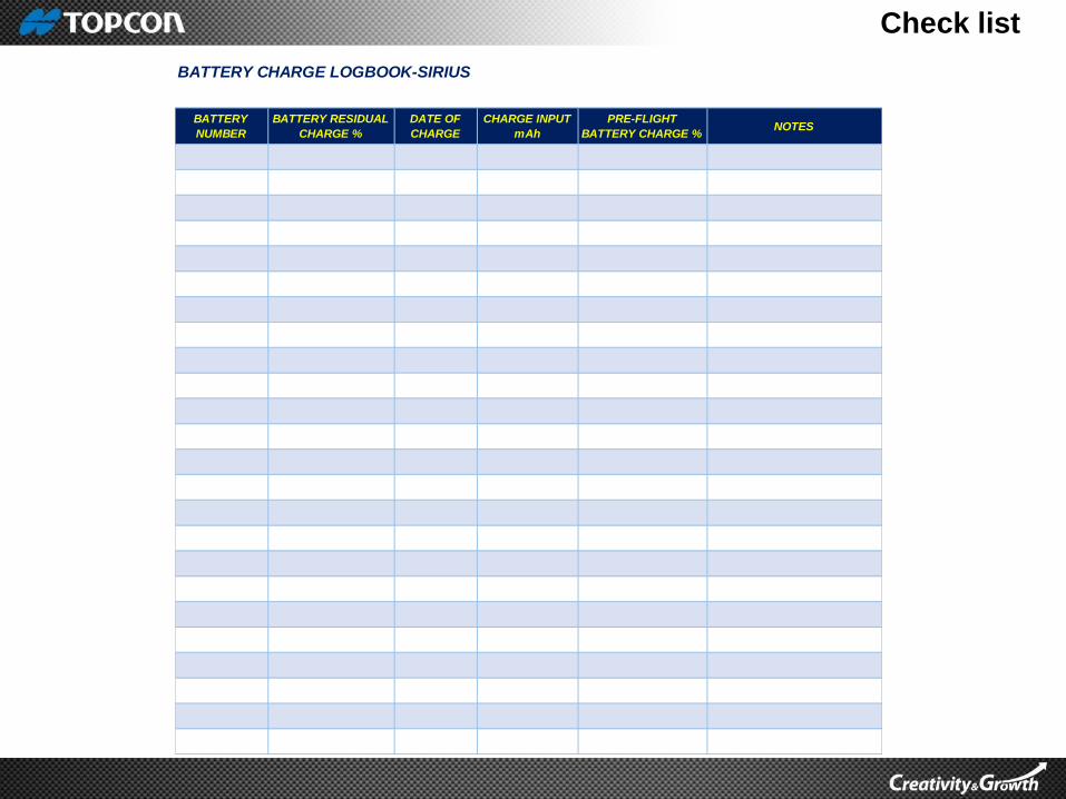
BATTERY CHARGE LOGBOOK-SIRIUS
BATTERY
NUMBER
BATTERY RESIDUAL
CHARGE %
DATE OF
CHARGE
CHARGE INPUT
mAh
PRE-FLIGHT
BATTERY CHARGE %

Check list
TEST FLIGHT
SIGNATURENOTES
MAINTENANCE LOGBOOK-SIRIUS
DATEREASON FOR
MAINTENANCE
WORK
COMPLETEDCOMPLETED BY
PARTS
REPLACED
Check list
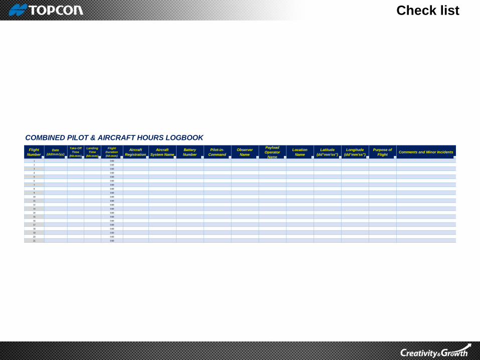
Flight
Number
Date
(dd/mm/yy)
Take-Off
Time
(hh:mm)
Landing
Time
(hh:mm)
Flight
Duration
(hh:mm)
Aircraft
Registration
Aircraft
System Name
Battery
Number
Pilot-in-
Command
Observer
Name
Payload
Operator
Name
Location
Name
Latitude
(dd°mm'ss")
Longitude
(dd°mm'ss")
Purpose of
FlightComments and Minor Incidents
1 0:00
2 0:00
3 0:00
4 0:00
5 0:00
6 0:00
7 0:00
8 0:00
9 0:00
10 0:00
11 0:00
12 0:00
13 0:00
14 0:00
15 0:00
16 0:00
17 0:00
18 0:00
19 0:00
20 0:00
21 0:00
COMBINED PILOT & AIRCRAFT HOURS LOGBOOK
Check list
NOTES
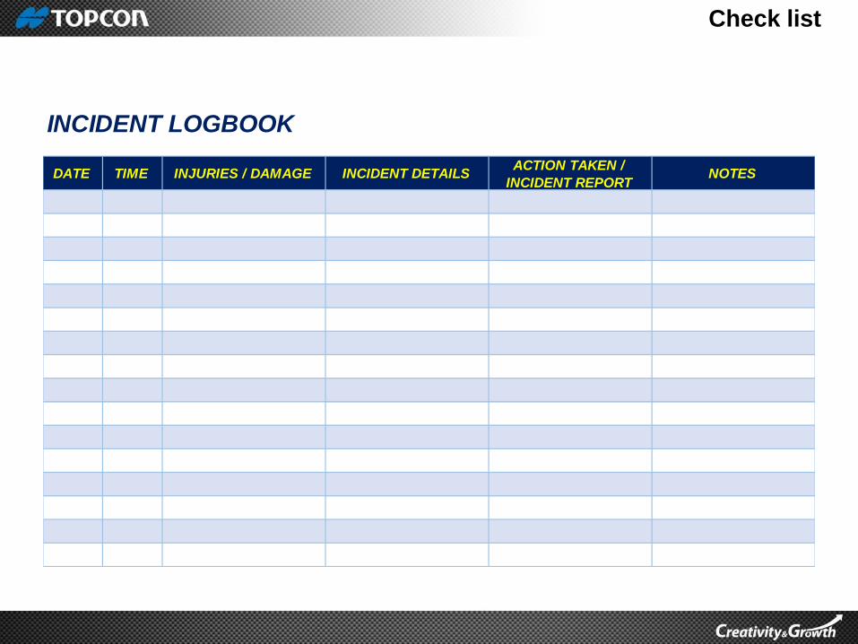
INCIDENT LOGBOOK
DATE TIME INJURIES / DAMAGE INCIDENT DETAILSACTION TAKEN /
INCIDENT REPORT

Fail safe It is important that a pilot fully understand all the fail safe features.
How it works and what it does.
How to activate it.
Understanding and lots of practice will make it second nature and pilot
would not panic during emergency.
Learn to fly in the different mode for fix wing aircraft
, Fully automatic, assisted mode and full manual mode
Common fail safe features for fix wing include:-
Loss of GPS - Circle down after 5 sec
Loss of RC and Data link – return to home after 30 sec
Loss of RC link - ignore
Loss of Data link - ignore
Safety altitude – 50 M
Return to home – Return to starting position and circle or land
automatically
Bounding box – geo-fencing
Learn to fly in the different mode for multi rotor :-
Manual mode, Height mode and GPS mode
Common fail safe features for multi rotor:-
Come home straight
Come home High
Direct landing
Loss of RC and Radio link
Return home and circle or land automatically
Motor failure
Return to home and land if one motor is down.
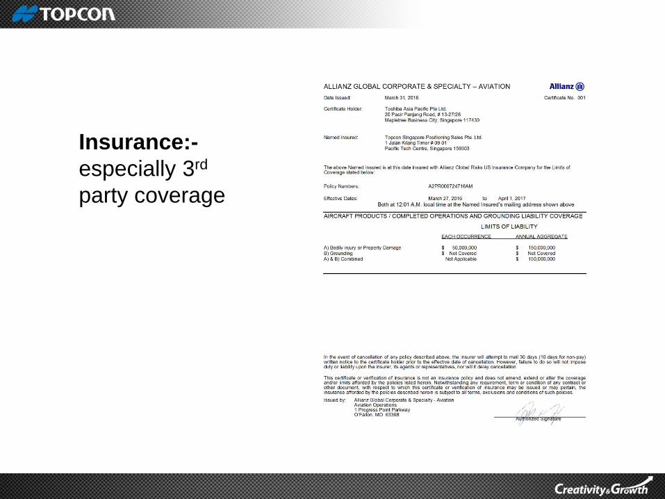
Insurance:-
especially 3rd
party coverage
5 P’s
PROPER
PLANNING
PREVENTS
POOR
PERFORMANCE

THANK YOU
1. Aspiring Model Actress
2. Wedding crasher