dsd-int 2016 local effects of the reshape of the niers - walter
TRANSCRIPT
iMOD International User Day, 1st November 2016
Local effects of the reshape of the Niers
Christian Walter
Niersverband, Germany

Local effects of the reshape of the Niers
• Introduction
• The project
• Why iMOD ?
• Model/Results
• Next steps and conclusion

Delft
Introduction
The Niersverband:
• Headquartered in Viersen
• 330 employees
• water board responsible for the hole (german)
catchment area of the river Niers
• wastewater and rainwater treatment
• waters care and restauration of the river

Introduction
The Niers:
• length ca.116 km, last 8 km in the Netherlands
• flows into the Maas
• catchment area ca.1400 sqkm, between rhine and maas
• Source 73 m above sealevel
• Mouth 10 m above sealevel in Gennep, NL
• Slope: first 30 km ~ 0,6 ‰ (60 cm/km)
the following 85 km ~ 0,25 ‰ (25 cm/km)
• no mountains in the catchment area

Introduction
The Niers
• Since Middle Ages lots of watermills (1920: 37), though rare slope
• Population increases and industrialisation decreases water quality
(Reasons for founding Niersverband in 1927)
• Riparian rights (watermills) has been revoked
• Niers was straightend and put in the dump of the valley
regional groudwater lowering, less floodings, quicker runoff
Agriculture is possible in the floodplain

Introduction
The Niers
• Niers valley underground is builded from thick layers of sand and
gravel from the ice age
• Groundwaterlevels in the narrow Niers valley
are between 0 and 3 m below the surface
• Niers and its tributaries are fed from emerging groundwaters
Changes in waterlevels of the niers river have effects on the
groundwater levels

Introduction
• Since the 1980th a more ecological kind of view became accepted
• (Not at last) the european water framework directive has lead to
the request of removement of all weirs and such structures
• Weirs are relicts from the straightening last century
• Weirs support groundwaterlevels next to wood footed buildings
• Many Weirs has been broken down in the last years
Footing of the buildings has been replaced
Buildings has been destroyed

The project “Wissener Schleife“
• The weir „Wissen“ is the last one between the mouth and
Mönchengladbach
• Mouth km 0
Wissen km 37
Mönchengladbach km 95
• Waterlevel and bottom difference from about 1m
• Weir lies beneath Schloss Wissen with a moat, filled by Niers-
water

The project “Wissener Schleife“
• Downstream of the weir
the Niers has been straightened in 1935
• As second part of the project
the old reach will be reactivated
• Both reaches are used
(one for ecology; the other for high water and canoes)
• What questions have to be answered now ???

The project “Wissener Schleife“
• Why actual to consider about changes?
Only few plots possessed by the Niersverband
Landowners want to know the effects on land use
(agriculture and forestry)
castle „Wissen“: can any subsidence happen to the buildings?
Parts of the planning area are under nature protection
Enough reasons to calculate with a groundwater-model

From DELTARES(2015):
Actualisatie en Kalibratie IBRAHYM
Why iMOD ?
Easy question - easy answer!
• In the province Limburg/NL exists an iMOD-based Model „IBRAHYM“
since years
• In 2012 the NAGREWA-project takes place. That was an EU-project
with 5 different water boards in NL and in D
• The dutch water board Peel en Maasvallei and the german
Niersverband have developed it for the lower reaches of the Niers
• The Niersmodell was worked out bei DHV, ahu and Deltares
• Through the NAGREWA-project a first part from the Niersverbands-
catchment area became part of the IBRAHYM-model.

Why iMOD ?
Once again:
• Model is existing and could be used to answer the questions!
Changes in groundwaterlevels should be estimated
Sensitivity analysis minimization of encroachment
• The project has two big aims:
- to remove the weir „Wissen“
- to reactivate a historical river course

Model description
Input
• rearrangement-planning; measured timeseries
• Hydraulic 2D-modell delivers waterlevels, (steady state)
• projected on the new water reaches and timeseries adapted
Border conditions (for the river)
• waterlevels upstream the weir should be the same as today
(wetland should be protected)
• runoff division 50/50 between both reaches (mean water)
• high water: bigger part runs through existing reach

Model
Cross-sections from hydraulik model Cross-sections in iMOD

Results
hydraulic head (in m above sealevel)

Computed (top) highest HAG; topographical image for reference purposes

Results
Computed differences between the averaged
groundwater level and the renewed Niers-“Altarm”
• absolute levels of groundwater cannot show the difference
between present situation and planning
Use of the computed differences instead.
• There is a wide range of differences in the modelled period
We decided to take the mean differences

Results
Sensitivity analysis • bed resistance is one of the key parameter in this project
• Another one is width of the river (less sensitive)
• Variation of 4 types:
I. Gravel (Cb = 0.01 days)
II. Sand (Cb = 0.1 days)
III. Loam (Cb = 1.0 days)
IV. Silty/clayey (Cb = 10.0 days)
Computed
differences between
the averaged
groundwater level
and the renewed
Niers-“Altarm” for
(top left) gravel,
(top right) sand,
(bottom left) loam,
(bottom right) clay

Results
• Further planning with szenario “sand bed resistance”
• Drillings have confirmed this meanwhile
• Opportunity to influence this parameter
through different bedmaterial while renaturation
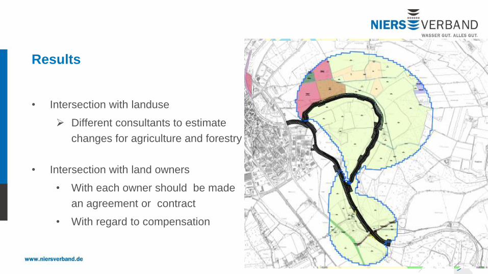
• The outline of this szenario (> 10 cm difference)
is used as investigation area
Results
• Intersection with landuse
Different consultants to estimate
changes for agriculture and forestry
• Intersection with land owners
• With each owner should be made
an agreement or contract
• With regard to compensation

Next steps and conclusion
• Agreement with land owners
• Approval procedure at Bezirksregierung Düsseldorf
means participation of all public authorities
and involved private persons
• Results from groundwatermodelling are very suitable for further steps
• Resolution of the regional model was good enough
for working on a detailed question

iMOD International User Day, 1st November 2016
Local effects of the reshape of the Niers
Christian Walter
Niersverband, Germany
Thanks for your attention!