dundee core paths plan - dundee city council
TRANSCRIPT

Dundee Core Paths Plan
Strategic Environmental Assessment
Environmental Report December 2008
Contents
1. Non-technical summary . ..................................................................................................3 1.1. Introduction.................................................................................................................3
1.1.1. Purpose of this Environmental Report . ...............................................................3 1.1.2. Key Facts. ...........................................................................................................4 1.1.3. Key Findings . ......................................................................................................5 1.1.4. SEA activities to date. .........................................................................................7
2. Plan context ....................................................................................................................10 2.1. Description of the Core Path Plan . ..........................................................................10
2.2. Relationship with other Plans, Programmes and Strategies. ...................................10
2.3. Relevant aspects of the current state of the environment . ......................................11
2.4. Environmental Problems . ........................................................................................16
2.5. Likely evolution of the environment without the Dundee Core Paths Plan ..............18
2.6. SEA Objectives . ......................................................................................................19
3. Assessment of environmental effects and measures envisaged for prevention, reduction and offset of significant adverse effects . ............................................................................19
3.1. Alternatives to which SEA was applied . ..................................................................19
3.2. Assessment Methods . .............................................................................................19
3.3. Summary of the assessment of the Dundee Core Paths Plan . ...............................21
3.4. Assessment of alternatives - cumulative and synergistic effects . ............................22
3.5. Measures envisaged for the prevention, reduction and offsetting of significant
adverse effects ................................................................................................................23
4. Monitoring .......................................................................................................................25
5. Next steps.......................................................................................................................26
Appendix A: Links to other PPS and environmental objectives. .........................................27 Appendix B: Full assessment results . ...............................................................................32 Appendix C: The Conservation (Natural Habitats, &c.) Regulations 1994 .........................46 Appendix D: Designated Sites . ..........................................................................................46
List of Scheduled Ancient Monuments . ..........................................................................46
Natural Heritage Sites . ...................................................................................................47
Cultural Heritage Sites . ..................................................................................................48
2

1. Non-technical summary
1.1. Introduction
1.1.1. Purpose of this Environmental Report
As part of the preparation of the Dundee Core Paths Plan, Dundee City Council is carrying out a Strategic Environmental Assessment (SEA). SEA is a systematic method for considering the likely environmental effects of certain Plans, Programmes or Strategies (PPS). SEA aims to:
• integrate environmental factors into PPS preparation and decision-making; • improve PPS and enhance environmental protection; • increase public participation in decision making; and • facilitate openness and transparency of decision-making.
SEA is required by the Environmental Assessment (Scotland) Act 2005. The key SEA stages are:
Screening determining whether the PPS is likely to have significant environmental effects and whether an SEA is required
Scoping deciding on the scope and level of detail of the Environmental Report, and the consultation period for the report – this is done in consultation with Scottish Natural Heritage, The Scottish Ministers (Historic Scotland) and the Scottish Environment Protection Agency
Environmental publishing an Environmental Report on the PPS and its Report environmental effects, and consulting on that report
Adoption providing information on: the adopted PPS; how consultation comments have been taken into account; and methods for monitoring the significant environmental effects of the implementation of the PPS
Monitoring monitoring significant environmental effects in such a manner so as to also enable the Responsible Authority to identify any unforeseen adverse effects at an early stage and undertake appropriate remedial action.
The purpose of this Environmental Report is to:
• provide information on the Dundee Core Paths Plan;
• identify, describe and evaluate the likely significant effects of the Core Paths Plan and any reasonable alternatives;
• provide an early and effective opportunity for the Consultation Authorities and the public to offer views on any aspect of this Environmental Report.
3

1.1.2. Key Facts
The key facts relating to the Dundee Core Paths Plan are set out in Table 1 below.
Table 1: Key facts relating to the Dundee Core Paths Plan
Responsible Authority Dundee City Council
Title of Plan Dundee Core Paths Plan
What prompted the Plan Statutory duty under the Land Reform (Scotland) Act 2003
Plan Subject Outdoor Access
Period covered by Plan up to 5 years (2008 - 2013)
Frequency of Updates up to 5 years
Area covered by Plan City of Dundee
Purpose of Plan The main purpose of the Core Paths Plan is to produce a plan which shows a framework of routes sufficient for the purpose of giving the public reasonable access throughout their area.
Objectives of Plan
To provide a basic framework of routes for leisure and everyday journeys throughout the Dundee City area
To connect homes, workplaces, schools, services, greenspaces, communities and the wider countryside.
To help Dundee become a healthy and sustainable city.
Contact Point
Laura Campbell, Access Officer
Leisure & Communities Dept, Dundee City Council Floor 13, Tayside House, Crichton Street, Dundee, DD1 3RA
Tel: 01382 433748
Email: [email protected]
4
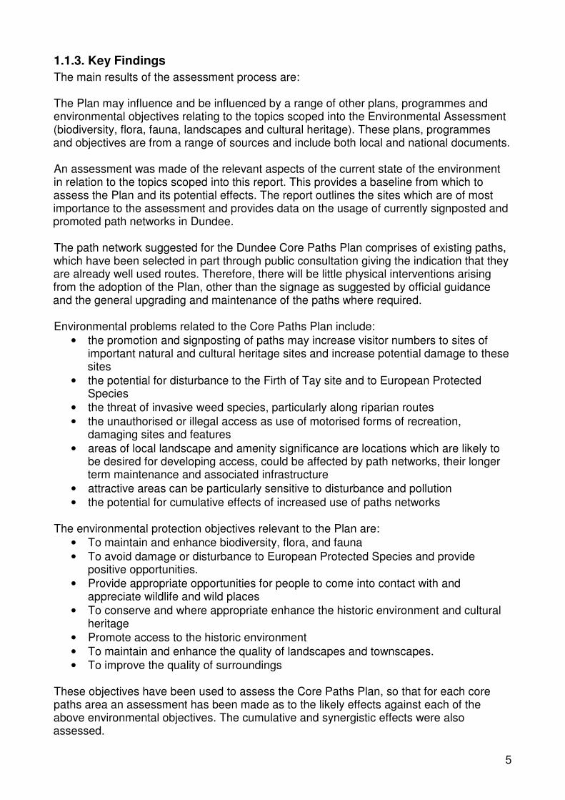
1.1.3. Key Findings The main results of the assessment process are:
The Plan may influence and be influenced by a range of other plans, programmes and environmental objectives relating to the topics scoped into the Environmental Assessment (biodiversity, flora, fauna, landscapes and cultural heritage). These plans, programmes and objectives are from a range of sources and include both local and national documents.
An assessment was made of the relevant aspects of the current state of the environment in relation to the topics scoped into this report. This provides a baseline from which to assess the Plan and its potential effects. The report outlines the sites which are of most importance to the assessment and provides data on the usage of currently signposted and promoted path networks in Dundee.
The path network suggested for the Dundee Core Paths Plan comprises of existing paths, which have been selected in part through public consultation giving the indication that they are already well used routes. Therefore, there will be little physical interventions arising from the adoption of the Plan, other than the signage as suggested by official guidance and the general upgrading and maintenance of the paths where required.
Environmental problems related to the Core Paths Plan include: • the promotion and signposting of paths may increase visitor numbers to sites of
important natural and cultural heritage sites and increase potential damage to these sites
• the potential for disturbance to the Firth of Tay site and to European Protected Species
• the threat of invasive weed species, particularly along riparian routes • the unauthorised or illegal access as use of motorised forms of recreation,
damaging sites and features • areas of local landscape and amenity significance are locations which are likely to
be desired for developing access, could be affected by path networks, their longer term maintenance and associated infrastructure
• attractive areas can be particularly sensitive to disturbance and pollution • the potential for cumulative effects of increased use of paths networks
The environmental protection objectives relevant to the Plan are: • To maintain and enhance biodiversity, flora, and fauna • To avoid damage or disturbance to European Protected Species and provide
positive opportunities. • Provide appropriate opportunities for people to come into contact with and
appreciate wildlife and wild places • To conserve and where appropriate enhance the historic environment and cultural
heritage • Promote access to the historic environment • To maintain and enhance the quality of landscapes and townscapes. • To improve the quality of surroundings
These objectives have been used to assess the Core Paths Plan, so that for each core paths area an assessment has been made as to the likely effects against each of the above environmental objectives. The cumulative and synergistic effects were also assessed.
5

In general the adoption of the Plan is likely to have a positive overall effect on the Dundee environment. The plan promotes access to areas of natural and cultural heritage importance, as these tend to be popular places for people to visit, but also to take into consideration land management and any negative environmental impacts. The plan will be used to promote responsible access to such sites and additional interpretation materials will be used to encourage responsible path use. The Plan also presents opportunities for habitat and landscape enhancements and access improvements to a variety of landscapes and townscapes. Negative effects of the Plan were found to be that additional signage may provide more clutter on the landscape and there is potential that with increased use there could be an increase of litter and graffiti along Core Paths.
It is possible that the effect of any impacts that do arise may become increasingly significant when combined with other factors. This is most likely to be the case where there is development of the rest of the path network and construction activities occurring concurrently with any core path activities. There are currently no planned construction elements to the proposed Plan, other than some additional signage, although some paths may be upgraded through future funding opportunities. This minimal construction on the Core Path Network itself means that the adoption of the plan is unlikely to contribute to the construction impacts of unrelated developments in the vicinity of the path network. Cumulative and synergistic impacts relating to development proposals are therefore not likely to have an affect.
The development and promotion of the Plan as a whole will increase awareness of the path network and bring improvements in access to the Dundee area, whilst bringing support to other sustainable transport initiatives by linking in with local and regional public transport hubs and supporting the development and improvement of the network for active travel purposes.
Mitigation measures considered in the Environmental Report include:
• give consideration to the location of the habitats used by protected species and select paths accordingly -alternative routes selected where necessary
• use promotional materials, signage and information to encourage sustainable use of paths and highlight sites of ecological importance
• collect data on path usage and assess any disturbance or damage through regular path audits
• consider methods of control of invasive species alongside core path networks • encourage increased use of paths by legitimate users to discourage illegitimate use • select paths where land management conflicts and pressure on individual sites can
be mitigated or avoided • install litter and dog waste bins where possible along core paths
Monitoring of the effects of implementing the Core Paths Plan will be undertaken by regimes currently in place for local authority infrastructure and maintenance through routine monitoring by the environmental authorities. Information about management, maintenance and development of core paths will be collated annually and form part of an overall report on access related work across the Dundee City area.
6

1.1.4. SEA activities to date The SEA process began in August 2007 when a Screening Report was issued for consultation. Both Historic Scotland and Scottish Natural Heritage determined that the Dundee Core Paths Plan had the potential to result in significant environmental effects. The Scottish Environment Protection Agency determined that whilst the Plan may have positive environmental effects at the local level it was unlikely that there would be significant environmental effects with regards to their areas of interest.
A scoping report was issued in December 2007 and comments were received from the Consultation Authorities in January 2008. The main comments received from the Consultation Authorities are outlined in Table 2 below.
Table 2: Comments on the Scoping Report Scoping Report
SNH Historic Scotland SEPA
Background Information
No comment No comment SEPA found the information provided in this section to be useful
Relationship with other plans and programmes
Provided a list of additional plans, programmes, policies and environmental objectives to be analysed for their relationship to the Core Paths Plan.
No comment SEPA note that a comprehensive list of the plans, programmes and environmental objectives that are to be analysed in the Environmental Report has been provided.
Current state of the environment
Provided details on where to locate information on designated sites.
Suggest a baseline of existing signposted routes and data on current path usage to assist in the prediction of the potential impacts.
Provided definition of 'the historic environment' to aid the collection of baseline data and the consideration of the impact of the plan on the historic environment.
Request that the evolution of the baseline without implementation of the Plan should also be provided in the Environmental Report.
Scope of assessment and level of detail
Subject to specific comments, SNH is content with the scope and level of detail proposed for the Environmental Assessment.
Subject to specific comments, HS is content with the scope and level of detail proposed for the Environmental Assessment.
Scoping report Fig 4.1is incorrect - SEPA did not “determine no significant strategic environmental effects” on material assets.
Suggest further details on why the Plan is not likely to have significant effects on the SEA issues scoped out.
Mitigation No comment No comment SEPA welcomes the early consideration of mitigation measures and indicators.
7

Scoping Report
SNH Historic Scotland SEPA
Significant issues
Recommend specific reference to European Protected Species, maintaining links between features and national and local Biodiversity Action Plan (BAP) species/habitats.
Recommend reference to the Scottish Biodiversity List and the "Biodiversity Duty".
Request that new routes and those likely to see a significant change in use are identified - where these are close to designated areas SEA should consider impact on designated site features.
Consider assessment of issues relating to the Dundee Core Paths Plan with neighbouring authorities.
The proposed assessment of the "cumulative and synergistic impacts using a combination of spatial analysis and the cumulative assessment matrix" is welcomed.
No comment No comment
SEA Objectives
SNH welcome the consideration of SEA objectives.
Suggest the inclusion of a specific objective relating to European Protected Species
No comment SEPA supports the development of SEA objectives.
8

Scoping Report
SNH Historic Scotland SEPA
Assessment Methodology
Suggest consideration of alternative path options where there are potential negative environmental impacts both at a more strategic network approach level and regarding deleting or changing particular routes.
HS give details of how impacts on the historic environment should be assessed.
HS note that some impacts will be uncertain at a strategic level and suggest that these issues should be identified and show how they will be addressed at the project level and who will be responsible for following them through.
Suggest consideration of alternatives within the plan (e.g. alternative routes).
SEPA note the assessment will include the Plan’s policies, proposals and individual core paths. SEPA supports the use of the appraisal framework and particularly welcomes the use of a commentary box proving justification/explanation for the identified effect.
SEPA considers that mitigation measures are a crucial part of SEA in that they offer an opportunity to not only address potential adverse effects of a plan, but also to increase positive effects.
Mitigation measures are required to prevent, reduce and as fully as possible offset all significant adverse effects on the environment of implementing the Plan.
Enhancement of positive effects should also be considered where appropriate.
The Environmental Report should clearly set out the mitigation measures which are proposed as a result of the assessment. These should follow the mitigation hierarchy (avoid, reduce, remedy or compensate).
Consultation period for the Environmental Report
SNH is content with the proposed 12 week consultation period
HS is content with the proposed 12 week consultation period and requests hard copies of the Environmental Report and Core Paths Plan.
SEPA is content with the proposed 12 week consultation period.
9

2. Plan context
2.1. Description of the Core Path Plan
The Land Reform (Scotland) Act 2003 established the right of responsible access to most of Scotland's outdoors. This right applies to people involved in non-motorised activities such as walking, cycling, horse riding and canoeing. In practice, most people will do this along clearly defined paths.
Dundee City Council is drawing up a Core Paths Plans to show a basic framework of routes that will cater for a variety of uses, including walking cycling, horse riding and for use by people with disabilities - although not every path will be designed or managed for every type of user. The types of path in the plan will take various forms and will range from trodden earth paths to high specification constructed paths. The Core Path Network will link into wider path networks and general access areas, such as open land, woods, parks and fields. For Dundee this will mean a network of signposted and promoted paths for getting around, particularly for sustainable travel use e.g. getting to school, work, local shops and parks and for recreational purposes.
The Core Path Plan is designed to deliver the following objectives:
• To provide a basic framework of routes for leisure and everyday journeys throughout the Dundee City area
• To connect homes, workplaces, schools, services, greenspaces, communities and the wider countryside.
• To help Dundee become a healthy and sustainable city.
The core path plan will be used to promote outdoor access on a network of routes throughout the city. The final plan will appear on the base map of the Local Plan and on Ordnance Survey maps. The routes will be signposted so that local people and visitors to Dundee can use them.
Once the formal consultation is completed, and provided there are no outstanding objections, the Plan will be adopted by the Council. The Plan will be published and will be available on the Dundee City Council website www.dundeecity.gov.uk/outaccess/corepaths as well as in Libraries across the City. The plan will then be updated alongside the review of the Dundee Local Plan, approximately every 5 years.
2.2. Relationship with other Plans, Programmes and Strategies
The Plan may influence and be influenced by a range of other plans, programmes and environmental objectives. A review of such documents was undertaken during the scoping stage of the SEA process and the findings were reported in the Scoping Report. Further analysis has taken place and recommendations have been made as to how the requirements of other plans, programmes and strategies and environmental protection objectives can be incorporated into the Core Paths Plan.
10

The full analysis is available in Appendix A of this report. The key points from this analysis in relation to SEA objectives relevant to the Dundee Core Paths Plan are:
Biodiversity, Flora and Fauna In relation to biodiversity, flora and fauna the Nature Conservation (Scotland) Act 2004, which implements the EC Directives 92/43/EEC "the Habitats Directive" and 79/409/EEC "the Birds Directive", is of particular importance to the Dundee Core Paths Plan. In this act a duty is placed on all public bodies to further the conservation of biodiversity. The Core Path Plan should provide opportunities for this duty to be taken forward, this could include the creation of wildlife corridors alongside core paths. It will also be necessary for an Appropriate Assessment to be carried out where new paths are close to sensitive sites. Guidance will be sought on this from appropriate sources when a new path is being considered as part of the Core Paths Plan in the future. It is important that the Core Paths Plan takes into account the need to conserve European Protected Species and BAP Species and Habitats. An opportunity exists to promote responsible wildlife watching and provide relevant information to further knowledge of biodiversity and conservation issues.
Cultural Heritage The Historic Environment is defined in Section 16(3) of the Public Appointments and Public Bodies etc. (Scotland) Act 2003 as "...any or all of the structures and places in Scotland of historical, archaeological or architectural interest or importance". Scottish Historic Environment Policy 1 (Section 2) builds on this definition by identifying that the historic environment encompasses built heritage features (ancient monuments, archaeological sites and landscapes, historic buildings, townscapes, parks, gardens, and designed landscapes as well as marine heritage) and the context or setting in which they sit, and the patterns of past use, in landscapes and within soil, and also in our towns, villages and streets. The historic environment also has less tangible aspects recognised as the historical, artistic, literary, linguistic and scenic associations of places and landscapes. The Core Paths Plan should protect cultural heritages sites, whilst allowing and managing access to them, allowing people to explore these important places responsibly. Positive opportunities could be developed through interpretive signage and information leaflets related to historic environments alongside Core Paths. Opportunities also exist to explore the less tangible aspects described above through interventions such as artistic interpretation/ sculptures, creative workshops on the Core Paths Networks.
Landscape A number of documents are relevant to the Core Paths Plan which outline best practice in urban and landscape design. When implementing the Core Paths Plan on the ground these National, Regional and Local guidelines should be followed, taking into account the appropriate sections from the Landscape Character Assessment. The Core Paths Plan has the potential to create positive opportunities for the restoration of landscape features such as drystone dykes and hedges in areas next to Core Paths through external funding opportunities.
2.3. Relevant aspects of the current state of the environment
Schedule 3 of the Environmental Assessment (Scotland) Act 2005 requires that the Environmental Report includes a description of “the relevant aspects of the current state of the environment and the likely evolution thereof without implementation of the plan or programme”, and “the environmental characteristics of areas likely to be significantly affected”. This section aims to describe the environmental context within which the
11

Dundee Core Paths Plan will operate and the constraints and targets that this context imposes on the Dundee Core Paths Plan.
Topics scoped out of the environmental assessment The topics of air, water, soil, human health, climatic factors, population, and material assets were scoped out of the environmental assessment. The topics under SEPA's area of interest (air, water, soil, human health, climatic factors) were scoped out due to responses received from consultation authorities during the screening stage of the SEA process. Particular attention was paid to SEPA's comment that whilst there may be positive environmental impacts in these areas at the local level, it is unlikely that there would be a significant environmental impact. The local authority also decided to scope out material assets and population from the environmental assessment.
The main reason for scoping out these topics from the environmental assessment is that the paths in the plan already exist and are currently well used. Whilst there may be a general increase in path use due to increased promotion and signage, it is unlikely that this increase will be significant enough to impact upon the above topics.
These topics may be scoped in to the SEA when it is reviewed alongside the Core Paths Plan in the future. This could be due to the result of monitoring on the existing plan, or to the inclusion of a number of new paths to the Core Paths Plan.
Biodiversity, Flora and Fauna Dundee has several sites which are important for the conservation and protection of biodiversity. In particular, the Firth of Tay Estuary is a high quality site for biodiversity. A number of designations have been assigned to it along the Dundee City Council area.
The Local Plan for Dundee City identifies the following sites of importance for their biodiversity, flora and fauna, the boundaries of which can be seen in the Natural Heritage Sites map in Appendix D:
• 1 Special Area of Conservation (SAC) and Special Protection Area (SPA) site o the Tay Estuary
• 2 Ramsar Wetland Sites o Broughty Ferry Beach o Inner Tay Estuary
• 3 Local Nature Reserves (LNR) o Broughty Ferry o Inner Tay Estuary o Trottick Ponds
• 49 Nature Conservation Sites • 41 Community Wildlife Sites • Wildlife Corridors along Riverside and the Dighty Burn
In addition to these designated sites, there are other habitats within the Dundee City area that are important to wildlife and natural heritage. A Habitats and Species survey carried out in 2000 found that Dundee has many semi-natural woodlands, and grasslands with patches of relatively high local conservation value. There is great diversity in the types of woodlands, grasslands, tall herb and ephemeral vegetation communities, while other areas such as swamps, coastlands and heathland are sparse. Woodlands play a particularly important role in supporting Dundee's populations of red squirrels, bats, and a variety of birdlife.
12

Of particular interest are the European Protected Species: bats, otters and dolphins.
The Bat Conservation Trust are currently carrying out bat surveys in Dundee and this will highlight sites where bats are present and where potential disturbance could be avoided. At present this data is not available, but will be monitored alongside the Core Paths Plan.
There are some locations in Dundee where otters may be present. Potential otter sites include the Trottick Ponds LNR and the Murroes Burn.
Over the last decade increasing numbers of dolphins have been visiting the River Tay in the summer months and dolphin watching is becoming a popular activity both on and offshore. It will be possible to carry out dolphin watching activities from some core paths, particularly Broughty Ferry Esplanade. Dundee City Council has entered into discussions with SNH and other relevant organisations to agree a dolphin watching policy. The agreed policy will be promoted to those using core paths in relevant areas.
Cultural Heritage Dundee has a rich and varied cultural heritage and there are several areas where the historic environment has great significance. The Cultural Heritage Sites map in Appendix D gives an overview of the locations of Scheduled Ancient Monuments, Conservation Areas and Listed Buildings.
There are 14 Scheduled Ancient Monuments in Dundee. They cover a range of structures, from standing stones, souterrains and standing stones to forts and castles.
Many of the Conservation Areas in Dundee relate to its industrial heritage, such as the Blackness Industrial Area, where there are a number of important mill buildings from Dundee' s jute production, and the Trottick Mill Ponds area in the north of the city. The Broughty Ferry area is also important, both as an example of a fishing village and as an area where the wealthy owners of jute factories built mansion houses.
There are 82 Grade A Listed Buildings and 565 Grade B Listed Buildings in Dundee.
Historic parks and gardens are also an important part of the City's cultural heritage. The Dundee Public Open Space Strategy identifies several 'City Heritage Parks', including the Dighty Linear Park, The Law, Stobsmuir Ponds, the Firth of Tay Linear Park, Reres Hill, Dudhope Park, and Trottick Mill Ponds Local Nature Reserve.
Landscape Dundee's landscape is constantly changing, with major redevelopments taking place in the City Centre, Whitfield, Hilltown and Lochee. These redevelopments will enhance opportunities for access and green corridors, and will assist in the creation of some of the aspirational links in the plan. There are also new developments taking place within the city and on the outskirts, which are changing the current landscape of the city. These include not only new buildings, but associated features, such as soft landscaping and sustainable urban drainage systems.
Dundee has a large number of parks and open spaces which contribute to its landscape. The Dundee Public Open Space Strategy identifies a hierarchy of parks within the City. This goes from Country Parks, City Heritage Parks and City Recreation Parks to Neighbourhood Parks and Local Parks and Open Spaces. At the top end of this hierarchy is Camperdown Country Park, which includes Clatto Country Park and Templeton Woods.
13

The City Recreation Parks are parks which offer places for sport, recreation, play, or just somewhere to walk or sit. Caird Park, Dawson Park, Baxter Park, Balgay Park, South Road Park, and the Broughty Ferry Esplanade and Beach. There are three areas in Dundee which have the designation of Gardens and Designed Landscapes. These are Balgay Park, Baxter Park, and Camperdown House.
The coastal landscape is an integral part of Dundee's setting and character. Some is natural or semi-natural e.g. Riverside 'Nature Park', Grassy Beach, Broughty Ferry Dunes. Some is developed e.g. city centre developments and Port Authority area.
Countryside areas lie to the north and west of the city, and although there are housing developments underway or planned for these areas, the countryside feel of these areas is still important.
Current trends relating to the use of path networks in Dundee Signposted and promoted path networks include the Dundee Green Circular (circumnavigates Dundee) Dundee Greenways West (City Centre to Green Circular via Balgay Park, Ninewells Hospital and South Road Park) and East (City Centre to Green Circular via University of Dundee (Gardyne Road Campus) and Dawson Park).
A recent 'Get Active Getting There' project by Sustrans increased the network of signposted and promoted paths in the West of Dundee. As part of the project a survey of two of the paths in the area was undertaken, over a 4 day period in March 2007. The paths are quite different in their use and provide a background of the type of use that core paths might receive. Diagram 1 below shows the daily average of the number of people using both of the paths by type of activity undertaken.
Diagram 1: daily average of number of people using paths by activity type (March 2007)
Balgay Park
274
14 11
10
3
Walker
Cyclist
Jogger
Pushchair
Wheelchair
Riverside
27
62
21
1 0
Walker
Cyclist
Jogger
Pushchair
Wheelchair
The path in Balgay Park has been used by walkers for many years. As part of the Dundee's Greenways project it was signposted and resurfaced in August 2006. This allowed cyclists to use the route as well as walkers. In comparison the path along Riverside Drive, is a well-established cycle route popular with commuters and has an ongoing programme of surface upgrading. In Balgay Park 50% of the respondents said that they used the route daily throughout the year, whereas at Riverside 33% said they
14

Dogwalki
ng
Just
walking
/cycli
ng
Educa
tion
Commuti
ng
Perso
nal b
usine
ss
Shopp
ing
Daytrip
Entert
ainment
Other
Pleasa
ntsu
rroun
dings
Conve
nienc
e ofro
ute
Perso
nal fi
tnes s
Safety
onthe
route
Jour
ney ef
ficien
cy
Perso
nal h
ealth
Quality
ofro
ute
Money
save
d onro
ute
Part o
f tour
ingro
ute
used the route daily in the spring and summer and 20% said they used the route daily in the autumn and winter.
Peoples journey purpose (diagram 2) and reasons for using that particular path (diagram 3) reinforce the view that the Riverside path is well used by commuters, whilst the Balgay path is used more for recreational purposes. In both cases just over 25% of the respondents were aware of recent path improvements and only 3% said that this had encouraged them to use the route more often.
Diagram 2: Sustrans survey of path users - journey purpose
0% 10% 20% 30% 40% 50% 60% 70%
% o
f res
pond
ents
who
sel
ecte
dpu
rpos
e Balgay Riverside
Journey purpose
Diagram 3: Sustrans survey of path users - reason for path use
0%
10%
20%
30%
40%
50%
60%
% o
f res
pond
ents
who
sel
ecte
d u
se
Balgay Riverside
Reason for path use
15

2.4. Environmental Problems
Schedule 3 paragraph 4 of the Environmental Assessment (Scotland) Act 2005 requires that the Environmental Report includes a description of existing environmental problems, in particular those relating to any areas of particular environmental importance. The purpose of this section is to explain how existing environmental problems will affect or be affected by the Dundee Core Paths Plan, and whether the Plan is likely to aggravate, reduce or otherwise affect existing environmental problems. Relevant environmental problems are summarised in Table 4.
Table 4: Environmental problems relevant to the Dundee Core Paths Plan
Problem Supporting data Implications
Biodiversity, flora and fauna
Promotion and signposting of paths may increase visitor numbers to environmentally sensitive sites
SNH Use promotional materials to encourage sustainable use of paths and highlight sites of ecological importance.
Use selection criteria that avoids or mitigates negative environmental impacts.
Potential for disturbance to the Firth of Tay site
SPA, SAC, SSSI and Ramsar designations.
Undertake an Appropriate Assessment on aspirational core path(s) before adopting.
Potential for disturbance to European Protected Species e.g. otters, bats, dolphins
Bat Conservation Trust are carrying out Bat Surveys (not yet available)
Dolphin watching policy to be drawn up and implemented.
Consider the location of the habitats used by these species and select paths which will be suitable for people's journeys without degradation to these habitats - alternative routes may be necessary.
Threat of invasive weed species, particularly along riparian routes.
Giant Hogweed evident along much of the Dighty Burn and Rhododendron is evident along some woodland paths
Consider methods of control of invasive species alongside core path networks.
Unauthorised or illegal access as use of motorised forms of recreation, damaging sites and features.
Problems at Camperdown Country Park being tackled through Police initiative.
Improve sites to encourage legitimate access and discourage others
Continue work with Community Safety Teams
Potential for disturbance and damage to natural
Green Circular Route Audits
Agree a management and monitoring plan for the core
16

Problem Supporting data Implications
heritage sites Green Circular Maintenance Policy
paths system.
Collect data on numbers of people using the path and assess any disturbance or damage through regular path audits.
Develop mitigation measures to be put in place if audits record damage or disturbance.
Cultural Heritage
Promotion and signposting of paths may increase visitor numbers to areas important for their historic features
Historic Scotland
Arts Heritage Section within Dundee City Council
Use promotional materials to encourage sustainable use of paths and highlight sites of cultural importance.
Use selection criteria that avoids or mitigates land management conflicts and pressure on individual sites.
Potential for disturbance and damage to cultural heritage sites
Green Circular Route Audits
Agree a management and monitoring plan for the core paths system.
Collect data on numbers of people using the path and assess any disturbance or damage through regular path audits.
Develop mitigation measures to be put in place if audits record damage or disturbance.
Landscape
Areas of local landscape and amenity significance are locations which are likely to be desired for developing access, such as Riverside and Dundee Law, and could be affected by path networks, their longer term maintenance and associated infrastructure.
Landscape Design Team within Dundee City Council
Dundee TWIG
Opportunity to implement the reinstatement of valued features such as walls and hedges alongside core path networks.
Monitor path network use and consider mitigation methods.
17

Problem Supporting data Implications
The plan has the potential for higher environmental impact if paths are introduced in more sensitive sites. Certain attractive areas can be particularly sensitive to this through disturbance and pollution.
SNH Use selection criteria and appropriate assessments, where required, along with monitoring, management and maintenance measures seeking to minimise negative impacts.
Potential for cumulative effects of increased use of paths networks.
SUSTRANS active travel survey of South West Dundee
Green Circular Route Audits
Further assessment and ongoing monitoring will be required.
2.5. Likely evolution of the environment without the Dundee Core Paths Plan
The SEA process is designed to identify what impacts the adoption of the Plan is likely to have on the environment. The SEA Directive also requires that the evolution of the environment in the absence of the Plan is examined.
The path network suggested for the Dundee Core Paths Plan comprises of existing paths, which have been selected in part through public consultation giving the indication that they are already well used routes. Therefore, there will be little physical interventions arising from the adoption of the Plan, other than the signage as suggested by official guidance and the general upgrading and maintenance of the paths where required. The paths listed in the Plan will be afforded an additional level of protection which will be most significant where land available for development and path routes coincide. Consequently, in the absence of the Plans adoption, there is risk that existing routes may be lost, and that future opportunities for new core paths would not be identified.
The Plan also identifies Aspirational Core Paths. These will not be part of the adopted plan and will not be signposted or promoted as Core Paths. These are paths that have been identified as important links, but which do not yet exist on the ground. The intention will be to add these in future reviews of the Core Path Plan when the Local Authority is able to develop them. These may be particularly important as routes to be created through planning and development opportunities. If the Plan was not adopted the potential for these additional links to be created may be lost.
Outdoor access would continue, but would not be proactively managed. This could cause an increase in conflicts with land management operations. It could also lead to negative impacts on the biodiversity from path erosion and disturbance to ground nesting birds. The settings of historic sites could be adversely affected as visitors make their own paths to access sites.
18

2.6. SEA Objectives The following SEA objectives have been included as measures against which the environmental impacts of the Dundee Core Paths Plan will be assessed.
Biodiversity, Flora & Fauna • To maintain and enhance biodiversity, flora, and fauna • To avoid damage or disturbance to European Protected Species and provide
positive opportunities. • Provide appropriate opportunities for people to come into contact with and
appreciate wildlife and wild places
Cultural Heritage • To conserve and where appropriate enhance the historic environment and cultural
heritage • Promote access to the historic environment
Landscape • To maintain and enhance the quality of landscapes and townscapes. • To improve the quality of surroundings
3. Assessment of environmental effects and measures envisaged for prevention, reduction and offset of significant adverse effects
3.1. Alternatives to which SEA was applied The SEA Directive and the Environmental Assessment (Scotland) Act require the Environmental Report to consider the impacts of alternatives to the proposed plan. There is no alternative to producing the Core Paths Plan itself, as the production of a plan is a statutory requirement of the Land Reform (Scotland) Act 2003, however, alternatives to the Core Paths themselves have been considered. The Core Paths Plan has undergone a development process in which a large number of possible routes were considered for inclusion. This process included selection methods including the application of the criteria listed, discussions with relevant parties and consultations with the general public. Alternatives to the content and proposals contained within the Plan have therefore been considered as part of the Plan development.
3.2. Assessment Methods The reasonable alternatives described above have been assessed against the range of environmental issues set out in Schedule 3 of the Environmental Assessment (Scotland) Act 2005. Comments from the Consultation Authorities (SNH, SEPA, Historic Scotland) have been taken into account regarding the methods, scope and level of detail in this Environmental Report.
Initially Core Paths were individually selected on their compatibility with the Core Paths Key Criteria. The paths were then grouped into areas for the SEA assessment. For each area the paths were measured against their ability to meet the SEA criteria and any issues relating to specific paths or significant environmental problems was flagged up. Table 5 gives an example of the framework drawn up for this assessment.
19

Table 5. Framework used to assess the Dundee Core Paths Plan Core Path Area: Summary and Key Features:
List Core Path Criteria*met:
Topic SEA Objectives
SEA Criteria Criteria met?
Comments Overall effect on objective
Biodiversity, Flora & Fauna
To maintain and enhance biodiversity, flora, and fauna
To avoid damage or disturbance to European Protected Species and provide positive opportunities.
• Avoid harm to protected species
• Conserve and enhance natural / semi-natural habitats
• Avoid damage to wildlife and geological sites designated for their conservation interest
• Provide opportunities for people to come into contact with and appreciate wildlife and wild places.
Cultural Heritage
To conserve and where appropriate enhance the historic environment and cultural heritage
To promote access to the historic environment
• Protect historic buildings, archaeological sites and other culturally important features
• Support the positive management of cultural heritage resources
Landscape To maintain and enhance the quality of landscapes and townscapes.
To improve quality of surroundings
• Protect and enhance the landscape and townscape, particularly in designated areas
• Improve satisfaction of people with their neighbourhoods as places to live
• Decrease litter and graffiti in towns and countryside
* Core Path Criteria: 1. Fit for multi-use, 2. Creates/enhances routes and wider path network, 3. Allows access to cultural and natural heritage sites, parks and visitor facilities, 4. Links community facilities (e.g. schools, shops, workplaces) and transport links, 5. Avoids/mitigates negative environmental impact and land management issues, 6. Level of public demand (from consultations), 7.Value for money
20

3.3. Summary of the assessment of the Dundee Core Paths Plan The Dundee Core Paths Plan was assessed using the framework shown earlier. A summary of the assessment findings is shown in Table 6, and the full findings are shown in Appendix B.
Table 6. Summary of assessment findings Topic SEA
Objectives Likely significant impact
Comments
Biodiversity, Flora & Fauna
To maintain and enhance biodiversity, flora, and fauna
To avoid damage or disturbance to European Protected Species and provide positive opportunities.
Positive In general the plan promotes access to areas of natural heritage importance, as these tend to be popular places for people to visit.
Interpretation, leaflets or boards, explaining and promoting responsible use of the path network and surrounding areas will be encouraged.
Emerging policies on protected species, e.g. dolphin watching, will be promoted.
Opportunities for habitat enhancements alongside core paths will be sought to develop wildlife corridors.
Appropriate assessments will be undertaken where required before adopting aspirational core paths.
The majority of the paths exist and are already popular.
Access to natural heritage sites will be monitored.
Cultural Heritage
To conserve and where appropriate enhance the historic environment and cultural heritage
To promote access to the historic environment
Positive Core paths have been selected to allow access to sites of cultural heritage, but also to take into consideration land management and any negative environmental impacts.
The plan will promote responsible access to places of cultural and historic significance.
Potential to explore promotion of cultural heritage of path networks and associated sites through the arts e.g. drama, sculpture, poetry.
Access to cultural heritage sites will be monitored.
Landscape To maintain and enhance the quality of landscapes and townscapes.
To improve quality of surroundings
Positive Positive opportunities exist to improve access to a variety of landscapes and townscapes via core paths. There is also potential to introduce landscape features which compliment, or add interest to, the setting.
Additional signage may provide more clutter on the landscape. Consideration will have to be made on the location and design of signage for core paths.
There is potential that with increased use there could be an increase of litter and graffiti along Core Paths. Where possible litter and dog waste bins should be provided, Community Wardens could patrol core paths and rapid response teams could be alerted to remove graffiti.
21

3.4. Assessment of alternatives - cumulative and synergistic effects
As the above assessment shows, there are very few individual environmental impacts that are likely to arise as a result of adopting the proposed Core Paths Plan. A further assessment of the cumulative impact of the Core Paths Plan itself is shown in Table 7, where each of the criteria used for selecting Core Paths have been checked for compatibility with SEA topics and the interrelationship of SEA topics.
Table 7: Potential cumulative impact of the Core Paths Plan
SEA Topic Core Paths Plan Criteria 1. Fit for multi-use 2. Creates/enhances routes and wider path network 3. Allows Access to cultural and natural heritage sites, parks and
visitor attractions 4. Links community facilities and transport links 5. Avoids/mitigates negative environmental impact and land
management issues 6. Level of public demand 7. Value for money
Potential cumulative impact of the CPP
1. 2. 3. 4. 5. 6. 7. Biodiversity etc
0 0 + 0 + 0 0 neutral/ positive
Landscape + + + + + 0 0 neutral/ positive
Cultural Heritage
0 0 + 0 + 0 0 neutral/ positive
Interrelationship
0 0 + 0 + 0 0 neutral/ positive
It is possible that the effect of any impacts that do arise may become increasingly significant when combined with other factors. This is most likely to be the case where there is development of the rest of the path network and construction activities occurring concurrently with any core path activities. There are currently no planned construction elements to the proposed Plan, other than some additional signage, although some paths may be upgraded through future funding opportunities. This minimal construction on the Core Path Network itself means that the adoption of the plan is unlikely to contribute to the construction impacts of unrelated developments in the vicinity of the path network. Cumulative and synergistic impacts relating to development proposals are therefore not likely to have an affect.
The Plan is likely to raise awareness of sites of historic and natural heritage and may increase footfall and could add to the numbers of people already drawn to these sites through other activities to promote such sites e.g. the Dundee Roots festival, Countryside Ranger events. It is not likely that the cumulative and synergistic impacts of such promotion will be significant.
The development and promotion of the Plan as a whole will increase awareness of the path network and bring improvements in access to the Dundee area, whilst bringing support to other sustainable transport initiatives by linking in with local and regional public transport hubs and supporting the development and improvement of the network for active travel purposes.
22

3.5. Measures envisaged for the prevention, reduction and offsetting of significant adverse effects
Schedule 3 paragraph 7 of the Environmental Assessment (Scotland) Act 2005 requires an explanation of “the measures envisaged to prevent, reduce and as fully as possible offset any significant adverse effects on the environment of implementing the plan or programme.” Table 8 sets out any environmental problems that are likely to remain on implementation of the PPS and summarises proposed measures for the prevention, reduction and offset of significant adverse effects.
Table 8. Measures envisaged for the prevention, reduction and offsetting of any significant adverse effects
SEA issue Existing problem?
Impact of PPS Proposed measures for the reduction/prevention and offset of significant adverse effects
Biodiversity, flora and fauna
Yes: People enjoy coming into contact with wildlife and wild places, but do not always think of the consequences of their actions and they could potentially disturb European Protected Species or cause damage to sites such as the Firth of Tay Ramsar site.
Potential for slight negative impact
Consider the location of the habitats used by protected species and select paths accordingly -alternative routes selected where necessary.
Use promotional materials to encourage sustainable use of paths and highlight sites of ecological importance.
Undertake an Appropriate Assessment on aspirational core path(s) before adopting.
Collect data on numbers of people using the path and assess any disturbance or damage through regular path audits. Develop further mitigation measures to be put in place if audits record damage or disturbance.
Biodiversity, flora and fauna
Yes: giant hogweed evident along much of the Dighty Burn and rhododendron is evident along woodland paths
Largely positive impact.
Consider methods of control of invasive species alongside core path networks.
Conservation volunteers assist with the removal of rhododendron.
23

SEA issue Existing problem?
Impact of PPS Proposed measures for the reduction/prevention and offset of significant adverse effects
Biodiversity, flora and fauna
Yes: problems of illegal use of motorbikes etc in green spaces around the north of the City.
Mainly neutral impact
The removal of barriers along routes may increase motorbike use; however, the improvement of sites to encourage legitimate access should discourage illegitimate users.
Cultural Heritage
Yes: People enjoy visiting sites of cultural and historic importance, but do not always think of the consequences of their actions and they could potentially cause damage to sites and features.
Potential for slight negative impact
Use promotional materials to encourage sustainable use of paths and highlight sites of cultural importance.
When selecting core paths use criteria that helps to avoid or mitigate potential land management conflicts and pressure on individual sites.
Collect data on numbers of people using the path and assess any disturbance or damage through regular path audits.
Develop further mitigation measures to be put in place if audits record damage or disturbance.
Potential to raise awareness of responsible behaviour through signage and information.
Landscape Yes: People enjoy visiting sites of high landscape value, but do not always think of the consequences of their actions and they could potentially cause damage to sites and features.
Potential for slight negative impact
Opportunity to implement the reinstatement of valued features such as walls and hedges alongside core path networks.
Implement monitoring, management and maintenance measures and seek to minimise negative impacts.
Potential to raise awareness of responsible behaviour through signage and information.
24

SEA issue Existing problem?
Impact of PPS Proposed measures for the reduction/prevention and offset of significant adverse effects
Landscape Yes: Litter and dog waste can be a problem along some paths
Slight negative impact
Install litter and dog waste bins where possible along core paths.
Landscape Yes: Cumulative effects of increased use of paths networks.
Slight negative impact
Further assessment and ongoing monitoring will be required.
4. Monitoring
Section 19 of the Environmental Assessment (Scotland) Act 2005 requires the Responsible Authority to monitor significant environmental effects of the implementation of the PPS. This must be done in such a way as to also identify unforeseen adverse effects and to take appropriate remedial action.
Monitoring of the effects of implementing the Core Paths Plan will be undertaken by regimes currently in place for local authority infrastructure and maintenance through routine monitoring by the environmental authorities. Information about management, maintenance and development of core paths will be collated annually and form part of an overall report on access related work across the Dundee City area.
Monitoring activities will include, but will not be restricted to:
• Unadopted path surveys carried out by the Leisure and Communities Dept including: numbers of people on the route, path and verge condition, sufficiency of signage, and any barriers on the routes.
• Adopted path surveys carried out by the Planning and Transportation Dept • Bridge surveys carried out by the Planning and Transportation Dept • Red squirrel surveys conducted by the Countryside Ranger Service • Bat surveys conducted by the Bat Conservation Trust • Other relevant natural and cultural heritage surveys
25

5. Next steps
The Draft Core Paths Plan is to be prepared by February 2008; it is then to be made available for formal consultation alongside the Draft SEA. There is a statutory duty for the Local Authority to hold formal consultation for a minimum of 12 weeks. The plans will be made available for inspection on the Dundee City Council Website during this period. After this consultation period the Plan and accompanying SEA will be adopted by Dundee City Council provided that there are no outstanding objections.
The Core Paths Plan will be subject to review in timing with the 5 yearly Local Plan reviews. This will provide an opportunity to develop the plan and to reflect upon the findings of the SEA and environmental monitoring.
The anticipated milestones in the development of the Dundee Core Paths Plan and its SEA, and the dates when these are expected to be completed are:
• February 2008 - Completion of the Draft Core Paths Plan and Environmental Report
• April 2008 - Confirmation from Council Committee to begin formal consultation
• May 2008 - Formal Consultation begins
• August 2008 - Formal Consultation ends
• To be confirmed - Publication of the Dundee Core Paths Plan and SEA statement
26
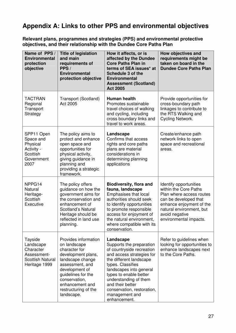
Appendix A: Links to other PPS and environmental objectives
Relevant plans, programmes and strategies (PPS) and environmental protective objectives, and their relationship with the Dundee Core Paths Plan
Name of PPS / Environmental protection objective
Title of legislation and main requirements of PPS / Environmental protection objective
How it affects, or is affected by the Dundee Core Paths Plan in terms of SEA issues* at Schedule 3 of the Environmental Assessment (Scotland) Act 2005
How objectives and requirements might be taken on board in the Dundee Core Paths Plan
TACTRAN Regional Transport Strategy
Transport (Scotland) Act 2005
Human health Promotes sustainable travel choices of walking and cycling, including cross boundary links and travel to work areas.
Provide opportunities for cross-boundary path linkages to contribute to the RTS Walking and Cycling Network.
SPP11 Open Space and Physical Activity Scottish Government 2007
The policy aims to protect and enhance open space and opportunities for physical activity, giving guidance in planning and providing a strategic framework.
Landscape Confirms that access rights and core paths plans are material considerations in determining planning applications
Create/enhance path network links to open space and recreational areas.
NPPG14 Natural Heritage-Scottish Executive
The policy offers guidance on how the government aims for the conservation and enhancement of Scotland’s Natural Heritage should be reflected in land use planning.
Biodiversity, flora and fauna, landscape Emphasises that local authorities should seek to identify opportunities to promote responsible access for enjoyment of the natural environment, where compatible with its conservation.
Identify opportunities within the Core Paths Plan where access routes can be developed that enhance enjoyment of the natural environment, but avoid negative environmental impacts.
Tayside Landscape Character Assessment-Scottish Natural Heritage 1999
Provides information on landscape character for development plans, landscape change assessment, and development of guidelines for the conservation, enhancement and restructuring of the landscape.
Landscape Supports the preparation of countryside recreation and access strategies for the different landscape types. Classifies landscapes into general types to enable better understanding of them and their better conservation, restoration, management and enhancement.
Refer to guidelines when looking for opportunities to enhance landscapes next to the Core Paths.
27

Name of PPS / Environmental protection objective
Title of legislation and main requirements of PPS / Environmental protection objective
How it affects, or is affected by the Dundee Core Paths Plan in terms of SEA issues* at Schedule 3 of the Environmental Assessment (Scotland) Act 2005
How objectives and requirements might be taken on board in the Dundee Core Paths Plan
NPPG5 Archaeology and Planning – Scottish Executive 1998
It is associated with Planning Advice Note Archaeology - the Planning Process and Scheduled Monument Procedures
Cultural heritage Promotes the role of local authorities in safeguarding the archaeological heritage whilst developing its use for recreational and educational purposes.
There should be careful consideration of designating Core Paths in sensitive areas to ensure that archaeological heritage sites and features are preserved and protected.
NPPG18 Planning and the Historic Environment Scottish Executive 1999
Listed buildings, conservation areas, historic gardens, designated landscapes and their settings.
Cultural heritage Identifies the role of the historic environment in supporting tourism and informal recreation
Identify opportunities to create/enhance access to cultural heritage sites and provide information about these sites.
Scotland's Historic Environment Policy (SHEP 1), 2007
SHEP 1 is the overarching policy statement for the historic environment providing a framework for more detailed strategic policies.
Cultural heritage There will be instances where the proposed core paths will affect areas of Dundee that are important Historic Environments.
Identify opportunities for positive development related to historic environments, and explore interventions relating to the historical, artistic, literary, linguistic and scenic associations of places and landscapes.
Dundee Outdoor Access Strategy 20052010
Land Reform (Scotland) Act 2005
Landscape Plan policies and proposals will be formulated in accordance with the strategic policy framework for outdoor access defined in the Access Strategy
Ensure that priorities from the Outdoor Access Strategy are taken forward in the Core Paths Plan.
Dundee Public Open Space Strategy 1999 & draft review
Required by SPP11 Landscape, Cultural Heritage, Biodiversity, flora and fauna Supports the development of an Access Strategy and for actions relating to green networks and access routes
Ensure cross-referencing between the Public Open Space Strategy and the Core Paths Plan to achieve outcomes for both.
28

Name of PPS / Environmental protection objective
Title of legislation and main requirements of PPS / Environmental protection objective
How it affects, or is affected by the Dundee Core Paths Plan in terms of SEA issues* at Schedule 3 of the Environmental Assessment (Scotland) Act 2005
How objectives and requirements might be taken on board in the Dundee Core Paths Plan
Dundee Local Plan Review, 2005
Sets the Development Strategy for the City, alongside detailed proposals and policies.
Biodiversity, flora and fauna, Cultural heritage, Landscape The Dundee Core Paths Plan will both influence and be influenced by the local plan land use and development policies and proposals in relation to outdoor access, and sustainable transport.
Incorporate the Core Paths Plan into updates of the Local Plan to ensure that opportunities to create and enhance path networks are maximised and monitored.
Dundee Partnership for the Environment Draft Strategy, 2007
Developed in response to the Dundee Partnership's Community Plan 2005
Biodiversity, flora and fauna, Cultural heritage, Landscape The Core Paths Plan will help to deliver a number of actions highlighted across the Partnership Strategy themes.
Implement recommendations made throughout the strategy relating to path networks and associated landscapes, cultural and natural heritage sites.
Streets Ahead Design Guide 2001
Informs developers of Council's benchmark standards for street design.
Landscape Provides a quality framework for street design and transport infrastructure within the city of Dundee.
Advocates greater priority to be given to pedestrians and cyclists in certain locations, such as residential areas, schools, shopping and leisure facilities.
Follow best practise design when upgrading, creating paths.
Developers to consider Core Paths Plan and priorities for nonmotorised access.
Tayside Biodiversity Action Plan
Takes forward regional priorities from Biodiversity: the UK Action Plan and Scotland's Biodiversity: It's in your hands.
Biodiversity, flora and fauna Identifies at risk local species and habitats to be protected and enhanced within the Tayside Region.
Consider implications and management options where BAP species and habitats are present.
29

Name of PPS / Environmental protection objective
Title of legislation and main requirements of PPS / Environmental protection objective
How it affects, or is affected by the Dundee Core Paths Plan in terms of SEA issues* at Schedule 3 of the Environmental Assessment (Scotland) Act 2005
How objectives and requirements might be taken on board in the Dundee Core Paths Plan
Nature Conservation (Scotland) Act 2004
EC Directive 92/43/EEC on the Conservation of Natural Habitats and of Wild Flora and Fauna (the Habitats Directive) and EC Directive 79/409/EEC on the Conservation of Wild Birds (the Birds Directive)
Biodiversity, flora and fauna A duty is placed on all public bodies to further the conservation of biodiversity. This duty should be taken forward in the delivery of the Core Paths Plan.
Seek opportunities to enhance biodiversity alongside Core Paths to create wildlife corridors.
Provide information on the biodiversity, flora and fauna that can be found alongside Core Paths.
Undertake appropriate assessments when creating new paths.
The Offshore Marine Conservation (Natural Habitats, &c.) Regulations 2007
Ensures consistency with the Habitats Directive and the Birds Directive for marine areas.
Biodiversity, flora and fauna Covers Dolphins, a European Protected Species, which may be seen off the Dundee coastline.
Provide relevant information/guidelines to people using the coastal path who may be interested in dolphin watching.
Angus Core Paths Plan
and
Perth & Kinross Core Paths Plan
Land Reform (Scotland) Act 2003
Biodiversity, flora and fauna, Cultural heritage, Landscape Ensure integration of Plans to provide meaningful networks for Green Corridors and appropriate connections to areas of cultural and natural importance.
Cross-refer to neighbouring authorities Core Paths Plans.
Where possible create cross-boundary links to ensure continuation of routes and enhance wildlife corridors.
Designing Places: a policy statement for Scotland' Scottish Executive
Supports PAN documents and NPPG1: The Planning System
Cultural heritage, Landscape Provides a general statement setting out the Scottish Ministers' aspirations for design and the role of the planning system in delivering PAN documents.
Implement best practice design standards when creating/ upgrading paths.
30

Name of PPS / Environmental protection objective
Title of legislation and main requirements of PPS / Environmental protection objective
How it affects, or is affected by the Dundee Core Paths Plan in terms of SEA issues* at Schedule 3 of the Environmental Assessment (Scotland) Act 2005
How objectives and requirements might be taken on board in the Dundee Core Paths Plan
European Protected Species, Development Sites and the Planning System; interim guidance for local authorities on licensing arrangements, 2001
The Habitats Directive
Biodiversity, flora and fauna Provides guidance where European Protected Species are present
Specific SEA objective created to protect European Protected Species. Core Paths must meet this criterion where European Protected Species are present.
PAN 65 Planning and Open Space, Scottish Executive, 2003
Supports SPP11 Biodiversity, flora and fauna, Landscape Linking access routes to the quality and accessibility of open space.
Encourages local authorities to develop and maintain networks of green and civic spaces with particular reference to walking and cycling.
Contribute to overall network of routes to open space.
Provide opportunities for enhancements to routes to create attractive green networks.
Scottish Rural Development Programme 2007-2013
The SRDP will set Scottish Ministers' goals for sustainable rural development and the types of support that will be available to help achieve these goals.
Biodiversity, flora and fauna, Cultural heritage, Landscape Core Paths will contribute to the regional priorities for access under the SRDP scheme.
Identify local priorities in the SRDP programme for Outdoor Access and Core Paths.
*Biodiversity, flora, fauna, population, human health, soil, water, air, climatic factors, material assets, cultural heritage, landscape, inter-relationship between these issues; secondary and cumulative effects.
31

Appendix B: Full assessment results
This section gives the full assessment of the Dundee Core Paths Plan against SEA and Core Paths criteria by area. Relevant path names and numbers are given for each area alongside a summary of the types of path, their use and any significant issues. An assessment is made of whether or not the SEA criteria are met, an explanatory comment is also provided as well as a judgement on the overall effect of the paths in the area on each SEA objective.
32

Core Path Area: Green Circular Summary and Key Features: A route that circumnavigates Dundee, connecting up some of the cities main green and open spaces.
For the most part the route is easy for walkers, cyclists (although some sections cyclists are on road) and people with disabilities (although there are some sections which may cause users problems currently) to use. Horse riders also use the route in areas such as Camperdown, Templeton and Trottick. The majority of the route is on tarmac surfaced paths. There are some sections in whindust.
List Core Path Criteria*met: 1, 2, 3, 4, 5, 6, 7 Topic SEA Objectives SEA Criteria Criteria
met? Comments Overall effect
on objective Biodiversity, Flora & Fauna
To maintain and enhance biodiversity, flora, and fauna
To avoid damage or disturbance to European Protected Species and provide positive opportunities.
• Avoid harm to protected species
• Conserve and enhance natural / semi-natural habitats
• Avoid damage to wildlife and geological sites designated for their conservation interest
• Provide opportunities for people to come into contact with and appreciate wildlife and wild places.
Yes
Yes
Yes
Yes
Route takes people close to areas of the city important for biodiversity and conservation, but avoids harm to these areas by encouraging people to keep to the main route.
Information boards provide information about wildlife along the route.
Positive
Cultural Heritage To conserve and where appropriate enhance the historic environment and cultural heritage
To promote access to the historic environment
• Protect historic buildings, archaeological sites and other culturally important features
• Support the positive management of cultural heritage resources
Yes
Yes
Buildings such as Broughty Castle and Claypotts Castle, and archaeological sites such as the Balgarthno stone circle are just off the route. As this is one of the most popular routes in Dundee it is unlikely that visitor numbers will increase greatly.
Neutral/ Positive
Landscape To maintain and enhance the quality of landscapes and townscapes.
To improve quality of surroundings
• Protect and enhance the landscape and townscape, particularly in designated areas
• Improve satisfaction of people with their neighbourhoods as places to live
• Decrease litter and graffiti in towns and countryside
Yes
Yes
Yes
The paths and signage for this route already exist, so there will be little further impact on the landscape.
The potential exists for landscape enhancements alongside the route.
Litter and graffiti may increase; however, a maintenance policy dealing with this is in place.
Neutral/ Positive
* Core Path Criteria: 1. Fit for multi-use, 2. Creates/enhances routes and wider path network, 3. Allows access to cultural and natural heritage sites, parks and visitor facilities, 4. Links community facilities (e.g. schools, shops, workplaces) and transport links, 5. Avoids/mitigates negative environmental impact and land management issues, 6. Level of public demand (from consultations), 7. Value for money

Core Path Area: Western Countryside Area Summary and Key Features: Paths in this area are mainly tracks alongside fields. Aspirational routes highlighted will add significantly to the network in
this area when they are implemented as they will provide safer off-road links. Currently this area is undergoing large changes with 3 housing estates planned. Potentially this will increase the demand for path networks in the area and there may be opportunities to implement and upgrade the path network through planning gain.
List Core Path Criteria*met: 1, 2, 3, 5, 6, 7
Topic SEA Objectives SEA Criteria Criteria met?
Comments Overall effect on objective
Biodiversity, Flora & Fauna
To maintain and enhance biodiversity, flora, and fauna
To avoid damage or disturbance to European Protected Species and provide positive opportunities.
• Avoid harm to protected species
• Conserve and enhance natural / semi-natural habitats
• Avoid damage to wildlife and geological sites designated for their conservation interest
• Provide opportunities for people to come into contact with and appreciate wildlife and wild places.
Yes
Yes
Yes
Yes
The proposed Core Path Network in this area will encourage people to access the countryside more often.
Promotional materials detailing responsible behaviour should be promoted alongside the core paths plan.
Neutral
Cultural Heritage To conserve and where appropriate enhance the historic environment and cultural heritage
To promote access to the historic environment
• Protect historic buildings, archaeological sites and other culturally important features
• Support the positive management of cultural heritage resources
Yes
Yes
Some scheduled ancient monuments and listed buildings in this area; however they are not affected by the proposed Core Paths Network.
Neutral
Landscape To maintain and enhance the quality of landscapes and townscapes.
To improve quality of surroundings
• Protect and enhance the landscape and townscape, particularly in designated areas
• Improve satisfaction of people with their neighbourhoods as places to live
• Decrease litter and graffiti in towns and countryside
Yes
Yes
No
Landscape is currently undergoing change with new housing developments, so signage of path network is not likely to have a significant impact on the landscape. Promotion and signposting of a path network is likely to increase residents satisfaction with the area. There is potential for litter to increase in the area, but this is more likely to be a result of the increased numbers of people living in the area than of the Core Paths Plan.
Neutral/ Positive
* Core Path Criteria: 1. Fit for multi-use, 2. Creates/enhances routes and wider path network, 3. Allows access to cultural and natural heritage sites, parks and visitor facilities, 4. Links community facilities (e.g. schools, shops, workplaces) and transport links, 5. Avoids/mitigates negative environmental impact and land management issues, 6. Level of public demand (from consultations), 7. Value for money
34

Core Path Area: Camperdown Country Park Summary and Key Features: The paths in this area are a mixture of whindust and tarmac surfaced paths. Generally these are suitable for all types of
user. A quite track links from the north of Templeton Woods to Bridgefoot. Some of the paths can become muddy. Path 79 linking to Templeton may also be upgraded, to provide a crossing at a safer position.
List Core Path Criteria*met: 1, 2, 3, 5, 6, 7
Topic SEA Objectives SEA Criteria Criteria met?
Comments Overall effect on objective
Biodiversity, Flora & Fauna
To maintain and enhance biodiversity, flora, and fauna
To avoid damage or disturbance to European Protected Species and provide positive opportunities.
• Avoid harm to protected species
• Conserve and enhance natural / semi-natural habitats
• Avoid damage to wildlife and geological sites designated for their conservation interest
• Provide opportunities for people to come into contact with and appreciate wildlife and wild places.
Yes
Yes
Yes
Yes
The paths in this area already exist and are already popular routes. Whilst there are important species in this area, such as red squirrels, the core paths chosen are generally away from significant sites.
Interpretation boards provide information about wildlife along some of the routes. Leaflets have been developed by the Countryside Ranger Service.
Neutral
Cultural Heritage To conserve and where appropriate enhance the historic environment and cultural heritage
To promote access to the historic environment
• Protect historic buildings, archaeological sites and other culturally important features
• Support the positive management of cultural heritage resources
Yes
Yes
The paths in this area already exist and are already popular routes. Camperdown House is a listed building and the grounds have the designation of Gardens and Designed Landscapes.
Interpretation boards provide information about historic features.
Neutral
Landscape To maintain and enhance the quality of landscapes and townscapes.
To improve quality of surroundings
• Protect and enhance the landscape and townscape, particularly in designated areas
• Improve satisfaction of people with their neighbourhoods as places to live
• Decrease litter and graffiti in towns and countryside
Yes
Yes
Yes
The paths for this route already exist, so there will be little further impact on the landscape other than additional signage where required.
The potential exists for landscape enhancements alongside the routes.
The routes are already well used and litter is unlikely to increase as a direct result of the plan.
Neutral
* Core Path Criteria: 1. Fit for multi-use, 2. Creates/enhances routes and wider path network, 3. Allows access to cultural and natural heritage sites, parks and visitor facilities, 4. Links community facilities (e.g. schools, shops, workplaces) and transport links, 5. Avoids/mitigates negative environmental impact and land management issues, 6. Level of public demand (from consultations), 7. Value for money
35

Core Path Area: Lochee, Charleston and Menzieshill Summary and Key Features: Mostly well-used tarmac paths. Links to Ninewells Hospital are important in this area. Balgay Park provides a major
recreation area. South Road park provides an area for recreation and sports such as football. Desire line path 76 through Medipark - well used by local dog walkers - possible upgrade. Many of the paths are, or could be, shared-use. Possible upgrade of path 62.
List Core Path Criteria*met: 1, 2, 3, 4, 5, 6, 7
Topic SEA Objectives SEA Criteria Criteria met?
Comments Overall effect on objective
Biodiversity, Flora & Fauna
To maintain and enhance biodiversity, flora, and fauna
To avoid damage or disturbance to European Protected Species and provide positive opportunities.
• Avoid harm to protected species
• Conserve and enhance natural / semi-natural habitats
• Avoid damage to wildlife and geological sites designated for their conservation interest
• Provide opportunities for people to come into contact with and appreciate wildlife and wild places.
Yes
Yes
Yes
Yes
Most of the paths in this area already exist. Protected species, such as Bats, are present in Balgay Park, although the paths are already well used and no further disturbance as a direct result of the plan is anticipated. There is potential to conserve/enhance natural and semi-natural habitats at Balgay Park and Ninewells Medipark. Opportunities are provided for people to come into contact with wild places e.g. Countryside Ranger events, information boards and leaflets
Neutral
Cultural Heritage To conserve and where appropriate enhance the historic environment and cultural heritage
To promote access to the historic environment
• Protect historic buildings, archaeological sites and other culturally important features
• Support the positive management of cultural heritage resources
Yes
Yes
Access to historic buildings and places, such as the Mills Observatory and the Balgarthno Stone Circle, are facilitated through the Core Path Network. These paths are already busy and so footfall is unlikely to increase to these sites as a direct result of the Core Paths Plan. The Stone Circle has been fenced off to prevent vandalism. Interpretation exists on some routes and is a possibility on others.
Neutral
Landscape To maintain and enhance the quality of landscapes and townscapes.
To improve quality of surroundings
• Protect and enhance the landscape and townscape, particularly in designated areas
• Improve satisfaction of people with their neighbourhoods as places to live
• Decrease litter and graffiti in towns and countryside
Yes
Yes
Yes
Work alongside local community plans and local area master plans.
People will feel more satisfied with signposted paths to local greenspaces and areas of cultural interest.
The routes are already well used and litter is unlikely to increase as a direct result of the plan.
Neutral
* Core Path Criteria: 1. Fit for multi-use, 2. Creates/enhances routes and wider path network, 3. Allows access to cultural and natural heritage sites, parks and visitor facilities, 4. Links community facilities (e.g. schools, shops, workplaces) and transport links, 5. Avoids/mitigates negative environmental impact and land management issues, 6. Level of public demand (from consultations), 7. Value for money
36

Core Path Area: West End Summary and Key Features: Paths consist mostly of footways next to roads, which would be for pedestrian use only - cyclists would have to use the
adjacent roads. There are important links under and over the railway line. There are several major employers in this area including the University of Dundee, Ninewells Hospital, and the Technology Park. The Riverside LNR site would be popular for access; however it is currently classed as landfill site until remedial works are completed. It is anticipated that the existing path network would be reopened to the public in the future.
List Core Path Criteria*met: 2, 3, 4, 5, 6, 7
Topic SEA Objectives SEA Criteria Criteria met?
Comments Overall effect on objective
Biodiversity, Flora & Fauna
To maintain and enhance biodiversity, flora, and fauna
To avoid damage or disturbance to European Protected Species and provide positive opportunities.
• Avoid harm to protected species
• Conserve and enhance natural / semi-natural habitats
• Avoid damage to wildlife and geological sites designated for their conservation interest
• Provide opportunities for people to come into contact with and appreciate wildlife and wild places.
Yes
Yes
Yes
Yes
The paths in this section of the plan already exist and are well used. The paths allow access to places such as Magdalen Green, Victoria Park and the area around Ninewells, and give views across the Tay, allowing people to appreciate wildlife and wild places.
Neutral
Cultural Heritage To conserve and where appropriate enhance the historic environment and cultural heritage
To promote access to the historic environment
• Protect historic buildings, archaeological sites and other culturally important features
• Support the positive management of cultural heritage resources
Yes
Yes
There is a high concentration of Conservation Areas and listed buildings in this area. The core paths plan uses existing paths through these areas and past these buildings. Potential exists to highlight their importance through supplementary literature and interpretation.
Positive
Landscape To maintain and enhance the quality of landscapes and townscapes.
To improve quality of surroundings
• Protect and enhance the landscape and townscape, particularly in designated areas
• Improve satisfaction of people with their neighbourhoods as places to live
• Decrease litter and graffiti in towns and countryside
Yes
Yes
Yes
The paths and signage for the majority of these routes already exist, so there will be little further impact on the landscape.
The potential exists for landscape enhancements alongside the paths.
Litter and graffiti may increase, however, these are currently well used paths and a significant increase is not anticipated.
Neutral
* Core Path Criteria: 1. Fit for multi-use, 2. Creates/enhances routes and wider path network, 3. Allows access to cultural and natural heritage sites, parks and visitor facilities, 4. Links community facilities (e.g. schools, shops, workplaces) and transport links, 5. Avoids/mitigates negative environmental impact and land management issues, 6. Level of public demand (from consultations), 7. Value for money
37

Core Path Area: Ardler, St Mary's & Kirkton Summary and Key Features: The paths in this area are mostly tarmac and multi-use. They provide good connections to neighbouring communities,
local facilities and to parks, open spaces and the countryside. Path 16b is a desire line running from St Mary's to Clatto. There is the potential to upgrade this route in the future.
List Core Path Criteria*met: 1, 2, 3, 4, 5, 6, 7
Topic SEA Objectives SEA Criteria Criteria met?
Comments Overall effect on objective
Biodiversity, Flora & Fauna
To maintain and enhance biodiversity, flora, and fauna
To avoid damage or disturbance to European Protected Species and provide positive opportunities.
• Avoid harm to protected species
• Conserve and enhance natural / semi-natural habitats
• Avoid damage to wildlife and geological sites designated for their conservation interest
• Provide opportunities for people to come into contact with and appreciate wildlife and wild places.
Yes
Yes
Yes
Yes
Candidate Core Paths pass local Sustainable Urban Drainage System Ponds and Retention Basins, which have become popular places for people to watch wildlife locally.
Potential to improve interpretation where routes run alongside such areas or to provide an interpretive leaflet.
Neutral
Cultural Heritage To conserve and where appropriate enhance the historic environment and cultural heritage
To promote access to the historic environment
• Protect historic buildings, archaeological sites and other culturally important features
• Support the positive management of cultural heritage resources
Yes
Yes
Candidate Core Paths do not interfere with any listed buildings or structures in this area.
Potential to develop artistic interpretation alongside key routes relating to the history of the area. Work alongside Ardler Village Trust.
Positive
Landscape To maintain and enhance the quality of landscapes and townscapes.
To improve quality of surroundings
• Protect and enhance the landscape and townscape, particularly in designated areas
• Improve satisfaction of people with their neighbourhoods as places to live
• Decrease litter and graffiti in towns and countryside
Yes
Yes
?
The routes already exist and so adoption of the Core Paths Plan is unlikely to have a significant impact.
Residents in the area will benefit from increased signage to greenspaces.
Litter may increase along these routes, but more people on the routes may help to decrease current litter problem.
Neutral
* Core Path Criteria: 1. Fit for multi-use, 2. Creates/enhances routes and wider path network, 3. Allows access to cultural and natural heritage sites, parks and visitor facilities, 4. Links community facilities (e.g. schools, shops, workplaces) and transport links, 5. Avoids/mitigates negative environmental impact and land management issues, 6. Level of public demand (from consultations), 7. Value for money
38

Core Path Area: Central Summary and Key Features: A disused railway, forms one of the key routes in this area, 'the Miley' links Lochee to the Kingsway Retail Park and
provides a green wildlife corridor in the heart if the city. Links to the Law are popular with walkers and dog walkers. Clepington Road is a busy street with good links to buses and local shops. Baxter Park is a well used city park which provides for recreation and play; it is also used by children going to school at the Morgan Academy. Although steep the Hilltown provides access to shops and services and is a good link to the city centre.
List Core Path Criteria*met: 2, 3, 4, 5, 6, 7
Topic SEA Objectives SEA Criteria Criteria met?
Comments Overall effect on objective
Biodiversity, Flora & Fauna
To maintain and enhance biodiversity, flora, and fauna
To avoid damage or disturbance to European Protected Species and provide positive opportunities.
• Avoid harm to protected species
• Conserve and enhance natural / semi-natural habitats
• Avoid damage to wildlife and geological sites designated for their conservation interest
• Provide opportunities for people to come into contact with and appreciate wildlife and wild places.
Yes
Yes
Yes
Yes
The paths in this section of the plan already exist and are well used.
Possibilities for habitat enhancements alongside some of the routes should be explored.
The paths allow access to places such as the Law and Baxter Park, allowing people to appreciate wildlife and wild places.
Neutral
Cultural Heritage To conserve and where appropriate enhance the historic environment and cultural heritage
To promote access to the historic environment
• Protect historic buildings, archaeological sites and other culturally important features
• Support the positive management of cultural heritage resources
Yes
Yes
Access will be promoted to the Fort on the Law and paths have been selected through the Conservation areas to the south of the Law and the area around and including Baxter Park. These are existing paths, which will allow access, without the need for further path construction. Potential exists to highlight the importance of these areas through supplementary literature and interpretation.
Neutral
Landscape To maintain and enhance the quality of landscapes and townscapes.
To improve quality of surroundings
• Protect and enhance the landscape and townscape, particularly in designated areas
• Improve satisfaction of people with their neighbourhoods as places to live
• Decrease litter and graffiti in towns and countryside
Yes
Yes
?
The routes already exist and so adoption of the Core Paths Plan is unlikely to have a significant impact.
Residents in the area will benefit from increased signage to greenspaces.
Litter may increase along these routes, but more people on the routes may help to decrease current litter problem in some areas.
Neutral
* Core Path Criteria: 1. Fit for multi-use, 2. Creates/enhances routes and wider path network, 3. Allows access to cultural and natural heritage sites, parks and visitor facilities, 4. Links community facilities (e.g. schools, shops, workplaces) and transport links, 5. Avoids/mitigates negative environmental impact and land management issues, 6. Level of public demand (from consultations), 7. Value for money
39

Core Path Area: City Centre Summary and Key Features: A large number of visitors to the city arrive by public transport via bus and rail stations, increasing the numbers of people
in the area travelling by foot or bicycle. There are a number of attractions for visitors to the city, such as the Discovery, shops and restaurants. There are also many people who commute to Dundee city centre for work or study who come from across the city and from Fife via the Tay Road Bridge. Dedicated shared use paths run east-west and over the Tay Road Bridge and the pedestrianised city centre has allowance for bicycle use.
List Core Path Criteria*met: 2, 3, 4, 5, 6, 7
Topic SEA Objectives SEA Criteria Criteria met?
Comments Overall effect on objective
Biodiversity, Flora & Fauna
To maintain and enhance biodiversity, flora, and fauna
To avoid damage or disturbance to European Protected Species and provide positive opportunities.
• Avoid harm to protected species
• Conserve and enhance natural / semi-natural habitats
• Avoid damage to wildlife and geological sites designated for their conservation interest
• Provide opportunities for people to come into contact with and appreciate wildlife and wild places.
Yes
Yes
Yes
Yes
The paths and signage for the majority of these routes already exist and the city centre is already busy with residents and visitors. It is unlikely that there will be a large increase in numbers of people going to places such as Dudhope Park, the Howff and city centre greenspaces as a direct result of the Core Paths Plan.
Neutral
Cultural Heritage To conserve and where appropriate enhance the historic environment and cultural heritage
To promote access to the historic environment
• Protect historic buildings, archaeological sites and other culturally important features
• Support the positive management of cultural heritage resources
Yes
Yes
Access to historic buildings and places, such as the Howff and Dudhope Castle, is facilitated through the Core Path Network. The City Centre is already busy with residents and visitors and so footfall is unlikely to increase to these sites as a direct result of the Core Paths Plan.
Potential for interpretation on historical features.
Neutral
Landscape To maintain and enhance the quality of landscapes and townscapes.
To improve quality of surroundings
• Protect and enhance the landscape and townscape, particularly in designated areas
• Improve satisfaction of people with their neighbourhoods as places to live
• Decrease litter and graffiti in towns and countryside
Yes
Yes
?
The paths and signage for the majority of these routes already exist, so there will be little further impact on the landscape.
Promotion of paths to parks and greenspaces should encourage people to visit them more often Litter and graffiti may increase, although these are currently well used paths and a significant increase is not anticipated.
Neutral
* Core Path Criteria: 1. Fit for multi-use, 2. Creates/enhances routes and wider path network, 3. Allows access to cultural and natural heritage sites, parks and visitor facilities, 4. Links community facilities (e.g. schools, shops, workplaces) and transport links, 5. Avoids/mitigates negative environmental impact and land management issues, 6. Level of public demand (from consultations), 7. Value for money
40

Core Path Area: West Ferry Summary and Key Features: Paths in this area are, or have the potential to be, multi-use paths. A link through Dawson Park would be required to
complete the network. Important areas for access to are Dawson Park and Grassy Beach. Local schools and workplaces are also connected by the proposed network. There are links to Broughty Ferry, the City Centre and north towards the countryside.
List Core Path Criteria*met: 1, 2, 3, 4, 5, 6, 7
Topic SEA Objectives SEA Criteria Criteria met?
Comments Overall effect on objective
Biodiversity, Flora & Fauna
To maintain and enhance biodiversity, flora, and fauna
To avoid damage or disturbance to European Protected Species and provide positive opportunities.
• Avoid harm to protected species
• Conserve and enhance natural / semi-natural habitats
• Avoid damage to wildlife and geological sites designated for their conservation interest
• Provide opportunities for people to come into contact with and appreciate wildlife and wild places.
Yes
Yes
Yes
Yes
Grassy Beach is an area which is locally important for its flora. Upgrading of this path has already been carried out and makes this path more accessible to people to appreciate nature. Information and interpretation is facilitated through boards and artistic contributions from the Broughty Ferry Environment Project.
Some sites are becoming eroded due to tidal action, this may affect the path network in the future and management options should be considered.
Neutral
Cultural Heritage To conserve and where appropriate enhance the historic environment and cultural heritage
To promote access to the historic environment
• Protect historic buildings, archaeological sites and other culturally important features
• Support the positive management of cultural heritage resources
Yes
Yes
The area to the south and west of Dawson Park is a Conservation Area. Claypotts Castle is also in this area. Existing paths run past and through these areas, but will not significantly affect them. Potential exists to highlight the importance of these areas through supplementary literature and/or interpretation.
Neutral
Landscape To maintain and enhance the quality of landscapes and townscapes.
To improve quality of surroundings
• Protect and enhance the landscape and townscape, particularly in designated areas
• Improve satisfaction of people with their neighbourhoods as places to live
• Decrease litter and graffiti in towns and countryside
Yes
Yes
?
The routes already exist and so adoption of the Core Paths Plan is unlikely to have a significant impact. Residents in the area will benefit from increased signage to greenspaces, schools and work places. Litter may increase along these routes, although most are already popular and an increase in litter due to the adoption of the plan is unlikely to be significant.
Neutral
* Core Path Criteria: 1. Fit for multi-use, 2. Creates/enhances routes and wider path network, 3. Allows access to cultural and natural heritage sites, parks and visitor facilities, 4. Links community facilities (e.g. schools, shops, workplaces) and transport links, 5. Avoids/mitigates negative environmental impact and land management issues, 6. Level of public demand (from consultations), 7. Value for money
41

Core Path Area: Whitfield, Douglas, Fintry Summary and Key Features: The majority of the paths in this area are multi-use paths providing connections between communities and to community
facilities. There are also links to the countryside and to greenspaces such as Middleton Woods and the Dighty Burn. There are connects to workplaces in the Baldovie Industrial Estate. The Aspirational Paths highlighted in the plan would help to create a continuous network and facilitate links to the countryside.
List Core Path Criteria*met: 1, 2, 3, 4, 5, 6, 7
Topic SEA Objectives SEA Criteria Criteria met?
Comments Overall effect on objective
Biodiversity, Flora & Fauna
To maintain and enhance biodiversity, flora, and fauna
To avoid damage or disturbance to European Protected Species and provide positive opportunities.
• Avoid harm to protected species
• Conserve and enhance natural / semi-natural habitats
• Avoid damage to wildlife and geological sites designated for their conservation interest
• Provide opportunities for people to come into contact with and appreciate wildlife and wild places.
Yes
Yes
Yes
Yes
Middleton Woods, the parks and open spaces alongside the Dighty Burn and the burn itself are locally important places for people to come into contact with wildlife and wild places. These are already popular places for access and it is unlikely that the adoption of the plan will have a significant impact. It is possible that illegal motorbike use may decrease due to the promotion of the path network.
Neutral
Cultural Heritage To conserve and where appropriate enhance the historic environment and cultural heritage
To promote access to the historic environment
• Protect historic buildings, archaeological sites and other culturally important features
• Support the positive management of cultural heritage resources
Yes
Yes
The paths alongside the Dighty Burn present a good opportunity to highlight the historical importance of the area. The burn once had more mills along it than any other watercourse in Scotland. There is potential to promote this as a heritage trail with associated interpretation and literature.
Positive
Landscape To maintain and enhance the quality of landscapes and townscapes.
To improve quality of surroundings
• Protect and enhance the landscape and townscape, particularly in designated areas
• Improve satisfaction of people with their neighbourhoods as places to live
• Decrease litter and graffiti in towns and countryside
Yes
Yes
?
Candidate Core Paths in the Whitfield area may change as the area undergoes development. It is likely that they will still follow the same general route as shown in this plan. Generally people will benefit from improved signage to local greenspaces and the countryside. Litter may increase, but not likely to be by a significant amount.
Neutral
* Core Path Criteria: 1. Fit for multi-use, 2. Creates/enhances routes and wider path network, 3. Allows access to cultural and natural heritage sites, parks and visitor facilities, 4. Links community facilities (e.g. schools, shops, workplaces) and transport links, 5. Avoids/mitigates negative environmental impact and land management issues, 6. Level of public demand (from consultations), 7. Value for money
42

Core Path Area: North East Countryside Summary and Key Features: The majority of this area has a countryside feel with farmland being mostly arable in use. There are two new housing
developments at Linlathen House and Balmossie which will add to the need for path networks allowing for both access to the countryside and to shops, schools and other facilities. There are good connections to Angus, particularly via the Green Circular route and along the Arbroath Road. There are also links into Broughty Ferry, Baldovie Industrial Estate and Douglas.
List Core Path Criteria*met: 2, 3, 4, 5, 6, 7
Topic SEA Objectives SEA Criteria Criteria met?
Comments Overall effect on objective
Biodiversity, Flora & Fauna
To maintain and enhance biodiversity, flora, and fauna
To avoid damage or disturbance to European Protected Species and provide positive opportunities.
• Avoid harm to protected species
• Conserve and enhance natural / semi-natural habitats
• Avoid damage to wildlife and geological sites designated for their conservation interest
• Provide opportunities for people to come into contact with and appreciate wildlife and wild places.
Yes
Yes
Yes
Yes
New housing developments in the area will increase pressure for access to the countryside, particularly for walking and dog walking. Promoting and signposting existing major links will assist in managing this.
Promoting these paths will also encourage people from nearby housing estates to visit the countryside more often and appreciate wildlife and wild places.
Positive
Cultural Heritage To conserve and where appropriate enhance the historic environment and cultural heritage
To promote access to the historic environment
• Protect historic buildings, archaeological sites and other culturally important features
• Support the positive management of cultural heritage resources
Yes
Yes
There are Scheduled Ancient Monuments close to path network, notably the A listed Linlathen bridges. These are not on the proposed path network, but can be seen from it and restoration works would be viewed favourably to increase wider path network use.
Positive
Landscape To maintain and enhance the quality of landscapes and townscapes.
To improve quality of surroundings
• Protect and enhance the landscape and townscape, particularly in designated areas
• Improve satisfaction of people with their neighbourhoods as places to live
• Decrease litter and graffiti in towns and countryside
Yes
Yes
?
Potential for features such as drystone dykes and hedgerows to be restored or improved along main routes.
Signposted routes will increase peoples satisfaction with the place they live.
Potential for an increase in litter, but more people on the routes might decrease fly tipping.
Positive
* Core Path Criteria: 1. Fit for multi-use, 2. Creates/enhances routes and wider path network, 3. Allows access to cultural and natural heritage sites, parks and visitor facilities, 4. Links community facilities (e.g. schools, shops, workplaces) and transport links, 5. Avoids/mitigates negative environmental impact and land management issues, 6. Level of public demand (from consultations), 7. Value for money
43

Core Path Area: Broughty Ferry Summary and Key Features: A popular area for outdoor access due to its attractive greenspaces, coastal landscape and cultural heritage. The routes
in this area are mainly tarmac paths where there is either shared use or the opportunity for shared use or on road cycling facilities. Routes selected are useful for accessing shops in the town centre and for getting to schools and community facilities.
List Core Path Criteria*met: 2, 3, 4, 5, 6, 7
Topic SEA Objectives SEA Criteria Criteria met?
Comments Overall effect on objective
Biodiversity, Flora & Fauna
To maintain and enhance biodiversity, flora, and fauna
To avoid damage or disturbance to European Protected Species and provide positive opportunities.
• Avoid harm to protected species
• Conserve and enhance natural / semi-natural habitats
• Avoid damage to wildlife and geological sites designated for their conservation interest
• Provide opportunities for people to come into contact with and appreciate wildlife and wild places.
Yes
Yes
Yes
Yes
Broughty Ferry has a number of natural heritage designations, including the LNR and the Firth of Tay SAC, SPA, SSSI and RAMSAR site. These are already popular places to take access and it is unlikely that the adoption of the plan will have a significant effect on these areas.
A dolphin watching policy is to be developed and promoted.
There are a number of places in this area where people can appreciate wildlife and wild places.
Neutral
Cultural Heritage To conserve and where appropriate enhance the historic environment and cultural heritage
To promote access to the historic environment
• Protect historic buildings, archaeological sites and other culturally important features
• Support the positive management of cultural heritage resources
Yes
Yes
Broughty Castle is currently open to the public as a museum and interpretation is available both inside and outside the Castle
A heritage trail has been developed and promoted by the Community Council.
Neutral
Landscape To maintain and enhance the quality of landscapes and townscapes.
To improve quality of surroundings
• Protect and enhance the landscape and townscape, particularly in designated areas
• Improve satisfaction of people with their neighbourhoods as places to live
• Decrease litter and graffiti in towns and countryside
Yes
Yes
Yes
Routes already exist and are in use, therefore little is likely to change.
People unhappy with current signage opportunity to address this and create clearer, less cluttered signage.
Unlikely that litter and graffiti will increase as a direct result of the Core Paths Plan.
Positive
* Core Path Criteria: 1. Fit for multi-use, 2. Creates/enhances routes and wider path network, 3. Allows access to cultural and natural heritage sites, parks and visitor facilities, 4. Links community facilities (e.g. schools, shops, workplaces) and transport links, 5. Avoids/mitigates negative environmental impact and land management issues, 6. Level of public demand (from consultations), 7. Value for money
44

Core Path Area: Caird Park and Trottick Summary and Key Features: Most of the paths in this area are available for multi-use.
The area has both historical and natural heritage features of importance. In particular the Trottick Mill Ponds Local Nature Reserve. Caird Park provides a facility for a variety of recreational purposes, such as golf, football, velodrome cycling and cross country style events.
List Core Path Criteria*met: 1, 2, 3, 5, 6, 7
Topic SEA Objectives SEA Criteria Criteria met?
Comments Overall effect on objective
Biodiversity, Flora & Fauna
To maintain and enhance biodiversity, flora, and fauna
To avoid damage or disturbance to European Protected Species and provide positive opportunities.
• Avoid harm to protected species
• Conserve and enhance natural / semi-natural habitats
• Avoid damage to wildlife and geological sites designated for their conservation interest
• Provide opportunities for people to come into contact with and appreciate wildlife and wild places.
?
Yes
Yes
Yes
Possible location for otters. Monitoring will be required. These are already popular paths and it is unlikely that the adoption of the plan will have a significant impact. It is possible that illegal motorbike use may decrease due to the promotion of the path network. Caird Park and Trottick LNR are locally important places for people to come into contact with wildlife and wild places.
Neutral
Cultural Heritage To conserve and where appropriate enhance the historic environment and cultural heritage
To promote access to the historic environment
• Protect historic buildings, archaeological sites and other culturally important features
• Support the positive management of cultural heritage resources
Yes
Yes
Paths give access to the Trottick LNR, which is also listed for historical interest in the mill ponds and lades. Mains Castle is situated in the grounds of Caird Park and access to this is also facilitated in the plan. There is some existing interpretation on site, however, there is potential to back this up with other literature/ interpretation.
Neutral
Landscape To maintain and enhance the quality of landscapes and townscapes.
To improve quality of surroundings
• Protect and enhance the landscape and townscape, particularly in designated areas
• Improve satisfaction of people with their neighbourhoods as places to live
• Decrease litter and graffiti in towns and countryside
Yes
Yes
?
As mentioned above these are already popular paths and adoption of the plan is not likely to change the landscape, other than some increase in signage. Promotion of these paths may attract more people to the parks and countryside areas. This in turn may lead to an increase in litter along some paths, but it may also discourage illegitimate users such as motorcyclists.
Neutral
* Core Path Criteria: 1. Fit for multi-use, 2. Creates/enhances routes and wider path network, 3. Allows access to cultural and natural heritage sites, parks and visitor facilities, 4. Links community facilities (e.g. schools, shops, workplaces) and transport links, 5. Avoids/mitigates negative environmental impact and land management issues, 6. Level of public demand (from consultations), 7. Value for money
45

Appendix C: The Conservation (Natural Habitats, &c.) Regulations 1994
Grant of licences for certain purposes 44.—(1) Regulations 39, 41 and 43 do not apply to anything done for any of the following purposes under and in accordance with the terms of a licence granted by the appropriate authority.
(2) The purposes referred to in paragraph (1) are(a) scientific or educational purposes; (b) ringing or marking, or examining any ring or mark on, wild animals; (c) conserving wild animals or wild plants or introducing them to particular areas; (d) protecting any zoological or botanical collection; (e) preserving public health or public safety or other imperative reasons of overriding public interest including those of a social or economic nature and beneficial consequences of primary importance for the environment; (f) preventing the spread of disease; or (g) preventing serious damage to livestock, foodstuffs for livestock, crops, vegetables, fruit, growing timber or any other form of property or to fisheries.
(3) The appropriate authority shall not grant a licence under this regulation unless they are satisfied
(a) that there is no satisfactory alternative, and (b) that the action authorised will not be detrimental to the maintenance of the population of the species concerned at a favourable conservation status in their natural range.
(4) For the purposes of this regulation "the appropriate authority" means(a) in the case of a licence under any of sub-paragraphs (a) to (d) of paragraph (2), the appropriate nature conservation body; and (b) in the case of a licence under any of sub-paragraphs (e) to (g) of that paragraph, the agriculture Minister.
(5) The agriculture Minister shall from time to time consult with the nature conservation bodies as to the exercise of his functions under this regulation; and he shall not grant a licence of any description unless he has been advised by the appropriate nature conservation body as to the circumstances in which, in their opinion, licences of that description should be granted.
Appendix D: Designated Sites
List of Scheduled Ancient Monuments
1. Wishart Arch, East Port of Dundee 8. Souterrains, 250m NNE of Mains of Grey 2. Stone Circle, Gourdie 9. Souterrain, 250m NE of Barns of 3. Paddock Stone, standing stone 90m NE Claverhouse
of Greystone House 10. Souterrain, 100m SE of North Gates 4. Powrie Castle, Powrie 11. Cursus and barrows SW of Greystane 5. Cairn Greg, cairn 430m ESE of North Lodge
Gates 12. Site of Hospital of St. John the Baptist, 6. Fort, Dundee Law Broughty Ferry Road 7. Benvie, enclosure 50m SE of Benvie 13. Claypotts Castle
Church 14. Broughty Ferry Castle

Natural Heritage Sites

Cultural Heritage Sites
48