during autumn 2016 the italian-palestinian joint eam of ... xxi/vo_xxi... · their protection and...
TRANSCRIPT

[Vicino Oriente XXI (2017), pp. 5-57]
NEW ARCHAEOLOGICAL FEATURES IN BETHLEHEM (PALESTINE): THE ITALIAN-PALESTINIAN RESCUE SEASON OF NOVEMBER 2016
Lorenzo Nigro - Daria Montanari - Alessandra Guari - Maria Tamburrini - Pierfrancesco Izzo
Sapienza University of Rome Mohammed Ghayyada - Iman Titi - Jehad Yasine
Ministry of Tourism and Antiquities - Department of Archaeology and Cultural Heritage
During Autumn 2016 the Italian-Palestinian joint team of Sapienza University of Rome and the Ministry of Tourism and Antiquities of Palestine carried out further rescue excavations and surveying in the city of Bethlehem and in its surroundings. These activities were conducted in order to protect the archaeological and historical patrimony of this area of Palestine, and to prevent looting, sites destruction, vandalism and illegal trade of archaeological items. A provisional report on finds and activities is offered below.
Keywords: Bethlehem; Early and Middle Bronze Age; Iron Age; necropolis; archaeological and historical sites 1. INTRODUCTION
In November 2016 the joint team of the Palestinian MOTA-DACH and Sapienza University of Rome 1 resumed rescue activities in the urban area of the city of Bethlehem, due to the accidental discovery of a new burial place at Jebel Dhaher, and with the aim of monitoring the situation in the necropolis of Khalet al-Jam’a (fig. 1). The second season at Bethlehem was in fact also suitable for continuing the graphic and photographic documentation and the study of finds from the tombs of the Khalet al-Jam’a necropolis. A special time was devoted to Tomb D13, called ‘Barmil Tomb’, an Iron Age II burial cave which illustrated the use of the necropolis also in the 1st millennium BC. 2 During the four weeks campaign, the team members visited several sites in order to check and document their preservation state. They collected all available data on a GIS platform3 which is now online in the open access website: www.lasapienzatojericho.it/Betlemme. A catalogue of checked sites is offered on § 2. Paragraph 3. is devoted to finds from different burial places: the necropolises of Khalet al-Jam’a, Jebel Dhaher, Bardhaa, and the tomb of el-Atan. Finally, a short note (§ 4.) is devoted to the site of Khirbet el-Kôm – midway from Hebron to Tell ed-Duweir/ancient Lachish, and to one major archaeological site inside the town of Bethlehem, that is the cisterns known as David’s Wells. 2. SITES IN MAPS
Natural (§ 2.1.), archaeological (§ 2.2.), historical (§ 2.3.) and cultural (§ 2.4.) sites, and monuments dating back from the beginning of the Early Bronze Age up to the Islamic Period have been monitored and surveyed during 2015 and 2016 seasons for the sake of
1 An Agreement on Cooperation establishing the joint Italian-Palestinian Expedition to Bethlehem was signed by Dr Jehad Yasine and Prof Lorenzo Nigro on 10th April 2016.
2 Nigro et al. 2015, 192. 3 https://pf87.maps.arcgis.com/apps/MapJournal/index.html?appid=60b0495a716d400e97198e11070f8e2e.
ISSN 0393-0300 e-ISSN 2532-5159

Nigro - Montanari - Guari - Tamburrini - Izzo - Ghayyada - Titi - Yasine VO
their protection and scientific valorisation. They were recorded and plotted in the Sapienza Expedition - MOTA-DACH GIS, developing a comprehensive archaeological map of the city of Bethlehem (fig. 2) and its surroundings (fig. 3). A detailed catalogue of these sites was then filled up, with relative chronology, occupational periods, archaeological/historical features, and main bibliographic references.
2.1. Natural sites ‘Ain Artas/عین ارطاس ID: 001 Site location: lat. 31.687764429; long. 35.185372585 State of preservation: preserved and rehabilitated Occupational period: connected to the Aqueduct C (Herodian period) Elevation: 695 m Bibliography: Smith 1907, 124; Nigro 2015, 2. ‘Ain Battir/عین بتیر ID: 002 Site location: lat. 31.7272804680001; long. 35.1384357090001 State of preservation: preserved Occupational period: since 4th millennium BC Elevation: 650 m Bibliography: Levental 2010; Nigro 2015, 3.
‘Ain Salih/عین صالح ID: 003 Site location: lat. 31.689172222; long. 35.1704972220001 State of preservation: preserved Occupational period: connected to the Solomon’s Pool (from Hasmonean period until modern times) Elevation: 794 m Bibliography: Smith 1907, 124; Nigro 2015, 3. ‘Ain el-Karmil (Birket al-Karmel)/ عین الكرمل(بركة الكرمل)ID: 012 Site location: lat. 31.4241910170001; long. 35.13497103 Site extension: 0.9 ha ca. State of preservation: preserved and rehabilitated Occupational period: until modern times Elevation: 805 m.
2.2. Archaeological sites el-Atan/el-‘Aṭn/العطن ID: 030 Site location: lat. 31.703926977; long. 35.211158004 State of preservation: badly eroded Occupational period: Early Bronze IV (el-Atan Tomb § 3.3.), Iron, Hellenistic, Byzantine periods Elevation: 733 m Disturbance: new constructions covering ancient necropolis Bibliography: Gutman - Berman 1970, 583-585, fig. 3; Prag 2000, 177, fig. 3. Bardhaa/برضیعة ID: 029 Site location: lat. 31.684435029; long. 35.2213540020001 State of preservation: preserved Occupational period: Middle Bronze Age Elevation: 664 m Disturbance: caves looted; site cut by streets.
Battir/Kh. el-Yahudiya/ Kh. el-Yahud/Betar Fortress/بتیر ID: 040 Site location: lat. 31.7300621326639; long. 35.1353022154497 Site extension: 2.45 ha ca. State of preservation: partially preserved Occupational period: Middle Bronze II, Iron II, Persian, Hellenistic, Roman, Byzantine, Islamic, Ottoman periods Elevation: 794 m Disturbance: modern dump Bibliography: Clermont-Ganneau 1899, 463-470; Nigro 2015, 2. Battir Roman Bath/الحمام الروماني في بتیر ID: 009 Site location: lat. 31.727374001; long. 35.138594819 State of preservation: preserved and rehabilitated Occupational period: Roman period Elevation: 657 m Bibliography: Ussishkin 1993.
6

XXI (2017) New archaeological features in Bethlehem (Palestine)
Kh. Beit Bassa/Kh. el-Bedd/ Bir Beit Bassa/خربة بیت بصة ID: 007 Site location: lat. 31.69232077; long. 35.223518144 Site extension: 2.6 ha ca. State of preservation: preserved Occupational period: Roman, Byzantine, Early Islamic and Abbasid periods Elevation: 660 m Disturbance: altered by terracing and construction of buildings on eastern and southern slopes of the mound Bibliography: Conder - Kitchener 1883, 87; Barukh - Shorukh 1998, 98; Nigro 2015, 11. Beit Jala/بیت جاال ID: 035 Site location: lat. 31.7163525441752; long. 35.1873015748837 Site extension: 10 ha ca. State of preservation: preserved Occupational period: Persian, Hellenistic and Early Roman periods (Khirbet Kabar); 1st century AD and Byzantine (Khirbet en-Najjar) Bibliography: Barukh - Shorukh 2006; Hizmi - Shabtai 1997. Beit Sahur/بیت ساحور ID: 005 Site location: lat. 31.698297428; long. 35.2309542360001 Site extension: 5 ha State of Preservation: ruins Occupational period: Early Bronze, Roman, Byzantine, Islamic, Crusader periods Elevation: 619 m Bibliography: Hennessy 1966; De Cree 1999; Nigro 2015, 4-5. Jebel Dhaher/جبل ظاھر ID: 028 Site location: lat. 31.6948340370001; long. 35.18991801 Site extension: 0.5 ha ca. State of preservation: partially preserved Occupational period: Early Bronze IV, Middle Bronze II, Iron periods Elevation: 800 m Disturbance: new buildings covered ancient necropolis.
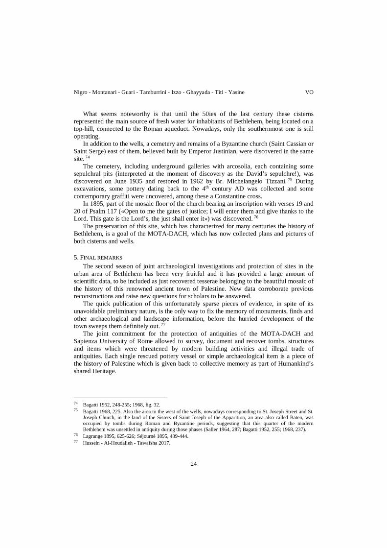
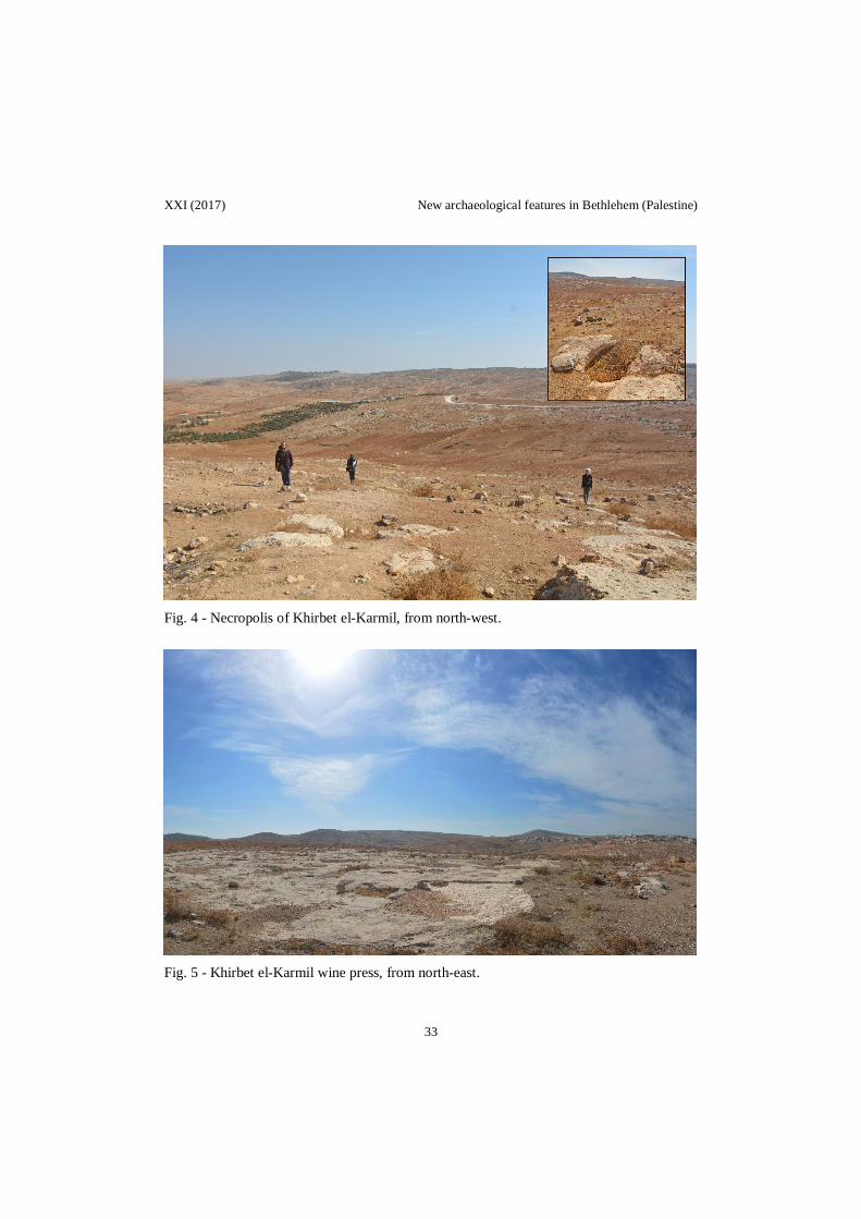
Kh. el-Karmil necropolis/ (fig. 4) مقبرة خربة الكرملID: 021 Site location: lat. 31.4234880270001; long. 35.1459280220001 Site extension: 4 ha ca. State of preservation: preserved Occupational period: Early Bronze IV, Middle Bronze I periods Elevation: 771 m Bibliography: Dever 1975. Khalet al-Jama’a/خلة الجامع ID: 033 Site location: lat. 31.6818666460001; long. 35.2102333120001 Site extension: 5 ha ca. State of preservation: partially preserved Occupational period: Early Bronze IV, Middle Bronze, Iron periods Elevation: 667 m Disturbance: industrial factories covered partially the necropolis Bibliography: Nigro 2015; Nigro et al. 2015. Kh. el-Karmil wine press/ (fig. 5) معصر النبیذ في خربة الكرملID: 040 Site location: lat. 31.4223878808353; long. 35.144882015879 Site extension: 0.14 ha ca. State of preservation: preserved Occupational period: Byzantine period Elevation: 783 m Bibliography: Magness 2003, 99. Burj el-Karmil/Rujm el-Karmil/ (fig. 6) برج الكرملID: 016 Site location: lat. 31.4222599940001; long. 35.1341829630001 Site extension: 0.12 ha ca. State of preservation: partially preserved; nowadays excavations in the site are carried on by Dr. Issa Sarie’ (Al-Quds University) and MOTA Occupational period: Byzantine, Crusader periods Elevation: 814 m Bibliography: Conder - Kitchener 1883, 372-374; Pringle 1997, 61.
7

Nigro - Montanari - Guari - Tamburrini - Izzo - Ghayyada - Titi - Yasine VO
Kh. el-Kôm/خربة الكوم ID: 018 Site location: lat. 31.531110993; long. 34.961203029 Site extension: 5 ha ca. State of preservation: partially preserved Occupational period: Chalcolithic, Early Bronze I-III, Middle Bronze, Iron, Persian, Hellenistic periods Elevation: 456 m Disturbance: the ancient site is partially covered by new village and by agricultural terracing Bibliography: Dever 1969-1970; Holladay 1971a; 1971b. Jebel Qa’aqir/Rasm Qa’qir necropolis/ (fig. 7) مقبرة جبل الكعاكيID: 019 Site location: lat. 31.5222379940001; long. 34.951577 Site extension: 4 ha ca. State of preservation: preserved Occupational period: Early Bronze Age IV Elevation: 408 m Disturbance: cultivation and agricultural terraces Bibliography: London 1985; Dever 2014. Domestic cave of Jebel Qa’aqir/ مغارة السكن في جبل الكعاكیرID: 020 Site location: lat. 31.5217570400001; long. 34.9542619750001 State of preservation: partially preserved Occupational period: Early Bronze Age IV Elevation: 398 m Disturbance: dense vegetation inside Bibliography: Gitin 1975; Dever 1981. Qasr el-Qa’aqir/قصر الكعاكیر ID: 025 Site location: lat. 31.5269620340001; long. 34.9606309640001 State of preservation: scanty remains Occupational period: Early Bronze IV, Iron, Byzantine, Ottoman periods Elevation: 400 m Disturbance: modern road cut the ancient site Bibliography: Dagan 2006, 68-70.
Rachel’s Tomb/قبر راحیل ID: 031 Site location: lat. 31.7190922200001; long. 35.202010237 State of preservation: preserved Occupational period: remains of Roman aqueduct, Medieval, Ottoman periods Elevation: 755 m Bibliography: Vetrali 1967; Tubb 1980; Nigro 2015, 7. Roman Aqueduct (Lower Aqueduct)/ قناة المیاه الرومانیة السفلىID: 011 Site location: lat. 31.705766972; long. 35.2046219630001 State of Preservation: partially preserved Occupational period: Hasmonean-Herodian, Ottoman periods Elevation: 757 m Disturbance: section of a Lower Aqueduct is incorporated within a souvenir shop on Manger Street Bibliography: Smith 1907, 125-127; Prag 2008. Solomon’s Pools/برك سلیمان ID: 008 Site location: lat. 31.6886690050001; long. 35.1700994220001 Site extension: 3 ha ca. State of preservation: preserved and rehabilitated Occupational period: since Hasmonean period Elevation: 790 m Bibliography: Murphy-O’Connor 1998, 425-428; Prag 2008; Nigro 2015, 2-3, fig. 5. Tekoa/Kh. Teku’a/تقوع ID: 010 Site location: lat. 31.634496991; long. 35.210964968 Site extension: 12 ha ca. State of preservation: scanty remains Occupational Period: Early Bronze, Middle Bronze, Iron II, Roman, Byzantine, Mameluk, Crusader periods Elevation: 816 m Bibliography: Saller, 1962, 153, 162; Escobar 1976; Herr 1986; Nigro, 2015, 11.
8

XXI (2017) New archaeological features in Bethlehem (Palestine)
2.3. Historical sites Al-Badd Giacaman Museum/ متحف بد جقمانID: 013 Site location: lat. 31.7038930300001; long. 35.2040600400001 State of preservation: restored in 2014 Occupational period: located in a traditional olive oil mill dated to 18th-19th century AD Elevation: 765 m Bibliography: Nigro 2015, 2, fig. 2.
Cremisan Complex (Salesian Monastery, Salesian Sisters Convent and School, Cellars)/دیر كریمزان ID: 039 Site location: lat. 31.7268450434838; long. 35.1723252398892 Site extension: 70 ha ca. State of preservation: preserved Occupational period: from Byzantine until modern times.
David’s Wells/ابار داود ID: 017 Site location: lat. 31.7093779800001; long. 35.205297042 State of preservation: restored in 1962 Occupational period: Iron, Roman, Byzantine periods Elevation: 770 m Disturbance: wells are in the Catholic Action Club Bibliography: Bagatti 1952, 248-249; 1968, 223-236; Bagatti - Alliata 1980; Nigro 2015, 4; § 4.2.
The Green Market/Bethlehem Old Souk/ سوق الخضرة ( سوق بیت لحم القدیم)ID: 015 Site location: lat. 31.7045629960001; long. 35.204602014 State of Preservation: restored Occupational period: since 1929 Elevation: 775 m.
Grotto of St. Jerome/مغارة القدیس جیروم ID: 027 Site location: lat. 31.704569753; long. 35.2076979280001 State of preservation: preserved Occupational period: Roman, Byzantine, Crusader, until modern times Elevation: 758 m Bibliography: Bagatti 1968, 139-140; Saller 1963, 325; Nigro 2015, 10
Note: this grotto is part of caves complex under the Nativity Church, composed, in addition to it, to the Navitiy Grotto, Grotto of Magi and the Manger, Grotto of St. Joseph, Altar of Innocents, and Tomb of St. Eusebius.
Manger Square/ساحة المھد ID: 022 Site location: lat. 31.7041100370001; long. 35.20616197 Site extension: 0.32 ha State of preservation: renovated in 1998-1999 Occupational period: Iron Age until modern times Elevation: 762 m Bibliography: Nigro 2015, 2, 4, 6, 8.
Milk Grotto/Magharet Sitti Mariam/ Grotto of the Lady Mary/مغارة الحلیب ID: 023 Site location: lat. 31.70343102; long. 35.2087509720001 State of preservation: restored in 2007 Occupational period: 7th century BC Elevation: 762 m Bibliography: Bagatti 1952, 258-261; Nigro 2015, 10, fig. 9.
Mosque of Omar/جامع عمر ID: 037 Site location: lat. 31.7045411609862; long. 35.205349898163 State of preservation: preserved Occupational period: built in 1860, renovated in 1954.
Nativity Church/كنیسة المھد ID: 024 Site location: lat. 31.7043280770001; long. 35.2072808880001 State of preservation: preserved and restored Occupational period: Roman, Byzantine, Crusader, until modern times Elevation: 762 m Bibliography: Vincent - Abel 1914; Harvey 1937; Richmond 1936; Bagatti 1952, 9-69; Taha 2012; Nigro 2015, 9-11.
St. Catherine’s Church/كنیسة القدیسة كاترینا ID: 038 Site location: lat. 31.7045642251017; long. 35.2077239268594 State of preservation: preserved Occupational period: built in 1882, enlarged in 1949 Elevation: 759 m Bibliography: Bagatti 1952, 218-224.
9

Nigro - Montanari - Guari - Tamburrini - Izzo - Ghayyada - Titi - Yasine VO
2.4. Sites of cultural interest Bethlehem Museum/متحف بیت لحم (fig. 8) ID: 032 Site location: lat. 31.7166889640001; long. 35.201593831 Occupational period: Roman (section of stone pipe of Upper Roman Aqueduct passing through the museum) Elevation: 753 m Bibliography: Vetrali 1967; Nigro 2015, 2, fig. 3. Museum of the History of the City of Bethlehem/Baituna al-Talhami Museum/Bethlehem Folklore Museum/ متحف تاریخ مدینة بیت لحمID: 014 Site location: lat. 31.7048039750001;
long. 35.204948019 State of preservation: preserved Occupational period: two traditional Palestinian houses host inside a collection of household items Elevation: 774 m Bibliography: Nigro 2015, 2, fig. 4. Salesian Complex and International Nativity Museum/ متحف المیالد الدولي ومجمع السلزیانID: 026 Site location: lat. 31.7064453240001; long. 35.2027301310001 State of Preservation: preserved Elevation: 781 m Bibliography: Nigro 2015, 2.
3. BURIAL PLACES
Four different burial places have been the object of rescue interventions during the Autumn 2016 season, all of them located within a radius of 1.5 Km south of the Church of Nativity.
3.1. Necropolis of Khalet al-Jam’a (n. 033 in fig. 3)
Further research activities at the site of Khalet al-Jam’a were carried out by the Italian-Palestinian Expedition in November 2016, with the aim of continuing the archaeological exploration of the recently discovered necropolis (fig. 9).4
The new inspection of the burial ground made it possible to ascertain that building activities for the industrial park are still going on over its northern part. The already damaged area has, unfortunately, undergone a - if possible - more drastic impact of new constructions: big warehouses have been erected enlarging the industrial quarter to the north-east in Area B. Moreover, to the south, in the southern part of previously untouched Area C, new structures have definitively obliterated Tombs B9, B10, B11 and C12 (fig. 10).5 Also in Area D (i.e. the Iron Age cemetery), new houses are under construction, even though the already excavated Tomb D13 (the ‘Barmil Tomb’) is still preserved as it was in 2015.
A survey was conducted on November 2016 in Area A, the only one kept completely safe from destruction, as it belongs to the al-Awqaf (because of the presence in the last century of an ancient small mosque).
First aim of the survey was to evaluate the preservation state of tombs identified in the first season (2015), and to assure that they had not been looted in the meantime. The second one was to collect further information about the history of the site during later periods, and to analyse scattered pottery fragments collected from the surface. Periods represented by
4 Nigro et al. 2015. 5 Nigro et al. 2015, 190-192.
10
XXI (2017) New archaeological features in Bethlehem (Palestine)
ceramics collected in Cemetery A are Middle Bronze6 and, mainly, Iron Age. Middle Bronze pottery consists of sherds of Simple Ware jars; Iron Age pottery consists of ridged neck Simple Ware jug, holemouth jar with cylindrical body, flat and unridged rim, and Cooking Ware. 7
As regards Khalet al-Jam’a, the main goal of the second season, following up 2015 work, was recording and documenting, by means of descriptions, drawings and photos, Tombs A1, A2, C5, and D13, and their funerary sets. New finds from these tombs were also collected, and they are, thus, illustrated below.
3.1.1. Tomb A1
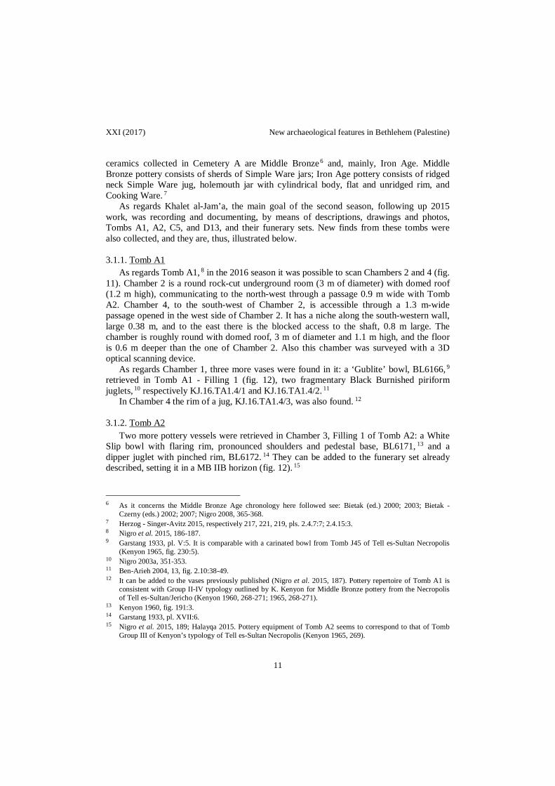
As regards Tomb A1, 8 in the 2016 season it was possible to scan Chambers 2 and 4 (fig. 11). Chamber 2 is a round rock-cut underground room (3 m of diameter) with domed roof (1.2 m high), communicating to the north-west through a passage 0.9 m wide with Tomb A2. Chamber 4, to the south-west of Chamber 2, is accessible through a 1.3 m-wide passage opened in the west side of Chamber 2. It has a niche along the south-western wall, large 0.38 m, and to the east there is the blocked access to the shaft, 0.8 m large. The chamber is roughly round with domed roof, 3 m of diameter and 1.1 m high, and the floor is 0.6 m deeper than the one of Chamber 2. Also this chamber was surveyed with a 3D optical scanning device.
As regards Chamber 1, three more vases were found in it: a ‘Gublite’ bowl, BL6166, 9 retrieved in Tomb A1 - Filling 1 (fig. 12), two fragmentary Black Burnished piriform juglets, 10 respectively KJ.16.TA1.4/1 and KJ.16.TA1.4/2. 11
In Chamber 4 the rim of a jug, KJ.16.TA1.4/3, was also found. 12
3.1.2. Tomb A2 Two more pottery vessels were retrieved in Chamber 3, Filling 1 of Tomb A2: a White
Slip bowl with flaring rim, pronounced shoulders and pedestal base, BL6171, 13 and a dipper juglet with pinched rim, BL6172. 14 They can be added to the funerary set already described, setting it in a MB IIB horizon (fig. 12). 15
6 As it concerns the Middle Bronze Age chronology here followed see: Bietak (ed.) 2000; 2003; Bietak - Czerny (eds.) 2002; 2007; Nigro 2008, 365-368.
7 Herzog - Singer-Avitz 2015, respectively 217, 221, 219, pls. 2.4.7:7; 2.4.15:3. 8 Nigro et al. 2015, 186-187. 9 Garstang 1933, pl. V:5. It is comparable with a carinated bowl from Tomb J45 of Tell es-Sultan Necropolis
(Kenyon 1965, fig. 230:5). 10 Nigro 2003a, 351-353. 11 Ben-Arieh 2004, 13, fig. 2.10:38-49. 12 It can be added to the vases previously published (Nigro et al. 2015, 187). Pottery repertoire of Tomb A1 is
consistent with Group II-IV typology outlined by K. Kenyon for Middle Bronze pottery from the Necropolis of Tell es-Sultan/Jericho (Kenyon 1960, 268-271; 1965, 268-271).
13 Kenyon 1960, fig. 191:3. 14 Garstang 1933, pl. XVII:6. 15 Nigro et al. 2015, 189; Halayqa 2015. Pottery equipment of Tomb A2 seems to correspond to that of Tomb
Group III of Kenyon’s typology of Tell es-Sultan Necropolis (Kenyon 1965, 269).
11
Nigro - Montanari - Guari - Tamburrini - Izzo - Ghayyada - Titi - Yasine VO
3.1.3. Tomb C5 Tomb C5 16 was, unfortunately, discovered by looters, which broke part of the rocky
roof to pillage it. The following excavation by the Palestinian MOTA-DACH, in Spring 2014, allowed to collect what was left inside it.
The entrance to Tomb C5 was through a wide square shaft, 1.35 ⨯ 1.55 m, located to the south-east of an underground approximately square burial chamber. This is larger than the other of the same necropolis, as it measures 2.9 ⨯ 3.5 m, with a 1.9 m-high domed roof, heavily damaged by collapses. The shaft is 1.5 m deep, and the passage between it and the chamber is only 0.8 m wide and 0.8 m high.
Inside the tomb, 628 pottery fragments were collected (figs. 13-15), which belonged to the most popular shapes and productions known from Middle Bronze II funerary sets: Black or Red Burnished piriform juglets with double handle (KJ.16.TC5.1/1, 2); 17 White Slip bowls with flaring rim, pronounced shoulders and pedestal base (KJ.16.TC5.1/3), a very common type also in Jericho; Simple Ware jugs (KJ.16.TC5.1/4-5); Metallic Ware medium size jars (KJ.16.TC5.1/6-10); 18 Storage/Transport Ware jars (KJ.16.TC5.1/11-13, including a pierced fragment: KJ.16.TC5.1/16), with fifty-six decorated jar walls, fourteen incised (KJ.16.TC5.1/13) and forty-two combed (KJ.16.TC5.1/14-15). This pottery material indicates that the tomb was primarily used during the Middle Bronze II. 19
3.1.4. Tomb D13 (‘Barmil Tomb’)
A detailed plan of Tomb D13 20 was re-drawn at the end of the 2016 season (fig. 16). The round main chamber, 4 m of diameter, has a flat roof and it is 1.6 m high. The shaft is to the south-west of the chamber, 1.1 m wide, while to the north, in front of it, there is a raised niche 1.7 m wide and 1.3 m high, used as repository. The shape of the tomb is characterized by the location of the shaft, which is included within the limits of the circular cave. The underground circular tomb was characterized by the presence of a V-shaped installation made of stones (Bench 3), located roughly in the middle. Three depositional areas were, thus, identified, east of the installation (Filling 1), west of it (Filling 2), and inside it (Filling4). Installation B.3 was built up with middle size stones and a flat slab, 0.6 m long and 0.5 m wide, upon which human bones (mainly teeth; KJ.16.TD13.1.HR.1, 2) and several personal ornaments were found (bronze and iron earrings, carnelian beads, stamps, sea-shells).
In Filling 1 thirty-eight vessels were found (fig. 17): 1 miniature twin vase; 1 strainer; 21 2 one-spouted lamps; 22 5 bowls 23 (one Simple Ware, two Simple Painted, one Red Slip,
16 Nigro et al. 2015, 192. 17 These piriform juglets are comparable with those from Tomb 24 of Tell Beit-Mirsim (Ben-Arieh 2004, fig.
2.10:38-49). 18 Garfinkel - Cohen 2007, fig. 3.37:2. They can be compared with some specimens from Tell es-Sultan
(Kenyon - Holland 1982, respectively figs. 128:5, 127:22, 25; 129:33, 30). 19 Pottery repertoire is widely comparable to that of Jericho Tomb Groups II-V, especially Storage jars mainly
belong to B.1.a and b types (Kenyon - Holland 1982, figs. 191-193). 20 Nigro et al. 2015, 192. The ‘Barmil Tomb’ is the object of a dedicated publication in preparation where finds
will be thoroughly illustrated. 21 Loud 1948, pl. 85:9.
12
XXI (2017) New archaeological features in Bethlehem (Palestine)
and one Red Burnished); 10 small Black Burnished juglets; 24 6 pinched mouth dipper juglets; 25 3 Simple Ware juglets; 5 Simple Ware jugs; 26 1 stirrup storage jar; 27 3 fragmentary cooking pots, and 1 jar. In Filling 2 (fig. 18) 2 one-spouted lamps, 1 high footed chalice, 28 7 small Black Burnished juglets, 29 5 Simple Ware jugs, 1 Line Painted juglet, and 1 Line Painted amphoriskos 30 were retrieved. 31 Moreover, a chalice with high foot from Filling1 and a Red Slip Painted jug plus a strainer-spouted jug from Filling2, already published in the first report, 32 must be included to complete the funerary set of Tomb D13.
As it regards small finds, 37 objects were collected in Tomb D13, they mainly consist of bronze and iron bracelets, bronze and iron rings, numerous semiprecious beads, an udjat-eye, shells, bone items, one seal, one signet-ring seal, one ivory scarab, and one ivory pommel. 33
A complete analysis of funerary equipment of Tomb D13 confirms a date from Iron IB up to Iron IIA-B.
3.1.5. Human and animal remains from Khalet al-Jam’a necropolis [A.G.]
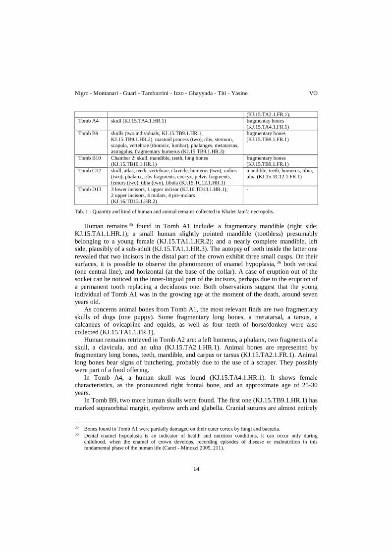
Human and animal remains from Khalet al-Jam’a necropolis were collected within seven tombs (A1, A2, A4, B9, B10, C12, and D13). They are preliminarily analyzed in this paragraph and summarized in tab. 1.
The most common bone retrievals are human skulls, 34 long bones, and teeth. As it regards animal remains, they are most often fragmentary long bones of ovicaprines, canides, and equids.
Sometimes bones have a whitish concretion attributable to the calcification caused by the limestone in which tombs were hewn.
TOMB HUMAN REMAINS ANIMAL REMAINS
Tomb A1 Chamber 1: mandible (KJ.15.TA1.1.HR.1), mandible (female; KJ.15.TA1.1.HR.2), mandible and teeth (child; KJ.15.TA1.1.HR.3).
Chamber 1: crania (dog), tarsus, calcaneus, teeth (horse) (KJ.15.TA1.1.FR.1).
Tomb A2 fragmentary skull, teeth, humerus sx, clavicle, ulna, phalanx (KJ.15.TA2.1.HR.1).
teeth, mandible, carpus/tarsus, long bones
22 Herzog - Singer-Avitz 2015, 217, pl. 2.4.8:7-9. 23 Herzog - Singer-Avitz 2015, pl. 2.4.1:5, 7-8. 24 Tufnell 1953, pl. 88:309; Tubb 1980, pl. I:3. 25 Herzog - Singer-Avitz 2015, 217. 26 Yezerski 2004, pl. 4:13-14; Herzog - Sineger-Avitz 2015, 221, pl. 2.4.12:1-3. 27 Albright 1932, pls. 53(A):1; 54(A):1; Yezerski 1997, 32, ns. 17-18. 28 Herzog - Singer-Avitz 2015, pl. 2.4.2:1. 29 Peleg - Yerzeski 2004, pl. 6:23, 26-27. 30 Herzog - Singer-Avitz 2015, pl. 2.4.6:4. 31 4 lamps and 7 small Black Burnished juglets are already illustrated in Nigro et al. 2015 (fig. 31:1-2). 32 Nigro 2015, fig 18; Nigro et al. 2015, fig. 32. 33 Nigro et al. 2015, 192-193. 34 Skulls are indicators of sex of individuals when sexual dimorphism characteristics are marked and clear, and
allow it (Acsádi - Nemeskéri 1970; Canci - Minozzi 2005, 119, tab 8.1).
13
Nigro - Montanari - Guari - Tamburrini - Izzo - Ghayyada - Titi - Yasine VO
(KJ.15.TA2.1.FR.1). Tomb A4 skull (KJ.15.TA4.1.HR.1) fragmentay bones
(KJ.15.TA4.1.FR.1) Tomb B9 skulls (two individuals; KJ.15.TB9.1.HR.1,
KJ.15.TB9.1.HR.2), mastoid process (two), ribs, sternum, scapula, vertebrae (thoracic, lumbar), phalanges, metatarsus, astragalus, fragmentary humerus (KJ.15.TB9.1.HR.3)
fragmentary bones (KJ.15.TB9.1.FR.1)
Tomb B10 Chamber 2: skull, mandible, teeth, long bones (KJ.15.TB10.1.HR.1)
fragmentary bones (KJ.15.TB9.1.FR.1)
Tomb C12 skull, atlas, teeth, vertebrae, clavicle, humerus (two), radius (two), phalanx, ribs fragments, coccyx, pelvis fragments, femurs (two), tibia (two), fibula (KJ.15.TC12.1.HR.1)
mandible, teeth, humerus, tibia, ulna (KJ.15.TC12.1.FR.1)
Tomb D13 3 lower incisors, 1 upper incisor (KJ.16.TD13.1.HR.1); 2 upper incisors, 4 molars, 4 pre-molars (KJ.16.TD13.1.HR.2)
-
Tab. 1 - Quantity and kind of human and animal remains collected in Khalet Jam’a necropolis.
Human remains 35 found in Tomb A1 include: a fragmentary mandible (right side;
KJ.15.TA1.1.HR.1); a small human slightly pointed mandible (toothless) presumably belonging to a young female (KJ.15.TA1.1.HR.2); and a nearly complete mandible, left side, plausibly of a sub-adult (KJ.15.TA1.1.HR.3). The autopsy of teeth inside the latter one revealed that two incisors in the distal part of the crown exhibit three small cusps. On their surfaces, it is possible to observe the phenomenon of enamel hypoplasia, 36 both vertical (one central line), and horizontal (at the base of the collar). A case of eruption out of the socket can be noticed in the inner-lingual part of the incisors, perhaps due to the eruption of a permanent tooth replacing a deciduous one. Both observations suggest that the young individual of Tomb A1 was in the growing age at the moment of the death, around seven years old.
As concerns animal bones from Tomb A1, the most relevant finds are two fragmentary skulls of dogs (one puppy). Some fragmentary long bones, a metatarsal, a tarsus, a calcaneus of ovicaprine and equids, as well as four teeth of horse/donkey were also collected (KJ.15.TA1.1.FR.1).
Human remains retrieved in Tomb A2 are: a left humerus, a phalanx, two fragments of a skull, a clavicula, and an ulna (KJ.15.TA2.1.HR.1). Animal bones are represented by fragmentary long bones, teeth, mandible, and carpus or tarsus (KJ.15.TA2.1.FR.1). Animal long bones bear signs of butchering, probably due to the use of a scraper. They possibly were part of a food offering.
In Tomb A4, a human skull was found (KJ.15.TA4.1.HR.1). It shows female characteristics, as the pronounced right frontal bone, and an approximate age of 25-30 years.
In Tomb B9, two more human skulls were found. The first one (KJ.15.TB9.1.HR.1) has marked supraorbital margin, eyebrow arch and glabella. Cranial sutures are almost entirely
35 Bones found in Tomb A1 were partially damaged on their outer cortex by fungi and bacteria. 36 Dental enamel hypoplasia is an indicator of health and nutrition conditions, it can occur only during
childhood, when the enamel of crown develops, recording episodes of disease or malnutrition in this fundamental phase of the human life (Canci - Minozzi 2005, 211).
14

XXI (2017) New archaeological features in Bethlehem (Palestine)
obliterated suggesting that it belonged to a mature male adult. The second skull (KJ.15.TB9.1.HR.2; fig. 19) could belong to a young (female?) individual, according to the smoothed and straight forehead, rounded eye sockets, the junction point of the nose close to the front, slight occipital protuberance, pronounced right frontal bone, sutures in some places are not yet calcified. Furthermore, it presents an epigenetic variation on front bone: the furrow 37 goes from the nasal area to the wall. 38 This feature looks like a rare character, because it is usually attested up to the age of three/four years. In this case, it occurs in an adult, or in a young individual showing a praecox sexual dimorphism. The cranial sutures are open up to 1 cm, from bregma the suture is fully open (1.8 cm), all over the skull. It is 14 cm wide and 17 cm long, the thickness of the crown ranges from 0.3 to 0.7 cm. Also two fragmentary mastoid processes (one short, pointed and curve, long 2.9 cm and wide 1.1 cm; the second 1.3 cm wide, without the distal part), thus, point to a presumable age of 15-18.
The other human bones found in Tomb B9 are ribs, sternum, scapula, vertebrae (thoracic, lumbar), phalanges, metatarsus, astragalus, and fragmentary humerus (KJ.15.TB9.1.HR.3) difficult to be attributed to previous individuals.
Inside Chamber 2 of Tomb B10 a further human skull was found just before the north-western wall, facing up, about 50 cm from a mandible, and near long bones (KJ.15.TB10.1.HR.1; fig. 20). The skull presents some marked features: the glabella and eyebrow arch, the occipital protuberance is pronounced, and the mastoid process is large and rounded, suggesting the identification with a male individual. It can be also noted the disappearance of the coronal suture, especially of the bregma, and of sagittal suture. Medium-lambda and lambda result in synostosis more than 50%, therefore the age of death is in the range 35-45 years. During the excavations a mandible was also found. It is robust, with marked features, and pronounced chin, thick bottom margin with a single tooth (fractured penultimate molar). Dental alveolus are small. 39 Right humerus and mandible have mummification traces, probably due to the deposition in the cave. These rests, thus, belong to the same male individual.
Some fragmentary and mixed animal bones were also recovered in this tomb. An almost complete skeleton (KJ.15.TC12.1.HR.1) was found in Tomb C12. The skull
(fig. 21) has large, rounded and vertical mastoid processes. Supraorbital margin, as well as the brow ridge and glabella, is quite wide, nuchal plane presents a pronounced superior line; the frontal and parietal bumps are just slightly pronounced. The skull is 13 cm width, maximum 20 cm length, 16 cm height, and 0.4 cm thick. Twelve teeth are in the upper arch (there are two central incisors and the last right molar, while the second upper molar is missing in the left side). Some thin horizontal lines testify the presence of enamel hypoplasia. Skeletal remains also included the atlas, four vertebrae, a clavicula, two shoulders, two radios, a phalanx, a coccyx, the right pelvis, two femura, two tibias, a fibula,
37 The furrow is the median suture of the frontal bone, which brings together the two symmetrical halves of the bone, corresponding to the two primitive ossification points. It tends to disappear with the ageing, in the event of persistence this phenomenon is called metopism.
38 An abnormality of bone fusion can be identified on this skull. Component part of a bone may fail to fuse together, or normally discrete skeletal structures may instead be fused. In foetus, frontal bone is formed via intra-membranous ossification from two halves which make up the left and right bone. On occasion, however, they fail to unite, so that the division persists. This suture is called the metopic suture (Mays 2010, 184).
39 In this case the loss during the lifetime of some teeth and the total healing of the bone tissue can be identified.
15

Nigro - Montanari - Guari - Tamburrini - Izzo - Ghayyada - Titi - Yasine VO
and seven fragmentary ribs. All these observations suggests that the skeleton was of a young male of 20-30 years.
In the same tomb also some fragmentary animal bones were collected. In Tomb D13 some human remains were upon a flat slab of the V shaped installation
B.3, they were: 3 lower incisors mineralized, amongst these one deciduous, and 1 upper incisor (KJ.16.TD13.1.HR.1); 2 upper incisors, 4 molars, one with tooth decay, and 4 pre-molars (KJ.16.TD13.1.HR.2).
Human remains recovered in tombs of Khalet al-Jam’a seem to be related to primary, single, as it is in the case of Tomb C12, multiple, as in the case of Tomb B9, and maybe familiar, as in the case of Tomb A1, depositions, dating back from Early Bronze IV and Middle Bronze Age II, accompanied by funerary sets, mainly consisting of pottery and weapons.
3.2. Necropolis of Jebel Dhaher (rescue excavations 2016; n. 028 in fig. 3)
The site lays 1.95 km south-west from the centre of Bethlehem, directly to the south-west of the new souk and to the east of the Al-Ahlia University, in a land owned by the Palestinian Army (figs. 22-23). Geologically the area is composed by a friable whitish chalky limestone spur, the local bedrock, overlaid by reddish-brown soil. Jebel Dhaher necropolis was brought to light by chance on 1st October 2016 during construction works for a military compound. The site is on a regular flat bedrock berm at 714 m a.s.l. The necropolis is distinguished by shaft-tombs, with circular shafts and generally a single round domed chamber, distributed with a noticeable density.
Three tombs (Tombs 1-3) were dug by MOTA-DACH in the days of their accidental discovery (early October), while the other three (Tombs 4-6) were identified when a proper rescue intervention begun on Saturday 12th November 2016, with the participation also of the Italian Team of Sapienza University of Rome which already worked in Khalet Jam’a in 2015 (fig. 24).
Three more tombs (Tomb A, B, C) had already been discovered in 2003 along the western boundary wall of the compound. They were cut by bulldozers in an area slightly westwards and higher in elevation in respect of the tombs discovered in Autumn 2016. When work started at Jebel Dhaher, in 2016, Tomb A (fig. 25), the southernmost one, was still visible, while the other two tombs (B and C) had already been buried under a concrete wall. Tomb A was sliced on its north-south axis, and, according to what it was observable, it was 2.7 m long. It originally consisted of a domed chamber reached by a vertical round shaft. The chamber was filled up with collapsed limestone chops. Some human bones were collected inside it in 2003; ceramic material retrieved inside dates from Middle Bronze II. 40 Unfortunately, on November 18th 2016, also Tomb A was concealed under the concrete wall.
The necropolis of Jebel Dhaher was in use, according to architectural features of tombs and findings within them (see below), from the Early Bronze IVB/Intermediate Bronze Age up to the Middle Bronze Age, with a possible (maybe restricted) use during the Iron Age (documented only for Tomb 5).
40 Local office of the MOTA-DACH, personal communication.
16

XXI (2017) New archaeological features in Bethlehem (Palestine)
3.2.1. Tomb 1 The identification of Tomb 1 was due to the discovery of the nearby Tomb 2, the first to
be brought to light at the site in 2016. In fact, when Tomb 2 was discovered, the bulldozer shovel accidentally broke the rocky diaphragm separating the two tombs, allowing the archaeologists to notice the presence of Tomb 1. Tomb 1 was a familiar tomb, apparently used for two or more generations during Middle Bronze Age I-II (fig. 26).
It consisted of a vertical round shaft, 0.94 ⨯ 0.87 m, 1.4 m deep, and one round chamber 3.3 m wide. The shaft was occupied in its lower part by a stepped ramp partly built with stones and partly made of compacted clay reaching the depth of -1.4 m. The passage to the chamber was 0.5 m wide, and also thanks to the ramp could be easily blocked by a flat stone. The latter was still standing in situ when the tomb was accidentally discovered, so that it was possible to observe it and how it blocked the passage. The stone was a big limestone slab 0.92 m long, 0.64 m wide, 0.18 m thick, fixed by means of two small limestone chops.
The round chamber had regular circular plan with a diameter of 3.3 m and a shallow slightly domed roof 0.95 m high (fig. 27). Along the north-western wall of the chamber, a platform was uncovered (Bench 33), made of flat stones, which hosted the latest inhumation (§ 3.2.7.) with some skull fragments and its funerary furnishings. Near the skull, between the head of the dead and the wall, an ovoid Middle Bronze IB jug (JD.16.T1/1) 41 with painted decoration had been placed (fig. 28).
Some other long bones belonging to different individuals were found in the space surrounding the platform, and a shallow elongated niche, 0.95 m wide, had been cut along the southern wall of the chamber, perhaps for gaining space for one of them.
3.2.2. Tomb 2
Tomb 2 (figs. 27, 29) is to the north-west of Tomb 1. This is the tomb more damaged by building activities in the compound. Bulldozer removed almost completely its roof and shaft, and also part of the underground chamber. It had a round shaft of 0.9 m of diameter, 1.3 m deep, only partially preserved to the north of the chamber. The burial cave, had a roughly circular shape, with a diameter of 1.8 m, and a slightly concave floor. The roof was domed with a reconstructed height of 1.1 m. A 0.32 m wide and 0.16 m high niche was cut in its southern wall. The dimensions and the presence of the niche suggest that Tomb 2 was originally excavated in the Early Bronze IV/Intermediate Bronze Age.
A Middle Bronze II dipper juglet with pinched rim, JD.12.T2/1 (fig. 28), 42 was found in the shaft. It may signal the latest use of the tomb. No human neither animal remains were collected in Tomb 2.
41 Pritchard 1963, pl. 21:48. This jug with painted decoration, that can find some comparison at Tell el-Mutesellim (Loud 1948, pls. 11:18, 22; 12:21), suggests a possible date to the early phase of the Middle Bronze I (Gerstenblith 1980, 69; Nigro 2008, 379).
42 It can be compared with Kenyon 1965, fig. 121:5.
17

Nigro - Montanari - Guari - Tamburrini - Izzo - Ghayyada - Titi - Yasine VO
3.2.3. Tomb 3 Tomb 3 was discovered to the north-west of Tomb 1 (fig. 24). It consisted of a round
vertical shaft, 0.85 m of diameter and 1.6 m deep, and two chambers (1 and 2). Chamber 1 was located to the south-west of the shaft, and Chamber 2 is to the north of Chamber 1 (fig. 30).
The shaft was found filled up with stones of medium dimensions. Like in Tomb 1, also in Tomb 3 at the bottom of the shaft there was a stepped ramp facilitating the access to Chamber 1.
At the bottom of the shaft, the opening towards Chamber 1 was blocked by a closing stone: a big vertical limestone slab 1.5 ⨯ 0.6 m.
Chamber 1 has a circular plan with domed roof, 2.2 m of diameter and 0.8 m high. Its south-western quadrant is occupied by a raised stone platform (Bench 3), 1.4 m long on the east-west axis, and 1.1 m wide on the north-south one (fig. 31). The platform was coated with a whitish clayish plaster. Some fragmentary human vertebra (§ 3.2.7.) were still in situ on the platform at the moment of discovery. They had belonged to a dead buried on it. This individual was accompanied by a carinated bowl, JD.16.T3.3/1, 43 and a jug with double-handle, JD.16.T3.3/2, 44 hinting at a drinking rite, common in such Middle Bronze Age tombs (fig. 32). 45
Just to the north of the platform, a squared passage, 0.6 m wide, leads to Chamber 2. A 0.35 m high step marked the passage to this second round chamber, which up to now remained unexcavated.
3.2.4. Tomb 4
A fourth tomb was identified about 5 m east of Tomb 1. It has a roughly round shaft, 1.06 m of diameter, filled up with a brownish sandy soil and limestone chops. Two blocks were uncovered within the shaft at 0.74 m from the surface, and they measure 0.50 ⨯ 0.40 m. After the removal of these stones the excavation was interrupted.
3.2.5. Tomb 5
Tomb 5 (fig. 33) is the easternmost one identified so far (fig. 24), and it is provided by a shaft and a single chamber. It is smaller than the other tombs of the same necropolis. The shaft is roughly round, with a diameter of 1.10 m, 0.92 m deep, and it was filled up with a brownish layer (Filling 1). At its bottom some stones were sunken in the clayish soil, and the access to the chamber was blocked by a closing stone 0.5 ⨯ 0.4 m. The entrance to the tomb is 0.68 m high and 0.5 m wide (fig. 34). The chamber, to the north of the shaft, is round with a diameter of 1.6 m, and it was filled up in its upper strata with a layer of debris (Filling 2) with limestone chops collapsed from the domed roof, and a few scattered pottery sherds. Under this upper deposit, there was a layer of buff sandy soil (Filling 3) accumulated against the eastern side of the chamber, aside a central L-shaped stone built
43 Pritchard 1963, fig. 50:20; Loffreda 1984, fig. 4:22. The type reminds bowls with high carination imitating metallic prototypes well known in the Levantine tradition (Nigro 2003a).
44 Pritchard 1963, pl. 21:48. 45 Garfinkel - Cohen 2007, 61; Zuckerman 2007, 189.
18

XXI (2017) New archaeological features in Bethlehem (Palestine)
platform (Bench 7) which hosted a fragmentary inhumation (Burial 5.1). Along eastern side of the chamber some pottery vessels were aligned (JD.T5.F.5), apparently as funerary set of Burial 5.1: a cooking jug with carinated body (JD.16.T5.5/1); a pinkish fabric jug (JD.16.T5.5/2, fig. 35), 46 and another fragmentary jug (JD.16.T5.4/1; fig. 36), 47 which was found on the L-shaped platform together with some teeth (four upper molars and two incisors) and scattered human bones comprising skull fragments (JD.16.T5.4.HR.1; § 3.2.7.), covered by two small flat stones. As the teeth and the jug show signs of having been burnt, it seems plausible that all these finds were the remains of an incineration. Burial 5.1 is thus likely to represent a sort of secondary internment dating back to early Iron Age, with the simple funerary set to the east (Filling 5), for which the bench was built overlaying previous layers. Under the bench, in facts, there was a brownish layer (Filling 6) with some fragmentary human bones (§ 3.2.7.). In this layer a copper dagger (JD.16.T5.1; fig. 37) was found, indicating the original presence of an earlier burial. This dagger belongs to a type spread in the Southern Levant during the Intermediate and Middle Bronze Ages, 48 hinting, according its typology, to a use of Tomb 5 during these periods, as it is also documented by other tombs of the necropolis. The architecture of the tomb may suggest that it was first excavated in the Early Bronze IV/Intermediate Bronze Age.
3.2.6. Tomb 6
Tomb 6 (fig. 38) was identified roughly at middle of the small cemetery, north-west of Tomb 5 and south-east of Tomb 3. It has a large round shaft, 1.2 m of diameter, 1.4 m deep from the topsoil. It was filled up with a yellowish fine friable sandy soil (Filling 1), where an EB IVB globular jar with everted rim and flat base was found (JD.16.T6.1/1; fig. 39). 49 The passage between the shaft and the chamber was blocked by a heap medium size stones. At the bottom of the shaft a small entrance, 0.6 ⨯ 0.6 m, gives access to a large chamber, 3.4 ⨯ 4 m and 1.5 m high, to the west (fig. 40). Inside it, there was a thick layer of debris and collapsed stone chops (Filling 2). In this layer an almost complete human skeleton was found (§ 3.2.7.). At the moment of the opening of the tomb, a half skull, pierced on the frontal bone, left side over glabella, was next to the south-western wall. Under the debris layer, a yellowish clayish layer (Filling 3) was all over the chamber. Here, an ovoid jar with everted rim, combed decoration and flat base was found (JD.16.T6.3/1; fig. 39) 50 along with scattered bones (§ 3.2.7.), in the western quadrant of the chamber. A rectangular limestone slab (Wall 4), 0.95 ⨯ 0.5 m, was standing next to the western wall of the chamber just underneath where the pierced half skull was uncovered. Removing Filling 3 a compacted chalky layer (Filling 5) was exposed, from where some fragmentary human bones were collected (§ 3.2.7.). Some human remains were also deposited under slab W.4.
The pottery found suggests a date to the Early Bronze IVB for the last use of the tomb.
46 Respectively, Arie 2006, fig. 13.59:8; Singer-Avitz 2002, fig. 9:1. 47 Mazar 2015, 16-17. 48 Maxwell-Hyslop 1946, 21; Dunand 1950-1958, 253, 292, 302, 383, figs. 277:9162, 415:1068, pls. LXII:9162,
LXIV:9534, LXVIII:9662; Philip 1989, 103-104; Gernez 2007, 472-480, 482-486; Montanari 2014, 102-103. 49 It seems quite similar to necked jars with globular body and short flaring neck, Class NJ2, of D’Andrea (2014,
vol. 2, 265). 50 It is comparable to Ovoid Storage Jar 1.2 class of D’Andrea (2014, vol. 2, 294-295, pl. CXVIII:2).
19

Nigro - Montanari - Guari - Tamburrini - Izzo - Ghayyada - Titi - Yasine VO
3.2.7. Human and animal remains from Jebel Dhaher necropolis [A.G.] This paragraph is devoted to a preliminary overview of human and animal remains
collected in Tombs 1, 3, 5 and 6 51 of the Jebel Dhaher necropolis (tab. 2). Most of the remains are human long bones and fragments of different kinds. Preservation status is not good, due to the high acidity of the soil inside tombs, which affected in many cases the outer cortex of bones. At a first autopsy, some long bones were totally abraded along the epiphysis and show on the outer surface small grooves.
TOMB HUMAN REMAINS ANIMAL REMAINS Tomb 1 fragmentary long bones, 2 fragments of skull, 2 femura, 2 tibia, 3
or 4 humerus, fragment of ribs (JD.16.T1.3.HR.1) fragmentary long bones (JD.16.T1.3.FR.1)
Tomb 2 - - Tomb 3 vertebrae fragments (JD.16.T3.3.HR.1) - Tomb 4 - - Tomb 5 F.4: 3 upper molars, fragment of a skull (JD.16.T5.4.HR.1);
F.5: fragmentary skull walls (JD.16.T5.5.HR.1), fragment of long bones (tibia), 2 skull walls, 1 small incisor (JD.16.T5.5.HR.2); F.6: 1 small incisor, 1 fragment of rib, fragmentary bones (JD.16.T5.6.HR.1)
ovicaprine astragalus (JD.16.T5.4.FR.1)
Tomb 6 F.2: 1 small incisor, 1 fragmentary rib, 3 fragmentary bones (JD.16.T6.2.HR.1), 1 fragmentary skull, 2 shoulders, 1 ulna, 1 radio, 2 femurs, fragmentary coccyx, 1 atlas, 2 vertebrae, fragmentary long bones (JD.16.T6.2.HR.2); F.3: 2 shoulders, 1 ulna, 1 radio, 1 fragment of basin, 2 tibia, 2 fragmentary ribs, 2 vertebrae, fragmentary foot, fragmentary long bones (JD.16.T6.3.HR.1); F.5: 2 femurs, 1 humerus, 1 phalanx, a fragmentary mandible (JD.16.T6.5.HR.1)
fragmentary long bones (JD.16.T6.2.FR.1)
Tab. 2 - Quantity and kind of human and animal remains collected in Jebel Dhaher necropolis during 2016 season. In Tomb 1, both human and animal remains were found. Human bones include: two
femura, two fragmentary tibia, and three or four humerus (JD.16.T1.3.HR.1; fig. 41). Moreover, between platform Bench 3, on which human remains were laid, and the wall of the chamber skulls fragments were found (a parietal bone and a frontal bone). Skeletal remains on the platform seem to be related to a primary crouched inhumations (Burial 1.1). According to the number of long bones lying on platform, it is reasonable that this tomb was a multiple burial.
In Tomb 3, it was possible to recognized some human vertebrae (JD.16.T3.3.HR.1; fig. 42) on the built up stone platform, JD.T3.B.3.
In Tomb 5, some fragments of a skull and three burnt upper molars (JD.16.T5.4.HR.1), together with an ovis vel capra astragalus (JD.16.T5.4.FR.1) were found in Filling 4, in an incineration (Burial 5.1) inside juglet JD.16.T5.4/1 (fig. 36). Moreover, in Filling 5, other fragments of human skull (JD.16.T5.5.HR.1), an incisive and fragments of long bones (probably a tibia; JD.16.T5.5.HR.2) were retrieved. Near the dagger, in Filling 6 under the L-shaped platform, a tooth was collected, a small incisor, together with a fragment of rib
51 These are currently the only tombs with recognizable remains.
20

XXI (2017) New archaeological features in Bethlehem (Palestine)
and other small bone fragments (JD.16.T5.6.HR.1), belonging to an earlier inhumation (Burial 5.2).
Bones from Tomb 6 were characterized by clear calcareous concretions which in some cases have contributed to their welding. This is the case of an ulna and radio in T6.F.3, completely welded together with a concretion in the middle, probably residue of tibial plate of a sub-adult placed above. Bones were extremely fragile and in the case of the long bones showed small grooves on the epiphysis, attributable also to corrosion suffered in the soil.
Nevertheless, it was possible to recognize some important skeletal sections, as it is in the case of human remains found in Filling 2 (fig. 43). A small fragmentary skull, probably belonging to a young woman (Burial 6.1), without glabella, with rounded orbits and small and pointed mastoid process was recognized. According to teeth still in place in the mandible two premolars and three molars, it can be assumed that the individual had died when it was 20 years old. In the mandible there is a hole, perhaps the residual of an alveolar infection.
Basically, two burials can be distinguished in Tomb 6: one (Burial 6.1) on the limestone slab W.4 laying to the west of the tomb; the other (Burial 6.2) to the east of the slab and under it, in Filling 5 (a male adult aged 20).
The presence of other sparse bones shows that the tomb served for multiple burials during a certain time lapse during the Early Bronze Age.
3.3. el-Atan Tomb (n. 030 in fig. 3)
An Early Bronze IVB tomb was discovered on early June 2009 due to the erection of a private house in el-Atan Street, nearby the Milk Grotto, 52 400 m east of the Nativity Church, in the area of the city known as Tell Bethlehem, in a land owned by Mr. Nassri el-Bandaq.
The shaft single chamber tomb was incidentally discovered by a bulldozer which cut through a part of the burial chamber. The archaeologists thus entered it directly from the chamber and they could not excavate the shaft, which was in the land of another owner, who did not allow them to operate.
On 19th June 2009 the MOTA-DACH Office of Bethlehem started rescue excavations, collecting some human remains and a funerary set comprising 4 four-spouted lamps, 5 slightly carinated bowls with combed or grooved decoration under the rim, 53 1 flat base ovoid jar with flaring neck and combed decoration, 54 1 flat base jar with upper wall slightly waisted with combed and wavy combed decoration, 55 2 amphoriskoi with combed
52 In 1989 a rock-cut tomb used between the 8th and the 1st century BC was discovered in the site of Ain el-Atan, in the neighborhood of Bethlehem (Dadon 1990; 1997), at about 2.5 km to the south-west of the centre of Bethlehem, in a site identified with Khirbet el-Khokh.
53 Kenyon 1965, 43-44, fig. 21:2-3. 54 Nigro 2003b, fig. 24:1. 55 Kenyon - Holland 1982, fig. 94:10; Nigro 2003b, fig. 20:5.
21

Nigro - Montanari - Guari - Tamburrini - Izzo - Ghayyada - Titi - Yasine VO
decoration 56 and a beaker, as well as a copper pin with rolled head, 57 and 5 carnelian beads. This material dates back to the second part of the Early Bronze IV (fig. 44). 58
This tomb is included into the already known cemetery extended to the east and to the south of the Nativity Church, in use from the Early Bronze Age until the Byzantine Period. 59
3.4. Necropolis of Bardhaa (n. 029 in fig. 3)
A necropolis in the village of Bardhaa, to the east of Khalet al-Jam’a and 2.5 km south-east of the Nativity Church, was discovered and looted in the period between 1967 and 1995 (fig. 45). 60 The Necropolis of Bardhaa was set on the northern flank of Wadi Ta’amireh and to the west of Wadi et-Tin, along emerging limestone bedrock cliffs. Tombs are mostly shaft tombs, with squared or round shafts, leading to underground rock-cut chambers. A preliminary visit to the site showed that it had been largely plundered, and a provisional calculation of the number of tombs is around 30-40 tombs.
Information provided by the Palestinian Tourism Police, which sequestered materials by antique dealers during some building activities at the site, allowed to rescue some pottery vessels, including two Middle Bronze ovoid jars, BL1518 and BL1536, 61 which confirm the chronological range of the necropolis between the Early Bronze IV and Middle Bronze I-II (fig. 46).
The Necropolis of Bardhaa seems to belong to a system of cemeteries established on the emerging bedrock spurs of the hills in between Wadi ‘Artas, Wadi Ta’amireh and Wadi et-Tin south of Bethlehem up to Tekoa: 62 Khalet al-Jam’a, Jebel Dhaher, Bardhaa, during the urban occupation of Bethlehem in the Bronze and Iron Ages. They were first established in the Early Bronze Age and one may suggest that each of these cemeteries belonged to a familiar group, a clan or a tribe.
4. OTHER ARCHAEOLOGICAL SITES 4.1. Khirbet el-Kôm (n. 018 in fig. 2)
The site 63 that lays along Wadi es-Saffar, a tributary of Nahar ed-Duweir, is about 11.2 Km west of Hebron and 11.6 Km east of Tell ed-Duweir/ancient Lachish. 64 It was put on
56 Kenyon - Holland 1982, fig. 98:19. 57 Gernez 2008, 247-248, pl. 11. 58 Pottery equipment of el-Atan Tomb, together with the pin with rolled head (Gernez 2008, 260, fig. 8), aligns
itself with the horizon of Southern Palestine (Amiran 1969, 80-82, pl. 22; Dever 1980, 48; fig. 4; D’Andrea 2014, vol. 1, 201, fig. 5:32, vol. 2, 91-118, pl. XXX) in late Early Bronze IV.
59 Bagatti 1952, 261-262; Saller 1963, 325; 1964, 287; 1968; Gutman - Berma 1970, 585; Prag 2000, 177, fig. 3. 60 In the area of Bardhaa some structures, interpreted as a Roman house, an enclosure wall and a mosaic pavement,
were discovered on September 1944 (www.iaa-archives.org.il/zoom/zoom.aspx?folder_id=2319&type_id=&id=35263). 61 They can find a parallel in necropolis of Jericho (Kenyon 1960, fig. 182:2-3) and Tell Beit Mirsim (Ben-Arieh
2004, fig. 2.15.76-77). 62 Vincent 1947; Dajani 1960, 102. Moreover, Saller (1964, 288) quotes the presence of rock-cut tombs
eastwards and northwards of Tekoa. 63 A special thank goes to Dr. Ahmed Rjoob that made possible the visit to Khirbet el-Kôm and Jebel Qa’aqir,
and guided the team sharing his knowledge and experience about these sites and beyond. 64 The site has been tentatively identified with Biblical Saphir (Micah 1:11).
22

XXI (2017) New archaeological features in Bethlehem (Palestine)
the map by Captain C.R. Conder and Captain H.H. Kitchener, who described it as a large ruin, 65 and successively partially sounded during the Spring 1971 by J.S. Holladay on behalf of the University of Toronto, Canada. 66 The site was first occupied during the Chalcolithic Period, albeit in a very limited way, and stably settled during the Early Bronze Age. Some small finds, pottery vases and sparse structures of this phase were uncovered. 67 A more substantial occupation characterizes the life of settlement from the Iron Age onwards, which, in the University of Toronto excavations, was found directly upon Early Bronze Age collapsed remains. According to the collected material, Khirbet el-Kôm was settled in the 10th century BC being reconstructed several times until the Persian and Hellenistic periods. During Iron Age II, Khirbet el-Kôm was a fortified site on the road from Hebron to Lachish in the Kingdom of Judah. The remains of its monumental defensive system, consisting of heavy stone walls, probably of the casemate type with a city-gate, are still visible, in the later reconstruction of the Hasmoneans. 68
One of the major small finds collected on the site is a bilingual, Aramaic and Greek, ostracon dated to the late 4th-early 3rd century BC, 69 concerning an early loan of money (32 drachma), beyond other ostraca in Aramaic and Greek. 70
Ancient fortification walls underlay the modern terrace wall of the village that nowadays encircles the site (fig. 47); the area all around the city-walls is terraced for cultivation, with olive tree groves. Modern buildings are unfortunately threatening the ancient structures having been built inside and upon the terrace walls. 4.2. Abar al-Nabi Daoud - David’s Wells (n. 017 in fig. 3)
The so-called David’s Wells (Abar [Beyar] al-Nabi Daoud) are an historical archaeological site in Bethlehem Downtown, inside the yard of the Franciscan Fathers Catholic Action Circle, in King David Street (fig. 48), where the tradition identified one of the many holy places of the town. 71 They consist of three large cisterns hewn in the northern rock hill (Ras Eftais), located at the entrance of the old main road of the city. 72
According to the guardian of the Catholic Action Circle, the wells opening on the cisterns were actually five, but only three of them are still visible inside the compound of this institution, while the other two are northwards, outside the boundary wall of the Circle, buried under the modern street. 73 The real situation was clarified by Father Bellarmino Bagatti o.f.m. when he reported that three wells opening on one underground cistern are in Franciscan Father’s land, while a second cistern (with two wells) was located north of the street, in the nearby Greek Orthodox Church property.
65 Conder - Kitchener 1883, 358. 66 Holladay 1971a. 67 Holladay 1971a, 176. 68 Moreover, Holladay (1971a, 176) mentioned also some rich tombs. 69 Geraty 1975. 70 Dever 1969-1970. 71 Nigro 2015, 4. 72 Bagatti 1952, 248. 73 Bagatti - Alliata 1980, 259.
23
Nigro - Montanari - Guari - Tamburrini - Izzo - Ghayyada - Titi - Yasine VO
What seems noteworthy is that until the 50ies of the last century these cisterns represented the main source of fresh water for inhabitants of Bethlehem, being located on a top-hill, connected to the Roman aqueduct. Nowadays, only the southernmost one is still operating.
In addition to the wells, a cemetery and remains of a Byzantine church (Saint Cassian or Saint Serge) east of them, believed built by Emperor Justinian, were discovered in the same site. 74
The cemetery, including underground galleries with arcosolia, each containing some sepulchral pits (interpreted at the moment of discovery as the David’s sepulchre!), was discovered on June 1935 and restored in 1962 by Br. Michelangelo Tizzani. 75 During excavations, some pottery dating back to the 4th century AD was collected and some contemporary graffiti were uncovered, among these a Constantine cross.
In 1895, part of the mosaic floor of the church bearing an inscription with verses 19 and 20 of Psalm 117 («Open to me the gates of justice; I will enter them and give thanks to the Lord. This gate is the Lord’s, the just shall enter it») was discovered. 76
The preservation of this site, which has characterized for many centuries the history of Bethlehem, is a goal of the MOTA-DACH, which has now collected plans and pictures of both cisterns and wells. 5. FINAL REMARKS
The second season of joint archaeological investigations and protection of sites in the urban area of Bethlehem has been very fruitful and it has provided a large amount of scientific data, to be included as just recovered tesserae belonging to the beautiful mosaic of the history of this renowned ancient town of Palestine. New data corroborate previous reconstructions and raise new questions for scholars to be answered.
The quick publication of this unfortunately sparse pieces of evidence, in spite of its unavoidable preliminary nature, is the only way to fix the memory of monuments, finds and other archaeological and landscape information, before the hurried development of the town sweeps them definitely out. 77
The joint commitment for the protection of antiquities of the MOTA-DACH and Sapienza University of Rome allowed to survey, document and recover tombs, structures and items which were threatened by modern building activities and illegal trade of antiquities. Each single rescued pottery vessel or simple archaeological item is a piece of the history of Palestine which is given back to collective memory as part of Humankind’s shared Heritage.
74 Bagatti 1952, 248-255; 1968, fig. 32. 75 Bagatti 1968, 225. Also the area to the west of the wells, nowadays corresponding to St. Joseph Street and St.
Joseph Church, in the land of the Sisters of Saint Joseph of the Apparition, an area also called Baten, was occupied by tombs during Roman and Byzantine periods, suggesting that this quarter of the modern Bethlehem was unsettled in antiquity during those phases (Saller 1964, 287; Bagatti 1952, 255; 1968, 237).
76 Lagrange 1895, 625-626; Séjourné 1895, 439-444. 77 Hussein - Al-Houdalieh - Tawafsha 2017.
24

XXI (2017) New archaeological features in Bethlehem (Palestine)
REFERENCES ACSÁDI, G. - NEMESKÉRI, J. 1970 History of Human Life, Span and Mortality (Akadémiai Kiadó), Budapest 1970. ALBRIGHT, W.F. 1932 The Excavation of Tell Beit Mirsim. Vol. I: The Pottery of the First Three Campaigns
(1930 - 1931) (Annual of American School of Oriental Research 12), New Heaven 1932. AMIRAN, R. 1969 Ancient Pottery of the Holy Land, From the Prehistoric to the Persian Period, Jerusalem
1969. ARIE, E. 2006 Chapter 13. The Iron Age I Pottery: Levels K-5 and K-4 and an Intra-site Spatial Analysis
of the Pottery from Stratum VIA: I. FINKELSTEIN - D. USSISHKIN - B. HALPERN (eds.), Megiddo IV. The 1998 - 2002 Seasons (Monograph Series 24), Tel Aviv 2006, pp. 191-298.
BAGATTI, B. O.F.M. 1952 Gli antichi edifici sacri di Betlemme in seguito agli scavi e restauri praticati dalla
Custodia di Terra Santa (1948-51) (Studium Biblicum Franciscanum Collectio Maior 9), Gerusalemme 1952.
1968 Recenti scavi a Betlemme (Grotte di S. Girolamo; cisterne di David): Liber Annuus 18 (1968), pp. 181-237.
BAGATTI, B. - ALLIATA, E. 1980 Scavo ai “Pozzi di Davide” a Betlemme: Liber Annuus 30 (1980), pp. 259-262. BARUKH, Y. - SHORUKH, I. 1998 Khirbet Beit Bassa: Hadashot Arkheologiyot/Exploration and Survey in Israel 18 (1998),
p. 98. 2006 Building of the Persian, Hellenistic and Early Roman Periods at Khirbat Kabar, in the
Northern Hebron Hills: ‘Atiqot 52 (2006), pp. 49-71*. BEN-ARIEH, S. 2004 Bronze and Iron Age tombs at Tell Beit Mirsim (Israel Antiquity Authority 23), Jerusalem
2004. BIETAK, M. (ed.) 2000 The Synchronisation of Civilisations in the Eastern Mediterranean in the Second
Millennium B.C. Proceedings of an International Symposium at Schloß Haindorf, 15th-17th of November 1996, and at the Austrian Academy, Vienna, 11th-12th of May 1998 (Österreichischen Akademie der Wissenschaften XIX. Contributions to the Chronology of the Eastern Mediterranean 1), Wien 2000.
2003 The Synchronisation of Civilisations in the Eastern Mediterranean in the Second Millennium B.C. II. Proceedings of the SCIEM 2000 - EuroConference, Haindorf, 2nd of May – 7th of May 2001 (Österreichischen Akademie der Wissenschaften XXIX. Contributions to the Chronology of the Eastern Mediterranean 4), Wien 2003.
BIETAK, M. - CZERNY, E. (eds.) 2002 The Middle Bronze Age in the Levant. Proceedings of an International Conference on MB
IIA Ceramic Material, Vienna, 24th-26th of January 2001 (Österreichischen Akademie der Wissenschaften XXVI. Contributions to the Chronology of the Eastern Mediterranean 3), Wien 2002.
2007 The Synchronisation of Civilisations in the Eastern Mediterranean in the Second Millennium B.C. Proceedings of the SCIEM 2000 - 2nd EuroConference, Vienna, 28th of
25

Nigro - Montanari - Guari - Tamburrini - Izzo - Ghayyada - Titi - Yasine VO
May - 1st of June 2003 (Österreichischen Akademie der Wissenschaften XXXVII. Contributions to the Chronology of the Eastern Mediterranean 9), Wien 2007.
CANCI, A. - MINOZZI, S. 2005 Archeologia dei resti umani, Roma 2005. CLERMONT-GANNEAU, C.S. 1899 Archaeological Researches in Palestine 1873-1874 (Palestine Exploration Fund), London
1899. CONDER, C.R. - KITCHENER, H.H. 1883 The Survey of Western Palestine. Vol. III: Judaea (Palestine Exploration Fund), London
1883. CREE, F. DE 1999 History and Archaeology of Bēt Sāïūr Region. A Preparatory Study for a Regional Survey
(The Bethlehem Archaeological Project): Zeitschrift des Deutschen Palästina-Vereins 115 (1999), pp. 59-84.
DADON, M. 1990 El-‘Aýn (Bethlehem): Excavation and Surveys in Israel 9 (1990), pp. 156-157. 1997 A Burial Cave of the Middle Bronze Age I at Giv’at Ze’ev: ‘Atiqot 32 (1997), pp. 51,
199-201*. DAGAN, Y. 2006 Map of Amazya (109). Volume I, The Northern Sector (Archaeological Survey of Israel.
Israel Antiquities Authority), Jerusalem 2006. DAJANI, A.K. 1960 Middle Bronze Age pottery: Annual of the Department of Antiquities of Jordan IV-V
(1960), pp. 99-113. D’ANDREA, M. 2014 The Southern Levant in Early Bronze IV. Issues and perspectives in the pottery evidence
(Contributi e Materiali di Archeologia Orientale XVII), Roma 2014. DEVER, W.G. 1969-1970 Iron Age Epigraphic Material from the Area of Khirbet el-Kôm: Hebrew Union College
Annual 40-41 (1969-1970), pp. 139-204. 1975 A Middle Bronze I Cemetery at Khirbet el-Khirmil: Eretz Israel 12 (1975), pp. 18-33. 1980 New Vistas on the EB IV (“MB I”) Horizon in Syria-Palestine: Bulletin of the American
School of Oriental Research 237 (1980), pp. 35-64. 1981 Cave G26 at Jebel Qa’qir: A domestic Assemblage of Middle Bronze I: Eretz Israel 15
(1981), pp. 22-32. 2014 Excavations at the Early Bronze IV Sites of Jebel Qa’qair and Be’er Resisim (Studies in
the Archaeology and History of the Levant 6), Winona Lake 2014. DUNAND, M. 1950-1958 Fouilles de Byblos. Tome II. 1933-1938, Paris 1950-1958. ESCOBAR, J. 1976 Estudio de los restos Arqueologicos de Tecoa: Liber Annuus 26 (1976), pp. 5-26. GARFINKEL, Y. - COHEN, S. 2007 The Early Middle Bronze Cemetery of Gesher. Final Excavation Report (Annual of
American School of Oriental Research 62), Boston 2007. GARSTANG, J. 1933 Jericho: City and Necropolis: Liverpool Annals of Archaeology and Anthropology XX
(1933), 3-42.
26

XXI (2017) New archaeological features in Bethlehem (Palestine)
GERATY, L.T. 1975 The Khirbet el-Kôm Bilingual Ostracon: Bulletin of American School of Oriental
Research 220 (1975), pp. 55-61. GERNEZ, G. 2007 L’armement en métal au Proche et Moyen-Orient Des origines à 1750 av. J.-C., Paris
2007. 2008 Le métal de Tell Arqa a l’âge du Bronze: Bulletin d’Archéologie et d’Architecture
Libanaises 12 (2008), pp. 221-264. GERSTENBLITH, P. 1980 A Reassessment of the Beginning of the Middle Bronze Age in Syria-Palestine: Bulletin
of America School of Oriental Research 237 (1980), pp. 65-84. GITIN, S. 1975 Middle Bronze I “Domestic Pottery” at Jebel Qa‘aqir: a Ceramic Inventory of Cave G 23:
Eretz Israel 12 (1975), pp. 46-62. GUTMAN, S. - BERMAN, A. 1970 Bethléem: Revue Biblique 77 (1970), pp. 583-585. HALAYQA, I.K.H. 2015 Two Canaanite Scarabs from Kherbit el-Jami‘ (el-‘Ubayat) South of Bethlehem: Ugarit-
Forshungen 46 (2015), pp. 183-188. HARVEY, W. 1937 Bethlehem, Nativity Church: Archaeologia 87 (1937), pp. 7-17. HENNESSY, J.B. 1966 An Early Bronze Age Tomb Group from Beth Sahur: Annual of Department of Antiquities
of Jordan XI (1966), pp. 19-40. HERR, L.G. 1986 A Seventh Century B.C. Tomb Group from Tekoa: L.T. GERATY - L.G. HERR (eds.), The
Archaeology of Jordan and Other Studies (Andrews University Seminary Studies), Berrien Springs 1986, pp. 265-284.
HERZOG, Z. - SINGER-AVITZ, L. 2015 Chapter 2.4: Iron Age IIA-B: Judah and the Negev: S. GITIN (ed.), The Ancient Pottery of
Israel and its Neighbors, from the Iron Age through the Hellenistic Period (Israel Exploration Society), Jerusalem 2015, pp. 213-255.
HIZMI, H. - SHABTAI, Z. 1997 Khirbet en-Najjar in Beit Jala: ‘Atiqot 32 (1997), pp. 57-61. HOLLADAY, J.S. 1971a Khirbet el-Qȏm: Israel Exploration Journal 21 (1971), pp.175-177. 1971b Khirbet el-Kom: Revue Biblique 78 (1971), pp. 593-595. HUSSEIN, S. - AL-HOUDALIEH, A. - TAWAFSHA, S.A. 2017 The Destruction of Archaeological Resources in the Palestinian Territories, Area C: Kafr
Shiyān as a Case Study: Near Eastern Archaeology 8.1 (2017), pp. 40-49. KENYON, K.M. 1960 Excavations at Jericho. Volume One. The Tombs excavated in 1952-1954, London 1960. 1965 Excavations at Jericho. Volume Two. The Tombs Excavated in 1955-1958, London 1965. KENYON, K.M. - HOLLAND, T.A. 1982 Excavations at Jericho. Volume Four. The Pottery Type Series and Other Finds, London
1982. LAGRANGE, P.M.J. 1895 Chronique de Jérusalem (fouilles de M. Bliss, voyage de Bliss au pays de Moab,
nouvelles de Bethléem): Revue Biblique 4 (1895), pp. 622-626.
27

Nigro - Montanari - Guari - Tamburrini - Izzo - Ghayyada - Titi - Yasine VO
LEVENTAL, S. 2010 Battir Spring Rehabilitation: The Battir Spring - the Road to a Safe Water Resource
(Tufts University Department of Urban and Environmental Policy, Water Resources Policy and Watershed Management), Boston 2010.
LOFFREDA, S. 1984 La tomba n. 4 del Bronzo Medio II B a Betania: Liber Annuus 34 (1984), pp. 357-370. LONDON, G.A. 1985 Decoding Designs: The Late Third Millennium B.C. Pottery From Jebel Qa‘aqir, PhD
Thesis University of Arizona, Tucson 1985. LOUD, G. 1948 Megiddo II. Season of 1935-1939 (Oriental Institute Publications 62), Chicago 1948. MAGNESS, J. 2003 The Archaeology of the Early Islamic Settlement in Palestine, Winona Lake 2003. MAXWELL-HYSLOP, K.R. 1946 Daggers and Swords in Western Asia. A Study from Prehistoric Times to 600 B.C.: Iraq 8
(1946), pp. 1-64. MAYS, S. 2010 The Archaeology of Human Bones, London 20102. MAZAR, A. 2015 Iron Age I: Northern Coastal Plain, Galilee, Samaria, Jezreel Valley, Judah, and Negev: S.
GITIN (ed.), The Ancient Pottery of Israel and its Neighbors, from the Iron Age through the Hellenistic Period (Israel Exploration Society), Jerusalem 2015, pp. 5-70.
MONTANARI, D. 2014 An EB IV dagger from Tell es-Sultan/Jericho: Vicino Oriente XVIII (2014), pp. 101-111. MURPHY-O’CONNOR, J. 1998 The Holy Land: An Oxford Archaeological Guide from Earliest Times to 1700, 4th
Edition (Oxford University Press), Oxford 1998. NIGRO, L. 2003a The Smith and the King of Ebla. Tell el Yahudiyeh Ware, Metallic Wares and the
Ceramic Chronology of Middle Bronze Syria: M. BIETAK (ed.), The Synchronisation of Civilisations in the Eastern Mediterranean in the Second Millennium B.C. II. Proceedings of the SCIEM 2000 - EuroConference, Haindorf, 2nd of May – 7th of May 2001 (Österreichischen Akademie der Wissenschaften XXIX. Contributions to the Chronology of the Eastern Mediterranean 4), Wien 2003, pp. 345-363.
2003b Tell es-Sultan in the Early Bronze Age IV (2300-2000 BC). Settlement VS Necropolis - A Stratigraphic Periodization: Contributi e Materiali di Archeologia Orientale 9 (2003), pp. 121-158.
2008 Towards a Unified Chronology of Syria and Palestine. The Beginning of the Middle Bronze Age: P. MATTHIAE - F. PINNOCK - L. NIGRO - L. PEYRONEL (eds.): Proceedings of the International Colloquium From Relative Chronology to Absolute Chronology: the Second Millennium BC in Syria-Palestine (Rome, 29th November – 1st December 2001) (Contributi del Centro Linceo Interdisciplinare «Beniamino Segre» 117), Roma 2008, pp. 365-389.
2015 Bethlehem in the Bronze and Iron Age. A Summary in the light of recent discoveries by The Palestinian MOTA-DACH: Vicino Oriente XIX (2015), pp. 1-15.
NIGRO, L. - MONTANARI, D. - GHAYYADA, M. - YASINE, J. 2015 Khalet al-Jam’a. A Middle Bronze and Iron Age necropolis near Bethlehem (Palestine):
Vicino Oriente XIX (2015), pp. 185-218.
28

XXI (2017) New archaeological features in Bethlehem (Palestine)
PELEG, Y. - YEZERSKI, I. 2004 A Dwelling and Burial Cave at Kh. Abu-Musarrah in the Land of Benjamin: H. HIZMI - A.
DE GROOT (eds.), Burial Caves and Sites in Judea and Samaria from the Bronze and Iron Ages (Judea and Samaria Publications 4), Jerusalem 2004, pp.107-156
PHILIP, G. 1989 Metal Weapons of the Early and Middle Bronze Ages in Syria-Palestine (British
Archaeological Reports International Series 526), Oxford 1989. PRAG, K. 2000 Bethlehem: a site assessment: Palestine Exploration Quarterly 132 (2000), pp. 167-181. 2008 R.W. Hamilton, D.C. Baramki and the Lower Aqueduct at Bethlehem: Palestine
Exploration Quarterly 140 (2008), pp. 27-38. PRINGLE, D. 1997 Secular buildings in the Crusader Kingdom of Jerusalem: an Archaeological Gazetter
(Cambridge University Press), New York 1997. PRITCHARD, J.B. 1963 The Bronze Age Cemetery at Gibeon (Museum Monographs), Philadelphia 1963. RICHMOND, E.T. 1936 Basilica of the Nativity: Discovery of the Remains of an Earlier Church: Quarterly of the
Department of Antiquities in Palestine 5 (1936), pp. 75-81. SALLER, S.J. 1962 Jerusalem and its surroundings in the Bronze Age: Liber Annuus XII (1962), pp. 147-176. 1963 Archaeological Activity in the Holy Land 1962/3: Liber Annuus XIII (1963), pp. 323-328. 1964 Recent Archaeological work in Palestine: Liber Annuus XIV (1964), pp. 272-292. 1968 Iron Age Remains from the site of a new school at Bethlehem: Liber Annuus 18 (1968),
pp. 153-180. SEJOURNE, P.M. 1895 Chronique de Jérusalem: Revue Biblique 4 (1895), pp. 437-447. SINGER-AVITZ, L. 2002 Arad: Iron Age Pottery Assemblages: Tel Aviv 29 (2002), pp. 110-214. SMITH, G.A. 1907 Jerusalem: the topography, economics and history from the earliest times to A.D. 70,
London 1907. TAHA, H. 2012 The Story of Inscribing Bethlehem on the World Heritage List: This Week in Palestine
172 (2012), pp. 6-12. TUBB, J.N. 1980 An Iron Age II Tomb Group from the Bethlehem Region (British Museum Occasional
Paper 14), London 1980. TUFNELL, O. 1953 Lachish III: The Iron Age, Oxford 1953. USSISHKIN, D. 1993 Archaeological Soundings at Betar, Bar Kokhba’s Last Stronghold: Tel Aviv 20 (1993),
pp. 66-97. VETRALI, L. 1967 Le iscrizioni dell’acquedotto romano presso Betlemme: Liber Annuus 17 (1967), pp. 149-
161. VINCENT, H. 1947 Une grotte funéraire antique dans l’ouady et-Tin: Revue Biblique 54 (1947), pp. 269-282.
29

Nigro - Montanari - Guari - Tamburrini - Izzo - Ghayyada - Titi - Yasine VO
VINCENT, H. - ABEL, F.-M. 1914 Bethléem. Le Sanctuaire de la Nativité, Paris 1914. YEZERSKI, I. 1997 Burial Caves in the Hebron Hills: ‘Atiqot 32 (1997), pp. 21-36*. 2004 An Iron Age II Burial Cave at Rās āl-Tawīl: H. HIZMI - A. DE GROOT (eds.), Burial Caves
and Sites in Judea and Samaria from the Bronze and Iron Ages (Judea and Samaria Publications 4), Jerusalem 2004, pp. 209-230.
ZUCKERMAN, S. 2007 ‘..Slaying oxen and killing sheep, eating flesh and drinking wine..’: feasting in Late
Bronze Age Hazor: Palestine Exploration Quarterly 139 (2007), pp. 186-204.
30

XXI (2017) New archaeological features in Bethlehem (Palestine)
Fig. 1 - The Italian-Palestinian team during the expedition in Autumn 2016 in the Expedition Headquarter at Al-Badd Giacaman Museum in Bethlehem.
Fig. 2 - Comprehensive archaeological and historical map of the city of Bethlehem developed by Sapienza Expedition - MOTA-DACH.
31

Nigro - Montanari - Guari - Tamburrini - Izzo - Ghayyada - Titi - Yasine VO
Fig. 3 - Comprehensive map of the area of Bethlehem, city and surroundings, and of neighbouring archaeological sites, developed by Sapienza Expedition - MOTA-DACH.
32
XXI (2017) New archaeological features in Bethlehem (Palestine)
Fig. 4 - Necropolis of Khirbet el-Karmil, from north-west.
Fig. 5 - Khirbet el-Karmil wine press, from north-east.
33

Nigro - Montanari - Guari - Tamburrini - Izzo - Ghayyada - Titi - Yasine VO
Fig.
6 -
Burj
el-K
arm
il (le
ft), a
nd th
e Cr
usad
er c
hurc
h (r
ight
).
Fig.
7 -
Nec
ropo
lis o
f Jeb
el Q
a’aq
ir, fr
om e
ast.
34

XXI (2017) New archaeological features in Bethlehem (Palestine)
Fig. 8 - The Bethlehem Museum with a stretch of the Roman Aqueduct.
Fig. 9 - Panoramic view of Khalet al-Jam’a necropolis from the upper terrace of Area D.
35

Nigro - Montanari - Guari - Tamburrini - Izzo - Ghayyada - Titi - Yasine VO
Fig. 10 - Plan of necropolis of Khalet al-Jam’a with areas and tombs.
Fig. 11 - Chamber 2 of Tomb A1, the passage communicating with Tomb A2 (left), and the entrance from Chamber 1 (right).
36

XXI (2017) New archaeological features in Bethlehem (Palestine)
Fig. 12 - The ‘Gublite’ bowl (BL6166) from Chamber 1 of Tomb A1; the White Slip bowl (BL6171) and the dipper juglet (BL6172) from Chamber 3 of Tomb A2 (1:4).
37

Nigro - Montanari - Guari - Tamburrini - Izzo - Ghayyada - Titi - Yasine VO
Fig. 13 - Middle Bronze fine ware from Tomb C5 (1:4).
Fig. 14 - Middle Bronze Storage jars from Tomb C5 (1:8).
Fig. 15 - Middle Bronze Storage ware from Tomb C5 (1:8).
38

XXI (2017) New archaeological features in Bethlehem (Palestine)
Fig. 16 - Detailed plan of Tomb D13 of Khalet al-Jam’a.
39

Nigro - Montanari - Guari - Tamburrini - Izzo - Ghayyada - Titi - Yasine VO
Fig. 17 - Finds from F.1 of Tomb D13 of Khalet al-Jam’a.
Fig. 18 - Finds from F.2 of Tomb D13 of Khalet al-Jam’a.
40
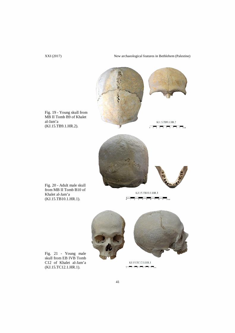
XXI (2017) New archaeological features in Bethlehem (Palestine)
Fig. 19 - Young skull from MB II Tomb B9 of Khalet al-Jam’a (KJ.15.TB9.1.HR.2). Fig. 20 - Adult male skull from MB II Tomb B10 of Khalet al-Jam’a (KJ.15.TB10.1.HR.1). Fig. 21 - Young male skull from EB IVB Tomb C12 of Khalet al-Jam’a (KJ.15.TC12.1.HR.1).
41

Nigro - Montanari - Guari - Tamburrini - Izzo - Ghayyada - Titi - Yasine VO
Fig. 22 - The site of Jebel Dhaher during rescue excavations in November 2016, from north-east.
Fig. 23 - The site of Jebel Dhaher during rescue excavations in November 2016, from south-west.
42

XXI (2017) New archaeological features in Bethlehem (Palestine)
Fig. 24 - Plan of the necropolis of Jebel Dhaher with tombs discovered in Autumn 2016.
Fig. 25 - Tomb A of Jebel Dhaher before its concealing under the concrete wall.
43

Nigro - Montanari - Guari - Tamburrini - Izzo - Ghayyada - Titi - Yasine VO
Fig. 26 - Shaft and closing stone (left), and shaft from the inside (right) of Tomb 1 of Jebel Dhaher.
Fig. 27 - Plan of Tombs 1 and 2 of Jebel Dhaher.
44

XXI (2017) New archaeological features in Bethlehem (Palestine)
Fig. 28 - Middle Bronze pottery from Tomb 1 (JD.16.T1/1) and Tomb 2 (JD.16.T2/1) of Jebel Dhaher (1:4).
Fig. 29 - Tomb 2 of Jebel Dhaher, from north.
45

Nigro - Montanari - Guari - Tamburrini - Izzo - Ghayyada - Titi - Yasine VO
Fig. 30 - Plan of Tomb 3 of Jebel Dhaher.
Fig. 31 - The stone platform B.3 in Chamber 1 and the passage to Chamber of Tomb 3 of Jebel Dhaher.
46

XXI (2017) New archaeological features in Bethlehem (Palestine)
Fig. 32 - Middle Bronze pottery equipment of Tomb 3 of Jebel Dhaher (1:4).
Fig. 33 - Shaft and entrance of Tomb 5 of Jebel Dhaher.
47

Nigro - Montanari - Guari - Tamburrini - Izzo - Ghayyada - Titi - Yasine VO
Fig. 34 - Plan of Tomb 5 of Jebel Dhaher.
Fig. 35 - Iron Age pottery equipment of Tomb 5, from JD.T5.F.5 (1:4).
48

XXI (2017) New archaeological features in Bethlehem (Palestine)
Fig. 36 - The Iron Age Burial B5.1 from Tomb 5 of Jebel Dhaher. Fig. 37 - Intermediate Bronze Age copper dagger from Tomb 5 of Jebel Dhaher.
49

Nigro - Montanari - Guari - Tamburrini - Izzo - Ghayyada - Titi - Yasine VO
Fig. 38 - Plan of Tomb 6 of Jebel Dhaher.
Fig. 39 - Early Bronze IVB pottery equipment of Tomb 6 of Jebel Dhaher (1:4).
50

XXI (2017) New archaeological features in Bethlehem (Palestine)
Fig. 40 - Chamber (left) and entrance (right) of Tomb 6 of Jebel Dhaher. Fig. 41 - Multiple burials (JD.16.T1.3.HR.1) on stone platform B.3 of Tomb 1 of Jebel Dhaher.
Fig. 42 - Human vertebrae (JD.16.T3.3.HR.1) on stone platform of Chamber 1 in Tomb 3 of Jebel Dhaher.
51

Nigro - Montanari - Guari - Tamburrini - Izzo - Ghayyada - Titi - Yasine VO
Fig. 43 - Young female skull (JD.16.T6.2.HR.2) from Tomb 6 of Jebel Dhaher.
Fig. 44 - Early Bronze IVB funerary equipment of el-Atan Tomb.
52

XXI (2017) New archaeological features in Bethlehem (Palestine)
Fig.
45
- Pan
oram
ic v
iew
of B
ardh
aa n
ecro
polis
(fro
m n
orth
), an
d de
tails
of s
ome
shaf
ts.
53

Nigro - Montanari - Guari - Tamburrini - Izzo - Ghayyada - Titi - Yasine VO
Fig. 46 - Two Middle Bronze jars from Bardhaa necropolis (1:8).
Fig. 47 - Modern terrace wall overlapping the Iron Age fortifications at Khirbet el-Kôm.
54

XXI (2017) New archaeological features in Bethlehem (Palestine)
Fig.
48
- The
so-c
alle
d D
avid
’s W
ells
in th
e Fr
anci
scan
Fat
hers
Cat
holic
Act
ion
Circ
le.
55

Nigro - Montanari - Guari - Tamburrini - Izzo - Ghayyada - Titi - Yasine VO
ARABIC ABSTRACT
معالم اثریة جدیدة في بیت لحم /فلسطینمن قبل دائرة االثار الفلسطسینیة وجامعة السابینزا روما االیطالیة 2016االنقاذیة لموسم عام التنقیبات االثریة
صف روما االیطالیة ، والذي بدا منذ منت -السابینزا ضمن التعاون المشترك ما بین وزارة السیاحة واالثار وجامعة
رك بین الطرفین عام فقد تم توقیع اتفاقیة تعاون مشتالتسعینیات القرن الماضي في موقع تل السلطان في مدینة اریحا ،دمة من اجل استكشاف وتطویر موقع خلة الجامع في محافظة بیت لحم وضمن برنامج دراسة الدكتوراه المق 6201
كمنحة لكاتب ھذا المقال .رغم من زیارة یل منھا ،على التشیر االدلة الى انھ لم تجر في مدینة بیت لحم ،ایة حفریات اثریة سابقة اال النزر القل
ة الفترة العدید من الرحالة االوروبین لھا،وقد برز اسم ھذه المدنیة في العدید من الكتابات القدیمة والحدیثة وخاص البیزنطیة واالسالمیة ،ویبدو ان شھرتھا جاءت من خالل مولد سیدنا عیسى علیھ السالم في كنیسة المھد.
على العدید من الجوانب 30/11/2016الى 10/11/2016والذي جرى في الفترة الواقعة ما بین لقد تركز ھذا الموسم كان ابرزھا :
في موقع خلة الجامع من خالل الرسم والتصویر 2015وعام 2014استكمال توثیق المواد المكتشفة في حفریة عام -1نة بیت لحم،والذي یرجع تاریخھ الى العصر من قبر العطن في مدی 2009،وكذلك دراسة المواد المكتشفة عام
ذي یؤرخ الى البرونزي المبكر الرابع وبدایة العصر البرونزي المتوسط ،عالوة على ذلك ،دراسة مواد قبر" البرمیل" ال) 13العصر الحدیدي الثاني في خلة الجامع والمعروف بقبر (د
خیة لمقبرة الجامع مثل بریضعة وكذلك المواقع ذات الصلة التاریعمل مسح اثري اولي للمنطقة المحیطة بموقع خلة -2 خلة الجامع في محافظة الخلیل مثل خربة الكرمل وجبل الكعاكیر.
ذا التوثیق على اسم العمل على توثیق المواقع الطبیعیة واالثریة والتاریخیة والدینیة في محافظة ببت لحم وقد اشتمل ھ-3ئمة لھ مستخدمین نظام المعلومات الجغرافیة،باالضافة الى تاریخ الموقع، وعمل قا الموقع ووضع االحداثیات
مختصرة للمراجع التي تناولت ھذا المكان من العصر اجراء الحفریة االنقاذیة في جبل ظاھر والتي اعطت مدلوال جدیدا على اھمیة بیت لحم في المرحلة الرابعة -4
رونزي المتوسط وكذلك العصر الحیدیدي .البرونزي المبكر والعصر الب مقبرة جبل ظاھر :
رقي لجبل ظاھر، والى تقع المقبرة التي جرت فیھا التنقیبات االثریة االنقاذیة في جنوب مدینة بیت لحم على السفح الشیة ل شرق قرالجھة الشرقیة من جامعة فلسطین االھلیة ،والى الجنوب الغربي من مدینة ابو عمار الریاضة ،وشما
یقوم ). لقد كانت معرفتنا بھذة المقبرة من خالل احد افراد االمن الوطني الفلسطیني الذي3ارطاس . انظر (شكل رقم ابلغ مدیر عام بحراسة الموقع لكونھ یقع ضمن مربع امني . خالل حفریات انشائیة فتبین لھ وجود بعض المقابر ف
ام بالكشف بدوره اتصل ھاتفیا بكاتب ھذا المقال مدیر اثار محافظة بیت لحم ،والذي قالتنقیبات في الوزارة والذي ع على الموقع ،ومن ثم تم تشكیل فریق عمل مشترك من دائرة االثار وجامعة روما الجراء حفریة انقاذیة للموق
استمرت مدة اسبوع حیث عثر على ستة قبور ضمن مساحة محدودة . على ذي یقعالى ان ھذه المقبرة تعتبر احد المقابر المھمة التي تم التنقیب بھا بعد كل من قبر العطن ال تجدر االشارة
متر. وعالوة على ما تقدم فان النمط االنشائي 250السفح الشرقي لتل بیت لحم و الى الشرق من كنیسة المھد بحواليلى عمق یتراوح دة بتم قطعھا في الصخر بشكل عمودي لتنتھي علھذه القبور یمتاز بما یعرف القبور البئریة والتي عا
طة حجریة كبیرة مابین المتر الواحد الى المترین بوجود فتحة في احد جوانبھ السفلیة صغیره كانت تغلق بواسطة بالف على سقواحیانا تستخدم حجارة متوسطة وصغیرة الحكام االغالق ، وھي تفضي الى حجرة شبھ دائرة الشكل ذات
ئزیة المتعلقة شكل قبة ، وارضیة مستویة وجوانب دائریة . كما انھا كانت تحتوي على رفات المتوفي والمرفقات الجنام وخرز بھ مثل االواني الفخاریة او المواد المعدنیة مثل المشابك او الخناجر وایضا ربما تحتوي على جعران او اختا
ن المستوى االجتماعي للمتوفي.وھذه اللقى تعكس في كثیر من االحیا یمكن القول انھ تم كما اشتمل التقریر على دراسة اولیة للعظام الحیوانیة والبشریة التي عثر علیھا في ھذه القبور والتي
التعرف على اعمار وجنس المتوفین وانماط و اتجاه الدفن في ھذه المقبرة.
56

XXI (2017) New archaeological features in Bethlehem (Palestine)
م والتي تم بالمناقشة والتسجیل ان ھذه الدافن المنتشرة في محیط مدینة بیت لحیبقى القول ان المالحظة الجدیرة ثورات التعرف علیھا من خالل ھذا الموسم والمواسم السابقة ، السیما وانھا متشابھة من الناحیة المعماریة وكذلك المع
یط المدینة یعود ستقرار استیطاني في محاالثریة والفترة الزمنیة ،وعلیھ یمكن التسلیم ربما مؤقتا باحتماالت وجود ا لھذه الحقب ، لكن مشكلة االستقرار االستیطاني في ھذه المحافظھ تكمن في امرین ھما :
رة العصر المرحلة الرابعة من العصر البرونزي المبكر وحتى فت ندرة االكتشافات التي تؤید االستیطان خالل -1 الحدیدي .
راني التي من خاللھا یمكن التعرف على مواقع االستقرار.باالضافة الى النشاط العم عدم وجود مسوحات اثریة -2ان ولغایة االن والذي ریما نتج عنھ تدمیر ھذه المواقع دون العلم بمواقعھا ،خاصة اب 1976الحدیث في المنطقة منذ عام
االحتالل االسرائیلي للمنطقة . لى مواقع یتطلع الى اجراء مسح شامل لمحافظة بیت لحم من اجل التعرف ع بناء على ما تقدم فان الفریق المشترك
ناءا الى ما االستیطان لھذه الحقب الحضارة من تاریح المنطقة ،في المستقبل واعادة كتابة تاریخ المحافظة من جدید باالكتشافات. تفضي الیھ ھذه
محمد غیاظھ مدیراثار محافظة بیت لحم
57