dwarka lost and reclaimed: planning for a resilient landscape
TRANSCRIPT

36 TEKTON: Volume 3, Issue 2, September 2016
Heena Gajjar was a University Olmstead Scholar in 2015 and graduated with a Masters in Landscape Architecture from University of Illinois at Urbana Champaign, USA. She is currently working as a landscape designer with
Sasaki Associates in Watertown, MA.
Amita Sinha, is a Professor in the Department of Landscape Architecture at the University of Illinois at Urbana Champaign, USA. She is the author of Landscapes In India: Forms and Meanings (University Press of Colorado, 2006;
reprinted by Asia Educational Services, 2011) and editor of Landscape Perception (Academic Press, 1995) and Natural Heritage of Delhi (USIEF and INTACH, 2009). Her co-edited volume Cultural Landscapes and Heritage Conservation in South Asia will be published by Routledge in 2017.
KEY WORDS:Climate Change, Dwarka, Resiliency, Lapsarian, Pilgrimage, Myth, Krishna
Dwarka Lost and Reclaimed:Planning for a Resilient Landscape
Heena Gajjar and Amita Sinha
ABSTRACT
The coastal peninsula of Okhamandal in Gujarat, India is a popular pilgrimage destination, especially the holy
city of Dwarka established by Krishna and swallowed by the sea upon his death. The environmental history
of the region is marked by a continuing tussle between humans and nature in reclaiming land from sea.
Archaeological findings and changes in the shoreline suggest repeated inundation and rebuilding. Presently,
threatened by rise in sea levels due to climate change and desertification due to salt ingress. One of the four
major holy sites across the Indian subcontinent, this landscape of immense cultural significance is visited by
nearly two million pilgrims annually. The ongoing infrastructure development is harmful to its fragile ecologies
and disturbs the ambience of its sacred sites. It is proposed that the lapsarian approach to landscape design
guide the conservation of Dwarka and other pilgrim sites in Okhamandal. This will promote resiliency,
encourage a faith based environmental ethic, and sustainable management of sacred sites.
TektonVolume 3, Issue 2, September 2016pp. 36 - 57

37TEKTON: Volume 3, Issue 2, September 2016
IntroductionThe region around the Gulf of Kutch and
Khambhat on the west coast in India is
particularly vulnerable to climate change. Sea
ingress is noticeable in the low-lying areas
in the Great Rann of Kutch and below in the
tiny peninsula of Okhamandal, home to the
pilgrim city of Dwarka and other sacred sites.
Okhamandal embodies significant cultural
heritage as the site of all India pilgrimage
and of archaeological discoveries of historic
and proto-historic settlements dating back to
1500 BCE. Its cultural landscape is shaped by
archetypal images and ritual enactments that
celebrate mythic events. From a historian’s
perspective, the landscape is a palimpsest
containing relics that need to be excavated and
dated to piece together the historic narrative.
Both ways of seeing contribute to its immense
significance as a site of cultural memory.
At the tip of the arm of the Gulf of Kutch
covering an area of 780 sq. km., Okhamandal
has suffered repeated inundations due to
seismic events, cyclones, and also the slower
sea ingress through the low-lying areas on its
shoreline (Figure 1). The state is developing
infrastructure on a large scale at Dwarka to
meet the requirements of increasing amount of
pilgrimage. The current model of infrastructure
based urban development is not sustainable
and will not be able to withstand catastrophic
It was a fabulous golden city- svarna nagri, also known as Dvaravati- the door to eternal bliss. As per the legend, the shining city rose from the sea, designed by the divine architect Viswakarma, and rivaled the heavenly Amaravati in its splendor.
events. We propose an alternative model in
which heritage conservation practices are
leveraged towards building resilient ecosystems.
The Myth of Dwarka The fabled city of Dwarka, like the myth of
Atlantis, has captured the Hindu imagination
for centuries. It was a fabulous golden city-
svarna nagri, also known as Dvaravati- the door
to eternal bliss. As per the legend, the shining
city rose from the sea, designed by the divine
architect Viswakarma, and rivaled the heavenly
Amaravati in its splendor. The land on which it
was built was wrested from the sea by Krishna,1
Vishnu’s incarnation, who had taken birth
to destroy evil and restore the moral order in
dvapar yuga. Dwarka is mentioned in a number
of medieval puranic texts—Vishnu, Bhagwata,
and Matsya Puranas. In Harivamsa, epilogue to the
Mahabharata, Dwarka is described as a varidurga- a
fortress in water and dronimukha- a port at the
confluence of a river and sea. It was naturally
protected by hills and sea on three sides and
Figure 1: Location of Okhamandal

Heena Gajjar and Amita Sinha
38 TEKTON: Volume 3, Issue 2, September 2016
Dwarka (Eck, 2012). With that Dvapar Yug, the
third epoch in the Hindu cycle of creation and
destruction of the universe, ended and the fourth,
the present age of Kali Yug, began.
Legend has it that Dwarka was destroyed and
rebuilt seven times, each instance of building
mimetic of Krishna’s establishment of the
archetypal golden city and every destruction
a replay of the original cataclysmic event.
Dwarka’s destruction by the sea marking the
end of an epoch and beginning of another is
symbolic of the Hindu belief in eternal cycle of
time and its manifestation in space. Time in this
worldview is cyclical and begins anew when
the universe is created following its dissolution.
The memory of genesis (shrashti) and apocalypse
(pralaya) is preserved in the coded language of
myth (Chandrasekharam, 2007). The divine hero
fortified by a wall with four gateways. It was
divided into eight sectors by broad streets lined
with magnificent marble palaces according
to the principles of vastu shastra (Rao, 1995).
Dwarka’s destruction by the sea is attributed
to the community’s decline into decadence
and infighting. Krishna himself was killed by
a hunter who mistook him for a deer at the
coastal settlement of Prabhas (modern Somnath)
after his kinsmen fought each other to death. A
huge tidal wave rose from the sea and swallowed
Figure 2: Dwarka as an archetypal island
Legend has it that Dwarka was destroyed and rebuilt seven times, each instance of building mimetic of Krishna’s establishment of the archetypal golden city and every destruction a replay of the original cataclysmic event.

Dwarka Lost and Reclaimed:Planning for a Resilient Landscape
39TEKTON: Volume 3, Issue 2, September 2016
Krishna is instrumental in building a perfect
city but is helpless in preventing his community
from committing moral transgressions that
hasten its end. The city as a seat of avatar, like
the Vedic altar of sacrifice, must be built and
destroyed and rebuilt (Couture, 2003). Dwarka
is believed to have been rebuilt seven times and
each occasion of rebuilding is a commemoration
of the original act and its creative force.
Mythic Dwarka is the archetypal ‘golden city’,
built on land wrested out of the sea by Krishna,
and a testament to his divine power over natural
forces. Krishna in his human incarnation is
superior to Varun, the god of sea and Agni,
god of fire, whose temples line the seashore
along with Dwarkadhish Temple in present day
Dwarka. Yet nature wins, and the sea swallows
the beautiful and perfect city. In a fable similar
to that of lapse of humans in the Judeo-Christian
belief and their exile from the Garden of Eden,
the moral transgressions of the residents are
blamed for this destruction. The quest for
utopian Dwarka inspires the rebuilding of the
temple city in every epoch brought forth by
ceaseless turning of the wheel of time.
Landscape of Pilgrimage Archetypal images deeply rooted in the
collective unconscious and expressed through
building are significant in the making of
cultural landscape of Okhamandal. Images of
island and axial pillar signify cosmogony and
emergence of land from the waters. Island
is a recurring motif in Hinduism with the
Indian subcontinent conceived of as an island
called Jambudvip. The images of axial pillar
linking the three worlds of earth, heaven, and
underworld, are powerful because they signify
victory over destructive forces of nature and
creation of order out of chaos. These primordial
images are charged with profound meanings
communicated in stories of places. The spatial
practices of pilgrimage—circumambulatory
movement in walking, bathing in water bodies,
worshipping in temples and shrines, among
others—regenerate the cultural landscape and
its sacred powers.
Okhamandal joined by a narrow isthmus with
the mainland appears to be an island. Moreover
since the highest elevation of this plateau is
only 45.75 meters above sea level, its low-lying
areas are filled with water during monsoons
and storm events (Desai and Clarke, 1923; Shah,
1938). The unknown Greek author of Periplus
of the Erythraen Sea written in the first century,
describes Baraca (Gulf of Kutch) as having
seven islands interspersed with the Rann (salt
marshes) and sea (Schoff, 1912).2 Dwarka is
actually on a high mound at the confluence
of River Gomati and sea with marshlands and
water bodies around it. During the monsoons
the low-lying areas are completely inundated
accentuating the island effect (Figure 2).
Promontories at the confluence of rivers or of
river and sea signify land emerging from the
cosmic ocean at the beginning of time. The
archetypal image of the world pillar fixing the
primordial mound floating in the cosmic ocean
represents the paradigmatic act of cosmogony
The spatial practices of pilgrimage—circumambulatory movement in walking, bathing in water bodies, worshipping in temples and shrines, among others—regenerate the cultural landscape and its sacred powers.

Heena Gajjar and Amita Sinha
40 TEKTON: Volume 3, Issue 2, September 2016
(Irwin, 1983). Temple spires at promontories on
the coastal edge in Okhamandal are modeled
on this image and symbolically mark the
emergence of land from the watery chaos
(Figure 3). The archetypal image of the axial
pillar is found inland at the edge of water bodies
as well. At Gopi Talav and Nageshwar, in northern
part of Okhamandal, the landscape is fashioned
in this image as it is in many sites in Braj where
Krishna spent his youth. The pond in a clearing
in the forest is a space marked by interiority and
signifies plenitude and nourishment.
In circumambulating Dwarka and Okhamandal,
pilgrims are reaffirming the sacred emergence
of land and demarcating it with their
movement.3 Dwarka’s most celebrated
temple of 16th century, dedicated to Krishna as
Dwarkadhish was, according to legend, originally
built by Krishna’s grandson, Vrajnabh, ruling in
Mathura. Pilgrims begin the circumambulation
of sacred sites in Okhamandal from a square
behind this Dwarkadhish Temple. Fifty-six steps
from the temple lead down to the River Gomati
where pilgrims bathe, worship, and perform
rituals (Figure 4). They wade through the river
during low tide to the island called Panchkund,
formed by sediments deposited by the sea, and
visit the five wells dedicated to the five Pandavs
(of Mahabharata). They visit Rukmini Temple on
the outskirts of the city, where according to the
legend, Krishna’s arrow brought forth fresh water
to quench the thirst of his chief queen Rukmini
when they both were travelling to meet the sage
Durvasa (Figure 5).
Travelling further, pilgrims take the boat from
Okha to the island of Bet Dwarka, also known
as Shankhodhara, named after conch shells
found there in profusion. A satellite settlement
to Dwarka, it has many temples including
one to Dwarkadhish and Shankhodhara where
Vishnu is worshipped in his incarnation as a
fish.4 From the conch shaped island, they cross
the sea again to Gopi Talav where the temple and
pond behind it commemorate the reunion of
cowherdesses (gopis) of Vrindavan with Krishna.
Pilgrims circumambulate the pond and ingest the
soil and engage in raas lila (enactment of episodes
from Krishna’s life). Further on to Nageshwar,
to visit Shiva Temple containing the jyotirlinga
surrounded by the primeval forest Darukvan as
mentioned in Shiv Purana, and then ending the
journey at Dwarka where it began.
Figure 3: Sun setting over Dwarkadhish Temple Figure 4: View of Dwarka ghats

41TEKTON: Volume 3, Issue 2, September 2016
Dwarka Lost and Reclaimed:Planning for a Resilient Landscape
Dwarka in HistoryDwarka’s recovery in face of catastrophes is a
remarkable testimony to its cultural resilience.
Myth and history agree on this but differ
in conceptions of time and space and their
connection with landscape. History, an objective
account of actors and events, is chronological
with a fixed point of beginning against which
all that is subsequent is measured. The division
into protohistoric, historic, medieval, colonial,
and post-colonial in Indian history describes the
linear progression of time. This arrow of time
linking past, present, and future presupposes
no return to origin unlike mythic time that is
forever looping back in an endlessly recurring
cycle (Eliade, 1954). The landscape is treated
as a palimpsest and treated as an archive to be
mined for deciphering the age of objects and
their possible uses in times gone by. Relics as
fragments of complete structures are pieced
together and interpreted to tell the story of the
past never to return.
The story of Dwarka, lost and reclaimed from
the sea, has inspired and intrigued countless
generations of Hindus. In the twentieth century,
it has motivated archaeologists to prove the
veracity of the myth and make it history through
scientific explorations. Sites with claims to being
Krishna’s Dwarka have been excavated since the
1960s and archeological findings are published
in numerous articles and books. The present
day Dwarka appears to be the likeliest candidate
for the mythic city, although evidence of its
historicity is inconclusive. That it was part of a
network of settlements in protohistoric period
(1800 BCE to 1500 BCE) in Okhamandal peninsula
is attested by archaeological research (Figure 6).
The presence of creeks and seasonal rivers in the
coastal region of Saurashtra in Gujarat where
Okhamandal is situated, allowed harbors to
be built and sea trade to flourish since ancient
times.5 Stone and iron anchors and fragments of
stone walls and bastions have been found on the
seabed at a depth of 7-10 meters in underwater
exploration 1 to 1.3 km seaward of the present
day Samudranarayan Temple in Dwarka. Rao
(1999) surmises these may be remains of the
ancient submerged Dwarka, planned as a
fortified settlement with six sectors on the banks
of the River Gomti whose bed in the past had
extended into the sea. A natural ridge running
parallel to the shore where a number of anchors
were found had served as a wharf in what would
have been a very busy port in the protohistoric
period. Other archaeologists disagree, pointing
out that underwater structures are of dressed
Figure 5: Pilgrims walking towards Rukmini Temple
The story of Dwarka, lost and reclaimed from the sea, has inspired and intrigued countless generations of Hindus. In the twentieth century, it has motivated archaeologists to prove the veracity of the myth and make it history through scientific explorations.

42 TEKTON: Volume 3, Issue 2, September 2016
Heena Gajjar and Amita Sinha
stone and likely of recent origin although
the anchors are much older suggesting that
Dwarka had been a seaport at least since the
third century BCE (Gaur, Sundaresh, and Vora,
2008). Excavations in Dwarkadhish Temple
in Dwarka yielded remains of five successive
temples built since the beginning of the
millennium (Rao, 2001).
What about Dwarka being swept away by the
sea? Archaeological research is once again
inconclusive in substantiating this as a fact.
The estuarine delta environment in the Great
and Little Rann in Kutch above Okhamandal
has evidenced erosion and redistribution of
sediments caused by sea level fluctuations since
the late Pleistocene/early Holocene epochs.
Figure 6: Archaeological sites in Okhamandal

43TEKTON: Volume 3, Issue 2, September 2016
Dwarka Lost and Reclaimed:Planning for a Resilient Landscape
Transgression and regression of sea caused
changes in shoreline evidenced by artifacts found
in intertidal zones. Sea level would have been
higher than the present level in the protohistoric
period since many Harappan coastal towns
such as Lothal in the Gulf of Khambat are now
located in hinterland. It declined by 2-3 meters
in Bet Dwarka around 1300 BCE resulting in
land reclaimed from the sea on the northern and
eastern part of the island and its connection with
mainland. Sea level rose again around a thousand
years ago submerging coastal sites of the historic
period. The shore has advanced landward by 550
meters in the last 130 years (Gaur, Sundaresh, and
Tripati, 2004; Gaur, Sundresh, and Vora, 2007).
In Okhamandal, coral reef fossils have been
found inland near Dwarka and Gopi Talav, and
below surface in Mithapur, pointing to tectonic
disturbances in the region. The Gulf of Kutch
has also been seismically active with major
earthquakes recorded in the recent past (1819,
1956, and 2001). Rajendra et al. (2003) have
identified a seismically generated sand blow in
Bet Dwarka near a thrust fault suggesting an
earthquake 2000 years ago.6 While more studies
could prove Dwarka was submerged by a giant
tsunami, it is more likely that ancient harbors
in Okhamandal became non-navigable due to
changes in coastal morphology.7
There are major gaps in the history of Dwarka
between the protohistoric and historic periods.
Dwarka’s destroyed earlier temples were dated by
digging trenches in the forecourt of Dwarkadhish
Temple; offshore excavations on the seabed at
Dwarka and in the intertidal range in Bet Dwarka
revealed artifacts whose age was determined
through carbon and thermoluminescence dating.
Their use value in the present is limited to their
survival from another time and what they tell us
about it. Yet the story, unlike the myth, is never
complete and gaps continue to persist waiting to
be filled by promise of further research.
Figure 7: Krishna devotee
Dwarka’s popularity as a pilgrim destination began to grow since the ninth century when the saint philosopher Adi Shankaracharya chose it as the site of Sharadapith, one of the four major monasteries for the study of Vedanta doctrine of Hinduism.

44 TEKTON: Volume 3, Issue 2, September 2016
Heena Gajjar and Amita Sinha
Dwarka’s popularity as a pilgrim destination
began to grow since the ninth century when the
saint philosopher Adi Shankaracharya chose it
as the site of Sharadapith, one of the four major
monasteries for the study of Vedanta doctrine
of Hinduism (Sen Gupta, 2003). Dwarkadhish
Temple became the prime target of Islamic
iconoclasm and was ransacked by Muhammad
Shah in 1241 CE and the Gujarat Sultan Mahmud
Begarha in 1473 CE (Davidson and Gitlitz, 2002).
The sixteenth century saint Vallabhacharya is
believed to have hidden the deity in a stepwell
during one of the Islamic invasions and installed
it in a temple in Bet Dwarka. Dwarkadhish
Temple was looted during the 1857 Uprising
and later restored by Gaekwad rulers of Baroda
state. Today Dwarka is a thriving pilgrim town
of 38,873 residents visited by nearly two million
pilgrims annually (Figure 7). Its temples and
those at other sacred sites in Okhamandal
are thriving centers of worship and receive
government aid in their upkeep.
Site of MemoryDwarka is a site of memory as an enacted
landscape of pilgrimage and an archive of
fragments buried underground and scattered
on the seabed at the coastal edge. Place myths,
temples and shrines, pamphlets, local folk
art, and songs create and buttress memory
of Krishna’s heroic feats and his eternal city.
Oral traditions have been tenacious in keeping
those memories alive yet there appears to be
the need to authenticate the past through
empirical knowledge. Myths enacted by the
devotee are successful in reliving the past
in the present and are in that sense ‘living
history’ although considered to be works of
imagination by historians. In the quest to turn
myth into history, archaeologists have sought
to ‘prove’ the existence of historic Dwarka
and Krishna through material remains. In
translating myth into history through empirical
research, reconstruction of past events is given
a factual basis and therein lies its appeal.
The psychological immediacy of the enacted
myth is complemented with the detached
perspective used in documenting history. In
this reconciliation of myth and history, Dwarka
becomes a representational space—of myth,
symbols, traditional spatial practice-- as well
as a space of representation—of timelines,
taxonomies, and networks that describe
empirical knowledge systems.8 Both two ways
of seeing and remembering the past inform the
present and should be considered in projecting
Dwarka’s future.9
Heritage at RiskPilgrim sites on the coastal edge of Okhamandal
are vulnerable to the projected sea level
rise of 1-2 meters by 2100 CE due to global
warming.10 The melting of polar ice caps is
predicted to alter the isostatic balance in the
earth’s crust resulting in greater frequency of
high magnitude earthquakes in structurally
unstable areas accompanied by rising levels of
sea. The fluctuation of Saurashtra coastline due
to transgression and regression of sea since the
last ice age coupled with the history of tectonic
Dwarka is a site of memory as an enacted landscape of pilgrimage and an archive of fragments buried underground and scattered on the seabed at the coastal edge. Place myths, temples and shrines, pamphlets, local folk art, and songs create and buttress memory of Krishna’s heroic feats and his eternal city.

45TEKTON: Volume 3, Issue 2, September 2016
Dwarka Lost and Reclaimed:Planning for a Resilient Landscape
activity in the region, make the possibility of
Dwarka being drowned by the sea for the eighth
time not entirely improbable.
Coral reefs and mangroves protect the shore
from tidal surges and increase its stability. They
are essential to the biodiversity of the coastal
marine environment as breeding grounds for
fishes, crustaceans, and algae, and for bird
nesting. Mangroves are being cut down by locals
for fuel wood; plus an engineering approach is
used to stabilize the shoreline in Dwarka with
concrete tetrapods to reduce coastal erosion
(Figure 8). New urban development in the low-
lying marshland and scrubland around the city
has disturbed the local hydrology and is causing
creeks and streams to dry up. The damming
of streams upstream has reduced fresh water
and increased salinity in Okhamandal. Salt
ingress, i.e. movement of saline water into fresh
water aquifers, is a major issue in Okhamandal
since the 1960s caused by subsurface sea water
intrusion and vertical percolation of saline
water (Figure 9). It is predicted that by 2025
there may be no fresh water available if the
present rate of over extraction of ground water
continues resulting in salt ingress at the rate of
30 hectares per year. 11 Coastal erosion and salt
intrusion disrupt the coastal ecology and reduce
the landscape’s ability to adapt and recover
from sudden catastrophes as well as slower
disturbances caused by climate change.
Lapsarian LandscapesIn recent years Dwarka has seen new
development—roadways, beachfront,
bridges—meant to increase access and
provide recreational facilities to pilgrims. The
Government of India is promoting sustainable
development of twelve pilgrim cities across the
country including Dwarka under the National
Heritage City Development and Augmentation
Figure 8: Engineered coastal edge at Dwarka

46 TEKTON: Volume 3, Issue 2, September 2016
Heena Gajjar and Amita Sinha
Figure 9: Salt ingress in Okhamandal (source: GIS mapping by Heena Gajjar based upon report by
Coastal Salinity Prevention Cell)

47TEKTON: Volume 3, Issue 2, September 2016
Dwarka Lost and Reclaimed:Planning for a Resilient Landscape
Yojana popularly known as HRIDAY.12 The
focus is on developing infrastructure for the
increasing pilgrimage with little thought to
understanding the sacred landscape as part of
the regional ecosystem. Today the pilgrim city is
developing rapidly with massive investment in its
infrastructure of roadways, bridges, and sea walls.
Domestic pilgrimage is the biggest economic
engine driving its development. Okhamandal’s
vulnerability to sea level rise and its slow
desertification will impact the immense cultural
heritage of Dwarka and other sacred sites, a fact
not being taken account in state sponsored urban
development. The engineered infrastructural
model of development of pilgrim sites is geared
for resisting nature, not working with natural
systems. It is linear and hierarchical, relies on
fossil fuel for its energy sources, pollutes ground,
water, and air, and has little capacity to adapt
and regenerate on its own. Its ability to recover
from extreme events and absorb disturbances
without destabilizing is questionable. In the on-
going efforts to dominate nature with modern
technology and build an eternal city, the question
remains-- will it be sustainable as environmental
problems caused by climate change accelerate?
Is there a way to avert or delay the inevitable
catastrophe as foretold by myth? How may the
new understanding of ecology and a different way
of viewing nature increase resilience of its cultural
landscape? The answers lie in acknowledging the
legacy of the myth of Dwarka’s destruction by
the sea caused by human transgressions, but
moving beyond in applying scientific research to
generate innovative solutions to problems posed
by climate change.
David Hays (2015; pp. 9-10) describes the lapsarian
approach to landscape as abandoning the ideal
of perfect nature, the garden in Eden associated
with the fall of man in Judeo-Christian thought,
and embracing the idea of imperfect nature in
ecological theory.
“In a “lapsarian” approach to landscape design,
dynamic systems are manipulated without
thought to static ideals. The lapse on which this
approach depends is an intentional failure to
generate and be guided by stable design images
(e.g. Edenic paradigms, picturesque formulas,
climax communities).”
Infrastructural landscapes based upon softer, looser
ecological systems rather than fixed engineered
structures perform better in that they have a greater
capacity to adapt and regenerate (Belanger, 2016).
Resilience thinking is about understanding the
complexity of cultural and natural systems and their
capacity to change in response to new conditions
while still maintaining their functionality. The
emergence of resilience as a central concept in
ecology, landscape, and urbanism is tied to growing
concerns about climate change (Lister, 2016). It is
the key to sustainability (Walker and Salt, 2006).
The answers lie in acknowledging the legacy of the myth of Dwarka’s destruction by the sea caused by human transgressions, but moving beyond in applying scientific research to generate innovative solutions to problems posed by climate change.
Resilience thinking is about understanding the complexity of cultural and natural systems and their capacity to change in response to new conditions while still maintaining their functionality.

48 TEKTON: Volume 3, Issue 2, September 2016
Heena Gajjar and Amita Sinha
Proposed ApprochesIn operational terms, this means that instead
of erecting static barriers such as walls and
levees in the vertical plane, dynamic coastal
infrastructure in the horizontal plane should
be planned for (Hill and Barnett, 2007). The
regional ecosystem of the Okhamandal
peninsula defined by its coastal edge, mudflats,
and estuaries should be considered in planning
for future growth of Dwarka and other sacred
sites (Figure 10). Coastal landforms should be
able to shift in response to changing hydraulic
conditions as the sea level rises and achieve
a dynamic equilibrium. The living coastal
infrastructure will respond to higher level of
wave action through migration of landforms,
for example, mudflats would migrate landwards
with increase in coastal energy levels and be
replaced by sand beaches (Crooks, 2004). Since
coastal wetlands provide valuable ecological
services—flood protection and support of
marine life- building upland wetlands will
compensate their loss from sea level rise.
Currently, the Marine National Park and
Wildlife Sanctuary in the Gulf of Kutch covers
42 islands including Bet Dwarka and intertidal
zone supporting coral reefs, mangroves,
creeks, mudflats, and sand shores.13 Additional
protection is ensured under coastal regulation
zone designated under the Environment
Protection Act (1986) covering coastal land up to
500 meters from high tide line and 100 meters
along rivers, creeks, and estuaries subject to
tidal fluctuations. We propose that the scope
of protection be increased by designating
Okhamandal as a cultural and natural heritage
In planning for the future of Okhamandal within the lapsarian approach, conservation of cultural heritage should be guided by ecological thinking while acknowledging the legacy of enacted myths and oral traditions.
Figure 10: Coastal marshlands
49TEKTON: Volume 3, Issue 2, September 2016
Dwarka Lost and Reclaimed:Planning for a Resilient Landscape
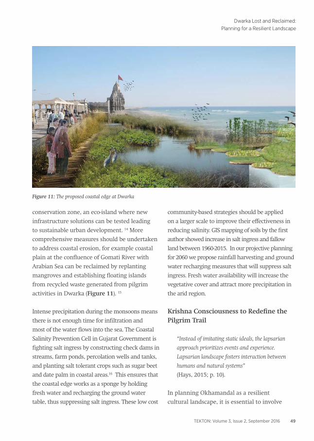
conservation zone, an eco-island where new
infrastructure solutions can be tested leading
to sustainable urban development. 14 More
comprehensive measures should be undertaken
to address coastal erosion, for example coastal
plain at the confluence of Gomati River with
Arabian Sea can be reclaimed by replanting
mangroves and establishing floating islands
from recycled waste generated from pilgrim
activities in Dwarka (Figure 11). 15
Intense precipitation during the monsoons means
there is not enough time for infiltration and
most of the water flows into the sea. The Coastal
Salinity Prevention Cell in Gujarat Government is
fighting salt ingress by constructing check dams in
streams, farm ponds, percolation wells and tanks,
and planting salt tolerant crops such as sugar beet
and date palm in coastal areas.16 This ensures that
the coastal edge works as a sponge by holding
fresh water and recharging the ground water
table, thus suppressing salt ingress. These low cost
community-based strategies should be applied
on a larger scale to improve their effectiveness in
reducing salinity. GIS mapping of soils by the first
author showed increase in salt ingress and fallow
land between 1960-2015. In our projective planning
for 2060 we propose rainfall harvesting and ground
water recharging measures that will suppress salt
ingress. Fresh water availability will increase the
vegetative cover and attract more precipitation in
the arid region.
Krishna Consciousness to Redefine the Pilgrim Trail
“Instead of imitating static ideals, the lapsarian
approach prioritizes events and experience.
Lapsarian landscape fosters interaction between
humans and natural systems”
(Hays, 2015; p. 10).
In planning Okhamandal as a resilient
cultural landscape, it is essential to involve
Figure 11: The proposed coastal edge at Dwarka

50 TEKTON: Volume 3, Issue 2, September 2016
Heena Gajjar and Amita Sinha
Figure 12: Proposed Eco-cultural Heritage Trail

51TEKTON: Volume 3, Issue 2, September 2016
Dwarka Lost and Reclaimed:Planning for a Resilient Landscape
local communities and pilgrims in the
process. We propose an eco-cultural heritage
trail, in which the pilgrims will be able to
experience the landscape in walking and
close interactions with nature (Figure 12). A
heightened awareness of the environment,
‘Krishna consciousness’ can be induced as they
visit sites associated with the life of Krishna,
listen to discourses on environmentalism and
spirituality, and participate in eco-restoration
projects. “Krishna consciousness’, a way of
seeing and relating to nature, can be cultivated
through close attention to natural processes
and by developing a caring and reverential attitude.
This would be the basis for an environmental
ethos rooted in past traditions and conversant
with present realities. Today, as salt ingress is
threatening to turn Okhamandal into a desert,
fresh water bodies with mythic associations can
be revived to restore the once verdant landscape.
Krishna’s image as a proto-environmentalist can
play a useful role in developing a pilgrimage
circuit that links the existing temples with
groves and wetlands. The rich repertoire of
place myths will grow over time, as pilgrimage
traditions are seldom static.
Most pilgrims take the tourist bus from
Dwarka to visit other temples in Okhamandal
and come back in a few hours. There are very
few opportunities to have close interaction
with the landscape as premium is put on
obtaining darshan (ritual sighting) of deities
in the temples. Pilgrims who step down from
Dwarkadhish Temple through the moksha
dvar to the ghats on Gomati will see the sun
setting over Varun Temple rising out of the
sea.17 If they take the path behind the temples
Figure 13: Integrated water catchment for Gopi Talav and Nageshwar

52 TEKTON: Volume 3, Issue 2, September 2016
Heena Gajjar and Amita Sinha
at Nageshwar and Gopi Talao, they will come
upon hidden ponds in groves. If they walk the
entire circuit, they will see many temples on
the coast and inland rising out of the waters,
and experience the local flora and fauna. But
few do as there are no rest stops or signage and
the walking path is not well defined.
In our planning proposal, the existing trail is
extended beyond the existing loop—Dwarka,
Bet Dwarka, Gopi Talao, Nageshwar—to
include the sacred site of Okhamadhi at the
southern tip of the peninsula. The journey
on foot on this longer loop of 105 km will
take nearly a week to complete. Rest spots
proposed on the trail include reclaimed sites
where salt ingress has been checked through
wetland restoration and planting. Gopi Talav
and Nageshwar Talav are proposed to become
part of the regional scale macro-catchment
for harvesting rainwater and recharging the
ground water table (Figures 13, 13 A, 13
B). Gopi Talav is believed to be the site of
Krishna’s dance with gopis, and a place similar
in form and meaning to the garden groves of
Braj that represent a now lost environmental
ethic (Sinha, 2014). 18 We propose to reclaim
it as a cultural space of ritual enactments
and festivals celebrating the birth of Krishna
(Janmashtami). The performative spaces
generated from dancing garba raas and
playing with colors during Holi festival will
add vitality and renew the cultural landscape.
An abandoned stone quarry reclaimed as
stepwell, solar and wind farm, underwater
archaeological exhibit, and bird sanctuary are
proposed as rest spots that will engage the
Figure 13A: Detail of Gopi Talav

53TEKTON: Volume 3, Issue 2, September 2016
Dwarka Lost and Reclaimed:Planning for a Resilient Landscape
for the future of Okhamandal within the lapsarian
approach, conservation of cultural heritage
should be guided by ecological thinking while
acknowledging the legacy of enacted myths and
oral traditions. This means that images reified in
static structures that resist and dominate nature
should be discarded in favor of new images that
represent resilient landscapes.
Photo Credits: All photographs and maps are by
Heena Gajjar.
Acknowledgements:The paper is based upon Master of Landscape
Architecture thesis “Journeys in the Cultural
Landscapes of Okhamandal in Gujarat, India:
An Ecological Model for Heritage Conservation”,
University of Illinois at Urbana Champaign, 2016 by
Heena Gajjar. The authors thank Jessica Birkenholtz
and David Hays for their guidance and support.
Figure 13B: Detail of Nageshwar
pilgrim in understanding natural processes
and environmental history of Okhamandal.
ConclusionHuman (and divine) actions sought to build a ‘center’
in the tiny peninsula of Okhamandal on the western
edge of the Indian subcontinent, in marginal land on
the seacoast. In spite of environmental catastrophes
and social upheavals, Dwarka remained a center, even
as it was on the periphery, within the polycentric
sacred geography of Hinduism. Its repeated rebuilding
demonstrates the tenacity of place memories
and cultural commitment to mimic Krishna’s
foundational act in reclaiming land from sea. The
illusion of stability communicated by ancient sea
forts and modern floodwalls and their failure in
overcoming high magnitude natural disasters and
slow encroachment by the sea necessitates a paradigm
shift in landscape planning and design. In planning

54 TEKTON: Volume 3, Issue 2, September 2016
Heena Gajjar and Amita Sinha
Notes:1 The lovable child and adolescent cowherd grew
up in the pastoral community of Yadavs in Braj
and came into age by killing his evil uncle Kansa in
Mathura and restoring the throne to its rightful heir.
Krishna and his clan of Yadavas left Mathura upon
repeated attacks by Jarasandh, king of Magadha.
Krishna established his kingdom in Dwarka where he
is worshipped as Dwarkadhish, ruler of Dwarka, and
Ranchor, one who left the battlefield.
In the epic Mahabharata Krishna was the charioteer of
Arjun, one of five Pandav brothers in the grand battle
between the cousins Pandavs and Kauravs. The dialogue
between Krishna and Arjun became Bhagavad-Gita, the
seminal text of Hinduism in which Krishna is a wise
sage and guru enunciating the meaning and purpose of
life to Arjun and reveals himself as Brahma, the ultimate
transcendent reality (Arnold, 1899).
2 S.R. Rao (1999) described them as Suvarna
Tirtha, Bet Dwarka/Shankodhara, Narayanapura,
Arambhadvara, Dhenuka, Okha, and Purvadvara. This
suggests that Okhamandal landscape was perceived
traditionally as an island nested and duplicated at
smaller scales alluding to the pattern of self-similarity
found in nature.
3 Dwarka in the west is one of the four char dhaams
(four abodes or seats in the four cardinal directions)
that every Hindu is enjoined to visit once in a lifetime.
The clockwise circumambulation by pilgrims of the
four dhaams defines the sacred geography of India (Eck,
2012). Two other dhaams-- Puri (east), and Rameshvaram
(south)--are also at confluences of river and sea, while
Badrinath on the north is on a hilly range rising out of
the waters (Bhardwaj, 1973). The fluvial aspect of sacred
sites is further reiterated through building of large
water tanks within the temple complexes.
4 According to the medieval Sanskrit text, Padma Purana
Vishnu took the form of a fish (matsya) and rescued the
Vedas hidden in the sea from the demon Shankhasura.
5 The island of Bet Dwarka in Okhamandal was
inhabited by Late Harappan settlers in the 19th c -15th
BCE as indicated by relics such as a seal engraved with a
composite animal (bull, unicorn, and goat) motif, copper
fishhook, and two inscribed potsherds. The availability
of chank shells in profusion in the Gulf of Kutch meant
that Bet Dwarka and Nageshwar became centers for
production of a variety of objects—beads, bangles, ladle,
spoon, and seals-- made with shells (Gaur, A. Sundresh, and
V. Patankar 2005). Bet Dwarka had a flourishing overseas
trade in the early centuries of the CE, as discoveries of
amphora (pottery ware for wine and olive oil used in
the Roman empire) and stone anchors reveal (Gaur,
Sundaresh, and Vora, 2005).
6 The Harappan site of Dholavira in the Rann of Kutch
suffered a massive earthquake around 2200 BCE that
along with siltation may have caused its demise.
7 Archaeologists believe the decline of Harappan
societies was caused by climate change. The retraction
of Ghaggar-Hakra River, a tributary of Indus, and
the weakening of monsoons, for example led to the
demise of settlements on its banks and migration of its
population eastwards (Giosan et al, 2012).
8 According to Lefebvre (1991) representations of
space are produced by knowledge systems while
representational spaces are symbolic, linked to art
and hidden side of social life.
9 Dwarka and Okhamandal were studied in three
site visits in 2008, 2014, and 2015. The sacred
sites were visually documented, and pilgrims and
stakeholders were interviewed. Mapping of water
bodies, vegetation, trails, and settlements was done
to do projective planning of Okhamandal for 2060.
Remediation strategies were developed to address
coastal erosion and salt ingress. Design scenarios for
existing and proposed rest stops for the pilgrim on the
proposed eco-cultural heritage trail were developed. The
report can be accessed at: https://issuu.com/heenagajjar/
docs/journeys_in_the_cultural_landscapes
10 http://www.climatecentral.org/
11 Ecological Profile for Coastal Talukas of Gulf of Kachch,
Report by Gujarat Ecological Society, 2014. Retrieved
20 December 2014, from http://gesindia.org/

55TEKTON: Volume 3, Issue 2, September 2016
Dwarka Lost and Reclaimed:Planning for a Resilient Landscape
12 http://Hridayindia.in/hriday-cities/
13 Nilanjana Biswas. The Gulf of Kutch Marine National
Park and Sanctuary: A Case Study. Unpublished report
by International Collective in Support of Fishworkers.
Retrieved from http://aquaticcommons.org/2077/1/
Kutch.pdf.
14 Hodson and Marvin (2010) describe eco-islands
as experiments in sustainable development using
renewable sources of energy and recirculating
resource flows. Treasure Island in San Francisco Bay
and the island county of Tuvalu in Pacific Ocean
are being planned to generate their energy from
renewable sources by 2020.
15 Rossano (2015) reviews six river widening and
floodplain expansion projects in Switzerland, France,
Germany, and the Netherlands for preserving the dynamic
estuarine landscape. Instead of levees controlled
flooding is advocated for resilient landscape design.
16 Coastal Salinity Prevention Cell Annual Progress Report,
2012-2014 (http://cspc.org.in/). Salt panning is also increasing
the rate of ingress. Increase in soil salinity and aridity has
led to the reduction of native species forest cover and
propagation of the invasive weed Prosopis Juliflora.
17 The number of pilgrims in Dwarka increased
by 23% from 2012 (1,436,488) to 2013 (1,770,438)
according to Gujarat Tourism (http://www.
gujarattourism.com). In response to the increase
in domestic tourism, the sea front is developed
as the famous Chowpatty Beach in Mumbai and a
pedestrian suspension bridge has been constructed to
link the ghats with Panchkund Island. Pilgrims do not
appreciate the new look. As one of them remarked
to the first author in January 2015, “This place is not
Mumbai, it is Dwarka. Krishna’s Dwarka!”
18 Krishna had directed the cowherders to venerate
Govardhan Hill in Braj instead of the distant sky god
Indra because its vegetation provided food for their
cattle. He had lifted the Hill on his finger to protect
the community when angry Indra sent incessant
rains causing floods. He had fought and subdued
the serpent Kaliya living in waters of the Yamuna
River and had killed the many demons in animal
forms lurking in the wilderness. In these allegorical
legends, Krishna destroyed the evil forces of nature and
promoted reverence of the bountiful natural landscape
that sustained his community. Krishna’s deeds and
sayings as exemplars of right values and actions are
relevant in contemporary times and its environmental
concerns (Haberman, 1994; Luthy, 2016)
References:Arnold, E. (Tr.). (1899). Bhagavad-Gita. Boston:
Roberts Brother.
Bhardwaj, S. (1973). Hindu Places of Pilgrimage in India:
A Study in Cultural Geography. Berkeley: University of
California Press.
Belanger, P. (2016). Is landscape infrastructure? in G.
Doherty and C. Waldheim (eds.) Is Landscape…? Essays on
the Identity of Landscape. New York: Routledge, 190-227.
Chandrasekharam, D. (2007) Geo-mythology of India in L.
Piccardi and W.B. Masse (eds.). Myth and Geology. Geological
Society, London, Special Publications, vol. 273, 29-37.
Crooks, S. (2004). The effect of sea-level rise on coastal
geomorphology. British Ornithologists’ Union, Ibis, 146
(suppl.1), 18-20.
Couture, A. (2003). Dvaraka: The Making of a Sacred Place
in P. Granoff and K. Shinohara (eds.). Pilgrims, Patrons,
and Place: Localizing Sanctity in Asian Religions. Vancouver:
University of British Columbia Press, 224-248.
Davidson, L.K. and D. Gitlitz. (2002). Pilgrimage: from
the Ganges to Graceland: an encyclopedia. Santa Barbara,
California: ABC-CLIO, vol. 1.
Desai, G.H. and Clarke, A.B. (1923). Gazetteer of the
Baroda State. Bombay: Times Press.
Eck, D. (2012). India: A Sacred Geography. New York: Harmony.
Eliade, M. (1954). The Myth of the Eternal Return, Tr. W.
Trask. Princeton, New Jersey: Princeton University Press.
Gaur, A.S.; Sundaresh; Tripati, S. (2004). An Ancient

56 TEKTON: Volume 3, Issue 2, September 2016
Heena Gajjar and Amita Sinha
Harbour at Dwarka: study based on the recent
underwater explorations. Current Science, vol. 86, no. 9,
May 10, 1256-1260.
Gaur, A.S.; Sundresh; Patankar, V. (2005). Ancient
Shell Industry at Bet Dwarka Island. Current Science,
Vol. 89, September, pp. 941-946.
Gaur, A.S.; Sundaresh; and Vora, K.H. (2005).
Archaeology of Bet Dwarka Island: An Excavation Report.
New Delhi: Aryan Books International in association
with National Institute of Oceanography, Goa.
Gaur, A.S.; Sundresh; Vora K.H. (2007). Shoreline
Changes During the Last 2000 Years on the
Saurashtra Coast of India: Study based on
archaeological evidences. Current Science, vol. 92, no. 1,
January, 103-110.
Gaur, A.S.; Sundaresh; K.H. Vora, K.H. (2008). Underwater
Archaeology of Dwarka and Somnath (1997-2002). New
Delhi: Aryan Books International in association with
National Institute of Oceanography, Goa.
Giosan, L. et al. (2012). Fluvial Landscapes of the
Harappan Civilization. PNAS, E 1688-E 1694, published
online May 29.
Haberman, D. (1994). Journey through the Twelve Forests:
An Encounter with Krishna. New York: Oxford
University Press.
Hays, D. (2015). Lapsarian Landscape. Matericos
Perifericos 12. Rosario, Argentina, 8-10.
Hill, K.; Barnett, J. (2007). Design for Rising Sea Levels.
Harvard Design Magazine, vol. 27, Fall/Winter.
Hodson, M.; Marvin, S. (2010). World cities and climate
change. Berkshire, U.K.: Open University Press.
Irwin, J. (1983). The Ancient Pillar-cult at Prayaga
(Allahabad): Its Pre-Asokan Origins. Journal of the Royal
Asiatic Society, 2, 253-280.
Lefebvre, H. (1991). The Production of Space, Tr. Donald
Nicholson-Smith. Malden, MA: Blackwell Publishing.
Lister, N. (2016). Is Landscape Ecology? in G. Doherty
and C. Waldheim (eds.) Is Landscape…? Essays on the
Identity of Landscape. New York: Routledge, 115-137.
Luthy, T. (2016). Few People Know That Krishna Was
the First Environmentalist: Religiously Motivated
Conservation as a Response to Pilgrimage Pressures in
Vrindavan, India in M. Mostafanezhad, E.Shelton, R.
Norum, and A. Thompson-Carr (eds.). Political Ecology
of Tourism: Community, power and the environment. New
York: Routledge.
Rajendran, C.P., Rajendran, K.; Vora, K.H.; Gaur, A.S.
(2003). The Odds of a Seismic Source Near Dwarka,
NW Gujarat: An evaluation based on proxies. Current
Science, vol. 84, no. 5, published online March 10.
Rao, S.R. (1995). Research on the Historicity of Pilgrim
Places: A study of Dvaraka in D.P. Dubey (ed.) Pilgrimage
Studies: Sacred Places, Sacred Traditions. The Society of
Pilgrimage Studies, no. 3, Allahabad, 145-155.
Rao, S. R. (1999). The Lost City of Dvaraka. New Delhi:
Aditya Prakashan.
Rao, S. R. (2001). Marine Archaeology in India. New
Delhi: Ministry of Information and Broadcasting,
Government of India.
Rossano, F. (2015). From Absolute Protection to
Controlled Disaster: New Perspectives on Flood
Management in Times of Climate Change. Journal of
Landscape Architecture, 1, 16-25.
Schoff, W. (Tr.) (1912). The Periplus of the Erythraean Sea:
Travel and Trade in the Indian Ocean by a Merchant of the
First Century. New York: Longmans, Green and Co.
Sen Gupta, S. (2003). Chaar Dhaam: A Guide to Hindu
Pilgrimages. Kolkata: Rupa & Co.
Shah, C. (ed.). (1938). The Geology of Baroda State by R.B.
Foote. Baroda: Baroda State Press.
Sinha, A. (2014). The Sacred Landscape of Braj, India:
Imagined, Enacted, and Reclaimed. Landscape Journal,
USA, 33(1), 59-75.

57TEKTON: Volume 3, Issue 2, September 2016
Dwarka Lost and Reclaimed:Planning for a Resilient Landscape
Walker, B. and Salt., D (2006). Resilience Thinking:
Sustaining Ecosystems and People in a Changing World.
Washington: Island Press.