dynamic earth vocabulary - charles burrows 4. hot spot _____ 5. magma a. liquid rock that is...
TRANSCRIPT

Name____________________________________Date___________
DYNAMICEARTHVOCABULARY

inner core outer core mantle crust plates
fault subduction lithosphere fault-block
folded upwarped volcanic isostasy
1. The ____________________ is broken into about 30 sections that movearound on the asthenosphere.
2. Because the ____________________ stops one type of seismic wave and slowsanother, scientists believe it is a liquid.
3. The pushing forces of two plates moving together causes rocks to buckle, forming
____________________ mountains.
4. A denser plate sinking under a less dense plate is called ____________________.
5. As erosion removes material from the tops of mountains and the mass ofthe mountain decreases, the crust is forced upward because of
____________________.
6. The ____________________ is thinnest under the oceans and thickest throughthe continents.
7. A cone-shaped feature made of layers of lava is a(n) ____________________mountain.
8. ____________________ move so slowly that they can take more than a year totravel a few centimeters.
9. The innermost layer of Earth’s interior is the ____________________.
10. Forces inside Earth sometimes push crust upward, creating
____________________ mountains.
11. Pulling forces form ____________________ mountains such as the TetonRange in Wyoming.
12. Even though it is solid, the ____________________ flows slowly.
13. A large fracture in rock along which movement occurs is called
a(n) ____________________.
a. magnetic field that points south
b. hypothesis stating large landmass broke
up into smaller landmasses to form the
continents, which then drifted to their
present locations
c. process by which new ocean lithosphere
forms
d. single landmass once formed by the
continents
_____ 1. sea-floor spreading
_____ 2. mid-ocean ridge
_____ 3. supercontinent
_____ 4. reversed polarity
_____ 5. continental drift

a. outer layer of Earth made up of the upper
part of the mantle and the crust
b. cycle in which heated material rises and
cooler material sinks
c. solid layer of plastic mantle rock that flows
very slowly
d. theory that explains how large pieces of the
lithosphere move
e. region along a plate boundary where one
plate moves under another plate
_____ 1. asthenosphere
_____ 2. subduction zone
_____ 3. plate tectonics
_____ 4. lithosphere
_____ 5. convection cell

_____ 1. Pangaea a. process by which supercontinents form
and break apart over time
b. piece of lithosphere with magnetic
properties different from those of its
surroundings
c. supercontinent formed about 300 million
years ago
d. process by which a continent breaks apart
e. single large ocean covering Earth 300
million years ago
_____ 2. terrane
_____ 3. Panthalassa
_____ 4. supercontinent
cycle
_____ 5. rifting

Directions: Study the following diagram. Then label each part with the letter of the correct description below.
A. A mid-ocean ridge forms whenever diverging plates continue to separate,
creating a new ocean basin. As the rising magma cools, it forms new ocean crust.
B. When an oceanic plate converges with a less dense continental plate, the denser
oceanic plate sinks under the continental plate.
C.When two oceanic plates converge, the denser plate is forced beneath the other
plate and volcanic islands form above the sinking plate.
Continental crust
Oceanic crust
1. ____________
2. ____________
3. ____________

_____ 1. Pangaea
_____ 2. lithosphere
_____ 3. rift valley
_____ 4. sea-floor spreading
_____ 5. paleomagnetism
_____ 6. terrane
_____ 7. mid-ocean ridge
_____ 8. subduction zone
_____ 9. continental drift
_____ 10. convection cell
a. region along a plate boundary where one
plate moves under another
b. piece of lithosphere with a unique
geologic history
c. crack in the center of a mid-ocean ridge
d. supercontinent formed about 300 million
years ago
e. residual magnetism of rock
f. process by which new sea floor forms
g. layer that forms the thin outer shell of
Earth
h. cycle in which heated material rises and
cooler material sinks
i. undersea mountain range
j. hypothesis that the continents once formed a single landmass

_____ 1. paleomagnetism
_____ 2. transform boundary
_____ 3. asthenosphere
_____ 4. continental drift
_____ 5. terrane
_____ 6. sea-floor spreading
_____ 7. rifting
_____ 8. convergent boundary
_____ 9. lithosphere
_____ 10. divergent boundary
a. the thin outer shell of Earth that is broken into several blocks
b. boundary that forms where two plates
collide
c. process by which new sea floor forms as magma rises through a rift
d. hypothesis that the continents moved to
their present positions
e. study of the alignment of magnetic minerals in rock
f. boundary where two plates slide past one
another horizontally
g. layer of plastic rock just below the lithosphere
h. forming of cracks in weakened
continental or oceanic crust
i. boundary at which two plates move away
from each other
j. piece of lithosphere with a unique geologic history

_____ 1. compression
_____ 2. fault
_____ 3. shear stress
_____ 4. tension
_____ 5. fold
a. ductile stress causing rock layers to bend
b. a break in rock along which the surrounding rock moves
c. stress that squeezes and shortens rock
d. stress that distorts rock by pushing parts of it in opposite directions
e. stress that stretches and pulls rock apart

_____ 1. folded mountain
_____ 2. graben
_____ 3. dome mountain
_____ 4. fault-block
mountain
_____ 5. volcanic mountain
a. mountain formed when faults break Earth’s
crust into blocks that tilt and drop
b. valley formed when faults break Earth’s
crust into blocks that tilt and drop
c. mountain formed when magma pushes rock layers up
d. mountain formed when magma erupts onto
Earth’s surface
e. mountain formed when rock is squeezed and uplifted
Pangaea Arctic rock
continents Africa seafloor spreading
Alfred Wegener was one of the first people to suggest that all of the
1. ___________________ were joined together in the past. He called the one large
continent 2. ___________________. Evidence exists to support his hypothesis.
For example, similar fossils have been found in South America and
3. ___________________. Also, fossils of warm weather plants have been found in
the 4. ___________________. Similar 5. ___________________ structures exist in
the Appalachian Mountains and in Greenland and western Europe. But until clues on
the ocean floor led to Harry Hess’s theory of 6. ___________________, scientists
could not think of how the continents might move.
_____ 1. shear stress
_____ 2. folded mountain
_____ 3. isostasy
_____ 4. fault-block
mountain
_____ 5. dome mountain
_____ 6. fault
_____ 7. compression
_____ 8. tension
_____ 9. fold
_____ 10. mountain range
a. stress that stretches and pulls a body of rock apart
b. a series of mountains related in shape and
structure
c. a bend in rock layers from stress
d. distorts by pushing parts of the body in
opposite directions
e. mountain formed when rock layers are squeezed and uplifted
f. equilibrium in gravity and buoyancy
between the asthenosphere and the lithosphere
g. a break in rock along which rock moves
h. stress that squeezes and shortens rock
i. forms where faults break Earth’s crust into
large blocks that tilt and drop
j. mountain with rock layers sloping from a central point
_____ 1. compression
_____ 2. folded mountain
_____ 3. dome mountain
_____ 4. tension
_____ 5. shear stress
_____ 6. fold
_____ 7. volcanic
mountain
_____ 8. fault-block
mountain
_____ 9. isostasy
_____ 10. fault
a. type of stress that pulls apart rock
b. a bend in rock layers that results from stress
c. a mountain formed when magma erupts
through Earth’s surface
d. type of stress that squeezes rock
e. a break along which surrounding rock
moves
f. a state in which the asthenosphere and lithosphere are in balance
g. mountain with circular rock layers that
gently slope from the center
h. mountain that forms where rock layers are
squeezed and bent
i. type of stress that distorts rock by pushing parts of it in opposite directions
j. a mountain that forms where large blocks of
Earth’s crust tilt and drop along faults relative to other blocks

_____ 1. S wave
_____ 2. elastic rebound
_____ 3. body wave
_____ 4. P wave
_____ 5. surface wave
a. seismic wave that can travel through solids, liquids, and gases
b. seismic wave that travels through solids only
c. seismic wave that travels along the surface of a medium
d. seismic wave that travels through the body of
a medium
e. sudden return of deformed rock to its undeformed shape

_____ 1. moment magnitude
_____ 2. seismograph
_____ 3. Richter scale
_____ 4. modified Mercalli scale
_____ 5. seismogram
a. displays earthquake motion recorded
by a seismograph
b. measures intensity
c. measures magnitude using ground
motion
d. records ground vibrations
e. uses fault size and distance that fault blocks move to measure magnitude
_____ 1. foreshock
_____ 2. seismic gap
_____ 3. tsunami
a. an area where relatively few earthquakes have occurred recently, but where strong
earthquakes have occurred in the past
b. a large ocean wave that forms after a volcanic
eruption, underwater earthquake, or landslide
c. a small earthquake that precedes a larger one

_____ 1. seismic gap
_____ 2. Richter scale
_____ 3. body wave
_____ 4. tsunami
_____ 5. modified Mercalli scale
_____ 6. surface wave
_____ 7. seismograph
_____ 8. foreshock
_____ 9. elastic rebound
_____ 10. moment
magnitude
a. an instrument used for detecting and recording vibrations in the ground
b. a measurement of earthquake strength based in
part on the size of the area of the fault that
moves
c. a scale used to measure an earthquake’s intensity
d. a wave that travels through the body of a
medium
e. a scale used to measure ground motion from earthquakes
f. the sudden return of deformed rock to its
undeformed state
g. a wave that travels along the surface of a body,
not through the middle
h. section of a fault along which few quakes have occurred recently, but along which strong
quakes have occurred in the past
i. a smaller earthquake that precedes a larger one
j. a giant wave that can form after an undersea earthquake

_____ 1. seismogram
_____ 2. seismograph
_____ 3. Richter scale
_____ 4. elastic rebound
_____ 5. body wave
_____ 6. moment
magnitude
_____ 7. surface wave
_____ 8. modified
Mercalli scale
_____ 9. P wave
_____ 10. S wave
a. a magnitude scale based on the size of the
fault area that moves, how far fault blocks move, and the rigidity of rocks
b. a scale that measures earthquake intensity
c. a tracing of earthquake motion that is recorded by a seismograph
d. the sudden return of elastically deformed
rock to its undeformed shape
e. the fastest seismic wave; can travel through solids, liquids, and gases
f. an instrument that records ground vibrations
g. a seismic wave that travels along the surface of a medium
h. the second-fastest seismic wave; can only
travel through solids
i. a seismic wave that travels through the body of a medium
j. a magnitude scale that measures ground
motion

_____ 1. pluton
_____ 2. volcanism
_____ 3. lava
_____ 4. hot spot
_____ 5. magma
a. liquid rock that is produced under Earth’s surface
b. a volcanically active area of Earth’s surface, often
far from a tectonic plate boundary
c. magma that flows onto Earth’s surface
d. igneous rock formations that develop when
magma cools and solidifies inside Earth’s crust
e. any activity that includes the movement of magma toward or onto Earth’s surface

_____ 1. caldera
_____ 2. pyroclastic
materials
_____ 3. cinder cone
_____ 4. quiet eruption
_____ 5. explosive eruption
a. a volcanic cone, rarely more than a few hundred meters high, with slope angles up to 40°;
formed from small explosive eruptions
b. produced by thick, sticky lava with a high
viscosity and a high volume of trapped gases
c. volcanic dust, volcanic ash, lapilli, volcanic
bombs, and volcanic blocks
d. produced by runny lava with a low viscosity and a low volume of trapped gases
e. a large, circular depression that forms when the
magma chamber below a volcano partially empties and causes the ground above to collapse

_____ 1. magma
_____ 2. volcanism
_____ 3. lava
_____ 4. volcano
_____ 5. hot spot
_____ 6. mafic
_____ 7. felsic
_____ 8. pyroclastic
material
_____ 9. caldera
_____ 10. cinder cone
a. magma that flows onto Earth’s surface; the rock that forms when lava cools and solidifies
b. describes magma or igneous rock that is rich in
feldspars and silica, and generally light in color
c. liquid rock that forms under Earth’s surface
d. describes magma or igneous rock that is rich in
magnesium and iron, and generally dark in color
e. a vent or fissure in Earth’s surface through which magma and gases are expelled
f. a volcanically active area of Earth’s surface,
often far from a tectonic plate boundary
g. any activity that includes the movement of magma toward or onto Earth’s surface
h. a large, circular depression that forms when the
magma chamber below a volcano partially
empties and causes the ground above to collapse
i. a type of volcano made up of pyroclastic
material
j. fragments of rock that form during a volcanic eruption
_____ 1. volcanism
_____ 2. hot spot
_____ 3. quiet eruption
_____ 4. igneous rock
_____ 5. magma
_____ 6. explosive
eruption
_____ 7. pyroclastic material
_____ 8. lava
_____ 9. lapilli
_____ 10. pluton
a. large rock particles that are less than 64 mm in
diameter
b. fragments of rock that form during a volcanic eruption
c. produced by mafic magma, a runny lava with
a low viscosity and a low volume of trapped
gases
d. produced by felsic magma, a sticky lava with a high viscosity and a high volume of trapped
gases
e. any activity that includes the movement of
magma toward or onto Earth’s surface
f. a volcanically active area of Earth’s surface,
commonly far from a tectonic plate boundary
g. a type of rock that forms when magma cools and solidifies
h. magma that cools and solidifies before it
reaches Earth’s surface
i. magma that flows onto Earth’s surface; the rock that forms when lava cools and solidifies
j. liquid rock that is produced under Earth’s
surface
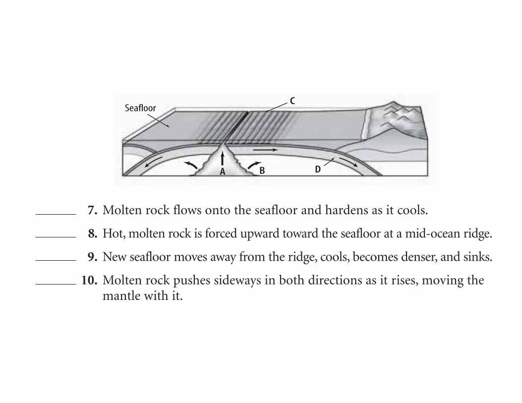
DA B
CSeafloor
7. Molten rock flows onto the seafloor and hardens as it cools.
8. Hot, molten rock is forced upward toward the seafloor at a mid-ocean ridge.
9. New seafloor moves away from the ridge, cools, becomes denser, and sinks.
10. Molten rock pushes sideways in both directions as it rises, moving the mantle with it.

asthenosphere convection
lithosphere plates faults
1. Shearing causes areas between plates that are sliding past one another to form
____________________ and experience earthquakes.
2. Sections of Earth’s crust and upper mantle, called ____________________, move around onpart of the mantle.
3. The crust and upper mantle are called the ____________________.
4. Beneath this layer is the plasticlike ____________________.
5. Uneven heating of the upper mantle can cause differences in density, or ____________________;this could be one cause of plate movement.

1. Earth’s crust and upper mantle are broken into sections called ______
a. lava. b. plates.
2. The collision of one continental plate with another may produce ______
a. oceans. b. mountains.
3. New ocean crust is formed at a ______
a. rift valley. b. mid-ocean ridge.
4. A rift valley can form where two continental plates are ______
a. moving apart. b. colliding.
5. Where Earth’s plates move, they may slide alongside one another, pullapart, or ______
a. collide. b. divide.

21
mid-ocean ridges volcanic islands major earthquakes
rift valleys deep-sea trenches volcanic mountains
Plate boundaries
8.
transform
include include
7.6.
11.
convergent
form
and
10.9.
divergent
form
and
include
cause
Column I
1. reptile fossil found in South America and Africa
2. fossil plant found in Africa, Australia, India,South America, and Antarctica
3. clues that support continental drift
4. mountains similar to those in Greenland and western Europe
5. Wegener’s name for one large landmass
6. slow movement of continents
7. evidence that Africa was once cold
Column II
a. Pangaea
b. Appalachians
c. continental drift
d. glacial deposits
e. Glossopteris
f. Mesosaurus
g. fossil, climate, and rock

asthenosphere lithosphere plate tectonics
convection plates
1. The theory of ____________________ states that Earth’s crust and upper mantle are brokeninto sections.
2. These sections, called ____________________, are composed of the crust and a part of theupper mantle.
3. The crust and upper mantle together are called the ____________________.
4. Beneath this layer is the plasticlike ____________________.
5. Scientists suggest that differences in density cause hot, plasticlike rock to be forced upward
toward the surface, cool, and sink. This cycle is called a ____________________ current.

reverse strike-slip earthquakes pull rocks apart
resulting in theoccurrence of
making rocks abovethe fault move
making rocks abovethe fault move making rocks move
Forces
upward at a2. __________ fault
downward at anormal fault
sideways at a3.__________ fault
1.
4.
push rocks againstone another
push rocks pasteach another
acting along faults can
Directions: Unscramble the terms in italics to complete the sentences below. Write the terms on the lines provided.
1. Forces cause sections of Earth’s surface, called petals,to move.
2. When rocks break, they move along surfaces calledstufla.
3. To relieve the srests caused by plate movement, rockstend to bend, compress, or stretch.
4. When rocks are stressed beyond their staleci limitthey break, move along the fault, and return to theiroriginal shapes.
5. An akquethera is the vibrations produced by thebreaking of rock.
6. At a roamnl fault, tension pulls rocks apart.
7. At a riskte-pils fault, rocks move past each other.
8. At a normal fault, rock above the fault surface movesddwwoanr in relation to rock below the fault surface.
9. At a rreeesv fault, rocks above the fault surface moveup and over the rocks below the fault surface.
10. At a reverse fault, mnopsericos forces pushes on rocksfrom opposite directions.
11. earsh forces can cause strike-slip faults.
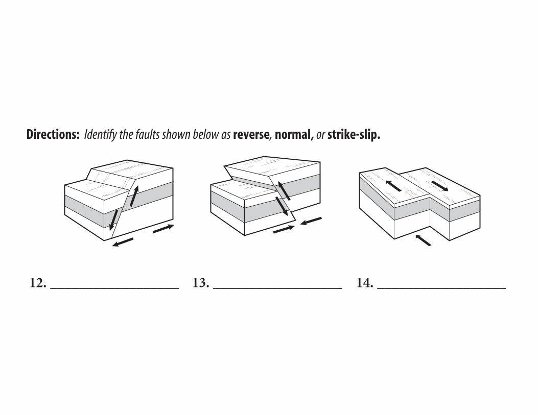
Directions: Identify the faults shown below as reverse, normal, or strike-slip.
12. __________________ 13. __________________ 14. __________________

1. When an earthquake occurs, energy is released in the form of ______.a. seismic waves b. faults
2. What kind of waves cause particles in rocks to move at right angles tothe direction of the wave?a. primary waves b. secondary waves
3. What kind of waves cause particles in rocks to move back and forth inthe same direction?a. primary waves b. faults
4. An earthquake’s ______ is the point on Earth’s surface directly abovethe earthquake focus.a. elastic limit b. epicenter
5. ______ waves cause the most destruction.a. Secondary b. Surface
6. ______ waves are the fastest.a. Primary b. Secondary
7. At the very center of Earth is a ______.a. liquid layer of minerals b. solid, dense inner core
8. Earth’s largest layer is the ______.a. mantle b. crust
9. The Richter scale measures the ______ of an earthquake.a. magnitude b. intensity
10. An earthquake that measured X on the modified Mercalli scale would cause ______ damage.a. very little b. considerable
11. Suppose water along a shoreline moves rapidly toward the sea, exposinga large portion of land that is usually under the water. This is a clue thata ______ might strike.a. tsunami b. liquefaction
1. melted rock formed by heat and pressure deep inside Earth
2. area between mantle and core where hot rockis forced into the crust
3. places where most volcanoes occur
4. opening in Earth’s surface through which magma flows
5. steep-walled depression around a volcano’s vent
6. an opening in Earth’s surface that often forms a mountain when layers of lava and volcanic ash erupt
7. cause rocks to melt and form magma
a. magma
b. crater
c. vent
d. volcano
e. hot spot
f. heat and pressure
g. plate boundaries

acid rain lava flow pyroclastic flow volcano
falling ash magma rise volcanologists
igneous rock plates vent
Earth’s crust is formed from (1)____________________ that are constantly moving. Pressure
between these shifting plates causes rock deep within Earth to melt, forming liquid rock called
(2)____________________. Because it is less dense than the surrounding rock, this molten rock
begins to (3)____________________ to the surface and escape through a
(4)____________________. As the lava cools, it builds up in layers which become
(5)____________________. Spewing gases, ash, and lava around the opening creates a
(6)____________________.
Volcanoes can have dramatic effects on people’s lives and their property. Volcanic ash and
debris may pour down a mountain side as (7)____________________ crushing crops, villages,
forests, and wildlife. (8)____________________ forms when gases mix with water vapor raining
down and killing plants. Entire villages may be buried below (9)____________________ as in
Herculaneum. A (10)____________________ destroys everything in its path. These eruptions can
be violent and unpredictable, but volcano scientists, also known as (11)____________________,
still find them beautiful, exciting, and intriguing to study.

combine stronger isochron lower magnetic field
normal polarity older cancel reversed polarity younger
Earth’s (17) has changed over time. A field with the same orien-
tation as today’s field is said to have (18) . A field that is opposite
the present field has (19) . Magnetometers have been used to
measure the ocean floor’s magnetic field. When the ocean floor’s magnetic readings
match the present field, the two fields (20) . This produces a(n)
(21) than normal reading. When the magnetic readings of the
ocean floor are reversed compared to today’s field, the two fields partially
(22) to produce a(n) (23) than
normal reading. Magnetic data of the ocean floor has been used to generate
(24) maps, which have shown that the ocean floor is
(25) near ocean ridges and (26)
near deep-sea trenches.

Column A Column B
27. Device that can detect small changes in magnetic fields
28. Minerals containing this act like small compassneedles and record the orientation of Earth’smagnetic field at the time of their formation
29. Was constructed from data gathered from continentalbasalt flows
30. This type of line connects points on a map that havethe same age
31. Each cycle of spreading and magma intrusion alongan ocean ridge results in the formation of this
a. isochron
b. iron
c. geomagnetic time scale
d. new ocean crust
e. magnetometer

Hawaiian Islands crust divergent flood basalts hot spots
Iceland mantle volcanoes plateau ocean ridges
Circum-Pacific Belt western convergent
Most of the world’s volcanoes form along (25) plate boundaries. Slabs
of oceanic crust descend into the (26) and melt. The magma that forms
is forced upward through the overlying plate and forms (27) when it
reaches Earth’s surface. The (28) marks the locations of most convergent
boundary volcanoes. It stretches along the (29) coasts of North and
South America and down the eastern coast of Asia.
At (30) plate boundaries, magma is forced upward into fractures
and faults that form as plates separate or spread apart. Most of the volcanoes that form along
divergent boundaries are located underwater along (31) . This type of
volcanic activity can be observed above sea level in (32) , which sits atop
the Mid-Atlantic Ridge.
Some volcanoes that form far from plate boundaries form over (33) ,
which are unusually hot regions of Earth’s mantle. At hot spots, high-temperature plumes melt
rock. The magma that forms moves upward toward the (34) and melts
the crust to form a volcano. As a tectonic plate moves over a hot spot, a string of volcanoes forms.
The (35) are forming as the result of a hot spot. Hot spots can also result
in the formation of (36) , which erupt from fissures to form a flat plain or
a (37) rather than volcanic mountains.
Column A Column B
9. Fracture that forms as a result of horizontal compression
10. Fracture caused by horizontal shear
11. Famous California strike-slip fault
12. Fracture caused by horizontal tension
13. Fracture along which movement occurs
14. Fault surface along which movement takes place
a. fault
b. fault plane
c. normal fault
d. reverse fault
e. San Andreas
f. strike-slip fault

mass seismometer seismogram frame
1. A is an instrument that records earthquake vibrations.
2. All seismometers include a suspended from a wire.
3. A paper or computer record of earthquake vibrations is called a .
4. All seismometers include a that is anchored to the ground
and vibrates during an earthquake.

Label the diagram below. Choose from the following: epicenter, epicentral distance, seismic station.
14. 15.
16.
Circum-Pacific Belt boundaries tectonic plates
Mediterranean-Asian Belt ocean ridges seismic belts
Most earthquakes occur in narrow (19) that lie between large regions with
little or no seismic activity. Seismic activity in seismic belts is a result of movements among Earth’s
(20) . Most earthquakes occur near the (21) of
tectonic plates. Nearly 80 percent of earthquakes occur in the seismic belt known as the
(22) . About 15 percent of all earthquakes occur in the
(23) , which stretches across Europe and Asia.
Most other earthquakes occur on the crests of (24) .

continental crust trench magma oceanic crust
sediments subducting plate volcanic mountains
12.
13.
14.15.
16.
17.
18.

convection currents faults hot spot
magnetic patterns modified-Mercalli scale volcanoes
6. Evidence of seafloor spreading is provided by symmetric
of ocean-floor rocks.
7. Plate movements are related to in Earth’s mantle that cause
warm matter to rise and cool matter to sink.
8. Cinder-cone, shield, and composite are three types of .
9. Earthquakes occur when stress in rock is released at breaks in Earth’s crust
called .
10. An earthquake’s intensity, or the amount of damage it causes, is measured
on the .
11. A solitary volcanic peak may form when a plate moves over a
in Earth’s mantle.
magma divergent mantle hot spots tectonic energy
Volcanoes often occur at 6. _______________ and convergent plate boundaries.
They also occur at 7. _______________ where large, rising bodies of
8. _______________ can force their way through Earth’s 9. _______________
and crust.
Like volcanoes, earthquakes also occur at 10. _______________ plate
boundaries. They are caused by the 11. _______________ generated by the plates’
movement.

Description Earthquake Feature
2. Earth vibration caused by rapid energy release
3. energy that radiates in all directionsfrom the earthquake origin
4. fracture where movement has occurred
5. surface location directly above where an earthquake originates
6. location within Earth where an earthquake originates
a. epicenterb. focusc. seismic waved. faulte. earthquake

Description Term
9. derived from the amount of displacement that occurs along a fault zone
10. based on the amplitude of the largest seismic wave recorded on a seismogram
11. measure of the size of seismic waves or amount of energy released at the earthquake source
12. measure of the amount of earthquake shaking at a location based on damage
a. intensityb. magnitudec. Richter scaled. moment magnitude scale

Use the figure of Earth’s structure to write the letter(s) thatrepresents each of the following layers. mantlecontinental crust oceanic crust core
Dep
th (k
m)
100
200
350–700
AB
2885km
2270km
1216km
C
D
E
F
G
5–40 km

Description Earth Layer
3. soft, weak rock with some melting
4. liquid iron-nickel alloy thatgenerates Earth’s magnetic field
5. cool, rigid crust and uppermost mantle
6. solid iron-nickel alloy
a. asthenosphereb. inner corec. outer cored. lithosphere

Composition Earth Layer
10. basaltic rock a. continental crust11. granitic rock b. oceanic crust12. similar to stony meteorites c. core13. similar to metallic meteorites d. mantle
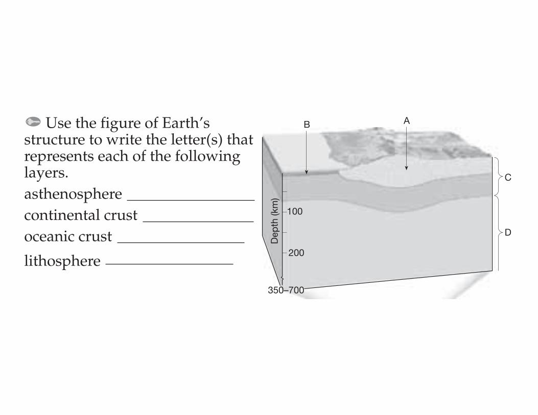
Use the figure of Earth’sstructure to write the letter(s) thatrepresents each of the followinglayers. asthenosphere continental crust oceanic crust
lithosphereD
epth
(km
)
100
200
350–700
AB
C
D

Evidence for Example Continental Drift
2. Similar mountain chains run through eastern North America and the British Isles.
3. Land areas that show evidence of ancient glaciation are now located near the equator.
4. The Atlantic coastlines of South America and Africa fit together.
5. Remains of Mesosaurus are limited to eastern South America and southern Africa.
a. rock types and structuresb.matching fossilsc. continental puzzled.ancient climates

The figure shows Earth’s ancient supercontinent as it appeared about 300 million years ago, according to Alfred Wegener. Write the letterthat represents each of the following present-day continents.
Antarctica Europe and Asia South America India
A B
DC
E
F
G
North America
Africa
Australia

Definition Term
1. weaker region in the mantle over which Earth’s outer shell lies
2. segments of the lithosphere that move and change shape
3. rigid layer of the uppermost mantle and crust
4. theory that states that the lithosphere is divided into plates that move
a. lithosphereb. platesc. plate tectonicsd. asthenosphere

a. sonarb. rift valleyc. mid-ocean ridge
Definition Term1. system that uses sound waves
to calculate the distance to an object
2. deep faulted structure found along a divergent boundary
3. a long chain of mountains extending through Earth’s oceans
fault rift tsunami seismic wave
hot spot seismic safe lava focus
shield volcano seismograph composite volcano
epicenter cinder cone volcano magnitude
1. broad volcano with gently sloping sides
2. long crack that forms as two tectonic plates move apart
3. magma that reaches Earth’s surface
4. point inside Earth where earthquake movement firstoccurs
5. small volcano formed from tephra
6. the surface of a break in a section of rock
7. powerful sea wave caused by an earthquake
8. steep-sided volcano formed from layers of lava andtephra
9. point on Earth’s surface directly above the focus of anearthquake
10. rising magma that may force its way through Earth’scrust, not at a plate boundary
11. type of building structure that can withstand earthquake vibrations
12. waves generated by an earthquake and measured usingthe Richter scale
13. the instrument scientists use to record the measurements in question 12
14. the height of the lines recorded on a seismograph, orthe amount of energy released by an earthquake

Definition Term
3. process by which plate tectonics produces new oceanic lithosphere
4. deep faulted structure found along a divergent boundary
5. elevated seafloor along a divergent boundary
a. seafloor spreadingb. rift valleyc. oceanic ridge

Sinking oceanic lithosphere Oceanic crust TrenchContinental volcanic arc Continental lithosphere Continental crust Asthenosphere
D
A
B
C
E
G
F
Melting
100 km
200 km
▲
▲
▲
▲
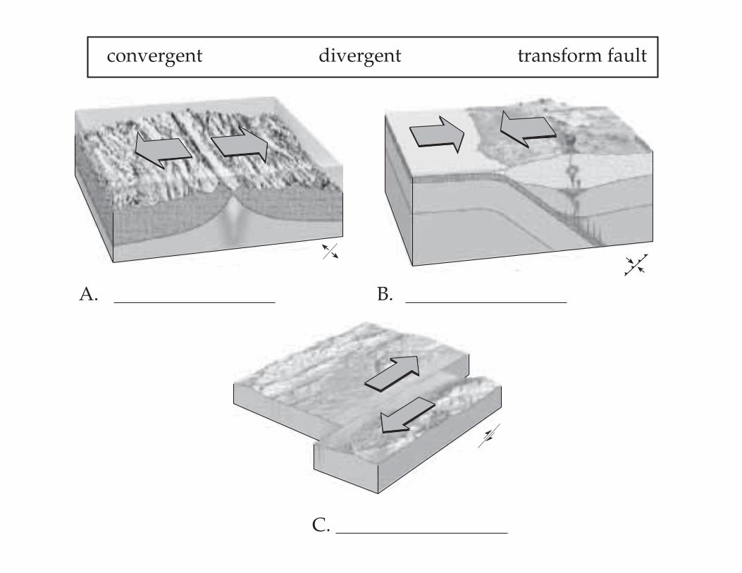
A. B.
C.
convergent divergent transform fault
▲
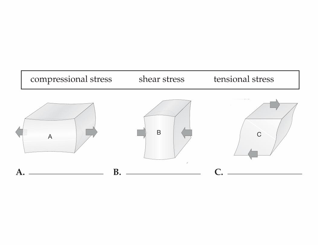
A. B. C.
compressional stress shear stress tensional stress
A CB
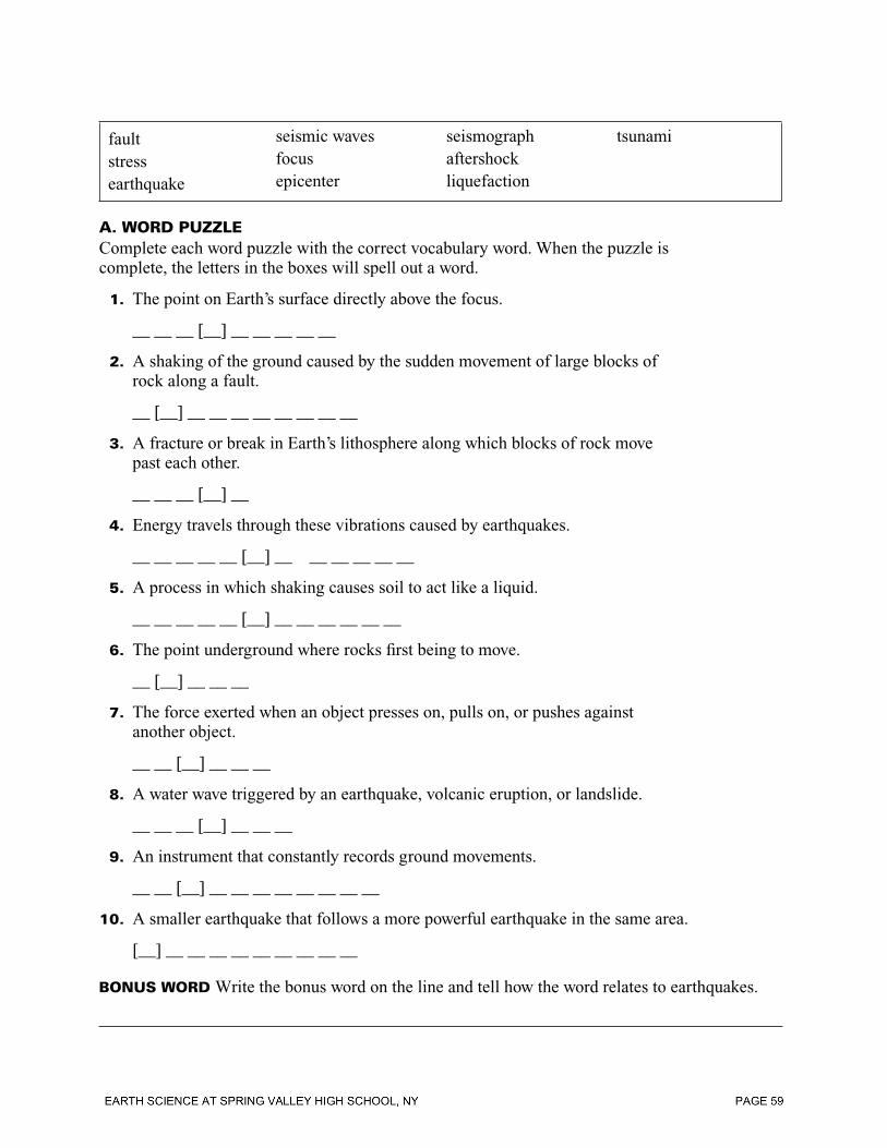
faultstressearthquake
seismic wavesfocusepicenter
seismographaftershockliquefaction
tsunami
A. WORD PUZZLEComplete each word puzzle with the correct vocabulary word. When the puzzle is complete, the letters in the boxes will spell out a word.
1. The point on Earth’s surface directly above the focus.
__ __ __ [__] __ __ __ __ __
2. A shaking of the ground caused by the sudden movement of large blocks of rock along a fault.
__ [__] __ __ __ __ __ __ __ __
3. A fracture or break in Earth’s lithosphere along which blocks of rock move past each other.
__ __ __ [__] __
4. Energy travels through these vibrations caused by earthquakes.
__ __ __ __ __ [__] __ __ __ __ __ __
5. A process in which shaking causes soil to act like a liquid.
__ __ __ __ __ [__] __ __ __ __ __ __
6. The point underground where rocks fi rst being to move.
__ [__] __ __ __
7. The force exerted when an object presses on, pulls on, or pushes against another object.
__ __ [__] __ __ __
8. A water wave triggered by an earthquake, volcanic eruption, or landslide.
__ __ __ [__] __ __ __
9. An instrument that constantly records ground movements.
__ __ [__] __ __ __ __ __ __ __ __
10. A smaller earthquake that follows a more powerful earthquake in the same area.
[__] __ __ __ __ __ __ __ __ __
BONUS WORD Write the bonus word on the line and tell how the word relates to earthquakes.
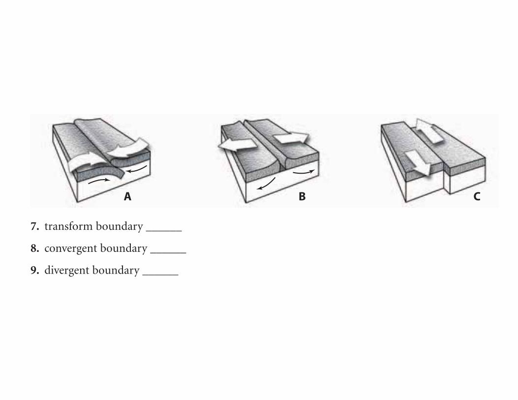
A B C
7. transform boundary ______
8. convergent boundary ______
9. divergent boundary ______