e please attach an annotated copy - scgov.net
TRANSCRIPT

SA-2021-01 21-101910 GA Rcv'd 1/08/2021Exhibit A -
APPLICATION FOR COMPREHENSIVE PLAN AMENDMENT Planning and Development Services Department
1660 Ringling Blvd., 1st Floor Sarasota, FL 34236
Telephone: 941-861-5244 Fax: 941-861-5593 E-mail: [email protected]
FORMAL REQUEST I hereby request the Sarasota County Commission to amend The Sarasota County Comprehensive Plan by revising:
The Future Land Use Map by changing from Neighborhood Commercial Center to Major Employment Center
Other Comprehensive Plan Amendment Application Type: _______ (Attach Narrative)
For Future Land Use Map amendments, please attach a legible map that depicts an area that includes the subject property, the surrounding area for a distance of not less than 2,000 feet from the boundaries of the subject property, and one or more major thoroughfares. All parcel boundaries should be shown. The Future Land Use Map designations should be indicated. The property that is the subject of the amendment should be outlined on the map and the requested change should be noted in the legend. If a new Commercial Center or Commercial Highway Interchange designation is being requested, whose boundaries will have to be defined through the Critical Area Planning Program, the applicant shall show the applicable Future Land Use Map symbol rather than a specific boundary delineation.
_.00_ Small Scale Comprehensive Plan Amendment (proposing a Future Land Use Map change
D only, for a parcel 10 acres or less in size)
__ Large Scale Comprehensive Plan Amendment(> 10 acres in size) ___ill_ Maps in the Future Land Use Series (listed in Future Land Use Policy 1.1.2.)
Please attach an annotated copy of the map(s) as adopted.
E Goals, Objectives, Policies and/or Guiding Principles and/or Provisions for Evaluating Developments in Native Habitats
Please attach a page(s) showing the proposed text revisions with additions underlined and deletions shown struck through. see attached
Please be sure to refer to page 7 for County Charter language governing Board approval of Comprehensive Plan Amendments.
PAYMENT OF FEES All expenses of advertising, notice, staff review, and processing shall be paid by the Petitioner under the County's billable fee system pursuant to Resolution No. 18-057. The Billable Fee Payment Agreement, is included in this application form, and must be submitted with the application.
Revised 3/15/2019

SA-2021-01 21-101910 GA Rcv'd 1/08/2021
FUTURE LAND USE MAP REVISIONS If a Future Land Use Map revision is being requested, please answer the questions in this section.
If a Commercial Center or Commercial Highway Interchange designation is being requested, whose boundaries will have to be defined through the Critical Area Planning Program, the applicant shall use the maximum area permitted by the designation for all market demand and impact calculations. Do not include a concept plan with your application.
Existing Land Use 1. What is the acreage of the property proposed for redesignation? 8.87 Acres (Not
applicable to new Commercial Center and Commercial Highway Interchange designation requests)
2. Are there any buildings on the property? _D_ YES ill NO a. If YES, please describe briefly:
3. Please attach a description of the land uses on all surrounding properties. An aerial photograph should be submitted to accompany the description. The boundaries of the amendment area should be indicated on the photograph. If the owner of the subject parcel(s) also own parcels adjacent to the subject parcel, please indicate the location of these parcels. In the case of a request for a proposed new Commercial Center or Commercial Highway Interchange designation, existing land uses should be described for a distance of at least 1,000 feet from the intersection, but no parcel boundaries should be indicated.
4. If there are native habitats on the property, please indicate the native habitat areas, as categorized on the Land Cover Map in the Comprehensive Plan, on an aerial photograph. If an environmental assessment has been done please attach the report to this application.
Availability of Public Facilities 5. Is the property located within the Urban Service Boundary? [iJ YES O NO
a. If no, would the proposed designation require an extension of the Urban Service Boundary?
D YES __..n ___ NO
Please be sure to refer to page 7 for County Charter language governing Board approval of Comprehensive Plan Amendments.
6. Is the property located within a Future Urban Service Boundary? _O_YES __OO_No
Wastewater Facilities 7. What is the estimated maximum wastewater flow per day that would be generated if the
property were developed under the proposed designation as compared with the present designation? Please answer in gallons per day and show calculations.
2
Revised 3/15/2019

SA-2021-01 21-101910 GA Rcv'd 1/08/2021
See attached narrative
8. Is the property within a wastewater service area? [i] YES O NO (if yes, please answer the following questions)
a. Which wastewater service area? Sarasota County -----------------calculated for the proposed designation? ~ YES NO
b. Is there adequate capacity at the wastewater ~ment fafr,il · serve the flow
c. Would a line extension be needed to serve the property? YES [iJ NO d. If yes, please describe the route of the proposed line extension.
e. Is the line extension described above listed in the f.2mjnty's most r=tly adopted Five Year Schedule of Capital Improvements? _L_J_ YES ~ NO
f. If the answer to 8e is NO, is the needed line extension I~ in Tabl~-4: Future Capital Improvements - in the Comprehensive Plan? J_j_YES ---1.!.l_NO
Potable Water Facilities 9. What is the estimated maximum demand for potable water that would be generated if the
property were developed under the proposed designation as compared with the present designation? Please answer in gallons per day and show calculations. See attached narrative
10. Is the property within a potable water service a as shown qn...1;1ap 12-8: Potable Water Service Areas in the Comprehensive Plan. ~ YES __LJ_ NO (if yes, please answer the following questions)
a. Would a line extension be needed to serve the property? 0 YES [iJ NO b. If yes, please describe the proposed route.
c. Is the line extension described above listed i~ County's J.jrecently adopted Five Year Schedule of Capital Improvements? _L_J_ YES • NO
3
Revised 3/15/2019

SA-2021-01 21-101910 GA Rcv'd 1/08/2021
Stormwater 11. In which drainage basin is the property located?_s_ar_as_o_ta_B_ay ____________ _
12. Has a Basin Master Plan been approved by the County for that basin? J!lYEs il_No a. IfYES, does the Basin Master Plan show that the drainage~tem that~uld be impacted
meets current minimum adopted level of service criteria? __L!J_ YES _J_J__ NO b. If NO, please describe the nature of the deficiencies.
See attached narrative
c. If there are deficiencies are the improvements needed to correct the problem listed in the CP!lllty' s most recently adopted Five Year Schedule of Capital Improvements? ..l__L YES [iJ NO
13. Is any portion of the property within a 100 Year Floodplain as shown on the applicable Basin Master Plan? (If a Basin Master Plan has not been approved, use a County approved study, if applicable, or the flood maps of the Federal Emergency Management Agency.)
MAP SOURCE ilYEs _OO_No a. If YES, please indicate the approximate percentage of the total area that lies within the
100 Year Flood Plain as depicted on the map resource cited above. __
14. Is any portion of the property located within a Hurricane Vulnerability Zone?
MAP SOURCE
Note: Hurricane Vulnerability Maps may be found at all County public libraries. For more information, contact Sarasota County Emergency Management Services at 861-5000.
a. If YES, please indicate the approximate percentage of the property that is located within the hurricane vulnerability zone or in the case of more than one zone, the percentage in each zone.
4
Revised 3/15/2019

SA-2021-01 21-101910 GA Rcv'd 1/08/2021
Transportation 15. Please calculate the traffic generation potential of the maximum allowable intensity/density
of the proposed designation as compared with the present designation. The assumptions used in this determination should be shown. See attached narrative
a. Please describe the traffic impact area. See attached narrative
b. Can the additional traffic impact of the requested designation change be supported by the County's Thoroughfare Plan?
_D_ NO (if NO, please answer 15c) ~ YES (if YES, please answer 15d)
c. IfNO, identify any additional roadway improvements that would be needed that are not included in the most recently adopted Five Year Schedule of Capital Improvements, or Table 14-2: Facilities with Unfunded Capital Improvements - or Map 10-8: Year 2040 Future Thoroughfare Plan in the Comprehensive Plan.
Not Applicable
d. If YES, identify the additional roadway improvements, if any, that are in the Year 2040 Future Thoroughfare Plan that would need to be made to support the proposed designation.
Not Applicable
5
Revised 3/15/2019

SA-2021-01 21-101910 GA Rcv'd 1/08/2021
Plans Affecting the Area 16. Please check any other County approved plans that affect the property.
Critical Area Plans (please cite ordinance number) _1-_1s_c_o_rr_id_or_P_1a_n ___________ _
Development of Regional Impact (please name) -----------------Myakka River Protection Plan Community Plan------------------Other (please name) __________________________ _
Neighborhood Workshop 17. Please indicate the date and location of the workshop conducted by the Petitioner.
Date Wednesday, July 31, 2020 Location zoom call ---------------Attach a copy of the Neighborhood Workshop newspaper advertisement, summary minutes of the workshop and attendance sheet.
PLAN COMPATIBILITY 18. Provide a narrative describing the justification for this request using the applicable
Supportive Material, including how the Goals, Objectives, and Policies of the Future Land Use Chapter and those of any other affected chapters are met or futhered. (Attach additional page( s) if needed.)
See attached narrative
6
Revised 3/1 5/2019

SA-2021-01 21-101910 GA Rcv'd 1/08/2021
COUNTY CHARTER LANGUAGE PERTAINING TO COMPREHENSIVE PLAN AMENDMENTS
2.2A(l) Provided, however, any ordinance amending Sarasota County's Comprehensive Plan which increases allowable land use density or intensity, shall require an affirmative vote of a majority plus one of the full membership of the Board of County Commissioners. (Added 11/6/2007.)
2.2A(2) Provided further, that from and after the effective date of this sub-section
2.2A(2), any ordinance amending Sarasota County's Comprehensive Plan which either: (I) adds lands lying outside the Urban Service Area Boundary to the Urban Service Area; (2) establishes new Future Land Use Overlay Districts which increase the allowable land use density or intensity on lands lying outside the Urban Service Area Boundary; or, (3) adds lands outside the Urban Service Area Boundary to either the Settlement Area Overlay or the Affordable Housing Overlay, shall be fiscally neutral and shall require the unanimous affirmative vote of the full membership of the Board of County Commissioners. July 2012 Edition 9
"Urban Service Area" shall mean that area delineated on that certain map titled "Future Land Use Map of Sarasota County," on file in the official records of the Clerk to the Board of County Commissioners.
This sub-section 2.2A(2) shall not apply to amendments to the goals, objectives, and policies of the Sarasota 2050 Resource Management Areas or to the Land Use Maps approved as part of Sarasota 2050.
This sub-section 2.2A(2) shall not apply to comprehensive plan amendments that were approved for transmittal to the Department of Community Affairs prior to January 1, 2008.
Any proposed ordinance amending Sarasota County's Comprehensive Plan eliminating the Urban Service Area Boundary from Sarasota County's Comprehensive Plan shall be subject to voter approval at a referendum election called for that purpose. (Pursuant to Section 163 .3167 (8), Florida Statutes, the requirement of a referendum for a Comprehensive Plan Amendment is prohibited.)
No Charter amendment adopted after the effective date of this sub-section 2.2A(2) that deals with the extent of or process for altering the Urban Service Area in Sarasota County's Comprehensive Plan shall become effective unless that amendment explicitly provides for the repeal of this sub-section 2.2A(2). (Added sub-section 2.2A(2) 5/6/2008)
Link to Countv Charter
7 Revised 3/15/2019

SA-2021-01 21-101910 GA Rcv'd 1/08/2021
Attachment H
The proposed Comprehensive Plan Amendment and Rezoning/Special Exception can be found to be consistent with and further the following Goals Objectives and Policies. Where there are specific Goals Objectives and Policies that were intended to be specially addressed by the DRC, detailed responses are identified in greater detail in specific sections of the Cover Transmittal Letter.
ENVIRONMENT
Environmental Objective 1.1 Ecological communities and habitats
Identify, manage, and protect ecological communities, and native habitats.
Environmental Policy 1.2.1
Land uses and land and water development shall be consistent with and governed by the Environmental Values and Functions of Sarasota County's native habitats in accordance with the Management Guidelines set forth in the "Principles for Evaluating Development Proposals in Native Habitats."
FUTURE LAND USE (FLU)
FLU Policy 1.1.1
The Comprehensive Plan is intended to provide for the future use ofland in Sarasota County and contemplates a gradual and ordered growth. The Future Land Use Map establishes a long-range maximum limit on the possible density and intensity of land use; it does not simultaneously establish an immediate minimum limit. The present use of land may, by the adopted Zoning Atlas, continue to be more limited than the future use designated on the Future Land Use Map (Map 7-3) based on special circumstances identified during project review. Special circumstances include, but are not limited to the following:
1. Site characteristics
2. Availability of necessary public infrastructure; and
3. Compatibility with surrounding development patterns.
FLU Objective 1.2
The FLUM shall reflect the Policy direction set forth within the chapters of the Comprehensive Plan, and shall coordinate land use categories with soil and topographic characteristics, the protection of historical and natural resources, existing land uses, forms of development and the availability of public facilities.
1

SA-2021-01 21-101910 GA Rcv'd 1/08/2021
FLU Policy 1.2.14
In addition to areas designated on the Future Land Use Map, Medium and High Density Residential development, as defined in FLU Policies 2.3.4 and 2.3.5, shall be permitted uses in the following situations:
• within Commercial Centers provided that residential uses do not exceed twenty-five percent of the total Commercial Center acreage and that the location and use are consistent with the adopted Critical Area Planning Regulations. The acreage associated with multi-store mixed use buildings, where the first floor of the building is required to be used for commercial/ office uses, shall not be counted as "residential acreage" for the purposes of this standard.
• within Commercial Corridors, provided that the plan meets the standards set forth in FLU Policy 2.5.4;
• as a single or mixed use within Office/Multi-Family Residential designations, provided that the parcel is of sufficient size to enable a site design that provides adequate access and circulation, and buffering from adjacent uses.
• within Major Employment Centers where such residential development may be approved provided that the residential use is part of a mixed-use development.
• within Developments of Regional Impact, where such residential development may be approved as part of a Planned District (PD), and where such residential development may be approved as part of a Planned Unit Development (PUD), in accordance with the Sarasota County Zoning Regulations; and
• within Future Land Use Map Designated Village Centers upon completion of the relevant Village Center Plan.
FLU Policy 1.2.17
As reflected in Sarasota County Zoning standards, potential incompatibilities between land uses due to the density, intensity, character or type of use proposed, shall be mitigated through site and architectural design techniques including but not limited to any or all of the following: • provision and location of open space, perimeter buffers, landscaping and berms; • the location and screening of sources of light, noise, mechanical equipment, refuse areas, delivery areas and storage areas; and, • the location of road access to minimize adverse impacts, increased building setbacks, step downs in building heights.
FLU Policy 1.2.2
All development shall be consistent with the Environment Chapter.
FLU Policy 1.3.1
The Sarasota County Zoning Regulations shall set forth a hierarchy of zoning districts and associated buffering/open space requirements, based on the density and intensity of permitted
2

SA-2021-01 21-101910 GA Rcv'd 1/08/2021
uses, for the purpose of establishing appropriate development ratio standards commensurate with the parcel size and compatibility with adjacent uses.
FLU Policy 1.3.4
Applicants for land use amendments to the comprehensive plan, rezonings and special exceptions shall hold at least one advertised neighborhood workshop prior to the application being submitted to the Planning and Development Services Department. The purpose of the workshop shall be for the applicant and community to work collaboratively and discuss the nature of the proposed development, to solicit suggestions and concerns, and for rezonings and special exceptions to explain the development concept plan where applicable. Applicants will be financially responsible for one hundred percent of the costs associated with conducting the required workshops. Criteria shall be established for the content of these workshops, including time frames and notification requirements for the workshop.
FLU Policy 1.3.5
The approval of all development orders shall be subject to the availability of applicable transportation options as identified in the County Mobility Plan, potable water, sanitary sewer, solid waste, stormwater management facilities, public school facilities, and parks, as defined in the adopted quality /level of service standards.
FLU Policy 1.3.9 The following chart is not intended to identify the only zoning districts that can implement the Future Land Use Map designations. The zone districts identified on the chart are the districts commonly associated with the Future Land Use Map designations listed in the left-hand column. The identified districts are consistent with the comprehensive plan when selected for a site having the land use designation shown on the chart and when the district is also consistent with the goals objectives and policies of the plan; this will usually be the case. An implementing zoning district, which is not specifically identified on this chart, but is consistent with the goals, objectives and policies of the plan, may be selected for a site that is more limited than the Future Land Use Map designation and be consistent with the Comprehensive Plan. In accordance with Policies 1.1.1
of this Chapter, the present use of land and the zoning district associated with that use may, consistent with this plan, be more limited than the future land use designation on the Future Land Use Map.
3

SA-2021-01 21-101910 GA Rcv'd 1/08/2021
----FUTURE LAND USE
10/2.5/2016
ZONE DISTRICTS
RSF RSF RSF RSF RMF RMF RMf RMH RE RE RE OU£ OUR OUA ouc OUM PUD GU 1 2 3 4 1 2 3 1 2 3
low Density X X X X X X X Residential
Moderate Density X X X X l( X X X X Residential
Medium Density Resid;mlial X X X X X X X
fligh Density X X l( X X Residential
Semi-Rural X X l( X
Rural X X X X X X X
ZONE DISTRICTS
CN CG Cl CHI CM 01'1 RSF RMF RMF RMF PCD IR ILW MP GU PED 4 1 2 3
Commercial .. .. .. . . Centers:
Neighborhood X X X X X
VIiiage i X X X X X X X
vmage 11 X X X X X X X
Community X X X )( X X X X
Regl011a! X X X X X X X X
Commerdal Highway X X X )(
Commerdal )( X X X X .. .. .. .. X X X
Corridor
Light Office X x• X X Corridor
Offiee/ Multi·Famlly X X l( l( l( X X X Residential
Major Employment X X X X X X X Center
• Special exceptions not permitted, and rn the light Office designation, OPl/l'O ls required.
FLU Objective 2.4.1
Office uses may be located within designated Commercial Centers, Commercial Corridors, Office/Multi-Family Residential, Light Office, Major Employment Centers, and Future Land Use Map designated Village Centers.
FLU Policy 2.5.1
All commercial development located outside of Commercial Enclaves pursuant to FLU Policy 1.3.3(C), shall be limited to those areas designated as Commercial Centers, Commercial Corridors, Commercial Highway Interchanges, and as allowed by FLU Policy 2.8.3 within Major Employment Centers on the Future Land Use Map.
4

SA-2021-01 21-101910 GA Rcv'd 1/08/2021
FLU Policy 2.5.2
The following classifications of Commercial Centers as designated on the Future Land Use Map shall apply: Neighborhood Centers Myrtle Street and Lockwood Ridge Road Dr. Martin Luther King, Jr. Way and Lockwood Ridge Road 17th Street and Honore Avenue Fruitville Road and McIntosh Road Palmer Boulevard and Honore Avenue Webber Street and Beneva Road Proctor Road and Swift Road Gulf Gate Drive and Beneva Road Laurel Road and Pine brook Road Bee Ridge Road and Mauna Loa Boulevard Bee Ridge Road and Bee Ridge Road Extension S.R. 776 and Manasota Beach Road Village I Centers Colonia Lane and River Boulevard University Parkway and Lockwood Ridge Road University Parkway and Honore Avenue (half) 17th Street and Lockwood Ridge Road Bahia Vista Street and Beneva Road Bee Ridge Road and Tuttle Avenue Bee Ridge Road and Beneva Road Bee Ridge Road and McIntosh Road U.S. 41 and Proctor Road Clark Road and Swift Road Clark Road and Beneva Road S.R. 776 and Artist Avenue S.R. 776 and Englewood Isles Parkway Palmer Ranch Parkway and Honore Avenue Village II Centers US 41 and Central Sarasota Parkway Center Road and Jacaranda Boulevard Fruitville Road and Honore Avenue Bee Ridge and Cattlemen Road Clark Road and Honore Avenue U.S. 41 and Laurel Road Dearborn Street, Pine Street and River Road U.S. 41 and Blackburn Point Road Central Sarasota Parkway and Honore Avenue Venice Avenue and Jacaranda Boulevard University Parkway and North Cattlemen Road Community U.S. 41 and Stickney Point Road U.S. 41 and Venice By Pass Regional U.S. 41 and Jacaranda Boulevard (limited to 134 acres) US 41 and Beneva Road 1-75, University Parkway and North Cattlemen Road
FLU Objective 2.6
Maintain governing regulations for Major Employment Center land uses. flu policy 2.6.1 Industrial and office uses may be located within Major Employment Centers designated areas on the Future Land Use Map.
FLU Objective 2.6.2
Where an area has not been specifically mapped as Major Employment Center, having instead a residential or other non-Major Employment Center future land use designation, such land must be mapped as Major Employment Center on the Future Land Use Map before it can be used for Major Employment Center purposes.
FLU Objective 2.6.3
The development of planned office parks including high technology research and development centers shall be encouraged within Major Employment Center areas adjacent to I-75 and its major crossroads as designated on the Future Land Use Map.
FLU Objective 2.6.4
Major Employment Center areas as designated on the Future Land Use Map shall comply with the following:
• be located along major transportation and transit routes; • possess adequate levels of infrastructure.
• be parcels that are large enough to ensure coordinated development and buffering; and
• be in proximity to the labor supply.
5

SA-2021-01 21-101910 GA Rcv'd 1/08/2021
FLU Objective 2.6.5
Lands designated Major Employment Center are intended to further and advance Sarasota County's Economic Development. IR (Industrial and Research) is the preferred implementing district for all rezoning within Major Employment Center designated areas.
FLU Policy 2.6.6
All nonresidential development, excluding in-structure parking, within Major Employment Centers shall be limited to a maximum Floor Area Ratio (FAR) of 1.2 except as provided for below: Mixed use projects, industrial developments and targeted redevelopment areas may exceed the maximum FAR of 1.2 by up to an additional 50% pursuant to an approved Critical Area Plan, Development of Regional Impact (DRI), or Development of Critical Concern (DOCC), which determines that:
• The location and mix of uses and other development standards will encourage pedestrian or other nonautomotive modes of transportation; Mixed use developments shall utilize all of the following techniques:
• Design guidelines and requirements to ensure that new development and redevelopment will prevent, replace, or eliminate blighting influences of outmoded and inefficient development patterns;
• Adequate standards to ensure connectivity and compatibility with appropriate measures to protect any adjacent residential uses;
• Multi-modal access to promote walking, biking and transit; and,
• Connectivity index standards to ensure that the development is walkable.
FLU Policy 2.6.7
The maximum Floor Area Ratio (FAR) for Major Employment Center land uses is a 1.2 FAR. This maximum FAR may be exceeded by up to 50% provided that the proposal is consistent with the requirements outlined in Future Land Use Policy 2.6.6.
FLU Policy Z.8.3
Coordinated and planned mixed use developments including industrial, office, public and civic, commercial, and residential uses shall be encouraged in designated Major Employment Centers (MEC). Residential uses within MEC are intended to provide housing in proximity to employment. The primary land uses in the MEC shall be industrial and office parks. The amount of land dedicated for commercial uses, shall be accessory and incidental to the primary uses allowed within a Major Employment Center. Commercial uses other than industrial and office uses may be permitted as follows:
1. as accessory uses located within a principal industrial or office structure; if free-standing, these uses shall not exceed 12% of the total non-residential building square footage specifically approved through a Development of Regional Impact (DRI), Critical Area Plan (CAP), Development of Critical Concern (DOCC) or Rezone for the employment center and shall be required to be developed with shared parking associated with a principal office, industrial, or other employment use,or
6

SA-2021-01 21-101910 GA Rcv'd 1/08/2021
2. on properties zoned ILW as of January 1, 2012; such commercial uses are limited to a maximum free-standing size of 15,000 square feet per building. However, free-standing retail commercial buildings larger than 15,000 square feet may be approved by Special Exception, provided that the additional commercial square footage is accessory and incidental to the MEC within it is located.
FLU Policy 2.8.5
Increased residential density to create Affordable Housing may be approved by the Board of County Commissioners, pursuant to FLU Policy 1.2.14, within Commercial Centers ( excluding Neighborhood Centers) and Commercial Corridor designations, Office Multi-Family Residential designations, Major Employment Center designated areas, and Civic and Government land use designated areas.
FLU Objective 3.1
Maintain an Urban Service Area Boundary within which development is encouraged by ensuring sufficient developable acreage is available to accommodate the sustainable projected population growth and that adequate concurrency-related public facilities are available concurrent with the impact of development consistent with Florida Statutes.
FLU Policy 3.1.2
Future Land Use Map designations that permit Low, Moderate, Medium and High Density Residential, Major Employment Centers, Light Office Development, Office/Multi-Family Residential, Commercial Centers, Commercial Corridors, and Commercial Highway Interchange uses shall be limited to the Urban Service Area. Such uses, however, are allowed outside the Urban Service Area consistent with an adopted Master Plan approved pursuant to the Sarasota 2050 Plan. In addition, Light Office may be allowed outside of the Urban Service Area where they are consistent with all the following criteria: 1. The proposed use shall have frontage along a 4-6-lane Major Arterial roadway as classified on the Sarasota 2040 Future Thoroughfare Plan; 2. Shall be located within a corridor where more than 50% of the existing parcels within 1,000 feet of the subject parcel as measured along the 4-6-lane Major Arterial roadway are currently nonresidential uses; 3. Shall be located within a corridor where adequate infrastructure is available to serve the subject property. Major Employment Center designated on the Future Land Use Map outside the Urban Service Boundary shall be continued.
FLU Policy 4.1.5
The Critical Area Planning (CAP) regulations shall be updated as necessary, to provide development, redevelopment, and infill opportunities for Critical Areas of Concern such as the following as determined by the Board of County Commissioners:
• Commercial Centers,
• Village Centers,
• Corridors,
• Commercial Highway Interchanges,
7

SA-2021-01 21-101910 GA Rcv'd 1/08/2021
• Major Employment Centers (MEC),
• Sarasota 2050 Plan - Economic Development Resource Management Area (RMA), and
• Other areas determined appropriate by the Board of County Commissioners.
TRANSPORTATION
Transportation Objective 3.2 Land use and transit planning
To coordinate land use planning and land development based upon existing major trip generators or attractors, safe and convenient transit terminals with the provision of public transit service.
Transportation Policy 2.1.2
Maintain and expand inter-modal travel opportunities where financially feasible. Promote car and bicycle sharing at inter-modal faci1ities.
WATER
Water Policy 1.3.5
Development shall provide for easy maintenance of outfalls for discharge of drainage.
WATERGoal2
Sanitary sewer service shall be provided to Sarasota County residents through the continual evolution of a centralized regional wastewater collection and treatment system, and shall be provided in a safe, clean, efficient, economical, and environmentally sound manner, concurrent with urban development.
Water Objective 2.5
Ensure that the issuance of development permits shall be conditioned upon adequate sanitary sewer service capacity.
Water Policy 3.2.3
The county shall continue to require new development to connect to central water systems consistent with the requirements contained in the Land Development Regulations based on the size of the development and distance to the existing system, if the capacity is available in the system and the Utility's rules allow connections to the system.
Water Objective 3.5
Ensure that the issuance of development permits shall be conditioned upon adequate potable water capacity.
8

SA-2021-01 21-101910 GA Rcv'd 1/08/2021
Water Policy 1.2.2
The county shall require that the treatment of stormwater discharge meet standards which will ensure that there will not be adverse impacts on the quality of natural surface waters.
Water Objective 2.2
Maximize the use of existing and available central wastewater facilities and new facilities when they are constructed and discourage urban sprawl.
9

SA-2021-01 21-101910 GA Rcv'd 1/08/2021
Attachment J
The proposed Small Area Comprehensive Plan Amendment necessitates the need to make both text and map amendments to the Sarasota County Comprehensive Plan. Map changes are shown in Attachment K under Plan at a Glance and Map Series. The only text change is related to Section 4 Commercial Center Inventory as the existing Neighborhood Commercial Center acreage is being reduced from 13.88 acres to 2.07 acres as the only remining area designated Neighborhood Commercial is the existing Race Trac Gas Station.
I.AND USE CLEMENT J DAfA AND ANALYSIS
10/25/ 2016
V2-354
SECTION 4: COMMERCIAL CENTER INVENTORY
The inventory of Commercial Centers has been evaluated based upon the Functional
Classification of Commercial Centers (see Table 7-1). There is a recognition that in some centers
the square footage or acreage listed in the Functional Classification of Commercial Centers
table has been exceeded. This reflects historical dev~_Jopment patterns as well as changes in
technology to calculated parcel acreages and does not in and of itself warrant a change in
designation. Staff has reviewed each center and based on function and other factors selected the
most clearly applicable designation.
TABLE 7-2: INVENTORY OF COMMERCIAL CENTERS
! Ex. SQ. FT.
I EXISTING DESIGNATION LOCATION ACRES COMMERCIAL/
OFFICE USES
Neighborhood Bee Ridge Rd and Bee 12.57 49,456 Ridge Rd Ext.
Neighborhood 17th Street and Honore 13.12 93,571 Avenue (83-11-SP)
Neighborhood Bee Ridge Rd and Mauna 13.88 0 Loa Blvd. 2.07
Neighborhood Fruitville and McIntosh 0 * UNDEFI NED
Neighborhood Gulf Gate Drive and 2 19,592 Beneva Road (85-05-SP)
Neighborhood Dr. M L King and 0 *UNDEFI NED Lockwood Ridge Road
Neighborhood Laurel Road and 0 * UNDEFI NED Pinebrook Road
Neighborhood Myrtle Street and 11.78 75,934 Lockwood Ridge Road
Neighborhood Palmer and Honore 4.10 49,456 Avenue
Neighborhood Proctor Road and Swift 12.39 78,920 Road
Neighborhood S.R.776 and Manasota 8 8,108 Beach Rd (NW-SE)
Neighborhood Webber Street and 14.98 157,392 Beneva Road
SARASOTA COUNTY COMPREHENSIVE PLAN f VOLUME 2: DATA AND ANALYSIS

SA-2021-01 21-101910 GA Rcv'd 1/08/2021
ATTACHMENT I
Strike Through and Underline of Previously Adopted Stipulation Contained in Ordinance No. 2014-030 Approving Rezone Petition No. 13-26
The last rezoning approved by Sarasota County on property owned by Terracap BR Partners resulted in approval of Rezone Petition No. 13-26 on a 6.9 Acre +/- parcel located at 6450 Mauna Loa Boulevard, located north of Bee Ridge Road and east of Mauna Loa Boulevard. The rezoning changed the zoning from PCD to CN (Commercial Neighborhood). Ordinance No. 2014-030 approving Rezone Petition No. 13-26 contained seven (7) stipulations adopted as part of the approval. There was also a document entitled Declaration of Covenants and Restrictions Restricting land Uses wherein the Applicant agreed to a series of covenants and restrictions as part of the rezoning. The original Ordinance 2014-030 is contained as in Attachment I as Exhibit 1.
The Applicant has reviewed these previously approved stipulations in Ordinance No. 2014-030 including the Declaration of Covenants and Restrictions Restricting land Uses. Using a strike through and underline technique, the Applicant has determined which stipulations were no longer needed or requiring modification. Specific justification in terms of which stipulations were retained, eliminated or modified are identified below each stipulation, as shown in italics.
1. Access to/from Mauna Loa Boulevard, less than 500 feet north of Bee Ridge Road, shall be restricted to right-in/right-out only.
Justification: The Applicant has determined this Stipulation is still valid and should remain applicable.
2. Access to Bee Ridge Road shall be restricted to a right-in/right-out only access, no closer than 440 feet east of Mauna Loa Boulevard.
Justification: The Applicant has determined this Stipulation is still valid and should remain applicable.
3. Prior to or concurrent with the development of the subject parcel, the developer/owner shall design and construct a westbound to northbound right tum lane on Bee Ridge Road to serve the right in/right out access. The right turn lane shall be designed in accordance 1.vith IndeJces 301 and 526 of the Florida Department of Transportation's Roadway and Traffic Design gtandards. The improvements shall be included in the construction plans for the de11elopment.
Justification: The improvements have already been made.
4. The Master Surface Water Management Plan shall be consistent with the Phillippi Creek Basin Master Plan.
Justification: The Applicant has determined this Stipulation is still valid and should remain applicable.
5. All stormwater treatment shall be open and above ground.
Justification: The Applicant has determined this Stipulation is still valid and should remain applicable.

SA-2021-01 21-101910 GA Rcv'd 1/08/2021
Mr. Todd Dary, AICP Page 2 of2
6. Development of the subject property shall include a 50-foot, 0.10 opacity landscape buffer along the Bee Ridge Road property frontage.
Justification: The Applicant has determined this Stipulation is still valid and should remain applicable.
7. Commercial and office square footage shall aot e*ceed 92,800 square feet within the boundaries of the subject parcel.
Justification: The Applicant has determined this Stipulation is no longer valid.
DECLARATION OF COVENENTS AND RESTRICTIONS RESTRICTING LAND USES
A complete new set of Declaration of Covenets and Restrictions Redstriction Land Uses is below as follows:

SA-2021-01 21-101910 GA Rcv'd 1/08/2021
DECLARATION OF COVENANTS AND RESTRICTIONS
RESTRICTING LAND USES
This Declaration of Covenants and Restrictions Restricting Land Uses (hereinafter referred to as
"Covenant") is made this~ day of No1,eFRber 2014 2021, by TERRACAP BR PARTNERS,
LP., a Florida Limited Partnership (hereinafter referred to as "TerraCap" and/or "Declarant), for itself, its
successors and assigns, whose mailing address is 100 Sheppard Avenue East, Suite 502, Toronto, ON M2N
6-N5 CA.
RECITALS:
A. WHEREAS, TerraCap is the present record owner of a parcel of land within unincorporated
Sarasota County, Florida, which is approximately &91.75 acres in size and generally located North of Bee Ridge Road and East of Mauna Loa Boulevard, described in Exhibit "A" attached hereto and
incorporated herein by reference, (hereinafter referred to as the "Property"); and
B. WHEREAS, Declarant has previously made that certain DECLARATION OF COVENANTS AND
RESTRICTIONS RESTRICTING LAND USES, ("Original Covenant"), dated November 21, 2014, and
recorded the same in the public records of Sarasota County, Florida beginning at Official Records Instrument #2014144958, which Original Covenant applied to a parcel of land within
unincorporated Sarasota County, Florida, which was more particularly described and depicted in
Exhibit A thereto.
C. WHEREAS the Property is currently zoned Planned Commercial Development (PCD) and
Commercial Neighborhood (CN) pursuant to the Sarasota County Zoning Regulations; and
WHEREAS, TerraCap desires to re-zone the Property to CoFRFRercial Neighborhood PCD with a
Binding Development Concept Plan under the Sarasota County Zoning Regulations Unified
Development Code (UDC) Regulations, and
D. WHEREAS, in order to change the zoning designation of the Property as described in Recital C.
above, TerraCap has submitted to Sarasota County a Rezoning Petition to change the zoning
classification of the Property from Commercial Neighborhood to PCD with a Binding Development
Concept Plan; and
E. WHEREAS, TerraCap has voluntarily decided and determined that, in the event Sarasota County
shall approve the Rezone Petition, they will and do hereby voluntarily, and without any request
or coercion, duress or influence, direct or indirect by Sarasota County to do so, restrict the uses
that may be developed on the Property for the benefit of the Property, TerraCap and Lake
Sarasota Community Group, INC., a Florida Non Profit Corporation, (hereinafter referred to as
"LSCG"); and

SA-2021-01 21-101910 GA Rcv'd 1/08/2021
F. WHEREAS, TerraCap therefore desires to impose the restrictions contained within this Covenant
upon the Property for the benefit of the Property, TerraCap and LSCG.
G. WHEREAS, Original Covenant reserved in Section 8 of the of the Original Covenant the right in its
sole discretion and by an instrument filed of record, to modify, enlarge, amend, waive or add to
the Original Covenant. Declarant now wishes to exercise such authority, and believes it prudent
amend and restate the Original Covenant in its entirety due to the extent and frequency of the alterations to be made.
H. WHEREAS, Declarant intends that the Original Covenant shall be hereafter regarded as
superseded in its entirety by this Covenant, so that to the Original Covenant shall be treated as being of no further force or effect.
NOW THEREFORE, TerraCap does hereby voluntarily and without any request or coercion, duress
or influence, direct or indirectly by Sarasota County to do so, declares that the Property shall hereinafter be subject to the following covenants and restrictions:
1. Land Use Restrictions: Notwithstanding any other uses that might in the future be permitted on
the Property under the Sarasota County Comprehensive Plan,~ Unified Development Code (UDC) Regulations, and any other applicable regulations, the Property as shown in Exhibit A shall
not be used for the following principal uses:
a. Adult Entertainment b. Clubs and Lodges
c. Boarding House
d. ~ntertainFRent 01:1tdoors
e. Townho1:1se (seFRi attached, roof deck, stacked)
f. Asphalt Batching Plant or other Industrial Facility
g. M1:1lti l=aFRily (FR1:1ltiplex, apartFRent)
h. All passenger terminals except limited airport, helipad i. Extreme Sports Facility
j. Bar/Tavern (stand alone) k. Pet Boarding or Resort
I. Firing or Archery Range, indoor or outdoor
FR. COFRl'Rercial Parl<ing
n. Package Store
o. Retail Lumber and Building Supplies
p. All Self Service Storage
q. Car Wash, !=1:111 or Self-Service
r. All Light Industrial Service
s. All Warehouse and Freight Movement and Stockpiling of sand and gravel
[NOTE: All uses will be re-lettered in final version]

SA-2021-01 21-101910 GA Rcv'd 1/08/2021
2. Limited Land Use Restrictions. Notwithstanding any other uses that might in the future be
permitted on the Property under the Sarasota County Comprehensive Plan, ~ UDC
Regulations, and any other applicable regulations, the following limitations on uses shall apply to
the Property:
a. Dry Cleaners are allowed, but no harmful chemical cleaning will occur onsite
b. Veterinary Clinics are allowed, but no boarding kennel; overnight stays for treated
animals is allowed.
c. Sales of Vehicle Parts and Accessories are allowed, but no vehicle maintenance and
repair.
d. For indoor recreation uses, no outdoor component of a game shall be allowed.
e. No permanent tents associated with outdoor activities shall be allowed. f. Truck deliveries to uses facing Bee Ridge Road shall only be allowed between the hours
of 6:00 a.m. to 11:00 p.m. No issues to occur if truck deliveries are internal to the site.
g. For restaurants with frontage on Bee Ridge Road, no live outdoor music shall be
performed at night after 10:00 p.m. and no live outdoor disc jockey shall perform at
night after 10:00 p.m.
h. Terracap BR Partners will refer to the noise study that is submitted during the
application process to minimize and mitigate noise impacts and potential noise related
concerns that LSCG may have.
3. Lighting Standards. All lighting will meet dark sky requirements by providing a photometric
lighting plan, which will have the lowest possible light levels occurring at the property boundary.
4. Terms Used. The terms used in Paragraph 1. (a)-(s) and Paragraph 2. (a)-(h) shall have the same
meaning ascribed to such terms by the Sarasota County~ UDC Regulations.
5. Covenants to Run with the title to the Property. The Original Covenant is hereby replaced by this
Covenant and the Original Covenant shall be treated as being of no further force or effect. The
provisions of this covenant shall be deemed to run with the title to the Property applicable to the area identified in Exhibit A. and shall be binding upon TerraCap, its successors and assigns.
6. Enforcement. The provisions of this Covenant are for the benefit of and shall be enforceable by
TerraCap and LSCG. LSCG or TerraCap may commence an action to prevent and enjoin the
violation of the terms of this Covenant, or to enforce the terms of this Covenant. This Covenant
shall be governed, enforced, and construed in accordance with the laws of the State of Florida. If
any provisions of this Covenant or the application thereof shall be held to be invalid or
unenforceable in a court of law, the remainder of this Covenant shall be fully affected thereby
and each provision of this Covenant shall not otherwise remain valid and enforceable.
7. Prevailing Party. In the event LSCG or TerraCap should commence an action as described herein,
the prevailing party shall be entitled to recover all costs, expenses and reasonable attorneys' fees
(trial and appellate) incurred in connection with such action, in addition to any other relief to
which it or they may be entitled.

SA-2021-01 21-101910 GA Rcv'd 1/08/2021
8. Amendment. This Covenant may be amended by TerraCap, its successors or assigns by recording
an amendatory Covenant in the Public Records of Sarasota County, Florida. However, no such
amendment shall be effective without the prior written consent of LSCG, which consent shall not
be unreasonable withheld. If LSCG does not give its consent or provide its reasons for withholding
same, within 30 days from request, they shall be deemed to have given consent. Notwithstanding
anything in the foregoing to the contrary, TerraCap, its successors and assigns, may unilaterally
amend the Covenant to accommodate adjustments and modifications as may be required by
Sarasota County in connection with its review and approval of any Development Orders for the
Property.
9. Effective Date. This Covenant shall be recorded in the Public Records of Sarasota County, Florida
following final approval of the Zoning Petition by Sarasota County and shall be effective upon such recording. For the purpose of this provision, the term "final approval" shall mean all appeals of
the Zoning Petition have been exhausted and/or all appeal periods have expired.
10. Duration. This Covenant shall continue in full force and effect against the Property from its
recording in the public records and continue until the expiration of twenty (20) years from the
date of recording. Notwithstanding anything in the foregoing to the contrary, TerraCap, its
successors and assigns, may terminate this Covenant if all or any portion of the Property thereof
is changed to a different zoning classification than Commercial Neighl3orhooel PCD.
IN WITNESS WHEREOF, TerraCap has caused this Declaration of Covenants and Restrictions
Restricting Land Uses on the Property to be executed in its name on the date first above written.

SA-2021-01 21-101910 GA Rcv'd 1/08/2021
IN WITNESS WHEREOF, the undersigned Declarant has caused this Declaration of Covenants and Restrictions Restricting Land Uses, this_ day of ____ ~ ___ _
WITNESSES:
Witness Signature
Printed Name of Witness
Witness Signature
Printed Name of Witness
STATE OF FLORIDA)
COUNTY OF LEE)
Terracap BR Partners, LP.,
a Florida limited partnership
By its General Partner, Terracap BR Developers, Inc., a Florida corporation
By: ____________ _
Name: --------------Title: _____________ _
The foregoing instrument was acknowledged before me by means of [ ] physical presence or [ ] online
notarization this day of by as _______ of Terracap BR Developers, Inc. a Florida corporation as General Partner of Terracap BR
Partners, L.P., a Florida limited partnership, on behalf of the corporation and the partnership. He is
personally known to me or did produce------------ as identification.
{Seal)
Signature of Notary Public
Printed Name of Notary Public

SA-2021-01 21-101910 GA Rcv'd 1/08/2021
CONSENT AND JOINDER
KNOW ALL MEN BY THESE PRESENTS that the undersigned, Lake Sarasota Community Group,
Inc., a Florida Non Profit Corporation, hereby consents to the foregoing Amendment and does hereby
ratify all terms conditions, restrictions, and obligations contained in the Amendment.
IN WITNESS WHEREOF the undersigned has caused this Joinder and Consent of Owner to be signed this day of ____ ~ __ _
Lake Sarasota Community Group, Inc., a Florida
Non Profit Corporation
By: _____________ _
Print Name: ___________ _
Title: --------------

SA-2021-01 21-101910 GA
Rcv'd 1/08/2021
~ :,:
z
.--;
EXISTING ZONING: PCD
Exhibit A
;• •• . .; ..
··-' . ; ••
,. .. , •• • ,. .. -' ·, .
• I • .
,· -, ;• ,. ..... ·. .. : _,.. . ;I ,... . :
~ I .; . IL _,,_..• • I': ' • • :*\ .............. I I *• ~ . • ~ : • '~ ~ , I • * ~ , , ' . ..----1 ·, '1'<o *•, : : *• ..,~ • I I ,. r~ ·,. :
: ·, ·, ~ ! I • *• • : • ' I I ' ~ • ' ' . * •. I • . ' \ : : •• •• I I ,. \ \ : I
: \ • \ I I * \ ' \ : • - . ,:. . "._ . I I \ \ \ ...... - •• -.... vrArea of Property * ....... • •
f \ • ~~, :1
D;c~:~=~~~o of I \ f0 AREA OF PCD ~ • Covenants and : i 1 .~"; COMMERCIAL 1M i Restrictions I. : : (1.75 ACRES+/-~ : : ///'//////,·/ '1 .... _ ··-= .! ~ &,:~~$.d~; !
0 200' Scale: 1 "=200'-0"
. . i..·-··-··-··-··-··• L.·-··-··-··-··-··-··'
'$. [ID BEE RIDGE ROAD
Enclave at Bee Ridge Park of Commerce Limits of the Covenants and Restrictions
II
m t1£?ITs Date: 12.22.2020 Copyright @ 2020 Hoyt Architects

SA-2021-01 21-101910 GA Rcv'd 1/08/2021
I
; ,
Exhibit 1
Please record and return to: (Via Inter-Office Mail) Cynthia Spraggins, Administrative Specialist Planning Services 1660 Ringling Blvd., 15' Floor Sarasota, FL 34236
Customer ID# 5223 Charge to: Planning Services Account# 51810000500489
NOTICE OF STIPULATIONS AND LIMITATIONS ENCUMBERING REAL PROPERTY PURSUANT TO THE SARASOTA COUNTY ZONING CODE
RECORDED IN OFFICIAL RECORDS INSTRUMENT# 2014150637 11 PG(S)
December 18, 2014 10 , 02 , 30 AM KAREN E. RUSHING
CLERK OF THE CIRCUIT COURT SARASOTA COUNTY, FL
I llllll lllll lllll lllll lllll lllll lllll lllll lllll lllll llll llll
The following property, located at Mauna Loa Boulevard and Bee Ridge Road in Sarasota County, Florida, owned by Larry Krauss, Terracap BR Partners, L.P. and described in Ordinance No. 2014-030 attached hereto, has been rezoned to a CN (Commercial Neighborhood) zone district pursuant to Rezone Petition No. 13-26 filed by Peter M. Dailey, Agent, and granted by Sarasota County on December 10, 2014 and is subject to the following stipulations and limitations, violations of which shall constitute a violation of the Sarasota County Zoning Code:
(Stipulations and limitations are those described in Section 3 of Ordinance No. 2014-030, attached hereto)
STATE OF FLORIDA COUNTY OF SARASOTA
Before me, the undersigned Notary Public, personally appeared Tate Taylor, Operational Manager, to me known to be the individual who executed the foregoing Notice of Stipulations and Limitations Encumbering Real Property pursuant to the Sarasota County Zoning Code, and he acknowledged before me that he executed the same.
.!7-11.. Witness my hand and official seal at Sarasota County, Florida, this -+-H+---- day of
MARK A. LOVERIDGE . Commlsslon#FF113720
Expires August 16, 2018 8cndod TlwT..,fa,-eoo,antt
State of Florida at Large
This instrument prepared by: CMS

SA-2021-01 21-101910 GA Rcv'd 1/08/2021
RICK SCOTT Governor
December 12, 2014
Honorable Karen E. Rushing Clerk of the Circuit Court Board Records Department Sarasota County 1660 Ringling Boulevard, Suite 210 Sarasota, Florida 34236
Attention: Cheryl Dexter, Recording Secretary
Dear Ms. Rushing:
KENDETZNER Secretary of State
Pursuant to the provisions of Section 125 .66, Florida Statutes, this will acknowledge receipt of your electronic copy of Sarasota County Ordinance No. 2014-030, which was filed in this office on December 12, 2014.
Sincerely,
Ernest L. Reddick Program Administrator
ELR/lb
R, A. Gray Building • 500 South Bronough Street • Tallahassee, Florida 32399-0250 Telephone: (850) 245-6270 • Facsimile: (850) 488-9879
www .dos.state.fl.us

SA-2021-01 21-101910 GA Rcv'd 1/08/2021
ORDINANCE NO. 2014-030
AN ORDINANCE OF THE COUNlY OF SARASOTA, FLORIDA, AMENDING THE OFFICIAL ZONING ATLAS, AS PART OF SARASOTA COUNTY ORDINANCE NO. 2003-052 (AS AMENDED}, CODIFIED IN APPENDIX A TO THE SARASOTA COUNTY CODE, RELATING TO ZONING.-, WITHIN THE UNlNCORPORA TED AREA OF SARASOT~g ~ ,'. COUNTY; PROVIDING FINDINGS; PROVIDING F~:::_:~ c:; ~ ~; AMENDMENT OF THE ZONING ATLAS; PROVIDING~>:~ r-,; -:E·: RESTRICTIONS, STIPULATIONS AND SAFEGUARDS; A Ng~;.; £:: :-: PROVIDING AN EFFECTIVE DATE. -,c-,~, N -=~
c- .... ~{~J c:~~-;: :?. ,·:.;, ---~'- ~ .. BE IT ORDAINED BY THE BOARD OF COUNTY COMMISSIONERS ~~t\RJlSbT~-,: COUNlY, FLORIDA: c=-:g ~ . ·
-;..,
Section I. Findings. The Board of County Commissione~ hereinafter referred to as the "Board," hereby makes the following findings:
A. The Board has received and considered the report of the Sarasota County Planning Commission concerning Rezone Petition No. 13-26, requesting rezoning of the property described herein.
B. The Board has held a public hearing on the proposed rezoning of the property described herein in accordance with the requirements of Sarasota County Ordinance No. 2003-052, codified in Appendii< A of the Saraso1a County Code (hereinafter ''the Zoning Ordinance"), and has considered lhe information received at said public hearing.
C. The rezoning herein granted is consistent with lhe Sarasota County Comprehensive Plan and meets the requirements of the Zoning Ordinance.
D. Pursuant to the provisions of Article Vil of Chapter 94 of the Sarasota County Code, an evaluation has been completed of the impacts that the proposed rezoning of the property described herein will have on the levels of service for parks, drainage, solid waste, roads, mass transit and water and sewer systems. With the exception of the provisions of Section 3 of this Ordinance, adequate levels of service are anticipated to be available.
E. This site is located within a Neighborhood Commercial Center as designated on the Comprehensive Plan Future Land Use Map but had an approved Site and Development plan that included 92,800 square feet of approved commercial buildings prior to the plan amendment that designated this site as part of a Neighborhood Commercial Center.

SA-2021-01 21-101910 GA Rcv'd 1/08/2021
Section 2. Amendment of the Zoning Ordinnnce. The Official Zoning Atlas, adopted under Article 4 of the Zoning Ordinance, is hereby amended by changing the zoning district classification from PCD (Planned Commerce Development) to CN (Commercial, Neighborhood} zone district for the following described property located in Sarasota County, Florida:
The legal description of said property in Sarasota County, Florida, being located north of Bee Ridge Road and east of Mauna Loa Boulevard and being more pnrticularly described as follows: ·
BEGIN AT THE NORTHWEST CORNER OF LOT 2, BEE RIDGE PARK OF COMMERCE, RECORDED IN PLAT BOOK 48, PAGES 2 THROUGH 2F, PUBLIC RECORDS OF SARASOTA COUNTY, FLORIDA; THENCE NORTHWESTERLY ALONG THE EASTERLY RJGHT Of WAY LINE OF MAUNA LOA BOULEVARD (BEING A CURVE TO THE LEFT HA VINO: A RADIUS OF 710.00 FEET, A CENTRAL ANGLE OF 18°39'57", A CHORD LENGTH OF 230.28 FEET AND A CHORD BEARING OF N 25° 16'4 l" W), AN ARC DISTANCE OF 231.30 FEET; THENCE N 55°23'20" E, A DISTANCE OF J 30.48 FEET; THENCE N 89°59'30" E, A DISTANCE OF 593.30 FEET; THENCE S 05°14'52" E, A DISTANCE OF 591.86 FEET TO TI-IE NORTH RIGHT OF WAY OF BEE RJDGE ROAD; THENCE S 89°59'3011 W, ALONG SAID NORTH RJGHT OF WAY AND THE SOUTH LINE OF LOT 3, A DISTANCE OF 358.3 I FEET TO THE SOUTHEAST CORNER OF AFOREMENTIONED LOT 2; THENCE ALONG THE BOUNDARY OF SAID LOT 2 THE FOLLOWING FIVE (5) COURSES: l) N 00°00'3011 W, A DISTANCE OF 138.01 FEET; 2) S 89°59'30" W, A DISTANCE OF 25.00 FEET; 3) N 00°00'30" W, A DISTANCE OF 180.91 FEET; 4) S 89°59'30" W, A DISTANCE OF 190.26 FEET; 5) S 75°17'17" W, A DISTANCE OF 109.56 FEET TO THE
POINT OF BEGINNING.
Section 3. Restrictions, Stipulations and Safeguards. As used in the stipulations hereinafter set forth, the tenn "Owner" shall refer to the Owner or Owners of the property described in Section 2 and their successors and assigns. Upon recording in the public records of Sarasotn County, these stipulations shall be covenants running with the land. The use of the property described in Section 2 of this Ordinance, in addition to the applicable restrictions imposed by the Zoning Ordinance, is hereby further limited by and subject to the following restrictions, stipulations and safeguards:

SA-2021-01 21-101910 GA Rcv'd 1/08/2021
I. Access to/from Mauna Loa Boulevard, less than 500 feet north of Bee Ridge Road, shall be restricted to right-in/right-out only.
2. Access to Bee Ridge Road shall be restricted to a right-in/right-out only access, no closer than 440 feet east of Mauna Loa Boulevard.
3. Prior to or concurrent with the development of the subject parcel, the developer/owner shall design and construct a westbound to northbound right-tum lane on Bee Ridge Road to serve the right-in/right-out access. The right-tum lane shall be designed in accordance with Indexes 301 and S26' of the Florida Department of Transportation's Roadway and Traffic Design Standards. The improvements shall be included in the construction plans for the development.
4. The Master Surface Water Management Pinn shall be consistent with the Phillippi Creek Basin Master Plan.
5. All stormwater treatment shall be open and above ground.
6. Development of the subject property shall include a SO foot, 0.10 opacity landscape buffer along the Bee Ridge Road property frontage.
7. Commercial and office square footage shall not exceed 92,800 square feet within the boundaries of the subject parcel.

SA-2021-01 21-101910 GA Rcv'd 1/08/2021
Section 4. Effective Date. This Ordinance shall take effect immediately upon receipt of official acknowledgment from the Office of the Secretary of State of Florida that this Ordinance has been filed with said office.
AITEST:
KAREN E. RUSHING, Clerk of the Circuit Court and ExOfficio Clerk of the Board of County Commissioners of Sarasota County, Florida.
By{kgs 2 Deputy Clerk

SA-2021-01 21-101910 GA Rcv'd 1/08/2021
Exhibit A
Tue legal descrip tion of said property in Sarasota County. Florida. being located north of Bee Ridge Road and east of Mauna Loa Boulevard and being more particularly described as follows:
BEGIN AT THE NORTHWEST CORNER OF LOT 2, BEE RIDGE PARK OF COMMERCE. RECORDED IN PLAT BOOK 48, PAGES 2 THROUGH 2F. PUBLIC RECORDS OF SARASOTA COUNTY. FLORIDA; TIIENCE NORTHWESTERLY ALONG THE EASTERLY RIGHT OF WAY LINE OF MAUNA LOA BOULEVARD (BEING A CUR.VE TO TIIE LEFT HAVING: A RADIUS OF 710.00 FEET. A CENTRAL ANGLE OF 18°391ST', A CHORD LENGTH OF 230.28 FEET AND A CHORD BEARING OF N 25°16'41" W). AN ARC DISTANCE OF 231.30 FEET: TIIENCE N 55°23'20" E. A DISTANCE OF 130.48 FEET: 1HENCE N 89°59'30" E. A DISTANCE OF 593.30 FEET; THENCE S 05°14'52" E. A DISTANCE OF 591.86 FEET TO THE NORTH RIGHT OF WAY OF BEE RIDGE ROAD; 1HENCE S 89°59'30" W. ALONG SAID NORTII RIGHT OF WAY AND TiiE SOUTII LINE OF LOT 3, A DISTANCE OF 358.31 FEET TO THE SOUTIIEAST CORNER OF AFOREMENTIONED LOT 2: THENCE ALONG THE BOUNDARY OF SAID LOT 2 1HE FOLLOWING FIVE (5) COURSES:
1) N 00°00'30" W, A DISTANCE OF 138.01 FEET~ 2) S 89°59'30" W. A DISTANCE OF 25.00 FEET;
3) N 00°00'30" W. A DISTANCE OF 180.91 FEET:
4) S 89°59'30" W, A DISTANCE OF 190.26 FEET:
5) S 75°17'17" W. A DISTANCE OF 109.56 FEET TO THE POlNT OF BEGINNING.

SA-2021-01 21-101910 GA Rcv'd 1/08/2021
R£COIIOEO IN OFFICIAi. 11£COROS INSTIIUIENT I 2014144958 5 PGISJ
December 05 , 2014 11 · 12 92 M KAR£ll E RUSHINlt
a.ERi( OF TtE CIRCUIT COi.RT SARASOTA COUNTY , FL
pr .e(l,J"a:l Qf
r... eoone. eoone&Kodo Attorneys at Law
P.O. Box 1696 Venice, Ft.34284-1596
111111111111111111
DECLARATION OF COVENANTS AND RESTRICTIONS RESTRICTINC LAND usq
This Declanwon of Covenants and Rcsuictions Rcsuicting Land Uses (hemnoftcr rcfcmd to as "Covenant") is made this ~day of ~seg , 2014, by TERRACAP BR PARTNERS, L.P., a Florida Limilcd Partnership (hereinafter rcfc:m:d to as .. TcmCap"), for ilsclf. i&s successors 1111d assigns. whose malling addras is 100 Sheppard Avenue East. Suite 502, Tonnuo, ON M2N 6-NS CA.
RECITALS:
A. WHEREAS, TcnaCap is the pn:sent r=otd owner of a parcel or land wilhin unfncorporaied Sarasola County, Florida. which is approximately 6.9 acn:s in size and generally locatm North of Bee Ridsc Road and East of Mauna Loa Boulcvord, described in Exhibit .. A" awu:hed hereto and incorponated hemn by reference. (hereinafter mcrrcd to u the "Property"); and
B. WHEREAs. the Property is c:umntly zoned Planned Commerc:iaf Development pursuant to the Sarasota County Zcning Regulations; and
C. WHEREAS. TerraCap desires to ,e.zone die Pnlpeny to Commercial Nelghbomood under the Sarasola County Zcnlng Regulations; and
D. WHEREAS, In order ta dumgc: the zoning designation of the Property as described in Recital C. above, TCITICap has submitted ro Saruota County a Rezoning Petition to change the zoning c:lassif!Calion of the Property to Commcn:ial Neighborhood; und
E. WHEREAS, TenaCap h111 vol11111arily decided and determined that, in lhe event Sarasota Cowtty shall approve the Rezone Petition, they will and do hereby voluntarily. and withoui any request or coercion. duress or infJucnc:e. din:c:t or indirect. by Sarasota County to do so, reslrict lbe ll5CI chat may be developed on the Property for the bencrn of the Prupen:y, TcrnCap and Lakc Sarasoaa Community Group, Inc., a Florida Non Prorn Coporatimt, (hminafter refcm:d to as "LSCG"): and
F. WHEREAS, Tc:rraCap therefore desires to impose the: restrictions contained within &bis Covenant upon die Propcny for the benefit of the Propeny, TcrraCap and LSCO.
NOW THEREFORE, TcnaCap does hereby voluntarily and without any request or coercion, duress or influence, direct or indirect by Sarasota County to do so, declares thllt the: Propcr1y shall hereinafter be subject IO the following covenanu and restrictions:
I. Lapd Ya Rptrfctlogs, Notwithstanding any olhcr uses that might In the future be pcnnitlcd on the Property under die Sarasota County Comprehensive Plan, Zoning Regulations, and miy other npplicable ,qulations, the Propcny shall not be used for the following principal uses:
a. Adule Entcnainmcnt

SA-2021-01 21-101910 GA Rcv'd 1/08/2021
b. Clubs and Lodges c. Boarding House d. Entenainment Outdoors e. Townhouse (semi-attached, roof deck, stacked) f. Asphalt Batching Plant or other Industrial Facility g. Multi-Family (multiplex. apartment} h. All passenger tenninals except limited airport, helipad i. Extreme Spons Facility j. Barffavem (stand-alone) k. Pet Boarding or Resort I. Firing or Archery Range, indoor or outdoor m. Commercial Parking n. Package Store o. Retail Lumber and Building Supplies p. AJI Self-Service Storage q. Car Wash, Full or Self-Service r. All Light Industrial Service s. All Warehouse and Freight Movement and Stockpiling of sand and
gravel.
2. Limited Land Use Restrictions. Notwithstanding any other uses that might in the future be pennitted on the Property under the Sarasota County Comprehensive Plan. Zoning Regulations, and any other applicable regulations. the following limitations on uses shall apply to the Property:
a. Dry Cleaners are allowed, but no hannful chemical cleaning will occur onsite.
b. Veterinary Clinics are allowed. but no boarding kennel; overnight stays for treated animals is allowed.
c. Sales of Vehicle Parts and Accessories are allowed. but no vehicle maintenance and repair.
d. For indoor recreation uses. no outdoor component of a game shall be allowed.
e. No pennanent tents associated with outdoor activities shall be allowed.
f. Truck deliveries to uses fronting Bee Ridge Road shall only be allowed between the hours of 6:00 a.m. to I J :00 p.m.
g. For restaurants with frontage on Bee Ridge Road, no live outdoor music shall be perfonned at night after I 0:00 p.m.
h. For restaurants with frontage on Bee Ridge Road, no live outdoor disc jockey shall perf onn at night after 10;00 p.m.
3. Lighting Standards. All lighting will meet dark sky requirements by providing a photometric lighting plan, which will have the lowest possible light levels occurring at the property boundary.
4. Terms Used. The terms used in Paragraph I. (a) - (s) and Paragraph 2. (a} - (h} shall have the same meaning ascribed to such terms by the Sarasota County Zoning Regulations.
2

SA-2021-01 21-101910 GA Rcv'd 1/08/2021
5. Covenants to Run with the Title to the Property. The provisions of this Covenant shall be deemed to run with the title to the Property and shall be binding upon TerraCap, its successors and assigns.
6. Enforcement. The provisions of this Covenant are for the benetit of and shall be enforceable by TerraCap and LSCO. LSCG or TermCap may commence an action to prevent and enjoin the violation of the tenns of this Covenant. or to enforce the terms of this Covenant. This Covenant shall be governed, enforced, and construed in accordance with the laws of the State of Florida. If any provisions of this Covenant or the application thereof shall be held to be invalid or unenforceable in a court of law, the remainder of this Covenant shall be fully affected thereby and each provision of this Covenant shall not otherwise remain valid and enforceable.
7. Pre\lailing Party. In the event LSCG or TerraCap should commence an action as described herein, the prevailing party shall be entitled to recover all costs, expenses and reasonable attorneys' fees (trial and appellate) incurred in connection with such action, in addition to any other relief to which it or they may be entitled.
8. Amendment. This Covenant may be amended by TerraCap, its successors or assigns by recording an amendatory Covenant in the Public Records of Sarasota County, Florida. However, no such amendment shall be effective without the prior written consent of LSCG, which consent shall not be unreasonably withheld. If LSCG does not give its consent or provide its reasons for withholding same, within 30 days from request, they shall be deemed to have given consent. Notwithstanding anything in the foregoing to the contrary, TerraCap. its successors and assigns, may unilaterally amend the Covenant to accommodate adjustments and modifications as may be required by Sarasoaa County in connection with its review and approval of any Development Orders for the Property.
9. Effective Date. This Covenant shall be recorded in the Public Records of Sarasoaa County, Florida following final approval of the Zoning Petition by Sarasota County and shall be effective upon such recording. For the purpose of this provision the term "final approval" shall mean all appeals of the Zoning Petition have been exhausted and/or all appeal periods have expired.
l 0. Duration. This Covenant shall continue in full force and effect against the Propeny from its recording in the public records and continue until the expiration of twenty (20) years from the date of recording. Notwithstanding anything in the foregoing to the contrary, TerrnCap, its successors and assigns, may tenninate this Covenant if aU or any ponion of the Property thereof is changed to a different zoning classification than Commercial Neighbomood.
IN WITNESS WHEREOF, TerraCap has caused this Declaration of Covenants and Restrictions Restricting Land Uses on the Property to be executed in its name on the date first above written.
3

SA-2021-01 21-101910 GA Rcv'd 1/08/2021
STATE OF FLORIDA COUNTY OF SARASOTA
Th,il fozing instrument W&J ~Wledged 'H{fl • 2014, by /JG,-J 1
pmdy;ea identifiaatieH _. /
4
. . JI before me this ~ day of who is personally known __ -eF-

RZ 21-01 21-101852 GP Rcv'd 1/08/2021
VISION PLANNING & DESIGN, LLC
Mr. Todd Dary, AICP Manager of Current Planning
6912 White Willow Court Sarasota, Florida 34243
941. 780.4166 [email protected]
Sarasota County Planning Services 1660 Ringling Boulevard Sarasota, FL 34236
January 6, 2021
RE: Small Scale Comprehensive Plan Amendment Application on 8.94 +/- Acres Located North of Bee Ridge Road and East and West of Mauna Loa Boulevard from Neighborhood Commercial to Major Employment Center; and Concurrent 13.86 Acre+/- Rezoning/Special Exception from Commercial Neighborhood (CN) with a binding Development Concept Plan and PCD without a Binding Development Concept Plan to PCD With a Binding Plan -Enclave at the Bee Ridge Park of Commerce
Dear Mr. Dary,
Attached, please find a Small-Scale Comprehensive Plan Amendment (CPA) and concurrent Rezone/Special Exception Petition forms as contained in Attachment A. The CPA is limited to an area of 8.94 acres +/- and is intended to redesignate an area located north of Bee Ridge Road and east and west of Mauna Loa Boulevard with a single consistent Future Land Use Plan designation of Major Employment Center (MEC). The majority of the 8.94 +/- acres has a physical address of 6450 Mauna Loa Boulevard. The parcel is currently zoned CN (Commercial Neighborhood) and is located north of Bee Ridge Road and east of Mauna Loa Boulevard in Sarasota, Florida, 34275. The proposed Comprehensive Plan Amendment and Rezoning/Special Exception represents only a portion of Parcel Identification Nos. 0240100030 and 0240140010.
The current property owner TERRA CAP BR PARTNERS LP a Canadian Based Corporation is seeking to obtain a Small-Scale Comprehensive Plan Amendment from Neighborhood Commercial to Major Employment Center. In addition, a concurrent Rezoning from CN and PCD with no Development Concept Plan to PCD with a Binding Development Concept Plan. The proposed PCD Binding Development Concept is proposing a unified mixed-use development containing 270 market rate apartments and 5.11 acres+/- of PCD commercial uses. The Binding Development Concept Plan of the Rezone Petition is contained in Attachment L. Exhibit 8 of Attachment K illustrates the areas of the rezonmg
The proposed Small-Scale CPA and Rezoning application demonstrate the appropriateness of creating one overall PCD development under the Future Land Use Plan designation of Major Employment Center

RZ 21-01 21-101852 GP Rcv'd 1/08/2021
Mr. Todd Dary, AICP Page 2 of 17
(MEC). Versus the current land use designations of Neighborhood Commercial (NC) and zone districts of CN and PCD with no approved Development Concept Plan, resulting in a hodgepodge of disjointed land use designations and non-defined PCD and CN zoning districts. The proposed plan will create a unified plan for the last remaining undeveloped acreage in this area that was once originally all designated Major Employment Center (MEC). This proposed Comprehensive Plan Amendment is proposing to go back to the original MEC designation.
Executive Summary The proposed Small-Scale Comprehensive Plan Amendment is intended to designate the entire 26.05 acres+/- owned by Termcap BR Partners LP as Major Employment Center (MEC) on the Future Land Use Plan. NOTE: Approximately 3.0 acres+/- located west ofMauna Loa Boulevard (existing parking lot) is already designated MEC and zoned PCD so no change is needed or proposed. This total MEC designation of Termcap BR Partners LP properties will allow the Owners to create a mixed-use development containing a maximum of 270 market rate multifamily units and 5.11 acres +/- of PCD commercial uses. To assist the reader, this Executive Summary is intended to help better understand the intent of the proposed Small-Scale Comprehensive Plan Amendment and Rezone Petition which are admittedly complicated. By examining Exhibits 7, 8 and 9 in the Plan At A Glance contained in Attachment K, it will be easier to understand why and how the context of what the Applicant is proposing on the last remaining undeveloped 23.05 acres+/-, within the overall 73.4 acre+/- acre MEC area in the northeast quadrant ofI-75 and Bee Ridge Road. Major elements of the proposed Small-Scale Comprehensive Plan Amendment and Rezoning are as follows:
• Consistent with Section 124-1014f.2 of the Unified Development Code (UDC), the PCD District allows up to 25% of land area zoned PCD to be developed at 13 dwelling units per acre. Currently there are 66.84 acres+/- of existing PCD zoned lands. After the amendment there will be a total of 73.4 acres+/-. Based upon a total of 73.74 acres+/- which will be designated MEC and would allow all 73 .4 acres +/- designated PCD Zoning in the northeast quadrant of I-75 and Bee Ridge Road. The result would be 18.43 acres+/- (i.e., 25%) that could be used for PCD/Multi Family uses. Based upon the 26.05 acres+/- owned by Terracap BR Partners, only 17.18 Acres+/- are proposed to be used for PCD/Multi Family (i.e., 17.18 x 13 Dwelling Units Per Acre= 223 units). By utilizing dwelling units of< 750 Sq. Ft. in size as allowed by the County, a total of 270 DU are proposed. The balance 5.11 acres+/- would be used as PCD commercial. See Attachment K.
• Based upon the above, the Applicant is proposing to rezone 6.96 acres+/- zoned PCD without a Binding Development Concept Plan (DCP) and 6.9 acres zoned CN with a Binding Development Concept Plan (DCP) to all PCD with a Binding DCP.
• Approximately 5.11 acres+/- are proposed to be used as PCD/Commercial (see Attachment K) which is consistent with the PCD requirements of the UDC provided a Special Exception is requested to exceed 10% of commercial with not more than 5% devoted to Retail Sales and Service, Restaurant, and vehicle Sales and Service Uses.
• The Applicant is requesting a Small-Scale Comprehensive Plan Amendment to redesignate approximately 8.94 acres +/- from Neighborhood Commercial to Major Employment Center (MEC). See Exhibit 7 of Attachment K.

RZ 21-01 21-101852 GP Rcv'd 1/08/2021
Mr. Todd Dary, AICP Page 3 of 17
• The Applicant is requesting a concurrent Rezone Petition on approximately 3.6 acres +/- from PCD without a Binding Development Concept Plan and 6.90 acres+/- zoned CN with a Binding Development Concept Plan to PCD with a Binding Development Concept Plan.
• Consistent with Section 124-10 h. of the UDC, the Applicant is required to fully justify a modification to allow> 5% of PCD retail commercial on the 5.11 acres+/- which amounts to 2.7 acres+/- more than what is permitted unless requested through a Special Exception.
In the interest of expediency, all three Petitions (i.e., Small Scale CPA and PCD Rezoning/Special Exception) are contained in this one application, with references to individual petition applications clearly labeled.
INCLUDED IN THIS PACKAGE ARE THE FOLLOWING ITEMS:
Narrative of proposed project (included herein)
Attachment A - Completed County Application Forms for Small Scale Comprehensive Plan Amendment, and Rezone/Special Exception Petition Application. Includes all signed signature pages.
Attachment B - Neighborhood Workshop Materials from July 23, 2020
Attachment C - Aerial photograph with Property Boundary Marked both areawide and close-up
Attachment D-Boundary and Topographic Survey of the site showing easements and encumbrances
Attachment E - Environmental Assessment prepared by Steinbaum and Associates - January 16, 2020
Attachment F- Transportation Analysis Prepared by Florida Transportation Consultants dated September 2020
Attachment G - DRC Pre-Application Comments and Applicant responses from meeting on May 7, 2020
Attachment H-Applicable Goals, Objectives & Policies of the Comprehensive Plan.
Attachment I- Strike Through and Underline of Previously Adopted Rezone Petition No. 13-26
Attachment J -Required modifications to text portions of the Comprehensive Plan
Attachment K - Plan at a Glance and Map Series Including Future Land Use Plan Map Designation Changed from Neighborhood Commercial Center to Major Employment Center on the Future Land Use Plan Map
Attachment L - Binding Development Concept Plan

RZ 21-01 21-101852 GP Rcv'd 1/08/2021
Mr. Todd Dary, AICP Page 4 of 17
HISTORY
NARRATIVE
The Northeast quadrant of I-75 and Bee Ridge Road including The Enclave At The Bee Ridge Park of Commerce (BRPOC) which is the focus of these petitions, has had a long history of planning and development approvals by Sarasota County. The area has been through numerous Comprehensive Plan Amendments, the I-75 Corridor Plan, numerous Rezonings and numerous Site and Development Plan approvals.
On June 11, 1996 The BRPOC at the time contained approximately 32.79 acres+/- (included existing hotel site) located on either side of Mauna Loa Boulevard, was rezoned to Planned Commerce District (PCD), Groups 1-5. This rezoning was the result of an original request for Industrial Light Warehousing (IL W), which at the final Board of County Commission Hearing, the BOCC decided to rezone the 90 acres +/- acres comprising the northeast quadrant of Bee Ridge Road and I-7 5 as PCD Group 1-5. The rezoning was approved without benefit of a Site Plan and it was essentially left to individual Applicants to determine which PCD Group 1-5 they desired. NOTE: The PCD District no longer uses the PCD Group 1-5 concept.
In December 2001, a 8.94 acre+/- portion of The BRPOC was approved for a Comprehensive Land Use Plan Amendment for a Neighborhood Commercial Center through RU-84 (Ordinance No. 2001-094). The area defined in the Comprehensive Plan Amendment was not defined by a legal description. However, in 2003 as part of the Zoning Code update, the Growth Management Staff proposed specific boundaries of all Activity Centers approved in Sarasota County. An 8.94 acre+/- area, is what is now being requested to be redesignated from Neighborhood Center to Major Employment Center through the current Small-Scale Comprehensive Plan Amendment and rezoning from CN to PCD with a Binding Development Concept Plan
From 2001 to 2003 The BRPOC as a whole was approved for Site and Development Approval for specific uses in the project which vested the traffic/water and sewer impacts, and stormwater management was created for the entire project. All environmental, drainage, traffic, site layout and land use issues were resolved and approved. Mauna Loa Blvd. has been constructed through The BRPOC. All land clearing activities have been completed. The drainage lakes and structures have all been completed. The wetlands and littoral shelf creation are completed. Improvements to Bee Ridge Road at the intersection of Bee Ridge Road and Mauna Loa Boulevard have been completed. Water and sewer lines are in p[lace along Mauna Loa Blvd. and stubbed out ready for extension as the parcels are brough on line.
The last rezoning approved in the BRPOC was in 2014 through Rezone Petition No. 13-26 and Ordinance No. 2014-030 rezoned the subject 6.9 acres+/- from PCD to CN. The current Rezone Petition is a request to rezone the subject 6.9 acres+/- from to CN with a Binding Development Concept Plan and 6.96 acres +/- from PCD without a Binding Development Concept Plan to PCD with a Binding Development Concept Plan. Attachment K which shows the limits of the 13.86 acres+/-.

RZ 21-01 21-101852 GP Rcv'd 1/08/2021
Mr. Todd Dary, AICP Page 5 of 17
PROPOSED COMPREHENSIVE PLAN AMENDMENT PROPOSAL
The Enclave at Bee Ridge Park of Commerce (BRPOC) is located in the northeast quadrant ofl-75 and Bee Ridge Road in an area east and west of Mauna Loa Boulevard. The request is a Small-Scale Comprehensive Plan Amendment to the Future Land Use Map to change the designation on 8.94 acres +/- from Neighborhood Commercial Center to Major Employment Center (MEC). This amendment necessitates a need to amend Section 4 Commercial Center Inventory Volume 2: Data and Analysis of the Comprehensive Plan to reflect the revised acreage of the Bee Ridge and Mauna Loa Blvd. Neighborhood Commercial Center. The Future Land Use Plan Map amendment is proposed to be amended by replacing the Neighborhood Center (NC) designation of all Terracap owned parcels to Major Employment Center and shown in Attachment K.
The reason for this request amendment is related to several factors . The first reason relates to the history of the entire Northeast quadrant ofI-75 and Bee Ridge Road which was originally approved by the Board of County Commissions in 2000 when the entire area was approved as a Maj or Employment Center (MEC) and approved for Planned Commerce District 1-5 without the benefit of a site plan. There were subsequent amendments which then changed the Future Land Use designation to Neighborhood Commercial and then rezoned to CN. However, in retrospect, the type and intensity of a Neighborhood Commercial Center and CN zoning is generally not consistent with being located at an I-75 Interchange, adjacent to a PCD zoned Gas Station/Convenience Store and the need to serve and compliment a MEC area.
A second reason for this request is there are several different zoning categories controlling land use decisions in the Enclave at the BRPOC. Both planning staff and the owners have struggled trying to figure out what is the best category to move development forward. The last zoning request in 2014 through Rezone Petition No. 13-26 and Ordinance No. 2014-030 rezoned 6.9 acres +/- from PCD to CN. Attachment I contain the previously adopted stipulations for Rezone Petition No. 13-26 as contained in Ordinance No. 2014-030 with Strike Through and Underline of stipulations intended to keep those stipulations which are still applicable and eliminate or modify others.
It is important to note the Enclave at The BRPOC is an area that can already be developed under existing CN and PCD zoning for a variety of intensive land uses. Furthermore, the area is already serviced with adequate public water and sewer in place. Likewise, all stormwater and drainage facilities are in place, as are existing setbacks and buffers along the Bee Ridge Road and Mauna Loa Boulevard. Mauna Loa Blvd. is classified as a minor arterial and Bee Ridge is a Major Arterial. There exist dual lefts into the project eastbound to northbound on Bee Ridge Road and Mauna Loa Boulevard. And there exists dual left lane out southbound to eastbound on Bee Ridge Rd. All these factors are rationale for allowing the higher intensity uses than what traditional neighborhood CN zoning is intended to provide.
The existing Race Trac gas station in the northeast quadrant of Bee Ridge Road and Mauna Loa had to remain PCD zoning to allow more than 4 gas pumps. A change to Major Employment Center (MEC) land use designation would solve this inconsistency. Nevertheless, the property is designated Neighborhood Commercial and is not under the ownership of Terracap BR Partners so it must remain unchanged.

RZ 21-01 21-101852 GP Rcv'd 1/08/2021
Mr. Todd Dary, AICP Page 6 of 17
The proposed Enclave at The BRPOC is a request for a Small-Scale Comprehensive Plan Amendment to redesignate 8.94 +/- acres located in the northeast quadrant of the I-75/Bee Ridge Road interchange from Neighborhood Commercial to Major Employment Center. More specifically the Neighborhood Commercial Center which is designated in the northeast and northwest quadrants of Bee Ridge Road and Mauna Loa Boulevard. Graphics in Attachment K identify the exact location of the areas to be amended to Major Employment Center and how the Future Land Use Plan Map will appear if the amendment is approved. The subject 8.94 acre +/- area located both east and west of Mauna Loa Boulevard parcel is vacant. The area east ofMauna Loa Boulevard is located between an existing Race Trac Gas Station and the Big Earth Landscape Supply Business. The area to the west of Mauna Loa Boulevard is a 21. 04 acre +/- area west of the intersection.
PROPOSED REZONING/SPECIAL EXCEPTION PROPOSAL
In addition to the Small Area Comprehensive Plan Amendment to redesignate 8.94 acres+/- from Neighborhood Commercial to Major Employment Center, the Applicant is also filing a Rezoning on the 13 .86 acres+/- (Note: Does not include the existing parking lot of 3.0 Acres west ofMauna Boulevard) owned by Terracap BR Partners or the wetland/preserve area or the stormwater retention areas already zoned PCD. The proposed Enclave at the BRPOC as the project is being called, is being planned within a park like setting and includes on-site stormwater management areas, landscape buffers, extensive landscaping and an interconnected pedestrian network along Mauna Loa Boulevard.
The development will allow a multifamily apartment complex of 270 market rate apartments to be located in three buildings on the northern portion of the site adjacent to an existing hotel. A discussion about how the proposed density is consistent with the 13 units per acre allowed in the PCD District can be found in Attachment G. The Rezoning/Special Exception to PCD will also allow approximately 5.11 acres+/along the frontage of Bee Ridge Road to be used for commercial development within three out parcel buildings labeled as Building E/22,900 S. Ft; Building F/7,080 Sq. Ft. and Building G/7,080 Sq. Ft contains a total of 37,060 Sq. Ft. These three parcels are identified on the Binding Development Concept Plan in Attachment L. The three commercial sites area all well positioned to have modem buildings creating a positive first impression as the frontage structures on the north side of Bee Ridge Road east of I-75. A total of 189 parking spaces are shown along with 50 foot street yard setback and 10 foot landscape buffer.
On May 7, 2020 the Applicant attended a DRC Preapplication meeting with Sarasota County Staff. Comments and responses from the Applicant of specific DRC comments are contained in Attachment G. Otherwise, the following sections contain a discussion about the consistency of the proposed Small Scale Comprehensive Plan Amendment and Rezone/Special Exception Petition with the fact all environmental constraints have been addressed; on-site storm water and drainage are provided: there is availability of potable water and wastewater treatment; internal circulation is being planned; satisfactory levels of service will exist after the completion of the project; proposed land use and zoning are consistent with the PCD District; and overall consistency with various elements of the Unified Development Code and Comprehensive Plan is maintained.

RZ 21-01 21-101852 GP Rcv'd 1/08/2021
Mr. Todd Dary, AICP Page 7 of 17
ENVIRONMENT
The subject parcel has been inspected by Michele Steinbaum and Associates during the month of January 2020 and then further updated in August 2020. The full Environmental Assessment Report is contained in Attachment E. The site reviews were performed in order to gather data relative to on-site habitats and relative to endangered/threatened species. The site reviews resulted in no State and/or federally jurisdictional wetlands exist within the project boundaries and in general, current vegetative associated FLUCS codes for the "project area" are non-native and have weedy/ruderal character.
STORMW ATER DRAINAGE
The project is part of a master storm water management system which provides treatment and attenuation for runoff from the development site. The system will be assessed to verify that it is sufficient to meet the requirements all pertinent codes. If modifications are required, those will be addressed at the time of Site & Development review and approval.
Runoff from the proposed development will be conveyed to the master system via inlets with related piping. All drainage patterns of the master system will be maintained or modified in order to meet current code requirements. Treatment is provided via wet detention and no wetlands are proposed to be impacted by the development.
The master system will maintain previously permitted discharge restrictions or verification of no downstream or upstream impacts will be provided to verify a proposed increase in discharge from the site. The existing Master Stormwater Management system is consistent with and furthers Water Policy 1.2.2, 1.3.1 , 1.3.2, 1.3.5 and Future Land use Element Chapter 7 and Future Land Use Policy 1.2.5.
POTABLE WATER/WASTEWATER TREATMENT
The subject parcel is within the franchise area of the Sarasota County Utilities District, and sewer and water facilities are available along Bee Ridge Road and Mauna Loa Boulevard. Connection would be required at the time of Site and Development Plan submission. Accordingly, the project can be found to be consistent with and further Water Policy 1.2.2, 1.3.1 , 1.3.2, and 13.5.
TRANSPORTATION
The entire subject 26.05 acre+/- area has access to Bee Ridge Road and Mauna Loa Boulevard. Bee Ridge Road is a designated four lane major arterial from I-75 to the Lorraine Road. Mauna Loa Boulevard is a designated two-lane minor arterial from Bee Ridge Road to the northern limits of the Northeast quadrant ofl-75 and Bee Ridge Road. According to the Sarasota County Transportation Department, Bee Ridge Road from I-75 to Lorraine Road is a designated four-lane major arterial on the Future Thoroughfare Plan Bee Ridge Road in front of this parcel currently operates at LOS C and the adopted LOS is D. Likewise, Mauna Loa Boulevard is designated as a minor arterial and currently operates at LOS A and the adopted LOS is C.

RZ 21-01 21-101852 GP Rcv'd 1/08/2021
Mr. Todd Dary, AICP Page 8 of 17
As part of the Comprehensive Plan Amendment a Traffic Analysis dated September 2020 was prepared by Florida Transportation Consultants. The results of this analysis are contained in Attachment F. NOTE: The Applicant acknowledges since the original Traffic Analysis was prepared, minor modifications were made to the commercial square footages on the Development Concept Plan in Attachment L and buildout date that may require updates to the Traffic Analysis. In the interest of expediency, a revised study, if required, would be updated during the Completeness Review.
SCAT Route 14S provides daily service from the site to Downtown Sarasota making this an ideal location for both residents of the area and employees to have ready access to SCAT bus services.
LAND USE/ZONING
The subject 23.05 acres +/- is currently designated in two land use designation which include Major Employment Center (MEC) and Neighborhood Commercial Center on the County Future Land Use Plan Map. The portion designated MEC is for the most part zoned PCD. The portion designated Neighborhood Commercial Center is zoned CN (Commercial Neighborhood). In general, the entire 1-75 and Bee Ridge Road quadrant is designated Major Employment Center, Medium Density Residential and Neighborhood Commercial Center on the County Future Land Use Plan Map and is zoned PCD, RMF-2 and CN.
To the south across four lanes of Bee Ridge Road in the Lake Sarasota Subdivision the area is designated Moderate Density Residential and is zoned RSF-3 (Residential Single Family 3, 4.5 Dwelling Units per acre. NOTE: There are six lanes of traffic separating areas zoned RSF-3 to the south across Bee Ridge Road and the first tier oflots located directly along the south side of Bee Ridge Road are vacant and were purchased by Sarasota County as part of the widening of Bee Ridge Road.
The entire subject area is part of the Urban Service Boundary, which is the area where Sarasota County plans for all major urban services to be provided. Accordingly, this area is adequately served by all major services one would expect within the Urban Service Area. Additionally, there are already significant buffers, setbacks, a large drainage canal and adequate distance from any of the homes in the Lake Sarasota Subdivision across Bee Ridge Road to ensure compatibility with those neighbors. Nevertheless, the Applicant has previously agreed to a series of restrictive covenants with the Lake Sarasota neighborhood to the south across Bee Ridge Road when the property was previously rezoned to CN back in 2014. The Applicant has again worked with the Lake Sarasota Homeowners Group as part of this Comprehensive Plan Amendment Rezoning/Special Exception Applicant. Likewise, the Applicant has discussed modifications to the Restrictive Covenants and agreements agreed to as part of Rezone Petition No. 13-26 when the property was rezoned to CN in 2014. A series of strike throughs and underlines to previous stipulations and the previously adopted Declarations of Covenants and Restrictions is contained in Attachment J.

RZ 21-01 21-101852 GP Rcv'd 1/08/2021
Mr. Todd Dary, AICP Page 9 of 17
COMPATIBILITY
The proposed rezoning to PCD requires a Binding Development Concept Plan which is shown in Attachment L. There are a series oflandscape buffers and setbacks shown throughout the project. Along the southern frontage of Bee Ridge Road there is a 50' street yard setback and 10' landscape buffer. Along the eastern property there is an extensive series of staggered setbacks and landscape buffers to ensure compatibility with the OUE-1 zoned properties to the east. This includes a 35' side yard setback adjacent to these residential areas which includes a 20' enhanced landscape buffer of 0.6 opacity along with a greater than 50-foot retention pond setback. This results in over a 100-foot combination setback/landscape buffer area along the eastern boundary of the subject property line of the BRPOC.
The street landscape buffer along Bee Ridge Road would require a 12 foot landscape buffer for either the CN or PCD zoning. A 50-foot setback/landscape buffer area maintained by the Applicant along the roadway frontage. As previously mentioned, there are already significant buffers, setbacks, a large drainage canal and adequate distance from any of the homes in the Lake Sarasota Subdivision across Bee Ridge Road to ensure compatibility with those neighbors. Furthermore, the Applicant has previously agreed to a series of restrictive covenants with the neighborhood when the property was previously rezoned to CN back in 2014. The Applicant has again worked closely with the Lake Sarasota Homeowners Group to make modifications to the Restrictive Covenants and agreements as contained in Attachment I.
COMPREHENSIVE PLAN CONSISTENCY
Distinctions Between A Neighborhood Commercial Center Versus a Major Employment Center
Neighborhood Commercial Center
According to the Future Land Use Chapter of the Comprehensive Plan and the Unified Development Code, the function of a Neighborhood Commercial Center as implemented by the CN zoning district is intended to permit small-scale, neighborhood-oriented commercial facilities. Their proper development and use shall be facilitated through design techniques and sufficient buffering, which provide for walkable, pedestrian- friendly uses compatible with nearby residential uses. The district is not intended for use by major or large-scale commercial, sales, service or automotive-oriented activities. The primary uses include retail sale of food, drugs, hardware, and similar items and the provision of personal services. Offices and other similar uses are encouraged. Uses in this district are intended to be located within convenient traveling distance from one or several neighborhoods which they will serve. This district allows residential use, including upper story residential dwelling units, in order to promote live-work and mixed-use opportunities. The CN District is generally used to implement the Comprehensive Plan within those areas of the County shown as Regional, Community, Village I, Village II, or Neighborhood Commercial Center, or Commercial Corridor on the Future Land Use Map. According to Table 7-1, a Neighborhood Commercial Center has a service radius of one-half mile or less, a Resident Household Support population of

RZ 21-01 21-101852 GP Rcv'd 1/08/2021
Mr. Todd Dary, AICP Page 10 ofl7
approximately 1,750 residents and contains up to 10 acres. The function of a Neighborhood Commercial Center is to provide for the sale of convenience goods such as food, drugs, hardware, and personal service needs of the surrounding residential areas. These Centers are usually comprised of small-scale facilities that may or may not be anchored by a supermarket.
According to Table 7-2 in the Comprehensive Plan (see Attachment J), the Neighborhood Center at Bee Ridge Road and Mauna Loa Boulevard has the following attributes:
Existing acreage of 13.88 acres and contains O Sq. Ft. of Commercial/Office Uses.
Should the Board of County Commissioners recommend approval of the proposed Small Area Comprehensive Plan Amendment, Attachment J contains a strike through and underline version of the text changes required in FLU Policy 2.5.1 of the Comprehensive Plan and Section 4 Commercial Center Inventory and Table 7-2. Also contained in Attachment K contains a revised Future Land Use Map showing the property re-designated as a Major Employment Center.
Major Employment Center
Excerpts from the Sarasota County Comprehensive Plan related to Major Employment Centers are as follows:
Major Employment Centers (MEC) are designated on the Future Land Use Map to provide locations for employment and economic development opportunities. The MEC designation provides places for people to work other than commercial V2-316 centers. Generally, the criteria used to designate parcels for MEC includes:
• Be located along major transportation and transit routes. • Possess adequate levels of infrastructure. • Be parcels that are large enough to ensure coordinated development and buffering; and, • Be in proximity to the labor pool.
The uses typically found in MEC include light industrial, manufacturing, warehousing and office uses, and combinations of these uses. Accessory and incidental commercial activities within MECs are limited as allowed in the implementing zoning districts. It is not the intent of the MEC designation to be predominantly commercial in nature. The commercial uses are encouraged to be limited to the sale of merchandise produced, manufactured, or distributed within the center, and the internal retail and service needs of employees. Many MEC' s were developed without the benefit of coordinated plans that allocated employment and incidental/ accessory commercial uses. In order to encourage more flexible redevelopment and serve neighborhood scale commercial needs on IL W zoned properties that were existing as of January 1, 2012, ILW zoned properties within MEC's are allowed to provide for a broader range of commercial uses up to a maximum free-standing size of 15,000 square feet per building. Free standing retail commercial buildings larger than 15,000 square feet may be approved on such IL W zoned properties, by Special Exception provided that the additional commercial square footage is accessory and

RZ 21-01 21-101852 GP Rcv'd 1/08/2021
Mr. Todd Dary, AICP Page 11 of 17
incidental to the MEC within it is located. Limited amounts of residential development, provided it is part of a mixed-use development, are also permitted to facilitate access between home and place of work.
Residential development within MEC is encouraged to provide workforce housing. (2011-02-A, Ord. No. 2012-030, August 29, 2012) There are a number of different methodologies that can be used to project MEC needs, often with very different results. Typically, capacity analyses produce outcomes solely measured in raw land (acreages), assuming an unending supply of land, and do not take into consideration underutilized lots and potential for redevelopment, particularly in a development form that better utilizes the property. As discussed in the Redevelopment Section in the Future Land Use Chapter, the Planned Economic Development (PED) zoning district encourages mixed use, a grid pattern, and integrated infrastructure, all of which help to better utilize a site. Another issue not taken into consideration is the changing trend of the industry based on V2-317 technology. Less acreage per employee may be needed due to telecommuting, use of the Internet, and mechanization. Lastly, such capacity methodologies do not take into account locational preferences that vary by employer. The development potential or future capacity for MEC designated lands is discussed in more detail in the Economic Development Element. The existing inventory analysis of MEC indicates that sufficient vacant lands are designated to accommodate growth for the next 25 years. However, input from economic development entities continues to indicate a need for additional MEC lands.
The Economic Development RMA (see Map RMA-1) includes the MEC designated properties in addition to properties designated as Commercial Centers, Commercial Corridors, and areas adjacent to these uses, such as high density residential, where economic development opportunities exist as part of redevelopment efforts. MEC-type uses may also be accommodated through these other designations, especially when redeveloped. MEC development immediately adjacent to the 1-75 Corridor is intended to be of high quality, provide a variety of employment opportunities and enhance the image of Sarasota County. Limited freestanding support uses are allowed to meet the service needs of employees, if the uses are located in discrete, buffered areas, and less visible from the Interstate and its major crossroads. MEC areas are implemented through the following zoning districts: Planned Commerce Development (PCD), Industrial, Light Manufacturing and Warehousing (IL W), Planned Economic Development (PED), Government Use (GU) and Industrial Research (IR). Implementation of the MEC designation is not intended to convert MEC lands to commercial uses.
COMPREHENSIVE PLAN CONSISTENCY
A comprehensive list of the applicable Goals Objectives and Policies of the Comprehensive Plan are contained in Attachment D. However, the following responses are intended to address several specific areas relevant in support of the proposed Small Area Comprehensive Plan Amendment that serve to demonstrate why a Major Employment Center (MEC) implemented through PCD zoning on the subject parcels designated as MEC on the Future Land Use Plan Map.
FLU Policy 1.2.14 States: In addition to areas designated on the Future Land Use Map, Medium and High-Density Residential development, as defined in FLU Policies 2.3.4 and 2.3.5, shall be permitted uses in the following situations:

RZ 21-01 21-101852 GP Rcv'd 1/08/2021
Mr. Todd Dary, AICP Page 12 of 17
• within Commercial Centers provided that residential uses do not exceed twenty-five percent of the total Commercial Center acreage and that the location and use are consistent with the adopted Critical Area Planning Regulations. The acreage associated with multi-store mixed use buildings, where the first floor
of the building is required to be used for commercial/office uses, shall not be counted as "residential acreage" for the purposes of this standard. • within Commercial Corridors, provided that the plan meets the standards set forth in FLU Policy 2.5.4; • as a single or mixed use within Office/Multi-Family Residential designations, provided that the parcel is of sufficient size to enable a site design that provides adequate access and circulation, and buffering from adjacent uses; • within Major Employment Centers where such residential development may be approved provided that the residential use is part of a mixed use development. • within Developments of Regional Impact, where such residential development may be approved as part of a Planned District (PD), and where such residential development may be approved as part of a Planned Unit Development (PUD), in accordance with the Sarasota County Zoning Regulations; and • within Future Land Use Map Designated Village Centers upon completion of the relevant Village Center Plan.
APPLICANT RESPONSE: The proposed CPA is consistent with FLU Policy 1.2.14 and specifically the provision relating to Major Employment Centers where such residential development may be approved provided that the residential use is part of a mixed-use development. Overall, the entire Northeast Quadrant of I-75 and Bee Ridge Road is an excellent example of a mixed-use development and the Enclave at the BRPOC is a mixed-use development within a mixed-use development.
One of the implementing zoning districts of an MEC area is PCD. Consistent with Section 124-101 f.2 of the Unified Development Code (UDC), the PCD District allows up to 25% of land area zoned PCD to be developed at 13 dwelling units per acre. Based upon a total of 72.5 acres of existing PCD Zoning in the northeast quadrant of I-75 and Bee Ridge Road, this translates into 18.1 acres+/- that could be used for PCD/Multi Family uses. Based upon the 26.05 acres+/- owned by Terracap BR Partners, 17.18 Acres+/are proposed to be used for PCD/Multi Family (i.e., 17 .18 x 13 Dwelling Units Per Acre = 223 units). Accordingly, the Applicant is proposing to cluster the 223 multi-family units from the 17.18 acres+/- into three buildings with a height of 64' which is below the allowed height of 65 ' allowed in the PCD District.
Consistent with Section 124-lOlf.4 of the UDC, the PCD District may exceed the five percent limitation for the gross land area devoted to retail sales and service, restaurant and vehicle sales and service uses and the ten percent limitation of the gross land area devoted for all commercial land uses in a Major Employment Center (MEC) as identified through the adopted Critical Area Plan or Development of Regional Impact provided a Special Exception in accordance with Section 124-43 is approved. This application is making the request through the proposed Special Exception application to exceed the maximum allowed commercial within a Major Employment Center to 7.71 percent, which exceeds the five percent limitation on commercial by 2.71 acres+/- which is what the Special Exception is requesting. A complete discussion is contained in Attachment G.

RZ 21-01 21-101852 GP Rcv'd 1/08/2021
Mr. Todd Dary, AICP Page 13 of 17
FLU Policy 1.2.17 states:
As reflected in Sarasota County Zoning standards, potential incompatibilities between land uses due to the density, intensity, character or type of use proposed, shall be mitigated through site and architectural design techniques including but not limited to any or all of the following:
• provision and location of open space, perimeter buffers, landscaping and berms. • the location and screening of sources oflight, noise, mechanical equipment, refuse areas, delivery areas and storage areas; and, • the location of road access to minimize adverse impacts, increased building setbacks, step downs in building heights.
APPLICANT RESPONSE: The Enclave at BRPOC is a proposed mixed-use development containing significant amounts of open space and landscape buffers which are already built in based upon the extensive buffers already contained in the PCD District. The Applicant believes the proposed three multi story residential buildings will be set back far enough away from any of the homes along Sarasota Golf Club Boulevard that they should not even be see. Nevertheless, if they are visible, the Applicant is fully prepared to provide additional screening once the units are constructed to ensure compatibility. The four outparcels along Bee Ridge Road already contain extensive setbacks and existing buffers which create significant distance and screening from any of the neighboring properties to the east and south. The area to the north is already zoned PCD and contains a five-story hotel. Along the south, the street landscape buffer along Bee Ridge Road would require a 25-foot landscape buffer. A 50-foot setback/landscape buffer area is already maintained by the Applicant along the roadway frontage. As previously mentioned, there are already significant buffers, setbacks, a large drainage canal and adequate distance from any of the homes in the Lake Sarasota Subdivision across Bee Ridge Road to ensure compatibility with those neighbors. Furthermore, the Applicant has previously agreed to a series of restrictive covenants with the neighborhood when the property was previously rezoned to CN back in 2014. The Applicant has again worked closely with the Lake Sarasota Homeowners Group to make modifications to the Restrictive Covenants and agreements as contained in Attachment I.
FLU Policy 1.3.4 states:
Applicants for land use amendments to the comprehensive plan, rezonings and special exceptions shall hold at least one advertised neighborhood workshop prior to the application being submitted to the Planning and Development Services Department. The purpose of the workshop shall be for the applicant and community to work collaboratively and discuss the nature of the proposed development, to solicit suggestions and concerns, and for rezonings and special exceptions to explain the development concept plan where applicable. Applicants will be financially responsible for one hundred percent of the costs associated with conducting the required workshops. Criteria shall be established for the content of these workshops, including time frames and notification requirements for the workshop.
APPLICANT RESPONSE: The Applicant held one initial required neighborhood workshop. However, because the project has changed significantly from that initial neighborhood workshop, the Applicant

RZ 21-01 21-101852 GP Rcv'd 1/08/2021
Mr. Todd Dary, AICP Page 14 of 17
held a completely new neighborhood workshop. The second neighborhood workshop was held on July 23, 2020. The full summary of the workshop can be found in Attachment B.
FLU POLICY 2.5.1 States: All commercial development located outside of Commercial Enclaves pursuant to FLU Policy 1.3.3(C), shall be limited to those areas designated as Commercial Centers, Commercial Corridors, Commercial Highway Interchanges, and as allowed by FLU Policy 2.8.3 within Major Employment Centers on the Future Land Use Map.
APPLICANT RESPONSE: The proposed 5.11 acres +/- of PCD commercial is consistent with FLU Policy 2.5.1 and FLU Policy 2.8.3 within MEC areas. The PCD zoning through a Special Exception will allow the type of commercial development which will serve as a complimentary land uses to the nearby MEC area and high-density residential neighborhoods in the northeast quadrant of I-75 and Bee Ridge Road. Together, the MEC uses and high density residential neighborhoods adjacent to PCD Commercial Uses will serve to create both internal commercial to support the adjacent residential areas and also serve to create a positive first impression for the traveler along Bee Ridge Road east ofl-75 , an interstate connector road. The location of the proposed PCD Commercial uses would also be convenient and serve to meet the daily and weekly commercial shopping needs of residents living east of I-75 and serve in part to avoid the need to travel further west on Bee Ridge Road under I-75 to obtain goods and services. The proposed commercial uses will all be located internally and not accessible directly from Bee Ridge Road.
FLU POLICY 2.6.2 States: Where an area has not been specifically mapped as Major Employment Center, having instead a residential or other non-Major Employment Center future land use designation, such land must be mapped as Major Employment Center on the Future Land Use Map before it can be used for Major Employment Center purposes.
APPLICANT RESPONSE: The proposed 8.94 acres+/- redesignation from Neighborhood Commercial and CN zoning will ensure internal consistency with FLU Policy 2.6.2.
FLU POLICY 2.6.4 STATES: Major Employment Center areas as designated on the Future Land Use Map shall comply with the following:
• be located along major transportation and transit routes. • possess adequate levels of infrastructure. • be parcels that are large enough to ensure coordinated development and buffering; and • be in proximity to the labor supply
APPLICANT RESPONSE: The existing areas designates MEC comply with FLU Policy 2.6.4 and the proposed 8.94 acres+/- redesignated from Neighborhood Commercial (NC) to MEC will also meet all the criteria of FLU Policy 2.6.4.
FLU POLICY 2.6.5

RZ 21-01 21-101852 GP Rcv'd 1/08/2021
Mr. Todd Dary, AICP Page 15 of 17
Lands designated Major Employment Center are intended to further and advance Sarasota County' s Economic Development. IR (Industrial and Research) is the preferred implementing district for all rezoning within Major Employment Center designated areas.
APPLICANT RESPONSE: Sarasota County has lost hundreds of acres of previously designated Major Employment Center over the last 20 years. Or more. This proposed amendment is an opportunity to at least get back a few of the acres. While IR may be the preferred implementing district, PCD is very similar in terms of the result in creating high quality development. Furthermore, the subject amendment area is not as well suited in this instance to create IR versus PCD uses. Nevertheless, the increase in employment opportunities created by the PCD Commercial areas will generate a number of new jobs within the County.
FLU POLICY 2.6.6 All nonresidential development, excluding in-structure parking, within Major Employment Centers shall be limited to a maximum Floor Area Ratio (FAR) of 1.2 except as provided for below: Mixed use projects, industrial developments and targeted redevelopment areas may exceed the maximum FAR of 1.2 by up to an additional 50% pursuant to an approved Critical Area Plan, Development of Regional Impact (DRI), or Development of Critical Concern (DOCC), which determines that: • The location and mix of uses and other development standards will encourage pedestrian or other
nonautomotive modes of transportation; Mixed use developments shall utilize all of the following techniques: • Design guidelines and requirements to ensure that new development and redevelopment will prevent, replace, or eliminate blighting influences of outmoded and inefficient development patterns; • Adequate standards to ensure connectivity and compatibility with appropriate measures to protect any adjacent residential uses; • Multi-modal access to promote walking, biking and transit; and, • Connectivity index standards to ensure that the development is walkable.
APPLICANT RESPONSE The MEC quadrant in the Northeast Quadrant of I-75 and Bee Ridge Road is an excellent example of a mixed use development that has been developed with very high quality developments consistent with the intent of the Comprehensive plan to encourage high quality land uses near I-75 interchanges. Standards. The development contains an extensive network of sidewalks along both side ofMauna Loa Boulevard
and along Eastlake Boulevard linking everyone of the buildings including a linkage to the Ridge Lake Apartments. The proposed development from Terracap will similarly incorporate an extensive network of sidewalks linking the proposed residential and internal commercial uses.
FLU POLICY 2.6.7 The maximum Floor Area Ratio (FAR) for Major Employment Center land uses is a 1.2 FAR. This maximum FAR may be exceeded by up to 50% provided that the proposal is consistent with the requirements outlined in Future Land Use Policy 2.6.6.

RZ 21-01 21-101852 GP Rcv'd 1/08/2021
Mr. Todd Dary, AICP Page 16 of 17
APPLICANT RESPONSE
Although the Applicant would certainly be eligible consistent with the requirements outlined in Future Land Use Policy 2.6.6.to seek the maximum FAR, it is not being requested.
Adequate supporting infrastructure.
APPLICANT RESPONSE: The intersection of Bee Ridge Road and Mauna Loa Boulevard contains all necessary infrastructure, including adequate transportation facilities, sewer and water facilities, and planned stormwater facilities to more than adequately accommodate the three proposed commercial buildings 37,000 Sq. Ft. and still maintain all adequate Levels of Service as demonstrated in the Rezoning Application.
Impacts on level of service opportunities and constraints on development and/or redevelopment proposals.
APPLICANT RESPONSE: The intersection of Bee Ridge Road and Mauna Loa Boulevard contains all necessary roads, sewer and water facilities and urban services to more than adequately accommodate three commercial buildings and still maintain all adequate Levels of Service as demonstrated in the rezoning application. There are no constraints to redevelopment of the subject parcel. The Transportation Study prepared by FTE (Attachment F) also demonstrates adequate capacity to support the proposed project.
Mitigation measures, including site design modifications and buffering to reduce or eliminate any potential land use compatibility conflicts.
APPLICANT RESPONSE: As demonstrated in the Rezoning application, the site can easily mitigate any issues of being located at a major intersection within the urban service area and the Applicant has incorporated adequate setbacks, and buffering to ensure compatibility at this location .
Minimum parcel sizes, provision of central utilities, unified access controls; internal circulation, signage, and landscaping; and
APPLICANT RESPONSE: As demonstrated in the Rezone Application, the 8.94 acre± commercial parcels can accommodate all necessary on-site utilities, unified access controls, internal circulation, signage and Landscaping.
The application of existing standards, codes, and regulations, including but not limited to, the Unified Development Code. Based upon the above examination, development and/or redevelopment within Commercial Centers may be subject to additional requirements to ensure consistency with the Primary Components of the Comprehensive Plan.

RZ 21-01 21-101852 GP Rcv'd 1/08/2021
Mr. Todd Dary, AICP Page 17 of 17
APPLICANT RESPONSE: The Applicant believes no additional requirements are necessary to ensure consistency with the Primary Components of the Comprehensive Plan or Unified Development Code, as demonstrated in the Rezone/Special Exception Application for the subject parcel.
The subject parcel has been designated Neighborhood Commercial Center as far back as 2014 on the County's Comprehensive Plan and is within the Urban Service Boundary. There is nothing in this proposed Rezoning that would be inconsistent with the adopted Comprehensive Plan. A Rezoning to PCD is consistent with Sarasota County Future Land Use Plan designation of Major Employment Center. Attachment D contains applicable goals, objectives and policies of the Comprehensive Plan which support the proposed Comprehensive Plan Amendment and rezoning.
CONCLUSION
In conclusion, approval of the proposed Small-Scale Comprehensive Plan Amendment from a Neighborhood Commercial Center to a Major Employment Center will serve to create a unified Major Employment Center located east ofl-75 at Bee Ridge Road. Approval of this Small-Scale Comprehensive Plan Amendment and Rezone Petition will allow up to 270 market rate new multifamily residential units and 32,260 Sq. Ft of additional PCD commercial services to serve existing and projected populations east ofl-75.
The proposed Small-Scale CPA and Rezone/Special Exception Petition will allow the subject 8.94 Acre +/- area located directly on an I-75 Connector Road to be used for internal commercial consistent with a Major Employment Center (MEC) designation. The current Comprehensive Plan designation does not take into consideration how a designation ofMEC would be a more appropriate designation near an I-75 Corridor Interchange and adjacent to a MEC area. The proposed concurrent Rezoning would allow for three commercial parcels 5.11 acres +/- containing 37,000 +Sq.Ft., which in all respects are consistent and compatible for this property, and any adjacent parcels. The proposed concurrent Special Exception will allow for an increase in commercial uses within a PCD area.
The proposed development is consistent with all applicable goals, objective and policies of the adopted Comprehensive Plan. Given the safeguards already contained in the Unified Development Code and the PCD district and the compatibility with the surrounding neighborhood, it is respectfuily requested approval ofthis Small Area Comprehensive Plan Amendment and Rezone/Special Exception Petition by the Board of County Commissioners.
Please review this package for completeness. Should you have any questions or comments, please do not hesitate to contact me.
Sincerely,
VISION P~ANN~G & 91sr~ ~----~'e#v---
BRIAN LICHTERMAN, PA Project Agent

RZ 21-01 21-101852 GP Rcv'd 1/08/2021Exhibit B
A Sarasota County
Step 3 - Formal Application Part A - Formal Application General Information Form
PROJECT INFORMATION Project Name The Enclave at Bee Ridge Park of Commerce
Short Legal (General location) North of Bee Ridge Road and East and West of Mauna Loa Boulevard
Acres (Total site) 26.05 ----------Parcel Identification (PID) Numbers (note partial PIDs) 0240140010 and a portion of 024010030
Address 6551 Bee Ridge Road and 6450 Mauna Loa Boulevard Sarasota, Florida
Existing and Previous Use of Land
What are the existing uses on this property?
Vacant
What were the previous uses on this property?
Vacant
APPLICATION TEAM
Agent Name Brian Lichterman Company Vision Planning & Design
Address 6912 White willow Court, Sarasota. Florida Email [email protected]
Phone numbers: Office 941-780-4166 Cell 941-780-4166
Owner Name Larry Krauss Company Terracap BR Partners LP
Address 100 Sheppard Ave. E. Suite 502 Toronta, ON M2N 6N5 Email [email protected]
Phone numbers: Office--------- Cell 416-821-9345
Contract Purchaser
Name --------------- Company __________ _
Address ______________________________ _
Email _______________________________ _
Phone numbers: Office Cell --------- -------------
Formal Application Form Part A Page 1 of 9
Last Updated/Revised on 2/08/2019

RZ 21-01 21-101852 GP Rcv'd 1/08/2021
a Sarasota County
Step 3 - Formal Application Part A - Formal Application General Information Form
CHANGES FROM PRE-APPLICATION Are there any significant changes to the General Information from the Pre-Application (Step 1)?
Iii N
D y
Please describe the changes
APPLICATION DETAILS
Application Type
Iii Private
D Public (County-Initiated)
Type of Request
Iii RZ (Rezone)
D SE (Special Exception)
Describe why a SE request is necessary (based on Unified Development Code 124-43)
Note other Applications that will be processed concurrently with this Application:
Iii Comprehensive Plan Amendment (CPA)
D Critical Area Plan (CAP) Amendment
D Zoning Text Amendment (ZTA)
PREVIOUS PETITIONS
Are there previously approved petitions on this property?
D N
:ev~ous Petition Numbers 96-10, 13-26 and 1720 List other previous approvals (variances, alternative parking plans)
Attach resolutions, ordinances or other pertinent documents related to the previous approvals to
your Pre-Application Form.
Formal Application Form Part A Page 3 of 9
Last Updated/Revised on 2/08/2019

RZ 21-01 21-101852 GP Rcv'd 1/08/2021
a Sarasota Counjy
Step 3 - Formal Application Part A - Formal Application General Information Form
Consultant Team
Land Planning
Brian Lichterman, P.A.
Vision Planning and Design
6912 White Willow Court
Sarasota, Florida, 34243
941-780-4166
Architecture
Chris Gallagher, AIA, NCARB
1527 Second Street
Sarasota, Florida 34236 941-366-6066
Ron Sivitz
Sivitz Innovative Designs
5571 Marquesas Circle
Sarasota, Florida 34233
941-316-9300
Civil Engineering
John F. Cavoli, P.E. LEED AP
CAVOLI Engineering, Inc.
Physical: 5539 Marquesas Circle
Mail: 5824 Bee Ridge Road, #325
Sarasota, FL 34233
941-927-3647
John.cavoliengineering.com
Environmental
Michele L. Steinbaum, President
Steinbaum and Associates, Inc. Ecological
Consultants
State of Florida WBE/Federally certified DBE
P.O. Box 15437, Sarasota, Florida 34277
o 941.921.2707
C 941.374.3909
steinbaumecological.com
Transportation
Claudia Lamus, PE
FTE
Tel: 941-6392818, Ext. 107
Cell:305-582-5938
[email protected] I www.fteinc.net
Site Development
Richard M. Fischer
4725 Larkridge Circle
Sarasota, Florida 34233
C 941-356-7580
Surveying
William R. Knight, Jr. P.S.M
Sampey, Burchett and Knight, Inc.
Professional Surveyors and Mappers
1570 Global Court
Sarasota, Florida 34240 941-342-0349
Formal Application Form Part A Page 2 of 9
Last Updated/Revised on 2/08/2019

RZ 21-01 21-101852 GP Rcv'd 1/08/2021
A Sarasota Councy
Step 3 - Formal Application Part A - Formal Application General Information Form
ZONING, FUTURE LAND USE AND CRITICAL AREA PLANS
Provide the existing and proposed Zoning Districts, Future Land Use Designations and whether the
proposed development is within a Critical Area Plan. Provide the area size in acres.
Zoning Districts
Existing
1 - District CN Acres 6.90 ---- ----2 - District PCD Acres 7.41 ----3 - District Acres ___ _
Is a Planned District proposed?
0 N
Iii y
Proposed
District PCD Acres 6.90 ---- ----District PCD Acres 7.41 ----District Acres ___ _
If Yes, will there be modifications to the Unified Development Code?
0 Unknown
0 N
Iii Y; Describe
Request amendment to allow more commercial than is currently allowed
Is the purpose of the proposed application to address a code violation?
Iii N
0 Y; Describe
Future Land Use (FLU) Designations
Existing
1 - Designation _c_N_c ___ Acres 8.94
2 - Designation ____ Acres ___ _
3 - Designation Acres ___ _
Proposed
Designation MEC Acres 8.94 ---- ----Designation Acres ___ _
Designation Acres ___ _
Is the property located within the Urban Service Boundary?
0 N
Iii y
Formal Application Form Part A Page 4 of 9
Last Updated/Revised on 2/08/2019

RZ 21-01 21-101852 GP Rcv'd 1/08/2021
A Sarasota County
Step 3 - Formal Application Part A - Formal Application General Information Form
Is property located in a Critical Area Plan (CAP)? D Unknown
D N
Iii y
Name of CAP 1-75 Corridor Plan
PROPOSED USES
Provide the proposed uses for the project. If the proposed project includes a mix of uses (within a single
building or a single development plan), then complete the Mixed-Use Development section. If the
proposed project only includes a single type of use, then complete the Single-Use section.
MIXED-USE DEVELOPMENT
Is the mix of uses within a single building?
Iii N
D y
Is the mix of uses within single development plan?
D N Iii y
Note the proposed amount of each use:
Iii Commercial: Sq. Ft. _3_6_,2_6_o _________ _
D Office: Sq. Ft.---------------0 Civic: Sq. Ft.--------------Iii Residential: Number of units 270
What type of parking is proposed?
D On-Street parking
Iii Surface parking
---------
D Understory parking (parking on lower floors with other uses above)
How many floors of parking? __ _
D Parking structure (parking only, no other uses)
How many floors of parking? ___ _
Formal Application Form Part A Page 5 of 9
Last Updated/Revised on 2/08/2019

RZ 21-01 21-101852 GP Rcv'd 1/08/2021
A Sarasota Coun!Y
Step 3 - Formal Application Part A - Formal Application General Information Form
SINGLE-USE
Non-Residential
Is a Non-Residential Use Proposed?
0 N
D y
Describe type of use (i.e., car wash, restaurant, hotel, medical office, manufacturing, etc.)
Note the proposed use and amount:
D Assisted Living Facility (ALF)
D Number of beds per room [Unified Development Code 124-144(a)] --------
0 Commercial: Sq. Ft.-------------
0 Office: Sq. Ft.---------------0 Industrial: Sq. Ft.--------------0 Telecommunication Tower: Height--------
D Transient Accommodation (hotel/motel):
D Number of rooms-------------0 Number of rooms with a kitchen (per Unified Development Code 124-305)
D Other: Type ; Sq. Ft. ___ _
What type of parking is proposed?
D On-Street parking
D Surface parking
D Understory parking (parking on lower floors with other uses above)
How many floors of parking? ___ _
D Parking structure (parking only, no other uses)
How many floors of parking? ___ _
Residential
Is a Residential Use Proposed?
0 N
~ y
Requested Total Number of Units 210 <""ude•< 750SS· "
1
Requested Density 17.18 x 13 = 223 units (units/acre)
Formal Application Form Part A Page 6 of 9 Last Updated/Revised on 2/08/2019

RZ 21-01 21-101852 GP Rcv'd 1/08/2021
r -- -
A Sarasota County
Step 3 - Formal Application Part A - Formal Application General Information Form
Type and Number of Units
D Single Family detached; Number __ _
D Single Family attached; Number __ _
Iii Multi-Family; Number 270
D Live-Work; Number __ _
Anticipated Price Range (Market Rate):
D ForSale ------------0 For Rent $1,485 to $2,500
Is Affordable/Workforce Housing being provided? D Unknown
Iii N
D y
At or below 80% AMI:
At or below 100% AMI
At or below 120% AMI:
At or below 140% AMI
___ % of Units ___ # of Units
___ % of Units ___ # of Units
___ % of Units # of Units
___ % of Units # of Units
Anticipated Price Range for the Affordable/Workforce Housing:
For Sale ___________ _ For Rent ___________ _
What type of parking is proposed?
D On-Street parking
Iii Surface parking
D Understory parking (parking on lower floors with other uses above)
How many floors of parking? ___ _
D Parking structure (parking only, no other uses)
How many floors of parking? ___ _
Development Timeframe
Anticipated Construction Start Date _2_0_22 ________ _
Anticipated Build-Out Date _2_02_s ___________ _
Formal Application Form Part A Page 7 of 9 Last Updated/Revised on 2/08/2019

RZ 21-01 21-101852 GP Rcv'd 1/08/2021
a Sarasota County
Step 3 - Formal Application Part A - Formal Application General Information Form
INFRASTRUCTURE
Provide information related to road access, transit, stormwater and utilities.
Transportation (Public Works Mobility)
Is there direct access to a public road? (The parcel abuts directly to a public road right-of-way.)
D N, Easement Agreement attached. Iii Y, Name of public road Mauna Loa and Bee Ridge Rd.
SCAT (Sarasota County Area Transit)
D Is proposed project on an existing SCAT route?
D N
Iii Y; The distance of main entrance to nearest bus stop is: adjacent
D What transit amenities exist on the site? (i.e., bus pullout, shelter, deployment pad, bench)
Iii None D Yes, please list _____ _
Stormwater (Drainage)
The proposed project is located in the following FEMA Flood Hazard Area. Show on the DCP.
Iii X D AH
D A D VE
D AE
The proposed project is located in the following watershed .
Iii Sarasota Bay D Myakka River
D Little Sarasota Bay D Braden River
D Lemon Bay D Coastal
D Dona/Roberts Bay
The site is located in a local community flood hazard area (CFHA). Iii Yes D No
Identify the amount of impervious area (in square feet) on the site. D Existing Sq. Ft. _o ___ _ Iii Proposed Sq. Ft. 435,000
Identify the type of stormwater facilities for the development (check all that apply). Iii Wet Pond D Please illustrate and label exist ing (if Iii Dry Pond applicable) and proposed stormwater Iii Swales management system on concept plan. D Underground Vault D Please provide written response to all D Low Impact Development (LID) Stormwater Pre-Application comments
Techniques at time of Completeness Review filing. D Please provide written narrative D Other
explaining existing (if applicable) and proposed stormwater management for the subject site.
Formal Application Form Part A Page 8 of 9
Last Updated/Revised on 2/08/2019

RZ 21-01 21-101852 GP Rcv'd 1/08/2021
a Sarasota County
Step 3 - Formal Application Part A - Formal Application General Information Form
Utilities (Potable Water, Wastewater/ Sewer, Reclaimed Water)
Is there an existing well on the property?
ii N D y
Is there an existing septic system on the property?
ii N
D y
How many Equivalent Dwelling Units (EDU), (per Unified Development Code 124-305), are proposed with the
new development? 370 EDUs
Potable Water
How will potable water be provided?
D Existing well
D Proposed well
ii Sarasota County Utilities
D Other provider; Provider Name-------------------Wastewater
How will wastewater be provided? (Check all that apply)
D Existing septic tank
D Proposed septic tank
ii Sarasota County Utilities
D Other provider; Provider Name-------------------Reclaimed Water
Will reclaimed water be utilized by the proposed development? D N
D Y; If yes, an isolated/separated reuse storage pond is required.
Note: Is an isolated/separated reuse storage pond provided?
D N
D y
Provide the name of the proposed reclaimed water supplier------------Is reclaimed water available to the property?
• N
D v Will an augmentation be utilized as a backup for the reclaimed water?
D N
D y
Estimated irrigated acreage _3_.o __ _
Formal Application Form Part A Page 9 of 9 Last Updated/Revised on 2/08/2019

RZ 21-01 21-101852 GP Rcv'd 1/08/2021
Exhibit C ~----------------- ----------------------,
DISCLOSURE OF OWNERSHIP OR OTHER INTEREST IN THE PROPERTY
Under the County Charter, this application may not be deemed complete until the applicant provides complete ownership or other interest disclosure.
Section 3.8 of the Sarasota County Charter requires disclosure of those who own and/or have an interest in property proposed for rezoning or special exception. This includes: owners, lessees, beneficiaries, contract purchasers, partnerships, and corporations. For any entity other than a publicly traded corporation or nonprofit corporation, the disclosure information must include the names of all persons having interests in the subject property, and the percentage of ownership held by each person. Please provide name(s), mailing address(es), and street address( es) for all persons.
Existing Owner · Terracap BR Partners LP (Larry Krauss)
(Name)
Contract purchaser (attach copy of the signed contract) -----------------(Name)
Lessee (attach a copy of the signed lease) _________________ ____ _ (Name)
If any owner, part owner, or beneficiary is: • Individual (indicate name exactly as recorded and list all other owners) • Partnership (limited or business entity- name owners and percentage held by each) • Corporation other than publicly traded or nonprofit, name all shareholders and percentage held by each • Trust (Name beneficiaries and percentage held by each) • Other - ------------------
(Please list below and attach additional sheets as needed for each of the above types of ownership to ensure that all required information is submitted)
Type Name Address Percent of Interest
See Att~ched_
't .
Revised 3/15/2019

RZ 21-01 21-101852 GP Rcv'd 1/08/2021
/
Terracap BR Investors, LP
S.I.L. Developments Limited
Diversified Equities, 2003 Trust
Michael Da Costa Limited
Norman Ronald Limited
Shirley Marder
Shirleen Penn
Lisa Morrison
The Lavin Trust
2392195 Ontario Inc.
748849 Ontario Limited
The LK Family Trust
Global Canada Florida Properties Inc.
v/0 UI
Ownership
4.08163%
5.10204%
2.04082%
1.02041%
4.08163%
2.04082%
3.06122%
4.08163%
8.16327%
5.10204%
38.77551%
11.22449%
50.00000%
50.00000%
100.00000%

RZ 21-01 21-101852 GP Rcv'd 1/08/2021
I
I
I I I
I
OWNER AFFIDAVIT
I Larry Kra~~s 'being first duly sworn, deposed and say that I am the owner of the property which is the subject matter of this application; that I am authorized to submit this application; that all the answers to the questions i11 this application, and all sketches, data, and other supplementaty matter attached to and made part of this application, are complete, honest, and true to the best of my knowledge and belief. I understand this application must be complete and accurate before a hearing can be advertised. I further designate the agent identified below to act as my representative in any matter regarding this petition. I authorize County staff to visit the site as necessa1y for proper review of this petition. If there are any special conditions limiting staff access such as guard dogs, locked gates, restricted hours, etc., I have provided the name and phone number of someone who can allow entry.
AGENT:
NAME Brian Lichterman ADDREss 6912 White Willow Court crTv Sarasota srArn FL zIP 34243 PHONE/FAX 941-780-4166 EMAIL [email protected]
OWNER: ._,/,
SIGNATURE ---ft,,,----
NAME Larry Krauss ADDRESS: 100 Sheppard Ave. E. Suite 502
CITY Toronto STATE ON zrpM2N 6N5
PHONI?iFAX~~~~~~~~~~~~~~~~~
EMAIL [email protected] ·
SWORN TO (OR AFFIRMED) AND SUBSCRIBED BEFOR ME THIS
PERSONALLY KNOWN: J{__PRODUCED IDENTIFICATION:
IDENTIFICATION ~ CED:
NOTAR~~ATl~ ~cftS-:::;.-~-/"'--~-== 0
(SEAL) :;>,.,./ ~dr ~w• .
OR STAMPED)
Revised 3/15/2019

RZ 21-01 21-101852 GP Rcv'd 1/08/2021
ExhibitE ~--- ------- ----- -------------------------- -
BILLABLE FEE PAYMENT AGREEMENT
Petition Number: ------------
I/WE agree to pay all the costs associated with processing this application petition. Payment is due within 10 days of receipt of an invoice, and all processing of the petition will stop if payments, including advances, are not made within 10 days. All funds that remain at the end of the processing will be returned to the entity which paid funds to the County. A petition is considered complete once the Board of County Commissioners has rendered a decision and the change has been recorded on the official zoning maps, or the petition has been withdrawn by the Applicant.
Name(s): Larry Krauss Billing address: 100 Sheppard Ave. E. Suite 502, Toronto
Employer: Terracap BR Partners LP
Employer's phone: 416-222-4446
Home address:
D1ivers License No: State ---------- -
I understand and agree to the conditions outlined in this agreement, and certify that all the information ][ have provided is conect.
Signature: :.~-- -
Print Name:------ ---- -
Applicants are billed for actual costs of processing the petition. Fees will vary depending upon the amount of staff time required and the cost of advertising the two required public hearings. The following initial fees. shall be paid to the County at the time of submission for the following applications: .
Comprehensive Plan amendments $5,000 Developments of Critical Concern $10,000 Critical Area Plans and amendments $7,500 Rezone Petitions $7,500 Special Exception Petitions $7,500
If costs exceed the initial deposit, the person designated as responsible for fee payment will be billed for additional expenses. Billing will include maintenance of a minimum escrow balance in addition to expenses incurred during the billing period. Please note payment is due within 10 days of billing, and that all processing of an application will stop if payment is not received within that period. ·
Upon completion of the process and recording of any final instrnments the pers~n narµed in the application as responsible for payment of fees should submit a w1itten request for a refund of any remaining funds.
Revised 3/15/2019

RZ 21-01 21-101852 G
P R
cv'd 1/08/20210240100035
Bee Ridge Hospitality LLC PCD
Existing 5-Story Hotel -------.._
-----------·---
-·-----------20' Side Yard Setback ---
1 O' Landscape Buffer -----.ri.
Fence I Wall at Perimeter of Residential Multifamily Development~
50' Street Yard Setback
0240121003 . .
HealthSouth of Sarasota I Limited Partners
PCD
. . Existing Parking
±3Ac.
"·, ., ·,.,.,
Hospital I NOT INCLUDED
·'-. 20' Side Yard Setback ·,.,_
. . I . • I • I
10' Landscape Buffer'-. __ (0.2 Opacity)~':: ,, 0240122001 - ' Ridgelake METI LLC
PCD ~~~~ i
-----------·---·-·-· .
.>- @l 1 O' Landscape Buffer .>- @J
50' Street Yard Setback Ex. Traffic Signal
-...
0240100001 Nikia Thomas F
OUE1 Single Family
Home
0240100002 Foster Daniel
OUE1 Including 30' Upland @> i .. i i Single Family Buffer and Existing \Ci . \ : Home Stormwater Area to \':' 1· ! I I
~h , I
Rem:fj z \ i ' I • 35' S'd Y ti S tb k
:!iii!lilllil~1i'lllil:i~;;;•?,B1dg B ; ~~:n::~:~~:::::pe \ ~ . \Y Buffer (0.6 Opacity)
II • 0240100003 1 ·, Bedi Kiran
'1 I OUE1 I • \ i Vacant
\: -·-·-·-----------·, \I 0240150001 \ 1: R&W I 1
11 Gulfcoast \
1 • Properties LLC I 1
1i RE2 i 1. Plant Nursery i I• i
20' Side Yard Setback i 1 O' Landscape Buffer \
r ·-·-·--...J
i i i i i i i
I \ ' --·-------l-------------
BEE RIDGE ROAD
~ 0 200' Scale: 1 "=200'-0"
Enclave at Bee Ridge Park of Commerce Binding Development Concept Plan Date: 12.12.2020
m~~irs Sheel
A-1 Copyright © 2020 Hoyt Arch itects
..•

RZ 21-01 21-101852 G
P R
cv'd 1/08/2021SITE DATA
ENCLAVE AT BRPOC - SARASOTA, FLORIDA
PARCEL ADDRESSES: 6450 MAUNA LOA BOULEVARD, SARASOTA, FL 34240 6551 BEE RIDGE ROAD, SARASOTA, FL 34240
TOTAL SITE AREA: 26.05 ACRES+/- (1,134,738 S.F.)
AREA OF PROPOSED REZONING REQUEST: 13.86 ACRES+/-
EXISTING FUTURE LAND USE: MAJOR EMPLOYMENT CENTER (17.11 ACRES+/-) & NEIGHBORHOOD COMMERCIAL (8.94 ACRES +/-)
PROPOSED FUTURE LAND USE: MAJOR EMPLOYMENT CENTER INCLUDES 8.94 ACRES +/- CURRENTLY DESIGNATED NEIGHBORHOOD COMMERCIAL
EXISTING ZONING: PCD (PLANNED COMMERCE DEVELOPMENT) & CN (COMMERCIAL NEIGHBORHOOD)
PROPOSED REZONING: CN & PCD TO PCD WITH A BINDING DEVELOPMENT CONCEPT PLAN
PROPOSED SPECIAL EXCEPTION:
FLOOD ZONE:
EXISTING USE:
PROPOSED USE:
REQUEST TO EXCEED THE FIVE PERCENT LIMITATION FOR GROSS LAND AREA FOR RETAIL SALES & TEN PERCENT LIMITATION OF THE GROSS LAND AREA DEVOTED FOR COMMERCIAL USES
FLOOD ZONE 'X' - FIRM PANEL 0162F
VACANT LAND
FIVE STORY MULTI-FAMILY RESIDENTIAL (BLDGS. A, B, & C / 75,300 S.F. TOTAL} WITH 270 UNITS
TWO STORY CLUBHOUSE (BLDG. D / 10,000 S.F.)
ONE STORY COMMERCIAL BUILDINGS (BLDG. E / 22,900 S.F.; BLDG. F / 7,080 S.F.; BLDG. G / 7,080 S.F.) WITH 37,060 S.F. OF COMMERCIAL TOTAL.
PROPOSED PARKING: MULTIFAMILY RESIDENTIAL : 511 PARKING SPACES
UTILITIES:
SURROUNDING ZONING/ LAND USE:
HABITAT:
ROADWAYS:
COMMERCIAL EAST OF MAUNA LOA : 79 PARKING SPACES
COMMERCIAL WEST OF MAUNA LOA: 183 PARKING SPACES
TOTAL NUMBER OF PARKING SPACES: 773 PARKING SPACES
SARASOTA CO. UTIL. CENTRAL WATER & SEWER
NORTH - PCD / HOTEL SOUTH - RSF-3 / SINGLE FAMILY SUBDIVISION EAST - QUE/ RE-1 / PLANT NURSERY/ SINGLE FAMILY RESIDENTIAL
WEST- PCD / MEDICAL HOSPITAL
NONE - DEVELOPED FEATURES/ WETLAND PRESERVE
BEE RIDGE ROAD/ MAUNA LOA BOULEVARD (PUBLIC)
IMPER\iilOUS COVERAGE:TOTAL IMPERVIOUS COVERAGE IS APPROX. 74%
OPEN SPACE: 40% MIN. {INCLUDES STORMWATER & WETLAND AREAS
BUILDING HEIGHT: MAXIMUM PERMITIED IN PCD: 65 FT. / MAXIMUM PROPOSED: 64 FT.
Shoot Enclave at Bee Ridge Park of Commerce Binding Development Concept Plan Date: 12.12.2020
l"C'I HOYT 1.a1 ARCHITECTS A-2 Copyright © 2020 Hoyt Architects
,.

RZ 21-01 21-101852 G
P R
cv'd 1/08/2021_._ ~!)
Enclave at Bee Ridge Park of Commerce 0 300
' s·t L t· M Scale: 1"=300'-0" I e oca 10n ap Date: 12.12.2020
re, HOYT Sheet
1.a1 ARCHITECTS A-3 Copyright © 2020 Hoyt Architects

RZ 21-01 21-101852 GP Rcv'd 1/08/2021
EXHIBIT "A"
DESCRIPTION:
Exhibit F - Legal Descriptions in Word
(Note: Corresponding Surveys in Attachment D)
BEGIN AT NORTHWEST CORNER OF LOT 2, BEE RIDGE PARK OF COMMERCE. RECORDED IN PLAT BOOK 48, PAGES 2 THROUGH 2F, PUBLIC RECORDS OF SARASOTA COUNlY, FLORIDA; THENCE NORTHWESTERLY ALONG THE EASTERLY RIGHT OF WAY LINE OF MAUNA LOA BOULEVARD (BEING A CURVE TO THE LEFT HAVING: A RADIUS OF 710.00 FEET, A CENTRAL ANGLE OF 18°39'57", A CHORD LENGTH OF 230.28 FEET AND A CHORD BEARING OF N 25°16'41" W), AN ARC DISTANCE OF 231.30 FEET; THENCE N 55°23'20" E, A DISTANCE OF 158.54 FEET; THENCE N 89°59'30" E. A DISTANCE OF 593.30 FEET; THENCE S 05°14'52" E, A DISTANCE OF 591.86 FEET TO THE NORTH RIGHT OF WAY OF BEE RIDGE ROAD; THENCE S 89°59'30" W, ALONG SAID NORTH RIGHT OF WAY AND THE SOUTH LINE OF LOT 3, A DISTANCE OF 358.31 FEET TO THE SOUTHEAST CORNER OF AFOREMENTIONED LOT 2; THENCE ALONG THE BOUNDARY OF SAID LOT 2 THE FOLLOWING FIVE (5) COURSES:
1) N 00°00'30" W, A DISTANCE OF 138.01 FEET; 2) S 89°59'30" W, A DISTANCE OF 25.00 FEET; 3) N 00°00'30" W, A DISTANCE OF 180.91 FEET; 4) S 89°59'30" W, A DISTANCE OF 190.26 FEET; 5) S 75°17'17" W, A DISTANCE OF 109.56 FEET TO THE POINT OF BEGINNNG.
CONTAINING 299,903 SQUARE FEET, MORE OR LESS.

RZ 21-01 21-101852 GP Rcv'd 1/08/2021
EXHIBIT "B11
DESCRIPTION:
A PARCEL OF LAND, BEING PART OF LOT 1, BEE RIDGE PARK OF COMMERCE, AS PER THE PLAT THEREOF RECORDED IN PLAT BOOK 48, PAGE 2 OF THE PUBLIC RECORDS OF SARASOTA COUNTY, FLORIDA, MORE PARTICULARLY DESCRIBED AS FOLLOWS:
BEGIN AT THE SOUTHEAST CORNER OF LOT 1, BEE RIDGE PARK OF COMMERCE, AS PER THE PLAT THEREOF RECORDED IN PLAT BOOK 48, PAGE 2, OF THE PUBLIC RECORDS OF SARASOTA COUNTY, FLORIDA; THENCE N 00°04'27" E, ALONG THE EAST LINE OF SAID LOT 1, A DISTANCE OF 95.31 FEET TO A POINT OF CURVATURE TO THE LEFT HAVING: A RADIUS OF 590.00 FEET, A CENTRAL ANGLE OF 41°13'19", A CHORD LENGTH OF 415.39 FEET AND A CHORD BEARING OF N 20°32'13" W; THENCE NORTHWESTERLY ALONG THE ARC OF SAID CURVE, A DISTANCE OF 424.48 FEET; THENCE N 41 °08'52" W, A DISTANCE OF 54.20 FEET; THENCE S 57°00'00" W, A DISTANCE OF 42.34 FEET; THENCE SOUTH, A DISTANCE OF 502.08 FEET TO THE SOUTH LINE OF SAID LOT 1; THENCE N 89°59'30" E, ALONG SAID SOUTH LINE, A DISTANCE OF 216.77 FEET TO THE POINT OF BEGINNING
CONTAINING 88,992 SQUARE FEET, MORE OR LESS.

RZ 21-01 21-101852 GP Rcv'd 1/08/2021
EXHIBIT "C"
DESCRIPTION:
A PARCEL OF LAND, BEING PART OF LOT 1, BEE RIDGE PARK OF COMMERCE, AS PER THE PLAT THEREOF RECORDED IN PLAT BOOK 48, PAGE 2 OF THE PUBLIC RECORDS OF SARASOTA COUNTY, FLORIDA, MORE PARTICULARLY DESCRIBED AS FOLLOWS:
BEGIN AT THE SOUTHEAST CORNER OF LOT 1, BEE RIDGE PARK OF COMMERCE, AS PER THE PLAT THEREOF RECORDED IN PLAT BOOK 48, PAGE 2, OF THE PUBLIC RECORDS OF SARASOTA COUNTY, FLORIDA; THENCE N 00°04'27" E, ALONG THE EAST LINE OF SAID LOT 1, A DISTANCE OF 95.31 FEET TO THE POINT OF CURVATURE OF A CURVE TO THE LEFT HAVING: A RADIUS OF 590.00 FEET, A CENTRAL ANGLE OF 34°41'07", A CHORD LENGTH OF 351.74 FEET AND A CHORD BEARING OF N 17°16'06" W; THENCE NORTHWESTERLY ALONG THE ARC OF SAID CURVE, A DISTANCE OF 357.17 FEET; THENCE S 55°23'20" W, A DISTANCE OF 516.46 FEET TO A POINT LYING ON THE WEST LINE OF SAID LOT 1; THENCE S 03°51'25" W, ALONG SAID WEST LINE, A DISTANCE OF 78.10 FEET TO THE SOUTHWEST CORNER OF SAID LOT 1; THENCE EASTERLY ALONG THE SOUTHERLY BOUNDARY OF SAID LOT 1 THE FOLLOWING THREE (3) COURSES:
1) N 89°59'30" E, A DISTANCE OF 148.22 FEET 2) S 00°00'30" E, A DISTANCE OF 60.00 FEET 3) N 89°59'30" E, A DISTANCE OF 386.37 FEET
TO THE POINT OF BEGINNING.
CONTAINING 146,382 SQUARE FEET, MORE OR LESS.

RZ 21-01 21-101852 GP Rcv'd 1/08/2021
EXHIBIT "D"
DESCRIPTION: A PARCEL OF LAND, BEING PART OF LOT 3, BEE RIDGE PARK OF COMMERCE, AS PER THE PLAT THEREOF RECORDED IN PLAT BOOK 48, PAGE 2, OF THE PUBLIC RECORDS OF SARASOTA COUNTY, FLORIDA, MORE PARTICULARLY DESCRIBED AS FOLLOWS:
COMMENCE AT THE SOUTHEAST CORNER OF LOT 2, BEE RIDGE PARK OF COMMERCE, AS PER THE PLAT THEREOF RECORDED IN PLAT BOOK 48, PAGE 2, OF THE PUBLIC RECORDS OF SARASOTA COUNTY, FLORIDA; THENCE N 00°00'30" W, ALONG THE EAST LINE OF SAID LOT 2, A DISTANCE OF 50.00 FEET FOR A POINT OF BEGINNING; THENCE CONTINUE ALONG THE BOUNDARY OF SAID LOT 2 THE FOLLOWING FIVE (5) COURSES:
1) N 00°00'30" W, A DISTANCE OF 88.01 FEET 2) S 89°59'30" W, A DISTANCE OF 25.00 FEET 3) N 00°00'30" W, A DISTANCE OF 180.91 FEET 4) S 89°59'30" W, A DISTANCE OF 190.26 FEET 5) S 75°17'17" W, A DISTANCE OF 109.56 FEET
TO A POINT ON A NON-TANGENT CURVE TO THE LEFT HAVING: A RADIUS OF 710.00 FEET, A CENTRAL ANGLE OF 25°12'09", A CHORD LENGTH OF 309.79 FEET AND A CHORD BEARING OF N 28°32'48" W; THENCE NORTHWESTERLY ALONG THE ARC OF SAID CURVE (SAID CURVE BEING THE EASTERLY RIGHT OF WAY OF MAUNA LOA BOULEVARD), A DISTANCE OF 312.31 FEET; THENCE N 41°08'52" W, A DISTANCE OF 150.00 FEET TO THE POINT OF CURVATURE OF A CURVE TO THE LEFT HAVING: A RADIUS 150.00 FEET, A CENTRAL ANGLE OF 14°50'06", A CHORD LENGTH OF 38.73 FEET AND A CHORD BEARING OF N 48°33'55" W; THENCE NORTHWESTERLY ALONG THE ARC OF SAID CURVE, A DISTANCE OF 38.84 FEET TO A POINT OF REVERSE CURVATURE OF A CURVE TO THE RIGHT HAVING: A RADIUS 150.00 FEET, A CENTRAL ANGLE OF 14°50'06", A CHORD LENGTH OF 38.73 FEET AND A CHORD BEARING OF N 48°33'55" W; THENCE NORTHWESTERLY ALONG THE ARC OF SAID CURVE, A DISTANCE OF 38.84 FEET; THENCE N 41°08'52" W, A DISTANCE OF 118.31; THENCE N 50°23'48" E (LEAVING SAID EASTERLY RIGHT OF WAY OF MAUNA LOA BOULEVARD), A DISTANCE OF 88.84 FEET; THENCE N 81°16'27" E, A DISTANCE OF 118.57 FEET; THENCE N 36°39'03" E, A DISTANCE OF 28.89 FEET; THENCE EAST, A DISTANCE OF 38.47 FEET TO A POINT ON THE BOUNDARY OF PRESERVATION AREA "D" AS SHOWN ON SAID PLAT OF BEE RIDGE PARK OF COMMERCE; THENCE SOUTHERLY AND EASTERLY ALONG THE BOUNDARY OF SAID PRESERVATION AREA "D" THE FOLLOWING TWENTY-TWO (22) COURSES:
1) S 08°37'44" E, A DISTANCE OF 77.87 FEET 2) S 25°35'17" E, A DISTANCE OF 47.69 FEET 3) S 68°10'13" E, A DISTANCE OF 46.25 FEET 4) S 80°29'14" E, A DISTANCE OF 18.25 FEET 5) N 89°47'27" E, A DISTANCE OF 89.90 FEET 6) S 00°42'45" E, A DISTANCE OF 91.31 FEET 7) S 65°20'24" E, A DISTANCE OF 88.45 FEET 8) S 86°45'27" E, A DISTANCE OF 60.25 FEET 9) S 70°29'21" E, A DISTANCE OF 76.37 FEET 10) S 55°13'20" E, A DISTANCE OF 49.69 FEET

RZ 21-01 21-101852 GP Rcv'd 1/08/2021
11) N 89°40'01" E, A DISTANCE OF 94.01 FEET 12) S 89°45'04" E, A DISTANCE OF 19.46 FEET 13) N 41°49'29" E, A DISTANCE OF 33.17 FEET 14) N 20°07'20" E, A DISTANCE OF 55.75 FEET 15) N 16°55'55" E, A DISTANCE OF 26.96 FEET 16) N 33°11'10" W, A DISTANCE OF 96.22 FEET 17) N 82°36'32" W, A DISTANCE OF 19.86 FEET 18) N 00°00'30" W, A DISTANCE OF 185.32 FEET TO THE POINT OF CURVATURE OF
A CURVE TO THE RIGHT HAVING: A RADIUS OF 12.50 FEET, A CENTRAL ANGLE OF 89°57'19", A CHORD LENGTH OF 17.67 FEET AND A CHORD BEARING OF N 44°58'09" E
19) ALONG THE ARC OF SAID CURVE, A DISTANCE OF 19.63 FEET 20) N 89°56'49" E, A DISTANCE OF 177.30 FEET 21) S 34°21'30" E, A DISTANCE OF 52.97 FEET 22) N 89°59'30" E, A DISTANCE OF 2.41 FEET
TO THE NORTHWEST CORNER OF AREA "E" AS SHOWN ON SAID PLAT OF BEE RIDGE PARK OF COMMERCE; THENCE ALONG THE BOUNDARY OF SAID AREA "E" THE FOLLOWING (SEVEN) 7 COURSES:
1) S 00°12'38" W, A DISTANCE OF 220.60 FEET 2) S 08°11'39" E, A DISTANCE OF 139.98 FEET 3) S 00°17'59" E, A DISTANCE OF 141.23 FEET 4) S 05°15'40" E, A DISTANCE OF 159.87 FEET 5) S 28°07'53" E, A DISTANCE OF 34.42 FEET 6) S 00°01'32" E, A DISTANCE OF 189.61 FEET 7) S 89°59'30" W, A DISTANCE OF 338.16 FEET TO THE POINT OF BEGINNING.
CONTAINING 10.5 ACRES, MORE OR LESS.

RZ 21-01 21-101852 GP Rcv'd 1/08/2021
5/24/2020 https://www.sc-pa.com/propertysearch/parcel/details/0240140010
Bill Furst SARASOTA COUNTY PROPERTY APPRAISER
Property Record Information for 0240140010
Ownership:
TERRACAP BR PARTNERS LP
C/0 CYNDICATE MANAGEMENT INC 100 SHEPPARD AVE EAST STE 502, TORONTO, ON, M2N 6N5, CANADA
Situs Address:
6551 BEE RIDGE RD SARASOTA, FL, 34240
: Exhibit G
Land Area: 299,396 Sq.Ft.
Municipality: Sarasota County
Subdivision: 3165- BEE RIDGE PARK OF COMMERCE
Property Use: 1000 - Vacant commercial land
Status OPEN
Sec/Twp/Rge: 31-36S-19E
Census: 121150014011
Zoning: PCD - PLANNED COMMERCE DEVELOPEMENT
Total Living Units: O
Parcel Description: LOT 1, BEE RIDGE PARK OF COMMERCE, CONTAINING 6.87 AC M/L
Buildings
Vacant Land
Extra Features
There are no extra features associated with this parcel
Values
Year
2019 2018 2017 2016 2015 2014 2013
Land
$1,909,700 $1,483,700 $1,483,700 $1 ,408,900 $1,246,300 $1,192,200 $1,192,200
Current Exemptions
Building
$0 $0 $0 $0 $0 $0 $0
There are no exemptions associated with this parcel
Sales & Transfers
Transfer Date
6/5/2012 3/19/2012
Recorded Consideration $100 $200
Associated Tangible Accounts
Extra Feature
$0 $0 $0 $0 $0 $0 $0
Just
$1,909,700 $1,483,700 $1 ,483,700 $1,408,900 $1 ,246,300 $1,192,200 $1,192,200
Assessed
$1,632,070 $1,483,700 $1,483,700 $1,370,930 $1,246,300 $1,192,200 $1,192,200
Instrument Number 2012072807 2012039814
Qualification Code 11 12
There are no associated tangible accounts for this parcel
Property record information last updated on: 5/23/2020
ExemP-tions Taxable
$0 $1 ,632,070 $0 $1,483,700 $0 $1,483,700 $0 $1,370,930 $0 $1,246,300 $0 $1 ,192,200 $0 $1 ,192,200
Grantor/Seller TERRACAP BR PARTNERS LP,
HORTON PR.REX S
FEMA Flood Zone (Data provided by Sarasota County Government as of 5/18/2020)
Cap_O $277,630
$0 $0
$37,970 $0 $0 $0
Instrument Typ.Jt
OT CT
Different portions of a property can be in different flood zones. Please click on MAP link below to see the flood zones.
FIRM Panel 0162F
Floodway OUT
SFHA OUT
Flood Zone ** X
CommunitY. 125144
• If your property is in a SFHA or CFHA, use the map to determine if the building footprint is within the flood area. •• For more information on flood and flood related issues specific to this property, call (941) 861-5000 For general questions regarding the flood map, call (941) 861-5000.
https://www.sc-pa.com/propertysearch/parcel/details/0240140010
Base Flood Elevation (ft) CFHA* IN
1/2

RZ 21-01 21-101852 GP Rcv'd 1/08/2021
5/24/2020 SARASOTA COUNTY PROPERTY APPRAISER/Bill Furst
SARASOTA COUNTY PROPERTY APPRAISER/BPI
DD 400ft
https://ags3.scgov.net/scpa/?esearch=024014001 O&slayer=O 1/1

RZ 21-01 21-101852 GP Rcv'd 1/08/2021
5/24/2020 https://www.sc-pa.com/propertysearch/parcel/details/0240100030
Bill Furst SARASOTA COUNTY PROPERTY A PP RAISER
Property Record Information for 0240100030
Ownership:
TERRACAP BR PARTNERS LP
C/0 CYNDICATE MANAGEMENT INC 100 SHEPPARD AVE EAST STE 502, TORONTO. ON, M2N 6N5, CANADA
Situs Address:
6450 MAUNA LOA BLVD SARASOTA. FL, 34240
Buildings
Vacant Land
Extra Features
There are no extra features associated with this parcel
Values
Year Land Building
2019 $3,821,100 $0 2018 $3,100,900 $0 2017 $3,100,900 $0 2016 $2,945,900 $0 2015 $2,604,800 $0
2014 $2,542,800 $0 2013 $2,542,800 $0
Current Exemptions
There are no exemptions associated with this parcel
Sales & Transfers
Extra Feature
$0 $0 $0 $0 $0 $0 $0
Land Area: 835,631 Sq.Ft.
Municipality: Sarasota County
Subdivision: 3165- BEE RIDGE PARK OF COMMERCE
Property Use: 1000 - Vacant commercial land
Status OPEN
Sec/Twp/Rge: 31-36S-19E
Census: 121150014011
Zoning: PCD - PLANNED COMMERCE DEVELOPEMENT
Total Living Units: 0
Parcel Description: LOT 3, BEE RIDGE PARK OF COMMERCE, LESS BEG AT NW COR OF LOT 3, BEE RIDGE PARK OF COMMERCE TH S 83-36-22 E 480.39 FT TH N 42-21-25 E 97.68 FT TH N 89-59-30 E 664.20 FT TO NE COR OF SAID LOT 3 TH S 63-37 -56 W 843.90 FT TH W 85.27 FT TH S 36-39-03 W 28.89 FT TH S 81-16-27 W 118.57 FT TH S 50-23-48 W 88.84 FT TO ELY R/W OF MAUNA LOA BLVD TH N 41-08-52 W ALONG ELY R/W 24.78 FT TH NWLY ALONG CURVE TO RIGHT 471.29 FT TO POB, SUBJ TO 218645 C-SF CONSERVATION ESMT TO SARASOTA COUNTY AS DESC IN ORI 2005271113, BEING A PORTION OF LANDS DESC IN ORI 2012039814
Just
$3,821 ,100 $3,100,900 $3,100,900 $2,945,900 $2,604,800 $2,542,800 $2,542,800
Assessed
$3,410,990 $3,100,900 $3,100,900 $2,865,280 $2,604,800 $2,542,800 $2,542,800
ExemP-tions
$0 $0 $0 $0 $0 $0 $0
Taxable
$3,410,990 $3,100,900 $3,100,900 $2,865,280 $2,604,800 $2,542,800 $2,542,800
CaP-..0 $410,110
$0 $0
$80,620 $0 $0 $0
Transfer Date 3/19/2012
Recorded Consideration $200
Instrument Number
2012039814
Qualification Code
05
Grantor/Seller Instrument TY.P..e
CT
Associated Tangible Accounts
There are no associated tangible accounts for this parcel
Property record information last updated on: 5/23/2020
FEMA Flood Zone (Data provided by Sarasota County Government as of 5/18/2020) Different portions of a property can be in different flood zones. Please click on MAP link below to see the flood zones.
FIRM Panel 0162F
FloodwaY. OUT
SFHA OUT
Flood Zone•• X
https://www.sc-pa.com/propertysearch/parcel/details/0240100030
CommunitY. 125144
Base Flood Elevation (tt). CFHA * IN
1/2

RZ 21-01 21-101852 GP Rcv'd 1/08/2021
5/24/2020 SARASOTA COUNTY PROPERTY APPRAISER/Bill Furst
SARASOTA COUNTY PROPERTY APPRAISER/BPI
DD 400ft
https://ags3.scgov.net/scpa/?esearch=0240100030&slayer=O 1/1

RZ 21-01 21-101852 GP Rcv'd 1/08/2021
ATTACHMENT D
Boundary and Topographic Surveys Showing Legal Access to Site and Parcels Proposed to be Redesignated in the Comprehensive Plan
Amendment and those Parcels Proposed to be Rezoned
The attached legal descriptions and surveys describe the areas currently
designated Neighborhood Commercial Center (Exhibit A and Exhibit B) and to be redesignated as Major Employment Center. Exhibit C is the
area to be rezoned from PCD without a Binding Development Concept
Plan to PCD with a Binding Development Concept Plan. Exhibit D is the
area to be rezoned from CN (Commercial Neighborhood) with a Binding
Development Concept Plan and PCD without a Binding Development
Concept Plan to PCD with a Binding Development Concept Plan.

RZ 21-01 21-101852 GP Rcv'd 1/08/2021
EXHIBIT "A" DESCRIPTION AND SKETCH (NOT A FIELD SURVEY)
LOCATED IN SECTION 31, TOWNSHIP 36 SOUTH, RANGE 19 EAST SARASOTA COUNTY, FLORIDA
SHEET 1 OF 2 INVALID WITHOUT ALL SHEETS
SEE SHEET 2 FOR SKETCH
DESCRIPTION: BEGIN AT NORTHWEST CORNER OF LOT 2, BEE RIDGE PARK OF COMMERCE. RECORDED IN PLAT BOOK 48, PAGES 2 THROUGH 2F, PUBLIC RECORDS OF SARASOTA COUNTY, FLORIDA; THENCE NORTHWESTERLY ALONG THE EASTERLY RIGHT OF WAY LINE OF MAUNA LOA BOULEVARD (BEING A CURVE TO THE LEFT HAVING: A RADIUS OF 710.00 FEET, A CENTRAL ANGLE OF 18'39'57", A CHORD LENGTH OF 230.28 FEET AND A CHORD BEARING OF N 25'16' 41" W), AN ARC DISTANCE OF 231.30 FEET; THENCE N 55'23'20" E, A DISTANCE OF 158.54 FEET; THENCE N 89'59'30" E. A DISTANCE OF 593.30 FEET; THENCE S 05'14'52" E, A DISTANCE OF 591.86 FEET TO THE NORTH RIGHT OF WAY OF BEE RIDGE ROAD; THENCE S 89'59' 30" W, ALONG SAID NORTH RIGHT OF WAY AND THE SOUTH LINE OF LOT 3, A DISTANCE OF 358 . .31 FEET TO THE SOUTHEAST CORNER OF AFOREMENTIONED LOT 2; THENCE ALONG THE BOUNDARY OF SAID LOT 2 THE FOLLOWING FIVE (5) COURSES:
1) N 00'00'30" W, A DISTANCE OF 138.01 FEET; 2) S 89'59'30" W, A DISTANCE OF 25.00 FEET; 3) N 00'00'30" W, A DISTANCE OF 180.91 FEET; 4) S 89'59' 30" W, A DISTANCE OF 190.26 FEET; 5) S 75'17'17" W, A DISTANCE OF 109.56 FEET TO THE POINT OF BEGINNNG.
NOTE: THE SEAL APPEARING ON THIS DOCUMENT WAS AUTHORIZED BY WILLIAM R. KNIGHT, JR., LS 4554 ON 12/11/2020
.----~-"~--~!.,·;4 ......... __ CERTIFICATE OF SURVEYOR ... /~ '.,....-... ._'f I F I c~---{, '•,,, ..... .
,· .. .... c,fi "• ·, ., '-. !f ~/~ .. \;. \\ J f No. 4554 \ \ I, THE UNDERSIGNED REGISTERED LAND SURVEYOR, HEREBY CERTIFY TIHAT THIS l ,i i STATE OF i II i DESCRIPTION AND SKETCH IS TRUE AND CORRECT TO TIHE BEST OF MY \ \ \ j: / KNOWLEDGE AND BELIEF AS PREPARED UNDER MY DIRECT SUPERVISION AND \'.,\ /#/ TIHAT SAID DESCRIPTION AND SKETCH WAS PREPARED IN ACCORDANCE WITIH TIHE \ .. ~+,i-....,,'°t.ORioll- ./~ ~/ "STANDARDS OF PRACTICE FOR SURVEYS" SET FORTIH BY THE FLORIDA BOARD
·····--~O •uav.a:;,01;-.. ,,........ OF PROFESSIONAL SURVEYORS & MAPPERS IN CHAPTER SJ-17, FLORIDA ............. ,, ... .,., .. .,,,,,,,,,, ... " ADMINISTRATIVE CODE, PURSUANT TO SECTION 472.027, FLORIDA STATUTES.
Sampey, Burchett & Knight, Inc. Professional Surveyors & Mappers 1570 Global Court Sarasota, Florida 34240 Phone: 941-342-0349 Fax: 941-342-7490
: 2019 19-035 Endove at BRPOC 2020 PCO REZONE REVISED 19-035 REZONE EXH A.dw
W K . h Digitally signed by W Knight n 19 t Date:2020.12.1109:30:11
-OS'OO' 12/11/2020
WILLIAM R. KNIGHT, JR., P.S.M. DATE FLORIDA CERTIFICATE No. LS 4554 SAMPEY, BURCHETT & KNIGHT, INC. - LB 7009

RZ 21-01 21-101852 GP Rcv'd 1/08/2021
EXHIBIT "A" DESCRIPTION AND SKETCH
(NOT A FIELD SURVEY)
LOCATED IN SECTION 31, TOWNSHIP 36 SOUTH, RANGE 19 EAST SARASOTA COUNTY, FLORIDA
SHEET 2 OF 2 INVALID WITHOUT ALL SHEETS
SEE SHEET 1 FOR DESCRIPTION
BEE RIDGE PARK OF COMMERCE PLAT BOOK 48, PAGES 2 - 2F
PRESERVATION / I '- AREA "D" / I
,~t-, .......__-............_ j \ ,7,0 N 39·59'30" E "- 593.30' 6~' ~~~~~~~---'>--~~-'-~~~~--\
~ ~ \'o-~br f RADIUS 770.00' ~- DELTA 73·39'57"
PART OF LOT 3 ~ J/' ARC 231.30' ~ CHORD 230.28' -r BEARING N 25°16'41" W ./' ~ \.-0 % "w s
7 ~ s 75·17',17 •
......... \ 109.56 190.26' _$; \)..J <;;?, S 89°59'30" W , 25 S z ;:;;a
1.....-1 ~ ci c::i t'°"'i LOT2 ~<= t_rj NOT INCLUDED
S 39·59'30" W 25.00' I~
I . < ::t> ~ t,
N 00·00'30" w POINT OF 138_01 · I BEGINNING _________ _J NW CORNER OF LOT 2 SE CORNER OF LOT 2
NORTH RIGHT OF WAY LINE 5 39·59'30" W 358.31'
BEE RIDGE ROAD
Sampey, Burchett & Knight, Inc. Professional Surveyors & Mappers 1570 Global Court Sarasota, Florida 34240 Phone: 941-342-0349 Fox: 941-342-7490
: 2019 19-035 Enclove ot BRPOC 2020 PCD REZONE REVISED 19-035 REZONE EXH A.dw
0
NOTES:
N
1" = 200'
200
GRAPHIC SCALE
1. THIS ORA WING IS A SKETCH ONLY AND DOES NOT REPRESENT A BOUNDARY SURVEY AS SUCH.
400
2. SUBJECT PARCEL HAS NOT BEEN ABSTRACTED BY THE UNDERSIGNED SURVEYOR.
3. HEAVY SOLID LINE DELINEATES SUBJECT PARCEL.
4. BEARINGS SHOWN HEREON ARE BASED ON THE NORTH RIGHT OF WAY LINE OF BEE RIDGE ROAD BEING S 89'59'30" W (PLAT).

RZ 21-01 21-101852 GP Rcv'd 1/08/2021
EXHIBIT "B" DESCRIPTION AND SKETCH (NOT A FIELD SURVEY)
LOCATED IN SECTION 31, TOWNSHIP 36 SOU TH, RANGE 19 EAST SARASOTA COUNTY, FLORIDA
SHEET 1 OF 2 INVALID WITHOUT ALL SHEETS
SEE SHEET 2 FOR SKETCH
DESCRIPTION: A PARCEL OF LAND, BEING PART OF LOT 1, BEE RIDGE PARK OF COMMERCE, AS PER THE PLAT THEREOF RECORDED IN PLAT BOOK 48, PAGE 2 OF THE PUBLIC RECORDS OF SARASOTA COUNTY, FLORIDA, MORE PARTICULARLY DESCRIBED AS FOLLOWS:
BEGIN AT THE SOUTHEAST CORNER OF LOT 1, BEE RIDGE PARK OF COMMERCE, AS PER THE PLAT THEREOF RECORDED IN PLAT BOOK 48, PAGE 2, OF THE PUBLIC RECORDS OF SARASOTA COUNTY, FLORIDA; THENCE N 00·04'27" E, ALONG THE EAST LINE OF SAID LOT 1, A DISTANCE OF 95.31 FEET TO A POINT OF CURVATURE TO THE LEFT HAVING: A RADIUS OF 590.00 FEET, A CENTRAL ANGLE OF 41 ·13'19", A CHORD LENGTH OF 415.39 FEET AND A CHORD BEARING OF N 20·32'13" W; THENCE NORTHWESTERLY ALONG THE ARC OF SAID CURVE, A DISTANCE OF 424.48 FEET; THENCE N 41 ·08'52" W, A DISTANCE OF 54.20 FEET; THENCE S 5TOO'oo" W, A DISTANCE OF 42.34 FEET; THENCE SOUTH, A DISTANCE OF 502.08 FEET TO THE SOUTH LINE OF SAID LOT 1; THENCE N 59·59'30" E, ALONG SAID SOUTH LINE, A DISTANCE OF 216. 77 FEET TO THE POINT OF BEGINNING
CONTAINING 88,992 SQUARE FEET, MORE OR LESS.
NOllE: THE SEAL APPEARING ON THIS DOCUMENT WAS AUTHORIZED BY WILLIAM R. KNIGHT, JR., LS 4554 ON 12/11/2020.
_ .. -""";;}.~ . .'!2.li4·;··........ CERTIFICATE OF SURVEYOR /, ,,....;.,.il'fl F IC:,4~,, ····· .. ,,, .... c..... ~ ........ ., .....
/~~// \~ ·.\ I,. ( s~:T:S~: ) • \ 6E~~1i~~~R:~E~K:ig~s~R~u~Af~D ~~i~~~~· :OE~~Y 8~~~116; ;AT THIS \ ':i \ J f j KNOWLEDGE AND BELIEF AS PREPARED UNDER MY DIRECT SUPERVISION AND \-.\ .. , /:/ THAT SAID DESCRIPTION AND SKETCH WAS PREPARED IN ACCORDANCE WITH THE \ .. ~f'i·:.-... "C.ORio'" .... ...-~ ~f "STANDARDS OF PRACTICE FOR SURVEYS" SET FORTH BY THE FLORIDA BOARD
··· ..... ~~ .. viive:;,o!-.. -""·· OF PROFESSIONAL SURVEYORS & MAPPERS IN CHAPllER 5J-17, FLORIDA .............. ................... ADMINISTRA llVE CODE, PURSUANT TO SECTION 472.027, FLORIDA STA TU TIES.
Sampey, Burchett & Knight, Inc. Professional Surveyors & Mappers 1570 Global Court Sarasota, Florida 34240 Phone: 941-342-0349 Fax: 941-342-7490
: 2019 19-035 Endave at BRPOC 2020 PCO REZONE REVISED 19-035 REZONE EXH B.dw
W K . h Digitally signed by W Knight n I g t ~~~~;.020.12., 1 o9:3o:so 12/11/20
WILLIAM R. KNIGHT, JR., P.S.M. DATE FLORIDA CERTIFICATE No. LS 4554 SAMPEY, BURCHETT & KNIGHT, INC. - LB 7009

RZ 21-01 21-101852 GP Rcv'd 1/08/2021
EXHIBIT "B" DESCRIPTION AND SKETCH (NOT A FIELD SURVEY) N
SHEET 2 OF 2 INVALID WlTHOUT ALL SHEETS
SEE SHEET 1
I[) (0
c.,j l{) D:)
l{)
.0.1
l{)
") 0
(/)
\ \
LOCATED IN SECTION 31, TOWNSHIP 36 SOUTH, RANGE 19 EAST FOR DESCRIPTION SARASOTA COUNTY, FLORIDA
RADIUS 700.00' DELTA 14'00'07" ARC 171.07' CHORD 170. 64' BEARING N 34'08'49" W
RADIUS 150.00' DELTA 14·50'07" ARC 38.84' CHORD 38.73' BEARING N 33·43' 49" W
S 57°00'00" 42.34'
RADIUS 150.00' DELTA 14'50'07" ARC 38.84' 0
1" = 100'
100 200 CHORD 38. 73' ~~rii/!_~-~~~~~~ BEARING N 33°43' 49" W GRAPHIC SCALE
NOTES: 1. THIS ORA 'MNG IS A SKETCH ONLY AND DOES NOT REPRESENT A BOUNDARY SURVEYAS SUCH.
N 41 '08'52" W 95.80' 2. SUBJECT PARCEL HAS NOT BEEN ABSTRAC1ED
BY THE UNDERSIGNED SURVEYOR.
3. HEAVY SOLID LINE DELINEATES SUBJECT PARCEL.
4. BEARINGS SHOWN HEREON ARE BASED ON THE SOUTH LINE OF LOT 1 BEING N89'59'30"E.
RADIUS 590. 00' DELTA 47·73'79" ARC 424.48' CHORD 415.39'
BEE RIDGE PARK OF COMMERCE PLAT BOOK 48, PAGE 2
BEARING N 20·32'73" W
REMAINDER OF LOT 1
NOT INCLUDED
\ ________ l
I I
PART OF LOT 1
88,992± SQUARE FEET
N 89'59'30" E 148.22'
L ________________ _
AREA "F" PRIVA1E DRAINAGE EASEMENT CJ L()
S 00'00'30" E N 89.59'30" E 169.60'
60.00' SOUTH LINE OF LOT 1 N 89'59'30" E 216.77'\ < Sampey, Burchett & Knight, Inc. Professional Surveyors & Mappers 1570 Global Court BEE Sarasota, Florida 34240 Phone: 941-342-0349 Fax: 941-342-7490
POINT OF RIDGE ROAD BEGINNING
SOUTHEAST CORNER OF LOT 1
: 2019 19-035 Endove at BRPOC 2020 PCD REZONE REVISED 19-035 REZONE EXH B.dw

RZ 21-01 21-101852 GP Rcv'd 1/08/2021
EXHIBIT "c" DESCRIPTION AND SKETCH (NOT A FIELD SURVEY)
LOCATED IN SECTION .31, TOWNSHIP .36 SOUTH, RANGE 19 EAST SARASOTA COUNTY, FLORIDA
DESCRIPTION:
SHEET 1 OF 2 INVALID WITHOUT ALL SHEETS
SEE SHEET 2 FOR SKETCH
A PARCEL OF LAND, BEING PART OF LOT 1, BEE RIDGE PARK OF COMMERCE, AS PER THE PLAT THEREOF RECORDED IN PLAT BOOK 48, PAGE 2 OF THE PUBLIC RECORDS OF SARASOTA COUNTY, FLORIDA, MORE PARTICULARLY DESCRIBED AS FOLLOWS:
BEGIN AT THE SOUTHEAST CORNER OF LOT 1, BEE RIDGE PARK OF COMMERCE, AS PER THE PLAT THEREOF RECORDED IN PLAT BOOK 48, PAGE 2, OF THE PUBLIC RECORDS OF SARASOTA COUNTY, FLORIDA; THENCE N 00'04'27" E, ALONG THE EAST LINE OF SAID LOT 1, A DISTANCE OF 95.31 FEET TO THE POINT OF CURVATURE OF A CURVE TO THE LEFT HAVING: A RADIUS OF 590.00 FEET, A CENTRAL ANGLE OF 34'41 '07", A CHORD LENGTH OF 351. 74 FEET AND A CHORD BEARING OF N 17'16'06" W; THENCE NORTHWESTERLY ALONG THE ARC OF SAID CURVE, A DISTANCE OF 357.17 FEET; THENCE S 55'23'20" W, A DISTANCE OF 516.46 FEET TO A POINT LYING ON THE WEST LINE OF SAID LOT 1; THENCE S 03'51 '25" W, ALONG SAID WEST LINE, A DISTANCE OF 78 .10 FEET TO THE SOUTHWEST CORNER OF SAID LOT 1; THENCE EASTERLY ALONG THE SOUTHERLY BOUNDARY OF SAID LOT 1 THE FOLLOWING THREE (3) COURSES:
1) N 89"59'30" E, A DISTANCE OF 148.22 FEET 2) S oo·oo'30" E, A DISTANCE OF 60.00 FEET 3) N 89°59' 30" E, A DISTANCE OF 386.37 FEET
TO THE POINT OF BEGINNING.
CONTAINING 146,382 SQUARE FEET, MORE OR LESS.
NOTE: THE SEAL APPEARING ON THIS DOCUMENT WAS AUTHORIZED BY WILLIAM R. KNIGHT, JR., LS 4554 ON 12/11/2020.
_ .. /;;.;:~.~J;;;········· CERTIFICATE OF SURVEYOR _ .. / , _,...··i,.'f I F I C<4 , .. ...._, ····,,,
/ ,'..-·· c,fi "• ,..._., \, !~II \~ \
I I \ \ I, THE UNDERSIGNED REGISTERED LAND SURVEYOR, HEREBY CERTIFY ll-iAT THIS • No. 4554 , ! ;11 \ STATE oF ! 11 J DESCRIPTION AND SKETCH IS TRUE AND CORRECT TO THE BEST OF MY \ '& \ / t j KNOWLEDGE ANO BELIEF AS PREPARED UNDER MY DIRECT SUPERVISION AND \~\ /#'! THAT SAID DESCRIPTION ANO SKETCH WAS PREPARED IN ACCORDANCE WITH THE \ ... t~+,'::-... .. "LORi1>t-_...-··{~,/ "STANDARDS OF PRACTICE FOR SURVEYS" SET FORTH BY THE FLORIDA BOARD
·······!~ ·auive:;,o~.----···"·· OF PROFESSIONAL SURVEYORS & MAPPERS IN CHAPTER 5J-17, FLORIDA ........ ................ ADMINISTRATIVE CODE, PURSUANT TO SECTION 472.027, FLORIDA STATUTES.
Sampey, Burchett & Knight, Inc. Professional Surveyors &: Mappers 1570 Global Court Sarasota, Florido 34240 Phone: 941-342-0349 Fax: 941-342-7490
: 2019 19-035 Enciove ot BRPOC 2020 PCO REZONE REVISED 19-035 REZONE EXH C.dw
W K . h DigitallysignedbyWKnight n 1g t Date:2020.12.1109:31:39
-05'00' 12/11 /20
WILLIAM R. KNIGHT, JR., P.S.M. DATE FLORIDA CERTIFICATE No. LS 4554 SAMPEY, BURCHETT & KNIGHT, INC. - LB 7009

RZ 21-01 21-101852 GP Rcv'd 1/08/2021
EXHIBIT "C" DESCRIPTION AND SKETCH (NOT A FIELD SURVEY) N
SHEET 2 OF 2 INVALID WITHOUT ALL SHEETS
SEE SHEET 1
f-0 -.J
LL 0
w 2 ::J
LOCATED IN SECTION 31, TOWNSHIP 36 SOUTH, RANGE 19 EAST FOR DESCRIPTION SARASOTA COUNTY, FLORIDA
RADIUS 700.00' DELTA 14·00'07" ARC 171.07' CHORD 170.64' BEARING N 34'08'49" W
RADIUS 150.00' DELTA 14'50'07" ARC 38.84' 0
, .. = 100·
100 200 CHORD 38.73' ~~.ii!.~-~~~~~~ BEARING N 33"43'49" W
\
RADIUS 150.00' DELTA 14'50'07" ARC 38.84' CHORD 38.73' BEARING N 33"43' 49" W
BEE RIDGE PARK OF COMMERCE PLAT BOOK 48, PAGE 2
RADIUS 590.00' DELTA 06'32'12" ARC 67.31' CHORD 67.28' BEARING S 37'52' 46" E
REMAINDER OF LOT 1
NOT INCLUDED ~6 (:)\o·
SW CORNER OF LOT 1
PART OF LOT 1
146,382± SQUARE FEET
\ __ - - - - - 1 5 00'00'30" E
GRAPHIC SCALE
NOTES: 1. THIS ORA WlNG IS A SKETCH ONLY AND DOES NOT REPRESENT A BOUNDARY SURVEY AS SUCH.
2. SUBJECT PARCEL HAS NOT BEEN ABSTRACTED BY THE UNDERSIGNED SURVEYOR.
3. HEAVY SOLID LINE DELINEATES SUBJECT PARCEL.
4. BEARINGS SHOWN HEREON ARE BASED ON THE SOUTH LINE OF LOT 1 BEING N89'59'30"E.
RADIUS 590.00' DELTA 34'41'07" ARC 357.17' CHORD 351. 74' BEARING N 17'16'06" W
t ~ 7
b ?
'S § :;i:>
: 60.00' Lw ~
EAST LINE OF LOT 1----- ~
N 39·59'30" E 148.22'
;-~ ----------------- .~
AREA "F" PRIVATE DRAINAGE EASEMENT - Lr) $:) 0 0) c:i LD C)
N 39·59'30" E 386.37' Sampey, Burchett & Knight, Inc.
<
\POINT OF ROAD BEGINNING
Professional Surveyors & Mappers 1570 Global Court BEE RIDGE Sarasota, Florida 34240 Phone: 941-342-0349 Fax: 941-342-7490
SOUTHEAST CORNER OF LOT 1
: 2019 19-035 Endave at BRPOC 2020 PCD REZONE REVISED 19-035 REZONE EXH C.dw

RZ 21-01 21-101852 GP Rcv'd 1/08/2021
EXHIBIT "D" DESCRIPTION AND SKETCH (NOT A FIELD SURVEY)
LOCATED IN SECTION 31, TOWNSHIP 36 SOUTH, RANGE 19 EAST SARASOTA COUNTY, FLORIDA
SHEET 1 OF 4 INVALID WITHOUT ALL SHEETS
SEE SHEET 3 FOR SKETCH
DESCRIPTION: A PARCEL OF LAND, BEING PART OF LOT 3, BEE RIDGE PARK OF COMMERCE, AS PER THE PLAT THEREOF RECORDED IN PLAT BOOK 48, PAGE 2, OF THE PUBLIC RECORDS OF SARASOTA COUNTY, FLORIDA, MORE PARTICULARLY DESCRIBED AS FOLLOWS:
COMMENCE AT THE SOUTHEAST CORNER OF LOT 2, BEE RIDGE PARK OF COMMERCE, AS PER THE PLAT THEREOF RECORDED IN PLAT BOOK 48, PAGE 2, OF THE PUBLIC RECORDS OF SARASOTA COUNTY, FLORIDA; THENCE N 00'00'30" W, ALONG THE EAST LINE OF SAID LOT 2, A DISTANCE OF 50.00 FEET FOR A POINT OF BEGINNING; THENCE CONTINUE ALONG THE BOUNDARY OF SAID LOT 2 THE FOLLOWING FIVE (5) COURSES:
1) N 00'00'30" W, A DISTANCE OF 88.01 FEET 2) S 89'59'30" W, A DISTANCE OF 25.00 FEET 3) N oo·oo'30" W, A DISTANCE OF 180.91 FEET 4) S 89'59'30" W, A DISTANCE OF 190.26 FEET 5) S 75'17'17" W, A DISTANCE OF 109.56 FEET
TO A POINT ON A NON-TANGENT CURVE TO THE LEFT HAVING: A RADIUS OF 710.00 FEET, A CENTRAL ANGLE OF 25'12'09", A CHORD LENGTH OF 309. 79 FEET AND A CHORD BEARING OF N 28'32'48" W; THENCE NORTHWESTERLY ALONG THE ARC OF SAID CURVE (SAID CURVE BEING THE EASTERLY RIGHT OF WAY OF MAUNA LOA BOULEVARD), A DISTANCE OF 312.31 FEET; THENCE N 41'08'52" W, A DISTANCE OF 150.00 FEET TO THE POINT OF CURVATURE OF A CURVE TO THE LEFT HAVING: A RADIUS 150.00 FEET, A CENTRAL ANGLE OF 14'50'06", A CHORD LENGTH OF 38. 73 FEET AND A CHORD BEARING OF N 48'33'55" W; THENCE NORTHWESTERLY ALONG THE ARC OF SAID CURVE, A DISTANCE OF 38.84 FEET TO A POINT OF REVERSE CURVATURE OF A CURVE TO THE RIGHT HAVING: A RADIUS 150.00 FEET, A CENTRAL ANGLE OF 14'50'06", A CHORD LENGTH OF 38.73 FEET AND A CHORD BEARING OF N 48'33'55" W; THENCE NORTHWESTERLY ALONG THE ARC OF SAID CURVE, A DISTANCE OF 38.84 FEET; THENCE N 41'08'52" W, A DISTANCE OF 118.31; THENCE N 50'23'48" E (LEAVING SAID EASTERLY RIGHT OF WAY OF MAUNA LOA BOULEVARD), A DISTANCE OF 88.84 FEET; THENCE N 81'16'27" E, A DISTANCE OF 118.57 FEET; THENCE N 35·39'03" E, A DISTANCE OF 28.89 FEET; THENCE EAST, A DISTANCE OF 38.47 FEET TO A POINT ON THE BOUNDARY OF PRESERVATION AREA "D" AS SHOWN ON SAID PLAT OF BEE RIDGE PARK OF COMMERCE; THENCE SOUTHERLY AND EASTERLY ALONG THE BOUNDARY OF SAID PRESERVATION AREA "D" THE FOLLOWING TWENTY- TWO (22) COURSES:
CONTINUED ON SHEET 2
NOTE: THE SEAL APPEARING ON THIS DOCUMENT WAS AUTHORIZED BY WILLIAM R. KNIGHT, JR., LS 4554 ON 12/11/2020.
No.4554
STATE OF
Sampey, Burchett & Knight, Inc. Professional Surveyors & Mappers 1570 Global Court Sarasota, Florida Phone: 941-342-0349
34240 Fax: 941-342-7490
S: 2019 19-035 Enclave al BRPOC 2020 PCD REZON REv1SED 19-035 REZONE EXH O.dw
CERTIFICATE OF SURVEYOR
I, THE UNDERSIGNED REGISTERED LAND SURVEYOR, HEREBY CERTIFY THAT THIS DESCRIPTION AND SKETCH IS TRUE AND CORRECT TO THE BEST OF MY KNOWI..EDGE AND BELIEF AS PREPARED UNDER MY DIRECT SUPERVISION AND THAT SAID DESCRIPTION AND SKETCH WAS PREPARED IN ACCORDANCE WITH TIHE "STANDARDS OF PRACTICE FOR SURVEYS" SET FORTH BY THE FLORIDA BOARD OF PROFESSIONAL SURVEYORS & MAPPERS IN CHAPTER 5J-17, FLORIDA ADMINISTRATIVE CODE, PURSUANT TO SECTION 472.027, FLORIDA STATUTES.
W K . h Digitally signed by W Knight n1g t Date:2020.12.1109:32:16
-05'00'
WILLIAM R. KNIGHT, JR., P.S.M. FLORIDA CERTIFICATE No. LS 4554
12/11 /20 DATE
SAMPEY, BURCHETT & KNIGHT, INC. - LB 7009

RZ 21-01 21-101852 GP Rcv'd 1/08/2021
EXHIBIT "D" DESCRIPTION AND SKETCH (NOT A FIELD SURVEY)
LOCATED IN SECTION 31, TOWNSHIP 36 SOUTH, RANGE 19 EAST SARASOTA COUNTY, FLORIDA
DESCRIPTION: (CONTINUED FROM SHEET 1)
1) S 08 '37'44" E, A DISTANCE OF 77.87 FEET 2) S 25"35'17" E, A DISTANCE OF 47.69 FEET 3) S 68'10'13" E, A DISTANCE OF 46.25 FEET 4) S 80'29'14" E. A DISTANCE OF 18.25 FEET 5) N 89"47'27" E, A DISTANCE OF 89.90 FEET 6) S 00"42' 45" E, A DISTANCE OF 91.31 FEET 7) S 65"20'24" E. A DISTANCE OF 88.45 FEET 8) S 86'45'27" E, A DISTANCE OF 60.25 FEET 9) S 70'29'21" E, A DISTANCE OF 76.37 FEET 10) S 55'13'20" E, A DISTANCE OF 49.69 FEET 11) N 89'40'01" E, A DISTANCE OF 94.01 FEET 12) S 89'45'04" E, A DISTANCE OF 19.46 FEET 13) N 41'49'29" E, A DISTANCE OF 33.17 FEET 14) N 20 '07'20" E, A DISTANCE OF 55.75 FEET 15) N 16'55'55" E, A DISTANCE OF 26.96 FEET 16) N 33°11'10" W, A DISTANCE OF 96.22 FEET 17) N 82'36'32" W, A DISTANCE OF 19.86 FEET 18) N 00'00'30" W, A DISTANCE OF 185.32 FEET TO THE POINT OF CURVATURE OF
A CURVE TO THE RIGHT HAVING: A RADIUS OF 12.50 FEET, A CENTRAL ANGLE OF 89 '57'19" , A CHORD LENGTH OF 17.67 FEET AND A CHORD BEARING OF N 44'58'09" E
19) ALONG THE ARC OF SAID CURVE, A DISTANCE OF 19.63 FEET 20) N 59·55'49" E, A DISTANCE OF 177.30 FEET 21) S 34'21'30" E, A DISTANCE OF 52. 97 FEET 22) N 89'59' 30" E, A DISTANCE OF 2.41 FEET
SHEET 2 OF 4 INVALID WITHOUT ALL SHEETS
SEE SHEET 3 FOR SKETCH
TO THE NORTHWEST CORNER OF AREA "E" AS SHOWN ON SAID PLAT OF BEE RIDGE PARK OF COMMERCE; THENCE ALONG THE BOUNDARY OF SAID AREA "E" THE FOLLOWING (SEVEN) 7 COURSES:
1) S 00'12'38" W, A DISTANCE OF 220.60 FEET 2) S 08'11 '39" E, A DISTANCE OF 139.98 FEET 3) S 00·17'59" E, A DISTANCE OF 141.23 FEET 4) S 05'15'40" E, A DISTANCE OF 159.87 FEET 5) S 28'07'53" E, A DISTANCE OF 34.42 FEET 6) S 00 '01'32" E, A DISTANCE OF 189.61 FEET 7) S 89'59'30" W, A DISTANCE OF 338.16 FEET TO THE POINT OF BEGINNING.
CONTAINING 10.5 ACRES, MORE OR LESS.
Sampey, Burchett & Knight, Inc. Professional Surveyor s & Mapper s 1570 Global Court Sarasota, Florida 34240 Phone: 941-342-0349 Fax: 941-342-7490
S: 2019 19-035 Enclave at BRPOC 2020 PCD REZONE RE\1SED 19-035 REZONE EXH D.dw

RZ 21-01 21-101852 GP Rcv'd 1/08/2021
EXHIBIT "D" (NOT A FIELD SURVEY) DESCRIPTION AND SKETCH SHEET 3 OF 4
INVAUD WITHOUT ALL SHEETS
0
RADIUS 600.00' DELTA 45'00'17" ARC 471.29' CHORD 459.27'
LOCATED IN SECTION 31, TOWNSHIP 36 SOUTH, RANGE 19 EAST SARASOTA COUNTY, FLORIDA
N 89°59'30" E 664.20'
TAX PARCEL 0240100035
/
SEE SHEETS 1 & 2 FOR DESCRIPTION
SEE SHEET 4 FOR DIMENSION TABLES
BEARING N 18'38' 44" W REMAINDER OF LOT 3
N
SCALE: 1" = 200'
200
GRAPHIC SCALE
L-11 NOT INCLUDED c-
4 __ L_-_3o __ .
PRESERVATION AREA "D' CONSERVATION & PRIVATE DRAINAGE EASEMENT ~
I -.J
-- TAX PARCEL 0240100030
L-28 L-32 r
t NW CORNER
AREA "[" \:. L-1,; L-16
L-15
SUBJECT PARCEL PART OF LOT 3
BEE RIDGE PARK OF COMMERCE PLAT BOOK 48, PAGE 2
10.5+ ACRES L-4
LOT 2
"' I -.J
POINT OF BEGINNING
~ N 00'00'30" W L-2
::;E )>
-<
50.00'
AREA "E" PRIVATE DRAINAGE EASEMENT
NORTH RIGHT OF WAY LINE
L-39
S 89'59'30" W
~
~ I
-.J
BEE RIDGE ROAD POINT OF COMMENCEMENT
SE CORNER OF LOT 2
400 NOTES: 1. THIS DRAWING IS A SKETCH ONLY AND DOES NOT REPRESENT A BOUNDARY SURVEY AS SUCH.
Sampey, Burchett & Knight, Inc. Professional Surveyors & Mappers 1570 Global Court
2. SUBJECT PARCEL HAS NOT BEEN ABSTRACTED BY THE UNDERSIGNED SURVEYOR.
3. HEAVY SOLID LINE DELJNEA TES SUBJECT PARCEL.
Sarasota, Florida 34240 Phone: 941-342-0349 Fax: 941-342-7490
4. BEARINGS SHOWN HEREON ARE BASED ON THE NORTH RIGHT OF WAY LINE OF BEE RIDGE ROAD BEING S 89'59'30" W (PLAT).
S: 2019 19-035 Enclave at BRPOC 2020 PCC REZONE RE\1SED 19-035 REZONE EXH D.dw

RZ 21-01 21-101852 GP Rcv'd 1/08/2021DESCRIPTION AND SKETCH EXHIBIT "D" (NOT A FIELD SURVEY)
LOCATED IN SECTION 31, TOWNSHIP 36 SOUTH, RANGE 19 EAST SARASOTA COUNTY, FLORIDA
LINE TABLE LINE BEARING
L-1 N oo·oo 30 w L-2 S 59·59' 30" W L-3 N oo·oo 30 w L-4 S 59•59'30" W L-5 S 75°1717" W L-6 N 41 "08 52" W L-7 N 41"08'52' W L-8 N 50"23 48" E L-9 N 81"16 2T E L-10 N 36°39'03" E L-11 EAST L-12 S 08'37' 44" E L-13 S 25'351T E L-14 S 68°10'13" E L-15 S 80'29'14' E L-16 N 89"47'27" E L-17 S 00'42'45' E L-18 S 65°20 24" E L-19 S 86°45'27" E L-20 S 70°29°21" E L-21 S 55"13 20 ' E L-22 N 89"40'01" E L-23 S 89°45 04' E L-24 N 41"49 29" E L-25 N 20"07'20' E L-26 N 15·55'55" E L-27 N 33°11 '10"' W L-28 N 82"36 32" W L-29 N oo·oo 30" w L-30 N 89'56 49" E L-31 S 34·21 30 E L-32 N 89'59 '30' E L-33 S 00·12'38" W L-34 S 08"11 39" E L-35 S 00·17 59' E L-36 S 05'15'40" E L - 37 S 28"07'53" E L-38 S 00'01 '32' E L-39 S 89"59 30" W
CURVE TABLE CURVE RADIUS DELTA ARC
C-1 710.00 25'12 09' 312.31 C-2 150.00 14·50 06' 38.84 C-3 150.00 14"50 06" 38.84 C-4 12.50 59 ·57 19" 19.63
Sampey, Burchett & Knight, Inc. Professional Surveyors &c Mappers 1570 Global Court Sarasota, Florida Phone: 941-342-0349
34240 Fox: 941-342-7490
S: 2019 19-035 Enclave ot BRPOC 2020 PCO REZONE RE'v1SED 19-035 REZONE EXH D.dw
DISTANCE 88.01 25.00 180.91 190.26 109.56 150.00 118.31 88.84
118.57 28.89 38.47 77.87 47.69 46.25 18.25 89.90 91 .31
88.45 60.25 76.37 49.69 94.01 19.46 33.17 55.75 26.96 96.22 19.86
185.32 177.30 52.97
2.41 220.60 139.98 141.23 159.87
34.42 189.61 338.16
CHORD CHORD BEARING 309.79 N 28"32' 48" W 38.73 N 45·33'55' W 38.73 N 48'33 55' W 17.67 N 44"58 09" E
SHEET 4 OF 4 INVALID WITHOUT ALL SHEETS
SEE SHEET 3 FOR SKETCH

RZ 21-01 21-101852 G
P R
cv'd 1/08/2021
Attachment C Areawide Aerial Photo

RZ 21-01 21-101852 G
P R
cv'd 1/08/2021
Lot Lines Superimposed on an Aerial Photo and boundaries of the 26.05 Acres Owned By Terracap (Red ) as Part of the Proposed Comp Plan Amendment and Rezone Petition
,,

RZ 21-01 21-101852 GP Rcv'd 1/08/2021
Attachment E
-· STEINBAUM AND AssOCIATEs]Nc. ·- ECOLOGICAL CONSULTANTS
August 21, 2020 Mr. Bryan Beard, Environmental Specialist Environmental Protection Division Planning and Development Services Department Sarasota County Government 1001 Sarasota Center Boulevard Sarasota, Florida 34240
RE: THE ENCLAVE AT BEE RIDGE PARK OF COMMERCE SARASOTA COUNTY PARCEL I.D. NO. 0240100030 AND PORTION OF 0240140010 ECOLOGICAL NARRATIVE - COUNTY REVIEW
Dear Bryan:
As requested by the applicant, Terracap BR Partners, L.P., the subject ecological narrative has been prepared by Steinbaum and Associates, Inc. for the above referenced ±26.05 acre site (inclusive of the proposed development section) pursuant to County comprehensive plan amendment and rezone application review.
The subject site borders east and west sides of Mona Loa Boulevard, north of Bee Ridge Road, within the Bee Ridge Park of Commerce development.
Please refer to the Hoyt Architects proposed site plan (and other information contained in the applicant's submittal package).
The subject Enclave at Bee Ridge Park of Commerce site includes the following areas:
• proposed development area ( east and west of Mona Loa) shown on the Hoyt Architects proposed site plan
• existing drainage easements labeled "Area E" and "Area F" on the recorded plat for Bee Ridge Park of Commerce prepared by Sampey, Burchett & Knight, Inc. (Plat Book 48-2, Instnunent No. 2012072807) - referred to herein as "recorded plat for Bee Ridge Park of Commerce".
• a portion of an environmental area ( east of Mona Loa Boulevard) labeled "Preservation Area D, Conservation & Private Drainage Easement" on the recorded plat for Bee Ridge Park of Commerce. Wetland mitigation/habitat components of this environmental area were designated as part of previous County review. Note that wetland mitigation information for the State is contained in the Southwest Florida Water Management District (SWFWMD) file ofrecord for Environmental Resource Permit (ERP) 4301 7503.007 issued November 1, 2007 (obtained via SWFWMD's WMIS).
P.O. Box 15437 • Sarasota, Florida 34277 Phone (941) 921-2707 • Fax (941) 921-2739
www. steinbau mecological. com

RZ 21-01 21-101852 GP Rcv'd 1/08/2021
THE ENCLAVE AT BEE RIDGE PARK OF COMMERCE ECOLOGTCAL NARRATIVE - COUNTY REVIEW AUGl!ST 21, 2020
The proposed development area is outside of the area labeled "Preservation Area D, Conservation & Private Drainage Easement" on the recorded plat.
Existing on-site vegetation associations within the proposed development area were characterized based on review of ecological labeling on the recorded plat for Bee Ridge Park of Commerce, various ecological information contained in SWFWMD file of record for ERP 43017503.007, field observations by Steinbaum and Associates, Inc. staff on December 3 and 4, 2019 ( east side of Mona Loa Boulevard) and on August 6, 2020 (west side ofMoa Loa Boulevard), and application of the Florida Land Use, Cover & Forms Classification System (FLUCFCS).
Please refer to the attached Conceptual FLUCFCS Map, dated August 21, 2020 (included as Exhibit 1).
In general, current vegetative associations and associated FLU CFCS codes for the "project area" are non-native and have a weedy/ruderal character described as follows:
VEGETATION ASSOCIATIONS - PROPOSED DEVELOPMENT AREA
190 - OPEN LAND
East Side of Mona Loa Boulevard Dominant species include bahia grass (Paspalum notatum), broomsedge (Andropogon virginicus), guineagrass (Megathyrsus maximus), Spanish needles (Bidens alba), ragweed (Ambrosia artemisiifolia), napiergrass (Pennisetum purpureum), muscadine grape (Vitis rotundifolia), salt bush (Baccharis spp. ), Brazilian pepper (Schinus terebinthifolius), Caesarweed (Urena lobata), lantana (Lantana spp.), and trace Chinaberry (Melia azedarach), castorbean (Ricinus communis), and eartree (Enterolobium cyclocarpum ).
The combined FLUCFCS code "422 Brazilian Pepper"/ "438 Mixed Hardwoods" is used to describe several vegetation clusters that occur within the "190 - Open Land" matrix. Dominant species include exotic hardwoods [mainly Brazilian pepper, carrotwood (Cupaniopsis anacardioides), oaks (Quercus spp.), cabbage palm (Sabal palmetto), guineagrass, creeping ox-eye (Sphagneticola trilobata), and vines (e.g. S. rotundifolia, Vitis rotundifolia). Several vagrant camps were observed within the 422/438 clusters.
West Side of Mona Loa Boulevard Dominant species include Spanish needles, broomsedge, partridge pea (Chamaecristafasciculata) , beggar's tick, spurge, ragweed, rattlebush (Sesbania spp.), matchhead (Phyla nodiflora), bahia grass, cogongrass (Imper at a Cylindrica ), crabgrass (Digitaria spp. ), guineagrass, Brazilian pepper seedlings, trace carrotwood. A small stand of primrose willow (Ludwigia peruviana) established within uplands where soils appears to have been disturbed on the west side. A grouping of Brazilian pepper and live oak occurs near Mona Loa Boulevard.
-2- .1 ·-

RZ 21-01 21-101852 GP Rcv'd 1/08/2021
THE ENCLA YE AT BEE RIDGE PARK OF COMMERCE ECOLOGICAL NARRATIVE - COUNTY REVIEW AUGUST 21, 2020
VEGETATION ASSOCIATIONS - PROPOSED DEVELOPMENT AREA (CONTINUED)
190 - OPEN LAND 1422 -BRAZILIAN PEPPER
Areas described as "190 Open Land/ "422 - Brazilian Pepper" on east side of Mona Loa Boulevard include species indicated for open land sections, however have increased density of shrubs ( e.g. Brazilian pepper, castorbean, saltbush).
OTHER
The proposed development area (east of Mona Loa) includes a man-made east-west drainage ditch ("510- Streams and Waterways"). The SWFWI\IID file ofrecord for an existing developed area (outside the subject project area) labels this feature a "proposed temporary drainage swale" within a drainage easement.
The proposed development area (west of Mona Loa) includes minor dewatering swales possibly associated with construction outside the subject development area.
LISTED SPECIES
LISTED SPECIES REFERENCES RESEARCHED
Steinbaum and Associates, Inc. staff conducted research of various website resources for any documented wildlife species within the project vicinity that are considered endangered, threatened and/or species of special concern by the U.S. Fish and Wildlife Service (FWS) or the Florida Fish and Wildlife Conservation Commission (FWC), or afforded other specific protection through FWS and/or FWC guidelines. Such resources are as follows: FWC Eagle Nest Locator website, Sarasota County's List of Parcel Nos. with Scrub Habitat requiring FWS Coordination, and the Florida Natural Areas Inventory (FNAI) Biodiversity Matrix Map.
Regarding bald eagles, the FWC Eagle Nest Location GIS website identifies no bald eagle nests within 660' of the subject site. 660' is the current radius from a bald eagle nest for which human activity is evaluated pursuant to bald eagle management guidelines. Note that the FWC Eagle Nest Locator website data is current through the 2017-2018 nesting season for Sarasota County (and does not include un-documented nests).
Regarding scrub jay habitat, note that the subject component parcels are not included on Sarasota County's List of Parcel Nos. with scrub habitat requiring FWS Coordination.
Regarding the FNAI Biodiversity Matrix Query Results (BMQR) "Unofficial Report" - the site is within Matrix Unit 26002. This one-square mile matrix unit encompasses and extends well beyond the subject project area. The FNAI BMQR for Matrix Unit 26002 indicates no "documented" elements.
-3- -· ·-

RZ 21-01 21-101852 GP Rcv'd 1/08/2021
THE ENCLAVE AT BEE RIDGE PARK OF COMMERCE ECOLOGICAL NARRATIVE - COliNTV REVIEW AUGllST 21, 2020
LISTED SPECIES (CONTINUED)
ON-SITE LISTED SPECIES SURVEY
Steinbaum and Associates, Inc. staff conducted a general on-site listed species survey on December 3, 2019 (east side of Mona Loa Boulevard) and on August 6, 2020 (west side ofMoa Loa Boulevard), using standardized and recognized methods. The methodology entailed systematically walking linear and meandering transects, and observing both understory and tree canopies for signs of listed species.
Refer to the attached conceptual Listed Species Survey Pedestrian Transect Map, dated August 21, 2020 for depiction of approximate pedestrian transects walked by Steinbaum and Associates, Inc. staff for the above referenced on-site general listed species survey events.
The pedestrian transects within the project area were oriented east-west and spaced an average of 70' apart (allowing a ±3.5' visual reach per transect). Additional diagonal and meandering transects were added (including through 422/438 areas and unimproved travelways).
Several linear transects were established through the portion of the environmental area (labeled "Preservation Area D, Conservation & Private Drainage Easement" on the recorded plat).
Additionally, the on-site perimeter oflakes (inside and outside of "Preservation Area D, Conservation & Private Drainage Easement") and property perimeter were also walked for the subject project area.
The result of the December 3, 2019 (east side) and August 6, 2020 (west side) listed species survey is that Steinbaum and Associates, Inc. staff observed no state or federally protected species (nor signs of state or federally protected species) on the subject site.
As with any site, the occurrence and extent of listed species are subject to change.
Please contact me if you have any questions or need to discuss.
Sincerely y
It{~~ Michele L. Steinbaum, President Steinbaum and Associates, Inc.
Enclosures cc: Alicia Kuntz (Tenacap BR Partners, L.P.)
John Cavoli, P.E. (Cavoli Engineering, Inc.) Richard Fischer
-4-
-· ·-

RZ 21-01 21-101852 G
P R
cv'd 1/08/2021FLlJCFCS KEY 190 OPEN LAND 422 BRAZILIAN PEPPER 438 MIXED HARDWOODS 510 STREAMS & WATERWAYS
(MAN- MADE DRAINAGE SWALE 524 LAKES LESS THAN 10 ACRES
(STORM WATER LAKE)
NOTES: 1. BASED ON THE FLORIDA LAND VSE, COVER & FORMS CLASSIFICATION SYSTEM (FLVCFCS) 2. ALL INFORMATION DEPICTED ON THIS EXHIBIT 15 CONCEPTVAL AND APPROXIMATE ONLY,
AND SVBJECT TO APPROVAL BY PERTINENT GOVERNMENT AGENCIES.
iii ·-STEINBAUMAND ASSOCIATES, INC P.O. BOX 15437 SARASOTA, FLORIDA 34277 PHONE 941-921-2707 FAX 941-921-2739
THE ENCLAVE AT BEE RIDGE PARK OF COMMERCE SARASOTA COUNTY, FLORIDA
EXHIBITN0.1 CONCEPTUAL FLVCFCS MAP
AVGVST21, 2020

RZ 21-01 21-101852 G
P R
cv'd 1/08/2021FLVCFCS KEY 190 OPEN LAND 422 BRAZILIAN PEPPER 438 MIXED HARDWOODS 510 STREAMS & WATERWAYS
(MAN- MADE DRAINAGE SWALE 524 LAKES LESS THAN iO ACRES
(STORM WATER LAKE)
APPROXIMATE LISTED SPECIES SURVEY PEDESTRIAN TRANSECT WALKED BY STEIN BAUM AND ASSOCIATES, INC. STAFF FOR LISTED SPECIES SURVEY
1-------coNDUCTED ON DECEMBER 3, 2019 (E SIDE) AND AUGUST6, 2020 (W. SIDE) NOTES: 1. BASED ON THE FLORIDA LAND USE, COVER & FORMS CLASSIFICATION SYSTEM (FLUCFCS)
12. ALL INFORMATION DEP ICTED ON THIS EXHIBIT IS CONCEPTUAL AND APPROXIMATE ONLY, , AND SUBJECT TO APPROVAL BY PERTINENT GOVERNMENT AGENCIES.
iii ·-STEINBAVMANDASSOCIATES, INC P 0. BOX 15437 SARASOTA, FLORIDA34277 PHONE 941-921-2707 FAX: 941-921-2739
THE ENCLAVE AT BEE RIDGE PARK OF COMMERCE SARASOTA COVNTY, FLORIDA
EXHIBITN0.2 LISTED SPECIES SURVEY TRANSECT MAP
AVGVST 21, 2020

RZ 21-01 21-101852 GP Rcv'd 1/08/2021
----FTE

RZ 21-01 21-101852 GP Rcv'd 1/08/2021
Bee Ridge Park of Commerce Traffic Impact Study
PROFESSIONAL ENGINEER CERTIFICATION
PROJECT:
CITY /COUNTY:
Bee Ridge Park of Commerce
Traffic Impact Study
Sarasota, Florida
... ~
No 72303
*
Florida License No. 72303
Florida Transportation Engineering, Inc.
8250 Pascal Drive Punta Gorda FL, 33950
(941) 639-2818
Certificate of Authorization No. 00007924
Pages 1 through 21
Appendix B, E-1
Page Ii September 2020

RZ 21-01 21-101852 GP Rcv'd 1/08/2021
Bee Ridge Park of Commerce Traffic Impact Study
Table of Contents
1.0 INTRODUCTION ........................................... ...................................................................................... 4
2.0 EXISTING CONDITIONS ................................... ....... ... ................... ...................... ........... ..................... 6
2.1 Roadway Characteristics ................................................................................................................... 6
2.2 Traffic Counts .................................................................................................................................... 6
2.3 Peak Hour Traffic Counts .................................................................................................................. 6
2.4 Signal Timing ..... ........................... .......... ........... ... .. ... .... .............. .......... ........................................... 7
3.0 BACKGROUND CONDITIONS ..... .. ..... ........ .. ... ......... ...... .. ... ................... ............................................. 9
3.1 Study Area's Growth Rate ................................................................................................................. 9
3.2 Committed Developments ................................................................................................................ 9
4.0 PROJECT TRAFFIC ............................................................................................................................ 11
4.1 Trip Generation ............. .... ............ .................................. ................... ............................................. 11
4.2 Trip Distribution and Assignment ... ......... .......................... ............ ............................. ........... .. ....... 12
4.3 Future Total Intersection Traffic .. ........ ... ...... ..... ..... ..................... ... ......... ... .... .. ... ........ ............... .... 12
5 .0 CAPACITY ANALYSIS ..................................................................................... ................................... 16
5.1 Roadway Capacity Analysis ............. ................................................................ ........ .. ............. .. .. ..... 16
5.2 Intersection Capacity Analysis ....... .... .... ..... ......... .......... ..... ...... ... ................ ................................... 17
5.3 Turn Lane Analysis .. ......... .. ................................. ............................................................................ 17
6.0 Crash Analysis ........ ................................................ ..................................................................... .... 20
7.0 CONCLUSION ............ ...... ... ..... ....... ........ ... ......... ...... ........ .. .... ... ......... ...... .. .... ....... .. ........... .... ... ....... 21
List of Tables
Table 1: AADT .... .... .. ...................................................................................................................................... 6
Table 2: Trip Generation ............................................................................................................................. 11
Table 3: Roadway LOS Analysis ................................................................................................................... 16
Table 4: Intersection LOS ............................................................................................................................ 18
Table 5:Right Turn Lane Analysis .. ... ..... ..... ...... ..... .............................. ........................... .... ....... .... .... .... .. .... 19
Table 6: Intersection Queue analysis ...... ...... ............ ....................... ........................................................... 19
Table 7: Crash Analysis .. ... ............................................................ ............................................................... 20
Page I ii September 2020

RZ 21-01 21-101852 GP Rcv'd 1/08/2021
Bee Ridge Park of Commerce Traffic Impact Study
List of Exhibit
Exhibit 1: Project Location ............................................................................................................................ 5
Exhibit 2: Existing Peak Hour Traffic Volumes .............................................................................. ................ 8
Exhibit 3: Background Peak Hour Traffic Volumes ...................................................................................... 10
Exhibit 4: Trip Distribution and Assignment ..................................................................... .......................... 13
Exhibit 5: Pass-by Trip Distribution and Assignment ........................................................ .. ........................ 14
Exhibit 6: Build out Traffic Volumes .. ... .. .... .......................................................................... ......... ............... 15
List of Appendix
APPENDIX A: Concept Plan
APPENDIX B: Methodology
APPENDIX C: Traffic Data
APPENDIX D: Signal Timing
APPENDIX E: Growth Rate
APPENDIX E: Trip Generation
APPENDIX F: Trip Distribution and Assignment
APPENDIX G: Volume Development Worksheets
APPENDIX H: Capacity Analysis Worksheets
APPENDIX I: Crash Data
Page I iii September 2020

RZ 21-01 21-101852 GP Rcv'd 1/08/2021
Bee Ridge Park of Commerce Traffic Impact Study
1.0 INTRODUCTION
The proposed Bee Ridge Park of Commerce is located east and west of Mauna Loa Boulevard and on the
north side of Bee Ridge Road in Sarasota, Florida (see Exhibit 1). The site is currently vacant. The
development plan for the site is as follows:
• Five story multifamily residential (Bldgs. A, B, C) - 270 Units
• A two-story Clubhouse- (Bldg. D)-10,000 SF.
• One Story commercial buildings (Bldg. G, bldg. H) -14,160 Sq. Ft
• One Story commercial buildings (Bldg. E, bldg. F) - 22,100 Sq. Ft
• Offsite Parking lot for the adjacent Encompass Heath Rehabilitation Hospital of Sarasota.
The development is expected to be completed by 2022. Access to the site will be provided via three
driveways at Mauna Loa Blvd, and a right in/right out driveway onto Bee Ridge Road. Note that the
north most driveway at Mauna Loa Blvd will be a shared driveway with the existing Home2 Suites by
Hilton Hotel, and it will be used as an emergency access only to the residential condominium. The
second driveway at Mauna Loa Blvd will serve the commercial buildings E and F as well as the residential
condominium. The third driveway on Mauna Loa Blvd will be a right in/right out driveway that will be
shared with the exiting RaceTrac Gas Station. In addition, the right in/right out driveway onto Bee Ridge
Road will also be a shared driveway with the RaceTrac Gas Station. The driveway will serve as the main
access to the commercial Buildings G and Has well as an exit only access to the residential condominium.
A concept plan is provided in Appendix A.
FTE has completed this study for submittal to Sarasota County. The purpose of the study is to assess the
traffic impacts associated with the proposed development. Methodology correspondence detailing the
traffic study requirements is included in Appendix B. The traffic report summarizes the data collection,
project trip generation and distribution, and capacity analysis.
Page I 4 September 2020

RZ 21-01 21-101852 G
P R
cv'd 1/08/2021
Bee Ridge Park of Commerce Traffic Impact Study
~
- Project location
.~ TE.:_
Exhibit 1: Project Location
'S. I
Sarasota
Slesctn Key
17th$ I
Set Ridge Rd
Ptoctor Rd Bee Ridge
Gulf Ga~ Estates
~ * Project location ~
rourr.fo11 Cl\1b
Page I 5 September 2020

RZ 21-01 21-101852 GP Rcv'd 1/08/2021
Bee Ridge Park of Commerce Traffic Impact Study
2.0 EXISTING CONDITIONS
Data collection for the traffic study includes roadway characteristics, intersection traffic counts, and
seasonal adjustment factors.
2.1 Roadway Characteristics
The roadway network adjacent to the project consists of Bee Ridge Road and Mauna Loa Blvd.
Bee Ridge Road
West of Mauna Loa Blvd, Bee Ridge Road is an urban minor arterial with a posted speed limit of 45 mph.
It is a four-lane divided roadway with an access classification 5. East of Mauna Loa Blvd, the roadways
functional class changes to urban major collector.
Mauna Loa Blvd
Mauna Loa Blvd is a two-lane divided street. Adjacent to the site, it has a posted speed limit of 35 mph.
South of Bee Ridge Road, Mauna Loa Blvd speed limit is reduced to 25 mph.
2.2 Traffic Counts
As a result of COVID-19, traffic counts were not collected. The Sarasota County's 2019 Generalized Level
of Service Analysis sheets were reviewed to obtain the recorded (AADT) on the study roadways. Extracts
from the County's report are provided in Appendix C. Traffic data collected May 2018 on Mauna Loa
Blvd, north of Bee Ridge Road was also used. Table 1 summarizes the data obtained.
Table 1: AADT
=- - - . - -~ - _,, . - -,-- - -- ------ ' - - - ~ -- - . -...--.- ' AADT ' -_.·; County Site Roadway - - - - - - . -
27 Bee Ridge Road, 1-75 to Mauna Loa Blvd 30,652
28 Bee Ridge Road, Mauna Loa Blvd to Sarasota Golf Club 16,951
2018 Count Mauna Loa Blvd, north of Bee Ridge Road 2,600
2.3 Peak Hour Traffic Counts
Turning movement counts collected on Thursday January 30 and Friday January 31, 2020 at the
intersection of Bee Ridge Road at Mauna Loa Blvd were used. The TM Cs were summarized in 15-minute
intervals between 6:30 AM to 8 PM.
The intersection was found to peak at 7:30 AM and at 4:30 PM. The turning movement counts are
included in Appendix C. Exhibit 2 presents the existing turning movement volumes.
Page I 6 September 2020

RZ 21-01 21-101852 GP Rcv'd 1/08/2021
Bee Ridge Park of Commerce
Traffic Impact Study
To determine the existing volumes at the driveways, a trip generation for the existing RaceTrac gas
station was prepared. The Race Trac gas station consists of a 24 vehicle fueling positions. ITE land use
945 - Gasoline/Service Station with Convenience Market was used. The trips were assigned to the gas station driveways as per the distribution percentages discuss in Section 4.2 of the report.
2.4 Signal Timing
Existing Signal Timing and Phasing was obtained from the County. The signal data obtained is included in
Appendix D.
Page I 7 September 2020

RZ 21-01 21-101852 G
P R
cv'd 1/08/2021
Bee Ridge Park of Commerce Traffic Impact Study
-0 >
374 2 ai
"' 250 2 .9
"' C: ::,
"'
3 ...... t_ 0 0
r 55 28
! L 21 Resi dential Drivewa y
t r 267 0 232 0
2 I .....
-0 >
402 ai
"' 305 ~It_ 1 2
! C: ::, .. 2 1 Gas Station Dr
t r 266 36 230 41
_11 -0
t_ 28 40 .2:
306 35 61 CXl +- 901 "'
718
237 8 59 .9 r 16 22 .. j l L
C: r;- 1 3 ::,
"' 2 Bee Ridge Rd.
0 3 ~ 1 t r 194 218 _J I
851 584 -- 370 55 15
413 149 • 219 37 17
_)
_;g
I
Encompasss H
Hospital
102
91
J
Parking Lot
I
Shopping
Center
~, t_ 115 128
~ +- 854 680 ~
I Bee Ridge Rd .
I 932 659 -
\__
l4
Residential
Bee Ridge Road
-.., # .....
xx
xx
Project Location
Intersection ID
AM Peak Hour Volumes
PM Peak Hour Volumes
Exhibit 2: Existing Peak Hour Traffic Volumes
/ ~
Page I 8 September 2020

RZ 21-01 21-101852 GP Rcv'd 1/08/2021
Bee Ridge Park of Commerce
Traffic Impact Study
3.0 BACKGROUND CONDITIONS
Future background traffic conditions are defined as expected traffic conditions on the roadway network
in the year 2022 without the construction of the proposed development. Future background traffic
volumes used in the analysis are the sum of any committed developments, the existing traffic and an
additional amount of traffic generated by growth in the study area. Refer to Exhibit 3 for the peak hour
background traffic volumes.
3.1 Study Area's Growth Rate
Available traffic counts from Sarasota County were reviewed to determine a growth factor for the study
area. Sarasota Roadway Level of Service Analysis tables have two stations within the study area.
• Station 27 Bee Ridge Road, 1-75 to Mauna Loa Blvd
• Station 28 Bee Ridge Road, Mauna Loa Blvd to Sarasota Golf Club
. The data indicated that Bee Ridge Road within the proximity of the site has had a yearly growth rate of
1.8%. Therefore, a growth factor of 1.8% is proposed to be applied to the existing traffic volumes to
establish background traffic. Supportive documentation is included in Appendix E.
3.2 Committed Developments
During the methodology correspondence for this TIS, County staff indicated that there are no
committed developments in close proximity to the site.
Page I 9 September 2020

RZ 21-01 21-101852 G
P R
cv'd 1/08/2021
Bee Ridge Park of Commerce
Traffic Impact Study
-0 >
387 2 iii
"' 259 2 3 "' C ::,
"'
3 ..... L 0 0
r 57 29
l L 21 Residential Driveway
t r 277 0 240 0
2 I .....
-0 >
416 iii "'
316 31 L "'
1 2
l C ::,
"' :;;I Gas Station Dr
t r 276 37 238 42
~1 1 -0 L 29 41 >
317 36 63 iii - 933 IO
744 246 8 61 3 r 17 23
"' j l L
C
i:- 1 3 ::,
"' :;;; Bee Ridge Rd.
0 3 ~ 201 226 _j 1 t r 882 605 - 383 57 16 428 154 t 227 38 18
_ TE -- ~
I I
/
Encompasss H
Hospital
106 94
j
966 683 -
I
Shopping
Center
1.1 L 119 133 ~ - 885 704 §
I Bee Ridge Rd.
l 4
Residential
Bee Ridge Road
- Project Location
ii) Intersection ID
XX AM Peak Hour Volumes
XX PM Peak Hour Volumes
Exhibit 3: Background Peak Hour Traffic Volumes
/ ~ / .. I N
Page I 10 September 2020

RZ 21-01 21-101852 GP Rcv'd 1/08/2021
Bee Ridge Park of Commerce
Traffic Impact Study
4.0 PROJECT TRAFFIC
4.1 Trip Generation
Trip generation for the proposed project was estimated using the Institute of Transportation Engineers
(ITEJ Trip Generation Manual, 10th Edition. The ITE manual provides gross trip generation rates and/or
equations by land use type. These rates and equations estimate vehicle trip ends at free-standing site's
driveways. The trip generation for the proposed development was determined using the following ITE
Land Use Codes (LUC).
• LUC 221 Multifamily Housing (Mid Rise) - 270 Units
• LUC 820 Shopping Center - 36,260 sq. ft. (14,160 sq. ft. Bldg. G, bldg. H, and 22,100 sq. ft . Bldg.
E, bldg. F)
Note that no new trips were calculated for the clubhouse or the parking lot proposed for the adjacent
medical facilities. The clubhouse will be considered auxiliary to the residential units and the parking lot
is serving the adjacent medical facilities. They are not generating new trips.
Consistent with industry procedures, internal capture and pass-by capture were calculated and
deducted from the trip generation. The calculations were determined based upon the methodology
contained in the ITE's Trip Generation Handbook, 3rd Edition. In addition, ITE's Trip Generation Manual.
10th Edition documents a 34% pass-by rate for commercial developments during the PM peak. However,
the total pass-by trips for the proposed development will be verified as not to exceed the maximum
allowable pass-by percentage of 10% of the adjacent roadway volume as specified in the FDOT's Site
Impact Handbook, 2019.
The traffic projections are summarized in Table 2 and documented in Appendix F. The trip generation
calculations indicate that the proposed development will generate 245 net new trips in the AM peak
period and 211 net new trips in the PM peak hour.
Table 2: Trip Generation
~f~,!~~:~~~, ~~~_,z:-¥ ,..:7. -·,-~-·7';"'::~""J,'"', ~."',!~·''\"~ ~:-';';:'-':~~?°"':~'"";'-'l..- -,-:_- ,,-,.. <:.'.:';"'1:~-""', ·~-";, n,·,..,,,. - ,.,~ q;•-c.- ~~;-' ~-..,""""' •,".. > ~~-,: . ,"'": .. ,-.,,~ - ._..,p.- ':'''7 .. '74..:f:,J':-'"1
, . Prhposed·ITE Land -Use _ ·. s· · AM Peak · , · PM Peak _ :· ,-:1 f . tze · , · , · Desionation ---- ·-- · · ·- .·. -. ·- :·- -- -,-.-.·--··, .. -'"; :,, ; . _ e · In Out Total In · . Out , Total ;, .. - ---*--"' - -~· ----- - _,._, ,.~ --·~ -- - ·- - - ~-- - ___ ,_ - --- • ~ ·- ·-- - - -'~- ~ -""~-----:,;,
Multifamily Housing 270 Units 24 67 (Mid-Rise): 221
Shopping Center: 820 36.26 105 65 Sq. Feet
Subtotal Gross Vehicle Trips 129 132 Internalization 8 8
Pass-by trips (34% from LUC 820) - -Net External trips 121 124
91 70
170 123
261 193 16 44 - 38
245 111
45 115
133 256
178 371 44 88 34 72 100 211
Page I 11 September 2020

RZ 21-01 21-101852 GP Rcv'd 1/08/2021
Bee Ridge Park of Commerce Traffic Impact Study
4.2 Trip Distribution and Assignment
The estimate of project traffic to the regional roadway network was prepared using the adopted FOOT
District One Regional Planning Model. A printout of the FSUTMS select-zone plot of trip assignment
percentages is included in Appendix G.
The trips will be distributed as follows:
• I-75 from/to north 22%
• 1-75 from/to south 11%
• Bee Ridge Road from/to west 47%
• Bee Ridge Road from/to east 15%
• Mauna Loa Blvd from/to south 4%
• Mauna Loa Blvd from/to north 1%
Exhibits 4 and S show the project's trip distribution, and assignment.
4.3 Future Total Intersection Traffic
Future total traffic conditions are defined as the expected traffic conditions in the year 2022 after the
opening of the project. Total traffic volumes considered in the analysis for this project are the sum of the
background traffic volumes and the expected project traffic volumes. The analysis peak hour future
traffic volumes are shown in Exhibit 6. Volume development worksheets for the study intersections are
included in Appendix H.
Page I 12 September 2020

RZ 21-01 21-101852 G
P R
cv'd 1/08/2021
Bee Ridge Park of Commerce
Traffic Impact Study
1
1
-0
-" co
"' ~Ir C :,
"'
41 21
j ~ Residenti a l Driveway
1 1-1 51 36-.
72
77
l
52 3 17
54 4 19
j l L 0 0~
64 73 _j
16 24--
0 0 -.
,-=-~
I ,, > ;;; "' ~I t.._ C :,
"'
1 r 59 22
39 36
0 0
~I Ga s Station Dr
t 81 75
-0 L 12 11 -" co -"'
45 37 s • 1 1 "' C
i:- 0 0 :,
"' ~ Bee Ridge Rd.
1 t 0 4
0 4
r 8 4
r 1 0
3
2
"'
1 -
Encompasss H
Hospital
-#)
xx
xx
38
46
j
Shopping Center
.... .... l2.2 169
Project Location
Intersection ID
AM Peak Hour Volumes
PM Peak Hour Volumes
~1 L 31 20 i _ 12 11 .2
0
I Bee Ridge Rd .
33 44 --
I~
. -· ~ s~ 6 ~ ~~
4J / I lS
C
~I - 1s 1s :0
Bee Ridge Rd.
16 25 ~
17 19 --
Exhibit 4: Trip Distribution and Assignment
Page I 13 September 2020

RZ 21-01 21-101852 G
P R
cv'd 1/08/2021
Bee Ridge Park of Commerce Traffic Impact Study
13 -.
23
l
4 19
j L
13 _J
-13 -
.,.-r.,;
,:, 2:
"' ~Ir 10
" :,
"' :? I Residential Driveway
1 t 23 -8
~1 iii
"' s "' C
ii Gas Station Dr
t r 13 5
,:, > ca "'
L... 4 ..9- -4 "' " :::,
"' :? Bee Ridge Rd.
I
3
~
1
I I
Encompasss H
Hospital
I
Parking Lot
Shopping
Center
- Project Location
© Intersection ID
xx AM Pass-by Trip Assignment
xx PM Pass-by Trip Assignment
~ ~ L... 10
I ~ -2 -2 >
~ j I Bee Ridge Rd.
6 - I
Residential
{i\ Bee Ridge Road
( I
I E :::,
;;;
I Bee Ridge Rd.
8~
-2 -
Exhibit 5: Pass-by Trip Distribution and Assignment
~
j~
Page I 14 September 2020

RZ 21-01 21-101852 GP Rcv'd 1/08/2021
Attachment G Responses to DRC
The following responses are based upon comments received at the Pre-Application Meeting Held on 5/7/2020
Affordable Housing
No response required
Air and Water Quality
Response: No response required
Environmental Protection
1. Provide an analysis and consistency review of applicable Comprehensive Plan Policies.
Response: An Environmental Analysis has been prepared and is contained in Attachment E.
Fire Protection
Response: No response required
Health
Response: No response required
Historical Resources
Response: No response required
Landscape
Rezoning Parcel A to CG will require the provision of a 20% opacity landscape buffer adjoining CG. Where the RMF abuts PCD with Parcel B, at 50% opacity buffer will be required, and RMF to CN will require a 40% opacity landscape buffer.
Response: The Applicant is no longer requesting CG zoning and there will no longer be any CN zoning.
Parks and Recreation
Response: No response required
Planning
Describe rezoning request based on Unified Development Code Sections 124-39(c)
Response: A full discussion about the consistency of the request and the Unified Development Code Sections 124-39(c) is contained in these responses and the narrative portion of the transmittal cover memo.
1

RZ 21-01 21-101852 GP Rcv'd 1/08/2021
1.. The comprehensive plan amendment application indicates a change in FLU designation of a portion of the Neighborhood Commercial Center and a portion of the MEC to Village I Commercial Center. The subject properties in the amendment total 9.2 acres located east and west of Mauna Loa Boulevard and on the north side of Bee Ridge Road. The application leaves out approximately 6 acres of Neighborhood Center, which would remain adjacent to the proposed Village I Commercial Center. Leaving the Neighborhood Center designation at the intersection of the two roadways with Village I Center designation adjacent is not logical or appropriate. Staff recommends that all of the Neighborhood Center designation to be changed to Village I Commercial Center. The intent of the Commercial Center designations is for each to be singular in a location, and not mixed with other Commercial Center designations.
Response: The Applicant is no longer seeking an amendment to a Village II Commercial Center. Rather, the request has been modified to convert the existing Neighborhood Commercial Center to MEC and rezoned PCD with a Binding Development Concept Plan.
2. The application would be a FLU map designation change to approximately 1.5.2 acres, which would be a LargeScale Comprehensive Plan Amendment. The amendment also needs to include revisions to FLU Policy 2.5.2.
Response: The Applicant is no longer seeking an amendment from a Neighborhood Commercial Center to a Village
I Commercial Center. Rather, the request has been modified to convert the existing Neighborhood Commercial
Center controlled by the Applicant to MEC and rezoned PCD with a Binding Development Concept Plan. Since there
is still approximately 2.07 acres+/- remaining within the designated Neighborhood Commercial Center on the FLUP map represented by the existing Race Trac Gas Station, there is no need to amend FLU Policy 2.5.2.
3. Any Comprehensive Plan Amendment application for change to a Commercial Center should include an analysis addressing the items contained in FLU Policy 2.5.3.
Response: The Applicant is no longer requesting a change to a Village I Commercial Center. Therefore, FLU Policy
2.5.3 is not applicable.
4. Please consider as an alternative to changing the Future Land Use designation on the Map from MEC to Commercial Village I. Instead consider expanding the Major Employment Center designation and eliminating the Commercial Neighborhood designation. PCD is an implementing zone district for MEC and can include a mix of residential, commercial, office, industrial. This approach would entail a CPA to MEC with corresponding change to update Policy 2.5.2 removing this CN from the list, a concurrent rezone application to rezone the property to PCD1 and special exception request to modify the maximum cap on commercial within in a PCD zone district. Note, if amount of land use change is under 10 acres and updating concurrently Policy 2.5.2 to remove the designation would be considered a small area comprehensive plan amendment.
Response: The Applicant has taken the suggestion from Staff and has amended the application to expand the Major Employment Center designation and eliminate the Commercial Neighborhood designation. Likewise, as suggested by Staff, the Applicant is now proposing to implement the MEC designation using PCD with a Binding Development
Concept Plan. The amount of acreage being redesignated from Neighborhood Commercial (NC) to MEC is less than 10 acres and is therefore being filed as a Small Area Comprehensive Plan Amendment. As referenced previously,
there are still 2.07 acres+/- of the Neighborhood Commercial Center remaining which is reflected on the Race Trac
parcel.
5. Addition to the existing PCD zone district will allow for the mix of use calculations to use the entire contiguous designated district. Conduct an assessment of available acres to existing uses and desired uses to see if PCD would be appropriate for the desired mix of development. PCD use minimums and maximums are listed in UDC 1.24-1.01(4). Note, not more than 5% of total PCD acreage can be devoted to Retail Sales and Service, Restaurant,
2

RZ 21-01 21-101852 GP Rcv'd 1/08/2021
Vehicle Sales and Service. This can be modified with Special Exception through an adopted Critical Area Plan or DR/.
Response: The PCD zoning district is intended to provide "an area for coordinated mixed use developments which include industrial, commercial, office, educational civic, institutional, residential and service uses within a planned development." . The UDC contains specific parameters to account for the variety of uses. As noted in the table below, with one exception, the project assumptions demonstrate compliance with these parameters. The Applicant has conducted an analysis of the acreage within the existing 1-75 and Bee Ridge Road Major Employment Center Area and determined the following:
Project Compliance with Land Use Regulations-Existing Plus Proposed Development
Land Use Existing Proposed Percent of Total Permitted Range Acreage Acreage Project Under PCD Zoning
Industrial - 14.9% 0%-65% 10.94**
Office/Institutional - 16.92% 30%-95% 12.42
Commercial, 5.1 13.91% 0%-10%
Retail 5.11 • Requesting 1.8 Acres
+/-above 5% retail allowed
Environmental/Public - 22.82 5%-50% and Civic 16.75
Vacant/Other 21.63 -15.73 8.04% --Residential 17.18 0%-25%
0.0 . 23.41%
TOTAL 66.84 73.4 100% --** Source is a graphic generated from a 2019 Sarasota County Planning Department Study and a graphic as
contained in Exhibit K
• Special Exception requested to exceed 10% commercial with not more than 5% devoted to Retail Sales and Service, Restaurants, and Vehicle Sales and Service Uses.
The intersection of 1-75 and Bee Ridge Road was originally included in the boundaries of the 1-75 Corridor Study which is a Critical Area Plan. The 1-75 Corridor Plan, however, was never intended to serve as a specific plan for the allocation of uses within the designated MEC area. Rather, the Plan allowed uses to be guided by the PCD Groups which at the time, identified as groups 1-5. However, this MEC area was never approved by the BCC with these specific groups and the area has instead developed organically but with a variety of mixed land uses consistent with the intent of the MEC designation. As indicated, the Applicant's 26.05 acres represents the last remaining undeveloped acreage within the 73.4-acre MEC area. In this instance, because the 1-75 Corridor Plan did not actually create any kind of overall plan, and because the Applicant's 26.05 acres+/- is under unified control, it does not seem reasonable to try and amend the 1-75 Corridor Plan which never created a plan for this area anyway. Rather, the Applicant believes the proposed Special Exception alone can certainly be the tool used to evaluate the appropriateness of the commercial allocations within the MEC area. In this instance, a total of 5.11 acres+/- is being requested which exceeds the 5% of retail commercial allowed by 1.8 acres. The Applicant believes this increase is warranted based upon the demand created both internally and externally.
3

RZ 21-01 21-101852 GP Rcv'd 1/08/2021
6. A neighborhood workshop is required ...
Response: The Application held a neighborhood workshop on July 23, 2020. See Attachment B.
7. Follow the requirements for a Rezone/Special Exception Application, as described on the forms and UDC Articles, Section 124-39 & 124-43.
Response: Acknowledged.
8. Please follow the requirements of the Development Concept Plan Checklist, as described on the forms.
Response: Acknowledged.
9. Include a detailed narrative with your application explaining your proposed use. Explain the history of land use and zoning on the subject and nearby properties. Explain how the proposed use is compatible with existing and planned nearby uses. Clearly identify the size and location of all existing and proposed structures, those to remain and those to be removed or newly built. Describe proposed areas to be used for events, access, parking and open space.
Response: The Cover memo contains a detailed narrative of the proposed application including a history of land use and zoning on the subject properties and nearby properties.
The proposed development will be compatible with existing and planned nearby uses. For example, the MEC area is a self-contained area that represents a mix of industrial, office, commercial and residential land uses. Until Spine Road extends further north to connect to the area along Porter Road, this entire quadrant will remain as a selfcontained mixed-use development consistent with the FLUP Map.
There are no existing structures on the 26.05-acre +/-Terracap owned properties. The height of nearby structures includes the nearby 5 story Home 2 Suites by Hilton Hotel which is a 60' building in height. The proposed cluster of three apartment buildings will be of similar height at 64' and will serve to create a cluster of 5 story buildings which are located within the interior of the overall development. The existing self-storage facility which is 35' in height is located along Bee Ridge Road. All other buildings within the MEC area are single story buildings. Nearby apartments in the Ridge Lake Apartments are three story (35') in height and the DR Horton Townhomes are 25' in height. The proposed five story apartments in Buildings A, Band c will be of a similar height as the existing hotel. There are no proposed areas to be used for events or access. The approximate 3.0 Acre parcel in the tip west of Mauna Loa Boulevard owned by Terracap BR Partners has a long-term lease to only be used for parking to serve the adjacent hospital facility. The only specifically identified open spaces within the boundaries of the MEC area is the large lake south of the Ridge Lake Apartments and the Lake/Preservation Area east of the existing Hotel.
10. Provide a list of applicable Comprehensive Plan Policies. Provide specific details of the development that demonstrates consistency with applicable policy, and/or how each policy is advanced or implemented by the request. Describe how the proposed development is consistent with the Future Land Use Map designation.
Response: A list of applicable Comprehensive Plan Policies is contained in Attachment H. However, specific details of the development that demonstrates consistency with applicable policy, and/or how each policy is advanced or implemented by the request is contained in the discussion of Comprehensive Plan consistency of this Cover memo. There are numerous references throughout the narrative indicating how the proposed development is consistent with the Future Land use Map designation.
4

RZ 21-01 21-101852 GP Rcv'd 1/08/2021
11. Provide signature(s) of the current owner(s) or appropriate signature authority and disclosure on the Ownership Disclosure forms. Provide contract purchaser information and signature(s).
Response: See Attachment A.
12. Application forms and instructions ...
Response: Acknowledged.
13. Applicants may request appointment before submittal.
Response: Acknowledged.
14. Submit complete applications as requested.
Response: Acknowledged.
15. Schedule an appointment
Response: Acknowledged.
Response: No response required
Schools
Response: No response required
Site & Development
Response: No response required
Stormwater (Drainage)
Locate the stormwater management facilities on the DCP
Response: Acknowledged. See Attachment L.
Provide an analysis and consistency review of applicable Comprehensive Plan policies.
Public Utilities Element, Chapter 12
Watershed Management: Water Policy 1.2.2 Water Policy 1.3.1 Water Policy 1.3.2 Water Policy 1.3.5 Future Land Use Element, Chapter 7:
Future Land Use Policy 1.2.S
5

RZ 21-01 21-101852 GP Rcv'd 1/08/2021
Response: See discussion in Cover memo under Comprehensive Plan Consistency Attachment L.
1. The applicant shall be required to provide a stormwater management system to satisfy treatment and attenuation of surface water runoff requirements for the development per the Sarasota County Unified Development Code (UDC}. Please maintain historic drainage flow patterns and inflow/discharge points for the site. At the time of site development1 the applicant will also have to demonstrate consistency with the following stormwater policies in the County Comprehensive Plan per Future Land Use Element, Chapter 7 Future Land Use Policy and Public Utilities Element, Chapter 12 Water Policy.
i. Future Land Use Policy 1.2.5 ii. Water Policy 1.2.2 iii. Water Policy 1.3.1 iv. Water Policy 1.3.2 v. Water Policy 1.3.5
Response: See discussion under Stormwater Management in the cover memo narrative.
2. Please provide a detailed drainage narrative to summarize how the stormwater management requirements for the site will be met for attenuation1 water quality treatment, and floodplain compensation. A/soi please be aware that the proposed improvements appear to be located in the 100-year floodplain on site.
Response: See discussion under Stormwater Management in the cover memo narrative.
3. If any on-site wetlands are to be made part of a proposed stormwater management system, please specify by labeling on the DCP and include discussion in your drainage narrative. Additionally, treatment must be provided in a proposed stormwater facility prior to discharging into the wetlands. All off-site discharges into the wetland areas will need to be considered as part of the stormwater management system design.
Response: Not applicable.
4. Please make sure that the proposed improvements are consistent with the Bee Ridge Park of Commerce Master Stormwater Management Plan (Permit No. 06-121466-DS}. Proposed impervious areas shall be in compliance with the maximum allowable impervious acreages based on the Basin Delineations associated with the Bee Ridge Park of Commerce Master Stormwater Management Plan (Permit No. 06-121466-DS). The additional impervious areas in these Basins shall not exceed the maximum allowable impervious acreuges. Moximum allowable impervious acreages can be found on Construction Plan Sheet B1-R of the Bee Ridge Park of Commerce Master Stormwater Management Plan {Permit No. 06-121466-DS).
Response: See discussion under Stormwater Management
5. For clarity, please provide the following site data area totals on the Development Concept Plan for this application: (1) Existing Impervious Area1 (2) Existing Impervious Area to be Removed, (3) New Impervious Area, and (4) Total Net Impervious Area (+or-). Since the proposed impervious acreage is less than 8 acres, demonstration of presumptive criteria (i.e., Post-development peak discharge S Pre-development peak discharge for the 100-year/24-hour storm} will be required. Please include discussion of this storm water methodology requirement in the detailed drainage narrative and acknowledge that this will be satisfied at time of site development plan review.
Response: See discussion under Stormwater Management
6

RZ 21-01 21-101852 GP Rcv'd 1/08/2021
6. Please clearly label all existing and proposed buffers and easements on the plans. Please be aware that easements for proposed ponds, ditches and pipes will require easements in accordance with Article 13, Section 124-252 of UDC and consistent with Article 18, Appendix C13 and Appendix C29 of the UDC.
Response: See discussion under Stormwater Management
7. SWFWMD should be contacted for a permit.
8. If considering the use of Low Impact Development techniques for reducing stormwater runoff and providing stormwater management, please refer to the Sarasota County Low Impact Development (LID} Guidance Document (Updated May 2015} for applications and requirements. The LID guidance document can be found and downloaded by searching key words "Low Impact Development Guidance Document" on the Sarasota County Website, www.scgov.net.
9. Please provide a written response to all Pre-Application comments provided here prior to submitting for Completeness Review.
Response: Acknowledged.
Transportation
1. The proposed development is expected to generate over 100 PM peak hour trips; therefore, a traffic impact analysis is required. Please contact Transportation Planning at 941-861-0925 to set up a methodology meeting before conducting the analysis. The traffic impact analysis is also subject to Stipulation No. 3 of Ordinance No. 97-077 (Rezone Petition No. 97-04}.
Response: See Attachment F.
2. The proposed CPA requires a traffic impact analysis. Please contact Transportation Planning at 941-861-0925 to set up a methodology meeting before conducting the analysis.
Response: See Attachment F.
3. The site is subject to the 1-75 Corridor Plan (Ordinance No. 89-35} and must comply with all transportation related conditions.
Response: See Attachment F.
Utilities (Potable Water, Wastewater/ Sewer, Reclaimed Water)
Project will connect to existing potable water and sanitary sewer services already stubbed to both parcels.
Response: Acknowledged.
ZONING
7

RZ 21-01 21-101852 GP Rcv'd 1/08/2021
1. Density cannot be transferred across Mauna Loa from parcel A to parcel B, and, upon further research, there is no mechanism to create a sending/receiving zone except in residential districts. Density is based on the acreage of a parcel.
Response: Acknowledged and the Applicant does not need to transfer density from parcel A to Parcel B.
2. Maximum density for residential within a PCD is 13 units per acre and there is not provision to ask for a modification to this restriction. The 25 units per acre being sought may only be obtained by creating a CAP for the area.
Response: Acknowledged. The density being requested is 13 units per acre.
3. The preserve area and the area where you are proposing to "cluster" the housing units will either need to be one parcel or demonstrated that both parcels are under unified control.
Response: Acknowledged. All properties included within the application are under unified control.
8

RZ 21-01 21-101852 GP Rcv'd 1/08/2021
Exhibit A
NEIGHBORHOOD WORKSHOP SUMMARY
MINUTES OF A NEIGHBORHOOD WORKSHOP TO CONSIDER A PROPOSED COMPREHENSIVE PLAN AMENDMENT, REZONING AND SPECIAL EXCEPTION ON A 26.05 ACRE+ PARCEL LOCATED NORTH OF BEE RIDGE ROAD AND EAST AND WEST OF MAUNA LOA BOULEVARD IN ORDER TO ALLOW A 270 UNIT MULTI FAMILY APARTMENT COMPLEX AND FOUR COMMERCIAL OUTPARCELS ALONG BEE RIDGE ROAD IN THE PCD ZONING DISTRICT WITH A BINDING DEVELOPMENT CONCEPT PLAN IN SARASOTA, FLORIDA.
A formal neighborhood workshop was scheduled on Wednesday, July 23, 2020, beginning at 6:00 p.m. as a zoom virtual conference call. The purpose of the Neighborhood Workshop was to discuss a proposal by the Property Owner Terracap BR Partners who are interested in developing the site as a 270-unit multifamily apartment complex and four outparcels along Bee Ridge Road on the subject 26.05 acre+/- subject parcel. The purpose of the workshop was explaining the Applicants request for a proposed Small-Scale Comprehensive Plan Amendment and Rezone Petition on a 8.7 acre ± area. The subject parcel is currently designated Major Employment Center (MEC) and Neighborhood Commercial (NC) on the Future Land Use Plan Map. Properties are also zoned PCD (Planned Commerce Development) and Commercial Neighborhood (CN). The Applicant is proposing a Small Area Comprehensive Plan Amendment to change the land use designation from NCC (Neighborhood Commercial Center) to Major Employment Center; and a concurrent rezoning from PCD and CN with no Binding Development Concept Plan to PCD with a Binding Development Concept Plan. The proposed development is located within the Urban Service Area Boundary and is tentatively being called the Enclave at Bee Ridge Park of Commerce (BRPOC). Development of the project will occur in a mix of buildings with direct access from Bee Ridge Road and Mauna Loa Boulevard. All buildings would be Architecturally designed, and the project will have adequate on-site stormwater and parking and will also meet all the required setbacks and landscape buffers. Access from Bee Ridge Road is right-in and right-out only.
The letter mailed to the homeowners is attached hereto as Exhibit B. Exhibit C contains the map and mailing list supplied by Sarasota County. The zoom Audi is attached along with the agenda. Exhibit D contains the Binding Development Concept Plan discussed at the workshop.
There was a total of fifteen (15) people on the zoom call including Brian Lichterman, Project Agent; Ron Sivitz, Architect, Chris Gallagher, Hoyt Architecture; Alicia Kuntz, Terracap Representative; Marissa Firoz, Terracap Representative, and Claudia Lamur, Transportation Consultant from FTE. Also present was Carlos Gonzalez, Planner-Current Planning.
Mr. Brian Lichterman began the meeting by thanking everyone for attending and explaining the reason for the meeting and application process. Mr. Lichterman explained his background and
1

RZ 21-01 21-101852 GP Rcv'd 1/08/2021
that he has worked on over 60 plans and has successfully incorporated projects by compromising with the neighborhood and developer to come up with something that works for everyone. He has a company called Vision Planning and Design. The ultimate goal is to come up with a plan that is consistent with the county's comprehensive plan and also satisfies the larger community.
Mr. Lichterman read into the record a prepared statement by the County Planning Department explaining that the purpose of the workshop is for the Applicant to inform the neighboring residents of the development and elicit any suggestions or concerns. The public will have several opportunities to provide input into the application process. To date no application has been officially filed on this project. The Neighborhood workshop is required to be held prior to the submittal of an application. Once the application is submitted, it is reviewed by various applicable County departments called the Developed Review Coordination (DRC). Once reviewed by the DRC, it is scheduled for a public hearing with the Planning Commission.
We are also asking for a special exception to exceed the allowable retail commercial uses within a Major Employment Center.
Mr. Lichterman reviewed the agenda and the history. The northeast quadrant of I-75 and Bee Ridge Road has had a long history of planning and zoning related decisions over time. We are attempting to do what we think are the last and final approvals for the few remaining undeveloped properties in this area. We are attempting to bring this into one cohesive Comprehensive Plan designation and one rezoning with a Binding Development Concept Plan so everyone understands what will occur in the future on this property.
Mr. Lichterman than used a Power Point Presentation to illustrate how the subject parcel is currently designated Major Employment Center (MEC) and Neighborhood Commercial (NC) on the Future Land Use Plan Map. Properties are also zoned PCD (Planned Commerce Development) and Commercial Neighborhood (CN). This total area of this northeast quadrant is approximately 140 acres. Termcap BR Partners owns 26.05 acres. There are currently essentially three land-use designations in this area. There is Medium Density Residential, which is where the Ridge Lake Apartments and DR Horton Townhomes. The balance of the property is MEC. This area is where the County wants to encourage major employers which is consistent with the facilities and business that are currently there (hotel, storage facilities, healthcare). The remaining is NCC (Neighborhood Commercial Center). This area is designated for neighborhood commercial center uses which allows for commercial type uses (RaceTrac gas station). Mr. Lichterman showed on a slide the areas of the MEC that are owned by Termcap BR Partners which is now designated NCC. We are trying to make the entire area north of Bee Ridge Road with the exception of RaceTrac into a Major Employment Center. This area was previously MEC prior to the last amendment which changed it to NCC. Mr. Lichterman then provided history on the zoning. Most of the property is zoned PCD except for a small area that is zoned CN. This went through rezoning a in 2014. Nothing has been developed on the property. We are proposing to change that CN zoned area back to PCD as originally zoned. The next slide shows the proposed area to be zoned that is owned by Terracap BR Partners. There is one small triangular piece that is not proposed to change as it is a parking lot.
2

RZ 21-01 21-101852 GP Rcv'd 1/08/2021
Mr. Lichterman presented the proposed Binding Development Concept Plan for Future Development. There is a large portion of wetland and nothing is being proposed to change in this area. We are proposing a total of 270 residential units with required parking in three 5-story buildings with a 2-story clubhouse and a pool. Main entrance way is off Mauna Loa Boulevard and a secondary access off Bee Ridge Road that is not accessible to public as it is gated. Off Bee Ridge Road are four buildings. These are future commercial buildings of one story which would range from 7,080 square feet to 15,300 square feet. At this point there are no end users for this proposed development. These would be buildings that are adaptable to a number of uses. There is a provision in the PCD district that allows us to exceed 5% of the entire MEC. The MEC represents approximately 85 acres. In order to allow these four buildings, we would build approximately 2.5 acres and need special exception for the other approximately 2 acres.
Mr. Lichterman opened the meeting for questions and discussion.
Mr. Frank Martin's wife asked how this is a compatible use for the surrounding neighborhoods. Mr. Lichterman noted this area has already been designated by the county for MEC as well as Higher Density Residential. It does not impact any of the other areas because the main entrance way is only off Mauna Loa Boulevard. A MEC is intended to allow for intensive employment opportunities. The intent is to allow Higher Density Residential to be close to these MEC areas so people can walk or ride a bike and get to employment opportunities without having to get onto the arterial roadway network. The PCD district allows densities of 13 units per acre, which is what we are requesting. It also allows developments to be 65 feet in height. The proposal is within these measurements.
There was discussion about the height of the new building. Mr. Lichterman noted that are setbacks of over 100 feet required along the eastern edges. There is a 35-foot setback and a very large stormwater retention area along the eastern edge. The buildings are set back. The question was asked of the occupancy rates of the new apartment complexes along Cattleman and Ridge Lake. Mr. Ron Sivitz stated he believes they are in the 90%. Mr. Lichterman noted he would address this in the application. [Note subsequent to the workshop the Ridge Lake Apartment Complex was contacted and it was determined the complex was experiencing a 54.1 occupancy rate of the 329 dwelling units. Units consist of a combination 1, 2 and 3 bedrooms. There are 120 I-bedroom units].
Mr. Tom Matrullo asked who the builder would be. Mr. Lichterman stated that has not been determined yet but noted that Terracap has developed numerous high-quality properties around the country. Ms. Alicia Kuntz introduced herself (VP of Development and Acquisition). She introduced the website as Terracap.ca. They are long-term investors and very invested in the communities because of the long-term ownership and want to develop a community that is viable and amenable to local people.
Mr. Matrullo: This area is designated as MEC, but this proposal is mostly residential. Mr. Lichterman noted there is some commercial. The options are to either go all commercial or do a combination of multifamily and commercial, which is the approach we are taking now. The multifamily is intended to provide support to those major employment center users. Mr. Matrullo suggested doing an analysis as to what is already exciting compared to how many jobs are
3

RZ 21-01 21-101852 GP Rcv'd 1/08/2021
currently in the area; Ridge Lake has 333 apartments; Bay Town has 89 townhomes. Mr. Lichterman responded he could get this information and noted that Ridge Lake and Bay Town are nearby the MEC but are not part of the MEC. Tom asked about the residential market with concern over families with school-aged children who would be using cars to transport. Mr. Lichterman noted there is a demand for multifamily residential in this area. A lot of the units will be smaller units consistent with what Sarasota County is trying to incorporate, which are units of 750 square feet or less. Mr. Matrullo noted that any further pressures on the main road is important to the neighbors. Tom asked what the minimum units. Mr. Lichterman noted that 223 units could be developed but this proposal is for a number of the units to be the smaller onebedroom units which allows for the increase to 270 units. Mr. Matrullo asked who the property managers would be. Ms. Alicia Kuntz noted that TerraCap are long-term investors and have a vested interest that the property is well maintained, tenants are happy and a good reputation in the community. Mr. Matrullo asked about lease terms. Ms. Alicia Kuntz discussed they prohibit short-term rentals such as Air BNB.
Mr. Ron Sivitz gave information about storm water management. This will be completely analyzed and appropriately designed at the time of site and development. Tom asked about the number of parking spaces; approximately 770. Mr. Lichterman noted there is a parking lot that serves Health South and is not included.
Mr. Keith Russo had concerns over the habitat of deer that live in this area. Mr. Lichterman said there was an environmental study done of this property and deer is not a listed species of concern to be addressed as part of an environmental analysis. There is a large preserve area to the north of this area that will be completely untouched that is appropriate habitat for deer and other species. Mr. Russo asked if there were plans to widen Mauna Loa. Mr. Lichterman noted they are in the process of doing a transportation analysis. Ms. Claudia Lamur, Transportation Specialist, is on this call. The analysis should be available in approximately six weeks which will be included in the entire package as part of the full application. Mr. Russo asked what the quality of the buildings would be based on the fact that the majority of the apartments will be one bedroom, one income. Ms. Alicia Kuntz responded they would be competitive with the newly completed apartments on the west side of Mauna Loa. The timeline of the project is dependent upon a number of things including the economic feasibility.
Mr. Keith Russo asked roadways and capacity. Ms. Claudia Lamur discussed that they will meet with the County and study levels of service for the intersections. Once they have a better definition of the study area, then they will move toward analysis as part of the traffic study. Ms. Lamur noted that the County has models of all the roadways to be able to see the traffic patterns.
Question was asked about the size of the buildings near the Race Trac and what they are zoned for. Mr. Ron Sivitz noted they are close in size to the RaceTrac, 7080 square feet. Mr. Lichterman stated these can go smaller but cannot go larger. These could be retail use. An unknown male asked about rumors putting a diverging diamond interchange on Bee Ridge and I-75. Ms. Lamur stated that this project and any others would be taken into consideration.
Mr. Matrullo: Discussion about Binding Concept Plan is for the buildings but not the contents. Mr. Lichterman stated they are putting some additional safeguards through restrictions covenants
4

RZ 21-01 21-101852 GP Rcv'd 1/08/2021
and agreements so the community and residents are protected and will have an opportunity to discuss and that items will be addressed. The document will be continued to be modified.
After seeing no further questions, Mr. Lichterman thanked everyone for attending and the meeting was concluded at 7:20 pm.
Minutes prepared by Darcy Bessette and approved by Brian Lichterman, PA.
5

RZ 21-01 21-101852 GP Rcv'd 1/08/2021ExhibitB
AFFIDAVIT OF PUBLICATION
SARASOTA HERALD-TRIBUNE PUBLISHED DAILY
SARASOTA, SARASOTA COUNTY, FLORIDA
STATE OF FLORIDA COUNTY OF SARASOTA
BEFORE THE UNDERSIGNED AUTHORITY PERSONALLY APPEARED JM MITCHELL, WHO ON OATH SAID SHE IS VICE PRESIDENT OF SALES, WEST FL, FOR THE SARASOTA HERALD-TRIBUNE, A DAILY NEWSPAPER PUBLISHED AT SARASOTA, IN SARASOTA. COUNTY FLORIDA; AND CIRCULATED IN SARASOTA COUNTY DAILY; THAT THE ATTACHED COPY OF ADVERTISEMENT BEING A NOTICE IN THE MATTER OF:
Legal description documented below:
IN THE COl)RT WAS PUBLISHED IN THE SARASOTA EDITION OF SAID NEWSPAPER IN THE ISSUES OF:
7115 lx
AFFIANT FURTHER SAYS THAT THE SAID SARASOTA HERALD-TRIBUNE IS A NEWSPAPER PUBLISHED AT SARASOTA, IN SAID SARASOTA COUNTY, FLORIDA, AND THAT THE SAID NEWSPAPER HAS THERETOFORE BEEN CONTINUOUSLY PUBLISHED IN SAID SARASOTA COUNTY, FLORIDA, EACH DAY, AND HAS BEEN ENTERED AS SECOND CLASS MAIL MATTER AT THE POST OFFICE IN SARASOTA, IN SAID SARASOTA COUNTY, FLORIDA, FOR A PERIOD OF ONE YEAR NEXT PRECEDING THE FIRST PUBLICATION OF THE A TT ACHED COPY OF ADVERTISEMENT; AND AFFIANT FURTHER SAYS THAT SHE HAS NEITHER PAID NOR PROMISED ANY PERSON, FIRM OR CORPORATION ANY DISCOUNT, REBATE, COMMISSION OR REFUND FOR THE PURPOSE OF SECURING THIS ADVERTISEMENT FOR PUBLICATION IN THE SAID NEWSPAPER.
SWORN OR AFFIRMED TO, AND SUBSCRIBED BEFORE ME THIS 9 DAY 0 ~ ¢4:n~.D., 2010 BY JM MITCHELL WHO IS PERSONALLY KNOWN TO ME.
Notary Public
•••• ,~;;;~ ·;~;;:-.. SHARON E TIJRNER / 'fm,. ""S\• ~\ Notary Public -State of Florida :: • A\J• . , • • • 1 Commission# GG 068983 \~; ··~ w.''/ My Comm. Ex~ires Apr 18, 2021
· .. , .. ~;,.~';'".,•'' ~anded thmugh National Notary Assn.

RZ 21-01 21-101852 GP Rcv'd 1/08/2021
Neighborhood WorkShop- Enclave at BRPOC
PLEASE NOTE: The previous Zoam Meeting for July 15, 2020 11 Cancelled. We aPOlallza for any lnconwnlence. The New l>ate ls Thursday, July 23, 2020
A Virtual Neighborhood Workshop onllne Via ZOOM Is scheduled on Thursday, July 23, 2020 at e:oo PM to discuss a project
~ .. ~~:~ 1i~r&f. t: ~i~~~ proposing a Small-5cale Comprehensive Plan Amendment and Concurrent Rezoning/Special Elcceptton request related to a 26.05 acre + /- area located In the northwest and northeast quadrants of Bee Ridge Road and Mauna Loa Boulevard, Sarasota, Florida 34231. The intent Is to re-reclesignate 8.87 acres +/· of the 26.05 acres + /· owned by Terracap BR Partners LP from Neighborhood Commercial 10 Ma)Or Employment Center on the Future Land Use Plan, allowing Owners to process a Rezone/Special Exception on 17.18 acres + /· currenUy zoned PCD (Planned Commerce Development) wllhout a Binding Development Concept Plan (DCP) and CN (Commercial Neighborhood) to PCD with a Binding DCP. This Rezoning/Special Exception will allow for the creatlon of a mixed-use development consisting of a maximum of 270 multffamily units and 8.87 Acres + /or PCD commercial uses on four parcels along Bee Ridge Road. The entire project Is within PIO Nos. 0240100030 and 024014001 o. Topic: Proposed Small Scale Comprehensive Plan Amendment; Rezone PetiUoll/Speoial Exception for the Enclave at BRPOC, Sarasota. Florida 34231
Time: 6:00 PM (Eastern Time (US and Canada)
Join Zoom Meeting, [Type the entire link Into your browser] https://zoom.us/i/9338201982?pwd ~ VH A0dFZ3dVRmNS91 UUJOeU1 qemdLUTO 9
Meetlrt1 ID: 933 620 1982
Password: 123456
Call-In Number: 1 646 876 8823
The purposa of the Workshop is to lnfOrm neighboring residents of the nature of the proposal. Sarasota County Planning Staff will also be available to answer process questions. This is not a public hearinQ. For more intormaUon, visit http://blt.ly/2C6XKPK
You may also contact Mr. Brian Uchterman. Project Agent at 941-780-4166 or email at [email protected]
Publish Date: July 15, 2020

RZ 21-01 21-101852 GP Rcv'd 1/08/2021
Exhibit C
Virtual Neighborhood Workshop Notice
PLEASE NOTE: The previous Zoom Meeting for July 15, 2020 is Cancelled. We apologize for any inconvenience. The New Date is Thursday, July 23, 2020
Dear interested resident, please plan on attending a virtual Neighborhood Workshop online via ZOOM on Thursday, July 23, 2020 at 6:00 PM to discuss a project being referred to as the Enclave at Bee Ridge Park of Commerce (BRPOC). The Applicant is proposing a Small-Scale Comprehensive Plan Amendment and Concurrent Rezoning/Special Exception request related to a 26.05 acre +/- area located in the northwest and northeast quadrants of Bee Ridge Road and Mauna Loa Boulevard, Sarasota, Florida 34231. The overall intent of the petitions is to reredesignate 8.87 acres +/- of the 26.05 acres +/- owned by Terracap BR Partners LP from Neighborhood Commercial to Major Employriient Center (MEC) on the Future Land Use Plan. This will alk,w ta.€-Qw11€rs to process a R-ez1,one/-8pecial E-xcept-ion on 17. -1-8-acres +/-- currently zoned PCD (Planned Commerce Development) without a Binding Development Concept Plan and CN (Commercial Neighborhood) to PCD with a Binding Development Concept Plan. This Rezoning/Special Exception will allow for the creation of a mixed-use development consisting of a maximum of 270 multifamily units and 8.87 Acres+/- of PCD commercial uses on four parcels fronting along Bee Ridge Road. The entire project is contained within two PID Nos. 0240100030 and 0240140010. Please visit the following scheduled Zoom Meeting:
Topic: Proposed Small Scale Comprehensive Plan Amendment; Rezone Petition/Special Exception for the Enclave at BRPOC, Sarasota, Florida 34231
Time: 6:00 PM (Eastern Time (US and Canada)
Join Zoom Meeting: [Type the entire link into our browser]
https://zoom.us/j/9336201982?pwd-VHA0dFZ3dVRmNS91 UUJQeU1 qemdLUT09
Meeting ID: 933 620 1982
Password: 123456
C: Call-In Number: 1 646 876 9923 > The Workshop presentation is an opportunity to ask questions via Zoom following the presentation. The purpose of the Workshop is to inform neighboring residents of the nature of the proposal, discuss the Binding Development Concept Plan, and to seek public comments online. Staff of the Sarasota County Planning Department will also be available to answer questions about the process. This is not a public hearing. For more information, visit http://bit.ly/2C6XKPK
You may also contact Mr. Brian Lichterman, Project Agent who will be conducting the Neighborhood Workshop by calling 941-780-4166 or email at [email protected]

RZ 21-01 21-101852 GP Rcv'd 1/08/2021
,..---------------------- Exhibit D------------------------.
Notification Labels Enclave at BRPOC
Buffer: 750 Feet
\ i.----1
i
I t
LL .. LL--=~ ~~~~~~.::.. ~11---_.__.., I
= .... ••
; /
II 1'H "m
Legend
0 750 Ft. Buffer of Mailing List Request Parcels "" Mailing Label Request Parcels Q Area To Notify Parcels ~ Incorporated Areas
a Sarasota County scgov.net I 941.861.5000 '
0 500 Feet
This map is produced from Sarasota County GIS, and is representative infonnation only, The County does not warrantee, guarantee, or assume any responsibility for geographic information completeness and/or accuracy. This map should not be used as guide for navigation. Copyright © SCGIS 2020

RZ 21-01 21-101852 GP Rcv'd 1/08/2021
TERRACAP BR PARTNERS LP C/0 CYNDICATE
MANAGEMENT INC
100 SHEPPARD AVE EAST STE 502
TORONTO, ON M2N 6N5
CANADA
ANDERSEN L MICHAEL
6539 MAU NA LOA BLVD
SARASOTA, FL 34241-5714
BASINGER STEPHEN W
6617 BRENTFORD RD
SARASOTA, FL 34241-5704
BEE RIDGE HOSPITALITY LLC
783 S ORANGE AVE STE 210
SARASOTA,FL34236
BLACKWELL TROY L
6665 BRENTFORD RD
SARASOTA,FL34241
CARTER KELLI N
4271 PALAU DR
SARASOTA, FL 34241-5738
CHALLENGE PROPERTIES II INC
PO BOX 5668 SARASOTA, FL 34277-5668
COLLINS ARTHUR T
6510 BIKINI WAY
SARASOTA, FL 34241-5510
DALESSANDRO GUISEPPE
6345 BIKINI RD
SARASOTA, FL 34241-5506
DINARDO DOMINICK M
4240 LANCASTER DR
SARASOTA,FL34241
ACOSTA JR ANTONIO
4242 SANTO AVE
SARASOTA, FL 34241-5718
ANDERSON WILLIAM J
6572 MAU NA LOA BLVD
SARASOTA, FL 34241-5715
BAYTOWN SQUARE TOWNHOME ASSOCIATION
INC
12602 TELECOM DR
TAMPA, FL 33637
BEST SHAUN T
6543 BIKINI WAY
SARASOTA, FL 34241-5510
BONTRAGER MELISSA J
4245 PALAU DR
SARASOTA, FL 34241-5738
CARTER RANDY M
6433 KAHANA WAY
SARASOTA, FL 34241-5526
CLARET FAMILY TRUST
1802 MID OCEAN CIR SARASOTA, FL 34239-3409
COYLE ROBERT K
4269 PALAU DR
SARASOTA, FL 34241-5738
DANFORD ALEXIS
208 CHESTERTON BLVD
CHESTERTON, IN 46304
DUNN DAVID
55 S WASHINGTON DR
SARASOTA, FL 34236-1433
ADKINS KELAND
6313 BIKINI RD
SARASOTA,FL34241
ARNOLD PATRICIA A
4263 LANCASTER DR
SARASOTA,FL34241
BED! KIRAN
824 NANCY GAMBLE LN
ELLENTON, FL 34222-2836
BH RIDGELAKE LLC C/0 PARADIGM TAX ESS #1835
PO BOX 800729
DALLAS, TX 75380
BURCHFIELD KARLA
6336 BIKINI RD
SARASOTA,FL34241
CAUSEY ROBERT J
6515 MAUNA LOA BLVD
SARASOTA, FL 34241-5730
CLEMENTS ELAINE B (E LIFE EST)
4217 SANTO AVE SARASOTA, FL 34241-5746
CUETO-ALVEREZ REINALDO A
6516 MAUNA LOA BLVD
SARASOTA,FL34241
DILLON TAMARA J
4567 E KENTUCKY CIR
DENVER, CO 80246
EASTWOOD JOHN SCOTT
6453 BAYTOWN DR
SARASOTA,FL34240

RZ 21-01 21-101852 GP Rcv'd 1/08/2021
EDWARD AO NEIL REVOCABLE TRUST 130 AMALFIE RD
NOKOMIS, FL 34275-2106
FESZAK URSZULA 5544 TWILIGHT GREY LN
SARASOTA, FL 34240
GERBIG ANITA E 6642 BRENTFORD RD
SARASOTA, FL 34241-5713
GROSSO ROSE 5552 TWILIGHT GREY LN
SARASOTA,FL34240
HILL WILLIAM L 6502 BIKINI WAY
SARASOTA, FL 34241-5510
HORNER MICHELLE 6425 BIKINI RD
SARASOTA, FL 34241-5508
JACTRACE LLC 3500 S DUPONT HWY
DOVER, DE 19901-6041
KING KELLI R 6451 BIKINI RD
SARASOTA, FL 34241-5508
LA FOND PAMELA MARY 6473 BAYTOWN DR
SARASOTA,FL34240
LARONGE JONATHAN D
6516 BIKINI WAY SARASOTA, FL 34241-5510
ENCOMPASS HEALTH REHABILITATION HOSPITAL OF SARASOTA LL
PO BOX 385046 BIRMINGHAM, AL 35238
FOSTER DANIEL 3758 SARASOTA GOLF CLUB BLVD
SARASOTA, FL 34240-9303
GOULD RICHARD J Ill 6625 BRENTFORD RD
SARASOTA, FL 34241-5704
HATI LEER (TIEE) 3748 INNISBROOK DR
LAKELAND, FL 33810-5770
HINMAN ROBERT E 3570 SARASOTA GOLF CLUB BLVD
SARASOTA, FL 34240-9318
HOSKING JOHN H 6609 BRENTFORD RD
SARASOTA, FL 34241-5704
JOHN A LANZETIA REVOCABLE TRUST 5175 SW 64TH AVE MIAMI, FL 33155
KNIGHT KRISTINE 6366 BIKINI RD
SARASOTA, FL 34241-5505
LAKE SARASOTA THOMAS MATRULLO PO BOX21983
SARASOTA,FL34276
LENA STOBIENIA REVOCABLE LIVING TRUST
2280 MIDNIGHT PEARL DR SARASOTA,FL34240
FABIAN ANDREW N
6550 BIKINI WAY SARASOTA, FL 34241-5510
GARY RAND NANCY C GOOCH FAMILY TRUST 6547 MAUNA LOA BLVD
SARASOTA, FL 34241-5714
GRAEB DIANE M 6357 KAHANA DR
SARASOTA,FL34241
HEBERT NEAL A 4235 LANCASTER DR
SARASOTA, FL 34241-5722
HOPKINS JAM ES 6468 BIKINI RD
SARASOTA, FL 34241-5507
HYDE JANEE 6738 BRENTFORD RD
SARASOTA, FL 34241-5705
KANOTZ HOPE M 6409 KAHANA WAY
SARASOTA, FL 34241-5526
KOSKI ERIKS 6417 KAHANA WAY
SARASOTA, FL 34241-5526
LAKE SARASOTA INC LIDO SHORES 1141 CENTER PL
SARASOTA,FL34236-1103
LENARD ANTHONY
4224 LANCASTER DR SARASOTA, FL 34241-5721

RZ 21-01 21-101852 GP Rcv'd 1/08/2021
LESTER MICHAEL D
4277 SANTO AVE
SARASOTA, FL 34241-5717
MALWIN KNUTE R
4270 SANTO AVE
SARASOTA, FL 34241-5718
MASSEY JOHN R
6713 FRIENDSHIP DR
SARASOTA, FL 34241-5758
MC CLELLAN GARY R
6326 BIKINI RD
SARASOTA, FL 34241-5505
M ILICEVIC RADA
4256 LANCASTER DR
SARASOTA, FL 34241-5721
MOORE JOSEPH R
6508 MAU NA LOA BLVD
SARASOTA, FL 34241-5729
NIEBERLE GEORG M C/0 OVERSEAS REALTY INC
786 S ORANGE AVE SARASOTA, FL 34236-7718
NIKLA THOMAS F
3660 SARASOTA GOLF CLUB BLVD
SARASOTA, FL 34240-9318
NUNEZ MARIA
6353 BIKINI RD
SARASOTA, FL 34241-5506
ORR STEVEN M
6425 KAHANA WAY
SARASOTA,FL34241
LEY ROBERT
6531 MAUNA LOA BLVD
SARASOTA, FL 34241-5714
MARCH CORY TRUST
4435 HOLLYBROOK WAY
SARASOTA,FL34233
MATIONI KEVIN M (TIEE)
5017 RIVERWOOD AVE
SARASOTA,FL34231-4237
MEDINA MARIO
6479 BIKINI RD
SARASOTA, FL 34241-5508
MILLER KRISTIE
6555 MAUNA LOA BLVD
SARASOTA, FL 34241-5714
NAMER STANLEY
6305 BIKINI RD
SARASOTA, FL 34241-5506
NIEDZIELSKI ARTUR
3933 MAUI WAY SARASOTA, FL 34241-5528
NOAH NANCY K
6346 BIKINI RD
SARASOTA, FL 34241-5505
NUSSBAUM ADELHEID E C/0 OVERSEAS REALTY
INC
786 S ORANGE AVE
SARASOTA, FL 34236-7718
PALMER JEFFREY A
6329 BIKINI RD
SARASOTA,FL34241
LIU ZHULIE
6702 BRENTFORD RD
SARASOTA, FL 34241-5705
MARTINEZ ROLANDO
6563 MAUNA LOA BLVD
SARASOTA, FL 34241-5714
MAUNA LOA LAKE LLC
783 SOUTH ORANGE AVE STE 200
SARASOTA,FL34236
MEYER ADAM W
4229 SANTO AVE
SARASOTA, FL 34241-5746
MIYAMOTO DAVIDE
529 S PARSONS AVE APT 206
BRANDON, FL 33511
NICOLAI PETER
4265 SANTO AVE
SARASOTA, FL 34241-5746
NIEMCZAK ELIZABETH I
6526 BIKINI WAY SARASOTA, FL 34241-5510
NOONAN SEAN
6635 BRENTFORD RD
SARASOTA,FL34241
0 BRIEN LORI J REDA
6413 KAHANA WAY
SARASOTA, FL 34241-5526
PAM GEN INC C/0 OVERSEAS REALTY INC
786 S ORANGE AVE
SARASOTA, FL 34236-7718

RZ 21-01 21-101852 GP Rcv'd 1/08/2021
PAPENHAUSEN REVOCABLE LIVING TRUST
4241 SANTO AVE
SARASOTA,FL34241
PEREZ CARLOS ARMANDO
6465 BAYTOWN DR
SARASOTA, FL 34240
POLLAK ANNETTE C/0 OVERSEAS REALTY INC
786 S ORANGE AVE
SARASOTA, FL 34236-7718
PULEO MARCY L
4257 PALAU DR
SARASOTA, FL 34241-5738
RANNEY CHRISTOPHER L
25 LAKECREST AVE
ROCHESTER, NY 14612-5117
RIDGELAKE BUSINESS PARK PROPERTY OWNERS
ASSOCIATION INC
5659 CATILERIDGE BLVD STE 200
SARASOTA,FL34232
RIGDON THOMAS C
6337 BIKINI RD SARASOTA,FL34241
SAGONA MICHAEL ALEX
6461 BAYTOWN DR
SARASOTA,FL34240
SARASOTA COUNTY
PO BOX8
SARASOTA, FL 34230-0008
SILVA OLGA R
6626 BRENTFORD RD
SARASOTA, FL 34241-5713
PAULINE KIMBERLY A
6441 KAHANA WAY
SARASOTA,FL34241
PETREY ROBERT W
4263 SANTO AVE
SARASOTA, FL 34241-5746
PROGRESS RESIDENTIAL BORROWER 5 LLC
PO BOX4090
SCOTISDALE, AZ 85261
R & W GULFCOAST PROPERTIES LLC
2423 MANATEE AVE W
BRADENTON, FL 34205-4933
REEDY KATHLEEN A
3925 MAUI WAY
SARASOTA, FL 34241-5528
RIDGELAKE MET! LLC
5969 CATILERIDGE BLVD STE 200
SARASOTA, FL 34232-6050
ROWLETT NANCY L
4272 LANCASTER DR SARASOTA, FL 34241-5721
SALERNO EDWARD R
4284 SANTO AVE
SARASOTA, FL 34241-5718
SARASOTA COUNTY FIRE & RESCUE DISTRICT
1660 RINGLING BLVD FL 6
SARASOTA, FL 34236-6808
SILVERSTEIN EDWIN
4112 PRAIRIE VIEW DRS
SARASOTA, FL 34232-1601
PEKARSKI RONALD E
6714 BRENTFORD RD
SARASOTA, FL 34241-5705
PLANNING SERVICES
1660 RINGLING BLVD
SARASOTA,FL34236
PROGRESS RESIDENTIAL BORRWER 12 LLC
PO BOX4090
SCOTTSDALE, AZ 85261
RACETRAC PETROLEUM INC
PO BOX 2437
SMYRNA, GA 30081
RIDGELAKE BUSINESS PARK
5969 CATTLERIDGE BLVD STE 200
SARASOTA, FL 34232-6050
RIDGELAKE RESIDENTIAL LLC
783 SOUTH ORANGE AVE STE 200
SARASOTA,FL34236
RUTLEDGE THOMAS R
6524 MAUNA LOA BLVD SARASOTA,FL34241
SANCHEZ CIRA
6407 BIKINI RD
SARASOTA,FL34241
SCHOENFELD PARRIS
6542 BIKINI WAY
SARASOTA, FL 34241-5510
SMALL FAMILY TRUST
4256 SANTO AVE
SARASOTA, FL 34241-5718
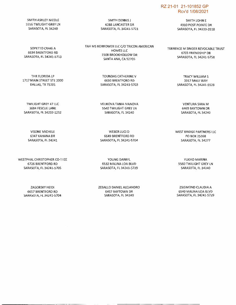
RZ 21-01 21-101852 GP Rcv'd 1/08/2021
SMITH ASHLEY NICOLE
5556 TWILIGHT GREY LN
SARASOTA,FL34240
SOPETIO CRAIG A
6634 BRENTFORD RD
SARASOTA, FL 34241-5713
THR FLORIDA LP
1717 MAIN STREET STE 2000
DALLAS, TX 75201
TWILIGHT GREY 47 LLC
3684 FESCUE LANE
SARASOTA,FL34232-1252
VISONE MICHELE
6347 KAHANA DR
SARASOTA,FL34241
WESTPHAL CHRISTOPHER CO-TIEE
6726 BRENTFORD RD
SARASOTA, FL 34241-5705
ZAGORSKY HEIDI
6657 BRENTFORD RD SARASOTA, FL 34241-5704
SMITH DENNIS J
4288 LANCASTER DR
SARASOTA, FL 34241-5721
TAH MS BORROWER LLC C/0 TRICON AMERICAN
HOMES LLC
1508 BROOKHOLLOW DR
SANTA ANA, CA 92705
TOUNDAS CATHERINE V
6610 BRENTFORD RD
SARASOTA, FL 34241-5703
VELIKOVA TANIA IVANOVA
5540 TWILIGHT GREY LN
SARASOTA,FL34240
WEBER LUCID
6649 BRENTFORD RD
SARASOTA, FL 34241-5704
YOUNG DARRYL
6532 MAU NA LOA BLVD
SARASOTA, FL 34241-5729
ZEBALLO DANIEL ALEJANDRO
6457 BAYTOWN DR SARASOTA,FL34240
SMITH JOHN E
4910 POST POINTE DR
SARASOTA, FL 34233-3518
TERRENCE M SINGER REVOCABLE TRUST
6703 FRIENDSHIP DR
SARASOTA, FL 34241-5758
TRACY WILLIAM S
3917 MAUI WAY
SARASOTA, FL 34241-5528
VENTURA SARA M
6469 BAYTOWN DR
SARASOTA, FL 34240
WEST BRIDGE PARTNERS LLC
PO BOX 25368
SARASOTA,FL34277
YUKHO MARINA
5560 TWILIGHT GREY LN
SARASOTA,FL34240
ZSIGMOND CLAUDIA A
6540 MAU NA LOA BLVD SARASOTA, FL 34241-5729
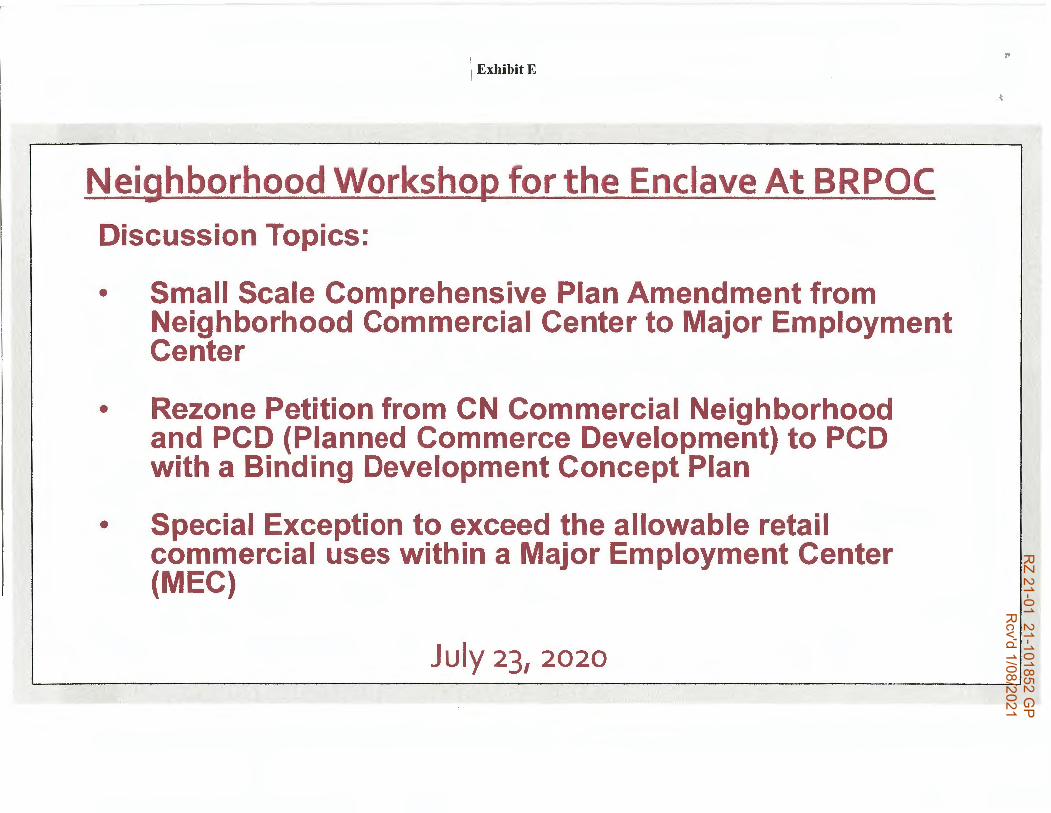
RZ 21-01 21-101852 G
P R
cv'd 1/08/2021
\ ExhibitE
Neighborhood Workshop for the Enclave At BRPOC
Discussion Topics:
• Small Scale Comprehensive Plan Amendment from Neighborhood Commercial Center to Major Employment Center
• Rezone Petition from CN Commercial Neighborhood and PCD (Planned Commerce Development) to PCD with a Binding Development Concept Plan
• Special Exception to exceed the allowable retail commercial uses within a Major Employment Center (MEC)
July 23, 2020

RZ 21-01 21-101852 G
P R
cv'd 1/08/2021
AGENDA NEIGHORHOOD WORKSHOP
6:oo PM THURSDAY, JULY 23, 2020
VIRTUAL NEIGHBORHOOD WORKSHOP ON ZOOM CONCERNING A PROPOSED SMALL SCALE COMPREHENSIVE PLAN; REZONE PETITION FROM CN AND PCD WITH NO BINDING DEVELOPMENT CONCEPT PLAN TO PCD WITH A BINDING DEVELOPMENT
CONCEPT PLAN AND A SPECIAL EXCEPTION TO ALLOW GREATER THAN FIVE PERCENT OF RETAIL COMMERCIAL USES WITHIN A MAJOR EMPLOYMENT CENTER AREA ENCLAVE AT BEE RIDGE PARK OF COMMERCE
1. Welcome and Introductions of Applicant Team
2. Brief background on the Owners of the 26.05 Acres Terracap BR Partners LLC
3. History of Previous Approvals on Overall Major Employment Center (MEC) and the 26.05 Acres Owned byTerracap
4. Quick Introduction of proposed Binding Development Concept Plan
5. Overview of Sarasota County Comprehensive Future Land Use Map designation of MEC and Neighborhood Commercial Center
6. Discussion on a proposed Small Scale Comprehensive Plan Amendment from Commercial Neighborhood to MEC
7. Discussion on Proposed Rezone Petition on 8.87 Acres+/- Parcel from PCD and CN with no Binding DCP to PCD with a Binding DCP
8. Discussion on a proposed Special Exception on a 8.87 Acres+/- to exceed the five percent of retail uses within a MEC area
9. Presentation of proposed Binding Development Concept Plan
10. Overview of the plann ing process and timeframes
11. Question and answer period from members of the public
12. Adjournment
'

RZ 21-01 21-101852 G
P R
cv'd 1/08/2021
History of Previous Approvals
• The Northeast Quadrant of l-75 and Bee Ridge Road has a Long History of Planning and Zoning Related Decisions that have Occurred
• This has included Comprehensive Plan Amendments, l-75 Corridor Plan, numerous Rezonings and numerous Site and Development Plan Approvals
• We are attempting to do what we think will be the last and final approvals required for the future development of the remaining undeveloped properties
• The next series of slides will bring land development order to what is currently a hodgepodge of comp plan and zoning designations into one cohensive comp plan designation and one rezoning with a Binding Development Concept Plan so everyone understands what will occur in the future on this property.

RZ 21-01 21-101852 G
P R
cv'd 1/08/2021
Northeast Quadrant of l-75 and Bee Ridge Road

RZ 21-01 21-101852 G
P R
cv'd 1/08/2021
Northeast Quadrant of l-75 and Bee Ridge Road

RZ 21-01 21-101852 G
P R
cv'd 1/08/2021
Lot Lines Superimposed on an Aerial Photo and boundaries of the 26.05 Acres Owned ByTerracap (Red)

RZ 21-01 21-101852 G
P R
cv'd 1/08/2021
Previous Development Concept Plan presented at last neighborhood workshop
PRoPEFllYKEVPI.A"I
200' 50' 100' 200'
~ I
PRELIMINARY BINDING DEVELOPMENT CONCEPT PLAN -
I/ 'I I
f Ill
··-·-·,
~/~
~---------------------------, . I . I . I . I .
' . ' . I . I . I . I . ' . I . I . I . I
BEE RIDGE ROAD
I I! jll_l 1i" i l
w ~
! !i 8 ~ i LI,. iil • 0.
~Iii ~ ~ ~ ~ ~ 9 .. ~ @ "'~1 >wo • w• ril ca ~111 <I)~ Q ~w: f;· ~ ~
~
'!r;-1

RZ 21-01 21-101852 G
P R
cv'd 1/08/2021
Binding Development Concept Plan for
Future Development
20' Side Yard Setback
10' landscape BuHer--..n.
Fence / Wall at Perimeter of Residential Mullifamily Development
0240100035 Bee Ridge
Hospitality LLC PCD Hotel
SO'StreetYardSetback ~,~~~
0240121003 HealthSouth of Sarasota
Limited Partners PCD
Hospital
0240122001 Ridgelake METILLC
PCO Manufacturing
~ ! ~l. Sea!&: 1"=200'-0"
... BEE RIDGE ROAD
Enclave at Bee Ridge Park of Commerce Binding Development Concept Plan Date: 07 23.2020
0240100001 Nikla Thomas F
OUE1 Single Family
Home
0240100002 Foster Daniel
OUEf Single Family
Home
35' Side Yard Setback Adj. to Residential
15' Landscape Buffer (0.4 Opacity)
0240100003 BediKirao
OUE1 Vacant
0240150001 R&W
Gulf<:oast Properties LLC
RE2 Plant Nursery
·20' Side Yard Selbacic
10' Landscape Buffer .---
l'C'I HOYT l&I ARCHITECTS ~:llll0'"'1ft.Ai~
A-1

RZ 21-01 21-101852 G
P R
cv'd 1/08/2021
Future Land Use Plan Designations in the Northeast Quadrant of l-75 and Bee Ridge Road Are A Combination of Medium Density Residential; Major Employment Center (MEC), and Neighborhood Commercial (NC)
Town Homes
Medium. Den,sity Residen,ti·al
Moderate Density Residential

RZ 21-01 21-101852 G
P R
cv'd 1/08/2021
Proposed Comprehensive Plan Amendment Request is to Eliminate the Majority of the Neighborhood Commercial Center
~~lj:21~
Boundaries of Neighborhood Commercia Center Olll\!'7
GU

RZ 21-01 21-101852 G
P R
cv'd 1/08/2021
Proposed--Future Land Use Map DesignatesMEC Are-a (Purple) andNeighborhOod Commercial Center (red)
eYc1sting Race Tr.a ti ot ir cluded
I ! I I
Stei.eofFi

RZ 21-01 21-101852 G
P R
cv'd 1/08/2021
Existing Zoning North of Bee Ridge Road and East/West of Mauna Loa Blvd. is PCD andCN

RZ 21-01 21-101852 G
P R
cv'd 1/08/2021
The subject Parcels are 26.05 Acres Zoned PCD (Planned Commerce Development) & CN (Commercial Neighborhood)
~W.Ull Boundaries of 26.05Acres Subject Properties
~ ljll;~!
OUE-2
/3U

RZ 21-01 21-101852 G
P R
cv'd 1/08/2021
Proposed Re-Zoning from PCD (Planned Commerce Development) and CN (Commercial Neighborhood) with no Bindina Development Concept Plan to PCD with a Bindina Development Concept Plan
'(178,710:
:0 11?;-:i
0UE·2
GU

RZ 21-01 21-101852 G
P R
cv'd 1/08/2021
Binding Development Concept Plan for
Future Development
Fence I Wall at Perimeter of Residential Multifamily Development
0240100035 Bee Ridge
Hospilatity LLC PCD Hotel
50' Street Yard Setback 1?::::A,~~~ 0240121003
HealthSouth of Sarasota limited Partnera
PCD Hospital
0240122001 Ridgelake METILLC
PCD Manufacturing
-$ ! 2Ao· Scala: 1",,200'-0"
... BEE RIDGE ROAD
Enclave at Bee Ridge Park of Commerce Binding Development Concept Plan Date:: 07.23.2020
0240100001 Nikia Thomas F
OUE1 Single Family
Home
0240100002 Foster Daniel
OUE1 Single Family
Home
3S Side Yard Setbacl< Adj. to Res.idential
15' Landscape Buffer (0.4 Opacity)
0240100003 Bed1Kiran
OUE1 Vacant
0240150001 R&W
GUif coast Properties LLC
RE2 Plant Nursery
20' Side Yard Setback
10' Landscape Bu:lrer ,-
1'C'1 HOYT l&I ARCHITECTS ~1(1...,~A,r:h~
A-1

RZ 21-01 21-101852 G
P R
cv'd 1/08/2021
Proposed Future Commercial Along the Bee Ridge Frontage
~ I I I "ti.I O ...... -... 21~~--'- 200'
NOT INCLUDED
p ! ! ! ! ~1 DIIIDD -; ,_
BEE RtDGE ROAD
Enclave at Bee Ridge Park of Commerce Binding Development Concept Plan Oate: 07.23.2020
l'C'I HOYT Lal ARCHITECTS A-2 OlwJltH 2)21) ~AttMta,

RZ 21-01 21-101852 G
P R
cv'd 1/08/2021
The End
Any Questions

RZ 21-01 21-101852 G
P R
cv'd 1/08/2021
Attachment K Plan At A Glance
& Map Series
Proposed CPA and Rezone/Special Exception Petitions for the
Enclave At Bee Ridge Park of Commerce
December 22, 2020
LIST OF EXHIBITS
Exhibit 1- Aerial Photograph and boundaries of the 26.05 Acres Owned by Terracap BR Partners
Exhibit 2 -Areawide of Future Land Use Map of MEC Area East of 1-75
Exhibit 3 - Existing MEC Acreage Based by Parcels
Exhibit 4- Areawide Future Land Use Map of 13.88 Acres+/- Neighborhood Commercial Center
Exhibit 5 - Existing PCD and CN Zoning by Parcels
Exhibit 6- Proposed Comprehensive Plan Future Land Use Plan Map
Exhibit 7 - Existing Comprehensive Plan designations for the BRPOC
Exhibit 8 -Existing Zoning for BRPOC
Exhibit 9 - Proposed Use Map for the BRPOC

RZ 21-01 21-101852 G
P R
cv'd 1/08/2021
Exhibit 1 Aerial Photo and boundaries of the 26.05 Acres Owned By Terracap BR Partners LP (Red)

RZ 21-01 21-101852 G
P R
cv'd 1/08/2021
Exhibit 2 Areawide Future Land Use Map of MEC Area at 1-75 and Bee Ridge Road East of 1-75
Medium Density Residential
Moderate Density Residenti~I
Low Density Residential
.__ __________________ ;.;,.;;;;;.,;;-a ... ---------- St.:oo' F

RZ 21-01 21-101852 G
P R
cv'd 1/08/2021
Exhibit 3 Existing MEC Area By Parcels= 66.84 Ac. +/-
0240040004 0240030130
0240040001 024007000
024010001
0240121005
0240 100(
10.47 Ac 75
0240121003
Ed~elake D<
6.9 Ac CN
0240122001 0240150001
• 7.58 Ac . 0240150020

RZ 21-01 21-101852 G
P R
cv'd 1/08/2021
Exhibit 4 Future Land Use Plan Designates 13.88 Acres+/- Existing Neighborhood Commercial (NC) at
Bee Ridge Road and Mauna Loa Boulevard
I ™ -- S~!tt~ o1 F

RZ 21-01 21-101852 G
P R
cv'd 1/08/2021
Exhibit 5 Existing PCD Area By Parcels= 66.84 Ac. +/- and Existing CN = 6.9
0240040004 0240030130
0240040001 0240 07000
0240121001 0240100035 024010001
1.54 Ac. 6.74 Ac. 0240121005 024q 1iroo ..
10.47 Ac 0240 100(
12.28 Ac. 1S
0240121003
6.0Ac. 0240100030
Edcielake or
0240140010 6.9 Ac CN 0240122001 0240150001
7.58 Ac. 6.87 Ac.
I

RZ 21-01 21-101852 G
P R
cv'd 1/08/2021
\ Exhibit 6
Proposed Future Land Use Plan Map Designation of Major Employment Center and Remaining 2.04 Acres+/- Designated Neighborhood Commercial
(;-,tffffiiMI•@ ,lllllil:llilr , ........ -· · , w., ..... . ,.,., ... ,... • .. .... - ·51 ... .............. ....... .. , .. , ....... .......... ~ .. ~ ..,.., ,ec st

RZ 21-01 21-101852 G
P R
cv'd 1/08/2021
....
. . I . . I • . I • . I • . I • . I . •
\
EXISTING ZONING: PCD
! AREA OF Existing Area I MAJOR
~ j EMPL6YMENT
/
EXISTING ZONING: PCD
Exhibit 7
AREA OF
·•··. MAJOR I
EMPLOYMENT ·· ·.·. CENTER .
• 'i . . . I ... ..
I : Note: Total Combined
' · l Existing Neighborhood :1
Commercial Center to be • Redesignated to Major i Employment Center is
8.94 Acres +/-. . I • . I . • I . . I • .
, I : . . .
I 1 \ •
~~7,' ,\ i : ~ ;{:;%~; ·· : : Existing Area of
· \ I Neighborhood
Neighborh~od : . CENTER ~ , AREA OF Commercial I ~ Center to be : 'w m NEIGHBORHOOD • Changed to ! fl~ COMMERCIAL
Major i..•-••-: • ~ .. (2.04 ACRES)
'1
• I Commercial Center
• '\ \ ~:j~~ lf ti:r:~~~I -~ .
Employment • __ _ _ ::,;; L -Center L .. _ .. _ .. _ .. _ -11 il'I
~
:$ ~ BEE RIDGE ROAD
L.·-··-··-'··-··-··:... .. i II
~ Enclave at Bee Ridge Park of Commerce 0
scale: 1"=200·}00
' Existing Comprehensive Plan Future Land Use Map III tt9i4Ts Date: 12.12.2020 Copyright © 2020 Hoyt Architects
Sheet
A-4

RZ 21-01 21-101852 G
P R
cv'd 1/08/2021_._ ~!)
,;- ·- ...
·\.
i
EXISTING ZONING: PCD
Exhibit 8 .. , ., . ,. . •• I ., . ,· .
. ~·· .! ,· . •• I ,. · .. .. : : .. . ;,•·' . i ,·· ····· ... :
~ I ., - . ,· . •' , I .
,.-~· - ,. _... . : Existing PCD Zomng f. . ··-·""\ ' . ' - . I with no Binding Plan · \ · ; ' L __ .. --- ·- - • : to be Rezoned to I .. ~ 1..• \_ ' . . EXISTING . . . I . d' • , _ "'"I, , ·•-;; ____ , ZoN1NO,eco • PCD with a Bin 1ng
i ·•, ""<o '•, " ·1: . 1 ·1 Plan (3.6 Acres +/-) • • -,_. • .__ - I • •, \, •,, --.., __ I I :
I .. . ·, I I . . : ' . : I
\ ·,.. . ... ~ ! ·, .. ,\ '··v· \ I . . I . . I • . EXISTING •.,
ZONING: PCD \
I • I . . I . . I .
.... \ .. \ .. • \
EXISTING . : ZONING: PCD I . i . ,_ .
ii. .. - •• - I . . . . LI • ..; I~-;.;;.; I·-··-··-I .I
~
EXISTING ZONING: PCD
i [ID BEE RIDGE ROAD
• . I • I . . I • . I . • I • •
L.·-··-··-··-··-··-··' II
Existing CN Zoning to be Rezoned to
PCD (6.09 Acres+/-)
Enclave at Bee Ridge Park of Commerce re, HOYT Sheet
1.a1 ARCHITECTS A-5 o 200· E . t· z . M Scale: 1"=200'-0" XIS ,ng oning ap Date: 12.22.2020 Copyright @ 2020 Hoyt Architects
,,

RZ 21-01 21-101852 G
P R
cv'd 1/08/2021
~
EXISTING ZONING: PCD
Exhibit 9 , .. , •• • ., . ,. I ,·· . _,,.. ·,
•• ., . '''' ' ' ' .,·.' .·, ,· ·· .
' .:...•• ·.·, .. ,, : Proposed Net Usable Area:
I ..• ~ I ,. •• I •-" J : Wetland Preserve, , - - - - - - -,
. . Multi Family: 8.75 Ac. Commercial: 5.11 Ac.
, • t 30' Upland Buffer · t r-1· ' •- _,,i_.•• , and Existing :I I r,. _..• li '_, I . I : \ • • _., • i :,1 Stormwater Area . 1 / 1
.. I Total: 13.86 Ac .
I .. . ; /"f:. Are Not Included .. 1 \ ·!.. 1 ,. ~" ., I ' I • ' ...,(/. '·,,, .t: ,. ' ' .. ' '. \'
I• ,. ~ ,,,. 1..., ·- - ~· .. .. -- . 1 . : . I
,.'- '<. ,. , -----1 ...... . I ~ 0 " '\ ~ ~ -1 ~ ·. : .. ,. ..., ~ . ~.. . - I ., ) I
I ' r'<> .. , ~ ,, \ , ~ • .... - .... .-~ 11 . /
,. • . ......., I I
, .,
• • I . • I . • I . • I . . I I• ,.. ,.. ~ . · ,,, , , ..... ,, , ,, ' ·· \
: '~ ,,. • .·· ', ......... _.,, I I ~ .. / j I ,. V ' . -- .... I : EXISTING ,.... , .... · l ... , i \ :
• . I . . I I PARKING LOT ' ' . L PROPOSED i ' !·
: .... , .... , MULTI-FAMILY 1
I EXISTING I ! ZONING: PCD ,,.. ~ 8.75 ACRES+/- 1 I • .
I • I
,, \ \ I , , ,. ,. EXISTING I :
,,' .. , ' .. ZONING: CN ' I I ,,' .. \ ............ --...... It : I CJ I •
,, ,. ~ I I • : .,,,,,, I :; \ - .. ----------------,. I ':, r-' PROPOSED ; .. I ' ' .: ' : I 1 . COMMERCIAL; \ z~~~~~~cD I i PRC/POSED l : ! :~ 3.36 ACRES +/- ·, I COMMERCIAL : i I •\ . EXISTING -, 1 75 ACRES / 1 • • , ., - - ":" - - - 1 ZONING: PCD : . I · + - I • • I I I " I I ... ·-··- ' ~ I • f. \--------------: -~- -- .--~-------~--~/ :
0 200' Scale: 1 "=200'-0"
i~.;;;;;;;. . ..;. •. _ .. _.,_ •. 1 L .. _ .. .;. .. -~·-· .-.. -··' II
.....
i [ID BEE RIDGE ROAD
Enclave at Bee Ridge Park of Commerce Proposed Use Map
l'C'I HOYT LILI ARCHITECTS Date: 12.22.2020 Copyright© 2020 Hoyt Architects
Sheet
A-6
,,