e3.1a mediterranean tall humid inland grassland · e3.1a mediterranean tall humid inland grassland...
TRANSCRIPT

European Red List of Habitats - Grasslands Habitat Group
E3.1a Mediterranean tall humid inland grassland
SummaryThis habitat comprises rush- and grass-dominated vegetation of seasonally water-logged soils, both base-rich and acidic, throughout the Mediterranean basin. Though not dependent on grazing, it can be avaluable source of fodder for cattle and sheep during summer when other pastures are dried up. Intensification of farming and conversion to arable cropping can threaten this habitat but more widespreadis loss to increased human settlements and their associated infrastructure, including changes to thedistinctive hydrology on which the habitat depends. Reduction in extent is not substantial, though likely tocontinue, and the biotic and abiotic habitat quality is declining.
SynthesisThe small amount of available quantitative data supports an evaluation of Least Concern (LC), despitea continuing decline in quantity and quality and of several threats the habitat faces.
Overall Category & CriteriaEU 28 EU 28+
Red List Category Red List Criteria Red List Category Red List CriteriaLeast Concern - Least Concern -
Sub-habitat types that may require further examinationNo sub-habitats have been distinguished for further analysis.
Habitat TypeCode and nameE3.1a Mediterranean tall humid inland grassland
Scirpus holoschoenus-dominated grassland, Spain (Photo: Javier Loidi).
Vegetation dominated by Schoenus nigricans in a calcareous, damp depression nearLake Vrana, Croatia (Photo: John Janssen).
Habitat descriptionMediterranean humid herb communities dominated by rushes (Scirpus holoschoenus) and tall grasses,common in depressions with wet soils, on both siliceous and calcareous terrain. The water table remainspermanently near to the surface but is subject to strong seasonal fluctuations, experiencing a lower levelduring summer and a higher in the rainy season, although the habitat is never or very rarely flooded. It ismore frequent in areas under a predominantly stock-rearing system, being thus more abundant in siliceousregions. It is widespread in the entire Mediterranean basin, extending as far as the coasts of the Black Sea
1

and the Balkans, north to Romania. This habitat has been traditionally grazed in the areas where summerpastures dry out and cattle and sheep have to graze humid pastures in the dry season. However, it is notdependent on grazing and its sustainability can be assured without this intervention.
Indicators of good quality:
Domination by a complete and dense cover of reeds (Scirpus holoschoenus) and grasses●
High plant species diversity●
Absence of shrubs, particularly willows, ashes or poplars, indicating initial stages of succession towards●
forestNo signs of heavy grazing.●
Characteristic species:
Vascular plants: Agrostis stolonifera, Agrostis reuteri, Alopecurus arundinaceus subsp. castellanus,Blackstonia perfoliata, Carex mairii, Centaurea jacea subsp. vinyalsii, Cirsium monspessulanum, Cirsiumpyreanicum subsp. micranthum, Cirsium pyrenaicum subsp. pyrenaicum, Cochlearia glastifolia, Cochleariamegalosperma, Cyperus eragrostis, Dorycnium rectum, Erica erigena, Euphorbia hirsuta, Festucaarundinacea subsp. mediterranea, Festuca fenas, Galium debile, Genista tinctoria, Hypericum caprifolium,Hypericum hircinum subsp. cambessedesii, Hypericum pubescens, Hypericum tetrapterum, Hypericumtomentosum, Juncus striatus, Linum tenue, Lysimachia ephemerum, Melilotus indicus, Molinia caeruleasubsp. arundinacea, Oenanthe lachenalii, Oenanthe pimpinelloides, Peucedanum hispanicum, Phalarisaquatica, Prunella vulgaris, Pulicaria dysenterica var. ramossisima, Ranunculus bulbosus subsp. aleae,Ranunculus granatensis, Ranunculus macrophyllus, Senecio doria, Sonchus aquatilis, Schoenus nigricans,Scirpus holoschoenus (Holoschoenus vulgaris),Scrophularia balbisii subsp. valentina, Serapias vomeracea,Sonchus maritimus subsp. aquatilis, Succisella andreae-molinae, Tetragonolobus maritimus var. hirsutus,Thalictrum flavum, Thalictrum minus subsp. matritense, Thalictrum speciosissimum.
ClassificationThis habitat may be equivalent to, or broader than, or narrower than the habitats or ecosystems in thefollowing typologies.
EUNIS:
E3.1 Mediterranean tall humid grassland
EuroVegChecklist:
Molinio-Holoschoenion Br.-Bl. ex Tchou 1948
Annex 1:
6420 Mediterranean tall humid grasslands
6460 Peat grasslands of Troodos
Emerald:
E3.1 Mediterranean tall humid grassland
MAES-2:
Grassland
IUCN:
4.4 Temperate Grassland
2

Does the habitat type present an outstanding example of typical characteristics of oneor more biogeographic regions?Yes
RegionsMediterranean
JustificationThe distribution is strongly related to the distinctive Mediterranean climate, in particular the effects ofseasonal rainfall on fluctuations in the soil water table.
Geographic occurrence and trends
EU 28 Present or PresenceUncertain
Current area ofhabitat
Recent trend inquantity (last 50 yrs)
Recent trend in quality(last 50 yrs)
Bulgaria Present 0.5 Km2 Decreasing DecreasingCyprus Present 0.01 Km2 Stable DecreasingFrance France mainland: Present 45 Km2 Decreasing Decreasing
Greece Greece (mainland and otherislands): Present 68 Km2 Stable Unknown
Italy Italy mainland: Present 114 Km2 Decreasing DecreasingPortugal Portugal mainland: Present 51 Km2 Decreasing UnknownRomania Present 5 Km2 Decreasing DecreasingSpain Spain mainland: Present 909 Km2 Stable Stable
EU 28 + Present or PresenceUncertain
Current area ofhabitat
Recent trend inquantity (last 50 yrs)
Recent trend in quality(last 50 yrs)
Montenegro Uncertain unknown Km2 Unknown Unknown
Extent of Occurrence, Area of Occupancy and habitat area Extent of Occurrence
(EOO)Area of Occupancy
(AOO)Current estimated
Total Area Comment
EU 28 5304250 Km2 3655 1125 Km2 Most of this habitat isin Italy and Spain
EU 28+ 5304250 Km2 3662 1125 Km2
Distribution map
3

The map is largely complete for EU, but with with data gaps along the eastern Adriatic coast, and probablyoverestimation in coastal dune sites. Sources: EVA, Art17.
How much of the current distribution of the habitat type lies within the EU 28?Probably >95%.
Trends in quantityWhere an assessment has been made, the recent historical trend is for a decrease of less than 30% and, inBulgaria and Romania, there is evidence that this has been a longer term shift. Only these countries andSpain make a qualitative assessment of likely future change and that is for a continuing decrease inextent.
Average current trend in quantity (extent)●
EU 28: DecreasingEU 28+: UnknownDoes the habitat type have a small natural range following regression?●
NoJustificationThere has been a reduction in extent but the overall range is probably largely unchanged.Does the habitat have a small natural range by reason of its intrinsically restricted area?●
NoJustificationThe habitat is widespread through the entire Mediterranean basin.
Trends in qualityIn recent historical time, there has been a slight-severe decline in the biotic and abiotic quality of thishabitat over part up to a high proportion of its extent. Longer term historical data are lacking and noassessments of future change are provided.
Average current trend in quality●
EU 28: DecreasingEU 28+: Decreasing
4

Pressures and threats
The main threats to this habitat are from development of settlements, associated infrastructure and theconsequences of habitation such as pollution, together with, in some places, intensification of farming. The impact has been patchy, locally intensive but overall moderate. In some localities, the pressures willremain.
List of pressures and threatsAgriculture
Modification of cultivation practicesGrassland removal for arable land
GrazingAbandonment of pastoral systems, lack of grazing
Urbanisation, residential and commercial developmentUrbanised areas, human habitation
PollutionPollution to surface waters (limnic, terrestrial, marine & brackish)
Natural System modificationsHuman induced changes in hydraulic conditions
Conservation and management
No detailed information is available.
List of conservation and management needsMeasures related to agriculture and open habitats
Maintaining grasslands and other open habitats
Conservation statusAnnex 1 types:
6420: ALP U1, ATL U1, BLS U2, CON U1, MAC FV, MED U1
6460: MED FV
When severely damaged, does the habitat retain the capacity to recover its typicalcharacter and functionality?Recovery depends greatly on the feasibility of restoring the distinctive hydrological conditions.
Effort required10 years 20 yearsUnknown Through intervention
Red List Assessment
Criterion A: Reduction in quantity
5

Criterion A A1 A2a A2b A3EU 28 -15 % unknown % unknown % unknown %EU 28+ -15 % unknown % unknown % unknown %
Quantitative estimates of loss have been calculated based on data from only Italy and Portugal.
Criterion B: Restricted geographic distribution
Criterion BB1 B2
B3EOO a b c AOO a b c
EU 28 >50000 Km2 Yes Yes unknown >50 Yes Yes unknown unknownEU 28+ >50000 Km2 Yes Yes unknown >50 Yes Yes unknown unknown
The EOO and probably the AOO do not come close to the thresholds for B1/2, although there is acontinuing decline in extent (B1/2Ai) and biotic/abiotic quality (B1/2Aii & iii) due to ongoing agriculturalchange and modification of drainage, threats which remain (B1/2b). Also the number of location is large(B3).
Criterion C and D: Reduction in abiotic and/or biotic quality
CriteriaC/D
C/D1 C/D2 C/D3Extent
affectedRelativeseverity Extent affected Relative
severity Extent affected Relativeseverity
EU 28 19 % 78 % unknown % unknown % unknown % unknown %EU 28+ 19 % 78 % unknown % unknown % unknown % unknown %
Criterion CC1 C2 C3
Extentaffected
Relativeseverity
Extentaffected
Relativeseverity
Extentaffected
Relativeseverity
EU 28 unknown % unknown % unknown % unknown % unknown % unknown %EU 28+ unknown % unknown % unknown % unknown % unknown % unknown %
Criterion DD1 D2 D3
Extentaffected
Relativeseverity
Extentaffected
Relativeseverity
Extentaffected
Relativeseverity
EU 28 unknown % unknown% unknown % unknown% unknown % unknown%EU 28+ unknown % unknown% unknown % unknown% unknown % unknown%
Quantitative data are available only for Bulgaria and Italy and there the threshold for VU is not closelyapproached.
Criterion E: Quantitative analysis to evaluate risk of habitat collapseCriterion E Probability of collapse
EU 28 unknownEU 28+ unknown
There is no quantitative analysis available that estimates the probability of collapse of this habitat type.
Overall assessment "Balance sheet" for EU 28 and EU 28+
6
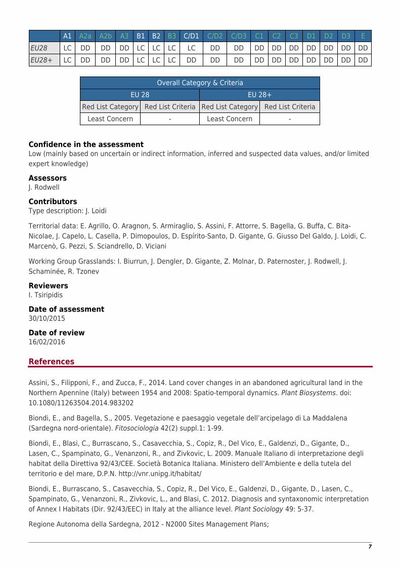
A1 A2a A2b A3 B1 B2 B3 C/D1 C/D2 C/D3 C1 C2 C3 D1 D2 D3 EEU28 LC DD DD DD LC LC LC LC DD DD DD DD DD DD DD DD DDEU28+ LC DD DD DD LC LC LC DD DD DD DD DD DD DD DD DD DD
Overall Category & CriteriaEU 28 EU 28+
Red List Category Red List Criteria Red List Category Red List CriteriaLeast Concern - Least Concern -
Confidence in the assessmentLow (mainly based on uncertain or indirect information, inferred and suspected data values, and/or limitedexpert knowledge)
AssessorsJ. Rodwell
ContributorsType description: J. Loidi
Territorial data: E. Agrillo, O. Aragnon, S. Armiraglio, S. Assini, F. Attorre, S. Bagella, G. Buffa, C. Bita-Nicolae, J. Capelo, L. Casella, P. Dimopoulos, D. Espírito-Santo, D. Gigante, G. Giusso Del Galdo, J. Loidi, C.Marcenò, G. Pezzi, S. Sciandrello, D. Viciani
Working Group Grasslands: I. Biurrun, J. Dengler, D. Gigante, Z. Molnar, D. Paternoster, J. Rodwell, J.Schaminée, R. Tzonev
ReviewersI. Tsiripidis
Date of assessment30/10/2015
Date of review16/02/2016
References
Assini, S., Filipponi, F., and Zucca, F., 2014. Land cover changes in an abandoned agricultural land in theNorthern Apennine (Italy) between 1954 and 2008: Spatio-temporal dynamics. Plant Biosystems. doi:10.1080/11263504.2014.983202
Biondi, E., and Bagella, S., 2005. Vegetazione e paesaggio vegetale dell’arcipelago di La Maddalena(Sardegna nord-orientale). Fitosociologia 42(2) suppl.1: 1-99.
Biondi, E., Blasi, C., Burrascano, S., Casavecchia, S., Copiz, R., Del Vico, E., Galdenzi, D., Gigante, D.,Lasen, C., Spampinato, G., Venanzoni, R., and Zivkovic, L. 2009. Manuale Italiano di interpretazione deglihabitat della Direttiva 92/43/CEE. Società Botanica Italiana. Ministero dell’Ambiente e della tutela delterritorio e del mare, D.P.N. http://vnr.unipg.it/habitat/
Biondi, E., Burrascano, S., Casavecchia, S., Copiz, R., Del Vico, E., Galdenzi, D., Gigante, D., Lasen, C.,Spampinato, G., Venanzoni, R., Zivkovic, L., and Blasi, C. 2012. Diagnosis and syntaxonomic interpretationof Annex I Habitats (Dir. 92/43/EEC) in Italy at the alliance level. Plant Sociology 49: 5-37.
Regione Autonoma della Sardegna, 2012 - N2000 Sites Management Plans;
7
http://cdr.eionet.europa.eu/it/eu/art17/envupyjhw;ftp://ftp.dpn.minambiente.it/Natura2000/TrasmissioneCE_2014/
Rivas-Martínez, S. and coauthors 2011. Mapa de series, geoseries y geopermaseries de vegetación deEspaña [Memoria del mapa de vegetación potencial de España]. Parte II. Itinera Geobotanica 18 (1 and 2):5-800.Gussev (2011).
8