early urbanism on the syrian euphrates
DESCRIPTION
Early Bronze history Ancient Syria Cities and towns, Ancient EuphratesValley SyriaTRANSCRIPT

EARLY URBANISM ON THESYRIAN EUPHRATES

EARLY URBANISMON THE SYRIAN
EUPHRATES
Lisa Cooper
First published 2006by Routledge
270 Madison Ave, New York, NY 10016
Simultaneously published in the UKby Routledge
2 Park Square, Milton Park, Abingdon, Oxon OX14 4RN
Routledge is an imprint of the Taylor & Francis Group, an informa business
© 2006 Lisa Cooper
All rights reserved. No part of this book may be reprinted orreproduced or utilized in any form or by any electronic,
mechanical, or other means, now known or hereafterinvented, including photocopying and recording, or in any
information storage or retrieval system, without permission inwriting from the publishers.
British Library Cataloguing in Publication DataA catalogue record for this book is available from the British Library
Library of Congress Cataloging in Publication DataCooper, Lisa, 1963–
Early urbanism on the Syrian Euphrates / Lisa Cooper.p. cm.
Includes bibliographical references and index.ISBN 0-415-35351-3 (hardback : alk. paper) 1. Cities and
towns, Ancient—Syria. 2. Cities and towns, Ancient—EuphratesValley. 3. Syria—History—To 333 b.c. 4. Euphrates Valley—
History. I. Title.
DS96.C56 2006939′43009732—dc22 2005029935
ISBN10: 0-415-35351-3 (hbk)ISBN10: 0-203-30672-4 (ebk)
ISBN13: 978-0-415-35351-9 (hbk)ISBN13: 978-0-203-30672-7 (ebk)
This edition published in the Taylor & Francis e-Library, 2006.
“To purchase your own copy of this or any of Taylor & Francis or Routledge’scollection of thousands of eBooks please go to www.eBookstore.tandf.co.uk.”
CONTENTS
List of illustrations viiList of tables xvPreface and acknowledgements xvii
1 Introduction 1
2 Environment and subsistence 27
3 Settlement and socio-political structure 47
4 Defence of Early Bronze Age cities 69
5 Housing and households 89
6 Large-scale secular buildings 126
7 Communal places of worship 143
8 Crafts and craft production 164
9 Death, funerary monuments and ancestor cults 202
10 The end of the Early Bronze Age: Euphrates settlementin decline 257
11 Conclusions 278
Notes 285Bibliography 290Index 308
v

ILLUSTRATIONS
1.1 Locator map of Syria (left), and map of Euphrates River, withprincipal EB sites (right) 3
1.2 Phase 1–2 pottery 10Source: Adapted from Orthmann 1981: Taf. 56:5, 23, 57:4; Dornemann1988: Figure 7:14; Bunnens 1990: Figure 21:10, 23:4, 39:8, 44:1; ValdésPereiro 1994: Figure 36:4; 2001: Figure 31:7; Armstrong and Zettler 1997:App. 2.1:a, i; Peltenburg et al. 1997: Figure 13:3–5; Falsone 1998: Figure 4:5.
1.3 Phase 3 pottery: Euphrates fine wares 13Source: Adapted from Kampschulte and Orthmann 1984: Taf. 33:10; ValdésPereiro 1994: Figure 32:3; Porter 1995a: Figure 13:P217, 14: P234,16:P211; Zettler 1997b: App. 3.3:dd, mm, qq, rr; Coqueugniot et al. 1998:Figure 4:b.
1.4 Phase 3 pottery: plain simple wares 14Source: Adapted from Orthmann 1981: Taf. 60:19; Kampschulte andOrthmann 1984: Taf. 19:42; Dornemann 1988: Figure 15:25, 18:12; Meyer1991: Taf. 8:12; Valdés Pereiro 1994: Figure 34:6; Porter 1995a: Figure11:P5, P44; Zettler 1997b: App. 3.2:e, n; Porter and McClellan 1998:Figure 9:24.
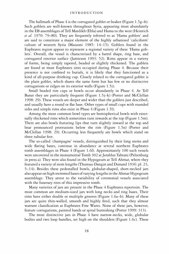
1.5 Phase 4 pottery: fine and plain simple wares 17Source: Adapted from Kampschulte and Orthmann 1984: Taf. 10:95,11:107; Dornemann 1979: Figure 12:24; Dornemann 1988: Figure 20:15;Orthmann and Rova 1991: Abb. 11:W11B:03, 13:W54A:37, 27:W86:01;Peltenburg et al. 1995: Figure 18:3; Porter and McClellan 1998: Figure17:13, 25; Porter 1999: Figure 4:E; Van Loon 2001: Figure 4A:30, 4A.5:19,5A.4:c.
1.6 Phase 4 plain simple ware (a–f), and cooking pot (g) 19Source: Adapted from Kampschulte and Orthmann 1984: Taf. 9:77;Dornemann 1979: Figure 14:11; 1990: Pl. 18:25; Peltenburg et al. 1995:Figure 27:11; Porter 1999: Figure 4:D; Porter 2002a: Figure 11:T9P9;Sconzo in press a: BM115997.
1.7 Phase 5 pottery 21Source: Adapted from Holland 1976; Figure 9:19, 27, 44; Holland 1977:Figure 10:3; Kampschulte and Orthmann 1984: Taf. 12:22, 29, 13:39;Orthmann 1989: Abb. 23:1, 24:7, 12; Valdés Pereiro 1994: Figure 13:6;Porter 1995b: Figure 9:12; Van Loon 2001: Figure 5B.40A:4; Finkbeiner2003: Abb. 20:g.
vii
1.8 Phase 6 pottery from Tell Kabir 24Source: Photo courtesy of Anne Porter, reproduced with the permission ofAnne Porter and Thomas McClellan.
1.9 Phase 6 pottery 25Source: Adapted from Dornemann 1979: Figure 21:19; 1992: Figure 3:23;Porter 1995b: Figure 14, 16:2, 17:5, 18:2, 5,19:4, 20:3.
2.1 Sheep, Tell es-Sweyhat 39Source: Photo Lisa Cooper.
3.1 Northern Euphrates River Valley of Syria, showing locationof EB settlements (dotted line indicates edge of rivervalley) 48
3.2 Tell es-Sweyhat (low mound in distance) 49Source: Photo Lisa Cooper.
4.1 Section through mud brick core of citadel structure, Telles-Sweyhat 72Source: Photo Lisa Cooper.
4.2 Large boulders of rounded bastion of citadel structure, Telles-Sweyhat 72Source: Photo Lisa Cooper.
4.3 Line of city wall around EB settlement at Halawa Tell A. 74Source: From Orthmann 1989: Abb. 3, reproduced with the permission ofDr Rudolf Habelt GmbH Verlag.
4.4 Tell es-Sweyhat, showing excavated squares and inner andouter city walls 75Source: From Zettler 1997a: Figure 1.4, reproduced with the permission ofMASCA Research Papers in Science and Archaeology. Museum AppliedScience Center for Archaeology, University of Pennsylvania Museum ofArchaeology and Anthropology.
4.5 Eastern casemate wall on the ‘Kuppe’ at Munbaqa 80Source: Image courtesy of Munbaqa Archive, reproduced with permission.
4.6 City wall, with projecting buttress, and corner tower(Quadrants U and T), Halawa Tell A 82Source: From Orthmann 1989: Abb. 4, reproduced with the permission ofDr Rudolf Habelt GmbH Verlag.
4.7 Schematic section of rampart, retaining wall and walkwayagainst city wall, Halawa Tell A 85Source: From Orthmann 1989: Abb. 5, reproduced with the permission ofDr Rudolf Habelt GmbH Verlag.
5.1 Early EB settlement at Halawa Tell B 90Source: From Orthmann 1989: Beilage 12, reproduced with the permissionof Dr Rudolf Habelt GmbH Verlag.
5.2 Wall painting from Room 312, Halawa Tell B 92Source: From Orthmann 1989: Abb. 66, reproduced with the permission ofDr Rudolf Habelt GmbH Verlag.
5.3 Wall painting from room (101) in house, Halawa Tell B 93Source: From Orthmann 1981: Taf. 8, reproduced with the permission ofDr Rudolf Habelt GmbH Verlag.
I L L U S T R AT I O N S
viii
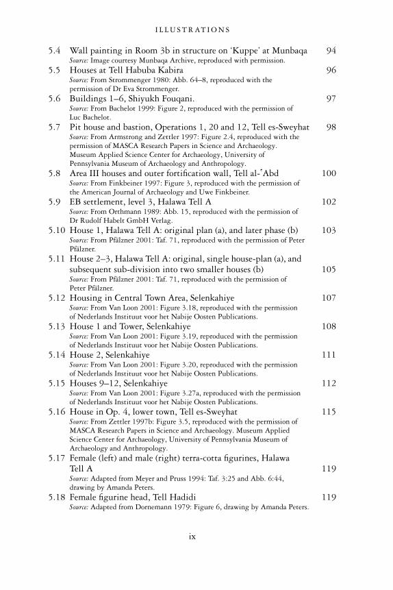
5.4 Wall painting in Room 3b in structure on ‘Kuppe’ at Munbaqa 94Source: Image courtesy Munbaqa Archive, reproduced with permission.
5.5 Houses at Tell Habuba Kabira 96Source: From Strommenger 1980: Abb. 64–8, reproduced with thepermission of Dr Eva Strommenger.
5.6 Buildings 1–6, Shiyukh Fouqani. 97Source: From Bachelot 1999: Figure 2, reproduced with the permission ofLuc Bachelot.
5.7 Pit house and bastion, Operations 1, 20 and 12, Tell es-Sweyhat 98Source: From Armstrong and Zettler 1997: Figure 2.4, reproduced with thepermission of MASCA Research Papers in Science and Archaeology.Museum Applied Science Center for Archaeology, University ofPennsylvania Museum of Archaeology and Anthropology.
5.8 Area III houses and outer fortification wall, Tell al- �Abd 100Source: From Finkbeiner 1997: Figure 3, reproduced with the permission ofthe American Journal of Archaeology and Uwe Finkbeiner.
5.9 EB settlement, level 3, Halawa Tell A 102Source: From Orthmann 1989: Abb. 15, reproduced with the permission ofDr Rudolf Habelt GmbH Verlag.
5.10 House 1, Halawa Tell A: original plan (a), and later phase (b) 103Source: From Pfälzner 2001: Taf. 71, reproduced with the permission of PeterPfälzner.
5.11 House 2–3, Halawa Tell A: original, single house-plan (a), andsubsequent sub-division into two smaller houses (b) 105Source: From Pfälzner 2001: Taf. 71, reproduced with the permission ofPeter Pfälzner.
5.12 Housing in Central Town Area, Selenkahiye 107Source: From Van Loon 2001: Figure 3.18, reproduced with the permissionof Nederlands Instituut voor het Nabije Oosten Publications.
5.13 House 1 and Tower, Selenkahiye 108Source: From Van Loon 2001: Figure 3.19, reproduced with the permissionof Nederlands Instituut voor het Nabije Oosten Publications.
5.14 House 2, Selenkahiye 111Source: From Van Loon 2001: Figure 3.20, reproduced with the permissionof Nederlands Instituut voor het Nabije Oosten Publications.
5.15 Houses 9–12, Selenkahiye 112Source: From Van Loon 2001: Figure 3.27a, reproduced with the permissionof Nederlands Instituut voor het Nabije Oosten Publications.
5.16 House in Op. 4, lower town, Tell es-Sweyhat 115Source: From Zettler 1997b: Figure 3.5, reproduced with the permission ofMASCA Research Papers in Science and Archaeology. Museum AppliedScience Center for Archaeology, University of Pennsylvania Museum ofArchaeology and Anthropology.
5.17 Female (left) and male (right) terra-cotta figurines, HalawaTell A 119Source: Adapted from Meyer and Pruss 1994: Taf. 3:25 and Abb. 6:44,drawing by Amanda Peters.
5.18 Female figurine head, Tell Hadidi 119Source: Adapted from Dornemann 1979: Figure 6, drawing by Amanda Peters.
I L L U S T R AT I O N S
ix
5.19 Female figurine head, Tell Hadidi 120Source: Adapted from Dornemann 1979: Figure 6, drawing by Amanda Peters.
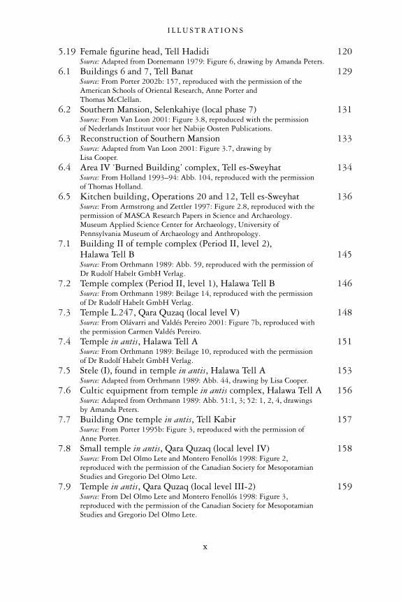
6.1 Buildings 6 and 7, Tell Banat 129Source: From Porter 2002b: 157, reproduced with the permission of theAmerican Schools of Oriental Research, Anne Porter andThomas McClellan.
6.2 Southern Mansion, Selenkahiye (local phase 7) 131Source: From Van Loon 2001: Figure 3.8, reproduced with the permissionof Nederlands Instituut voor het Nabije Oosten Publications.
6.3 Reconstruction of Southern Mansion 133Source: Adapted from Van Loon 2001: Figure 3.7, drawing byLisa Cooper.
6.4 Area IV ‘Burned Building’ complex, Tell es-Sweyhat 134Source: From Holland 1993–94: Abb. 104, reproduced with the permissionof Thomas Holland.
6.5 Kitchen building, Operations 20 and 12, Tell es-Sweyhat 136Source: From Armstrong and Zettler 1997: Figure 2.8, reproduced with thepermission of MASCA Research Papers in Science and Archaeology.Museum Applied Science Center for Archaeology, University ofPennsylvania Museum of Archaeology and Anthropology.
7.1 Building II of temple complex (Period II, level 2),Halawa Tell B 145Source: From Orthmann 1989: Abb. 59, reproduced with the permission ofDr Rudolf Habelt GmbH Verlag.
7.2 Temple complex (Period II, level 1), Halawa Tell B 146Source: From Orthmann 1989: Beilage 14, reproduced with the permissionof Dr Rudolf Habelt GmbH Verlag.
7.3 Temple L.247, Qara Quzaq (local level V) 148Source: From Olávarri and Valdés Pereiro 2001: Figure 7b, reproduced withthe permission Carmen Valdés Pereiro.
7.4 Temple in antis, Halawa Tell A 151Source: From Orthmann 1989: Beilage 10, reproduced with the permissionof Dr Rudolf Habelt GmbH Verlag.
7.5 Stele (I), found in temple in antis, Halawa Tell A 153Source: Adapted from Orthmann 1989: Abb. 44, drawing by Lisa Cooper.
7.6 Cultic equipment from temple in antis complex, Halawa Tell A 156Source: Adapted from Orthmann 1989: Abb. 51:1, 3; 52: 1, 2, 4, drawingsby Amanda Peters.
7.7 Building One temple in antis, Tell Kabir 157Source: From Porter 1995b: Figure 3, reproduced with the permission ofAnne Porter.
7.8 Small temple in antis, Qara Quzaq (local level IV) 158Source: From Del Olmo Lete and Montero Fenollós 1998: Figure 2,reproduced with the permission of the Canadian Society for MesopotamianStudies and Gregorio Del Olmo Lete.
7.9 Temple in antis, Qara Quzaq (local level III-2) 159Source: From Del Olmo Lete and Montero Fenollós 1998: Figure 3,reproduced with the permission of the Canadian Society for MesopotamianStudies and Gregorio Del Olmo Lete.
I L L U S T R AT I O N S
x
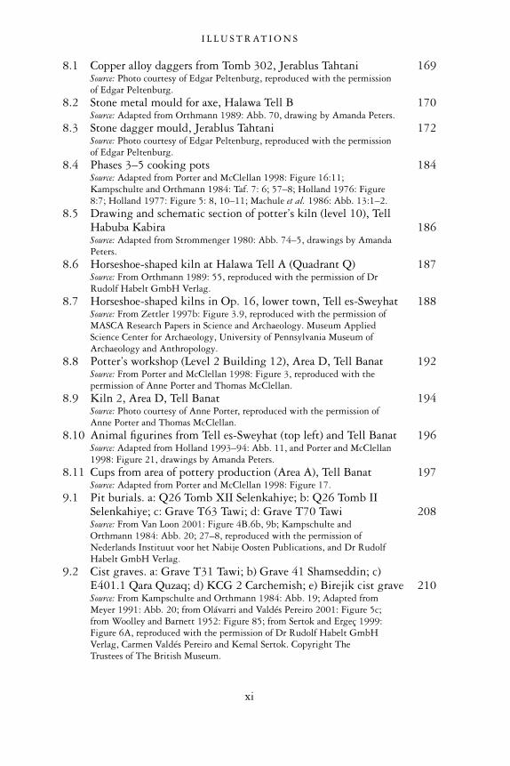
8.1 Copper alloy daggers from Tomb 302, Jerablus Tahtani 169Source: Photo courtesy of Edgar Peltenburg, reproduced with the permissionof Edgar Peltenburg.
8.2 Stone metal mould for axe, Halawa Tell B 170Source: Adapted from Orthmann 1989: Abb. 70, drawing by Amanda Peters.
8.3 Stone dagger mould, Jerablus Tahtani 172Source: Photo courtesy of Edgar Peltenburg, reproduced with the permissionof Edgar Peltenburg.
8.4 Phases 3–5 cooking pots 184Source: Adapted from Porter and McClellan 1998: Figure 16:11;Kampschulte and Orthmann 1984: Taf. 7: 6; 57–8; Holland 1976: Figure8:7; Holland 1977: Figure 5: 8, 10–11; Machule et al. 1986: Abb. 13:1–2.
8.5 Drawing and schematic section of potter’s kiln (level 10), TellHabuba Kabira 186Source: Adapted from Strommenger 1980: Abb. 74–5, drawings by AmandaPeters.
8.6 Horseshoe-shaped kiln at Halawa Tell A (Quadrant Q) 187Source: From Orthmann 1989: 55, reproduced with the permission of DrRudolf Habelt GmbH Verlag.
8.7 Horseshoe-shaped kilns in Op. 16, lower town, Tell es-Sweyhat 188Source: From Zettler 1997b: Figure 3.9, reproduced with the permission ofMASCA Research Papers in Science and Archaeology. Museum AppliedScience Center for Archaeology, University of Pennsylvania Museum ofArchaeology and Anthropology.
8.8 Potter’s workshop (Level 2 Building 12), Area D, Tell Banat 192Source: From Porter and McClellan 1998: Figure 3, reproduced with thepermission of Anne Porter and Thomas McClellan.
8.9 Kiln 2, Area D, Tell Banat 194Source: Photo courtesy of Anne Porter, reproduced with the permission ofAnne Porter and Thomas McClellan.
8.10 Animal figurines from Tell es-Sweyhat (top left) and Tell Banat 196Source: Adapted from Holland 1993–94: Abb. 11, and Porter and McClellan1998: Figure 21, drawings by Amanda Peters.
8.11 Cups from area of pottery production (Area A), Tell Banat 197Source: Adapted from Porter and McClellan 1998: Figure 17.
9.1 Pit burials. a: Q26 Tomb XII Selenkahiye; b: Q26 Tomb IISelenkahiye; c: Grave T63 Tawi; d: Grave T70 Tawi 208Source: From Van Loon 2001: Figure 4B.6b, 9b; Kampschulte andOrthmann 1984: Abb. 20; 27–8, reproduced with the permission ofNederlands Instituut voor het Nabije Oosten Publications, and Dr RudolfHabelt GmbH Verlag.
9.2 Cist graves. a: Grave T31 Tawi; b) Grave 41 Shamseddin; c)E401.1 Qara Quzaq; d) KCG 2 Carchemish; e) Birejik cist grave 210Source: From Kampschulte and Orthmann 1984: Abb. 19; Adapted fromMeyer 1991: Abb. 20; from Olávarri and Valdés Pereiro 2001: Figure 5c;from Woolley and Barnett 1952: Figure 85; from Sertok and Ergeç 1999:Figure 6A, reproduced with the permission of Dr Rudolf Habelt GmbHVerlag, Carmen Valdés Pereiro and Kemal Sertok. Copyright TheTrustees of The British Museum.
I L L U S T R AT I O N S
xi
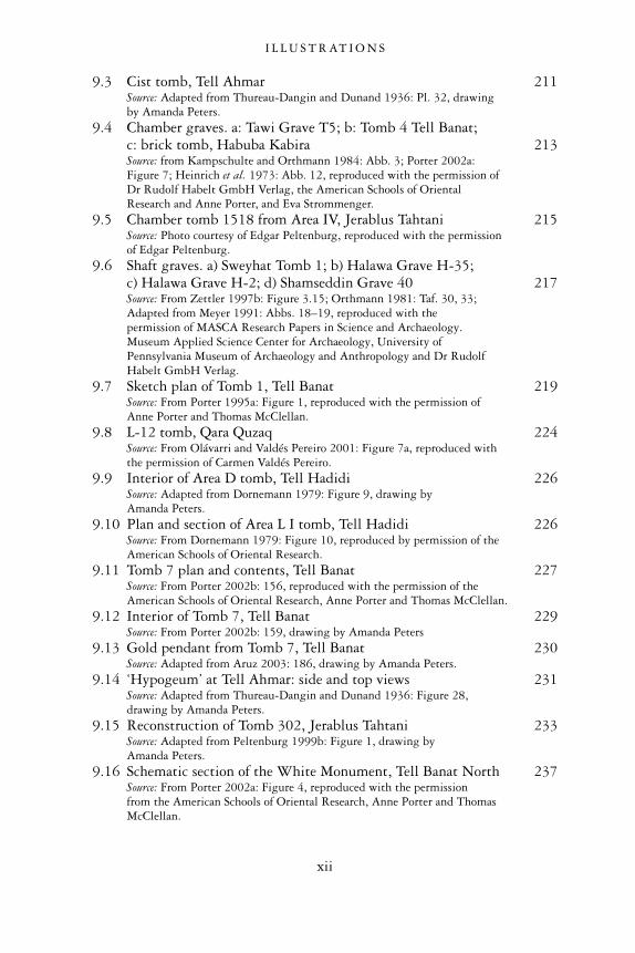
9.3 Cist tomb, Tell Ahmar 211Source: Adapted from Thureau-Dangin and Dunand 1936: Pl. 32, drawingby Amanda Peters.
9.4 Chamber graves. a: Tawi Grave T5; b: Tomb 4 Tell Banat;c: brick tomb, Habuba Kabira 213Source: from Kampschulte and Orthmann 1984: Abb. 3; Porter 2002a:Figure 7; Heinrich et al. 1973: Abb. 12, reproduced with the permission ofDr Rudolf Habelt GmbH Verlag, the American Schools of OrientalResearch and Anne Porter, and Eva Strommenger.
9.5 Chamber tomb 1518 from Area IV, Jerablus Tahtani 215Source: Photo courtesy of Edgar Peltenburg, reproduced with the permissionof Edgar Peltenburg.
9.6 Shaft graves. a) Sweyhat Tomb 1; b) Halawa Grave H-35;c) Halawa Grave H-2; d) Shamseddin Grave 40 217Source: From Zettler 1997b: Figure 3.15; Orthmann 1981: Taf. 30, 33;Adapted from Meyer 1991: Abbs. 18–19, reproduced with thepermission of MASCA Research Papers in Science and Archaeology.Museum Applied Science Center for Archaeology, University ofPennsylvania Museum of Archaeology and Anthropology and Dr RudolfHabelt GmbH Verlag.
9.7 Sketch plan of Tomb 1, Tell Banat 219Source: From Porter 1995a: Figure 1, reproduced with the permission ofAnne Porter and Thomas McClellan.
9.8 L-12 tomb, Qara Quzaq 224Source: From Olávarri and Valdés Pereiro 2001: Figure 7a, reproduced withthe permission of Carmen Valdés Pereiro.
9.9 Interior of Area D tomb, Tell Hadidi 226Source: Adapted from Dornemann 1979: Figure 9, drawing byAmanda Peters.
9.10 Plan and section of Area L I tomb, Tell Hadidi 226Source: From Dornemann 1979: Figure 10, reproduced by permission of theAmerican Schools of Oriental Research.
9.11 Tomb 7 plan and contents, Tell Banat 227Source: From Porter 2002b: 156, reproduced with the permission of theAmerican Schools of Oriental Research, Anne Porter and Thomas McClellan.
9.12 Interior of Tomb 7, Tell Banat 229Source: From Porter 2002b: 159, drawing by Amanda Peters
9.13 Gold pendant from Tomb 7, Tell Banat 230Source: Adapted from Aruz 2003: 186, drawing by Amanda Peters.
9.14 ‘Hypogeum’ at Tell Ahmar: side and top views 231Source: Adapted from Thureau-Dangin and Dunand 1936: Figure 28,drawing by Amanda Peters.
9.15 Reconstruction of Tomb 302, Jerablus Tahtani 233Source: Adapted from Peltenburg 1999b: Figure 1, drawing byAmanda Peters.
9.16 Schematic section of the White Monument, Tell Banat North 237Source: From Porter 2002a: Figure 4, reproduced with the permissionfrom the American Schools of Oriental Research, Anne Porter and ThomasMcClellan.
I L L U S T R AT I O N S
xii

9.17 Corrugations and white plastered surface, White Monument,Tell Banat North 238Source: Photo courtesy of Thomas McClellan and Anne Porter, reproducedwith permission from Anne Porter and Thomas McClellan.
9.18 Geographical distribution of burial types in the northernEuphrates Valley 244
9.19 View of Tell Banat (area of modern village) and Tell BanatNorth behind 250Source: Photo courtesy of Thomas McClellan and Anne Porter, reproducedwith permission from Anne Porter and Thomas McClellan.
I L L U S T R AT I O N S
xiii

TABLES
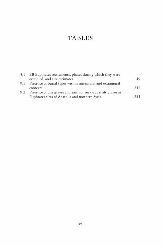
3.1 EB Euphrates settlements, phases during which they wereoccupied, and size estimates 49
9.1 Presence of burial types within intramural and extramuralcontexts 242
9.2 Presence of cist graves and earth or rock-cut shaft graves atEuphrates sites of Anatolia and northern Syria 245
xv

PREFACE ANDACKNOWLEDGEMENTS
This book was written to fill the need for a synthetic presentation of the richand diverse array of Early Bronze archaeological remains brought to light inthe Euphrates River of northern Syria region in the recent past. Until now,much of this archaeological material has only been published in reports of apreliminary nature or in studies concerning one site or one class of artifacts.By bringing all material bearing on the northern Euphrates of the thirdmillennium bc together in one place, I have endeavoured to produce a clearoverview of the most salient characteristics of this pivotal era of antiquity. Iconsider also the prevalent scholarly interpretations of the archaeologicalremains of this period, highlighting especially those pertaining to the riseand persistence of urban life among settlements of the Euphrates River Valley,and factors that contributed to Euphrates cities’ distinctive and complexcharacter.
My interest in the ancient Euphrates River Valley first arose out of doctoralresearch on pottery and the chronology of the Middle Bronze Age of northernSyria. While working on this project, I frequently found myself drawn toarchaeological reports describing the ancient remains of the earlier EarlyBronze Age of the Euphrates Valley. Not only was the EB period representedby a wealth of funerary remains, it had well-built, densely inhabited settle-ments that testified to a flourishing riverine culture from a very early periodof urban society in the Near East. It seemed that a broad, yet comprehensiveinvestigation of the Syrian Euphrates during this period might yield interest-ing patterns regarding settlement complexity and urbanism that could serveas valuable points of comparison with ancient complex societies of otherregions of the Near East such as southern Mesopotamia, the Khabur Plains ofnortheastern Syria and the Levant. With this project in mind, my researchfocus slowly shifted backward in time, first with a concentration on theelusive ‘dark age’ and collapse of complex societies at the end of the thirdmillennium bc, and subsequently with a review of the principal remains ofEarly Bronze Age settlements in the centuries before this urban decline.
My engagement with the EB (Early Bronze Age) Euphrates was furtherheightened by my participation in archaeological projects in northern Syria
xvii
on the Euphrates, at Tell Banat in 1995 and 1997, Tell Amarna in 1998 andat Tell es-Sweyhat in 2000. I wish to thank directors Tom McClellan andAnne Porter, Onhan Tunça, and Richard Zettler, for inviting me to share intheir exciting field seasons, and encouraging my research on their archaeo-logical material, especially their pottery. My conversations and deliberationswith these individuals and members of their teams were tremendouslystimulating. Overall, I do not believe that this book could have been writtenwithout the opportunity I had to listen to and learn from the talented andexperienced archaeologists that I met and worked with in Syria. I am alsograteful to my Syrian colleagues and friends, whose generosity and hospital-ity ensured that all of my seasons in the field were thoroughly enjoyable andproductive.
My participation in conferences and workshops pertaining to the archae-ology of the Syrian Early Bronze Age provided other useful venues for thecollection of data. The Barcelona Conference of 1998, organized by Gregoriodel Olmo Lete, which presented early results of excavations in the TishreenDam region of the Euphrates, provided many summaries of recent archaeo-logical projects. The workshop on the Carchemish Region at the ICAANEcongress in Berlin, 2004, organized by Edgar Peltenburg, endeavoured tobring together recent research of sites in the region both to the north andsouth of the ancient city of Carchemish. The meetings of the EB-MB work-shop in Blaubeuren, which I attended in 2002 and 2005, helped me tounderstand more fully the material culture of the late third millennium, andhow individual sites should correspond with one another temporally andculturally. My special thanks goes to Uwe Finkbeiner for organizing thesemeetings, and to all of those who participated in and contributed to theseproductive and colleagial workshops.
I am grateful to Marie-Claude Boileau, Giacchino Falsone, Alice Petty,Edgar Peltenburg, Anne Porter, Paola Sconzo, Jill Weber and Tony Wilkinson,for providing me with copies of their research reports or book manuscripts inadvance of their publication. I would also like to thank RudolphDornemann, Michel Fortin, Renate Gut, Ralph Hempelmann, ThomasMcClellan, the late Nina Pons, Anne Porter, Ferhan Sakal and GlennSchwartz for offering me useful advice or opinions on issues pertaining to theEB Syrian Euphrates, or referring me to important and relevant sources ofpublished information. Grant Frame and Douglas Frayne of the RoyalInscriptions of Mesopotamia Project at the University of Toronto generouslymade their archives available to me during my research visits to Toronto. Iam indebted to colleagues who have supplied me with illustrations or havegiven their permission to use them: Luc Bachelot, Gregorio del Olmo Lete,Uwe Finkbeiner, Thomas Holland, Thomas McClellan, Diederik Meijer,Winfried Orthmann, Edgar Peltenburg, Peter Pfälzner, Anne Porter, KemalSertok, Eva Strommenger, Carmen Valdés Pereiro, Peter Werner and RichardZettler.
P R E FA C E A N D A C K N O W L E D G E M E N T S
xviii
At the University of British Columbia, I gratefully acknowledge the talentand dedication of my student Anthony Russell who assisted in the prepar-ation of the majority of illustrations in this book. Julia Armstrong also con-tributed to the production and final layout of two of the figures. I had thegreat fortune of enlisting the talents of Amanda Peters, who provided lovelyline drawings of several tombs, kilns and artifacts.
A research stipend for Early Career Scholars provided by the Peter WallInstitute of the University of British Columbia provided me with the fund-ing necessary to purchase computer equipment and software, and to employstudent research assistants. Additional funding provided by two HSS SmallResearch Grants from the University of British Columbia, and a TravelResearch Grant from the British School of Archaeology in Iraq, enabled meto travel to and research in Toronto, Milwaukee, Philadelphia and Syria.
The steadfast support of my colleagues in the Department of Classical,Near Eastern and Religious Studies at the University of British Columbiaensured that I had a productive environment in which to conduct myresearch. I am particularly grateful to Rob Cousland and Anthony Barrett forreading early drafts of sections of this book. My greatest thanks goes to mycolleague Shirley Sullivan. Not only did she read the entire manuscript sev-eral times, offering countless editorial comments and corrections, she was aunending source of moral support and encouragement.
A special thanks must go to my professor and mentor, the late T. CuylerYoung Jr., formerly of the Royal Ontario Museum and the University ofToronto. A superb lecturer, a talented field archaeologist and a gentleman,Cuyler will always be a major source of inspiration to me in my life andwork.
My fiancé Richard Ritson read most of my manuscript with great interest,and made many valuable comments. I also thank him for his cheerful supportand companionship during what was a busy time for me.
My deepest expression of gratitude goes to my parents, Reed and JaneCooper. It was their love of travel and curiosity for the ancient world thatsparked my interest in Near Eastern archaeology in the first place, and theircontinuing support for my academic progress through the years helpedme to get to where I am today. This book is dedicated to them, with admirationand affection.
P R E FA C E A N D A C K N O W L E D G E M E N T S
xix

1
INTRODUCTION
The majestic presence of the river in the midst of uncultivatedlands, which, with the help of its waters, would need so littlelabour to make them productive, takes a singular hold on theimagination. I do not believe that the east bank has alwaysbeen so thinly peopled . . . it is probable that there was once acontinuous belt of villages, their site being still marked bymounds.
(Gertrude Bell, 1910: 518)
We have had no rain since we came to Carchemish, but gener-ally sun, with often after midday a gale from the North thatdrives the workmen off the top of the mound, and tosses up thedust of our diggings . . . If one can struggle up to the top of themound and hold on one can look over all the plain of the rivervalley up to Biredjik and down to Tell Ahmar, and over it allthe only things to show out of the dust clouds are the hills andtops of the tells.
(T.E. Lawrence, quoted in Garnett 1938: 98–9)1
The striking landscape and rich archaeological potential of the northernEuphrates Valley could not fail to affect even Gertrude Bell and T.E. Lawrence,two individuals who were to figure prominently in the shaping of the modernMiddle East.
In the recent past, many more than a few travellers and casual archaeolo-gists have turned their attention to the antiquity of the land of Syria, includ-ing the Euphrates River Valley. Especially in recent decades, Syria hasbecome the major focus of many investigations, when archaeologists, nolonger able to access the antiquity of countries such as Iraq and Iran, shiftedtheir focus to the heritage of Syria and its rich array of ancient architecturalremains and artifacts. Their investigations have proven tremendously signifi-cant. They have demonstrated that we can no longer regard the ancient landof Mesopotamia, defined by the alluvial valley of the Tigris and Euphrates
1
Rivers of southern Iraq, as the sole source of the great cultural transform-ations taking place at the dawn of history. Now we must realize that Syriatoo partook in many of these radical major changes.
Especially important were developments taking place in ancient Syria dur-ing the third millennium bc. This time period, often referred to as the EarlyBronze Age, was witness to a dynamic growth of complex societies and therise of urbanism. These new advancements had a major impact on humanpopulations, bringing about dramatic changes to their political systems, andradically reorganizing their social and economic structures. Many of thesepivotal developments are now well attested in the archaeological record.Investigations have shown, for example, that in the northeastern corner ofSyria, along the banks and tributaries of the Khabur River, large and denselypopulated cities, supported by the agricultural produce of vast tracts of fer-tile fields, began to spring up all over the landscape. Settlements such as TellLeilan, grew as large as 100 ha by 2600 bc, truly attesting to the earlysuccess of urban growth in this region. The discovery of an administrativearchive of cuneiform tablets at the site of Tell Beydar, confirming that peopleof the Khabur region were literate, lends further support to this picture ofurban progress. Cities also emerged in western Syria, in the agriculturallyrich Orontes River Valley and the dry farming plains to the south of Aleppo.Here, the most well-known of ancient Syrian cities, Ebla, is renowned notonly for its immense and rambling palace but for its archive rooms, foundfull of thousands of inscribed cuneiform tablets describing all the politicalactivities and economic accounts of the powerful Eblaite king and hisnumerous officials.
In light of such discoveries in Syrian archaeology, the land of southernMesopotamia must now be seen as but one of many regions in the Near Eastwhere early civilizations arose. More importantly still, ancient Syria’s urbantransformation should not be regarded as having derived solely from its con-tact with Mesopotamia, its cultural achievements being but pale imitationsof the truly monumental advances engendered in the south. As the archaeo-logical evidence has proven, many aspects of Syrian cities are original anddistinctive, and they attest to the vibrant, independent character of theirpeople and culture.
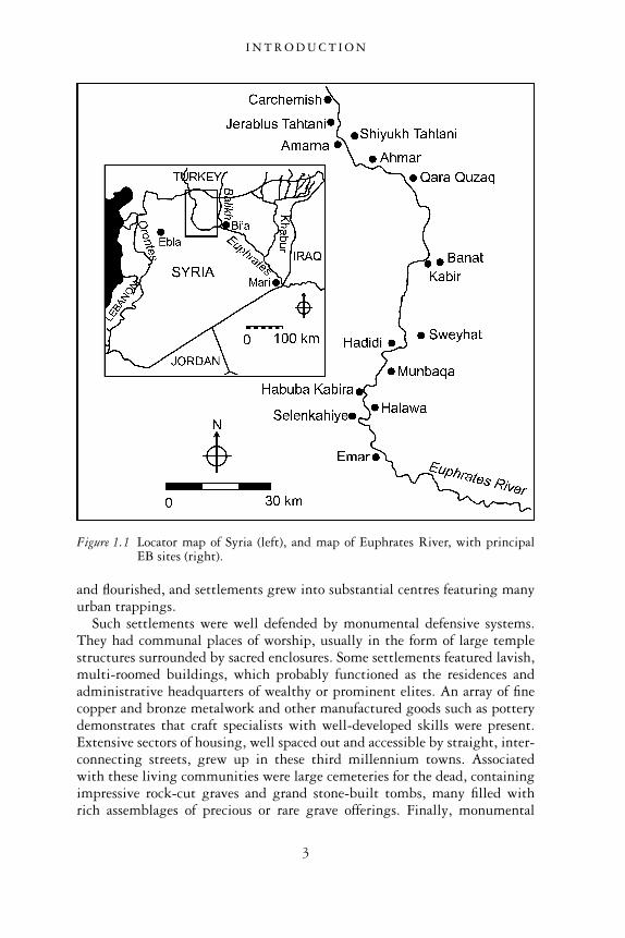
The northern Euphrates River Valley perhaps stands out as one of the mostremarkable areas in which early urbanism evolved in Syria (Figure 1.1). Thisriverine region, stretching for about 100 km from the modern border ofTurkey and Syria down to the area around the ancient site of Emar, supportedseveral flourishing settlements during the third millennium bc. Settlementswere established near the banks of the river and on the higher terraces. Herethey were able to take advantage of the agricultural potential of the alluvialvalley and commercial traffic of the river itself, as well as the pastoral andhunting opportunities provided by the vast upland steppe plateau that rises upon either side of the river valley. For several centuries populations increased
I N T R O D U C T I O N
2
and flourished, and settlements grew into substantial centres featuring manyurban trappings.
Such settlements were well defended by monumental defensive systems.They had communal places of worship, usually in the form of large templestructures surrounded by sacred enclosures. Some settlements featured lavish,multi-roomed buildings, which probably functioned as the residences andadministrative headquarters of wealthy or prominent elites. An array of finecopper and bronze metalwork and other manufactured goods such as potterydemonstrates that craft specialists with well-developed skills were present.Extensive sectors of housing, well spaced out and accessible by straight, inter-connecting streets, grew up in these third millennium towns. Associatedwith these living communities were large cemeteries for the dead, containingimpressive rock-cut graves and grand stone-built tombs, many filled withrich assemblages of precious or rare grave offerings. Finally, monumental
Figure 1.1 Locator map of Syria (left), and map of Euphrates River, with principalEB sites (right).
I N T R O D U C T I O N
3
funerary tumuli, towering high above the river valley, provided an importantfocus of community identity. Together, this evidence demonstrates thatthe northern Euphrates River Valley was not merely a backwater of simplefarming and pastoral villages. It also had a sophisticated, thriving culture,characterized by many of the same urban attributes as its Mesopotamian andSyrian neighbours.
On the other hand, several notable differences serve to distinguish settle-ments that grew in the northern Euphrates Valley from those found else-where. Although some settlements grew considerably in size, supportingfairly large populations, their scale was modest compared to that of the citiesof southern Mesopotamia or even the Khabur Plains of northeastern Syria.The largest northern Euphrates city in Syria expanded to no more 56 haduring the third millennium bc, only half the size of some of the cities of theKhabur Plains, and only a small fraction of the grand urban centres of thesouth. Other northern Euphrates settlements were even smaller, most beingless than 10 ha in area.
Another striking difference from the south was the absence of rigidsettlement hierarchies and the associated presence of city-states in the north-ern Euphrates Valley, a development that marks many urban societies else-where in Greater Mesopotamia. While it is possible to identify clusters ofsettlements of varying sizes in some parts of the region, these site aggrega-tions do not appear to exhibit rigid hierarchical structures. They are notdefined by central or core cities that possessed all the administrative andorganizational apparatus to govern and control the political, economic andreligious affairs of the smaller, simpler, agro-pastoral communities that sur-rounded them. On the contrary, what we see in the Euphrates region is amore evenly dispersed arrangement of political, economic and religiousauthority, such that even the smallest settlements exhibited significant dis-plays of complexity. These smaller riverine communities were characterized,for example, by impressively rich tombs and monumental temples. Becauseof these unexpected features and the unusual settlement configurations theyreflect, it is not appropriate to use the term ‘city-state’ to refer to any settle-ment cluster within the northern Euphrates region. This designation sug-gests too many notions of a central-place political ascendancy and economicdomination that are simply not well attested.
As the evidence will show, however, it is impossible to deny the existence oflocal elites and some degree of social stratification in the northern EuphratesValley. Yet, we submit that there existed at the same time a contrasting oropposing dynamic that appears strongly to have constrained the degree towhich elite power and authority could take hold and grow. Few powerfulindividuals or families appear to have risen to such a level of authority thatthey could control the entire economic base and administrative systems ofthe community in which they lived. This situation is reflected by the rarityof palatial complexes or public buildings from which such pre-eminent
I N T R O D U C T I O N
4
authority would have emanated. Such architectural complexes have only beenfound at a few sites and appear to have existed only towards the very end ofthe third millennium bc. In contrast to these complexes, most of the evi-dence from the northern Euphrates River Valley appears to reflect a moreheterarchically structured society, in which there existed several coexistingand overlapping sources of power and political-economic control.
Although archaeological manifestations of such heterarchical organizationare more difficult to identify than the physical markers of social stratificationand elite control, they are nonetheless apparent in some contexts. We find,for example, a kind of group-centred ideology existing at the remarkablemortuary centre of Tell Banat. At this site, monuments in the form of tower-ing tumuli and their accompanying burial rites reflect corporate notionsof inclusion in which all markers of individual social status and personalwealth were extinguished (Porter 2002b: 166). But nonetheless, in contrast,these ideals of corporate belonging do not stand alone at Tell Banat. Thepresence of well-built, lavishly furnished tombs at this site and elsewhereundoubtedly mark the burial places of wealthy, elite members of society.Our evidence suggests, therefore, that the society of the northern Euphrateswas varied. It seems inappropriate to characterize it as either a ‘corporate’ ora hierarchically structured society. Rather, we must acknowledge the pres-ence of both systems, sometimes existing in tension and opposition to oneanother, while at other times coexisting in a state of mutual interdependenceand complementarity (Porter 2002b: 169).
All the differences we have outlined suggest that we should regard theSyrian Euphrates Valley as a unique place. On the one hand, it is defined bymany of the same urban attributes that may be observed in other regions ofthe Near East. On the other hand, it developed distinctive social, politicaland economic structures differing significantly from examples of ancienturbanism observed elsewhere. In the chapters that follow, we will discuss avariety of factors that, in our view, contribute to this region’s unique character.We will suggest how these factors contributed not only to long settlementlife and cultural continuity but how they enabled the region to withstandsocio-political and environmental stresses at the end of the third millennium.
The archaeological heritage of the Euphrates Valley of Syria has beenknown for well over a hundred years. Early twentieth-century investigationsat the site of Carchemish by British archaeologists, and at Tell Ahmar by theFrench, confirmed that the third millennium was an important period ofsettlement in this region (Thureau-Dangin and Dunand 1936; Woolley andBarnett 1952). Not until the last few decades of the twentieth century,however, were serious, systematic attempts made to explore this region’santiquity. The greatest strides came with the archaeological salvage workinitiated prior to the construction of two large dams across the Euphrates.These dams led to the formation of massive lakes that submerged the major-ity of ancient sites located in the river valley. Before completion of the first
I N T R O D U C T I O N
5
dam at Tabqa in 1973, surveys and archaeological salvage work were con-ducted in the southern section of the region, from el-Qitar in the north,extending well below the site of Meskene/Emar in the south (Van Loon 1967;Freedman 1979). The more recent Tishreen hydroelectric dam promptedinvestigations of the northern-most stretch of the Euphrates in Syria, fromjust below the site of Jerablus and the ancient site of Carchemish in thenorth, to the site of el-Qitar in the south (McClellan and Porter in press).The bulk of information presented in this book derives from the archaeo-logical reports produced by the archaeological teams carrying out salvageoperations in these Tishreen and Tabqa Dam regions.
CHRONOLOGY
The time period that we present in this book covers over 1,000 years ofhuman settlement in Syria. It not only spans all of the third millennium bcbut it also includes the last centuries of the fourth millennium and the first100 years of the second millennium (c.3200–1900 bc). For absolute dates inthis book we have followed the so-called ‘middle’ chronology, which reckonsall developments backward in time from the fall of Babylon in 1595 bc(Akkermans and Schwartz 2003: 13). It is possible that the ‘low’ chronologyadvocated by several scholars in the recent past may eventually prove to bemore accurate (Gasche et al. 1998). Nevertheless, since the majority ofarchaeologists working in the northern Euphrates Valley up to this pointhave used the ‘middle’ chronology, we do not wish to cause confusion bydeviating from this conventional practice.
One of the biggest dilemmas facing scholars investigating the materialremains of the northern Euphrates region of Syria is the terminology used todescribe the passage of time during the third millennium bc. The generaldesignation ‘Early Bronze Age’ is almost universally applied to this region,but given that this age covers over 1,000 years, a periodization that dividesthis time into smaller phases is needed to chronicle the more precise socio-political changes and cultural transformations taking place.
Several chronological terminologies exist, but few are appropriate. Thethird millennium bc of southern Mesopotamia is divided according to his-torical developments that chronicle the establishment of the Sumerian EarlyDynastic city-states and the subsequent rise and fall of the Old Akkadianand Ur III empires (ED I, II, III, Akkadian and Ur III periods). Althoughthe Syrian Euphrates is contemporary with these developments and sharessome cultural features with southern Mesopotamia, its abundant differencescannot justify the adoption of this southern chronological sequence. Thelack of perfect synchronisms between the two regions, gleaned primarilyfrom inscriptional evidence, further urges against the use of the southernMesopotamian chronology.
I N T R O D U C T I O N
6
The sequence devised for the Amuq plain of southern Turkey (phasesG–K) (Braidwood and Braidwood 1960), the Levantine sequence, whichapplies principally to Palestine and Jordan (EBI–IV), and even the recentlydevised Early Jezireh periodization, which pertains to the area of northeast-ern Syria (Early Jezireh I–IV) (Pfälzner 1998), are equally inapplicable to theSyrian Euphrates. This region shares many cultural features with the otherareas, and indeed, several important chronological synchronisms have beenestablished through correlations with these places’ cultural assemblages.Nonetheless, the northern Euphrates’ distinctive, singular cultural develop-ments through time necessitate the establishment of its own chronologicalsequence.
Within the Syrian Euphrates, several superb efforts have been made to for-mulate a relative chronological sequence based principally on changes observedin the form and fabric of pottery through time. Rudolph Dornenmann’sdetailed examination of the pottery from successive strata at Tell Hadidirepresents the first serious attempt to formulate a chronological sequencethat divides the Early Bronze Age into smaller sub-phases, these being reck-oned roughly according to the Palestinian sequence (Dornemann 1979, 1988,1990). Andrew Jamieson also made important strides when he attemptedto build a chronological sequence for the Euphrates Valley based on pot-tery obtained from the entire region, not just one site ( Jamieson 1993).Jamieson’s division of the Early Bronze Age into successive ceramic ‘hori-zons’ included many important observations about ceramic developmentsthrough time. Since his publication, however, the appearance of new strati-fied ceramic material from sites such as Tell es-Sweyhat, Qara Quzaq, TellBanat and Tell Kabir has required some adjustments to his sequence. Inparticular, Jamieson’s final third millennium horizon, 2B, can now be furthersubdivided into two smaller phases, each marked by significant ceramicdevelopments.
Tony Wilkinson, well aware of the shortcomings of earlier chronologiesand the problems of using other regions’ sequences, has often used generalterms such as ‘Early Early Bronze Age’, ‘Middle-Late Bronze Age’ and ‘LateEarly Bronze Age’ to denote the passage of time in the Euphrates region(Wilkinson 2004: 83–92). As straightforward as this chronological schememay sound, its threefold periodization does not account for importantchanges in the ceramic assemblages that correlate with significant develop-ments in settlement structure, urban growth and regional collapse over thecourse of the third millennium bc.
Anne Porter’s own attempt to establish a regional chronology representsthe most recent effort to establish a northern Euphrates sequence (Porter inpress). It is an improvement over others in that it is based almost exclusivelyon Early Bronze pottery assemblages from the Syrian Euphrates itself ratherthan material from areas further to the north in Anatolia or from the westand east. Porter’s periodization, which consists of six separate ceramic phases
I N T R O D U C T I O N
7
(Phases 1–6), has been specifically designed to mark the passage of time inthe Euphrates River Valley of Syria, and its terminology is separate anddistinct from that of other Near Eastern regional chronologies.
Rather than generating any further confusion by devising yet anotherchronological sequence to compete with the myriad of those already in exist-ence, we have decided to adopt Porter’s six-phase sequence for the EarlyBronze Age. A few slight adjustments have been made to the dating of thephases to conform to recent radiocarbon determinations. Moreover, a fewdifferent diagnostic ceramic types have been presented for each phase, butessentially this is Porter’s sequence:
Phases 1 and 2: 3200–2600 bcPhase 3: 2600–2450 bcPhase 4: 2450–2300 bcPhase 5: 2300–2100 bcPhase 6: 2100–1900 bc (also referred to as the EB-MB transitionalperiod)
Before describing some principal ceramic traits of each of these phases, it isimportant to note that the entire Early Bronze Age sequence is marked bystrong continuity. Invariably, diagnostic vessel types are representative notonly of one Early Bronze Age phase but rather appear over the course ofseveral phases. As Porter notes, the overall ceramic sequence displays a ‘seriesof gradual additions and deletions of types’ (Porter in press). In light of thiscontinuity, the best way to document the passage of time is not simply toregister the presence or absence of various pot types, but rather to considertheir frequency relative to other types within the overall assemblage and therise and fall in their abundance through successive strata. A vessel form thathas reached a high frequency proportionate to other vessel types can be saidto be diagnostic of the phase in which it occurs. It is challenging to deter-mine vessel frequencies given the unquantified nature of many ceramicreports. Nonetheless, by carefully considering pots’ relationships to othervessel types within the assemblage and carefully considering the ways inwhich the assemblages are described by the excavators, one can frequentlyascertain important ceramic developments through time.
Phases 1 and 2 (3200–2600 bc)2
A great deal of ceramic continuity exists between Phases 1 and 2, and theprecise differences that distinguishes one from the other is still a matter ofdebate. It has been pointed out that Late Uruk vessels no longer appear inassemblages belonging to Phase 2, which probably began sometime after2900 bc (Dornemann 1988: 16; Porter in press). Since Uruk wares, however,are not documented in every site’s pottery sequence, we cannot confirm that
I N T R O D U C T I O N
8
their presence or absence is always an issue pertaining to progress throughtime. Others have suggested that the replacement of the sinuous-sided cupwith the so-called cyma recta cup form marks the beginning of Phase 2, butthis is problematic in that some assemblages do not feature cyma recta cups atall (Wilkinson 2004: 90). Furthermore, sinuous-sided cups have now beenshown to have extended well into Phase 2 and possibly even later (Porter inpress). It is clear that further fine-tuning of the ceramic sequence still needsto be done for these early phases of the Early Bronze Age. For this reason, weare treating the two phases together in this study and will proceed todescribe and illustrate vessel forms which are largely representative of thetwo phases as a whole.
The beginning of the Early Bronze Age can be traced back to the earlierfourth millennium. Although originally believed to begin around 3100 bcat the earliest, recent radiocarbon dates from the site of Hajji Ibrahim, whosepottery is most distinctly Early Bronze in character, suggest that the EBshould be pushed back even earlier, perhaps to 3300 or 3200 bc (Danti2000: 159; Wilkinson 2004: 89 n. 57). The beginning of the Early BronzeAge probably overlapped with the end of the earlier Late Uruk period(3500–3100 bc), whose material culture, which is distinguished by featuresthat have a strong southern Mesopotamian orientation and includes suchvessels as bevelled-rim bowls, contrasts sharply to the local Euphrates assem-blage. At some sites like Tell Hadidi, both Uruk and EB ceramic assemblagesoccur in abundance in the same strata (Str. 1, Dornemann 1988: 16). At themajority of sites, however, the local EB forms overshadow those of Late Urukappearance, the latter of which may only appear as a few scattered sherds. Atsettlements with such assemblages, we may surmise that we are witnessingthe tail end of the Late Uruk culture, whose southern Mesopotamian pres-ence and influence is withdrawing from this region and is becoming com-pletely replaced by a culture of local origin and inspiration.
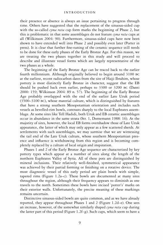
Phases 1 and 2 of the Early Bronze Age sequence are characterized by keypottery types which appear at a number of sites along the length of thenorthern Euphrates Valley of Syria. All of these pots are distinguished bymineral inclusions. Their relatively well-finished, symmetrical appearancewas achieved by their partial forming or finishing on a rotative device. Themost diagnostic vessel of this early period are plain bowls with simple,tapered rims (Figure 1.2a–c). These bowls are documented at many sitesthroughout the region, although their frequency appears to diminish as onetravels to the north. Sometimes these bowls have incised ‘potter’s’ marks ontheir exterior walls. Unfortunately, the precise meaning of these markingsremains uncertain.
Distinctive sinuous-sided bowls are quite common, and as we have alreadyreported, they appear throughout Phases 1 and 2 (Figure 1.2d–e). One seesan increase, however, of the somewhat similarly shaped cyma recta cup duringthe latter part of this period (Figure 1.2f–g). Such cups, which seem to have a
I N T R O D U C T I O N
9
fairly wide distribution covering much of southern Turkey and western Syria,are distinguished by their thin, out-flared sinuous profiles, and also by smallring bases (Dornemann 1988: 17; Jamieson 1993: 46). For the most part,cyma recta cups are diagnostic of the northern stretch of the Syrian Euphrates,while further to the south below Tell Hadidi, they are much rarer. At HalawaTell B, a variant of a cyma recta cup is distinguished by the absence of a smallring base.
Medium-sized, hemispherical bowls with exterior thickened rims appearin Phases 1 and 2 of the Early Bronze Age (Figure 1.2h). Like the cyma rectacups, they appear to be concentrated in the northern part of the Euphrates.On the other hand, restricted necked jars, characterized by out-turned thick-ened rims and interior rim indentations, seem more frequent in the southern
Figure 1.2 Phase 1–2 pottery.
I N T R O D U C T I O N
10
part of the region, occurring at sites such as Tell es-Sweyhat, Tell Hadidi andHalawa Tell B (Figure 1.2i–j). Nonetheless, a few of such jars are attested atthe more northerly site of Tell Ahmar.
More diagnostic of the entire northern Euphrates are restricted neck jarswith out-turned thickened rims, but which have no visible interior rimindentation (Figure 1.2k–l). These occur with great frequency. Other wide-mouthed neckless jars, featuring short, slightly out-turned rims, are also wellattested. At least a few of these forms, bearing a rather coarse fabric andrough, handmade appearance, represent cooking pots.
Still other vessel forms are diagnostic of the Phases 1 and 2 of the EarlyBronze Age, although their presence is less frequent and they may have amore restricted distribution than some of the vessel types described above.Most distinctive are large bowls with plain flaring rims, whose carinationbelow the rim is frequently emphasized by a protruding ridge (Figure 1.2m).These bowls invariably stood on long, stems with wide flaring bases andraised, rounded lips (Figure 1.2n) (Falsone 1998: 29). Encountered first inEarly Bronze Age tombs at Carchemish at the northern end of the region,such so-called ‘champagne vases’ have now been encountered at the sites ofShiyukh Tahtani, Jerablus Tahtani, and Qara Quzaq, as well as further northalong the Euphrates in Turkey, at sites such as the Birecik Dam Cemetery(Woolley and Barnett 1952: 219–22; Sertok and Ergeç 1999: 92). It has beensuggested that their frequent or almost exclusive association with tombs isreflective of their function as ceremonial drinking containers in feasts associ-ated with burial rites (Peltenburg in press a). The majority of these vesselsoccurs at sites located north of Tell Banat, signifying that they may havebeen part of a northern funerary tradition that was not shared by all of theinhabitants of the region.
Another northern diagnostic vessel type, referred to as Late Reserved-SlipWare is distinguished by its decoration, which features a light-coloured slipapplied to the upper body of the vessel and then partially wiped off inoblique radial lines to expose the darker clay body beneath (Figure 1.2o)(Jamieson 1993: 43). This type of decoration occurs on a variety of cupand bowls, but is most frequent on restricted necked jars with externallythickened, out-turned rims (Jamieson 1993: 43).
Finally, there are a few vessel groups having a very narrow distributionthat occur at only one or a few sites. There is, for example, a unique group ofred painted pots which have only been recorded at Qara Quzaq (Figure 1.2p)(Valdés Pereiro 1994: 63). Within the Tell es-Sweyhat embayment, stillother local wares have been reported, these including jars with squared rimsor hollowed tops, and jars with grooved, exterior rims (Wilkinson 2004: 90).Such locally distinctive features indicate that while Euphrates settlementsbelonged to the same cultural horizon overall, they nonetheless possesseddistinctive local traditions which found expression in several aspects of theirmaterial culture, including pottery.
I N T R O D U C T I O N
11
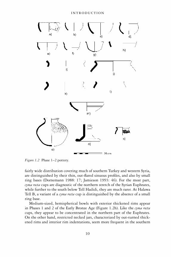
Phase 3 (2600–2450 bc)3
Although several vessel types appearing in Phases 1 and 2 continue intoPhase 3, this phase is also distinguished by several new vessel forms andwares. Of particular note is the introduction of a class of fine wares in theEuphrates region. These wares have received considerable discussion in theliterature, being variously referred to as Metallic Ware, Euphrates BandedWare, Red Banded Ware and Orange Spiral Burnished Ware. None of thesedesignations is entirely satisfactory. The term Metallic Ware is problematicbecause it is often confused with the Metallic Ware of the Khabur region ofnortheastern Syria, appearing around the same time period. This latter pot-tery, which is also referred to as Stone Ware, features a dense, highly vitrifiedfabric with few visible inclusions, whose sherds make a ‘metallic’ clinkysound when they are struck together (Schneider 1989; Akkermans andSchwartz 2003: 254). Fine Euphrates pottery, in contrast, comprises analtogether different fabric, range of fired colours, and set of vessel shapes.Nevertheless, most of the Euphrates specimens of this ware consist of well-made vessels, sometimes featuring eggshell-thin walls which are uniformlyhighly fired and well finished, and therefore their designation as fine wareseems appropriate.
Euphrates Fine Ware is usually decorated. It commonly features fine, hori-zontal striations or corrugations, especially on the upper section of a vessel’sexterior. This surface decoration may be accompanied by spiral bands ofhorizontal burnishing. This decoration was produced when a thin tool wasapplied to the exterior of the vessel as it was being turned on a rotative device(Porter in press). The ware is also sometimes decorated with thin concentricbands of red paint.
Several vessel forms belong to the class of Euphrates Fine Wares. Commonare medium-sized jars with long, straight necks and very pronounced evertedrims (Figure 1.3a–b). Thin bands of red paint are found frequently on theupper bodies and necks of these vessels. The bases of these jars are usuallydistinguished by ring bases. Sometimes the foot ring encircles a convex basewhich extends beyond the ring itself, producing a vessel that could not havestood upright. Porter has observed that some jar examples have the remnantsof a criss-cross string bag on their exterior surfaces, suggesting that they werefrequently suspended (Porter 1995a: 20).
Other Euphrates Fine Ware vessel types include bottle-necked jars withflaring and inverted rims, round bodies and ring bases (Figure 1.3c). Openbowls with thickened, usually out-turned, rims, are also included amongthese fine wares (Figure 1.3d). They often have thin, graceful walls andfine spiral burnishing. One deep, fine-walled bowl found in Tomb 5 at Telles-Sweyhat was supported by three attached tubular feet (Figure 1.3h).
A version of the ‘champagne’ cup or ‘fruit-stand’ exists in EuphratesFine Ware. The majority of these have pronounced corrugations on the
I N T R O D U C T I O N
12
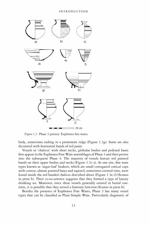
body, sometimes ending in a prominent ridge (Figure 1.3g). Some are alsodecorated with horizontal bands of red paint.
Vessels or ‘chalices’ with short necks, globular bodies and pedestal basesfirst appear in the Euphrates Fine Ware assemblages of Phase 3 and then persistinto the subsequent Phase 4. The majority of vessels feature red paintedbands on their upper bodies and necks (Figure 1.3i–j). At one site, fine waretypes known as ‘sugar-loaf’ beakers, which are small corrugated conical cupswith convex, almost pointed bases and tapered, sometimes everted rims, werefound inside the red banded chalices described above (Figure 1.3e–f) (Sconzoin press b). Their co-occurrence suggests that they formed a type of luxurydrinking set. Moreover, since these vessels generally existed in burial con-texts, it is possible that they served a funerary function (Sconzo in press b).
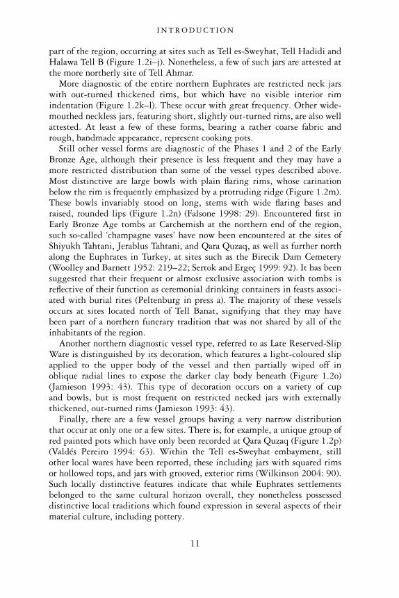
Besides the presence of Euphrates Fine Wares, Phase 3 has many vesseltypes that can be classified as Plain Simple Ware. Particularly diagnostic of
Figure 1.3 Phase 3 pottery: Euphrates fine wares.
I N T R O D U C T I O N
13
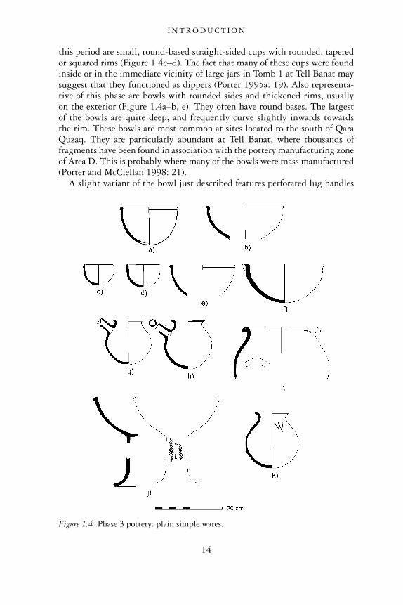
this period are small, round-based straight-sided cups with rounded, taperedor squared rims (Figure 1.4c–d). The fact that many of these cups were foundinside or in the immediate vicinity of large jars in Tomb 1 at Tell Banat maysuggest that they functioned as dippers (Porter 1995a: 19). Also representa-tive of this phase are bowls with rounded sides and thickened rims, usuallyon the exterior (Figure 1.4a–b, e). They often have round bases. The largestof the bowls are quite deep, and frequently curve slightly inwards towardsthe rim. These bowls are most common at sites located to the south of QaraQuzaq. They are particularly abundant at Tell Banat, where thousands offragments have been found in association with the pottery manufacturing zoneof Area D. This is probably where many of the bowls were mass manufactured(Porter and McClellan 1998: 21).
A slight variant of the bowl just described features perforated lug handles
Figure 1.4 Phase 3 pottery: plain simple wares.
I N T R O D U C T I O N
14
(Figure 1.4f). These bowls’ association with tomb contexts suggests that theywere part of funerary assemblages. Other funerary vessels include ‘champagne’bowls in Plain Simple Ware. Vessels from Tomb 1 at Tell Banat have thick-ened triangular rims, and some also have fenestrated and incised tubular stems(Figure 1.4j). Two pedestalled ‘champagne’ vases from Halawa Tell A andTomb 5 at Tell es-Sweyhat probably also belong to this same class of vessels.
Spouted jars stand out as another diagnostic vessel type of Phase 3 (Figure1.4g–h). These vessels, commonly dubbed ‘teapots’, have round bases. Allfeature a single straight spout extending from the upper shoulder of the jar,below a simple everted rim. Other medium-sized jars do not appear withspouts. They are either short or long-necked, but they invariably haverounded bases and plain everted rims. A few of these types of jars areadditionally distinguished by potter’s marks on the shoulders (Figure 1.4k).Last, Phase 3 includes large, restricted necked jars with round bases. Thesehave short, flaring rims which are often thickened on the exterior. Many bearan interior rim indentation, a distinctive feature that was introduced inPhase 2 (Porter and McClellan 1998: 21).
Triangular lugged cooking pots replace the earlier Cooking Pot Wareof Phases 1 and 2 (Figure 1.4i). Like their predecessors, these hand-madevessels are globular, only now they are distinguished by applied triangularhandles or lugs which are attached to the top of the rim (Jamieson 1993: 48).The domestic, utilitarian function of these vessels is supported by theirinfrequent appearance in tomb contexts.
Phase 4 (2450–2300 bc)4
Phase 4 marks an important period in the Syrian Euphrates. Many sitesexperienced significant expansions and urban transformations during thistime, reflected by increases in the size, monumentality and complexity ofsecular residences, temples and fortifications. One also sees greater regionalhomogeneity in the material culture during this period. A growing numberof tomb structures, for example, share similar plans, construction materialsand techniques. This period also marks the widespread appearance of theso-called temples in antis. These long-roomed temples are not only present atseveral Euphrates sites, they appear throughout northern Mesopotamia (seeChapter 7). The reason for such growing homogeneity in architectural styles,in our view, is related to the increase in trade and exchange within theEuphrates region and beyond, and the desire of many inhabitants to emulatethe styles and technology of their neighbours.
The increased cultural homogeneity attested in architecture during Phase 4is also manifested in the pottery of this time period. Many of the same vesseltypes occur throughout the northern Euphrates Valley. Unlike earlier phasesof the Early Bronze Age, it is usually difficult to speak of northern andsouthern pottery collections (Porter in press). In spite of this wider trend
I N T R O D U C T I O N
15
towards homogeneity, however, slight variations in the form and decorationof pots within each general vessel type can be discerned at the local level.We suspect that this local variability can be ascribed to the presence ofworkshops dispersed throughout the region whose potters were producingvessels according to the tastes of consumers in their own local areas. Insum, although a increase in communication and exchange throughout theEuphrates Valley generated an overall homogeneous pottery repertoire, theconcurrent presence of well-organized, locally-based craft workshops resultedin slight differences in vessel styles from one settlement to the next.
Euphrates Fine Wares continue to be manufactured and consumed duringPhase 4. As with the earlier Phase 3, these fine wares have been recoveredprimarily from funerary contexts (Porter 1999: 313). Of the common forms,tall-necked globular jars painted with red horizontal bands and spiral bur-nishing continue to appear, although greater variations now exist. Whereasin Phase 3, such jars invariably featured pronounced everted rims, now onesees several different rim forms, including thickened rims, or double andmultiple grooved rims (Figure 1.5a–b). A jar from Wreide has a potter’smark, as have some of the jars from the Tawi cemetery. Another Wreide jarfeatures vertical, as opposed to, horizontal burnishing on the neck. The over-all impression conveyed by these differently decorated jars is that while thetradition of Euphrates Fine Ware is well-known among all sites during thisperiod, there is a tendency for local variability.
As already reported, ‘chalices’ with short necks, globular bodies and ped-estal bases continue to appear in Phase 4 (Figure 1.5c). As in Phase 3, themajority of these vessels have red painted bands on their necks and upperbodies as well as spiral burnishing.
There are a few new additions to the Fine Euphrates Ware repertoire inPhase 4. Like the older fine ware pots, these new vessels are hard, highlyfired, and are frequently decorated with spiral burnishing and corrugations.Their noteworthy distinction is that they have a dark grey colour. Thesetypes of vessels are sometimes referred to as Grey Spiral Burnished Ware (VanLoon 2001: 5A.233) or Black Euphrates Banded Ware (Porter in press). Ofthis grey ware, one of the most prominent vessel types appearing in fre-quency in Phase 4 is the so-called ‘Syrian bottle’. This is a small jar or bottle,distinguished by a long bag-shaped or globular body and a very narrow neckthat flares out to a wider rim (Figure 1.5d). The long body of the bottlerounds to a slightly pointed base (Porter in press). These distinctive vesselshave been found throughout the Syrian Euphrates, usually in tomb contexts.One wonders about their specific function. Given their small size, narrowbodies and restricted necks, it is possible that they contained some kind ofprecious perfumed resin or oil that was used in funerary celebrations.
Also included among the Grey Fine Euphrates Wares are a variety of small,short necked jars with wide, rounded shoulders that taper to a rounded, flator ring base (Figure 1.5e–f ) (Porter in press). The majority are also decorated
I N T R O D U C T I O N
16
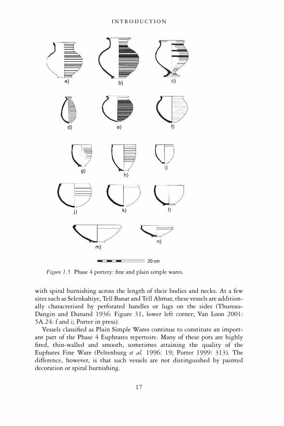
with spiral burnishing across the length of their bodies and necks. At a fewsites such as Selenkahiye, Tell Banat and Tell Ahmar, these vessels are addition-ally characterized by perforated handles or lugs on the sides (Thureau-Dangin and Dunand 1936: Figure 31, lower left corner; Van Loon 2001:5A.24: f and i; Porter in press).
Vessels classified as Plain Simple Wares continue to constitute an import-ant part of the Phase 4 Euphrates repertoire. Many of these pots are highlyfired, thin-walled and smooth, sometimes attaining the quality of theEuphates Fine Ware (Peltenburg et al. 1996: 19; Porter 1999: 313). Thedifference, however, is that such vessels are not distinguished by painteddecoration or spiral burnishing.
Figure 1.5 Phase 4 pottery: fine and plain simple wares.
I N T R O D U C T I O N
17
The hallmark of Phase 4 is the corrugated goblet or beaker (Figure 1.5g–h).Such goblets are well-known throughout Syria, appearing most abundantlyin the EB assemblages of Tell Mardikh (Ebla) and Hama to the west (Heinrichet al. 1970: 79–80). They are frequently referred to as ‘Hama goblets’ andare said to constitute a major element of the highly urbanized ‘caliciform’culture of western Syria (Mazzoni 1985: 14–15). Goblets found in theEuphrates region appear to represent a regional variety of these ‘Hama gob-lets’. Overall, the vessel is characterized by a barrel shape, ring base, andcorrugated exterior surface (Jamieson 1993: 52). Rims appear in a varietyof forms, being simply tapered, beaded or slightly thickened. The gobletsare found at most Euphrates sites occupied during Phase 4. Because theirpresence is not confined to burials, it is likely that they functioned as akind of all-purpose drinking cup. Closely related to the corrugated goblet isthe plain goblet, which shares the same form but has few or no distinctivecorrugations or ridges on its exterior walls (Figure 1.5i).
Small beaded rim cups or bowls occur abundantly in Phase 4. At TellBanat they are particularly frequent (Figure 1.5j–k) (Porter and McClellan1998: 29). These vessels are deeper and wider than the goblets just described,and usually have a round or flat base. Other types of small cups with roundedsides and simple rims also exist in Phase 4 (Figure 1.5l).
Among the most common bowl types are hemispherical bowls with exter-nally thickened rims which sometimes turn inwards at the top (Figure 1.5m).There are also bowls featuring lips that turn slightly inward at the top andbear pronounced protrusions below the rim (Figure 1.5n) (Porter andMcClellan 1998: 29). Occurring less frequently are bowls which stand onthree tubular feet.
The so-called ‘champagne’ vessels, distinguished by their long stems andwide flaring bases, continue in abundance at several northern Euphratestomb assemblages in Phase 4 (Figure 1.6f). Approximately 100 such vesselswere uncovered in the monumental Tomb 302 at Jerablus Tahtani (Peltenburgin press a). They were also found in the Hypogeum at Tell Ahmar, where theyfeatured a variety of stem lengths (Thureau-Dangin and Dunand 1936: pl. 23,5–14). Besides these pedestalled bowls, globular-shaped, short-necked jarsalso appear on high stemmed bases of varying lengths in the Ahmar Hypogeumassemblage. They attest to the variability of ceremonial vessels associatedwith the funerary rites of this impressive tomb.
Many varieties of jars are present in the Phase 4 Euphrates repertoire. Themost common are medium-sized jars with long necks and ring bases. Theirrims have either double or multiple grooves (Figure 1.6a–b). Many of thesejars are quite thin-walled, smooth and highly fired, such that they almostwarrant classification as Euphrates Fine Wares. None of these jars, however,feature corrugations, painted bands or spiral burnishing (Porter 1999: 313).
The most distinctive jars in Phase 4 have narrow-necks, wide, globularbodies and two loop handles, set high on the shoulders (Figure 1.6c). These
I N T R O D U C T I O N
18
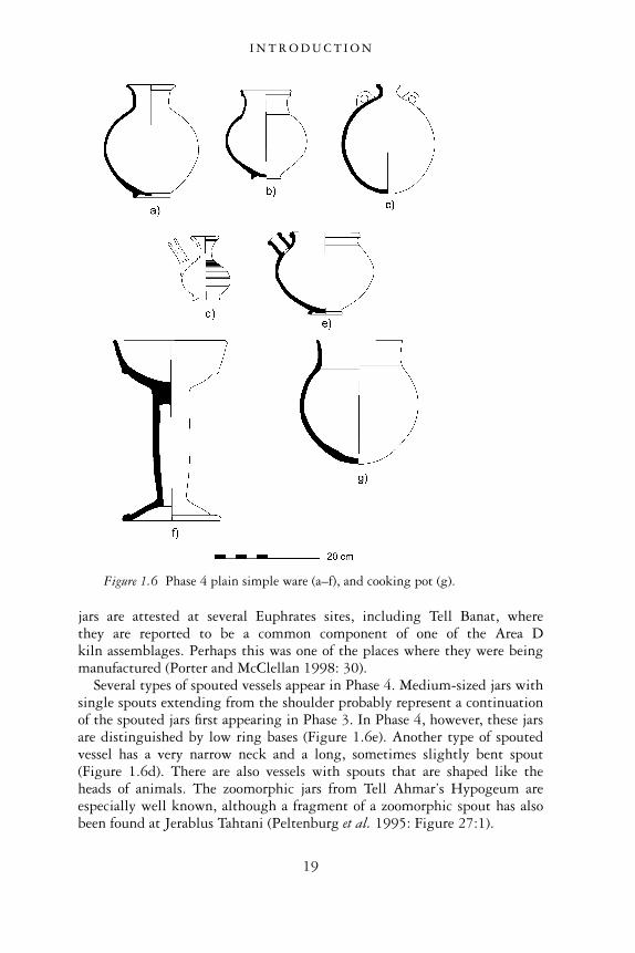
jars are attested at several Euphrates sites, including Tell Banat, wherethey are reported to be a common component of one of the Area Dkiln assemblages. Perhaps this was one of the places where they were beingmanufactured (Porter and McClellan 1998: 30).
Several types of spouted vessels appear in Phase 4. Medium-sized jars withsingle spouts extending from the shoulder probably represent a continuationof the spouted jars first appearing in Phase 3. In Phase 4, however, these jarsare distinguished by low ring bases (Figure 1.6e). Another type of spoutedvessel has a very narrow neck and a long, sometimes slightly bent spout(Figure 1.6d). There are also vessels with spouts that are shaped like theheads of animals. The zoomorphic jars from Tell Ahmar’s Hypogeum areespecially well known, although a fragment of a zoomorphic spout has alsobeen found at Jerablus Tahtani (Peltenburg et al. 1995: Figure 27:1).
Figure 1.6 Phase 4 plain simple ware (a–f), and cooking pot (g).
I N T R O D U C T I O N
19
Cooking pots, made by hand and usually taking the form of jars withtriangular lugs protruding from externally thickened rims, continue to bemanufactured in Phase 4. The exterior walls and rims of several of these cook-ing pots are burnished. Another cooking pot type attested at a few Euphratessites has a rounded body, straight neck and simple tapering rim (Figure 1.6g).Although these vessels have a wide distribution in the Euphrates, beingfound as far north as Jerablus Tahtani and as far south as Selenkahiye, theyappear less frequently than the distinctive triangular-lugged pots.
Phase 5 (2300–2100 bc)5, 6
Although this is the newest phase that has been properly identified, it repre-sents a significant time in the Euphrates Valley. Some sites had alreadyceased to be occupied during this period (for example, Jerablus Tahtani, TellBanat). Tell es-Sweyhat was long regarded as an unusual case since it was alarge, densely occupied city during this late stage of the third millennium.Present evidence now shows that Tell es-Sweyhat was one of many northernEuphrates sites inhabited during this phase. Halawa Tell A continued tothrive in this period, as did Tell Habuba Kabira, Tell Hadidi and TellAmarna. The small settlement at Tell Kabir was clearly inhabited, althoughthe nature of its occupation remains elusive. The settlement at Selenkahiyeexisted, although there are signs of decline in its last settlement, reflected bythe occupation of fewer houses and cursory repairs to houses and fortificationsthat had been previously destroyed by fire. The most recent Syrian-Germanexcavations at Emar, which have uncovered a good sequence of late thirdmillennium domestic architecture and Phase 5 pottery, have confirmed thatthis site was also occupied (Finkbeiner 2002: 130–9; 2003: 65–90).
The combined evidence suggests that while one or a series of events mayhave contributed to the end of some settlements, others continued to holdon, and some were even able to grow and flourish during this period. We willdiscuss reasons for the persistence of settlement in the Euphrates regionduring this time and into the subsequent Phase 6 in our final chapter.
Because the pottery of Phase 5 is still in the early stages of being properlyunderstood, only a few observations and accompanying illustrations are pre-sented here. Overall, the phase is defined by strong ceramic continuity fromthe earlier Phase 4, although a few new forms appear. Some of the older waresdecline in frequency quite dramatically. The most noticeable decline is thatof the Euphrates Fine Ware, whose highly-fired, thin-walled red banded andspiral burnished vessels disappear altogether during this period. They arereplaced by assemblages almost exclusively made up of Plain Simple Wares.
Some of the older Plain Simple vessel forms still appear during this time.The ‘Hama goblet’ exhibits both plain and corrugated walls and the samerange of tapered or beaded rims as in Phase 4 (Figure 1.7a, c). A new type ofcup, however, seems to have evolved out of these goblets. Although its rims
I N T R O D U C T I O N
20
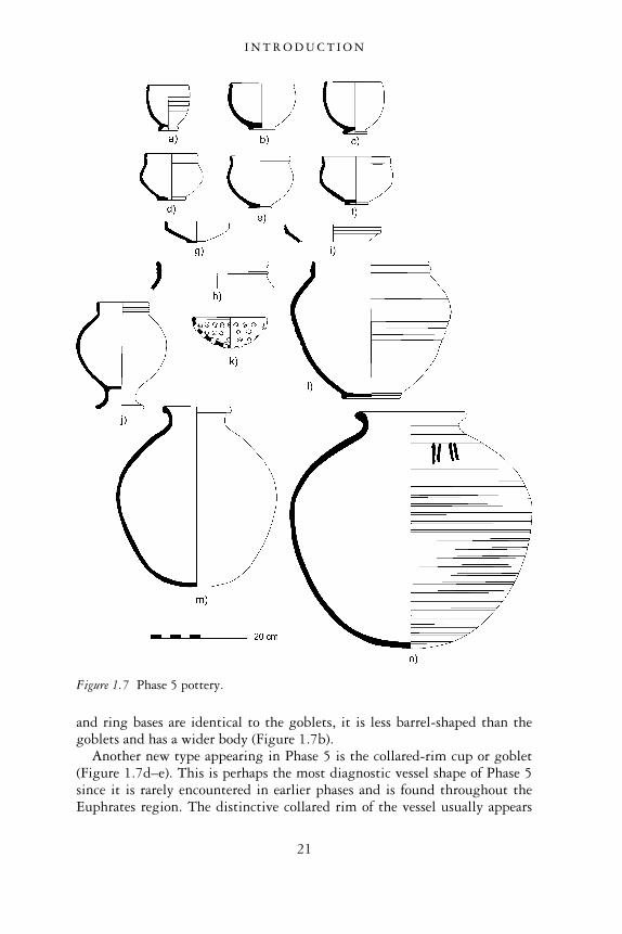
and ring bases are identical to the goblets, it is less barrel-shaped than thegoblets and has a wider body (Figure 1.7b).
Another new type appearing in Phase 5 is the collared-rim cup or goblet(Figure 1.7d–e). This is perhaps the most diagnostic vessel shape of Phase 5since it is rarely encountered in earlier phases and is found throughout theEuphrates region. The distinctive collared rim of the vessel usually appears
Figure 1.7 Phase 5 pottery.
I N T R O D U C T I O N
21
on a cup form whose walls are rounded and wide. Some of these vessels areparticularly wide, such that it may be more appropriate to call themcollared-rim bowls rather than cups (Figure 1.7f).
Several bowl types continue from the earlier Phase 4. Bowls with exter-nally thickened rims, for example, are still present, as are bowls with in-turned rims with slight protrusions below the rims. Perhaps evolving out ofthese latter forms are bowls whose rims are now more vertical than in-turned,and which frequently feature multiple grooves (Figure 1.7g, i).
A distinctive medium-sized jar has a wide, rounded body. It is neckless,with a vertical rim that is frequently grooved. While this jar is usuallycharacterized by a simple ring base, there are also instances in which it isset on a high pedestal base (Figure 1.7j).
Another diagnostic form are jars characterized by multiple-grooved rimsthat rise vertically above a very short neck (Figure 1.7h, l). These jars maketheir first appearance in Phase 5, but they continue into Phase 6, where theybecome even more frequent. For the most part, these jars have wide, globularbodies. Many may be akin to the jars just mentioned since they are usuallyneckless, although many have wider bodies and rim diameters.
Phase 5 is defined especially by the appearance of many restricted neckedstorage jars. These jars take on many forms, although the most diagnostic arenoticeably wide-bellied and have slightly convex bases (fig 1.7m). Such largejars have no precursors in the earlier phases of the Early Bronze, but theycontinue into Phase 6 and the subsequent Middle Bronze Age, albeit withdifferent rim forms. During Phase 5, these jars are usually characterizedby thickened, everted rims. Many of these Phase 5 jars are also distinguishedby incised potter’s marks which usually occur on their shoulders. One won-ders if these marks have anything to do with the storage function of the jars,possibly identifying the owner of the goods stored within, or the destinationof the jar.
Aside from potters’ marks, most large jars are undecorated. The exceptionare those with parallel bands of cream-coloured reserve slip decoration cover-ing much of the exterior surface of their bodies and necks (Figure 1.7n). Thisform of decoration is especially prevalent at Tell es-Sweyhat, where it hasbeen observed on many large jars found in the buildings on the main moundas well as the extensively occupied late third millennium lower town. Thepresence of this slipped decoration on large jars from Wreide and Emar,however, confirms that this is not a local development (Orthmann and Rova1991: IIC:4; Finkbeiner 2002: Abb. 14:a).
A few other distinctive vessel forms characterize Phase 5 of the northernEuphrates Valley. These include small colander or strainer-type bowls, dis-tinguished by numerous holes pierced through their bodies (Figure 1.7k).These bowls have a variety of rims, although simple tapered and beaded rimsappear to be the most frequent.
Last, the phase witnessed the increased frequency of decorated vessels with
I N T R O D U C T I O N
22
applied and incised animals and human figures. One interesting examplecomes from Room 7 of the Area IV ‘warehouse’ on the main mound at Telles-Sweyhat. This particular spouted pot features two strange beasts facingtowards a bird. The beasts’ heads have been applied in relief, while the rest oftheir bodies as well as the central bird have been incised into the clay wall ofthe vessel (Holland 1976: 59). A similarly decorated pot with spout wasfound at the site of Munbaqa, this also featuring a centrally incised birdflanked by two animals, identified in this example as lions (Machule et al.1986: Abb. 15). Although these are the only two vessels which are completeor nearly complete, the discovery of several fragments of applied and incisedanimals and people from other sites such as Halawa Tell A indicates thatthese vessels were fairly common during this time period (Hempelmann2001). The vessels’ frequency in the temple precinct and its vicinity at HalawaTell A may indicate that they had some association with religious activities(Hempelmann 2001: 158–9; see also Chapter 7).
Phase 6 (2100–1900 bc)7
Phase 6 represents the last period during which Early Bronze Age culturalfeatures appear in the Syrian Euphrates Valley. It also marks the beginning ofthe Middle Bronze Age, defined by several new cultural elements. Many havepreferred to call this period ‘transitional’, thus acknowledging the blend ofboth old and new features.
Phase 6 is still elusive archaeologically. It seems that at the end of Phase 5,many settlements were abandoned or experienced dramatic decreases inpopulation and settlement size. Environmental degradation or some kind ofsocio-political collapse may have taken place that precipitated this decline insettlement, although we cannot precisely define the nature of the upheavals.Whatever the reasons for its settlements’ decline, the northern EuphratesValley of Syria was not abandoned altogether. Architectural and artifactualremains at several sites indicate that occupation continued without a signifi-cant break during this phase, and that local populations continued to supportthemselves, albeit on a less intensive scale, with the resources of the fieldsand pastures of their hinterland.
The pottery of Phase 6 is very transitional in nature (Figure 1.8). Thepottery possesses several morphological analogies to forms prevalent in theearlier Phase 5 repertoire in the Syrian Euphrates, while at the same time,it has new features which compare favourably with the succeeding MiddleBronze Age ceramic assemblages of this region. Given the repertoire’s strongcultural connections in both directions, it is actually difficult to pinpoint avessel type that distinguishes this phase in particular.
Small cups that appear in Phase 6 appear to represent a development fromthe earlier collared-rim cups of Phase 5. They have the same general bodyshape of the earlier cups but the rim has become less vertical and collared,
I N T R O D U C T I O N
23
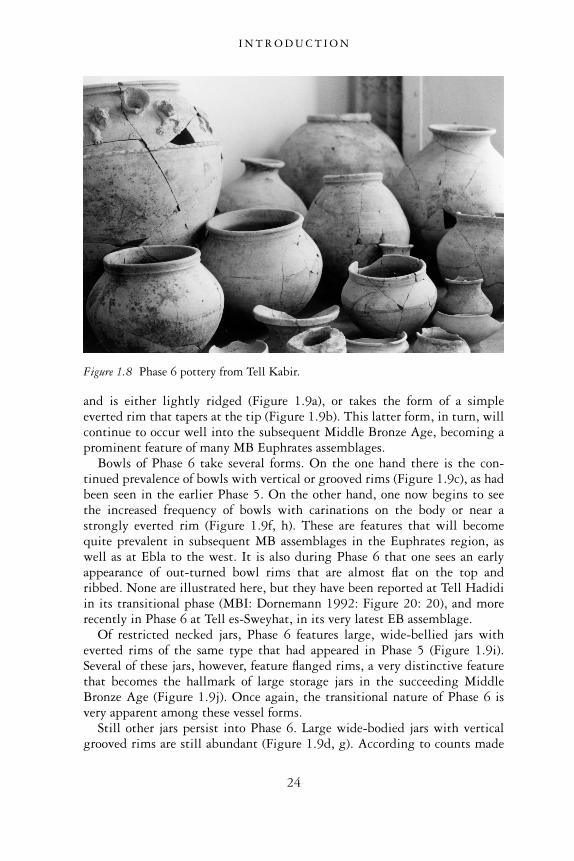
and is either lightly ridged (Figure 1.9a), or takes the form of a simpleeverted rim that tapers at the tip (Figure 1.9b). This latter form, in turn, willcontinue to occur well into the subsequent Middle Bronze Age, becoming aprominent feature of many MB Euphrates assemblages.
Bowls of Phase 6 take several forms. On the one hand there is the con-tinued prevalence of bowls with vertical or grooved rims (Figure 1.9c), as hadbeen seen in the earlier Phase 5. On the other hand, one now begins to seethe increased frequency of bowls with carinations on the body or near astrongly everted rim (Figure 1.9f, h). These are features that will becomequite prevalent in subsequent MB assemblages in the Euphrates region, aswell as at Ebla to the west. It is also during Phase 6 that one sees an earlyappearance of out-turned bowl rims that are almost flat on the top andribbed. None are illustrated here, but they have been reported at Tell Hadidiin its transitional phase (MBI: Dornemann 1992: Figure 20: 20), and morerecently in Phase 6 at Tell es-Sweyhat, in its very latest EB assemblage.
Of restricted necked jars, Phase 6 features large, wide-bellied jars witheverted rims of the same type that had appeared in Phase 5 (Figure 1.9i).Several of these jars, however, feature flanged rims, a very distinctive featurethat becomes the hallmark of large storage jars in the succeeding MiddleBronze Age (Figure 1.9j). Once again, the transitional nature of Phase 6 isvery apparent among these vessel forms.
Still other jars persist into Phase 6. Large wide-bodied jars with verticalgrooved rims are still abundant (Figure 1.9d, g). According to counts made
Figure 1.8 Phase 6 pottery from Tell Kabir.
I N T R O D U C T I O N
24

of these jar types at both Tell Kabir and at Tell es-Sweyhat, these jar typesactually increase in frequency during this transitional phase. They have alsobeen reported in subsequent Middle Bronze Age levels, although by thistime they have begun to dwindle in number.
One interesting large, wide-bodied jar found at Tell Kabir has a groovedrim of a type prevalent in the transitional period, while additionally featur-ing a spout and a motif of incised and applied lions (Figure 1.9k). This jar isclearly derived from the decorated spouted pots of Phase 5.
As a final comment, we note that the handmade triangular lugged cookingvessels of the earlier phases of the EB have disappeared. They are replaced by
Figure 1.9 Phase 6 pottery.
I N T R O D U C T I O N
25

cooking pots with ovoid bodies and thickened, out-turned rims, these bear-ing strong affinities to Middle Bronze Age cooking pots in terms of their clayfabric constituents and production technology (Figure 1.9e) (Dornemann1992: 80; Figure 4:10; Cooper 1998: 274). It is striking that such a commonutilitarian vessel should have experienced such a significant change duringthis time. No doubt it reflects the extent to which dramatic culturaltransformations were being felt at all levels of society during this unsettled,changeable time period.
I N T R O D U C T I O N
26
2
ENVIRONMENT ANDSUBSISTENCE
Without question, the environment of the Syrian Euphrates region playedan important part in moulding the character of human settlement duringthe third millennium bc. Although we cannot deny the impact that humanagency had in shaping the distinctive and remarkable ways in which eventsunfolded during this significant period of antiquity, the environment, tono small degree, set the stage for these events and developments. It encouragedor limited some human actions and choices, while stimulating responsesto other challenges. During the third millennium bc, in our view, theenvironment provided much of the incentive for human groups both tomove beyond simple small-scale pastoral-agrarian livelihoods and to adoptincreasingly complex economic enterprises and exchanges as well as distinct-ive social-cultural traditions and ideologies. The environment contributedgreatly not only to the growth and success of urban life in the Euphratesregion, but also to the unique character that urban settlements acquired overthe course of their long development.
The northern Euphrates Valley was essentially a marginal environment, inwhich low amounts of rainfall per year made dry farming in this region avery risky undertaking. This climate has characterized the region for at leastthe past 5,000 years. At the same time, however, the natural environment ofthe river valley and its environs made up in several ways for this shortfall inprecipitation. The alluvial flood plains provided other natural resources inabundance. The vast grassy upland plateaus, extending away from eitherside of the valley, provided the potential for flourishing pastoral activitiesand they abounded in wild game. Trading opportunities afforded by theEuphrates River itself opened up the region to long-distance contacts. Suchcommercial relations were responsible for the procurement of surplus goodsas well as foreign influences and cultural exchanges. In short, the SyrianEuphrates region provided a challenging environment, but once its potentialwas realized, ample opportunities presented themselves for human groups toenjoy economic prosperity and a certain degree of socio-political stability.As we shall see, such groups seemed particularly attuned to the positivepotential of the Euphrates environment, as attested by the numbers of EB
27
settlements established within the river valley and strategically positioned soas to take advantage of favourable economic opportunities. Overall, people’sability to harness the advantages of the environment not only enabled theirsettlements to grow and flourish but also gave them a degree of resilience andflexibility, enabling them to endure for many centuries.
PHYSICAL ENVIRONMENT
The natural landscape of the Euphrates River Valley of northern Syria,extending for approximately 100 km from the modern Turkish-Syrian borderin the north to the region below the ancient city of Emar in the south,presents a sharp contrast to the dry, deserted land that surrounds it. Throughthe lonely expanse of the treeless, undulating steppe land of the northernSyrian plateau, the Euphrates River cuts a deep trough, creating a fertilevalley of alluvial plains and terraces on either side of its banks. Humangroups were attracted to this river valley in antiquity because of the varietyof plant and animal life that they could exploit for food, clothing and shelter.In addition, the navigable waterways of the Euphrates River provided aneffective means of communication, enabling economic and cultural linksbetween the inhabitants of this otherwise isolated region and people of otherpopulated, cosmopolitan regions of Mesopotamia, Anatolia and the Levant.
The Euphrates River begins its long journey in the highlands of easternTurkey, where its headwaters are fed by rainfall and melting mountain snow.After a steep descent through Anatolia, the Euphrates enters Syria just belowthe ancient city of Carchemish. As it flows through northern Syria, theriver’s meandering channel is contained within an alluvial plain that is aswide as 10 km in some places, while in other areas, it flows through long,narrow gorges featuring flood plains no wider than 500 m, surrounded onboth sides by precipitous limestone bluffs that rise up over 100 m (Serrat andBergadà 1999: 239–40). Where the river valley is wider and the channel isless deeply entrenched, minor streams break off and rejoin the main channelbetween lengths of 3 and 6 km (Wilkinson 2004: 20). The river may alsooccasionally break through its meanders, causing a shift in the course of thechannel altogether. In such cases, ancient settlements that were once situatednear the river’s edge have either been completely erased by river erosion orobscured by sedimentation (Wilkinson 2004: 34). In other cases, sites arenow situated on the edges of relict channels which lie at a considerabledistance to the present river course (Besançon and Sanlaville 1985: 11).
While the modern dams constructed along the Euphrates have largelyregulated its flow, the amount of water carried by the river in the past wouldhave varied tremendously according to the seasons of the year. The river wasat its lowest in the dry months of August, September and October, butmelting snow and winter rains in the Anatolian highlands caused the river to
E N V I R O N M E N T A N D S U B S I S T E N C E
28
reach its highest levels in the April and May (Wilkinson 2004: 21). Thisannual flooding would have inundated many of the fields of the adjacentflood plain. Unfortunately, unlike other river regimes of the world, whereflooding coincides with the agricultural growing season, and fresh waterand alluvial soil are welcomed as much needed nourishment for crops, theEuphrates flooded at precisely the wrong time of the year, just when cerealcrops were beginning to ripen and large volumes of water were no longerrequired for their growth. Such poor timing clearly made winter-springfarming on the flood plain a high-risk venture (Danti 1997: 92). Con-sequently, most crops were grown on the gently sloping river terraceselevated several metres above the flood plain, safely beyond the limits of theannual inundation.
Flood plain
Due to the risk of flooding, the banks immediately adjacent to the Euphrateswould also have been unsuitable for human habitation, although recent fieldsurveys and satellite imagery have confirmed that some ancient settlementsexist in this precarious environment. These sites are perched on older sectionsof the alluvium, where accumulations of river silt as well as aggrading wadifans from the higher terraces to the east and west have raised the terrain a fewmetres above the current level of the flood plain (Wilkinson 2004: 22). Thesesmall rises of land would have offered some measure of protection for thesettlements, at least during years of normal flooding.
During the third millennium bc, the sites of Jerablus Tahtani, Tell Kabirand Tell Jouweif were among the settlements that existed in the flood plainon such relict channels (Peltenburg et al. 1995: 4; Porter 1995b: 125;Wilkinson 2004: 22). It is possible that the sites’ proximity to the riverallowed them to take advantage of economic opportunities afforded bycommercial traffic along the river. Alternatively, the strategic location ofthese sites at key crossing points over the river may have enabled them tocontrol overland caravan traffic arriving from points to the east and west. TellJouweif’s position along one such overland crossing point is attested by itslocation directly opposite the large, contemporaneous third millenniumcentre of Tell Hadidi on the west bank of the river (Wilkinson 2004: 186).Aerial photographs have also identified ancient roadways radiating out fromTell Jouweif. These roads head either in the direction of Tell es-Sweyhatto the east, or they go to the southeast in the direction of the upland plateau.From there, the road continued past a series of wells that would have pro-vided overland caravans with vital drinking stops on their journey to theBalikh River and beyond (Wilkinson 2004: 186).
Besides favourable trading opportunities, other advantages of the Euphratesflood plain were its natural resources. Riparian forests of poplar, willow andtamarisk trees provided valuable construction materials and wood fuel (Miller
E N V I R O N M E N T A N D S U B S I S T E N C E
29
1997b: 124). Animals such as fish, fowl and fallow deer were hunted for foodin this lush riverine environment (Weber 1997: 141). It may also be possiblethat small plots of summer crops, namely legumes, were flood-water farmedalong the river banks, just as beans were cultivated in this area in the recentpast (Wilkinson 2004: 173).
Years of exceptional inundations could have had disastrous effects forsettlements in the flood plain, as confirmed by geomorphological investiga-tions conducted around the site of Jerablus Tahtani. Here, a series ofabnormally high flood events towards the end of the third millennium bcnot only devastated agricultural fields around the site but were probablyresponsible for the total abandonment of the settlement and the dislocationof its people (Peltenburg 1999a: 103).
Terraces
On either side of the river, a series of terraces gently slopes down towardsthe flood plain. These are the dry remnants of the large and oldest channels ofthe river, formed during the mid-to-late Pleistocene Era (Danti 2000: 23).Composed of chalky white limestone bedrock superimposed by a layer ofbrown limestone, river gravels and silty soil, the terraces now stand severalmetres above the level of the alluvial plain (Wilkinson 2004: 19). Since theyare safely above potentially destructive flooding events, they are favourableplaces to practise dry farming.
Where the meanders of the most ancient river channels have shifteddramatically, terraces take the form of broad plains often extending forseveral kilometres before reaching the bluffs of the upland plateaus. Theterrace upon which the site of Tell es-Sweyhat is situated is one such plain.This large crescentic embayment, which is about 7 km east–west, and10 km north–south, would have offered extensive agricultural and grazingopportunities. Moreover, it would have supported a number of both smalland large settlements in antiquity, as it does today. In other areas of theEuphrates Valley, river terraces are merely narrow strips running alongsidethe flood plain, the steep uplands rising immediately behind them. Whileagricultural activities would have been constrained by this kind of topo-graphy, settlements’ proximity both to the alluvial plain and the highersteppe lands would have enabled them to exploit a variety of alternativeresources within only a short distance.
Seasonal watercourses, or wadis, carrying water runoff from the uplandplateau during the winter rainy seasons, cut deep paths through the terracesas they make their way to the lower elevations in the river valley (Wilkinson2004: 24, 31). As these wadis not only carry water but fresh silt, the cultiva-tion of crops would have been especially successful along their banks, or inbasins nearby where increased moisture was retained in the soil. Occasion-ally, basins where water was collected from these wadis may have served as
E N V I R O N M E N T A N D S U B S I S T E N C E
30
drinking holes for animals, thus also increasing the suitability of pastoralactivities in these areas.
Because of deforestation and the low amount of annual rainfall, the ter-races of the Euphrates River Valley around the site of Tell es-Sweyhat werevirtually treeless by the late third millennium with the exception of a fewremnant stands of oak forest. The trees’ presence is indicated by the smallamounts of oak charcoal found in paleobotanical collections (Miller 1997a:101). In addition, the Tell es-Sweyhat faunal assemblage has yielded a smallnumber of bones of red deer and aurochs, animals that favoured open oakwoodlands (Weber 1997: 141). Travelling further to the north in the direc-tion of the Turkish border, the moister climate would have encouraged thegrowth of greater amounts of woodland vegetation on the terraces. Althoughthere is scant evidence from the paleobotanical record thus far, it is probablethat occasional stands of oak forest existed in the terrace zone of the rivervalley directly to the south of Carchemish and extended down as far as thesite of Tell Ahmar.
Uplands
The uplands rise beyond the flood plain and terraces. Their edges are stronglyscarped, rising in steep banks as much as 100 m above the level of the rivervalley (Zettler 1997a: 2). On the western side of the Euphrates, the uplandplateau extends in the direction of western Syria, while on the river’s easternside, the uplands comprise what is known as the Jezireh, a vast undultingupland steppe that extends all the way across northern Syria into northernIraq, where it reaches the Tigris River (Wilkinson 1994: 484).
The vegetation of the upland plateau consists of grasses and wild andweedy plants. While most areas are unsuitable for agricultural cultivation,this open steppe land is ideal grazing land for sheep and goats, and pastoral-ist activities would have flourished in this area in antiquity. Although fewancient encampments of pastoral nomadic groups have been identified inthe archaeological record owing to the ephemeral nature of much of theirremains, we can postulate that in the third millennium the region aboundedin such groups, moving their flocks across this broad region in their quest forfavourable grazing land and available sources of water.
The uplands are generally unsuitable for agricultural activities, althoughan interesting observation made by Michael Danti suggests that some uplandareas may have been cultivated in the third millennium. While investigatingthe subsistence economy of the inhabitants of the Sweyhat embayment,Danti noted that the settlement itself receives between 200–250 mm ofrainfall per year, just barely enough to practise successful dry-farming. To theeast of the river valley, however, a downward slope in the 250 mm isoyhetmay have provided some upland regions with greater amounts of rainfall peryear (Danti 1997: Figure 5.1; 2000: 266). This higher rainfall provided a
E N V I R O N M E N T A N D S U B S I S T E N C E
31
potential for agriculture, particularly in areas adjacent to the highlandplateau to the east which are additionally fed by large amounts of runoff andwater-born silts brought down by branching wadi systems (Danti 1997: 85).It is possible that settlements and fields located along the wadi systemsutilized the concentration of runoff for the cultivation of crops. Today thisarea is a patchwork of dry-farming and pump-irrigated fields, although weknow that prior to the nineteenth and early twentieth centuries, before theresettlement of modern upland villages and the introduction of mechanizedagriculture and pump irrigation, this region was important for its wells forwatering flocks of sheep and goats (Danti 1997: 85, 87–8).
Surveys conducted by Danti in this upland region between the Euphratesand the Balikh Rivers, approximately 10–30 km to the east of the Sweyhatembayment, found traces of ancient settled occupation (Danti 2000: 272). Inone area where a wadi had been diverted into a low-lying region to form asmall lake, a third millennium site called Tell Jedi was identified. The sitewas occupied during the late Early Bronze Age (Phases 4–5), when Telles-Sweyhat and other settlements of the Euphrates and Balikh basins wereexperiencing peak periods of urbanization (Danti 2000: 276). This site’spresence thus points to the utilization of these agriculturally productive areasof runoff even as early as the third millennium. Settlements such as Tell Jedimay have served as satellite communities for the burgeoning urban centres ofthe Euphrates River valley, supplying their increasing populations withnecessary surpluses of agricultural and pastoral goods (Danti 1997: 92).
SUBSISTENCE
Several forms of subsistence were possible for the inhabitants of the SyrianEuphrates region, given the region’s physical environment, vegetation, andclimate. These methods of subsistence were practised at varying levels ofintensity during different periods of the third millennium and according tolocal levels of rainfall, topographical characteristics and the availability ofnatural resources. Because the region has a marginal environment in whichannual rainfall levels are low, a combination of dry farming, pastoralism,hunting and commercial exchanges would have been the most effective wayof sustaining the region’s population and offsetting losses that wouldhave been incurred if only one or two of these economies were practised ontheir own.
Agriculture
Much of our understanding of the dry-farming regime of the EuphratesRiver Valley derives from T.J. Wilkinson’s in-depth investigation of the agri-cultural economy around the Tell es-Sweyhat embayment area (Wilkinson
E N V I R O N M E N T A N D S U B S I S T E N C E
32
1976; 1994; 2004). Wilkinson’s study combined geomorphological investi-gations with site survey and the mapping of off-site sherd scatters and linearhollows. His principal objectives were to ascertain the periods during whichsettlements were occupied in the Sweyhat embayment in antiquity, and toclarify ancient agricultural practices and the agricultural potential of thisarea (Danti 2000: 7). While Wilkinson’s study of agriculture focussed ononly one area of the Syrian Euphrates, his findings can generally be applied tomost of the Euphrates region considered in this study. Only a slight adjust-ment is needed for the area to the north as one approaches the site ofCarchemish at the Turkish-Syrian border. Here, increased rainfall would havemade dry-farming of cereal grains more feasible and successful. Moreover,increased moisture would have permitted the cultivation of other types ofplants besides the hearty, drought-resilient barley crops predominantlygrown in the Sweyhat embayment and in other areas of the river valley tothe south.
Wilkinson has effectively shown that dry-farming, while possible in thisregion, becomes increasingly precarious as one travels further to the south.This is because the region receives the minimum amount of annual rainfall inwhich dry-farming can be successfully practised. The site of Tell es-Sweyhatfalls close to that limit, experiencing a mean annual rainfall of around 250 mm(Zettler 1997a: 2; Wilkinson 2004: 41). The other significant observationabout the rainfall is that it fluctuates tremendously from one year to the next.It is, therefore, far from regular and reliable. In some years generous amountsof well-timed rainfall can result in a successful crop; in other years cropfailures occur because precipitation levels have fallen well below the annualmean amount. By applying modern levels of rainfall in northern Syria over a30-year period to the third millennium bc, and accounting for inter-annualvariability, Wilkinson calculated that crop failure would have occurred in thearea around Tell es-Sweyhat once every five years if the inhabitants had nottaken additional measures to ensure the success of their crop through theincorporation of a yearly fallow system or manuring (Wilkinson 1994: 499–500). This statistic clearly underlines the marginal nature of the region andthe necessity of incorporating strategies in the agricultural economy to offsetlosses resulting from insufficient rainfall.
To the north, in the direction of the Turkish-Syrian border, higher rainfalllevels would have permitted more reliable crop production and the successfulgrowth of a wider variety of plant species. The Euphrates region belowCarchemish received between 300–400 mm of precipitation per year, judg-ing by maps and tables that illustrate key rainfall isohyets (Wilkinson 1994:Figure 1; Miller 1997b: Figure 7.2). In contrast, the potential for crop failurewould have increased dramatically as one travelled south along the river.Around the site of Selenkahiye, mean annual precipitation was about200 mm (Van Loon 2001: 16.589). At Meskene/Emar, at the southern limitof the area considered here, crop failures may have occurred as often as every
E N V I R O N M E N T A N D S U B S I S T E N C E
33
two years given that annual rainfall levels frequently fall below 200 mm(Wilkinson 2004: 44).
Since there are ways of counteracting the deleterious effect of inadequaterain, it is somewhat erroneous to assume a one-to-one correspondencebetween annual rainfall levels and successful dry-farming. Wilkinson com-ments on strategies employed by landowning farmers today, who are able toabsorb some of the risk of crop failure by extending their fields over largedistances, and can even enjoy profits in wet years (Wilkinson 2004: 41).Local topographic conditions may also have contributed to the success withwhich crops were grown. The exploitation of flat terrain, where less rainfall islost to runoff and soil moisture is higher than in areas of undulating land,may have resulted in greater crop yields. Crops planted near water runofffrom wadis, which represent areas of enhanced moisture concentration andricher soil, may also have had advantages (Wilkinson 2004: 30).
Other land use strategies can offset some of the negative effects of amarginal environment. One common practice is fallowing, in which landis left uncultivated in alternate cropping years. Rain that falls onto theuncropped land is retained in the soil until the next cropping year ratherthan being consumed by crop growth (Wilkinson 2004: 47–8). Wilkinsonhas effectively shown that while dry-farming alone often produces crop fail-ures in the region around Tell es-Sweyhat, the application of fallowing,allowing uncropped fields to retain their moisture, effectively reduces short-falls, such that virtually no crop failures occur. While this practice is lessproductive agriculturally, it is certainly sustainable and resilient (Wilkinson2004: 48–9).
Another way in which to enhance crop growth is to apply fertilizer,namely manure, on the land. Phosphorus and nitrogen contents of manureare favourable for plant growth. In addition, by increasing the growth of theplant canopy, the resultant shade can increase the amount of water moistureretained in the soil. Uses of manuring practices in many dry-farming zones inthe world today have been largely successful, although in years of extremedrought, manuring may ‘heat’ the soil so much that it causes young plants todie off (Wilkinson 2004: 50).
Interestingly, it has been possible to infer extensive manuring practicesin the fields around ancient settlements in the Syrian Euphrates by observ-ing the extent to which low-density scatters of worn potsherds occurwithin or on top of the existing topsoil. It is unlikely that these sherdsrepresent places of sedentary occupation given their even distribution acrossthe land as well as their abraded character. Rather, these sherds are theresult of spreading fields with refuse, principally manure, in order to fertil-ize the soil and thus increase plant production (Wilkinson 1994: 491–2).Much of this fertilizer would have been collected from refuse dumps withinthe settlement, in places like animal byres, streets and kilns. These types ofdumps were also places where broken or old pots were thrown along with
E N V I R O N M E N T A N D S U B S I S T E N C E
34
kiln slag, stone quern fragments, lithic debitage and fragments of figurines.Although the fertilizer which had been spread over the ancient fields haslong since disappeared, these durable pieces of rubbish have remained inthe plow topsoil over several millennia (Wilkinson 1994: 492; Wilkinson2004: 72).
While many ancient tells are distinguished by observable scatters ofsherds and other small artifact fragments, only a few Near Eastern sites’scatters have been systematically studied. Careful observations of scatterdensities and the distance which sherds extend from the site may yield valu-able information about the nature and intensity of land use. Wilkinson’ssurvey of the sherd scatter found around Tell es-Sweyhat is one such study(Wilkinson 1994: 491–2; 2003: 117–18). By measuring the sherd scatterzone around the site he concluded that the fields within a 3–4 km radiusfrom the site had been manured and cultivated. Moreover, the fact that themajority of diagnostic sherds were dated to the late third millennium (Phase 5)indicated that manuring practices did not take place until quite late in thehistory of this settlement’s occupation, when Sweyhat had reached its largestsize and population density (Wilkinson 2004: 68).
Wilkinson’s significant finding suggests that the settlement at Sweyhat,which was now somewhere around 40 ha in area, and may have supportedmore than 100 people per ha, would have needed to cultivate all availableland in the vicinity of the settlement in order to sustain its present levelsof consumption. The decision was made to manure the fields, which wouldhave increased crop productivity. In this period of maximum urbanization,however, there may also have been a temptation to cultivate annually,thus violating fallowing strategies in favour of annual cropping (Wilkinson2004: 175).
Unfortunately, in this semi-arid region, the long-term effects of suchintensive agricultural practices were likely quite disastrous, particularly ifthe population exceeded over 100 people per ha (Wilkinson 2004: 175).Fields would no longer be able to retain their moisture, resulting in cropfailures during the drier years. The breakdown of this system may havebeen exacerbated further by the demands for supplemental feeding in theform of crop residues and barley required by the increasingly growing num-bers of sheep and goats, whose steppeland pastures may have been dwindlingas a result of overgrazing and the onset of soil erosion (Danti 2000: 65;Wilkinson 2004: 174). Overall, Wilkinson’s prediction that the regionaround Sweyhat could not have sustained such levels of agricultural intensityfor very long without ruinous outcomes may match up with the archaeo-logical record from Tell es-Sweyhat. The data show that shortly after thesite had reached its maximum urban extent, it suffered some kind ofcollapse, resulting in settlement contraction, the disuse of large-scale publicbuildings and fortifications, and the dwindling of its population.
E N V I R O N M E N T A N D S U B S I S T E N C E
35
Zones of agricultural activity
The greatest cultivation of crops took place on the river terraces, around themajor settlements. These terraces provided sufficient soil cover for crops, andtheir elevation above the flood plain prevented fields from being accidentallyinundated.
Given the abundance of water carried by the Euphrates and its proximityto agricultural fields, one might assume that the river was harnessed forirrigation. This is unlikely, however, since the river channel is deeplyentrenched, and water would have been difficult to convey up to the level ofthe fields (Danti 2000: 23). It must also be remembered that because waterwas most needed when the level of the river was low, it would have beennecessary to haul the water up over a vertical distance of several metres. Suchan undertaking, which may only have been possible with more sophisticatedhydraulic engineering such as animal-driven and water-driven scoop wheels,may not have come into existence until Roman times (Van Loon 2001:16.590). Irrigation was also problematical on account of the fact that theEuphrates River exhibits high, poorly timed floods that would have beendifficult to control. Moreover, it frequently breaks through its meanders orshifts its course (Besançon and Sanlaville 1985: 11; Danti 2000: 23; Wilkinson2004: 38). While it is possible that advances in irrigation technology and theemployment of canals enabled some settlements, like Emar, to be irrigatedas early as the Late Bronze Age (Wilkinson 2004: 38), there is no physicalnor paleobotanical evidence to indicate that such irrigation strategies wereutilized as early as the third millennium (Miller 1997a: 100).
Types of crops
Archaeobotanical remains collected during excavations at the site of Telles-Sweyhat have provided rich information, not only about the nature of theenvironment during the third millennium, but also the types of plants thatwere exploited for human and animal consumption during that time (Miller1997a). Studies from other sites, namely Jerablus Tahtani, Qara Quzaq andSelenkahiye, have also provided useful data concerning the ancient environ-ment and subsistence economy (Matilla Séiquer and Rivera Núñez 1994;Peltenburg et al. 1995; 1996; Rivera Núñez et al. 1999; Van Loon 2001:Chapter 16).
The first archaeobotanical samples collected by the Tell es-Sweyhat teambetween 1973 and 1975 revealed the presence, in late third millenniumstorage contexts, of pure crop remains, principally in the form of two-row barley, grass pea and a small jar of wild caper buds (van Zeist andBakker-Heeres 1985: 308–10). Further plant remains were collected whenexcavations were extended across the site under Richard Zettler, beginningin 1989. These collections were extensively studied and summarized by
E N V I R O N M E N T A N D S U B S I S T E N C E
36
Naomi Miller (Miller 1997a). Miller not only endeavoured to identify thetypes of plants represented by the carbonized seeds but also consideredhow these plant remains arrived at the site and the types of contexts in whichthey were found. She concluded that much of the charred remains, collectedfrom installations such as hearths, ovens and pits, derived from dungfuel. This finding is based on the high percentage of wild and weedyplant remains among the archaeobotanical remains, probably consumed bySweyhat’s sheep and goats (Miller 1997a: 95–6). This finding certainlyunderlines the strong pastoral component of the subsistence economy of thepeople of Tell es-Sweyhat, who were not only growing crops but also grazinglarge flocks of sheep and goats in the steppe lands beyond the limits of thecultivated zone.
Besides the preponderance of wild and weedy steppe plants, Miller con-cluded that two-row barley was the principal crop grown in the embaymentplateau around Tell es-Sweyhat. Given that two-row barley is more droughtresistant than the six-row type, it is more likely to have been grown success-fully in Sweyhat’s marginal environment (Miller 1997a: 96). Barley was notonly consumed by humans but likely used as supplemental fodder foranimals. This assumption is supported by the charred remains of dung fuel,containing not only quantities of wild and weedy plant seeds but also barley,charred straw and chaff (Miller 1997a: 102–3; Danti 2000: 265). Barley mayhave been especially important in the winter, when snow cover and depletedpastures in the steppe may have required this supplemental form of feed(Miller 1997b: 128).
Wheat is far less evident in the archaeobotanical remains. Since wheattends to have a higher water requirement than barley, and since Sweyhat’senvirons are only marginal for rainfall agriculture, it is likely that wheatwas, at most, a minor crop (Miller 1997a: 97). Since wheat has been found infar greater abundances in third millennium collections from Kurban Höyükand Hacinebi in Anatolia to the north, it is likely that as one travelledabove Tell es-Sweyhat towards Carchemish, wheat crops would have steadilyincreased in abundance (Miller 1997b: 127–8). Confirmation of this trend isprovided by the archaeobotanical remains from Jerablus Tahtani, just southof Carchemish, which reveal that although two-row barley was the mostcommon cereal grain, wheat, in the form of emmer and einkorn was presentin some quantities (Peltenburg et al. 1995: 25; 1996: 20).
Pulses in the form of lentils and peas were found in small amounts in thesame trashy deposits as the other seeds at Tell es-Sweyhat (Miller 1997a: 97).No doubt these were grown as crops, although it is difficult to know theextent to which they were cultivated. Their low quantities in the settlementdebris may simply be due to the fact that they were not used as animal fodderand thus had not become incorporated in dung fuel (Miller 1997a: 97).Quantities of Lathyrus or grass pea were also recovered at Tell es-Sweyhat.Since this legume was found in storage vessels in Room 6 of the ‘Burned
E N V I R O N M E N T A N D S U B S I S T E N C E
37
Building’ in Area IV at that site, it is likely that it was used for human food.It could have been ground for use in breads, although it did not constitute aprincipal plant food since it is toxic in large quantities, with a tendency tocause paralysis (Wilkinson 2004: 167–8).
Archaeobotanical remains of grapes are exceedingly rare at the sites of Telles-Sweyhat and Selenkahiye (Miller 1997a: 97). Nonetheless they seem tohave been a common component of the plant samples collected to the northat Jerablus Tahtani, owing to the moister climate (Peltenburg et al. 1995: 25;1996: 20). Figs, olives, pistachios, almonds or prunes may also have beengrown in the region around Jerablus Tahtani, although their presence hasnot yet been confirmed. They are certainly common in paleobotanical samplesretrieved from Kurban Höyük further to the north (Algaze et al. 2001: 63).Linseed/flax has been identified at Jerablus Tahtani, whereas only two wildseeds have been recovered at Sweyhat (Peltenburg et al. 1996: 20; Miller 1997a:98). Linseed is absent from the southern site of Selenkahiye altogether (VanLoon 2001: 16.586).
Pastoralism
One of the noteworthy features of the northern Euphrates Valley of Syriaduring the third millennium was the prevalence of pastoralism. Althoughagriculture produced vital crops to sustain both people and animals, animalhusbandry was another essential component of the Early Bronze Age subsist-ence economy. Recent research has especially underscored pastoralism’simportance to the sustenance and prosperity of the Euphrates region, aswell as its connection to people’s way of life, their ideologies and socialorganization (Danti 2000; Porter 2002a; Fleming 2004). These studies havedemonstrated that a true understanding of the urban society and culture ofthis region cannot be accurately gauged without considering the importantand pervasive role of pastoralism (Danti 2000: 12).
Domestic sheep and goats were the animals principally involved in pastor-alist activities (Figure 2.1). Where analyses of the faunal assemblages of thirdmillennium Syrian Euphrates sites have been carried out, the results consist-ently show that sheep and goats were the most common of all identifiedanimal specifies. Thus, 75 per cent of the animal bones collected from thesite of Tell es-Sweyhat were identified as sheep or goat (Weber 1997: 135).At the sites of Halawa Tell A and B, sheep and goat constituted between30–52 per cent of the total animals (Orthmann 1989: 117). Most of theanimal bones identified at Selenkahiye also belonged to sheep and goat(Van Loon 2001: 15.574).
Sheep and goats, providing products in the form of meat and milk, wouldhave afforded a diverse and nutritious supplement to the inhabitants’ diet ofcereal grains and legumes (Danti 2000: 63). They were also economicallyadvantageous in that they produced wool and hair. The fleece of sheep was
E N V I R O N M E N T A N D S U B S I S T E N C E
38
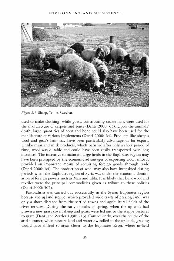
used to make clothing, while goats, contributing coarse hair, were used forthe manufacture of carpets and tents (Danti 2000: 63). Upon the animals’death, large quantities of horn and bone could also have been used for themanufacture of various implements (Danti 2000: 64). Products like sheep’swool and goat’s hair may have been particularly advantageous for export.Unlike meat and milk products, which perished after only a short period oftime, wool was durable and could have been easily transported over longdistances. The incentive to maintain large herds in the Euphrates region mayhave been prompted by the economic advantages of exporting wool, since itprovided an important means of acquiring foreign goods through trade(Danti 2000: 64). The production of wool may also have intensified duringperiods when the Euphrates region of Syria was under the economic domin-ation of foreign powers such as Mari and Ebla. It is likely that bulk wool andtextiles were the principal commodities given as tribute to these polities(Danti 2000: 307).
Pastoralism was carried out successfully in the Syrian Euphrates regionbecause the upland steppe, which provided wide tracts of grazing land, wasonly a short distance from the settled towns and agricultural fields of theriver terraces. During the early months of spring, when the uplands hadgrown a new grass cover, sheep and goats were led out to the steppe pasturesto graze (Danti and Zettler 1998: 213). Consequently, over the course of thearid summer, when pasture land and water dwindled in the uplands, grazingwould have shifted to areas closer to the Euphrates River, where in-field
Figure 2.1 Sheep, Tell es-Sweyhat.
E N V I R O N M E N T A N D S U B S I S T E N C E
39
fodder had become available after the last harvest, or in fields that hadexperienced crop failures. Last, during the wet months of winter, when bothin-field fodder and upland steppe pastures were unavailable, herds were keptclose to the settled zone and provisioned with supplementary feed in theform of stored barley (Danti and Zettler 1998: 213). This annual cycle ofgrazing largely concurs with modern pastoral strategies practised in Syriatoday (Wilkinson 2004: 53). It is also supported by the archaeobotanicalremains from Tell es-Sweyhat, where pastoralism constituted an importantpart of the third millennium subsistence economy. As we have alreadyreported, much of the carbonized plant remains, which derive from sheepand goat dung, contained a wide variety of steppic plants, these having beenconsumed by herds while they grazed in the uplands. In addition, the car-bonized remains contained large amounts of barley, the result of supplemen-tary feed during the months of the year when steppe resources were depleted.
Still other evidence might be summoned to support the intensity of pas-toralism in the Euphrates region, even during the early part of the thirdmillennium. Some of this information derives from Hajji Ibrahim, a sitelocated in the Tell es-Sweyhat embayment, about 500 metres beyond thesoutheast corner of Sweyhat’s outer town wall, on the edge of a wadi (Danti1997: 89–90). Hajji Ibrahim was a very small site that was principally occu-pied in the first centuries of the third millennium bc (Phases 1–2). In itsbest-preserved phase (phase B), excavations exposed rectangular mudbrick structures which surrounded a single central building and courtyard.Because these structures had no ground-level entry, and their walls and floorshad been heavily coated with mud and lime plaster, they were interpreted assilos or storerooms (Danti 1997: 91). Paleobotanical remains recoveredfrom the central building nearby indicate that barley was processed here(Danti 1997: 91).
Based on the available evidence, Tell Hajji Ibrahim is interpreted as agrain storage and processing centre (Danti 1997: 91). Nevertheless, it isprobably erroneous to reconstruct this site as a grain storage facility for theinhabitants of Sweyhat, given that the site was no more than 5–6 ha in thisearly EB phase and probably would not have required crop surpluses to feedits inhabitants. It is more likely that this facility functioned as a feedingstation for transhumant pastoralists who moved in a yearly cycle from theriver embayment to the uplands to support their herds of sheep and goats.They owned agricultural territories in the embayment along the wadis,where they grew crops, namely barley. This grain would have been processedand stored at Tell Hajji Ibrahum as supplemental fodder, and used to feedthe flocks when steppe plants became unavailable in the uplands during thewinter (Danti and Zettler 1998: 223). Wool and hides, products that mayhave been used in interregional exchange, may also have been stored at thesesites (Danti 2000: 304).
We have already reported that some upland areas may have supported
E N V I R O N M E N T A N D S U B S I S T E N C E
40
small-scale agriculture, especially in areas of wadi runoff and slightly higherlevels of rainfall. It is difficult to envision that the crops produced by thesepockets of cultivable land supplied major riverine centres with grain sur-pluses given their distance from those settlements. On the other hand, onecan easily reconstruct such upland areas as permanent stations for the pro-duction and storage of conserved feed for the region’s flocks, their wellsserving as places for watering livestock (Danti 1997: 92). Overall, the effectsof extending grazing areas further into the uplands and establishing a net-work of feeding and watering stations beyond day-long forays from the river(over 15 km) greatly augmented pastoral production within the region(Danti 1997: 92). Moreover, these distant sites would have helped to distrib-ute evenly animals on rangeland, thereby preventing overgrazing and soilerosion (Danti 2000: 67; Wilkinson 2004: 53).
Hunting
In addition to pastoralism, the hunting of wild animals was also part ofthe subsistence economy of many third millennium Euphrates sites. Thebest single source about hunting derives from the analyses of animal bonescollected from third millennium occupation levels at Tell es-Sweyhat butother sites’ collections have also been useful (Clason and Buitenhuis 1978;Orthmann 1989: 113–52; Weber 1997). These studies indicate that severalvarieties of deer were hunted, as well as gazelle and aurochs (Clason andBuitenhuis 1978: 80; Weber 1997: 135–6). Equid bones also constituted asubstantial portion of the faunal collections. During the third millennium,the Euphrates region would have supported equids in the form of thedomestic ass, the wild half-ass (Equus hemionus), or a sub-species known as theSyrian onager (Equus hemionus hemippus) (Weber 1997: 137–8). Morphologicaland metric studies of these latter bones do seem to indicate that the majorityof equid bones were of the wild variety, thus indicating active huntingpractices.
Wild animals, which included mainly equids, gazelle and deer, consti-tuted about 11 per cent of the animals consumed by the inhabitants of Telles-Sweyhat (Weber 1997: 141). Since onager and gazelle would have beenanimals that flourished in the steppe, their presence in the faunal recordconfirms that hunting, alongside pastoralism, was practised in the uplandplateau behind the Sweyhat embayment. On the other hand, the presence inthe assemblages of fallow deer, which would have roamed the riparian forestsof the flood plain, confirms that hunting also took place near the EuphratesRiver. Finally, red deer and aurochs, which are comfortable in open wood-land, were probably hunted in the remnant stands of oak forest that existedon the river terraces beyond the flood plain (Weber 1997: 141).
It is significant that at Tell es-Sweyhat, the percentage of wild animalbones, particularly equids, reached a maximum when Sweyhat’s population
E N V I R O N M E N T A N D S U B S I S T E N C E
41
was at its highest at the end of the third millennium (Phase 5) (Weber 1997:141). This would seem to indicate that in times of maximum population, thevarying ecological niches of the surrounding hinterland centre were exploitedto their greatest extent. One should note, however, that this pattern, inwhich high numbers of wild animals were hunted, alters as one travels fur-ther to the north along the Euphrates into wetter regions. As the region ofthe Turkish-Syrian border is approached, it would seem that the number ofwild animals decreases while the number of domesticated animals, such aspigs and cattle, increases. Nonetheless, sheep and goats are still found inlarge numbers, and their presence testifies to the prevalence of pastoralism inthese more northerly areas (Peltenburg et al. 1995: 24; Weber 1997: 142).
Other economic opportunities
While past studies have focussed on the agricultural regime of the northernEuphrates Valley, and more recently on the significant role of pastoralismand hunting, our overall understanding of the region’s economy is not com-plete without acknowledging the importance and sustained role of riverinecommerce during the third millennium.
The archaeological record confirms that the Euphrates had long been aprincipal avenue of trade and cultural exchange. It attained a true import-ance, however, during the Late Uruk period at the end of the fourth millen-nium, when settlements with an unmistakable southern Mesopotamianmaterial culture appear along the banks of the Euphrates River as far north asAnatolia. The majority of these settlements were likely inhabited by south-ern Mesopotamian colonists and merchants, who situated themselves in thisdistant region in order to acquire raw materials such as silver and copperfrom the mines of the Taurus Mountains, or timber from coniferous forests ofthe Taurus and Amanus Mountains (Akkermans and Schwartz 2003: 203). Inboth cases, the Euphrates River would have provided such traders with adirect line of access to these raw materials. That the importance of the rivercontinued into the third millennium is deduced from textual sources likethose from the western Syrian city of Ebla. This city’s foreign relations andcommerce were facilitated by the Euphrates River, which led to importantMesopotamian cities in the southeast such as Mari and Kish, and providedthe means by which precious goods such as lapis lazuli were conveyed to Eblain exchange for other materials such as wool, oil, wine, and grain (Astour1995: 1406). Even towards the end of the third millennium, the EuphratesRiver continued to be used as an active route of commerce. Mesopotamianrulers such as Gudea of Lagash, for example, are known from textualsources to have obtained cedar and boxwood from the Amanus Mountains,which were cut into logs and formed into rafts that were floated down theEuphrates River to the south, along with other imported goods such as metaland stone (Astour 1995: 1408; Edzard 1997: Gudea E3.1.1.7.StB).
E N V I R O N M E N T A N D S U B S I S T E N C E
42
Exotic and precious materials, discovered at several Syrian Euphratessites considered in this study, also attest to the importance of EuphratesRiver as an avenue of trade. The copper ore that was used to fashion theweapons, tools and pins which have been found in EB tombs at the sites ofCarchemish, Jerablus Tahtani, Tell Ahmar, and Qara Quzaq, for example,was obtained from the Ergani-Maden mines of eastern Turkey. Similarly, thesilver used to produce various torques, pendants, bracelets, finger rings andother adornments found in tombs at Jerablus Tahtani and Selenkahiye mustalso have come from mines in Anatolia. Without question, the EuphratesRiver would have provided the fastest and most effective means by whichthese metals were conveyed to these Early Bronze Age communities.
Local evidence also attests to riverine traffic from the south. The discoveryof a stone cuneiform weight at Tell es-Sweyhat, inscribed with the cuneiformscript of the Ur III period of southern Mesopotamia surely demonstratescontact with the south (Holland 1975). We might also add the presenceof several cylinder seals and impressions at sites such as Selenkahiye andJerablus Tahtani, whose designs emulate southern Mesopotamian styles orare themselves clear imports from the south (Van Loon 2001: 12.496;McCarthy in press). The Euphrates River would have been the most likelyavenue by which these items were conveyed to the region.
Not all cultural interaction and trade, however, were conducted along thenorth–south trajectory of the Euphrates River. There were also importantroutes running from east to west, along which goods were conveyed betweennorthern Iraq and the cities and trade emporiums of the west, as far as theMediterranean coast. Algaze has postulated that most east–west communica-tions took place further north, at the ford in the Samsat-Lidar region andin the Zeugma-Birecik area of Anatolia, where the Euphrates finally breaksout of its steep constraining canyon (Algaze 1999: 536–7). Such crossingpoints served to connect the Syrian plains west of the river and the northernMesopotamian plains east of it (Algaze 1999: 537). Algaze’s northern fords,however, must not have commanded all east–west traffic, judging by evi-dence from the Syrian Euphrates region to the south. In particular, it wouldseem that some EB settlements were located at key crossing points along theEuphrates River. Tell Ahmar, which was well known to have been at a majorcrossing point in later periods (Copeland and Moore 1985: 69), stands onthe left bank of the river directly opposite the mouth of the Sajur River,flowing from the west from the direction of Aleppo. Archaeological surveysconducted in the Sajur River Valley testify to the frequency of EB settle-ments along its banks, and support its importance as a major thoroughfarein the third millennium (Copeland and Moore 1985: 176). Similarly, TellAmarna is conveniently located on the right bank of the Euphrates floodplain, at the point where the west–east Nahr Amarna (first a wadi and thena stream), debouches onto the flood plain. This stream also supportedseveral EB settlements (Copeland and Moore 1985: 71; Peltenburg et al.
E N V I R O N M E N T A N D S U B S I S T E N C E
43
1995: Figure 1). In both cases, therefore, key Early Bronze Age sites weresited along the river’s edge at places that gave access to further routes to thewest, surely underlining their role in east–west commercial traffic.
Wilkinson’s intensive investigations of the Tell es-Sweyhat embaymenthave also produced evidence for east–west roadways and important crossingpoints along the river. As we have already reported, one such crossing pointmay have existed at Tell Jouweif on the left bank, which is directly oppositeTell Hadidi. Judging by linear hollows, which mark the remnants of ancientroadways, a second crossing point may have existed a few kilometres tothe north, connecting Tell Hadidi on one side of the river to Tell Ali al-Haj(SS 17) on the other (Wilkinson 2004: 139, Figure 7.5). In both cases, thegrowth and success of Tell Hadidi and Tell es-Sweyhat, the principal cities oneither side of the river at this point, can be attributed not only to the abun-dant agricultural and pastoral resources which they exacted from their broadhinterlands, but also their role as key control-points along an importanteast–west commercial route (Wilkinson 2004: 185).
DISCUSSION
This chapter has outlined some of the most salient features of the naturalenvironment of the northern Euphrates Valley of Syria. It has described theprincipal constituents of the physical landscape of the region, which includethe river channel and flood plain, the ancient river terraces and the uplandsteppes that rise beyond the valley to the east and west. Although thislandscape and its accompanying climate limited the degree to which inten-sive dry-farming practices could be carried out, they made other types ofeconomies possible. We have described, for example, the importance of pas-toralism, which no doubt formed a major part of every settlement’s economyduring the third millennium. Hunting also appears to have been practised,judging by the quantities of wild animal bones found in the faunal collec-tions of third millennium sites. Last, trade that took place both along theEuphrates as well as along overland routes which traversed the river atkey crossing points, must have been influential to the success with whichsettlements were able to grow and flourish during this period.
The range of potentially exploitable resources in this region stands inmarked contrast to other regions of the Near East, where such varied eco-nomic opportunities were not as widely and easily available. With suchlimitations, many ancient economic systems tended to place emphasis on oneor two subsistence strategies to support their populations. Under the rightconditions, these forms of economic specialization could frequently haveextremely favourable results, resulting in flourishing settlements and grow-ing populations. On the other hand, such systems lacked the flexibilitywhich those with more variable economic strategies possessed, and as a
E N V I R O N M E N T A N D S U B S I S T E N C E
44
consequence they were more vulnerable to stresses such as environmentaldegradation and political instability. We shall return to this issue of flexibleversus rigid economies in Chapter 10 when we discuss the collapse of com-plex societies at the end of the third millennium bc. For now, we wish tostress that the variability of the subsistence strategies available to Euphratescommunities not only enabled them to establish themselves successfully inthis unusual, marginal region for the better part of the third millennium butalso provided them with the means to grow into vibrant urban communitiesthat persisted over several centuries.
Beside the different resources and subsistence strategies available in thisunique Euphrates environment, we should like to point out another interest-ing development that this variable economy may have engendered. Onthe one hand, trade and cultural exchanges afforded by boat traffic alongthe Euphrates River exposed this region to many outside influences. Wecan expect that foreign contacts, especially those with southern Mesopotamia– which during the third millennium was experiencing full-blown urbanismand the dramatic rise of states and empires – would have left some impres-sion upon the inhabitants of the northern Euphrates region. It is truethat no Euphrates settlement grew to the same size and stature as anysouthern Mesopotamian city, nor can we identify any entity that emulatedthe configuration and hierarchical structure of a Mesopotamian city-state.Nonetheless, the growth of elite power and wealth, as manifested by richlyaccommodated tombs and monumental secular architecture at a numberof Euphrates sites, may have been induced or amplified through contactand influence from the south, where elites played a dominant role inthe organization and administration of the cities which they inhabited.We may also wish to attribute elite growth to the region’s contact with therich and powerful city of Ebla to the west, whose economic empire expandedto include most or all of the Syrian Euphrates region during thetwenty-fourth century bc. Many of the new urban material cultural featuresthat developed in settlements during this particular time, in addition tothe increased prominence of social-economic inequalities, may have beenstrongly influenced by the hierarchical, urbane character of this pre-eminentSyrian city.
On the other hand, the continued prominence of rural life in the Euphratesregion of Syria was assured by the region’s strong engagement in pastoralism.This way of life, which developed out in the open range lands far beyond theconfines of river valleys and settled communities, had at its core a kin-basedtribal structure that favoured collective, cooperative social-economic rela-tionships and heterarchical political systems. Pastoralism, and the mode oflife that it embraced, therefore, contrasted sharply to the settled, urbanbehaviour encouraged by contacts with other parts of Greater Mesopotamia.It is difficult to imagine how such opposing modes of economy and seem-ingly incompatible ways of life could have co-existed within one region, and
E N V I R O N M E N T A N D S U B S I S T E N C E
45

yet in the case of the northern Euphrates Valley, they do seem to operate inconcert. While we cannot begin to understand all of the myriad and complexways in which rural versus urban elements intermingled and overlapped withone another in this land, we can recognize the products of this unique inter-play, manifested in distinctive forms of art and architecture at variousEuphrates EB settlements, and the unique traditions and ideologies reflectedby such material cultural remains.
E N V I R O N M E N T A N D S U B S I S T E N C E
46
3
SETTLEMENT AND SOCIO-POLITICAL STRUCTURE
Many ancient villages, towns and cities were established in the EuphratesRiver Valley in antiquity, having been supported by the economic opportun-ities available by the river itself, the valley in which it is situated, and theuplands beyond. The third millennium bc appears to have been an especiallyprolific period for settlement in the river valley, if we judge by the number ofancient mounds bearing evidence for occupation during some or all phases ofthe Early Bronze Age. Almost every few kilometres along the river bringsinto view another small or large mound that was settled during this period.Nor is settlement restricted to this stretch of the river as its runs throughnorthern Syria. As one travels north of Carchemish into Turkey, a continuousstring of third millennium settlements appears for a considerable distance upthe river. Guillermo Algaze’s survey of this region of the Turkish Euphratesas well as subsequent excavations at a number of key settlements prior tothe completion of the Birecik and Carchemish Dams, further attests tothe frequency of third millennium occupation in the region, and the com-plexity and uniqueness of some of the communities established there (Algazeet al. 1994; Kepinski-Lecomte and Ergeç 2000; Marro et al. 2000; Ökse2002).
Settlement location
Based on archaeological reports of surveys as well as excavations in the SyrianEuphrates region, a map has been devised which locates the majority ofthird millennium sites within this region (Figure 3.1). For the most part,places of ancient human habitation take the form of mounds of earth (tells)(Figure 3.2), rising conspicuously above the level of the surrounding riverflood plain or terrace and often littered on the surface with artifacts such aspotsherds, fragments of grinding stones and chipped stone, as well as theremnants of ancient stone or mud brick structures. The map also includesthe location of third millennium cemeteries, whose presence is attested byshafts or pits cut into the limestone conglomerate, a few still containinghuman remains and accompanying grave goods, especially pottery.
47
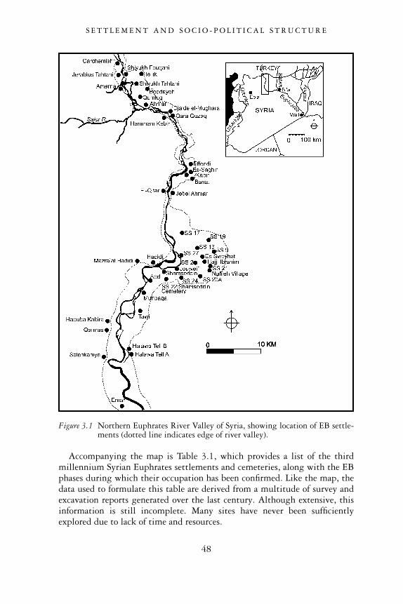
Accompanying the map is Table 3.1, which provides a list of the thirdmillennium Syrian Euphrates settlements and cemeteries, along with the EBphases during which their occupation has been confirmed. Like the map, thedata used to formulate this table are derived from a multitude of survey andexcavation reports generated over the last century. Although extensive, thisinformation is still incomplete. Many sites have never been sufficientlyexplored due to lack of time and resources.
Figure 3.1 Northern Euphrates River Valley of Syria, showing location of EB settle-ments (dotted line indicates edge of river valley).
S E T T L E M E N T A N D S O C I O - P O L I T I C A L S T R U C T U R E
48
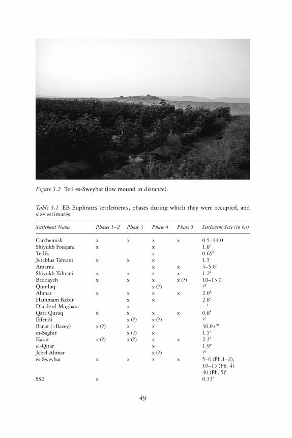
Figure 3.2 Tell es-Sweyhat (low mound in distance).
Table 3.1 EB Euphrates settlements, phases during which they were occupied, andsize estimates
Settlement Name Phases 1–2 Phase 3 Phase 4 Phase 5 Settlement Size (in ha)
Carchemish x x x x 0.5–44.0Shiyukh Fouqani x x 1.8a
Tellik x 0.65b
Jerablus Tahtani x x x 1.5c
Amarna x x 3–5.0d
Shiyukh Tahtani x x x x 1.2e
Beddayeh x x x x (?) 10–13.0f
Qumluq x (?) ?g
Ahmar x x x x 2.0h
Hammam Kebir x x 2.8i
Dja �de el-Mughara x – j
Qara Quzaq x x x x 0.8k
Effendi x (?) x (?) ?l
Banat (+Bazey) x (?) x x 30.0+m
es-Saghir x (?) x 1.5n
Kabir x (?) x (?) x x 2.3o
el-Qitar x 1.9p
Jebel Ahmar x (?) ?q
es-Sweyhat x x x x 5–6 (Ph.1–2),10–15 (Ph. 4)40 (Ph. 5)r
SS2 x 0.33s
49
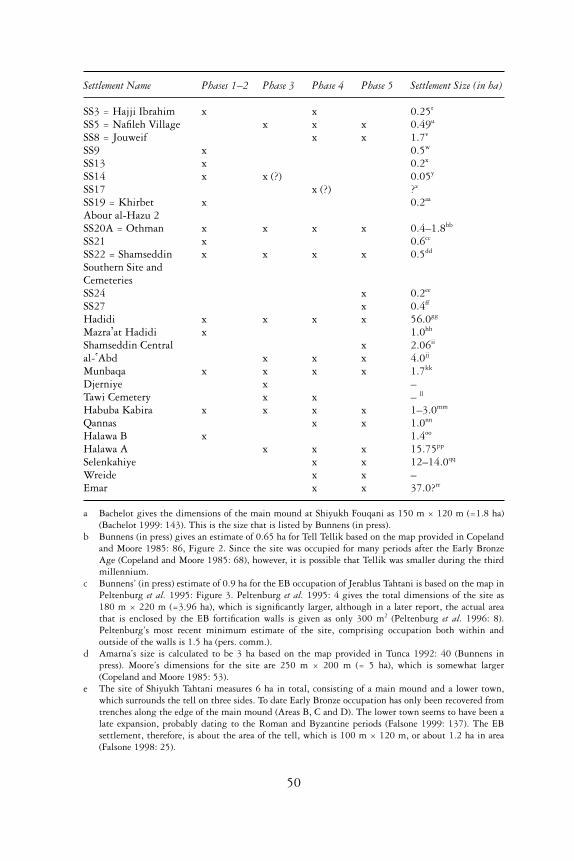
Settlement Name Phases 1–2 Phase 3 Phase 4 Phase 5 Settlement Size (in ha)
SS3 = Hajji Ibrahim x x 0.25t
SS5 = Nafileh Village x x x 0.49u
SS8 = Jouweif x x 1.7v
SS9 x 0.5w
SS13 x 0.2x
SS14 x x (?) 0.05y
SS17 x (?) ?z
SS19 = Khirbet x 0.2aa
Abour al-Hazu 2SS20A = Othman x x x x 0.4–1.8bb
SS21 x 0.6cc
SS22 = Shamseddin x x x x 0.5dd
Southern Site andCemeteriesSS24 x 0.2ee
SS27 x 0.4ff
Hadidi x x x x 56.0gg
Mazra � at Hadidi x 1.0hh
Shamseddin Central x 2.06ii
al- �Abd x x x 4.0jj
Munbaqa x x x x 1.7kk
Djerniye x –Tawi Cemetery x x – ll
Habuba Kabira x x x x 1–3.0mm
Qannas x x 1.0nn
Halawa B x 1.4oo
Halawa A x x x 15.75pp
Selenkahiye x x 12–14.0qq
Wreide x x –Emar x x 37.0?rr
a Bachelot gives the dimensions of the main mound at Shiyukh Fouqani as 150 m × 120 m (=1.8 ha)(Bachelot 1999: 143). This is the size that is listed by Bunnens (in press).
b Bunnens (in press) gives an estimate of 0.65 ha for Tell Tellik based on the map provided in Copelandand Moore 1985: 86, Figure 2. Since the site was occupied for many periods after the Early BronzeAge (Copeland and Moore 1985: 68), however, it is possible that Tellik was smaller during the thirdmillennium.
c Bunnens’ (in press) estimate of 0.9 ha for the EB occupation of Jerablus Tahtani is based on the map inPeltenburg et al. 1995: Figure 3. Peltenburg et al. 1995: 4 gives the total dimensions of the site as180 m × 220 m (=3.96 ha), which is significantly larger, although in a later report, the actual areathat is enclosed by the EB fortification walls is given as only 300 m2 (Peltenburg et al. 1996: 8).Peltenburg’s most recent minimum estimate of the site, comprising occupation both within andoutside of the walls is 1.5 ha (pers. comm.).
d Amarna’s size is calculated to be 3 ha based on the map provided in Tunca 1992: 40 (Bunnens inpress). Moore’s dimensions for the site are 250 m × 200 m (= 5 ha), which is somewhat larger(Copeland and Moore 1985: 53).
e The site of Shiyukh Tahtani measures 6 ha in total, consisting of a main mound and a lower town,which surrounds the tell on three sides. To date Early Bronze occupation has only been recovered fromtrenches along the edge of the main mound (Areas B, C and D). The lower town seems to have been alate expansion, probably dating to the Roman and Byzantine periods (Falsone 1999: 137). The EBsettlement, therefore, is about the area of the tell, which is 100 m × 120 m, or about 1.2 ha in area(Falsone 1998: 25).
50
f Bunnens’ estimate of 10 ha (in press) is lower than the dimensions of Beddayeh provided by Moore,which are given as 360 m in diameter (= 13 ha) (Copeland and Moore 1985: 54).
g Qumluq’s dimensions are given as 250 m × 200 m (= 5 ha) by Moore, along with a 160 m circularmound at one end (Copeland and Moore 1985: 54). At present, we are completely uncertain as to theextent of EB occupation at this tell, although pottery collected from this site by Woolley does confirmhabitation from this period (or a cemetery) (Sconzo in press a).
h EB settlement was restricted to the area of the high mound, whose dimensions have been calculatedfrom a map of Tell Ahmar (Bunnens 1990: 8). Bunnens (in press) gives an estimate of 2 ha.
i Bunnens’ (in press) 2.8 ha estimate for Hammam Kebir is based on the dimensions provided byMoore: 300 m × 95 m (= 2.85 ha) (Copeland and Moore 1985: 48).
j Thus far, the only EB discovery at the predominantly PPNB site of Dja �de el-Mughara has been anisolated tomb (Coqueugniot et al. 1998). The nature of EB occupation at this site remains ill-defined.
k The dimensions of Qara Quzaq are reported by Moore as 160 × 100 m (= 1.6 ha) (Copeland andMoore 1985: 55). Valdés Pereiro (1999) reports, however, that the maximum diameter of the site is150 m (2.25 ha). Bunnens’ (in press) own conservative estimation of the EB site as 0.8 ha takes intoconsideration the site’s expansion during the later Roman and Byzantine times.
l No dimensions are provided for the site of Tell Effendi.m Thomas McClellan’s estimate of 30 ha for the site of Tell Banat may not take into account the area of
EB occupation that has recently been found on Jebel Bazey (McClellan 1999: 413, 417).n Anne Porter gives the size of Tell es-Saghir as 1.5 ha (Porter 1995a: 1).o Anne Porter gives the size of Tell Kabir as 2.3 ha (Porter 1995a: 1).p Based on the map published in Culican and McClellan 1983–84: Figure 1, Bunnens has provided an
estimate of 1.9 ha for the size of el-Qitar during the EB (Bunnens in press). It should be noted that noEB structures or pottery have yet been excavated at the site of el-Qitar, although McClellan and Porter,in their survey report, do confirm that EBIV pottery (Phases 4–5) has been found there (McClellan andPorter in press). In addition, a shaft tomb of EBIVA date (Phase 4), located to the north of el-Qitar onthe road to the village of Yusef Pasha, was cleared and investigated (Sagona 1986: 107).
q There are no dimensions for Jebel Ahmar, a site located on a small conical mountain opposite el-Qitar.r It is estimated that during Tell es-Sweyhat’s earliest third millennium occupation was no more than
5–6 ha (Danti and Zettler 1998: 219), but then expanded to 10–15 ha by the third quarter of thethird millennium (Danti and Zettler 1998: 219). Its largest extent, which included the area south ofthe outer wall, made Tell es-Sweyhat about 40 ha in size in the late third millennium bc (Zettler1997b: 51).
s SS 2’s dimensions are 55 m × 60 m (= 0.33 ha) (Reichel 2004: 199).t SS 3’s dimensions are 50 m × 50 m (= 0.25 ha) (Danti 1997: 91).u SS 5’s dimensions are 70 m × 70 m (= 0.49 ha) (Reichel 2004: 200).v SS 8’s dimensions are 180 m × 120 m (=2.16 ha) (Reichel 2004: 202), although Wilkinson’s estimate
of 1.7 ha for the EB occupation may be more accurate given this site’s subsequent occupation in laterperiods (Wilkinson 2004: 175).
w SS 9 is described as two mounds, each 50 m × 50 m in diameter (= 0.5 m total) (Reichel 2004: 202).x SS 13 is described as having a 30–50 m diameter (Reichel 2004: 204).y SS 14 is described as a small site located on the spur of a limestone escarpment overlooking Nafileh. It
may have been nothing more than a watchpost, 20 m × 20 m (Reichel 2004: 204–5). Wilkinsonestimates its size as 0.05 ha (Wilkinson 2004: 175).
z The presence of EB occupation at SS 17 (Tell Ali al-Haj) is still uncertain given the equivocal date ofthe remains found there (Reichel 2004: 207). It is described as a medium-sized tell of 200 m diameter(4 ha), its large size probably due to later Bronze and Iron occupation (Reichel 2004: 207).
aa SS 19 is described as a number of very small mounds with an intervening space of 70 m × 80 m(Reichel 2004: 208). Wilkinson estimates the size of this site as 0.2 ha (Wilkinson 2004: 175).
bb SS 20A’s dimensions are given as 150 m × 150 m (= 2.25 ha) (Reichel 2004: 209), althoughWilkinson estimates 0.4 ha for the site’s earliest EB levels and 1.8 ha for its later EB occupation(Wilkinson 2004: 175).
cc SS 21’s dimensions are given as 100 m × 100 m (= 1 ha) (Reichel 2004: 210), although Wilkinsonestimates that its early EB occupation was only 0.6 ha (Wilkinson 2004: 175).
dd SS 22 consists of a low mound that was surrounded by several other areas where EB pottery was found,many of these indicating the location of EB cemeteries (see Meyer 1991). The dimensions of the tellare given as 190 m × 90 m (1.7 ha) (Reichel 2004: 210–11), although Wilkinson prefers a far moreconservative estimate of 0.5 ha for the EB occupation on this mound (Wilkinson 2004: 175).
51
In Figure 3.1, one can note the high number of EB settlements reported inthe left bank embayment around the site of Tell es-Sweyhat. Although thelength and breadth of this curving plain no doubt encouraged the growth ofsettlement in antiquity, we must also attribute the inordinate number ofsites identified in this region to the intensive, systematic surveys that havebeen conducted there by a number of archaeological teams over the past fewdecades. It is possible that other areas of the Syrian Euphrates were equallyheavily settled, but that many of their sites, especially those smaller than1 ha in area, have not yet been positively identified on the ground because ofless comprehensive survey strategies.
As we might expect, the majority of third millennium settlements arelocated on the fluvial terraces, where their proximity to the river allowedthem to exploit riparian resources, while their elevation protected them
ee SS 24 is described as a small flat site. Wilkinson estimates that it was about 0.2 ha in area (Wilkinson2004: 175).
ff SS 27’s dimensions are given as 100 m × 50 m (= 0.5 ha), although Wilkinson gives a slightly lowerestimate of 0.4 ha for the site’s late EB occupation (Wilkinson 2004: 175).
gg Dornemann calculates the size of Hadidi as 135 acres (or about 55 ha) at its largest extent(Dornemann 1985: 50). He also reports that the earliest EB settlement covered the entire tell, as it didin the later EB (1985: 50). McClellan’s estimate of 56 ha for the maximum size of Hadidi, whichessentially concurs with the figure above, derives from an unpublished excavation report (McClellan1999: 413, and n. 4).
hh Mazra � at Hadidi’s dimensions are 200 m × 50 m (1 ha) (Reichel 2004: 232).ii The site of Shamseddin Central Tell is estimated to be 140 m × 140 m (= 2.06 ha) (Reichel 2004:
249).jj The site of Tell al- �Abd, which is perched on a limestone cliff overlooking the left bank of the
Euphrates, is 210 m × 220 m in area (= 4.6 ha) (Bounni 1979: 49), although it was probablysomewhat smaller in size if we only factor in the settlement that existed within the EB fortificationwalls (= 4 ha).
kk According to Peter Werner, the Early Bronze Age settlement at Munbaqa was limited to the area ofthe ‘Kuppe’ and covered an area of about 170 m × 100 m (1.7 ha) (Werner 1998: 38).
ll Tawi is predominantly the place of Early Bronze Age cemeteries. The date of settlement at Tell Djefle,the tell that is located nearby, is still uncertain, although it could have some EB occupation (Kamp-schulte and Orthmann 1984: 5; Reichel 2004: 240–1).
mm J.-C. Heusch calculates that the settlement at Tell Habuba Kabira would have covered about 3 ha,although only 1 ha is enclosed by the city walls, which for a long time constituted the main area of EBsettlement (Heusch 1980: 161).
nn The site of Tell Qannas is said to cover an area of about 1 ha (Reichel 2004: 242).oo Orthmann calculates the size of Halawa Tell B as about 140 m × 100 m (= 1.4 ha) (Orthmann 1989:
8).pp Orthmann calculates the size of Halawa Tell A as about 450 m × 350 m (= 15.75 ha) (Orthmann
1989: 10).qq The site of Selenkahiye was originally measured to be about 600 m × 250 m in area (= 15 ha) (Meijer
1980: 117). In the final report, however, the walled area is estimated to have encompassed about520 m × 200 m (= 10.4 ha) (Van Loon 2001: 3.25). It is also reported that to the west, additionalremains of houses represent habitation outside of the town wall some time during the late EarlyBronze Age. These remains were found as much as 220 m to the west of the settlement’s outerdefences (Van Loon 2001: 3.94). If we factor in this area of habitation, then the size of Selenkahiyemay have been another 2–5 ha in area, bringing its total to about 12–15 ha. McClellan’s own estimateof 15–20 ha for Selenkahiye may be too generous (McClellan 1999: 413).
rr Emar’s EB occupation is estimated to be 37 ha by Weiss, although this size has not yet been confirmed(Weiss 1983: Figure 11).
S E T T L E M E N T A N D S O C I O - P O L I T I C A L S T R U C T U R E
52
from seasonal flooding and more exceptional fluvial intrusions. As we havealready reported, only a few EB sites have been positively located directlyon the flood plain. They were founded on slightly elevated beds of gravel andsilt, this alluvial terrain offering some level of protection against seasonalflooding.
In a few cases, third millennium settlements were perched significantlyhigh above the level of the flood plain. The site of Selenkahiye is located onan elongated ridge that is 20 m above the course of the river to which it runsparallel. In addition, a depression that runs alongside the site to the west is10 m lower than the top of the ridge (Van Loon 2001: 2.14). Rather thanseeing the threat of flooding as the reason for Selenkahiye’s lofty location, wemight regard its position on top of a high ridge as a defensive measure,protecting its inhabitants against attacks and raids. The fact that this site isalso characterized by thick city walls, towers and a sloping rampart furtherunderlines defensive concerns of this nature. Halawa Tell A, located slightlyto the north of Selenkahiye on the river’s opposite bank is also situated on ahigh terrace. Its eastern side slopes steeply down to the river’s edge, while itsnorthern end is protected by a deeply cut wadi (Orthmann 1981: 3, Taf. 21).No doubt, this location was also chosen for its natural defensibility. Thesettlements at el-Qitar and Jebel Ahmar, located on opposing sides of theriver where it runs through a narrow gorge, are situated on what can real-istically be described as small mountains. The mountain upon which el-Qitaris located rises 76 m above the Euphrates River plain, and is rugged and eveninsurmountable in places. Clearly such a location would have offered theinhabitants of the settlement excellent natural protection (Culican andMcClellan 1983–84: 31). This factor, coupled with man-made constructionssuch as towers, walls, and a glacis, which we know were built at the sitein later periods, would have made el-Qitar a formidable and intimidatingfortress (Culican and McClellan 1983–84: 39).
The natural topography of the terraces and ridges alongside the EuphratesValley, while offering defensive advantages, clearly constrained the growthof some settlements. The ridge upon which Tell Halawa B was situated issmall and would not have permitted the physical expansion of this earlythird millennium settlement beyond a certain size. It is perhaps for thisreason that around the middle of the third millennium occupation wasmoved to Tell Halawa A, located on a broader ridge directly to the south ofTell B (Orthmann 1981: Taf. 21). This new locale would have supported thegrowing population and settlement, although on account of the steep slopesthat characterize the ridge on all sides, Halawa A too would have eventuallybeen unable to support further settlement expansion.
In contrast to the high, relatively narrow ridges upon which Selenkahiyeand Halawa A and B are situated, Tell Hadidi and Tell es-Sweyhat are locatedon broad, level plains. It is also striking that both Tell Hadidi and Telles-Sweyhat are among the only sites of the Syrian Euphrates characterized
S E T T L E M E N T A N D S O C I O - P O L I T I C A L S T R U C T U R E
53
by high acropolis mounds and extensive lower towns. While there couldbe political and economic factors associated with this type of settlementconfiguration (see below and Chapter 4), we might also attribute this layoutto the wide areas upon which structures of the lower towns of these sitescould expand.
One should not overlook settlements located at greater distances from theriver’s edge. Such sites have been found in areas where the older river terracesare especially wide. Tell Tellik and Tell Beddayeh, for example, are bothlocated at the eastern limit of a wide plain on the left bank of the Euphratesas it flows south of Carchemish (Copeland and Moore 1985: 54). Further-more, although Beddayeh is several kilometres from the main course of theEuphrates River, there are two springs in the vicinity of the tell (Copelandand Moore 1985: 68). Tell Banat, perhaps one of the most well known sitesin the Euphrates Valley on account of the spectacular discoveries made there,is located almost 3 km to the east of the current channel of the EuphratesRiver (McClellan and Porter in press). Finally, the ancient settlement at Telles-Sweyhat, which stands in the centre of a large plain formed by a broadcrescent-shaped embayment, would also have been 3 km from the river inantiquity (Zettler 1997a: 2). The presence of these three sites at considerabledistances from the flood plain indicates that settlements were supported byother resources besides those from the river and its flood plain. It might betempting to postulate, given the position of several of these sites almost atthe edge of the upland plateau, that these settlements were strategicallylocated to exploit and/or control resources deriving from the upland steppecountry, namely pastoral products and hunted animals.
Settlement size
Although we are fairly well informed about which Euphrates sites wereoccupied during the Early Bronze Age, and have even ascertained duringwhich phase of the EB they were settled, it has been difficult to ascertaineach site’s overall size during this period. Frequently, subsequent centuries ofoccupation have all but obscured the remnants of EB habitation since laterbuildings have been built directly over the settlement’s earliest construc-tions. At the site of Emar, excavations have successfully penetrated intothe earlier phases of EB occupation and have confirmed habitation duringthis time (Finkbeiner 2002, 2003), but later buildings erected over thissettlement phase, especially during the Late Bronze Age, have made firmstatements about the nature and extent of the EB occupation well nighimpossible. Similar problems plague our understanding of the layout andsize of the EB settlement of Carchemish, which experienced a massive expan-sion and transformation during the later Iron Age, when the site became thecentre of an important Neo-Hittite dynasty (Hawkins 1976–80).
Although archaeological surveys have successfully identified ancient habi-
S E T T L E M E N T A N D S O C I O - P O L I T I C A L S T R U C T U R E
54
tation on the visible, artificially elevated mounds or tells, their techniqueshave often failed to detect the extent to which occupation spread to thesurrounding unmounded areas. The recognition of such occupation requirescareful prospection of surrounding areas through the mapping of sherd scat-ters and the recording of other features such as the remnants of buildingwalls, door sockets, supports, kilns and pavements. When such intensivesurveys are conducted, the results may significantly alter one’s original esti-mation of the extent of ancient occupation. A case in point is the EB site ofTell Taya in northern Iraq. Although the mounded area of Tell Taya includesa 1 ha high tell and an 8 ha outer town, low-density occupation attestedby foundation walls and artifact scatters extending over areas of 70–160 haaround Taya increases its settlement-size several-fold (Reade 1968: 239;1971: pl. 24; Wilkinson 1994: 485). In the region under investigationhere, a detailed prospection was made of the unmounded area beyond thelimits of the outer enclosure wall at Tell es-Sweyhat. Late EB occupation inthe form of artifact scatters and fragmentary wall footings to the south of theLower City’s southern wall added another 10–15 ha to the whole site(Wilkinson 1994: 487). Unfortunately, because most surveys conducted onand around ancient sites in the Euphrates Valley have not been carried outas intensively as at Sweyhat, other settlement-size estimates can only beconsidered tentative at best.
Table 3.1 also gives the estimated size of sites occupied during the EarlyBronze Age. The data presented here derive from size approximations pro-vided in both survey and excavation reports. In a few exceptional cases, sitesizes during individual phases of the Early Bronze Age have been deter-mined, as in the case of Tell es-Sweyhat. The fact that Sweyhat grew froma 5–6 ha town in the earliest phases of the EB (Phases 1–2), to a city of over40 ha in the Late EB (Phase 5), testifies to the dramatic growth that settle-ments could experience during this period of the third millennium (Dantiand Zettler 1998: 213). This example should caution us against drawing toomany conclusions about settlements and their importance until we have moreprecise size estimates for the specific phases in which they were occupied.
Unfortunately, the greatest uncertainties with regard to settlement size liewith Carchemish, at the extreme northern end of this regional study, andEmar, at the southern limit. This lack of data regarding size is especiallydisappointing given that textual sources from the third millennium, princi-pally the cuneiform archives from Ebla, make specific mention of both ofthese sites (Edzard 1981; Archi 1990; Lacambre and Tunca 1999; Meyer1996: 155–70). As was reported above, the extent of EB occupation atEmar has been difficult to determine due to the large size of the settlementand the monumentality of its structures in later periods, these having beenbuilt directly over the EB town. We have provided Harvey Weiss’ estimationof 37 ha for the Early Bronze Age size of Emar, although we acknowledgethat it is highly conjectural (Weiss 1983: Figure 11).
S E T T L E M E N T A N D S O C I O - P O L I T I C A L S T R U C T U R E
55
In the case of Carchemish, since that site has never been properly surveyed,reliance must be put on the results of the early twentieth-century Britishinvestigations of the site. These excavations concentrated on the magnificentNeo-Hittite remains of the first millennium bc, and only penetrated intoearlier levels in small sondages (Woolley 1921; Woolley and Barnett 1952;Algaze et al. 1994: 5). From these investigations, we know that Early BronzeAge levels were exposed on Carchemish’s acropolis mound (Woolley andBarnett 1952: 214–26; Algaze et al. 1994: 12). On this basis, Guy Bunnensproposes a size estimate of 4 ha, arguing that EB occupation did not extendbeyond the Acropolis (Bunnens in press). He additionally argues that thesmall size of Carchemish is consistent with the data derived from the Eblaarchives, in which it would appear that Carchemish was under the politicalcontrol of Ebla. Last, since the settlement was not actually mentioned fre-quently in the Ebla tablets, it may not have been particularly important orlarge during this period (Bunnens in press).
In contrast to Bunnens’ modest estimate, Thomas McClellan proposes asize of 42 ha for Carchemish, which is a measurement of the Inner Town andacropolis according to the map produced by Leonard Woolley in his 1921report (Woolley 1921: pl. 3; McClellan 1999: 413 and n. 2). McClellan’sinclusion of the Inner Town is no doubt based on references in the reports tovarious Phases 3–4 Metallic Wares that were found in various points withinthe Inner City (Woolley 1921: 48; Algaze et al. 1994: 15). One can alsoreport here that during an archaeological survey of Tıladir Tepe, a site dir-ectly across the river from Carchemish, G. Algaze and his team found lateEB/Early MB sherds littered across the surface, indicating that this settle-ment covered an area of some 12 ha (Algaze et al. 1994: 15). If Tıladir Tepe isto be regarded as a suburb of Carchemish, then one could expect Carchemishitself to have been no less in size during this period.
Algaze’s own estimate for the size of Carchemish’s Inner Town is givenas 44.5 ha, which would seem to include the dimensions of the acropolisas well. Nevertheless, he is cautious to provide only a minimum estimateof 0.5 ha for the duration of occupation at Carchemish during the EB(Algaze et al. 1994: 61). In the end, the evidence does not yet present a firmconclusion as to the size of Carchemish during the EB, and as a result, wehave left the figure ranging widely between 0.5 and 44 ha.
Whatever sizes we accept for Carchemish and Emar during the EarlyBronze Age, the table (Table 3.1) shows us that the majority of settlementsin the northern Euphrates Valley were quite small, usually under 5 ha. Noneof these settlements attained the size of cities found in other parts of the NearEast during the third millennium. They contrast especially to the massiveurban sites of the Mesopotamian plains of southern Iraq. The centre of Uruk,for example, grew as large as 400 ha during the early part of the Early BronzeAge and may have supported between 40,000 and 80,000 people (Wilkinson1994: 503). Northern Euphrates sites also did not attain the sizes of settle-
S E T T L E M E N T A N D S O C I O - P O L I T I C A L S T R U C T U R E
56
ments in other parts of Upper Mesopotamia, such in the Jezireh of northernIraq and northeastern Syria. Tell Taya and Tell Leilan, for example, grew aslarge as 90–160 ha in area (Wilkinson 1994: Table 2).
Tony Wilkinson has cogently pointed out that differences in site sizesin these regions are directly related to the productive capacity of the terri-tories surrounding the settlements and the amount of food surplus and otheressential products that these hinterlands could generate in order to supportthe settlements’ populations (Wilkinson 1994). Further, sources of availablelabour to harvest and process food surpluses, and the limited distanceacross which bulk food products can be transported, also dictated the carry-ing capacity of cities and their overall size. Considering these factors, wemay see why the environmental and geographical conditions of southernMesopotamia made it an exceptionally favourable region for urban growth.The existence of an irrigation system permitted higher and more dependablecrop yields, thus enabling towns to increase above normal limits. Moreover,the use of boats would have facilitated the ease with which bulk fooditems could be transported, thus ‘nullifying the frictional effect of distance’(Wilkinson 1994: 503). Moving into the Upper Mesopotamian Jezireh, wefind large tracts of cultivable land and rainfall that were sufficient in mostyears to support a healthy regime of dry-farming, thus permitting thegrowth of large settlements (Wilkinson 1994: 485). But unlike the cities ofsouthern Mesopotamia, these Early Bronze Age settlements did not exceed aceiling of 100 ha, probably due to the constraints of available labour and theday-return access threshold of some 15 km radius from the core towns tothe furthest ‘feeder’ dependent towns and villages that supported the centres(Wilkinson 1994: 483, 505).
In contrast to both southern Mesopotamia and parts of the Jezireh of UpperMesopotamia, the Euphrates River Valley was a marginally productiveregion. Dry farming was frequently precarious in this region, owing toinsufficient rainfall. Many of the sites considered in this study are locatedbelow areas receiving a mean-annual precipitation of 250 mm, which is thelower limit in which dry-farming can be practised successfully (Danti 2000:4). Furthermore, available areas for dry-farming were limited because of theregion’s topography, in which only land relatively close to the flood plain ofthe Euphrates could support reasonably productive agricultural regimes. It islikely, therefore, that environmental factors, which constrained agriculturalproductivity in the Euphrates region, may explain in part the relatively smallsize of cities in this region compared to those found in other parts of theTigris-Euphrates Basin.
While it is true that none of the Syrian Euphrates sites grew to sizesattained in other parts of Mespotamia, neither is it true that they wereall diminutive. Tell Hadidi had already reached a size of 56 ha early on in theEarly Bronze Age. Tell Banat, during its fluorescence in the mid-to-late thirdmillennium (Phases 3–4), grew to 30 ha, while in the late third millennium,
S E T T L E M E N T A N D S O C I O - P O L I T I C A L S T R U C T U R E
57
Tell es-Sweyhat attained a size that exceeded 40 ha (Phase 5). Sweyhat’surban extent is especially significant given that its largest size was attainedwhen other settlements in the Euphrates Valley and beyond had been aban-doned. Moreover, the site grew in excess of that predicted by models ofagricultural sustainability (Wilkinson 1994), forcing us to look for otherfactors that might explain its success. Last, it is significant to note that manyEuphrates EB settlements attained substantially larger sizes than urbancentres in Palestine and Jordan from the same time period (Joffe 1993:73–82; Philip 2001: 181).
We can summon still other features of Euphrates EB settlements thatunderscore their noteworthy urban-like character. Subsequent chapters ofthis study will present settlement evidence in the form of monumentaltemples, large-scale secular structures, craft specialization, planned domesticneighbourhoods and extensive fortification systems, of all these reflectingrather surprisingly high degrees of complexity. The appropriation of wealth,attested also by the monumentality of some Euphrates graves as well as thefrequency of exotic, valuable objects that accompanied these interments willalso underline the urban character of these sites. In sum, it is difficult todismiss all northern Euphrates sites as simple, small-scale communities offood producers that paled in comparison to the more developed and sophisti-cated ‘urban’ communities of other parts of Mesopotamia. A variety of factorscan be proposed to explain the relatively complex composition of EarlyBronze Euphrates sites, and the relatively large size that some of these sitesattained. At this point, it suffices to state that site size alone cannot be usedto gauge accurately the importance, range of functions or degree of urbancomplexity of the settlements of this region. A settlement’s constituentfeatures must also be considered. Moreover, the types of socio-political inter-actions and economic exchanges these communities engaged in both withinand outside of the region need also to be carefully scrutinized.
Settlement hierarchies
Settlement hierarchies occur when sites expand in size to a point wherethe food requirements of the city exceeds that of the food producing capabil-ities of the city’s environs. As a consequence, that city begins to exacttribute from rural communities beyond its immediate landscape. Thesecommunities produce the required surpluses to support the populations andinstitutions at the centre (Wilkinson 1994: 484; Matthews 2003: 110).Through this phenomenon, towns and villages of the rural hinterlandbecome dependencies of the city, being tied to that centre by obligation, byforce or by economic factors (Wilkinson 1994: 484). We see this kind ofdevelopment clearly at Uruk in southern Mesopotamia, which during thelate fourth millennium and early third millennium expanded to such a sizethat it dominated a large area which included many smaller towns, villages
S E T T L E M E N T A N D S O C I O - P O L I T I C A L S T R U C T U R E
58
and hamlets. These smaller settlements became Uruk’s tributaries (Pollock2001: 195).
Settlement hierarchies may also be present in the Jezireh of UpperMesopotamia. During the Early Bronze Age one sees the development of a‘ranked’ or ‘three-tiered’ settlement hierarchy dominated by the site of Tellal-Hawa. This settlement attained a size of 66 ha, while at a distance of 9–12km from this centre were secondary sites ranging from 10–19 ha. Belowthese towns were small satellite villages with areas of 1–5 ha (Wilkinson andTucker 1995: 81). This settlement configuration reflects the fact that, as aprime centre, Tell al-Hawa overshadowed in size the settlements in itsneighbourhood, transforming these smaller secondary and tertiary sites intotributaries.
In contrast to the pattern found in the northern Jezireh and SouthernMesopotamia, Wilkinson observes that settlements in the northern EuphratesValley tend to be less distinctly ranked, possibly because of the topographic-ally fragmented terrain. In this region, riverine terraces enclosed by lime-stone hills restricted the area of land that could be put under cultivation(Wilkinson 1994: 489). But even while no hierarchies of the order of south-ern Mesopotamia or the region around Tell al-Hawa occur in this region, itwould appear that large settlements could occasionally grow to overshadowother sites in their neighbourhoods. At the third millennium settlement ofTitris Höyük in southeastern Turkey, for example, it would appear that a fewoutlying settlements were drawn into the Titris system, supporting thatcentre through the generation of surplus production (Algaze 1999: 548;Algaze et al. 2001: 56–7).
Can any such settlement hierarchies be detected in the Euphrates Valley ofnorthern Syria? It has been observed that as the settlement at Tell es-Sweyhatbegan to grow in size around Phase 4 in the mid-third millennium, othersmaller sites in Sweyhat’s embayment continued to be occupied or new siteswere founded (SS 5, 8, 17, 20A) (Wilkinson 2004: 138, Figure 7.5; Danti2000: 263). By the time of Tell es-Sweyhat’s largest expansion in Phase 5,the same sites continued to be occupied and new settlements were foundedon or near the flood plain (SS 24, 27) (Danti 2000: 264). Certainly, none ofthese attained Tell es-Sweyhat’s large size of 40 ha. Although their preciserelationship with Sweyhat remains largely unexplored, it is plausible thatthese villages were drawn into Sweyhat’s system as it expanded, supportingthe core site with whatever surplus and services they were capable ofgenerating.
Similar settlement configurations might be postulated further north alongthe left bank of the Euphrates River, particularly where the flood plain hasbroadened to form wide, relatively fertile embayments. On the left banksouth of Carchemish, the plain widens to nearly 6–7 km wide at its greatestextent. This area not only supported the settlement of Beddayeh, locatedalong the eastern limit of this plain, but also Tell Tellik to the north, and the
S E T T L E M E N T A N D S O C I O - P O L I T I C A L S T R U C T U R E
59
sites of Shiyukh Fouqani, Shiyukh Tahtani, and Tell Ahmar alongside themain course of the Euphrates or one of its subsidiary channels. Tell Qumluq,which is located about 5.5 km northwest of Tell Ahmar on the edge of aterrace overlooking the flood plain to the west, may also have been occupiedduring this period (Copeland and Moore 1985: 54). One can note thatBeddayeh, in its position furthest from the river’s edge, attained the largestsize in this region, growing to some 10–13 ha in the late third millenniumbc. In contrast, the other sites do not appear to have been larger than 2 ha atany period in the Early Bronze Age.
Further down the river towards the southern end of the Tishreen DamBasin, another wide plain supported several Early Bronze Age settlements.Besides the prominent settlement at Tell Banat, which was located about3 km inland from the Euphrates, other smaller settlements were known tohave been occupied during the same time period. These included TellEffendi, located at the north end of the alluvial plain, and Jebel Ahmar, atthe region’s southern limit. Clustered around the site of Tell Banat itselfwere the sites of Tell Kabir and Tell es-Saghir. Tell Banat was the largest sitein this region, attaining a size of around 30 ha during the period of itsmaximum expansion in the mid-to-late third millennium (Phases 3–4). Ofthe other sites in its neighbourhood, the largest was probably Tell Kabir,which grew to no more than 2.3 ha.
Can we suggest that some sort of settlement hierarchy existed in theseEuphrates embayments, in which the smaller settlements became dependen-cies of the larger towns, and provided produce and labour to those centres,receiving administrative and ceremonial services, protection and redistrib-uted goods in return? It is tempting to accept this proposition, given thelocation of the ‘core’ towns towards the back of the fertile plains (Beddayeh,Banat), and thus in advantageous positions to exploit and control both theproduce of the agricultural fields of the Euphrates plain as well as the pas-toral resources of the surrounding upland steppes. At the same time, smallersites poised along the river would have provided the centres with dry-farmedor flood-water irrigated produce of their immediate vicinity as well asimported goods deriving from commercial exchanges along the river.
On the other hand, a true settlement hierarchy of the type observed inother parts of Mesopotamia is not particularly supportable for the EuphratesRiver Valley if we factor in other observable aspects of the settlements underinvestigation. As has already been noted, the small size of many of the river’sEarly Bronze Age communities masks an underlying complexity that onemight not expect of small settlements that are simply viewed as small-scaledependencies of larger central places. Turning more closely to the evidencefrom the regions discussed above, for example, one may note that while TellAhmar is a relatively small settlement (2 ha) in comparison to the muchlarger site of Beddayeh (10–13 ha), it has yielded a late Early Bronze tomb ofmonumental proportions and highly valued tomb objects, suggesting a
S E T T L E M E N T A N D S O C I O - P O L I T I C A L S T R U C T U R E
60
high degree of wealth and access to resources on the part of the individualswho were interred within the tomb. At Tell Kabir, excavations have revealeda monumental temple in antis of a type well known at other sites in theEuphrates River Valley and beyond, but unaccounted for at Tell Banat, thelarge settlement in whose shadow it stands. In light of the nature of thisevidence, it seems fallacious to reconstruct a truly ranked settlement hier-archy in these Euphrates locales. Rather, we might view settlements withinthese systems as possessing complementary or specialized functions, possiblyserving the larger communities in some respects but at the same timemaintaining high degrees of autonomy and authority. We might addition-ally envision that depending on various economic, ideological or militaryconditions and concerns, these communities had close connections withsettlements even outside of their local systems. Thus, rather than a neatsystem of discrete, hierarchical ‘city-states’, we should probably reconstruct amore heterarchical web of settlements whose variable and overlapping func-tions and activities linked them to a variety of settlements of different sizesand geographic locations (McClellan 1999: 416).
Socio-political structure
The distinctive heterarchical character of the northern Euphrates region andthe unusual way in which third millennium settlements were configuredmay be attributed in part to the persistent tribally-structured composition ofthe region’s inhabitants, defined by loosely organized confederacies of bothagrarian and pastoral nomadic kin-groups. Their membership often tran-scended the boundaries of individual centres or specific places of residence.Furthermore, their political relationships included the dissemination ofpower and decision-making across the community rather than being solelyconcentrated in the hands of a few elite individuals. It is possible that theregion’s pronounced subsistence strategy of long-range herding sheep andgoats encouraged this tradition of collective power, since it is ‘the tendencyof pastoralists to manage access to grazing land at the collective level, forwhole communities’ (Fleming 2004: 218).
The type of political organization posited here agrees well with the modelformulated by Richard Blanton and his colleagues, who observe that thepolitical systems of some complex societies are not entirely and rigidly hier-archical in their structure. Rather, Blanton et al. see two principal types ofpower strategies coexisting within one larger system. One of these is‘exclusionary’ in that it centres on individual leadership and the monopol-istic control of sources of power, while the other ‘corporate’ political strategyis more group-oriented, with power being shared across different groups andsectors of society (Blanton et al. 1996: 2; Fleming 2004: 177). Within thissystem, there is a constant tension between the two political actions, onestriving to concentrate power in the hands of one individual or a single
S E T T L E M E N T A N D S O C I O - P O L I T I C A L S T R U C T U R E
61
authoritative group or class within the society, while the other attemptsto offset the attainment of absolute power by maintaining an emphasis oncollective political authority (Blanton et al. 1996: 2; Porter 2002b: 167;Fleming 2004: 180).
While Blanton and his colleagues used their model to elucidate betterpatterns of political action in ancient Mesoamerican civilization (Blantonet al. 1996), its application to other complex societies around the world,including the ancient Near East, is highly tenable. Most recently, this so-called ‘dual-processual’ model has been applied by Daniel Fleming to thepolitical world of the Mari Archives of ancient Syria during the MiddleBronze Age of the early second millennium bc (Fleming 2004). Through hisconsideration of the textual sources of this period, Fleming cogently observesthat although Syrian cities and states were controlled by leaders or kings whoruled from well-demarcated urban centres and who expressed their status andsovereignty by building palaces and other impressive monumental structuresand fortifications, a collective decision-making tradition continued to existthroughout this period as well. There is, for example, frequent mention inthe textual sources of this period of the presence of ‘elders’, whose collectiveauthority was distinct from that of a king (Fleming 2004: 190–1). Suchassemblies of ‘elders’ are known to have taken part in negotiations withoutsiders and engaged in diplomacy. They also acted as witnesses in legalaffairs, and played important roles in religious rituals (Fleming 2004:191–2). The authority of the elders appears to have varied widely during thisperiod from place to place. In some cities, these individuals acted as represen-tatives of their king, while in other instances, the elders served as an officialbody that decided town affairs in the absence of a local individual chief orking (Fleming 2004: 195–200). Whatever the case, abundant references tothese collective assemblies or town councils in the textual sources suggestthat a ‘corporate’ political strategy, much like that described by Blanton andhis colleagues, was prevalent during this period of ancient Syrian kingdomsand existed alongside more ‘exclusionary’ forms of political authority.
The presence in the letter of the Mari Archives of a collective decisionmaking group called the tahtamum stands out as a particularly significantform of assembly of elders since it is known especially from Tuttul and Emar,two cities situated along the Euphrates River of Syria at the southeastern endof the region considered in this work (Durand 1989: 27–44; Fleming2004: 212–16). Fleming suggests that the towns’ distance from the shadowof major kingdoms may have allowed this distinctly collective politicaltradition to thrive with relatively little interference from outside powers(Fleming 2004: 213). Besides the fact that the tahtamum has its origins in theEarly Bronze Age as attested by the term’s occurrence at third millenniumEbla (Fleming 2004: 214), both Tuttul and Emar were known to have beenprominent Early Bronze Age towns, suggesting that this institution of eldersmay well be rooted in this earlier period (Fleming 2004: 214). In light of
S E T T L E M E N T A N D S O C I O - P O L I T I C A L S T R U C T U R E
62
this evidence, it is highly plausible that neighbouring third millenniumEuphrates cities, such as the ones under examination here, also shared thesame collective political traditions.
As we shall see in forthcoming chapters, there is considerable archaeo-logical evidence testifying to the presence of corporate power traditions at anumber of Euphrates sites. One can attribute, for example, the distinctivedispersed layout of some cities’ important buildings, the somewhat eclecticdesign of fortifications and the non-centralized nature of craft production tothis type of socio-political structure. On the other hand, elite residences andwealthy tombs attest to the presence of ‘exclusionary’ forms of power. It isinteresting that these opposing systems can be present at one settlementwhile absent at another nearby. Alternatively, they can operate contempor-aneously within the same settlement. These patterns serve all the more tounderline the highly variable socio-political character of northern EuphratesValley settlements, and the distinctive local traditions of their populations.
Economic or political control from elsewhere?
Foreign powers or states may have exerted their political or economicauthority over the northern Euphrates region at one time or another duringthe course of the third millennium. Yet how, if at all, did their exercise ofpower affect the size, composition, socio-political structure and configurationof settlements in the Euphrates region?
One of the most widely known regional powers to have existed in Syriaduring the Early Bronze Age was the kingdom of Ebla, located in westernSyria. Our information about this great centre comes from the thousands ofinscribed clay tablets found in the archive rooms of Royal Palace G on themain mound at Ebla. The palace was destroyed in a massive conflagrationwhen the city was conquered by the Akkadian king Sargon or his grandsonNaram-Sin sometime during the latter part of the twenty-fourth century bc(Akkermans and Schwartz 2003: 244).
The cuneiform tablets from the Ebla archives span about 50 years duringthe reigns of the three successive Eblaite kings of the twenty-fourth century.From these tablets we learn that the city of Ebla had gained control overseveral smaller kingdoms and land through military actions and politicalalliances (Zettler 1997a: 1). Through its expansion, it came into contact withseveral other major political powers including Mari, an ancient city locatedon the Euphrates River near the modern border between Syria and Iraq.
Both Ebla and Mari had interests in the northern Euphrates Valley, andfought against one another in a series of wars for political and economiccontrol over this region. Valuable information about this rivalry comes froma letter written by Enna-Dagan, king of Mari, to an unnamed individual atEbla, in which he describes political and military events taking place duringthis period of inter-state warfare (Edzard 1981; Meyer 1996: 155–70). The
S E T T L E M E N T A N D S O C I O - P O L I T I C A L S T R U C T U R E
63
events described in the letter appear to have taken place during the reigns ofthree Eblaite rulers, who probably lived some time in the early part of thetwenty-fourth century. It would seem that for a period of time, the kingdomof Mari had gained considerable territory, having campaigned successfullyinto Upper Mesopotamia, where it took control over parts of the KhaburPlains, and conquered towns and cities along the Euphrates River as far northas southern Turkey. At this time, Ebla was obliged to pay tribute to Mari(Astour 1992: 39). The political successes of Mari were reversed, however,during the period of the king Irkab-Damu, who was able to re-assert Ebla’spower, consequently taking for itself many of the cities and towns that hadpreviously fallen to Mari (Astour 1992: 39–40).
Through Ebla texts such as Enna-Dagan’s letter, we gain precious infor-mation about the Euphrates River Valley. We learn the names of severalimportant towns and cities that were taken in Mari’s military campaigns,among them, Emar, Ebal, Gasur, Ra’aq, Burman, and Carchemish (Astour1992: 32; Bonechi 1998: 227–8; Bunnens in press). The exact location ofEmar and Carchemish on the Euphrates is secure thanks to later inscriptionsand archaeological evidence. Of the remaining cities, their appearance inother Ebla texts, often in close association with Emar and Carchemish,strongly suggest that they too should be located in the Euphrates RiverValley. Astour places many of these sites in the Tabqa region above the site ofEmar, on the left bank (Astour 1992: 34). While their precise location is stilluncertain, some scholars have suggested that the city of Burman should beequated with the site of Tell es-Sweyhat (Astour 1992: 35 n. 213; Meyer1996: 170; Zettler 1997a: 9), while Gasur could be represented by the thirdmillennium settlement at Halawa Tell A (Meyer 1996: 169).
While Ebla had control over the northern Euphrates Valley of Syria afterits victory over Mari, it is difficult to understand the exact nature of thiscontrol. On the one hand, Ebla texts often describe the Euphrates cities ashaving been ruled by an ‘en’. This term generally refers to a king at the cityof Ebla, an individual in whom political, economic and religious powerswere concentrated. The Ebla texts tell us, for example, that Burman was theseat of an ‘en’ and we even know the name of that ruler (En’ar-Halam) andhis queen (Zimini-barku) (Danti 2000: 83). Gasur is also reported as havinghad an ‘en’, although after Ebla regained this kingdom it was dismantled andthereafter may not have been ruled by such an individual (Astour 1992: 45).The city of Emar was the most noteworthy, having been ruled by a queen(ma-lik-tum) whose name was Tisa-Lim who herself may have been from theruling family at Ebla.
On the other hand, there are several other places for which no mention ofan ‘en’ is given at all. The city of Carchemish, for example, was not dis-tinguished by this kind of authority, although we learn that it was governedby an ‘ugula’ or overseer. Guy Bunnens argues on the basis of this evidencethat Carchemish was only a settlement of minor importance during the
S E T T L E M E N T A N D S O C I O - P O L I T I C A L S T R U C T U R E
64
period of the Ebla archives, and thus should not be considered of the rankand power of other Euphrates kingdoms (Bunnens in press).
One must remain somewhat cautious, however, of how such terms forindividuals or officials are interpreted, especially when they are applied to theEuphrates Valley. All the available historical information derives from Eblaitself, and its administrative documents were largely composed and inscribedby Ebla officials and scribes. These individuals may have had a differentperspective on the political and economic organization of a distant regionlike the Euphrates Valley than what actually existed in that area. Thus,individuals referred to as ‘en’s in that region may have had differentresponsibilities and degrees of authority from those of the great kings atEbla. Moreover, it is important to remember that the political structure ofeach polity within the Euphrates Valley was itself highly variable. Somecities were defined by rulers of considerable status and power, while in othersabsolute power was constrained or offset by more collective decision makinggroups or assemblies. As we have already discussed, later textual sources fromMari, which describe the highly divergent responsibilities of the assemblyknown as the tahtamum from city to city, provide excellent documentationof the fluctuating nature of political power in this region. Thus, while termssuch as ‘en’ and ‘ugula’ in Ebla tablets may seem to be describing individualswith well-defined, well-understood roles and responsibilities, in reality theseindividuals performed highly divergent functions according to the localpolitical traditions of the settlements in which they exercised authority.
Whichever way we reconstruct the political organization of the EuphratesValley, the relationship between this region and its Ebla overlord likelyconsisted of client kingdoms who, although swearing allegiance to the Eblaking, at the same time, maintained a high degree of local autonomy. Obliga-tions to the king of Ebla would have included the payment of a fixed amountof tribute in the form of various goods such as metals, livestock, cloths andother crafted goods. When requested, teams of corvée workers may also havebeen sent to Ebla (Astour 1992: 40, 45, 51–2). Nonetheless, matters con-cerning the administration of local communities and the methods by whichtribute was to be extracted were probably left entirely up to local authoritiesto organize and execute.
Archaeologically, there is slim evidence testifying to Ebla’s supremacyover the Euphrates region. The twenty-fourth century, corresponding toPhase 4 in our Euphrates sequence, does not witness a radical re-organizationor re-configuration of settlements. Sites previously occupied in Phase 3 con-tinue to be inhabited during Phase 4. There is no appreciable increase ordiminishment in site size during this period. Although it has already beenobserved that Euphrates Valley sites never attained a large size during theEarly Bronze Age, one cannot easily attribute this situation to a regionalpower such as Ebla, which in its pre-eminent position in Syria constrainedother settlements from growing and becoming potential rivals. Euphrates
S E T T L E M E N T A N D S O C I O - P O L I T I C A L S T R U C T U R E
65
settlements had been small long before Ebla’s rise to power, and most wouldnot grow larger after its demise. As was discussed earlier, other factors such asthe marginal environment of the region, which impeded the productive cap-acity of most communities, as well as the river valley’s topography, in whichonly a limited amount of cultivable land was available, are more likely tohave affected the size of settlements than the territorial ambitions of a largeregional power.
There is little physical evidence from within Euphrates sites that attest toEbla’s position as an overlord. Artifacts associated with an Eblaite adminis-trative system, such as inscribed tablets, Eblaite cylinder seals, and otherobjects, such as measures and weights, are conspicuously absent. It is alsodifficult to identify any large building from which a governor or overseer ofEbla might have ruled. The large warehouse, kitchen building and publicreception hall on the main mound at Tell es-Sweyhat might be the bestcandidate for such a governor’s ‘palace’, but this complex does not appearuntil Phase 5 of the Euphrates Early Bronze Age sequence, well after Ebla’sdemise.
One noteworthy development might prove to be linked to the power ofEbla. During Phase 4 in the Euphrates Valley, several new settlementswere founded, most of them consisting of small villages and towns. Thesesettlements’ appearance probably reflects a concurrent intensification of thesubsistence economy during this period, in which more land was put undercultivation and pastoral production increased. It is possible that this intensi-fied economy was linked to the demands made from regional centres suchas Mari and Ebla, whose requested tribute would have consisted of goodsprimarily in the form of agricultural produce, goat’s hair and sheep’s wool.The consolidation of additional key control points and crossing places alongthe river (e.g. el-Qitar, Jebel Ahmar and Tell Jouweif), might also be linkedto this system of tribute supply, serving to regulate and ensure an efficientflow of surplus goods to Ebla. Thus, even though direct evidence attesting tothe economic and political power of Ebla is invisible in the Euphrates Valley,this more indirect evidence, in the form of land intensification and improvedtransport links, could well highlight that city-state’s important presence inthe Syrian Euphrates.
These foreign demands hardly had the effect of crippling the communitiesof the Euphrates region. On the contrary, concurrent with the increase in thenumber of settlements in Phase 4, one sees considerable urban developmentat several settlements, reflected by the increase in grandiose works such asmonumental temples, shaft and chamber tombs with rich burial offerings,burial tumuli, and substantial fortifications. It would seem that the region’scontact with foreign powers such as Mari and Ebla served only to augmentits urban character, encouraging the growth in complexity of its internalsocio-economic structures, and opening it up to cultural influences andeconomic relationships from the outside.
S E T T L E M E N T A N D S O C I O - P O L I T I C A L S T R U C T U R E
66
DISCUSSION
This brief overview has shown that human settlements were abundant dur-ing the third millennium in the northern Syrian Euphrates Valley. Ancientsites have been identified along the entire course of the Euphrates Riverunder investigation here, and their occupation ranges from the earliestphases of the third millennium up to its closing centuries. It would appearthat settlement reached its peak frequency during Phase 4 in the thirdquarter of the millennium. As we will elaborate further in forthcomingchapters, it is also during this period that most settlements exhibit theirstrongest urban character, characterized by monumental works, planneddomestic housing, institutionalized religion, developed funerary traditions aswell as the activities of craft specialists. Even though this period witnessedmilitary interventions and economic pressures from regional powers such asEbla and Mari, it was a time of relative abundance, when human groups hadsuccessfully harnessed the resources of their environment and consolidatedtheir local socio-political structures so as to enjoy considerable prosperity.
At the same time, the landscape and climate of the Euphrates regionconstrained the sizes and urban scale of such settlements. The narrow andsegmented landscape of the river valley, and its climate of limited rainfall,meant that settlements could only expand to a certain size before runningout of physical space in which to grow, and before exhausting their localresources. In this way, Euphrates settlements differed considerably fromthose in other parts of Greater Mesopotamia. Thus, even the site of TellHadidi, attaining a grand size of 56 ha during the Early Bronze Age, is stillonly half of the size of some cities that developed in the wide, well-wateredKhabur Plains of northeastern Syria and northern Iraq during the same timeperiod, and but a fraction of the massive Early Dynastic cities that developedin the southern Mesopotamian alluvial plain.
But what Euphrates settlements lack in terms of size, they make up forby their interesting and distinctive urban character, which sets them apartfrom contemporary cities elsewhere. We might even argue that the samefactors that limited settlement growth were also responsible for these uniquequalities. Thus, the fragmented landscape and the narrowness of the rivervalley that prevented settlements from growing beyond a certain point alsoprevented any one settlement from developing to such a size and stature thatit could dominate other settlements beyond its own small neighbourhood.As a result, the Euphrates Valley of Syria does not witness the formation ofany type of political configuration that approaches the level of a regionalstate, controlled by one pre-eminent city that politically or economicallydominated all other settlements. Even within the smaller, river embaymentsof the Euphrates, we have shown that settlement hierarchies were relativelyundeveloped, such that even small sites possessed a degree of autonomy,wealth and urban character, these features incompatible with their total
S E T T L E M E N T A N D S O C I O - P O L I T I C A L S T R U C T U R E
67
subordination to a larger settlement. Again, we might attribute this distinct-ive settlement configuration to the composition of the riverine environment.Its variable landscape and the diverging, local economic opportunities itprovided meant that settlements could grow relatively independent of oneanother, each developing its own economy, socio-political structure and ideo-logical traditions, and thus each in turn cultivating its own distinctive formof urban life. To the best of our knowledge, this very interesting and uniquesettlement phenomenon finds no precise parallels elsewhere in the ancientNear East.
S E T T L E M E N T A N D S O C I O - P O L I T I C A L S T R U C T U R E
68
4
DEFENCE OF EARLY BRONZEAGE CITIES
Defensive systems were an extremely common feature of cities in the SyrianEuphrates region during the third millennium. They testify to the ever-present threat of hostilities which characterized the region during this time.This threat of danger seems to have been especially present towards the endof the Early Bronze age, when nearly all sites bore some evidence of strong,defensive structures. Given their proximity to vast tracts of empty steppeland rising behind the narrow strip of river valley, the settlements wereprobably perennially vulnerable to pillaging and attacks by desert maraud-ers. It is also possible that with the growth of cities in the Early BronzeAge and their accompanying wealth and territorial expansion, hostilitiesdeveloped between neighbouring polities in competition over available nat-ural resources, pasturages and agricultural land. Such competition mayhave been further exacerbated by climatic fluctuations or environmental deg-radation (Weiss et al. 1993; Algaze et al. 2001: 69–70; Wilkinson 2003:104–5).
That some military aggression emanated from cities and states beyondthe Syrian Euphrates is known from ancient cuneiform sources. These outlinethe territorial aspirations of the kings of Ebla and Mari during the twenty-fourth century bc, both of whom were known to campaign into the northernEuphrates (Edzard 1981; Astour 1992: 26–40; Meyer 1996: 155–70). Theindomitable armies of the Akkadian kings Sargon and Naram-Sin alsoforayed into the north, passing through the Euphrates en route to theircapture and destruction of Ebla and Armanum, two powerful cities to thenorthwest (Frayne 1993: E2.1.1.11, E4.1.4.26). Reports of such militarycampaigns, in which cities and fortresses are described as being defeatedand turned into ‘tells and ruins’, indicates that siege tactics were the mostcommon form of warfare, at least during the period in which these sourceswere composed (Burke 2004: 50–1). In view of the presence of these for-eign aggressors and their numerable victories, it is understandable thatmany settlements would have spent considerable time, energy andresources protecting themselves against the predations of these formidableforces.
69
Early Bronze Euphrates fortifications ordinarily took the form of thickwalls of stone and mud brick encircling the principal part of the settlement,usually located on high ground. In at least one case a second wall was knownto have enclosed a lower town where additional housing, food-producinginstallations and craft workshops were situated. Fortification walls frequentlyfeatured buttresses, towers, fortified gates, sloping ramparts, glacis andfosses. Such defensive elements provided protection against enemy attacks, inwhich hazardous missiles such as arrows, sling stones and javelins were dir-ected against the besieged inhabitants. High fortification walls would havedeterred enemy attackers from scaling the defences with ladders, while thickwalls would have made breaching, tunnelling or undermining a costly andlabourious undertaking (Burke 2004: 72–3). Thick, steeply sloping rampartsconstructed against the outer face of the city walls protected these walls fromerosion (Parr 1968: 43). They also deterred the use of the battering ram, ahighly effective weapon used to prize away pieces of city walls in order tobreach or undermine them (Burke 2004: 78–80). Large ramparts may alsohave lengthened the distance between the defenders and the attackers, mak-ing enemy arrows and sling stones fall short of their targets (Tubb 1985:193–6). Ditches or fosses carved in bedrock at the base of a rampart wouldhave prevented any siege engine or battering ram from being brought dir-ectly up against the fortifications (Burke 2004: 77). Enemy sappers, intheir efforts to tunnel through the city defences, would have been com-pelled to dig through bedrock, all the while being exposed to the deadlyarrow-firing defenders on the walls above the ramparts (Stager 1991; Burke2004: 24).
Besides the threat of enemy aggression, these thick walls also possiblyserved to protect some settlements from natural forces, namely flooding,which may have been quite hazardous and destructive during seasons ofexceptionally high river inundations. Settlements located in or just above thelevel of the Euphrates flood plain were particularly vulnerable to this type ofnatural calamity, and their inhabitants may have constructed thick perimeterwalls as a defence against encroaching waters. That such flooding did occurin antiquity has been documented through geomorphological investigationsconducted at the site of Jerablus Tahtani. These studies show that excessivelyhigh Euphrates flooding took place towards the end of the Early Bronze Age,possibly having negative effects not only on the settlement itself, but also onits immediate agricultural environs (Peltenburg 1999a: 103).
Not only were defensive works typical of large settlements, such asTell es-Sweyhat and Tell Banat, they constituted essential elements of eventhe smallest settlements, such as Jerablus Tahtani and Tell al- �Abd, neither ofwhich were more than a few hectares in area during periods of their largestsettlement extent. Such measures taken to fortify strongly even the smallestsettlements testify to the importance of the sites in spite of their diminutivesize. In addition to serving simply as places of residence, these sites no doubt
D E F E N C E O F E A R LY B R O N Z E A G E C I T I E S
70
acted as repositories, where valuable raw and finished goods and agriculturalproduce could be stored and safeguarded. Important personnel serving thecommunities in religious or secular administrative capacities were alsolodged and protected within these strong encircling walls.
Chronology and overall configuration ofcity fortifications
The beginnings of Early Bronze Age defensive systems can be traced back tothe earliest EB levels at the site of Tell Habuba Kabira (levels 2 and 3),which date to the first centuries of the third millennium bc (Phases 1–2)(Figure 5.5a). Excavations along the southeastern side of the site haverevealed a series of mud brick buildings which were built side by side, andwhose back walls formed a solid line along the eastern side of the site facingthe Euphrates River (Heusch 1980: 161). Overall, these buildings wouldhave given the exterior facade of the settlement a strong, defensive appear-ance (Heusch 1980: 163). In the earliest levels of occupation at the site ofTell B at Halawa, another early EB site (Phases 1–2), a thick mud brickwall, reinforced several times over the course of its lifetime through theaddition of parallel courses along its interior and buttresses on the exterior,seems to have enclosed several of the early habitations of the settlement(Figure 5.1) (Orthmann 1989: 87–8). The presence of these substantialworks at both Tell Habuba Kabira and Halawa Tell B indicates that evenduring this early period of urban development in the Euphrates Valley, thereexisted some form of organized labour and pooling of resources on the partof the settlements’ inhabitants to construct such lines of defence. This evi-dence also shows a preoccupation with the protection of the settlements’population and assets, possibly prompted by the threat of attacks from theoutside.
Besides the early evidence for defensive works at Tell Habuba Kabira andHalawa B, excavations in the area of the central mound at Tell es-Sweyhathave exposed a high mud brick structure dating from the early to middlepart of the third millennium (Phase 3). Built of solid mud brick, it had beenenlarged a number of times over its long history (Figure 4.1) (Danti andZettler 2002: 40). The core section, built in segments, was at least 5.5 mhigh, and appears to have been an irregular rectangle whose northern facewas at least 10 m in length. Its face was stepped back, or battered, andcovered with a heavy red plaster (Danti and Zettler 2002: 40–1). The latestenlargement of the structure was on the western side. Taking the formof a rounded face, it was constructed of red and grey bricks set on andagainst stone footings (Figure 5.7). Some of the stone courses of this founda-tion were quite substantial, comprising several rows of large boulders (Figure4.2). Overall these massive stones gave the structure an impressive,monumental appearance on this side (Armstrong and Zettler 1997: 18).
D E F E N C E O F E A R LY B R O N Z E A G E C I T I E S
71
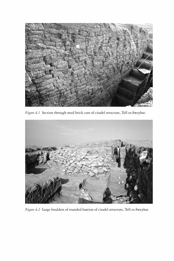
Figure 4.1 Section through mud brick core of citadel structure, Tell es-Sweyhat.
Figure 4.2 Large boulders of rounded bastion of citadel structure, Tell es-Sweyhat.
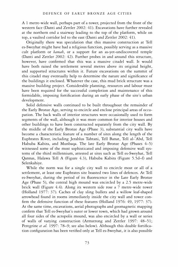
A 1 metre-wide wall, perhaps part of a tower, projected from the front of thewestern face (Danti and Zettler 2002: 41). Excavations have further revealedat the northern end a stairway leading to the top of the platform, while ontop, a vaulted corridor led to the east (Danti and Zettler 2002: 41).
Originally there was speculation that this massive construction at Telles-Sweyhat might have had a religious function, possibly serving as a massivecult platform or bamah, or a support for an as-yet-undiscovered temple(Danti and Zettler 2002: 42). Further probes in and around this structure,however, have confirmed that this was a massive citadel wall. It wouldhave both raised the settlement several metres above its original height,and supported structures within it. Future excavations on the summit ofthis citadel may eventually help to determine the nature and significance ofthe buildings it enclosed. Whatever the case, this mud brick structure was amassive building project. Considerable planning, resources and labour musthave been required for the successful completion and maintenance of thisformidable, imposing fortification during an early phase of the site’s urbandevelopment.
Solid defensive walls continued to be built throughout the remainder ofthe Early Bronze Age, serving to encircle and enclose principal areas of occu-pation. The back walls of interior structures were occasionally used to formsegments of the wall, although it was more common for interior houses andother buildings to have been constructed separately from the city wall. Bythe middle of the Early Bronze Age (Phase 3), substantial city walls havebecome a characteristic feature of a number of sites along the length of theEuphrates River, including Jerablus Tahtani, Tell Banat, Tell al- �Abd, TellHabuba Kabira, and Munbaqa. The late Early Bronze Age (Phases 4–5)witnessed some of the most sophisticated and imposing defensive wall sys-tems of the third millennium, attested at sites such as Tell es-Sweyhat, TellQannas, Halawa Tell A (Figure 4.3), Habuba Kabira (Figure 5.5d–f) andSelenkahiye.
While the norm was for a single city wall to encircle most or all of asettlement, at least one Euphrates site boasted two lines of defences. At Telles-Sweyhat, during the period of its fluorescence in the Late Early BronzeAge (Phase 5), the central high mound was encircled by a 2.5 metre-widebrick wall (Figure 4.4). Along its western side rose a 7 metre-wide tower(Holland 1977: 37). Caches of clay sling bullets and a willow leaf-shapedarrowhead found in rooms immediately inside the city wall and tower con-firm the defensive function of these features (Holland 1976: 49, 1977: 37).At the same time, excavations, aerial photographs and geomagnetic mappingconfirm that Tell es-Sweyhat’s outer or lower town, which had grown aroundall four sides of the acropolis mound, was also encircled by a wall or seriesof walls of varying construction (Armstrong and Zettler 1997: 48–51;Peregrine et al. 1997: 78–9; see also below). Although this double fortifica-tion configuration has been verified only at Tell es-Sweyhat, it is also possible
D E F E N C E O F E A R LY B R O N Z E A G E C I T I E S
73
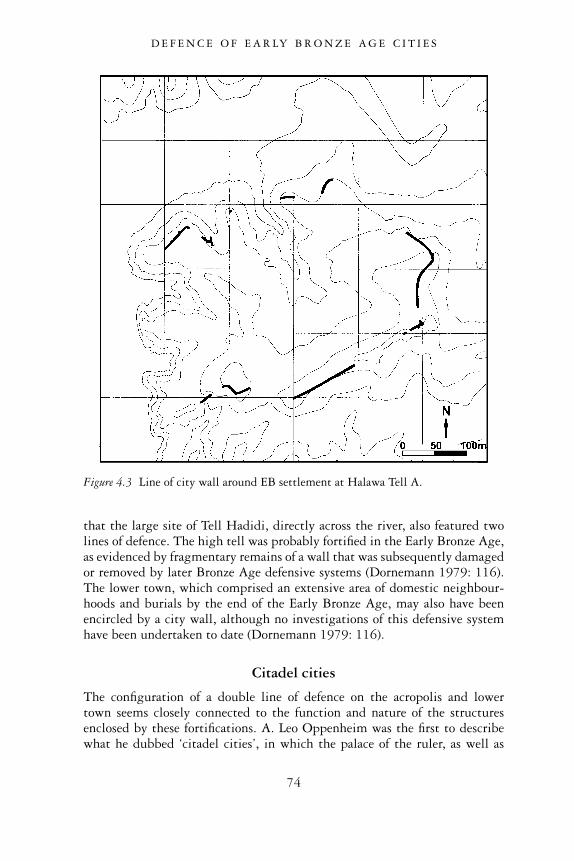
that the large site of Tell Hadidi, directly across the river, also featured twolines of defence. The high tell was probably fortified in the Early Bronze Age,as evidenced by fragmentary remains of a wall that was subsequently damagedor removed by later Bronze Age defensive systems (Dornemann 1979: 116).The lower town, which comprised an extensive area of domestic neighbour-hoods and burials by the end of the Early Bronze Age, may also have beenencircled by a city wall, although no investigations of this defensive systemhave been undertaken to date (Dornemann 1979: 116).
Citadel cities
The configuration of a double line of defence on the acropolis and lowertown seems closely connected to the function and nature of the structuresenclosed by these fortifications. A. Leo Oppenheim was the first to describewhat he dubbed ‘citadel cities’, in which the palace of the ruler, as well as
Figure 4.3 Line of city wall around EB settlement at Halawa Tell A.
D E F E N C E O F E A R LY B R O N Z E A G E C I T I E S
74
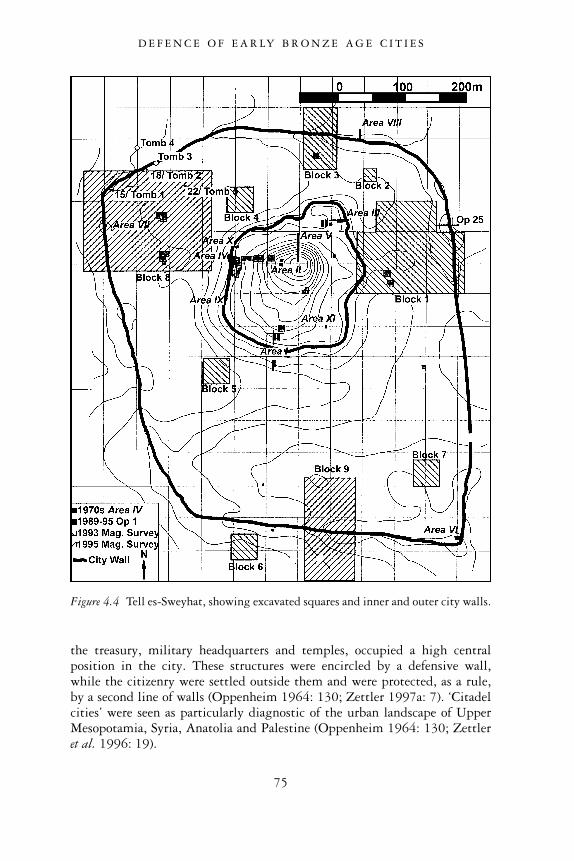
the treasury, military headquarters and temples, occupied a high centralposition in the city. These structures were encircled by a defensive wall,while the citizenry were settled outside them and were protected, as a rule,by a second line of walls (Oppenheim 1964: 130; Zettler 1997a: 7). ‘Citadelcities’ were seen as particularly diagnostic of the urban landscape of UpperMesopotamia, Syria, Anatolia and Palestine (Oppenheim 1964: 130; Zettleret al. 1996: 19).
Figure 4.4 Tell es-Sweyhat, showing excavated squares and inner and outer city walls.
D E F E N C E O F E A R LY B R O N Z E A G E C I T I E S
75
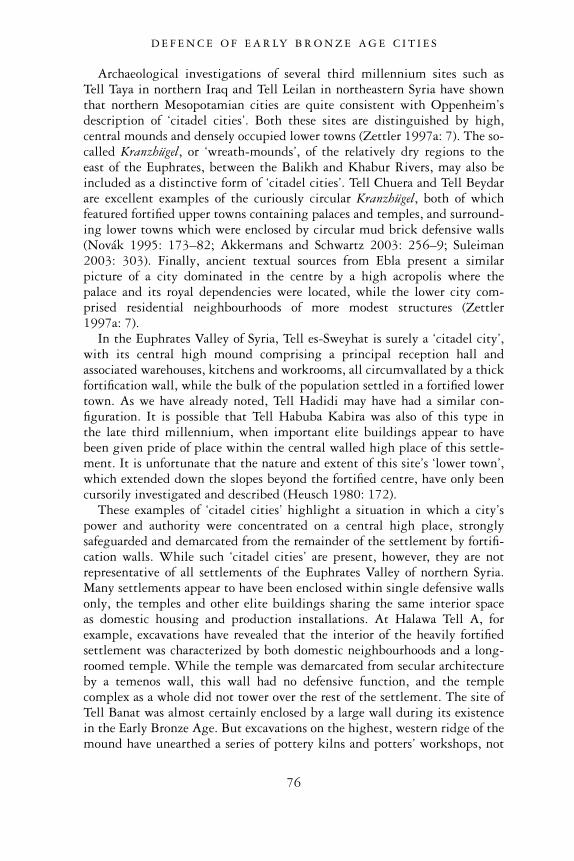
Archaeological investigations of several third millennium sites such asTell Taya in northern Iraq and Tell Leilan in northeastern Syria have shownthat northern Mesopotamian cities are quite consistent with Oppenheim’sdescription of ‘citadel cities’. Both these sites are distinguished by high,central mounds and densely occupied lower towns (Zettler 1997a: 7). The so-called Kranzhügel, or ‘wreath-mounds’, of the relatively dry regions to theeast of the Euphrates, between the Balikh and Khabur Rivers, may also beincluded as a distinctive form of ‘citadel cities’. Tell Chuera and Tell Beydarare excellent examples of the curiously circular Kranzhügel, both of whichfeatured fortified upper towns containing palaces and temples, and surround-ing lower towns which were enclosed by circular mud brick defensive walls(Novák 1995: 173–82; Akkermans and Schwartz 2003: 256–9; Suleiman2003: 303). Finally, ancient textual sources from Ebla present a similarpicture of a city dominated in the centre by a high acropolis where thepalace and its royal dependencies were located, while the lower city com-prised residential neighbourhoods of more modest structures (Zettler1997a: 7).
In the Euphrates Valley of Syria, Tell es-Sweyhat is surely a ‘citadel city’,with its central high mound comprising a principal reception hall andassociated warehouses, kitchens and workrooms, all circumvallated by a thickfortification wall, while the bulk of the population settled in a fortified lowertown. As we have already noted, Tell Hadidi may have had a similar con-figuration. It is possible that Tell Habuba Kabira was also of this type inthe late third millennium, when important elite buildings appear to havebeen given pride of place within the central walled high place of this settle-ment. It is unfortunate that the nature and extent of this site’s ‘lower town’,which extended down the slopes beyond the fortified centre, have only beencursorily investigated and described (Heusch 1980: 172).
These examples of ‘citadel cities’ highlight a situation in which a city’spower and authority were concentrated on a central high place, stronglysafeguarded and demarcated from the remainder of the settlement by fortifi-cation walls. While such ‘citadel cities’ are present, however, they are notrepresentative of all settlements of the Euphrates Valley of northern Syria.Many settlements appear to have been enclosed within single defensive wallsonly, the temples and other elite buildings sharing the same interior spaceas domestic housing and production installations. At Halawa Tell A, forexample, excavations have revealed that the interior of the heavily fortifiedsettlement was characterized by both domestic neighbourhoods and a long-roomed temple. While the temple was demarcated from secular architectureby a temenos wall, this wall had no defensive function, and the templecomplex as a whole did not tower over the rest of the settlement. The site ofTell Banat was almost certainly enclosed by a large wall during its existencein the Early Bronze Age. But excavations on the highest, western ridge of themound have unearthed a series of pottery kilns and potters’ workshops, not
D E F E N C E O F E A R LY B R O N Z E A G E C I T I E S
76
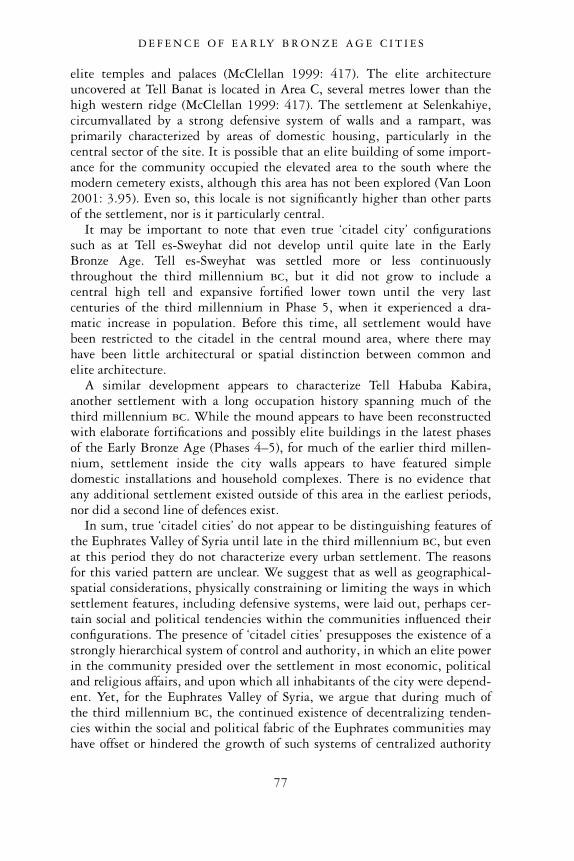
elite temples and palaces (McClellan 1999: 417). The elite architectureuncovered at Tell Banat is located in Area C, several metres lower than thehigh western ridge (McClellan 1999: 417). The settlement at Selenkahiye,circumvallated by a strong defensive system of walls and a rampart, wasprimarily characterized by areas of domestic housing, particularly in thecentral sector of the site. It is possible that an elite building of some import-ance for the community occupied the elevated area to the south where themodern cemetery exists, although this area has not been explored (Van Loon2001: 3.95). Even so, this locale is not significantly higher than other partsof the settlement, nor is it particularly central.
It may be important to note that even true ‘citadel city’ configurationssuch as at Tell es-Sweyhat did not develop until quite late in the EarlyBronze Age. Tell es-Sweyhat was settled more or less continuouslythroughout the third millennium bc, but it did not grow to include acentral high tell and expansive fortified lower town until the very lastcenturies of the third millennium in Phase 5, when it experienced a dra-matic increase in population. Before this time, all settlement would havebeen restricted to the citadel in the central mound area, where there mayhave been little architectural or spatial distinction between common andelite architecture.
A similar development appears to characterize Tell Habuba Kabira,another settlement with a long occupation history spanning much of thethird millennium bc. While the mound appears to have been reconstructedwith elaborate fortifications and possibly elite buildings in the latest phasesof the Early Bronze Age (Phases 4–5), for much of the earlier third millen-nium, settlement inside the city walls appears to have featured simpledomestic installations and household complexes. There is no evidence thatany additional settlement existed outside of this area in the earliest periods,nor did a second line of defences exist.
In sum, true ‘citadel cities’ do not appear to be distinguishing features ofthe Euphrates Valley of Syria until late in the third millennium bc, but evenat this period they do not characterize every urban settlement. The reasonsfor this varied pattern are unclear. We suggest that as well as geographical-spatial considerations, physically constraining or limiting the ways in whichsettlement features, including defensive systems, were laid out, perhaps cer-tain social and political tendencies within the communities influenced theirconfigurations. The presence of ‘citadel cities’ presupposes the existence of astrongly hierarchical system of control and authority, in which an elite powerin the community presided over the settlement in most economic, politicaland religious affairs, and upon which all inhabitants of the city were depend-ent. Yet, for the Euphrates Valley of Syria, we argue that during much ofthe third millennium bc, the continued existence of decentralizing tenden-cies within the social and political fabric of the Euphrates communities mayhave offset or hindered the growth of such systems of centralized authority
D E F E N C E O F E A R LY B R O N Z E A G E C I T I E S
77
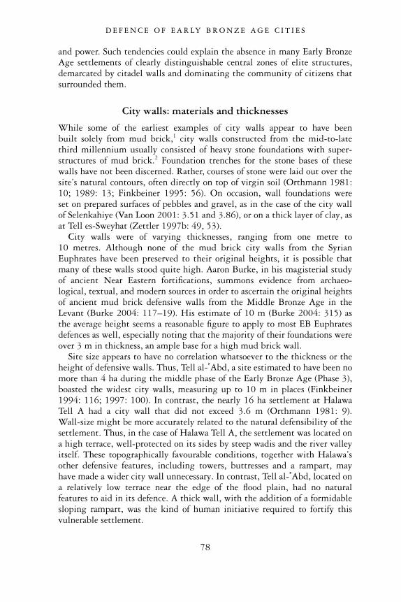
and power. Such tendencies could explain the absence in many Early BronzeAge settlements of clearly distinguishable central zones of elite structures,demarcated by citadel walls and dominating the community of citizens thatsurrounded them.
City walls: materials and thicknesses
While some of the earliest examples of city walls appear to have beenbuilt solely from mud brick,1 city walls constructed from the mid-to-latethird millennium usually consisted of heavy stone foundations with super-structures of mud brick.2 Foundation trenches for the stone bases of thesewalls have not been discerned. Rather, courses of stone were laid out over thesite’s natural contours, often directly on top of virgin soil (Orthmann 1981:10; 1989: 13; Finkbeiner 1995: 56). On occasion, wall foundations wereset on prepared surfaces of pebbles and gravel, as in the case of the city wallof Selenkahiye (Van Loon 2001: 3.51 and 3.86), or on a thick layer of clay, asat Tell es-Sweyhat (Zettler 1997b: 49, 53).
City walls were of varying thicknesses, ranging from one metre to10 metres. Although none of the mud brick city walls from the SyrianEuphrates have been preserved to their original heights, it is possible thatmany of these walls stood quite high. Aaron Burke, in his magisterial studyof ancient Near Eastern fortifications, summons evidence from archaeo-logical, textual, and modern sources in order to ascertain the original heightsof ancient mud brick defensive walls from the Middle Bronze Age in theLevant (Burke 2004: 117–19). His estimate of 10 m (Burke 2004: 315) asthe average height seems a reasonable figure to apply to most EB Euphratesdefences as well, especially noting that the majority of their foundations wereover 3 m in thickness, an ample base for a high mud brick wall.
Site size appears to have no correlation whatsoever to the thickness or theheight of defensive walls. Thus, Tell al- �Abd, a site estimated to have been nomore than 4 ha during the middle phase of the Early Bronze Age (Phase 3),boasted the widest city walls, measuring up to 10 m in places (Finkbeiner1994: 116; 1997: 100). In contrast, the nearly 16 ha settlement at HalawaTell A had a city wall that did not exceed 3.6 m (Orthmann 1981: 9).Wall-size might be more accurately related to the natural defensibility of thesettlement. Thus, in the case of Halawa Tell A, the settlement was located ona high terrace, well-protected on its sides by steep wadis and the river valleyitself. These topographically favourable conditions, together with Halawa’sother defensive features, including towers, buttresses and a rampart, mayhave made a wider city wall unnecessary. In contrast, Tell al- �Abd, located ona relatively low terrace near the edge of the flood plain, had no naturalfeatures to aid in its defence. A thick wall, with the addition of a formidablesloping rampart, was the kind of human initiative required to fortify thisvulnerable settlement.
D E F E N C E O F E A R LY B R O N Z E A G E C I T I E S
78
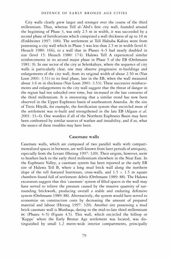
City walls clearly grew larger and stronger over the course of the thirdmillennium. Thus, whereas Tell al- �Abd’s first city wall, founded aroundthe beginning of Phase 3, was only 2.5 m in width, it was succeeded by asecond phase of fortifications which comprised a wall thickness of up to 10 m(Finkbeiner 1997: 100). The settlement at Tell Habuba Kabira went frompossessing a city wall which in Phase 3 was less than 2.5 m in width (level 6:Heusch 1980: 166), to a wall that in Phases 4–5 had nearly doubled insize (level 15: Heusch 1980: 174). Halawa Tell A experienced similarreinforcements in its second major phase in Phase 5 of the EB (Orthmann1981: 9). In one sector of the city at Selenkahiye, where the sequence of citywalls is particularly clear, one may observe progressive re-buildings andenlargements of the city wall, from its original width of about 2.50 m (VanLoon 2001: 3.51) to its final phase, late in the EB, when the wall measuredabout 3.6 m in thickness (Van Loon 2001: 3.53). These successive reinforce-ments and enlargements to the city wall suggest that the threat of danger inthe region had not subsided over time, but increased in the last centuries ofthe third millennium. It is interesting that a similar trend has now beenobserved in the Upper Euphrates basin of southeastern Anatolia. At the siteof Titris Höyük, for example, the fortification system that encircled most ofthe settlement was re-built and strengthened in the late EB (Algaze et al.2001: 33–4). One wonders if all of the Northern Euphrates Basin may havebeen confronted by similar sources of warfare and instability, and if so, whatthe source of these troubles may have been.
Casemate walls
Casemate walls, which are composed of two parallel walls with compart-mentalized spaces in between, are well-known from later periods of antiquity,especially from the Levant (Herzog 1997: 320). Their origins, however, seemto hearken back to the early third millennium elsewhere in the Near East. Inthe Euphrates Valley, a casemate system has been reported at the early EBsite of Halawa Tell B, where a long mud brick wall along the northernslope of the tell featured buttresses, cross-walls, and 1.5 × 1.5 m squarechambers found full of settlement debris (Orthmann 1989: 88). The Halawaexcavators suggest that this ‘casemate’ system of filled spaces in the wall mayhave served to relieve the pressure caused by the massive quantity of sur-rounding brickwork, producing overall a stable and enduring defensivesystem (Orthmann 1989: 88). Alternatively, the system would have served toeconomize on construction costs by decreasing the amount of preparedmaterial and labour (Herzog 1997: 320). Another site possessing a mudbrick casemate wall is Munbaqa, dating to the mid-to-late third millenniumbc (Phases 4–5) (Figure 4.5). This wall, which encircled the hilltop or‘Kuppe’ where the Early Bronze Age settlement was located, was dis-tinguished by small 1.2 metre-wide interior compartments, principally
D E F E N C E O F E A R LY B R O N Z E A G E C I T I E S
79
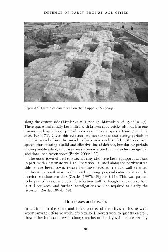
along the eastern side (Eichler et al. 1984: 73; Machule et al. 1986: 81–3).These spaces had mostly been filled with broken mud bricks, although in oneinstance, a large storage jar had been sunk into the space (Room 9: Eichleret al. 1984: 73). Given this evidence, we can suppose that during periods ofpotential attacks from the outside, efforts were made to fill in the casematespaces, thus creating a solid and effective line of defence, but during periodsof comparable safety, this casemate system was used as an area for storage andadditional habitation space (Burke 2004: 122).
The outer town of Tell es-Sweyhat may also have been equipped, at leastin part, with a casemate wall. In Operation 15, sited along the northwesternside of the lower town, excavations have revealed a thick wall orientednortheast by southwest, and a wall running perpendicular to it on theinterior, southeastern side (Zettler 1997b: Figure 3.12). This was positedto be part of a casemate outer fortification wall, although the evidence hereis still equivocal and further investigations will be required to clarify thesituation (Zettler 1997b: 49).
Buttresses and towers
In addition to the stone and brick courses of the city’s enclosure wall,accompanying defensive works often existed. Towers were frequently erected,these either built at intervals along stretches of the city wall, or at especially
Figure 4.5 Eastern casemate wall on the ‘Kuppe’ at Munbaqa.
D E F E N C E O F E A R LY B R O N Z E A G E C I T I E S
80
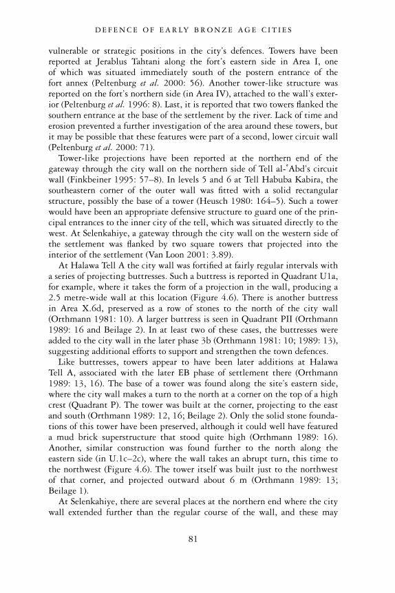
vulnerable or strategic positions in the city’s defences. Towers have beenreported at Jerablus Tahtani along the fort’s eastern side in Area I, oneof which was situated immediately south of the postern entrance of thefort annex (Peltenburg et al. 2000: 56). Another tower-like structure wasreported on the fort’s northern side (in Area IV), attached to the wall’s exter-ior (Peltenburg et al. 1996: 8). Last, it is reported that two towers flanked thesouthern entrance at the base of the settlement by the river. Lack of time anderosion prevented a further investigation of the area around these towers, butit may be possible that these features were part of a second, lower circuit wall(Peltenburg et al. 2000: 71).
Tower-like projections have been reported at the northern end of thegateway through the city wall on the northern side of Tell al- �Abd’s circuitwall (Finkbeiner 1995: 57–8). In levels 5 and 6 at Tell Habuba Kabira, thesoutheastern corner of the outer wall was fitted with a solid rectangularstructure, possibly the base of a tower (Heusch 1980: 164–5). Such a towerwould have been an appropriate defensive structure to guard one of the prin-cipal entrances to the inner city of the tell, which was situated directly to thewest. At Selenkahiye, a gateway through the city wall on the western side ofthe settlement was flanked by two square towers that projected into theinterior of the settlement (Van Loon 2001: 3.89).
At Halawa Tell A the city wall was fortified at fairly regular intervals witha series of projecting buttresses. Such a buttress is reported in Quadrant U1a,for example, where it takes the form of a projection in the wall, producing a2.5 metre-wide wall at this location (Figure 4.6). There is another buttressin Area X.6d, preserved as a row of stones to the north of the city wall(Orthmann 1981: 10). A larger buttress is seen in Quadrant PII (Orthmann1989: 16 and Beilage 2). In at least two of these cases, the buttresses wereadded to the city wall in the later phase 3b (Orthmann 1981: 10; 1989: 13),suggesting additional efforts to support and strengthen the town defences.
Like buttresses, towers appear to have been later additions at HalawaTell A, associated with the later EB phase of settlement there (Orthmann1989: 13, 16). The base of a tower was found along the site’s eastern side,where the city wall makes a turn to the north at a corner on the top of a highcrest (Quadrant P). The tower was built at the corner, projecting to the eastand south (Orthmann 1989: 12, 16; Beilage 2). Only the solid stone founda-tions of this tower have been preserved, although it could well have featureda mud brick superstructure that stood quite high (Orthmann 1989: 16).Another, similar construction was found further to the north along theeastern side (in U.1c–2c), where the wall takes an abrupt turn, this time tothe northwest (Figure 4.6). The tower itself was built just to the northwestof that corner, and projected outward about 6 m (Orthmann 1989: 13;Beilage 1).
At Selenkahiye, there are several places at the northern end where the citywall extended further than the regular course of the wall, and these may
D E F E N C E O F E A R LY B R O N Z E A G E C I T I E S
81
possibly be interpreted as small buttress-like jumps in the wall (Van Loon2001: 3.87). The kind of inset-offset effect that such buttresses produced isnot too unlike that found in the latest fortification wall at Tell Habuba Kabira,which, in addition to featuring a large tower that juts out in the north,comprises a similar set of buttresses (Figure 5.5f ) (Heusch 1980: 174–5).
The most prominent tower-base at Selenkahiye was located protrudingfrom the town wall along the west part of the settlement (Figure 5.13). Itwas founded on large stones and measured about 5 × 5 m. This constructionis generally thought to have been added fairly late in Selenkahiye’s sequenceof occupation, and thus represents one further example of efforts made atthis site through time to strengthen and enlarge the settlement’s defensivecapabilities (Van Loon 2001: 3.89; Figure 3.18).
Figure 4.6 City wall, with projecting buttress, and corner tower (Quadrants U andT), Halawa Tell A.
D E F E N C E O F E A R LY B R O N Z E A G E C I T I E S
82
As a final example of an impressive tower-base, we may turn again to theinner fortification wall at Tell es-Sweyhat, which encircled a group ofimportant public buildings on the central, high mound during the lastphase of occupation at the site late in the third millennium bc (Phase 5).Excavations have revealed there a 7 metre-wide mud brick tower base, pro-jecting out from the exterior western side of the citadel wall (Figure 6.4).This tower had been badly damaged either by attack or subsequent erosion(Holland 1977: 37). The fact that a cache of 35 complete and over 60fragments of clay sling bullets were found in rooms immediately inside thecitadel wall at this point underline the feature’s defensive function (Holland1977: 37).
Ramparts and glacis
Accompanying many city walls in the Euphrates Valley of Syria are ram-parts, which are characterized by thick, sloping layers of gravel, or packedclay and earth, usually thrown up against the exterior face of the wall andsometimes adding elevation to it, in an effort to impede the advance of anenemy approaching the city walls (Mazar 1995: 1527–8; Herzog 1997:320; Burke 2004: 96). Most of these ramparts are also accompanied byglacis, which refer to the surface treatment of the slope of the rampart.Such glacis, which were made from a variety of materials including gyp-sum plaster, crushed limestone, pebbles or packed clay, made the surfaceof the rampart impervious to rain and thus resistant to erosion (Burke 2004:96). Originally believed to be Hyksos inventions of the second millenniumbc, many earlier third millennium examples of ramparts and glacis have nowbeen confirmed in Anatolia, Syria and Palestine (Parr 1968: 36–42; Burke2004: 166–8).
In the northern Euphrates Valley of Syria, traces of such EB constructionshave been reported at the site of Tell al- �Abd, where they were completed inconjunction with the enlargement of the city wall during the settlement’ssecond phase in Phase 3 of the EB. The rampart is particularly well preservedin the northern end of the settlement, where it consisted of a sloping layerof packed clay built upon stone foundations and resting up against themudbrick superstructure of the second phase of the city wall. The brickworkof the city wall receded in layers in order to accommodate this slopingrevetment (Finkbeiner 1995: 56; Abb. 4; 1997: 100).
An impressive rampart has been found at the site of Jerablus Tahtani,attributed to the site’s occupation in the mid-to-late third millennium bc(Phase 4). This artificial bank had been thrown up against the exterior of thecity wall in the second phase of the city’s defences. Not only did this bankdramatically change the outer appearance of the fort, internal arrangementswere also affected, the most significant change being that much of the earli-est phase of fort occupation was filled in, resulting in a new occupation level
D E F E N C E O F E A R LY B R O N Z E A G E C I T I E S
83
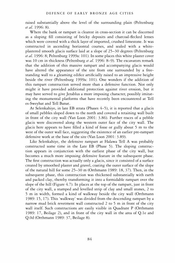
raised substantially above the level of the surrounding plain (Peltenburget al. 1996: 8).
Where the bank or rampart is clearest in cross-section it can be discernedas a sloping fill consisting of bricky deposits and charcoal-flecked lenseswhich were covered with a thick layer of imported, crushed limestone. It wasconstructed in ascending horizontal courses, and sealed with a white-plastered smooth glacis surface laid at a slope of 25–30 degrees (Peltenburget al. 1996: 8; Peltenburg 1999a: 101). In some places this white plaster coverwas 10 cm in thickness (Peltenburg et al. 1996: 8–9). The excavators remarkthat the addition of this massive rampart and accompanying glacis wouldhave altered the appearance of the site from one surrounded by a free-standing wall to a gleaming edifice artificially raised to an impressive heightbeside the river (Peltenburg 1999a: 101). One wonders if the addition ofthis rampart construction served more than a defensive function. Not onlymight it have provided additional protection against river erosion, but itmay have served to give Jerablus a more imposing character, possibly imitat-ing the monumental platforms that have recently been encountered at Telles-Sweyhat and Tell Banat.
At Selenkahiye, in late EB strata (Phases 4–5), it is reported that a glacisof small pebbles sloped down to the north and covered a retaining wall builtin front of the city wall (Van Loon 2001: 3.86). Further traces of a pebbleglacis were discovered along the western outer face of the city wall. Theglacis here appears to have filled a kind of fosse or gully about 5 m to thewest of the outer wall face, suggesting the existence of an earlier pre-rampartdefensive work at the base of the site (Van Loon 2001: 3.89).
Like Selenkahiye, the defensive rampart at Halawa Tell A was probablyconstructed some time in the Late EB (Phase 5). The sloping construc-tion appears in conjunction with the earliest phase of the city wall, butbecomes a much more imposing defensive feature in the subsequent phase.The first construction was actually only a glacis, since it consisted of a surfacecreated by smoothed plaster and gravel, coating the outer surface of the slopeof the natural hill for some 25–30 m (Orthmann 1989: 18, 37). Then, in thesubsequent phase, this construction was thickened substantially with earthand packed clay, thereby transforming it into a formidable rampart over theslope of the hill (Figure 4.7). In places at the top of the rampart, just in frontof the city wall, a stamped and levelled strip of clay and small stones, 2 to5 m in width, formed a kind of walkway beside the city wall (Orthmann1989: 15, 17). This ‘walkway’ was divided from the descending rampart by anarrow mud brick revetment wall constructed 2 to 5 m in front of the citywall itself. Such constructions are easily visible in Quadrant P (Orthmann1989: 17, Beilage 2), and in front of the city wall in the area of Q.1e andQ.0d (Orthmann 1989: 37, Beilage 8).
D E F E N C E O F E A R LY B R O N Z E A G E C I T I E S
84
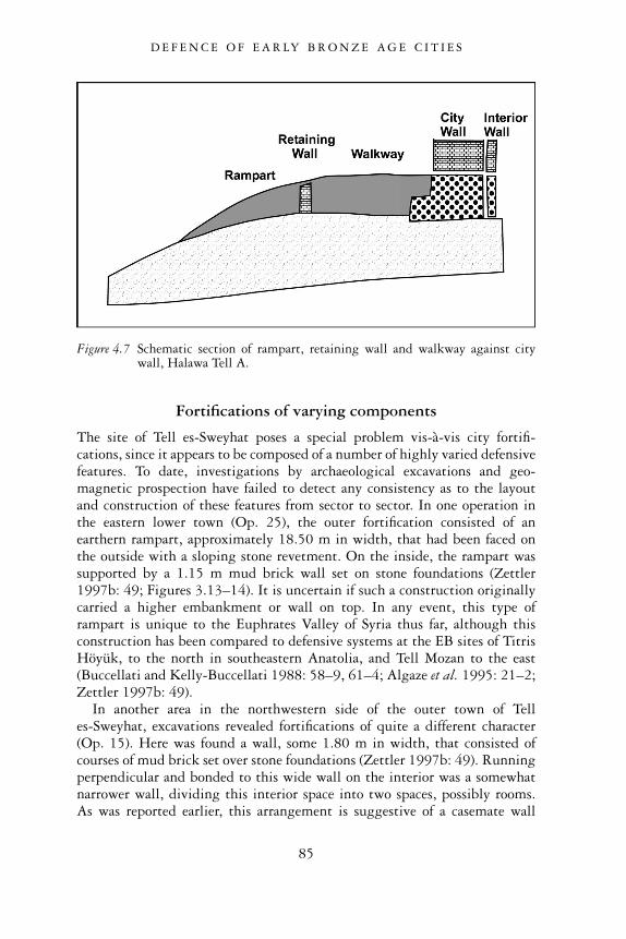
Fortifications of varying components
The site of Tell es-Sweyhat poses a special problem vis-à-vis city fortifi-cations, since it appears to be composed of a number of highly varied defensivefeatures. To date, investigations by archaeological excavations and geo-magnetic prospection have failed to detect any consistency as to the layoutand construction of these features from sector to sector. In one operation inthe eastern lower town (Op. 25), the outer fortification consisted of anearthern rampart, approximately 18.50 m in width, that had been faced onthe outside with a sloping stone revetment. On the inside, the rampart wassupported by a 1.15 m mud brick wall set on stone foundations (Zettler1997b: 49; Figures 3.13–14). It is uncertain if such a construction originallycarried a higher embankment or wall on top. In any event, this type oframpart is unique to the Euphrates Valley of Syria thus far, although thisconstruction has been compared to defensive systems at the EB sites of TitrisHöyük, to the north in southeastern Anatolia, and Tell Mozan to the east(Buccellati and Kelly-Buccellati 1988: 58–9, 61–4; Algaze et al. 1995: 21–2;Zettler 1997b: 49).
In another area in the northwestern side of the outer town of Telles-Sweyhat, excavations revealed fortifications of quite a different character(Op. 15). Here was found a wall, some 1.80 m in width, that consisted ofcourses of mud brick set over stone foundations (Zettler 1997b: 49). Runningperpendicular and bonded to this wide wall on the interior was a somewhatnarrower wall, dividing this interior space into two spaces, possibly rooms.As was reported earlier, this arrangement is suggestive of a casemate wall
Figure 4.7 Schematic section of rampart, retaining wall and walkway against citywall, Halawa Tell A.
D E F E N C E O F E A R LY B R O N Z E A G E C I T I E S
85
construction (Zettler 1997b: 49). The results of the geomagnetic mapping inthe northwestern corner, however, have revealed a different configurationconsisting of not one but two parallel runs of the outer wall. This double linewas also detected along the northern stretch of the outer town (Zettler et al.1996: 33). Last, a double line in the northwestern corner of the outer settle-ment was picked up on lower level aerial photographs (Zettler 1997b: 49;Peregrine et al. 1997: Figure 4.2). This double line could perhaps representtwo fortification walls, one perhaps later than the other. Alternatively, it ispossible that these linear features represent rampart revetments similar tothose uncovered in Op. 25 on the eastern side (Peregrine et al. 1997: 77). Insum, the outer town fortifications at Tell es-Sweyhat present a rather diverseset of features that appear to vary from one city sector to another. Futureinvestigations will no doubt shed further light on this unique set ofconstructions.
The town defences at Selenkahiye display considerable variation in plan-ning and execution. The excavators of Selenkahiye have observed that the citywall was not consistently built. Several changes in direction, for example,were noted along the city wall’s northern length. Along the western edgeof the tell, the wall seems to take a ‘curious, squiggly course’ (Van Loon2001: 3.103). All along the wall one sees changes in the dimensions of thewall. There is no regular or predictable placement of buttresses and towers,and a great number of variations in the numbers of reconstructions andenlargements have been observed.
Taken together, the evidence from Selenkahiye suggests perhaps that whilecity authorities may have generally indicated where the wall was to be built,the actual construction and refurbishment of that wall was left to individualquarters, or blocks, of the settlement. Accordingly, this assumption couldmean that while a central authority may have existed at Selenkahiye, it waslimited in power (Van Loon 2001: 110). One wonders if the town fortifi-cations at Tell es-Sweyhat, also exhibiting considerable variability from onearea to the next, can be explained in the same way.
DISCUSSION
Archaeological evidence clearly indicates the presence of well built, solidfortification systems along the length of the northern Euphrates Valley ofSyria. Their appearance at the majority of settlements occupied during theEarly Bronze Age indicates the necessity for safeguarding the cities’ inhabit-ants and their possessions during a period that was probably marked by inter-city rivalries or the threat of attacks and raids by outside groups. Towards theend of the Early Bronze Age, when city defences grew particularly formid-able, the presence of insecurity and the threat of attacks must have been quitepronounced, calling for the most secure of defensive systems. The fact that
D E F E N C E O F E A R LY B R O N Z E A G E C I T I E S
86
most EB settlements were destroyed, abandoned or experienced a dramaticdecline in population and settlement size shortly after this period clearlytestifies to the upheavals that must have shaken the region at this time.
While protection against attacks and raids was clearly the primary moti-vation for the construction of fortifications, it is also important to emphasizethe psychological impact that such lines of defence may have had. LeoOppenheim astutely observed that Mesopotamian city walls, by virtue oftheir large size and the quality of their construction, underlined the impressiveurban character of the cities they encircled (Oppenheim 1964: 129). Thesewalls served as potent symbols of the wealth, sophistication and strength ofthe populations whom they protected, setting them apart from the unsettled,less ‘civilized’ populations and regions that existed beyond.
We may imagine the dramatic impact that such works would have hadupon outsiders, particularly in the case of EB settlements of the Euphrates,which are characterized not only by simple encircling walls, but also formid-able towers, buttresses, ramparts and smooth, gleaming glacis. Moreover, thefact that even some of the smallest Euphrates’ settlements were distinguishedby such monumental constructions demonstrates membership within thisurban landscape regardless of their size. Part of the reason for this is thatmany of these settlements gained their livelihood from participation inthe brisk trade conducted either along the river or overland. Thus eventhe smallest commercial storage facility, tariff outpost or crossing stationalong the river would have needed to keep up appearances of stability andsecurity, afforded by these impressive fortifications, if it wished to maintainits participation within this important, profitable exchange network.
Even from an early phase of the Early Bronze Age, a coordinated effort onbehalf of the community must have existed in order to summon the necessaryresources, planning and labour to construct and maintain these defensiveworks. While the fortifications imply a sophisticated level of organizationwithin the settlement, it is still difficult to define the exact nature of thiseffort. As we have pointed out, double fortification systems, or ‘citadel cities’are present in the region. Their configuration may be the result of the pres-ence of a centralized political authority, in which all efforts of the city,including its defence, were planned and supervised by a few powerful indi-viduals who ruled the city from its acropolis. We have also shown, however,that cities do not all reflect such a hierarchical system of political authority,as indicated by the absence of a distinguishable fortified acropolis at manysites. Centres of power and authority seem to be spread throughout thecommunity, and were enclosed by a single fortification wall. Moreover, thecity walls themselves, which show differences in alignment, constructiontechniques, and even variable defensive systems from one sector to another,suggest that not all city construction projects fell under the direction andexecution of a single authority. On the contrary, some efforts may have beenleft to individual community groups, or city neighbourhoods, to coordinate
D E F E N C E O F E A R LY B R O N Z E A G E C I T I E S
87
and complete. This evidence may betray a more heterarchical form of poli-tical control at some cities, where authority was dispersed among severalgroups spread out across the urban community. To be sure, this argument isconjectural, but as we shall see, it appears to find support in other aspects ofthe Euphrates’ archaeological record.
D E F E N C E O F E A R LY B R O N Z E A G E C I T I E S
88
5
HOUSING AND HOUSEHOLDS
Clusters of roofed structures, courtyards and streets, representing the remainsof domestic neighbourhoods, have been brought to light at several Euphrates’sites. The common folk of Early Bronze Age settlements resided in theseplaces, and daily activities, such as food preparation, eating, sleeping, andsmall-scale craft activities, were carried out there. Fortunately, enoughdomestic spaces have been excavated to make some general observationsabout the social and economic character of the individuals who inhabitedthem and the ways in which their status and livelihood changed over time.We will also comment on how the houses reflect the growing and distinctive,urban character of the Euphrates region of this period.
Early-to-Middle EB housing (Phases 1–3)
Halawa Tell B
Some of the earliest manifestations of Early Bronze Age houses in the northernEuphrates Valley of Syria were discovered at Halawa Tell B (Figure 5.1).Dated to the earliest centuries of the third millennium bc (Phases 1–2), thestructures of Period I, level 3 were found inside a thick brick enclosure wallset on virgin soil. At least six individual mud brick structures were identifiedwithin this walled space. They either abutted one another or were free-standing, separated by narrow streets or alleyways. Each house seems to havebeen originally conceived as a single room enclosed on four sides by thickmud brick walls. The interior of the house was accessed by a narrow doorwayin one of the sides. A flat roof, likely consisting of several horizontally placedwooden beams, may have been additionally supported by internal woodenposts positioned either in the centre of the room, or along one or more of itssides (Orthmann 1989: 89; Pfälzner 2001: 127). Internal or external mudbrick buttresses also helped to support the house’s superstructure and roof.That the interior space of these structures was the locus of domestic activitiesis suggested by the installations and artifacts found within them. Hearthsand ovens point to the cooking of food, benches against the walls appear to
89
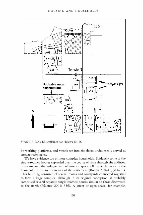
be working platforms, and vessels set into the floors undoubtedly served asstorage receptacles.
We have evidence too of more complex households. Evidently some of thesingle-roomed houses expanded over the course of time through the additionof rooms and the enlargement of interior space. Of particular note is thehousehold in the southern area of the settlement (Rooms 310–11, 314–17).This building consisted of several rooms and courtyards connected togetherto form a large complex, although in its original conception, it probablycomprised several separate single-roomed houses similar to those discoveredto the north (Pfälzner 2001: 356). A street or open space, for example,
Figure 5.1 Early EB settlement at Halawa Tell B.
H O U S I N G A N D H O U S E H O L D S
90
may have existed between two of the rooms (315 and 317), making theseoriginally two free-standing, single-roomed houses. The two units were lateramalgamated into one complex with the addition of a narrow wall alongthe southern side, forming a courtyard space between them (Room 316)(Orthmann 1989: 90; Pfälzner 2001: 356). Another wall was built to enclosea courtyard space (Room 310) between two other rooms in the southwesternpart of the complex.
Of all of the rooms within the household complex, the central square room(Room 314) appears to have been the most important, given its large size, neat,square plan, and fine, white plastered interior that featured wall paintingswith geometrical motifs (Orthmann 1989: 91).
Noteworthy are the artifacts discovered in the southwestern courtyard ofthe household complex, which included a stone mould of a straight axe anda large quantity of bone tools, among them awls and needles (see Figure 8.2)(Orthmann 1989: 91, Abb. 70). Such artifacts point to the presence of craftactivities within the house, including metalworking. The additional dis-covery in Room 314 of a long bronze axe-head may be connected with thisactivity (Orthmann 1989: 91, Abb. 69:9; Pfälzner 2001: 357). It may be thatspecialization in metalworking, which probably augmented the household’seconomic livelihood, accounts for the house’s spatial expansion.
While some of the houses at Halawa Tell B grew in size, others retainedtheir single-roomed ground plan for the duration of their occupation. Free-standing, single-roomed houses, for example, dominated the central area ofexcavation on the tell (Rooms 309, 312, 313). Since the central area wasunfortunately much disturbed by later building operations and erosion, littleof the structures’ interior repertoires has survived. One view of these build-ings is that they functioned as houses where a variety of domestic activitiestook place (Pfälzner 2001: 356). On the other hand, it is tempting to posita sacred character given the buildings’ position in the centre of the settle-ment and their location directly under the cult platform and temple of thesubsequent Period II settlement. Distinctive architectural features oftencharacteristic of EB sacred buildings elsewhere further support a religiouscharacter. Two antae-like projections on the southern exterior of Room 313,for example, are reminiscent of other third millennium long-roomed templein antis shrines found in northern Syria such as at Tell Chuera and HalawaTell A (Moortgat 1960: Abb. 9; Moortgat 1962: Plan II; Orthmann 1989:Beilage 10). Exterior pilasters on the central-most Room 312 may beregarded as precursors to the more elaborate arrangement of buttresses andrecesses of the succeeding temple that was built almost directly over thatbuilding (Orthmann 1989: Beilage 13). It is noteworthy too that at theend of its use, Room 312 was emptied of its contents and filled with mudbrick (Orthmann 1989: 89), a practice known to have been carried out atother religious structures in northern Mesopotamia when they were being‘de-commissioned’ (Schwartz 2000: 171).
H O U S I N G A N D H O U S E H O L D S
91
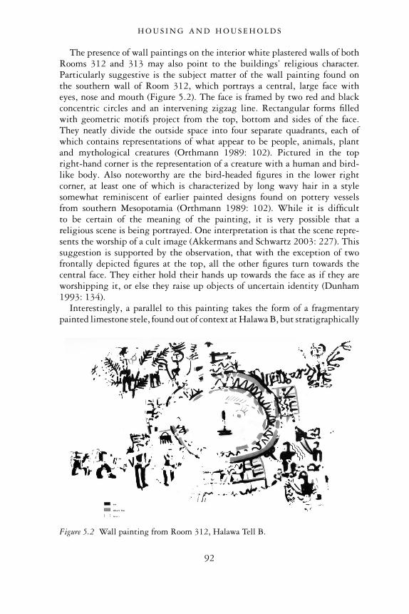
The presence of wall paintings on the interior white plastered walls of bothRooms 312 and 313 may also point to the buildings’ religious character.Particularly suggestive is the subject matter of the wall painting found onthe southern wall of Room 312, which portrays a central, large face witheyes, nose and mouth (Figure 5.2). The face is framed by two red and blackconcentric circles and an intervening zigzag line. Rectangular forms filledwith geometric motifs project from the top, bottom and sides of the face.They neatly divide the outside space into four separate quadrants, each ofwhich contains representations of what appear to be people, animals, plantand mythological creatures (Orthmann 1989: 102). Pictured in the topright-hand corner is the representation of a creature with a human and bird-like body. Also noteworthy are the bird-headed figures in the lower rightcorner, at least one of which is characterized by long wavy hair in a stylesomewhat reminiscent of earlier painted designs found on pottery vesselsfrom southern Mesopotamia (Orthmann 1989: 102). While it is difficultto be certain of the meaning of the painting, it is very possible that areligious scene is being portrayed. One interpretation is that the scene repre-sents the worship of a cult image (Akkermans and Schwartz 2003: 227). Thissuggestion is supported by the observation, that with the exception of twofrontally depicted figures at the top, all the other figures turn towards thecentral face. They either hold their hands up towards the face as if they areworshipping it, or else they raise up objects of uncertain identity (Dunham1993: 134).
Interestingly, a parallel to this painting takes the form of a fragmentarypainted limestone stele, found out of context at Halawa B, but stratigraphically
Figure 5.2 Wall painting from Room 312, Halawa Tell B.
H O U S I N G A N D H O U S E H O L D S
92
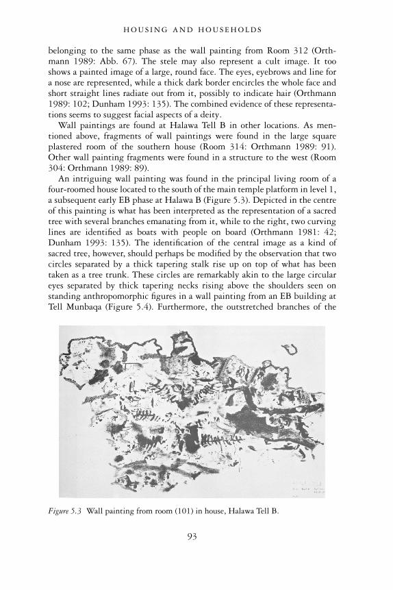
belonging to the same phase as the wall painting from Room 312 (Orth-mann 1989: Abb. 67). The stele may also represent a cult image. It tooshows a painted image of a large, round face. The eyes, eyebrows and line fora nose are represented, while a thick dark border encircles the whole face andshort straight lines radiate out from it, possibly to indicate hair (Orthmann1989: 102; Dunham 1993: 135). The combined evidence of these representa-tions seems to suggest facial aspects of a deity.
Wall paintings are found at Halawa Tell B in other locations. As men-tioned above, fragments of wall paintings were found in the large squareplastered room of the southern house (Room 314: Orthmann 1989: 91).Other wall painting fragments were found in a structure to the west (Room304: Orthmann 1989: 89).
An intriguing wall painting was found in the principal living room of afour-roomed house located to the south of the main temple platform in level 1,a subsequent early EB phase at Halawa B (Figure 5.3). Depicted in the centreof this painting is what has been interpreted as the representation of a sacredtree with several branches emanating from it, while to the right, two curvinglines are identified as boats with people on board (Orthmann 1981: 42;Dunham 1993: 135). The identification of the central image as a kind ofsacred tree, however, should perhaps be modified by the observation that twocircles separated by a thick tapering stalk rise up on top of what has beentaken as a tree trunk. These circles are remarkably akin to the large circulareyes separated by thick tapering necks rising above the shoulders seen onstanding anthropomorphic figures in a wall painting from an EB building atTell Munbaqa (Figure 5.4). Furthermore, the outstretched branches of the
Figure 5.3 Wall painting from room (101) in house, Halawa Tell B.
H O U S I N G A N D H O U S E H O L D S
93
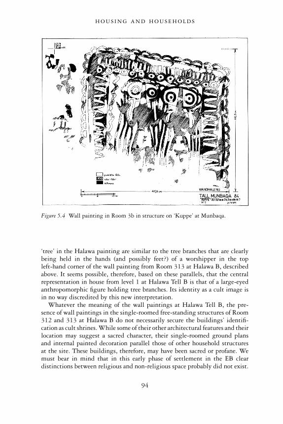
‘tree’ in the Halawa painting are similar to the tree branches that are clearlybeing held in the hands (and possibly feet?) of a worshipper in the topleft-hand corner of the wall painting from Room 313 at Halawa B, describedabove. It seems possible, therefore, based on these parallels, that the centralrepresentation in house from level 1 at Halawa Tell B is that of a large-eyedanthropomorphic figure holding tree branches. Its identity as a cult image isin no way discredited by this new interpretation.
Whatever the meaning of the wall paintings at Halawa Tell B, the pre-sence of wall paintings in the single-roomed free-standing structures of Room312 and 313 at Halawa B do not necessarily secure the buildings’ identifi-cation as cult shrines. While some of their other architectural features and theirlocation may suggest a sacred character, their single-roomed ground plansand internal painted decoration parallel those of other household structuresat the site. These buildings, therefore, may have been sacred or profane. Wemust bear in mind that in this early phase of settlement in the EB cleardistinctions between religious and non-religious space probably did not exist.
Figure 5.4 Wall painting in Room 3b in structure on ‘Kuppe’ at Munbaqa.
H O U S I N G A N D H O U S E H O L D S
94
Tell Habuba Kabira
Other early house plans have been reported from the oldest EB levels at thesite of Tell Habuba Kabira (Phases 1–2), probably occurring only shortlyafter the decline or collapse of the nearby Late Uruk community. Whereexcavations have been able to penetrate into these early layers along thesoutheastern side of the tell, they have exposed at least two building com-plexes in level 3 (Figure 5.5a). The so-called ‘Southern Complex’ can bejudged to be a single house since its interior space of four rooms (1–4) isconnected via doorways, and the house is separated from the suite of roomsimmediately to the north by double walls. Nonetheless, it is likely that thishouse plan represents an adaptation and modification of what had originallybeen two smaller houses. This is suggested by the remnant of the double wallthat exists between rooms 1 and 3 on the east, and the unusual, somewhatoblique nature of the middle section of wall separating the two rooms, whichis likely to be a later construction (Pfälzner 2001: 368). The original designhere was probably two separate houses, positioned side by side along thesoutheastern corner of the settlement. Each household was characterized by asingle square-planned room with internal pilasters, which in size and planwould have resembled well the single-roomed houses encountered in theearly levels at Halawa Tell B. Subsequently the houses were expanded, firstwith the addition of rooms to the west, and then with a connecting passage-way set between the two, transforming the formerly-separate buildings into asingle, larger household (Pfälzner 2001: 369).
The fire that destroyed the ‘Southern Complex’ brought down the roofand sealed much of the house’s artifactual inventory. The rooms’ functionshave been posited on the basis of this in situ material, although even withsuch information, reconstructions are varied. The function of the smallsquare southwestern room (Room 2) has been especially disputed. On theone hand, the presence of a row of four shallow clay basins has been taken toindicate pottery production activities. It is argued that the basins were vatsfor levigating clay with water (Heinrich et al. 1971: 12; Strommenger 1980:76; Akkermans and Schwartz 2003: 228). The discovery of both workedstone discs in the room, possibly the remnants of turntables for potters’wheels (Heusch 1980: 164), and ‘finished’ vessels standing nearby furthersupports the room’s function as a potter’s workshop. The lack of clay lumps,pottery wasters and unfired pottery, in addition to the enclosed nature ofthis room, however, argues against such an interpretation (Pfälzner 2001:161). An alternative and more reasonable function for this room was that ofstorage and preparation of food. Some of the worked stone fragments mayhave been the remains of milling stones. The mud brick platform againstthe south wall could represent a milling platform (Strommenger 1980:Abb. 73; Pfälzner 2001: 145). As for the shallow clay ‘vats’, these may bemore correctly interpreted as stands for pottery vessels, serving especially
H O U S I N G A N D H O U S E H O L D S
95
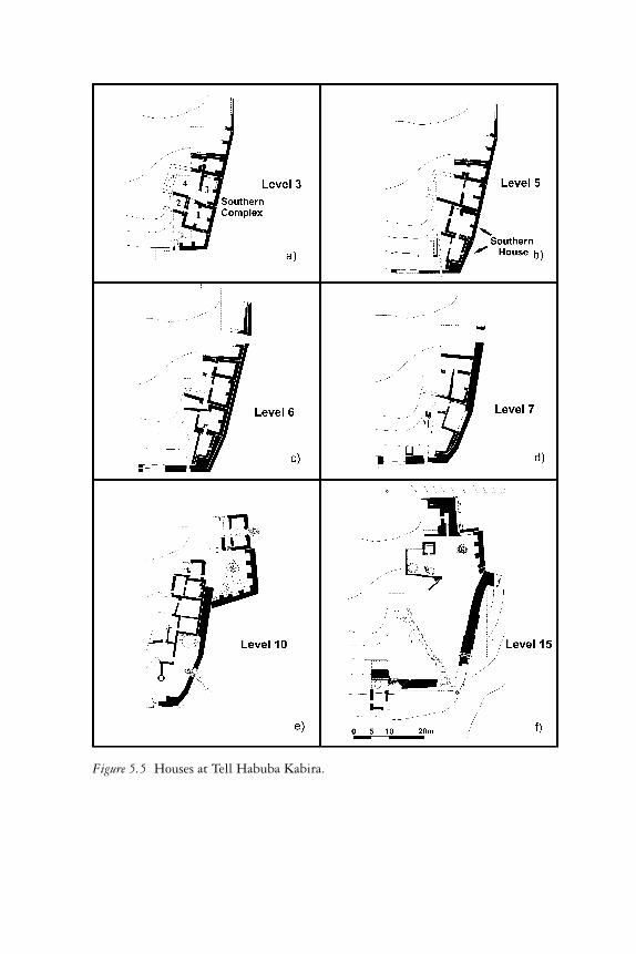
Figure 5.5 Houses at Tell Habuba Kabira.
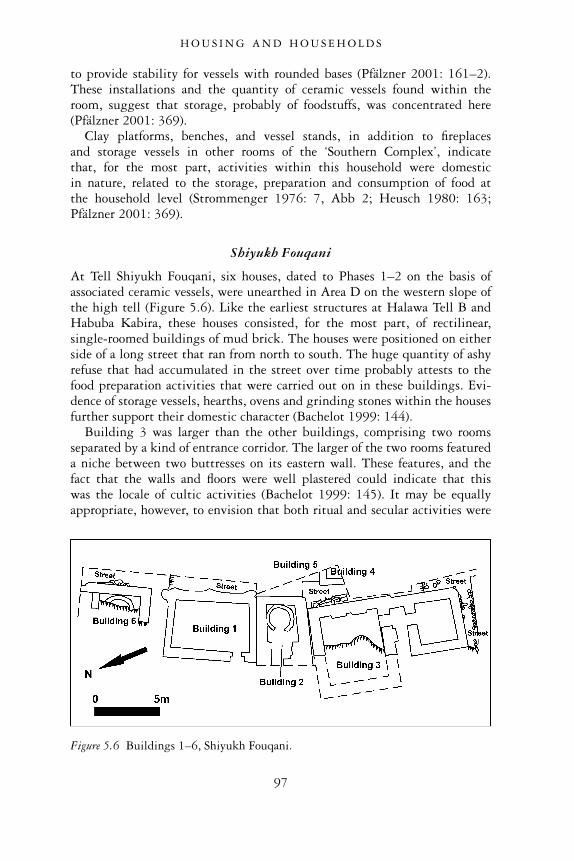
to provide stability for vessels with rounded bases (Pfälzner 2001: 161–2).These installations and the quantity of ceramic vessels found within theroom, suggest that storage, probably of foodstuffs, was concentrated here(Pfälzner 2001: 369).
Clay platforms, benches, and vessel stands, in addition to fireplacesand storage vessels in other rooms of the ‘Southern Complex’, indicatethat, for the most part, activities within this household were domesticin nature, related to the storage, preparation and consumption of food atthe household level (Strommenger 1976: 7, Abb 2; Heusch 1980: 163;Pfälzner 2001: 369).
Shiyukh Fouqani
At Tell Shiyukh Fouqani, six houses, dated to Phases 1–2 on the basis ofassociated ceramic vessels, were unearthed in Area D on the western slope ofthe high tell (Figure 5.6). Like the earliest structures at Halawa Tell B andHabuba Kabira, these houses consisted, for the most part, of rectilinear,single-roomed buildings of mud brick. The houses were positioned on eitherside of a long street that ran from north to south. The huge quantity of ashyrefuse that had accumulated in the street over time probably attests to thefood preparation activities that were carried out on in these buildings. Evi-dence of storage vessels, hearths, ovens and grinding stones within the housesfurther support their domestic character (Bachelot 1999: 144).
Building 3 was larger than the other buildings, comprising two roomsseparated by a kind of entrance corridor. The larger of the two rooms featureda niche between two buttresses on its eastern wall. These features, and thefact that the walls and floors were well plastered could indicate that thiswas the locale of cultic activities (Bachelot 1999: 145). It may be equallyappropriate, however, to envision that both ritual and secular activities were
Figure 5.6 Buildings 1–6, Shiyukh Fouqani.
H O U S I N G A N D H O U S E H O L D S
97
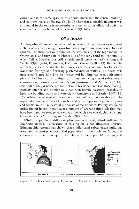
carried out in the same space in this house, much like the central buildingand southern house at Halawa Tell B. The fact that a crucible fragment wasalso found in the room is noteworthy, and points to metallurgical activitiesconnected with this household (Bachelot 1999: 145).
Tell es-Sweyhat
An altogether different arrangement of domestic architecture was encounteredat Tell es-Sweyhat, setting it apart from the simple house complexes observedthus far. The structures were found on the western side of the high mound inOperation 1, and they date to Phases 1–2 of the early third millennium bc,when Tell es-Sweyhat was still a fairly small settlement (Armstrong andZettler 1997:13–14, Figure 2.4; Danti and Zettler 1998: 219). Besides theremnants of two rectangular buildings, each made of mud bricks set onlow stone footings and featuring plastered interior walls, a ‘pit house’ wasuncovered (Figure 5.7). This distinctive oval building had been built into apit that had been cut into virgin soil, thus producing a semi-subterraneanconstruction, measuring c.4.5 m × 6.5 m (Armstrong and Zettler 1997: 14).The wall of the pit house was built of mud bricks set on a low stone footing.Both its interior and exterior walls had been heavily plastered, probably tokeep the building warm and watertight (Armstrong and Zettler 1997: 14,17). While the superstructure was not preserved, it is conceivable that thetop would have been made of branches and brush supported by interior postsand beams, much like pastoral pit houses of recent times. Pottery was foundinside the pit house, in particular a number of jars with fitted lids that mayhave been used for storage, as well as a model chariot wheel, chipped stone,bones and shell (Armstrong and Zettler 1997: 16).
While the pit house differs in plan from other early third millenniumEuphrates houses, its presence in this region is not altogether unusual.Ethnographic research has shown that similar semi-subterranean buildingswere used by semi-sedentary tribal populations in the Euphrates Valley andelsewhere in Syria even up to the relatively recent past (Armstrong and
Figure 5.7 Pit house and bastion, Operations 1, 20 and 12, Tell es-Sweyhat.
H O U S I N G A N D H O U S E H O L D S
98

Zettler 1997: 16). The presence of a pit house from the Early Bronze Age atTell es-Sweyhat, therefore, might indicate that a semi-sedentary or trans-humant population existed at this settlement in antiquity. Moreover, the pithouse’s location directly next to contemporary solid rectangular housespoints to a co-existing population of both sedentary and non-sedentary ele-ments (Danti and Zettler 1998: 219). This reconstruction concurs very wellwith the posited subsistence economy of the Early Bronze Age communitiesin the Euphrates Valley gathered from other sources, which shows that amixture of both sedentary farming and transhumant pastoralism prevailed inthis region (see Chapter 2).
Tell al- �Abd
Well-preserved evidence for domestic housing during Phase 3 comes fromthe site of Tell al- �Abd. In the central part of the settlement just inside thecity wall as it runs along the eastern side of the tell, the remains of severalhouses forming a small residential quarter were found (Finkbeiner 1995: 63;1997: 100). These houses were preceded by earlier structures whose remnantshave only been cursorily investigated.
The houses of Tell al- �Abd are similar to those from Tell Halawa B in thatthey consist primarily of square, single-roomed spaces, where a variety ofdomestic activities would have been carried out (Figure 5.8). Their domesticfunction is confirmed by the number of storage and cooking installationsfound within them. Several such houses exist, abutting one another or separ-ated from one another by a narrow, gravel-lined lane. While most of thehouses appear with one room only, the centrally located House A consisted ofa nearly square principal room (Room 1), to which an anteroom (Room 2)and a small courtyard bordering on a street to the south, had been added.The walls and floors of the principal room had been thickly and repeatedlycoated with white limestone plaster. Even so, the domestic function of thisroom is indicated by the benches that were set into the corners of the room,the presence of a small fireplace, and a jar that was sunk into the floor nearthe doorway to the antechamber. The antechamber itself featured additionaldomestic installations, as did the courtyard to the south, where vessels sunkinto the ground were either used for storage or served as circular ovens(Finkbeiner 1995: 65).
Mid-to-Late EB housing (Phases 3–5)
Tell Habuba Kabira
As time progressed through the Early Bronze Age, Euphrates’ domesticarchitecture underwent significant changes. In level 5 at Tell Habuba Kabira,the house that had earlier expanded into one large household was once again
H O U S I N G A N D H O U S E H O L D S
99
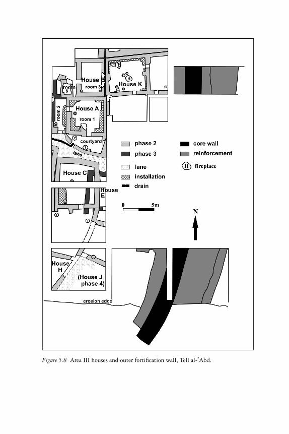
Figure 5.8 Area III houses and outer fortification wall, Tell al- �Abd.
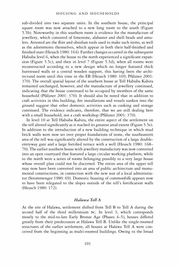
sub-divided into two separate units. In the southern house, the principalsquare room was now attached to a new long room to the south (Figure5.5b). Noteworthy in this southern room is evidence for the manufacture ofjewellery, which consisted of limestone, alabaster and shell beads and amu-lets. Attested are the flint and obsidian tools used to make such items, as wellas the adornments themselves, which appear in both their half-finished andfinished state (Heusch 1980: 164). Further changes occurred in the subsequentHabuba level 6, when the house to the north experienced a significant expan-sion (Figure 5.5c), and then in level 7 (Figure 5.5d), when all rooms werereconstructed according to a new design which no longer featured thickbuttressed walls or a central wooden support, this having been the archi-tectural norm until this time in the EB (Heusch 1980: 169; Pfälzner 2001:370). The overall spatial layout of the southern house at Tell Habuba Kabiraremained unchanged, however, and the manufacture of jewellery continued,indicating that the house continued to be occupied by members of the samehousehold (Pfälzner 2001: 370). It should also be noted that in addition tocraft activities in this building, fire installations and vessels sunken into theground suggest that other domestic activities such as cooking and storagecontinued. The evidence indicates, therefore, that we are still dealing herewith a small household, not a craft workshop (Pfälzner 2001: 370).
In level 10 at Tell Habuba Kabira, the entire aspect of the settlement onthe tell altered significantly as it reached its greatest areal extent (Figure 5.5e).In addition to the introduction of a new building technique in which mudbrick walls were now set over proper foundations of stone, the southeasternarea of the tell was significantly altered by the construction of a large double-entryway gate and a large fortified terrace with a well (Heusch 1980: 168–70). The earlier southern house with jewellery manufactory was now convertedinto an open courtyard that featured a large circular working platform, whileto the north were a series of rooms belonging possibly to a very large housewhose overall plan could not be discerned. The entire area of the upper tellmay now have been converted into an area of public architecture and monu-mental constructions, in connection with the new seat of a local administra-tor (Strommenger 1980: 69). Domestic housing of commonfolk appears nowto have been relegated to the slopes outside of the tell’s fortification walls(Heusch 1980: 172).
Halawa Tell A
At the site of Halawa, settlement shifted from Tell B to Tell A during thesecond half of the third millennium bc. In level 3, which correspondsmostly to the mid-to-late Early Bronze Age (Phases 4–5), houses differedgreatly from their predecessors at Halawa Tell B. Unlike the single-roomedstructures of the earlier settlement, all houses at Halawa Tell A were con-ceived from the beginning as multi-roomed buildings. Owing to the broad
H O U S I N G A N D H O U S E H O L D S
101
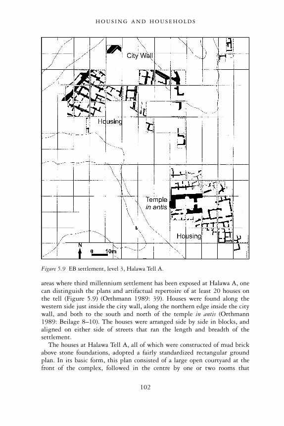
areas where third millennium settlement has been exposed at Halawa A, onecan distinguish the plans and artifactual repertoire of at least 20 houses onthe tell (Figure 5.9) (Orthmann 1989: 39). Houses were found along thewestern side just inside the city wall, along the northern edge inside the citywall, and both to the south and north of the temple in antis (Orthmann1989: Beilage 8–10). The houses were arranged side by side in blocks, andaligned on either side of streets that ran the length and breadth of thesettlement.
The houses at Halawa Tell A, all of which were constructed of mud brickabove stone foundations, adopted a fairly standardized rectangular groundplan. In its basic form, this plan consisted of a large open courtyard at thefront of the complex, followed in the centre by one or two rooms that
Figure 5.9 EB settlement, level 3, Halawa Tell A.
H O U S I N G A N D H O U S E H O L D S
102
represented the heart of the household, while in the back were one or moresmaller rooms that served as storage spaces. This house plan can be clearlyobserved along the western side of the tell in Quadrant Q, directly insidethe fortification wall. The best preserved, central-most house in this area is
Figure 5.10 House 1, Halawa Tell A: original plan (a), and later phase (b).
H O U S I N G A N D H O U S E H O L D S
103
distinguished by an entrance at the front that gives access to a large court-yard (House 1) (Figure 5.10 Room A). This open space would have been usedfor a number of work activities and storage, attested by the ground stonetools, circular fire installations, bitumen-lined basins, benches serving asworking platforms, and large vessels found within it (Orthmann 1989: 42–3,Abb. 21).
Behind the courtyard were two similar square rooms (B and D) separatedfrom one another by a double wall, each carefully plastered. One or bothmay have served as central ‘reception rooms’ of the household, where sleepingand eating took place, although food processing seems also to have beencarried out here from time to time (Pfälzner 2001: 349). These rooms werealso distinguished by rectangular niches that were set into the long walls(Orthmann 1989: Abb. 20). Since the surrounding plaster on the walls wascovered with smoke blackening, it is conceivable that such niches served asthe place for lamps (Orthmann 1989: 41). Alternatively, the niches may havebeen places for cultic paraphernalia, as suggested by the discovery of a stonefigurine, possibly an ancestor figure, in a niche in a reception room of a housesouth of the Antentempel (House 3–35: Meyer and Pruss 1994: 210). Thethree remaining rooms at the back part of the house (C, E–F) served as spacesfor storage. Their function is confirmed by the discovery of large quantities ofstorage vessel fragments. In the southern-most room of House 1, 32 largeceramic jars were resting in situ among the burned brick and carbonizedwood of the fire that destroyed the house at the end of its lifetime (Orthmann1989: 41; Abb. 18–19).
Peter Pfälzner, in his study of houses and households in Northern Mesopo-tamia, provides some illuminating observations about change in the domesticstructures at Halawa Tell A (Pfälzner 2001: 349–50). He notes that whilethe houses may originally have been laid out according to the same standard-ized plan, in many cases modifications and additions over the course of timechanged their appearance and internal layout considerably. The house dir-ectly to the northeast of House 1 in Quadrant Q illustrates such changes(House 2–3). In its original conception this house was of roughly equaldimensions to those of House 1 (Figure 5.11b). It was designed with a frontcourtyard and at least three rooms in behind. Over the course of its lifetime,however, it was subdivided into two separate households (Figure 5.11a). Eachhouse was now roughly half of the original ground plan and as a result,possessed significantly narrower internal spaces (Pfälzner 2001: 349; Taf. 71).A similar house division can be observed in Quadrant Q–5e, just inside thenorthern fortification wall (Pfälzner 2001: 350–1). The house directly to thesoutheast of House 1 illustrates another form of change (House 4). Anentrance vestibule that gave access to the street to the south appears to havebeen added on to the front of the house, while the once large, open courtyardwas subdivided into smaller units, possibly to accommodate different typesof household activities (Pfälzner 2001: 350; Taf. 72).
H O U S I N G A N D H O U S E H O L D S
104
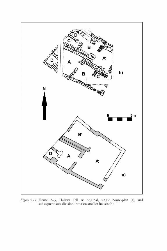
Figure 5.11 House 2–3, Halawa Tell A: original, single house-plan (a), andsubsequent sub-division into two smaller houses (b).
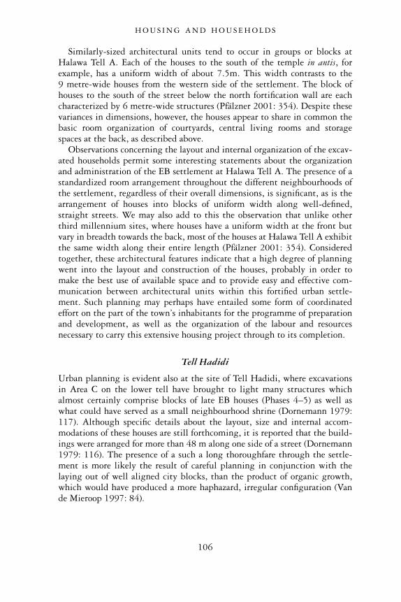
Similarly-sized architectural units tend to occur in groups or blocks atHalawa Tell A. Each of the houses to the south of the temple in antis, forexample, has a uniform width of about 7.5m. This width contrasts to the9 metre-wide houses from the western side of the settlement. The block ofhouses to the south of the street below the north fortification wall are eachcharacterized by 6 metre-wide structures (Pfälzner 2001: 354). Despite thesevariances in dimensions, however, the houses appear to share in common thebasic room organization of courtyards, central living rooms and storagespaces at the back, as described above.
Observations concerning the layout and internal organization of the excav-ated households permit some interesting statements about the organizationand administration of the EB settlement at Halawa Tell A. The presence of astandardized room arrangement throughout the different neighbourhoods ofthe settlement, regardless of their overall dimensions, is significant, as is thearrangement of houses into blocks of uniform width along well-defined,straight streets. We may also add to this the observation that unlike otherthird millennium sites, where houses have a uniform width at the front butvary in breadth towards the back, most of the houses at Halawa Tell A exhibitthe same width along their entire length (Pfälzner 2001: 354). Consideredtogether, these architectural features indicate that a high degree of planningwent into the layout and construction of the houses, probably in order tomake the best use of available space and to provide easy and effective com-munication between architectural units within this fortified urban settle-ment. Such planning may perhaps have entailed some form of coordinatedeffort on the part of the town’s inhabitants for the programme of preparationand development, as well as the organization of the labour and resourcesnecessary to carry this extensive housing project through to its completion.
Tell Hadidi
Urban planning is evident also at the site of Tell Hadidi, where excavationsin Area C on the lower tell have brought to light many structures whichalmost certainly comprise blocks of late EB houses (Phases 4–5) as well aswhat could have served as a small neighbourhood shrine (Dornemann 1979:117). Although specific details about the layout, size and internal accom-modations of these houses are still forthcoming, it is reported that the build-ings were arranged for more than 48 m along one side of a street (Dornemann1979: 116). The presence of a such a long thoroughfare through the settle-ment is more likely the result of careful planning in conjunction with thelaying out of well aligned city blocks, than the product of organic growth,which would have produced a more haphazard, irregular configuration (Vande Mieroop 1997: 84).
H O U S I N G A N D H O U S E H O L D S
106
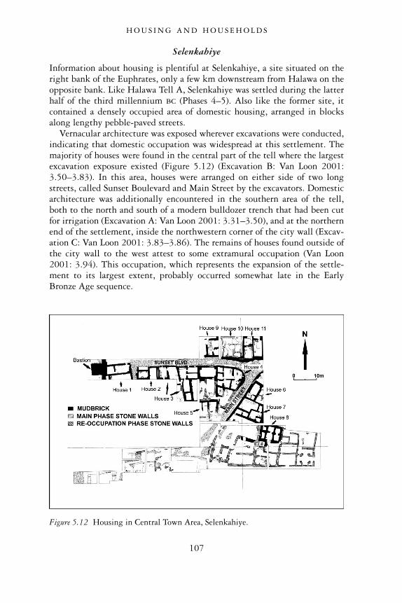
Selenkahiye
Information about housing is plentiful at Selenkahiye, a site situated on theright bank of the Euphrates, only a few km downstream from Halawa on theopposite bank. Like Halawa Tell A, Selenkahiye was settled during the latterhalf of the third millennium bc (Phases 4–5). Also like the former site, itcontained a densely occupied area of domestic housing, arranged in blocksalong lengthy pebble-paved streets.
Vernacular architecture was exposed wherever excavations were conducted,indicating that domestic occupation was widespread at this settlement. Themajority of houses were found in the central part of the tell where the largestexcavation exposure existed (Figure 5.12) (Excavation B: Van Loon 2001:3.50–3.83). In this area, houses were arranged on either side of two longstreets, called Sunset Boulevard and Main Street by the excavators. Domesticarchitecture was additionally encountered in the southern area of the tell,both to the north and south of a modern bulldozer trench that had been cutfor irrigation (Excavation A: Van Loon 2001: 3.31–3.50), and at the northernend of the settlement, inside the northwestern corner of the city wall (Excav-ation C: Van Loon 2001: 3.83–3.86). The remains of houses found outside ofthe city wall to the west attest to some extramural occupation (Van Loon2001: 3.94). This occupation, which represents the expansion of the settle-ment to its largest extent, probably occurred somewhat late in the EarlyBronze Age sequence.
Figure 5.12 Housing in Central Town Area, Selenkahiye.
H O U S I N G A N D H O U S E H O L D S
107
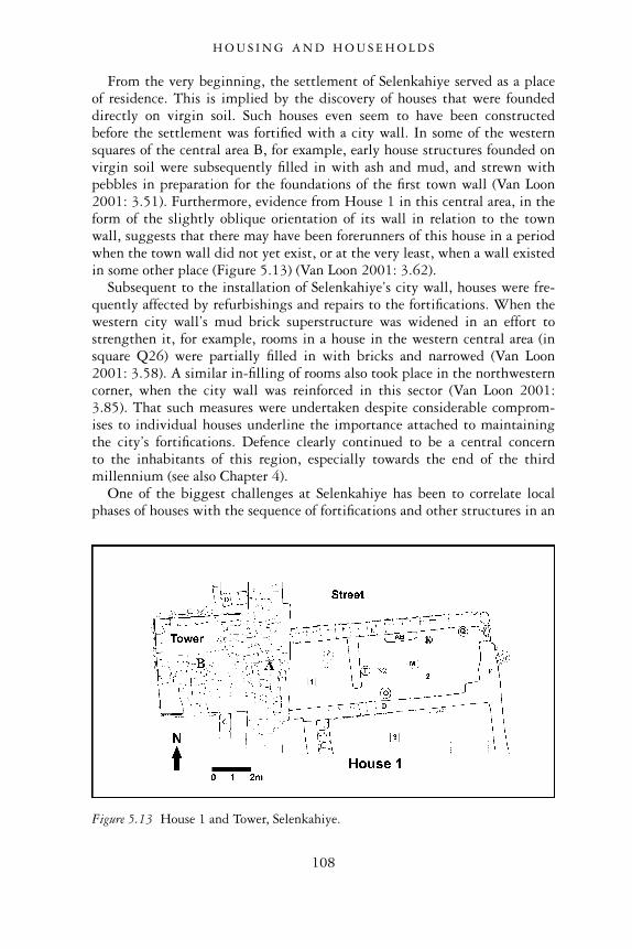
From the very beginning, the settlement of Selenkahiye served as a placeof residence. This is implied by the discovery of houses that were foundeddirectly on virgin soil. Such houses even seem to have been constructedbefore the settlement was fortified with a city wall. In some of the westernsquares of the central area B, for example, early house structures founded onvirgin soil were subsequently filled in with ash and mud, and strewn withpebbles in preparation for the foundations of the first town wall (Van Loon2001: 3.51). Furthermore, evidence from House 1 in this central area, in theform of the slightly oblique orientation of its wall in relation to the townwall, suggests that there may have been forerunners of this house in a periodwhen the town wall did not yet exist, or at the very least, when a wall existedin some other place (Figure 5.13) (Van Loon 2001: 3.62).
Subsequent to the installation of Selenkahiye’s city wall, houses were fre-quently affected by refurbishings and repairs to the fortifications. When thewestern city wall’s mud brick superstructure was widened in an effort tostrengthen it, for example, rooms in a house in the western central area (insquare Q26) were partially filled in with bricks and narrowed (Van Loon2001: 3.58). A similar in-filling of rooms also took place in the northwesterncorner, when the city wall was reinforced in this sector (Van Loon 2001:3.85). That such measures were undertaken despite considerable comprom-ises to individual houses underline the importance attached to maintainingthe city’s fortifications. Defence clearly continued to be a central concernto the inhabitants of this region, especially towards the end of the thirdmillennium (see also Chapter 4).
One of the biggest challenges at Selenkahiye has been to correlate localphases of houses with the sequence of fortifications and other structures in an
Figure 5.13 House 1 and Tower, Selenkahiye.
H O U S I N G A N D H O U S E H O L D S
108
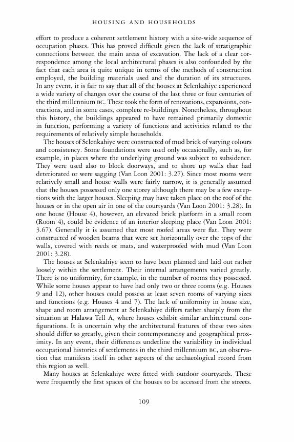
effort to produce a coherent settlement history with a site-wide sequence ofoccupation phases. This has proved difficult given the lack of stratigraphicconnections between the main areas of excavation. The lack of a clear cor-respondence among the local architectural phases is also confounded by thefact that each area is quite unique in terms of the methods of constructionemployed, the building materials used and the duration of its structures.In any event, it is fair to say that all of the houses at Selenkahiye experienceda wide variety of changes over the course of the last three or four centuries ofthe third millennium bc. These took the form of renovations, expansions, con-tractions, and in some cases, complete re-buildings. Nonetheless, throughoutthis history, the buildings appeared to have remained primarily domesticin function, performing a variety of functions and activities related to therequirements of relatively simple households.
The houses of Selenkahiye were constructed of mud brick of varying coloursand consistency. Stone foundations were used only occasionally, such as, forexample, in places where the underlying ground was subject to subsidence.They were used also to block doorways, and to shore up walls that haddeteriorated or were sagging (Van Loon 2001: 3.27). Since most rooms wererelatively small and house walls were fairly narrow, it is generally assumedthat the houses possessed only one storey although there may be a few excep-tions with the larger houses. Sleeping may have taken place on the roof of thehouses or in the open air in one of the courtyards (Van Loon 2001: 3.28). Inone house (House 4), however, an elevated brick platform in a small room(Room 4), could be evidence of an interior sleeping place (Van Loon 2001:3.67). Generally it is assumed that most roofed areas were flat. They wereconstructed of wooden beams that were set horizontally over the tops of thewalls, covered with reeds or mats, and waterproofed with mud (Van Loon2001: 3.28).
The houses at Selenkahiye seem to have been planned and laid out ratherloosely within the settlement. Their internal arrangements varied greatly.There is no uniformity, for example, in the number of rooms they possessed.While some houses appear to have had only two or three rooms (e.g. Houses9 and 12), other houses could possess at least seven rooms of varying sizesand functions (e.g. Houses 4 and 7). The lack of uniformity in house size,shape and room arrangement at Selenkahiye differs rather sharply from thesituation at Halawa Tell A, where houses exhibit similar architectural con-figurations. It is uncertain why the architectural features of these two sitesshould differ so greatly, given their contemporaneity and geographical prox-imity. In any event, their differences underline the variability in individualoccupational histories of settlements in the third millennium bc, an observa-tion that manifests itself in other aspects of the archaeological record fromthis region as well.
Many houses at Selenkahiye were fitted with outdoor courtyards. Thesewere frequently the first spaces of the houses to be accessed from the streets.
H O U S I N G A N D H O U S E H O L D S
109
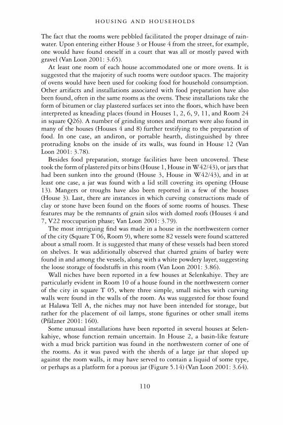
The fact that the rooms were pebbled facilitated the proper drainage of rain-water. Upon entering either House 3 or House 4 from the street, for example,one would have found oneself in a court that was all or mostly paved withgravel (Van Loon 2001: 3.65).
At least one room of each house accommodated one or more ovens. It issuggested that the majority of such rooms were outdoor spaces. The majorityof ovens would have been used for cooking food for household consumption.Other artifacts and installations associated with food preparation have alsobeen found, often in the same rooms as the ovens. These installations take theform of bitumen or clay plastered surfaces set into the floors, which have beeninterpreted as kneading places (found in Houses 1, 2, 6, 9, 11, and Room 24in square Q26). A number of grinding stones and mortars were also found inmany of the houses (Houses 4 and 8) further testifying to the preparation offood. In one case, an andiron, or portable hearth, distinguished by threeprotruding knobs on the inside of its walls, was found in House 12 (VanLoon 2001: 3.78).
Besides food preparation, storage facilities have been uncovered. Thesetook the form of plastered pits or bins (House 1, House in W42/43), or jars thathad been sunken into the ground (House 3, House in W42/43), and in atleast one case, a jar was found with a lid still covering its opening (House13). Mangers or troughs have also been reported in a few of the houses(House 3). Last, there are instances in which curving constructions made ofclay or stone have been found on the floors of some rooms of houses. Thesefeatures may be the remnants of grain silos with domed roofs (Houses 4 and7, V22 reoccupation phase; Van Loon 2001: 3.79).
The most intriguing find was made in a house in the northwestern cornerof the city (Square T 06, Room 9), where some 82 vessels were found scatteredabout a small room. It is suggested that many of these vessels had been storedon shelves. It was additionally observed that charred grains of barley werefound in and among the vessels, along with a white powdery layer, suggestingthe loose storage of foodstuffs in this room (Van Loon 2001: 3.86).
Wall niches have been reported in a few houses at Selenkahiye. They areparticularly evident in Room 10 of a house found in the northwestern cornerof the city in square T 05, where three simple, small niches with curvingwalls were found in the walls of the room. As was suggested for those foundat Halawa Tell A, the niches may not have been intended for storage, butrather for the placement of oil lamps, stone figurines or other small items(Pfälzner 2001: 160).
Some unusual installations have been reported in several houses at Selen-kahiye, whose function remain uncertain. In House 2, a basin-like featurewith a mud brick partition was found in the northwestern corner of one ofthe rooms. As it was paved with the sherds of a large jar that sloped upagainst the room walls, it may have served to contain a liquid of some type,or perhaps as a platform for a porous jar (Figure 5.14) (Van Loon 2001: 3.64).
H O U S I N G A N D H O U S E H O L D S
110
Flagstones occupying much of the floor area in Room 9 of House 4 may alsorelate to a household activity that involved the use of water, although theprecise function of such an installation is obscure (Van Loon 2001: 3.68).
While the majority of buildings served as habitations for households offamilies, the houses were by no means solely domestic in function. Otheractivities beyond simple food preparation and storage for the household’sconsumption were carried out in some of these homes, as evidenced bycertain unusual installations that have been found, particularly in the housesnorth of Sunset Boulevard. In House 9, for example (Figure 5.15), Room 3contained two ovens in a corner with a working platform, while near thecentre of the room a square plastered bin was situated next to the remainsof an oven wall, indicating that this may have been the kitchen courtyard(Van Loon 2001: 3.74). Room 1, on the other hand, contained an unusualconstruction. It consisted of a plastered recess in the western wall that wasflanked by two benches with arm rests, behind which were vent holes (VanLoon 2001: 3.76). The function of this installation is far from certain, butto be sure, no other house featured such a construction. The special functionof this installation indicates that unique activities took place withinHouse 9.
House 11 also featured some unusual constructions (Figure 5.15). One ofits rooms, room 1, had been equipped with two ovens. One of the ovens (AL)was different in that there was a partition separating the interior into twoparallel chambers. The other oven (AX) was cut off at the corner, and had aflue for letting in air. This flue ended against a stone in the adjacent wall,from which an air shaft would have gone up vertically. It is interesting also
Figure 5.14 House 2, Selenkahiye.
H O U S I N G A N D H O U S E H O L D S
111
that a terra-cotta ‘lid’ was found inside this oven, serving to shut the flue(Van Loon 2001: 3.77). The unusual nature of these ovens may indicatethat some kind of industrial activity was carried out here, rather than simplehousehold pursuits. The excavators suggest that the function of the fluedoven was a smelting oven, although that interpretation remains highlyconjectural (Van Loon 2001: 3.100). Finally, one can note that in additionto the two ovens in Room 1, an additional three ovens were found in theadjoining Room 2. This house, therefore, possesses the largest number ofovens. It may have served as a bakery, with the two small back rooms servingas places for the storage of flour. The extra oven with the flue might havebeen added as a specialized installation for side-line activities (Van Loon2001: 3.101).
Another unusual house was House 2 (Figure 5.14). In addition to having aroom with ovens, a working surface and an unusual basin with a surface ofpotsherds, all described above, the house possessed a shop-like rectangularspace that was open to the street to the north (Van Loon 2001: 3.64).Although no opening was found between this ‘shop’ room and the room withthe basin in behind, it may be that there was a connection between the twoconstructions. If the basin was accessible through a window, it may havefunctioned as the placement for a porous jar, holding a cold drink that wouldbe served in the shop (Van Loon 2001: 3.99).
House 1 may have served as a guardroom, given its location right againstthe western city wall, precisely at a point where a large stone bastion juttedout from the city wall. It is suggested that as the roof of House 1 wasprobably flush with the parapet of the town wall, it would have given accessto it (Figure 5.13) (Van Loon 2001: 3.99 n. 61).
Figure 5.15 Houses 9–12, Selenkahiye.
H O U S I N G A N D H O U S E H O L D S
112
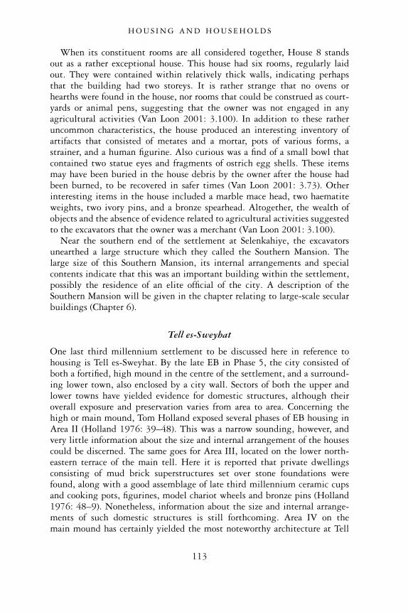
When its constituent rooms are all considered together, House 8 standsout as a rather exceptional house. This house had six rooms, regularly laidout. They were contained within relatively thick walls, indicating perhapsthat the building had two storeys. It is rather strange that no ovens orhearths were found in the house, nor rooms that could be construed as court-yards or animal pens, suggesting that the owner was not engaged in anyagricultural activities (Van Loon 2001: 3.100). In addition to these ratheruncommon characteristics, the house produced an interesting inventory ofartifacts that consisted of metates and a mortar, pots of various forms, astrainer, and a human figurine. Also curious was a find of a small bowl thatcontained two statue eyes and fragments of ostrich egg shells. These itemsmay have been buried in the house debris by the owner after the house hadbeen burned, to be recovered in safer times (Van Loon 2001: 3.73). Otherinteresting items in the house included a marble mace head, two haematiteweights, two ivory pins, and a bronze spearhead. Altogether, the wealth ofobjects and the absence of evidence related to agricultural activities suggestedto the excavators that the owner was a merchant (Van Loon 2001: 3.100).
Near the southern end of the settlement at Selenkahiye, the excavatorsunearthed a large structure which they called the Southern Mansion. Thelarge size of this Southern Mansion, its internal arrangements and specialcontents indicate that this was an important building within the settlement,possibly the residence of an elite official of the city. A description of theSouthern Mansion will be given in the chapter relating to large-scale secularbuildings (Chapter 6).
Tell es-Sweyhat
One last third millennium settlement to be discussed here in reference tohousing is Tell es-Sweyhat. By the late EB in Phase 5, the city consisted ofboth a fortified, high mound in the centre of the settlement, and a surround-ing lower town, also enclosed by a city wall. Sectors of both the upper andlower towns have yielded evidence for domestic structures, although theiroverall exposure and preservation varies from area to area. Concerning thehigh or main mound, Tom Holland exposed several phases of EB housing inArea II (Holland 1976: 39–48). This was a narrow sounding, however, andvery little information about the size and internal arrangement of the housescould be discerned. The same goes for Area III, located on the lower north-eastern terrace of the main tell. Here it is reported that private dwellingsconsisting of mud brick superstructures set over stone foundations werefound, along with a good assemblage of late third millennium ceramic cupsand cooking pots, figurines, model chariot wheels and bronze pins (Holland1976: 48–9). Nonetheless, information about the size and internal arrange-ments of such domestic structures is still forthcoming. Area IV on themain mound has certainly yielded the most noteworthy architecture at Tell
H O U S I N G A N D H O U S E H O L D S
113
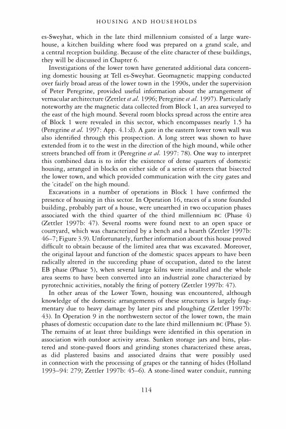
es-Sweyhat, which in the late third millennium consisted of a large ware-house, a kitchen building where food was prepared on a grand scale, anda central reception building. Because of the elite character of these buildings,they will be discussed in Chapter 6.
Investigations of the lower town have generated additional data concern-ing domestic housing at Tell es-Sweyhat. Geomagnetic mapping conductedover fairly broad areas of the lower town in the 1990s, under the supervisionof Peter Peregrine, provided useful information about the arrangement ofvernacular architecture (Zettler et al. 1996; Peregrine et al. 1997). Particularlynoteworthy are the magnetic data collected from Block 1, an area surveyed tothe east of the high mound. Several room blocks spread across the entire areaof Block 1 were revealed in this sector, which encompasses nearly 1.5 ha(Peregrine et al. 1997: App. 4.1:d). A gate in the eastern lower town wall wasalso identified through this prospection. A long street was shown to haveextended from it to the west in the direction of the high mound, while otherstreets branched off from it (Peregrine et al. 1997: 78). One way to interpretthis combined data is to infer the existence of dense quarters of domestichousing, arranged in blocks on either side of a series of streets that bisectedthe lower town, and which provided communication with the city gates andthe ‘citadel’ on the high mound.
Excavations in a number of operations in Block 1 have confirmed thepresence of housing in this sector. In Operation 16, traces of a stone foundedbuilding, probably part of a house, were unearthed in two occupation phasesassociated with the third quarter of the third millennium bc (Phase 4)(Zettler 1997b: 47). Several rooms were found next to an open space orcourtyard, which was characterized by a bench and a hearth (Zettler 1997b:46–7; Figure 3.9). Unfortunately, further information about this house proveddifficult to obtain because of the limited area that was excavated. Moreover,the original layout and function of the domestic spaces appears to have beenradically altered in the succeeding phase of occupation, dated to the latestEB phase (Phase 5), when several large kilns were installed and the wholearea seems to have been converted into an industrial zone characterized bypyrotechnic activities, notably the firing of pottery (Zettler 1997b: 47).
In other areas of the Lower Town, housing was encountered, althoughknowledge of the domestic arrangements of these structures is largely frag-mentary due to heavy damage by later pits and ploughing (Zettler 1997b:43). In Operation 9 in the northwestern sector of the lower town, the mainphases of domestic occupation date to the late third millennium bc (Phase 5).The remains of at least three buildings were identified in this operation inassociation with outdoor activity areas. Sunken storage jars and bins, plas-tered and stone-paved floors and grinding stones characterized these areas,as did plastered basins and associated drains that were possibly usedin connection with the processing of grapes or the tanning of hides (Holland1993–94: 279; Zettler 1997b: 45–6). A stone-lined water conduit, running
H O U S I N G A N D H O U S E H O L D S
114
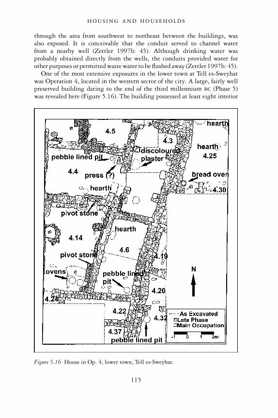
through the area from southwest to northeast between the buildings, wasalso exposed. It is conceivable that the conduit served to channel waterfrom a nearby well (Zettler 1997b: 45). Although drinking water wasprobably obtained directly from the wells, the conduits provided water forother purposes or permitted waste water to be flushed away (Zettler 1997b: 45).
One of the most extensive exposures in the lower town at Tell es-Sweyhatwas Operation 4, located in the western sector of the city. A large, fairly wellpreserved building dating to the end of the third millennium bc (Phase 5)was revealed here (Figure 5.16). The building possessed at least eight interior
Figure 5.16 House in Op. 4, lower town, Tell es-Sweyhat.
H O U S I N G A N D H O U S E H O L D S
115
rooms as well as several additional rooms abutting the building to the south-east (Zettler 1997b: 39–43; figs. 3.5–3.6). With a floor space that exceeded110 m2, this is a large building indeed (Zettler 1997b: 43). Nonetheless,since its internal features suggest that it was a place of domestic activities, weare fairly confident in identifying this structure as a house.
One room of the house was interpreted as a courtyard due to its large area(Room 4.14: 7 m × 4.5 m). Its floor was paved with pebbles, and its south-eastern corner was distinguished by two circular plastered pits with traces ofburning inside. These are likely cooking pits or ovens (Zettler 1997b: 42).Thus, like the courtyards reported at Selenkahiye and Halawa Tell A, this spacealso appears to have been the locus of food processing within the house.
Other types of installations were encountered in other rooms of the house.A hearth and circular storage pit were found in a room to the east of thecourtyard. In the room to the north of the courtyard was found a largelimestone block with a truncated oblong depression and narrow channel, pos-sibly the remains of some kind of press, while a circular clay and pebble linedpit was found in the floor next to it (Zettler 1997b: 40, 43). Room 4.3 to theeast was particularly unique, as three piers abutted its southeastern wall.Such piers, which would have been used to buttress the walls, may also haveprovided support for a second story. The presence of two storeys is not wellattested in settlements in the Euphrates Valley from this period, althoughterra-cotta house models from the nearby site of Ali al-Haj (SS 17), and alsothe site of Assur in northern Mesopotamia confirm that such houses existed(Andrae 1922: 36–8; Masuda 1983: 153–60; Zettler 1997b: 41). In the sameroom were found two baked clay disks with central perforations on the floorwhich have been spindle whorls, possibly attesting to the activity of spinningin this locale. Last, directly outside of the house to the northeast were foundthe remains of hearths and one circular beehive-shaped oven. Further cookingactivities, possibly the baking of bread, may have been carried out here(Zettler 1997b: 43).
The large building found in Operation 4, therefore, appears to have servedas a house comprising a full array of domestic installations and associatedhousehold artifacts. The house may also have been the locus of specializedactivities, possibly related to cloth-making, evidenced by the spindle whorls,and grape processing, as attested by a ‘press’. While somewhat uncommon,such small-scale activities are not absent elsewhere in domestic contextsin the Euphrates Valley and should not be construed as overly unusual.Nonetheless, it remains uncertain whether such side-line activities have anyrelationship to the size of the house. Moreover, it is uncertain whether theseactivities represent a small-scale ‘cottage industry’ for local use, or if theycontributed to a larger site-wide industry that was connected with externaltrade (Holland 1993–94: 279).
H O U S I N G A N D H O U S E H O L D S
116
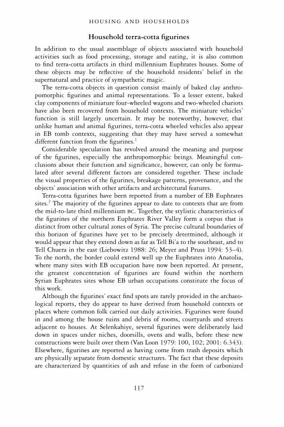
Household terra-cotta figurines
In addition to the usual assemblage of objects associated with householdactivities such as food processing, storage and eating, it is also commonto find terra-cotta artifacts in third millennium Euphrates houses. Some ofthese objects may be reflective of the household residents’ belief in thesupernatural and practice of sympathetic magic.
The terra-cotta objects in question consist mainly of baked clay anthro-pomorphic figurines and animal representations. To a lesser extent, bakedclay components of miniature four-wheeled wagons and two-wheeled chariotshave also been recovered from household contexts. The miniature vehicles’function is still largely uncertain. It may be noteworthy, however, thatunlike human and animal figurines, terra-cotta wheeled vehicles also appearin EB tomb contexts, suggesting that they may have served a somewhatdifferent function from the figurines.1
Considerable speculation has revolved around the meaning and purposeof the figurines, especially the anthropomorphic beings. Meaningful con-clusions about their function and significance, however, can only be formu-lated after several different factors are considered together. These includethe visual properties of the figurines, breakage patterns, provenance, and theobjects’ association with other artifacts and architectural features.
Terra-cotta figurines have been reported from a number of EB Euphratessites.2 The majority of the figurines appear to date to contexts that are fromthe mid-to-late third millennium bc. Together, the stylistic characteristics ofthe figurines of the northern Euphrates River Valley form a corpus that isdistinct from other cultural zones of Syria. The precise cultural boundaries ofthis horizon of figurines have yet to be precisely determined, although itwould appear that they extend down as far as Tell Bi’a to the southeast, and toTell Chuera in the east (Liebowitz 1988: 26; Meyer and Pruss 1994: 53–4).To the north, the border could extend well up the Euphrates into Anatolia,where many sites with EB occupation have now been reported. At present,the greatest concentration of figurines are found within the northernSyrian Euphrates sites whose EB urban occupations constitute the focus ofthis work.
Although the figurines’ exact find spots are rarely provided in the archaeo-logical reports, they do appear to have derived from household contexts orplaces where common folk carried out daily activities. Figurines were foundin and among the house ruins and debris of rooms, courtyards and streetsadjacent to houses. At Selenkahiye, several figurines were deliberately laiddown in spaces under niches, doorsills, ovens and walls, before these newconstructions were built over them (Van Loon 1979: 100, 102; 2001: 6.343).Elsewhere, figurines are reported as having come from trash deposits whichare physically separate from domestic structures. The fact that these depositsare characterized by quantities of ash and refuse in the form of carbonized
H O U S I N G A N D H O U S E H O L D S
117
grain and broken utilitarian pottery, however, suggests that they representthe by-products of activities associated with ordinary domestic contexts.
Halawa Tell A and Selenkahiye, two late EB sites with the widest exposureof domestic structures, yielded the greatest number of terra-cotta figurines. Adistribution map of the EB city of Halawa A, which highlights the locationof anthropomorphic figurines is especially telling because of the heavy con-centration of such objects in domestic houses (Meyer and Pruss 1994: Karte 7).While some figurines have indeed been unearthed in the zone of the long-roomed temple in antis, they are far fewer than in the residential quarters ofthe site. It is also significant that only two specimens were found withinthe temple building itself, while the remainder were found in smaller associ-ated buildings and the open courtyard within the enclosed sacred enclosure.These latter spaces may have been places where common folk were admitted,while the sacred space of the temple itself provided access only to priests andcult functionaries. Whatever the situation, there is not a strong correlationbetween anthropomorphic figurines and institutionalized religion, at least atHalawa Tell A.
Animal figurines include the representations of equids, bulls, sheep, goats,and birds. There are also occasional examples of animal and rider figurines, inwhich crudely rendered human figures sit side-saddle on equids that areusually identifiable as donkeys (Liebowitz 1988: 18). The fact that animalfigurines have roughly the same household distribution as anthropomorphicfigurines, and that the majority were found broken suggests a similar func-tion to the latter. One noteworthy exception to the concentration of animalfigurines in households is the discovery of over 70 parts of animal figurinesin area D at Tell Banat (Figure 8.10) (Porter and McClellan 1998: 24, Figure21). It has been conjectured that this was the locale of a large pottery manu-factory, owing to the number of workshop spaces, kilns and waster depositsassociated with the forming and firing of ceramic vessels (Porter and McClellan1998: 18–24). The location of many of the animal figurines in kiln dumpsmay indicate that they too were being produced in this area, possibly for awide number of consumers (Porter and McClellan 1998: 24).
Anthropomorphic figurines are both of females and males. We will notrepeat here the detailed classification of these figurines, based on visual traits,which has been carefully undertaken by others (Badre 1980; Liebowitz 1988;Meyer and Pruss 1994). Only some of the objects’ general characteristics aredescribed. The majority of figurines are pillar-shaped standing figures withsplaying, slightly concave, circular or oval bases (Liebowitz 1988: 4). The basesof most of the figurines suggest standing figures in long garments, ratherthan bare legs (Figure 5.17 left) (Van Loon 2001: 6.341). While the faces ofthe figurines usually have prominent noses, there is a notable absence ofmouths and chins (Liebowitz 1988: 4). Details of dress are normally restrictedto necklaces, which are characterized by one or more applied strips of clayaround the neck, often incised or scored (Figure 5.18). Only occasionally does
H O U S I N G A N D H O U S E H O L D S
118
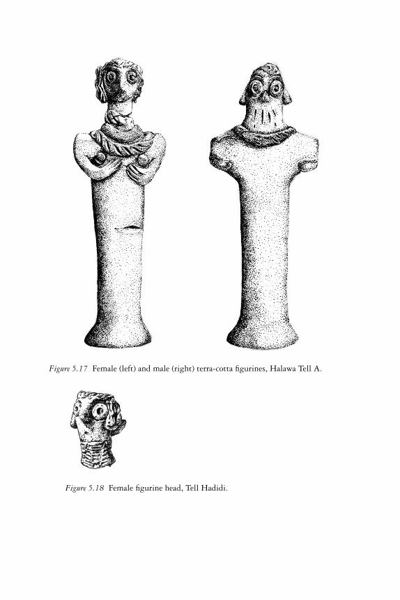
Figure 5.17 Female (left) and male (right) terra-cotta figurines, Halawa Tell A.
Figure 5.18 Female figurine head, Tell Hadidi.
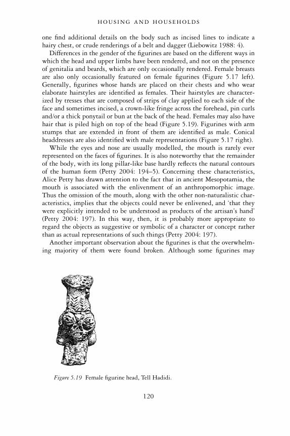
one find additional details on the body such as incised lines to indicate ahairy chest, or crude renderings of a belt and dagger (Liebowitz 1988: 4).
Differences in the gender of the figurines are based on the different ways inwhich the head and upper limbs have been rendered, and not on the presenceof genitalia and beards, which are only occasionally rendered. Female breastsare also only occasionally featured on female figurines (Figure 5.17 left).Generally, figurines whose hands are placed on their chests and who wearelaborate hairstyles are identified as females. Their hairstyles are character-ized by tresses that are composed of strips of clay applied to each side of theface and sometimes incised, a crown-like fringe across the forehead, pin curlsand/or a thick ponytail or bun at the back of the head. Females may also havehair that is piled high on top of the head (Figure 5.19). Figurines with armstumps that are extended in front of them are identified as male. Conicalheaddresses are also identified with male representations (Figure 5.17 right).
While the eyes and nose are usually modelled, the mouth is rarely everrepresented on the faces of figurines. It is also noteworthy that the remainderof the body, with its long pillar-like base hardly reflects the natural contoursof the human form (Petty 2004: 194–5). Concerning these characteristics,Alice Petty has drawn attention to the fact that in ancient Mesopotamia, themouth is associated with the enlivenment of an anthropomorphic image.Thus the omission of the mouth, along with the other non-naturalistic char-acteristics, implies that the objects could never be enlivened, and ‘that theywere explicitly intended to be understood as products of the artisan’s hand’(Petty 2004: 197). In this way, then, it is probably more appropriate toregard the objects as suggestive or symbolic of a character or concept ratherthan as actual representations of such things (Petty 2004: 197).
Another important observation about the figurines is that the overwhelm-ing majority of them were found broken. Although some figurines may
Figure 5.19 Female figurine head, Tell Hadidi.
H O U S I N G A N D H O U S E H O L D S
120
have been broken post-depositionally, many seem to have been deliberatelybroken during their use. The patterns of breakage can vary, although it wasvery common for figurines to have been broken at the neck. Alternatively,many figurines were broken at the level of or below the waist.
How can one interpret these figurines? The suggestion that they are repre-sentations of deities or other cult figures seems unlikely for a number ofreasons. These figurines do not have analogies with any representations ofdeities that have been found in purely religious contexts at the settlements,which is what one might expect if these were regarded as cheap or miniaturehousehold versions of cult objects or worshipper statues (Meyer and Pruss1994: 56). Further, as we reported earlier, these figurines are not found prolif-ically in temple contexts. Finally, enthographic studies that have been con-ducted around the world have shown that because of their potency, cultfigures are usually carefully disposed of at the end of their use; they areunlikely to be found in ordinary garbage (Voigt 1991: 36). While somecarefully buried figurines at Selenkahiye may fit this pattern, one still needsto explain the overwhelming majority of figurines, which were found brokenand disposed, it seems, in regular household trash.
A more persuasive suggestion is that the figurines represent vehicles ofmagic. Cross-culturally, such objects tend to include a wide range of activ-ities and behaviours which can range from pious burials in sub-floor con-texts, disposal in trash or placement underneath other features. Moreover, itis not uncommon for vehicles of magic to be deliberately broken (Petty2004: 198). Perhaps magical potency is thought to be released from thefigurines as they are broken, or else the act of breaking them brings aboutsome desired effect, such as the termination of an illness, or the expulsion ofa malevolent ghost. In many cases, once the object has been used and hasbeen drained of its magical power, it can be tossed aside. Last, it is worthreporting that vehicles of magic need not stand directly for the human,animal or the thing that they represent in terra-cotta (Voigt 1991: 36). Thefigures may be symbolic of some concept or idea. The representation of awild bull, for example, does not have to symbolize the life of the bull oreven the concept of the fertility of the herds. The wild bull could be asymbol of male virility among humans. Whatever the exact symbolism ofthese magical objects, their frequency in domestic contexts probably indi-cates their utilization by common folk, and their connection to concernsabout personal or kin-group activities and interactions taking place withinthe cities’ households.
DISCUSSION
In this chapter, we have presented in full the evidence for ancient domesticarchitecture, and as well as some of the artifacts and decoration found within
H O U S I N G A N D H O U S E H O L D S
121
such contexts, pointing out specific features of importance. Thus, for thedifferent sites, we have discussed patterns relating to the physical layout,function and transformation of domestic space as well as the behaviour of theoccupants of this space over time. In the pages to follow, we will summarizethe evidence for urban planning in Euphrates settlements of the Early BronzeAge. We will also describe changes that occurred in households in thesesettlements. Of particular importance in this regard will be the strong rela-tionship between the nature of housing and the urban character of thesettlements of this period.
Urban planning
In Phases 1–2 of the EB, domestic houses were relatively small and simplylaid out. Nearly all the early EB houses from Halawa Tell B, Tell HabubaKabira and Shiyukh Fouqani, for example, were single-roomed households,sharing similar mud brick construction techniques and internal arrangements.These structures apparently provided living quarters for individual nuclearfamilies. While some domestic activities took place within the houses, limitedspace probably led to many activities being carried out in exterior open areas,possibly in communally shared spaces within the settlements.
In spite of the simplicity of these houses, indications of urban planning arealready evident. Some of the houses at the northern end of the settlement atHalawa Tell B, for example, appear to have been well aligned within themassive city wall. The houses at Shiyukh Fouqani were laid out on either sideof a straight street. At Tell Habuba Kabira, the neat alignment of the exter-ior eastern walls of the houses produced a solid, defensive line, therebyenhancing the protection and security of the settlement as a whole. Whilethese examples indicate some form of community organization and poolingof labour, a super-ordinate elite authority was probably not responsible fortheir successful undertaking and completion. Most of the town planningmanifested in these small early EB settlements could easily have been carriedout by inhabitants who coordinated their plans and cooperated in theirneighbourhoods’ foundations and construction.
By the latter half of the third millennium (Phases 4–5), urban planninghad become quite apparent. Sites such as Halawa Tell A, Tell Hadidi, Telles-Sweyhat and Selenkahiye were characterized by long streets, some inter-secting at right angles, and well-aligned city blocks of domestic houses. Suchurban configurations suggest intensive planning to increase the efficiency ofcommunication and transport within what were becoming increasingly largeand densely inhabited city sectors. At the settlement of Halawa Tell A, thereis even evidence that houses were built of roughly the same dimensionsfrom front to back, and that they were characterized by the same standard-ized room arrangements. This level of architectural regularity suggestscentralized planning and the mobilization of labour beyond the level of the
H O U S I N G A N D H O U S E H O L D S
122
household, although precisely what form such centralized organization tookis difficult to reconstruct.
Patterns of recurring, standardized houses occur elsewhere. At the thirdmillennium site of Titris Höyük in northeastern Anatolia, for example, twobasic household modules with standardized internal arrangements have beenreported in the Outer Town (Matney and Algaze 1995: 40–1). Groups ofstandardized house sizes and similar internal room arrangements have like-wise been reported within various sectors of the EB settlement at Tell Chuerato the east (Pfälzner 2001: 348). Common also were orderly alignments ofsimilarly-sized houses along streets. These houses were organized into cityblocks. Such configurations have likewise been reported at Titris Höyük, TellChuera, as well as Tell Taya in northern Iraq (Matney and Algaze 1995: 49;Orthmann et al. 1986; Plan II; Reade 1973: pls. 60–1). We should not seethese patterns as indicative of a single overarching authority imposing itsconventions of architectural standardization and town planning upon allsettlements of northern Mesopotamia. Rather, such patterns appear to bethe result of a general trend towards urbanization that most areas of northernMesopotamia began to experience around the middle of the third millen-nium bc. In this milieu of urban development, in which cultural exchangebetween settlements was a natural product of frequent trade contacts, poli-tical alliances and other forms of communication, shared information abouttown planning and the internal organization of space would have circulated,especially among growing, similarly-structured cities.
Household expansions
Even during the earliest phases of EB occupation, simple single-roomedhouses were occasionally transformed into larger households. At Halawa TellB, houses were expanded by the addition of enclosed areas and courtyards.Similarly, at Tell Habuba Kabira, the so-called ‘Southern Complex’ repre-sents an adaptation and modification of what had originally been two smallerhouses. This pattern of expansion continues into the middle of the EarlyBronze Age. At Tell al- �Abd, it was observed that various additions in theform of anterooms and courtyards had been added to the principal rooms ofhouses.
During the mid-to-late EB (Phases 4–5), almost all Euphrates houses wereplanned from the beginning as multi-roomed buildings. Most houses werecharacterized by large courtyard spaces that were furnished with fire installa-tions and other equipment related to food preparation. Other rooms of thehouse served as spaces for sleeping, eating, entertaining, additional foodprocessing and storage.
What causes may there have been for the late EB interior expansion ofhousehold space? It is possible that households were growing in family size.It is difficult to summon specific evidence for this supposition, but we may
H O U S I N G A N D H O U S E H O L D S
123
safely assume that as families increased in size, their needs of greater spaceand defined space emerged.
There is considerable evidence of household space now being used forspecific activities. The internal division of domestic space into a number ofsmaller units reflects the various activities taking place in the household.Functionally discrete spaces appear where these activities could be performedto their maximum efficiency. In early periods of the Early Bronze Age, vari-ous household activities, such as food preparation, sleeping and eating,occurred in the same internal space. In later periods these activities weregiven distinct spaces, separated from one another by walls, benches, alcovesand other partitioning constructions.
Along with this development, inhabited space came also to be dividedinto sacred and profane areas. In the earliest phases of the EB the appearanceof architectural features and wall paintings connected with religious practicesexisted in what appeared to be rooms of simple domestic structures. Sacredand profane spheres of behaviour at this time were not clearly demarcated.With time, however, a distinction between the two developed. By the end ofthe EB, the separation of sacred and profane is most clearly manifested in theappearance of several visibly recognizable temples at Euphrates settlements.These religious complexes were neatly segregated from the other non-religioussectors of the urban community by temenos walls and gate-houses.
Another example of the growing complexity of the household is theincreasing privatization of space (Akkermans and Schwartz 2003: 269). Theappearance of enclosed courtyard spaces observed by the mid-third millen-nium bc in almost every Euphrates household is probably related to thisdevelopment. Activities, previously carried out within open communal spacesin a settlement, were now undertaken in enclosed spaces within individualhouseholds (Akkermans and Schwartz 2003: 269). Another feature of thesehouseholds consists of household storage spaces of increased size and number.At Halawa Tell A and Selenkahiye, storage rooms positioned at the rear ofthe house were found still full of ceramic jars resting in situ amid charredgrains of barley.
Changes to the household can be ascribed to the growing complexityof urban life and the economic inequalities that accompanied such a devel-opment. At this time, the means of acquiring economic prosperity grewthrough trade, the acquisition of agricultural land and the intensificationof farming and pastoral pursuits. Concurrent with these activities, thereprobably developed a preoccupation with personal gain and, by extension,personal possessions. The household, comprising individuals bound bykinship ties emerged as the most important unit of social and economicorganization in this region. The household served for the safeguarding andstockpiling of resources. Thus we have evidence for additions to andexpansions of interior household activity and storage space. In contrast,evidence that reflects efforts on the part of the urban communities to
H O U S I N G A N D H O U S E H O L D S
124
pool commodities and to hold such resources in communal ownership areabsent.
In some instances, economic successes of individual households resulted inthe expansion of house size and complexity well beyond that of other housesin the city. It would seem that this development began to occur quite earlyin the EB, as evidenced at Halawa Tell B, where several smaller houses weresubsumed into one extraordinarily large house at the southern end of thesettlement. In later periods, Selenkahiye’s House 8 was unusually large anddistinctive, as was the large ‘manor’ found in Operation 4 in the lower townof Tell es-Sweyhat.
In some cases, certain economic activities appear to have a correlation withthe size and wealth of these houses. Thus, for example, the expansion of thehousehold at the southern end of Halawa Tell B might have been tied to itsmetal-working activities. At Tell Habuba Kabira, the presence of a jewellerymanufactory in one household may have been related both to its size andalso the long duration of this household, which persisted through severalphases of occupation within the city. Within the large house at Telles-Sweyhat, artifacts and installations point to activities such as textileproduction and olive or wine making. House 8 at Selenkahiye may have beenengaged in long-distance trading activities.
As a last remark, we would like to suggest that there was a connectionbetween the increasing complexity of the household – in terms of its size, thenumber of activities performed within it, and the variety of economic ven-tures it engaged in – and the growing frequency and complexity with whichwe find manifestations of sympathetic magic. Such phenomena are most vis-ibly expressed in the form of anthropomorphic terra-cotta figures and animalfigurines, and possibly also miniature wheeled vehicles. These figurines,which likely served as vehicles of magic, display considerable stylistic vari-ation, breakage patterns and methods of burial and disposal. Their varietyunderlines the multiplicity of ways in which they must have functioned inthe realm of the supernatural, serving to expel, entreat, destroy, create orcajole any number of spirits, ghosts, sensations, impulses and passions withinthe physical space of the household, including within the individuals them-selves who inhabited these spaces. The variety of concerns expressed by thesefigurines surely corresponds with the growing complexity of urban lifeexperienced by people in the Euphrates communities, who would have facedon a daily basis a complicated and entangled array of economic and socialpartnerships, rivalries, opportunities and new challenges within the urbancommunities developing around them.
H O U S I N G A N D H O U S E H O L D S
125
6
LARGE-SCALE SECULARBUILDINGS
Large-scale buildings are among the more conspicuous architectural featuresof third millennium Euphrates sites. These buildings are physically granderand usually have a more complex arrangement of rooms than typicaldomestic structures. In this chapter, we will deal with large-scale buildingswhere secular, as opposed to religious, activities were carried out. Oneis likely to find material remains attesting to the acquisition and possessionof wealth in these structures, as well as the performance of complexor frequent economic activities. In contrast, remains attesting to sacred,ceremonial activities are rare.
It is probable that large-scale secular buildings served as the residences orheadquarters of an elite group of citizens, or at the very least, some corporatebody of city inhabitants who possessed a measure of influence or authoritywithin the city. We have avoided using the term ‘public’ to refer to thesestructures since some buildings may have been restricted or closed off to themajority of the inhabitants of the settlements in which they existed. At thesame time, we cannot reject altogether the possibility that some importanteconomic and political activities of the city were organized through thesecentres. In this sense, therefore, some of these buildings may have had a‘public’ function since they served in some capacity to administer to thewider urban community.
Although the term ‘large-scale’ was chosen to designate the greater sizeof these structures in relation to common urban houses, we have refrainedfrom using the term ‘palace’ to denote most of these third millennium struc-tures. It may be true that these buildings have a character of monumentalityand comprise several features that one may also find at other buildings ofthird millennium Syria whose identification as palaces has gone unchal-lenged. On the other hand, none of the excavated Euphrates structures areof an overall size that is comparable to other palatial structures from Syriaduring the third millennium. None of these Euphrates’ large-scale buildings,for example, approach the dimensions of Palace G at Ebla, which compriseda vast and rambling interconnected complex of courtyards, archive rooms,reception halls, private apartments and storage wings (Dolce 1988; Akkermans
126
and Schwartz 2003: 235). The excavated area covered by rooms of the Eblapalace already amounts to more than 2,400 m2, and it is likely that this royalcomplex extended across the entire summit of the acropolis (Matthiae 1997:181). Similarly, the third millennium palace complex at Mari to the southeastfar exceeds in size and monumentality all of the north Syrian Euphratesbuildings excavated thus far. Dating between 2500–2300 bc, the palace’scomplex of rooms, courtyards and an impressive columned throne room,could well exceed 6,000 m2 once all of its ground plan has been revealed(Margueron 1982: 94–5; Figure 52; 1990a: Figure 2). At this size, Mari’smassive palatial complex might have been almost three times the size ofBuilding 6 at Tell Banat, which at approximately 2,500 m2, appears to be thegrandest large-scale secular building in the northern Euphrates regionknown at this time (Porter 2002b: 157).
Besides its large size, the term ‘palace’ inevitably brings to mind thepresence, especially in the ancient Near East, of a ruling class or ruling house,characterized principally by a king who exercised absolute power over a sub-ordinate population. While the presence of this kind of royal authority maybe an appropriate way of describing the exercise of power in other thirdmillennium cities in Mesopotamia, we are not certain that it is correct tospeak of the Syrian Euphrates urban society in terms of hierarchical, monar-chical systems of class distinction (Porter 2002b: 167). An urban elite wascertainly present in Euphrates Early Bronze Age societies, particularlytowards the late third millennium, when large-scale structures became espe-cially prominent. It remains uncertain, however, whether or not we shouldassign a superordinate status to these cities’ elites, and to characterize themas wielding extensive control over the social, economic and political institu-tions of the urban communities which they dominated, as in the manner ofkings. We have already suggested that power need not always be concen-trated in the hands of a small, exclusive group of aristocratic individuals. Theresponsibilities of the organization and maintenance of the city and controlover its resources could just as easily have been dispersed among many indi-viduals or groups from divergent lineages and socio-economic backgrounds.Furthermore, rather than envisioning only one type of power structure thatuniformly characterized all third millennium settlements in the region, it ispossible that the nature of power varied widely from one city to the next. Itis important to recognize the individual, distinctive character of eachEuphrates settlement, and the unique way in which each settlementdeveloped and transformed over the course of several centuries of urban life.
Large-scale secular structures may have existed at several of the SyrianEuphrates sites, although archaeological excavations have enabled only a fewbuildings to be positively identified as such. Thus, the remains of a largestructure with wide walls, designated as Building A, was found near one of theprincipal city gates at Tell al- �Abd, although its precise function remainsundetermined (Finkbeiner 1995: 58–9; 1997: 98–100). Some large-scale
L A R G E - S C A L E S E C U L A R B U I L D I N G S
127
buildings may have been positioned on the summit of the small but defensivelyimpressive mound of Jerablus Tahtani, although that area remains largelyunexplored. At Tell Habuba Kabira, excavations along the southwesternslope of the mound have revealed in a late third millennium level (Phase 5) amonumental terrace and gate-house that may have served a larger structureor complex higher on the mound. Unfortunately that complex has also notbeen recovered (Strommenger 1980: 72).
Buildings 6 and 7 at Tell Banat
Although we are uncertain about the existence and function of some sites’large-scale buildings, we are relatively well informed about two large build-ings at the site of Tell Banat, which existed during the peak of the site’s pre-eminence, roughly between 2600–2300 bc (Phases 3–4) (Figure 6.1). It isunfortunate that the modern village, which is located directly over the ancientmound, has prevented excavations from uncovering the entire ground plansof these extraordinary edifices, although sufficient investigations have beenundertaken to get some sense of their size and grandeur. These structuresclearly had a special function, although curiously they were not located in anexceptionally visible or elevated place at the site. On the contrary, thebuildings were sited in a low, flat area, several metres lower than the westernridge, where the potter’s quarter was located (McClellan 1999: 417).
As we will outline in greater detail in Chapter 9, Tell Banat appears tohave functioned primarily as a mortuary centre, where a variety of tombs andtumuli were erected, and where elaborate funerary festivals and culticactivities served to commemorate the dead and to strengthen the bonds ofkinship and community among the living. Given the overwhelming mortu-ary character of Banat, it seems likely that these large-scale buildings servedin some association with the funerary traditions observed at the site. That thebuildings were located only a few metres away from several tombs furthersupports their funerary association. It may be additionally significant thatthe walls of the earlier Building 7 were set directly into a clean gravel fillingthat entirely covered an earlier monumental mortuary tumulus (MortuaryMound II) (McClellan 1999: 418–19; Porter 2002a: 16).
Although it is not common to find large-scale residences connected tofunerary structures in southern Mesopotamia during the third millennium,this association is not out of place in Syria. At Ebla, a royal tomb was dis-covered under the floor of one of the rooms of the EB Palace G (Akkermansand Schwartz 2003: 238). Similarly, a large above-ground mausoleum atTell Bi’a may have been connected to an elite ruler’s palace nearby (McClellan1999: 419; Strommenger 1997: 113). Elaborate multi-chambered corbelledtombs were also found under the floors of the impressive late third millenniumshakkanaku palace at Mari (Margueron 1990b). In light of this evidence, itis possible that some of the funerary structures located in proximity to
L A R G E - S C A L E S E C U L A R B U I L D I N G S
128
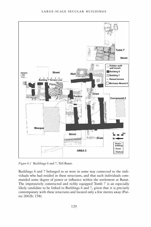
Buildings 6 and 7 belonged to or were in some way connected to the indi-viduals who had resided in these structures, and that such individuals com-manded some degree of power or influence within the settlement at Banat.The impressively constructed and richly equipped Tomb 7 is an especiallylikely candidate to be linked to Buildings 6 and 7, given that it is preciselycontemporary with these structures and located only a few metres away (Por-ter 2002b: 158).
Figure 6.1 Buildings 6 and 7, Tell Banat.
L A R G E - S C A L E S E C U L A R B U I L D I N G S
129
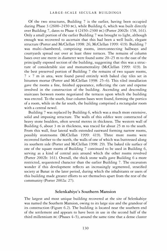
Of the two structures, Building 7 is the earlier, having been occupiedduring Phase 3 (2600–2450 bc), while Building 6, which was built directlyover Building 7, dates to Phase 4 (2450–2300 bc) (Porter 2002b: 158, 161).Only a small portion of the earlier Building 7 was brought to light, althoughenough was recovered to ascertain that this had been a well built, elegantstructure (Porter and McClellan 1998: 26; McClellan 1999: 419). Building 7was multi-chambered, comprising rooms, interconnecting hallways andcourtyards spread out over at least three terraces. The remains of columnbases over one metre in diameter were found some 20–25 m to the east of theprincipally exposed section of the building, suggesting that this was a struc-ture of considerable size and monumentality (McClellan 1999: 419). Inthe best preserved portion of Building 7 the remains of two square rooms,7 × 7 m in area, were found paved entirely with baked clay tiles set inbitumen mortar (Porter and McClellan 1998: 25–6). This tiled installationgave the rooms a fine, finished appearance, reflecting the care and expenseinvolved in the construction of the building. Ascending and descendingstaircases between rooms negotiated the terraces upon which the buildingwas erected. To the south, four column bases were found, forming the porticoof a room, while in the far south, the building comprised a rectangular roomwith a central newel.
Building 7 was replaced by Building 6, which was a much more extensive,solid and imposing structure. The walls of this edifice were constructed ofheavy stone boulders, often several metres in thickness. The western wall ofBuilding 6, about 3 m in thickness, was traced for about 25 m to the south.From this wall, four lateral walls extended eastward forming narrow rooms,possibly storerooms (McClellan 1999: 419). Three more rooms wererecovered further to the north, the walls of one of which was buttressed alongits southern side (Porter and McClellan 1998: 29). The baked tile surface ofone of the square rooms of Building 7 continued to be used in Building 6,serving as a kind of central axis around which the other rooms revolved(Porter 2002b: 161). Overall, the thick stone walls gave Building 6 a morerestricted, sequestered character than the earlier Building 7. The excavatorswonder if this development reflects an increasingly segmented, stratifiedsociety at Banat in the later period, during which the inhabitants or users ofthis building made greater efforts to set themselves apart from the rest of thecommunity (Porter 2002a: 27).
Selenkahiye’s Southern Mansion
The largest and most unique building recovered at the site of Selenkahiyewas named the Southern Mansion, owing to its large size and the grandeur ofits construction (Figure 6.2). The building is located near the southern endof the settlement and appears to have been in use in the second half of thethird millennium bc (Phases 4–5), around the same time that a dense cluster
L A R G E - S C A L E S E C U L A R B U I L D I N G S
130
of houses occupied the central area of the settlement and the city fortifica-tions enclosed the site. The Southern Mansion experienced at least two majordestructions, the first causing a collapse of brickwork in several of the rooms,while the second consisted of a major conflagration, leaving traces of heavyburning everywhere and filling the rooms with burnt debris (Van Loon 2001:3.38–3.41). Within this debris, the skeleton of a child was found, probably avictim of the disaster, while another male victim was found lying prone withhis head shielded by his raised arm. His toggle and an adze were foundnearby (Van Loon 2001: 3.41). After this violent event, the Southern Man-sion was occupied once more, although evidence in the form of blockeddoorways and the construction of several ovens suggests a functional shiftfrom an important spacious house to the cramped quarters of several families(Van Loon 2001: 41). For the purposes of our discussion here, we will restrict
Figure 6.2 Southern Mansion, Selenkahiye (local phase 7).
L A R G E - S C A L E S E C U L A R B U I L D I N G S
131
our discussion of the Southern Mansion to the period before its final ‘re-occupation’ phase.
The layout of the Southern Mansion was quite regular, and all of the wallsof the house were bonded, showing that the building had been conceived andconstructed as a whole (Van Loon 2001: 3.35). The foundations were made oflarge unhewn blocks of stone, topped by courses of bricks. The walls aver-aged 80 cm in thickness, which is wide enough to support a second story.The outer walls were especially wide, measuring about 1.20 m (Van Loon2001: 3.35).
The entrance to the Southern Mansion was probably located in the north-eastern corner in Room 7, although it was not recoverable due to damage byerosion and a bulldozer cut. The interior of the house comprised severalrectangular or square rooms, the most unusual of which was the centrallylocated Room 3. The eastern entrance of this room had a raised mud brickthreshold upon which was found a drum-shaped white limestone columnbase. This base supported a poplar column, whose burned traces were clearlyrecognizable (Van Loon 2001: 3.37). To date, no other columned arrange-ment like this has been recovered from third millennium contexts in north-ern Mesopotamia. Its closest parallel comes from a much later date in theseventeenth century bc, in level VII of Yarim-Lim’s Palace at Alalakh. Here aroom with a columned entrance has also been recovered. Perhaps theSelenkahiye Southern Mansion represents one of the earliest examples of thisdistinctive feature of elite north Syrian architecture (Van Loon 2001: 3.96).
It is likely that the western side of the Southern Mansion had two storeys.In addition to the thickness of the walls, the western rooms contained moredestruction debris than the eastern rooms. Moreover, bitumen-coated frag-ments of beams and reeds were found in one of the rooms, suggesting thatsome kind of waterproof installation like an indoor basin or reservoir existedsomewhere on the second floor (Van Loon 2001: 3.39 n.8). Room 3 itself maynot have had a second storey, although its ceiling could have been raised to ahigher level. In the reconstructed drawing of the Southern Mansion, the highwalls of Room 3 are shown with open spaces flanking a second column abovethe lower one (Figure 6.3) (Van Loon 2001: 3.96).
It is possible that in the second phase of occupation of the SouthernMansion, the southwestern corner was converted into a tower. Given themansion’s location in the southern extremity of the settlement, this defensivefeature would not have been unusual. Evidence for this tower takes the formof a filling of large mud bricks that were laid in mortar in the western half ofRoom 4. A platform in the southeastern corner may have served as a supportfor wooden stairs leading to the upper part of the tower (Van Loon 2001:3.40–3.41).
Artifacts from several rooms of the Southern Mansion testify to the build-ing’s importance before its second destruction. Many unbaked clay sealed jarstoppers, some carrying the imprints of strings that had secured the covers of
L A R G E - S C A L E S E C U L A R B U I L D I N G S
132
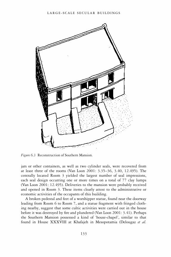
jars or other containers, as well as two cylinder seals, were recovered fromat least three of the rooms (Van Loon 2001: 3.35–36, 3.40, 12.495). Thecentrally located Room 3 yielded the largest number of seal impressions,each seal design occurring one or more times on a total of 77 clay lumps(Van Loon 2001: 12.495). Deliveries to the mansion were probably receivedand opened in Room 3. These items clearly attest to the administrative oreconomic activities of the occupants of this building.
A broken pedestal and feet of a worshipper statue, found near the doorwayleading from Room 6 to Room 7, and a statue fragment with fringed cloth-ing nearby, suggest that some cultic activities were carried out in the housebefore it was destroyed by fire and plundered (Van Loon 2001: 3.41). Perhapsthe Southern Mansion possessed a kind of ‘house-chapel’, similar to thatfound in House XXXVIII at Khafajeh in Mesopotamia (Delougaz et al.
Figure 6.3 Reconstruction of Southern Mansion.
L A R G E - S C A L E S E C U L A R B U I L D I N G S
133
1967: pl. 10; Van Loon 2001: 3.97). Whatever the case, it would beerroneous to assume that the entire building had a cultic function given thelack of podia, the presence of several ovens and storage containers in some ofits rooms, and the defensive tower in the southwestern corner (Van Loon2001: 3.97).
In layout and contents, the Southern Mansion has no parallels with any ofthe other houses at Selenkahiye. The central room with column was clearlyan important room in the structure, serving as a point of access to all of theother rooms, and playing a key role in the administrative activities of thebuilding’s occupants (Van Loon 2001: 3.95). The Southern Mansion is alsothe largest building at Selenkahiye. In light of these attributes, it is likelythat the structure served as the residence and administrative quarters of anwealthy, elite household.
Tell es-Sweyhat’s high mound: Area IV ‘warehouse’
The most coherent plan of a large-scale secular building at Tell es-Sweyhatcomes from Area IV, located on the lower northwest terrace of the centralhigh mound. The building comprised several rooms that had been builtagainst the wide, inner fortification wall of the settlement, while its easternside was bordered by a long pebble-paved street that ran parallel to the townwall (Holland 1993–94: 278). The building eventually came to be dubbedthe ‘Burned Building’ owing to the massive conflagration that destroyed itsometime around 2100 bc (Figure 6.4). After this fire, traces of further late
Figure 6.4 Area IV ‘Burned Building’ complex, Tell es-Sweyhat.
L A R G E - S C A L E S E C U L A R B U I L D I N G S
134
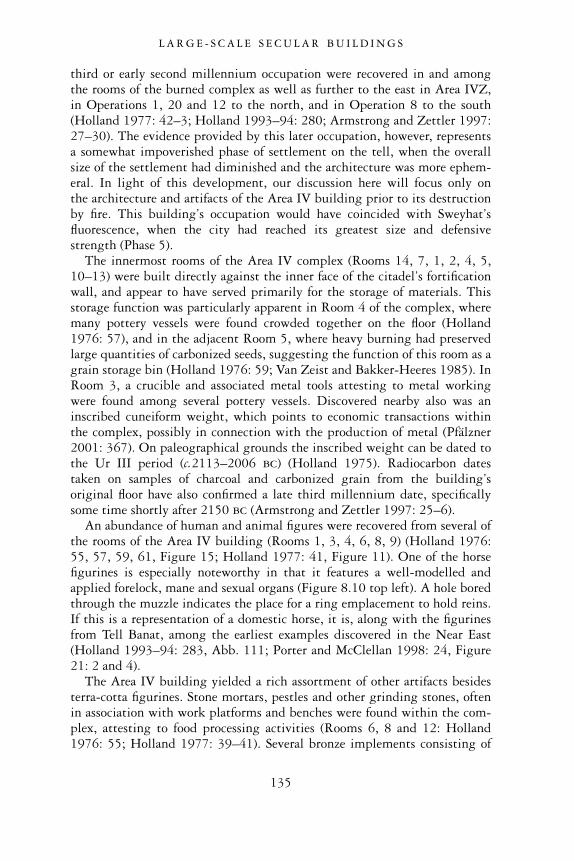
third or early second millennium occupation were recovered in and amongthe rooms of the burned complex as well as further to the east in Area IVZ,in Operations 1, 20 and 12 to the north, and in Operation 8 to the south(Holland 1977: 42–3; Holland 1993–94: 280; Armstrong and Zettler 1997:27–30). The evidence provided by this later occupation, however, representsa somewhat impoverished phase of settlement on the tell, when the overallsize of the settlement had diminished and the architecture was more ephem-eral. In light of this development, our discussion here will focus only onthe architecture and artifacts of the Area IV building prior to its destructionby fire. This building’s occupation would have coincided with Sweyhat’sfluorescence, when the city had reached its greatest size and defensivestrength (Phase 5).
The innermost rooms of the Area IV complex (Rooms 14, 7, 1, 2, 4, 5,10–13) were built directly against the inner face of the citadel’s fortificationwall, and appear to have served primarily for the storage of materials. Thisstorage function was particularly apparent in Room 4 of the complex, wheremany pottery vessels were found crowded together on the floor (Holland1976: 57), and in the adjacent Room 5, where heavy burning had preservedlarge quantities of carbonized seeds, suggesting the function of this room as agrain storage bin (Holland 1976: 59; Van Zeist and Bakker-Heeres 1985). InRoom 3, a crucible and associated metal tools attesting to metal workingwere found among several pottery vessels. Discovered nearby also was aninscribed cuneiform weight, which points to economic transactions withinthe complex, possibly in connection with the production of metal (Pfälzner2001: 367). On paleographical grounds the inscribed weight can be dated tothe Ur III period (c.2113–2006 bc) (Holland 1975). Radiocarbon datestaken on samples of charcoal and carbonized grain from the building’soriginal floor have also confirmed a late third millennium date, specificallysome time shortly after 2150 bc (Armstrong and Zettler 1997: 25–6).
An abundance of human and animal figures were recovered from several ofthe rooms of the Area IV building (Rooms 1, 3, 4, 6, 8, 9) (Holland 1976:55, 57, 59, 61, Figure 15; Holland 1977: 41, Figure 11). One of the horsefigurines is especially noteworthy in that it features a well-modelled andapplied forelock, mane and sexual organs (Figure 8.10 top left). A hole boredthrough the muzzle indicates the place for a ring emplacement to hold reins.If this is a representation of a domestic horse, it is, along with the figurinesfrom Tell Banat, among the earliest examples discovered in the Near East(Holland 1993–94: 283, Abb. 111; Porter and McClellan 1998: 24, Figure21: 2 and 4).
The Area IV building yielded a rich assortment of other artifacts besidesterra-cotta figurines. Stone mortars, pestles and other grinding stones, oftenin association with work platforms and benches were found within the com-plex, attesting to food processing activities (Rooms 6, 8 and 12: Holland1976: 55; Holland 1977: 39–41). Several bronze implements consisting of
L A R G E - S C A L E S E C U L A R B U I L D I N G S
135
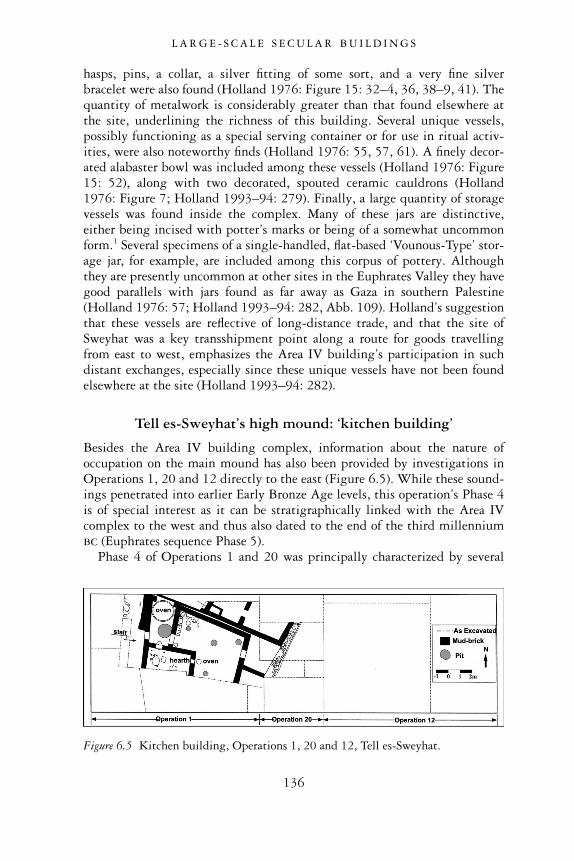
hasps, pins, a collar, a silver fitting of some sort, and a very fine silverbracelet were also found (Holland 1976: Figure 15: 32–4, 36, 38–9, 41). Thequantity of metalwork is considerably greater than that found elsewhere atthe site, underlining the richness of this building. Several unique vessels,possibly functioning as a special serving container or for use in ritual activ-ities, were also noteworthy finds (Holland 1976: 55, 57, 61). A finely decor-ated alabaster bowl was included among these vessels (Holland 1976: Figure15: 52), along with two decorated, spouted ceramic cauldrons (Holland1976: Figure 7; Holland 1993–94: 279). Finally, a large quantity of storagevessels was found inside the complex. Many of these jars are distinctive,either being incised with potter’s marks or being of a somewhat uncommonform.1 Several specimens of a single-handled, flat-based ‘Vounous-Type’ stor-age jar, for example, are included among this corpus of pottery. Althoughthey are presently uncommon at other sites in the Euphrates Valley they havegood parallels with jars found as far away as Gaza in southern Palestine(Holland 1976: 57; Holland 1993–94: 282, Abb. 109). Holland’s suggestionthat these vessels are reflective of long-distance trade, and that the site ofSweyhat was a key transshipment point along a route for goods travellingfrom east to west, emphasizes the Area IV building’s participation in suchdistant exchanges, especially since these unique vessels have not been foundelsewhere at the site (Holland 1993–94: 282).
Tell es-Sweyhat’s high mound: ‘kitchen building’
Besides the Area IV building complex, information about the nature ofoccupation on the main mound has also been provided by investigations inOperations 1, 20 and 12 directly to the east (Figure 6.5). While these sound-ings penetrated into earlier Early Bronze Age levels, this operation’s Phase 4is of special interest as it can be stratigraphically linked with the Area IVcomplex to the west and thus also dated to the end of the third millenniumbc (Euphrates sequence Phase 5).
Phase 4 of Operations 1 and 20 was principally characterized by several
Figure 6.5 Kitchen building, Operations 1, 20 and 12, Tell es-Sweyhat.
L A R G E - S C A L E S E C U L A R B U I L D I N G S
136
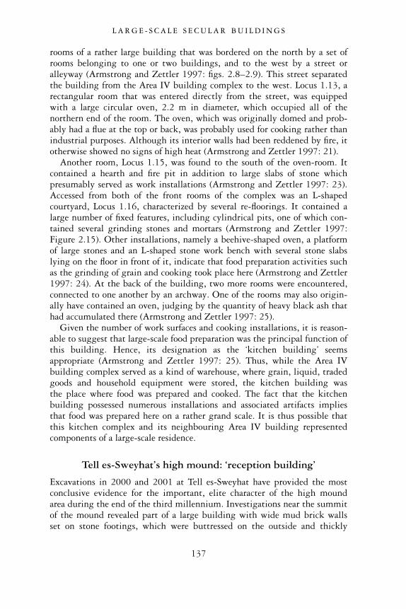
rooms of a rather large building that was bordered on the north by a set ofrooms belonging to one or two buildings, and to the west by a street oralleyway (Armstrong and Zettler 1997: figs. 2.8–2.9). This street separatedthe building from the Area IV building complex to the west. Locus 1.13, arectangular room that was entered directly from the street, was equippedwith a large circular oven, 2.2 m in diameter, which occupied all of thenorthern end of the room. The oven, which was originally domed and prob-ably had a flue at the top or back, was probably used for cooking rather thanindustrial purposes. Although its interior walls had been reddened by fire, itotherwise showed no signs of high heat (Armstrong and Zettler 1997: 21).
Another room, Locus 1.15, was found to the south of the oven-room. Itcontained a hearth and fire pit in addition to large slabs of stone whichpresumably served as work installations (Armstrong and Zettler 1997: 23).Accessed from both of the front rooms of the complex was an L-shapedcourtyard, Locus 1.16, characterized by several re-floorings. It contained alarge number of fixed features, including cylindrical pits, one of which con-tained several grinding stones and mortars (Armstrong and Zettler 1997:Figure 2.15). Other installations, namely a beehive-shaped oven, a platformof large stones and an L-shaped stone work bench with several stone slabslying on the floor in front of it, indicate that food preparation activities suchas the grinding of grain and cooking took place here (Armstrong and Zettler1997: 24). At the back of the building, two more rooms were encountered,connected to one another by an archway. One of the rooms may also origin-ally have contained an oven, judging by the quantity of heavy black ash thathad accumulated there (Armstrong and Zettler 1997: 25).
Given the number of work surfaces and cooking installations, it is reason-able to suggest that large-scale food preparation was the principal function ofthis building. Hence, its designation as the ‘kitchen building’ seemsappropriate (Armstrong and Zettler 1997: 25). Thus, while the Area IVbuilding complex served as a kind of warehouse, where grain, liquid, tradedgoods and household equipment were stored, the kitchen building wasthe place where food was prepared and cooked. The fact that the kitchenbuilding possessed numerous installations and associated artifacts impliesthat food was prepared here on a rather grand scale. It is thus possible thatthis kitchen complex and its neighbouring Area IV building representedcomponents of a large-scale residence.
Tell es-Sweyhat’s high mound: ‘reception building’
Excavations in 2000 and 2001 at Tell es-Sweyhat have provided the mostconclusive evidence for the important, elite character of the high moundarea during the end of the third millennium. Investigations near the summitof the mound revealed part of a large building with wide mud brick wallsset on stone footings, which were buttressed on the outside and thickly
L A R G E - S C A L E S E C U L A R B U I L D I N G S
137
plastered with white gypsum (Danti and Zettler 2002: 39). One of theexcavated rooms, which featured a wide plastered doorway with a steppedstone threshold and a low mud brick bench lining the interior walls, hadbeen burned in antiquity. This was attested by the quantity of charred roofbeams found on the floor, these overlying several smashed ceramic vessels. Asthese jars parallel vessels found in the Area IV complex and ‘kitchen build-ing’, the contemporaneity of these buildings is quite secure (Danti andZettler 2002: 39).
The most intriguing features of the building on Sweyhat’s summit wereits wall paintings, which were found in a deep recess between two buttresseson the exterior of the building (Danti and Zettler 2002: 39). The paintingshad been executed in black, yellow and red paint on gypsum plaster.Although they were extremely fragmentary, it was possible to make out therepresentation of a man with distorted head and raised arms, standing next toa woman with prominent hips and hands clasped at her waist (Danti andZettler 2002: 40). This painted scene is quite reminiscent of the wall paint-ings from other EB Euphrates sites such as Tell Halawa B and Tell Munbaqa,where human figures with upraised arms were also represented. The wallpaintings are probably also comparable to fragments of painted scenes thatwere found in an earlier phase at Tell es-Sweyhat itself, uncovered in the early1990s on the south side of the high mound. There, in Operation 5, excav-ations revealed a portion of a massive mud brick wall that featured wallpaintings on its plastered, buttressed, western face (Holland 1993–94: 279).Fragments belonging to at least two painted wall scenes included geometricborders, tree branches and stylized human figures with ‘Medusa’-like hairstyles, also comparable to the figures represented at Tell Halawa B andMunbaqa (Holland 1993–94: 280–1). The depiction of a cow standing on amountain side with a suckling calf, and a painted geometric pattern on itsside, was also found on a large plaster fragment (Holland 1993–94: 281,Abb. 107). It was postulated that these paintings belonged to a very largepublic building, possibly a temple, which dated to the middle part of thethird millennium bc (Holland 1993–94: 279).
The presence of wall paintings from two phases of Early Bronze Ageoccupation at Tell Sweyhat spanning the second part of the third millenniumbc, and their presence in an early phase at Tell Halawa B shows that suchwall paintings remained popular in the Euphrates Valley for an extremelylong period of time, spanning much of the third millennium. It is strikingthat the subject matter of the paintings also seems to have remained remark-ably static over this long period, demonstrating a continuity in beliefs,ideology, or at the very least, aesthetic preferences over many centuries.
While the precise function of the large, late third millennium buildingwith wall paintings at Tell es-Sweyhat cannot be positively ascertained, itsposition near the centre of the high mound, its size, monumentality and walldecorations suggest that it had an important function in the settlement. This
L A R G E - S C A L E S E C U L A R B U I L D I N G S
138
building may have served in some connection to a high official of the city. Ifwe regard this building as part of a residence of such an elite individual,perhaps the Area IV ‘warehouse’ and the ‘kitchen building’, which arelocated on terraces further down the western slope of the high mound, wereattached complexes that served this elite household. Such a reconstructionaccords quite well with what we know about the palatial complex at Eblafrom the twenty-fourth century. Here, a series of structures, including a‘southern storehouse’, where food for immediate needs of the extensive royalestablishment was stored, was attached to the royal Palace G (Dolce 1988).
An alternative possible function for the excavated building on the summitis that it served as a gathering place for the elders of the city. This publicreception function is perhaps supported by the mud brick benches whichlined the walls of the building (Danti and Zettler 2002: 39–40). Thisreconstruction also accords with third millennium inscriptions from Syria,which make reference to elders who either stood independently or alongsidethe king as the highest authority of the city (Danti and Zettler 2002: 40;Fleming 2004:190–200; Chapter 3 above).
DISCUSSION
From the investigations of large-scale structures from Tell Banat, Selenkahiyeand Tell es-Sweyhat, we can offer some conclusions about the role andsignificance of these structures in Early Bronze Age urban society.
The size and monumental features of the buildings underline the fact thatthe individuals who were responsible for the construction and maintenanceof these buildings had access to considerable wealth and resources. Materialssuch as stone for the massive walls and column bases of Building 6 at Banat,and the copious amounts of bitumen, a valuable imported substance used tocoat the baked tiled floors of Building 7, reflect access to large amounts ofraw materials and the mobilization of labour to assemble these materials andto transform them into impressive monumental structures. At Selenkahiye,the wide walls of the Southern Mansion, which possibly supported twostories, and the large size of the building in comparison with all other excav-ated structures at the site emphasize its wealth and prominence. At Telles-Sweyhat, the large size and the functional discreteness of the warehouseand kitchen building suggest the presence of a complex, well organizedhousehold or institution which required large amounts of food, metals andother supplies, as well as the economic means to acquire these goods. Thediscovery of an inscribed weight at Sweyhat, along with the profusion ofcylinder sealings at Selenkahiye, also fit appropriately with these contexts,testifying to the frequent and complex economic activities that were under-taken in these large-scale complexes. In all, the evidence reflects the elitestatus of the occupants of these buildings, whose status, authority and wealth
L A R G E - S C A L E S E C U L A R B U I L D I N G S
139
exceeded that of the other inhabitants of the local communities in whichthey were situated.
Observable variations in the layout and context of these large-scalestructures, however, underline their distinct function and varying signifi-cance within the settlements in which they were located. We have alreadyreported that Buildings 6 and 7 at Banat were located in close proximity toseveral burials and funerary monuments, indicating their connection to themortuary activities of this site. This relationship is further confirmed by theobservation that some of the same raw materials (i.e. bitumen) that were usedin the construction of both Buildings 6 and 7, were also used in the monu-mental Tomb 7 nearby. Because of the quality and amount of the materialsused for these complexes, the high level of technical skill reflected in theirconstruction as well as their large size, it is fair to say that these monumentalconstructions belonged to one and the same elite group.
At the same time, none of this evidence from Tell Banat permits us toassume that these elite individuals wielded autocratic authority or controlover the mortuary centre in which they were prominently present in both lifeand death. As we have reported, Buildings 6 and 7, while monumental, werenot located on high ground or on an acropolis where they would have domin-ated the site. On the contrary, the buildings were located in a hollow behind ahigh ridge where pottery production took place (Porter 2002b: 167). More-over, the absence of artifacts within these structures that point to large-scaleeconomic or administrative activities cannot confirm that this elite group hadany socio-economic or political control over the rest of the Banat community.Finally, the overall character of Tell Banat as adduced principally by its funer-ary remains, where tendencies of incorporation and corporate collectivitystrongly offset divisions based on social status and exclusionary power, indi-cates that if elite groups did exist at this site, their authority was never allowedto attain excessive levels of control and subordination (Porter 2002b: 167).
The ground plan and setting of the Southern Mansion at Selenkahiye iscompletely different from that of Buildings 6 and 7 at Tell Banat. Here noobvious connections to mortuary activities can be discerned, suggesting thatthe occupants of the Southern Mansion had an altogether different set ofconcerns and activities. As attested by the building’s large size, its singularground plan and especially the frequency of its economic transactions, wesubmit this is the residence of an elite household, whose wealth was gener-ated by activities relating to the trade and exchange of various commoditiesboth within and beyond the confines of the city. On the other hand, none ofthe data recovered from the Southern Mansion justify attaching superordin-ate status and authority to the building’s occupants. While they may have beenwealthy, the elites of the Mansion did not necessarily supervise or control theeconomic, social or political activities of the city as a whole. The fact that theSouthern Mansion is located at one end of the settlement at an elevationcomparable to other settlement structures, where it is neither literally or
L A R G E - S C A L E S E C U L A R B U I L D I N G S
140
figuratively at the centre or apex of this community, further abrogates its roleas a pre-eminent power at Selenkahiye.
If we consider all of the excavated buildings on the main mound at Telles-Sweyhat together as part of a unified complex, then we have here the mostlikely candidate for a palace, with its warehouse of food stores and metalsupplies, its kitchen facilities for preparing food for a large household, and itsprominently-located reception hall. This eloquent testimony to elite statuswithin Sweyhat’s late third millennium city almost certainly reflects theowners’ abilities to extract considerable resources from the surroundingcommunity and countryside, and their ability to mobilize and sustain labourfor the construction and maintenance of this grand complex. As will beoutlined in greater detail in a later chapter on craft production, the concen-tration of metals and metalworking on the main mound reflects the controlover the production and distribution of metal, a material that has frequentconnections with elite status and kingship elsewhere in Syria (Philip 1995:152). As powerful and wealthy as the elite individuals who inhabited thiselevated space may have been, however, there is no compelling evidenceto indicate that their power entailed highly centralized control over thesurrounding city and hinterland in which they were prominently situated.
Unlike at Ebla, where the palace received the bulk of the city’s resourcesprincipally in the form of grain and wool, and where most of the city’sresidents were palace dependents who were paid in kind for their labour andother services, this type of highly centralized and bureaucratized royal estab-lishment is absent at Sweyhat. Furthermore, none of the material remainsfrom outside of the main acropolis mound at Sweyhat demonstrated anystrong links to the central complex. The diversity of house structures, thevariability of outer city defences, and the presence of independently operatedproduction facilities suggest that many aspects of this city fell well outsidethe controlling forces of the acropolis complex. In sum, while an elite groupalmost certainly existed in late third millennium Sweyhat, and while theymanaged to assume a high degree of wealth and power that enabled them tomobilize and organize a considerable amount of the city’s resources, it seemsunlikely that their power within the city was all-controlling or all-pervasive.
Overall, our examination of large-scale secular architecture has served tofurther highlight the distinctive character of each individual Euphrates site.Through the specific layout and contents of these buildings we are sometimesprovided with a deeper glimpse into the varying functions and foci of thecommunities in which they existed. Even further, these buildings serve toillustrate the varying nature of authority itself. While it is fair to say thatelite groups did exist, differences in the buildings’ plans, layout and associ-ation with other structures as well as the artifacts associated with these build-ings suggest that elite wealth and power fluctuated greatly from one site toanother. Thus while the Southern Mansion at Selenkahiye was impressive incontrast to other buildings in the settlement, it did not have the scale and
L A R G E - S C A L E S E C U L A R B U I L D I N G S
141
complexity of the complex on the summit of the main mound at Telles-Sweyhat, with its large storerooms, kitchen buildings and reception hall,all enclosed within a citadel wall. Such evidence would suggest that whileelite groups and their associated structures played a prominent role in socio-economic and political activities at some sites, and may have had a degree ofwealth or control over some facets of urban society, still other sites had atradition in which an exclusionary or centralizing authority was far morelimited. Almost certainly, these differences are largely attributable to theindividual histories, traditions and successes of the individual Euphratesurban communities and the unique way in which they autonomously grewand flourished over the course of the Early Bronze Age.
There are some Euphrates settlements where such large-scale secular struc-tures have not been encountered at all. While some sites are obviously inneed of further archaeological investigations, sufficient excavation work hasallowed one to confirm the presence or absence of such buildings. Thus, thesite of Halawa Tell A, which has been extensively investigated, has failed toyield any large-scale secular building. Perhaps pronounced social, political oreconomic inequalities did not even exist at this site. Alternatively, the pres-ence of a monumental temple at Halawa may indicate that a powerful groupwas present at the site, but that it was largely religious in character, compris-ing cult authorities who directed the ritualistic and spiritual life of thecommunity. Perhaps no secular elite group existed at Halawa. This inter-pretation of the Halawa A evidence would underline all the more the varyingand singular nature of the exercise of power in the Euphrates region, evenamong urban communities which were contemporaneous and located in closegeographical proximity to one another.
L A R G E - S C A L E S E C U L A R B U I L D I N G S
142
7
COMMUNAL PLACES OFWORSHIP
Religious worship was a regular and recurring activity among the inhabitantsof the Syrian Euphrates judging by the recovery at several settlements ofbuildings of a sacred character. Large and solid structures, carefully segre-gated from the rest of the urban communities, served as places where sacredrites and cult festivals dedicated to the gods were celebrated. These religiousstructures had a long history that reached back even to the earliest phases ofthird millennium occupation in the region. Some of these early sacred com-plexes reveal a striking degree of monumentality and organization, reflectingthe presence of well established religious traditions and institutionalizedoffices of religious leadership.
Although some of the architectural features and associated equipmentand furnishings of the Syrian places of worship appear to have been inspiredor influenced by religious art and architecture from other regions of theNear East, notably southern Mesopotamia, the overall character of theseSyrian temples is distinctive, reflecting the unique religious traditions ofthe northern Euphrates Valley during the third millennium. Even amongindividual sites, singular expressions of devotion and ritual activities can bediscerned in the material cultural remains, setting urban communities aparteven from their nearest neighbours.
Phases 1–2 temple complexes
Halawa Tell B
The religious complex at the site of Halawa Tell B stands out as an impressiveexample of sacred architecture in the Euphrates Valley during Phases 1–2 ofthe Early Bronze Age. It also provides robust evidence for the presence of awell-established religious institution that dates just after the settlement’sinitial occupation. Concerning this initial settlement at Halawa B, its religiouscharacter remains equivocal. In this phase (Period I, level 3), at least threefree-standing, single-roomed mud brick buildings stood in the central partof the settlement (Rooms 309, 312 and 313) (Figure 5.1). The buildings’
143

sacred character is suggested by a number of distinctive features that includedpilasters and antae-like projections on the exterior walls and the buildings’north–south or east–west axes, which differed from the obliquely-angledhouses built against the fortification walls (Orthmann 1989: 91). The build-ings were also located directly under the massive brick platform and templeof the subsequent phase of occupation at the site (Period II), when thecentral area of the settlement was transformed into a religious complex ofmonumental proportions. While these features suggest a religious character,the structures’ similarity in form and dimensions to other single-roomeddomestic buildings that were constructed and inhabited during this phase ofoccupation at Halawa suggests that they were simple houses. Given thesesomewhat conflicting data, it is impossible at this time to reach a firm con-clusion as to the sacred or profane character of these central buildings in theearliest phase.
While the earliest architecture at Tell Halawa B is elusive, the nexthighest occupation phase (Period II, level 2) comprises structures that areunambiguously sacred in nature given their large scale, elevated position andarchitectural embellishments, which compare with sacred buildings fromelsewhere in Greater Mesopotamia. The phase is distinguished in particularby the construction of a 1 metre-high mud brick platform in the centre ofthe settlement. This terrace was built directly over the earlier Room 312 ofPeriod I, whose interior space had been emptied entirely of its contents andfilled with bricks (Orthmann 1989: 89). The walls of a mud brick building,designated Building II, were constructed above this platform surface.
Building II was an impressive structure (Figure 7.1). Although it con-sisted only of a single room with an area of 12 m × 10 m, its eastern andwestern facades were adorned with niches and buttresses. These embellish-ments gave the exterior of the building an elaborate appearance that can becompared to the niched and buttressed exterior walls of sacred structuresfrom southern Mesopotamia from around the same time period. The princi-pal entrance to Building II was located in the centre of the buttressed easternside, this being characterized also by two side-antae that ended in inwardly-projecting pilasters, forming a shallow porch. The porch was approached bytwo steps which led up from the base of the temple platform and an opencourtyard beyond (Orthmann 1989: 92).
Inside the sanctuary, a white plastered podium was set against the north-ern wall. A rectangular black discoloration found in the white plaster abovethis feature may represent the remains of an object made of some organicmaterial that originally stood there, possibly a cult statue (Orthmann 1989:92). The inside walls of the sanctuary were lined with very low and narrowwhite plastered benches.
A small room, also standing on the brick platform, was built against thewestern face of Building II. This room was characterized by a deep niche inthe back wall. In the southeastern corner a small fireplace was found, but no
C O M M U N A L P L A C E S O F W O R S H I P
144
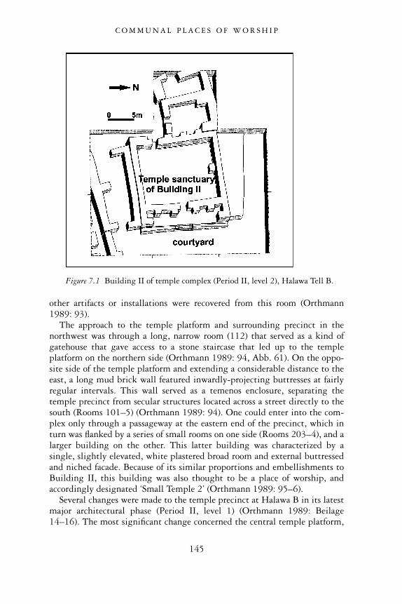
other artifacts or installations were recovered from this room (Orthmann1989: 93).
The approach to the temple platform and surrounding precinct in thenorthwest was through a long, narrow room (112) that served as a kind ofgatehouse that gave access to a stone staircase that led up to the templeplatform on the northern side (Orthmann 1989: 94, Abb. 61). On the oppo-site side of the temple platform and extending a considerable distance to theeast, a long mud brick wall featured inwardly-projecting buttresses at fairlyregular intervals. This wall served as a temenos enclosure, separating thetemple precinct from secular structures located across a street directly to thesouth (Rooms 101–5) (Orthmann 1989: 94). One could enter into the com-plex only through a passageway at the eastern end of the precinct, which inturn was flanked by a series of small rooms on one side (Rooms 203–4), and alarger building on the other. This latter building was characterized by asingle, slightly elevated, white plastered broad room and external buttressedand niched facade. Because of its similar proportions and embellishments toBuilding II, this building was also thought to be a place of worship, andaccordingly designated ‘Small Temple 2’ (Orthmann 1989: 95–6).
Several changes were made to the temple precinct at Halawa B in its latestmajor architectural phase (Period II, level 1) (Orthmann 1989: Beilage14–16). The most significant change concerned the central temple platform,
Figure 7.1 Building II of temple complex (Period II, level 2), Halawa Tell B.
C O M M U N A L P L A C E S O F W O R S H I P
145
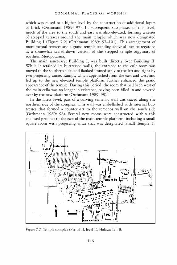
which was raised to a higher level by the construction of additional layersof brick (Orthmann 1989: 97). In subsequent sub-phases of this level,much of the area to the south and east was also elevated, forming a seriesof stepped terraces around the main temple which was now designatedBuilding I (Figure 7.2) (Orthmann 1989: 97–101). This arrangement ofmonumental terraces and a grand temple standing above all can be regardedas a somewhat scaled-down version of the stepped temple ziggurats ofsouthern Mesopotamia.
The main sanctuary, Building I, was built directly over Building II.While it retained its buttressed walls, the entrance to the cult room wasmoved to the southern side, and flanked immediately to the left and right bytwo projecting antae. Ramps, which approached from the east and west andled up to the new elevated temple platform, further enhanced the grandappearance of the temple. During this period, the room that had been west ofthe main cella was no longer in existence, having been filled in and coveredover by the new platform (Orthmann 1989: 98).
In the latest level, part of a curving temenos wall was traced along thenorthern side of the complex. This wall was embellished with internal but-tresses that formed a counterpart to the temenos wall on the south side(Orthmann 1989: 98). Several new rooms were constructed within thisenclosed precinct to the east of the main temple platform, including a smallsquare room with projecting antae that was designated ‘Small Temple 1’.
Figure 7.2 Temple complex (Period II, level 1), Halawa Tell B.
C O M M U N A L P L A C E S O F W O R S H I P
146
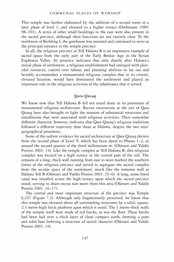
This temple was further elaborated by the addition of a second room in alater phase of level 1, and elevated to a higher terrace (Orthmann 1989:98–101). A series of other small buildings to the east were also present inthe sacred precinct, although their functions are not entirely clear. To thenorthwest of Building I, the gatehouse was retained and continued to serve asthe principal entrance to the temple precinct.
In all, the religious precinct at Tell Halawa B is an impressive example ofsacred space from the early part of the Early Bronze Age in the SyrianEuphrates Valley. Its presence indicates that only shortly after Halawa’sinitial phase of settlement, a religious establishment had emerged with plen-tiful resources, control over labour, and planning abilities to lay out andlavishly accommodate a monumental religious complex that in its central,elevated location, would have dominated the settlement and played animportant role in the religious activities of the inhabitants that it served.
Qara Quzaq
We know now that Tell Halawa B did not stand alone in its possession ofmonumental religious architecture. Recent excavations at the site of QaraQuzaq have also brought to light the remains of substantial structures andinstallations that were associated with religious activities. Their somewhatdifferent character, however, indicates that Qara Quzaq’s religious traditionsfollowed a different trajectory than those at Halawa, despite the two sites’geographical proximity.
Some of the earliest evidence for sacred architecture at Qara Quzaq derivesfrom the second phase of Level V, which has been dated to Phases 1–2, oraround the second quarter of the third millennium bc (Olávarri and ValdésPereiro 2001: 14). Like the temple complex at Tell Halawa B, this religiouscomplex was located on a high terrace in the central part of the tell. Theremains of a long, thick wall running from east to west marked the southernlimits of the religious precinct and served to segregate the sacred complexfrom the secular space of the settlement, much like the temenos wall atHalawa Tell B (Olávarri and Valdés Pereiro 2001: 25–6). A long, stone-linedcanal was installed across the high terrace upon which the sacred precinctstood, serving to drain excess rain water from this area (Olávarri and ValdésPereiro 2001: 16–17).
The central and most important structure of the precinct was TempleL.247 (Figure 7.3). Although only fragmentarily preserved, we know thatthis temple was elevated above all surrounding structures by a solid, square,2.3 metre-high brick platform upon which it stood. The 1 metre-thick wallsof the temple itself were made of red bricks, as was the floor. These brickshad been laid over a thick layer of clean compact earth, forming a pureand solid base befitting a structure of sacred character (Olávarri and ValdésPereiro 2001: 19).
C O M M U N A L P L A C E S O F W O R S H I P
147
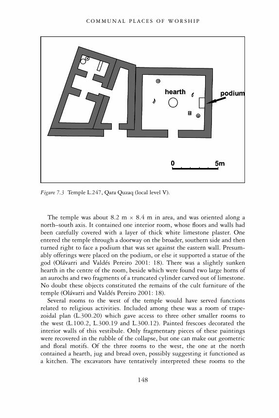
The temple was about 8.2 m × 8.4 m in area, and was oriented along anorth–south axis. It contained one interior room, whose floors and walls hadbeen carefully covered with a layer of thick white limestone plaster. Oneentered the temple through a doorway on the broader, southern side and thenturned right to face a podium that was set against the eastern wall. Presum-ably offerings were placed on the podium, or else it supported a statue of thegod (Olávarri and Valdés Pereiro 2001: 18). There was a slightly sunkenhearth in the centre of the room, beside which were found two large horns ofan aurochs and two fragments of a truncated cylinder carved out of limestone.No doubt these objects constituted the remains of the cult furniture of thetemple (Olávarri and Valdés Pereiro 2001: 18).
Several rooms to the west of the temple would have served functionsrelated to religious activities. Included among these was a room of trape-zoidal plan (L.300.20) which gave access to three other smaller rooms tothe west (L.100.2, L.300.19 and L.300.12). Painted frescoes decorated theinterior walls of this vestibule. Only fragmentary pieces of these paintingswere recovered in the rubble of the collapse, but one can make out geometricand floral motifs. Of the three rooms to the west, the one at the northcontained a hearth, jug and bread oven, possibly suggesting it functioned asa kitchen. The excavators have tentatively interpreted these rooms to the
Figure 7.3 Temple L.247, Qara Quzaq (local level V).
C O M M U N A L P L A C E S O F W O R S H I P
148
west of the temple as the residence of the priest in charge of the temple(Olávarri and Valdés Pereiro 2001: 24).
The distinctive character of the sacred precinct of level V-2 at QaraQuzaq is highlighted especially by the next buildings, which are somewhatpeculiar. One of the structures, L.12, is an above-ground, red brick building.Located to the west of temple L.247 and directly north of the temenos wall,L.12 contained two chambers, L.12E and L.12W, each of which containedthe partially cremated remains of an individual and a rich assortment ofaccompanying funerary offerings that included ceramic vessels, metal pins,weapons and jewellery (Figure 9.8) (Olávarri 1995b: 16–17). The buildinghad no windows, and after the burials had been deposited, its single doorwaywas walled up (Olávarri 1995b: 15–16). Additional details of this funerarystructure are provided in the next chapter. Suffice here to say that this struc-ture with its accompanying burials had a prominent place at the settlementof Qara Quzaq in level V-2, sharing the same central location as the templeand temple platform nearby.
Still other buildings were found near temple L.247 and enclosed bythe temenos wall. They included three mud brick buildings L.400.4, andL.400.2 and L.400.3. The latter two were rectangular semi-subterraneanstructures possessing vaulted ceilings formed by brick arches. The interiorsof both chambers were painted with white limestone plaster, and both con-tained small podia for receiving offerings (Olávarri and Valdés Pereiro 2001:19–20). The funerary character of these structures is somewhat tentativesince no human remains were found with the exception of an infant jar burialfound inside a small stone cist tomb underneath a wall of the earliest phaseof building L.400.2 (Olávarri and Valdés Pereiro 2001: 20, Figure 5c, photoVIII). Nevertheless, the lack of domestic installations and artifacts withinthese structures, their unusual subterranean layout and their location withinthe sacred precinct, near the burial chamber L.12, could indicate their associ-ation with funerary activities.
Together, the buildings found within the sacred precinct at Qara Quzaqconstitute a unique set of structures. The brick chamber L.12 stands out asthe most distinctive and unusual building of this complex given its funerarycharacter and its central, visible position in the settlement next to the prin-cipal temple. While it is rare to find a clear and direct association betweentemple structures and burials elsewhere in the Syrian Euphrates, such a con-figuration has been observed at the site of Tell Chuera to the east, where afunerary deposit, consisting of a number of skeletons that were partiallyburned with offerings of pottery and metal weapons, was found inside achamber of the temple designated as ‘Steinbau I’ at that site (Moortgat 1962:pl. V; Olávarri and Valdés Pereiro 2001: 23). Furthermore, we cannot denythat within the EB Euphrates one occasionally sees a connection betweenfunerary rituals and religious activities, especially the cult of the ancestors,which frequently involved rituals and celebrations around the tombs of the
C O M M U N A L P L A C E S O F W O R S H I P
149
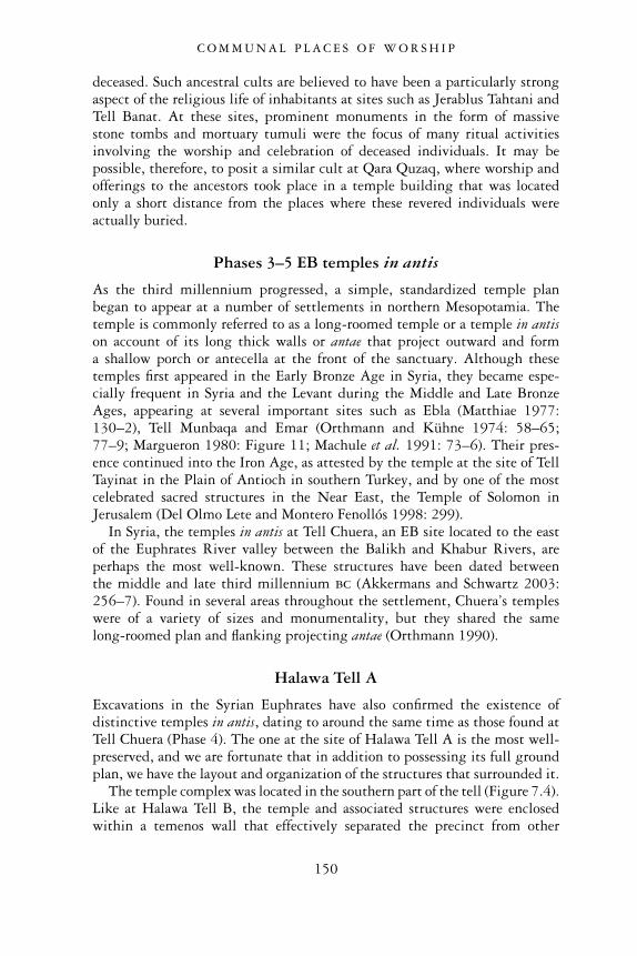
deceased. Such ancestral cults are believed to have been a particularly strongaspect of the religious life of inhabitants at sites such as Jerablus Tahtani andTell Banat. At these sites, prominent monuments in the form of massivestone tombs and mortuary tumuli were the focus of many ritual activitiesinvolving the worship and celebration of deceased individuals. It may bepossible, therefore, to posit a similar cult at Qara Quzaq, where worship andofferings to the ancestors took place in a temple building that was locatedonly a short distance from the places where these revered individuals wereactually buried.
Phases 3–5 EB temples in antis
As the third millennium progressed, a simple, standardized temple planbegan to appear at a number of settlements in northern Mesopotamia. Thetemple is commonly referred to as a long-roomed temple or a temple in antison account of its long thick walls or antae that project outward and forma shallow porch or antecella at the front of the sanctuary. Although thesetemples first appeared in the Early Bronze Age in Syria, they became espe-cially frequent in Syria and the Levant during the Middle and Late BronzeAges, appearing at several important sites such as Ebla (Matthiae 1977:130–2), Tell Munbaqa and Emar (Orthmann and Kühne 1974: 58–65;77–9; Margueron 1980: Figure 11; Machule et al. 1991: 73–6). Their pres-ence continued into the Iron Age, as attested by the temple at the site of TellTayinat in the Plain of Antioch in southern Turkey, and by one of the mostcelebrated sacred structures in the Near East, the Temple of Solomon inJerusalem (Del Olmo Lete and Montero Fenollós 1998: 299).
In Syria, the temples in antis at Tell Chuera, an EB site located to the eastof the Euphrates River valley between the Balikh and Khabur Rivers, areperhaps the most well-known. These structures have been dated betweenthe middle and late third millennium bc (Akkermans and Schwartz 2003:256–7). Found in several areas throughout the settlement, Chuera’s templeswere of a variety of sizes and monumentality, but they shared the samelong-roomed plan and flanking projecting antae (Orthmann 1990).
Halawa Tell A
Excavations in the Syrian Euphrates have also confirmed the existence ofdistinctive temples in antis, dating to around the same time as those found atTell Chuera (Phase 4). The one at the site of Halawa Tell A is the most well-preserved, and we are fortunate that in addition to possessing its full groundplan, we have the layout and organization of the structures that surrounded it.
The temple complex was located in the southern part of the tell (Figure 7.4).Like at Halawa Tell B, the temple and associated structures were enclosedwithin a temenos wall that effectively separated the precinct from other
C O M M U N A L P L A C E S O F W O R S H I P
150
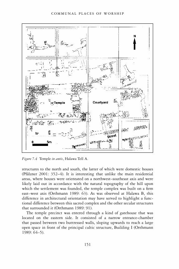
structures to the north and south, the latter of which were domestic houses(Pfälzner 2001: 352–4). It is interesting that unlike the main residentialareas, where houses were orientated on a northwest–southeast axis and werelikely laid out in accordance with the natural topography of the hill uponwhich the settlement was founded, the temple complex was built on a firmeast–west axis (Orthmann 1989: 63). As was observed at Halawa B, thisdifference in architectural orientation may have served to highlight a func-tional difference between this sacred complex and the other secular structuresthat surrounded it (Orthmann 1989: 91).
The temple precinct was entered through a kind of gatehouse that waslocated on the eastern side. It consisted of a narrow entrance-chamberthat passed between two buttressed walls, sloping upwards to reach a largeopen space in front of the principal cultic structure, Building I (Orthmann1989: 64–5).
Figure 7.4 Temple in antis, Halawa Tell A.
C O M M U N A L P L A C E S O F W O R S H I P
151
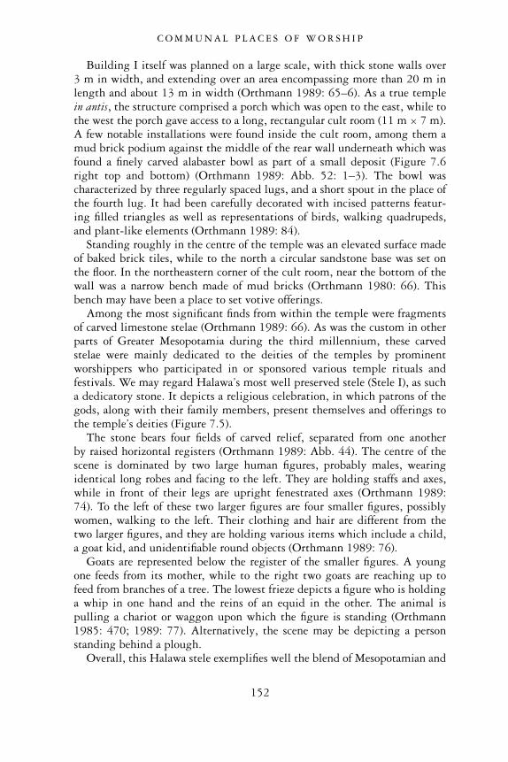
Building I itself was planned on a large scale, with thick stone walls over3 m in width, and extending over an area encompassing more than 20 m inlength and about 13 m in width (Orthmann 1989: 65–6). As a true templein antis, the structure comprised a porch which was open to the east, while tothe west the porch gave access to a long, rectangular cult room (11 m × 7 m).A few notable installations were found inside the cult room, among them amud brick podium against the middle of the rear wall underneath which wasfound a finely carved alabaster bowl as part of a small deposit (Figure 7.6right top and bottom) (Orthmann 1989: Abb. 52: 1–3). The bowl wascharacterized by three regularly spaced lugs, and a short spout in the place ofthe fourth lug. It had been carefully decorated with incised patterns featur-ing filled triangles as well as representations of birds, walking quadrupeds,and plant-like elements (Orthmann 1989: 84).
Standing roughly in the centre of the temple was an elevated surface madeof baked brick tiles, while to the north a circular sandstone base was set onthe floor. In the northeastern corner of the cult room, near the bottom of thewall was a narrow bench made of mud bricks (Orthmann 1980: 66). Thisbench may have been a place to set votive offerings.
Among the most significant finds from within the temple were fragmentsof carved limestone stelae (Orthmann 1989: 66). As was the custom in otherparts of Greater Mesopotamia during the third millennium, these carvedstelae were mainly dedicated to the deities of the temples by prominentworshippers who participated in or sponsored various temple rituals andfestivals. We may regard Halawa’s most well preserved stele (Stele I), as sucha dedicatory stone. It depicts a religious celebration, in which patrons of thegods, along with their family members, present themselves and offerings tothe temple’s deities (Figure 7.5).
The stone bears four fields of carved relief, separated from one anotherby raised horizontal registers (Orthmann 1989: Abb. 44). The centre of thescene is dominated by two large human figures, probably males, wearingidentical long robes and facing to the left. They are holding staffs and axes,while in front of their legs are upright fenestrated axes (Orthmann 1989:74). To the left of these two larger figures are four smaller figures, possiblywomen, walking to the left. Their clothing and hair are different from thetwo larger figures, and they are holding various items which include a child,a goat kid, and unidentifiable round objects (Orthmann 1989: 76).
Goats are represented below the register of the smaller figures. A youngone feeds from its mother, while to the right two goats are reaching up tofeed from branches of a tree. The lowest frieze depicts a figure who is holdinga whip in one hand and the reins of an equid in the other. The animal ispulling a chariot or waggon upon which the figure is standing (Orthmann1985: 470; 1989: 77). Alternatively, the scene may be depicting a personstanding behind a plough.
Overall, this Halawa stele exemplifies well the blend of Mesopotamian and
C O M M U N A L P L A C E S O F W O R S H I P
152
local North Syrian artistic styles that prevailed in the Syrian Euphratesregion during this period of the late third millennium bc. Orthmann hasidentified several commonalities between this object and artistic representa-tions from southern Mesopotamia, including the styles of the long, fringedgarments of the males, the hairstyles of the women, the chariot motif andthe kid bearer (Orthmann 1985: 471). Furthermore, the overall layout of thestele, in which the work is divided into registers and features figures inprofile, falls well within the established canon of Mesopotamian sculpturalrepresentation of the mid-to-late third millennium bc.
Figure 7.5 Stele (I), found in temple in antis, Halawa Tell A.
C O M M U N A L P L A C E S O F W O R S H I P
153
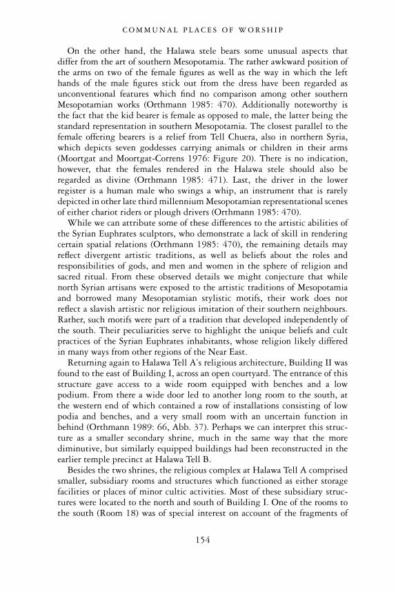
On the other hand, the Halawa stele bears some unusual aspects thatdiffer from the art of southern Mesopotamia. The rather awkward position ofthe arms on two of the female figures as well as the way in which the lefthands of the male figures stick out from the dress have been regarded asunconventional features which find no comparison among other southernMesopotamian works (Orthmann 1985: 470). Additionally noteworthy isthe fact that the kid bearer is female as opposed to male, the latter being thestandard representation in southern Mesopotamia. The closest parallel to thefemale offering bearers is a relief from Tell Chuera, also in northern Syria,which depicts seven goddesses carrying animals or children in their arms(Moortgat and Moortgat-Correns 1976: Figure 20). There is no indication,however, that the females rendered in the Halawa stele should also beregarded as divine (Orthmann 1985: 471). Last, the driver in the lowerregister is a human male who swings a whip, an instrument that is rarelydepicted in other late third millennium Mesopotamian representational scenesof either chariot riders or plough drivers (Orthmann 1985: 470).
While we can attribute some of these differences to the artistic abilities ofthe Syrian Euphrates sculptors, who demonstrate a lack of skill in renderingcertain spatial relations (Orthmann 1985: 470), the remaining details mayreflect divergent artistic traditions, as well as beliefs about the roles andresponsibilities of gods, and men and women in the sphere of religion andsacred ritual. From these observed details we might conjecture that whilenorth Syrian artisans were exposed to the artistic traditions of Mesopotamiaand borrowed many Mesopotamian stylistic motifs, their work does notreflect a slavish artistic nor religious imitation of their southern neighbours.Rather, such motifs were part of a tradition that developed independently ofthe south. Their peculiarities serve to highlight the unique beliefs and cultpractices of the Syrian Euphrates inhabitants, whose religion likely differedin many ways from other regions of the Near East.
Returning again to Halawa Tell A’s religious architecture, Building II wasfound to the east of Building I, across an open courtyard. The entrance of thisstructure gave access to a wide room equipped with benches and a lowpodium. From there a wide door led to another long room to the south, atthe western end of which contained a row of installations consisting of lowpodia and benches, and a very small room with an uncertain function inbehind (Orthmann 1989: 66, Abb. 37). Perhaps we can interpret this struc-ture as a smaller secondary shrine, much in the same way that the morediminutive, but similarly equipped buildings had been reconstructed in theearlier temple precinct at Halawa Tell B.
Besides the two shrines, the religious complex at Halawa Tell A comprisedsmaller, subsidiary rooms and structures which functioned as either storagefacilities or places of minor cultic activities. Most of these subsidiary struc-tures were located to the north and south of Building I. One of the rooms tothe south (Room 18) was of special interest on account of the fragments of
C O M M U N A L P L A C E S O F W O R S H I P
154
many vessels that were found within it (Figure 7.6) (Orthmann 1989: 66).Two ceramic fragments of storage jars are particularly noteworthy, havingbeen decorated in relief and incised with representations of animals andhuman figures (Figure 7.6 left). On one of the fragments, the heads of twoantithetically-arranged snakes are being grasped by a ‘hero’ standing betweenthem, while above their backs are the paws of a quadruped (Orthmann 1989:84, Abb. 51:3). On the second fragment, two antithetical snakes are graspedby a lion-headed bird of prey, while below is the representation of a quadru-ped painted with black marks (Orthmann 1989: 84, Abb. 51:1). Last, thereis a terra-cotta stand, decorated in relief with the representation of two heroes(Figure 7.6 right centre). One stands between two lions, while the otherstands between the hind quarters of two animals, whose backs he graspswith his hands (Orthmann 1989: 84, Abb. 52: 4–7). Overall, it is difficultto ascertain the precise meaning and significance of these vessels’ unusualmotifs, except to suggest that their imagery was appropriate to the cultsetting with which they were associated.
In all, the structures of the religious precinct at Tell Halawa A represent animpressive complex of monumental proportions. The size of the principaltemple, and the nature of the artifacts and the buildings associated with it,as well as its segregation from the rest of the settlement by an enclosure wall,clearly underline its importance and sacred character. The presence of thiscomplex also emphasizes the continuing prominence of religious institutionsin the region in the third millennium.
Tell Kabir
A large building with stone foundation was found at Tell Kabir, a small sitelocated in the Tell Banat embayment, only about 800 m from the largemortuary centre of Tell Banat. Pottery unearthed from the temple’s phases ofconstruction and use suggest that it existed during Phase 4 (c.2450–2300bc) (Porter 1995b: 135).
Excavations of the Kabir temple have revealed a rectangular single-roomedbuilding, about 22 m × 13 m in area, with large walls which were as much as2 m thick and made of field stones often as big as 1 m2 (Figure 7.7) (Porter1995b: 129). Judging from the amount of bricky collapse found inside thebuilding, the stone walls were probably topped by a superstructure of mudbrick (Porter 1995b: 129). A long wall on one side of the structure projectedout beyond the wall with the doorway in the southeast, forming an openporch in the front. A doorway in the eastern cross wall would have providedaccess from the porch to the main sanctuary room (McClellan 1999: 416). Inall, this layout is highly suggestive of a temple in antis, similar to the onefound at Tell Halawa A.
The floors of the building were first paved with mud bricks, then withpacked clay, and finally with a layer of dense limestone rubble which was
C O M M U N A L P L A C E S O F W O R S H I P
155
Figure 7.6 Cultic equipment from temple in antis complex, Halawa Tell A.
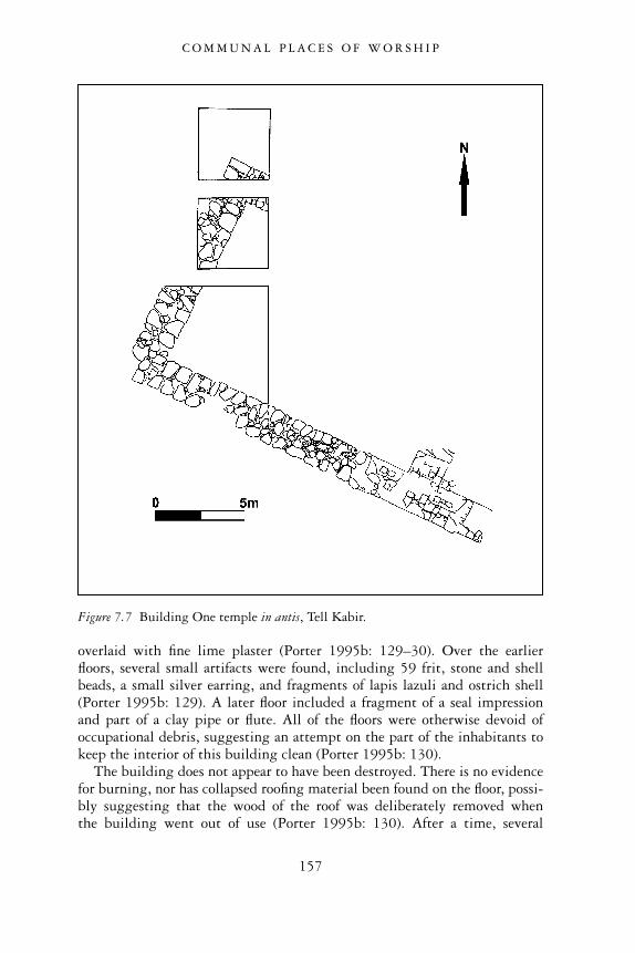
overlaid with fine lime plaster (Porter 1995b: 129–30). Over the earlierfloors, several small artifacts were found, including 59 frit, stone and shellbeads, a small silver earring, and fragments of lapis lazuli and ostrich shell(Porter 1995b: 129). A later floor included a fragment of a seal impressionand part of a clay pipe or flute. All of the floors were otherwise devoid ofoccupational debris, suggesting an attempt on the part of the inhabitants tokeep the interior of this building clean (Porter 1995b: 130).
The building does not appear to have been destroyed. There is no evidencefor burning, nor has collapsed roofing material been found on the floor, possi-bly suggesting that the wood of the roof was deliberately removed whenthe building went out of use (Porter 1995b: 130). After a time, several
Figure 7.7 Building One temple in antis, Tell Kabir.
C O M M U N A L P L A C E S O F W O R S H I P
157
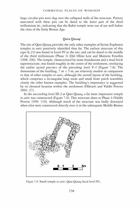
large circular pits were dug over the collapsed walls of the structure. Potteryassociated with these pits can be dated to the latter part of the thirdmillennium bc, indicating that the Kabir temple went out of use well beforethe close of the Early Bronze Age.
Qara Quzaq
The site of Qara Quzaq provides the only other examples of Syrian Euphratestemples in antis positively identified thus far. The earliest structure of thistype (L.23) was found in Level IV at the site, and can be dated to the middleof the third millennium (Phase 3) (Del Olmo Lete and Montero Fenollós1998: 296). The temple, characterized by stone foundations and a mud bricksuperstructure, was found roughly in the centre of the settlement, overlayingthe earlier sacred precinct of the preceding level V-2 (Figure 7.8). Thedimensions of the building, 7 m × 5 m, are relatively modest in comparisonto that of other temples in antis, although the overall layout of the building,which comprises a rectangular long room and small front porch resemblesclosely the other known examples. The building’s importance is suggestedby its elevated location within the settlement (Olávarri and Valdés Pereiro2001: 27).
In the succeeding level III-2 at Qara Quzaq, a far more impressive templein antis was constructed (Figure 7.9). This structure dates to Phase 4 (ValdésPereiro 1999: 119). Although much of the structure was badly destroyedwhen silos were constructed directly over it in the subsequent Middle Bronze
Figure 7.8 Small temple in antis, Qara Quzaq (local level IV).
C O M M U N A L P L A C E S O F W O R S H I P
158
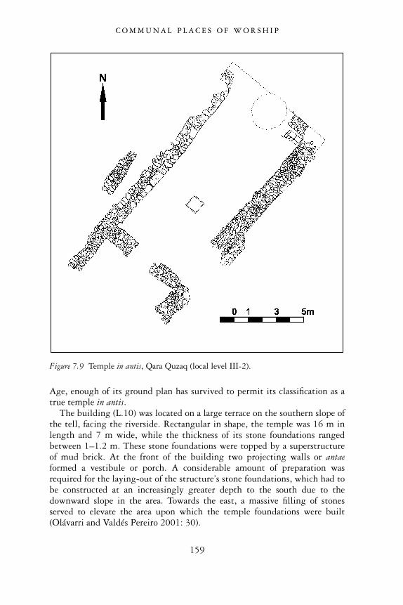
Age, enough of its ground plan has survived to permit its classification as atrue temple in antis.
The building (L.10) was located on a large terrace on the southern slope ofthe tell, facing the riverside. Rectangular in shape, the temple was 16 m inlength and 7 m wide, while the thickness of its stone foundations rangedbetween 1–1.2 m. These stone foundations were topped by a superstructureof mud brick. At the front of the building two projecting walls or antaeformed a vestibule or porch. A considerable amount of preparation wasrequired for the laying-out of the structure’s stone foundations, which had tobe constructed at an increasingly greater depth to the south due to thedownward slope in the area. Towards the east, a massive filling of stonesserved to elevate the area upon which the temple foundations were built(Olávarri and Valdés Pereiro 2001: 30).
Figure 7.9 Temple in antis, Qara Quzaq (local level III-2).
C O M M U N A L P L A C E S O F W O R S H I P
159
The floor of the long-roomed cella was made of carefully laid brick andthen covered over with white plaster. The walls were also white-washed.Benches, running along the entire northern and western walls, were placeswhere votive offerings were likely placed (Olávarri and Valdés Pereiro 2001:29). A square brick platform or podium in the centre of the cella may alsohave served as a place for offerings (Olávarri and Valdés Pereiro 2001: 29).
An exceptional discovery was made in the porch area of this temple. Underthe floor of this room, near the western wall, the excavators recovered astorage jar containing a treasure hoard that contained 333 pieces of alabaster,mother-of-pearl, shell, bone, stone and frit objects (Valdés Pereiro 1999:121). The majority of objects were beads, rings, pendants and animal-shapedamulets, but the hoard also contained two small alabaster vessels, cylinderseals with geometric designs, and a mother-of-pearl plaque in the form of abull. The hoard can almost certainly be interpreted as a ritual deposit mark-ing the founding of the temple, an act well known from other Mesopotamiantemple contexts (Del Olmo Lete and Montero Fenollós 1998: 297).
Several of the objects of the deposit have parallels from third millenniumcontexts elsewhere. The mother-of-pearl bull, which is characterized bydrilled concentric circles that decorate its body and form its eyes, compareswell with mother-of-pearl bulls found at Tell Brak in a pre-Akkadian context(Oates et al. 2001: 30; 296), and at Tell �Atij along the Khabur River, from aburial of the Ninevite 5 period (Fortin 1990: 240).
DISCUSSION
Our available evidence demonstrates that monumental sacred architectureenjoyed a long history in Syrian Euphrates during the Early Bronze Age,extending back to the first centuries of the third millennium. Tell HalawaB’s temple complex with its stepped platform, and Qara Quzaq’s sacred brickbuildings clearly testify to the early presence of impressive sacred works.By their central location these temples undoubtedly played an important rolein the religious life of the inhabitants they served. These early places ofworship, however, were defined by somewhat dissimilar elements, possiblyreflecting locally divergent religious practices and beliefs. The complex atQara Quzaq was characterized by an unusual funerary brick burial chamberand other supposed funerary buildings that were located in close proximityto the principal sanctuary. None of the remains of the terraced temple com-plex at Halawa, by contrast, can be positively linked to any funerary cult oractivity associated with death and burial. This evidence underlines the strongdegree of local character of the religious traditions of these Euphrates com-munities. Despite the geographical proximity of Halawa B and Qara Quzaq,these settlements’ traditions, rituals and beliefs appeared to have divergedconsiderably from one another.
C O M M U N A L P L A C E S O F W O R S H I P
160
Large-scale temples continued to be conspicuous elements of Euphratessettlements into the latter part of the third millennium, although now agrowing homogeneity in the overall plan of the temple emerged in the formof the long-roomed temple in antis. To date such temples have been identi-fied at Tell Halawa A, Tell Kabir and Qara Quzaq. We assume that thisgrowing standardization of religious architecture was part of a greater trendthroughout northern Mesopotamia, in which many aspects of culture becameshared across wide distances. This development can largely be attributed tothe growth of communication and exchange networks among settlements ofthis region. It can also be related to the desire, especially on the part ofreligious and secular leaders of individual cities, to secure their inclusionwithin this profitable network of exchange through the emulation of neigh-bouring cities’ material cultural accoutrements. The Syrian Euphrates wasby no means excluded from this wider world, and its temples in antis,replicas of which can be seen outside of the region at sites like Tell Chuera tothe east, reflected well this process of cultural homogenization and ‘peerpolity interaction’ (Renfrew 1986: 7–8).
The transformation of religious architecture in the Syrian Euphrates didnot also mean that local traditions were abandoned and replaced by new,standardized religious ideologies and cult practices. Quite the opposite wastrue. Based on the evidence that we have surveyed, it would appear, forexample, that the temple in antis of level 4 at Qara Quzaq was foundedalmost directly over the sacred complex of earlier level V, thus underliningthe continued sanctity of the area in which the temple was sited. It impliescontinuity in religious traditions despite outward changes made to thephysical appearance of the sanctuary. The temple complex at Halawa Tell Alikewise reflects continuity of local religious traditions. The complex wascharacterized by a large temple in antis together with a smaller subsidiaryshrine, both of which were situated within a temenos enclosure. Thisarrangement parallels almost exactly the earlier Halawa Tell B complex, inwhich the principally elevated sanctuary, with its accompanying subsidiaryshrine, was located within a sacred, walled enclosure. If we assume that theinhabitants of Halawa Tell A were the descendants of the people of HalawaTell B, and that the shift in settlement from one hilltop to anotherimmediately to the south was simply the result of relocating to a largerarea in which to accommodate an increasingly larger population, we maypropose that the religious establishment of this community simply changedplaces. The same deities continued to be worshipped in their respectivesanctuaries, although the inhabitants by now had adapted their architectureto conform to the accepted norms of sacred architecture prevalent through-out northern Mesopotamia at this time. Local cult practices and religiousbeliefs prevailed and continued to flourish even though changes hadoccurred to the physical, structural spaces that provided the focus for thesetraditions.
C O M M U N A L P L A C E S O F W O R S H I P
161
We wonder if other aspects of religion, society and culture find reflectionin the presence and location of temples within the Syrian Euphrates. It maybe significant, for instance, that large temples were present at a number ofsites of varying sizes, and not simply at the largest sites in the region. Notemple in antis has yet been unearthed at the 30 ha site of Tell Banat, forexample, although one has been located at Tell Kabir, a small 2.3 ha settle-ment located only 1 km away from Banat. Qara Quzaq is likewise not asignificant site in terms of its size, although the evidence demonstrates thatit supported a long-lived, well-established complex of sacred structures. Thelate third millennium settlement of Halawa Tell A, with its grand temple inantis, occupies an area of 15 ha, and yet at the comparably large settlement ofSelenkahiye nearby, no monumental temple has been discovered thus far.When combined, the evidence provides no discernible relationship betweenthe physical size of the site and the presence or absence of monumental temples.This interesting observation compels us to reconsider the model of a simplehierarchical settlement system for this region, in which the largest settlementsacted as centres that coordinated the social, economic and religious affairs ofsmaller, satellite settlements in their immediate vicinity. In this model ofurbanism, we should only expect to find large-scale buildings – includingtemples which would have governed the religious affairs of the wider ‘city-state’ – in the largest centres. Since the evidence from the Syrian Euphratesdoes not conform to this traditional type of urban hierarchical model, wemust seek alternative ways of understanding how individual communitiesfunctioned within the network of settlements located in the river valley andbeyond, and the special nature of their relationships to one another.
One last interesting observation about the presence of temple architectureconcerns its relationship with other forms of religious expression, especiallyfunerary traditions and their attendant mortuary rituals and ceremonies. Itseems that funerary practices played an important role in the religious andsocial life of many Euphrates’ communities, judging by the frequency withwhich large, visible funerary monuments in the form of above-ground tombsand mortuary tumuli are often found at these sites. Such important workswill be discussed in greater detail in our chapter on burials. For the timebeing, we observe that none of the temples described above, with the excep-tion of Qara Quzaq, occur at the same sites where large-scale funerarymonuments have been discovered. No temple structure has been discoveredat the site of Jerablus Tahtani, for example, with its impressive Tomb 302.Tell Ahmar, with its well-known Hypoegeum which may have stood withina cluster of similar tombs, has also failed to yield any central place of worship.The pattern is most cogently demonstrated at Tell Banat. This mortuary sitepar excellence, which accommodated not only monumental tombs but alsomassive mortuary tumuli, has not yielded a single temple, although in itsimmediate neighbourhood at Tell Kabir, a temple in antis was prominentlysituated.
C O M M U N A L P L A C E S O F W O R S H I P
162
In the absence of any textual documents that might illuminate the religioustraditions of the Euphrates valley, it is hazardous to make any firm state-ments about the significance of this interesting spatial configuration oftemples and mortuary constructions. We would like to propose as a possibleexplanation, however, that these two types of religious monuments reflectthe existence of two separate and somewhat opposing ideological traditionsamong the inhabitants of the Euphrates during this period. On the one hand,temples, invariably located in built-up centres of towns and cities, have aclose association with the sedentary, agriculturally-based character of theEuphrates region, this having been established fairly early in the thirdmillennium bc, and which continued to grow and persist over many centuries.On the other hand, funerary markers and monuments of the type found inthe northern Euphrates at sites such as Tell Banat may have had greaterassociations with the largely mobile character of many of the inhabitants ofthe region. Some groups were obliged to move across considerable distancesin the broad steppe lands beyond the confines of the river valley in theirquest for suitable grazing lands for their flocks of sheep and goats. Yet themortuary monuments, which served as potent symbols of the tribal ancestors,provided an important focus for these pastoral nomadic groups, serving toreaffirm and strengthen their ties of kinship and social cohesion. In sum-mary, while temples and their associated complexes may have at theirroots the settled, sedentary character of many of the Euphrates’ inhabitants,funerary monuments were more closely associated with the tribal, pastoralnomadic character of the population whose traditions were originally rootedin a more rural, as opposed to urban setting. The conjoining of these twocontrasting elements in the Euphrates Valley over time resulted in thegeneration of two types of religious expression characterized by physicallydistinctive places of worship and divergent ritual activities and observances.Together, these ideological expressions of divine worship and ancestor vener-ation underscore the variegated nature of society and religion in this complexperiod of urban growth.
C O M M U N A L P L A C E S O F W O R S H I P
163
8
CRAFTS AND CRAFTPRODUCTION
The archaeological record of the Syrian Euphrates well attests to the produc-tion of metalwork, textiles, pottery, and other crafted materials. It confirmsnot only regular, recurring production but also one that was sometimesorganized on a scale featuring well appointed workshops and craft specialists.A full picture, however, of the nature and scale of craft production in thisregion during the third millennium is somewhat difficult to reconstructowing to a number of factors. The first problem is related to issues of archaeo-logical preservation. We are certain, for example, that some materials, suchas leather, hides, wool and wood, were worked into finished products just asthey were in other parts of Greater Mesopotamia (Stol 1983; Van de Mieroop1987; Pollock 1999: 128, 138; Nichols and Weber in press), but theirnon-permanent, perishable composition makes it impossible to verify theirpresence. Facilities and tools that probably assisted in transforming thesematerials into finished, consumable products may also have suffered from thevicissitudes of time and nature.
A second difficulty is that facilities and materials associated with craftmanufacturing activities are hard to identify correctly. Several SyrianEuphrates sites have yielded installations that may have been connected withcraft activities, but they provide few unambiguous clues concerning theirspecific function. White limestone plastered or pebbled basins and surfaces atmany third millennium north Mesopotamian sites, for example, have beenvariously interpreted as dye-vats for textiles, wine-processing facilities, andplaces for the cleaning and levigating of clay (Strommenger 1980: 71; Algazeet al. 1995: 18–19; Routledge 1998: 246). With fine-grained analyses suchas micromorphological and residue investigations (e.g. W. Matthews 1995),it may soon be possible to obtain a more accurate reconstruction of someproduction facilities and their specific uses. For the time being, however, wecan only report what has been excavated and offer suggestions concerninghow the installations might have functioned within the context of known,third millennium production activities.
Most of the items manufactured in the Euphrates Valley seem to have beenintended for local consumption. Some crafted materials, however, may have
164
been traded with neighbouring cities and occasionally conveyed to consumersin other regions of northern Mesopotamia. The fact that the Euphrates Riverwas a natural avenue of exchange, facilitating the flow of crafted goods to thenorth and the south, makes this likely. Ancient textual sources also alludeto the presence of long-established overland routes that linked regionsfrom the east and west of the Euphrates Valley. The considerable wealth ofexotic items, especially from tomb contexts within the region, attests to theoccurrence of extensive, and at times, long-lasting exchange relations withother regions outside of the Euphrates Valley. On the basis of this evidence,it seems reasonable to conclude that some goods produced in the SyrianEuphrates were conveyed outside of this region through various avenues ofexchange.
In southern Mesopotamia during the third millennium, craft activitiestook the form of high-intensity factory-scale production. This is not the caseof such activities in the northern Euphrates Valley region. But nonetheless,craft production was often regularized and well-organized, and, in some casesa high level of specialization was attained. In most instances, craft produc-tion appears to have occurred at the level of the independent household orworkshop, but sometimes it seems to have been connected to prominentindividuals or institutions. Some individuals of importance probably ownedand operated craft production facilities, while others may have commissionedartisans to produce their goods for them, supplying the necessary raw materialsor funds to buy them (Van de Mieroop 1997: 180). To date, the Euphratesarchaeological evidence indicates that such prominent individuals commis-sioned valuable, luxury products rather than products of a common, utilitar-ian nature. Such production was clearly related to their desire to surroundthemselves with precious or sumptuous goods that illustrated their wealth,status and power. These valuable products were also frequently exchangedwith neighbouring polities and elites in an effort to initiate or maintainpolitical or economic alliances.
Past studies have often interpreted the organization of production withinan ancient society in monolithic terms, suggesting for craft activities ageneral system that comprised uniform or affiliated modes of control, similarscales of production and corresponding rates of intensity. Such an approachto the evidence, however, fails to acknowledge that craft production, likeother human activities, takes many forms. Craft organization, for example,may vary because of the different social or economic positions of the indi-viduals involved in the process and consumption of the products. It may alsovary according to the degree of specialization required for the products’manufacture, and the products’ function as utilitarian or luxury goods withinthe society. In this study, we will attempt to demonstrate the multidimen-sional nature of the organization of production by investigating the differenttypes of objects being manufactured (i.e. metal implements, pots, textiles,stone beads). We will observe where such products were manufactured and
C R A F T S A N D C R A F T P R O D U C T I O N
165
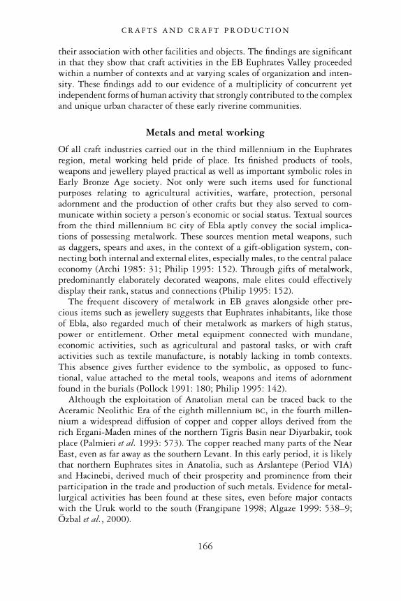
their association with other facilities and objects. The findings are significantin that they show that craft activities in the EB Euphrates Valley proceededwithin a number of contexts and at varying scales of organization and inten-sity. These findings add to our evidence of a multiplicity of concurrent yetindependent forms of human activity that strongly contributed to the complexand unique urban character of these early riverine communities.
Metals and metal working
Of all craft industries carried out in the third millennium in the Euphratesregion, metal working held pride of place. Its finished products of tools,weapons and jewellery played practical as well as important symbolic roles inEarly Bronze Age society. Not only were such items used for functionalpurposes relating to agricultural activities, warfare, protection, personaladornment and the production of other crafts but they also served to com-municate within society a person’s economic or social status. Textual sourcesfrom the third millennium bc city of Ebla aptly convey the social implica-tions of possessing metalwork. These sources mention metal weapons, suchas daggers, spears and axes, in the context of a gift-obligation system, con-necting both internal and external elites, especially males, to the central palaceeconomy (Archi 1985: 31; Philip 1995: 152). Through gifts of metalwork,predominantly elaborately decorated weapons, male elites could effectivelydisplay their rank, status and connections (Philip 1995: 152).
The frequent discovery of metalwork in EB graves alongside other pre-cious items such as jewellery suggests that Euphrates inhabitants, like thoseof Ebla, also regarded much of their metalwork as markers of high status,power or entitlement. Other metal equipment connected with mundane,economic activities, such as agricultural and pastoral tasks, or with craftactivities such as textile manufacture, is notably lacking in tomb contexts.This absence gives further evidence to the symbolic, as opposed to func-tional, value attached to the metal tools, weapons and items of adornmentfound in the burials (Pollock 1991: 180; Philip 1995: 142).
Although the exploitation of Anatolian metal can be traced back to theAceramic Neolithic Era of the eighth millennium bc, in the fourth millen-nium a widespread diffusion of copper and copper alloys derived from therich Ergani-Maden mines of the northern Tigris Basin near Diyarbakir, tookplace (Palmieri et al. 1993: 573). The copper reached many parts of the NearEast, even as far away as the southern Levant. In this early period, it is likelythat northern Euphrates sites in Anatolia, such as Arslantepe (Period VIA)and Hacinebi, derived much of their prosperity and prominence from theirparticipation in the trade and production of such metals. Evidence for metal-lurgical activities has been found at these sites, even before major contactswith the Uruk world to the south (Frangipane 1998; Algaze 1999: 538–9;Özbal et al., 2000).
C R A F T S A N D C R A F T P R O D U C T I O N
166
At the beginning of the third millennium bc, after the collapse of the LateUruk expansion and the withdrawal of southern Mesoptomian influence,metals continued to be a conspicuous component of many northern Euphrates’assemblages. In the far northern Euphrates, at Arslantepe (Period VIB), anEarly Bronze I hoard of metalwork comprising weapons such as copperspearheads, daggers and axes, along with ornaments such as pins, braceletsand hair ornaments, was found in a rich tomb from that period (Frangipane1998). Further down the river, the region around the Early Bronze Agesettlement of Carchemish produced a considerable quantity of metalwork. AtCarchemish itself, several Phases 1–2 cist graves were found containing flataxes, spearheads and simple daggers along with pins with clear links to thestyles represented in the hoard at Arslantepe (Woolley and Barnett 1952: pls.59–60; Philip in press). In the burials of the Birecik Dam Cemetery about25 km north of Carchemish, an abundance of differently styled copper pinsand other ornaments, tripartite spearheads with leaf-shaped blades, ‘poker’spearheards, daggers and flat axes has been recovered from many of thegraves (Sertok and Ergeç 1999: 93, and figs. 9–10; Squadrone 2000). If weconsider the northern Euphrates Valley of Syria itself, the most prominentcollection of copper and bronze artifacts comes from a prominent brick tomblocated within the enclosed religious precinct of level V-2 at the site of QaraQuzaq (Olávarri 1995b: 16–17). Its collection of copper spearheads andbronze pins finds excellent parallels to the metalwork from the other sitesjust mentioned (Montero 1995).
That so much superb metalwork comes principally from burial contextsemphasizes the importance of such items for indicating one’s status in death.In one instance, at the site of Qara Quzaq, true tin-bronze as opposed toarsenical copper was used for the manufacture of these tomb items (MonteroFenollós 1999: 456). Since tin had to be imported from as far away asAfghanistan, its presence confirms on the one hand that even in the earlythird millennium, the Syrian Euphrates was participating in long-distancecommercial exchanges. On the other hand, the presence of these tin-bronzeitems testifies to the existence of wealthy individuals who could afford suchexotic and costly materials (Montero Fenollós 1999: 456). Finally, the dis-covery of considerable quantities of metal within tomb contexts suggests thatcopper and bronze were considered disposable materials, and that they wereprobably abundantly available.
During the middle and late part of the Early Bronze Age, burials fromEuphrates River Valley sites continued to contain vast amounts of metal-work, especially in the form of copper or bronze weapons and pins, but alsoto a lesser extent, items in silver and gold. During this period, one sees theappearance of copper socketed axes, spearheads with hooked tangs andtoggle-pins with spiral or hemispherical heads. Most of these items demon-strate considerable morphological homogeneity, and they often occur insimilar combinations at different sites not only within the Euphrates Valley,
C R A F T S A N D C R A F T P R O D U C T I O N
167
but also in other parts of northern and western Syria (Philip in press). Thishomogeneity testifies to a well-connected and intensive trade in suchmaterials that linked even distant communities. The growing uniformity inthe metal repertoire may also be linked to the growth of locally situatedelites in Syria during this time, who desired to reinforce their positions ofpower and wealth with appropriate status trappings, and who, in the process,increased contacts and exchanges with individuals of similar status fromother urban centres (Philip in press).
The greatest collections of Phases 3–5 metalwork come from what canbe considered the burials of prominent individuals. Two individuals, forexample, interred in the rich stone-built ‘Hypogeum’ at the Euphrates site ofTell Ahmar, were accommodated with a vast number of pottery vessels. Theywere also left with an astonishing number of metal objects, in the form ofbowls, a wide array of axes, spears and daggers, toggle pins, as well as a setof rein-rings, probably associated with a wheeled vehicle of some kind(Thureau-Dangin and Dunand 1936: 106–8, pls. 28–31). The large Tomb 302at the site of Jerablus Tahtani seems to have been similarly furnished with arich trove of grave goods, included among them metalwork in the form ofcopper shaft-hole axes, poker-butted spearheads, thin-bladed daggers (Figure8.1), as well as a smaller array of adornments of gold and silver (Peltenburg et al.1995: 10, figs. 12 and 14). At the remarkable Euphrates site of Tell Banat,tombs such as Tomb 1 have yielded a rich collection of bronzes, includingtongs, daggers, adzes and pins (Porter 1995a: 8, figs. 5–7). The large stone-built Tomb 7, while yielding only a modest amount of copper and bronzeitems, nonetheless featured a variety of gold beads, including almost athousand tiny circular rings cut from tubes, as well as quadruple-spiral,pumpkin-shaped and rilled beads. The burial treasure also included goldscallop shells, bell and biconical forms, mushroom-shaped pendants, longgold bars with pinched holes and a gold pendant with applied lozenge(Figure 9.13). Gold was also used as inlay in lapis lazuli bottle stoppers(McClellan and Porter 1999: 110; Aruz 2003: 185–6). It has been pointedout that many of these gold ornament styles match those found in con-temporary contexts as far away as Troy and Poliochni in Anatolia, testifying tothe widespread interactions that Syrian Euphrates communities must havebeen engaged in during this time (Aruz 2003: 185, 271).
The shaft tombs at Tell Halawa contained metal objects, notably bronzepins, daggers, spearheads, axes, beads, earrings, arm rings, collars and handles(Orthmann 1981: Taf. 68–70). Last, at the site of Selenkahiye and its neigh-bouring cemetery of Wreide, items such as bronze daggers, axes, spearheads,and most notably pins, typically occurring as crossed pairs, accompaniedseveral burials, sometimes along with silver adornments such as torques,pendants, diadems and earrings (Van Loon 2001: Chapters 4A–4B). In all, themiddle to later part of the Early Bronze Age had by no means an impoverishedmetal repertoire, as these rich and plentiful tombs clearly demonstrate.
C R A F T S A N D C R A F T P R O D U C T I O N
168
Evidence for metal working
The discovery of artifactual remains associated with metal working at anumber of Euphrates sites confirms that the manufacture of at least some ofthe metal artifacts found so copiously in archaeological contexts, especiallyburials, was undertaken on a local level. Included among this repertoire arestone moulds for casting metal implements, tools and crucibles. Althoughsome of the contexts in which such metallurgical equipment has been foundare disturbed or poorly understood, it is sometimes possible to obtain cluesconcerning where this important industry was carried out, and under whoseauspices it was organized.
The earliest EB evidence for local metal working in the northern EuphratesValley comes from the small site of Halawa Tell B, whose early levels ofoccupation can be dated to the first centuries of the third millennium bc in
Figure 8.1 Copper alloy daggers from Tomb 302, Jerablus Tahtani.
C R A F T S A N D C R A F T P R O D U C T I O N
169
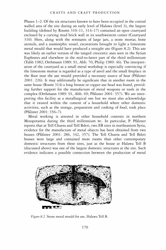
Phases 1–2. Of the six structures known to have been occupied in the centralwalled area of the site during an early level of Halawa (level 3), the largestbuilding (defined by Rooms 310–11, 314–17) contained an open courtyardenclosed by a curving mud brick wall in its southwestern corner (Courtyard310). Here, along with the remnants of large jars, a stone mortar, boneutensils, and a zoomorphic vessel, excavations brought to light a limestonemetal mould that would have produced a straight axe (Figure 8.2). This axewas likely an earlier version of the tanged crescentic axes seen in the SyrianEuphrates and elsewhere in the mid-to-latter part of the third millennium(Tubb 1982; Orthmann 1989: 91, Abb. 70; Philip 1989: 46). The interpret-ation of the courtyard as a small metal workshop is especially convincing ifthe limestone mortar is regarded as a type of anvil and the small fireplace inthe floor near the axe mould provided a necessary source of heat (Pfälzner2001: 226). It may additionally be significant that in another room in thesame house (Room 314) a long bronze or copper axe head was found, provid-ing further support for the manufacture of metal weapons or tools in thecomplex (Orthmann 1989: 91, Abb. 69; Pfälzner 2001: 357). We are inter-preting this facility as a metallurgical one but we must also acknowledgethat it existed within the context of a household where other domesticactivities, such as the storage, preparation and cooking of food, took place(Pfälzner 2001: 356–7).
Metal working is attested in other household contexts in northernMesopotamia during the third millennium bc. In particular, P. Pfälznerreports that at Tell Chuera and Tell Bderi, two EB sites in northeastern Syria,evidence for the manufacture of metal objects has been obtained from twohouses (Pfälzner 2001: 286, 342, 357). The Tell Chuera and Tell Bderihouses were large and contained more rooms than other contemporarydomestic structures from these sites, just as the house at Halawa Tell B(discussed above) was one of the largest domestic structures at the site. Suchevidence indicates a possible connection between the production of metal
Figure 8.2 Stone metal mould for axe, Halawa Tell B.
C R A F T S A N D C R A F T P R O D U C T I O N
170
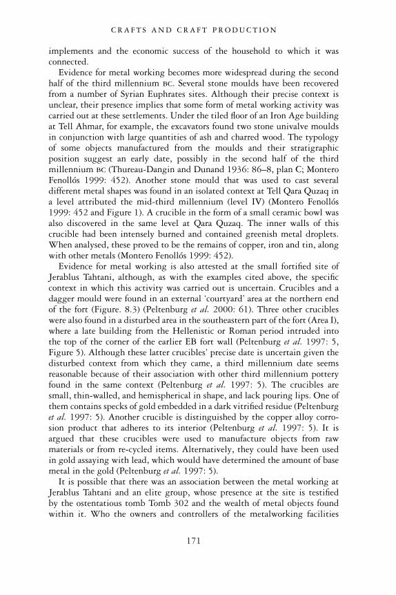
implements and the economic success of the household to which it wasconnected.
Evidence for metal working becomes more widespread during the secondhalf of the third millennium bc. Several stone moulds have been recoveredfrom a number of Syrian Euphrates sites. Although their precise context isunclear, their presence implies that some form of metal working activity wascarried out at these settlements. Under the tiled floor of an Iron Age buildingat Tell Ahmar, for example, the excavators found two stone univalve mouldsin conjunction with large quantities of ash and charred wood. The typologyof some objects manufactured from the moulds and their stratigraphicposition suggest an early date, possibly in the second half of the thirdmillennium bc (Thureau-Dangin and Dunand 1936: 86–8, plan C; MonteroFenollós 1999: 452). Another stone mould that was used to cast severaldifferent metal shapes was found in an isolated context at Tell Qara Quzaq ina level attributed the mid-third millennium (level IV) (Montero Fenollós1999: 452 and Figure 1). A crucible in the form of a small ceramic bowl wasalso discovered in the same level at Qara Quzaq. The inner walls of thiscrucible had been intensely burned and contained greenish metal droplets.When analysed, these proved to be the remains of copper, iron and tin, alongwith other metals (Montero Fenollós 1999: 452).
Evidence for metal working is also attested at the small fortified site ofJerablus Tahtani, although, as with the examples cited above, the specificcontext in which this activity was carried out is uncertain. Crucibles and adagger mould were found in an external ‘courtyard’ area at the northern endof the fort (Figure. 8.3) (Peltenburg et al. 2000: 61). Three other crucibleswere also found in a disturbed area in the southeastern part of the fort (Area I),where a late building from the Hellenistic or Roman period intruded intothe top of the corner of the earlier EB fort wall (Peltenburg et al. 1997: 5,Figure 5). Although these latter crucibles’ precise date is uncertain given thedisturbed context from which they came, a third millennium date seemsreasonable because of their association with other third millennium potteryfound in the same context (Peltenburg et al. 1997: 5). The crucibles aresmall, thin-walled, and hemispherical in shape, and lack pouring lips. One ofthem contains specks of gold embedded in a dark vitrified residue (Peltenburget al. 1997: 5). Another crucible is distinguished by the copper alloy corro-sion product that adheres to its interior (Peltenburg et al. 1997: 5). It isargued that these crucibles were used to manufacture objects from rawmaterials or from re-cycled items. Alternatively, they could have been usedin gold assaying with lead, which would have determined the amount of basemetal in the gold (Peltenburg et al. 1997: 5).
It is possible that there was an association between the metal working atJerablus Tahtani and an elite group, whose presence at the site is testifiedby the ostentatious tomb Tomb 302 and the wealth of metal objects foundwithin it. Who the owners and controllers of the metalworking facilities
C R A F T S A N D C R A F T P R O D U C T I O N
171
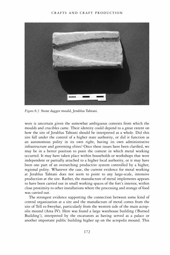
were is uncertain given the somewhat ambiguous contexts from which themoulds and crucibles came. Their identity could depend to a great extent onhow the site of Jerablus Tahtani should be interpreted as a whole. Did thissite fall under the control of a higher state authority, or did it function asan autonomous polity in its own right, having its own administrativeinfrastructure and governing elites? Once these issues have been clarified, wemay be in a better position to posit the context in which metal workingoccurred. It may have taken place within households or workshops that wereindependent or partially attached to a higher local authority, or it may havebeen one part of an overarching productive system controlled by a higher,regional polity. Whatever the case, the current evidence for metal workingat Jerablus Tahtani does not seem to point to any large-scale, intensiveproduction at the site. Rather, the manufacture of metal implements appearsto have been carried out in small working spaces of the fort’s interior, withinclose proximity to other installations where the processing and storage of foodwas carried out.
The strongest evidence supporting the connection between some kind ofcentral organization at a site and the manufacture of metal comes from thesite of Tell es-Sweyhat, particularly from the western side of the main acrop-olis mound (Area IV). Here was found a large warehouse building (‘BurnedBuilding’), interpreted by the excavators as having served as a palace oranother important public building higher up on the acropolis mound. This
Figure 8.3 Stone dagger mould, Jerablus Tahtani.
C R A F T S A N D C R A F T P R O D U C T I O N
172
complex of public architecture is dated to Phase 5, in the late centuries of thethird millennium, when Sweyhat reached its largest settlement size. A seriesof nine rooms were excavated along a 31 m stretch of an inner fortificationwall in this area, one of which contained a crucible (Room 3). This crucible,coarse and heavily tempered, had a thick residue on the interior, left fromthe smelting of copper (Holland 1976: 51, Figure 15: 29). Along with thecrucible, Room 3 also yielded a pair of bronze tongs that had been bentaround a piece of metal, in addition to a flat bronze strip, which may alsohave been used with the tongs as a metal working implement (Holland1976: 51, Figure 15: 37, 42). The finding of an inscribed cuneiform weightin this room may point to economic activities associated with metal working(Pfälzner 2001: 367).
Chemical analyses were performed on metal objects recovered from otherrooms of the same building on the western acropolis at Tell es-Sweyhat, aswell as on the copper residue of the crucible itself. Significantly, several itemswere found to contain the same proportions of metals – principally copper,tin, arsenic and nickel – as those of the crucible, strongly suggesting thatsuch items were being produced from this crucible, or at the very least by oneand the same smith at the site (Holland 1976: 66).
We may question whether or not actual metal-production was carried outin the room in which the crucible was found, given its location within the innerspaces of a large house-like structure, and in association with storage facilities.Alternatively, we may propose that this room served as a storage space formetal working equipment (Pfälzner 2001: 367), and that the actual productionsite was in some other place in the building, or in its immediate environs.
Excavations in an area at the southern end of the main mound revealed amassive mudbrick wall and associated fragments of a wall painting which arethought to be part of a very large public building, possibly a temple dated tothe middle of the third millennium bc (2600–2300 bc) (Holland 1993–94:279). Overlying this building were two pits filled with pottery in which wasalso found a glazed rock crystal bead containing a large concentration ofcopper oxide, as well as the discovery of a stone mould for either a dagger orspear (Holland and Zettler 1994: 140). Such evidence seems also to be clearlyrelated to the copper working that was going on at this site.
Since the evidence for metal working at Sweyhat was found on the centralhigh mound, in association with what appears to be large-scale seculararchitecture, it seems to have some association with a central authority orinstitution at the site. This contextual association possibly points to theconcentration of metal manufacture in the hands of individuals of importancewho occupied these buildings, perhaps a governing elite. Support for thissupposition comes from further evidence. Although considerable investiga-tions have been undertaken in the lower town at Sweyhat, and other craftinstallations have been discovered there, no lower town context has thus faryielded the remains of metal working facilities or equipment.
C R A F T S A N D C R A F T P R O D U C T I O N
173
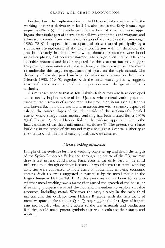
Further down the Euphrates River at Tell Habuba Kabira, evidence for theworking of copper derives from level 14, also late in the Early Bronze Agesequence (Phase 5). This evidence is in the form of a cache of raw copperingots, the tubular part of a terra-cotta bellows, copper tools and weapons, anda limestone mould from which various types of axes were cast (Strommenger1980: 78–9). It appears in a occupational phase marked principally by asignificant strengthening of the city’s fortification wall. Furthermore, thearea immediately inside the wall, where domestic structures were foundin earlier phases, had been transformed into a large open terrace. The con-siderable resources and labour required for this construction may suggestthe growing pre-eminence of some authority at the site who had the meansto undertake this large reorganization of space on the high mound. Thediscovery of circular paved surfaces and other installations on the terrace(Heusch 1980: 176–5), together with the metal working items, suggeststhat craft activities developed in conjunction with the growth of thisauthority.
A similar situation to that at Tell Habuba Kabira may also have developedat the nearby Euphrates site of Tell Qannas, where metal working is indi-cated by the discovery of a stone mould for producing items such as daggersand knives. Such a mould was found in association with a massive deposit ofash on the eastern slopes of the tell outside of the settlement’s fortifiedcentre, where a large multi-roomed building had been located (Finet 1979:83–6, Figure 12). As at Habuba Kabira, the evidence appears to date to thefinal centuries of the third millennium bc (Phase 5). The presence of a largebuilding in the centre of the mound may also suggest a central authority atthe site, to which the metalworking facilities were attached.
Metal working discussion
In light of the evidence for metal working activities up and down the lengthof the Syrian Euphrates Valley and through the course of the EB, we maydraw a few general conclusions. First, even in the early part of the thirdmillennium, although evidence is scanty, it would seem that metal workingactivities were connected to individuals or households enjoying economicsuccess. Such a view is suggested in particular by the metal mould in thelargest house at Halawa Tell B. At this point we cannot know for certainwhether metal working was a factor that caused the growth of the house, orif existing prosperity enabled the household members to exploit valuableresources, including metal. Whatever the case, already in the early thirdmillennium, this evidence from Halawa B, along with the rich cache ofmetal weapons in the tomb at Qara Quzaq, suggest the first signs of impor-tant individuals, who, having access to the raw materials and productionfacilities, could make potent symbols that would enhance their status andwealth.
C R A F T S A N D C R A F T P R O D U C T I O N
174
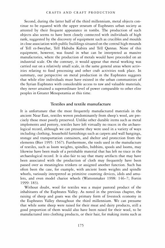
Second, during the latter half of the third millennium, metal objects con-tinue to be equated with the upper stratum of Euphrates urban society asattested by their frequent appearance in tombs. The production of suchobjects also seems to have been closely connected with individuals of highrank, suggested by the discovery of equipment such as crucibles and mouldsin close association with public buildings situated on the central high moundsof Tell es-Sweyhat, Tell Habuba Kabira and Tell Qannas. None of thisequipment, however, was found in what can be interpreted as massivemanufactories, where the production of metals would have proceeded on anindustrial scale. On the contrary, it would appear that metal working wascarried out on a relatively small scale, in the same general areas where activ-ities relating to food processing and other craft activities took place. Insummary, our perspective on metal production in the Euphrates suggeststhat while elite individuals must have existed in the urban communities ofthe Syrian Euphrates with considerable access to raw and valuable materials,they never attained a superordinate level of power comparable to other elitepeoples in Greater Mesopotamia at this time.
Textiles and textile manufacture
It is unfortunate that the most frequently manufactured materials in theancient Near East, textiles woven predominantly from sheep’s wool, are pre-cisely those most poorly preserved. Unlike other durable items such as metalimplements and pottery, textiles have left virtually no traces in the archaeo-logical record, although we can presume they were used in a variety of waysincluding clothing, household furnishings such as carpets and wall hangings,storage and transportation containers, and shelter and protection from theelements (Bier 1995: 1567). Furthermore, the tools used in the manufactureof textiles, such as loom weights, spindles, bobbins, spools and looms, maylikewise have been made of a perishable material that has left no trace in thearchaeological record. It is also fair to say that many artifacts that may havebeen associated with the production of cloth may frequently have beenpassed over as meaningless trinkets or assigned another function. Such hasoften been the case, for example, with ancient loom weights and spindlewhorls, variously interpreted as primitive counting devices, idols and amu-lets, and even model chariot wheels (Wattenmaker 1998: 146–7; Fortin1999: 183).
Without doubt, wool for textiles was a major pastoral product of theinhabitants of the Euphrates Valley. As noted in the previous chapter, theraising of sheep and goats was the primary form of livestock economy inthe Euphrates Valley throughout the third millennium. We can presumethat while some sheep were raised for their meat and dairy products, still agood proportion of them would also have been raised for their wool, to bemanufactured into clothing products, or their hair, for making items such as
C R A F T S A N D C R A F T P R O D U C T I O N
175
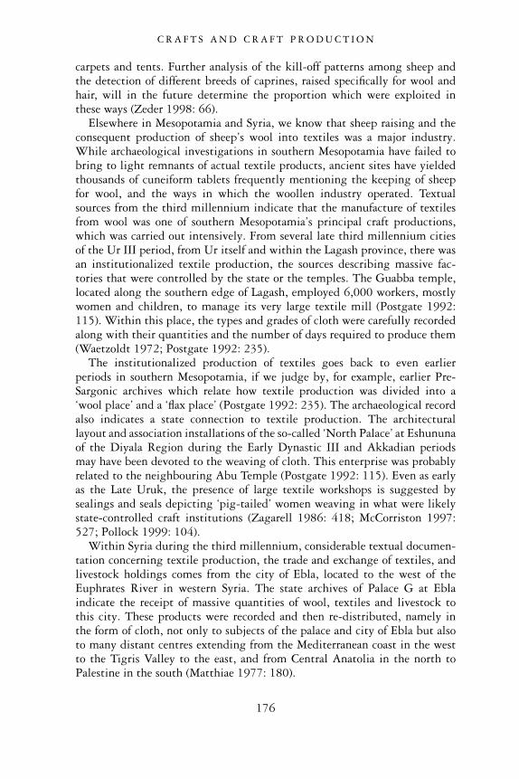
carpets and tents. Further analysis of the kill-off patterns among sheep andthe detection of different breeds of caprines, raised specifically for wool andhair, will in the future determine the proportion which were exploited inthese ways (Zeder 1998: 66).
Elsewhere in Mesopotamia and Syria, we know that sheep raising and theconsequent production of sheep’s wool into textiles was a major industry.While archaeological investigations in southern Mesopotamia have failed tobring to light remnants of actual textile products, ancient sites have yieldedthousands of cuneiform tablets frequently mentioning the keeping of sheepfor wool, and the ways in which the woollen industry operated. Textualsources from the third millennium indicate that the manufacture of textilesfrom wool was one of southern Mesopotamia’s principal craft productions,which was carried out intensively. From several late third millennium citiesof the Ur III period, from Ur itself and within the Lagash province, there wasan institutionalized textile production, the sources describing massive fac-tories that were controlled by the state or the temples. The Guabba temple,located along the southern edge of Lagash, employed 6,000 workers, mostlywomen and children, to manage its very large textile mill (Postgate 1992:115). Within this place, the types and grades of cloth were carefully recordedalong with their quantities and the number of days required to produce them(Waetzoldt 1972; Postgate 1992: 235).
The institutionalized production of textiles goes back to even earlierperiods in southern Mesopotamia, if we judge by, for example, earlier Pre-Sargonic archives which relate how textile production was divided into a‘wool place’ and a ‘flax place’ (Postgate 1992: 235). The archaeological recordalso indicates a state connection to textile production. The architecturallayout and association installations of the so-called ‘North Palace’ at Eshununaof the Diyala Region during the Early Dynastic III and Akkadian periodsmay have been devoted to the weaving of cloth. This enterprise was probablyrelated to the neighbouring Abu Temple (Postgate 1992: 115). Even as earlyas the Late Uruk, the presence of large textile workshops is suggested bysealings and seals depicting ‘pig-tailed’ women weaving in what were likelystate-controlled craft institutions (Zagarell 1986: 418; McCorriston 1997:527; Pollock 1999: 104).
Within Syria during the third millennium, considerable textual documen-tation concerning textile production, the trade and exchange of textiles, andlivestock holdings comes from the city of Ebla, located to the west of theEuphrates River in western Syria. The state archives of Palace G at Eblaindicate the receipt of massive quantities of wool, textiles and livestock tothis city. These products were recorded and then re-distributed, namely inthe form of cloth, not only to subjects of the palace and city of Ebla but alsoto many distant centres extending from the Mediterranean coast in the westto the Tigris Valley to the east, and from Central Anatolia in the north toPalestine in the south (Matthiae 1977: 180).
C R A F T S A N D C R A F T P R O D U C T I O N
176
At Ebla, textual sources enumerating the palace’s ownership of sheep,which numbered in the thousands (Archi 1992: 27), certainly indicate theruling authority’s economic interests in the woollen industry. Such interestsare further underlined by the fact that extant records show all consignmentsof textiles to the city were made specifically to the palace, and that it was theEbla palace that saw to these products’ redistribution. We also know fromthe texts that much of the manufacturing of wool into textiles was carriedout under the auspices of the palace. Such activity is attested by the numer-ous individuals, particularly female personnel who were issued rations ofwool and food in return for their spinning and weaving work (Biga 1988;Archi 1992: 25; Milano 1995: 1225).
Syrian Euphrates textile production
To reconstruct the organization of textile production in the Syrian Euphratesis a complicated task. Unlike Ebla and Mesopotamia, we do not have textualsources to help us to ascertain where and under whom production took place,nor where the bulk of manufactured items was conveyed. Clearly importantto our understanding of textile production is knowledge concerning whetherthe products of wool and hair were destined primarily for local consumption,or if a portion of these products was saved for exchange with other com-munities within the river valley and beyond. Given that sheep and goatswere a primary staple of the Euphrates productive economy, we can surmisethat these animals and their products were part of wider exchanges in thethird millennium bc. At some point in time, it is likely that pastoral pro-ducts were sent as tribute to the distant centres of Ebla and Mari, which,according to textual sources, held political sway over the Syrian Euphratesand exacted tribute from the client kingdoms in this region. In spite of thesewider exchanges, however, the precise form that such pastoral products took,either the animals themselves, wool and hair shorn from the animals, ortextiles manufactured from these raw materials, is far from clear. One canonly turn to the archaeological record for any clues about the nature of thesepolitical and economic relationships.
To date, only a few archaeological discoveries in the Syrian Euphrates haveelicited any clear evidence for the manufacture of textiles and associatedworkshops. In Level 7 at the site of Tell Habuba Kabira around the mid-third millennium, plastered basins and work platforms were excavated inclose proximity to what appear to be lumps of yellow or red colour pigments.This evidence might point to the production and dyeing of textiles (Heusch1980: 168; Strommenger 1980: 71). Such materials and installations werefound in association with the manufacture of jewellery, suggesting thepresence of a multi-craft zone of activity. Nonetheless, both manufacturingactivities appear to have taken place in a household context, which served asthe residence for a moderately-sized family.
C R A F T S A N D C R A F T P R O D U C T I O N
177
At the site of Jerablus Tahtani, in a phase after the defensive rampart wasadded in the late third millennium bc (Phase 4), it is reported that one roomof the fort yielded as many as 42 terra-cotta bobbins suggestive of textileworking (Peltenburg et al. 1997: 7). As at Tell Habuba Kabira, this activityappears to been carried out in areas where other domestic activities, suchas cooking and food storage, took place. Such evidence implies that theproduction of the textiles was a household-level industry (Peltenburg1999a: 101).
Further evidence for textile production was obtained from the site of Telles-Sweyhat, in a large multi-roomed house in the northwestern sector ofthe lower town dated to the end of the third millennium bc (Phase 5). On theone hand, pierced clay disks, probably spindle whorls, were found on the floorsof some rooms, indicating that such spaces may have been used for cloth-making activities (Holland and Zettler 1994: 139; Zettler 1997b: 39, 42).On the other hand, the presence of cooking hearths, a bread oven, as well aspebble-lined pits and a press, suggest a multi-functional use for this building(Zettler 1997b: 39, 42). The excavators are confident in interpreting thebuilding not as the locale of a specialized occupation, but rather a large house(Zettler 1997b: 42).
Last, the site of Tell Banat also provides evidence testifying to themanufacture of textiles. As many as 50 circular wheels, possibly identified asspindle whorls, were recovered from contexts in and around the buildingsand kiln dumps of Area D, where pottery was also being produced. Thepresence of such spindle whorls, along with the existence of post-holes foundin many parts of the complex, which may be the remnants of looms, suggestthat textile manufacture was another important craft activity carried out inthis particular sector of the city (Porter and McClellan 1998: 16, 20, pl. 6d;Porter 2002b: 158).
Textile manufacture discussion
The combined evidence for the manufacturing of textiles at the Early BronzeEuphrates sites points to a different level of production from that of metalworking. Unlike the former craft activity, which seems to have had a connec-tion with an elite class, most of the evidence indicates that the spinning,weaving and dyeing of cloth took place principally in household contextsalongside other domestic activities. So far, it is only at Tell Banat that themaking of textiles seems to have occurred together with other craft activities,namely pottery production, in a larger, specialized workshop. The higherfrequency of craft-related tools and working surfaces as opposed todomestic artifacts does not suggest a typical household function for this area.The situation at Tell Banat, however, is unusual given its principal role as amassive mortuary centre rather than the residence of a large living com-munity. Thus all evidence from Tell Banat, including materials relating
C R A F T S A N D C R A F T P R O D U C T I O N
178
to craft production such as textile weaving, must be considered in light ofthe site’s special function. This site and its extraordinary facilities will beexplored further in the context of our discussions of pottery production andfunerary practices.
The majority of our evidence of textiles, therefore, points to householdmanufacture. Even if this was so, it does not mean that such products weredestined merely for the individuals in whose houses manufacture took place.Textile products may have been exchanged commercially within the widercommunity and beyond. If exchanged in this way, they may have providedan additional means of income for households with access to the resourcesand specialization for such endeavours. This notion finds some support intextual evidence from the Old Assyrian city of Assur in Mesopotamia,around 2000 bc, in which textiles appear to have been largely a home-basedproduction used to meet a commercial demand (Veenhof 1977: 114–15;Postgate 1992: 235). Alternatively, consignments of textiles may have beenproduced in households but destined as a form of tax and tribute paid to ahigher local or regional authority.
Whatever the final destination of these products, it is fair to say that theorganization of textile production did not occur within the same context andthe grand scale as is attested in southern Mesopotamia and Ebla. To date, wefind no evidence of large nucleated workshop areas where sheep wool andgoat’s hair were collected, processed, washed, spun and woven into textiles.We do not discern a connection between such activities and a higher, govern-ing authority administering the industry. While temple complexes and a fewpublic buildings have been identified within the Syrian Euphrates, so farnone of these places has yielded any compelling evidence linking them toany kind of textile industry. Such observations are significant since theyunderline the altogether different systems of political and economic organi-zation that distinguish the Euphrates riverine urban communities fromother contemporaneous ‘state’ societies of Greater Mesopotamia.
Stone and shell jewellery and jewellery manufacture
Jewellery does not constitute a significant part of the archaeological evidenceof most third millennium bc contexts, except for Early Bronze Age burials,where it occurs with considerable regularity. Jewellery is especially frequentin the larger tombs of prominent individuals and may include adornmentsfashioned from precious metals, such as silver and gold. In smaller, less opu-lent tombs, other pieces are often present in more modest quantities (e.g.Van Loon 2001: 11.487–94). These pieces usually comprise items such asbeads, amulets and pendants carved from a variety of semi-precious or locallyavailable stone, and shell.
Jewellery manufacture in the Euphrates Valley is not well attested exceptat the site of Habuba Kabira, where the manufacture of beads from a variety
C R A F T S A N D C R A F T P R O D U C T I O N
179
of stone materials has been reported. The evidence for jewellery working firstappears in level 5 of the EB occupation (Phase 3), in the southeastern cornerof the tell in a room of a house located near the outer fortification wall(Strommenger 1980: 71). Tools were found within the room, such as flintand obsidian borers and polishing stones, as well as the products themselves,consisting of both half-finished and finished beads. The raw materials formaking the beads included red and white limestone, alabaster and shell(Heusch 1980: 164). This jewellery manufactory continued in existence intoboth levels 6 and 7, despite alterations in the layout and size of the buildingand the room in which it was situated (Heusch 1980: 166–8). In addition tothis craft industry, other activities appear to have been carried out in thesame general locale, such as cooking and storage, suggesting that this was asmall household (Pfälzner 2001: 370).
We can suggest that many of these beads and amulets were locally distrib-uted, and may eventually have ended up in burial contexts, interred with thedeceased individuals who owned them. Confirming this supposition aregraves to the south of Tell Habuba Kabira, which have yielded the samelocally produced beads and amulets as well as copper pins and other objects(Strommenger 1980: 70).
Pottery and pottery production
Pottery constitutes the most common and abundant class of artifacts in thearchaeological record of the Euphrates Valley of Syria of the third millen-nium bc. Since very many pieces have been found in virtually every placewhere excavation work and surface reconnaissance of ancient tells have beencarried out, we will not attempt to describe all the contexts in which potteryhas been recovered. Most types of ceramic vessels were available to theinhabitants of these settlements throughout the course of the Early BronzeAge, the pots having been used for a variety of functions relating principallyto the transport, storage, serving and cooking of various solid and liquidmaterials in everyday life. Pottery vessels were also linked to funerary activ-ities, placed within the tombs of deceased individuals, where they functionedas receptacles of food and drink either to be consumed by the deceased in theafterlife or to placate spirits of the underworld. Tomb vessels also representthe utensils of a mortuary feast held in honour of the deceased (Peltenburgin press a).
In contrast to common pottery, it is difficult to pinpoint vessel types thatmight be construed as ‘elite wares’ with a possible circumscribed distribu-tion in contexts associated with individuals having access to exceptionalwealth, status or power within Euphrates EB society. There are vessel typesclassified as fine wares because of their well-finished appearance and highlyfired state. These wares, however, are accounted for in a variety of contextsthat appear to cross-cut social-economic boundaries. The largest quantities of
C R A F T S A N D C R A F T P R O D U C T I O N
180
mid-to-late fine ware vessels, particularly those classified as Orange or GreySpiral Burnished Wares or Euphrates Banded Wares, have been reported intomb contexts. These vessels are found in a wide variety of burial types andsizes and their association with both poor and valuable grave goods preventsan unequivocal connection to an elite stratum in Euphrates society.
Recent studies of the uses and significance of pottery around the world,including the Near East, emphasize not only what the decoration andshape of pottery vessels may tell us about the people using these objects, butalso what can be gleaned from understanding how the vessels were made(Schneider 1989; Blackman et al. 1993; Greenberg and Porat 1996; Goren1996; Vandiver 2003; Boileau 2005). Knowledge of the various stagesinvolved in the production of pottery vessels and the type of facilities wherepottery was produced may shed valuable light on important social, economicor political systems within the ancient society. Thus, for example, the con-text, scale and intensity of vessel production may show the degree to whichspecialization was sponsored or controlled by a centralized institution orelite class (Costin 1991: 5). Similarly, the identification of the provenance ofraw materials for pottery manufacture may indicate possible exchange rela-tionships among contemporary communities and shed light on the natureand degree of economic complexity within a society during a given periodof time.
Despite the recent frequent studies of pottery mentioned above, EB pot-tery from the Euphrates Valley of Syria has rarely been the subject of specificinvestigation. Our understanding of the organization of ceramic productionand its connection to the overall economic, social and political dynamics ofthe Euphrates communities remains quite incomplete. Nevertheless, througha general scrutiny of EB vessels and the types and locations of the facilities inwhich they were manufactured, we hope to make some general observationsabout ceramic production and its place in Euphrates’ urban society. Furtherfine-grained studies will add to our knowledge in the future.
Fine and plain simple ware production
Our first observation about EB Syrian Euphrates pottery is that both Fineand Plain Simple Ware vessels are of relatively good quality. Throughouttheir development in the EB, most pots were symmetrically shaped andeven-walled, well fired in the kiln. Many EB Fine Ware vessels possess thinwalls and relatively fine fabrics. The clays of the vessels are invariably charac-terized by mineral inclusions, these either occurring naturally in the claymatrices or deliberately added as temper.
Further analytical techniques are required to determine the ways anddegrees to which these vessels were worked on the potter’s wheel or tour-nette. While most vessels exhibit fairly regularly spaced concentric grooves,rilling, or striations, we now know that such markings are not necessarily
C R A F T S A N D C R A F T P R O D U C T I O N
181
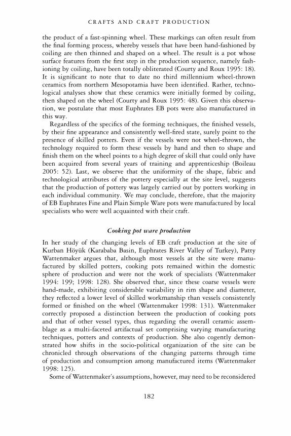
the product of a fast-spinning wheel. These markings can often result fromthe final forming process, whereby vessels that have been hand-fashioned bycoiling are then thinned and shaped on a wheel. The result is a pot whosesurface features from the first step in the production sequence, namely fash-ioning by coiling, have been totally obliterated (Courty and Roux 1995: 18).It is significant to note that to date no third millennium wheel-thrownceramics from northern Mesopotamia have been identified. Rather, techno-logical analyses show that these ceramics were initially formed by coiling,then shaped on the wheel (Courty and Roux 1995: 48). Given this observa-tion, we postulate that most Euphrates EB pots were also manufactured inthis way.
Regardless of the specifics of the forming techniques, the finished vessels,by their fine appearance and consistently well-fired state, surely point to thepresence of skilled potters. Even if the vessels were not wheel-thrown, thetechnology required to form these vessels by hand and then to shape andfinish them on the wheel points to a high degree of skill that could only havebeen acquired from several years of training and apprenticeship (Boileau2005: 52). Last, we observe that the uniformity of the shape, fabric andtechnological attributes of the pottery especially at the site level, suggeststhat the production of pottery was largely carried out by potters working ineach individual community. We may conclude, therefore, that the majorityof EB Euphrates Fine and Plain Simple Ware pots were manufactured by localspecialists who were well acquainted with their craft.
Cooking pot ware production
In her study of the changing levels of EB craft production at the site ofKurban Höyük (Karababa Basin, Euphrates River Valley of Turkey), PattyWattenmaker argues that, although most vessels at the site were manu-factured by skilled potters, cooking pots remained within the domesticsphere of production and were not the work of specialists (Wattenmaker1994: 199; 1998: 128). She observed that, since these coarse vessels werehand-made, exhibiting considerable variability in rim shape and diameter,they reflected a lower level of skilled workmanship than vessels consistentlyformed or finished on the wheel (Wattenmaker 1998: 131). Wattenmakercorrectly proposed a distinction between the production of cooking potsand that of other vessel types, thus regarding the overall ceramic assem-blage as a multi-faceted artifactual set comprising varying manufacturingtechniques, potters and contexts of production. She also cogently demon-strated how shifts in the socio-political organization of the site can bechronicled through observations of the changing patterns through timeof production and consumption among manufactured items (Wattenmaker1998: 125).
Some of Wattenmaker’s assumptions, however, may need to be reconsidered
C R A F T S A N D C R A F T P R O D U C T I O N
182
especially vis-à-vis cooking pots and the level of skill required for their pro-duction. Elsewhere in northern Mesopotamia it has been shown that somecooking pots, while made by hand, often share many technological andmorphological characteristics, suggesting that they too may have been theproduct of specialist potters. In the Khabur Valley of northeastern Syria, forexample, M.-C. Boileau has shown that two types of cooking pots characterizethe EB assemblages of Tell �Atij and Tell Gudeda. Both cooking pot types weremanufactured by hand, although one of the types was technologically superiorand performed well over fire. Vessels of this type were uniformly temperedwith crushed basalt and showed high techno-morphological homogeneity(Boileau 2005: 46). It is significant that these vessels were made of non-localraw materials, indicating that they were imported to the site. Boileau sug-gests that these cooking pots were the product of specialists, aware of theproperties required to produce efficient utensils that would be durable andable to withstand intense sources of heat. These specialists, it appears, wereso skilled that their products became highly valued and sought after byconsumers in distant settlements (Boileau 2005: 54).
A general survey of Cooking Ware pots from many sites of the mid-to-lateEB periods (Phases 3–5) in the Syrian Euphrates shows that they exhibitconsistently similar traits. In terms of overall appearance, although the potsexhibit some metric variability, there is a remarkable uniformity in theshapes produced (Figure 8.4). Invariably the vessels comprise globular bodies,restricted necks and everted rims, with triangular lug-handles extendingfrom the rim. The outer and the inner rim surfaces are usually horizontallyburnished by hand. Although the present data are incomplete, it wouldappear that most cooking pots were tempered with calcite, a mineral inclu-sion well-known for its thermodynamic suitability (Rye 1976). All thesefactors suggest that EB Euphrates cooking pots, like those from the Khabur,were the product of specialist potters, possibly working from a few house-holds, workshops or a community whose location has yet to be identified. Inlight of these observations, it would be difficult to draw conclusions aboutthe changing socio-political organization of EB society based on shiftingproportions of specialist versus non-specialist wares according to the methodemployed by Wattenmaker, since the latter wares have been shown to belargely under-represented in the EB Euphrates assemblages.
Ceramic production locales in the Syrian Euphrates
While evidence for the location of the production of pottery is sadly lackingin other parts of Syria during the Early Bronze Age, sites along the EuphratesRiver have yielded some remains that testify to this activity. From this evi-dence it is possible to make a few additional remarks, both about the natureof craft specialization within the EB communities and about the settlements’socio-political and economic complexity. The following archaeological data
C R A F T S A N D C R A F T P R O D U C T I O N
183

derives from the sites of Tell Habuba Kabira, Halawa Tell A and Telles-Sweyhat.
At the site of Tell Habuba Kabira, where early Early Bronze Age occupation(Phases 1–2) was exposed in the southeastern corner of the excavated tell, asmall room within a house may have been the locale of pottery manufacture
Figure 8.4 Phases 3–5 cooking pots.
C R A F T S A N D C R A F T P R O D U C T I O N
184
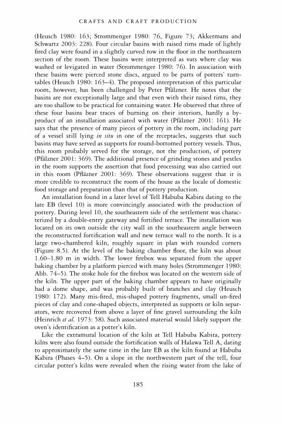
(Heusch 1980: 163; Strommenger 1980: 76, Figure 73; Akkermans andSchwartz 2003: 228). Four circular basins with raised rims made of lightlyfired clay were found in a slightly curved row in the floor in the northeasternsection of the room. These basins were interpreted as vats where clay waswashed or levigated in water (Strommenger 1980: 76). In association withthese basins were pierced stone discs, argued to be parts of potters’ turn-tables (Heusch 1980: 163–4). The proposed interpretation of this particularroom, however, has been challenged by Peter Pfälzner. He notes that thebasins are not exceptionally large and that even with their raised rims, theyare too shallow to be practical for containing water. He observed that three ofthese four basins bear traces of burning on their interiors, hardly a by-product of an installation associated with water (Pfälzner 2001: 161). Hesays that the presence of many pieces of pottery in the room, including partof a vessel still lying in situ in one of the receptacles, suggests that suchbasins may have served as supports for round-bottomed pottery vessels. Thus,this room probably served for the storage, not the production, of pottery(Pfälzner 2001: 369). The additional presence of grinding stones and pestlesin the room supports the assertion that food processing was also carried outin this room (Pfläzner 2001: 369). These observations suggest that it ismore credible to reconstruct the room of the house as the locale of domesticfood storage and preparation than that of pottery production.
An installation found in a later level of Tell Habuba Kabira dating to thelate EB (level 10) is more convincingly associated with the production ofpottery. During level 10, the southeastern side of the settlement was charac-terized by a double-entry gateway and fortified terrace. The installation waslocated on its own outside the city wall in the southeastern angle betweenthe reconstructed fortification wall and new terrace wall to the north. It is alarge two-chambered kiln, roughly square in plan with rounded corners(Figure 8.5). At the level of the baking chamber floor, the kiln was about1.60–1.80 m in width. The lower firebox was separated from the upperbaking chamber by a platform pierced with many holes (Strommenger 1980:Abb. 74–5). The stoke hole for the firebox was located on the western side ofthe kiln. The upper part of the baking chamber appears to have originallyhad a dome shape, and was probably built of branches and clay (Heusch1980: 172). Many mis-fired, mis-shaped pottery fragments, small un-firedpieces of clay and cone-shaped objects, interpreted as supports or kiln separ-ators, were recovered from above a layer of fine gravel surrounding the kiln(Heinrich et al. 1973: 58). Such associated material would likely support theoven’s identification as a potter’s kiln.
Like the extramural location of the kiln at Tell Habuba Kabira, potterykilns were also found outside the fortification walls of Halawa Tell A, datingto approximately the same time in the late EB as the kiln found at HabubaKabira (Phases 4–5). On a slope in the northwestern part of the tell, fourcircular potter’s kilns were revealed when the rising water from the lake of
C R A F T S A N D C R A F T P R O D U C T I O N
185
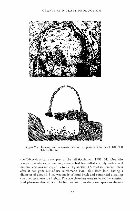
the Tabqa dam cut away part of the tell (Orthmann 1981: 61). One kilnwas particularly well-preserved, since it had been filled entirely with gravelmaterial and was subsequently topped by another 1.5 m of settlement debrisafter it had gone out of use (Orthmann 1981: 61). Each kiln, having adiameter of about 1.5 m, was made of mud brick and comprised a bakingchamber set above the firebox. The two chambers were separated by a perfor-ated platform that allowed the heat to rise from the lower space to the one
Figure 8.5 Drawing and schematic section of potter’s kiln (level 10), TellHabuba Kabira.
C R A F T S A N D C R A F T P R O D U C T I O N
186
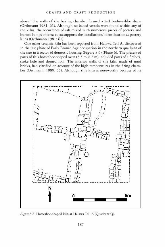
above. The walls of the baking chamber formed a tall beehive-like shape(Orthmann 1981: 61). Although no baked vessels were found within any ofthe kilns, the occurrence of ash mixed with numerous pieces of pottery andburned lumps of terra-cotta supports the installations’ identification as potterykilns (Orthmann 1981: 61).
One other ceramic kiln has been reported from Halawa Tell A, discoveredin the last phase of Early Bronze Age occupation in the northern quadrant ofthe site in a sector of domestic housing (Figure 8.6) (Phase 6). The preservedparts of this horseshoe-shaped oven (3.5 m × 2 m) included parts of a firebox,stoke hole and domed roof. The interior walls of the kiln, made of mudbricks, had vitrified on account of the high temperatures in the firing cham-ber (Orthmann 1989: 55). Although this kiln is noteworthy because of its
Figure 8.6 Horseshoe-shaped kiln at Halawa Tell A (Quadrant Q).
C R A F T S A N D C R A F T P R O D U C T I O N
187
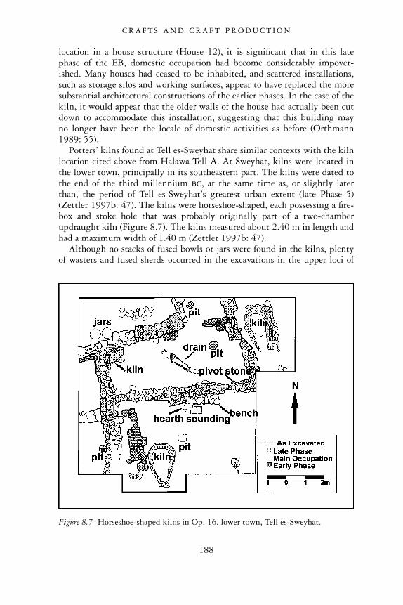
location in a house structure (House 12), it is significant that in this latephase of the EB, domestic occupation had become considerably impover-ished. Many houses had ceased to be inhabited, and scattered installations,such as storage silos and working surfaces, appear to have replaced the moresubstantial architectural constructions of the earlier phases. In the case of thekiln, it would appear that the older walls of the house had actually been cutdown to accommodate this installation, suggesting that this building mayno longer have been the locale of domestic activities as before (Orthmann1989: 55).
Potters’ kilns found at Tell es-Sweyhat share similar contexts with the kilnlocation cited above from Halawa Tell A. At Sweyhat, kilns were located inthe lower town, principally in its southeastern part. The kilns were dated tothe end of the third millennium bc, at the same time as, or slightly laterthan, the period of Tell es-Sweyhat’s greatest urban extent (late Phase 5)(Zettler 1997b: 47). The kilns were horseshoe-shaped, each possessing a fire-box and stoke hole that was probably originally part of a two-chamberupdraught kiln (Figure 8.7). The kilns measured about 2.40 m in length andhad a maximum width of 1.40 m (Zettler 1997b: 47).
Although no stacks of fused bowls or jars were found in the kilns, plentyof wasters and fused sherds occurred in the excavations in the upper loci of
Figure 8.7 Horseshoe-shaped kilns in Op. 16, lower town, Tell es-Sweyhat.
C R A F T S A N D C R A F T P R O D U C T I O N
188
the operation in the same stratigraphic position as the kilns, leaving nodoubt that these ovens had been used for the firing of pottery (Zettler et al.1996: 25; Zettler 1997b: 47).
Immediately to the southeast of the area where the horseshoe-shaped kilnswere unearthed a circular kiln was excavated (Op. 23: Zettler 1997b: 47).The kiln, with a diameter of 2.5 m, does not appear to have been associatedwith any standing architecture. It was simply surrounded by stones whichmay have served as a kind of wind-shelter. The kiln was set in a bowl-shapeddepression that had cut through earlier occupational debris and into virginsoil. It is likely that the kiln was a two-chamber updraught kiln. Althoughthe floor between the firebox and baking chamber had not been preserved,traces of vents that had pierced the floor to allow heat into the upper cham-ber were found around the circumference of the firebox (Zettler 1997b: 48).Also found was a stoke hole on the kiln’s southeastern side, while a semi-circular protrusion in the wall of the firebox may represent the remnants ofa chimney (Zettler 1997b: 47–8). In size and form, this kiln comparesfavourably with those discovered outside the fortification walls at HalawaTell A and Habuba Kabira (Heinrich et al. 1973: 56–8; Orthmann 1981:61–2; Zettler 1997b: 47).
The strong magnetic signatures of the kilns at Tell es-Sweyhat were firstdetected while geomagnetic mapping was being performed in the lowertown of the site (Peregrine et al. 1997: App. 4.1a, d). Their clustering in thisone particular sector of the lower town suggests that this was an area spe-cially designated for pottery production. At the same time, geomagneticmapping in the area of the kilns to the east of the main mound detectedtraces of many room blocks, suggesting that at one time this area had been arather densely built-up sector of the city (Peregrine et al. 1997: 78). Withthis information, one might posit that the kilns were located in areas ofinhabited domestic units. As with Halawa Tell A, however, the archaeo-logical evidence from the excavations in the lower town at Sweyhat revealsthat in order to accommodate the kilns, the remnants of older houses’ wallswere cut away, or else their remnants were used as additional supports for thekiln structures (Zettler 1997b: 47). This implies that the kilns came into useonly after the houses had ceased to function as inhabited domestic structures.In sum, rather than envisioning a densely settled urban neighbourhood withhousing and production facilities existing side by side in this late phase ofthe EB, we should consider the possibility that this sector had now becomean open area where only activities of an industrial nature were carried out.
The combined evidence of kilns from Tell Habuba Kabira, Halawa Tell Aand Tell es-Sweyhat confirm that pottery was being manufactured at the localsettlement level during the Early Bronze Age. This evidence, however,contributes only in small part to our understanding of the nature and scale ofpottery production at these sites. If we disregard the presence of potteryproduction in the house from the early levels of Tell Habuba Kabira because
C R A F T S A N D C R A F T P R O D U C T I O N
189
of the equivocal nature of the evidence, we are left with potters’ kilns whosecontexts cannot be unambiguously connected with any identifiable domesticor public structures. The late EB kiln from Tell Habuba Kabira was dis-covered outside of the city walls in the high mound. The group of kilns fromHalawa Tell A, likewise, were found outside of the city walls. Admittedly,some other kilns were encountered in household contexts within Halawa TellA and the lower town of Tell es-Sweyhat, but these seem to have operatedonly after the houses had ceased to be inhabited. On the one hand, it islogical to assume from this evidence that the kilns were constructed in areaswhere the inhabitants of the settlement would not have been bothered by theintense heat and smoke that such installations would have generated. On theother hand, we are still uncertain about the identities of the users of the kilnsand the type and degree of their specialization.
Another suggestion we can make is that potter’s workshops may haveexisted in a special quarter somewhere within the settlements, but that pot-ters chose to fire their vessels in open spaces outside of the city walls or inother disused spaces. In modern societies, ethnographic evidence for pottingreveals that, although potters produced pottery vessels within householdcontexts, kilns were often located outside or on the edge of the settlement.These kilns were owned and used cooperatively among these households(Rice 1987: 156; Roux 2003: 769), just as cooperative baking ovens are usedtoday in many Middle Eastern communities (Pollock 1999: 131). Coopera-tive use of kilns may have extended back as early as the fifth millennium inSyria, where production would have taken place at the household level withseveral households sharing the use and maintenance of the kilns (Akkermansand Schwartz 2003: 171).
Although these observations and also the locations of Euphrates kilnsthemselves do not allow us to define precisely the context of production (i.e.independent versus attached potters), we can probably rule out the notionthat pottery production was a large-scale industry at these sites. If it were,we should probably expect to see production activities occurring in large,spatially segregated spaces where all stages of the manufacturing process,including firing, took place. It seems more likely, given the separationbetween workshop and kiln, that production was carried out on a less inten-sive scale, perhaps by small workshops or households. It might be significantthat some kilns were found in clusters, as outside the walls at Halawa TellA, and in the western lower town of Tell es-Sweyhat. Such a location mayindicate a concentration of production in the hands of a group or guildof manufacturers in the settlements rather than an activity carried out bydifferent individuals in widely dispersed workshops or households. Thereconstruction of pottery production in some kind of nucleated, but stillsmall-scale, workshop is also consistent with the manufactured pottery itself,which comprises well made and relatively uniform vessel types within eachsettlement.
C R A F T S A N D C R A F T P R O D U C T I O N
190
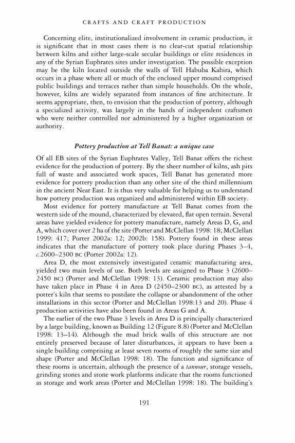
Concerning elite, institutionalized involvement in ceramic production, itis significant that in most cases there is no clear-cut spatial relationshipbetween kilns and either large-scale secular buildings or elite residences inany of the Syrian Euphrates sites under investigation. The possible exceptionmay be the kiln located outside the walls of Tell Habuba Kabira, whichoccurs in a phase where all or much of the enclosed upper mound comprisedpublic buildings and terraces rather than simple households. On the whole,however, kilns are widely separated from instances of fine architecture. Itseems appropriate, then, to envision that the production of pottery, althougha specialized activity, was largely in the hands of independent craftsmenwho were neither controlled nor administered by a higher organization orauthority.
Pottery production at Tell Banat: a unique case
Of all EB sites of the Syrian Euphrates Valley, Tell Banat offers the richestevidence for the production of pottery. By the sheer number of kilns, ash pitsfull of waste and associated work spaces, Tell Banat has generated moreevidence for pottery production than any other site of the third millenniumin the ancient Near East. It is thus very valuable for helping us to understandhow pottery production was organized and administered within EB society.
Most evidence for pottery manufacture at Tell Banat comes from thewestern side of the mound, characterized by elevated, flat open terrain. Severalareas have yielded evidence for pottery manufacture, namely Areas D, G, andA, which cover over 2 ha of the site (Porter and McClellan 1998: 18; McClellan1999: 417; Porter 2002a: 12; 2002b: 158). Pottery found in these areasindicates that the manufacture of pottery took place during Phases 3–4,c.2600–2300 bc (Porter 2002a: 12).
Area D, the most extensively investigated ceramic manufacturing area,yielded two main levels of use. Both levels are assigned to Phase 3 (2600–2450 bc) (Porter and McClellan 1998: 13). Ceramic production may alsohave taken place in Phase 4 in Area D (2450–2300 bc), as attested by apotter’s kiln that seems to postdate the collapse or abandonment of the otherinstallations in this sector (Porter and McClellan 1998:13 and 20). Phase 4production activities have also been found in Areas G and A.
The earlier of the two Phase 3 levels in Area D is principally characterizedby a large building, known as Building 12 (Figure 8.8) (Porter and McClellan1998: 13–14). Although the mud brick walls of this structure are notentirely preserved because of later disturbances, it appears to have been asingle building comprising at least seven rooms of roughly the same size andshape (Porter and McClellan 1998: 18). The function and significance ofthese rooms is uncertain, although the presence of a tannour, storage vessels,grinding stones and stone work platforms indicate that the rooms functionedas storage and work areas (Porter and McClellan 1998: 18). The building’s
C R A F T S A N D C R A F T P R O D U C T I O N
191
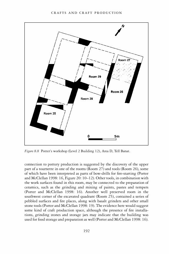
connection to pottery production is suggested by the discovery of the upperpart of a tournette in one of the rooms (Room 27) and tools (Room 26), someof which have been interpreted as parts of bow-drills for fire-starting (Porterand McClellan 1998: 16, Figure 20: 10–12). Other tools, in combination withthe work surfaces found in this room, may be connected to the preparation ofceramics, such as the grinding and mixing of paints, pastes and tempers(Porter and McClellan 1998: 16). Another well preserved room in thesouthwest corner of the excavated quadrant (Room 25), contained a series ofpebbled surfaces and fire places, along with basalt grinders and other smallstone tools (Porter and McClellan 1998: 19). The evidence here would suggestsome kind of craft production space, although the presence of fire installa-tions, grinding stones and storage jars may indicate that the building wasused for food storage and preparation as well (Porter and McClellan 1998: 16).
Figure 8.8 Potter’s workshop (Level 2 Building 12), Area D, Tell Banat.
C R A F T S A N D C R A F T P R O D U C T I O N
192
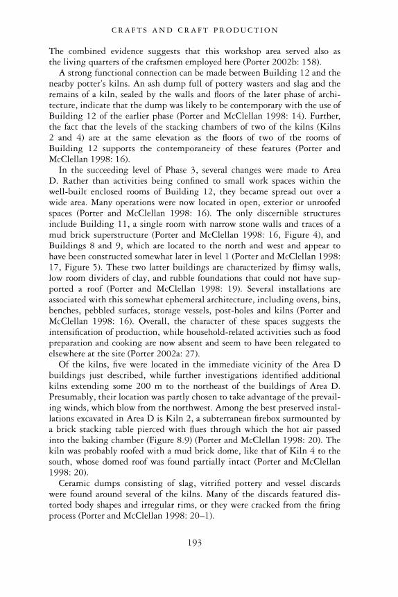
The combined evidence suggests that this workshop area served also asthe living quarters of the craftsmen employed here (Porter 2002b: 158).
A strong functional connection can be made between Building 12 and thenearby potter’s kilns. An ash dump full of pottery wasters and slag and theremains of a kiln, sealed by the walls and floors of the later phase of archi-tecture, indicate that the dump was likely to be contemporary with the use ofBuilding 12 of the earlier phase (Porter and McClellan 1998: 14). Further,the fact that the levels of the stacking chambers of two of the kilns (Kilns2 and 4) are at the same elevation as the floors of two of the rooms ofBuilding 12 supports the contemporaneity of these features (Porter andMcClellan 1998: 16).
In the succeeding level of Phase 3, several changes were made to AreaD. Rather than activities being confined to small work spaces within thewell-built enclosed rooms of Building 12, they became spread out over awide area. Many operations were now located in open, exterior or unroofedspaces (Porter and McClellan 1998: 16). The only discernible structuresinclude Building 11, a single room with narrow stone walls and traces of amud brick superstructure (Porter and McClellan 1998: 16, Figure 4), andBuildings 8 and 9, which are located to the north and west and appear tohave been constructed somewhat later in level 1 (Porter and McClellan 1998:17, Figure 5). These two latter buildings are characterized by flimsy walls,low room dividers of clay, and rubble foundations that could not have sup-ported a roof (Porter and McClellan 1998: 19). Several installations areassociated with this somewhat ephemeral architecture, including ovens, bins,benches, pebbled surfaces, storage vessels, post-holes and kilns (Porter andMcClellan 1998: 16). Overall, the character of these spaces suggests theintensification of production, while household-related activities such as foodpreparation and cooking are now absent and seem to have been relegated toelsewhere at the site (Porter 2002a: 27).
Of the kilns, five were located in the immediate vicinity of the Area Dbuildings just described, while further investigations identified additionalkilns extending some 200 m to the northeast of the buildings of Area D.Presumably, their location was partly chosen to take advantage of the prevail-ing winds, which blow from the northwest. Among the best preserved instal-lations excavated in Area D is Kiln 2, a subterranean firebox surmounted bya brick stacking table pierced with flues through which the hot air passedinto the baking chamber (Figure 8.9) (Porter and McClellan 1998: 20). Thekiln was probably roofed with a mud brick dome, like that of Kiln 4 to thesouth, whose domed roof was found partially intact (Porter and McClellan1998: 20).
Ceramic dumps consisting of slag, vitrified pottery and vessel discardswere found around several of the kilns. Many of the discards featured dis-torted body shapes and irregular rims, or they were cracked from the firingprocess (Porter and McClellan 1998: 20–1).
C R A F T S A N D C R A F T P R O D U C T I O N
193
It is noteworthy that only a few types of vessels of Plain Simple Ware wereobtained from the kiln refuse deposits. The types include deep, round-basedbowls with everted modelled rims, round-based jars with flaring necks andeverted rims, round-based cups with straight or slightly inturned walls,and round jars with narrow necks and two loop handles (Porter 1999: 312and Figure 1). For the most part, these vessel types show uniformity in termsof their overall size, body shape, rim and base features. It was additionallyobserved that the paste and temper of the vessels is fundamentally the samethroughout, with the exception of differences in the colour of the fired ves-sels, which would mainly be attributable to fluctuations in kiln temperaturesduring the firing process and the vessels’ placement in the kiln stackingchamber (Porter and McClellan 1998: 21–3).
A few examples of Cooking Pot Ware were found in Area D, but ratherthan deriving from the kiln dumps, these cooking pots, along with pedestalled
Figure 8.9 Kiln 2, Area D, Tell Banat.
C R A F T S A N D C R A F T P R O D U C T I O N
194
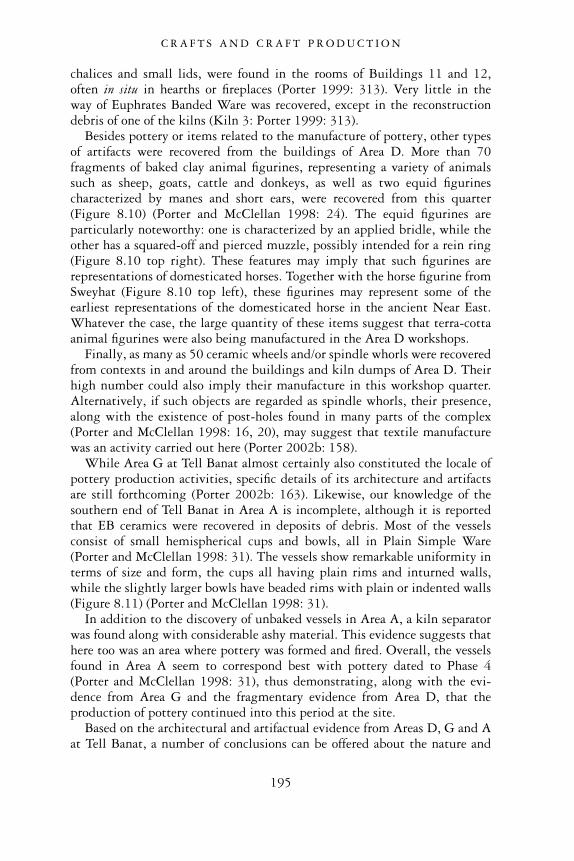
chalices and small lids, were found in the rooms of Buildings 11 and 12,often in situ in hearths or fireplaces (Porter 1999: 313). Very little in theway of Euphrates Banded Ware was recovered, except in the reconstructiondebris of one of the kilns (Kiln 3: Porter 1999: 313).
Besides pottery or items related to the manufacture of pottery, other typesof artifacts were recovered from the buildings of Area D. More than 70fragments of baked clay animal figurines, representing a variety of animalssuch as sheep, goats, cattle and donkeys, as well as two equid figurinescharacterized by manes and short ears, were recovered from this quarter(Figure 8.10) (Porter and McClellan 1998: 24). The equid figurines areparticularly noteworthy: one is characterized by an applied bridle, while theother has a squared-off and pierced muzzle, possibly intended for a rein ring(Figure 8.10 top right). These features may imply that such figurines arerepresentations of domesticated horses. Together with the horse figurine fromSweyhat (Figure 8.10 top left), these figurines may represent some of theearliest representations of the domesticated horse in the ancient Near East.Whatever the case, the large quantity of these items suggest that terra-cottaanimal figurines were also being manufactured in the Area D workshops.
Finally, as many as 50 ceramic wheels and/or spindle whorls were recoveredfrom contexts in and around the buildings and kiln dumps of Area D. Theirhigh number could also imply their manufacture in this workshop quarter.Alternatively, if such objects are regarded as spindle whorls, their presence,along with the existence of post-holes found in many parts of the complex(Porter and McClellan 1998: 16, 20), may suggest that textile manufacturewas an activity carried out here (Porter 2002b: 158).
While Area G at Tell Banat almost certainly also constituted the locale ofpottery production activities, specific details of its architecture and artifactsare still forthcoming (Porter 2002b: 163). Likewise, our knowledge of thesouthern end of Tell Banat in Area A is incomplete, although it is reportedthat EB ceramics were recovered in deposits of debris. Most of the vesselsconsist of small hemispherical cups and bowls, all in Plain Simple Ware(Porter and McClellan 1998: 31). The vessels show remarkable uniformity interms of size and form, the cups all having plain rims and inturned walls,while the slightly larger bowls have beaded rims with plain or indented walls(Figure 8.11) (Porter and McClellan 1998: 31).
In addition to the discovery of unbaked vessels in Area A, a kiln separatorwas found along with considerable ashy material. This evidence suggests thathere too was an area where pottery was formed and fired. Overall, the vesselsfound in Area A seem to correspond best with pottery dated to Phase 4(Porter and McClellan 1998: 31), thus demonstrating, along with the evi-dence from Area G and the fragmentary evidence from Area D, that theproduction of pottery continued into this period at the site.
Based on the architectural and artifactual evidence from Areas D, G and Aat Tell Banat, a number of conclusions can be offered about the nature and
C R A F T S A N D C R A F T P R O D U C T I O N
195
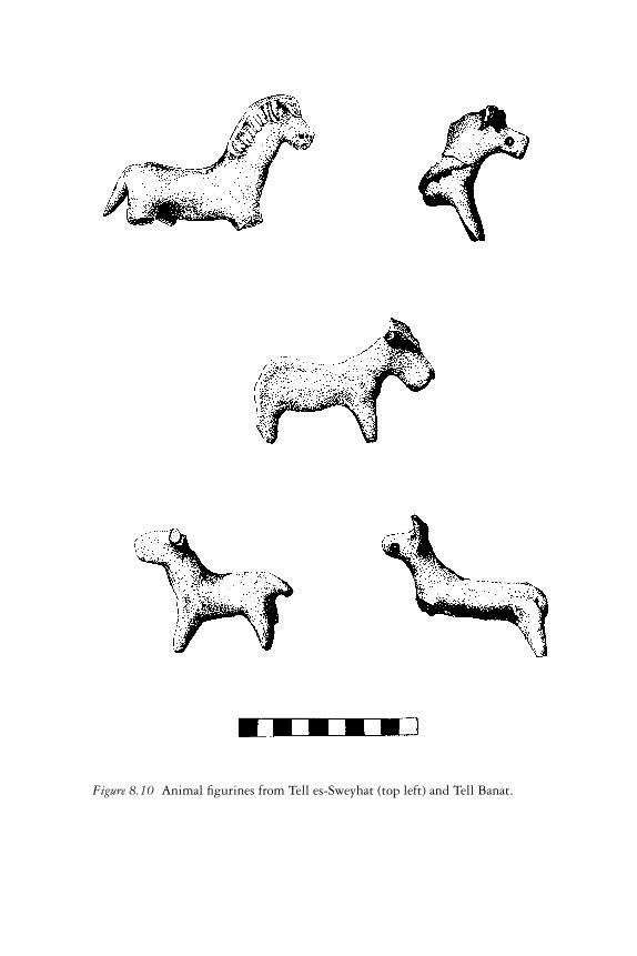
Figure 8.10 Animal figurines from Tell es-Sweyhat (top left) and Tell Banat.
organization of production within these areas. First, the high degree of mor-phological similarity among the vessels found in kiln refuse dumps suggeststhat these pots were the product of specialists, sufficiently accomplished intheir craft to produce uniformly similar products many times over. Wewould argue, therefore, that a relatively high degree of standardization wasattained, although further fine-grained studies of metric variability amongthe vessel types and studies of technological and compositional features of thepots will be necessary to determine the precise level of standardization andintensity of production achieved (Roux 2003). Interestingly, it has beenpersuasively argued elsewhere that third millennium northern Mesopotamianpottery, while often manufactured by specialists, does not reflect especiallyhigh rates of production, raising the possibility that vessels were not manu-factured by full-time potters (Roux 2003: 780). In light of these findings,we suspect that the Tell Banat pottery may have been manufactured in com-parable conditions, the potters either working seasonally or as part-timemanufacturers. The latter proposition seems especially plausible given the
Figure 8.11 Cups from area of pottery production (Area A), Tell Banat.
C R A F T S A N D C R A F T P R O D U C T I O N
197
archaeological evidence for other production activities in Area D at Banat,which include terra-cotta figurines and textile production, implying that thecraftsmen of this manufactory were engaged concurrently in a multiplicity ofactivities.
The restricted number of vessel types found in the kiln dumps aroundBuildings 11 and 12 suggests that these kilns and possibly the workshopsassociated with them were dedicated to the production of specific typeswithin the overall pottery assemblage (Porter and McClellan 1998: 23). Ifthese kilns and workshops produced only specific types of pottery, there mayhave been others at Tell Banat that produced different vessel types. Up untilnow, however, such facilities have not yet been excavated and identified.Given that scores of kilns were likely spread out across the western side of thesite, it seems feasible that most vessels of the Period IV repertoire – includingEuphrates Banded Ware whose presence in Area D is conspicuously low – wereproduced here.
The evidence from Tell Banat, with its massive expanse of kilns, wasterdeposits and workshop facilities, suggests clearly that pottery production wasan important industry at this site during the third millennium bc. Yet weshould probably not see Tell Banat as typical. The reason for this is that TellBanat seems to have been a site with a specific function. In addition topottery production, the remains at the site include many tombs and mortu-ary monuments but little domestic architecture. The site appears to havefunctioned as a massive funerary complex serving the needs of the dead on ascale not yet observed at other EB Euphrates settlements. The large facilitiesfor the manufacture of pottery, therefore, might have been related to itsintended use in funerary rituals and placement in tombs rather than forconsumption by living members of the settlement or its environs.
Did Tell Banat’s pottery production facilities have any attachment toindividuals of importance or a centralized organization of some kind? Ourevidence thus far does not suggest such an observable link. The vessels manu-factured at Tell Banat appear to have been used in all funerary contexts, greatand small. There is no discernible spatial relationship between this produc-tion area and the ‘elite’ structures found at Banat, if we are indeed correct tospeak of such contexts in this way (Porter 2002b: 167–8). The rich Tomb 7is a distance away, as are the ‘public’ Buildings 6 and 7. The excavators ofTell Banat observe some changes in the architecture and nature of craft pro-duction in Area D over time, in which living activities became relegatedelsewhere (Porter 2002a: 27). Such changes could reflect a shift towards amore segmented, possibly increasingly stratified, society (Porter 2002a: 27).Nevertheless, even with such a transformation, it still remains difficult tosee a clear link between production at Tell Banat and the presence of a fewhigh-ranking individuals whose overall structuring of social and economicrelationships among both the living and the dead included their control overand administration of craft activities.
C R A F T S A N D C R A F T P R O D U C T I O N
198
DISCUSSION
When the evidence for craft production is viewed in its entirety, it becomesclear that the manufacture of metal objects, textiles, stone and shell jewelleryand pottery was prevalent among many Syrian Euphrates communities of theEarly Bronze Age. Even though excavations have yielded but a small fractionof the overall architecture and artifacts at these sites, enough work has takenplace to confirm that craft activities were already established as early as thethird millennium bc. By the latter part of the third millennium craft pro-duction is well represented in the material record, taking the form of toolsand equipment used in the production processes, raw materials alongside thefinished products, and sometimes the household spaces or workshop areasin which the manufacturing took place. Objects such as well-crafted metalweapons and tools, finely carved and polished beads and fine thin-walledceramic vessels, indicate that many products were the work of specialistshaving the necessary skills to produce high-quality utilitarian or luxuryitems. Such a level of specialization attests to a high degree of organizationwithin the cities in which such artisans lived and worked. Urban communitieswould have supported these artisans, releasing them from other forms oflabour related to food procurement and processing long enough that theirskills as artisans could be developed, and providing them with the necessitiesof life in exchange for their crafted goods.
Even with this level of specialization, however, the scale of production ofthe crafted goods must not have been exceptionally large or of a high inten-sity. Much of the equipment associated with the manufacture of pottery,jewellery, textiles and metals, for example, was found in association withother facilities, suggesting the use of shared work spaces for a variety ofproduction activities. Even at Tell Banat, where many kilns, and other facil-ities attesting to pottery production were found, it is evident that this wasbut one of many manufacturing activities that artisans undertook within thiscraft quarter. Still other evidence for craft production has been found indomestic quarters, indicating that although some household members weretrained as specialists in their craft, their work nonetheless did not disassociatethem from their family units and domestic activities.
The context within which craft production took place was somewhat var-ied. By the middle of the third millennium, metal working seems to havebeen closely attached to the centres of the urban communities, either appear-ing within or in the vicinity of large public buildings. Metal working seemslargely to have been sponsored by elite individuals, who owned theequipment, resources and artisans necessary to manufacture metal weaponsand other items of personal adornment that enhanced and legitimatedtheir status within society. Evidence for other crafts such as textile spinningand weaving, jewellery manufacture as well as pottery production, however,do not yet appear to have any strong connection with elite contexts. These
C R A F T S A N D C R A F T P R O D U C T I O N
199
crafts have a wider, more dispersed pattern, being located in various house-hold contexts or scattered, isolated areas. We may postulate that althoughelite individuals may have occasionally commissioned the production of finetextiles, stone and shell jewellery and pottery from the artisans working inthese contexts, the majority of items were manufactured to meet therequirements of commoners and were distributed throughout the urbansettlements.
This picture of craft production that emerges for the Syrian Euphrates isvastly different from the kind of ‘elite’ controlled, institutionalized ‘factories’that are attested in southern Mesopotamia and Ebla from the same timeperiod. In these latter places, large land-owning institutions such as templesand palaces controlled and operated vast manufactories where the productionof items such as precious stones, metals and textiles were undertaken at a highlevel of intensity by hundreds and sometimes even thousands of labourers.These workers, comprising many women and children, disassociated fromtheir kin groups, both worked and lived under the auspices of these enormousgoverning institutions, receiving rations of food and clothing in return fortheir skills and labour. The products that they manufactured would have beenconsumed by the elites who were associated with these organizations, or elsethey were destined for state-controlled commercial ventures, to be exchangedfor other fine products and raw materials across vast geographic distances.
Unlike these highly centralized systems, the Syrian Euphrates settlementshave brought to light little evidence for large-scale industries, indicatingthat almost certainly such institutionalized, state-controlled activities didnot exist in this region. These findings have important implications for ourwider understanding of ways in which Euphrates urban communities wereeconomically organized. Based on the available archaeological evidence, it isfair to say that locally crafted products, in general, were not a principal formof revenue during the third millennium. Although craft activities were clearlyundertaken within Euphrates settlements, these activities do not appear tohave generated a substantial surplus of goods used profitably in commercialexchanges on any significant scale.
This situation compels us to look for other forces that may have helped todrive the economy of this region. Profit was likely acquired through theadministration and taxation of both foreign raw materials and crafted prod-ucts flowing through the Euphrates region on their way to other destinationsin the Near East. Although these products may not have been of local originor manufacture, local commercial agents would have been required to overseetheir safe and efficient conveyance through the region to other ports of trade.Revenue, therefore, was generated by those involved in such commercialenterprises. The second source of profit almost certainly came from theEuphrates’ principal and most prized commodity: sheep and goats. Theseanimals were extensively bred and pastured in the steppe lands beyond thevalley and produced vital products in the form of milk, meat and especially
C R A F T S A N D C R A F T P R O D U C T I O N
200

fibres. Although we have seen that the actual production of these lattermaterials into finished textiles may not have been a principal industry, theraw materials themselves in the form of shorn sheep’s wool and goat’s hairwere without question one of the region’s biggest exports and generated avaluable source of revenue for many of the riverine communities.
C R A F T S A N D C R A F T P R O D U C T I O N
201
9
DEATH, FUNERARYMONUMENTS AND ANCESTOR
CULTS
INTRODUCTION: THE ARCHAEOLOGY OFDEATH IN THE EUPHRATES VALLEY
For human beings, death is a momentous, sobering and perplexing event.Death is inevitable, and no amount of coercion, coaxing, or begging of thegods, fate, or the forces of nature, can reverse its inescapable arrival. Thepeople of ancient Mesopotamia were well aware of the certainty of death.Already by the third millennium bc, its sombre presence pervaded Mesopo-tamian literature, finding its way, for example, into the ageless poetry of theGilgamesh Epic, whose hero, lamenting the untimely death of his belovedfriend Enkidu, searches in vain for immortality.
Besides sharing anguish over the certainty of death, humanity universallyis accustomed to treat this weighty event with reverence and ritual behaviour.By assisting the deceased to make the transformation from this life intothe next through a prescribed set of solemn, ceremonial acts, humanbeings assure themselves of the safety and comfort of their departed lovedones. They also give closure and a sense of order to a most disturbing eventin their lives. Death affects not only the person who dies but also thoseleft behind, filling their lives temporarily with confusion, disorder andanxiety.
The inhabitants of the Euphrates Valley in Syria during the Early BronzeAge were strongly affected by death like other Near Eastern societies. Liketheir Sumerian neighbours in southern Mesopotamia, they held similar ideasabout the causes and nature of death, about the gods’ role in this event, andabout what one could expect in the afterlife. The abundance of funeraryartifacts and burials preserved in the archaeological record shows us that theancient people of the Euphrates treated death with appropriate respect andritual behaviour. We observe, for example, the careful way in which theyprepared burials for their dead, and the ritual offerings and gifts which theyplaced within their tombs.
A large quantity of archaeological material has been recovered from theEuphrates Valley which sheds considerable light on northern Syrian funerary
202
practices and the ancient people who developed these customs. The funeraryrecord for the Early Bronze Age of the third millennium is especially rich,comprising a number of burial grounds, funerary monuments, artifacts andother associated mortuary installations.
The discovery of such remains began with the systematic excavations ofEarly Bronze Age sites in the Euphrates River Valley. Early in the twentiethcentury, when Sir Leonard Woolley and his British team excavated thenorthern ancient city of Carchemish, several Early Bronze Age pot and cistgraves were located. These burials were found both at Carchemish itselfand also at several cemeteries and burial grounds in the countryside aroundthe site. T.E. Lawrence, then a student of archaeology, undertook the docu-mentation of many of these burials. His responsibilities entailed keepingpainstaking records of the minute and fragmentary remains of civilizationslong vanished, but his passion for Syria perhaps exceeded his skills as arecorder of the past. What the Carchemish archaeological reports lack inconsistency and completeness, however, they make up for by their colourfulaccount of a fascinating and long-lived city-state and the richness of itsmortuary practices.
In the 1930s, the French, working at Til Barsip, a site commonly calledtoday by its modern Arabic name, Tell Ahmar, provided further knowledgeabout the burial practices of the ancient Euphrates inhabitants. While excav-ating the main acropolis mound of this extensive ancient settlement, theyunearthed a grave structure which they named the ‘Hypogeum’. Its enor-mous size, grandeur, and the abundance of its grave goods greatly surprisedthe excavators, unmatched as it was by any other third millennium monumentfound outside of southern Mesopotamia up to this time.
Construction of dams along the river, whose waters threatened to sub-merge thousands of years of human habitation in the river valley, promptedinternational teams of archaeologists to undertake the wide-scale explorationof ancient sites’ burials and neighbouring cemeteries from the late 1960sup to the beginning of the new millennium. By today recovery work in thisregion is all but complete, the massive lakes of the dams having covered overmany of the ancient sites.
In the 1990s, just before flood waters had encroached upon the river valleyto the south of Carchemish, some of the most outstanding funerary monu-ments were uncovered. They include, for example, a spectacular stone-builttomb designated as Tomb 302. Discovered at Jerablus Tahtani in a prominentand visible location near the base of the settlement, this tomb surpasses theHypogeum at Tell Ahmar in its size and the quality of its construction.Apart from this tomb, however, a most fascinating Early Bronze Age site wasexplored about 30 km to the south, at Tell Banat. This unique centre appearsfor much of its history in the third millennium to have functioned almostexclusively for mortuary purposes, complete with all the facilities necessaryto prepare, equip, honour and bury the deceased. It seems also to have
D E AT H A N D A N C E S T O R C U LT S
203
perpetuated the memory of dead ancestors through an elaborate funerarycult. These impressive remains at Tell Banat, representing a remarkableachievement of Early Bronze Age culture in the northern Euphrates Valley,attest to the singularity and richness of the region’s ancient society and thecomplexity of its urban culture.
Archaeological approaches to death
Scholars have frequently studied ancient funerary practices and accompany-ing ritual actions, since both of these provide valuable information aboutpast human behaviour and ideology. Funerary practices, for example, offerevidence of an ancient society’s beliefs concerning death, the gods and theafterlife. Such studies of ancient religion are valid and important fields ofinquiry, providing vital information about the fundamental ideologies ofdifferent societies that give shape to their distinctive traditions and customs.
Recently, studies have emphasized how mortuary remains can help us tounderstand how a society was organized. Grave types, ritual funerary practices,the selection of grave offerings and their placement within the burials, forexample, can provide valuable insights into communities’ social and economicstructure. Studying practices related to death, therefore, help us to understandthe behaviour of the living.
Lewis Binford, one of the first archaeologists to emphasize the value funer-ary remains have for understanding the living, argued that variability in aculture’s burial practices was a direct function of social differentiation in thatculture (Binford 1971). Some scholars have criticized Binford’s failure torecognize that burials may be ideological representations of social relationsrather than direct reflections of past social structures (Pollock 1999: 196).Despite this problem, however, Binford’s work remains highly valuablefor its presentation of a specific programme specifying the archaeologicalcorrelates of social organization and funerary deposits. Many archaeologicalinvestigations follow Binford’s essential methodology, albeit cautiously. Thischapter will do the same in certain contexts.
Today, in light of a richer understanding of funerary remains and theirrelation to ancient societies, studies with new perspectives have appeared.Many of these suggest the focus should be on the living survivors who wereresponsible for the deceased’s interment, funeral and the burial’s continuedmaintenance, and not on the social persona of the dead. Mourners may beconcerned with the proper treatment of the dead, but they are also mindfulof how funerary behaviour can re-model or re-structure social roles andresponsibilities among themselves. J. Barrett, considering Early Bronze Agemortuary mounds in southern Britain, remarks that ‘it is the mourners whoare the active participants in the funeral ritual, and the practices are amongstthose which continually bring the social system into being’ (Barrett 1990:182). The actions and ritual behaviour of the living actors in funerary rituals
D E AT H A N D A N C E S T O R C U LT S
204
not only reflect the organization of a society but also give shape to andrestructure it. Thus, material features such as burials, tomb markers, tombofferings and the residues of ritual performances do not merely expressfunerary behaviour but they can also have transformative power, making andre-defining social roles and cultural identities. We will see below severalconcrete examples of the range of such materials in the case of the monu-mental mortuary remains of the Euphrates Valley during the Early BronzeAge. We will see that these monuments played a central, active role amongthe living inhabitants who created and maintained them.
Caveats and concerns about the Euphrates burial data
We can consider and analyse a multitude of variables within the archaeo-logical record in our effort to reconstruct past social systems during the EarlyBronze Age in northern Syria. Several weaknesses and gaps in the availabledata, however, will make the reconstructions that we derive from funeraryremains tentative at best. One problem is the frequent, fragmentary nature ofthe archaeological record. At many sites, burials have been severely disturbedby thousands of years of the elements such as rain and erosion. The interiorsof many graves that have often been found full of water-borne silt havedestroyed funerary objects or displaced them within the tomb. The vis-sicitudes of time and nature have caused many tomb items to perish anddecay. A wide range of tomb offerings within burials was made of organicmaterials. This fact is illustrated, for example, by the recurrent pattern ofcrossed copper pins found at the head, neck and feet of interred skeletons.These metal implements probably fastened the corpses’ burial shrouds, thecloth having long since decayed. In another example, distinct impressions ofwooden items, woven textiles and traces of basketry have been found on thesoft bitumen floors of Tell Banat’s Tomb 7, giving further evidence of graveitems that once existed, but perished because of their organic composition(Porter 2002a: 20).
Tomb robbing has caused the greatest destruction to grave sites within theEuphrates Valley. While some of this robbing was done in antiquity, muchof it occurred recently, just prior to the flooding of the valley in the latetwentieth century. In many instances, excavators had to race to investigate acemetery, fearing not only future flooding by water but also the stripping ofgraves by robbers eager to fetch a good price on the antiquities market forthe burial artifacts they had looted.
Tomb robbing has undermined investigations of the precise layout of thedeceased within the tombs since bones have been broken or unceremoniouslyshoved aside by looters desiring only items of value. These severely disturbedgraves stand in marked contrast to well-preserved, intact burials such asthose at Halawa, where the positions of the skeletons were carefully recorded,and where it was possible to determine the sex and age of individual corpses.
D E AT H A N D A N C E S T O R C U LT S
205
Sadly, no comparable data have been salvaged from contemporary cemeterysites such as Shamseddin and Tawi where information about the demograph-ics of Euphrates society during the late Early Bronze Age could have beengreatly augmented.
One other problem with the archaeological data concerns the way inwhich information was collected and recorded in the past. Since formal col-lection procedures were often missing at many excavation projects, the valueof the data retrieved often came to depend on the skills of individual excav-ators and the number and accuracy of the observations that they choseto make. Unfortunately, archaeologists have been affected by their ownparticular interests and agendas. A project director’s emphasis on the physical-anthropological study of the human remains in graves, for example, mayhave been done at the expense of a fine-grained study of the pottery and smallfinds associated with those remains. Alternatively, an excavator with aninterest in chronology may have placed inordinate attention upon the potteryassemblages gathered from tomb contexts in an attempt to formulate atemporal cultural sequence, and in so doing, neglected to provide adequateinformation about the types of tomb structures that were found, their locationwithin the cemetery, and specifics about their size and construction. Suchflaws in reporting have been frequent among archaeological investigations,making the task of providing a comprehensive and accurate reconstruction offunerary practices, and the ideology and social behaviour that they reflect, achallenging one.
EARLY BRONZE AGE BURIALS IN THENORTHERN EUPHRATES VALLEY
Important for an investigation of burial practices in the Euphrates Valley is avaluable article by E. Carter and A. Parker (1995), which describes a largequantity of archaeological burial data from third millennium contexts innorthern Mesopotamia. This article attempts to test the effectiveness of pot-tery as a means of confirming the presence of different cultural zones thatreflect specific political polities or ethnic groups. It tries to find correspond-ences between proposed ceramic horizons and contemporary burial types,proceeding on the assumption that mortuary traditions generally reflectthe prevailing ideology of a social or cultural group. This article highlightsfactors important for our investigation. It shows that pottery best reflectstechnological and economic relationships that cross over political or ethnicboundaries. It also demonstrates the potential utility of burials in definingseparate or overlapping cultural and social spheres of influence as well asaspects of social organization among living communities (Carter and Parker1995: 109–10).
Carter and Parker present a valuable typology of graves in northern Syria
D E AT H A N D A N C E S T O R C U LT S
206
and southern Turkey, one that has been largely adhered to in some of themost recent investigations of burial practices in the Euphrates (Porter 2002a:Table 2). This typology serves also as a basis for the discussion of burialsin this chapter, although a few modifications have been necessary. Thesechanges have been made in light of recent burial data published from cemet-ery sites in Syria such as Shamseddin, Djerniye, Wreide and Dja �de el Mughara(Meyer 1991; Orthmann and Rova 1991; Coqueugniot et al. 1998) as wellas the impressive burials and mortuary monuments excavated at JerablusTahtani and Tell Banat (Porter 1995a; McClellan 1998; McClellan andPorter 1999; Peltenburg 1999b). The revised burial typology has also takeninto account several recently explored EB sites on the Turkish side of theEuphrates, from which a significant amount of new burial data has beenretrieved (Stein et al. 1997; Sertok and Ergeç 1999; Ökse 2002; Sertok andKulaloglu 2002; Sertok in press). While most of our discussion focussesprincipally on Syrian burial data, we cannot ignore the Euphrates Turkishmaterial since a number of burial patterns continue well up the river intothis region.
Changes to Carter and Parker’s grave typology are also the result ofa careful re-examination of the data based on the tombs’ location, sizeand construction. The most important changes include the addition of anew category of burial type, the tumulus, and an important distinctionbetween two burial types where formerly only one type had been recognized.Together, these changes bring to light an interesting spatial pattern whichmay be related to the social-cultural composition of the population of theregion.
In the following typology, we will briefly describe each of the knowngrave types along with pertinent information about their size, their presenceat settlements and cemeteries within the Euphrates River Valley, and com-ments pertaining to the gender, age or unusual treatment of the dead foundwithin. Our discussion will also include brief comments about the gravegoods that accompanied such burials, and insights into their meaning andsignificance.
Pit burials1
The simplest graves are pit burials, which have a long history in the SyrianEuphrates Valley (Figure 9.1). They first appear in Phases 1 and 2, andpersist until Phase 5 in the late third millennium. Pit burials are small, ovalor rectangular pits dug into the ground to accommodate one, or sometimestwo or three, individuals, and a small number of grave goods. The deceasedin these burials have been usually laid out in the flexed position on their side.In most cases, the walls of the pit are not lined. The one known exception tothis is the EB tomb found at Daj’de el Mughara, whose burial pit consistedof two long walls constructed of packed mud pisé, while the two ends were
D E AT H A N D A N C E S T O R C U LT S
207
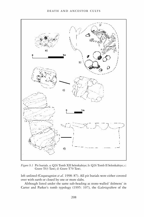
left unlined (Coqueugniot et al. 1998: 87). All pit burials were either coveredover with earth or closed by one or more slabs.
Although listed under the same sub-heading as stone-walled ‘dolmens’ inCarter and Parker’s tomb typology (1995: 107), the Galeriegräbern of the
Figure 9.1 Pit burials. a: Q26 Tomb XII Selenkahiye; b: Q26 Tomb II Selenkahiye; c:Grave T63 Tawi; d: Grave T70 Tawi.
D E AT H A N D A N C E S T O R C U LT S
208
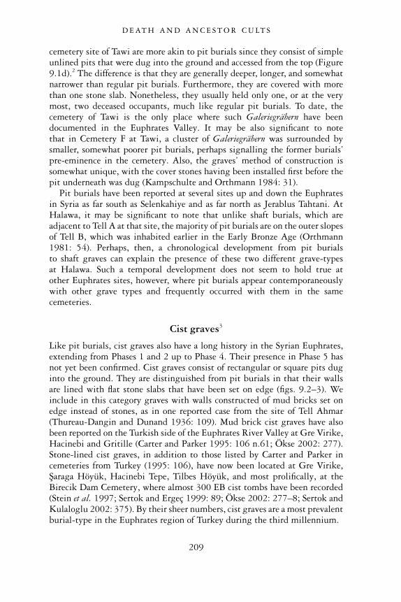
cemetery site of Tawi are more akin to pit burials since they consist of simpleunlined pits that were dug into the ground and accessed from the top (Figure9.1d).2 The difference is that they are generally deeper, longer, and somewhatnarrower than regular pit burials. Furthermore, they are covered with morethan one stone slab. Nonetheless, they usually held only one, or at the verymost, two deceased occupants, much like regular pit burials. To date, thecemetery of Tawi is the only place where such Galeriegräbern have beendocumented in the Euphrates Valley. It may be also significant to notethat in Cemetery F at Tawi, a cluster of Galeriegräbern was surrounded bysmaller, somewhat poorer pit burials, perhaps signalling the former burials’pre-eminence in the cemetery. Also, the graves’ method of construction issomewhat unique, with the cover stones having been installed first before thepit underneath was dug (Kampschulte and Orthmann 1984: 31).
Pit burials have been reported at several sites up and down the Euphratesin Syria as far south as Selenkahiye and as far north as Jerablus Tahtani. AtHalawa, it may be significant to note that unlike shaft burials, which areadjacent to Tell A at that site, the majority of pit burials are on the outer slopesof Tell B, which was inhabited earlier in the Early Bronze Age (Orthmann1981: 54). Perhaps, then, a chronological development from pit burialsto shaft graves can explain the presence of these two different grave-typesat Halawa. Such a temporal development does not seem to hold true atother Euphrates sites, however, where pit burials appear contemporaneouslywith other grave types and frequently occurred with them in the samecemeteries.
Cist graves3
Like pit burials, cist graves also have a long history in the Syrian Euphrates,extending from Phases 1 and 2 up to Phase 4. Their presence in Phase 5 hasnot yet been confirmed. Cist graves consist of rectangular or square pits duginto the ground. They are distinguished from pit burials in that their wallsare lined with flat stone slabs that have been set on edge (figs. 9.2–3). Weinclude in this category graves with walls constructed of mud bricks set onedge instead of stones, as in one reported case from the site of Tell Ahmar(Thureau-Dangin and Dunand 1936: 109). Mud brick cist graves have alsobeen reported on the Turkish side of the Euphrates River Valley at Gre Virike,Hacinebi and Gritille (Carter and Parker 1995: 106 n.61; Ökse 2002: 277).Stone-lined cist graves, in addition to those listed by Carter and Parker incemeteries from Turkey (1995: 106), have now been located at Gre Virike,Saraga Höyük, Hacinebi Tepe, Tilbes Höyük, and most prolifically, at theBirecik Dam Cemetery, where almost 300 EB cist tombs have been recorded(Stein et al. 1997; Sertok and Ergeç 1999: 89; Ökse 2002: 277–8; Sertok andKulaloglu 2002: 375). By their sheer numbers, cist graves are a most prevalentburial-type in the Euphrates region of Turkey during the third millennium.
D E AT H A N D A N C E S T O R C U LT S
209
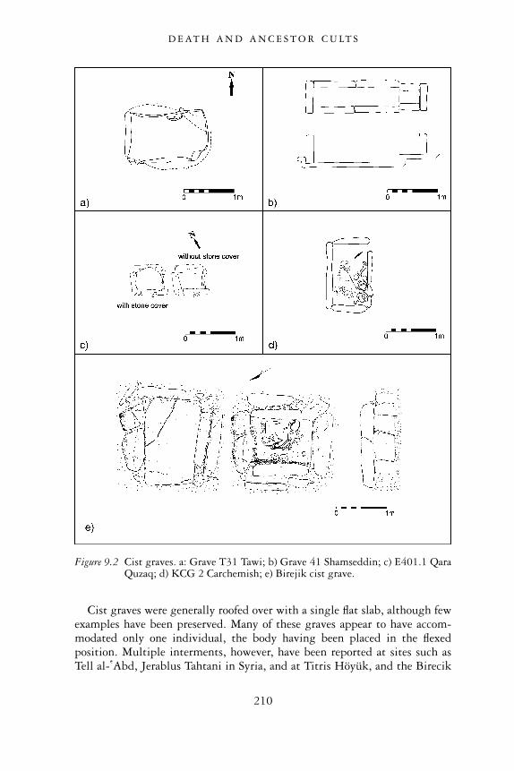
Cist graves were generally roofed over with a single flat slab, although fewexamples have been preserved. Many of these graves appear to have accom-modated only one individual, the body having been placed in the flexedposition. Multiple interments, however, have been reported at sites such asTell al- �Abd, Jerablus Tahtani in Syria, and at Titris Höyük, and the Birecik
Figure 9.2 Cist graves. a: Grave T31 Tawi; b) Grave 41 Shamseddin; c) E401.1 QaraQuzaq; d) KCG 2 Carchemish; e) Birejik cist grave.
D E AT H A N D A N C E S T O R C U LT S
210
Dam Cemetery in Turkey (Bounni 1979: 55; Algaze et al. 1995: 20, 28;Matney and Algaze 1995: 42; Sertok and Ergeç 1999: 90 Peltenburg et al.1997: 8). At Carchemish, T.E. Lawrence reported the presence of three bod-ies in cist burial KCG 8, which was questioned by one of the expedition’sdirectors (Woolley and Barnett 1952: 221 n.2). Lawrence also reported twoskulls in cist-grave KCG 8, which Woolley himself queries (Woolley andBarnett 1952: 221 n.3). Given, however, that neighbouring sites such asJerablus Tahtani have now positively identified multiple interments, it is nolonger necessary to doubt the accuracy of Lawrence’s observations.
In one grave at Titris Höyük, the skulls of earlier interments had beenpiled in the corner, and water-laid soil had accumulated between the skullsand grave goods, indicating that the grave had been reopened and reusedfor multiple occupants who had died at different times (Algaze et al. 1995:20). There are a few instances where cist graves have been found empty ofhuman remains, for example, in some of the burials at the Birecik DamCemetery, Saraga Höyük and Carchemish (Sertok and Ergeç 1999: 90;Sertok and Kulaloglu 2002: 376). While in some cases, this phenomenoncan be explained by tomb looting and destruction of bones due to naturalcauses, in other cases, it may indicate a multi-stage burial process, the boneshaving been moved and re-buried elsewhere. This practice has also beenposited for some of the burials at the site of Tell Banat in Syria (Porter2002b: 165).
Figure 9.3 Cist tomb, Tell Ahmar.
D E AT H A N D A N C E S T O R C U LT S
211
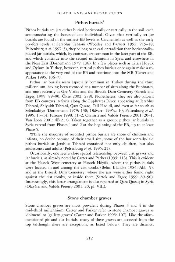
Pithos burials4
Pithos burials are jars either buried horizontally or vertically in the soil, eachaccommodating the bones of one individual. Given that vertically-set jarburials are found in the earliest EB levels at Carchemish as well as the earlypre-fort levels at Jerablus Tahtani (Woolley and Barnett 1952: 215–18;Peltenburg et al. 1997: 3), they belong to an earlier tradition than horizontally-placed jar burials, which, by contrast, are common in the later part of the EB,and which continue into the second millennium in Syria and elsewhere inthe Near East (Dornemann 1979: 138). In a few places such as Titris Höyükand Oylum in Turkey, however, vertical pithos burials once again make a re-appearance at the very end of the EB and continue into the MB (Carter andParker 1995: 106–7).
Pithos jar burials seem especially common in Turkey during the thirdmillennium, having been recorded at a number of sites along the Euphrates,and most recently at Gre Virike and the Birecik Dam Cemetery (Sertok andErgeç 1999: 89–90; Ökse 2002: 278). Nonetheless, they are also knownfrom EB contexts in Syria along the Euphrates River, appearing at JerablusTahtani, Shiyukh Tahtani, Qara Quzaq, Tell Hadidi, and even as far south asSelenkahiye (Dornemann 1979: 138; Olávarri 1995a: 10; Peltenburg et al.1995: 13–14; Falsone 1998: 31–2; Olavárri and Valdés Pereiro 2001: 20–1;Van Loon 2001: 4B.217). Taken together as a group, pithos jar burials inSyria extend from Phases 1 and 2 at the beginning of the EB, up to at leastPhase 5.
While the majority of recorded pithos burials are those of children andinfants, no doubt because of their small size, some of the horizontally-laidpithos burials at Jerablus Tahtani contained not only children, but alsoadolescents and adults (Peltenburg et al. 1995: 25).
Occasionally, one sees a close spatial relationship between cist graves andjar burials, as already noted by Carter and Parker (1995: 113). This is evidentat the Hassek West cemetery at Hassek Höyük, where the pithos burialswere located in and among the cist tombs (Behm-Blancke 1984: Abb. 9),and at the Birecik Dam Cemetery, where the jars were either found rightagainst the cist tombs, or inside them (Sertok and Ergeç 1999: 89–90).Interestingly, this latter arrangement is also reported at Qara Quzaq in Syria(Olavárri and Valdés Pereiro 2001: 20, pl. VIII).
Stone chamber graves
Stone chamber graves are most prevalent during Phases 3 and 4 in themid-third millennium. Carter and Parker refer to stone chamber graves as‘dolmens’ or ‘gallery graves’ (Carter and Parker 1995: 107). Like the afore-mentioned pit and cist burials, many of these graves are accessed from thetop (although there are exceptions, as listed below). They are distinct,
D E AT H A N D A N C E S T O R C U LT S
212
however, in that their interior walls are constructed of horizontally-placed,roughly quarried stones, sometimes corbelling inwardly toward the top.The burials are capped by monolithic stone slabs. One stone chamber gravehas been reported at Tawi, where it is referred to as a ‘stone gallery grave’(Figure 9.4a) (Tawi T5: Kampschulte and Orthmann 1984: 9–12). Withits unique stone corbelled-wall construction, however, it really should bedistinguished from the other reported Galeriegräbern at this site, which, asdiscussed above, are not lined with stone and consequently have been classifiedabove as elaborate pit burials.
Figure 9.4 Chamber graves. a: Tawi Grave T5; b: Tomb 4 Tell Banat; c: brick tomb,Habuba Kabira.
D E AT H A N D A N C E S T O R C U LT S
213
Several stone chamber burials have been reported at Jerablus Tahtani,where they occur in a variety of intramural contexts (e.g. Tomb 787, Tomb1036, and Tomb 1518: Peltenburg et al. 1996: 10–11; Peltenburg et al.1997: 7). Another example of a stone chamber grave was found intramurallyat Halawa Tell B, although it had been robbed entirely of its contents, and itscapping stones were missing (H-600, Orthmann 1989: 50, 54). At TellBanat, tombs that are described as stone cist graves by the excavators prob-ably are better described as stone chamber graves since the stones of theirwalls have not been set on edge, a defining characteristic of cist graves(Figure 9.4b) (Tombs 3–5 and 9; Porter 2002a: 13, 17–20; McClellanand Porter 1999: 108, figs. 3–4). Also, in terms of their construction anddimensions, the Tell Banat graves are similar to the stone chamber gravesfound at other sites such as Tawi and Jerablus Tahtani. We must pointout, however, that like several Euphrates cist graves which were foundempty of human remains, some of the Banat chamber burials were alsodiscovered without bones, suggesting a similar multi-stage burial process(Porter 2002b: 165).
An EB brick tomb from Habuba Kabira South which was dug into thehouse ruins of the earlier Uruk period might also be included in this group ofchamber graves because its dimensions and overall appearance are similar tothe other stone chamber graves listed above (Figure 9.4c) (Heinrich et al.1973: 33–8).
As described above, many chamber graves discovered in the EuphratesValley were accessed from the top. There are exceptions, however. A mid-EBtomb in one of Titris Höyük’s extramural cemeteries, for example, comprisedseveral courses of large cut stones sloping inward towards the top, a roofformed by large rectangular slabs, and an entrance on the western side thathad been carefully closed by two standing stones (Algaze et al. 1995: 27).Similarly, an EB tomb reported at the site of Munbaqa in Syria was foundwith an entrance shaft at its southern end (Orthmann 1976: 38). Also partof this category are some of the single-chamber stone-built ‘shaft’ tombsreported by Carter and Parker at Lidar, Hayaz, Oylum, Gedikli in Anatolia,and at Tell Hadidi in Syria (Carter and Parker 1995: 108). These tombs areactually most similar in form to monumental stone-built shaft and chambertombs (described below), although one could argue that their significantlysmaller dimensions place them among the shaft-less chamber tombs of thiscategory.
Stone chamber graves could accommodate one or several individuals.Multiple interments have been recorded in tombs both accessed from thetop, and those accessed via an entrance shaft. The highest number of bodiescomes from Tomb 1518 at Jerablus Tahtani, where at least five intermentswere recorded (Figure 9.5) (Peltenburg et al. 1997: 7).5
D E AT H A N D A N C E S T O R C U LT S
214
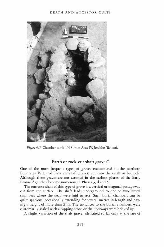
Earth or rock-cut shaft graves6
One of the most frequent types of graves encountered in the northernEuphrates Valley of Syria are shaft graves, cut into the earth or bedrock.Although these graves are not attested in the earliest phases of the EarlyBronze Age, they become numerous in Phases 3, 4 and 5.
The entrance shaft of this type of grave is a vertical or diagonal passagewaycut from the surface. The shaft leads underground to one or two lateralchambers where the dead were laid to rest. Such burial chambers can bequite spacious, occasionally extending for several metres in length and hav-ing a height of more than 2 m. The entrances to the burial chambers werecustomarily sealed with a capping stone or the doorways were bricked up.
A slight variation of the shaft grave, identified so far only at the site of
Figure 9.5 Chamber tomb 1518 from Area IV, Jerablus Tahtani.
D E AT H A N D A N C E S T O R C U LT S
215
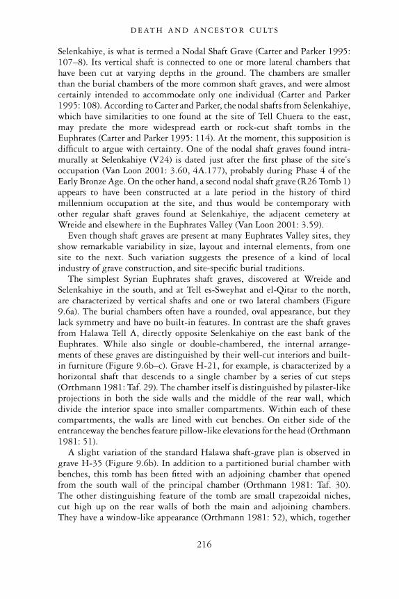
Selenkahiye, is what is termed a Nodal Shaft Grave (Carter and Parker 1995:107–8). Its vertical shaft is connected to one or more lateral chambers thathave been cut at varying depths in the ground. The chambers are smallerthan the burial chambers of the more common shaft graves, and were almostcertainly intended to accommodate only one individual (Carter and Parker1995: 108). According to Carter and Parker, the nodal shafts from Selenkahiye,which have similarities to one found at the site of Tell Chuera to the east,may predate the more widespread earth or rock-cut shaft tombs in theEuphrates (Carter and Parker 1995: 114). At the moment, this supposition isdifficult to argue with certainty. One of the nodal shaft graves found intra-murally at Selenkahiye (V24) is dated just after the first phase of the site’soccupation (Van Loon 2001: 3.60, 4A.177), probably during Phase 4 of theEarly Bronze Age. On the other hand, a second nodal shaft grave (R26 Tomb 1)appears to have been constructed at a late period in the history of thirdmillennium occupation at the site, and thus would be contemporary withother regular shaft graves found at Selenkahiye, the adjacent cemetery atWreide and elsewhere in the Euphrates Valley (Van Loon 2001: 3.59).
Even though shaft graves are present at many Euphrates Valley sites, theyshow remarkable variability in size, layout and internal elements, from onesite to the next. Such variation suggests the presence of a kind of localindustry of grave construction, and site-specific burial traditions.
The simplest Syrian Euphrates shaft graves, discovered at Wreide andSelenkahiye in the south, and at Tell es-Sweyhat and el-Qitar to the north,are characterized by vertical shafts and one or two lateral chambers (Figure9.6a). The burial chambers often have a rounded, oval appearance, but theylack symmetry and have no built-in features. In contrast are the shaft gravesfrom Halawa Tell A, directly opposite Selenkahiye on the east bank of theEuphrates. While also single or double-chambered, the internal arrange-ments of these graves are distinguished by their well-cut interiors and built-in furniture (Figure 9.6b–c). Grave H-21, for example, is characterized by ahorizontal shaft that descends to a single chamber by a series of cut steps(Orthmann 1981: Taf. 29). The chamber itself is distinguished by pilaster-likeprojections in both the side walls and the middle of the rear wall, whichdivide the interior space into smaller compartments. Within each of thesecompartments, the walls are lined with cut benches. On either side of theentranceway the benches feature pillow-like elevations for the head (Orthmann1981: 51).
A slight variation of the standard Halawa shaft-grave plan is observed ingrave H-35 (Figure 9.6b). In addition to a partitioned burial chamber withbenches, this tomb has been fitted with an adjoining chamber that openedfrom the south wall of the principal chamber (Orthmann 1981: Taf. 30).The other distinguishing feature of the tomb are small trapezoidal niches,cut high up on the rear walls of both the main and adjoining chambers.They have a window-like appearance (Orthmann 1981: 52), which, together
D E AT H A N D A N C E S T O R C U LT S
216
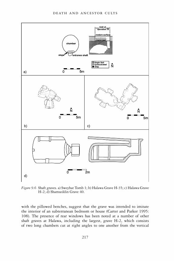
with the pillowed benches, suggest that the grave was intended to imitatethe interior of an subterranean bedroom or house (Carter and Parker 1995:108). The presence of rear windows has been noted at a number of othershaft graves at Halawa, including the largest, grave H-2, which consistsof two long chambers cut at right angles to one another from the vertical
Figure 9.6 Shaft graves. a) Sweyhat Tomb 1; b) Halawa Grave H-35; c) Halawa GraveH-2; d) Shamseddin Grave 40.
D E AT H A N D A N C E S T O R C U LT S
217
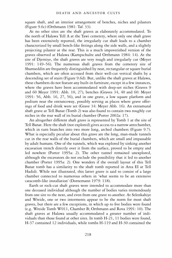
square shaft, and an interior arrangement of benches, niches and pilasters(Figure 9.6c) (Orthmann 1981: Taf. 33).
At no other sites are the shaft graves as elaborately accommodated. Tothe north of Halawa Tell A at the Tawi cemetery, where only one shaft gravehas been extensively reported, the irregularly cut shaft leads to a chambercharacterized by small bench-like fittings along the side walls, and a slightlyprojecting pilaster at the rear. This is a much impoverished version of thegraves observed at Halawa (Kampschulte and Orthmann 1984: 14). At thesite of Djerniye, the shaft graves are very rough and irregularly cut (Meyer1991: 149–56). The numerous shaft graves from the cemetery site ofShamseddin are frequently distinguished by neat, rectangular or square burialchambers, which are often accessed from their well-cut vertical shafts by adescending set of stairs (Figure 9.6d). But, unlike the shaft graves at Halawa,these chambers do not feature any built-in furniture, except in a few instances,where the graves have been accommodated with deep-set niches (Graves 9and 60 Meyer 1991: Abb. 10, 27), benches (Graves 34, 40 and 60: Meyer1991: 56, Abb. 16, 27, 56), and in one grave, a low square platform andpodium near the entranceway, possibly serving as places where grave offer-ings of food and drink were set (Grave 34: Meyer Abb. 16). An extramuralshaft grave at Tell Banat (Tomb 2) was also found to contain two roughly cutniches in the rear wall of its burial chamber (Porter 2002a: 17).
An altogether different shaft grave is represented by Tomb 1 at the site ofTell Banat. Here the shaft (not explored) gives access to a narrow antechamber,which in turn branches into two more long, arched chambers (Figure 9.7).What is especially peculiar about this grave are the long, man-made tunnelscut in the rear walls of the burial chambers, which are small and impassableby adult humans. One of the tunnels, which was explored by sinking anotherexcavation trench directly over it from the surface, proved to be empty andled nowhere (Porter 1995a: 2). The other tunnel remained unexplored,although the excavators do not exclude the possibility that it led to anotherchamber (Porter 1995a: 2). One wonders if the overall layout of this TellBanat tomb has a similarity to the shaft tomb reported in Area EI at TellHadidi. While not illustrated, this latter grave is said to consist of a largechamber connected to numerous others in ‘what seems to be an extensivecatacomb-like installation’ (Dornemann 1979: 118).
Earth or rock-cut shaft graves were intended to accommodate more thanone deceased individual although the number of bodies varies tremendouslyfrom one site to the next, and even from one grave to another. At Selenkahiyeand Wreide, one or two interments appear to be the norm for most shaftgraves, but there are a few exceptions, in which up to five bodies were found(e.g. Wreide Tomb W011, Chamber B; Orthmann and Rova 1991: 10). Theshaft graves at Halawa usually accommodated a greater number of indi-viduals than those found at other sites. In tomb H-21, 11 bodies were found,H-37 contained 12 individuals, while tombs H-119 and H-30 contained the
D E AT H A N D A N C E S T O R C U LT S
218
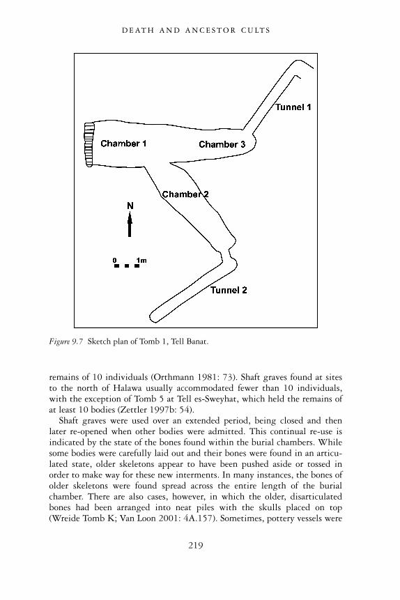
remains of 10 individuals (Orthmann 1981: 73). Shaft graves found at sitesto the north of Halawa usually accommodated fewer than 10 individuals,with the exception of Tomb 5 at Tell es-Sweyhat, which held the remains ofat least 10 bodies (Zettler 1997b: 54).
Shaft graves were used over an extended period, being closed and thenlater re-opened when other bodies were admitted. This continual re-use isindicated by the state of the bones found within the burial chambers. Whilesome bodies were carefully laid out and their bones were found in an articu-lated state, older skeletons appear to have been pushed aside or tossed inorder to make way for these new interments. In many instances, the bones ofolder skeletons were found spread across the entire length of the burialchamber. There are also cases, however, in which the older, disarticulatedbones had been arranged into neat piles with the skulls placed on top(Wreide Tomb K; Van Loon 2001: 4A.157). Sometimes, pottery vessels were
Figure 9.7 Sketch plan of Tomb 1, Tell Banat.
D E AT H A N D A N C E S T O R C U LT S
219
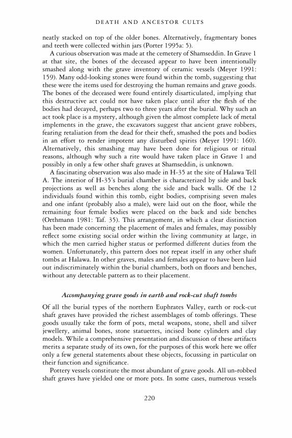
neatly stacked on top of the older bones. Alternatively, fragmentary bonesand teeth were collected within jars (Porter 1995a: 5).
A curious observation was made at the cemetery of Shamseddin. In Grave 1at that site, the bones of the deceased appear to have been intentionallysmashed along with the grave inventory of ceramic vessels (Meyer 1991:159). Many odd-looking stones were found within the tomb, suggesting thatthese were the items used for destroying the human remains and grave goods.The bones of the deceased were found entirely disarticulated, implying thatthis destructive act could not have taken place until after the flesh of thebodies had decayed, perhaps two to three years after the burial. Why such anact took place is a mystery, although given the almost complete lack of metalimplements in the grave, the excavators suggest that ancient grave robbers,fearing retaliation from the dead for their theft, smashed the pots and bodiesin an effort to render impotent any disturbed spirits (Meyer 1991: 160).Alternatively, this smashing may have been done for religious or ritualreasons, although why such a rite would have taken place in Grave 1 andpossibly in only a few other shaft graves at Shamseddin, is unknown.
A fascinating observation was also made in H-35 at the site of Halawa TellA. The interior of H-35’s burial chamber is characterized by side and backprojections as well as benches along the side and back walls. Of the 12individuals found within this tomb, eight bodies, comprising seven malesand one infant (probably also a male), were laid out on the floor, while theremaining four female bodies were placed on the back and side benches(Orthmann 1981: Taf. 35). This arrangement, in which a clear distinctionhas been made concerning the placement of males and females, may possiblyreflect some existing social order within the living community at large, inwhich the men carried higher status or performed different duties from thewomen. Unfortunately, this pattern does not repeat itself in any other shafttombs at Halawa. In other graves, males and females appear to have been laidout indiscriminately within the burial chambers, both on floors and benches,without any detectable pattern as to their placement.
Accompanying grave goods in earth and rock-cut shaft tombs
Of all the burial types of the northern Euphrates Valley, earth or rock-cutshaft graves have provided the richest assemblages of tomb offerings. Thesegoods usually take the form of pots, metal weapons, stone, shell and silverjewellery, animal bones, stone statuettes, incised bone cylinders and claymodels. While a comprehensive presentation and discussion of these artifactsmerits a separate study of its own, for the purposes of this work here we offeronly a few general statements about these objects, focussing in particular ontheir function and significance.
Pottery vessels constitute the most abundant of grave goods. All un-robbedshaft graves have yielded one or more pots. In some cases, numerous vessels
D E AT H A N D A N C E S T O R C U LT S
220
filled the tombs. H-119 at Halawa had an assemblage of 99 pots (Orthmann1981: Taf. 64–7), for example, while the shaft grave T6 at Tawi contained110 vessels (Schwartz 1987: 241). Tomb 1 at Tell Banat contained a prolificassemblage of 163 vessels (Porter 1995a: 16). The fact that each of thesetombs accommodated several deceased persons might account for the abun-dance of pots since each individual would have been provided with his or herown funerary set.
It is still uncertain how one should understand these tomb potteryassemblages. On the one hand we can accept the traditional interpretationthat such pots were filled with food and drink that were intended to sustainthe deceased in his or her afterlife or used as offerings for the gods of theunderworld. An alternative interpretation, however, is that many or all ofthese vessels were used by living participants at a funerary feast that was heldin honour of the deceased persons buried in the tomb (Peltenburg in press a).The fact that some pots were found stacked, indicating that they were emptywhen they were arranged in the tomb, may support the notion of a funeraryfeast (e.g. Wreide Tomb 2 and Selenkahiye Tomb 9: 4A.133, 4A.167).Pottery vessels and other tomb offerings found in levels of earth and debrishigh above the floors of the tombs may also be indicative of commemorativefunerary feasts, these taking place on occasions well after the dead had beenburied and the tombs had begun to fill with debris (Meyer 1991: 21; Zettler1997b: 55; Peltenburg in press a).
Generally all vessel types are represented in the large grave assemblages.These include beakers, cups, bowls, small jars, and larger pots. Cooking potsare often present, although they are fewer in number than other vessel types.In Phases 3 and 4, one sees the preponderance of Euphrates Fine Ware, theseconsisting of bowls, jars and bottles decorated with spiral burnishing, corru-gations and bands of red paint. Given the striking absence of such FineWare in non-funerary contexts, we conclude that this ware was specificallyproduced for use in burials.
A variety of metal weapons, namely daggers, spearheads and axes accom-panied the dead in the shaft graves. Such weapons, when found in situ, wereoften placed near the shoulder or hips of specific individuals, indicating thatthey were the personal possessions of such individuals (e.g. Halawa H-70,Orthmann 1981: 54). Unfortunately, it is difficult to confirm an associationbetween the presence of metal weapons and the gender of the deceased dueto the infrequency with which sex determination has been performed onskeletal remains. Where such investigations have been carried out, as in thecase of some of the Halawa shaft graves, there seems to be a strong associationbetween weaponry and male individuals (Orthmann 1981: 54, 56).
Of all the metal artifacts, copper or bronze pins were the most numerousin shaft graves. Common were ball-headed pins with bent or straight shafts,these occurring mainly in Phase 3 graves (e.g. Porter 1995a: Figure 5;Zettler 1997b: Figure 3.20). Mushroom-headed pins with straight shafts
D E AT H A N D A N C E S T O R C U LT S
221

appear usually in burials dated to Phases 4 and 5 (e.g. Orthmann 1981: Taf.68; Van Loon 2001: Figure 4A.4A; 4A.11). These pins were often found inpairs, sometimes crossed, and frequently positioned above the head, at thearea of the rib cage, or below the feet of a deceased individual.7 It is possiblethat such pairs of pins were used to secure burial shrouds (Van Loon 2001:4A.160, 4B.197). Alternatively, pairs of pins found near the shoulders or atthe chest of some deceased individuals may have secured some short of shawl,similar to those seen in contemporary shell plaques from the site of Mari(Zettler et al. 1996: 20, Figure 9).8 In Tomb 5 at Tell es-Sweyhat, the factthat such crossed pins were found in association with a decorated flat gypsumring and a necklace of gypsum and carnelian beads supports the suppositionthat these were the personal adornments of the deceased and not shroudfasteners (Zettler 1997b: Figure 3.18).
Because of the number of plundered tombs, it is hazardous to make toomany statements concerning wealth differentiation within the shaft graves ofthe Euphrates Valley. Some of the largest and most well-constructed tombsof the region, like the multi-chambered tombs at Halawa Tell A (e.g. H-2and H-35) and Shamseddin (e.g. Grave 34) were found virtually empty oftheir contents. In shaft graves with intact offerings, grave goods do not standout as being particularly precious or rare. A few burials containing severalmetal weapons and pins may indicate some economic success on the partof their owners. A deceased individual in a grave at Wreide (W066), forexample, was buried with 13 metal implements (Orthmann and Rova 1991:34). This abundance can be contrasted with other graves at Wreide (e.g.W011, W054) where significantly fewer metal implements were found, eventhough several individuals were interred (Orthmann and Rova 1991: 10, 18).
A few of the intramural burials found at Selenkahiye have yielded richgrave goods consisting of silver and bronze objects. The nodal shaft graveswere accommodated with various bronze pins and weapons, as well assmall silver items such as frontlets, earrings, and beads (Van Loon 2001:4A.166–4A.177). Similarly the double shaft grave found in square W12/13was also richly furnished with silver buckles, beads, pendants, ringlets, ringsas well as other bronze adornments (Van Loon 2001: 4B.210–4B.213).Nonetheless, in terms of their size and construction these shaft graves werenot large or lavish. They consisted of small, simple rock-cut oval chambers.
One final type of grave good will be described here. These are crudelyshaped statuettes fashioned out of white limestone principally found in rock-cut shaft graves in the southern part of the Euphrates region considered inthis study. The bodies of these statuettes are usually represented as simplerectangles, while the heads, which sit directly on the shoulders, are providedwith little more than crude protrusions for noses and slight depressions foreyes (Orthmann and Rova 1991: 63). The lack of details makes it impossibleto determine the sex of the figurines. Thus far, these statuettes have beenfound in shaft graves in the Wreide cemetery, both in situ and in the debris
D E AT H A N D A N C E S T O R C U LT S
222
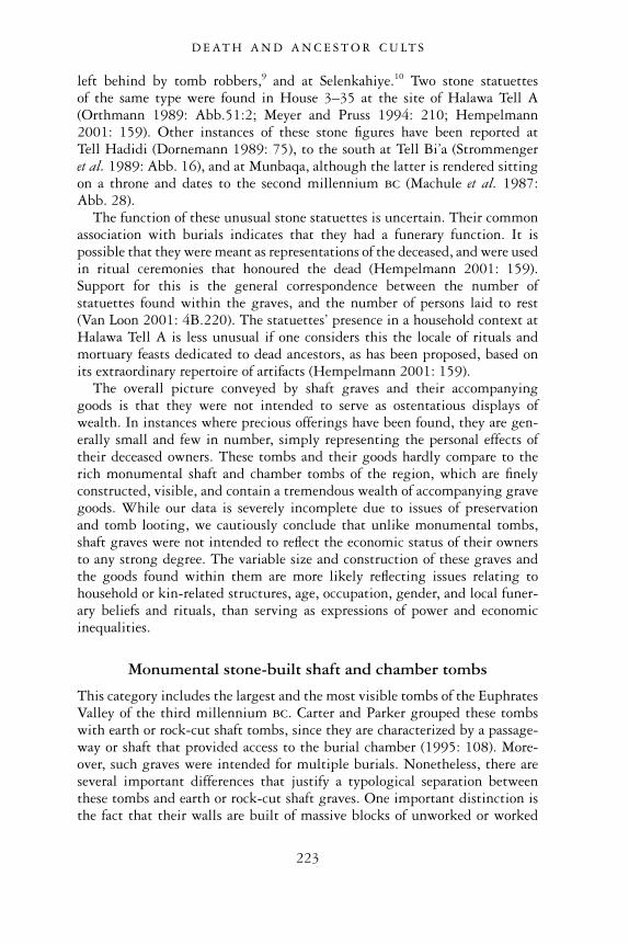
left behind by tomb robbers,9 and at Selenkahiye.10 Two stone statuettesof the same type were found in House 3–35 at the site of Halawa Tell A(Orthmann 1989: Abb.51:2; Meyer and Pruss 1994: 210; Hempelmann2001: 159). Other instances of these stone figures have been reported atTell Hadidi (Dornemann 1989: 75), to the south at Tell Bi’a (Strommengeret al. 1989: Abb. 16), and at Munbaqa, although the latter is rendered sittingon a throne and dates to the second millennium bc (Machule et al. 1987:Abb. 28).
The function of these unusual stone statuettes is uncertain. Their commonassociation with burials indicates that they had a funerary function. It ispossible that they were meant as representations of the deceased, and were usedin ritual ceremonies that honoured the dead (Hempelmann 2001: 159).Support for this is the general correspondence between the number ofstatuettes found within the graves, and the number of persons laid to rest(Van Loon 2001: 4B.220). The statuettes’ presence in a household context atHalawa Tell A is less unusual if one considers this the locale of rituals andmortuary feasts dedicated to dead ancestors, as has been proposed, based onits extraordinary repertoire of artifacts (Hempelmann 2001: 159).
The overall picture conveyed by shaft graves and their accompanyinggoods is that they were not intended to serve as ostentatious displays ofwealth. In instances where precious offerings have been found, they are gen-erally small and few in number, simply representing the personal effects oftheir deceased owners. These tombs and their goods hardly compare to therich monumental shaft and chamber tombs of the region, which are finelyconstructed, visible, and contain a tremendous wealth of accompanying gravegoods. While our data is severely incomplete due to issues of preservationand tomb looting, we cautiously conclude that unlike monumental tombs,shaft graves were not intended to reflect the economic status of their ownersto any strong degree. The variable size and construction of these graves andthe goods found within them are more likely reflecting issues relating tohousehold or kin-related structures, age, occupation, gender, and local funer-ary beliefs and rituals, than serving as expressions of power and economicinequalities.
Monumental stone-built shaft and chamber tombs
This category includes the largest and the most visible tombs of the EuphratesValley of the third millennium bc. Carter and Parker grouped these tombswith earth or rock-cut shaft tombs, since they are characterized by a passage-way or shaft that provided access to the burial chamber (1995: 108). More-over, such graves were intended for multiple burials. Nonetheless, there areseveral important differences that justify a typological separation betweenthese tombs and earth or rock-cut shaft graves. One important distinction isthe fact that their walls are built of massive blocks of unworked or worked
D E AT H A N D A N C E S T O R C U LT S
223
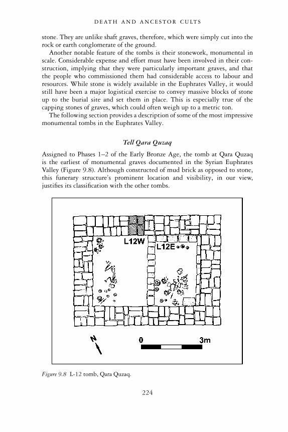
stone. They are unlike shaft graves, therefore, which were simply cut into therock or earth conglomerate of the ground.
Another notable feature of the tombs is their stonework, monumental inscale. Considerable expense and effort must have been involved in their con-struction, implying that they were particularly important graves, and thatthe people who commissioned them had considerable access to labour andresources. While stone is widely available in the Euphrates Valley, it wouldstill have been a major logistical exercise to convey massive blocks of stoneup to the burial site and set them in place. This is especially true of thecapping stones of graves, which could often weigh up to a metric ton.
The following section provides a description of some of the most impressivemonumental tombs in the Euphrates Valley.
Tell Qara Quzaq
Assigned to Phases 1–2 of the Early Bronze Age, the tomb at Qara Quzaqis the earliest of monumental graves documented in the Syrian EuphratesValley (Figure 9.8). Although constructed of mud brick as opposed to stone,this funerary structure’s prominent location and visibility, in our view,justifies its classification with the other tombs.
Figure 9.8 L-12 tomb, Qara Quzaq.
D E AT H A N D A N C E S T O R C U LT S
224
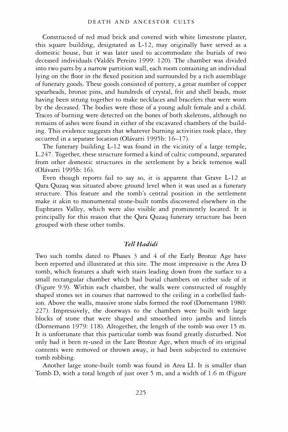
Constructed of red mud brick and covered with white limestone plaster,this square building, designated as L-12, may originally have served as adomestic house, but it was later used to accommodate the burials of twodeceased individuals (Valdés Pereiro 1999: 120). The chamber was dividedinto two parts by a narrow partition wall, each room containing an individuallying on the floor in the flexed position and surrounded by a rich assemblageof funerary goods. These goods consisted of pottery, a great number of copperspearheads, bronze pins, and hundreds of crystal, frit and shell beads, mosthaving been strung together to make necklaces and bracelets that were wornby the deceased. The bodies were those of a young adult female and a child.Traces of burning were detected on the bones of both skeletons, although noremains of ashes were found in either of the excavated chambers of the build-ing. This evidence suggests that whatever burning activities took place, theyoccurred in a separate location (Olávarri 1995b: 16–17).
The funerary building L-12 was found in the vicinity of a large temple,L.247. Together, these structure formed a kind of cultic compound, separatedfrom other domestic structures in the settlement by a brick temenos wall(Olávarri 1995b: 16).
Even though reports fail to say so, it is apparent that Grave L-12 atQara Quzaq was situated above ground level when it was used as a funerarystructure. This feature and the tomb’s central position in the settlementmake it akin to monumental stone-built tombs discovered elsewhere in theEuphrates Valley, which were also visible and prominently located. It isprincipally for this reason that the Qara Quzaq funerary structure has beengrouped with these other tombs.
Tell Hadidi
Two such tombs dated to Phases 3 and 4 of the Early Bronze Age havebeen reported and illustrated at this site. The most impressive is the Area Dtomb, which features a shaft with stairs leading down from the surface to asmall rectangular chamber which had burial chambers on either side of it(Figure 9.9). Within each chamber, the walls were constructed of roughlyshaped stones set in courses that narrowed to the ceiling in a corbelled fash-ion. Above the walls, massive stone slabs formed the roof (Dornemann 1980:227). Impressively, the doorways to the chambers were built with largeblocks of stone that were shaped and smoothed into jambs and lintels(Dornemann 1979: 118). Altogether, the length of the tomb was over 15 m.It is unfortunate that this particular tomb was found greatly disturbed. Notonly had it been re-used in the Late Bronze Age, when much of its originalcontents were removed or thrown away, it had been subjected to extensivetomb robbing.
Another large stone-built tomb was found in Area LI. It is smaller thanTomb D, with a total length of just over 5 m, and a width of 1.6 m (Figure
D E AT H A N D A N C E S T O R C U LT S
225
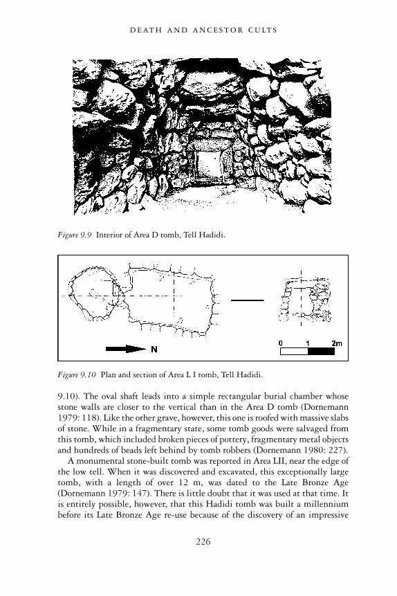
9.10). The oval shaft leads into a simple rectangular burial chamber whosestone walls are closer to the vertical than in the Area D tomb (Dornemann1979: 118). Like the other grave, however, this one is roofed with massive slabsof stone. While in a fragmentary state, some tomb goods were salvaged fromthis tomb, which included broken pieces of pottery, fragmentary metal objectsand hundreds of beads left behind by tomb robbers (Dornemann 1980: 227).
A monumental stone-built tomb was reported in Area LII, near the edge ofthe low tell. When it was discovered and excavated, this exceptionally largetomb, with a length of over 12 m, was dated to the Late Bronze Age(Dornemann 1979: 147). There is little doubt that it was used at that time. Itis entirely possible, however, that this Hadidi tomb was built a millenniumbefore its Late Bronze Age re-use because of the discovery of an impressive
Figure 9.9 Interior of Area D tomb, Tell Hadidi.
Figure 9.10 Plan and section of Area L I tomb, Tell Hadidi.
D E AT H A N D A N C E S T O R C U LT S
226
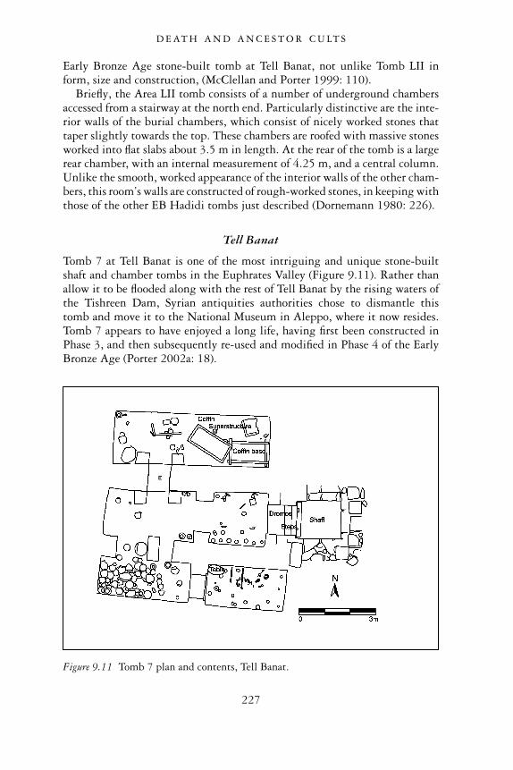
Early Bronze Age stone-built tomb at Tell Banat, not unlike Tomb LII inform, size and construction, (McClellan and Porter 1999: 110).
Briefly, the Area LII tomb consists of a number of underground chambersaccessed from a stairway at the north end. Particularly distinctive are the inte-rior walls of the burial chambers, which consist of nicely worked stones thattaper slightly towards the top. These chambers are roofed with massive stonesworked into flat slabs about 3.5 m in length. At the rear of the tomb is a largerear chamber, with an internal measurement of 4.25 m, and a central column.Unlike the smooth, worked appearance of the interior walls of the other cham-bers, this room’s walls are constructed of rough-worked stones, in keeping withthose of the other EB Hadidi tombs just described (Dornemann 1980: 226).
Tell Banat
Tomb 7 at Tell Banat is one of the most intriguing and unique stone-builtshaft and chamber tombs in the Euphrates Valley (Figure 9.11). Rather thanallow it to be flooded along with the rest of Tell Banat by the rising waters ofthe Tishreen Dam, Syrian antiquities authorities chose to dismantle thistomb and move it to the National Museum in Aleppo, where it now resides.Tomb 7 appears to have enjoyed a long life, having first been constructed inPhase 3, and then subsequently re-used and modified in Phase 4 of the EarlyBronze Age (Porter 2002a: 18).
Figure 9.11 Tomb 7 plan and contents, Tell Banat.
D E AT H A N D A N C E S T O R C U LT S
227
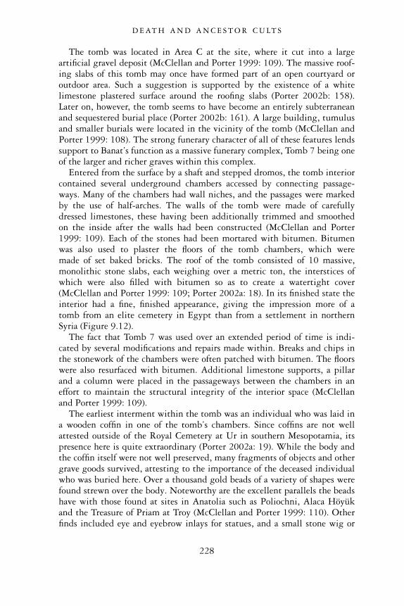
The tomb was located in Area C at the site, where it cut into a largeartificial gravel deposit (McClellan and Porter 1999: 109). The massive roof-ing slabs of this tomb may once have formed part of an open courtyard oroutdoor area. Such a suggestion is supported by the existence of a whitelimestone plastered surface around the roofing slabs (Porter 2002b: 158).Later on, however, the tomb seems to have become an entirely subterraneanand sequestered burial place (Porter 2002b: 161). A large building, tumulusand smaller burials were located in the vicinity of the tomb (McClellan andPorter 1999: 108). The strong funerary character of all of these features lendssupport to Banat’s function as a massive funerary complex, Tomb 7 being oneof the larger and richer graves within this complex.
Entered from the surface by a shaft and stepped dromos, the tomb interiorcontained several underground chambers accessed by connecting passage-ways. Many of the chambers had wall niches, and the passages were markedby the use of half-arches. The walls of the tomb were made of carefullydressed limestones, these having been additionally trimmed and smoothedon the inside after the walls had been constructed (McClellan and Porter1999: 109). Each of the stones had been mortared with bitumen. Bitumenwas also used to plaster the floors of the tomb chambers, which weremade of set baked bricks. The roof of the tomb consisted of 10 massive,monolithic stone slabs, each weighing over a metric ton, the interstices ofwhich were also filled with bitumen so as to create a watertight cover(McClellan and Porter 1999: 109; Porter 2002a: 18). In its finished state theinterior had a fine, finished appearance, giving the impression more of atomb from an elite cemetery in Egypt than from a settlement in northernSyria (Figure 9.12).
The fact that Tomb 7 was used over an extended period of time is indi-cated by several modifications and repairs made within. Breaks and chips inthe stonework of the chambers were often patched with bitumen. The floorswere also resurfaced with bitumen. Additional limestone supports, a pillarand a column were placed in the passageways between the chambers in aneffort to maintain the structural integrity of the interior space (McClellanand Porter 1999: 109).
The earliest interment within the tomb was an individual who was laid ina wooden coffin in one of the tomb’s chambers. Since coffins are not wellattested outside of the Royal Cemetery at Ur in southern Mesopotamia, itspresence here is quite extraordinary (Porter 2002a: 19). While the body andthe coffin itself were not well preserved, many fragments of objects and othergrave goods survived, attesting to the importance of the deceased individualwho was buried here. Over a thousand gold beads of a variety of shapes werefound strewn over the body. Noteworthy are the excellent parallels the beadshave with those found at sites in Anatolia such as Poliochni, Alaca Höyükand the Treasure of Priam at Troy (McClellan and Porter 1999: 110). Otherfinds included eye and eyebrow inlays for statues, and a small stone wig or
D E AT H A N D A N C E S T O R C U LT S
228
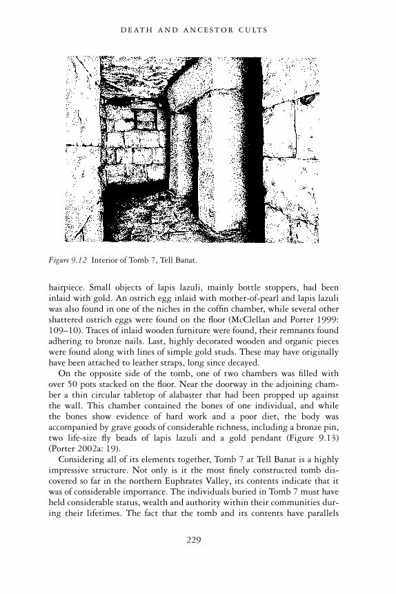
hairpiece. Small objects of lapis lazuli, mainly bottle stoppers, had beeninlaid with gold. An ostrich egg inlaid with mother-of-pearl and lapis lazuliwas also found in one of the niches in the coffin chamber, while several othershattered ostrich eggs were found on the floor (McClellan and Porter 1999:109–10). Traces of inlaid wooden furniture were found, their remnants foundadhering to bronze nails. Last, highly decorated wooden and organic pieceswere found along with lines of simple gold studs. These may have originallyhave been attached to leather straps, long since decayed.
On the opposite side of the tomb, one of two chambers was filled withover 50 pots stacked on the floor. Near the doorway in the adjoining cham-ber a thin circular tabletop of alabaster that had been propped up againstthe wall. This chamber contained the bones of one individual, and whilethe bones show evidence of hard work and a poor diet, the body wasaccompanied by grave goods of considerable richness, including a bronze pin,two life-size fly beads of lapis lazuli and a gold pendant (Figure 9.13)(Porter 2002a: 19).
Considering all of its elements together, Tomb 7 at Tell Banat is a highlyimpressive structure. Not only is it the most finely constructed tomb dis-covered so far in the northern Euphrates Valley, its contents indicate that itwas of considerable importance. The individuals buried in Tomb 7 must haveheld considerable status, wealth and authority within their communities dur-ing their lifetimes. The fact that the tomb and its contents have parallels
Figure 9.12 Interior of Tomb 7, Tell Banat.
D E AT H A N D A N C E S T O R C U LT S
229
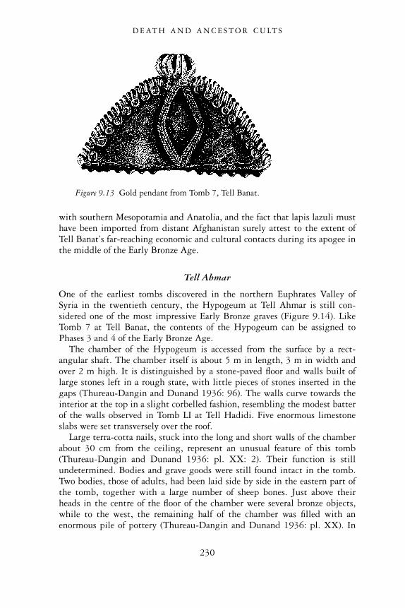
with southern Mesopotamia and Anatolia, and the fact that lapis lazuli musthave been imported from distant Afghanistan surely attest to the extent ofTell Banat’s far-reaching economic and cultural contacts during its apogee inthe middle of the Early Bronze Age.
Tell Ahmar
One of the earliest tombs discovered in the northern Euphrates Valley ofSyria in the twentieth century, the Hypogeum at Tell Ahmar is still con-sidered one of the most impressive Early Bronze graves (Figure 9.14). LikeTomb 7 at Tell Banat, the contents of the Hypogeum can be assigned toPhases 3 and 4 of the Early Bronze Age.
The chamber of the Hypogeum is accessed from the surface by a rect-angular shaft. The chamber itself is about 5 m in length, 3 m in width andover 2 m high. It is distinguished by a stone-paved floor and walls built oflarge stones left in a rough state, with little pieces of stones inserted in thegaps (Thureau-Dangin and Dunand 1936: 96). The walls curve towards theinterior at the top in a slight corbelled fashion, resembling the modest batterof the walls observed in Tomb LI at Tell Hadidi. Five enormous limestoneslabs were set transversely over the roof.
Large terra-cotta nails, stuck into the long and short walls of the chamberabout 30 cm from the ceiling, represent an unusual feature of this tomb(Thureau-Dangin and Dunand 1936: pl. XX: 2). Their function is stillundetermined. Bodies and grave goods were still found intact in the tomb.Two bodies, those of adults, had been laid side by side in the eastern part ofthe tomb, together with a large number of sheep bones. Just above theirheads in the centre of the floor of the chamber were several bronze objects,while to the west, the remaining half of the chamber was filled with anenormous pile of pottery (Thureau-Dangin and Dunand 1936: pl. XX). In
Figure 9.13 Gold pendant from Tomb 7, Tell Banat.
D E AT H A N D A N C E S T O R C U LT S
230
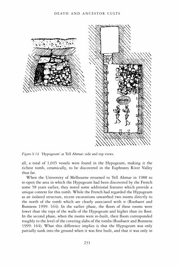
all, a total of 1,045 vessels were found in the Hypogeum, making it therichest tomb, ceramically, to be discovered in the Euphrates River Valleythus far.
When the University of Melbourne returned to Tell Ahmar in 1988 tore-open the area in which the Hypogeum had been discovered by the Frenchsome 58 years earlier, they noted some additional features which provide aunique context for this tomb. While the French had regarded the Hypogeumas an isolated structure, recent excavations unearthed two rooms directly tothe north of the tomb which are clearly associated with it (Roobaert andBunnens 1999: 164). In the earlier phase, the floors of these rooms werelower than the tops of the walls of the Hypogeum and higher than its floor.In the second phase, when the rooms were re-built, their floors correspondedroughly to the level of the covering slabs of the tombs (Roobaert and Bunnens1999: 164). What this difference implies is that the Hypogeum was onlypartially sunk into the ground when it was first built, and that it was only in
Figure 9.14 ‘Hypogeum’ at Tell Ahmar: side and top views.
D E AT H A N D A N C E S T O R C U LT S
231
a second, later phase that it became a truly subterranean installation. Oneother significant observation was the discovery of stairs descending towardsthe north on the western side of the complex and possibly leading to anotherchamber tomb (Roobaert and Bunnens 1999: 165). Overall, this entire areaof the tell appears to have been characterized by at least one and possiblyseveral funerary structures and associated rooms. They formed a uniqueand visible complex in the settlement, possibly having an important role inthe religious and social life of the Early Bronze Age community that livedthere.
Jerablus Tahtani
Discovered at the Early Bronze Age settlement of Jerablus Tahtani, Tomb302 stands out as a particularly distinctive funerary monument. The tomb issituated at the southern foot of the settlement, close to the river’s edge. Thefact that the structure was separated from other buildings by temenos-likewalls underlines its importance. The tomb comprised a restricted dromos atthe western side that was accessed only by a bent axis entrance-way (Figure9.15). Beyond that entrance was a long walled passage that led towards theupper levels of the settlement, ascending the mound by a sloping, stone-paved floor and stairs (Peltenburg et al. 1996: 14). The area in which Tomb302 had been constructed featured several pre-existing architectural features,and the tomb itself had been built directly over large storage silos, indicatingits rather late date in the occupational sequence of this Early Bronze Age site(Peltenburg et al. 2000: 69–70). Based on the pottery found within Tomb302, it should probably be assigned to Phase 4.
Tomb 302 is not unlike previous tombs described in that it too features anentranceway on the west which leads to a large rectangular burial chamber(6.6 m × 3.5 m), constructed of massive, transversely laid, undressed lime-stone blocks in six courses that corbel towards the top (Peltenburg et al.1995: 7). Its western entrance is defined by a very large stone lintel and athreshold, while a rectilinear annex, whose purpose is unclear, was set at therear of the chamber (Peltenburg et al. 1996: 13).
It is unusual that no intact or collapsed roofing or portal slabs wererecovered from Tomb 302, begging the question of what happened to the roof,if it had existed at all (Peltenburg et al. 1995: 8). Moreover, the tomb itselfappears to have been enclosed or revetted by a large mound which wouldhave been visible at surface-level. In other words, the stone chamber wasbut one component of what was originally a visible, upstanding monument(Peltenburg et al. 1995: 7).
The encasing mound was made of bands of orange bricky constructionalmaterial interleaved with horizontal lenses of bone, pottery and pebbles.Tomb 302 and this surrounding mound would have covered an area of atleast 8 m × 10 m in the latest phase (Peltenburg et al. 1995: 8). A thick
D E AT H A N D A N C E S T O R C U LT S
232
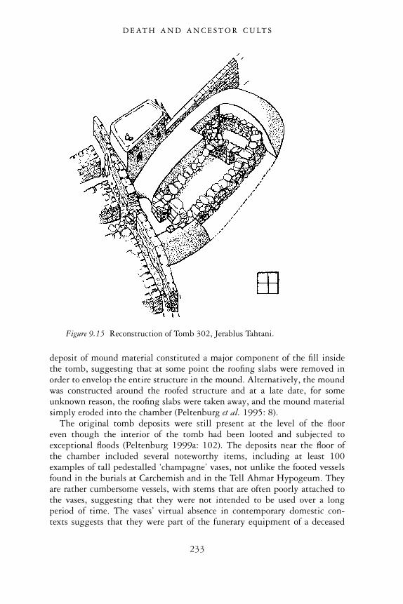
deposit of mound material constituted a major component of the fill insidethe tomb, suggesting that at some point the roofing slabs were removed inorder to envelop the entire structure in the mound. Alternatively, the moundwas constructed around the roofed structure and at a late date, for someunknown reason, the roofing slabs were taken away, and the mound materialsimply eroded into the chamber (Peltenburg et al. 1995: 8).
The original tomb deposits were still present at the level of the flooreven though the interior of the tomb had been looted and subjected toexceptional floods (Peltenburg 1999a: 102). The deposits near the floor ofthe chamber included several noteworthy items, including at least 100examples of tall pedestalled ‘champagne’ vases, not unlike the footed vesselsfound in the burials at Carchemish and in the Tell Ahmar Hypogeum. Theyare rather cumbersome vessels, with stems that are often poorly attached tothe vases, suggesting that they were not intended to be used over a longperiod of time. The vases’ virtual absence in contemporary domestic con-texts suggests that they were part of the funerary equipment of a deceased
Figure 9.15 Reconstruction of Tomb 302, Jerablus Tahtani.
D E AT H A N D A N C E S T O R C U LT S
233
individual, possibly functioning as serving vessels for the deceased to beused in the afterlife, or alternatively, used during the funerary feasts orcommemorative banquets by living participants (Peltenburg 1999b: 432; inpress a).
Most importantly in the lower deposits were found the remains of 12individuals. Studies of the bones of these individuals show that they includedone infant, four children, two adults and five mature adults. On the basis ofthe presence of children in the tomb, it was suggested that Tomb 302 shouldbe considered a family vault, possibly that of an important family in thesettlement (Peltenburg 1999b: 431).
The deposits of exotic or luxury goods in the primary phase of this tombare also notable, since besides pottery they included objects of gold, silverand rock crystal, ostrich eggshells and ivory plaques, and dagger pommels(Peltenburg 1999a: 102). Although the tomb was extensively looted, theremnants of these objects, comprising precious materials, testifies to theoriginal wealth of the grave offerings.
Peltenburg has emphasized the importance of Tomb 302 at JerablusTahtani, drawing attention to the unusually large size of this funerarycomplex, the restricted and elaborate approach to it, and its prominent pos-ition at the foot of the settlement. In this location, it was visible not only tothe inhabitants of the settlement but also to those approaching the site fromthe river (Peltenburg 1999b: 430). The tomb’s monumental constructionindicates a considerable investment of labour and planning (Peltenburg1999b: 430). These aspects, along with the presence of precious grave objectsand the fact that smaller, satellite burials were found in a cluster around thismonument all underline the pre-eminence of the tomb and by extension theindividuals buried within it, who almost certainly belonged to a family ofelite status in the community (Peltenburg et al. 1995: 10).
The tomb objects and the stratigraphic relationship of the tomb in rela-tion to the sequence of occupation and architectural construction at JerablusTahtani fix the tomb’s date to Phase 4, around the mid-third millennium bc(Peltenburg 1999b: 429). As we have seen in our previous chapters, it isaround this time that the processes of urbanism were intensifying in north-ern Syria, and when the manifestations of urbanism, such as increased socialstratification and economic differentiation, were becoming more apparent.Tomb 302, an expensive and highly visible burial-place for one of thecommunity’s elite families, reflects well this growing social and economicdifferentiation among inhabitants of an increasingly complex society.
Significance of monumental shaft and chamber built tombs
In his discussion of Tomb 302 from Jerablus Tahtani, Peltenburg calls atten-tion to the important role this funerary structure played among the livingdescendants of the dead who were buried here. He suggests that such
D E AT H A N D A N C E S T O R C U LT S
234
individuals would have emphasized the continuing prominence and sacred-ness of this tomb of the dead ancestors as a means of perpetuating andreinforcing their own elevated status within society (Peltenburg 1999b:427–8). Such a practice may have been especially important in this period ofurban growth, when major changes in the old social order were occurring,tensions among new socio-economic groups were growing, and effectivestrategies were required among the existing elite to assure their continuedprominence within this changing society (Peltenburg 1999b: 429; Schwartzet al. 2003: 339–40). It seems that a real or fabricated association withprominent symbols of traditional social order and power, such as monu-mental funerary structures dedicated to the ancestors, would have beeneffective tools in promoting and maintaining that privileged status.
The continuing significance of the tomb structure would have been espe-cially emphasized if it came to be regarded as a place of ancestor venerationand remembrance, and if the potency of the monument required not only theappropriate funerary rituals at the time of the disposal of the dead, but alsocontinuing visitations, offerings and feasts at the tomb long after the deadhad been buried here. Interestingly, the performance of such death ritualsis referred to in several ancient Near Eastern written sources found at Mariin southern Syria and cities in southern Mesopotamia. In such societies,offerings to dead kin often took place over the course of several generationsafter the death of a kin-member, and served to reinforce the status of thedescendants by reference to the authority of the dead (Peltenburg 1999b:428). While many of these textual sources pertain to royalty, it has beenshown that death rituals were observed by other levels of Mesopotamiansociety as well (Peltenburg 1999b: 428, after Tsukimoto 1985).
In the case of Tomb 302, there is evidence that visitations and offeringscontinued to be made at this monument even after the roofing slabs had beenremoved and the earth of the surrounding mound had eroded into theinterior of the tomb chamber. Above this eroded material were found severalcaches of objects such as pottery, terra-cotta bull figurines and metalweaponry. The lack of human remains among these caches of objects suggeststhat these deposits signify tomb visitations and not new episodes of corpsedisposal (Peltenburg 1999b: 433). As with the cult of the dead kin knownfrom texts in ancient Mesopotamian textual sources, such offerings served toestablish the status of the donors by reference to the power of the dead andillustrious ancestors (Peltenburg 1999b: 433). The presence of such deposits,and the fact that their artifacts are also dated to the Early Bronze Age indi-cates the continuing significance of this tomb, even after its enclosing moundhad begun to encroach into its roofless interior.
Considered as a whole, the monumental, stone-built burial chambers ofthe Euphrates Valley of northern Syria share several striking similarities.All are massively built. All accommodated several individuals, suggestingtheir probable function as family vaults. Where tomb offerings have been
D E AT H A N D A N C E S T O R C U LT S
235
preserved, they are numerous, exotic or precious. Their continued import-ance is signified by their maintenance or elaboration through time, andrepeated tomb offerings. Perhaps their most noteworthy feature is their visi-bility. Tomb 302 at Jerablus Tahtani was certainly a highly conspicuousmonument, with its location at the base of the mound and the fact that alarge mound enclosed it. As we have seen, recent investigations at TellAhmar have shown that the Hypogeum may originally have been an above-ground structure, and further, that it was attached to several other funerarystructures, forming a prominent, visible complex in the settlement. WhileTomb 7 at Tell Banat was subterranean, it is believed that its massive roofingstones were in full view, serving as part of a large, freely accessible courtyard(Porter 2002b: 158). The tombs at Tell Hadidi had grand entrances fromground-level in what is thought to have been densely inhabited sectors of theEarly Bronze Age city. In sum, all of these monuments appear to have beenquite visible to members of the living community who had built and main-tained them, thus distinguishing them from earth or rock-cut shaft graves,which were largely hidden from view, and which had less prominent markerson the surface to indicate their presence.
Monumental tombs are not restricted in their distribution to the northernEuphrates Valley of Syria. Such tombs have also been reported at sites such asTell Bi’a, located further down the Euphrates River. In the southern part ofthe central mound, a set of six above-ground mud brick elite tombs werediscovered (Strommenger and Kohlmeyer 2000). The Bi’a tombs are similar tothe stone-built shaft and chamber tombs further to the north in that they arealso monumental in scale. Further, with their above-ground construction, theyassumed a central and visible place within the settlement. The same can be saidfor the monumental stone-built tombs discovered at Mari, located furtherdown the Euphrates River. Those found in the temple precinct of Ishtar, forexample, were also centrally located and visible (Jean-Marie 1990: 305–10).Finally, to our list we can now add an Early Bronze elite stone-built tombfound at an elevated level in the Acropolis Centre at Umm el-Marra, a sitelocated to the west of the Euphrates Valley in Syria (Schwartz et al. 2003).
Given the widespread geographical distribution of these monumentalstone-built graves, it seems unlikely that they are reflecting the spatial limitsof one socio-cultural territory or the political boundaries of an ancient city-state. Rather, we should probably seek to explain the tombs’ commonality asstrategies employed by ascendant elites as a means of illustrating andenhancing their status, not only within their own cities, as has already beenconjectured, but also among their peers from other contemporary princi-palities. These local elites were thus attempting to legitimate their status byidentifying themselves with elite behaviour elsewhere, even across politicaland cultural boundaries (Peltenburg 1999b: 429). This would seem, therefore,to be an instance of ‘peer polity interaction’ (Renfrew 1986: 7–8). In sum, thedistribution of monumental, visible tombs in northern Mesopotamia has a
D E AT H A N D A N C E S T O R C U LT S
236
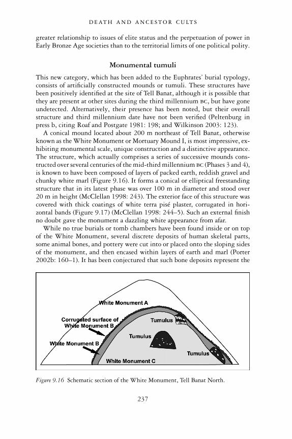
greater relationship to issues of elite status and the perpetuation of power inEarly Bronze Age societies than to the territorial limits of one political polity.
Monumental tumuli
This new category, which has been added to the Euphrates’ burial typology,consists of artificially constructed mounds or tumuli. These structures havebeen positively identified at the site of Tell Banat, although it is possible thatthey are present at other sites during the third millennium bc, but have goneundetected. Alternatively, their presence has been noted, but their overallstructure and third millennium date have not been verified (Peltenburg inpress b, citing Roaf and Postgate 1981: 198; and Wilkinson 2003: 123).
A conical mound located about 200 m northeast of Tell Banat, otherwiseknown as the White Monument or Mortuary Mound I, is most impressive, ex-hibiting monumental scale, unique construction and a distinctive appearance.The structure, which actually comprises a series of successive mounds cons-tructed over several centuries of the mid-third millennium bc (Phases 3 and 4),is known to have been composed of layers of packed earth, reddish gravel andchunky white marl (Figure 9.16). It forms a conical or elliptical freestandingstructure that in its latest phase was over 100 m in diameter and stood over20 m in height (McClellan 1998: 243). The exterior face of this structure wascovered with thick coatings of white terra pisé plaster, corrugated in hori-zontal bands (Figure 9.17) (McClellan 1998: 244–5). Such an external finishno doubt gave the monument a dazzling white appearance from afar.
While no true burials or tomb chambers have been found inside or on topof the White Monument, several discrete deposits of human skeletal parts,some animal bones, and pottery were cut into or placed onto the sloping sidesof the monument, and then encased within layers of earth and marl (Porter2002b: 160–1). It has been conjectured that such bone deposits represent the
Figure 9.16 Schematic section of the White Monument, Tell Banat North.
D E AT H A N D A N C E S T O R C U LT S
237
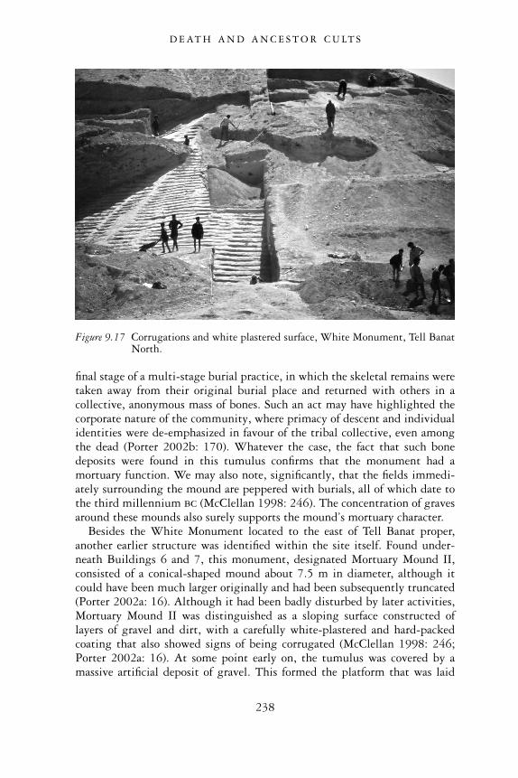
final stage of a multi-stage burial practice, in which the skeletal remains weretaken away from their original burial place and returned with others in acollective, anonymous mass of bones. Such an act may have highlighted thecorporate nature of the community, where primacy of descent and individualidentities were de-emphasized in favour of the tribal collective, even amongthe dead (Porter 2002b: 170). Whatever the case, the fact that such bonedeposits were found in this tumulus confirms that the monument had amortuary function. We may also note, significantly, that the fields immedi-ately surrounding the mound are peppered with burials, all of which date tothe third millennium bc (McClellan 1998: 246). The concentration of gravesaround these mounds also surely supports the mound’s mortuary character.
Besides the White Monument located to the east of Tell Banat proper,another earlier structure was identified within the site itself. Found under-neath Buildings 6 and 7, this monument, designated Mortuary Mound II,consisted of a conical-shaped mound about 7.5 m in diameter, although itcould have been much larger originally and had been subsequently truncated(Porter 2002a: 16). Although it had been badly disturbed by later activities,Mortuary Mound II was distinguished as a sloping surface constructed oflayers of gravel and dirt, with a carefully white-plastered and hard-packedcoating that also showed signs of being corrugated (McClellan 1998: 246;Porter 2002a: 16). At some point early on, the tumulus was covered by amassive artificial deposit of gravel. This formed the platform that was laid
Figure 9.17 Corrugations and white plastered surface, White Monument, Tell BanatNorth.
D E AT H A N D A N C E S T O R C U LT S
238
as preparation for the construction of Buildings 6 and 7. The removal ofMortuary Mound II from sight by this gravel layer may have been done inan effort to render it dysfunctional, or to de-sanctify it. For what purposesthis gravel served, it was extensive, being at least 3.5 m thick. It clearlyrepresents a massive earth-moving project.
Perhaps forming a sub-set of the monumental mortuary mound justdescribed are smaller earth tumuli. The difference is that these smallermounds almost always covered above-ground stone-built tombs. Tomb 302at Jerablus Tahtani, for example, belongs to this category since it was encasedin an earthen mound (Peltenburg 1999b: 431). Other such burial tumulihave been reported at the Bronze Age site of Baghouz, further south alongthe Euphrates River Valley near the Syrian/Iraqi border (Mesnil du Buisson1948). Last, a series of above-ground megalithic monuments, or dolmens,have been reported at Rumeilah, about 20 km south of Tell Banat, althoughthe earth tumuli that likely enclosed them have not survived (McClellan andPorter 1999: 108).
SPATIAL CONSIDERATIONS OF TOMB TYPESAND CEMETERIES
The grave typology formulated above has underlined the range and vari-ability of burial practices existing in the Euphrates Valley of Syria during theEarly Bronze Age. This general pattern of variability can also be observedin the graves’ placement within or outside occupied settlements, as well astheir spatial relationships to one another in individual cemeteries and sites.Despite this variability in tomb location, however, a few interesting patternsemerged in the data that appear to reflect specific social and economicbehaviour among the inhabitants of the region.
Intramural graves
Early Bronze Age tombs were frequently sited within or very near to con-temporary settlements. While the prevailing preference seems to have beenfor the burial of the dead in cemeteries just outside of occupied settlements,there are also a few notable instances of intramural graves. The inhabitants ofSelenkahiye, for example, appear to have been buried in the area immediatelyto the south of the site at the Wreide cemetery, but many were also buriedinside their city. Two nodal shaft graves were found within the settlement,one near the northern city wall under a floor in a domestic area of the city(Van Loon 2001: 3.59), and the other in one of Selenkahiye’s principalstreets, cut below its pavement (Van Loon 2001: 4A.177). Shaft graves werealso found in a cluster in the west-central part of the settlement near a citygate (Van Loon 4B.198). One of the richest shaft tombs, W12/13, was
D E AT H A N D A N C E S T O R C U LT S
239
located in a part of the central town area where it cut into domestic archi-tecture belonging to an earlier occupation phase (Van Loon 2001: 4B.210).Neither tomb W12/13, nor the five other simpler burials that were locatednear it, however, have any structural connections with existing houses, sug-gesting that they belong to a phase of abandonment in this particular sectorof the city (Van Loon 2001: 4B.210).
Intramural burials have been reported elsewhere too. The impressivestone-built shaft-and-chamber tombs investigated by Dornemann at TellHadidi were found in areas of the lower town, east of the main acropolis. It isreported that wall fragments and floor remains were found near these tombs,although the stratigraphic evidence documenting the placement of tombsunder such buildings was difficult to ascertain (Dornemann 1979: 117).
All of the reported burials from the site of Qara Quzaq derive from con-texts within the town (Olávarri 1995a: 10; Valdés Pereiro 1999: 120;Olávarri and Valdés Pereiro 2001: 20–1). The same goes for those found atTell Ahmar and Carchemish. At Jerablus Tahtani, an abundance of pit, cist,stone chamber and pithos burials have been reported intramurally, althoughin addition to these, an area at the northern end outside of the fortificationwalls, where excavations exposed two EB graves, may have served as thelocation of an extramural cemetery (Peltenburg et al. 2000: 72–3).
The reasons for burying the dead within or close to places of the living isuncertain, although such practices are not unique to northern Syria. InSouthern Mesopotamia during the third millennium, intramural burialswere quite common. Bodies were interred in otherwise unused or abandonedparts of settlements, such as rubbish dumps, or else they were buried underthe floors of inhabited houses (Pollock 1999: 206).
In her discussion of the co-existence of both intramural and extramuralburials in southern Mesopotamia, Susan Pollock discusses the growing ten-sion between household production and consumption on the one hand, andactivities within the oikoi, the collective term for larger and wealthier estatesbelonging to important public officials, temples and palaces within the cities(Pollock 1999: 117–18). Unlike households whose membership consisted ofnuclear or extended families living under one roof, these oikoi comprisedlarge socio-economic units with a dependent workforce and managerial per-sonnel who were not necessarily related to one another through kinship ties(Pollock 1999: 117–18). In this environment of competing levels of pro-duction, individuals may have felt pressure to connect themselves with theoikos-community through burial within a corporate cemetery, often locatedbeyond the limits of the city. Alternatively, the continuing practice of burialwithin family houses may have underlined the continued strength of indi-viduals’ ties to this more basic level of organization. One wonders if a similardynamic had developed in the northern Euphrates River Valley at the sametime. As has been noted in the earlier chapters, the third millennium was atime of increasing social and economic complexity as cities in this region
D E AT H A N D A N C E S T O R C U LT S
240
grew and prospered. Further, we have already seen considerable evidence forthe development of larger secular buildings, temples and other public worksrequiring cooperation within the community beyond the simple domesticlevel of production. Perhaps then, the distinction between intramural andextramural burials is related to the presence of both household and oikosgroups, one preferring to bury their dead within or near their own householdcomplexes, while the other encouraged interment of its members in a speciallydesignated cemetery located beyond the walls of the city.
As convincing as this reconstruction may sound, however, we shouldremain somewhat cautious about imposing the structure of one society ontothat of another. The oikoi system may seem to be a good way of consideringthe socio-economic structure of southern Mesopotamia. But in the northernEuphrates Valley, the contradistinction between the household on the onehand and the state, entirely divorced from kinship ties on the other, does notwork entirely well. This region continued to demonstrate a strong tribalcharacter despite growing social and economic complexity and an increas-ingly urban environment. Thus, even within the most densely inhabitedcentres of the Euphrates Valley, many of the inhabitants still identifiedthemselves with the tribal group to which they belonged, and performedmany social obligations and economic activities along tribal lines within thewider community. When we consider the relationship between burial loca-tions and social organization, we must be mindful of this unique situation. Inlight of this, perhaps we should see extramural cemeteries as the burial placesof tribal members, while intramural burials were for those who did not wishto emphasize their tribal affiliation, either because they were outsiders ornewcomers, or because they wished to highlight their role or influence insome other sphere of socio-economic activity.
If we now consider the practice of intramural versus extramural burialsaccording to the different grave types that have been identified in theEuphrates Valley, do any other interesting patterns emerge? As observed inTable 9.1, in which the presence of different grave types within or outside anoccupied settlement is indicated by an ‘x’, only monumental stone-builtshaft and chamber tombs are absent from extramural cemeteries.
This spatial pattern is not surprising, given that the overall visibility ofsuch monumental tombs, as previously discussed, assisted the tombs’ role instructuring social relationships among the settlement’s living inhabitants.By their intramural location, the potency of these funerary monumentswould have been all the more emphasized. Not only were these tombsostentatious by virtue of their large size, elaborate construction, and the factthey were above ground or otherwise well-marked, they were continuallyacknowledged because of their prominent location within the city. By theirspatial centrality, they would have provided constant reminders to the city’sinhabitants of the importance of the deceased who were buried within,and the deceased’s descendants, who reinforced their connection to such
D E AT H A N D A N C E S T O R C U LT S
241
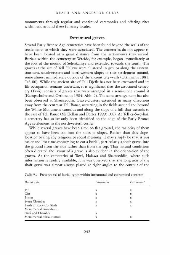
monuments through regular and continued ceremonies and offering riteswithin and around these funerary locales.
Extramural graves
Several Early Bronze Age cemeteries have been found beyond the walls of thesettlements to which they were associated. The cemeteries do not appear tohave been located at a great distance from the settlements they served.Burials within the cemetery at Wreide, for example, began immediately atthe foot of the mound of Selenkahiye and extended towards the south. Thegraves at the site of Tell Halawa were clustered in groups along the eastern,southern, southwestern and northwestern slopes of that settlement mound,some almost immediately outside of the ancient city-walls (Orthmann 1981:Taf. 80). While the ancient site of Tell Djefle has not been excavated and itsEB occupation remains uncertain, it is significant that the associated cemet-ery (Tawi), consists of graves that were arranged in a semi-circle around it(Kampschulte and Orthmann 1984: Abb. 2). The same arrangement has alsobeen observed at Shamseddin. Grave-clusters extended in many directionsaway from the centre at Tell Banat, occurring in the fields around and beyondthe White Monument tumulus and along the slope of a hill that extends tothe east of Tell Banat (McClellan and Porter 1999: 108). At Tell es-Sweyhat,a cemetery has so far only been identified on the edge of the Early BronzeAge settlement in the northwestern corner.
While several graves have been sited on flat ground, the majority of themappear to have been cut into the sides of slopes. Rather than this slope-location having any religious or social meaning, it may simply be that it waseasier and less time-consuming to cut a burial, particularly a shaft grave, intothe ground from the side rather than from the top. That natural conditionsoften dictated the layout of a grave is also evident in the orientation of thegraves. At the cemeteries of Tawi, Halawa and Shamseddin, where suchinformation is readily available, it is was observed that the long axis of theshaft grave was almost always placed at right angles to the contour of the
Table 9.1 Presence (x) of burial types within intramural and extramural contexts
Burial Type Intramural Extramural
Pit x xCist x xPithos x xStone Chamber x xEarth or Rock-Cut Shaft x xMonumental Stone-builtShaft and Chamber xMonumental burial tumuli x x
D E AT H A N D A N C E S T O R C U LT S
242
hillside into which it was dug. In summary, most graves demonstrate amultiplicity of orientations depending upon the direction of the slope of thehills.
BURIAL TYPES AND THEIRGEOGRAPHICAL DISTRIBUTION
The map shown in Figure 9.18 represents an updated version of the mapappearing in Carter and Parker’s earlier article, incorporating revisions andadditions to their original typology, and focussing in particular on burialtypes reported along the Euphrates River Valley of northern Syria andextending into southeastern Turkey. Each burial type is indicated by aunique pictorial symbol. While the map has generated several significantpatterns, the most interesting is the geographical distribution of cist gravesand earth and rock-cut shaft graves. For purposes of clarity, the geographicaldistribution of cist and shaft graves is also presented in a table in Table 9.2.In this table, the precise location of these graves, from north to south, islisted.
The pattern observable in this table was not clearly evident in Carter andParker’s earlier study because the authors had grouped earth and rock-cutshaft graves together with stone-built shaft and chamber tombs (Carter andParker 1995: 108). When a distinction between these burial types is made,however, the distribution of earth and rock-cut shaft graves is seen to belimited, for the most part, to the southern part of the region under investiga-tion, from the cemetery site of Wreide in the south, up to Tell Banat in thenorth. Except for the Anatolian site of Dibecik and tombs in the vicinity ofTilbes Höyük, northern Euphrates sites have failed to produce these distinct-ive rock-cut shaft tombs. On the other hand, the northern part of the studyarea contains an abundance of cist graves. The quantity of cist graves is par-ticularly high at Anatolian sites such as Titris Höyük, the Birecik Cemetery,where almost 300 cist graves have been reported, and the site of Lidar, whereno less than 200 cist graves have been recovered thus far (Carter and Parker1995: 113). The northern orientation of the cist burials, therefore, appearsvery pronounced.
It is tempting to derive some meaning from the clear geographical distinc-tion between the cist and earth or rock-cut shaft graves. One could suggest anumber of factors to account for this interesting spatial pattern, includingthe possibility that the grave-types reflect the existence of two separate polit-ical territories. One could posit, for example, that the distribution of cistgraves reflects the extent of an important Early Bronze Age polity such asCarchemish. Although archaeological investigations have failed to uncoversignificant exposures of that ancient city’s EB occupation, third millenniumtextual sources certainly do report its existence and its importance along
D E AT H A N D A N C E S T O R C U LT S
243
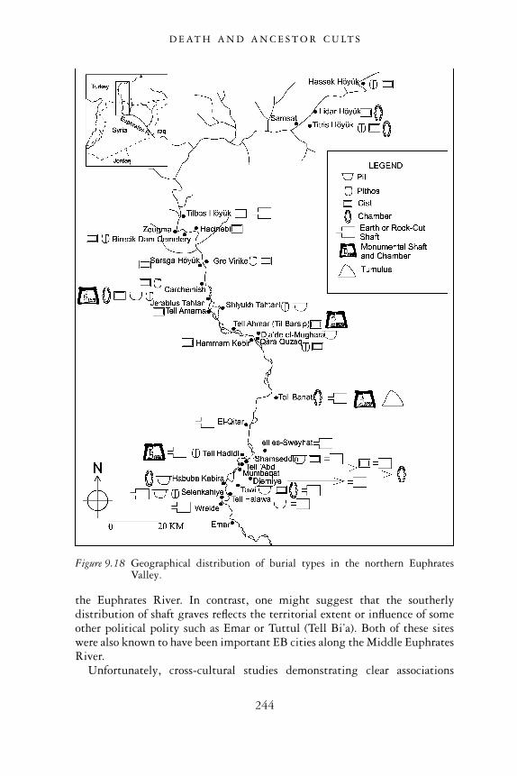
the Euphrates River. In contrast, one might suggest that the southerlydistribution of shaft graves reflects the territorial extent or influence of someother political polity such as Emar or Tuttul (Tell Bi’a). Both of these siteswere also known to have been important EB cities along the Middle EuphratesRiver.
Unfortunately, cross-cultural studies demonstrating clear associations
Figure 9.18 Geographical distribution of burial types in the northern EuphratesValley.
D E AT H A N D A N C E S T O R C U LT S
244
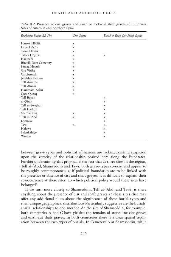
between grave types and political affiliations are lacking, casting suspicionupon the veracity of the relationship posited here along the Euphrates.Further undermining this proposal is the fact that at three sites in the region,Tell al- �Abd, Shamseddin and Tawi, both grave-types co-exist and appear tobe roughly contemporaneous. If political boundaries are to be linked withthe presence or absence of cist and shaft graves, it is difficult to explain theirco-occurrence at these sites. To which political polity would these sites havebelonged?
If we turn more closely to Shamseddin, Tell al- �Abd, and Tawi, is thereanything about the presence of cist and shaft graves at these sites that mayoffer any additional clues about the significance of these burial types andtheir unique geographical distribution? Particularly suggestive are the burials’spatial relationships to one another. At the site of Shamseddin, for example,both cemeteries A and C have yielded the remains of stone-line cist gravesand earth-cut shaft graves. In both cemeteries there is a clear spatial separ-ation between the two types of burials. In Cemetery A at Shamseddin, while
Table 9.2 Presence of cist graves and earth or rock-cut shaft graves at EuphratesSites of Anatolia and northern Syria
Euphrates Valley EB Site Cist Grave Earth or Rock-Cut Shaft Grave
Hassek Höyük xLidar Höyük xTitris Höyük xTilbes Höyük x xHacinebi xBirecik Dam Cemetery xSaraga Höyük xGre Virike xCarchemish xJerablus Tahtani xTell Amarna xTell Ahmar xHammam Kebir xQara Quzaq xTell Banat xel-Qitar xTell es-Sweyhat xTell Hadidi xShamseddin x xTell al- �Abd x xDjerniye xTawi x xHalawa xSelenkahiye xWreide x
D E AT H A N D A N C E S T O R C U LT S
245
the shaft graves appear in regularly spaced rows along the southern slopeof the hill, the stone cist graves are located at a distance at the northern endof the cemetery. The same kind of pattern is repeated in Cemetery C, where thecist graves are located on a different hill upon which the cemetery is located,thus being spatially distinct from the shaft graves (Meyer 1991: 89–90).
At Tawi, a similar separation of burial types is evident. Shaft graves werefound in a cluster in only one area of Area B, on the edge of a high hilldirectly to the east of the ancient settlement. In contrast, cist graves, whichwere more numerous, were found clustered in area A, at a healthy distancefrom the shaft graves (Kampschulte and Orthmann 1984: 75–80).
The absence of a final report from the first excavations at Tell al- �Abdmakes it difficult to confirm the relation between the cist and shaft graves atthis site. The excavator describes a cemetery of cist graves at the foot of theeastern slope of the mound (Bounni 1979: 55), while shaft graves arereported further to the east, on the slope of a small wadi (Orthmann 1980:99). Although we cannot be sure because of the brief nature of this report, itwould appear that here too was a spatial separation existing between cist andshaft burials.
Are there still other factors that might account for the unusual distributionof cist and shaft graves? Is time a factor? To be sure, cist graves do appear tohave had a longer history in the northern Euphrates Valley than shaft graves.They extend even as far back as the earliest EB phases of settlement in theregion (Phases 1 and 2). The cist graves of the Birecik Dam Cemetery,Carchemish and Tell Ahmar can be included among these early examples,judging by their pottery and metal artifacts (Thureau-Dangin and Dunand1936: 108–10; Woolley and Barnett 1952: 218–22; Sertok and Ergeç 1999).On the other hand, cist graves continue to appear in later EB contexts, wherethey are approximately contemporary with earth or rock-cut shaft graves, themajority of which date from the mid-to-late EB (Phases 3–4). While muchburial data are sadly lacking for the cist graves of Shamseddin because ofpoor preservation and tomb looting (Meyer 1991: 90), a few chronologicalconclusions can nonetheless be determined. At Cemeteries A and C, wherescattered pot sherds around the looted cist tombs were collected, the vesselforms were found to match up precisely with the pottery that had beencollected from shaft graves (Meyer 1991: 62–5; 99–102), indicating the twoburial types’ contemporaneity. At Tawi, the nine reported cist tombs fromArea A were likewise heavily robbed (Kampschulte and Orthmann 1984:75). Only Grave T31 yielded a single pot. Unfortunately the vessel is diffi-cult to date, although accompanying it was a tanged crescentic axe, a typethat is also known from the cemetery at Amarna to the north and dated toPhase 3 or 4, around the middle of the third millennium bc (Kampschulteand Orthmann 1984: Taf. 30; Tubb 1982: 9). A great deal of the potteryfrom other burials at Tawi can be similarly dated, as can shaft graves fromother neighbouring sites such as Tell es-Sweyhat and Tell Banat (Kampschulte
D E AT H A N D A N C E S T O R C U LT S
246
and Orthmann 1984: Taf. 18–28; Porter 1995a; Zettler 1997b: App. 3.1–3.3).In summary, the present evidence indicates that many cist burials canbe dated earlier than shaft graves in the northern Euphrates Valley. None-theless, with their continuing presence in the region in the latter half ofthe EB, some would have been contemporary with earth or rock-cut shaftgraves.
We exclude still other factors that might account for the different burialtypes. Differences in gender hardly match up with the marked north–southdistribution of cist graves and shaft graves. Moreover, where studies ofhuman skeletal material have been performed, such as at the shaft-gravecemetery of Halawa, they verify that both sexes could be buried in suchgraves (Orthmann 1981: 72). It is likewise difficult to correlate the unusualnorth–south configuration of the two burial types with differences in wealthor status within one population. In any event, the full range of wealth dif-ferentiation can be observed among the shaft graves alone – from the sim-plest small rock-cut tombs, to magnificently cut and elaborately furnishedinhumations that contained a wealth of grave goods – such that searches forwealth distinctions based on different burial types are unwarranted.
Burial types and ethnic identity
One last possible explanation to justify a northern and southern distributionof cist and rock-cut shaft graves, and their co-existence at three sites but inseparate locales, is the presence of two ethnic groups. Several factors wouldsupport such a proposition.
First, unlike the widespread lack of reported correspondences betweenpolitical polities and mortuary remains in the anthropological literature,ethnic identity can sometimes be correlated with burial remains and prac-tices. A survey of studies of the archaeological manifestations of ethnicityfrom around the world finds several examples of ethnic groups who are dis-tinguished from other groups by the ways in which they bury their kinsmenand conduct funerary rituals. One example comes from the Mesoamericancentre of Matacapan, located in southern Veracruz. During the MiddleClassic Period (ad 400–700), this centre appears to have supported enclavesof people from Teotihuacan, a large and important urban centre with tre-mendous influence throughout Mesoamerica. At Matacapan, distinct occupa-tion zones or enclaves rich in Teotihuacan-style materials, such as cylindricaltripod bowls, candeleros, and Teotihuacan-inspired civic-ceremonial archi-tecture were found. Also evident in these enclaves were distinctive burialpractices, namely the flexed interment of the deceased below house floorswithin domestic structures, a custom practised at Teotihuacan, along withinfant jar burials, another Teotihuacan mortuary custom (Santley et al. 1987).The combination of these funerary remains and the other artifacts, therefore,presents a strong case for a Teotihuacan ethnic presence at this site.
D E AT H A N D A N C E S T O R C U LT S
247
Closer in region and date to the mortuary remains described here are archae-ological remains connected with the Hyksos, a population group that hadsettled in the Delta region of northern Egypt during the Second IntermediatePeriod of Egypt (c.1648–1540 bc). The distinctive ‘Asiatic’ character of theHyksos population is particularly evident in burials found at sites such asTell el-Dab’a, Tell el-Maskhuta and Inshas, where vaulted mudbrick chambertombs and the presence of donkey sacrifices clearly represent non-Egyptianfunerary traditions and practices (Weinstein 1992: 345).
One can see by these examples, therefore, how the ethnic identities ofparticular human groups are marked by distinctive funerary remains andtheir accompanying rituals, for which material residuals have been preserved.Such examples support the notion that differences between cist and shaftburial types in the northern Euphrates Valley of the Early Bronze Age couldalso be attributable to the presence of two distinct ethnic groups in thisregion.
Second, although it is difficult to suppose a situation in which individualswere affiliated with different political polities co-existing at the same site, itis not hard to accept that more than one ethnic group resided together in thesame settlement. Once again, a survey of the anthropological literature,which includes cross-cultural studies of ethnicity, produced many examplesof such a phenomenon. In the modern world, the co-existence of two or moredistinct ethnic groups residing in the same city is extremely common (Glazerand Moynihan 1965; Nagata 1974), while the same has been observed inmany cities in the ancient world. In ancient Mesopotamia during the Ur IIIperiod, for example, Amorite groups were known to have co-existed withSumerian populations in several southern Mesopotamian cities (Kamp andYoffee 1980: 90). In light of these examples, therefore, we cannot exclude thepossibility that cities in the Euphrates Valley of Syria and Anatolia duringthe EB also comprised mixed ethnic populations.
Which ethnic group, then, might be associated with the cist burials?Although Carter and Parker did not find such a clear spatial pattern amongburials as observed here, their overall impression of the northern orientationof cist burials led them to suggest that such graves might be linked withAnatolian/Hurrian populations (Carter and Parker 1995: 113). This prop-osition seems quite plausible, given the textual evidence for the presence ofsmall Hurrian states to the north and northeast of Akkad in the late thirdmillennium bc (Carter and Parker 1995: 113). While the Hurrians seem tohave been most numerous in the Habur region of northeastern Syria (atNagar and Urkesh) as well as to the east of the Tigris River (Stein 1997:127), it is not unlikely that smaller pockets of Hurrian groups settled alongthe Euphrates River in Anatolia, and further south in Syria, where theywould have settled alongside the indigenous populations of this region.Interestingly, this proposition also finds support in geographical place namesknown from contemporary ancient sources, as will be discussed below.
D E AT H A N D A N C E S T O R C U LT S
248

On the other hand, can we ascribe an ethnic identity to the users of theearth or rock-cut shaft graves? In order to address this question, we needto survey the entire geographical region in which such graves have beenfound. Shaft graves are abundant not only in the area of the ‘Big Bend’ ofthe Euphrates region, they are present further to the south at Tell Bi’a(Strommenger and Kohlmeyer 1998). Further, they cross over into westernSyria, and the Levant, where they are reported in Palestine and Transjordan.Shaft graves occur throughout the EB period in the Levant, but becomeespecially prevalent in the Early Bronze IV period, in the last centuries of thethird millennium bc. This is also the period in which shaft graves are themost numerous in the Syrian Euphrates Valley. Given this distribution,perhaps we can propose a Semitic identity for the owners of the shaft graves.We know that Semitic groups such as the Amorites were present in northernand western Syria, especially during the end of the Early Bronze age, soperhaps we are looking at the kinds of burials that the Amorites, or possibly,proto-Amorites, used for the interment of their dead.
As a last word on the discussion of ethnic variability in the northernEuphrates Valley, one can turn to Marco Bonechi’s recent study of Pre-Sargonic geographical names. His study, which utilizes third millenniumtextual sources from Ebla and Mari, focusses in particular on place namesfrom the region along the Euphrates up to the modern border between Turkeyand Syria, including the toponymy of the area around Carchemish (Bonechi1998). While Bonechi ascertains that the majority of place names in thisregion are Semitic, originating some time at the beginning of the thirdmillennium bc, some Hurrian place names are also detectable, appearing ingreatest numbers in the northernmost part of the area, namely in the foot-hills just north of the present-day Syrian-Turkish border in the regions of theEuphrates and Balikh Rivers (Bonechi 1998: 236). As is common of borderzones, Bonechi is not surprised to find small enclaves with a Hurrian top-onymy present relatively far from the Anatolian foothills (namely to thesouth, in Syria), while at the same time he conjectures that small enclaveswith Semitic toponymy also existed far from the plains, e.g. in the Anatolianhighlands (Bonechi 1998: 237). This type of pattern, detectable among geo-graphical place names in ancient textual sources, is very tantalizing as itmirrors precisely the pattern that we have observed among cist and earth orrock-cut shaft graves. Thus, just as pockets of Hurrian place-names can berecognized within a region dominated by Semitic toponymy, so too can cistgraves be detected among the prevalent shaft grave types of northern Syria.At the same time, a few scattered rock-cut shaft graves in Anatolia parallelthe presence of occasional Semitic toponyms in the north. In sum, the con-vergence of textual and archaeological data, as noted here, offers consider-able validity to the notion that two separate ethno-linguistic populationsco-existed in the Euphrates valley of northern Syria and southern Anatolia,and that they can be distinguished from one another in the funerary record.
D E AT H A N D A N C E S T O R C U LT S
249
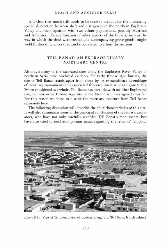
It is clear that much still needs to be done to account for the interestingspatial distinction between shaft and cist graves in the northern EuphratesValley and their equation with two ethnic populations, possibly Hurriansand Amorites. The examination of other aspects of the burials, such as theway in which the dead were treated and accompanying grave goods, mightyield further differences that can be correlated to ethnic distinctions.
TELL BANAT: AN EXTRAORDINARYMORTUARY CENTRE
Although many of the excavated sites along the Euphrates River Valley ofnorthern Syria have produced evidence for Early Bronze Age burials, thesite of Tell Banat stands apart from these by its extraordinary assemblageof mortuary monuments and associated funerary installations (Figure 9.19).When considered as a whole, Tell Banat has parallels with no other Euphrates’site, nor any other Bronze Age site in the Near East investigated thus far.For this reason we chose to discuss the mortuary evidence from Tell Banatseparately here.
The following discussion will describe the chief characteristics of this site.It will also summarize some of the principal conclusions of the Banat’s excav-ators, who have not only carefully recorded Tell Banat’s monuments, buthave also tried to resolve important issues regarding the remains’ temporal
Figure 9.19 View of Tell Banat (area of modern village) and Tell Banat North behind.
D E AT H A N D A N C E S T O R C U LT S
250
sequence, their spatial connections with other funerary installations, and theirfunction and ideological character. The researchers’ thoughtful considerationsof the diversity of mortuary remains and their significance have underlinedthe myriad of overlapping, conflicting and congruous social relationships andideology existing among the inhabitants of this intriguing settlement. Suchrelationships indicate a culture and society that was far more complex thanoriginally perceived, and defined by more than simple socio-economic statusdisparities (Porter 2002b: 158). Further, these multiple social relationships‘did not simply reflect the nature of life in the third millennium’, they‘actively produced it’ (Porter 2002b: 158).
Our typology of graves has already provided a description of Tomb 7 atTell Banat, an impressive stone-built shaft and chamber tomb. We alsodescribed other burials uncovered at Tell Banat or in its immediate environs.These included stone-walled chamber tombs and earth-cut shaft tombs,located both within (Tomb 1) and outside of the ancient settlement (Tomb2). Last, we provided a description of the Mortuary Mounds, which areimpressive, artificially constructed tumuli. Deposits of human bones foundwithin these monuments suggest that they had some mortuary significance,as does the fact that lesser, contemporary burials were found in the fieldsaround them.
The strong funerary character of Tell Banat is indicated by other remainsbesides burials and mortuary mounds. In Chapter 6, we described twolarge-scale structures, Buildings 6 and 7. These buildings’ association withmortuary activities is supported by their close spatial relation to a variety ofgraves, including Tomb 7, as well as their location on the enigmatic thickgravel layer that covered Mortuary Mound II in its entirety.
The extensive manufacturing sector of Tell Banat should also be con-sidered. This area contained kilns and a sequence of buildings which func-tioned as the workshops of craftsmen engaged in the mass manufacture ofpottery. The ubiquity of pottery in all of the third millennium bc graves atTell Banat, and the fact that many of the grave vessels duplicate those pro-duced in the site’s pottery manufactories, suggest that the principal functionof these workshops was to fabricate large quantities of pottery for funeraryconsumption.
When considered as a whole, Tell Banat represents a remarkable settlement.It is significantly different from other sites along the Euphrates River fromthe same period which are invariably characterized not only by cemeteriesand graves, but also blocks of houses and places of domestic activity. Whilethese other sites served primarily as settlements for living inhabitants, theprimary purpose of Tell Banat was the accommodation of the dead. Thosewho did reside at the site seem to have been there for the purpose of main-taining or serving this mortuary centre in some capacity. Nevertheless, this‘city of the dead’ must not be construed as having functioned exclusivelyfor the comfort and sustenance of the dead, with little connection or social
D E AT H A N D A N C E S T O R C U LT S
251
relevance to living persons. On the contrary, in their constituent parts, theremains at Tell Banat were potent symbols, communicating strong messagesabout society, tradition, and appropriate behaviour among the living.
It is tempting to regard the remains of Tell Banat, which comprise elabor-ate and monumental architecture, extensive industrial installations, and atleast one impressive tomb with rich and abundant burial gifts, as reflecting asocio-political system dominated by an elite (Porter 2002b: 165). In thislight, the individuals buried in Tomb 7 could have been members of a localroyal family, while other less impressive graves belonged to the subordinatepopulation who were controlled by this elite (Porter 2002b: 165). Textualevidence from sites like Ebla might support this picture, since that citywas marked by the presence of the king and his royal family. At Ebla, thedistinction between royal and commoner was perpetrated not only by certainnorms and practices within daily life, but also through funerary practices.Royal burials were clearly marked and segregated from the rest of the settle-ment. Regular pilgrimages were made to such tombs of the royal ancestors,and rituals at these funerary locales served to sanctify and legitimate theauthority of the living kings who were descended from them (Porter 2002a:5; 2002b: 168).
Despite this evidence, however, one should remember that Early BronzeAge society in the Euphrates River Valley, unlike Ebla to the west, was notwidely defined by instances of status differentiation, either in burial practicesand burial goods, or in other aspects of the region’s urban culture. It wouldsurely be erroneous to deny the presence of elite groups in the region, astestified by visible stone-built tombs like those at Tell Banat, JerablusTahtani and Tell Ahmar. These types of tombs, however, represent only asmall fraction of the total range of burials present in the Euphrates Valley.Moreover, few other graves reflect status differentiation through their size,layout, and tomb artifacts. While there are certainly many variations ofburials and burial objects from site to site, and from grave to grave, it can beargued that factors such as ethnic distinctions, economic relationships, andtribal versus household affiliations account for this diverse array of graves andfurnishings. Thus, to place an inordinate emphasis on status differentiationat Tell Banat would seem incongruous with mortuary remains elsewhere inregion. We can also add, as a last remark, that too many anomalous burialpractices exist at Tell Banat itself to be convincingly explained by statusdifferentiation alone.
One interesting observation concerns the degree of individual identitythat appears to have been erased in the act of burial at many of Banat’sfunerary contexts. All of the burials contained within the White Monument,for example, are disarticulated and have few grave goods. These mortuarypractices do not appear to express the individuation of specific members ofthe group, their status or position. On the contrary, they highlight thecorporate nature of the deceased, all of whom were buried in a similar,
D E AT H A N D A N C E S T O R C U LT S
252
unostentatious manner in a single locale (Porter 2002b: 166). It is suggestedthat this amorphous mass of dead ancestors was the result of a multi-stageburial practice, in which the body was taken away from its original burial placeand individual funerary goods, and disarticulated in a individual-less mass ofanonymity. There is much evidence in the form of empty graves and second-ary graves of disarticulated skeletons at Banat to testify to this practice.Through the creation of this amorphous mass of ancestors, primacy of descentand individual identities were lost in the collectivity (Porter 2002b: 170).
In her interpretation of the enigmatic White Monument at Banat, Porterattributes to them the place of the cult of the ancestors. In contrast to otherworld cultures, however, in which ancestors are named individuals whoestablish rights, relationships and positions in descent hierarchies among theliving, the ancestors at Banat are an unnamed amorphous group (Porter2002b: 167). Their anonymity is suggested by the encompassing nature ofthe tumulus itself, which encases earlier tumuli, and the characterless natureof the burials within it.
Porter argues that the way in which the ancestors are perceived as such hasimplications for the living society at Banat, whose own social behaviour isinformed and reinforced by the manner in which they see their ancestralcommunity behaving:
The society of ancestors forms a blueprint for the nature of socialrelationships among the living, which may be adhered to or deviatedfrom in the real world, but which nevertheless has impact upon thenature of that world. That the ancestral community of the WhiteMonuments portrays a corporate society by virtue of their nebuloustreatment of their remains is integrally related to the notion ofcorporation in the world of the living.
(Porter 2002b: 167)
Such ancestral monuments, then, whose funerary message is that of integra-tion and corporation, would have encouraged the same type of behaviouramong the living inhabitants.
It should be noted that this ideology of corporation appears to be similarto that held by other ancient Mesopotamian communities. Textual sourcesfrom the city of Mari to the southeast, for example, speak of rites such as theso-called kispum, a regularly performed communal meal at which the livingand the dead are present. Such a ritual was intended to perpetuate and affirmthe role of a generalized class of the dead in the realm of the living (Porter2002a: 5). While this ritual seems to have been central to the legitimation ofthe king, it nonetheless placed emphasis on the importance of incorporationamong those who participated in it, and in so doing, affirmed an ideal tribalunity.
This kind of corporate social structure is entirely in keeping with what
D E AT H A N D A N C E S T O R C U LT S
253
has already been conjectured about Euphrates society from the point ofview of settlement subsistence, social organization, architecture and artifacts.Further, we can add how this corporate society fits very well with the pro-posed tribal aspect of Syrian Euphrates society. Despite the overall trendtowards larger and more densely populated urban centres and greater polit-ical and economic complexity among sites over the course of the third mil-lennium bc, the basic structure of society remained tribal, and individualscontinued to identify themselves according to the kin-based tribal group towhich they belonged. The continuing tribal character of the Euphratesregion may have been the result of the continuing importance of pastoralism.As we have already related, mobile pastoralists flourished throughout the EarlyBronze Age, and they constituted a very important aspect of the economicand social character of the region.
The kin-based tribal-based structure of Euphrates society is accepted alsoby the Tell Banat researchers, who note that in such a society, while elites orrulers may have been present, they were linked to the rest of the communitythrough kinship ties that permeated many types of social interaction (Porter2002b: 168). Further, they note that ‘kin structures were not negated by thestate, nor annulled by increasing sizes of settlement and polity . . . but wereactively productive of the state and arrogated by it’ (Porter 2002b: 168).Altogether, this form of kin-based structure would have served to ‘perpetuateat least a degree of parity among different sectors of society and allowedgreater access to decision-making and power-sharing’ (Porter 2002b: 168).Such a model of a corporate society, derived from the mortuary remains ofTell Banat, is truly elegant. One wonders how many future funerary findingsin the northern Euphrates Valley and perhaps elsewhere, will lend furthersupport to this compelling notion.
DISCUSSION
This overview of the archaeology of death has emphasized a number ofimportant issues that are critical to our understanding of settlement andsociety in the northern Euphrates River Valley during the Early Bronze Age.We have tried to show how funerary remains not only offer informationabout this ancient society’s beliefs about death and the afterlife, they alsohelp us to understand how Euphrates’ society was organized, particularly interms of its social structure and economy. We have also seen how in somecases the material remains of burials, tomb offerings and the residues of ritualperformances did not merely express funerary behaviour. They had trans-formative power among the living, making and re-defining social roles andcultural practices.
It is clear that a myriad of issues influenced how a deceased individual wasto be interred and the kinds of funerary rituals taking place in his or her
D E AT H A N D A N C E S T O R C U LT S
254
honour. These issues, which were related to social organization, ethnic iden-tities, economic differentiation, peer polity interaction, age, gender differ-ences and religious beliefs, influenced the types, sizes, layout, and location oftombs. They also had a bearing on the quantity and quality of grave offeringslaid inside of the tombs. Together, this variety of burial evidence stronglyunderlines the complexity of society during the Early Bronze, with itsmultiplicity of overlapping, competing or complementary relationships, allexisting together within densely inhabited urban communities and theirsurrounding territories.
Tremendous variability occurred in funerary practices from one Euphratessite to another. Thus, no two cemeteries were exactly alike in terms of theirburial types, the location of their tombs and the ways in which the deadwere interred within them. Even with sites in close proximity to one another,we see tremendous differences in funerary remains and the accompanyingmortuary rites they reflect. Such differences stress yet again the independentcharacter of the settlements within this region. While all Euphrates settle-ments were no doubt bound together by common social and economic struc-tures, as well as beliefs about religion, the gods and the afterlife, the ways inwhich they specifically interpreted these notions and ideologies and actedupon them were unique and distinctive.
One of the most interesting observations derived from our investigation ofEuphrates funerary practices is the notion of the corporate polity, possiblyengendered by the strong pastoral, tribal background of many of the region’sinhabitants. As we have discussed, this corporate ideology finds reflection inthe mortuary remains of Tell Banat, where people’s individual identitieswere removed after they died, to be subsumed within a collective mass ofunnamed ancestors. This ancestral worship was focussed primarily on theMortuary Mounds, these being impressive, white monuments that toweredhigh above the river valley at Tell Banat. By their monumentality theyserved to strengthen the notion of shared traditions and common kin des-cent. Although such tumuli at Tell Banat have been the only ones to bepositively identified, it is likely that several other such mounds existed, andthat these funerary markers and the theme of corporate belonging that theyreflect, were well known in the Euphrates Valley.
At the same time as such potent symbols of unity and social parity existed,there was a concurrent tendency within Euphrates society that favoured thegrowth of social-economic hierarchies, characterized by wealthy and power-ful elites. These individuals asserted their prominent status by buildingimpressive tombs for themselves and filling them with a rich assortment ofrare and precious grave goods. Monumental shaft and chamber tombs,observed at Tell Banat, Tell Ahmar, Jerablus Tahatani and Tell Hadidi, standout as excellent examples of elite tombs, and confirm that Euphrates societywas not completely immersed within an ideology of collectivity and inclu-sion. There existed a strong, contrasting element of social inequality in the
D E AT H A N D A N C E S T O R C U LT S
255
region as well. This development seems to have reached a peak around Phase 4(c.2450–2300 bc), at precisely a time when settlements were experiencingurban growth, and monumental tombs were most numerous. We cannotbe certain of the precise factors that favoured this elite growth, although it islikely that people’s increased contact with other regions, made accessible byriverine communications and trade, encouraged this development. The factthat many tomb offerings in the large tombs comprised precious and raregoods obtained from distant lands further supports the strong associationbetween elite growth and far-reaching contacts.
The excavators of Tell Banat, who also recognize the growth of elitepower in the Euphrates Valley in the mid-to-late third millennium, haveproposed a theory to explain this development, while at the same timeacknowledging the continued persistence of a corporate ideology. They arguethat to legitimate their claims to power, the elite would have continuedto utilize the traditional symbols of social relations, such as the WhiteMonument, in order to emphasize a communal imagery of the idealized past(Porter 2002a: 28). In other words, the elite endeavoured to make theirpower more palatable by presenting the imagery of community and the con-tinuity of a long-established social system even when such a system wasbeing strongly undermined (Porter 2002b: 170). If this is truly the operatingprinciple at Tell Banat, one can see how potent symbols of community and acorporate social system were used and manipulated, and also how they carriedtransformative power. These symbols not only reflected social relationshipsand community ideologies, but actually served to create, perpetuate andtransform them.
However fascinating and significant these mortuary practices and funerarytraditions were, they eventually came to an end. By Phase 6 at the end of theEarly Bronze Age, precious little evidence exists for graves and funerarymonuments in the northern Euphrates Valley. The site of Tell Banat hadlong ceased to be occupied and its mortuary mounds were neglected. By theonset of the Middle Bronze Age in the early second millennium, nearly all ofthe rich and potent funerary symbols of the dead had been extinguished andforgotten.
D E AT H A N D A N C E S T O R C U LT S
256
10
THE END OF THE EARLY BRONZEAGE: EUPHRATES SETTLEMENT
IN DECLINE
Understanding urban collapse in the ancient Near East
The last centuries of the third millennium bc mark an intriguing time inthe Near East. Areas that once had flourishing cities and had thrivedunder effectual political and economic systems, declined dramatically. Statessuccumbed to internal disorder, cities were destroyed or abandoned, andpopulations were uprooted and displaced. The great empires of southernMesopotamia and Egypt, which had powerful royal dynasties and far-reaching trade contacts, now fell precipitously. In other areas of the Levantand Northern Mesopotamia, where urban states were smaller and less struc-turally complex, collapse also occurred. Here cities that had controlledextensive tracts of agricultural and pastoral lands, and had prospered understable, productive economies, crumbled and eventually disappeared.
Tumultuous upheavals mark this period of collapse, although little isknown about the actual events that led up to and took place during thistroubled time. The small number of surviving inscriptions that have beenrecovered give few clear clues about this period of recession. Moreover,obscure or unspectacular architectural and artifactual remains characterizemuch of this period’s archaeological record. It is no wonder that the NearEast at this time is frequently referred to as a ‘dark age’, since the frag-mentary and ambiguous nature of the evidence give the period an overallenigmatic and murky quality.
Despite the difficulties presented by this obscure evidence, we shouldnot exclude this period of decline from our study of Bronze Age urbansettlement and society. An examination of the ways in which cities experi-enced collapse contribute as significantly towards our understanding of thesettlements’ complex and distinctive nature as do studies of their growth andsuccess. It is valuable, therefore, to attempt to comprehend more fully thecircumstances that led to urban demise in the Near East. It will be useful tosee how cities responded to factors that threatened to weaken their social oreconomic structures, and how they were able to revive after serious politicaldisruptions. Once we understand these topics, we will be able to understand
257
and appreciate more fully the true character of an urban settlement. Theywill shed light on the special attributes that give a settlement its uniquecultural distinctiveness, and the mechanisms that enable it to perseverethrough periods of both prosperity and recession.
Settlement in the Euphrates River Valley of Syria, the main focus of thiswork, provides an especially interesting and unique example of the rise anddemise of Bronze Age urban society. Although human settlement in thisregion was not immune to the social and economic upheavals that affectedmany other parts of the Near East at the end of the third millennium bc, itstands out as an interesting example of a society in which several earlierBronze Age institutions and cultural traditions managed to survive and con-tinued to shape the essential character of Euphrates culture throughout theperiod of decline and after. Further, although some settlements within theEuphrates Valley were abandoned during this period, several others con-tinued to be inhabited. Finally, only a short time period passed before thesecommunities revived, growing once more into flourishing cities, taking partin brisk trade along the river, and effectively exploiting the agricultural andpastoral potential of their hinterlands.
This chapter will present the archaeological evidence that demonstratesthe region’s character of continuity and resilience. It will also present explan-ations of why settlement in the Euphrates River Valley differs from that ofother contemporary Near Eastern societies. It will discuss as well the region’senvironment and the nature of its social, political and economic institutions.This chapter overall will show that an understanding of the essential fabric ofan ancient city is facilitated not only by looking at the optimal conditionsthat led to its growth and prosperity, but also by comprehending itsresponses to negative forces that weakened its foundations and threatened tobring an end to its very existence.
Near Eastern regions affected by late thirdmillennium collapse
As noted above, we find that several regions of the Near East experiencedsome form of decline at the end of the third millennium bc. We will nowsummarize the nature of this decline in each area and briefly describe theform that settlement and society took in the wake of these disruptions.
In the alluvial plains of the Tigris and Euphrates Rivers of southernMesopotamia, two great empires fell in succession during this period. Thehouse of Akkad, the first imperial power in southern Mesopotamia to con-solidate political control over a mosaic of competing city-states and to estab-lish trading opportunities over a vast area of the Near East, came to an endaround 2150 bc. This Akkadian Empire was replaced shortly afterwards bythe Third Dynasty of Ur, although this state too, characterized as it was byan extremely centralized bureaucracy and overstretched economy, rapidly
E U P H R AT E S S E T T L E M E N T I N D E C L I N E
258
crumbled around 2000 bc. The once-great capital city of Ur was overrun byforeigners, and the whole empire was thrown into a state of internal chaosand political fragmentation (Yoffee 1988: 46–51).
North of the Tigris-Euphrates flood plain, the region of the Jezireh ofUpper Mesopotamia, essentially comprising the Khabur Plains of north-eastern Syria and the Sinjar Plain of northern Iraq, underwent a similar crisistowards the end of the third millennium bc. Up to this point in time, thearea had been pursuing a regime of agricultural maximization, no doubtprecipitated by the growth of large urban settlements. Extensive manuring(evidenced by widespread sherd scatters) and a multitude of linear hollows,interpreted as roadways radiating out from settlements to the fields, arebelieved to reflect the intensity of agricultural production that took placeduring this period (Wilkinson 1994: 492–3). Around 2200 bc, however,the area experienced a dramatic reduction in this intensified dry-farmingagricultural regime, about the same time that Akkadian imperial control inthis region began to weaken (Weiss and Courty 1993). While recent archaeo-logical evidence at sites like Tell Brak and Tell Mozan indicate that someurban settlements survived after this time (Oates et al. 2001: 3931), overallan appreciable reduction in the number of occupied sites, in addition toa pattern of contracting settlement, appear as the prevailing trend in theJezireh between 2200–1900 bc (Weiss and Courty 1993: 141; Peltenburg2000: 164–5). This change may have been brought about by a large-scalepopulation emigration, in which human groups moved towards southernMesopotamia via the Euphrates River valley in their quest for reliablefood and pasturage (Weiss and Courty 1993: 144). Alternatively, it is pos-sible that many of the inhabitants adapted successfully to pastoralism, andthat such a transformation left sparse remains in the archaeological record(Peltenburg 2000: 180).
Still other regions of the Near East were affected by collapse at the end ofthe third millennium. In Egypt, this period is marked by the end of theprosperous Old Kingdom, and its replacement by the First IntermediatePeriod, a time of political fragmentation and decentralization (Morris inpress). In most areas to the west of the Jordan River in Palestine, as early as2300 bc, the Early Bronze III urban centres were destroyed or abandoned,and the stable productive subsistence systems, based on intensified agri-culture, industry and trade, ceased to operate (Richard 1987: 34; Dever1989: 228). In the Early Bronze IV period that followed, the region experi-enced a kind of ‘ruralization’, in which a diversified subsistence economybased on small-scale farming and pastoral nomadism prevailed for severalcenturies (Palumbo 2001: 237).
Several reasons for the collapse of urban centres have been put forward bythose studying archaeological and textual data from different parts of theancient Near East, two of which are examined here. One of these theoriestakes into account the impact of the natural environment on the growth or
E U P H R AT E S S E T T L E M E N T I N D E C L I N E
259
deterioration of an ancient human society. The other hypothesis, which con-cerns a Near Eastern ‘world economy’, emphasizes the multi-dimensional,interactive character of most human societies. In these ‘general systems’perspectives, changes or disruptions that take place in one part of an inter-connected network of political and economic systems can seriously affectother parts of that network as well.
Climatic change
The first hypothesis put forth to explain why the Near East became engulfedin a ‘time of troubles’ in the late Early Bronze period is climatic change. Thisis described as consisting specifically of increased aridity, decreases in avail-able sources of water and drops in flood levels along major rivers. Suchchanges may have had a sufficiently debilitating effect to bring about catas-trophe to Near Eastern political systems, especially in environmentally fra-gile regions where a constant and stable climate was essential if agriculturalregimes were to survive and flourish.
Several people who study the collapse of the Old Kingdom and the follow-ing two centuries of instability of the First Intermediate Period in Egyptsupport this hypothesis. B. Bell (1971), drawing heavily from existingpalaeo-climatic data and historical texts from Egypt, argues that a ‘GreatDrought’ took place between 2200–2000 bc. She refers to the work ofK. Butzer, who reported the end of a moist interlude in Egypt around 2350bc, after which increasing aridity set in. Bell also refers to textual evidencesurviving from the First Intermediate Period, which includes no less than20 references to famine. The texts describe not only people dying of hun-ger, but also provincial governors dispensing grain to the hungry, sendingshipments to assist neighbouring polities and modifying irrigation canals inorder to convey water to otherwise parched and useless agricultural fields(Morris in press). It is significant too, that during this period, artistic repre-sentations in Egyptian tombs no longer illustrate desert fauna and trees,perhaps suggesting that desert life had become depleted by this time (Kemp1983: 179).
There has recently been both questioning of and support for the hypo-thesis of a change in climate. First, Butzer’s most recent consideration of thegeological, climatic and historical data has weakened the significance of cli-matic change, at least in the case of the Old Kingdom of Egypt (Butzer1997). His study draws on evidence of water levels at Lake Turkana inKenya, the source of the Blue Nile. The lake dropped in level between2750–2200 bc, rose again abruptly around 2150–2050, dipped again androse once more around 1600 bc. This pattern is complemented by findingsbased on lake cores taken from both Lake Turkana and the northeasternNile Delta, that point to a lower water level towards the end of the thirdmillennium. Interesting data also appear in the Fayum Depression to the
E U P H R AT E S S E T T L E M E N T I N D E C L I N E
260
west, which was linked to the nearby Nile floodplain by a secondary channel.There lakes were supported by an influx of Nile flood waters, with recessionsduring periods of lower floods. Analyses of these lake levels show that thefloods were high between 3100–2900 bc, then lower, with a short-livedminimum around 2200 bc.
These convincing data might suggest climatic deterioration at the end ofthe third millennium bc (c.2200 bc). Butzer, however, points out that thelowest flood levels are contemporary with the First Intermediate Period ofthe eighth and ninth dynasties, but not with the dynasties of the Old King-dom some two centuries earlier (Butzer 1997: 258). It was at this time thatEgyptian civilization actually began its dramatic collapse. Thus Butzer, seek-ing an explanation other than climatic change, suggests that internal factorsin Egypt, such as the increasing territorial holdings and the wealth of thetemple estates that were exempt from taxation, and greater administrativeautonomy within the provinces, served to weaken the centralized govern-ment. The final fatal blow may have come from the over-long reign of thelast pharaoh of the sixth dynasty, Pepi II (c.2330–2240 bc). At his death, theEgyptian state promptly disintegrated, with power devolving to strong localfamilies in the provinces, and pharaonic authority dissolving completely(Butzer 1997: 258). Destabilizing factors of this kind within Egyptian soci-ety itself were sufficient to account for the country’s decline, in Butzer’s view.
But the climatic theory still has its adherents. They include Harvey Weissand his colleagues, whose analyses of soil deposition in archaeological con-texts in northeastern Syria have been especially influential in promotingclimatic change as a prime cause of urban collapse (Weiss et al. 1993).Micromorphological soil studies of excavated strata from the site of TellLeilan in the Khabur Plains and elsewhere in the Jezireh of Upper Mesopotamiahave isolated late third millennium desertion levels containing tephra falloutalong with other soil profiles that point to marked environmental deterior-ation. From these data, Weiss argues that, in addition to a dramatic volcanicevent occurring at the end of the Akkadian occupation of Tell Leilan, anabrupt climatic change occurred, bringing about a rapid intensification ofwind circulation, an increase in atmospheric dust and the establishment ofarid conditions (Weiss and Courty 1993: 143). Weiss believes that thischange in climate was not a local phenomenon, but was of global propor-tions, affecting many regions of the Old World. In the case of GreaterMesopotamia, he argues that such climatic severity not only brought aboutthe abandonment of the North Mesopotamian Plain but also the fall of theAkkadian Empire in the south and synchronous political collapse in adjacentregions. He also finds compelling support for this dramatic event in con-temporary Mesopotamian literature in the form of references to ‘drought,harvest failure, decreased Euphrates flow, wind turbulence, and a variety ofatmospheric aberrations that suggest volcanic activity, including “flaming”potsherds raining from the sky’ (Weiss 2000: 209).
E U P H R AT E S S E T T L E M E N T I N D E C L I N E
261
Weiss’ assumptions, however, have been challenged. Critics have pointedout anomalies and inconsistencies in his climatic data, questioning inparticular his suggestion of an association between a volcanic eruption anda global climatic change. Such an explosive event finds little support inpublished ice corings from Greenland and deep-sea cores in the easternMediterranean (Butzer 1997: 250). The latest research by M.-A. Courty onmicromorphological studies of soil layers elsewhere in the Khabur Plains ofthe Jezireh has further undermined this argument (Courty 2001). In herstudy of dust fallout in third millennium bc contexts at the site of Tell Brak,Courty has pushed back the date of some sort of cataclysmic occurrence to2350 bc. The original, erroneous date of 2200 bc for this event, based on herstudy of Tell Leilan dust levels, is now explained as the result of the soilhaving been recovered from secondary fills instead of primary contexts.Further, she emphasizes that this remarkable event was more likely to havebeen caused by some cosmic impact, possibly the explosion of a bolide in theatmosphere, rather than by fallout from a volcano. Whatever the nature ofthe event, it cannot be seen to be related to the dramatic climatic change thatis argued to have taken place around 2200 bc.
The discussion above shows that climatic data obtained from Egyptand Upper Mesopotamia fails to provide an agreed-upon date for a climaticchange. Its significance as a factor causing urban decline in this period has alsobeen questioned. Other factors within the society may more convincinglyaccount for increased instability and decline at this time.
What extensive climatic data from both Egypt and Upper Mesopotamiaall agree upon, however, is that some form of climatic deterioration occurredin the Near East between approximately 2350 and 2200 bc. This period of150 years coincides well with the time during which upheavals in manyparts of the Near East occurred. Although we hesitate in light of this evi-dence to make climatic change the major cause of collapse, we can suggestthat climatic fluctuations, occurring simultaneously with other debilitatingelements in an urban society or state, had the effect of worsening an already-weakened system. Future studies may add confirmation to climatic change assignificant at this time.
Collapse of a ‘world economy’
A second hypothesis put forth to explain the major changes we are discussingis essentially an economic one. Butzer emphasizes the importance of inter-regional connections in both the rise and decline of political economiesduring the third millennium bc. He speaks of a form of ‘world economy’existing at this time, which consisted of a web of inter-related politiesand economies. When this web was strong, centres flourished around theNear East, but when it weakened, the centres declined and outlying ruralcommunities grew in their place (Butzer 1997: 280–7).
E U P H R AT E S S E T T L E M E N T I N D E C L I N E
262
With such a network of interconnecting systems, regions like Palestineand Egypt could have been affected simultaneously. Events in both areassuggest possible changes of this sort. During the Old Kingdom in Egypt, thepharaohs’ insatiable desire for luxury goods led to a monopoly of foreigntrade with Palestine. Their demand was for wine and oil, and also timber, firresin and Dead Sea asphalt. In face of such a demand, Palestine increased itsproduction of the sought-after commodities. Intensification of agricultureand the growth of populations and cities ensued, especially where trade net-works were particularly strong (along the coast, for example). But when thisstrong economic link was severed as the result of Egyptian militarism and itsmisguided decision to enforce hegemony over Palestine at all costs, Palestin-ian towns collapsed. As they ceased to flourish, synchronous economic tur-moil arose in Egypt, with its already-faltering monarchy. Since Egypt’s trademonopoly and profits had ended, the pharaohs were now deprived of thecurrency of power just when they needed it the most (Butzer 1997: 260).
At the same time elsewhere in the Levant, Butzer suggests that thedestruction by the rulers of Akkad of the important coastal city of Byblosprecipitated even further economic decline in Egypt. Since Byblos was thecountry’s most profitable port of trade in the Near East, its fall would havecut off the country completely from the Near Eastern exchange network andpossibly even from points further afield, such as the Aegean and Anatolia.The Akkadian conquest of Byblos, as well as of the rest of Syria, would haveinevitably led to an inability on the part of Akkad itself to generate capital,leaving it economically weakened as well (Butzer 1997: 282).
We can see that damage to any part of the Near Eastern exchange networkwould have led to the breakdown and collapse of most or all of the regionsthat belonged to this interconnected web. In our view, this hypothesis offersa most compelling explanation for the decline of urban society that can beobserved at the end of the third millennium bc.
While the hypotheses we have described can never be proven, theirvalue is still considerable, particularly for the study of the Euphrates Valleyof Syria, the principal focus of this work. They assist, for example, in under-lining the impact that climatic and environmental stresses may have onthe essential livelihood of a society. They also highlight the need to under-stand both the social and economic structures of societies and the nature anddegree of these polities’ economic and political interconnections with otherregions and states. It may never be possible to explain what led to significantdecline in the Near East, but awareness of factors that may affect settlementhistories and human culture can help us to understand more fully a region’sdevelopment and demise. We can formulate ways in which a region mayhave responded and adapted to such factors. We can then suggest whya region either collapses entirely under the weight of destabilizing ordisruptive forces, or alternatively, how it is able to withstand these forcesand successfully regenerate itself.
E U P H R AT E S S E T T L E M E N T I N D E C L I N E
263
Northern Euphrates valley settlement
We turn now to the developments and alterations that took place withinancient settlements in the northern Euphrates River Valley of Syria in thelast centuries of the third millennium bc. Archaeological records providemuch of the evidence for these transformations. This section will considerhow these changes compare with those experienced in other parts of theNear East in decline at the same time. It will suggest factors that may beresponsible for some of the differences or similarities observed within theseregions. Our argument will be that while urban decline existed as a NearEast-wide phenomenon at the end of the third millennium, it took manydifferent forms in individual regions. The Euphrates Valley of Syria standsout as an intriguing and noteworthy example of this variegated phenomenon.We will highlight how an awareness of the environmental, socio-politicaland economic elements of the Euphrates River Valley, forming the fabricof human society and giving shape to its unique cultural character, helpto evaluate this region’s responses, successful or not, to the forces of timeand change.
Settlement abandonment, discontinuity and decline
During the last centuries of the third millennium bc, several large towns orcities along the river, which had once supported sizeable populations andwere often characterized by fortification systems, large-scale secular build-ings, funerary monuments and densely inhabited domestic quarters, wereabandoned. The site of Jerablus Tahtani, for example, which in the mid-Early Bronze Age had a city wall and protective rampart, textile and metalmanufacturing installations, grain processing and storage facilities, as well asa prominent burial monument in the form of a tomb enclosed by a tumulus,was abandoned. The tell was not re-occupied again until the Late Iron Age(Peltenburg et al. 1995: 14–15). While the excavators of Jerablus Tahtani donot posit a date for this abandonment, a comparison of the late Early Bronzepottery from this site and other Euphrates’ sites whose relative dates arereasonably secure, suggests that its final occupation was around 2200 bc, orsometime during Phase 5 according to our Euphrates sequence.
Another instance of abandonment is the great mortuary centre of TellBanat on the eastern bank of the Euphrates River. Even as early as 2300 bc atthe end of Phase 4, this site, which had once supported several large tombs, arelated large-scale building, and associated pottery manufactory, was des-erted. Around the same time, the nearby monolithic tumulus known as theWhite Monument ceased to be maintained (Porter and McClellan 1998;Porter 2002a: 12).
The site of Selenkahiye, which possessed an elite residence as well ashousing, workshops and a city wall, seems to have survived somewhat
E U P H R AT E S S E T T L E M E N T I N D E C L I N E
264
longer than Jerablus Tahtani and Tell Banat. It appears to have been desertedaround 2100–2000 bc, during Phase 5, judging by its latest pottery (VanLoon 2001).
It is significant that an even greater number of other sites along theEuphrates River were not abandoned, although they too appear to have beenaffected by the widespread tide of collapse. Such sites are characterized by aconsiderable diminishment in their settlement size, and/or the disuse oflarge-scale buildings and fortifications, and accompanied in some cases bydestruction by fire. At the site of Tell Kabir, for example, the Early Bronzelong-roomed temple in antis, went out of use, and after a time its wallscollapsed (Porter 1995b: 130). Dug into this bricky collapse were four largestorage pits, in which were found good examples of late third millenniumpottery (Phase 5: 2300–2100 bc). Following this, and dating to Phase 6,only domestic architecture characterized this sector of the settlement (Porter1995b: 143–52).
At the site of Halawa Tell A, the Early Bronze Phases 3c and 3b at thatsite (equivalent to Phases 3–5) featured a sizeable residential district, a citywall and a long-roomed temple in antis. In contrast, the succeeding phase 3a,which dates to Phase 6 at the very end of the Early Bronze Age, was charac-terized by an absence of fortifications and monumental architecture. Theremains of flimsy walls, or re-used older walls defined the nature of occupa-tion. Associated with these modest architectural features were storage silos,small fireplaces, tannours, and irregular working surfaces made of clay,pebbles and plastered material (Orthmann 1989: 55).
The settlement history of Tell es-Sweyhat presents a similar picture ofdecline. This site had actually enjoyed its fluorescence quite late in the thirdmillennium, even after other centres such as Tell Banat and Jerablus Tahtanihad ceased to be occupied. During this time, which corresponds to Phase 5,the site was composed of a fortified citadel on the central mound, and a largelower town enclosed by a wall (Zettler 1997a: 4). The site may have reacheda size as large as 40 ha (Danti and Zettler 1998: 213). Consequently, how-ever, this settlement shrank dramatically in size, continuing to exist nowonly on the central mound, while the important elite function of the citadelbuildings appears to have been discontinued after they were abandoned ordestroyed by fire (Holland 1976: 51; Armstrong and Zettler 1997: 27). Thelast phases of the late third millennium occupation at Sweyhat (Phase 6according to our Euphrates sequence) are represented by layers of ash andflimsy architectural remains, largely the remnants of domestic dwellings(Armstrong and Zettler 1997: 27–8).
Tell Hadidi had been an impressive Early Bronze Age site along theEuphrates, characterized by both an extensive lower town composed oftightly spaced houses along a long street, and a central acropolis mound(Dornemann 1979: 116). Elite individuals at the settlement were buried inmonumental chamber tombs located in various sectors of the lower town
E U P H R AT E S S E T T L E M E N T I N D E C L I N E
265
(Dornemann 1979: 117–18). During its zenith in the Early Bronze Age, TellHadidi grew in size to around 56 ha, making it one of the largest knownsettlements in the northern Euphrates Valley of Syria (Dornemann 1979:116; McClellan 1999: 413). The presence of smaller EB villages in the vicin-ity of Tell Hadidi as well as several roadways radiating out from the site andeven crossing over to the other side of the Euphrates, testify further to TellHadidi’s prominence in the third millennium (Wilkinson 2004: 133).Around 2000 bc during Phase 6, however, the settlement appears to haveundergone a dramatic diminishment of size after a major destruction. Thelower town was abandoned altogether, and occupation became limited tothe area of the main acropolis mound only (Dornemann 1985: 50–1). Thereis no evidence that Tell Hadidi was characterized by anything other thansimple domestic housing during this period of ‘collapse’.
In sum, archaeological evidence testifies to a region-wide collapse ofsettlements at the end of EB, marked by the complete abandonment of sites,or a dramatic reduction in site size and settlement complexity. Along withthis, urban centres and their dependencies of farming and pastoral com-munities no longer flourished from economic exchanges with one another orthrough the intensive agricultural and pastoral exploitation of their hinter-lands. By the end of the third millennium, the northern Euphrates regionhad devolved into a ruralized landscape of small self-sufficient village-sizesettlements. Each community functioned at a very simple political and eco-nomic level of organization. Settlements were now composed chiefly ofdomestic housing, and simple food-producing and food-processing activitiesnow served to meet the needs of those small communities only.
While the decline in settlement in the Northern Euphrates Valley in Syriaat the end of the third millennium cannot be overlooked, however, one mustalso take note of the success with which this region was able to regenerateitself at the beginning of the Middle Bronze Age in the early second millen-nium. It was only a short period of time, perhaps no more than a century,before this region once again featured large settlements strung out alongthe banks of the river, each growing in prosperity through the successfulexploitation of the natural resources of their surrounding territory and takingpart in the brisk commercial trade which had resumed along the river fromnorth to south, and overland, from east to west. What is even more strikingis that considerable cultural continuity appears to have existed throughout,with many aspects of the material culture from the Early Bronze Age devel-oping smoothly into the subsequent Middle Bronze period, despite theinterval of collapse that separated these two periods. Further, combinedarchaeological and textual evidence suggests that the same fundamentalaspects of Euphrates urban government and economic structures re-surfacedafter the period of collapse. In summary, in spite of widespread turmoil andweakness that gripped many parts of the Near East at the end of the EarlyBronze Age, the culture of the Northern Euphrates Valley shows itself
E U P H R AT E S S E T T L E M E N T I N D E C L I N E
266
to be remarkably resilient, being able to withstand successfully considerablestresses to its political fabric and subsistence economy, regenerating itselfsmoothly and changing little in its essential core over an extended periodof time.
Resiliency and cultural continuity
The following observations provide details of the evidence that supports anoverall trend of resiliency and cultural continuity from the Early to MiddleBronze Ages.
As mentioned above, several sites, although experiencing some diminish-ment in size and the discontinuation of public buildings, elite tombs, indus-trial manufactories and fortifications at the very end of the Early Bronze Age,show no signs of having been completely destroyed or abandoned. On thecontrary, these sites appear to be characterized by a continuous and unbrokensequence of occupational phases that carry through from the end of the EarlyBronze Age into the Middle Bronze Age. Sites with such settlement continu-ity include Tell Amarna (Tunca 1999: 130–1; Pons 2001: 41–2),2 ShiyukhTahtani (Falsone 1998: 25; 1999: 138), Tell Ahmar (Roobaert and Bunnens1999: 164–6), Qara Quzaq (Valdés Pereiro 1999: 118–19, 2001: 120), TellKabir (Porter 1995b), Tell es-Sweyhat (Holland 1976: 49–63; 1977: 37–43;Armstrong and Zettler 1997: 19–28; Cooper 1997: 24–6), Tell Hadidi(Dornemann 1979; 1985: 50–6), Munbaqa (Werner 1998: 38–48), HalawaTell A (Orthmann 1981; 1989), Tell Habuba Kabira (Heusch 1980: 168–77),and Emar (Finkbeiner 1999–2000; 2002: 128–30).3
The time between the demise of the urban polities at the end of theEB during Phase 6 and their regenerated forms in the Middle Bronze Ageappears to have been very short, perhaps no more than 100 years. This isevidenced, for the most part, by the fact that many of the new foundationsof MB structures were set directly on top of the remnants of earlier EBbuildings. One can note this phenomenon at Halawa Tell A, for example,where the MB inhabitants even re-used the foundations of the earlier EBbuildings, integrating the remains into the foundations of their own newhouses (Orthmann 1989: 23). It is also interesting to note that at Halawa,in the case of at least one sector of the city, the function of that quarterremained the same. Quadrant Q, which in the EB was the principal domesticarea of the settlement, continued in that capacity into the Middle BronzeAge, implying that the later inhabitants were well aware of the configurationof the earlier settlement, and retained that layout (Orthmann 1989: 22).
At Habuba Kabira, the continued existence and use of several mudbrickwalls through occupational phases attributed to both the end of the EB andthe early MB have been noted, indicating that a short period had passedbetween these periods (Heinrich et al. 1969: 48). Continuity in architecturecan also be observed in the form of part of Habuba Kabira’s fortification
E U P H R AT E S S E T T L E M E N T I N D E C L I N E
267

walls, which feature a distinctive inset-offset pattern of buttresses andrecesses in the latest EB levels (Heusch 1980: 174–5). This type of wallconstruction may also have existed along the northern fortification walls ofthe EB settlement of Selenkahiye, where short bastions or small buttress-likejumps have been observed (Van Loon 2001: 3.87). Interestingly, this archi-tectural features manifests itself again in the regenerated settlement ofMunbaqa, where the long, well preserved stretch of the MB town wall fea-tures a strikingly similar pattern of alternating buttresses and recesses(Machule et al. 1993: 76–7).
As a last example of EB–MB continuity, a long-roomed temple in antisstructure at the site of Munbaqa (Steinbau 1) was excavated on the summitof the mound. Its original foundations appear to have been constructedback in the Early Bronze Age, when the building featured a small cultroom with stepped podium (Orthmann and Kühne 1974: 59–65). Con-sequently the temple remained as an important religious centre throughthe Middle and Late Bronze Ages, indicated by the number of alterationsand restorations performed in subsequent building phases (Heinrich et al.1974: 11–45). Again, such evidence highlights the degree of occupationaland architectural continuity, not to mention an unbroken sequence ofreligious-cultural traditions.
Cultural continuity is readily observable in the pottery assemblages fromthe Early to Middle Bronze Ages. Rather than revealing a sharp and abruptbreak in stylistic traditions and technology between these two periods, theEuphrates ceramic sequence indicates a smooth, unbroken development ofvessel types from one cultural phase to the next. To be sure, there is evidencethat many of the finer, thin-walled and highly fired wares of the assemblage,such as caliciform cups, experience a dramatic drop in frequency in the lastcenturies of the third millennium bc, concurrent with Phase 6, the last phaseof the EB (Cooper 1999: 324). Still other decorated Euphrates Fine Wares,characterized by red painted bands and spiral burnishing, cease to existaltogether in Phases 5 and 6 of the EB. These wares are absent, for example,in the assemblage of the Area IV ‘Burned Building’ at Tell es-Sweyhat,which can be dated later than 2150 bc, in Phase 5 (Holland 1976; 1977;Armstrong and Zettler 1997: 25). They are also absent in the Period II ‘pit’phase at Tell Kabir, which is contemporary with or slightly later than theArea IV occupation at Tell es-Sweyhat (Porter 1995b: 139–43). Last, one canobserve that MB vessels are somewhat thicker walled and coarser than EBpots. The MB assemblage also possesses fewer ware categories and fewervarieties of surface decoration.
Despite these changes, however, one can still observe that several EB vesselforms continue throughout the last years of the collapse at the end of theEarly Bronze Age and persist or evolve gradually into the subsequentregenerated occupation phases of the Middle Bronze Age (Chapter 1 above,Cooper 1998: figure 1–2). Some technological aspects of the Euphrates
E U P H R AT E S S E T T L E M E N T I N D E C L I N E
268
pottery also exhibit considerable continuity. Cooking pots – which inPhase 6 of the EB were carefully finished on the wheel and characterizedby simple out-turned rounded rims and a calcite tempered fabric – continuedto be produced with the same technological and morphological character-istics well into the Middle Bronze Age, where they persist as the standardnorthern Euphrates cooking vessel (Cooper 1999: 324). We see, therefore,that the developments observed in the pottery assemblage of the NorthernEuphrates Valley demonstrate the same degree of change, whether by evolu-tion or transformation, that would characterize any ceramic tradition of acontinuously occupied region over an extended period of time.
Yet other evidence for continuity in the Bronze Age is found in the politi-cal make-up of settlements in the Euphrates Valley. The archaeological datashow that the political configuration of settlements in the Euphrates Valleywas quite similar before and after the period of collapse that separated theEB and MB. In the Early Bronze Age, the region comprised a number ofautonomous cities, characterized by rather densely populated centres thatwere surrounded by tracts of agricultural fields and grazing land and some-times featured smaller satellite communities. Each of these urban politieswould essentially have been politically and economically independent of oneanother. Few of these sites have yielded more than a small number ofadministrative artifacts and other material evidence that indicate any signifi-cant authority or influence from the important yet distant urban centres ofEbla and Mari, constantly vying, according to inscriptions, for control of thisparticular stretch of the river (Astour 1992: 26–51). To be sure, the dearth ofarchaeological evidence for control from Ebla and Mari should caution usfrom positing too many historical reconstructions through these textualsources alone. What may have been perceived as definite military and eco-nomic successes in this region among the authorities of these two greatcentres, may have actually been regarded as something quite different by thelocal inhabitants of the region in question.
During the Middle Bronze Age, the same configuration of urban settle-ments appears to have re-emerged, each with its own control over land andother resources. To date, no archaeological evidence suggests that any onesettlement exercised political and economic authority or control over theothers. Again, however, contemporary cuneiform sources from Mari may dis-tort this picture somewhat. These texts suggest that this stretch of theEuphrates River may have formed the border between the states of Mari,Yamhad and Carchemish, and that settlements and populations along itsbanks were firmly under the control of one of these polities. Nonetheless,archaeological investigation of these sites has failed to produce any tangibleevidence for such political configurations (for a full discussion, see Cooper1997: 332–47; 2001: 79–86).
What we see thus far is that while some Euphrates urban settlements wereabandoned, contracted in size and diminished in complexity at the end of
E U P H R AT E S S E T T L E M E N T I N D E C L I N E
269
the Early Bronze Age, the region did not collapse and wither altogether. Onthe contrary, several features testify to a strong, unbroken cultural continuityand the persistence of social and political structures across several centuries ofurban fluorescence, decline and regeneration. This phenomenon becomesespecially striking when it is compared to the developments that have beendocumented in other regions of the ancient Near East from the same timeperiod, such as Palestine and the Khabur Plains of northeastern Syria, wheresevere and long-lasting settlement disruptions and cultural discontinuitiesoccurred.
What accounts for this high degree of continuity and resilience in theEuphrates Valley of Syria? What factors existing within this region andamong its inhabitants could have prompted these trends, setting the regionapart from other areas of the Near East? While there are almost certainly amultitude of factors bearing on this issue, three key, somewhat inter-relatedfeatures, can best account for this unique situation.
Environment
First, the environment played an important role in the way in which thesettlements developed in the Northern Euphrates Valley. As we have alreadydiscussed, studies indicate this region falls at the southern limit of the semi-arid transitional zone between the desert steppe and the better-watered landsof northern and western Syria. This particular stretch of the Euphrates Valleywas, therefore, something of a marginal land, in which dry framing, althoughpossible, was precarious, and where pastoralism as well as other forms of foodproduction, constituted critical parts of the subsistence economy (Zettler1997a: 2). Thus, for successful survival in this marginal environment, adiversified subsistence economy was necessary. Recent palaeobotanical andfaunal analyses confirm this assumption.
In and around the site of Tell es-Sweyhat, for example, there is ampleevidence for the herding of sheep and goats in the steppe behind theriver valley, even during the flourishing of Sweyhat’s urban phase in thetwenty-second century bc. Moreover, the percentage of wild animal remains,particularly onager and gazelle, reaches a maximum when the population ofthe city was at its highest (Weber 1997: 141–2). Both types of evidence,therefore, underline the varied subsistence in this region, even in times ofstability and relative prosperity. As a result of this varied, flexible economy,when the Euphrates Valley was faced with the disintegration of a centralizedurban authority or climatic deterioration, the diversity of its subsistence baseenabled the remnant population to adapt itself accordingly. Consequently,the return to a more prosperous economy and stable political system wouldhave occurred swiftly and smoothly. This situation appears in marked con-trast to the agricultural regimes that appear to have characterized WesternPalestine in the Early Bronze III period and the Khabur Plains of Upper
E U P H R AT E S S E T T L E M E N T I N D E C L I N E
270
Mesopotamia. These areas had concentrated intensively on one form ofsubsistence (namely agriculture) over any others. As a result, when negativeforces came into play, either in the form of climate change or politicalinstability, these regimes lacked the flexibility to withstand such stresses,and rapidly withered. This lack of flexibility might then explain whythese regions experienced long ‘dark ages’ in the last centuries of the thirdmillennium before their eventual rejuvenation in the Middle Bronze Age.
Site autonomy
Second, the fact that the settlements of the Euphrates Valley were largelyautonomous, never under the rigid control of a greater political authorityover the duration of the Early and Middle Bronze Ages, may also help toexplain their high degree of resilience and cultural continuity. Individualsettlements or city-states were not intimately tied to the fate, successful orotherwise, of a higher, centralized power. Again, the Khabur Plains regionprovides an interesting counterpoint to this situation. Since this region hadcome under the control of the expanding Akkadian empire, it enjoyedincreased prosperity and grew in complexity (Weiss and Courty 1993:139–41). But this very dependence may have led to its downfall. When theAkkadian Empire broke apart, settlement in the Khabur Plains crumbledalong with it. In contrast, in the environment found in the Euphrates Valley,where settlements were autonomous and economically self-sufficient, theirability both to withstand stresses and to encourage growth was much greater.They depended heavily on the abilities of their individual inhabitants. Thisfeature of the Euphrates settlements may help to explain why they managedto bear the hardships of the period and to adapt themselves accordingly.
Tribal character
A third important feature of these settlements is their persistent tribalcharacter throughout the Early and Middle Bronze Ages. While Euphratessettlements expanded into large centres at times of stability and prosperity,they never adopted what can be considered full state systems, typically char-acterized by the presence of recognizable economic, political and ritual hier-archies, and dominant ruling strata, as opposed to commoner strata, within aclosed, urban environment. On the contrary, the population appears to havebeen continuously defined by loosely organized confederacies of both agrarianand pastoral nomadic kin-groups. Membership in these groups transcendedthe boundaries of individual centres or specific places of residence. Theirpolitical relationships encouraged the dissemination of power across thecommunity rather than being concentrated in the hands of a few eliteindividuals.
As we have described earlier (Chapter 2 above), the type of political
E U P H R AT E S S E T T L E M E N T I N D E C L I N E
271
organization posited here agrees well with what Blanton and his colleaguescall a ‘corporate’ political system which is more group-oriented, with powerbeing shared across different groups and sectors of society (Blanton et al.1996: 2; Fleming 2004: 177). This system seems to have co-existed with themore well known ‘exclusionary’ system that centres on individual leadershipand the absolute control of sources of power. Turning to the archaeologicalrecord, convincing evidence among Euphrates settlements of Syria duringboth the Early and Middle Bronze Age supports this social-political con-figuration in which both ‘exclusionary’ and ‘corporate’ power co-existed. Thethird millennium monumental stone tombs and tumuli of Jerablus Tahtani,Tell Ahmar and Tell Banat, for example, surely testify to the presence ofelites, whose wealth and labour resources no doubt assisted in the construc-tion and accommodation of these lavish funerary monuments. But, as AnnePorter has observed among the graves and mortuary mounds of Tell Banat,many interments contained disarticulated human bones in secondary burials,and the lack of differentiation between burials and groups of burials do not‘express the individuation of specific members of the groups, their status orposition, but rather highlight the corporate nature of the deceased’ (Porter2002b: 166).
Although archaeological investigations at Euphrates’ sites have uncoveredconsiderable architectural evidence for the Early and Middle Bronze Ages,few excavations have uncovered large buildings that can be considered true‘royal’ residences. In the Early Bronze Age, we have already noted that onlythree sites have revealed the presence of secular elite buildings of any kind.These consisted of Buildings 6 and 7 at Tell Banat, the Southern Mansionat the site of Selenkahiye (Van Loon 2001: 3.35–3.42), and the ‘BurnedBuilding’ and associated ‘building complex’ on the central mound at Telles-Sweyhat (Holland 1977: 36–43; Danti and Zettler 2002: 39). In thesecases it is hard to connect such buildings to the presence of an overarchingroyal dynasty within the community. Buildings 6 and 7 at Tell Banat werenot overly imposing structures within the settlement. Because the buildingswere not located on high ground or an acropolis, they did not dominate thesite (Porter 2002b: 167). Neither of the elite structures at Selenkahiye or Telles-Sweyhat are especially monumental or palatial in plan. The excavatorssuggest that Selenkahiye’s central authority was probably limited in power.Not only does the town wall show a haphazard layout with changes in orien-tation and building technique from one sector to another, its actual construc-tion was also left to individual quarters or blocks of the settlement (Van Loon2001: 3.110). At Tell es-Sweyhat, the large, multi-roomed warehouse com-prises evidence for grain storage, metalworking and an administrative arti-fact (an inscribed weight). But, as we have discussed, while this buildingreflects the presence of a wealthy elite in the city, none of its features necessi-tates the presence of a superordinate authority with highly centralized, abso-lute control over the surrounding city and hinterland. It has also been noted
E U P H R AT E S S E T T L E M E N T I N D E C L I N E
272
that the layout and furniture of the recently excavated ‘building complex’ onthe high mound at Tell es-Sweyhat suggest that this structure may haveserved as a gathering place for the elders of the city, not the residence of aroyal individual (Danti and Zettler 2002: 39).
In the case of the Middle Bronze Age, excavations to date have failed touncover any elite structures that might be connected with a centralizedauthority or king. Although there is evidence of substantial fortifications(Tell Hadidi, Munbaqa and Emar), quarters of domestic housing (HalawaTell A, Tell Habuba Kabira, and Emar) and storage facilities (Qara Quzaq) atthese regenerated Middle Bronze Age sites, no palatial-style residences haveyet been unearthed.
Textual sources also provide evidence that kingship was absent or stronglylimited. We have already mentioned the presence in the letters of theMari Archives of a collective decision-making assembly of elders called thetahtamum that prevailed in cities such as Tuttul and Emar on the EuphratesRiver (Chapter 2 above). It would appear that in some cities these eldersserved as the official governing body that decided town affairs in the absenceof a local individual chief or king (Fleming 2004: 195–200). The tahtamumare well attested in the Euphrates region during the Middle Bronze Age(Durand 1989: 27–44), while the occurrence of the term tahtamum at thirdmillennium Ebla seems to support the existence of this institution in theearlier Early Bronze Age too (Fleming 2004: 214).
Other textual sources provide indications that a strong tribe-based societycharacterized the Euphrates region. From the Mari tablets of the MiddleBronze Age, we learn that even the urban leaders identified themselves notonly with the city over which they ruled, but with the tribal family to whichthey belonged. Zimri-Lim, for example, titled himself not as ‘king of Mari’but also as ‘king of the Haneans’, thus stressing his nomadic tribal affiliation(Schwartz 1995: 255). While this inscriptional material derives mostly fromthe Euphrates Valley further downstream at Mari, the fact that the territoriallimits of these tribal groups are known to have extended well to the north,suggests that such tribal ascriptions may have been prevalent among thepopulations of the northern Euphrates Valley as well.
There is, therefore, compelling archaeological and textual evidence for thepersistence of a tribal-based socio-political structure among the Euphratescommunities of the Early and Middle Bronze Ages. This tribal organizationprobably had the effect of curbing or hindering the growth of highlycentralized urban polities characterized by ruling dynasties and rigid socialhierarchies. Although the existence of such strong decentralizing forcesmeant that this region never enjoyed the heights of political power andeconomic prosperity, it probably also meant that it would never experiencethe kinds of precipitous or violent collapses to which tightly structured andrigidly organized state systems are highly susceptible.
This phenomenon may be both analogous and somewhat related to the
E U P H R AT E S S E T T L E M E N T I N D E C L I N E
273
region’s adaptation to its environment, as described above. The Euphrates’subsistence economy was flexible and varied, and enabled its communities toadapt successfully to prevailing environmental conditions in difficult times.So the same can also be said for the socio-political structure of such com-munities, whose loosely organized and heterarchical political relationshipsgave them a highly elastic character, thus enabling them to modify theirsocial and political structures to suit the conditions in which they foundthemselves. In the conditions prevailing at the end of the third millenniumbc, therefore, the local communities of the Euphrates River, despite experi-encing forces that threatened to bring an end to their economies and way oflife, were able to develop strategies which ensured their continued existenceand carried them through them to more stable times, making the task ofrebuilding and revitalizing their communities a relatively straightforwardprocess.
Jordan: a parallel instance?
The findings and conclusions for the Euphrates Valley of Syria seem toparallel closely those recently proposed for the Transjordan during the EarlyBronze IV period (c.2350–2000 bc). Like the Euphrates Valley, we do not seein the Transjordan a complete and dramatic shift from an urban landscapewith an intensified agricultural economy to a complete absence of cities andfew sedentary, farming communities, as has sometimes been posited forWestern Palestine (Dever 1995: 291). On the contrary, the Early Bronze IVperiod of the Transjordan comprised a myriad of small sedentary sites, a fewvillages and at least one fortified ‘town’ (Palumbo 2001: 240–6). Further-more, technological and provenience studies of the material culturalassemblages from several of these sites have highlighted the degree of special-ized production and technological innovations that developed at the villagelevel during this time, despite the absence of large towns or cities and thekinds of complex production processes and exchange nodes they might beexpected to facilitate (Falconer 1994; Palumbo 2001: 253–7).
Essentially, what is highlighted in the Transjordan for the Bronze Age isthe persistence and resilience of human settlement at the village level, whichis seen as the strongest and most enduring socio-economic entity in thisregion. In this ruralized landscape of autonomous villages, a diversified, flexi-ble economy was prevalent, and it gave the population the adaptive abilityto shift from one type of productive strategy to another, as circumstancesdictated (Marfoe 1979: 8; Palumbo 2001: 260). As for cities, in this ‘heart-land of villages’ (Falconer 1987), they are to be viewed as exceptional entitieson a fundamentally rural system, and, while economic complexity and socialstratification become more pronounced during periods of urbanism, theunderlying village core, with its kin-based structure and diversified, flexibleeconomy, remained essentially stable and intact.
E U P H R AT E S S E T T L E M E N T I N D E C L I N E
274
Overall the conclusions reached for the Transjordan parallel quite favour-ably the Syrian Euphrates River Valley, especially when one considers thestrong continuity that is manifested in the Euphrates throughout the periodsof urban fluorescence, decline and regeneration. This phenomenon of con-tinuity reflects the stable, adaptive capabilities of a largely rural-based eco-nomic system that existed in the northern Euphrates region. This model fitsvery well also with the suggested tribal character of the Euphrates com-munities, since such a social structure would have been more likely to havebeen born from a landscape of small, loosely organized confederacies ofkinship groups spread out across village communities than a landscapeperennially characterized by urban polities and their more hierarchicallystructured socio-economic systems.
Reasons for regeneration in the Middle Bronze Age
We now must ask a further question. Even if we accept that the Euphrateslandscape was like its Jordanian neighbour in that it was essentially ‘rural’and ‘tribal’ at its base, why did this region experience a transformationtowards larger, more densely populated settlements, some characterized byconsiderable defences and other public works, at the beginning of the MiddleBronze Age (c.2000–1900 bc)? Most of these Middle Bronze Age settle-ments, as we are aware, were founded directly upon earlier Early Bronzesettlements and display considerable cultural continuity from the earlierperiods. Further, many of the same basic social structures appear to haveremained intact, and the basic subsistence economy, although intensified,was never radically altered. Thus, this transformation cannot easily be cred-ited to an influx of new people implanting their radically different urbanways on the region. Rather, the growth in size and scale of the Euphratessettlements at the beginning of the Middle Bronze Age appears to havehappened within the existing communities.4
Should we look for the cause of growth from the outside? Is increasedtrade a factor? At the start of the second millennium, there was a consolida-tion of power by a number of powerful Amorite groups in Mesopotamia,some of the most influential locating themselves along the Euphrates Riverat sites such as Mari, or in southern cities such as Larsa and Babylon (Kuhrt1995: 78–80, 95–8, 108–9). These new centres, eager to validate and toenhance their power and prestige, energetically pursued their quest for suchvaluable materials as precious metals, stone, and timber, and in so doing,revitalized trade routes. The Euphrates River was one of the most profitableof these routes, providing access to the rich resources of the Taurus to thenorth, and the active ports of the Mediterranean to the west (Klengel 1983:25–32). In this light, therefore, perhaps the regeneration of settlementsalong the northern Euphrates River can be attributed to this resumption oftrade and exchange. Such settlements would have benefited economically
E U P H R AT E S S E T T L E M E N T I N D E C L I N E
275
from the establishment of commercial relationships with foreign merchantsand caravans. They could have intensified their own levels of productionto participate in this active commerce, and may also have received tariffsfrom shipments of goods passing through their territories (i.e. Burke 1964:67–103; Durand 1990: 81). This growing prosperity and increased contactwith the wider world may explain in large part the growth in size andcomplexity of their settlements.
This possibility is, at the moment, only conjecture, and before it can beverified, archaeological and textual evidence will have to prove that thegrowth of urban life and the resumption of long-distance trade began earlierin the Middle Bronze Age at other settlements like Mari, and then spread topoints further northwest along the Euphrates. Further archaeologicalinvestigations will be needed, especially a fine-tuning of the relative chrono-logies of Middle Bronze Age sites in Syria. But these deeper enquiriesmay be able to provide information that could produce the critical key tounlocking this very intriguing period of urban decline and consolidation.
If trade was a factor in revitalizing new centres along the Euphrates, wasits decline a possible reason for a concurrent decline of urban centres at least acentury earlier? A collapse of trade relations can have a resounding impact,just as Butzer suggested for the Near East as a whole. Was this the case toofor the Euphrates settlements? Thus, just as the introduction of long-distance trade brought improved fortunes to an existing, essentially stableand resilient society, the withdrawal of trade could have had the oppositeeffect, removing the extra economic benefit to the region, forcing it to with-draw to a more basic and simplified form of economic and political existence.In archaeological terms, such a decline could be manifested by diminishmentof settlements, impoverishment in material cultural assemblages, and pos-sibly the abandonment of some of the region’s large centres, especiallythose in which commercial activities had become a critical component oftheir internal socio-economic structure and which were essential for theircontinued existence and prosperity.
Such a proposition seems highly compelling, especially when we con-sider that the breakdown of commercial exchanges and long-distance tradewas a persuasive hypothesis for the collapse of states and urban societyelsewhere in the Near East at this time. Moreover, in the case of Euphratessettlements, trade and commercial exchange may well have had significantimplications since the Euphrates River itself is the most prominent naturalfeature of this unique landscape. This river had served for millennia as theessential life-line for the communities strung out along its banks, bringingsustenance to its inhabitants and acting as the principal avenue along whichcultural exchanges and communications were conducted. Cuneiform sourcesemphasize time and time again the importance of this river in conveyingmaterials to the resource-poor regions of southern Mesopotamia and contrib-uting in no small way to that land’s continuing prosperity and economic
E U P H R AT E S S E T T L E M E N T I N D E C L I N E
276
complexity. That trade along this important waterway was a vital ingredientin shaping and altering the human societies that grew up along its banksseems altogether a clear and appropriate proposition. It remains now forfuture investigations to prove the possible strength of this suggestion.
CONCLUSION
Settlement data from the Euphrates River Valley of Syria at the end of thethird millennium bc in the Bronze Age have provided useful informationabout the form that urban demise took in this intriguing area of the NearEast. It has suggested how this demise differed from other regions experi-encing similar forms of collapse. It has also suggested explanations for whyancient settlements of the Euphrates Valley stand out in their capacity towithstand and adapt to changing and sometimes disruptive forces. Thischapter has especially highlighted how such factors as the environment, sub-sistence economy, and the socio-political character of the region’s populationgreatly affected the degree to which such processes were experienced. We seethat for the Near East as a whole, two hypotheses may explain urban collapse:climatic change, and the collapse of a ‘world economy’. In the case of theEuphrates settlements these may well have been operative. A climatic changemay have had a negative influence. Trade may have decreased. But thesesettlements’ flexible economies and autonomous, tribal, political structuresseem to have had a definitive impact. In the northern Euphrates region,successful adaptations to the marginal natural environment, in combinationwith the political character of decentralization, greatly reduced the extent towhich the area suffered from periods of dramatic decline. These same factorsalong with the presence of revitalized trade, enabled its communities torecover with success and rapidity.
E U P H R AT E S S E T T L E M E N T I N D E C L I N E
277
11
CONCLUSIONS
The vast quantity of archaeological data presented in the chapters of thisbook clearly emphasize the rich cultural composition of the communitieswhich developed and flourished along the banks of the Euphrates Riverduring the Early Bronze Age. Although each riverine settlement exhibits aconsiderable degree of variability and individuality in terms of its overalllayout, artifactual assemblage and architectural history, it is possible to dis-cern overarching themes and common cultural developments among thesediverse sites which give rise to general conclusions about the populations ofthe northern Euphrates region and the progress of urbanization during thisintriguing ancient period.
Early EB complexity
One important finding concerns the high level of cultural complexity inexistence during the early phases of the Early Bronze Age. When we considerall of the archaeological evidence of this period as a whole, we see that settle-ments were not only numerous and well-established within the EuphratesValley during this period, but that several communities already show clearsigns of socio-economic sophistication. In terms of settlement abundance,archaeological surveys and excavations in the Tell es-Sweyhat embayment onthe left bank of the Euphrates River have positively located a high number ofsmall, early EB farming and pastoral communities. Of the 12 sites withevidence for third millennium occupation in this area, nine were alreadysettled during Phases 1–2 of the Early Bronze Age. Although these settle-ments cannot be fitted into any discernible hierarchical settlement structurein which they were linked to larger, common centres, their individual econ-omies appear to have been well consolidated. Excavated sites such as TellHajji Ibrahim indicate that communities were well aware of the pastoral andagricultural potential of their marginal, yet diversified environment, andmade effective use of its resources.
Not all early EB settlements were small. Across the river from the Sweyhatembayment, Phases 1–2 pottery found across the wide expanse of the upper
278
and lower tell at Hadidi indicate that even in this early stage of the EarlyBronze Age, a settlement larger than 50 hectares could have developed(Dorneman 1985: 50). We have already conjectured that Tell Hadidi’s eco-nomic success was based not only on a successful exploitation of the land andits natural resources, but also its exposure to and participation in long-distance commercial exchanges, afforded by its location on an importantcrossing point over the river.
Elsewhere, excavations carried down to early EB levels have frequentlyrevealed unexpectedly large or well-planned architectural constructions. Theseinclude, for example, the solid lines of defence at Tell Habuba Kabira andTell Halawa B and the large mud brick citadel at Tell es-Sweyhat. Earlyindications of town planning are attested at Shiyukh Fouqani, where itshouses were set along one side of a long street. The temple complex at thesite of Halawa Tell B is perhaps the most grand and impressive of early EBconstructions. Only shortly after the earliest phases of occupation at this site,the entire central sector of housing was transformed into a sacred precinctfeaturing a series of stepped platforms which supported a monumental templewith architectural embellishments similar to those found on Sumeriantemples of southern Mesopotamia. Such evidence confirms not only that theinhabitants of the Euphrates region were exposed to southern Mesopotamiancultural developments, but that they possessed the organizational abilitiesand access to wealth necessary to plan and build these structures and tomaintain them over a extended period of time.
In view of this evidence for the abundance and complexity of early EBsettlements, it is difficult to accept the argument that in the centuries fol-lowing the withdrawal of the Late Uruk colonies and intensive economiccontacts with southern Mesopotamia, the whole of the Euphrates Valley ofnorthern Syria experienced a dramatic ‘ruralization’ in which the regiondiminished to only a few scattered farming villages and low-order politicaland economic systems (Akkermans and Schwartz 2003: 211). The reasonsfor the Euphrates’ enduring socio-economic complexity can be attributed toseveral factors, perhaps the most important being the region’s continuingparticipation in the trade of precious resources originating in the highlandsof Anatolia. The Near Eastern demand for important raw materials fromAnatolia, especially copper, continued in strength during the Early BronzeAge. Euphrates settlements, in their location on one of the major trade routesbetween Anatolia and the thriving markets of the south, would have takenadvantage of their position as intermediaries on this route to reap the benefitsof this flourishing commerce in metals. The rich array of copper and bronzeobjects found in Phases 1–2 tombs such as Qara Quzaq and Carchemish wellattest to the continued importance of the metals trade, and the metals’ pre-sence in the Euphrates Valley confirms that local settlements profited fromthis commercial network.
C O N C L U S I O N S
279
Settlement variability
A second general observation about Euphrates settlement during the EarlyBronze Age concerns the variable character of Euphrates Valley communities,even from their earliest inception in the first phases of the Early Bronze Age.Despite being united by a relatively homogenous regional culture, attestedby common material attributes of pottery, metalwork and other artifacts,individual sites exhibited considerable individuality in terms of their sitelayout and architectural traditions. We have observed, for example, that bothHalawa Tell B and Qara Quzaq were home to important sacred temple com-plexes in Phases 1–2 of the early EB, but that the physical arrangement ofthese sacred spaces and the central focus of their cults appears to have differedconsiderably. The overall layout of Euphrates sites was also tremendouslyvariable, some featuring high central acropolis mounds, like the site ofTell es-Sweyhat, while other sites, like the roughly contemporary late EBsettlement at Halawa Tell A, possessed different configurations where none ofthe buildings of the settlement were elevated above other structures.
We can summon many other physical features that highlight the consider-able diversity of EB architecture features and site planning. In many cases,these features reflect the varying function of the settlements. We have high-lighted, for example, the principal role of the site of Tell Banat as a largemortuary centre, where a cult of dead ancestors constituted a strong focus ofthe religious traditions practised there. In contrast, the small site of TellKabir nearby, with its temple in antis, probably had as its central cult focus avery different religious tradition. Extensive domestic neighbourhoods at sitessuch as Halawa Tell A and Selenkahiye indicate that these sites served pri-marily as places of residence, while other sites may have served as storagefacilities for agricultural and pastoral surpluses, trading depots along theriver, or fortified military outposts.
In regard to the issue of site variability in the Early Bronze Age, we havealso noted that differences between sites and their respective functions haveno discernible relation to their size. Sites characterized by monumental struc-tures are not only found at the largest of sites. We have seen, for example,that both Jerablus Tahtani and Tell Ahmar featured monumental tombs ofgreat wealth even though their overall site size did not exceed more than afew hectares. In contrast, the comparably large 12-ha site of Selenkahiyepossessed many tombs, although none were inordinately large or rich.
All of this evidence, combined with the apparent lack of relationship tosite size, indicates that we are dealing with an unusual configuration ofsettlements whose function and layout cannot be explained in straight-forward hierarchical terms. Thus, one does not see here large central placeswhich controlled and co-ordinated the religious, political and economicactivities of smaller, simpler, satellite sites in their hinterlands. In contrast,what emerged in the Early Bronze Age was a more dispersed, heterarchical
C O N C L U S I O N S
280
pattern featuring sites bound to one another in a complex system of overlap-ping economic networks and interconnecting socio-political relationships. Inthis system, no single settlement emerged as a regional nucleus or the centreof a state polity. The reasons for the growth and success of this unusualpattern of settlement in the Early Bronze Age are somewhat obscure, althoughthe environment emerges as an important factor. The topographically frag-mented and limited territorial space available in the Euphrates Valley wouldhave constrained the growth of large regional polities while it promoted thedevelopment of smaller, autonomous communities and their own distinctivecultural traditions. We must also factor in the highly divergent economicbase of the Euphrates settlements, which ranged from agricultural pursuits,to large-scale pastoralism and hunting activities, to trading ventures alongthe river. The geographical location of each Euphrates site and its participa-tion in these economies would have affected the settlement’s function andthe nature of its relationship to other neighbouring communities.
Dual socio-economic character
We must also consider the variable social structures and ways of life that suchdiverse economic systems promoted. On the one hand, the growth of elitesand material wealth may have developed in the wake of successful commercialriverine contacts and exposure to foreign cultural systems. The presence oflarge-scale secular buildings such as the Southern Mansion at Selenkahiyeand Tell es-Sweyhat’s acropolis complex, as well as the large, richly furnishedtombs at Jerablus Tahtani, Tell Ahmar, Tell Banat and Tell Hadidi, certainlyattests to the wealth and high status acquired by some individuals. Several ofthese elites may have wielded considerable power and control over thereligious, social and economic institutions of the communities in which theyresided. This trend towards elite growth seems particularly apparent in thesecond half of the third millennium bc, the period which saw the greatestinflux of large-scale secular structures and monumental tombs. We suspectthat increased cultural and commercial contacts with other areas of Syria andthe wider Near East were largely responsible for this development.
On the other hand, the archaeological evidence reveals an equally pervasiveinclination towards the limitation of elite growth. The presence of centralacropolis mounds, where large secular buildings served as the residence andheadquarters of elites, are not widely attested, except in a few cases. Thelack of centralized control may also be seen in the variable nature of cityfortifications, suggesting that local neighbourhoods, rather than city-wide,centralized powers, were responsible for the construction and maintenance ofcommunities’ defensive systems. A similar pattern is reflected in the organ-ization of production, in which most craft industries were not managed orcontrolled by a central, elite institution. On the contrary, evidence for craftproduction is dispersed throughout the settlement, suggesting the presence
C O N C L U S I O N S
281
of independently organized craftsmen who gained a livelihood through theirown economic initiatives and organizational abilities.
Regarding the burial of the dead, with the exception of the largest tombs,one sees little economic differentiation among the graves of most Euphratesinhabitants. Variability in tomb design and grave offerings were usually thefunction of other factors relating to social structure, ethnic identity, age andgender, rather than to unequal access to wealth. The most potent symbols ofsocial equality and a collective as opposed to exclusionary ideology were themassive mortuary mounds of Tell Banat. There is no evidence that individualelite persons or families were associated exclusively with these highly visiblemonuments. If such persons were buried here, their individual identities hadbeen deliberately removed after they died, this was attested by the anonymous,disarticulated nature of the burials made into the sloping sides of the WhiteMonument at Tell Banat, and the paucity of associated grave goods. TheWhite Monument was a potent symbol of the dead ancestors, but rather thancommemorating the greatness of past, prominent individuals, it served toreinforce collective traditions and strengthened the notion of corporatebelonging and common kin descent.
The dual socio-economic character of the population of the EuphratesValley of northern Syria, in which one sees a concurrent dynamic of both elitegrowth and collective, heterarchical relationships, is an especially distinctivefeature of this region. We have suggested that the roots of this opposingdynamic can be found in the divergent economies and ways of life of theinhabitants of the Euphrates River Valley and their environs. On the onehand, the region’s strong pastoral livelihood, encouraged by the abundance ofpastureland in the open steppe lands beyond the river valley, ensured thatpeople would retain a rural, tribal character in which collective decision-making and corporate organizational structures were highly favoured. Onthe other hand, wealth acquired by individuals with ties to the profitabletrade networks along the river, and their exposure to the cultures of othercosmopolitan regions of the Near East would have promoted the growth ofsocial and economic inequalities and the attendant development of elites.The dualistic character of these two opposing socio-economic systems weresometimes in tension with one another, while at other times they operated ina balanced system of complementarity. To the best of our knowledge, thedevelopment and persistence of this unusual dynamic is not well attestedamong other Near Eastern regions during the Early Bronze Age.
Future directions
While this book has endeavoured to emphasize the abundance of archaeo-logical material for the Euphrates region and significant developments dis-cerned from these rich data, a number of important issues still require furtherconsideration. One issue concerns the degree to which foreign powers
C O N C L U S I O N S
282
impacted the Euphrates Valley, and the nature of their presence in theregion. As we have discussed, textual sources make it certain that the Syrianstates of Mari and Ebla had tremendous commercial and political interests inthe Euphrates River Valley, but since unequivocal archaeological evidencefor these polities’ presence is very scant, it remains difficult to understandwhat kind of control, if any, they wielded here. Further refinements to thechronological sequence of the Euphrates region and the detection of clearsynchronisms with the Ebla and Mari cultural assemblages may help at leastto establish the precise moments in time when these states and polities inter-acted. From thence it may be possible to detect additional, more subtledevelopments linked to increases in long-distance trade, settlement com-plexity and economic intensification that affected the internal structure ofEuphrates’ settlements and confirm their relationship to outside polities. Itshould also be important to consider the effects of the withdrawal of controland influence from Ebla and Mari after around 2200 bc, and the impactthat the decline of the Akkadian Empire of southern Mesopotamia had onexisting trade networks and political systems.
Landscape studies in and around archaeological sites have proved tremen-dously useful in understanding issues relating to the subsistence economyof the river valley and uplands. They have shown how factors such as theclimate, soil quality, access to water and other topographical features of thelandscape affected the level of agricultural potential and sustainability ofdifferent regions of the river valley. Observations recording the distancesbetween contemporary ancient sites, their size and population estimates rela-tive to one another has also made possible statements about the presence orabsence of settlement hierarchies and insights into local economic and politi-cal structures. Research within and beyond the Tell es-Sweyhat embaymenton the left bank of the Euphrates, in tandem with paleobotanical and faunalstudies in that area, have been among the most conclusive of such studies(Miller 1997a; Weber 1997; Danti 2000; Wilkinson 2004). They clearlyunderline the value of multi-disciplinary research in generating full informa-tion about the success and decline of settlement in antiquity. This form ofresearch, when carried out elsewhere in the river valley in the future, shouldelucidate additional patterns about land-use and settlement that will providean even fuller picture of the Early Bronze Age and the progress of urbanismthrough time than what is currently known.
While considerable efforts must focus on local environmental factors andtheir role in the development of urban societies in the Euphrates Valley ofnorthern Syria, researchers must also consider the impact that riverine tradehad on shaping the culture and socio-economic complexity of Early BronzeAge communities within this region. Evidence in the form of imported tombgoods at a number of Euphrates sites, shared artistic and architectural tradi-tions with southern Mesopotamia and other regions, as well as the frequentlocation of sites along the banks of the river indicate that riverine commerce
C O N C L U S I O N S
283
was a vital part of the economy in the region during the Early Bronze Age.No doubt, many individuals played active roles as intermediaries in thiscommercial network, facilitating trade links between Syro-Mesopotamianpolities and the resource-rich highlands of Anatolia (Algaze 1999: 546).Further fine-grained studies of the material cultural assemblages of EB sitesshould underline even further the importance of this trade system. Theymay even identify specific settlements whose economies were particularlyinvested in such commercial ventures, and how their political and economicstructures were affected by such activities.
Many of the Early Bronze Age sites described in this book now lie underseveral metres of water, resting within the artificial lakes created when thevalleys behind the massive Tabqa and Tishrin hydro-electric dams wereflooded. Although these sites’ archaeological remains are now inaccessible,other unexplored ancient tells remain beyond the limits of the submergedvalley and in the surrounding uplands. We are certain that future investiga-tions of these sites will bring to light additional evidence for the rich antiquityof this region and reveal the striking complexity of the ancient Early BronzeAge cities that once developed here during what was a fascinating andeventful period of ancient urban growth.
C O N C L U S I O N S
284
NOTES
1 INTRODUCTION
1 Extract of letter by T.E. Lawrence is quoted by permission of the Trustees of theSeven Pillars of Wisdom Trust. The letter is part of the correspondence andpapers of T.E. Lawrence at the Bodleian Library, Oxford. Shelfmark reference:MS. Eng. c. 6739, folios (fols.) 159–60.
2 Sites providing well-illustrated examples of pottery from Phases 1–2 includeCarchemish (Woolley and Barnett 1952: pls. 57–9); Shiyukh Tahtani (Falsone1998: figs. 4–5); Tell Ahmar (Area A: Jamieson 1990: figs. 19–48); Qara Quzaq(Level V: Valdés Pereiro 1994: figs. 35–6; 2001: 31–47); Tell Hadidi (Area RIIStr. 1 and Str. 2 level 1: Dornemann 1988: figs. 4–7; 1990: pls. 20–1); Telles-Sweyhat region (Wilkinson 2004: figs. 6.3–6.5); Hajji Ibrahim (Phases A-B:Danti 2000: 169–85); Tell es-Sweyhat (Area II, Phases A–F: Holland 1976: figs.4–5; Operations 1, 20 and 12: Armstrong and Zettler 1997: App. 2.1); Munbaqa(Orthmann and Kühne 1974: Abb. 4–6); and Halawa Tell B (Orthmann 1981:Taf. 56–7).
3 Sites providing well-illustrated examples of Phase 3 pottery include ShiyukhTahtani (Falsone 1998: Figure 7); Dja �de el-Mughara (Coqueugniot et al. 1998:figs. 4–8); Qara Quzaq (level IV: Valdés Pereiro 1994: figs. 23–34; 2001: figs.17–22, 29–30); Tell Banat (period IV: Porter 1995a; Porter and McClellan 1998:figs. 9–12); Tell es-Sweyhat (tombs 1, 2 and 5: Zettler 1997b: App. 3.1–3.3); TellHadidi (early Tomb LI: Dornemann 1988: figs. 13–8); Shamseddin (early burials,especially Grave 19: Meyer 1991); Djerniye (Meyer 1991); Tawi (early burials,especially Graves T1, T4, T19–22, T70–1: Kampschulte and Orthmann 1984:Taf. 1–2, 18–28, 33–4); and Halawa Tell A (Graves H–64 and H–70: Orthmann1981: Taf. 58–62).
4 Sites providing well-illustrated examples of Phase 4 pottery include JerablusTahtani (Peltenburg et al. 1995: figs. 19–20, 22, 27–8; 1996: figs. 18–19; 1997:figs. 8 and 14); Shiyukh Tahtani (Falsone 1998: figs. 6 and 8); Tell Ahmar(Hypogeum: Thureau-Dangin and Dunand 1936: figs. 29–32, and pls. 20–7);Qara Quzaq (level III–2: Valdés Pereiro 1994: figs. 17–22); Tell Banat (period III:Porter and McClellan 1998: figs. 13–19; Porter 1999: figs. 3–4; and Porter2002a: Figure 11; also the bulk of the pottery found on the surface of the WhiteMonument: McClellan 1998: 14–19); el-Qitar (grave found near the site: Sagona1986: figs. 2–3); Tell Hadidi (Tombs EI, LI and 1972: Dornemann 1979: figs.12–14; 1988: figs. 19–20; 1990: pls. 18–19); Tawi (especially Graves T5–6, T16:Kampschulte and Orthmann 1984: Taf. 3–11, 14–15); Halawa Tell A (olderphase of level 3: Orthmann 1989: Abbs. 42–3); Selenkahiye (Van Loon 2001: pls.
285
5.A1–A31); Selenkahiye and Wreide tombs (Van Loon 2001: figs. 4A.1–9, 12A;5B, 39A–B; Orthmann and Rova 1991: Abbs. 11–18, 25–9). Also, the Phase 4pottery from Tell Amarna has recently been published by P. Sconzo, along withother vessels in the Carchemish region that were collected by L. Woolley and T.E.Lawrence during their investigations of Carchemish and its environs in the early1900s (Sconzo in press a).
5 Note that we have pushed the terminal date for Phase 5 forward to 2100 bc, fromPorter’s date proposed date of 2150 bc (Porter in press). This is largely onaccount of radiocarbon dates obtained from good floor contexts in the Area IV‘Burned Building’ on the main mound at Tell es-Sweyhat. This structure isclearly dated to Phase 5 on account of its pottery. The radiocarbon dates indicatethat the building was probably occupied later than 2150 bc (Armstrong andZettler 1997: 25).
6 Sites providing well-illustrated examples of pottery from Phase 5 include TellAmarna (especially phase V: Pons 2001); Qara Quzaq (level III–1: Valdés Pereiro1994: figs. 13–16; 2001: Figure 12); Tell Kabir (= Banat Period II: Porter1995b: Figure 9; Porter, in press: Figure 6); Tell es-Sweyhat (Area IV ‘BurnedBuilding’: Holland 1976: figs. 7–14; 1977: figs. 2–10); Tell Hadidi (Areas C andM: Dornemann 1979: 16–19); Munbaqa (‘Kuppe’ levels 1–5: Machule et al.1986: Abb. 12–17); Shamseddin (Grave 1: Meyer 1991); Tawi (Grave T9: Kamp-schulte and Orthmann 1984: Taf. 12–13); Halawa Tell A (Level 3: Orthmann1981: Taf. 54–5; 1989: Abb. 23–5); Selenkahiye (Van Loon 2001: 5A.244–6 andassociated plates; Figure 5B.40–42); Wreide (Tomb N: Van Loon 2001: Figure4A.10; and possible also Grave W 054: Orthmann and Rova 1991: Abb. 19–24);and Emar (Finkbeiner 2002: Abb. 13–14; 2003: Abb. 20–5).
7 The pottery of Phase 6 is the least well-illustrated of EB assemblages inthe Euphrates Valley. The most complete published assemblage comes from level6 at Tell Kabir (Porter 1995b: figs. 14–20). The latest EB occupation phase atHalawa Tell A, level 3a, almost certainly should belong to this phase (Orthmann1989: 54–6). At Tell Amarna, Phases IV and III correspond to Phase 6 (Pons2001). Last, recent excavations on the main tell at Tell es-Sweyhat haveuncovered two settlement phases (5 and 6) that postdate the late third millen-nium city. The pottery from these phases has not yet been published but it has aclear transitional EB–MB character, and should belong, therefore, to Phase 6 aswell.
4 DEFENCE OF EARLY BRONZE AGE CITIES
1 City walls built entirely of mud brick include those found at Halawa TellB (Orthmann 1989: 87), and Tell Habuba Kabira, levels 2–7 (Heusch 1980:162–3).
2 Mud brick city walls with stone foundations have been uncovered at JerablusTahtani (Peltenburg et al. 1996: 8), Tell es-Sweyhat (Zettler 1997b: 49), Tellal-�Abd (Finkbeiner 1994: 116), Tell Habuba Kabira, levels 10–15 (Heusch 1980:168), Halawa Tell A (Orthmann 1989: 13) and Selenkahiye (Van Loon 2001:3.51).
5 HOUSING AND HOUSEHOLDS
1 Terra-cotta wheeled vehicles have been found in Tomb 5 at Tell es-Sweyhat(Zettler 1997b: Figure 3.22), and in Tomb 2 at Tell Banat (Porter and McClellan1998: 33 and Figure 23:1).
N O T E S
286
2 Figurines have been found at Tell Ahmar, Qara Quzaq, Tell Banat, Tell Kabir,Tell es-Sweyhat, Tell Hadidi, Tell Munbaqa, Tell al- �Abd, Tell Habuba Kabira,Halawa Tell A, and Selenkahiye.
6 LARGE-SCALE SECULAR BUILDINGS
1 Pots with unusual forms are illustrated, for example, in Holland 1976: figs.10–13 (esp. Figure 10: 2, 4–5; 12:1, 13:1).
9 DEATH, FUNERARY MONUMENTS ANDANCESTOR CULTS
1 Pit burials have been found at Jerablus Tahtani (Peltenburg et al. 1996: 11; 1997:8; 2000: 71–2), Shiyukh Tahtani (Falsone 1998: 30–2), Shamseddin (Meyer1991: 15), Tawi (Kampschulte and Orthmann 1984: 63–105; Schwartz 1987:241), Habuba Kabira (Heinrich et al. 1973: 33), Halawa Tell B (Orthmann 1981:53–5), and Selenkahiye (Van Loon 2001: Chapters 4A and 4B, numerousexamples).
2 Examples of these graves include T16, T19, T20–22, T70–71 at Tawi(Kampschulte and Orthmann 1984: 26–9, 33–62, 93–102).
3 Cist graves have been reported at Carchemish (Woolley and Barnett 1952:218–22), Jerablus Tahtani (Peltenburg et al. 1997: 8; 2000: 71), Tell Amarna(Woolley 1914: 91), Tell Ahmar (Thureau-Dangin and Dunand 1936: 108–10),Hammam Kebir (Woolley 1914: 90), Qara Quzaq (where an infant had beenplaced in a jar inside of the cist: Olávarri and Valdés Pereiro 2001: 20, Lam.VIII), Shamseddin (Graves 41–9 in Cemetery A, and Graves 94–120 in CemeteryC: Meyer 1991: 58–61 and 99), Tell al- �Abd (Bounni 1979: 55) and Tawi, (butonly in Cemetery A, Kampschulte and Orthmann 1984: 7). Cist tombs are alsoreported from Tell Banat, although they appear more akin to chamber tombs(Porter 2002a: 17–21).
4 Horizontal pithos burials have been reported at Jerablus Tahtani, where theyoccur in a cluster to the south of the paramount stone-built tomb Tomb 302, andare believed to be either contemporary or slightly later than that important tomb(Peltenburg et al. 1995: 13–14). Pithos burials have also been reported at Shiy-ukh Tahtani (Falsone 1998: 31–2), Qara Quzaq (where one of the three was foundinside a cist grave: Olávarri 1995a: 10; Olávarri and Valdés Pereiro 2001: 20–1),Tell Hadidi (Dornemann 1979: 138), and at Selenkahiye, just inside the northerncity wall (Van Loon 2001: 4B.217).
5 At Jerablus Tahtani, stone chamber graves are often referred to as stone chamberburials, and include Tomb 787 found in Area IV intramurally, with corbelledwalls (Peltenburg et al. 1996: 10), Tomb 1036, also found in Area IV (Peltenburget al. 1996: 11), and Tomb 1518 in the extension of the Area IV step trench to thesouth, from the latest EB levels (Peltenburg et al. 1997: 7). Still other corbel-wallchamber tombs are reported but not described or pictured (Peltenburg et al.1997: 8; 2000: 71).
6 Shaft graves are too numerous to name individually. They have been found at TellBanat (Porter 1995a), el-Qitar (Sagona 1986), Tell es-Sweyhat (Zettler 1997b),Tell Hadidi (Dornemann 1979), Shamseddin (Meyer 1991), Tell el- �Abd (Bounni1979), Djerniye (Meyer 1991), Tawi (Kampschulte and Orthmann 1984),Halawa Tell A (Orthmann 1981), Selenkahiye (Van Loon 2001) and Wreide (VanLoon 2001 and Orthmann and Rova 1991).
7 At the Wreide Tombs D, G and H, a crossed pair of pins were found near the ribcage (Van Loon 2001: 4A.140, 4A.149, 4A.152). At Wreide Tomb L, two pins
N O T E S
287
were lying near the ankles (Van Loon 2001: 4A.160), whereas in Tomb VII inthe Old Canal Cut at Selenkahiye, two pins were found above the skull (Van Loon2001: 4B.197).
8 Also at Halawa H–119, several of the mushroom-headed pins were found in pairsin the vicinity of the shoulders of the deceased, perhaps serving as fasteners for thedeceased’s clothing (Orthmann 1981: 56).
9 W 054 Chamber C (Orthmann and Rova 1991: 21, 63; Abb. 30–4) and TombsK and N (Van Loon 2001: figs. 4A.9A and 4A.10).
10 Tombs P, Q26 Tomb I, U22 Tomb IX, and W13 Tomb I (Van Loon 2001:4A.12A, 4B.201, 4B.208, 4B.210).
10 THE END OF THE EARLY BRONZE AGE: EUPHRATESSETTLEMENT IN DECLINE
1 See also the recent findings at Chagar Bazar, which indicate post-Akkadianoccupation, although the scale and extent of this settlement are still largelyundetermined (McMahon et al. 2001: 205–10).
2 While it is difficult to verify from the published reports of the architecturalremains that Tell Amarna has an uninterrupted stratigraphic sequence from Earlyto Middle Bronze Ages, this is clearly borne out in the pottery from the site,which has been carefully studied by Nina Pons (Pons 2001: 23–76). In particular,the pottery of Phase III in Area A possesses some of the same ‘transitionalEB-MB’ forms as exist at other Euphrates sites. Moreover, my own research onMiddle Bronze Age tombs at the site has confirmed the existence of a well-developed Middle Bronze Age assemblage at Amarna. In summary, Tell Amarna’spottery assemblage, comprising all periods under scrutiny in this investigation(EBIV, EB-MB, MB), supports settlement continuity.
3 The absence of fine-tuning in the relative ceramic chronology, and still-incompleteor uncertain stratigraphic sequences at some sites (namely Tell Ahmar, QaraQuzaq, and possibly Munbaqa) leave open the possibility that these sites experi-enced occupational hiatuses at the very end of the Early Bronze or beginningof the Middle Bronze (e.g. Werner 1998: 45; Valdés Pereiro 1999: 120). None-theless, any such disruptions do not appear to have been very long in duration.
4 This argument has important implications concerning the ethnic identity of theinhabitants of the Euphrates settlements during the Early and Middle BronzeAges. From textual sources from the early second millennium bc, we know thatmost of Syria came to be dominated by population groups who were ethnicallyAmorite (Klengel 1992: 39–43; Nichols and Weber in press). There was a power-ful Amorite dynasty at the city of Mari (Kuhrt 1995: 95–8). Amorite kingdomsalso developed in other parts of Syria, namely at Yamhad, Qatna and Carchemish(Klengel 1992: 44–74).
Given that the northern Euphrates Valley of Syria was surrounded on all sidesby Amorite polities, it is logical that this region would have been inhabited byAmorites as well. If we are to insist, however, that there was considerable con-tinuity in traditions, material culture, social structure and subsistence strategiesfrom the end of the Early Bronze Age through to the Middle Bronze Age, then wemust conclude that the Early Bronze Age inhabitants of this region were them-selves Amorites, or ‘proto-Amorites’. At the very least, they belonged to aSemitic group whose ethnic affiliation to the Amorites was very close. In thislight, the proposition that Amorites swept in, supplanted the older population,and established a new Middle Bronze Age culture must be discarded, at least forthis particular region of the Near East. Past studies emphasize not the dichotomy
N O T E S
288

between one ethnic group and another, but rather the degree to which one groupcomprised a diversity of lifestyles and economic strategies, i.e. nomadic, seden-tary, farming, pastoralist, urban and rural (Kamp and Yoffee 1980). Given thisethnic diversity, I submit that almost all of the differences/discontinuities thatcan be observed between the Early Bronze period and the regenerated MiddleBronze period in northern Syria can be explained by the differing degree andduration to which parts of one and the same group of people had become seden-tary and fully immersed in urban life with all of its complex trappings andinstitutions. Further studies which explore the true archaeological correlates ofAmorite ethnicity will no doubt help to resolve this very important issue beyondwhat is argued here.
N O T E S
289
BIBLIOGRAPHY
Akkermans, P. and Schwartz, G. (2003) The Archaeology of Syria. From ComplexHunter-Gatherers to Early Urban Societies (c.16,000–300 bc), Cambridge:Cambridge University Press.
Algaze, G. (1999) ‘Trends in the Archaeological Development of the Upper EuphratesBasin of Southeastern Anatolia during the Late Chalcolithic and Early BronzeAges’, in G. Del Olmo Lete and J.-L. Montero Fenollós (eds) Archaeology ofthe Upper Syrian Euphrates. The Tishrin Dam Area. Proceedings of the InternationalSymposium Held at Barcelona, Jan. 28th–30th, 1998, Barcelona: Editorial Ausa,pp. 535–72.
Algaze, G., Breuninger, R. and Knudstad, J. (1994) ‘The Tigris-Euphrates Archaeo-logical Reconnaissance Project: Final Report of the Birecik and Carchemish DamSurvey Areas’, Anatolica 20: 1–97.
Algaze, G., Goldberg, P., Honça, D., Matney, T., Mısır, A., Rosen, A.M., Schlee, D.and Somers, L. (1995) ‘Titris Höyük, A Small EBA Urban Center in SE Anatolia.The 1994 Season’, Anatolica 21: 13–64.
Algaze, G., Dinckan, G., Hartenberger, B., Matney, T., Pournelle, J., Rainville, L.,Rosen, S., Rupley, E., Schlee, D. and Vallet, R. (2001) ‘Research at Titris Höyükin southeastern Turkey: The 1999 Season’, Anatolica 27: 23–106.
Andrae, W. (1922) Die archaischen Ischtar-Tempel in Assur, Leipzig: Hinrich.Archi, A. (1985) ‘Circulation d’objets en métal précieus de poids standardisé à Ebla’,
in J.-M. Durand and J.-R. Kupper (eds) Miscellanea Babylonica, Mélanges Offerts àMaurice Birot, Paris: Editions Recherche sur les civilisations, pp. 25–34.
—— (1990) ‘Imar au IIIe millénaire d’après les archives d’Ebla’, MARI 6: 21–38.—— (1992) ‘The City of Ebla and the Organization of its Rural Territory’, Altorien-
talische Forschungen 19: 24–8.Armstrong J.A. and Zettler, R.L. (1997) ‘Excavations on the High Mound (Inner
Town)’, in R.L. Zettler (ed.) Subsistence and Settlement in a Marginal Environment:Tell es-Sweyhat, 1989–1995 Preliminary Report, MASCA Research Papers in Scienceand Archaeology 14. Philadelphia: Museum Applied Science Center for Archae-ology, University of Pennsylvania Museum of Archaeology and Anthropology,pp. 11–32.
Aruz, J. (ed.) (2003) Art of the First Cities. The Third Millennium b.c. from theMediterranean to the Indus, New York: Metropolitan Museum of Art.
Astour, M.C. (1992) ‘An Outline of the History of Ebla (Part 1)’, in C.H. Gordon and
290
G.A. Rendsburg (eds) Eblaitica: Essays on the Ebla Archives and Eblaite Language,Volume 3, Winona Lake, Indiana: Eisenbrauns, pp. 3–82.
—— (1995) ‘Overland Trade Routes in Ancient Western Asia’, in J.M. Sasson (ed.)Civilizations of the Ancient Near East, New York: Scribner, pp. 1401–20.
Bachelot, L. (1999) ‘Tell Shiuokh Faouqani (1994–1998)’, in G. Del Olmo Leteand J.-L. Montero Fenollós (eds) Archaeology of the Upper Syrian Euphrates. TheTishrin Dam Area. Proceedings of the International Symposium Held at Barcelona, Jan.28th–30th, 1998, Barcelona: Editorial Ausa, pp. 143–62.
Badre, L. (1980) Les figurines anthropomorphes en terre cuite à l’Age du Bronze en Syrie,Paris: Bibliothèque Archéologique et Historique.
Barrett, J.C. (1990) ‘The Monumentality of Death: The Character of Early BronzeAge Mortuary Mounds in Southern Britain’, World Archaeology 22: 179–89.
Behm-Blancke, M.R. (1984) ‘Hassek Höyük. Vorläufiger Bericht über dieAusgrabungen in den Jahren 1981–1983’, Istanbuler Mitteilungen 34: 31–149.
Bell, B. (1971) ‘The Dark Ages in Ancient History I. The First Dark Age in Egypt’,American Journal of Archaeology 75: 1–26.
Bell, G.L. (1910) ‘The East Bank of the Euphrates from Tel Ahmar to Hit’,Geographical Journal 36: 513–37.
Besançon, J. and Sanlaville, P, (1985) ‘Le milieu géographique’, in P. Sanlaville (ed.)Holocene Settlement in North Syria, Oxford: B.A.R. publications, pp. 7–40.
Bier, C. (1995) ‘Textile Arts in Ancient Western Asia’, in J.M. Sasson (ed.) Civilizationsof the Ancient Near East, New York: Scribner, pp. 1567–88.
Biga, G. (1988) ‘Frauen in der Wirtschaft von Ebla’, in H. Waetzoldt andH. Hauptmann (eds) Wirtschaft und Gesellschaft von Ebla, Heidelberg: HeidelbergerOrientverlag, pp. 159–71.
Binford, L. (1971) ‘Mortuary Practices: their Study and Potential’, American Antiquity36: 6–29.
Blackman, M.J., Stein, G. and Vandiver, P.B. (1993) ‘The Standardization Hypo-thesis and Ceramic Mass Production: Technological, Compositional, andMetric Indexes of Craft Specialization at Tell Leilan, Syria’, American Antiquity 58:60–80.
Blanton, R., Feinman, G.M., Kowalewski, S.A. and Peregrine, P.N. (1996) ‘ADual-Processual Theory for the Evolution of Mesoamerican Civilization’, CurrentAnthropology 37:1–14.
Boileau, M.-C. (2005) Production et distribution céramique au IIIe millénaire en Syrie dunord-est. Une étude technologique des céramiques de Tell �Atij et Tell Gudeda, Paris:Maison des sciences de l’homme.
Bonechi, M. (1998) ‘Remarks on the IIIrd Millennium Geographical Names ofSyrian Upper Mesopotamia’, in M. Lebeau (ed.) About Subartu. Studies devoted toUpper Mesopotamia. Vol. 1 – Landscape, Archaeology, Settlement (Subartu 4) Turnhout:Brepols, pp. 219–41.
Bounni, A. (1979) ‘Preliminary Report on the Archeological Excavations at Tellal- �Abd and ‘Anab al-Safinah (Euphrates) 1971–72’, in D.N. Freedman (ed.)Archaeological Projects from the Tabqa Dam Project – Euphrates Valley, Syria,(AASOR 44) Cambridge, MA: American Schools of Oriental Research,pp. 49–61.
Braidwood, R.J. and Braidwood, L.S. (1960) Excavations in the Plain of Antioch 1: TheEarlier Assemblages, Phases A–J, Chicago: University of Chicago Press.
B I B L I O G R A P H Y
291
Buccellati, G. and Kelly-Buccellati, M. (1988) Mozan 1. The Soundings of the FirstTwo Seasons, (Bibliotheca Mesopotamica 20) Malibu: Undena.
Bunnens, G. (ed.) (1990) Tell Ahmar. 1988 Season, Leuven: Publications of theMelbourne University Expedition to Tell Ahmar.
—— (in press) ‘Site Hierarchy in the Tishrin Dam Area and the GeographicalHorizon of the Ebla Texts’, in E. Peltenburg (ed.) The Carchemish Region in theEarly Bronze Age: Investigating the Archaeology of Boundaries, Oxford: OxbowBooks.
Burke, A.A. (2004) ‘The Architecture of Defense: Fortified Settlements of the Levantduring the Middle Bronze Age’, unpublished PhD dissertation, University ofChicago.
Burke, M.L. (1964) ‘Lettres de Numusda-Nahrâri et de trois autres correspondants àIdiniatum’, Syria 41:67–103.
Butzer, K.W. (1997) ‘Sociopolitical Discontinuity in the Near East, c.2200 b.c.e.:Scenarios from Palestine and Egypt’, in J.N. Dalfes, G. Kukla and H. Weiss (eds)Third Millennium bc Climate Change and Old World Collapse (NATO ASI Ser.I 49), Heidelberg: Springer Verlag, pp. 245–96.
Carter, E. and Parker, A. (1995) ‘Pots, People and the Archaeology of Death inNorthern Syria and Southern Anatolia in the Latter Half of the Third Millenniumbc’, in S. Campbell and A. Green (eds) The Archaeology of Death in the Ancient NearEast, Oxford, Oxbow Books, pp. 96–116.
Clason, A.T. and Buitenhuis, H. (1978) ‘A Preliminary Report on the FaunalRemains of Nahr el Homr, Hadidi and Ta’as in the Tabqa Dam Region in Syria’,Journal of Archaeological Science 5: 75–83.
Cooper, E.N. (1997) ‘The Middle Bronze Age of the Euphrates Valley, Syria:Chronology, Regional Interaction and Cultural Exchange’, unpublished PhDdissertation, University of Toronto.
—— (1998) ‘The EB-MB Transitional Period at Tell Kabir, Syria’, in M. Fortin andO. Aurenche (eds) Espace Naturel, Espace Habité en Syrie du Nord (19e–2e millénairesav. J-C.), Lyon: Maison de l’Orient Méditerranéen, pp. 271–80.
—— (1999) ‘The EB-MB Transitional Period at Tell Kabir, Syria’, in G. Del OlmoLete and J.-L. Montero Fenollós (eds) Archaeology of the Upper Syrian Euphrates. TheTishrin Dam Area. Proceedings of the International Symposium Held at Barcelona, Jan.28th–30th, 1998, Barcelona: Editorial Ausa, pp. 321–32.
—— (2001) ‘Archaeological Perspectives on the Political History of the EuphratesValley, during the Early Second Millennium bc’, in M. Fortin (ed.) CanadianResearch On Ancient Syria, Québec: Musée de la civilisation à Québec, pp. 79–86.
Copeland, L. and Moore, A. (1985) ‘Inventory and Description of Sites’, in P. Sanlaville(ed.) Holocene Settlement in North Syria, Oxford, B.A.R. publications, pp. 41–98.
Coqueugniot, É., Jamieson, A.S., Montero Fenollós, J.-L, and Anfruns, J. (1998) ‘Unetombe du Bronze ancien à Dja �de el Mughara (Moyen-Euphrate, Syrie)’, Cahiers del’Euphrate 8: 85–114.
Costin, C.L. (1991) ‘Craft Specialization: Issues in Defining, Documenting, andExplaining the Organization of Production’, in M.B. Schiffer (ed.) ArchaeologicalMethod and Theory, vol. 3, Tuscon: University of Arizona Press, pp. 1–56.
Courty, M.-A. (2001) ‘Evidence at Tell Brak for the Late ED III/Early Akkadian AirBlast Event (4 kyr BP)’ in D. Oates, J. Oates and H. McDonald (eds) Excavationsat Tell Brak. Vol. 2: Nagar in the Third Millennium bc, Cambridge and London:
B I B L I O G R A P H Y
292
McDonald Institute for Archaeological Research and the British School ofArchaeology in Iraq, pp. 367–72.
Courty, M.-A. and Roux, V. (1995) ‘Identification of Wheel Throwing on the basisof Ceramic Surface Features and Microfabrics’, Journal of Archaeological Science 22:17–50.
Culican, W. and McClellan, T.L. (1983–84) ‘El-Qitar: First Season of Excavations,1982–83’. Abr-Nahrain 22: 29–63.
Danti, M.D. (1997) ‘Regional Survey and Excavations’, in R. Zettler (ed.) Subsistenceand Settlement in a Marginal Environment. Tell es-Sweyhat, 1989–1995 PreliminaryReport, MASCA Research Papers in Science and Archaeology 14. Philadelphia:Museum Applied Science Center for Archaeology, University of PennsylvaniaMuseum of Archaeology and Anthropology, pp. 85–94.
—— (2000) ‘Early Bronze Age Settlement and Land Use in the Tell es-SweyhatRegion, Syria’, unpublished PhD dissertation, University of Pennsylvania.
Danti, M. and Zettler, R. (1998) ‘The Evolution of the Tell es-Sweyhat (Syria)Settlement System in the Third Millennium b.c.’ in M. Fortin and O. Aurenche,Espace Naturel, Espace Habité en Syrie du Nord (19e–2e millénaires av. J-C.), Lyon:Maison de l’Orient Méditerranéen, pp. 209–28.
—— (2002) ‘Excavating an Enigma. The latest discoveries from Tell es-Sweyhat’,Expedition 44: 36–45.
Del Olmo Lete, G. and Montero Fenollós, J. (1998) ‘Du temple à l’entrepôt. Unexemple de transformation de l’espace urbain à Tell Qara Quzaq en Syrie du nord’,in M. Fortin and O. Aurenche (eds) Espace Naturel, Espace Habité en Syrie duNord (19e–2e millénaires av. J-C.), Lyon: Maison de l’Orient Méditerranéen,pp. 295–304.
Delougaz, P., Hill, H. and Lloyd, S. (1967) Private Houses and Graves in the DiyalaRegion, (OIP 88) Chicago: University of Chicago Press.
Dever, W. (1989) ‘The Collapse of the Urban Early Bronze Age in Palestine – Towarda Systemic Analysis’, in P. de Miroschedji (ed.) L’urbanisation de la Palestine à l’âgedu Bronze ancien, Oxford: B.A.R. publications, pp. 225–46.
—— (1995) ‘Social Structure in the Early Bronze IV Period in Palestine’, in T. Levy,The Archaeology of Society in the Holy Land, London: Leicester University Press,pp. 282–96.
Dolce, R. (1988) ‘Some Aspects of the Primary Economic Structures of Ebla in theThird and Second Millennium bc: Stores and Workplaces’, in H. Waetzoldt andH. Hauptmann (eds) Wirtschaft und Gesellschaft von Ebla, Heidelberg: HeidelbergerOrientverlag, pp. 35–46.
Dornemann, R. (1979) ‘Tell Hadidi: A Millennium of Bronze Age City Occupation’,in D.N. Freedman (ed.) Archaeological Projects from the Tabqa Dam Project – EuphratesValley, Syria, (AASOR 44) Cambridge, MA: American Schools of OrientalResearch, pp. 113–51.
—— (1980) ‘Tell Hadidi: An Important Center of the Mitannian Period and Earlier’,in J.-C. Margueron (ed.) Le Moyen Euphrate, Leiden: E.J. Brill, pp. 218–34.
—— (1985) ‘Salvage Excavations at Tell Hadidi in the Euphrates River Valley’,Biblical Archaeologist 48: 49–59.
—— (1988) ‘Tell Hadidi: One Bronze Age Site among Many in the Tabqa DamSalvage Area’, Bulletin of the American Schools of Oriental Research 270: 13–42.
—— (1989) ‘Comments on Small Finds and Items of Artistic Significance from Tell
B I B L I O G R A P H Y
293
Hadidi and Nearby Sites in the Euphrates Valley, Syria’, in A. Leonard andB. Williams (eds) Essays in ancient Civilization presented to Helene Kantor, Chicago:Oriental Institute of University of Chicago, pp. 59–75.
—— (1990) ‘The Beginning of the Bronze Age in Syria in Light of Recent Excav-ations’, in P. Matthiae, M. Van Loon and H. Weiss (eds) Resurrecting the Past: AJoint Tribute to Adnan Bounni, Leiden: Nederlands Historisch-ArchaeologischInstituut te Istanbul, pp. 85–100.
—— (1992) ‘Early Second Millennium Ceramic Parallels between Tell Hadidi–Azuand Mari’, in G.D. Young (ed.) Mari in Retrospect. Fifty Years of Mari and MariStudies, Winona Lake, Indiana: Eisenbrauns, pp. 77–112.
Dunham, S. (1993) ‘A Wall Painting from Tell al-Raqa’i, North-East Syria’, Levant25: 127–43.
Durand, J.-M. (1989) ‘L’assemblée en Syrie à l’époque pré-amorite’, in P. Fronzaroli(ed.) Miscellanea Eblaitica, vol. 2, Florence: Università di Firenze, pp. 27–44.
—— (1990) ‘Le Cité-État d’Imâr a l’époque des rois de Mari’, MARI 6: 39–92.Edzard, D.O. (1981) ‘Neue Erwägungen zum Brief des Enna-Dagan von Mari
(TM.75.G.2367)’, Studi Eblaiti 4: 89–97.—— (1997) Gudea and His Dynasty, (The Royal Inscriptions of Mesopotamia. Early
Periods vol. 3/1) Toronto: University of Toronto Press.Eichler, S., Frank, D.R., Machule, D., Mozer, G. and Pape, W. (1984) ‘Ausgrabungen
in Tall Munbaqa 1983’, Mitteilungen der Deutschen Orient-Gesellschaft 116:65–93.
Falconer, S.E. (1987) ‘Heartland of Villages: Reconsidering Early Urbanism in theSouthern Levant’, unpublished PhD dissertation, University of Arizona.
—— (1994) ‘Village Economy and Society in the Jordan Valley: A Study ofBronze Age Rural Complexity’, in G.M. Schwartz and S.E. Falconer (eds) Archaeo-logical Views from the Countryside, Washington: Smithsonian Institution Press,pp. 121–42.
Falsone, G. (1998) ‘Tell Shiyukh Tahtani on the Euphrates. The University of PalermoSalvage Excavations in North Syria (1993–94)’, Akkadica 109–110: 22–64.
—— (1999) ‘Tell Shiyukh Tahtani’, in G. Del Olmo Lete and J.-L. Montero Fenollós(eds) Archaeology of the Upper Syrian Euphrates. The Tishrin Dam Area. Proceedings ofthe International Symposium Held at Barcelona, Jan. 28th–30th, 1998, Barcelona:Editorial Ausa, pp. 137–42.
Finet, A. (1979) ‘Bilan provisoire des fouilles belges du Tell Kannâs’, in D.N. Freed-man (ed.) Archaeological Projects from the Tabqa Dam Project – Euphrates Valley,Syria, (AASOR 44) Cambridge, MA: American Schools of Oriental Research,pp. 79–95.
Finkbeiner, U. (1994) �Abd, in H. Weiss (ed.) ‘Archaeology in Syria’, American Journalof Archaeology 98:116–17.
—— (1995) ‘Tell el- �Abd’, Damaszener Mitteilungen 8: 51–83.—— (1997) �Abd, in H. Weiss (ed.) ‘Archaeology in Syria’, American Journal of
Archaeology 101: 97–100.—— (1999–2000) ‘Emar and Balis 1996–1998: Preliminary Report of the Joint
Syrian-German Excavations with the Collaboration of Princeton University’,Berytus 44: 5–34.
—— (2002) ‘Emar 2001 – Bericht über die 4. Kampagne der syrisch-deutschenAusgrabungen’, Baghdader Mitteilungen 33: 109–46.
B I B L I O G R A P H Y
294
—— (2003) ‘Emar 2002 – Bericht über die 5. Kampagne der syrisch-deutschenAusgrabungen’, Baghdader Mitteilungen 34: 10–100.
Fleming, D.E. (2004) Democracy’s Ancient Ancestors. Mari and Early Collective Governance,Cambridge: Cambridge University Press.
Fortin, M. (1990) ‘Rapport préliminaire sur la seconde campaigne de fouilles à tell�Atij et la première à tell Gudeda (automne 1987), sur le moyen Khabour’, Syria67: 219–56.
—— (1999) Syria, Land of Civilizations, Québec: Musée de la Civilisation.Frangipane M. (1998) ‘Arslantepe 1996. The Finding of an E.B. I “Royal Tomb” ’,
Kazı Sonuçları Toplantısı 19: 291–310.Frayne, D. (1993) Sargonic and Gutian Periods (2334–2113 bc), (The Royal Inscrip-
tions of Mesopotamian Project, Early Periods vol. 2) Toronto: University ofToronto Press.
Freedman, D.N. (ed.) (1979) Archaeological Projects from the Tabqa Dam Project –Euphrates Valley, Syria (AASOR 44), Cambridge, MA: American Schools of OrientalResearch.
Garnett, D. (ed.) (1938) The Letters of T.E. Lawrence, London: Jonathan Cape.Gasche, H., Armstrong, J., Cole, S. and Gurzadyan, V. (1998) Dating the Fall of
Babylon: A Reappraisal of Second-Millennium Chronology, Chicago: University ofGhent and the Oriental Institute of the University of Chicago.
Glazer, N. and Moynihan, D.P. (1965) Beyond the Melting Pot, Cambridge, MA:Harvard University Press.
Goren, Y. (1996) ‘The Southern Levant during the Early Bronze IV: The PetrographicPerspective’, Bulletin of the American Schools of Oriental Research 303: 33–72.
Greenberg, R. and Porat, N. (1996) ‘A Third Millennium Levantine Pottery Produc-tion Center: Typology, Petrography and Provenance of the Metallic Wares ofNorthern Israel and Adjacent Regions’, Bulletin of the American Schools of OrientalResearch 301: 5–23.
Hawkins, J. (1976–80) ‘Karkamis’, Reallexikon der Asssyriologie 5: 425–46.Heinrich, E., von Schuler, E., Schmid, H., Ludwig, W., Strommenger, E. and Seidl,
U. (1969) ‘Bericht über die von der Deutschen Orient-Gesellschaft mit Mittelnder Stiftung Volkswagenwerk im Euphrattal bei Aleppo’, Mitteilungen derDeutschen Orient-Gesellschaft 101: 28–67.
Heinrich, E., Ludwig, W., Strommenger, E., Opificius R. and Sürenhagen (1970)‘Zweiter vorläufiger Bericht über die von der Deutschen Orient-Gesellschaft mitMitteln der Stiftung Volkswagenwerk in Habuba Kabira und in Mumbaqatunternommenen archäologischen Untersuchungen (Herbstkampagne 1969),erstattet von Mitgliedern der Mission’, Mitteilungen der Deutschen Orient-Gesellschaft102: 27–85.
Heinrich, E., Schmid, H.J., Kara, H-C., Strommenger, E., Sürenhagen, D., Hecker,G., Seidl, U., Machule, D. and Rentschler, D. (1971) ‘Dritter vorläufiger Berichtüber die von der Deutschen Orient-Gesellschaft mit Mitteln der StiftungVolkswagenwerk in Habuba Kabira und in Mumbaqat unternommenen archäolo-gischen Untersuchungen (Herbstkampagne 1970), erstattet von Mitgliedern derMission’, Mitteilungen der Deutschen Orient-Gesellschaft 103: 5–58.
Heinrich, E., Strommenger, E., Frank, D.R., Ludwig, W., Sürenhagen, D.,Töpperwein, E., Schmid, H., Heusch, J.-C., Kohlmeyer, K., Machule, D., Wäfler,M. and Rhode, T. (1973) ‘Vierter vorläufiger Bericht über die von der Deutschen
B I B L I O G R A P H Y
295
Orient-Gesellschaft mit Mitteln der Stiftung Volkswagenwerk in Habuba Kabira(Habuba Kabira, Herbstkampagnen 1971 und 1972 sowie Testgrabung Frühjahr1973) und in Mumbaqat (Tall Munbaqa, Herbstkampagne 1971) unternom-menen archäologischen Untersuchungen, erstattet von Mitgliedern der Mission’,Mitteilungen der Deutschen Orient-Gesellschaft 105: 5–68.
Heinrich, E., Strommenger, E., Frank, D.R., Ludwig, W., Sürenhagen, D.,Töpperwien, E., Schmid, H., Heusch, J.-C., Kohlmeyer, K., Machule, D., Wäfler,M. and Rhode, T. (1974) ‘Vierter vorläufiger Bericht die von der DeutschenOrient-Gesellschaft in Habuba Kabira und in Mumbaqat’, Mitteilungen derDeutschen Orient-Gesellschaft 106: 5–52.
Hempelmann, R. (2001) ‘Menschen- und tiergestalitige Darstellungen auf früh-bronzezeitlichen Gefässen von Halawa A’, in J.-W. Meyer, M. Novák and A. Pruss(eds) Beiträge zur vorderasiatischen Archäologie. Festschrift W. Orthmann, Frankfurt amMain: Johann Wolfgang Goethe-Universität, pp. 150–69.
Herzog, Z. (1997) ‘Fortifications’, in E.M. Meyers (ed.) The Oxford Encyclopedia ofArchaeology in the Near East, New York: Oxford University Press, pp. 319–26.
Heusch, J.-C. (1980) ‘Tall Habuba Kabira im 3. und 2. Jahrtausend: Die Entwick-lung der Baustruktur’, in J.-C. Margueron (ed.) Le Moyen Euphrate, Leiden: E.J.Brill, pp. 159–78.
Holland, T.A. (1975) ‘An Inscribed Weight from Tell Sweyhat in Syria’, Iraq 37:75–76.
—— (1976) ‘Preliminary Report on Excavations at Tell Sweyhat, Syria, 1973–4’,Levant 8: 36–70.
—— (1977) ‘Preliminary Report on Excavations at Tell es-Sweyhat, Syria 1975’,Levant 9: 36–65.
—— (1993–94) Tall as-Swehat, in H. Kühne (ed.) ‘Archäologische Forschungen inSyrien’, Archiv für Orientforschung 40/41: 275–85.
Holland, T. and Zettler, R. (1994) Sweyhat, in H. Weiss (ed.) ‘Archaeology in Syria’,American Journal of Archaeology 98: 139–42.
Jamieson, A. (1990) ‘Area A – The Pottery’, in G. Bunnens (ed.) Tell Ahmar. 1988Season, Leuven: Publications of the Melbourne University Expedition to TellAhmar, pp. 25–105.
—— (1993) ‘The Euphrates Valley and Early Bronze Age Ceramic Traditions’, AbrNahrain 31: 36–92.
Jean-Marie, M. (1990) ‘Les tombeaux en pierres de Mari’, MARI 6: 303–36.Joffe, A.H. (1993) Settlement and Society in the Early Bronze Age I and II, Southern Levant,
Sheffield: Sheffield Academic Press.Kamp, K.A., and Yoffee, N. (1980) ‘Ethnicity in Ancient Western Asia during the
Early Second Millennium bc: Archaeological Assessments and Ethnoarchaeo-logical Perspectives’, Bulletin of the American Schools of Oriental Research 237:85–104.
Kampschulte, I. and Orthmann, W. (1984) Gräber des 3. Jahrtausends im syrischenEuphrattal. 1. Ausgrabungen bei Tawi 1975 und 1978, Bonn: Dr. Rudolf Habelt.
Kemp, B.J. (1983) ‘Old Kingdom, Middle Kingdom and Second IntermediatePeriod c.2686–1552 bc’, in B.G. Trigger, B.J. Kemp, D. O’Connor and A.B. Lloyd(eds) Ancient Egypt, A Social History, Cambridge: Cambridge University Press,pp. 71–182.
Kepinski-Lecomte, C. and Ergeç, R. (2000) ‘Tilbeshar 1999. Occupations de la vallée
B I B L I O G R A P H Y
296
du Sajour de la fin du Chalcolithique au Bronze Moyen’, Anatolia Antiqua 8:215–25.
Klengel, H. (1983) ‘The Middle Euphrates and International Trade in the OldBabylonian Period’, Les Annales archéologiques arabes syriennes 34: 25–32.
—— (1992) Syria, 3000–300 b.c. Berlin: Akademie Verlag.Kuhrt, A. (1995) The Ancient Near East, c.3000–330 bc, London: Routledge.Lacambre, D. and Tunca, Ö. (1999) ‘Histoire de la vallée de l’Euphrate entre le
barrage de Tisrin et Karkemis aux IIIe et IIe millénaire av. J.-C.’, in G. Del OlmoLete and J.-L. Montero Fenollós (eds) Archaeology of the Upper Syrian Euphrates. TheTishrin Dam Area. Proceedings of the International Symposium Held at Barcelona, Jan.28th–30th, 1998, Barcelona: Editorial Ausa, pp. 587–603.
Liebowitz, H. (1988) Terra-Cotta Figurines and Model Vehicles (BibliothecaMesopotamica 22) Malibu: Undena.
McCarthy, A. (in press) ‘Is there a Carchemish Region Glyptic Style? Reflections onSealing Practices in the Northern Euphrates Region’, in E. Peltenburg (ed.) TheCarchemish Region in the Early Bronze Age: Investigating the Archaeology of Boundaries,Oxford: Oxbow Books.
McClellan, T.L. (1998) ‘Tell Banat North: The White Monument’, in M. Lebeau (ed.)About Subartu. Studies devoted to Upper Mesopotamia. Vol. 1: Landscape, Archaeology,Settlement, (Subartu 4) Turnhout: Brepols, pp. 243–69.
—— (1999) ‘Urbanism on the Upper Syrian Euphrates’, in G. Del Olmo Lete andJ.-L. Montero Fenollós (eds) Archaeology of the Upper Syrian Euphrates. The TishrinDam Area. Proceedings of the International Symposium Held at Barcelona, Jan.28th–30th, 1998, Barcelona: Editorial Ausa, pp. 535–72.
McClellan, T.L. and Porter, A. (1999) ‘Survey of Excavations at Tell Banat: FuneraryPractices’, in G. Del Olmo Lete and J.-L. Montero Fenollós (eds) Archaeology ofthe Upper Syrian Euphrates. The Tishrin Dam Area. Proceedings of the InternationalSymposium Held at Barcelona, Jan. 28th–30th, 1998, Barcelona: Editorial Ausa,pp. 107–16.
—— (in press) ‘Archaeological Surveys of the Tishreen Dam Flood Zone’, Les AnnalesArchéologiques Arabes Syriennes.
McCorriston, J. (1997) ‘The Fiber Revolution. Textile Extensification, Alienation, andSocial Stratification in Ancient Mesopotamia’, Current Anthropology 38: 517–49.
McMahon, A., Tunca, Ö. and Bagdo, A.-M. (2001) ‘New Excavations at ChagarBazar, 1999–2000’, Iraq 63: 201–22.
Machule, D., Karstens, K., Klapproth, H.-H., Mozer, G., Pape, W., Werner,P., Mayer, R., Mayer-Opificius, R. and Mackensen, M. (1986) ‘Ausgrabungen inTall Munbaqa 1984’, Mitteilungen der Deutschen Orient-Gesellschaft 118: 65–93.
Machule, D., Benter, M., Boessneck, J., von de Driesch, A., de Feyter, T.C., Karstens,K., Klapproth, H.-H., Koelling, S., Kunze, J., Tezeren, Ö. and Werner, P. (1987)‘Ausgrabungen in Tall Munbaqa 1985’, Mitteilungen der Deutschen Orient-Gesellschaft 119: 73–134.
Machule, D., Benter, M., Czichon, R., Luciani, M., Miftah, M., Pape, W. and Werner,P. (1993) ‘Ausgrabungen in Tall Munbaqa/Ekalte 1991’, Mitteilungen der DeutschenOrient-Gesellschaft 125: 69–101.
Marfoe, L. (1979) ‘The Integrative Transformation: Patterns of Sociopolitical Organ-ization in Southern Syria’, Bulletin of the American Schools of Oriental Research 234:1–42.
B I B L I O G R A P H Y
297
Margueron, J.-C. (1980) ‘Emar: Un exemple d’implantation hittite en terre syrienne’,in J.-C. Margueron (ed.) Le Moyen Euphrate, Leiden: E.J. Brill, pp. 285–313.
—— (1982) Recherches sur les palais mésopotamiens de l’age du bronze, Paris: LibrairieOrientaliste Paul Geuthner.
—— (1990a) ‘La salle aux piliers du palais de Mari de l’époque agadéenne’, MARI 6:385–400.
—— (1990b) ‘Une tombe royale sous la salle du trône du palais des Shakkanakku’,MARI 6: 401–22.
Marro, C., Tilbet, A. and Bulgan, F. (2000) ‘Fouilles de sauvetage de Horum Höyük(province de Gaziantep): quatrième rapport préliminaire’, Anatolia Antiqua 8:257–78.
Masuda, S.-I. (1983) ‘Terracotta House-Models Found at Rumeilah’, Les AnnalesArchéologiques Arabes Syriennes 33: 153–60.
Matney, T. and Algaze, G. (1995) ‘Urban Development at Mid-Late Early BronzeAge Titris Höyük in Southeastern Anatolia’, Bulletin of the American Schools ofOriental Research 299/300: 33–52.
Matthews, R. (2003) The Archaeology of Mesopotamia, Theories and Approaches, London:Routledge, 2003.
Matthews, W. (1995) ‘Micromorphological Characterisation and Interpretation ofOccupation Deposits and Microstratigraphic Sequences at Abu Salabikh, SouthernIraq’, in A.J. Barham and R.I. Macphail (eds) Archaeological Sediments and Soils,Analysis, Interpretation and Management, London: Archetype Books, pp. 41–76.
Matthiae, P. (1977) Ebla: An Empire Rediscovered, London: Hodder and Stoughton.—— (1997) ‘Ebla’, in E.M. Meyers (ed.) The Oxford Encyclopedia of Archaeology in the
Near East, Oxford: Oxford University Press, pp. 180–3.Matilla Séiquer, G. and Rivera Núñez, D. (1994) ‘Estudio paleoetnobotánico de Tell
Qara Quzaq-I’, in G. Del Olmo Lete (ed.) Tell Qara Quzaq – I. Campañas I–III(1989–1991), Barcelona: Editorial AUSA, pp. 151–82.
Mazar, A. (1995) ‘The Fortification of Cities in the Ancient Near East’, in J.M.Sasson, Civilizations of the Ancient Near East, New York: Scribner, pp. 1523–37.
Mazzoni, S. (1985) ‘Elements of the Ceramic Culture of Early Syrian Ebla in Com-parison with Syro-Palestinian EBIV’, Bulletin of the American Schools of OrientalResearch 257: 1–18.
Meijer, D.J.W. (1980) ‘The Excavations at Tell Selenkahiye’, in J.-C. Margueron (ed.)Le Moyen Euphrate, Leiden: E.J. Brill, pp. 117–26.
Mesnil du Buisson, Le Comte du (1948) Baghouz: L’ancienne Corsôte, Leiden, E.J. Brill.Meyer, J-W. (1991) Gräber des 3. Jahrtausends v. Chr. im syrischen Euphrattal. 3.
Ausgrabungen in Samseddin und Djerniye, Saarbrücken: Saarbrücker Dr. und Verlag.—— (1996) ‘Offene und geschlossene Siedlungen’, Altorientalische Forschungen 23:
132–70.Meyer, J-W. and Pruss, A. (1994) Die Kleinfunde von Tell Halawa A, Saarbrücken:
Saarbrücker Druckerei und Verlag.Milano, L. (1995) ‘Ebla: A Third Millennium City-State in Ancient Syria’, in
J.M. Sasson (ed.) Civilizations of the Ancient Near East, New York: Scribner,pp. 1219–30.
Miller, N.F. (1997a) ‘Sweyhat and Hajji Ibrahim: Some Archaeobotanical Samplesfrom the 1991 and 1993 Seasons’, in R. Zettler (ed.) Subsistence and Settlement in aMarginal Environment. Tell es-Sweyhat, 1989–1995 Preliminary Report, MASCA
B I B L I O G R A P H Y
298
Research Papers in Science and Archaeology 14. Philadelphia: Museum AppliedScience Center for Archaeology, University of Pennsylvania Museum of Archeologyand Anthropology, pp. 95–122.
—— (1997b) ‘Farming and Herding Along the Euphrates: Environmental Con-straint and Cultural Choice (Fourth to Second Millennia b.c.)’, in R. Zettler (ed.)Subsistence and Settlement in a Marginal Environment. Tell es-Sweyhat, 1989–1995Preliminary Report, MASCA Research Papers in Science and Archaeology 14.Philadelphia: Museum Applied Center for Archeology, University of PennsylvaniaMuseum of Archaeology and Anthropology, pp. 123–32.
Montero, J.-L. (1995) ‘Estudio provisional del ajuar metálico del conjunto funerariode los loci 12 E y 12 W. Tell Qara Quzaq (Siria). Campaña 1992’, Aula Orientalis13: 25–30.
Montero Fenollós, J.-L. (1999) ‘Metallurgy in the Valley of the Syrian Upper Euphratesduring the Early and Middle Bronze Ages’, in G. Del Olmo Lete and J.-L.Montero Fenollós (eds) Archaeology of the Upper Syrian Euphrates. The Tishrin DamArea. Proceedings of the International Symposium Held at Barcelona, Jan. 28th–30th,1998, Barcelona: Editorial Ausa, pp. 443–69.
Moortgat, A. (1960) Tell Chuera in Nordost-Syrien: Vorläufiger Bericht über die Grabung1958, Köln and Oplanden: Westdeutscher Verlag.
—— (1962) Tell Chuera in Nordost-Syrien: Vorläufiger Bericht über die dritte Grabundgs-kampagne 1960, Köln and Oplanden: Westdeutscher Verlag.
Moortgat, A. and Moorgat-Correns, U. (1976) Tell Chuera in Nordost Syrien. VorläufigerBericht über die siebente Grabungskampagne 1974, Berlin: Gebr. Mann.
Morris, E. (in press) ‘ “Lo, Nobles Lament, the Poor Rejoice”, Social Order Invertedin First Intermediate Period Egypt’, in G.M. Schwartz and J. Nichols (eds) AfterCollapse: The Regeneration of Complex Societies, Tuscon: University of Arizona Press.
Nagata, J.A. (1974) ‘What is a Malay? Situational Selection of Ethnic Identity in aPlural Society’, American Ethnologist 1: 331–50.
Nichols, J. and Weber, J. (in press) ‘Societal Collapse and Regeneration at Early andMiddle Bronze Age Umm el-Marra, Syria’, in G.M. Schwartz and J. Nichols (eds)After Collapse: The Regeneration of Complex Societies, Tuscon: University of ArizonaPress.
Novák, M. (1995) ‘Die Stadtmauergrabung’, in W. Orthmann (ed.) Ausgrabungenin Tell Chuera in Nordost-Syrien, Saarbrücken: Saarbrücker Druckerei und Verlag,pp. 173–82.
Oates, D., Oates, J. and McDonald, H. (2001) Excavations at Tell Brak. Vol. 2: Nagarin the Third Millennium bc, Cambridge and London: McDonald Institute for Arch-aeological Research and the British School of Archaeology in Iraq.
Ökse, T.A. (2002) ‘Excavations at Gre Virike in 2000’, in N. Tuna and J. Velibeyoglu(eds) Salvage Project of the Archaeological Heritage of the Ilisu and CarchemishDam Reservoirs: Activities in 2000, Ankara: Middle East Technical University,pp. 270–85.
Olávarri, E. (1995a) ‘Excavaciones en Tell Qara Quzaq. Informe provisional:campañas tercera y cuarta (1991–92). Misión arqueológica de la Universidad deBarcelona en Siria’, Aula Orientalis 13: 5–14.
—— (1995b) ‘Dos tumbas del Bronce Antiguo de Qara Quzaq’, Aula Orientalis13: 15–23.
Olávarri, E. and Valdés Pereiro, C. (2001) ‘Excavaciones en Tell Qara Quzaq:
B I B L I O G R A P H Y
299
Campañas IV-VI (1992–1994)’, in G. Del Olmo Lete, J.-L. Montero Fenollós andC. Valdés Pereiro (eds) Tell Qara Quzaq II. Campañas IV–VI (1992–1994),Barcelona: Editorial Ausa, pp. 13–76.
Oppenheim, A.L. (1964) Ancient Mesopotamia. Portrait of a Dead Civilization, RevisedEdition Completed by Erica Reiner. Chicago: University of Chicago Press.
Orthmann, W. (1976) ‘Mumbaqat 1974. Vorläufiger Bericht über die von der Deut-schen Orient-Gesellschaft mit Mitteln der Stiftung Volkswagenwerk unternom-menen Ausgrabungen’, Mitteilungen der Deutschen Orient-Gesellschaft 108: 25–44.
—— (1980) ‘Burial Customs of the Third Millennium bc in the Euphrates Valley’,in J.-C. Margueron (ed.) Le Moyen Euphrate, Leiden: E.J. Brill, pp. 97–105.
—— (1981) Halawa 1977–1979, Bonn: Dr. Rudolf Habelt.—— (1985) ‘Art of the Akkade Period in Northern Syria and Mari’, MARI 4:
469–74.—— (1989) Halawa 1980–1986, Bonn: Dr. Rudolf Habelt.—— (1990) ‘L’architecture religieuse de Tell Chuera’, Akkadica 69: 1–18.Orthmann, W. and Kühne, H. (1974) ‘Mumbaqat 1973. Vorläufiger Bericht über die
von der Deutschen Orient-Gesellschaft mit Mitteln der Stiftung Volkswagenwerkunternommenen Ausgrabungen’, Mitteilungen der Deutschen Orient-Gesellschaft 106:53–97.
Orthmann, W., Klein, H. and Lüth, F. (1986) Tell Chuera in Nordost-Syrien. VorläufigerBericht über die neunte und zehnte Grabungskampagne 1982–1983, Berlin: Mann.
Orthmann, W. and Rova, E. (1991) Gräber des 3. Jahrtausends v. Chr. im syrischenEuphrattal. 2. Ausgrabungen in Wreide, Saarbrücken: Saarbrücker Druckerei undVerlag.
Özbal, H., Adriaens, A. and Earl, B. (2000) ‘Hacinebi Metal Production andExchange’, Paléorient 25: 57–65.
Palmieri, A. Sertok, K. and Chernykh, E. (1993) ‘From Arslantepe Metalwork toArsenical Copper Technology in Eastern Anatolia’, in M. Frangipane (ed.) Betweenthe Rivers and Over the Mountains. Archaeologica Anatolica et Mesopotamica AlbaPalmieri dedicata, Rome: Dipartimento di Scienze Storiche Archeologiche eAntropologische dell’Antichità, Università di Roma ‘La Sapienza’, pp. 573–99.
Palumbo, G. (2001) ‘The Early Bronze Age IV’, in B. MacDonald, R. Adams andP. Bienkowski (eds) The Archaeology of Jordan, Sheffield: Sheffield Academic Press,pp. 271–89.
Parr, P. (1968) ‘The Origin of the Rampart Fortifications of Middle Bronze AgePalestine and Syria’, Zeitschrift des Deutschen Palastina-Vereins 84: 18–45.
Peltenburg, E. (1999a) ‘Tell Jerablus Tahtani 1992–1996: A Summary’, in G. DelOlmo Lete and J.-L. Montero Fenollós (eds) Archaeology of the Upper Syrian Euphra-tes. The Tishrin Dam Area. Proceedings of the International Symposium Held atBarcelona, Jan. 28th–30th, 1998, Barcelona: Editorial Ausa, pp. 97–105.
—— (1999b) ‘The Living and the Ancestors: Early Bronze Age Mortuary Practices atJerablus Tahtani’, in G. Del Olmo Lete and J.-L. Montero Fenollós (eds) Archae-ology of the Upper Syrian Euphrates. The Tishrin Dam Area. Proceedings of the Inter-national Symposium Held at Barcelona, Jan. 28th–30th, 1998, Barcelona: EditorialAusa, pp. 427–42.
—— (2000) ‘From Nucleation to Dispersal. Late Third Millennium bc SettlementPattern Transformations in the Near East and Aegean’, in O. Rouault andM. Wäfler (eds) La Djéziré et l’Euphrate syriens de la protohistoire à la fin du IIe
B I B L I O G R A P H Y
300
millénaire av. J.-C: tendances dans l’interprétation historique des données nouvelles,(Subartu 7) Turnhout: Brepols, pp. 163–86.
—— (in press a) ‘Feasting and Funerary Offerings in the Syrian Early Bronze Age:Evidence from Jerablus Tahtani’, in J.-C. Margueron, P. de Miroschedji and J.-P.Thalmann (eds) Proceedings of the Third International Congress on the Archaeology of theAncient Near East, (Paris, April 14–19, 2002) Winona Lake, Indiana: Eisenbrauns.
—— (in press b) ‘Intra-site Burial Variation at Jerablus Tahtani: a Regional Perspec-tive’, in E. Peltenburg (ed.) The Carchemish region in the Early Bronze Age: Investigat-ing the Archaeology of Boundaries, Oxford: Oxbow Books.
Peltenburg, E., Bolger, D., Campbell, S., Murray, M.A. and Tipping, R. (1996)‘Jerablus-Tahtani, Syria, 1995: Preliminary Report’, Levant 28: 1–25.
Peltenburg, E., Campbell, S., Croft, P., Lunt, D., Murray M.A. and Watt, M.E.(1995) ‘Jerablus-Tahtani, Syria, 1992–4: Preliminary Report’, Levant 27: 1–28.
Peltenburg, E., Campbell, S., Carter, S., Stephen, F. and Tipping, R. (1997) ‘Jerablus-Tahtani, Syria, 1996: Preliminary Report’, Levant 29: 1–18.
Peltenburg, E., Eastaugh, E., Hewson, M., Jackson, A., McCarthy, A. and Rymer, T.(2000) ‘Jerablus Tahtani, Syria, 1998–9: Preliminary Report’, Levant 32: 53–75.
Peregrine, P.N., Bell, A., Braithwaite, M. and Danti, M. (1997) ‘Geomagnetic Map-ping of the Outer Town’, in R. Zettler (ed.) Subsistence and Settlement in a MarginalEnvironment: Tell es-Sweyhat, 1989–1995 Preliminary Report, MASCA ResearchPapers in Science and Archaeology 14. Philadelphia: Museum Applied ScienceCenter for Archaeology, University of Pennsylvania Museum of Archaeology andAnthropology, pp. 73–84.
Petty, A. (2004) ‘Bronze Age Figurines from Umm el-Marra, Syria: Style andMeaning’, unpublished PhD dissertation, Johns Hopkins University.
Pfälzner, P. (1998) ‘Eine Modifikation der Periodisierung Nordmesopotamiens im3. Jtsd. v. Chr.’ Mitteilungen der Deutschen Orient-Gesellschaft 130: 69–71.
—— (2001) Haus und Haushalt. Wohnformen des dritten Jahrtausends vor Christus inNordmesopotamien, Mainz am Rhein: von Zabern.
Philip, G. (1989) Metal Weapons of the Early and Middle Bronze Ages in Syria-Palestine,Oxford: BAR International Series.
—— (1995) ‘Warrior Burials in the Ancient Near Eastern Bronze Age: the Evidencefrom Mesopotamia, Western Iran and Syria-Palestine’, in S. Campbell andA. Green (eds) The Archaeology of Death in the Ancient Near East, Oxford: OxbowBooks, pp. 140–54.
—— (2001) ‘The Early Bronze I-III Ages’, in B. MacDonald, R. Adams andP. Bienkowski (eds) The Archaeology of Jordan, Sheffield: Sheffield Academic Press,pp. 163–232.
—— (in press) ‘The Metalwork of the Carchemish Region: Distinctive or Derivative?’in E. Peltenburg (ed.) The Carchemish region in the Early Bronze Age: Investigating theArchaeology of Boundaries, Oxford: Oxbow Books.
Pollock, S. (1991) ‘Of Priestesses, Princes and Poor Relations: the Dead in the RoyalCemetery of Ur’, Cambridge Archaeological Journal 1: 171–89.
—— (1999) Ancient Mesopotamia. The Eden that Never Was, Cambridge: CambridgeUniversity Press.
—— (2001) ‘The Uruk Period in southern Mesopotamia’, in M. Rothmann (ed.)Uruk Mesopotamia and its Neighbours. Cross-Cultural Interactions in the Era of StateFormation, Oxford: James Currey, pp. 181–231.
B I B L I O G R A P H Y
301
Pons, N. (2001) ‘La poterie de Tell Amarna (Syrie) au BA IV et au BM I’, Akkadica121: 23–75.
Porter, A. (1995a) ‘Tell Banat – Tomb 1’, Damaszener Mitteilungen 8: 1–50.—— (1995b) ‘The Third Millennium Settlement Complex at Tell Banat: Tell Kabir’,
Damaszener Mitteilungen 8: 125–63.—— (1999) ‘The Ceramic Horizon of the Early Bronze in the Upper Euphrates’, in
G. Del Olmo Lete and J.-L. Montero Fenollós (eds) Archaeology of the Upper SyrianEuphrates. The Tishrin Dam Area. Proceedings of the International Symposium Held atBarcelona, Jan. 28th–30th, 1998, Barcelona: Editorial Ausa, pp. 311–20.
—— (2002a) ‘The Dynamics of Death: Ancestors, Pastoralism, and the Origins of aThird-Millennium City in Syria’, Bulletin of the American Schools of Oriental Research325: 1–36.
—— (2002b) ‘Communities in Conflict. Death and the Contest for Social Order inthe Euphrates River Valley’, Near Eastern Archaeology 65: 156–73.
—— (in press) ‘The Ceramic Assemblages of the Third Millennium in the EuphratesRegion’, in M. al-Maqdissi, V. Matoiän and C. Nicolle (eds) La céramique de l’âge duBronze en Syrie, Damascus: IFAPO.
Porter, A. and McClellan, T. (1998) ‘The Third Millennium Settlement Complex atTell Banat: Results of the 1994 Excavations’, Damaszener Mitteilungen 10: 11–63.
Postgate, N. (1992) Early Mesopotamia. Society and Economy at the Dawn of History,London: Routledge.
Reade, J. (1968) ‘Tell Taya (1967): A Summary Report’, Iraq 30: 234–64.—— (1971) ‘Tell Taya (1968–69): A Summary Report’, Iraq 33: 87–100.—— (1973) ‘Tell Taya (1972–73): A Summary Report’, Iraq 35: 155–87.Reichel, C. (2004) ‘Appendix B: Site Gazeteer’, in T.J. Wilkinson On the Margin of
the Euphrates: Settlement and Land Use at Tell es-Sweyhat and in the Upper LakeAssad Area, Syria, Chicago: Oriental Institute of the University of Chicago,pp. 223–60.
Renfrew, Colin (1986) ‘Peer Polity Interaction and Socio-Political Change’, inC. Renfrew and J. Cherry (eds) Peer Polity Interaction and Socio-Political Change,Cambridge: Cambridge University Press, pp. 1–18.
Richard, S. (1987) ‘The Early Bronze Age: The Rise and Collapse of Urbanism’,Biblical Archaeologist 50: 22–43.
Rice, P. (1987) Pottery Analysis: A Sourcebook, Chicago: University of Chicago Press.Rivera-Núñez, D., Matilla, G. and Obón de Castro, C. (1999) ‘Paleoethnobotanical
Approach to the Upper Euphrates’, in G. Del Olmo Lete and J.-L. MonteroFenollós (eds) Archaeology of the Upper Syrian Euphrates. The Tishrin Dam Area.Proceedings of the International Symposium Held at Barcelona, Jan. 28th–30th, 1998,Barcelona: Editorial Ausa, pp. 245–56.
Roaf, M. and Postgate, J.N. (1981) ‘Excavations in Iraq, 1979–80’, Iraq 43: 167–98.Roobaert, A. and Bunnens, G. (1999) ‘Excavations at Tell Ahmar – Til Barsib’, in
G. Del Olmo Lete and J.-L. Montero Fenollós (eds) Archaeology of the Upper SyrianEuphrates. The Tishrin Dam Area. Proceedings of the International Symposium Heldat Barcelona, Jan. 28th–30th, 1998, Barcelona: Editorial Ausa, pp. 163–78.
Routledge, B. (1998) ‘Making Nature Human: Small-Scale Production and Special-ization at Tell Gudeda in the Middle Khabour Valley’, in M. Fortin and O.Aurenche (eds) Espace naturel, espace habité en Syrie du Nord (10e–2e millénaires av.J-C.), Lyon: Maison de l’Orient Méditerranéen, pp. 243–56.
B I B L I O G R A P H Y
302
Roux, V. (2003) ‘Ceramic Standardization and Intensity of Production: QuantifyingDegrees of Specialization’, American Antiquity 68: 768–82.
Rye, O.S. (1976) ‘Keeping your Temper under Control: Materials and the Manu-facture of Paluan Pottery’, Archaeology and Physical Anthropology in Oceania 11:106–37.
Sagona, A. (1986) ‘An Early Bronze Age IV Tomb at el-Qitar, Syria’, Abr Nahrain 24:107–19.
Santley, R., Yarborough, C. and Hall, B. (1987) ‘Enclaves, Ethnicity, and the Arch-aeological Record at Matacapan’, in R. Auger, M.F. Glass, S. MacEachern andP.H. MacCartney (eds) Ethnicity and Culture, Calgary: Dept. of Archaeology at theUniversity of Calgary, pp. 85–100.
Schneider, G. (1989) ‘A Technological Study of North-Mesopotamian Stone Ware’,World Archaeology 21: 30–50.
Schwartz, G.M. (1987) Review of Kampschulte, I. and Orthmann, W. ‘Gräber des 3.Jahrtausends im syrischen Euphrattal. 1. Ausgrabungen bei Tawi 1975 und 1978’(Bonn: Dr. Rudolf Habelt), Bibliotheca Orientalis 44:1/2, 239–43.
—— (1995) ‘Pastoral Nomadism in Ancient Western Asia’, in J.M. Sasson (ed.)Civilizations of the Ancient Near East, New York: Scribner, pp. 249–58.
—— (2000) ‘Perspectives on Rural Ideologies: the Tell al-Raqa’i “Temple” ’, inO. Rouault and M. Wäfler (eds) La Djéziré et l’Euphrate syriens de la protohistoire à lafin du sécond millénaire av. J.-C.: tendances dans l’interprétation historique des donnéesnouvelles, (Subartu 7) Turnhout: Brepols, pp. 163–82.
Schwartz, G., Curvers, H., Dunham, S. and Stuart, B. (2003) ‘A Third-Millenniumbc Elite Tomb and Other New Evidence from Tell Umm el-Marra, Syria’, AmericanJournal of Archaeology 107: 325–61.
Schwartz, G.M. and Nichols, J. (eds) (in press) After Collapse: The Regeneration ofComplex Societies. Tucson: University of Arizona Press.
Sconzo, P. (in press a) ‘The Bronze Age Pottery from the Carchemish Region. TheWoolley-Lawrence Collections at the British and Ashmolean Museums’, in J.-C.Margueron, P. de Miroschedji and J.-P. Thalmann (eds) Proceedings of the ThirdInternational Congress on the Archaeology of the Ancient Near East, (Paris, April 14–19,2002) Winona Lake, Indiana: Eisenbrauns.
—— (in press b) ‘Plain and Luxury Wares of the Third Millennium bc in theCarchemish Region: Two Case-Studies from Tell Shiyukh Tahtani’, in E. Pelten-burg (ed.) The Carchemish Region in the Early Bronze Age: Investigating the Archaeologyof Boundaries, Oxford: Oxbow Books.
Serrat, D. and Bergadà, M. (1999) ‘Geomorphological Study of the Upper SyrianEuphrates Basin’, in G. Del Olmo Lete and J.-L. Montero Fenollós (eds) Archae-ology of the Upper Syrian Euphrates. The Tishrin Dam Area. Proceedings of the Inter-national Symposium Held at Barcelona, Jan. 28th–30th, 1998, Barcelona: EditorialAusa, pp. 239–44.
Sertok, K. (in press) ‘May Fruitstands Define a Cultural Area?’ in E. Peltenburg(ed.) The Carchemish region in the Early Bronze Age: Investigating the Archaeology ofBoundaries, Oxford: Oxbow Books.
Sertok, K. and Ergeç, R. (1999) ‘A New Early Bronze Age Cemetery: ExcavationsNear the Birecik Dam, Southeastern Turkey. Preliminary Report (1997–98)’,Anatolica 25: 87–107.
Sertok, K. and Kulaloglu, F. (2002) ‘Saraga Höyük 2000’, in N. Tuna and J.
B I B L I O G R A P H Y
303
Velibeyoglu (eds) Salvage Project of the Archaeological Heritage of the Ilisu andCarchemish Dam Reservoirs Activities in 2000, Ankara, Middle East Technical Uni-versity, pp. 370–81.
Squadrone, F.F. (2000) ‘Metals for the Dead. Metal Finds from the Birecik Dam EarlyBronze Age Cemetery in the Middle Euphrates Area, near Carchemish (Turkey)’,in P. Matthiae, A. Enea, L. Peyronel and F. Pinnock (eds) Proceedings of the FirstInternational Congress on the Archaeology of the Ancient Near East, Rome May18th–23rd, 1998, Rome: Università degli Studi di Roma ‘La Sapienza’,pp. 1541–56.
Stager, L. (1991) ‘The Massive Middle Bronze Fortifications – How did they Work?’Biblical Archaeology Review 17: 30.
Stein, D.L. (1997) ‘Hurrians’, in E.M. Meyers (ed.) The Oxford Encyclopedia ofArchaeology in the Near East, Oxford, Oxford University Press, pp. 126–30.
Stein, G., Boden, K., Edens, C., Pearce Edens, J., Keith, K., McMahon, A. andÖzbal, H. (1997) ‘Excavations at Hacinebi, Turkey 1996: Preliminary Report’,Anatolica 23: 111–71.
Stol, M. (1983) ‘Leder(industrie)’, Reallexikon der Assyriologie 6: 527–43.Strommenger, E. (1976) ‘Fünfter vorläufiger Bericht über die von der Deutschen
Orient-Gesellschaft mit Mitteln der Stiftung Volkswagenwerk in Habuba Kabiraunternommenen archäologischen Untersuchungen (Kampagnen 1973, 1974,1975)’, Mitteilungen der Deutschen Orient-Gesellschaft 108: 5–22.
—— (1980) Habuba Kabira. Eine Stadt vor 5000 Jahren. Ausgrabungen der DeutschenOrient-Gesellschaft am Euphrat in Habuba Kabira, Mainz am Rhein: Von Zabern.
—— (1997) Bi’a/Tuttul, in H. Weiss (ed.) ‘Archaeology in Syria’, American Journal ofArchaeology 101: 112–16.
Strommenger, E. and Kohlmeyer, K. (1998) Tell Bi’a/Tuttul – 1: Die AltorientalischenBestattungen, Saarbrücken, Saarbrücker Druckerei und Verlag.
—— (2000) Die Schichten des 3. Jahrtausends v. Chr. im Zentralhügel E (Ausgrabungen inTall Bi’a/Tuttul 3), Saarbrücken, Saarbrücker Druckerei und Verlag.
Strommenger, E., Böhme, S., Brandes, M.A., Hemker, C., Kohlmeyer, K., Ludwig, W.,Schulze-Wischeler, H., Selz, G. (1989) ‘Ausgrabungen eu Tall Bi’a 1987’,Mitteilungen der Deutschen Orient-Gesellschaft 121: 5–64.
Suleiman, A. (2003) ‘The Northern Stratigraphical Sounding (Field G)’, in M.Lebeau and A. Suleiman (eds) Tell Beydar 1995–1999 Seasons of Excavations. APreliminary Report, (Subartu 10) Brepols: Turnhout, pp. 301–13.
Thureau-Dangin, F. and Dunand, M. (1936) Til-Barsib. Paris: Librairie OrientalistePaul Geuthner.
Tsukimoto, A. (1985) Untersuchungen zur Totenpflege (kispum) im altern Mesopotamien,(AOAT 216) Neukirchen-Vluyn: Neukirchener Verlag.
Tubb, J. (1982) ‘A Crescentic Axehead from Amarna (Syria) and an Examination ofSimilar Axeheads from the Near East’, Iraq 44: 1–12.
—— (1985) ‘Some Observations on Spearheads in Palestine in the Middle and LateBronze Ages’, in J.N. Tubb (ed.) Palestine in the Bronze and Iron Ages: Papers inHonour of Olga Tufnell, London: Institute of Archaeology, pp. 189–96.
Tunca, Ö. (1992) ‘Rapport préliminaire sur la 1ère campagne de fouilles à TellAmarna (Syrie)’, Akkadica 79–80: 14–38.
—— (1999) ‘Tell Amarna. Présentation sommaire de sept campagnes de fouilles(1991–1997)’, in G. Del Olmo Lete and J.-L. Montero Fenollós (eds) Archaeology of
B I B L I O G R A P H Y
304
the Upper Syrian Euphrates. The Tishrin Dam Area. Proceedings of the InternationalSymposium Held at Barcelona, Jan. 28th–30th, 1998, Barcelona: Editorial Ausa,pp. 129–36.
Valdés Pereiro, C. (1994) ‘La cerámica de la Edad del Bronce de Tell Qara Quzaq.Campaña de 1991’, in G. Del Olmo Lete (ed.) Tell Qara Quzaq – I. Campañas I–III(1989–1991), Barcelona: Editorial Ausa, pp. 35–143.
—— (1999) ‘Tell Qara Quzaq: A Summary of the First Results’, in G. Del Olmo Leteand J.-L. Montero Fenollós (eds) Archaeology of the Upper Syrian Euphrates. TheTishrin Dam Area. Proceedings of the International Symposium Held at Barcelona,Jan. 28th–30th, 1998, Barcelona: Editorial Ausa, pp. 117–27.
—— (2001) ‘La cerámica de Tell Qara Quzaq. Campañas 1992–94’, in G. Del OlmoLete, J.-L. Montero Fenollós and C. Valdés Pereiro (eds) Tell Qara Quzaq II.Campañas IV–VI (1992–1994), Barcelona: Editorial Ausa, pp. 119–254.
Van der Mieroop, M. (1987) Crafts in the Early Isin Period, Leuven: DepartementOriëntalistiek.
—— (1997) The Ancient Mesopotamian City, Oxford: Clarendon Press.Van Loon, M.N. (1967) The Tabqa Reservoir Survey 1964, Damascus: Direction
Générale des Antiquités et des Musées.—— (1979) ‘1974 and 1975 Preliminary Results of the Excavations at Selenkahiye
near Meskene, Syria’, in D.N. Freedman (ed.) Archaeological Projects from the TabqaDam Project – Euphrates Valley, Syria, (AASOR 44) Cambridge, MA: AmericanSchools of Oriental Research, pp. 97–112.
—— (2001) Selenkahiye. Final Report on the University of Chicago and University ofAmsterdam Excavations in the Tabqa Reservoir, Northern Syria, 1967–1975, Istanbul:Nederlands Historisch-Archaeologisch Instituut.
Van Zeist, W. and Bakker-Heeres, J.A.H. (1985) ‘Archaeobotanical studies inthe Levant, 4. Bronze Age site on the North Syrian Euphrates’, Palaeohistoria 27:247–316.
Vandiver, P. (2003) ‘A Preliminary Study of Ninevite 5 Pottery Technology atTell Leilan’, in E. Rova and H. Weiss (eds) The Origins of North MesopotamianCivilization: Ninevite 5 Chronology, Economy, Society, (Subartu 9). Turnhout: Brepols,429–53.
Veenhof, K.R. (1977) ‘Some Social Effects of Old Assyrian Trade’, Iraq 29: 109–18.Voigt, M. (1991) ‘The Goddess from Anatolia’, Oriental Rug Review 11/2: 33–9.Waetzoldt, H. (1972) Untersuchungen zur neusumerischen Textilindustrie, Rome.Wattenmaker, P. (1994) ‘Political Fluctuations and Local Exchange Systems in the
Ancient Near East: Evidence from the Early Bronze Age Settlements at KurbanHöyük’, in G. Stein and M. Rothmann (eds) Chiefdoms and Early States in the NearEast: The Organizational Dynamics of Complexity, Madison, WI: Prehistory Press,pp. 193–208.
—— (1998) Household and State in Upper Mesopotamia, Washington: SmithsonianInstitution.
Weber, J.A. (1997) ‘Faunal Remains from Tell es-Sweyhat and Tell Hajji Ibrahim’,in R. Zettler (ed.) Subsistence and Settlement in a Marginal Environment. Telles-Sweyhat, 1989–1995 Preliminary Report, MASCA Research Papers in Scienceand Archaeology 14. Philadelphia: Museum Applied Science Center for Archae-ology, University of Pennsylvania Museum of Archaeology and Anthropology,pp. 133–68.
B I B L I O G R A P H Y
305
Weinstein, J.M. (1992) ‘Hyksos’, in D.N. Freedman (ed.) Anchor Bible Dictionaryvol. 3 H–J, New York, Doubleday, pp. 344–8.
Weiss, H. (1983) ‘Excavations at Tell Leilan and the Origins of North MesopotamianCities in the Third Millennium b.c.’, Paléorient 9/2: 39–52.
—— (2000) ‘Causality and Chance. Late Third Millennium Collapse in SouthwestAsia’, in O. Rouault and M. Wäfler (eds) La Djéziré et l’Euphrate syriens de laprotohistoire à la fin du IIe millénaire av. j.-c: tendances dans l’interprétationhistorique des données nouvelles, (Subartu 7) Turnhout: Brepols, pp. 207–17.
Weiss, H. and Courty, M.-A. (1993) ‘The Genesis and Collapse of the AkkadianEmpire: The Accidental Refraction of Historical Law’, in M. Liverani (ed.) Akkad,the First World Empire, Padua: Sargon, pp. 131–55.
Weiss, H., Courty, M.-A., Wetterstrom, W., Guichard, F., Senior, L., Meadow, R.and Curnow, A. (1993) ‘The Genesis and Collapse of Third Millennium NorthMesopotamian Civilization’, Science 261: 995–1004.
Werner, P. (1998) Tall Munbaqa. Bronzezeit in Syrien, Neumünster: Wachholtz Verlag.Wilkinson, T.J. (1976) ‘The Ancient Landscape of the Tell es-Sweyhat Plain’, Appen-
dix III in T.A. Holland, ‘Preliminary Report on the Excavations at Telles-Sweyhat, Syria, 1973–74’, Levant 8: 67–70.
—— (1994) ‘The Structure and Dynamics of Dry-Farming States in UpperMesopotamia’, Current Anthropology 35: 483–520.
—— (2000) ‘Regional Approaches to Mesopotamian Archaeology: The Contributionof Archaeological Surveys’, Journal of Archaeological Research 8: 219–67.
—— (2003) Archaeological Landscapes of the Near East, Tucson: University of ArizonaPress.
—— (2004) On the Margin of the Euphrates: Settlement and Land Use at Telles-Sweyhat and in the Upper Lake Assad Area, Syria, Chicago: Oriental Institute ofthe University of Chicago.
Wilkinson, T.J. and Tucker, D.J. (1995) Settlement Development in the North Jazirah,Iraq: A Study of the Archaeological Landscape, Warminster, UK: Aris and Phillips.
Woolley, C.L. (1914) ‘Hittite Burial Customs’, Annals of Archaeology and Anthropology,University of Liverpool 6: 87–98.
—— (1921) Carchemish II. The Town Defences, London: British Museum Publications.Woolley, L. and Barnett, R.D. (1952) Carchemish III. The Excavations in the Inner Town,
London: British Museum Publications.Yoffee, N. (1988) ‘The Collapse of Ancient Mesopotamian States and Civilization’, in
N. Yoffee and G. Cowgill, The Collapse of Ancient States and Civilizations, Tucson:University of Arizona Press, pp. 44–68.
Zagarell, A. (1986) ‘Trade, Women, Class and Society in Ancient Western Asia’,Current Anthropology 27: 415–30.
Zeder, M.A. (1998) ‘Environment, Economy, and Subsistence on the Threshold ofUrban Emergence in Northern Mesopotamia’, in M. Fortin and O. Aurenche (eds)Espace naturel, espace habité en Syrie du Nord (10e–2e millénaires av. J-C.), Lyon:Maison de l’Orient Méditerranéen, pp. 55–67.
Zettler, R.L. (1997a) ‘Introduction’, in R. Zettler (ed.) Subsistence and Settlement ina Marginal Environment: Tell es-Sweyhat, 1989–1995 Preliminary Report, MASCAResearch Papers in Science and Archaeology 14. Philadelphia: MuseumApplied Science Center for Archaeology, University of Pennsylvania Museum ofArchaeology and Anthropology, pp. 1–10.
B I B L I O G R A P H Y
306
—— (1997b) ‘Surface Collections and Excavations in the Lower Town and LowerTown South’, in R. Zettler (ed.) Subsistence and Settlement in a Marginal Environment:Tell es-Sweyhat, 1989–1995 Preliminary Report, MASCA Research Papers in Scienceand Archaeology 14. Philadelphia: Museum Applied Science Center for Arche-ology, University of Pennsylvania Museum of Archaeology and Anthropology,pp. 35–72.
Zettler, R., Miller, N.F., Weber, J.A., Peregrine, P. and Danti, M.D. (1996) ‘Tell es-Sweyhat, 1989–1995. A City in Northern Mesopotamia in the Third Millenniumb.c.’, Expedition 38: 14–36.
B I B L I O G R A P H Y
307
INDEX
‘Abd, Tell al- 50, 52, 70, 73, 78–9, 81,83, 99, 100, 123, 127, 210, 244–5,246, 286n2, 287n2, 3, 6
Ahmar, Tell 5, 11, 17, 18, 31, 43, 49,51, 60, 162, 168, 171, 203, 209,230–2, 233, 236, 240, 244–5, 246,252, 255, 267, 272, 280, 281, 285n2,4, 287n2, 3
Akkadian empire 63, 69, 258–9, 261,263, 271, 283
Akkadian period (Old) 6, 176alabaster 101, 136, 152, 160, 180, 229Alalakh 132Aleppo 2, 43, 227Algaze, Guillermo 43, 47, 56Ali al-Haj, Tell (SS17) 44, 116Amanus Mountains 42Amarna, Tell 20, 43, 49–50, 244–5,
246, 267, 286n4, 6–7, 287n3, 288n2Amorites 248–50, 275, 288n4, 289n4Amuq plain 7Anatolia (modern Turkey) 2, 7, 10, 11,
28, 37, 42, 43, 47, 59, 64, 83, 117,150, 166, 168, 176, 182, 207, 209,211, 212, 214, 228, 230, 243, 248–9,263, 279, 284
ancestral cults 149–50, 163, 204, 235,252–3, 280, 282 see also funerarypractices and traditions, religion,ritual and magic
Armanum 69Arslantepe 166–7Assur 116, 179Astour, M.C. 64‘Atij, Tell 160, 183
Babylon 275Baghouz 239
Balikh River region 29, 32, 76, 150, 249Banat, Tell 5, 7, 11, 14, 15, 17, 18, 19,
20, 49, 51, 54, 57, 60–1, 70, 73,76–7, 84, 118, 127, 128–30, 135,139–40, 150, 155, 162, 163, 168,178, 191–8, 199, 203–4, 205, 207,211, 213, 214, 218, 219, 227–30,236, 237–9, 242, 244–5, 246, 250–4,255–6, 264, 272, 280, 281, 282,285n3–4, 286n1, 287n2, 3, 6
Barrett, J. 204Bderi, Tell 170Beddayeh, Tell 49, 51, 54, 59–60Bell, B. 260Bell, Gertrude 1bevelled-rim bowls 9Beydar, Tell 2, 76Bi’a, Tell (ancient Tuttul) 62, 117, 128,
223, 236, 244, 249, 273Binford, Lewis 204Birecik Dam Cemetery 11, 167,
209–11, 212, 243, 244–5, 246bitumen 130, 132, 139, 140, 205, 228Black Euphrates Banded Ware 16Blanton, Richard 61–2, 272Boileau, M.-C. 183bone artifacts 39, 91, 160, 170, 220Bonechi, Marco 249Brak, Tell 160, 259, 262bronze 167, 168, 170, 173, 221, 222,
225, 229, 230, 279Bunnens, Guy 50–1, 56, 64burials 3–4, 5, 11, 15, 60–1, 128, 129,
140, 149, 150, 160, 162, 166, 167,168, 174, 179, 180, 198, 202–56,279, 280, 281–2, 287n1–7,288n8–10 see also cemeteries, funerarypractices and traditions
308
Burke, Aaron 78Burman 64Butzer, K. 260–2, 276Byblos 262
‘caliciform’ culture 18Carchemish 5, 6, 11, 28, 31, 33, 37, 43,
49, 54–6, 59, 64, 167, 203, 210, 211,212, 233, 240, 243, 244–5, 246, 249,269, 279, 285n2, 286n4, 287n3,288n4
Carter, Elizabeth 206–9, 212, 214, 223,243, 248
cemeteries 3, 11, 167, 209, 210–11,212, 218, 239–43, 245–7 see alsoburials, funerary practices andtraditions
Chagar Bazar 288n1‘champagne’ vessels (‘fruit-stands’) 11,
12, 15, 18, 233chronology 6–26Chuera, Tell 76, 91, 117, 123, 149, 150,
154, 161, 170, 216‘citadel cities’ 74–8, 87city-states 4, 6, 61, 162, 203climate 27, 31, 32–4, 57, 67, 69, 260–2,
270, 277collapse, settlement 23, 45, 257–77complexity, settlement 2, 47, 58, 60, 62,
66, 234, 257cooking see food preparationcooking pots (Cooking Pot Ware) 11,
15, 20, 25–6, 182–83, 184, 194, 221,269
copper 3, 42, 43, 166, 168, 170, 171,173, 174, 180, 205, 221, 225, 279 seealso metals and metal working
Courty, M.-A. 262craft production (including craft
specialization) 3, 91, 101, 164–201,281–2 see also mass production, metalsand metal working, potteryproduction, textiles and textileproduction
cultic equipment 104, 133, 144, 148,152, 155
cylinder seals and sealings 43, 132–3,139, 157, 160
cyma recta cups 9–10
dams, Euphrates River 5–6, 28, 47, 60,203, 284
Danti, Michael 31defensive systems see fortificationsDibecik 243Dja’de el Mughara 49, 51, 207, 244,
285n3Djefle, Tell 52, 242Djerniye 50, 207, 218, 244–5, 285n3,
287n6Dornemann, Rudolph 7, 240
Early Dynastic period (ED) 6, 67, 176Early Jezireh periodization 7Ebal 64Ebla (Tell Mardikh) 2, 18, 24, 39, 42,
45, 55–6, 62, 63–6, 67, 69, 76,126–7, 128, 141, 150, 166, 176–7,179, 200, 249, 252, 269, 273, 283
Effendi, Tell 49, 51, 60Egypt 259–63elders (tahtamum) 62, 65, 139, 273elite residences see large-scale secular
buildingsEmar 2, 6, 20, 22, 28, 33, 36, 50, 52,
54, 55–6, 62, 64, 150, 244, 267, 273,286n6
Enna-Dagan 63–4environmental degradation 23, 30, 35,
45, 69, 260–2, 270–1equids 41, 118, 135, 152, 195, 196Ergani-Maden 43, 166Eshnunna (Tell Asmar) 176ethnicity 206, 247–50, 252, 255, 282,
288n4Euphrates Banded Ware 12, 181, 195,
198Euphrates Fine Ware 12–13, 16–17, 18,
20, 181–2, 221, 268
fallowing 33–4figurines, stone and terra-cotta 104, 110,
113, 117–21, 135, 195, 196, 198,235, 287n2
First Intermediate Period (Egypt)259–61
fishing 30Fleming, Daniel 62floods, flooding 70, 203, 205, 233,
260–1flood plain 27, 28, 29–30, 36, 41, 53,
70food preparation (including cooking) 89,
95, 97, 99, 101, 104, 110, 111, 112,
I N D E X
309
116, 124, 135, 136–7, 148, 170, 178,185, 192–3
fortifications 20, 53, 69–88, 108, 112,122, 132, 267–8, 272, 273, 279, 281,286n1–2
funerary practices and traditions(including funerary offerings) 11, 16,18, 60, 128, 149, 160, 162–3, 174–9,180, 198, 202–5, 211, 214, 218, 220,226, 233–5, 238, 248, 252–6, 279 seealso ancestral cults, religion, ritual andmagic
Galeriegräbern 208–9, 213Gasur 64Gedikli 214gender 205–6, 220, 247, 255, 282gold 167, 168, 171, 179, 228–9, 234Gre Virike 209, 212, 244–5Grey Spiral Burnished Ware 16, 181Gritille 209Gudea of Lagash 42Gudeda, Tell 183
Habuba Kabira, Tell 20, 50, 52, 71, 73,76, 77, 79, 81, 82, 95–7, 99, 101,122, 123, 125, 128, 174, 175, 177,179–80, 184–85, 186, 189–91, 213,244, 267, 273, 279, 286n1–2, 287n1,2
Habuba Kabira South 214Hacinebi 37, 166, 209, 244–5Hadidi, Tell 7, 9, 11, 20, 24, 29, 44, 50,
52, 53, 57, 67, 74, 76, 106, 119–20,122, 212, 214, 218, 223, 225–7, 230,236, 240, 244–5, 255, 265–5, 267,273, 279, 281, 285n2–4, 286n6,287n2, 4, 6
Hajji Ibrahim 9, 40, 50, 278, 285n2Halawa Tell A 15, 20, 23, 38, 50, 52,
53, 64, 73, 74, 76, 78, 79, 81, 82, 84,85, 91, 101–6, 107, 109, 110, 118,119, 122, 124, 142, 150–5, 156, 161,162, 168, 184, 185–8, 189–90, 205,209, 216–18, 220, 221, 222, 223,242, 244–5, 247, 265, 267, 273, 280,285n3–4, 286n2, 6–7, 287n2, 6
Halawa Tell B 10, 11, 38, 50, 52, 53,71, 79, 89–94, 95, 99, 122, 123, 125,138, 143–7, 150–1, 154, 160, 161,169–70, 174, 209, 214, 244, 279–80,285n2, 286n1, 287n1
Hama (city) 18‘Hama goblets’ 18, 20Hammam Kebir 49, 51, 244–5, 287n3Hassek Höyük 212, 244–5Hawa, Tell al- 59Hayaz Höyük 214hierarchies, settlement 4, 58–61, 67,
269, 278, 280–1, 283Holland, Tom 113, 136hollow ways see roadwayshouse models 116houses and related structures 3, 20, 74,
76, 77, 89–125, 144, 170, 174, 177,178, 184, 187–90, 217, 225, 265,267, 273, 280
hunting (wild game) 27, 30, 32, 41–2,44, 54, 270
Hurrians 248–50Hyksos 83, 248Hypogeum, Tell Ahmar 18, 19, 162,
168, 203, 230–2, 233, 236, 252
Irkab-Damu 64Iron Age 54, 150, 171, 264irrigation 36, 57
Jamieson, Andrew 7Jebel Ahmar 49, 51, 53, 60, 66Jedi, Tell 32Jerablus 6Jerablus Tahtani 11, 18, 19, 20, 29, 30,
36, 37, 38, 43, 49–50, 70, 73, 81,83–4, 128, 150, 162, 168, 169,171–2, 203, 207, 209, 210, 211, 212,214, 215, 232–6, 239, 240, 244–5,252, 255, 264, 272, 280, 281, 285n4,286n2, 287n1, 3–5
Jerusalem 150jewellery 43, 101, 113, 118, 125, 136,
149, 157, 160, 166, 167, 168, 177,179–80, 199, 200, 205, 221, 222,225, 226, 228, 287n7, 288n8
Jezireh 31, 57, 59, 259, 261–2Jordan (Transjordan) 7, 58, 249, 274–5Jouweif, Tell 29, 44, 50, 66
Kabir, Tell 7, 20, 25, 29, 49, 51, 60, 61,155, 157–8, 161, 162, 265, 267, 268,280, 286n6–7, 287n2
Khabur River region 2, 4, 12, 64, 67,76, 150, 160, 183, 248, 259, 261–2,270–1
I N D E X
310
Khafajeh 133kilns 114, 118, 185–99 see also pottery
productionKish 42Kranzhügel (‘wreath-mounds’) 76Kurban Höyük 37–8, 182
lapis lazuli 42, 157, 168, 229large-scale secular buildings 126–42,
172–3, 174, 199, 251, 265, 272–3,281
Late Bronze Age 7, 36, 54, 150, 225–6,268
Late Reserved-Slip Ware 11Lawrence, T.E. 1, 203, 211, 286n4leather and leather working 114, 164,
229Leilan, Tell 2, 57, 76, 261–2Lidar Höyük 214, 243, 244–5
manuring 33, 34–5, 259Mari 39, 42, 62, 63, 64, 65, 66, 67, 69,
127, 128, 177, 222, 235, 236, 249,253, 269, 273, 275, 283, 288n4
mass production 165, 175, 176, 177,179, 200, 251 see also craft production,pottery production
Matacapan (Mesoamerica) 247McClellan, Thomas 56Meskene 6, 33Mesopotamia, southern (modern Iraq) 1,
2, 4, 6, 9, 28, 42, 43, 45, 56–7, 58,67, 92, 133, 143, 144, 146, 152–4,176, 177, 179, 200, 202, 228, 230,235, 240–1, 248, 258–9, 279, 283
Metallic Ware (Stone Ware) 12, 56metals and metal working 3, 43, 91, 98,
112, 125, 135, 141, 166–75, 199,275 see also bronze, copper, gold, silver
Middle Bronze Age (MB) 22, 23–6, 62,78, 150, 158, 212, 256, 266–73,275–7, 288n2–4, 289n4
Miller, Naomi 37mother-of-pearl 160, 229Mozan, Tell 85, 259Munbaqa 23, 50, 52, 73, 79–80, 93, 94,
138, 150, 214, 223, 244, 267, 268,273, 285n2, 286n6, 287n2
Old Kingdom (Egypt) 259–63Oppenheim, A. Leo 74–6, 87Orange Spiral Burnished Ware 12, 181
Orontes River Valley 2Orthmann, Winfried 153ostrich egg 113, 157, 229, 234Oylum 212, 214
palaces 4, 126–7, 128, 139, 141, 172,177, 200, 272–3
Palestine 7, 58, 83, 136, 176, 249, 259,263, 270, 274
Parker, Andrea 206–9, 212, 214, 223,243, 248
pastoralism (including pastoral productsand pastoral surplus) 27, 31–2, 37,38–41, 42, 44, 45, 54, 60, 61, 66, 99,163, 177, 254, 255, 259, 270, 282
‘peer polity interaction’ 161, 236, 255Peltenburg, Edgar 50, 234Peregrine, Peter 114pins see jewelleryPfälzner, Peter 104, 170, 185Plain Simple Ware 13, 15, 17, 20,
181–2, 194, 195plants and plant cultivation (including
agricultural activities, agriculturalintensification agricultural surplus,agricultural sustainability, and plantprocessing) 29, 30–8, 40–1, 57–8, 66,71, 135, 137, 259, 263, 271
Poliochni 168, 228Pollock, Susan 240Pons, Nina 288n2population (density, growth and
migration) 35, 42, 56, 77, 259Porter, Anne 7, 8, 12, 253, 272, 286n5pottery 3, 7–26, 180–200, 206, 219–21,
225, 229, 230, 235, 237, 246, 265,268–9, 285n1–4, 286n5–7, 287n1,288n2–3
pottery production 14, 16, 19, 95, 114,118, 178, 180–200, 251 see also craftproduction, kilns, mass production
Qannas, Tell 50, 52, 73, 174, 175Qara Quzaq 7, 11, 14, 36, 43, 49, 51,
147–50, 158–60, 161, 162, 167, 171,174, 210, 212, 224–5, 240, 244–5,267, 273, 279–80, 285n2–4, 286n6,287n2, 3–4
Qatna 288n4Qitar, el- 6, 49, 51, 53, 66, 216, 244–5,
285n4, 287n6Qumluq, Tell 49, 51, 60
I N D E X
311
Ra’aq 64radiocarbon dating 8, 9, 135, 286n5rainfall see climateRed Banded Ware 12religion, ritual and magic 117–18,
120–1, 124, 125, 133–4, 142, 143,149, 152, 154, 160, 161, 162–3, 220,239, 255–6, 280 see also ancestralcults, funerary practices and traditions
remote sensing (including aerialphotography, geophysical techniquesand satellite imagery) 29, 73, 85–6,114, 189
river terraces 29, 30–1, 36, 41, 52, 54,59
roadways (hollow ways) 29, 44, 259, 266Rumeilah 239
Saghir, Tell es- 49, 51, 60Sajur River 43salvage archaeology 5–6Saraga Höyük 209, 211, 244–5Second Intermediate Period (Egypt) 248Selenkahiye 17, 20, 33, 36, 38, 43, 50,
52, 53, 73, 77, 78, 79, 81–2, 84, 86,107–13, 117, 118, 121, 122, 124,125, 130–4, 139, 140–1, 162, 168,208, 209, 212, 216, 218, 222–3, 239,242, 244–5, 264, 268, 272, 280, 281,285n4, 286n2, 4, 6 287n1, 2, 4, 6,288n7, 10
settlement size 54–8, 59, 60, 65–6, 70,78, 162, 280–1
Shamseddin 50, 52, 206, 207, 210, 217,220, 222, 242, 244–5, 245–6, 285n3,286n6, 287n1, 3, 6
sheep and goats 31–2, 37, 38–40, 42,61, 66, 152, 163, 175–7, 195, 200–1,230, 270
shell 98, 101, 157, 160, 179–80,199–200, 220, 222, 225
sherd scatters 33–5, 55Shiyukh Fouqani 49–50, 60, 97–8, 122,
279Shiyukh Tahtani 11, 49–50, 60, 212,
244, 267, 285n2–4, 287n1, 4silver 42, 43, 136, 157, 167–8, 179,
222, 234 see also metals and metalworking
social structure and social stratification3, 4–5, 45, 61–3, 77–8, 122–3, 127,130, 140–2, 163, 173, 174–5, 198,
200, 204–5, 220, 223, 234–6, 240–1,247, 251–4, 255–6, 271–4, 277,
281–2‘Southern Mansion’ (Selenkahiye) 113,
272, 281statuettes, stone 222–3stelae 92–3, 152–4storage vessels 90, 110, 114, 136storerooms and silos 40, 97, 99, 103,
104, 110, 112, 114, 116, 124, 130,135, 158, 173, 185, 232, 265, 273
‘sugar-loaf ’ beakers 13Sweyhat, Tell es- 7, 11, 12, 15, 20, 22,
23, 24, 25, 29, 30, 31, 33, 35, 36, 37,38, 39, 40, 41, 43, 44, 49, 51, 53, 54,55, 58, 59, 64, 70, 71, 72, 73, 75,76–7, 78, 80, 83, 84, 85–6, 98–9,113–16, 122, 125, 134–9, 141, 142,172–3, 175, 178, 184, 188–90, 195,196, 216, 217, 219, 222, 242, 244–5,246, 265, 267, 268, 270, 272–3, 279,280, 281, 285n2–3, 286n1, 2, 5–7287n2, 6
Sweyhat embayment 30, 31, 32–3, 34,37, 40, 44, 52, 54, 59, 278, 283,285n2
‘Syrian bottle’ 16
Tabqa 6, 64, 186, 284tahtamum see eldersTaurus Mountains 42, 275Tawi 16, 50, 52, 206, 208, 209, 210,
213, 218, 242, 244, 245–6, 285n3–4,286n6, 287n1–3, 6
Taya, Tell 55, 57, 76, 123Tayinat, Tell 150Tellik, Tell 49–50, 54, 59temples and shrines 3, 4, 15, 23, 61, 73,
76, 91, 94, 97, 106, 118, 138,143–63, 173, 265, 268, 279–80
Teotihuacan (Mesoamerica) 247textiles and textile production 116, 125,
164, 166, 175–9, 195, 198, 199, 200,205
texts and textual evidence 2, 43, 55, 56,62, 63, 64, 65, 69, 76, 135, 139, 173,176, 177, 235, 249, 252, 269, 273,276, 283
Tigris River 31, 166, 176, 248Tıladir Tepe 56Tilbes Höyük 209, 243, 244–5tin 167, 171, 173
I N D E X
312
Tishreen 6, 60, 227, 284Titris Höyük 59, 79, 85, 123, 210, 211,
212, 214, 243, 244–5tombs see burialstown planning 106, 122–3, 279trade and exchange 27, 28, 29, 32, 40,
42–44, 45, 58, 60, 66, 87, 123, 125,136, 140, 161, 165, 166, 167, 168,177, 179, 183, 200–1, 230, 256, 263,275–7, 279, 281, 282, 283–4
Troy 168, 228tumuli (mortuary mounds) 4, 5, 128,
150, 162, 204, 207, 228, 237–9, 242,251, 252–3, 255–6, 272, 282 see alsoWhite Monument
Turkey see AnatoliaTuttul, see Tell Bi’a
Umm el-Marra 236upland steppe plateau 2, 30, 31–2, 37,
39, 40, 54, 60, 69Ur (site) 176, 228, 259Ur III period 6, 43, 125, 176, 248,
258–9urbanization 2, 3, 4, 5, 32, 35, 45,
58, 66, 87, 123, 125, 234, 240–1,278
Uruk (city) 56, 58, 59Uruk (Late) period 9, 42, 95, 166–7,
176, 214, 279
Uruk pottery 8, 9
‘Vounous’ jars 136
wadi 30, 32, 34, 40wall paintings 91–4, 138, 148, 173warfare 63, 69–71, 79, 86, 87Wattenmaker, Patty 182–3weapons 70, 73, 83, 113, 120, 149, 152,
166, 167, 168, 170, 171, 173, 174,221, 222, 225, 234, 235, 246
Weiss, Harvey 55, 261–2White Monument (Tell Banat tumulus)
237–8, 242, 251–3, 256, 264, 282,285n4
Wilkinson, Tony 7, 32, 33, 34, 35, 44,57, 59
wine production 114, 116, 125, 164wool 38–9, 40, 66, 164, 175–7, 179,
201Woolley, Leonard 56, 203, 286n4‘world economy’ 262–3, 277Wreide 16, 22, 50, 168, 207, 216, 218,
222, 239, 242, 244–5, 286n4, 6,287n6–7, 288n9
Yamhad 269, 288n4
Zettler, Richard 36ziggurats 146
I N D E X
313