earth observations for the benefit of humankind · earth observations for the benefit of humankind...
TRANSCRIPT

Earth Observations For the Benefit of Humankind Overview of the Group on Earth Observations (GEO) and United States Contributions
1
Presenters: Ivan DeLoatch, Executive Director FGDC 9/6/2017

MISSION GEO’s mission is to connect the demand for sound and timely environmental information with the supply of data and information about the Earth.
GEO: An intergovernmental body that promotes open Earth Observation data availability, access and use.
Vision
To realize a future where decisions and actions, for the benefit of humankind, are informed by coordinated, comprehensive and sustained Earth observation information and services.
Together, the GEO community is creating a Global Earth Observation System of Systems (GEOSS) to better integrate observing systems and share data by connecting existing infrastructures using common standards.
2
Countries have borders Earth Observations don’t

3
Africa
Americas
Asia/Oceania
C.I.S.
Europe
Total
27
16
104
34
7
20
0
20
40
60
80
100
120
Number of Members by Year
GEO Members
Non-GEO Members
GEO: 104 National Governments

4
115 Participating Organizations

5
Biodiversity and Ecosystem Sustainability
Infrastructure and Transport Management
Disaster Resilience
Public Health Surveillance
Energy and Mineral Resources Management
Sustainable Urban Development
Food Security and Sustainable Agriculture
Water Resources Management
The societal benefits identified by GEO illustrate how GEOSS serves the needs of the international community.

Together, the GEO community is creating a Global Earth Observation System of Systems (GEOSS) to better integrate observing systems and share data by connecting existing infrastructures using common standards.
What is GEOSS?
GEOSS is a set of coordinated,
independent and open Earth
observation (EO) collection,
information and processing
systems.
What does GEOSS do?
GEOSS links observing systems to
strengthen monitoring of the state
of the Earth, ensuring that data is
accessible and interoperable.
Why does GEOSS matter?
GEOSS increases our understanding
of Earth processes, and enhances
predictive capabilities that underpin
sound decision-making.

7
Participation and Contribution Examples
• Initiatives • Architecture • Data Sharing Principles • Data Management Principles • Technical Principles • GCI Services

What has GEO accomplishments by the Numbers
8
Millions of open data and information resources available on the GEOSS Portal. The Global Earth Observation System of Systems (GEOSS) makes over 400 million Earth observation resources accessible for better decisions on a range of areas from food security, to protection of biodiversity, renewable energy and disaster resilience.
Hundreds of GEO Member countries & Participating Organizations working together. The GEO community is working across sectoral lines to solve global challenges and is collectively investing hundreds of millions of dollars in the GEO Work Programme every year.
Tens of expert Communities of Practice working on the world’s most pressing global issues.
Through GEO, multiple, disparate communities come together to share best practices, knowledge, and experience to drive forward data sharing and applications in a wide range of benefit areas.

9
9
National Global
GLOBAL Earth Observation System of Systems (GEOSS)
Local | State | Tribal | Federal | Academia | Professional Global
ARCTIC SDI GeoSUR
Regional
Work to link US resources to the global community

10
AmeriGEOSS Initiative & Regional Coordination
Reflects local, national, and regional interests of the GEO country-members for short and long-term planning, development, and implementation aligned with GEO activities.
Is entrenched in the institutional and technical capabilities of its country members and in the resources of other global initiatives available for the benefit of the region.
Seeks to increase institutional and personal capacity and engage experts, stakeholders, and decision makers in the process of decision making.
– Argentina
– Bahamas
– Belize
– Brazil
– Canada
– Chile
– Colombia
– Costa Rica
– Ecuador
– Honduras
– Mexico
– Panama
– Paraguay
– Peru
– United States
– Uruguay
Is a cooperative effort of the 16 GEO member countries in the Americas that:
16 Member Countries Observers: Bolivia, Guatemala
AmeriGEOSS Members
Non-AmeriGEOSS Members
Born in October 2014, launched in November 2015
AmeriGEOSS.org
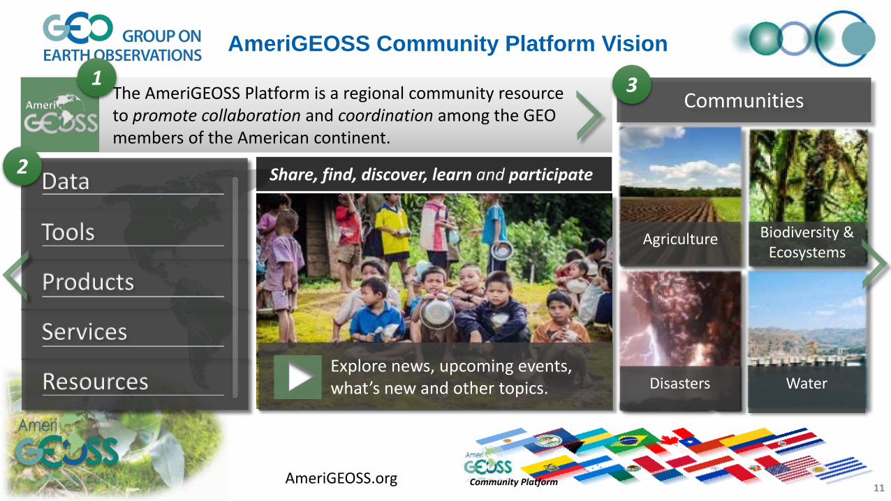
Ameri The AmeriGEOSS Platform is a regional community resource to promote collaboration and coordination among the GEO members of the American continent.
11
Explore news, upcoming events, what’s new and other topics.
Community Platform
Water Disasters
Agriculture Biodiversity & Ecosystems
Communities
Data
Tools
Products
Services
Resources
AmeriGEOSS Community Platform Vision
1
2
3
Share, find, discover, learn and participate
AmeriGEOSS.org

About AmeriGEOSS Initiatives | Data | Tools | Products | Services | Resources |
XLS
Carlos Maia Luis Miguel
12
AmeriGEOSS Data-Hub – Analytical Tools to Support Understanding
Interact With Data
Create Graphs, Charts, Maps and More
1
2
4
View, Share, Documents, Reports, Dashboards & more
5
3
AmeriGEOSS.org

w w w . e a r t h o b s e r v a t i o n s . o r g / g e o w e e k 2 0 1 7
GEO WEEK 2017 : Highlight global contributions and accomplishments
• Exhibits • Side Events