earthquake monitoring, research, and preparation
TRANSCRIPT

U.S. GOVERNMENT PRINTING OFFICE
WASHINGTON :
For sale by the Superintendent of Documents, U.S. Government Printing OfficeInternet: bookstore.gpo.gov Phone: toll free (866) 512–1800; DC area (202) 512–1800
Fax: (202) 512–2104 Mail: Stop IDCC, Washington, DC 20402–0001
64–485 PDF 2011
S. HRG. 109–1117
EARTHQUAKE MONITORING, RESEARCH, AND PREPARATION
FIELD HEARING BEFORE THE
SUBCOMMITTEE ON DISASTER PREVENTION AND
PREDICTION OF THE
COMMITTEE ON COMMERCE,
SCIENCE, AND TRANSPORTATION
UNITED STATES SENATE
ONE HUNDRED NINTH CONGRESS
SECOND SESSION
APRIL 18, 2006
Printed for the use of the Committee on Commerce, Science, and Transportation
(
VerDate Nov 24 2008 06:34 Feb 17, 2011 Jkt 064485 PO 00000 Frm 00001 Fmt 5011 Sfmt 5011 S:\GPO\DOCS\64485.TXT SCOM1 PsN: JACKIE

(II)
SENATE COMMITTEE ON COMMERCE, SCIENCE, AND TRANSPORTATION
ONE HUNDRED NINTH CONGRESS
SECOND SESSION
TED STEVENS, Alaska, Chairman JOHN MCCAIN, Arizona CONRAD BURNS, Montana TRENT LOTT, Mississippi KAY BAILEY HUTCHISON, Texas OLYMPIA J. SNOWE, Maine GORDON H. SMITH, Oregon JOHN ENSIGN, Nevada GEORGE ALLEN, Virginia JOHN E. SUNUNU, New Hampshire JIM DEMINT, South Carolina DAVID VITTER, Louisiana
DANIEL K. INOUYE, Hawaii, Co-Chairman JOHN D. ROCKEFELLER IV, West Virginia JOHN F. KERRY, Massachusetts BYRON L. DORGAN, North Dakota BARBARA BOXER, California BILL NELSON, Florida MARIA CANTWELL, Washington FRANK R. LAUTENBERG, New Jersey E. BENJAMIN NELSON, Nebraska MARK PRYOR, Arkansas
LISA J. SUTHERLAND, Republican Staff Director CHRISTINE DRAGER KURTH, Republican Deputy Staff Director
KENNETH R. NAHIGIAN, Republican Chief Counsel MARGARET L. CUMMISKY, Democratic Staff Director and Chief Counsel
SAMUEL E. WHITEHORN, Democratic Deputy Staff Director and General Counsel LILA HARPER HELMS, Democratic Policy Director
SUBCOMMITTEE ON DISASTER PREVENTION AND PREDICTION
JIM DEMINT, South Carolina, Chairman TED STEVENS, Alaska GORDON H. SMITH, Oregon DAVID VITTER, Louisiana
E. BENJAMIN NELSON, Nebraska, Ranking MARIA CANTWELL, Washington BILL NELSON, Florida
VerDate Nov 24 2008 06:34 Feb 17, 2011 Jkt 064485 PO 00000 Frm 00002 Fmt 5904 Sfmt 5904 S:\GPO\DOCS\64485.TXT SCOM1 PsN: JACKIE

(III)
C O N T E N T S
Page Hearing held on April 18, 2006 .............................................................................. 1 Statement of Senator Boxer .................................................................................... 2
Prepared statement .......................................................................................... 4 Statement of Senator DeMint ................................................................................. 1
WITNESSES
Brooks, Harold W., President/CEO, American Red Cross—Bay Area ................ 11 Prepared statement .......................................................................................... 13
Cluff, Lloyd S., Director, Geosciences Department and Earthquake Risk Man-agement Program, Pacific Gas and Electric Company (PG&E); Chairman, Scientific Earthquake Studies Advisory Committee (SESAC) ......................... 16
Prepared statement with attachments ........................................................... 18 Conroy, Annemarie, Executive Director, Office of Emergency Services and
Homeland Security, City and County of San Francisco .................................... 52 Prepared statement .......................................................................................... 56
Vannucchi, James M., Captain, San Francisco Fire Department (SFFD) and Director, San Francisco Firefighters Union—Local 798 ................................... 59
Prepared statement .......................................................................................... 61
VerDate Nov 24 2008 06:34 Feb 17, 2011 Jkt 064485 PO 00000 Frm 00003 Fmt 5904 Sfmt 5904 S:\GPO\DOCS\64485.TXT SCOM1 PsN: JACKIE

VerDate Nov 24 2008 06:34 Feb 17, 2011 Jkt 064485 PO 00000 Frm 00004 Fmt 5904 Sfmt 5904 S:\GPO\DOCS\64485.TXT SCOM1 PsN: JACKIE

(1)
EARTHQUAKE MONITORING, RESEARCH, AND PREPARATION
TUESDAY, APRIL 18, 2006
U.S. SENATE, SUBCOMMITTEE ON DISASTER PREVENTION AND PREDICTION, COMMITTEE ON COMMERCE, SCIENCE, AND TRANSPORTATION,
San Francisco, CA. The Subcommittee met, pursuant to notice, at 10:24 a.m. at the
Moscone Convention Center North, Esplanade Level Room 133, Hon. Jim DeMint, Chairman of the Subcommittee, presiding.
OPENING STATEMENT OF HON. JIM DEMINT, U.S. SENATOR FROM SOUTH CAROLINA
Senator DEMINT. Good morning. This hearing of the Disaster Prevention and Prediction Subcommittee will now come to order.
I want to thank all of you for being here, particularly my col-league, Senator Boxer, and all of our witnesses. The Subcommittee hearing today is to review preparation for a potential and likely major earthquake here on the West Coast. Contrary to some re-ports, those of us who live on the East Coast do not want Cali-fornia to fall into the Pacific Ocean. If we can be a part of prepara-tion, we would like to be.
Last summer with Katrina, and in 1906 with the major earth-quake here, we have seen that disasters can have a major impact on major American cities. Unfortunately, there is not enough ap-preciation of how bad this could be, particularly with the earth-quake that we’re discussing today.
This slide here just begins to give us some indication of the pro-jected property loss which would be staggering. Thirty-four billion dollars in San Francisco; $28 billion in Santa Clara County; $26 billion in other counties; $15 billion in Alameda County. And the next slide.
The economy of the region would be crippled. Seven to 10,000 commercial buildings closed. It’s unclear how quickly it would be before the Bay Area economy would be back up and running. And of 250,000 households, some 400,000 people could be displaced. At least 40,000 people, perhaps even a hundred thousand, could be homeless and need public shelter. This would severely strain the sheltering capacity in the immediate aftermath of the quake.
The recovery costs would be phenomenal. Rebuilding the region could come at a price tag that could reach $150 billion. All of this assumes that there would be no fires following the quake.
While a quake today probably wouldn’t be as bad as 1906, be-cause of a lot of preparation that has taken place, it is very likely
VerDate Nov 24 2008 06:34 Feb 17, 2011 Jkt 064485 PO 00000 Frm 00005 Fmt 6633 Sfmt 6633 S:\GPO\DOCS\64485.TXT SCOM1 PsN: JACKIE

2
that there will be some fires following a major quake. And these fires could only add to the cost. Worst of all, some estimates indi-cate that there could be as many as 3,400 fatalities associated with the quakes.
Now the facts serve to highlight how important it is that every-one be prepared. These slides show that a quake in San Francisco could be just as devastating as Katrina was to New Orleans. Prop-er preparation will be as important here as it should have been for Katrina.
Individuals can protect themselves from a lot of the threats posed by earthquakes. In the Northridge Quake, 55 percent of the quake-related injuries were caused by falling objects, such as tele-visions, pictures, and mirrors, and heavy light fixtures. People can cheaply and effectively secure these items and protect their fami-lies. A lot of injuries are preventable.
Organizations in the region appreciate the importance of edu-cating people in the region and have sent out—and I’m sure a lot of you have seen this, ‘‘Putting Down Roots in Earthquake Country’’ with a lot of helpful hints in getting prepared for a potential quake.
The report outlines seven steps individuals can take to protect themselves. If individuals take the steps outlined in the booklet, and if local first responders are effectively equipped, many more lives can be saved.
Again, I want to thank my witnesses who we will introduce in a minute, but I’ll now ask Senator Boxer for her opening state-ment.
STATEMENT OF HON. BARBARA BOXER, U.S. SENATOR FROM CALIFORNIA
Senator BOXER. Thank you so much, Mr. Chairman. Welcome to our beautiful California. We’re so happy that the weather is cooper-ating with your visit. And we are so happy to hear you talk about how much you want to help us as we look ahead.
A hundred years ago, at 5:12 a.m., a small earthquake was felt in the San Francisco Bay Area. But, 30 seconds later, a 7.9 mag-nitude earthquake struck for an entire minute. The length of the rupture was 290 miles.
On this Centennial Anniversary we must remember the 3,000 lives that were lost in the severe destruction, the 225,000 people left homeless, and the $400 million in damages. Mr. Chairman, you, by your presence here and through this subcommittee are en-suring that we don’t forget.
On this day we must also look at how far we’ve come since that tragic day, and how far we still have to go when it comes to earth-quake preparedness.
I want to thank the San Francisco Chronicle for their special edi-tion that they put out today. I don’t know if you’ve had the oppor-tunity to see it, but it really, I think, keeps this issue front and center. By making the earthquake in 1906 come alive again for all of us so that we don’t forget the challenges that we face.
When the big quake struck, San Francisco had 400,000 residents and the Greater Bay Area had 650,000 residents. Compare that to today. The Bay Area now has seven million residents. Imagine the devastation of another huge earthquake on our region.
VerDate Nov 24 2008 06:34 Feb 17, 2011 Jkt 064485 PO 00000 Frm 00006 Fmt 6633 Sfmt 6633 S:\GPO\DOCS\64485.TXT SCOM1 PsN: JACKIE

3
Although earthquakes can’t be predicted like hurricanes, the USGS estimates that there’s a 62-percent likelihood that at least one earthquake of 6.7, or greater, will occur in the San Francisco Bay Area before 2032.
You and I know, Mr. Chairman, that it is imperative that we not put our head in the sand, that we really be prepared. Since I went to Congress, and that was a very long time ago, 1982 was when I was first elected, there have been many earthquakes in our state. There was the San Simeon, the Diablo Canyon, and one in Napa Valley.
But I want to highlight for you, Mr. Chairman, and for our guests here today two California earthquakes that required a major Federal response.
The Loma Prieta in the Bay Area in 1989, and Northridge in the Los Angeles region in 1994. The reason I wanted to highlight those in my brief time this morning is that the response were quite dif-ferent. And I would ask unanimous consent that my entire state-ment be placed in the record.
Senator DEMINT. Without objection. Senator BOXER. But I’ll just summarize what happened. In Loma Prieta, many people will never forget this earthquake,
because it was televised right before game three of the World Se-ries at Candlestick Park. I personally will never forget it because my husband was at that game, and we couldn’t get in touch with each other. It was a horrifying experience, although it turned out well for us it didn’t turn out well for everyone else.
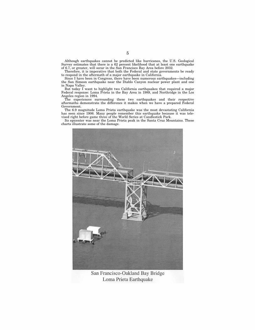
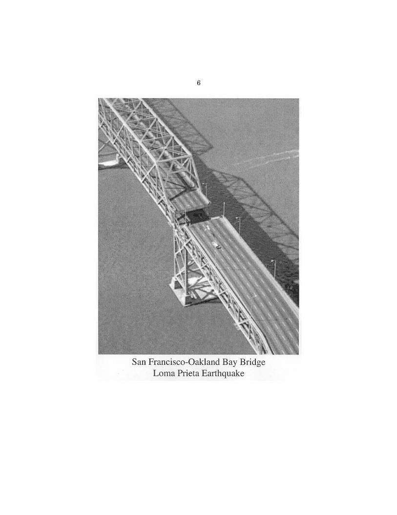
The epicenter was near the Loma Prieta Peak in the Santa Cruz Mountains. I want to show you, Mr. Chairman, if I could beg your indulgence——
Senator DEMINT. Sure. Senator BOXER.—a couple of charts that illustrate some of the
damage that we experienced. And the famous one—I’ll show the Chairman—the bridge just collapsing right in the middle. OK. Let’s show the others. Here it is again. This is the Bay Bridge.
Mr. Chairman, just a couple of hours before that, perhaps two— I don’t know exactly; somebody can correct me—all the people were going to the game across that particular bridge.
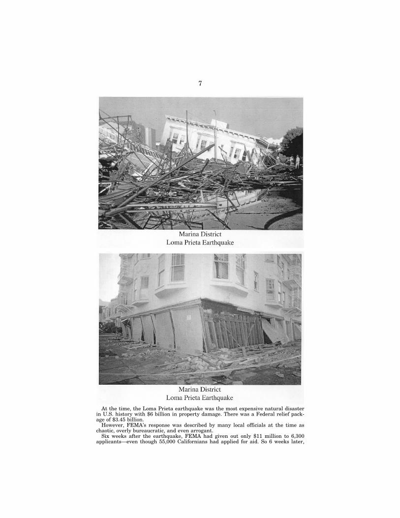
Here are some more scenes. The Marina District, beautiful homes just crumbling. And we have one more. Thank you, Laurie. Here’s another view of our Marina District.
At that time the Loma Prieta Earthquake was the most expen-sive natural disaster in U.S. history with $6 billion in property damage. There was a Federal relief package of $3.45 billion.
But, I just want to say, without going into details because there’s no point in reliving this, that the response of FEMA was inad-equate at best, and a lot of people thought it was worse than inad-equate.
Paul Cobb, then President of the Oakland Urban Renaissance So-ciety, said, ‘‘FEMA is understaffed and in disarray.’’
We had Congressional hearings. At the hearing, Oakland Mayor Wilson told the panel how FEMA had dispatched only one agent, Mr. Chairman, to handle the thousands left homeless in Oakland. So we knew we didn’t do well.
VerDate Nov 24 2008 06:34 Feb 17, 2011 Jkt 064485 PO 00000 Frm 00007 Fmt 6633 Sfmt 6633 S:\GPO\DOCS\64485.TXT SCOM1 PsN: JACKIE

4
And I have to say that the Congress and everybody worked very hard to change things. And when we were hit with the Northridge Earthquake things got a lot better. Why? Because there was a plan in place, and there was a feeling of who was responsible for what and things were much better. All this is in my statement.
For example, the L.A. Times’ editorial published 1 week after Northridge said, ‘‘For victims speed is of the essence. Federal Dis-aster Agency is overwhelmed but undaunted.’’ It would have been nice to have something like that in the recent Katrina experience.
So we have leadership, Mr. Chairman. We can do this if we’re ready. We all know that the House held hearings on the response to Katrina, and the House Republicans issued a very strong con-demnation of FEMA. They said, ‘‘We’re just not ready for prime time.’’
And, as you know, your presence here indicates we have to be ready for prime time. I won’t go over the Katrina response prob-lems. They’ll be in my statement. I certainly hope and pray that California is not the next disaster. We surely need leadership at the Federal level.
Let me just give you, in closing, a couple of ideas that I have, and I hope maybe we can work together on. We need to have a plan from FEMA. FEMA had predicted three terrible things would happen: A terrorist attack in New York, a hurricane in New Orle-ans, and then an earthquake in San Francisco. They’ve gotten that part right, two out of three. We’ve been warned, and we need to see the Federal Government’s response plan.
And it doesn’t take that much effort, it seems to me, to make sure that the Federal Government is ready, willing, and able to do everything to augment the state and local response. If the State and local people can act to move into leadership positions, and then in the rebuild have disaster centers where you have everything in one place for the people who need to rebuild; that’s one thing.
The other thing is a little more controversial. And that is, I real-ly do think we ought to make FEMA an independent agency and take it out of Homeland Security. I just feel it has lost its way. And that’s another idea that I have.
So I’m anxious to work with you. And you may have other ideas. But, we will work together, I’m sure, across party lines to get this country prepared. Again, I thank you and I welcome you.
[The prepared statement of Senator Boxer follows:]
PREPARED STATEMENT OF HON. BARBARA BOXER, U.S. SENATOR FROM CALIFORNIA
Mr. Chairman, I want to thank you for holding this hearing on the current state of earthquake monitoring, research, and preparation in the United States on the 100th anniversary of the 1906 quake.
One hundred years ago today at 5:12 a.m., a small earthquake was felt in the San Francisco Bay Area. Thirty seconds later, a 7.9 magnitude earthquake struck for an entire minute. The length of the rupture was 290 miles.
On this Centennial Anniversary, we must not only remember the three thousand lives lost in the severe destruction, the 225,000 people left homeless and the $400 million in damages.
On this day we must also look at how far we have come since that tragic day, and how far we still have to go when it comes to earthquake preparedness.
When the big quake struck in 1906, San Francisco had 400,000 residents and the greater Bay Area had 650,000 residents.
Compare that to today—the Bay Area has 7 million residents. Imagine the devas-tation of another 7.9 magnitude earthquake on the region.
VerDate Nov 24 2008 06:34 Feb 17, 2011 Jkt 064485 PO 00000 Frm 00008 Fmt 6633 Sfmt 6621 S:\GPO\DOCS\64485.TXT SCOM1 PsN: JACKIE
5
Although earthquakes cannot be predicted like hurricanes, the U.S. Geological Survey estimates that there is a 62 percent likelihood that at least one earthquake of 6.7, or greater, will occur in the San Francisco Bay Area before 2032.
Therefore, it is imperative that both the Federal and state governments be ready to respond in the aftermath of a major earthquake in California.
Since I have been in Congress, there have been numerous earthquakes—including the San Simeon earthquake near the Diablo Canyon nuclear power plant and one in Napa Valley.
But today I want to highlight two California earthquakes that required a major Federal response: Loma Prieta in the Bay Area in 1989, and Northridge in the Los Angeles region in 1994.
The experiences surrounding these two earthquakes and their respective aftermaths demonstrate the difference it makes when we have a prepared Federal Government.
The 6.9 magnitude Loma Prieta earthquake was the most devastating California has seen since 1906. Many people remember this earthquake because it was tele-vised right before game three of the World Series at Candlestick Park.
Its epicenter was near the Loma Prieta peak in the Santa Cruz Mountains. These charts illustrate some of the damage.
VerDate Nov 24 2008 06:34 Feb 17, 2011 Jkt 064485 PO 00000 Frm 00009 Fmt 6633 Sfmt 6621 S:\GPO\DOCS\64485.TXT SCOM1 PsN: JACKIE box1
.eps
6
VerDate Nov 24 2008 06:34 Feb 17, 2011 Jkt 064485 PO 00000 Frm 00010 Fmt 6633 Sfmt 6621 S:\GPO\DOCS\64485.TXT SCOM1 PsN: JACKIE box2
.eps
7
At the time, the Loma Prieta earthquake was the most expensive natural disaster in U.S. history with $6 billion in property damage. There was a Federal relief pack-age of $3.45 billion.
However, FEMA’s response was described by many local officials at the time as chaotic, overly bureaucratic, and even arrogant.
Six weeks after the earthquake, FEMA had given out only $11 million to 6,300 applicants—even though 55,000 Californians had applied for aid. So 6 weeks later,
VerDate Nov 24 2008 06:34 Feb 17, 2011 Jkt 064485 PO 00000 Frm 00011 Fmt 6633 Sfmt 6621 S:\GPO\DOCS\64485.TXT SCOM1 PsN: JACKIE box3
.eps
box4
.eps

8
nearly 50,000 people were still waiting for assistance, leaving many families home-less.
Paul Cobb, then-President of the Oakland Urban Renaissance Society said, ‘‘FEMA is understaffed and in disarray . . .’’
Six months after the Loma Prieta earthquake, a Congressional hearing was held to review the response of Federal agencies.
At the hearing, Oakland Mayor Lionel Wilson told the panel how FEMA had dis-patched only one agent to handle the thousands left homeless in Oakland, and the individual had no idea how to deal with the disaster.
So not only was there anecdotal evidence attesting to FEMA’s poor response to the Loma Prieta quake, but the General Accounting Office found that FEMA did not have enough staff and guidance on Federal reimbursement. GAO also found that 2 years after the earthquake FEMA still had major outstanding funding decisions.
By the time the 6.7 magnitude earthquake struck Northridge in 1994, FEMA had learned from its mistakes.
VerDate Nov 24 2008 06:34 Feb 17, 2011 Jkt 064485 PO 00000 Frm 00012 Fmt 6633 Sfmt 6621 S:\GPO\DOCS\64485.TXT SCOM1 PsN: JACKIE box5
.eps
9
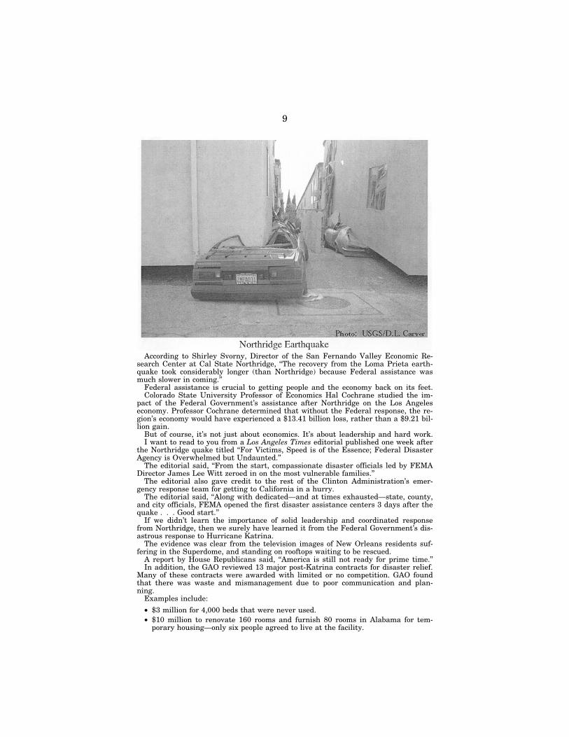
According to Shirley Svorny, Director of the San Fernando Valley Economic Re-search Center at Cal State Northridge, ‘‘The recovery from the Loma Prieta earth-quake took considerably longer (than Northridge) because Federal assistance was much slower in coming.’’
Federal assistance is crucial to getting people and the economy back on its feet. Colorado State University Professor of Economics Hal Cochrane studied the im-
pact of the Federal Government’s assistance after Northridge on the Los Angeles economy. Professor Cochrane determined that without the Federal response, the re-gion’s economy would have experienced a $13.41 billion loss, rather than a $9.21 bil-lion gain.
But of course, it’s not just about economics. It’s about leadership and hard work. I want to read to you from a Los Angeles Times editorial published one week after
the Northridge quake titled ‘‘For Victims, Speed is of the Essence; Federal Disaster Agency is Overwhelmed but Undaunted.’’
The editorial said, ‘‘From the start, compassionate disaster officials led by FEMA Director James Lee Witt zeroed in on the most vulnerable families.’’
The editorial also gave credit to the rest of the Clinton Administration’s emer-gency response team for getting to California in a hurry.
The editorial said, ‘‘Along with dedicated—and at times exhausted—state, county, and city officials, FEMA opened the first disaster assistance centers 3 days after the quake . . . Good start.’’
If we didn’t learn the importance of solid leadership and coordinated response from Northridge, then we surely have learned it from the Federal Government’s dis-astrous response to Hurricane Katrina.
The evidence was clear from the television images of New Orleans residents suf-fering in the Superdome, and standing on rooftops waiting to be rescued.
A report by House Republicans said, ‘‘America is still not ready for prime time.’’ In addition, the GAO reviewed 13 major post-Katrina contracts for disaster relief.
Many of these contracts were awarded with limited or no competition. GAO found that there was waste and mismanagement due to poor communication and plan-ning.
Examples include:
• $3 million for 4,000 beds that were never used. • $10 million to renovate 160 rooms and furnish 80 rooms in Alabama for tem-
porary housing—only six people agreed to live at the facility.
VerDate Nov 24 2008 06:34 Feb 17, 2011 Jkt 064485 PO 00000 Frm 00013 Fmt 6633 Sfmt 6621 S:\GPO\DOCS\64485.TXT SCOM1 PsN: JACKIE box6
.eps
10
And in one of the most embarrassing examples, over $300 million was wasted on nearly 11,000 mobile homes that were never used for temporary housing because they sunk into the mud.
The Katrina response was unacceptable, and is particularly troubling to me given California’s earthquake threat.
In 2001, according to the Houston Chronicle, FEMA ranked the three most likely catastrophic disasters facing this country: a terrorist attack on New York City, a direct hit to New Orleans from a powerful hurricane, and a massive earthquake in California.
I hope and pray that California is not next, but we need the leadership at the Federal level to be ready.
That is why I have requested from both the White House and the Department of Homeland Security a copy of the Federal Government’s response to a major earth-quake in California. I wanted to share that plan with first responders in the state.
However, I have learned that a Federal response plan for a major earthquake in California does not exist.
Every day we wait the situation becomes more crucial, especially with the levee situation in the San Joaquin Valley.
If there was an earthquake there and the antiquated levee system failed, 2⁄3 of California’s drinking water would be at risk, and both agriculture land and numer-ous homes would be flooded.
The bottom line is that if there was a 1906 earthquake today—Californians could not count on the Federal Government.
Today, we have a chance to hear from local responders and find out what they need. And one of the issues I really want to hear about is the communications capa-bilities of our first responders.
We all know how critical interoperable communications are in an emergency—the 9/11 Commission Report highlighted the desperate need for first responders to be able to speak to one another.
And yet the Federal Government has repeatedly failed to address this critical need. In the last 7 months alone, the Senate has twice voted down amendments to increase funding for interoperable communications.
I am going to continue working with my colleagues in the Senate to ensure this need is met.
So I am anxious to hear from all of the witnesses today, and I trust we will all work together to meet these needs.
Thank you, Mr. Chairman.
Senator DEMINT. Thank you, Senator Boxer. Some good ideas, I think.
I want to thank our witnesses again for joining us. This morning we have four experts appearing before the Subcommittee to discuss how well the Nation is prepared for a major earthquake, and what can be done to increase the preparation to save lives when the big one hits.
Appearing this morning is Mr. Harold Brooks, CEO of the Bay Area Chapter of the American Red Cross. The Red Cross is an out-standing organization and one of the first faces on the scene when disasters strike. Red Cross volunteers and staff, in conjunction with their counterparts in the Salvation Army and other faith- based organizations, provide comfort, aid, and support to citizens during some of the worst times in their lives. I look forward to hearing from Mr. Brooks on how the Bay Area Chapter is pre-paring for a major earthquake.
Also appearing is Mr. Lloyd Cluff. Mr. Cluff is a distinguished engineer, a member of the National Academy of Engineering, and Director of the Earthquake Risk Management Program at Pacific Gas and Electric. Mr. Cluff has been in this business for nearly 45 years and has a comprehensive understanding of the threat posed to power generation by an earthquake. Because fires caused by rupturing gas lines are such a significant threat following an earth-quake, Mr. Cluff’s testimony will be extremely important.
VerDate Nov 24 2008 06:34 Feb 17, 2011 Jkt 064485 PO 00000 Frm 00014 Fmt 6633 Sfmt 6601 S:\GPO\DOCS\64485.TXT SCOM1 PsN: JACKIE

11
Also appearing is Captain Jim Vannucchi. Captain Vannucchi is a career firefighter with the San Francisco Fire Department. Cap-tain Vannucchi, his colleagues in the Fire and Police Departments are the city’s first responders. When the quake hits, it will mean that men and women like Jim Vannucchi will respond with life-saving aid. I’m looking forward to hearing from the Captain on what challenges he faces with the San Francisco Fire Department and how we can work with him to help at the Federal level.
And finally appearing is Ms. Conroy, Director of the Office of Emergency Services and Homeland Security for the City and Coun-ty of San Francisco. Ms. Conroy leads the office that is responsible for coordinating the numerous agencies that are involved in pre-paring for, and responding to , a disaster in the area. I’m interested in hearing how the Office of Emergency Services has been working with the diverse communities in the city to deliver the message of preparedness.
With that, I’ll ask Mr. Brooks to give his opening statement. I’d ask that you all keep your opening statements as close to 5 min-utes as possible so that we can get to questions, and begin to ad-dress more fully the issues that concern the community.
Mr. Brooks.
STATEMENT OF HAROLD W. BROOKS, PRESIDENT/CEO, AMERICAN RED CROSS—BAY AREA
Mr. BROOKS. Thank you. Chairman DeMint and Senator Boxer, thank you for the opportunity to meet with you on this very signifi-cant and historic day in the Bay Area.
Most of us disaster geeks were up early to join the kindred spir-its at 5:12 a.m., at Lotta’s Fountain, to commemorate the Centen-nial of the Great Earthquake and Fire of 1906. The events of April 18, 1906, pushed our chapter of the American Red Cross into a crit-ical role. It was charged by President Teddy Roosevelt with over-seeing the recovery and rebuilding of San Francisco. Our organiza-tion rose to the occasion. It’s a role that has been treated as a sa-cred trust by the volunteers of this community ever since.
Since that initial testing of the organization in 1906, we’ve con-tinued to grow our disaster response capability as an organization. We’ve learned some really valuable lessons from each disaster over the past century.
The 1989 Loma Prieta Earthquake challenged us to work with our homeless populations as they became disaster victims. We were humbled by the fact that we could not take care of the community alone, and were thrilled by the spontaneous volunteers and organi-zations that joined us to respond to the needs of the Bay Area.
But our greatest lessons learned have come from Katrina. Here in the Bay Area we have always thought our worst-case scenario that was coming at us would require us to serve 300,000 displaced people in the aftermath of an earthquake on the Hayward Fault.
While being prepared to serve 100,000 people at the time Katrina hit last year the Red Cross, nationally, ultimately was called upon to serve 1.2 million people. This is a sobering new reality that speaks to the need for the types of changes announced last week by our National Headquarters. These changes focused on two really
VerDate Nov 24 2008 06:34 Feb 17, 2011 Jkt 064485 PO 00000 Frm 00015 Fmt 6633 Sfmt 6601 S:\GPO\DOCS\64485.TXT SCOM1 PsN: JACKIE

12
key lessons from Katrina: The need for more capacity, and the need to partner more effectively.
We are now working to ensure that our national organization can handle a possible surge of one million affected families within a 10- day period and two million over the longer-term.
Locally we continue to expand our operating capacity to enable us to handle any emergency that comes our way. Chevron provides us with a warehouse and distribution center out in the City of Dub-lin, where national assets of cots, blankets, comfort kits, and other disaster supplies can be used here or distributed wherever they’re needed.
We’re led by the Pacific Service Area, which is located in Sac-ramento. And we’ve developed some really strong relationships with the chapters throughout the state, and the Pacific, for mutual assistance to coordinate and deploy more staff from throughout the state or the Nation and effectively communicate with the state gov-ernment agencies.
Now we’ll be focusing even more on our partnerships with other organizations, community, government, faith-based, community- based, and business and taking a lead in ensuring that the entire community is capable of implementing an effective response. These partnerships will not only increase our capacity, but will help en-sure that all segments of the community receive the services they need in a sensitive, culturally-competent manner.
All segments of the community should realize that they will be a part of this response and must be prepared to offer their services. And Red Cross will ensure that we assist in incorporating the re-sources and knowledge into an overall community response.
The greatest lesson from Katrina was that these relationships need to exist well before the disaster occurs. Building them on-the- fly simply does not work. Locally we’ve seen the value of these rela-tionships, as community comes together to assist—or came together to assist 5,000 Katrina evacuees who made their way here to the Bay Area. And we continually work to help prevent, and prepare for, and respond to emergencies.
One of our key corporate partners is PG&E. They provided us with the initial funding for an exciting new campaign called ‘‘Pre-pare Bay Area.’’ It’s a campaign with a goal to prepare one in four people in the Bay Area—that’s over a million folks—to cope effec-tively with a disaster.
It’s a very simple campaign. We want to prepare everyone so that they know what to do. They have three steps they’ve got to remember:
To make a family disaster plan; To build a disaster supply kit; and Be trained in CPR, first aid, and disaster preparedness. Now to get started with this campaign, we conducted a six-coun-
ty survey. The results reinforce the importance of our campaign. Those surveyed were asked whether they had taken the three steps to preparedness. And only 6 percent said that they had. Not sur-prisingly, our survey results indicate many differences among the demographic subgroups and their reasons for not being prepared.
VerDate Nov 24 2008 06:34 Feb 17, 2011 Jkt 064485 PO 00000 Frm 00016 Fmt 6633 Sfmt 6601 S:\GPO\DOCS\64485.TXT SCOM1 PsN: JACKIE

13
It only reinforced the fact that the key focus under our program needs to be on the vulnerable populations, those most devastated during a major disaster and least prepared to deal with it.
It also reinforced the need to work with the community leaders from among various groups in the Bay Area who can influence their constituents to take action. They will promote Prepare Bay Area’s ‘‘how to’’ preparedness program by either helping us to con-duct, or taking responsibility for conducting the preparedness training within their communities. We’ve got a few working mod-els, one that’s wonderful in the Hispanic and another in the Asian communities.
Today we’re working hard to continue to earn the trust of the American people. We’ve always been there for them at the time dis-aster strikes, the first example being the event we commemorate today. Our predecessors demonstrated the capabilities of the orga-nization with their disaster response when the Nation needed it a hundred years ago.
Now we have the privilege to live on this really most beautiful patch of Earth. I think the Bay Area is the most beautiful place on the planet. We have the awesome responsibility to also make it the most prepared place on the planet. Standing on the shoulders of those great community leaders that showed us the way, we know that we can do it. And we take on this responsibility with great confidence and humility.
I again want to thank you for the opportunity to meet with you, and I’d be happy to answer any questions that you may have.
[The prepared statement of Mr. Brooks follows:]
PREPARED STATEMENT OF HAROLD W. BROOKS, PRESIDENT/CEO, AMERICAN RED CROSS—BAY AREA
Chairman DeMint and Senator Boxer, thank you very much for the opportunity to meet with you on this very significant and historic day in the Bay Area. Most of us disaster geeks were up early to join with kindred spirits at 5:12 a.m. at Lotta’s Fountain to commemorate the Centennial of the Great Earthquake and Fire of 1906. April 18, 1906, pushed this chapter of the American Red Cross into a very critical role. At a time when the national organization was reeling from the transi-tion from founding President Clara Barton to a new national Executive, Mabel Boardman—the Red Cross was charged by President Teddy Roosevelt and the U.S. Congress with overseeing the recovery and rebuilding of the city. The organization performed very well. It is a role that has been treated as a sacred trust by the vol-unteers of this community ever since.
Another big test for this chapter was the Loma Prieta Earthquake of 1989. The chapter had some challenges. We grappled with how to work with our homeless pop-ulations as they became disaster victims. We were humbled by the fact that we could not take care of the community alone. We were thrilled to have spontaneous volunteers and organizations join us—shoulder to shoulder to respond to the needs of the community. We were shocked to learn that no matter how much money was needed for the devastation wrought by Hurricane Hugo in the Caribbean and Caro-linas, we were obliged to use dollars raised for the earthquake on the earthquake. We learned how serious the concept of donor intent was. Although there had been severe losses in disasters elsewhere, people throughout the Nation responded quite generously when they saw San Francisco’s Marina District on fire in an earthquake that many saw live as they watched the World Series game between the Oakland A’s and The San Francisco Giants.
The most powerful lesson of Loma Prieta was the one of collaboration and commu-nity partnerships. The volunteers in this community vowed to build the best dis-aster response team in the Nation. We believe we have that. They also learned that no one organization can handle a major disaster by itself. Through our corporate partners, the public-sector, volunteer centers, Salvation Army, United Way, and a
VerDate Nov 24 2008 06:34 Feb 17, 2011 Jkt 064485 PO 00000 Frm 00017 Fmt 6633 Sfmt 6621 S:\GPO\DOCS\64485.TXT SCOM1 PsN: JACKIE

14
series of non-government and faith-based organizations; we have learned to look to one another to ensure a great response.
We have not rested since Loma Prieta. We continue to expand our operating ca-pacity to enable us to handle any emergency that comes our way. Chevron provides us with a warehouse and distribution center (in the city of Dublin) where national assets of cots, blankets, comfort kits, and other disaster supplies can be used here or distributed wherever the need is. We have a great relationship with chapters throughout the Pacific of mutual assistance. We have a great Pacific service area team—one of eight of our service areas across the country—located in Sacramento. They help us to coordinate and deploy more staff from throughout the state or Na-tion, and effectively communicate with State government agencies.
We have developed very exciting relationships with the leading technology compa-nies headquartered here in the greater Bay Area. They are beginning to help us bet-ter manage the quick and efficient delivery of assistance to our clients and track their progress. We are also using software that allows us to share confidential data and forms with our collaborating agencies—so our clients don’t have to fill out dupli-cate forms from each agency with whom they meet. We are using debit cards for displaced families. We have always thought of our worst case scenario being the need to handle 300,000 displaced people in the aftermath of an earthquake on the Hayward fault. We learned from Katrina that our response was able to handle 100,000 people. We ultimately served 1.2 million people. This is a sobering new re-ality. We want to do our part to ensure that the organization can handle the surge of one million affected families within a ten-day period, and two million over the longer term. This chapter has always been a leader in helping our national organi-zation build the systems and processes needed to expand our reach and improve our efficiency.
This chapter, in conjunction with the American Red Cross national organization, is continuing to evaluate the response efforts to the hurricanes of 2005, and imple-ment initiatives that will enhance our capacity to effectively respond to disaster caused needs of a magnitude we previously had not imagined. As mentioned, we will be focusing even more on our partnerships with other organizations in the commu-nity—government, faith-based, community-based, business—and taking a lead in ensuring that the entire community is capable of implementing an effective re-sponse. No one agency or organization can do it all, and we are looking at new ways that we can lead and/or support other organizations when it comes to increasing the readiness level of the entire Bay Area. These partnerships will not only increase our capacity, but will help ensure that all segments of the community receive the serv-ices they need in a sensitive and culturally-competent manner. All segments of the community should realize that they will be part of the response, and must be pre-pared to offer their services, and the Red Cross will ensure that we assist in incor-porating their resources and knowledge into the overall community response.
The Bay Area Chapter of the American Red Cross has worked hard to build these community relationships, and cultivating additional relationships that can help the community with the initial needs of sheltering and feeding hundreds of thousands of people is our highest priority task. We have worked with our government and community partners to identify and evaluate hundreds of schools, churches, and other facilities that can serve as shelters. We continue to build on our relationships with the Salvation Army, Southern Baptists, institutional food produces, large cater-ers, Food Banks, and other community feeding organizations to ensure coordinated feeding efforts can be executed as quickly as possible after a disaster. We have strong relationships through Citizen Corps, local Emergency Services coordinating groups, VOAD (Voluntary Agencies Active in Disaster) with our community re-sponse partners to ensure we all understand how our response plans work, and how they will work together. We also maintain strong ties with our Volunteer Center partners to ensure we have a coordinated response to the surge of spontaneous vol-unteers that will want to help with the feeding and sheltering efforts. We continue to explore new ways to ensure all of the community responders are included in an efficient and coordinated response effort. Drills, exercises, and joint planning efforts have been very beneficial, and we are confident that these relationships, as well as those we are working to form, will take our response readiness to a new level.
We work diligently to help people prevent, prepare for, and respond to emer-gencies. We are visible and actively serving more than 4.5 million people in Ala-meda, Contra Costa, Marin, San Francisco, San Mateo, and Solano Counties. Through a team of 85 paid and 3,000 plus volunteers we help our communities pre-pare for life’s emergencies.
We live in one of the most seismically active regions in the world. The U.S. Geo-logical Survey says there is a 70 percent chance of another catastrophic earthquake here within 30 years. The terrible events of September 11 raised the spectrum of
VerDate Nov 24 2008 06:34 Feb 17, 2011 Jkt 064485 PO 00000 Frm 00018 Fmt 6633 Sfmt 6621 S:\GPO\DOCS\64485.TXT SCOM1 PsN: JACKIE

15
terrorism that must be confronted from a disaster response perspective. The San Francisco Bay Area is a vibrant, high-profile area that has been identified as among the top potential targets for acts of terrorism. We prepare for all hazards, including terrorist attacks and even pandemics.
One of our favorite corporate partners, PG&E has provided the initial funding for a wonderful new campaign called Prepare Bay Area. Just last week they joined with Red Cross, the Mayors of Oakland and Martinez, the Fire Chief of San Francisco, and leaders from every sector of our community to launch the most ambitious pre-paredness campaign ever. Prepare Bay Area has a goal of preparing one in four (over one million people) here in the Bay Area. The logic behind that number is, we want one person in each household to be able to save the lives of their loved ones, neighbors, and others. Put simply we want everyone to take three steps: 1. Make a family disaster plan; 2. Build a disaster supplies kit; 3. Get trained in CPR, first aid and/or disaster preparedness.
To get started on this campaign, we conducted a six county survey. The results reinforce the importance of our campaign. Those surveyed were asked whether they had:
1. Made a family plan outlining what to do in the aftermath of a disaster. 2. Prepared a disaster supplies kit suitable for sustaining them for 3–5 days. 3. Received training in disaster preparedness, CPR and/or first aid.
Only 6 percent indicated they had taken all three of the steps that Red Cross con-siders essential to being prepared.
Katrina repeated the lesson clearly that our economically disadvantaged and vul-nerable communities require special attention to get prepared. Not surprisingly our survey tells us that there are many differences between demographic sub-groups in regards to reasons for not being prepared. Hispanics and Asians are much more likely than Caucasians or African Americans to say a major reason why they are not prepared is because they do not think an emergency situation is likely to hap-pen. This is also the case with lower-income respondents. African Americans, His-panics, and Asians are significantly more likely than Caucasians to say the major reason why they have not prepared is because they do not know what to do in order to prepare. We are working with community influencers to either help us or actually do the preparedness training with their communities. These community partners will promote Prepare Bay Area’s ‘‘how to’’ preparedness plan by using their unique influence to compel their constituents to take action—to become fully ready for dis-asters.
In the Spanish Speaking communities we have Sabados por la familia training. It is highly successful. We have a Youth for Chinese Elderly Program, where high school students learn, then help prepare the elderly Chinese in their communities. Oracle and Chiron are just two corporations who have adopted schools near their offices and funded preparedness training for the students.
In the aftermath of Katrina we registered and served 5,000 evacuees. Our direc-tors of Emergency Services at the state, county, and city levels were amazing to work with in mobilizing the community. Many of the leading faith-based organiza-tions stepped forward and opened their doors. They provided volunteers to house and feed evacuees. The community came together and did a great job. It is clear we must build upon what we saw happen here as well as throughout the Gulf Coast. The Red Cross concept has always been neighbor helping neighbor. We are working hard to enable the citizens of the Bay Area to prepare for, and alleviate, human suf-fering from emergencies.
Henri Dunant started this International Red Cross movement 143 years ago in May of 1863. Clara Barton founded the American Red Cross in May of 1881—125 years ago. The Red Cross in the Bay Area started 108 years ago with the support to our troops deploying to Manila for the Spanish American War. They elevated the organization with their disaster response when the Nation needed it 100 years ago. We are privileged to live in one of the most beautiful places on the planet here. It is an awesome responsibility to also make it the most prepared place on the planet. Standing on the shoulders of the great community leaders that showed us they way, we take on that responsibility with confidence and humility.
Thank you for the opportunity to meet with you. I would be happy to answer any questions you may have.
Senator DEMINT. Thank you, Mr. Brooks. Mr. Cluff.
VerDate Nov 24 2008 06:34 Feb 17, 2011 Jkt 064485 PO 00000 Frm 00019 Fmt 6633 Sfmt 6601 S:\GPO\DOCS\64485.TXT SCOM1 PsN: JACKIE

16
STATEMENT OF LLOYD S. CLUFF, DIRECTOR, GEOSCIENCES DEPARTMENT AND EARTHQUAKE RISK MANAGEMENT PROGRAM, PACIFIC GAS AND ELECTRIC COMPANY (PG&E); CHAIRMAN, SCIENTIFIC EARTHQUAKE STUDIES ADVISORY COMMITTEE (SESAC)
Mr. CLUFF. Thank you, Senator DeMint and Senator Boxer, for inviting me to testify at this field hearing. My testimony is fairly large and copies of it are over on the desk. And I ask that my full testimony be adopted into the record.
Senator DEMINT. Without objection. Mr. CLUFF. I’m speaking here wearing two hats. One is I’m
Chairman of the Congressional mandated oversight committee, called the Scientific Earthquake Studies Advisory Committee, with regard to the United States Geological Survey’s mission in the Na-tional Earthquake Hazard Reduction Program. Now that Commit-tee’s activity has been going on for 5 years. And I have attached a copy of our last report in 2005 to my testimony.
In addition, Senator DeMint and Senator Boxer have both re-ferred to data contained in a report particularly released this morn-ing or yesterday, I guess it was, Managing Earthquake Risk in Earthquake Country Estimated Losses for a Repeat of the 1906 Earthquake and Earthquake Professionals’ Action Agenda for Northern California. I have appended this, and I adopt this as part of my testimony. It has excellent information in it.
I would like to start off with my experience this morning at 4:30 going to Lotta’s Fountain. And that experience with the thousands of people who were there really demonstrated the spirit of San Francisco. And the San Francisco Earthquake of 1906 provided the routes of the scientific understanding of why earthquakes occur, the plate tectonic model developed out of the lessons learned from the scientists studying the San Andreas Fault, which released the earthquake by rupturing almost 300 miles. And a lot of lessons were learned in terms of what to do and what not to do.
San Francisco, for example, has a redundant firefighting system to protect the City against a repeat of 1906 and the fire. And it’s the only city in the world that I know of that has a redundant, to-tally dedicated firefighting system for earthquake safety. And that’s involved in some of the field trips that will be held during these commemoration activities.
I want to go to one of the recommendations in the SESAC report of the last year. We have three main, key recommendations in that report, but I think the first one has the spirit of what we’re trying to accomplish. And the SESAC strongly encourages the USGS, the Secretary of the Interior, the Office of Management and Budget, and Congress to move forward vigorously with the National Hazard Initiative in the USGS Fiscal Year 2007.
The Director of the Survey declared that starting at 2007, for at least 5 years, there will be a new initiative for the Survey with its highest priorities.
Recent events have spotlighted natural hazards, and the Com-mittee believes the USGS, through its Natural Hazards Initiative, has a major growth opportunity to take the leadership in creating a disaster-resistant country.
VerDate Nov 24 2008 06:34 Feb 17, 2011 Jkt 064485 PO 00000 Frm 00020 Fmt 6633 Sfmt 6601 S:\GPO\DOCS\64485.TXT SCOM1 PsN: JACKIE
17
We recommend the USGS undertake a complete analysis of the consequences of catastrophic earthquakes in the San Francisco Bay Area, and in Southern California, and integrate the complete pic-ture, from the rupture on the faults, wave propagation into build-ings and other structures, and the response of all levels of our in-frastructure, the emergency response, and continuing to the full re-covery of our society.
The purpose of this exercise would be to identify where and when the breaking points for an extreme earthquake disaster in Cali-fornia will be. The lessons learned in this demonstration project would be applicable to all extreme disasters like Katrina.
And I’d add to this, and I’ve written this in my testimony, that with the more than 6 weeks of almost continuous rainfall, if we had a repeat of a large earthquake now, today, we would see mas-sive landslides in the hills around the Bay Area, much more lique-faction because of the saturated ground around the Bay.
And also the largest concern that I would have would be the vul-nerability of the Delta Levees. The Delta Levees are filled to capac-ity right now. Some of them have failed in the storms in the last few weeks. They would all massively fail in a large earthquake on either the San Andreas, Hayward, or Calaveras Fault.
The California Department of Water Resources has estimated that the economic loss of the failure of the levees alone would be in excess of $50 billion. That includes substantial losses of the water supply to Southern California, and significant water supply to the Bay Area communities, as well.
So I’m going to close with that activity for SESAC and then move to the PG&E activities. I am Director of PG&E’s Earthquake Risk Management Program. And for the last two decades I’ve helped lead PG&E to invest about $2.5 billion in strengthening the lifeline infrastructure that PG&E operates and manages to serve our cus-tomers. And that has included a lot of activities to prepare us so that our vital resources will be available, not only weeks after the earthquake, but in some cases during and immediately after the earthquake.
Our response time that we expect with a large earthquake in the Bay Area is that we will lose power and some gas in some localities for a few hours to a few days. Most of our service will be ready within less than a week, and within the week, we believe that the majority of our system will be restored with the exception of places where massive collapsing, bridges and buildings, have caused our facilities to be damaged. And as we saw in the Marina, in Loma Prieta, our services in those pockets of damage may not be restored for months.
I would like to close by saying that PG&E has been working with private-public partnerships. I help lead PG&E’s efforts to develop a user-driven research program at the Pacific Earthquake Engi-neering Research Center at Berkeley. It’s a consortium of nine big universities. And through that, starting with PG&E, CalTrans, the California Energy Commission, and FEMA, and many other inter-ested parties have stepped up to contribute to the initial invest-ment PG&E made. And now we have in excess of $13 million in leverage funding. So I’m very pleased to have been part of that pro-gram.
VerDate Nov 24 2008 06:34 Feb 17, 2011 Jkt 064485 PO 00000 Frm 00021 Fmt 6633 Sfmt 6601 S:\GPO\DOCS\64485.TXT SCOM1 PsN: JACKIE

18
Out of this has come mitigation efforts for the Bay Area, since Loma Prieta, in excess of $15 billion for the lifeline community; PG&E, CalTrans, East Bay MUD, the BART System, and many other utilities in the Bay Area.
I’d be happy to answer any questions when the time comes. Thank you.
[The prepared statement of Mr. Cluff follows:]
PREPARED STATEMENT OF LLOYD S. CLUFF, DIRECTOR, GEOSCIENCES DEPARTMENT AND EARTHQUAKE RISK MANAGEMENT PROGRAM, PACIFIC GAS AND ELECTRIC COMPANY (PG&E); CHAIRMAN, SCIENTIFIC EARTHQUAKE STUDIES ADVISORY COMMITTEE (SESAC)
For my testimony today, I have been asked to speak from various viewpoints; from the perspective of Chairman of the Congressionally-mandated Scientific Earth-quake Studies Advisory Committee (SESAC). The SESAC was appointed by the Sec-retary of the Interior to advise on activities of the U.S. Geological Survey for the National Earthquake Hazards Reduction Program (NEHRP). The most recent SESAC report to Congress, dated November 23, 2005, is appended to my testimony. In addition, I have been asked to speak from the perspective of Director of Earth-quake Risk Management Program for Pacific Gas and Electric Company in San Francisco, one of the Nation’s largest-investor owned gas and electric utilities. I will discuss PG&E’s activities in preparation for major earthquakes, and measures PG&E has taken to mitigate and minimize the impact of major earthquakes, as well as the ability of the utility to restore power, and PG&E’s coordination with research efforts of the U.S. Geological Survey.
Today, April 18, is the day of commemoration of the 100th Anniversary of the 1906 San Francisco Earthquake. Therefore, I am appending a relevant report, Man-aging Risk in Earthquake Country Estimated Losses for a Repeat of the 1906 San Francisco Earthquake and Earthquake Professionals’ Action Agenda for Northern California. I adopt the contents, conclusions, and recommendations of the report, and I am making this report part of my testimony. This document has been pre-pared in advance of the 100th Anniversary Conference to provide conference leaders and speakers with a concise summary of the study performed to estimate potential losses for a repeat of the 1906 San Francisco Earthquake, as well as the Earthquake Professionals’ Agenda of actions that we must undertake to ensure that Northern California can safeguard its extraordinary cultural and economic vitality, and re-bound quickly following the next major earthquake. The report was prepared by an affiliation of earthquake scientists, engineers, and emergency managers; the Earth-quake Engineering Research Institute (EERI), the Seismological Society of America (SSA), the Disaster Resistant California (DRC), and the California Governors Office of Emergency Services (OES).
Scientific Earthquake Studies Advisory Committee—The complete 2005 report of the SESAC is appended to my testimony, and I would like to emphasize three rec-ommendations as quoted below that are relevant to today’s hearing:
1. The SESAC strongly encourages the USGS, the Secretary of the Interior, the Office of Management and Budget, and Congress to move forward vigorously with the Natural Hazards Initiative in the USGS Fiscal Year 2007 budget. Re-cent events have spotlighted natural hazards, and the Committee believes the USGS, through its Natural Hazards Initiative, has a major growth opportunity to take the leadership in creating a disaster-resistant country. We recommend the USGS undertake a complete analysis of the consequences of catastrophic earthquakes in the San Francisco Bay Area, and in Southern California, and integrate the complete picture, from rupture on the fault, wave propagation into buildings and other structures, the response of all levels of our infrastructure, the emergency response, and continuing to the full recovery of our society. The purpose of this exercise would be to identify where and when the breaking points for an extreme earthquake disaster in California will be. The lessons learned in this demonstration project would be applicable to all national ex-treme disasters.
This recommendation is extremely relevant for today’s hearing because assuming the 1906 earthquake was repeated today, as described in the appended report, Man-aging Risk in Earthquake Country Estimated Losses for a Repeat of the 1906 San Francisco Earthquake and Earthquake Professionals’ Action Agenda for Northern California, the extremely saturated condition of the land in the San Francisco Bay
VerDate Nov 24 2008 06:34 Feb 17, 2011 Jkt 064485 PO 00000 Frm 00022 Fmt 6633 Sfmt 6621 S:\GPO\DOCS\64485.TXT SCOM1 PsN: JACKIE

19
Region, due to the more than 6 weeks of almost continuous rainfall, would further compound and exacerbate the catastrophic consequences. One prime example would be the failure of the Delta Levees. Given a major earthquake on any of the Bay Area faults (San Andreas, Hayward, or Calaveras) would result in massive failure of many of the levees. This single consequence has been reported by the California De-partment of Water Resources to result in direct economic losses of $50 billion, in-cluding substantial losses to the agriculture industry, loss of significant water-sup-ply to Southern California, and many of the San Francisco Bay Area communities.
2. In support of the above recommendation, the Committee continues to strongly recommend to the Director of the USGS that full funding of the ANSS at the level authorized in the current NEHRP legislation be appropriated. The USGS must make a commitment to work through the Department of the Interior and the Office of Management and Budget to ensure this objective is met. Full de-ployment of the ANSS offers the potential to substantially reduce earthquake losses, and their consequences by providing critical information for land-use planning, building design, insurance, warnings, and emergency preparedness and response. A 2005 report by the National Research Council reiterates that the potential benefits far exceed the costs. 3. The Committee reemphasizes the USGS must reestablish the National Earth-quake Prediction Evaluation Council to serve as the forum to review predictions and resolve scientific debate prior to public controversy or misrepresentation, so decisionmakers are not mislead by unfounded, short-term earthquake pre-dictions. The Committee encourages the USGS to support an active NEPEC equipped with adequate resources to perform this role.
I am pleased to report that since the SESAC submitted it’s 2005 report to the USGS and Congress, this recommendation has now been implemented. Many of the earthquake predictions that have been in the news during the past year or two could have become a disservice to society triggering unintended losses due to the ‘‘cry wolf or the sky is falling syndrome.’’ Therefore, I am confident that the NEPEC will be of great service to society to forestall short-term earthquake prediction false alarms.
During the three decades since the National Earthquake Hazards Reduction Pro-gram was established, the NEHRP has provided insightful scientific and engineer-ing leadership toward reducing earthquake risks. This leadership has resulted in major advances in identifying and characterizing active faults (earthquake sources) and understanding the destructive effects of earthquakes that will eventually be re-leased by slip on these faults. Twenty-five years ago, there was hope that short-term earthquake predictions would have been realized by now. Although that capability has not been realized, reliable estimations of the locations of future major earth-quakes, their size, their likelihood of occurrence, and the character and extent of their effects are now possible.
Additionally, a wealth of information has been developed to enhance our knowl-edge of the vulnerabilities of the built environment to earthquakes. We now better understand the factors that influence good, as well as poor, earthquake performance of utilities and transportation systems, as well as specific types of structures and buildings. This improved knowledge has resulted in useful tools that, if applied, have the potential to bring unacceptable risks under control to protect the public and minimize catastrophic consequences.
However, the risk is growing faster than our ability to provide effective mitiga-tion. In spite of the increased knowledge and the good work that has been done, particularly in regions of high seismic exposure, earthquake risk continues to grow nationwide. This is largely due to: (1) uncontrolled growth in earthquake-prone areas, (2) the lack of effective land-use planning in the hazardous areas, (3) the lack of implementation and enforcement of appropriate building standards, and (4) the high cost of strengthening the existing built environment. This trend has positioned the Nation in an unacceptable situation, one that will eventually result in cata-strophic losses. Studies such as the 1999, National Research Council publication, The Impacts of Natural Disasters: A Framework For Loss Estimation, show the per- event costs could reach thousands to tens of thousands dead, hundreds of thousands injured and homeless, and direct and indirect economic losses that could exceed $200 billion. This trend will not be reversed until the earthquake-prone commu-nities in all 39 vulnerable states understand the threat and take action to mitigate unacceptable risks.
Pacific Gas and Electric Company’s (PG&E) Earthquake Risk Management Pro-gram—In addition to its concern for employee and customer safety during earth-quakes, Pacific Gas and Electric Company has a strong economic interest in ‘‘keep-ing the lights on.’’ PG&E has vast resources in dams and power plants, transmission
VerDate Nov 24 2008 06:34 Feb 17, 2011 Jkt 064485 PO 00000 Frm 00023 Fmt 6633 Sfmt 6621 S:\GPO\DOCS\64485.TXT SCOM1 PsN: JACKIE

20
and distribution systems, and administrative buildings. Although protecting these resources from earthquake damage is important, equally important is functionality following an earthquake. The ability to continue to provide, or quickly restore utility service to customers, will assist emergency response efforts and reduce recovery time for the community, as well as assure a continuing income stream to Northern California businesses during a particularly challenging time. Functionality also af-fects the communities PG&E serves, as businesses having gas and electricity can recover quickly, lessening the overall economic impact to the community.
PG&E has been able to leverage their efforts to improve earthquake safety and reliability of their gas and electric systems through the development of user-driven, public/private research partnerships, co-funded in part by state and national agen-cies. Three examples are presented below.
PG&E/U.S. Geological Survey CRADA—The 1989 Loma Prieta earthquake pro-vided an opportunity and motivation for PG&E to focus on better understanding the nature and character of earthquake hazards in Central and Northern California, PG&E’s service territory. After extensive discussions with the USGS Menlo Park of-fice in 1992, PG&E entered into a non-financial Cooperative Research and Develop-ment Agreement (CRADA) with the USGS. We agreed to cooperate on research on earthquake hazards throughout the greater San Francisco Bay Area. Based on the success of this effort, in 1996, the agreement was modified into a financial CRADA. Over the next few years PG&E provided $4.4 million in funding for projects with USGS scientists that would focus on PG&E’s needs for system safety and reliability improvements, throughout our service territory. Generally, the projects include stud-ies to better understand the location and characteristics of specific active faults, the effects of strong ground shaking, local site effects known to influence the degree of damage at particular locations, and the nature of ground failure mechanisms (land-slides and liquefaction). Many projects have been completed, and the results are being used to help reduce earthquake risks not only to PG&E facilities, but also to PG&E’s industrial customers, private homeowners, and the public at large.
Pacific Earthquake Engineering Research Center (PEER)—The research results from the PG&E/USGS cooperative program feeds directly into another user-driven, applied research, public/private partnership that PG&E played a major role in es-tablishing, the Pacific Earthquake Engineering Research Center (PEER) Lifelines Research Program. Program partners include PG&E, Caltrans, and the California Energy Commission (CEC), under the auspices of the Pacific Earthquake Engineer-ing Research Center (PEER), at the University of California at Berkeley.
In 1996, PG&E and the University of California entered into an agreement to focus applied research efforts toward improving the earthquake performance (safety and reliability) of gas and electric systems in California. The concept of the users driving the research agenda, in collaboration with the best earthquake researchers available, was the focus of this initial partnership. PG&E engineers are intimately involved in selecting research topics, as well as guiding the research so that re-search results will be in a form that can be used in improving operations. This col-laboration provides a mechanism for research results to be immediately imple-mented to improve PG&E’s system seismic safety and performance during earth-quakes.
The initial funding from PG&E to jumpstart the program was $3.5 million, how-ever, the user-driven concept interested Caltrans for their earthquake safety and re-liability research program for bridges and highways, and a matching funding ar-rangement was established. Also, the California Energy Commission realized the merits of this program that would benefit all California Gas and Electric systems. The combined leveraged funding from PG&E, Caltrans, and the CEC to support the PEER Lifelines Research Program is now at about $15 million, through 2005. We are seeking additional partners to participate in the benefits of future research and to join in future funding of user-focused applied research. Additional matching fund-ing from NEHRP funding agencies would also provide opportunities to enhance the user-driven research approach.
American Lifelines Alliance (ALA)—The formation in 1997 of the American Life-lines Alliance (ALA), initially by FEMA and the American Society of Civil Engineers (now with the Multihazard Mitigation Council within the National Institute of Building Sciences (NIBS), is in direct response to needs for improved lifeline per-formance that were identified more than 10 years ago, and was specifically required in the 1990 reauthorization of the NEHRP. Leaders from lifeline organizations strongly endorsed the need for developing and adopting seismic design guidance for lifelines in a 1997 Lifeline Policymakers’ Workshop.
The ALA’s objective is to facilitate the creation, adoption, and implementation of design and retrofit guidelines and other national consensus documents that, when implemented by lifeline owners and operators, will systematically improve the seis-
VerDate Nov 24 2008 06:34 Feb 17, 2011 Jkt 064485 PO 00000 Frm 00024 Fmt 6633 Sfmt 6621 S:\GPO\DOCS\64485.TXT SCOM1 PsN: JACKIE

21
mic safety and performance of lifelines during natural hazard and human threat events. The current participants in the partnership include FEMA, NIBS, U.S. Geo-logical Survey, U.S. Bureau of Reclamation, PG&E, Rohn Industries, Pima County, Arizona, and various private-sector consultants.
Although the formation of the ALA was closely tied to concerns regarding earth-quake threats, the consideration of multiple hazards was determined necessary by the ALA to facilitate decisions on design and retrofit measures to achieve improve-ments in reliability on a national scale, where the level of risk from various natural hazards is highly variable. The initial focus of ALA guidance development was on all natural hazards, including earthquakes, floods, windstorms (including hurricanes and tornados), icing, and ground displacements (including landslides, frost heave, and settlement). However, following the September 11, 2001, terrorist attacks, FEMA directed the ALA to address hazards posed by human threats, including blast, chemical, biological, radiological, and cyber threats. The utility and transpor-tation systems appropriate for the ALA process include electric power transmission and distribution, natural gas transmission and distribution, potable water convey-ance and distribution, wastewater transportation and processing, oil and liquid fuel handling, transport, and storage, highways, railroads, ports and inland waterways, air transportation, and telecommunications.
The ALA is working closely with the Lifelines Subcommittee of the Interagency Committee on Seismic Safety in Construction, which is charged with assisting Fed-eral departments and agencies to develop and incorporate earthquake hazard reduc-tion measures in their ongoing construction programs. The ALA’s efforts to develop national consensus guidance documents are aligned with many of the objectives of the Lifelines Subcommittee. ALA products will provide appropriately qualified seis-mic guidance, and the Lifelines Subcommittee can help in the preparation and adop-tion of such guidance by Federal agencies. The ALA has developed matrices that de-fine the current status of natural and manmade hazards guidance available in the United States for lifeline system operators and other interested parties.
ALA guidelines published in the last 2 years include Seismic Fragility Formula-tions for Water Systems, Guidelines for the Design of Buried Steel Pipe, Seismic De-sign and Retrofit of Piping Systems, Extreme Ice Loads from Freezing Rain, and Guidelines to Define Natural Hazards Performance Objectives for Water Systems. Guidelines currently in preparation include those to evaluate the performance of electric power, oil and natural gas pipelines, and wastewater systems during nat-ural hazard and terrorist threat events.
In spite of these successes, ALA has recently lost its funding support from FEMA due to budget cuts during the past year, creating a leadership vacuum for helping to prepare the Nation’s critical infrastructure systems for natural disasters. And now there is no clear direction about how to address infrastructure performance in a multi-hazard environment. There is an urgent need to coordinate the activities of NEHRP and Wind Hazard Reduction Program.
Misplaced Complacency—Many public policymakers know that earthquakes are infrequent and assume they can be safely ignored in favor of more pressing issues; but they can be assured that when a catastrophic earthquake occurs on their watch, the truth will be revealed. Public perception, it could be said, might be that the United States is not that vulnerable to earthquakes, because the number of lives lost has been exceptionally low compared with that in other countries. The fact is, it has been a matter of luck that earthquake deaths have not been higher in the United States. Thirty-nine states have an earthquake threat, and it is just a matter of time before disaster strikes. We cannot afford to rely on good fortune to minimize earthquake loss of life. Let’s look at a few examples.
1971 San Fernando, California, Magnitude 6.7 Earthquake—The San Fernando earthquake was a direct hit beneath the San Fernando Valley, a few miles north of downtown Los Angeles. The earthquake occurred at 6 a.m., when most people were safe at home. The Lower San Fernando Dam was severely damaged and would have experienced massive failure, except the reservoir had been drawn down for maintenance a few days before the earthquake. We were lucky that the duration of the shaking was short. Had the earthquake lasted a few more seconds, the dam would have massively failed, releasing the water in the reservoir onto the 80,000 people living directly downstream. The first floor of the outpatient facility at the new Olive View Hospital massively collapsed, but it was unoccupied because of the early morning hour of the earthquake; later in the day, the facility would have had hundreds of patients.
1989 Loma Prieta, California, Magnitude 7.1 Earthquake—In spite of the fact that a major earthquake struck the San Francisco Bay Area on October 17, 1989, losses were minimal; there were only 63 deaths. We take credit for the fact that we had an aggressive program of seismic safety improvements throughout the Bay Area,
VerDate Nov 24 2008 06:34 Feb 17, 2011 Jkt 064485 PO 00000 Frm 00025 Fmt 6633 Sfmt 6621 S:\GPO\DOCS\64485.TXT SCOM1 PsN: JACKIE
22
and that helped limit the losses. However, we were lucky. The center of the energy release along the San Andreas fault was in the Santa Cruz Mountains, 30 to 60 miles from the major cities. Had the earthquake been closer, damage, particularly to the older building stock that had not been seismically upgraded, would have been disastrous. It occurred at 5:04 p.m., commute time, the worst time of day for an earthquake according to earthquake scenarios, and because the streets are filled with people and the freeways are jammed with traffic. An upper section of the Bay Bridge dropped onto the lower deck, and the Cyprus double-decker freeway in Oak-land massively collapsed. These two structural failures could have been the source of hundreds of deaths. But we were lucky. The World Series Earthquake, as it has been called, occurred at the beginning of the third game of the World Series between the two Bay Area teams, the San Francisco Giants and the Oakland Athletics. The freeways and bridges were eerily empty while people were inside, watching the game. It was also fortunate that, because of the game, we had media coverage of the earthquake that lasted more than 2 weeks, helping to raise awareness of the earthquake threat.
1994 Northridge, California, Magnitude 6.7 Earthquake—The Northridge earth-quake also occurred during the early morning hours, 4:31 a.m., on Martin Luther King, Jr. Day. Had the earthquake occurred only a few hours later on the national holiday, the near-massive collapse of the Bullocks Department Store in Northridge would have resulted in more deaths in that one building than all the deaths (57) in the entire region affected by the earthquake. Thousands of commercial buildings were badly damaged and many collapsed, and many freeway bridges collapsed, but they were all virtually empty at the time of the earthquake.
2001 Nesqually, Washington, Magnitude 6.8 Earthquake—The February 28, 2001 earthquake that struck the Nesqually district of Seattle, Washington, resulted in only minor casualties and localized damage. The lack of significant damage and cas-ualties were due to two important factors: the focal depth of the earthquake was two to three times deeper (55 km) than most damaging earthquakes, and for the past few decades the Seattle region has adopted an aggressive seismic safety im-provement program, particularly with support from FEMA’s Project Impact during the 1990s. However, just prior to the earthquake, due to Mardi Gras-related riots in Pioneer Square and the Sodo District, the police had barricaded the area to public access. We were lucky because in this old part of the city, unreinforced masonry walls fell into the streets when the earthquake struck, and would have resulted in many casualties had people been allowed normal access.
2002 Denali Fault, Alaska Magnitude 7.9 Earthquake—The second largest earth-quake ever to strike the United States, the magnitude 7.9 earthquake on November 3, 2002, on the Denali fault, was a media non-event. This was partly because the earthquake struck a very remote region of Alaska. We were lucky this large earth-quake was released on a fault in Alaska, rather than along one of the many faults close to major population centers in California. A similar earthquake along any of the faults associated with the San Andreas fault would have resulted in thousands of deaths and direct and indirect economic losses that could have easily exceeded $200 billion.
But it was also a media non-event because the only significant structure situated in the path of this potentially devastating earthquake did not fail. It was not a mat-ter of luck that the Trans-Alaska Pipeline performed so well. It was exceptional sci-entific assessment of the earthquake hazards and innovative engineering design that prevented an oil spill. The Denali fault experienced 18 feet of horizontal and 2.5 feet of vertical displacement at the pipeline crossing of the fault. Thirty-two years ago, I organized a state-of-the-art scientific team to complete seismic hazard evaluations of the pipeline route. We worked with an innovative pipeline engineer-ing design team, under the direction of Newmark and Hall, and the result was that when the maximum design earthquake occurred directly beneath the pipeline, not a drop of oil was spilled because the pipeline was well prepared to accommodate the fault displacement and related earthquake effects.
Seventeen percent of U.S. crude oil flows through the Trans-Alaska Pipeline. The State of Alaska depends on the pipeline for eighty percent of its revenue. If dam-aged, the pipeline could have been disabled for many months, causing gas prices to soar. It is possible that if the pipeline had broken, the resulting environmental dis-aster would cause the pipeline never to be restored.
Earthquake programs and hazard-reduction priorities are too important to risk being lost among competing demands and priorities. In California, important earth-quake programs were but a small portion of the overall responsibilities of depart-ments responsible for emergency response, geologic hazards, and structural engi-neering. The state responded by establishing a Seismic Safety Commission as an independent and single-minded body charged with making certain that earthquake
VerDate Nov 24 2008 06:34 Feb 17, 2011 Jkt 064485 PO 00000 Frm 00026 Fmt 6633 Sfmt 6621 S:\GPO\DOCS\64485.TXT SCOM1 PsN: JACKIE

23
safety is never overlooked. At the present time the Commission is threatened by bu-reaucratic elimination.
The NEHRP needs to continue under an improved organizational structure and proceed along the lines of the overdue, but recently published, NEHRP Strategic Plan—The Strategic Plan outlines a course of action for the best use of existing funding and prioritizes opportunities for accelerating the program as additional funding becomes available. It outlines a balanced and accelerated approach that calls for Federal-level leadership and incentives focused on the adoption of proper public policy and expanded funding for the activities needed to develop new design techniques aimed at making mitigation affordable.
A strong, viable earthquake risk reduction effort must include proactive imple-mentation through increased funding, incentives for risk reduction, new public pol-icy, and inspired leadership. As pointed out in the recent Earthquake Engineering Research Institute report, Securing Society Against Catastrophic Earthquake Losses (Earthquake Engineering Research Institute, Oakland, California, 2003), at current funding levels, it will likely take 100-plus years to secure the Nation against unac-ceptable earthquake risks. Based on EERI’s research and outreach plan, imple-menting an expanded program that has three times the funding and includes full appropriations for ANSS and NEES, will provide the needed earthquake risk reduc-tion results in the next 20 to 30 years. The next major earthquake will demonstrate that 100 years is much too long to wait.
Unless seismic safety is afforded a priority that is now lacking throughout most of the 39 states that have significant earthquake exposure, the United States will experience unacceptable yet avoidable deaths and economic losses from future earth-quakes. We have been lucky, we cannot afford to base our earthquake public policy on dumb luck.
I recommend the Subcommittee consider the many lessons contained in my testi-mony, as well as lessons presented in activities of this 1906 San Francisco Earth-quake 100 year Anniversary Commemoration, and take prudent action to minimize our earthquake risks.
Thank you for the opportunity to address the Subcommittee.
APPENDIX A—SCIENTIFIC EARTHQUAKE STUDIES ADVISORY COMMITTEE 2005 REPORT
SCIENTIFIC EARTHQUAKE STUDIES ADVISORY COMMITTEE San Francisco, CA, November 23, 2005
Dr. PATRICK LEAHY Acting Director, U.S. Geological Survey, Reston, VA.
SUBJECT: 2005 ANNUAL REPORT OF THE SCIENTIFIC EARTHQUAKE STUDIES ADVISORY COMMITTEE
Dear Dr. Leahy: Enclosed is our fourth committee report on the USGS Earthquake Hazards Pro-
gram for submission to Congress and other interested parties, particularly the NEHRP Advisory Committee.
The Committee met three times in 2005, and identified many challenges, opportu-nities, and recommendations that are included throughout our report. However, we believe there are three especially important, high-priority recommendations, dis-cussed in detail in the report, for the USGS Earthquake Hazards Program at this time.
1. The SESAC strongly encourages the USGS, the Secretary of the Interior, the Office of Management and Budget, and Congress to move forward vigorously with the Natural Hazards Initiative in the USGS Fiscal Year 2007 budget. Re-cent events have spotlighted natural hazards, and the Committee believes the USGS, through its Natural Hazards Initiative, has a major growth opportunity to take the leadership in creating a disaster-resistant country. We recommend the USGS undertake a complete analysis of the consequences of catastrophic earthquakes in the San Francisco Bay Area and in Southern California, and in-tegrate the complete picture, from rupture on the fault, wave propagation into buildings and other structures, the response of all levels of our infrastructure, the emergency response, and continuing to the full recovery of our society. The purpose of this exercise would be to identify where and when the breaking points for an extreme earthquake disaster in California will be. The lessons
VerDate Nov 24 2008 06:34 Feb 17, 2011 Jkt 064485 PO 00000 Frm 00027 Fmt 6633 Sfmt 6621 S:\GPO\DOCS\64485.TXT SCOM1 PsN: JACKIE

24
learned in this demonstration project would be applicable to all national, ex-treme disasters. 2. In support of the above recommendation, the Committee continues to strongly recommend to the Director of the USGS that full funding of the ANSS at the level authorized in the current NEHRP legislation be appropriated. The USGS must make a commitment to work through the Department of the Interior and the Office of Management and Budget to ensure this objective is met. Full de-ployment of the ANSS offers the potential to substantially reduce earthquake losses and their consequences by providing critical information for land-use planning, building design, insurance, warnings, and emergency preparedness and response. A 2005 report by the National Research Council reiterates that the potential benefits far exceed the costs. 3. The Committee reemphasizes the USGS must reestablish the National Earth-quake Prediction Evaluation Council to serve as the forum to review predictions and resolve scientific debate prior to public controversy or misrepresentation, so decisionmakers are not mislead by unfounded, short-term earthquake pre-dictions. The Committee encourages the USGS to support an active NEPEC equipped with adequate resources to perform this role.
We recommend that a joint meeting of the SESAC and the NEHRP Advisory Committee be held soon after the formation of the new committee. Representatives of the SESAC should be considered for appointment to the NEHRP Advisory Com-mittee.
We look forward to continued involvement in this important program. Sincerely,
LLOYD S. CLUFF, Chairman.
REPORT OF THE SCIENTIFIC EARTHQUAKE STUDIES ADVISORY COMMITTEE OF THE DEPARTMENT OF THE INTERIOR TO THE DIRECTOR OF THE UNITED STATES GEOLOGICAL SURVEY (2005)
The Scientific Earthquake Studies Advisory Committee (SESAC) of the Depart-ment of the Interior is issuing this annual report to the Director of the United States Geological Survey (USGS) for submission to Congress. The report describes the Committee’s activities of the past year and addresses policy issues and matters relating to the participation of the USGS in the National Earthquake Hazards Re-duction Program (NEHRP). We believe this report (and previous years’ reports) will be particularly useful to the NEHRP Advisory Committee on Earthquake Hazards Reduction currently being established.
SESAC Mandate The Scientific Earthquake Studies Advisory Committee was appointed and
charged, through Public Law 106–503, to advise the Director of the United States Geological Survey on matters relating to that agency’s participation in the National Earthquake Hazards Reduction Program. The charge includes review of the USGS Earthquake Hazard Program’s roles, goals, and objectives, assessment of its capa-bilities and research needs, guidance on achieving major objectives, and establish-ment of performance goals.
Activities of the Committee During 2005 The SESAC met three times:
1. Meeting in Reston, January 11 and 12. Objective: Review the overall direc-tion of the USGS Earthquake Hazards Program for the current year and for the future, with emphasis on defining opportunities for future growth and strategies for balancing program needs against increasing resource limitations. 2. Meeting in Menlo Park, April 13 and 14. Objective: Review the direction of the USGS Earthquake Hazards Program in the Western United States, with emphasis on the creation, communication, and use of seismic hazard analyses in the region. 3. Meeting in Seattle, September 27, 28, and 29. Objective: Review the direction of the USGS Earthquake Hazards Program in the Pacific Northwest, with em-phasis on tsunami hazard mitigation.
VerDate Nov 24 2008 06:34 Feb 17, 2011 Jkt 064485 PO 00000 Frm 00028 Fmt 6633 Sfmt 6621 S:\GPO\DOCS\64485.TXT SCOM1 PsN: JACKIE
25
Review of the USGS Earthquake Hazards Program The various accomplishments of, issues pertaining to, and opportunities for the
USGS Earthquake Hazards Program identified and reviewed at our January, April, and September meetings are discussed below. Five-Year Plan Review
The USGS provided the SESAC the September 2004 draft of the Earthquake Haz-ards Program’s Five-Year Plan for 2004–2008. This draft of the plan was initiated in January 2003, presented to the USGS executive leadership team for review in January 2004, presented to the White House Office of Management and Budget (OMB) in September 2004, and given to the Committee for discussion at its January 11–12, 2005 meeting. Shortly after the January 2005 meeting, SESAC members submitted comments regarding the plan to the USGS. The USGS intends to consider these comments in the final version, which they hope to complete by the end of 2005. In mid-September 2005, the USGS met with OMB to discuss finalization of the plan.
The SESAC finds the September 2004 draft Five-Year Plan to be a good one. It sets five-year goals for the three key elements of the program (national and regional earthquake hazard assessment; earthquake monitoring, notification, and informa-tion; and research on earthquake physics and effects). In addition, this new plan sets five-year goals for a fourth element that had not been clearly articulated in pre-vious program plans—earthquake safety policy. The plan includes a set of prioritized tasks, which can only be accomplished if funding for the USGS Earth-quake Hazards Program is significantly increased to the levels authorized by Con-gress for the National Earthquake Hazards Reduction Program (NEHRP).
The SESAC looks forward to seeing the final version of the Five-Year Plan. Sub-stantive comments we have about the September 2004 draft follow:
• A priority for the Committee ,in 2006 will be to scrutinize the USGS’s intention reflected in the draft Five-Year Plan to become involved in risk assessment ac-tivities and earthquake safety policy. In the interim, we feel it wise for the USGS to work with the Federal Emergency Management Agency (FEMA) and the National Institute of Standards and Technology (NIST) to assure the geo-logical products (probabilistic seismic hazard maps, fault maps, ShakeMaps, in-formation on liquefaction hazards, landslide hazards, and local basin effects) of the USGS and other organizations can be, and are, properly integrated into HAZUS and other loss-estimation methods.
• The USGS must recognize that to do a thorough job of assessing earthquake hazards, detailed (1:24,000-scale and sometimes larger) earthquake hazard maps are needed, including probabilistic ground-shaking maps; liquefaction-, landslide-, and fault-rupture-hazard maps; and three-dimensional models of seismic velocities at shallow depths (for geotechnical engineering applications) and at greater depths (for predicting amplification resulting from basin effects). Such maps are critical for hazard assessments and consequent earthquake-risk mitigation. FEMA’s view is such mapping is the responsibility of the USGS, but the USGS has not aggressively tried to build the level of program funding to produce the detailed maps that are needed across the country, even in the high-est hazard areas. There are two possible solutions to this problem: (1) the USGS obtains a dramatic increase in its budget to handle the need for detailed hazard maps, or (2) the USGS strongly informs FEMA, NIST, and others they do not have the resources to adequately cover the needs for detailed maps; therefore, the production of these maps should be a legitimate and required component of mitigation, thereby making funds available through FEMA’s pre-disaster mitigation program and post-disaster Stafford Act relief.
• Maintaining an active research program on earthquake occurrence, physics, and effects is vital to the overall objectives of the USGS Earthquake Hazards Pro-gram. Many of the advances in earthquake hazard assessments, monitoring, and notification now put into practice were made possible by research supported through the National Earthquake Hazard Reduction Program. The Five-Year Plan properly focuses on developing physics-based understanding of earthquake nucleation, propagation, and arrest, as well as the transmission of seismic waves and their impacts on the built environment. The real question for the Earthquake Hazards Program is whether the program will have the personnel and resources to address the crucial tasks identified. At present, Element III (Research on Earthquake Physics, Occurrence and Effects) represents only 20 percent of the overall program. Given the increasing public expectations for 24/ 7 monitoring and notification, there is a danger the research component will wither under flat or declining budgets. The Earthquake Hazards Program can-
VerDate Nov 24 2008 06:34 Feb 17, 2011 Jkt 064485 PO 00000 Frm 00029 Fmt 6633 Sfmt 6621 S:\GPO\DOCS\64485.TXT SCOM1 PsN: JACKIE

26
not afford to become solely a monitoring entity, hoping the vital research need-ed to improve hazard assessments and earthquake forecasting will be accom-plished by other agencies or academia. It is imperative the program receives funding to continue to support and coordinate internal and external research.
• A major component of the Earthquake Hazards Program, internally and through cooperative agreements with universities, private-sector partners, and others, is regional earthquake monitoring. At present, there is effective coopera-tion between regional networks, but much more must be done to move toward a fully integrated national network. Earthquake parameters, including location and magnitude, need to be standardized across network boundaries. Seismic data, including waveforms, must be uniformly available. Finally, given the budgetary environment, the USGS cannot afford to duplicate efforts in each of the regional networks, including those supporting volcano monitoring. There has been considerable progress in this area, particularly in California with the development of the California Integrated Seismic Network (CISN), but the USGS and its partners must do more to ensure uniform availability and quality of data products. For example, the USGS needs to develop a data center for parametric information from ANSS products, and must develop standardized software for use by regional networks and make its adoption a requirement for USGS support. The USGS has invested a great deal in its array systems and there is a foundation to build on, but it is not articulated in the Five-Year Plan.
• The December 26, 2004 Sumatra earthquake and Indian Ocean tsunami high-lighted the need for the Five-Year Plan to better reflect the Earthquake Hazard Program’s role in working with NOAA for tsunami warning and hazard mitiga-tion. The plan lacks adequate discussion of the role of earthquake monitoring and related research in effective tsunami warning. Furthermore, developing a 24/7 earthquake monitoring and reporting capability is listed as a lesser priority (3). Given the supplemental funding provided following the Indian Ocean dis-aster, we understand this will be upgraded and the change should be reflected in the final plan.
• An issue that needs to be adequately addressed in the Five-Year Plan is the importance of geodesy in earthquake physics. What should be the role of the USGS in geodetic monitoring, given the key advances and opportunities for partnering with Earth Scope and NASA? In the past, the USGS led the world in geodetic survey monitoring of active faults. Existing GPS networks operated cooperatively by the USGS and others are being folded into the Plate Boundary Observatory framework. InSAR measurements are contributing to mapping crustal strain as well as earthquake deformations. A logical role for the USGS is to provide comprehensive maps of strain accumulation in space and time, as is being done for Southern California, and to integrate these data into physical models of the fault loading processes.
Earthquake Hazards Program in the Western United States In April, the SESAC met in Menlo Park, California. The primary focus of the
meeting was research conducted by the USGS Earthquake Hazards Program in the Western U.S. Additional discussions centered on the proposed USGS regional reor-ganization, and the recently announced emphasis on a Natural Hazards Initiative.
The Committee heard a detailed summary of the state of planning for the regional restructuring of the USGS, the Director’s reasons for enacting a restructure, the op-tions currently on the table, and the potential impacts of these options for the man-agement and financial health of the Geologic Discipline and the Earthquake Haz-ards Program. SESAC members expressed concern that a reorganization would im-pede the success of the Earthquake Hazards Program. It cannot be assumed it will be business as usual after a reorganization, particularly if the favored Zip-Code plan is put in place. We recommended the USGS maintain a process-oriented focus and assure that national monitoring is not compromised by a regionalized management structure. We understand the financial challenges and hope the reorganization will not increase the burden; the Earthquake Hazards Program’s biggest challenge is having the money and people to take advantage of opportunities.
The Fiscal Year 2007 Natural Hazards Initiative design team in Menlo Park re-ported receiving $300 million worth of research proposals. Risk assessment requires earthquake-engineering expertise and there was discussion as to how to incorporate this capability. A significant component in the initiative will be partnerships. The Committee felt it was imperative to include the development of strategies for poten-tially catastrophic urban disasters in the U.S.
The SESAC reviewed the activities of the Crustal Deformation Project, which are managed out of Menlo Park. Key reasons for monitoring crustal deformation, using
VerDate Nov 24 2008 06:34 Feb 17, 2011 Jkt 064485 PO 00000 Frm 00030 Fmt 6633 Sfmt 6621 S:\GPO\DOCS\64485.TXT SCOM1 PsN: JACKIE
27
GPS and InSAR, are to: (a) estimate fault slip rates for input to earthquake prob-ability assessments and National Strong Ground Motion Maps; (b) map and model co-seismic, post-seismic, and inter-seismic deformation; (c) search for and constrain potential precursory deformation; and (d) obtain process-based understanding of the earthquake deformation cycle (needed to accomplish (a), (b), and (c)).
The Earthquake Processes and Occurrences (EQPRO) Project reported on two large projects they participate in that cross both mega-project and internal/external USGS program borders: the Rupture Dynamics part of the 1906 Project (a collabo-rative effort led by the San Francisco Bay Area program, with heavy participation by the Earthquake Effects Projects, the Earth Surfaces Processes Team, and exter-nal researchers); and the Hayward Fault Project (a collaborative effort led by the Earthquake Physics and Faulting Project, with heavy participation by EQPRO, the Earth Surfaces Processes Team, and external researchers). We felt the activities of the Hayward Fault Project need to be applied to more faults in the San Andreas fault system and in the Pacific Northwest.
Work of the Physics of Earthquakes and Faulting Project involving borehole stud-ies, heat-flow research, and laboratory research was presented. There are extensive collaborations with universities, the Southern California Earthquake Center (SCEC), and international partners to leverage USGS assets and resources. The USGS has made obvious contributions to crustal processes and earthquake research (Byerlee’s law, rate/state friction, mechanics of induced seismicity, Coulomb stress transfer/earthquake triggering models).
The activities of the Golden-based Earthquake Effects Project were summarized, emphasizing: (a) three-dimensional velocity model-building and scenario ground-mo-tion prediction in the Santa Clara Valley; (b) comparison of alternative shallow shear-wave velocity measurement techniques and site response calculations; (c) cal-culation of time histories of ground motion, kinematic, and dynamic models; and (d) landslide susceptibility maps for Alaska. The Committee engaged USGS staff in an extensive discussion of how the science flow fits with the development of attenuation functions used in hazard maps. We would like to see better coordination between ground-motion modeling at the various centers and more national coordination.
The research encompassed by the Western Region Earthquake Effects MegaProject includes: (a) rupture dynamics and radiated energy; (b) ground motion regressions; (c) aftershock and site response deployments; (d) active source refrac-tion and reflection; (e) Northern California ShakeMap; (f) liquefaction studies and sampling; and (g) landslide studies. An important aspect of this work is collabora-tion with Pacific Earthquake Engineering Research Center’s (PEER) New Genera-tion Attenuation Project. Additional discussions centered on a Bay Area three-di-mensional model, several seismic imaging experiments, and a Parkfield dense-array analysis of the main shock rupture.
Stress-interaction calculations have been performed by the Menlo Park and Gold-en teams to estimate the effects of the magnitude 9.0 and magnitude 8.7 Sumatra earthquakes on the state of stress of other faults in the region. Faults of concern include the Sumatra fault, a strike-slip fault that traverses northern Sumatra and Banda Aceh and is capable of magnitude 7.5 earthquakes, and portions of the subduction interface off the West Coast of Sumatra. Preliminary geodetic and other data suggest that at least two substantial fault patches are primed for failure. An array of ten strong-motion stations is being installed and funds from the U.S. Agen-cy for International Development are being sought to defray the cost of installing and maintaining the stations. The recorded ground motions will be valuable in studying similar tectonic environments in the U.S., such as Cascadia and Alaska.
A detailed time-line of the National Earthquake Information Center (NEIC) ac-tions and response to the Sumatra earthquake was presented, along with perspec-tives on how the existing technology, practices, and interagency agreements factored into the response. Advances are underway at the NEIC, including testing of a new, integrated software and hardware system called Hydra that will include an ad-vanced analyst interface and improved algorithms for rapid phase determination and event characterization.
April 18, 2006, will mark the centennial of the San Francisco Earthquake and Fire, the great natural disaster of the 20th century in the United States. The Menlo Park office is playing a major role in preparations that include an impressive lineup of activities that commemorate the event, review the progress made in earthquake risk reduction, and set the agenda for managing earthquake risk in the 21st cen-tury. Many of the activities are being coordinated through the 135 members of the 1906 Earthquake Centennial Alliance (http://1906centennial.org/). This partner-ship of business, government, museums, media, educational institutions, and profes-sional societies is sponsoring scores of public activities leading up to the centennial. The 100th Anniversary Conference Commemorating the 1906 San Francisco Earth-
VerDate Nov 24 2008 06:34 Feb 17, 2011 Jkt 064485 PO 00000 Frm 00031 Fmt 6633 Sfmt 6621 S:\GPO\DOCS\64485.TXT SCOM1 PsN: JACKIE
28
quake will be held in San Francisco on April 18–22, 2006. This joint meeting of the Earthquake Engineering Research Institute, Seismological Society of America, and Disaster Resistant California and 55 cosponsoring organizations, including the USGS, will assemble government, business, engineering, and scientific professionals to learn from the past, assess the present, and prepare for the future (http:// www.1906eqconf.org/index.htm). For one week, these institutions will be focused on integrating mitigation efforts to create disaster resistant communities in all earth-quake vulnerable areas. Earthquake Hazards Programs in the Pacific Northwest
In September, the SESAC met in Seattle, Washington. The USGS’s earthquake hazard reduction activities there include geologic and geophysical research and mon-itoring, primarily from the Seattle USGS office. They participate in collaborative re-gional seismic monitoring of the Washington/Oregon region by the Pacific Northwest Seismic Network (operated by the University of Washington) and a strong business- community partnership program with the Cascadia Region Earthquake Workgroup (CREW), and share tsunami research and warning capabilities with the Seattle Na-tional Oceanic and Atmospheric Administration (NOAA) office. The Committee par-ticularly noted the significant collaboration of the community in geology, engineer-ing, and emergency management efforts exemplified by CREW. The credibility of the local experts is enhanced by the participation of the USGS, NOAA, and university experts in state, county, and city government earthquake hazard activities and briefings. The Committee recognized the Pacific Northwest hazards programs are ef-fectively tied to the national program and efforts are required to insure this con-tinues.
A presentation of geologic mapping of active and regional tectonic features focused on the Seattle region. The project demonstrated the value of LIDAR imagery for de-tailed analysis of the Seattle fault and surrounding area of Puget Sound. Seismic refraction and reflection of crustal structure were employed to map subsurface structures, particularly the geometry and extent of the Seattle fault, and the extent of the surrounding sedimentary basins. Ground-motion assessments by the USGS have been very successful in the Puget Sound Area. Using data from the magnitude 6.8 Nisqually (near Tacoma) Earthquake of February 2001, recorded by the ANSS broadband seismic stations and accelerometers, and numerical modeling associated with sedimentary basins verified this important method. Earthquake scenarios de-veloped for the Puget Sound region illustrate that populated areas could be signifi-cantly impacted by large events due to the amplification of strong ground motions. Additional hazards in the area are landslides triggered by earthquakes and other sources in over-steepened slopes, particularly along the coastline of Puget Sound. The USGS needs to improve collaboration with the Washington Department of Nat-ural Resources on the joint objective of natural hazard mapping.
The Oregon Department of Geology and Mineral Industries summarized related seismic hazard studies in the Portland area. The Oregon group is partnering with the USGS for advancing hazard assessment in that region and implementing ANSS monitoring. The USGS has begun to strengthen ties to the Oregon Department of Geology and Mineral Industries in natural hazard mapping in Oregon. This activity needs to be continued, with additional commitment of USGS support for Oregon earthquake hazard assessment.
The USGS demonstrated strong ties to community programs. Efforts have been made to engage the business community and assist them in implementing earth-quake risk mitigation activities; successful examples include Starbucks, Microsoft, and Boeing. The Pacific Northwest Seismic Network operates a modern, digital seis-mic monitoring network that materially benefits the State of Washington. We note, however, that unfortunately, the State of Washington’s contribution to this effort is very limited. We urge the USGS to become more engaged with the academic com-munity to help the researchers in science and engineering become more user-focused so the needs of the communities at risk will be addressed and research results can be effectively applied in risk reduction activities.
The clear goals of earthquake loss reduction must continue to be communicated by the USGS in understandable terms to local decisionmakers. Effective communica-tion (bottom-up approach) to decisionmakers addressing community needs has been very effective in the region, especially through ties to CREW. This approach achieves local buy-in for loss reduction activities and is highly commended by the Committee. The Elementary Edition K–6 educational booklet, How the Smart Fam-ily Survived a Tsunami, and the DVD Run to High Ground, by the Washington State Military Department, Emergency Management Division, developed to help children prepare for tsunamis, are fine examples of how complex scientific issues can be explained to the public. Another exemplary report is the Earthquake Engi-
VerDate Nov 24 2008 06:34 Feb 17, 2011 Jkt 064485 PO 00000 Frm 00032 Fmt 6633 Sfmt 6621 S:\GPO\DOCS\64485.TXT SCOM1 PsN: JACKIE

29
neering Research Institute’s Scenario for a Magnitude 6.7 Earthquake on the Seattle Fault. This report was accomplished through broad collaborative efforts among var-ious professional organizations (the American Society of Civil Engineers, Seattle, the Structural Engineers Association of Washington, the University of Washington, the Washington Emergency Management Division, the Cascadia Region Earthquake Workgroup, the Federal Emergency Management Agency, and the U.S. Geological Survey).
The implementation of the FEMA’s Project Impact in Seattle has been a tremen-dous success. Project Impact was a nationwide program of pre-disaster mitigation that was a casualty of FEMA’s downsizing; however, the 2001 Nisqually Earthquake kept the program alive in Seattle. As is the case with most of the USGS’s work in the Pacific Northwest, additional funding is needed so USGS scientists can work closely with the Project Impact disaster mitigation activities.
The tsunami hazard is of particular importance to the Pacific Northwest because major subduction-zone earthquakes are possible in the coastal areas of Washington, Oregon, California, and Alaska. The relatively short warning time of only a few min-utes, up to 20 minutes, in Washington, Oregon, and California specifically highlights the need for full implementation of ANSS and additional broadband seismic station information, incorporated with real-time NOAA tsunami forecasting. The Committee was particularly impressed with the timely publication by the USGS of Local Tsu-nami Hazards in the Pacific Northwest from the Cascadia Subduction Zone Earth-quake, only 8 days after the December 26, 2004 Sumatra Earthquake and Indian Ocean tsunami, illustrating the high level of tsunami awareness in the Pacific Northwest.
Significant progress in the Pacific Northwest has been accomplished toward im-proved tsunami awareness, the development of hazard maps and reports, and pro-posed risk reduction measures. Interagency collaboration on tsunami hazard mitiga-tion exists between the USGS, NOAA, the Washington Emergency Management Di-vision, Clallam County Emergency Management Division, and the Quileute Tribal Council. Such ties among state, local, and tribal agencies must be continued. Addi-tionally, the USGS and NOAA (particularly the National Weather Service) need to increase collaboration to improve real-time transfer of tsunami-generating earth-quake information and tsunami warnings. This must include access to the real-time earthquake information developed by the National Earthquake Information Center (NEIC), which will be communicated more effectively with the 24/7 operation of the NEIC, beginning January 2006. The USGS NEIC team needs to work closely with the National Weather Service to implement corrective measures to avoid recurrence of the unacceptable June 14, 2005 tsunami warning, which was ineffective and in-formed the public of nonexistent threats.
Site-specific and highly reliable instrumentation is needed near the Cascadia tsu-nami source so that communities along the Pacific Coast where destructive tsunamis have the potential to strike within 5 to 20 minutes after the earthquake can be notified immediately that a tsunami has been initiated and is moving toward the coast. The USGS must work with local and state agencies in this effort to incor-porate timely monitoring information on earthquake occurrence. The emergency management community must engage the structural engineering community in their tsunami protection efforts. The Committee noted that some poles for mounting tsunami-warning instrumentation and certain evacuation structures were not earth-quake or tsunami resistant. Funding agencies need to designate resources to sup-port the efforts to create tsunami-ready communities. The efforts so far have only begun to make the public aware that potential catastrophic earthquakes and tsu-nami threats exist. Effective educational programs will help to ensure rapid re-sponse and recovery. EarthScope Opportunities for the USGS Earthquake Hazards Program
EarthScope is expanding seismic and geodetic observational capabilities that will provide key information for the USGS earthquake research and monitoring goals. In the past 3 years, EarthScope has begun to populate USArray, a mobile seismic array, and the Plate Boundary Observatory network of Global Positioning System receivers and strain meters. The resulting information is vital to understanding the structure, evolution, and crustal deformation of North America, as well as providing data on earthquake and volcano processes. Additionally, components of existing western United States GPS networks, initially funded under NSF and other grants, are being transferred and coordinated into the overall Plate Boundary Observatory. These stations will provide important geodetic coverage on active fault zones and tectonic deformation of the entire western U.S.
The USGS is regarded as a partner with EarthScope in its operations and re-search; however, the USGS does not have the resources to take full advantage of
VerDate Nov 24 2008 06:34 Feb 17, 2011 Jkt 064485 PO 00000 Frm 00033 Fmt 6633 Sfmt 6621 S:\GPO\DOCS\64485.TXT SCOM1 PsN: JACKIE
30
EarthScope activities and data. To do its job, the USGS needs to fully exploit EarthScope instrumentation. The Committee reiterates its 2004 recommendations that the USGS become a more integral participant in EarthScope by:
• Continuing to support USGS scientists and provide technical support in the San Andreas Fault Observatory at Depth project.
• Incorporating data from the seismic and geodetic arrays into USGS monitoring systems.
• Involving USGS scientists more broadly in use of EarthScope data. • Actively seeking collaborative research with university scientists in research
and hazard topics of common interest. The EarthScope USArray provides seismic data that complement the ANSS data,
as well as providing additional information for several USGS-funded regional seis-mic arrays. The Plate Boundary Observatory provides important information on the rate at which strain is accumulating in earthquake prone regions. These efforts ma-terially benefit the USGS earthquake monitoring and research objectives, especially at a time when resources are limited. The SESAC will concentrate on the USGS Earthquake Hazards Program’s relationship with EarthScope at their next meeting in January 2006. USGS Regional Reorganization
During its meetings this year, the SESAC received reports on the ongoing USGS planning process for reorganization of its regional management structure. At the January meeting in Reston, the Committee was briefed by then-Director Chip Groat on his goals for the reorganization, in particular, improving the interaction between external partners and pushing decisionmaking out to the field to enhance respon-siveness to partner needs. At the April meeting in Menlo Park, the Committee was briefed on the progress in the planning process.
At both meetings, the Committee members emphasized the importance of retain-ing a national vision for USGS earthquake hazards activities and maintaining strong linkages between the regional offices (such as Pasadena, Seattle, and Mem-phis) and the program office in Reston, and the team leadership in Menlo Park, and Golden. Without these linkages, the ability of program-supported scientists to share resources and apply their experiences in other regions would be adversely affected. The Committee feels the leaders of the Earthquake Hazards Program, the Western Region Earthquake Hazards Team, and the Central Region Geologic Hazards Team have been successful at maintaining these linkages and being responsive to regional partner needs, in particular through the efforts of regional coordinators who form the program’s internal council, along with coordinators focused on monitoring and research topics. Whatever form the restructuring takes, the Committee feels strong-ly that it should not hinder the current management system, which is working well. Working Group on California Earthquake Probabilities
A new Working Group on California Earthquake Probabilities has been estab-lished recently, in partnership with the Southern California Earthquake Center, the California Geological Survey, and the California Earthquake Authority (CEA) (the State’s earthquake insurance provider and rate-setting organization). The Com-mittee notes that such partnerships strengthen the USGS Earthquake Hazards Pro-gram in several tangible ways. They marshal new resources (the Working Group will receive $1.75 million directly from CEA) and expand the pool of expertise (the Working Group will include SCEC’s academic scientists). Most importantly, they co-ordinate and integrate efforts to produce useful products for regional hazard assess-ment and risk reduction.
This project will combine new information on earthquake occurrence with the best-available forecasting methods to construct a uniform earthquake rupture fore-cast for all California. It will build on previous Working Group studies (the latest published in 2002) and will be tightly coordinated with the 2007 revisions to the National Seismic Hazard Maps. National Earthquake Prediction Evaluation Council (NEPEC)
The Committee continues to strongly urge the USGS to reconstitute the National Earthquake Prediction Evaluation Council (NEPEC) as soon as possible. There is renewed scientific interest in earthquake prediction, which is likely to intensify given the increased awareness of natural hazards following the recent tsunami and hurricane disasters. A number of research groups are working in this area, and their efforts are being reported in the popular press. Currently no mechanism exists for the Director of the USGS to meet the statutory responsibility to evaluate and respond to scientific earthquake predictions. A reconstituted NEPEC would estab-
VerDate Nov 24 2008 06:34 Feb 17, 2011 Jkt 064485 PO 00000 Frm 00034 Fmt 6633 Sfmt 6621 S:\GPO\DOCS\64485.TXT SCOM1 PsN: JACKIE

31
lish the means to evaluate predictions at the national level, and to inform decision-makers of the scientific credibility of earthquake prediction methods. Natural Hazards Initiative
The SESAC strongly encourages the USGS, the Secretary of the Interior, the Of-fice of Management and Budget, and Congress to move forward vigorously with the Natural Hazards Initiative in the USGS Fiscal Year 2007 budget. The apocalyptic Sumatra Earthquake in December 2004, and the ensuing tsunami serve as stark re-minders of our vulnerability to earthquakes and their associated hazards. Geologic and historical evidence indicates that in 1700, an earthquake of similar magnitude (estimated to be 9+) along the Cascadia subduction zone devastated coastal areas of Northern California, Oregon, Washington, and British Columbia, causing a com-parable tsunami and extensive ground shaking. The geologic record further indi-cates that such an earthquake has occurred at least seven times in the past in the Pacific Northwest, and that it will happen again, perhaps soon. Tsunamis from dis-tant earthquakes can be detected hours before they strike our shores, but a tsunami caused by a local event, such as the 1700 earthquake along the Pacific Northwest coast, would take only minutes to strike our coastline.
Although devastating landslides usually are caused by storms, landslides of even greater scale frequently are triggered by earthquakes. Earthquake hazard maps, particularly in urban areas, will reduce risks through improvements in building de-sign and practice, and through land-use planning that recognizes landslides and other geologic hazards. These maps include probabilistic ground-shaking maps, landslide-hazard maps, liquefaction-hazard maps, and fault-rupture-hazard maps.
As was recognized in Project Impact, hardening the built environment for the pre-dominant natural hazard in an area has the effect of reducing exposure to many other hazards. Major earthquakes are particularly challenging in this regard, be-cause they are sudden events that are unpredictable in the short time frames in which emergency responders could mobilize. Recent experiences and loss-estimation models indicate that urban earthquakes can kill thousands of people and cause tens to hundreds of billions of dollars of economic losses. Cities throughout the country (including ones in Alaska, California, Nevada, New York, Missouri, Oregon, South Carolina, Tennessee, Utah, and Washington) face significant risk from earthquakes. These risks can be reduced through planning, mitigation, and emergency response. Recent events have caused natural hazards to come to the fore, and the Committee believes the USGS, through its Natural Hazards Initiative, has a major growth op-portunity to take the leadership in creating a disaster-resistant country.
There is an exponential exposure to hazards—in 2 years it will be worse than it is today due to population growth and urbanization. Post-Katrina and Rita, we rec-ognize the next big one will come. Natural disasters will be a national discussion for the next year or so, and the USGS should do everything it can do ensure the government is thinking broadly about catastrophic events that break the system— disasters at the largest scale for which we are not prepared to respond in time to save lives and protect property. The cornerstone of effective risk reduction is under-standing and defining the hazard, and the USGS Earthquake Hazards Program pro-vides the key elements—scientific understanding, hazard assessment, and real-time earthquake monitoring.
Large-scale computational capability is absent in the USGS and would be impor-tant to this effort. Increasingly, what the USGS does so well is synthesize large data sets, and it needs to increase its modeling capabilities to accomplish this important work. There is concern the USGS is being bypassed because it does not have the computers needed. If a greatly enhanced computational ability is seriously consid-ered, code verification, maintenance, and quality assurance also will need to be funded.
The USGS is effective in disseminating information that can reduce the aftereffects of a catastrophic event, but it needs the budget to do so. The Natural Hazards Initiative could provide the necessary increases to the USGS budget to ad-dress earthquake, tsunami, landslide, and other hazards. Leadership and partner-ships have to be strengthened because NEHRP currently is ineffective. The hazard reduction program in the U.S. cannot fall through the cracks as it did during Katrina. Catastrophic events will occur on the San Andreas system, the Cascadia subduction zone, Utah’s Wasatch fault, and the New Madrid fault in the Midwest, and we need to be better prepared. The U.S. cannot afford to sustain continued major losses from natural hazards.
In our past three annual reports, the SESAC raised concerns that the level of sup-port for the Advanced National Seismic System (ANSS) was woefully inadequate to meet program goals. Although funding in Fiscal Year 2005 was below the amount authorized by Congress, the Committee was pleased to see a 19 percent increase in
VerDate Nov 24 2008 06:34 Feb 17, 2011 Jkt 064485 PO 00000 Frm 00035 Fmt 6633 Sfmt 6621 S:\GPO\DOCS\64485.TXT SCOM1 PsN: JACKIE

32
the appropriation for ANSS this year (from $4.4 million in Fiscal Year 2004 to $5.25 million in Fiscal Year 2005). In addition, ANSS received $2.95 million in supple-mental funding in support of the President’s tsunami warning initiative, an increase that will continue in Fiscal Year 2006. Because the supplemental funds are nar-rowly targeted at those aspects of ANSS that support improved tsunami response, the need remains for improved support of the entire ANSS program.
The supplemental funds will be used to implement round-the-clock (24/7) oper-ations at the National Earthquake Information Center (NEIC), complete the re-placement of the legacy earthquake event processing system at NEIC, and improve the distribution of earthquake intensities and tsunami warnings to a variety of users. With these upgrades, NEIC will dramatically reduce the response time for issuing earthquake alerts, achieve improvements in the accuracy and efficiency of locating earthquakes, and expand the number of standard products it generates.
In our 2004 report, we recommended the USGS pick up the costs of long-term maintenance of the backbone ANSS stations that NSF is purchasing and installing as part of the USArray element of the EarthScope facility. The Committee is pleased to see that the USGS is following that recommendation and collaborating with NSF on this important aspect of the ANSS.
The Committee was pleased to learn that NEIC had developed a partnership with the Air Force Technical Applications Center (AFTAC) to improve real-time moni-toring and notification of global earthquakes. Data from both the AFTAC arrays and the seismic stations in the International Monitoring System of the Comprehensive Nuclear Test Ban Treaty Organization will be incorporated into NEIC operations. In return, NEIC is now sending e-mail notifications of magnitude 6.0 or larger earthquakes to AFTAC; these are then broadcast to U.S. military response facilities worldwide.
The National Research Council (NRC) recently completed its study on the eco-nomic benefits of improved seismic monitoring. The NRC’s 2005 report, Improved Seismic Monitoring—Improved Decision Making: Assessing the Value of Reduced Uncertainty, concluded that
Full deployment of the ANSS offers the potential to substantially reduce earth-quake losses and their consequences by providing critical information for land- use planning, building design, insurance, warnings, and emergency prepared-ness and response. In the Committee’s judgment, the potential benefits far ex-ceed the costs—annualized building and building-related earthquake losses alone are estimated to be about $5.6 billion, whereas the annualized cost of the improved seismic monitoring is about $96 million, less than 2 percent of the es-timated losses. It is reasonable to conclude that mitigation actions—based on improved information and the consequent reduction of uncertainty—would yield benefits amounting to several times the cost of improved seismic monitoring.
The NRC, while noting the difficulty in quantifying benefits of the ANSS, dem-onstrated:
It is possible, by using a series of assumptions, to determine a ‘‘ball-park’’ figure for earthquake losses that could be avoided by using improved seismic moni-toring information as the basis for implementing improved performance-based earthquake engineering design. These assumptions relate to the value of the built environment within the U.S., the cost of seismic rehabilitation and the number of existing buildings that need strengthening, and the annual expected loss from earthquakes compared with reduced losses when higher seismic de-sign standards based on information from improved monitoring are applied. These calculations indicate a total loss avoided of more than $140 million per year, based on an estimate of reduced earthquake losses together with esti-mates of savings in construction costs that would accrue from the implementa-tion of performance-based engineering design in those regions where improved seismic monitoring indicates the seismic design standards can be reduced.
The SESAC wholeheartedly endorses the NRC report. Full funding for the ANSS is a key element in reducing the risk from the inevitable damaging earthquakes that will strike the United States. As the report states,
The United States should rank arresting the future growth of seismic risk and reducing the Nation’s current seismic risk as highly as other critical national programs that need persistent long-term attention, and it should make the nec-essary investment to achieve these goals.
A magnitude 8 earthquake in California (or a well-placed magnitude 7) is the apotheosis of a class of extreme disasters that will break the system. Catastrophes in this class include hurricanes the size of Katrina, terrorist attacks the size of 9/
VerDate Nov 24 2008 06:34 Feb 17, 2011 Jkt 064485 PO 00000 Frm 00036 Fmt 6633 Sfmt 6621 S:\GPO\DOCS\64485.TXT SCOM1 PsN: JACKIE

33
11, and tsunamis the size of Sumatra. An earthquake of this magnitude has not hit California since 1906, but it certainly will, most likely soon. Earthquake scenarios have been prepared for high-hazard areas such as Northern and Southern Cali-fornia, Seattle, and Salt Lake City, but they need to updated and expanded to all high-hazard areas of the country. To understand what a catastrophic event will in-volve, we propose a demonstration project to form a model for the others. We pro-pose the USGS undertake a complete analysis of the consequences of two cata-strophic earthquakes—one in the San Francisco Bay Area and one in Southern Cali-fornia. This analysis has a head start because many pieces have been completed or are currently underway. We propose the USGS integrate the complete picture, from rupture on the fault, wave propagation into buildings and other structures, the re-sponse of all levels of our infrastructure, the emergency response, and continuing to the full recovery of our society.
The purpose of this exercise would be to identify where and when the breaking points for an extreme earthquake disaster in California will be, so steps to prevent such breakage might be taken. A coherent response by local, state, and Federal agencies will require ‘‘vertical integration’’ of preparatory actions, emergency re-sponse, and recovery programs upward through all three levels of government. Such integration is currently lacking and best achieved by planning for the most extreme disasters. To accomplish this goal, we need to rebuild our capacity for managing the earthquake problem. The Federal earthquake program employs half the staff it did in 1981. California’s earthquake preparedness and mitigation program has shrunk from 30 people 10 years ago to 2 people today. We need to develop an integrated program in which scientists, engineers, and emergency managers work together to develop a comprehensive response program. Many people need to be involved, in-cluding the relevant agencies at the local, state, and Federal level, academic re-searchers, and private industry.
We estimate to mobilize the necessary resources will require $10 million a year for 2 years. The lessons learned in this demonstration project will be applicable to all national, extreme disasters. As the 1906 earthquake and fires and Hurricane Katrina demonstrated, decisions made by politicians in the critical hours following the disaster are not always the best. The time to understand and formulate the re-sponse is now. Recommendations
We believe there are three especially important and high-priority recommenda-tions for the USGS Earthquake Hazards Program at this time:
1. The SESAC strongly encourages the USGS, the Secretary of the Interior, the Office of Management and Budget, and Congress to move forward vigorously with the Natural Hazards Initiative in the USGS Fiscal Year 2007 budget. Re-cent events have spotlighted natural hazards, and the Committee believes the USGS, through its Natural Hazards Initiative, has a major growth opportunity to take the leadership in creating a disaster-resistant country. We recommend the USGS undertake a complete analysis of the consequences of catastrophic earthquakes in the San Francisco Bay Area, and in Southern California, and integrate the complete picture, from rupture on the fault, wave propagation into buildings and other structures, the response of all levels of our infrastructure, the emergency response, and continuing to the full recovery of our society. The purpose of this exercise would be to identify where and when the breaking points for an extreme earthquake disaster in California will be. The lessons learned in this demonstration project would be applicable to all national, ex-treme disasters. 2. In support of the above recommendation, the Committee continues to strongly recommend to the Director of the USGS that full funding of the ANSS at the level authorized in the current NEHRP legislation be appropriated. The USGS must make a commitment to work through the Department of the Interior and the Office of Management and Budget to ensure this objective is met. Full de-ployment of the ANSS offers the potential to substantially reduce earthquake losses and their consequences by providing critical information for land-use planning, building design, insurance, warnings, and emergency preparedness and response. A 2005 report by the National Research Council reiterates that the potential benefits far exceed the costs. 3. The Committee reemphasizes the USGS must reestablish the National Earth-quake Prediction Evaluation Council to serve as the forum to review pre-dictions, and resolve scientific debate, prior to public controversy or misrepre-sentation, so decisionmakers are not mislead by unfounded short-term earth-
VerDate Nov 24 2008 06:34 Feb 17, 2011 Jkt 064485 PO 00000 Frm 00037 Fmt 6633 Sfmt 6621 S:\GPO\DOCS\64485.TXT SCOM1 PsN: JACKIE

34
quake predictions. The Committee encourages the USGS to support an active NEPEC equipped with adequate resources to perform this role.
MANAGING RISK IN EARTHQUAKE COUNTRY—ESTIMATED LOSSES FOR A REPEAT OF THE 1906 SAN FRANCISCO EARTHQUAKE AND EARTHQUAKE PROFESSIONALS’ ACTION AGENDA FOR NORTHERN CALIFORNIA—(PRE-CONFERENCE VERSION) APRIL 6, 2006
Managing Risk in Earthquake Country—100th Anniversary Conference Commemorating the 1906 San Francisco Earthquake
The 1906 Earthquake and Fire have endured as one of the most widely known disasters in the world. Almost 300 miles of the San Andreas Fault ruptured shortly after 5 a.m. on April 18, 1906, affecting portions of 19 counties, from Mendocino in the north to Sacramento in the east, and Monterey in the south. The ground shak-ing and ensuing fires caused more than 3,000 deaths, destroyed over 28,000 build-ings, and left homeless about 225,000 of Northern California’s one million residents. If a Repeat of the 1906 Earthquake Happened Today
The Earthquake Engineering Research Institute (EERI), Seismological Society of America (SSA), California Governor’s Office of Emergency Services (OES), and U.S. Geological Survey (USGS) commissioned teams of experts to incorporate recent sci-entific and engineering advances into a new, comprehensive simulation and analysis of potential losses due to a repeat of the 1906 earthquake.
The report, ‘‘When the Big One Strikes Again,’’ found that if the 1906 earthquake were to happen today, it would affect many of Northern California’s nearly 10 mil-lion residents, and cost between $90 and $120 billion to repair or replace the more than 90,000 damaged buildings and their contents. As many as 10,000 commercial buildings would sustain major structural damage and between 160,000 and 250,000 households would be displaced from damaged residences. Depending upon whether the earthquake occurs during the day or night, building collapses would cause 800 to 3,400 deaths. More than half of these deaths would result from the collapse of old concrete, unreinforced masonry and other vulnerable buildings yet to be strengthened. These dangerous structures comprise less than 5 percent of the re-gion’s building stock; structures built after the mid-1970s are generally much safer.
Subsequent individual fire ignitions would damage an additional 5 percent to 15 percent of the region’s buildings and cause additional deaths. A conflagration simi-lar in scale to the 1906 Fire is possible, and could cause an immense loss. Damage to utilities and transportation systems would increase losses by an additional 5 per-cent to 15 percent, and economic disruption from prolonged outages would cost sev-eral times this amount. Considering all loss components, the total price tag for a repeat of the 1906 earthquake is likely to exceed $150 billion. What Still Needs To Be Done
The earthquake professionals of the 100th Anniversary Earthquake Conference have developed an action agenda for the region’s residents, businesses, earthquake professionals, and governments to increase safety, reduce losses, and ensure a speedier recovery when the next major earthquake strikes. In summary, the agenda looks specifically at what is needed to develop a culture of preparedness, and calls on all residents, businesses, and governments to know their risks and take responsi-bility for risk management and preparedness. It challenges governments, public agencies, building owners, and the engineering community to target the most dan-gerous buildings, essential facilities, and community-serving infrastructure for stra-tegic investments in mitigation. It calls on governments, insurers, and the region’s major industries to collaborate to ensure that adequate resources are available for recovery. With these actions and a renewed emphasis on safety, Northern California can safeguard its extraordinary cultural and economic vitality, and rebound quickly following the next major earthquake. Summary—Estimated Losses for a Repeat of the 1906 San Francisco
Earthquake Study Methods and References
The Earthquake Engineering Research Institute (EERI), Seismological Society of America (SSA) and the California Governor’s Office of Emergency Services (OES) commissioned a team of earthquake loss-experts, led by Charles Kircher and Associ-ates to perform the study summarized in April 2006 issue of Earthquake Spectra: ‘‘When the Big One Strikes Again—Estimated Losses Due to a Repeat of the 1906 San Francisco Earthquake,’’ by Charles A. Kircher et al.
The study relies primarily on the ‘‘Earthquake Model’’ of the Federal Emergency Management Agency’s (FEMA) HAZUS technology to estimate earthquake damage
VerDate Nov 24 2008 06:34 Feb 17, 2011 Jkt 064485 PO 00000 Frm 00038 Fmt 6633 Sfmt 6621 S:\GPO\DOCS\64485.TXT SCOM1 PsN: JACKIE

35
and loss to the region’s building inventory. Inventory data was supplemented with expert engineering opinion, as well as information from recent surveys of some of the region’s most vulnerable buildings, including the: assessor’s and neighborhood building survey data from San Francisco’s Community Action Plan for Seismic Safe-ty (CAPSS), unreinforced masonry data from the California Seismic Safety Commis-sion, and a tuck-under garage apartment survey in Santa Clara County. Updates to the HAZUS model also include: updates to building and contents replacement val-ues and ‘‘time of day’’ populations to better reflect the region’s conditions; develop-ment of new damage and loss functions for retrofitted building types; and modifica-tion of economic loss functions to account for the post-disaster ‘‘surge’’ in repair and replacement costs as experienced following the 2004 and 2005 hurricanes in the U.S. Statistics on actual damage and loss caused by the 1989 Loma Prieta Earth-quake were used to validate the methodology.
As every earthquake generates a different pattern of ground shaking, two dis-tinctly different ground motion scenarios were used to estimate losses for a repeat of the 1906 earthquake today. The first scenario is based on recent work of the U.S. Geological Survey (USGS) in which the damage and shaking reports for more than 600 sites, compiled after the 1906 earthquake, were re-evaluated, and updated in-tensities converted into a set of ShakeMaps representing the best-available estimate of how the ground shook in 1906. The second scenario assumes that a magnitude Mw7.9 earthquake occurs on the fault segments that ruptured in 1906, and cal-culates ground motions using a method based on the current seismic provisions of California’s building code. This scenario represents the best estimate of how the ground is likely to shake next time and shows a much stronger pattern of shaking in San Francisco and most Bay Area counties than the first scenario.
Study Region The study covers 19 counties of Northern California (24,000 square miles). This
region’s risk has increased considerably since 1906, because of substantial increases in both population and property values. In 1906, about 390,000 people lived in San Francisco and less than 1 million lived in the entire 19-county region. Today, the number of San Franciscans has more than doubled, and Northern California’s popu-lation exceeds 10 million. The 19-county region now has more than 3 million build-ings with a total value of $1 trillion ($1.5 trillion with contents). The majority of the region’s property and population is within 25 miles (40 km) of the San Andreas Fault.
Building Damage and Losses The study estimates that it would cost up to $120 billion to repair or replace
buildings and contents damaged by a repeat of the 1906 earthquake. Of this, San Francisco County would sustain as much as $34 billion in building-related losses, followed by $28 billion in Santa Clara, $26 billion in San Mateo, and $15 billion in Alameda counties. The remaining $18 billion in building-related losses would be spread across the other 15 counties. For reference, building-related losses totaled about $80 billion in the 1995 Kobe, Japan Earthquake, and only about $20 billion in the 1994 Northridge Earthquake.
VerDate Nov 24 2008 06:34 Feb 17, 2011 Jkt 064485 PO 00000 Frm 00039 Fmt 6633 Sfmt 6621 S:\GPO\DOCS\64485.TXT SCOM1 PsN: JACKIE

36
The study estimates that 90,000 to 130,000 buildings across Northern California would sustain extensive or complete structural damage in a repeat of the 1906 earthquake. For reference, more than 140,000 buildings were severely damaged or collapsed in the 1995 Kobe Earthquake, and only about 15,000 buildings were se-verely damaged in the 1994 Northridge Earthquake.
The study estimates that between 7,000 and 10,000 commercial buildings in Northern California would sustain major structure damage, including about 40 per-cent of all commercial buildings in San Francisco and San Mateo counties. Further-more, between 80,000 and 120,000 residential building in the region would sustain major damage, displacing between 160,000 and 250,000 households, or at least 400,000 people.
Depending upon whether the earthquake occurs during the day or night, building collapses would cause between 800 and 3,400 deaths. Building damage from a night-time earthquake would cause 800 to 1,800 deaths. If the earthquake occurred during the day, human losses would be greater with between 1,600 and 3,400 deaths caused by severe damage to the many vulnerable classes of buildings where we work. For reference, only 60 people died in the Northridge Earthquake (26 of which were building related), and more than 5,000 people died in the 1995 Kobe Earth-quake (most of which were building related).
The study shows that more than 50 percent of the estimated deaths are caused by the collapse of unreinforced masonry buildings, older reinforced concrete build-ings, and other vulnerable structures that have not yet been strengthened; yet, these vulnerable structures represent less than 5 percent of all the buildings in the study region. The most dangerous building types are one- and two-story wood-frame structures with a minimally reinforced first floor (i.e. soft-story buildings), unreinforced masonry, and older, non-ductile concrete frame structures. Fire-Related Losses
Several hundred individual fire ignitions are estimated to cause an additional 5 percent to 15 percent in building damage as well as additional deaths. This is a re-gion-wide estimate, and some counties, in particular San Francisco which has older buildings and a denser pattern of development, could suffer a greater percentage of fire-related losses. A conflagration similar in scale to the 1906 Fire is not likely, but if it did happen it would cause an even greater loss. In 1906, the 3-day conflagration following the earthquake burned over 500 downtown blocks, and was responsible for 80 percent to 90 percent of all losses. Utility and Infrastructure Losses
Damage to utilities and transportation systems would increase losses by an addi-tional 5 percent to 15 percent. Prolonged utility and transportation outages would cause widespread disruption costing several times this amount. Since the 1989
VerDate Nov 24 2008 06:34 Feb 17, 2011 Jkt 064485 PO 00000 Frm 00040 Fmt 6633 Sfmt 6621 S:\GPO\DOCS\64485.TXT SCOM1 PsN: JACKIE cluf
f.eps

37
Loma Prieta Earthquake, many of the region’s utility and transportation operators have invested substantially in seismic retrofit or upgrades to their systems. For ref-erence, Federal expenditures on transportation and utility repairs following the 1994 Northridge Earthquake exceeded $4 billion.
Following the 1989 Loma Prieta Earthquake, the California Legislature author-ized the California Department of Transportation (Caltrans) to lead a multi-year program to evaluate all of the approximately 24,000 publicly-owned roadway bridges in the state, and to take actions necessary to prevent their collapse in future earth-quakes. Since then, billions of dollars have been invested to retrofit bridges and overpasses across the state. In the Bay Area, most of the major bridges spanning the Bay have been upgraded with the exception of the San Francisco Bay Bridge, which is currently undergoing seismic upgrades and a full replacement of the east-ern span. If the 1906 earthquake were to occur today, the Bay Bridge would sustain heavy damage and would be out-of-service for many weeks. Other bridges spanning the Bay would sustain limited damage to approaches, which would likely affect transportation patterns for days until repairs were completed.
The Bay Area Rapid Transit (BART) is currently undertaking a major seismic ret-rofit of its entire system, with many projects already underway, including the Transbay Tube retrofits. If a repeat of the 1906 earthquake were to occur today, it would cause extensive damage to the Transbay Tube, forcing its closure for more than 2 years, and interrupting services for more than 150,000 weekday passenger trips. BART estimates that it would cost $860 million to repair damage to its sys-tem. The subsequent economic disruption caused by a prolonged BART system out-age would be several times this amount. Retrofit is being done on some small seg-ments of the Transbay Tube, and the latest BART schedule shows completion of the entire Transbay Tube retrofit in April, 2010. Total Losses
Considering all loss components, the total price tag for a repeat of the 1906 earth-quake could reach $150 billion. This includes both public and private building and contents damage, as well as infrastructure and business interruption losses. It does not include the potentially significant and long-term losses that might be caused by widespread economic disruption, such as potential decreases in property values and property tax revenue, loss of tourism revenues, and other key income generators for the region. For reference, this estimate is similar to the total losses from the 1995 Kobe Earthquake, roughly four times the total losses from the 1994 Northridge Earthquake, and about 10 times the total losses from the 1989 Loma Prieta Earth-quake (in 2006 dollars). Earthquake Professionals’ Top Ten Actions for Northern California
The people, businesses, and government agencies in Northern California risk suf-fering life, structural, and financial losses when major earthquakes strike. Sci-entists, engineers, and emergency management experts gathering for the 100th An-niversary Earthquake Conference call on the region’s citizens, businesses, and pol-icymakers to take the following actions to increase safety, reduce losses, and ensure a speedier recovery from the next major earthquake. Develop a Culture of Preparedness
1. Every household, government agency, and business must know the seismic risks of the buildings they occupy, the transportation systems they use, and the util-ities that serve them, as well as the actions they can take to protect themselves.
2. Every household, government agency, and business needs to be prepared to be self-sufficient for at least 3 days (72 hours) following a disaster.
3. Citizens and governments need to take steps to ensure adequate response/care for special needs and vulnerable populations.
4. Government agencies, the region’s major industries, and earthquake profes-sionals have to work together to prepare the region to respond to, and recover from, major earthquakes. This can be done through region-wide, multi-organizational plans, training, exercises and coordination assessments, as well as continuing im-provements in our collective understanding of seismic risks. Invest in Reducing Losses
5. Building owners, governments, and the earth science and engineering profes-sions must target potential collapse-hazard buildings for seismic mitigation, through retrofit, reduced occupancy, or reconstruction.
6. Governments and other relevant agencies must retrofit or replace all facilities essential for emergency response to ensure that they function following earth-quakes. These facilities include fire and police stations, emergency communications centers, medical facilities, schools, shelters, and other community-serving facilities.
VerDate Nov 24 2008 06:34 Feb 17, 2011 Jkt 064485 PO 00000 Frm 00041 Fmt 6633 Sfmt 6621 S:\GPO\DOCS\64485.TXT SCOM1 PsN: JACKIE
38
7. Governments and other relevant agencies must set priorities and retrofit or re-place vulnerable response- and community-serving infrastructure, including cellular communications, airports, ports, roads and bridges, transportation, water, dams and levees, sewage, and energy supplies, to ensure that functions can be resumed rap-idly after earthquakes.
Ensure Resiliency in Recovery 8. Government agencies, the region’s major industries, and earthquake profes-
sionals have to plan collaboratively for the housing, both short- and long-term, of residents displaced by potential fires, large numbers of uninhabitable buildings, and widespread economic and infrastructure disruption following a major earthquake.
9. Every household, government agency, and business has to assess and plan for financing the likely repair and recovery costs following a major earthquake.
10. Federal, state, and local governments, the insurance industry, and the region’s major industries have to collaborate to ensure adequate post-event funding to pro-vide economic relief to individuals and communities after a major earthquake, when resources are most scarce, yet crucial for recovery and reconstruction.
In conclusion, the earthquake professionals of the 100th Anniversary Earthquake Conference believe that, based on our current understanding of the hazards, local planning, stronger building codes, and ongoing mitigation have substantially re-duced the potential loss of life and property that a major Northern California earth-quake could cause. Many areas are better prepared than ever before, yet the region is still not sufficiently ready for the next major earthquake. The social and economic consequences could prove to be long-lasting and ruinous to communities. With these actions and a renewed emphasis on safety, Northern California can safeguard its extraordinary cultural and economic vitality, and rebound quickly following the next major earthquake.
APPENDIX—SUPPORTING DOCUMENTATION FOR EARTHQUAKE PROFESSIONALS’ ACTION AGENDA FOR NORTHERN CALIFORNIA
The earthquake professionals of the 100th Anniversary Earthquake Conference have developed an action agenda for the region’s residents, businesses, earthquake professionals, and governments to increase safety, reduce losses, and ensure a speedier recovery when the next major earthquake strikes. In summary, the agenda looks specifically at what is needed to develop a culture of preparedness, and calls on all residents, businesses, and governments to know their risks and take responsi-bility for risk management and preparedness. It challenges governments, public agencies, building owners, and the engineering community to target the most dan-gerous buildings, essential facilities and community-serving infrastructure for stra-tegic investments in mitigation. It calls on governments, insurers, and the region’s major industries to collaborate to ensure that adequate resources are available for recovery. With these actions and a renewed emphasis on safety, Northern California can safeguard its extraordinary cultural and economic vitality, and rebound quickly following the next major earthquake.
The following document encapsulates the details of nominated actions made by the more than 50 experts participating in the action agenda elicitation led by the Northern California chapter of EERI for the 100th Anniversary Earthquake Con-ference. More specifics and justifications for the top ten actions are provided here.
Part I. Develop a Culture of Preparedness An emphasis on education and preparedness is one of three fundamental
underpinnings of this action agenda. This is a region-wide responsibility involving all levels of government, nongovernmental agencies, businesses, and individuals. All residents and businesses must take responsibility to understand and reduce their risks, and make plans to care for themselves and their operations after a disaster. Governments also need to understand their risks, help residents and businesses to access accurate and reliable information about earthquake risk and preparedness, and focus resources on special needs populations, coordinated training and response planning.
VerDate Nov 24 2008 06:34 Feb 17, 2011 Jkt 064485 PO 00000 Frm 00042 Fmt 6633 Sfmt 6621 S:\GPO\DOCS\64485.TXT SCOM1 PsN: JACKIE

39
Action 1: Every household, government agency, and business must know the seismic risks of the buildings they occupy, the transportation systems they use, and the utilities that serve them, as well as the actions they can take to protect them-selves.
1.A. Everyone must take responsibility for living in ‘‘earthquake country’’ and un-derstand the seismic hazards and vulnerabilities of the places and buildings we occupy, and the roads and utilities we use, as well as the ways we can better prepare and mitigate our risks.
With the notable exception of the 1989 (Mw6.9) Loma Prieta Earthquake, there have been few moderate or larger earthquakes in Northern California in recent years. The many decades of seismic quiescence have given a false sense of security to many of the region’s 10 million residents. Based upon research conducted since the 1989 Earthquake, the U.S. Geological Survey (USGS) and other scientists have concluded that there is a 62 percent probability of at least one magnitude 6.7 or greater quake, capable of causing widespread damage, striking the San Francisco Bay region before 2032. In addition to a 1906-type earthquake, smaller yet powerful earthquakes are possible on any of the region’s seven major fault systems. The Hay-ward fault is of particular concern since it runs through the densely urbanized East Bay corridor, and several critical elements of the region’s major infrastructure either cross or are within close proximity of that fault.
Northern California has more than 3 million buildings valued at $1 trillion ($1.5 trillion with contents). Many of the region’s most vulnerable structures have been strengthened or replaced by more seismically resistant construction. Yet, many aging and vulnerable structures, transportation systems, and utilities remain. Most were built to older design and code standards which recent earthquakes have shown to be inadequate.
An array of educational resources exists for homeowners, business and commer-cial building owners, and individuals (Fact Sheets on vulnerable buildings at www.quake06.org). The California Seismic Safety Commission (www.seismic.ca.gov) has developed both the ‘‘Homeowner’s Guide to Earthquake Safety’’ and ‘‘Commercial Property Owner’s Guide to Earthquake Safety.’’ Each guide includes information on geologic and seismic hazards, explanations of related structural and nonstructural hazards, and recommendations for mitigating earthquake damage. State legislation requires property sellers to disclose potential hazards from earthquakes and any structural deficiencies, of which they have actual knowledge, in a Natural Hazard Disclosure Statement, and to indicate whether any corrective measures have been taken.
City and county building departments, consulting engineers, insurers, lenders, the seismic hazards mapping program of the California Geological Survey (CGS) (www.consrv.ca.gov), the Association of Bay Area Governments (ABAG) (www.abag.ca.gov), the Governor’s Office of Emergency Services (OES) (www.oes.ca.gov) and the USGS (www.usgs.gov) all provide earthquake hazards, building, and mitigation information. City and county emergency services and fire departments, OES, and the American Red Cross (www.redcross.org) can assist with individual preparedness. 1.B. Local governments, utility operators, and other public-serving agencies are re-
sponsible for gathering credible seismic risk information, and making it acces-sible to the region’s residents.
The public has a right to know about collapse-risk buildings and vulnerable infra-structure, so they can make informed decisions about their continued use. All public agencies must survey and make available information on all transportation systems and classes of buildings most susceptible to earthquake damage or collapse.
In 1986, the state enacted legislation requiring local jurisdictions to catalog their unreinforced masonry buildings and develop a retrofit program. In 2002, ABAG sur-veyed the 109 cities and counties, in the 9-county region abutting San Francisco Bay, about the status of local earthquake mitigation. In addition to the state-man-dated inventory of unreinforced masonry buildings, 40 percent of responding local governments had conducted an inventory of at least one other type of potentially hazardous private building (i.e., non-ductile concrete frame, tilt-ups, and soft-story one- and two-story residences). In 2004, the Bay Area’s overall mitigation rate for unreinforced masonry (demolitions plus retrofits divided by the total number of buildings) was only 49 percent, and considerably lower than the statewide rate of 69 percent in other areas with active earthquake faults. It is, however, an increase of 3 percent over the Bay Region’s 46 percent mitigation rate in 2003. Reference: California Seismic Safety Commission, The Right to Know, Disclosure of Seismic Hazards in Buildings, CSSC 92–03.
VerDate Nov 24 2008 06:34 Feb 17, 2011 Jkt 064485 PO 00000 Frm 00043 Fmt 6633 Sfmt 6621 S:\GPO\DOCS\64485.TXT SCOM1 PsN: JACKIE
40
The cities of Berkeley, Campbell, Fremont, and San Leandro are among those that have conducted inventories of privately-owned, multi-family, soft-story, wood-frame buildings, such as the buildings so heavily damaged in the Marina district of San Francisco in the 1989 Loma Prieta Earthquake. The city of Palo Alto requires the identification of high-occupancy, older concrete buildings and the upgrade of those that are deemed hazardous. Information on the number and locations of vulnerable apartment buildings can be found through each of these cities’ building depart-ments.
The State Architect (www.dsa.dga.ca.gov) has also assessed the seismic vulner-ability of California public schools. Over 8,000 school buildings in California are seismically vulnerable and warrant further analysis and potential structural up-grades. The University of California, Berkeley has also embarked on a 20-year pro-gram to seismically strengthen all campus facilities at a cost of nearly $1 billion. While much information has been gathered, public agencies need to enhance efforts to make the information more widely available, promote public awareness and edu-cation, and implement policies, standards and incentives that will encourage pre-paredness and mitigation. While many of the region’s public schools have been strengthened or replaced, there are still many dangerous privately-owned school buildings that need mitigation.
1.C. The state’s existing unreinforced masonry (URM) placarding law needs to be strengthened.
The San Simeon Earthquake of December 2003 demonstrated the effectiveness of retrofitting URM buildings. None of the 9 strengthened URMs in downtown Paso Robles suffered major damage, while many of the 44 unstrengthened URMs sus-tained enough damage to require demolition. Two women died in the collapse of an unstrengthened URM. In 1992, state legislation was enacted requiring owners to post placards at entrances to URM buildings. The Seismic Safety Commission rec-ommends that the law be enhanced to impose fines for non-compliance so that there is a better enforcement mechanism. Owners should also be required to post warning signs that clearly describe where occupants can find more information about their building’s risk, and recommendations to building occupants for appropriate actions to take when an earthquake occurs. The law also needs to be amended so that URM building owners can remove placards after completing retrofits that comply with the state’s minimum standards. Alternatively, owners should be allowed to post sub-stitute signage indicating that the building has been retrofitted. Reference: Cali-fornia Seismic Safety Commission http://www.seismic.ca.gov/pub/CSSCl2004- 02lFindingsSanSimeonEarthquake.pdf.
1.D. Earthquake scientists and engineers must provide efficient, accurate, and reli-able risk information, assessment tools and guidance on mitigation and pre-paredness actions.
Several of the recent damaging earthquakes—the 1971 Sylmar, the 1983 Coalinga, and 1994 Northridge earthquakes—occurred on unknown faults. Scientific investigations must continue to assess the seismic vulnerabilities of all regions of the state. The statewide Seismic Hazard Mapping Program needs to be completed for all potentially high-risk areas of the state. Additional investments in hazard esti-mation research are also needed to further assess maximum and characteristic mag-nitude events, as well as recurrence intervals, for the region’s major faults, and to refine ground-shaking estimates for the region.
Investments in engineering are also needed to refine risk assessment procedures and improve the vocabulary for communicating the risk to the public. The engineer-ing profession also needs to help provide better access to and education for building owners and occupants on expected building damage and performance levels (i.e. life safety versus higher-levels of performance) and what they need to do to protect themselves and reestablish activities quickly after an earthquake.
1.E. Make long-term investments in educating school-age (K–12) children about the threat of earthquakes and what to do about them.
Most of the region’s children are likely to see one or more M7 earthquakes in their lifetimes. Developing a culture of preparedness will take time. We must invest now in educating the next generation of homeowners and business leaders about the re-gion’s risks, preparedness and mitigation. Children can also help educate their fami-lies on risks and how to prepare.
VerDate Nov 24 2008 06:34 Feb 17, 2011 Jkt 064485 PO 00000 Frm 00044 Fmt 6633 Sfmt 6621 S:\GPO\DOCS\64485.TXT SCOM1 PsN: JACKIE

41
Action 2: Every household, government agency, and business needs to be prepared to be self-sufficient for at least 3 days (72 hours) following a disaster.
2.A. All of the region’s residents who are able need to plan to take care of their basic food, water, clothing, and bedding needs during the first 3 days after a disaster.
Over one-third (3 million) of Northern California’s 10 million residents live and work in the three Peninsula counties of San Francisco, San Mateo, and Santa Clara—all within 40 km (25 miles) of the San Andreas Fault. While response serv-ices in California have historically performed well, a major urban earthquake will strain local and state resources. The response to Hurricane Katrina illustrates the need for residents to be more self-reliant in a post-disaster situation. Prepare Bay Area is a 3-year initiative led by the American Red Cross—Bay Area (www.preparebayarea.org) to help 1 million households develop a disaster response plan, put together an emergency supply kit, and obtain training in CPR, first aid, household mitigation, and other forms of community preparedness. 2.B. Involve the media, residents, and businesses in public information campaigns
and regional drills that help develop skills and relationships which will be in-strumental after future real disasters.
We must engage citizens and businesses in disaster preparedness. Public informa-tion campaigns and drills need to alert households and businesses to understand the level of disruption likely (i.e., disrupted transportation, electricity/gas, water and communications) and to pre-identify options, including emergency shelter with rel-atives, friends, or family in other communities willing to share homes in case of homelessness. Outreach and education need to emphasize low- or no-cost efforts that can save lives, reduce losses and help people to be more self-reliant. Examples in-clude training in CPR and knowing how and when to shut-off gas and electricity, evacuate structures, and extinguish small fires. Small businesses, in particular, need training in business continuity planning, since about 40 percent of small busi-nesses never resume operations after disasters. Businesses need tools and ap-proaches for securing potentially hazardous building contents, workplace safety, building risk assessment, and emergency planning. References: www.disaster education.org; California Seismic Safety Commission, California Loss Reduction Plan, 2002–2006, http://www.seismic.ca.gov/sscmit.htm 2.C. Expand the recruitment, training and support for Community Emergency Re-
sponse Teams (CERTs) throughout the Bay Area in neighborhoods, schools, and workplaces.
Well-trained occupants in disaster-stricken regions are effective first responders and can leverage professional emergency resources. Earthquake response is unique-ly suited to benefit from effective CERTs; because of the lack of warning before earthquakes and the all-at-once circumstances that may overwhelm government emergency services. CERTs can provide training and resources for teaching First Aid, light search-and-rescue, the National Incident Management System, commu-nicating emergency needs to authorities, disaster preparedness, and financial preparedness for the public. Professional CERT training and recruitment resources and personnel already exist in San Francisco, Berkeley, and San Jose. These can be leveraged to help train others in the region. Funding for an expanded regional support network, staff and proper equipment is also needed. References: http:// training.fema.gov/EMIWeb/CERT; www.fema.gov/kids/02certltable.pdf; http:// www.sanjoseca.gov/emergencyservices/sanjoseprepared/; www.sfgov.org/site/sfnert lindex.asp; http://www.ci.berkeley.ca.us/fire/oes.html. Action 3: Citizens and governments need to take steps to ensure adequate response
care for special needs and vulnerable populations. 3.A. The region’s governments must provide safe, culturally-sensitive, and appro-
priate training and support for the region’s diverse and special needs popu-lation.
The Loma Prieta Earthquake put the lack of preparedness in responding to spe-cial needs communities in front of a worldwide audience, and sixteen years later Hurricane Katrina provided a gruesome reminder that this challenge still remains. In this region, as much as 20 percent of the population (certainly in the dense urban areas) will need post-disaster care. Collaborating Agencies Responding to Disasters (CARD) (http://www.preparenow.org/alameda.html; www.firstvictims.org), fire de-partments, the American Red Cross, and emergency services organization are key resources for this task. CARD was created in Alameda County after the Loma Prieta Earthquake and the Oakland Hills firestorm to provide disaster preparedness/re-sponse support to the county’s Community Based Organizations (CBOs), and the
VerDate Nov 24 2008 06:34 Feb 17, 2011 Jkt 064485 PO 00000 Frm 00045 Fmt 6633 Sfmt 6621 S:\GPO\DOCS\64485.TXT SCOM1 PsN: JACKIE
42
‘‘first victims’’—members of the community who are seniors, children, disabled, homeless, non-English speakers, low-income, or otherwise in need of ongoing sup-port. 3.B. Region-wide drills need to emphasize special needs populations, and provide
training to respond to the needs of these individuals. The region’s residents and businesses also must be informed of the need to help.
In the initial aftermath of a disaster, government will be responding to the great-est needs, such as fire suppression and search-and-rescue. We must engage resi-dents and businesses to prepare themselves, and help others in need. Region-wide drills need to emphasize awareness and basic training for neighbors in need. 3.C. Recipients of funding from local government must participate in community
preparedness training. The City of San Leandro, CA, requires any agency receiving funding from the
City’s Community Development Block Grant (CDBG) program to participate in dis-aster preparedness classes, training, and exercises. These agencies are valued part-ners in the community’s preparedness, and are better able to serve and support the preparedness needs of the city’s most vulnerable residents. Reference: http:// www.preparenow.org/alameda.html. 3.D. Strengthen licensing requirements for skilled-care facilities to ensure that cli-
ent care continues post-disaster. Access to medical care is an existing, daily problem for many of the region’s resi-
dents and it will be exacerbated following a catastrophe. As we saw in the Loma Prieta Earthquake and in Hurricane Katrina, medically-compromised people require special care beyond what is typically offered in public shelters. In 1997, the Joint Commission on Accreditation of Healthcare Organizations began evaluating healthcare organizations’ disaster recovery plans for computer systems and data protection. Evaluations such as this need to be expanded, and appropriate licensing requirements also established to ensure that all skilled-care facilities continue to serve patients after disasters. The public health system and local governments will not be able to accept the additional patient load, if these care facilities are closed. Action 4: Government agencies, the region’s major industries, and earthquake profes-
sionals have to work together to prepare the region to respond to, and recover from, major earthquakes. This can be done through region-wide, multi-organiza-tional plans, training, exercises, and coordination assessments, as well as con-tinuing improvements in our collective understanding of seismic risks.
4.A. All levels of government should exercise together regularly. Agencies at many levels of government have responsibilities to ensure readiness,
but local governments are the primary lead agency for disaster response. Coordi-nated exercises require time, resources, and therefore money. Additional capacity in local first responders (i.e., police and fire departments) is needed and appropriate ongoing funding must be provided. Reference: ABAG/MTC Principles for Emergency Response Legislation, http://www.abag.ca.gov/jointpolicy/Emergency%20Manage ment%20Legislative%20Principles.pdf. 4.B. Each level of government must develop all-hazards plans to guide its com-
prehensive emergency management program in cooperation with other local and regional agencies.
All-hazard plans should address the need for businesses, neighborhoods, and all citizens (including those with special needs) to ensure their safety and well-being during the immediate response period. They should also: (1) identify hazards and prioritize risks; (2) define mitigation strategies and prioritize investment programs; (3) include an emergency preparedness element to ensure that the agency, as well as its citizens and businesses, are ready to respond to the various hazards; (4) estab-lish standard operating procedures for the response to any hazard; and (5) establish priorities for the recovery of critical infrastructure and services to ensure economic recovery. This comprehensive all-hazards approach is consistent with California General Plan law that requires each local jurisdiction to adopt a safety element as part of its general plan. Reference: ABAG/MTC Principles for Emergency Response Legislation, http://www.abag.ca.gov/jointpolicy/Emergency%20Management%20Leg islative%20Principles.pdf 4.C. Conduct region-wide drills regularly (every 6 months to 1 year) and involve
public agencies, businesses, households, and special needs populations. Region-wide drills, conducted regularly and involving all sectors (both private and
public), are essential to foster a culture of preparedness in the region. Coordination,
VerDate Nov 24 2008 06:34 Feb 17, 2011 Jkt 064485 PO 00000 Frm 00046 Fmt 6633 Sfmt 6621 S:\GPO\DOCS\64485.TXT SCOM1 PsN: JACKIE

43
collaboration, preparation, and planning amongst government, the region’s utilities, major businesses, nongovernmental and volunteer organizations, the Red Cross, and others are necessary to focus on the complex and cross-organization issues of a re-gion-wide disaster, including evacuations, responding to major conflagrations, and providing for emergency sheltering needs.
Such drills will require regional leadership from government organizations, such as OES and ABAG, nongovernmental organizations, and major industries. Their ob-jectives should address the complex, regional issues requiring cross-organizational solutions and cooperation. They should also have an educational and training com-ponent for the general public and special needs populations, teaching universal skills, and working with existing community organizations. Existing training re-sources and efforts need to be used in a more coordinated way, and additional re-source commitments and cooperation is needed from the region’s utilities, major cor-porations, and volunteer organizations
4.D. The region’s fire departments need to develop an estimate of the fires expected following a major earthquake, develop plans and capabilities for fire fighting without normal water supply, and exercise these plans with mutual aid jurisdic-tions.
Fire following earthquake (FFE) is an obvious severe earthquake hazard in the Bay Area, as demonstrated in 1906, the 1989 Loma Prieta Earthquake, and the 1991 East Bay Hills fire. Estimates have been made of the potential losses due to FFE, demonstrating the continuing risk of peril. Existing fire department planning and drills may need to be redirected and better coordinated for this task. There will likely be needs for new equipment (i.e., additional hoses and pumps) that will re-quire additional funding. Residents also need training and resources to suppress small fires.
4.E. Ensure school and district boards, and administrators develop and implement school emergency plans and staff training as required by the current State Edu-cation Code.
School districts and administrators should be involved in regional drills. School compliance with the state’s Standardized Emergency Management System (SEMS) is also needed to help improve the region’s response coordination. Reference: Cali-fornia Seismic Safety Commission, California Loss Reduction Plan 2002–2006, http://www.seismic.ca.gov/sscmit.htm).
4.F. Improve the rapidity and reliability of basic science information concerning the location, size, and shaking intensity of earthquakes, and incorporate it to im-prove early warnings and post-disaster response.
One of the biggest challenges after an earthquake is to understand quickly the size, source, and levels of ground shaking for every earthquake, in order to better define which areas are most seriously are impacted, and where damage is likely to be concentrated. After the 1994 Northridge Earthquake, California and the Federal Government invested in the earthquake monitoring infrastructure in Southern Cali-fornia. Recently, similar efforts have begun in Northern California. The goal is to be able to monitor seismic activity reliably, and to quickly report an earthquake’s size and location, as well as estimate shaking. Investments must continue to im-prove earthquake monitoring equipment and technology throughout California, and harden the communications systems which deliver data, so that the measured ground motions can be translated rapidly into maps of ground shaking intensity for use in assessing where damage may have occurred. In addition, the region also needs additional investments in baseline information, such as the maintenance of an up-to-date (in 2 to 5 year intervals) digital database of imagery, to compare with post-disaster data for use in post-disaster building damage and ground failure as-sessments. References: OES (www.oes.ca.gov), CGS (www.consrv.ca.gov) and USGS (www.earthquake.usgs.gov).
Part II. Invest in Reducing Losses The second area of focus in this action agenda is more strategic mitigation of the
region’s most dangerous buildings and critical infrastructure. This is also a region- wide responsibility involving all levels of government, nongovernmental agencies, engineering and science professions, businesses, and individuals. Five over-arching activities that need to be undertaken to ensure that more strategic investments are being made are:
VerDate Nov 24 2008 06:34 Feb 17, 2011 Jkt 064485 PO 00000 Frm 00047 Fmt 6633 Sfmt 6621 S:\GPO\DOCS\64485.TXT SCOM1 PsN: JACKIE

44
A. Create a ‘‘living risk model’’ for Northern California which can be used collabo-ratively by the scientific, technical, and policy-making communities to better un-derstand the region’s growing risks, evaluate where the biggest risks lie, and pro-mote, prioritize, and implement risk reduction efforts.
The region’s risk is ever-changing as vulnerable structures are upgraded or re-placed, population continues to grow, and urbanization expands. A living risk model can be an effective tool to help quantify the region’s risk in terms of deaths, dollars and downtime. It can be used to evaluate community-wide earthquake risk (not sin-gle buildings) and evaluate the effects of risk management decisions and approaches for handling future losses and recovery. The Northern California Chapter of EERI has initiated work to develop the framework and pilot projects for an accessible, se-cure data repository and modeling system. Funding and development resources are needed to establish and maintain such a model. Reference:http://www.quake06.org/ lerm.html.
B. All public agencies in the region must develop consistent and strategic all-hazard mitigation plans.
The Federal Disaster Mitigation Act of 2000, requires public agencies to prepare a Local Hazard Mitigation Plan (LHMP). Dozens of cities, counties, and special dis-tricts in the San Francisco Bay Area are using the multi-jurisdictional LHMP co-ordinated by ABAG. All public agencies in Northern California should develop com-prehensive risk reduction strategies and all-hazard mitigation plans that help prioritize the risks. These plans and strategies should demonstrate cost-effective-ness, and also identify resources for mitigation. Local general plan safety elements, building codes, and retrofit programs should also be consistent with the local mitiga-tion strategy and plan, and the LHMP goals should be included in the housing, land use, and safety elements of the local agency’s general plan. Reference: ABAG/MTC Principles for Emergency Response Legislation, http://www.abag.ca.gov/joint policy/Emergency%20Management%20Legislative%20Principles.pdf.
C. Secure dedicated funding for mitigation and ensure that the funds are allocated on a priority basis to address the highest-risk communities, buildings, and infra-structure first.
In order to accomplish a meaningful level of risk reduction, ongoing funding is needed. The region’s public agencies and earthquake professionals must advocate for dedicated mitigation funding through new and existing legislative vehicles (i.e., bond measures, taxes at state, regional and local levels, and tax incentives for building owners). Federal and state financial assistance are critical to seed private funding opportunities. Funds must be allocated on a priority basis to reduce the greatest risks first. Public agencies also need to monitor funded projects to ensure their con-tinued effectiveness. Reference: ABAG/MTC Principles for Emergency Response Leg-islation, http://www.abag.ca.gov/jointpolicy/Emergency%20Management%20Legis lative%20Principles.pdf.
D. Strengthen the role of the California Seismic Safety Commission as the policy and technical lead for earthquake risk reduction in the state.
As it has for 20 years, the Seismic Safety Commission has the technical experts needed to draft recommend policies to the California Legislature. With added sup-port, the Seismic Safety Commission will be able to deepen its examination of risk and disaster consequences, develop substantive recommendations to the legislature, and also sponsor/support effective action-oriented mitigation initiatives.
E. Support and co-fund California-based seismic research programs funded by Fed-eral agencies or the private sector.
Research in all areas of earthquake science, engineering, and emergency manage-ment needs to be adequately funded so that the cost of mitigation for new and exist-ing structures can be minimized through reduced conservatism and appropriate per-formance criteria. Reference: CSSC California Loss Reduction Plan, 2002–2006, http://www.seismic.ca.gov/sscmit.htm.
VerDate Nov 24 2008 06:34 Feb 17, 2011 Jkt 064485 PO 00000 Frm 00048 Fmt 6633 Sfmt 6621 S:\GPO\DOCS\64485.TXT SCOM1 PsN: JACKIE
45
Action 5: Building owners, governments, and the earth science and engineering pro-fessions must target potential collapse-hazard buildings for seismic mitigation, through retrofit, reduced occupancy, or reconstruction.
5.A. Local governments and the engineering professions are challenged to move be-yond identifying dangerous ‘‘classes of buildings’’ and to focus efforts on devel-oping and implementing more cost-effective means of identifying the actual, in-dividual buildings that are most likely to collapse, and to work together with building owners to mitigate collapse hazards.
The collapse or extensive damage to certain buildings will be the greatest cause of life and economic losses in future earthquakes. Over the past decades, many of the region’s most dangerous buildings have been strengthened or replaced by more earthquake-resistant construction. There are still large numbers of seismically-haz-ardous buildings, such as unreinforced masonry, older non-ductile reinforced con-crete, soft-story wood-frame, and older tilt-up buildings, in the Bay Area. Most are currently in use which puts all the occupants at risk. The 1906 scenario study per-formed by Charles A. Kircher et al., for the 100th Anniversary Conference found that 50 percent of all the building damage and nearly all the deaths resulting from a repeat of the 1906 earthquake would come from soft-story, wood-frame, non-duc-tile reinforced concrete, and URM buildings which represent less than 4 percent of the region’s building stock.
Over the past 20 years, effective legislation has led to the reduction of risks posed by unreinforced masonry buildings. As of 2004, nearly half of the 6,718 URM build-ings identified in the 10-county Bay Area have been mitigated, through retrofit or demolition. While the majority of unstrengthened URMs are collapse hazards, the safety risks and mitigation solutions for other classes of vulnerable building are not as readily available. For example, many concrete buildings are not likely to collapse and the methods for identifying which ones are at risk can be time-consuming and costly.
Local governments and the engineering profession must collaborate to identify the exceptionally high-risk buildings that are most likely to collapse in a future earth-quake, and develop and implement technically sound, economically efficient, and so-cially acceptable solutions to mitigate them. Recent advances in performance-based engineering procedures and new retrofit techniques show great promise at identi-fying and correcting safety problems. EERI is sponsoring a major collaborative effort to identify the most dangerous concrete buildings and fix them. The Concrete Coali-tion unites structural engineers, building officials, public policy interests, building owners and managers in this long-term effort (www.eeri.org).
We cannot neglect the facts as we now know them. All of the region’s local govern-ments need to require surveys of all vulnerable building types, and identify those that are exceptionally high-risk and might collapse, and incorporate seismic retrofit requirements into all-hazard mitigation plans. These exceptionally high-risk build-ings must be retrofitted or vacated in the shortest possible time frame to avoid fu-ture loss of life. 5.B. The earthquake professionals are challenged to develop more localized assess-
ments of ground shaking and building response. Scientific investigations must continue to complete the state-wide Seismic Hazard
Mapping Program, and also develop more localized estimations of likely ground shaking. Investments in science and engineering are also needed to refine localized procedures for assessing building risk. In particular, state and Federal agencies should support focused research to improve procedures that will help identify the exceptionally high-risk buildings within the greater existing building stock. This is especially true for older, non-ductile concrete buildings where identification of the truly dangerous, collapse-risk buildings is costly and especially challenging. 5.C. Adopt and enforce the International Existing Building Code and other key
codes regionally, with adequate peer review. California has a successful history of seismic safety programs that rely on strict
compliance with cost-effective regulations including the 1933 Riley Act that requires building permits for new construction. Seismic risk in existing buildings is not cur-rently regulated in a uniform fashion in California. Existing buildings routinely un-dergo major alterations and repairs without consideration of overall collapse risk in disasters.
Adopting and enforcing the new International Existing Building Code (IEBC) will continue to allow minor and moderate alterations to existing buildings without sig-nificant earthquake safety enhancements. However, it will trigger minimum seismic safety evaluations and retrofits when major repairs and alterations are imple-mented. The IEBC will regulate seismic retrofits more effectively and in a gradual
VerDate Nov 24 2008 06:34 Feb 17, 2011 Jkt 064485 PO 00000 Frm 00049 Fmt 6633 Sfmt 6621 S:\GPO\DOCS\64485.TXT SCOM1 PsN: JACKIE

46
manner. It will also protect the public’s interests more so than current laws. Pio-neering governments, such as San Leandro, Berkeley, and the State of Utah, have already adopted all or part of the IEBC for use in their jurisdictions. FEMA has repeatedly determined that existing state regulations do not comply with Federal regulations for the proper repair of buildings damaged in all types of disasters, thus jeopardizing post-disaster eligibility for Federal public assistance. Adoption of the IEBC would help to ensure that every local government uses effective post-disaster repair standards and is fully eligible for public assistance from FEMA after disas-ters. Retrofit priorities and code changes for certain buildings also need to require fire prevention devices that can significantly reduce the number of earthquake-trig-gered fires. Reference: www.iccsafe.org. 5.D. All levels of government, the engineering profession, and building owners need
to collaborate to create effective financial programs to mitigate collapse-risk buildings.
Recent earthquakes have repeatedly demonstrated the effectiveness of basic seis-mic retrofits in reducing damage and the cost of repairs after an earthquake, but the high cost of retrofits is one of the biggest impediments. URM retrofit costs about $40 per square foot, or $400,000 for an average 10,000 square foot building. Build-ing valuations in Northern California have doubled in recent years, and a greater number of building owners can tap their assets or sell to other owners who may be more able to invest in seismic retrofits. When possible, the costs for managing the risks in collapse-risk buildings should be paid by building owners.
Local, state, and Federal Governments, and the earthquake professionals need to collaborate to create effective financial incentives for the private sector to mitigate the most dangerous buildings. Stronger partnerships with the private sector are needed to ensure safer and more disaster resistant commercial and residential buildings, to encourage private investments in these facilities, and to improve the quality of retrofit construction. Economic models, incentives, and real case studies (i.e., improve mortgage terms, reduced insurance rates, and positive tax benefits) are needed which can demonstrate the cost-effectiveness of specific mitigation meth-ods based on increased levels of property, contents, functionality, and tax base pro-tection. Many local agencies have encouraged retrofits with permit fee reductions or waivers. Others have developed grant and loan programs financed by redevelopment funds (i.e., cities of Fremont, Berkeley, and Napa), community development block grants (i.e., city of Vallejo), special assessment districts (i.e., City of San Leandro), general obligation (i.e., City and County of San Francisco) and revenue bonds. Re-sources: Reference: Northern California EERI Quake 2006 Campaign, http:// www.quake06.org/quake06/bestlpractices.html; ABAG/MTC Principles for Emer-gency Response Legislation, http://www.abag.ca.gov/jointpolicy/Emergency%20 Management%20Legislative%20Principles.pdf; CSSC California Loss Reduction Plan, 2002–2006, http://www.seismic.ca.gov/sscmit.htm. Action 6: Governments and other relevant agencies must retrofit or replace all facili-
ties essential for emergency response to ensure that they function following earth-quakes. These facilities include fire and police stations, emergency communica-tions centers, medical facilities, schools, shelters, and other community-serving facilities.
The mitigation of vulnerable critical facilities can generate high benefits when compared to costs, potentially saving lives, reducing indirect losses, and shortening recovery after future disasters. If not addressed, the Bay Region faces potentially- large, indirect life and property losses, particularly conflagrations that could result from dysfunctional or delayed emergency response if based in vulnerable facilities. 6.A. Governments and relevant agencies need to assess the vulnerabilities of all es-
sential response facilities, prioritize facilities for mitigation, and incorporate mitigation plans into their capital outlay and all-hazard mitigation plans.
Agencies need to conduct seismic evaluations and assess the costs and prioritize the mitigation of all structural and nonstructural elements of essential response fa-cilities and building contents. Agencies need to identify funding gaps for structural seismic retrofits or replacements of vulnerable structures, and advocate for pre-dis-aster resources. Some financing options include: new tax assessments on property owners, regional or statewide general obligation bonds, redirection of existing cap-ital outlay funds, and Federal and state mitigation grants. Agencies also need to monitor and periodically report on mitigation progress.
Many of the region’s agencies have already strengthened or replaced many essen-tial facilities. Since 1992, Berkeley voters have approved over $362 million in local taxes to seismically upgrade and improve fire resistance of public buildings. Major public facilities, schools and fire stations, along with the Civic Center Administra-
VerDate Nov 24 2008 06:34 Feb 17, 2011 Jkt 064485 PO 00000 Frm 00050 Fmt 6633 Sfmt 6621 S:\GPO\DOCS\64485.TXT SCOM1 PsN: JACKIE

47
tive Building and the Main Library have been reconstructed. The City also has a new emergency operations center, public safety building and has constructed a new multi-jurisdictional fire station. Reference: City of Berkeley, www.ci.berkeley.ca.us. The City and County of San Francisco has strengthened all fire stations and schools for earthquake and fire safety and most city administrative buildings, including the base-isolated City Hall. The City of Oakland is also in the process of seismically up-grading all fire stations and schools, and has upgraded the City Hall and main ad-ministrative building.
Following the 1994 Northridge Earthquake, every hospital in California has been required to meet new seismic safety requirements by 2030. Hospitals that are in danger of collapse must be strengthened or vacated by 2008. Medical facilities in the Bay Area are working to replace or retrofit facilities to meet deadlines that, in many cases, have been extended to 2013. At this time, many of the region’s hospital facilities remain at risk. 6.B. State and Federal resources are needed to protect and strengthen essential fa-
cilities based on priorities in an all-hazards plan. Ongoing dedicated funding is needed for risk reduction activities. Federal and
state funding sources will be needed to seed local and private investments. These funds should be allocated on a priority basis to reduce the vulnerability of critical facilities and functions. Reference: ABAG/MTC Principles for Emergency Response Legislation, http://www.abag.ca.gov/jointpolicy/Emergency%20Management%20Leg islative%20Principles.pdf. Action 7: Governments and other relevant agencies must set priorities and retrofit or
replace vulnerable response- and community-serving infrastructure, including cellular communications, airports, ports, roads and bridges, transportation, water, dams and levees, sewage, and energy supplies, to ensure that functions can be resumed rapidly after earthquakes.
It has taken more than 10 years for the Bay Area to fully recover from the 1989 Loma Prieta Earthquake, and some retrofit programs are still underway to seis-mically upgrade or replace critical elements of the region’s infrastructure. At a cost of billions of dollars, Caltrans has rebuilt or retrofit major highway sections and interchanges, and most of the bridges crossing the Bay. Only the Bay Bridge, Gold-en Gate Bridge and the Benicia Bridge are still undergoing seismic strengthening. In November 2004, a $1 billion regional bond measure was approved by over 66 per-cent of voters in 3 Bay Area counties to fund the seismic upgrade of the Bay Area Rapid Transit (BART) metro system. BART is currently undertaking a major seis-mic retrofit of its entire system, with many projects already underway. Seismic ret-rofit of BART’s Transbay Tube will take up to 4 years to complete from today. If a repeat of the 1906 earthquake or other major earthquake were to occur today, it would cause extensive damage to the Transbay Tube, forcing its closure for more than 2 years, and the interruption of services to more than 150,000 weekday pas-senger trips. Two vulnerable tunnels are BART’s Berkeley hills tunnel and one of East Bay Municipal Utility District’s (EBMUD) major water supply lines both of which cross the Hayward fault. The Hayward fault crosses Highway 24 west of the Caldecott Tunnel.
Since 1986, Pacific Gas and Electric (PG&E) has been actively mitigating sub-stations and other critical facilities to ensure that the region’s power can be restored quickly. During this time, PG&E also completed 88 percent of a $2.2 billion upgrade to 2,250 miles of high-risk natural gas distribution lines. In 1994, the East Bay Mu-nicipal Utility District (EBMUD) began a $189 million plan to upgrade its entire system to withstand a M7.0 earthquake on the Hayward fault. Work is about 80 percent complete, and the seismic retrofit of its major supply tunnel that crosses the Hayward Fault near the Caldecott Tunnel will be finished in 2006.
In January 2000, the San Francisco Public Utilities Commission completed a facil-ity reliability study that examined the likely impacts of four scenario earthquakes on the Hetch-Hetchy water system. The scenarios included a magnitude 7.9 earth-quake on the San Andreas Fault, and an earthquake that ruptured the entire Hay-ward Fault. It described the types and locations of damage to the system and the service interruption implications. In 2002, the Bay Area Economic Forum produced a follow-on report, Hetch-Hetchy Water and the Bay Area Economy, estimating that the losses associated with failure of the system would be $28.7 billion in the San Andreas Fault scenario, and $17.2 billion in the Hayward Fault scenario. The San Francisco Public Utilities Commission has a $4.3 billion retrofit program of its sys-tem underway, including the Hetch-Hetchy reservoir and aqueduct system, and it will be completed in 2012. About 40 percent of the region’s remaining water systems have begun retrofitting.
VerDate Nov 24 2008 06:34 Feb 17, 2011 Jkt 064485 PO 00000 Frm 00051 Fmt 6633 Sfmt 6621 S:\GPO\DOCS\64485.TXT SCOM1 PsN: JACKIE

48
7.A. Government and relevant agencies need to assess the vulnerabilities of commu-nity-serving infrastructure, set mitigation priorities, develop appropriate contin-gency plans, and incorporate mitigation plans into their capital outlay and all- hazard mitigation plans.
Agencies need to complete seismic evaluations, assess the costs, and prioritize the mitigation of public and private utility systems and infrastructure in the region. Basic infrastructure should be robust and redundant to ensure uninterrupted serv-ice; or, if uninterrupted service is not possible, contingency plans should be in place to have those systems back in service within 72 hours. Systems need to be put in place to make the repair process as autonomous as possible, so that repair crews can self-dispatch to designated areas and make necessary repairs.
The vulnerability of critical lifelines crossing the seismically vulnerable levee sys-tem, the Sacramento River Delta, also must be mitigated. PG&E has largely elimi-nated the risk to their pipeline systems crossing the Delta, but a failure of levees would have catastrophic impacts on the water supplies, and subsequently, on the economies of both Northern and Southern California.
Agencies need to identify funding gaps for seismic retrofits or replacements of vul-nerable infrastructure, and advocate for pre-disaster resources. Agencies also need to monitor and periodically report on mitigation progress.
7.B. Earthquake engineering and science professionals need to ensure accurate, and reliable seismic hazard and risk information, assessment tools, and guidance for infrastructure system mitigation.
Investments are needed to complete the state’s Seismic Hazard Mapping Program, and also to further refine our understanding of the locations of faults, liquefaction, shaking, and landslides hazards, and their potential effects on lifeline systems.
7.C. State and Federal resources are needed to protect and strengthen critical life-line systems and facilities based on priorities in an all-hazards plan.
According to the California Infrastructure Coalition (CIC), spending for infrastruc-ture projects in California has decreased over the past decades, and only 3 per cent of the state’s spending today goes toward infrastructure today, despite tremen-dous growth and aging systems. Many public works systems are nearing, or have exceeded, their life expectancies. Ongoing funding is needed for risk reduction activi-ties; Federal and state funding sources are needed to seed other local and private investments. These funds should be allocated on a priority basis to reduce the vul-nerability of the most critical facilities and functions. Reference: www.calinfrastruc ture.org; ABAG/MTC Principles for Emergency Response Legislation, http://www.ab ag.ca.gov/jointpolicy/Emergency%20Management%20Legislative%20Principles.pdf.
Part III. Ensure Resiliency in Recovery The third area of focus in this action agenda is to provide resources to fund recov-
ery. Better preparedness and investments in pre-event mitigation will reduce the deaths, injuries, and property damage following a major earthquake. Earthquakes will cause widespread destruction. As Kircher et al.’s study reveals, a repeat of the 1906 earthquake would severely damage more than 100,000 buildings, and cost up to $120 billion to repair or replace these damaged structures and contents. As many as 10,000 commercial buildings in Northern California would sustain major struc-tural damage, and displace over 160,000 households or at least 400,000 people. When the additional losses from infrastructure damage and fires are also consid-ered, the region’s total economic loss could rise to $150 billion.
Financing repairs and rebuilding, relocating displaced residents, and retaining businesses and communities are just some of the complex challenges that individ-uals, businesses, and governments must face in rebuilding following a catastrophic disaster. Examples abound in New Orleans and many other Gulf Coast communities struggling to rebuild in the aftermath of Hurricane Katrina. Recovery is a region- wide responsibility involving all levels of government, nongovernmental agencies, businesses, and individuals. Without adequate planning, the long-term social and economic consequences could prove ruinous to some communities. Action 8: Government agencies, the region’s major industries, and earthquake profes-
sionals have to plan collaboratively for the housing, both short- and long-term, of residents displaced by potential fires, large numbers of uninhabitable build-ings, and widespread economic and infrastructure disruption following a major earthquake.
Northern California must be prepared to accommodate large displaced populations on both an interim and longer-term basis.
VerDate Nov 24 2008 06:34 Feb 17, 2011 Jkt 064485 PO 00000 Frm 00052 Fmt 6633 Sfmt 6621 S:\GPO\DOCS\64485.TXT SCOM1 PsN: JACKIE

49
8.A. Public agencies, in collaboration with ABAG, OES, the region’s major employ-ers, the Red Cross, and other response organizations, must establish com-prehensive and consistent plans for housing those displaced by future earth-quakes.
Plans for immediate as well as long-term housing must be developed in advance of a major earthquake. According to ABAG, more than one-third of the people left homeless are likely to need short-term public shelter after a major earthquake for several weeks; the other two-thirds will stay in hotels, or with friends, or relatives in the region. Depending upon the earthquake, over 80,000 households could require short-term shelter. Suitable public facilities for immediate sheltering must be identi-fied. They might include military facilities, publicly-owned parks and recreational facilities, manufactured housing, and other appropriate options. This is especially critical for densely populated areas like San Francisco and Oakland. Agencies must pre-select emergency shelters using criteria that include ease of transport and erec-tion, and allow for the gradual return to permanent residences.
Long-term, temporary housing in appropriate locations must be planned. Planning may need to involve areas of Northern California that do not sustain heavy damage in a major earthquake. The planning departments of each city must be involved in this process so that sheltering does not result in permanent blight. Such temporary housing may be needed for up to 5 years, as in Kobe, Japan, after the 1995 earth-quake.
The region’s major employers need to consider how widespread transportation dis-ruption would affect their employees’ abilities to commute, and may also need to plan for housing staff at their facilities or relocating portions of their business to accommodate displaced residents. Reference: CSSC California Loss Reduction Plan, 2002–2006, http://www.seismic.ca.gov/sscmit.htm. 8.B. Local agencies must prioritize seismic retrofit of vulnerable housing to prevent
catastrophic collapse and loss of housing stock. Availability of housing is among the top problems facing the Bay Area today, and
the problem will only be exacerbated if a significant amount of housing is severely damaged in an earthquake. Residential building owners need help in understanding their risk, and in obtaining funds to retrofit soft-story buildings or bolt individual homes to their foundations. Regulations may be needed to require upgrades that re-duce potential losses of affordable housing.
Berkeley and San Leandro are two of the region’s cities that have seismic retrofit programs for homeowners. Berkeley’s program provides economic incentives for homeowners to conduct retrofits with up to 1⁄3 of the city’s 1.5 percent property tax eligible to be applied toward seismic upgrades; upwards of 65 percent of single-fam-ily homes have been improved through this funding incentive. San Leandro’s pro-gram provides training and support for simple and cost-effective methods of strengthening wood-frame homes. The city provides workshops for homeowners and contractors, and has standardized retrofit plans and a tool lending library. Ref-erences: www.ci.berkely.ca.us; www.ci.san-leandro.ca.us/cities.html. Action 9: Every household, government agency, and business has to assess and plan
for financing the likely repair and recovery costs following a major earthquake. The cost to repair damage from an earthquake will financially threaten many
households, public agencies, and businesses, regardless of whether they own or rent their building. 9.A. Each household and business, whether an owner or a tenant, needs to assess
the likely cost of repairs and recovery, consider options for financing these costs, and take this information into account in household and business financial planning.
Just as we plan for future risks like healthcare, unemployment, disabilities, re-tirement, and credit risk, every household and business, that is able, needs to assess the likely costs to repair their structure and replace damaged contents. There are many simple and cost-effective structural and non-structural mitigation actions that every household and business can take to reduce their losses, including strapping water heaters, strengthening cripple walls and foundations, and anchoring shelving to walls. Costs for repairs and rebuilding can be substantial and need to consider additional living and business interruption expenses until repairs can be completed. For many Gulf Coast residents, this time is likely to be more than a year.
Individuals and businesses typically finance repairs and recovery through a mix of public and private funds. Those with private funds, such as individual savings or insurance, are generally able to access these funds more readily and began repair sooner than those relying heavily or solely upon public funds. Each household and
VerDate Nov 24 2008 06:34 Feb 17, 2011 Jkt 064485 PO 00000 Frm 00053 Fmt 6633 Sfmt 6621 S:\GPO\DOCS\64485.TXT SCOM1 PsN: JACKIE

50
business needs to determine their likely costs and initiate planning to manage this financial risk. Reference: California Earthquake Authority, www.earthquake authority.com. 9.B. Local governments, the insurance industry, and earthquake professionals are
responsible for gathering credible risk assessment and management informa-tion, and making it accessible to the region’s businesses and residents to use in financial planning.
Public-private partnerships are necessary to better educate and prepare every household and business for dealing with potential damages and a coordinated recov-ery. Research after the Northridge Earthquake indicates that approximately 40 per-cent of small businesses never resume operations after disasters. Small businesses, in particular, need to be educated in business continuity planning. They need tools for seismic hazard mitigation, including a better understanding of earthquake fun-damentals, seismic hazards identification, safety information about potentially haz-ardous building contents and non-structural mitigation, damage and repair cost as-sessment techniques, and information on public and private financing options. Ref-erence: CSSC California Loss Reduction Plan, 2002–2006, http://www.seismic .ca.gov/sscmit.htm. 9.C. Local governments and other public agencies need to complete hazard mitiga-
tion plans in compliance with the Disaster Mitigation Act of 2000, so that the region’s communities are eligible for post-disaster Federal funding.
The Disaster Mitigation Act of 2000 required states and local governments to have in place pre-event, multi-hazard mitigation plans by May 2005. While the main purpose of the Act is to encourage state and local governments to reduce re-petitive disaster losses through local planning, risk assessment and mitigation, pub-lic agencies must comply with the Act in order to qualify for certain relief funds after a disaster. FEMA is now working with many cities affected by Hurricane Katrina to complete their Local Hazard Mitigation Plan (LHMP) to be eligible for post-disaster funding. The City of Berkeley was the first California city to comply with the requirement, adopting its LHMP in July 2004. ABAG has developed a multi-agency HMP that has been approved by FEMA. Dozens of cities, counties and special districts are participants in this plan. Those agencies that are not using the ABAG plan must complete their own plan in order to be eligible for future Federal post-disaster funding. 9.D. Local governments, nonprofits and other public agencies in the region need to
assess the likely damage levels in their community, both to public and private facilities, and plan for the recovery following a major earthquake.
No local government has sufficient assets for response and recovery. Govern-ments, nonprofits, and other public agencies often self-insure and rely heavily upon the post-disaster public assistance provided by the Federal Government through the Stafford Act. State and Federal assistance is typically reimbursement-based and usually delayed even under the ‘‘best’’ of circumstances. To help communities re-build and remain resilient to disasters, each agency must estimate its potential losses and develop a robust, fiscal recovery plan that uses insurance and other post- event funding mechanisms to provide economic relief to individuals and commu-nities at a time when resources are most scarce. 9.E. The region’s governments and major industries need to help expand the adop-
tion and use of ‘‘building occupancy resumption’’ programs. Detailed post-earthquake building safety inspections take time, and large portions
of the urban core may be cordoned off until the process is complete. This affects the economy’s ability to recover after major earthquakes. A building occupancy resump-tion program (BORP) allows building owners to pre-certify private, post-earthquake inspection of their buildings by qualified engineers. San Francisco established its BORP in 1996, and several other Northern California jurisdictions have since cre-ated similar programs. Resources: San Francisco Department of Building Inspection and www.seaonc.org. 9.F. Engineering and science professionals need to work with building officials to re-
fine the survey processes for determining when buildings are safe to reoccupy after earthquakes so that fewer are actually closed.
Strong motion records inside buildings can provide an early indication of likely damage that needs only to be validated by a knowledgeable engineer. Investments are needed to expand the region’s strong motion instrumentation, and its post-dis-aster communications reliability, and utilization by local governments for damage assessment and reoccupancy determinations.
VerDate Nov 24 2008 06:34 Feb 17, 2011 Jkt 064485 PO 00000 Frm 00054 Fmt 6633 Sfmt 6621 S:\GPO\DOCS\64485.TXT SCOM1 PsN: JACKIE

51
Action 10: Federal, state, and local governments, the insurance industry, and the re-gion’s major industries have to collaborate to ensure adequate post-event funding to provide economic relief to individuals and communities after a major earth-quake, when resources are most scarce yet crucial for recovery and reconstruc-tion.
Recovery from a major catastrophic earthquake like the 1906 scenario, will re-quire a region-wide and collaborative plan that pools public and private resources to put our communities and individual lives back together. In 1906, swift and col-laborative action was taken by all levels of government, banks and insurers to begin rebuilding and provide employment for the suddenly homeless and jobless residents. The Federal Government guaranteed a bond issue for the city equal to 10 percent of the total damages and deposited Federal funds into local banks, effectively mak-ing an interest-free loan for rebuilding. Led by the Mayor, 40 leading business fig-ures formed a committee to lead planning for reconstruction. Insurers and rein-surers paid out more than $235 million (equivalent to $4.9 billion in 2005) for fire and shake-related claims. References: ‘‘A shake in insurance history: The 1906 San Francisco Earthquake,’’ Swiss Re, 2006; www.swissre.com; ‘‘Blueprints from Cities that Rose from Their Ashes.’’ NY Times, October 9, 2005.
10.A. Local, regional and state agencies, and the insurance and catastrophe reinsur-ance industries are challenged to work together to develop alternative products that are actuarially-sound and attractive to residential consumers.
Private insurance is a major financing source for post-disaster economic recovery in the U.S., and it has been a major source of recovery funding for several recent large-scale disasters—the September 11, 2001 terrorist attacks, and the 2004 and 2005 hurricanes. But, for recent U.S. earthquakes—the 1994 Northridge, 2001 Nisqually, and the 2003 San Simeon earthquakes—the proportion of insurance-re-lated funding has been significantly smaller. The adequacy and availability of insur-ance to offset repair and rebuilding costs, particularly for damaged residential prop-erties, in Northern California is a serious obstacle for future catastrophic earth-quake recovery financing.
Following the 1994 Northridge Earthquake, residential losses were nearly half ($20 billion) of the total direct losses, and private insurance covered an estimated $10 billion (or 50 percent) of the total residential loss But, in 1994, about 30 percent of California homeowners had earthquake insurance, with levels above 40 percent in some areas such as Los Angeles. In the epicentral region of San Fernando Valley, an estimated 60 percent of all homeowners had earthquake insurance in 1994, al-though far fewer renters and owners of rental housing and condominiums had in-surance.
In 1996, the state established the California Earthquake Authority (CEA)—a pri-vately financed, publicly-managed organization that offers basic earthquake insur-ance for California homeowners, condominium owners, mobile homeowners, and renters. Today, the CEA is one of the world’s largest residential earthquake insur-ance providers with over $7 billion in financial resources to pay claims from future earthquakes. But the number of residential earthquake insurance policyholders in California has been declining since 1994, in spite of the state’s actions. In 2004, there are only 1.2 million residential earthquake policyholders in California, rep-resenting less than 20 percent of California homeowners; and the policy coverages and typically have a 15 percent deductible. Policy limitations and the high costs for supplemental coverages are the main reasons cited for the poor penetration rates.
Given the decreasing number of residential earthquake insurance policies, it is quite likely that the proportional public burden for funding residential recovery from future catastrophic earthquakes, especially in the heavily urbanized Northern California region, will be substantially higher than it was in Southern California in 1994. Strategic and collaborative planning between government and insurers is needed to create more affordable and attractive residential insurance products, and increase take-up rate among consumers. References: California Earthquake Author-ity, www.earthquakeauthority.com; Johnson, LJ, 2005. Strategies for Financing Re-covery from Future Catastrophic Earthquakes. ISEE Kobe 2005. Petak, WJ et al., 2000. The Northridge Earthquake, USA and Its Economic and Social Impacts. EuroConference on Global Change and Catastrophe Risk Management, Earthquake Risks in Europe. IIASA: Laxenburg, Austria. Risk Management Solutions (RMS), 2004. The Northridge Earthquake: RMS 10-year Retrospective. RMS: Newark, CA. www.rms.com.
VerDate Nov 24 2008 06:34 Feb 17, 2011 Jkt 064485 PO 00000 Frm 00055 Fmt 6633 Sfmt 6621 S:\GPO\DOCS\64485.TXT SCOM1 PsN: JACKIE

52
10.B. Local and state agencies must collaborate, seeking input from insurers, utili-ties, and major employers in the region, to plan for a coordinated recovery.
Following the 1994 Northridge Earthquake, the gap of approximately $10 billion in residential losses that was not covered by private insurance was filled by a mix of public and private funding sources. Three large public sources of funding were: FEMA’s Individual Assistance grant program ($1.4 billion), Small Business Admin-istration (SBA) loans to residences and businesses ($4.1 billion), and Department of Housing and Urban Development (HUD) grants and loans amounting to $840 mil-lion. Private lenders and individual victims assumed the remaining burden for di-rect damages, as well as the many indirect and hidden costs associated with recov-ery. The public and private sectors must begin work now to develop a robust, fiscal recovery plan that pools Federal and state funding, insurance, and other post-event funding mechanisms and focuses on housing and economic recovery strategies that will help the region rebound quickly, and safeguard its extraordinary cultural and economic vitality from the next major earthquake. References: Johnson, LJ, 2005. Strategies for Financing Recovery from Future Catastrophic Earthquakes. ISEE Kobe 2005. Petak, WJ et al., 2000. The Northridge Earthquake, USA and Its Eco-nomic and Social Impacts. EuroConference on Global Change and Catastrophe Risk Management, Earthquake Risks in Europe. IIASA: Laxenburg, Austria. 10.C. The science and engineering professions and local governments need to de-
velop and adopt building and lifeline codes for new construction that include regulations and/or incentives for designs that exceed minimum life-safety stand-ards and focus more ‘‘capital preservation,’’ ‘‘immediate occupancy,’’ and ‘‘contin-ued functionality’’ for structures critical to the local economy.
We must bring the region to a higher level of seismic performance as soon as pos-sible, and help ensure that all structures and lifelines critical to restarting the local economy following a major earthquake are built to standards focused on capital- preservation and continued function. Critical buildings and systems responsible for emergency response, treating the injured, and providing post-earthquake lifelines (such as transportation, water supply, and utilities) must be functional following the next major earthquake. Responsible jurisdictions and professional organizations should develop appropriate regulations and incentives to promote design for higher- than-minimum-life-safety standards for high-occupancy residential and office build-ings, as well as key industrial facilities, so that we can reoccupy residences and re-turn to jobs as soon as possible. This involves all areas of construction and requires refinements in hazard assessment, target performance levels, design requirements, incentives, construction processes, and post-earthquake repair requirements.
Senator DEMINT. Thank you, Mr. Cluff. Ms. Conroy.
STATEMENT OF ANNEMARIE CONROY, EXECUTIVE DIRECTOR, OFFICE OF EMERGENCY SERVICES AND HOMELAND SECURITY, CITY AND COUNTY OF SAN FRANCISCO
Ms. CONROY. Welcome, Senators, to San Francisco on this his-toric day. And thank you, Senator Boxer, for all you do for San Francisco. And to Senator DeMint and to Senator Boxer, thank you for providing San Francisco the opportunity to give input today on this most valuable discussion.
Today San Franciscans mark the Centennial of the Great Earth-quake and Fire of 1906. A formal program began at 4:30 this morn-ing with San Franciscans filling Market Street and honoring our survivors, of which there are 15, with the oldest survivor at the age of 109.
Today our city is focused on three things: commemorating, edu-cating, and, of course, celebrating. We commemorate the loss of lives and recognize the destruction of our city; we honor the heroic deeds of first responders and the resilience of the survivors.
We use this Centennial as an opportunity to educate our citi-zenry to be prepared to be on their own for a minimum of a 72 hours. And we celebrate the great rebirth of San Francisco.
VerDate Nov 24 2008 06:34 Feb 17, 2011 Jkt 064485 PO 00000 Frm 00056 Fmt 6633 Sfmt 6601 S:\GPO\DOCS\64485.TXT SCOM1 PsN: JACKIE

53
Jack London, writing for eastern newspapers, after the 1906 Earthquake stated, ‘‘San Francisco is gone. Nothing remains of it but memories.’’ And how wrong he was. Determined San Francis-cans labored to put their city back on its feet.
Today we stand, as equally determined San Franciscans living in this great city, despite the known certainty of earthquakes and the threat of terrorism. We are a city that is 100 years older and wiser.
Disaster preparedness is one of our Mayor’s top priorities. This preparedness effort has two parts: First, government preparedness, and, second, is citizen preparedness. And they are equally impor-tant.
Under new leadership at OES for the first time in San Francisco representatives from police, fire, public health, sheriff, and transit work every day side by side for planning, for training, and for exer-cises.
By embracing public health as a full partner in disaster plan-ning, San Francisco is ahead of the curve. The issues of bioter-rorism, the complexities of initiating and accepting the strategic national stockpile, issues involving mass casualty incidents, and now pandemic flu planning, all necessitate this very close working relationship with public health.
In the area of citizen preparedness, San Francisco leads the way. We’ve created an innovative and new website called ‘‘www.72hours.org.’’ It’s a very simple website. We call it almost a disaster for dummies, that if you can log on to this website for five, maybe 10 minutes, you can find everything that you need to know, from checklists that you can download, to getting your supplies to-gether, to protecting your home, to doing the types of things that you need to do to make a plan, to build a kit, and how to get in-volved.
Since Katrina we have had over 240,000 unique visitors to that website. We are now nominated for a Webby. It’s really a great thing for San Francisco. We’re leading the way.
Chicago, which is usually a gold standard in preparedness and emergency response and management, has adopted our 72hours.org. Part of this is the simplicity of the message, making it easy for people to get prepared.
There’s been many polls and studies, as Mr. Brooks will let you know as well, showing that people—looking at why people can’t get prepared. What’s keeping them from becoming prepared. Even post-Katrina the numbers have really not changed in America for citizen preparedness. What is it? What is that key to get people prepared?
One issue cited by citizens regularly is that they just wish they were more organized. Another issue is they just don’t want to think about it. So it’s our job to make people think about it, to help peo-ple think about it, and to help them get organized.
One of the issues we have really focused on in this Centennial is taking the education opportunity with so much focus on earth-quakes and disaster preparedness. We’ve partnered with Walgreens in Northern California. A hundred and eighty stores are now carrying this ‘‘Disaster Supply Shopping List.’’ It can’t be much easier than picking up this shopping list when you’re at a
VerDate Nov 24 2008 06:34 Feb 17, 2011 Jkt 064485 PO 00000 Frm 00057 Fmt 6633 Sfmt 6601 S:\GPO\DOCS\64485.TXT SCOM1 PsN: JACKIE

54
Walgreens and getting your disaster supply materials. So, again, we’re making that message easy and organized.
This is also a culturally competent campaign in San Francisco. It’s had a lot of outreach into the different communities. 72hours.org is available in Chinese and in Spanish so we make sure we have a culturally-competent program in San Francisco.
We’ve also created the city’s first community disaster plan, which we’re testing in District 5. And we hope to roll that out all across San Francisco district by district, where communities are empow-ered to take over after an emergency and to deal with all of the different issues that are happening as our first responders are helping those most in need, and city government can focus on get-ting the lifelines restored to our city.
That’s why we focus so much on citizen preparedness, so that if our citizens are prepared to be on their own for a minimum of 72 hours we can have our first responders, our leaders in San Fran-cisco dealing with the major issues and our citizens can be there to take care of themselves.
We also have great partnerships with the American Red Cross, as Mr. Brooks and I work together on a regular basis, as well as other city agencies with the American Red Cross. And San Fran-cisco, as my colleague from the Fire Department will let you know, the Neighborhood Emergency Response Team, incredibly impor-tant, it was born in San Francisco. The CERT Programs that you see throughout the country are based on the NERT Programs that began in San Francisco.
In San Francisco, on the issues of leadership and looking at de-veloping these emergency plans and preparing San Francisco for a major catastrophic event, two of the greatest lessons learned that are coming out of Katrina for the locals are citizen preparedness and regional planning.
San Francisco has taken the lead in the last year using our Urban Area Security Initiative dollars to bring together the three major cities of San Francisco, Oakland, and San Jose and the ten Bay Area counties in partnership with the State Office of Emer-gency Services. We’re creating a Regional Emergency Coordination Plan so that we won’t be looking for assets in an emerging event; we’ll know where they are.
That was one of the greatest surprises to me in assuming the leadership of OES 18 months ago that that did not already exist in the Bay Area. This Regional Emergency Coordination Plan looks at inventory of resources, Federal, state, and local, and mecha-nisms for their deployment, particularly for Federal assets, wheth-er they need a Presidential Declaration or whether they can self- deploy.
We’re looking at the coordination of emergency medical resources and transportation, not only transportation of patients in a mass- casualty incident, but restoring transportation and moving our first responders back to their home cities so that they can help fight fires and assist in emergency response.
This Regional Emergency Coordination Plan also looks at the co-ordination of fire, hazardous materials, and search-and-rescue re-sources. It also looks at regional planning for care and shelter serv-
VerDate Nov 24 2008 06:34 Feb 17, 2011 Jkt 064485 PO 00000 Frm 00058 Fmt 6633 Sfmt 6601 S:\GPO\DOCS\64485.TXT SCOM1 PsN: JACKIE

55
ices, as one area may be hit harder than the other, and we’ll need to be able to search county to county for care and shelter.
The other issue is a 90-Day Recovery Plan for the Bay Area so that we’re looking at recovery issues for the first 90 days.
In San Francisco, we have been recognized as a leader in the country in the area of regional planning by the Department of Homeland Security. And the lessons learned of Katrina certainly validate that the Bay Area is ahead of the curve.
We’ve created an Emergency Operations Plan in San Francisco which had not been updated in over 10 years. Care and shelter, tsunami plans, terrorism plans, these have all been written by San Francisco’s Office of Emergency Services. We’re using our Home-land Security grants in a dual-purpose manner. As you are well aware, there are many restrictions on the UASI Program that is heavily weighted toward terrorism.
In San Francisco we try to focus our efforts on a dual-use, since Mother Nature, we know, guarantees an earthquake for San Fran-cisco. In looking at mass-casualty incidents, in looking at commu-nications issues, structural collapse, all the types of things that could happen both in an earthquake and as an act of terrorism. We try to take an all-hazards approach in San Francisco to emergency management and planning. The UASI dollars have helped us tre-mendously.
We have placed 4,000 public-safety officials through weapons of mass destruction training, hours upon hours of training and exer-cises for our police, fire, public health, and sheriff and also with our regional partners, our state partners, and our Federal partners. Personal relationships, working with people during these exercises is incredibly important. You don’t want to be meeting these people for the first time during an emergency event.
We’ve conducted regular exercises for first responders and for policymakers. We have exercises of our Emergency Operations Cen-ter and disaster forums once a month. Tomorrow we will have two major exercises; one of the policy group and major policy advisors in San Francisco, and another of the more boots-on-the-ground in our Emergency Operations Center in full swing.
We’ve done a number of exercise scenarios from an anthrax out-break, setting up a care-and-shelter response, major earthquake, a terrorist attack on a ferry, a gas main leak with an explosion re-sulting in evacuation and mass casualties.
San Francisco’s led the way on the process for the 2006 Urban Areas Security Initiative. As you’re well aware, we were suddenly consolidated with San Francisco, Oakland, and San Jose into one super-urban area, now called a SUASI, which brought together ten Bay Area counties, three major cities, and seven million residents. Creating a governance structure for that body was not an easy task, and getting our grant application in by February 24th re-quired 208 representatives from 134 different Federal, state, re-gional, local, and nongovernmental agencies in a 30-day period, but we did it.
San Francisco is taking the lead in care and shelter, as well in creating what we believe will be a best practice for the country. We now have a web-enabled tool where we have gone out and surveyed
VerDate Nov 24 2008 06:34 Feb 17, 2011 Jkt 064485 PO 00000 Frm 00059 Fmt 6633 Sfmt 6601 S:\GPO\DOCS\64485.TXT SCOM1 PsN: JACKIE

56
all the sites in San Francisco where we can house up to 40,000– 50,000 San Franciscans.
This web-enabled tool will have each of the sites surveyed, know-ing what the ADA compliances of those different buildings, know-ing what their cooking capacity is, their sleeping capacity, whether those facilities are ADA compliant, what needs to be done for them to become ADA compliant, and also areas for pets.
As everyone saw in Katrina and in Rita, people will not evacuate if they cannot take their animals with them. A lot of people snicker when we talk about planning for animals in the care and shelter planning, but it’s a very real issue, particularly in San Francisco where there are more dogs than there are children. So we plan for that as well.
We’ve also created the Disaster Service Worker Program in San Francisco, a training program. Every public employee in San Fran-cisco, in this state, becomes a disaster service worker in the event of a declaration of emergency. San Francisco’s 26,000 employees be-come a conscripted army.
We are looking at programs and training for our disaster service workers in San Francisco so the skill sets that our employees have can be deployed in a strategic manner for care and shelter, for points of dispensing when we move the strategic national stockpile, for multi-link to know who our multilingual employees are so we can call upon them in an emergency working very closely with our Department of Human Resources in that effort.
We’ve also attracted top emergency management staff to the City of San Francisco. Since 1909—excuse me—since 1906 San Fran-cisco, as we’ve spoken, has been very innovative with the Auxiliary Water Supply System, creating wide boulevards, and rebuilding our City with natural fire breaks, and changing our building codes.
Since 1989, we’ve had tremendous improvements to our commu-nication system. And since 9/11 we’ve made tremendous improve-ments using our UASI funding. And today we ask that you protect the UASI Program for San Francisco and for the major urban areas, and help us trend it back upward. Thank you.
[The prepared statement of Ms. Conroy follows:]
PREPARED STATEMENT OF ANNEMARIE CONROY, EXECUTIVE DIRECTOR, OFFICE OF EMERGENCY SERVICES AND HOMELAND SECURITY, CITY AND COUNTY OF SAN FRANCISCO
Major Accomplishments Leading the development of a new Regional Emergency Coordination Plan. San
Francisco recognized the need to plan for a catastrophic event on a regional basis. The RECP, which includes the Governor’s Office of Emergency Services, the 10 Bay Area Counties, and the cities of Oakland, San Jose, and San Francisco, represents the first time this region has come together to engage in a comprehensive emer-gency planning process. While the RECP had been in the planning stages for months prior to Hurricane Katrina, it has become even more significant with the increased national focus on the need for a regional approach to emergency prepared-ness.
Highlights of the RECP include: • Inventory of resources—Federal, state, and local—and mechanisms for deploy-
ment. • Coordination of emergency medical resources and transportation. • Coordination of fire, hazardous materials, and search-and-rescue resources. • Regional planning for care and shelter services.
VerDate Nov 24 2008 06:34 Feb 17, 2011 Jkt 064485 PO 00000 Frm 00060 Fmt 6633 Sfmt 6621 S:\GPO\DOCS\64485.TXT SCOM1 PsN: JACKIE
57
• 90-Day Recovery Plan. Created a new Emergency Operations Plan for the first time in a decade. The EOP
Part 1 serves as the foundation for emergency response in San Francisco. For the first time since 1996, this document was updated—and it took less than a year to do it. The new plan lays out how to respond to all hazards in, or affecting, the CCSF, such as natural disasters and national security emergencies.
In addition, OES/HS has drafted Part 2 of the Emergency Operations Plan—a document that never existed before. EOP Part 2 is the nuts-and-bolts guide to the functioning of the Emergency Operations Center, which will become partially or fully active in any large-scale emergency. It outlines roles and responsibilities of the various branches of the EOC, including planning and intelligence, operations, and logistics.
We have also created new annexes to the EOP that never existed before. The top-ics of these annexes include Care and Shelter, Terrorism, Severe Weather, Tsunami and Animal Care and Shelter.
In January 2004, Mayor Newsom asked city departments to update their emer-gency plans and file them at OES/HS. Since that time, 30 of 46 departmental emer-gency plans have been updated. Given the varied nature of the responsibilities and size of city departments, OES/HS developed, and introduced in January 2006, a de-partmental emergency plan template to increase their uniformity and comprehen-siveness. In an ongoing process, we have also offered assistance to departments in updating their plans.
Convened Disaster Council and Disaster Forum on a regular basis. OES/HS has delivered regular updates on disaster preparedness efforts to policymakers, elected officials, and the public through televised Disaster Council meetings. In addition, we have held monthly Disaster Forums, at which city department representatives dis-cuss disaster planning and participate in a tabletop exercise. Since August 2004, there have been 6 Disaster Councils and 19 Disaster Forum meetings.
Using Homeland Security grants to fund planning, training, equipment, and exer-cises. The grants are helping improve our ability to respond to disasters both man- made and natural. For example, major improvements have been made to the city’s emergency radio communications system. Funding has been provided for protective equipment for first responders for CBRNE (Chemical, Biological, Radiological, Nu-clear, Explosive) types of events. We’ve invested in security improvements for crit-ical infrastructure. We’ve also funded extensive training, including: terrorism awareness training for 4,000 public safety personnel; structural collapse training for Fire Department personnel; incident command training for public safety and health command staff; and CBRNE-related training for Police Department personnel.
Conducted regular exercises for first responders and policymakers. We conduct monthly exercises at our Emergency Operations Center and larger-scale exercises on a regular basis. A tabletop exercise based on the London and Madrid transit bombings was attended by 120 emergency personnel from the region including the Mayor, key department heads, FBI, Federal and state Homeland Security personnel, and the National Guard. We also held a field exercise based on the transit bombing scenario last October and participated in the statewide Golden Guardian exercise last November. Other exercise scenarios include an anthrax outbreak, shelter oper-ations in response to a major earthquake, a terror attack on a ferry (which was held at the Port of San Francisco) and a gas-main leak with explosion resulting in evacu-ations and mass casualties.
Led the Application Process for 2006 Bay Area UASI funding. San Francisco served as Chair of the Bay Area group that submitted a $332.2 million application for Federal homeland security funding in February 2006. In January, the Federal Department of Homeland Security announced that for the 2006 grant year, the three previously separate Urban Area Security Initiative (UASI) areas of San Fran-cisco, Oakland, and San Jose were being consolidated into one Bay Area Super UASI, which also included the 10 Bay Area counties. The grant application process involved 208 representatives from 134 different Federal, state, regional, local, and nongovernmental agencies who met over a one-month period.
Created the City’s First Community Disaster Plan. OES/HS has begun a pilot pro-gram to help San Francisco communities develop their own disaster plans. Begin-ning in Supervisorial District 5, and in conjunction with the Office of Supervisor Ross Mirkarimi, the Mayor’s Office of Neighborhood Services and SF 5 Together, the program is designed to empower communities to work with city agencies to develop emergency response plans that are tailored to their unique needs. The Community Disaster Plan suggests forming an Emergency Preparedness Committee to coordi-nate neighborhood disaster preparedness efforts. Other key elements include identi-fying resources such as recreation centers, congregations, and neighborhood associa-
VerDate Nov 24 2008 06:34 Feb 17, 2011 Jkt 064485 PO 00000 Frm 00061 Fmt 6633 Sfmt 6621 S:\GPO\DOCS\64485.TXT SCOM1 PsN: JACKIE

58
tions that can help support implementation of the plan, and outlining how residents can work together to improve their capacity to shelter safely in place for at least 72-hours post disaster. This project will be applicable to entire districts, neighbor-hoods, or residential communities such as condominium and apartment complexes. The pilot program is expected to expand to other districts later this year.
Created an innovative and interactive new website—www.72hours.org. 72hours.org helps San Franciscans plan for emergencies such as earthquake, fire, severe storms, power outages, and acts of terrorism. The website is available in English, Spanish, and Chinese. We’ve launched public education campaigns using bus and shelter ads and street banners to encourage people to visit the website and get prepared. We’ve designed new multilingual brochures with the same content as the website. Since last September, the site has had more than 228,000 unique visitors. And the site has just been nominated for a Webby Award.
Developed a Community Outreach Program and Ad Campaign. OES/HS regularly presents preparedness information at venues including street fairs, town halls, and community meetings. Each year during Fleet Week, we hold an earthquake pre-paredness fair at Marina Green that attracts thousands of people.
In the Fall of 2005, we launched a unique ad campaign that encouraged San Franciscans to think about what items they need in order to be prepared for an emergency. The theme of the ads, which appeared on MUNI buses and bus shelters, was ‘‘Nice to Have’’/‘‘Need to Have,’’ juxtaposing items such as water and wine; sushi and a can of tuna; a battery-operated toy monkey and a flashlight with bat-teries. Our next ad campaign, which revolves around the Centennial of the 1906 earthquake, is set to begin in mid-April.
Partnered with Walgreens to Promote 72hours.org and Disaster Preparedness. As part of the events commemorating the 1906 Earthquake and Fire, OES/HS has partnered with Walgreens drugstore on a major initiative to promote personal pre-paredness and encourage San Franciscans to log on to 72hours.org. Walgreens is prominently placing a 72hours.org display in its 180 Bay Area stores, which will in-clude a checklist and items to put in a disaster supply kit. The displays are set to go up on April 1. In addition, in its April 16 advertising circular in the San Fran-cisco Chronicle, Walgreens is placing a special ad featuring 72hours.org.
Created a New Care and Shelter Plan and Data base. For the first time, the City’s new Care and Shelter Plan addresses how to accommodate up to 50,000 people who may become displaced by a disaster. As a key part of this process, we created an online database of possible shelter sites in all SF neighborhoods. We’re conducting a comprehensive survey of sites such as schools, recreation centers, congregations, neighborhood centers, and convention or large meeting facilities. The information contained in the searchable database includes floor plans and accessibility for the disabled. This important planning tool will help to identify how and where we can provide shelter to San Franciscans in advance of a disaster. The database is ex-pected to be completed in early May 2006.
Established San Francisco as a StormReady Community. OES/HS applied for and received recognition from the National Weather Service as a StormReady commu-nity. San Francisco was one of the first major cities in the Nation to receive this designation. The program is designed to help communities better prepare for and mitigate effects of extreme weather-related events, focusing on the communication and safety skills needed to save lives and property. It provides a close partnership with, and direct assistance from, the National Weather Service before and during an event. The National Weather Service has approved our new Severe Weather annex.
Developed the Disaster Service Worker Training Program and Identification Sys-tem. Under state and local law, all 26,000 City employees are disaster service work-ers—meaning they can be called upon to assist in any way during a major disaster. Last year, in conjunction with the Department of Human Resources, OES/HS began to develop a training program and new Disaster Service Worker identification sys-tem for all city workers—both of which had never existed before. Over the last 6 months, more than 400 city employees have received this training. In addition, DHR and OES/HS are developing a ‘‘skills-tracking’’ computer program—which will iden-tify language skills, medical skills, and special training—to help strategically and effectively deploy employees during an emergency event. We expect to expand the program to train hundreds of employees over the coming year (pending funding and personnel).
Created the City’s Departmental Operations Center Program. OES/HS has assisted the various city departments that have a role in disaster response in establishing, equipping, and maintaining Departmental Operations Centers. The DOCs serve as the department’s response headquarters during a major emergency. Some of the de-partments and agencies OES/HS has assisted include: Public Health, Fire, Police,
VerDate Nov 24 2008 06:34 Feb 17, 2011 Jkt 064485 PO 00000 Frm 00062 Fmt 6633 Sfmt 6621 S:\GPO\DOCS\64485.TXT SCOM1 PsN: JACKIE

59
Treasure Island Development Authority, SF Unified School District, Recreation and Park Department, Port of SF, Medical Examiner, and MUNI.
Attracted Top Emergency Management Staff. For the first time in the history of the Office of Emergency Services, the major emergency departments are all under one roof—Police, Fire, Public Health, Sheriff and Transit. In the past year and a half, we have attracted top people from numerous disciplines including hazardous materials and explosives, heavy rescue, emergency medical services, care and shel-ter, tactical operations, and disaster response. This group of trained experts comes from organizations as varied as the American Red Cross and the U.S. military.
Senator DEMINT. Thank you, Ms. Conroy. Captain Vannucchi.
STATEMENT OF JAMES M. VANNUCCHI, CAPTAIN, SAN FRANCISCO FIRE DEPARTMENT (SFFD); AND DIRECTOR,
SAN FRANCISCO FIREFIGHERS UNION—LOCAL 798
Mr. VANNUCCHI. Senator Boxer, Senator DeMint, good morning to you both. I’d like to thank you initially for the privilege to be here with you this morning. It’s an absolute honor. And before I begin, if you’ll indulge me for just a moment.
Although I am employed by the San Francisco Fire Department, much like Mr. Cluff, I wear two hats. I’m also a Director of the San Francisco Firefighters Union Local 798, and I will be appearing today on behalf of the Firefighters Union, not the Fire Department. And if I may?
April 3, 2006, marked the 140th anniversary of the San Fran-cisco Fire Department. The Fire Department’s century and a quar-ter plus of heroic dedication to the citizens of San Francisco began in the cauldron of the San Francisco California Gold Rush, and was further personified as the Fire and Earthquake of 1906 became a watershed in the history of San Francisco, an event that would shadow the rebirth and vitality of this great city to this very day, the 100-year Anniversary of the Great Earthquake and Fire.
The San Francisco Fire Department provides protection to ap-proximately 750,000 citizens who reside in the 47.5-square miles of San Francisco.
During a normal business day, this number increases dramati-cally to approximately 1.2 million people. The Fire Department’s Suppression forces consist of approximately 1,700 firefighting and emergency medical field personnel, 42 engine companies, 19 aerial truck companies, 18 ambulances, two rescue squads, two fireboats, and assorted specialized units.
These companies are deployed into two divisions, which are fur-ther divided into nine battalions. Fire stations are strategically and geographically located throughout the City of San Francisco. A sep-arate division of the Fire Department is comprised of three fire-fighting companies located at the San Francisco International Air-port.
Since the 1907 report on the Great Earthquake and Fire of 1906, the next major report on suppression operations of the Fire Depart-ment was not authored until October 17, 1990, following the 1989 Loma Prieta Earthquake.
Some of the changes made in the Department’s structure as a re-sult of the 1906 disaster are still with us, including the current battalion system, design and use of an auxiliary water system sup-
VerDate Nov 24 2008 06:34 Feb 17, 2011 Jkt 064485 PO 00000 Frm 00063 Fmt 6633 Sfmt 6601 S:\GPO\DOCS\64485.TXT SCOM1 PsN: JACKIE

60
ply, the continued use of water street cisterns, and certain Charter requirements which guide the operations of the Fire Department.
Although the Fire Department was far better prepared for dis-aster in 1989 than the Fire Department of 1906, we still need to move forward with recommendations, technology, and implementa-tion of same.
The mission of the San Francisco Fire Department is to protect the lives and property of the people of San Francisco from fires, natural disasters, and hazardous material incidents; to stabilize by providing emergency medical services; and to prevent fires through prevention and educational programs.
As I come before this body to address the call to preparation in the community, I am haunted by our greatest enemy, and that enemy is complacency. History has taught us we cannot ignore his-tory. In 1906, hell was unleashed upon this majesty that we have come to embrace as San Francisco, all but destroying what we have come to love.
Again, in 1989, nature provided us with a courtesy call, sharing with us the devastation of 1906, again, was not only possible but inevitable. I would be naive to say that San Francisco, unlike other cities, possesses an unlimited budget. We do not. Our resources are stretched beyond limits, held together solely by the originality of our administration but, more importantly, the unwavering dedica-tion of our members, but a storm still rages.
As aggressive as we are in our training, as fiscally conscious as our management is, as prepared as we are for disaster, we are still without preparedness. The crucial element that has come to be known as mitigation cries out for equal footing.
For the San Francisco Fire Department it turns defensive into the offensive the most fundamental of equipment that management has needed in seven areas.
Initially equipment. Due to budgetary restraints should a recall of off-duty firefighters occur, we are still without sufficient appa-ratus, engines, and aerial trucks; self-contained breathing appa-ratus and hand-held radios.
Water supply. The entire water system is vulnerable due to the proximity of faults and infirm soil. The fireboats that augment the water system and protect the port are over 50 years old and in need of replacement. The inventory of portable hydrants, large-di-ameter hose, and associated valves needs to be increased dramati-cally.
Fire Department facilities. Disaster supplies, the most basic: Water, food, medicine need to be stocked at all Fire Department sites to support Fire Department personnel and citizens during long-term campaigns. In the event of a major disaster, help is at least 72 hours away.
Medical. Within 3 hours of a major disaster, hospitals and ancil-lary medical fields would be overwhelmed.
Grants. Funds need to be quickly, easily, and directly accessible for fire agencies. They should not be channeled through state, re-gional, or local offices. Fire assets should be controlled by the Fire Department.
Finally, leadership. Disasters require a visible commander at all levels who is a career professional in emergency services molded by
VerDate Nov 24 2008 06:34 Feb 17, 2011 Jkt 064485 PO 00000 Frm 00064 Fmt 6633 Sfmt 6601 S:\GPO\DOCS\64485.TXT SCOM1 PsN: JACKIE

61
an experience of success, not a political appointment that lacks a synergistic balance of education and experience.
Thank you. [The prepared statement of Captain Vannucchi follows:]
PREPARED STATEMENT OF JAMES M. VANNUCCHI, CAPTAIN, SAN FRANCISCO FIRE DEPARTMENT (SFFD) AND DIRECTOR, SAN FRANCISCO FIREFIGHTERS UNION— LOCAL 798
Opening Remarks The mission of the of the San Francisco Fire Department is to protect the lives
and property of the people of San Francisco from fires, natural disasters, and haz-ardous material incidents; to save lives by providing emergency medical services; and to prevent fires through prevention and education programs.
As I come before this body to address a call to preparation and community, I am haunted by our greatest enemy and that is complacency. History has taught us that we cannot ignore history.
In 1906, hell was unleashed upon this majesty that we embrace as San Francisco, all but destroying what we have come to love. Again in 1989, nature provided us with a courtesy call sharing with us that the devastation of 1906, again, was not only possible, but inevitable.
I would be naı̈ve to say that San Francisco, unlike other cities, possess an unlim-ited budget. We do not. Our resources are stretched beyond limits, held together solely by the originality of our administration, but more importantly, the unwaver-ing dedication of our members. But a storm still rages.
As aggressive as we are in our training, as fiscally conscious as our management is, as prepared as we are for disaster, we are still without:
Preparedness, the crucial element that is now known as ‘‘mitigation,’’ cries out for equality. For the San Francisco Fire Department to turn the defensive into the of-fensive, the most fundamental of equipment and management is needed:
• Equipment—Due to budgetary restraints, should a recall of off-duty firefighters occur, we are still without sufficient apparatus (engine and aerial trucks), self- contained breathing apparatus and hand-held radios.
• Water Supply—The entire water system is vulnerable due to the proximity of faults and infirm soil. The fireboats that augment the water system and protect the port are over 50 years old and are in need of replacement. The inventory of portable hydrants, large-diameter hose (5 inch) and associated valves needs to be increased dramatically.
• Facilities—Disaster supplies need to be stocked at all SFFD sites (water, food, and medicines) to support SFFD personnel and citizens during long-term cam-paigns. In the event of a major disaster, help is at least 72 hours away.
• Communications—Although the Emergency Communications Department boasts state-of-the-art technology, the San Francisco Fire Department still does not possess the ability to communicate with the San Francisco Police Depart-ment, or outside agencies, with the exception of one channel.
• Medical—Within 3 hours of a major disaster, hospitals and ancillary medical vehicles will be overwhelmed.
• Grants—Funds need to be quickly, easily and directly accessible for fire agen-cies. They should not be channeled through state, regional or local offices.
• Leadership—Disasters require a visible commander at all levels who is a career professional in emergency services, molded by an experience of success. Not a political appointment that lacks the synergistic balance of education and experi-ence.
Testimony April 3, 2006, marked the 140th anniversary of the San Francisco Fire Depart-
ment. The Fire Department’s century and a quarter plus of heroic dedication to the citizens of San Francisco began in the cauldron of the California Gold Rush, and was further personified as the Fire & Earthquake of 1906 became a watershed in the history of San Francisco. An event that would shadow the rebirth and vitality of this great city to this very day; the 100 year anniversary of the Great Fire & Earthquake of 1906.
The San Francisco Fire Department (SFFD) provides protection to approximately 750,000 citizens residing in the 47.5 square miles of San Francisco.
VerDate Nov 24 2008 06:34 Feb 17, 2011 Jkt 064485 PO 00000 Frm 00065 Fmt 6633 Sfmt 6621 S:\GPO\DOCS\64485.TXT SCOM1 PsN: JACKIE

62
During the business day, this number increases to approximately 1.2 million peo-ple. The SFFD Suppression forces consist of approximately 1700 firefighting and emergency medical field personnel, 42 engine companies, 19 aerial truck companies, 18 ambulances, 2 rescue squads, 2 fireboats and assorted specialized units. These companies are deployed into 2 divisions, which are further divided into 9 battalions. Fire stations are strategically and geographically located throughout the City of San Francisco (CCSF). A separate division of the SFFD is comprised of 3 firefighting companies located at the San Francisco International Airport.
Since the 1907 report on the Great Earthquake & Fire of 1906, the next major report on suppression operations of the San Francisco Fire Department was not au-thored until October 17, 1990, following the 1989 Loma Prieta Earthquake. The fol-lowing reviews and recommendations that will be addressed later in this document were compiled by David Fowler, and brought forward by then-Chief of Department Frederick Postel.
Some of the changes made in the Department’s structure as a result of the 1906 disaster are still with us, including the current battalion system, the design and use of an auxiliary water supply system, the continued use of street water cisterns and certain Charter requirements which guide the operations of the San Francisco Fire Department.
Although the SFFD was far better prepared for disaster in 1989 than the SFFD of 1906, we still need to move forward with recommendations, technology, and im-plementation of same. 1989 Loma Prieta Earthquake
• The earthquake shook for 15 seconds and resulted in at least 67 deaths from direct earthquake causes, 3,757 injuries, more than 12,000 left homeless, and property damage in excess of $10 billion (1989 dollars) throughout the affected zone according to the State of California OES.
• In San Francisco, 11 people died as a direct result of the earthquake and hun-dreds were injured. Thirty buildings either collapsed or were immediately de-molished and 91 others were condemned.
• From 5:04 p.m. October 17 to midnight October 19, 36 fires involving structures were reported to the San Francisco Fire Department. Of these, 34 fires were directly or indirectly attributable to the earthquake and subsequent aftershocks.
• When the earthquake struck, the electric supply was lost to most of San Fran-cisco.
• Initially, failure of electric service may have been beneficial in reducing the number of potential fires because of the loss of an ignition source for hundreds of PG&E gas leaks. As anticipated, natural gas was responsible for some of the fires following this earthquake.
• An estimated 500 dispatches were transmitted by midnight of October 17 of which 80 percent were investigations of natural gas odors.
• Damage to private and public property in San Francisco is in excess of $3.2 bil-lion (1989 dollars).
• The SFFD suffered $327,000 damage to facilities, $80,000 to equipment that was either damaged or lost during the earthquake emergency. Almost $1 mil-lion was expended for earthquake-related labor and overtime.
• The Loma Prieta Earthquake of 1989 measured 7.1 on the Richter magnitude scale (6.9 on the Moment magnitude scale).
Of both immediate and long-range concern to the SFFD, as a result of the 1989 Loma Prieta Earthquake, is the excessive damage from earth shaking in the Marina District, South of Market area and portions of the Inner Mission District where, in places, severe liquefaction occurred which damaged water mains and structures. There was also liquefaction on Treasure Island, which is within the city limits of San Francisco. Further, in addition to the collapse of two decks of the San Fran-cisco-Oakland Bay Bridge, there was near-failure of a westerly portion of the struc-ture which also lies within the jurisdiction of the SFFD.
The U.S. Geological Survey wrote, ‘‘Areas underlain by thick deposits of water- saturated unconsolidated sand and mud were not only strongly shaken but were also affected by compaction and loss of strength in sediment that liquefied the shak-ing; many of these same areas experienced similar processes in the 1906 earth-quake.’’
The USGS also reported, ‘‘Events of magnitude 7 or larger, each with a prob-ability of 20 to 30 percent . . . are expected . . . at three locations in Northern Cali-fornia. (The locations in Northern California are the San Francisco segments of the San Andreas fault and the northern and southern segments of the Hayward fault
VerDate Nov 24 2008 06:34 Feb 17, 2011 Jkt 064485 PO 00000 Frm 00066 Fmt 6633 Sfmt 6621 S:\GPO\DOCS\64485.TXT SCOM1 PsN: JACKIE

63
in the East Bay.) A magnitude of 7 shock on any of these fault segments will prob-ably cause considerably more damage than the recent Loma Prieta event because of their proximity to larger population centers.’’
On July 20, 1990, the USGS revised upward the probability factor for a Richter- magnitude 7 event to 67 percent by the year 2020 (Magnitude 6 event 80 percent by the year 2030) is inevitable.
Of significant concern to the SFFD is the large number of freeway viaducts which transverse San Francisco, and were damaged during the earthquake.
SFFD Planning Review This earthquake required a city-wide, multi-agency response. In this case, the
SFFD’s day-to-day experience in handling large-scale emergencies was of value in the initial response to the disaster. On-duty and recalled personnel were able to ex-pand normal operations to effectively deal with the disaster, despite numerous ob-stacles. However, planning must be strengthened before a larger earthquake strikes San Francisco.
The major areas of concern are:
• Familiarity and understanding of the SFFD Disaster Operations Plan and the CCSF Emergency Operations Plan.
• The SFFD’s current procedures for coordinating response of the command staff, companies, bureaus, reserve personnel, and recalled personnel.
SFFD Planning Recommendations • The SFFD Disaster Plan should be revised and expanded to allow for the best
coordination in large-scale disasters. (Revised 1999 and currently under revi-sion).
• The SFFD Disaster Plan should cover all possible contingencies and have ac-companying checklists for practical and efficient application.
• The SFFD annexes in the CCSF Emergency Operations Plan should be re-viewed and updated.
• Mutual Aid agreements and plans should be reviewed and updated. These plans should reflect the concern that mutual aid during an earthquake disaster may not reach San Francisco for up to 72 hours. (It should be noted the in its’ 140 year history, the SFFD has never utilized mutual aid from an outside fire agen-cy.)
• Exercises and orientation sessions based upon the SFFD Disaster Operations Plan should be part of an on-going training program.
SFFD Apparatus and Equipment Review The majority of the apparatus that responded to emergency calls during the
earthquake period performed well. Very little difficulty was noted with first-line ap-paratus, and the Bureau of Equipment made necessary repairs to keep apparatus in running condition. However, deficiencies were noted with reserve equipment:
• Reserve engine, trucks and some specialized apparatus are old and are no longer reliable. This condition still exists today.
• There was an insufficient number of relief or reserve apparatus. This condition still exists today.
• There is insufficient five-inch hose. This condition exists today. Currently there are 3 miles of five-inch hose available; 100 miles are required.
• There is an insufficient amount of heavy rescue and urban search-and-rescue equipment.
• Apparatus from the SFFD Museum was placed in-service to transport fire-fighters.
• There was an insufficient number of self-contained breathing apparatus and hand-held radios.
SFFD Apparatus and Equipment Recommendations • The reserve fleet of engines, trucks and rescue units should be expanded. • A transportable cache of search-and-rescue equipment should be acquired for
both SFFD and volunteer use. • The inventory of equipment for in-service apparatus should be expanded to
allow for the influx of recalled personnel to effectively operate.
VerDate Nov 24 2008 06:34 Feb 17, 2011 Jkt 064485 PO 00000 Frm 00067 Fmt 6633 Sfmt 6621 S:\GPO\DOCS\64485.TXT SCOM1 PsN: JACKIE
64
SFFD Water Supply Review The auxiliary water supply system (AWSS) was designed to protect San Francisco
from fires following the 1906 earthquake beginning in 1908, and expansion con-tinues at this time.
The lower zone, which supplies water by gravity to hydrants from sea level to 150 feet elevation, suffered five breaks in the South-of-Market Area because of lique-faction and lateral earth spread.
The upper zone of the AWSS, however, functioned normally through the earth-quake period, and was used to suppress earthquake-caused fires.
Two pump stations associated with the AWSS functioned as designed and were additionally prepared to pump saltwater into the system. Further, as envisioned, the SFFD Fireboat Phoenix supplied saltwater to large-diameter hose and associ-ated valves at the Marina District fire.
• Breaks in the domestic mains in the Marina District severely hampered fire suppression operations.
• One 75,000-gallon cistern at Fifth and Harrison streets developed a leak at the cold joint between roof and sidewall due to earthquake damage and lost 20 per-cent of its water.
• Falling structures destroyed one high pressure hydrant and damage another. • Placing the utility and valve units out-of-service hampered the SFFD’s ability
to quickly close off leaks in the high pressure system.
SFFD Water Supply System Recommendations • Damage assessment of the high pressure system must be accomplished quickly
to allow restoration of water service for fire suppression purposes. Technical im-provements such as seismic valves to be installed, as required by the 1986 bond issue, may improve the system’s survivability during major earthquakes.
• The use of large-diameter hose and associated valves should be expanded, with a commensurate increase in the number of hose tenders and the amount of five- inch hose and associated valves.
• Status of the SFFD Fireboat Phoenix should be clarified. Both the Phoenix and its’ sister ship, the Guardian, are over 50 years old and only one vessel is staffed at any given time.
• In-service firefighters should be trained in the emergency operation of the high pressure system valves to be able to quickly isolate breaks.
SFFD Facilities Review The majority of SFFD buildings sustained only minor damage during the earth-
quake, and none collapsed or were condemned. All facilities were fit for use imme-diately after the earthquake. SFFD facilities have been undergoing seismic upgrad-ing since the 1950s and the survivability of these structures can be credited to many years of earthquake planning.
The October 1989 earthquake did, however, expose weaknesses in planning for the long-term use of these structures following a major disaster:
• There are no formal procedures in the SFFD Disaster Operations Plan to deter-mine when a fire station can or should be reoccupied following an earthquake.
• Some stations still have no generators for long-term operations during disasters. • There are no supplies for supporting personnel during long-term disasters.
There is no food, water, or search-and-rescue equipment within the stations to support major operations.
• A plan to notify on-duty personnel of family status following an earthquake should be formalized.
SFFD Facilities Recommendations • The existing earthquake repair and retrofitting projects should be accelerated. • Installation of generators at all SFFD facilities should be accelerated. • Plans should be developed to provide disaster supplies to all SFFD facilities for
the support of personnel during long-term emergencies.
SFFD Emergency Recall Signal Review Imaginative use of the television and radio broadcast media and the Emergency
Broadcast System (EBS) in transmitting the Emergency Duty Recall Signal, and the ingenuity displayed by recalled personnel returning to San Francisco despite dam-
VerDate Nov 24 2008 06:34 Feb 17, 2011 Jkt 064485 PO 00000 Frm 00068 Fmt 6633 Sfmt 6621 S:\GPO\DOCS\64485.TXT SCOM1 PsN: JACKIE
65
aged freeways and fallen bridges, was outstanding. However, the disaster did high-light weaknesses in recall procedures:
• The Emergency Duty Recall Signal is dependent upon the telephone system and staff to make the calls.
• Transportation alternatives for recalled personnel were not sufficient given the size of the disaster.
• Plans which called for helicopter transportation from Marin County (Hamilton AFB) did not work.
• Plans for use of the telephone system for personnel recall should be examined.
SFFD Emergency Recall Signal Recommendations • Plans for emergency transportation of recalled personnel into San Francisco
should be revised. • Agreements should be drawn up with available carriers such as ferry boat oper-
ators and helicopter services. • The current Emergency Duty Recall Signal notification system should be re-
viewed and updated in its entirety. • A new Emergency Duty Recall notification plan should become part of on-going,
in-service training.
SFFD Training Review • This disaster exposed the need for better disaster training. Cross-training with
CCSF employees, the public and SFFD personnel in individual, group or cooper-ative disaster operations was lacking.
• Those firefighters with formal rescue systems training were few in numbers. • The psychological effects of a disaster upon the public and emergency workers
left many persons feeling they had not been prepared for this disaster.
SFFD Training Recommendations • Urban search-and-rescue and heavy search-and-rescue training should be ob-
tained for all field personnel and training staff. Currently, over 300 members have received this exposure.
• Members of the SFFD should receive training in the psychological effects of dis-asters upon the public, other emergency workers, and themselves.
SFFD Volunteer Operations Review Hundreds of citizen volunteers assisted the SFFD at the Marina District fire, and
the collapse of a building at Sixth and Bluxome streets. Some, acting under the di-rection of SFFD members, were instrumental in rescue and fire suppression oper-ations. Clearly, the organization and direction of volunteers must be addressed:
• Some citizens, at their own initiative, assisted in search-and-rescue operations, fire suppression, and traffic control. Many others stood by, ready to help, but were not used.
• 15 of 40 members of the SFFD Reserves reported for duty at various locations.
SFFD Volunteer Operations Recommendations • The SFFD Reserve should be expanded and its mission redirected away from
purely suppression-oriented activities. The Charter authorizes the SFFD 800 sworn Reserve positions.
• The SFFD Reserve should be become Emergency Response Teams and trained in emergency first-aid, light rescue, limited suppression activities, and commu-nity organizing (Neighborhood Emergency Response Teams, aka NERT, which is a FEMA Compliant Emergency Response Team).
• All firefighters should be trained in the direction and supervision of citizen vol-unteers during disasters.
SFFD Communications Review Central Fire Alarm Station (CFAS) suffered minimal damage during the earth-
quake, because the building had been seismically strengthened, and dispatch con-soles, status boards, and other equipment were anchored as a precaution against earthquake damage. Similarly, components of the SFFD telephone, street telegraph, and radio systems had also been seismically strengthened by the CCSF Department of Electricity during the past 10 years.
VerDate Nov 24 2008 06:34 Feb 17, 2011 Jkt 064485 PO 00000 Frm 00069 Fmt 6633 Sfmt 6621 S:\GPO\DOCS\64485.TXT SCOM1 PsN: JACKIE

66
Even with the overwhelming call volume and the drastically increased dispatch load, SFFD dispatchers were able to fulfill almost all calls for service, including Spe-cial-Call assistance to the Division of Airports, initiation and transmission of the Modified Assignment Response and Emergency Duty Recall signals, coordination of ambulance responses as well as the handling of emergency service requests from other CCSF agencies.
At the same time, Central Fire Alarm Station began to serve as the Emergency Operations Center, with a commensurate increase of staffing from other CCSF agen-cies.
There were however, still several problem areas that are to be examined:
• The rising demand for fire service caused the computer aided dispatch (CAD) to overload, and it became necessary for supervisory personnel to shut-down a portion of the computer system to maintain other functions of the communica-tion system.
• The radio system became overloaded because of the excessive number of dis-patches, calls for assistance and excessive narrative messages. As a result, delays occurred in the dispatch of calls and handling of field request for assist-ance.
• Inadequate facilities for the Emergency Operations Center located within CFAS.
SFFD Communications Recommendations • Replace the CAD system that was installed in 1974 (1994 Voter approved 9/11
Capital Improvements created the Emergency Communications Department which consolidates all Fire/Police/Medical dispatch functions).
• Expand the number of emergency radio frequencies for use during disasters. • Update communications procedures manual to impose better procedures upon
dispatchers and field units. • Clearly separate the EOC functions from the SFFD communications (now the
Emergency Communications Department) functions so personnel working with-in EOC will not impact SFFD operations.
• Develop procedures and protocols for disaster response to include: 1. Establishment of a system to prioritize response to incidents. 2. Implement the Incident Command System (ICS). 3. Predetermined personnel assignments for disaster response. 4. Expanded exercises and training at the Emergency Communications Depart-ment to include scheduled and unscheduled drills. 5. Enhance the ability to communicate with the San Francisco Police Depart-ment as well as other agencies.
Resources: City and County of San Francisco San Francisco Fire Department San Francisco Fire Commission San Francisco Historical Society Chief Frederick Postel David Fowler Dennis Smith International Association of Firefighters San Francisco Firefighters Local 798 United States Geological Survey
Senator DEMINT. Thank you. I’m very impressed. I would guess that San Francisco is certainly one of the most prepared cities in the country. But even with that I think we understand that despite the publicity and how hard you’ve tried, I think the statistic is 6 percent of citizens are prepared, and you hope to move that up to 25 percent, which is a goal, if it could be attained, would be great. And then I think if you had 25 percent of the population prepared, you’d have a lot of people prepared to help their neighbors who weren’t prepared in a situation. So that sounds good.
VerDate Nov 24 2008 06:34 Feb 17, 2011 Jkt 064485 PO 00000 Frm 00070 Fmt 6633 Sfmt 6601 S:\GPO\DOCS\64485.TXT SCOM1 PsN: JACKIE
67
But we know, the majority of citizens are not going to be pre-pared. We saw that in Katrina; we’ve seen it other places. That the state, and the local, and Federal Governments have to be prepared to take up the slack.
I’d just like to ask some questions, first, about the partnerships and how those are set up. Ms. Conroy, you’ve talked about them, Mr. Brooks. I’m interested in the ability of the partnerships, par-ticularly the three-city area, which was the big problem in New Or-leans, all the first responders were basically wiped out, and it was very difficult to get support in from other areas where they did not have regional networks, at least regional networks that worked.
Do we have a system of good communication between the part-ners, a transportation system that could reach San Francisco in the event the bridges were out, where supplies could come by air, by water, and do we have the supply centers, in effect, that would be ready to get shelter, food, and water. Do we have any plans with food distributors, supermarkets, or whatever, to create a public-pri-vate delivery system of food?
So let’s just talk for a second about this partnership, the commu-nication, the transportation, the supplying, and at what status is that?
Ms. Conroy, I’ll start with you. And then, Mr. Brooks, if you or any of the other witnesses have
ideas, I’d like to hear them. Ms. CONROY. Well, as my colleagues here know, there’s in the
State of California a very highly developed system of mutual aid, which is used on a regular basis, whether it’s law enforcement or fire, throughout the state.
The way that the Emergency Management System works in the City and County of San Francisco, through the state, assistance will be requested through the REOP, the Regional Emergency Op-erations Center, of the state OES, to start bringing in mutual aid and start bringing in those assets.
That’s really how the structure is in the State of California, which is rather sophisticated. The State of California is rather so-phisticated after so many wildfires, earthquakes, and those types of things.
The Standardized Emergency Management System, which has been adopted almost in its entirety as NIMS, the National Incident Management System for the Nation, was modeled on SEMS, which is the California standard.
Senator DEMINT. Do we have the ability to shelter and feed tens of thousands of people who will be homeless?
Ms. CONROY. In San Francisco we’ve identified shelter sites for 40,000 to 50,000 within San Francisco. Again, if it’s a catastrophic earthquake, some of those shelter sites may not be available. That’s part of this regional plan, is really starting all of the coun-ties identifying their sites for these different shelters.
So if something was a San Francisco-centered event we could surge into Marin County, Alameda County, or to San Mateo Coun-ty, working very closely with Red Cross and others on these dif-ferent issues.
Senator DEMINT. Mr. Brooks, you may want to comment.
VerDate Nov 24 2008 06:34 Feb 17, 2011 Jkt 064485 PO 00000 Frm 00071 Fmt 6633 Sfmt 6601 S:\GPO\DOCS\64485.TXT SCOM1 PsN: JACKIE

68
But there’s not a stockpile of temporary shelters that could be moved in? Is there a stockpile of daily rations, or things we have that are ready to go, or how long would it be before we could get that here?
Mr. BROOKS. Well, I’ll first talk about shelters. We have a series of shelters located throughout the Greater Bay Area, and even out into the Central Valley, so that we can move people if we can get them there, if the roads are open. So we feel pretty good about the shelters.
We are also working with the interfaith councils to help churches become, quote, ‘‘prepared congregations and faith-based organiza-tions that can also serve as shelters.’’ They’re very willing to, and did a great job in the aftermath of Katrina in helping us to get many of the evacuees housed.
In terms of food, well, supplies in general. As I mentioned ear-lier, Chevron has been wonderful in providing a large warehouse space where we have a lot of our disaster supplies, cots, blankets, and things like that.
The national organization is just expanding significantly the kind of contracts we have with a number of the food supply, caterers and the food industry, to make sure we have heater meals, meals ready to eat, and much larger supplies of food in our hands so that we can make sure that people are taken care of; their immediate needs are going to be met for food, clothing, and shelter in the aftermath of a catastrophic event.
Senator DEMINT. OK. Mr. Cluff. Mr. CLUFF. Chairman DeMint, I would like to comment on
PG&E’s activities. We also, and so do all other utilities, have mu-tual aid programs. And we get to exercise them every time there’s a storm or some other smaller disaster, not like a big catastrophic earthquake. And we all work with each other. And, if needed, we can have massive help on the way from clear across the country.
PG&E supplied electric folks to go to Katrina, to help in that ef-fort, for example.
Senator DEMINT. Do you have the ability to get it in here, as-suming road routes were blocked or destroyed?
Mr. CLUFF. Well, we have our own emergency contingency plan. We have emergency contracts with helicopter companies for big helicopters and also ferry boats. In 1989, we brought ferry boats down from Seattle to help move PG&E equipment around the Bay Area. So we’ve thought about this. That’s one of our biggest vulnerabilities, is given an earthquake right now before the Bay Bridge, the one that’s being built, the cantilevered section, that would be a mass of twisted steel in the Bay, the old one. And that would really cripple the ability to get around the Bay Area as we experienced for a little over a month in 1989. So PG&E has an emergency plan to help in our communication efforts.
I think this kind of brings us down to the recommendation that Senator Boxer made about FEMA. I think a lot of these plans were coming out of FEMA’s Predisaster Mitigation Program. And the funding has been taken out of that.
I would second her recommendation to have FEMA out of Home-land Security , and restore the money that’s needed in predisaster
VerDate Nov 24 2008 06:34 Feb 17, 2011 Jkt 064485 PO 00000 Frm 00072 Fmt 6633 Sfmt 6601 S:\GPO\DOCS\64485.TXT SCOM1 PsN: JACKIE

69
mitigation efforts that would help in the communication and stock-piling equipment.
Senator DEMINT. Let me ask a question about communication. One of the issues that we’ve seen after disasters, particularly in Katrina’s, is that individual citizens no longer had the ability to communicate. Their phones were out; their cellphone batteries were dead.
And we could save, I think, countless lives if people had the abil-ity to call, ask for help. And it’s something we’ve actually worked on in this committee. We’ve got what we call an ‘‘All-Hazards Alerts System’’ that passed out of Committee that would encourage cellphone companies and BlackBerry, Internet, and all places to do what the Weather Service has done for years and create immediate information of which way to go, which roads were blocked, where were the dangers.
And after an earthquake I would think that would be particu-larly important. It’s something I hope we can move through the Congress and continue that.
But in the meantime are there plans to give people the ability to communicate in the event that cell towers are down. Citizen communication post-earthquake is what I’m interested in. So any thoughts on that?
Yes. Mr. CLUFF. Yes, I could speak to that. When I was Chairman of
the California Seismic Safety Commission, we put together a task force to look at this very issue, because a lot of cellphone companies sell their equipment saying: ‘‘In a disaster this is the only way you’ll be able to communicate.’’
Well, what we found in the task force was that more than 50 per-cent of the cell sites around the city were on collapse-hazard build-ings. And particularly the big towers that have some of the big— that cover a large area, like the Sutro Tower off to the west of here, was unstable in an earthquake.
Well, I can tell you that since that task force came to its rec-ommendations a lot of changes have been made. Sutro Tower has been upgraded; 780 structural elements of that have been replaced so that is not going to fall on the neighbors. And it will be able to sustain the communication with massive cell-site coverage. So that’s been corrected.
But the cell site companies still go out to try to get the cheapest supplier, like an unreinforced masonry building that for a few dol-lars they’ll let them put their cell site on their building. It’s still a problem.
Senator DEMINT. I’ll yield to Senator Boxer. Senator BOXER. Thanks so much, Mr. Chairman. Mr. Chairman, I think you raised two very key issues: Shelter
and communication. And we have to learn from Katrina, because we still don’t really know why those mobile homes never made it to the folks, the 11,000. And, you know, it’s so frustrating. And that’s an area where the Federal Government had the equipment, and yet people aren’t able to use these very expensive mobile homes. So that’s something I’d love to work with you on, and maybe we can figure out more specifically what exactly went wrong, and how we can make sure it doesn’t happen again.
VerDate Nov 24 2008 06:34 Feb 17, 2011 Jkt 064485 PO 00000 Frm 00073 Fmt 6633 Sfmt 6601 S:\GPO\DOCS\64485.TXT SCOM1 PsN: JACKIE
70
On communication, when I mentioned the two things in my ac-tion plan were—making FEMA an independent agency was one, and making sure FEMA had a plan to augment our state and local folks, all the good work you’re doing. And you are, I agree with the Chairman, you are all to be commended for everything you’re doing.
The other piece I forgot to mention is this ability, and I share your view on individuals because we’ve worked on that together, but the ability of, say, the San Francisco Fire Department to speak to the Police Department is still a problem; is that right, Captain?
Mr. VANNUCCHI. If I could address that, Senator. Senator BOXER. Please. Mr. VANNUCCHI. There are several channels open, but they don’t
allow for communication. But in the event of a major disaster, and I could speak as having been an active firefighter during the 1989 Loma Prieta Earthquake, the channels are overwhelmed. And emergency traffic just doesn’t come across as quickly and as rapidly as you need because of the lack of channels available.
But if I could speak to communication also, Senator. Senator BOXER. Yes. Mr. VANNUCCHI. One of the jewels in the crown that we’ve
learned from the 1989 Earthquake in 1990, as Ms. Conroy spoke to was—our Neighborhood Emergency Response Teams are also known as NERT, and they’re 11,000 strong, trained primarily by firefighters. And they possess the ability to communicate. They’re self-activating in the event of a major disaster. They report to emergency regional disaster areas which are controlled by a bat-talion chief at the Fire Department.
And they have with them an alternative communication system which are Federal radio bands, and also the ability to have actual runners where, which I prefer, a face-to-face communication with a battalion chief that commands that district.
So information flows quite readily and easily that way. And I think one of the most important things in a disaster is to keep the citizens informed, and we can do that.
Senator BOXER. Well, you’re talking about face-to-face. Mr. VANNUCCHI. Correct. But they also have what they call an
ace—— Senator BOXER. But we’re talking about an earthquake. Look at
what happened in 9/11. People couldn’t be face-to-face. They couldn’t talk to each other. And I just want to read your statement here.
Mr. VANNUCCHI. Please. Senator BOXER. You said, ‘‘Although the Emergency Communica-
tions Department boasts state-of-the-art technology, the San Fran-cisco Fire Department still does not possess the ability to commu-nicate with the San Francisco Police Department or outside agen-cies with the exception of one channel.’’
And the reason I’m stressing this is since 9/11 we’ve all been working together in the Senate to figure out a way that we can help fund interoperable communications. If ever there was some-thing that we needed to do, in my opinion, it is this. We have made many attempts; we’ve come close. But not only do we need to work on the ability of a child to call his mom or dad—that’s essential—
VerDate Nov 24 2008 06:34 Feb 17, 2011 Jkt 064485 PO 00000 Frm 00074 Fmt 6633 Sfmt 6601 S:\GPO\DOCS\64485.TXT SCOM1 PsN: JACKIE

71
but we also need to make sure that these various emergency de-partments can speak with one another, whether it’s even here, po-lice to fire, or, as Ms. Conroy said is so important, regionally.
Now I’ve been helping some of the Bay Area regional entities by getting them some funding, those famous earmarks that keep get-ting reported as being so awful. I’m so proud of these earmarks I’ve been able to get to help one agency talk to another, and a third, and a fourth.
Because it seems to me, Ms. Conroy, if you are in a circumstance where you must call on your regional partners, it might be difficult if you—I would put it in a positive way—wouldn’t it be easier if you had interoperable communications in a region?
Ms. CONROY. Most definitely. Our 2006 UASI package that went forward to the Department of Homeland Security included a $107 million request for the Bay Area for that purpose.
One of the major things we’ve been working on is a microwave backbone for the entire Bay Area, so that there could be gateways there for the movement of both voice and data communication.
With regard to the 800-megahertz system in San Francisco, we have been investing in that program, both from the UASI stand-point and general fund dollars to make it a more robust program, mobile repeaters. The police cars are also going to keep their old low-band system so we’ll have a redundant system. And we’re add-ing other systems to the fire rigs of—is it fire white or fire scope, Captain?
Mr. VANNUCCHI. Fire white. Ms. CONROY. Fire white. So there is a separate communication system that’s redundant.
And there’s a lot of new fail-safe technology for the 800-megahertz system as well.
Senator BOXER. Did you want to say something, Mr. Brooks, about interoperable?
Mr. BROOKS. Well, very simply interoperability is a very impor-tant concept. It requires a significant financial investment.
Senator BOXER. It does. Mr. BROOKS. But it’s definitely worth it. It’s something, if there
was a take-away, that should be invested in. The other thing is, you know, bless those nerds and others who
are amateur radio people because—I’ve been in this disaster busi-ness since 1975—and they have been the one way that was reliable and communicating ever since I’ve been in disaster in places like the Caribbean and places all around the world. It works when ev-erything else, as high-faluting as it might be, fails.
Senator BOXER. Mr. Chairman, I would like to sum up, if I might at this point?
Senator DEMINT. Yes. Senator BOXER. I just want to say to the four of you, you’ve been
very helpful to us in so many ways. And that’s not just rhetoric. I want to say what I learned from you. And I want to also say those of you who supported my views on making FEMA a separate agency, thank you for that, as well as the idea of interoperability which I think is so key.
Let me just say what I’ve taken away. First, Mr. Cluff, on the USGS, a major study, this seems to me, Mr. Chairman, to be some-
VerDate Nov 24 2008 06:34 Feb 17, 2011 Jkt 064485 PO 00000 Frm 00075 Fmt 6633 Sfmt 6601 S:\GPO\DOCS\64485.TXT SCOM1 PsN: JACKIE

72
thing maybe we could work on. Maybe USGS needs some funding to do this.
Mr. Cluff, do you think they do? Mr. CLUFF. It’s not ‘‘maybe.’’ Yes, they need about—— Senator BOXER. OK. Mr. CLUFF.—$200 million extra to take on these—they’re the
best scientific—— Senator BOXER. Right. Mr. CLUFF.—organization in the world. Senator BOXER. Right. Mr. CLUFF. And we need to help them. They haven’t been fund-
ed. Senator BOXER. Well, I think the beauty of that investment
would be that we would know what buildings are the most vulner-able, what bridges are the most vulnerable.
Mr. CLUFF. Yes. Senator BOXER. We would know—we would have a roadmap—if
we’ve got time to 2030. Who knows? We have a day or a hundred years. We don’t know.
Mr. CLUFF. Right. Senator BOXER. But, if we had a guidepost to where our
vulnerabilities are, we would know where to then go with retro-fitting dollars, and so on. So I would love to talk to my Chairman about the possibilities of working together on that. And maybe we could come up with a funding package that would be a little bit from here, there, and there. And we can talk about that.
I think, for Ms. Conroy, what I thought was so interesting is the notion of making all San Francisco employees emergency workers. And I asked my staff to check. We have got almost 20,000—this is the number I’m getting—Federal employees in the Bay Area. That does not include postal, defense, or people who work at the courts for whatever reason they didn’t include that. So we have more than this. We have so many people who work for the Federal Govern-ment.
And if there was a way maybe to have FEMA train them, just as you have trained your people, that seems to me to be a very cost-efficient way of getting people who know what they’re doing in an emergency, which is so critical, that helping hand. This is where it is at in moments like that. That’s another idea I took away.
Mr. Brooks, your idea, of course, Red Cross’s idea of getting our families ready to do three things: A family plan, a supply kit, and first aid training is something. I’d like to see our Federal Govern-ment do some public service announcements about this, because we do many of these announcements for a ton of different things, and we have a budget for these announcements.
I would love to work with my Chairman because, by the way, this is national; this isn’t just for San Francisco. This is for any emergency.
Mr. BROOKS. That’s right. Senator BOXER. You need to have a family plan. You need a sup-
ply kit. You need to be trained in first aid. We could do this all across the country and raise that 6 percent number, if we did this right, to a way higher number.
VerDate Nov 24 2008 06:34 Feb 17, 2011 Jkt 064485 PO 00000 Frm 00076 Fmt 6633 Sfmt 6601 S:\GPO\DOCS\64485.TXT SCOM1 PsN: JACKIE
73
And last, I just want to say to the Captain that, what I found compelling in your testimony is the fact that you really do need more and better equipment, including the interoperability with other equipment as well. I just think we need to make sure that we do our part to help you with that, because, again, you’re going to respond in a terror attack; you’re going to respond in a natural disaster.
So it is, as Ms. Conroy says, it is a seamless type of plan. So cer-tainly we, in the Federal Government, have an interest in helping both mitigate a natural disaster or, God forbid, a terror attack.
And so I would like to continue to work with you, because I have in the past, on making sure that our firefighters who showed their bravery, their heroism, and everything else on that day which we’ll never forget. You can’t be shortchanged. It’s insane. We count on you. We rely on you. We respect you. And we have to show that, not just say that.
So, Mr. Chairman, I just want to say to you: Thank you for this opportunity. I’m so glad that we serve on this committee together. I know you and I don’t agree on everything in the world; that’s true. That’s the way America is, you know. But there are a few times, I think, when we come together. And if we come together I think it’s a powerful message.
And I think we’re certainly together in our conviction that we need to be prepared, and we need to move forward in as seamless a way as we can to mitigate any future disasters.
So thank you for being here. It means a lot to me. Thank you very much.
Senator DEMINT. Thank you, Senator. And I think definitely one good idea today, if we prepared all the
Federal, state, and local government employees in San Fran-cisco——
Senator BOXER. Right. Senator DEMINT.—you would have your 25-percent goal and
more. So that’s something we really need to think about—— Senator BOXER. Right. Senator DEMINT.—how we can equip and train folks that we
might have a little bit to say on what they do. So one question before I sum up. And, Mr. Cluff, you mentioned
that the levees for the water supply would fail in the event of a major earthquake.
Mr. CLUFF. Yes, Mr. Chairman. Senator DEMINT. Just let me add to that. I understand from Sen-
ator Boxer that the water supply for a large part of the state comes from this part of the state. So you’re telling me we can expect the water supply to fail in the event of a major earthquake. And what does that have to do with the redundant water supply. The pipes are no good if the water is not flowing through them. So just give me a little bit of a help here on water.
Mr. CLUFF. Well, the point is that we all knew, as we’ve talked about, about the problems in New Orleans. And given Katrina, the Department of Water Resources sent a team from their engineers and scientists, and UC Berkeley engineers and scientists went down to look at the quality of the dikes and levees to compare them with the Delta Levees.
VerDate Nov 24 2008 06:34 Feb 17, 2011 Jkt 064485 PO 00000 Frm 00077 Fmt 6633 Sfmt 6601 S:\GPO\DOCS\64485.TXT SCOM1 PsN: JACKIE

74
And they came back and they said, ‘‘The levees in New Orleans are far better engineered because the ones in the Delta were not engineered. They were just farmers dredging and stacking mud and sand on top of sand to create the levees,’’ and that they have been talking about a Katrina disaster in the Delta for a long time.
And so given an earthquake, that will be the event that could hit many of the levees all together and, particularly with the saturated conditions like we have today, that would be a massive failure. And Governor Schwarzenegger has already submitted, I think, to the Federal Government his plan for starting on mitigating and im-proving the capacity of those levees to withstand an earthquake and be improved. I’ve forgotten the exact number, but I’m sure that’s part of the record.
Senator DEMINT. Well, I know all of you probably have other functions to go to related to the celebration, remembrance today. And I want to add my thanks to Senator Boxer for the really won-derful testimony today.
And I am encouraged at the preparation, the insight. And I think we can work together at the Federal level to uphold our part of the support that is needed here for San Francisco, throughout Cali-fornia, and the West Coast.
So thank you for being here, and I appreciate very much your testimony and cooperation, and I look forward to working with all of you in the future.
Senator BOXER. Thank you. [Whereupon at 11:37 a.m., the hearing was adjourned.]
Æ
VerDate Nov 24 2008 06:34 Feb 17, 2011 Jkt 064485 PO 00000 Frm 00078 Fmt 6633 Sfmt 6611 S:\GPO\DOCS\64485.TXT SCOM1 PsN: JACKIE