earthquake tectonics and hazards on the...
TRANSCRIPT

2464-21
Earthquake Tectonics and Hazards on the Continents
R. Reilinger
17 - 28 June 2013
MIT, Cambridge USA
Dead Sea System Tectonics and hazard

Crustal Deformation and Earthquake Behavior along the Dead Sea Fault System
Illustrations From Francisco (Paco) Gomez
University of Missouri
Presented by Robert Reilinger, MIT

African Plate
Arabian Plate
Anatolian Plate
Eurasian Plate
Acknowledgements
• Collaborators: – Rob Reilinger, Muawia Barazangi, Mustapha
Meghraoui – Rani Jaafar , Tony Nemer, Joey Cochran
– Syria: Syrian National Earthquake Center – Lebanese American University – Hashemite University (Jordan)
• National Science Foundation, University of Missouri Research Board

• Outline – Why the Dead Sea fault – Where we started (ca. 2000) – Where we are now
• Paleoseismic & Neotectonic Results • A geodetic perspective of the transform
– Conclusions

The Main Point: Earthquake Geology vs. Tectonic Geodesy
• How does the rate of slip change along strike of the DSF? What do any differences reflect?
• Is the northern DSF convergent, “leaky”, or pure strike-slip?
• Is there internal deformation of Arabia?
• How do GPS velocities compare with Geological slip rates?
• What supports the Syrian Coast Range?
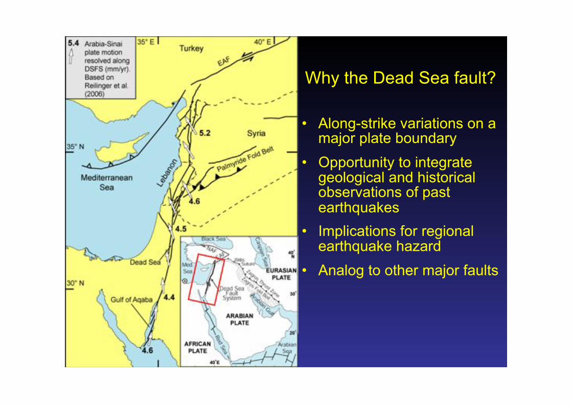
Why the Dead Sea fault?
• Along-strike variations on a major plate boundary
• Opportunity to integrate geological and historical observations of past earthquakes
• Implications for regional earthquake hazard
• Analog to other major faults"

Dead Sea fault as structural analog to San Andreas fault?

Earthquake Hazard Map
90% chance of ground acceleration exceeding these values during the next 50 years
Note the hazard along the Dead Sea fault system.
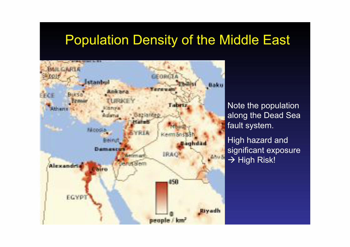
Population Density of the Middle East
Note the population along the Dead Sea fault system.
High hazard and significant exposure ! High Risk!

Roman / Byzantine Era
A rich cultural history …
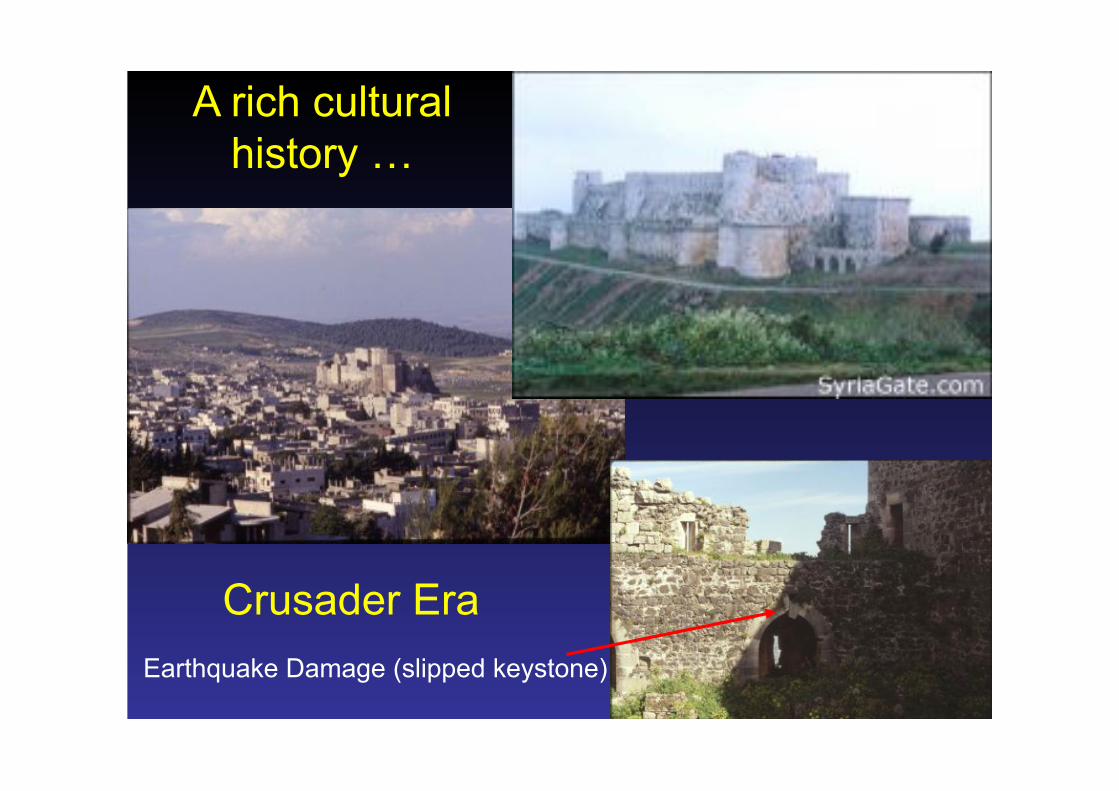
Crusader Era
A rich cultural history …
Earthquake Damage (slipped keystone)

Burqosh, Syria
Baalbek, Lebanon
Historical Record of Earthquakes
Slipped Keystone
Toppled Columns
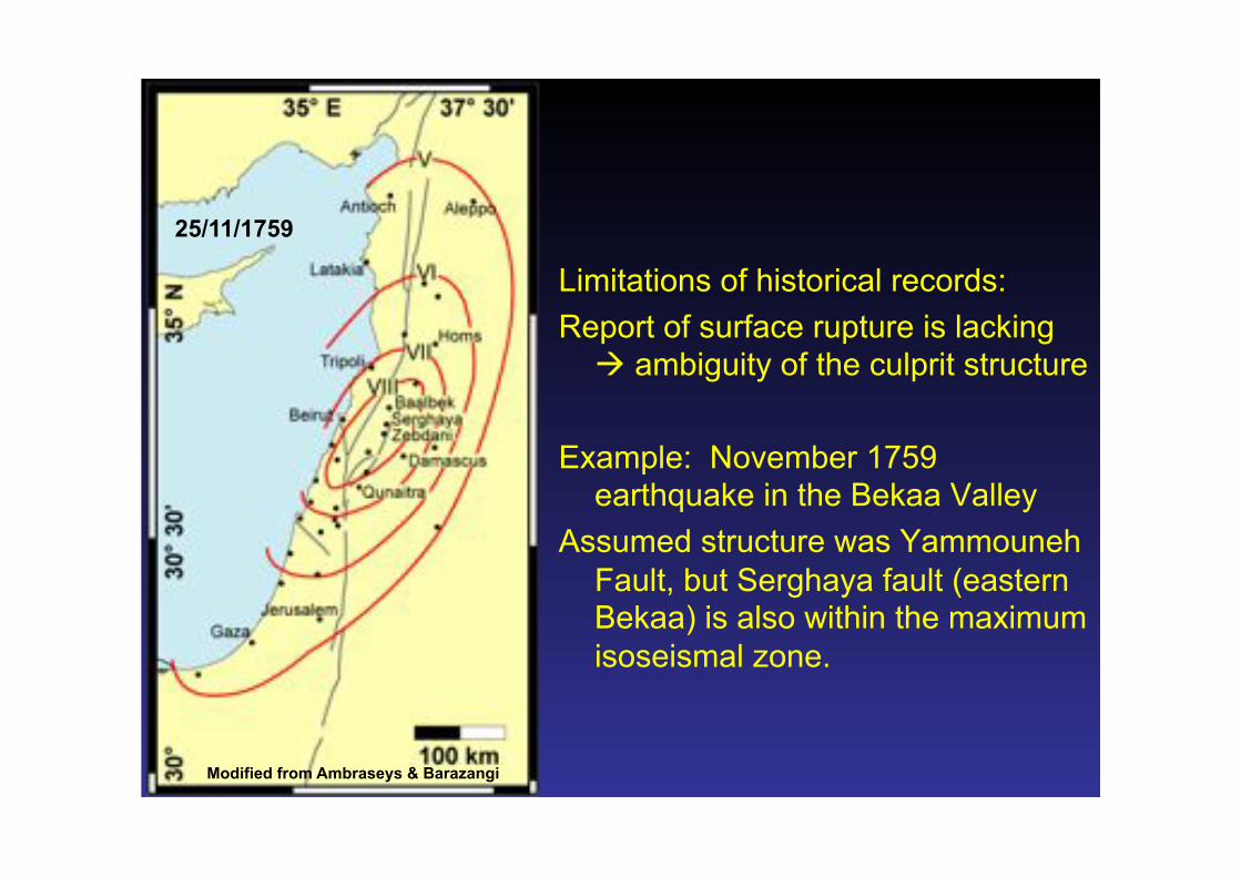
Limitations of historical records: Report of surface rupture is lacking
! ambiguity of the culprit structure
Example: November 1759 earthquake in the Bekaa Valley
Assumed structure was Yammouneh Fault, but Serghaya fault (eastern Bekaa) is also within the maximum isoseismal zone.
Modified from Ambraseys & Barazangi
25/11/1759

Instrumental seismicity from ISC (1963-1997)
Historical earthquakes from Ambraseys & Jackson (1998), Sbeinati et al. (2005), and Ambraseys et al. (1994)
Instrumental vs. Historical Earthquake Records
20th century is characterized by quiescence on Dead Sea fault that could be misleading …
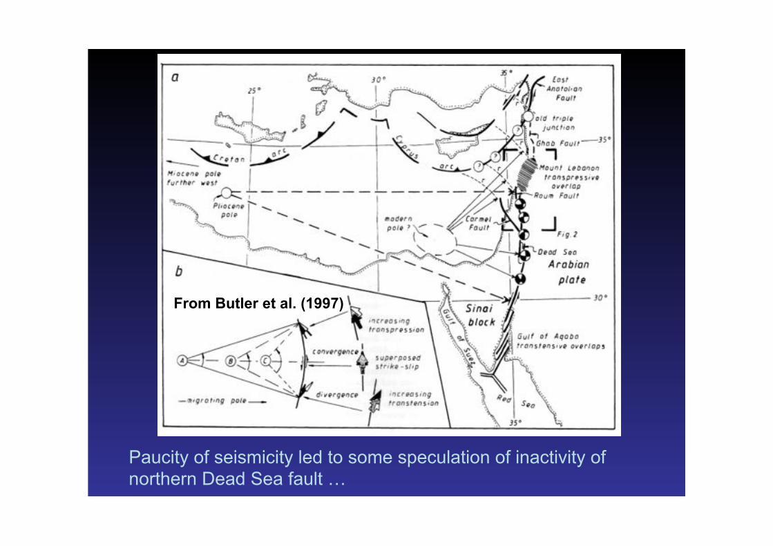
From Butler et al. (1997)
Paucity of seismicity led to some speculation of inactivity of northern Dead Sea fault …

From McClusky et al. (2000)
Where we started (GPS velocities, ca. 2000)
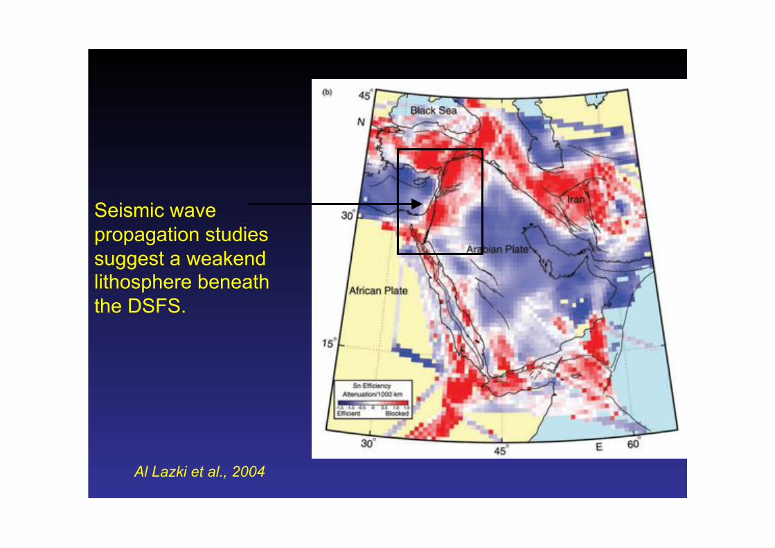
Seismic wave propagation studies suggest a weakend lithosphere beneath the DSFS.
Al Lazki et al., 2004
Earthquake Geology
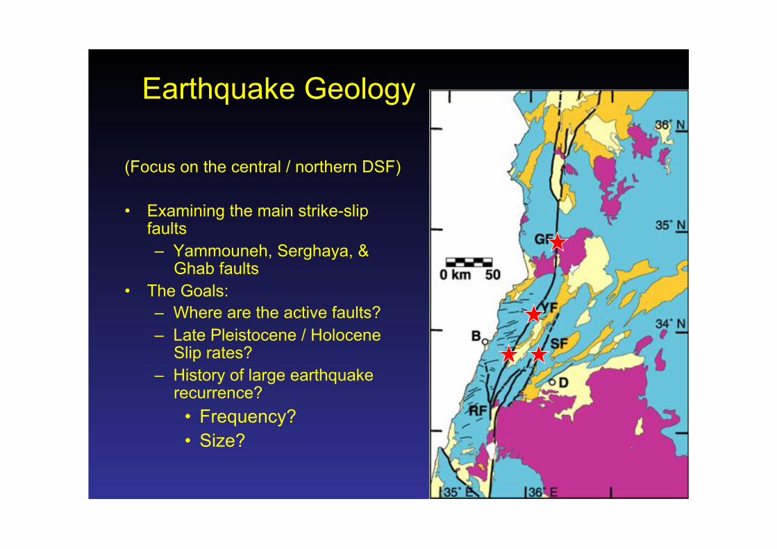
Earthquake Geology
(Focus on the central / northern DSF)
• Examining the main strike-slip faults – Yammouneh, Serghaya, &
Ghab faults • The Goals:
– Where are the active faults? – Late Pleistocene / Holocene
Slip rates? – History of large earthquake
recurrence? • Frequency? • Size?
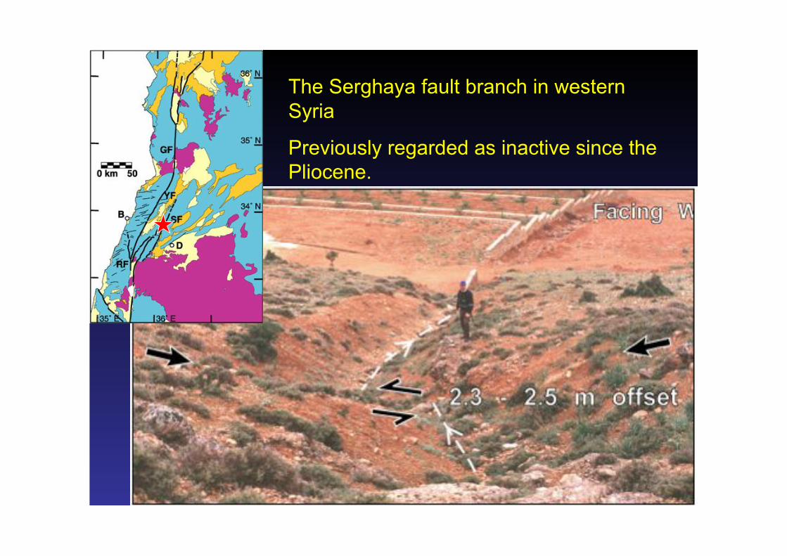
The Serghaya fault branch in western Syria
Previously regarded as inactive since the Pliocene.
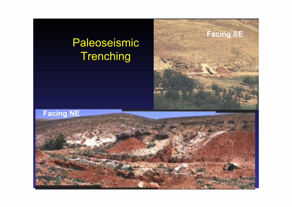
Paleoseismic Trenching
Facing SE
Facing NE
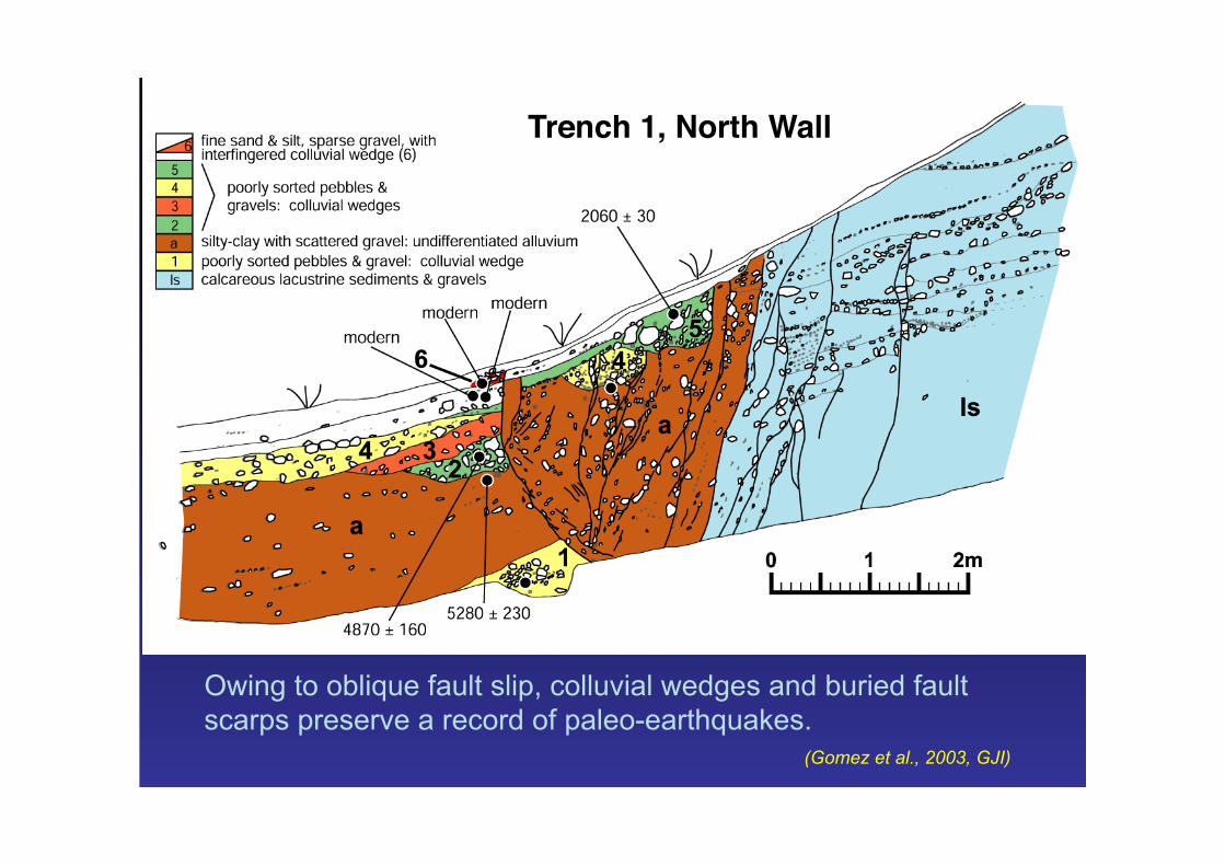
Trench 1, North Wall!
(Gomez et al., 2003, GJI)
Owing to oblique fault slip, colluvial wedges and buried fault scarps preserve a record of paleo-earthquakes.

Trench 2, East Wall!
(Gomez et al., 2003, GJI)
Buried channels in trenches parallel to the fault act as piercing points to constrain Holocene offsets.

(Gomez et al., 2003, GJI)

Calendar Correction with 2! uncertainty"
Slip Rate and Holocene Earthquakes on Serghaya
Fault
Not too bad for a fault originally believed to be inactive for the past 2 – 3 million years! Gomez et al. (JGSL 2001; GJI 2003)

• Holocene slip rate for Yammouneh fault from a faulted alluvial fan
51 – 61 m
On the Yammouneh Fault …

• Offset can be estimated using the fan morphology – 51 – 61 meters (ignore the
number on the previous slide) • Age of the abandoned fan surface
is determined using cosmogenic Cl-36 ages – 9.8 – 11.7 Ka
• Suggested slip rate ~3.9 – 5.2 mm/yr.
(Gomez et al., 2007, GSL Spec. Pub.290)
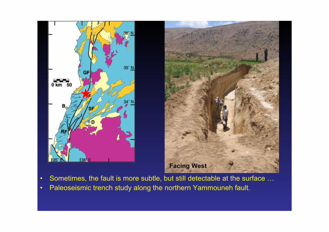
• Sometimes, the fault is more subtle, but still detectable at the surface … • Paleoseismic trench study along the northern Yammouneh fault.
Facing West
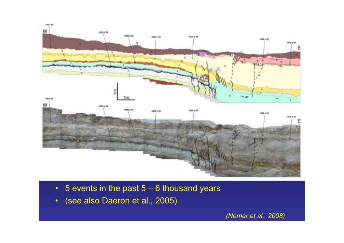
• 5 events in the past 5 – 6 thousand years • (see also Daeron et al., 2005)
(Nemer et al., 2008)

• Average recurrence period of ~1000 years
• Last event is the historically documented earthquake in 1202 AD
(Nemer et al., 2008)
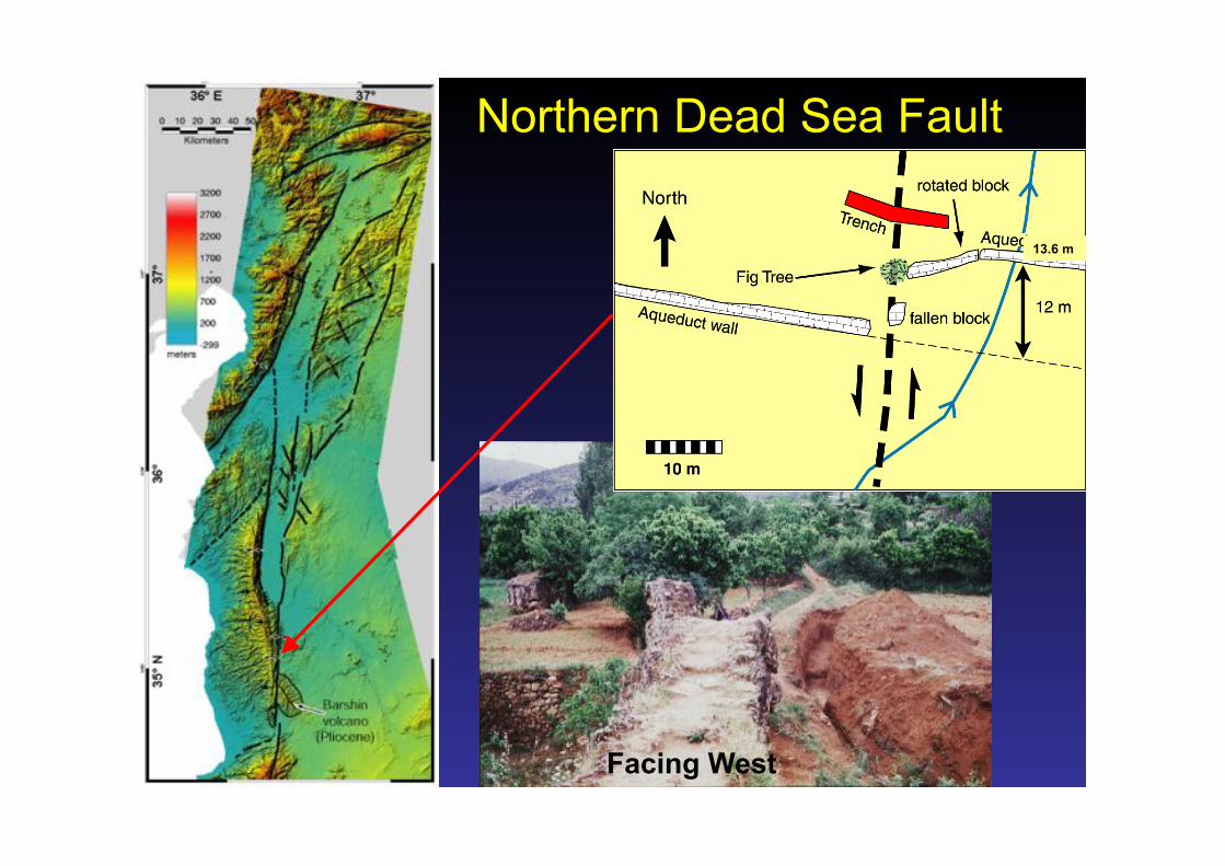
Northern Dead Sea Fault
13.6 m
Facing West

3 events during 1st millenium
No earthquake during prior 500 years
No earthquake since 1170 AD (historical record)
Meghraoui et al. (EPSL, 2003) Seinati et al. (GSA SP, 2010)

Al Harif aqueduct - Faulting episodes
Sbeinati et al. (2010)

(Sbeinati et al., 2010)
This seems a bit fast?
Note: Displacement for 1,000-1400 BC event is assumed.

~ 40 ± 5 m offset
Faulted Tell site Sicantarla (Amik Basin, Turkey)
42.4 ± 1 m
Magnetic Survey 6 – 8 Ka
Sr ~ 5.3 – 7.1 mm/yr (Altunel et al., 2006)

Earthquake Geology (partial summary) • Northern DSF (Meghraoui et al., 2003; Sbeinati et al., 2010)
• Slip rate: 4.1 – 7.0 mm/yr • EQ behavior: temporal clustering
• Central DSF – Serghaya fault (Gomez et al., 2003)
• Slip rate: 1.3 – 1.5 mm/yr • EQ behavior: quasi-periodic
– Yammouneh fault (Nemer et al., 2008; Daeron et al. 2006) • Slip rate: 3.9 – 5.2 mm/yr • EQ behavior: quasi-periodic
• Southern DSF – Jordan Valley:
• Slip rate: 4.9 – 6.0 mm/yr (Ferry et al., 2007, 2011) – Wadi Araba
• Slip rate: 3.9 – 5.0 mm/yr (Klinger et al., 2000; Niemi et al., 2001; Lebeon et al., 2012)
Tectonic Geodesy

GPS Observations for the DSFS • Syria (Alchalbi et al., 2009)
– 3 survey campaigns: 2000, 2007, 2008
– 1 CGPS (2001 – present); 3 2008 – present
• Lebanon (Jaafar, 2008) – 7 (+!) survey campaigns: 2002
– 2010 – 1 CGPS (2002 – present)
• Jordan (Abu Rajab et al., in review) – 5 survey campaigns: 2005 –
2010 – 4 CGPS (2005 – present)
• Plus, regional CGPS data • Plus, other data from MIT &
collaborators (especially Turkey, Egypt)

• Uncertainties • 8+ years (Syria,
Lebanon): 1! < 0.5 mm/yr
• 6 years (Jordan, some Lebanon): 1! < 0.6 mm/yr
• 5 years (Jordan, some Lebanon): 1! ~ 0.8 mm/yr
• Along-strike change in velocities?!

• Uncertainties • 8+ years (Syria,
Lebanon): 1! < 0.5 mm/yr
• 5 years (Jordan, some Lebanon): 1! < 0.8 mm/yr
• 3 years (Jordan, some Lebanon): 1! ~ 1 mm/yr
• Along-strike change in velocities?!
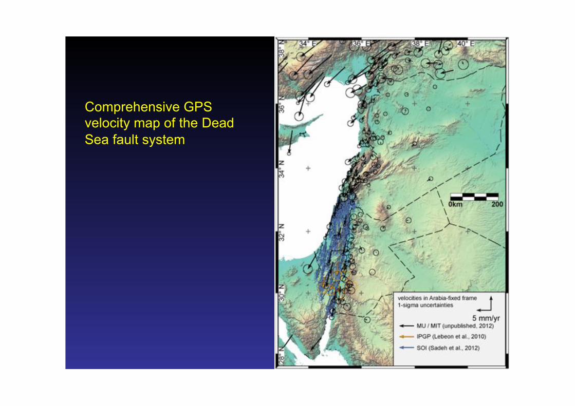
Comprehensive GPS velocity map of the Dead Sea fault system
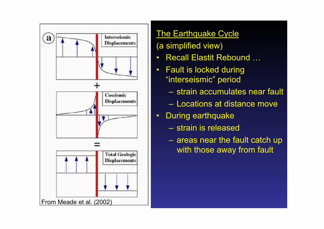
The Earthquake Cycle (a simplified view) • Recall Elastit Rebound … • Fault is locked during
“interseismic” period – strain accumulates near fault – Locations at distance move
• During earthquake – strain is released – areas near the fault catch up
with those away from fault
From Meade et al. (2002)
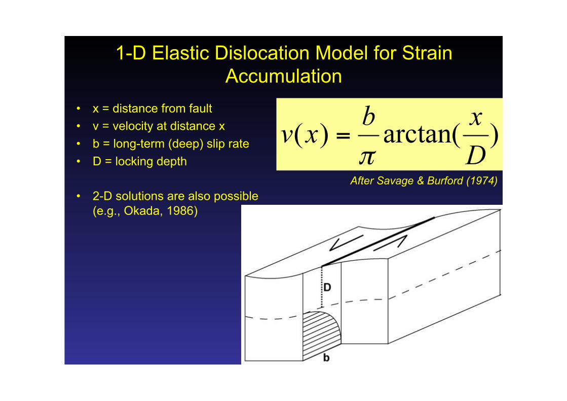
1-D Elastic Dislocation Model for Strain Accumulation
• x = distance from fault • v = velocity at distance x • b = long-term (deep) slip rate • D = locking depth
• 2-D solutions are also possible (e.g., Okada, 1986)
After Savage & Burford (1974)

Block Model • Divide E.
Mediterranean region into elastic blocks bounded by locked faults
• Accounts for deformations from fault bends and terminations (following Meade & Loveless, 2009)
• Two variations: • NE Sinai coherent • NE Sinai broken

(Al-Tarazi et al., 2011)
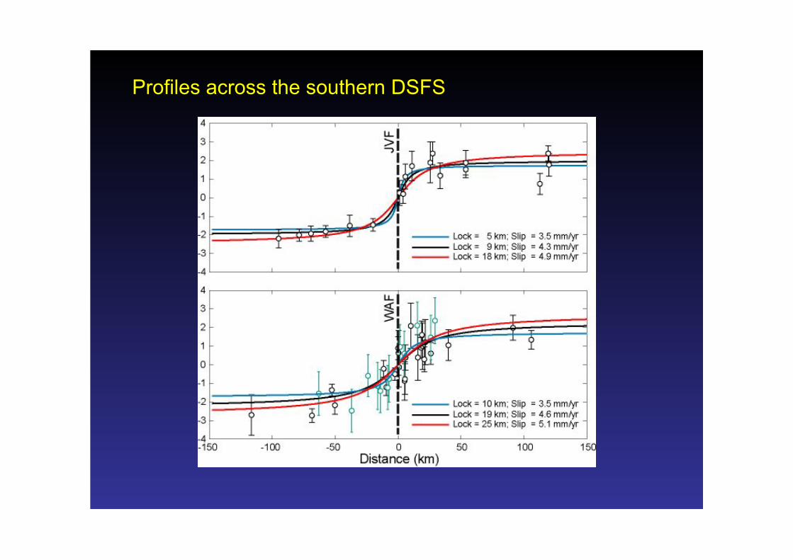
Profiles across the southern DSFS

(Al Tarazi et al., 2011)
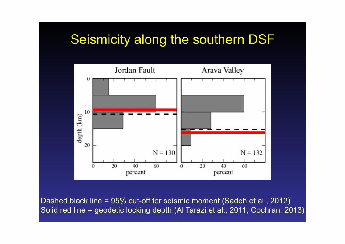
Seismicity along the southern DSF
Dashed black line = 95% cut-off for seismic moment (Sadeh et al., 2012) Solid red line = geodetic locking depth (Al Tarazi et al., 2011; Cochran, 2013)

• Along-strike change in velocities?!
• Examination of 3 profiles

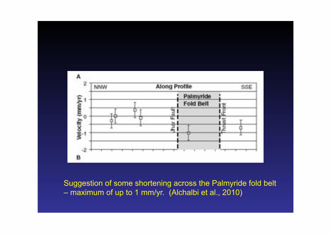
Suggestion of some shortening across the Palmyride fold belt – maximum of up to 1 mm/yr. (Alchalbi et al., 2010)
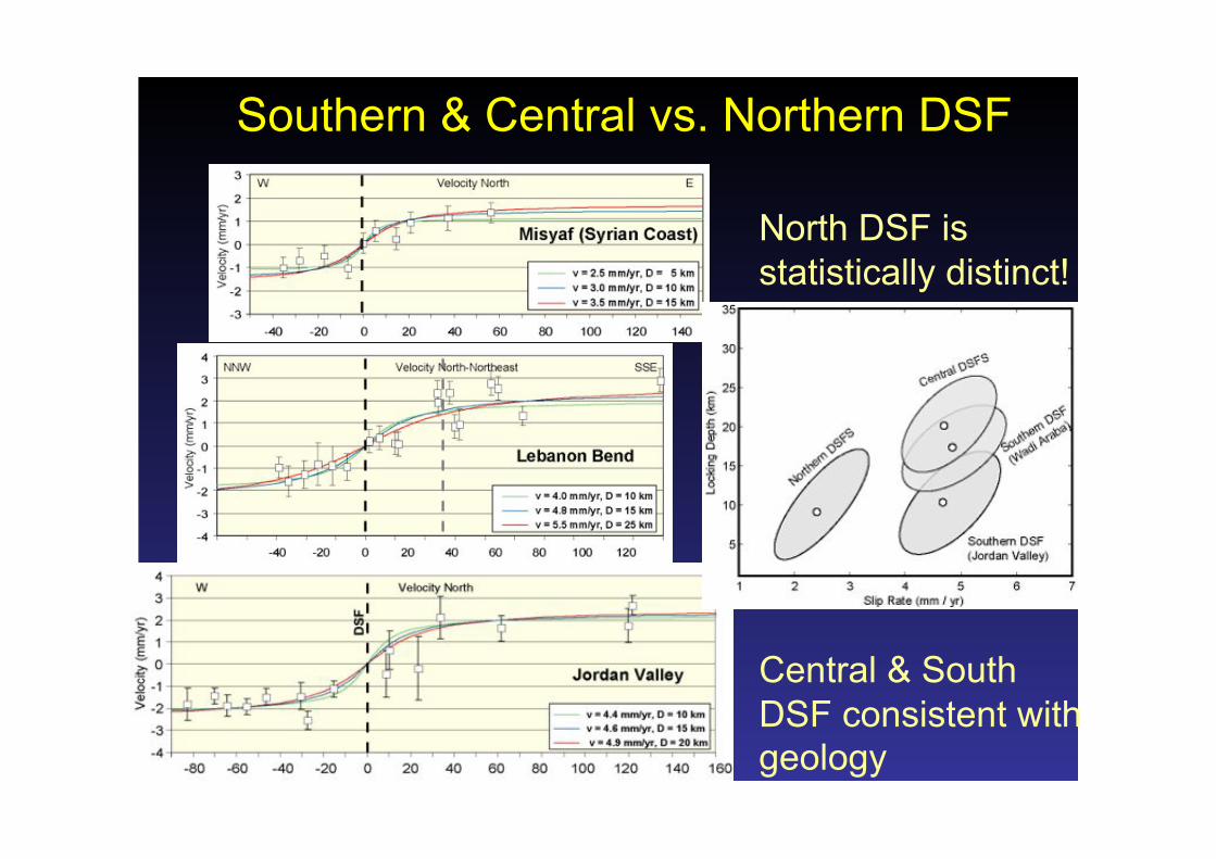
Southern & Central vs. Northern DSF
North DSF is statistically distinct!
Central & South DSF consistent with geology
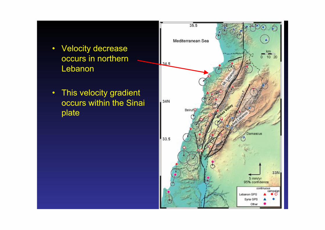
• Velocity decrease occurs in northern Lebanon
• This velocity gradient occurs within the Sinai plate
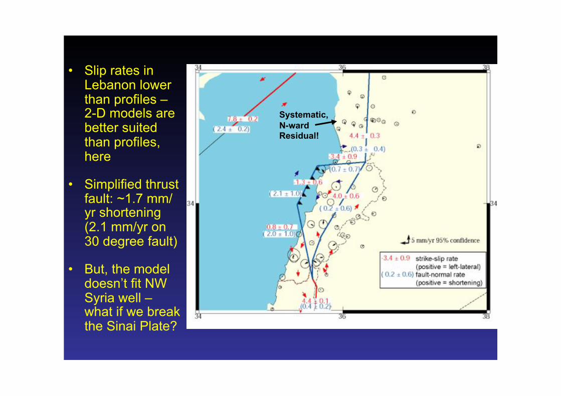
Systematic, N-ward Residual!
• Slip rates in Lebanon lower than profiles – 2-D models are better suited than profiles, here
• Simplified thrust fault: ~1.7 mm/yr shortening (2.1 mm/yr on 30 degree fault)
• But, the model doesn’t fit NW Syria well – what if we break the Sinai Plate?

• Slip rates in Lebanon lower than profiles – 2-D models are better suited than profiles, here
• Simplified thrust fault: ~1.7 mm/yr shortening (2.1 mm/yr on 30 degree fault)
• But, the model doesn’t fit NW Syria well – what if we break the Sinai Plate?
But, DO NOT take the ‘fault’ In this model literally – perhaps diffuse extension / stretching in Sinai Plate?

Perhaps the NE Sinai plate is partially broken from the main plate
If so, perhaps subducted oceanic lithosphere pulls the plate –i.e., NE Sinai converges with Anatolia faster than the main part of Sinai
Could this be caused by Eratosthenes Seamount?
Now, for some controversy …

Conclusions • A comprehensive view of near-field geodetic deformation is
now available for the DSFS – a result of international cooperation
• GPS showing some surprises – DSFS is not as simple as we thought
• Geological and geodetic slip rates are generally consistent – except northern DSF!
• Only about 1/2 of the slip is ‘transferred’ through the LRB – it’s not a simple restraining bend
• Much of the expected shortening is not present within the Lebanese Restraining Bend – is it offshore? (elastic block model)
• Is plate tectonic approximation appropriate for NE Sinai plate?