east landsdale local structure plan
TRANSCRIPT

East Landsdale – Local Structure Plan
August 2020
East Landsdale Cell 9 - LOCAL STRUCTURE PLAN NO. 57 (As amended)
East Landsdale – Local Structure Plan
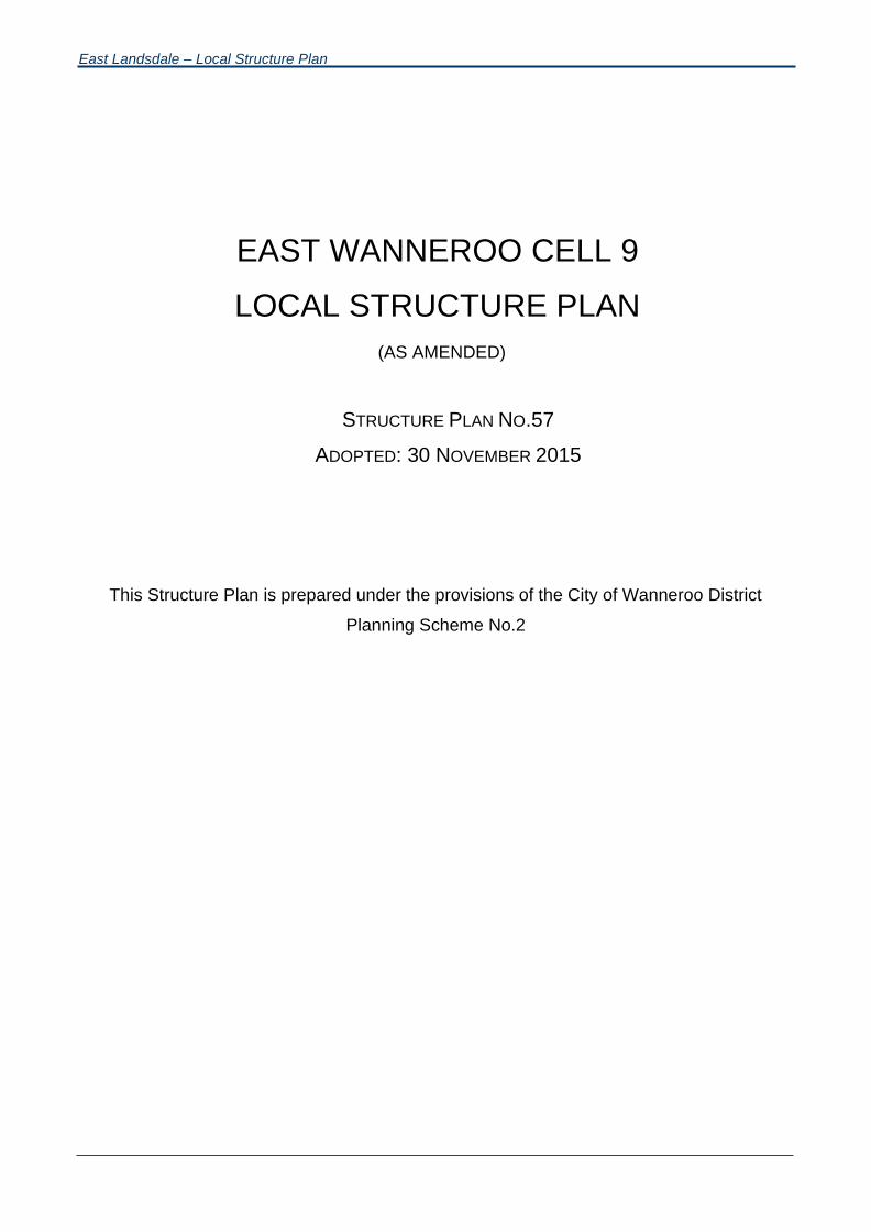
EAST WANNEROO CELL 9
LOCAL STRUCTURE PLAN
(AS AMENDED)
STRUCTURE PLAN NO.57
ADOPTED: 30 NOVEMBER 2015
This Structure Plan is prepared under the provisions of the City of Wanneroo District
Planning Scheme No.2
East Landsdale – Local Structure Plan
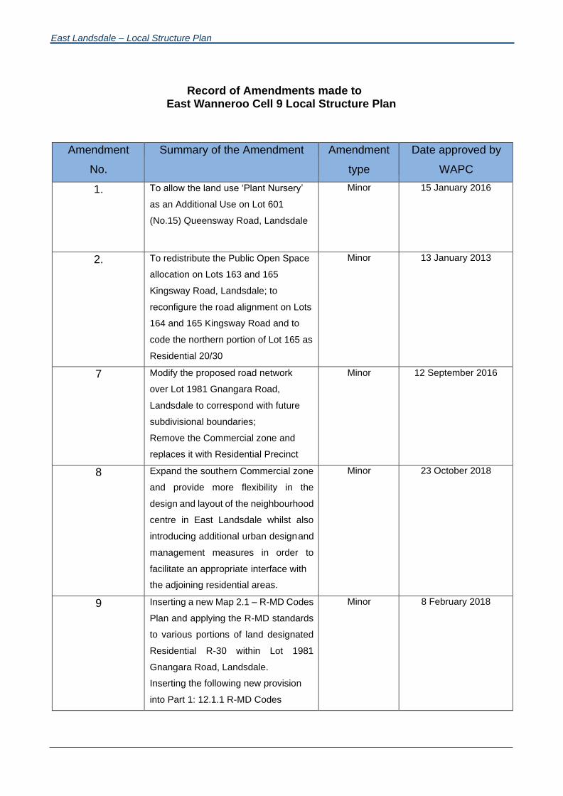
Record of Amendments made to East Wanneroo Cell 9 Local Structure Plan
Amendment
No.
Summary of the Amendment Amendment
type
Date approved by
WAPC
1. To allow the land use ‘Plant Nursery’
as an Additional Use on Lot 601
(No.15) Queensway Road, Landsdale
Minor 15 January 2016
2. To redistribute the Public Open Space
allocation on Lots 163 and 165
Kingsway Road, Landsdale; to
reconfigure the road alignment on Lots
164 and 165 Kingsway Road and to
code the northern portion of Lot 165 as
Residential 20/30
Minor 13 January 2013
7 Modify the proposed road network
over Lot 1981 Gnangara Road,
Landsdale to correspond with future
subdivisional boundaries;
Remove the Commercial zone and
replaces it with Residential Precinct
Minor 12 September 2016
8 Expand the southern Commercial zone
and provide more flexibility in the
design and layout of the neighbourhood
centre in East Landsdale whilst also
introducing additional urban design and
management measures in order to
facilitate an appropriate interface with
the adjoining residential areas.
Minor 23 October 2018
9 Inserting a new Map 2.1 – R-MD Codes
Plan and applying the R-MD standards
to various portions of land designated
Residential R-30 within Lot 1981
Gnangara Road, Landsdale.
Inserting the following new provision
into Part 1: 12.1.1 R-MD Codes
Minor 8 February 2018

East Landsdale – Local Structure Plan
The City of Wanneroo’s Local Planning
Policy 4.19: Medium-Density Housing
Standards (R-MD) sets out acceptable
variations to the deemed-to-comply
provisions of the R-Codes for lots coded
R25- R60. The variations set out in LPP
4.19 apply to all lots designated R-MD
on ASP No.57 and thereby constitutes
acceptable development within the
Structure Plan area.
Renumbering the existing provisions in
Section 12.1 accordingly.
10 To:
a) Update the Structure Plan to be
consistent with Part 4 of the
deemed provisions of the Scheme;
and
b) Modify the Structure Plan to
modify/delete provisions that will be
incorporated into Scheme
Amendment 146 which provides for
the introduction of Special Control
Area 2 into Schedule 17 of the
Scheme relating to the area subject
of East Wanneroo Cell 9 East
Landsdale – Approved Structure
Plan No. 57.
08 June 2021Minor

East Landsdale – Local Structure Plan
OVERVIEW
Clause 9.8 of the City of Wanneroo District Planning Scheme No.2 (hereinafter called “the Scheme”) provides,
amongst other things, that a provision, standard or requirement of a Structure Plan approved under Part 9 of
the Scheme, shall be given the same force and effect as if it was a provision, standard or requirement of the
Scheme. It is hereby provided that such force and effect shall only be given to Part 1 of this Structure Plan. Part
2 of the Structure Plan is for explanatory purposes only, providing a descriptive analysis of the Structure Plan
initiatives.
Clause 9.8.3(f) of the Scheme states that, in the event of there being any inconsistency or conflict between any
provision, requirement or standard of the Scheme and any provision requirement or standard of an Approved
Structure Plan, the provision, requirement or standard of the Scheme shall prevail.
A key element for the special development provisions included in this Structure Plan is to ensure the ongoing
compatibility between residential development and the Perth International Telecommunications Centre (PITC)
located on the eastern side of Alexander Drive. The PITC is sensitive to the emission of Radio Frequency (RF)
interference that can be produced in urban environments. The following development controls will assist in
minimising those impacts and assist in the ongoing compatibility between urban uses and the PITC.
East Landsdale – Local Structure Plan
Page i
TABLE OF CONTENTS
PART 1 - IMPLEMENTATION
1.0 STRUCTURE PLAN AREA .............................................................................................. 1
2.0 STRUCTURE PLAN CONTENT........................................................................................ 1
3.0 INTERPRETATION ........................................................................................................... 1
4.0 OPERATION DATE .......................................................................................................... 1
5.0 RELATIONSHIP WITH THE SCHEME .............................................................................. 1
6.0 PLANNING PRINCIPLES, ELEMENTS, OBJECTIVES AND STRATEGIES .................... 2
6.1 Urban Form Principles ............................................................................................................... 2
6.2 Urban Form Elements ............................................................................................................... 2
6.2.1 Movement Network .................................................................................................................... 3
6.2.2 Housing ...................................................................................................................................... 3
6.2.3 Sustainability, Environment & Open Space ................................................................................ 4
6.2.4 Community Facilities and School ............................................................................................... 7
6.2.5 Infrastructure, Tree Retention and Earthworks ........................................................................... 7
6.2.6 Activity Centres and Employment .............................................................................................. 8
7.0 OPERATION OF STRUCTURE PLAN .............................................................................. 9
8.0 STRUCTURE PLAN MAP ................................................................................................. 9
9.0 ZONES 9
9.1 Additional Use ............................................................................................................................ 9
10.0 RESIDENTIAL DENSITY CODING ................................................................................. 10
10.1 Residential Density Coding Provisions ....................................................................................11
11.0 PUBLIC OPEN SPACE SCHEDULE............................................................................... 11
12.0 GENERAL PROVISIONS ................................................................................................ 13
12.1 Residential Precinct .................................................................................................................13
12.1.1 R-MD Codes ............................................................................................................................ 13
12.1.2 Land Uses ................................................................................................................................ 13
12.1.3 Building Heights ....................................................................................................................... 14
12.1.4 Construction ............................................................................................................................. 14
12.2 Local Scheme Reserves .......................................................................................................... 14
12.3 Other Provisions ...................................................................................................................... 14
12.3.1 Landscaping ............................................................................................................................. 14
12.3.2 Subdivision Process ................................................................................................................. 14
12.3.3 Orientation of Roads ................................................................................................................ 15
12.3.4 Transitional Provisions ............................................................................................................. 15
East Landsdale – Local Structure Plan
Page ii
Explanatory Report ...................................................................................................................... 27
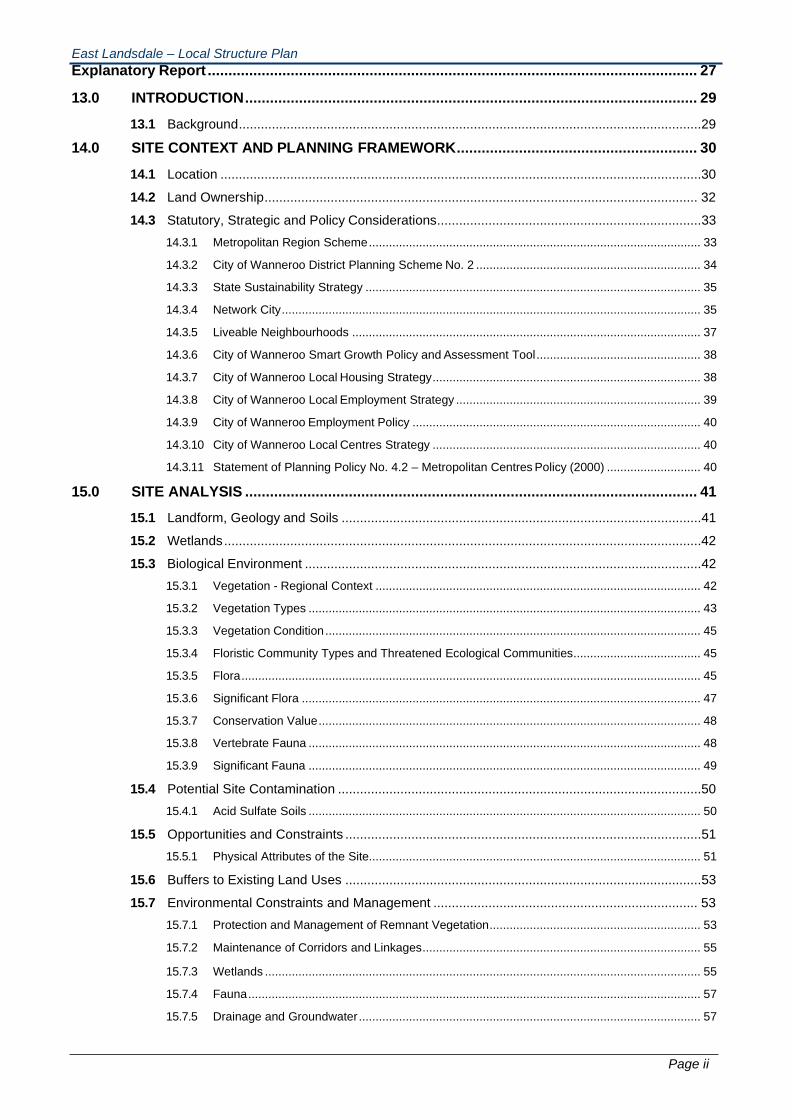
13.0 INTRODUCTION ............................................................................................................. 29
13.1 Background ..............................................................................................................................29
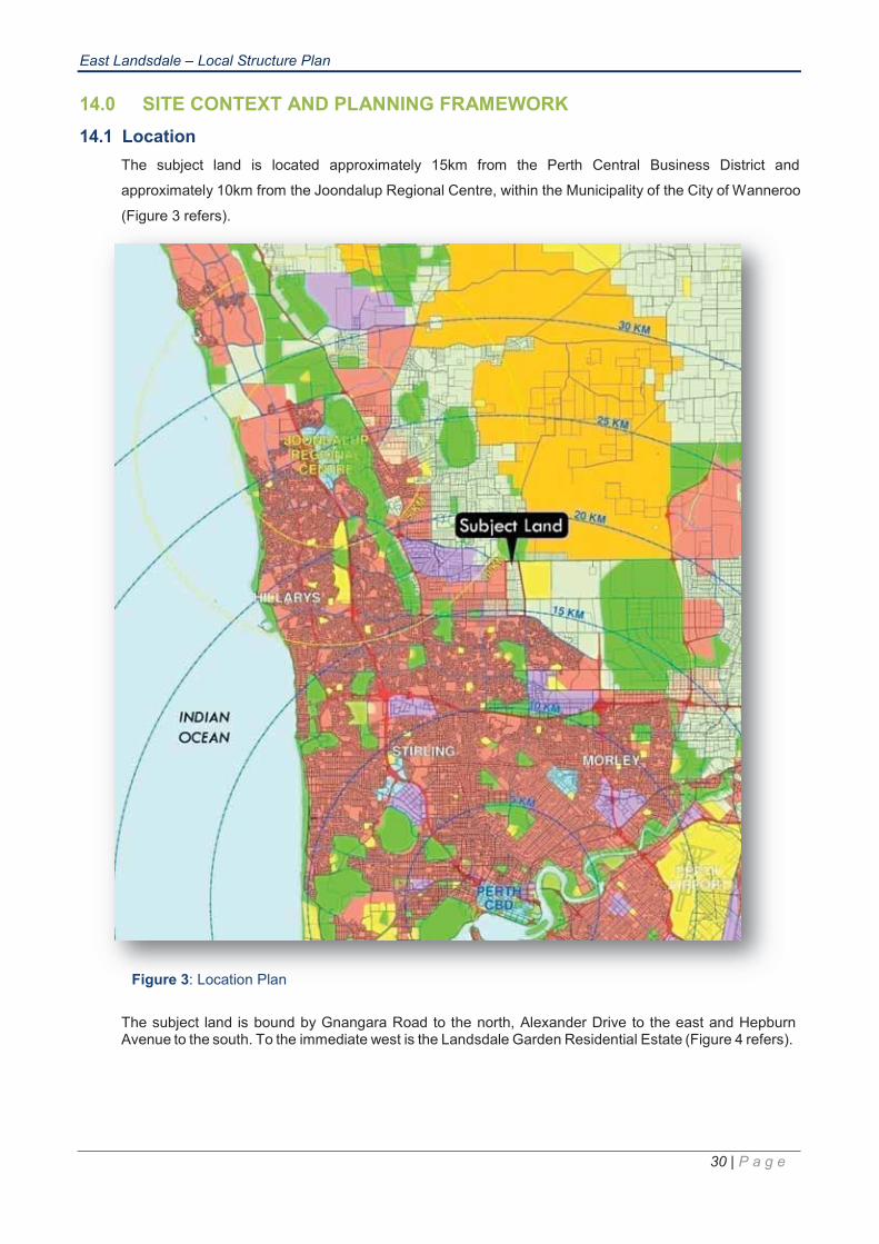
14.0 SITE CONTEXT AND PLANNING FRAMEWORK .......................................................... 30
14.1 Location ...................................................................................................................................30
14.2 Land Ownership ...................................................................................................................... 32
14.3 Statutory, Strategic and Policy Considerations........................................................................ 33
14.3.1 Metropolitan Region Scheme ................................................................................................... 33
14.3.2 City of Wanneroo District Planning Scheme No. 2 ................................................................... 34
14.3.3 State Sustainability Strategy .................................................................................................... 35
14.3.4 Network City ............................................................................................................................. 35
14.3.5 Liveable Neighbourhoods ........................................................................................................ 37
14.3.6 City of Wanneroo Smart Growth Policy and Assessment Tool ................................................. 38
14.3.7 City of Wanneroo Local Housing Strategy ................................................................................ 38
14.3.8 City of Wanneroo Local Employment Strategy ......................................................................... 39
14.3.9 City of Wanneroo Employment Policy ...................................................................................... 40
14.3.10 City of Wanneroo Local Centres Strategy ................................................................................ 40
14.3.11 Statement of Planning Policy No. 4.2 – Metropolitan Centres Policy (2000) ............................ 40
15.0 SITE ANALYSIS ............................................................................................................. 41
15.1 Landform, Geology and Soils .................................................................................................. 41
15.2 Wetlands ..................................................................................................................................42
15.3 Biological Environment ............................................................................................................ 42
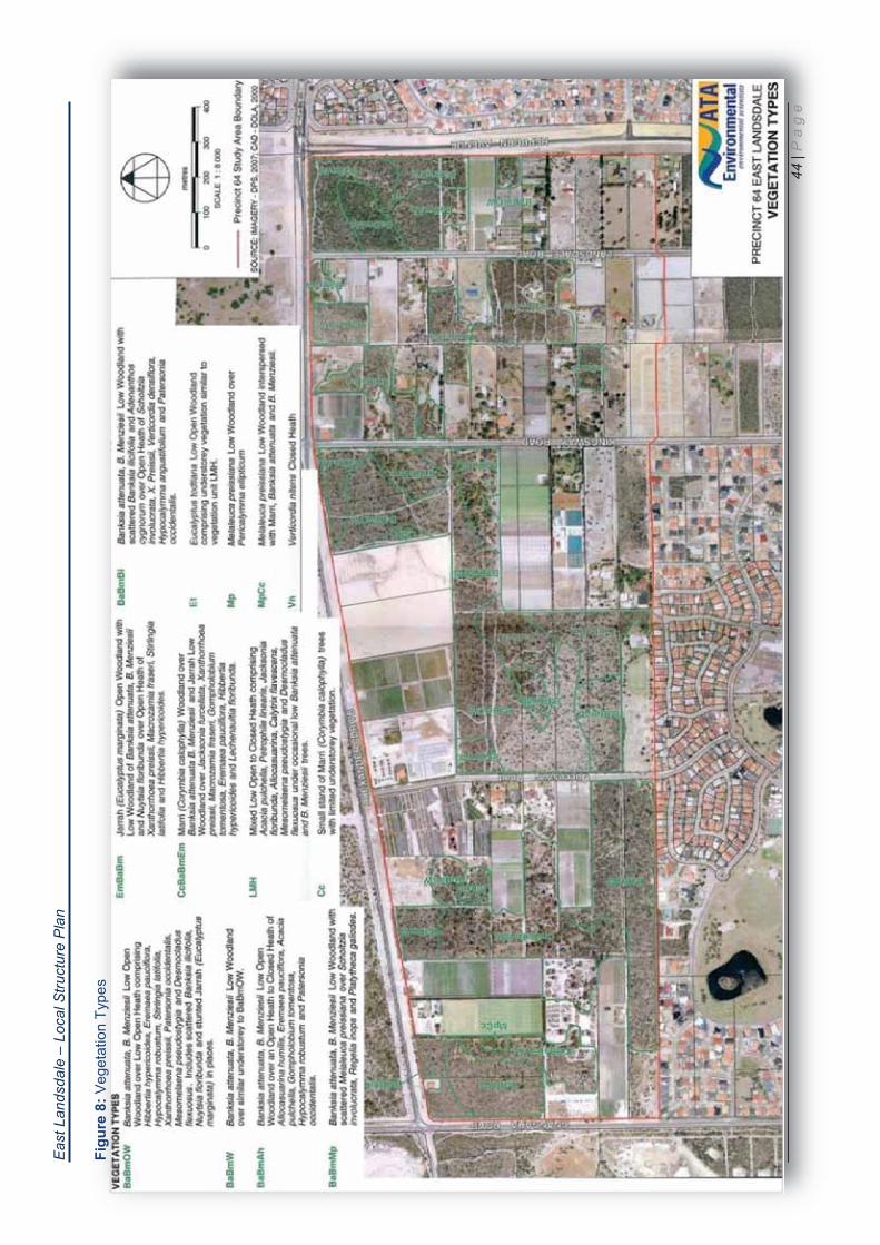
15.3.1 Vegetation - Regional Context ................................................................................................. 42
15.3.2 Vegetation Types ..................................................................................................................... 43
15.3.3 Vegetation Condition ................................................................................................................ 45
15.3.4 Floristic Community Types and Threatened Ecological Communities ...................................... 45
15.3.5 Flora ......................................................................................................................................... 45
15.3.6 Significant Flora ....................................................................................................................... 47
15.3.7 Conservation Value .................................................................................................................. 48
15.3.8 Vertebrate Fauna ..................................................................................................................... 48
15.3.9 Significant Fauna ..................................................................................................................... 49
15.4 Potential Site Contamination ...................................................................................................50
15.4.1 Acid Sulfate Soils ..................................................................................................................... 50
15.5 Opportunities and Constraints ................................................................................................. 51
15.5.1 Physical Attributes of the Site................................................................................................... 51
15.6 Buffers to Existing Land Uses ................................................................................................. 53
15.7 Environmental Constraints and Management ........................................................................ 53
15.7.1 Protection and Management of Remnant Vegetation ............................................................... 53
15.7.2 Maintenance of Corridors and Linkages ................................................................................... 55
15.7.3 Wetlands .................................................................................................................................. 55
15.7.4 Fauna ....................................................................................................................................... 57
15.7.5 Drainage and Groundwater ...................................................................................................... 57

East Landsdale – Local Structure Plan
Page iii
15.8 Groundwater Protection ...........................................................................................................57
15.9 Perth International Telecommunications Centre ..................................................................... 58
16.0 THE STRUCTURE PLAN................................................................................................ 60
16.1 Community Design................................................................................................................... 60
16.2 Proposed Land Uses .............................................................................................................. 60
16.3 Movement Network .................................................................................................................. 61
16.4 Public Transport ...................................................................................................................... 67
16.5 Pedestrian and Cycle Networks ............................................................................................. 69
16.6 Residential ...............................................................................................................................71
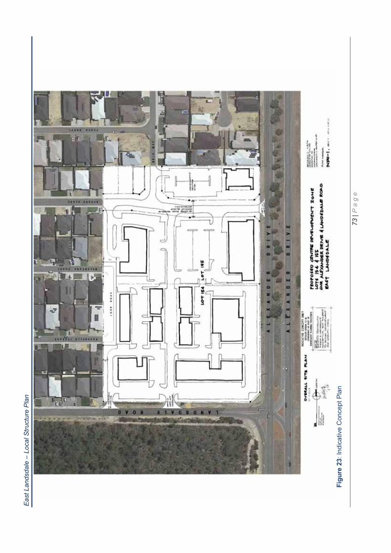
16.7 Local Activity Centre ............................................................................................................... 71
16.8 Education Facilities ..................................................................................................................74
16.9 Community Facilities ............................................................................................................... 74
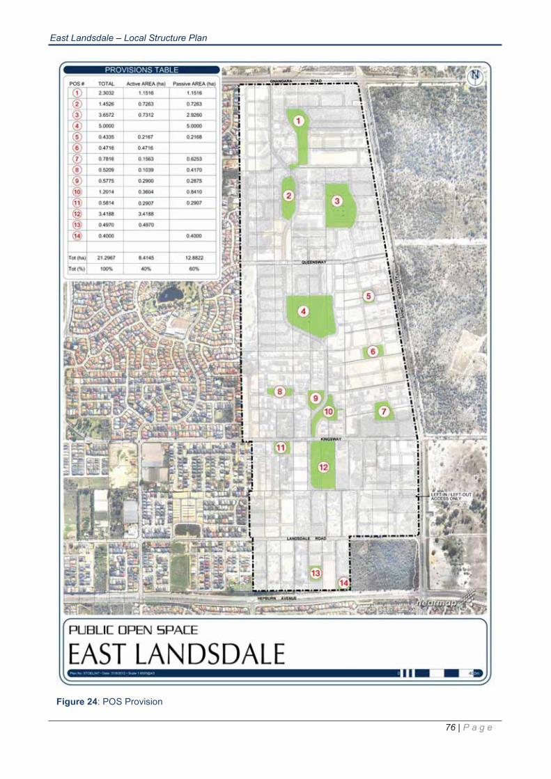
16.10 Public Open Space, Streetscape and Landscaping ............................................................... 74
16.11 Servicing Infrastructure ........................................................................................................... 80
16.11.1 Siteworks and Earthworks Regime .......................................................................................... 80
16.11.2 Roadworks ............................................................................................................................... 81
16.11.3 Stormwater Drainage ............................................................................................................... 81
16.11.4 Sewer Reticulation ................................................................................................................... 82
16.11.5 Water Reticulation .................................................................................................................... 83
16.11.6 Power Supply and Other Services ........................................................................................... 83
16.12 Implementation ........................................................................................................................84
16.12.1 City of Wanneroo District Planning Scheme No. 2 ................................................................... 84
16.13 Cost Sharing Arrangements .................................................................................................... 84
16.14 Summary of Key Environmental Recommendations ...............................................................84
17.0 CONCLUSIONS .............................................................................................................. 85

Page iv
East Landsdale – Local Structure Plan
MAPS
Map 1: Structure Plan
Map 2: Residential Coding Plan
Map 2.1: R-MD Codes Plan
Map 3: Zoning Plan
Map 4: Road Hierarchy Plan
Map 5: Public Open Space
FIGURES
Figure 1: Alexander Drive Species and Densities
Figure 2: Alexander Drive Buffer Concepts
Figure 3: Location Plan
Figure 4: Context Plan
Figure 5: Orthophoto (December 2005)
Figure 6: Current MRS Zoning
Figure 7: Current DSP No.2 Zoning
Figure 8: Vegetation Types
Figure 9: Vegetation Condition
Figure 10: Opportunities and Constraints
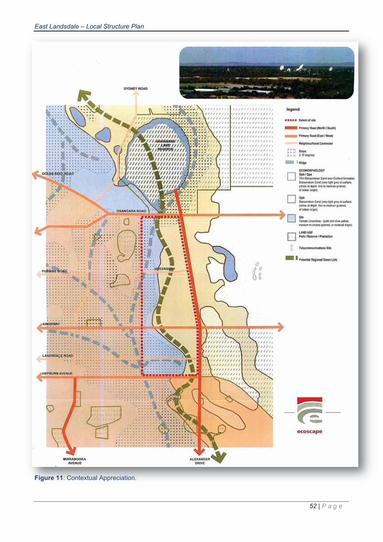
Figure 11: Contextual Appreciation
Figure 12: Environmental Constraints
Figure 13: PITC Site Location
Figure 14: Road Hierarchy
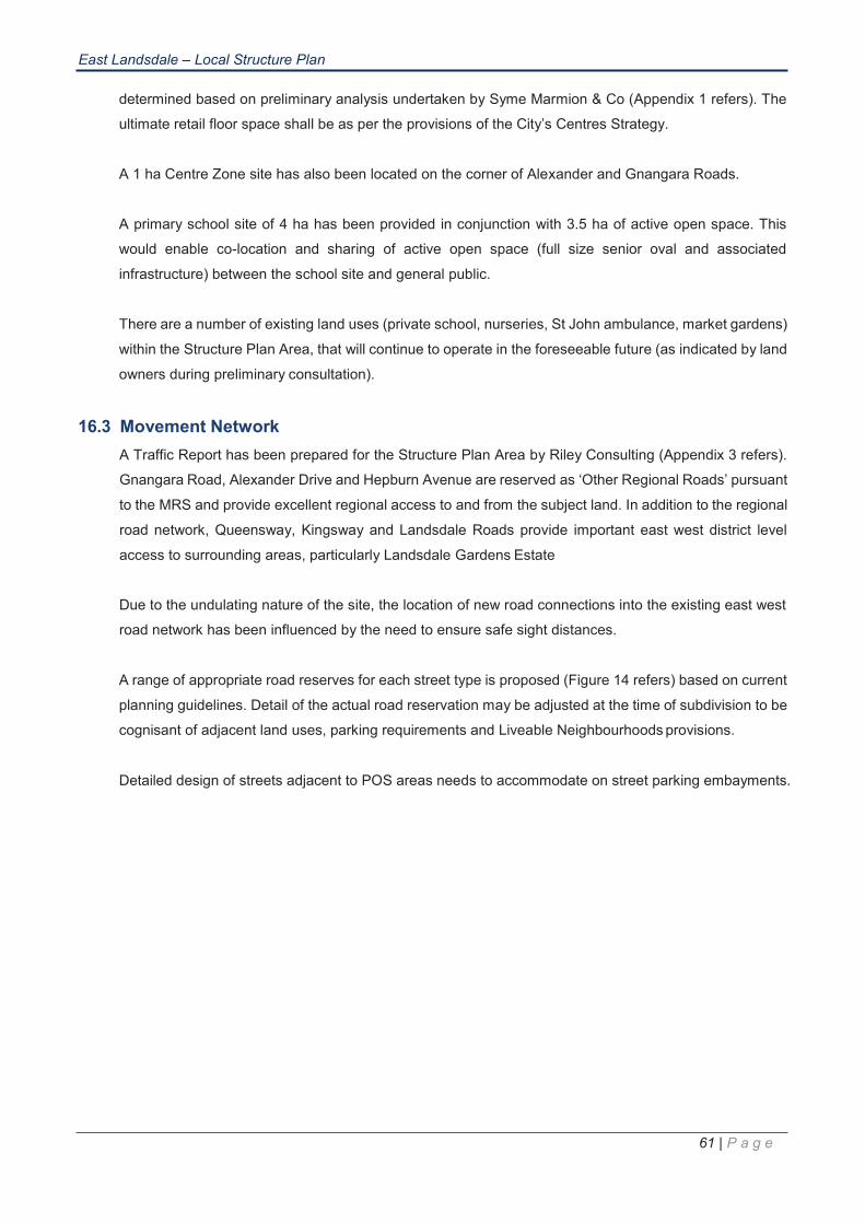
Figure 15: Cross-section of 23m Drainage Boulevard
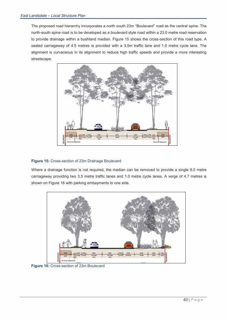
Figure 16: Cross-section of 23m Boulevard
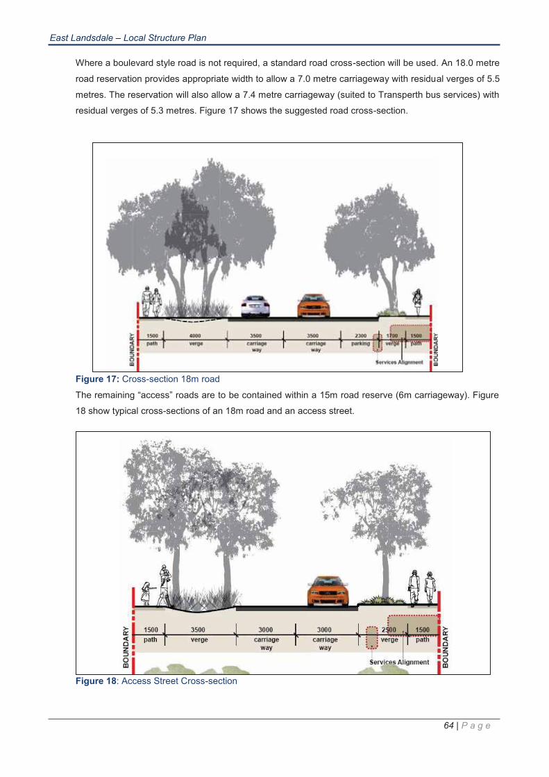
Figure 17: Cross-section 18m road
Figure 18: Access Street Cross-section
Figure 19: Alexander Drive Landscaping Treatment
Figure 20: Existing Bus Service Route
Figure 21: Proposed Bus Service Route, Roads Designed to Accommodate Future Bus Service,
Figure 22:
Walkable Catchments
Proposed Pedestrian / Cyclist Path Network
Figure 23: Southern Commercial Site Indicative Concept Plan
Figure 24: POS Provision
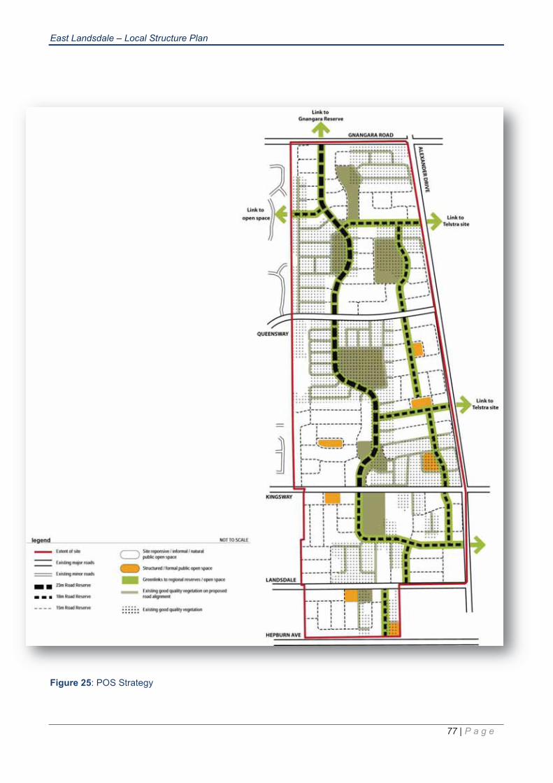
Figure 25: POS Strategy
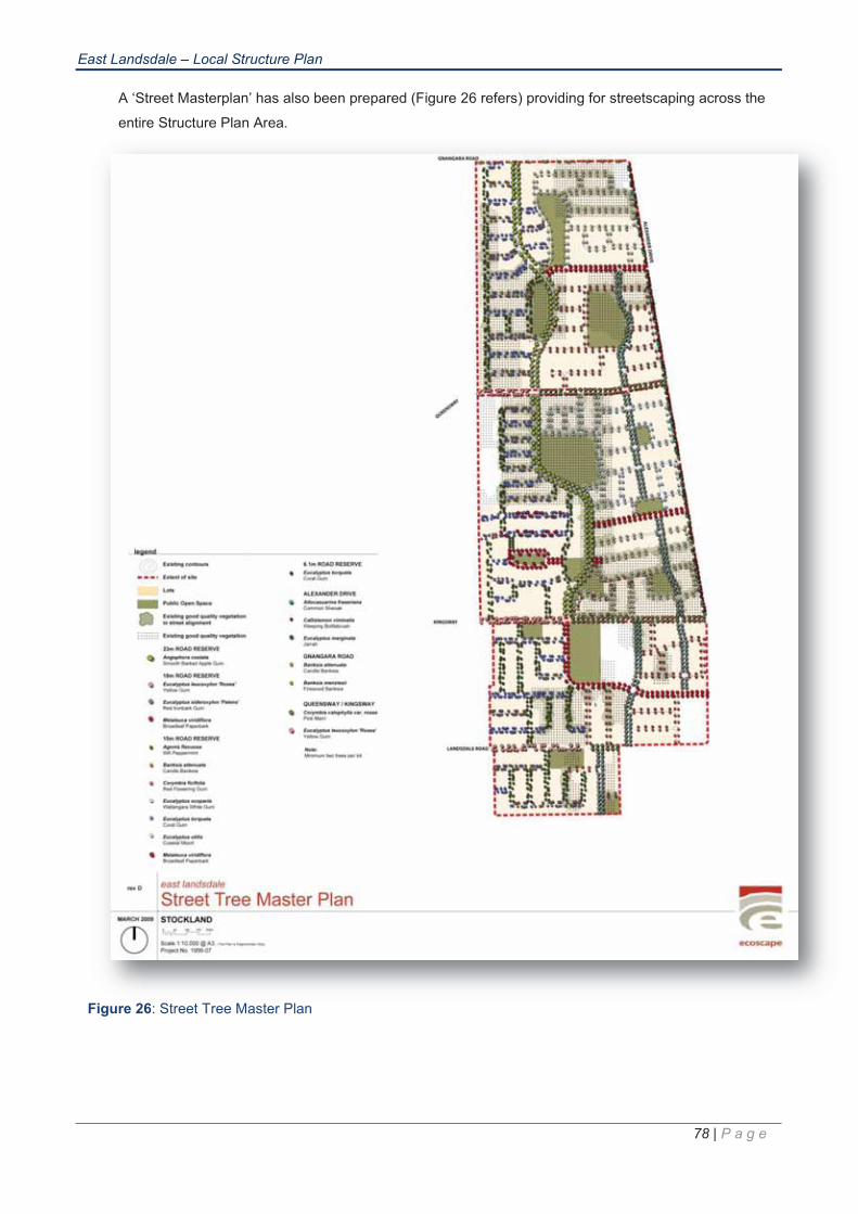
Figure 26: Street Trees Masterplan Figure
Figure 27: Areas of Good Vegetation in POS areas
Page v
East Landsdale – Local Structure Plan
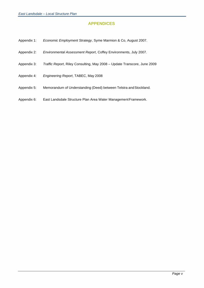
APPENDICES
Appendix 1: Economic Employment Strategy, Syme Marmion & Co, August 2007.
Appendix 2: Environmental Assessment Report, Coffey Environments, July 2007.
Appendix 3: Traffic Report, Riley Consulting, May 2008 – Update Transcore, June 2009
Appendix 4: Engineering Report, TABEC, May 2008
Appendix 5: Memorandum of Understanding (Deed) between Telstra and Stockland.
Appendix 6: East Landsdale Structure Plan Area Water Management Framework.
Part 1
Implementation
East Landsdale – Local Structure Plan
1 | P a g e
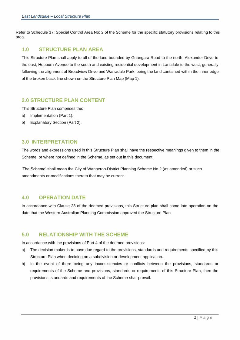
Refer to Schedule 17: Special Control Area No: 2 of the Scheme for the specific statutory provisions relating to this area.
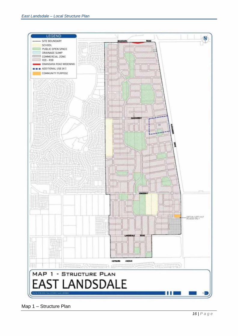
1.0 STRUCTURE PLAN AREA
This Structure Plan shall apply to all of the land bounded by Gnangara Road to the north, Alexander Drive to
the east, Hepburn Avenue to the south and existing residential development in Lansdale to the west, generally
following the alignment of Broadview Drive and Warradale Park, being the land contained within the inner edge
of the broken black line shown on the Structure Plan Map (Map 1).
2.0 STRUCTURE PLAN CONTENT
This Structure Plan comprises the:
a) Implementation (Part 1).
b) Explanatory Section (Part 2).
3.0 INTERPRETATION
The words and expressions used in this Structure Plan shall have the respective meanings given to them in the
Scheme, or where not defined in the Scheme, as set out in this document.
‘The Scheme’ shall mean the City of Wanneroo District Planning Scheme No.2 (as amended) or such
amendments or modifications thereto that may be current.
4.0 OPERATION DATE
In accordance with Clause 28 of the deemed provisions, this Structure plan shall come into operation on the
date that the Western Australian Planning Commission approved the Structure Plan.
5.0 RELATIONSHIP WITH THE SCHEME
In accordance with the provisions of Part 4 of the deemed provisions:
a) The decision maker is to have due regard to the provisions, standards and requirements specified by this
Structure Plan when deciding on a subdivision or development application.
b) In the event of there being any inconsistencies or conflicts between the provisions, standards or
requirements of the Scheme and provisions, standards or requirements of this Structure Plan, then the
provisions, standards and requirements of the Scheme shall prevail.

East Landsdale – Local Structure Plan
2 | P a g e
6.0 PLANNING PRINCIPLES, ELEMENTS, OBJECTIVES AND STRATEGIES
This section details a number of Urban Form Principles, Elements, Objectives and Strategies which are intended
to inform and guide the detailed planning process:
The Principles are broad statements derived from Liveable Neighbourhoods and Council’s Smart Growth
Strategy, to guide the detailed design and development.
The various strategies referred to in the Structure Plan are generally to be implemented as part of the future
subdivision and development of the Structure Plan Area.
6.1 Urban Form Principles
The following urban form principles underpin the Structure Plan:
• To create a sustainable development that aims to achieve key ‘triple bottom line’ outcomes whilst
fostering the development of a strong local identity and sense of place within the community.
• To create a vibrant, sustainable and interactive community that provides a wide range of residential,
recreational, retail, education and mixed use areas within walkable neighbourhoods allowing for a
variety of living, employment and leisure opportunities.
• To create an urban form which encourages a range of lot and housing types enhancing lifestyle and
affordability opportunities.
• To provide an efficient movement network which facilitates safe and pleasant walking, cycling and
driving, improving access to public transport systems, local employment, retail and community
facilities.
• To provide an integrated approach to the retention of key environmental areas, urban servicing and
design of open space.
• Identify and articulate discernable neighbourhoods, addressing Liveable Neighbourhoods Policy
(as updated from time to time).
6.2 Urban Form Elements
Urban Form Elements within the Structure Plan are generally guided by the key elements contained within
Western Australian State Operational Policy - Liveable Neighbourhoods:
• Movement Network.
• Housing.
• Sustainability, Environment and Open Space.
• Community and Schools.
• Infrastructure.
• Activity Centres & Employment.

East Landsdale – Local Structure Plan
3 | P a g e
6.2.1 Movement Network
Primary Objectives:
• To provide an interconnected movement network providing convenient and safe linkages for
vehicles, cyclists and pedestrians to and throughout the residential areas, activity centres,
open space and other areas of interest within or adjoining the development.
• To provide a street network and design which creates a pleasant public realm and
encourages walking, less reliance on the private car and enhances public transport use.
• To ensure efficient use of land through the application of Liveable Neighbourhoods road
design principles and standards.
Strategies:
• To locate neighbourhood connectors and major intersection points generally consistent with
the locations depicted in the Structure Plan.
• A highly interconnected street network to provide focus on the Activity Centre with strong links
both within and external to the Structure Plan Area, maximising safety, encouraging walking
and cycling, supporting public transport and minimising the impact of through traffic.
• Locate a road interface to areas of public open space, unless it can be demonstrated in a
particular instance that an alternative form of interface treatment is appropriate.
• Design the street network in a way that provides for development orientation toward major
roads.
• Identify a conveniently positioned bus route network, providing maximum accessibility in
conformance with PTA policy.
• Locate a public transport node and access points within the Activity Centre.
• The design and character of major roads, to provide an environment amenable to
pedestrians, cyclists, homes and businesses.
• Design and locate local streets to create safe low vehicle speed environments embracing
Liveable Neighbourhood standards for widths, cross sections, truncations, street trees and
other matters.
• Provide a road network that facilitates energy efficiency in accordance with Liveable
Neighbourhood standards.
6.2.2 Housing
Primary Objectives:
• To ensure the provision of choice and a range of housing product, responsive to community
needs and sustainability principles.
• To promote efficient use of land through the appropriate spatial allocation and site design.
• To minimise the impact of development on landform, to realistically reflect the constraints and
opportunities posed by landform and topography in the design of subdivision.
• To ensure ongoing compatibility between residential development and the Perth International
Telecommunications Centre (PITC).
East Landsdale – Local Structure Plan
4 | P a g e
Strategies:
• Provide the Structure Plan with densities, consistent with targets outlined in Clause 10.0 –
Residential Density Codes, to facilitate variety and affordability of housing product.
• Design a road network that allows the creation of residential lots that can be developed in a
manner that facilitates solar passive design.
• Promote housing layouts that incorporate energy efficiency and passive solar design through
purchaser information.
6.2.3 Sustainability, Environment & Open Space
Primary Objectives:
• To deliver triple bottom line sustainability outcomes being:
o Economic – commercial success for all.
o Environment – preservation and response to natural features, energy, water and waste
minimisation.
o Social – a vibrant and safe community.
• Create a range of recreational opportunities within the Structure Plan Area (including active
and passive recreation spaces, integrated bushland areas within open space and
conservation areas), which generally reflect WAPC subdivision policy requirements and the
City of Wanneroo’s environmental policy framework.
• Retain natural landscape character through local vegetation retention, native landscape
themes and the reuse of native vegetation.
• Provide for the co-location, integration and sharing of public open space areas and recreation
facilities with schools.
• Create an area of quality community open space in the vicinity of the Activity Centre.
• Locate open spaces to ensure good pedestrian accessibility and to enhance pedestrian
movement opportunities throughout the Structure Plan Area.
• Ensure surveillance of public open space areas to enhance security.
• Promote solar passive design.
• Promote water efficiency through rainwater collection and grey water reuse to enhance
sustainability of the development.
• Objectives for Sustainable Wetland Development:
o To maintain a sense of place through retention of existing good quality natural vegetation,
use of indigenous plant species and the protection and enhancement of the existing
natural wetland processes.
o To achieve up to 100% open space credits for buffers surrounding any identified
Resource Enhancement Wetland (REW) and Conservation Category Wetland (CCW).
o To enhance regional connectivity of the existing wetland systems.
o To ensure all development storm water runoff is stripped of nutrients prior to entering an
existing wetland system.
East Landsdale – Local Structure Plan
5 | P a g e
• Objectives for Streetscapes and Public Open Space (POS):
o Use the site’s ecology as a design tool to retain, develop and enhance the site’s existing
landscape and landforms with an Australian native, wild flower character.
o Maintain the sense of place through the retention of existing good quality natural
vegetation, local planning theming and reuse of indigenous local species to rehabilitate
degraded vegetation communities.
o Locate open space areas within the Structure Plan Area in a manner that facilitates good
pedestrian access and connectivity both within the development and regionally.
o Integrate opportunities for stormwater runoff infiltration source to replenish ground water
systems.
o Integrate Crime Prevention through Environmental Design principles and practices.
o To protect locally significant natural areas.
• Objectives for Urban Water Management:
o Implement water sensitive urban design in accordance with the Water Management
Framework (Appendix 6);
o Optimise efficient use and re-use of water resources.
o Demonstrate capacity of the land to sustain urban development, considering (where
relevant) acid sulphate soils, surface and groundwater biodiversity and other land uses in
the Structure Plan Area.
o Incorporate objectives relating to performance of the development with regards to potable
water consumption, groundwater and stormwater quality and quantity.
o Encourage water conservation.
o Enhance water related environmental issues.
o Protect water sensitive ecosystems, including wetlands.
Strategies:
• Provide a mixed use public open space corridor as indicated on the Structure Plan and a
central POS network.
• A minimum of 10% of the total site at full development is to be set aside as POS in accordance
with WAPC policy and should achieve the following:
o Provide a practical balance between the protection of local vegetation, community
requirements and provision of active and passive parkland.
o Provide a range of passive ‘pocket parks’ with a high amenity focus.
o Provide good connectivity to and through the open spaces and ensure most residents are
no more than 450 metres from an open space.
o Selectively retain native vegetation in road reserves and POS.
o Integrate drainage into multiple use open space corridors in addition to the 10% POS
areas. This does not preclude the use of drainage basins where appropriate.
o Use native landscape themes for public open spaces, street trees and private landscape
packages.
• Strategies for Sustainable Wetland Development:
East Landsdale – Local Structure Plan
6 | P a g e
o Identify buffers surrounding the REW and CCW wetlands for inclusion in public open
space as local conservation areas for passive recreation and up to 100% credit, based
on calculations in accordance with Liveable Neighbourhoods.
o Identify and retain good to pristine quality condition vegetation within the wetland buffers.
o Undertake seed collection and propagation of indigenous plant species within the
identified wetlands for rehabilitation of degraded sites and buffers.
o Identify wetland processes, local flora and fauna for interpretation opportunities.
o Integrate boardwalks and site responsive pedestrian access within nominated wetland
buffers, to increase pedestrian connectivity within the Structure Plan Area.
o Incorporate interpretative signage, about the natural environment the residential
development is set in, with shade structures, for educational purposes.
o Identify drainage requirements and appropriate “at source” infiltration techniques
throughout the development streetscape network and appropriate non-structural source
controls. This would allow for nutrient stripping prior to the runoff entering the wetland
systems.
o Develop Wetland Concept and Management Plans for the CCW and REW including, but
not limited to, weed control mechanisms and barriers, controlled pedestrian access,
interpretation and recreation within buffers, re-vegetation and on-going maintenance.
• Strategies for Streetscapes and Public Open Space:
o Evenly distribute POS throughout the Structure Plan Area, generally consistent with the
Structure Plan, to maximise accessibility for all residents.
o Provide a north-south open space corridor aligned with the main “Green Spine” road, as
shown on the Structure Plan, to allow for conservation, passive and active recreation
opportunities and connection to Gnangara Reserve Regional Open Space.
o Identify and protect, where practicable, good to pristine quality condition vegetation within
the POS areas and streetscapes, to protect and retain a sense of place and provide
instant amenity.
o Integrate drainage solutions throughout the development in streetscapes and POS areas
to promote best practice water sensitive urban design.
o Undertake seed collection and propagation of indigenous plant species within the
identified good to pristine quality condition vegetation for rehabilitation of degraded sites
and reuse in identified natural conservation areas.
• Strategies for Urban Water Management :
o Land owners to develop Urban Water Management Plans to the satisfaction of the City of
Wanneroo and the Department of Water prior to lodgement of a subdivision application
with the Western Australian Planning Commission.
o Incorporate stormwater treatment into the landscape through implementation of Urban
Water Management Plans.
o As far as practicable, develop coordinated approaches to urban water management
through cooperation in the development of urban water management plans across
landholdings.

East Landsdale – Local Structure Plan
7 | P a g e
o Optimise the use of existing resources.
6.2.4 Community Facilities and School
Primary Objectives:
• To create a distinctive and responsive built form, enhancing a sense of neighbourhood and
community identity, place and character.
• Provide community facilities and services (including retail, education, recreation, etc), a variety
of housing choice and a legible street network to facilitate community interaction, and support
different needs and lifestyles.
• Provide educational facilities that meet the needs of the existing and future community.
• Promote efficient land use through innovative design and site planning solutions.
• Promote the co-location of educational facilities with areas of active open space and
community uses.
Strategies:
• To provide for location of a public Primary School within the Structure Plan Area, generally
in the location shown on the Structure Plan.
• Educational facilities are to be located to comply with Telstra requirements and designed to
encourage contemporary urban form outcomes.
• Promote, where appropriate, sharing of school infrastructure with the broader community
through partnerships with Local Government.
6.2.5 Infrastructure, Tree Retention and Earthworks
Primary Objectives:
• To optimise the use of existing infrastructure and assets within and surrounding the site.
• To ensure that infrastructure is provided in an appropriately staged manner, as development
proceeds.
• Objectives for tree retention and earthworks:
o Achieve minimum 1.2m freeboards above AAMGL.
o Minimise earthworks requirements across developments.
o Retain significant vegetation (where practicable) within POS reserves and road reserves.
o Minimise height of retaining walls (where practicable) below 3m.
o Ensure existing and future development levels are compatible between adjoining
subdivisions which respond and / or consider issues in relation to legal boundaries.
o Land owners are encouraged to consider consolidated earthworks design to gain
efficiencies and to achieve desired objectives.
Strategies:
• Provide communications infrastructure within the Structure Plan Area to improve local
employment opportunities.

East Landsdale – Local Structure Plan
8 | P a g e
• Strategies for tree retention and earthworks:
o Achieve minimum 1.5m freeboard above AAMGL to accommodate onsite infiltration of
storm water management.
o Liaise with adjoining landowners to achieve above objectives.
o Landowners to prepare (at subdivision stage) an earthworks management plan.
o In the event of any significant trees being identified for retention, management plans to
be prepared to ensure tree retention.
o Detail design to consider minor variations to road alignments and lot boundaries to
facilitate, where practical, tree retention.
6.2.6 Activity Centres and Employment
Primary Objectives:
• To establish an accessible and amenable Activity Centre to serve the commercial, social and
employment needs of the community and act as a focus point for community activity and
interaction.
• Create a robust urban framework within and around the Activity Centre, which enhances the
opportunity for mixed use and local based employment.
Strategies:
• Develop a vibrant Activity Centre, incorporating best practice design and sustainability
principles to act as a focus and attractor for the local community.
• Create a centre for commercial activity and provide opportunities for local employment,
consistent with Liveable Neighbourhoods.
• Promote good access to the centre through its location on higher order roads and public
transport, pedestrian and cycle routes.
• Maximise on-street parking at the centre to enable appropriately reduced private parking,
make best use of urban land and encourage alternative modes of transport.
• Incorporate a diversity of land uses within the centres.

East Landsdale – Local Structure Plan
9 | P a g e
7.0 OPERATION OF STRUCTURE PLAN
Subdivision applications shall be generally consistent with the intent of the Approved Structure Plan. At the time
of lodging an application for subdivision, the proponent shall provide supporting information pertinent to the
relevant area detailed on the Structure Plan Map (Map 1) to demonstrate how the objectives and strategies
detailed in section 6.0 will be addressed. This information will include, where relevant, amongst other things,
strategies, preliminary concepts and objectives for the following supporting technical documents, with the
detailed Management Plans being required as a condition of subdivision:
• Wetland Management Plan(s)
• Vegetation Management Plan(s).
• Native Fauna Management Plan(s).
• Landscape Concept Plan(s).
• Local Road Network Plan.
• Intersection Improvement Plan for Alexander Drive.
8.0 STRUCTURE PLAN MAP
The Structure Plan Map (Map 1) outlines the planned pattern of development for the Structure Plan Area. All
development should be carried out in accordance with the principles outlined in this document and described
on the Approved Structure Plan Map (Map 1).
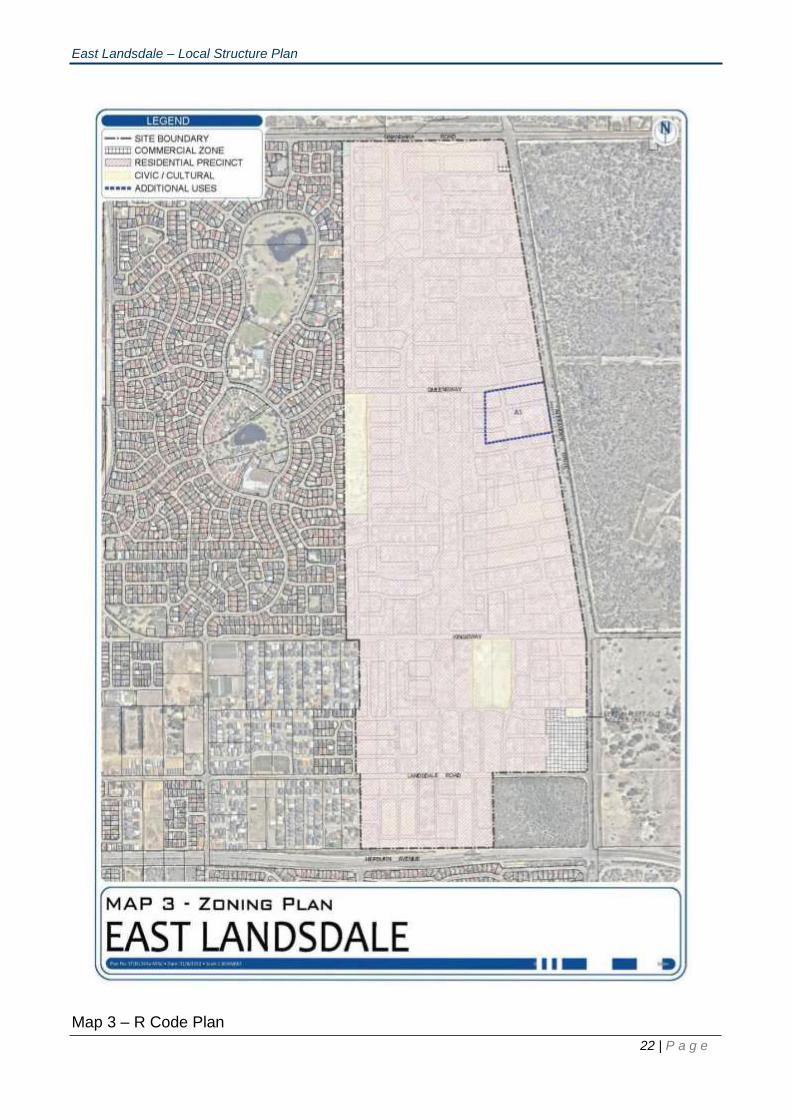
9.0 ZONES
Map 3 – Zoning Map delineates and depicts the zones applicable to the Structure Plan Area according to the
legend thereon.
9.1 Additional Use
Notwithstanding anything contained in Table No.1 of the District Planning Scheme No. 2, the land
specified in Schedule A of the East Wanneroo Cell 9 – East Landsdale LSP 57 may be used for the
specific use listed in addition to any uses permissible for the zone in which the land is located, subject to
the conditions set out therein.
East Landsdale – Local Structure Plan
10 | P a g e
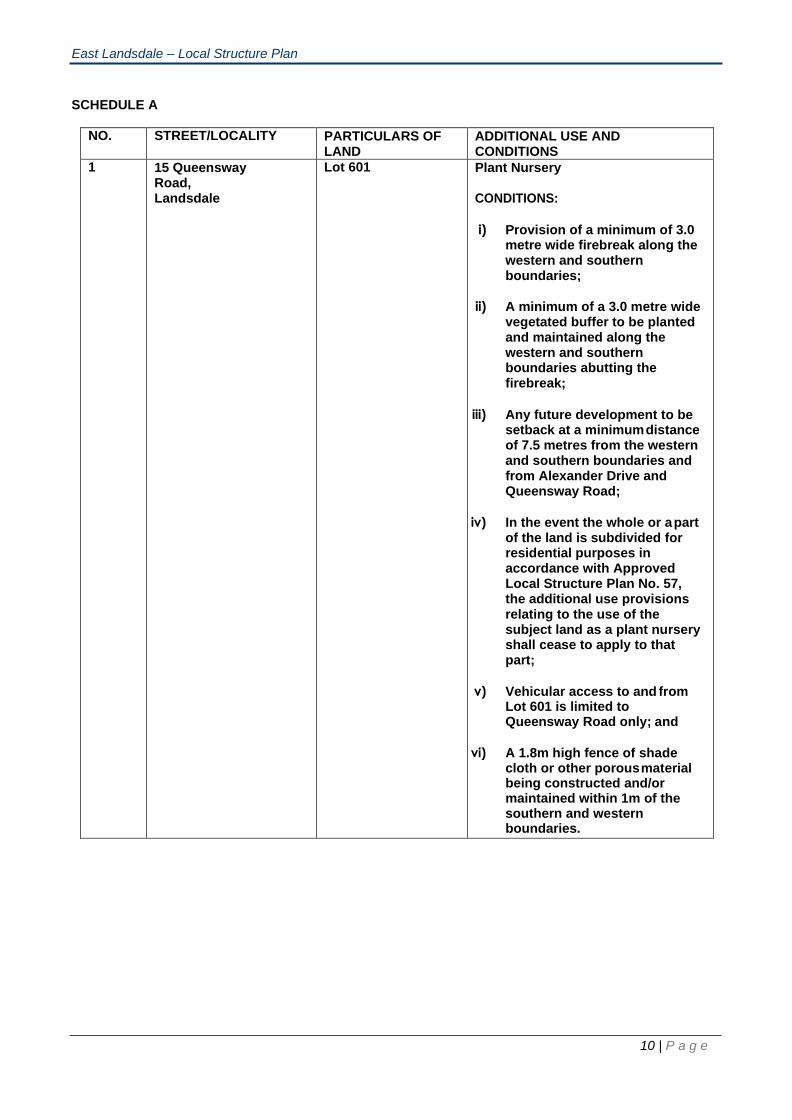
SCHEDULE A
NO. STREET/LOCALITY PARTICULARS OF
LAND ADDITIONAL USE AND CONDITIONS
1 15 Queensway Road, Landsdale
Lot 601 Plant Nursery
CONDITIONS:
i) Provision of a minimum of 3.0 metre wide firebreak along the western and southern boundaries;
ii) A minimum of a 3.0 metre wide vegetated buffer to be planted and maintained along the western and southern boundaries abutting the firebreak;
iii) Any future development to be setback at a minimum distance of 7.5 metres from the western and southern boundaries and from Alexander Drive and Queensway Road;
iv) In the event the whole or a part of the land is subdivided for residential purposes in accordance with Approved Local Structure Plan No. 57, the additional use provisions relating to the use of the subject land as a plant nursery shall cease to apply to that part;
v) Vehicular access to and from Lot 601 is limited to Queensway Road only; and
vi) A 1.8m high fence of shade cloth or other porous material being constructed and/or maintained within 1m of the southern and western boundaries.
East Landsdale – Local Structure Plan
11 | P a g e
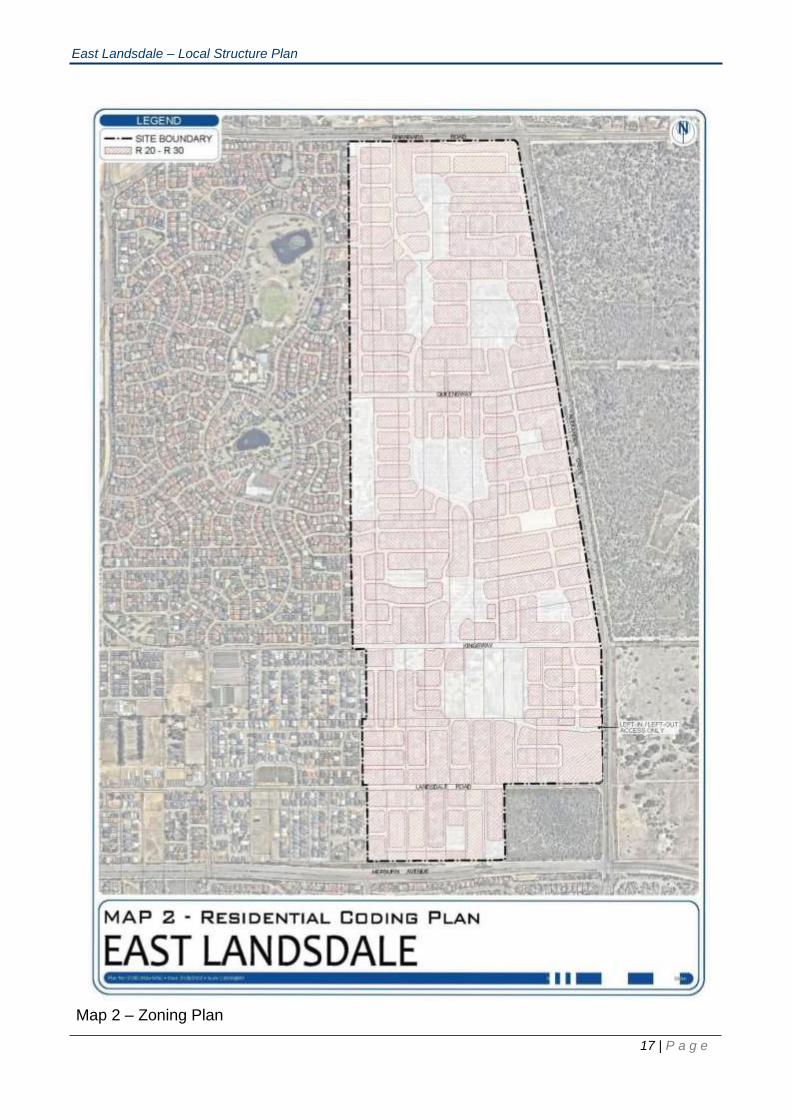
10.0 RESIDENTIAL DENSITY CODING
Map 2 - Residential Coding Map delineates and depicts the residential density codes applicable to the Structure
Plan Area according to the legend thereon.
The residential density codes designated under this Structure Plan apply to the land as if the residential density
codes were incorporated in the Scheme.
10.1 Residential Density Coding Provisions
a) A base coding of R20 applies to the structure plan area;
b) R30 may be provided in the following circumstances:
• 400m from Commercial/Retail centres
• 250m from Public Open Space
• 250m from Bus Routes;
c) at the time of subdivision, an R-Code plan is to be submitted allocating R- Codes in
accordance with clauses a) and b) above, for the assessment of development applications;
d) subdivision is to achieve a minimum average site area of not less than 500m2 per dwelling.
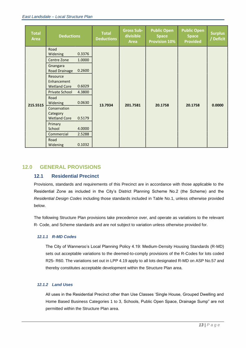
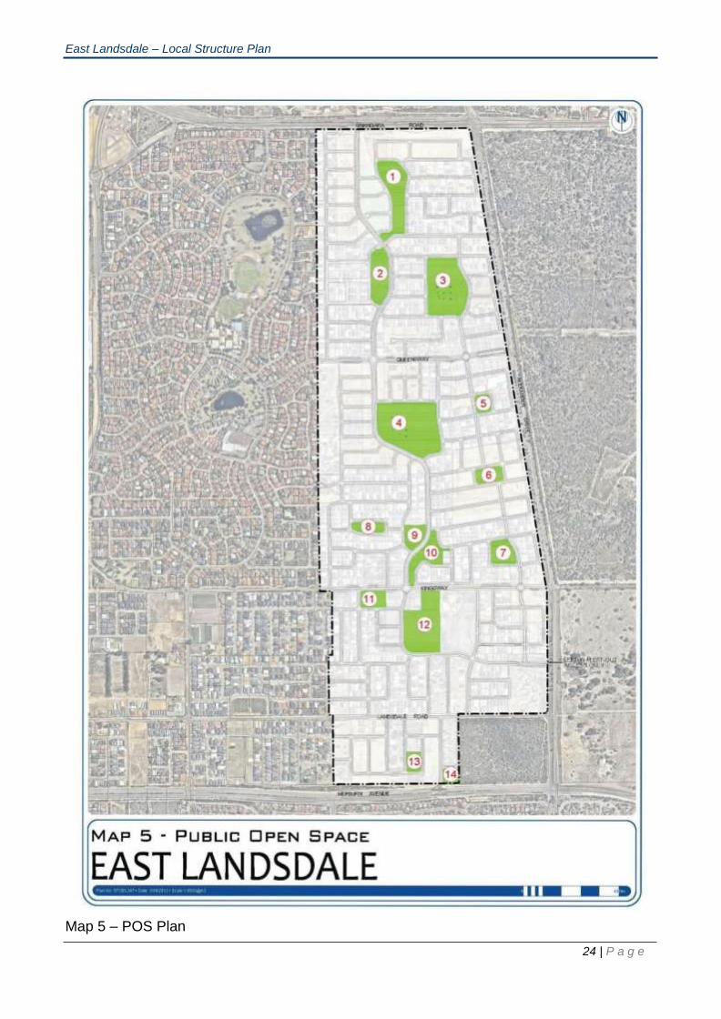
11.0 PUBLIC OPEN SPACE SCHEDULE
A minimum of 10% of the total site at full development is to be set aside as public open space (POS) in
accordance with WAPC Policy DC 2.3 Public Open Space in Residential Areas and Liveable Neighbourhoods
requirements and the following POS Schedule. Any drainage requirements to be located in POS areas will be
in addition to the 10% POS areas.

East Landsdale – Local Structure Plan
12 | P a g e
POS Lot Area POS Area Credited Area Total Credited Area
1 152 6900 6900
154 5000 5000
155 6015 6015
156 4917 4917
404 200 23032 200 23032
2 52 10026 10026
404 4500 14526 4500 14526
3 55 6901 6901
2170 9071 2170 100% Credit (wetland buffer) 56 14688 14688 100% Credit (wetland buffer) 2283 2283
6029 23000 0 No Credit (wetland core) 57 4500 4500 4500 30542
4 72 1370 1370
2930 4300 2930 100% Credit (wetland buffer) 73 1226 1226
4494 0 No Credit (wetland core) 11380 17100 11380 100% Credit (wetland buffer) 74 7952 7952 100% Credit (wetland buffer) 685 0 No Credit (wetland core) 12163 20800 12163
75 7800 7800 7800 44821
5 58 2271 2271
59 2064 4335 2064 4335
6 60 4716 4716 4716 4716
7 62 2435 2435
602 5381 7816 5381 7816
8 670 5209 5209 5209 5209
9 66 1403 1403
65 4372 5775 4372 5775
10 65 6587 6587
64 5427 12014 5427 12014
11 128 2021 2021
163 4842 6863 4842 6863
12 165 13449 13449
166 19690 33139 19690 33139
13 150 4970 4970 4970 4970
14 152 4000 4000 4000 4000 POS: 21.2966 Credited: 20.1758
East Landsdale – Local Structure Plan
13 | P a g e
Total Area
Deductions
Total Deductions
Gross Sub- divisible
Area
Public Open Space
Provision 10%
Public Open Space
Provided
Surplus / Deficit
215.5515
Road Widening
0.3376
13.7934
201.7581
20.1758
20.1758
0.0000
Centre Zone 1.0000
Gnangara Road Drainage
0.2600
Resource Enhancement Wetland Core
0.6029
Private School 4.3800
Road Widening
0.0630
Conservation Category Wetland Core
0.5179
Primary School
4.0000
Commercial 2.5288
Road Widening
0.1032
12.0 GENERAL PROVISIONS
12.1 Residential Precinct
Provisions, standards and requirements of this Precinct are in accordance with those applicable to the
Residential Zone as included in the City’s District Planning Scheme No.2 (the Scheme) and the
Residential Design Codes including those standards included in Table No.1, unless otherwise provided
below.
The following Structure Plan provisions take precedence over, and operate as variations to the relevant
R- Code, and Scheme standards and are not subject to variation unless otherwise provided for.
12.1.1 R-MD Codes
The City of Wanneroo’s Local Planning Policy 4.19: Medium-Density Housing Standards (R-MD)
sets out acceptable variations to the deemed-to-comply provisions of the R-Codes for lots coded
R25- R60. The variations set out in LPP 4.19 apply to all lots designated R-MD on ASP No.57 and
thereby constitutes acceptable development within the Structure Plan area.
12.1.2 Land Uses
All uses in the Residential Precinct other than Use Classes ‘Single House, Grouped Dwelling and
Home Based Business Categories 1 to 3, Schools, Public Open Space, Drainage Sump” are not
permitted within the Structure Plan area.
East Landsdale – Local Structure Plan
14 | P a g e
12.1.3 Building Heights
Refer to Scheme Schedule 17: Clause 4(a) and (c).
12.1.4 Construction
Refer Scheme Schedule 17: Clause (a)-(i)
12.2 Local Scheme Reserves
The provisions, standards and requirements of any Local Scheme Reserve are in accordance with those
applicable to the same Reserves as are included in the Scheme.
12.3 Other Provisions
12.3.1 Landscaping
A landscape plan is to be prepared by landowners (at subdivision stage) and adopted by Council
to establish evergreen vegetation within public open space and road reserves.
The landscape plan shall include species identified for the relevant locality type in the Street Tree
Master Plan. Wherever practical, Australian native vegetation should be used.
It should be noted that the clearing of habitat for the Graceful Sun Moth such as Lomandra
Hermaphrodita and Banksia Woodland requires the approval of the Minister for the Environment,
or their delegate, pursuant to the Wildlife Protection Act 1950.
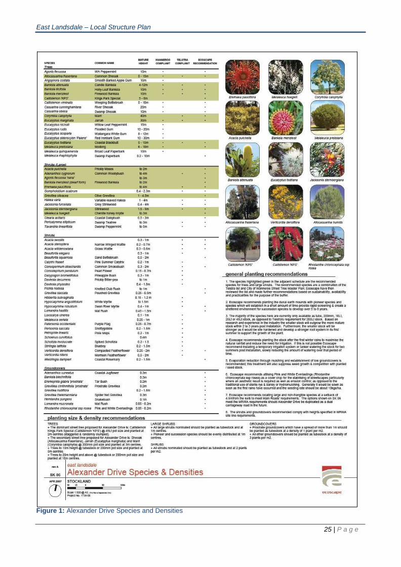
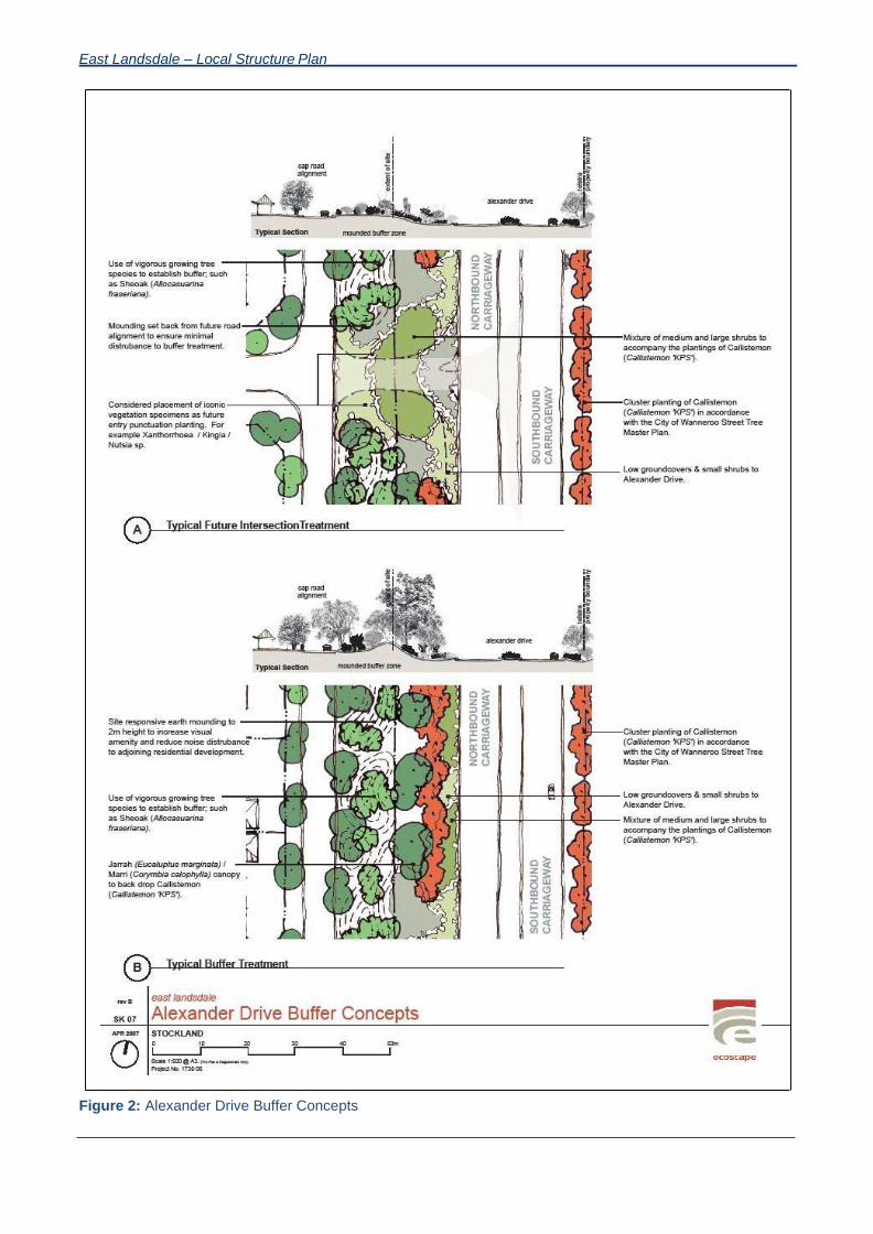
Species diversity, density and planting size (when planted along Alexander Drive), should be
generally as recommended in Figure 1 - Alexander Drive Species and Densities, planted utilising
a mounded buffer zone as described in Figure 2 - Alexander Drive Buffer Concept Plan.
12.3.2 Subdivision Process
At the time of subdivision of land within East Wanneroo Cell 9 Structure Plan Area, Council may
consider recommending the following condition(s) on any subdivision approvals in order to
minimize the potential for adverse radio frequency emissions to the PITC:
Measures being taken to ensure that:
a) Lighting along Alexander Drive is incandescent or halogen type rather than sodium or
mercury type light;
b) Street lighting has a metal cap installed over the top of the light and mesh installed around
the open portion of the light;
c) Street lighting utilises energy efficient lights and practices, in consultation with Telstra and
Western Power;

East Landsdale – Local Structure Plan
15 | P a g e
d) Natural vegetation in any existing and proposed public open space is retained to a
reasonable extent; and
e) During subdivision works earthmoving equipment is diesel powered, materials used are
prefabricated, and where reasonably possible, no arc welding is undertaken.
12.3.3 Orientation of Roads
Roads within Cell 9 must be aligned to a predominantly east-west system, generally as shown on
Map 1 – Structure Plan.
Appropriate connections be provided to Grayswood Court, Mossfiel Retreat and Strathpine Chase
at the time of subdivision of the adjoining land within the Structure Plan Area. A road connection is
to be provided to Kevo Place at the time of subdivision.
12.3.4 Transitional Provisions
Prior to the revocation of the Structure Plan, the provisions included in Part 1 are to be incorporated
into the Scheme.
East Landsdale – Local Structure Plan
16 | P a g e
Map 1 – Structure Plan
East Landsdale – Local Structure Plan
17 | P a g e
Map 2 – Zoning Plan

East Landsdale – Local Structure Plan
Map 3 – R Code Plan
22 | P a g e

East Landsdale – Local Structure Plan
Map 4 – Road Heirarchy
23 | P a g e
East Landsdale – Local Structure Plan
24 | P a g e
Map 5 – POS Plan
East Landsdale – Local Structure Plan
25 | P a g e
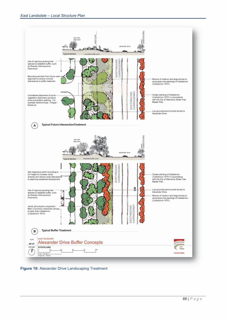
Figure 1: Alexander Drive Species and Densities
East Landsdale – Local Structure Plan
Figure 2: Alexander Drive Buffer Concepts


oooo
o
oo
oo
o
oo
o