economic geology and photogeology of by...
TRANSCRIPT

Economic geology and photogeologyof the Tsumeb area, South West Africa
Item Type text; Thesis-Reproduction (electronic); maps
Authors Readdy, Leigh Arthur, 1936-
Publisher The University of Arizona.
Rights Copyright © is held by the author. Digital access to this materialis made possible by the University Libraries, University of Arizona.Further transmission, reproduction or presentation (such aspublic display or performance) of protected items is prohibitedexcept with permission of the author.
Download date 19/05/2018 06:17:07
Link to Item http://hdl.handle.net/10150/557374

ECONOMIC GEOLOGY AND PHOTOGEOLOGY OF
THE TSUMEB AREA, SOUTH WEST AFRICA
by
Leigh Arthur Readdy
A T hesis Submitted to the Faculty of the
DEPARTMENT OF GEOSCIENCES
In P ar tia l Fulfillm ent of the Requirements • For the Degree of
MASTER OF SCIENCE
In the Graduate College
THE UNIVERSITY OF ARIZONA
1 9 7 2
STATEMENT BY AUTHOR
This th e s i s h a s been subm itted in p a r t ia l fu lfillm ent of r e quirem ents for an ad v anced degree a t The U niversity of Arizona and is d e p o s ited in the U n iv ers ity Library to be made a v a i la b le . to borrowers under ru le s of the Library „
Brief quo ta tions from th is th e s i s are a llow able w ithout sp e c ia l p e rm iss io n , provided th a t accu ra te acknow ledgm ent of source is m a d e . Requests for perm iss ion for ex tended quotation from or reproduction of th is m anuscrip t in whole or in part may be granted by the head of the m ajor departm ent or the Dean of the G raduate College when in h is ju d g m ent th e proposed u se of the m ate ria l is in the in te re s ts of s c h o la r s h ip „ In a l l o ther i n s t a n c e s , how ever, pe rm iss ion m ust be ob ta ined from the a u th o r .
APPROVAL BY THESIS DIRECTOR
This th e s i s h as been approved on the da te shown below:
/ SPENCER R. TIT LEYP rofesso r of G e o sc ie n c e s

ACKN OWLEDG ME NT S
The m ateria l p re sen ted in th is th e s i s was o r ig ina lly prepared
by the author a s two Kennecott Copper C orpora tion , G eo log ic Research
D iv is ion r e p o r t s . The author is indeb ted to Kennecott Copper Corpora
tion for th e ir perm ission to u se th e se d a ta as th e s is m a te r ia l .
The au thor ben ef ited g rea tly from d isc u s s io n w ith .and c r i t ic a l
rev iew from h is former c o l le a g u e s w ithin the G eologic Research D iv is ion
of Kennecott Copper C orporation , p a r t ic u la r ly Dr. John W ilso n and Dr./
T. W . M itcham , p re se n t and former C hiefs of the D iv is io n , r e s p e c t iv e ly .
I ap p rec ia te the encouragem ent and support by the members of my th e s i s
co m m ittee , D rs . Spencer R. T i t le y , Evans B. M a y o , and John S. Sumner.
My s p e c ia l thanks go to M r. Eugene D em eter, who spen t many
hours help ing me t ra n s la te the e a r l ie r German lite ra tu re for the area of
s tu d y .
The high s tan d a rd s of p ro fess io n a lism of the d rafting p e rso n n e l
w as very much a p p re c ia te d . P ar ticu la r thanks are due M r s . M argret
Strom who typed the numerous rough drafts of the o r ig ina l reports and
M rs . Linda Shaw and M iss Linda De Long who typed the th e s i s d r a f t s .

TABLE OF CONTENTS
Page
LIST OF ILLUSTRATIONS . . . . . . . . . o . . . . . . . . v i
ABSTRACT . . . . . . . . . . . . . . . . . . . . . . . . . v i i i
INTRODUCTION . . . . . . . . . . ........................ . '. 1
REGIONAL GEOLOGY ........................ 6
Stra tig raph ic Problems . . . . . ,. . . . . . . . . . . . . 7P seu d o ap li te ........................ .... . . . . . . . . . . . . . 8Karst F ea tu res ........................ 9
ECONOMIC GEOLOGY . . . . . . . . . . . . . . . . . . . 11
Types of D ep o s i ts . . . . . . . . . . . . . . . . . . . 11Tsumeb Ore Body. . . . . . . . . . . . . . . . . . . . 12
Geology of the Tsumeb Mine . . . . . . . . . . . . . 12Alteration ........................ 18Igneous In trusive Rocks. .................... 19
Tsumeb W e s t . . . 7 . . . . . . . . . . . . . . . . . . 19Vanadium O ccu rren ces . . . . . . . . . . . . . . . . . 23D is c u s s io n of O ther M ines and P ro sp ec ts . . . . . . . . . 25
Tsumeb E a s t . . . . . . . . . . . . . . . . . . . . 25Abenab and Abenab W est . . . . . . . . . . . . . . 26Alt Bobos . . . 30Bobos . . . . . . . . . . . . . . . . . .................... 30Uris and Karavatu . . . . . . . . . . . . . . . . . 31
ORE CONTROLS AND ORE GUIDES ........................ 32
S tra tig raph ic C ontro ls . . . . . . . . . . . . . . . . . 32Structural Contro ls . . . . . . . . . . . . . . . . . . . 33Favorable S tructural Settings ........................ 34Vanadium as an Ind icator M eta l .................................. 37S inkholes . . . . . . . . . . . . . . . . . . . . . . .- 37Upper Tsumeb Substage . . . . . . . . . . . . . . . . . 38Aeromagnetic S u rv e y s . . . . . . . . . . . . . . . . . . 38
PHOTOGEOLOGIC STUDY . . . . . . . . . . . . . h . . . . 40
D isc u ss io n of Photo in te rp re ta tive M aps ............................. 42Photogeologic Structure Map . . . . . . . . . . . 42In te rp re ta tive S tra tigraphic Map . . . . . . . . . . . 42
iv

V
TABLE OF CONTENTS— Continued
Page
Road N et Map . . . . . . . . . c . . . . . . . . . 43 .Rose Diagram s of Linear E lem ents . . . . . . . . . . . 43
OTAVI VALLEY DEPOSITS . . . . . . . . .. . . . . . . . . . 47
Kombat M ine . . . . . . . . . . . . . . ... . . 47Asis M in e . . . . . . . . . . . . . . . . . . . . . . . 53
Ore in P seudoap li te . . . . . . . . . . . . . . . . 54Copper O ccurrences in T ec to n ica lly Trapped
P seudoap li te Blocks . . . . . . . . . . . . . . . 59C opper-bearing Breccia V e i n s ............................ 59
A sis East-End . . . . . . . . . . . . . . . . . . . . . 60Asis East . . . . . . . . . . . . . . . . . . . . . . . . 61Baltika . . . . . . . . . . . . . . . . . . . . . . . . 62Berg Aukas . . . . . . . . . . . . . . . . . . . . . . 62G au ss 4 6 ........................ . . . . . . . . . . . . . . . . . 64G ro s s -O ta v i . . . . . . . . . . . . , . .. . . . . . . . . 64
P seudoap li te Ore B o d y ................................... ... . . . . . . 64O re -b e a r in g , S an d -f i l led S in k h o le s . . . . . . . . . . 6 6Eastern Group of S inkholes . . . . . . . . . . . . . . 6 6
G uchab . . . . . . . . . . . . . . . . . . . . . . . . . 69O re-b ea rin g S inkholes . . . . . . . . . . . . . . . 71The " E isener Hut" O c c u r r e n c e ...................................... 72
G uchab E a s t . . . . . . . . . . > .. .. . . . . . . . . . . 74H aras ib 317 . . .. . . . . . . . . . . . . . . . . . . . 74O lifan ts fon te in 9 . . . . . . . . 75O tjirukaku 42 . . . . . . . . . . . . . . . . . . .- . . 75Reitfontein 344 . . . . . . . . . . .. . ... . . . . . . . 75Toggenburg 591 . . . . . . . . . . . . . . . . . . . . 76U itsa b 654 . , . . . . . . . . . . . . . . . . . . . . 76
SELECTED BIBLIOGRAPHY 77

LIST OF ILLUSTRATIONS
Figure Page
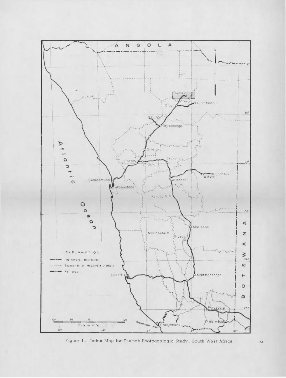
1 . Index Map for Tsumeb Photogeologic S tudy ,South W est Africa ........................ 2
2. P rospec t Location M a p , Tsumeb Area,South W e s t Africa ...................................... 3
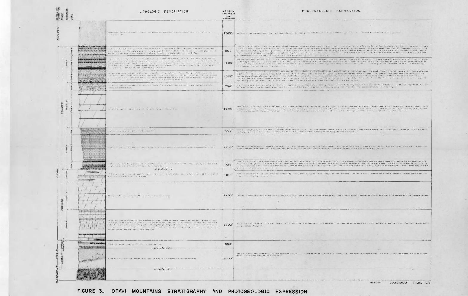
3. O tav i M ountains S tratigraphy andPhotogeologic Expression in pocke t
4 . G eologic C ross Section through Tsumeb Ore Body. . . . 10
5. G eolog ic P lan , Level 26, Tsumeb Ore B o d y ............... 13
6 . Road Net Map Showing Location of Tsumeb M ining. Corporation Sampled A reas, Tsumeb and Vicinity . . 14
- ■ »7. Geology of Tsumeb Area, South W est Africa . . . . . . 15
8 . D iagram m atic Section through the Tsumeb W e s t 'P seudoap li te P i p e ................................. 20
» 9 . Photogeologic S tructure M ap, Tsumeb Area,South W es t A f r i c a in pock e t
10. Abenab Mine , South W e s t Africa, Showing the• N orth eas t Face of the O p en cas t and Section
. through the M ain Ore Body . . . . . . . . . . . 27
11. N orth -sou th Section through Abenab M i n e ............................. . 28
12. Volcanic Belts of Late Karroo Age, Angolaand South W e s t A f r i c a ................... .... . . . . . . . 35
13. G en era lized Sketch of the S tructura l Settingof the Berg Aukas M ine, South W es t Africa . . . . 36
14. S tra tig raph ic D is tr ib u tio n , Tsumeb Area,South W es t A f r i c a in pock e t
15. Rose Diagram s of Linear Elements andG eographic Base M ap, Tsumeb Area,South W es t Africa . . . . . . . . . . . . . . in pocke t
v .

v ii
LIST OF ILLUSTRATIONS— Continued
Figure Page
16. Index M ap, O tav i Valley Region,South W es t Africa ........................ 48
17 . P rospec t Location M ap, O tavi Valley Region,South W e s t Africa . . . . . . . . . . . . . . . 49
18. G eolog ic Sketch Map of the Ore D e p o s i t s ,O tav i V alley , South W es t Africa . . . . . . . . . . 50
19. Id ea l ized Section through Kombat Ore B odies. . . . . . 52
20. Plan of Asis (Kombat) Mine Area,O tav i Valley, South W e s t Africa . . . . . . . . . 55
21. Plan of the 30- and 60-m eter L e v e ls , Asis M ine . . . . 56
22. P rospec t Area a t G ro ss-A tav i, O tav i V alley,South W e s t Africa . . . . . . . „ . . . . . . . . . .67
23. Typica l Section through G ro ss -O ta v i C opper-bear ing Karst D e p o s it , O tav i Valley,South W e s t Africa . . . . . . . . . . . . . . . 67
24. G eolog ic Map of Guchab Copper O c c u r re n c e s ,O tav i V a lley ................. ....... ......................................................... 70

ABSTRACT
The b a s e -m e ta l d ep o s its of the O tavi M o u n ta in s , South W est ■' ■ '
Africa, occur as r e p la c e m e n ts , d issem in a ted m inera liza tion in p se u d o -
a p l i te , a rock of d ispu ted o rig in , and in b recc ia p ipes and zones of
b recc ia t io n w ithin the th ick Precambrian carbonate sequence of the O tavi
S e r ie s . The d e p o s its are ch a ra c te r iz e d by very lo ca l c a lc i te and quartz
a l te ra t io n of the do lom ite . M inera lized a reas have a g rea te r inc idence
of s ink h o les as a r e su l t of the c a lc i t ic a l te ra t io n , and the s tudy of s in k
hole d is tr ibu tion by a irphoto a n a ly s is is a p o ten tia l ly u se fu l exp loration
techn ique for the O tav i M ountain a r e a .
: The two major b a s e -m e ta l d e p o s i ts of the O tav i M oun ta in s ,
Tsumeb and Kombat (A sis), are c lo se ly re la te d to p seu d o ap li te bod ies
w ith in dolom ites and lim esto n es of two s tra tig rap h ic z o n e s .o f the Upper
Tsumeb s u b s ta g e . The sp a t ia l a s so c ia t io n of p seu d o ap li te with Tsumeb
Zones 7 and 8 m akes the a rea l d is tr ibu tion of th e se zo n es of exp lo ra tion .
s ig n if ic a n c e . The th ree zones of the Tsumeb s u b s ta g e , Zones 6 , 7, and
8 , are the m ost e a s i ly d is t in g u ish a b le ca rb o n a te u n its of the O tavi
Series during fie ld or photogeo log ic m apping.
Three major reg ional s tru c tu res appear to con tro l m inera liza tion
in the O tav i M o u n ta in s . These .are the two d e e p e s t s y n c l in e s , the Tsumeb
and the O tav i Valley s y n c l in e s , and a probable N. 50° E . basem ent s t ru c
tu re . Surface ex p re ss io n of the b asem en t s truc ture in c lu d es a s e r ie s of
roughly p a ra l le l do ler ite d ik e s . B edding-p lane f a u l ts , zones of b re c c ia
tion and b recc ia p ip es form important ore lo c i w ith in the O tav i M ountains .
v ii i
Structura l s e tt in g s m ost favorable for the formation of zo n es of in ten se
fracturing are drag folding a s s o c ia te d with the major e a s t - w e s t f o ld s ,
in te rse c t io n s of reg iona l folds and c ro ss fo ld s , and the p er ipheries of
p seu d o ap li te b o d ie s .

INTRODUCTION
In Septem ber 1967, a req u es t w as m ade.by th e New York office
of Kennecott Copper Corporation for a s tudy of the Tsumeb d e p o s i t ,
South W est A frica. Through 1959, th e Tsumeb mine h as produced
426, 720 to n s of copper , 1 ,1 0 3 , 510 to n s of l e a d , 507 ,970 tons of z in c ,
2 2 ,7 4 1 ,8 4 2 ounces of s i lv e r , and su b s ta n t ia l am ounts o f cadmium and
germ anium . The purpose of the req u es ted study w as to de term ine , i f
p o s s ib le , w hether or not the Tsum eb.pipe w as g e n e t ic a l ly re la ted to
prem ineral c a v e r n s . A second o b jec t iv e w as to be a s tudy of the pho to -
geo log ic fea tu res of the immediate Tsumeb mine area to d e te c t p o s s ib le
s truc tu ra l con tro ls pe rtinen t to ore search in the rem ainder of the Tsumeb
and G rootfontein m ag is tra te d i s t r i c t s . A third ob jec tiv e w as the p rep a ra
tion of a geo log ic map for part of the O tavi M ountains w ith in the Tsumeb
and G rootfontein d is t r i c t s (F igs . 1 and 2) .
This t h e s i s sum m arizes the g en era l geology of th e O tavi M oun
ta in s and the econom ic gfeology of the a rea mapped p h o to g e o lo g ic a l ly .
D isc u ss io n of ore con tro ls and p o s s ib le ore gu ides p re ced es the sec t io n
on the photogeologic s tu d y . v
During the tw o-m onth ass ig n m en t in South W est A frica , the
Tsum eb-G rootfontein photographs w ere quickly s tud ied on a regional
s c a le , se le c te d photographs were s tud ied in d e ta i l , and in i t ia l an n o
ta ted o ver lays were p re p a re d . Two days were spent a t Tsumeb and '
Tsumeb W e s t , and one day a t the Kombat m ine. Several r e c o n n a is sa n c e
tr ip s were made through the O tavi M ounta in la n d . In it ia l l i te ra tu re s tudy
18 °
G r o o t f o n t e i nOtavi
2 0 °
OutjQ-
Omaruru
Ok ah o nd j qU s a k o s 2 2 °
Ko r i b i b
G o b o b i s
.Wind n o ek
R e ho b ot h o
2 4 °
M o n e n f a I
M al ta ho he OGi b e o n
E x p l a n a t i o n
2 6 °I n f e r n a f l o n o l B o u n d o n ' e :
B o u n d a r i e s o f M a g i s f r o f e D i s t r i c t s
R a i l r o a d sL u d e r i t z K e e t m a n s h o o p
Ka r o s burg 2 8 °
100 100Wo rm bo
e j s u ) r a n j e m u n dScale in miles
16° 20 °
Figure 1. Index Map for Tsumeb Photogeologic Study, South W es t Africa
L I T H O L O G I C D E S C R I P T I O N
V) V) N
MAXIMUMT HI CKNESS
f>G
P H O T O G E O L O G I C E X P R E S S I O N
a n r a v w a c k e . e l a t v 1 h f a r k u' «H PHtk ->«• r#rl
f r o e h r x p i . n u r r w e a t h r r m v I
f«tght g r a y h r d H e d d o l o m i t e tw o o r t h r e e p r o m i n e n t e i t t c e o u e bed* d o o l i t e s s h o w in g <. r . - a s b e d d in g n e a r t h e t , , p . ;f t h e s e c t n - n . T h e l i g h t g r a y d o l o m i t e ; s l a m i n a t e d t o t h i c k b e d d e d , c o n t a i n i n g a b u n d a n t s t r i n g e r s «>t t h e a nd a t l e a s t tw s t r o m a t o l i t e m a r k e r s i n a d d i t i o n t o a c h e r t y s t r o m a t o l i t i t . b e d n e a r t h e b a s e
•1 !»• if a n d d a r k - g r a y b e d d e d d o l o m i t e w i th i n t e r t>eil« t d e n s e t h in b e d d e d h*h« r t i t e I h r un i t c o n t a i n * fe n flO* n* r s i s t e n t m l e r b e d s o f b l a c k c r y s t a l l i n e l i m e s t o n e ' s t i n k Walk' , u p t«. t w e l v e I I / ' u n i t s >i f i n e l y l ao i n a ' r d b l a ck - h a i e. ex t r w e i y n u n i e r o p a t h in c h e r t l a y e r s . *«»: r ' w h i c h a r e oo l i t i c O ne m a r k e r l l n e # t " n e un i t t h a t c o n t a i n s y< .it t er«»d •. a I c l u s t e r s o f c o a r s e c r y s t a l l i n e c a l . i t e an d a m a r k e r "". . i t .* b e d a t o r n e a r t h e b a s e >f t h e s e c t i o n .!'h«- O t a i V a l l e y p h y l l l t e b e l o n g s l t h i s m r a t i g r a p h o /• ne.
X i i «ht n r a v b e d d e d d o l o m i t e w i th m a n y s t r o m a t o l i t e b e d s ant i a b u n d a n t c h e r t . f h * u p p e r h a l t o f t h i s r .one i s , y o s . d ,f w e l l • V d d e d d o l o m i t e w i th n u m e r o u s l a y e r s o f u n i f o r m c h e r t an d a p p r o x i m a t e l y t w e l v e (1 .!t pm. - r r e d
a r g i l l a c e o u s s e a m s . Th e l o w e r ha l f if t h e / o n e i s . h a r a c t e n / e r i by a s e r i e s o f c h < r t y s t r o m e t o l i i l c d o h i n i t# b e d s . I t r e t . ia t v n a lo n g be d d in g p l a n e f a u l t s i s Con r r n th r. ugh u t t h e r o n e
l . i gh t g r a y m a s s i v e a nd b e d d e d d o l o m i t e c o n t a i n i n g e ig h t 8 n i a r r a r h« r i s»» ns of t h r e a d y a r g i l l a c e o u s s e a m :
2 3 0 0 '
8 0 0 '
Lig h t t o m e d i u m to n e w i t h m o d e r a l e - t o w e a k - b a n d e d c h a r a c t e r , f o r m s t h e u p p n p o r t i o n of s t r i k e r i d g e s . T h e o o l i t e m a r k e r be d* m th e T s u m e b ( an d K o m b a t ) a r ea ( s^ ) f o r m n a r r o w w a l l - l i k e r i d g e uo t o D f e . i h i g h . T h e s r s i l u i f r ed o o l i t e m a r k e r s a r e t h e on ly b e d s t h a t c an be t r a « e d w i t h go od c o n t i n u i t y on t he a e r i a l p h o t o g r a p h s . S l op e* a r e u s u a l l y l e s s t h a n 10 . D r a i n a g e i s c h a r a c t e r i s e d by a f l at b o t t o m e d d i v e r g e n t d r a i n a g e p a t t e r n T h e f l a t t e r t he s l o p e , t h e m o r e n u m e r o u s t h e b r a n c h i n g s t r e a m s S t r e a m s e n t e r i n g f l a t - l y i n g a r e a s e n d in g r a v e l p i l e d i n f i l t r a t i o n p o in t* . V e g e t a t i o n . s s p a r s e , m o r e a b u n d a n t v e g e t a t i o n i s l o c a l i s e d a lo n g t a l u s t r a p p e d a b o v e t h e o o l i t e r i d g e s . I h e c o n t a c t of t h i n z o n e w i t h t h e o v e r l y i n g M u l d e n f o r m a t i o n c a n be p l a c e d a t a p o in t 0 t o *•() f e e t s t r a i i g r a p h i c a 1!y a b o v e t h e u p p e r o o l i t e un i t w h e r e t h e r e a r e s l o p e , l o n e , a n d v e g e t a t i o n c h a n g e s
1 3 0 0 '
I O O O
7 0 0 '
M e d i u m - t o m e d i u m - d a rk - t o n e d , f l a t , s o i l - c o v e r e d a r e a s . G e n e r a l l a ck o f w e l l - d e f i n e d d r a i n a g e , m o s t d r a i n a g e i s i n t e r n a l . A b u n d a n t t h o r n b u s h a n d o t h e r v e g e t a t i o n .
V a r i a b l y t o n e d f r o m m e d i u m (o l a r k g r a y w i th t o n - l i g h t e n in g p r o g r e s s i v e t y - w e s t of T s u m e b . I n d iv id u a l b e d d in g t r a c e * a r e d i s c o n t i n u o u s . T h i s z o n e f o r m s t h e m i d d l e p o r t i o n of t h e u p p e r T s u m e bs t r i k e r i d g e s . S l o p e s a r e g e n e r a l l y l e s s t h a n 1 0° . D r a i n a g e i s i n t e r m e d i a t e t o t h a t of Z o n e S a n d Z o n e b (b e l o w ) . V e g e t a t i o n is s i m i l a r t o Z o n e fl w i t h s h o r t e r t r e e t y p e s t ha n t h o s e c ha r a c t e n s t iof Z o n e b V e g e t a t i o n d e n s i t y >* a l s o lew* t h a n t h a t o f Z o n e b. S m a l l s i n k h o l e s m a y f o r m a l i g n m e n t s a l o n g f a v o r a b l e b e d d i n g p l a n e s . I h e m a r l y u n i t s in t h e m i d d l e p o r t i o n of t h i s z o n e a r e t yp ic a l l y c o v e r e d by s h o r t , b r o w n i s h - r e d g r a s s w i t h f ew s h r u b s o r t r e e s .
A l t e r n a t i n g b a n d s o f v e r y l i ght a n d m e d i u m - t o n e d b e d d in g t on e g r a d u a l l y d a r k e n s t o w a r d t h e t op . A b u n d a n t b e d s o f l i g h t - t o n e d c h e r t f o r m s m a l l r i d g e s T h i s un i t f o r m s s t r i k e r i d g e s w i t h s l o p e s of 2 0 ° t o 40 * . D r a i n a g e .* a l o n g s l e e p , d e e p l y im i s e d , s h a r p , V s h a p e d c u t s . V e g e t a t i o n i s g e n e r a l l y d e n s e a n d s i m i l a r t o t h a t of Z o n e s 4 a n d 5 ( be l ow ) T h e c h e r t b e d s l o r n , t a l u s d a m s a n dl o c a l i z e z o n e s o f m o r e a b u n d a n t v e g e t a t i o n . T h e s e c h e r t b e d s ar«- g e n e r a l l y d i s c o n t i n u o u s a n d c a n on ly be f o l l o w e d t o r a f ew t h o u s a n d f ee t a l o n g s t r i k e T h e r e i s a d e c r e a s e in t h e n u m b e r ofr e s i s t a n t c h e r t b e d s t o w a r d t h e t o p of t h e z o n e . T h e m o s t c o n t i n u o u s c h e r t b e d s a r e t h e " T u t e n " m a r k e r u n i t s , T j a n d T g . of S c h n e i d e r ho lm ( I 420 ) w h ic h f o r m tw o p a r a l l e l 1- t o 6 - foo t r i d g e s MSt r e t , s t r a t . g r a p h i c a l l y , a p a r t . T h e c o n t a c t of Z o n e s h a n d 7 is o f t e n m a r k e d by t h e r i d g e l i n e o r a t t e a s i by a c h a n g e in s l o p e .
U n i f o r m l i g h t t o m e d i u m to n e w i th a v e r y f ew w e a k s u g g e s t i o n * of t h in d i s c o n t i n u o u s b e d d in g t r i n s i m i l a r t o Z o n e 4 t h a t l o r p r a c t i c a l p u r p o s e * it * s u g g e s t e d t ha t Z o n e S be g r o u p e d w i th Zoi
M o s t of t h e b e d d in g t r a c e * w i l l be n e a r t h e Z o n e b b o u n d a r y L a n d f o r m , v e g e t a t i o n , e t c e x c e p t f o r a r e a * w h e r e t h e v a r t b e d d e d n a t u r e is b e s t d e v e l o p e d .
•i.ght - g r a y m a s h i ; e d o lu m i f e w i th l o c a l a r e a s of r i h g r I s t r o m a t o l i t e s . 3 2 0 0 'T h i s z o n e f o r m * th e l a r g e s t p a r t of t h e O ta v i M o u n ta in l a n d a n d e x h i b i t s a m o n o t o n o u s , u n i f o r m , l i g h t - t o m e d i u m - l i g h t - g r a y t on e w i th e x t r e m e l y r a r e , w e a k s u g g e s t i o n s of b e d d in g . B e c a u s e o f i t s u n i f o r m m a s s i v e c h a r a c t e r , t h e u n i t f o r m s t h e h i g h e s t p a r t s of t he r e g i o n a n d f o r m s r o u n d e d a n d e l l i p t i c a I h i l l s a n d g r o u p * o f h i l l s f r o m w h i c h r o u n d e d e x t e n s i o n s r a d i a t e T h e r o u n d e d h i l l s o f t e ns u r r o u n d * d e p r e s s i o n . D e n s e t h o r n b v s h g r o w t h , w i th m e d i u m - h e i g h t t r e e s a n d u n d e r b r u s h , is c h a r a c t e r i s t i c . D r a i n a g e i s m o s t l y i n t e r n a l t h r o u g h v e r y s m a l l k a r a t f e a t u r e s
L i g h t - t r a y l a m i n a t e d an d t h in l y b e d d e d d u l u n i te . 6 0 0 ' M e d i u m - t o l i g h t - g r a y t o n e w i th a b u n d a n t c l o s e l y s p a c e d b e d d i n g t r a c e s . T h i s z o n e g e n e r a l l y f o r m s f l a t s o r l o w r o l l i n g h i l l s c o v e r e d w i th a l a b b y t a l u s . V e g e t a t i o n i s a l m o s t e x c l u s i v e l y l i m i t e d i s h o r t g r a s s g r o w t h . A b r e c c i a z o n e a t t h e b a s e of t h i* un i t m a y f o r m a n a r r o w t o p o g r a p h i c l ow a l o n g t h e Z o n e 2 - 1 b o u n d a r y .
f ~ r
Ligh t c» r a v l a m i n a t e d an d t h in l y b e d d e d l i m e a t o n e . L " b » r ■>( t h i s />.ne i I -c t i K »« pt eki .xh r yeMowf&sh 2 3 0 0 ' M e d i u m - l i g h t - t o m e d i u m g r a y t o n e ( t an t o b r o w n c o l o r ) w i th a b u n d a n t c l o s e l y s p a c e d b e d d in g t r a c e s . A l t h o u g h t h i s un i t d o e s f o r m s o m e h i gh g r o u n d , it t y p i c a l l y f o r m s r o l l i n g l ow h i l l s * i t h eht-i g r a s * a* t h e e x c l u s i v e v e g e t a t i o n . A w e l l - d e f i n e d , w h i t e c a l c r e t e r i d g e f o r m * a u s e f u l p h o t o m a r k e r un i t a t t h e ba we of t h i s z o n e m th e S a r g b e r g a r e a .
T i i l i t e .- #ingi<»n*erate. q u a r t ' i t e s h a l e m a r b l e , and s i r<ima t - i t t e m a r k e r u n i t s . T h e n l l v e t * g r a y w h e n f r e s h w e a t h e r i n g t o a d e e p b r o w n an d m a y c u n t a i r a b u n d a n t p v r i l e .
-----------------------------------------------------------------u n c o n f o r m i t y ---------------------------------------------- -----------------
7 0 0 '[ ) » rk t o n . ( t i l l i t , . , I t . m a t i n g With n t . d i u m t o n , ( s h a l e ) a n d l i g h t - t o m e d i u m l i g h t - t o n e d 1 d o l o m i t e ) u n i t s . T h e t n t e r b e d d e d u n i t s o< t h i s z o n e a r e w e a k ly r e s i s t a n t t o w e a t h e r i n g a n d g e n e r a l l y l o r t r . i l a l x o r low ro l l . ng h i l l s . T h e t i l l i l e m e m b e r s , w h e r e p r e s e n t , g e n e r a l l y p r o t e c t a few f e e l a b o v e t h e s u r r o u n d i n g m a t e r i a l f o r m i n g l ow , r o u n d e d r i d g e s . M ic r o d r a m a g e t e a t u r e s in t h e t i l l i t e a r e c u r v e d . T h e r o c k s o f t h i s z o n e l o r m a d a r k s o i l a n d y e l l o w i s h s a n d w h ic h s u p p o r t s p a r s e g r a s s c o v e r . T h e t i l l i t e m e m b e r s o f t h i s z o n e a r e r e g i o n a l l y d i s c o n t i n u o u s . L o c a l l y , t h e r e m a y be a t h i n d e v e l o p m e n t o f w h i t e d o l o m i t e ( l i g h t t o n e )
Wedded a n d m a s s i v e m e d i u m g r a y d o l o m i t e , w e a t h e r i n g tt, * d a r k br«» g r a y wed/ fed l i m e s t o n e m a y be d e v e l o p e d
a! lv l i gh t g r a v b e d d e d d«»J«>mite • I 100 D a r k t o m e d i u m t o n e d , w i th bo th b e d d e d a n d non b e d d e d p o r t i o n s , f o r m i n g r u g g e d c l i f f s a n d l a r g e , r e s i d u a l b o u l d e r s . T h e un i t i v e g e t a t i o n a n d d r a i n a g e c h a r a c t e r i s t i c s .
n ly m a s s i v e a n d p r o b a b l y r e s e m b l e s 1 s u r n e b Z o n e s b a n d 4 i
M a s s i v e l i g h t g r a y d o l o m i t e w i th l o c a l l y d e v e l o p e d o o l i t e / .one*. 2 4 0 0 M e d i u m - t o l i g h t - t o n e d m a s s i v e s e q u e n c e , s i m i l a r t o T s u m e b Z o n e 4 , b u t s l i g h t l y l e s s v e g e t a t e d t h a n Z o n e 4. M o r e a b u n d a n t v e g e t a t i o n n e a r t h e b a s e t h a n in t h e r e m a i n d e r of t h e m a s s i v e s e q u e n c e .
D a r k - an d l i g h t - g r a y l a m i n a t e d a n d m a s s i v e d o l o m i t e , l i m e s t o n e , s h a l e g r a y w a c k r a n d g r i t W i t h i n t h e l i m e s t o n e s i n t e r m i t t e n t l a y e r s •»( g r i t t y m a t e r i a l a r e d e v e l o p e d . T h e g r i t s a r e d o m i n a n t l y p a r t i c l e s o f d o l o m i t e w i th s u b o r d i n a t e a m o u n t s o f c h e r t a n d q u a r t z . T he a n g u l a r g r i t f r a g m e n t s a r e f r o m a t ew i r .m to 4 i n c h e s i n d i a m e t e r T h i s s e c t i o n a l * v c o n t a i n s a b l u i s h -b lack l i m e s t o n e w i th s p o r a d i c l a y e r s ,f g r a y p h v l i i t e o r y e l l o w i s h s h a l e . G r a y w a c k e . a r k o s e . an d q u a r t / i t e a r c a l s o r e p o r t e d .
2 7 0 0A l t e r n a t i n g l i g h t - , m e d i u m - , a n d d a r k - t o n e d m e m b e r s . D e v e l o p m e n t of b e d d in g t r a c e s i s v a r i a b l e . T h e l o w e r h a l f of t h i s s e q u e n c e h a s m o r e e v i d e n c e o f b e d d i n g t r a c e s T he L o w e r A b e n a b f o r m s g e n t l y u n d u l a t i n g t o p o g r a p h y .
L p i d o s i t e . s c h i s t , a g g l o m e r a t e a r k o s e . a n d q u a r t / i t e .
- u n c o n f o r m i t y -
C o n g l o m e r a t e q u a r t / i t e , a r k . i s r . g r i t p h y I I i t e m a y l o c a l l y c o n t a i n t h i n b e d d e d d o l o m i t e .
5 0 0 '
2000 '
M e d i u m - t o d a r k - t o n e d u n i t s w i th o r w i t h o u t e v i d e n c e s of b e d d in g . T o p o g r a p h y v a r i e s f r o m c l i f f s t o r o u n d e d h i l l s . T h e N o s i b is d e n s e l y w o o d e d . AU f e a t u r e s , w i t h t h e p o s s i b l e e x c e p t i o n o f v e g e t a t i o n , v a r y w i t h t he v a r i a t i o n * of t h e l i t h o lo g y .
- u n c o n f o r m i t y
READDY GEOSCIENCES THESIS 1972
FIGURE 3. OTAVI MOUNTAINS STRATIGRAPHY AND PHOTOGEOLOGIC EXPRESSION

\ B o b o s^ - T s u m e b
V - 1^ ^ T s u m e b W e s t
b o s . v ”
^ F r i e s e n b e r g r _ ' j / |
' • ' v . . '
I
v 5? A b e n a bI ' ‘
<4xJX / \ y .V >A -• V' G r o o t f o n t e i n
i \ ; —I ' ' " 'O t a v i _y
^ TK o m b a
\E X P L A N A T I O N
--------------- b o u n d a r y o f p h o t o g e o l o g i c m a p p i n g
^ m i n e
• p r o s p e c t
T s u m e b Z o n e 8 m i n e r a l i z a t i o n ( l e a k a g e ? )
10 20 30
sca /e in miles___
Figure 2. P rospect Location Map, Tsumeb Area, South W est Africa

accom panied the re c o n n a is s a n c e scan of th e large co l le c t io n of ae r ia l
photographs for the r e g io n . The prelim inary li te ra tu re s tudy in d ica ted
some photo k e y s , and f i r s t - p a s s overlay tem p la te s were prepared for 65
photographs s e le c te d from the sev era l hundred photographs s tu d ied .
No good b a se maps were, " a v a i lab le " for th is a r e a . The b ase
map used in th is report w as ob ta ined by trac ing portions of four farm
boundary maps showing the pos it io n of photo cen te rs for Government
M apping P ro jec t 502. The s h e e ts from w hich the b a s e map w as tra c e d
w ere produced by a w et p ro c e ss and unfortunate ly con ta ined d is to r t io n s
w hich could not be e lim inated .
Additional photographs were required for a study of the pho to -
geo log ic fea tu res of the Berg Aukas d e p o s i t , w hich i s not covered by
P rojec t 502 photography . The photographs were ordered but did not a r
rive un til s ev era l w eeks af te r my departure from W in d h o ek .
The ea r ly a rriva l of the ra iny s e a so n s e r io u s ly lim ited the field
check ing of o f f ice -d e f in e d photo marker u n i t s . C o n seq u en tly , the r e
m ainder of the p ro jec t w as com pleted more by pho to in te rp re ta tion th an by
f ie ld -c h e c k e d photogeolog ic m apping.
Our re q u e s t for pe rm iss ion to remove sev e ra l hundred se le c te d
pho tog raphs, including the 65 in i t ia l ly s tu d ied , w as su b seq u en tly d e n ie d .
This is u n fo r tu n a te , s in ce a la rg e r a rea could have been mapped w ith
more geo log ic and p lan im etric c o n t ro l . Subsequent read ing of h a rd - to -
o b ta in , ea r ly German l i te ra tu re h as brought out s tra t ig ra p h ic ty p e -
sec t io n lo c a l i t ie s and sp ec if ic p ro sp ec t a re a s which should have been •
incorporated into th e p re sen t s tu d y . Had th e data from th is l i te ra tu re
b een on hand a t the beg inn ing of the p ro je c t , more re l ia b le and much
f a s te r pho togeologic mapping would have been p o s s i b l e . In ad d it io n ,
th e p re sen t photo s tudy would have co n cen tra ted on the a rea ju s t north
of the O tavi Valley w ith only minor mapping in the Tsumeb (Fig. 2) .
As a re s u l t o f the n e c e s s a r i ly lim ited photo d a ta th a t can be
tran sfe rred to overlay s h e e t s , a co n s id e rab le amount of com pilation of
s tra t ig ra p h ic 'd a ta sc a t te re d in the l i te ra tu re w as requ ired b e fo re 'th e map
ping could be a d eq u a te ly c o m p le te d .

REGIONAL GEOLOGY
. The a rea o f the O tav i M ountain land is ch a ra c te r iz e d by a th ick
carbona te sequence of th e la te Precam brian Otavi g ro u p , g en tly folded
in the northern a r e a , and more in te n se ly fo ld e d , in f a c t , o v e rfo ld ed ,
toward th e n o r th , and th ru s t fau lted in th e southern a r e a . The M ulden
form ation, prim arily a fe ld sp a th ic q u a r tz i te , o v e r l ie s th e O tavi group
w ithin the troughs of reg ional e a s t - w e s t s y n c l in e s . M uch of the reg ion
i s covered by a th in v en ee r of Tertiary co n tin en ta l d e p o s i t s , c a l ic h e ,
and Kalahari s a n d s . The O tavi group r e s t s unconformably upon v ar iab le
th ic k n e s s e s of N osib formation (maximum th ic k n e s s , 2 ,500 fee t) , w hich
i s a mixture of q u a r tz i te s , a rk o s e s , co n g lo m era tes , and m eta lav as w h ich ,
in turn is s ep a ra ted from the basem en t by an unconform ity . W here the
N osib i s a b s e n t , th e low erm ost member of the O tavi g ro u p , the Abenab,
r e s t s d ire c t ly on the o lder Precam brian b asem en t of s c h is t and g ran ite .
The basem en t r o c k s , where ex p o sed , have a grain th a t i s roughly p a ra l
le l to the e a s t - w e s t ax is of folding w ith in the r e g io n .
The O tavi S er ie s i s subdivided into the Tsumeb and Abenab
s ta g e s , sep a ra ted by a d isc o rd a n c e . The A benab , w hich forms the low er
h a lf of the O tavi g ro u p , h a s been subdiv ided into th ree p a r ts and com
p r is e s a maximum to ta l th ic k n e s s of s lig h tly more than 6 ,000 fe e t , The
upper h a lf of the O tav i g ro u p , the Tsumeb s ta g e , has been subdiv ided ,
into th ree su b s ta g e s com prised of a to ta l of e igh t z o n e s . The maximum
to ta l th ic k n e s s of th e Tsumeb s tage i s reported ly 10 ,600 f e e t . These
6

s tra tig rap h ic su b d iv is io n s are g rap h ica lly shown and d e sc r ib e d in Figure
3 (in pocket) „ .
S tra tig raphic Problems
In the Kombat area (Fig. 2), i t .is apparen t th a t th e O tavi Valley
phy ll i te and the p se u d o a p l i te s are contem poraneous w ith Zones 7 and 8
of the Upper Tsumeb s u b s t a g e . The O tav i Valley phy llite h a s been c o n
sidered to be part o f Tsumeb Zone 7 (Sohnge, 1963) but may be e q u iv a
le n t to both Zones 7 and 8 and be p a r t ia l ly co rre la tive w ith the M ulden
a s w e l l . The p se u d o ap li te a t Kombat is a l s o , accord ing to the Kombat
geo lo g ica l s ta f f , a sed im entary unit in terbedded w ith in th e Tsumeb Zones
7 (?) and 8 . Zone 7 ap p ears to be m iss in g in the Kombat a r e a . The O tavi
Valley phy ll i te and the p seu d o ap li te (fe ldspath ic quartz ite ) le n s e s can
be con s id e red to 'form a r e g re s s iv e - t r a n s g re s s iv e sequence prior to and
culm inating in th e d e p o s it io n of th e main m ass of the O tav i Valley p h y l
l i t e , w hich may be the southern eq u iv a len t of the M ulden .
N ear T sum eb , th e M ulden sed im en ts are d e f in ite ly p o s td e p o s i -
t io n a l to Zone 8 . The M ulden is s ep a ra ted from th e Tsumeb Zone 8
do lom ites by a lo ca l unconform ity in a reg ion w e s t of Tsumeb (Martin,
1965) but ap p ears (?) to be conform able in the Tsumeb a re a .
O ther s tra t ig rap h ic un its w ith in the O tavi M oun ta ins show
marked la te ra l fa c ie s ch an g es which often make d iff icu lt th e i r reco g n i
t io n during reg ional m ap p in g . The re la t iv e abundance of chert and the
p re se n c e of o o li t ic b a n d s , bedding c h a r a c te r i s t i c s , sp ec if ic ty p es o f
s tro m a to li te s , and d isco n tin u o u s t i l l i te ban d s allow c e r ta in zo n es to be
mapped with fa ir r e l ia b i l i ty .

P seu d o ap li te
W ithin the Tsumeb and Kombat m in e s , a rock type occurs which
h a s c a u se d co n s id e rab le d e b a t e . The rock is referred to a s p s e u d o a p l i te .
Sohnge e t a l . (1961) d e sc r ib e s th is a s " . . . a p e c u l ia r rock with the
petrograph ic c h a ra c te r is t ic s of a fe ld sp a th ic q u a r tz i te , but undoubtedly
in t ru s iv e , having been em placed af te r folding of the dolom ite and a fte r
the peak of sh ea rin g , b re c c ia t io n , and cy lin d rica l frac tu ring . The a b
sen ce of c o n ta c t m etamorphic e f fec ts in d ic a te s th a t the p seu d o ap li te w as
in jec ted a t low te m p e ra tu re ." From d is c u s s io n s with the g eo lo g ica l
s ta f f of Tsumeb and Kombat m in e s , it .is apparen t th a t th e ir f ie ld d e f in i
tion of "p seu d o a p li te " is m inera lized quartz i t e . It it is no t m in e ra l iz e d ,
it is quartz ite or a rk o se . ■ ■
The p se u d o ap li te of Tsum eb.W est co n ta in s many fea tu res in
common w ith the nearby M ulden fo rm ation , including p eb b le s and
rounded g ra ins of q u a r tz , The n o n -q u artz c o n s t i tu e n ts have been la rge ly
converted to s e r ic i te and minor amounts of c l a y .
The p se u d o ap li te in the upper portion o f the Tsumeb mine co n
ta in s 1 0 p e rcen t rounded grains of quartz up to 1 mm and is very s im ilar
to the nearby M ulden sed im en ts . Pebb les of u n sp e c if ie d com position
have a lso been reported from the p seu d o ap li te in the upper le v e ls of the
Tsumeb m ine . The p seu d o ap li te in the low er le v e ls h as not y ie lded
pebb les ; and heavy m ineral s tu d i e s , accord ing to Sohnge (1962), in d i
ca te a s tronger affin ity w ith in trus ive igneous r o c k s .
Sohnge (1962) repo rts the com position of p se u d o a p l i te to be
70% q u a r tz , 15% to 20% m icrocline and o r th o c la s e , 5% to 10% sodic
p l a g io c la s e , with b lot i t e , m u sco v ite , s e r ic i t e , r u t i l e , le u c o x e n e ,

9
i lm en ite , z i r c o n , and tourm aline a s a c c e s s o ry m in e ra ls . The 1-mm
g ra in s have been c rushed and further modified by re c ry s ta l l iz a t io n ,
s i l i c i f i c a t io n , quartz overgrow ths , and c a lc i t iz a t io n ; how ever, rounded
g ra ins of quartz and fe ld sp a r su g g es t iv e of sedim entary m ateria l are s t i l l
recogn izab le in m ost th in s e c t io n s of p seu d o ap lite tak en from above the
. 24 lev e l (Fig. 4) . The problem is further com plica ted by the marked
s im ila r ity of the p se u d o ap li te w ith both the M ulden fe ld sp a th ic q u a r tz -
i t e s and the q u a r tz i te s in the N osib s e c t io n .
Karst Fea tu res
Karst fea tu re s are very abundant in the O tavi M ountain lan d .
The type and degree of k a rs t developm ent are dependen t on the var ia tio n
of so lub il i ty w ithin the d ifferen t ca rbonate u n i ts , pe rfec tion of bedding
and bedding a t t i tu d e , jo in t in g , fau lting , and loca l hydrology.
The area s tud ied is w e ll known for two of i ts sp e c ta c u la r k a rs t
fe a tu re s , the O tjikoto See and the G u in e ss See, w hich are la rg e , deep
s in k h o les p a r t ia l ly f illed w ith w a te r . The O tjikoto s in k h o le , 700 by 650
f e e t , i s a w a te r -su p p ly source for the Tsumeb mine and h as been r e
ported ly plumbed to a depth of 600 fe e t . .Other s ink h o les are known to
ex tend to a dep th of a t l e a s t 300 fe e t , bottoming in c o l la p se b re c c ia .
Karst fea tu re s include poorly developed d ra in a g e , van ish ing
stream c o u r s e s , open s in k h o le s , in f i l tra t io n p o in ts , c a v e s , and sev era l
v a r ia t io n s of p it-m ount to p o g ra p h y . In a re a s underla in by the more s o l
uble and th in ly bedded u n its of the O tav i group, tha t i s , Tsumeb Zones 2
and 3, c l a s s i c ro lling k a rs t topography is d ev e lo p ed . Several such a re a s
a re ind ica ted on the photogeolog ic s truc tu ra l map sim ply a s " k a r s t . "
1 0
SOUTH NORTH
0 f e e t
IOOO
2000
3 0 0 0
D e W e t S h o r t N o 1 S h o f t
r,
I
N o . 5 S h a f t = -
E X P L A N A T I O N
| f e l d s p o t h i c q u o r t z i t e , g r e y w o c k e , S l a t e ) - Malden Ser i es
Dedded l ig h t gr ey do lo m ite , c h e r t , ool i te
bedd ed d o r k g re y d o l o m i t e , oo l i te s
be dde d l i g h t- g re y d o l o m i t e , a l g o l c h e r tMiddle Tsu meb
U p p e r T s u m e b — S u b s t o g e
m a s s i v e l i g h t- g re y d o lo m it e
| p s e u d o o p h f e
| S/j m a s s i v e o re
•«‘I b re c c i a
S u b s t o g e
8 level
— 12 level
— 16 level
20 level
24 level
28 level
- 30 level
10 0 0 8 0 0 6 0 0 4 0 0 2 0 0 0_________________________________________1000
Sct7/e in f e e t
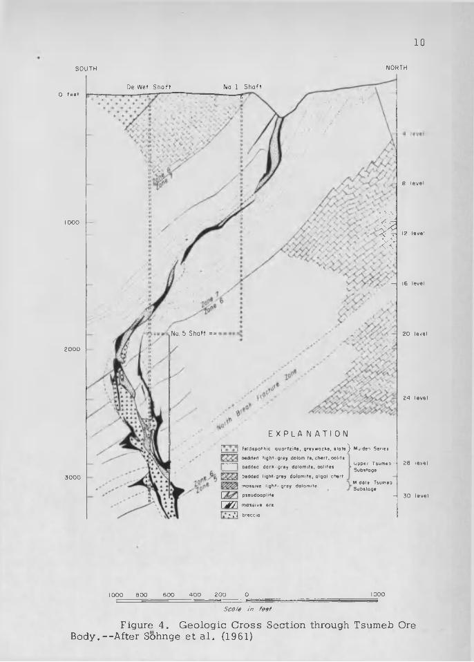
Figure 4. G eologic C ross Section through Tsumeb Ore B ody .—After Sohnge e t a l . (1961)

ECONOMIC GEOLOGY
Types of D ep o s its
The hypogene m in era liza tio n s of th e O tavi M ounta ins are t e l e -
thermal b a s e -m e ta l d e p o s i ts of copper , l e a d , and z inc w ith variab le
am ounts of cadm ium , germ anium , and s i lv e r . The four p r in c ip a l types
of m inera liza tion are (1) rep lacem ent bod ies in b recc ia zo n es in dolomite
o f the O tavi S e r ie s , (2) rep lacem en t periphera l to b recc ia p ip es or
p se u d o a p li te m a s s e s , (3) branching v e in s in do lom ite , and (4) d is s e m i
n a ted m inera liza tion in do lom ite , b re c c ia z o n e s , or p s e u d o a p l i t e .
No igneous in tru s iv e s are known a t th e s e d e p o s i ts o ther than
postm inera l d ik es of do le r ite and k e r s a n i te . A lteration of the dolom itic
h o s t rocks c o n s is t s of re c ry s ta l l iz a t io n of the dolomite and the add ition
of c a lc i te and q u a r tz . C a lc i te and quartz are the m ost common a l te ra t io n
m inera ls in the r e g io n . G raphitic a l te ra t io n and minor a lb i te a l te ra t io n
are reported by Sohnge (1962). Q u a r tz -s e r ic i te a l te ra t io n with or w ithout
the addition of c a lc i te is common in the m inera lized p s e u d o a p l i t e s .
R esidual d e p o s i ts of c h a lc o c i te have been mined from sa n d -
fil led s ink h o les th a t formed by so lu tion of the c a lc i t ic a l te ra t io n e n
v e lo p es surrounding v e in s o f primary c h a lc o c i te or c h a lc o c i te -b e a r in g
p se u d o a p l i te .
Supergene vanadium d e p o s i ts have formed by th e add ition of
vanad ium , from c ircu la t in g ground w a te r s , to ox id iz ing hypogene d e
p o s i ts con ta in ing le a d . ,
11
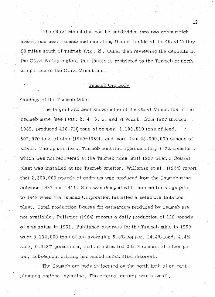
. 1 2
The O tavi M ountains can be subdiv ided into two co p p e r-r ich
a r e a s , one near Tsumeb and one along the north s ide o f th e O tavi Valley
50 m iles south of Tsumeb (Fig. 2). O ther than review ing the d e p o s i ts in
the O tavi Valley reg ion , th is th e s i s is re s t r ic te d to the Tsumeb or n o r th
ern portion of the O tav i M o u n ta in s .
' Tsumeb Ore Body
G eology of the Tsumeb M ine
The la rg e s t and b e s t known mine of the O tavi M ountains is the
Tsumeb mine (see F i g s . 2, 4 , 5, 6 , and 7) w hich , from 1907 through
1959, produced 4 2 6 ,720 tons of copper , 1 ,1 0 3 ,5 1 0 to n s of le a d ,
507 ,970 tons o f z inc (1949-1959), and more th an 2 3 ,0 0 0 ,0 0 0 ounces of
s i lv e r . The sp h a le r i te a t Tsumeb co n ta in s approxim ate ly 1.7% cadmium,
w hich w as not recovered a t the Tsumeb mine un til 1927 when a C ottre l
p lan t w as in s ta l le d a t the Tsumeb sm elte r . W illem se e t a l . (1944) report
th a t 2 ,3 0 0 ,0 0 0 pounds of cadmium w as produced from th e Tsumeb mine
be tw een 1927 and 1941. Zinc w as dumped with the sm elte r s lag s prior
to 1949 when th e Tsumeb C orporation in s ta l le d a s e le c t iv e flo tation
p l a n t . Total production figures for germanium produced by Tsumeb are
not av a ila b le . P e l le t ie r (1964) repo rts a da ily production of 120 pounds
of germanium in 1961. P ub lished re se rv e s for the Tsumeb mine in 1959
were 8 ,1 3 2 , 000 tons of ore averag ing 5.3% copper, 14.4% le a d , 4 .4%
z i n c , 0.013% germanium, and an es tim a ted 2 to 4 ou n ces of s ilv e r per
ton; su b seq u en t d ril l ing h as added su b s ta n t ia l r e s e r v e s .
The Tsumeb ore body i s lo ca ted on the north limb of an e a s t -
plunging reg ional sy n c lin e . The o r ig ina l outcrop w as a sm all,

55
40
6045 A <
AO, 5055
50
Figure 5. Geologic Plan, Level 26, Tsumeb Ore Body
i
E X P L A N A T I O N
o r e b o d y
m o s s i v e o r e
p s e u d o o p l i t e
b r e c c i o
N
100sco/e in feet
From Sohnge (1962).

T s u m e b M i n e
V V T s u m e b
T s u m e b W e s t
Scale m miles
s ze of CriQi.not T su^ec Oa»CfOD
E X R L - A N A T I O N
$ 3 ^ 5 efl c reos Show ng spoc ■ 0#Cut Dy ’’sumeD M -rt-g Co'pO'O ’ on
oh c to c en t e r s
Figure 6 . Road Net Map Showing Location of Tsumeb Mining Corporation Sampled Areas # Tsumeb and Vicinity

5a4d o l e r i t e d i k e
T S U M E B E A S T ,
45
4 5T S U M E B
55 > -
35
T S U M E B . W E S T
45
20
50
20
-< 3 0
5 a4
E X P L A N A T I O N
I I
M u l d e n q u o r t z i t e
l i g h t d o l o m i t e w i t h o o l i t i c c h e r t
d o r k d o l o m i t e w i t h l i m e s t o n e a n d s h a l e
K- r
III 5 a4
MVJ44ft»44
l i g h t d o l o m i t e w i t h o b u n d o n t c h e r t
l i g h t - g r a y m a s s i v e d o l o m i t e
b r e c c i a z o n e s
p s e u d o a p l i t e
c o p p e r a n d v a n a d i u m p r o s p e c t s
o o l i t e m a r k e r b e d s i n T s u m e b z o n e 8
0 1/2
scale in miles
Figure 7. Geology of Tsumeb Area, South W est A frica. --M od ified from maps by Schneiderhbhn (1929) and Sbhnge (1958).

16
tw o -p eak ed h i l l , approxim ate ly 500 by 100 fee t and 36 fee t h igh , lo ca ted
en tire ly w ith in the Upper Tsumeb s u b s ta g e , Zone 7, about 200 feet north
o f the Tsumeb Zone 7 -Zone 8 c o n ta c t . The h i l l w as com posed e s s e n t ia l ly
o f m a la c h i te , c h a lc o c i te , and g a le n a , w ith l e s s e r am ounts of o ther c o p
p e r , l e a d , and z in c m inera ls ; p seu d o ap li te formed th e sad d le be tw een
the sm all peak s of m ass iv e o re .
The ore body is an e l l ip so id a l p ipe com posed o f m ass iv e r e
p lacem ent o res w ith d is se m in a te d ore in b recc ia and p s e u d o a p l i te . From
th e su rface to about 770 fe e t , a ce n tra l low -grade core of p seu d o ap lite
s e p a ra te s th e ore pipe in to the w e s t and e a s t ore b o d ie s . P a r tia l ly
d eveloped cy lin d r ica l f rac tu res around th e p seu d o ap li te in the w este rn
ore body formed the lo cu s for sev e ra l r ich copper v e in s above a depth o f
515 f e e t .
The pipe c h an g es plunge re p e a te d ly a s the ore s truc tu re t r a v
e r s e s u n its of d iffering com petency within the Tsumeb do lom ites (Fig. 4).
The c h an g es in plunge are accom panied by var ia tion in p lan area of the
ore p ip e , being sm alle r in th e portions tha t conform to th e dip of the
sed im en ts and notably larger where it cu ts sharp ly a c ro s s the b edd ing .
Maximum plan d im ensions of th e ore p ipe are 600 by 200 fee t a t a depth
of 2 ,390 f e e t .
The ore pipe p lunges s tee p ly to th e south a s i t t r a v e rs e s the
upper part of Zone 7 but f la t ten s out to cu t gen tly a c ro s s the bedding of
the low er portion of th is z o n e . As the more b r it t le ch e r ty dolom ites of
Zone 6 are en co u n te red , the ore body aga in changes to a very s tee p ly
plunging pipe cu tting nearly a t right an g le s to the more com petent d o lo
m ite s . This e f fec ts a r e v e rsa l in plunge of the ore body from

17
approx im ate ly 55° S. to approxim ate ly 75° N. A b recc ia p ipe forms the
core of the d e p o s i t w ith in Zone 6 (F ig s . 4 and 5) . The b recc ia core- b e
g ins a t 2,015: fee t and con tin u es to a t l e a s t a depth of 3 ,2 6 5 fe e t .
W ithin Zone 6 (Fig. 4) , the ore body in te rs e c ts many so u th -
d ipping b ed d in g -p la n e f a u l t s , including the North Break Fracture Zone
(NBFZ), a b re c c ia zone up;to TOO fee t th ic k . This b recc ia zone in te r
s e c ts the main ore pipe a t a depth of 2 ,890 f e e t ., O ther bedding fau lts
are numerous in Zones 6 and 7, but the NBFZ is the m ost im portant e c o
nom ica lly , a s i t is the locus for th ree manto wings of h ig h -g rad e m ass iv e
o r e . The NBFZ co n ta in s d issem in a ted m inera liza tion and sm all pods of
p seu d o ap li te for s e v e ra l hundred fee t on e ither s ide of the ore body.
B edding-p lane b re c c ia s in c re a se below a depth of 2 ,640 f e e t , reach
th e ir maximum developm ent in the NBFZ, and occur on down to a depth
of a t l e a s t 3 ,140 fe e t , a t l e a s t ten h ig h -g rad e m antos ex tend ing up to
300 fee t aw ay from the pipe have been e n c o u n te re d . One of th e se m an tos ,
ju s t below th e NBFZ, a t a depth of 3 ,015 fe e t , con ta ined 75 ,000 tons o f
ore averag ing 23% copper .
Between the dep ths of 1 ,890 and 2 ,765 fe e t , the ore pipe is
c lo se ly re la te d to a sm all lo c a l iz e d s y n c lin e , the "orebody s y n c l in e ,"
superim posed on the reg iona l sync line with the long ax is of the pipe in
p lan view roughly co in c id en t with the a x is of the "orebody syncline"
(Fig. 5). Radial fracturing a t each end and con cen tr ic fracturing su r
rounding the ends of the " orebody sync line" are lo ca lly w e ll deve lo p ed .
The ore body con tin u es its 75° N. plunge to a depth of 3 ,150
fee t below the s u r f a c e , w ell into Zone 5 . Sohnge e t a l . 's (1961) s e c t io n
(F ig . 4) shows the ore body d e c reas in g in d iam eter and in d ic a te s the

18
beginning of a re v e rsa l in the p lu n g e . D rilling below a dep th of 3 , 515
fee t by th e Tsumeb Corporation h as shown tha t a r e v e rs a l h as indeed
occurred and th a t the ore body has becom e tab u la r and sp li t into sev e ra l
z o n e s . T hese ta b u la r ore zo n es are r icher in copper than in lead and may
correspond to rep lacem en t a long the th in a rg i l lac eo u s u n its o f Zone 5 or
to rep lacem ent a long frac tu res in Zone 4 .
A lteration
A lteration a s s o c ia te d w ith th e Tsumeb ore body in c lu d es c a l c i t -
iz a t io n , s i l i c i f i c a t io n , s e r ic i t iz a t io n , a lb i t iz a t io n , and the convers ion .
o f carbon to g raph ite . D e ta iled information on the d is tr ib u t io n of a l t e r a
t ion is p re se n t ly la c k in g .
C a lc i t i z a t io n . Developm ent of c a lc i te and r e c ry s ta l l iz a t io n of
the dolomite ad ja c e n t to the ore body is the c h a ra c te r is t ic a l te ra t io n f e a
ture of the Tsumeb m in e . C a lc i te h a s a lso been added to the p se u d o -
a p l i t e . C a lc i t iz a t io n , w hich is the m ost ty p ic a l a l te ra t io n type found a t
th e mines of the O tav i M o u n ta in s , ta k e s the form of v e in le ts of c o a r s e
gra ined c a lc i te w ith quartz g rains and a s d issem in a ted c a lc i te of v a r iab le
gra in s iz e in the do lom ite . C a lc i t iz a t io n a t Tsumeb h a s formed a l a r g e ,
c o a rse -g ra in e d c a lc i te plug be tw een 3 ,390 and 3 ,765 f e e t .
S i l i c i f i c a t io n . S i l ic if ica tio n of th e dolomite near the surface
of the Tsumeb pipe is reported by Schneiderhohn (1929) . S i l ic if ica tio n o f
the dolomite is w eakly p re se n t in the in term ed ia te le v e ls of the mine
from dep ths of 515 to 2 ,640 f e e t . The re la t iv e abundance of quartz in
c r e a s e s below 2 ,640 fee t un ti l the gangue becom es h igh ly s i l ic e o u s and
forms a d en se q u a r tz - r ic h core a t 3 ,8 9 0 fe e t . S i l ic if ica tio n of dolom ite

' " . . 1 9
and quartz vein ing a s s o c ia te d with c a lc i t iz a t io n is a l s o reported in o ther
p a r ts of the O tav i M o u n ta in s . The p seu d o ap li te a lso h a s been s l ig h tly
s i l ic i f ie d .
S e r ic i t iz a t io n . M ost of the o r th o c la se fe ld sp a rs in the pdeudo-
ap li te have been a l te re d to s e r i c i t e . Seric ite grains are a lso found in the
dolomite im m ediately a d ja c e n t to the ore b o d y .
A lb i t iz a t io n . Sohnge (1962) reports sporad ic occu rren ces of /
a lb i te rep lac ing dolomite near the p seu d o ap lite be tw een a depth of 1 , 1 0 0
and 2, 390 fe e t .
G ra p h i t iz a t io n . G raphitic a l te ra t io n of the dolomite below
2 ,140 fee t is m an ifes ted as a gradual darkening of the dolom ite per iphera lt
to the ore body.
Igneous In trusive Rocks
Several pos tm inera l d ikes and s i l l s of k e r s a n t i te , a dark p la g io -
c la s e b io tite rock belonging to the lamprophyre s e r i e s , cu t the ore body, '
but as y e t no o ther truly, igneous in trus ive rocks have been encoun tered
in the workings or in the deep drill ing conducted by the Tsumeb M ining
C o rp o ra t io n .
Tsumeb W es t
During O ctober 1967, I sp en t o n e -h a l f day a t the Tsumeb W e s t
p ro sp e c t , 1 .9 m iles so u th w est of the Tsumeb mine (F ig s . 2, 6 , 7, and
8 ) with M r. C il l ie rs of the Tsumeb geo log ic s ta f f . According to C i l l i e r s ,
the poorly exposed Tsumeb W es t p seu d o ap li te body h a s an a rea l ex ten t
ten tim es th a t of the o r ig ina l Tsumeb o u tc ro p . Previous d rilling by the
Tsumeb Mining Corporation a s w ell as g eo p h y s ic a l su rveys (L ow enste in ,

* £ s r
s s/b/
7
Pi'Pe.~_
f /<sr
N)O

FIGURE 9E X P L A N A T I O N
5T RHOTOOEOLOGIC: STRUCTURE, MARTSUMER AREA
SOUTH WEST AFRICAm miles
rtnqmol Tsum^b OutC?0£)
x»- X - Xm x«»
vi'zz
Z z
pnoio df t . t ed d ps
X »
/ /
XX
//x«
X
r* r Z
x »
x»>X*
READDY GEOSCIENCESTHESIS 1972

* 21 ,
1950) have been d isco u rag in g . Future p lan s for th is a rea include ad d i
t io n a l d r il l in g .
The outcrops of the Tsumeb W e s t pipe is lo c a te d in fla t- ly ing ,
dolomite and lim estone of the Upper Tsumeb s u b s ta g e , Zone 7, near the
ax is of a lo ca l no r th - trend ing a n tic l in e which t r a n s g re s s e s the reg ional
e a s t - w e s t fold a x is of the Tsumeb s y n c l in e . Surface m inera liza tion of
th is p ipe is m a la c h i te , p la n c h e i te , c u p r i te / copper v a n a d in a te s and
a r s e n a t e s , and fine ly d issem in a ted c h a lc o c i t e . A grab sam ple of
p se u d o ap li te c o l le c te d from the e a s te rn co n ta c t of the pipe a s sa y e d
6.1% copper and s lig h tly over 0 .5 ounce of s i lv e r per ton (F ig s . 7 arid
8 ) . Because of the immediate proximity of the chem ica lly reac t iv e do lo
m ite , it is e x p ec ted th a t th is va lue is probably fairly re p re se n ta t iv e of
the o r ig ina l copper v a lu e . It is in te re s t in g to note th a t th is grab sam ple
y ie lded a copper va lue id e n tic a l to .th e average for p se u d o a p li te mined
from the f irs t s ix le v e ls of the Tsumeb mine . This grab sample of
p seu d o ap lite c o n s is t s of rourided but sh ea red quartz g ra ins up to 1 mm
in s i z e , abundant s e r ic i te rep lac in g fe ld sp a r , a sm all pebble of do lom ite ,
and abundant green copper ox ides with g o e th i te . The copper oxide a s
semblage, is m ostly m alach ite with p la n c h e i te , SCuSiOg • H 2 O . A sm all
amount of d u f t i t e , (Pb, Cu)3 (ASO4 ) 2 (Pb, Cu) (OH2) , is p re s e n t , and X -ray
tech n iq u es ind ica te t ra ce amounts of sp a n g o li te , Cu6 A1C1 (SC>4 ) (OH) 1 2 ,
and la n g i te , Cu^SO^^OH) g - H gO .
The Tsumeb W es t p seu d o ap li te body d esc r ib ed by Schneider-
hohn (1921) is an e l l ip t ic a l pipe 650 fe e t long e a 's t -w e s t by 260 fee t
wide n o r th -so u th . This v e r t ic a l ly plunging pipe w as te s te d about 1921
by two sh a fts with minor underground workings and s e v e ra l sm all

22
p ro sp e c t p i ts a long th e w es te rn c o n ta c t . The d eeper of the two s h a f t s ,
165 fe e t , w as sunk v e r t ic a l ly in the middle of the p seu d o ap li te body.. A
c ro s s c u t which w as driven north from the bottom of th is sh a ft in ter
se c te d a v e r t ic a l in tru s iv e c o n ta c t be tw een p se u d o ap li te on the south
and Zone 7 dolomite on the north . The p se u d o ap li te co n ta in s angular
do lom ite , l im e s to n e , and chert fragm ents n ea r the c o n ta c t „ Branching
p se u d o a p l i te d ik e le ts and sm all c h a lc o c i te v e in s with a q u a r tz -c a lc i te
gangue ex tend short d is ta n c e s into the do lom ite . C on tac t e f fec ts are
s l ig h t with only minor r e c ry s ta l l iz a t io n of the dolomite a t the p seu d o
ap li te c o n ta c t . The second shaft w as sunk a t the northern co n tac t of
the p seu d o ap li te p ip e . This shaft is 50 fee t deep with only two short
a d v a n c e s , one a t 43 fee t and the o ther a t the bottom of the sh a f t .
Schneiderhohn (1921) s ta te s th a t the p seu d o ap li te n ea r the co n
ta c t is more h ighly m inera lized than the c en te r of the body; th is may be
a function of the primary m inera liza tion p r o c e s s . H igher grade ore is
found s im ilarly s i tu a te d a t the p seu d o ap li te -d o lo m ite c o n ta c ts a t Tsumeb
and Kombat. At Tsumeb W e s t , th is may be partly the re s u l t of leach ing
of the copper ore m inera ls w ithin the c e n tra l , non reac tive part of the
p seu d o ap li te body . If there h as been le a c h in g , there is the p o s s ib i l i ty
of an enrichm ent b lan k e t a t depth w ith in the cen tra l p a r t of the p se u d o
a p li te p ip e . A h y p o th e t ica l sec tio n through the Tsumeb W e s t p seu d o ap lite
showing a p o s s ib le enrichm ent b lan k e t is shown in Figure 8.
Severa l s a n d - f i l le d s in k h o le s 'n e a r the p se u d o a p li te pipe co n
ta in sm all m a sse s of ch a lc o c i te d is tr ib u ted through the re s id u a l f i l l .
One of th e se s in k h o le s , ju s t 10 fee t e a s t of the 6.1% copper grab
sam p le , w as exam ined during my v i s i t to the a re a . The s inkhole is more
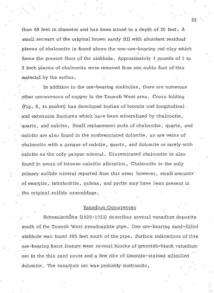
23
th an 40 fee t in. d iam eter and h as been mined to a depth of 30 fe e t . A
sm all remnant of the o rig ina l brown sandy fill w ith abundant re s id u a l
p ie c e s of c h a lc o c i te is found above th e no n - ore -b earing red c la y which
forms the p re se n t floor of the s in k h o le . Approximately 4 pounds of 1 to
2 inch p ie c e s of c h a lc o c i te w ere removed from one cub ic foot of th is
m ate ria l by th e au tho r .
In add ition to the o re -b ea r in g s in k h o le s , there are numerous
o ther o ccu rren ces of copper in the Tsumeb W e s t a r e a . C ro ss folding
(Fig. 9, in pocket) h as developed bod ies of b recc ia and long itud ina l
and ex ten s io n frac tu res w hich have b een m inera lized by c h a lc o c i te ,
qu ar tz , and c a l c i t e . Small rep lacem ent pods of c h a lc o c i te , quartz , and
c a lc i te are a lso found in the nohbrecc ia ted dolom ite , a s are ve ins of
c h a lc o c i te w ith a gangue of c a lc i t e , q u ar tz , and dolom ite or rare ly w ith
c a lc i te a s the only gangue m in era l. D issem in a ted c h a lc o c i te is a lso
found in a re a s of in te n se c a lc i t ic a l te ra t io n . C h a lc o c i te is the only
primary su lfide mineral reported from th is a rea ; how ever, sm all am ounts
of en a rg i te , t e t r a h e d r i te , g a le n a , and pyrite may have been p re se n t in
the o r ig ina l su lf ide a s se m b la g e .
Vanadium O ccurrence s
Schneiderhohn (1920-1921) d e sc r ib e s sev e ra l vanadium d e p o s i ts
south of the Tsumeb W est p seu d o ap li te p i p e . One o re -b ea r in g s a n d -f i l le d
s inkhole w as found 985 fee t south of th e p i p e . Surface in d ica tio n s of th is
o re -b e a r in g k a rs t fea ture were se v e ra l b locks of g re e n ish -b la c k vanadium
ore in the th in sand cover and a few ribs of limonite - s ta in ed s i l ic if ie d
do lom ite . The vanadium ore w as probably m o ttram ite ,

(Pb, Cu) 3 V2 O 8 (Pb, Cu) (OH) 2 . U nusually d e n se thornbush may a lso have
been an in d ica t io n of the s in k h o le . Filled s inkho les often support more
abundant p lan t life a s a function of so il dep th and m oisture retention-:;
D en se thornbush growth would probably form a sm all v eg e ta t io n anomaly
on a e r ia l photography . H ow ever, s in ce no pre-m ine a e r ia l photography
e x i s t s , it i s not known if a definab le anomaly e x is te d over th is s in k h o le .
When d ev e lo p ed , th is s inkhole proved to be 65 feet long , 30 to 50 fe e t
w id e , and 16 fee t d e e p . The f il l m ateria l c o n s is t s of red san d , b locks
of le a c h e d , and s i l ic i f ie d dolom ite w hich are coa ted w ith lim onite and
vanadium o re s , and h e a d - s iz e m a ss e s o f vanadium o re s .
The h o s t rock w hich c o n s is t s of s il ic i f ie d dolom ite w ith chert
ban d s i s probably the Upper Tsumeb s u b s ta g e , Zone 7. The dolomite a t
th is point s tr ik es e a s t - w e s t and d ips 3 0 ° -4 0 o S . , in d ica tin g a sou therly
plunge of the sm all n o r th -so u th a n t ic l in e and the p re se n c e of a very
lo c a l iz e d e a s t - w e s t s y n c lin e . In add ition to the ore in the cave f i l l ,
th e vanadium m in era liza tio n follow s the bedding p lan es for a short d i s
ta n c e . A vanad ium -bearing f is s u re , cu tting a c ro s s the bedd ing , w as
followed for 72 fee t north from the bottom of the s in k h o le . A sim ilar
vanadium occu rrence w as mined 360 fee t south of th is d e p o s i t . Both
o ccu rren c es are apparen tly re la ted to minor c o p p e r - le a d -z in c m in e ra liza
tion and a s s o c ia te d c a lc i te -q u a r tz a l te ra t io n . The s in k h o le s .d e v e lo p e d
on the c a lc i t i c a l te ra t io n e n v e lo p e . Sm all, c le a r , d ipyram idal c ry s ta ls
of quartz line c e l lu la r par t i t ions w ith in the c a v i t ie s and portions of the
s inkhole w a l l s . Vanadium has been added to the ox ida tion products of
the primary m ineral a s se m b la g e by c ircu la t in g ground w ate r a t a much

25
la te r t im e . The vanadium ore m inera ls reported from the a rea are m ot-
t ra m ite , (Pb, Cu) 3 V2 O g(Pb, Cu) (OH2 ) , and d e s c lo iz i t e , (Pb,Zn)3 V2 0 g-
(Pb, Zn) (OH) 2 •
Klinger (1938) pub lished p roduction figures for the early v a n a
dium mining a t Tsumeb W est a s 200 m etric to n s in 1912 and 450 m etric
to n s for the period 1913-1914 .
D isc u ss io n of O ther M in es and P ro sp e c ts
Tsumeb East
M inor am ounts of m inera liza tion occur on both the north and
south lim bs and around the nose of the Tsumeb sync line (Fig. 7) . These
show ings occur in Tsumeb Zones 7 and 8 . Only one of t h e s e , Tsumeb
E a s t , i s d esc r ib ed in the l i te ra tu re of the a r e a . •
The Tsumeb E ast p ro sp ec t w as d isco v e red during road c o n s tru c
tio n 1 .6 (1 mile) e a s t of Tsumeb on the north side of th e r e s i s ta n t r idge
formed by th e Upper Tsumeb do lom ites (Fig. 7) . Schneiderhohn (1921)
d e s c r ib e s the v e in zone a s being com posed of numerous v e in s of ga len a
w ith w id ths up to 20 cm . A c o a rse -g ra in e d gangue of quartz and c a lc i te
w ith t ra c e s of m alach ite and copper a r s e n a te s is a s s o c ia te d w ith the
g a le n a . Although the lead m in era liza tio n reached the s u r f a c e , the o u t
crop didjiot_shjow_yisi^ a t the point of d isc o v e ry . Fur- .
th e r p rospec ting in the area re su l te d in trac ing th e zone for severa l
k ilom eters a long the s tr ike b y following t ra c e s of m a lach ite in the su r
face f lo a t .

26
Abenab and Abenab W es t
The Abenab d e p o s i t , 17 m iles north of G rootfontein and 30 m iles
e a s t - s o u th e a s t of Tsumeb on farm Abenab 707 (Fig. 2), produced 50 ,000
tons o f lead and vanadium c o n c e n tra te s up to 1940. The d e p o s i t is a
p ip e -sh a p e d m inera lized b recc ia of mixed te c to n ic and so lu tion origin
a t the fau lted co n tac t be tw een th e underlying p la ty lim estone (Tsumeb
Zones 2 and 3) and the overly ing dolom ite (Tsumeb Zone 4) . This fau lt
co n tac t and the ore zone dip s tee p ly to the no rthw est , more or l e s s p a ra l
le l to the dip of the sed im en ts on the south limb of an e a s t - w e s t sync line
(Fig. 10) . The in te r s t i t ia l space of the b re c c ia co n ta in s secondary v a n a
d a te m in e ra ls , c a lc i t e , and red c la y .
A large so lu tion c a v i ty , p a r t ia l ly f illed w ith c a lc i t e , mud, and
some v a n a d a te s , i s exposed near the b re c c ia body by the o p e n - c a s t
mining opera tion (Schw ellnus, 1945) . V anadium -bearing s in k h o les occur
in th e v ic in i ty of the m ine . The b recc ia p ip e , which is 250 fee t in d iam
e te r a t a depth of 500 fe e t . Deep dril l ing by the South W es t Africa
Company in d ic a te s th a t the pipe c o n s tr ic ts to a narrow th roa t a t 1 ,500
fee t (Fig. 11) (Sohnge, 1963).
The main ore m inera l is d e s c lo iz i t e , (Pb,Zn)gV2 O 0 ° (Pb,Zn) (OH)2 *
Sulfides of lead and copper have never been found w ith in the Abenab pipe
but are reported to occur in sm all p a tc h e s north a n d .w e s t of the m ine.
The co n c e n tra te s con ta in ed 18% V2 O 5 , 45% P b , .14% Zn, and 1% C u .
The Abenab W est d e p o s i t l ie s 900 feet so u th w es t of the Abenab
mine and is a m ine ra l-b ea r in g so lu tion f is su re which formed along a
b e d d in g -p la n e fau lt in the p la ty l im estone of Tsumeb Zones 2 and 3 . The
f is su re is f illed w ith a b r ic k - re d , sandy c lay con ta in ing 2% V2 O 5 . Ore

27
N O R T H W E S T S O U T H E A S T
P S E !
E X P L A N A T IO N
T s u m e b Z o n e 4 b l u e - g r e y m a s s i v e d o l o m i t e T s u m e b Z o n e s 2 8 3 w e l l - b e d d e d p l a t y l i m e s t o n e
n o n b e d d e d g r a n u l a r c a v e d e p o s i t s
w e l l - b e d d e d , f i n e g r o i n e d c a v e d e p o s i t s
n o n m i n e r o l i z e d c o l l a p s e b r e c c i a
m i n e r a l i z e d c o l l a p s e b r e c c i a
f a u l t s
a d i t s
u n d e r g r o u n d w o r k i n g s b e l o w
iIB isJflJU d' I h v « «el
/
P w i 'p f m
r aMoim
LclJLiU
Zir-im ------------
Q c o Z7 CP ^
30 0 50 100 150
sca/e in f e e t
Figure 10. Abenab M in e , South W est A frica, Showing the N ortheast Face of the O p en cas t and Section through the M ain Ore Body. - -M o d if ied from Schwellnus (1945) .

28
N O R T H SOUTH
5 I
H.c
5 0 05 0 0
scale in fee I* * 7 T s u m e b Z o n e 4
/ m a s s i v e d o l o m i t e ( m c l . b r e c c i a )
tt- 1- I T - T s u m e b Z o n e 2 Q <S’ " C K o H H q H I i m o c t n n o
v a n a d a t e o n e in b r e c c i a
A A b e n o b b r e c c i a p i p e
A b e n o b W e s t o r e z o n eT s u m e b Z o n e Ib e d d e d d o l o m i t e a n d s h a l e
Figure 11. N orth-sou th Section through Abenab Mine . - M odified from Sbhnge (1963).
EVEL
E V E L
L E V E L

m inera ls inc lude d e s c lo iz i t e , v a n a d in i te , c e r u s s i t e , g a le n a , and su b
o rd ina te am ounts o f o ther oxide m in e ra ls , including abundant w illem ite
a t th e e a s te rn e n d . The o re -b ea r in g f is su re filling v a r ie s from 2 to 20
feet w ide and h a s been followed along s tr ike for 1 ,500 fe e t . The m in e ra l-
bearing c la y seam is conform able to the enc lo s in g sed im en ts , s tr ik ing
n o r th e a s t and dipping 45o -7 0 ° NW./ - '
The orig inal c h a ra c te r of the m inera lized b e d d in g -p la n e fau lt
has been la rge ly obscured by th e so lu tion a c t iv i ty re sp o n s ib le for the
re s id u a l c la y fill and the supergene vanadium m in e ra l iz a t io n . Local
p a tc h e s of b recc ia ted lim estone a re p reserved a d ja c e n t to the a ren aceo u s
c lay seam .
Small s tr ingers and b lo tch es of ga lena are reported to occur in
th e n o n -b re c c ia te d w a ll rocks (Schw ellnus, 1945, and W illem se e t a l . ,
1944) . L en ses and pods of spha le r i te and g a le n a , each surrounded by a
sh e l l of v a n a d a te s , occur below 500 fee t and have been followed to a
dep th o f 1 ,250 f e e t .
Prior to 1940, s e v e ra l underground t e s t workings w ere d r iv e n .
M ill t e s t s were run on 52 bulk sam ples to ta ling 3 ,9 6 4 t o n s . These .
sam ples were reduced to 714 tons of co n c e n tra te s averag ing 60% lead ;
of th e s e , 290 tons of co n c e n tra te s averag ing 12% V2O 5 were sh ipped .
Remaining re se rv e s on th is p roperty , according to W illem se e t al.. (1944),
are e s tim a ted to be equ iva len t to 2 , 0 0 0 tons of c o n c e n tra te s con ta in ing
15% V2 O 5 and 60% le a d .

Alt Bobos
Alt Bobos ap p ea rs from the l i te ra tu re to be a s e p a ra te and d i s
t in c t d e p o s i t from B o b o s . Sohnge (1958) d e sc r ib e s th e Alt Bobos d ep o s it
(Pig. 2 ) a s c o n cen tra t io n s of nodular copper o res a long calcitized.
b ed d in g -p la n e fau lts in the south limb of th e Tsumeb sy n c lin e . Bedding-
p lane sh ea r zones are repo rted ly a s s o c ia te d w ith drag folds and show
"flow b r e c c ia " and a s s o c ia te d c a lc i t i z a t io n , with c h a lc o c i te occurring
a s " n e s ts " in the c a lc i t i c do lom ite . .
Bobos
The Bobos d e p o s it is 16 m iles w e s t of Tsumeb along the pro
je c te d a x is of the Tsumeb s y n c l in e , s e v e ra l hundred m eters e a s t of a
sm all c lo se d portion of the syn c lin e ( F ig s . 2 and 9). C opper o res occur
in ro u n d - tb -e l l ip s o id a l s a n d -f i l le d s in k h o les 6 6 to 1 0 0 feet d eep , w hich
range from 3 to 33 fee t in d iam e te r . The o re -b ea r in g s in k h o les are a l l
lo c a te d w ith in a sm all a rea in f la t- ly in g d o lo m ite . A cen tra l core or
p i l la r of dolom ite is sometim es p re se n t in the la rger s in k h o le s .
Copper ore in the s a n d -f i l le d s inks o ccu rs m ostly a s m a la c h ite ,
commonly with co res of c h a lc o c i te . The ore fragments range from sand
s iz e up to cub ic m eter b locks of a lm ost pure c h a lc o c i te . The average
ore p iece is about f is t s ize and com posed of rad ia l ly s truc tu red m a la
ch ite around a ce n tra l p a r t ic le of c h a l c o c i t e . The ore co n ten t v a r ie s b e
tw een s in k h o le s . Although the w a lls of some of th e s in k h o le s are
covered in p la c e s by ce n t im e te r - th ic k c ru s ts of m a la c h i te , nearly a l l
th e developed ore reported by Schneiderhohn (1921) cam e from the sand
f i l l in g .

31
The filling of th e o re -b ea r in g s in k h o les c o n s is t s of leached and
l im o n ite -co a ted remnant b locks of the dolom ite hos t rock , m a s s e s of
m alach ite and c h a lc o c i te , a few m a ss e s of g o e th i te , and ra re ly rad ia l
s tructured m a ss e s of p s ilo m e la n e ; the rem ainder of the f il l is, red or
b ro w n ish -b lack s a n d . Schneiderhohn (1921) m ain ta ins th a t the sand in
th e s e s inkho les is id e n t ic a l in a l l r e sp e c ts to the surface sands in the
a r e a . In some a r e a s , the sand fill i s cem ented by c a lc i te and l im o n i te .
The w h i te - to -p in k chert bands in the dolom ite im m ediately a d
ja c e n t to the s in k h o les reported ly con ta in f lakes and g ra ins of c h a lc o
c i t e . Schneiderhohn (1921) m entions th a t m in e ra liza tio n is a lso found
in a nearby p seu d o ap li te (? ) . C lark (1931) a lso m entions a p seu d o ap lite
n ea r Bobos, but n e i th e r author g ives d e ta i l s on loca tio n or geology of
th is p se u d o a p li te b o d y . This p seu d o ap li te w as not d e te c te d during the
in i t ia l pho to in te rp re ta tion of th is a r e a .
Uris and Kara va tu
The Uris d e p o s i t i s shown on the geologic map of South W est
Africa a s occurring a t or near th e sou thern boundary o f Uris 481 (F igs .
2 and 9). C lark (1931) d e sc r ib e s the Uris d ep o s it a s a p ipe (sinkhole) ,
50 to 60 feet w ide , w hich p inched out a t a depth of 250 fe e t , adjoining
the Kara va tu m ine. The a rea w as f irs t worked for an accum ula tion o f
vanadium m inera ls in sm all surface d e p r e s s io n s . L a te r, the pipe
d e p o s it w as encountered and m ined . C o n ce n tra te s produced in 1926
con ta ined 19% V2 O 5 , 46% Pb, 10% C u, and 4% Zn.

ORE CONTROLS AND ORE GUIDES _ ;
S tra tig raph ic C ontro ls
M in e ra l iza t io n is not confined to any p a r t icu la r s tra t ig raph ic
horizon w ith in the ch em ica lly favorable carbonate seq u en ce of th e O tavi
S e r ie s . H ow ever, the Tsum eb, Tsumeb W e s t , B obos, and Uris m in es ,
a s w e ll a s the m ines along th e north s ide of the O tavi Valley (Fig. 2).,
a re a l l w ith in the Upper Tsum eb. This i s p a r t ia l ly exp la ined by the
b r i t t le nature of th e Upper Tsumeb, Zones 6 , 7, and 8 , w hich developed
abundant b ed d in g -p la n e fau lts and b recc ia bod ies during fo ld ing . These
fracture zo n es were favorab le for o re -f lu id m igration and ore d e p o s i t io n .
Another fac to r tending to lo c a l iz e ore depos it ion in the Upper Tsumeb is
the p re fe ren tia l occu rrence of p seu d o ap li te bod ies w ithin Zones 7 and 8 .
The a s s o c ia t io n of p seu d o ap li te w ith the Tsumeb and Kombat
ore bod ies m akes any occurrence of p se u d o ap li te worth in v e s t ig a t in g .
Although p se u d o ap li te occu rs w ith in Tsumeb Zone 6 in th e Tsumeb mine
w ork ings , m ost p seu d o ap li te o ccu rren ces in th e O tavi M ounta ins are r e
la ted tp Zones 7 and 8 and ap p ear to be of sed im entary orig in a lb e i t
rem obilized in m ost if not a l l c a s e s . P se u d o ap li te b o d ie s have co n tr ib
uted to the m inera liza tion p ro c e ss by forming ch an n e ls for the migration
of ore-form ing f lu id s . During fo ld ing , a le n s of fe ld sp a th ic quartz ite
(pseudoaplite) would form a zone of s truc tu ra l w e a k n e s s lo ca l iz in g
b ed d in g -p la n e fau lts with b re cc ia t io n a t the quartz ite (p seudoap li te )-
dolom ite c o n ta c t . A te c to n ic a l ly trapped feld spa th ic q u ar tz i te c o n ta in
ing form ational w a te rs would have in je c te d i t s e l f into any open fracture
32

33
formed during fo ld ing , which m a y ex p la in th e sm all v e in le ts of p se u d o -
a p l i te found near Kombat, a t Tsumeb W e s t , and o ther p la c e s in the O tavi
M o u n ta in s . Zones of co n cen tr ic fracturing could p o s s ib ly develop in the
a d ja c e n t dolom ite during the folding p r o c e s s . In add it ion to the s tru c
tu ra l c h a n n e ls d ev e lo p ed , the perm eab ility of the sheared p seu d o ap lite
(fe ldspath ic quartzite) offers a conven ien t channel for o re -f lu id m igration .
S tructural C ontro ls
The b e d d in g -p la n e fau lts and b recc ia zones referred to above
are major ore con tro ls in the d i s t r i c t . Sohnge (1962) r e la te s th ree o re -
bearing fracture zones in th e d is t r ic t to rev e rse b ed d in g -p la n e fau lts
formed in the s te e p e r limbs of m ajor sy n c l in e s , th a t i s , a t Tsumeb,
Abenab-Abenab W e s t , and a t the Kombat (Asis) mine along th e Otavi
V alley . -
Breccia p ip e s and zo n es of b re cc ia t io n are commonly re la ted
to m in era liza tio n in th e O tav i M o u n ta in s . M in e ra l iza t io n in th e b re c c ia s
may be a s m a ss iv e ore or a s d is s e m in a t io n s . B reccias re la te d to true
b recc ia pipe formation (example: Tsumeb) are known ore lo c i in the
Tsum eb-G rootfontein d i s t r i c t s . C o l la p se b re c c ia s a lso e x is t in the
r e g io n , forming from the c o l la p se of pos tm inera l c a v e s , a s for e x am p le ,
a t Abenab (S chw ellnus , 1945; S ohnge , 1963). The c o l la p se b recc ia of
th e Abenab mine forms th e locus for supergene vanadium m inera liza tion
which h as been added to the ox idation products of a p rev io u s ly ex is t in g
hypogene le a d -c o p p e r -z in c d e p o s i t . B reccias along b ed d in g -p la n e fau lts
a l s o form favorable loc i for m inera liza tion ; the m antos a t Tsum eb, e s p e
c ia l ly in and n ea r the North Break Fracture Zone, are e x c e l le n t e x a m p le s .

34
Known normal fau lts of reg ional ex ten t are lim ited in number' • f
an d , a t p re se n t , do not ap p ear to be of much im portance a s ore d e p o s i
tion con tro ls in the ind iv idual m ines of the d i s t r i c t . A N . 50° E. f rac
tu re zo n e , 2 m iles northw est of Tsumeb, con ta ins postm inera l do lerite
d ik es of probable la te Karroo age (Sohnge, 1962) . The Tsumeb s taff
p la c e s im portance on th is trend a s a deep reg ional basem en t s tructure
linking th is a rea w ith the Stromberg v o lcan o -p lu to n s of M essu m , Brand-i
berg , and Erongo, and to the a s s o c ia te d ca rb o n a te s to the sou thw est :
w hich have the same average trend a s does a s im ilar l ine of p lu tons and
ca rb o n a t i te s in Angola (M achado, 1958) (Fig. 12). The p ro jec tion of th is
trend to the n o r th e as t of Tsumeb p a s s e s near or through the Prince
Leopold mine and the Tsumeb mine is s tr ik in g . Both con ta in econom ically
im portant co n cen tra tio n s of copper , l e a d , and z in c , with germ anium ,
cadm ium , and s i l v e r .
Favorable S tructural Settings
In te rs e c t io n of small c ro s s folds with reg ional fo ld s , such a s a t
Tsumeb W es t (F ig s . 7 and 9), give r i s e to s tee p ly plunging zones of in
te n s e frac tu ring . S im ilar c ro s s - fo ld in te rs e c t io n s occurring betw een
minor fo lds a lso form favorable ore lo c i a s , for exam ple , a t . th e Berg
Aukas mine (Figs. 2 and 13). Fracturing at and near the nose of plunging
reg ional fo lds a lso ap p ears to form p o te n t ia l ore lo c i , for exam ple , Bobos
an d , in p a r t , Tsumeb W e s t .
P se u d o a p li te , a s d esc r ib ed under s tra t ig rap h ic c o n t r o ls , a p
pea rs to be the m ost im portant s ing le locus for the Tsumeb and Kombat

35
C h i » r c
2 Itngo3 l Of.qoj.io4 h i a n g c
5 Po.iU;r c$ € Cc;j o7 C h i u e c o
5 Uiomfo 10. Su imo l i C h c n j o I? Cooj 1 3 O u i ? u o
. 4 C h i m b O O
IS Bongo
L E O P O l O v h l E
' r i m S e r ' e p ' p e
'I UASDA
r AV-lQ
LLOI Ol D
A N G O l A
Mt-QAMI v.r i
Z A fvl i 1 I A
UV'.GSTON/
T S U M i Bv ABENAB
« WI7<rhOEK> AAuVIS BAY UOTSWANA
S O U T H
AFRiCA
S A AFRICA
i Copt Cross V e s s u m Bi-ordfceg
IV Dor osSp'l/nop*
VI E r o n g o VU OkonjejeVIII f isente rgIX PorosisX 0»orujis
n o l f c o r b o n o l i f e s o r ? u n d e r l i n e d
Figure 12. Volcanic Belts of Late Karroo Age, Angola and South W est A fr ic a .— M odified from M achado (1958).

36
N
-
Figure 13. G enera lized Sketch of the S tructural Setting of the Berg Aukas M in e , South W est Africa

FIGURE 14.E X P L A N A T I O N
STR ATIGRAPHIC DISTRIBUTIONTSUMEB AREA
SOUTH WEST AFRICApholo moike< ho rizon I zone boundory I
n te rp re le d zone boundo iy , do sh ed m h e 'e o p p ro n m o te
zone boundory from p u b lished m opping
zone boundory in te rred from pub lished m opping
M u 'den to r mo lion
centers
form b o u ndones
0115 o t
O H S o f synclm e
lo u l ts com piled Irom pub lished m opping
d o ie n te d lies trom pu b lish ed m opping
ne d i k e s ! 7 ) from pho tos
tpper Tsumefc |/o n e s 6 8 ) ]
M iddle Tsumeb ( /o n es 4 o nd 5 ) i
■Lower Tsumeb
in te-preio t'on based on photoqroph.c and ovbi'shed doio
I tone onom G l'es, possib ly p seu d o o p h te 0 ' th ick M uiden form ation \ zones i - 3 }
Abenob
Sohnqe, 1962 S chne iderhohn , 1929
S c tw eiinus, e 1 o t. >940
4 - ?
I-
5
XH -
- - f - -
mm
----------
* * sI
I~ ~ T : I 4 - gSHSSi
?
—
RE ADD Y GEOSCIENCESTHESIS 1972

H eid ttb e rg 29- / E londsv lok 8 58D nefontom 8 4 6ToevluQ 8 4 5Ph-'.odelphio 8 44
FIGURE 15
ROSE DIAGRAMS of LINEAR ELEMENTSand
GEOGRAPHIC BASE MAPTSLJMEB AREA
SOUTH WEST AFRICA
Posodeno 4 77D ynnenberg 4 7 8
u d w g sh o fen 4 8 0
X <30
6 5 9
Scale m milesw onnhe,m jqq
V Bobos (V) - 0 1 prOSIH 'S I u m m n c r i d 'C O te-155 SO-f^pied by fsum eb M-n«ng i.om pony
SDoc-ng jt sampled i.re s nd-ccied
o o g w f r o i 1 • e -j ' e i e n e n t s
accro 660ooerown 6 9 5
Ad » ia ,d e 66
Aden 662
V Bobos ( C u )Tsumeb
Tsumeb WestV Al t . Bobos ( Cu )
K o r a v o t u ( V ) V46 6m oy 664, Boston 67
y Ur i s ( V )
H vc* lend 665
very d o s e
V F r l e s e n b e r g (V)
Abenab ( Pb,V)
READDYTHESIS
GEOSCIENCES1972

37
m in e s , both b e c a u s e of th e i r perm eab il ity and a s a r e s u l t of th e ir e f fe c ts
on the deform ation of the surrounding dolom ite during fo ld ing .
The hydrotherm al na ture o f the Tsumeb d e p o s i t i s w ell d o cu
m en ted . No true igneous in tru s ive rocks o ther than th e la te or post-:
Karroo d o le r ite and k e rsa n t i te d ik es have been recognized in the a r e a ,
C o n ce iv a b ly , a buried p luton or ca rb o n a ti te e x is t s a t dep th which ac te d
a s a therm a l, and p o ss ib ly a m e ta l-su p p ly in g , s o u rc e . If such a buried
p luton e x i s t s , i t may have a s ligh t surface ex p re ss io n , such a s loca l
doming of s e d im e n ts , an anom alous fracture pa tte rn with p o s s ib ly w eak
a l te ra t io n ,o r m in e ra liza tio n leak ag e to the su rfa c e .
Vanadium a s an In d ica to r M eta l
M ost of the vanadium occu rren ces in the reg ion are l inked to
p a r t ia l ly ox id ized b a s e -m e ta l d e p o s i ts con ta in ing le a d . The recorded
occu rren c es of vanadium m in era liza tio n should be a u se fu l guide to lead
m in era liza tio n even in t ra c e am oun ts .
S inkholes
M any co p p er- lead -v an ad iu m d e p o s i ts of the reg ion are re la ted
to pos tm inera l so lu tion c a v i t i e s . These p a r t icu la r c a v i t i e s , in the form
of s in k h o les or so lu tion f is s u re s , are app aren tly g e n e t ic a l ly re la ted to
the ore d e p o s i t io n . The most l ik e ly ex p lan a tio n for the c lo se a s s o c i a
t io n of s in k h o les w ith ch a lc o c i te vein system s and p se u d o a p li te o ccu r
re n c e s is the c a lc i t i c a l te ra t io n of the dolom ite n ea r primary
m in e ra l iz a t io n . C a lc i t ic a l te ra t io n w as noted during my v is i t s to both
the Tsumeb and Kombat m ines and h a s been docum ented for many other
d e p o s i ts in the region by Schneiderhohn (1920-1921, 1921, and 1929).

38
H olland e t a l . (1964) , a f te r in v e s t ig a t in g th e chem istry of cav e w a te r s ,.
arrive a t a so lu b il i ty product of 10-17 for d o lo m ite , co n tra s te d with a
so lu b il i ty product o f 10."® for c a l c i t e . C a lc i t ic a l te ra t io n in the Tsumeb
region i s a lso accom panied by re c ry s ta l l iz a t ip n of the a d ja c e n t dolomite
w hich a lso s lig h tly in c re a se s so lu b il i ty . Fau lts and zo n es of b recc ia t io n
a re a l s o a re a s favorable for developm ent of both ore b o d ie s and s in k
h o le s . A com bination of in te n se fracturing or b recc ia t io n accom panied
by c a lc i t i c a l te ra t io n w ill undoubtedly prepare an area for abundant s ink-,
hole formation during w e a th e r in g . The p ic tu re i s com plica ted by the
e x is te n c e of normal k a rs t developm ent throughout the reg ion com ple te ly
un re la ted to a l te ra t io n or m in e ra l iz a t io n .
Upper Tsumeb Sub s tag e
P o ss ib le leak ag e of m inera liza tion a long bedding fau lts and
b re c c ia s w ith in the b r it t le Upper Tsumeb bed s (Zones 6 , 7, and 8) may
make th e s e zo n es u sefu l in the la te ra l geochem ica l d e tec t io n of non
outcropping ore d e p o s i t s . C opper, le a d , z in c , s i lv e r , and a rsen ic
would be u se fu l in d ic a to rs . C o n s id e ra b le surface contam ination by l e a d ,
z in c , a r s e n i c , and cadmium from ea r ly (p ro -1927) sm elte r d u s t should be
expec ted n e a r T su m eb . Search for ad d it io n a l p seu d o p a li te bod ies should
be co n cen tra ted in a re a s con ta in ing Zones 7 and 8 o f the Upper Tsum eb .
s u b s ta g e .
Aeromagnetic Surveys
An aerom agnetic survey could be used to map b asem en t s tru c
tu r e s , d ik e s , and p o s s ib le buried in t ru s io n s . A erom agnetics and

photogeology w ould , o f n e c e s s i ty , be in i t ia l to o ls in exp lo ra tion of ad
ja c e n t a re a s covered by Kalahari s a n d s .

PHOTOGEOLOGIC STUDY
The area o f th is study is covered by g o o d -q u a l i ty , conven tiona l
b la c k -a n d -w h i te , 1 :36 ,000 ae r ia l p ho tog raphy . The a e r ia l photographs
of the O tavi M ountains w ere rap id ly scanned to ob ta in an overa ll a p p re
c ia t io n of th e ir geologic information c o n te n t . Following th is rapid s c a n ,
th e photographs for the Tsumeb area w ere s tud ied in d e ta i l to determ ine
th e photographic e x p ress io n for each member of the Upper Tsumeb su b -
s ta g e , Zones 6 , 7, and 8 , and for the M ulden form ation. Once a se t of
te n ta t iv e photo c r i te r ia w a s e s ta b l i s h e d , re c o n n a is s a n c e tr ip s through
the Tsumeb a rea w ere made to verify the photographic e x p ress io n of
t h e s e u n i t s .
In it ia l o ver lay tem p la te s w ere prepared for 65 a e r ia l pho to
graphs rep resen tin g a to ta l a rea of 750 square m iles (F ig s . 1, 2, and
F ig s . 9 , 14 and 15, in pocket) . An ad eq u a te b a se map for the photo
d a ta w as ob ta ined by trac in g portions of four South W est Africa G overn
ment farm boundary m a p s .
The area of th is study is am enable to pho togeolog ic m ap p in g . ■
Some geo log ic d a ta can be ex trac ted from th e photographs in a re a s of
sand and c a l ic h e co v er . The p re sen t s tudy would have g re a t ly benefited
from an in i t ia l l i te ra tu re r e v ie w . The l i te ra tu re study , a f te r my return to
Salt Lake C ity , w as n e c e s s a ry to refine the cr i te r ia for d isc r im ina tion of
various dolom ite u n i t s . The l i te ra tu re sea rch re su lte d in sev e ra l long
d e la y s s ince much of the important l i te ra tu re on th is a rea w as pub lished
in h a rd - to -o b ta in jo u rn a ls . M any of the early d e ta i led repo rts were
40

w ritten in German and required t ra n s la t io n . I owe sp e c ia l th an k s to M r.
E . Demeter for h is many hours of help w ith the t ra n s la t io n of th is l i t e r a
tu re . Had th is l i te ra tu re study been com pleted before working with the
photographs in South W e s t A frica , the en tire nature and scope of the
p ro jec t would have been c h a n g e d . Photo recognition fea tu re s would have
required a fraction o f the time spen t in th is s tudy . Key a re a s would have
been v is i te d and worked up in d e ta i l a t th e s ta r t of the p r o je c t . Photo
geo log ic mapping would have s ta r ted a t the O tavi Valley and p rogressed
n o r th , in p reference to the area m apped, w ith d e ta i le d fie ld and pho to -
geo log ic mapping o f s e le c te d m ines and p r o s p e c t s . The photogeologic
mapping would have covered a much la rger a rea w ith far more d e ta i l in
a fraction of the time required for the p re sen t s tudy .
The u se of photogeologic te c h n iq u e s in the O tav i M ounta ins
a llow s rapid r e c o n n a is s a n c e m ap p in g . Rapid photogeo log ic mapping of
s tra t ig rap h ic u n i t s , e s p e c ia l ly the Upper Tsumeb s u b s ta g e , w ill a id in
the sea rch for favorab le s tra t ig ra p h ic -s t ru c tu ra l t a r g e t s , such a s b re c
c ia zones and p seu d o ap li te b o d ies . D e tec tio n of p seu d o ap li te and
b recc ia zones on co n ven tiona l a e r ia l photography is p o s s ib le but a s y e t
req u ires ad d it io n a l study to improve r e l ia b i l i ty . S tructural d a ta are
g en era lly w ell e x p ressed on the p h o to g ra p h s , a id ing rapid recognition
of p o te n t ia l ly favorable s truc tu ra l s e tt in g s sim ilar to th o se of Tsumeb
W est and Berg A ukas.
D is c u ss io n of Pho to in terp re ta tive M aps
Photogeologic S tructure Map
This map (Fig. 9 , in pocket) is a reduction of an orig inal
1 :36 ,000 map prepared from the photo overlay sh e e ts and an en largem ent
o f the traced farm boundary m a p . Many d is to r t io n s e x is t on th is map a n d ,
although s te p s w ere taken to keep the d is to r t io n s to a re a so n a b le m ini
mum, lo ca tio n of sp e c if ic geo log ic f e a tu re s , such a s bedding t r a c e s ,
f ra c tu re s , and s in k h o le s , m ust be regarded a s a p p ro x im a te .
M uch ad d it io n a l work could be done on the d e n s i ty of fracture
t r a c e s , the d e l in e a t io n of reco g n izab le photo marker b e d s , and d is t r ib u
tio n of s in k h o le s . Some of the a re a s w hich have been g eochem ica lly
sam pled by the Tsumeb M ining C orporation are a lso in d ica ted on th is
m a p . The raw da ta p re sen ted on th is map w ere u sed for the p reparation
of the ro se diagram of l inear e lem ents and the in te rp re ta t iv e s tra t ig rap h ic
m ap.
In te rp re ta tiv e S tra tig raph ic Map
In te rp re ta tio n of a re a l d is tr ib u tio n for various u n its of the O tavi
Series and the M ulden quartz it e (Fig. 14, in pocket) i s b a se d on d e ta i l s
shown on th e photogeolog ic s truc tu ra l map and from pub lish ed d a t a .
C r ite ria u sed to s e le c t s tra t ig rap h ic b reak s for field mapping are not
n e c e s s a r i ly c o n s is te n t w ith fea tu res recogn izab le on photographs for
photogeologic mapping . In the sp ec if ic c a s e of the Upper Tsumeb Zone
8 -M ulden c o n ta c t , the prominent oo lite band near th e to p of Zone 8 is
often shown a s the boundary , s in ce the a c tu a l Zone 8 -M ulden boundary
could not be tra ced r e l i a b ly .

43
Line w eigh ts on the map in d ic a te re la t iv e re l ia b i l i ty . The h e a v
ie s t l in e s are photo marker un its shown on the s truc tu ra l map (Fig. 9)
w hich c lo se ly approxim ate zone b o u n d a r ie s . The next h e a v ie s t l in e s
correspond to in te rp re ted boundaries b ased on pho to - and l i te ra tu re -
derived da ta where no reco g n izab le photo marker u n its w ere shown on
the overlay s h e e t s . The w e a k e s t l in e s in d ica te boundaries from p u b lished
d a t a .
S ince se v e ra l s tra t ig rap h ic un its have p h y s ica l fea tu res th a t
commonly a c t a s ore c o n t r o ls , such a s the lo c a l iz a t io n of p seu d o ap lite
in Zones 6 , 7, and 8 and the abundant b ed d in g -p la n e fau lts of Zone 6 ,
know ledge of the d is tr ib u tio n of the carbona te un its and th e ir s truc tu ra l
se tting should be u sefu l in future exp lo ra tion in the a r e a .
Road Net Map
The road ne t map for the Tsumeb a rea (Fig. 6) w as prepared to
a s s i s t any future s tu d ies in the im m ediate Tsumeb mine a r e a . This map
w a s prepared by the te m p la te -a n d -ra y m ethod. Scale of th e th ree in
d iv idual flight s tr ip s involved are ad ju s te d to form a uniform map sc a le
w hich is approx im ate ly 1:36, 000 on the orig inal and approxim ate ly
1 :107 ,325 on the reduc tion accom panying th is t h e s i s .
Rose Diagram s of L inear Elements
P ho to -der ived fracture t r a c e s are p resen ted a s ro se diagram s
a s a percen tag e function of number of f rac tu res (north quadrants) and
len g th (south quadrants) (Fig. 15, in pocket) . Both p re se n ta t io n un its
were u sed to in d ica te re l ia b il i ty of fracture da ta for any g iven d irec tion .
F racture d ire c t io n s re la ted c lo se ly to the reg ional fracture pa tte rn should
; ' 44
have opposing ray s o f s im ilar m a g n itu d e . The sm all s ta t i s t i c a l pop u la
tions o f fracture, t ra c e s for some a re a s limit th e u se fu ln e s s of th e se
d iag ram s; Summation of the number of frac tu res and unit leng th is shown
for each diagram . A sm all number of large frac tu res would show a s a .
long ray on the lower portion and a s a much sm aller ray on th e upper
portion of th e d iagram . Bach ro se diagram re p re se n ts an a rea roughly
2 .8 by 3 .7 in c h e s on the reduced maps accom panying th is report, c o r
responding to 30 square m i le s .
The reg ional fracture pa tte rn conforms to the n o r th -so u th com
p re ss iv e fo rces re sp o n s ib le for the e a s t - w e s t folds of th e O tavi M oun
t a i n s . The predom inant fracture d ire c t io n s form a cu te a n g le s of from
20° to 30° with the n o r th -so u th com press ive c o u p le . 8 mit (1962) reports
the major fracture tre n d s form 30° to 40° an g le s w ith the n o r th -so u th
com press ive forces in the area so u th e a s t of O tavi (Figs. 1 and 2).
W ithin re a so n ab le l im its , th e fracture data b a se d on number of
frac tu res can be u sed for the p red ic tion of the normal fracture pa tte rn for
various portions of th e mapped a re a . I f the photographs of the mapped
a rea had been a v a i la b le for further a n a l y s i s , a more com plete mapping
o f fracture t ra ce d e n s i ty and d is tr ib u tio n could have been prepared ,
e s p e c ia l ly in the w e s te rn portion of the accom panying s truc tu re map
(Fig. 9).
Anomalous fracture d ire c t io n s no t c o n s is te n t w ith no rth -so u th
com press ive forces are ex p re sse d in se v e ra l ro se d iagram s (40/1252),
(53/1292), (33/675), (123/2575), (53/1218), (232/4593) . H ow ever, in
m ost o f th e s e c a s e s , the to ta l number of fracture t r a c e s i s too small to
make fracture a n a ly s is very r e l i a b l e . Several of the fracture ro se

45
d ia g ra m s , including the anom alous v a r ia t io n , are d e sc r ib e d ind iv idua lly
in th e following p a ra g ra p h s .
Rose d iagram s (40/1252) , 5 .5 m iles s o u th - s o u th e a s t of Tsum eb,
and (53/1292), 7 .5 m iles so u th e a s t of Tsumeb, co n ta in large rays p a ra l
l e l to the reg ional n o r th e as t do ler ite dike t re n d . This in d ic a te s a s tro n g
e r developm ent of th is fracture system in th is area th an w as p rev iously
in d ica ted on pub lished m a p s .
Rose diagram (33/675), 4 m iles sou thw est of Tsum eb, shows an. i
ad d it io n a l frac ture trend n o r th -n o r th e a s t and a sm alle r n o r th -so u th f ra c
ture trend rep resen tin g e x ten s io n frac tu res a long a small e a s t - w e s t a n t i
c l in e . The ax is of th is sm all a n t ic l in e could not be determ ined and is
not shown on the accom panying m a p s .
Rose diagram (123/2575) , 3 .5 m iles northw est of Tsumeb, th is
fracture p a t te rn shows strong e x te n s io n frac tu res pe rpend icu la r to the
a x is of the e a s t -w e s t - t r e n d in g a n tic l in e ; th is supports the minor b e d
ding t ra c e ev idence for lo c a l doming of th e sed im ents in th is a re a .
Minor doming is a l s o expec ted from the p ro jec tion of the sm all c ro ss
warp a n t ic l in e through th is a r e a . P o ss ib ly an in tru s io n e x i s t s a t depth
h e r e .
Rose diagram (53/1218), 7 .25 m iles w e s t - s o u th w e s t of Tsumeb,
in d ic a te s some te n s io n a l ex ten s io n frac tu ring . The no r th -no r thw est
fracture system is a lso more s trongly d ev e lo p ed .
Rose diagram (3 7 /887), 8 m iles n o r th e as t of Tsum eb, re p re se n ts
a normal fracture system n ear the no se of a fold and i s not anom alo u s .
Rose diagram (232/4593), 11 m iles n o r th e as t o f Tsumeb, shows
th a t th e frac ture p a tte rn in th is area i s s trongly in fluenced by ex ten s io n

46
f rac tu res perpend icu la r to the sy n c lin a l a x i s . There i s apparen tly no
lo ng itud ina l .f rac tu ring .
P ro g ress iv e ly e a s t from the p reced ing rose d iag ram , the frac
tu re p a t te rn s in d ica te a change in the com press ive fo rces from north -
sou th to more n o r th w e s t - so u th e a s t „ The e as te rn m o s t ro se diagram
, (44/765) , 22 .5 m iles e a s t -n o r th e a s t of Tsum eb , in d ic a te s a probable
sh if t o f the sy n c lin a l a x is from e a s t - w e s t to a more e a s t -n o r th e a s t trend
a s the sync line becom es p ro g ress iv e ly covered by Kalahari sand and
c a l ic h e to the e a s t .
The rem ainder of th is map is d es ig n ed to be a geograph ica l
supplem ent to the o ther m a p s . Farm nam es and numbers are show n , a s
a re the approxim ate lo c a t io n s of m ines and p ro sp ec ts and the cen te rs o f
a e r ia l photographs u sed in th is s tu d y . Areas sampled by th e Tsumeb
M ining Corporation are a lso shown w ith no ta tions a s to th e re la tive
spac ing of the b ru sh ed -o u t l in e s .
OTAVI VALLEY DEPOSITS
The d e p o s i ts in the southern O tav i M ountains are predom inantly
lo c a te d along the north s ide of the O tav i V alley, which runs e a s t - w e s t
be tw een O tav i and G rootfrontein (F ig s . 16 and 17) . M o st of the d e p o s i ts
were p ro sp ec ted and developed during the period 1910-1925 . For the
m ost p a r t , th e se d e p o s i ts were abandoned during the 1930 's and lay
id le until about 1957. The Tsumeb M ining C orporation began in ten s iv e
p rospec ting in th e A sis mine area during the m id -1950's and developed
w hat is now known as the Kombat m ine .
. Kombat M ine
The Kombat mine is lo ca ted along the north edge of the O tavi
V alley , 31 a i r m iles s o u th - s o u th e a s t of Tsumeb and 8 m iles w e s t of the
old G uchab m ine . The mine area co n ta in s th ree se p a ra te ore b o d ie s , the
E a s t , C e n t r a l , and W e s t . The e a r l ie r underground w orkings of the A sis .
mine are in th e v ic in i ty of the Kombat W est d isc o v e ry . Following favor
ab le geochem ica l sample re tu rns in th e a r e a , Tsumeb M ining 'C orpora tion
began a d rilling pro jec t b e tw een the old A sis mine w orkings and an i s o
la te d outcrop of p seu d o ap li te w ith in the dolomite of th e Upper Tsumeb
sub s ta g e , Zone 8 . The th ir t ie th drill ho le in te rcep ted w hat is now known
a s the Kombat W e s t ore body . Although surface e x p o su res are often poor,
S chneiderhohn 's (1921) geo log ic sk e tc h map of the A sis mine area a p p a r
en tly show s the p seu d o ap li te bod ies being mined' by th e Tsumeb M ining
C orporation and a ls o the small p seu d o ap li te body in a ra ilroad cut near
Kombat (Fig. 18).
47

10°
Ot ov i j
2 0 °
Outjg.
O m o r u r u
U s o k o sK o r i b i b
G o b a b i sW i t v l e i
R e h o b o t h o
2 4 °
M o r i e n t o l
M a l t a h o h e oGi b e o n
E x p l a n a t i o n
2 6 °I n t e r n a t i o n a l B o u n d a r i e s
B o u n d a r i e s o f M a g i s t r a t e D i s t r i c t s
R a i l r o a d sL u d e n t z K e e f m o n s h o o p
K ar o s burg 2 8 °
100100W a r m b a
O r a n j e m u n dScale in m iles
20 °
Figure 16. Index M a p , O tavi Valley Region , South W es t Africa00

4 9
O h f o n t s f o n t e i n
P b * Z n V \
H o r o s i bb.Zn
B e r g A u k o ^
^ : i '•x # H a r a s i b ( 6 4 8 ) / * T o g g e n b u r g
■ % % %Pb — Y
/G a u s s ' 4 6 4 v v G r o o t f o n t e i n X
X_ A P I ? , Z n
G r o s s O t a v i C u ' / / x
O t a v i
\/LrrF==bti!>< A s i s , - v o / / ^ X a > / K o m b o t «>|| x x ^ e O t j i r u k a k ' uPb.Znr \ \
" ' G u c h a bA s i s E a s t End
L^ R i e t f o n t e jn 3 4 4
E X P L A N A T I O N
M i n e a n d c o m m o d i t y
P r o s p e c t
O c c u r e n c e a n d c o m m o d i t y
0 10 20
P b , Z n
s c a l e in m i l e s
Figure 17. P rospect Location M a p , Otavi Valley Region, South W est Africa

Aurcs • Guess
'j
\ /
G r o s s - O t o v i
A y s ( K e m b o f )Guchob _
y / Rietfonfein • /
E X P L A N A T I O N
m e t a m o r p h o s e d s e d i m e n t s
O t o v i f o r m a t i o n u n d i f f e r e n t i a t e d ( i n c l u d i n g t h e O t o v i V a l l e y p h y l l i t e a n d s o m e N o s i b )
T ix / . b a s e m e n t
cSZ3> p s e u d o a p l i t e .
o r e o c c u r r e n c e s
l O O O O O O ________________ 3 0 0 0 0 0
Scal e in f e e l
Figure 18. Geologic Sketch Map of the Ore D e p o s i ts , O tavi Valley, South W es t A frica . — Modified from Schneiderhohn (1921).

51
Following the Kombat W es t d isc o v e ry , the East and C entra l ore
bo d ies were found by p rospecting known p seu d o ap lite o c c u r re n c e s .
Kombat C en tra l w as found by trench ing a p seu d o ap lite l e n s . Kombat
East w as d isco v e red by drilling an .a rea conta in ing se v e n .o r e igh t sm all
s tr ingers of p s e u d o a p l i te .
The m inera liza tion a t Kombat i s la rg e ly confined to p seu d o
ap l i te bod ies con ta in ed w ith in the Upper Tsumeb s u b s ta g e , Zone 8 , a t
and near, th e co n tac t be tw een the dolom ite and th e O tav i Valley p h y l l i t e .
At Kombat, the p seu d o ap li te is c o n s id e re d .to be a sed im entary rock e n
c lo se d w ith in the c a rb o n a te s of Zone 8 . C ro s s -c u t t in g v e in s and s to c k -
work s w ere noted during th e p re sen t in v e s t ig a t io n a t th e su rface in and
nea r th e Kombat ore b o d ie s .
The footw all co n tac t of the p seu d o ap lite w ith the dolom ite is
sheared and i s the lo cu s of m ass iv e o re . The Kombat W est ore body is
sheared and d is to r ted by a 3 0 -fo o t-w id e fracture zone of the Kombat W est
fau l t , w hich h a s both prem ineral and pos tm inera l m ovem ent. Shears
p a ra l le l to the Kombat W est fault are a lso m in e ra lize d . The nonsheared
c o n ta c ts of p seu d o ap li te and dolom ite are sharp and show no co n tac t
e f fe c ts o ther than the typ ica l q u a r tz -c a lc i te a l te ra t io n a s s o c ia te d with
th e hydrothermal d e p o s i ts of the O tavi M ountain la n d . Each ore body h a s
two known ore z o n e s , one above and one below a lo ca l ro ll in the
do lom ite -phy llite , c o n ta c t w hich d ips 45° S . a t the s u r f a c e . P resen t c u t
off grade is 0 .9% co p p er . An id e a l iz e d c ro ss sec tio n through a Kombat
ore body is shown in Figure 19.
M in e ra l iza t io n a t Kombat is such th a t the mine is a copper mine
down to th e 4 le v e l , a mixed c o p p e r - le a d mine from th e 4 to 6 l e v e l s ,

NORT H SOUTH
E X P L A N A T I O N
d o l o m i t e
p s e u d o o c l i t e w i t h m i o e r o .■ z o t i o n
O t o v i V a l l e y P h y H i t e
Figure 19. Idea lized Section through Kombat Ore Bodies

53
and a lead mine below the 6 l e v e l . E stim ated ore re se rv e s a t Kombat are
approxim ate ly 2 m illion to n s of 3.6% copper, 4.4% le a d , and 0.5% z in c .
In a d d i t io n , a s yet u n te s te d p o ten tia l e x i s t s for open p it o res w ith grade
and to n n ag es com parable to th e porphyry copper d e p o s i ts of the sou th
w es te rn United S ta te s .
C urren tly , the d e p o s i ts are being mined by very la rge open
s to p e s , b lock c a v in g , and c u t - a n d - f i l l m ethods. Production is 750 tons
per day from the b lock cav ing opera tions and 250 to n s pe r day by cut and
f i l l , for an overa ll d a i ly production o f 1 ,000 to n s . The Kombat mine pro
duced 2 m illion ounces of s ilv e r in 1966.
Since the A sis d e p o s it i s e s s e n t i a l ly synonymous with the p r e s
en t Kombat m in e , th e following sec t io n derived from the o lder l i te ra tu re
on A s is , e s p e c ia l ly Schneiderhohn (1921), im m ediately fo llow s th is s e c
tion a s ad d it io n a l supporting da ta on the ore o ccu rren c es in the Kombat
a r e a .
A sis M ine
Four ty p e s o f ore d e p o s i ts occur in a narrow e a s t -w e s t - t r e n d in g
zone w ith in the do lom ite , from 330 to 660 feet north o f the O tavi Valley
p h y ll i te -d o lo m ite c o n ta c t (Schneiderhohn, 1921):
1 . Branched ve in sy s tem s and groups of ve ins or l e n s e s of p se u d o -
aplite. in trude th e d o lo m ite . The p seu d o ap li te and ad jacen t
dolom ite co n ta in d issem in a ted b o rn ite , c h a lc o p y r i te , c h a lc o -
c i t e , and minor pyrite .
2 . L e n se s of p seu d o ap li te are fau lted or folded in to th e do lom ite .
At the pseudoap lite -do lom ite c o n ta c t , there are la y e rs of "red

54
iron" o res (hematite) and m a g n e t i te . Some of the m agnetite
occu rs d is se m in a te d in the p s e u d o p a l i te . Copper is a lso found
in some of th e se p seu d o ap li te l e n s e s .
3 . C a lc i te -q u a r tz -b e a r in g b recc ia v e in s con ta in ing c h a lco c ite .
4 „ Chaleo c i t e - and m a la c h i te -b e a r in g , s a n d - f i l le d s in k h o le s ,
a s s o c ia te d w ith b recc ia v e in s and s tr ingers of p se u d o a p l i te .
The d e p o s i ts a t Asis (Kombat) are lo ac ted in the 15- to 3 0 - fo o t-
high te rrace of dolomite th a t forms the northern boundary of the O tavi
V alley . The dolom ite is commonly b recc ia ted a t i ts c o n ta c t with the
O tavi Valley p h y l l i te . The dolom ite be longs to Zone 8 of the Upper
Tsumeb s u b s ta g e . The p se u d o ap li te may re p re se n t a l i tho log ic e q u iv a
len t of the M ulden fe Id sp a th ic quartz ite in terbedded w ith the do lom ite .
Schneiderh&hn (1921) re fers to in terbeds of phylli te and p seu d o ap lite
folded into the dolomite with in jec tio n of large and sm all v e in s and •
le n se s of p se u d o ap li te into the dolomite in other p a r ts of the d e p o s its
(Fig. 20). Ore occurs in both ty p es of pseudoaplite .. M inera liza tio n is
confined to p se u d o a p li te b o d ie s , th e ir immediate c o n ta c t a r e a s , and to
the e a s t - w e s t b recc ia v e in s .
Ore in P seudoap li te
In 1921, the Asis mine (F ig s . 20 and 21) w as co n s id e red to be
the m ost important ore d e p o s i t of the O tav i Valley. The mine is 985 fee t
north -north we s t of the old Asis ra ilroad s ta t io n d irec tly a c ro ss from the\40-knri mark of the O tav i-G roo tfon te in ra ilw ay (Fig. 18) . The mine w as
developed by a 115 -fo o t- lo n g by 6 6 - fo o t wide open p i t , part of which w as

jdDlW
A N A T
d o l o m i t e
p h y l l i t e
c h e r t
p s e u d o o p l i t eJlllllJ
4 b r e c c i a
o r e ( p r o j e c t e d t o s u r f a c e )
5 0 0
Sco'e in feet
Figure 20. Plan of Asis (Kombat) Mine A rea# O tavi Valley, South W est A fr ic a .— M odified from Sohnge (1958) .

56
e x p l a n a t i o n
m m e r o h z . d o p h t e "| q u o r l z - C0| C| I | 0 „ e r o , i on
w i t h b o r n i t e t r t id c h o l c o p y r i t e v . Zm i r. mr-n I i ♦,'#»*
J
3 0 m e t e r l eve l
m m e r o i i z e d d o l o m i t e ! m i n e r o l i z o t i o n
u n m i n e r o l i z e d d o l o m i t e
m o i n s h o f t
i m r
6 0 m e t e r level
Scale in feet
Figure 21. Plan of the 30- and 60-m eter L evels , Asis M in e .— Modified from Schneiderhohn (1920-1921).

57
deve loped to a -dep th of 1 0 0 fee t where it w as connec ted to a 98-foo t
(30-meter) underground le v e l . This p it h a s s ince been b a c k f i l le d . Ad
ja c e n t to th i s former p it i s a 197-foot (60-meter) deep sh a ft with two
developm ent l e v e l s , one a t 30 m e te r s , the o ther a t 60 m eters (Fig.. 21) .
The d ep o s it i s reported to have a second s h a f t , the lo ca t io n of w hich is
not shown on th e accom panying se t of m a p s .
The surface ex p o su res in the mine a rea w ere poor, but
Schneiderhohn (1921) fe lt th a t there w ere a t l e a s t th ree sep ara te p se u d o -
ap li te le n s e s w ith w id ths of 26, 13, and 1 .6 fe e t . Narrow and irregu lar
la y e rs of ph y ll i te are known to occur a t sev e ra l of the p seu d o ap li te
b o u n d a r ie s . These p seu d o ap lite l e n s e s w ere w e ll m inera lized with m a la
ch ite and azu r ite a t th e su rface an d , in a d d i t io n , b lo ck s of co p p er- and
iron -bear ing s i l ic i f ie d dolom ite occurred w ith in th e p s e u d o a p l i t e . The
dolom ite a t the main A sis shaft is c ro s se d by a vein zone of p seu d o ap li te
which i s a ligned so u th w est and a lso p lunges so u th w e s t . The ind iv idual
v e in s are often b ranched and sinuous w ith w id ths of from 8 in ch es to 5
f e e t . The co n tac t b e tw een the p se u d o ap li te and the dolom ite is g rad a
tio n a l and w as d iff icu lt to d is t in g u ish underg round . At the c o n ta c t , the
dolom ite is c o a rse r g ra in ed , but th is change only p e r s i s t s for a few
m il l im e te rs . The p seu d o ap li te is w e ll m inera lized w ith d issem in a ted
copper o r e , w hile the ad ja c e n t dolomite co n ta in s ore in v e in s and pods
for sev era l m eters aw ay from.the co n tac t and a s sm alle r s tr ingers and
zo n es of d issem in a ted m inera liza tion s t i l l farther away from the c o n ta c t .
The length of th e ore zone i s 260 to 295 fee t on both working le v e ls ; ore
w id ths are from 16 to 82 f e e t .

58
The ore on th e 3 0 -m e te r lev e l (F ig . 21) i s m ostly azu r ite and
m a la c h i te , but some la rger m a ss e s o f su lf ide o res w ere.found near and
a t the p seu d o ap li te -d o lo m ite c o n ta c t . The m inera liza tion in the 60-m ete r
lev e l is a l l su lf id e . The predominant ore m inera ls on th e 60-m eter le v e l
are reported to be ch a lcopyrite and b o m i te , w ith r a r e , very sm all gra ins
of c h a lq o c i t e . The ch a lcopyrite and bornite occur a s f ine ly d ivided d i s
sem inations , a s m ass iv e p o d s , or as v e in s . Pods of m a ss iv e ore up to
head s iz e were common. The ore m inera ls rep lace both the p seu d o ap lite
and the do lom ite . In the d o lo m ite , the ore m inera ls are c lo s e ly re la ted
to c o a rse -g ra in e d a re a s of c a lc i te and dolom ite irregu la r ly d is tr ib u ted
through the d en se r do lom ite . The dolom ite n ea r the d e p o s i t has been
s lig h t ly s i l ic i f ie d .
The m inera lized dolomite a d ja c e n t to the p se u d o a p li te is cu t by
many sm all v e in le ts of p seu d o ap li te to the south and w e s t of the main
w o rk in g s . These v e in le ts are a l l m inera lized a t the su rface with m ala
ch ite and azu r ite ; t r a c e s of ore occur in the dolomite, near th e p se u d o
ap l i te s tr in g e rs . The lo ca t io n of th e s e sm all p seu d o ap li te v e in s w as
u s u a l ly marked by an a ligned s e r ie s o f v e r t ic a l s in k h o les f illed with a
mixture of sand and r ich co n cen tra tio n s of c h a lc o c i te ore lo c a l iz e d in
the c a lc i t i c a l te ra t io n en v e lo p e . The mine workings are confined to the
c a lc i t iz e d and s i l ic i f ie d dolomite and to the p seu d o ap li te b o d ie s .
Schneiderhohn (1921) repo rts a very minor occurrence of c o a rse -g ra in e d
g a le n a , a l te red to c e ru s s i te a t the s u r f a c e , in dolom ite an u n s p e c i f ie d .
d is ta n c e north of the A sis m ine. O ccu rren ces such a s th is may e a s i ly
have been m is se d , a s the w eathered su rface of ga lena a lte r in g to c e r u s
s ite is very s im ila r in appearance to the w eathered su rface of s l ig h tly

59
a lte red d o lo m ite . A p o s s ib le field guide to a lte ra t io n would be the
"craggy su rface" w eathering re la ted to re c ry s ta l l iz a t io n of the dolomite
and enrichm ent in the more so luble CaCOg molecule..
C opper O ccu rren ces in T ec to n ica lly Trapped P se u d o ap li te Blocks
Several p seu d o ap li te b e d s , m inera lized a t the su rface with
azu r ite and m a la c h ite , crop out in the san d -co v e red f la ts 1 ,476 feet
(450 m eters) e a s t of the p it of the A sis mine (Fig. 18); th i s may rep re
sen t the Kombat E ast o reb o d y . This a rea w as p ro sp ec ted prior to 1921 by
a 148-foo t (45-meter) inc lined shaft and by a large number of small p ro s
p e c t p i t s . The main occurrence is a le n s of p s e u d o a p l i te , s trik ing e a s t -
w e s t , 3 9 5 fee t long and up to 6 6 fee t w id e , which jo in s a t i t s e a s t end
w ith a phy ll i te len s 985 feet long and 100 feet w ide surrounded by the
do lom ite . Phyllite and p seu d o ap li te w ere a lso encountered a t a 148-
foot dep th in a c ro s s c u t to the south from the sh a f t . In the c ro s s c u t ,
th e p s e u d o a p l i te , w hich w as 46 .3 feet wide in the upper l e v e l s , i s only
6 .5 fe e t w id e . "It a p p ea rs th a t to g e th e r w ith the s la te / p h y l l i t e / , the
p seu d o ap li te forms a ro o t le s s fo ld ed -in wedge w ith in th e do lom ite .
M in era l iza t io n apparen t does not extend to depth" (Schneiderhohn, 1921).
I f th is is indeed th e Kombat E ast o rebody, the p se u d o a p li te h a s en larged
ag a in w ith d e p th .
C opper-bearing Breccia Veins
A large number of b recc ia v e in s very s im ilar in form and m iner
a l iz a t io n to the b recc ia v e in s of G uchab cu t the dolom ite 260 to 330 fee t
north of the p seu d o ap li te le n s e s d e sc r ib e d in the p reced ing s e c t io n s .

60
These v e in s were developed by a 260-fo o t- lo n g t r e n c h , 33 fee t d e e p ,
and by a n o r th -so u th , d e e p trench 130 fee t long . Schneiderhohn (1921)
rep o rts th a t s ev e ra l deeper, p ro sp ec t p its have e s ta b l i s h e d th a t . th e b re c
c ia v e in s d ie out a t d e p th . P o ss ib ly the b recc ia "v e in s" behave in a
m anner s im ila r to the p seu d o ap li te l e n s e s and may en large again with
d e p th .
A s is East-End
The A sis East-End d ep o s it (Fig . 18) i s a 6 5 0 -fo o t- lo n g m iner-/
a l iz e d zone con ta in ing p seu d o ap li te ve in swarms which o ccu r on a low
dolom ite h i l l 1 .1 m iles e a s t of th e Asis mine sh a f t . The A s is East-End
h i l l is bounded on the south by the A s is-G u ch ab road and on the w e s t by
a sm all c ro s s v a l le y through which p a s s e s the A s is -G u a ss -G a u b -N o s ib
ro ad . The e a s t - w e s t zone of ore and p seu d o ap lite is 650 fee t long and
from 65 to 130 feet w id e . The m in era liza tio n ex ten d s a c ro s s two small
h i l l s . The summit of the e a s te rn h ill is occupied by a sm all open pit
w hich is partly in p seu d o ap lite (north) and partly in the dolom ite (so u th ) .
The p seu d o ap li te occu rs a s a l e n s , 148 fee t long and 26 feet wide a t th e
m idd le . The c o n ta c t b e tw een the p seu d o ap li te and th e dolom ite is
marked by a very narrow se lvage of p h y l l i t e . South of th e open p i t , the
dolom ite i s com ple te ly r idd led by v e in s 1 cm th ick and v e in swarms of
p s e u d o a p l i te . Southw est of the main p i t , there are se v e ra l sm aller p i ts
cu t in dolom ite tra v e rse d by p seu d o ap li te v e in s ; th e s e p i ts do not exceed
26 fee t to ta l depth and are confined to the oxide z o n e . M in era l iza t io n in
th e p seu d o ap li te c o n s is t s of iron oxide s ta in ing w ith a z u r i te , m a la c h ite ,
and a y e l lo w -g reen a rse n ic -b e a r in g m inera l, p o ss ib ly c h e n e v ix i te (?)

61 •
The p seu d o ap li te a p p ea rs to be s trongly leach ed or w e a th e re d . D eep
s a n d - and o re -f i l le d s inkho les in the dolomite are a ligned along the
p seu d o ap li te v e i n s .
North of the main open p i t , the re is a r e s i s ta n t quartz " r e e f , "
197 fee t long and 6 .5 fee t w id e , w hich forms a rib 26 to 33 feet h igh .
The dolom ite ad ja c e n t to the north s ide of th is quartz "reef" is " strongly"
m inera lized w ith c h a lc o p y r i te . This ore zone h as been p rospec ted by a
4 0 - fo o t-d e e p shaft put down from the bottom of a long , deep p rospec t
t r e n c h .
On the w e s te rn h i l l , the dolom ite i s a lso m inera lized and cut
by numerous w e l l-m in e ra l ized p seu d o ap li te v e in s . M any o re -b ea r in g
s in k h o les are a lso c lo s e ly a s s o c ia te d w ith the p seu d o ap li te v e in s in
th is part of the d e p o s i t .
A sis East
The A sis East d e p o s it is 2 .2 m iles e a s t of th e production shaft
of the A sis mine (Fig, 18) . Between the A sis East-End d e p o s i t p rev ious ly
d esc r ib ed and th is d e p o s i t , there is a more or l e s s con tinuous line of low
h i l l s con ta in ing a narrow m inera lized z o n e . W ithin th is m inera lized z o n e ,
th e dolomite forms small r e s i s ta n t k n o b s , p o ss ib ly a s a re s u l t of s ligh t
s i l i c i f i c a t io n , and there are s tr ingers of w eakly m inera lized p se u d o
a p l i t e . Several occu rren ces of ga lena are a lso reported in th is c o n n e c t
ing zone by Schneiderhohh (1921).
The A sis E as t mine w as abandoned before World W ar I . W ork
ings c o n s is te d of a 6 0 -m e te r-d eep shaft w ith severa l d r if ts and c r o s s
c u t s . The workings are in a large p seu d o ap li te body w hich is w ell

62
m inera lized a t the s u r f a c e . Schneiderhohn (1921), from an exam ination
of the dumps and surface w o rk in g s , concluded th a t a t l e a s t part of the
underground workings were in p seu d o ap li te but th a t the p seu d o ap li te a t
depth w as w eakly m in era lized .
Baltika
Schw ellnus (1945) d e sc r ib e s the Baltika d e p o s i ts (Fig. 17), 11
m iles e a s t of O tavi on farm 515, a s o re -b e a r in g , f il led s inkho les ( san d -
sacks) and as ore in a v e r t ic a l c a lc i te "vein" (filled so lu tion f is su re ? ) ,
in the Upper Tsumeb dolom ites north of the O tavi V alley.
The s a n d -f i l le d s inkhole d e p o s its continue downward into la rger
so lu tion c a v i t ie s which are a lso f il led with sand a n d /o r red c la y . Vana
dium m inera ls occur d issem in a ted in the sand and c la y , as co a tin g s on
the dolomite w a lls , or as a. cem enting m ateria l betw een dolomite c o l la p se
b re c c ia b lo c k s . C aliche p a r t ia l ly cem ents the f il l m ate ria l a t the su rfa c e .
The "vein" occurrence p in ch es and sw e lls a long s tr ike from le s s than 1
foot to more than 6 fe e t , w ith an open cav ity in the c e n te r a t the th ick e r
portions of the d e p o s i t . The "vein" c o n s is t s of a l te rn a t in g layers of c a l
c i t e , very th in bands of ore m in e ra ls , and thin bands of c lay ; in p la c e s ,
the "vein" is en t ire ly barren c a l c i t e . The "vein" has been mined over a
s tr ike length of 1 0 0 f e e t .
Berg Auk as
The Berg Aukas m ine, 15 m iles n o r th e as t of G rootfon te in , is
d esc r ib ed by Schw ellnus (1945) as a v e r t ic a l , irregu lar "p ipe" c o n ta in
ing the seco n d ary z in c m in e ra ls , s m i th s o n i te , and ca la m in e , with
boulders of dolom ite in a matrix of "brow nish c a lc a re o u s ' c l a y ' ." In the

, 63
" p ip e ," vanadium m inera ls occu r a s en c ru s ta t io n s on the dolomite bou l
ders and as d isco n tin u o u s coa tings on the pipe w a l l s . N ear the "p ipe"
d e p o s i t , a f is su re con ta in ing over 3 fe e t of m ass iv e vanadium ore w as
mined to a depth of 1 0 fee t where the p h rea tic zone w as encoun tered and
the f is su re and vanadium m inera liza tion abruptly en d ed .
P e lle t ie r (1964) g ives a more u p - to -d a te p ic tu re of the geo log ic
se tt in g and p re se n t mining of the d e p o s i t by the South W e s t Africa
Com pany, L td . The ore body is lo c a l iz e d a t a po in t where a c ro ss warp
in te rs e c ts the s te e p ly dipping north limb of a lo c a l , m oderately w es tw ard -
plunging syn c lin e formed in the southern limb of a reg iona l e a s t - w e s t
syn c lin e (F ig„ 13). The c ro ss warp is of a lo ca l nature and only d is tu rbs
the so u th -d ipp ing beds for 700 fee t a long th e ir s t r ik e . The h o s t rock is a
700 - fo o t- th ick bed of dolom ite in the lower part of the O tav i form ation.
This 700- fo o t- th ic k bed of dolom ite h as been h ighly r e c ry s ta l l iz e d , d i s
tin g u ish in g it from the a d ja c e n t dolomite and l im es to n e . The re s u l t of
th e se lo c i is a s te e p ly p lunging ore body 700 by 700 fee t in plan sec t io n
with a proven depth of over 2 , 0 0 0 f e e t .
Vanadium h as been added by supergene w ate rs to the ox ida tion
products of the primary m in era liza tio n , g a le n a , and s p h a le r i te . The
p r in c ip a l vanadium m inera l is d e s c lo iz i t e . The ore body is primarily a
vanadium producer to the 400-fo o t le v e l . Although d e s c lo iz i te has been
found to the g re a te s t dep ths exp lo red , th e re is a g radual d e c re a se in
vanadium co n ten t u n ti l vanadium becom es a byproduct a t about a 500-
foot d e p th . The vanadium ore occurs rep lac in g the primary m inera ls in
the m ass iv e ore body, in dolomite b re c c ia z o n e s , as en c ru s ta t io n s on
the roofs and w a lls of so lu tion c a v i t i e s , and in the c o l la p se filling of

: . 64
large so lu tion c a v e r n s , The ore body is a z inc and lead d e p o s it below
500 fe e t . O xidation-of the primary ore is developed to g rea t d e p th . The
ox id ized ore co n ta in s very abundant w illem ite and some c e r u s s i t e . The
su lf ide o r e , where i t e x i s t s , forms large rep lacem en t bod ies of m ass iv e
ore as w e ll as d issem in a ted ore in dolomite b r e c c i a s .
Large re se rv e s of z inc and lead are inferred from P e l le t ie r 's
(1964) d esc rip t io n of the d e p o s i t . This is su b s ta n t ia te d by the January
1968 i s s u e of M ineral Trade N otes (Baker, S p ro u se , and W ilc o x ) , w hich
reports a 1 5 -y ea r c o n ta c t be tw een the Berg Auk as mine and the South
African Iron and S teel Corporation (ISCOR) w hereby the mine w ill produce
36 ,500 to n s of e le c tro ly t ic z in c annually for ISCOR, rep resen tin g 100
tons of e le c tro ly t ic z in c per day or ju s t over o n e -h a l f m illion tons of
m e ta ll ic z in c over the co n trac t pe riod .
G au ss 46 •
Very minor g a le n a , p o ss ib ly sy n g e n e t ic , is reported from th is/ ’
farm (Fig . 17), 43 m iles e a s t of O tav i, by W illem se e t al„ (1944) . The
g a lena w as n o ticed in m ass iv e dolomite on top of a high h i l l 1 mile
n o rth -n o r th w es t of the fa rm h o u se .
G ro ss -O ta v i
P seudoap lite Ore Body
The p seu d o ap li te ore body a t G ro ss -O ta v i is 1 km north of the
2 9 .5 -km mark of the O tav i-G rootfon te in ra ilw ay (Figs . 17 and 18). The
d e p o s i t is lo ca ted on the low. te r race of dolomite h i l ls th a t forms the
northern boundary of the O tav i V alley . The d e p o s it began developm ent
in 1913 and in 1919, when Schneiderhfthn (1921) v is i te d th is m ine, w as

65
developed by a sh a ft from th e te rrace and by a connecting ad it driven
from the m id -e lev a tio n of the te r ra c e . A w inze was sunk from the bottom
of the shaft a c ro ss the ore body and into th e foo tw all. At a depth of 80
fee t below the ad it le v e l , the w inze in te rse c te d se v e ra l so lu tion f is su re s
w hich con ta ined c ru s ts and c ry s ta l agg reg a tes of copper and lead v a n a
d a te s . Schw ellnus (1945) may have been referring to th is d e p o s it in h is
d esc r ip t io n of the vanadium occurrence a t G ro s s -O ta v i . Schw ellnus d e s
c r ib es the vanadium occurrence as a conformable so lu tion f is su re f il led
by redd ish san d , c la y , and e r ra t ic a l ly d is tr ib u ted p a tc h e s of vanadium
. o r e .
The su rface ex p re ss io n of th is d e p o s i t w as a sha llow e l l ip t ic a l
d e p re s s io n , 330 fee t by 100 fe e t , w ith numerous s c a t te re d b locks of
goe th ite con ta in ing c e r u s s i t e , m a la c h i te , a z u r i te , and many o ther yellow
and green ox idation m inera ls of lead and copper . The h o s t rock is a
den se dolomite with a pronounced layering of s e v e ra l p a ra l le l beds of
s i l ic i f ie d o o l i t e s . The s i l ic i f ie d oo lite beds p ro jec t as sharp ribs with
the se p ta of dolomite eroded to form tro u g h s . The s i l ic i f ie d oo lite beds
s tr ike e a s t - w e s t and dip 50° to 60° S. (Schneiderhohn, 19 21). This
dolomite m ust re p re se n t Zone 8 of the Upper Tsumeb s u b s ta g e .
In the a d i t , three d is t in c t zones of the ore body were recogn ized
by Schneiderhohn (1921): (1) a c en tra l zone of lead and iron m in e ra liza
tion e n c lo se d by (2) two copper- iron z o n e s , and (3) a footw all co n tac t :
zone which is a snow -w hite layer of so f t , g reasy se r ic i te (phyllite)
s c h is t ( ? ) . The p seu d o ap li te pipe d e sc e n d s concordantly w ith the do lo
mite bedding (60° tq 70° S . ) . The s i l ic i f ie d oo lite beds n ea r the ore body
often con ta in m ic ro sco p ica lly fine p a r t ic le s of d issem in a ted c h a lc o p y r i te .

66
O re-b ea r in g , S and-f i l led S inkholes
There are two a re a s of o re -b ea r in g s in k h o le s . The w es te rn a rea
w as the in i t ia l d isco v e ry for th is type of d e p o s it w ith in the O tavi M oun
ta in land (F ig s . 22 and 23). This d e p o s i t is 1 km north of the 29-km
mark of the O tav i-G roo tfon te in ra i lw ay . The s in k h o les were found on the
e a s te rn s lope of a sm all v a l ley cu tting the O tavi Valley dolomite te rrace
and a l s o on the main t e r r a c e . The zone con ta in ing th e se s a n d - f i l le d ,
o re -b ea r in g s in k h o les and sm all ch a lc o c i te v e in le ts is 500 fee t e a s t - w e s t
by 100 to 230 fee t n o r th -so u th . The h o s t rock is aga in the dense dolo
mite of Zone 8 w ith p a ra l le l s i l ic i f ie d o o li te beds s tr ik ing e a s t - w e s t and
dipping 40° S. The s in k h o les con ta ined large m a sse s of ore with b locks
of m ass iv e ch a lc o c i te up to 24 cub ic m eters (847 cub ic feet) encoun tered
during the mining o p e ra t io n s . In November 1909, a block of nearly pure
c h a lc o c i te 2 by 3 by 4 m eters (6 . 5 x 9 . 8 x 13.1 feet) w as found at a
depth of 4 m eters com plete ly surrounded by sand within the en c lo s in g
s in k h o le . The m ost common s iz e of the ore fragments w as from nut to
f i s t s i z e . H ow ever, p e a - s i z e p ie c e s were so common th a t the f il l m a te
r ia l w as sc reen ed to recover th e se finer ore p a r t ic le s . In add ition to the
m alach ite and c h a lc o c i te m a s s e s , a l e s s e r number of intergrown c h a l
co c i te and g a lena ore p ie c e s were found and , ra re ly , some com posed
only of g a le n a . Ore m a sse s were found only in the s in k h o les th a t in te r
se c te d sm all ch a lc o c i te v e in le ts in the d o lo m ite .
Eastern Group of S inkholes
The second occurrence of th e s e o re -b ea r in g s in k h o le s is north
of the 35-km mark of the O tav i-G rootfon te in ra ilw ay and is a lso located.

67
I
Scale in feel
Figure 22. P rospect Area at G ro ss -O ta v i , O tavi V alley , South W est A frica . - -M o d if ie d from Kuntz (1904).
Figure 23. Typical Section through G ro ss -O tav i Copper- bearing Karst D ep o s it , O tavi Valley, South W est A frica . - -M o d if ied from Kuntz (1904).
\I

a t the mouth of a sm all c ro ss v a l le y which cu ts the O tav i Valley dolomite
t e r r a c e . The so lu tion p ipes are confined to a re la t iv e ly sm all a rea and
are from 80 to 100 fee t d eep . The p ipes u su a lly die out by an 80-foot
depth; where they p e r s i s t fa rther , they are barren below about 80 fe e t .
This o re -b ea r in g k a rs t w as worked by the O tav i Exploring Syndicate and
w as in production during the early 1 9 2 0 's . The c h a lc o c i te ore m asse s
were up to one cub ic m eter in s ize ; the ore was m ost commonly about
nut s iz e . The sm alle r p ie c e s of c h a lc o c i te had been a lm ost com pletely
converted to m alach ite with a rad ia l fibrous s truc ture surrounding a p a r t
ly converted c h a lc o c i te n u c le u s . Rarely, d io p tase may occur w ithin the
ore m a sse s a s sm all v e i n l e t s . P la n c h e ite , another copper s i l i c a te , h as
a lso been reported from the m alach ite rind of th e se ore m a s s e s .
W ithin the s in k h o le s , la rger fragments of the dolomite h o s t rock
are very rare; and when they do o ccu r , they are g rea tly w ea thered and
co a ted by a rind of goeth ite (Schneiderhbhn , 1921). The w a lls of the
ind iv idual s in k h o le s are often covered with a n e t l ik e , in te rg row n ,
c e n tim e te r - th ic k c ru s t of m alach ite and c h a lco c ite which never p en e tra te
very far into the w a ll rock; th is ore c ru s t is to ta l ly a b se n t from the b o t
tom of the p ip e s . The h o s t rock is again the d e n s e , gray dolomite of the
Upper Tsumeb s u b s ta g e , Zone 8 , con ta in ing p a ra l le l o o li t ic chert beds
s tr ik ing e a s t - w e s t and dipping 400 S. In one p ip e , an e tc h e d , large
rem nant p iece of a c o a rse -g ra in e d c a lc i te vein w as found supported in
the sand f il l . in approxim ately the same p o s it io n as i ts corresponding
v e in , which con tinued on into the dolomite h o s t r o c k .
Some of the f il l in th e se p ip es con ta ins the bones and tee th of
l a r g e , recen t m am m als . The v e r teb ra te m ate ria l is s c a t te re d throughout

69
the p ip es a t a l l l e v e l s . Some of the bones are rep laced by a b lu e -g re e n
copper p h o s p h a te .
Klinger (1938) reports th a t the ore of G ro ss -O ta v i con ta ined
grades up to 40% copper. It is uncer ta in a s to which of the three d e -. i
p o s i ts th is figure r e fe r s .
Guchab
Guchab. is 33 m iles s o u th - s o u th e a s t of Tsumeb and 21 m iles
so u th w est of G rootfonte in . The p ro sp e c ts occur in a m inera lized zone
500 to 985 fee t wide w hich trends e a s t - w e s t along the north s id e of the
O tav i Valley (Schneiderhohn , 1921). The zone co n ta in s over 50 w e l l -
defined v e in s . Longitudinal v e in s s tr ik e approxim ately N. 80° W. and
dip s te e p ly south; the c ro ss v e in s s tr ike N . 65° to 70° E. and dip s te e p
ly w e s t (F ig . 24). The dip of th e s e v e in s is a lw ays s te e p with a mini
mum angle of 75° , but more often the ve in s dip v e r t ic a l ly . The ind iv idual
v e in s do not have sharp boundaries and are more tru ly ve in zones com
posed of narrow lodes a l te rn a tin g with b r e c c i a . Often s e v e ra l of th e se
z o n e s , 16 to 26 fee t w id e , p a ra l le l one ano ther and are s e p a ra ted by
no n b recc ia ted zones of s im ilar w id th . M ost of the ind iv idua l vein zones
have a "proven ore width" of 6 .5 to 13 fe e t . The m inera liza tion d ies out
along s tr ik e . E longate le n s e s of ore w ithin th e se ve in zones may be 985
fee t lo n g . Larger bod ies of ore occur a t and near the in te rse c t io n of c ro ss
v e in s and long itud ina l v e in s , for exam ple , the "E isen er Hut" (Iron Hat)
ore body d e sc r ib ed in a following s e c t io n . The G uchab v e in s , as d e s
cribed by Schneiderhohn (1921), con ta in ch a lco c ite and c o v e ll i te a s the.
only iden tif ied su lf id es and a wide v a r ie ty of copper ox ides . C hem ical

f isener iHut
Guchob - Berg
-r _v^ ^ - r-r^-v-TT^-T- -r >T r\ T rr -rcr 7\vTr\T T
X R L _ A N A T I O N
" \ < \ V
^ \x\x\x 'Ot a v i t a l s c h i e f e r ( Otav i V o l l e y P h y l l i t e ) -K l o t z i g e r Do l omi t e ( b l ocky or m a ss i ve d o l o m i t e ) ^ = d rP f-Q u o r t z i t e s t o c k e ( Wa h r s c he in l i c h )( J os pe r o i d or s i l i c i f i ed p s eu do op l i t e
+ ++ + i i £a nd / o r dolomi t e )
... V e rq u a r z t e Zonen ( Ve r k i ese l te R i f f g e s t e m e )I K ( s i l i c i f i e d zones , p s eu d oo p l i t e ? )
T e k t o ms c he Brekz ienzonen ( t ec t on i c b recc i o zone )
Vererz f e B r ek z i e n g bn g e ( m i n e r o l i z e d brecc i a ve ins
Toube( b a r r e n v e i n s )
Junge A r o g o n i t g d n g e ( l a t e a r a g o n i t e v e i ns )
IOOO 1000 2000 3 0 0 0 4 0 0 0 5 0 0 0
Scale in feet
Figure 24. G eologic Map of Guchab Copper O c c u rre n c e s , O tavi V a l le y .— From Schneiderhbhn (1929) .

a n a ly s is of the ore has shown the p re sen ce of z inc and l e s s e r amounts
of lead and a r s e n ic , but ore m inerals of th e se e lem ents have no t, a c
cording to Schneiderhohn (1921), been iden tif ied from th e se v e in s . The
e h o s t rock is a s i l ic i f ie d dolomite with abundant ch e r t . W ithin the vein,
b r e c c ia s , the p r in c ip a l gangue m inera ls are c a lc i t e , lim onite and c a lc i te
cem enting the vein b r e c c ia s , and lo c a l iz e d o ccu rrences of qu a r tz . The
b re c c ia s th a t jo in the ind iv idual v e in s are not ore bearing but are c a l
careous and iron s ta in e d . The long itud ina l ve ins con ta in the copper
s i l i c a te s p lan ch e ite and d io p tase . These long itud ina l v e in s a lso have
undergone p o s t-o re movem ent, forming open sp a c e s which are fil led by
la te r a rag o n ite .
The ore grade d e c re a se s no tab ly a t about 33 fee t below the su r
fa c e , and both the ore and the b recc ia zones die out a t about 165 fee t
with only s l ig h t b recc ia t io n below th is d ep th .
O re-bea ring S inkholes
The m ajority of ore produced from the Guchab d e p o s i ts prior to
1921 w as produced from s a n d -f i l le d so lu tion p ip e s . The f i l l m ateria l
w ith in the p ipes is com posed of re s id u a l m ate ria l developed during the
so lu tion p ro c e s s , such a s r e s id u a l b locks of do lom ite , s i l ic i f ie d do lo
m ite , quartz , ore m in e ra ls , and eo lian s a n d . The o r ig ina l surface w ork
ings in the a rea were begun in 1907 and were dep le ted by 1908. The
tenor of th e se su rface d ep o s its is g iven by Schneiderhohn (1929) as 29%
to 3 3 % copper and 0 .032% to 0.04% (7 .7 to 9 .6 ounces per ton) s i lv e r .
Schneiderhohn (1921, p . 235) s ta te s th a t "w herever there is m in e ra liza
tion there is a g rea te r abundance of th e s e s in k h o le s ." He a ttr ibu ted the

72
c lo se a s s o c ia t io n of s in k h o les with the m inera lized v e in s to so lu tion
a c t iv i ty accom panying ac id developed, during the breakdown of c h a lc o -
citeV A more a c c e p ta b le exp lanation is th a t the c a lc i t i c a l te ra tio n
aureo le surrounding the primary ore d e p o s i ts c re a te s a reas of p re fe ren
t ia l ly h igher so lu b il i ty and therefore h as a na tu ra lly h igher den s ity of
s inkho le developm ent.
Only th o se s in k h o les th a t cu t ch a lc o c i te ve ins con ta in ore a c
c u m u la t io n s . In some of th e se o re -b ea r in g s in k s , the o r ig ina l vein
p o s it io n is vague ly p rese rv ed by an alignm ent of the re s id u a l vein m a te
r ia l . In g e n e ra l , the p ie c e s of ore are randomly d is tr ib u ted throughout
the p ip e , w ith l i t t le or no s iz e d iffe ren tia t ion within the d e p o s i t .
The "E isen er Hut" O ccurrence
The E isener Hut is d esc r ib ed by Schneiderhohn (1921). This is
the h ig h e s t and la rg e s t outcrop in the group and o c c u p ie s the en tire sum
mit of a 6 , 248-foot mountain (Fig. 24). The outcrop is 262 fee t long by
165 fee t wide and 100 fee t h ig h . The entire upper 100 fe e t of th is moun
ta in is a com plex b recc ia com posed of angu la r to rounded fragments o f
do lom ite , dense w hite q u a r tz i te , and f in e -g ra in ed pink c h e r t . The b re c
c ia fragments vary from pea s iz e up to se v e ra l cub ic m e te rs . There is no
apparen t s tra t i f ic a t io n or s iz e d iffe ren tia tion within the b re c c ia . The
b recc ia fragm ents are s e t in a ca lc a re o u s -d o lo m it ic and s la ty pu lverized
m atrix , cu t by a network of quartz v e in le ts from paper th in up to a c e n t i
m eter t h i c k , accom panied by quartz b leb s and a network of ch a lco c i te
v e in s up to 10 cm t h i c k . In the su rface ou tcrop , the m atrix h as been
com ple te ly w ea thered aw ay , and the b re c c ia b locks form a lo o se - ru b b le .

73
The quartz v e in s and la rger b recc ia b locks remain in p la c e . The outcrop,
forms a p i t te d , deep ly w ea th e red , jum bled m ass of quartz v e in s , with
b locks of quartz ite (p seu d o ap li te? ) and dolomite . The quartz v e i n s ,
which have w eathered f r e e , as w ell as the w alls of numerous so lu tion
c a v i t i e s , are co a ted with sm all quartz c r y s t a l s , a dark red-brow n lim o-
n ite (hematite + g o e th i t e ? ) , and numerous copper oxide m in e ra ls .
C h a lco c ite v e in le t s , 5 to 10 cm in w id th , accom pan ied by co p
per ox ides have r e s i s te d the w eathering p ro c e ss and rem ain in the upper
part of the outcrop as f re e -s ta n d in g ribs w ithin so lu tion c a v i t ie s and as
ve in s cu tting through b locks of dolomite and quartz i t e . D ruses in the
quartz ite b locks are often fil led with _secondary copper o r e s . The o c cu r
rence is the type lo c a l i ty of b a r th i t e , 3ZnO, CuO, 3AS2 O 5 , 2H 2 O, w hich
partly pseudom orphoses quartz in th is d e p o s i t , ind ica ting the e x is te n c e
of a t l e a s t some z inc and a rse n ic -b e a r in g s u lf id e s , probably sp h a le r i te
and e n a r g i te , before ox id a tio n .
A m inera lized b recc ia vein s tr ik ing N. 80° W. with a 70° S.
dip forms the northw este rn boundary of th is d e p o s i t . Another m inera lized
v e in , roughly p a ra l le l to th i s , ex ten d s from the so u th w es t s ide of the
main b re c c ia body. A b re c c ia te d c ro ss v e in , N. 50° E . , ex tends from
the northern c o rn e r . All of th e se rad ia t in g ve ins are m in era lized , with
the m inera liza tion ex tend ing for a t l e a s t 1 0 0 meters, aw ay from the main
b recc ia body and d e c re a s in g g rada tiona lly un ti l the b re c c ia ve ins becom e
b a r re n . The N. 80° W. v e in s c o n n e c t to o ther m inera lized b recc ia v e in s
to the w e s t .
W ithin the quartz b r e c c ia , n ea r the southern boundary of the
main b re c c ia body, a vein of w e l l -b a n d e d a ra g o n i te , up to 2 m eters w id e ,

74
s tr ik e s N . 80° W. e a s t of the d e p o s i t and to the w e s t v a r ie s in s tr ike
u n ti l i t n ear ly p a ra l le ls the N„ 50° E. v e in s . The aragon ite and a so ft
m ass of b recc ia co n ta in the s h e l ls of re c e n t land m o l lu s k s , docum enting
the very re c e n t origin for the f illing of th e s e pos tm inera l f i s s u r e s .
Guchab East
The Guchab E ast d e p o s i t , which is d esc r ib ed by Schneiderhohn
(1921), is on the north s ide of Rodger M ountain , approxim ate ly 30 m eters
below the summit (F ig . 24). The h o s t rock is a d e n s e , g ray , loca lly
s i l ic i f ie d dolomite b re c c ia . The dolomite is cu t by irregular v e in le ts and
m a sse s of w h i te , c o a rse -g ra in e d c a l c i t e . The ore zone is 10 to 13 fee t
th ic k . Ore l e n s e s , 16 to 26 fee t long and 6 .5 to 1 0 f ee t w id e , a l te rn a te
w ith cub ic m eter pods of c a lc i te which con ta in only narrow s tr ingers of
o r e . The su lfide ore in the main ore le n se s is a f in e -g ra in ed m ass of
intergrown c h a lc o c i te g r a in s . Q uartz and c a lc i te occur as intergrowths
a t the boundaries of the ore le n se s and ra re ly w ithin the ore le n se s
th e m se lv e s . Small ore sh o o ts branch d iagona lly away from the main ore
zo n e . P a ra l le l to th e se d iagonal ore shoo ts is a s l i c k e n s id e d , dense
quartz b recc ia with v e in le ts of c h a lc o c i te and a z u r i te . The ch a lco c ite
occurs as m ass iv e co a t in g s and very fine branching v e in le ts in p la ty to
f in e -g ra in ed quartz in the q u a r tz -c h a lc o c i te b r e c c ia s . Bordering the
quartz b recc ia is a lam inated and in te r lay e red zone of c a lc i te and s i l i
ceous m a la c h i te .
Harasib. 317 ..
T races of g a lena and sp h a le r i te are reported by W illem se e t a l .
(1944) from th is farm and the ad jo in ing farm, No s ib 655 (Fig. 17), 30

75
m iles n o rthw est of G ro o tfo n te in . Surface tren ch es on th is occurrence are
lo c a te d 1 mile n o r th -n o r th e a s t of the farm b u i ld in g s . W eak m in era liza
tion has. been tra ced 1 ,500 to 1, 800 fee t along s tr ik e . Two other o ccu r
ren ces with the name H aras ib (F ig . 17) are shown on the geo log ic map of
South W es t Africa; both occur on block 648.
; O lifan ts fon te in 9
D e sc lo iz i te (basic vanada te of le a d , z in c , and copper) occurs
in a strongly b recc ia ted and s i l ic i f ie d m ass iv e dolomite (W illemse e t a l . ,
1944) on th is farm, 18 m iles northw est of Grootfontein a t a point 2 m iles
north of the farmhouse n ea r the boundary of farm Khuisib (Fig. 17).
Small sp eck s of g a lena w ere reported in the nonbrecc ia ted dolomite in
the v ic in i ty of the d e s c lo iz i te o c c u r re n c e .
1 Otj irukaku 42
A m inera lized zone with sm all p a tc h e s of g a len a is reported by
W illem se e t a l . (1944) as occurring n ea r the no r thw est-co rner of th is
farm, 22 m iles so u th w est of Grootfontein (Fig. 17). The m inera lized zone
s tr ik e s n o r th -n o rth w est and is reported ly 1 , 2 0 0 fee t long, ex tending onto
farm Okombongor 43; no width da ta are g iv en . Vanadium m inera liza tion
is found nearby in b recc ia and in f il led so lu tion c a v i t i e s .
Rietfonte in 344
Vanadium m inera liza tion (desc lo iz ite ) occurs as irregular m a ss e s
. in red and gray ca lc a re o u s c lay and as co a tin g s on dolom ite boulders in
a f illed s inkhole on th is farm, approxim ate ly 45 m iles e a s t - s o u th e a s t of
O tav i (F ig . 17). Animal bones of re c e n t sp e c ie s have been found in th is
76
d e p o s i t , including some tha t were coa ted with vanadium m inera ls . G a
lena and copper su lf id es are reported ly p re se n t (S ch w elln u s , 1945) in
sm all am ounts in the m ass iv e dolomite a d ja c e n t to the d e p ress io n and in
some of the boulders in the c lay f i l l . No su lf ide m inera ls have been r e -
ported from the c la y .
I Toggenburg 591
Numerous occu rren ces of vanadium m inera ls occur on th is farm,
approxim ately 19 m iles northw est of Grootfontein (Fig., 17). Schwellnus
(1945) fe lt th a t only one of three m erited d e sc r ip t io n . This occurrence
w as a number of so lu tion c a v i t ie s (sinkholes) con ta in ing vanadium m in
e r a l s , 2 m iles south of the h o m estead , from which s e v e ra l tons of v a n a
dium ore were rem o v ed . These s in k h o les were mined to a depth of 10 to
12 f e e t . Small rep lacem en t p a tc h e s of g a len a with quartz are found in
the surrounding do lom ite . A s e r ie s of a ligned vanadium o ccu rrences is
shown on the geo log ic map of South W es t Africa as p a s s in g through th is
fa rm .
U itsab 654
This now -dorm ant o p e n - c a s t mine is lo ca ted on farm U itsab
654, 27 m iles w e s t of G rootfontein (F ig . 17). V anadin ite , d e s c lo iz i te ,
and pyromorphite occu r a s lo c a l iz e d in te r s t i t ia l f il l ings in a tec to n ic
b re c c ia . The d e p o s it w as exp lo ited by o p e n - c a s t m e th o d s . Total pro
duction is reported ly in e x c e s s of 800 tons of c o n c e n tra te s . W illem se
e t a l . (1944) found d issem in a ted g a le n a , pyrom orphite , and c e ru s s i te in
the m ass ive dolomite ad jo in ing the b re c c ia zone and reported th a t pyro
morphite w as " fairly abundant" on the dump.

SELECTED BIBLIOGRAPHY
Baker, D . C . , Sprouse , S. P . , and W ilc o x , D . M . (com pile rs ) , 1968, Z inc , _in M ineral Trade Notes: D ep t, of In te rio r, v . 65, n o . 1, p . 35.
C lark , A. ,W. , 1931, The ore d e p o s i ts of the O tavi M o u n ta in s , South- W e s t Africa: M ining M a g . (London), v . 44 (May), p . 265-272 .
Fortune M ag az in e , 1950, Tsumeb: T h ree -y ea r wonder: v . 41 ( J a n .- J u n e ) , p . 8 4 -8 5 , 166-168 .
Fronde 1, C lifford , and l td , Jun, 1957, G eochem istry of germanium in the o x id ized zone of the Tsumeb m ine, S ou th -W est Africa: Am. M in e ra lo g is t , v . 42 (N o v .- D e c . ) , p . 743-753 .
G ro b le , N. J . , 1961, The geology of the w es te rn p a r t of the O taviM ountain land ; S .W .A .: u n p u b . M .S . t h e s i s . U niversity of
• B loem fontein, Republic of South A frica .
H o lland , H . D . , K irs ip u , ,T . V . , H uebner, J. S . , and Oxburgh, U . M . , . 1964, On some a s p e c ts of the chem ical evo lu tion of cave
: w ate rs ; Jo u r , G eology , v . 72, n o . 1, p . 3 6 -6 7 .
Klinger, F ritz -E rdm ann , 1 9 3 8 , Die Tsum eb-G rube in O tav i-B erg land(D eu tsch-S hdw estafr ika): Z e i t s c h r . f . p rak t . G eo lo g ie , v . 46 , p . 189-194 . , '
Kuntz, J . , 1904, Copper ore in S ou th -W est Africa: G e o ! . Soc. South . Africa T ra n s . and P r o c . , v . 7 .
Le Roex, H. D. , 1941, A t i l l i te in the O tav i M o u n ta in s , S .W .A .: G eo l. Soc. South Africa T ra n s . and P ro c . , v . 44, p . 207-218 .
________ 1955, A study of the p s e u d o -a p l i te of the O tav i M ountains andthe rock a l te ra t io n in the ad jo in ing dolomite: u n p u b . D. Sc. t h e s i s , U n ivers ity P re to ria , P re to r ia , South A frica.
Low enste in , N . , 1950 , G eop h y s ica l survey of T su m eb -W est , South W e s t Africa (ab s .) : G e o p h y s ic s , v , 15, n o . 2, p . 312.
M achado , F . J. de S o u sa , 1958, The v o lcan ic b e lt of Angola and i ts carbonatit .es , in C . C . T . A . / C . S . A . , Proc. jo in t m eeting , L eopo ldv ille , London, Pub. 44, p . 309-317 .
M a r t in , H enno, 1965, The Precam brian geology of South W e s t Africa:The Precambrian Research U nit, U niversity of Cape Town, Republic of South A frica .
77

78
M aucher, W . , 1908, Die Erzlagerst&tte von Tsumeb in O tav i-B ezirk im Norden D eu tsch -S u d w es ta fr ik as : Z e t i s c h r . f . p rak t . G eo log ie , v . 16, n o . 1 , p . 24 -32 ,
M etz , John, 1952, The Tsumeb story: W orld Mining (M ay), p . 2 1 -2 6 .
M o r i tz , H . , 1933, Die su lf id isch en Erze der Tsum eb-M ine vom Aus- gehenden b is zur XVI Sohle: N eues Jahrb . M in e r . , G eol. u . P a la o n t . , Beil, Bd. , 67A, p . 118-150 . .
•Z P a rk , C . P . , and M acD iarm id, R. A . , 1964, Ore d e p o s i ts : San F ra n c isc o ,W . H. Freeman and Co.
P e l le t ie r , R. A . , 1964, M ineral re so u rc e s of s o u th -c e n t r a l Africa: Oxford U n ivers ity P re s s , p . 128-130 .
/ Perry, V. D . , 1961, The s ig n if ican ce of m inera lized b re c c ia p ipes(Jackling le c tu re ) : M ining E n g . , v . 13, no . 4, p . 366-376 .
/ Rankama, K . , and Bahama, T. G . , 1950 , G eochem istry: C h icago , U niversity of C hicago P re s s .
Schneiderhfthn, H . , 1920-1921) , Die Erglagerst&tten des O ta v ib e rg la n d e s , D e u tsch -S h d w es ta fr ica : M e ta l l , u . Erz, v . 17, p . 293-302, 361 -3 6 8 , 421 -428 , 544-551; v . 18, p . 22, 225-236 , 266-272 .
_________ 1921, BeitrSge zur Kenntnis der E rz lagers th tten und g eo lo g isch e nV erha ltn isse des O tav iberg lands: Abh. Senckenberg , N atu rfo rsch . G e s . , 37.
________1929, D as O tav i-B erg land und se ine Erzlagerst&tten: Z e tisch r .f . p ra k t . G eo log ie , v . 37, p . 85 -116 .
1958, Zur E rfo rschungsgesch ich te der Erze der Tsum eb-M ineund der g eo lo g isch en V erhaltn isse des O ta v ib e rg la n d s , S tidw est- afrika: N eues Jahrb . M in e r . , n o . 6 .
S chw ellnus , C. M . , 1945, Vanadium d e p o s i ts in the O tav i M ounta ins , S o u th -W est Africa: G eo l. Soc. South Africa T ra n s . and P r o c . , v . 48, p . 49—73.
/ _________ , and LeRoex, H . D . , 1945, Columnar, c o n ic a l and othergrowths in the dolom ites of the O tavi sy s te m , S .W .A .: G e o l .
• S o c . South Africa T ra n s . and P ro c . , v . 46, p . 9 3 -1 0 4 .
Smit, J. M . , 1962, S tratigraphy and metamorphism of the O tavi Series s o u th e a s t of O tav i, South W e s t Africa: G eo l. Soc. South Africa T ra n s . and P ro c . , v . 65, p . 6 3 -7 8 .
S o h n g e , P . G . , 1958, The environm ent of copper d e p o s i ts in South W e s t A frica , in C . C . T . A . / C . S . A j , P u b . 44, Proc. jo in t m eeting , Leopoldville:. London.

79
S&hnge, P. G.., 1962, The geology of the Tsumeb m in e , In The geology of some ore d e p o s i ts in sou thern Africa: Geol> Soc, South Africa T ra n s . and P ro c . , v . 65, p t . 2.
_____^_1963 , G ene tic problems of pipe d ep o s its in South Africa(Inaugural a d d re ss by the P res id en t , G eo l. Soc. South Africa): G eo l . Soc. South Africa T ra n s . and P ro c . , v . 6 6 , p . I v i - l x .
______ , and Staff of Tsumeb Mining C orporation , 1961, G eology,mining m ethods and m eta llu rg ica l p rac t ice a t Tsumeb: Seventh Commonwealth M ining M e ta l l . Cong. (April), p . 159-179 .
S tah l, A . , 1926, G eo log ische Grundztlge des nord lichen SUdwestafrika und E rz lagers th tten des O tav iberg lands: Z e itsc h r . f. p rak t. G e o lo g ic , v . 34, p . 145-151 .
1940, Die Otaviform ation des E to sc h a b o g e n s , Slidwestafrika: Beitr. g e o l . E rfo rsch . d t . S c h u tz g e b . , n o . 22.
W agner, P. A. , 1910, The geology of a portion of the G rootfontein d i s t r ic t of German S ou th -W est Africa: G eo l. Soc. South Africa T ra n s . and Proc. , v . 13, p . 107-128 .
W illem se , J . , S chw ellnus , C . M . , Brandt, J. W . , R u sse l l , H . D. , and Van Rooyen, D . P. , 1944, Lead d e p o s i ts in the Union of South Africa and South W es t A frica , jn^S ec . I l l , D e p o s i ts in South W e s t Africa: South Africa D ep t. M ines G eo l. Survey Mem. 39, p . 129-145 .