economic opportunity gateways urban redevelopment plan · the economic opportunity gateways urban...
TRANSCRIPT

ECONOMIC OPPORTUNITY GATEWAYS
URBAN REDEVELOPMENT PLAN
June, 2012
Prepared for the City of Gainesville and Hall County
Prepared by:

ECONOMIC OPPORTUNITY GATEWAYS
URBAN REDEVELOPMENT PLAN
TABLE OF CONTENTS 2
TABLE OF CONTENTS Table of Contents 2 Introduction 3 Consistency with the Comprehensive Plan 7 Boundaries of the Redevelopment Area 14 Negative Conditions within Redevelopment Area 19 Community’s Land Use Objectives 30 Description of Parcels to be Acquired 40 Structures to be Demolished or Rehabilitated 40 Plan to Leverage Private Resources for Redevelopment 40 Strategy for Relocating Displaced Residents 41 Covenants and Restrictions to be Placed on Properties 41 Needed Public Infrastructure 41 Strategy for Implementing the Plan 44 Appendices 45
Appendix A: Resolutions Adopting Urban Redevelopment Plan 46 Appendix B: Map of Urban Redevelopment Area 51 Appendix C: Current Zoning of Urban Redevelopment Area 56 Appendix D: Redevelopment Plan Amendment Worksheet 58 Appendix E: Public Hearing Documentation 59

ECONOMIC OPPORTUNITY GATEWAYS
URBAN REDEVELOPMENT PLAN
INTRODUCTION 3
INTRODUCTION The Gainesville/Hall Economic Opportunity Gateways Urban Redevelopment Plan has been prepared in conjunction with the Gainesville 2030 Comprehensive Plan, and is intended to increase the number of incentives and economic development tools available to encourage investment and job creation in the City and Hall County. The Plan, as authorized by O.C.G.A. sec. 36-61-1 et. Seq., will serve as the basis for future application(s) for Opportunity Zone designation from the Georgia Department of Community Affairs for the area, with the goal of creating one Urban Redevelopment Area with three potential Opportunity Zones contained in three subareas. The Economic Opportunity Gateways Urban Redevelopment Plan is needed to help the City and County fulfill the vision and goals set forth in numerous planning efforts, most recently the Gainesville 2030 Comprehensive Plan. The objective of this initiative is three-fold: Economic Growth - To grow the economy of Gainesville and Hall County, increase the
tax base of both the City and County and to provide a wider range of employment opportunities in the community.
Responsible Growth - To direct growth into developed corridors or those areas which the City and County have designated as future employment centers in order to provide services more efficiently and to protect the area’s natural resources and the rural character of Hall County.
Redevelopment - To stimulate redevelopment of aging properties without historic or aesthetic appeal in order to develop more pedestrian friendly, mixed-use projects which reflect the character of Gainesville and Hall County while protecting natural resources and established residential neighborhoods.
This plan identifies three subareas as Economic Opportunity Gateways: SubArea 1 - Browns Bridge Road and Atlanta Highway This area was extensively built out several decades ago with a wide-range of commercial properties. To the south, Gainesville Industrial Park West is a large industrial business park. Atlanta Highway is more predominately retail in nature, with a variety of locally-owned, community serving retail. Browns Bridge Road includes more national retailers in an auto-oriented highway-commercial style of development. It includes Lakeshore Mall, one of the area’s first retail centers which is no longer a primary tenant location. The City and County hope to stimulate redevelopment of these corridors where needed. As well, the City and County desire to provide incentives to businesses so that the commercial space in these corridors will be better utilized and provide more employment opportunities for area residents as well as a higher level of business services for residents, employees and visitors.

ECONOMIC OPPORTUNITY GATEWAYS
URBAN REDEVELOPMENT PLAN
INTRODUCTION 4
SubArea 2 - Highway 365 Development Corridor The Highway 365 Development Corridor subarea begins in the City of Gainesville at the intersection of I-985 and Hwy 129/Jesse Jewell Parkway and extends to the Hall County border. This area has some well-performing industrial land uses, but is not fully developed. The City and County hope to stimulate infill development along the corridor. By focusing new development into this Corridor, local jurisdictions can provide services in a more efficient and fiscally sound manor. In addition, by funneling development into pre-existing corridors, disturbances to natural amenities and existing residential neighborhoods can be minimized. SubArea 3 - Candler Road SubArea3 includes significant industrial development along Candler Road and Calvary Church Road as well as large expanses of undeveloped land along Allen Creek Road. The subarea benefits from excellent proximity to both Interstate 985 and Lee Gilmer Memorial Airport. The vision for this area is that it will serve as the location for the development of larger business parks which can house a variety of employment types. As the City and County try to expand its “white collar” and high-end technology and research operations, the development of business parks will be required.

ECONOMIC OPPORTUNITY GATEWAYS
URBAN REDEVELOPMENT PLAN
INTRODUCTION 5
Economic Opportunity Gateways Urban Redevelopment Area CONTEXT MAP
SubArea 2 – Highway 365
Development Corridor
SubArea 1 – Browns Bridge Road & Atlanta Highway
SubArea 3 – Candler Road
LEGEND
Hall County
Incorporated
URA (County)
URA (City)
ECONOMIC OPPORTUNITY GATEWAYS
URBAN REDEVELOPMENT PLAN
INTRODUCTION 6
These economic opportunity gateways have future economic potential; however, they are suffering from disinvestment and distress, as evidenced in part by the following: A significantly higher poverty rate than in Hall County as a whole; Their identification as “Areas Requiring Special Attention;” General distress from antiquated transportation infrastructure leading to significant
traffic congestion and unacceptable levels of service; and A lack of investment and growth as seen in the lagging expansion of commercial space
in the Urban Redevelopment Area as compared to Gainesville and Hall County as a whole.
The City of Gainesville and Hall County see these indicators as a dangerous early warning sign about the future of the corridors and a signal of the potential for greater utilization of these corridors. Together, the City and County are committed to using all of the tools at their disposal to create an aggressive, integrated approach to ensure that the trends of these areas are reversed and that their full potential as economic drivers is achieved. The City and County are planning targeted infrastructure investments, particularly in transportation as well as multi-use trails that will support the redevelopment, infill and new growth of the Economic Opportunity Gateways Urban Redevelopment Area. Gainesville and Hall County believe that the combination of incentives for new development provided by the Urban Redevelopment Plan, Opportunity Zones, and the investments in public improvements throughout the area will create a synergistic approach to redevelopment that will benefit not just the the Urban Redevelopment Area, but also the entire City of Gainesville and Hall County.
ECONOMIC OPPORTUNITY GATEWAYS
URBAN REDEVELOPMENT PLAN
CONSISTENCY WITH THE COMPREHENSIVE PLAN 7
CONSISTENCY WITH THE COMPREHENSIVE PLAN The Urban Redevelopment Area and subsequent Opportunity Zones are important tools needed to help achieve the goals set forth in several recent planning initiatives by the City of Gainesville, including the Gainesville 2030 Comprehensive Plan, which is being completed currently. The specific goals and issues set forth in this redevelopment plan are derived primarily from this plan, and benefit from the Comprehensive Plan’s extensive community involvement process. This plan also draws from the goals set forth in previous planning efforts, including the Hall County Comprehensive Plan (adopted June 2004 and amended May 2005), Vision 2030 sponsored by Greater Hall County Chamber of Commerce (completed June 2006) and the City of Gainesville’s Partial Update (adopted June 2009).
These plans outline several specific policy initiatives which are being addressed through action by the City and County, particularly in regards to public investment in transportation infrastructure, parks and greenspace, and pedestrian amenities. These initiatives will be enhanced by the creation of the Urban Redevelopment Area, which will encourage the private investment in commercial and residential revitalization required to implement the full vision found in the Comprehensive Plan.
2025 GAINESVILLE - HALL COUNTY COMPREHENSIVE PLAN The City of Gainesville worked with Hall County to develop the 2025 Gainesville - Hall County Comprehensive Plan, which was adopted in June 2004, and amended by Hall County in May 2005. As set forth in this plan, the City and County expressed a vision for the community which balances economic vitality and growth with the preservation of the area’s natural resources, traditional neighborhoods and rural character where appropriate. In order to achieve this vision, the plan calls for policies which guide growth to those areas which take advantage of targeted investments in infrastructure while protecting those community amenities which make Gainesville and Hall County a desirable residential location. The Economic Opportunity Gateway Urban Redevelopment Area meets several of the 2025 Gainesville – Hall County Comprehensive Plan’s goals and objectives, particularly in regard to land use, community facilities and services, and economic development as follows:

ECONOMIC OPPORTUNITY GATEWAYS
URBAN REDEVELOPMENT PLAN
CONSISTENCY WITH THE COMPREHENSIVE PLAN 8
Land Use Goal 1: Development Quality - Gainesville and Hall County will ensure that land resources
are allocated for uses that will accommodate and enhance economic development, protect natural and historic resources, ensure adequate community facilities, and provide a range of housing - resulting in the preservation of a high quality of life. Objective 1: The economic and fiscal benefits of growth will be maximized, and the
negative impacts of growth (i.e. traffic, land use, storm water, environmental, community character) will be minimized.
Objective 2: The design quality and appearance of new development in Gainesville and Hall County will be significantly improved. High standards for residential and commercial development quality will be implemented and enforced – with emphasis on land use compatibility, landscaping, signage, lighting, access management, traffic impact, and environmental impact.
Objective 3: The protection of natural resources and the preservation of environmentally sensitive areas will be promoted through a compact development pattern with new growth encouraged to occur in and around existing or planned service areas, and with urban and suburban growth discouraged in rural areas that are not efficiently provided with services.
Vision The Gainesville/Hall County community will embody the best and most balanced forms of urban, suburban, and rural development. It will balance these three forms to achieve fiscal and economic health, preserve natural and cultural resources and open space, foster community facility efficiency and quality, and provide for a diverse housing stock and community livability. This will be accomplished by promoting a more compact form of growth, with new growth directed towards areas that can be efficiently provided with infrastructure and services. Infrastructure will be used as a tool to help manage growth, with infrastructure provided in support of desired types and patterns of growth, with a particular emphasis on high quality commercial, industrial, and business development. Gainesville/Hall County will have a strong economy that promotes fiscal health and prosperity for its citizens and as a means to allow local government to provide a high level of public services. Sensitive and compatible infill development that respects the historic fabric of existing neighborhoods will be encouraged as a way to maintain the viability of existing urban areas. In areas that can not be efficiently served with public services such as sewers, rural densities will be maintained. Rural character, open space, and environmental resources will be preserved through the use of conservation oriented development practices that also acknowledge long term investments by existing land owners.
-2025 Gainesville-Hall County Comprehensive Plan

ECONOMIC OPPORTUNITY GATEWAYS
URBAN REDEVELOPMENT PLAN
CONSISTENCY WITH THE COMPREHENSIVE PLAN 9
Goal 2: Efficient Growth - Gainesville and Hall County will grow and develop efficiently relative to the cost and timing of providing infrastructure and public services. Objective 1: Growth will be managed on the basis of available or planned public services
and infrastructure. Infrastructure will be used as a tool to guide growth, not simply in reaction to market forces.
Objective 2: Land use will be planned in concert with public services and infrastructure. Low density uses will be planned in areas not efficiently served with public services, and compatible higher densities will be planned in areas that can be efficiently served with public services.
Objective 3: A compact development pattern will be identified that results in a more cost efficient infrastructure expansion.
Objective 4: New residential development, other than low density rural development will be directed to areas that are or can be efficiently provided with public services.
Goal 3: Fiscally Sound Growth -Gainesville and Hall County will grow and develop with a
fiscally responsible land use pattern consisting of a balance of housing and jobs that supports the economic health and vitality of residents and businesses. Objective 1: There will be an appropriate balance targeted between the amount and type
of growth of housing and business in order to assure long term fiscal health. Objective 2: Land that is suitable for commercial or industrial uses is a valuable resource
that will be discouraged from developing as residential. Objective 3: The provision of infrastructure in areas with potential to attract commercial
and industrial development is a higher short range priority than infrastructure that supports new residential development.
Objective 4: The costs of growth will be allocated fairly between local governments and the development community. Growth should generally pay its own way.
Goal 4: Urban and Rural Distinction - Existing and planned urban and suburban areas will
be stable, vibrant, and well defined; development in rural areas will reflect low density that maintains true rural character. Objective 1: Gainesville and Hall County will maximize the use of existing infrastructure
by encouraging compatible development or redevelopment of urban sites. Objective 2: Sensitive and compatible infill and adaptive reuse that stabilizes and
encourages reinvestment in urban areas will be promoted. Objective 3: Downtown Gainesville and the surrounding area will continue to be the
traditional focal point of the community, offering a pedestrian friendly range of civic, retail, employment, dining, and entertainment uses.
Objective 4: New urban or suburban development will be targeted in or around the existing cities and designated major activity areas at densities that promote an efficient utilization of land while being compatible with existing neighborhoods.
Objective 5: Relatively higher, yet compatible densities will occur in some areas currently designated for lower densities outside current municipal boundaries.

ECONOMIC OPPORTUNITY GATEWAYS
URBAN REDEVELOPMENT PLAN
CONSISTENCY WITH THE COMPREHENSIVE PLAN 10
Objective 6: Development in rural areas will maintain rural character. Lower gross densities will be preserved in rural areas, with conservation subdivisions encouraged to permanently preserve open space, especially environmentally sensitive areas.
Objective 7: The continuation of agricultural uses is encouraged as long as is feasible, but as such uses are converted to non-agricultural uses, rural density, character, and sensitive environmental features will be preserved.
Community Facilities and Services Goal 1: Efficient Public Facilities and Services - In order to foster a fiscally efficient provision
of services, development will occur in a more compact form, with growth oriented in and around existing and planned service areas. Objective 1: Growth will generally be directed toward existing or planned service areas
and away from rural areas with low levels of services and dependence on septic systems. Objective 2: Infrastructure will be targeted as priorities to areas suitable for commercial,
industry, and business uses, but new residential uses (other than low density rural residential) will also be directed to areas that can be efficiently served with sanitary sewers.
Economic Development Goal 1: Balanced Economy - Gainesville and Hall County will have a growing and balanced
economy, which equitably benefits all segments of the population, consistent with prudent management of the County’s resources. Objective 1: Gainesville and Hall County will promote the creation of new employment
opportunities, both as a way to strengthen the economic base of the community, and to reduce the loss of revenues and the transportation impacts of regional commuting.
Objective 2: Gainesville and Hall County will promote the retention and expansion of existing businesses.
Objective 3: Businesses that generate higher paying jobs with above average wages, will be targeted through economic development efforts.
Objective 4: Gainesville and Hall County will work to put in place the prerequisites for quality economic development, including infrastructure, quality development standards, education and training, and a range of housing types needed to support desired economic growth.
Objective 5: Gainesville and Hall County will promote quality retail uses that encourage the capture of sales tax revenue in Gainesville and Hall County by planning for appropriate locations and adequate land for retail uses.
Objective 6: Gainesville and Hall County will promote tourism as a viable component of the local economy.
Goal 2: Balance of Housing and Jobs - Gainesville and Hall County will have a fiscally healthy
balance of employment and housing.

ECONOMIC OPPORTUNITY GATEWAYS
URBAN REDEVELOPMENT PLAN
CONSISTENCY WITH THE COMPREHENSIVE PLAN 11
Objective 1: The relative rates of growth of residential and nonresidential uses will be brought into better balance in order that public service costs of growth and the revenues associated with new development can be more efficiently shared.
Objective 2: The relationship of tax revenues from residential and nonresidential uses will be improved through increased commercial, industrial, and business development so that the nonresidential uses are the dominant tax generator.
Housing Goal 1: Quality and Diverse Housing - Gainesville and Hall County will have a balanced
range of adequate and affordable housing, making it possible for all who work in the community to also live in the community. Objective 1: A full and balanced range of housing opportunities will be targeted, with an
emphasis on providing support for economic development goals and objectives related to higher wage jobs.
Objective 2: A better balance of housing price points will be targeted in order to provide a diverse range of housing options.
Objective 3: Housing diversity will be further pursued to meet the needs of changing demographics, including higher density and attached housing options, particularly targeted at the aging population.
Objective 4: While Gainesville and Hall County provide more “starter” housing than most cities and counties, affordable housing that meets high quality standards will continue to be an important element of the overall housing mix. Affordable housing is appropriate only where its design has been fully reviewed and evaluated according to standards designed to insure long-term sustainability of high quality and stable value.
Goal 2: Neighborhood Preservation and Housing Maintenance - Existing neighborhoods will
be maintained as stable and desirable places to live and raise families. Objective 1: Gainesville and Hall County will enforce land use and housing codes in
order to promote the long-term integrity of existing neighborhoods. Objective 2: Gainesville and Hall County will continue to engage in land use planning
and regulation that is designed to promote harmonious land use relationships and avoid land uses that are incompatible with residential neighborhood character.
Objective 3: Gainesville and Hall County will continue to participate in and support housing programs designed to provide housing that reinforces neighborhood preservation goals.
Objective 4: Gainesville and Hall County will identify mechanisms and programs to eliminate substandard or dilapidated housing.

ECONOMIC OPPORTUNITY GATEWAYS
URBAN REDEVELOPMENT PLAN
CONSISTENCY WITH THE COMPREHENSIVE PLAN 12
GAINESVILLE-HALL COUNTY VISION 2030 The VISION 2030 project, led by the Greater Hall Chamber of Commerce, was a community engagement process which spent almost one year to develop a comprehensive vision for Hall County which was then used to create 15 Big Ideas and action steps to achieve those ideas. The Economic Opportunity Gateways Urban Redevelopment Plan can help achieve Big Idea #6, which envisions Gainesville and Hall County as a center of healthcare and technology businesses.
Big Idea #6 - Gainesville-Hall County is a center for healthcare education, employment,
lifesciences companies (including veterinary medicine) and medical-devices manufacturers. These industries work closely together on training and research. Identify major needs of target industries (veterinary medicine, life science companies
and medical-device manufacturers) and develop the assets to meet the target industries’ needs. Specific needs may include: Excellent transportation connections to Athens (UGA), Atlanta (Emory and Georgia
Tech) and Atlanta’s Hartsfield-Jackson Airport Appropriate campus-style development sites, which would have infrastructure such
as Fiber-optic telecommunications Sewer capacity Water capacity Roads Convenient recreational and housing assets
Create a “future industries” land-use plan that identifies sites for technology, lifescience, medical-devices and healthcare industry companies as well as the services needed for those sites, such as sewer, water, energy and telecommunications.
Vision In 2030, Gainesville-Hall County is known across the country as a 21st century community of towns, a county on the edge of a major metropolitan area that has developed itself with human scale and connectedness as guiding principles…
…Gainesville-Hall County has become a center for the healthcare industry and technological companies…. …Gainesville-Hall County wisely planned the location of its research and industrial parks and built the infrastructure to serve them… …That planning is also shown in the amount of parks, recreation areas and other green space that Hall County governments have been able to preserve….
-Vision 2030: Final Report

ECONOMIC OPPORTUNITY GATEWAYS
URBAN REDEVELOPMENT PLAN
CONSISTENCY WITH THE COMPREHENSIVE PLAN 13
Become an industry leader in medical device development and manufacturing. Support the Featherbone Center Business and Manufacturing Incubator, through
partnership/collaboration between Lanier Technical College, Gainesville State College, Brenau University, North Georgia College and State University, the University of Georgia, Georgia Tech, Emory University and other institutions.
Develop and support clinical research relationships for the medical device industry with the Northeast Georgia Health System, private physicians, home health agencies, the Hall County Health Department, the Good News Clinics (community free clinic), etc.
Create a shared data base to provide access to health information that may be relevant to these companies’ product development efforts.
Develop a marketing and image campaign designed to build Hall’s healthcare industry.
Develop capability to market community to established medical device/biotech industry to locate/relocate in Gainesville-Hall County.
Assist medical devices entrepreneurs in locating venture capital and other forms of investment capital.
Develop an appropriate set of local economic incentives for the medical devices industry and advocate for state incentives.
2009 PARTIAL UPDATE TO THE GAINESVILLE COMPREHENSIVE PLAN In 2009, the City of Gainesville completed the 5-year update to its Comprehensive Plan. This partial update focused on progress made by the City in achieving the goals and objectives set forth in the 2004 Plan, and added new recommended implementation strategies. Several of these strategies are focused on job creation and efficient land development, which will be supported by the implementation of the Economic Opportunity Gateways Urban Redevelopment Plan and specifically the following plan recommendations: Recommendations
Seek additional forms of incentives the City can adopt to encourage quality infill development and redevelopment.
Continue to promote appropriate business and industry through the various local economic development organizations, such as the Downtown Development Authority, Main Street, and the Greater Hall Chamber of Commerce
Continue to explore incentive programs for new development and redevelopment. Continue to support and enhance the economic viability of the City’s hallmark
industries while being flexible enough to respond to market forces.

ECONOMIC OPPORTUNITY GATEWAYS
URBAN REDEVELOPMENT PLAN
BOUNDARIES OF THE REDEVELOPMENT AREA 14
GAINESVILLE 2030 COMPREHENSIVE PLAN The City of Gainesville is recently completed its 2030 Comprehensive Plan. This plan builds on many of the objectives and goals set forth in the previous plans discussed, with a focus on exploring and defining the various character areas of the City. This plan’s vision is discussed in the Future Land Use section on Page 30 of this Urban Redevelopment Plan.
BOUNDARIES OF THE REDEVELOPMENT AREA The proposed Economic Opportunity Gateways Urban Redevelopment Area encompasses three distinct subareas, which together provide a range of commercial locations that will be suitable to different business needs and will allow the City and County to direct economic growth into locations which are most suitable, both in terms of business needs and considerations of surrounding land uses.
This boundary was chosen to be consistent with the definition of the “urban redevelopment area” in Georgia’s Urban Redevelopment Law (O.C.G.A. § 36-61). The boundaries of the three subareas are discussed in detail below. Larger copies of the boundary maps can be found in the Appendix.

ECONOMIC OPPORTUNITY GATEWAYS
URBAN REDEVELOPMENT PLAN
BOUNDARIES OF THE REDEVELOPMENT AREA 15
Economic Opportunity Gateways Urban Redevelopment Area CONTEXT MAP
SubArea 2 – Highway 365
Development Corridor
SubArea 1 – Browns Bridge Road & Atlanta Highway
SubArea 3 – Candler Road
LEGEND
Hall County
Incorporated
URA (County)
URA (City)

ECONOMIC OPPORTUNITY GATEWAYS
URBAN REDEVELOPMENT PLAN
BOUNDARIES OF THE REDEVELOPMENT AREA 16
SUBAREA 1 – BROWNS BRIDGE ROAD & ATLANTA HIGHWAY SubArea 1 includes the southwest portion of the City of Gainesville, concentrating on the commercial corridors of Browns Bridge Road and Atlanta Highway. On the northeast side of the railroad, the SubArea is generally bound by Atlanta Highway, Myrtle Street and Tower Heights Road until reaching HWY 53, which serves as the northern boundary of the SubArea. On the west, the SubArea is bounded by Skelton Road to its intersection with Browns Bridge Road until reaching Memorial Park Drive which serves as the southwestern boundary. In addition, SubArea 1 includes Gainesville Industrial Park West located to southeast of the railroad, bound by Tumbling Circle on the northwest, Tumbling Creek Road on the southwest, and Atlanta Highway on the southeast.
Economic Opportunity Gateways Urban Redevelopment Area BROWNS BRIDGE ROAD & ATLANTA HIGHWAY
LEGEND
Hall County
Incorporated
URA (County)
URA (City)

ECONOMIC OPPORTUNITY GATEWAYS
URBAN REDEVELOPMENT PLAN
BOUNDARIES OF THE REDEVELOPMENT AREA 17
SUBAREA 2 – HIGHWAY 365 DEVELOPMENT CORRIDOR SubArea 2 begins at the intersection of I-985 and Hwy 129 in the City of Gainesville. On the northwest, it is bound by the railroad, Sargent Rd. and Cagle Rd. and Lake Lanier until Belton Bridge Rd. when the boundary continues along Bill Wilson Rd. to the Hall County line. On the southeast, the SubArea is bound by Hwy 365 (excluding parcels in the City of Lula), Hwy 52, the railroad, Cagle Mill Rd., Whitehall Rd. and the parcels fronting Simpson Rd. It continues southwest, between Hwy 365 and Hwy 52, until the Gainesville City limits/Howard Road, when the border continues along I-985/Hwy 365 until Hwy 129/Jesse Jewell Parkway.
Economic Opportunity Gateways Urban Redevelopment Area HIGHWAY 365 DEVELOPMENT CORRIDOR
LEGEND
Hall County
Incorporated
URA (County)
URA (City)

ECONOMIC OPPORTUNITY GATEWAYS
URBAN REDEVELOPMENT PLAN
BOUNDARIES OF THE REDEVELOPMENT AREA 18
SUBAREA 3 – CANDLER ROAD SubArea 3 includes the industrial land surrounding Candler Road, located primarily on the southeast side of Interstate 985/Hwy 365. The study area border begins at the intersection of Hwy 11 and I-985 and extends northwest along E.E. Butler to the railroad, then travels along the railroad to the Gainesville City limits. The border travels southeast crossing over I-985 at Harrison Drive and continues southeast, encompassing those parcels fronting Eugene Drive, Floyd Circle, Rogers Circle and Hwy 11 until the Gainesville City limits. The boundary continues south on Hwy 11 until turning south on Microwave Tower Road and continuing south along the Gainesville City limits. The southern border extends just north of South Oaks Road to Calvary Church Road, which is the western border until Hwy 365. The boundary then crosses I-985 again, travels up Queen City Parkway until the City limits and returns south along the railroad to I-985, which is the northwestern border to E.E. Butler Parkway.
Economic Opportunity Gateways Urban Redevelopment Area CANDLER ROAD
LEGEND
Hall County
Incorporated
URA (County)
URA (City)

ECONOMIC OPPORTUNITY GATEWAYS
URBAN REDEVELOPMENT PLAN
NEGATIVE CONDITIONS WITHIN THE REDEVELOPMENT AREA 19
NEGATIVE CONDITIONS WITHIN REDEVELOPMENT AREA The designation of an Urban Redevelopment Area is based on four criteria: Pervasive Poverty Under-Development General Distress Blight
The Economic Opportunity Gateways Urban Redevelopment Area meets all of these criteria as evidenced by the following: A significantly higher poverty rate than in Hall County as a whole; Identification by the City as “Areas Requiring Special Attention;” General distress from antiquated transportation infrastructure leading to significant
traffic congestion and unacceptable levels of service; and A lack of investment and growth as seen in the lagging expansion of commercial space
in the Economic Opportunity Gateways Urban Redevelopment Area as compared to Gainesville and Hall County as a whole.
PERVASIVE POVERTY The Economic Opportunity Gateways Urban Redevelopment Area lies in seventeen (17) Census Block Groups1: Tract 1, Block Group 1 Tract 1, Block Group 2 Tract 1, Block Group 3 Tract 6, Block Group 1 Tract 6, Block Group 2 Tract 7, Block Group 2 Tract 8, Block Group 1 Tract 10.01, Block Group 1 Tract 10.01, Block Group 2 Tract 10.01, Block Group 3 Tract 11, Block Group 3 Tract 11, Block Group 4 Tract 11, Block Group 5 Tract 12, Block Group 1 Tract 12, Block Group 3 Tract 12, Block Group 4 Tract 13, Block Group 1
1 The Georgia Department of Community Affairs uses 2009 American Community Survey data which use 2000 block group boundaries to determine URP eligibility.

ECONOMIC OPPORTUNITY GATEWAYS
URBAN REDEVELOPMENT PLAN
NEGATIVE CONDITIONS WITHIN THE REDEVELOPMENT AREA 20
The proposed Urban Redevelopment Area falls entirely within census block groups that exhibit high rates of poverty (with more than 15% of residents living below the poverty line) or fall within block groups adjacent to high-poverty block groups. In the 2009 US Census American Community Survey, these seventeen Census Block Groups where the Urban Redevelopment Area is located had a poverty rate of 17.92%, which is slightly lower than the City of Gainesville’s poverty rate of 21.70%, but significantly higher than Hall County as a whole (13.76%).
Poverty in the Urban Redevelopment Area, Gainesville & Hall County
Block Group ID Population Below Poverty Percent Below
Poverty Adjacent 131390001001 2,406 339 14.09% yes 131390001002 2,124 239 11.25% yes 131390001003 1,881 123 6.54% yes 131390006001 1,359 256 18.84% 131390006002 1,314 179 13.62% yes 131390007002 6,971 1,343 19.27% 131390008001 943 275 29.16% 131390010011 995 148 14.87% yes 131390010012 429 177 41.26% 131390010013 5,465 1,027 18.79% 131390011003 2,016 810 40.18% 131390011004 1,901 613 32.25% 131390011005 4,626 988 21.36% 131390012001 1,347 437 32.44% 131390012003 5,197 695 13.37% yes 131390012004 5,036 619 12.29% yes 131390013001 2,799 122 4.36% yes URA Total 46,809 8,390 17.92% City of Gainesville 32,723 7,100 21.70% Hall County 173,156 23,834 13.76% Source: Georgia Department of Community Affairs, Interactive Map of Potential Opportunity Zone Areas for 2012; 2005-2009 American Community Survey 5-Year Estimates S1701

ECONOMIC OPPORTUNITY GATEWAYS
URBAN REDEVELOPMENT PLAN
NEGATIVE CONDITIONS WITHIN THE REDEVELOPMENT AREA 21
UNDERDEVELOPMENT Areas Requiring Special Attention – All three of the SubAreas of the Urban Redevelopment Area have been identified by the City of Gainesville, through their Comprehensive Planning, as Areas Requiring Special Attention. (See map below.) Specifically: Areas in need of redevelopment and/or significant improvements to aesthetics or
attractiveness (including strip commercial corridors): Nonresidential properties in need of improvement include the Browns Bridge and Atlanta Highway corridors and properties along E. E. Butler Parkway between Monroe Drive and Martin Luther King, Jr. Boulevard. These essentially are established residential areas with scattered distressed units, surrounded by more intense industrial or auto-oriented commercial activity that adversely impacts residential values. These areas are noted on the map below as “Declining Areas with Redevelopment or Improvement Potential”.
Areas with significant infill development opportunities (scattered vacant sites): Two
areas with potential for significant infill opportunities include Limestone Parkway and White Sulphur Road. These areas are shown on the map as “Areas with Significant Infill Development Opportunities” below.
- Gainesville 2030 Comprehensive Plan

ECONOMIC OPPORTUNITY GATEWAYS
URBAN REDEVELOPMENT PLAN
NEGATIVE CONDITIONS WITHIN THE REDEVELOPMENT AREA 22
City of Gainesville AREAS REQUIRING SPECIAL ATTENTION
Source: 2030 Gainesville Comprehensive Plan

ECONOMIC OPPORTUNITY GATEWAYS
URBAN REDEVELOPMENT PLAN
NEGATIVE CONDITIONS WITHIN THE REDEVELOPMENT AREA 23
GENERAL DISTRESS The 2030 Gainesville Comprehensive Plan has documented the following distressed conditions in the Urban Redevelopment Area: SubArea 1 - Browns Bridge Road & Atlanta Highway: Future retail opportunities at the Lakeshore Mall and surrounding retail area may suffer as
new regional commercial developments are located within other segments of Gainesville and Hall County;
Increasing commercial vacancies; Hispanic community in flux; Instances of blight, vacancies; Visual chaos due to distracting signage and lack of pedestrian amenities; and Atlanta Highway corridor aesthetics need improvement - underground utilities, smaller
signs, streetscaping. SubAreas 2 & 3 - Highway 365 and Candler Road Blighted entry corridors from SR 365/I-985; Incompatible industrial use with emerging residential along SR 129; Landfill sites and industrial use could be obstacles to future expansion of Allen Creek
Soccer Complex; and There are vacant properties available for industrial development within the City’s
industrial parks as well as along Athens Highway (GA Hwy 129) and Candler Highway. Area-wide Issues: Lack of northern connector between Thompson Bridge road and Dawsonville Highway; Local retail is facing heavy competition from outside; Retail leakage to surrounding jurisdictions is affecting SPLOST revenue; Blighted entry corridors from SR 365/I-985; Not enough protection of historic resources; Limited resources for airport expansion; Utility improvements and infrastructure are needed within some of the fringe areas to
facilitate infill development; Peak-hour level-of-service issues along select arterials resulting from conflicts between
through traffic and local traffic; and Large, auto-oriented commercial sites are impacting surrounding neighborhoods; and Need to balance land use and traffic functions along City’s arterials.

ECONOMIC OPPORTUNITY GATEWAYS
URBAN REDEVELOPMENT PLAN
NEGATIVE CONDITIONS WITHIN THE REDEVELOPMENT AREA 24
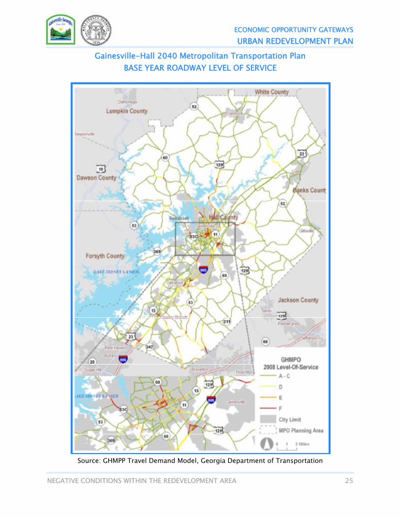
Transportation Infrastructure The Gainesville-Hall Metropolitan Planning Organization recently completed the 2040 Metropolitan Transportation Plan. The planning effort analyzed the current and projected Levels of Service (LOS) for Gainesville and Hall County. As shown on the map below, even in the base year (2008) analysis, several portions of the Urban Redevelopment Area are experiencing significant transportation service problems, in particular, Browns Bridge Road and Atlanta Highway. These gateways are among those roadways described as having “unacceptable LOS or congestion.” Hwy 52, located in SubArea 2, is described as having “noticeable traffic congestion, longer delays and unfavorable signal progression.”
ECONOMIC OPPORTUNITY GATEWAYS
URBAN REDEVELOPMENT PLAN
NEGATIVE CONDITIONS WITHIN THE REDEVELOPMENT AREA 25
Gainesville-Hall 2040 Metropolitan Transportation Plan BASE YEAR ROADWAY LEVEL OF SERVICE
Source: GHMPP Travel Demand Model, Georgia Department of Transportation

ECONOMIC OPPORTUNITY GATEWAYS
URBAN REDEVELOPMENT PLAN
NEGATIVE CONDITIONS WITHIN THE REDEVELOPMENT AREA 26
Lack of Commercial Real Estate Investment and Growth Over the past decade, the Economic Opportunity Gateway Urban Redevelopment Area has not enjoyed the private investment and growth that the remainder of Gainesville and Hall County have experienced. The performance of commercial properties varies significantly by property type (office, retail and industrial) by SubArea. However, all areas are growing at a significantly lower pace than either Gainesville or Hall County as a whole. The real estate performance data is summarized in the table on page 28. SubArea 1 - Browns Bridge Road & Atlanta Highway: There is 82,680 square feet of office space in SubArea 1, of which 18% or 14,787 square
feet, is vacant - a higher rate than either Gainesville (16%) or Hall County (16%). The average rent for office space in SubArea 1 is $8.25, approximately half of the average office rent in Gainesville ($16.58) or Hall County ($16.21). There has been no growth in office space in the past 10 years, compared to 11.6% growth in Gainesville and 16.7% growth in Hall County.
There is 3.3 million square feet of industrial space in SubArea 1, of which 31%, or 996,309 square feet, is vacant - a significantly higher rate of vacancy than in Gainesville (24%) or Hall County (17%). The average rent for industrial space is $2.60 per square foot, which is lower than either Gainesville ($2.82) or Hall County ($3.17). In SubArea 1, the amount of industrial space has grown from 3.1million square feet in 2002 to 3.3 million square feet in 2011, a growth of 5.9% which lags significantly behind industrial growth in the City (8.0%) and Hall County (19.2%) for the same period.
There is 2.0 million square feet of retail space in SubArea 1, of which 14% or 282,873 square feet, is vacant – a rate comparable with retail vacancy in Gainesville (13%) and Hall County (13%). The average rent for retail space in SubArea 1 is $9.82, slightly lower than the average retail rent in Gainesville ($11.92) or Hall County ($13.71). In SubArea 1, the amount of retail space has grown from 1.9 million square feet in 2002 to 2.0 million square feet in 2011, a growth of 3.2% which is less than half of the rate of retail growth in the City (6.8%) and significantly lower than the retail growth in Hall County (31.9%).
SubArea 2 – Highway 365 Development Corridor There is 39,136 square feet of office space in SubArea 2, of which 48% or 18,608 square
feet, is vacant - a higher rate than either Gainesville (16%) or Hall County (16%). The average rent for office space in SubArea 2 is $18.65, slightly higher than the average office rent in Gainesville ($16.58) or Hall County ($16.21). There has been no growth in office space in the past 10 years, compared to 11.6% growth in Gainesville and 16.7% growth in Hall County.
The industrial properties in SubArea 2 are performing well compared to the City and County. There is 868,671 square feet of industrial space in SubArea 2, of which 2% or 20,550 square feet, is vacant – a lower rate of vacancy than in Gainesville (24%) or Hall County (17%). The average rent for industrial space is $4.00 per square foot, which exceeds
ECONOMIC OPPORTUNITY GATEWAYS
URBAN REDEVELOPMENT PLAN
NEGATIVE CONDITIONS WITHIN THE REDEVELOPMENT AREA 27
average rents in Gainesville ($2.82) and Hall County ($3.17). In SubArea 2, the amount of industrial space has grown from 728,871 square feet in 2002 to 868,671 square feet in 2011, a growth of 19.2%, a higher rate than industrial growth in the City (8.0%) and comparable to Hall County (19.2%) for the same period.
There is 89,666 square feet of retail space in SubArea 2, of which 39% or 35,000 square feet, is vacant – a rate significantly higher than retail vacancy in Gainesville (13%) and Hall County (13%). Rent data for retail space in the area is not available. In SubArea 2, the amount of retail space has grown from 12,366 square feet in 2002 to 89,666 square feet in 2011, a significant growth of 625.1%. However, this is due in part to the very low retail square footage in 2002 and is the result of the addition of only one retail property in the SubArea.
SubArea 3 - Candler Road There are only three office properties in SubArea 3 with 22,703 square feet in total. These
properties do not have any vacancy and their average rent of $16.88 is comparable with Gainesville and Hall County. However, while office space in Gainesville has grown 11.6% and Hall County 16.7% since 2002, office space in SubArea 3 decreased 15.4%.
There is 2.3 million square feet of industrial space in SubArea 3, of which 17% or 386,705 square feet, is vacant - a lower rate of vacancy than in Gainesville (24%) but comparable to Hall County (17%). The average rent for industrial space is $2.81 per square foot which is comparable to Gainesville ($2.82) but lower than Hall County ($3.17). In SubArea 3, the amount of industrial space has grown from 1.9 million square feet in 2002 to 2.3 million in 2011, a growth of 15.0%, which exceeds the growth rate for industrial space in the City (8.0%) but lower than industrial growth in Hall County (19.2%).
There are only ten retail properties in SubArea 3. The properties have a total of 71,577 square feet of space, of which 22% is vacant which is a higher vacancy rate than either the City (13%) or the County (13%). The average rent for retail space in SubArea 3 is $10 per square foot which is slightly lower than in the City ($11.92) or County ($13.71). From 2002 to 2011, while the City’s retail inventory grew 6.8% and the County’s retail inventory grew 31.9%, SubArea retail inventory increased 16.2%.

ECONOMIC OPPORTUNITY GATEWAYS
URBAN REDEVELOPMENT PLAN
NEGATIVE CONDITIONS WITHIN THE REDEVELOPMENT AREA 28
Economic Opportunity Gateways Commercial Property Performance
SubArea 1 SubArea 2 SubArea 3 Gainesville Hall County Office Properties 19 5 3 286 383 Total RBA 82,680 39,136 22,703 2,618,406 3,238,013 Average RBA 4,352 7,827 7,568 9,155 8,454 Vacant RBA 14,787 18,608 0 409,487 509,066 % Vacant 18% 48% 0% 16% 16% Rent Min $7.37 $6.84 $16.88 $7.20 $6.84 Rent Max $12.00 $24.88 $16.88 $27.60 $27.60 Rent Avg $8.25 $18.65 $16.88 $16.58 $16.21 Avg Age 39.8 26.5 23.0 43.8 41.2 Growth 2002 RBA 82,680 39,136 26,844 2,345,669 2,737,008 2011 RBA 82,680 39,136 22,703 2,618,406 3,193,973 % Growth 0.0% 0.0% -15.4% 11.6% 16.7%
Industrial Properties 75 17 96 281 508 Total RBA 3,261,164 868,671 2,312,736 8,823,603 16,838,170 Average RBA 43,482 51,098 24,091 31,401 33,146 Vacant RBA 996,309 20,550 386,705 2,084,988 2,899,130 % Vacant 31% 2% 17% 24% 17% Rent Min $1.25 $4.00 $2.25 $1.25 $1.25 Rent Max $7.50 $4.00 $5.22 $7.50 $9.61 Rent Avg $2.60 $4.00 $2.81 $2.82 $3.17 Avg Age 25.8 14.0 19.0 27.8 23.5 Growth 2002 RBA 3,078,844 728,871 1,981,439 8,168,617 14,120,063 2011 RBA 3,261,164 868,671 2,277,950 8,823,603 16,838,170 % Growth 5.9% 19.2% 15.0% 8.0% 19.2%
Retail Properties 82 4 10 268 522 Total RBA 2,034,085 89,666 71,577 4,538,581 7,902,669 Average RBA 24,806 22,417 7,158 16,935 15,139 Vacant RBA 282,873 35,000 15,996 570,090 1,035,981 % Vacant 14% 39% 22% 13% 13% Rent Min $1.92 N/A $10.00 $1.92 $1.92 Rent Max $36.58 N/A $10.00 $36.58 $36.58 Rent Avg $9.82 N/A $10.00 $11.92 $13.71 Avg Age 28.1 21.3 25.3 32.8 27 Growth 2002 RBA 1,971,156 12,366 61,600 4,250,698 5,993,199 2011 RBA 2,034,085 89,666 71,577 4,538,581 7,902,669 % Growth 3.2% 625.1% 16.2% 6.8% 31.9% Source: CoStar

ECONOMIC OPPORTUNITY GATEWAYS
URBAN REDEVELOPMENT PLAN
NEGATIVE CONDITIONS WITHIN THE REDEVELOPMENT AREA 29
BLIGHT The Gainesville 2030 Comprehensive Plan Community Assessment noted that both Browns Bridge Road and Atlanta Highway are suffering from instances of blight and vacancies, as well as “visual chaos”. Similarly, the plan noted that SubAreas 2 and 3 also have blighted entry corridors from SR 365/I-985. While these instances of blight are on a property-by-property basis and are not yet wide-spread throughout the Urban Redevelopment Area, the City of Gainesville is concerned that these corridors, without reinvestment and revitalization, will continue to deteriorate and will lead to further blight throughout the Redevelopment Area.
Atlanta Highway
ECONOMIC OPPORTUNITY GATEWAYS
URBAN REDEVELOPMENT PLAN
COMMUNITY’S LAND USE OBJECTIVES 30
COMMUNITY’S LAND USE OBJECTIVES As previously stated above, the vision set forth in this plan is consistent with the Community’s Land Use Objectives, as set forth in the City of Gainesville 2030 Comprehensive Plan and the 2005 Hall County Comprehensive Plan. The goal of this initiative is three-fold: To grow the economy ; and provide a wider range of employment opportunities in the
area; To direct growth into developed gateways or those areas which have been designated as
future employment centers in order to provide services more efficiently and to protect the natural resources and the rural character of Hall County;
To stimulate redevelopment of aging properties without historic or aesthetic appeal in order to develop more pedestrian friendly, mixed-use projects which reflect the character of Gainesville and Hall County while protecting the City’s natural resources.
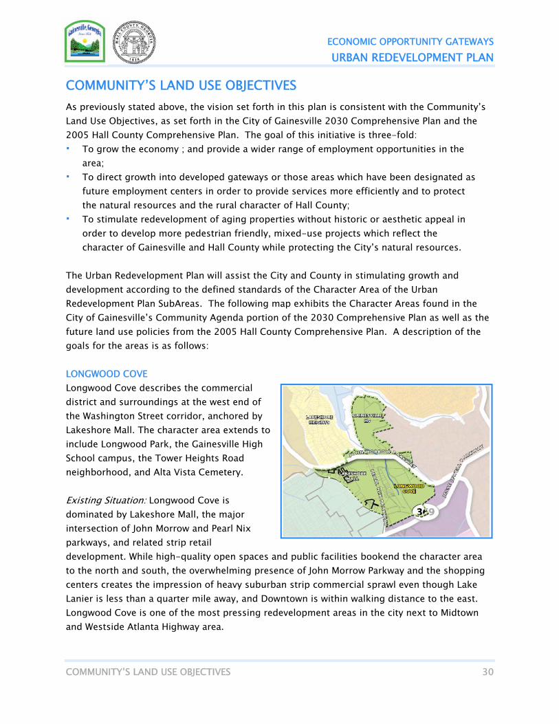
The Urban Redevelopment Plan will assist the City and County in stimulating growth and development according to the defined standards of the Character Area of the Urban Redevelopment Plan SubAreas. The following map exhibits the Character Areas found in the City of Gainesville’s Community Agenda portion of the 2030 Comprehensive Plan as well as the future land use policies from the 2005 Hall County Comprehensive Plan. A description of the goals for the areas is as follows: LONGWOOD COVE Longwood Cove describes the commercial district and surroundings at the west end of the Washington Street corridor, anchored by Lakeshore Mall. The character area extends to include Longwood Park, the Gainesville High School campus, the Tower Heights Road neighborhood, and Alta Vista Cemetery. Existing Situation: Longwood Cove is dominated by Lakeshore Mall, the major intersection of John Morrow and Pearl Nix parkways, and related strip retail development. While high-quality open spaces and public facilities bookend the character area to the north and south, the overwhelming presence of John Morrow Parkway and the shopping centers creates the impression of heavy suburban strip commercial sprawl even though Lake Lanier is less than a quarter mile away, and Downtown is within walking distance to the east. Longwood Cove is one of the most pressing redevelopment areas in the city next to Midtown and Westside Atlanta Highway area.

ECONOMIC OPPORTUNITY GATEWAYS
URBAN REDEVELOPMENT PLAN
COMMUNITY’S LAND USE OBJECTIVES 31
Area Vision: Future development or redevelopment of Longwood Cove must consider the presence of the lake and extend its character further inland. Intensification and repositioning of Lakeshore Mall as a premium retail center is a primary short-term development goal, while long-term conversion of the mall into a mixed-use “town center” is highly desirable. Other aging strip commercial centers like Washington Square and Gainesville West could be redeveloped as mixed-use with mixed-income residential to expand the city’s quality affordable housing inventory. However, taming John Morrow Parkway traffic and increasing walkability are essential for any successful residential development. Public improvements should stress increasing pedestrian access from Alta Vista Cemetery to Longwood Park and Lake Lanier, ideally by creating greenways along the Longwood Cove’s tributary creeks and John Morrow Parkway. A very long-term possibility might be the realignment of Pearl Nix Parkway north of the mall, swinging east to intersect with Century Place. This would allow restoration of Longwood Creek and conversion of its valley to new open space, essentially bringing Longwood Cove to the foot of John Morrow Parkway. The Century Place / John Morrow intersection area could be redesigned as a gateway to the Rainey Street / Oak Street / Washington Street district; while pedestrian and bike improvements to Alta Vista Road would link the historic cemetery to the new mixed-use cove district and the Bradford-Ridgewood neighborhood. BROWNS BRIDGE CORRIDOR The Browns Bridge character area roughly corresponds to the land north of Flat Creek and west of Shallowford Road, extending north to include properties fronting on (or accessed from) Browns Bridge and Shallowford. Phase 1 of Atlas Industrial Park also is included in its entirety - extends all the way to Atlanta Highway. Existing Situation: The immediate road corridor is dominated by strip commercial development heavily biased toward auto retailing and services, particularly at the western end. The Shallowford Road frontage also is strip / big-box commercial with Wal-Mart, Target and Lowes as major retail anchors. The balance of the character area is roughly split between residential neighborhoods and industrial parks including Atlas and Centennial. The neighborhood housing stock is divided comparably between 1950-1960s ranches and mobile homes, with a few apartment complexes present to the west. Other significant land uses include the Memorial Park cemetery and undeveloped parcels of forested stream valleys stretching back to McEver Road at the western fringe. Like the West Side, the area is a blend of city and county land, with commercial mostly in the city, residential mostly in the county and industrial split between the two.

ECONOMIC OPPORTUNITY GATEWAYS
URBAN REDEVELOPMENT PLAN
COMMUNITY’S LAND USE OBJECTIVES 32
Area Vision: Long-term activity center nodes should be encouraged at the Memorial Park Drive and Pearl Nix Parkway intersections. Future public space improvements could include better pedestrian facilities and connections; possible road and signal enhancements to Browns Bridge; and aesthetic guidelines. Targeted redevelopment of outdated strip commercial is encouraged. Browns Bridge Road could be a future Community Improvement District for the corridor businesses.
WESTSIDE The West Side character area is essentially the expanded Atlanta Highway corridor from the Norfolk Southern railroad line on the south to Flat Creek and Jesse Jewell Parkway on the north. It includes the entire extent of Atlanta Highway to the railroad overpass at Queen City Parkway, most of the Dorsey Street corridor, and the residential areas served by the two. Phase II of Atlas Industrial Park is included in this area as well. The West Side is marked by “island” annexation, and most of its acreage lies in Hall County. Existing Situation: The development patterns of the West Side are vestiges of highway commercial and suburban growth from the 1940s and 1950s. Almost all commercial uses along Atlanta Highway are small, locally-owned establishments blending older businesses from the early years of the corridor, with newer shops catering to the large multi-ethnic population. The neighborhoods vary from simple frame houses from the 1930s to 1950s ranch houses and newer construction, to mobile homes. Small apartment complexes, light industrial uses, and churches are scattered throughout. While much of the West Side is stable and in fair condition, there are pockets of severe blight and deteriorated housing; and most of the area lacks sidewalks and curb-and gutter paving. The overall impression is that of an area that has been in slow decline for decades but has seen some recent stabilization and revitalization by new residents, small investors and entrepreneurs determined to remake the area. Area Vision: The stakeholder vision for the West Side embraces the cultural richness of Atlanta Highway and adjoining neighborhoods by upgrading and branding the road corridor to an “International District” with coordinated pedestrian and road improvements, new landscaping, and a community-based public art program. Other considerations include better pedestrian connections to residential areas, a new central open space / community facility near the

ECONOMIC OPPORTUNITY GATEWAYS
URBAN REDEVELOPMENT PLAN
COMMUNITY’S LAND USE OBJECTIVES 33
planned Flat Creek Greenway, improved access to the Central Hall Trail, a future CID for corridor businesses, and potential annexation to address blighted areas. In addition, a gateway park marking the beginning of the International District could be created at the Jesse Jewell / Atlanta Highway intersection by redevelopment of the triangular block adjacent to West End Avenue. This gateway could take the form of an open market hall and plaza with a small lawn area at the north. Incremental mixed-use redevelopment would surround the market / park over time. The proximity to Alta Vista Road should be exploited to create a pedestrian and bike connection to Longwood Cove. At the opposite end of the corridor, long-term realignment of SR13 from Atlanta Highway to Memorial Park Drive would reduce congestion and the threat of widening, allowing Atlanta Highway to remain a walkable neighborhood main street. ECONOMIC DEVELOPMENT GATEWAYS This character area represents the industrial, warehousing and other commercial enterprises that parallel the I-985 and Norfolk-Southern railroad corridor. It includes existing business parks and areas identified for future light industrial or office park development. Existing Situation: Because many of these industrial / business parks and facilities were built over the last 30 to 40 years, they exhibit modern industrial development norms such as single-story large footprint buildings, extensive parking / loading areas, and reliance on truck transportation. Common site design patterns include campus-style master plans or light industrial subdivisions with low-rise office or office-warehouse buildings. They also are highly visible to motorists entering the city from the south and east, and therefore, act as gateways to Gainesville. The character area also features large, forested tracts of natural land and coexists with recreation and conservation landmarks like the Allen Creek Soccer Complex, the Elachee Nature Science Center, and the Chicopee Woods Agricultural Center. It reaches to the Athens Street corridor, which was once a primary entry to the city from the south but has struggled with economic disinvestment and creeping blight. It has been the subject of recent revitalization planning efforts. Area Vision: The primary vision for the area is to continue to support economic development while preserving and strengthening important natural and cultural resources. Other goals include creating a positive impression for visitors entering the city from I-985; supporting the revitalization of the Athens Street corridor; and creating better connections to the Downtown / Midtown area. Green design / sustainability standards should be considered in future modifications to site development regulations or as an overlay for the area.

ECONOMIC OPPORTUNITY GATEWAYS
URBAN REDEVELOPMENT PLAN
COMMUNITY’S LAND USE OBJECTIVES 34
East Hall County Geographic Area Lying in a crescent from Allen Creek north to the Chattahoochee River, this area features predominantly residential development with the exception of the Athens Highway and SR 365 corridors. The Highway 365 corridor features a significant industrial area taking advantage of rail access, and large areas of mixed use that are anticipated to be dominated by office and business park development. Along either side of the office/industrial corridor, residential, along with supporting commercial opportunities in the mixed-use area, are designed to supplement the primary office/warehouse development in the area. A regional retail node is planned at the intersection of Highway 365 and SR 52, based on its unique accessibility in this region. Community commercial nodes are planned for the intersections of Highway 365 and White Sulphur Road, Highway 365 and Belton Bridge Road, and Athens Highway and Gillsville Highway. Community level commercial services are also anticipated within Lula and Gillsville. The primary land uses within the Urban Redevelopment Area are: Hall County Retail Commercial - The retail commercial land use category generally includes retail uses, offices, personal services, restaurants, automotive related business, and related uses. This land use category is intended to provide retail and related uses at three levels including neighborhood retail, community retail, and regional retail. Development policies for this land use include: Regional retail is intended to serve larger areas, and include uses such as retail/grocery
superstores, large discount stores, warehouse clubs, large specialty retailers, manufacturers’ outlet stores, and department stores.
Other related but smaller uses may also occur as part of regional retail, such as restaurants
and smaller specialty stores. These smaller uses must be carefully coordinated from a site planning standpoint with the larger retail uses, particularly related to traffic access and circulation.
Regional retail uses should meet quality standards related to site layout, building
configuration, materials, massing, shape, height, landscaping, signage, parking lot aesthetic and functional design, vehicular and pedestrian circulation, trash removal, lighting, storm water management, environmental protection, and others as discussed below. Regional retail should be subject for land use impact review and mitigation for such issues.
ECONOMIC OPPORTUNITY GATEWAYS
URBAN REDEVELOPMENT PLAN
COMMUNITY’S LAND USE OBJECTIVES 35
Regional retail should be encouraged only where they have a strong network of interstate or arterial roadways to provide access.
Regional and community retail should be approved only upon a demonstration that
adequate public facilities exist or will be established by the time of opening. Circulation systems should be designed to efficiently facilitate traffic flow, yet designed to
discourage speeds in volumes that impede pedestrian activity and safety. Common or shared access points are encouraged. Access management principles and techniques should be incorporated in the site plan design and development phase.
Adequate parking should be provided, but excessive parking is discouraged. The visual
impacts of parking should be minimized with interior landscape islands, and through dividing parking areas into groupings. The edges of parking lots should be screened through landscaping or other methods.
The location of service areas and mechanical equipment should be considered as part of the
overall site design. Service areas and mechanical equipment should be screened from public view.
A master sign plan should be prepared illustrating the location, type, size, and material of
signage. Lighting should be designed to avoid spill over onto adjacent properties, including the use
of cut off shields or similar features. Hall County Industrial - The industrial land use category includes a wide range of office, business, light industrial, manufacturing, research and development uses, and support commercial uses. Industrial uses involve a significant number of vehicle trips, particularly in the morning and evening peak hours. They also involve a mixture of automobile and truck traffic. They also may prefer rail access and are typically located near major highway facilities in areas naturally buffered or away from residential areas. Development policies for this land use include: The appropriate land uses in this category include manufacturing, processing, mining, and
major warehousing and distribution facilities.
Industrial uses should meet quality standards designed to mitigate negative impacts on any surrounding non-industrial uses.

ECONOMIC OPPORTUNITY GATEWAYS
URBAN REDEVELOPMENT PLAN
COMMUNITY’S LAND USE OBJECTIVES 36
The most desired form of industrial uses is that of an “employment campus” with an
integration and coordination of uses, although freestanding industrial uses are also anticipated.
Industrial uses should be located within easy access to an arterial roadway and the
interstate highway system, and take advantage of rail locations that are compatible with surrounding development.
Employer transportation programs are encouraged to reduce the percentage of trips made
by single-occupancy vehicles. Vehicular access should be designed to maximize efficiency and minimize negative impacts
on the level of service of adjacent roads. On-site amenities such as walking trails and eating areas are encouraged.
Accessory uses designed to serve on-site employees, such as restaurants, day care centers,
and personal services are also encouraged but only when integrated with and subordinate to the primary business uses.
Hall County Mixed Use - The category of mixed use is intended to create a land use environment where compatible land use can be located in close proximity to each other. This can be desirable for several reasons. First, allowing compatible and mutually supportive uses in close proximity to each other can reduce the length and amount of automobile trips on the road system, thereby helping to reduce congestion and negative environmental impacts caused by automobile traffic. Second, a well-planned mixture of land uses and help to create a positive transition of land uses, with less intensive uses serving as a transition between more intensive uses and single family neighborhoods. At the same time, the idea of mixed uses should not be interpreted as allowing for the intrusion of incompatible land uses into single-family neighborhoods that create negative land use impacts. On the contrary, mixed use is intended, in part, as a tool help protect neighborhoods. Development policies for this land use include: The dominant use in the mixed-use category is intended to be office/business park use.
Retail uses are intended to be supportive of the job-based uses. Residential uses are also intended to be supportive of and in response to the establishment of job-based uses. Residential uses are only anticipated in those mixed use areas in the Gainesville sewer service districts, and the percentage of residential development may be greater on certain properties based on surrounding land uses. While not every individual development must meet the ratio guidelines identified above, the intent of this land use category is to provide for the mutually supportive mixture of land uses with business uses being the primary use.

ECONOMIC OPPORTUNITY GATEWAYS
URBAN REDEVELOPMENT PLAN
COMMUNITY’S LAND USE OBJECTIVES 37
Because this land use category is intended in part as a transition between more intensive uses and single-family uses, all sides of a building open to view to the public should display a similar level of architectural quality. Building materials should be limited to brick, masonry, stucco, wood, fiber cement siding, wood shingle, wood siding, cultured stone, or similar materials.
Buildings and sites should be designed to emphasize pedestrian orientation. A
coordinated pedestrian system should be provided throughout the development including connections between uses on the site, in between the site, and adjacent properties and rights-of-way where appropriate.
Circulation systems should be designed to efficiently facilitate traffic flow, yet designed
to discourage speeds in volumes that impede pedestrian activity and safety. Common or shared access points are encouraged.
Adequate parking should be provided, but excessive parking is discouraged. The visual
impacts of parking should be minimized with interior landscape islands, and through dividing parking areas into groupings. The edges of parking lots should be screened through landscaping or other methods.
The location of service areas and mechanical equipment should be considered as part of
the overall site design. Service areas and mechanical equipment should be screened from public view.
A master sign plan should be prepared illustrating the location, type, size, and material
of signage. Lighting should be designed to avoid spill over onto adjacent properties, including the
use of cut off shields or similar features.

ECONOMIC OPPORTUNITY GATEWAYS
URBAN REDEVELOPMENT PLAN
COMMUNITY’S LAND USE OBJECTIVES 38
City of Gainesville 2030 Comprehensive Plan CHARACTER AREAS

ECONOMIC OPPORTUNITY GATEWAYS
URBAN REDEVELOPMENT PLAN
COMMUNITY’S LAND USE OBJECTIVES 39
Hall County 2005 Comprehensive Plan FUTURE LAND USE MAP

ECONOMIC OPPORTUNITY GATEWAYS
URBAN REDEVELOPMENT PLAN
PLAN TO LEVERAGE PRIVATE RESOURCES FOR REDEVELOPMENT 40
DESCRIPTION OF PARCELS TO BE ACQUIRED This proposed redevelopment area requires no parcels to be acquired at this time. Should circumstances change making property acquisition probable or necessary, this plan will be amended to reflect those changes.
STRUCTURES TO BE DEMOLISHED OR REHABILITATED Because the City of Gainesville and Hall County anticipate redevelopment to be led by private developers responding to market conditions, it is impossible to determine what, if any, structures will be demolished or rehabilitated at this time. As market conditions change, it is anticipated that some obsolete commercial developments in the Urban Redevelopment Area may be demolished in order to build new structures that are better suited to respond to and capture market demand, particularly commercial developments to provide new employment opportunities and new housing developments to provide a broader range of housing options for the area. The City and County will adhere to all current regulations regarding building permitting and redevelopment guidelines.
PLAN TO LEVERAGE PRIVATE RESOURCES FOR REDEVELOPMENT The City of Gainesville and Hall County have devoted considerable resources to planning initiatives and has committed all of the tools at their disposal to encourage redevelopment and growth in the Urban Redevelopment Area. In particular, the City of Gainesville and Hall County have invested significantly in the development of business parks throughout the Urban Redevelopment Area to encourage business retention and relocation to those areas. The City and County have defined the Urban Redevelopment Area as being those areas that they would like future business growth to occur. The City and County have committed to expand infrastructure to these areas with the intention that the investment will draw growth in the form of employment, an increased tax base, and other economic benefits which will far outpace the initial investment from the City and County.

ECONOMIC OPPORTUNITY GATEWAYS
URBAN REDEVELOPMENT PLAN
NEEDED PUBLIC INFRASTRUCTURE 41
STRATEGY FOR RELOCATING DISPLACED RESIDENTS The City of Gainesville and Hall County have determined that the development and implementation of a relocation strategy is not necessary at this time. The Economic Opportunity Gateways Urban Redevelopment Plan is focused primarily on commercial properties, and therefore, it is assumed that the relocation of residents will not be required. In the event displacement of residents becomes necessary at a later date, the Urban Redevelopment Plan will be amended to incorporate a strategy/plan for relocating displaced residents in accordance will all local and State statutory requirements.
COVENANTS AND RESTRICTIONS TO BE PLACED ON PROPERTIES No covenants or restrictions will be placed on properties at this time.
NEEDED PUBLIC INFRASTRUCTURE The deficiencies in the public infrastructure in the Urban Redevelopment Area, particularly those related to transportation, have been well-documented in several previous studies as noted above. The City of Gainesville and Hall County are commited to working together with GDOT to continue addressing these deficiencies. Three planned projects shown on the map below, could significantly improve the transportation deficiencies throughout the Redevelopment Area: Atlanta Highway Widening SR 60 Widening Jesse Jewell/John Morrow Intersection Improvement
In addition, the City will continue to invest in pedestrian and bicycle amenities such as multiuse trails. On the map below, there are several planned projects, two of which would be located in the Urban Redevelopment Area: Flat Creek Route Palmour Drive Connector Atlanta Highway Greenway

ECONOMIC OPPORTUNITY GATEWAYS
URBAN REDEVELOPMENT PLAN
NEEDED PUBLIC INFRASTRUCTURE 42
City of Gainesville 2030 Comprehensive Plan PLANNED PROJECTS
Gainesville-Hall MPO 2040 Metropolitan Transportation Plan

ECONOMIC OPPORTUNITY GATEWAYS
URBAN REDEVELOPMENT PLAN
NEEDED PUBLIC INFRASTRUCTURE 43
Gainesville-Hall 2040 Metropolitan Transportation Plan EXISTING AND PROPOSED MULTIUSE TRAILS

ECONOMIC OPPORTUNITY GATEWAYS
URBAN REDEVELOPMENT PLAN
STRATEGY FOR IMPLEMENTING THE PLAN 44
STRATEGY FOR IMPLEMENTING THE PLAN Upon approval of this document, the Gainesville City Council and the Hall County Board of Commissioners will exercise their redevelopment powers (as authorized in O.C.G.A §36-61-17) to implement the plan jointly or individually according to their current service delivery strategy or jurisdictional boundary. Implementation Schedule: Review of Plan by Gainesville Community Development Department June, 2012 Review of Plan by Gainesville City Council June, 2012 Review of Plan by Hall County June, 2012 Finalize Plan June, 2012 City of Gainesville Public Hearing July 3, 2012 City of Gainesville Adopt Urban Redevelopment Plan July 3, 2012 Hall County Public Hearing July 12, 2012 Hall County Adopt Urban Redevelopment Plan July 12, 2012 Apply to DCA for Opportunity Zone Designation August, 2012

ECONOMIC OPPORTUNITY GATEWAYS
URBAN REDEVELOPMENT PLAN
APPENDICES 45
APPENDICES Appendix A: Resolutions Adopting Urban Redevelopment Plan City of Gainesville Hall County Appendix B: Map of Urban Redevelopment Area Appendix C: Current Zoning of Urban Redevelopment Area Appendix D: Redevelopment Plan Amendment Worksheet Appendix E: Public Hearing Documentation

ECONOMIC OPPORTUNITY GATEWAYS
URBAN REDEVELOPMENT PLAN
APPENDIX A: RESOLUTION ADOPTING URBAN REDEVELOPMENT PLAN 46
APPENDIX A: RESOLUTIONS ADOPTING URBAN REDEVELOPMENT PLAN


ECONOMIC OPPORTUNITY GATEWAYS
URBAN REDEVELOPMENT PLAN
APPENDIX B: MAP OF URBAN REDEVELOPMENT AREA 51
APPENDIX B: MAP OF URBAN REDEVELOPMENT AREA Large Context Map Detail SubArea 1 - Browns Bridge Road & Atlanta Highway Detail SubArea 2 - Highway 365 Development Corridor Detail SubArea 3 - Candler Road

ECONOMIC OPPORTUNITY GATEWAYS
URBAN REDEVELOPMENT PLAN
APPENDIX B: MAP OF URBAN REDEVELOPMENT AREA 52
Economic Opportunity Gateways Urban Redevelopment Area CONTEXT MAP
SubArea 2 – Highway 365
Development Corridor
SubArea 1 – Browns Bridge Road & Atlanta Highway
SubArea 3 – Candler Road
LEGEND
Hall County
Incorporated
URA (County)
URA (City)

ECONOMIC OPPORTUNITY GATEWAYS
URBAN REDEVELOPMENT PLAN
APPENDIX B: MAP OF URBAN REDEVELOPMENT AREA 53
Economic Opportunity Gateways Urban Redevelopment Area BROWNS BRIDGE ROAD & ATLANTA HIGHWAY
LEGEND
Hall County
Incorporated
URA (County)
URA (City)

ECONOMIC OPPORTUNITY GATEWAYS
URBAN REDEVELOPMENT PLAN
APPENDIX B: MAP OF URBAN REDEVELOPMENT AREA 54
Economic Opportunity Gateways Urban Redevelopment Area HIGHWAY 365 CORRIDOR
LEGEND
Hall County
Incorporated
URA (County)
URA (City)

ECONOMIC OPPORTUNITY GATEWAYS
URBAN REDEVELOPMENT PLAN
APPENDIX B: MAP OF URBAN REDEVELOPMENT AREA 55
Economic Opportunity Gateways Urban Redevelopment Area CANDLER ROAD
LEGEND
Hall County
Incorporated
URA (County)
URA (City)

ECONOMIC OPPORTUNITY GATEWAYS
URBAN REDEVELOPMENT PLAN
APPENDIX C: ZONING MAP OF URBAN REDEVELOPMENT AREA 56
APPENDIX C: CURRENT ZONING OF URBAN REDEVELOPMENT AREA

ECONOMIC OPPORTUNITY GATEWAYS
URBAN REDEVELOPMENT PLAN
APPENDIX C: ZONING MAP OF URBAN REDEVELOPMENT AREA 57
Economic Opportunity Gateways Urban Redevelopment Area CURRENT ZONING

ECONOMIC OPPORTUNITY GATEWAYS
URBAN REDEVELOPMENT PLAN
APPENDIX D: REDEVELOPMENT PLAN AMENDMENT WORKSHEET 58
APPENDIX D: REDEVELOPMENT PLAN AMENDMENT WORKSHEET Date: The following is a checklist of items to be considered by City and County officials when reviewing the Gainesville Economic Opportunity Gateways Urban Redevelopment Plan. These items represent required plan components as defined in the Official Code of Georgia Annotated Section 36-61-4 and 36-61-7. _____Statement that the Economic Opportunity Gateways Urban Redevelopment Plan is consistent with the comprehensive plan. (See: p.7-14) _____Clearly Defined Boundaries of the proposed Redevelopment Area (need not be contiguous). (See: p.14-18) _____Explanation of negative conditions in the area necessitating redevelopment. (See: p.19-29) _____Description of the City and County’s land use objectives for the area (types of uses, building requirements, zoning changes, development densities, etc.). (See: p.30-39) _____Description of land parcels to be acquired and structures to be demolished or rehabilitated. (See: p.40) _____Strategy for leveraging private resources to aid in redevelopment of the area. (See: p.40) _____Strategy for relocating any displaced residents. (See: p.41) _____Any covenants or restrictions to be placed on properties in the redevelopment area in order to implement the plan. (See: p.41) _____Public infrastructure to be provided (i.e. transportation, water, sewer, sidewalks, lighting, streetscapes, public recreational space, parking, etc.) to support redevelopment of the area. (See: p.41-43) _____Strategy for implementing the plan. (See: p.44)

ECONOMIC OPPORTUNITY GATEWAYS
URBAN REDEVELOPMENT PLAN
APPENDIX E: PUBLIC HEARING DOCUMENTATION 59
APPENDIX E: PUBLIC HEARING DOCUMENTATION (Copy of Public Hearing Advertisement and Minutes to be added.)