eden district council employment land allocations · prepare the employment land allocations dpd...
TRANSCRIPT

Eden District Council
Employment Land Allocations
Supporting information for Habitats Regulations Assessment
AMEC Environment & Infrastructure UK Limited
June 2013

© AMEC Environment & Infrastructure UK Limited June 2013 Doc Reg No. S33648rr014i2
Copyright and Non-Disclosure Notice The contents and layout of this report are subject to copyright owned by AMEC
(©AMEC Environment & Infrastructure UK Limited 2013). save to the extent that
copyright has been legally assigned by us to another party or is used by AMEC under
licence. To the extent that we own the copyright in this report, it may not be copied
or used without our prior written agreement for any purpose other than the purpose
indicated in this report.
The methodology (if any) contained in this report is provided to you in confidence
and must not be disclosed or copied to third parties without the prior written
agreement of AMEC. Disclosure of that information may constitute an actionable
breach of confidence or may otherwise prejudice our commercial interests. Any third
party who obtains access to this report by any means will, in any event, be subject to
the Third Party Disclaimer set out below.
Third-Party Disclaimer Any disclosure of this report to a third party is subject to this disclaimer. The report
was prepared by AMEC at the instruction of, and for use by, our client named on the
front of the report. It does not in any way constitute advice to any third party who is
able to access it by any means. AMEC excludes to the fullest extent lawfully
permitted all liability whatsoever for any loss or damage howsoever arising from
reliance on the contents of this report. We do not however exclude our liability (if
any) for personal injury or death resulting from our negligence, for fraud or any other
matter in relation to which we cannot legally exclude liability.
Document Revisions
No. Details Date
1 Draft for Client Review 21.05.13
2 Draft for consultation 14.06.13
© AMEC Environment & Infrastructure UK Limited June 2013 Doc Reg No. S33648rr014i2
Report for
Paul Fellows, Planning Policy Manager
Mansion House
Penrith
Cumbria CA11 7YG
Main Contributors
Mike Frost
Issued by
…………………………………………………………
Mike Frost
Approved by
…………………………………………………………
Deborah Starkings
AMEC Environment & Infrastructure UK Limited
Canon Court, Abbey Lawn, Abbey Foregate,
Shrewsbury SY2 5DE, United Kingdom
Tel +44 (0) 1743 342 000
Fax +44 (0) 1743 342 010
Doc Reg No. S33648rr014i2
h:\projects\33648 eden district sa & hra\docs\hra\rr014i2.doc
Eden District Council
Employment Land Allocations
Supporting information for Habitats Regulations Assessment
AMEC Environment & Infrastructure UK Limited
June 2013
In accordance with an environmentally responsible approach,
this document is printed on recycled paper produced from 100%
post-consumer waste, or on ECF (elemental chlorine free) paper

iv
© AMEC Environment & Infrastructure UK Limited June 2013 Doc Reg No. S33648rr014i2

v
© AMEC Environment & Infrastructure UK Limited June 2013 Doc Reg No. S33648rr014i2
Contents
1. Introduction 1
1.1 The Employment Plan 1
1.2 Habitats Regulations Assessment (HRA) 1
1.3 This Report 1
2. Approach 3
2.1 Overview 3
2.2 Guidance 4
2.3 Assessing the emerging plan 4
2.3.1 Baseline data collection 5
2.3.2 Assessment of Allocations 5
2.3.3 Assessment of Policies 6
2.3.4 Addressing Uncertainty 6
3. Baseline 8
3.1 Baseline summary 8
4. Assessment 20
4.1 Assessment of allocations 20
4.2 Allocations with potential for significant effects 27
4.2.1 Potential effects 28
4.2.2 Effects 32
4.3 Assessment of draft policies 32
4.4 In combination effects 34
4.4.1 Within-plan effects 34
4.4.2 Between-plan effects 34
4.5 Summary 35
Table 3.1 European sites within 15km of Eden District (* = priority feature) 9
Table 4.1 Summary of potential effects of allocations on European sites due to scale and location 22
Table 4.2 Summary of European sites within study area that will not be affected by the proposals 27
Table 4.3 Water Courses with the Ranunculion fluitantis and Callitricho-Batrachion Vegetation 30
Table 4.4 Alluvial Forests 30
Table 4.5 White-Clawed Crayfish 31
Table 4.6 Fish Species (Sea lamprey, Brook lamprey, River lamprey, Twaite shad, Atlantic salmon, Bullhead, Allis Shad) 31

vi
© AMEC Environment & Infrastructure UK Limited June 2013 Doc Reg No. S33648rr014i2
Table 4.7 Otter 32
Table 4.8 Assessment of draft policies 33
Table 4.9 Plans with potential ‘in combination’ effects 34
Figure 3.1 SACs in and near Eden After Page 19 Figure 3.2 SPAs in and near Eden After Page 19 Figure 3.3 Ramsar sites in and near Eden After Page 19 Figure A1 Penrith Employment Allocations and European sites Appendix A Figure A2 Appleby Employment Allocations and European sites Appendix A Figure A3 Alston Employment Allocations and European sites Appendix A Figure A4 Kirkby Stephen Employment Allocations and European sites Appendix A Figure A5 Tebay Employment Allocations and European sites Appendix A Figure A6 Brough Employment Allocations and European sites Appendix A Appendix A Large-scale allocation figures

1
© AMEC Environment & Infrastructure UK Limited June 2013 Doc Reg No. S33648rr014i2
1. Introduction
1.1 The Employment Plan
Eden District Council (EDC) is currently exploring options for the allocation of employment sites within the
district, which will form part of the Local Plan (LP) for Eden. EDC has published a consultation document
(Employment: Preferred Sites and Policies) which sets out the employment policies and proposals that are
proposed for the draft Local Plan for Eden District.
The components of the LP must undergo a number of statutory environmental assessments including Sustainability
Appraisal (SA) and Strategic Environmental Assessment (SEA); these ensure that the plan provides for a high level
of protection of the environment and contribute to the integration of environmental considerations into the
preparation and adoption of the plan. One such assessment is Habitats Regulations Assessment (HRA) which is
required by the Conservation of Habitats and Species Regulations 20101 (the ‘Habitats Regulations’).
1.2 Habitats Regulations Assessment (HRA)
Regulation 61 of the Conservation of Habitats and Species Regulations 2010 (as amended) (the ‘Habitats
Regulations’) requires that competent authorities assess the potential impacts of plans and programmes on the
Natura 2000 network of European protected sites2 to determine whether there will be any ‘likely significant effects’
(LSE) on any European site as a result of the Plan’s implementation (either on its own or ‘in combination’ with
other plans or projects); and, if so, whether these effects will result in any adverse effects on the site’s integrity.
The process by which the impacts of a Plan or Programme are assessed against the conservation objectives of a
European site is known as Habitats Regulations Assessment (HRA)3. Eden District Council has a statutory duty to
prepare the Employment Land Allocations DPD and therefore is the Competent Authority for a HRA.
1.3 This Report
Although the LP and its component plans must be subject to HRA, this is ultimately a test that the final document
must pass; as such, there is no statutory requirement for the phases of the plan development (Issues and Options
1 The Conservation of Habitats and Species Regulations 2010 transposes Council Directive 92/43/EEC on the Conservation of
natural habitats and of wild fauna and flora into UK law.
2 Strictly, a European Site is any classified Special Protection Area (SPA) or any Special Area of Conservation (SAC) from the
point at which the European Commission and the UK Government agree the site as a ‘Site of Community Importance’ (SCI).
However, the provisions of the Habitats Regulations and Article 4(4) of Directive 2009/147/EC (the ‘new wild birds
directive’) are also applied (respectively) to candidate SACs (cSACs) and potential SPAs (pSPAs); and as a matter of
Government policy for possible SACs (pSACs) and listed Ramsar Sites for the purpose of considering development proposals
affecting them (NPPF para. 18)). As such, pSPAs, pSACs and Ramsar Sites must also be considered by any HRA. Within this
report “European site” is used as a generic term for all of the above designated sites.
3 ‘Appropriate Assessment’ has been historically used as an umbrella term to describe the process of assessment as a whole.
The whole process is now more usually termed ‘Habitats Regulations Assessment’ (HRA), and ‘Appropriate Assessment’ is
used to indicate a specific stage within the HRA.

2
© AMEC Environment & Infrastructure UK Limited June 2013 Doc Reg No. S33648rr014i2
and any subsequent draft stages)) to undergo HRA themselves. However, as with SEA or SA it is accepted best
practice for the HRA to be run as an iterative process alongside the policy and plan development, with the
emerging proposals or policies continually assessed for their possible effects on European sites and modified as
necessary to help ensure that the subsequently developed policies and proposals do not result in significant effects
or adverse effects.
AMEC has been commissioned by EDC (the Competent Authority for the LP) to undertake the data collection and
interpretation required to support their HRA of the Employment: Preferred Sites and Policies, and to determine
whether any aspects of the emerging document (alone or in-combination) could have significant or adverse effects
on the integrity of any European sites.
This report summarises AMEC’s review and assessment of the preliminary Employment: Preferred Sites and
Policies document against the conservation objectives of European sites that may be affected by its
implementation, and provides recommendations for the future development of the document. It is not an
HRA of the final document and so any conclusions are preliminary and subject to further review and
consultation as the emerging document is refined.

3
© AMEC Environment & Infrastructure UK Limited June 2013 Doc Reg No. S33648rr014i2
2. Approach
2.1 Overview
The HRA determines whether there will be any ‘likely significant effects’ (LSE) on any European site as a result of
the Plan’s implementation (either on its own or ‘in combination’ with other plans or projects) and, if so, whether
these effects will result in any adverse effects on the site’s integrity. The current European Commission guidance4
details a four stage process for HRA, although not all stages will be necessarily required:
Box 1 Stages of Habitats Regulations Assessment
Stage 1 – Screening:
This stage identifies the likely impacts upon a European Site of a project or plan, either alone or in combination with other projects or plans, and determines whether these impacts are likely to be not significant (inconsequential), significant or whether this is uncertain.
HABITATS REGULATIONS ASSESSMENT
(HRA)
Stage 2 – Appropriate Assessment:
Where there are likely significant effects, or the effects are uncertain, the plan should be subject to appropriate assessment. This stage considers the impacts of the Plan or project on the integrity of the relevant European Sites, either alone or in combination with other projects or plans, with respect to the sites’ structure and function and their conservation objectives. Where there are adverse impacts, it also includes an assessment of the potential mitigation for those impacts.
Stage 3 – Assessment of alternative solutions:
Where adverse impacts are predicted, this stage examines alternative ways of achieving the objectives of the project or Plan that avoid adverse impacts on the integrity of European Sites.
Stage 4 – Assessment where no alternative solutions exist and where adverse impacts remain:
This stage assesses compensatory measures where it is deemed that the project or Plan should proceed for imperative reasons of overriding public interest (IROPI). The guidance does not deal with the assessment of IROPI.
The approach summarised in Box 1 works well at the project-level where the scheme design is usually established
and possible effects on European sites can be assessed (usually quantitatively) using a linear stepwise process.
In contrast, this stepwise approach is less easily applied to the iterative process that is preferred for strategic plans
and policy documents. This is because the strategic-HRA process is not so much an assessment of an established
scheme to determine ‘an answer’ (although this is the ultimate end-point of HRA), but rather an assessment of a
still-evolving plan that allows potential effects to be identified (and so avoided) at an early stage. Also, from a
strict procedural perspective, since the HRA is essentially a test that must be passed the ‘screening’ and
‘appropriate assessment’ stages can only be formally applied to the finalised plan, and not to its various phases or
iterations (e.g. Issues and Options). It is therefore important to recognise that the strategic HRA is as much about
guiding the development of the plan (and demonstrating that this has been done) as it is about (ultimately) assessing
its effects.
4 Methodological guidance on the provisions of Article 6(3) and (4) of the Habitats Directive 92/43/EEC (EC 2002).

4
© AMEC Environment & Infrastructure UK Limited June 2013 Doc Reg No. S33648rr014i2
Despite this, the principles of ‘screening’ or ‘appropriate assessment’ can still be used to identify those policies or
allocations that have the potential to significantly or adversely affect a European site if not appropriately framed,
and to test the emerging policies against the requirements of the Habitats Regulations. This is the approach that has
been used in completing this HRA supporting study, with the principles of ‘screening’ applied to the emerging
policy options and allocations in order to direct and shape the option and hence policy (etc.) development so that
significant or adverse effects are avoided. This process also identifies those areas where the evidence base is
lacking or where further study is required to confirm that there will be no significant or adverse effects.
2.2 Guidance
In addition to AMEC’s experience of plan-level HRAs, we have also taken into account the following guidance
during the assessment process:
• English Nature (August 2006) Draft Guidance – The Assessment of Regional Spatial Strategies and
Sub-regional strategies under the provisions of the Habitats Regulations, David Tyldesley Associates
for Natural England, Peterborough;
• Department for Communities and Local Government (August 2006) Planning for the Protection of
European Sites: Appropriate Assessment. Guidance for Regional Spatial Strategies and Local
Development Documents, DCLG, London;
• Scott Wilson, Levett-Therivel, Treweek Environmental Consultants and Land Use Consultants
(August 2006) Appropriate Assessment of Plans, Scott Wilson et al.
2.3 Assessing the emerging plan
The HRA must be completed for the final submission of the plan; there is no statutory requirement for the phases of
the plan development (Issues and Options and any subsequent draft consultation stages) to undergo HRA
themselves although it is best practice for the HRA to be run as an iterative process alongside the policy and plan
development. For the purposes of HRA, the Employment Plan has two main aspects that require assessment:
• the employment site allocations (can development in the proposed locations be accommodated without
significant or adverse effects on any European sites?);
• the policies for determining planning applications and any supporting text clarifying or amplifying the
proposed allocations or policies (can the policies be delivered without significant or adverse effects on
any European sites, or can the policies be used to ensure that allocations can be delivered without
significant or adverse effects?).
These aspects are determined through the plan development, with various options for site allocations or policies
developed, examined and refined during the plan development.

5
© AMEC Environment & Infrastructure UK Limited June 2013 Doc Reg No. S33648rr014i2
2.3.1 Baseline data collection
European sites
The plan will not influence development outside the boundaries of Eden District, and any effects are unlikely to
extend significantly beyond the boundaries, except possibly in combination with other plans. As a result, all
European sites that are within 15km or directly downstream of the district are included in the baseline data
collection, with sites beyond this considered on a case-by-case basis depending on the site interest features and how
the plan would function. This is considered to be a suitably precautionary approach that has important advantages
due to the number of options and hence the benefits of a consistent approach across all options5.
Data on the interest features, sensitivities, vulnerabilities, condition assessments, conservation objectives and
management plans for the European sites was obtained from Natural England and the JNCC.
In combination plans
The plans identified by the SA have also provided the basis for the assessment of ‘in combination’ effects.
2.3.2 Assessment of Allocations
One of the purposes of the plan is to identify and allocate specific sites to meet the identified employment needs.
Potential sites were identified through a ‘call for sites’ process. All of the submitted sites were then subjected to a
series of assessments (including the principles of HRA) to assess their suitability.
The HRA component of the assessment is undertaken by determining those European sites that could be affected
by an allocation, reviewing the European site interest features, their vulnerabilities and sensitivities, and identifying
any reasonable impact pathways by which the specific allocations could affect these. The sites submitted were
therefore assessed in detail to identify those sites that are likely to be:
• unacceptable from an HRA perspective (i.e. unavoidable significant or adverse effects on a European
site likely); or
• which may require additional assessment or investigation; or
• which may require specific mitigation to be identified and included in the plan to ensure no significant
or adverse effects are likely if the site is developed.
5 ‘Arbitrary’ buffers are not generally appropriate for HRA. However, as distance is a strong determinant of the scale and
likelihood of effects the considered use of a suitably precautionary search area as a starting point for the screening (based on a
thorough understanding of both the DPD and the European site interest features) has some important advantages. Using
buffers allows the systematic identification of European sites using GIS, so minimising the risk of sites or features being
overlooked, and also ensures that sites where there are no reasonable impact pathways can be quickly and transparently
excluded from any further screening or assessment. When assessing multiple allocations it also has the significant advantage
of providing a consistent point of reference for consultees following the assessment process, and the ‘screening’ can therefore
focus on the assessment of effects, rather than on explaining why certain sites may or may not have been considered in relation
to a particular allocation.

6
© AMEC Environment & Infrastructure UK Limited June 2013 Doc Reg No. S33648rr014i2
This assessment is used to help determine the Preferred Options. The Preferred Options are then subject to the
same assessment and review process, to ensure that they remain acceptable from an HRA perspective, and / or to
refine any mitigation or caveats that must be incorporated into the final plan. This process is repeated for the final
plan, although at this point it is necessary to reach a formal conclusion (i.e. no significant effects or no adverse
effects).
It should be noted that the absolute quantum of development across the county is not considered in detail since
these are determined by higher tier planning documents that have themselves been subject to HRA, in which the
issues associated with the quantum of development have been specifically considered (e.g. water resources).
However, the distribution of development is considered within the HRA of the plan to ensure that the development
is appropriately sited with respect to European sites and their interest features.
2.3.3 Assessment of Policies
There are certain ‘types’ of policy which cannot have a significant effect on any European site simply because they
do not provide a mechanism by which such an effect could occur. Accordingly, policies with the following
characteristics are generally unlikely to result in significant effects:
• Non-development policies: policies that will not lead to development themselves as they relate to
design or other qualitative criteria for development;
• Unknown location development issues/ options: that make provision for a specific type of
development but the location of the development is yet to be selected are unlikely to have significant
effect, unless the type/ quantum of development provided for in the policy cannot be accommodated
without potentially affecting a European Site. This is because making provision for a type/ quantum
of development at this strategic level will not itself have any effect on a European Site, and it should
not be assumed that developments will be sited such that they will have a LSE on European sites since
normal development controls (and the requirements for site- or project-level HRA) would prevent or
mitigate this;
• Protective policies: policies that specifically steer development away from European Sites and
associated sensitive areas e.g. excluding development from certain areas;
• Biodiversity policies: policies that specifically protect the natural environment;
• Enhancement policies: policies that specifically enhance the natural, built or historic environment
where proposed measures are not likely to result in adverse effects upon European Sites.
However, it is important to note that policies will often set the framework for the delivery of allocation sites, and
therefore it is critical that these policies provide adequate protection for European sites.
2.3.4 Addressing Uncertainty
Although the plan will be spatially-specific, there will inevitably be a number of uncertainties which cannot be
fully investigated at this stage. Indeed, for some allocations it may only be possible to fully assess any potential
effects at the pre-project planning stage when certain specific details are known; for example, construction work

7
© AMEC Environment & Infrastructure UK Limited June 2013 Doc Reg No. S33648rr014i2
near an SAC clearly has the potential for significant or adverse effects that cannot be easily ‘avoided’ at the
strategy level as the details of construction are unknown. However, it is likely, based on experience, that most
potential construction effects could almost certainly be avoided or mitigated at the project-level using standard
best-practice. In these cases where measures, such as mitigation, are established and known to be typically
successful, it is considered appropriate to assume that this will be the case at the pre-project planning and project
stages.
Usually with strategy-level HRAs uncertainty is addressed by either abandoning an option / allocation (the primary
approach) or by including caveats and avoidance measures/mitigation within the policy wording to help ensure that
adverse effects will not occur. However, current guidance indicates that in some instances it is appropriate and
acceptable for assessment to be undertaken ‘down-the-line’ at a lower tier in the planning hierarchy, if:
• the higher tier plan appraisal cannot reasonably predict the effects on a European site in a meaningful
way; whereas
• the lower tier plan, which will identify more precisely the nature, scale or location of development,
and thus its potential effects, retains enough flexibility within the terms of the higher tier plan over the
exact location, scale or nature of the proposal to enable an adverse effect on site integrity to be
avoided; and
• Habitats Regulations Appraisal of the Plan at the lower tier is required as a matter of law or
Government policy.
8
© AMEC Environment & Infrastructure UK Limited June 2013 Doc Reg No. S33648rr014i2
3. Baseline
3.1 Baseline summary
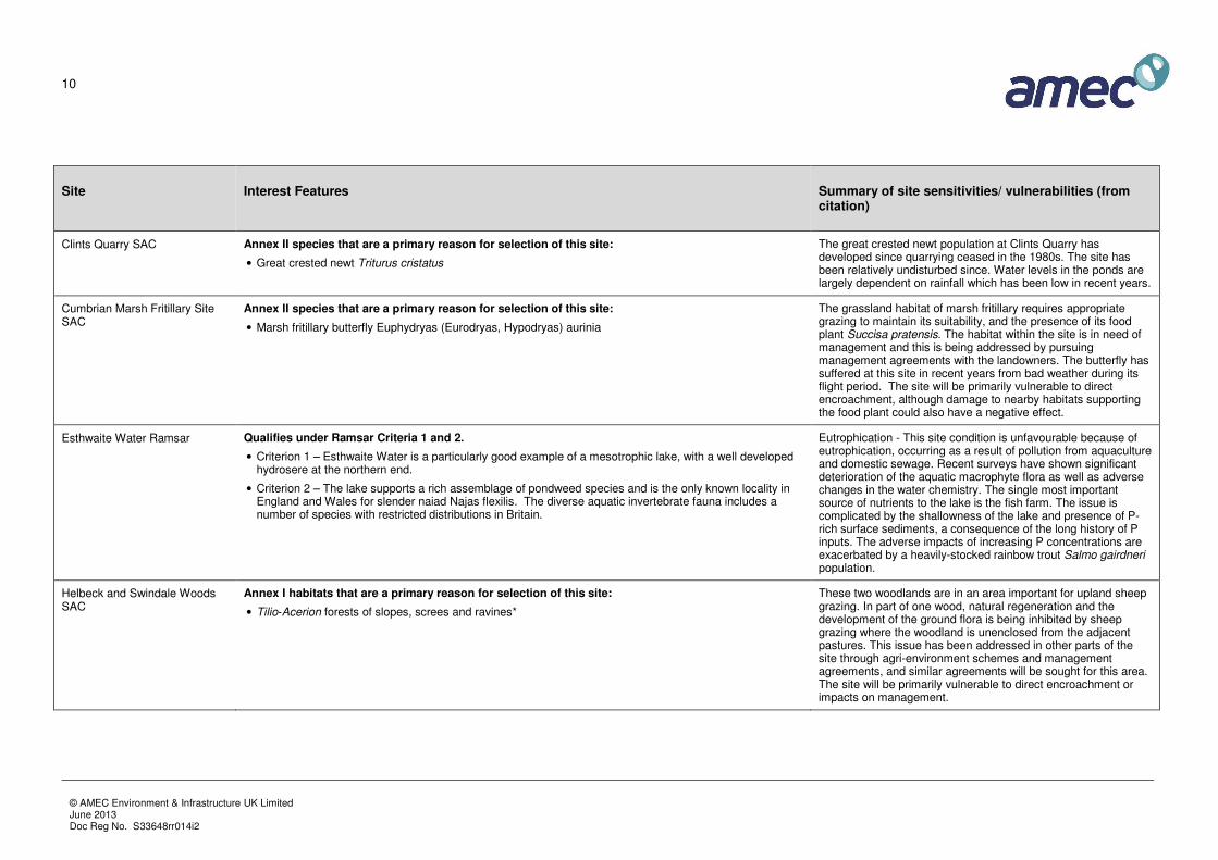
Table 3.1 provides a summary of the baseline information on the European sites within 15km of Eden District, and
the sensitivities and vulnerabilities of the interest features. The table provides a broad indication of the types of
impact that each site is likely to be susceptible to. The information has been primarily obtained from freely
available data from NE, including the citation forms, and will be reviewed and updated as the plan develops and the
likely impacts and outcomes of the options become evident. In addition, the assessment has considered the
potential for impacts on the Solway Firth suite of sites, which are the main downstream receptor.
Conservation objectives for the sites are published by Natural England; however, detailed objectives are in
preparation by NE and therefore the current objectives are broadly the same for all sites:
• Avoid the deterioration of the qualifying natural habitats and the habitats of qualifying species, and the
significant disturbance of those qualifying species, ensuring the integrity of the site is maintained and
the site makes a full contribution to achieving Favourable Conservation Status of each of the
qualifying features.
• Subject to natural change, to maintain or restore:
- The extent and distribution of qualifying natural habitats and habitats of qualifying species;
- The structure and function (including typical species) of qualifying natural habitats and habitats of
qualifying species;
- The supporting processes on which qualifying natural habitats and habitats of qualifying species
rely;
- The populations of qualifying species;
- The distribution of qualifying species within the site.

9
© AMEC Environment & Infrastructure UK Limited June 2013 Doc Reg No. S33648rr014i2
Table 3.1 European sites within 15km of Eden District (* = priority feature)
Site Interest Features Summary of site sensitivities/ vulnerabilities (from citation)
Asby Complex SAC Annex I habitats that are a primary reason for selection of this site:
• Semi-natural dry grasslands and scrubland facies: on calcareous substrates (Festuco-Brometalia)
• Molinia meadows on calcareous, peaty or clayey-silt-laden soils (Molinion caeruleae)
• Petrifying springs with tufa formation (Cratoneurion)*
• Alkaline fens
• Limestone pavements*
Annex I habitats present as a qualifying feature:
• Hard oligo-mesotrophic waters with benthic vegetation of Chara spp.
• European dry heaths
• Calcareous fens with Cladium mariscus and species of the Caricion davallianae*
Annex II species that are a primary reason for selection of this site:
• Geyer`s whorl snail Vertigo geyeri
• Slender green feather-moss Drepanocladus (Hamatocaulis) vernicosus
Limestone pavements have been extensively damaged in the past for supply of decorative rockery stone. The damage has been reduced in recent years by protective Limestone Pavement Orders. Unauthorised damage still continues as a minor and local problem. Asby Complex SAC suffers from overgrazing. The limestone pavement flora and the dry heathland are particularly affected, though the fen and spring habitats appear tolerant of the grazing levels. Management agreements are being sought but may be difficult to achieve on common land. There has been some agricultural pressure on the fen and tufa springs but damage from drainage and fertiliser application is being addressed through management agreements on some parts of the site. The site will be primarily vulnerable to direct encroachment or nearby development affecting site hydrology or use (visitor pressure).
Borrowdale Woodland Complex SAC
Annex I habitats that are a primary reason for selection of this site:
• Old sessile oak woods with Ilex and Blechnum in the British Isles
Annex I habitats present as a qualifying feature:
• Siliceous rocky slopes with chasmophytic vegetation
• Bog woodland*
In recent decades, there has been very little natural regeneration of native woodland tree species to ensure the long-term survival of the woodlands, due to grazing pressures from domestic livestock. However, very low levels of grazing are important to maintain the rich and diverse bryophyte flora. This issue should be addressed through the Environmentally Sensitive Area, Woodland Grant Scheme and agreement of Site Management Statements. The cSAC is also part of the UK Restoration of Atlantic Oakwoods LIFE project, under which further positive management is being carried out.
10
© AMEC Environment & Infrastructure UK Limited June 2013 Doc Reg No. S33648rr014i2
Site Interest Features Summary of site sensitivities/ vulnerabilities (from citation)
Clints Quarry SAC Annex II species that are a primary reason for selection of this site:
• Great crested newt Triturus cristatus
The great crested newt population at Clints Quarry has developed since quarrying ceased in the 1980s. The site has been relatively undisturbed since. Water levels in the ponds are largely dependent on rainfall which has been low in recent years.
Cumbrian Marsh Fritillary Site SAC
Annex II species that are a primary reason for selection of this site:
• Marsh fritillary butterfly Euphydryas (Eurodryas, Hypodryas) aurinia
The grassland habitat of marsh fritillary requires appropriate grazing to maintain its suitability, and the presence of its food plant Succisa pratensis. The habitat within the site is in need of management and this is being addressed by pursuing management agreements with the landowners. The butterfly has suffered at this site in recent years from bad weather during its flight period. The site will be primarily vulnerable to direct encroachment, although damage to nearby habitats supporting the food plant could also have a negative effect.
Esthwaite Water Ramsar Qualifies under Ramsar Criteria 1 and 2.
• Criterion 1 – Esthwaite Water is a particularly good example of a mesotrophic lake, with a well developed hydrosere at the northern end.
• Criterion 2 – The lake supports a rich assemblage of pondweed species and is the only known locality in England and Wales for slender naiad Najas flexilis. The diverse aquatic invertebrate fauna includes a number of species with restricted distributions in Britain.
Eutrophication - This site condition is unfavourable because of eutrophication, occurring as a result of pollution from aquaculture and domestic sewage. Recent surveys have shown significant deterioration of the aquatic macrophyte flora as well as adverse changes in the water chemistry. The single most important source of nutrients to the lake is the fish farm. The issue is complicated by the shallowness of the lake and presence of P-rich surface sediments, a consequence of the long history of P inputs. The adverse impacts of increasing P concentrations are exacerbated by a heavily-stocked rainbow trout Salmo gairdneri population.
Helbeck and Swindale Woods SAC
Annex I habitats that are a primary reason for selection of this site:
• Tilio-Acerion forests of slopes, screes and ravines*
These two woodlands are in an area important for upland sheep grazing. In part of one wood, natural regeneration and the development of the ground flora is being inhibited by sheep grazing where the woodland is unenclosed from the adjacent pastures. This issue has been addressed in other parts of the site through agri-environment schemes and management agreements, and similar agreements will be sought for this area. The site will be primarily vulnerable to direct encroachment or impacts on management.

11
© AMEC Environment & Infrastructure UK Limited June 2013 Doc Reg No. S33648rr014i2
Site Interest Features Summary of site sensitivities/ vulnerabilities (from citation)
Lake District High Fells SAC Annex I habitats that are a primary reason for selection of this site:
• Oligotrophic to mesotrophic standing waters with vegetation of the Littorelletea uniflorae and/or of the Isoëto-Nanojuncetea
• Northern Atlantic wet heaths with Erica tetralix
• European dry heaths
• Alpine and Boreal heaths
• Juniperus communis formations on heaths or calcareous grasslands
• Siliceous alpine and boreal grasslands
• Hydrophilous tall herb fringe communities of plains and of the montane to alpine levels
• Blanket bogs*
• Siliceous scree of the montane to snow levels (Androsacetalia alpinae and Galeopsietalia ladani)
• Siliceous rocky slopes with chasmophytic vegetation
• Old sessile oak woods with Ilex and Blechnum in the British Isles
Annex I habitats present as a qualifying feature:
• Species-rich Nardus grassland, on siliceous substrates in mountain areas (and submountain areas in continental Europe) ( Priority feature)
• Alkaline fens
• Calcareous rocky slopes with chasmophytic vegetation
Annex II species present as a qualifying feature:
• Slender green feather-moss Drepanocladus (Hamatocaulis) vernicosus�
The European habitats on this site, other than acidic scree, are threatened by grazing and more locally grazing combined with visitor pressure. A very high proportion of the site occurs on unfenced common land where control of grazing is difficult to achieve and pressure of sheep threatens to destroy or prevent favourable condition from being achieved. These pressures have been significantly reduced over much of the site by entry into the Lake District ESA scheme, but this largely only slows or possibly arrests decline. Siliceous scree is possibly the least-threatened habitat and is widespread, albeit in a modified state. The site will be primarily vulnerable to direct encroachment or changes in management.

12
© AMEC Environment & Infrastructure UK Limited June 2013 Doc Reg No. S33648rr014i2
Site Interest Features Summary of site sensitivities/ vulnerabilities (from citation)
Moor House – Upper Teesdale SAC
Annex I habitats that are a primary reason for selection of this site:
• Juniperus communis formations on heaths or calcareous grasslands
• Siliceous rocky slopes with chasmophytic vegetation
• Siliceous scree of the montane to snow levels (Androsacetalia alpinae and Galeopsietalia ladani)
• Semi-natural dry grasslands and scrubland facies: on calcareous substrates (Festuco-Brometalia)
• Blanket bogs*
• Alpine and Boreal heaths
• Molinia meadows on calcareous, peaty or clayey-silt-laden soils (Molinion caeruleae)
• Calaminarian grasslands of the Violetalia calaminariae
• Hydrophilous tall herb fringe communities of plains and of the montane to alpine levels
• Alpine pioneer formations of the Caricion bicoloris-atrofuscae*
• Hard oligo-mesotrophic waters with benthic vegetation of Chara spp.
• Siliceous alpine and boreal grasslands
• Mountain hay meadows
• Calcareous rocky slopes with chasmophytic vegetation
• Petrifying springs with tufa formation (Cratoneurion)*
• Alkaline fens
• Calcareous and calcshist screes of the montane to alpine levels (Thlaspietea rotundifolii)
Annex I habitats present as a qualifying feature:
• European dry heaths
• Limestone pavements*
Annex II species that are a primary reason for selection of this site:
• Round-mouthed whorl snail Vertigo genesii
• Marsh saxifrage Saxifraga hirculus
Ecologically unsustainable grazing, driven by agricultural support mechanisms, has had a deleterious effect on virtually all the Annex I habitats listed, to the extent that for some habitats it is difficult to make the necessary assessments of conservation structure and function required here. This serious problem has so far been very difficult to solve, requiring fundamental policy change as well as targeted local action. Some successes have been achieved however through Wildlife Enhancement Schemes geared at moorland and pasture, and through the ESA and Countryside Stewardship schemes, while issues impacting on meadows have been largely addressed through meadow schemes. Refining scheme prescriptions in the light of monitoring feedback is an important part of delivering favourable condition. Inappropriate burning and drainage of bogs also need tackling; much progress has been made on the latter through partnerships. Acid deposition and the microclimatic shifts stemming from reservoir construction may also have implications for the vegetation, as may increased access.

13
© AMEC Environment & Infrastructure UK Limited June 2013 Doc Reg No. S33648rr014i2
Site Interest Features Summary of site sensitivities/ vulnerabilities (from citation)
Morecambe Bay Pavements SAC
Annex I habitats that are a primary reason for selection of this site:
• Limestone pavements*
• Hard oligo-mesotrophic waters with benthic vegetation of Chara spp.
• Taxus baccata woods of the British Isles*
• Juniperus communis formations on heaths or calcareous grasslands
• Tilio-Acerion forests of slopes, screes and ravines*
• Semi-natural dry grasslands and scrubland facies: on calcareous substrates (Festuco-Brometalia)
Annex I habitats present as a qualifying feature:
• Calcareous fens with Cladium mariscus and species of the Caricion davallianae*
• Old sessile oak woods with Ilex and Blechnum in the British Isles
• European dry heaths
Annex II species that are a primary reason for selection of this site:
• Narrow-mouthed whorl snail Vertigo angustior
The SAC is subject to a number of problems related to the decline of traditional management practices. The under-grazing of grasslands and decline of traditional cattle grazing is leading to the loss of sward diversity and scrub encroachment problems. Localised overgrazing (sheep-dominated) has impoverished the pavement flora on one of the component sites. A decline of traditional coppice management has reduced the interest of some of the woodland sites. The planting of non-native conifer crops on some of the sites has led to localised declines in condition. However, large parts of the site are nature reserves and are sensitively managed. A major restoration project funded by LIFE Nature is in progress to remove non-native conifer plantations and further other aspects of site restoration. The problems are being addressed primarily through a series of management agreements. These include Natural England Wildlife Enhancement Schemes, Environmentally Sensitive Area Agreements, and Woodlands Grant Schemes.
Naddle Forest SAC Annex I habitats that are a primary reason for selection of this site:
• Old sessile oak woods with Ilex and Blechnum in the British Isles
Annex I habitats present as a qualifying feature:
• European dry heaths
• Northern Atlantic wet heaths with Erica tetralix
The European habitats on the site have been threatened by grazing, by both sheep and deer. Much of the woodland area has been fenced to reduce sheep and deer grazing and allow regeneration to occur, although deer still range through parts of the site. Sheep grazing pressures have been reduced on the heath areas through entry into the ESA scheme, and further reductions are planned through this mechanism.
North Pennine Dales Meadows SAC
Annex I habitats that are a primary reason for selection of this site:
• Mountain hay meadows
Annex I habitats present as a qualifying feature:
• Molinia meadows on calcareous, peaty or clayey-silt-laden soils (Molinion caeruleae)
These grasslands are dependent upon traditional agricultural management, with hay-cutting and no or minimal use of agrochemicals. Such management is no longer economic. Management agreements and ESA payments are being used to promote the continuation of traditional management. The refining of the prescriptions underpinning these schemes in the light of the findings of monitoring programmes is an important, continuing, part of delivering favourable condition.

14
© AMEC Environment & Infrastructure UK Limited June 2013 Doc Reg No. S33648rr014i2
Site Interest Features Summary of site sensitivities/ vulnerabilities (from citation)
North Pennine Moors SAC Annex I habitats that are a primary reason for selection of this site:
• European dry heaths
• Old sessile oak woods with Ilex and Blechnum in the British Isles
• Siliceous rocky slopes with chasmophytic vegetation
• Blanket bogs*
• Juniperus communis formations on heaths or calcareous grasslands
• Petrifying springs with tufa formation (Cratoneurion)*
Annex I habitats present as a qualifying feature:
• Calaminarian grasslands of the Violetalia calaminariae
• Siliceous alpine and boreal grasslands
• Siliceous scree of the montane to snow levels (Androsacetalia alpinae and Galeopsietalia ladani)
• Calcareous rocky slopes with chasmophytic vegetation
• Alkaline fens
• Semi-natural dry grasslands and scrubland facies: on calcareous substrates (Festuco-Brometalia)
• Northern Atlantic wet heaths with Erica tetralix
• Annex II species present as a qualifying feature:
• Marsh saxifrage Saxifraga hirculus
All interest features have been affected by excessive livestock grazing levels across parts of the site. These have been, and are still, encouraged by headage payments, but agreements with graziers and moorland owners, including those in Wildlife Enhancement and Countryside Stewardship schemes, are starting to overcome the problems of overgrazing. In places, the difficulty of reaching agreements on commons, which cover much of the site, means that successes are limited at present, and continues to prevent restoration. Drainage of wet areas can also be a problem; drains have been cut across many areas of blanket bog, disrupting the hydrology and causing erosion, but in most parts these are being blocked and the habitat restored under agreements. Burning is a traditional management tool on these moorlands, which contributes to maintaining high populations of SPA breeding birds. However, over-intensive and inappropriate burning is damaging to heath and blanket bog and further agreements are needed with the landowners to achieve sympathetic burning regimes. Restoration, to some degree, of a mosaic of more natural habitats across parts of the site is desirable. Acid and nitrogen deposition continue to have damaging effects on the site.

15
© AMEC Environment & Infrastructure UK Limited June 2013 Doc Reg No. S33648rr014i2
Site Interest Features Summary of site sensitivities/ vulnerabilities (from citation)
North Pennine Moors SPA • Curlew Numenius arquata (breeding)
• Dunlin (ssp. schinzii) Calidris alpina schinzii (breeding)
• Golden plover Pluvialis apricaria (breeding)
• Hen harrier Circus cyaneus (breeding)
• Merlin Falco columbarius (breeding)
• Peregrine falcon Falco peregrinus (breeding)
The North Pennine Moors covers nearly 150,000 hectares and is largely heather moorland, either as blanket bog or drier heathland, with smaller associated areas of wetland, grassland, bracken, scrub, woodland and cliff. The habitats and qualifying breeding bird populations are mostly dependant upon stock grazing and burning at sympathetic levels. The continuation of these practices relies on their profitability, including any subsidy or incentive payments. Over-grazing, over-burning and other forms of intensive agricultural or sporting management (e.g. drainage) may be damaging. These issues are being partly addressed through management agreements and related incentives. Further legislation relating to Common land and reform of the Common Agricultural Policy would achieve sustainable solutions.
River Derwent and Bassenthwaite Lake SAC
Annex I habitats that are a primary reason for selection of this site:
• Oligotrophic to mesotrophic standing waters with vegetation of the Littorelletea uniflorae and/or of the Isoëto-Nanojuncetea
Annex I habitats present as a qualifying feature:
• Water courses of plain to montane levels with the Ranunculion fluitantis and Callitricho-Batrachion vegetation
Annex II species that are a primary reason for selection of this site:
• River Lamprey Lampetra fluviatilis
• Brook lamprey Lampetra planeri
• Sea lamprey Petromyzon marinus
• Atlantic salmon Salmo salar
• Marsh fritillary butterfly Euphydryas (Eurodryas, Hypodryas) aurinia
• Floating water-plantain Luronium natans
• Otter Lutra lutra
Water levels and flooding are an issue with the River Derwent. Concern has been expressed about both the level of flooding of adjacent agricultural land and also recent flooding of urban areas. This has resulted in public pressure both for new flood defences and different water-level control regimes. Issues relating to water control levels are being addressed through a collaborative project between Natural England, Environment Agency and the water company, Yorkshire Water. Natural England is also fully consulted over any new proposals relating to new or improved flood defences. Water quality is also a potential issue on the river.

16
© AMEC Environment & Infrastructure UK Limited June 2013 Doc Reg No. S33648rr014i2
Site Interest Features Summary of site sensitivities/ vulnerabilities (from citation)
River Eden SAC Annex I habitats that are a primary reason for selection of this site:
• Oligotrophic to mesotrophic standing waters with vegetation of the Littorelletea uniflorae and/or of the Isoëto-Nanojuncetea
• Water courses of plain to montane levels with the Ranunculion fluitantis and Callitricho-Batrachion vegetation
• Alluvial forests with Alnus glutinosa and Fraxinus excelsior (Alno-Padion, Alnion incanae, Salicion albae)*
• White-clawed (or Atlantic stream) crayfish Austropotamobius pallipes
• Sea lamprey Petromyzon marinus
• Brook lamprey Lampetra planeri
• River lamprey Lampetra fluviatilis
• Atlantic salmon Salmo salar
• Bullhead Cottus gobio
• Otter Lutra lutra
The maintenance of breeding and nursery areas for the species on this site depends on the habitat quality of streams and their margins. Many of the streams within the site suffer from overgrazing of riverbanks and nutrient run-off. This is being addressed by a number of measures, including a conservation strategy with actions to address river quality issues, and a partnership approach to funding habitat improvements. Thewater-crowfoot communities as well as the species are sensitive to water quality, particularly eutrophication. Again, actions have been identified for getting improvements in water quality and they will be carried forward in the periodic reviews of water company expenditure and reviews of consents under the Habitats Regulations. Practices associated with sheep-dipping pose a potential threat at this site, and are currently under investigation. Much of the alluvial forest cover is fragmented and/or in poor condition. It is hoped to address this through management agreements or Woodland Grant Schemes with individual owners.
River Kent SAC Annex I habitats present as a qualifying feature:
• Water courses of plain to montane levels with the Ranunculion fluitantis and Callitricho-Batrachion vegetation
Annex II species that are a primary reason for selection of this site:
• White-clawed crayfish Austropotamobius pallipes
• Annex II species present as a qualifying feature:
• Freshwater pearl mussel Margaritifera margaritifera
• Bullhead Cottus gobio
The maintenance of breeding and nursery areas for the species on this site depends on the habitat quality of streams and their margins. Some areas of the site suffer from poor habitat quality. The intention is to address this through implementation of habitat improvement schemes. The impact of point-discharges on water quality will be reviewed and action proposed where necessary. A particular problem on this site and affecting white-clawed crayfish is incidents of pyrethroid sheep-dip pollution of watercourses. These are currently under investigation. The dwindling population of freshwater pearl mussels needs to be investigated in relation to the factors affecting its recruitment and structure. A management plan will be developed for the part of the catchment supporting this species.
17
© AMEC Environment & Infrastructure UK Limited June 2013 Doc Reg No. S33648rr014i2
Site Interest Features Summary of site sensitivities/ vulnerabilities (from citation)
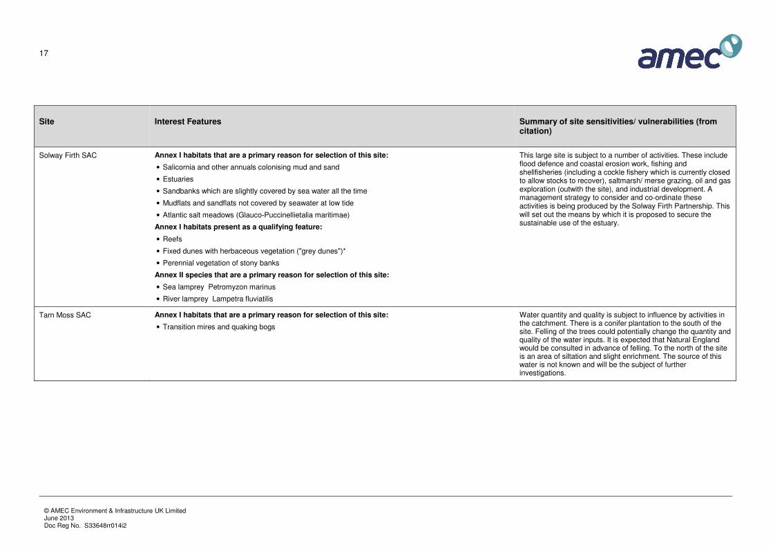
Solway Firth SAC Annex I habitats that are a primary reason for selection of this site:
• Salicornia and other annuals colonising mud and sand
• Estuaries
• Sandbanks which are slightly covered by sea water all the time
• Mudflats and sandflats not covered by seawater at low tide
• Atlantic salt meadows (Glauco-Puccinellietalia maritimae)
Annex I habitats present as a qualifying feature:
• Reefs
• Fixed dunes with herbaceous vegetation ("grey dunes")*
• Perennial vegetation of stony banks
Annex II species that are a primary reason for selection of this site:
• Sea lamprey Petromyzon marinus
• River lamprey Lampetra fluviatilis
This large site is subject to a number of activities. These include flood defence and coastal erosion work, fishing and shellfisheries (including a cockle fishery which is currently closed to allow stocks to recover), saltmarsh/ merse grazing, oil and gas exploration (outwith the site), and industrial development. A management strategy to consider and co-ordinate these activities is being produced by the Solway Firth Partnership. This will set out the means by which it is proposed to secure the sustainable use of the estuary.
Tarn Moss SAC Annex I habitats that are a primary reason for selection of this site:
• Transition mires and quaking bogs
Water quantity and quality is subject to influence by activities in the catchment. There is a conifer plantation to the south of the site. Felling of the trees could potentially change the quantity and quality of the water inputs. It is expected that Natural England would be consulted in advance of felling. To the north of the site is an area of siltation and slight enrichment. The source of this water is not known and will be the subject of further investigations.
18
© AMEC Environment & Infrastructure UK Limited June 2013 Doc Reg No. S33648rr014i2
Site Interest Features Summary of site sensitivities/ vulnerabilities (from citation)
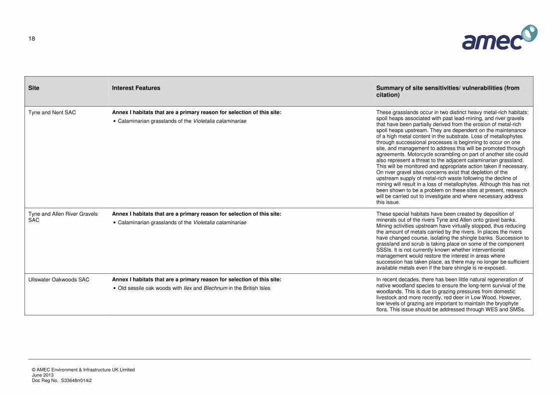
Tyne and Nent SAC Annex I habitats that are a primary reason for selection of this site:
• Calaminarian grasslands of the Violetalia calaminariae
These grasslands occur in two distinct heavy metal-rich habitats: spoil heaps associated with past lead-mining, and river gravels that have been partially derived from the erosion of metal-rich spoil heaps upstream. They are dependent on the maintenance of a high metal content in the substrate. Loss of metallophytes through successional processes is beginning to occur on one site, and management to address this will be promoted through agreements. Motorcycle scrambling on part of another site could also represent a threat to the adjacent calaminarian grassland. This will be monitored and appropriate action taken if necessary. On river gravel sites concerns exist that depletion of the upstream supply of metal-rich waste following the decline of mining will result in a loss of metallophytes. Although this has not been shown to be a problem on these sites at present, research will be carried out to investigate and where necessary address this issue.
Tyne and Allen River Gravels SAC
Annex I habitats that are a primary reason for selection of this site:
• Calaminarian grasslands of the Violetalia calaminariae
These special habitats have been created by deposition of minerals out of the rivers Tyne and Allen onto gravel banks. Mining activities upstream have virtually stopped, thus reducing the amount of metals carried by the rivers. In places the rivers have changed course, isolating the shingle banks. Succession to grassland and scrub is taking place on some of the component SSSIs. It is not currently known whether interventionist management would restore the interest in areas where succession has taken place, as there may no longer be sufficient available metals even if the bare shingle is re-exposed.
Ullswater Oakwoods SAC Annex I habitats that are a primary reason for selection of this site:
• Old sessile oak woods with Ilex and Blechnum in the British Isles
In recent decades, there has been little natural regeneration of native woodland species to ensure the long-term survival of the woodlands. This is due to grazing pressures from domestic livestock and more recently, red deer in Low Wood. However, low levels of grazing are important to maintain the bryophyte flora. This issue should be addressed through WES and SMSs.

19
© AMEC Environment & Infrastructure UK Limited June 2013 Doc Reg No. S33648rr014i2
Site Interest Features Summary of site sensitivities/ vulnerabilities (from citation)
Upper Solway Flats and Marshes Ramsar
Criterion 2 - Supports over 10% of the British population of natterjack toad Bufo calamita (Habitats Directive Annex IV species (S1202))
Criterion 5 - 35720 waterfowl (5 year peak mean 1998/99-2002/2003)
Criterion 6 - Lesser black-backed gull Larus fuscus, Herring gull Larus argentatus, Barnacle goose Branta leucopsis, Bar-tailed godwit Limosa lapponica, Curlew Numenius arquata, Dunlin (ssp. alpina) Calidris alpina alpina, Knot Calidris canutus, Oystercatcher Haematopus ostralegus, Pink-footed goose Anser brachyrhynchus, Pintail Anas acuta, Redshank Tringa tetanus, Ringed plover Charadrius hiaticula, Scaup Aythya marila, Whooper swan Cygnus cygnus
As for Upper Solway Flats and Marshes SPA, except for natterjack toad which will be primarily vulnerable to direct damage / disturbance of habitats.
Upper Solway Flats and Marshes SPA
Barnacle goose Branta leucopsis (Wintering; added in SPA review); Bar-tailed godwit Limosa lapponica (Wintering); Curlew Numenius arquata (Wintering); Dunlin (ssp. alpina) Calidris alpina alpina (Wintering); Golden plover Pluvialis apricaria (Wintering); Goldeneye Bucephala clangula (Wintering; removed in SPA review); Grey plover Pluvialis squatarola (Wintering; removed in SPA review); Knot Calidris canutus (Wintering); Oystercatcher Haematopus ostralegus (Wintering); Pink-footed goose Anser brachyrhynchus (Wintering); Pintail Anas acuta (Wintering); Redshank Tringa totanus (Wintering); Ringed plover Charadrius hiaticula (Passage; added in SPA review); Sanderling Calidris alba (Wintering; removed in SPA review); Scaup Aythya marila (Wintering; removed in SPA review); Shelduck Tadorna tadorna (Wintering; removed in SPA review); Shoveler Anas clypeata (Wintering; removed in SPA review); Teal Anas crecca (Wintering; removed in SPA review); Turnstone Arenaria interpres (Wintering; removed in SPA review); Whooper swan Cygnus cygnus (Wintering); Waterfowl assemblage (Wintering)
A management strategy for the site has been produced by the Solway Firth Partnership. The strategy addresses threats to the SPA interest on the site and sets out the means by which it is proposed to secure the sustainable use of the Firth.
There has been relatively little land claim compared with most other estuaries in the UK but some established and new flood defence and coastal erosion works may exacerbate erosion elsewhere within the site. The cockle fishery has been closed for a number of years due to overexploitation and the other commercial, traditional and shell fisheries are regulated by Government to ensure that they are carried out in a sustainable way and that their impact on bird feeding areas are not significant. Roosts and feeding areas are vulnerable to disturbance and the management strategy addresses the planning of recreational and development activities to avoid disturbance to roosts and feeding areas.

314000
314000
316000
316000
318000
318000
320000
320000
322000
322000
324000
324000
326000
326000
328000
328000
330000
330000
332000
332000
334000
334000
336000
336000
338000
338000
340000
340000
342000
342000
344000
344000
346000
346000
348000
348000
350000
350000
352000
352000
354000
354000
356000
356000
358000
358000
360000
360000
362000
362000
364000
364000
366000
366000
368000
368000
370000
370000
372000
372000
374000
374000
376000
376000
378000
378000
380000
380000
382000
382000
384000
384000
386000
386000
388000
388000
390000
390000
392000
392000
394000
394000
396000
396000
398000
398000
400000
400000
402000
402000
404000
404000
48
60
00
48
70
00
48
80
00
48
90
00
49
00
00
49
10
00
49
20
00
49
30
00
49
40
00
49
50
00
49
60
00
49
70
00
49
80
00
49
90
00
50
00
00
50
10
00
50
20
00
50
30
00
50
40
00
50
50
00
50
60
00
50
70
00
50
80
00
50
90
00
51
00
00
51
10
00
51
20
00
51
30
00
51
40
00
51
50
00
51
60
00
51
70
00
51
80
00
51
90
00
52
00
00
52
10
00
52
20
00
52
30
00
52
40
00
52
50
00
52
60
00
52
70
00
52
80
00
52
90
00
53
00
00
53
10
00
53
20
00
53
30
00
53
40
00
53
50
00
53
60
00
53
70
00
53
80
00
53
90
00
54
00
00
54
10
00
54
20
00
54
30
00
54
40
00
54
50
00
54
60
00
54
70
00
54
80
00
54
90
00
55
00
00
55
10
00
55
20
00
55
30
00
55
40
00
55
50
00
55
60
00
55
70
00
55
80
00
55
90
00
56
00
00
56
10
00
56
20
00
56
30
00
56
40
00
56
50
00
Key:
Based upon the Ordnance Survey Map with the permission of the Controller of Her Majesty's Stationery Office. © Crown Copyright. 100001776
Scale: 1:300000 @ A3
H:\Projects\33648 Eden District SA & HRA\Drawings\ArcGIS\HRA Figures\33648-Shr15 - Fig 3.1 SACs.mxd
N
June 201333648-Shr15 frosm
Eden District EmploymentAllocations HRA
Figure 3.1SACs in and near Eden District
01002003004005006007008009001,0001,1001,2001,3001,4001,5001,6001,7001,8001,9002,0002,1002,2002,3002,4002,5002,6002,7002,8002,9003,0003,1003,2003,3003,4003,5003,6003,7003,8003,9004,0004,1004,2004,3004,4004,5004,6004,7004,8004,9005,0005,1005,2005,3005,4005,5005,6005,7005,8005,9006,0006,1006,2006,3006,4006,5006,6006,7006,8006,9007,0007,1007,2007,3007,4007,5007,6007,7007,8007,9008,0008,1008,2008,3008,4008,5008,6008,7008,8008,9009,0009,1009,2009,3009,4009,5009,6009,7009,8009,90010,00010,10010,20010,30010,40010,50010,60010,70010,80010,90011,00011,10011,20011,30011,40011,50011,60011,70011,80011,90050Metres
SAC
Proposed Employment Sites
15km from Eden boundary
Eden District

314000
314000
316000
316000
318000
318000
320000
320000
322000
322000
324000
324000
326000
326000
328000
328000
330000
330000
332000
332000
334000
334000
336000
336000
338000
338000
340000
340000
342000
342000
344000
344000
346000
346000
348000
348000
350000
350000
352000
352000
354000
354000
356000
356000
358000
358000
360000
360000
362000
362000
364000
364000
366000
366000
368000
368000
370000
370000
372000
372000
374000
374000
376000
376000
378000
378000
380000
380000
382000
382000
384000
384000
386000
386000
388000
388000
390000
390000
392000
392000
394000
394000
396000
396000
398000
398000
400000
400000
402000
402000
404000
404000
48
60
00
48
70
00
48
80
00
48
90
00
49
00
00
49
10
00
49
20
00
49
30
00
49
40
00
49
50
00
49
60
00
49
70
00
49
80
00
49
90
00
50
00
00
50
10
00
50
20
00
50
30
00
50
40
00
50
50
00
50
60
00
50
70
00
50
80
00
50
90
00
51
00
00
51
10
00
51
20
00
51
30
00
51
40
00
51
50
00
51
60
00
51
70
00
51
80
00
51
90
00
52
00
00
52
10
00
52
20
00
52
30
00
52
40
00
52
50
00
52
60
00
52
70
00
52
80
00
52
90
00
53
00
00
53
10
00
53
20
00
53
30
00
53
40
00
53
50
00
53
60
00
53
70
00
53
80
00
53
90
00
54
00
00
54
10
00
54
20
00
54
30
00
54
40
00
54
50
00
54
60
00
54
70
00
54
80
00
54
90
00
55
00
00
55
10
00
55
20
00
55
30
00
55
40
00
55
50
00
55
60
00
55
70
00
55
80
00
55
90
00
56
00
00
56
10
00
56
20
00
56
30
00
56
40
00
56
50
00
Key:
Based upon the Ordnance Survey Map with the permission of the Controller of Her Majesty's Stationery Office. © Crown Copyright. 100001776
Scale: 1:300000 @ A3
H:\Projects\33648 Eden District SA & HRA\Drawings\ArcGIS\HRA Figures\33648-Shr16 - Fig 3.2 SPAs.mxd
N
June 201333648-Shr16 frosm
Eden District EmploymentAllocations HRA
Figure 3.2SPAs in and near Eden District
01002003004005006007008009001,0001,1001,2001,3001,4001,5001,6001,7001,8001,9002,0002,1002,2002,3002,4002,5002,6002,7002,8002,9003,0003,1003,2003,3003,4003,5003,6003,7003,8003,9004,0004,1004,2004,3004,4004,5004,6004,7004,8004,9005,0005,1005,2005,3005,4005,5005,6005,7005,8005,9006,0006,1006,2006,3006,4006,5006,6006,7006,8006,9007,0007,1007,2007,3007,4007,5007,6007,7007,8007,9008,0008,1008,2008,3008,4008,5008,6008,7008,8008,9009,0009,1009,2009,3009,4009,5009,6009,7009,8009,90010,00010,10010,20010,30010,40010,50010,60010,70010,80010,90011,00011,10011,20011,30011,40011,50011,60050Metres
Eden District
15km from Eden boundary
Proposed Employment Sites
SPA

314000
314000
316000
316000
318000
318000
320000
320000
322000
322000
324000
324000
326000
326000
328000
328000
330000
330000
332000
332000
334000
334000
336000
336000
338000
338000
340000
340000
342000
342000
344000
344000
346000
346000
348000
348000
350000
350000
352000
352000
354000
354000
356000
356000
358000
358000
360000
360000
362000
362000
364000
364000
366000
366000
368000
368000
370000
370000
372000
372000
374000
374000
376000
376000
378000
378000
380000
380000
382000
382000
384000
384000
386000
386000
388000
388000
390000
390000
392000
392000
394000
394000
396000
396000
398000
398000
400000
400000
402000
402000
404000
404000
48
60
00
48
70
00
48
80
00
48
90
00
49
00
00
49
10
00
49
20
00
49
30
00
49
40
00
49
50
00
49
60
00
49
70
00
49
80
00
49
90
00
50
00
00
50
10
00
50
20
00
50
30
00
50
40
00
50
50
00
50
60
00
50
70
00
50
80
00
50
90
00
51
00
00
51
10
00
51
20
00
51
30
00
51
40
00
51
50
00
51
60
00
51
70
00
51
80
00
51
90
00
52
00
00
52
10
00
52
20
00
52
30
00
52
40
00
52
50
00
52
60
00
52
70
00
52
80
00
52
90
00
53
00
00
53
10
00
53
20
00
53
30
00
53
40
00
53
50
00
53
60
00
53
70
00
53
80
00
53
90
00
54
00
00
54
10
00
54
20
00
54
30
00
54
40
00
54
50
00
54
60
00
54
70
00
54
80
00
54
90
00
55
00
00
55
10
00
55
20
00
55
30
00
55
40
00
55
50
00
55
60
00
55
70
00
55
80
00
55
90
00
56
00
00
56
10
00
56
20
00
56
30
00
56
40
00
56
50
00
Key:
Based upon the Ordnance Survey Map with the permission of the Controller of Her Majesty's Stationery Office. © Crown Copyright. 100001776
Scale: 1:300000 @ A3
H:\Projects\33648 Eden District SA & HRA\Drawings\ArcGIS\HRA Figures\33648-Shr17 - Fig 3.3 Ramsar.mxd
N
June 201333648-Shr17 frosm
Eden District EmploymentAllocations HRA
Figure 3.3Ramsar sites in and near Eden District
01002003004005006007008009001,0001,1001,2001,3001,4001,5001,6001,7001,8001,9002,0002,1002,2002,3002,4002,5002,6002,7002,8002,9003,0003,1003,2003,3003,4003,5003,6003,7003,8003,9004,0004,1004,2004,3004,4004,5004,6004,7004,8004,9005,0005,1005,2005,3005,4005,5005,6005,7005,8005,9006,0006,1006,2006,3006,4006,5006,6006,7006,8006,9007,0007,1007,2007,3007,4007,5007,6007,7007,8007,9008,0008,1008,2008,3008,4008,5008,6008,7008,8008,9009,0009,1009,2009,3009,4009,5009,6009,7009,8009,90010,00010,10010,20010,30010,40010,50010,60010,70010,80010,90011,00011,10011,20011,30011,40011,50011,60050Metres
Eden District
15km from Eden boundary
Proposed Employment Sites
Ramsar

20
© AMEC Environment & Infrastructure UK Limited June 2013 Doc Reg No. S33648rr014i2
4. Assessment
4.1 Assessment of allocations
The potential allocation sites identified through the initial ‘call for sites’ process were reviewed and assessed for
their potential to affect European sites. This assessment aimed to identify any sites that are clearly unsuitable from
an HRA perspective, or which would require the inclusion of specific measures within the plan to ensure that
significant effects are avoided or mitigated. The assessment was desk-based, using available OS mapping data and
information on the following key aspects:
• the proximity of potential allocation sites to any European sites;
• the presence of direct linkages or impact pathways to a European site (e.g. connecting watercourses);
• any known indirect linkages or impact pathways (e.g. roosting areas);
• the broad type of development envisaged for the potential allocation site;
• the size of the potential allocation site (as a surrogate for scale of potential environmental impact).
Those sites with potential issues were identified to allow their potential effects on European sites to be factored in
to the selection process and the policy design. The results of the assessment are summarised in Table 4.1; the
assessment criteria and colour coding used are summarised in Box 1. Table 4.2 summarises the ‘screening’
assessment with respect to European sites (note the assessment informing this Table is an integral part of the
assessment of the allocations – it is not possible to exclude a site without understanding both the likely effects of
the allocations and the vulnerabilities of the European site interest features).
21
© AMEC Environment & Infrastructure UK Limited June 2013 Doc Reg No. S33648rr014i2
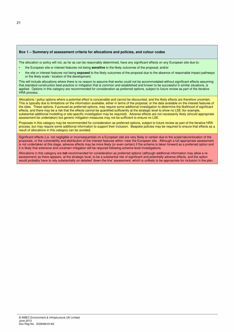
Box 1 – Summary of assessment criteria for allocations and policies, and colour codes
The allocation or policy will not, as far as can be reasonably determined, have any significant effects on any European site due to:
• the European site or interest features not being sensitive to the likely outcomes of the proposal; and/or
• the site or interest features not being exposed to the likely outcomes of the proposal due to the absence of reasonable impact pathways or the likely scale / location of the development.
This will include allocations where there is no reason to assume that works could not be accommodated without significant effects assuming that standard construction best-practice or mitigation that is common and established and known to be successful in similar situations, is applied. Options in this category are recommended for consideration as preferred options, subject to future review as part of the iterative HRA process.
Allocations / policy options where a potential effect is conceivable and cannot be discounted, and the likely effects are therefore uncertain. This is typically due to limitations on the information available, either in terms of the proposal, or the data available on the interest features of the sites. These options, if pursued as preferred options, may require some additional investigation to determine the likelihood of significant effects, and there may be a risk that the effects cannot be quantified sufficiently at the strategic level to show no LSE (for example, substantial additional modelling or site-specific investigation may be required). Adverse effects are not necessarily likely (should appropriate assessment be undertaken) but generic mitigation measures may not be sufficient to ensure no LSE.
Proposals in this category may be recommended for consideration as preferred options, subject to future review as part of the iterative HRA process, but may require some additional information to support their inclusion. Bespoke policies may be required to ensure that effects as a result of allocations in this category can be avoided.
Significant effects (i.e. not negligible or inconsequential) on a European site are very likely or certain due to the scale/nature/location of the proposals, or the vulnerability and distribution of the interest features within /near the European site. Although a full appropriate assessment is not undertaken at this stage, adverse effects may be more likely (or even certain) if the scheme is taken forward as a preferred option and it is likely that extensive and uncertain mitigation will be required following scheme-level investigations.
Allocations in this category are not recommended for consideration as preferred options (although additional information may allow a re-assessment) as there appears, at the strategic level, to be a substantial risk of significant and potentially adverse effects, and the option would probably have to rely substantially on detailed ‘down-the-line’ assessment, which is unlikely to be appropriate for inclusion in the plan.
22
© AMEC Environment & Infrastructure UK Limited June 2013 Doc Reg No. S33648rr014i2
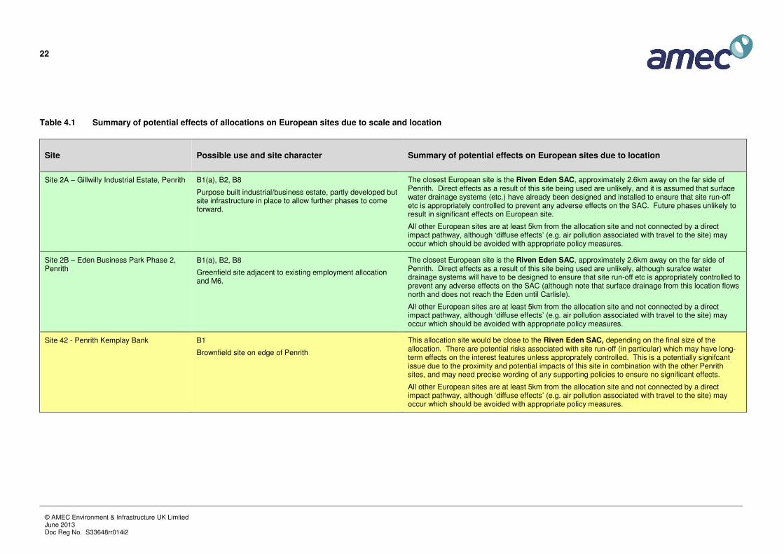
Table 4.1 Summary of potential effects of allocations on European sites due to scale and location
Site Possible use and site character Summary of potential effects on European sites due to location
Site 2A – Gillwilly Industrial Estate, Penrith B1(a), B2, B8
Purpose built industrial/business estate, partly developed but site infrastructure in place to allow further phases to come forward.
The closest European site is the Riven Eden SAC, approximately 2.6km away on the far side of Penrith. Direct effects as a result of this site being used are unlikely, and it is assumed that surface water drainage systems (etc.) have already been designed and installed to ensure that site run-off etc is appropriately controlled to prevent any adverse effects on the SAC. Future phases unlikely to result in significant effects on European site.
All other European sites are at least 5km from the allocation site and not connected by a direct impact pathway, although ‘diffuse effects’ (e.g. air pollution associated with travel to the site) may occur which should be avoided with appropriate policy measures.
Site 2B – Eden Business Park Phase 2, Penrith
B1(a), B2, B8
Greenfield site adjacent to existing employment allocation and M6.
The closest European site is the Riven Eden SAC, approximately 2.6km away on the far side of Penrith. Direct effects as a result of this site being used are unlikely, although surafce water drainage systems will have to be designed to ensure that site run-off etc is appropriately controlled to prevent any adverse effects on the SAC (although note that surface drainage from this location flows north and does not reach the Eden until Carlisle).
All other European sites are at least 5km from the allocation site and not connected by a direct impact pathway, although ‘diffuse effects’ (e.g. air pollution associated with travel to the site) may occur which should be avoided with appropriate policy measures.
Site 42 - Penrith Kemplay Bank B1
Brownfield site on edge of Penrith
This allocation site would be close to the Riven Eden SAC, depending on the final size of the allocation. There are potential risks associated with site run-off (in particular) which may have long-term effects on the interest features unless approprately controlled. This is a potentially signifcant issue due to the proximity and potential impacts of this site in combination with the other Penrith sites, and may need precise wording of any supporting policies to ensure no significant effects.
All other European sites are at least 5km from the allocation site and not connected by a direct impact pathway, although ‘diffuse effects’ (e.g. air pollution associated with travel to the site) may occur which should be avoided with appropriate policy measures.

23
© AMEC Environment & Infrastructure UK Limited June 2013 Doc Reg No. S33648rr014i2
Site Possible use and site character Summary of potential effects on European sites due to location
Site MP B – Masterplan Option B, Redhills – land to the south of A66 (west)
B1(a), B2, B8
10 ha. greenfield site adjacent to existing employment allocation
This allocation site would border the Riven Eden SAC. It is currently a greenfield site and therefore there are potential risks associated with site run-off (in particular) which may have long-term effects on the interest features unless approprately controlled. This is a potentially signifcant issue due to the proximity , size of site, and switch from greenfield to built. Other direct effects are possible during construction and (depending on use) operation and the potential impacts of this site (particularly in combination with the other Penrith sites) would need to be examined in more detail.
All other European sites are at least 5km from the allocation site and not connected by a direct impact pathway, although ‘diffuse effects’ (e.g. air pollution associated with travel to the site) may occur which should be avoided with appropriate policy measures.
Site MP C – Masterplan Option C, Skirsgill – land to the south of A66 (east)
B1(a) as part of a mixed use allocation to include C3.
3.5 ha. greenfield site adjacent to existing employment allocation
This allocation site would border the Riven Eden SAC. It is currently a greenfield site and therefore there are potential risks associated with site run-off (in particular) which may have long-term effects on the interest features unless approprately controlled. This is a potentially signifcant issue due to the proximity, size of site, and switch from greenfield to built. Other direct effects are possible during construction and (depending on use) operation and the potential impacts of this site (particularly in combination with the other Penrith sites) would need to be examined in more detail.
All other European sites are at least 5km from the allocation site and not connected by a direct impact pathway, although ‘diffuse effects’ (e.g. air pollution associated with travel to the site) may occur which should be avoided with appropriate policy measures.
Site 24 – Skelgillside Workshops, Alston B1(a) and B2
Boundary amended to include undeveloped land to rear of site. Site located east of Alston village
This is a small site east of Alston village that is adjecent to an existing site. The closest European site is the Tyne and Nent Gravels SAC, the closest units of which are approximately 1.5km away and associated with the rivers South Tyne and Nent. The closest units of the site are ‘upstream’ of the allocation site. The site is designated for its Calaminarian grasslands (grasslands on heavy-metal rich soils), although these interest features are unlikely to be affected by the proposed use of the site, assuming normal design and mitigation measures.
The next nearest sites are the Moor House-Upper Teesdale SPA and the North Pennine Moors SPA (>3km from the allocation site), although the interest features of these sites are unlikely to be affected by any development at the allocation site. All other European sites are at least 5km from the allocation site and not connected by a direct impact pathway.
‘Diffuse effects’ and other indirect effects on distant sites (e.g. air pollution associated with travel to the site) should be avoided with appropriate policy measures.
Site 29 – Bonds Factory, Alton B2
Boundary amended to include undeveloped land to south of site.
As for site 24.

24
© AMEC Environment & Infrastructure UK Limited June 2013 Doc Reg No. S33648rr014i2
Site Possible use and site character Summary of potential effects on European sites due to location
Site 26 –High Mill Alston B1 (part of mixed use development to include C3)
Vacant employment unit. May be suitable for conversion to other uses during plan period.
As for site 24.
Site 19 – Cross Croft Industrial Estate, Appleby
B1(a), B1(b) and B8
Site no longer in use – Currently being demolished. Surrounding uses mainly consists of light industrial with small element of residential. Boundary amended to only include greenfield land to east.
The closest European site is the Riven Eden SAC, approximately 700m away on the far side of Appleby. Direct effects as a result of the proposed uses for the site are unlikely, although surafce water drainage systems will have to be designed to ensure that site run-off etc is appropriately controlled to prevent any adverse effects on the SAC.
The next nearest sites are the Moor House-Upper Teesdale SPA and the North Pennine Moors SPA (>4km from the allocation site), although the interest features of these sites are unlikely to be affected by any development at the allocation site. All other European sites are at least 5km from the allocation site and not connected by a direct impact pathway.
‘Diffuse effects’ and other indirect effects on distant sites (e.g. air pollution associated with travel to the site) should be avoided with appropriate policy measures.
Site 21 – The Old Creamery, Appleby C3, B1(a) and B1(b)
Site no longer in use – currently being demolished. Surrounding uses mainly consists of light industrial with small element of residential. May be suitable for conversion to other uses during plan period.
The closest European site is the Riven Eden SAC, approximately 500m away on the far side of Appleby. Direct effects as a result of this site being used or converted are unlikely, although surafce water drainage systems will have to be designed to ensure that site run-off etc is appropriately controlled to prevent any adverse effects on the SAC.
The next nearest sites are the Moor House-Upper Teesdale SPA and the North Pennine Moors SPA (>4km from the allocation site), although the interest features of these sites are unlikely to be affected by any development at the allocation site. All other European sites are at least 5km from the allocation site and not connected by a direct impact pathway.
‘Diffuse effects’ and other indirect effects on distant sites (e.g. air pollution associated with travel to the site) should be avoided with appropriate policy measures.
Site 23 – Shire Hall, Appleby B1(a)
Vacant employment unit previously used by optician and dental practice. May be suitable for conversion to other uses during plan period.
Site within Appleby town centre, within 100m of the Riven Eden SAC; however, conversion of site to other uses unlikely to result in any signifcant effects on European sites.
‘Diffuse effects’ and other indirect effects on distant sites (e.g. air pollution associated with travel to the site) should be avoided with appropriate policy measures.

25
© AMEC Environment & Infrastructure UK Limited June 2013 Doc Reg No. S33648rr014i2
Site Possible use and site character Summary of potential effects on European sites due to location
Site 33 – Kirkby Stephen Business Park B2/B8
The Kirkby Stephen Business Park was allocated for employment use in the last Local Plan with the final stage of construction currently underway. A natural extension to the park could be delivered through development of the fields directly to the west of the site and consideration should be given to allocating this land for development.
The closest European site is the Riven Eden SAC, approximately 350m away on the far side of Kirkby Stephen. Direct effects as a result of the proposed uses for the site are unlikely, although surafce water drainage systems will have to be designed to ensure that site run-off etc is appropriately controlled to prevent any adverse effects on the SAC.
The next nearest site is the North Pennine Moors SPA (~4km from the allocation site), although the interest features of these sites are unlikely to be affected by any development at the allocation site. All other European sites are at least 5km from the allocation site and not connected by a direct impact pathway.
‘Diffuse effects’ and other indirect effects on distant sites (e.g. air pollution associated with travel to the site) should be avoided with appropriate policy measures.
Site 40 – Brough Main Street B2, B8 and B1(a)
Current bus depot with staff and coach parking surrounding (current base for Grand Prix Coaches). Surrounding uses mainly consists of light industrial with small element of residential. (Possible) future floor space on vacant land (by sector/use class), Existing employment site likely to come forward for redevelopment within the plan period.
The closest European sites to this allocation are the Moor House-Upper Teesdale SPA and the North Pennine Moors SPA (~1km from site boundary) and the Helbeck and Swindale Woods SAC (~750m from site boundary). These sites are all effectively ‘upstream’ of the allocation site and therefore unlikely to be affected by any hydrological (etc.) effects associated with site drainage. The interest features are also unlikely to be exposed to the other likely effects of any of the proposed changes in site use. All other European sites are at least 5km from the allocation site and not connected by a direct impact pathway.
‘Diffuse effects’ and other indirect effects on distant sites (e.g. air pollution associated with travel to the site) should be avoided with appropriate policy measures.
Brough Main Street South B2
Greenfield site on edge of settlement
The closest European sites to this allocation are the Moor House-Upper Teesdale SPA and the North Pennine Moors SPA (~1km from site boundary) and the Helbeck and Swindale Woods SAC (~750m from site boundary). These sites are all effectively ‘upstream’ of the allocation site and therefore unlikely to be affected by any hydrological (etc.) effects associated with site drainage. The interest features are also unlikely to be exposed to the other likely effects of any of the proposed changes in site use. All other European sites are at least 5km from the allocation site and not connected by a direct impact pathway.
‘Diffuse effects’ and other indirect effects on distant sites (e.g. air pollution associated with travel to the site) should be avoided with appropriate policy measures.

26
© AMEC Environment & Infrastructure UK Limited June 2013 Doc Reg No. S33648rr014i2
Site Possible use and site character Summary of potential effects on European sites due to location
Site 38 (b) – Old Tebay Depot B2
(Possible) future floor space on vacant land (by sector/use class). Site partly developed but there is capacity for further developed
The closest European sites to this allocation are the North Pennines Dales Meadows SAC (~2.5km), the Lake District High Fells SAC (~2.8km), and Asby Complex SAC (~2.5km). These sites are all effectively ‘upstream’ of the allocation site and therefore unlikely to be affected by any hydrological (etc.) effects associated with site drainage. The interest features of the nearest sites are unlikely to be exposed to the other likely effects of site use. All other European sites are at least 5km from the allocation site and not connected by a direct impact pathway.
‘Diffuse effects’ and other indirect effects on distant sites (e.g. air pollution associated with travel to the site) should be avoided with appropriate policy measures.

27
© AMEC Environment & Infrastructure UK Limited June 2013 Doc Reg No. S33648rr014i2
Table 4.2 Summary of European sites within study area that will not be affected by the proposals
Site LSE? Rationale
Asby Complex SAC No effects Upland site over 3km from nearest allocation; no impact pathways
Borrowdale Woodland Complex SAC No effects Over 20km from nearest allocation; no impact pathways
Clints Quarry SAC No effects Over 30km from nearest allocation; no impact pathways
Cumbrian Marsh Fritillary Site SAC No effects Over 6km from nearest allocation; no impact pathways
Esthwaite Water Ramsar No effects Over 20km from nearest allocation; no impact pathways
Helbeck and Swindale Woods SAC Unlikely Considered with respect to Brough allocations (within 1km)
Lake District High Fells SAC No effects Upland site over 3km from nearest allocation; no impact pathways
Moor House – Upper Teesdale SAC Unlikely Considered with respect to Brough allocations (within 1km)
Morecambe Bay Pavements SAC No effects Over 15km from nearest allocation; no impact pathways
Naddle Forest SAC No effects Over 12km from nearest allocation; no impact pathways
North Pennine Dales Meadows SAC No effects Over 2km from nearest allocation; no impact pathways
North Pennine Moors SAC No effects Upland site over 4km from nearest allocation; no impact pathways
North Pennine Moors SPA Unlikely Considered with respect to Brough allocations (within 1km)
River Derwent and Bassenthwaite Lake SAC No effects Over 13km from nearest allocation; separate catchment; no pathways
River Eden SAC Yes Vulnerable to allocations in Penrith
River Kent SAC No effects Over 7km from nearest allocation; separate catchment; no pathways
Solway Firth SAC No effects Over 30km from nearest allocation; any effects via rivers attenuated.
Tarn Moss SAC No effects Upland site over 9km from nearest allocation; no impact pathways
Tyne and Nent SAC No effects Over 25km from nearest allocation; separate catchment; no pathways
Tyne and Allen River Gravels SAC No effects Over 25km from nearest allocation; separate catchment; no pathways
Ullswater Oakwoods SAC No effects Over 10km from nearest allocation; no impact pathways
Upper Solway Flats and Marshes Ramsar No effects Over 30km from nearest allocation; any effects via rivers attenuated.
Upper Solway Flats and Marshes SPA No effects Over 30km from nearest allocation; any effects via rivers attenuated.
4.2 Allocations with potential for significant effects
The majority of the allocations are several kilometres from the nearest European sites, with no reasonable impact
pathways, and the scale of the potential developments at these locations is very unlikely to result in any significant
effects assuming all normal best-practice in design and implementation is employed: there is nothing associated
with the scale or location of the sites, or the type of development proposed, that would suggest that the
development of employment sites in these locations cannot be accommodated without significant effects.
The exceptions to this are some of the Penrith sites, specifically:

28
© AMEC Environment & Infrastructure UK Limited June 2013 Doc Reg No. S33648rr014i2
• Site 42 - Penrith Kemplay Bank
• Site MP B – Masterplan Option B, Redhills – land to the south of A66 (west)
• Site MP C – Masterplan Option C, Skirsgill – land to the south of A66 (east)
These allocation sites are all near to the River Eden SAC, which may be affected by their development although
buffer zones have been proposed to help mitigate or avoid potential impacts. In theory, these impacts could also
affect species shared with the Solway Firth SAC (Sea lamprey, River lamprey) but it is considered that there will
be no direct impacts on the estuary itself (due to attenuation) and any impacts on the mobile species will be as for
the River Eden SAC (and hence can be avoided through the same measures).
4.2.1 Potential effects
The River Eden SAC has the following interest features:
• Oligotrophic to mesotrophic standing waters with vegetation of the Littorelletea uniflorae and/or of
the Isoëto-Nanojuncetea
• Water courses of plain to montane levels with the Ranunculion fluitantis and Callitricho-Batrachion
vegetation
• Alluvial forests with Alnus glutinosa and Fraxinus excelsior (Alno-Padion, Alnion incanae, Salicion
albae)
• White-clawed (or Atlantic stream) crayfish Austropotamobius pallipes
• Sea lamprey Petromyzon marinus
• Brook lamprey Lampetra planeri
• River lamprey Lampetra fluviatilis
• Atlantic salmon Salmo salar
• Bullhead Cottus gobio
• Otter Lutra lutra
All of these features are likely to be present in the river near to the Penrith allocation sites, or downstream, with the
exception of the Oligotrophic to mesotrophic standing waters feature which is associated with Ullswater and
which is unlikely to be affected by the proposals.
The remaining interest features will be vulnerable to a range of potential impacts. Development at the three Penrith
sites could result in significant effects on these interest features during both construction and operation, primarily
through the following mechanisms:

29
© AMEC Environment & Infrastructure UK Limited June 2013 Doc Reg No. S33648rr014i2
• Increased sedimentation associated with construction or operational run-off;
• Acute/point source pollution events (e.g. spillages of fuel, chemicals etc.);
• Increases in site run-off increasing diffuse pollution;
• Changes in local river flows due to alterations to site hydrology;
• Spread of invasive species (notably Japanese knotweed, depending on site conditions);
• Displacement of mobile species (e.g. due to noise and vibration disturbance).
The broad sensitivity of the SAC interest features to the above impacts is summarised in Table 4.2 – Table 4.6.
The fish species are considered together as their sensitivities to the likely impacts of development at the allocation
sites are broadly similar. Note that this considers the sensitivities of the interest features only, and does not take
account of exposure (and therefore vulnerability) which will vary with environmental measures or location of
features within the SAC.

30
© AMEC Environment & Infrastructure UK Limited June 2013 Doc Reg No. S33648rr014i2
Table 4.3 Water Courses with the Ranunculion fluitantis and Callitricho-Batrachion Vegetation
Aspect Sensitivity Rationale
Sediment increase
High In general, the physical habitat typified by Callitricho-Batrachion communities is one of clean substrate and swift to moderate flow. Sedimentation is a particular problem in lowland (low energy) rivers which may experience fewer spate flows that flush sediment away. Increased sediment loading can lead to increased turbidity (so reducing light levels) and sediments will retain nutrients and may have high levels of phosphorus or nitrogen.
Acute Pollution High/Low The impact of acute pollution depends very much on the type of pollutant; however, plants tend to be more resilient to acute pollution events than fish/invertebrates, and long-term impacts on plant communities would not generally be anticipated.
Diffuse pollution
High The most significant source of diffuse pollution in the Eden catchment is agriculture, with run-off from farms significantly increasing the nutrient status of the river. Eutrophication in aquatic macrophytes usually results in a shift in community composition, an overall reduction in the number of species, with a loss of Ranunculus spp. and an increase in pollution-tolerant species including filamentous algae. This is particularly significant in oligotrophic communities (such as those found in the upper reaches of the Wye SAC). However, the relationship is complex due to the significance of other variables (e.g. flow) influencing the response to nutrient enrichment.
Flow change Medium The effects of flow variation changes between rivers and plant communities. Alterations to the drainage pattern of catchments can increase the flashiness of rivers, which can affect plant communities, although many Ranunculus-type vegetation communities occur in rivers with naturally variable flow regimes.
Physical barriers
Low The installation of physical barriers is not considered particularly significant for this feature.
Table 4.4 Alluvial Forests
Aspect Sensitivity Rationale
Sediment increase
High Since this is primarily terrestrial features, increased sediment inputs would mainly have smothering or eutrophying effect, although potential sources of increased sediment input are likely to be limited.
Acute Pollution High The effects will vary with pollutant, although acute pollution events can have long-term effects on this feature due to the slow rate of water through-put and consequently long residence time of any pollutants within the system.
Diffuse pollution
High Eutrophication is a significant problem for this feature, particularly from agricultural run off; this reduces the complexity and diversity of the botanical community.
Flow change High Sensitive primarily to flow reduction
Physical barriers
n/a -

31
© AMEC Environment & Infrastructure UK Limited June 2013 Doc Reg No. S33648rr014i2
Table 4.5 White-Clawed Crayfish
Aspect Sensitivity Rationale
Sediment increase
Medium Gills may be clogged by sediment which may lead to long-term negative impacts on individuals and populations. Increased siltation may reduce the suitability of some areas for crayfish and the generally avoid areas with substrates that are covered in mud or silt.
Acute Pollution
Varies Are be particularly vulnerable to some pollutants (e.g. biocides such as sheep dip, or organic material with a high biochemical oxygen demand such as cattle slurry or silage) but populations are also known to exist where intermittent pollution occurs, such as below the storm overflows of sewage treatment works.
Diffuse pollution
Medium Crayfish may be vulnerable to long-term diffuse pollution by biocides or organic material with a high biochemical oxygen reducing the suitability of reaches; however, diffuse pollution will also affect vegetation and habitats for crayfish.
Flow change Low Populations occur in both still and running water, and flow variability does not appear to be a significant factor influencing crayfish distribution. Very low water levels caused by natural droughts or over-abstraction can affect crayfish populations by increasing their vulnerability to predation.
Physical barriers
Varies Some physical barriers (e.g. minor tracks across watercourses) can be crossed by crayfish, although other barriers will exist (e.g. unsuitable reaches).
Table 4.6 Fish Species (Sea lamprey, Brook lamprey, River lamprey, Twaite shad, Atlantic salmon, Bullhead, Allis Shad)
Aspect Sensitivity Rationale
Sediment increase
High Sedimentation of spawning gravels and other habitats is a particular problem for the fish species, and elevated levels of fines (>0.83 mm) will often fill interstices within gravel beds such that flow of water through them is greatly reduced, so reducing spawning success by increasing the likelihood of anoxic conditions. Sedimentation will also smother habitats used for other life stages, and may physically choke fish or disrupt feeding behaviour.
Acute Pollution High Most fish are vulnerable to acute pollution events, either directly or through impacts on their food sources (e.g. synthetic pyrethroid (SP) sheep dips are highly toxic to stream invertebrates).
Diffuse pollution
High Eutrophication can increase algae growth, smothering spawning gravels and the nursery silts. It can increase biological oxygen demand and reduce river suitability. Increased water acidity (e.g. from peat drainage, forestry, or other activities) can also affect fish populations by (among other things) increasing the bioavailability of toxic metals. Other pollutants can be sub-lethal to fish but affect their food sources (e.g. sheep dip).
Flow change High High spate flows can prevent fish (particularly shad) reaching spawning areas, although generally this is not a significant problem and spate flows are useful for flushing sediment from gravels. Low flows may result in elevated water temperatures and low dissolved oxygen during summer periods, potentially causing fish kills, or (in severe cases) isolating reaches.
Physical barriers
High All fish species are sensitive to barriers preventing upstream migration to spawning sites including both physical (e.g. weirs) or chemical (e.g. water quality) barriers.
Indirect Disturbance
Varies Some fish species (notably Atlantic salmon) are known to be vulnerable to indirect disturbance, particularly noise and vibration. They are more sensitive during the key migration periods, and therefore effects are generally avoided by timing construction work appropriately.

32
© AMEC Environment & Infrastructure UK Limited June 2013 Doc Reg No. S33648rr014i2
Table 4.7 Otter
Aspect Sensitivity Rationale
Sediment increase
Varies Principally affected through impacts on fish and other prey species.
Acute Pollution Varies Principally affected through impacts on fish and other prey species.
Diffuse pollution
Varies Principally affected through impacts on fish and other prey species; can be sensitive to bio-accumulation of toxins due to their status as a primary predator, and PCBs and other toxins were considered contributory factors to their long-term decline.
Flow change Varies Principally affected through impacts on fish and other prey species.
Physical barriers
Low Large roads can create significant barriers for otters, although most physical barriers on water courses do not present significant obstacles.
4.2.2 Effects
It is likely that many of these potential effects could be avoided with suitable mitigation (i.e. suitably designed
SuDS; suitable stand-off areas from the river margins); however, it will be necessary to specify this within design
criteria for these sites, and additional protective policies may be required.
4.3 Assessment of draft policies
Three preferred policies are set out within the consultation document, which are intended to replace any Local Plan
“saved” policies or ultimately supersede any parts of the adopted Core Strategy. The final version of the document
will contain the policies and accompanying explanations only. The assessment of these draft policies is as follows:

33
© AMEC Environment & Infrastructure UK Limited June 2013 Doc Reg No. S33648rr014i2
Table 4.8 Assessment of draft policies
Policy Policy Text or Summary Assessment
Policy ES1: Employment Allocations
This policy sets out the sites to be allocated for future employment development in Penrith and the three market towns of Alston, Appleby and Kirkby Stephen (see Table 4.1 above).
It is the intention that these sites will be safeguarded for the permissible employment uses classes identified in accordance with Policy ES2. Development would be delivered in accordance with Policy ES3.
See Section 4.1 / 4.2 and Table 4.1; in summary, all of the sites are acceptable, with the exception of the Penrith allocations discussed in Section 4.2. The policy will need to identify that additional consultation and agreement will be required with NE prior to any development, and it will be appropriate to state that permission for the Penrith sites will not be granted unless agreement with NE is obtained. It may be possible to include these sites with sufficient safeguards that NE are comfortable with, but these can only be determined through further consultation. If included, the Penrith sites will need to have a strong “no development, unless…” policy associated with them.
Policy ES2: Protection of Employment Sites
Draft policy text:
Planning permission for non-employment uses on existing employment allocations or site currently or last in employment use will be permitted where it can be shown that:
• The loss of the site would not have an unacceptable impact on the quality and quantity of employment land and premises in the area; or
• The development would result in the removal of a non-conforming use from a residential area; or
• There is a demonstrable lack of market demand; or
• Employment development would not be viable on the site.
This policy is likely to be acceptable assuming that there are other protective policies that would govern release of the sites for alternative use (i.e. if a site is released for non-employment uses then sufficient safeguards must exist in other relevant policy documents to ensure that the non-employment development would not have any significant or adverse effects on any European sites. It may be appropriate to include an additional final bullet point, as follows, if this is not the case:
• Employment development would not be viable on the site; and
• the proposed development can be accommodated without any adverse effects on any designated nature conservation sites.
Note, it may be appropriate toexpand this final point to include cultural heritage, etc.
Policy ES3: Employment Development at Existing Settlements
Draft policy text:
Employment development within and adjacent to existing settlements, including proposals outside of the employment allocations listed in Policy ES1, will be permitted where all of the following criteria can be met:
• Development is of a scale, type and design sympathetic to the location within which it is proposed;
• Development would not have an unacceptable impact on highways or other forms of infrastructure;
• Development would not give rise to any unacceptable impacts in relation to local amenity, landscape, ecology or other environmental and cultural heritage considerations; and
• The development is capable of achieving appropriate standards of access, servicing, parking and amenity space.
'Where proposals do not meet one or more of the above criteria, the acceptability of proposals will be considered against the employment, economic and other benefits of the development. Where proposals do not meet the above criteria, the Council will expect applicants to seek to minimise negative impacts as far as reasonable and, where appropriate, to provide suitable mitigation measures
This policy is likely to be acceptable although it should be strengthened to ensure that development will not be pursued if signficant adverse effects are likely which cannot be mitigated, particularly as a result of the Penrith allocations. Currently, ‘unacceptable impact’ in respect of ecology or other environmental considerations is relatively ambiguous and should be strengthened.

34
© AMEC Environment & Infrastructure UK Limited June 2013 Doc Reg No. S33648rr014i2
4.4 In combination effects
4.4.1 Within-plan effects
AMEC has reviewed the proposed allocations and policies, and it is considered unlikely that any of the proposed
allocations will have significant effects on any European sites ‘in combination’ with each other (based on their
location and likely use) with the possible exception of the Penrith sites (Penrith Kemplay Bank; Masterplan Option
B, Redhills; Masterplan Option C, Skirsgill) which could theoretically combine to affect the River Eden through
changes to run-off and so on. Control of potential significant effects at each individual site should also control the
risk of in combination effects.
4.4.2 Between-plan effects
The list of plans and programmes used for the SA has been used as the basis for the assessment of potential ‘in
combination’ effects with other plans. The vast majority of the plans and programmes are, due to their nature as
high level policy documents, unlikely to have any significant ‘in combination’ effects with the Employment Plan.
However, there are some local and regional plans that could potentially combine to affect European sites.
It should be noted that for most European sites the Employment Plan will have no effects at all, which means that
in combination effects cannot occur. It should also be noted that all of these plans have themselves been subject to
HRA, and so the assessment is trying to identify potential non-significant effects within the Employment Plan or
other plans that may be made significant ‘in combination’.
The following plans are those where significant effects are possible ‘in combination’.
Table 4.9 Plans with potential ‘in combination’ effects
Plan Summary Summary of Assessment
Draft Cumbria Minerals and Waste Local Plan 2013 to 2028
This plan identifies potential waste and minerals sites within Cumbria. There are two sites identified within the Eden district; a mineral extraction site in Long Marton, and a household recycling facility (Flusco) near Newbiggin. Both of these are currently in operation.
The HRA of the draft plan suggests that the two Eden sites are unlikely to affect any European sites:
Flusco – this site is approximately 2.6km from the River Eden, but drainage from the site does not meet this receptor for over 30km; on this basis, it is considered that effects are unlikely alone. The Flusco site is not near any of the Employment allocations, such that a non-signifcant impact from either might become significant.
The proposed Long Marton gypsum mine is located approximately 500m from the River Eden. The draft HRA concluded that adverse effects would not be expected, assuming normal EA permitting is applied. With regard to ‘in combination’ effects with the Employment allocations, these are unlikey provided that the employment plan policies suitably control the employment land near to the River Eden.
These assessments will require review as the two plans are progressed to adoption.

35
© AMEC Environment & Infrastructure UK Limited June 2013 Doc Reg No. S33648rr014i2
Plan Summary Summary of Assessment
Eden Preferred Housing Policies And Sites DPD (Draft)
This plan identifies potential housing sites within Eden. The draft HRA of this plan suggests that the Housing DPD is likely to have signficant effects on the River Eden on its own, and potentially in combination with the Employment allocations. However, this assessment preceeded the Employment plan and therefore made some assumptions that perhaps overestimate the likely effect of the Employment plan. It is likely that the Employment plan will be able to avoid signficant effects on the River Eden through appropriate policy wording, since there is nothing fundamental about the scale of type of development that suggests that it cannot be accommodated. However, the housing plan is subject to further assessment and the in combination assessment will require review once this is completed.
4.5 Summary
The potential employment sites have been reviewed, and their potential impacts on European sites in the area
assessed. It is considered that the vast majority of the proposed sites will have no likely significant effects on any
European sites (alone) due to either their location, or the scale and type of development, assuming that all normal
project-level measures are employed.
The exceptions to this are some of the Penrith sites, specifically:
• Site 42 - Penrith Kemplay Bank
• Site MP B – Masterplan Option B, Redhills – land to the south of A66 (west)
• Site MP C – Masterplan Option C, Skirsgill – land to the south of A66 (east)
These allocation sites are all near to the River Eden SAC, which may be affected by their development either
during construction (although these effects can almost certainly be avoided or mitigated using normal best-practice)
or, more importantly, through their long-term use, particularly with regard to alterations in run-off; the discharge of
surface water; and potential development impacts on the riparian corridor.
Existing riverside sites within Penrith have been developed with appropriate measures (including buffer zones and
stand-offs) and buffer zones have been proposed for these sites to maintain a stand-off from the river and to provide
sufficient room for appropriate SuDS or treatment (however, this should be clearly identified on the plans or within
the text of the final document). It is therefore considered that there is nothing fundamental about the scale that
would inevitably result in significant or adverse effects if the sites were utilised, but it is important that appropriate
caveats are included within the supporting policies to help ensure that potential impacts are mitigated or avoided.
With regard to in combination effects, it is considered that significant effects are only likely to be possible with the
Draft Cumbria Minerals and Waste Local Plan 2013 to 2028 and the Eden Preferred Housing Policies And Sites
DPD (Draft). In combination effects with the former are unlikely due to the locations of the sites and the likely

36
© AMEC Environment & Infrastructure UK Limited June 2013 Doc Reg No. S33648rr014i2
scale of the works. However, the draft HRA of the Eden Preferred Housing Policies and Sites DPD (Draft) plan
suggests that the Housing DPD is likely to have signficant effects on the River Eden on its own, and potentially in
combination with the Employment Allocations. However, this assessment preceeded the Employment plan and
therefore made some assumptions that perhaps overestimate the likely effect of the Employment plan. It is possible
that the Employment plan will be able to avoid signficant effects on the River Eden through appropriate policy
wording, since there is nothing fundamental about the scale of type of development proposed that suggests that it
cannot be accommodated. In addition, the Employment Plan is unlikely to make ‘non-significant’ effects in the
Housing plan signficant. However, the housing plan is subject to further assessment and the in combination
assessment will require review once this is completed; these processes need to be aligned, but currently it would
appear that in combination effects with this plan are unlikely, assuming that the Housing DPD can avoid significant
effects on its own.
The assessment of the Employment Allocations is necessarily at the draft stage, and therefore the conclusions of
this HRA supporting document are preliminary also, based on the available information and without the benefit of
detailed consultation with NE (this is the next stage of the process). All assessments and assumptions will be
reviewed as the plan develops.

37
© AMEC Environment & Infrastructure UK Limited June 2013 Doc Reg No. S33648rr014i2
Appendix A Large-scale figures showing allocations and European sites

Eden Business Park Phase 2
Skirsgill
Land adjacent Redhills Business Park
Eden Business Park Phase 1
Land Adjacent Stoneybeck
Land adjacent Skirsgill Depot
Land adjacent Rheged Discovery Centre
Eden Business Park Phase 2
Land adjacent Penrith Fire Station
River Eden
River Eden
346000
346000
347000
347000
348000
348000
349000
349000
350000
350000
351000
351000
352000
352000
353000
353000
354000
354000
355000
355000
52
70
00
52
70
00
52
80
00
52
80
00
52
90
00
52
90
00
53
00
00
53
00
00
53
10
00
53
10
00
53
20
00
53
20
00
53
30
00
53
30
00
53
40
00
53
40
00
53
50
00
53
50
00
Based upon the Ordnance Survey Map with the permission of the Controller of Her Majesty's Stationery Office. © Crown Copyright. 100001776
Scale: 1:50000 @ A4
Key:
01002003004005006007008009001,0001,1001,2001,3001,4001,5001,6001,700Metres
H:\Projects\33648 Eden District SA & HRA\Drawings
N
Eden District Employment AllocationsHabitats Regulations Assessment
Figure A1Penrith Employment Allocations
May 201333648-Shr09.mxd frosm
Proposed Employment Sites
Ramsar
SAC
SPA

Former Dairy Site
Cross Croft Industrial Estate
Shire Hall
River Eden
River Eden
River Eden
367000
367000
368000
368000
369000
369000
370000
370000
371000
371000
51
90
00
51
90
00
52
00
00
52
00
00
52
10
00
52
10
00
52
20
00
52
20
00
Based upon the Ordnance Survey Map with the permission of the Controller of Her Majesty's Stationery Office. © Crown Copyright. 100001776
Scale: 1:25000 @ A4
Key:
0 100 200 300 400 500 600 700 800Metres
H:\Projects\33648 Eden District SA & HRA\Drawings
N
Eden District Employment AllocationsHabitats Regulations Assessment
Figure A2Appleby Employment Allocations
May 201333648-Shr10.mxd frosm
Proposed Employment Sites
Ramsar
SAC
SPA

Skelgillside Workshops
Land adjacent to Bonds Foundry
High Mill
Tyne & Nent
Tyne & Nent
370000
370000
371000
371000
372000
372000
373000
373000
374000
374000
54
50
00
54
50
00
54
60
00
54
60
00
54
70
00
54
70
00
54
80
00
54
80
00
Based upon the Ordnance Survey Map with the permission of the Controller of Her Majesty's Stationery Office. © Crown Copyright. 100001776
Scale: 1:25000 @ A4
Key:
0 100 200 300 400 500 600 700 800Metres
H:\Projects\33648 Eden District SA & HRA\Drawings
N
Eden District Employment AllocationsHabitats Regulations Assessment
Figure A3Alston Employment Allocations
May 201333648-Shr11.mxd frosm
Proposed Employment Sites
Ramsar
SAC
SPA
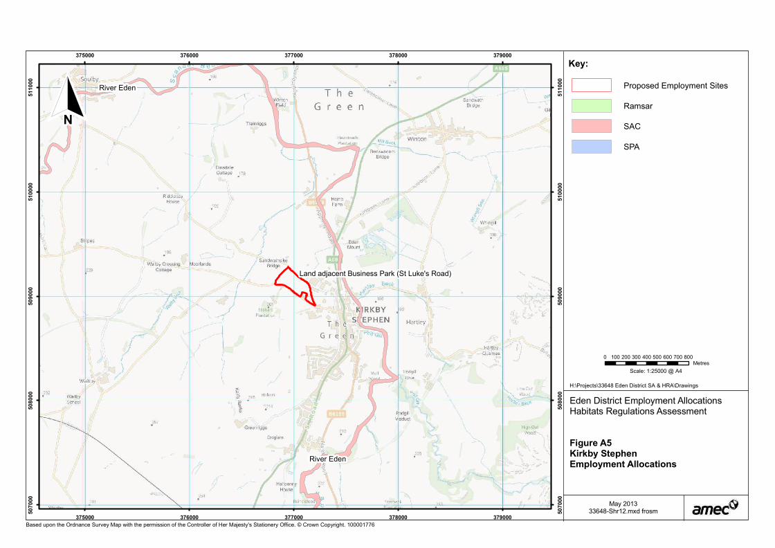
Land adjacent Business Park (St Luke's Road)
River Eden
River Eden
375000
375000
376000
376000
377000
377000
378000
378000
379000
379000
50
70
00
50
70
00
50
80
00
50
80
00
50
90
00
50
90
00
51
00
00
51
00
00
51
10
00
51
10
00
Based upon the Ordnance Survey Map with the permission of the Controller of Her Majesty's Stationery Office. © Crown Copyright. 100001776
Scale: 1:25000 @ A4
Key:
0 100 200 300 400 500 600 700 800Metres
H:\Projects\33648 Eden District SA & HRA\Drawings
N
Eden District Employment AllocationsHabitats Regulations Assessment
Figure A5Kirkby StephenEmployment Allocations
May 201333648-Shr12.mxd frosm
Proposed Employment Sites
Ramsar
SAC
SPA

Tebay Old Railway Sidings
Lake District High Fells
North Pennine Dales Meadows
North Pennine Dales Meadows
359000
359000
360000
360000
361000
361000
362000
362000
363000
363000
50
20
00
50
20
00
50
30
00
50
30
00
50
40
00
50
40
00
50
50
00
50
50
00
50
60
00
50
60
00
Based upon the Ordnance Survey Map with the permission of the Controller of Her Majesty's Stationery Office. © Crown Copyright. 100001776
Scale: 1:25000 @ A4
Key:
0 100 200 300 400 500 600 700 800Metres
H:\Projects\33648 Eden District SA & HRA\Drawings
N
Eden District Employment AllocationsHabitats Regulations Assessment
Figure A6Tebay Employment Allocations
May 201333648-Shr13.mxd frosm
Proposed Employment Sites
Ramsar
SAC
SPA

Trading Estate and Grand Prix Club
Land adjacent Trading Estate
North Pennine Moors
Moor House-Upper TeesdaleHelbeck & Swindale Woods
Helbeck & Swindale Woods
River Eden
377000
377000
378000
378000
379000
379000
380000
380000
381000
381000
51
30
00
51
30
00
51
40
00
51
40
00
51
50
00
51
50
00
51
60
00
51
60
00
Based upon the Ordnance Survey Map with the permission of the Controller of Her Majesty's Stationery Office. © Crown Copyright. 100001776
Scale: 1:25000 @ A4
Key:
0 100 200 300 400 500 600 700 800Metres
H:\Projects\33648 Eden District SA & HRA\Drawings
N
Eden District Employment AllocationsHabitats Regulations Assessment
Figure A7Brough Employment Allocations
May 201333648-Shr14.mxd frosm
Proposed Employment Sites
Ramsar
SAC
SPA