effects of urbanization on agricultural lands and river ... · development of the urban fabric and...
TRANSCRIPT

363
Journal of Environmental Biology ����April 2012����
Online Copy
Effects of urbanization on agricultural lands and river basins: Case
study of Mersin (South of Turkey)
Author Details
Celalettin Duran Eastern Mediterranean Forestry Research Institute, Tarsus, 33401, Turkey
(Corresponding author) e-mail: [email protected]
Halil Gunek Department of Geography, Firat University, Elazig, 23169, Turkey
Ersin Kaya Sandal Department of Geography, Kahramanmaras Sutcu Imam University, Kahramanmaras, 46100, Turkey
© 2012 Triveni Enterprises
Vikas Nagar, Lucknow, INDIA
Full paper available on: www.jeb.co.in
J. Environ. Biol.
33, 363-371 (2012)
ISSN: 0254-8704
CODEN: JEBIDP
Abstract
Largely, Turkey is a hilly and mountainous country. Many rivers rise from the mountains and flow into the seas
surrounding the country. Mean while along fertile plains around the rivers and coastal floodplains of Turkey were
densely populated than the other parts of the country. These characteristics show that there is a significant
relationship between river basins and population or settlements. It is understood from this point of view, Mersin
city and its vicinity (coastal floodplain and nearby river basins) show similar relationship. The city of Mersin was
built on the southwest corner of Cukurova where Delicay and Efrenk creeks create narrow coastal floodplain.
The plain has rich potential for agricultural practices with fertile alluvial soils and suitable climate. However,
establishment of the port at the shore have increased commercial activity. Agricultural and commercial potential
have attracted people to the area, and eventually has caused rapid spatial expansion of the city, and the urban
sprawls over fertile agricultural lands along coastal floodplain and nearby river basins of the city. But unplanned,
uncontrolled and illegal urbanization process has been causing degradation of agricultural areas and river basins,
and also causing flooding in the city of Mersin and its vicinity. Especially in the basins, urbanization increases
impervious surfaces throughout watersheds that increase erosion and runoff of surface water. In this study, the
city of Mersin and its vicinity are examined in different ways, such as land use, urbanization, morphology and
flows of the streams and given some directions for suitable urbanization.
Key words
Urbanization, Land use, Degradation, Basins of river, Mersin
Publication Data
Paper received:
28 October 2010
Revised received:
12 July 2011
Accepted:
30 July 2011
Introduction
In Turkey, the land use plans and policies can not be fully
implemented. On the one hand infertile lands are used as agricultural
land, on the other hand as a result of wrong development plans,
there is irreversible uses with industrial and residential areas on 1st
class agricultural lands.
The population that began to concentrate in cities with
industrialization and technological developments leads to expand
and spread urban fabric spatially. All such areas, industrial and
commercial areas established without taking into account of survey
and planning processes according to land capability affect the
development of the urban fabric and cause the emergence of
unplanned settlement.
Agricultural lands in the periphery of the cities serve as
transition zones from natural and rural habitats to urban landscapes.
They serve as supplier of vital ecosystem services such as food,
feed, clean air, soil and water to the urban areas and as buffer zones
to diminish negative effects of the urban systems on the natural
environment (Doygun, 2009).
The rapid and random expansion of urban centers has
caused changes on land cover. Forests and water catchment areas
are faced with the threat of a dense settlement (Archer, 1989; Mount,
1995). Agricultural capacity is reduced due to urban sprawl on high
quality agricultural land (Kim et al. 2003).
Mersin and Cukurova plains have rich potential for
agricultural practices with fertile alluvial soils and suitable climate.
This agricultural potential has attracted people to the area, and
eventually has caused rapid growing of industry and trade in Mersin.
These developments have resulted rapid spatial expansion of the
city. However, the desire for cheaper infrastructure and superstructure
Special Issue - Environment and Geography in the Mediterranean
Guest Editors - Dr. Recep Efe, Dr. Munir Ozturk and Dr. Sumati Gaumat

364
Journal of Environmental Biology ����April 2012����
Online Copy
Duran et al.
lead to cause expansion of the city over fertile agricultural lands
along the Adana-Mersin-Antalya road. These unplanned structures,
along both the sides of the Adana-Mersin-Antalya road, have been
causing unplanned urbanization consequently affecting agricultural
areas negatively (Sandal and Gürbüz, 2003).
Mersin, which is located in the Adana subregion of the
Mediterranean region, is one of the big cities in Turkey in the sense
of population and economical aspects. The city of Mersin was built
on the southwest corner of Cukurova where Delicay and Efrenk
creeks create narrow coastal floodplain, and where the state roads
coming from Eastern Anatolia, Southeastern Anatolia and Interior
Anatolia are intersect on the Mediterranean coast (Sandal and
Gürbüz, 2003).
Materials and Methods
Study area: City of Mersin and it’s basins of northern river are
located in east Mediterranean region of Turkey. The study area lies
between 36°40'00" to 37°10'00" N latitude and 34°10'00" to 34°45'00"
E longitude (Fig. 1). Study area is between coastal zone near the
sea side and alpine zone which is the western part of Bolkar mountains.
The basins have an area of 1383 km2 and undulating
topography with steep slopes. Section of the longest on the west-
east direction is 48 km and the north-south direction is 51.5 km. The
elevation within study area is between mean sea level with 2557 m
at watershed boundary. The main source of water is in the Northern
mountainous areas. Lithologically, the rock type of the area is
belonging to different periods limestone, ophiolite and sedimentary
formation.
In the study, first, the basin boundaries of four streams
restricting the city were identified. According to these stream basins,
forms of land use and land capability classes and relations were
evaluated. Mapping of spatial information is extremely important visual
data sources in the stages of decision-making related to these areas.
In order to describe the physiographic features of the study area,
the topographic and geologic maps was used. Remote sensing
(RS) and geographic information system (GIS) techniques were
used to determine urban growth for the period 1972-2006 (using
Landsat and Aster data archive). The urban areas were determined
by making use of image enhancement filters. In the analysis of these
data ArcGIS 9.2 and TNTmips 7.1 software were used.
The city of Mersin is between the Efrenk and Deliçay creeks,
close to the shore until the 1970s. The urban development areas
progressed rapidly in the western direction with the new zoning
plans. For this reason, according to the Landsat satellite images for
the years 1972,1987 (Aster, 2006), the development period on
productive land of urban is brought up. In consequence of rapid and
unplanned urban development regardless of streams and basins
has led to the wrong land use. However, flooding and flood risk has
emerged. In this context, this study was conducted.
Fig. 1: Location map of the study area
365
Journal of Environmental Biology ����April 2012����
Online Copy
Effects of urbanization on agricultural lands and river basins
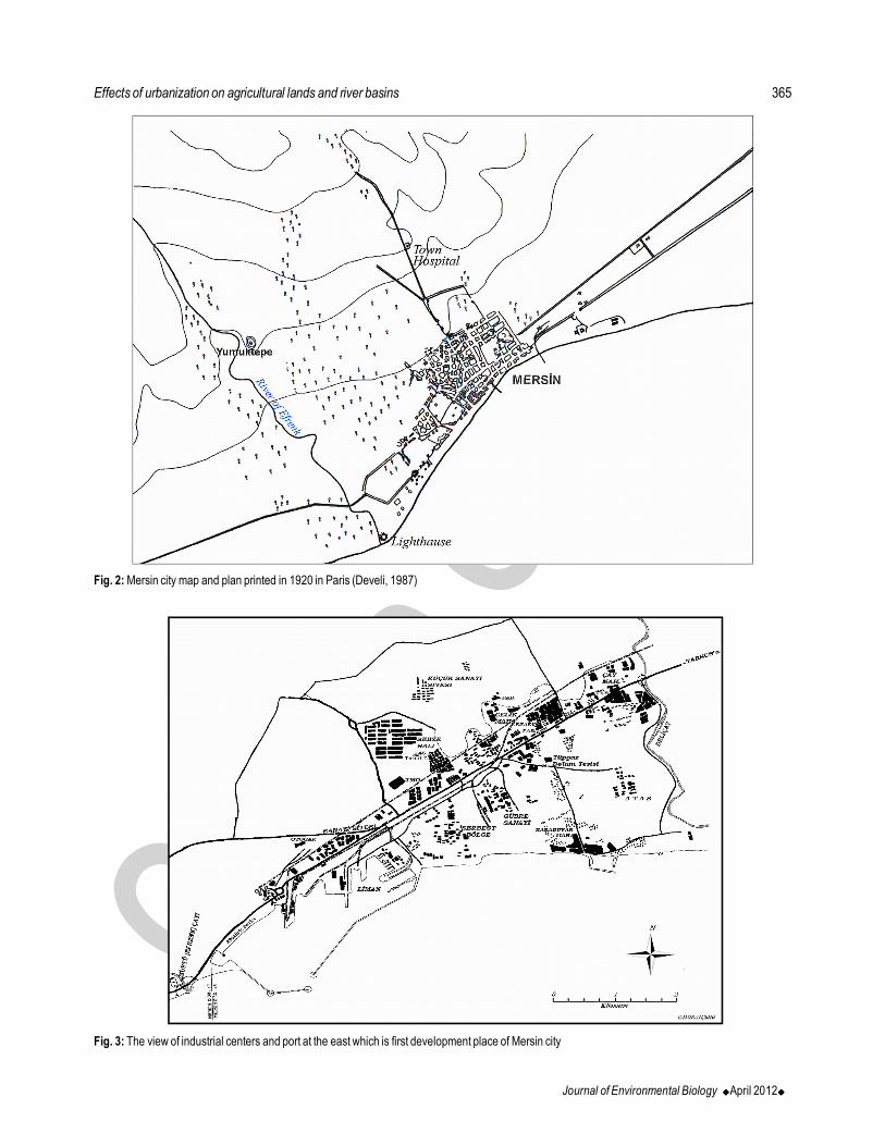
Fig. 3: The view of industrial centers and port at the east which is first development place of Mersin city
Fig. 2: Mersin city map and plan printed in 1920 in Paris (Develi, 1987)

366
Journal of Environmental Biology ����April 2012����
Online Copy
Results and Discussion
Except some general features urban history of Mersin city
shows significantly different state than other cities in Anatolia. Looking
to other cities in Anatolia a “continuity” will strike our attention. Here,
continuity means that these cities were either started during Roman-
Hellenistic period or even before this period. However, Mersin is
different from others in terms of established period. It is obvious that
there was a city in the place of the current city Mersin in the ancient
times, but during the middle age and classical Ottoman period
urbanisation was not so apparent. Moreover, in the old days Mersin
strike out with its famous Soloi-Pompeiopolis port, but later it is realised
that there was no port activity in the vicinity. Therefore, it is hardly
difficult to mention about a historical continuity of the city of Mersin
(Oguz, 2006).
In many resources examined, foundation of Mersin city relies
on mid 19th century. However, information with regard to date of
foundation is insufficient. Form of residential as a fishing village
connected to the nearest centre, Tarsus as from its foundation is in
question. Mersin forms nearest coast location of region because of its
location and has function suitable for international commercial activities
and this leads to show rapid development in a short time. In the early
19th century, Mersin being the identity of a village has become one of
the major urban centers enough to fit into human life in a short time.
The earliest record that was found about urban fabric of
Mersin is Mersin City Map and Plan printed in 1920 in Paris (Fig. 2).
Avenues and streets opened with plan in that years is a feature not
found in other Anatolian towns. The reason why Mersin is different
from nearest city, Adana is close commercial relationship of important
part of public with Europe and Lebanon (Hisarli, 1988).
Modern Mersin port which has important part of economic
development of Mersin and laid foundation in 1954 is brough into
action in 1962 (MTSO, 2006). Industrial organizations mostly collected
around Mersin port at the east of city (Fig. 3). There are many
neighbourhoods and slums formed by migration at north and north-
west of industrial organizations. The areas at west of city (areas
which vineyards-garden agriculture was made at past) and sections
closest to coast were turned into high-rise buildings by high income
groups and urbanization was accelerated in the direction of west.
The urban fabric extending to the Tece Creek at the west
consists of high rise buildings made mostly for summer use of
coastal areas. Urbanization which shows a horizontal development
parallel to the shore today, with the actual construction storey building,
has shifted towards the north coast. Suitable areas for agricultural
activities slowly are eliminated because of transport and infrastructure
facilities.
Transformation which has carried the city of Mersin today
mainly accelerated with responses in the Mersin historical city center
in the late 1960’s and early 1970’s and during this period, a break
occurred in the city’s identity.
Fig. 4: The physical development of the city of Mersin depending upon the
time has been shown at the satellite images belonging to the years (Using
fusion image enhancement for visual inspection of urban area)
Duran et al.

367
Journal of Environmental Biology ����April 2012����
Online Copy
Fig. 5: Location according to Mersin city and northern rivers (from the Google Earth/2010)
Fig. 6: The overview from port and surrounding that is first establishment place of Mersin (from North to South)
16
17
18
19
20
21
1975
1977
1979
1981
1983
1985
1987
1989
1991
1993
1995
1997
1999
2001
2003
2005
2007
Yıllar
Fig. 7: The distribution of 33 year average temperature of Mersin meteoroligical station in between 1975-2008 according to years (source: SMS, 2009)
Effects of urbanization on agricultural lands and river basins
Year
Tem
pera
ture
(o C)

368
Journal of Environmental Biology ����April 2012����
Online Copy
Fig. 9: Land capability classification (source: GDRS maps, 1991)
Fig. 8: Slope groups (source: Digital elevation model / 10 m)Fig. 10: Agriculture and settlement areas (source: GDF maps 2008)
On one hand rapid population growth effects the social fabric,
on the other hand, it brought the city’s physical development to the
third dimension, so that housing in two-storey and inside large gardens
gave place to multi-layer construction process (Unlü, 2007).
In 1963 development plan, city is focusing on development
trends to the north and west. Because of the first-class agricultural
land in these areas, agricultural land preservation has become one
of the main problems (Akcura, 1981).City mostly remained in the
area between Delicay and Efrenk streams until the 1970’s and was
generally moving in the direction of the north of port.The construction
period switching to the west of Efrenk stream in the 1970’s and later
on the farmland accelerated the progress in the 1980’s (Fig. 4, 5).
Mersin in the 1980’s, began to receive intense internal
migration from particularly lower socio-economic development level
of the provinces. The expectations that free zone is being established
lead to the extensive employment and the South-East conflict were
the developments encouraging the migration.
While the migration of Mersin was 46000 in two years
between 1983–1985, it reached by 36000 people in 1986. The
migration continued up to 1990s (Table 1) (Turgut, 2006). Due to
migration after 1983, coastal ecosystems in the coastal part was
deteriorated. Acquired through completion coastal areas, the
shoreline has been growing at unnatural rates
Mersin free zone and port is located on the slope of the
straight and level area to be closer to the establishment of a wide
range of economic activities has facilitated and encouraged (Fig. 6).
There is very well-developed transportation network in the plains;
Taurus mountains lying just behind connect the gate and plains to the
inner region (Akova, 2002). Industrial and commercial sector in the
rapid spread of the plains, agricultural activities has led to a shift to the
north. The temperate climate which prevails in the area allows to
provide agricultural activity all the year, has also led to conversion of
non-arable areas to agriculture (Fig. 11).
The change in land use such as urbanization and
agricultural areas causes atmospheric and environmental impact.
(Kalnay and Chai, 2003; Fazal, 2000). In other words by influencing,
it naturally causes local and regional climate change in air quality
Duran et al.

369
Journal of Environmental Biology ����April 2012����
Online Copy
Fig. 11: Geology map (left); urban area on deltaic deposits (suitable area to agricultural activity) and agriculture areas on caliche deposits (not suitable area to
agricultural activity) (source: GDMRE maps 2009; GDF maps 2008)
(Kindap et al., 2008). Depending on the increase in urban
construction, it is observed that there is an increase in mean annual
temperature trend over the years. With expansion of urban on land,
it also encourages to increase the temperature of urban structures. It
is seen that there is significant increase in annual mean temperature
in connection with urban development (Fig. 7). The lack of sufficient
openness and greenery area of the fast-growing cities as well as a
plurality of heat-absorbing structures is effective in increase of
temperature.
Problems of land use on river basins of northern mersin
city: As a result of rapid urbanization, other land cover has also led
to changes. The natural structure of river basins is deteriorated.
The risk of flooding and flood has increased (Khan 2005; Nirupama
and Simonovic, 2007; Zhang et al. 2008). Urbanization has an
irreversible impact on natural drainage patterns, and flows in the
receiving water bodies’ hydrologic systems (Novotny et al. 2000).
Mersin is at the position of significant center to be established
city-basin relation. Urban lying to coast parallel to Middle Taurus
limits its source to the southeast-northwest direction with river basins
vertically going to sea and formed the mountainous areas. The river
downstream of this position being for the 1st class of agricultural land
increases the potential for rising mountainous area contains enough
water. The rivers arising from all mountainous generations, for
centuries, they carry with erosion as particles and pile up in front of
rivers to form productive land for agriculture. A large number of small
and big rivers that pass through Mersin city and reach the sea
causes flooding and flood events after heavy rainfall. The city’s
establishment and development process took place very quickly, the
river reached the sea and the debris cones and fans of high-field
structure of the revolution by filling out the skirt, to floods and flood
damage has become an open position.
Deliçay, Efrenk, Mezitli, Tece and Sahna streams and the
arm of river valleys that these streams pass through are usually
concentrated in the rural areas and towns settlements. Settlements
surrounding river valleys often are located on terraces or small
pond range. The settlement pattern is sparse and settlements in
general, lay along a slope or valley. Bekiralani and Sogucak villages
are good examples.
The majority of settlements in river basins was established
and developed in the places where water supply is close. Shores of
the land does not allow cultivation of agricultural products; so such
activities expand around the settlements located in the river basin;
the water sources were affected (Fig. 10). Depending on intense
agricultural activity in this area, it leads the environmental effects of
pesticides and fertilizers into the water supply. The main rivers forming
the workspace has a significant impact in shaping the region’s
topography, the ecological environment and the human activities.
If we briefly describe these streams;
Efrenk (Muftu) creek: It is due to plateau and the slopes forming
southwest of the Bolkar mountains. Approximately, 70 km long Efrenk
Creek, divides the city placement to be centered. Efrenk (Mufti)
Creek, has a catchment area 464 km2. The highest point is top of
Kizildag (2565 m) and lowest downstream code creates the
Mediterranean.
Delicay creek: Reach the sea from the eastern part of the city, make
curve in the vicinity of Degirmendere and falls to the south. Delicay
Effects of urbanization on agricultural lands and river basins

370
Journal of Environmental Biology ����April 2012����
Online Copy
basin covers approximately 471 km2 area. The highest elevation of
the basin is Çökelekkapa hill with 2275 m, the lowest level constitutes
the downstream Mediterranean.
Mezitli (Liparis) creek: It is fed by rainfall in the northern hills and
it is flowing into the sea through the center of Mezitli town. The highest
point in the basin is Kalegedigi hill with 1898 m. Basin area, in
general, has the appearance of the land slopes. Approximately, 34
km in length and has a 176 km2 basin.
Tece creek: The Tece creek reaches the sea at the western edge of
the city, by collecting the water of Findikpinari highlands flowing to the
south, and it is falling into the sea through the settlements of Tece
town. Lying parallel to Mezitli creek, the creek is average 34 km in
length as Mezitli creek and has narrower basin of 103 km2. The
highest point in the basin is Peynirdagi hill with 2041 m.
In certain parts of the land at the north of the city, the highland
villages and settlements are intertwined. Because of the unbearable
heat of summer, the summer houses have been built with 2nd housings
within the highlands of the basin and in the villages; human activities
in this way also extend to the north areas (Fig. 10).
Large plateaus such as Aslanköy, Gözne, Findikpinari,
Sogucak, Bekiralani, Mihrican, Ayvagedigi and Güzelyayla are
located within the basins boundaries of these settlements. The area
of urban and rural areas is approximately 120 km2 in total in study
area. Mediterranean coastal zone during the summer season is
utilized for recreation for people in the highland city of Mersin to the
property indicating that the average settlement of 24 to 52 km away
from the sea, the elevation is between 800 and 1500 m (Sandal,
2003).
Where the caliche lands established on arable land of the
city in the north of the alluvial land is widely available and, in terms of
settlement it is more suitable ground. Topography is generally
favorable. Undulating flat surface is dominated (Fig. 8). The planning
of this area appropriate for influence of the seismicity would be more
appropriate as settlement (Fig. 11).
Mersin which continuously develops as socio-economic and
spatial inception to the present greatly carried this development on
soil class I, II, III and IV. (Fig. 9,11). But today, the city of the plains at
the base of this development was not healthy enough. Destroyed
thousands of hectares of fertile agricultural land, because of this
development, and an unhealthy urbanization have brought new
environmental problems (Sandal and Gürbüz, 2003).
At soundings made on the shore, the high groundwater
level was observed. Urban and agricultural areas around the city
for use in the north of the city opened up due to excessive water from
wells, sea water is input. For this case, the structure also creates a
negative situation. Highland settlements are constantly growing in
terms of space and population. This situation forces the potential
facilities having the plateau and highland areas are beginning to
disrupt ecosystems. The arbitrary-irregular construction developed
on the sea coast and productive agricultural land is threatening our
highland areas. Continuous nature of people in a way that their
goals tend to change according to the shores of which occur in
natural and environmental degradation has resulted in increasingly
moving to highland areas.
The developing cities without taking into account structure
and capability of the land, often leads to form land in the way that do
not conform to the class of land use ideally. The flood events, in
Duran et al.
Table - 1: Annual growth rate of the population of the city of Mersin and Turkey (1927-2007)
Turkey Mersin
Years The amount of Annual growth Population Annual growth
the population rate (%0) rate (%0)
1927 3 305 879 - 21 147 -
1935 3 802 642 17.50 27 620 33.4
1940 4 346 249 26.72 30 007 16.7
1945 4 687 102 15.10 33 148 20.1
1950 5 244 337 22.47 36 463 19.2
1955 6 927 343 55.67 50 104 65.6
1960 8 859 731 49.21 68 485 64.4
1965 10 805 817 39.71 86 692 48.2
1970 13 691 101 47.33 112 982 54.4
1975 16 869 068 41.75 152 236 61.4
1980 19 645 007 30.47 216 308 72.7
1985 26 865 757 62.61 314 350 77.6
1990 33 326 351 43.10 422 357 60.8
2000 44 006 274 26.8 537 842 24.2
2007 49 747 859 17.52 623 861 21,2
Source: TSI 2009

371
Journal of Environmental Biology ����April 2012����
Online Copy
2009, have led to huge losses in many cities in Turkey. In the spatial
development of cities, one of the most important factor to be
considered as affecting the cities of the river basin planning are to
be made by considering the boundaries.
Although there is no previous urban settlement for the city
of Mersin, during expansion of the city, outfalls have not been
considered. Moreover, this river basin covering the territory with
the destruction of natural vegetation to urban flooding and flood risk
has become more open.
References
Akcura, T.: Observations about Institution of Public Works: ODTU, Ankara.
Turkey (1981).
Akova, B.S.: Geographical researches on the Mediterranean coasts: Cantay
Publications, Istanbul. Turkey (2002).
Archer, D.R.: Flood wave attenuation due to channel and floodplain storage and
effects on flood frequency in floods: Hydrological, sedimentological and
geomorphological implication. editor John Wiley, NewYork, USA. 37-46
(1989).
Develi, H.S.: Mersin from past to present (1936–1987). Gaziyurt publ.i,
Gaziantep. Turkey. (1987).
Doygun, H.: Effects of urban sprawl on agricultural land: A case study of
Kahramanmaras, Turkey: Environ. Monit. Assess, 158, 471–478
(2009).
Fazal, S.: Urban expansion and loss of agricultural land – a GIS based
study of Saharanpur City, India, Environ. Urbani., 12, 2 (2000).
GDF.: General Directorate of Forestry, Digital Maps. Ankara. Turkey. (2008).
GDMRE.: General Directorate of Mineral Research and Exploration, Geology
Maps. Ankara. Turkey (2009)
GDRS.: General Directorate of Rural Services, land capability classification
and soil maps. Ankara. Turkey (1991)
Kalnay, E. and M. Cai: Impact of urbanization and land-use change on
climate, Nature. 423, 528–531 (2003).
Khan, S. D.: Urban development and flooding in houston texas, Inferences
from remote sensing data using neural network technique. Environ.
Geol., 47, 1120-1127 (2005).
Kim, D.S., K. Mizuno and S. Kobayashi: Analysis o f urbanizat ion
characteristics causing farmland loss in a rapid growth area using
GIS and RS. Paddy and Water Environ., 1, 189-199 (2003).
Kindap, T., A. Unal and M. Karaca: Air pollution problems and solutions in
Turkey: Air pollution and control national symposium, Hatay. Turkey.
(2008).
MCCI.: Mersin chamber of commerce and industry, Economic report.
Mersin. Turkey (2006).
Mount, J.F.: California rivers and streams. University of California Press.
Berkeley. USA (1995).
Nirupama, N. and S. P. Simonovic: Increase of flood risk due to urbanization:
A Canadian example. Natural Hazards, 40, 25–41 (2007).
Novotny, V., D. Clark R. J. Griffin and D. Booth: Risk based urban watershed
management under conflicting object ives. Proc. 1st World water
congress of the International Water Association (IWA), Paris, France.
July 3-7, Book 5 Water res. waste manag., 144-151. (2000).
Oguz, I.: History the establishment of the Mersin City, Mersin chamber of
commerce and industry. Mersin. Turkey. (2006).
Sandal, E. K.: Recreational yayla activities on settlement unites in the
North of Mersin, Turkish Geographical Review, 40, 121–138 (2003).
Sandal, E., K. and M. Gurbuz: The examination of spatial expansion of the
city of Mersin and misuse of agricultural lands: Turkish J. Geograph.
Sci., 1, 117-130 (2003).
SMS.: Turkish State Meteorological Service, Data of Mersin Meteorology
Station. Ankara. Turkey (2009)
TSI.: Turkish Statistical Institute, Data of Demographic Statistic. Ankara.
Turkey (2009)
Turgut, M.: Migrations and history of Mersin, Et ik Publicat ion. Turkey
(2006).
Unlu, T.: Urban planning experience and formation of urban space in
Mersin, J. Fac. Eng. Arch. Gazi Univ. Ankara. 22, 425-436, (2007).
Zhang, H., W. C. Ma and X. R. Wang: Rapid urbanization and implications
for flood risk management in hinterland of the Pearl river delta, China:
The Foshan Study. Sensors 8, 2223-2239 (2008).
Effects of urbanization on agricultural lands and river basins