effects of urbanization on water resources-facts … · 2017-05-03 · “effects of urbanization...
TRANSCRIPT
International Journal of Scientific & Engineering Research, Volume 8, Issue 4, April-2017 433 ISSN 2229-5518
IJSER © 2017 http://www.ijser.org
“EFFECTS OF URBANIZATION ON WATER RESOURCES-FACTS AND
FIGURES”
Dr. Sheetal Sharma, Asst. Professor, Dept. of Architecture and Planning, Maulana Azad National Institute of technology, Bhopal-
462007, India. Email: [email protected]
& Abstract: Urban Areas are continually facing Problems of water scarcity and urban Flash Floods. Recent news from IPCC report 2010 , CIESIN's Global Rural Urban Mapping Project and World Water Vol7 2007, it is clear that urban land area has doubled and affected the Hydrological Cycle . The components of Hydrological cycle affected are Infiltration, Runoff and Evaporation and the causing components are derived by studies as Land Use Land Cover, Water Withdrawal and Urban Developments. Thus water availability, water recharge and water Cycle all are destabilized in course or urban Development. The paper is an attempt to correlate and identify the periodical changes in Urban Hydrology, during urbanization of Bhopal City, India during last twenty years and above. The observations are based on GIS Mapping of the Study Area from 1991 to 2009 using rational method of Runoff and Recharge Calculations and statistical analysis of related built-up areas. Also Change in Natural course of Drainages with help of GIS imageries during twenty years have been detected that help to observe the adaptation of natural system to urban course. Observations show an interesting relation of geology, land use-land cover and water table, which can be used for further research and sustainable development.
Key Words: Runoff, built up, water levels, land use-land cover.
————————————————————
1. INTRODUCTION:
Natural systems are already responding increasingly making their presence by extreme weather events in the recent decades like floods, droughts , tsunamis, earthquakes along with world’s rivers, lakes, wildlife, glaciers, permafrost, coastal zones, disease carriers and many other elements of the natural and physical environment leading to imbalance and natural hazards. Many activities like UNESCO, UNEP, IPCC and UNHSP at international level during last decade have been developing a basis for the rational use and conservation of the resources of biosphere, overcome the impacts of climate change for the improvement of the relationship between man and environment within the natural and social sciences (SienceDaily-IPCC 2007) the Intergovernmental Panel on Climate Change (IPCC). The assessment reports of IPCC 2007 and 2013 have stated that warming of the climate system is unequivocal, and since the 1950s, many of the observed changes are unprecedented over decades to millennia. The atmosphere and ocean have warmed, the amounts of snow and ice have diminished, sea level has risen, and the concentrations of greenhouse gases have increased. Each of the last three decades has been successively warmer at the earth’s surface than any preceding decade since 1850. Confidence in precipitation change averaged over global land areas since 1901 is low prior to 1951 and medium afterwards. (E.B, Thestate of Resource, Chapter 4 2004) (C. V. H.Hengeveld 1982)
The most notable changes observed are related to the urban and hydrological system where urban areas have increased from 100000 to 5000000 and as per United nations projections half of the urban population would live in urban areas and by 2050 64.1 and 85.9% of the developing and developed world respectively will be
IJSER

International Journal of Scientific & Engineering Research, Volume 8, Issue 4, April-2017 434 ISSN 2229-5518
IJSER © 2017 http://www.ijser.org
urbanized. Built up associates with urban areas have also had noticeable change of 145.68% as compared to 54.05 % change in Population Growth from 1971 to 1999 ( Figure 1). Also UN report of 2013 the urban population will increase from 29.1 in 1950 to 66.6 in 2050. As per the State of resource (UNESCO, State of Resource Chapter 4) water is predicted to be the primary medium through which early climate change impacts will be felt by people, ecosystems and economies. (E. W. White 2006). Hydrology has suffered drastic changes in its components felt changes in recharge that dropped from 45-50% in 1961 to -10to-30% in 2050 as per the UNEP and IGRAC.
Hydrological changes may have impacts that are positive in some aspects and negative in others. For example, increased annual runoff may produce benefits for a variety of both in stream and out-of-stream water users by increasing renewable water resources, but may simultaneously generate harm by increasing flood risk (IPCC, Linking climate change and water resources 2007). Water scarcity on the other hand is expected to become an ever-increasing problem in the future, for various reasons. First, the distribution of precipitation in space and time is very uneven, leading to tremendous temporal variability in water resources worldwide ( (CLimate 2007-2010) second, Rising temperatures are accelerating the hydrological cycle and causing rivers and lakes to freeze later in the autumn. Scientists are increasingly confident that, as global warming continues, certain weather events and extremes will become more frequent, widespread or intense. IPCC 2007 Human activities and urbanization is likely to affect climate change which in result will impose extreme weather events ( (M.Stephenson 2004). Both observational records and climate projections provide strong evidence that freshwater resources are vulnerable, and have the potential to be strongly impacted by the increasing urban areas. Possible impacts of climate change due to changes in extreme precipitation-related weather and climate events, based on projections to the mid- to late 21st century indicate areas with heavy precipitation increasing intensities, increase in areas affected by droughts, and intense Tropical cyclone increase , damaging to crops, soil erosion, land degradation, lower yields, damage to ability of land to cultivate. More intense rainfall events will increase runoff percentages and will overload the capacity of sewer systems and water and wastewater treatment plants more often. One reason is that precipitation variability is very likely to increase, and more frequent floods and droughts are anticipated.
Thus changes in land use and land cover due to urbanization are likely to impact water requirement as some places are suffering from water scarcity and some with Flash floods. Dynamic land use changes and transitions bring challenged not only for Social Systems but also for ecological systems and decision making processes creating an urgent need for planning and developing parallel solutions to changing world.
Broad scale changes in Land systems influence climate in several ways. Vegetation affects the physical characteristics of the land surface, which affect water evaporation and transpiration, the reflection or absorption of solar radiation, and the transfer of momentum with atmospheric flows. These processes determine water and energy exchanges with the atmosphere at its lower boundary, and can exert a major influence on climate at all scales. Land systems also affect the cycling of
IJSER

International Journal of Scientific & Engineering Research, Volume 8, Issue 4, April-2017 435 ISSN 2229-5518
IJSER © 2017 http://www.ijser.org
chemical elements, the most prominent and well-known being the carbon cycle, in particular the role of land systems in modulating atmospheric concentrations of the greenhouse gases carbon dioxide and methane.
From several studies and worldwide reports of world water day 2007,2010, IPCC 2008, (CARA 2006) (Booth 1991) (E. W. White 2006) it is observed that when an area is developed for housing or other urban purposes, the immediate hydrologic effect is to increase the area of low or zero infiltration capacity and to increase the efficiency or speed of water transmission in channels or conduits and in physical terms the most obvious landscape level change is the extent to which previously natural surfaces are covered with engineered , impervious ones. (Chester L.Arnold 1996) .Once vegetation and soil is replaced with buildings and paved surfaces, the infiltration potential for precipitation is greatly reduced, resulting in increased surface runoff, decreased lag time and increased peak discharge in streams and roads leading to flash floods and ponding. (Booth 1991)
The urban landscape has many impacts on the local climate, such as reduced average wind speed due to the blocking effect of buildings and greater frequency of flash flooding owing to the higher proportion of ground sealed with concrete and asphalt and a corresponding reduction in natural drainage. Detailed estimate of climate change impacts and landscape modifications on water resources at regional and local level are currently inaccurate due to inadequate data for water cycle and hydrogeology relations. Physical planning though equipped with modern means as well as best technologies is still lagging behind from the hands of urban planners due to insufficient knowledge of natural systems and their correlations . Physical development as part of regional development such as construction of buildings, housings, roads, bridges and public utilities are continuously increasing due to the development in all sectors. The physical developments need land space and give positive impacts for the benefit of the people. However it also creates negative impacts to the physical environment. It can be understood since a physical development is directly related to the land where constructions stand on, where water occur as source for water supply of men living on it, and where the air is available for supporting life.
Some facts at global level observations verify these changes as sensitive issues for urban areas are given in Figure1.
IJSER

International Journal of Scientific & Engineering Research, Volume 8, Issue 4, April-2017 436 ISSN 2229-5518
IJSER © 2017 http://www.ijser.org
Figure 1-1: variations in Worlds Surface water. (Gleick, Chapter 1. Peak water World water 2008-09) Note: it is observed that world’s surface water has runoff has prime component varying with precipitation.
Considering run off as prime effect of urbanization to the hydrological cycle in terms of water infiltration, the intention of the study is to contribute to a better understanding of the relation of the local hydrological parameters in urban areas to the physical transformation of land covers as impervious built ups and develop an understanding of the resulting effects of one component on other. This will help to predict and project the changes in hydrological cycles due to land use /land cover transformation and thus help urban planners in physical planning of new as well as old development of an area to achieve a maximum sustainability in the city.
The aim of the study is to fill the gap of correlation and develop a better understanding of the interactions between surface water flows and water replenishment with changes in land cover characteristics resulting from urbanization at the local, neighborhood and regional scales to create a multidisciplinary and interdisciplinary perspective to achieve least disturbance to natural system, through innovative conceptual and methodological approaches.
3. LITERTURE REVIEW.
Early studies (LEOPOLD n.d.) Luna B. Leopold (1973) is one of the pioneers of scientific research evaluating the adverse changes humans can impose on streams. His work on the Watts Branch of the Potomac River near Rockville, Maryland is considered seminal among investigations of temporal fluvial geomorphic response to urbanization (Leopold 1973). Leopold helped to introduce the idea that urbanization is an impact on watersheds, geographic units that he considered significant environments in form and function. William L. Graf focused on how changes in channel networks occur as a result of impervious surfaces, proposing that: Roofs, sidewalks, streets, parking areas, and sod lawns accelerate overland flow and restrict infiltration, resulting in flood discharges of greater magnitude and frequency than those that occurred before urbanization. In addition to changes in surfaces, however, suburban development introduces another significant change into the hydro-geomorphic systems in the form of radical alteration of channel networks .Graf 1976). Graf’s research (1976) found that an increase in impervious surface added a significant artificial channels to the previously existing natural drainage network. His early work references Leopold, among others, but is unique for its time because of its multi-variable approach. Graf examined several indicators of change and ranked the importance of their spatial relationships to the drainage network. Morisawa (1979) found that streams in several urbanized drainages in the Pittsburgh, Pennsylvania area were enlarging by incision, bank erosion, or both and attributed variations in enlargement to the complex interactions of
IJSER

International Journal of Scientific & Engineering Research, Volume 8, Issue 4, April-2017 437 ISSN 2229-5518
IJSER © 2017 http://www.ijser.org
hydrology and differing resistance of bed and bank material to erosion. Channels with more resistant bed material will erode laterally while channels with more resistant banks will tend to incise. Knox (1989) summarized this process: The enlarged channels now contain most floods that once overflowed stream banks, and because these channels perform a “flume-like” function with relatively little hydraulic roughness compared to that experienced when shallow flood waters are spread across wide floodplains, the floods are quickly routed downstream with considerable velocity and erosive force… (Knox 1989). Booth (1990) indicated that the immediate increase in discharge may, with time, cause an increase in stream channel cross-sectional area or potentially catastrophic channel incision depending on slope and geology. Channels can yield significant amounts of sediment from bank erosion and bed incision, especially when they are in an unstable state. Trimble (1997) hypothesized that 60% to 75% of the sediment yield from watersheds he observed in California and Texas was derived from bank erosion. Gregory (1992) observed channel capacity increases in the Monks Brook in southern England on the order of 2 to 2.5 times after urbanization. Channel adjustments resulted in width increases up to 2.2 times and bed incision up to 0.4 meters. Collins (2001) reported that within the 2.6-mile (4.2 km) study reach of San Pedro Creek, sediment supplied from bed incision was 7 times greater than from bank erosion. Significant in stream erosion may continue until development of the watershed has stopped long enough for the channel to adjust to a more stable geometry suited to post-urbanization flow and sediment regimes. Several studies compiled by Schuler (2003) found that channel enlargement in response to urbanization can result in cross-sectional area that is 2 to 8 times greater than pre-urbanization conditions.
Studies and work related to effects of Urbanization on water cycle.
a) The effects of urbanization on groundwater in Beijing: The University of Texas at Austin: 2006 has concluded that CN values close to 100 indicate high runoff whereas low to moderate CN values indicate lower runoff. Developed lands with higher levels of impervious area have higher curve numbers which correspond to greater surface runoff because impervious surfaces reduce permeability of land surface and infiltration at the site. The total volume of runoff increases as the urbanization density increases. The results may indicate that the increase in impervious cover increases surface-water runoff while the increase in urban irrigation and underground Karst results in greater recharge to the groundwater. The results have implications for World Bank policies that advocate urbanization as a water resources management strategy for the sustainable development of water in rural and urban areas.
IJSER

International Journal of Scientific & Engineering Research, Volume 8, Issue 4, April-2017 438 ISSN 2229-5518
IJSER © 2017 http://www.ijser.org
b) The Water Cycle: Surface Runoff factsheet of USGS 2003 increasing imperviousness due to roads, houses, parking lots, and buildings, removal of vegetation and soil, grading the land surface, and constructing drainage networks increase runoff volumes and shorten runoff time into streams from rainfall and snowmelt.
c) As per CARA (Consortium for Atlantic Regional Assessment), impacts that Climate Change has on a region will depend, in part, on the land use and land cover in that region due to population growth or decline, Economic Growth, demographics, Agriculture & forest prices and regional & local planning and policies.
d) The successful implementation and planning of SUDS (Sustainable urban drainage systems) have introduced an Ecosystem Approach to sustainable use of natural resources – flood control, water storage, reuse. Equitable sharing of the benefits – SUDS components such as ponds, wetlands and grasslands providing amenity value to the local community. Conservation of natural resources – pollution attenuation at source, supporting and maintaining wildlife habitats.
e) Urban runoff as defined and studied by Naraine Persaud (http://www.cee.vt.edu/ewr/ environmental/teach/gwprimer/group18/urbanr.htm#def) accessed on 24.04.2011. Rainfall and the soil conditions are the direct causes of urban runoff. Rainfall can take one of several routes once it reaches the earth’s surface. Rainwater can be absorbed by the soil on the land surface, intercepted by vegetation, directly impounded in many different surface features from small depressions to large lakes and oceans, or infiltrated through the surface and subsurface soils into the groundwater. Another route taken by falling precipitation is runoff. Soil characteristics in a watershed have a direct effect on the rainfall-runoff process and these include soil layer thickness, permeability, infiltration rate, and the degree of moisture in the soil before the rain event. The greater the permeability of the soil, or the ability to infiltrate rainfall to its lower strata, the less remaining to become runoff (Horner et. al. 1994). Causes and Effects of Runoff on Urban Land Surfaces vs. Rural Land Surfaces Population effects on runoff, Vegetative cover, Water flow velocity , Changes to natural hydrologic cycle . Remedies suggested were porous pavements, green belts, adsorbents in sewer inlets and surface cleaning using wet scrubbing.
f) The research project carried out by U.S, Office of research and development, Washington in June 1999 for land cover change concluded that Land use and land cover changes occur at all scales, and changes at local scales can have dramatic, cumulative impacts at broader scales. Consequently, land use and land cover changes are not just of concern at local and regional levels (i.e., because of impacts on land management practices, economic health and sustainability, and social processes), but globally as well. Unfortunately, there
IJSER

International Journal of Scientific & Engineering Research, Volume 8, Issue 4, April-2017 439 ISSN 2229-5518
IJSER © 2017 http://www.ijser.org
is a paucity of information on land use and land cover change except at very local levels.
g) IHDP report on GEC 2009 have stated 5 analytical problems for GEC mentioning research Gap between the effective Earth System Governance and Understanding the agents that Drive Earth System Governance , Flexibility in Long term governance to reach quickly to new findings and developments.
h) Lisa Chalmers and Emma Monk (Emma Monk 2006) and (Walsh 2004) have proposed concept of mimicking natural drainage processes to protect life and properties from flooding, to improves the aesthetics of urban areas and maintain the water quantity and quality requirements of receiving water bodies. It has also shown how natural drainage processes can be incorporated within urban areas by maintaining the natural or the pre-development hydrologic regime.
i) (Elizabeth McNicholas 2008) from school of architecture UCD, have explained in spatial planning and hydrology at different scales that in order to make informed decisions about future hydrology policies for expanding cities, it is crucial to determine where change to the landscape is likely to occur. The majority of surfaces within a city are sealed preventing the infiltration to groundwater and aquifers, and increasing the possibility of flood that may endangering the quality of the water supply. Furthermore there are additional behavioral changes arising from lifestyle choices and fashions. In addition, climate change is going to increase the intensity and frequency of floods in Ireland. It is therefore imperative to examine the local landscape and examine the pre-existing drainage systems that currently are operating and look at means of improving this to cope with changing climates and surfaces.
j) U.S Land Cover change and EPA, Research Project, 1999 developed a methodology and determined the variables of land cover change by using temporal and spatial frameworks and categorizing land cover types into Urban and Built-Up ,Agriculture (Cropland and Pasture) , Forests and Woodlands , Rangeland/Grassland , Wetland , Water bodies , Snow and Ice , Natural Barren ,Disturbed or Transitional and cover change variables as Land Cover Change variables, General Land Cover Type, Landscape biophysical properties, Landscape properties and concluded that and land cover changes occur at all scales, and changes at local scales can have dramatic, cumulative impacts at broader scales. Consequently, land use and land cover changes are not just of concern at local and regional levels (i.e., because of impacts on land management practices, economic health and sustainability, and social processes), but globally as well. Land use and Land Covers changes are driven by Natural processes- Climate and atmospheric changes, wild fire and Pest Infestation, Direct effects of human activity, such as deforestation and road building ,Indirect efforts of human activity , as water diversion leading to
IJSER

International Journal of Scientific & Engineering Research, Volume 8, Issue 4, April-2017 440 ISSN 2229-5518
IJSER © 2017 http://www.ijser.org
lowering of water table. Unfortunately, there is a paucity of information on land use and land cover change except at very local levels.
k) The state of resource report CHAPTER 4, by UNESCO for Global hydrology and water resources have stated that Climate change is having significant impact on the weather patterns, precipitation and the hydrological cycle, affording water availability, as well as soil moisture and ground water recharge and the major driving forces for these are Population growth, major Demographic changes as people move from rural to Urban. higher demands for food, security and soil economic well being, increased competition between users and usage pollution from Industrial, municipal and agricultural sources.
l) World water Day report 2011 have emphasized the need for Proper long term urban planning as key to sustainable urban water on basis of Singapore Master plan 2060. Dr. Joan Clos, Under-Secretary General and Executive Director, UNHABITAT, observed that large rural-urban migration flows are taking place without proper urban planning. He added that the urban crisis can only be addressed by developing a new urban policy that takes into account problems of the future, including the influx of people to cities and the future development of the cities. Dr. Clos recommended a phased approach to urban planning starting with basic streets and basic services so that the city is functional and able to provide goods and services, taking into account all aspects, including mobility, water, and energy. Dr. Clos noted that rapid urbanization was increasing faster than the capacity of cities to provide infrastructure. He added, “The good news is that we can face this by developing urban policies to address urban planning and urban legislation. We need to plan in advance of the problem to mitigate; we need to plan today not tomorrow. We need to plan at the scale of the problem and in line with growth. We must have a basic plan that considers water, sanitation and drainage.”
m) United Nations Human Settlement Programme (UN-HABITAT); the African Ministers’ Council on Water (AMCOW); the United Nations Environment Programme (UNEP) and Water Aid. Suggested urban Planning inclusive of water & sanitation , Ground Water Management in Urban Areas- ( UNESCO) along with “ invisible” dimensions of water management in cities and vital role that ground water plays in urban areas. Dr. Dubravaka- Simulation Model with UGROW- simulation is modeling and decision making tool for urban ground water management- Ground water Interaction with Urban Water System elements.
n) Similarly World water 2007 stated that- Conscious of the increasing pressure on limited water resources, UN-Water has identified 1.water scarcity as the theme for World Water Day 2007. And 2. The multiple dimensions of water scarcity: Imbalances between availability and demand, the degradation of groundwater and surface water quality, intersectoral competition, and
IJSER

International Journal of Scientific & Engineering Research, Volume 8, Issue 4, April-2017 441 ISSN 2229-5518
IJSER © 2017 http://www.ijser.org
interregional and international conflicts, all bring water issues to the fore. Un-water a mechanism for coordinating the actions of the United Nations (U N) system aimed at implementing the agenda set by Millennium Declaration by using appropriate scale for understanding water scarcity as at the local or regional level, notably within a river basin or sub-basin, rather than at the national or global level. In many countries, especially the larger ones, there are both water-scarce and water-abundant areas.
o) Water challenges in Asia as (Schneider 2011), Scarcity of water increasingly challenges economic growth of India and China. Water’s role in economic development is taken for granted, yet for running the growth engine it’s as precious a commodity as fossil fuels.
p) The Chinese government anticipated contests over water and already enforces many efficiency and conservation measures. But food and energy production depend on water while China is getting drier: Water reserves are down 13 percent from 2000. “Water shortage is the most important challenge to China right now,” said Wang Yahua, deputy director of the Center for China Study at Tsinghai University in Beijing. “It’s a puzzle that the country has to solve.” The central and provincial governments enacted and enforced a range of water conservation and efficiency measures essential for China’s new prosperity. Though China’s economy has grown almost eightfold since the mid-1990s, water consumption has increased just over 15 percent or 1 percent annually, according to the National Bureau of Statistics.
q) China is getting steadily drier. Total water resources, according to the National Bureau of Statistics, have dropped 13 percent since the start of the century. In other words, China’s water supply is 350 billion cubic meters, or 93 trillion gallons, less than it was at the start of the century.
r) Chinese climatologists and hydrologists attribute much of the drop to climate change, which is disrupting patterns of rain and snowfall. The new five-year plan calls for reducing water use by 30 percent for every new dollar of industrial output, the same target included in the 11th Five-Year Plan, easily met with programs to recycle water in major industries and in large cities, led by Beijing.
s) Man’s influence on hydrological cycle, Water Resources Of India: Current science , Vol.89, No.5 , 10 Sept 2005) Pg. 794- 811.Rakesh Kumar, R.D Singh, K.D Sharma ( National Institute of Hydrology, Roorkee) concluded that The hydrological cycle is being modified quantitatively and qualitatively in most of the river basins of our country as a result of the developmental activities such as construction of dams and reservoirs, land use change, irrigation, etc. Such human activities affecting the hydrological regime can be classified into four major groups:
IJSER

International Journal of Scientific & Engineering Research, Volume 8, Issue 4, April-2017 442 ISSN 2229-5518
IJSER © 2017 http://www.ijser.org
i. activities which affect river runoff by diverting water from rivers, lakes, and reservoirs or by groundwater extraction,
ii. Activities modifying the river channels, e.g. construction of reservoirs and ponds, levees and river training, channel dredging, etc.
iii. activities due to which runoff and other water balance components are modified due to impacts of basin surface e.g. agricultural practices, drainage of swamps, afforestation or deforestation, urbanization, etc. and
iv. Activities which may induce climate changes at regional or global scale, e.g. modifying the composition of atmosphere by increasing the ‘greenhouse’ gases or by increased evaporation caused by large scale water projects.
t) Dialogue on Water and Climate: Coping with Impacts of Climate Variability And Climate Change in Water Management: A Scoping Paper, Wageningen, November 2002, international secretariat of the dialogue on water and climate
u) The International Dialogue on Water and Climate (DWC) is a platform that bridges the information gaps between the water and climate sectors in order to improve our capacity to cope with the impacts on water management of increasing climate variability and change stated that Floods, droughts and other extreme climate events, such as hurricanes, add to the major problems water managers face from population growth, urbanization and land use changes.
4. CASE STUDY
IJSER

International Journal of Scientific & Engineering Research, Volume 8, Issue 4, April-2017 443 ISSN 2229-5518
IJSER © 2017 http://www.ijser.org
Case study Method Conclusion Thoughts contributed in research area.
1
Geomorphological Studies for exploration of ground water in Rajasthan Desert. Proc. Indian .Sci. Acad, 46, A, No.5, 1980, pp 509-518., by P.C Chatterjee and Surendra Singh, central arid zone research Institute, Jodhpur., 1980
Ground water potential zones identified with study of Shallow and deep Aquifers.
The Dominant Geomorphic factors which have favored the development of the potential aquifers under the geomorphological settings are-type and extent of drainage pattern, thickness of alluvial and Aeolian materials, presence and extent of structurally weak zone, and presence or absence of concealed structure.
The study of local geomorphology and soil characteristics help to demarcate water potential zones , which if considered in planning can help water sustainability.
2
Role of satellite remote sensing for monitoring of surface water resources in an arid environment, jodhpur (Hydrological Sciences - Journal - des Sciences Hydrology’s, 34,5, 10/1989)
Land stat TM Data
Due to the interaction of man, land and water desertic environmental conditions have deteriorated resulting in the desertification of a large acreage of adjoining agricultural Lands.
Desertic environmental conditions are deteriorating in India.
3
Prisma Nürnberg-Nürnberg, Germany, 1992-94, Water Sensitive Urban Design Principles and Inspiration for Sustainable Stormwater management in the City of the Future - Manual –ISBN 978-3-86859-106-4
housing block – urban – commercial/ residential mixed
Use decentralized stormwater management for playful stormwater design to establish a balanced indoor climate while providing an attractive living and working environment.
Using stormwater management to improve indoor climate and the quality of living and working in DENSE URBAN AREAS. The project of Nuremberg Prisma shows that rainwater can be processed on‐site, even in densely built city centre locations, and that this treatment can be done in a design‐oriented way.
4
Potsdamer Platz-Berlin, Germany, 1994-1998, Water Sensitive Urban Design Principles and Inspiration for Sustainable Stormwater anagement in the City of the Future - Manual –ISBN 978-3-86859-106-4
building complex –
central – mainly
commercial
Create a sustainable and aesthetically pleasing building complex managing all stormwater on-site
The creation of a vibrant, beautiful and ecologically functional public waterscape in dense mixed‐use urban epicentre
IJSER

International Journal of Scientific & Engineering Research, Volume 8, Issue 4, April-2017 444 ISSN 2229-5518
IJSER © 2017 http://www.ijser.org
5
Analyzing Land Use Change In Urban Environments, USGS Fact sheet 1999
Features are interpreted from diverse data Sources including historical topographic maps, satellite images, census statistics, and aerial photographs.
Planners use Urban Dynamics data to evaluate environmental impacts, to delineate urban growth boundaries or service areas, to develop land use zoning plans, and to gauge future infrastructure requirements.
Results from modeling urban growth and land use change can be used by the public, land use planners, and policy makers to anticipate and plan for the future. Land use change models can also generate alternative landscape predictions on the basis of different land use policies and environmental constraints.
6 Trabrennbahn Farmsen-Hamburg, Germany,1997-2000
new development district – suburban – residential
apply on-site stormwater management through the implementation of an open drainage system that is the key design element of the new development
Application of an open drainage system as a key design element for a newly built residential estate; design reflects the former function of the site as a harness racetrack. Trabrennbahn Farmsen shows how urban design and water management go hand in hand to create a livable sustainable settlement
7 Tanner Springs Park-Portland,
Oregon, USA, 2002-2004 public park – urban – residential/commercial
use decentralized stormwater management to re-establish natural wetland in a dense urban area that can also be used for recreation
Using sustainable stormwater management to re‐establish natural wetlands and create a functional, beautiful public park in a dense urban area A master plan was developed to counter this shortage of green spaces, while contributing to the overall ecological revitalization of the city. types of parks
8 10th@Hoyt Apartments-Portland, Oregon, USA, 2003
housing block – urban – residential
turn rainwater into art to contribute to the quality of life in the apartment complex
Using stormwater management as an on‐site design feature that emphasizes rainwater artistically and contributes to the amenity of the site. From this project, other cities and planners can learn that it is worth taking the opportunity to use rainwater management facilities as a means of offering a clear value‐added amenity that attracts business and creates a desirable image – it should not just be a case of finding the lowest‐cost solution to meet local requirements.
9
The hydrological cycle and human impact on it, Lev S. Kuchment , WATER RESOURCES MANAGEMENT - The Hydrological Cycle and Human Impact on it - Lev S.
Literature on Hydrological Cycle, Water Resources, Precipitation, Evaporation,
The global hydrological cycle is produced by water exchange between the atmosphere, the land, and the oceans, and its main components are precipitation on the land and the oceans, evaporation
The terrestrial hydrological cycle is of special interest as the mechanism of formation of water resources on a given area of the land. Components- precipitation, interception, storage in land surface depressions infiltration of water into soil and vertical transfer of soil moisture; evapotranspiration; recharge of groundwater and ground flow; river runoff generation; and
IJSER

International Journal of Scientific & Engineering Research, Volume 8, Issue 4, April-2017 445 ISSN 2229-5518
IJSER © 2017 http://www.ijser.org
Kuchment, 2004 Evapotranspiration etc from the land and the oceans, and runoff from the land to the oceans.
movement of water in river Channel systems.
10
Climate change urban flooding and rights of the urban poor in Africa., Key findings from six African cities, Nairobi, Kenya, Kampala, Uganda, Lagos, Nigeria, Accra, Ghana, Free Town, Sierra Leone, Maputo, Mozambique, Climate change, urban flooding and the rights of the urban poor in Africa A report by ActionAid October 2006
participatory vulnerability analysis (PVA) and Policy analysis
Urban areas may help to increase thunderstorm activity because their built-up surfaces attain higher temperatures than surrounding areas and create a local air circulation that produces an ’urban heat island’.
Climate change is making weather less predictable, rains more uncertain and heavy storm rainfalls more likely.
Urban areas may help to increase thunderstorm activity because their built-up surfaces attain higher temperatures than surrounding areas and create a local air circulation that produces an ’urban heat island’.
11
Analysis of Land Use Change and Urbanization in the Kucukcekmece Water Basin (Istanbul, Turkey) *, Ugur Alganci and Gokce Usta, ISSN 1424-8220, 2006.
multitemporal satellite imagery with change detection techniques, using RS and GIS techniques, changing satellite data into coordinate system.
LULC changes in the Kucukcekmece Water Basin for the years 1992, 1993, 2000and 2006 shows that, remotely sensed data combined with ground truth data makes it possible to explore the LULC management problems.
Land use plans should be prepared in accordance with a protection strategy. Local governments, relevant administrations, municipalities, planning and environmental protection agencies must protect the catchments area for protection of this precious reserve of good drinking water.
12
Alterations to Natural Catchments due to Urbanization, a Morphologic Approach, urbanized catchment located in the city of Raleigh, North Carolina, USA ,NOVATECH 2007, Jorge Gironás1, Hervé Andrieu2, Larry Roesner3
Rodriguez et al., Digital Elevation Model, geomorphologic instantaneous unit hydrograph (GIUH),
Alterations to the morphology of drainage systems, need to be taken into account to better understand the hydrologic response of anthropogenic
basins, and to improve the modeling, planning and design of sub-urban and urban areas
a “functional landscape” should conserve the ecological processes and, from a hydrologic point of view, emulate the predevelopment temporary storage (detention) and infiltration (retention) functions of the site. This functional landscape is designed to mimic the predevelopment hydrologic conditions through runoff volume control, peak runoff rate control, flow frequency/duration control, and water quality control
13 Hohlgrabenäcker-Stuttgart, Germany, 2003-2007
new development district – suburban – residential
save costs for stormwater management through the application of green roofs, cisterns and pervious pavement instead of enlarging sewer
Save costs of stormwater management through the application of green roofs, cisterns and pervious pavement instead enlarging sewer system for rainwater drainage. Hohlgrabenäcker
IJSER
International Journal of Scientific & Engineering Research, Volume 8, Issue 4, April-2017 446 ISSN 2229-5518
IJSER © 2017 http://www.ijser.org
system for rainwater drainage
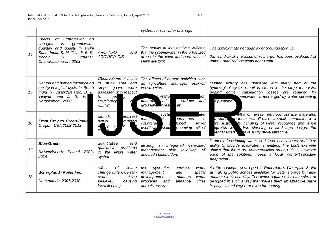
14
Effects of urbanization on changes in groundwater quantity and quality in Delhi State, India, S. M. Trivedi, B. R. Yadav, N. Gupta*,H. Chandrasekharan, 2008
ARC-INFO and ARCVIEW GIS
The results of this analysis indicate that the groundwater in the urbanized areas in the west and northwest of Delhi are toxic.
The approximate net quantity of groundwater, i.e.
the withdrawal in excess of recharge, has been evaluated at some urbanized locations near Delhi.
15
Natural and human influence on the hydrological cycle in South India, Y. Janardan Rao, B. E. Vijayam and J. S. V. L. Narasimham, 2008
Observations of rivers in study area and crops grown were assessed with respect to geology , Physiography and rainfall.
The effects of human activities such as agriculture, drainage, reservoir construction,
and urbanization, on the erosion patterns and on surface and groundwater resources
Human activity has interfered with every part of the hydrological cycle; runoff is stored in the large reservoirs behind dams, transpiration losses are reduced by deforestation, groundwater is recharged by water spreading and pumping.
16 From Grey to Green-Portland, Oregon, USA 2008-2013
periodic combined sewer overflows during heavy rain events
develop sustainable stormwater management programmes to counteract combined sewer overflows while enhancing cities’ greenery
Green roofs, infiltration areas, pervious surface materials, and other such measures all make a small contribution to a more sustainable handling of water resources and when integrated with urban planning or landscape design, the potential exists to make a city more attractive
17 Blue-Green
Network-Lodz, Poland, 2009-2014
quantitative and qualitative problems of the entire water system
develop an integrated watershed management plan involving all affected stakeholders
Properly functioning water and land ecosystems and their ability to provide ecosystem amenities. The Lodz example shows that there are commonalities among cities, however each of the solutions needs a local, context‐sensitive adaptation.
18 Waterplan 2- Rotterdam,
Netherlands. 2007-2030
effects of climate change (intensive rain events, rising sealevel) causing local flooding
use synergies between water management and spatial development to manage water problems and enhance cities attractiveness
All the concepts developed in Rotterdam’s Waterplan 2 aim at making public spaces available for water storage but also enhance their usability. The water squares, for example, are designed in such a way that makes them an attractive place to play, sit and linger. or even for boating
IJSER

International Journal of Scientific & Engineering Research, Volume 8, Issue 4, April-2017 447 ISSN 2229-5518
IJSER © 2017 http://www.ijser.org
5. OBSERVATIONS
Observations of hydrological changes as per case studies:
The management of surface water flooding is hindered by the characteristics of urban Drainage. The presence or large sealed surfaces in urban area ( such as Buildings Roads, car parks) raises the volume of surface water run off and lowers the underground water percolation from paved coverings.
Similarly open and green vegetated spaces reduce direct runoffs and facilitate the water infiltration in ground and through the evapotranspiration back into the air. Several studies carried out have modeled surface water runoff from different types of land uses and found that runoff increases with proportion of built up areas.
Some readings from these studies are as follows
Table 1 Reading and observations for variations in infiltration runoff and evapotranspiration from case studies
Case studies % vegetated % infiltration % runoff evapotranspiration
Natural condition natural 50 10 10
Modified modified 6 50
Northwest England
66 1 32 1
20 4 74 2
California, Thompson creek
natural 50 ( 25 shallow + 25 Deep)
10 40
80-90 42(21+21) 20 38
50-65 35(20+15) 30 35
0-50 15(10+5) 55 30
Harzliya , Israel 30-40( residential
45
60-75( Industrial)
90
Vegetated cover in Low density areas
66 32
IJSER

International Journal of Scientific & Engineering Research, Volume 8, Issue 4, April-2017 448 ISSN 2229-5518
IJSER © 2017 http://www.ijser.org
Very less vegetated town centre’s
20 74
Therefore it is apparent that land use, land cover and the evapotranspiring surfaces have a significant influence on behavior of water in urban water cycle and related urban flooding. Similarly Induction of Built up areas around natural water routes make these readings more focused on placement of Land use –land cover as per accordance to the natural landscaping behavior.
Indian scenario:
Study of some Indian Major Urban Centre’s for alterations in Components of Hydrological Cycle with respect to impervious areas reveal that built up areas and water withdrawal has resulted in declining of water levels in areas . (S.Sharma 2013)
2-2 Figure Inian Urban centres with population, land area and water availability. Source: Demographia World Urban Areas: 8th Annual Edition: Version 2 (2012.07)
The Indian Urban centers as ranked worldwide as per their urbanization extent and as per their Urban land area ( footprints) were observed in reference of the specific Water Supply and Demand for these urban cities and also the density and source of available water resources are compared to achieve a correlation of urban centers and availability of water or shortage of water.
Demand –supply-decline in water levels : ( (A. V. S.Sharma 2013)
As per study carries out by myself for different Indian urban centers and their present water availability conditions worldwide and in India, it was observed that most of
IJSER

International Journal of Scientific & Engineering Research, Volume 8, Issue 4, April-2017 449 ISSN 2229-5518
IJSER © 2017 http://www.ijser.org
developed and economically progressed cities have been facing water supply and demand problems as natural water resources are depleting and hence cities are dependent on external water resources and water has to be transported from far away.
Correlation Chart 1
World largest urban centers and water scarcity
Correlation Chart 2, Source: (S.Sharma 2013)
Case Study –BHOPAL city (Personal Findings)
Personal case study results of Bhopal City comparing decrease in water leves and increase in built up areas of certain wards and villages.
Table 2 Comparative Analysis of Built up in safe side of Natural Working System
S.N WARD Recharge ( year) Drop in Recharge %
Increase in Built up %
1991 1994 1996 2001 2004 2009
IJSER

International Journal of Scientific & Engineering Research, Volume 8, Issue 4, April-2017 450 ISSN 2229-5518
IJSER © 2017 http://www.ijser.org
Average
1 25(Tulsi nagar) 12.56 9.49
17.83 11.56
17.07 9.80
10.64 3.20
9.65 4.23
12.76 3.21
Decrease 75% to 25%
44.7 to 70.43%
2 26( Panchsheel)
8.65 8.26
12.28 10.35
11.76 9.71
7.33 4.56
6.65 1.07
8.79 0.97
Decrease 95% to 11%
2.64% to 88.96%
3 27 (MANIT) 135.19 134.29
191.98 134.29
183.82 188.60
114.55 179.61
103.87 107.00
137.32 95.39
Decrease 99% to 69%
0.31 % to 11.71%
4 28(Chuna Bhatti)
666.59 643.62
946.63 821.73
906.41 761.14
564.83 457.16
512.13 338.32
677.14 398.52
Decrease 96.55 % to 58.85%
2.22% to 41.14%
5 45(Ravishankar Nagar)
208.41 159.64
295.97 229.98
283.39 220.78
176.601 137.70
160.13 125.42
211.70 175.32
Decrease 76.59 %to
76.6 % to 85.86%
6 48(Arera Colony)
136.72 90.03
194.16 60.69
185.91 46.19
115.85 16.42
105.05 13.50
138.88 7.08
Decrease 65.84 %to 6.73%
0.16 to 94.9%
7 52 ( Shapura)
25.22 24.10
35.82 33.18
34.29 31.13
21.37 11.80
19.38 10.20
25.62 13.25
Decrease 95.55% to 51.71%
1.11 to 48.27%
8. 34 Jawahar nehru
10.97 3.53
15.57 4.47
14.91 2.41
9.29 1.20
8.43 0.62
11.14 0.80
Decrease 32.17% to 7.18%
58.52 % to 92.79%
Villages in Nagar Palika 1 Akbarpur 10.43
9.87
14.82 13.92
14.19 13.14
8.84 5.86
8.02 4.76
10.60 3.90
Decrease 94.63 to 36.79%
2.81 % to 63.23%
2 Nayapura 29.93 28.22
42.51 39.78
40.70 37.47
25.36 22.34
23.00 19.07
30.41 23.88
Decrease 94.28 to 78.52%
3.88 to 21.46%
3. Bairagarh Chichli
53.41 52.85
75.84 73.96
72.62 70.29
45.25 43.73
41.04 39.60
54.25 52.33
Decrease 98.95 % to 96.46%
0.86 to 3.55%
4. Neel bad 26.24 25.10
37.2735.53 35.68 34.03
22.24 20.82
20.16 18.72
26.66 24.22
Decrease 95.65 % to 90.84%
1.01 % to 9.15%
Source: (Sheetal 2010)
Comparative methods and models to study variations
Methods used to study these parameters worldwide:
IJSER
International Journal of Scientific & Engineering Research, Volume 8, Issue 4, April-2017 451 ISSN 2229-5518
IJSER © 2017 http://www.ijser.org
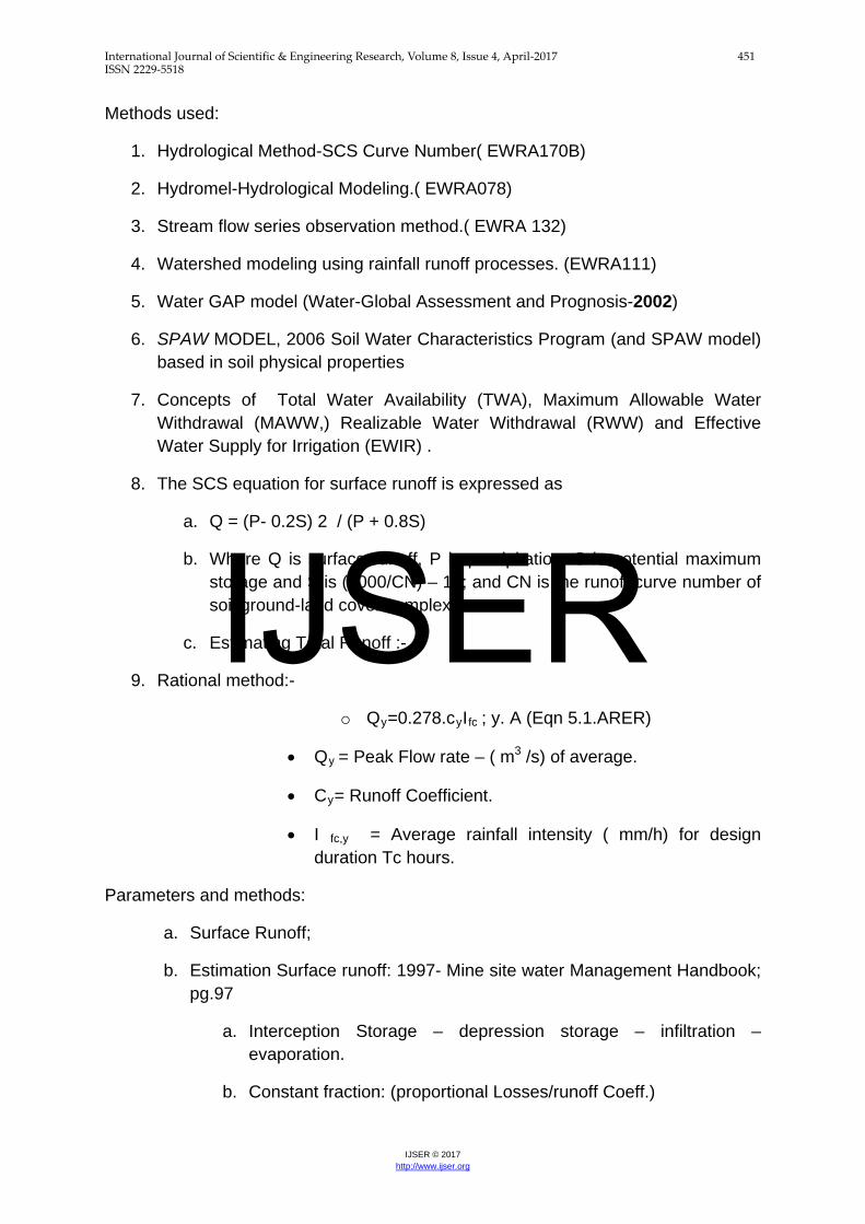
Methods used:
1. Hydrological Method-SCS Curve Number( EWRA170B)
2. Hydromel-Hydrological Modeling.( EWRA078)
3. Stream flow series observation method.( EWRA 132)
4. Watershed modeling using rainfall runoff processes. (EWRA111)
5. Water GAP model (Water-Global Assessment and Prognosis-2002)
6. SPAW MODEL, 2006 Soil Water Characteristics Program (and SPAW model) based in soil physical properties
7. Concepts of Total Water Availability (TWA), Maximum Allowable Water Withdrawal (MAWW,) Realizable Water Withdrawal (RWW) and Effective Water Supply for Irrigation (EWIR) .
8. The SCS equation for surface runoff is expressed as
a. Q = (P- 0.2S) 2 / (P + 0.8S)
b. Where Q is surface runoff, P is precipitation, S is potential maximum storage and S is (1000/CN) – 10; and CN is the runoff curve number of soil ground-land cover complexes.
c. Estimating Total Runoff :-
9. Rational method:-
o Qy=0.278.cyIfc ; y. A (Eqn 5.1.ARER)
• Qy = Peak Flow rate – ( m3 /s) of average.
• Cy= Runoff Coefficient.
• I fc,y = Average rainfall intensity ( mm/h) for design duration Tc hours.
Parameters and methods:
a. Surface Runoff;
b. Estimation Surface runoff: 1997- Mine site water Management Handbook; pg.97
a. Interception Storage – depression storage – infiltration – evaporation.
b. Constant fraction: (proportional Losses/runoff Coeff.)
IJSER

International Journal of Scientific & Engineering Research, Volume 8, Issue 4, April-2017 452 ISSN 2229-5518
IJSER © 2017 http://www.ijser.org
c. A runoff coefficient a applied to rainfall.
d. Proportion of catchment contributing to runoff when catchment area is known.
c. Estimating Total Runoff : -Rational method:-
a. Qy=0.278.cyIfc; y. A (Eqn 5.1.ARER)
i. Qy = Peak Flow rate – (m3 /s) of average.
b. Cy= Runoff Coefficient.
c. I fc,y = Average rainfall intensity ( mm/h) for design duration Tc hours.
d. Conclusion: Method useful to calculate Surface runoff with rainfall and runoff coefficient for nonurbanised catchments.
e. HSPF: - Hydrologic Simulation in water yield Analysis – US Army Corps of Engineers- March 1967 – TP-10. ( www.hec.usace.army.mil)
f. “ Simulation Procedure”
g. Months by months/ day by day examination.
h. Hypothetical stream flows.
i. Stream flow analysis- constructing simulation models for generating realistic values of stream flows
a. “Stochastic Hydrology “- governing the variation – as “stochastic” process.
b. “Persistence Tendency” – serial correlation Coefficient of successive monthly streamflows.
c. Generate stream flow from continuous frequencies of flows.
j. KAUFMAN RUNOFF : Water Availability Methods.
k. General methodologies.
Runoff Curve Number method
Maximum average runoff method.
Famous Model:
1. . SWMM MODEL : Storm water management model
IJSER

International Journal of Scientific & Engineering Research, Volume 8, Issue 4, April-2017 453 ISSN 2229-5518
IJSER © 2017 http://www.ijser.org
SWMM is a dynamic rainfall-runoff simulation model, primarily but not exclusively for urban areas, for single-event or long-term (continuous) simulation.
Flow routing is performed for surface and sub-surface conveyance and groundwater systems, including the option of fully dynamic hydraulic routing in the Extra Block.
Nonpoint source runoff quality and routing may also be simulated, as well as storage, treatment and other best management practices (BMPs).
List popular hydrologic models:
Table 3 List of Popular hydrological Models
MODEL NAME AUTHOR(YEAR) REMARKS 1 Stanford watershed Model(
SWM)/ Hydrologic Simulation Package-Forton IV ( HSPF)
Crawford and Linsley(1966). Bicknell et.all (1993)
Continuous dynamic event or steady-state, simulator of hydrologic and hydraulic water processes
2. Catchment Model ( CM) Dawdy n O’Donnell ( 1965)
Lumped, event based runoff model.
3 Tennessee Valley Authority( TVA) Model
Tenn Valley Authority ( 1972)
Lumped, event based runoff model
4 U.S Dept of Agriculture Hydrograph Laboratory (USDAHL) Model
Holten and Lopez (1971) Holten et.al (1974)
Event based, process oriented, lumped hydrograph model
5 U.S geological Survey ( USGS) Dowdy et.al ( 1970,1978)
Process oriented, continuous /event based model
6 Utah State university (USU ) Model
Andrews et.al( 1978) Process oriented, event /continuous stream flow based model
7 Purdue Model Huggins and Monke ( 1970)
Process oriented, physically based, event runoff model.
8 Antidecent Precipitation Index ( API) Model
Sittner et.al(1978) Lumped, Riverflow forecast model
9. Hydrologic engineering center-hydrologic Modeling System ( HES-HMS)
Feldman(1981), HEC ( 1981,2000)
Physically-based, semi distributed, event based, runoff model.
10. Stream flow synthesis and Reservoir regulation ( SSARR) Model
Rockwood(1982) U.S Army corps of Engineers (1987) Speers ( 1995)
Lumped, Continuous stream flow simulation model.
11 National Weather service – river forecast system ( NWS-RFS)
Burnash et.al( 1973, Burnash ( 1975)
Lumped, continuous river forecast system.
12 University of British Columbia ( UBC) Model
Quick and Pipes ( 1977) Quick (1995)
Process-oriented, lumped parameter, continuous simulation model
13 Tank Model Sugwara et.al (1974), Sugwara (1995)
Process oriented, semi-distributed or lumped continuous simulation model.
IJSER

International Journal of Scientific & Engineering Research, Volume 8, Issue 4, April-2017 454 ISSN 2229-5518
IJSER © 2017 http://www.ijser.org
14 Runoff Routing Model ( RORB) Laurenson ( 1964) Laurenson and Mein ( 1993,1995)
Lumped, Event based runoff simulation model
15 Agriculture Runoff Model Donigian et.al ( 1977) Process-oriented , Lumped runoff simulation model.
16 Strom water Management Model (SWMM)
Metcalf and eddy et. Al ( 1971) Huber and Dickinson ( 1988) Huber ( 1995)
Continous, Dynamic, Event or steady state simulator of hydrologic and hydraulic and water quality processes.
17 Areal Non-point source Watershed Environment response Simulation ( ANSWERS)
Beasley et.al (1977) Bouraoui et.al (2002)
Event Based or Continous, lumped parameter runoff and sediment yield simulation model.
18 National Hydrology Research Institute ( NHRI) Model
Vandenberg (1989) Physically based, lumped parameter, continuous hydrologic simulation model.
19 Technical report -20 ( TR-20) Model
Soil Conservation Service ( 1965)
Event based process-oriented, lumped hydrograph Model.
20 U.S Geological Survey ( USGS) Model
Dawdy et.al ( 1970) Lumped parameter, event based runoff simulation model
21 Physically based runoff Production Model ( TOPMODEL)
Beven and Kirkby (1976, 1979), Beven (1995)
Physically based, distributed, continuous hydrologic simulation model .
22 Generalized River Modeling Package-System Hydroloque European ( MIKE_SHE)
Refsgaard and Storm ( 1995)
Physically based, distributed, continuous hydrologic and hydraulic simulation model.
23 ARNO ( Arno River Model ) Todini ( 1988a,b,1996) Semidistributed, continous rainfall runoff simulation model.
24 Waterloo Flood System ( WATERFLOOD)
Kouwen et al ( 1993) Kouwen ( 2000)
Process oriented, semi distributed continuous flow simulation model
25 Topographic Kinematic Approximation and Integration ( TOPIKAP) Model
TODINI (1995) Distributed , physically based, continous rainfall –runoff simulation model.
26 Soil -vegetation – Atmosphere-transfer ( SVAT )Model
Ma. Et al(1999) Ma & Cheng ( 1998)
Macroscale, lumped parameter, streamflow simulation model.
27 Systeme Hydrologique Euroepan Transport ( SHETRAN)
Ewen et.al(2000) Physically based, distributed water quantity and quality simulation model
28 Daily Conceptual Rainfall-Runoff Model ( HYDROLOG) Monash Model
Potter and Mc Mahon ( 1976) , Chiew and Mc Mahon ( 1994)
Lumped, Conceptual, Continuous simulation model.
29 Soil water Assessment Tool ( SWAT)
Arnold et.al ( 1998) Distributed, conceptual, continuous simulation model.
30 Distributed Hydrological Model ( HYDROTEL)
Fortin et.al ( 2001 a, b)
Physically based , distributed, continuous hydrologic simulation model
IJSER

International Journal of Scientific & Engineering Research, Volume 8, Issue 4, April-2017 455 ISSN 2229-5518
IJSER © 2017 http://www.ijser.org
5. CONCLUSIONS :
Conclusion from literature According to Studied Four interested but separate effects of Land use changes on the Hydrology of an area were Observed. 1. Changes in Peak flow Characteristics. 2. Changes in Total Runoff. 3. Changes in Quality of Water. 4. Changes in Hydrologic amenities or Appearance of River Channels.
Main Reasons: Runoff that spam’s the entire region of flow- Measured by number and Characteristics. 2 principal factors governing flow regimen. Percentage of area made impervious. Rate at which water is transmitted across the land to stream channels. Percentage of area impervious- is governed by the type of land use. Rate water is transmitted is- governed by the density; size and
characteristics of tributary channels and storm sewerage. Volume of Runoff α % of area covered by roofs, streets and other
impervious surfaces. Because Volume of runoff is governed by infiltration characteristics and is
related to land slope and soil type as well as to the type of vegetative cover.
Two Principles factors governing flow regime- 1. The percentage of area made impervious. 2. The rate at which water is transmitted across the land to stream channels.
URBAN DEVELOPMENT SIGNIFICANTLY CHANGES THE HYDROLOGICAL CYCLE.
The main changes of the physical pathways of the water cycles due to urbanization include: removal of natural vegetation drainage patterns; loss of natural depressions which temporarily store surface water; loss of rainfall absorbing capacity of soil; creation of impervious areas (e.g., rooftops, roads, parking lots, sidewalks,
driveways) Provision of man-made drainage systems (e.g., storm sewers, channels,
detention ponds). Therefore, although the hydrological cycle consists of the same elements, their proportions in urban area are significantly different due to following reasons: interception of rainfall is reduced due to removal of trees; precipitation is usually higher than in rural areas; evapotranspiration is much lower;
IJSER

International Journal of Scientific & Engineering Research, Volume 8, Issue 4, April-2017 456 ISSN 2229-5518
IJSER © 2017 http://www.ijser.org
surface run-off is much larger; ground-water run-off, infiltration and recharge is small; water storage is much lower; runoff volumes and peak flows in rivers are higher; Frequency of surface runoff is increased. Urban development significantly increases the amount of storm water and the frequency of extreme hydrological events experienced by the City's catchments. The increased runoff causes more intense local flooding, while droughts during dry weather are deeper and longer. (Figure2.4 & 2.5) Source : (WALUPCALIFORNIA 2005)
Literature review based observation in runoff variations. 1. Between 10 – 25% imperviousness, major alterations in stream morphology occur . 2. . At greater than 25% impervious cover, streams suffer from loss of habitat, floodplain connectivity, and bank stability, as well as decreased water quality . 3. Studies in California indicate that Surface run off accelerates and water depletion occurs at 40-50 % of Impervious land covers. 4. Studies at Israel and USA and England have observed changes in surface run off at about 20 % impervious Land Covers
Table 4 VARIATIONS IN PARAMETERED AND SYSTEMS AFFECTED:
Action Systems affected
DESERTIFICATION IS occurring in urban areas Changes in Hydrological System
Excess of withdrawal than recharge. Changes in Hydrological System
Human interventions affect drainages, erosion patterns and ground water.
Changes in Urban System
Land Use and Land Cover models can help land use planners to mitigate future environmental policies
Changes in Urban System
Local government can take help of lulc changes and ground water truth for better water management
Changes in Urban System
Alterations to alterations to the morphology of drainage systems, need to be taken into account to better understand the hydrologic response of anthropogenic basins, and to improve the modeling, planning and design of sub-urban and urban areas.
Changes in Hydrological System
Need for green perforated spaces and open stomr channels along with pervious surfaces is basic need in urban areas
Changes in Urban System
IJSER

International Journal of Scientific & Engineering Research, Volume 8, Issue 4, April-2017 457 ISSN 2229-5518
IJSER © 2017 http://www.ijser.org
Better use of storm water management in urban planning. Changes in Urban System
The importance of sustainable water management in dense urban areas cannot be Underestimated
Changes in Urban System
Rainwater can be processed on‐site, even in densely built city centre locations, and that this treatment can be done in a design‐oriented way.
Changes in Hydrological System
Gaps Identified on basis of literature review : a. By IPCC
• “Despite the critical importance of groundwater resources in many parts of the world, there have been very few direct studies of the effect(s) of global warming on groundwater recharge.” (IPCC 1996, p. 336) • “Although the effects ... on groundwater resources are not adequately understood at present, they cannot be ignored.” (IPCC 1998, p.122) • “Groundwater is the major source of water across much of the world, particularly in rural areas in arid and semi-arid regions, but there has been very little research on the potential effects of climate change.” (IPCC 2001, p. 199) • “There is a need to improve understanding and modelling of climate changes related to the hydrological cycle at scales relevant to decision making. Information about the water-related impacts of climate change is inadequate - especially with respect to water quality, aquatic ecosystems and groundwater - including their socioeconomic dimensions.” (IPCC 2008, p. 4)
b. Through literature 1) Changes in biodiversity, land use and land cover; the water cycle, and climate have
potential impacts on different aspects of urban life. Broader knowledge on these impacts is needed to assist communities and individuals in preparing, coping and adapting to these changes.
2) Soil characteristics in a watershed have a direct effect on the rainfall-runoff process and these include soil layer thickness, permeability, infiltration rate, and the degree of moisture in the soil before the rain event. Thus Soil consideration is a must in Land Use Planning which at present is lagging behind than the speed of development.
3) Land use and land cover changes occur at all scales, and changes at local scales can have dramatic, cumulative impacts at broader scales. Consequently, land use and land cover changes are not just of concern at local and regional levels but globally as well. Unfortunately, there is a paucity of information on land use and land cover change except at very local levels.
IJSER

International Journal of Scientific & Engineering Research, Volume 8, Issue 4, April-2017 458 ISSN 2229-5518
IJSER © 2017 http://www.ijser.org
4) To better understand the relationship between climate change and water resources we need to enhance our knowledge, particularly on the processes of the hydrological cycle in relation to the atmosphere, land use and the biosphere.
5) .While our knowledge continues to increase about climate, water and vulnerability,
6) we are still far from being able to reliably identify ‘hot spot’ areas of vulnerability.
7) we need to Mimick natural drainage processes for protecting life and properties from flooding, thus improving the aesthetics of urban areas and maintaining the water quantity and quality requirements of receiving water bodies.
8) Insufficient knowledge of impacts in different parts of the world (especially in developing countries),
9) Almost complete lack of information on impacts under different development pathways and under different amounts of mitigation,
10) No clear relationship between climate change and impacts on water resources,
11) Little analysis of the capacity and cost of adaptation, and 12) Lack of understanding of how changes in variability affect the water Environment
References:
Booth, Derek. (1991), "Urbanization and the natural drainage System:Impacts, solutions and Prognosis." The Northwest Environmental Journal 7, no. 1, pp. 93-118.
Heidi M. Peterson, John L. Nieber, Roman Kanivetsky. (2011), "Hydrologic regionalization to assess anthropogenic changes." Journal of Hydrology Volumne 408, no. Issue 3-4, October, pp. 212-225.
Kundzewicz Z. W, et al (2007), Feshwater resources and their management, Climate CHange 2007. Assessment report of the Intergovermental Panel on Climate Change., Cambridge.
IPCC. Climate Change 2007. (2007), The Physical Science Basis. Contribution of Working Group I to the Fourth Assessment , Cambridge: Cambridge University,.
IPCC. (2007), Linking climate change and water resources. Technical Paper, www.ipcc.ch/pdf/technical-papers/ccw/chapter3.pdf,.
Worldwater. (2007), Coping with Water Scarcity, CHallenges of the twenty first Century. World Water Report., New York: www.world water 2007.org.
E. B, White. "Thestate of Resource, Chapter 4." UNESCO.ORG. 2004. www.unesco.org/bpi/wwap/press/pdf/wwdr2_chapter_4.pdf (Retreived Sept 11, 2011).
GRUMP. "Global Rural-Urban Mapping Project (GRUMP)." columbia.edu. 1997. http://sedac.ciesin.columbia.edu/data/collection/grump-v1 (Retreived 07 12, 2013).
UN2013. "World Urbanization Prospects, the 2011 Revision." www.un.org. 2013. http://esa.un.org/unup/p2k0data.asp (Retreived June 12, 2010).
IJSER

International Journal of Scientific & Engineering Research, Volume 8, Issue 4, April-2017 459 ISSN 2229-5518
IJSER © 2017 http://www.ijser.org
ANNEXURE A
Figure 1: Built up area as per GIS- 1971 Figure 2: Built up area as per GIS 2013
Snap shot 1. SWMM modeling Snap shot 2. modeling
IJSER