egypt - birdlife internationaldatazone.birdlife.org/.../ibas/africacntrypdfs/egypt.pdf242 important...
TRANSCRIPT

241
Important Bird Areas in Africa and associated islands – Egypt
Pharoah Eagle-owl Bubo ascalaphus. (ILLUSTRATION: SHERIF BAHA EL DIN)
■■■■■ EGYPTSHERIF M. BAHA EL DIN
GENERAL INTRODUCTION
The Arab Republic of Egypt occupies the north-eastern corner ofthe African continent, with a surface area of just over one millionsquare kilometres (1,019,600 km²), equivalent to c.3% of the totalarea of Africa. The country lies at the centre of the largest anddriest desert region on the globe. Average temperatures are high(mean: summer 20–30°C, winter 10–20°C) and the mean annualrainfall over most of the country is less than 10 mm.
Perhaps the most significant feature of Egypt’s landscape isthe Nile river, which is the largest and most important source offresh water in the country. The Nile divides Egypt into two parts,east and west of the river. Egypt east of the Nile has muchrelief, including the country’s highest mountain peaks; west of theNile the landscape is generally featureless, largely made up of vastexpanses of serir and sand desert, dotted with scattered oases.
Egypt enjoys a considerable diversity of habitat, despite itspredominantly hyper-arid environment. Lying at the junctionof four biogeographical regions—Saharo–Sindian, Irano–Turanian, Mediterranean and Afrotropical—Egypt has a uniquemixture of vegetation-types, which support a correspondingdiversity of faunal elements. The Saharo–Sindian elements are wellrepresented in Egypt’s vast deserts, while Mediterranean and Irano–Turanian elements occupy fairly small areas along theMediterranean coast and in the Sinai highlands respectively. Egyptis tenuously connected with sub-Saharan Africa through the Nileriver and the Red Sea, along both of which many African faunaland floral elements extend north, adding a further dimension toEgypt’s biodiversity.
The Nile, with its enormous water resources, supports almostall of the country’s major wetlands. Long coastlines on two seaswith very different marine ecosystems and terrestrial environments,encompassing a wide variety of topographic features; ranging fromthe rugged mountains of South Sinai and the Eastern Desert (up to2,641 m) to the Qattara Depression (134 m below mean sea-level),contribute to the diversity of Egypt’s habitat-types.
Wetlands are some of Egypt’s most important habitats in termsof biodiversity (second only to the Red Sea’s coral reefs), supportingboth the greatest diversity and density of bird species. MostEgyptian wetlands have been degraded drastically during the past50 years: drained, polluted, over-fished and over-hunted. It shouldbe a conservation priority in Egypt to protect at least representativewetland habitats.
There are six major inland wetland areas in Egypt: the BitterLakes, Wadi El Natrun, Lake Qarun, Wadi El Rayan Lakes, Nileriver and Lake Nasser. In addition, there are many smaller wetlandsdispersed in the Nile delta and valley, and in oases in the WesternDesert. Of the Mediterranean coastal wetlands, the most importantare the six major coastal lagoons on the Mediterranean: Bardawil,Malaha, Manzala, Burullus, Idku and Maryut. The remainder ofthe Egyptian Mediterranean coast is of rather limited importancefor birds. The Red Sea coastal habitats and wetlands includemudflats, reefs, mangroves and marine islands.
Desert habitats cover over 90% of Egypt’s territory. TheMediterranean coastal desert receives the highest rainfall in thecountry (up to 200 mm annually), and has a fair amount of plantcover and the greatest floral diversity nationally. The influence ofcoastal rains extends up to 60 km inland. In contrast, the desertbordering the Red Sea is very dry. The vegetation is typical of thatof the Eastern Desert, being largely restricted to the mouths of largerwadis and along the coast, where saltmarsh vegetation grows.
Wadis and mountains are characteristic of the landscape of muchof the Eastern Desert and Sinai. Mountain habitats are of particularinterest since they usually support unique faunal and floral elements.This is true of the mountain massif of South Sinai and the mountainsof the Eastern Desert, particularly Gebel Elba. These regions andassociated habitats contribute an important element to the country’sbiodiversity.
Open gravel and sand desert occupy the greater part of Egypt’sland area. This, however, is the least productive of the country’shabitats. Where rain is regular (as in sub-coastal deserts), plantcover is dispersed regularly over the landscape. In more arid inland
242
Important Bird Areas in Africa and associated islands – Egypt
regions, vegetation (if present at all) is scant and largely confinedto depressions where sufficient rainwater accumulates or wheregroundwater reaches the surface (oases).
Oases are perhaps the most prominent features of the WesternDesert. They are the only source of water and vegetation over muchof this desert, which occupies about two-thirds of the country’sarea. The principal oases of the Western Desert are Maghra, Siwa,Wadi El Rayan, Bahariya, Farafra, Dakhla, Kharga, Kurkur andDungul. Most of these are inhabited by people and some have beenhighly modified by man, such as Wadi El Rayan, parts of whichhave been inundated by excess agricultural drainage water fromthe Nile valley. There are also some smaller, largely uninhabitedoases dispersed throughout parts of the Western Desert.
Oases in the Eastern Desert and Sinai are much smaller than mostof those in the Western Desert. They do not completely fulfil themeaning of the term ‘oasis’, as they are usually well linked with otherlife-supporting habitats through wadi systems, where they aretypically located (e.g. Feiran Oasis), or on their deltas near the coast(e.g. Ain Sukhna).
Almost all of the cultivated land in Egypt is in the Nile valleyand delta. This is amongst the oldest cultivated land in the world,and has been subjected to man’s manipulation for over 7,000 years.There are also small areas of cultivation in North Sinai and inWestern Desert oases, which are irrigated with underground water.Urban centres are mostly concentrated along the Nile valley and inthe delta, with smaller settlements in coastal areas.
ORNITHOLOGICAL IMPORTANCE
More than 470 bird species are known from Egypt, most of whichare non-breeding migrants, passing through the country or spending
the winter, and are of Palearctic origin. These wintering and transientbird populations, although not present in Egypt all or most of thetime, are an important component of the country’s biodiversity.About 150 species can be considered resident breeding birds,although some of these also migrate further south during the winter.
A total of 16 species of global conservation concern have beenrecorded in Egypt (Collar et al. 1994). However, the country iscurrently of significance for only six of these, namely Aythya nyroca,Aquila clanga, Aquila heliaca, Falco naumanni, Crex crex and Larusleucophthalmus. Larus leucophthalmus is the most important ofthese, for the Egyptian Red Sea islands hold the largest breedingpopulation known in the world.
Egypt’s native avifauna is of moderate significance in terms ofglobal avian diversity. There are no endemic or restricted-rangebird species, although Larus leucophthalmus is endemic to the RedSea and there are several subspecies confined to unique Egyptianhabitats, such as the Nile delta and valley. In addition, there arec.18 species with relatively small world distributions, for whichEgypt constitutes an important part of their range. Perhaps themost important component of Egypt’s native avifauna, in terms ofglobal biodiversity, is the group of species that are restricted to theSahara–Sindian biome. These species are adapted to life in aridenvironments, and are either widespread throughout the Egyptiandeserts or confined to parts of them.
Because of Egypt’s unique, strategic geographical position alongmigration routes of Palearctic birds wintering in Africa, manyPalearctic species migrate through Egypt in internationallysignificant numbers. Many of these migrants congregate atbottlenecks. Soaring birds (such as many birds of prey and storks)are particularly known to concentrate at such localities, but alsowaterbirds have several migration bottlenecks in Egypt, e.g. theareas of Suez, Hurghada and Zaranik. In addition, vast numbers
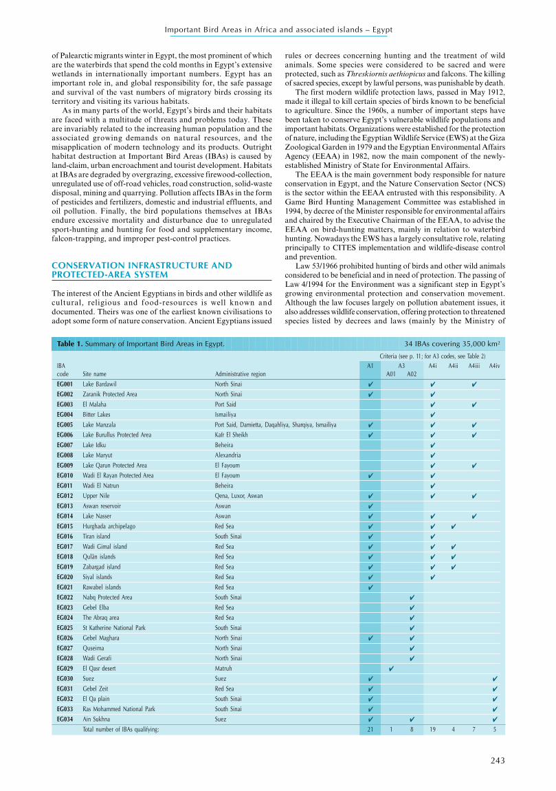
Map 1. Location and size of Important Bird Areas in Egypt.
3
6
8
10
11
12
13
14
15
17
18
19
2123
24
27
28
29
32
2
4
20
25
26
30
3133
34
57
9
16
22
1
M E D I T E R R A N E A N S E A
LIB
YA
S U D A N
L A K EN A S S E R
R E DS E A
Area of IBA (ha)
100 to 999
1,000 to 9,999
10,000 to 49,999
50,000 to 99,999
100,000 to 999,999
0 250
km
500
243
Important Bird Areas in Africa and associated islands – Egypt
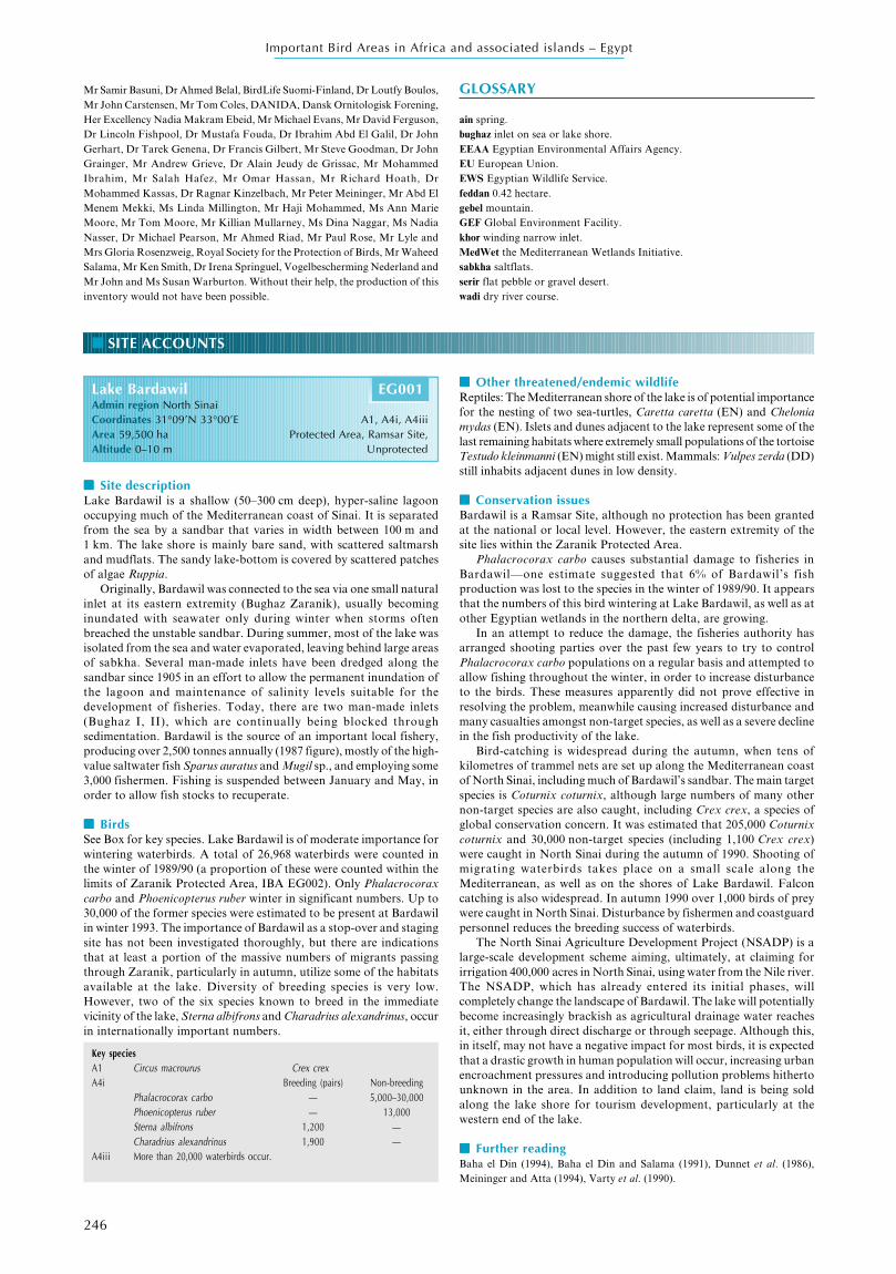
Table 1. Summary of Important Bird Areas in Egypt. 34 IBAs covering 35,000 km²
Criteria (see p. 11; for A3 codes, see Table 2)IBA A1 A3 A4i A4ii A4iii A4ivcode Site name Administrative region A01 A02EG001 Lake Bardawil North Sinai ✔ ✔ ✔
EG002 Zaranik Protected Area North Sinai ✔ ✔
EG003 El Malaha Port Said ✔ ✔
EG004 Bitter Lakes Ismailiya ✔
EG005 Lake Manzala Port Said, Damietta, Daqahliya, Sharqiya, Ismailiya ✔ ✔ ✔
EG006 Lake Burullus Protected Area Kafr El Sheikh ✔ ✔ ✔
EG007 Lake Idku Beheira ✔
EG008 Lake Maryut Alexandria ✔
EG009 Lake Qarun Protected Area El Fayoum ✔ ✔
EG010 Wadi El Rayan Protected Area El Fayoum ✔ ✔
EG011 Wadi El Natrun Beheira ✔
EG012 Upper Nile Qena, Luxor, Aswan ✔ ✔ ✔
EG013 Aswan reservoir Aswan ✔
EG014 Lake Nasser Aswan ✔ ✔ ✔
EG015 Hurghada archipelago Red Sea ✔ ✔ ✔
EG016 Tiran island South Sinai ✔ ✔
EG017 Wadi Gimal island Red Sea ✔ ✔ ✔
EG018 Qulân islands Red Sea ✔ ✔ ✔
EG019 Zabargad island Red Sea ✔ ✔ ✔
EG020 Siyal islands Red Sea ✔ ✔
EG021 Rawabel islands Red Sea ✔
EG022 Nabq Protected Area South Sinai ✔
EG023 Gebel Elba Red Sea ✔
EG024 The Abraq area Red Sea ✔
EG025 St Katherine National Park South Sinai ✔
EG026 Gebel Maghara North Sinai ✔ ✔
EG027 Quseima North Sinai ✔
EG028 Wadi Gerafi North Sinai ✔
EG029 El Qasr desert Matruh ✔
EG030 Suez Suez ✔ ✔
EG031 Gebel Zeit Red Sea ✔ ✔
EG032 El Qa plain South Sinai ✔ ✔
EG033 Ras Mohammed National Park South Sinai ✔ ✔
EG034 Ain Sukhna Suez ✔ ✔ ✔
Total number of IBAs qualifying: 21 1 8 19 4 7 5
of Palearctic migrants winter in Egypt, the most prominent of whichare the waterbirds that spend the cold months in Egypt’s extensivewetlands in internationally important numbers. Egypt has animportant role in, and global responsibility for, the safe passageand survival of the vast numbers of migratory birds crossing itsterritory and visiting its various habitats.
As in many parts of the world, Egypt’s birds and their habitatsare faced with a multitude of threats and problems today. Theseare invariably related to the increasing human population and theassociated growing demands on natural resources, and themisapplication of modern technology and its products. Outrighthabitat destruction at Important Bird Areas (IBAs) is caused byland-claim, urban encroachment and tourist development. Habitatsat IBAs are degraded by overgrazing, excessive firewood-collection,unregulated use of off-road vehicles, road construction, solid-wastedisposal, mining and quarrying. Pollution affects IBAs in the formof pesticides and fertilizers, domestic and industrial effluents, andoil pollution. Finally, the bird populations themselves at IBAsendure excessive mortality and disturbance due to unregulatedsport-hunting and hunting for food and supplementary income,falcon-trapping, and improper pest-control practices.
CONSERVATION INFRASTRUCTURE ANDPROTECTED-AREA SYSTEM
The interest of the Ancient Egyptians in birds and other wildlife ascultural, religious and food-resources is well known anddocumented. Theirs was one of the earliest known civilisations toadopt some form of nature conservation. Ancient Egyptians issued
rules or decrees concerning hunting and the treatment of wildanimals. Some species were considered to be sacred and wereprotected, such as Threskiornis aethiopicus and falcons. The killingof sacred species, except by lawful persons, was punishable by death.
The first modern wildlife protection laws, passed in May 1912,made it illegal to kill certain species of birds known to be beneficialto agriculture. Since the 1960s, a number of important steps havebeen taken to conserve Egypt’s vulnerable wildlife populations andimportant habitats. Organizations were established for the protectionof nature, including the Egyptian Wildlife Service (EWS) at the GizaZoological Garden in 1979 and the Egyptian Environmental AffairsAgency (EEAA) in 1982, now the main component of the newly-established Ministry of State for Environmental Affairs.
The EEAA is the main government body responsible for natureconservation in Egypt, and the Nature Conservation Sector (NCS)is the sector within the EEAA entrusted with this responsibility. AGame Bird Hunting Management Committee was established in1994, by decree of the Minister responsible for environmental affairsand chaired by the Executive Chairman of the EEAA, to advise theEEAA on bird-hunting matters, mainly in relation to waterbirdhunting. Nowadays the EWS has a largely consultative role, relatingprincipally to CITES implementation and wildlife-disease controland prevention.
Law 53/1966 prohibited hunting of birds and other wild animalsconsidered to be beneficial and in need of protection. The passing ofLaw 4/1994 for the Environment was a significant step in Egypt’sgrowing environmental protection and conservation movement.Although the law focuses largely on pollution abatement issues, italso addresses wildlife conservation, offering protection to threatenedspecies listed by decrees and laws (mainly by the Ministry of

244
Important Bird Areas in Africa and associated islands – Egypt
Agriculture). This is the country’s most significant piece oflegislation to control environmental degradation issued to date.The law defines the responsibilities of the EEAA and outlines acourse of action to protect the environment in cooperation withother concerned bodies.
Law 102/1983 concerning protected areas is the other importantlegislation in the field of nature conservation in Egypt. The Lawestablished a legal framework for the creation and management ofprotected areas in the country. These are to be areas of land orwater known for their flora, fauna or geological formations andhaving cultural, scientific, touristic and aesthetic values. Accordingto the Law, human activities are to be strictly controlled in theprotected areas; hunting in these areas is prohibited. Protected areasare declared upon the issuing of Prime Ministerial Decrees, basedupon the recommendations of the EEAA, the competent authorityresponsible for the implementation of the law.
Much of the nature conservation effort in Egypt has focused onestablishing this network of protected areas, with the objective ofprotecting the country’s best-known sites of outstanding naturalvalue. Since the passage of Law 102/1983, 21 protected areas havebeen declared in Egypt, totalling an area of some 78,000 km² andencompassing several of the country’s main physiographic regionsand habitats.
This network represents about 8% of Egypt’s total land surface.The Government of Egypt has a stated objective of protecting 15%of the country’s territory. According to IUCN, the optimal size ofa national protected-area system is 10% of a nation’s surface area.However, biodiversity components in arid environments, onaverage, need larger territories to survive and hence would requireplacing larger areas under protection.
INTERNATIONAL MEASURES RELEVANT TO THECONSERVATION OF SITES
Since 1936, Egypt has been party to a number of international and
regional conventions concerning nature conservation. Nearly allof these conventions have provisions for the protection andsustainable use of wildlife resources. Some conventions are moreactive and effective than others. According to Article Number 151in the Egyptian Constitution, any international convention to whichEgypt is a party becomes the law of the land in Egypt and takesprecedence over Egyptian law.
According to Law 4/1994, the EEAA is the competent nationalauthority for overseeing compliance with international and regionalenvironmental conventions. It is empowered to undertake thenecessary measures to join international and regional conventionsrelated to the environment and to draft the necessary legislation anddecrees to ensure the local implementation and follow-up of theseconventions.
The main international and regional environmental conventionswith emphasis on nature conservation that Egypt has signed andratified are the African Convention on the Conservation of Natureand Natural Resources, the Ramsar Convention, the Conventionon International Trade in Endangered Species of Wild Fauna andFlora (CITES), the Convention on the Conservation of MigratorySpecies of Wild Animals (CMS), the Convention on BiologicalDiversity (CBD), the African-Eurasian Migratory WaterbirdAgreement (AEWA) and the World Heritage Convention. Egyptis also a party to the Convention to Combat Desertification andthe Convention on Climate Change.
OVERVIEW OF THE INVENTORY
A total of 34 Important Bird Areas (IBAs) have been identified inEgypt, all of which meet one or more of the selection criteria forglobally Important Bird Areas (Map 1, Table 1). The total areacovered by IBAs in Egypt is some 35,000 km², or about 3.5% ofEgypt’s territory. All of Egypt’s avian habitats are representedwithin the identified network of IBAs, although not equally so.Wetland habitats (both inland and coastal) are the best-represented,
Table 2. The occurrence of biome-restricted species at Important Bird Areas in Egypt. Sites that meet the A3 criterion arehighlighted in bold.
A01 – Mediterranean North Africa biome (four species in Egypt; one site meets the A3 criterion)IBA code: 026 027 028 029Ramphocoris clotbey ✔
Chersophilus duponti ✔
Eremophila bilopha ✔ ✔ ✔ ✔
Oenanthe moesta ✔
Number of species recorded: 1 1 1 4
A02 – Sahara–Sindian biome (22 species in Egypt; eight sites meet the A3 criterion)IBA code: 005 006 009 014 022 023 024 025 026 027 028 029 034Falco concolor ✔ ✔ ✔ ✔ ✔ ? ✔
Ammoperdix heyi ✔ ✔ ✔ ✔ ✔ ✔ ✔ ✔
Pterocles lichtensteinii ✔ ✔ ✔ ✔ ✔
Pterocles coronatus ✔ ✔ ✔ ✔ ✔ ✔ ✔ ✔
Pterocles senegallus ✔ ✔ ✔ ✔
Strix butleri ✔ ✔ ✔ ✔ ? ? ✔
Bubo ascalaphus ✔ ✔ ✔ ✔ ✔ ✔ ✔
Caprimulgus aegyptius ✔ ✔ ✔ ✔
Ammomanes cincturus ✔ ✔ ✔ ✔ ✔ ✔ ✔ ✔
Ammomanes deserti ✔ ✔ ✔ ✔ ✔ ✔ ✔ ✔
Alaemon alaudipes ✔ ✔ ✔ ✔ ✔ ✔ ✔ ✔ ✔
Hirundo obsoleta ✔ ✔ ✔ ✔ ✔ ✔ ✔ ✔
Oenanthe leucopyga ✔ ✔ ✔ ✔ ✔ ✔ ✔ ✔
Oenanthe monacha ✔ ✔ ✔ ✔ ✔ ✔
Oenanthe lugens ✔ ✔ ✔ ✔ ✔ ✔ ✔ ✔ ✔
Cercomela melanura ✔ ✔ ✔ ✔ ✔ ✔
Turdoides squamiceps ? ✔
Turdoides fulvus ✔
Scotocerca inquieta ✔ ✔ ✔ ✔ ✔ ✔
Rhodopechys githaginea ✔ ✔ ✔ ✔ ✔ ✔ ✔ ✔
Passer simplexOnychognathus tristramii ✔
Number of species recorded: 1 1 1 1 15 15 13 16 15 14 18 4 12

245
Important Bird Areas in Africa and associated islands – Egypt
occurring in 25 IBAs (74%). Wetland habitats also occupy a largearea within the IBAs, over 10,000 km², or 28% of the total IBAarea. Mountain-and-wadi desert and desert-plains are representedin a smaller number of IBAs (13, or 38% of IBAs), but the areathey occupy is much greater, estimated at c.20,000 km², or 55% ofthe total IBA area. Coastal deserts, on the other hand, arerepresented in six IBAs (18% of the total) and occupy c.5,000 km²,or 14% of the total IBA area, mostly in one IBA (El Qasr Desert,EG029). Oases and agricultural landscapes each contribute a smallfraction to the total area of IBAs in Egypt.
The majority of IBAs in Egypt are in the eastern portion of thecountry, largely east of the Nile, which clearly indicates the greatpoverty of the Western Desert in avian habitats. This is not a resultof lack of information from this vast and desolate region, but averified fact. Recent extensive surveys of the natural heritageresources of the Western Desert by the EEAA, have confirmed thelack of any habitats or sites that qualify as IBAs in that region. Onthe other hand, Sinai holds a disproportionately large number ofIBAs (29% of Egypt’s IBAs) which, although it represents only 6%of Egypt’s territory, reflects its diversity of habitats, as well as theunique biogeographic location of the region.
Most Egyptian IBAs qualify for categories A1 and A4, while nonequalify for category A2, as no endemic or restricted-range birds breedor are resident in Egypt (Table 1). Eighteen IBAs qualify for twocategories of criteria, while 15 IBAs qualify for a single category,and only one for three categories. A total of 24 IBAs qualify underthe A4 criterion, making a total of c.14,000 km² or 39% of the totalIBA area. Most of these IBAs are wetlands holding largecongregations of wintering waterbirds, or bottlenecks for soaringmigrants.
In contrast, there are only nine IBAs that qualify under theA3 criterion, alone or in conjunction with other categories,comprising a total of 22,000 km², or 61% of the total IBA area(Tables 1 and 2). The larger area encompassed by A3-qualifyingIBAs reflects the fact that desert and steppe avifaunas (of whichthe Sahara–Sindian and Mediterranean North Africa biome-restricted assemblages are comprised) have ecological andbehavioural requirements that entail the utilization of extensiveareas of land.
The IBAs that qualify under the A1 criterion support a varietyof bird species of global conservation concern (most prominentlyLarus leucophthalmus), with a wide spectrum of ecologicalrequirements. IBAs selected solely for the A1 criterion include onlythose sites known to be of unquestionable importance for the speciesconcerned. Larus leucophthalmus is the threatened species for whichEgypt has the greatest conservation significance and for which thelargest number of A1-qualifying IBAs have been identified.Qualification under the A1 criterion, based on species occurringon passage, was only considered in conjunction with qualificationfor other categories and only where these species occur in a regularand predictable fashion.
IBAs selected for the A3 criterion are the most subjectivelychosen. Basically, sites that support the highest number of biome-restricted species are selected. However, the intactness of the site,its uniqueness, its qualification under other IBA criteria, itsimportance for other fauna and flora, its geographic positionand its protection status are all factors that are taken intoconsideration during the selection process. Table 2 shows thedifferent degrees of representation of biome-restricted species inthe A3-qualifying IBAs, as well as the extent to which each speciesis represented in the IBAs. It might be interesting to note that thelargest IBA, El Qasr Desert (7,500 km²; EG029), selected underthe A3 criterion, has the lowest number of biome-restrictedspecies (eight). These, however, include 100% of those speciesinhabiting Egypt that are characteristic of, and restricted to, theNorth African component of the Mediterranean biome. This is alsothe only IBA where three species of this assemblage are representedin Egypt. Here, site selection was also based on the uniqueness ofthe habitat, its intactness and the degree of threat faced by the site,in addition to the ecological requirements of the species involved.Wadi Gerafi (EG028), on the other hand, has the highest numberof A3 species (19), reflecting its diverse habitats and uniquebiogeographic position.
The biome-restricted species that are best represented in theIBA network are Pterocles coronatus, Alaemon alaudipes and
Oenanthe lugens, which are present in all eight A3-qualifying IBAs(Table 2). This reflects the species’ wide distribution in thecountry. Some A3 species are, however, represented in only a smallnumber of IBAs, because their distribution in Egypt is limited; oneexample is Turdoides fulvus. Passer simplex, a species restricted tothe Sahara–Sindian biome, is not represented in any IBA becauseits occurrence in Egypt is erratic and it is limited to a very smallarea of Gebel Uweinat. Although Caprimulgus aegyptius is notrepresented in any A3-qualifying IBAs, it is present in at least fourIBAs that qualify under other criteria (see Table 2).
The selection of IBAs according to the quantitative criteria ofcategory A4 is reasonably straightforward and includes all siteswhere the A4i 1% population thresholds are exceeded, particularlywith regard to wintering waterbird populations, which are fairlywell-known in Egypt. Migration bottlenecks are less easy to assess.Many areas in the eastern part of Egypt could, in theory, qualifyunder criterion A4iv, since well over 20,000 birds of prey and othersoaring birds pass through them on an annual basis. However, thesites have been selected only where birds are known to regularlyland (to drink, rest or roost) or to fly at low altitudes, and hencecome in close contact with potential hazards.
Fifteen IBAs, or c.44% of the total, representing c.39% of thetotal IBA area, fall entirely within the existing protected-areanetwork. This is much greater than the proportion of protectedIBAs in the Middle East, where only about a quarter of the identifiedsites have some form of protection. A further four IBAs are partiallyprotected (i.e. only parts of them fall within the boundaries ofexisting protected areas). In addition, there are three sites, identifiedhere as IBAs, which are unprotected, but which are being proposedas future additions to the protected-area network of Egypt. Two ofthese proposals have developed as a direct outcome of the IBAprogramme in Egypt.
However, this relatively high degree of protection of IBAs inEgypt is more apparent than real. Only six of Egypt’s IBAs (17%of the total) can be said to be located in areas receiving adequateprotection. The fact is that many protected areas in Egypt are stillonly ‘nominally protected’ (i.e. have little effective enforcement ormanagement). This is changing though, as the capacity of thecountry in the field of protected-area management (in terms of bothhuman and financial resources) is increasing, and there is a growinginterest in, and effort to, introduce practical and effective protectionfor these areas in the near future.
Egypt is divided into 27 Governorates, of which 18 have IBAs.Some IBAs are shared by more than one Governorate. The RedSea Governorate has the most, with nine IBAs, followed by theNorth Sinai and South Sinai Governorates with five each. Thisreflects the importance of these regions for biodiversity in general.The majority of the Governorates that have no IBAs are small insize and are located in the densely populated and intensely cultivatedNile valley and delta.
It is realized that, in a large country like Egypt, even with itsfairly simple set of ecosystems and habitats, many of the lessaccessible and less well-known regions may hold areas ofimportance for birdlife that are not reported here. The size andsignificance of such potential sites is, however, thought likely to besmall. It is estimated that at least 90% of all IBAs in Egypt havebeen identified by the IBA programme to date. Regions that couldhold potential IBAs are the oases of the Western Desert (wetlandhabitats) and the southern Red Sea coastal zone (coastal habitatsand near-shore islands).
ACKNOWLEDGEMENTS
I would like to thank all the individuals and organizations who helped bringthis document about, either by providing information, participating infieldwork, offering advice, ensuring that financial and organizationalaffairs are dealt with efficiently and establishing the framework for conductingand preparing this work. I would especially like to acknowledge themany contributions of my wife, Ms Mindy Baha el Din, who helped withfundraising, text revision and print supervision. In addition, a special noteof thanks to Ms Patsy Gasperetti and Ms Dominique Tawfik for editingthe text.
My deep appreciation and gratitude also goes to: Mr Bahi Ahmed,Dr Gary Allport, Mr Omar Attum, Dr Essam El Badry, Ms Hala Barakat,
246
Important Bird Areas in Africa and associated islands – Egypt
■ SITE ACCOUNTS
Lake Bardawil EG001Admin region North SinaiCoordinates 31°09’N 33°00’E A1, A4i, A4iiiArea 59,500 ha Protected Area, Ramsar Site,Altitude 0–10 m Unprotected
■■■■■ Site descriptionLake Bardawil is a shallow (50–300 cm deep), hyper-saline lagoonoccupying much of the Mediterranean coast of Sinai. It is separatedfrom the sea by a sandbar that varies in width between 100 m and1 km. The lake shore is mainly bare sand, with scattered saltmarshand mudflats. The sandy lake-bottom is covered by scattered patchesof algae Ruppia.
Originally, Bardawil was connected to the sea via one small naturalinlet at its eastern extremity (Bughaz Zaranik), usually becominginundated with seawater only during winter when storms oftenbreached the unstable sandbar. During summer, most of the lake wasisolated from the sea and water evaporated, leaving behind large areasof sabkha. Several man-made inlets have been dredged along thesandbar since 1905 in an effort to allow the permanent inundation ofthe lagoon and maintenance of salinity levels suitable for thedevelopment of fisheries. Today, there are two man-made inlets(Bughaz I, II), which are continually being blocked throughsedimentation. Bardawil is the source of an important local fishery,producing over 2,500 tonnes annually (1987 figure), mostly of the high-value saltwater fish Sparus auratus and Mugil sp., and employing some3,000 fishermen. Fishing is suspended between January and May, inorder to allow fish stocks to recuperate.
■■■■■ BirdsSee Box for key species. Lake Bardawil is of moderate importance forwintering waterbirds. A total of 26,968 waterbirds were counted inthe winter of 1989/90 (a proportion of these were counted within thelimits of Zaranik Protected Area, IBA EG002). Only Phalacrocoraxcarbo and Phoenicopterus ruber winter in significant numbers. Up to30,000 of the former species were estimated to be present at Bardawilin winter 1993. The importance of Bardawil as a stop-over and stagingsite has not been investigated thoroughly, but there are indicationsthat at least a portion of the massive numbers of migrants passingthrough Zaranik, particularly in autumn, utilize some of the habitatsavailable at the lake. Diversity of breeding species is very low.However, two of the six species known to breed in the immediatevicinity of the lake, Sterna albifrons and Charadrius alexandrinus, occurin internationally important numbers.
Key speciesA1 Circus macrourus Crex crexA4i Breeding (pairs) Non-breeding
Phalacrocorax carbo — 5,000–30,000Phoenicopterus ruber — 13,000Sterna albifrons 1,200 —Charadrius alexandrinus 1,900 —
A4iii More than 20,000 waterbirds occur.
■■■■■ Other threatened/endemic wildlifeReptiles: The Mediterranean shore of the lake is of potential importancefor the nesting of two sea-turtles, Caretta caretta (EN) and Cheloniamydas (EN). Islets and dunes adjacent to the lake represent some of thelast remaining habitats where extremely small populations of the tortoiseTestudo kleinmanni (EN) might still exist. Mammals: Vulpes zerda (DD)still inhabits adjacent dunes in low density.
■■■■■ Conservation issuesBardawil is a Ramsar Site, although no protection has been grantedat the national or local level. However, the eastern extremity of thesite lies within the Zaranik Protected Area.
Phalacrocorax carbo causes substantial damage to fisheries inBardawil—one estimate suggested that 6% of Bardawil’s fishproduction was lost to the species in the winter of 1989/90. It appearsthat the numbers of this bird wintering at Lake Bardawil, as well as atother Egyptian wetlands in the northern delta, are growing.
In an attempt to reduce the damage, the fisheries authority hasarranged shooting parties over the past few years to try to controlPhalacrocorax carbo populations on a regular basis and attempted toallow fishing throughout the winter, in order to increase disturbanceto the birds. These measures apparently did not prove effective inresolving the problem, meanwhile causing increased disturbance andmany casualties amongst non-target species, as well as a severe declinein the fish productivity of the lake.
Bird-catching is widespread during the autumn, when tens ofkilometres of trammel nets are set up along the Mediterranean coastof North Sinai, including much of Bardawil’s sandbar. The main targetspecies is Coturnix coturnix, although large numbers of many othernon-target species are also caught, including Crex crex, a species ofglobal conservation concern. It was estimated that 205,000 Coturnixcoturnix and 30,000 non-target species (including 1,100 Crex crex)were caught in North Sinai during the autumn of 1990. Shooting ofmigrating waterbirds takes place on a small scale along theMediterranean, as well as on the shores of Lake Bardawil. Falconcatching is also widespread. In autumn 1990 over 1,000 birds of preywere caught in North Sinai. Disturbance by fishermen and coastguardpersonnel reduces the breeding success of waterbirds.
The North Sinai Agriculture Development Project (NSADP) is alarge-scale development scheme aiming, ultimately, at claiming forirrigation 400,000 acres in North Sinai, using water from the Nile river.The NSADP, which has already entered its initial phases, willcompletely change the landscape of Bardawil. The lake will potentiallybecome increasingly brackish as agricultural drainage water reachesit, either through direct discharge or through seepage. Although this,in itself, may not have a negative impact for most birds, it is expectedthat a drastic growth in human population will occur, increasing urbanencroachment pressures and introducing pollution problems hithertounknown in the area. In addition to land claim, land is being soldalong the lake shore for tourism development, particularly at thewestern end of the lake.
■■■■■ Further readingBaha el Din (1994), Baha el Din and Salama (1991), Dunnet et al. (1986),Meininger and Atta (1994), Varty et al. (1990).
Mr Samir Basuni, Dr Ahmed Belal, BirdLife Suomi-Finland, Dr Loutfy Boulos,Mr John Carstensen, Mr Tom Coles, DANIDA, Dansk Ornitologisk Forening,Her Excellency Nadia Makram Ebeid, Mr Michael Evans, Mr David Ferguson,Dr Lincoln Fishpool, Dr Mustafa Fouda, Dr Ibrahim Abd El Galil, Dr JohnGerhart, Dr Tarek Genena, Dr Francis Gilbert, Mr Steve Goodman, Dr JohnGrainger, Mr Andrew Grieve, Dr Alain Jeudy de Grissac, Mr MohammedIbrahim, Mr Salah Hafez, Mr Omar Hassan, Mr Richard Hoath, DrMohammed Kassas, Dr Ragnar Kinzelbach, Mr Peter Meininger, Mr Abd ElMenem Mekki, Ms Linda Millington, Mr Haji Mohammed, Ms Ann MarieMoore, Mr Tom Moore, Mr Killian Mullarney, Ms Dina Naggar, Ms NadiaNasser, Dr Michael Pearson, Mr Ahmed Riad, Mr Paul Rose, Mr Lyle andMrs Gloria Rosenzweig, Royal Society for the Protection of Birds, Mr WaheedSalama, Mr Ken Smith, Dr Irena Springuel, Vogelbescherming Nederland andMr John and Ms Susan Warburton. Without their help, the production of thisinventory would not have been possible.
GLOSSARY
ain spring.bughaz inlet on sea or lake shore.EEAA Egyptian Environmental Affairs Agency.EU European Union.EWS Egyptian Wildlife Service.feddan 0.42 hectare.gebel mountain.GEF Global Environment Facility.khor winding narrow inlet.MedWet the Mediterranean Wetlands Initiative.sabkha saltflats.serir flat pebble or gravel desert.wadi dry river course.
247
Important Bird Areas in Africa and associated islands – Egypt
Zaranik Protected Area EG002Admin region North SinaiCoordinates 31°07’N 33°25’E A1, A4iArea 25,000 ha Altitude 0–10 m Protected Area
■■■■■ Site descriptionZaranik Protected Area is located at the eastern end of Lake Bardawiland encompasses an eastern extension of that lake: the ZaranikLagoon. The lagoon is shallow, with numerous small islets scatteredthroughout it, most of which are covered with dense saltmarshvegetation. Extensive mudflats and saltmarshes are found along thelagoon’s shores, merging into sabkha and sand-dunes further inland.A saltworks was established at Zaranik in the early 1980s, prior to itsdeclaration as a protected area, consisting of a pumping station,extensive evaporation pools and saltpans. The facility only becameactive in 1997.
■■■■■ BirdsSee Box for key species. Zaranik’s importance is primarily as abottleneck area for migrant Palearctic waterbirds. Every autumn,hundreds of thousands of waterbirds flying along the easternMediterranean coastline concentrate at Zaranik or pass through thearea, many landing to rest and feed before resuming their journeysouthwards across Sinai or westwards to the Nile valley.
The maximum counts (seasonal totals) of some of the mostnumerous autumn migrants recorded during four seasons between1979 and 1992 at Zaranik are as follows: Pelecanus onocrotalus (2,122),Ixobrychus minutus (4,162), Nycticorax nycticorax (2,742), Ardeolaralloides (5,487), Casmerodius albus (4,239), Ardea cinerea (6,194),Ardea purpurea (5,349), Anas querquedula (221,616), Recurvirostraavosetta (6,828), Glareola pratincola (490), Charadrius hiaticula (1,909),Charadrius alexandrinus (5,687), Charadrius leschenaultii (197),Calidris alba (5,776), Calidris minuta (15,503), Calidris alpina (8,134),Limosa limosa (1,254), Larus genei (2,011), Sterna hirundo (12,433),Sterna albifrons (1,810), Chlidonias hybridus (950) and Chlidoniasleucopterus (18,436).
Vast numbers of passerines and near-passerines also arrive at thecoast, as they do everywhere along the Egyptian Mediterraneanshoreline, but here hunting and persecution is illegal and controlled.Some 270 bird species have been reported in Zaranik. Only 10 speciesare known to breed in the Protected Area, of which Sterna albifronsand Charadrius alexandrinus are the most numerous and prominent.Zaranik is also the only locality in Egypt where Recurvirostra avosettais known to breed on a regular basis (five pairs in summer 1994), andlarge numbers also winter (up to 700, December 1998).
Key speciesA1 Circus macrourus Crex crexA4i Breeding (pairs) Non-breeding
Phalacrocorax carbo — 5,000Phoenicopterus ruber — 10,000Larus genei — 2,000
■■■■■ Other threatened/endemic wildlifeReptiles: Caretta caretta (EN) was recently found to have its largestbreeding concentration along the Egyptian Mediterranean in theProtected Area. Chelonia mydas (EN) is suspected of breeding locallyand Dermochelys coriacea (EN) has been recorded once. Islets andlittoral dunes fringing the southern margins of the Zaranik Lagoonand adjacent sabkha are said to have held a small population ofTestudo kleinmanni (EN). Trapelus savignii, endemic to the IsthmicDesert and the western Negev, is found throughout the sandy habitatsof the region. Mammals: the rare Vulpes zerda (DD) has been recorded.
■■■■■ Conservation issuesZaranik is protected by Prime Ministerial Decree 1429/1985. Anadministrative building and visitor centre have recently been opened.There is an ongoing GEF–MedWet–EEAA project to develop themanagement and infrastructure of the reserve.
Zaranik shares many of the same problems as Lake Bardawil (IBAEG001). Due to the growing coastal tourist development activity inNorth Sinai, the value of land in the area has risen sharply in the pastfew years. This has led local politicians, under pressure from nativeinhabitants who claim ownership of the land within the Protected Area,
to dispute the protection status and boundaries of Zaranik.Considerable pressure is being exerted to reduce the eastern boundariesof the reserve along the Mediterranean Sea. Traditional land-ownership in the Protected Area is a sensitive issue that needs to beaddressed in an effective and fair manner.
The saltworks in Zaranik have caused large-scale, ecologicalchanges in the Zaranik Lagoon, none of which appear to have had anegative impact on birds; in fact, they seem to have been largelypositive. The production of salt has caused limited disturbance so far.The effectiveness of the Protected Area in preventing bird-catchingactivities (primarily during autumn) has been fairly high. However,violations still take place regularly. Falcon-catching activities haveproven particularly difficult to control.
■■■■■ Further readingBaha el Din (1996b, 1997).
El Malaha EG003Admin region Port SaidCoordinates 31°13’N 32°19’E A4i, A4iiiArea 3,500 ha Altitude 0–10 m Unprotected
■■■■■ Site descriptionMalaha was formerly the easternmost extension of Lake Manzala,from which it was cut off when the Suez Canal was constructed in the1800s, and was further diminished by the construction of the PortSaid bypass in the 1980s. Today, Malaha is composed of two shallowhyper-saline lagoons, the size and shape of which are variable; theyreach their maximum size during winter and become nearly dry insummer. The lagoons are connected to the Mediterranean via BughazEl Kala (eastern lagoon) and El Malaha (western lagoon). To the southand east lies the Tina Plain, which is a broad, barren, salt-encrustedsabkha, fringed at its southern edge by a large saltmarsh dominatedby Nitraria bushes. The lagoons are separated from the Mediterraneanby a sandbar that varies in width between 100 and 500 m, and whichis covered in many areas with dense halophytic vegetation. Malahasupports a fishery of modest production. The catch in 1977 was631 tonnes. The lagoon is manipulated to maximize fish production.
■■■■■ BirdsSee Box for key species. Despite its fairly small size, Malaha is one ofthe most important wetlands in Egypt for waterbirds, and holds someof the greatest densities and numbers of both wintering and breedingwaterbirds in the country. In winter 1989/90, a total of 52,700waterfowl was counted, and in winter 1994, 6,500 Phoenicopterus ruberwere counted in the eastern lagoon alone. The site’s relative isolationfrom human activity, and its highly productive habitats, make itattractive for several breeding waterbird species. In spring 1990, alarge breeding colony of Larus genei was found here (about 5,700nests). Phoenicopterus ruber is known to breed as well, but numbersand breeding success vary from year to year, and in some yearsbreeding is not attempted. In 1986, some 750–1,000 adults with350–400 chicks were counted. Breeding also took place in 1993 and1994. Sterna albifrons and Sterna hirundo also breed in smallernumbers, Malaha being the only known breeding locality of the latterspecies in Egypt.
Key speciesA4i Breeding (pairs) Non-breeding
Phalacrocorax carbo — 5,300Phoenicopterus ruber 375–500 6,500Anas clypeata — 8,200Recurvirostra avosetta — 8,910Charadrius alexandrinus — 3,290Larus genei 5,700 —
A4iii More than 20,000 waterbirds occur.
■■■■■ Conservation issuesMalaha suffers from several management-related problems thatadversely affect its ecology and birdlife. However, all of these aredwarfed by the recent advent of the “East of the Bypass Project”,launched in 1998 to establish a port and an industrial zone locatedprecisely where the Malaha lagoons are. Work has already started on
248
Important Bird Areas in Africa and associated islands – Egypt
the infrastructure of the project. Land claim for the North SinaiDevelopment Project and fish-farming are also taking place in thevicinity. Unfortunately, these human activities could entail the veryrapid, complete and permanent disappearance of this important wetland.
Bird-catching takes place during autumn all along theMediterranean coast of this region. As in the rest of North Sinai,Coturnix coturnix is the chief target species of this activity. The impacton waterbirds is thought to be small.
■■■■■ Further readingGoodman and Meininger (1989), Meininger and Atta (1994).
Bitter Lakes EG004Admin region IsmailiyaCoordinates 30°20’N 32°15’E A4iArea 6,000 ha Altitude 0–10 m Unprotected
■■■■■ Site descriptionBefore the construction last century of the Suez Canal, the Bitter Lakeswere relatively small, hyper-saline inland lakes, with a salinity of upto 161 g/l, surrounded by salt-encrusted sabkha. After the lakes wereconnected with both the Mediterranean and the Red Seas by the SuezCanal, they became a single marine body, their size increased andsalinity decreased, reaching between 43 and 46 g/l in 1972. Thenorthern, wider end of this water-body is known as the Great BitterLake, while the southern, narrower part is known as the Little BitterLake. The bottom is sandy and scantily covered with vegetation.Agricultural land, tourist developments and scattered areas ofsaltmarsh border the lakes on the western side, while the eastern sideis mostly sandy desert. Drainage from recent agricultural developmenton the Sinai side of the Suez Canal has created a fairly large Typhaand Phragmites marsh at the north-western corner of the Great BitterLake. There are a number of low sandy islets and spits in the LittleBitter Lake and scattered along the eastern side of the lakes.
■■■■■ BirdsSee Box for key species. Although there has not been a comprehensivesystematic count of birds at the Bitter Lakes, they are known to be oflimited importance for wintering and migratory waterfowl. Larus geneiis the only species that is known to winter in internationally importantnumbers. The species most likely breeds locally, as evidenced by thepresence of birds throughout the year, especially juveniles in summer.The species may breed on some of the islets and sandy spits on theeastern side of the lakes. Sterna albifrons, Charadrius alexandrinusand Vanellus spinosus also breed in good numbers.
Key speciesA4i Breeding (pairs) Non-breeding
Larus genei — 3,065
■■■■■ Conservation issuesOil pollution from ships passing through the Suez Canal is always apotential threat to waterbirds in this small body of water. Rapid urbanexpansion, mainly for tourism, which is occurring particularly alongthe western shores of the lake, is threatening to eliminate much of thenatural vegetation around the lake and will lead to increaseddisturbance.
■■■■■ Further readingMeininger and Atta (1994), Vadiya and Shenuda (1985).
Lake Manzala EG005Admin region Port Said, Damietta,
Daqahliya, Sharqiya, IsmailiyaCoordinates 31°17’N 32°04’E A1, A4i, A4iiiArea 77,000 ha Altitude 0–10 m Protected Area, Unprotected
■■■■■ Site descriptionLake Manzala, the largest of Egypt’s Mediterranean wetlands andthe most productive for fisheries, is located in the north-eastern cornerof the Nile delta. Manzala is generally rectangular in shape, about
60 km long and 40 km wide, and has an average depth of 1.3 m. It isseparated from the Mediterranean Sea by a sandbar, through whichit is connected to the sea by three channels (bughaz). The salinity inthe lake varies greatly; while it is low near drain and canal outflows inthe south and west, it is high in the extreme north-west. Brackishconditions predominate over much of the remainder of the lake. Over1,000 islands of varying sizes are scattered throughout the lake.
The three main habitats are reed-swamps, saltmarshes and sandyareas. The reed-swamps of Phragmites and Typha, with associatedsubmerged water-plants (e.g. Potamogeton and Najas), are foundextensively in the less saline portions of the lake in the south and westand fringing many islands. Saltmarshes of Juncus and Halocnemumoccur on the northern (coastal) margins of the lakes and some islands.Sand formations are occupied by several plant communities, e.g.coastal dunes. Open water and mudflats are also important habitatsfor birds. Large areas in the north-west of the lake have been turnedinto fish-farms, while much of the southern part of the site (south of31°10’N) has been divided into large plots and drained, in preparationfor its conversion to agricultural use.
A total of 3.7 km³ of fresh water (mostly from agricultural drainage)flow annually into Lake Manzala from nine major drains and canals.The most important of these are Faraskur, Al Sarw, Baghous, AbuGarida and Bahr El Baqar. Of all the drains discharging into LakeManzala, the Bahr El Baqar drain is the most polluted. It carries amixture of treated and untreated waste-water originating from Cairoand contributing much to the deteriorating water quality of the lake.Bughaz El Gamil is the main connection between the lake and theMediterranean. Several other less important sea connections haverecently been enlarged.
■■■■■ BirdsSee Box for key species. Manzala is by far the most important wetlandfor wintering waterbirds in Egypt, holding a total of 233,901 waterbirdsin winter 1989/90. This represented c.40% of all waterfowl countedthroughout Egypt’s wetlands that winter and included the world’s largestconcentrations of wintering Larus minutus and Chlidonias hybridus.There were also up to 36,180 waders present in spring 1990, indicatingthe great importance of the wetland for populations of passage migrants,especially of Recurvirostra avosetta, Calidris minuta, Calidris alpina andPhilomachus pugnax. No similar counts are available for autumn, butthe lake is likely to be as important in that season. Manzala is also ofimportance for a number of breeding waterbirds and wetland species.About 35 species are known to breed, including Ixobrychus minutus,Egretta garzetta, Ardeola ralloides, Porphyrio porphyrio, Sterna albifrons,Charadrius alexandrinus, Vanellus spinosus, Glareola pratincola,Caprimulgus aegyptius, Ceryle rudis and Acrocephalus stentoreus. Forsome of these species, Manzala is one of the most important breedingareas in the entire western Palearctic region.
Key speciesA1 Circus macrourus Crex crexA4i Breeding (pairs) Non-breeding
Phalacrocorax carbo — 22,500Egretta garzetta — 1,073Casmerodius albus — 528Ardeola ralloides 300 —Anas clypeata — 12,021Porphyrio porphyrio 500 —Recurvirostra avosetta — 8,981Charadrius hiaticula — 563Charadrius alexandrinus — 4,323Charadrius pecuarius — 35Vanellus spinosus 300 —Tringa totanus — 3,247Larus minutus — 47,316Larus ridibundus — 45,080Larus genei — 2,269Larus armenicus — 358Sterna albifrons 1,500 —Chlidonias hybridus — 39,331
A4iii More than 20,000 waterbirds occur.
■■■■■ Other threatened/endemic wildlifeReptiles: The Mediterranean shore of the lake is a potential breedingsite for endangered marine turtles. Caretta caretta (EN) is the species

249
Important Bird Areas in Africa and associated islands – Egypt
most likely to breed in the area. Mammals: Felis chaus is still knownto occur in good numbers.
■■■■■ Conservation issuesThe lake is unprotected, apart from Ashtum El Gamil Protected Area(declared by Prime Ministerial Decree 459/1988), which encompasses asmall area (c.35 km²) located along the sandbar at Bughaz El Gamil,the largest connection between the lake and the sea, near Port Said.The main purpose for creating this protected area was the protection ofgravid fish and fry during their passage in and out of Manzala, throughBughaz El Gamil. Ashtum El Gamil includes no suitable waterfowlhabitat, nor is it large enough to be of any significance for theconservation of the vast majority of Manzala’s resident and transientavifauna. However, there is a proposal to increase the size of thisprotected area to encompass larger, more important parts of LakeManzala.
At the beginning of the century the lake covered some 1,698 km².However, ambitious land-reclamation projects had reduced the size ofthe lake to 905 km² by 1981 and to 770 km² by 1988. It is predicted thatexisting reclamation plans will reduce its area further to 469 km².Encroachment from adjacent urban centres is threatening to reduce thearea of the lake even further. Since the construction of the High Damand the almost complete cessation of sedimentation, the coasts of theeastern delta have altered from predominantly accretional to erosional.The rapid erosion of the coast of Lake Manzala and encroachment ofthe sea in a region which, during the late Holocene, had been expandingnorthwards at an average rate of about 10 m per year, is of concern.
The implementation of the El Salam Canal project and the NSADPwill require the annual diversion of c.1.27 km³ of water from the delta(currently mostly destined for Manzala). This is expected to lead to asignificant increase in the salinity of the lake from the current 3 g/l to8 g/l, consequently changing its whole ecology. The present Bughaz ElGamil will be far too small to safeguard the present water-level. Withoutlarge infrastructural works, it can be expected that much of the lakewill turn into a very shallow brackish marsh, with much of the extensivereed-swamp (and associated avifauna) declining sharply or disappearingaltogether.
The pollution problem is very severe and is caused by many factors.Municipal waste-water is, perhaps, the most serious source of pollution,as much of the raw and treated sewage from Cairo, Port Said andDamietta ends up in Manzala. Industrial waste-water is also dischargedinto the lake from various sources, including industrial areas north ofCairo. Sewage-treatment projects for Cairo, once online, should helpto alleviate some of the pollution. In addition, agricultural drainagewater, which makes up most of the fresh water entering the lake, hashigh concentrations of fertilizers and pesticides. Solid waste fromadjacent urban centres is regularly dumped into the lake and used forland-fill.
Highly organized bird-catching activities take several tens ofthousands of waterfowl every year, mainly ducks, Fulica atra, Gallinulachloropus and waders. In spring 1990 a total of 11,709 birds (presumably,mostly from Manzala and its environs) were found for sale in birdmarkets in Port Said and Damietta. The impact of these activities onwaterfowl populations is not known. It is probably a less significantthreat than that posed by the deterioration and eventual loss ofManzala’s habitats.
■■■■■ Further readingAbu El Izz (1971), Ayyad et al. (1993), Baldwin et al. (1992), Meininger andAtta (1994), P. Lane Ltd. (1992).
Lake Burullus Protected Area EG006Admin region Kafr El SheikhCoordinates 31°29’N 30°50’E A1, A4i, A4iiiArea 46,000 ha Altitude 0–10 m Protected Area, Ramsar Site
■■■■■ Site descriptionThe Protected Area is composed primarily of Lake Burullus, a large,shallow, fresh-to-brackish coastal lagoon located between the two Nilebranches forming the delta. It is elongate in shape extending for c.54 kmfrom east to west with a width of 6–21 km and an estimated averagedepth of 75–100 cm. The lake is separated from the sea by a broad,dune-covered sandbar, which varies in width from a few hundred meters
in the east to 5 km in the west. There are some 50 islands scatteredthroughout the lake with a total area of 0.7 km². On average, 50–70 million m³ of slightly saline, nutrient-rich water enters the lakeannually from the south via six drains. Bughaz El Burullus, located inthe north-east corner of the lake, is the only direct connection betweenBurullus and the Mediterranean. Salinity in the lake decreases towardsthe south and west as the distance from the Bughaz increases, becomingfresh near the outflows of drains and canals that flow into the lakefrom the south. Consequently, the north shores of the lake are dominatedby saltmarshes and mudflats, while the southern shore is bordered byan extensive fringe of reed-swamps (mainly Phragmites and Typha),which currently covers more than 25% of the lake area. Lake Burullushas abundant submerged vegetation, dominated by Potamogeton, whichis densest in the southern portion of the lake. Burullus is by far the leastdisturbed and damaged of the delta wetlands and its environs still retainsome aspects of wilderness, which have been lost throughout most ofthe delta.
■■■■■ BirdsSee Box for key species. Burullus is one of Egypt’s most importantwetland for wintering waterfowl, holding a total of 98,887 in winter1989/90, the second-largest concentration recorded in Egypt that winter.The lake supports the largest numbers of some wintering waterfowl inthe country, including Anas penelope, Anas clypeata, Aythya nyroca,Aythya ferina, Fulica atra and Tringa totanus. Burullus is one of themost important wintering grounds for Aythya nyroca in the easternMediterranean. Because of its relative isolation, Burullus is also animportant breeding site for several waterbirds and wetland species.About 35 species of birds are known to breed, of which the mostprominent are Tachybaptus ruficollis, Ixobrychus minutus, Porphyrioporphyrio, Sterna albifrons, Charadrius alexandrinus, Vanellus spinosus,Glareola pratincola, Caprimulgus aegyptius, Ceryle rudis, Centropussenegalensis and Acrocephalus stentoreus. The endemic delta subspeciesof Calandrella rufescens (Calandrella rufescens nicolli) probably has itslargest population in the vicinity of Burullus.
Key speciesA1 Aythya nyrocaA4i Breeding (pairs) Non-breeding
Anas penelope — 24,997Anas clypeata — 15,427Recurvirostra avosetta — 2,949Porphyrio porphyrio 500 —Glareola pratincola 2,000 —Tringa totanus — 3,378Larus minutus — 3,906Sterna albifrons 600–800 —Chlidonias hybridus — 3,530
A4iii More than 20,000 waterbirds occur.
■■■■■ Other threatened/endemic wildlifeReptiles: the Mediterranean shore of the lake is a potential breedingsite for endangered marine turtles—Caretta caretta (EN) is known tobreed locally. Mammals: Felis chaus is known to occur in numbers.
■■■■■ Conservation issuesBurullus is protected by Prime Ministerial Decree 1444/1998 and is aRamsar Site. There is an ongoing GEF–MedWet–EEAA project todevelop the management and infrastructure of the Protected Area.Burullus covered 588 km² in 1913. An estimated 37% of the open-waterarea and 85% of the marsh area have been lost during the past 40 years,largely as a result of ongoing drainage and reclamation of the lake’seastern, western and southern margins, and also due to the proliferationof emergent and submerged vegetation. It is anticipated that Burullus,along with other coastal delta wetlands, will be further reduced in areaas a result of landward migration of coastal sandbars. This is aconsequence of severe coastal erosion, from which the northern coast ofthe delta has suffered since the closure of the High Dam in 1964, and thesubsequent impoundment of over 98% of the Nile sediment behind it.
Despite being the least polluted of the northern delta lakes, increasingquantities of agricultural drainage-water with heavy fertilizer andpesticide loads are being released into Burullus, contributingsignificantly to the eutrophication and pollution of the lake. Localfishermen complain that the combination of occasional siltation andclosure of the Bughaz and increased drainage-water leads to the

250
Important Bird Areas in Africa and associated islands – Egypt
reduction of the salinity of the lake and the expansion of reed-swampsand reduces fishing opportunities. The large number of fishermen onthe lake cause continuous disturbance to waterbirds, forcing them toutilize less optimal habitats or sites.
Waterbird-catching is widely practised on the lake in winter. Quailnets, shotguns and lime are used along the sandbar to catch thousandsof migrants in the autumn.
A coastal highway running along the entire northern coast of thedelta, designed to link the Egyptian Mediterranean coastal regions westand east of the delta, is near completion. The highway, which runsthrough the sandbar north of Lake Burullus, has dramatically increasedaccessibility and hence, coastal development pressures on this, the lastwilderness of the delta.
■■■■■ Further readingBaha el Din (1991), Meininger and Atta (1994), Stanley and Warne (1993),van Pelt et al. (1992).
Lake Idku EG007Admin region BeheiraCoordinates 31°14’N 30°11’E A4iiiArea 7,000 ha Altitude 0–10 m Unprotected
■■■■■ Site descriptionA shallow coastal wetland located west of the Rosetta Nile branch.Three main drains discharge into the lake, while Bughaz El Maadiaprovides a connection with the sea. The water in the lake is mainlyfresh, but increases in salinity towards the Bughaz and during thesummer. Most of the lake margins are covered with dense growths ofTypha and Phragmites, which cover about 50% of the lake’s area.Saltmarshes, salinas and high dunes, as well as some orchards, arefound on the sandbar separating the lake from the Mediterranean.Lake Idku supports a fishery of moderate importance.
■■■■■ BirdsSee Box for key species. Lake Idku is of moderate importance for bothwintering and breeding waterbirds. In winter 1989/90, a total of 22,549waterbirds was counted. The lake probably also supports importantnumbers of breeding birds associated with reed-swamps, such asPorphyrio porphyrio, Ixobrychus minutus and Centropus senegalensis.
Key speciesA4iii More than 20,000 waterbirds occur
■■■■■ Conservation issuesLake Idku suffers from the same ailments that affect other deltawetlands: drainage and land-claim, pollution, disturbance, waterbird-catching, etc. Habitat loss through land-claim is certainly the mostserious of these threats. Lake Idku has been reduced to less than half itsoriginal size.
■■■■■ Further readingMeininger and Atta (1994).
Lake Maryut EG008Admin region AlexandriaCoordinates 31°07’N 29°54’E A4iArea 6,000 ha Altitude -3–-3 m Unprotected
■■■■■ Site descriptionLake Maryut is the westernmost of the northern delta wetlands, althoughits history and origin are different. Formerly, the lake was fairly large,but late in the nineteenth century the western half was cut off by arailway embankment and transformed into an extensive salina, nowknown as Malahet Maryut, which is seasonally flooded (usually duringwinter). Today, the remaining part of this lake is made up of severalfragments, dissected by roads and embankments, and lies practicallywithin the boundaries of greater Alexandria and its sprawling suburbs.What remains of the lake proper is brackish, receiving agriculturaldrainage-water through several drains (the most important of these isthe Qala Drain), as well as large quantities of municipal and industrial
effluent from the city of Alexandria. The lake has no direct connectionwith the Mediterranean, and is maintained at a level of c.2.8 m belowsea-level by a pumping station at El Max. Much of the lake shore isfringed by extensive Typha/Phragmites marshes. The lake still supportsa fishery, with Tilapia sp. making up most of the production.
■■■■■ BirdsSee Box for key species. The importance of Lake Maryut for birds hasdiminished greatly over the last two or three decades, due to habitat loss,ecological changes and increased disturbance and hunting pressure.Numbers of wintering waterbirds are modest; in winter 1989/90, a totalof about 10,000 waterbirds was counted. Little is known about the lake’simportance for staging of migrants. Several waterbirds are known tobreed, including Tachybaptus ruficollis, Porphyrio porphyrio, Gallinulachloropus, Ixobrychus minutus, Charadrius alexandrinus and Sternaalbifrons. Little is known, also, about the numbers involved, but it is notexpected that there would be any significant concentrations, with theexception of the population of Sterna albifrons, which is in the order of150 pairs.
Key speciesA4i Breeding (pairs) Non-breeding
Casmerodius albus — 348Larus minutus — 866
■■■■■ Conservation issuesLake Maryut has been reduced by more than 75% from its originalarea, and is still shrinking. The main causes for the diminishing areatoday are urban encroachment and solid-waste dumping from therapidly growing city of Alexandria. The lake is eutrophic and is themost polluted wetland in Egypt. Agricultural drainage-water, dischargedinto the lake, is heavily contaminated with pesticides and fertilizers, asare the huge quantities of largely untreated municipal and industrialwaste water. The level of disturbance is particularly high because of thevery close proximity of Alexandria’s urban and industrial sprawl. Theoutlook for the future of this wetland is rather grim.
■■■■■ Further readingAbu El Izz (1971), Meininger and Atta (1994).
Lake Qarun Protected Area EG009Admin region El FayoumCoordinates 29°28’N 30°38’E A4i, A4iiiArea 25,000 ha Altitude -43–-43 m Protected Area
■■■■■ Site descriptionLake Qarun occupies the deepest part of the Fayoum Depression,located some 220 km south of the Mediterranean. In 1992, the elevationof the lake surface was 43.5 m below sea-level and mean water depthwas 4.2 m. The lake is bordered by agricultural land to the south anddesert to the north. There are several lagoons and bays along thesouthern and northern shores of the lake, some of which hold mud- orsaltflats of various sizes. El Qarn, the only sizeable island in the lake,covers almost 2 km². Formerly, Qarun was a much larger freshwaterlake, with dense marsh vegetation along its shores. The main source ofwater for the lake is drainage from irrigated land, which it receivesthrough two major drains: El Batts and El Wadi. With the intensificationof cultivation and irrigation since the early part of this century, the saltload of the water reaching Qarun has increased significantly. As theonly outflow for the water is evaporation, salinity is continuallyincreasing. Today, Lake Qarun is slightly more saline than seawater(about 40 g/l) and salinity increases at the rate of 0.5 g/l annually(Euroconsult 1992b). The highest salinity is recorded in the west andnorth of the lake, while swamp and marsh vegetation is now restrictedto the vicinity of drain outlets, on the eastern and southern shores ofthe lake. Nilotic aquatic fauna has mostly disappeared, being replacedby many marine species that have been introduced from theMediterranean to restock the ecologically modified lake. Between 1980and 1990, Lake Qarun produced an average of 956 tonnes of fish andshrimps annually, of which 40% was Tilapia sp. and 36% shrimps.
■■■■■ BirdsSee Box for key species. Lake Qarun holds large numbers of waterfowl
251
Important Bird Areas in Africa and associated islands – Egypt
in winter, e.g. 32,665 were present in the winter of 1989/90. Grebes areparticularly abundant, and there are also large numbers of Anas crecca,Aythya fuligula and Fulica atra. At least 10 species of waterbird areknown to breed, the most prominent of which are Bubulcus ibis, Vanellusspinosus, Charadrius alexandrinus, Sterna albifrons and Larus genei. Thelast species started breeding at Lake Qarun in the early 1990s, and insummer 1998 an estimated 1,000 pairs nested on El Qarn island.
Key speciesA4i Breeding (pairs) Non-breeding
Podiceps nigricollis — 3,516Larus genei 1,000+ 2,000Vanellus spinosus 150+ —
A4iii More than 20,000 waterbirds occur.
■■■■■ Conservation issuesLake Qarun was declared a Protected Area by Prime MinisterialDecree 943/1989. The increasing salinity of the lake is constantlychanging its ecology, and is likely to become too high for many lifeforms to continue to exist. This will ultimately reduce its importanceas a habitat for most waterbird species. Currently there are plans underconsideration which entail the division of the lake into severalsegments, where salinity in at least some parts of the lake (near sourcesof fresh water), could be maintained at favourable levels, while otherparts would be sacrificed.
Unregulated tourist developments, particularly along the southernshores of the lake, are destroying the best waterbird habitats,particularly mudflats and saltmarshes, and will lead to increaseddisturbance to birds. El Fayoum has traditionally been a popular sitefor European hunting parties visiting Egypt in winter. Although therehave been recent attempts to control and regulate hunting, evidenceindicates that there are many violations, both by foreign huntingparties and by natives who kill many protected species and cause muchdisturbance to both wintering and breeding birds.
In the summer of 1998, some 3,000 fledgling Larus genei were founddead on El Qarn island. Despite statements by Ministry of Agricultureexperts that starvation and parasites caused the mass death, it is almostcertain, because of the scale and suddenness of the incident, that thebirds were poisoned, probably by local fish-farmers. This illustratesthe type and scale of the conflicts that arise between man and wildlifein many of Egypt’s wetlands.
■■■■■ Further readingEuroconsult (1992b), Meininger and Atta (1994).
Wadi El Rayan Protected Area EG010Admin region El FayoumCoordinates 29°13’N 30°22’E A1, A4iArea 71,000 ha Altitude -20–-5 m Protected Area
■■■■■ Site descriptionWadi El Rayan was originally an arid desert depression located to thesouth-west of Fayoum, with an average elevation of 43 m below sea-level and a maximum depth of 64 m below sea-level. As of 1973, excessdrainage water from Fayoum was diverted into the depression, floodinglarge parts of it. Two large lakes were formed as a result. The first lakereached its current level of 5 m below sea-level in 1978. The secondlake, which lies at a lower elevation, has a current estimated water-levelof 20 m below sea-level and is still in the process of filling. It is expectedthat the water-level in the lake will be allowed to reach 13 m below sea-level. About 0.25 km³ of drainage-water reaches the lakes of Wadi ElRayan annually (salinity 1 g/l). This is carried through a canal and atunnel, which link the first lake and El Wadi Drain and flows from thefirst lake to the second via a shallow, swampy canal and a small waterfall.Because water-levels in the first lake have been stable for a considerablelength of time, a very dense growth of Phragmites and Tamarix hasdeveloped along the shores of this lake. In contrast, the second lake hasscant cover along its shores because of the constantly, though slowly,rising level of water in it. Salinity is also rising slowly in the second lake(which has no outflow) as a result of evaporation. The salt-level in thelake is currently about 2.5 g/l, but it is only a matter of time before itbecomes as saline as Lake Qarun. Salinity is expected to remain stablein the first lake, since it is constantly flushed.
The lakes of Wadi El Rayan produced an average of 477 tonnes offish annually between 1980 and 1990, composed mostly of Tilapia sp.and Mugil sp.
To the west of the lakes of Wadi El Rayan is a further, shallower,sandy depression that supports three natural springs and extensivedesert scrub. A limestone escarpment surrounds the depression on allsides except the east, where it is closed off by a series of highlongitudinal dunes. The vegetation is dominated by shrubs of Alhagi,Nitraria, Calligonum and Tamarix. This is an excellent and rareexample of an undeveloped Saharan oasis.
■■■■■ BirdsSee Box for key species. The lakes of Wadi El Rayan have becomefairly important wintering grounds for waterbirds and appear to beincreasing in importance. A total of 12,600 waterbirds were countedin January 1995. Most numerous were Podiceps cristatus, Podicepsnigricollis, Aythya fuligula, Aythya ferina and Fulica atra. The secondlake holds more waterbirds than the first, because of its larger sizeand its greater isolation. The second lake also supports a substantialbreeding population of Porphyrio porphyrio. Other breeding speciesinclude Tachybaptus ruficollis, Ixobrychus minutus, Egretta garzetta,Gallinula chloropus and Acrocephalus stentoreus. The desert habitatsof Wadi El Rayan spring area also hold a number of Sahara–Sindianbiome restricted species. At least four of these species are known orare expected to breed in the area. These are Falco concolor, Buboascalaphus, Oenanthe lugens and Alaemon alaudipes.
Key speciesA1 Aythya nyrocaA4i Breeding (pairs) Non-breeding
Porphyrio porphyrio 100 —
■■■■■ Other threatened/endemic wildlifeMammals: four threatened mammals are found in the desert habitatsof Wadi El Rayan. Gazella leptoceros (EN) occurred until the mid-1980s, but has probably become locally extirpated. Gazella dorcas (VU)is still found in the area in small numbers, but is rapidly declining.Both Vulpes zerda (DD) and Vulpes rueppelli (DD) are scarce and arealso declining due to illegal hunting.
■■■■■ Conservation issuesWadi El Rayan was declared a Protected Area by Prime MinisterialDecree 943/1989. There is an ongoing, Italian-funded project, incooperation with the EEAA, to develop the management andinfrastructure of the protected area, and this is addressing many ofthe conservation issues. The greatest threat to the area comes from aland-claim project (in progress) which aims at cultivating 15,000feddan of desert, right in the centre of Wadi El Rayan Protected Area.Fish-farming, taking place in and around the lakes, is a potential sourceof water-pollution. In addition there is a possibility that water flow tothe lakes will be severely reduced in the future as part of the drainage-water recycling policy the government is applying to conserve water.This would lead to a great reduction in the size of the second lake orits complete disappearance. The salinity of the second lake is likewiseincreasing and this is likely to diminish its importance for waterbirds.Illegal hunting and especially falcon-catching are still evident, despitethe efforts of the EEAA to control the problem. The growing numberof fisherman and fish-farms is causing increased disturbance towintering waterbirds. The recently established tarmac road, encirclingthe two lakes of Wadi El Rayan, has made the area more accessible,drastically increasing the opportunities for illegal hunting and habitatdestruction.
■■■■■ Further readingEuroconsult (1992b).
Wadi El Natrun EG011Admin region BehairaCoordinates 30°28’N 30°16’E A4iArea 2,000 ha Altitude Below sea level Unprotected
■■■■■ Site descriptionAn elongate, narrow depression, about 50 km long, with an average
252
Important Bird Areas in Africa and associated islands – Egypt
width of 8 km, oriented from south-east to north-west and situatedwest of the Nile delta, c.90 km south of the Mediterranean. It containsa series of nine small lakes (total area over 200 km²), scatteredalong its general axis. The water in the lakes originates from twomain sources: from seepage and from springs in the bottoms ofsome lakes. As the depression is hydrostatically linked with the delta,lateral seepage is generally from the north-east, resulting in thecreation of wet saltmarshes on the north-eastern shores of the lakeswhile, in contrast, the southern and western shores are distinctlybarren. Water in the lakes is hyper-saline, fluctuating seasonallyaccording to the depth of the water-table. Typha swamps occur atlocalities along the shores of the lakes where there is a plentifulfreshwater supply. Juncus and Cyperus dominate the wet saltmarsheson the waterlogged eastern shores. The latter species carpets most ofthe marsh areas in a dense cover that does not exceed a few centimetresheight because of severe grazing pressure. This, however, creates oneof the most characteristic and attractive habitats for waterbirds inWadi El Natrun. Mudflats and salt-encrusted sabkhas fringe parts ofthe lake’s shores.
■■■■■ BirdsSee Box for key species. Wadi El Natrun is of modest importance forwaterbirds. In winter 1989/90 a total of c.7,700 waterbirds wascounted. Wadi El Natrun is known to hold some of the largestwinter concentrations in Egypt of Tadorna tadorna, Gallinagogallinago, Numenius arquata, Calidris minuta and Charadriusalexandrinus. However, with the exception of the latter, none areknown to occur in internationally significant numbers. The area isalso of moderate importance for migrant waterbirds; in spring 1990 atotal of c.7,800 waders was counted (including some residentspecies). The area might be more important for staging migrants duringautumn. Grus grus is known to pass through and rest in significantnumbers during spring and autumn. Some 12 species of waterbirdsare known or expected to breed in Wadi El Natrun, including thelargest breeding population of Charadrius pecuarius known in Egypt.Marmaronetta angustirostris previously bred in Wadi El Natrun, atleast until 1912. There is no recent indication of breeding. The lastobservation of the species in Wadi El Natrun was in 1986 and it isunlikely that it will breed again unless disturbance and hunting pressureare curbed.
Key speciesA4i Breeding (pairs) Non-breeding
Charadrius alexandrinus — 1,120Charadrius pecuarius 50–100 45Vanellus spinosus 150 —
■■■■■ Other threatened/endemic wildlifeFlora: Typha elephantina, one of the prominent components of marshflora in Wadi Natrun, is known nowhere else in Egypt. After beingconsidered extinct in Egypt, Papyrus Cyperus papyrus was rediscoveredin Wadi El Natrun at Lake Um Risha in 1971, where the onlyremaining wild stand in the country is reported. Reptiles: this is theonly known locality where the rare Philochortus zolli is found in Egypt.Mammals: Gazella leptoceros (EN) has occurred in the desert habitatsof Wadi El Natrun, but has become extirpated from the region duringthe past three decades. The apparently rare endemic shrew, Crocidurafloweri (EN), was last recorded from Wadi El Natrun.
■■■■■ Conservation issuesLand-claim and fish-farming are taking place in and around the lakes,transforming the wetlands. Rapidly expanding, groundwater-dependent agricultural projects, in and around Wadi El Natrun, arethreatening to lower the water-table significantly. These will (ifuncontrolled) eventually dry up the lakes of Wadi El Natrun. Increasedgrazing pressure and reed-cutting (for various domestic uses) arethreatening the remaining reed-swamps with extermination. Thegrowing population, along with an increase in tourism and industrialdevelopment, is leading to greater urbanization, pollution, disturbanceand hunting pressure.
■■■■■ Further readingBoulos (1995), Goodman (1985b), Goodman and Meininger (1989), Meiningerand Atta (1994), Osborne and Helmy (1980), Täckholm (1974), Zahran andWillis (1992).
Upper Nile EG012Admin region Qena, Luxor, AswanCoordinates 25°09’N 32°43’E A1, A4i, A4iiiArea 15,000 ha Altitude 100 m Protected Area, Unprotected
■■■■■ Site descriptionThe site comprises a portion of the Nile river extending some 190 kmbetween Luxor and Kom Ombo. The river forms an elongate wetlandthat meanders through the densely populated agricultural landscapeof the Nile valley. Since the closure of the High Dam in 1964, the Niledown stream from Aswan experiences water-level changes of only smallamplitude. This has allowed dense swamp vegetation, mainlyPhragmites and Typha, to become established in many places alongthe riverbanks, which were previously largely devoid of vegetation.Bare sandy or muddy banks come into existence seasonally, dependingon the water-level, which is lowest in winter. A number of islands arefound along this stretch of the river, many of which hold good reed-swamp vegetation. About 40% of the arable land in this section of theNile valley is cultivated with sugar-cane. Other crops are date-palms,maize, wheat and alfalfa. Fishing probably provides important incometo many families inhabiting the region. In 1990, 589 boats and1,178 fishermen were active on the Nile in Aswan Governorate.
■■■■■ BirdsSee Box for key species. This is the stretch of the Nile river with thehighest concentrations of wintering waterbirds in Egypt. In the winterof 1989/90, 21,100 waterbirds were counted in this region. The riverimmediately above the Isna Barrage appears to hold the largest numbersof waterbirds within the site. The islands are particularly attractive toresting waterbirds. Aythya nyroca winters in internationally importantnumbers. Netta rufina winters regularly in small numbers, whileMarmaronetta angustirostris is an irregular and rare winter visitor, lastrecorded from the area in 1983. This section of the Nile valley is likelyto be of importance for staging waterbirds and other migrants, such asCiconia ciconia, during the migration seasons.
Key speciesA1 Aythya nyrocaA4i Breeding (pairs) Non-breeding
Aythya nyroca — 730A4iii More than 20,000 waterbirds occur.
■■■■■ Conservation issuesAll the islands in the Nile river were declared a Protected Area byPrime Ministerial Decree 1969/1998. Disturbance caused by a growingnumber of fishermen and tourist cruises is increasing. There is asubstantial water-pollution problem caused by untreated dischargefrom sugar, phosphate and dairy factories, as well as from urban areas.Erosion of the Nile banks has become a problem since the constructionof the High Dam. As a mitigating measure, long stretches of the Nilebanks are being encased with rocks. This will alter the naturalcondition of this part of the Nile and potentially reduce its importancefor waterbirds. Reed-control programs are likewise reducing vitalwaterbird habitat.
■■■■■ Further readingAswan Governorate (1993), Goodman and Meininger (1989), Meininger andAtta (1994).
Aswan reservoir EG013Admin region AswanCoordinates 24°00’N 32°54’E A1Area 1,500 ha Altitude 200 m Unprotected
■■■■■ Site descriptionThe Aswan reservoir is the segment of the Nile located between theold Aswan Dam (completed in 1920) and the High Dam. It is 7 km inlength and ranges between 1.5 and 4 km in width. The shores are verysteep and rocky, with many inundated desert wadis (khors), most ofwhich are on the eastern side. Several small granite islands (part ofthe First Cataract) are found in the northern section of the reservoir.The water in the reservoir is maintained at a fairly stable level, allowing
253
Important Bird Areas in Africa and associated islands – Egypt
a narrow fringe of vegetation to grow. Ceratophyllum and Potamogetonare the dominant aquatic plants.
■■■■■ BirdsSee Box for key species. Aythya nyroca winters in internationallyimportant numbers. Over 6,000 waterbirds were counted in winter1989/90, while c.3,000 were counted in February 1995. The mostnumerous birds were Anas penelope, Aythya ferina, Aythya fuligulaand Fulica atra. Characteristic breeding birds include Gallinulachloropus, Vanellus spinosus and Ceryle rudis. Egretta garzetta andArdeola ralloides breed in the vicinity of the reservoir.
Key speciesA1 Aythya nyroca
■■■■■ Conservation issuesUrban encroachment on neighbouring shores, and resultant pollutionand disturbance, are threatening to diminish the value of this area asa waterbird habitat. Shooting of waterbirds, particularly by visitingEuropean hunters, is reported to take place regularly during winter.
■■■■■ Further readingMeininger and Atta (1994), Springuel (1985a).
Lake Nasser EG014Admin region AswanCoordinates 23°06’N 32°44’E A1, A4i, A4iiiArea 540,000 ha Altitude 150–180 m Protected Area, Unprotected
■■■■■ Site descriptionLake Nasser was formed as a result of the construction of the HighDam, first closed in 1964 and completed in 1969. It is an elongate bodyof water some 496 km long, 196 km of which are in Sudan (Lake Nubia),with an average width of 15 km. The water volume in the lake fluctuatesgreatly, seasonally and from year to year, depending on the net annualvolume of water it receives. The highest water-level of 181.3 m (abovesea-level) was reached in November 1998, while the lowest level recordedso far was 150.6 m in July 1988.
In autumn 1996, water entered the Tushka Spillway for the firsttime, inundating parts of the Tushka Depression in the Western Desertand creating a huge temporary wetland, which lasted for almost a year.In 1998, the depression was inundated again, creating an even largerwetland. The spillway was built as a safety measure to divert waterfrom behind the High Dam when water exceeded the maximum plannedlevel of 178 m.
Seasonal fluctuation in water-level ranges between 5 m and 10 m,with the level being highest in autumn then gradually receding to itslowest level in summer, depending on the amount of water releaseddownstream from the dam, evaporation and the amount received fromupstream.
Lake Nasser is one of the world’s largest man-made lakes. It is ofvital importance for the country, representing Egypt’s main reservoirof fresh water. Lake Nasser and the region adjoining it are seen bysome of Egypt’s planners and scientists as the future food-basket forthe country. To date, the region is still largely uninhabited by man. Theirregular and huge fluctuations in water-level of the lake, poor soils,steep shoreline and inaccessibility are some of the factors that have ledto the failure of almost all development efforts along the lake shores.
However, this situation is changing rapidly. A huge and ambitiousagricultural development project (known as the South Valley or TushkaProject) was initiated in 1996 to reclaim and cultivate several hundredthousand feddans of the Western Desert using water from Lake Nasser.The project involves the installation of the world’s largest pumps, whichwill carry water from the lake into a 300 km long canal. It was envisagedthat the canal would extend all the way to Kharga Oasis in the heart ofthe Western Desert, and possibly beyond. Work on the project hasalready progressed substantially and it is planned that the pumps willbe operational by 2002.
Perhaps one of the most outstanding features of Lake Nasser is thevery complex nature of its shoreline, composed of numerous khors,which are, essentially, inundated desert wadis. Most are narrow andmeander into the desert for long distances, although some are very wide.There are some 85 major khors, 48 on the eastern side of the lake and
37 on the western side. Allaqi, Kalabsha and Tushka are the threelargest khors in Lake Nasser, making up a large part of its total area.Khors support the richest habitats in the lake. Their shallow waterssupport aquatic flora and provide good breeding grounds for fish;and their often gently sloping shores allow vegetation to grow. Muchof the rest of the lake’s shores are steep and rocky with little vegetation.A vast number of islands of various sizes, representing the tops offormer hills, are scattered throughout the lake. The number, locationand size of these varies greatly with fluctuations in lake-level.
The vegetation of the lake banks is largely dominated by Tamarix,which grows in thin bands along the lake’s shoreline, forming densegrowths at favourable habitats, usually in khors. Only a few plantspecies tolerate the continual alternation between flooding anddesiccation, which dominates the ecology of the lake shores. Whenthe lake-water recedes, extensive areas of waterlogged land are exposedand rapidly become colonized by dense Tamarix growths. Conversely,when the water-level rises, vast areas of Tamarix bush are inundated,creating swamp-like microhabitats that provide excellent feedinggrounds for waterbirds. Dominant aquatic vegetation in the shallowmargins of the lake includes water-lilies Najas.
Lake Nasser is one of the most important sources of freshwaterfish in Egypt, contributing from 25% to 40% of the total inland fisheriesproduction. In 1992, the catch amounted to about 26,000 tonnes, andthe number of fishermen was nearly 3,000. Tilapia dominate the fishcatch from the lake, contributing about 97–98% of the total. Othercommercial fish species include Bagrus bajad and Latus niloticus.
■■■■■ BirdsSee Box for key species. Lake Nasser has become increasinglyimportant as a wintering area for migratory Palearctic waterbirds.During January and February 1995, over 56,000 waterbirds werecounted on about 20% of the lake. Thus, the total number of waterbirdswintering in the entire lake could be in excess of 200,000, making itone of the most important wetlands in Egypt. Most abundant of thesewere Podiceps nigricollis, Pelecanus onocrotalus, Aythya fuligula,Aythya ferina, Anas clypeata, Anas penelope and Larus ridibundus.Characteristic breeding birds include Alopochen aegyptiacus, Milvusmigrans, Burhinus senegalensis, Charadrius pecuarius, Vanellusspinosus, Galerida cristata and Prinia gracilis. This is the only areawhere Rynchops flavirostris and Motacilla aguimp are known to breedin Egypt. During the summer months there is a significant influx ofMycteria ibis and Pelecanus rufescens into Lake Nasser.
Key speciesA1 Aythya nyrocaA4i Breeding (pairs) Non-breeding
Podiceps nigricollis — 5,811Pelecanus onocrotalus — 1,157Aythya fuligula — 19,281Anas clypeata — 9,437
A4iii More than 20,000 waterbirds occur.
■■■■■ Other threatened/endemic wildlifeThe newly established habitats in and around Lake Nasser have becomeof great importance for several species that have lost most of their habitatselsewhere in Egypt. Reptiles: the lake holds the only remainingpopulations of Crocodylus niloticus in Egypt, which is found in substantialnumbers. Good populations of Varanus niloticus and Trionyx triunguisalso inhabit the lake. Mammals: the shores of Lake Nasser probablynow support one of the largest populations of Gazella dorcas (VU) inEgypt, a species that is rapidly declining throughout the country.
■■■■■ Conservation issuesWadi Allaqi, declared a Protected Area by Prime Ministerial Decree945/1989, encompasses a section of Khor Allaqi (part of Lake Nasser).The adoption of inappropriate development strategies and techniquesin this unique and vital region, Lake Nasser being the main reservoir offresh water in Egypt, could be ecologically disastrous. Mismanagementof agricultural pests and over-use of pesticides are potentially very graveproblems for wildlife and the environment along the shores of LakeNasser. Species such as Alopochen aegyptiacus, Galerida cristata andeven Gazella dorcas are considered pests around Lake Nasser and havebeen persecuted by many means, including poisoning. This has led, inmany instances, to the killing of vast numbers of other, non-target wildlife.Already, workers, at the South Valley Development Project have been
254
Important Bird Areas in Africa and associated islands – Egypt
reported in the press as ‘purifying’ newly settled desert areas of ‘vermin’by poisoning. Victims are reported to be mostly foxes and rodents.
Shooting of waterbirds is reported to take place regularly duringwinter, particularly by visiting European hunters, who take both gameand non-game (protected) birds. Illegal hunting, collection and tradein protected species (mainly Crocodylus niloticus, Varanus niloticus andGazella dorcas) is widespread.
Development has increased in the south-eastern part of the lake, asa result of the Tushka Reclamation Project. While this has led toincreased disturbance to birds and their habitats at Lake Nasser, newwetland habitats are being created in the desert, benefiting waterbirds.
■■■■■ Further readingAswan Governorate (1993), Entz (1976), Springuel (1985b), Yaseen (1999).
Hurghada archipelago EG015Admin region Red SeaCoordinates 27°28’N 33°49’E A1, A4i, A4iiArea 150,000 ha Altitude 0–300 m National Park, Unprotected
■■■■■ Site descriptionAn archipelago of 22 uninhabited islands, plus a handful of very smallislets, scattered from the Straits of Gubal (at the mouth of the Gulf ofSuez) to Hurghada. Most are small or medium-sized and fairly flatcoralline islands, such as Tawila and Ashrafi, but some are quite largeand hilly. Shadwan is the largest of the Egyptian Red Sea islands, beingc.56 km² in area and reaching some 300 m at its highest point. The areaof the IBA includes adjacent marine waters.
Many of these islands have an igneous core ringed by fossil coralreefs that were raised and exposed by uplifting of the core. The igneouscore is visible at the centre of many of the larger islands. Typically, theislands have elevated rocky shores on their north-eastern sides and gentlysloping sandy shores on the south-western sides. This is most probablya result of erosion by prevailing north-easterly winds and currents.Extensive intertidal flats (coral table) fringe some of the islands,particularly on the southern and western shores, while deep waterssurround others.
Vegetation is sparse and consists mainly of saltmarsh, includingHalocnemum, Arthrocnemum and Nitraria. The islands of North Qeisum,Abu Mingar, Ashrafi and Shadwan have small- to medium-sized standsof mangrove Avicennia.
■■■■■ BirdsSee Box for key species. The Hurghada Archipelago holds the largestknown breeding population of Larus leucophthalmus in the world. Atotal of 6,500 adults was counted attending the sprawling Hurghadacity rubbish-dump in May 1996. It is almost certain that all these birdsbreed on the Hurghada archipelago and, probably, represent only partof the local breeding population. The fact that all birds counted wereadults in breeding plumage indicates that the total population of thearea, if immatures and juveniles are accounted for, should be muchlarger than the previous estimate of 1,500–2,000 pairs. The currentestimate made here for the Hurghada archipelago is of at least 3,000breeding pairs, or a total population of some 10,000 birds. In addition,the Hurghada archipelago supports a considerable diversity of otherbreeding seabirds and waterbirds. At least 15 species are known to breedor to have bred: Sula leucogaster, Phaethon aethereus, Butorides striatus,Egretta gularis, Platalea leucorodia, Pandion haliaetus, Falco concolor,Charadrius alexandrinus, Larus hemprichii, Sterna caspia, Sterna bergii,Sterna bengalensis, Sterna anaethetus and Sterna repressa. A large colonyof the last species (c.1,150 pairs) was discovered in July 1996 on an isletoff Tawila island. These islands also appear to play an important roleas a stepping-stone for some soaring migrants crossing the mouth ofthe Gulf of Suez, with some birds landing on the islands.
Key speciesA1 Larus leucophthalmusA4i Breeding (pairs) Non-breeding
Larus leucophthalmus 3,000 —Sterna repressa 1,500+ —Sterna caspia 200 —Sterna bengalensis 500 —
A4ii Falco concolor 44+ —
■■■■■ Other threatened/endemic wildlifeMarine: The coral reefs found in this area are some of the richest in theworld, supporting a diversity of life including endemic and endangeredspecies. Flora: The mangroves found on the islands are among the mostextensive in the northern Red Sea. Reptiles: Eretmochelys imbricata(CR) and Caretta caretta (EN) have been found breeding on severalislands of the archipelago. Mammals: Dugong dugon (VU) is stillreported to inhabit some shallow protected waters where there are sea-grass beds. This species has virtually vanished from the area, becauseof catching pressure and disturbance by fishermen and tourists and,undoubtedly, has suffered from the chronic oil pollution in the region.
■■■■■ Conservation issuesThe islands south of 27°15’N are protected as part of the Elba NationalPark, declared by Prime Ministerial Decree 450/1986, adjusted by PrimeMinisterial Decree 1186/1986 and Prime Ministerial Decree 642/1995.Islands further north are not protected, but are proposed for protection.EEAA, with support from USAID, is developing the management andinfrastructure of the island protectorates from Hurghada southwardsand will expand their programme to the north once those islands areprotected.
During the past decade the Hurghada region has witnessed anunprecedented development boom; from a quaint little town with twohotels, to a sprawling, densely populated city with tens of hotels andholiday resorts. Now, tourist developments extend from about 30 kmnorth of Hurghada nearly all the way to Safaga. All this developmenthas taken place with little regard for the natural environment, obviouslywith severe negative impact, particularly on littoral and marine habitats.There is, likewise, increasing pressure for tourism development on theislands. Two eco-facilities have been established for day use on GiftunKabir island and others are planned. There has been a request toestablish a hotel on one of the islands at the mouth of the Gulf of Suez.
Breeding success on offshore islands is probably severelycompromised by increased tourist activity in the vicinity. Touristslanding on the islands during the breeding season cause disturbance toseabird colonies. Egg- and chick-collection by local fishermen is known,but is thought not to be widespread, although the impact could beconsiderable. There is a constant threat of inappropriate activities onthe islands; for example, the use of dune buggies for recreationalpurposes has been reported from many islands.
Oil pollution is a chronic problem in this region of the Red Sea andone of the most serious for wildlife. Badly operated oil-productionfacilities contribute the most, although the busy shipping lanes of theGulf of Suez are an important source of oil pollution, as well as solidwaste.
The use of dynamite in submarine oil-exploration and fishing wasa common practice in the past and might still be practised in someparts of the Red Sea today. The impact of this destructive techniqueon the marine environment is devastating. Feral cats have beenintroduced on several islands by army personnel stationed there. Theimpact of these and other introduced fauna on nesting birds is notknown, but could be very destructive.
■■■■■ Further readingFrazier and Salas (1984), Goodman and Meininger (1989), Jennings et al.(1985).
Tiran island EG016Admin region South SinaiCoordinates 27°56’N 34°33’E A1, A4iArea 3,100 ha Altitude 0–524 m National Park
■■■■■ Site descriptionA large, crescent-shaped island situated at the mouth of the Gulf ofAqaba. The northern part of the island is flat, while the southern,larger part is fairly hilly. A fairly large stand of mangrove Avicenniais found on the northern shore of the southern part of the island.Extensive coral reefs fringe the island on the north and east, while thewestern shore overlooks the Straits of Tiran.
■■■■■ BirdsSee Box for key species. Seven waterbird species are known to breedon Tiran island: Egretta gularis, Butorides striatus, Platalea leucorodia,

255
Important Bird Areas in Africa and associated islands – Egypt
Larus leucophthalmus, Sterna repressa, Sterna bengalensis and Sternacaspia. In addition, Pandion haliaetus is a widespread breeder. Tiran’spopulation of this species (15–20 pairs) is the largest in the country.Three or four pairs of Falco concolor also breed on the island.
Key speciesA1 Larus leucophthalmusA4i Breeding (pairs) Non-breeding
Larus leucophthalmus 50+ —
■■■■■ Other threatened/endemic wildlifeReptiles: Chelonia mydas (EN) has bred on the island. Mammals: Theshallow waters east of Tiran are said to have sea-grass beds that areimportant grazing habitat for Dugong dugon (VU).
■■■■■ Conservation issuesTiran is part of the Ras Mohammed National Park, which was declaredby Prime Ministerial Decree 1068/1983, adjusted by Prime MinisterialDecree 2035/1996. Oil pollution from passing vessels is a serious threatto the birds of Tiran, particularly during the breeding season, whenchicks of Larus leucophthalmus and other seabirds typically congregatealong shores where they become exposed to contamination by floatingoil. Growing tourist activity in the vicinity of Tiran is threatening toincrease disturbance on the island and to degrade its habitats. However,the presence of landmines on some parts of the island deters manyfrom visiting. Military personnel stationed on the islands are reportedto have introduced feral cats that could potentially prey on fledgingseabirds.
■■■■■ Further readingFrazier and Salas (1984), Goodman and Meininger (1989).
Wadi Gimal island EG017Admin region Red SeaCoordinates 24°40’N 35°10’E A1, A4i, A4iiArea 200 ha Altitude 0–20 m National Park
■■■■■ Site descriptionA small coralline island, fringed by coral reefs to the north-east, withgood sea-grass beds offshore to the south-west. A small mangrovestand is located in an isolated pool in the middle of the island, andanother occurs on the south-west shore, which slopes very gently,forming extensive mudflats. A moderate-sized saltmarsh is found alongthe inland fringe of the coastal mangrove, and many isolatedhalophytic shrubs are scattered over the rest of the islands.
■■■■■ BirdsSee Box for key species. Nine bird species are known to breed on WadiGimal island: Phaethon aethereus, Butorides striatus, Egretta gularis,Platalea leucorodia, Pandion haliaetus, Falco concolor, Larushemprichii, Larus leucophthalmus and Sterna caspia. The smallernumber of breeding birds on this, and other southern Egyptian RedSea islands, is probably due to the limited ornithological coverage ofthis region, rather than to a lack of birds or suitable breeding habitats.
Key speciesA1 Larus leucophthalmusA4i Breeding (pairs) Non-breeding
Larus leucophthalmus 75+ —A4ii Falco concolor 10 —
■■■■■ Other threatened/endemic wildlifeReptiles: Chelonia mydas (EN) has been reported nesting on the island.Mammals: the marine pastures surrounding the island are probably agood grazing habitat for Dugong dugon (VU), as well as for Cheloniamydas.
■■■■■ Conservation issuesThe island is part of the Elba National Park, which was declared byPrime Ministerial Decree 450/1986, adjusted by Prime Ministerial Decree1186/1986 and Prime Ministerial Decree 642/1995. Pollution, particularlyby oil, and disturbance by an increasing number of tourists and fishermen,who occasionally collect the eggs and young of breeding birds, are the
main threats to birds on the island. The expanding tourist developmenttaking place along the coast in this vicinity is leading to increased humandisturbance and other threats to the island and its birdlife.
■■■■■ Further readingFrazier and Salas (1984).
Qulân islands EG018Admin region Red SeaCoordinates 24°22’N 35°23’E A1, A4i, A4iiArea 300 ha Altitude 0–5 m National Park
■■■■■ Site descriptionA small archipelago composed of four small coralline islands: Siyul,Showarit, Um Ladid and Mahabis, mentioned in ascending order ofsize. The islands are flat and sandy, usually with an elevated rockynorthern shoreline, and a sloping southern shore. Showarit island has asmall mangrove stand. A fringe of living coral reef surrounds all theislands.
■■■■■ BirdsSee Box for key species. Eight bird species have been found breedingon the islands: Phaethon aethereus, Butorides striatus, Egretta gularis,Platalea leucorodia, Falco concolor, Larus hemprichii, Larusleucophthalmus and Sterna caspia.
Key speciesA1 Larus leucophthalmusA4i Breeding (pairs) Non-breeding
Larus leucophthalmus 50+ —A4ii Falco concolor 10 —
■■■■■ Other threatened/endemic wildlifeReptiles: Caretta caretta (CR) has been reported nesting on three ofthe islands.
■■■■■ Conservation issuesThe islands are part of the Elba National Park, which was declaredby Prime Ministerial Decree 450/1986, adjusted by Prime MinisterialDecree 1186/1986 and Prime Ministerial Decree 642/1995. As withWadi Gimal island (EG017), oil pollution and floating solid wasteare an increasing problem along the shoreline. Because of the proximityof the islands to the mainland, they are fairly accessible and are beingdisturbed by an increasing number of tourists and fishermen, whooccasionally collect the eggs and young of breeding birds.
■■■■■ Further readingFrazier and Salas (1984).
Zabargad island EG019Admin region Red SeaCoordinates 23°37’N 36°12’E A1, A4i, A4iiArea 450 ha Altitude 0–235 m National Park
■■■■■ Site descriptionZabargad (or St John) is small triangular island rising abruptly fromdeep water in the Red Sea to about 235 m, some 60 km south-east ofRas Banas. It is geologically unique, amongst the Red Sea islands, inbeing composed of uplifted mantle and lower crustal metamorphicrocks. Vegetation is scant and mainly limited to halophytic flora.
■■■■■ BirdsSee Box for key species. Eight bird species have been found breeding:Sula leucogaster, Platalea leucorodia, Falco concolor, Larusleucophthalmus, Sterna caspia, Sterna bengalensis, Sterna anaethetusand Sterna repressa. In October 1994, about 150 pairs of Falco concolorwere found breeding on the island, representing a significantproportion of the world population.
Key speciesA1 Larus leucophthalmus
256
Important Bird Areas in Africa and associated islands – Egypt
Key species ... continuedA4i Breeding (pairs) Non-breeding
Larus leucophthalmus 50+ —A4ii Falco concolor 150 —
■■■■■ Other threatened/endemic wildlifeMarine life: The island is surrounded by some of the most spectacularcoral reefs in the Egyptian Red Sea. Reptiles: Remains of ‘hundreds’of marine turtles were found in December 1997, which probably cometo the island to nest, most likely involving Chelonia mydas (EN).
■■■■■ Conservation issuesZabargad is part of the Elba National Park, which was declared byPrime Ministerial Decree 450/1986, adjusted by Prime MinisterialDecree 1186/1986 and Prime Ministerial Decree 642/1995. The numberof tourists visiting this island and its surrounding reefs increaseddramatically in the past few years and started to degrade the coralreefs in the area and increase disturbance to nesting birds on the island.This led the EEAA, in collaboration with the coast guard, to close thearea to visitors for about a year until better controls on humanactivities were in place.
■■■■■ Further readingColeman (1993), Frazier and Salas (1984).
Siyal islands EG020Admin region Red SeaCoordinates 22°47’N 36°11’E A1, A4iArea 200 ha Altitude 0–5 m National Park
■■■■■ Site descriptionThree small, flat, sandy, coralline islands, the largest of which is SiyalEl Kabir. Coral reefs and shallow waters surround the islands.
■■■■■ BirdsSee Box for key species. Five bird species have been found breeding:Pandion haliaetus, Larus leucophthalmus, Larus hemprichii, Sternacaspia and Sterna repressa.
Key speciesA1 Larus leucophthalmusA4i Breeding (pairs) Non-breeding
Larus leucophthalmus 70+ —
■■■■■ Other threatened/endemic wildlifeReptiles: Eretmochelys imbricata (CR) and Chelonia mydas (EN) breedin significant numbers on Siyal El Kabir island. Dermochelys coriacea(EN) might also breed locally.
■■■■■ Conservation issuesThe islands are part of the Elba National Park, which was declaredby Prime Ministerial Decree 450/1986, adjusted by Prime MinisterialDecree 1186/1986 and Prime Ministerial Decree 642/1995. Localfishermen collect turtle eggs, and probably do the same with bird eggs.
■■■■■ Further readingGoodman (1985a).
Rawabel islands EG021Admin region Red SeaCoordinates 22°25’N 36°32’E A1Area Less than 100 ha Altitude 0–5 m National Park
■■■■■ Site descriptionTwo small, flat, coralline islands with scattered salt-tolerant vegetation,including shrubs of Nitraria and Tamarix. The islands are surroundedby coral reefs and shallow waters.
■■■■■ BirdsSee Box for key species. Four bird species have been found breeding:
Pandion haliaetus, Larus leucophthalmus, Larus hemprichii and Sternacaspia.
Key speciesA1 Larus leucophthalmus
■■■■■ Other threatened/endemic wildlifeReptiles: Eretmochelys imbricata (CR) or Chelonia mydas (EN)probably breed.
■■■■■ Conservation issuesThe islands are part of the Elba National Park, which was declaredby Prime Ministerial Decree 450/1986, adjusted by Prime MinisterialDecree 1186/1986 and Prime Ministerial Decree 642/1995.
■■■■■ Further readingGoodman (1985a), Goodman and Meininger (1989).
Nabq Protected Area EG022Admin region South SinaiCoordinates 28°16’N 34°26’E A3 (A02)Area 60,000 ha Altitude 0–500 m Protected Area
■■■■■ Site descriptionThe Nabq Protected Area encompasses a wide variety of ecosystemsand habitat-types. The majority of the Protected Area is occupied bymountain and wadi desert habitats. Wadi Kid is the largest wadi inthe area draining into the Gulf of Aqaba, where it forms a wide deltaof alluvial gravel, small sand-dunes and scrub. Along the sea front ofthe delta there is an extensive stand of mangrove Avicennia, known asShorat El Manqata. The mangroves are scattered along some 7 km ofshoreline, forming, in places, very dense and extensive groves thatcontain fairly large trees.
■■■■■ BirdsSee Box and Table 2 for key species. The desert habitats of theprotected area support a significant number of Sahara–Sindian biome-restricted species. The mangroves of Shorat El Manqata are of specialimportance for breeding waterbirds in the Gulf of Aqaba region.Platalea leucorodia, Butorides striatus, Egretta gularis and Pandionhaliaetus have all been found breeding in this mangrove stand. In April1990 a single Numenius tenuirostris was reported from the Nabq area.
Key speciesA3 (A02) Sahara–Sindian biome: 15 of the 22 species of this biome that occur in Egypt
have been recorded at this site; see Table 2.
■■■■■ Other threatened/endemic wildlifeFlora: 134 plant species are known from the protected area. Nabq isone of the most northerly mangrove stands in the world and the largestin the northern Red Sea. Further south, along the Red Sea coastproper, between Hurghada and Marsa Alam, mangrove distributionis sparse. South of Marsa Alam it becomes a more prominent andwidespread feature of the coastal landscape. In Egypt, the mangroveis surviving at the very edge of its ecological requirements. The complexweb of life that is built around the mangrove thus maintains a ratherprecarious existence that is very susceptible to environmentaldeterioration. Mammals: A small number of Gazella dorcas (VU)inhabit the desert wadis and plains. Vulpes rueppelli (DD) is fairlycommon. Capra nubiana (EN) is a prominent mammal species, foundin the mountainous areas.
■■■■■ Conservation issuesThe site was declared a Protected Area by Prime Ministerial Decree1151/1992. The EU, in cooperation with the EEAA, has been involvedin the development of the management and infrastructure of thisprotected area. Wall-to-wall tourism development has occurred southalong the coast, up to the reserve’s boundaries. While management ofthe area has greatly improved, there are concerns that the expectedincrease in visitors will result in growing disturbance to birds and otherwildlife in their breeding and feeding grounds (particularly thoseanimals which need isolated and secure conditions, such as birds ofprey). Cars and their tracks render large areas of wadi bed devoid of
257
Important Bird Areas in Africa and associated islands – Egypt
vegetation and break up the soil surface, reducing (often quite severely)the available feeding and nesting habitats for many bird species. Theproblem has become especially acute in recent years, with the increasein the number of desert safari tours using four-wheel-drive vehicles.
■■■■■ Further readingGoodman and Meininger (1989).
Gebel Elba EG023Admin region Red SeaCoordinates 22°15’N 36°19’E A3 (A02)Area 500,000 ha Altitude 0–1,435 m National Park
■■■■■ Site descriptionThe Gebel Elba area encompasses a cluster of coastal mountainsoverlooking the Red Sea, immediately to the north of the politicalborder with Sudan. Most prominent are Gebel Elba (1,435 m), GebelShellal (1,409 m), Gebel Shendib (1,911 m) and Gebel Shendodai(1,526 m). These are the southernmost of the Egypt’s Red Seamountains. A 25 km wide coastal plain separates the mountains fromthe Red Sea coast to the north and east. To the west lie the bleaksand-plains and hills of the Eastern Desert. A network of numeroussmall, deeply cut wadis drain the mountains into several major wadis,which flow towards the Red Sea or the Nile valley. The most importantof these are Wadi Akwamtra, Wadi Aideib and Wadi Serimtai.
Gebel Elba itself enjoys higher precipitation than any of the othermountains in the region, even the higher ones, primarily because ofits closeness to the sea and its favourable position in the face ofmoisture-laden north-easterly winds. Average annual rainfall in theregion is less than 50 mm, although orographic precipitation on GebelElba itself amounts to as much as 400 mm. The summit of Gebel Elbais a ‘mist oasis’ where a considerable part of the precipitation iscontributed in the form of dew or mist and clouds, which often shroudthe mountaintop. Aridity increases notably from the north-east tothe south-west.
The relative abundance of moisture, which is some of the highestin Egypt, allows a diverse flora to exist. Some 458 species of plantsare known from Gebel Elba. Ferns, mosses and succulents are fairlycommon in the mist-zone at higher altitudes, where trees of Acacia,Moringa and Dracaena are dominant. At lower altitudes, in mountainwadis and foothills, there is dense parkland, dominated by Acaciaand Delonix. The density of this vegetation is particularly high in thenorthern and north-east regions of Gebel Elba. This mid-altitude zonehas the greatest biotic diversity. The undulating coastal plain isinterspersed with shallow wadis and covered with scattered bushesand trees dominated by Acacia and Balanites. Saltmarsh vegetationand mangroves fringe long stretches of the coast.
■■■■■ BirdsSee Box and Table 2 for key species. Because of the abundance ofmoisture, altitudinal effects and geographic position, Gebel Elbasupports a rich biodiversity unparalleled in any other, similar, deserthabitat in Egypt. Many Afrotropical elements have their northernlimits at Elba, including several avian species.
Some 41 bird species are known or thought to breed in theimmediate vicinity of Elba. Of the Sahara–Sindian biome-restrictedspecies, Turdoides fulvus is not represented in any other IBA in Egypt.Terathopius ecaudatus, Oena capensis, Caprimulgus nubicus,Eremopterix nigriceps, Nectarinia habessinica, Sylvia leucomelaena,Rhodophoneus cruentus, Lonchura cantans and Passer luteus areAfrotropical species that, in Egypt, are largely confined to Gebel Elba.Other species, such as Struthio camelus and Torgos tracheliotos, whichhave disappeared from most of their former North African/MiddleEastern range, can still be found in the Gebel Elba area, althoughthey have both been greatly reduced in number during the past decade.The area also holds breeding populations of several birds of prey thatare rare, or have sharply declined, throughout the remainder of theirrange in Egypt: Gypaetus barbatus, Neophron percnopterus, Aquilaverreauxii and Hieraaetus fasciatus.
Key speciesA3 (A02) Sahara–Sindian biome: 15 of the 22 species of this biome that occur in Egypt
have been recorded at this site; see Table 2.
■■■■■ Other threatened/endemic wildlifeFlora: Biscutella elbensis is endemic to Gebel Elba (Boulos 1995).Several other plant species, rare elsewhere in Egypt, are also foundhere. Reptiles: Ophisops elbaensis was thought to be endemic, but hasbeen found recently in south-west Arabia. Mammals: Vulpes rueppelli(DD) is fairly common. If Panthera pardus still exists, it is very rare.Gazella dorcas (VU) and Capra nubiana (EN) are declining, but arestill found in small numbers, while Ammotragus lervia (VU) is,apparently, still present in very small numbers.
■■■■■ Conservation issuesGebel Elba is part of the Elba National Park, which was declared byPrime Ministerial Decree 450/1986, adjusted by Prime MinisterialDecree 1186/1986 and Prime Ministerial Decree 642/1995. The totalarea of the Elba National Park is 3,560,000 ha.
Hunting is perhaps the most serious threat that birds and otherwildlife face in the Gebel Elba region. Hunters, either well-to-doEgyptians, Gulf Arabs or military personnel, tend to shoot vastnumbers of animals in an indiscriminate, uncontrolled manner, whichhas particularly devastated gazelle populations. Among birds, thelarger species are usually the most affected, particularly Struthiocamelus and large birds of prey such as Torgos tracheliotos.
Increased disturbance by hunters, military personnel anddevelopment activities, especially in the coastal zone, is driving wildlifefurther inland towards more arid and less favourable habitats.
Initiatives are underway to settle the local Bishari, transformingthese traditional communities and their ways of life. Local BisharinBedouins have traditionally produced charcoal made solely of deadAcacia trees and branches. According to tribal laws it was forbiddento cut living trees. However, in recent years these laws have beenincreasingly overlooked, because of the growing demand for charcoalin the Nile valley, and the growing financial needs of the local people.Today, green trees are often felled to be turned into charcoal. This,combined with the severe grazing pressure, is working to reduce thevegetation cover, so increasing the aridity of the region.
The area from Berenice south is currently closed to visitors, exceptthose with permission. Most recently, the area between Marsa Alamand Shalateen has been opened to tourists. If large-scale tourism wereto take place at Gebel Elba itself, it would be highly detrimental tothis relatively untouched wilderness.
■■■■■ Further readingBaha el Din (1997), Boulos (1995), Goodman (1985a), Goodman and Meininger(1989), Kassas and Zahran (1971), Osborne and Helmy (1980).
The Abraq area EG024Admin region Red SeaCoordinates 23°25’N 34°48’E A3 (A02)Area 100,000 ha Altitude 300–400 m National Park
■■■■■ Site descriptionThe Abraq area encompasses a complex network of steep sandstonehills and winding sandy wadis, the best known of which are WadiNaam, Wadi Abraq and Wadi Abu Saafa, which drain eastwards intoWadi Hodein, and thence into the Red Sea. There are a number ofperennial springs in the region, of which Bir Abraq and Bir Abu Saafaare the most famous. The area is part of the extremely arid Nubian(southern) section of the Eastern Desert, and is unique in that itrepresents an enclave of sandstone located east of the Red Sea–Nilevalley hydrological divide of the Eastern Desert Mountains. At least107 plant species are known. The area has moderate vegetation cover,which is largely confined to wadi beds and dominated by Acacia, Zillaand Aerva.
■■■■■ BirdsSee Box and Table 2 for key species. The Abraq area supports abreeding avifauna that includes a large proportion of Egypt’s Sahara–Sindian biome-restricted species. The area also probably still holdsbreeding populations of several declining or rare birds of prey in Egypt,including Gypaetus barbatus, Neophron percnopterus and Hieraaetusfasciatus. The springs in the area are important watering stations forlarge populations of sandgrouse Pterocles. Both Pterocles lichtensteiniiand Pterocles coronatus use the water resources of the area extensively.
258
Important Bird Areas in Africa and associated islands – Egypt
Key speciesA3 (A02) Sahara–Sindian biome: 13 of the 22 species of this biome that occur in Egypt
have been recorded at this site; see Table 2.
■■■■■ Other threatened/endemic wildlifeReptiles: No fewer than 20 reptile species occur, including goodpopulations of the declining Uromastyx ocellata. Mammals: Gazelladorcas (VU) and Capra nubiana (EN) are known from the area.
■■■■■ Conservation issuesThis area is part of the Elba National Park, which was declared byPrime Ministerial Decree 450/1986, adjusted by Prime MinisterialDecree 1186/1986 and Prime Ministerial Decree 642/1995.Overgrazing, hunting, disturbance, firewood-collection and,particularly, charcoal production, are all activities that are threateningthe integrity of the site. However, the area is still fairly inaccessibleand thus severe human and development pressures remain relativelysmall.
■■■■■ Further readingKassas (1993).
St Katherine Protectorate EG025Admin region South SinaiCoordinates 28°20’N 33°55’E A3 (A02)Area 435,000 ha Altitude 100–2,641 m National Park
■■■■■ Site descriptionThe St Katherine Protectorate occupies much of the central part ofSouth Sinai, a mountainous region of Precambrian igneous andmetamorphic rock, which includes Egypt’s highest peaks: GebelKatherina (2,641 m), Gebel Um Shomar (2,586 m), Gebel El Thabt(2,439 m), Gebel Musa (2,280 m) and Gebel Serbal (2,070 m). Thesemountains are intersected by a complex network of deeply cut wadis,draining eastward to the Gulf of Aqaba and westward to the Gulf ofSuez. The most important of these are Wadi Feiran, Wadi Hibran,Wadi Isla, Wadi Nasb and Wadi Zaghra.
Mean annual rainfall is 62 mm, falling mostly in spring andautumn. Precipitation occasionally exceeds 300 mm in areas above1,600 m, where it falls mostly as snow. In winter, temperatures fall aslow as -10°C at higher elevations. This relatively high precipitationgives rise to a diversity of plant and animal life, making the highmountains of central South Sinai one of the richest terrestrial areasfor biodiversity in the country.
This relatively mountainous environment supports a diverse andunique assemblage of plants. About 1,000 plant species, representingalmost 40% of Egypt’s total flora, are found in this region. Theseinclude many Irano–Turanian relicts and several endemic species. Thedwarf shrub Artemisia is perhaps the most prominent floral componentof the landscape of the St Katherine area, being dominant or co-dominant in almost all plant communities at higher altitudes.
Four primary avian habitat-types can be identified in the NationalPark: mountains, wadis, plains and oases. Mountain habitat includeshilly country and slopes, as well as narrow small wadis, gullies andravines. These are usually poorly vegetated at lower elevations,although higher up very thin vegetation cover shrouds the mountainslopes and diversity is fairly high. Wadis contain much of thevegetation in the region. However, frequent flash floods render manyof the narrow wadis and torrent beds plantless. Several plains andplateaus are found at high altitude. Elwat El Agramya is one of thelargest. Some wadi beds, particularly at lower elevations, are very wideand plain-like. The largest and best-known oasis is Feiran. Manyorchards and small areas of cultivation are scattered in wadis,particularly at higher elevations. They form an important part of theregion’s landscape.
The National Park has many outstanding cultural and religiouslandmarks. The Monastery of St Katherine and Mount Sinai (GebelMusa) are the most famous.
■■■■■ BirdsSee Box and Table 2 for key species. The resident bird community ofthe St Katherine Protectorate includes the majority of Egypt’s Sahara–
Sindian biome-restricted species. Many of these species are not wellrepresented or are not present at all in any other IBA in Egypt.
The St Katherine region is an outpost for several species that havelarger ranges elsewhere. These are Aquila verreauxii, Onychognathustristramii, Corvus rhipidurus and, most remarkably, Carpodacussynoicus, which has its main area of distribution in Central Asia.Gypaetus barbatus, Hieraaetus fasciatus and Aquila chrysaetosprobably still breed in very small numbers, although there is no recentevidence of nesting.
Key speciesA3 (A02) Sahara–Sindian biome: 16 of the 22 species of this biome that occur in Egypt
have been recorded at this site; see Table 2.
■■■■■ Other threatened/endemic wildlifeFlora: Nearly half of the 33 known Sinai endemics are found in the StKatherine area; many are rare and endangered. Insects: the butterfliesSatyrium jebelia and Pseudophilotes sinaicus are endemic to the region,generally in areas above 1,800 m. Reptiles: Coluber sinai andTelescopus hoogstraali are two snakes endemic to South Sinai and theNegev. Mammals: Canis lupus still occurs in very small numbers.Vulpes cana (DD) has recently been discovered, but is rare. Vulpesrueppelli (DD) is fairly common. Panthera pardus probably becamelocally extirpated earlier this century, but there are recent indicationsthat a few individuals might still exist. Gazella dorcas (VU) has declinedsharply and is subject to heavy persecution. Capra nubiana (EN) is aprominent mammal species, which can still be seen regularly.
■■■■■ Conservation issuesThe site is a Protected Area, declared by Prime Ministerial Decree613/1988, and has been proposed as a World Heritage Site. The EU,in cooperation with the EEAA, has an ongoing project to develop thepark management and infrastructure.
At the heart of all problems facing the avifauna and the naturalhabitats in the St Katherine area is the increase in the number of peopleutilizing the area in an unregulated and haphazard manner. In recentyears there has been a dramatic increase in the number of tourists andtourist developments, along with an associated growth in the localpopulation. This uncontrolled human activity, which has suddenlystruck the tranquil mountains of South Sinai, is threatening to destroythe very fragile ecosystem of the area.
The drastic expansion in construction works in the St Katherinearea has been completely unregulated and very badly planned.Perhaps, one of the most significant problems facing the St Katherinearea is solid-waste management and disposal. Solid waste is mostlydisposed of haphazardly and ‘on site’. Plastic bags and paper can nowregularly be seen attached to vegetation at altitudes of up to 2,500 m,dispersed by wind action from open dumps. With the increased demandin St Katherine for water for municipal use, the output of liquid wastehas soared in the past few years. Waste-water is disposed of by meansof septic tanks, from where the waste-water leaches into theaquifer. At certain localities these tanks have been overburdened andwaste-water is being released directly onto the surface of the soil. Asewerage system is under construction, but has not become functionalyet. Overgrazing and collecting of firewood are degrading thevegetation cover in the St Katherine area, reducing the quality andquantity of feeding and nesting habitats of birds and other wildlife inthe area.
Bird-catching is practised on a local and infrequent basis in the StKatherine area. The main targeted species are Ammoperdix heyi andAlectoris chukar, which are trapped for food. The numbers involvedand impact of this activity on the birds’ populations are not known.Bird hunting using air rifles has been reported. Small birds arepresumably the main targets. Bird-trapping occurs, with as many as20 Carpodacus synoicus being collected by one child in one day. Inaddition, Bedouins of the Jabaliya tribe consider birds such as Alectorischukar, Ammoperdix heyi and Onychognathus tristramii to beagricultural pests and, as such, persecute them. Larger firearms arereadily available to locals, particularly in remote areas (where theyare used to protect illegal cannabis plantations) and are, undoubtedly,used to shoot larger birds, including birds of prey, as well as otherlarge wildlife. The hunting of animals other than birds could have anegative impact on bird-of-prey populations. Dab lizards Uromastyx,hares Lepus, hyrax Procavia capensis and young ibex Capra nubianaare all potentially important prey-items for larger birds of prey. Their
259
Important Bird Areas in Africa and associated islands – Egypt
decline or disappearance would directly impact the populations ofthese birds.
Since 1997 the St Katherine Protectorate development project,funded by the EU, has been instrumental in curbing and resolvingmany of the threats that are endangering the future of this uniqueregion.
■■■■■ Further readingAyyad et al. (1993), Boulos (1995), Goodman and Meininger (1989), Hobbs(1994), Larsen (1990).
Gebel Maghara EG026Admin region North SinaiCoordinates 30°45’N 33°33’E A1, A3 (A02)Area 100,000 ha Altitude 75–735 m Unprotected
■■■■■ Site descriptionThis site includes much of Gebel Maghara and the adjoining plainseast to Risan Aneiza. Gebel Maghara itself is one of several domeswhich characterize north-central Sinai. It is the largest Jurassicexposure in Egypt, being dissected by several wadis, the largest ofwhich flows eastwards into a large sand and gravel-plain. The NorthSinai dune-fields, composed of large dunes of aeolian sand, encroachupon the northern part of Maghara and the adjoining plains. Thearea receives between 50 and 100 mm of rain annually, allowing fairlygood vegetation cover of considerable diversity to grow on open plains,as well as in wadis. Dwarf shrubs (Fagonia, Anabasis) and grasses(Stipagrostis, Panicum) dominate the vegetation on the gravel-plain.Artemisia is common and widespread on fine sandy substrates.Substantial stands of Acacia trees are found in the larger wadis. Thevegetation on the hills of Maghara includes many Mediterraneanrelicts, such as Juniperus phoenicea, which grows on the north-facingslopes and is found nowhere in Egypt outside the hills of north-centralSinai.
■■■■■ BirdsSee Box and Table 2 for key species. Because of its great diversityof land forms and desert habitats, the Gebel Maghara area holds aunique combination of avian species, including a large proportionof Egypt’s Sahara–Sindian biome-restricted species. This IBA alsohas the greatest diversity of breeding larks in the country, seven speciesin all: Ammomanes cincturus, Ammomanes deserti, Alaemonalaudipes, Eremalauda dunni, Eremophila bilopha, Calandrellabrachydactyla and Galerida cristata. The declining Chlamydotisundulata winters in the region in small numbers and might still breedwhen conditions permit.
Key speciesA1 Circus macrourusA3 (A02) Sahara–Sindian biome: 15–16 of the 22 species of this biome that occur in
Egypt have been recorded at this site; see Table 2.
■■■■■ Other threatened/endemic wildlifeFlora: The area holds many endangered, rare and endemic plants.Reptiles: Good populations of the endemic Trapelus savignii and thedeclining Uromastyx aegyptia are still found in the sand and gravelhabitats of this region. Testudo kleinmanni (EN) might still exist inthe northern parts of the area. Mammals: small populations of Capranubiana (EN) still remain on Gebel Maghara, while Gazella dorcas(VU) has most probably been locally extirpated. Gerbillus floweri (CR)is probably found in the area.
■■■■■ Conservation issuesThe site has been proposed for protection as a Protected Area. TheNorth Sinai Agriculture Development Project, in its third stage, aimsat cultivating large areas of the open flat desert of the region southand east of Gebel Maghara, including a large part of the IBA identifiedherein. Overgrazing and ploughing both have extensive, negativeimpact on the vegetation of the area. Extensive quarrying for graveltakes place in a haphazard manner, completely altering the landscapeand destroying habitats in very large areas of the open plain.Disturbance and uncontrolled use of vehicles are contributing tofurther a deterioration in the natural conditions and habitat quality
in the area. Hunting by Gulf Arabs in the area during winter isunregulated. Chlamydotis undulata is the main quarry.
■■■■■ Further readingAyyad et al. (1993), Baha el Din (1990), Hadidi et al. (1992).
Quseima EG027Admin region North SinaiCoordinates 30°39’N 34°22’E A3 (A02)Area 20,000 ha Altitude 100–509 m Unprotected
■■■■■ Site descriptionA region of rolling limestone hills dissected by numerous wadis. Themost important of the latter is Wadi El Gedeirat, a narrow, windingwadi bounded by steep hills. To the north is Gebel El Ain (509 m). Asmall, perennial creek flows from the spring of Ain El Gedeirat,creating an elongate oasis with dense swamp vegetation dominatedby Phragmites and Tamarix. Old olive-groves and cultivated fieldscover most of the wadi bed. Some water from Ain El Gedeirat is pipedfurther downstream to irrigated fields and orchards near the villageof Quseima. The surrounding desert is formed of hills interspersedwith medium-sized gravel-plains with good vegetation cover. The floraof the region has a strong Irano–Turanian influence. Thymelaea is aprominent plant in this landscape. The ruins of the ancient fortress ofQadesh Barnea are found in the centre of the wadi. Ain Qadis is afurther, smaller spring located c.7 km south-east of Ain El Gedeirat.This spring flows only a short distance into the desert and lacks thevegetation cover that Ain El Gedeirat supports.
■■■■■ BirdsSee Box and Table 2 for key species. This unique area holds a diverseavian community, including many of Egypt’s Sahara–Sindian biome-restricted species. Ain El Gedeirat and Ain Qadis are two very importantdrinking-water sources for three sandgrouse species; Pterocles senegallus,Pterocles coronatus and Pterocles orientalis. Pterocles alchata is alsoknown from the area, but in smaller numbers. Several hundred of thesebirds come from a vast area of desert, including the western Negev, todrink at the springs, although the latter two species generally visit thearea only during autumn and winter. This is also the only known site inEgypt where Aquila chrysaetos regularly breeds.
In addition, the area falls within one of the most important flywaysfor soaring birds, particularly birds of prey. Although the migrationhere is on a rather broad front, large numbers are regularly seen overWadi El Gedeirat during the spring and autumn migrations. Manybirds are attracted to the water and vegetation and descend to drinkand roost.
Key speciesA3 (A02) Sahara–Sindian biome: 14–17 of the 22 species of this biome that occur in
Egypt have been recorded at this site; see Table 2.
■■■■■ Other threatened/endemic wildlifeFlora: Many Irano–Turanian floral elements, of limited distributionin Egypt, are found here. Crustacea: the perennial creek in Wadi ElGedeirat is the only known locality in which the freshwater crabPotamon potamios palaestinensis is found in Egypt. Reptiles: The rareWalterinnesia aegyptia is known from the area. Mammals: A smallpopulation of Capra nubiana (EN) still remains in adjacent hills.
■■■■■ Conservation issuesThe site has been proposed for protection as a Protected Area. Huntingtakes place on a regular basis. Target species are largely sandgrousePterocles and Alectoris chukar, but other species are also taken. Thepopulation of the latter species has sharply declined in recent years (itis also regarded as an agricultural pest in the region). Nests of Aquilachrysaetos have been raided regularly, and the few local pairs mighthave ceased nesting. Falcon-catching is prevalent throughout theregion, as is the case in most parts of North Sinai in autumn. Manynon-target birds of prey fall victim to this practice. Overgrazing hasdegraded much of the desert habitats in the vicinity.
■■■■■ Further readingBaha el Din and Salama (1991).

260
Important Bird Areas in Africa and associated islands – Egypt
Wadi Gerafi EG028Admin region North SinaiCoordinates 29°55’N 34°40’E A3 (A02)Area 100,000 ha Altitude 200–400 m Unprotected
■■■■■ Site descriptionAn extensive wadi system in eastern-central Sinai. The wadi’scatchment area extends from the El Tih Plateau in the south and theIsraeli border in the east, to a ridge of hills in the north and west thatseparate this watershed from that of Wadi El Arish. The wadi and itsnumerous tributaries cut through slightly undulating gravel-plains andlow-lying limestone country with scattered hills. The main tributariesthat flow into Wadi Gerafi include Wadi Tamarani and Wadi El Beida.This wadi system flows north-east, eventually reaching Wadi Arabain the Negev. Vegetation is largely restricted to runnels, depressionsand wadis, although wide torrent-beds are largely devoid of vegetation.A fairly dense growth of large Acacia trees lines the main wadi and itsmajor tributaries, forming open parkland. Retama forms dense, bushycover along the fringes of wadis and in depressions. Other dominantflora includes Hammada, Panicum and Fagonia. Bedouins, who havescattered settlements and cultivation along the wadi system, sparselyinhabit the area.
■■■■■ BirdsSee Box and Table 2 for key species. Wadi Gerafi and its tributarieshold nearly all of Egypt’s Sahara–Sindian biome-restricted species,more than any other IBA in the country. This reflects the exceptionaldiversity of habitat and landscape features, and the location of thearea at the meeting point of the distributional boundaries of severalavian species. The area is one of the very few remaining locations inEgypt where Chlamydotis undulata macqueenii breeds occasionally andstill winters regularly in moderate numbers. In addition, the regionfalls within a major migration route for soaring birds, which passthrough on a rather broad front. Many of these birds roost in thearea.
Key speciesA3 (A02) Sahara–Sindian biome: 18 of the 22 species of this biome that occur in Egypt
have been recorded at this site; see Table 2.
■■■■■ Other threatened/endemic wildlifeReptiles: Coluber sinai and Telescopus hoogstraali are two snakes thatare endemic to South Sinai and the Negev. The former was found inone of the southern tributaries of Wadi Gerafi, while the latter almostcertainly occurs in the area. Mammals: Canis lupus probably inhabitsthe area in very small numbers. Vulpes rueppelli (DD) is uncommon.Gazella dorcas (VU) is still found in small numbers, but is declining asa result of excessive hunting.
■■■■■ Conservation issuesThe site has been proposed for protection. Large livestock populationsare continually overgrazing the vegetation of the area and disturbinglarge parts of it. Gulf Arab hunters have targeted this region in pursuitof Chlamydotis undulata, their preferred quarry. These hunters alsokill other wildlife, especially gazelles, and cause extensive damage tovegetation and the important desert topsoil.
■■■■■ Further readingHadidi et al. (1992).
El Qasr desert EG029Admin region MatruhCoordinates 31°05’N 26°35’E A3 (A01)Area 750,000 ha Altitude 50–200 m Unprotected
■■■■■ Site descriptionA vast, flat, sand-and-gravel plain, with scattered clay pans, whichforms part of El Diffa Miocene Plateau. Several low limestone ridgesrun east–west across the plain and gradually raise the flat landscapeto an elevation of 200 m. Fairly dense desert scrub is dominated inthe northern part by Thymelaea and in the south by Anabasis andHamada, with scattered Lycium bushes. Annual rainfall is fairly high,
averaging about 140 mm near the coast. Rainfall and density ofvegetation decrease steeply southwards, and severe desert conditionsprevail more than 70 km from the coastline.
The area represents a fairly undisturbed example of a unique andrestricted habitat in Egypt: the Mediterranean coastal steppe, a habitatthat is being lost and degraded very rapidly.
■■■■■ BirdsSee Box and Table 2 for key species. The area falls on the boundarybetween the Mediterranean and Sahara–Sindian biomes; thus, itsupports species restricted to both biomes. It is the only IBA in Egyptselected on the basis of the occurrence of Mediterranean North Africabiome-restricted species. Four species, representing all of Egypt’sMediterranean North Africa biome-restricted species, are found inthis IBA. On the other hand, the four Sahara–Sindian biome-restrictedspecies found in the area represent only 19% of Egypt’s assemblageof these species.
Ornithologically, this is one of the least known regions ofEgypt. In the past few years Ramphocoris clotbey was found breedingin the area, for the first time in Egypt. Very large and previouslyunrecorded breeding populations of Calandrella rufescens werediscovered. A small, hitherto unknown, breeding population ofOenanthe lugens (apparently of the race halophila) was alsodiscovered. Other species known from the area include: Cursoriuscursor, Oenanthe deserti, Galerida cristata and Corvus ruficollis.Ramphocoris clotbey, Chersophilus duponti and Oenanthe moesta donot occur in any other Egyptian IBA. A flock of about 150 Charadriusmorinellus was seen in the area in spring 1994, indicating thatpotentially large numbers of this species might winter in the region.The area held good numbers of the nominate, North African race ofChlamydotis undulata until recently, but the local population has beendecimated by Arab hunters. The species still occurs, but breeding islocalized and rare.
Key speciesA3 (A01) Mediterranean North Africa biome: four of the 17 species of this biome that
occur in Egypt have been recorded at this site; see Table 2.
■■■■■ Other threatened/endemic wildlifeReptiles: small numbers of Testudo kleinmanni (EN) may still exist inthe region. Mammals: Allactaga tetradactyla (EN), Jaculus orientalis(LR/nt) and Eliomys melanurus (LR/nt) are present in the more denselyvegetated coastal region. Gazella dorcas (VU) used to be common inthis region, but has declined sharply as a result of excessive hunting.
■■■■■ Conservation issuesThe site has been proposed for protection as a Protected Area. Thewhole coastal desert of the Mediterranean, west of Alexandria, isseverely overgrazed, and is subjected to intensive rain-based cultivationand development pressures. Large areas of desert are ploughed andcleared of their vegetation cover in order to grow winter cereals. Afterthe crop is harvested in spring or early summer, the desert is left barren,devoid of any cover. Overgrazing further compounds the problem bydegrading remaining patches of natural vegetation.
Hunting and falconry, mostly by Gulf Arabs, has had a profoundimpact on all wildlife in the region. Gazelles and Chlamydotis undulatahave been the worst affected, as they are the main quarries for thesehunters. Off-road vehicle use by hunters, the military and Bedouins,is contributing in a major way to the degradation of natural habitatsin this region.
■■■■■ Further reading:Baha el Din (1996b, 1997, 1998).
Suez EG030Admin region SuezCoordinates 29°58’N 32°33’E A1, A4ivArea 5,000 ha Altitude 0–800 m Unprotected
■■■■■ Site descriptionThe city of Suez is located at the head of the Gulf of Suez, thenorthernmost point of the Red Sea. It overlooks the southern entranceto the Suez Canal and the Bay of Suez to the east and south-east. To

261
Important Bird Areas in Africa and associated islands – Egypt
the south-west a wide plain separates the city from Gebel Ataqa(871 m) and the Isthmic Desert plains lie to the north-east. A freshwatercanal and a narrow band of cultivated land extend along the westernbank of the Suez Canal and reach the northern suburbs of the city.The Bay of Suez once had some of the largest and richest intertidalmudflats in the Egyptian Red Sea; today only small fragments remain.Suez has a busy port and a growing number of industries consisting,primarily, of petrochemical and fertilizer factories. The humanpopulation of Suez numbers around 250,000.
■■■■■ BirdsSee Box for key species. Because of its unique position on the onlyland-bridge between Eurasia and Africa, the Isthmus of Suez is oneof the most important bottlenecks in the world for migrating soaringbirds, particularly birds of prey. Maxima of 134,000 and 125,000 birdsof prey were counted in autumn 1981 and spring 1982 respectively.The commonest birds of prey recorded on passage at Suez are Aquilanipalensis, Buteo buteo, Aquila pomarina and Circaetus gallicus. Ciconiaciconia, Ciconia nigra, Pelecanus onocrotalus and Grus grus also occurregularly in large numbers on migration. Although most soaring birdspass over Suez at fairly high altitudes without stopping, large numbersoccasionally roost in the vicinity of the city or land to drink and feeden route, particularly during the hotter parts of the migration seasons.This can expose large numbers of some species to serious dangers.Suez also falls on an important migration flyway for many waterbirds,and is still of importance for some wintering waders, which utilize theshrinking mudflats of the Bay of Suez.
Key speciesA1 Aquila heliaca Falco naumanni
Aquila clanga Larus leucophthalmusCircus macrourus
A4iv More than 20,000 migrants regularly pass during migration.
■■■■■ Conservation issuesMany of the activities and structures present in the bustling industrialcity of Suez pose a real and serious threat to the hundreds of thousandsof birds that pass over, or through, the region. For this reason specialattention should be given to future developments in the Suez regionand to evaluating their potential impact on migrating birds in this,one of the world’s most important migration bottlenecks.
Suez suffers from severe pollution problems. Perhaps the mostserious is oil pollution, a chronic problem in the Bay of Suez originatingfrom both onshore and offshore sources. Other water-pollutionproblems include improper dumping of chemical waste (frompetrochemical and fertilizer factories) and pesticides into exposedcanals. Because, invariably, thousands of migrating birds descend torest and drink at Suez, water-borne pollution will, potentially, affectvast numbers of waterbirds, as well as birds of prey. Sick, oiled anddying birds of prey are not unusual sights at Suez during the migrationseasons.
The newly established sewage-treatment facility at Suezprovides an illustrative example of how even small design oversightscan pose a major risk to migrating birds. Because sludge-dryinglagoons in the new facility were built with vertical (not sloping) sides,birds attempting to drink from the lagoons fall into the sludge anddrown. It is estimated that hundreds of birds of prey succumb to thistrap every year.
Much of the natural habitat in the vicinity of the city has vanishedin recent years. Over 50% of the mudflats in the Bay of Suez havebeen filled and claimed for the purpose of urban expansion. Reed-swamps, formerly found to the north of the city, have been drainedand built on. Although hunting is not widespread, the potentialdamage done by a single hunter could be enormous.
High-tension powerlines are numerous in the Suez region and posea serious threat to flying birds. An exceptionally hazardous powerlinewas erected in 1998, suspended about 250 m over the Suez Canal some15 km north of Suez. This powerline stands immediately in the flightpath of the majority of soaring migrants concentrated at Suez, andcould have a devastating impact on these birds, especially duringunusual weather conditions, such as sand-storms, which occur in thespring.
■■■■■ Further readingBijlsma (1983), Wimpfheimer et al. (1983).
Gebel El Zeit EG031Admin region Red SeaCoordinates 27°51’N 33°30’E A1, A4ivArea 100,000 ha Altitude 0–457 m Unprotected
■■■■■ Site descriptionThis site consists of a narrow, 100-km-long strip extending alongthe Gulf of Suez/Red Sea coast, from Ras Gharib in the north tothe bay of Ghubbet El Gemsa in the south. Gebel El Zeit itself isan isolated, elongate mountain that reaches up to 457 m andoverlooks the southern end of the Gulf of Suez. The eastern flankof the mountain falls steeply to the sea, while the western flankslopes more gently and merges with a 20-km-wide plain thatseparates Gebel El Zeit from the rest of the Red Sea hills furtherwest. To the north there is a wide coastal plain fringed near theshore by several areas of sabkha, the largest of which is SabkhetRas Shukheir. This contains several pools of hyper-saline water andlarge patches of saltmarsh. To the south are Ghubbet El Zeit andGhubbet El Gemsa, two large shallow bays with extensive intertidalmud and sandflats. Numerous small wadis drain the mountains ofthe area and dissect adjacent plains. These are lined with scatteredAcacia trees.
■■■■■ BirdsSee Box for key species. The Gebel El Zeit area is a very importantmigration corridor for soaring migrants, particularly birds of preyand storks. Because of the geography of the Gulf of Suez as a wholeand the micro-geographic configuration of the Gebel El Zeit area,which is the narrowest point in the southern part of the Gulf of Suez,over 250,000 Ciconia ciconia and many other migrant soaring birdsare funnelled through this stretch of coast on both spring and autumnjourneys. Birds of prey, storks and pelicans migrate through andusually land, rest or roost near the coastline and on the surroundingdesert plains and hills. Resting and roosting storks, especially, utilizethe two bays of Ghubbet El Zeit and Ghubbet El Gemsa and thesaltmarsh at Sabkhet Ras Shukheir.
Gebel El Zeit itself serves as a stepping-stone for birds that makethe crossing between the western coast of the Gulf of Suez and southSinai in spring. Many of the birds observed at Elat, and further northin Israel, most probably pass through this area. For example,c.16,000 birds of prey belonging to 18 species and 20,000 Ciconiaciconia were counted in two weeks of observations spread over threespring seasons. The most numerous birds of prey are Aquila nipalensis,Buteo buteo, Pernis apivorus and Accipiter brevipes.
In autumn the area is especially critical as many birds, after crossingthe Gulf of Suez, arrive tired, flying at low altitudes and often land inlarge numbers. Almost all of the vast numbers of Ciconia ciconia thatmigrate over South Sinai in the autumn (most of the world population)pass through the Gebel El Zeit area. A one-day count on 7 September1998 produced a total of 56,000 Ciconia ciconia. Up to 100,000 birdscross the Gulf of Suez in this region in a single day. Ciconia nigra,Pelecanus onocrotalus and many species of birds of prey also passthrough the area in huge numbers.
Moderate numbers of waterbirds utilize Ghubbet El Zeit andGhubbet El Gemsa, particularly during migration. Some of the largeflocks of ducks seen migrating far offshore, during spring and autumn,rest on the sheltered waters of these bays. Also, large numbers ofseabirds from breeding colonies on neighbouring islands feed regularlyin the sea off Gebel Zeit.
Key speciesA1 Aquila heliaca Falco naumanni
Circus macrourus Larus leucophthalmusA4iv More than 20,000 migrants regularly pass during migration.
■■■■■ Other threatened/endemic wildlifeMarine: There are seven species of sea grass in the bay of Ghubbet ElZeit forming one of the most diverse and extensive sea-grass beds inthe northern Red Sea. These beds are potential feeding grounds forDugong dugon (VU) and endangered marine turtles.
■■■■■ Conservation issuesSabkhet Ras Shukheir has been proposed for protection. Oil pollutionfrom onshore and offshore oil facilities, as well as from passing vessels,
262
Important Bird Areas in Africa and associated islands – Egypt
is one of the most serious threats to birds in this area. Theuncoordinated tourist developments spreading north fromHurghada are rapidly consuming all natural habitats and arethreatening to completely alter the landscape of the region in the nearfuture. Associated pollution and man-made obstacles (such aspowerlines, windmills, airports, etc.), could pose unforeseen threatsto vast numbers of migrant birds. Development in this region shouldbe carried out with very careful consideration of migratory birdrequirements.
Falcon-catching is an illegal activity that has expandedin recent years in Egypt, especially along the coast of Gulf ofSuez and the rest of the Red Sea. This activity is carried out in theautumn.
■■■■■ Further readingCelmins (1998), Goodman and Meininger (1989), Grieve (1996).
El Qa plain EG032Admin region South SinaiCoordinates 28°10’N 33°40’E A1, A4ivArea 200,000 ha Altitude 0–100 m Unprotected
■■■■■ Site descriptionThe site is a wide plain that flanks the South Sinai mountainmassif on the west and separates it from the Gulf of Suez. It is elongate,with a north-west to south-east axis, being more than 100 km longand 20 km wide. The IBA is mostly concerned with the coastalportion of the plain, and extends from Wadi Feiran in the north toRas Mohammed in the south, where migratory birds tend toconcentrate and often land in vast numbers. The plain is dissectedby many wadis that flow from the mountains of Sinai into the Gulfof Suez. To the north of El Tor a narrow mountain range separatesthe plain from the Gulf of Suez. This mountain, immediatelyoverlooking the Gulf, is thought to be a very important departurepoint for many of the soaring birds that attempt to cross the Gulf ofSuez in autumn. Sparse scrub vegetation and scattered Acacia treescover sizeable sections of the plain. The town of El Tor is locatedwithin the area of concern and is the only major human settlement inthe region.
■■■■■ BirdsSee Box for key species. This IBA has a similar role and importanceto migratory soaring birds as that of Gebel El Zeit (IBA EG031). Thearea is a major corridor for hundreds of thousands of migratorysoaring birds in both autumn and spring. Almost 70% of Ciconiaciconia counted at Ras Mohammed in autumn 1998 actually makethe crossing over the Gulf of Suez further north towards the town ofEl Tor. In a study of bird migration across the Middle East, allCiconia ciconia, monitored by means of satellite transmitters,were observed to make the critical crossing of the Gulf of Suezover the El Qa Plain. The area probably holds one of the largestremaining breeding populations of Chlamydotis undulata macqueeniiin Egypt.
Key speciesA1 Aquila heliaca Falco naumanni
Circus macrourusA4iv More than 20,000 migrants regularly pass during migration.
■■■■■ Other threatened/endemic wildlifeMammals: Gazella dorcas (VU) is present in small numbers, probablyrepresenting the largest remaining population in Sinai.
■■■■■ Conservation issuesDevelopment, especially for tourism, is planned for the coastline alongthe El Qa plain and could cause disturbance and pose a threat tomigrating birds. Of most concern is the construction of powerlinesnear the coast, which could lead to avian collisions, especially in thespring when birds tend to fly at low altitudes as they come ashoreafter crossing the Gulf of Suez.
■■■■■ Further readingCelmins and Baha el Din (in prep.).
Ras Mohammed EG033National ParkAdmin region South SinaiCoordinates 27°44’N 34°15’E A1, A4ivArea 48,000 ha Altitude 0–73 m National Park
■■■■■ Site descriptionRas Mohammed is a headland at the southernmost tip of the SinaiPeninsula, overlooking the juncture of the Gulfs of Suez and Aqaba.It is composed of uplifted coral reefs, which in places rise steeply fromthe sea forming high cliffs. These are interspersed with sandy baysand some intertidal flats. A stand of mangrove Avicennia is found atthe southern end of Ras Mohammed. Coral reefs fringe the headlandin almost all directions. Although Ras Mohammed is primarily amarine park, its boundaries encompass a considerable diversity ofdesert habitats, including sandstone mountains, gravel-plains, wadis,and sand-dunes.
■■■■■ BirdsSee Box for key species. Ras Mohammed’s primary importance isas a bottleneck for migratory soaring birds, which concentratein the area in large numbers and regularly stop to rest. Ciconiaciconia is the most numerous and prominent soaring birdoccurring at Ras Mohammed. In autumn, birds of this species tendto concentrate in southern Sinai, where huge flocks build up atRas Mohammed. A total of 275,743 individuals was countedover 27 days in August and September 1998, but the actualnumber of birds passing through was estimated to be 390,000–470,000.Many of the birds congregating in the area descend to rest onthe sandy beaches, particularly on the western side of thepeninsula, overlooking the Gulf of Suez. Smaller numbers also reston higher ground in the surrounding desert. An estimated dailyaverage of 12,000 birds rests at Ras Mohammed during peakautumn migration. After resting for some hours, the birds attemptto make the crossing to the western side of the Gulf of Suez. However,it appears that most of the birds seen at Ras Mohammed cross theGulf further north near El Tor. Other prominent migrantsconcentrating at Ras Mohammed regularly include Pelecanusonocrotalus, Ciconia nigra, Milvus migrans, Buteo buteo and Accipiterbrevipes. Spring migration is much less pronounced and no significantconcentrations have been noted. Notable breeding speciesinclude Egretta gularis, Falco concolor, Pandion haliaetus andCharadrius alexandrinus.
Key speciesA1 Aquila heliaca Falco naumanni
Circus macrourus Larus leucophthalmusA4iv More than 20,000 migrants regularly pass during migration.
■■■■■ Other threatened/endemic wildlifeMarine life: Ras Mohammed is primarily important for its marine lifeand unique coral reefs that are considered to be some of the mostspectacular in the world. Reptiles: both Chelonia mydas (EN) andEretmochelys imbricata (CR) occur off Ras Mohammed regularly, andthe latter breeds locally.
■■■■■ Conservation issuesRas Mohammed was declared a National Park by Prime MinisterialDecree 1068/1983, adjusted by Prime Ministerial Decree 2035/1996.This is Egypt’s oldest protected area. Since 1989, the EEAA, withsupport from the EU, has been developing the park management andinfrastructure, making it the country’s most famous and best-managedprotectorate. Storks have been colliding with the wires of thecommunication tower in the park. The main threat to migrating birdsis to the east, at Sharm El Sheikh, a rapidly expanding tourism resortalong the southern Sinai coast. Garbage, waste-water and green areasare attracting birds from the main migration route to land at SharmEl Sheikh, where they are subject to a variety of man-made threats.Thousands of storks die at Sharm and others may die while migratingfurther south, from injuries or illness sustained while in the vicinity ofthis site.
■■■■■ Further readingCelmins (1998), Celmins and Baha el Din (in prep.).
263
Important Bird Areas in Africa and associated islands – Egypt
ABU EL IZZ, M. S. (1971) Landforms of Egypt. Cairo: AUC Press.
ASWAN GOVERNORATE (1993) Environmental profile and action plan of AswanGovernorate.
AYYAD, M., KASSAS, M., SPRINGUEL, I. AND ZAHRAN, M. (1993) Plant Ecology.In M. Kassas, ed. Habitat diversity: Egypt. Cairo: National BiodiversityUnit (Publication No. 1).
BAHA EL DIN, M. (1991) Toward developing a biological resourcesmanagement strategy for Egypt for the Egyptian Environmental MasterPlan. (Unpubl. report to the International Cooperation Unit, EEAA,Cairo.)
BAHA EL DIN, M. (1996a) A report on hunting management in Egypt withrecommendations for potential actions. Organizational Support Program,EEAA, Cairo. (Unpubl. report.)
BAHA EL DIN, M. (1997) A pre-project study for the development of a GEFbiodiversity project for coastal and wetland areas along the EgyptianMediterranean. Tour du Valat–UNDP–EEAA. (Unpubl. report.)
BAHA EL DIN, M. ET AL. (1996b) Assessment of biodiversity along theMediterranean coast of Egypt for the development of a GEF biodiversityproject. Tour du Valat–UNDP–EEAA. (Unpubl. report.)
BAHA EL DIN, S. M. (1990) Dunn’s Lark breeding in Egypt. Bull. Orn. Soc.Middle East 25: 27–28.
BAHA EL DIN, S. M. (1993) The catching of Corncrakes (Crex crex) and otherbirds in northern Egypt. Cambridge, UK: BirdLife International (StudyReport No. 55).
BAHA EL DIN, S. M. (1994) Status of the Egyptian Tortoise Testudo kleinmanniin Egypt. (Unpubl. report to the Turtle Recovery Programme, WildlifeConservation Society, New York, USA.)
BIBLIOGRAPHY
BAHA EL DIN, S. M. (1997) Report on the vertebrate fauna of Elba ProtectedArea. (Unpubl. report to the Nature Conservation Sector, EEAA.)
BAHA EL DIN, S. M. (1998) Towards establishing a network plan forprotected areas in Egypt. Nature Conservation Sector, EEAA. (Unpubl.report.)
BAHA EL DIN, S. M. AND SALAMA, W. (1991) The catching of birds in NorthSinai. Cambridge, UK: BirdLife International (Study Report No. 45).
BALDWIN, M. F., FERGUSON, D. A., SATERSON, K. A. AND WALLEN, I. E.(1992) The biological resources of the Arab Republic of Egypt: Status andrecommended conservation needs. Cairo: USAID.
BIJLSMA, R. G. (1987). Bottleneck areas for migratory birds in the Mediterraneanregion. Cambridge, UK: International Council for Bird Preservation (StudyReport No. 18).
BIJLSMA, R. (1983) The migration of raptors near Suez, Egypt, autumn 1981.Sandgrouse 5: 19–44.
BOULOS, L. (1995) Flora of Egypt: Checklist. Cairo: Al Hadara Publishing.
CELMINS, A. (1998) South Sinai bird migration survey 14th August – 14thOctober 1998. Nature Conservation Sector, EEAA, Cairo, and the EU.(Unpubl. report.)
CELMINS, A. AND BAHA EL DIN, M. (in prep.) Observations of bird migrationthrough southern Sinai with insights on migration strategies.
COLLAR, N. J., CROSBY, M. J. AND STATTERSFIELD A. J. (1994) Birds to Watch2. Cambridge, UK: BirdLife International (BirdLife Conservation SeriesNo. 4)
COLEMAN, R. G. (1993). Geologic Evolution of the Red Sea. In OxfordMonographs on Geology and Geophysics, 24. Oxford, UK: OxfordUniversity Press.
Ain Sukhna EG034Admin region SuezCoordinates 29°35’N 32°20’E A1, A3 (A02), A4ivArea 15,000 ha Altitude 0–1,274 m Unprotected
■■■■■ Site descriptionAin Sukhna is a warm, brackish spring located about 50 km south ofSuez at the north-eastern foot of Gebel El Galala El Bahariya,overlooking the Gulf of Suez. The name, however, has traditionallybeen used in reference to a much larger region, roughlyencompassing the wide coastal plain wedged between Gebel Ataqain the north and Gebel El Galala El Bahariya in the south, andincluding the coastal portion of the latter mountain range. In theimmediate vicinity of the spring there is a dense growth of salt-tolerant vegetation, composed primarily of Juncus, Tamarix andNitraria. To the north and west there is a large sand-and-gravelplain, intersected by several large, shallow wadis with good vegetationcover, dominated by Hammada and Zilla, with numerous, scatteredtrees and bushes of Acacia, Tamarix and Calotropis. Gebel El GalalaEl Bahariya rises abruptly from the shallow waters of the Gulf ofSuez, up to 1,274 m. Several small springs and oases are found inthe deep wadis that drain the steep coastal (eastern) flanks of themountain.
■■■■■ BirdsSee Box and Table 2 for key species. Ain Sukhna is situated along amajor flyway for Palearctic migrant birds. Large birds of prey (passiveflyers) concentrate in significant numbers, particularly in spring. Mostprominent of these are Milvus migrans, Buteo buteo, Aquila nipalensis,Aquila pomarina, Hieraaetus pennatus and Neophron percnopterus.Although no systematic counts have been carried out at Ain Sukhna,numerous single-day counts indicate that well over 100,000 large birdsof prey and storks may pass through the area every year. Most birdscongregate on the north-eastern ridges of Gebel El Galala El Bahariyato gain altitude before gliding north across flat country. Many birdsare attracted to the springs of Ain Sukhna, particularly during thehotter part of the migration season, and fairly large numbers descendto drink and roost in the vicinity. A significant passage of Grus grus isalso known from the area. These birds regularly roost in large numberson the wide coastal plain.
The desert habitats of the area support a good diversity ofcharacteristic Sahara–Sindian species. Small numbers of Larusleucophthalmus are regularly seen offshore in the Gulf of Suez,particularly in winter. Other prominent waterbirds include Larus genei,
Larus fuscus and Larus cachinnans, all of which are migrants or wintervisitors.
Key speciesA1 Aquila heliaca Falco naumanni
Aquila clanga Larus leucophthalmusCircus macrourus
A3 (A02) Sahara–Sindian biome: 12 of the 22 species of this biome that occur in Egypthave been recorded at this site; see Table 2.
A4iv More than 20,000 migrants regularly pass during migration.
■■■■■ Conservation issuesOil pollution is perhaps the most serious threat to migrating birds inthis area. The Ain Sukhna oil terminal (an offloading and storagefacility located in the heart of this site), often causes minor spills inthe Gulf of Suez. Oil from the storage facility has also been releasedonshore on several occasions and has contaminated freshwater poolswhere birds of prey and other species regularly come to drink andbathe. High-tension powerlines have been erected in the area for sometime. Their impact on birds is not well known, but does not appear tobe a threat. There are concerns about the construction of new powerlinesand other tall structures, depending upon the location. A large cementfactory located some 30 km to the north-west of Ain Sukhna has beenactive for a number of years now and spews out tonnes of dust everyday, killing all desert vegetation within a radius of 15 km around thefacility. During north-westerly winds (the prevailing wind in the region)visibility at Ain Sukhna deteriorates drastically. The impact of this onthe migration of soaring birds is not known. Fast-growing touristdevelopments, overgrazing, misuse of off-road vehicles, landreclamation, unregulated quarrying and solid-waste dumping are allcausing rapid degradation of the natural habitats of the region.
In 1998 a massive development project was launched at Ain Sukhnato establish a shipping port, an airport and a heavy industry zone.The port is nearing completion and a number of factories have beenconstructed and are operating. This project could jeopardize migratorybirds concentrating in this area, if special attention is not paid to ensurethat no developments harmful to birds and other wildlife areestablished. The airport component would pose an exceptionally highrisk to both birds and aircraft operating in the airspace over the region.Waste-water and solid waste could attract birds and likewise pose arisk. Careful impact assessment of all development activity in thisregion is a top priority.
■■■■■ Further readingBaha el Din (1996), Zahran and Willis (1992).
264
Important Bird Areas in Africa and associated islands – Egypt
CRAMP, S. AND SIMMONS, K. E. L., EDS (1980) The birds of the westernPalearctic, Vol. 2. Oxford, UK: Oxford University Press.
DUNNET, G. M., CRICK, H. Q. P. AND BAHA EL DIN, S. M. (1986) BardawilLagoon baseline environmental study and vulnerability to oil-pollution.Pp. 335–358 in X. Monbaillu, ed. Mediterranean marine avifauna. Berlin:Springer-Verlag.
EL MINIAWY, H., MARK, F. AND TOBAH, S. (1992) Qasr rural developmentproject. Proposed development plan: Summary of final report. EEAA/GTZ.
ENTZ, B. (1976). Lake Nasser and Lake Nubia. In J. Rzóska, ed. The Nile,biology of an ancient river. The Hague: Junk.
EUROCONSULT (1992a) Northern Sinai Agricultural Development ProjectEnvironmental Impact Assessment. Vols. I and II. New York, USA: WorldBank.
EUROCONSULT (1992b) Fayoum Governorate Environmental Profile. ARE/Dutch Government.
EUROCONSULT (1993) Bardawil Lagoon Development Project. EU.EVANS, M. I., ED. (1994) Important Bird Areas in the Middle East. Cambridge,
UK: BirdLife International (BirdLife Conservation Series No. 2).FISHPOOL, L. D. C. (1997) Important Bird Areas in Africa: IBA criteria.
Cambridge, UK: BirdLife International (internal document).FRAZIER, J. AND SALAS, S. (1984) The status of marine turtles in the Egyptian
Red Sea. Biol. Conserv. 30: 41–67.GOODMAN, S. M. (1985a) Natural resources and management considerations,
Gebel Elba Conservation Area, Egypt/Sudan. WWF/IUCN ProjectNo. 3612.
GOODMAN, S. M. (1985b) The occurrence of Crocidura floweri in Wadi ElNatrun, Egypt. Mammalia 53(1): 134–135.
GOODMAN, S. M. AND MEININGER, P. L., EDS (1989) The birds of Egypt. Oxford,UK: Oxford University Press.
GOODMAN, S. M., MULLIÉ, W. C. AND MEININGER, P. L. (1986) The birds ofthe Egyptian Western Desert. Ann Arbor, USA: University of Michigan(Misc. Pub. Mus. Zool. Uni. Michigan). 172 pp.
GROOMBRIDGE, B. (1982) The IUCN Amphibia—Reptilia Red Data Book:Testudines, Crocodylia, Rhynchocephalia, Part I. Gland, Switzerland:IUCN.
HADIDI, M. N., ABD EL GHANI, M. M. AND FAHMY A. G. (1992) The plantRed Data Book of Egypt. 1. Woody perennials. Cairo: The Palm Press.
HOBBS, J. (1994) St Katherine’s Monastery. Cairo: AUC Press.HOULIHAN, P. F. (1996) The animals of Ancient Egypt. Cairo: AUC Press.HOULIHAN, P. F. AND GOODMAN, S. M. (1986) The birds of Ancient Egypt.
Cairo: AUC Press.IUCN (1990) IUCN Red List of Threatened Animals. Gland, Switzerland/
Cambridge, UK: IUCN.IUCN (1993) Parks for Life: Report on the IVth world congress on national
parks and protected areas. Gland, Switzerland/Cambridge, UK: IUCN.JENNINGS, M. C., HEATHCOTE, P. C., PARR, D. AND BAHA EL DIN, S. M. (1985)
Ornithological survey of the Ras Dib area and the islands at the mouth of theGulf of Suez, Egypt. Pembroke, UK: Oil Pollution Research Unit.
KASPAREK, M. (1993) Marine turtle conservation in the Mediterranean, marineturtles in Egypt Phase I. Survey of the Mediterranean coast betweenAlexandria and El-Salum. MEDASSET.
KASSAS, M., ED. (1993) Habitat diversity: Egypt. Cairo: National BiodiversityUnit (Publication No. 1).
KASSAS, M. AND ZAHRAN, M. A. (1971) Plant life on the coastal mountains ofthe Red Sea, Egypt. J. Indian Bot. Soc. 50a: 571–589.
LARSEN, T. B. (1990) The butterflies of Egypt. Cairo: Apollo Books/AUC Press.MARCHANT, S. (1941) Notes on the birds of the Gulf of Suez. Ibis (14)5:
265–295, 378–427.MARX, H. (1968) Checklist of the reptiles and amphibians of Egypt. Cairo:
United States Naval Medical Research Unit Number 3.
MEINERTZHAGEN, R. (1930) Nicoll’s birds of Egypt. London: Hugh Rees.
MEININGER, P. L. AND ATTA, G. (1994) Ornithological studies in Egyptianwetlands 1989/90. Netherlands: FORE (report no. 94-01).
MEININGER, P. L. AND DE RODER, F. E. (1992) The migration of birds of preyat Suez, spring 1990. Courser 3: 23–34.
MOREAU, R. E. (1972) The Palearctic–African bird migration systems. Londonand New York: Academic Press.
OSBORNE, D. J. AND HELMY, I. (1980) The contemporary land mammals ofEgypt (including Sinai). Fieldiana: Zoology, New Ser. 5.
P. LANE LTD (1992) Global Environmental Facility: Egyptian engineeredwetlands. Project brief, summary environmental impact assessment andproject implementation.
PARMENTER, B. (1991) The northern lakes of Egypt: encounters with a wetlandenvironment. Austin, USA: University of Texas.
QUMSIYEH, M. B. (1985) The bats of Egypt. Texas, USA: Texas Tech University(The Museum, Special Publication).
ROSE, P. M. AND SCOTT, D. A. (1994) Waterfowl population estimates.Slimbridge, UK: International Waterfowl and Wetlands Research Bureau(IWRB Special Publication 29).
SIBLEY, C. G. AND MONROE, B. L. JR (1990) Distribution and taxonomy ofbirds of the world. New Haven, Connecticut.
SPRINGUEL, I. (1985a) The shoreline vegetation of the area between the twodams south of Aswan, Egypt. Proc. Egypt. Bot. Soc. Ismailia 4: 1409–1421.
SPRINGUEL, I. (1985b) Studies on shoreline vegetation of High Dam lake atAswan, Egypt. Aswan Sc. Tech. Bull. 6: 297–315.
STANLEY, D. J. AND WARNE, A. G. (1993) Nile Delta: Recent geologicalevolution and human impact. Science 260: 628–634.
TÄCKHOLM, V. (1974) Students’ flora of Egypt. 2nd edition. Cairo: CairoUniversity.
TINARELLI, R. (1994) A report on a field mission to Lake Burullus in January–February 1993. (Unpubl. report.)
VADIYA, V. AND SHENUDA, S. (1985) Role of the Suez Canal and flow fromthe Nile River in changing the salinity and fauna of the MediterraneanSea. J. Ichthyol. 25: 134–135.
VAN PELT, M. J. F., MOLEMAKER, R. F., TUINHOF, A., SMIDT, E.,WINTERMANS, G. J. M. AND SPLIETHOFF, P. C. (1992) Lake Burullus:ecology, economy and Nile water conservation, Vols 1–3. (Unpubl. reportfor Ministry of Public Works and Water Resources, EEAA, and theNetherlands Government.)
VARTY, N. AND BAHA EL DIN, S. (1991) A review of the status and conservationof the Zaranik Protected Area, North Sinai, Arab Republic of Egypt andrecommendations for its protection. Cambridge, UK: International Councilfor Bird Preservation. (Unpubl. report.)
VARTY, N., BAHA EL DIN, S. AND SALAMA, W. (1990) Assessment of theimportance of Lake Bardawil for birds and the likely impact of the NorthSinai Agricultural Development Project on the region’s bird populationsand their habitats. International Council for Bird Preservation. (Unpubl.report.)
WIMPFHEIMER, D., BRUUN, B., BAHA EL DIN, S. M. AND JENNINGS, M. C.(1983) The migration of birds of prey in the northern Red Sea area. NewYork, USA: The Holy Land Conservation Fund.
YASEEN, A. (1999) [The flood of 1998 and the utilization of the Tushka lake.]El Ahram, 40961: 10 (in Arabic).
ZAHRAN, M. A. (1965) Distribution of mangrove vegetation in Egypt. Bull.Inst. Désert d’Égypte 15: 7–10.
ZAHRAN, M. A. (1977) Africa. A. Wet formations of the African Red Sea coast.Pp. 215–231 in V. J. Chapman, ed. Ecosystems of the world, 1. Wet coastalecosystems. Amsterdam: Elsevier.
ZAHRAN, M. A. AND WILLIS, A. J. (1992) The vegetation of Egypt. London:Chapman and Hall.