eia scoping report - brent cross · eia scoping report contents...
TRANSCRIPT

EIA Scoping Report
Brent Cross Cricklewood: Phase 1A (North) Reserved Matters Applications
October 2014
Waterman Energy, Environment & Design Limited
Pickfords Wharf, Clink Street, London SE1 9DG, www.watermangroup.com


Brent Cross Cricklewood: Phase 1A (North) Reserved Matters Applications
Client Name: Brent Cross Cricklewood (BXC) Development Partners Document Reference: EED13492-101.R.1.3.1 Project Number: EED13492-101
Our Markets
Property & Buildings Transport & Infrastructure Energy & Utilities Environment
Quality Assurance – Approval Status
This document has been prepared and checked in accordance with Waterman Group’s IMS (BS EN ISO 9001: 2008, BS EN ISO 14001: 2004 and BS OHSAS 18001:2007)
Issue Date Prepared by Checked by Approved by First (Draft) 15/09/2014 Caroline Coletto
Principal Consultant Lara Knapman Associate Director
Elin Fradgley Technical Director
Second (Draft for discussion with LBB)
30/09/2014 Caroline Coletto Principal Consultant
Lara Knapman Associate Director
Elin Fradgley Technical Director
Third (Final for Scoping Opinion)
27/10/2014 Caroline Coletto Principal Consultant
Lara Knapman Associate Director
Lara Knapman Associate Director
Comments
Comments

Disclaimer
This report has been prepared by Waterman Energy, Environment & Design Limited, with all reasonable skill, care and diligence within the terms of the Contract with the client, incorporation of our General Terms and Condition of Business and taking account of the resources devoted to us by agreement with the client.
We disclaim any responsibility to the client and others in respect of any matters outside the scope of the above.
This report is confidential to the client and we accept no responsibility of whatsoever nature to third parties to whom this report, or any part thereof, is made known. Any such party relies on the report at its own risk.

EIA Scoping Report Contents
\\NT-lncs\WEEDL\Projects\EED13492\101 & 102 RMA and Conditions\Reports\Working Drafts\01. RMA Phase 1AN ES Scoping Report\EED13492-101.R.1.3.1.EIA Scoping Report Phase 1AN RMA. DRAFT for LBB.docx
Contents
Glossary
1. Introduction ................................................................................................................................. 1
1.1 Background and Purpose of this Document .................................................................... 1
1.2 Planning and EIA History ................................................................................................. 1
1.3 Need for Further Environmental Information ................................................................... 3
1.4 Report Structure ............................................................................................................... 4
2. The Site and Setting ................................................................................................................... 6
2.1 Site Location and Setting ................................................................................................. 6
2.2 The 2014 Permission ....................................................................................................... 7
3. Pre-RMA Conditions ................................................................................................................... 9
4. Phase 1A (North) RMA ............................................................................................................. 11
4.1 Introduction .................................................................................................................... 11
5. Scope of Further Information .................................................................................................. 18
5.1 Introduction .................................................................................................................... 18
5.2 The Application Proposals ............................................................................................. 18
5.3 Development Programme and Construction .................................................................. 18
5.4 Consideration of Alternatives ......................................................................................... 19
5.5 Land Use Planning ......................................................................................................... 19
5.6 Traffic and Transport ...................................................................................................... 19
5.7 Socio Economics ............................................................................................................ 22
5.8 Noise and Vibration ........................................................................................................ 23
5.9 Landscape and Visual Assessment ............................................................................... 26
5.10 Ecology and Nature Conservation ................................................................................. 28
5.11 Water Resources and Flood Risk .................................................................................. 31
5.12 Archaeology and Cultural Heritage ................................................................................ 34
5.13 Air Quality and Dust ....................................................................................................... 35
5.14 Ground Contamination ................................................................................................... 37
5.15 Waste ............................................................................................................................. 39
5.16 Microclimate (Wind, Sunlight and Daylight) ................................................................... 41
5.17 TV, Radio and Mobile Phone Reception ........................................................................ 44
5.18 Carbon Dioxide Emissions ............................................................................................. 45
5.19 Intermediate Years Assessment .................................................................................... 46
5.20 Cumulative Effects ......................................................................................................... 47
6. Proposed Structure of the ’Further Information to the s.73 ES’ Report ............................. 50

EIA Scoping Report Contents
\\NT-lncs\WEEDL\Projects\EED13492\101 & 102 RMA and Conditions\Reports\Working Drafts\01. RMA Phase 1AN ES Scoping Report\EED13492-101.R.1.3.1.EIA Scoping Report Phase 1AN RMA. DRAFT for LBB.docx
Figures
Figure 1: Site Location
Figure 2: Site Boundary
Figure 3: Indicative Masterplan (2014 Permission)
Figure 4: Development Zones
Figure 5: Phase 1A (North) RMA Features
Figure 6: Location of Cumulative Schemes
Figure 7: Proposed Viewpoints
Tables
Table 1 Summary of Planning and EIA History............................................................................. 2 Table 2 2014 Permission Consented Floorspace ......................................................................... 7 Table 3 Pre-RMA Conditions - Reports Requiring Further Review .............................................. 9 Table 4 Phase 1A (North) Infrastructure RMA Content .............................................................. 12 Table 5 2014 Permission Bridge Parameters ............................................................................. 15 Table 6 2014 Permission Parameters for Brent Terrace BT1 ..................................................... 17 Table 7 Ecological Surveys reported in the s.73 ES ................................................................... 28 Table 8 Updated Cumulative Scheme List .................................................................................. 48 Table 9 Proposed Structure of the Further Information Report to the s.73 ES 50
Appendices
Appendix A Pre-RMA Conditions EIA Review
Appendix B Condition 4.2 – Plots 53 & 54 Explanatory Report
Appendix C Ecology Scope of Works

EIA Scoping Report Contents
\\NT-lncs\WEEDL\Projects\EED13492\101 & 102 RMA and Conditions\Reports\Working Drafts\01. RMA Phase 1AN ES Scoping Report\EED13492-101.R.1.3.1.EIA Scoping Report Phase 1AN RMA. DRAFT for LBB.docx
Project Specific Terms
Term Explanation
2010 Permission Approved development proposals for Brent Cross Cricklewood as defined by hybrid planning permission granted in October 2010 by the London Borough of Barnet (Ref C/17559/08)
2014 Permission Approved development proposals for Brent Cross Cricklewood as defined by planning permission granted in July 2014 by the London Borough of Barnet (Ref F/04687/13), incorporating amendments to the 2010 Permission
2008 ES Environmental Statement prepared by ERM which accompanied the March 2008 hybrid planning application
Applicant The Brent Cross Cricklewood Development Partners, Hammerson plc and Standard Life Investments
Brent Cross Cricklewood
The area identified for regeneration which encompasses the planning application boundary. This term may be used to refer to the Scheme as a whole and as per the latest permission.
Further Information to the s.73 ES
Presentation of further environmental information pursuant to the s.73 ES to accompany the reserved matters application submission in order to inform the decision making for the Phase 1A (North) RMA.
Phase 1A (North) RMAs
Refers to three separate Reserved Matters Applications which form Phase 1A (North) of the 2014 Permission. These comprise:
Infrastructure Open Space Development Plots
Pre-RMA Conditions Planning conditions resulting from the 2014 Permission which are required for submission before any RMAs can be lodged with the LPA.
RES 2008 Revised Environmental Statement prepared by ERM in November 2008
RES 2009 Revised Environmental Statement prepared by ERM in March 2009 submitted under Regulation 22 of the EIA Regulations
s.73 Section 73 planning application
s.73 ES Environmental Statement prepared by ERM which accompanied the October 2013 Section 73 planning application
s.73 TR Transport Report prepared by URS which accompanied the October 2013 Section 73 planning application
Scheme The consented scheme as described within the 2014 Permission and as represented in the parameter plans and indicative Masterplan found within the Revised Development Specification Framework (s.73)
Site The land contained within the planning application boundary, comprising 151 hectares

EIA Scoping Report Contents
\\NT-lncs\WEEDL\Projects\EED13492\101 & 102 RMA and Conditions\Reports\Working Drafts\01. RMA Phase 1AN ES Scoping Report\EED13492-101.R.1.3.1.EIA Scoping Report Phase 1AN RMA. DRAFT for LBB.docx
Glossary
Above Ordnance Datum (AOD)
Land levels in the UK are measured relative to the average sea level at Newlyn in Cornwall. This average level is referred to as ‘Ordnance Datum’. Benchmarks, spot heights and contours on Ordnance Survey maps of the UK show heights above Ordnance Datum in metres.
Addendum An addendum is an addition required to be made to a document by its author subsequent to its printing or publication
Air Quality Management Area (AQMA)
Areas where the National Air Quality objectives are likely not to be achieved, the local council will declare an Air Quality Management Area. This area could be just one or two streets, or it could be much bigger.
Area of Special Archaeological Importance (ASAS)
The Ancient Monuments and Archaeological Areas Act 1979 was a law passed by the British government, the latest in a series of Ancient Monument Acts legislating to protect the archaeological heritage of Great Britain.
Baseline Existing environmental conditions present on, or near a site, against which future changes may be measured or predicted.
Built heritage Upstanding structure of historic interest.
Conservation Area An area designated under Planning (Listed Buildings and Conservation Areas) Act 1990 as being of special architectural or historic interest the character or appearance of which it is desirable to preserve or enhance.
Construction Environmental Management Plan
A plan to undertake activities which provide for sound environmental management of a project during construction so that adverse environmental effects are minimised and mitigated.
Cumulative Effects Effects that result from incremental changes caused by other past, present or reasonably foreseeable actions.
Ecology The study of living organisms in relation to their surroundings.
EIA Development Development that falls under the Schedule 1 or 2 of The Town and Country Planning (Environmental Impact Assessment) Regulations 2011 as requiring an EIA.
Environmental Impact Assessment
A technique for ensuring that the likely effects of new development on the environment are fully understood and taken into account before the development is allowed to go ahead. It provides a focus for public scrutiny of the project and enables the importance of the predicted effects, and the scope for modifying or mitigating them, to be properly evaluated by the decision-making authority.
Listed Building A building included in a list produced by the Secretary of State for Culture, Media and Sport. It comprises buildings and other structures that are of special architectural or historic interest.
Mitigation (measure) The measures put forward to prevent, reduce and where possible, offset any adverse effects on the environment.
Particulate matter Discrete particles in ambient air, sizes ranging between nanometres (nm, billionths of a metre) to tens of micrometres (μm, millionths of a metre).
Phase 1 habitat survey Broad scale and rapid technique for identifying and mapping habitats according to standard definitions and based on vegetation.
Receptor Persons, living organisms, ecological systems, controlled water, atmosphere, structures and utilities that could be adversely affected by the contaminant(s).

EIA Scoping Report Contents
\\NT-lncs\WEEDL\Projects\EED13492\101 & 102 RMA and Conditions\Reports\Working Drafts\01. RMA Phase 1AN ES Scoping Report\EED13492-101.R.1.3.1.EIA Scoping Report Phase 1AN RMA. DRAFT for LBB.docx
Remediation Clean-up or other methods used to remove or contain a toxic spill or hazardous materials.
Reserved Matters Application
A reserved matters application deals with some or all of the outstanding details of the outline application proposal.
Residual effects Those effects of the development that cannot be mitigated following implementation of mitigation proposals.
Scoping An initial stage in determining the nature and potential scale of environmental effects arising as a result of a development, and an assessment of what further studies are required to establish their significance.
(Sensitive) Receptor A component of the natural, created or built environment such as human being, water, air, a building, or a plant that is affected by an effect.
Section 106 Agreement A Section 106 Agreement is a legal agreement between the Planning Authority and the applicant/developer and any others that may have an interest in the land.
Section 73 Application Section 73 of the Town and Country Planning Act 1990 allows applications to be made for permission to develop without complying with a condition(s) previously imposed on a planning permission.
Site of Special Scientific Interest (SSSI)
A Site of Special Scientific Interest is a conservation designation denoting a protected area in the UK. SSSIs are the basic building block of site-based nature conservation legislation and most other legal nature/geological conservation designations in Great Britain are based upon them.
Statutory Consultees Groups or bodies that, by law, must be consulted as part of the planning application process for certain types of development.
Abbreviations
APSH Analysis of Annual Probable Sunlight Hours
AQMA Air Quality Management Area
ASAS Area of Special Archaeological Significance
ATT Advance Thermal Technologies
AVR Accurate Visual Representations
BRE Building Research Establishment
CEMP Construction Environmental Management Plan
CHP Combined Heat and Power
CoCP Code of Construction Practice
CSM Conceptual Site Model
DDM Detailed Design Model
DEFRA Department for the Environmental Rural Affairs
DSF Design Specification Framework
DSWMP Demolition and Site Waste Management Plan
EHO Environmental Health Officer
EIA Environmental Impact Assessment

EIA Scoping Report Contents
\\NT-lncs\WEEDL\Projects\EED13492\101 & 102 RMA and Conditions\Reports\Working Drafts\01. RMA Phase 1AN ES Scoping Report\EED13492-101.R.1.3.1.EIA Scoping Report Phase 1AN RMA. DRAFT for LBB.docx
ES Environmental Statement
FRA Flood Risk Assessment
GLA Greater London Authority
GLAAS Greater London Archaeology Advisory Service
ha Hectares
HA Highways Agency
ICP Indicative Construction Programme
IEMA Institute of Environmental Management and Assessment
LBB London Borough of Barnet
LVIA Landscape and Visual Assessment
MRF Materials Recycling Facility
NO2 Nitrogen Dioxide
NTS Non-Technical Summary
PM10 Particulate Matter
PPERP Pollution Prevention and Emergency Response Plans
RDF Refuse Derived Fuel
RDSF Revised Development Specification Framework
RMA Reserved Matters Application
SLINC Sites of Local Importance to Nature Conservation
SSSI Site of Special Scientific Interest
SUDS Sustainable Urban Drainage Systems
SWMP Site Waste Management Plan
TA Transport Assessment
TFL Transport for London
VSC Vertical Sky Component
WHF Waste Handling Facility

Brent Cross Cricklewood – Phase 1A (North) RMAs EIA Scoping Report
Page 1 \\NT-lncs\WEEDL\Projects\EED13492\101 & 102 RMA and Conditions\Reports\Working Drafts\01. RMA Phase 1AN ES Scoping
Report\EED13492-101.R.1.3.1.EIA Scoping Report Phase 1AN RMA. DRAFT for LBB.docx
1. Introduction
1.1 Background and Purpose of this Document Planning permission was granted in October 2010 for the comprehensive redevelopment of the Brent Cross Cricklewood Regeneration Area.
In July 2014, the London Borough of Barnet (LBB) granted planning permission for a Section 73 (‘s.73’) planning application submitted by the Brent Cross Development Partners for the major redevelopment known as ‘Brent Cross Cricklewood’. The Brent Cross Development Partners comprise Hammerson UK Properties plc and Standard Life Investments (‘the Applicant’).
The site (‘Site’) is located in northwest London and comprises 151 hectares (ha) of land within LBB. The Site includes the existing Brent Cross Shopping Centre to the north, the A41 and Brent Cross London Underground Station to the east, Cricklewood Lane to the south, the A5 to the west and the M1 to the northwest. The location of the Site and the extent of the planning application boundary are shown in Figure 1 and Figure 2, respectively.
The s.73 planning application (Application Ref: F/04687/13) submitted in October 2013 sought a number of changes to planning conditions including drawings referred to for a previously approved scheme for the Site. The redevelopment proposals were subject to an Environmental Impact Assessment (EIA) process undertaken in line with The Town and Country Planning (Environmental Impact Assessment) Regulations 2011i (the ‘EIA Regulations’) and were reported in a Section 73 Environmental Statement (ES) dated October 2013 (‘s.73 ES’). The approved redevelopment proposals, as defined by the July 2014 planning permission is subsequently referred to as the ‘2014 Permission’. Further details of the planning history are provided below.
The Development Partners intend to submit the first Reserved Matters Applications (RMA) pursuant to the 2014 Permission in December 2014. The first RMAs will seek detailed approval for infrastructure, open space and two residential development plots and are known as the ‘Phase 1A (North) RMAs’.
This Scoping Report has been prepared by Waterman and sets out whether, and the extent to which, further information on the likely significant effects of the development should be provided to accompany the Phase 1A (North) RMAs to inform decision making. Consideration is also given to whether further information is required pursuant to the discharge of planning conditions attached to the 2014 Permission which require details of certain matters to be submitted to LBB in advance of the first RMA. These conditions are known as ‘Pre-RMA Conditions’.
1.2 Planning and EIA History The Brent Cross Cricklewood redevelopment already has the benefit of planning permission which now enables the project to progress to detailed design and the approval of RMAs for each Development Phase and Sub-Phase. The first RMAs are those of Phase 1A (North) which are the subject of this Scoping Report. The redevelopment project has been subject to a comprehensive EIA process, a summary of which is presented in Table 1 below together with a brief explanation of the planning applications.

Brent Cross Cricklewood – Phase 1A (North) RMAs EIA Scoping Report
Page 2 \\NT-lncs\WEEDL\Projects\EED13492\101 & 102 RMA and Conditions\Reports\Working Drafts\01. RMA Phase 1AN ES Scoping
Report\EED13492-101.R.1.3.1.EIA Scoping Report Phase 1AN RMA. DRAFT for LBB.docx
Table 1 Summary of Planning and EIA History
Date Planning History
March 2008 An outline planning application for the redevelopment scheme was first submitted to LBB with an ES (‘2008 ES’).
November 2008
Following review comments of the application and ES by LBB and statutory consultees, it was decided by the Applicant to expand and revise the documents and to amend the ES accordingly. As such a Revised Environmental Statement was issued in November 2008 (‘RES 2008’).
March 2009 LBB issued a request for further information under the EIA Regulations to inform the determination of the application. Subsequently an amended RES (‘RES 2009’) was submitted that incorporated the various responses to requests for further information.
October 2010 Outline planning permission was granted (‘2010 Permission’) subject to planning conditions and Section 106 agreements.
October 2013 A s.73 planning application was submitted to LBB under The Town and Country Planning Act 1990 which sought amendments to the 2010 Permission to reflect the evolution in the scheme design. The main scheme changes captured in the 2013 s.73 included:
A new pedestrian and cycle only bridge over the North Circular Road to improve site connectivity and integration between the northern and southern parts of the new town centre. This included reconfiguration of Market Square and the area south of the A406.
Alterations to the layout of development within Brent Cross East Development Zone including the new pedestrian and cycle only bridge, as well as changes to the alignment of the River Brent and the reconfiguration of Brent Cross Main Square.
Alterations to the phasing of the development to bring more of the Brent Cross East Development Zone into the earlier Phase 1, including all the proposed north side retail plot development and the new bus station.
The highways infrastructure required to support the altered phasing of plot development was brought forward into the earlier Phase 1A. This included changes to the A406/A5/M1 junction and the A406/A41 junction as well as a new ‘Living Bridge’.
The 2013 s.73 application was accompanied by an ES (the ‘s.73 ES’).
July 2014 The s.73 application was granted planning permission in July 2014 (the ‘2014 Permission’).
The 2014 Permission included the following definition of the development (‘Scheme’) as a whole:
“Comprehensive mixed use redevelopment of the Brent Cross Cricklewood Regeneration Area comprising residential uses (Use Class C2, C3 and student/special needs/sheltered housing), a full range of town centre uses including Use Classes A1 - A5, offices, industrial and other business uses within Use Classes B1 - B8, leisure uses, rail based freight facilities, waste handling facility and treatment technology, petrol

Brent Cross Cricklewood – Phase 1A (North) RMAs EIA Scoping Report
Page 3 \\NT-lncs\WEEDL\Projects\EED13492\101 & 102 RMA and Conditions\Reports\Working Drafts\01. RMA Phase 1AN ES Scoping
Report\EED13492-101.R.1.3.1.EIA Scoping Report Phase 1AN RMA. DRAFT for LBB.docx
filling station, hotel and conference facilities, community, health and education facilities, private hospital, open space and public realm, landscaping and recreation facilities, new rail and bus stations, vehicular and pedestrian bridges, underground and multi-storey parking, works to the River Brent and Clitterhouse Stream and associated infrastructure, demolition and alterations of existing building structures, CHP/CCHP, relocated electricity substation, free standing or building mounted wind turbines, alterations to existing railway including Cricklewood railway track and station and Brent Cross London Underground station, creation of new strategic accesses and internal road layout, at grade or underground conveyor from waste handling facility to CHP/CCHP, infrastructure and associated facilities together with any required temporary works or structures and associated utilities/services required by the Development (Outline Application).”
A description of the content of the Phase 1A (North) RMAs is provided in Section 3. An overview of the Scheme as per the 2014 Permission can be found in Section 2.2 and further details including planning application drawings, documents and the s.73 ES can be found at www.brentcrosscricklewood.com.
1.3 Need for Further Environmental Information The EIA process is a systematic means of identifying, predicting, evaluating and mitigating the likely significant environmental effects arising from a development. The process enables developers to respond iteratively to the prevailing environmental conditions and constraints in relation to their proposals. The purpose of the EIA is to inform the decision making process.
Where an EIA is required, all relevant assessment information must be provided by the Applicant in an Environmental Statement (ES) to accompany the planning application. As outlined in Table 1, the 2014 Permission has already been subject to EIA, most recently the s.73 ES.
The EIA Regulationsii can apply to “subsequent applications” which are defined as meaning:
“an application for approval of a matter where the approval –
(a) is required by or under a condition to which a planning permission is subject; and
(b) must be obtained before all or part of the development permitted by the planning permission may be begun.”
In doing so, the EIA Regulations seek to ensure the determining authority providing development consent is able to make its decision in the full knowledge of any likely significant environmental effects.
Since the Brent Cross Cricklewood redevelopment is an EIA Development, it follows that any subsequent applications pursuant to that planning permission will be ones that relate to EIA Development and will thus have to be determined by reference to an ES. An application for a ‘screening opinion’ has therefore not been sought as it does not result in the local planning authority determining whether or not further information will be required.
In relation to the 2014 Permission, it is necessary to consider the EIA Regulations on the basis set out in Regulation 8 for ‘subsequent applications’ since this applies where an ES has already been submitted. Regulation 8 states that where the environmental information (in this instance the s.73 ES and any other associated environmental information) already before the authority is considered adequate, the authority should take this into account. However, where the environmental information is not considered adequate to assess the environmental effects of the development, a notice can be served under Regulation 22. Alternatively, the applicant can submit material voluntarily.
The main aims of this Scoping Report are to:

Brent Cross Cricklewood – Phase 1A (North) RMAs EIA Scoping Report
Page 4 \\NT-lncs\WEEDL\Projects\EED13492\101 & 102 RMA and Conditions\Reports\Working Drafts\01. RMA Phase 1AN ES Scoping
Report\EED13492-101.R.1.3.1.EIA Scoping Report Phase 1AN RMA. DRAFT for LBB.docx
a) Determine whether or not ‘further environmental information’ is necessary under the 2011 Regulations or whether the ES documentation (the s.73 ES) remains valid for the purposes of decision making; and
b) Define the approach to the provision of ‘further environmental information’, where this is considered necessary.
This Scoping Report has been informed by the s.73 ES, July 2013 EIA Scoping Report (ERM), consultation responses and LBB’s Scoping Opinion (F/03027/13) in relation to the s.73 planning application.
In preparing this report, Waterman has also undertaken a full review of the planning conditions required to be submitted to LBB before any RMAs can be lodged (known as the ‘Pre-RMA Conditions’) to establish whether these require further environmental information for the purposes of decision making. Further details of these Pre-RMA Conditions are provided in Section 3.
In preparing this report, Waterman has undertaken a full review of emerging detailed design proposals for the Phase 1A (North) RMAs which are not yet finalised, as well as the Pre-RMA Condition reports which were available at the time of writing (as detailed in Section 3). The review has addressed the following questions:
a) Are the baseline conditions likely to have changed significantly since the information provided in the s.73 ES, such that the changes could materially affect the findings of the previous assessment?
b) Does the detailed design lead to likely significant environmental effects which differ from those reported in the s.73 ES, or effects which were not identified (or identifiable) in the s.73 ES?
c) Is further environmental information considered necessary to inform decision making, over and above that provided in the s.73 ES?
If the answer to c) is No, a ‘statement of conformity’ would be provided setting out why the s.73 ES remains valid for decision making.
If the answer to c) is Yes, further environmental information may be considered necessary. In such a case, the following question would then be addressed.
d) What is the scope of and approach to further environmental information (if considered necessary)? It should be noted that even if further information is considered necessary to inform decision making, it does not mean that the significant effects reported in the s.73 ES will change. Under Regulation 13(1) of the EIA Regulations a person who is minded to make an EIA application (including a subsequent application) may ask a local planning authority to state in writing their opinion as to the information to be provided in the ES. This is referred to as a ‘scoping opinion’. This Report is therefore submitted to LBB together with a request for a scoping opinion under Regulation 13(1).
1.4 Report Structure The remainder of the report is structured as follows:
Section 2 provides a summary of the Site as a whole, the extent of the Phase 1A (North) RMAs and identifies sensitive receptors;
Section 3 summarises the Pre-RMA Conditions which have been or will be submitted in advance of the Phase 1A (North) RMAs and sets out whether further information is considered

Brent Cross Cricklewood – Phase 1A (North) RMAs EIA Scoping Report
Page 5 \\NT-lncs\WEEDL\Projects\EED13492\101 & 102 RMA and Conditions\Reports\Working Drafts\01. RMA Phase 1AN ES Scoping
Report\EED13492-101.R.1.3.1.EIA Scoping Report Phase 1AN RMA. DRAFT for LBB.docx
necessary pursuant to the s.73 ES for decision making or whether further review is required.
Section 4 summarises the features and content of the Phase 1A (North) RMAs and identifies where deviations from the 2014 Permission are anticipated (if any);
Section 5 sets out whether further environmental information is considered necessary in respect of the Phase 1A (North) RMAs (and Pre-RMA conditions if appropriate) for each technical topic and how this would be approached; and
Section 6 sets out the proposed structure and approach to the document that would accompany the Phase 1A (North) RMAs providing statements of conformity and further environmental information (where necessary). This document will form ‘Further Information to the s.73 ES’.
Brent Cross Cricklewood – Phase 1A (North) RMAs EIA Scoping Report
Page 6 \\NT-lncs\WEEDL\Projects\EED13492\101 & 102 RMA and Conditions\Reports\Working Drafts\01. RMA Phase 1AN ES Scoping
Report\EED13492-101.R.1.3.1.EIA Scoping Report Phase 1AN RMA. DRAFT for LBB.docx
2. The Site and Setting
2.1 Site Location and Setting The Site is located within the LBB and covers an area of 151 ha including the Brent Cross Shopping Centre to the north, the A41 and Brent Cross London Underground Station to the east, Cricklewood Lane to the south and the A5 to the west. The neighbouring London boroughs include Brent and Camden.
Existing land uses within the Site include:
Brent Cross Shopping Centre - north of the A406 and its associated car parking and bus station. Major road infrastructure, including junctions, slip-roads, and bridges (including the Templehof Bridge)
including the M1, A406, A41, A5 and A407.
River Brent – this flows through the Site from the east to the west towards the Welsh Harp Site of Special Scientific Interest (SSSI) which lies approximately 500 metres west of the Site boundary. The river is located to the north of the A406 and to the south of the Brent Cross Shopping Centre.
Clitterhouse Stream – located in the Eastern Lands Zone flowing through Clitterhouse Playing Fields and Whitefield School.
Clitterhouse Playing Fields - located centrally within the Site, representing a large area of open space.
Brent South Shopping Park.
Claremont Way Industrial Estate which includes commercial and light industrial uses which is accessed Brent Terrace, including a waste transfer station.
Rail freight facilities and waste handling facilities adjacent to the railway line on the western Site boundary.
Commercial and light industrial units along the A5.
Holiday Inn at Templehof Avenue south of the A406.
Clarefield Park, a formal area of open space to the south of the Holiday Inn. Residential properties within the Whitefield Estate and Whitefield Avenue.
Mapledown Special School, Whitefield School and Claremont Primary School.
Surrounding the Site, the area is dominated by a mix of residential properties, major road and rail infrastructure, business and retail parks and light industrial uses.
The Site is not subject to any statutory designations such as Sites of Special Scientific Interest (SSSI), Areas of Outstanding Natural Beauty, National Park, World Heritage Sites or Scheduled Ancient Monuments. No Conservation Areas are located within the Site and the nearest such designation is the Cricklewood Railway Terraces Conservation Area which is located between the south-west Site boundary and Edgeware Road. The only listed building within the Site boundary is the Grade II listed Brent Cross Underground Station and parade of shops. There is one Area of Special Archaeological Significance (ASAS) within the Site, ‘Childs Hill’ (3a) - and another immediately adjacent to the south-west boundary of the Site ‘Cricklewood’. The Childs Hill ASAS coincides for the most part with the Clitterhouse Playing Fields.
The nearest statutory designations include the Brent Reservoir (Welsh Harp) SSSI and Local Nature Reserve located approximately 200m from the northwest Site boundary. There are two non-statutory Sites of Local Importance to Nature Conservation (SLINC), Clarefield Park and Ciltterhouse Playing Fields, within the Site. A Tree Preservation Order (TPO) also exists on an area of land north of the A406 around Brent
Brent Cross Cricklewood – Phase 1A (North) RMAs EIA Scoping Report
Page 7 \\NT-lncs\WEEDL\Projects\EED13492\101 & 102 RMA and Conditions\Reports\Working Drafts\01. RMA Phase 1AN ES Scoping
Report\EED13492-101.R.1.3.1.EIA Scoping Report Phase 1AN RMA. DRAFT for LBB.docx
Cross (as illustrated in Appendix 14 of the Revised Drawings & Plans document (BXC1) of the s.73 application).
The Site is predominantly located within the Environment Agency’s Flood Map Zone 1iii and is therefore at low risk of flooding, although a small area of the part of the Site (adjacent to Dollis Brook) is within Flood Zone 3(a) and is therefore at high risk, whilst another area is in Flood Zone 2 (medium risk). The Site is also located within an Air Quality Management Area (AQMA) owing to high levels of nitrogen dioxide (NO2) and fine particulate matter (PM10).
The M1 and A406 roads, junctions and bridges lie within the Department for the Environment and Rural Affairs (Defra) First Priority Location area for noise as identified during the recent round of Noise Mapping Englandiv.
2.2 The 2014 Permission The Applicant is seeking to obtain reserved matters approval for Phase 1A (North) Scheme in line with the 2014 Permission.
The overall vision of the area as outlined in the Revised Development Specification Framework (RDSF) which received planning permission in July 2014, is centred on the Scheme creating a new gateway for London and a vibrant urban area for Barnet. The Scheme would be at the centre of a new mixed-use town centre developed on both sides of the A406 North Circular Road, along a new high street. The existing Brent Cross Shopping Centre would be integrated with new uses such business, hotel and residential linked to a network of new streets and squares, with the intention for the Site to attract people day and night to create a vibrant new destination.
The Scheme as per the 2014 Permission includes the type and quantum of land uses as defined in Table 2.
Table 2 2014 Permission Consented Floorspace
Floorspace Class Total m2
Residential (Class C3) (approx. 7,550 units) of which a maximum of 750 units can be special needs (Class C2), student housing (Sui Generis) or sheltered accommodation (Class C2)
712,053
Retail and Related Uses North of A406 (Classes A1, A2, A3, A4 and A5) Of which the net addition of Comparison Retail (Class A1)
78,133 55,000
Retail and Related Uses South of A406 (Classes A1, A2, A3, A4 and A5) 32,794
Business (Class B1) 395,297
General Industrial/Storage & Distribution inc. Waste Handling Facility and Rail Freight (Classes B2, B8 and Sui Generis) (of which 6,500sq.m may be used within Use Classes B1, B2 and B8 as small units)
61,314
Hotel (Class C1) 61,264
Leisure (Class D2) 26,078
Private Hospital (Class C2) 18,580
Community Facilities (Class D1) 34,615
Rail & Bus Stations (Sui Generis) 2,533

Brent Cross Cricklewood – Phase 1A (North) RMAs EIA Scoping Report
Page 8 \\NT-lncs\WEEDL\Projects\EED13492\101 & 102 RMA and Conditions\Reports\Working Drafts\01. RMA Phase 1AN ES Scoping
Report\EED13492-101.R.1.3.1.EIA Scoping Report Phase 1AN RMA. DRAFT for LBB.docx
Petrol Filling Station (Sui Generis) 326
The Illustrative Masterplan included as Figure 3 presents one way in which the Scheme could be delivered within the controls and constraints of the 2014 Permission parameter plans.
The Site is divided into Development Zones which relate to the character of each area (as shown on Figure 4). The Development Zones are shown on Parameter Plan 001 of the RDSF from the 2014 Permission. The Zones include: Brent Cross East - Mixed use development including retail, residential, business, leisure in addition to
community facilities and enhanced public transport facilities. Brent Cross West - A mainly residential development configured around a realigned River Brent.
Market Square – Mixed use development, principal land uses include retail with residential uses. The Zone also includes hotel accommodation and community facilities, including leisure floor space.
Eastern Lands - Mixed use development comprising an education campus, private health care facilities, in addition to business and retail use and residential units.
Station Quarter – A new mainline railway station and business floorspace. The Zone also includes residential, retail and leisure uses.
Brent Terrace – New residential development with retail and education facilities. Railway Lands – Primarily industrial development including the Rail Freight and Waste Handling Facility
and some business use. Cricklewood Lane – Mixed use development including residential, retail and healthcare facilities, in
addition to improvements to Cricklewood Railway Station.
Clitterhouse Playing Fields – Improved and enhanced existing open space, including dual use education and community facilities.
The permission was largely granted in outline, although included nine road junctions referred to collectively as the ‘Gateway Junction’, which were submitted and approved in detail. Five of these junctions (as listed below) form part of Phase 1A (North), therefore as details have already been approved, further planning approval will not be sought for these elements Scheme under the Phase 1A (North) RMA. The junctions in Phase 1A (North) which already have planning approval are as follows:
A406 Brent Cross Ingress/Egress Junction Improvements;
A41/A406 Junction Improvements; M1/A406 and A5/A406 Junction Improvements;
A407 Cricklewood Lane/Claremont Road Junction Improvements; and
A5/A407 Cricklewood Lane Junction Improvements.
Further details of the Scheme as per the 2014 Permission can be found at www.brentcrosscricklewood.com.

Brent Cross Cricklewood – Phase 1A (North) RMAs EIA Scoping Report
Page 9 \\NT-lncs\WEEDL\Projects\EED13492\101 & 102 RMA and Conditions\Reports\Working Drafts\01. RMA Phase 1AN ES Scoping
Report\EED13492-101.R.1.3.1.EIA Scoping Report Phase 1AN RMA. DRAFT for LBB.docx
3. Pre-RMA Conditions
The 2014 Permission requires the Development Partners to discharge a number of conditions before submitting the first RMA (hereafter referred to as ‘Pre-RMA Conditions’).
As described in Section 1.3, the EIA Regulations apply to Other Matters Applications which can include planning conditions. Waterman has therefore undertaken an appraisal of the Pre-RMA conditions to establish whether any are likely to give rise to likely significant effects which were not identified in the s.73 ES (and therefore further environmental information is required) or whether the existing ES documentation remains valid for decision making.
For the most part, the applications under the conditions are not considered to give rise to effects which were not identified in the s.73 ES and other associated environmental information and therefore no further environmental information is required. This is because many of them relate to matters which are relevant to environmental impacts or they provide feasibility studies which set out options which could be taken forward. Appendix A provides the review of Pre-RMA Condition reports which were available at the time of writing using a proforma approach agreed in discussions with LBB. Table 3 summarises those Pre-RMA Conditions where the reports were not available at the time of writing and therefore will require further review. On the basis of the available reports, only one Pre-RMA Condition has been identified where a need for further information is considered necessary and this relates to the Revised Energy Strategy (see Table 3 for further details).
Table 3 Pre-RMA Conditions - Reports Requiring Further Review
Condition Title Status Comment
1.21 Framework Servicing and Delivery Strategy
IN PROGRESS Need for further information dependent on whether the study results in significant changes to the transport and traffic data which is deemed unlikely since this is a Strategy document. Further review required.
1.22 Phase Specific Servicing and Delivery Strategy
IN PROGRESS Need for further information dependent on whether the study results in significant changes to the transport and traffic data which is deemed unlikely since this is a Strategy document. Further review required.
2.7 A5 Corridor Study IN PROGRESS Need for further information dependent on whether outcomes of study significantly affect traffic data used / assumptions in s.73 ES. Further review required.
2.8 Pedestrian & Cycle Strategy
IN PROGRESS Need for further information dependent on whether outcomes of study significantly affect assumptions used in s.73 ES. This is considered likely as this a Strategy document.

Brent Cross Cricklewood – Phase 1A (North) RMAs EIA Scoping Report
Page 10 \\NT-lncs\WEEDL\Projects\EED13492\101 & 102 RMA and Conditions\Reports\Working Drafts\01. RMA Phase 1AN ES Scoping
Report\EED13492-101.R.1.3.1.EIA Scoping Report Phase 1AN RMA. DRAFT for LBB.docx
Condition Title Status Comment
35.6 Revised Energy Strategy
IN PROGRESS As the draft RDF Feasibility Study (Condition 35.3) concludes that RDF is not a feasible fuel option, the Energy Strategy for the Site as a whole has been revised. The s.73 ES was based on the use of a single energy centre and use of RDF as a fuel which would be produced by the new Waste Handling Facility.
The outcome of the Revised Energy Strategy may have implications for the findings of the s.73 ES, e.g. noise, air quality due to the selection of a different fuel type and proposed use of two energy centres (North and South) rather than one. However, design detail will not be available for inclusion in the Phase 1A (North) RMAs such that the relevant impact assessments could be updated quantitatively by modelling and/or calculations to assess the potential impacts of the Revised Energy Strategy. This modelling would therefore need to be undertaken in 2015 once further detailed design information is available to model as part of subsequent RMAs.
37.2/37.4 Phase Transport Report
IN PROGRESS Need for further review dependent on whether outcomes of study significantly affect traffic data used / assumptions in s.73 ES.

Brent Cross Cricklewood – Phase 1A (North) RMAs EIA Scoping Report
Page 11 \\NT-lncs\WEEDL\Projects\EED13492\101 & 102 RMA and Conditions\Reports\Working Drafts\01. RMA Phase 1AN ES Scoping
Report\EED13492-101.R.1.3.1.EIA Scoping Report Phase 1AN RMA. DRAFT for LBB.docx
4. Phase 1A (North) RMA
4.1 Introduction The Scheme as per the 2014 Permission is divided into Development Phases which relate to the sequencing of demolition and construction work across the Scheme. Features of the Scheme have been assigned to an appropriate Development Phase which considers the timing of demolition and construction of each feature to ensure infrastructure is in place prior to new residents or users occupying the Site and to ensure compliance with the planning conditions of the 2014 Permission. Phase 1A (North) is the first development phase to be brought forward in line with the 2014 Permission and the extent of this Development Phase and its features are shown on Figure 5. Phase 1A (North) will be defined by the following three RMAs, which are described in further detail below:
Phase 1A (North) (Infrastructure): includes roads and bridges including the Templehof and Living Bridges;
Phase 1A (North) (Open Spaces): includes the Clitterhouse Playing Fields, Claremont Park and River Brent corridor and nature park NP5; and
Phase 1A (North) (Development Plots) - Brent Terrace Plots 53 and 54: residential replacement units for the Whitefield Estate housing which will be removed in order to deliver the Living Bridge.
Whilst the above may be subject to an RMA, they are considered as a whole for the purposes of this EIA Scoping Report. Each of the RMAs will be subject to an Explanatory Report which set out the content and detail of the RMA. The Explanatory Reports will also demonstrate conformity of the detailed design with the parameters and principles described in the RDSF and Parameter Plans of the 2014 Permission. Relevant Parameter Plans to Phase 1A (North) features include: Parameter Plan 002 (Transport Infrastructure) – identifying the location of new/improved highway
junctions and routes including areas for new bridges and underpasses; Parameter Plan 003 (Public Realm and Urban Structure) – identifying a network of new and existing
public spaces and realm with pedestrian and cycle routes;
Parameter Plan 006 (Proposed Finished Site Levels) (in mAOD) for infrastructure and public realm; Parameter plan 011 (River Brent) – proposed zone for realignment of river corridor.
The Applicant intends to make a further planning submission for temporary works, including a temporary bus station, car parks and bridges, following the Phase 1A (North) RMAs.
Planning condition 1.9 requires a Construction Consolidation Centre Feasibility Study to be agreed with LBB prior to the submission of the RMA. This has been submitted to LBB but the location of Construction Consolidation Centres have not been confirmed at this stage. This will be subject to further review and consideration of the need for further environmental information once the details are known. It is proposed that the Construction Consolidation Centres will be included in the further submission for temporary works, following the Phase 1A (North) RMAs.
The detailed design for each element of the RMAs has been the subject of ongoing consultation with LBB, Transport for London (TfL), Highways Agency, Environment Agency, other statutory bodies and interested groups. A series of public exhibition events is also scheduled to take place early October 2014.

Brent Cross Cricklewood – Phase 1A (North) RMAs EIA Scoping Report
Page 12 \\NT-lncs\WEEDL\Projects\EED13492\101 & 102 RMA and Conditions\Reports\Working Drafts\01. RMA Phase 1AN ES Scoping
Report\EED13492-101.R.1.3.1.EIA Scoping Report Phase 1AN RMA. DRAFT for LBB.docx
4.1.1 Infrastructure As described in Section 1.5, some of the Phase 1A (North) Infrastructure received full planning permission as part of the 2014 Permission, and therefore is not considered further in this Report.
The infrastructure included in this Phase 1A (North) RMA contains the following elements: Primary and secondary routes: new roads, junctions and routes to link the future masterplan to the
existing infrastructure; Engineering works: alteration and diversion of the River Brent to operate during the construction phase
for works north of the A406; Bridge structures: replacement of Templehof Bridge (A406) (B1), River Brent bridges, creation of the
Living Bridge (B7) and a new pedestrian and cycle bridge at the M1 junction (B6).
The location of the infrastructure components being submitted as part of the RMA are identified on Figure 5 and are summarised in Table 4. The location of Development Zones referred to are shown on Figure 4.
Table 4 Phase 1A (North) Infrastructure RMA Content
Type of infrastructure
Infrastructure item
Description Relevant Approved plan
Primary and Secondary Routes
Claremont Avenue
The route in the Market Quarter Zone which links the new Claremont Road North Junction with Tilling Road.
The road is partially located on land currently occupied by the Whitefield Residential Estate. The road will predominantly act as the main route for local traffic travelling north on Claremount Road, wishing to join Tiling Road. The road will effectively replace an existing section of Claremont Road, which runs between Whitefield and Mapledown Schools, and the Whitefield Residential Estate.
Parameter Plan 002
Templehof Link Road
The route connecting Claremont Avenue and Templehof Avenue within the Market Quarter Zone.
The Templehof Link Road is intended to be a back-of-house route where vehicular rather than pedestrian circulation is a priority.
Parameter Plan 002
Tilling Road West Re-alignment and Diversion (Part 1)
The alterations to the existing Tilling Road west of the new Claremont Avenue. Tiling Road west extends from around the new Claremont Avenue to the M1/A406 roundabout.
Parameter Plan 002
Prince Charles Drive Diversion
The diversion of Prince Charles Drive towards the south of Brent Cross East Zone.
Prince Charles Drive is located immediately south of Brent Cross Shopping Centre, and stretches the southern boundary of the Shopping Centre perimeter road.
Parameter Plan 002

Brent Cross Cricklewood – Phase 1A (North) RMAs EIA Scoping Report
Page 13 \\NT-lncs\WEEDL\Projects\EED13492\101 & 102 RMA and Conditions\Reports\Working Drafts\01. RMA Phase 1AN ES Scoping
Report\EED13492-101.R.1.3.1.EIA Scoping Report Phase 1AN RMA. DRAFT for LBB.docx
Type of infrastructure
Infrastructure item
Description Relevant Approved plan
Claremont Road Junction North
The creation of a new junction between the existing Claremont Road, new Claremont Avenue, Claremont Park Road and Orchard Lane.
Parameter Plan 002
Claremont Avenue Junction with Tilling Road
The creation of a new junction between existing Tilling Road and new Claremont Avenue and including such realignment of Tilling Road as may be necessary in order to accommodate Bridge Structure B7 (Living Bridge).
Parameter Plan 002
High Street South (East Works)
Part of High Street South within Market Quarter zone
High Street South runs west from Market Square toward the new railway station. The route will act as a multi modal corridor and will be bounded by mixed use development.
Parameter Plan 002
Orchard Lane Connection of the new Claremont Avenue with the existing Prayle Grove.
Parameter Plan 002
Brent Cross Pedestrian Underpass Works
Such works to the existing pedestrian underpass beneath the A41 adjacent to the Brent Cross East Zone to include improvements to pedestrian links between the underpass and Brent Cross Shopping Centre, marked “U3” on Parameter Plan 002.
Parameter Plan 002
Engineering Works
Eastern, Central and Western River Brent Alteration & Diversion Works
The alteration and diversion works to the River Brent. This encompasses the stretch of the river between the M1 slip road onto the A406 North Circular in the West and the A41 Brent Cross flyover in the east.
Reconfiguration of the channel, south of the Shopping Centre, will free up land to enable the creation of the pedestrianised High Street North, while also providing an attractive resource for the new and existing community and reducing the current flooding problems.
It is anticipated that the works will be delivered in stages. The first will principally involve alterations to the eastern section around the new internal roundabout, created as a result of the A406/A41 modifications and particularly the new slip road off the A406, as well as around the western internal roundabout and River Brent Nature Park. The eastern section will be completed in line with the A41/A406 junction works.
Parameter Plan 011
Bridge Structures
Bridge Structure B1 (Replacement A406 Templehof Bridge)
The creation of a replacement road bridge to provide a link over the A406 to link Market Quarter and Brent Cross East and West Zones to include insofar as reasonably practicable provision for bus lanes, step free access and cycle access (without dismounting).
Parameter Plan 002

Brent Cross Cricklewood – Phase 1A (North) RMAs EIA Scoping Report
Page 14 \\NT-lncs\WEEDL\Projects\EED13492\101 & 102 RMA and Conditions\Reports\Working Drafts\01. RMA Phase 1AN ES Scoping
Report\EED13492-101.R.1.3.1.EIA Scoping Report Phase 1AN RMA. DRAFT for LBB.docx
Type of infrastructure
Infrastructure item
Description Relevant Approved plan
The bridge will be a replacement for the existing Templehof Bridge, which needs improvement both in terms of capacity and visual appearance. It will provide a new pedestrian walkway and cycle path, as well as a public transport route.
River Brent Bridges (as relevant to the Eastern, Western and Central River Brent Alteration and Diversion Works)
Two pedestrian and cyclist only bridges and nine vehicular bridges to be provided (as part of the River Brent Alteration and Diversion Works and the River Brent Riverside Park) over the River Brent within Brent Cross East and West Development Zones.
Across the central sections of the River Brent up to 4 vehicular bridges will be provided and across the western section there will be pedestrian and cycle only bridges. The bridges which form part of the eastern and western internal roundabouts are for use by vehicles as part of the overall road infrastructure.
Parameter Plan 003
Parameter Plan 011
Bridge Structure B6 (M1 Junction Pedestrian and Cycle Bridge)
The creation of a new pedestrian and cycle bridge to provide a link between the Site at the Station Quarter Zone to the existing communities north of the Site to include insofar as reasonably practicable provision for step free access and cycle access (without dismounting).
The new bridge will connect the BXC development with the existing pedestrian and cycle facilities at the Staples Corner junction, as an existing railway arch will be used to provide pedestrian access under the railway to the north of the new carriageway. The bridge will connect to a combined footpath and cycle path at a high level that will link to the new BXC Transport Interchange to the south.
Parameter Plan 002
D112186- 361 Rev C (as per parameters in DSF)
Bridge Structure B7 (Living Bridge)
Bridge Structure B7, the ‘Living Bridge’, is a new pedestrian and cycle bridge within Brent Cross East to provide a link over the A406 between the Market Quarter Zone/Eastern Lands Zone and the Brent Cross East Zone. Its construction will necessitate the realignment of Tilling Road (as part of the Claremont Avenue Junction with Tilling Road Junction Works) in order to accommodate the piers and other parts of the bridge. The bridge is to include provision for step free access between Market Square and the redeveloped Brent Cross Shopping Centre.
Parameter Plan 002
The assumptions of the s.73 ES were that primary routes (main roads) “will have a maximum building line to building line width of 28m and a minimum of 13m, of which pedestrian footways will be a minimum of 3m. The location of these routes are subject to a limit of deviation of +/- 35m.” Secondary routes (streets) “will have a maximum building line to building line width of 21m and minimum of 11m, of which pedestrian footways will be a minimum of 2m.” Tertiary routes (minor streets) “will have a maximum building line to

Brent Cross Cricklewood – Phase 1A (North) RMAs EIA Scoping Report
Page 15 \\NT-lncs\WEEDL\Projects\EED13492\101 & 102 RMA and Conditions\Reports\Working Drafts\01. RMA Phase 1AN ES Scoping
Report\EED13492-101.R.1.3.1.EIA Scoping Report Phase 1AN RMA. DRAFT for LBB.docx
building line width of 21m and minimum of 10m and pedestrian footways will be a minimum of 2m…. A number of routes have specified limits of deviation of +/- 40m”.
The following Phase 1A (North) features are classed as primary routes for which the +/- 35m deviation of location applies: Claremont Avenue, Templehof Avenue, Templehof Link Road. Specific parameters provided in the RDSF for the bridges are identified in Table 5.
Table 5 2014 Permission Bridge Parameters
Bridge Structure Number of Lanes
Length Width Footway width Horizontal Deviation
Bridge Structure B1 Replacement Templehof Bridge
4 lanes, 2 with a public transport priority
160 – 200m 18 – 34m 3m +/- 15m
Bridge Structure B6 (M1 junction pedestrian and cycle bridge)
Combined footpath and cycle path No motor vehicle access
50 – 70m 4 – 8m - +/- 10m
Bridge Structure B7 (Living Bridge)
Combined pedestrian and cycle access No motor vehicle access
80 – 120m 12 – 25m - +/- 20m
The emerging detailed design for the infrastructure elements have been developed in consultation with LBB, TfL and the Highways Agency.
In relation to the River Brent alteration and diversion works (eastern, central and western), the location of the diversion is provided in Parameter Plan 011 in the RDSF. The supporting text for this plan indicates the following parameters: River width from east to west will be a maximum of 24m in the eastern zone and central zones, and
approximately 37m in the western zone; A pedestrian and cycle path will run the length of the northern side of the river and will be a minimum of
6m wide to provide the Environment Agency’s (EA) maintenance access route; and
In the western zone there will be a southern pedestrian path also, which will be a minimum of 3m wide.
The emerging detailed design for the River Brent diversion works have been developed in consultation with the Environment Agency.
4.1.2 Open Space Phase 1A (North) contains the major areas of open spaces within the Scheme. The works include:
Claremont Park Improvements: improve and modify the existing park in the Market Quarter Zone (total area 1.95ha) comprising:
Buffer planting to the southern boundary to screen existing residents (minimum 5m width planting of hedge and woodland edge);

Brent Cross Cricklewood – Phase 1A (North) RMAs EIA Scoping Report
Page 16 \\NT-lncs\WEEDL\Projects\EED13492\101 & 102 RMA and Conditions\Reports\Working Drafts\01. RMA Phase 1AN ES Scoping
Report\EED13492-101.R.1.3.1.EIA Scoping Report Phase 1AN RMA. DRAFT for LBB.docx
Network of pathways through the park to link entrances and facilities (minimum 3m wide); Play provision for a neighbourhood play area (minimum of 2,000m2) and a picnic area (minimum of
200m2);
Informal recreation facilities in open grass areas (minimum 1,000m2) and seating.
Clitterhouse Playing Fields Improvements Part 1: improve the existing playing fields (total area 18.2ha) comprising: Park pavilion building located centrally within the Playing Fields, up to 251m2 as per the RDSF and will
include changing facilities, store, café kiosk and public toilets; Refurbishment of Clitterhouse Farm Buildings to accommodate storage facilities and offices;
Car park for park users;
Secure cycle parking;
Green corridors providing a minimum width of 5m of native hedge and woodland edge planting along the boundaries;
Network of pathways across the park to link entrances and facilities (minimum of 5m wide); Natural turf sports pitches provision to be a minimum of 6.23ha in total. The area will be left open with
no specific lighting or full perimeter fences;
Six tennis courts / mutli-use games areas to be provided to the east of the Farm Buildings; Play provision for a destination play area (minimum of 5,000m2 accommodating under 5 years, 5-12
years and 12 years+); Public gardens provision for quiet recreation away from the sports provision. To include seasonal
planting, pathways and shelter; and
Informal recreation facilities provided including tables and benches.
Central Brent Riverside Park: create a new riverside park directly adjacent to the River Brent (total area 3.10ha) comprising: A linear park along the length of the river plus bridges connecting features and footpaths, cycleways
and informal recreation and landscaping.
4.1.3 Development Plots – Plots 53 and 54 (Brent Terrace) Plots 53 and 54 were identified for new homes in the 2014 Permission and are located along the northern section of the Brent Terrace Development Zone, east of the railway line and Brent Terrace. Brent Terrace is a cul-de-sac running northwest to southeast, north of Cricklewood Station. Claremont Primary School is located to the southeast of the plots and Claremont Park is located to the northwest.
The housing on the western side of Brent Terrace are two storey brick, 19th century railway worker cottages. Housing within the surrounding area, including Clitterhouse Crescent is 2-3 storeys in height and generally consists of 1930s properties. The buildings at Plots 53 and 54 will provide new permanent homes for the displaced residents from Whitefield Estate and would provide up to 60 replacement units. The floorspace defined in the RDSF for this part of the Brent Terrace Development Zone (BT1) for residential use is 5,575m2 (subject to 15% deviation). The s.73 ES was based on the parameters defined in Table 6 for Plots 53 and 54.

Brent Cross Cricklewood – Phase 1A (North) RMAs EIA Scoping Report
Page 17 \\NT-lncs\WEEDL\Projects\EED13492\101 & 102 RMA and Conditions\Reports\Working Drafts\01. RMA Phase 1AN ES Scoping
Report\EED13492-101.R.1.3.1.EIA Scoping Report Phase 1AN RMA. DRAFT for LBB.docx
Table 6 2014 Permission Parameters for Brent Terrace BT1
Parameters Plots 53 & 54 Brent Terrace
Indicative Range of Building Storeys 4 storeys
Indicative Maximum Building Height (m AOD) 3 – 12m
Min. and Max. Length 11 – 61m
Min. and Max. Width 8 - 12m
It is currently proposed that the plots would provide up to 60 replacement units (detailed design is ongoing) with a mix of unit sizes ranging from 1 to 4 bedroom. The majority of buildings would be 3 storey throughout and all would remain below the 12m height constraint to conform to the surrounding buildings.
Access to the new homes would be via the existing Brent Terrace and car parking would be with a 1:1 ratio with units as per the RDSF. Landscaping plans have been developed for the residential plots and these will be submitted as part of the Phase 1A (North) RMA.
Brent Cross Cricklewood – Phase 1A (North) RMAs EIA Scoping Report
Page 18 \\NT-lncs\WEEDL\Projects\EED13492\101 & 102 RMA and Conditions\Reports\Working Drafts\01. RMA Phase 1AN ES Scoping
Report\EED13492-101.R.1.3.1.EIA Scoping Report Phase 1AN RMA. DRAFT for LBB.docx
5. Scope of Further Information
5.1 Introduction In undertaking EIA scoping for the Phase 1A (North) RMAs, the s.73 ES, other ES documentation (as set out in Table 1) and previous EIA scoping studies have been considered. The emerging detailed design together with any changes in policy, guidance, legislation or baseline conditions since the s.73 ES was prepared has also been considered. The outcome of the scoping study is described within this report and is set out in Sections 5.6 to 5.20. The following sections therefore define whether the s.73 ES is considered likely to remain adequate for decision making in respect of the RMAs and where Statements of Conformity will be provided, or, whether further environmental information may be necessary. Where further environmental information is considered necessary, the scope of this together with the proposed approach is provided. As previously stated, even if further environmental information is deemed necessary it should not be assumed that this will result in a change to the findings of the s.73 ES (i.e. alter the significance of effects and mitigation). In many cases, the further environmental information presented may just allow a greater level and depth of effect identification and analysis.
In order to reflect the process undertaken for this Scoping Study, the following sub-headings for each technical topic within this section have been used:
s.73 ES Summary and Approach;
Potential for New or Different Significant Environmental Effects; and
Approach to the Phase 1A (North) RMA and the ‘Further Information to the s.73 ES’ report.
5.2 The Application Proposals Under the EIA Regulations, an ES is required to provide a description of the development which is the subject of the EIA including in particular “… a description of the physical characteristics of the whole development and the land-use requirements during the construction and operational phases”. This description was provided in Chapter 2 of the s.73 ES. The Further Information to the s.73 ES report will provide a factual description of the Phase 1A (North) RMAs for which detailed planning approval is being sought. The description of the RMAs will be supported by a selection of planning application drawings and other documents submitted for approval. Any deviations from the 2014 Permission in terms of the parameters and assumptions used in the s.73 ES would be identified where appropriate and comment will be made on the likely significant effects where necessary.
This section of the Further Information to the s.73 ES report will also comment on other planning submission documents where considered relevant to the assessments, e.g. Revised Energy Strategy, Acoustic Design Report.
5.3 Development Programme and Construction The Applicants have already sought approval for the delivery of the Plots 53 and 54 earlier than originally expected as part of the 2014 Permission. Approval for this phasing change has been submitted under planning condition 4.2 and was accompanied by a review undertaken by Waterman which confirmed that the significant environmental effects reported in the s.73 ES remain valid for decision making purposes. This review is included at Appendix B and will also be included in the Further Information to the s.73 ES Report.

Brent Cross Cricklewood – Phase 1A (North) RMAs EIA Scoping Report
Page 19 \\NT-lncs\WEEDL\Projects\EED13492\101 & 102 RMA and Conditions\Reports\Working Drafts\01. RMA Phase 1AN ES Scoping
Report\EED13492-101.R.1.3.1.EIA Scoping Report Phase 1AN RMA. DRAFT for LBB.docx
The phasing and sequencing of Phase 1A (North) is not expected to change further since the s.73 ES other than that described under Condition 4.2 which has already been subject to review by Waterman.
Planning condition 5.1 also requires the Applicant to submit a Primary Development Delivery Programme and Detailed Delivery Programme for LBB’s approval. This will be prepared in due course for submission pre-RMA submission.
A full assessment of the Scheme-wide construction impacts was provided in the s.73 ES which included a Construction Impact Assessment Addendum. The Further Information to the s.73 ES Report will set out whether there have been any changes in the delivery and / or construction methods for Phase 1A (North) such that the significant environmental effects reported in the s.7S could differ. This is however, considered unlikely.
Each Phase 1A (North) RMA component will be subject to a Code of Construction Practice (CoCP) and also Construction Environmental Management Plan (CEMP) to be agreed with LBB prior to the commencement of the development, in line with planning conditions 8.3 and 28.1.
5.4 Consideration of Alternatives In accordance with the EIA Regulations, an ES should present a description of the main alternatives to the Scheme that were considered by the applicant and an indication of the main reasons for the choice made, taking into account the environmental effects.
The information required to meet this provision of the EIA Regulations was presented in Chapter 3 of the s.73 ES. It is therefore not considered necessary to report further on alternatives considered prior to the granting of the 2014 Permission. The ‘Further Information to the s.73 ES’ report will however, briefly consider whether there were any main alternatives to the detailed design being sought for approval for the Phase 1A (North) RMA in respect of infrastructure, open space and the development plots. Given that the detailed design has developed within the planning constraints set out in the 2014 Permission, it is reasonable to conclude that there are few, if any ‘main’ alternatives. However, this will be reviewed in conjunction with the design team and commentary will be provided to confirm this is the case. The ‘Further Information to the s.73 ES’ report will therefore not include commentary on detailed design iterations.
5.5 Land Use Planning The s.73 ES included a chapter on Land Use Planning (Chapter 6) which set out the key planning policy, legislation and guidance documents applicable to the Scheme. Planning permission has already been granted and this is not required by the EIA Regulations, therefore a full review is not considered necessary. A tabulated summary of key policy, legislation and guidance which has been published since the s.73 ES will however be included for ease of reference. The purpose of this review will be to identify any significant updates since the s.73 ES has been published which may be relevant to the impact assessments and detailed design of Phase 1A (North).
5.6 Traffic and Transport
5.6.1 s.73 ES Summary and Approach Transport infrastructure provision is an integral part of the 2014 Permission, which allows for new and improved transport for the movement of people associated with the Scheme to ensure its success in social and economic terms.

Brent Cross Cricklewood – Phase 1A (North) RMAs EIA Scoping Report
Page 20 \\NT-lncs\WEEDL\Projects\EED13492\101 & 102 RMA and Conditions\Reports\Working Drafts\01. RMA Phase 1AN ES Scoping
Report\EED13492-101.R.1.3.1.EIA Scoping Report Phase 1AN RMA. DRAFT for LBB.docx
The following transport documents were submitted in support of the s.73 application:
BXC 05 Volume 1 Consolidated Transport Assessment Main Report (‘Consolidated TA’).
BXC 05 Volume 2 Consolidated Transport Assessment Appendices.
BXC 05 Volume 3 Consolidated Transport Assessment Travel Plans.
BXC 05 Volume 4 Consolidated Transport Assessment Highway Engineering Proposals.
BXC 05 Volume 5 Section 73 Transport Report (‘s.73 TR’).
BXC 05 Volume 6 Section 73 Highway Engineering Report.
These documents assessed the demand for travel to and from the various areas of the Scheme using computer modelling techniques, and evaluated the subsequent effects on the transport network. The documents were prepared following extensive dialogue with LBB and TfL. The 2008 Consolidated TA focused on operational traffic upon completion of the Scheme, whilst the s.73 TR assesses the transport impacts of the changes to the development that were proposed in the s.73 application.
The s.73 ES chapter also assessed elements of the transport provision for the 2010 Permission that were changed by the s.73.
The Applicants have undertaken considerable analysis and assessment to demonstrate that the required infrastructure is delivered at the appropriate time, ahead of demand, as controlled by the triggers. As part of this, a Transport Matrix was prepared along with the TA which demonstrates that each phase of development is consistent with the forecasted impacts of the development as a whole, therefore acting as a control mechanism to ‘check’ the triggers remain accurate.
The system of monitoring and implementation in the Transport Matrix was reviewed and the principles of the RES for the 2010 Permission were found to be robust and confirmed earlier judgments that all likely significant effects of the Scheme will be mitigated and will be properly secured through the 2014 Permission planning conditions and Section 106 Agreement.
The s.73 ES concluded that no significant residual effects are anticipated on the basis of the various environmental management procedures that are being implemented. The mitigation measures presented in the ES are subject to the 2014 Permission planning conditions and/or will be implemented through the Integrated Transport Strategy.
5.6.2 Potential for New or Different Significant Environmental Effects As set out in Section 2.2, the Gateway Junctions already have full details approved under the 2014 Permission and therefore will not be considered further. The junctions listed in Table 4 however were approved in outline as part of the 2014 Permission and detailed designs will therefore be submitted for approval as part of the Phase 1A (North) RMA.
URS completed the traffic and transport assessment and all associated reports for the s.73 ES and previous ESs. Since the s.73 application, URS has continued to further develop the traffic model for the Scheme and in particular has further developed a Detailed Design Model (DDM) and produced a VISSIM model to support the technical approval process in accordance with a scope agreed with LBB, the Highways Agency and TfL.
Based on the outcomes of this modelling work and following a comparison between the Transport Model from the 2014 Permission and the DDM, it has been deemed that the forecasts from both models result in

Brent Cross Cricklewood – Phase 1A (North) RMAs EIA Scoping Report
Page 21 \\NT-lncs\WEEDL\Projects\EED13492\101 & 102 RMA and Conditions\Reports\Working Drafts\01. RMA Phase 1AN ES Scoping
Report\EED13492-101.R.1.3.1.EIA Scoping Report Phase 1AN RMA. DRAFT for LBB.docx
the same highway provision and therefore are consistent in their results. As such, the baseline and forecast traffic flow numbers are not considered to have changed from the 2014 Permission Transport Model such that this would materially affect the findings of the s.73 ES and s.73 TR.
Construction traffic numbers associated with the Phase 1A (North) RMAs are expected to remain consistent with the s.73 ES. There may be minor alterations to construction traffic routes which will come forward for the RMA, however it this is unlikely to alter the significance of effects from those previously reported.
In addition to a traffic study of the A5 corridor study (required by Pre-RMA Condition 2.7), detailed traffic modelling is currently ongoing to inform the detailed highway design for each road, junction and bridge within Phase 1A (North). The scope of these studies have been agreed with LBB, TfL and the Highways Agency. Once all additional traffic and transport modelling is completed, URS will be in a position to confirm whether there have been any material changes from the design presented in the s.73 ES. However, initial findings suggest that this is unlikely.
The detailed transport infrastructure design coming forward in the Phase 1 (North) RMA should therefore result in the same potential significant effects as previously identified in the s.73 TR and s.73 ES. In some cases, slight improvements are expected due to the refined design.
Car parking, specifically in relation to the Development Plots 53 and 54, will remain consistent with the parameters and principles outlined in the RDSF for the 2014 Permission at 1:1. As such, no change in car parking numbers is expected which could have a material impact on the findings of the s.73 TR or s.73 ES.
The detailed design of infrastructure and open spaces is also not expected to significantly change the results from those previously reported in the s.73 ES and s.73 TR.
5.6.3 Approach and Methodology for the Phase 1A (North) RMA - Further Information to the s.73 ES Report
The validity of baseline information presented in the s.73 ES and s.73 TR will be confirmed by URS based on the outcomes of recent traffic modelling and other information sources.
There have been no significant changes to policy, legislation or guidance since the s.73 TR was prepared which could have a material effect on the approach to or findings of the assessment. A review of material published since October 2013 will however be included for reference.
Construction traffic and phasing is not expected to changes as a result of the detailed design, therefore a statement will be provided confirming the s.73 ES remains valid in respect of construction traffic impacts.
Based on the assumption that the outcomes of the detailed design modelling work are consistent with the findings of modelling included in the s.73 ES and s.73 TR it is reasonable to conclude that these reports remain valid for decision making. URS will however review both and justify why they remain valid. This review will take into account the detailed design and layouts for the infrastructure and Plots 53 and 54. The outcomes of the relevant Pre-RMA Conditions will also be considered where appropriate e.g. A5 Corridor Study and the Pedestrian Walking and Cycling Strategy. The detailed design for the RMA in regard to the Phase 1A (North) features will also be reviewed to confirm the outcomes reported in the s.73 TR for the Scheme remain valid, including pedestrian and cycle facilities (taking into account the relevant pedestrian and cycle strategies required by the Pre-RMA conditions).
It is considered appropriate that a Statement of Conformity on traffic and transport will be included in the Further Information to the s.73 ES Report setting out why no further environmental information is necessary.

Brent Cross Cricklewood – Phase 1A (North) RMAs EIA Scoping Report
Page 22 \\NT-lncs\WEEDL\Projects\EED13492\101 & 102 RMA and Conditions\Reports\Working Drafts\01. RMA Phase 1AN ES Scoping
Report\EED13492-101.R.1.3.1.EIA Scoping Report Phase 1AN RMA. DRAFT for LBB.docx
5.7 Socio Economics
5.7.1 s.73 ES Summary and Approach The s.73 ES reviewed the assessment of Socio Economics presented in the RES 2008 (as amended in the RES 2009), particularly in relation to the changes in policy context and the amendments to the Scheme. Baseline studies were also updated using the latest available sources of information, including the 2011 Census data and other sources of information from 2010, 2011 and 2013.
The s.73 ES described and assessed the scale, nature, scope and permanence of the likely significant effects of the s.73 Scheme on communities within an Immediate, Inner and Wider Impact area. The areas were defined by the ‘Cricklewood, Brent Cross and West Hendon Regeneration Area Development Framework (2005)v’, which specified 11 wards as the Inner area, London Borough of Barnet, Brent and Camden as the Wider area, and the Immediate areas as Childs Hill, Golders Green and West Hendon.
The changes proposed to the Scheme through the s.73, were predominantly associated with the layout and phasing of development rather than any changes to the quantum and mix of uses, therefore alterations made to the s.73 ES chapter were largely the result of the availability of updated datasets, e.g. 2011 Census rather than 2001 Census.
The mitigation measures presented within the s.73 ES have been secured through the 2014 Permission planning conditions and / or through the Section 106 agreement.
5.7.2 New or Different Likely Significant Effects Following a review of the s.73 ES Chapter 8: Socio Economics, it was deemed that the baseline information (having been updated in 2013 for the s.73 ES) remains valid for the purposes of decision making, and any minor changes would not have a material impact on the findings of the study.
There have been no significant changes to policy, legislation or guidance since the socio economic assessment was prepared which could have a material effect on the approach to or findings of the assessment.
The potential for new or different likely significant effects arising from the Phase 1A (North) RMAs are considered below for each component:
Infrastructure – the key elements of this RMA includes transport infrastructure (roads and bridges) and the River Brent diversion work. The detailed design of the River Brent diversion and transport infrastructure were considered in the s.73 ES. Due to the nature of these features and the fact that no significant socio-economic effects are directly attributable to them, the effects reported in the s.73 ES can be considered to remain valid.
Open space - the likely significant effects of delivery of new areas of open space are considered in the s.73 ES and the emerging detailed design is considered to be largely in accordance with the parameters of the 2014 Permission. Due to this and the fact that no significant socio-economic effects reported in the s.73 were directly attributable to open space, the effects reported in the s.73 ES are likely to remain valid.
Development Plots 53 and 54 – Up to 60 new homes will be provided for those residents that will be relocated from the Whitefield Estate. The Development Partners are currently engaged with the local residents regarding the details of the relocation strategy. The socio-economic impact of the relocation and population arising from the new homes were considered within the s.73 ES. The detailed design of Plots

Brent Cross Cricklewood – Phase 1A (North) RMAs EIA Scoping Report
Page 23 \\NT-lncs\WEEDL\Projects\EED13492\101 & 102 RMA and Conditions\Reports\Working Drafts\01. RMA Phase 1AN ES Scoping
Report\EED13492-101.R.1.3.1.EIA Scoping Report Phase 1AN RMA. DRAFT for LBB.docx
53 and 54 is considered unlikely to give rise to significant effects which were not identified in the s.73 ES. The effects reported in the s.73 ES are therefore considered to remain valid.
The Applicant has brought forward the delivery of Plots 53 and 54 from Sub-Phase 1C to 1A through an application that was made under planning condition 4.2. Waterman undertook a review of the potential implications of the sub-phasing change to identify whether this could give rise to significant environmental effects not previously identified in the s.73 ES. This review (included at Appendix B) concluded that the s.73 ES remained valid for decision making and that no further information was necessary under the EIA Regulations. Plots 53 and 54 are identified for residential development in the 2014 Permission and within the Phase 1 (primary delivery package), therefore the earlier delivery of these plots is considered necessary to ensure completion prior to the need for demolition works at Whitefield Estate for the Living Bridge and surrounding plot development to ensure the primary delivery package can be achieved within the agreed programme.
Overall it is considered unlikely that any new or different significant socio-economic effects will result from the detailed design of the Phase 1A (North) RMA elements.
5.7.3 Approach and Methodology for the Phase 1A (North) RMA - Further Information to the s.73 ES Report
It is deemed that the baseline information remains valid for the purposes of decision making, having been updated in 2013 with the 2011 Census data. As such, no further baseline study will be undertaken.
A brief review of the latest policy, legislation and guidance will be undertaken and anything published since the s.73 ES will be summarised in the Further Information Report. There are however no significant changes that will alter the assessment methodology, or policy which will change the outcome of the socio-economic assessment.
For the reasons set out above, the emerging detailed design of the Phase 1A (North) RMAs is not considered likely to change any of the outcomes reported in the s.73 ES. As such, a Statement of Conformity will be provided based on the final detailed design of the Phase 1A (North) RMAs which confirms that no further environmental information is necessary. As part of the Statement of Conformity, population and child yield estimates for Plots 53 and 54 will be provided based on the final housing mix. Commentary will also be provided on key elements of the design including play and open space with reference to the findings of the s.73 ES and the Pedestrian and Cycle Strategy submitted under planning condition 1.20 of the 2014 Permission.
5.8 Noise and Vibration
5.8.1 s.73 ES Summary and Approach The s.73 ES reviewed the assessment of noise and vibration presented in the RES 2008 (as amended in 2009) in light of the s.73 Scheme amendments. The assessment considered impacts from the construction and operation of the Scheme on both existing noise sensitive receptors around the Site and future noise sensitive receptors resulting from the completed Scheme.
The existing Site experiences background traffic noise which may be altered due to the proposed transport alterations within the Scheme. The Scheme also includes new business, retail and residential uses which may cause additional traffic and other elements including a new railway station, waste handling facility and energy centre which may alter the noise levels for existing residents. The assessment considered the new

Brent Cross Cricklewood – Phase 1A (North) RMAs EIA Scoping Report
Page 24 \\NT-lncs\WEEDL\Projects\EED13492\101 & 102 RMA and Conditions\Reports\Working Drafts\01. RMA Phase 1AN ES Scoping
Report\EED13492-101.R.1.3.1.EIA Scoping Report Phase 1AN RMA. DRAFT for LBB.docx
residents and sensitive receptors including schools and health facilities which will require operational noise consideration.
The s.73 ES provided updates to the latest planning policy context where necessary and baseline conditions taking into account noise monitoring conducted in July 2013. Noise modelling of road traffic noise was also undertaken to predict future noise levels across the Site in the anticipated completion year of 2026 with and without the development in place.
The s.73 ES concluded that the residual effects of the Scheme resulting from demolition and construction activities were likely to have the potential to cause temporary disturbance to surrounding sensitive receptors. Minor significant adverse residual impacts were reported for construction noise including the application of noise control measures as per the draft CoCP and to be provided in a CEMP. No significant residual impacts were reported for operational noise however it was acknowledged that road traffic noise is likely to significantly increase in the northern end of Brent Terrace once the development is operational and that noise from the Rail Freight Facility and rail track at night are likely to be above noise standards for the Railway Terraces Cricklewood Conservation Area.
The s.73 ES highlighted the flexibility and long timescales of the Scheme which make some areas impossible to assess in detail at this stage. Where there was a lack of detail, in general the worst case was considered in the s.73 ES so as to identify the worst impacts and greatest level of mitigation likely to be needed. Mitigation measures are included within the 2014 Permission planning conditions and/ or through the implementation measures set out in the RDSF and CoCP.
5.8.2 Potential for New or Different Likely Significant Effects Following a review of the s.73 ES Chapter 9 Noise and Vibration, it was deemed that the baseline noise and vibration information (having been updated in July 2013 for the s.73 ES) remains largely valid. Some further monitoring is considered necessary in certain areas to inform the Phase 1A (North) RMA and future phases of development as described below.
There have been no significant changes to policy or legislation since the noise and vibration was prepared which could have a material effect on the approach to or findings of the assessment. Some further guidance is now available (IEMA Guidelines published on 6th October 2014) and this would be referenced in the Further Information to the s.73 ES Report, although this would not have a material effect on the approach to the assessment.
The potential for new or different likely significant effects arising from Phase 1A (North) are considered below for each component of the Scheme:
Infrastructure – the key elements of this RMA includes transport infrastructure (roads and bridges) and the River Brent diversion works. The detailed design of the River Brent diversion and transport infrastructure were considered in the s.73 ES. Due to the nature of these features and the fact that they are substantially in accordance with the 2014 Permission design parameters, the effects reported in the s.73 ES are considered to remain valid.
Open Space - the likely significant effects of delivery of new areas of open space are considered in the s.73 ES and the emerging detailed design is considered to be largely in accordance with the parameters of the 2014 Permission. The effects reported in the s.73 ES are therefore considered to remain valid.
Development Plots 53 and 54 – Further noise monitoring has been undertaken by Buro Happold in 2014 at Plots 53 and 54 to inform an Acoustic Design Report for this location where up to 60 new homes will be provided.

Brent Cross Cricklewood – Phase 1A (North) RMAs EIA Scoping Report
Page 25 \\NT-lncs\WEEDL\Projects\EED13492\101 & 102 RMA and Conditions\Reports\Working Drafts\01. RMA Phase 1AN ES Scoping
Report\EED13492-101.R.1.3.1.EIA Scoping Report Phase 1AN RMA. DRAFT for LBB.docx
The identification of new or different potential effects from those reported in the s.73 ES includes consideration of whether the traffic data remains valid following the URS modelling and whether the detailed design of Phase 1A (North) features may result in any changes in sensitive receptors or noise sources.
In regards to the traffic data, as stated above, no significant changes are expected to the baseline or future traffic data for the Scheme. This will however be confirmed by URS once the modelling studies are completed.
The emerging designs for infrastructure, open space, and Plots 53 and 54 do not appear to present the opportunity for new or different potential effects for noise and vibration from those identified in the s.73 ES, although do now allow for a more detailed analysis and assessment to be undertaken.
5.8.3 Approach and Methodology for the Phase 1A (North) RMA - Further Information to the s.73 ES Report
It is not anticipated that the emerging detailed designs would in themselves give rise to significant environmental effects not previously identified in the s.73 ES. However, the detailed design allows a more comprehensive analysis of noise and vibration effects to be undertaken (than that presented in the s.73 ES) which will inform future phases of the BXC development. The following is therefore proposed as part of the Further Information to the s.73 ES Report:
Review and update of policy, legislation and guidance (where there have been changes since the s.73 ES) including Building Regulations;
Additional baseline noise monitoring comprising several long term monitoring locations focused around Phase 1A (North) features and receptors;
Update to noise modelling based on additional long term monitoring measurements and detailed infrastructure design. This will be based on the latest available traffic data from the transport consultants;
Based upon the detailed noise modelling a revised assessment of road traffic noise will be undertaken based upon the final detailed highways design and appropriate traffic modelling studies (as set out under Section 5.6). The assessment will be completed in line with the methodology provided in the Design Manual for Roads and Bridges (DMRB);
Review of Acoustic Design Report for Plots 53 and 54 and confirm relevant impact assessment findings;
Review and confirm the impact assessment findings as presented in the s.73 ES remain valid; and
Review and confirm mitigation measures remain valid in light of updated noise modelling.
Details of the energy centres would not be included as part of the Phase 1A (North) RMAs therefore detailed assessment of noise impacts would not be provided at this stage. The detailed modelling and analysis of the energy centres would be provided as part of Phase 1B (North) RMA and any other relevant development phases within which they are proposed. Qualitative commentary based on the Revised Energy Strategy would however be included in the ‘Further Information to the s.73 ES’ report with respect to noise and vibration.

Brent Cross Cricklewood – Phase 1A (North) RMAs EIA Scoping Report
Page 26 \\NT-lncs\WEEDL\Projects\EED13492\101 & 102 RMA and Conditions\Reports\Working Drafts\01. RMA Phase 1AN ES Scoping
Report\EED13492-101.R.1.3.1.EIA Scoping Report Phase 1AN RMA. DRAFT for LBB.docx
5.9 Landscape and Visual Assessment
5.9.1 s.73 ES Summary and Approach The Landscape and Visual Assessment (LVIA) for the s.73 ES adopted the same general approach as the RES 2008 (amended in 2009) and identified the spatial scope of the assessment, construction and operational effects of the Scheme, and was based on a desk-based assessment and site appraisal as well as a number of Accurate Visual Representations (AVRs).
The planning policy context and methodology section was updated in the s.73 ES, with particular regard to the updated Landscape Institute and Institute of Environmental Management and Assessment (IEMA) Guidelines GLVIAvi. It was concluded that none of the updated guidance resulted in material changes to the conclusions of the LVIA as presented in the RES 2009.
The baseline assessment in the s.73 ES reviewed that of the RES 2008 ES, carried out a site visit and produced updated photography for the study area (taken as the immediate environs of streets and residential areas) in August 2013. Following the updated photography and LVIA review from 2008, it was confirmed that the baseline photographs from the RES 2008 were still applicable and therefore remained valid for the s.73 ES. It was noted that no development had occurred within the Site since 2008. As such, the updated photography from 2013 was not presented in the s.73 ES. 14 viewpoints as shown on AVRs were agreed for the assessment within and surrounding the Site.
The s.73 ES considered the effects of the maximum building parameters, including strategic mitigation planting measures as part of the overall landscape strategy. The assessment took the highest potential level for each section of the Site into account to allow for a ‘worst case assessment’. The assessment also took account of extensive planting proposals as contained within the Parameter Plans and RDSF. It was therefore reported that the Scheme will bring about significant benefits to the location.
The LVIA was undertaken for construction, operation and ten years following completion of the Scheme. This was to particularly account for the maturation of landscaping which could significantly alter the final views of the Scheme. The assessment reported short term adverse impacts on landscape character and views in the area of moderate significance during the construction period, and no significant adverse impacts during the operational period.
5.9.2 Potential for New or Different Significant Environmental Effects Following a review of the s.73 ES, it is considered there are unlikely to be significant changes in the baseline conditions which could affect the findings of the s.73 ES. This will however require confirmation through validation.
There have been no significant changes to policy, legislation or guidance since the LVIA was prepared which could have a material effect on the approach to or findings of the assessment. The latest LVIA was updated in the s.73 ES, with particular regard to the updated Guidelines GLVIA3.
As the detailed designs are now available for infrastructure, open spaces and residential Plots 53 and 54, there is additional information on massing, height, layout and landscaping which will be presented as part of the RMA. The emerging detailed design allows the outline features of the 2014 Permission included in the Phase 1A (North) RMA to be considered in greater depth than previously considered in the s.73 ES since they could only previously be assessed as maximum parameters. Those features which have the greatest potential for visual effects (could be both positive and negative) include the River Brent diversion

Brent Cross Cricklewood – Phase 1A (North) RMAs EIA Scoping Report
Page 27 \\NT-lncs\WEEDL\Projects\EED13492\101 & 102 RMA and Conditions\Reports\Working Drafts\01. RMA Phase 1AN ES Scoping
Report\EED13492-101.R.1.3.1.EIA Scoping Report Phase 1AN RMA. DRAFT for LBB.docx
and Riverside Park area, new / replacement bridge and road structures (including the Templehof and Living Bridge), new homes at Plots 53 and 54 and open space proposals. In addition, the detailed design of Clitterhouse Farm Buildings reflects a change in the proposed development with the Phase 1A (North) RMA detailed design allows for retention rather than demolition of these buildings.
5.9.3 Approach and Methodology for the Phase 1A (North) RMA - Further Information to the s.73 ES Report
Due to the level of emerging design information relevant to the LVIA available since the s.73 ES, it is proposed that a Supplement to the s.73 LVIA be prepared to reflect this. In the first instance viewpoints will be selected of specific relevance to the Phase 1A (North) RMA features which could give rise to significant landscape/visual impacts. Agreement will be sought with LBB on the location of these views.
It is expected that some photography will need updating from those views taken in 2007/8, however there is also the potential for new viewpoints to be added to ensure sufficient coverage of the Phase 1A (North) RMA features to enable accurate and representative AVRs to be produced. Due to the nature of the RMAs and based on the findings of the s.73 ES, the number of additional viewpoints necessary to cover the Phase 1A (North) features is considered to be limited.
Additional photography will be undertaken and the AVRs updated with the latest baseline images and detailed designs. The AVRs will be based on the detailed design for the Phase 1A (North) RMAs and the illustrative Masterplan of the 2014 Permission where applicable. It is best practice to undertake viewpoint photography for LVIA in the winter months. However, due to the nature of the Site and the conclusions of the LVIA with regard to impact significance it is considered that this will not undermine the validity of the assessment should baseline views not be undertaken in the winter months. In any case, commentary can be provided for winter views based on the AVRs.
The updated AVRs will focus on the Phase 1A (North) elements of the Scheme in detail (fully rendered where appropriate), with the remainder of the Scheme shown in blocks for the Indicative Layout and parameters and cumulative schemes in wireline (if visible). Of the existing views identified in the LVIA, only those which show the detail of Phase 1A (North) features would be updated and re-considered.
A supplement to the s.73 LVIA chapter will be provided as part of the ’Further Information to the s.73 ES’ report which would include:
A review and update of guidance, policy and legislation of relevance to the assessment since the s.73 ES was prepared;
An update to the baseline views of particular relevance to the Phase 1A (North) RMAs (see Figure 7);
A review of the AVRs for the selected views and commentary on the impacts of the detailed design, addressing the potential for environmental effects which were not identifiable in the s.73 ES due to the assessment having been based on outline parameters, as well as any new or changed impacts such as the retention of the Clitterhouse Farm Buildings and changes to the Clitterhouse Playing Fields; and
Review of s.73 mitigation measures to confirm they remain valid.

Brent Cross Cricklewood – Phase 1A (North) RMAs EIA Scoping Report
Page 28 \\NT-lncs\WEEDL\Projects\EED13492\101 & 102 RMA and Conditions\Reports\Working Drafts\01. RMA Phase 1AN ES Scoping
Report\EED13492-101.R.1.3.1.EIA Scoping Report Phase 1AN RMA. DRAFT for LBB.docx
5.10 Ecology and Nature Conservation
5.10.1 s.73 ES Summary and Approach The s.73 ES reviewed the assessment of Ecology and Nature Conservation presented in the RES 2008 (as amended in the RES 2009), particularly in relation to the altered River Brent realignment and associated Riverside Park. The s.73 ES also reviewed and revised the baseline conditions following an updated Phase 1 Habitat Survey which was undertaken in 2013. A summary of the ecological surveys presented in the s.73 ES is provided in Table 7.
Table 7 Ecological Surveys reported in the s.73 ES
Survey/species Survey undertaken and dates Notes
Extended Phase 1 Habitat Survey
30th May to 2nd June 2006.
Updated 4/5th July 2013.
Desk study data requests in 2006 and August 2013 update.
2013 found no changes from 2006. 2013 survey ‘validated’ habitats for protected species (used to assess no change since 2006 protected species surveys).
River Corridor Survey
August 2006 and validated as part of July 2013 Phase 1 habitat survey update.
Badger 2006 Survey. Validated as part of July 2013 Phase 1 habitat survey update.
No evidence found. No historical records from Site or within 2km.
Otter 2006 Survey. Validated as part of July 2013 Phase 1 habitat survey update.
No potential holts or resting places recorded.
Water vole 2006 Survey. Validated as part of July 2013 Phase 1 update.
No evidence recorded. Suitable habitat on Clitterhouse Brook.
Amphibians – including great crested newt.
ERM surveys in 2000 and 2001.
Clarefield Park pond surveyed in 2006 (4 visits between 21st June and 28th June).
Validated as part of July 2013 Phase 1 habitat survey update.
No great crested newts found.
Pond is within built up area and isolated.
No historical records for the Site or within 2km.
Reptiles Sept 2006. Five visits on consecutive days (25th-29th September).
Validated as part of July 2013 Phase 1 habitat survey update.
No historical records for Site and only one record of slow worm within 950m.
Invertebrates September 2006. Validated as part of July 2013 Phase 1 habitat survey update.
8 nationally scarce species and 2 Red Data Book species.
Some areas considered to be of ‘local’ value for invertebrates, including Clarefield Park.
Breeding birds 4 visits between 12th June and 12th July 2006, for 8 locations.
Fifth visit to habitats west of Brent Terrace on Network Rail land 22nd July 2006.
Validated as part of July 2013 Phase 1 habitat survey update.
19 species breeding, all common urban species and no Schedule 1 Wildlife and Countryside Act rare breeding birds.

Brent Cross Cricklewood – Phase 1A (North) RMAs EIA Scoping Report
Page 29 \\NT-lncs\WEEDL\Projects\EED13492\101 & 102 RMA and Conditions\Reports\Working Drafts\01. RMA Phase 1AN ES Scoping
Report\EED13492-101.R.1.3.1.EIA Scoping Report Phase 1AN RMA. DRAFT for LBB.docx
Survey/species Survey undertaken and dates Notes
Bats 4th to 22nd Sept 2006. Daytime survey, emergence surveys at 11 potential roost sites (2 visits each). 13 bat activity transects.
Resurvey June, July and August 2011 of 7 potential roost sites: 3 dusk/dawn emergence surveys. 5 trees, single building and set of 8 farm buildings. 4 sites from 2006 no longer existed.
No historical data from Site, but roosts within 2km.
2 common pipistrelle roosts in 2006; PR8 mature oak in Clitterhouse Park and PR10 Clitterhouse Farm buildings complex (2 of which were confirmed roosts and the remaining buildings of high potential).
In 2011, no roost recorded in tree PR8 (although high level of activity around). Single pipistrelle emerged from Clitterhouse Farm Buildings – high levels of activity around the other buildings.
The s.73 ES concluded that the residual effects of the Scheme on habitats and protected species (including bats, birds and red data book invertebrate species) would be:
short term and of negative significance within the zone of influence during construction; and
long term and neutral during operation.
The mitigation measures presented within the s.73 ES were secured through the 2014 Permission planning conditions and / or the implementation of the measures set out in the CoCP.
5.10.2 Potential for New or Different Significant Environmental Effects Following a review of the ecological survey data including work by Waterman in 2014 (see below), it was deemed that there have been no significant changes in baseline information which could alter the findings of the s.73 ecological assessment. There have also been no significant changes to relevant legislation, policy or guidance since the s.73 ES which could affect the outcome of the assessment.
In light of the emerging design for Phase 1A (North) there is a substantial component of the Scheme which is now at detailed design stage and which was assessed in ‘outline’ as part of the s.73 ES. The ecological assessment and significance of impacts from the s.73 ES are not anticipated to change however, the detailed design will require review to confirm this is the case. Key detailed design elements of relevance to ecology and nature consideration are as follows:
Detailed design of the central section of Riverside Park landscaping, planting of the River Brent realignment (in-channel), bridge structure design – potential for effects on aquatic ecology, water quality and riparian habitat; and
Detailed design for the Riverside Park, River Brent Nature Park, Clitterhouse Playing Fields, Claremont Park, Plots 53 and 54 and proposals for Clitterhouse Farm – potential for ecological enhancements and impacts on bat roosts. The detailed design of Clitterhouse Farm Buildings reflects a change in the proposed development with the Phase 1A (North) RMA detailed design allows for retention rather than demolition of these buildings.

Brent Cross Cricklewood – Phase 1A (North) RMAs EIA Scoping Report
Page 30 \\NT-lncs\WEEDL\Projects\EED13492\101 & 102 RMA and Conditions\Reports\Working Drafts\01. RMA Phase 1AN ES Scoping
Report\EED13492-101.R.1.3.1.EIA Scoping Report Phase 1AN RMA. DRAFT for LBB.docx
5.10.3 Approach and Methodology for the Phase 1A (North) RMA - Further Information to the s.73 ES Report
Waterman has undertaken an initial review of the existing ecological baseline data from the s.73 ES and RES 2009 following which it was deemed appropriate to undertake an update to the Phase 1 Habitat Survey to provide a comprehensive and robust survey of the Site to inform the RMA. A memo was provided to LBB to confirm the findings of this baseline data review and to agree the scope of further ecological survey work in relation to the Phase 1A (North) RMA. This note and relevant correspondence is provided in Appendix C.
An updated Phase 1 Habitat Surveyvii was undertaken for the whole Site in spring 2014. The survey assessed and recorded the habitats present, the presence of /or potential for protected species, and compared the current ecological baseline with the baseline considered within the s.73 ES.
In order to inform the EIA for Phase 1A (North) RMA, all buildings and trees that may be removed / affected by the Scheme were re-assessed for bat roost potential, updating the last bat surveys undertaken in 2011. Any trees with bat roost potential were subject to further inspection (e.g. tree climbing, use of endoscope). Following this, any structures with remaining bat roost potential were subject to appropriate dawn and dusk surveys (e.g. Clitterhouse Farm buildings) during the activity season (May - September). No further protected species surveys for other species were considered necessary.
It is anticipated that the findings of the s.73 ES Ecology and Nature Conservation Assessment are unlikely to alter significantly as a result of the detailed design for Phase 1A (North) RMA, therefore a Statement of Conformity is expected. This will provide the following:
A review and update of guidance, policy and legislation relevant to the assessment since the s.73 ES and confirmation these remain valid.
Summary of the validity of the baseline information presented in the s.73 and report on further work undertaken in 2014, including the bat survey and Updated Ecological Appraisal (Phase 1 Habitat Survey) which will be appended to the Further Information to the s.73 ES Report.
Review of the detailed design and landscaping proposals to confirm that the s.73 ES remains valid. Should any significant environmental effects arise which were not set out in the s.73 ES, (e.g. terrestrial and aquatic ecology and habitats as a direct result of the River Brent diversion, vegetation removal for residential plots, habitat enhancement measures associated with landscaping), as well as any changed impacts such as the retention of the Clitterhouse Farm Buildings would be clearly identified.
The focus of this review will be to confirm that the overall findings of the s.73 with respect to ecology and nature conservation remain valid in light of updated baseline and new detailed design information.
As required under the 2014 Permission planning conditions, the following plans and proposals will be produced in advance of the Phase 1A (North) RMAs. Where available, these will be included in the ecology update presented in the ‘Further Information to the s.73 ES’ report:
Production of a scheme showing existing landscape features to be retained and removed (Condition 27.1);
Arboricultural method statement for the protection of all existing trees, plants and shrubs indicated to be retained in the Scheme (Condition 27.2);
Proposals for new trees, plants, shrubs and seeded areas, and new ground levels including any green roofs (Condition 27.4); and

Brent Cross Cricklewood – Phase 1A (North) RMAs EIA Scoping Report
Page 31 \\NT-lncs\WEEDL\Projects\EED13492\101 & 102 RMA and Conditions\Reports\Working Drafts\01. RMA Phase 1AN ES Scoping
Report\EED13492-101.R.1.3.1.EIA Scoping Report Phase 1AN RMA. DRAFT for LBB.docx
Shading study of River Brent (Condition 34.4) – this will be incorporated in the ’Further Information to the s.73 ES’ (See Microclimate section).
Any potential effects including disturbance or removal of bat roosts within the Site as a result of the Scheme will be addressed via a Natural England protected species licence in advance of the start of construction in each area of the Scheme (Condition 27.14).
5.11 Water Resources and Flood Risk
5.11.1 s.73 ES Summary and Approach The s.73 ES reviewed the assessment of Water Resources and Flood Risk presented in the RES 2008 (as amended in the RES 2009), particularly in relation to the altered River Brent realignment. The s.73 ES also reviewed and revised the assessment of significant effects following the preparation of a Water Framework Directive (WFD) Assessment and an updated Flood Risk Assessment (FRA) both of which were undertaken in 2013. The s.73 ES also included an updated Drainage Strategy, undertaken in 2013, drawing on the site investigation and ground investigation works conducted to date.
In regards to the WFD assessment, the River Brent is currently classified as ‘Poor Potential’ for overall ecological quality, which is made up of ‘Bad’ biological quality, ‘Moderate’ physio-chemical quality and ‘Good’ specific pollutants quality. As such, the river is designated ‘At Risk’ to not reach the WFD ‘Good’ status targets of 2015. This is largely in relation to diffuse pollution and threats from invasive species of flora. The assessment concluded that the proposed realignment of the River Brent, as per the s.73 would be of substantial benefit to the WFD objectives.
With regards to water quality, samples were collected to inform the RES 2008 from existing monitoring installations within the River Brent and its vicinity, the area of its proposed diversion and Clitterhouse Stream. Sampling took place in May 2007, with a desk based review of historic water monitoring records.
The Brent Reservoir is described in relation to its ecological (SSSI and LNR), aesthetics and recreational value. It is stated that oil booms and debris traps are maintained on the inflows from the River Brent and Silk Stream to limit the urban runoff and contaminated land effluent reaching the reservoir waters. The 2012 management plan for the reservoir contains actions to control this and limit eutrophication where possible.
Historic contamination from land and groundwater is reported to have a more limited effect on water quality of the River Brent due to the isolating nature of the existing concrete channel. This has therefore been a consideration in the design process for the channel and in construction method terms to ensure that a barrier is maintained between any potential ground contaminants and the surface water of the river channel. The s.73 ES includes mitigation measures, many of which will be covered within the Construction Environmental Management Plan (CEMP) and CoCP documents for construction methods, whilst certain studies were reserved for future assessment as the detailed design emerges, these include:
Drainage
- Consideration of the Clitterhouse Playing Fields drainage including an assessment of the effects of landscaping upon the fluvial regime of Clitterhouse Stream;
- Further studies of the existing drainage system and its shortfalls in order to allow a quantification of the risk of impacts to water quality;
- Consideration of new techniques, systems and modifications for the currently proposed Sustainable Urban Drainage System (SUDS).
Brent Cross Cricklewood – Phase 1A (North) RMAs EIA Scoping Report
Page 32 \\NT-lncs\WEEDL\Projects\EED13492\101 & 102 RMA and Conditions\Reports\Working Drafts\01. RMA Phase 1AN ES Scoping
Report\EED13492-101.R.1.3.1.EIA Scoping Report Phase 1AN RMA. DRAFT for LBB.docx
Flood risk
- Confirmation of flood risk vulnerability assessment;
- A final solution regarding the flood pathways from the A406 into the River Brent;
- Investigations with regards to groundwater flooding to basements or low floor levels;
- Opportunities associated with flood warning, flood resistance and resilience;
- Updates to technical work undertaken in support of the FRA.
River Restoration
- Method statements setting out how the phased realignment of the watercourse will be conducted, particularly with regard to the construction of the new channel and removal of the existing channel;
- Input and review from specialist hydro-geomorphologists with regard to the progression of channel designs for the realignment and restoration;
- Options for restoration and enhancement of Clitterhouse Stream.
Aquatic ecology
- Investigation with regard to the species present within the River Brent, especially fish species. If fish species are found to be present, specific mitigation to be developed for the construction phase.
Water Resources
- Location of sewage and grey water processing and treatment facilities;
- Methodology for modifications to existing abstractions and discharges in association with the consent holders;
- Impacts relating to the use of waters by residents, businesses and public amenities;
- Development of efficiency measures.
The mitigation measures presented within the s.73 ES have been secured through the 2014 Permission Planning Conditions and / or through the implementation of the measures set out in the CoCP, CEMP, Pollution Prevention and Emergency Response Plans (PPERPs) and specialist method statements to be submitted prior to commencement of construction for Phase 1A (North).
The s.73 ES concluded that the residual effects of the Scheme have the potential to be positive, resulting in significant effects on water quality, runoff and managing flood risk. In particular, the proposed River Brent realignment and restoration works were reported to have the potential to result in positive effects on the ecology, aesthetics, water quality and hydro-geomorphology of the River Brent.
5.11.2 Potential for New or Different Significant Environmental Effects It is considered unlikely that there have been any significant changes in baseline information which could alter the findings of the s.73 ES Water Resources and Flood Risk Assessment (FRA). There have also been no significant changes to relevant legislation or guidance since the s.73 ES was prepared which could affect the outcome of the assessment. The Greater London Authority (GLA) published the Supplementary Planning Guidance (SPG) on Sustainable Design and construction in April 2014viii which sets out priorities in relation to drainage design which have been taken into account in the detailed drainage design of Plots 53 and 54.

Brent Cross Cricklewood – Phase 1A (North) RMAs EIA Scoping Report
Page 33 \\NT-lncs\WEEDL\Projects\EED13492\101 & 102 RMA and Conditions\Reports\Working Drafts\01. RMA Phase 1AN ES Scoping
Report\EED13492-101.R.1.3.1.EIA Scoping Report Phase 1AN RMA. DRAFT for LBB.docx
In light of the emerging detailed design of the Phase 1A (North) features, particularly those aspects of relevance to water being the River Brent realignment, Riverside Park (central section) and open spaces, there is potential for the detailed design and further studies to provide a greater level of detail to the assessment previously reported in the s.73 ES. The following studies are relevant to the ‘Further Information to the s.73 ES’ report:
Further studies of the existing drainage system, including the Clitterhouse Playing Fields drainage studies;
Effects on water resources including supply and network capacity to be provided to inform the water chapter update for the RMA; and
Detailed drainage design for Plots 53 and 54.
Several of the further studies listed within the s.73 ES water chapter will not be available for inclusion in the Phase 1A (North) RMA as they are primarily associated with EA permits e.g. flood defence permit, rather than planning application requirements, and therefore are associated with the ongoing detailed river design which will continue into 2015. These technical studies include:
A study of the movement of flood waters and flood storage capacity associated with the installation of drainage systems or any construction within areas subject to flooding based on an updated flood risk assessment to be issued in 2015;
Effects of the river realignment and restoration proposals on geomorphology, water quality and flood risk during operation based on the final detailed channel design to be issued in 2015. An interim geomorphology report will be available pre-RMA submission to inform the water chapter update; and
Updated Water Framework Directive assessment to be issued in 2015.
It is not anticipated that the significance of effects will alter from those presented in the s.73 ES or that new environmental effects would be identified, although this will be confirmed following a review of the above.
5.11.3 Approach and Methodology for the Phase 1A (North) RMA - Further Information to the s.73 ES Report
A Statement of Conformity is likely to be provided which incorporates the detailed design of the River Brent diversion works and which present the findings and assess the outcomes of the further studies carried out on the river diversion in regards to hydrology, geomorphology, flood risk and water quality.
In terms of baseline information, the existing water resources baseline is still considered valid. Further monitoring results (where available) will be presented where applicable to inform the Statement of Conformity. The s.73 ES stated that an investigation of fish species present within the River Brent would be undertaken at detailed design stage. Information will be sought from the EA (data request) on fish species and populations within the River Brent and in relation to any recorded invasive species within the River Brent. These results would be presented to support the chapter. Effects upon these species as a result of the proposed works will be assessed, where appropriate within the ecology chapter.
An update to relevant policy, legislation and guidance which has changed since the s.73 ES was prepared will be provided, where there have been changes since the s.73 ES.
The Flood Risk assessment and Water Framework Directive assessment will be updated (where necessary) following the final design of the river realignment and will be produced in 2015 to support the Environment Agency permits required for the proposed works.

Brent Cross Cricklewood – Phase 1A (North) RMAs EIA Scoping Report
Page 34 \\NT-lncs\WEEDL\Projects\EED13492\101 & 102 RMA and Conditions\Reports\Working Drafts\01. RMA Phase 1AN ES Scoping
Report\EED13492-101.R.1.3.1.EIA Scoping Report Phase 1AN RMA. DRAFT for LBB.docx
5.12 Archaeology and Cultural Heritage
5.12.1 s.73 ES Summary and Approach The s.73 ES reviewed the assessment of Archaeology and Cultural Heritage presented in the RES 2008 (as amended in the RES 2009), and provided updates in light of the latest planning policy context only. This did not materially affect the assessment as the updated policy remains in essence similar to the previous guidance.
For the RES 2008 (as amended in the RES 2009), a desk-based assessment was carried out that identified the potential for impacts from the Scheme to archaeological and cultural heritage resources. To supplement and enhance the information obtained from desk-based sources, a site visit was made and certain aspects of the archaeological potential of the Site were discussed with English Heritage’s Greater London Archaeological Advisory Service (GLAAS).
The RES 2009 assessment established that no physical archaeological remains are known to be present within the Site but that the potential exists for such remains to be present. Specifically, deposits and features associated with the manorial centre at Clitterhouse Farm are thought likely to be present within the area of Clitterhouse Playing Fields. In addition, the course of the Roman road from Londinium to Verulamium (St. Albans) runs close to the west side of the Site and remains of the actual road, or associated features, may be present. The assessment concluded that there is some potential for remains of other periods in the general area. Also of significance locally is the Grade II listed Brent Cross London Underground Station and parade of shops are (as of 20 July 2011) designated for their architectural features, materials and condition. Subject to a feasibility study at the appropriate RMA stage for the relevant development phase within which the station lies, a review would be undertaken to determine if an additional application were required to seek works to the Listed Building, if works were required.
The assessment concluded that the s.73 Scheme could potentially generate impacts on the archaeological resources, although it is not possible to determine the severity of such impacts at this time. The impacts are likely to be permanent.
The mitigation measures presented within the s.73 ES were secured through the 2014 Permission Planning Condition 43.1 requiring a Site-wide Scheme of Archaeological Investigation, setting out the process for assessing and mitigating the impact of the development on archaeological interest, including appropriate post-excavation analysis, archiving and publication. A site-specific Scheme of Archaeological Investigation (Written Scheme of Investigation) is also required for each phase of development to preserve or record any archaeological evidence.
5.12.2 Potential for New or Different Significant Environmental Effects It is considered that there have been no significant changes in baseline information which could alter the findings of the s.73 ES.
There have also been no significant changes to relevant legislation or guidance since the s.73 ES was prepared which could affect the outcome of the assessment.
In consideration of the emerging detailed design, it is anticipated that there will be minimal, if any, changes to the effects identified in the s.73 ES or new effects identified. One change is the retention and refurbishment of the Clitterhouse Farm Buildings which were previously proposed for demolition in the 2014 Permission. This will however be reviewed following finalisation of the detailed design.

Brent Cross Cricklewood – Phase 1A (North) RMAs EIA Scoping Report
Page 35 \\NT-lncs\WEEDL\Projects\EED13492\101 & 102 RMA and Conditions\Reports\Working Drafts\01. RMA Phase 1AN ES Scoping
Report\EED13492-101.R.1.3.1.EIA Scoping Report Phase 1AN RMA. DRAFT for LBB.docx
5.12.3 Approach and Methodology for the Phase 1A (North) RMA - Further Information to the s.73 ES Report
It is anticipated that the findings of the s.73 ES Archaeology and Cultural Heritage chapter will not alter significantly as a result of the Phase 1A (North) RMAs, therefore a Statement of Conformity is considered appropriate. This will provide the following:
A review and update of guidance, policy and legislation relevant to the assessment since the s.73 ES and confirmation these remain valid;
Comment on the validity of the baseline information presented in the s.73 and report on further work undertaken in 2014 by Waterman, including a site visit and historic records review which will be appended to the Further Information to the s.73 ES Report;
Comment on outcome of consultation with GLAAS;
Review of the detailed design to confirm that effects remain as reported in the s.73 ES including commentary regarding the setting of the Grade II Brent Cross Underground Station as well as a review of any changes such as the retention of the Clitterhouse Farm Buildings; and
Update on mitigation, including the Site-wide and Phase specific Written Scheme of Investigation which will be appended to the Further Information to the s.73 ES Report.
5.13 Air Quality and Dust
5.13.1 s.73 ES Summary and Approach The s.73 ES reviewed and updated the assessment of air quality presented in the RES 2008 (as amended in 2009) in light of the s.73 amendments to capture “changes to the existing local road and rail network and related infrastructure including the construction and/or improvements of a number of junctions and the provision of new pedestrian and highway bridges.”
The assessment presented in the s.73 ES relies on the operational traffic data and proposed Energy Strategy as presented in the 2008 RES (as amended in 2009). The road traffic and dust assessments were reviewed and updated to reflect the latest methodology and emission factors. Despite this update, there were no material changes to the conclusions of the air quality and dust assessment from the RES 2008.
The Site lies within the Air Quality Management Area (AQMA) for LBB which has been declared for exceedances of the annual mean NO2 and daily mean PM10 air quality objectives attributed to vehicle emissions. As such, the s.73 ES forecast pollutant concentrations have been assessed against the NO2 and PM10 air quality objectives.
Data for the s.73 air quality assessment comprised traffic data from the Consolidated Transport Assessment (TA), meteorological data for the years 2002 to 2006 from London Heathrow Airport, and background air quality concentrations for the years 2002 to 2006 obtained from existing air quality automatic monitoring stations and diffusion tubes operated by LBB.

Brent Cross Cricklewood – Phase 1A (North) RMAs EIA Scoping Report
Page 36 \\NT-lncs\WEEDL\Projects\EED13492\101 & 102 RMA and Conditions\Reports\Working Drafts\01. RMA Phase 1AN ES Scoping
Report\EED13492-101.R.1.3.1.EIA Scoping Report Phase 1AN RMA. DRAFT for LBB.docx
The s.73 ES states that there are no residual impacts for construction traffic impacts or construction dust. Construction dust at its highest concentrations and closest receptors may give rise to slight adverse impacts. The operational completed Scheme is also reported to have no significant adverse impacts. The Waste Handling Facility and Combined Heat and Power (CHP) plant are also assessed within the air quality chapter of the s.73 ES and are deemed to have no residual impacts. The s.73 ES was based on the use of a single energy centre and use of RDF as a fuel which would be produced by the new Waste Handling Facility included in the Consented Scheme.
The mitigation measures presented within the s.73 ES were secured through the 2014 Permission Planning Conditions and/or through the implementation measures set out in the Construction Traffic Management Plan and contained within the CoCP and CEMP.
5.13.2 Potential for New or Different Significant Environmental Effects Given the age of the air quality monitored background concentrations used within the s.73 ES (background concentrations between 2002 to 2006), it is considered that the baseline could have changed and therefore, site-specific monitoring using NO2 diffusion tubes has commenced and is ongoing (see below for further details) to establish the current conditions.
Since the s.73 ES was prepared Defra[ii] has identified a disparity between actual measured NOX and NO2 concentrations and the expected decline associated with emission forecasts. Based on this uncertainty, it is now standard practice for air quality assessments to undertake a sensitivity analysis, where the operational development is assessed against there being no future year on year reduction in NOX and NO2
concentrations and emissions. Other changes include revisions to the toolkits including the Department for Transport’s vehicle emission factors, Defra’s NOx to NO2 calculatorix, and Defra’s air quality background mapsx (all published in June 2014).
The construction programme has not changed since the s.73 ES and therefore construction traffic flows are likely to remain valid, although this would be confirmed.
The detailed design of the road infrastructure, open space and residential plots as outlined in the Phase 1A (North) RMA are unlikely in themselves to result in likely significant effects not reported in the s.73 ES. However, the changes outlined above could affect elements of the study. Detailed information is also now available on the following which can be reflected in the air quality assessment:
The exact location of proposed residential receptors (including distance to roads now defined in detail and other pollutant sources; and
Exact road layout and associated traffic flows (including traffic characteristics such as vehicle speed and vehicle types) associated with the Phase 1A (North) RMAs.
5.13.3 Approach and Methodology for the Phase 1A (North) RMA - Further Information to the s.73 ES Report
It is not anticipated that the emerging detailed designs would in themselves give rise to significant environmental effects not previously identified in the s.73 ES. However, the detailed design allows a more comprehensive analysis of air quality to be undertaken than that presented in the s.73 ES which will inform future phases of the Scheme. This study will involve the following:
A review and update of guidance, policy and legislation published since the s.73 ES.
Brent Cross Cricklewood – Phase 1A (North) RMAs EIA Scoping Report
Page 37 \\NT-lncs\WEEDL\Projects\EED13492\101 & 102 RMA and Conditions\Reports\Working Drafts\01. RMA Phase 1AN ES Scoping
Report\EED13492-101.R.1.3.1.EIA Scoping Report Phase 1AN RMA. DRAFT for LBB.docx
Update to baseline monitoring which has already commenced at representative locations across the Site using NO2 diffusion tubes. Recent continuous monitoring data for NO2 and PM10 will also be acquired from the LBB and London Borough of Brent nearby stations and Defra’s background pollution maps for the most recent years to supplement and update the previous background data. The baseline monitoring will concentrate on sensitive receptor locations (existing and future, including schools and residents) to understand existing concentrations and areas likely to represent the highest emissions, e.g. alongside the A406, M1 junction, A41 junction and A5 for the purposes of the model verification (comparison of monitored and modelled concentrations and the application of an adjustment factor, if required). The diffusion tube monitoring locations were discussed and agreed with the Environmental Health Officer (EHO) at LBB in August 2014. Diffusion tube monitoring is currently being undertaken (commenced in August 2014) which will inform the updated air quality assessment. The aim is to continue the background monitoring at these locations into 2015 for use on future RMAs and to inform pre-commencement conditions.
Air quality modelling will be re-run based on the latest available traffic data and with the Site-specific background concentrations to verify the model. The ADMS-Roads model would include the latest road junctions and layouts as per the Phase 1A (North) RMA, as well as the proposed location and heights of residential receptors. This will be in accordance with the latest air quality modelling tools. In addition, a sensitivity analysis (assuming that there are no year on year improvements to NOx and NO2) will be undertaken.
It is not anticipated that construction air quality impacts will be updated as the construction traffic data remains as per the s.73 ES.
A qualitative assessment of any potential issues arising from the existing WTS to residential receptors at Plots 53 and 54 will be undertaken. This will be based on existing odour complaints, a review of existing activities at the WTS and mitigation measures in place at the WTS. Further discussions with the EHO at LBB will be undertaken on the approach to the assessment.
Based on the modelling results, the effects assessment would be updated and compared against the AQMA objectives to determine any exceedances.
The air quality assessment will include DMRB methodology and assess the Scheme including Phase 1A (North) detail against the DMRB criteria to determine compliance.
Details of the energy centres would not be included as part of the Phase 1A (North) RMAs therefore detailed assessment of air quality impacts would not be provided at this stage. The detailed modelling and analysis of the energy centres would be provided as part of Phase 1B (North) RMA and any other relevant development phases within which they are proposed. Qualitative commentary based on professional judgement on the likely significant effects of the energy centres based on the Revised Energy Strategy would however be included in the ‘Further Information to the s.73 ES’ report with respect to air quality.
5.14 Ground Contamination
5.14.1 s.73 ES Summary and Approach The Ground Contamination chapter of the s.73 ES assesses the potential soil and groundwater contamination effects from the historical land uses within the Site. The s.73 ES reviewed the information previously provided in the RES 2008 (as amended by the RES 2009) and updates were provided in respect

Brent Cross Cricklewood – Phase 1A (North) RMAs EIA Scoping Report
Page 38 \\NT-lncs\WEEDL\Projects\EED13492\101 & 102 RMA and Conditions\Reports\Working Drafts\01. RMA Phase 1AN ES Scoping
Report\EED13492-101.R.1.3.1.EIA Scoping Report Phase 1AN RMA. DRAFT for LBB.docx
of current planning policy and context, and further data was included in the baseline assessment from project specific ground investigations.
The ground contamination assessment is supported by a Conceptual Site Model (CSM) which has been developed based on available recorded information for the Site, data from site investigations and details of the Scheme. Use of a CSM is in line with best practice methodology and allows for all of the potentially significant pollutant linkages on Site to be identified and assessed. The assessment considers effects on sensitive receptors during the construction and operation of the Scheme. The desk study area includes up to 1km from the Site boundary, whilst site investigation data is contained within the Site boundary.
Baseline data was based on 2006 data except where specified. The s.73 Supplementary Phase 1 Geo-Environmental Assessment and Geotechnical Report 47065005-GE-RPT-002 prepared by URS (BXC17xi), was provided in addition to the RES 2008. The purpose of this report was to determine whether the realigned River Brent channel would be at risk from potentially contaminated groundwater should it be de-canalised.
This chapter contains a risk assessment based on the contaminant sources, pathways and receptors identified within the Site and in respect of the Scheme.
The s.73 ES concluded further investigation work would be required to better define the extent and nature of contamination on the Site. Provided appropriate mitigation measures are employed, the s.73 ES concluded that residual impacts would not be significant in terms of risk to either human health and/ or the wider environment.
Planning Conditions 28 and 31 concerning the Global Remediation Strategy and the Site Specific Remediation Strategies are linked to this assessment and these will be updated and further site-specific strategies produced as the Scheme evolves and construction strategies finalised.
5.14.2 Potential for New or Different Significant Environmental Effects Further site investigation work and monitoring has been undertaken in 2014. This information was collected primarily to inform the Site-specific Remediation Strategy for Phase 1 to satisfy planning conditions. Based on the initial findings of the investigation work, it is considered that the baseline conditions presented in the s.73 ES have not changed significantly in respect of contamination.
There have been no significant changes to policy, guidance or legislation relating to the assessment which affect the outcome of the assessment.
The detailed design plans for the infrastructure, open spaces and residential units in Phase 1A (North) have been developed in accordance with the parameters of the 2014 Permission which formed the basis of the contamination assessment. It is therefore considered reasonable to conclude that no new or different significant environmental effects will arise as a result. Construction methods are also likely to remain as previously reported. The potential for new or different significant environmental impacts from those reported in the s.73 ES is therefore considered to be unlikely.
5.14.3 Approach and Methodology for the Phase 1A (North) RMA - Further Information to the s.73 ES Report
Given that no new or different environmental effects are considered likely, a Statement of Conformity will be prepared with the s.73 ES. Relevant policy, guidance and legislation of relevance to the assessment will be identified.

Brent Cross Cricklewood – Phase 1A (North) RMAs EIA Scoping Report
Page 39 \\NT-lncs\WEEDL\Projects\EED13492\101 & 102 RMA and Conditions\Reports\Working Drafts\01. RMA Phase 1AN ES Scoping
Report\EED13492-101.R.1.3.1.EIA Scoping Report Phase 1AN RMA. DRAFT for LBB.docx
The results of the Phase 1 site investigations from 2014 will be presented (as appropriate) in the Further Information to the s.73 ES Report chapter to supplement the existing baseline data and confirm that the additional information now available does not alter the findings of the s.73 ES.
A summary of the Global Remediation Strategy and the Site Specific Remediation Strategies are linked to this assessment (pre-RMA and pre-commencement conditions). These are being issued to LBB prior to the RMAs’ submissions and therefore would be reviewed to confirm that additional significant environmental effects will not arise and that the s.73 ES therefore remains valid.
A review would also be undertaken of the existing assessment against the detailed design of the Phase 1A (North) features and in consideration of the latest ground investigation results from 2014 and the Site-specific remediation strategies from URS. The Statement of Conformity will confirm why the proposed remediation strategy reports would not identify any significant environmental effects not identified in the s.73.ES.
5.15 Waste
5.15.1 s.73 ES Summary and Approach The s.73 ES reviewed the assessment of waste as presented in the RES 2008 (as amended by the 2009 RES) in light of the s.73 Scheme amendments. Updates to the waste chapter focused on the latest planning policy context and changes in the recycling rates for the Site area. Conclusions of the assessment remained consistent with those presented in the 2009 RES.
The s.73 Scheme included the relocation of the existing Hendon Waste Transfer Station (transfer of road borne waste onto rail wagons for onward travel to landfill) to a new Waste Handling Facility within the Site and the provision of a mix of facilities that would allow more sustainable waste management.
Waste arising forecasts were included in the s.73 ES chapter and were considered reflective of the s.73 Scheme in terms of both the type and quantity of wastes, although it was acknowledged that the data may not be wholly accurate without detailed information on individual end-user categories. When such information becomes available in detailed design for each phase a more accurate waste profile can be developed.
The chapter included an assessment of both short and long term impacts. Long term impacts included both business, retail and residential waste arisings, whist including recycling and composting potential and health care wastes. Short term impacts included waste arising from construction and demolition activities.
Mitigation measures presented in the s.73 ES were secured through the 2014 Permission Planning conditions including a Demolition and Site Waste Management Plan (DSWMP) and a Site Waste Management Plan (SWMP), and / or through the implementation of measures set out in the CoCP, CEMP, Pollution Prevention and Emergency Response Plans (PPERPs) and specialist method statements.
The s.73 ES chapter describes the option for integrated waste management on Site including the preferred option of vacuum waste collection. It was noted that at this early stage of planning and design (s.73) it is difficult to identify exact arrangements for the collection and onward management of waste, however it is clear that the Scheme will produce significant quantities of waste and that careful consideration is required for waste generation. As such potential options were assessed for the whole site management of wastes.
Options for the onsite management of waste including recyclables and compostable were considered. The 2014 Permission includes replacement of the existing Hendon Waste Transfer Station with a new Waste Handling Facility (WHF). This is discussed in the s.73 including details of how the proposed waste

Brent Cross Cricklewood – Phase 1A (North) RMAs EIA Scoping Report
Page 40 \\NT-lncs\WEEDL\Projects\EED13492\101 & 102 RMA and Conditions\Reports\Working Drafts\01. RMA Phase 1AN ES Scoping
Report\EED13492-101.R.1.3.1.EIA Scoping Report Phase 1AN RMA. DRAFT for LBB.docx
management scheme comprises the preparation of fuel at the WHF which will be transported to the combined heat and power (CHP) plant via a conveyor in a tunnel underneath the railway. The s.73 ES also refers to a materials recycling facility (MRF) proposed to deal with source segregated organic dry recyclable materials and a bulking facility for source segregated organic materials.
A description of the CHP plant is contained within this s.73 ES chapter stating that it will employ thermal processes (advanced thermal technologies (ATT)) including gasification / pyrolysis, but does not include mass burn incineration. It is acknowledged that the final technology selection is not included in the s.73 ES and will be subject to further studies. The s.73 ES chapter concludes that there will be no significant adverse residual effects for waste.
5.15.2 New or Different Potential Significant Environmental Effects Baseline conditions have not changed significantly since the s.73 ES and there have been no significant changes to policy, guidance or legislation relating to the assessment which affect the outcome of the assessment.
There have been no significant changes in the construction programme or methods which will affect the findings of the s.73 assessment.
Following the completion of feasibility studies for Pre-RMA conditions, some further information is available on the waste and energy supply options. The relevant Pre-RMA conditions are as follows:
Condition 1.24 Vacuum Waste Collection Feasibility Study;
Condition 35.3 Refuse Derived Fuel (RDF) Feasibility Study;
Condition 35.4 Further Feasibility Study for Alternative Fuels; and
Condition 35.6 Revised Energy Strategy.
Condition 1.24 was not available for review at the time of writing, although any changes to the use of vacuum waste are considered unlikely to affect the overall findings of the waste assessment.
The study prepared to satisfy Pre-RMA condition 35.3 concludes that the use of RDF to fuel the CHP plant(s) for the Scheme is technically feasible but not financially viable for the BXC Development. Not using RDF will have some implications on the assumed parameters of the Waste Handling Facility as RDF will no longer be required to be transported to the CHP plant by conveyor, although these implications are unlikely to be significant in terms of the environmental effects reported in the s.73 ES.
Details of the energy centres and their fuel type would not be included as part of the Phase 1A (North) RMAs therefore detailed assessment of waste impacts would not be provided at this stage. The detailed assessment of the energy centres would be provided as part of Phase 1B (North) RMA and any other relevant development phases within which they are proposed. Qualitative commentary based on the Revised Energy Strategy would however be included in the ‘Further Information to the s.73 ES’ report with respect to waste.
5.15.3 Approach and Methodology for the Phase 1A (North) RMA - Further Information to the s.73 ES Report
Given that no new or different environmental effects are considered likely, a Statement of Conformity will be prepared for inclusion in the ‘Further Information to the s.73 ES’ report. Given that there has been no

Brent Cross Cricklewood – Phase 1A (North) RMAs EIA Scoping Report
Page 41 \\NT-lncs\WEEDL\Projects\EED13492\101 & 102 RMA and Conditions\Reports\Working Drafts\01. RMA Phase 1AN ES Scoping
Report\EED13492-101.R.1.3.1.EIA Scoping Report Phase 1AN RMA. DRAFT for LBB.docx
significant changes to the waste baseline since the s.73 ES this will be set out together with a summary of relevant policy, guidance and legislation of relevance to the assessment published since the s.73.
The changes set out above are unlikely to lead to significant new or different environmental effects from those reported in the s.73 ES and therefore commentary will be provided setting out the reasons for the with particular reference to the relevant Pre-RMA conditions studies.
Commentary will be provided in relation to waste management, handling and collection methods for Plots 53 and 54 in line with the outcomes of Pre-RMA condition feasibility studies. References to the supply of waste from the Waste Handling Facility to the CHP plant via a conveyor will be updated as appropriate.
Subject to the outcome of the vacuum waste collection study (condition 1.24), comment will also be provided on whether this will have any material impact on the findings of the s.73 ES, although this is considered unlikely.
5.16 Microclimate (Wind, Sunlight and Daylight)
5.16.1 s.73 ES Summary and Approach
Wind
The s.73 wind study combined pedestrian level wind speed-up at key areas in and around the Site with long-term wind frequency statistics for the Site, to determine the probability of local wind speeds exceeding comfort and safety thresholds for a range of common pedestrian activities. The threshold wind speeds were based on the industry standard Lawson criteria. The wind speed-ups were measured in the model-scale boundary layer wind tunnel testing for a full range of wind directions. The wind statistics were transposed from the nearest suitable weather centre to apply directly at the Site.
The previous wind study results highlighted some reasonably windy conditions in some areas of the Site however, these were mainly in localised areas in close proximity to buildings.
The previous wind study utilised a 3D model of the s.73 indicative Masterplan, the focus of which was on high-rise towers particularly in the northern area of the Site.
Planning condition 34.5 states “In order to alleviate adverse wind conditions in accordance with the mitigation proposed in the Environmental Statement all reserved matters applications for buildings and bridge structures must demonstrate that the following mitigation measures have been considered and will be provided where appropriate:
a) Recessing of entrances;
b) Entrance screens;
c) Softening sharp building corners;
d) Canopies above entrances;
e) Localised shelter to create pockets of areas suitable for long periods of outdoor sitting or general recreational activities as required.”
Sunlight and Daylight
The s.73 ES chapter includes an assessment of the availability of sunlight and daylight at key amenity and façade locations surrounding the Scheme.

Brent Cross Cricklewood – Phase 1A (North) RMAs EIA Scoping Report
Page 42 \\NT-lncs\WEEDL\Projects\EED13492\101 & 102 RMA and Conditions\Reports\Working Drafts\01. RMA Phase 1AN ES Scoping
Report\EED13492-101.R.1.3.1.EIA Scoping Report Phase 1AN RMA. DRAFT for LBB.docx
The assessment was based on a 3D model based on the Indicative Layout in Parameter Plan 015 of the 2009 Development Specification and Framework (DSF)xii. The s.73 ES updated and re-ran the model for those areas where the Scheme had been altered including the re-aligned River Brent and the addition of the Living Bridge.
The s.73 assessment comprised the following:
Analysis of Annual Probable Sunlight Hours (APSH) at 49 façade locations within the areas surrounding the Site (outside of the boundary) for the baseline and the Scheme;
Analysis of Vertical Sky Component (VSC) at 49 façade locations within the area surrounding the Site for the baseline and Scheme; and
Analysis of the APSH and VSC for the baseline and Scheme with regard to 2011 industry standard guidelines relevant to the Site published by the Building Research Establishment (BRE).
The s.73 ES states that during detailed design, the predicted impacts will be retested to ensure that the relevant buildings are designed to meet acceptable standards of daylight in adjacent buildings.
The amenity space assessment within the s.73 ES noted that within the Site some amenity areas including Market Square, Community Square and Office District Park may be inadequately sunlit on 21st March. The s.73 ES assessed the APSH and VSC based on the s.73 Indicative Layout as presented within the RDSF. The APSH and VSC were assessed at 49 façade locations at existing buildings surrounding the Scheme. Daylight and sunlight within the Scheme including internal values were not included in the s.73 ES.
The s.73 ES assumed that various planning conditions (34.2, 34.3 and 34.4) of the 2009 RES Permission would be reapplied as part of the s.73. Based on the assumption that appropriate mitigation measures of these conditions will be taken into account during detailed design, the s.73 ES concluded that there will be no significant residual impacts as a result of the s.73 Scheme on sunlight and daylight.
Planning Condition 34.4. requires that “Prior to the Commencement of development in relation to any Bridge Structures, River Brent Bridges or Plot Development on or around the Plots immediately adjacent to the Eastern River Brent Alteration and Diversion Works, the Central River Brent Alteration and Diversion Works and/or the Western River Brent Alteration and Diversion Works a shading study for that river section shall be carried out and approved in writing with the LPA. Any shading impacts on the River Brent shall
be assessed and any appropriate mitigation measures shall be detailed as part of the survey and implemented as part of the relevant Bridge Structures Plot Development or ancillary works.”
5.16.2 Potential for New or Different Significant Environmental Effects
Wind
Baseline conditions have not changed significantly since the s.73 ES and there have been no significant changes to policy, guidance or legislation relating to the assessment which affect the outcome of the assessment.
There have been no significant changes in the construction programme which would affect the findings of the s.73 assessment.
Now that the detailed design of the infrastructure and open space is available for Phase 1A (North), further wind analysis is considered necessary to confirm whether the findings of the s.73 ES remain valid and that no further mitigation is required and to demonstrate the suitability of the new pedestrian environment. Key Phase 1A (North) features of relevance to the assessment include the following bridge structures:
Brent Cross Cricklewood – Phase 1A (North) RMAs EIA Scoping Report
Page 43 \\NT-lncs\WEEDL\Projects\EED13492\101 & 102 RMA and Conditions\Reports\Working Drafts\01. RMA Phase 1AN ES Scoping
Report\EED13492-101.R.1.3.1.EIA Scoping Report Phase 1AN RMA. DRAFT for LBB.docx
Bridge Structure B1 (Replacement A406 Templehof Bridge);
River Brent Bridges (as relevant to the Eastern, Western and Central River Brent Alteration and Diversion Works) (three pedestrian and cyclist only bridges and eight vehicular bridges);
Bridge Structure B6 (M1 Junction Pedestrian and Cycle Bridge); and
Bridge Structure B7 (Living Bridge).
The proposed public open spaces included in Phase 1A (North) RMA are listed below. These have been previously assessed in the s.73 ES in outline, however detailed design is now available which requires further consideration:
Claremont Park Improvements;
Clitterhouse Playing Fields Improvements Part 1; and
Central Brent Riverside Park including River Brent Nature Park.
Daylight and Sunlight
Baseline conditions are not thought to have changed significantly since the s.73 ES and there have been no significant changes to policy, guidance or legislation relating to the assessment which affect the outcome of the assessment.
There have been no significant changes in the construction programme which would affect the findings of the s.73 assessment.
Overall, it is considered unlikely that new or different significant effects would be identified for daylight and sunlight as a result of the detailed design of the infrastructure, open space and Plots 53 and 54 since there is little requirement for this to be assessed in detail for buildings under four storeys in height (such as Plots 53 and 54).
Shading effects on the River Brent were not considered in detail in the s.73 ES as the detailed design was not available at the time. Planning condition 34.4 therefore requires completion of a shading study for the River Brent to the commencement of development which presents the potential for effects to be identified which were not previously reported in the s.73 ES. These are unlikely however to be significant since any shading impacts would be on the newly realigned River Brent rather than on existing sensitive habitats.
5.16.3 Approach and Methodology for the Phase 1A (North) RMA - Further Information to the s.73 ES Report Wind
The s.73 ES chapter will be reviewed to confirm the validity of the baseline information and that there have been no changes to policy, legislation or guidance relevant to the assessment.
Further wind assessment will be undertaken to satisfy planning condition 34.5 and to confirm the likely wind conditions for pedestrians associated with features of the Phase 1A (North) RMA. This assessment will incorporate the detailed design of critical infrastructure components (roads and bridges) and open spaces. The residential Plots 53 and 54 are below four storeys in height and therefore do not require further assessment of pedestrian comfort or safety. The wind assessment will focus on the following:
the relative safety and comfort of Site occupants and visitors on completion of the Development, with particular reference to public open spaces, pedestrian routes and bridge structures;
the relative safety and comfort of pedestrians utilising routes bordering the Site.

Brent Cross Cricklewood – Phase 1A (North) RMAs EIA Scoping Report
Page 44 \\NT-lncs\WEEDL\Projects\EED13492\101 & 102 RMA and Conditions\Reports\Working Drafts\01. RMA Phase 1AN ES Scoping
Report\EED13492-101.R.1.3.1.EIA Scoping Report Phase 1AN RMA. DRAFT for LBB.docx
The 3D model will be updated to reflect the 2014 Masterplan incorporating the detailed design of structures and features within Phase 1A (North) RMA. Appropriate probe locations will be selected to test conditions at key features including the Living Bridge, road and bridge infrastructure in Phase 1A (North) and open spaces. Once the Development design for Phase 1A (North) has been fixed, wind tunnel testing will be undertaken. The assessment will use the well-established Lawson Comfort Criteria to confirm the suitability of the wind environment in relation to the Site’s intended pedestrian use. Further mitigation measures will be recommended where necessary and tested should adverse conditions be identified.
The results of the wind tunnel test will form an Appendix to the ‘Further Information to the s.73 ES’ report.
Daylight and Sunlight
The s.73 ES chapter will be reviewed to confirm the validity of the baseline information and that there have been no changes to policy, legislation or guidance relevant to the assessment. The approach to the different components of the Phase 1A (North) RMA will be as follows:
Development Plots 53 and 54 – these plots will be subject to further assessment by GL Hearn to confirm the potential daylight and sunlight at surrounding properties based on the final detailed design of the units. The findings of this study will be included in the Further Information to the s.73 ES Report. An analysis of the internal daylight and sunlight of Plots 53 and 54 will not be undertaken as part of the Further Information to the s.73 ES Report as this relates to design acceptability. Analysis will also be undertaken to demonstrate any significant permanent levels of overshadowing of the adjacent gardens of Brent Terrace and Cricklewood Terrace and this will be reported in the ’Further Information to the s.73 ES’ report.
Infrastructure - The detailed design for Phase 1A (North) will be reviewed and commentary included setting out why the surrounding model and receptors are not considered to have changed since the s.73 application, in relation to sunlight and daylight. A shading study of the River Brent will also be undertaken by BMT with specific reference to the final bridge designs to partly satisfy the requirements of planning condition 34.4. Should any new or different significant environmental effects be identified these will be reported in the ‘Further Information to the s.73 ES’ report and the technical report will be appended to this. Although not directly applicable to the River Brent, the shading study will reconfirm that daylight/sunlight and permanent overshadowing effects of Living Bridge and other bridge structures remain negligible.
In relation to planning conditions for daylight, sunlight and overshadowing, condition 34.2 applies to daylight and sunlight assessments to BRE standards for buildings over four storeys in height and therefore is not applicable to any development in Phase 1A (North). Condition 34.3 relates to light spill and required lighting levels adjacent to the River Brent which will be considered and incorporated through lighting design and strategy reports. This will not form part of the Further Information to the s.73 ES Report.
5.17 TV, Radio and Mobile Phone Reception
5.17.1 s.73 ES Summary and Approach The s.73 ES chapter considered the effects of the Scheme on television, radio and mobile phone reception in the immediate vicinity of the Site. It was noted that the development of new buildings, especially tall ones, can result in interference with analogue and digital television reception as a result of shadowing and reflection (multi-path ghosting) along with possible interference to radio and mobile phone reception. Cable television reception or other ‘landline’ systems are not considered to have the potential for impacts as a result of new developments.

Brent Cross Cricklewood – Phase 1A (North) RMAs EIA Scoping Report
Page 45 \\NT-lncs\WEEDL\Projects\EED13492\101 & 102 RMA and Conditions\Reports\Working Drafts\01. RMA Phase 1AN ES Scoping
Report\EED13492-101.R.1.3.1.EIA Scoping Report Phase 1AN RMA. DRAFT for LBB.docx
The built form of the s.73 Scheme was considered unlikely to result in a significant change to the predicted effects on TV, Radio and Mobile Phone Reception as presented in the 2009 RES. In addition, the changes from analogue to digital television transmission, anticipated in the 2009 RES, have now occurred and further reduce the opportunity for interference.
The s.73 ES concluded that there were likely effects on the quality of TV reception from the Crystal Palace transmitter in the shadow zone created by the Scheme and in certain areas there is a low or medium probability of reflection effects impacting on the perceptible quality of TV reception. The s.73 ES also considered effects on other forms of communication including radio stations and mobile phone reception. With mitigation measures presented within the s.73 ES in place, the ES concluded that there would be no significant residual impacts on TV reception, radio stations or mobile phone reception.
The s.73 ES did not defer any assessment of the TV, radio and mobile phone communications to the detailed design stage.
5.17.2 New or Different Potential Significant Environmental Effects Baseline conditions have not changed significantly since the s.73 ES and there have been no significant changes to policy, guidance or legislation relating to the assessment which affect the outcome of the assessment.
In consideration of the s.73 ES and the emerging detailed design for Phase 1A (North) which does not contain any tall buildings, it is not considered that any new or different potential significant environmental effects will arise.
5.17.3 Approach and Methodology for the Phase 1A (North) RMA - Further Information to the s.73 ES Report
Since no significant different or new environmental effects are considered likely, a Statement of Conformity will be prepared to confirm that there have been no changes in the assessment from the s.73 ES and therefore the effects reported in the s.73 ES remain valid.
5.18 Carbon Dioxide Emissions
5.18.1 s.73 ES Summary and Approach The s.73 ES and RES 2008 (as amended by the RES 2009) contained a chapter summarising the carbon dioxide emissions of the Scheme in relation to transport and energy generation. The information presented in the assessment has been taken from both the traffic and transport chapter and the air quality chapter of the s.73 ES, utilising outcomes from modelling studies reported therein.
The carbon dioxide assessment is based on the ‘Preferred Option’ in line with the 2009 Revised Energy Strategy which includes a Waste Handling Facility in Phase 1B (South), Energy from Waste, CHP plant in Phase 1B (South), and district heating and cooling infrastructure to serve all significant new residential buildings.
Alternative options were also presented should RDF be found to be not feasible, these would include biofuels/biomass and then natural gas.
The traffic emissions were assessed for the base case, ‘do minimum’ and ‘do something’ scenarios taken from the Consolidated TA, these traffic flows were assessed using the DMRB toolxiii and then CO2 values

Brent Cross Cricklewood – Phase 1A (North) RMAs EIA Scoping Report
Page 46 \\NT-lncs\WEEDL\Projects\EED13492\101 & 102 RMA and Conditions\Reports\Working Drafts\01. RMA Phase 1AN ES Scoping
Report\EED13492-101.R.1.3.1.EIA Scoping Report Phase 1AN RMA. DRAFT for LBB.docx
for each scenario were compared. No rail emissions were included in this assessment as it was stated that the existing network would be able to meet the future demand.
Since the time of the original CO2 assessment in 2007 that formed part of the RES 2008, current and future carbon intensity of transport modes will have changed. However the s.73 was not found to alter the outcomes of the carbon assessment as it was considered that the intensity of changes will influence the baseline, ‘do-minimum’ and ‘do-something’ scenarios equally, therefore the CO2 figures originally derived for these scenarios remain representative of the emissions outcomes. The previous conclusion therefore remains: “the reduction of transport CO2 emissions as a result of this Scheme does not meet the overall target of the Climate Change Act and the carbon budgets of the CCC”.
It is reported in the s.73 ES chapter that “transport CO2 emissions arising as a result of the s.73 scheme will reduce by 2.6% compared to the (2026) ‘do-minimum’ case. The principal reason for this CO2 emission reduction is due to the predicted reducing trend in the CO2 emissions intensity of each vehicle km.”
For buildings it was reported that the CO2 performance would be broadly the same for the preferred and alternative options.
5.18.2 Potential for New or Different Significant Environmental Effects Baseline conditions have not changed significantly since the s.73 ES and there have been no significant changes to policy, guidance or legislation relating to the assessment which affect the outcome of the assessment.
It is not considered that the Phase 1A (North) detailed designs will have any direct impact on the findings of the CO2 assessment. Taking into account proposed changes to the Revised Energy Strategy, this may alter the findings of the assessment. However, the overall conclusions on the significance of effects are expected to remain unaltered from those presented in the s.73 ES.
5.18.3 Approach and Methodology for the Phase 1A (North) RMA - Further Information to the s.73 ES Report
A Statement of Conformity will be produced for this chapter assuming the effects are not deemed to have altered from the s.73 ES. A meaningful update to the assessment cannot be undertaken until further details of the energy strategy are available (subsequent RMAs) although qualitative commentary can be provided alongside a description of the limitations / assumptions in deriving the conclusions. Overall, the findings of the assessment are not likely to change since both the preferred and alternative energy options were considered (as described above).
5.19 Intermediate Years Assessment
5.19.1 s.73 ES Summary and Approach The s.73 ES included an intermediate years assessment examining sensitivities surrounding the construction phasing and programming, in light of the scale and duration of the construction phase and the sensitivity of existing surrounding uses, as well as those new potentially sensitive uses which will be introduced into the area as construction progresses.
As such, the chapter includes an assessment of three intermediate years or ‘snapshots’ of the likely significant environmental effects of the evolving Development. These assessments focused on points in time during construction of the BXC Scheme where parts of the development will be built and other parts

Brent Cross Cricklewood – Phase 1A (North) RMAs EIA Scoping Report
Page 47 \\NT-lncs\WEEDL\Projects\EED13492\101 & 102 RMA and Conditions\Reports\Working Drafts\01. RMA Phase 1AN ES Scoping
Report\EED13492-101.R.1.3.1.EIA Scoping Report Phase 1AN RMA. DRAFT for LBB.docx
will be under construction. The assessments are presented at a high level, based on the Indicative Construction Programme (ICP) included in the s.73 application.
The s.73 ES intermediate years assessment provided an update to the 2008 RES assessment in order to capture the amended Phase 1 features and updated to the ICP. These updates did not materially affect the assessment outcomes presented in the RES 2008.
5.19.2 Potential for New or Different Significant Environmental Effects The 2014 Permission would still be delivered in accordance with the approved ICP and therefore there will be no further changes to phasing or delivery years from that assumed in the s.73 ES. Approval of minor sub-phase changes such as for Plots 53 and 54 from 1C to 1A has already been sought and this change was found not to give rise to significant environmental effects not identified in the s.73 ES.
Should the outcome of the revised air quality and noise assessments, or other studies identify significant environmental effects not previously in the s.73 ES these could potentially alter the findings of the interim years assessment.
5.19.3 Approach and Methodology for the Phase 1A (North) RMA - Further Information to the s.73 ES Report
A Statement of Conformity will be provided setting out why the interim years assessment remains valid with the detailed design for the Phase 1A (North) RMAs in place.
Should the outcome of the revised air quality and noise assessments, or other studies identify significant environmental effects not previously identified in the s.73 ES, these could potentially alter the findings of the intermediate years assessment. Commentary will therefore be provided based on the findings of these assessments.
5.20 Cumulative Effects
5.20.1 s.73 ES Summary and Approach The EIA Regulations require that, in assessing the effects of a particular development proposal, consideration is also given to the cumulative effects that may arise from the proposal in conjunction with other development proposals in the vicinity. Cumulative effects are typically defined as those effects of a development that may interact in an additive or subtractive manner, which could be in combination with the effects of other reasonably foreseeable projects.
Chapter 21 of the s.73 ES included a cumulative assessment of the potential for significant cumulative effects arising from the Scheme in combination with other developments. This chapter was based on an assessment of the potential for cumulative effects included in each technical chapter.
The study considered the following list of cumulative schemes, many of which have now been implemented or are under construction:
West Hendon Regeneration: demolition and redevelopment of an existing housing estate with circa 2,000 residential units (1,300 net) and 10,000 m2 of commercial/community uses;
Land at Edgware Road/Colindale Avenue, known as Zenith House: Erection of buildings ranging from 2 to 16 storeys to provide 309 residential units together with 1,611m2 office or community and 97m2 retail;

Brent Cross Cricklewood – Phase 1A (North) RMAs EIA Scoping Report
Page 48 \\NT-lncs\WEEDL\Projects\EED13492\101 & 102 RMA and Conditions\Reports\Working Drafts\01. RMA Phase 1AN ES Scoping
Report\EED13492-101.R.1.3.1.EIA Scoping Report Phase 1AN RMA. DRAFT for LBB.docx
Stonegrove and Spur Road Estate: demolition and redevelopment of an existing housing estate, and redevelopment providing 937 new homes of which 417 will be affordable;
Plot 61, Edgware Road, Former Parcel Force Depot: Redevelopment of Site to provide for 230 residential units and commercial accommodation;
Beaufort Park, Former RAF East Camp, Aerodrome Road: redevelopment of the former Hendon Aerodrome which includes 2,800 residential units; retail, food and drink, business; community and leisure space; and
Grahame Park Estate Regeneration: (3,400 residential units (1,700 net increase) and 10,000 m2 of commercial/community uses.
5.20.2 Potential for New or Different Significant Environmental Effects Since preparation of the s.73 ES a number of the cumulative schemes have been built out or are under construction. Following the grant of any planning permission there is always the potential for cumulative effects should other development projects receive consent in the vicinity of the Site since the cumulative schemes were identified. Planning permission for BXC has been in place since 2010 therefore it is reasonable to assume that in determining other applications LBB would have had regard to the potential for interaction with this major redevelopment project and deemed them acceptable in this context (taking into account the potential for interactions/in-combination effects).
5.20.3 Approach and Methodology for the Phase 1A (North) RMA - Further Information to the s.73 ES Report
Waterman approached LBB to establish whether the list of cumulative schemes considered in the s.73 ES remains valid or whether there are further schemes which have the potential to be considered ‘cumulative schemes’. Typically, cumulative schemes would be confined to those regarded as ‘reasonably foreseeable’, i.e. those with planning consent. Following receipt of this information from LBB and a completed review of Brent and Camden Borough cumulative schemes, a revised cumulative scheme list will be produced. Subsequently, a review will be undertaken to identify the potential for significant cumulative effects not previously identified in the s.73 ES.
Assuming the review of cumulative schemes confirms that no new significant environmental effects would arise in combination with the Scheme with the Phase 1A (North) RMAs in place a Statement of Conformity will be provided.
The revised list of cumulative schemes for inclusion within the ‘Further Information to the s.73 ES’ report are provided in Table 8 below and Figure 6. We would appreciate comment from LBB on the suitability of the list provided below.
Table 8 Updated Cumulative Scheme List
Cumulative Scheme Status Previously in s.73 ES
1. West Hendon Regeneration (H/01054/13) Under Construction Yes
2. Plot 61, Edgeware Road, Former Parcel Force Depot (F/01932/11)
Approved Yes
3. Beaufort Park, Former RAF East Camp, Aerodrome Road (W00198AA/04)
Under Construction Yes

Brent Cross Cricklewood – Phase 1A (North) RMAs EIA Scoping Report
Page 49 \\NT-lncs\WEEDL\Projects\EED13492\101 & 102 RMA and Conditions\Reports\Working Drafts\01. RMA Phase 1AN ES Scoping
Report\EED13492-101.R.1.3.1.EIA Scoping Report Phase 1AN RMA. DRAFT for LBB.docx
Cumulative Scheme Status Previously in s.73 ES
4. Grahame Park East Regeneration (W01731JS/04)
Under Construction Yes
5. Granville Road Estate (F/04474/14) Consultation No
6. Peel Centre (H/04753/14) Consultation No
7. Hendon Football Club (H/02747/14) Under Construction No
8. Finchley Road/Platt’s Lane/Kiddepore Avenue Regeneration (2013/0685/P; and 2014/5416/P)
Approved No
9. The Crest Boy’s Academy, Crest Road, London
Under Construction No
10. Sarena House and Allied Manufacture, Grove Road
Approved No
Any new or changed intra-project effects (the cumulative effects between the technical disciplines identifying where multiple impacts are likely to occur on a single receptor / resource) will be presented in the appropriate Chapter of the Further Information to the s.73 ES Report.

Brent Cross Cricklewood – Phase 1A (North) RMAs EIA Scoping Report
Page 50 \\NT-lncs\WEEDL\Projects\EED13492\101 & 102 RMA and Conditions\Reports\Working Drafts\01. RMA Phase 1AN ES Scoping
Report\EED13492-101.R.1.3.1.EIA Scoping Report Phase 1AN RMA. DRAFT for LBB.docx
6. Proposed Structure of the ’Further Information to the s.73 ES’ Report
The proposed structure of the ‘Further Information to the s.73 ES’ report is set out below:
Non-Technical Summary
This will provide an accurate and balanced account of the key information provided in the ‘Further Information to the s.73 ES’ report and will summarise any Statements of Conformity, identifying if there are any changes or new significant environmental effects associated with the 2014 Permission with the detailed design in place for Phase 1A (North). The Non-Technical Summary (NTS) will be produced as a stand-alone document in a format suitable for public dissemination. The NTS will clearly indicate where updates have been provided to the s.73 ES information and/or where new information in regard to the Phase 1A (North) features is provided.
Further Information to s.73 ES (Volume 1): Main Text
This will contain the full text of the ’Further Information to the s.73 ES’ report. The proposed chapter headings are set out below in Table 9. Alongside each chapter heading is an indication of the level of updates anticipated to that chapter of the s.73 ES.
Table 9 Proposed Structure of Further Information to the s.73 ES Report
Chapter Title Proposed Updates for Phase 1A (North) RMA
Introduction Overview of purpose of document, context and content
Application Proposals Description of Phase 1A (North) RMA features and deviations from 2014 Permission (if any)
Development of the Scheme and Consideration of Alternatives
Update in light of detailed design for Phase 1A (North)
Approach to the EIA Statement of Conformity
Land Use Statement of Conformity (based on baseline review)
Land Use Planning Update (if required) for any new legislation, policy or guidance
Traffic and Transport Likely Statement of Conformity (awaiting outcome of URS modelling)
Socio-Economics Statement of Conformity
Noise and Vibration Further assessment in light of detailed design for Phase 1A (North) and new baseline monitoring.
Landscape and Visual Further assessment in light of detailed design for Phase 1A (North) and updated baseline photography.
Ecology and Nature Conservation Statement of Conformity with presentation of updated survey results (Phase 1 Habitat Survey).
Water Resources and Flood Risk Statement of Conformity with presentation of additional detail on River Brent realignment and further modelling/analysis.
Archaeology and Cultural Heritage Statement of Conformity, with presentation of updated desk-based study and Written Scheme of Investigation.

Brent Cross Cricklewood – Phase 1A (North) RMAs EIA Scoping Report
Page 51 \\NT-lncs\WEEDL\Projects\EED13492\101 & 102 RMA and Conditions\Reports\Working Drafts\01. RMA Phase 1AN ES Scoping
Report\EED13492-101.R.1.3.1.EIA Scoping Report Phase 1AN RMA. DRAFT for LBB.docx
Chapter Title Proposed Updates for Phase 1A (North) RMA
Air Quality and Dust Further assessment in light of detailed design for Phase 1A (North) and new baseline monitoring.
Ground Contamination Statement of Conformity with presentation of updated baseline data from 2014 site investigations and Remediation Strategies.
Waste Statement of Conformity
Microclimate Further assessment in light of detailed design for Phase 1A (North) and outcome of planning condition studies.
TV, Radio and Mobile Phone Reception Statement of Conformity.
Carbon Dioxide Emissions Statement of Conformity.
Intermediate Years Assessment Statement of Conformity.
Cumulative Effects Statement of Conformity (assuming no significant cumulative effects identified following review of cumulative schemes).
Summary of Residual Effects and Mitigation
Update in accordance with potential new or different significant effects identified in the ES technical chapters.
The structure of each technical chapter of the ‘Further Information to the s.73 ES’ report would be as follows:
Introduction: description of the approach to the topic, i.e. Statement of Conformity or further environmental assessment, author and relevant supporting information (e.g. Appendices);
Policy, Legislation and Guidance: brief description of key changes since the s.73 ES of relevance to the assessment;
Assessment Methodology: description of significant changes in the methodology and / or significance criteria since the s.73 was prepared. The approach to the Statement of Conformity / further assessment work will also be set out;
Baseline Conditions: Description of significant changes in baseline conditions since the s.73 ES was prepared and/or why the baseline remains valid;
Assessment and Mitigation: This sets out the why the s.73 assessment and mitigation measures remains valid. Where further assessment has been undertaken, any new or different significant environmental effects will be identified. A review of the mitigation measures will also be included to confirm they remain valid; and
Conclusion: this section confirms whether the detailed design of the Phase 1A (North) results in a material change to the assessment and conclusions of the s.73 ES or whether it remains valid for decision making.
Further Information to s.73 ES (Volume 2): Figures
Further Information to s.73 ES (Volume 3): Technical Appendices
This will provide detailed supporting data and the full text of the technical assessments undertaken as part of the Further Information to the s.73 ES. Such technical appendices are likely to include updated air quality and noise modelling results, updated Ecological Appraisal and updated wind assessment.

EIA Scoping Report References
\\NT-lncs\WEEDL\Projects\EED13492\101 & 102 RMA and Conditions\Reports\Working Drafts\01. RMA Phase 1AN ES Scoping Report\EED13492-101.R.1.3.1.EIA Scoping Report Phase 1AN RMA. DRAFT for LBB.docx
References
i HMSO. The Town and Country Planning (Environmental Impact Assessment) Regulations 2011. SI No. 1824. ii HMSO (2011) The Town and Country Planning (Environmental Impact Assessment) Regulations 2011 (S.I. 1824) HMSO, London. iii Environmental Agency, EA (accessed 02/09/2014) Flood Map for Planning, Rivers & Sea http://maps.environment-agency.gov.uk/wiyby/wiybyController?x=357683.0&y=355134.0&scale=1&layerGroups=default&ep=map&textonly=off&lang=_e&topic=floodmap iv DEFRA- Noise Mapping England (accessed 11/08/2014) http://services.defra.gov.uk/wps/portal/noise v Brent Cross, Cricklewood and West Hendon Regeneration Area Development framework, (2005). vi IEMA, (April 2013), Guidelines for Landscape and Visual Impact Assessment, third edition. vii Waterman, (September 2014) Brent Cross Cricklewood Regeneration Scheme, Updated Ecological Appraisal. viii The Mayor of London (2014) Sustainable Design and Construction, Supplementary Planning Guidance [ii] http://laqm.defra.gov.uk/faqs/faqs.html ix DEFRA- Emissions Factors Toolkit, (Accessed 19/09/2014) http://laqm.defra.gov.uk/review-and-assessment/tools/emissions-factors-toolkit.html x DEFRA- Air Pollution background concentration maps (accessed 19/09/2014) http://laqm.defra.gov.uk/review-and-assessment/tools/background-maps.html xi URS (2014) s.73 Supplementary Phase 1 Geo-Environmental Assessment and Geotechnical Report 47065005-GE-RPT-002 (BXC17), xii ERM (2009) BXC01- Revised Development Specification Framework xiii Highways Agency, (2013) Design Manual for Roads and Bridges, Vol 11

EIA Scoping Report Appendices
\\NT-lncs\WEEDL\Projects\EED13492\101 & 102 RMA and Conditions\Reports\Working Drafts\01. RMA Phase 1AN ES Scoping Report\EED13492-101.R.1.3.1.EIA Scoping Report Phase 1AN RMA. DRAFT for LBB.docx
APPENDICES

EIA Scoping Report Appendices
\\NT-lncs\WEEDL\Projects\EED13492\101 & 102 RMA and Conditions\Reports\Working Drafts\01. RMA Phase 1AN ES Scoping Report\EED13492-101.R.1.3.1.EIA Scoping Report Phase 1AN RMA. DRAFT for LBB.docx
Appendix A. Pre-RMA Conditions EIA Review

PRE-RMA
CONDITION
No.CONDITION DESCRIPTION TOPIC OWNER EIA REVIEW COMMENTS
POTENTIAL NEED FOR
FURTHER ENVIRONMENTAL
INFORMATION TO INFORM
CONDITION PRE-PHASE 1A
NORTH RMA
HOW WILL FURTHER
ENVIRONMENTAL
INFORMATION BE
PROVIDED FOR THIS
CONDITION?
IS FURTHER ENVIRONMENTAL
INFORMATION REQUIRED IN
RELATION TO THIS CONDITION
FOLLOWING THE PHASE 1A NORTH
RMA?
1.22
1.22 - Not to submit the first Reserved Matters Application for any Phase or Sub-
Phase (further to Condition 1.21) of the Development without first submitting for
the LPA’s approval to the Servicing and Delivery Strategy for that Phase or Sub-
Phase and thereafter all relevant Reserved Matters Applications shall include details
to ensure that routes and facilities are provided and integrated with the railway and
the highways and roads network around the Site and around the relevant Phase or
Sub-Phase in accordance with the approved Servicing and Delivery Strategy. The
Developers and the occupiers and operators of Plot Development shall in carrying
out operating and using the Development in each Phase or Sub-Phase comply with
the Servicing and Delivery Strategy as approved in accordance with this Condition
from time to time.
Phase-specific
Servicing and
Delivery Strategy
URS
It is anticipated that the Strategy for each phase will remain overall consistent
with the parameters and principles of the Section 73 FSDS, however there is
the potential for minor changes to be introduced through the detailed design
outcomes for transport (DDM) and that of the Retail Consolidation Feasibility
Study. When the Strategy for each phase has been finalised it will be
reviewed by the environment team to determine any potential changes from
the approved FSDS and to identify if there is a requirement for further
environmental information to inform the condition.
Detailed design at each phase of the Development may result in minor
changes to the details within the FSDS, if this occurs any further
environmental information requirements would be provided within the
relevant RMA ES Addendum.
UNKNOWN
(awaiting outcome of retail
consolidation feasibility study
and transport DDM to
determine potential change to
FSDS and potential impacts to
Phase 1A North transport
infrastructure e.g. traffic
flows).
Details of the FSDS will be
incorporated and assessed
in the Phase 1B North RMA
Further Information report
(if required)
UNKNOWN
Any alterations to the FSDS or
additional detail from that already
provided, will be captured in the
subsequent phases of BXC which may
be affected by the servicing and
delivery strategy. There may be
potential for further environmental
information to be required for the
Phase 1B North RMA Further
Information report containing the
Brent Cross Shopping Centre and
supporting services.
1.9
Not to submit any Reserved Matters Application for any Phase or Sub Phase of the
Development unless and until the LPA shall have received and approved the CCC
Feasibility Study (which shall consider the Preferred Site or Sites) in respect of
constructing and providing the Construction Consolidation Centre or Centres as part
of the Development.
CCC Feasibility Study MACE NO
The condition requires the submission of a CCC Feasibility Study only and not
the requirement for detailed design of a ‘preferred option’. It is therefore
considered that at this stage further environmental information is not
necessary to inform the LPA's decision in discharging this condition. The
Feasibility Study draft has been reviewed and there has been no identification
of environmental input required. The need for further environmental
information is not therefore deemed necessary at the feasibility stage.
Following this Feasibility Study, a preferred option will be taken forward in
consultation with the LPA and statutory consultees to develop the detailed
design for the proposal. It is most likely that existing facilities will be selected
in conjunction with new or modified sites to meet the site construction needs.
At present some site options are located outside of the Planning Application
boundary and therefore would be subject to a separate planning application,
in this instance an environmental assessment would be required to
accompany the planning applications for these sites.
Alternatively, if the preferred CCC options lie within the Development
Boundary, then further environmental information and an assessment of the
site would be provided alongside the detailed design information in the RMA
for that Phase of BXC.
No CCCs are currently planned within Phase 1A North, therefore further
information would not be required prior to the RMA for this phase.
1.17
Not to submit the first Reserved Matters Application for any Phase or Sub-Phase or
Any Other Matters Application, which relate to the layout of the relevant Phase or
Sub-Phase of the Development or the other matters referred to in paragraph 6.9 of
the DSF, without submitting to the LPA (either before or at the same time as
submitting such application) an Illustrative Reconciliation Plan showing how the
proposed detailed layout of the primary and secondary roads, pedestrian and cycle
routes (as defined as Main Connections on Parameter Plan 003), and the detailed
layout of principal open spaces and other Critical Infrastructure (Pre-Phase) within
the Phase or Sub-Phase are consistent with the parameters and principles for the
layout of the wider Phase or Sub-Phase and Development Zone and where relevant
to the Phase or Sub-Phase to demonstrate that the proposed distribution of Green
and Brown Roofs will satisfy the site-wide 10% requirement in accordance with the
Reconciliation Mechanism described in Section 6 of the DSF (and such Illustrative
Reconciliation Plan shall be consistent with and supplemented by the information to
be submitted in accordance with Condition 2.1).
Illustrative
Reconciliation PlanA&M NO
The Illustrative Reconciliation Plan will provide an update to the Illustrative
Masterplan provided for the consented scheme in the Revised Development
Specification Framework (RDSF). A revised Illustrative Masterplan and
Illustrative Development Zone plans will be produced under this Condition to
show the location and layout of infrastructure for the Phase 1A North detailed
design (draft reviewed). The Plan will be updated in light of the detailed design
features including the Living Bridge, River Brent realignment, open spaces and
plots 53 and 54.
No environmental input is deemed necessary for the update of the Illustrative
Reconciliation Plan.
With regard to the distribution of brown and green roofs, this would be
provided as an illustrated site-wide plan demonstrating compliance with the
10% requirement. It is not considered that any further environmental
information is required for the determination of the roofing plans.
1.18
Not to submit the first Reserved Matters Application for any Phase or Sub-Phase
prior to the establishment of the Consultative Access Forum in consultation with the
LPA and the GLA.
Establishment of the
Access ForumBH NOForum establishment has no EIA implications
1.19
Not to submit the first Reserved Matters Application for any Phase or Sub-Phase
prior to the establishment of the Brent Cross Energy Panel in consultation with the
LPA and the GLA.
Establishment of the
Energy Panel and
advice
BH NOForum establishment has no EIA implications
1.20
Not to submit the first Reserved Matters Application for any Phase or Sub-Phase of
the Development without first submitting for the LPA’s approval the Area Wide
Walking and Cycling Study and thereafter all relevant Reserved Matters
Applications shall include details to ensure that the walking and cycling routes and
facilities are provided and integrated with the walking and cycling network within
and around the Site and around the relevant Phase or Sub-Phase in accordance with
the approved Walking and Cycling Study and the Pedestrian and Cycle Strategy.
Area Wide Walking
and Cycling StudyURS NO
The Area Wide Walking and Cycling Study will provide further detail on access
routes from the Site to the surrounds and will provide further detail on route
requirements to that provided in the Section 73. It is not anticipated that there
will be any need for further environmental information, however the final
study report will be reviewed (when available) to determine if any route
amendments could result in new or different environmental impacts from
those previously reported in the Section 73. If any further environmental
information was deemed necessary this would most likely be captured within
the RMA for the relevant Phase within which the access feature lies.
It is anticipated that the Framework Strategy will remain overall consistent
with the parameters and principles of the Section 73 FSDS, however there is
the potential for minor changes to be introduced through the detailed design
outcomes for transport model (DDM) and that of the Retail Consolidation
Feasibility Study. When the Strategy has been finalised it will be reviewed by
the environment team to determine any potential changes from the approved
FSDS and to identify if there is a requirement for further environmental
information to inform the condition.
If any changes to the existing servicing strategy are proposed then further
environmental information would be best provided within the RMA ES
Addendum for Phase 1B North which will contain the shopping centre and
servicing facilities.
1.23
Not to submit the first Reserved Matters Application for any Phase or Sub-Phase
prior to the preparation of a Brent Cross Cricklewood Regeneration Public
Consultation Strategy including the provision for planning and development forums
to be agreed by the LPA in writing and thereafter implemented.
Regeneration Public
Consultation
Strategy
LCA NOConsultation Strategy has no EIA implication
1.21
1.21 -Not to submit the first Reserved Matters Application for any Phase or Sub-
Phase of the Development without first submitting for the LPA’s approval the
Framework Servicing and Delivery Strategy which shall set out (in accordance with
the parameters and principles set out in Appendix 26 of the Initial Planning
Agreement as abstracted from paragraph 5.3.8 of Volume 1 of the Transport
Report) the Developers’ proposed approach to servicing and deliveries to the
Development to ensure that routes and facilities are provided and integrated with
the railway and the highways and roads network around the Site and around the
relevant Phase or Sub-Phase. The Framework Servicing and Delivery Strategy shall
be reviewed in consultation with the Transport Strategy Group and submitted to the
LPA for approval and approved every five years or such longer intervals as may be
approved by the Council on the application of the Developers in consultation with
the Transport Strategy Group. The Developers and the occupiers and operators of
Plot Development shall in carrying out operations and using the Development in
each Phase or Sub-Phase comply in accordance with Condition 38(7) with the
Framework Servicing and Delivery Strategy as approved in accordance with this
Condition from time to time.
Framework Servicing
and Delivery
Strategy
URS
UNKNOWN
(awaiting outcome of retail
consolidation feasibility study
and transport DDM to
determine potential change to
FSDS and potential impacts to
Phase 1A North transport
infrastructure e.g. traffic
flows).
1.24
1.24 - Not to submit the first Reserved Matters Application for any Phase or Sub-
Phase of the Development without first submitting for the LPA’s approval to the
VWCS Feasibility Study. If and to the extent that the VWCS Feasibility Study
concludes that it is feasible to incorporate the Vacuum Waste Collection System
into the Development or any Phase of the Development then Details of the
infrastructure for the Vacuum Waste Collection System shall be included in the
submission of Details for the relevant Critical Infrastructure and relevant Plot
Development for the relevant Phases and Plots in respect of which the VWCS
Feasibility Study concluded that it was feasible to provide the Vacuum Waste
Collection System. The Development shall thereafter be carried out in accordance
with such approved details.
Vacuum Waste
Collection Feasibility
Study
BH
NO
No further information
required at Feasibility stage.
It is considered that the VWCS Feasibility Study would not alter the findings of
the Section 73 ES until detailed design of a waste option is selected to take
forward. The Section 73 ES discusses the potential use of VWCS in order to
reduce the land requirement and resources required for traditional waste
storage and collection, however a detailed assessment of this waste collection
option was not included as part of the consented scheme. As this condition
refers only to the Feasibility Study, it is not considered necessary to provide
further environmental information to determine this condition.
Depending on the outcome of the study, it might be necessary to provide
further information and update the existing ES assessment within the RMA
with regard to the waste strategy for each phase.
POSSIBLE (subject to outcome of
feasibility study)
Once the Preferred Option is
selected it will be subject to either a
separate planning application or
detailed design would be included in
the RMA for the appropriate Phase
of BXC that the site falls into.
Further environmental information, if
required, would be provided either
as a standalone environmental
report for a separate planning
application, or as a Further
Information report for the RMA of
the relevant Phase of BXC.
Either as a standalone
environmental report to
accompany a separate
planning application,
or if the site lies within the
Development Boundary
then included within the
RMA Further Information
report for that Phase.
NO N/A
NO N/A
NO N/A
NOT ANTICIPATED, BUT POTENTIALLY
AWWCS to be reviewed at each RMA
Phase to ensure the pedestrian and
cycling routes and facilities in the
strategy are accurately reflected
those in the Section 73 ES. Updates
should be captured in the Further
Information report for the relevant
RMA, if necessary.
N/A
UNKNOWN
Any alterations to the FSDS or
additional detail from that already
provided, will be captured in the
subsequent phases of BXC which may
be affected by the servicing and
delivery strategy. There may be
potential for further environmental
information to be required for the
Phase 1B North RMA Further
Information report containing the
Brent Cross Shopping Centre and
supporting services.
Details of the FSDS will be
incorporated and assessed
in the Phase 1B North RMA
Further Information report
(if required)
NO N/A
Once the Feasibility Study is finalised
and submitted to the LPA. The
detailed design for the first RMA
(Phase 1A North) will need to include
the selected waste collection option.
As such, additional environmental
information and assessment might
be required to update the existing
waste strategy and environmental
assessments within the ES
Addendum for Phase 1A North and
all subsequent RMAs for each phase
affected by waste.
N/A

1.24
1.24 - Not to submit the first Reserved Matters Application for any Phase or Sub-
Phase of the Development without first submitting for the LPA’s approval to the
VWCS Feasibility Study. If and to the extent that the VWCS Feasibility Study
concludes that it is feasible to incorporate the Vacuum Waste Collection System
into the Development or any Phase of the Development then Details of the
infrastructure for the Vacuum Waste Collection System shall be included in the
submission of Details for the relevant Critical Infrastructure and relevant Plot
Development for the relevant Phases and Plots in respect of which the VWCS
Feasibility Study concluded that it was feasible to provide the Vacuum Waste
Collection System. The Development shall thereafter be carried out in accordance
with such approved details.
Vacuum Waste
Collection Feasibility
Study
BH
NO
No further information
required at Feasibility stage.
It is considered that the VWCS Feasibility Study would not alter the findings of
the Section 73 ES until detailed design of a waste option is selected to take
forward. The Section 73 ES discusses the potential use of VWCS in order to
reduce the land requirement and resources required for traditional waste
storage and collection, however a detailed assessment of this waste collection
option was not included as part of the consented scheme. As this condition
refers only to the Feasibility Study, it is not considered necessary to provide
further environmental information to determine this condition.
Depending on the outcome of the study, it might be necessary to provide
further information and update the existing ES assessment within the RMA
with regard to the waste strategy for each phase.
1.25
Not to submit the first Reserved Matters Application for any Phase of the
Development without first submitting for the LPA’s approval to the BXC Mobility
Feasibility Study and Strategy.
BXC Mobility
Feasibility StudyBH NOThe findings of the mobility study have no EIA implications
The Inclusive Access Strategy and Wayfinding Strategy will be consistent with
the access details outlined in the Section 73. Any changes or additions to the
access strategies are not considered to have environmental implications.
Therefore no further environmental information is deemed necessary for the
determination of this condition.
2.2
Not to submit the first Reserved Matters Application for any Phase of the
Development without first submitting for the LPA’s approval to the Clitterhouse
Mobility Scheme (unless and to the extent that it may have been included in the
Inclusive Access Strategy) which shall be prepared in consultation with the
Consultative Access Forum and which shall be reviewed in consultation with the
Consultative Access Forum and submitted to the LPA for approval and approved
every three years or such longer intervals as may be approved by the Council on the
application of the Developers in consultation with the Consultative Access Forum.
The strategy should include design standards for Accessible Wayfinding Information
and Interpretation and (insofar as reasonably practicable) the details of the
Clitterhouse Playing Fields Mobility Scheme which should investigate the feasibility
of linking into the shop mobility works required under Condition 21.23.The
Reserved Matters Applications and the Estate Management Framework insofar as
they relate to the Clitterhouse Playing Field Improvements and the Estate
Management Framework shall ensure that the Clitterhouse Playing Fields
Improvements are designed delivered and managed in accordance with the
Clitterhouse Mobility Scheme and/or the Inclusive Access Strategy.
Clitterhouse
Mobility SchemeBH NONo EIA implication or requirement for supporting environmental information.
1.26
Not to submit the first Reserved Matters Application for any Phase of the
Development without first submitting for the LPA’s approval to the Inclusive Access
Strategy and the Wayfinding Strategy which shall be prepared in consultation with
the Consultative Access Forum (and which shall be informed by the BXC Mobility
Feasibility Study and Strategy and the Area Wide Walking and Cycling Study) and
shall be reviewed in consultation with the Consultative Access Forum and submitted
to the LPA for approval and approved every five years or such longer intervals as
may be approved by the Council on the application of the Developers in
consultation with the Consultative Access Forum. The Reserved Matters
Applications and the Estate Management Framework shall ensure that the
Development is designed delivered and managed in accordance with the Inclusive
Access Strategy and the Wayfinding Strategy.
Inclusive Access
StrategyBH NO
2.3
Prior to or coincident with the submission of the first Reserved Matters Application
in relation to any Phase or Sub-Phase of the Development a detailed and precise
site measurement survey shall be conducted and submitted to the LPA for approval
in respect of all existing open spaces within the Site and to ensure that the accurate
measurement data so obtained shall be incorporated as appropriate into the plans
and documents submitted as part of the relevant Reserved Matters Applications
and Other Matters Applications.
Site measure of
open spaceMS NONo EIA implication or requirement for supporting environmental information.
2.7
Prior to or coincident with the submission of the first Other Matters Approval in
respect of Phase 1 the A5 Corridor Study (including any necessary Supplementary
Transport Measures required to address the detailed impacts identified in the study
together with an indicative programme for carrying out such works) shall be
submitted to the LPA, in consultation with the London Boroughs of Brent and
Camden and the Transport Strategy Group. All other relevant Reserved Matters
Applications and Other Matters Applications shall thereafter be in accordance with
the A5 Corridor Study approved in accordance with this Condition (and including for
the avoidance of doubt the approval of detailed delivery programmes in accordance
with Condition 5 of this Permission).
A5 Corridor Study URS
UNKNOWN
(awaiting review of A5
Corridor Study to determine
changes from the S73 ES and
any need for further
environmental information)
The scope of the A5 Corridor Study builds upon the transport assessment
provided in the Section 73 ES particularly for the road network to the west of
the railway track. The transport study provides further detailed assessment of
the local road network surrounding the A5 and across the Brent and Barnet
border. The study is currently being undertaken and will be reviewed once
issued to the team to determine if there are are amendments to the transport
strategy included in the Section 73 ES and if so, where further environmental
information is required.
It is not anticipated that the outcomes of the A5 Corridor Study will alter the
traffic data presented in the Section 73 ES and therefore should not require an
ES update.
This study sets out the quantum, programme and details in accordance with
the Area Wide Walking and Cycling Study and 2013 TA. Should new facilities
be identified which were not considered in the Section 73 ES these may
require further consideration, however given the scale of the facilities are
generally minor in size and are not likely to give rise to the need for further
environmental information.
7.1
No Reserved Matters Application shall be submitted in relation to Phase 1 or any
other Phase or Sub-Phase of the Development unless and until the Estate
Management Framework for that Phase or Sub-Phase, which may include the
establishment of an Estate Management Body for adopting managing cleansing
maintaining repairing and/or renewing such areas of Public Realm and other parts
of the Critical Infrastructure within the Development (as may be appropriate in
respect of the relevant Phase) shall have been submitted for that Phase or Sub
Phase for approval by the LPA and for the avoidance of doubt it is likely that the LPA
will consider that different arrangements are appropriate for different parts of
Public Realm and Critical Infrastructure within the Development.
Estate Management
FrameworkQuod NONo EIA implication or requirement for supporting environmental information.
2.8
(a) Prior to or coincident with the submission of the first Reserved Matters
Application for any Phase or Sub-Phase the Pedestrian and Cycle Strategy (setting
out the programme and details for the construction and delivery of new and/or
improved pedestrian and cycle links and Cycle Parking Spaces in accordance with
the Area Wide Walking and Cycling Study approved by the LPA under Condition
1.20) shall be submitted to the LPA (and where appropriate in consultation with TfL
in accordance with the TSG Terms of Reference as set out in paragraph 2 of
Schedule 3 to the Initial Planning Agreement) or on appeal, unless otherwise agreed
in writing by the LPA (in consultation with TfL as aforesaid where appropriate) for
that Phase or Sub Phase. All other relevant Reserved Matters Applications and
Other Matters Applications for that Phase or Sub-Phase shall thereafter be in
accordance with the Pedestrian and Cycle Strategy approved in accordance with this
Condition.
Pedestrian and Cycle
StrategyURS
UNKNOWN (awaiting final
Pedestrian and Cycle Strategy
to review and determine if
need for further
environmental information
from that provided in the S73
ES)
Once the Feasibility Study is finalised
and submitted to the LPA. The
detailed design for the first RMA
(Phase 1A North) will need to include
the selected waste collection option.
As such, additional environmental
information and assessment might
be required to update the existing
waste strategy and environmental
assessments within the ES
Addendum for Phase 1A North and
all subsequent RMAs for each phase
affected by waste.
N/A
NO N/A
NO N/A
NO N/A
NO N/A
POSSIBILITY
Depending on the outcome of the A5
Corridor Study there may be
transport implications which impact
beyond Phase 1A North. If so, this
will require inclusion in the RMA
Further Information report for the
relevant phase.
If further environmental
information is required this
would be provided within
the Phase 1A North RMA
Further Information report.
POSSIBILITY
Review of the final Pedestrian and
Cycle Strategy will determine any
potential impacts on phases beyond
1A North which may be affected by
changes to the Section 73. If further
environmental information required
this would form part of the RMA
Further Information report for the
relevant phase within which the
feature lies, or as a standalone report
to accompany the Strategy.
If further environmental
information is required this
would be provided within
either an RMA Further
Information report for the
relevant phase within which
the feature lies, or as a
standalone report to
accompany the Strategy.
NO N/A

7.1
No Reserved Matters Application shall be submitted in relation to Phase 1 or any
other Phase or Sub-Phase of the Development unless and until the Estate
Management Framework for that Phase or Sub-Phase, which may include the
establishment of an Estate Management Body for adopting managing cleansing
maintaining repairing and/or renewing such areas of Public Realm and other parts
of the Critical Infrastructure within the Development (as may be appropriate in
respect of the relevant Phase) shall have been submitted for that Phase or Sub
Phase for approval by the LPA and for the avoidance of doubt it is likely that the LPA
will consider that different arrangements are appropriate for different parts of
Public Realm and Critical Infrastructure within the Development.
Estate Management
FrameworkQuod NONo EIA implication or requirement for supporting environmental information.
10.1
No Reserved Matters Application shall be submitted in relation to any given Phase
or Sub Phase of the Development unless and until an Employment and Skills Action
Plan (incorporating a Skills Development Method Statement) for that Phase or Sub
Phase has been submitted to the LPA in accordance with the principles set out
within paragraph 11 of Schedule 2 to the Initial Planning Agreement. The Skills
Development Method Statement element of the plans will build up over the lifetime
of the scheme starting with measures to improve job opportunities associated with
demolition and construction phases and then employment opportunities in each
subsequent Phase or Sub Phase of the development including the operation of any
Plot Development after Occupation.
Skills and
Development
Method Statement
Quod NONo EIA implication or requirement for supporting environmental information.
11.1
No development shall commence unless and until the Car Parking Management
Strategy, has been submitted to and approved by the LPA in accordance with the
parameters and principles and the scope set out in the Car Parking Management
Strategy Schedule.
Car Parking
Management
Strategy
URS NO
No EIA implication or requirement for supporting environmental information.
Car parking will remain within the parameters and principles set out in the
Section 73 ES.
No EIA implication or requirement for supporting environmental information.
Car parking will remain within the parameters and principles set out in the
Section 73 ES.
27.1
No Reserved Matters Application shall be submitted in any given Phase or Sub-
Phase of the Development unless and until a scheme showing existing landscape
features within that Phase (or Sub-Phase) in accordance with the Schedule of
Mitigation Measures, has been submitted to the LPA. The scheme shall comply with
the requirements specified in BS 5837 (2005) ‘Trees in relation to construction’ and
shall show land survey information, the position, species, trunk diameter, height,
canopy spread and condition of all the existing trees, plants and shrubs (with a stem
diameter, measured over the bark, of 75mm or greater) which are on the Site
within the relevant Phase or Sub-Phase or within 10 metres of the perimeter of that
part of the Development which is comprised within the respective Reserved
Matters Application, as well as existing ground levels. The scheme shall also show
which of the existing trees, plants and shrubs are to be retained and which are to be
removed. None of the existing trees, plants and shrubs, within the Phase or Sub
Phase, which are shown to be removed shall be removed until the scheme has been
approved in writing by the LPA .
Existing Landscape
and Mitigation
Measure
MS NO
Details of the existing landscape features are currently being prepared using a
combination of existing information from the Section 73 and new survey data.
Plans for retention and removal of existing trees, plants and shrubs will be
provided by MacGregor Smith who are undertaking the landscaping plan. An
updated Phase 1 Habitat Survey from Waterman will be provided to
MacGregor Smith to inform their report on the existing conditions on Site.
The information provided for this condition is environmental in nature and
does not require further assessment of likely significant environmental
impacts for determination.
The Phase 1 Habitat Survey report which has been updated in 2014 to
accompany the Phase 1A (North) RMA will be provided as an appendix to this
condition to provide additional information on the existing site condition.
All landscaping plans will be captured within the ES Addendum for each Phase
RMA.
11.2
11.2 - Not to submit the first Reserved Matters Application for any Phase or Sub-
Phase of the Development without first submitting to the LPA the Phase Car Parking
Standards and the Phase Car Parking Strategy and thereafter all relevant Reserved
Matters Applications in that Phase or Sub-Phase shall include details to ensure that
car parking facilities and spaces are provided and managed within the relevant
Phase or Sub-Phase in accordance with the approved Phase Car Parking Standards
and Phase Car Parking Strategy for that Phase or Sub Phase.
Phase Parking
Standards and
Strategy
URS NO
27.2
No Reserved Matters Application shall be submitted in any given Phase or Sub-
Phase of the Development unless and until an arboricultural methods statement for
the protection of all existing trees, plants and shrubs indicated to be retained in the
scheme approved under Condition 27.1 has been submitted to the LPA. The
methods statement shall be prepared by an appropriately qualified and competent
arboriculturalist and other relevant experts. It shall detail how construction works
will be carried out close to trees, setting out the methodology for all proposed
works that affect trees on and adjacent to the works site and shall include such
preliminary investigations or work necessary to ensure that later submission of
details for Conditions 27.5, 27.8, 27.9, and in relation to the relevant phase or sub-
phase, details of the Wetland Area within the Eastern Brent Riverside Park as
required by Condition 13.1 would not result in material changes to the approved
method statement. It shall include details on how the works will be managed and
how the trees will be adequately protected during such a process. The methods
statement shall include as a minimum:
a) A timetable indicating when works adjacent to trees shall be carried out.
b) Schedule of Tree surgery works (prior to and upon completion of construction
works).
c) Root protection areas (RPA)
d) Position, height and nature of all fences or other means of protection proposed
to surround each existing tree, plant and shrub
e) Specification for level changes
f) Excavations for services, utilities and drainage (depth, width, methods)
g) Foundations (depth, width, methods)
h) Location and details of chemical and materials stores, refuelling facilities,
machinery parking etc.
i) Contingency Plans (chemical spillage, collision, emergency access to the TPZ)
j) Tree survey schedule
k) Contact listing (LPA, arboriculturalist, architect etc.)
Copies of this document shall be available for inspection on site. The developer shall
inform the LPA within twenty-four hours if the arboricultural consultant is replaced.
Tree Protection
Method StatementMS NO
The content of the method statement itself would not give rise to new
environmental impacts and therefore we would expect no further
environmental information requirements for this condition.
If there are potential changes to the impact to trees on site (those to be
removed or retained) due to the outcome of this condition, this would be
captured and assessed within the RMA ES Addendum for the relevant phase
within which the trees lie.
27.8
The Development shall not commence (including Temporary Works and Preparatory
Works save and except the works required in accordance with this Condition) in any
given Phase or Sub Phase unless and until a pre-construction survey has been
carried out in respect of that Phase or Sub-Phase to identify any areas that are
affected by buried or surface invasive non-native plants including but not limited to
Japanese Knotweed, Giant Hogweed and Himalayan Balsam. The survey should be
accompanied by a method statement containing measures to ensure that any soils
brought to the site are free of the seeds / root / stem of any invasive plant covered
under the Wildlife and Countryside Act 1981. In the event that the survey identifies
the presence of such plants, or any other proscribed noxious weeds, details of the
locations and methods for their removal or long-term management/eradication
with methods of working and measures that will prevent its spread during any
works operations, (such as gaining access, erection of security fencing, clearance
and demolition, site investigation, earthworks, mowing, trimming and other
vegetation management, or soil movement,) shall be submitted to and approved in
writing by the LPA and implemented before development commences within that
Phase or Sub Phase. Development shall proceed in accordance with the approved
method statements.
Invasive Plants MS NO
The Section 73 ES identified invasive species within the site and the aim of this
condition is to further build on the detail of location, type and extent of
invasive species on site. Method Statements for management and monitoring
will be provided. This is not considered to require any further environmental
information or assessment.
NO N/A
NO N/A
NO N/A
NO N/A
NO N/A
NO N/A
NO N/A

The Acoustic Design Report provides results from noise monitoring
undertaken at the Phase 1A North residential development plots within the
Development and provides recommendations for the level of acoustic facade
treatment, as reported in the Section 73 ES. The findings of this report do not
differ from those within the Section 73 application and therefore it is not
considered that any further environmental information is required to satisfy
this condition.
31.1
31.1 - No Reserved Matters Application shall be submitted in relation to any part of
Phase 1(North) or Phase 1(South) and/or Phase 2(North) or Phase 2 (South) (as the
case may be) or in relation to any other Phase and no works shall be carried out
pursuant to this Planning Permission unless and until details of proposed
Remediation Zones or Sub-Zones for the relevant Phase or Sub-Phase along with
schedules of earthworks and soil treatment activities relevant to each Remediation
Zone or Sub-Zone covering or comprising such Phase or Sub-Phase shall have been
submitted to and approved by the LPA. No Development shall be commenced on
any subsequent Phase or Sub Phase, unless and until the locations of the
Remediation Zones or Sub Zones relevant to such Phase or Sub-Phase shall have
been reviewed, and details of such review have been submitted to and approved by
the LPA in accordance with this condition and the Global Remediation Strategy and
the relevant Site Specific Remediation Strategy.
Proposed
Remediation Zones
and Site Inv
URS
NO
(assuming consistency with
the remediation strategy in
the Section 73 - to be checked
when finalised)
The Section 73 ES assessed the impact of the proposed Development on TV
and Radio in the vicinity of the Site. The Telecommunications Statement for
the discharge of this condition will provide an overview of the plan for
telecommunication across the site, outlining the telecommunication options
likely to be required for the Development. The Statement will not provide
detailed design plans for specific telecommunication infrastructure and
equipment. As such, it is not considered that the Statement would have any
requirement for further environmental information or the possibility to
produce new or different significant environmental impacts from those
identified in the Section 73.
During the RMA stage for each Phase the detailed design will include
telecommunication features where appropriate which would be included in
the ES Addendum for each RMA to identify further environmental information
where required.
29.1
Prior to, or coincident with the submission of any Reserved Matters Application for
residential uses, the Acoustic Design Report shall be submitted to and approved by
the LPA describing the design features that have been used to achieve good internal
noise standards with reference to BS8233 as referred to in Paragraph 2.82 of the
DSF. The report shall demonstrate that the following hierarchy of noise mitigation
measures has been considered so that the use of noise insulation, whilst necessary
in some areas, is minimised:
a) Site layout to locate non-noise-sensitive buildings adjacent to road/rail noise
sources to provide screening to residential units;
b) Residential block layout design to locate non-sensitive uses on noisy facades;
c) The provision of ‘quiet facades’ to residential units where practicable;
d) Architectural features such as balconies and to provide local screening to
windows to sensitive rooms; and
e) Resurfacing of roads with low noise surfaces, including the A406 running planes
past the development;
f) Opportunities for noise barriers adjacent to road and railway noise sources;
g) Upgraded glazing and external building fabric to attenuate noise ingress, and
where necessary, acoustic ventilation, passive wherever practicable (provided a
positive flow of air,
e.g. passive stack not trickle vents), to allow windows to remain closed where
necessary.
The Details submitted in connection with the relevant Reserved Matters Application
shall be in accordance with the Acoustic Design Report to be approved in
accordance with this Condition.
Acoustic Design
ReportBH NO
33.3
Prior to or coincident with the submission of the first Reserved Matters application
within any Phase or Sub-Phase a Telecommunications Statement shall be submitted
to the LPA for the relevant Phase or Sub-Phase to set out a plan for
telecommunications infrastructure required to support development, including e-
enabling cables, transmitters and masts. Wherever possible, telecommunications
equipment should be incorporated into buildings. Before the erection of any
telecommunications equipment details of the design, appearance and location will
be submitted to and approved by the LPA.
Telecommunications
StatementBH NO
The provision of details of proposed Remediation Zones or Sub-Zones has no
EIA implication as these are primarily just subdivisions of the Site for the
remediation and construction phase. The requirement for "schedules of
earthworks and soil treatment activities relevant to each Remediation Zone or
Sub-Zone" may be informed by the ground investigation works currently
underway on site. The construction and remediation works with relation to
earthworks and soil treatment is included within the existing construction
programme details within the Section 73 ES. This condition will expand on the
Section 73 remediation strategy details, however it is not considered that the
details of remediation would give rise to the need for further environmental
information.
35.3
Not to submit any Reserved Matters Application unless and until the developers
have undertaken the RDF Feasibility Study in accordance with this Condition and
paragraph 15 of Schedule 2 to the Initial Planning Agreement to investigate the
delivery potential of a Refuse Derived Fuel fuelled scheme for the onsite scheme-
wide CHP and the feasibility of an appropriate continuous conveyor between the
CHP and the Waste Handling Facility and the RDF Feasibility Study shall have been
approved by the LPA in accordance with the Energy Facilities Details.
RDF Feasibility Study BH NO
This condition relates to the provision of an RDF Feasibility Study. As such it is
not considered that further environmental information would be required at
this stage. However, when the results of the study are available, a preferred
fuel type for the CHP will be taken forward to detailed design in the relevant
Development phase. At the RMA stage for that phase, the preferred fuel
option would be assessed along with the CHP and relevant environmental
information and assessment provided in an ES Addendum. The CHP currently
lies within Phase 1B North.
The draft RDF Feasibility Study in Condition 34.3 concludes that RDF is not a
feasible option for the Development, therefore further renewable fuel studies
will be required for the CHP. The fuel studies will still be at a feasibility stage
and it is not therefore deemed necessary for EIA assessment to occur at this
level.
Once a preferred fuel option is decided upon and progressed to detailed
design within the RMA for the relevant Phase an EIA scoping exercise will
occur to inform a Further Information report. At this point further
environmental information would be provided, such as air quality studies.
35.5
If a Refuse Derived Fuel scheme for the onsite scheme wide CHP is shown to be
Feasible in the RDF Feasibility Study submitted in accordance with Condition 35.3
(or alternatively if the possibility of fuelling a scheme-wide CHP using alternative
renewable source(s) in accordance with the feasibility study conducted and
approved under Condition 35.4 is shown to be Feasible and is approved by the LPA),
no residential development shall commence unless and until Reserved Matters
Applications and/or Other Matters Applications, which include the following details
(and are consistent with the RDF Feasibility Report or the study approved under
Condition 35.4), shall have been submitted to and approved by the LPA in respect of
the CHP:
a) the proposed fuel and combustion process and details of the preferred fuel
option for the CHP which will deliver a reduction of 44% and 20% in CO2 emissions
below Part L Building Regulations 2006 for residential and commercial buildings
respectively, and potentially up to 60% reduction in CO2 emissions below Part L
2006 Building Regulations;
b) proposals for the staged installation of plant within the CHP Building;
c) siting, layout and design of the CHP Building, including the stack;
d) details of parking, highway access and landscaping;
e) details of any external plant, including chiller units, cooling towers, electricity sub-
stations, chemical storage tanks, ash silos and other post-combustion waste
management facilities, stores, workshops, offices and any other associated
buildings (unless covered under (c));
f) details of and the connections to the District Heating Network (as a site wide pipe
network), as well as external electricity, gas and water networks, if appropriate;
g) details of the arrangements for transport of the fuel to the CHP plant, any
storage facilities and arrangements for the export of waste-materials, including ash;
h) dispersion modelling of airborne emissions; and
i) design and use of the Building, and associated facilities and operational practices
on the CHP site so as to restrict the noise emissions to 5dB below existing
background LA90 noise levels at the nearest noise-sensitive buildings, in accordance
with BS4142.
The CHP shall not allow mass burn incineration.
Feasibility Report
DetailsBH NO
The draft RDF Feasibility Study concludes that RDF is not a feasible fuel option
for the scheme-wide CHP, therefore this condition is not triggered.
Once an alternative fuel option has been investigated and selected then
further information on the CHP will be required for submission to the LPA for
the RMA on the specific development phase or sub-phase within which the
CHP lies.
35.4
If a Refuse Derived Fuel fuelled scheme for the onsite scheme-wide
CHP is shown in the RDF Feasibility Study submitted in accordance
with Condition 35.3 not to be feasible the developers shall submit a
further feasibility report examining the possibility of fuelling a
scheme-wide CHP using alternative renewable source(s) in
accordance with the Revised Energy Strategy to the LPA for approval
prior to the submission of the first Reserved Matters Application for
Plot Development.
Further Feasibility
ReportBH NO
BH
YES (if condition applicable)
Update of existing Section 73
ES information to reflect
change in energy strategy.
The draft RDF Feasibility Study concludes that RDF is not a feasible fuel option,
therefore the Energy Strategy for the site as a whole will need to be updated
to demonstrate how the site will meet the LPA's requirements for carbon
emissions without the use of RDF or renewable fuels. Currently the Section 73
and associated ES state that a CHP will be provided on site and will use RDF.
This would therefore require updating throughout the relevant ES chapters.
Commentary would be provided on how this impacts assessments such as air
quality and noise, however emissions modelling based on the detailed design
of the CHP(s) would not be provided until the RMA for the relevant phase in
which the CHP is provided.
35.6
If a Refuse Derived Fuel fuelled scheme for the onsite scheme-wide CHP is shown in
the RDF Feasibility Study submitted in accordance with Condition 35.3 (or the
alternative feasibility study submitted and approved in accordance with Condition
35.4) to not be feasible the developers shall not Commence the Development
unless and until they shall have prepared the Revised Energy Strategy (in
consultation with the Energy Panel, LPA and the GLA) and shall have submitted to
the LPA and obtained the LPA’s approval to the Revised Energy Strategy. The
Revised Energy Strategy shall demonstrate how the minimum reduction in carbon
emissions below the standard set out in Building Regulations Part L 2010 of 40% and
25% for residential and non-domestic buildings respectively will be achieved using
fuel other than Refuse Derived Fuel, prior to the submission of any Reserved
Matters Application. All relevant Reserved Matters Applications and/or Other
Matters Applications shall thereafter be required to demonstrate (in accordance
with Condition 2.1)
compliance with the Revised Energy Strategy.
Revised Energy
Strategy
NO N/A
NO N/A
NO N/A
NON/A
NON/A
NON/A
YES
Any changes to the energy strategy
to be captured in the relevant
Development phase for the CHP.
Further environmental information
would be provided at the RMA stage.
Phase 1A North RMA
Further Information

BH
YES (if condition applicable)
Update of existing Section 73
ES information to reflect
change in energy strategy.
The draft RDF Feasibility Study concludes that RDF is not a feasible fuel option,
therefore the Energy Strategy for the site as a whole will need to be updated
to demonstrate how the site will meet the LPA's requirements for carbon
emissions without the use of RDF or renewable fuels. Currently the Section 73
and associated ES state that a CHP will be provided on site and will use RDF.
This would therefore require updating throughout the relevant ES chapters.
Commentary would be provided on how this impacts assessments such as air
quality and noise, however emissions modelling based on the detailed design
of the CHP(s) would not be provided until the RMA for the relevant phase in
which the CHP is provided.
37.1/37.3
Not to submit any Transport Report without first submitting to the LPA for approval
(in consultation with TfL) the Matrix and the proposed specification and scope in
respect of the relevant Transport Report (including for the avoidance of doubt the
Area of Concern for the relevant Transport Report) in accordance with the
parameters and principles set out in the Matrix and Transport Reports Schedule and
thereafter the relevant Transport Report shall be prepared in accordance with such
Transport Report Scope and Specification Approval.
No Transport Report shall be submitted unless and until the LPA shall (in response
to a written application therefore submitted by a relevant Matrix) have issued its
Transport Scope and Specification Approval in respect of such Transport Report in
accordance with the details and arrangements set out in the Matrix and Transport
Reports Schedule.
Phase Transport
Report ScopeURS NO
Provided the assumptions of the transport modelling included in the Section
73 ES are not materially affected by the Phase Transport Report, the
submitted information should have no implications for the EIA. As such, no
further environmental information would be necessary. It may however, be
appropriate to provide a Statement of Conformity to justify this.
35.6
If a Refuse Derived Fuel fuelled scheme for the onsite scheme-wide CHP is shown in
the RDF Feasibility Study submitted in accordance with Condition 35.3 (or the
alternative feasibility study submitted and approved in accordance with Condition
35.4) to not be feasible the developers shall not Commence the Development
unless and until they shall have prepared the Revised Energy Strategy (in
consultation with the Energy Panel, LPA and the GLA) and shall have submitted to
the LPA and obtained the LPA’s approval to the Revised Energy Strategy. The
Revised Energy Strategy shall demonstrate how the minimum reduction in carbon
emissions below the standard set out in Building Regulations Part L 2010 of 40% and
25% for residential and non-domestic buildings respectively will be achieved using
fuel other than Refuse Derived Fuel, prior to the submission of any Reserved
Matters Application. All relevant Reserved Matters Applications and/or Other
Matters Applications shall thereafter be required to demonstrate (in accordance
with Condition 2.1)
compliance with the Revised Energy Strategy.
Revised Energy
Strategy
43.1
Prior to the commencement of Development an over-arching Scheme of
Archaeological Investigation will be submitted to the LPA setting out the process for
assessing and mitigating the impact of
development on archaeological interest, including appropriate post excavation
analysis, archiving and publication. No part of the Development shall commence
within any Phase or Sub-Phase unless and until proposals have been submitted to
and approved by the LPA for a site-specific Scheme of Archaeological Investigation
to preserve or record any archaeological evidence within the Phase or Sub Phase.
Each Phase or Sub-Phase of the Development shall take place in accordance with
the approved over-arching Scheme of Archaeological Investigation and the site-
specific Scheme of Archaeological Investigation approved for that Phase or Sub-
Phase.
Archaeology WATERMAN NONo EIA implications as this relates to a Written Scheme of Investigation during
the site investigation works prior to commencement of construction.
It is anticipated that the assumptions and outcomes of the transport modelling
included in the Section 73 ES will not be materially altered by the Phase
Transport Report, therefore resulting in no requirement for further
environmental information. If this is the case then a Statement of Conformity
would be provided in the Further Information to the s.73 ES report for the
RMA.
Alternatively, if the Phase Transport Report presented any new or different
baseline or future traffic flows for Scheme, from those previously presented in
the s.73 ES, then a review will need to be undertaken to identify where
technical assessments of the ES require an update. Any updated assessments
would be presented as new information within the Further Information to the
s.73 ES report for the RMA.
37.8
No part of the Development (including Phase 1) shall Commence unless and until
the Developer shall have submitted and obtained approval from the LPA (following
appropriate consultation with the Transport Strategy Group) for a Monitoring
Strategy. The Monitoring Strategy shall be updated on its first anniversary and
annually from then until completion of the Development or another appropriate
time agreed by the LPA and TfL.
Monitoring Strategy URS NO
The monitoring strategy would expand upon the mitigation measures
including monitoring recommendations within the Section 73 ES. This is not
considered to have further EIA implications.
37.2/37.4
Not to submit any Reserved Matters Application or any Other Matters Application
in relation to any Site Engineering and Preparation Works or Building or Bridge
Structure in relation to any Phase or Sub-Phase unless and until the Phase Transport
Report shall have been submitted to the LPA in accordance with this Condition.
The Transport Report for any Phase or Sub-Phase shall be prepared and submitted
to the LPA and TfL in accordance with the Transport Report Scope and Specification
Approval and the arrangements and details set out in the Matrix and Transport
Reports Schedule.
Phase Transport
Report URS
UNKNOWN (awaiting final
Phase Transport Report to
review)
POSSIBILITY
Review of the Phase Transport
Report will determine any potential
new or different traffic data than
that presented in the s.73 ES. If
further environmental information
required this would form part of the
RMA Further Information report for
the relevant phase.
If further environmental
information is required this
would be provided within
an RMA Further Information
report.
NON/A
NON/A
YES
Any changes to the energy strategy
to be captured in the relevant
Development phase for the CHP.
Further environmental information
would be provided at the RMA stage.
Phase 1A North RMA
Further Information
NON/A

Condition Number
Condition Summary
Condition Details
Yes/No Comments
Is the scope of this Condition outside of the
Development Specification within the Section 73
ES?
Unknown It is anticipated that the Strategy will remain consistent with the parameters and principles of
the 2010 consented scheme Framework Servicing and Delivery Strategy (FSDS) (as per the
Section 73). However, results of the Retail Consolidation Feasibility Study and the outcomes of
the transport modelling (Detailed Design Model (DDM)) will be required to determine any
potential changes to the previously assessed FSDS, which could therefore give rise to the need
for further environmental information.
Have elements of the baseline environment
relative to this Condition altered from those
reported in the Section 73 ES?
No All elements of the proposed Development in relation to the Framework Servicing and Delivery
Strategy will remain within the Development Boundary of the Section 73 for which baseline
assessments have already been completed within the Section 73 ES.
Does this Condition have the potential to cause
new or different 'likely significant environmental
impacts', not already included within the Section 73
ES?
Yes If the Retail Consolidation Feasibility Study or transport DDM result in changes to the existing
servicing and delivery infrastructure included in the Section 73, then there is the potential for
new or different likely significant environmental impacts to arise.
What are the 'likely significant environmental
impacts' in relation to this Condition?
(changes or new impacts from the Section 73 ES -
indicate against relevant topic below )
If a new area of development or a change in the existing servicing and delivery infrastructure is
proposed under this condition, which lies within the planning application boundary and was not
previously included within the Section 73, there is the potential to give rise to new or different
likely significant environmental impacts such as those listed below depending on the location
and extent of changes.
Will construction, operation or decommissioning of
the Project involve actions which will cause physical
changes in the locality (topography, land use,
changes in waterbodies etc.)?
Will construction or operation of the Project use
natural resources such as land, water, materials or
energy, especially any resources which are non-
renewable or in short supply?
Will the Project involve the use, storage, transport,
handling or production of substances or materials
which could be harmful to human health or the
environment or raise concerns about actual or
perceived risks to human health?
Will the Project produce solid wastes during
construction or operation or decommissioning?
Will the Project release pollutants or any hazardous,
toxic or noxious substances to air?
Potential change in likely air pollution impacts if delivery or servicing routes/infrastructure
altered.
Will the Project cause noise and vibration or release
of light, heat energy or electromagnetic radiation?
Potential change in likely noise impacts if delivery or servicing routes/infrastructure altered.
Will the Project lead to risks of contamination of land
or water from releases of pollutants onto the ground
or into surface waters, groundwater, coastal waters
or the sea?
Are there any areas on or around the location which
are already subject to pollution or environmental
damage e.g. where existing legal environmental
standards are exceeded, which could be affected by
the Project?
Potential changes to the existing transport infrastructure in the Section 73 as a result of the
FSDS may lead to a change of air pollution/noise in these areas.
Will there be any risk of accidents during
construction or operation of the Project which could
affect human health or the environment?
Will the Project result in social changes, for example
in demography, traditional lifestyles, employment?
Are there any areas on or around the location which
are protected under international or national or local
legislation for their ecological, landscape, cultural or
other value, which could be affected by the Project?
Are there any other areas on or around the location
which are important or sensitive for reasons of their
ecology e.g. wetlands, watercourses or other
waterbodies, the coastal zone, mountains, forests or
woodlands, which could be affected by the Project?
Are there any areas on or around the location which
are used by protected, important or sensitive species
of fauna or flora e.g. for breeding, nesting, foraging,
resting, overwintering, migration, which could be
affected by the Project?
Are there any inland, coastal, marine or underground
waters on or around the location which could be
affected by the Project?
Are there any areas or features of high landscape or
scenic value on or around the location which could be
affected by the Project?
Is the Project in a location where it is likely to be
highly visible to many people?
Are there any routes on or around the location which
are used by the public for access to recreation or
other facilities, which could be affected by the
Project?
Are there any transport routes on or around the
location which are susceptible to congestion or which
cause environmental problems, which could be
affected by the Project?
Potential changes to traffic flows on servicing and delivery routes depending on the outcome of
the transport DDM and retail consolidation feasibility study.
Are there any areas or features of historic or cultural
importance on or around the location which could be
affected by the Project?
Is the Project located in a previously undeveloped
area where there will be a loss of greenfield land?
Are there existing land uses on or around the
location e.g. homes, gardens, other private property,
industry, commerce, recreation, public open space,
community facilities, agriculture, forestry, tourism,
mining or quarrying which could be affected by the
Project?
Potential changes in impacts to sensitive receptors due to servicing and delivery alterations.
Are there any areas on or around the location which
are densely populated or built-up, which could be
affected by the Project?
Potential changes in impacts to sensitive receptors due to servicing and delivery alterations.
Are there any areas on or around the location which
are occupied by sensitive land uses e.g. hospitals,
schools, places of worship, community facilities,
which could be affected by the Project?
Potential changes in impacts to sensitive receptors due to servicing and delivery alterations.
Are there any areas on or around the location which
contain important, high quality or scarce resources
e.g. groundwater, surface waters, forestry,
agriculture, fisheries, tourism, minerals, which could
be affected by the Project?
Is the Project location susceptible to earthquakes,
subsidence, landslides, erosion, flooding or extreme
or adverse climatic conditions e.g. temperature
inversions, fogs, severe winds, which could cause the
Project to present environmental problems?
Are there any plans for future land uses on or around
the location which could be affected by the Project?
Are there any other factors which should be
considered, such as consequential development
which could lead to environmental effects, or the
potential for cumulative impacts with other existing
or planned activities in the locality?
If Yes, how is it proposed that the 'further
environmental information' will be provided to the
planning authority?
A. Provision and submission of a standalone report to
be submitted with the Condition report to the LPA
prior to RMA submission
No
B. Inclusion of further environmental information
within the Reserved Matters Application Further
Information to the s.73 report. Submitted in line with
the RMA.
Yes Any changes to the Development with regard to this condition due to changes in the existing
delivery and servicing infrastructure for the Development would be included in a Further
Information to the s.73 ES report for the RMA for the appropriate Phase.
1.21
Service and Delivery Strategy
1.21 -Not to submit the first Reserved Matters Application for any Phase or Sub-Phase of the Development
without first submitting for the LPA’s approval the Framework Servicing and Delivery Strategy which shall set out
(in accordance with the parameters and principles set out in Appendix 26 of the Initial Planning Agreement as
abstracted from paragraph 5.3.8 of Volume 1 of the Transport Report) the Developers’ proposed approach to
servicing and deliveries to the Development to ensure that routes and facilities are provided and integrated with
the railway and the highways and roads network around the Site and around the relevant Phase or Sub-Phase. The
Framework Servicing and Delivery Strategy shall be reviewed in consultation with the Transport Strategy Group
and submitted to the LPA for approval and approved every five years or such longer intervals as may be approved
by the Council on the application of the Developers in consultation with the Transport Strategy Group. The
Developers and the occupiers and operators of Plot Development shall in carrying out operating and using the
Development in each Phase or Sub-Phase comply in accordance with Condition 38(7) with the Framework
Servicing and Delivery Strategy as approved in accordance with this Condition from time to time.

Condition Number
Condition Summary
Condition Details
Yes/No Comments
Is the scope of this Condition outside of the
Development Specification within the Section 73
ES?
Unknown It is anticipated that the Strategies for each phase will remain consistent with the parameters
and principles of the 2010 consented scheme FSDS (as per the Section 73). However, results
of the Retail Consolidation Feasibility Study and the outcomes of the transport modelling
(DDM) will be required to determine any potential changes to the previously assessed FSDS,
which could therefore give rise to the need for further environmental information. Detailed
design for each phase will also be considered to determine any changes to the SDS which can
be captured in the RMA and ES Addendum.
Have elements of the baseline environment
relative to this Condition altered from those
reported in the Section 73 ES?
No All elements of the proposed Development in relation to the Servicing and Delivery Strategy
will remain within the Development Boundary of the Section 73 for which baseline
assessments have already been completed within the Section 73 ES.
Does this Condition have the potential to cause
new or different 'likely significant environmental
impacts', not already included within the Section
73 ES?
Yes If the Retail Consolidation Feasibility Study or transport DDM result in changes to the existing
servicing and delivery infrastructure included in the Section 73, then there is the potential for
new or different likely significant environmental impacts to arise. For example if a specific
delivery route is altered this could increase or decrease likely significant environmental
impacts on sensitive receptors adjacent to that route for noise and air pollution.
What are the 'likely significant environmental
impacts' in relation to this Condition?
(changes or new impacts from the Section 73 ES -
indicate against relevant topic below )
If a new area of development or a change in the existing servicing and delivery infrastructure
is proposed under this condition, which lies within the planning application boundary and
was not previously included within the Section 73, there is the potential to give rise to new or
different likely significant environmental impacts such as those listed below depending on
the location and extent of changes.
Will construction, operation or decommissioning of
the Project involve actions which will cause physical
changes in the locality (topography, land use,
changes in waterbodies etc.)?
Will construction or operation of the Project use
natural resources such as land, water, materials or
energy, especially any resources which are non-
renewable or in short supply?
Will the Project involve the use, storage, transport,
handling or production of substances or materials
which could be harmful to human health or the
environment or raise concerns about actual or
perceived risks to human health?
Will the Project produce solid wastes during
construction or operation or decommissioning?
Will the Project release pollutants or any
hazardous, toxic or noxious substances to air?
Potential change in likely air pollution impacts if delivery or servicing routes/infrastructure
altered.
Will the Project cause noise and vibration or
release of light, heat energy or electromagnetic
radiation?
Potential change in likely noise impacts if delivery or servicing routes/infrastructure altered.
Will the Project lead to risks of contamination of
land or water from releases of pollutants onto the
ground or into surface waters, groundwater,
coastal waters or the sea?
Are there any areas on or around the location
which are already subject to pollution or
environmental damage e.g. where existing legal
environmental standards are exceeded, which
could be affected by the Project?
Potential changes to the existing transport infrastructure in the Section 73 as a result of the
FSDS may lead to a change of air pollution/noise in these areas.
Will there be any risk of accidents during
construction or operation of the Project which
could affect human health or the environment?
Will the Project result in social changes, for
example in demography, traditional lifestyles,
employment?
Are there any areas on or around the location
which are protected under international or national
or local legislation for their ecological, landscape,
cultural or other value, which could be affected by
the Project?
Are there any other areas on or around the location
which are important or sensitive for reasons of
their ecology e.g. wetlands, watercourses or other
waterbodies, the coastal zone, mountains, forests
or woodlands, which could be affected by the
Project?
Are there any areas on or around the location
which are used by protected, important or sensitive
species of fauna or flora e.g. for breeding, nesting,
foraging, resting, overwintering, migration, which
could be affected by the Project?
Are there any inland, coastal, marine or
underground waters on or around the location
which could be affected by the Project?
Are there any areas or features of high landscape
or scenic value on or around the location which
could be affected by the Project?
Is the Project in a location where it is likely to be
highly visible to many people?
Are there any routes on or around the location
which are used by the public for access to
recreation or other facilities, which could be
affected by the Project?
Are there any transport routes on or around the
location which are susceptible to congestion or
which cause environmental problems, which could
be affected by the Project?
Potential changes to traffic flows on servicing and delivery routes depending on the outcome
of the transport DDM and retail consolidation feasibility study.
Are there any areas or features of historic or
cultural importance on or around the location
which could be affected by the Project?
Is the Project located in a previously undeveloped
area where there will be a loss of greenfield land?
Are there existing land uses on or around the
location e.g. homes, gardens, other private
property, industry, commerce, recreation, public
open space, community facilities, agriculture,
forestry, tourism, mining or quarrying which could
be affected by the Project?
Potential changes in impacts to sensitive receptors due to servicing and delivery alterations.
Are there any areas on or around the location
which are densely populated or built-up, which
could be affected by the Project?
Potential changes in impacts to sensitive receptors due to servicing and delivery alterations.
Are there any areas on or around the location
which are occupied by sensitive land uses e.g.
hospitals, schools, places of worship, community
facilities, which could be affected by the Project?
Potential changes in impacts to sensitive receptors due to servicing and delivery alterations.
Are there any areas on or around the location
which contain important, high quality or scarce
resources e.g. groundwater, surface waters,
forestry, agriculture, fisheries, tourism, minerals,
which could be affected by the Project?
Is the Project location susceptible to earthquakes,
subsidence, landslides, erosion, flooding or extreme
or adverse climatic conditions e.g. temperature
inversions, fogs, severe winds, which could cause
the Project to present environmental problems?
Are there any plans for future land uses on or
around the location which could be affected by the
Project?
Are there any other factors which should be
considered, such as consequential development
which could lead to environmental effects, or the
potential for cumulative impacts with other existing
or planned activities in the locality?
If Yes, how is it proposed that the 'further
environmental information' will be provided to the
planning authority?
A. Provision and submission of a standalone report
to be submitted with the Condition report to the
LPA prior to RMA submission
No
B. Inclusion of further environmental information
within the Reserved Matters Application Further
Information to the s.73 report. Submitted in line
with the RMA.
Yes Any changes to the Development with regard to this condition due to changes in the existing
delivery and servicing infrastructure for the Development would be included in a Further
Information to the s.73 ES report for the RMA for the appropriate Phase.
1.22
Service and Delivery Strategy
1.22 - Not to submit the first Reserved Matters Application for any Phase or Sub-Phase (further to Condition
1.21) of the Development without first submitting for the LPA’s approval to the Servicing and Delivery Strategy
for that Phase or Sub-Phase and thereafter all relevant Reserved Matters Applications shall include details to
ensure that routes and facilities are provided and integrated with the railway and the highways and roads
network around the Site and around the relevant Phase or Sub-Phase in accordance with the approved
Servicing and Delivery Strategy. The Developers and the occupiers and operators of Plot Development shall in
carrying out operating and using the Development in each Phase or Sub-Phase comply with the Servicing and
Delivery Strategy as approved in accordance with this Condition from time to time.

Condition Number
Condition Summary
Condition Details
Yes/No Comments
Is the scope of this Condition outside of the
Development Specification within the Section 73
ES?
Yes The scope of the A5 Corridor Study is outwith the existing Section 73 ES. The A5 Corridor
Study is currently being undertaken and will be reviewed once issued to the wider team to
determine if there are likely significant environmental impacts. It is however anticipated that
the study outcomes will remain within the parameters of the Section 73 transport
infrastructure and will not result in significant changes to the scheme for the Phase 1A North
RMA.
Have elements of the baseline environment
relative to this Condition altered from those
reported in the Section 73 ES?
No
Does this Condition have the potential to cause
new or different 'likely significant environmental
impacts', not already included within the Section
73 ES?
Yes Alterations to the transport infrastructure as a result of the A5 Corridor Study could lead to
an increase or decrease in traffic flows and subsequently a change in congestion, noise and
air pollution in different areas of the Site which may result in new or different environmental
impacts than those presented in the Section 73.
What are the 'likely significant environmental
impacts' in relation to this Condition?
(changes or new impacts from the Section 73 ES -
indicate against relevant topic below )
Potential impacts are indicated below if transport and access routes are altered from those
included in the Section 73. Impacts will be dependent on the location and scope of the
changes.
Will construction, operation or decommissioning of
the Project involve actions which will cause physical
changes in the locality (topography, land use,
changes in waterbodies etc.)?
Will construction or operation of the Project use
natural resources such as land, water, materials or
energy, especially any resources which are non-
renewable or in short supply?
Will the Project involve the use, storage, transport,
handling or production of substances or materials
which could be harmful to human health or the
environment or raise concerns about actual or
perceived risks to human health?
Will the Project produce solid wastes during
construction or operation or decommissioning?
Will the Project release pollutants or any
hazardous, toxic or noxious substances to air?
Potential changes to the existing transport infrastructure in the Section 73 as a result of the
A5 Corridor study may lead to an increase/decrease of air pollution from traffic.
Will the Project cause noise and vibration or
release of light, heat energy or electromagnetic
radiation?
Potential changes to the existing transport infrastructure in the Section 73 as a result of the
A5 Corridor study may lead to an increase/decrease of noise from traffic.
Will the Project lead to risks of contamination of
land or water from releases of pollutants onto the
ground or into surface waters, groundwater,
coastal waters or the sea?
Are there any areas on or around the location
which are already subject to pollution or
environmental damage e.g. where existing legal
environmental standards are exceeded, which
could be affected by the Project?
Potential changes to the existing transport infrastructure in the Section 73 as a result of the
A5 Corridor study may lead to a change of air pollution/noise in areas currently exceeding
this.
Will there be any risk of accidents during
construction or operation of the Project which
could affect human health or the environment?
Will the Project result in social changes, for
example in demography, traditional lifestyles,
employment?
Are there any areas on or around the location
which are protected under international or national
or local legislation for their ecological, landscape,
cultural or other value, which could be affected by
the Project?
Are there any other areas on or around the location
which are important or sensitive for reasons of
their ecology e.g. wetlands, watercourses or other
waterbodies, the coastal zone, mountains, forests
or woodlands, which could be affected by the
Project?
Are there any areas on or around the location
which are used by protected, important or sensitive
species of fauna or flora e.g. for breeding, nesting,
foraging, resting, overwintering, migration, which
could be affected by the Project?
Are there any inland, coastal, marine or
underground waters on or around the location
which could be affected by the Project?
Are there any areas or features of high landscape
or scenic value on or around the location which
could be affected by the Project?
Is the Project in a location where it is likely to be
highly visible to many people?
Are there any routes on or around the location
which are used by the public for access to
recreation or other facilities, which could be
affected by the Project?
Public access could be affected by the outcome of the A5 Corridor Study if transport routes
are altered.
Are there any transport routes on or around the
location which are susceptible to congestion or
which cause environmental problems, which could
be affected by the Project?
Potential for effects on existing congested areas as a result of the A5 Corridor Study.
Are there any areas or features of historic or
cultural importance on or around the location
which could be affected by the Project?
Is the Project located in a previously undeveloped
area where there will be a loss of greenfield land?
Are there existing land uses on or around the
location e.g. homes, gardens, other private
property, industry, commerce, recreation, public
open space, community facilities, agriculture,
forestry, tourism, mining or quarrying which could
be affected by the Project?
Potential changes in impacts to sensitive receptors as a result of the A5 Corridor Study.
Are there any areas on or around the location
which are densely populated or built-up, which
could be affected by the Project?
Are there any areas on or around the location
which are occupied by sensitive land uses e.g.
hospitals, schools, places of worship, community
facilities, which could be affected by the Project?
Potential changes in impacts to sensitive receptors as a result of the A5 Corridor Study.
Are there any areas on or around the location
which contain important, high quality or scarce
resources e.g. groundwater, surface waters,
forestry, agriculture, fisheries, tourism, minerals,
which could be affected by the Project?
Is the Project location susceptible to earthquakes,
subsidence, landslides, erosion, flooding or extreme
or adverse climatic conditions e.g. temperature
inversions, fogs, severe winds, which could cause
the Project to present environmental problems?
Are there any plans for future land uses on or
around the location which could be affected by the
Project?
Are there any other factors which should be
considered, such as consequential development
which could lead to environmental effects, or the
potential for cumulative impacts with other existing
or planned activities in the locality?
If Yes, how is it proposed that the 'further
environmental information' will be provided to the
planning authority?
A. Provision and submission of a standalone report
to be submitted with the Condition report to the
LPA prior to RMA submission
No
B. Inclusion of further environmental information
within the Reserved Matters Application Further
Information to the s.73 report. Submitted in line
with the RMA.
Yes Additional environmental information may be required to assess the likely significant
environmental impacts due to changes in the transport infrastructure and traffic flows
around and within the Site. With respect to Phase 1A (North), supporting environmental
information and any necessary further assessment for air quality, noise and transport will be
included within the RMA Further Information to the s.73 ES report.
2.7
A5 Corridor Study
Prior to or coincident with the submission of the first Other Matters Approval in respect of Phase 1 the A5
Corridor Study (including any necessary Supplementary Transport Measures required to address the detailed
impacts identified in the study together with an indicative programme for carrying out such works) shall be
submitted to the LPA, in consultation with the London Boroughs of Brent and Camden and the Transport
Strategy Group. All other relevant Reserved Matters Applications and Other Matters Applications shall
thereafter be in accordance with the A5 Corridor Study approved in accordance with this Condition (and
including for the avoidance of doubt the approval of detailed delivery programmes in accordance with
Condition 5 of this Permission).

Condition Number
Condition Summary
Condition Details
Yes/No Comments
Is the scope of this Condition outside of the
Development Specification within the Section 73
ES?
Unknown This study sets out the quantum, programme and details in accordance with the Area Wide
Walking and Cycling Study and 2013 TA. There is a possibility that the scope of the
Pedestrian and Cycle Strategy may alter that which is already covered within the Section 73
ES, however it is anticipated that any alterations would be minor in nature.
Have elements of the baseline environment
relative to this Condition altered from those
reported in the Section 73 ES?
No In relation to this condition, baseline assessments for the Site presented in the Section 73
remain valid.
Does this Condition have the potential to cause
new or different 'likely significant environmental
impacts', not already included within the Section
73 ES?
Yes Alterations to the existing cycle and walking strategy may give rise to potential new or
different likely significant environmental effects from those presented in the Section 73 ES.
What are the 'likely significant environmental
impacts' in relation to this Condition?
(changes or new impacts from the Section 73 ES -
indicate against relevant topic below )
Potential likely significant effects are indicated as per below if the pedestrian and cycling
strategy is altered from that included in the Section 73. Effects will be dependent on the
location and scope of the changes.
Will construction, operation or decommissioning of
the Project involve actions which will cause physical
changes in the locality (topography, land use,
changes in waterbodies etc.)?
Will construction or operation of the Project use
natural resources such as land, water, materials or
energy, especially any resources which are non-
renewable or in short supply?
Will the Project involve the use, storage, transport,
handling or production of substances or materials
which could be harmful to human health or the
environment or raise concerns about actual or
perceived risks to human health?
Will the Project produce solid wastes during
construction or operation or decommissioning?
Will the Project release pollutants or any
hazardous, toxic or noxious substances to air?
Will the Project cause noise and vibration or
release of light, heat energy or electromagnetic
radiation?
Will the Project lead to risks of contamination of
land or water from releases of pollutants onto the
ground or into surface waters, groundwater,
coastal waters or the sea?
Are there any areas on or around the location
which are already subject to pollution or
environmental damage e.g. where existing legal
environmental standards are exceeded, which
could be affected by the Project?
Changes to the pedestrian and cycling strategy could have the potential to change the
existing impacts on polluted areas by further reducing traffic.
Will there be any risk of accidents during
construction or operation of the Project which
could affect human health or the environment?
Will the Project result in social changes, for
example in demography, traditional lifestyles,
employment?
Potential improvements to access and of pedestrian/cycle ways.
Are there any areas on or around the location
which are protected under international or national
or local legislation for their ecological, landscape,
cultural or other value, which could be affected by
the Project?
Are there any other areas on or around the location
which are important or sensitive for reasons of
their ecology e.g. wetlands, watercourses or other
waterbodies, the coastal zone, mountains, forests
or woodlands, which could be affected by the
Project?
Are there any areas on or around the location
which are used by protected, important or sensitive
species of fauna or flora e.g. for breeding, nesting,
foraging, resting, overwintering, migration, which
could be affected by the Project?
Are there any inland, coastal, marine or
underground waters on or around the location
which could be affected by the Project?
Are there any areas or features of high landscape
or scenic value on or around the location which
could be affected by the Project?
Is the Project in a location where it is likely to be
highly visible to many people?
Are there any routes on or around the location
which are used by the public for access to
recreation or other facilities, which could be
affected by the Project?
Public access could potentially be affected by the outcome of the study.
Are there any transport routes on or around the
location which are susceptible to congestion or
which cause environmental problems, which could
be affected by the Project?
Potential for changes in impacts on existing congested areas as a result of the study.
Are there any areas or features of historic or
cultural importance on or around the location
which could be affected by the Project?
Is the Project located in a previously undeveloped
area where there will be a loss of greenfield land?
Are there existing land uses on or around the
location e.g. homes, gardens, other private
property, industry, commerce, recreation, public
open space, community facilities, agriculture,
forestry, tourism, mining or quarrying which could
be affected by the Project?
Potential for changes in impacts to sensitive receptors as a result of the study outcomes if
routes changed.
Are there any areas on or around the location
which are densely populated or built-up, which
could be affected by the Project?
Are there any areas on or around the location
which are occupied by sensitive land uses e.g.
hospitals, schools, places of worship, community
facilities, which could be affected by the Project?
Potential for changes in impacts to sensitive receptors as a result of the study outcomes if
routes changed.
Are there any areas on or around the location
which contain important, high quality or scarce
resources e.g. groundwater, surface waters,
forestry, agriculture, fisheries, tourism, minerals,
which could be affected by the Project?
Is the Project location susceptible to earthquakes,
subsidence, landslides, erosion, flooding or extreme
or adverse climatic conditions e.g. temperature
inversions, fogs, severe winds, which could cause
the Project to present environmental problems?
Are there any plans for future land uses on or
around the location which could be affected by the
Project?
Are there any other factors which should be
considered, such as consequential development
which could lead to environmental effects, or the
potential for cumulative impacts with other existing
or planned activities in the locality?
If Yes, how is it proposed that the 'further
environmental information' will be provided to the
planning authority?
A. Provision and submission of a standalone report
to be submitted with the Condition report to the
LPA prior to RMA submission
No
B. Inclusion of further environmental information
within the Reserved Matters Application Further
Information to the s.73 report. Submitted in line
with the RMA.
Yes If additional environmental information is required to assess the likely significant
environmental impacts due to changes in the pedestrian and cycling strategy, this
information would affect the whole site and therefore would need to be included in the RMA
Further Information to the s.73 ES report for Phase 1A (North).
2.8
Pedestrian and Cycle Strategy
(a) Prior to or coincident with the submission of the first Reserved Matters Application for any Phase or Sub-
Phase the Pedestrian and Cycle Strategy (setting out the programme and details for the construction and
delivery of new and/or improved pedestrian and cycle links and Cycle Parking Spaces in accordance with the
Area Wide Walking and Cycling Study approved by the LPA under Condition 1.20) shall be submitted to the LPA
(and where appropriate in consultation with TfL in accordance with the TSG Terms of Reference as set out in
paragraph 2 of Schedule 3 to the Initial Planning Agreement) or on appeal, unless otherwise agreed in writing
by the LPA (in consultation with TfL as aforesaid where appropriate) for that Phase or Sub Phase. All other
relevant Reserved Matters Applications and Other Matters Applications for that Phase or Sub-Phase shall
thereafter be in accordance with the Pedestrian and Cycle Strategy approved in accordance with this Condition.

Condition Number
Condition Summary
Condition Details
Yes/No Comments
Is the scope of this Condition outside of the
Development Specification within the Section 73
ES?
Unknown The Section 73 ES currently states that a CHP will be provided as a site-wide energy strategy
based on the application of RDF. The draft RDF Feasibility Study concludes that the RDF is not a
feasible fuel option, therefore the energy strategy stated within the Development Specification
will no longer be applicable and will require an update. A Revised Energy Strategy will be
produced in line with this condition which would inform subsequent RMAs and ES Addenda.
Have elements of the baseline environment
relative to this Condition altered from those
reported in the Section 73 ES?
No Baseline information with regard to the CHP is expected to remain valid from the Section 73 ES.
Does this Condition have the potential to cause
new or different 'likely significant environmental
impacts', not already included within the Section 73
ES?
Yes The Revised Energy Strategy would include details of alternative fuel options for the CHP which
would be assessed within the ES Addendum (as required). Further emission modelling is
anticipated for alternative fuel options to accompany RMA submissions. The CHP should
however remain within the parameters and principles of those stated within the Section 73,
excluding the fuel type.
What are the 'likely significant environmental
impacts' in relation to this Condition?
(changes or new impacts from the Section 73 ES -
indicate against relevant topic below )
Will construction, operation or decommissioning of
the Project involve actions which will cause physical
changes in the locality (topography, land use,
changes in waterbodies etc.)?
Will construction or operation of the Project use
natural resources such as land, water, materials or
energy, especially any resources which are non-
renewable or in short supply?
Dependent on final fuel type agreed through feasibility study.
Will the Project involve the use, storage, transport,
handling or production of substances or materials
which could be harmful to human health or the
environment or raise concerns about actual or
perceived risks to human health?
Dependent on final fuel type agreed through feasibility study if not RDF.
Will the Project produce solid wastes during
construction or operation or decommissioning?
Waste management will be linked with the outcome of the feasibility study and therefore the
relevant section of the ES will require updating as appropriate.
Will the Project release pollutants or any hazardous,
toxic or noxious substances to air?
Operational emissions will be calculated and assessed in the relevant development phase to
inform the RMA.
Will the Project cause noise and vibration or release
of light, heat energy or electromagnetic radiation?
Operational noise and vibration will be assessed in the relevant development phase to inform
the RMA.
Will the Project lead to risks of contamination of land
or water from releases of pollutants onto the ground
or into surface waters, groundwater, coastal waters
or the sea?
Are there any areas on or around the location which
are already subject to pollution or environmental
damage e.g. where existing legal environmental
standards are exceeded, which could be affected by
the Project?
Will there be any risk of accidents during
construction or operation of the Project which could
affect human health or the environment?
Will the Project result in social changes, for example
in demography, traditional lifestyles, employment?
Are there any areas on or around the location which
are protected under international or national or local
legislation for their ecological, landscape, cultural or
other value, which could be affected by the Project?
Are there any other areas on or around the location
which are important or sensitive for reasons of their
ecology e.g. wetlands, watercourses or other
waterbodies, the coastal zone, mountains, forests or
woodlands, which could be affected by the Project?
Are there any areas on or around the location which
are used by protected, important or sensitive species
of fauna or flora e.g. for breeding, nesting, foraging,
resting, overwintering, migration, which could be
affected by the Project?
Are there any inland, coastal, marine or underground
waters on or around the location which could be
affected by the Project?
River Brent could be affected depending on the final location of the CHP and fuel type to
determine construction and operational effects.
Are there any areas or features of high landscape or
scenic value on or around the location which could be
affected by the Project?
Is the Project in a location where it is likely to be
highly visible to many people?
Visual impacts previously assessed in the Section 73 ES for the maximum stack height, this may
be amended in detail design stage.
Are there any routes on or around the location which
are used by the public for access to recreation or
other facilities, which could be affected by the
Project?
Are there any transport routes on or around the
location which are susceptible to congestion or which
cause environmental problems, which could be
affected by the Project?
Transport routes and volumes may be affected by the type and location of CHP proposed.
Are there any areas or features of historic or cultural
importance on or around the location which could be
affected by the Project?
Is the Project located in a previously undeveloped
area where there will be a loss of greenfield land?
Are there existing land uses on or around the
location e.g. homes, gardens, other private property,
industry, commerce, recreation, public open space,
community facilities, agriculture, forestry, tourism,
mining or quarrying which could be affected by the
Project?
Need to consider nearby sensitive receptors when final fuel options and CHP locations selected
for potential significant effects.
Are there any areas on or around the location which
are densely populated or built-up, which could be
affected by the Project?
Are there any areas on or around the location which
are occupied by sensitive land uses e.g. hospitals,
schools, places of worship, community facilities,
which could be affected by the Project?
Need to consider nearby sensitive receptors when final fuel options and CHP locations selected
for potential significant effects.
Are there any areas on or around the location which
contain important, high quality or scarce resources
e.g. groundwater, surface waters, forestry,
agriculture, fisheries, tourism, minerals, which could
be affected by the Project?
Is the Project location susceptible to earthquakes,
subsidence, landslides, erosion, flooding or extreme
or adverse climatic conditions e.g. temperature
inversions, fogs, severe winds, which could cause the
Project to present environmental problems?
Are there any plans for future land uses on or around
the location which could be affected by the Project?
Are there any other factors which should be
considered, such as consequential development
which could lead to environmental effects, or the
potential for cumulative impacts with other existing
or planned activities in the locality?
If Yes, how is it proposed that the 'further
environmental information' will be provided to the
planning authority?
A. Provision and submission of a standalone report to
be submitted with the Condition report to the LPA
prior to RMA submission
No
B. Inclusion of further environmental information
within the Reserved Matters Application Further
Information to the s.73 report. Submitted in line with
the RMA.
Yes Commentary on the Revised Energy Strategy would be provided within a Further Information
for the RMA. Environmental information such as emission modelling required for the EIA
update would be provided in the RMA for the relevant development phase within which the
CHP is proposed.
35.6
Revised Energy Strategy
If a Refuse Derived Fuel fuelled scheme for the onsite scheme-wide CHP is shown in the RDF Feasibility Study
submitted in accordance with Condition 35.3 (or the alternative feasibility study submitted and approved in
accordance with Condition 35.4) to not be feasible the developers shall not Commence the Development unless
and until they shall have prepared the Revised Energy Strategy (in consultation with the Energy Panel, LPA and the
GLA) and shall have submitted to the LPA and obtained the LPA’s approval to the Revised Energy Strategy. The
Revised Energy Strategy shall demonstrate how the minimum reduction in carbon emissions below the standard
set out in Building Regulations Part L 2010 of 40% and 25% for residential and non-domestic buildings respectively
will be achieved using fuel other than Refuse Derived Fuel, prior to the submission of any Reserved Matters
Application. All relevant Reserved Matters Applications and/or Other Matters Applications shall thereafter be
required to demonstrate (in accordance with Condition 2.1) compliance with the Revised Energy Strategy.

Condition Number
Condition Summary
Condition Details
Yes/No Comments
Is the scope of this Condition outside of the
Development Specification within the Section 73
ES?
Unknown It is anticipated that the Phase Transport Report will include transport model outputs as per
those presented in the s.73 ES and therefore no change will ensure. However, if the transport
model and/or outputs are updated in agreement with TfL then this would need to be reviewed
to determine the effects on the previously reported ES technical studies (particuarly air quality
and noise).
Have elements of the baseline environment
relative to this Condition altered from those
reported in the Section 73 ES?
Unknown Dependent on whether updated traffic data (baseline) is incorporated into the transport report
to discharge this condition. Awaiting final report to review.
Does this Condition have the potential to cause
new or different 'likely significant environmental
impacts', not already included within the Section 73
ES?
Yes The Phase Transport Report could include new or different traffic data (baseline and future
flows) from those presented in the s.73 ES. If this were the case then a review would need to be
undertaken to determine where updates are required to the previous technical assessments
presented.
What are the 'likely significant environmental
impacts' in relation to this Condition?
(changes or new impacts from the Section 73 ES -
indicate against relevant topic below )
Will construction, operation or decommissioning of
the Project involve actions which will cause physical
changes in the locality (topography, land use,
changes in waterbodies etc.)?
Will construction or operation of the Project use
natural resources such as land, water, materials or
energy, especially any resources which are non-
renewable or in short supply?
Will the Project involve the use, storage, transport,
handling or production of substances or materials
which could be harmful to human health or the
environment or raise concerns about actual or
perceived risks to human health?
Will the Project produce solid wastes during
construction or operation or decommissioning?
Will the Project release pollutants or any hazardous,
toxic or noxious substances to air?
Transport routes and volumes if altered by the Phase Transport Report may result in different
predicted pollutant emissions to those presented in the s.73 ES.
Will the Project cause noise and vibration or release
of light, heat energy or electromagnetic radiation?
Transport routes and volumes if altered by the Phase Transport Report may result in different
predicted noise emissions to those presented in the s.73 ES.
Will the Project lead to risks of contamination of land
or water from releases of pollutants onto the ground
or into surface waters, groundwater, coastal waters
or the sea?
Are there any areas on or around the location which
are already subject to pollution or environmental
damage e.g. where existing legal environmental
standards are exceeded, which could be affected by
the Project?
Air Quality Management Area across the site currently, therefore any changes in the previously
reported emissions may alter the effects on this.
Will there be any risk of accidents during
construction or operation of the Project which could
affect human health or the environment?
Will the Project result in social changes, for example
in demography, traditional lifestyles, employment?
Are there any areas on or around the location which
are protected under international or national or local
legislation for their ecological, landscape, cultural or
other value, which could be affected by the Project?
Are there any other areas on or around the location
which are important or sensitive for reasons of their
ecology e.g. wetlands, watercourses or other
waterbodies, the coastal zone, mountains, forests or
woodlands, which could be affected by the Project?
Are there any areas on or around the location which
are used by protected, important or sensitive species
of fauna or flora e.g. for breeding, nesting, foraging,
resting, overwintering, migration, which could be
affected by the Project?
Are there any inland, coastal, marine or underground
waters on or around the location which could be
affected by the Project?
Are there any areas or features of high landscape or
scenic value on or around the location which could be
affected by the Project?
Is the Project in a location where it is likely to be
highly visible to many people?
Are there any routes on or around the location which
are used by the public for access to recreation or
other facilities, which could be affected by the
Project?
Are there any transport routes on or around the
location which are susceptible to congestion or which
cause environmental problems, which could be
affected by the Project?
Transport routes and volumes if altered by the Phase Transport Report may result in different
transport effects to those presented in the s.73 ES.
Are there any areas or features of historic or cultural
importance on or around the location which could be
affected by the Project?
Is the Project located in a previously undeveloped
area where there will be a loss of greenfield land?
Are there existing land uses on or around the
location e.g. homes, gardens, other private property,
industry, commerce, recreation, public open space,
community facilities, agriculture, forestry, tourism,
mining or quarrying which could be affected by the
Project?
Are there any areas on or around the location which
are densely populated or built-up, which could be
affected by the Project?
Are there any areas on or around the location which
are occupied by sensitive land uses e.g. hospitals,
schools, places of worship, community facilities,
which could be affected by the Project?
Need to consider nearby sensitive receptors if the transport report presents different routes or
volumes to those within the s.73 ES.
Are there any areas on or around the location which
contain important, high quality or scarce resources
e.g. groundwater, surface waters, forestry,
agriculture, fisheries, tourism, minerals, which could
be affected by the Project?
Is the Project location susceptible to earthquakes,
subsidence, landslides, erosion, flooding or extreme
or adverse climatic conditions e.g. temperature
inversions, fogs, severe winds, which could cause the
Project to present environmental problems?
Are there any plans for future land uses on or around
the location which could be affected by the Project?
Are there any other factors which should be
considered, such as consequential development
which could lead to environmental effects, or the
potential for cumulative impacts with other existing
or planned activities in the locality?
If Yes, how is it proposed that the 'further
environmental information' will be provided to the
planning authority?
A. Provision and submission of a standalone report to
be submitted with the Condition report to the LPA
prior to RMA submission
No
B. Inclusion of further environmental information
within the Reserved Matters Application Further
Information to the s.73 report. Submitted in line with
the RMA.
Yes Following a review of the Phase Transport Report any changes to those previously presented in
the s.73 ES will be identified and determined how this may alter the results of the s.73 ES for
technical assessments including transport, air quality and noise.
37.2 / 37.4
Phase Transport Report
Not to submit any Reserved Matters Application or any Other Matters Application in relation to any Site
Engineering and Preparation Works or Building or Bridge Structure in relation to any Phase or Sub-Phase unless
and until the Phase Transport Report shall have been submitted to the LPA in accordance with this Condition.
The Transport Report for any Phase or Sub-Phase shall be prepared and submitted to the LPA and TfL in
accordance with the Transport Report Scope and Specification Approval and the arrangements and details set out
in the Matrix and Transport Reports Schedule.

EIA Scoping Report Appendices
\\NT-lncs\WEEDL\Projects\EED13492\101 & 102 RMA and Conditions\Reports\Working Drafts\01. RMA Phase 1AN ES Scoping Report\EED13492-101.R.1.3.1.EIA Scoping Report Phase 1AN RMA. DRAFT for LBB.docx
Appendix B. Condition 4.2 – Plots 53 & 54 Explanatory Report

23.09.14 Brent Cross-Cricklewood (Planning Permission Ref: F/04687/13) Sub-Phasing Change under Planning Condition 4.2 – Need for Further Environmental Information under The Town and Country Planning (Environmental Impact Assessment)
Regulations 2011
EIA Statement of Compliance
1) Introduction
Following the grant of outline planning consent in 2010 for the comprehensive regeneration of the Brent Cross Cricklewood (‘BXC Development’) site the Applicant submitted a Section 73 application to make alterations to the planning permission in October 2013. The London Borough of Barnet (‘LBB’) Planning Committee gave resolution to grant the Section 73 application at Planning Committee in January 2014 and permission was subsequently granted in July 2014 (the ‘2014 Permission’).
This note has been prepared by the environmental consultants Waterman Energy, Environment & Design Ltd and explores whether there is a need for ‘further information’ under The Town and Country Planning (Environmental Impact Assessment) Regulations 2011 (‘EIA Regulations’) to inform the decision making process in relation to the material submitted to LBB pursuant to Condition 4.2 of the 2014 Permission. Condition 4.2 relates to a change in the sub-phasing of the planned residential development at Plots 53 and 54 of the BXC Development since the Applicant intends to bring forward Plots 53 and 54 as part of the sub-phase Phase 1A (North), rather than as Phase 1C, as defined within 2014 Permission, and are therefore seeking an amendment to the approved indicative phasing. Further details of the background to the proposed change and the proposals for Plots 53 and 54 is provided below.
2) Background
The BXC site comprises an area of 151 hectares and is located within the LBB. The site includes Brent Cross Shopping Centre to the north, the A41 and Brent Cross London Underground Station to the east, Cricklewood Lane to the south and the A5 to the west. A plan showing the location and planning application boundary of the consented BXC Development is provided as Figure 1. This major regeneration scheme was subject to an Environmental Impact Assessment (EIA) and a brief summary of the application history and associated EIA process follows:
A planning application and associated Environmental Statement was submitted in March 2008.
A Revised Environmental Statement (RES) was submitted in November 2008 to supersede the original application documents.
In March 2009, LBB issued a Regulation 19 for further information, following which an amended RES was submitted.
Planning permission was granted in October 2010 subject to conditions and S106 agreements.
A Section 73 application was submitted with an associated Environmental Statement (the ‘2013 s.73 ES’) in October 2013 to capture amendments including the Living Bridge.
Condition 4.2 of the 2014 Permission states that:

EED13492.102.R.3.2.2_Condition 4.22 Page 2
“4.2 The Indicative Phasing Parameter Plan and/or Phase 1A (North) Phase 1A (South), Phase 1B (North), Phase 1B (South) and Phase 1C may be amended from time to time to reflect changes to the phasing of the development on written application and subject to obtaining the prior written approval of the LPA in respect of the definition of (a) any amendment to the Phases shown on Parameter Plan 029 or any subsequently approved Phasing Parameter Plan or (b) any part of a Phase as an approved Sub-Phase, but provided always that such approval to an amended Phase or Sub-Phase shall not be given unless and until any such proposed amendments or changes or the definition of any Sub-Phases shall have been demonstrated to be unlikely to: 4.2.1. have significant adverse environmental effects compared to the assessments contained in the EIA Process unless and to the extent that such changes are validly approved by the LPA after they have been assessed by a subsequent new or revised Environmental Statement and an appropriate EIA process;…” An EIA was undertaken for the 2014 Permission, although EIA Regulations can also apply to ‘other matters applications’, including the discharge of planning conditions and reserved matters applications in certain circumstances. Condition 4.2 also specifically requires consideration as to whether the change in phasing of the development would have significant adverse environmental effects that are new or differ from those reported in the assessments of the 2013 s.73 ES. Since the BXC Development is EIA Development if follows that any subsequent applications pursuant to the 2014 Permission will be ones that also relate to EIA Development and will thus have to be determined by reference to an ES. An application for a ‘screening opinion’ has therefore not been sought as it does not result in the local planning authority determining whether or not further information will be required.
Since an ES has already been submitted for the BXC Development (the 2013 s.73 ES), in considering the proposed phasing change LBB are required to consider whether the information available to them is adequate for the purpose of decision making, in terms of the identified likely significant environmental effects. This is under the basis set out in Regulation 8 of the EIA Regulations for ‘subsequent applications’ since this applies where an ES has already been submitted. Regulation 8 states that where the environmental information (in this instance the 2013 s.73 ES and any other associated environmental information) already before the authority is considered adequate, the authority should take this into account. However where the environmental information is not considered adequate to assess the environmental effects of the development, a notice can be served under Regulation 22. Alternatively, the applicant can submit material voluntarily. We have therefore sought to identify whether the proposed change to the sub-phasing for Plots 53 and 54 is likely to alter the findings of the 2013 s.73 ES by introducing new likely significant environmental effects not previously identified or changes to the likely significance of the reported effects. In so doing, drawing a conclusion as to whether the 2013 s.73 ES is adequate for the purpose of decision making in the context of the proposed phasing change or whether further environmental information is necessary. Plots 53 and 54 are both identified in the 2014 Permission as plots for new housing and are located between the existing Brent Terrace, which comprises a single row of terrace housing west-fronting, and Clitterhouse Crescent, which comprises a two-sided road of 1930’s two-storey terrace and semi-detached housing. Figure 1 shows the location of the Plots in the context of the wider BXC Development. The 2014 Permission refers to Plot 53 as the northern site at 0.45 hectares (ha) in area

EED13492.102.R.3.2.2_Condition 4.22 Page 3
and Plot 54 as the southern site, at 0.3ha. The Plots are located to the west of Clitterhouse Playing Fields and approximately 80m – 90m to the east of the existing Hendon Road Waste Transfer Station. Plots 53 and 54 are located in Illustrative Phase 1 on the Parameter Plan 029 - Indicative Phasing Plan (Figure 1) of the approved Revised Development Specification and Framework (RDSF). It is important to note that the approved Phasing Parameter Plan is indicative and therefore illustrates one way in which the 2014 Masterplan may be delivered. Parameter Plan 019 – Primary Development Plan Layout Plan (PDP) Layout Plan then illustrates one way in which the layout of the PDP (i.e. Phase 1) could be configured (Figure 2). Section 6: Implementation and Reconciliation Mechanism of the RDSF contains further detail of Plots and features within each phase and sub-phase of the Development. Plots 53 and 54 are not specifically named within Phase 1A or 1B sections, therefore fall under Phase 1C ‘all other southern development Plots’. Appendix 10 of the RDSF (relating to Parameter Plan 015) states the scale thresholds for illustrative buildings within the Brent Terrace Development Zone. Plots 53 and 54 lie within Brent Terrace 1 (BT1) for which maximum scale and massing of buildings were set out as per Table 1 below. These parameters will be applied to the Plots through detailed design which will be presented in the subsequent Phase 1A (North) Development Plots Reserved Matters Application (RMA). The location of Plots 53 and 54 within Brent Terrace is shown in Figure 3 (identified as ‘BT1’). Table 1: Scale Thresholds for buildings in the Brent Terrace – BT1 Building Zone (as per Appendix 10 of the Section 73 RDSF)
Building Zone Land Use Height (m) Length (m) (longest elevation)
Width (m) (shortest elevation)
BT1 Residential (Terraces)
6 – 12 11 – 61 8 – 12
3) The Proposals
The Development Partners propose to deliver new homes on Plots 53 and 54 as part of Phase 1A (North) to provide replacement housing for that lost at the existing Whitefield Estate to facilitate construction of the Living Bridge. It would be necessary to commence demolition of part of the Whitefield Estate prior to the commencement of works for the Living Bridge, in particular for the portion of the southern approach to the Living Bridge south of the A406. In order to align with the necessary planning conditions and Section 106 agreement, Plots 53 and 54 have been identified as providing replacement housing and are therefore required at an earlier phase of Development than previously anticipated to ensure new housing for local residents currently occupying Whitefield Estate is completed and available for occupation prior to demolition. The adjustment in phasing aims to reduce and where possible, remove the potential for construction and demolition-related disturbance for residents at the Whitefield Estate during the early phases of Development. The proposals for the replacement residential units within Plots 53 and 54 are currently being designed by Haworth Tompkins architects and will be subject to consultation with LBB and stakeholders, and a future Reserved Matters Application (RMA), the Phase 1A (North) – Development Plots. The detailed design will remain within the parameters and principles of the RDSF as per the 2014 Permission (as set out above).

EED13492.102.R.3.2.2_Condition 4.22 Page 4
The land use classes within each Development Zone and their associated floor space as stated within the RDSF will not be altered for Brent Terrace Zone by this change in sub-phasing for Plots 53 and 54. As such, the land class mix will remain as per the RDSF with floor space thresholds for Brent Terrace 1 (BT1) specifically at Plots 53 and 54 remaining as per the RDSF and Parameter Plan 014 - Floor Space Thresholds Building Zones: residential Class C3 – 5,575 m2. The 2013 s.73 ES assessment based on these figures therefore remains valid. The Indicative Construction Programme (ICP) which formed part of the 2013 s.73 ES indicated that the housing on Plots 53 and 54 would be delivered over a period of approximately 12 months commencing mid-2020 and completing mid-2021. Given that part of the Whitefield Estate housing will need to be removed to facilitate construction of the Living Bridge, delivery of Plots 53 and 54 will be brought forward in 2016 and will effectively represent existing Line 44 on the ICP ‘Construct Units to Relocate Residents from Whitefield Estate’. It should be noted that the ICP presented as an indicative programme in the ES and only showed one way in which the BXC Development may be built over time within the constraints of the parameters and other limits to be set by the 2014 Permission. The ICP lists the Critical Infrastructure by Phases and set out the framework of parameters and principles for approval of these detailed phase delivery programmes. The delivery of Plots 53 and 54 as part of Phase 1A (North) does not impact on any of the triggers associated with the delivery programme. 4) 2013 s.73 ES Assumptions and Statement of Compliance
The 2013 s.73 ES assessed the BXC Development as a whole to determine the likely significant environmental effects of the proposal on local residents and the environment. A review of the 2013 s.73 ES has been undertaken to establish whether the proposed change in phasing would give rise to likely significant effects not identified in the 2013 s.73 ES. This review is presented below in the context of the relevant elements of the impact assessment, i.e. construction assessment, intermediate years’ assessment and operational assessment as presented in the 2013 s.73 ES. Construction Assessment 2013 s.73 ES Assumptions Section 2.8 of the 2013 s.73 ES set out the assumptions of the EIA in relation to the assessment of construction impacts. The 2013 s.73 ES refers to the ICP which forms part of the Construction Impact Assessment (CIA) and shows one way in which the BXC Development may be built over time. The ICP allocates construction to an indicative set of seven development phases (Phases 1 to 7), which is consistent with the Indicative Phasing Parameter Plan 029 and indicative plot schedule (described in the explanatory text to Parameter Plan 029, in Appendix 2 of the RDSF). The 2013 s.73 ES recognises that although construction will not necessarily be undertaken in exactly this way, the ICP was used in the 2013 s.73 ES as a “realistic illustration of the timing and pattern of development”. Section 2.8.31 of the 2013 s.73 ES states “The ICP is an effective means of assessing the likely pattern of impacts arising from construction and in shaping the appropriate mitigation measures. It represents a reasonable interpretation of the ‘worst case’ construction impacts which may occur.” The assessment of construction stage effects within the 2013 s.73 ES was therefore based largely on the ICP and Parameter Plan 029, which shows Plots 53 and 54 within Phase 1. The assessment did not report on specific construction related impacts for sub-phases and development Plots. It is

EED13492.102.R.3.2.2_Condition 4.22 Page 5
acknowledged that the timing of construction of Plots 53 and 54 will alter from that considered in the 2013 s.73 ES and presented in the ICP as a result of the proposed change. However, due to the scale of the new homes to be delivered in Plots 53 and 54 in the context of the BXC Development as a whole it is considered that the significance of the construction related impacts reported in the 2013 s.73 ES would remain valid. The proposed change in phasing would therefore not alter the following construction stage assessments in any way as they are not sensitive to the delivery programmes for Plots 53 and 54:
Socio-economic
Archaeology and Cultural Heritage
Landscape and Visual Impacts
Ecology and Nature Conservation
Water Resources and Flood Risk
Ground Contamination
Waste
Microclimate
TV Radio and Mobile Phone Reception
Carbon Dioxide Emissions
Cumulative Impacts
Further commentary is provided below in relation to Traffic and Transport, Noise and Vibration, Air Quality and Dust. In relation to construction traffic, the revised CIA and Section 73 Transport Report identified the traffic impacts during construction and proposed mitigation measures. The CIA also identifies the forecast period of maximum traffic impact due to the construction traffic flows. The assessment is based on a worst case scenario associated with completion of the PDP. URS has confirmed that delivery of Plots 53 and 54 would have no material impact on the construction traffic assessment presented within the 2013 s.73 ES and therefore the findings remain valid. In view of the above, it follows that the assessment of noise and exhaust emissions from construction traffic would not be significantly affected. The assessment of construction activities (i.e. non-traffic) related noise and vibration and air quality and dust in the 2013 s.73 ES are not based on sub-phasing plans and are therefore not sensitive to the change in the delivery of Plots 53 and 54. Having reviewed the construction programme, the impacts of construction of Plots 53 and 54 as part of Phase 1A (North) as presented within the Section 73 are considered to remain valid. Since delivery of the Plots 53 and 54 is being brought forward, once occupied they would become receptors to construction work in subsequent stages, notably Claremont Park (north of the Plots) also in Phase 1A (North) and the School Green Corridor and Claremont Primary School (south of the Plots) in Phase 1B South. The scale of these potential impacts however, would be short term and temporary

EED13492.102.R.3.2.2_Condition 4.22 Page 6
and would be subject to controls through the Code of Construction Practice (CoCP). Construction Environmental Management Plans (CEMPs) will also be developed in line with relevant planning conditions for nearby construction works, which would identify the occupied housing in Plots 53 and 54 as a sensitive receptor. Appropriate management methods would be applied for dust, noise etc. The appointed contractor will also be contractually obliged to prepare a detailed method statement for construction work in accordance with the 2014 Permission, as required under Section 61 of the Control of Pollution Act. In summary, the construction impacts of the Development as reported within the 2013 s.73 ES are unaffected by the proposed change to delivery phasing of Plots 53 and 54. The findings of the 2013 s.73 ES therefore remain valid. Intermediate Years Assessment Chapter 20 of the 2013 s.73 ES provides an ‘Intermediate Years Assessment’ which was prepared in response to a request from LBB to examine sensitivities surrounding construction phasing and programming in regard to the scale and duration of the construction phases and sensitivity of existing land uses. The ICP has been used as the basis of the intermediate years assessment with three years selected as ‘snapshots' including:
Q3 2020 – peak construction activity, nearing the end of Phase 1 construction;
Q2 2023 – completion of Phase 1, now operational, subsequent phases under construction; and
Q4 2029 – completion of all phases, now operational, prior to new railway station opening.
Table 2.17 of the 2013 s.73 ES sets out those elements that would be under construction during 2020 and this includes Plots 53 and 54 (as part of Phase 1). Q3, 2020 is identified as the peak of construction activity, near to the end of the Phase 1 (the PDP). Since Plots 53 and 54 would still be delivered as part of Phase 1 it is reasonable to conclude that the assessment snapshots of 2020, 2023 and 2029 would be unaffected by the change in the sub-phasing of Phase 1. The assessment refers to the ‘Development Zones’ including Brent Terrace and the ‘Developing Phases’ including Phase 1. It does not refer to sub-phase levels or specifically assess Plots within each phase. Having reviewed each technical assessment within this chapter, it is not considered that the outcomes of the assessments would change due to the sub-phase alteration for Plots 53 and 54. The 2008 Transport Assessment (TA) also examined intermediate snapshots, although these are slightly different to those assumed for the other ES topics because the TA assessments were designed to identify the periods just before key items of transport infrastructure open. The TA Intermediate Year Scenario included 2016 which was based on the PDP without the M1/A5/A406 junction. The other intermediate years included 2020, 2026 and 2031. The provision of residential units on plots 53 and 54 in sub Phase 1AN will have will have no material impact on the findings of the intermediate years assessment. The number of trips likely to be generated by up to 60 residential units in the peak hours is very small compared to the trip generation of Phase 1 as a whole (less than 50 trips). The re-phasing to bring forward the residential units is therefore highly unlikely to affect the conclusions of the transport modelling. Following reserved matters approval, Plots 53 and 54 are expected to be delivered in 2016. Under the 2014 Permission, a new rail linked Waste Handling Facility would be located on a site adjacent to the

EED13492.102.R.3.2.2_Condition 4.22 Page 7
A5 as a replacement to the existing Hendon Waste Transfer Station. The existing facility would not be closed until the new facility has been constructed. The Parameters and Assumptions used in the assessment of the new Waste Handling Facility are set out in Annex 15 of the RSDF. The 2013 s.73 ES assumes the new Waste Handling Facility (Plot 63) would be in place by 2020 as part of Phase 1. By bringing the delivery of Plots 53 and 54 forward, it is reasonable to assume that residents will occupy Plots 53 and 54 for a period of a few years prior to the relocation of the Waste Handling Facility. Residential properties on Brent Terrace are located closer to the Hendon Waste Transfer Station than Plot 53 and 54 and it reasonable to assume that conditions for residents would be acceptable. The Phase 1A (North) RMA would however, be accompanied by an Acoustic Design Report which would address potential noise issues. Operational Development The 2013 s.73 ES for the BXC Development assessed the Site as a whole or in some cases Development Zones (e.g. Brent Terrace). The majority of impact assessments were not undertaken on a plot by plot basis or at a level that would be sensitive to the phased delivery of these particular Plots. As such, within the technical chapters and impact assessment outcomes there are no specific environmental effects directly attributed to Plots 53 and 54. Instead, the impacts and mitigation measures for all topics are applicable across the whole Site, except for those which are Development Zone specific however this excludes any direct reference to Plots 53 and 54. It should be noted that previously Phase 1A (North) did not contain residential units within the 2014 Permission and was instead focussed on the early delivery of critical infrastructure to aid the delivery of subsequent phases. Plots 53 and 54 have now been advanced to provide replacement housing for those units lost on the Whitefield Estate due to construction of the Living Bridge. The infrastructure constructed in Phase 1A (North) provides highway capacity for Phase 1 and beyond. The early delivery of Plots 53 and 54 within Phase 1A (North) will have no material impact on the capacity of the new infrastructure. The housing on Plots 53 and 54 is provided as a replacement for units currently on the Whitefield Estate. As such, the trips associated with the existing units are already present on the local transport network therefore the effect of the new units will be to redistribute those existing trips to a different area of the site, so any changes would have a negligible effect. The introduction of residential units within Phase 1A (North) is not considered to affect the operational assessments of the 2013 s.73 ES. The most important element with regard to Plots 53 and 54 is to ensure these are constructed and operational prior to the need to commence demolition works within the Whitefield Estate to minimise where possible the magnitude and duration of any adverse impacts on the remaining residents. The need for replacement housing is assessed within the Socio-economic chapter of the 2013 s.73 ES, however the development phase is not referred to and therefore a change in phasing is not considered to change the outcomes of the assessment or mitigation. Overall, it can be concluded that the findings in relation to operational impacts are not be altered by the change in sub-phasing to bring forward the development of Plots 53 and 54 from Phase 1C to 1A. 5) Conclusion
Following a review of the 2013 s.73 ES and proposed sub-phase alteration for Plots 53 and 54, Waterman consider that:

EED13492.102.R.3.2.2_Condition 4.22 Page 8
i. the submission under condition 4.2 reveals with regard to the subject matter of the condition that there are no additional or different likely significant environmental effects than is considered in the environmental information already before the LPA (i.e. the 2013 s.73 ES and any further and/or other information previously submitted);
ii. the environmental information already before LBB (the ES submitted at the outline stage and any further and/or other information previously submitted) remains adequate to assess the environmental effects of the BXC Development.
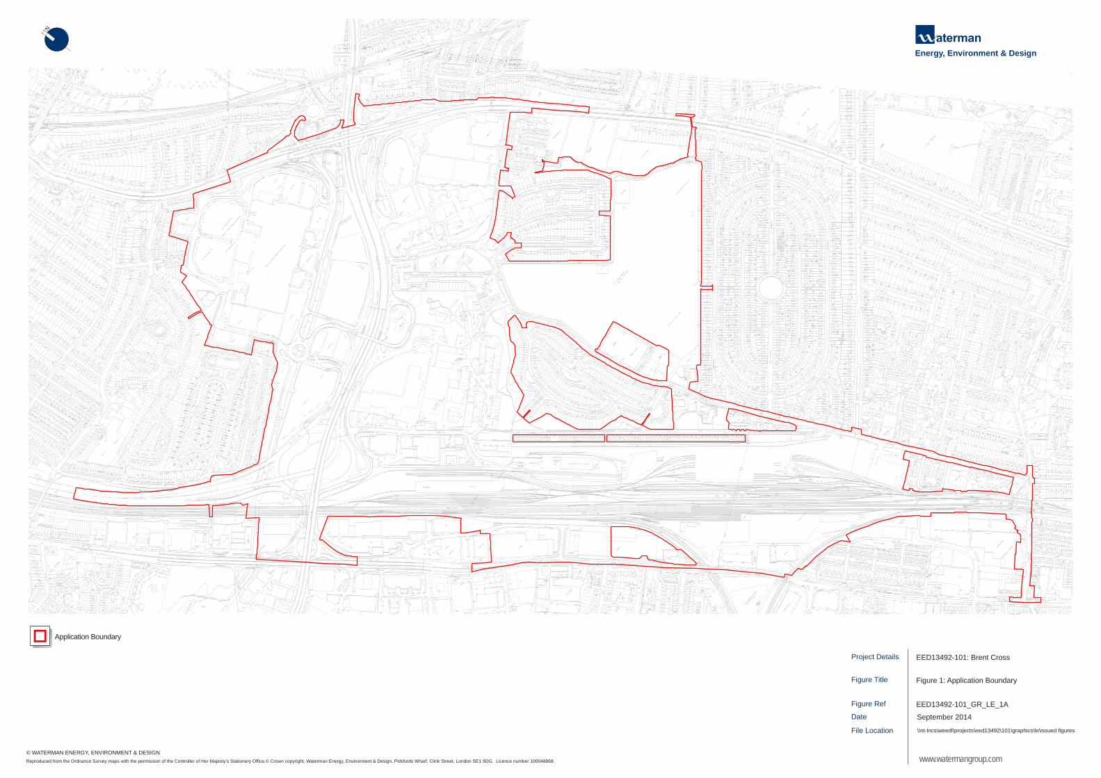
Project Details
Figure Ref
Date
Figure Title
File Location
Figure 1: Application Boundary
\\nt-lncs\weedl\projects\eed13492\101\graphics\le\issued figures
EED13492-101_GR_LE_1A
September 2014
EED13492-101: Brent Cross
www.watermangroup.com
Energy, Environment & DesignN
Reproduced from the Ordnance Survey maps with the permission of the Controller of Her Majesty’s Stationery Office,© Crown copyright, Waterman Energy, Environment & Design, Pickfords Wharf, Clink Street, London SE1 9DG. Licence number 100048868.
© WATERMAN ENERGY, ENVIRONMENT & DESIGN
Application Boundary


Figure 3: Location of Plots 53 and 54, collectively referred to as Brent Terrace (BT1)

EIA Scoping Report Appendices
\\NT-lncs\WEEDL\Projects\EED13492\101 & 102 RMA and Conditions\Reports\Working Drafts\01. RMA Phase 1AN ES Scoping Report\EED13492-101.R.1.3.1.EIA Scoping Report Phase 1AN RMA. DRAFT for LBB.docx
Appendix C. Ecology Scope of Works

1
Brent Cross: Waterman EED note on proposed scope of ecological works Ref: EED13492_102_C_007_JF_Ecology_Briefing_Note_Capita Issue 19th June 2014
1. Introduction Waterman EED has been commissioned to undertake ecological works in relation to the Brent Cross redevelopment scheme in North London. This work will inform the submission of Reserved Matters Applications (RMAs) for each phase of the development and the discharge of planning conditions. The Site is proposed for mixed use residential, commercial and leisure facilities with upgrades and expansion of supporting infrastructure (hereafter referred to as the ‘proposed Development’). This note has been produced to clarify and confirm with the Local Planning Authority (London Borough of Barnet), the scope of the ecological works in relation to the forthcoming RMAs and planning conditions including any protected species licensing requirements and identification of habitat creation and management opportunities. We would aim to consult with other key stakeholders where relevant to this work, including Natural England, the Environment Agency and the local wildlife group. 2. Ecological surveys and reporting to support RMAs and discharge planning conditions
2.1 General approach: Summary
Table 1, in Annex 1, summarises the existing ecological information for the site as per the Section 73 ES and previous EIAs and outlines our proposed approach. Further rationale is set out below. Following a review of the existing ecological information for the Site and in line with initial results from an updated Phase 1 habitat survey, carried out in May 2014, the key area of works for ecology relates to the protected species surveys for bats where there is a future requirement for further bat surveys to be undertaken.
In relation to all other protected species groups potentially relevant to the Site (badger, otter, water vole, great crested newt, reptiles, invertebrates, breeding birds), we propose to validate previous survey data (2006 and 2013) by our updated 2014 Phase 1 habitat survey. The rationale for this approach is based upon:
The Site is located in a heavily urbanised part of North London with very few potential wildlife habitats. The combination of the M1, North Circular and A41 isolate much of the site, especially given the main railway line location to the west and further constraints of the existing Brent Cross Shopping Centre and other built development and industry.
Extensive surveys in 2006 found no evidence of badger, otter, water vole, great crested newt or reptiles. The 2013 updated Phase 1 habitat survey validated that the habitat for these groups had not changed and that the likelihood of these groups being present is negligible. Based on our 2014 survey to date, we are assuming no change.
The 2006 Breeding Bird Survey recorded only a limited array of common urban bird species.
Again, the 2013 updated Phase 1 habitat survey found no change in bird habitats and therefore based on our 2014 survey to date, we are assuming no change.
The 2006 Invertebrate Survey found a number of species with restricted distributions and
classified the Site as of Local interest. Again, the 2013 updated Phase 1 habitat survey found
2
no change in invertebrate habitats and therefore based on our 2014 survey to date, we are assuming no change.
2.2 Ecological background 2.2.1 Phase 1 Habitat Survey and River Corridor Survey A Phase 1 habitat survey (including River Corridor Survey) was undertaken in May/June 2006 (by Thomson Ecology) and updated in July 2013 (by ERM). Desk study data requests were made to accompany each of these studies in 2006 and August 2013. The 2013 ecological walkover survey was commissioned to ‘validate’ habitats for protected species potential (it was used to assess ‘no change’ since the 2006 protected species surveys) to inform the Section 73 application. 2.2.2 Badger, otter and water vole Badger, otter and water vole assessments for the Site were carried out in 2006. These results were then ‘validated’ as part of the July 2013 Phase 1 habitat survey update. No evidence of the aforementioned species was recorded and there were no historical records from site or within a 2km radius. There was limited suitable habitat for water voles on Clitterhouse Brook, but no suitable habitat identified for otters. 2.2.3 Great crested newts Great crested newt surveys were carried out at the pond in Clarefield Park by ERM in 2000 and 2001. Clarefield Park pond was surveyed again in 2006 after being considered suitable for this species in the 2006 Phase 1 habitat survey (four visits between 21st June and 28th June by Thomson Ecology). The Site was ‘validated’ as remaining the same for this species as part of July 2013 Phase 1 habitat survey update and therefore no further surveys were considered necessary. No great crested newts have been recorded during these surveys; there are also no historical records for the site or within a 2km radius. 2.2.4 Reptiles Suitable habitat for reptiles was recorded on the Site during the 2006 Phase 1 habitat survey and surveys were undertaken Sept 2006 (five visits on consecutive days (25th-29th September)). No reptiles were recorded. The habitat for these species and conditions on Site were considered ‘validated’ as part of July 2013 Phase 1 habitat survey update. No historical records for reptiles exist for the Site and there is only one record of slow worm within a 2km radius (located 950m from the site). 2.2.5 Invertebrates Suitable habitat for invertebrates was recorded in the 2006 Phase 1 habitat survey and subsequently an invertebrate survey was undertaken by Thomson Ecology 2006. Some areas of the Site were considered to be of ‘local’ value for invertebrates, including Clarefield Park. These findings were ‘validated’ as part of the July 2013 Phase 1 habitat survey update. 2.2.6 Breeding birds Breeding bird surveys were undertaken after suitable habitat was recorded during the 2006 Phase 1 habitat survey. Four visits were carried out in June and July 2006, for eight locations, with a fifth visit to habitats west of Brent Terrace on Network Rail land in July 2006. These habitats were ‘validated’ as part of July 2013 Phase 1 habitat survey update. A total of 19 species were recorded as breeding; all common urban species and no Schedule 1 Wildlife and Countryside Act rare breeding birds. 2.2.7 Bats A daytime survey for the suitability of the Site to provide roosting opportunities for bats was carried out, followed by emergence surveys, at 11 potential roost sites (two visits each), in addition to 13 bat activity transects, carried out between 4th and 22nd September 2006, by Thomson Ecology. Two common pipistrelle roosts were recorded in 2006 at PR8 mature oak in Clitterhouse Park and B2 in the Clitterhouse Farm buildings complex. These 11 potential roost sites were resurveyed during the daytime

3
in Spring 2011 during which a number of trees and buildings were recorded to have been removed or were downgraded to negligible bat roost potential. One remaining tree (PR8) and the Clitterhouse Farm buildings were resurveyed with three dusk/dawn emergence surveys in June, July and August 2011. In 2011, no roost was recorded in tree PR8 (although high level of activity around). A single common pipistrelle emerged from B3 at Clitterhouse Farm, with high levels of activity around the other buildings. 2.2.8 Other protected species The site is not suitable for any other protected species. 2.3 Proposed scope and approach 2.3.1 Updated Phase 1 habitat survey: findings and recommendations An updated Phase 1 habitat survey and River Corridor Survey (RCS) were undertaken in April/May 2014 by a suitably experienced ecologist, to assess and record the habitats present on the site, the presence of or potential for protected species, and to compare the current ecological baseline with the ecological baseline recorded for the original 2009 Environmental Statement and subsequent addenda (including the Section 73 ES). Access has not yet been obtained for all areas of the Site: the intention is to complete the Phase 1 habitat survey for the entire site during summer 2014. Discussions are continuing with GL Hearn and Network Rail to organise access to the final areas including the rail corridor and yard and school sites.
The updated Phase 1 habitat survey undertaken to date in 2014 has recorded the following interim findings:
The Site has shown no signs of badgers and very limited suitable habitat for this species, therefore no further action is proposed;
The Site has shown no signs of otters or suitable otter habitat, therefore no further action is proposed;
The Site has shown no signs of water vole activity and very limited suitable habitat for this
species, therefore no further action is proposed;
The only previously recorded suitable pond for great crested newts on the Site was assessed in the 2014 updated Phase 1 habitat survey using Habitat Suitability Index (HSI) and scored 0.38. Great crested newts have not been found in ponds with HSI lower than 0.43. The pond in Clarefield Park is in a highly isolated urban situation and is considered unsuitable for this species and no further surveys are considered necessary. A frog was recorded in a previous great crested newt survey; therefore the pond should be drained under ecological supervision to prevent harm coming to common amphibians that could be present;
Habitats remain consistent with the 2006 Phase 1 habitat survey and 2013 update with
respect to reptile potential and no signs of reptiles were found in the 2014 update in the areas of the Site accessed. The River Brent (East) area (adjacent to A41) had been cleared recently with a new footpath constructed and as such no longer has reptile habitat potential. No further action is proposed for these areas;
There are no changes to the habitats on the Site surveyed in 2014 with relation to areas of
invertebrate interest and therefore the previous findings remain valid and no further surveys are proposed;
There are no changes on Site to habitats suitable for breeding birds and therefore the
previous findings remain valid and no further surveys are proposed; and
In relation to bats, there are a number of trees on the site that require climbing inspections and a number of buildings on site that require an internal inspection and / or emergence and re-entry bat surveys. These were recorded in the areas of the site which were accessible at

4
the time of survey (these are in addition to the previous roosts recorded in the Clitterhouse Park area).
The Phase 1 habitat survey report will be issued following completion of the survey (i.e. we have accessed all areas): this is likely to be in July 2014.
2.3.2 Recommendations for further survey work 2.3.2.1 Species other than bats Recommendations for species other than bats will be subject to the results in our final Phase 1 habitat survey update report. 2.3.2.2 Bats Further bat survey work will be needed to support the RMAs as well as to discharge planning condition 27.14. Bats and RMAs To support submission of the RMAs, we propose to re-assess all buildings and trees that may be removed / impacted by the scheme for bat roost potential. Any buildings or trees with bat roost potential will be subject to further inspection (e.g. tree climbing, use of endoscope etc). Following this, any with remaining bat roost potential will be subject to appropriate dawn and dusk surveys in the activity season (May - September). To provide full information on bat roosts within the Phase 1A North and 1B North RMAs, any buildings or trees recorded to have bat roost potential that will be impacted by the works will undergo further inspection and / or dusk and dawn re-entry bat surveys between June and September 2014. Otherwise the dawn and dusk surveys will be undertaken in the activity season (i.e. May – September) prior to each of the subsequent RMAs. From the updated Phase 1 habitat survey undertaken to date in 2014, the following trees and buildings have been identified as requiring further inspection / survey:
35 trees including: o 25 mature poplar trees located north and south of Brent Cross shopping centre
(groups of 9 and 16 trees) o 10 mature oak and horse chestnut trees around Clitterhouse Recreation Ground;
5 buildings/groups of buildings including: Clitterhouse Farm buildings; residential properties
near Brent Cross station and east of A41; and Brent Cottage on corner of Tilling Road and Claremont Road.
This will be revised when the 2014 Phase 1 habitat survey is completed and areas such as the school grounds and Retail Park have been resurveyed. Bat activity transects were undertaken in 2006, but not in 2011. No further transects are proposed in 2014. The Bat Survey Scope attached to this document provides further detail on the surveys to be undertaken prior to the RMAs. Bats and planning condition 27.14 Pre-commencement planning condition 27.14 requires bat surveys within six months prior to works for building demolition or tree felling on Site. The project programme currently proposes commencement of works on Site in mid-2016 for Phase 1A North of the proposed Development and works for Phase 1B North to follow this. It is therefore proposed that all bat surveys deemed necessary to identify bat roosts within these Phases are completed in 2014, so the necessary mitigation can be agreed in line with detailed design from the RMA in 2015 with Natural England. Any further surveys that may be required in addition to that outlined within the Bat Survey Scope attached can then be undertaken in
5
the summer of 2015 as required. As the phasing of development moves forward, it may be prudent to repeat the bat surveys each field season prior to commencement of works in order to ensure compliance with this condition. Bat licences In 2006 there were two bat roosts identified (both in Clitterhouse Park) and in 2011 only one (Clitterhouse Park). If bat roosts are found during our surveys, appropriate European Protected Species (EPS) licences will be sought prior to construction. The protected species licences will include details of the bat survey results and provide recommendations of the mitigation measures to be adopted. 3. Statutory and non-statutory wildlife sites Assessment of development impacts on statutory and non-statutory wildlife sites was adequately addressed in the 2009 ES and subsequent addenda. Further assessment work is unlikely to be required to support the RMAs. However, the general approach by the RMAs would be as follows:
Ensuring that the restoration of the River Brent makes a positive contribution to the conservation and enhancement of the Brent Reservoir SSSI;
Detailed proposals for the creation of new ecology areas and wildlife parks seek to replace any habitats with ecological value that are being lost, e.g. Clarefield Park Site of Local Importance, and maximise habitats for local invertebrates;
Creating enhanced opportunities for wildlife in landscaping proposals in retained and new
open space provision. We will liaise with appropriate key stakeholders, including Natural England and with the Brent Cross team as required, to facilitate the delivery of commitments as stated above. 4. Ecological habitat creation and management We are working alongside the scheme landscape architects, Macgregor Smith, to ensure that ecology is fully integrated into areas of retained and created open space. This work relates to the discharge of planning conditions 27.1 and 27.2 where the Phase 1 habitat survey results will be used to inform the potential retention of valuable ecological habitats or features. Key elements of this approach include:
Advising on biodiversity target species for the River Brent restoration and advice on species planting and habitat creation for different reaches of the River;
Advising on species planting and the creation of new ecological habitats in the proposed new ecology parks; and
Advising on ecological enhancement opportunities in areas of retained or created open
space, e.g. Clitterhouse Recreation Ground.

6
Annex 1 The following table summarises the previous ecological surveys for the Site, together with actions proposed by Waterman EED in 2014 and subsequent years. Table 1. Ecology survey record
Previous surveys and action Proposed action Completed/planned Survey/issue Dates Notes Extended Phase 1 Habitat Survey
30th May to 2nd June 2006. Updated 4/5th July 2013. Desk study data requests in 2006 and August 2013 update.
2013 found no changes from 2006. 2013 survey ‘validated’ habitats for protected species (used to assess no change since 2006 protected species surveys).
Update Extended Phase 1 habitat survey in Spring/Summer 2014 to ensure ecological information is up to date for first Reserved Matters submission (October 2014, Phase 1A North) and subsequent submissions.
Update Phase 1 habitat survey undertaken on accessible areas in May 2014. Obtain access and survey remaining areas in June 2014. Final report available July 2014.
River Corridor Survey
August 2006 and validated as part of July 2013 Phase 1 habitat survey update.
Validate 2006 RCS as part of Spring/Summer 2014 Phase 1 habitat survey update.
See above.
Statutory sites Brent Reservoir SSSI 0.2km to west.
Need to ensure no pollution during construction and operation. Liaison with NE.
Badger 2006 Survey. Validated as part of July 2013 Phase 1 habitat survey update.
No evidence found. No historical records from site or within 2km.
Spring/Summer 2014 update Phase 1 habitat survey to validate (would pick up any signs of badgers: if signs found, would require badger survey prior to construction).
No signs of badgers found in 2014 update: no further survey action proposed.
Otter 2006 Survey. Validated as part of July 2013 Phase 1 habitat survey update.
No potential holts or resting places recorded.
Spring/Summer 2014 update Phase 1 habitat survey to validate (would pick up any signs of otters: if signs found, would require otter survey prior to construction).
No signs of otters found in 2014 update: no further survey action proposed.

7
Water vole 2006 Survey. Validated as part of July 2013 Phase 1 update.
No evidence recorded. Suitable habitat on Clitterhouse Brook.
Spring/Summer 2014 update Phase 1 habitat survey to validate (would pick up any signs of water voles: if signs found, would require water vole survey prior to construction).
No signs of water voles found in 2014 update: no further survey action proposed.
Amphibians – including great crested newt.
ERM surveys in 2000 and 2001. Clarefield Park pond surveyed in 2006 (4 visits between 21st June and 28th June). Validated as part of July 2013 Phase 1 habitat survey update.
No GCN found. Pond is within built up area and isolated. No historical records for the site or within 2km.
Pond in Clarefield Park subject to Habitat Suitability Index (HSI) assessment as part of update Phase 1 habitat survey in 2014, to assess suitability for GCN and validate previous surveys.
No signs of GCN found in 2014 update: no further action proposed. Pond assessed in 2014 Phase 1 habitat survey update using Habitat Suitability Index (HSI) and scored 0.38. GCN not found in ponds with HSI lower than 0.43. Pond unsuitable for GCN and no further survey recommended.
Reptiles Sept 2006. Five visits on consecutive days (25th-29th September). Validated as part of July 2013 Phase 1 habitat survey update.
No historical records for site and only one record of slow worm within 950m.
Spring/Summer 2014 update Phase 1 habitat survey to validate (would pick up any signs of reptiles: if signs found, would require reptile survey prior to construction).
No signs of reptiles found in 2014 update: no further survey action proposed.
Invertebrates September 2006. Validated as part of July 2013 Phase 1 habitat survey update.
8 nationally scarce species and 2 Red Data Book species. Some areas considered to be of ‘local’ value for invertebrates, including Clarefield Park.
Spring 2014 update Phase 1 habitat survey to validate. Mitigation will be incorporated into new ecology areas for invertebrates.
No change in habitat found in 2014 update: no further survey action proposed.
Breeding birds 4 visits between 12th June and 12th July
19 species breeding, all common urban species and no Schedule 1
Spring 2014 update Phase 1 habitat survey to validate. Mitigation will be incorporated into new ecology areas for breeding birds.
No change in habitat found in 2014 update: no

8
2006, for 8 locations. Fifth visit to habitats west of Brent Terrace on Network Rail land 22nd July 2006. Validated as part of July 2013 Phase 1 habitat survey update.
Wildlife and Countryside Act rare breeding birds.
further survey action proposed.
Bats 4th to 22nd Sept 2006. Daytime survey, emergence surveys at 11 potential roost sites (2 visits each). 13 bat activity transects. Resurvey June, July and August 2011 of 7 potential roost sites: 3 dusk/dawn emergence surveys. 5 trees, single building and set of 8 farm buildings. 4 sites from 2006 no longer existed.
No historical data from site, but roosts within 2km. 2 common pipistrelle roosts in 2006; PR8 mature oak in Clitterhouse Park and PR10 Clitterhouse Farm buildings complex (2 of which were confirmed roosts and the remaining buildings of high potential). In 2011, no roost recorded in tree PR8 (although high level of activity around). Single pipistrelle emerged from Clitterhouse Farm Buildings – high levels of activity around the other buildings. No bat surveys since 2011.
Tree and building bat roost potential assessed as part of updated Phase 1 habitat survey in Spring/Summer 2014. Recommend daytime visits to trees/buildings with bat roost potential that will be impacted by the Phase 1AN and 1BN works in 2014. Dusk/dawn emergence surveys scheduled for June to September 2014 for any trees and buildings still recorded to have bat roost potential after daytime visits and that will be impacted by the Phase 1AN or 1BN works (to inform Reserved Matters Applications for each). Planning condition 27.14. states: ‘No more than six months before the demolition of any building or felling of any tree identified in the Revised Environmental Statement as having the potential to be used as a bat roost, a check survey involving detailed inspection of the building or tree concerned shall be undertaken…..’. To conform with this condition, dusk/dawn emergence surveys are recommended every field season prior to commencement of works on Site.
Trees and buildings assessed for bat roost potential as part of update Phase 1 habitat survey in Spring 2014. Further areas still to be accessed to complete the Phase 1 habitat survey. Scheduled in June 2014 with access arranged. Daytime visits to trees/buildings with bat roost potential to be impacted by Phase 1AN and 1BN works planned for summer 2014, followed by dusk/dawn emergence surveys on any buildings and trees still recorded to have bat roost potential that will be impacted by the Phase 1AN and 1BN
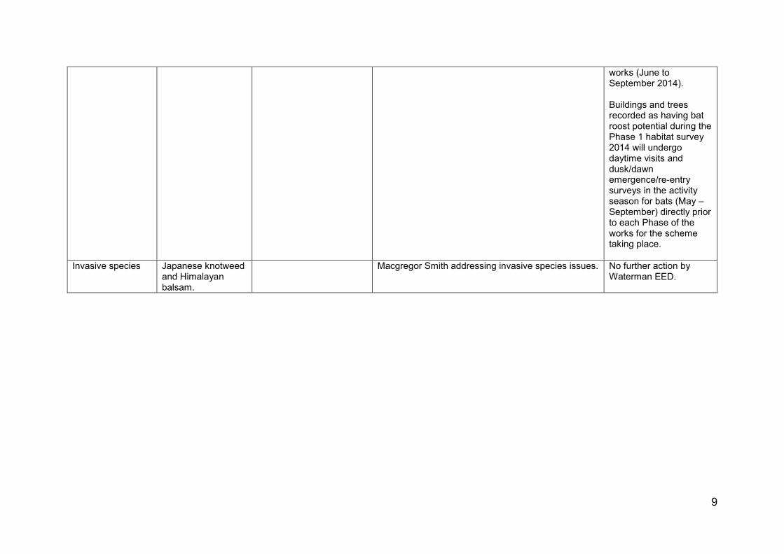
9
works (June to September 2014). Buildings and trees recorded as having bat roost potential during the Phase 1 habitat survey 2014 will undergo daytime visits and dusk/dawn emergence/re-entry surveys in the activity season for bats (May – September) directly prior to each Phase of the works for the scheme taking place.
Invasive species Japanese knotweed and Himalayan balsam.
Macgregor Smith addressing invasive species issues. No further action by Waterman EED.


EIA Scoping Report Appendices
\\NT-lncs\WEEDL\Projects\EED13492\101 & 102 RMA and Conditions\Reports\Working Drafts\01. RMA Phase 1AN ES Scoping Report\EED13492-101.R.1.3.1.EIA Scoping Report Phase 1AN RMA. DRAFT for LBB.docx
Figures
Figure 1: Site Location
Figure 2: Site Boundary
Figure 3: Indicative Masterplan (2014 Permission)
Figure 4: Development Zones
Figure 5: Phase 1A (North) RMA Features
Figure 6: Location of Cumulative Schemes
Figure 7: Proposed Viewpoints

EIA Scoping Report References
\\NT-lncs\WEEDL\Projects\EED13492\101 & 102 RMA and Conditions\Reports\Working Drafts\01. RMA Phase 1AN ES Scoping Report\EED13492-101.R.1.3.1.EIA Scoping Report Phase 1AN RMA. DRAFT for LBB.docx

Energy, Environment & Design
Project Details
Figure Ref
Date
Figure Title
File Location
Figure 1: Site Location
\\nt-lncs\weedl\projects\eed13492\101\graphics\sr\issued figures
EED13492-101_GR_SR_1A
September 2014
EED13492-101: Brent Cross Cricklewood -Phase 1A North Scoping Report
www.watermangroup.com
N
Reproduced from the Ordnance Survey maps with the permission of the Controller of Her Majesty’s Stationery Office,© Crown copyright, Waterman Energy, Environment & Design, Pickfords Wharf, Clink Street, London SE1 9DG. Licence number 100048868.
© WATERMAN ENERGY, ENVIRONMENT & DESIGN
SITE LOCATION

Project Details
Figure Ref
Date
Figure Title
File Location
Figure 2: Application Boundary
\\nt-lncs\weedl\projects\eed13492\101\graphics\sr\issued figures
EED13492-101_GR_SR_2A
September 2014
EED13492-101: Brent Cross Cricklewood -Phase 1A North Scoping Report
www.watermangroup.com
Energy, Environment & DesignN
Reproduced from the Ordnance Survey maps with the permission of the Controller of Her Majesty’s Stationery Office,© Crown copyright, Waterman Energy, Environment & Design, Pickfords Wharf, Clink Street, London SE1 9DG. Licence number 100048868.
© WATERMAN ENERGY, ENVIRONMENT & DESIGN
Application Boundary