eimeo beach plan final nov2010 - mackay.qld.gov.au · high eimeo point headland is a key feature of...
TRANSCRIPT

Mackay Coasts and Communities
Eimeo Beach Plan
2010

2
Contents
1. Beach unit description 3 2. Conservation and management issues 5
2.1 Vegetation 5 2.1.1 Remnant vegetation 5 2.1.2 Vegetation zonation 7 2.1.3 Non‐native vegetation 8 2.1.4 Waste dumping 8
2.2 Public access and facilities 9 2.3 Wildlife 11 2.4 Cultural heritage 12 2.5 Erosion 12 2.6 Climate change 14
3. Recommended activities 15 4. References 17
Acknowledgements: The project is supported by Reef Catchments and Mackay Regional Council, through funding from the Australian Government’s Caring for our Country, the Queensland Government, and Mackay Regional Council’s Natural Environment Levy. Beach Plans are based on Mackay Regional Council’s Coastal Management Guidelines (May 2009). Disclaimer: All maps within Eimeo Beach Plan © Reef Catchments. While every care is taken to ensure the accuracy of the maps included in this document, Reef Catchments make no representation or warranties about their accuracy, reliability, completeness or suitability for any particular purpose and disclaims all responsibility and all liability for all expenses, losses, damages which are incurred as a result of these products being inaccurate.
Cover image: Orthophotos from digital aerial photography 0.6 metre pixel 2004 supplied by Mackay Regional Council.

3
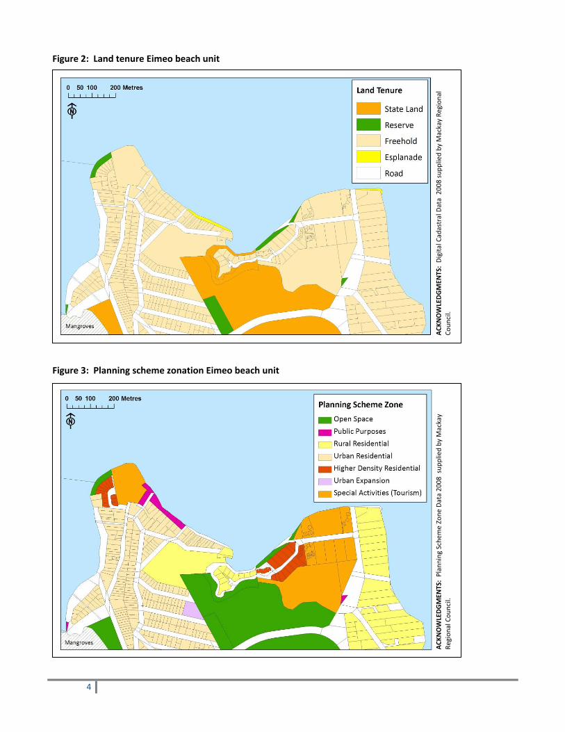
1. Beach unit description The Eimeo beach unit stretches for approximately three kilometres from the mouth of Eimeo Creek in the west, to a rocky outcrop, which forms the northern boundary of Blacks Beach, in the east (Figure 1). The 60 metre high Eimeo Point headland is a key feature of the unit, with Sunset Bay lying to its west, and Eimeo Beach to its east. Eimeo Beach is a 400 metre long, north facing, low energy beach which extends from the Point to the mouth of a small mangrove‐filled creek (Short, 2000). Dolphin Heads beach lies to the east of this creek mouth and is a 300 metre long, north‐west facing beach with tidal and rock flats extending to Black Point. The eastern stretch of the Eimeo beach unit is dominated by the 60 metre high Black Point basalt outcrop and associated bluffs with boulders and cobbles at their base. The Eimeo beach unit is dominated by Freehold tenured residential dwellings and tourism developments (Figures 2, 3). Freehold tenure occurs to the shoreline in many areas, with minor stretches of Reserve and Esplanade tenure associated with recreational areas. A large area of Open Space, State Land covers the mangrove and salt flats in the centre of the beach unit. Figure 1: Extent of Eimeo beach unit
ACKNOWLEDGMENTS: Orthophotos from digital aerial photography 0.6m pixel 2004 supplied by Mackay Regional Council.
4
Figure 2: Land tenure Eimeo beach unit
Figure 3: Planning scheme zonation Eimeo beach unit
ACK
NOWLEDGMEN
TS: Digita
l Cadastral Data 200
8 supp
lied by
Mackay Re
gion
al
Coun
cil.
ACK
NOWLEDGMEN
TS: Planning
Schem
e Zone
Data 20
08 sup
plied by
Mackay
Region
al Cou
ncil.

5
2. Conservation and Management Issues
2.1 Vegetation 2.1.1 Remnant vegetation Eimeo beach unit has been extensively cleared with only 0.4 ha of remnant vegetation (mangroves) mapped remaining on Reserve tenure (Environmental Protection Agency, 2005) (Figures 4, 6). An additional 25 ha of mangrove and salt flat communities is present on State Land tenure in the centre of the beach unit and lining Eimeo Creek. Thin bands of open Casuarina equisetifolia woodland with Ipomoea pes‐caprae or Spinifex sericeus dominated ground layer on foredunes are found at the eastern end of Eimeo Beach (Figure 5), and on accreting sand banks adjacent to Sunset Bay. A bushfire is an uncontrolled fire burning in forest, scrub or grassland vegetation and may occur in most vegetation types in Queensland where there is a fuel path of sufficient dryness to be flammable (Queensland Government, 2003). State Planning Policy 1/03 under the Sustainable Planning Act 2009 deals with the mitigation of adverse impacts of bushfire, and includes a natural hazard assessment for bushfires and the subsequent provision of safety buffers. According to this policy, a low hazard score and no prescribed safety buffer width is allocated to “narrow strips of coastal vegetation with a linear shape, less than 50 hectares in area and more than one kilomere from the nearest extensive vegetation, on 0‐5% slope, with an eastern aspect” (Queensland Government, 2003). All rehabilitation activities undertaken as part of this plan will be done so with consideration of this State Planning Policy. Table 1: Remnant vegetation (Regional Ecosystem) communities in Eimeo beach unit Regional Ecosystem (RE)
Short description (Environmental Protection Agency, 2005)
Approximate area (ha) on Reserve and Esplanade tenure
Vegetation Management Act status 2005
Biodiversity status
EPBC Status
8.1.1 Mangrove vegetation of marine clay plains and estuaries. Estuarine wetland.
0.4 ha. Remainder is on State Land tenure and not included in beach unit recommendations.
Not of concern
No concern at present
n/a
8.1.2 Samphire open forbland to isolated clumps of forbs on saltpans and plains adjacent to mangroves.
Freehold and State Land tenure. Not included in beach unit recommendations.
Not of concern
Of concern n/a
8.12.27b Eucalyptus tereticornis, Corymbia tessellaris, Livistona decipiens ± C. intermedia ± rainforest pioneering spp. open forest, on low hills on Mesozoic to Proterozoic igneous rocks.
Freehold tenure. Not included in beach unit recommendations.
Endangered Endangered

6
Figure 4: Mangrove communities line Eimeo Creek and much of the centre of the beach unit.
Figure 5: A thin band of Casuarinas and colonising grassesare found at the eastern end of Eimeo Beach.
Figure 6: Remnant vegetation Eimeo beach unit
ACKNOWLEDGMENTS: Orthophotos from digital aerial photography 0.6m pixel 2004 , and Digital Cadastral Data 2008 supplied by Mackay Regional Council. 2008 Central Queensland remnant beach scrub mapping 1:12,000; and 2003 Remnant Vegetation Communities and Regional Ecosystems of Queensland version 5, 2005, supplied by Environmental Protection Agency.

7
2.1.2 Vegetation zonation The Eimeo beach unit is highly disturbed, almost entirely removing natural vegetation zonation and function along its coastline. Intermittent low rock walls and groynes, mown recreational parklands, and Freehold properties dominate the coastline along Sunset Bay (Figure 7), Eimeo Beach (Figure 8), and Dolphin Heads (Figure 9). The sand spit Esplanade at the eastern end of Eimeo Beach has a small area of colonising spinifex and casuarina woodland on the foredune (Figure 10), which could be further encouraged with localised weed control. Other areas of natural vegetation zonation include mangrove communities lining parts of the low energy coastline along Sunset Bay and Eimeo Creek (Figure 4), sheer rocky headlands separating the sandy beaches which have sparse windswept vegetation (Figure 11), and a pocket of eucalypt vegetation backing the rocky foreshore where protection is provided by Eimeo Point headland (Figure 12).
Figure 7: A rock wall and recreational area at Sunset Bay have removed natural vegetation zonation.
Figure 8: Mown recreational parklands at the western end of Eimeo Beach have removed natural vegetation zonation.
Figure 9: Freehold properties, low rock walls and groynes dominate the coastline at Dolphin Heads, preventing natural zonation and function.
Figure 10: A 200 metre stretch of Esplanade with Casuarina woodland and colonising herbs and grasses is present at the eastern end of Eimeo Beach.

8
Figure 11: Sheer rocky headlands separating the sandy beaches in the Eimeo beach unit have sparse, windswept vegetation.
Figure 12: A pocket of eucalypt vegetation backs the rocky foreshore where protection is provided by Eimeo Point headland.
2.1.3 Non‐native vegetation Non‐native vegetation present along sandy foreshores in the Eimeo beach unit includes localised patches of leucaena (Leucaena leucocephala), and a variety of herbaceous garden escapees including mother‐in‐laws tongue (Sansevieria trifasciata), agave (Agave sp.), and the Declared mother of millions (Bryophyllum sp.) (Land Protection Pest and Stock Route Management Act, 2002). Rocks walls and Eimeo Point headland have infestations of Guinea grass (Megathyrsus maximus), guajava (Psidium guajava), agave, and the Declared Singapore daisy (Sphagneticola trilobata) and prickly pear (Opuntia sp.) (Land Protection Pest and Stock Route Management Act, 2002) (Figures 13, 14). Although much of Eimeo Point headland is Freehold property, the presence of these weeds provides a potential threat of spread to adjacent public coastal lands.
Figure 13: Localised stands of garden escapees outcompete native vegetation along the foredunes and rock walls in the Eimeo beach unit.
Figure 14: Eimeo Point headland has a high incidence of non‐native species including agave and guinea grass.

9
2.1.4 Waste dumping Minor vegetative waste dumping was observed to occur on the foredunes in the Eimeo beach unit, adjacent to residential areas.
2.2 Public access and facilities There are four designated pedestrian access points provided with fencing or associated infrastructure in the Eimeo beach unit (Figure 15, 19). Open pedestrian access to the beach front is provided along Eimeo Esplanade (Figure 16), and several other private beach accesses are also present along Sunset Bay and Dolphin Heads where Freehold property boundaries extend to the beach front (Figure 17). The Eimeo beach unit is well facilitated for recreational use, with beachfront parks located at both Sunset Bay and Eimeo Beach. Barbeques, tables, playground and parking facilities are provided. The Eimeo Surf Life Saving Club is located at Eimeo Esplanade, and the beach is patrolled during weekends and public holidays. A Council managed boat ramp is provided on Sunset Boulevard on the west facing Sunset Bay (Figure 18).
Figure 15: Sunset Bay beach access, Eimeo beach unit. Figure 16: Eimeo Beach Esplanade recreational area and beach access.
Figure 17: Multiple private beach accesses are present along Sunset Bay and Dolphin Heads where Freehold property boundaries extend to the beach front.
Figure 18: Eimeo boat ramp on the west facing Sunset Bay.

10
Figure 19: Eimeo access points and recreational areas
ACKNOWLEDGMENTS: Orthophotos from digital aerial photography 0.6m pixel 2004; Digital Cadastral Data 2008; and Boat Ramps 2008 supplied by Mackay Regional Council.

11
2.3 Wildlife Eimeo Beach provides potential marine turtle nesting habitat (Figure 20), with an average of four flatback turtle (Natator depressus) nests per year being recorded at Eimeo Beach between 1993 and 2003 (Mackay District Turtle Watch Association, 2003). An interpretive sign highlighting the value of Eimeo Beach as turtle nesting habitat is installed at the Eimeo Beach access point (Figure 19). Light pollution from nearby residential development increases the mortality rates of turtle hatchlings along Eimeo Beach (Griffin, F. 2009, pers. comm., 5 June). An education campaign targeting local residents along Eimeo Esplanade to minimise, redirect, shield, or switch off light sources during turtle nesting season is recommended. A shorebird roost on developing sandbanks in Sunset Bay is recorded in the Eimeo beach unit, and is part of the larger complex of Bucasia Creek roosts (Figure 20). The roost faces major threats from disturbance by fishers and pedestrians at lower tides (Milton, 2009). The vulnerable beach stone curlew (Esacus magnirostris) has also been recorded in the Eimeo beach unit, along the Dolphin Heads beach (Figure 20) (Andrews, M. 2009, pers. comm., 2 July). The vulnerable false water rat (Xeromys myoides) Essential Habitat covers the State Land tenure in the centre of the Eimeo beach unit (Listed ‘Vulnerable’ by Queensland Nature Conservation Act, 1992). The quantity and quality of storm water entering the system in this area will be of relevance to the health of the false water rat population into the future. Figure 20: Wildlife values in Eimeo beach unit
ACK
NOWLEDGMEN
TS: O
rtho
photos from digita
l aerial pho
tography
0.6m pixel 200
4 an
d 20
08 Digita
l Cadastral Data supp
lied by
Mackay Re
gion
al Cou
ncil. 2008
Cen
tral Que
ensland
remnant beach scrub
mapping
1:12,00
0; and
200
6 False Water Rat Essen
tial H
abita
t mapping,
supp
lied by
Environ
men
tal P
rotection Agency. 2
009 Be
ach Ston
e Cu
rlew
records pers comms
M. A
ndrews. 200
9 Shoreb
ird roosts GPS data sup
plied by
Que
ensland Wader Study
Group
.

12
2.4 Cultural heritage The Eimeo area was previously occupied by Traditional Owners and the retention and rehabilitation of natural areas remains of significance to the Yuibera people (Mooney, G. 2009, pers. comm., 9 March). Middens, fish traps or other items of cultural significance may be present in the area. 2.5 Erosion Development has occurred within the erosion prone area along much of the Eimeo beach unit (Figure 23). A series of low rock walls and groynes have been constructed along the beaches to stop erosion along the seaward boundaries of these properties (Figures 7, 9, 17, 21, 22, 23). The Mackay Coast Study (Environmental Protection Agency, 2004, p. 101) suggests that “it is unlikely that the groynes will have any long‐term effect on improving the beaches and attempts to upgrade the groynes are not recommended”. The Study further recommends that “a review of the adequacy of the existing protective rock walls should be undertaken to guarantee structural integrity … to protect against a storm event” (Environmental Protection Agency, 2004, p. 101). For the erosion prone area on the sand spit at the eastern end of Eimeo Beach, the Study suggests “increase development density should not be allowed” (Environmental Protection Agency, 2004, p. 101). Encouraging rehabilitation in the small areas of recruiting coastal vegetation, such as at the eastern end of Eimeo Beach, and behind current rock walls where possible, will provide some stabilisation to the current dune structure.
Figure 21: Rock walls have been built along much of the Eimeo beach unit coastline to stop erosion of property boundaries.
Figure 22: Several short rock groynes have been constructed in an attempt to build‐up sandy material near the shoreline at Dolphin Heads (Environmental Protection Agency, 2004).

13
Figure 23: Erosion Prone Area Eimeo beach unit
ACKNOWLEDGMENTS: Orthophotos from digital aerial photography 0.6m pixel 2004; and Digital Cadastral Data 2008 supplied by Mackay Regional Council. Central Queensland erosion prone area mapping supplied by Environmental Protection Agency 2008.

14
2.6 Climate change As discussed in section 2.5, limited coastal vegetation and buffer zone remain in the Eimeo beach unit. As a result, there are limited opportunities to rehabilitate dune systems to provide resilience against the effects of climate change. Tidal flat communities extend in from Eimeo Creek and the small creek at the eastern end of Eimeo Beach to the margins of the Eimeo and Dolphin Heads residential areas. This precludes the possibility of any expansion of these salt marsh communities as sea level changes occur (Figure 24). Figure 24: Current extent of tidal flat communities Eimeo beach unit (Landzone 1)
ACKNOWLEDGMENTS: Orthophotos from digital aerial photography 0.6m pixel 2004; and Digital Cadadstral Data 2008 supplied by Mackay Regional Council. 2003 Remnant Vegetation Communities and Regional Ecosystems of Queensland version 5, 2005, supplied by Environmental Protection Agency.

15
3. Recommended activities
# On‐ground activity details (Figure 25) Zone A | Sunset Bay (1 ha)
1 Weed control. Target weed species include leucaena (Leucaena leucocephala), prickly pear (Opuntia sp), mother of millions (Bryophyllum sp), and various other herbaceous garden escapees.
Zone B | Eimeo Beach (1 ha)
2 Weed control. Target weed species include agave (Agave sp.) and various other herbaceous garden escapees, particularly from the eastern boundary of the recreational area to the creek mouth.
Zone C | Dolphin Heads (0.5 ha)
3 Weed control. Target weed species include leucaena, and various other herbaceous garden escapees.
Other activities across multiple zones
4 Update and rationalise current regulatory and information signage; dogs on leads, vehicle and pedestrian access points, waste dumping, camping, and fire signage.
5 Educate the coastal community and local tourism businesses on weed species, and promote and facilitate the use of local native species in residential and commercial gardens, and on the headlands under Freehold tenure.
6 Educate the coastal community on requirement to dispose of garden waste and other debris at designated Council refuse sites.
7 Educate the coastal community (particularly zone B) on reducing the effects of urban/ artificial lighting during turtle nesting season.
8 Where appropriate, Mackay Regional Council will liaise with the Queensland state government to enable repairs and maintenance to be carried out on existing rock wall structures.

16
Figure 25: Zones for recommended activities
ACK
NOWLEDGMEN
TS: Ortho
photos from
digita
l aerial pho
tography
0.6m pixel 200
4; and
Digita
l Cadastral Data 20
08 sup
plied by
Mackay Re
gion
al Cou
ncil.

17
4. References Environmental Protection Agency (2004) Mackay Coast Study, State of Queensland Environmental Protection Agency. Environmental Protection Agency (2005) Regional Ecosystem Description Database. Available at http://www.epa.qld.gov.au/nature_conservation/biodiversity/regional_ecosystems/how_to_downloa d_REDD/ Short, A. (2000) Beaches of the Queensland Coast: Cooktown to Coolangatta, Sydney University Press, Sydney. Mackay District Turtle Watch Association (2003) Internal data marine turtle nesting 1993‐2003. Milton, D. (2009) Internal data provided on shorebird roost sites within Mackay Regional Council (1993‐2008),
Queensland Wader Study Group. Queensland Government (2003) State Planning Policy 1/03 Mitigating the Adverse Impacts of Flood, Bushfire
and Landslide. Available at http://www.emergency.qld.gov.au/publications/spp/