el geography - ccea.org.uk · el geography entry level geography unit 3: rivers and flooding fig 8:...
TRANSCRIPT

ELQ GeographyEntry Level Geography
Unit 3: Rivers and Flooding
Unit 3: Rivers and Flooding
Learning Outcome 1:Demonstrate knowledge of the key components of the drainage basin and how a river changes downstream
Learning Outcome 2:Know and understand the formation of river landforms
Learning Outcome 3:Know how rivers can be managed to reduce the impact of and prevent flooding

ELQ Geography Entry Level Geography
Unit 3: Rivers and Flooding
Guidance notes
This resource includes information and suggested tasks relating to Entry Level Geography. This booklet has been produced to meet the requirements for Entry Level 3. Teachers should amend the material to suit the needs of their learners and the available resources.
The list of resources is neither prescriptive nor exhaustive.
For the Introduction:https://www.bbc.com/bitesize/guides/zxvw4qt/revision/1http://www.bbc.co.uk/schools/gcsebitesize/geography/water_rivers/river_profiles_rev1.shtml
For river landforms:http://www.bbc.co.uk/education/guides/zkrdmp3/revision/2http://www.coolgeography.co.uk/GCSE/AQA/Water%20on%20the%20Land/Waterfalls/LandformsWaterfalls.htmhttp://www.geography.learnontheinternet.co.uk/topics/river_upper_course.html
For flooding:http://www.bbc.co.uk/schools/gcsebitesize/geography/water_rivers/river_flooding_management_rev1.shtmlhttp://www.bbc.co.uk/schools/gcsebitesize/geography/water_rivers/river_flooding_management_rev5.shtml
ELQ Geography Entry Level Geography
Unit 3: Rivers and Flooding
Introduction
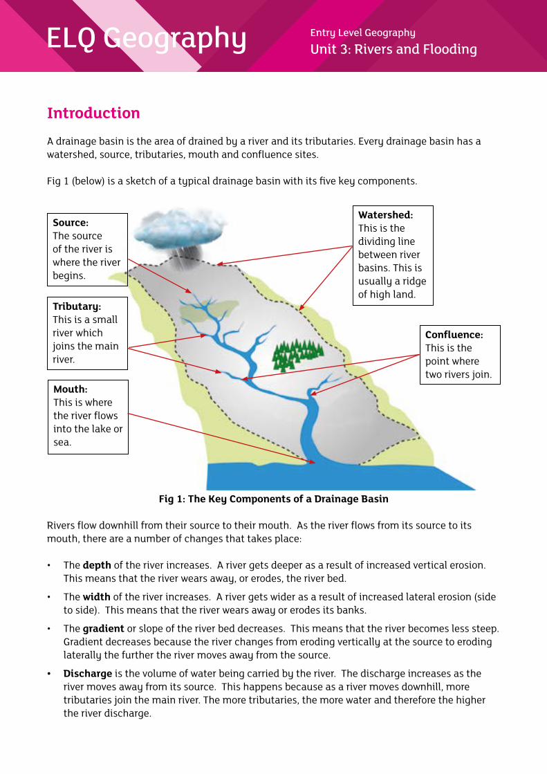
A drainage basin is the area of drained by a river and its tributaries. Every drainage basin has a watershed, source, tributaries, mouth and confluence sites.
Fig 1 (below) is a sketch of a typical drainage basin with its five key components.
Fig 1: The Key Components of a Drainage Basin
Rivers flow downhill from their source to their mouth. As the river flows from its source to its mouth, there are a number of changes that takes place:
• The depth of the river increases. A river gets deeper as a result of increased vertical erosion. This means that the river wears away, or erodes, the river bed.
• The width of the river increases. A river gets wider as a result of increased lateral erosion (side to side). This means that the river wears away or erodes its banks.
• The gradient or slope of the river bed decreases. This means that the river becomes less steep. Gradient decreases because the river changes from eroding vertically at the source to eroding laterally the further the river moves away from the source.
• Discharge is the volume of water being carried by the river. The discharge increases as the river moves away from its source. This happens because as a river moves downhill, more tributaries join the main river. The more tributaries, the more water and therefore the higher the river discharge.
Source: The source of the river is where the river begins.
Tributary:This is a small river which joins the main river.
Mouth:This is where the river flows into the lake or sea.
Confluence:This is the point where two rivers join.
Watershed:This is the dividing line between river basins. This is usually a ridge of high land.

ELQ Geography Entry Level Geography
Unit 3: Rivers and Flooding
• All rivers carry materials, this material is referred to as the load. The river’s load is made up of clay, silt, sand, gravel and boulders. The load changes as the river moves from its source to its mouth. It becomes smaller and rounder. This happens because as the river flows from the source to the mouth, particles in the load knock off one another. Each impact causes pieces of sediment to break off and so the load becomes smaller and more rounded.
River landforms
As a river flows from the source to mouth, landforms are created. Two landforms are waterfalls and meanders. Let’s look at waterfalls first.
Waterfalls are found on rivers all over the world. Famous examples include:
• Niagara Falls on the border between Canada and USA;
• Victoria Falls on the border between Zambia and Zimbabwe;
• Angel Falls in Venezuela; and
• Iguazu Falls on the border between Argentina and Brazil.
A waterfall is created when a river flows over the edge of steep land made up of hard rock and wears away the soft rock below. This causes a step to form. Over time the soft rock at the bottom of the step will be eroded causing a plunge pool to form. The swirling water undercuts the hard rock above causing an overhang to form. The hard rock collapses because there is nothing to support it underneath. When the hard rock falls into the plunge pool, the rocks become smaller, smoother and rounder as they bash against each other over time. The waterfall keeps moving upstream each time the overhang collapses. This forms a steep-sided gorge.
Fig 2 : The Formation of a Waterfall Source:
Waterfall retreats
OverhangHard rock
Plunge pool
Fallen rocks
Steep-sided gorge created as the waterfall retreats

ELQ Geography Entry Level Geography
Unit 3: Rivers and Flooding
Fig 3: High Force WaterfallMeander formation
Meanders are winding curves or bends in a river. When a river flows through a meander, the fastest current flows to the outside of the bend. This causes erosion to the river bank forming a river cliff. The river becomes deeper overtime on that side. On the inside bend of a meander, the water is flowing slower. This means that pebbles and sand is deposited forming a slip-off slope.
Fig 4: The Formation of a Meander
Slip-off slope
Slow current Fast current
Deposition on inside bank
Fine material in suspension
Lateral erosion on outside bank
River cliff

ELQ Geography Entry Level Geography
Unit 3: Rivers and Flooding
Fig 5: A Meander
FloodingFloods can be defined as the overflow of water from a river.
Fig 6: A Flooded Village

ELQ Geography Entry Level Geography
Unit 3: Rivers and Flooding
Fig 7: Severe Flooding in Paris
There are both physical and human causes of floods.
PHYSICAL CAUSES HUMAN CAUSESHeavy rain can cause floods. When it rains heavily, the soil soaks up the rain. It will reach a point where the soil will not be able to hold any more water so the ‘extra’ rain runs over the ground surface and straight into the river causing river levels to rise rapidly.
Snowmelt can cause floods. When snow melts, the extra water makes its way into the nearest rivers and floods can occur.
Steep slopes can causes floods. If a slope is steep, when the rain falls, it will not have time to soak into the soil below as the pull of gravity pulls the water down to steep slope fast into the river, causing river levels to rise rapidly.
Lots of tributaries - if a river has many tributaries, there will be more water in the river network. The more water, the higher the chance of a flood.
Deforestation (cutting down of trees) causes floods. When trees are cut down, there are fewer trees to absorb the water so water reaches the river quickly and floods occur.
Urban (built up) areas have many impermeable surfaces such as tarmac and concrete. This means that water can’t pass through into the soil below. This means the water flows straight to the river and not into the ground.

ELQ Geography Entry Level Geography
Unit 3: Rivers and Flooding
Fig 8: Deforestation
The Pakistan floods
In July 2010, major floods occurred in Pakistan. Pakistan is an Asian country that often experiences floods. In 2010, the heavy monsoon rains caused the rivers in Pakistan to burst their banks leading to widespread flooding. There were many impacts on people, property and the environment. The following is a list of the devastating impacts that hit Pakistan in 2010.
• There were approximately 1600 people who died during this 2010 flood.
• A lot of property was damaged for example 700 000 homes were damaged during the flood.
• More property such as bridges were destroyed. A total of 1000 bridges were affected during the 2010 flood.
• 160 000 km2 of the total environment was affected during the 2010 flood. This accounts for about 20% of the country.
• Crops were also ruined during the flood as estimates suggest that about 6.5 million acres of crops were destroyed.
• People could not get enough food to eat. The flooding ruined farmland and crops. At least 6 million people needed food aid.

ELQ Geography Entry Level Geography
Unit 3: Rivers and Flooding
Managing Rivers
Rivers can be managed to reduce the impact of floods or to even try and prevent floods from happening in the first place. To do this, both hard and soft engineering methods can be used.
Hard engineering – This is the building of structures to prevent a flood from taking place. These are usually expensive options and usually have a greater negative impact of the surrounding environment.
Dams are one example of a hard engineering method.
Fig 9: Hoover Dam, USA
Dams are expensive structures that are built along the course of a river. These dams are walls that are built with the aim of controlling the amount of discharge from the river. Water is held back by the dam in an area called a reservoir and released in a controlled way. This controls flooding.
Soft engineering – This involves adapting to flood risks rather than trying to prevent a flood from happening or controlling the river. Soft engineering allows natural processes to deal with the rainwater. This approach accepts the natural processes of the river and seeks to work with it. One way to achieve this is by zoning the land use near a river. Fig 10 shows open space alongside the river. If this river floods then there will be no damage to property.

ELQ Geography Entry Level Geography
Unit 3: Rivers and Flooding
Fig 10: Open space beside a river allows it to flood without damaging property
Afforestation is another example of a soft engineering method. Afforestation is simply the planting of trees close to the river. This means that there will be more trees to absorb the rainwater when it falls and therefore lower river discharge. This is a relatively low cost option as it is not very expensive to implement and it also enhances the environmental quality of the drainage basin.
Fig 11: Afforestation

ELQ Geography Entry Level Geography
Unit 3: Rivers and Flooding
Activity 1
Resource A shows a diagram of a drainage basin.
Identify the five key components of the drainage basin by drawing an arrow and labelling them on the diagram below. Use the following words to help you.
watershed source tributary confluence river mouth
Resource A
Complete the following sentences by underlining the correct word to describe how river features change from the source to mouth. For each feature explain why it changes.
1. As a river flows from its source to its mouth it becomes wider/narrower. This is because:
____________________________________________________________________________
____________________________________________________________________________
2. As a river flows from its source to its mouth it becomes deeper/shallower. This is because:
____________________________________________________________________________
____________________________________________________________________________

ELQ Geography Entry Level Geography
Unit 3: Rivers and Flooding
3. As a river flows from its source to its mouth its gradient becomes steeper/gentler. This is because: _____________________________________________________________________________
____________________________________________________________________________
4. As a river flows from its source to its mouth its discharge becomes greater/less. This is because: _____________________________________________________________________________
____________________________________________________________________________
5. As a river flows from its source to its mouth its load becomes bigger/smaller. The load also becomes more rounded/less rounded.
This is because:
____________________________________________________________________________
____________________________________________________________________________

ELQ Geography Entry Level Geography
Unit 3: Rivers and Flooding
Activity 2
Photograph 1 shows a river landform. In the spaces provided, name the landform and briefly explain how it was formed.
Photograph 1
This river landform is called a __________________________ .
It is formed when:
__________________________________________________________________________________
__________________________________________________________________________________
__________________________________________________________________________________
__________________________________________________________________________________
__________________________________________________________________________________
Photograph 2
This river landform is called a __________________________ .
It is formed when:
__________________________________________________________________________________
__________________________________________________________________________________
__________________________________________________________________________________
__________________________________________________________________________________
__________________________________________________________________________________
ELQ Geography Entry Level Geography
Unit 3: Rivers and Flooding
Activity 3
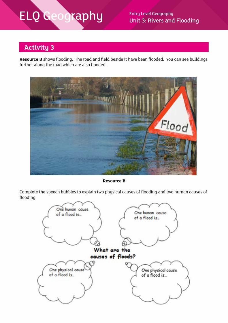
Resource B shows flooding. The road and field beside it have been flooded. You can see buildings further along the road which are also flooded.
Resource B
Complete the speech bubbles to explain two physical causes of flooding and two human causes of flooding.

ELQ Geography Entry Level Geography
Unit 3: Rivers and Flooding
Choose a flood that you have studied.
Complete the table below to describe the impact the flood had on people, property and the environment.
Name of flood: ____________________________________________________________
The impact the flood had on people
The impact the flood had on property
The impact the flood had on the environment
Rivers can be managed to reduce the impact of flooding and to prevent flooding.
Complete the following task to explain how one soft engineering method could reduce the impact of flooding and prevent flooding
A soft engineering method is to build a dam/plant trees.
This method works because:
__________________________________________________________________________________
__________________________________________________________________________________
__________________________________________________________________________________
__________________________________________________________________________________
__________________________________________________________________________________

ELQ Geography Entry Level Geography
Unit 3: Rivers and Flooding
A hard engineering method is to build a dam/plant trees.
This method works because:
__________________________________________________________________________________
__________________________________________________________________________________
__________________________________________________________________________________
__________________________________________________________________________________
__________________________________________________________________________________