electronic vfr (evfr) and onboard lbs -...
TRANSCRIPT

Ref: GIANT-2_WP4-SPA-D4.3
Issue: 2.0 Date: 7/3/2010
Electronic VFR (eVFR) and Onboard LBS
Class: CO Page 1 / 60
GIANT-2: EGNOS Adoption in the Aviation Sector Grant Agreement No. 227642
GIANT-2: EGNOS Adoption in the Aviation Sector
Electronic VFR (eVFR) and Onboard LBS
EGNOS for sports flying and private air travel
Ref: GIANT-2_WP4-SPA-D4.3
Issue: 2.0 Classification: CO
Date: 7/3/2010 Number of Pages: 60
Doc. Filename: GIANT-2_WP4-SPA-D3.1_Is2.0_eVFR and Onboard LBS Report.doc
Name/Company Signature Date
Author Wim De Peuter/SpaceConnect
WP Leader Pablo Haro/Aena
Project coordinator Luis Chocano/INECO
GSA Project Officer Hans de With /GSA
Ref: GIANT-2_WP4-SPA-D4.3
Issue: 2.0 Date: 7/3/2010
Electronic VFR (eVFR) and Onboard LBS
Class: CO Page 2 / 60
GIANT-2: EGNOS Adoption in the Aviation Sector Grant Agreement No. 227642
DOCUMENT CHANGE LOG
Issue Date Affected Sections Comments
0.1 24/02/2009 All Initial Draft
1.0 07/07/2009 All First release
1.1 09/11/2009 All Upgraded version of first release
1.2 4/3/2010 All Draft Final Version
2.0 7/3/2010 All Final Version
DOCUMENT DISTRIBUTION
To/Cc Organisation Name
To GSA / EC Mr. Hans de With
To GSA (Reviewer) Mr. Umberto Guida
To Eurocontrol Richard Farnworth
To GIANT-2 Consortium
To
To
To
To
To
To
To
To
To
To
To
To
To

Ref: GIANT-2_WP4-SPA-D4.3
Issue: 2.0 Date: 7/3/2010
Electronic VFR (eVFR) and Onboard LBS
Class: CO Page 3 / 60
GIANT-2: EGNOS Adoption in the Aviation Sector Grant Agreement No. 227642
electronic VFR (eVFR) and Onboard LBS
EGNOS for sports flying and private air travel
Ref: GIANT-2_WP4-SPA-D4.3
Issue: 2.0 Date: 7/3/2010
Electronic VFR (eVFR) and Onboard LBS
Class: CO Page 4 / 60
GIANT-2: EGNOS Adoption in the Aviation Sector Grant Agreement No. 227642
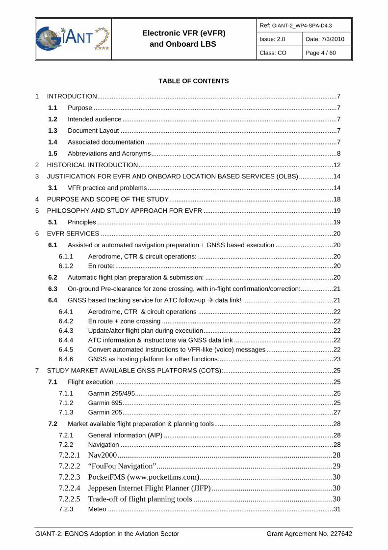
TABLE OF CONTENTS
1 INTRODUCTION.....................................................................................................................................7 1.1 Purpose .......................................................................................................................................7 1.2 Intended audience .......................................................................................................................7 1.3 Document Layout ........................................................................................................................7 1.4 Associated documentation ..........................................................................................................7 1.5 Abbreviations and Acronyms.......................................................................................................8
2 HISTORICAL INTRODUCTION............................................................................................................12 3 JUSTIFICATION FOR EVFR AND ONBOARD LOCATION BASED SERVICES (OLBS)...................14
3.1 VFR practice and problems.......................................................................................................14 4 PURPOSE AND SCOPE OF THE STUDY...........................................................................................18 5 PHILOSOPHY AND STUDY APPROACH FOR EVFR ........................................................................19
5.1 Principles ...................................................................................................................................19 6 EVFR SERVICES .................................................................................................................................20
6.1 Assisted or automated navigation preparation + GNSS based execution ................................20 6.1.1 Aerodrome, CTR & circuit operations: ...........................................................................20 6.1.2 En route:.........................................................................................................................20
6.2 Automatic flight plan preparation & submission: .......................................................................20 6.3 On-ground Pre-clearance for zone crossing, with in-flight confirmation/correction:..................21 6.4 GNSS based tracking service for ATC follow-up data link! ..................................................21
6.4.1 Aerodrome, CTR & circuit operations ...........................................................................22 6.4.2 En route + zone crossing ...............................................................................................22 6.4.3 Update/alter flight plan during execution........................................................................22 6.4.4 ATC information & instructions via GNSS data link .......................................................22 6.4.5 Convert automated instructions to VFR-like (voice) messages .....................................22 6.4.6 GNSS as hosting platform for other functions................................................................23
7 STUDY MARKET AVAILABLE GNSS PLATFORMS (COTS):.............................................................25 7.1 Flight execution .........................................................................................................................25
7.1.1 Garmin 295/495..............................................................................................................25 7.1.2 Garmin 695.....................................................................................................................25 7.1.3 Garmin 205.....................................................................................................................27
7.2 Market available flight preparation & planning tools..................................................................28 7.2.1 General Information (AIP) ..............................................................................................28 7.2.2 Navigation ......................................................................................................................28 7.2.2.1 Nav2000..............................................................................................................28 7.2.2.2 “FouFou Navigation”..........................................................................................29 7.2.2.3 PocketFMS (www.pocketfms.com)....................................................................30 7.2.2.4 Jeppesen Internet Flight Planner (JIFP)..............................................................30 7.2.2.5 Trade-off of flight planning tools .......................................................................30 7.2.3 Meteo .............................................................................................................................31

Ref: GIANT-2_WP4-SPA-D4.3
Issue: 2.0 Date: 7/3/2010
Electronic VFR (eVFR) and Onboard LBS
Class: CO Page 5 / 60
GIANT-2: EGNOS Adoption in the Aviation Sector Grant Agreement No. 227642
7.2.3.1 Belgocontrol........................................................................................................31 7.2.3.2 Buienradar (www.buienradar.nl and www.buienradar.be ) ...............................32 7.2.3.3 Meteox ................................................................................................................33 7.2.3.4 www.meteo-online.be.........................................................................................33 7.2.3.5 The US Air Force (USAF)..................................................................................34 7.2.3.6 Theyr.net (www.theyr.net)..................................................................................34 7.2.4 ATC and Zone crossing: NIL..........................................................................................35
8 CROSS-COUNTRY TEST FLIGHTS....................................................................................................36 8.1 Test flight #1: Brustem (EBST) - Den Helder (EHKD) – Brustem (EBST) ................................36 8.2 Test flight #2: Brustem (EBST) - Deauville (LFRG) – Brustem (EBST) ....................................37 8.3 Test flight #3: Brustem (EBST) – Annecy/Meythet (LFLP) – Brustem (EBST) .........................38 8.4 Test flight #4: Brustem (EBST) - Bremen (EDDW) – Brustem (EBST) .....................................40 8.5 Test flight #5: Brustem (EBST) – Munchen/Oberschleissheim (EDNX) - Brustem...................41 8.6 Test flight #6: Brustem (EBST) – Limoges/Saint Junien (LFBJ) - Brustem ..............................42 8.7 Test flight #7: Brustem (EBST) – Lyon/Bron (LFLY) – Genova (LILM) .....................................43 8.8 Test flight #8: Genova (LIMJ) – Ancona/Falconara (LIPY): .....................................................45 8.9 Test flight #9: Ancona (LIPY) – Fayence (LFMJ) – Saint Junien (LFBJ) ..................................46 8.10 Test flight #10: Saint Junien (LF) – Brustem (EBST) ................................................................48 8.11 Test flight #11: Brustem (EBST) – Lausanne (LSGL) – Piecenza (LIMS) - Genova ................50 8.12 Test flight #12: Genova (LIMJ) – Cuers/Pierrefeu (LFTF, alternate Fayence)..........................53 8.13 Test flight #13: Fayence – Lyon/Bron – Strasbourg..................................................................54 8.14 Test flight #14: Strasbourg (LFST) – Brustem (EBST)..............................................................56
9 RESULTS & CONCLUSIONS FOR FURTHER WORK .......................................................................58 9.1 Results.......................................................................................................................................58
9.1.1 eVFR works already now and is definitely worth being further developed ....................58 9.1.2 EGNOS is at the core of eVFR ......................................................................................58 9.1.3 A legal framework for eVFR development and experimentation is needed...................58
9.2 Improvement Areas ...................................................................................................................58 9.2.1 The list with candidate eVFR functions is not exhaustive ..............................................58 9.2.2 Europe lacks a wireless data network complementing EGNOS ....................................59 9.2.3 The traditional commercial/military aviation lobby might not easily support eVFR........59
9.3 Recommendations for further work ...........................................................................................59 9.3.1 Legal...............................................................................................................................59 9.3.2 Technical/Financial.........................................................................................................59 9.3.3 ATC involvement ............................................................................................................59

Ref: GIANT-2_WP4-SPA-D4.3
Issue: 2.0 Date: 7/3/2010
Electronic VFR (eVFR) and Onboard LBS
Class: CO Page 6 / 60
GIANT-2: EGNOS Adoption in the Aviation Sector Grant Agreement No. 227642
LIST OF TABLES
Table 1–1: Associated documentation ................................................................................................................7 Table 1–2: Abbreviations and Acronyms...........................................................................................................11
LIST OF FIGURES
Figure 2-1: The Triumph of Instrument Flight....................................................................................................12
Ref: GIANT-2_WP4-SPA-D4.3
Issue: 2.0 Date: 7/3/2010
Electronic VFR (eVFR) and Onboard LBS
Class: CO Page 7 / 60
GIANT-2: EGNOS Adoption in the Aviation Sector Grant Agreement No. 227642
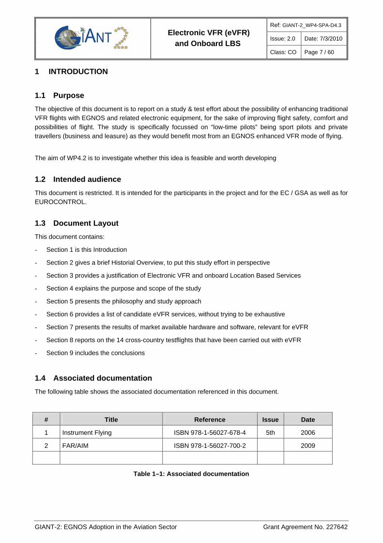
1 INTRODUCTION
1.1 Purpose The objective of this document is to report on a study & test effort about the possibility of enhancing traditional VFR flights with EGNOS and related electronic equipment, for the sake of improving flight safety, comfort and possibilities of flight. The study is specifically focussed on “low-time pilots” being sport pilots and private travellers (business and leasure) as they would benefit most from an EGNOS enhanced VFR mode of flying.
The aim of WP4.2 is to investigate whether this idea is feasible and worth developing
1.2 Intended audience This document is restricted. It is intended for the participants in the project and for the EC / GSA as well as for EUROCONTROL.
1.3 Document Layout This document contains:
- Section 1 is this Introduction
- Section 2 gives a brief Historial Overview, to put this study effort in perspective
- Section 3 provides a justification of Electronic VFR and onboard Location Based Services
- Section 4 explains the purpose and scope of the study
- Section 5 presents the philosophy and study approach
- Section 6 provides a list of candidate eVFR services, without trying to be exhaustive
- Section 7 presents the results of market available hardware and software, relevant for eVFR
- Section 8 reports on the 14 cross-country testflights that have been carried out with eVFR
- Section 9 includes the conclusions
1.4 Associated documentation The following table shows the associated documentation referenced in this document.
# Title Reference Issue Date
1 Instrument Flying ISBN 978-1-56027-678-4 5th 2006
2 FAR/AIM ISBN 978-1-56027-700-2 2009
Table 1–1: Associated documentation

Ref: GIANT-2_WP4-SPA-D4.3
Issue: 2.0 Date: 7/3/2010
Electronic VFR (eVFR) and Onboard LBS
Class: CO Page 8 / 60
GIANT-2: EGNOS Adoption in the Aviation Sector Grant Agreement No. 227642
1.5 Abbreviations and Acronyms The following table shows a list of abbreviations and acronyms used in this document.
Acronym Meaning
6-pack Basic set of flight instruments: Altimeter-Vertical Speed Indicator-Attitude Indicator-Turn Coordinator-Airspeed Indicator-Heading indicator
ACFT Aircraft
AD Aerodrome
AI Attitude Indicator: indicates the rotational attitude of the aircraft (3-axis)
AIP Aeronautical Information Package
APP Approach Traffic Control
ARP Airport Reference Point (mostly the threshold of the main runway)
ASTRA Large Satellite network operator in Luxemburg, launched AstraNet (satellite Internet)
AstraNet Satellite based internet service for the large consumer markets
ATA Actual Time of Arrival
ATC Air Traffic Control
CAS (1) Collision Avoidance System
(2) Conditional Acces System
CAVOK Clouds And Visibility OK (=meteo term for perfect VFR flying weather)
CB Cumulo-nimbus (= Thunderstorm)
CHT Cilinder Head Temperature
COTS Commercial Off The Shelf (general purpose equipment)
CTR (Aerodrome) Control Area
Datacom (wireless) Digital Data Communication e.g. Wifi, GPRS, Satcom
D-zone Danger zone
E6B “Flight computer” (mechanical line rule to plan flights)
eAIP Electronic (online-Internet) version of the AIP
EGNOS European Geostationary Navigation Overlay Service (similar to “WAAS”)
EGT Exhaust Gas Temperature
ELT Emergency Locator Transmitter
ELZ Emergency Landing Zone

Ref: GIANT-2_WP4-SPA-D4.3
Issue: 2.0 Date: 7/3/2010
Electronic VFR (eVFR) and Onboard LBS
Class: CO Page 9 / 60
GIANT-2: EGNOS Adoption in the Aviation Sector Grant Agreement No. 227642
Acronym Meaning
ETA Estimated Time of Arrival
ETE Estimated Time of Elapse (=travel time between 2 waypoints)
Eutelsat Paris-based satellite operator, focused on consumer market, partner of AstraNet
eVFR electronic Visual Flight Rules
FIS Flight Information Service
FL Flight Level (e.g. FL95 means 9500 feet above MSL at 1013 hPa air pressure)
GPS Geostationary Positioning System
GNSS Global Navigation Satellite System
GPRS General Packet Radio Service (an Internet-like wíreless data Communication)
HI Heading Indicator (gyro compass)
HMI Human-Machine Interface (also called Man-Machine Interface)
HSI Horizontal Situation Indicator (=combination of HI and VOR display)
IAS Indicated Air Speed (measure of kinetic pressure via pitot tube)
ICT Information and Communication Technology
IFR Instrument Flight Rules
IMC Instrument Meteological flight Conditions
JIFP Jeppesen Internet Flight Planner
KIAS Indicated Air Speed (in Knots)
KPH Kilometer Per Hour
KTAS True Air Speed (in Knots)
Kts Knots (=nautical miles per hour)
LBS Location Based Services
MAC Mid Air Collision
MAP Manifold Air Pressure
METAR (actual) Meteo Terminal Report
MSL Mean Sea Level
NOTAM Notice to Airmen
NVFR Night Visual Flight Rules
Ref: GIANT-2_WP4-SPA-D4.3
Issue: 2.0 Date: 7/3/2010
Electronic VFR (eVFR) and Onboard LBS
Class: CO Page 10 / 60
GIANT-2: EGNOS Adoption in the Aviation Sector Grant Agreement No. 227642
Acronym Meaning
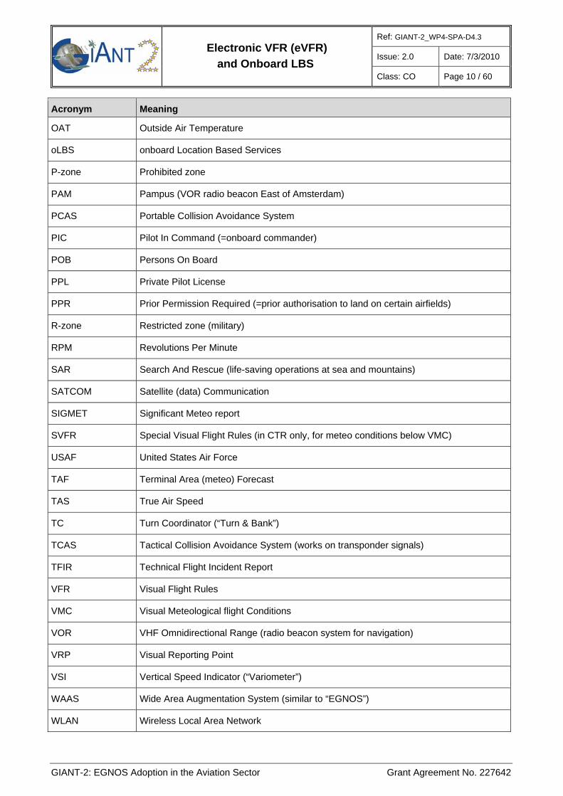
OAT Outside Air Temperature
oLBS onboard Location Based Services
P-zone Prohibited zone
PAM Pampus (VOR radio beacon East of Amsterdam)
PCAS Portable Collision Avoidance System
PIC Pilot In Command (=onboard commander)
POB Persons On Board
PPL Private Pilot License
PPR Prior Permission Required (=prior authorisation to land on certain airfields)
R-zone Restricted zone (military)
RPM Revolutions Per Minute
SAR Search And Rescue (life-saving operations at sea and mountains)
SATCOM Satellite (data) Communication
SIGMET Significant Meteo report
SVFR Special Visual Flight Rules (in CTR only, for meteo conditions below VMC)
USAF United States Air Force
TAF Terminal Area (meteo) Forecast
TAS True Air Speed
TC Turn Coordinator (“Turn & Bank”)
TCAS Tactical Collision Avoidance System (works on transponder signals)
TFIR Technical Flight Incident Report
VFR Visual Flight Rules
VMC Visual Meteological flight Conditions
VOR VHF Omnidirectional Range (radio beacon system for navigation)
VRP Visual Reporting Point
VSI Vertical Speed Indicator (“Variometer”)
WAAS Wide Area Augmentation System (similar to “EGNOS”)
WLAN Wireless Local Area Network

Ref: GIANT-2_WP4-SPA-D4.3
Issue: 2.0 Date: 7/3/2010
Electronic VFR (eVFR) and Onboard LBS
Class: CO Page 11 / 60
GIANT-2: EGNOS Adoption in the Aviation Sector Grant Agreement No. 227642
Acronym Meaning
W-zone Warning zone
Table 1–2: Abbreviations and Acronyms
Ref: GIANT-2_WP4-SPA-D4.3
Issue: 2.0 Date: 7/3/2010
Electronic VFR (eVFR) and Onboard LBS
Class: CO Page 12 / 60
GIANT-2: EGNOS Adoption in the Aviation Sector Grant Agreement No. 227642
2 HISTORICAL INTRODUCTION The aviation era is traditionally seen to start in 1903 when the Wright brothers undertook the first powered flights. The period 1903–1929 was earmarked by the quest for airplane reliability and endurance of flight. Since 1929 mankind was able to fly instruments. The enormous innovation and operational experience of World War II created the foundation for modern aviation as we know it today.
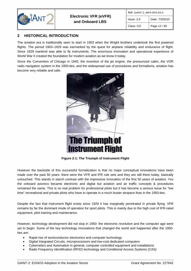
Since the Convention of Chicago in 1945, the invention of the jet engine, the pressurized cabin, the VOR radio navigation system in the 1950-ties, and the widespread use of procedures and formalisms, aviation has become very reliable and safe.
Figure 2-1: The Triumph of Instrument Flight
However the backside of this successful formalization is that no major conceptual innovations have been made over the past 50 years: there were the VFR and IFR rule sets and they are still there today, basically untouched. This stands in starch contrast with the impressive innovation of the first 50 years of aviation. Yes the onboard avionics became electronic and digital but aviation and air traffic concepts & procedures remained the same. This is no real problem for professional pilots but it has become a serious issue for “low time” recreational and private pilots who have to operate in a much busier airspace than in the 1950-ties.
Despite the fact that instrument flight exists since 1929 it has marginally penetrated in private flying. VFR remains by far the dominant mode of operation for sport pilots. This is mainly due to the high cost of IFR-rated equipment, pilot training and maintenance.
However, technology development did not stop in 1950: the electronic revolution and the computer age were yet to begin. Some of the key technology innovations that changed the world and happened after the 1950-ties are:
• Rapid rise of semiconductor electronics and computer technology • Digital Integrated Circuits, microprocessors and low-cost dedicated computers • Cybernetics and Automation in general, computer controlled equipment and installations • Radio Frequency Identification (RFID) technology and Conditional Access Systems (CAS)

Ref: GIANT-2_WP4-SPA-D4.3
Issue: 2.0 Date: 7/3/2010
Electronic VFR (eVFR) and Onboard LBS
Class: CO Page 13 / 60
GIANT-2: EGNOS Adoption in the Aviation Sector Grant Agreement No. 227642
• Information technology in virtually all equipment (“embedded IT”) • Satellites services for meteo forecasting, telecom and navigation • Telecom, wireless data communication, telemetry and remote control • Internet and the information society: a vast offer of information and services • GPS and other GNSS systems for positioning, navigation and location based services (e.g. tracking
of vehicles). • Engine technology for cars and trucks has undergone tremendous innovations in terms of reliability,
efficiency, eco-friendliness, comfort, combustion management, endurance and cost. Today, 95% of Piston Engines for GA (Continental, Lycoming) are 1950-technology designs with a very poor track record in terms of fuel efficiency, exhaust, handling complexity and hence risk for pilot errors. The required training and skill maintenance to operate these engines is not compatible with the limited flight experience of most low-time GA pilots.
Moreover, the pace of innovation and its adoption in society even accelerates, making technology obvious. This is creating a widening gap between the “ordinary” society and the strongly formalised and man-driven aviation sector.
Of the post-war technology innovation boom, much of the new achievements found their way to the modern civil and military aviation. But recreational and private travel aviation was largely left behind, and now struggles with the growing airspace complexity while having still old instrumentation technology:
• Paper maps, magnetic compass and inertial navigation instruments • Analogue radio, many discrete channels (risk of confusion, misunderstandings, workload) • Air traffic control (ATC) via analogue voice communication (slow, limited capacity, no direct
addressing, heterodynes, noisy, prone to errors, heavy mental load for the low-time pilot). • Paper records & admin (checklists, flight books, manuals, flight plans…) • Heavy, volume and power consuming onboard equipment (gyros, compass)
The advent of EGNOS is a dream opportunity to create a new VFR flight rules set, making use of GNSS and its electronic support technology to improve safety, comfort and capacity of flight. So far this idea has been nicknamed “electronic Visual Flight Rules” (eVFR) for the purpose of this study. eVFR would be similar to other VFR subclasses such as “Night VFR” (NVFR) and “Special VFR” (SVFR), or could even absorb these subclasses into one (eVFR).
It is worth mentioning that electronic Visual Flight Rules can be interpreted in 2 ways:
• electronic (Visual Flight Rules), meaning the automation of the current VFR rule set, or
• (electronic Vision) Flight Rules, meaning a flight rule set based on electronic vision (instead of direct natural vision). This is a very promising option with a lot of potential but –technology wise- quite ambitious and therefore not within the scope of this study. But it certainly should not be forgotten!
For the purpose of this study, the first eVFR interpretation is the most relevant.

Ref: GIANT-2_WP4-SPA-D4.3
Issue: 2.0 Date: 7/3/2010
Electronic VFR (eVFR) and Onboard LBS
Class: CO Page 14 / 60
GIANT-2: EGNOS Adoption in the Aviation Sector Grant Agreement No. 227642
3 JUSTIFICATION FOR EVFR AND ONBOARD LOCATION BASED SERVICES (OLBS)
3.1 VFR practice and problems VFR practice is changing, especially in the communities of (motor) gliders and ultralights. Because of weight and volume limitations pilots tend to have a minimal instrument set and rely more on modern GPS navigators with the supplementary electronic functions (terrain map, obstacle warning, flight panel simulator etc.). Also, because of their lesser pilot training they prefer modern intuitive instruments such as GPS navigators (which they know already from their car). Often this leads to flirting with the existing VFR rules and even crossing the line. But it can be expected that this practice will evolve –or derail- further because indeed the GNSS navigators are becoming so powerful and easy to handle that they facilitate this “beyond-VFR” type of flight.
An inventory has been made on common VFR problems and infringements:
3.1.1. Bravery and reckless behaviour: here eVFR cannot do much, unless warning for dangerous
situations (as this is mostly not realized). 3.1.2. VFR Flight preparation is often not done completely and even skipped: leisure pilots tend to
minimize their flight preparation, or take off without it. Meteo check, NOTAMS, PPR, flight plan submission, information on destination airfield, circuit pattern, reporting points, radio frequencies, no-fly zones and other flight information are often not onboard. The underlying reason is the lack of routine with a complex set of formalisms and lack of operational support for it. Modern GNSS navigators have most of this information onboard and hence serve as an electric map as well as in-flight data base.
3.1.3. A large percentage (90%) of GA accidents are fuel-related: insufficient fuel or contaminated
fuel (water, sediments). eVFR can do little about contaminated fuel but can do a lot in predicting and timely warning the pilot for insufficient fuel (depending on headwind, fuel flow..) and in proposing alternates. Fuel insufficiency can lead to powerless (emergency) landings which often end up badly. A diversion and even precaution landing is largely preferred over an emergency landing.
3.1.4. En route diversion and flight re-planning is often a problem causing stress and errors. This
happens typically during bad weather; sometimes combined with fuel shortage, air sickness etc. Paper maps & rulers onboard a small single-pilot aircraft are then simply useless. Often the aerodrome (AD) and circuit data of the new destination are not available onboard. All this creates pressure not to divert, and land anyway. This is obviously dangerous. Technology should be such that diversions are easy and quickly implemented, without stress or hesitation.
3.1.5. ATC zone infringements due to insufficient knowledge of the exact aircraft position, and the
impracticality of using paper maps in a small light aircraft, especially with a single pilot. Accurate positioning in unknown terrain, according to the official VFR practice, is often not possible and certainly not good enough to manoeuvre in today’s crowded airspace. Visual references not always work (there are too many wind turbine parks and highway crossings these days...) and lesser visibility aggravates the problem.
3.1.6. Many ATC zones (typically military Restricted Zones) are mostly dormant and rarely active,
so people tend to ignore them until they find out in flight that it is active indeed! When submitting a flight plan (FLP) the pilots is not pre-warned that he might be crossing active R-zones, which is a pity and easy to remedy with eVFR.
3.1.7. Most sports pilots avoid dealing with ATC and even Traffic Information Services (TIS)
because of their insufficient proficiency with ATC radio phraseology and formalisms. As a
Ref: GIANT-2_WP4-SPA-D4.3
Issue: 2.0 Date: 7/3/2010
Electronic VFR (eVFR) and Onboard LBS
Class: CO Page 15 / 60
GIANT-2: EGNOS Adoption in the Aviation Sector Grant Agreement No. 227642
consequence they fly “blind” with the transponder off causing trouble to other pilots and ATC operators. Ways can be found to work with pre-coded data messages, similar to pre-programmed SMS so that the airborne action is just to push a button. This is common today in logistic truck fleet operations.
3.1.8. Traditional aviation meteo information (Metar, TAF, Sigmet…) is not obvious to interpret and
not readily available in flight, apart from audio tape messages from airports in the vicinity. A more intuitive information carrier is needed, such as rain radar data and clouds on a moving map. As such rain showers are no major obstacle to flight but it is noticed that many leisure pilots can’t handle the situation due to poorly accessible information. Bigger aircraft are equipped with rainradar and strikefinders. These instruments are extremely useful but heavy & expensive. But eVFR could offer nearly similar information via a wireless datalink, with minimum weight and cost penalty.
3.1.9. Flight execution based on GPS rather then standard instruments: a quite noticeable –and
possibly worrisome- practice is growing that leisure pilots convert to using GPS-derived instruments and information, because it is more intuitive to use. Some pilots dare to go below VMC and fly in a quasi GPS-instrumented way. This trend is hard to stop but action must be taken that instead of a simple GPS instrument a aviation GNSS platform is taken ensuring precision, signal availability and fidelity. Hence EGNOS.
3.1.10. Sudden meteo changes: pilots sometimes continue their flight below VMC, based on GPS
navigator. As discussed earlier, eVFR should not lead to amateurship and pseudo-IFR. But what is perfectly possible is a way of flying similar to night VFR (NVFR) based on modern GNSS support. In-flight situations degrading rapidly below VMC simply happen, and every experienced pilot can testify that he/she has been “trapped” too in a below-VMC flight. In such situations eVFR would do miracles and could be life-saving. Needless to say that EGNOS would be more reliable and hence more suited than bare GPS.
3.1.11. VFR-on-top: crossing stratus clouds on GPS navigator & instruments. As such, VFR-on-top is
a very safe way to fly, largely preferred over the alternative of flying UNDER the clouds, with rain, poor visibility, turbulence and obstable risk. But the way to get there and to get out of there is the problem: under VFR rules it is forbidden to fly to clouds, even if the cloud base is thin and stable (e.g. fog, haze, low stratus). It is a true pity that this situation persists in most countries, as the safety of flight with VFR-on-top is undoubtedly much better than “going underneath”.
3.1.12. Failed precautionary and emergency landings: the mental stress for a (low-time) pilot dealing
with an engine problem is enormous. Time to act is limited and the ability to reason logically is reduced to a minimum. 60% of all powerless landings end with a tumble-over accident, often with dramatic consequences. A prime reason for this very high number is that the stressed pilot cannot identify in time a suitable Emergency Landing Zone (ELZ) and looses control over his flight parameters (mostly airspeed) and aircraft handling. It is time to get part of the burden out of his hands, and eVFR can contribute to this.
3.2. Airspace has become complex, traffic has increased
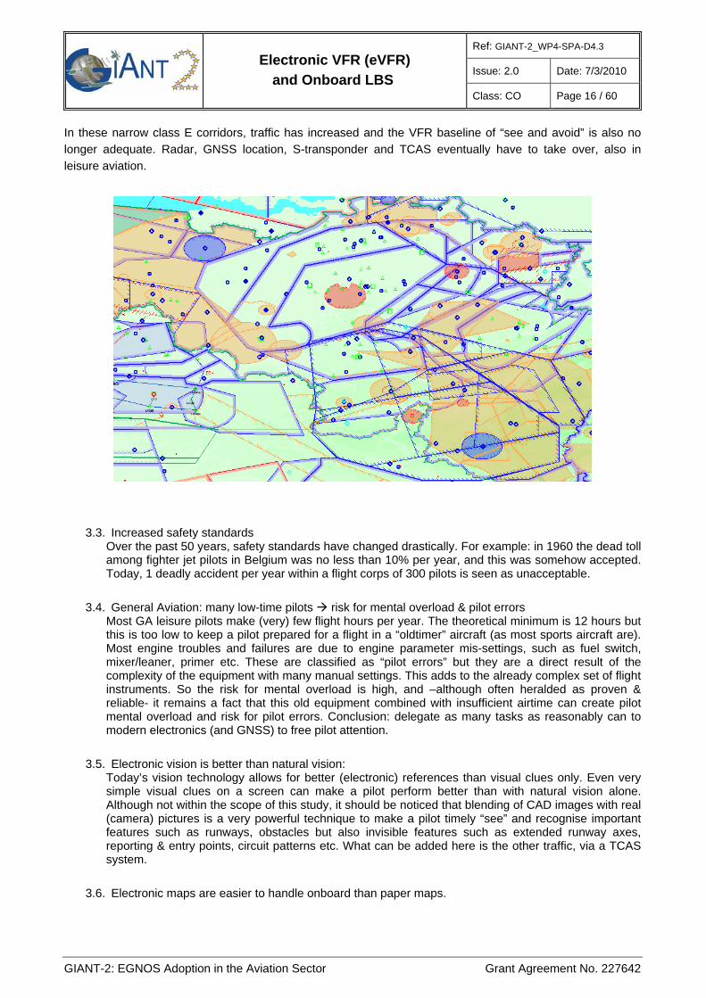
As an example, around 1950 Belgium –as any European country- had a “virgin” uncontrolled airspace with only 1 CTR around the main military airfield (Brussels/Melsbroek). Obviously, in that time it was still possible to navigate based on dead reckoning, as accuracy was no issue.
Now in 2009 the situation is incomparably more complex, and zones are adjusted and created several times per year, adding to the ever-increasing complexity. See below the map of the Belgian airspace anno 2009. Often the spacing between CTR’s is often so marginal that the class E airspace in between is a narrow corridor of barely 1 Nautical mile wide and 1500 ft high. Accurate positioning here is a must if one wants to avoid ATC infringements. Today, for safe navigation dead reckoning is no longer an option here.
Ref: GIANT-2_WP4-SPA-D4.3
Issue: 2.0 Date: 7/3/2010
Electronic VFR (eVFR) and Onboard LBS
Class: CO Page 16 / 60
GIANT-2: EGNOS Adoption in the Aviation Sector Grant Agreement No. 227642
In these narrow class E corridors, traffic has increased and the VFR baseline of “see and avoid” is also no longer adequate. Radar, GNSS location, S-transponder and TCAS eventually have to take over, also in leisure aviation.
3.3. Increased safety standards
Over the past 50 years, safety standards have changed drastically. For example: in 1960 the dead toll among fighter jet pilots in Belgium was no less than 10% per year, and this was somehow accepted. Today, 1 deadly accident per year within a flight corps of 300 pilots is seen as unacceptable.
3.4. General Aviation: many low-time pilots risk for mental overload & pilot errors
Most GA leisure pilots make (very) few flight hours per year. The theoretical minimum is 12 hours but this is too low to keep a pilot prepared for a flight in a “oldtimer” aircraft (as most sports aircraft are). Most engine troubles and failures are due to engine parameter mis-settings, such as fuel switch, mixer/leaner, primer etc. These are classified as “pilot errors” but they are a direct result of the complexity of the equipment with many manual settings. This adds to the already complex set of flight instruments. So the risk for mental overload is high, and –although often heralded as proven & reliable- it remains a fact that this old equipment combined with insufficient airtime can create pilot mental overload and risk for pilot errors. Conclusion: delegate as many tasks as reasonably can to modern electronics (and GNSS) to free pilot attention.
3.5. Electronic vision is better than natural vision:
Today’s vision technology allows for better (electronic) references than visual clues only. Even very simple visual clues on a screen can make a pilot perform better than with natural vision alone. Although not within the scope of this study, it should be noticed that blending of CAD images with real (camera) pictures is a very powerful technique to make a pilot timely “see” and recognise important features such as runways, obstacles but also invisible features such as extended runway axes, reporting & entry points, circuit patterns etc. What can be added here is the other traffic, via a TCAS system.
3.6. Electronic maps are easier to handle onboard than paper maps.

Ref: GIANT-2_WP4-SPA-D4.3
Issue: 2.0 Date: 7/3/2010
Electronic VFR (eVFR) and Onboard LBS
Class: CO Page 17 / 60
GIANT-2: EGNOS Adoption in the Aviation Sector Grant Agreement No. 227642
Unfolding a paper map in a single pilot (small & light) aircraft, in turbulent weather is not realistic and dangerous. Instead, the electronic maps technology of today allows for a better alternative with many strong features:
• Bright display, easy to recognise with a glimpse of an eye. • Zoom, and pan & tilt as a single hand operation • Highlighting features such as controlled airspace zones. • Possibility to hide features, to “de-crop” the map in layers • Regular updating (service subscriptions exist for a monthly update) • Special knobs for accurate handling in rough weather • Last but not least: combination with GNSS to locate yourself directly on the map. The
concept of this “moving map” is unbeatable and outclasses the conventional approach by a good factor!
• Backup maps in the eVFR backup equipment. • Moreover, with todays compact and affordable memory chips the whole world can be easily
made available onboard as electronic maps. • Electronic “search” mode

Ref: GIANT-2_WP4-SPA-D4.3
Issue: 2.0 Date: 7/3/2010
Electronic VFR (eVFR) and Onboard LBS
Class: CO Page 18 / 60
GIANT-2: EGNOS Adoption in the Aviation Sector Grant Agreement No. 227642
4 PURPOSE AND SCOPE OF THE STUDY The purpose of this study is to investigate the possibility and sense to create a new flight rule set, as an augmentation of VFR, based on EGNOS and related electronics. The current nickname is therefore “electronic VFR” (eVFR). The study includes quite a number of test flight and demonstrations whereby some of the proposed eVFR functions are tested and demonstrated in realistic flight conditions.
The scope of the study is: • Legal and regulatory frame for eVFR • Technical and operational justification of eVFR • eVFR functions and possible electronic implementations
o Flight planning o Flight execution
• Test- and demonstration flights

Ref: GIANT-2_WP4-SPA-D4.3
Issue: 2.0 Date: 7/3/2010
Electronic VFR (eVFR) and Onboard LBS
Class: CO Page 19 / 60
GIANT-2: EGNOS Adoption in the Aviation Sector Grant Agreement No. 227642
5 PHILOSOPHY AND STUDY APPROACH FOR EVFR
5.1 Principles The aviation sector has a long tradition of using formalism and procedures to improve safety. The backside of this success is a form of mental rigidity. When performing this study it was often felt that traditional aviation responsibles and professional actors had a difficulty understanding the very objectives of this study, and were spontaneously inclined to oppose the idea of eVFR. There is certainly no intention of eVFR to compete or conflict with existing VFR and IFR practices, therefore a few basic principles are listed:
• Evolve/augment VFR, don’t fight it:
o eVFR should be an umbrella rule set for Night VFR (NVFR), Special VFR (SVFR) and even further extensions. Let’s take Night VFR as a reference: NVFR is basically instrument flying, but without the heavy formalisms and procedures of the “full” IFR. The qualification for NVFR is simple: it is a short training and equipment extension to the Private Pilot License (PPL). eVFR should be similar to NVFR but an extension toward lower visibility also in daylight, based on electronic aids.
o Same philosophy with respect to licensing the eVFR qualification should be an extension (an extra “rating” similar to a mountain rating, or hydroplane rating) to the PPL or ULM pilot license.
• Use GNSS to its full extent: all references based on True Coordinates, so no longer confusions with magnetic coordinates and the related corrections
• Key objectives of eVFR: o Safety! o Reduction of ATC infringements o Optimal (leasure) pilot comfort & stress level o Efficiency of flight preparation & execution o Extension of flight conditions (similar to NVFR and SVFR) esp. wrt visibility
• eVFR has to be o easy o simple o intuitive o safe o low cost o low impact on avionics (mass & volume)
• Decide as much as possible ONGROUND & PRIOR to flight get support from services, automation • No extra rules, reference points use existing VFR/IFR names, references & procedures, but possibly
automated • No extra infrastructure (we have to preserve this key argument in favour of EGNOS!) • Practical/cost conscious: use COTS equipment, existing free or commercial services
Ref: GIANT-2_WP4-SPA-D4.3
Issue: 2.0 Date: 7/3/2010
Electronic VFR (eVFR) and Onboard LBS
Class: CO Page 20 / 60
GIANT-2: EGNOS Adoption in the Aviation Sector Grant Agreement No. 227642
6 EVFR SERVICES 6.1 Assisted or automated navigation preparation + GNSS based execution 6.1.1 Aerodrome, CTR & circuit operations: Aerodrome, CTR & circuit operations: the idea is to generate a full route including circuit operations for CTR entry and exit so that the pilot onboard has a very simple and predictable task. Also taxi operations are possible but might require a real-time interaction from the Tower. Visual reporting points can also be supported by pictures so that the pilot can compare the picture with his current direct view. This implies however that the active runway must be known in advance. This is relatively easy for departure operations but less evident for arrival. So a wireless data command is needed to activate the correct circuit for the runway in use at the arrival aerodrome. “Tunnel flying” is perfect here: pilot just flies in the box and respects both lateral and vertical space limitations.
6.1.2 En route: En route: idem ditto for the en route operations. Best would be to create a full en route plan including altitude (3D) with soft acoustic warnings if the pilot leaves the envelope. Obviously, eVFR must also include EGNOS based Vertical navigation (VNAV) for landing.
6.2 Automatic flight plan preparation & submission: Automatic flight plan preparation & submission: flight preparation should be a single process which is heavily automated, or can enjoy support from an automated or manned service center on the Internet. Apart from creating a passive navigation file a flight plan is made as well, all in a consistent manner. This complete data file is then used by the onboard EGNOS navigator for the flight execution, but is also available to ATC authorities for flight follow-up and zone crossing clearance. The technology for that is underway. Below is a picture of such an electronically generated flight plan. This file can be used by ATC for flight tracking, monitoring, clearance, editing etc. The key facilitator here is again EGNOS: once accurate real-time position information is available, these services can come to life.

Ref: GIANT-2_WP4-SPA-D4.3
Issue: 2.0 Date: 7/3/2010
Electronic VFR (eVFR) and Onboard LBS
Class: CO Page 21 / 60
GIANT-2: EGNOS Adoption in the Aviation Sector Grant Agreement No. 227642
6.3 On-ground Pre-clearance for zone crossing, with in-flight confirmation/correction:
Leisure pilots often cross Restricted Zones and training areas which most of the time are inactive (weekends, holidays) but sometimes they are. Often, during flight it is hard to get in contact with the R-zone controlling authority. Much easier and safer for everybody would be that the electronic flight plan is used by ATC to pre-clear the aircraft for zone crossing. The pilot simply executes his route and receives –via voice or better via data command- a confirmation of his clearance, or –in a rare case- a cancellation. In the latter case he should receive a string of vectors to guide him around the no-crossing zone. In the longer run this might lead to dynamic changes of the navigation file. 6.4 GNSS based tracking service for ATC follow-up data link! A data communication link is a vital complement to a GNSS location service. The most familiar case of these “Location Based Services” is Track & Trace whereby a vehicle (typically a car or truck) is positioned via a GNSS sensor and this data together with other data (vehicle status, cargo condition) is transmitted to a control or dispatching center. The data link is mostly Wifi, GSM, GPRS or satellite. For a plane the best solution is satellite but unfortunately there a (too) few satellite data operators and service providers in Europe which makes that prices are quite high. The use of terrestrial wireless networks such as Wifi, GSM and GPRS

Ref: GIANT-2_WP4-SPA-D4.3
Issue: 2.0 Date: 7/3/2010
Electronic VFR (eVFR) and Onboard LBS
Class: CO Page 22 / 60
GIANT-2: EGNOS Adoption in the Aviation Sector Grant Agreement No. 227642
at first seems less suited for use by aircraft, as their signal beams are shaped to service users on ground, and not in the air. However, with the right antenna technology a lot can be done. Our preference goes towards Wifi because of its very good wideband performance, speed, reliability and low cost.
But within the scope of this study it was not possible to implement this feature into the test flights.
6.4.1 Aerodrome, CTR & circuit operations This is an obvious case where GNSS based control and electronic mapping would be very useful and a significant improvement to flight safety. Mid Air Collisions (MAC) are most likely in and around aerodromes. The circuit pattern, the entry and reporting points are typically invisible non-physical references that mostly have to be followed quite accurately not to cause overload to local population and to avoid collision hazards (e.g. power lines). A GNSS based guidance on moving map with overlays (e.g. circuit pattern) makes a safe and correct landing quite easy. In the longer run the circuit traffic should also be displayed on the moving map. This is technically perfectly possible but more ambitious to impose as all aircraft need to be equipped with a transponder.
Within an Aerodrome Control Zone (CTR) it is perfectly possible to create a Wireless Local Area Network (WLAN) for data communication between the Tower and the aircraft in the circuit. Today’s Wifi networks offer very low cost equipment and can be configured for a range of a few kilometres by the use of directional antennas.
6.4.2 En route + zone crossing What applies for a CTR applies also to other control zones, so the zone crossing clearances could be handled by data communication and partly automated. Also here the main principle is: separate planning from execution. Then automate the planning amap and support the pilot’s execution by electronic aids
6.4.3 Update/alter flight plan during execution It is proposed that in eVFR the flight plan becomes a dynamic document, keeping pace with the flight execution, allowing ATC authorities to have real-time view on the history and status of the flight. A step further would be to have the possibility to dynamically change the flight plan during flight execution, also best by datacom. Most ATC authorities refuse the submission of a flight plan over the radio, during flight. A pilot on a domestic flight wishing (or needing?) to cross the border cannot submit a flight plan during flight and has to land somewhere first. It is perfectly thinkable that a flight plan submission is done from an ongoing flight, via a datalink to the ground. So without claiming capacity on the precious voice radio channel.
6.4.4 ATC information & instructions via GNSS data link Information and instructions provided by ATC are often not understood by the leisure pilot. The term “Say again” is probably the most often heard phrase in the air. Also some data are lengthy and time consuming if transmitted by voice. A common problem is that the pronunciation of the English language in combination with analogue radio is often not good enough for good understanding, and this even in english speaking countries! This leads to unnecessary repetitions and channel overload. The obvious remedy is to switch to datacom, for speed, reliability and channel availability.
6.4.5 Convert automated instructions to VFR-like (voice) messages An option and interesting combination of data communication with the familiar voice sound is what is done with GPS navigators: a data string is converted by a synthesizer into a crispy voice sound, the “lady shows

Ref: GIANT-2_WP4-SPA-D4.3
Issue: 2.0 Date: 7/3/2010
Electronic VFR (eVFR) and Onboard LBS
Class: CO Page 23 / 60
GIANT-2: EGNOS Adoption in the Aviation Sector Grant Agreement No. 227642
the way”… So datacom can be the modern, reliable, fast communication backbone whereas the pilot hears a perfectly English spoken “synthetic” ATC operator. This technology is already entering the market via consumer-grade PCAS systems.
6.4.6 GNSS as hosting platform for other functions
The basic funtionality of precise positioning on a moving map –as provided by the GNSS platform- combined with computing power, data storage and interfaces to other onboard equipment offer a dream platform for hosting other useful functions onboard the aircraft. Slowly these GNSS platforms will further evolve into quasi glass cockpits with a full panoply of functions to improve flight safety, comfort and effectiveness.
An interesting trend is the integration of the GNSS with the mode-S transponder. A mode-S (“Sierra”) transponder is a device that picks up pulses from ground radar, and returns a strong signal burst. At once it also transmits a data string with aircraft identification, squawk code and possibly other data. These return signals can be picked up by other aircraft in the vicinity to feed into their CAS “Collision Avoidance System” or TCAS “Tactical Collision Avoidance System”. These life-saving instruments are key in modern aviation safety and their usefulness has been proven more than once. Up to now these expensive equipment were limited to big commercial and military aircraft but the advent of the powerful GNSS platforms, with their ability to exchange data with the transponder enable the creation of low-cost CAS and TCAS systems (as it is essentially a matter of adding software).
Commercial CAS devices are finding their way to consumers already now:
1. Garmin
Garmin (www.garmin.com) launches a number of new products with respect to traffic monitoring and management: GTS800, GTS820 and GTS 850. These require a transponder that is outfitted for this function, such as the GTX330 with extended squitter option. Garmin GTX328 is not compatibel with TCAS. The GTS 800 can track up to 60 traffic targets simultaneously – and depict up to 30 intruder threats at a time, depending on the display being utilized. Offering 40 watts of transmit power, a +/- 10,000-foot vertical separation maximum, and a typical active interrogation range of 12 nm in the forward direction, the GTS 800 system will interface with a variety of compatible system displays in the cockpit. So it doesn’t require added panel space for a dedicated control/display. Synthetic Voice Alerting Helps Keep Heads Up, Eyes Out. Instead of the generic “Traffic, traffic” voice alerts of some earlier-generation systems, the GTS 800 provides for expanded audio messaging in an ATC-like verbal format: “Traffic. One o’clock. High (or Low or Same Altitude). Two miles” If surveillance bearing information is not available on the intruder, “Traffic, No Bearing” is called out.
2. Zaon
Zaon (www.zaon.aero) is an independent equipment manufacturer that offers low-cost CAS systems for the light aviation market, and has integrated their product with commercial GNSS platforms such as the Garmin 695. These devices are still in their infancy so they are not perfect yet, but this is matter of time. In any case,, it is much more safe to fly than relying on the human FIS (Flight Information Service).

Ref: GIANT-2_WP4-SPA-D4.3
Issue: 2.0 Date: 7/3/2010
Electronic VFR (eVFR) and Onboard LBS
Class: CO Page 24 / 60
GIANT-2: EGNOS Adoption in the Aviation Sector Grant Agreement No. 227642
3. Garrecht
www.garrecht.comThe German manufacturer Garrecht ( ) has launched a low-cost system TRX-1090 and TRX-2000 focused on the light aviation market which are meant to be electronic add-ons for VFR flights. It is compatible with commercial GNSS platforms such as Flarm and Garmin 695.

Ref: GIANT-2_WP4-SPA-D4.3
Issue: 2.0 Date: 7/3/2010
Electronic VFR (eVFR) and Onboard LBS
Class: CO Page 25 / 60
GIANT-2: EGNOS Adoption in the Aviation Sector Grant Agreement No. 227642
7 STUDY MARKET AVAILABLE GNSS PLATFORMS (COTS): For reasons of cost and time only the GNSS platforms of market leader Garmin were studied.
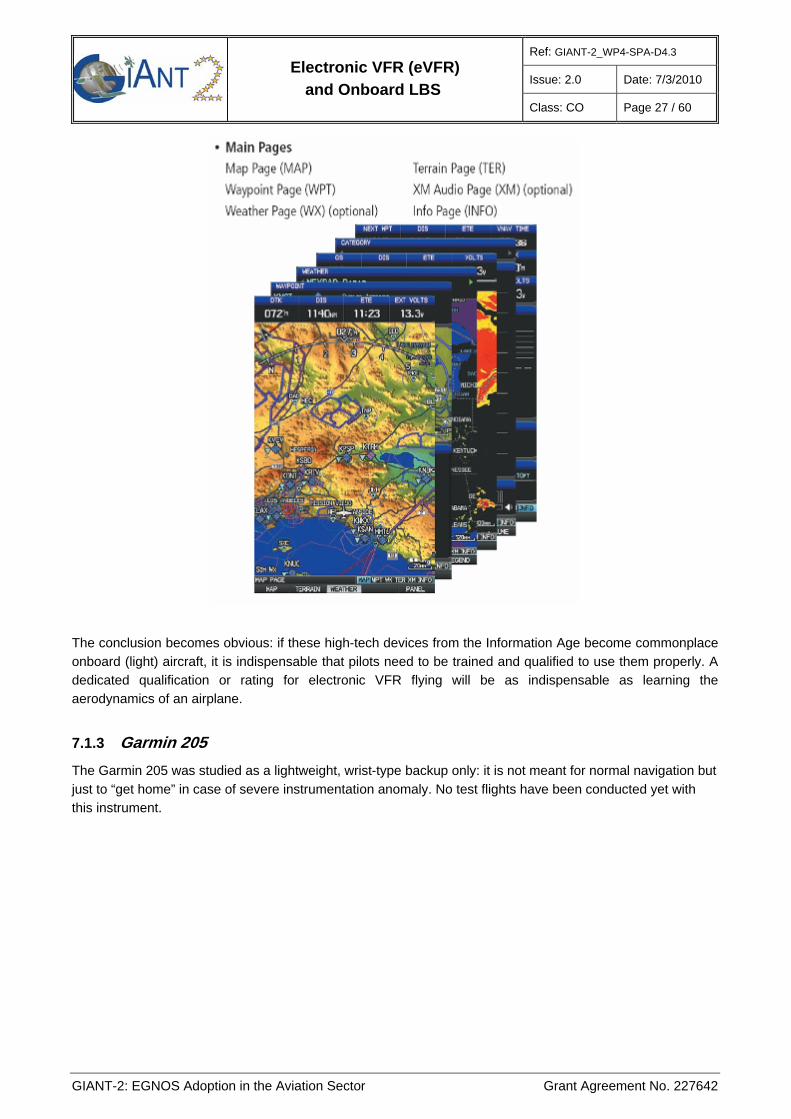
7.1 Flight execution 7.1.1 Garmin 295/495 The Garmin 295 and 495 are basically the same, only the 495 is a more recent version with better display, faster updates and more detailed terrain map. They both support WAAS and EGNOS signals. The functions are grouped under 5 different pages, among which the pilot can browse easily and quickly.
A particular safety feature –and very relevant for eVFR- is the terrain map with the obstacle warning. The obstacle warning automatically pops up in the left bottom corner of other pages as shown below in the panel page (which emulates the traditional instrument panel, serving as a backup).
7.1.2 Garmin 695 The Garmin 695 is similar to the 495 in terms of functionality, but it has a much bigger screen (very attractive for onboard use) and extra new features. In addition the 696 variant has a weather broadcast feature but this –unfortunately- works only over the XM Radio satellite network in the USA. However, the set of functions that the 696/695 offer comes quite close to what eVFR would need.
So for eVFR at least 2 GNSS systems onboard would be needed, having their separate antenna and independent power source for the duration of the flight. The Garmin 495 and 695 used for the test flights have

Ref: GIANT-2_WP4-SPA-D4.3
Issue: 2.0 Date: 7/3/2010
Electronic VFR (eVFR) and Onboard LBS
Class: CO Page 26 / 60
GIANT-2: EGNOS Adoption in the Aviation Sector Grant Agreement No. 227642
this. But they offer much more than navigation: they are an extensive data base and even a worthy backup for the basic instrument panel. So these GNSS devices are evolving into mini glass cockpits. During the eVFR tests it was noted that flying on the –simulated- HSI (Horizontal Situation Indicator) of the Garmin 695 was easier and more accurate than on a real HSI. Moreover, this saves considerable weight.
The increased reliability, mass & power efficiency of today’s micro-electronics, the fact that a full redundancy is possible and affordable makes that the failure risk at instrument level is quasi zero. The only bottleneck is then the satellite navigation network. But here EGNOS comes into play: network outages happen with GPS but with the built-in redundancy of EGNOS also this risk becomes quasi nihil. If that would still be seen as a non-acceptable risk the obvious step is to resort to inertial platforms for backup. But this is a bit overdone for leisure flying, and therefore not considered for eVFR.
It is therefore predicted that –within years- GNSS equipment such as the Garmin 695 (and later versions) will constitute the core of the onboard instrumentation for light aircraft, and that the physical instruments will become basic versions for backups only or will even disappear over time.
Ref: GIANT-2_WP4-SPA-D4.3
Issue: 2.0 Date: 7/3/2010
Electronic VFR (eVFR) and Onboard LBS
Class: CO Page 27 / 60
GIANT-2: EGNOS Adoption in the Aviation Sector Grant Agreement No. 227642
The conclusion becomes obvious: if these high-tech devices from the Information Age become commonplace onboard (light) aircraft, it is indispensable that pilots need to be trained and qualified to use them properly. A dedicated qualification or rating for electronic VFR flying will be as indispensable as learning the aerodynamics of an airplane.
7.1.3 Garmin 205 The Garmin 205 was studied as a lightweight, wrist-type backup only: it is not meant for normal navigation but just to “get home” in case of severe instrumentation anomaly. No test flights have been conducted yet with this instrument.

Ref: GIANT-2_WP4-SPA-D4.3
Issue: 2.0 Date: 7/3/2010
Electronic VFR (eVFR) and Onboard LBS
Class: CO Page 28 / 60
GIANT-2: EGNOS Adoption in the Aviation Sector Grant Agreement No. 227642
Conclusions: the GNSS platforms for onboard flight execution exist. They already could implement a significant share of the intended eVFR functions. As they are largely based on information technology one can expect their functionalities still to grow substantially over the coming years. However, all of these are proprietary software systems where an outsider cannot enter, so the extensions have to be implemented by the manufacturers themselves. This implies that for eVFR testing and demonstration we cannot integrate the new functionalities into these devices. The only realistic rapid prototyping avionics platforms are PDA or laptop PC (microPC, tablet). The flight tests have shown that a PDA with touchscreens is not very handy in flight, as the touchscreen pads are too small to handle in turbulent air.
7.2 Market available flight preparation & planning tools 7.2.1 General Information (AIP) The AIP (Aeronautical Information Package) is the basic document for any flight preparation. Nowadays, most national authorities have an online internet version of the AIP (eAIP) which is a blessing for private pilots as they mostly cannot afford to buy and maintain the paper AIP version of all countries they visit. The eAIP is free, always current and available from any PC with Internet connection. Hence eAIP fits perfectly in the eVFR philosophy.
There are some (strange) exeptions though: Germany does not bring the civil AIP online, but does so for the military AIP version? But still the eAIP can be bought via commercial channels.
7.2.2 Navigation 7.2.2.1 Nav2000
Nav2000 is Internet-based free software, running on a webserver. It is one the pioneering sites in its domain and quite well known within the community of leisure pilots. It interfaces well with most commercial GNSS navigators and excels in the information it provides on small aerodromes. Other websites and softwares often click-through to NAV2000 on this issue. The site is very handy for meteo checks and local aerodrome data (special warnings, fuel, lodging, cost etc.). It also provides for pictures so that the AD and circuit references are easily recognized from flight.
Ref: GIANT-2_WP4-SPA-D4.3
Issue: 2.0 Date: 7/3/2010
Electronic VFR (eVFR) and Onboard LBS
Class: CO Page 29 / 60
GIANT-2: EGNOS Adoption in the Aviation Sector Grant Agreement No. 227642
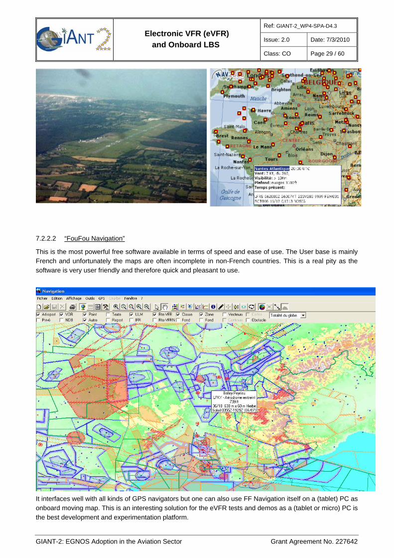
7.2.2.2 “FouFou Navigation”
This is the most powerful free software available in terms of speed and ease of use. The User base is mainly French and unfortunately the maps are often incomplete in non-French countries. This is a real pity as the software is very user friendly and therefore quick and pleasant to use.
It interfaces well with all kinds of GPS navigators but one can also use FF Navigation itself on a (tablet) PC as onboard moving map. This is an interesting solution for the eVFR tests and demos as a (tablet or micro) PC is the best development and experimentation platform.

Ref: GIANT-2_WP4-SPA-D4.3
Issue: 2.0 Date: 7/3/2010
Electronic VFR (eVFR) and Onboard LBS
Class: CO Page 30 / 60
GIANT-2: EGNOS Adoption in the Aviation Sector Grant Agreement No. 227642
7.2.2.3 PocketFMS (www.pocketfms.com)
PocketFMS is a dutch initiative and focused on small generic hardware/software platforms such as PDA and pocket PC’s. The maps are reliable but the software is slow and therefore not so handy to use. However, a true pluspoint is that is the only software found today that implements automatic route planning, according to airspace restrictions and even meteo. It also automatically creates the routing for aerodrome circuit navigation.
7.2.2.4 Jeppesen Internet Flight Planner (JIFP)
This is a commercial flight planning software based on an Internet webserver. It is based upon (older) commercial software packages but the webversion has the main benefit of offering up-to-date maps. Jeppesen is market leader in aviation maps and the electronic maps for the JIPF service are updated (“made current”) every month. This is a true plus point, especially since the reliability of maps is a main weakness of the other systems. However the product is not mature: it is not easy to use and the server is quite slow, making flight planning a bit tedious. Another plus is that the map data are not overcrowded, but appear when relevant. This feature is also available with FouFou Navigation and PocketFMS, and is a major advantage versus paper maps. JIFP interfaces well with commercial GPS navigators, using EMEA and Garmin data protocols.
7.2.2.5 Trade-off of flight planning tools
General trade-off and conclusions:
FF Navigation JIFP Nav2000 (1) PocketFMS

Ref: GIANT-2_WP4-SPA-D4.3
Issue: 2.0 Date: 7/3/2010
Electronic VFR (eVFR) and Onboard LBS
Class: CO Page 31 / 60
GIANT-2: EGNOS Adoption in the Aviation Sector Grant Agreement No. 227642
Reliability of maps and data Very poor: incomplete maps (2)
Very good (web based, 100% current)
Good
Good
Ease of programming & editing, HMI
Very good Too slow, unhandy (3)
Poor a bit slow and unhandy
Ease of data transfer to GNSS navigators
Very good Good, but bugs
Good
Limited to pocket PC, PDA (4)
Automated functions (route planning etc.)
Not available Limited Not available Good (5)
Ease of use in flight Very good, also PC possible
Very good (on Garmin)
Very good (on Garmin)
Poor (mostly PDA not suited) (6)
Available other data (AD, fuel, lodging etc.) (7)
Not available Not available Very good Not available
Speed of route planning Very good Poor Acceptable Acceptable
Cost Freeware 100€/year Freeware 50€/year
(1) NAV2000 has ceased to exist as from 1/1/2010 because of financial troubles.
(2) Navigation is mainly maintained for France, all other country maps are incomplete
(3) Surprisingly, JIFP is very slow and unhandy to use. It also lacks many handy functions that are commonplace today in IT tools
(4) The main limitation of PocketFMS is the choice of hardware platform: PDA are not suitable for use in flight as they rely mostly on touchscreen with too small touchfields for a bumpy air ride.
(5) PocketFMS is the only one –so far- that offers true automatic route planning in relation to actual meteo, NOTAMs etc.
(6) PocketFMS on a PDA platform is –generally speaking- not a good solution in a small aircraft.
(7) Mostly partly available on the GNSS platform (e.g. Garmin)
The negative conclusion is that none of the available flight planning systems is 100% suited for eVFR. The most suited one is the NAV2000 but as it was lacking a commercial/financial base it did not survive. All show shortcomings but –surprisingly enough- the weaknesses differ from one to the other. This is good news because it simply indicates product immaturity, and the different suppliers will learn from each other and likely “stuff the holes” of their own product. So one can expect that within the foreseeable future the sport pilot community will have access to the right planning tools for eVFR.
For the purpose of eVFR testing & demonstration within this study the choice is on JIFP + Garmin platforms, and FF Navigation + Garmin/tablet PC. The choice for JIFP/Garmin is driven by the map and data reliability.
7.2.3 Meteo 7.2.3.1 Belgocontrol
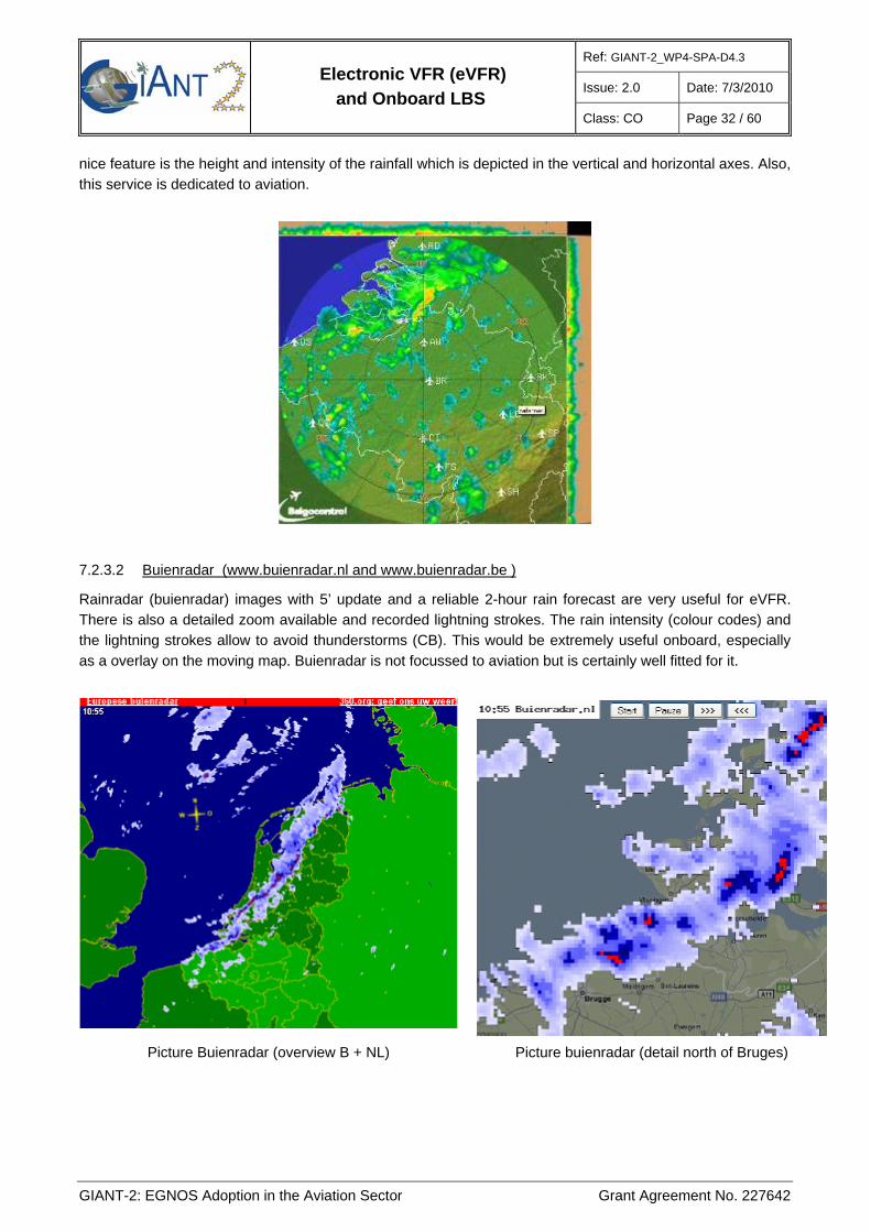
This site (www.belgocontrol.be) is very good and reliable, also quite detailed but clearly focused on the professional or at least high-time pilot. The rainradar is very good and intuitive enough to be used for eVFR. A
Ref: GIANT-2_WP4-SPA-D4.3
Issue: 2.0 Date: 7/3/2010
Electronic VFR (eVFR) and Onboard LBS
Class: CO Page 32 / 60
GIANT-2: EGNOS Adoption in the Aviation Sector Grant Agreement No. 227642
nice feature is the height and intensity of the rainfall which is depicted in the vertical and horizontal axes. Also, this service is dedicated to aviation.
7.2.3.2 Buienradar (www.buienradar.nl and www.buienradar.be )
Rainradar (buienradar) images with 5’ update and a reliable 2-hour rain forecast are very useful for eVFR. There is also a detailed zoom available and recorded lightning strokes. The rain intensity (colour codes) and the lightning strokes allow to avoid thunderstorms (CB). This would be extremely useful onboard, especially as a overlay on the moving map. Buienradar is not focussed to aviation but is certainly well fitted for it.
Picture Buienradar (overview B + NL) Picture buienradar (detail north of Bruges)
Ref: GIANT-2_WP4-SPA-D4.3
Issue: 2.0 Date: 7/3/2010
Electronic VFR (eVFR) and Onboard LBS
Class: CO Page 33 / 60
GIANT-2: EGNOS Adoption in the Aviation Sector Grant Agreement No. 227642
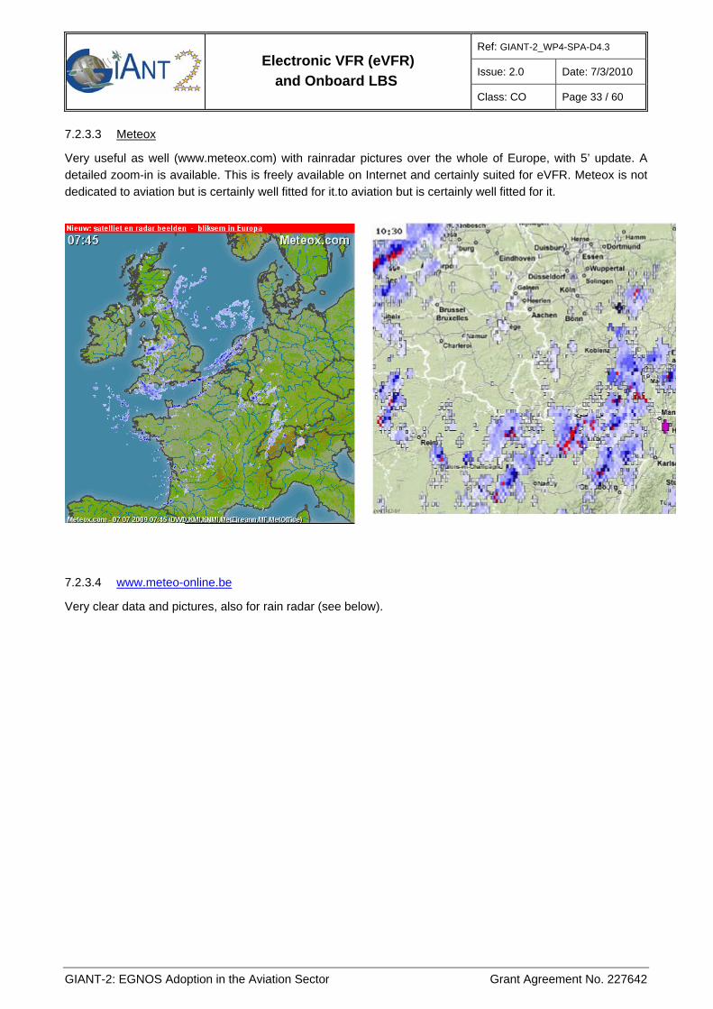
7.2.3.3 Meteox
Very useful as well (www.meteox.com) with rainradar pictures over the whole of Europe, with 5’ update. A detailed zoom-in is available. This is freely available on Internet and certainly suited for eVFR. Meteox is not dedicated to aviation but is certainly well fitted for it.to aviation but is certainly well fitted for it.
7.2.3.4 www.meteo-online.be
Very clear data and pictures, also for rain radar (see below).
Ref: GIANT-2_WP4-SPA-D4.3
Issue: 2.0 Date: 7/3/2010
Electronic VFR (eVFR) and Onboard LBS
Class: CO Page 34 / 60
GIANT-2: EGNOS Adoption in the Aviation Sector Grant Agreement No. 227642
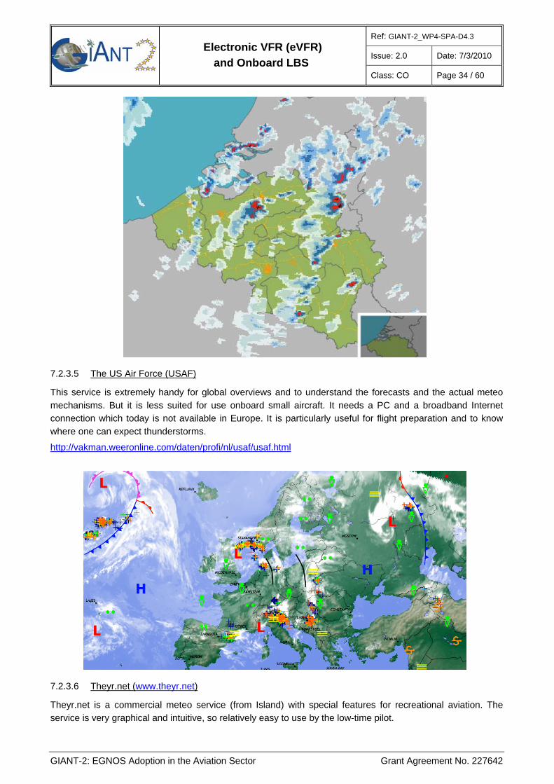
The US Air Force (USAF)7.2.3.5
This service is extremely handy for global overviews and to understand the forecasts and the actual meteo mechanisms. But it is less suited for use onboard small aircraft. It needs a PC and a broadband Internet connection which today is not available in Europe. It is particularly useful for flight preparation and to know where one can expect thunderstorms.
http://vakman.weeronline.com/daten/profi/nl/usaf/usaf.html
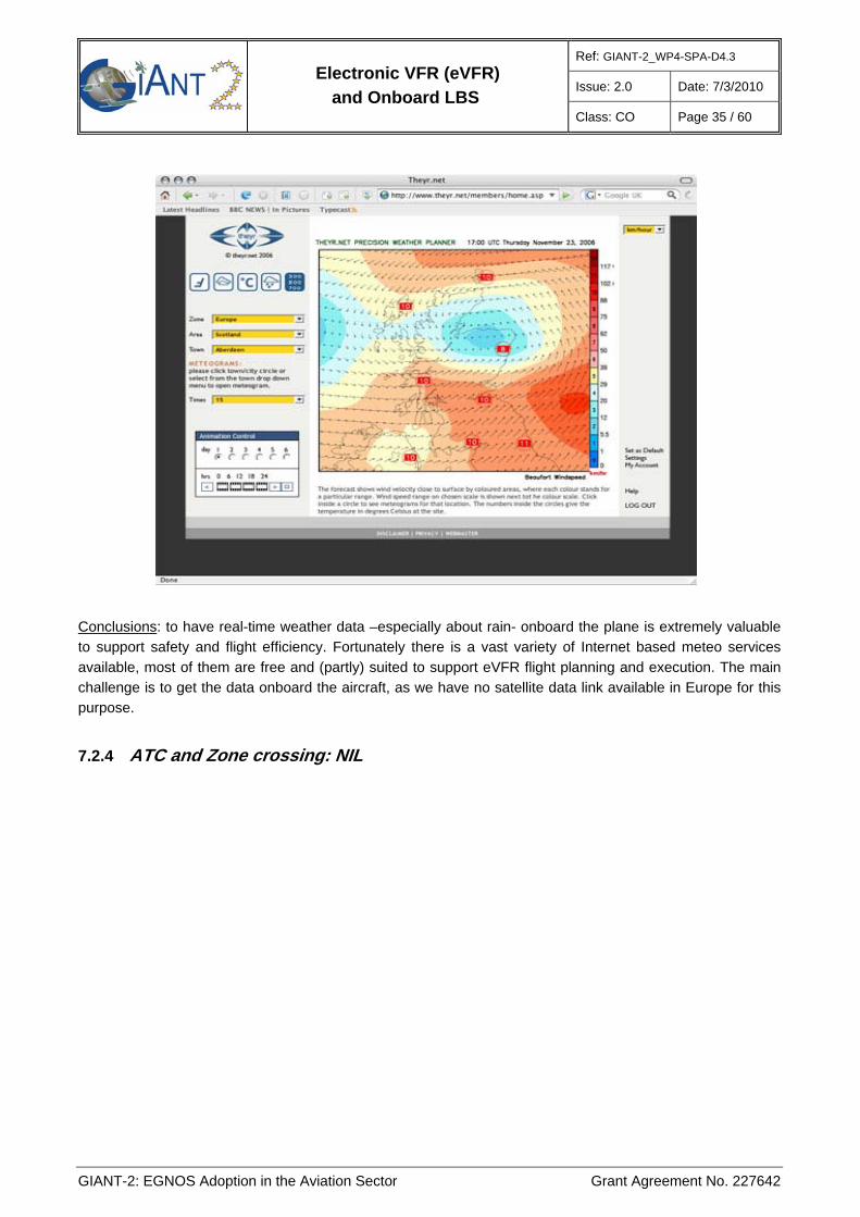
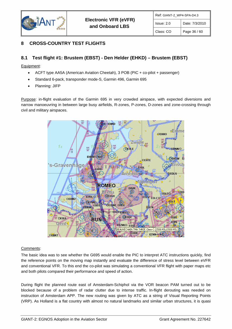
Theyr.net (7.2.3.6 www.theyr.net)
Theyr.net is a commercial meteo service (from Island) with special features for recreational aviation. The service is very graphical and intuitive, so relatively easy to use by the low-time pilot.
Ref: GIANT-2_WP4-SPA-D4.3
Issue: 2.0 Date: 7/3/2010
Electronic VFR (eVFR) and Onboard LBS
Class: CO Page 35 / 60
GIANT-2: EGNOS Adoption in the Aviation Sector Grant Agreement No. 227642
Conclusions: to have real-time weather data –especially about rain- onboard the plane is extremely valuable to support safety and flight efficiency. Fortunately there is a vast variety of Internet based meteo services available, most of them are free and (partly) suited to support eVFR flight planning and execution. The main challenge is to get the data onboard the aircraft, as we have no satellite data link available in Europe for this purpose.
7.2.4 ATC and Zone crossing: NIL
Ref: GIANT-2_WP4-SPA-D4.3
Issue: 2.0 Date: 7/3/2010
Electronic VFR (eVFR) and Onboard LBS
Class: CO Page 36 / 60
GIANT-2: EGNOS Adoption in the Aviation Sector Grant Agreement No. 227642
8 CROSS-COUNTRY TEST FLIGHTS
8.1 Test flight #1: Brustem (EBST) - Den Helder (EHKD) – Brustem (EBST) Equipment:
• ACFT type AA5A (American Aviation Cheetah), 3 POB (PIC + co-pilot + passenger)
• Standard 6-pack, transponder mode-S, Garmin 496, Garmin 695
• Planning: JIFP
Purpose: in-flight evaluation of the Garmin 695 in very crowded airspace, with expected diversions and narrow manoeuvring in between large busy airfields, R-zones, P-zones, D-zones and zone-crossing through civil and military airspaces.
Comments:
The basic idea was to see whether the G695 would enable the PIC to interpret ATC instructions quickly, find the reference points on the moving map instantly and evaluate the difference of stress level between eVFR and conventional VFR. To this end the co-pilot was simulating a conventional VFR flight with paper maps etc and both pilots compared their performance and speed of action.
During flight the planned route east of Amsterdam-Schiphol via the VOR beacon PAM turned out to be blocked because of a problem of radar clutter due to intense traffic. In-flight derouting was needed on instruction of Amsterdam APP. The new routing was given by ATC as a string of Visual Reporting Points (VRP). As Holland is a flat country with almost no natural landmarks and similar urban structures, it is quasi
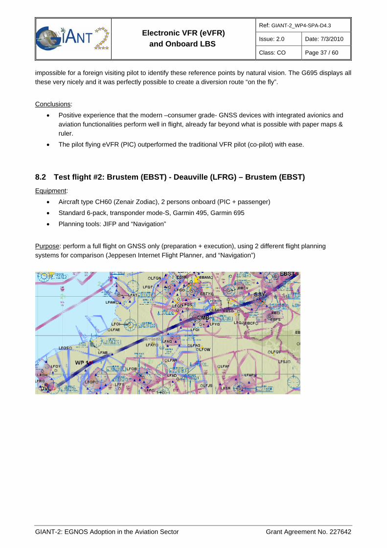
Ref: GIANT-2_WP4-SPA-D4.3
Issue: 2.0 Date: 7/3/2010
Electronic VFR (eVFR) and Onboard LBS
Class: CO Page 37 / 60
GIANT-2: EGNOS Adoption in the Aviation Sector Grant Agreement No. 227642
impossible for a foreign visiting pilot to identify these reference points by natural vision. The G695 displays all these very nicely and it was perfectly possible to create a diversion route “on the fly”.
Conclusions:
• Positive experience that the modern –consumer grade- GNSS devices with integrated avionics and aviation functionalities perform well in flight, already far beyond what is possible with paper maps & ruler.
• The pilot flying eVFR (PIC) outperformed the traditional VFR pilot (co-pilot) with ease.
8.2 Test flight #2: Brustem (EBST) - Deauville (LFRG) – Brustem (EBST) Equipment:
• Aircraft type CH60 (Zenair Zodiac), 2 persons onboard (PIC + passenger)
• Standard 6-pack, transponder mode-S, Garmin 495, Garmin 695
• Planning tools: JIFP and “Navigation”
Purpose: perform a full flight on GNSS only (preparation + execution), using 2 different flight planning systems for comparison (Jeppesen Internet Flight Planner, and “Navigation”)

Ref: GIANT-2_WP4-SPA-D4.3
Issue: 2.0 Date: 7/3/2010
Electronic VFR (eVFR) and Onboard LBS
Class: CO Page 38 / 60
GIANT-2: EGNOS Adoption in the Aviation Sector Grant Agreement No. 227642
Comments: during flight execution no striking difference was noted between the 2 planning tools, although there were some shortcomings with one: when creating a route via airports and radio beacons the JIFP file which was downloaded into the Garmin 695 did not match with the onboard data of Garmin, By this, some important in-flight support was lost.
The flight took off under marginally VMC with a horizontal visibility around 5000 meter. Because of the Brussels TMA we had to stay low, and the obstacle warning of the G695 and G495 were very usefull and relaxing: the pilot knows in advance where to expect a possibly dangerous obstacle and can actively look for it. This works far better than working with paper maps.
When arriving to Deauville the airfield –being close to the seashore- was shrouded in seasmoke (dense brume) and a sudden deterioration of VMC occurred. When contacting Deauville TWR by radio the operator agreed to guide us in on SVFR but only as from the north entry point “Pont de Normandie”. Using the GNSS as the prime navigation instrument we reached the N entry point safely as from when we followed TWR instructions for an SVFR landing.
Conclusion: SVFR is the legal way to fly within the CTR under below-VMC meteo conditions. But the eVFR mode we used to reach the N entry point worked even better, was less ambiguous and more safe and relaxing. So the obvious question is: “If SVFR is an official mode of operation, why not eVFR which is better and safer?” 8.3 Test flight #3: Brustem (EBST) – Annecy/Meythet (LFLP) – Brustem (EBST) Equipment:
• Aircraft type CH60 (Zenair Zodiac), 2 persons onboard (PIC + test engineer)
• Standard 6-pack, transponder mode-S, Garmin 495, Garmin 695
• Planning tool: JIFP
Purpose: Evaluate the GNSS software version of the E6B flight computer

Ref: GIANT-2_WP4-SPA-D4.3
Issue: 2.0 Date: 7/3/2010
Electronic VFR (eVFR) and Onboard LBS
Class: CO Page 39 / 60
GIANT-2: EGNOS Adoption in the Aviation Sector Grant Agreement No. 227642
Comments:
Evaluate the G695 as a replacement of the traditional “flight computer” E6B (see figure) to calculate the Estimated Time of Arrival (ETA), Estimated Time of Elapse (ETE) between waypoints, ground speed (GS), fuel consumption etc. The classic E6B is a logarithmic tool similar to a slide ruler, but still the official instrument to do flight planning. But modern GNSS platforms have a built-in E6B emulator, and it was expected that they do this much faster, easier and safer.
A particular shortcoming of the E6B method of flight (re)planning is the inaccuracy of estimating ground speed, which is essential for calculating ETE/ETA. On the contrary the GNSS displays in real-time a very accurate GS and ETE/ETA, without any pilot effort!
The expectations of better performance with the GNSS compared to the E6B were largely confirmed, and much better. On the way down south the flight execution followed closely the planned route data, and the ATA (Actual Time of Arrival) was only minutes away from the calculated ETA. The fuel consumption was exactly 50% of the full tank, as pre-calculated.
But on the route back, a wholly different scenario unfolded: we took off around 1500 with 90% full tanks, confident that this would be more than plenty to make it back home. But the flight was plagued with a series of setbacks:
• When crossing the Jura Mountains at FL95 we noticed a surprising difference between airspeed and ground speed (the GNSS displays ground speed, the 6-pack displays Indicated Air Speed IAS). As a rule-of-tumb the True Airspeed equals the IAS increased by 2% per 1000 feet. So at FL95 the true airspeed was 20% higher than the IAS so 100 kts IAS meaning 120 kts true airspeed. But the ground speed was around 70 kts implying we were facing a headwind of 120-70= 50 Kts, almost 100 KPH! As the groundspeed calculation with the GNSS was so quick and easy we tried various altitudes to find the best flight level to save fuel and shorten the flight.
• After 45 minutes in flight we were facing a technical failure of the propeller pitch control. As such this is not a dramatic incident as the propeller automatically falls back in the “fine pitch” position. But it slows down the plane considerably, and the fuel consumption jumps significantly higher, up to 50% more.
• When calculation the fuel situation we realized that the aerodrome service operator filled up one tank only up to 85%.
The combination of less airspeed, hence less ground speed, increased fuel flow rate and less fuel onboard than expected gave rise to 2 concerns: (1) do we have enough fuel to make it to our destination, and (2) what about sunset? We were flying over the north-east of France on a Sunday evening and past experiences had shown that is was hard to get 100LL fuel in that area at that time. By close monitoring and regular recalculations we managed to make it home safely and before sunset. It was very clear that without the

Ref: GIANT-2_WP4-SPA-D4.3
Issue: 2.0 Date: 7/3/2010
Electronic VFR (eVFR) and Onboard LBS
Class: CO Page 40 / 60
GIANT-2: EGNOS Adoption in the Aviation Sector Grant Agreement No. 227642
GNSS this would not have been possible and we would have been forced to land somewhere and stay overnight, with all troubles associated.
A Technical Flight Incident Report (TFIR) was made and sent to the responsible authorities.
Conclusion: this was an extremely successful and informative test flight. In the end, the incident turned out to be a major victory for eVFR and a significant improvement of safety. It is hard to simulate incidents, but if/when they spontaneously occur in a test flight they generate very convincing evidence, because the pilot stress is real, not fake.
8.4 Test flight #4: Brustem (EBST) - Bremen (EDDW) – Brustem (EBST)
Equipment:
• Aircraft type CH60 (Zenair Zodiac), 2 persons onboard (PIC + passenger)
• Standard 6-pack, transponder mode-S, Garmin 495, Garmin 695
• Planning tool: JIFP
Purpose:
1. evaluate GNSS navigation in over a region with little or no landmarks.
2. Evaluate the GNSS built-in software version of the HSI
Comments: the experience was similar to the EHKD flight (testflight #1), but with less surprises and no incidents. Flying over Germany is easy as there are less airports and control zones. A noteworthy observation during the test flight was that the landscape was changing because of the large-scale deployment of windfarms. This also makes the landscape look more homogenous and so VRP’s are harder to find. Identifying the VRP’s on the moving map is way easier. Also the follow-on action is easier: one pushes the cursor and slides it to the VRP, and presses the GOTO/DIRECT key. Even this is mostly not needed as the

Ref: GIANT-2_WP4-SPA-D4.3
Issue: 2.0 Date: 7/3/2010
Electronic VFR (eVFR) and Onboard LBS
Class: CO Page 41 / 60
GIANT-2: EGNOS Adoption in the Aviation Sector Grant Agreement No. 227642
GNSS has a ground track pointer, with time-calibrated marks. This makes steering and time estimation very easy.
As things were progressing very smoothly a new try-out was made during flight: the GNSS also contains a software simulated HSI (Horizontal Situation Indicator, see picture). The HSI is a popular instrument onboard large aircraft as it makes the navigation easier and more intuitive. The HSI is a combination of a Heading Indicator and a VOR display into one device. The plan was to test the HSI software version of the G695.
Horizontal Situation Indicator (HSI)
It worked remarkably well: apparently the bandwith was good so the response was quite alert, and the display very clear, even on the “panel mode” display. After some trying it was easy to maintain a planned route very accurately, in any case better than without the instrument. This is important as we had a narrow passage between 2 major airfields (Koln-Dusseldorf) and could not afford to deviate from the planned trajectory.
Conclusion: The test was so convincing that -as from that moment- all follow-on test (and other..) flights were done on the software HSI of the GNSS! And this is perfectly possible with the existing GNSS without cost, mass, volume of power penalty.
8.5 Test flight #5: Brustem (EBST) – Munchen/Oberschleissheim (EDNX) - Brustem Equipment:
• Aircraft type CH60 (Zenair Zodiac), 2 persons onboard (PIC + passenger)
• Standard 6-pack, transponder mode-S, Garmin 495, Garmin 695
• Planning tool: JIFP
Purpose:
Evaluate the G695/G495 for long distance navigation based on eVFR in difficult meteo conditions.
Comments: The way up was not particularly difficult, and we flew VFR-on-top at FL95. At this height is not very realistic to fly VFR on natural vision, because the ground objects appear too small, and there are scattered clouds in between the aircraft and the ground. So, moving map flying is the way to go. We also learned that a significant benefit of flying eVFR above the clouds is that one can see the CB’s in time. Note: CB stands for “Cumulonimbus” or a thunderstorm cloud. It is nicknamed “the cloud of death” as it is by far the most dangerous meteo phenomenon in flight. Their towering shape is easily recognizable when flying above the lower clouds, but when flying under the lower clouds the pilot might spot this dangerous phenomenon too late (the only indication is a stronger shade of grey of the cloud cover but often there is barely a noticeable difference).
The return trip was more difficult, more spectacular and hence more educational. Once again it was great to fly eVFR! The meteo forecast still indicated visual meteorological conditions (VMC) but once up in the air we

Ref: GIANT-2_WP4-SPA-D4.3
Issue: 2.0 Date: 7/3/2010
Electronic VFR (eVFR) and Onboard LBS
Class: CO Page 42 / 60
GIANT-2: EGNOS Adoption in the Aviation Sector Grant Agreement No. 227642
noticed large rain clouds stretching further than the eye could see. Here we regretted so much not to have a rainradar image onboard: normally we check the internet rain radar (www.buienradar.nl) at the airfield before taking off but unfortunately we could get access to an Internet connection so we could not do it. In the USA this in-flight rain radar service exists over the “XM Radio” satellite network but in Europe there is not a similar service.
Facing hefty headwinds and many detours around rainshowers we were forced to fly very low as we risked to enter the controlled airspaces of Stuttgart and Frankfurt. But at least we could do so because we had the GNSS based moving map and the eVFR mode of flight, another option simply does not exist.
As we risked to get low-on-fuel we needed to know whether there were more deviations to be expected. If we have had rain radar images onboard we would have been in a position to replan our route ourselves, but as we didn’t we consulted the German ATC service “Langen Information” to inform us about the upcoming showers on our route, and a heading advise. They did so and we followed the route but surprisingly we ended up in the middle of a rainshower? The GNSS helped us out –again- so that we could maintain VMC. We decided to play safe and make a fuel stop at Mainz airport. The GNSS contains all information so we contacted TWR, followed instructions via the proposed entry point and made our refueling stop. The rest of the testflight was straightforward and easy.
Conclusions:
• It was felt that rain radar imagery onboard the plane is vital to (re)planning and safe flight.
• The eVFR mode worked very well in crawling through showers and controlled airspace
• The eVFR mode worked very well for VFR-on-top flying and early detection of CB’s
8.6 Test flight #6: Brustem (EBST) – Limoges/Saint Junien (LFBJ) - Brustem Equipment:
• Aircraft type CH60 (Zenair Zodiac), 2 persons onboard (PIC + passenger)
• Standard 6-pack, transponder mode-S, Garmin 495, Garmin 695
• Planning tool: “Navigation”

Ref: GIANT-2_WP4-SPA-D4.3
Issue: 2.0 Date: 7/3/2010
Electronic VFR (eVFR) and Onboard LBS
Class: CO Page 43 / 60
GIANT-2: EGNOS Adoption in the Aviation Sector Grant Agreement No. 227642
Purpose: Similar to Testflight #3
Comments: N/A
Conclusion: The flight preparation was fully done, but not executed because of (very) poor meteo.
8.7 Test flight #7: Brustem (EBST) – Lyon/Bron (LFLY) – Genova (LILM) Equipment:
• Aircraft type CH60 (Zenair Zodiac), 1 person onboard (test pilot only)
• Standard 6-pack, transponder mode-S, Garmin 495, Garmin 695
• Planning tool: JIFP
Purpose: High-altitude “linea recta” flying in eVFR mode, with trajectory monitoring on GNSS only
Comments:
The leg Brustem-Lyon went fine and without any special notice

Ref: GIANT-2_WP4-SPA-D4.3
Issue: 2.0 Date: 7/3/2010
Electronic VFR (eVFR) and Onboard LBS
Class: CO Page 44 / 60
GIANT-2: EGNOS Adoption in the Aviation Sector Grant Agreement No. 227642
The leg Lyon – Genova was more interesting as the intrinsic benefits of eVFR flying could be better exploited and evaluated. The nominal route was planned from Lyon/Bron to Genova, with 2 alternate airfields being Fayence (LFMF) and Albenga (LIMG). Sunset was expected in 3 hours meaning the flight had to be over by then, so the decision to make a diversion to one of the alternates had to be taken in flight, by the pilot alone.
In circumventing the Alps the flight took place at high altitude FL105 (=10500 feet @ 1013 hP, roughly 3 km high). Apart from a few wind gusts it was quite feasible. The intension was to make a shortcut over the pre-Alps if meteo and visibility would allow so. This turned out to be the case and so it was done. Moreover, 2 additional benefits were drawn from the eVFR mode:
• Flying high, a big thunderstorm (CB) appeared at the horizon, direction Nice. So this was yet another motivator to deviate from the planned route and take a more easterly route, over the higher mountains. eVFR enabled this without difficulty, amongst others because the pre-Alps in France are paved with military training and restricted zones. The GNSS database showed them all, and the pilot could zoom in on the map to squeeze out the maximum time gain.
• From the Ground Speed (GS) indicator of the GNSS a strong tailwind was noticed, of around 35-40 knots. Hence, the GNSS-integrated E6B calculated the ETE’s and ETA to Genova. This allowed making a quick, safe and reliable decision not to divert to one of the alternates but to proceed to the planned destination.
Note: at 10.000 feet there is amazingly little traffic. Commercial planes fly higher in the airways, most leisure craft fly low to stay in uncontrolled airspace, military aircraft generally fly low, helicopters and balloons always fly low. The only traffic that was spotted was a lonely glider. As such this is also an argument for eVFR to facilitate flying high for private air travel.

Ref: GIANT-2_WP4-SPA-D4.3
Issue: 2.0 Date: 7/3/2010
Electronic VFR (eVFR) and Onboard LBS
Class: CO Page 45 / 60
GIANT-2: EGNOS Adoption in the Aviation Sector Grant Agreement No. 227642
Conclusion: very successful test flight, see comments above.
8.8 Test flight #8: Genova (LIMJ) – Ancona/Falconara (LIPY): Equipment:
• Aircraft type CH60 (Zenair Zodiac), 1 person onboard (test pilot only)
• Standard 6-pack, transponder mode-S, Garmin 495, Garmin 695
• Planning tool: JIFP
Purpose: evaluate mountain crossing in poor meteo using eVFR
Comments: As the Appenines had to be crossed in poor wheater it was key to find low-altitudes routes through the mountain chain. With JIFP –after some trial and error- a few routes were found where the ground altitude was reasonably low (around 3000 ft). As the JIFP shows a cross-section of the flight with altitude indication (see picture) one could easily try out a few different waypoints and see immediately what the effect was on the ground elevation. For this kind of problem JIFP has interesting built-in planning features: you specify the maximum desired altitude of your route, and JIFP creates by itself extra waypoints (e.g. WP1 on the map) to respect the altitude limit.
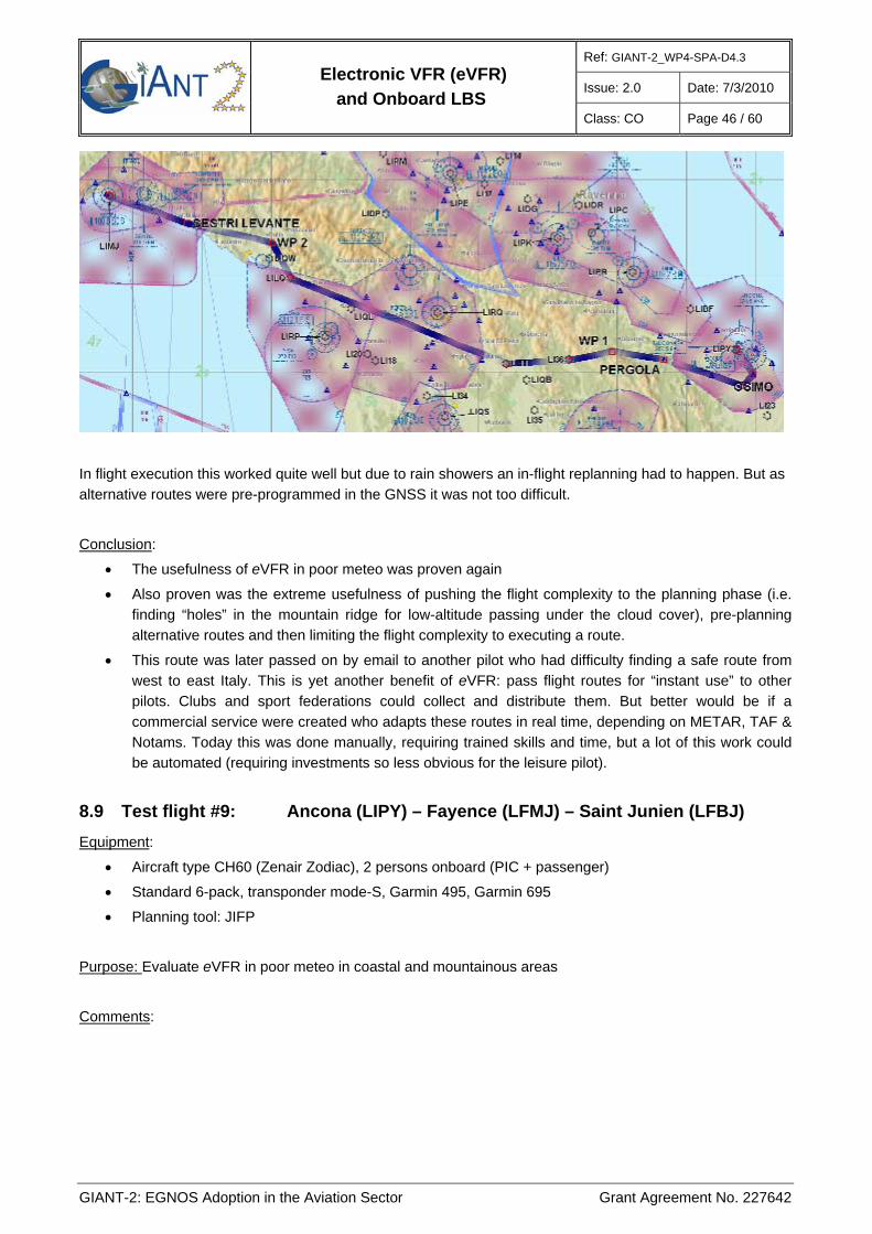
Ref: GIANT-2_WP4-SPA-D4.3
Issue: 2.0 Date: 7/3/2010
Electronic VFR (eVFR) and Onboard LBS
Class: CO Page 46 / 60
GIANT-2: EGNOS Adoption in the Aviation Sector Grant Agreement No. 227642
In flight execution this worked quite well but due to rain showers an in-flight replanning had to happen. But as alternative routes were pre-programmed in the GNSS it was not too difficult.
Conclusion:
• The usefulness of eVFR in poor meteo was proven again
• Also proven was the extreme usefulness of pushing the flight complexity to the planning phase (i.e. finding “holes” in the mountain ridge for low-altitude passing under the cloud cover), pre-planning alternative routes and then limiting the flight complexity to executing a route.
• This route was later passed on by email to another pilot who had difficulty finding a safe route from west to east Italy. This is yet another benefit of eVFR: pass flight routes for “instant use” to other pilots. Clubs and sport federations could collect and distribute them. But better would be if a commercial service were created who adapts these routes in real time, depending on METAR, TAF & Notams. Today this was done manually, requiring trained skills and time, but a lot of this work could be automated (requiring investments so less obvious for the leisure pilot).
8.9 Test flight #9: Ancona (LIPY) – Fayence (LFMJ) – Saint Junien (LFBJ) Equipment:
• Aircraft type CH60 (Zenair Zodiac), 2 persons onboard (PIC + passenger)
• Standard 6-pack, transponder mode-S, Garmin 495, Garmin 695
• Planning tool: JIFP
Purpose: Evaluate eVFR in poor meteo in coastal and mountainous areas
Comments:

Ref: GIANT-2_WP4-SPA-D4.3
Issue: 2.0 Date: 7/3/2010
Electronic VFR (eVFR) and Onboard LBS
Class: CO Page 47 / 60
GIANT-2: EGNOS Adoption in the Aviation Sector Grant Agreement No. 227642
The trip Ancona – Fayence went very well. The weather was CAVOK (=beautiful) and the flight at FL65 went smoothly with a magnificent view over the Apennines, the white-marmer mountains of Carrara and the Ligurian coast of Genoa.
In Fayence we took a fresh meteo forecast report (TAF) for the route to Limoges/Saint Junien and realized there were thunderstorms (CB’s) expected over the “Massif Central” which we had to cross. So we hurried to leave and the next trip (Fayence – Saint Junien) went at first quite smoothly.
When arriving to the Rhone valley at FL115 we could see numerous CB’s building up over the mountains. When we finally approached the Massif Central a few CB’s had grown to enormous sizes, especially on top of the “Puy du Dome”. From our (high) flight level we could see this well. It was then decided to deviate from the planned route and take a more northerly path (WP6) direction Clermont Ferrand. But that part of the Massif is full of military training areas so we contacted Clermont Ferrand tower (TWR) by radio to learn that a big military campaign was underway, and “no negotiation possible” for a zone-crossing. So the TWR of Clermont Ferrand gave us heading vectors to circumvent the forbidden zone. On the GNSS we then could see which restricted area it was so we felt more comfortable than with the TWR indications alone. As this was a second major deviation (WP2) we used the GNSS in-built E6B to calculate ETA, fuel consumption etc. to make sure we would not run low on fuel, and comply with the VFR aviation day limits (sunset + 30 minutes). There was not much margin, so an accurate calcution was needed which had to be redone at regular times, as wind changes led to different ground speeds. The GNSS did this perfectly.

Ref: GIANT-2_WP4-SPA-D4.3
Issue: 2.0 Date: 7/3/2010
Electronic VFR (eVFR) and Onboard LBS
Class: CO Page 48 / 60
GIANT-2: EGNOS Adoption in the Aviation Sector Grant Agreement No. 227642
Conclusion:
• Having life meteo imagery onboard (rainradar, clouds, lightning strikes) is vital to safe flying and one of the missing features of the eVFR mode we had at that moment. This is a top priority for follow-on developments.
• Complying with ATC instructions in eVFR mode is much easier and less confusing, so less radio communication is needed, as there is a double-check onboard. This is highly appreciated by ATC as the radio channel should be free and available as much as possible.
• Flying high (>10.000 feet) is much safer in summer meteo conditions (early CB spotting) but VFR flying on natural vision is no longer realistic so it has to happen on electronic vision.
8.10 Test flight #10: Saint Junien (LF) – Brustem (EBST) Equipment:
• Aircraft type CH60 (Zenair Zodiac), 2 persons onboard (PIC + passenger)
• Standard 6-pack, transponder mode-S, Garmin 495, Garmin 695
• Planning tool: “Navigation”
Purpose: similar to test flight #7 high-altitude “linea recta” flying in eVFR mode, with trajectory monitoring on GNSS only but this time in poor meteo.

Ref: GIANT-2_WP4-SPA-D4.3
Issue: 2.0 Date: 7/3/2010
Electronic VFR (eVFR) and Onboard LBS
Class: CO Page 49 / 60
GIANT-2: EGNOS Adoption in the Aviation Sector Grant Agreement No. 227642
Comments:
This was a more stressing flight as the meteo was really poor, and the cloud layer looked impressively thick. We took off from St. Junien and at first instance we stayed below the clouds. But because of rain showers, poor visibility, wind gusts, turbulence etc. and the intense military traffic in the area we felt a bit uneasy and decided to (try to) climb over the clouds. After having received permission from ATC (Limoges APP) we climbed in helix mode to 10.000 feet. What a difference: sun, no turbulence, 200 km visibility, no traffic just relax and smooth VFR-on-top flying. Moreover the air- and groundspeed was higher and fuel consumption significantly less. The cloud layer under us was still broken so we could maintain visual contact with the ground, so this was OK.
This went on for quite a while but we were too high to pass Paris on this route, as we would intercept the TMA of Charles De Gaulle airport. This TMA is class A which means that VFR flights are forbidden. So no hope for a crossing clearance, and we had to descent below the clouds again. The difference in mental load for the pilot is striking. At 10.000 feet we felt like commercial jet pilots flying high in an airway, with virtually no stress. Now, at 2000 ft it was again a matter of struggling with the flight controls in bumpy weather, watching out for obstacles, rain showers and traffic in mediocre visibility.
Conclusion:
• VFR-on-top flying is much safer than staying below the clouds. eVFR can facilitate this. But the big challenge is to maintain visual ground contact and spot for breaks in the clouds to evaluate the height of the ceiling and to descent in VMC, if needed.
• Flying high as such has many advantages for private air travel:
o Virtually no traffic

Ref: GIANT-2_WP4-SPA-D4.3
Issue: 2.0 Date: 7/3/2010
Electronic VFR (eVFR) and Onboard LBS
Class: CO Page 50 / 60
GIANT-2: EGNOS Adoption in the Aviation Sector Grant Agreement No. 227642
o If above the clouds, very good visibility & comfort (no turbulence)
o No concerns with ground obstacles.
o Few ATC zones to comply with: just higher TMA’s, airways (easy as the PIC just has to choose a VFR flight level), and a few R-zones (Restricted military zones). Virtually all P-zones, W-zones, R-zones, lower ATC zones and CTR’s are of no concern to the “10.000 feet pilot” flying in eVFR…
• But VMC must be maintained, and also flying in positive Outside Air Temperatures (OAT) as most aircraft are not equipped and qualified to fly in possible icing conditions. Obviously this is a summer condition. On many GNSS and transponder equipments it is possible to connect an electronic temperature sensor so that the OAT can be displayed electronically. Very handy to stay out of trouble!
8.11 Test flight #11: Brustem (EBST) – Lausanne (LSGL) – Piecenza (LIMS) - Genova Equipment:
• Aircraft type CH60 (Zenair Zodiac), 2 persons onboard (PIC + passenger)
• Standard 6-pack, transponder mode-S, Garmin 495, Garmin 695
• Planning tool: JIFP + Garmin (manually)
Purpose: Comparing the differences in planning performance between the automatic mode of JIFP and the human programming, directly on the GNSS
Comments:
The trip Brustem – Lausanne went very well. The manual programming was easy as all information was available, and it took just a few minutes to program the route into the two Garmins. In an way it is better than the JIFP route as there is no conflict or non-matching between the Airport Reference Points (ARP’s) in the Garmin and Jeppesen data bases.

Ref: GIANT-2_WP4-SPA-D4.3
Issue: 2.0 Date: 7/3/2010
Electronic VFR (eVFR) and Onboard LBS
Class: CO Page 51 / 60
GIANT-2: EGNOS Adoption in the Aviation Sector Grant Agreement No. 227642
The trip Lausanne – Piecensa
Automatic JIFP route
The route was programmed with JIFP and manually on the Garmin 695/495. The manual route was chosen for execution. Surprisingly this went very well and –in a way- even better as JIFP does not take the meteo into account (note: PocketFMS does). After our intermediate stop in Lausanne we checked the local meteo and took some advice from other pilots. Based on this we decided not to take the Simplon Pass (JIFP advice) but the higher Saint Bernard Pass, as the cloud cover was less. Also, we planned a route along other airports with several extra waypoints to be able make a quick diversion, if needed. We wanted to stay in the urbanized valleys in case of an emergency landing, but then we lost radio control with Milan APP so it was a good thing to have a detailed plan, nicely worked out in the airport, and limit the flight complexity to the handling of the aircraft.
The club pilots of Lausanne had advised us to follow the road leading to the Saint Bernard Pass. But because of unfamiliarity with the region and some lower clouds we could see the road. The the road was perfectly visible on the GNSS moving map, so we meticulously “followed” the road on our GNSS screen and made it safely and easily to the Pass. Another eVFR discovery…
Once over the Grand Saint Bernard Pass we arrived in the Val d’Aosta (Italy) and started our long gradual descent to the Po plains. Hidden by large mountains we were unable to establish radio contact with ATC Milan so it felt good to have the route pre-programmed in great detail. Because of the TMA’s of Milan/Malpensa and Turin we knew we had to stay quite low so we came down 9000 feet.
Once over the Po plains things were very easy: we followed ATC routing instructions, quite easy as we find all the reference points back quite well on the G695.
Purposely we had decided to land on a private airstrip (LI30) near Piacenza, in the middle of the fields. It turned out impossible to find it by natural sight: only the GNSS could tell us where it was: a green airstrip amid green fields, no marks…

Ref: GIANT-2_WP4-SPA-D4.3
Issue: 2.0 Date: 7/3/2010
Electronic VFR (eVFR) and Onboard LBS
Class: CO Page 52 / 60
GIANT-2: EGNOS Adoption in the Aviation Sector Grant Agreement No. 227642
Manual Garmin route
The trip Piecenza – Genova was done in the late afternoon, close to sunset with upcoming fog and still the Apennines mountains to cross. All programming was done manually on the G695 and a route was found circumventing the highest peaks, but still a climb to FL85 was necessary. Everything was perfectly under control. When descending gradually to Genova airport the Tower instructed an approach route via the north, over the mountains and hills while I had to descent already quite low. But the GNSS gave me good comfort and I curved through the valleys, watching carefully the GNSS and its obstacle warning feature.
I entered the downwind of the airport at dawn, and Genova is in the shade of the mountains so it became difficult to distinguish the airfield from the other industrial sites of the harbour. On top Genova tower asked me kindly for a favor: “Could you please position yourself in a waiting pattern over the city @2000 ft, to allow 2 incoming IFR flights from Air France and Lufthansa for a straight-in landing?”. In principle I had the right to claim my first position but I agreed with the change of sequence as I felt in full control, thanks to the eVFR mode. By the time I was allowed to land (several minutes after the landing of the 2 big planes, because of wake turbulence) it was still legal aviation day (sunset + 30 minutes) but is was getting pretty dark. Moreover I had to land with the sunset in the face. Without my GNSS I fear I could have got into trouble landing on this non-illuminated runway amid all these harbour sites.
Conclusion:
• The manual planning mode worked still much better that the automatic one from JIFP, but it requires more skill, time and effort
• Detailed pre-planning of the flight helps comfort and safety during flight
• Following the road over the Saint Bernard Pass was much easier by electronic vision on the moving map than by natural vision (too high, intermediate clouds)
• Finding unmarked private airstrips without GNSS is quasi impossible, and with the GNSS it is very simple. Quite important if one risks to run low on fuel at the end of a long journey. A similar sensation happened when landing in Genova in the almost dark against the sunset.

Ref: GIANT-2_WP4-SPA-D4.3
Issue: 2.0 Date: 7/3/2010
Electronic VFR (eVFR) and Onboard LBS
Class: CO Page 53 / 60
GIANT-2: EGNOS Adoption in the Aviation Sector Grant Agreement No. 227642
8.12 Test flight #12: Genova (LIMJ) – Cuers/Pierrefeu (LFTF, alternate Fayence) Equipment:
• Aircraft type CH60 (Zenair Zodiac), 2 persons onboard (PIC + passenger)
• Standard 6-pack, transponder mode-S, Garmin 495, Garmin 695
• Planning tool: Garmin 695/495 (manually)
Purpose: similar to the other testflights, trying to discover benefits of eVFR
Comments:
The flight started well from Genova, but near Monaco low-hanging clouds came up and it was impossible to fly over land. I passed Albenga airport (one of the alternates) and continued over the sea. When approaching Nice I climbed over the clouds to FL85 (to stay clear of the control zones of Nice airport I had to fly VFR-on-top). Unfortunately our eVFR mode did not allow –yet- to evaluate the cloud cover over our destination (Cuers Pierrefeu) and alternate airfield (Fayence LFMF) so I contacted the FIS Nice Information for actual meteo data. As this was OK I continued VFR-on-top, just north of the TMA of Nice airport. On my right-hand side I had the steeply rising Alps, shrouded in clouds, quite creepy if you only have your basic instruments! But the eVFR mode (with GNSS moving map) gave good comfort: via the obstacle warning feature I had electronic vision on the mountains and could evaluate the situation in time. It was safe and still relaxing: I could see well ahead of trouble whether I could continue or not.
Note: the PIC has to decide this in time because making a U-turn takes space and often cannot be done anymore if one realizes too late to be “trapped” in a narrow mountain valley/canyon. This is a common accident in mountain flying but eVFR can prevent this.
Ref: GIANT-2_WP4-SPA-D4.3
Issue: 2.0 Date: 7/3/2010
Electronic VFR (eVFR) and Onboard LBS
Class: CO Page 54 / 60
GIANT-2: EGNOS Adoption in the Aviation Sector Grant Agreement No. 227642
Nice Information warned that a major NATO military exercise was going on in the region, operating from Cuers/Pierrefeu. This was not made clear to me when we left Ancona, so I made a diversion to Fayence. Again, all relevant airfield data (radio frequencies, elevation, runways, circuit etc.) were available in the Garmin 695 and 495 and I landed normally. But it would be fantastic if such important data were available onboard via datacom, and shown on the GNSS! Again a missing feature of the eVFR mode I had at that moment.
Conclusion:
• Very instructive testflight
• The need for datacom e.g. to transmit relevant NOTAMs was shown again
• eVFR in poor meteo is indispensable
8.13 Test flight #13: Fayence – Lyon/Bron – Strasbourg Equipment:
• Aircraft type CH60 (Zenair Zodiac), 2 persons onboard (PIC + passenger)
• Standard 6-pack, transponder mode-S, Garmin 495, Garmin 695
• Planning tool: JIFP
Purpose: trying to discover features/benefits of eVFR
Comments:
The trip Fayence – Lyon/Bron went smoothly, a nominal flight without much to report. The stop in Lyon was just for fuel, as Fayence (the alternate of the previous trip) could not supply the right fuel.

Ref: GIANT-2_WP4-SPA-D4.3
Issue: 2.0 Date: 7/3/2010
Electronic VFR (eVFR) and Onboard LBS
Class: CO Page 55 / 60
GIANT-2: EGNOS Adoption in the Aviation Sector Grant Agreement No. 227642
The leg Lyon – Strasbourg was more adventurous. The meteo forecast for the flight to Strassbourg was a bit gloomy but doable. Out of caution a route was planned along the Saone river to keep maximum clearance with the low clouds.. But –contrary to the meteo forecast- the weather became better as we progressed up north, with larger breaks so we decided to climb up and continue the flight VFR-on-top.
As we approached the Vosges Mountains the clouds under us became thicker again and we were worried that we might not have sufficient breaks in the clouds at the destination for our descent. We contacted Paris Information for the actual meteo report (METAR) who assured us that the Strassbourg cloud cover was “scattered”. This request was repeated a few times. The mountain peaks of the Vosges were sticking out of the lower clouds and were the only visual reference for us. But the only true practical visual reference for location and navigation was the GNSS and its moving map.
We made it flawless to Strassbourg, entered the circuit and landed safely.

Ref: GIANT-2_WP4-SPA-D4.3
Issue: 2.0 Date: 7/3/2010
Electronic VFR (eVFR) and Onboard LBS
Class: CO Page 56 / 60
GIANT-2: EGNOS Adoption in the Aviation Sector Grant Agreement No. 227642
Conclusion: also this flight would have been interrupted in classic VFR flight. The eVFR enabeled it to continue in full safety.
8.14 Test flight #14: Strasbourg (LFST) – Brustem (EBST) Equipment:
• Aircraft type CH60 (Zenair Zodiac), 2 persons onboard (PIC + passenger)
• Standard 6-pack, transponder mode-S, Garmin 495, Garmin 695
• Planning tool: Garmin (manual)
Purpose: evaluate eVFR flying is very difficult meteo conditions
Comments:
The normal route would lead north-west via Metz but at the time of departure a cold front was passing the region, sweeping a string of thunderstorms over the Vosges Mountains. The CB’s were far too big so trying to fly over them was no option. But to fly under a CB in mountainous area is no safe option either. As the cold front was moving north-east (as they normally do) we decided to first fly south, clockwise around the Vosges mountains and cross the cold front in a perpendicular fashion, over low grounds. This would give us enougth clearance between cloud ceiling and ground. The inevitable showers we should be able to see and avoid. On the rainradar images (from Internet, in the airport before departure) we could clearly see that the showers on the southern part of the cold front were less intense. This is what you normally can expect but it is nice to check it for real on the rain radar!
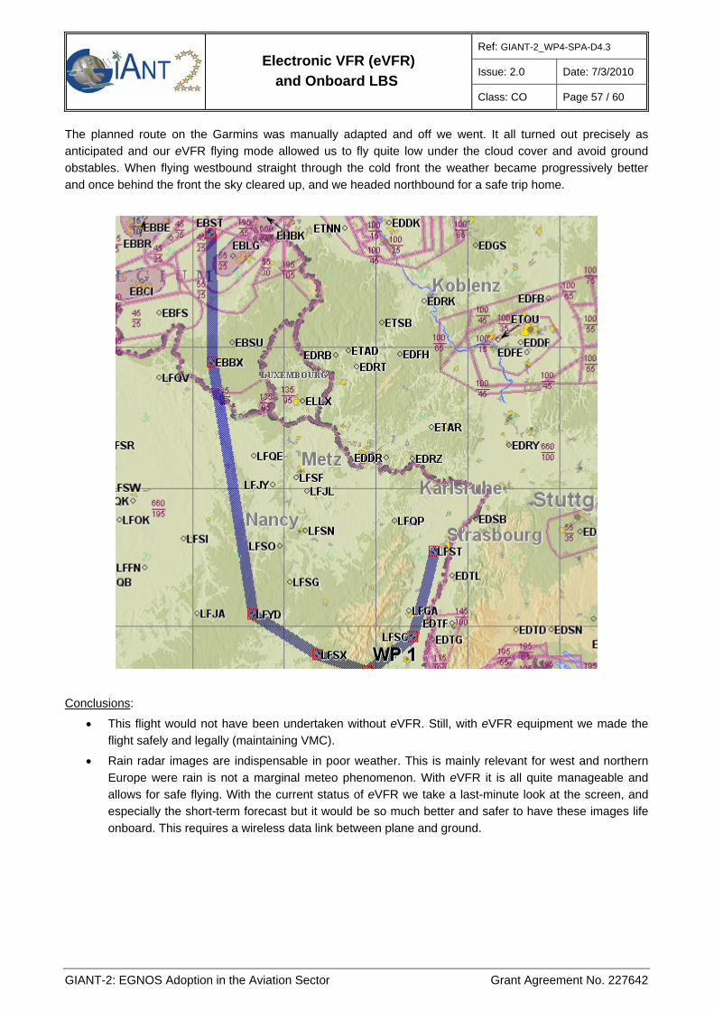
Ref: GIANT-2_WP4-SPA-D4.3
Issue: 2.0 Date: 7/3/2010
Electronic VFR (eVFR) and Onboard LBS
Class: CO Page 57 / 60
GIANT-2: EGNOS Adoption in the Aviation Sector Grant Agreement No. 227642
The planned route on the Garmins was manually adapted and off we went. It all turned out precisely as anticipated and our eVFR flying mode allowed us to fly quite low under the cloud cover and avoid ground obstables. When flying westbound straight through the cold front the weather became progressively better and once behind the front the sky cleared up, and we headed northbound for a safe trip home.
Conclusions:
• This flight would not have been undertaken without eVFR. Still, with eVFR equipment we made the flight safely and legally (maintaining VMC).
• Rain radar images are indispensable in poor weather. This is mainly relevant for west and northern Europe were rain is not a marginal meteo phenomenon. With eVFR it is all quite manageable and allows for safe flying. With the current status of eVFR we take a last-minute look at the screen, and especially the short-term forecast but it would be so much better and safer to have these images life onboard. This requires a wireless data link between plane and ground.

Ref: GIANT-2_WP4-SPA-D4.3
Issue: 2.0 Date: 7/3/2010
Electronic VFR (eVFR) and Onboard LBS
Class: CO Page 58 / 60
GIANT-2: EGNOS Adoption in the Aviation Sector Grant Agreement No. 227642
9 RESULTS & CONCLUSIONS FOR FURTHER WORK
9.1 Results
From the study the following positive results have been noted:
9.1.1 eVFR works already now and is definitely worth being further developed With the present state of the art technology, especially GNSS and ICT, eVFR is becoming a practical reality and is being used by leisure and private pilots to improve safety, comfort of flight and also to deal with difficult flight conditions especially poor visibility. The test results of the study were so convincing, and the mere fact that the information age has just begun, forces us to conclude that de facto eVFR will happen. Up to a certain extent it can be left to market forces, but a development initiative to create order in the emerging chaos is certainly welcome and beneficial to all users and other stakeholders.
9.1.2 EGNOS is at the core of eVFR A striking conclusion is that EGNOS is at the heart of the matter: most eVFR functions relate to precise, reliable and high-bandwidth global positioning data on a moving map. It is from here that all eVFR functions and features start. Moreover, the hardware/software GNSS platforms that are being offered on the market are rapidly developing into powerful hosting platforms for eVFR data, logic and electronic services. Needless to say that they will be at the core for implementing further eVFR functions
9.1.3 A legal framework for eVFR development and experimentation is needed For testing in Visual Meteo Conditions (VMC) it is sufficient to perform eVFR test flights as a normal VFR flight, possibly with 2 pilots executing/simulating classical VFR or eVFR operations.
However for test flying below VMC a combined IFR/eVFR flight could do be sufficient to test eVFR routines. That is how it was done in the study with the IFR-equipped test aircraft Rockwell Commander 112.
Later, for true flight operations a logical legal framework is needed. From this study it is proposed to create a new VFR rating (“eVFR” rating) similar to NVFR (“Night VFR” rating). The only extra qualifications needed are the proper operation and use of the eVFR equipment and functions. Similar to NVFR this eVFR rating would allow eVFR qualified pilots to fly in below-VMC conditions as far as visibility is concerned but respecting physical constraints on aircraft and crew.
So eVFR certainly does not make a plea for flying in icing conditions, strong wind gusts etc. with aircraft and pilots that are not prepared and qualified for it!
Before this debate can be initiated with aviation authorities eVFR as a flight rule concept must be better worked out, proven and demonstrated.
But also negative study conclusions have been drawn:
9.2 Improvement Areas 9.2.1 The list with candidate eVFR functions is not exhaustive When performing the study and especially the test flights several new ideas for eVFR and possibilities were discovered. It is obvious that this process is far from over: more study, test and development effort is needed

Ref: GIANT-2_WP4-SPA-D4.3
Issue: 2.0 Date: 7/3/2010
Electronic VFR (eVFR) and Onboard LBS
Class: CO Page 59 / 60
GIANT-2: EGNOS Adoption in the Aviation Sector Grant Agreement No. 227642
to increase the list of possible eVFR services so that later a consistent usable set can be derived from it for eVFR formalisation.
9.2.2 Europe lacks a wireless data network complementing EGNOS A tremendous shortcoming for onboard Location Based Services (oLBS) –especially life meteo images on rainfall, lightning strikes and cloud cover- is that Europe does not have a satellite data network that is suited for eVFR. In the USA this is available and the oLBS services are already being offered e.g. in the Garmin 696. So far only Inmarsat could do this in Europe but this organisation is not in consumer-type services so what they offer is prohibitively too expensive. Another option is ASTRA-Eutelsat who started a satellite-based internet service (AstraNet) but the test programme and especially the test satellite is not doing very well, a true pity and something that needs correction.
EGNOS and Galileo networks only dispose over a very limited data network for Search And Rescue (SAR) which it is largely insufficient to cope with the large data needs of eVFR.
9.2.3 The traditional commercial/military aviation lobby might not easily support eVFR
eVFR provides most benefit to low-time pilots, so the arguments weigh less for professional pilots. Hence it can be expected that the willingness to think along these lines is not very big in that community. The only solution is work eVFR better out, and come to the surface with a more mature and proven concept.
Inevitable, eVFR and its EGNOS foundation will find their use in non-leisure aviation but the most realistic path to get there is via leisure aviation, as the community is receptive, the risk much less as they are no passengers involved and the rulings more flexible.
9.3 Recommendations for further work 9.3.1 Legal Start up communication with EASA about a eVFR development programme, including the legal aspects.
9.3.2 Technical/Financial Foresee an R&D budget (1-2 Meuro) to do a meaningful and experiment-driven R&D programme for eVFR. This to create more candidate eVFR functions, to test and evaluate them and to implement them in system-level demonstrators. Also a (temporary) wireless data network to facilitate oLBS is needed.
9.3.3 ATC involvement ATC authorities need to be consulted, involved and committed to the eVFR project cause.

Ref: GIANT-2_WP4-SPA-D4.3
Issue: 2.0 Date: 7/3/2010
Electronic VFR (eVFR) and Onboard LBS
Class: CO Page 60 / 60
GIANT-2: EGNOS Adoption in the Aviation Sector Grant Agreement No. 227642
END OF DOCUMENT