elevation certificate omb no. 1660-0008 exoires februarv
TRANSCRIPT

· i ! ,
f· ' '
'<u.s. DEPARTMENT OF HOMELAND SECURITY Federal ~mergency Management Agency
ELEVATION CERTIFICATE OMB No. 1660-0008 Exoires Februarv 28. 2009
, . _ National Flood lnsur~nce Program Important: Read the instructions on pages 1-8.
SECTION A· PROPERTY INFORMATION
-!\ 1. Bui.lding Owner's Name
. Building Street Address (including Apt., Unit, Suite, and/or Bldg. No.) or P.O. Route and Box No. q-i,.
. City
A3. Property Description (Lo and Block Numbers, Tax Parcel Number, Legal Description, etc.)
:r~ uw 'l.7D3, M.~ No. ?.7 - 2W- M - P
For Insurance Company Use:
Policy Number
Company NAIC Number
A4. Building Use (e.g., Residential, Non-Residential, Addition, Accessory, etc.) _Deko.c..'ned G-o..r~e A5. latitude/Longitude: Lat. 4"2.0 \B' \J,2 1' N Long. 12"2. • 55 1 09. bu yJ Horizontal Datum: 0 NAO 1927 ~ NAO 1983 A6. Attach at least 2 photographs of the building if the Certificate is being used to obtain flood insurance.
· A7. Building Diagram Number_L A9. AB: For a building with a crawl space or enclosure(s), provide
a) Square footage of crawl space or enclosure(s) H/A._ sq ft For a building with an attached garage, provide: a) Square footage of attached garage N /A sq ft b) No. of permanent flood openings in the att~ garage b) No. of permanent flood openings in the crawl space or
enclosure(s) walls within 1.0 foot above adjacent grade c Total net area of flood o enin s in A8.b s in
walls within 1.0 foot above adjacent grade c Total net area of flood o nin s in A9.b -:-:--.·
SECTION B ·FLOOD INSURANCE RATE MAP (FIRM) INFORMATION
83. State
o~
s in
84. Map/Panel Number B5. Suffix 86. FIRM Index B7. FIRM Panel Date Effective/Revised Date
S M~ lS "2.oo'l.. A
88. Flood Zone(s)
89. Base Flood Elevation(s) (Zone AO, use base flood depth)
A ii 0 B10. Indicate the source of the Base Flood Elevation (BFE) data or base flood depth entered In Item 89.
0 FIS Profile ~FIRM 0 Community Determined 0 Other (Describe) __
811 . Indicate elevation datum used for BFE In Item 89: QlNGVD 1929 0 NAVO 1988 0 Other (Describe) __ r Is th~ building located In a Coastal Barrier Resources System (CBRS) area or Otherwise Protected Area (OPA)? OYes 8]No
Designation Date__ D CBRS D OPA
SECTION c-aUILDING ELEVATION INFORMATION (SURVEY REQUIRED)
C1 . Building elevations are based on: D Construction Drawings* D Building Under Construction* ~Finished Construction *A new Elevation Certificate will be required when construction of the building is complete.
C2. Elevations,.. Zones A 1-A30, AE, AH, A (with 8FE), VE, V1-V30, V {with BFE), AR, ARJA, ARJAE, AR/A 1-A30, AR/AH, AR/AO. Complete Items C2.a-g , below according to the building diagram specified in Item A7 .
.. , ·senchmark Utilized~ertical Datum~ \q '2.'l : . · Corlversion/Comments H.Ane
Check the measurement used.
a) Top of bottom floor (including basement, crawl space, or enclosure floor)_ b) Top of the next higher floor c) Bottom of the lowest horizontal structural member N Zones only) 'd) Attached garage (top of slab) e) Lowest elevation of machinery or equipment servicing the building
(Describe type of equipment in Comments) f) Lowes~ adjacent (finished) grade (LAG) g) Highest adjacent (finished) grade (HAG)
l~.J_
WA-·WA_._ WA_._ \.481..._, -
\ATI_.Ja_ ~-~
~feet
D feet D feet D feet IX! feet
~feet
r8J feet
D meters (Puerto Rico only) 0 meters (Puerto Rico only) 0 meters (Puerto Rico only) 0 meters (Puerto Rico only) D meters (Puerto Rico only)
0 meters (Puerto Rico only) D meters (Puerto Rico only)
SECTION D ·SURVEYOR, ENGINEER, OR ARCHITECT CERTIFICATION
·This certification is to be signed and sealed by a land surveyor, engineer, or architect authorized by law to certify elevation ; lnfonnation. I certify that the infonnation on this Certificate represents my best efforts to interpret the data available.
·./understand that any false statement may be punishable by fine or imprisonment under 18 US. Code, Section 1001 .
. ~ . Check here if comments are provided on back of form.
Certifier's Name Gary D. Wicks License Number PLS 1108
Owner Company Name WICKS ENGINEERING & SURVEYING
Address 311 N. E. "D" Street City Grants Pass State OR ZIP Code 97526
Signature Date ", ,, _ Telephone 541-479-3436 \e ~, '-UO
See reverse side for continuation.
O REGON JULY 22. 197 7
GARY D. WICKS 1108
Replaces all previous editions . ttEt-laJf\1, ti~ ~ C.. ~o .10

IMPORTANT: In these spaces, copy the corresponding.lnfonnatlon from Section A. For Insurance Company Use:
. , . Building Street Addr~ss (including Apt., Unit, Suite, and/or Bldg. No.) or .0. Route and Box No. Policy Number
;" .:,>· \p91., Mn.~~Q\;o.. A\tf:<nuc. ! . . City State ZIP Code Company NAIC Number
.t4 0 0 1 0 . .. ,1 ECTION 0 ·SURVEYOR, ENGINEER, OR ARCHITECT CERTIFICATION (CONTINUED)
.,, ....... ... : :···Y\\; both sides of this Elevation Certificate for (1) community official, (2) Insurance agenUcompany, and (3) building owner.
;., .. ·;~: ·:·:. Comments : :}~·~ ·~· ' . '._ . . ' .
r .. 1+cM , c:z.. e. = E. \.e c..1ri c<&\ ~\y ~ t lt\.S Ii. •,:
Signature c-.... • t. Date V • VJ .,._t-- " j~ "'-U."' 't' '2..<. , ~ 0 C) Check here If attachments
SECTION E • B~ILDING ELEVATION INFORMATION (SURVEY NOT REQUIRED) FOR ZONE AO AND ZONE A (WITHOUT BFE)
For Zones AO and A (without BFE), complete Items E1 .. E5. If the Certificate is intended to support a LOMA or LOMR-F request, complete Sections A, B, and C. For Items E1-E4, use natural grade, if available. Check the measurement used. In Puerto Rico only, enter meters.
E1.
E2.
E3. E4.
." E5.
Provide elevation information for the following and check the appropriate boxes to show whether the elevation is above or below the highest adjacent grade (HAG) and the lowest adjacent grade (LAG). a) Top of bottom floor (including basement, crawl space, or enclosure) is~·-- D feet D meters D above or D below the HAG: b) Top of bottom floor (including basement, crawl space, or enclosure) is--·-- D feet D meters D above or D below the LAG. For Building Diagrams 6-8 with permanent flood openings provided In Section A Items 8 and/or 9 (see page 8 of Instructions), the next higher floor (elevation C2.b in the diagrams) of the building is __ . __ . _ . D feet D meters 0 above or 0 below the HAG.
Attached garage (top of slab) is --·-- D feet D meters 0 above or D below the HAG.
Top of platform of 'machinery and/or equipment servicing the building Is -·-- 0 feet D meters 0 above or D below the HAG.
Zone AO only: If no flood depth number is available, Is the top of the bottom floor elevated in accordanc;e with the community's floodplain management ···· ordinance? D Yes D No D Unknown. The local official must certify this information in Section G.
SECTION F - PROPERTY OWNER (OR OWNER'S REPRESENTATIVE) CERTIFICATION
The property owner or owner's authorized representative who completes Sections A, B, and E for Zone A (without a FEMA-issued or community-issued BFE)
1 · · .:· · .. ' or Zone AO must sign here. The statements In Sections A, B, and E are cofT'9ct to the be!Jt of my knowledge .
. F.·:; ~-· Li,.i Property Owner's or Owner's Authorized Representative's Name
t~~;,'.}:t" ·· ·~s~ . . ,. . . (:;·
City State ZIP Code
· r~~\:·:·-~-.: -S .... ig-~-a-tu-re ___ ......... ~---------~---------D-a-te __________ T_e_l_ep_h_o_n_e ____________ _
Comments
0 Check here if attachments
SECTION G - COMMUNITY INFORMATION (OPTIONAL) The local.official who is authorized by law or ordinance to administer the community's floodplain management ordinance can complete Sections A, B, C (or E), and G of this Elevation Certificate. Complete the applicable item(s) and sign below. Check the measurement used in Items GB. and G9.
G1. D The information in Section C was taken from other documentation that has been signed and sealed by a licensed surveyor, engineer, or architect who is authorized by law to certify elevation information. (Indicate the source and date of the elevation data in the Comments area below.)
;: .·, · , G2. O A community official completed Section E for a building located In Zone A (without a FEMA-issued or community-issued BFE) or Zone AO.
'G3. O The following Information (Items G4.-G9.) is provided for community floodplain management purposes.
· . G4. Permit Number G5. Date Permit Issued G6. Date Certificate Of Compliance/Occupancy Issued
· ~·~;X.'>:.G7. This permit has been Issued for: D New Construction · . 0 Substantial Improvement /1:,.1· · /·i1. •i' ''
; \ ~; :·~ : 1 GS: Elevation of as-built lowest floor (Including basement) of the building: --·-- _D feet D meters (PR) Datum ___ .
r,;{'if(-:?/dg'., BFE or (In Zone AO) depth of flooding ·at the building site: --·-- D feet D meters (PR) Datum -! .. :., .. :..:f :::·.:: ';···,·; ! .. r/~;::::i-; , ~Lo_ca.,;._..l_O_ffi_1c-ia_l'_s_N_a_m_e---------------------~T-it-le ___________ __._ ___________ _
\ {GW{-..;.t~t...:···;;;..i' · -.,._---------------------------=:-:-------------------------i:a¥.:.~·;~ Community Name Telephone
. ; h~~~.~t!~l:'.·tl;i{; ~, : :. : . · ·:~k~~!hit.f t SignaturEt Date !;~."-1',: , ~1· Ii·· q~~~· ~:~\l ·!'·~·li:t•):l\! ' ·'" ... 1~~;;H~ff ~ · .. . , ~ ... ••· 1-.·N:·<· ·Comments
1\~:~ .. \r ·" I·•,•
I
~...;...-----------------------------------------0 Check here If attachments
FEMA Form 81-31, February 2006 Replaces all previous editions
' • • ', ' I •" r , t ·~· ,.,,,. ~ ,. >' r . ,,1 t"I' .11 , ,. ,~ , ,...."".,. 111, ., , ., ~
'' ·1 .
; ..
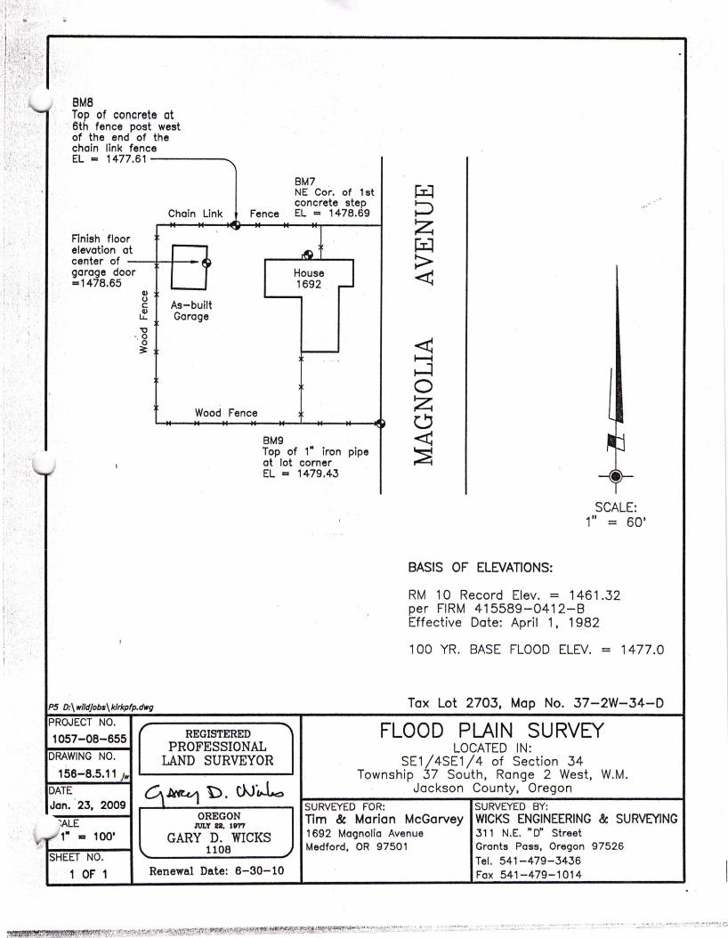
BMB Top of concrete ct
· 6th fence post west of the end of the chain link fence EL= 1477.61-----
BM7 NE Cor. of 1st concrete step
Chain Link Fence EL = 1478.69
Finish floor elevation at center of _ ___,.,... __ garage door =1478.65
Q)
g As-built ~ Garage "O
"g 3t
Wood Fence
BM9
House 1692
Top of 1" iron pipe at lot corner EL = 1479.43
PS D:\w/ldjobs\klrkpfp.dwg
PROJECT NO.
1057-08-655
DRAWING NO.
156-8.5.11 jw
DATE Jori. · 23, 2009
~ALE
1" 1111 100'
SHEET NO.
1 . OF 1
REGISTERED PROFESSIONAL
LAND SURVEYOR
OREGON JULY 22. urn
GARY D. WICKS 1108
Renewal Date: 6-30-10
BASIS OF ELEVATIONS:
SCALE: 1" = 60'
RM 10 Record Elev. = 1461.32 per FIRM 415589-0412-8 Effective Date: April 1 , 1982
100 YR. BASE FLOOD ELEV. = 1477.0
Tax Lot 2703, Map No. 37-2W-34-D
FLOOD PLAIN SURVEY LOCATED IN:
SE1/4SE1/4 of Section 34 Township 37 South, Range 2 West, W.M.
Jackson County, Oregon SURVEYED FOR: SURVEYED · BY: Tim & Marian McGarvey WICKS ENGINEERING & SURVEYING 1692 Magnolia Avenue 311 N.E. "D" Street Medford, OR 97501 Grants Pass, Oregon 97526
Tel. 541-479-3436 Fax 541-479-1014