elysian park lofts project - l.a. mountains · elysian park lofts project case number:...
TRANSCRIPT
November 2017
Elysian Park Lofts Project
Case Number: ENV-2016-4064-EIR
Project Location: 1251 North Spring Street and 1030 - 1380 North Broadway, Los Angeles, CA 90012
Community Plan Area: Central City North
Council District: 1—Cedillo
Project Description: The Elysian Park Lofts project proposes development of a mixed-use residential and commercial retail project (Project) consisting of approximately 920 residential units, including 17 live-work units, approximately 17,941 square feet (sf) of neighborhood-serving retail uses, and approximately 5,465 sf of leasing offices on an irregular bow-shaped parcel that is currently used for Metro vehicle and equipment storage and parking. All existing structures on the Project site would be demolished, including a one-story, wood modular building at the southwestern corner of the Project site, a rectangular one-story metal building at the western boundary of the Project site, a wood trailer shed at the southeastern boundary of the Project site, a metal storage container, and a one-story building that is attached to an adjacent off-site building, as well as surface parking, site improvements, and fences at the southern portion of the Project site. Upon completion, the Project would result in 1,159,800 square feet of new floor area with a 3.3 floor area ratio (FAR).
The Project site consists of a north parcel (“North Parcel”) and a south parcel (“South Parcel”). The North Parcel would be developed with approximately 469 dwelling units, including 10 live-work units, in 3 buildings over a 3-level subterranean parking garage. Building A on the North Parcel would be 7 stories and approximately 85 feet high; Building B would be 14 stories and approximately 170 feet high; and Building C would be 8 stories and approximately 100 feet high. The North Parcel would include 8,070 sf of neighborhood-serving restaurant/outdoor dining uses and a leasing office of 2,000 sf. The North Parcel would also be developed with recreational and open space uses, and a pool for residents.
The South Parcel would be developed with approximately 451 dwelling units, including 7 live-work units, in 3 buildings constructed over a 3-level subterranean parking garage. Building A on the South Parcel would be 7 stories and 85 feet high; Building B would be 7 stories and approximately 84 feet high; and Building C would be 13 stories and approximately 155 feet high. The South Parcel would include approximately 9,871 sf of neighborhood-serving restaurant/outdoor dining uses and a leasing office of approximately 3,465 sf. The South Parcel also would have a residential community center that would be 2 stories and 34 feet high, with a pool, club and lounge for residents.
PREPARED FOR: PREPARED BY: APPLICANT:
The City of Los Angeles Psomas S&R Partners, LLC Department of City Planning 225 South Lake Avenue 737 Lamar Street
Suite 1000 Los Angeles, CA 90031 Pasadena, CA 91101
Elysian Park Lofts i City of Los Angeles Initial Study – Table of Contents November 2017
INITIAL STUDY Table of Contents
Page
Environmental Checklist ............................................................................................IS-1
Attachment A: Project Description ............................................................................ A-1
1. Introduction ................................................................................................A-1 2. Project Location .........................................................................................A-1 3. Environmental Setting ...............................................................................A-2 4. Project Description ....................................................................................A-4
Attachment B: Explanation of Checklist Determinations ........................................ B-1
1. Aesthetics ..................................................................................................B-1 2. Agriculture / Forest ....................................................................................B-2 3. Air Quality ..................................................................................................B-3 4. Biological Resources .................................................................................B-5 5. Cultural Resources ....................................................................................B-7 6. Geology and Soils .....................................................................................B-8 7. Greenhouse Gas Emissions ....................................................................B-10 8. Hazards and Hazardous Materials ..........................................................B-10 9. Hydrology and Water Quality ..................................................................B-13 10. Land Use and Planning ...........................................................................B-15 11. Mineral Resources ..................................................................................B-16 12. Noise .......................................................................................................B-16 13. Population and Housing ..........................................................................B-18 14. Public Services ........................................................................................B-18 15. Recreation ...............................................................................................B-19 16. Transportation/Traffic ..............................................................................B-20 17. Tribal Cultural Resources ........................................................................B-21 18. Utilities and Service Systems ..................................................................B-22 19. Mandatory Findings of Significance ........................................................B-23
References ........................................................................................................................ i

Elysian Park Lofts ii City of Los Angeles Initial Study – Table of Contents November 2017
List of Exhibits Follows Page
1 Regional Location and Local Vicinity ................................................................. A-1 2 Site Plan ............................................................................................................ A-4 3 North Parcel-Site Section .................................................................................. A-4 4 North Parcel-Site Elevation ............................................................................... A-4 5 South Parcel-Site Section ................................................................................. A-4 6 South Parcel-Site Elevation ............................................................................... A-4 7 View Corridor Diagram ...................................................................................... B-1 8 Alquist Priolo Fault Zones ................................................................................. B-8
List of Tables Page
1 Project Land Uses ............................................................................................. A-5 2 Project Ground-Level Open Space ................................................................... A-6
Appendices
A Tree Report B Geotechnical Engineering Investigation

Elysian Park Lofts IS-1 City of Los Angeles Initial Study – Environmental Checklist November 2017
CITY OF LOS ANGELES OFFICE OF THE CITY CLERK
ROOM 395, CITY HALL LOS ANGELES, CALIFORNIA 90012
CALIFORNIA ENVIRONMENTAL QUALITY ACT
INITIAL STUDY AND APPENDIX G CHECKLIST
LEAD CITY AGENCY City of Los Angeles Department of City Planning
COUNCIL DISTRICT 1, Cedillo
DATE November 6, 2017
RESPONSIBLE AGENCIES State Water Resources Control Board Metropolitan Transportation Authority PROJECT TITLE / CASE NO. Elysian Park Lofts / ENV-2016-4064-EIR
RELATED CASES CPC-2016-4063-GPA-ZC-HD-ZAD-SPR; CPC-2016-4139-DA; VTT-74548
PROJECT LOCATION 1251 North Spring Street and 1030 - 1380 North Broadway, Los Angeles, CA 90012 APPLICANT NAME AND ADDRESS S&R Partners, LLC
PHONE NUMBER (323) 223-1401
PROJECT DESCRIPTION: The Elysian Park Lofts Project proposes development of a mixed-use residential and commercial retail project (Project) consisting of approximately 920 residential units, including 17 live-work units, approximately 17,941 square feet (sf) of neighborhood-serving retail uses, and approximately 5,465 sf of leasing offices on an irregular bow-shaped parcel that is currently used for Metro vehicle and equipment storage and parking. All existing structures on the Project site would be demolished, including a one-story, wood modular building at the southwestern corner of the Project site, a rectangular one-story metal building at the western boundary of the Project site, a wood trailer shed at the southeastern boundary of the Project site, a metal storage container, and a one-story building that is attached to an adjacent off-site building, as well as surface parking, site improvements, and fences at the southern portion of the Project site. Upon completion, the Project would result in 1,159,800 square feet of new floor area with a 3.3 floor area ratio (FAR). The Project site consists of a north parcel (“North Parcel”) and a south parcel (“South Parcel”). The North Parcel would be developed with approximately 469 dwelling units, including 10 live-work units, in 3 buildings over a 3-level subterranean parking garage. Building A on the North Parcel would be 7 stories and approximately 85 feet high; Building B would be 14 stories and approximately 170 feet high; and Building C would be 8 stories and approximately 100 feet high. The North Parcel would include 8,070 sf of neighborhood-serving restaurant/outdoor dining uses and a leasing office of 2,000 sf. The North Parcel would also be developed with recreational and open space uses, and a pool for residents. The South Parcel would be developed with approximately 451 dwelling units, including 7 live-work units, in 3 buildings constructed over a 3-level subterranean parking garage. Building A on the South Parcel would be 7 stories and 85 feet high; Building B would be 7 stories and approximately 84 feet high; and Building C would be 13 stories and approximately 155 feet high. The South Parcel would include approximately 9,871 sf of neighborhood-serving restaurant/outdoor dining uses and a leasing office of approximately 3,465 sf. The South Parcel also would have a residential community center that would be 2 stories and 34 feet high, with a pool, club and lounge for residents. (For additional detail, see Attachment A).
ENVIRONMENTAL SETTING: The Project site is located at 1030–1380 North Broadway and 1251 North Spring Street. The Metro Gold Line railroad tracks run parallel and adjacent to the southeastern boundary of the Project site, which is adjacent to the Los Angeles State Historic Park to the southeast. North Broadway borders the northwestern and western boundary of the Project site, and commercial and multi-family residential uses are located west of the Project site. The Project site is within the Chinatown neighborhood of Los Angeles and in the vicinity of downtown Los Angeles, Lincoln Heights, and Echo Park. (For additional detail, see Attachment A).
Have California Native American tribes traditionally and culturally affiliated with the project area requested consultation pursuant to Public Resources Code section 21080.3.1? If so, has consultation begun? No. Outreach to tribes will occur upon the issuance of the Notice of Preparation for the Project.

Elysian Park Lofts IS-2 City of Los Angeles Initial Study – Environmental Checklist November 2017
ENVIRONMENTAL FACTORS POTENTIALLY AFFECTED:
The environmental factors checked below would be potentially affected by this project, involving at least one impact that is a “Potentially Significant Impact” as indicated by the checklist on the following pages.
Aesthetics
Hazards & Hazardous Materials
Recreation Agriculture and Forestry Resources
Hydrology / Water Quality
Transportation / Traffic
Air Quality
Land Use / Planning
Tribal Cultural Resources Biological Resources
Mineral Resources
Utilities / Service Systems
Cultural Resources
Noise
Mandatory Findings of Significance Geology / Soils
Population / Housing
Greenhouse Gas Emissions
Public Services
DETERMINATION (to be completed by Lead Agency) On the basis of this initial evaluation:
I find that the proposed project COULD NOT have a significant effect on the environment, and a NEGATIVE DECLARATION will be prepared.
I find that although the proposed project could have a significant effect on the environment, there will not be a significant
effect in this case because revisions on the project have been made by or agreed to by the project proponent. A MITIGATED NEGATIVE DECLARATION will be prepared.
I find the proposed project MAY have a significant effect on the environment, and an ENVIRONMENTAL IMPACT
REPORT is required.
I find the proposed project MAY have a “potentially significant impact” or “potentially significant unless mitigated” impact on the environment, but at least one effect 1) has been adequately analyzed in an earlier document pursuant to applicable legal standards, and 2) has been addressed by mitigation measures based on earlier analysis as described on attached sheets. An ENVIRONMENTAL IMPACT REPORT is required, but it must analyze only the effects that remain to be addressed.
I find that although the proposed project could have a significant effect on the environment, because all potentially
significant effects (a) have been analyzed adequately in an earlier EIR or NEGATIVE DECLARATION pursuant to applicable standards, and (b) have been avoided or mitigated pursuant to that earlier EIR or NEGATIVE DECLARATION, including revisions or mitigation measures that are imposed upon the proposed project, nothing further is required.
Erin Strelich
PRINTED NAME
SIGNATURE
City Planning Associate
TITLE (213) 978-1351
TELEPHONE NUMBER
Elysian Park Lofts IS-3 City of Los Angeles Initial Study – Environmental Checklist November 2017
EVALUATION OF ENVIRONMENTAL IMPACTS: 1) A brief explanation is required for all answers except "No Impact" answers that are adequately supported by
the information sources a lead agency cites in the parentheses following each question. A "No Impact" answer is adequately supported if the referenced information sources show that the impact simply does not apply to projects like the one involved (e.g., the project falls outside a fault rupture zone). A "No Impact" answer should be explained where it is based on project-specific factors as well as general standards (e.g., the project will not expose sensitive receptors to pollutants, based on a project-specific screening analysis).
2) All answers must take account of the whole action involved, including off-site as well as on-site, cumulative as well as project-level, indirect as well as direct, and construction as well as operational impacts.
3) Once the lead agency has determined that a particular physical impact may occur, then the checklist answers must indicate whether the impact is potentially significant, less that significant with mitigation, or less than significant. "Potentially Significant Impact" is appropriate if there is substantial evidence that an effect may be significant. If there are one or more "Potentially Significant Impact" entries when the determination is made, an EIR is required.
4) "Negative Declaration: Less Than Significant With Mitigation Incorporated" applies where the incorporation of a mitigation measure has reduced an effect from "Potentially Significant Impact" to "Less Than Significant Impact." The lead agency must describe the mitigation measures, and briefly explain how they reduce the effect to a less than significant level (mitigation measures from "Earlier Analysis," as described in (5) below, may be cross referenced).
5) Earlier analysis must be used where, pursuant to the tiering, program EIR, or other CEQA process, an effect has been adequately analyzed in an earlier EIR, or negative declaration. Section 15063 (c)(3)(D). In this case, a brief discussion should identify the following:
a) Earlier Analysis Used. Identify and state where they are available for review.
b) Impacts Adequately Addressed. Identify which effects from the above checklist were within the scope of and adequately analyzed in an earlier document pursuant to applicable legal standards, and state whether such effects were addressed by mitigation measures based on the earlier analysis.
c) Mitigation Measures. For effects that are "Less Than Significant With Mitigation Measures Incorporated," describe the mitigation measures which were incorporated or refined from the earlier document and the extent to which they address site-specific conditions for the project.
6) Lead agencies are encouraged to incorporate into the checklist references to information sources for potential impacts (e.g., general plans, zoning ordinances). Reference to a previously prepared or outside document should, where appropriate, include a reference to the page or pages where the statement is substantiated
7) Supporting Information Sources: A sources list should be attached, and other sources used or individuals contacted should be cited in the discussion.
8) This is only a suggested form, and lead agencies are free to use different formats; however, lead agencies should normally address the questions from this checklist that are relevant to a project’s environmental effects in whichever format is selected.
9) The explanation of each issue should identify:
a) The significance criteria or threshold, if any, used to evaluate each question; and
b) The mitigation measure identified, if any, to reduce the impact to less than significance.

Elysian Park Lofts IS-4 City of Los Angeles Initial Study – Environmental Checklist November 2017
Potentially Significant
Impact
Less Than Significant
with Mitigation
Incorporated
Less Than Significant
Impact No Impact
I. AESTHETICS. Would the project:
a. Have a substantial adverse effect on a scenic vista?
b. Substantially damage scenic resources, including, but not limited to, trees, rock outcroppings, and historic buildings within a state scenic highway?
c. Substantially degrade the existing visual character or quality of the site and its surroundings?
d. Create a new source of substantial light or glare which would adversely affect day or nighttime views in the area?
II. AGRICULTURE AND FOREST RESOURCES. In determining whether impacts to agricultural resources are significant environmental effects, lead agencies may refer to the California Agricultural Land Evaluation and Site Assessment Model (1997) prepared by the California Dept. of Conservation as an optional model to use in assessing impacts on agriculture and farmland. In determining whether impacts to forest resources, including timberland, are significant environmental effects, lead agencies may refer to information compiled by the California Department of Forestry and Fire Protection regarding the state’s inventory of forest land, including the Forest and Range Assessment Project and the Forest Legacy Assessment project; and forest carbon measurement methodology provided in Forest Protocols adopted by the California Air Resources Board. Would the project:
a. Convert Prime Farmland, Unique Farmland, or Farmland of Statewide Importance (Farmland), as shown on the maps prepared pursuant to the Farmland Mapping and Monitoring Program of the California Resources Agency, to non-agricultural use?
b. Conflict with existing zoning for agricultural use, or a Williamson Act contract?
c. Conflict with existing zoning for, or cause rezoning of, forest land (as defined in Public Resources Code section 12220(g)), timberland (as defined by Public Resources Code section 4526), or timberland zoned Timberland Production (as defined by Government Code section 51104(g))?
d. Result in the loss of forest land or conversion of forest land to non-forest use?
e. Involve other changes in the existing environment which, due to their location or nature, could result in conversion of Farmland, to non-agricultural use or conversion of forest land to non-forest use?

Elysian Park Lofts IS-5 City of Los Angeles Initial Study – Environmental Checklist November 2017
Potentially Significant
Impact
Less Than Significant
with Mitigation
Incorporated
Less Than Significant
Impact No Impact
III. AIR QUALITY. Where available, the significance criteria established by the applicable air quality management or air pollution control district may be relied upon to make the following determinations. Would the project:
a. Conflict with or obstruct implementation of the applicable air quality plan?
b. Violate any air quality standard or contribute substantially to an existing or projected air quality violation?
c. Result in a cumulatively considerable net increase of any criteria pollutant for which the project region is non-attainment under an applicable federal or state ambient air quality standard (including releasing emissions which exceed quantitative thresholds for ozone precursors)?
d. Expose sensitive receptors to substantial pollutant concentrations?
e. Create objectionable odors affecting a substantial number of people?
IV. BIOLOGICAL RESOURCES. Would the project:
a. Have a substantial adverse effect, either directly or through habitat modifications, on any species identified as a candidate, sensitive, or special status species in local or regional plans, policies, or regulations, or by the California Department of Fish and Game or U.S. Fish and Wildlife Service?
b. Have a substantial adverse effect on any riparian habitat or other sensitive natural community identified in local or regional plans, policies, regulations or by the California Department of Fish and Game or US Fish and Wildlife Service?
c. Have a substantial adverse effect on federally protected wetlands as defined by Section 404 of the Clean Water Act (including, but not limited to, marsh, vernal pool, coastal, etc.) through direct removal, filling, hydrological interruption, or other means?
d. Interfere substantially with the movement of any native resident or migratory fish or wildlife species or with established native resident or migratory wildlife corridors, or impede the use of native wildlife nursery sites?
e. Conflict with any local policies or ordinances protecting biological resources, such as a tree preservation policy or ordinance?

Elysian Park Lofts IS-6 City of Los Angeles Initial Study – Environmental Checklist November 2017
Potentially Significant
Impact
Less Than Significant
with Mitigation
Incorporated
Less Than Significant
Impact No Impact
f. Conflict with the provisions of an adopted Habitat Conservation Plan, Natural Community Conservation Plan, or other approved local, regional, or state habitat conservation plan?
V. CULTURAL RESOURCES: Would the project:
a. Cause a substantial adverse change in the significance of a historical resource as defined in § 15064.5?
b. Cause a substantial adverse change in the significance of an archaeological resource pursuant to § 15064.5?
c. Directly or indirectly destroy a unique paleontological resource or site or unique geologic feature?
d. Disturb any human remains, including those interred outside of dedicated cemeteries?
VI. GEOLOGY AND SOILS. Would the project:
a. Expose people or structures to potential substantial adverse effects, including the risk of loss, injury, or death involving:
i. Rupture of a known earthquake fault, as delineated on the most recent Alquist-Priolo Earthquake Fault Zoning Map issued by the State Geologist for the area or based on other substantial evidence of a known fault, caused in whole or in part by the project’s exacerbation of the existing environmental conditions? Refer to Division of Mines and Geology Special Publication 42.
ii. Strong seismic ground shaking caused in whole or in part by the project’s exacerbation of the existing environmental conditions?
iii. Seismic-related ground failure, including liquefaction, caused in whole or in part by the project’s exacerbation of the existing environmental conditions?
iv. Landslides, caused in whole or in part by the project’s exacerbation of the existing environmental conditions?
b. Result in substantial soil erosion or the loss of topsoil?
c. Be located on a geologic unit that is unstable, or that would become unstable as a result of the project, and potentially result in on- or off-site landslide, lateral spreading, subsidence, liquefaction, or collapse, caused in whole or in part by the project’s exacerbation of the existing environmental conditions?

Elysian Park Lofts IS-7 City of Los Angeles Initial Study – Environmental Checklist November 2017
Potentially Significant
Impact
Less Than Significant
with Mitigation
Incorporated
Less Than Significant
Impact No Impact
d. Be located on expansive soil, as defined in Table 18-1-B of the Uniform Building Code (1994), creating substantial risks to life or property caused in whole or in part by the project’s exacerbation of the existing environmental conditions?
e. Have soils incapable of adequately supporting the use of septic tanks or alternative waste water disposal systems where sewers are not available for the disposal of waste water?
VII. GREENHOUSE GAS EMISSIONS. Would the project:
a. Generate greenhouse gas emissions, either directly or indirectly, that may have a significant impact on the environment?
b. Conflict with an applicable plan, policy or regulation adopted for the purpose of reducing the emissions of greenhouse gases?
VIII. HAZARDS AND HAZARDOUS MATERIALS. Would the project:
a. Create a significant hazard to the public or the environment through the routine transport, use, or disposal of hazardous materials?
b. Create a significant hazard to the public or the environment through reasonably foreseeable upset and accident conditions involving the release of hazardous materials into the environment?
c. Emit hazardous emissions or handle hazardous or acutely hazardous materials, substances, or waste within one-quarter mile of an existing or proposed school?
d. Be located on a site which is included on a list of hazardous materials sites compiled pursuant to Government Code Section 65962.5 and, as a result, would create a significant hazard to the public or the environment caused in whole or in part from the project’s exacerbation of existing environmental conditions?
e. For a project located within an airport land use plan or, where such a plan has not been adopted, within two miles of a public airport or public use airport, would the project result in a safety hazard for people residing or working in the project area?
f. For a project within the vicinity of a private airstrip, would the project result in a safety hazard for people residing or working in the project area?
g. Impair implementation of or physically interfere with an adopted emergency response plan or emergency evacuation plan?

Elysian Park Lofts IS-8 City of Los Angeles Initial Study – Environmental Checklist November 2017
Potentially Significant
Impact
Less Than Significant
with Mitigation
Incorporated
Less Than Significant
Impact No Impact
h. Expose people or structures to a significant risk of loss, injury or death involving wildland fires, including, where wildlands are adjacent to urbanized areas or where residences are intermixed with wildlands, caused in whole or in part from the project’s exacerbation of existing environmental conditions?
IX. HYDROLOGY AND WATER QUALITY. Would the project:
a. Violate any water quality standards or waste discharge requirements?
b. Substantially deplete groundwater supplies or interfere substantially with groundwater recharge such that there would be a net deficit in aquifer volume or a lowering of the local groundwater table level (e.g., the production rate of pre-existing nearby wells would drop to a level which would not support existing land uses or planned uses for which permits have been granted)?
c. Substantially alter the existing drainage pattern of the site or area, including through the alteration of the course of a stream or river, in a manner which would result in substantial erosion or siltation on- or off-site?
d. Substantially alter the existing drainage pattern of the site or area, including through the alteration of the course of a stream or river, or substantially increase the rate or amount of surface runoff in a manner which would result in flooding on- or off-site?
e. Create or contribute runoff water which would exceed the capacity of existing or planned stormwater drainage systems or provide substantial additional sources of polluted runoff?
f. Otherwise substantially degrade water quality?
g. Place housing within a 100-year flood hazard area as mapped on a federal Flood Hazard Boundary or Flood Insurance Rate Map or other flood hazard delineation map?
h. Place within a 100-year flood hazard area structures which would impede or redirect flood flows?
i. Expose people or structures to a significant risk of loss, injury or death involving flooding, including flooding as a result of the failure of a levee or dam?
j. Inundation by seiche, tsunami, or mudflow?
X. LAND USE AND PLANNING. Would the project:
a. Physically divide an established community?

Elysian Park Lofts IS-9 City of Los Angeles Initial Study – Environmental Checklist November 2017
Potentially Significant
Impact
Less Than Significant
with Mitigation
Incorporated
Less Than Significant
Impact No Impact
b. Conflict with any applicable land use plan, policy, or regulation of an agency with jurisdiction over the project (including, but not limited to the general plan, specific plan, local coastal program, or zoning ordinance) adopted for the purpose of avoiding or mitigating an environmental effect?
c. Conflict with any applicable habitat conservation plan or natural community conservation plan?
XI. MINERAL RESOURCES. Would the project:
a. Result in the loss of availability of a known mineral resource that would be of value to the region and the residents of the state?
b. Result in the loss of availability of a locally-important mineral resource recovery site delineated on a local general plan, specific plan or other land use plan?
XII. NOISE. Would the project result in:
a. Exposure of persons to or generation of noise levels in excess of standards established in the local general plan or noise ordinance, or applicable standards of other agencies?
b. Exposure of persons to or generation of excessive groundborne vibration or groundborne noise levels?
c. A substantial permanent increase in ambient noise levels in the project vicinity above levels existing without the project?
d. A substantial temporary or periodic increase in ambient noise levels in the project vicinity above levels existing without the project?
e. For a project located within an airport land use plan or, where such a plan has not been adopted, within two miles of a public airport or public use airport, would the project expose people residing or working in the project area to excessive noise levels?
f. For a project within the vicinity of a private airstrip, would the project expose people residing or working in the project area to excessive noise levels?
XIII. POPULATION AND HOUSING. Would the project:
a. Induce substantial population growth in an area, either directly (for example, by proposing new homes and businesses) or indirectly (for example, through extension of roads or other infrastructure)?
b. Displace substantial numbers of existing housing, necessitating the construction of replacement housing elsewhere?

Elysian Park Lofts IS-10 City of Los Angeles Initial Study – Environmental Checklist November 2017
Potentially Significant
Impact
Less Than Significant
with Mitigation
Incorporated
Less Than Significant
Impact No Impact
c. Displace substantial numbers of people, necessitating the construction of replacement housing elsewhere?
XIV. PUBLIC SERVICES. Would the project result in substantial adverse physical impacts associated with the provision of new or physically altered governmental facilities, need for new or physically altered governmental facilities, the construction of which could cause significant environmental impacts, in order to maintain acceptable service ratios, response times or other performance objectives for any of the public services:
a. Fire protection?
b. Police protection?
c. Schools?
d. Parks?
e. Other public facilities?
XV. RECREATION.
a. Would the project increase the use of existing neighborhood and regional parks or other recreational facilities such that substantial physical deterioration of the facility would occur or be accelerated?
b. Does the project include recreational facilities or require the construction or expansion of recreational facilities which might have an adverse physical effect on the environment?
XVI. TRANSPORTATION/TRAFFIC. Would the project:
a. Conflict with an applicable plan, ordinance or policy establishing measures of effectiveness for the performance of the circulation system, taking into account all modes of transportation including mass transit and non-motorized travel and relevant components of the circulation system, including but not limited to intersections, streets, highways and freeways, pedestrian and bicycle paths, and mass transit?
b. Conflict with an applicable congestion management program, including, but not limited to level of service standards and travel demand measures, or other standards established by the county congestion management agency for designated roads or highways?
c. Result in a change in air traffic patterns, including either an increase in traffic levels or a change in location that results in substantial safety risks?

Elysian Park Lofts IS-11 City of Los Angeles Initial Study – Environmental Checklist November 2017
Potentially Significant
Impact
Less Than Significant
with Mitigation
Incorporated
Less Than Significant
Impact No Impact
d. Substantially increase hazards due to a design feature (e.g., sharp curves or dangerous intersections) or incompatible uses (e.g., farm equipment)?
e. Result in inadequate emergency access?
f. Conflict with adopted policies, plans, or programs regarding public transit, bicycle, or pedestrian facilities, or otherwise decrease the performance or safety of such facilities?
XVII. TRIBAL CULTURAL RESOURCES. Would the project cause a substantial adverse change in the significance of a tribal cultural resource, defined in Public Resources Code section 21074 as either a site, feature, place, cultural landscape that is geographically defined in terms of the size and scope of the landscape, sacred place, or object with cultural value to a California Native American tribe, and that is:
a. Listed or eligible for listing in the California Register of Historical Resources, or in a local register of historical resources as defined in Public Resources Code section 5020.1(k)?
b. A resource determined by the lead agency, in its discretion and supported by substantial evidence, to be significant pursuant to criteria set forth in subdivision (c) of Public Resources Code Section 5024.1. In applying the criteria set forth in subdivision (c) of Public Resource Code Section 5024.1, the lead agency shall consider the significance of the resource to a California Native American tribe?
XVIII. UTILITIES AND SERVICE SYSTEMS. Would the project:
a. Exceed wastewater treatment requirements of the applicable Regional Water Quality Control Board?
b. Require or result in the construction of new water or wastewater treatment facilities or expansion of existing facilities, the construction of which could cause significant environmental effects?
c. Require or result in the construction of new storm water drainage facilities or expansion of existing facilities, the construction of which could cause significant environmental effects?
d. Have sufficient water supplies available to serve the project from existing entitlements and resources, or are new or expanded entitlements needed?

Elysian Park Lofts IS-12 City of Los Angeles Initial Study – Environmental Checklist November 2017
Potentially Significant
Impact
Less Than Significant
with Mitigation
Incorporated
Less Than Significant
Impact No Impact
e. Result in a determination by the wastewater treatment provider which serves or may serve the project that it has adequate capacity to serve the project’s projected demand in addition to the provider’s existing commitments?
f. Be served by a landfill with sufficient permitted capacity to accommodate the project’s solid waste disposal needs?
g. Comply with federal, state, and local statutes and regulations related to solid waste?
XIX. MANDATORY FINDINGS OF SIGNIFICANCE.
a. Does the project have the potential to degrade the quality of the environment, substantially reduce the habitat of a fish or wildlife species, cause a fish or wildlife population to drop below self-sustaining levels, threaten to eliminate a plant or animal community, reduce the number or restrict the range of a rare or endangered plant or animal or eliminate important examples of the major periods of California history or prehistory?
b. Does the project have impacts that are individually limited, but cumulatively considerable? (“Cumulatively considerable” means that the incremental effects of a project are considerable when viewed in connection with the effects of past projects, the effects of other current projects, and the effects of probable future projects)?
c. Does the project have environmental effects which will cause substantial adverse effects on human beings, either directly or indirectly?

Elysian Park Lofts Environmental Checklist ENV-2016-4064-EIR Page A-1
ATTACHMENT A: PROJECT DESCRIPTION
1. INTRODUCTION
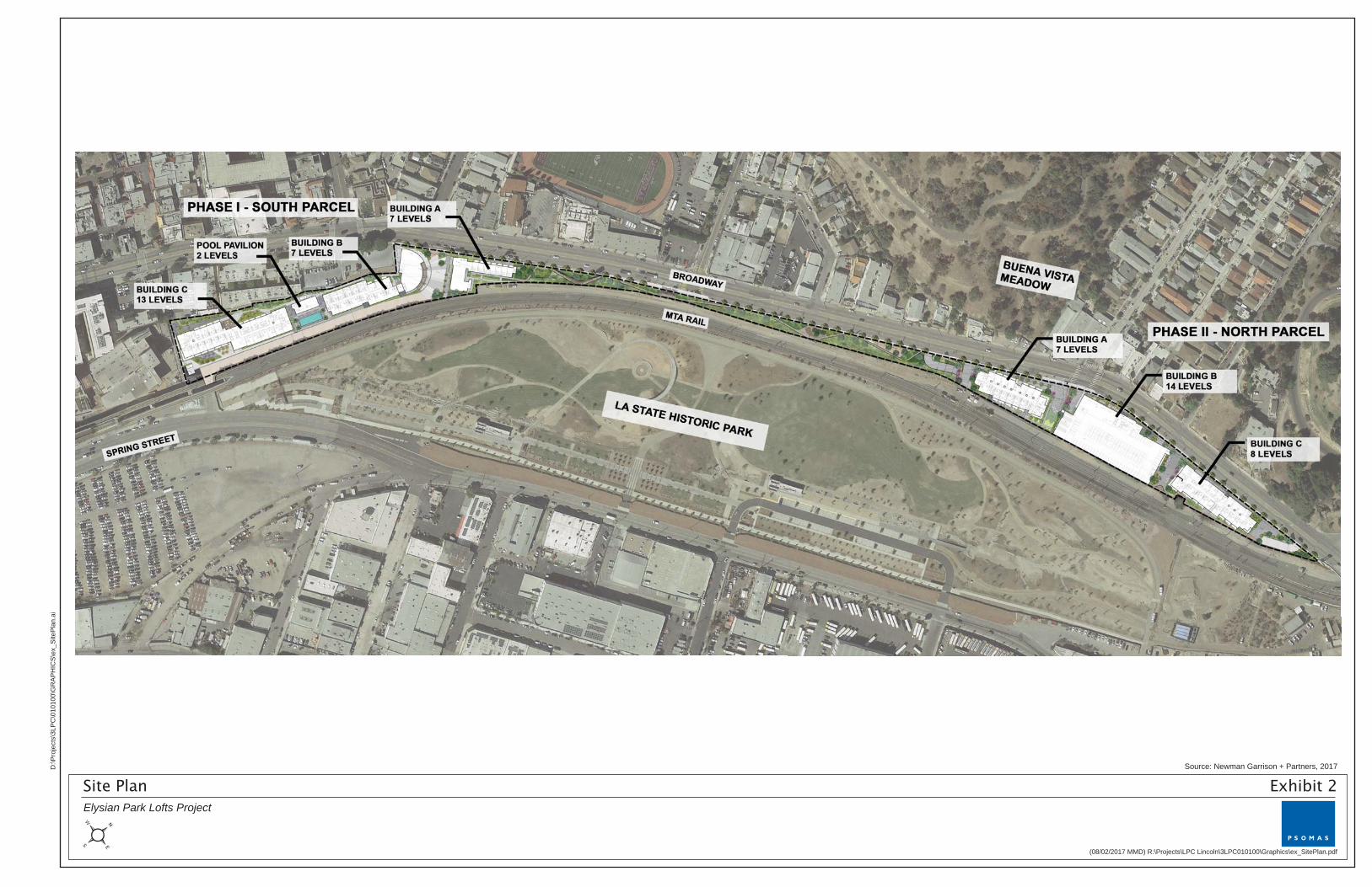
S&R Partners, LLC (the Applicant) proposes to develop a mixed-use residential and commercial retail project (Project) consisting of approximately 920 residential units, including 17 live-work units, approximately 17,941 square feet (sf) of neighborhood-serving retail uses, and approximately 5,465 sf of leasing offices on an 8.08-acre site located at 1030–1380 North Broadway and 1251 North Spring Street. Exhibit 1, Regional Location and Local Vicinity, shows the Project location, Project boundaries, and surrounding areas on an aerial photograph of the vicinity.
2. PROJECT LOCATION
The Project site is located within the Central City North Community Plan Area, immediately east of the Chinatown Redevelopment Project Area. The Project site consists of Assessor’s Parcel Number (APN) 5414-016-002 and is located southeast of North Broadway, north of the City’s Downtown area. The Los Angeles County Metropolitan Transportation Authority (Metro) Gold Line railroad tracks run parallel and adjacent to the southeastern boundary of the Project site, with the Los Angeles State Historic Park farther to the southeast of the Project site. North Broadway borders the northwestern boundary of the Project site, and commercial and multi-family residential uses are located west of the Project site. The Project site has an irregular bow shape that follows the curve of Broadway and the Metro Gold Line railroad. The northeastern corner is defined by the Broadway bridge over the Gold Line tracks for approximately 3,200 feet, with 200- to 250-foot-wide southwestern and northeastern sections and the narrow central section.
Primary vehicular access to the Project site is provided by North Broadway, which forms the northwestern and western boundaries of the Project site. Several gated driveways on the Project site connect with North Broadway. Vehicle access is also available to the southern section of the Project site through a short roadway that extends west from Spring Street and runs under the Metro Gold Line tracks and onto the Project site. Regional access is available through the Hollywood Freeway (U.S. 101) to the south, which has westbound on-ramps at North Broadway and westbound off-ramps at Spring Street, and through historic Arroyo Seco Parkway (State Route [SR-110]) to the west, which has northbound off-ramps and on-ramps at Hill Street and northbound on-ramps at Bishops Road. The Golden State Freeway (Interstate [I]-5) is located approximately 0.4-mile to the north of the North Parcel.
Bus service and light rail service are provided by Metro, and bus service is also provided by the City of Los Angeles Department of Transportation (LADOT). There are two bus stops located on the northwestern boundary of the Project site, one near the North Broadway/Bishops Road intersection and the other near the North Broadway/Solano Avenue intersection. The Metro operates Lines 28, 45, and 83, all of which run on North Broadway and stop at the Project site. Two other stops are located across the street from these bus stops. Metro’s Gold Line Chinatown station at the Spring Street/College Street intersection is located approximately 380 feet south of the South Parcel. The Metro’s Union Station in Downtown Los Angeles is located approximately 0.65-mile from the South Parcel.

Los Angeles State Historic
Park
Dodger Stadium
Los
An
gele
s R
iver
Elysian Park
N Spring St
CathedralHigh School
Stadium Wa y
Humboldt St
College St
Bishops Rd
N Sp
ring
St
Avenue 19
Alpine St
Solano Ave
NG
rand
Ave
New
Hig
h St
W College St
Cesar E Chavez Ave
N Spring St
N Broadway
N Main
St
Ala
med
aSt
Sprin
g St
Avenue 26N
Avenue 21
§̈5
UV110
£¤101
Academy Rd
N Broadway
NMain St
Vignes St
San Fernando Rd
R iverside Dr
N HillSt
Pasadena Ave
D:\P
roje
cts\
3LPC
\010
100\
MXD
\ex_
LV_R
L_20
1708
02.m
xd
²
ese o
Project Site
Seal Beach
P A C I F I C
O C E A N
§̈405
§̈105
§̈10
§̈710§̈110
§̈605
ST27
ST19
ST170
ST107
ST134
ST110
ST213
ST710
ST1
ST91
£¤101
Los Angeles
Downey
Carson
Lakewood
Pasadena
Glendale
Hawthorne
Long BeachPalos Verdes
Santa MonicaWest Hollywood
Regional Location and Local VicinityElysian Park Lofts Project
Exhibit 1
(Rev: 8-02-2017 MMD) R:\Projects\LPC Lincoln\3LPC010100\Graphics\ex_LV_RL.pdf
1,000 0 1,000500Feet
Project Boundary
Aerial Source: ESRI, NAIP 2016

City of Los Angeles November 2017
Elysian Park Lofts Environmental Checklist ENV-2016-4064-EIR Page A-2
3. ENVIRONMENTAL SETTING
A. CURRENT LAND USES
The Project site has an irregular, bow shape. Although the majority of the Project site has a relatively flat slope, the narrow central portion of the Project site has slopes over 15 percent. The Project site is currently used for vehicle and equipment storage and parking and is developed with various one-story structures in the southwestern portion of the Project site; a construction staging/bus parking area in the northeastern portion; and a vacant area in the central section. The southwestern portion of the Project site is largely paved and built over. At the southwestern corner of the Project site, there is an L-shaped, one-story, wood modular building and a long, rectangular, one-story metal building along the Project site’s western boundary. There is a wood trailer shed along the southeastern boundary; a metal storage container at the northwestern boundary near the metal building; and a one-story building that is attached to an adjacent off-site building behind the on-site metal building. These five structures have a total floor area of approximately 19,346 sf and are more than 50 years old. Additionally, a segment of the historic Los Angeles Zanja Madre, the Mother Ditch, is located within the parcel along the eastern boundary of the Project site.
The southwestern section also includes a guard house at the entry gate, concrete pads for trash enclosure, electric panels, drain grates, and an asphalt-paved outdoor storage yard. There are 69 parking spaces in this area and a concrete wall and chain-link fence topped with barbed wire surrounds this section of the Project site. Outdoor lights line the interior chain-link fence. This section is at a lower elevation than North Broadway, and the western portion of this area is a sloped dirt area, with two billboard signs, an eight-foot-high chain-link fence along North Broadway, and a gate at the southwestern corner.
The narrow strip of vacant land at the central section of the Project site consists mainly of bare ground with scattered weeds, although concrete pads, billboards, and a tree are present. This area features a flat strip of land at the southern portion, with a four- to six-foot-high chain-link fence along Broadway and the tracks. The flat area narrows to a steep slope down from Broadway toward the railroad tracks. Here, a retaining wall and a four- to six-foot-high chain-link fence runs along the Project site boundaries with the railroad tracks (at the southeastern boundary) and a concrete and metal fence running along North Broadway (at the northwestern boundary).
Trees and billboards are located in the northeastern portion of the Project site, as well as a paved area previously used as a storage container yard and for bus storage (with a gate across Solano Avenue); this section is also surrounded by a six-foot-high chain-link fence topped with barbed wire along North Broadway and an eight-foot-high chain-link fence along the tracks. The northeastern tip of the Project site slopes down to the Metro tracks, as North Broadway transitions into a bridge over the tracks.
Throughout the southwestern section of the Project site, there are scattered drain grates which connect to underground storm drain lines that convey stormwater to the Los Angeles River, approximately 0.1 to 0.5-mile east of the Project site. Overhead power lines run from the on-site billboards to the streetlights on either side of North Broadway and at the southeastern entry gate at Spring Street.
B. SURROUNDING LAND USES
Commercial uses immediately west of the southwestern corner of the Project site include two 1-story commercial buildings (Golden Dragon Restaurant and Bella Ana Salon); and one 1-story commercial building; two 2-story commercial buildings; and a two-level parking structure (comprising the Mandarin

City of Los Angeles November 2017
Elysian Park Lofts Environmental Checklist ENV-2016-4064-EIR Page A-3
Plaza shopping center). South of the Project site are 2- and 5-story buildings of the Capitol Milling Company that will house a microbrewery, restaurants, and offices.
West of the Project site across North Broadway are various commercial retail and restaurant uses, St. Peter’s Italian Catholic Church, Casa Italiana Cultural Center, Cathedral High School, Quan Yum Temple, offices, surface parking lots, multi-family residences, the Radio Hill Gardens, and vacant lots. Elysian Park is north of the northeastern section of the Project site (across North Broadway).
A maintenance road within the Metro Gold Line right-of-way runs southeast of and along the Project site boundaries and separates the Project site from the tracks. A chain-link fence separates the maintenance road from the tracks. The railroad tracks are at-grade and at a lower elevation than the northeastern and central sections, but then slowly rise on an elevated platform supported by concrete columns toward the Gold Line Chinatown Station at the intersection of Spring Street and College Street. The tracks are approximately 22 feet higher than the ground elevation, where the entry roadway into the Project site crosses under the tracks. The Los Angeles State Historic Park, various industrial uses, and the Los Angeles River are located across the Gold Line tracks to the southeast of the Project site. The 34-acre Los Angeles State Historic Park (aka Cornfield Park) reopened to the public in April 2017 after approximately 3 years of renovation. In addition to active and passive open spaces, the park contains a visitor’s center, events area, parking, plaza, picnic area, and a raised pedestrian bridge.
C. EXISTING LAND USE AND ZONING DESIGNATIONS
The City of Los Angeles General Plan sets forth goals, objectives, and programs to provide a guideline for land use policies and to meet the existing and future needs and desires of the community, while integrating a range of State-mandated elements including Land Use, Transportation, Noise, Safety, Housing, and Open Space/Conservation. The Land Use Element of the General Plan consists of the General Plan Framework Element, which addresses citywide policies, and the 35 community plans that guide land use at a more local level. Together, the community plans make up the Land Use Element of the General Plan. The Project site is located within the Central City North Community Plan and has a land use designation of “Light Industrial” (City of Los Angeles 2001).
The Community Plans are implemented through the development standards in the City’s Zoning Code. The Project site is zoned MR2-1 (Restricted Light Industrial). The Light Industrial and MR2-1 designations allow for the development of various industrial and manufacturing uses. The -1 suffix refers to Height District 1, which establishes a maximum floor area ratio of 1.5:1 per Section 12.21.1 of the Zoning Code (City of Los Angeles 2017).
The Central City North Community Plan Area (Central City North CPA) includes Chinatown and portions of Little Tokyo and El Pueblo (beginning east of Olvera Street), and is the birthplace of Los Angeles. The Central City North CPA was developed to promote a vision of a community that preserves and enhances the positive characteristics of housing and existing uses in the area; improves the function, design, and economic vitality of commercial corridors; maximizes the development opportunities of future transit systems while minimizing adverse impacts; and plans the remaining development opportunity sites for job-producing uses that may improve the economic and physical condition of the Central City North CPA (Los Angeles 2000).

City of Los Angeles November 2017
Elysian Park Lofts Environmental Checklist ENV-2016-4064-EIR Page A-4
The Central City North CPA consists of approximately 2,005 acres and is located adjacent to downtown Los Angeles and bounded by Stadium Way, Lilac Terrace, and North Broadway to the north; the City of Vernon to the south; the Los Angeles River to the east; and Alameda Street, Cesar Chavez Avenue, Sunset Boulevard, and Marview Avenue to the west. The Central City North CPA consists of seven subareas: Figueroa Terrace, Alpine Hill, Chinatown, North Industrial, Government Support, Artists-in Residence District, and South Industrial. The Project site is located within the North Industrial subarea (Los Angeles 2000). The Project site is adjacent to other areas within the Central City North CPA, such as the Cornfield/Arroyo Seco Specific Plan southwest of the Project site and the Chinatown Redevelopment Project area west of the site.
4. PROJECT DESCRIPTION
The Project involves the demolition of existing structures on the Project site, including surface parking areas and paved outdoor areas, as well as the removal of fences and walls on the site and at the site boundaries. Demolition of a portion of an existing structure on the Project site would be required; the majority of the building is off-site but a portion is located on-site. The on-site portion of the structure, including the associated surface parking, would be demolished for the proposed Project.
The Project site would then be graded to remove the slopes to accommodate three levels of subterranean parking. The proposed mixed-use project includes approximately 920 dwelling units in 6 buildings and approximately 17,941 sf of neighborhood-serving restaurant/outdoor dining uses and 5,465 sf of leasing offices on the ground floor of 2 of these buildings. A community center/pool pavilion is proposed as the 7th building. The total floor area of the proposed residential and commercial uses would be approximately 1,159,800 sf. Exhibit 2, Site Plan provides an overview of the overall site plan for the Project, including proposed building locations and landscaping.
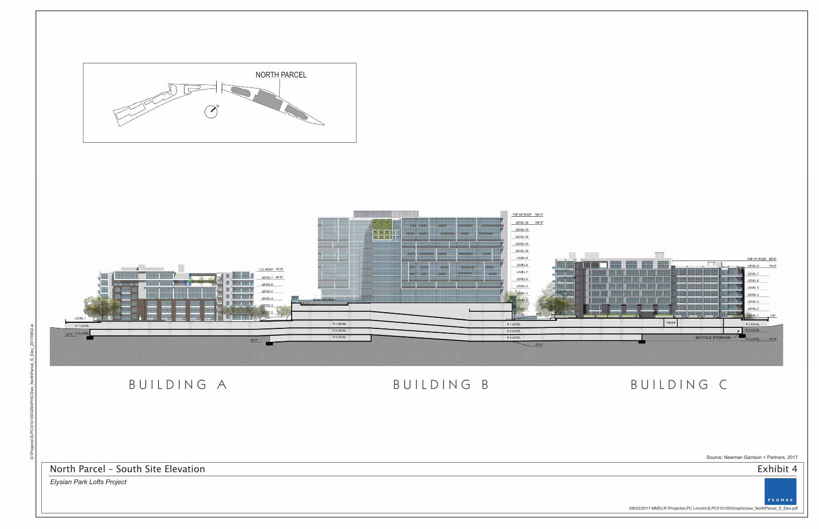
The Project would consist of a north parcel (“North Parcel”) and a south parcel (“South Parcel”). The North Parcel would be developed with approximately 469 dwelling units, including 10 live-work units, in 3 buildings over a 3-level subterranean parking garage. Building A on the North Parcel would be 7 stories and approximately 85 feet high; Building B would be 14 stories and approximately 170 feet high; and Building C would be 8 stories and approximately 100 feet high. The North Parcel would provide approximately 8,070 sf of neighborhood-serving restaurant/outdoor dining and 2,000 sf of leasing offices in Building B, recreational and open space uses, and a pool for residents. Exhibit 3, North Parcel-Site Section, shows a cross-section view of the North Parcel from the Los Angeles State Historic Park looking northward, and Exhibit 4, North Parcel-Site Elevation, shows the exterior proposed design features and landscaping from this same view.
The South Parcel would be developed with approximately 451 dwelling units, including 7 live-work units, in 3 buildings constructed over a 3-level subterranean parking garage. Building A on the South Parcel would be 7 stories and 85 feet high; Building B would be 7 stories and approximately 84 feet high; and Building C would be 13 stories and approximately 155 feet high. The South Parcel would provide a residential community center that would be 2 stories and 34 feet high, with a pool club and lounge for residents. The South Parcel would also provide approximately 9,871 sf of neighborhood-serving restaurant/outdoor dining uses in Building B, and 3,465 sf of leasing offices in Building A. Exhibit 5, South Parcel-Site Section shows a cross-section view of the South Parcel from the Los Angeles State Historic Park looking westward, and Exhibit 6, South Parcel-Site Elevation, shows the exterior proposed design features and landscaping from this same view.
Source: Newman Garrison + Partners, 2017
(08/02/2017 MMD) R:\Projects\LPC Lincoln\3LPC010100\Graphics\ex_SitePlan.pdf
D:\P
roje
cts\
3LP
C\0
1010
0\G
RA
PH
ICS
\ex_
Site
Pla
n.ai
Elysian Park Lofts Project
Site Plan Exhibit 2

Source: Newman Garrison + Partners, 2017
© 2 0 1 6 N E W M A N G A R R I S O N + P A R T N E R S . A L L R I G H T S R E S E R V E D . T H E C O N C E P T S A N D D R A W I N G S A R E P R O T E C T E D U N D E R U . S . A N D I N T E R N A T I O N A L C O P Y R I G H T A N D I N T E L L E C T U A L P R O P E R T Y L A W S A N D C A N N O T B E U S E D I N A N Y M A N N E R W I T H O U T E X P R E S S W R I T T E N C O N S E N T .
N O R T H P A R C E L - S I T E S E C T I O N
B U I L D I N G A B U I L D I N G B B U I L D I N G C
0’ 40’ 80’
L E G E N D
A - U N I T T Y P E
B - U N I T T Y P E
L I V E / W O R K U N I T S
R E S I D E N T A M E N I T Y
P A R K I N G & C O M M O N U S E
L O B B Y
C O M M E R C I A L S P A C E
NORTH PARCEL
N
(08/02/2017 MMD) R:\Projects\LPC Lincoln\3LPC010100\Graphics\ex_NParcel_SiteSection.pdf
D:\P
roje
cts\
3LP
C\0
1010
0\G
RA
PH
ICS
\ex_
NP
arce
l_S
iteS
ectio
n_20
1708
02.a
i
Elysian Park Lofts Project
North Parcel – Site Section Exhibit 3
Source: Newman Garrison + Partners, 2017
N
© 2 0 1 6 N E W M A N G A R R I S O N + P A R T N E R S . A L L R I G H T S R E S E R V E D . T H E C O N C E P T S A N D D R A W I N G S A R E P R O T E C T E D U N D E R U . S . A N D I N T E R N A T I O N A L C O P Y R I G H T A N D I N T E L L E C T U A L P R O P E R T Y L A W S A N D C A N N O T B E U S E D I N A N Y M A N N E R W I T H O U T E X P R E S S W R I T T E N C O N S E N T .
N O R T H P A R C E L - S O U T H S I T E E L E V A T I O N
B U I L D I N G A B U I L D I N G B B U I L D I N G C
0’ 40’ 80’
NORTH PARCEL
(08/02/2017 MMD) R:\Projects\LPC Lincoln\3LPC010100\Graphics\ex_NorthParcel_S_Elev.pdf
D:\P
roje
cts\
3LP
C\0
1010
0\G
RA
PH
ICS
\ex_
Nor
thP
arce
l_S
_Ele
v_20
1708
02.a
i
Elysian Park Lofts Project
North Parcel – South Site Elevation Exhibit 4

Source: Newman Garrison + Partners, 2017
SOUTH PARCEL
N
© 2 0 1 6 N E W M A N G A R R I S O N + P A R T N E R S . A L L R I G H T S R E S E R V E D . T H E C O N C E P T S A N D D R A W I N G S A R E P R O T E C T E D U N D E R U . S . A N D I N T E R N A T I O N A L C O P Y R I G H T A N D I N T E L L E C T U A L P R O P E R T Y L A W S A N D C A N N O T B E U S E D I N A N Y M A N N E R W I T H O U T E X P R E S S W R I T T E N C O N S E N T .
S O U T H P A R C E L - S I T E S E C T I O N
B U I L D I N G C B U I L D I N G B B U I L D I N G A
0’ 40’ 80’
L E G E N D
A - U N I T T Y P E
B - U N I T T Y P E
L I V E / W O R K U N I T S
R E S I D E N T A M E N I T Y
P A R K I N G & C O M M O N U S E
L O B B Y
C O M M E R C I A L S P A C E
(08/02/2017 MMD) R:\Projects\LPC Lincoln\3LPC010100\Graphics\ex_SParcel_SiteSection.pdf
D:\P
roje
cts\
3LP
C\0
1010
0\G
RA
PH
ICS
\ex_
SP
arce
l_S
iteS
ectio
n_20
1708
02.a
i
Elysian Park Lofts Project
South Parcel – Site Section Exhibit 5

Source: Newman Garrison + Partners, 2017
N
(08/02/2017 MMD) R:\Projects\LPC Lincoln\3LPC010100\Graphics\ex_SouthParcel_SE_Elev.pdf
D:\P
roje
cts\
3LP
C\0
1010
0\G
RA
PH
ICS
\ex_
Sou
thP
arce
l_S
E_E
lev_
2017
0802
.ai
Elysian Park Lofts Project
South Parcel – Southeast Site Elevation Exhibit 6
© 2 0 1 6 N E W M A N G A R R I S O N + P A R T N E R S . A L L R I G H T S R E S E R V E D . T H E C O N C E P T S A N D D R A W I N G S A R E P R O T E C T E D U N D E R U . S . A N D I N T E R N A T I O N A L C O P Y R I G H T A N D I N T E L L E C T U A L P R O P E R T Y L A W S A N D C A N N O T B E U S E D I N A N Y M A N N E R W I T H O U T E X P R E S S W R I T T E N C O N S E N T .
S O U T H P A R C E L - S O U T H E A S T S I T E E L E V A T I O N
B U I L D I N G C B U I L D I N G B B U I L D I N G A
0’ 40’ 80’
OPEN GARAGE WITH VERTICAL METAL SCREEN PANELS
SOUTH PARCEL

City of Los Angeles November 2017
Elysian Park Lofts Environmental Checklist ENV-2016-4064-EIR Page A-5
The Project also involves a three-foot-wide right-of-way dedication along the Project site boundaries on North Broadway to provide an expanded sidewalk/parkway area and the relocation of existing billboards to alternative locations on-site. Table 1 provides a summary of the proposed Project developed floor area and Table 2 provides a summary of the ground-level open space.
Table 1 Project Land Uses
Land Use Description Approximate Size
(Square Feet)
Proposed on North Parcel
Residential 469 du 416,505
Non-Residential
Restaurant/café 5,830
Outdoor dining 2,240
Leasing office 2,000
Other support spaces Lobbies, hallways, roof decks, clubroom/lounge, fitness room, media room, conference room, amenity areas, pool
219,455
North Parcel Subtotal 646,030
Proposed on South Parcel
Residential 451 du 380,458
Non-Residential
Restaurants 6,531
Outdoor dining 3,340
Leasing office 3,465
Other support spaces Community center, lobbies, hallways, roof decks, amenity areas, lounge, concierge, pools
56,957
South Parcel Subtotal 513,770
TOTAL FLOOR AREA 1,159,800
Parking
Parking Spaces North Parcel 903 spaces
Parking Spaces South Parcel 880 spaces
TOTAL PARKING 1,783 spaces
sf: square feet; du: dwelling units

City of Los Angeles November 2017
Elysian Park Lofts Environmental Checklist ENV-2016-4064-EIR Page A-6
Table 2 Project Ground-Level Open Space
Description Approximate Size
(Square Feet) Approximate Size
(Acres)
North Parcel Ground Level Open Space
Public-Linear Park 25,580 0.59
Public-Outdoor Plazas 27,594 0.63
Private Plazas 19,577 0.45
Total North Parcel 72,751 1.67
South Parcel Ground Level Open Space
Public-Linear Park 18,960 0.44
Public-Outdoor Plazas 24,247 0.56
Private Plazas 25,370 0.58
Total South Parcel 68,577 1.57
Total Ground-Level Open Space 141,328 3.24
A. PROPOSED RESIDENTIAL USES
The proposed dwelling units would be located in 6 buildings, 3 of which would be on the North Parcel providing approximately 469 units, and 3 of which would be on the South Parcel providing approximately 451 dwelling units. On the North Parcel, approximately 90 dwelling units would be provided in the 7-story Building A. Building B would provide 248 units on 14 floors. Building C would provide 131 units on 8 floors. On the South Parcel, approximately 53 dwelling units would be provided in the 7-story Building A. Building B would provide approximately 122 units on 7 floors. Building C would provide 276 units on 13 floors.
B. PROPOSED COMMERCIAL USES
The proposed commercial uses would include a total of approximately 23,406 sf on the ground floors of the North Parcel’s Building B and the South Parcel’s Buildings A and B. Approximately 10,070 sf of non-residential sf would be located on the North Parcel. This would include approximately 5,830 sf of restaurant and cafés, 2,240 sf in outdoor dining areas, and 2,000 sf for a leasing office in the North Parcel’s Building B.
Also, approximately 13,336 sf of non-residential floor area would be located on the South Parcel. This would include approximately 6,531 sf of restaurant uses and 3,340 sf in outdoor dining areas in Building B and 3,465 sf for a leasing office in Building A on the South Parcel.
C. PROPOSED LIVE-WORK UNITS
The Project proposes a total of approximately 17 live-work units, with 10 units on the North Parcel and 7 units on the South Parcel. These units would include 7 units with 3 levels, 2 bedrooms, and 1,850 sf of floor area in Building A on the South Parcel. The remaining 10 units would have 2 levels, 1 bedroom, and 1,370 sf of floor area, with 7 live-work units in Building A and 3 units in Building C on the North Parcel.

City of Los Angeles November 2017
Elysian Park Lofts Environmental Checklist ENV-2016-4064-EIR Page A-7
D. PROPOSED LAND USE AND ZONING DESIGNATIONS
The Project requires a General Plan Amendment (GPA) to change the land use designation from Light Industrial to Regional Commercial. According to the General Plan Framework Element, Regional Centers are intended to serve as the focal points of commerce, identity, and activity for populations of 250,000 to 500,000 persons. As defined by the Framework Element, Regional Centers are expected to contain a diversity of uses including professional offices, retail centers, and mixed-use housing and commercial developments (Los Angeles 2001). The Project is proposing a mix of residential- and neighborhood-serving retail uses, which would serve as a point of commerce and activity in the Chinatown community and is consistent with the General Plan’s Regional Center designation. Adjacent and nearby properties (e.g., parcels south and southwest of the Project site, as well as a few parcels to the west across North Broadway) are also designated Regional Commercial.
The Project requires a zone change to change the zoning for the Project site from MR2 to C2. In addition, a height district change from Height District 1 to Height District 2D is also needed. The zone change to C2 would make the zoning of the Project site consistent with the proposed Regional Commercial land-use designation and would allow for the development of the proposed mixed-use Project. With approval of the change to Height District 2, the allowable floor area ratio (FAR) in the C2 zone would be six times the buildable area of the lot. The D limitation is proposed to ensure a development that is compatible with the surrounding property and neighborhood. The C2-2D zoning would also be similar to the current zoning of parcels south and southwest of the Project site and across North Broadway.
E. DESIGN AND ARCHITECTURE
The proposed structures have been designed to increase pedestrian activity on the east side of North Broadway. A combination of restaurants, cafés, live-work units, two-story loft units, public open space, and residential lobby entrances front the public sidewalk along North Broadway. Each entryway has been designed to provide highly visible unobstructed views from public rights-of-way. All residential exit stairs would be open steel-frame structures to provide transparency and to integrate into the building architecture. All ground floor uses are designed to maximize the visual connection to the street by providing clear and unobstructed windows that are free of reflective glass coatings, exterior mounted gates, or security grills. Entrances to each building facing North Broadway are designed to be at grade level or raised approximately 1.5 feet above the finished grade. The on-site structures have also been designed and located to create light and view corridors within and through the Project site.
The building architecture reflects the industrial character of past land uses by utilizing cast-in-place concrete walls, structural steel, metal siding, concrete block, sand blasted brick, and glass. Variations in the textures, colors, and sizes of these materials are intended to allow for a unified design that links but differentiates the buildings. Building massing and scale is designed to provide vertical and horizontal plane changes along the facades of the buildings. Roof top terraces have been integrated into each building to provide outdoor amenity zones and to promote activity above the street level.
Large open space areas are proposed in between the buildings to the Los Angeles State Historic Park along Broadway and to adjacent land uses to the north. View corridors have been provided from the pool pavilion on the South Parcel; from Cottage Home Street, Solano Avenue, and Casanova Street; along the proposed linear park at the central portion of the Project site; and for northern and southern views from North Broadway. These view corridors have also been designed to provide outdoor open space amenities for the

City of Los Angeles November 2017
Elysian Park Lofts Environmental Checklist ENV-2016-4064-EIR Page A-8
public and residents. Decorative gates and landscape plantings are proposed along North Broadway at the openings between buildings and to provide a continuous visual presence at the street level.
F. OPEN SPACE, LANDSCAPING AND PUBLIC ART
Open space areas have been located and distributed throughout the Project site. Each building would have outdoor open space areas designed for passive and active uses. These areas are located throughout the development and are designed to take advantage of the views of Downtown Los Angeles, as well as Los Angeles State Historic Park. Swimming pools, decks, amphitheater seating, outdoor movie theaters, lounge areas with fire pits, barbecue stations with dining areas, dog parks, playgrounds, viewing platforms, and multi-level amenities with viewing roof decks for social gatherings and events would be provided on-site. In addition, private and public plaza spaces would be provided throughout the Project site. Balconies have been provided throughout the buildings to augment rather than substitute for actively used common open spaces and recreational areas. Certain buildings would also provide unique “art walls” where local artists can be commissioned to promote their work and encourage community participation.
The linear park located in the central portion of the Project site would provide a new public amenity that has been crafted to showcase the views of Downtown Los Angeles, the Los Angeles State Historic Park, Union Station, and the historic Zanja Madre Aqueduct (an uncovered section of the historic Los Angeles River that is adjacent to the Project site). Smaller terraced retaining walls would be used in the linear park linking the North and South Parcels. Walkways would connect the North and South Parcels and would be located where they would not have a grade elevation change of 30 feet or more. Along the ¼-mile path would be a series of perches that extend beyond the sidewalk to create new vistas and resting areas. Where the topography allows, new pocket plazas and a dog park have been situated at major intersections and level areas of the park.
A total of approximately 141,328 sf of common open space areas would be provided by the Project at the ground level, which would be approximately 17,478 sf more than the required 123,850 sf. Approximately 32 percent of the open space would be within the 44,540 sf linear park, 37 percent would be publicly accessible outdoor plazas, and 32 percent would be private plazas for use by Project residents.
The landscaping plan includes new street trees along the east side of North Broadway to provide shade to pedestrians and to connect to a ¼-mile walking path that incorporates a series of perches that provide new vistas and resting areas that extend beyond the existing sidewalk. In total, the landscape plan will add approximately 264 trees to the Project site. The Project will incorporate a mix of native plant materials along with Mediterranean and Australian plants, which are suitable for the Southern California climate and are considered low water use. Shade trees would be provided in areas for active use and passive pedestrian areas. Evergreen screening trees and vine plantings would buffer views of the parking and podium levels above grade.
G. ACCESS AND CIRCULATION, PARKING, AND BICYCLE AMENITIES
Access to the Project would be provided by several driveways off North Broadway that would lead to loading areas at the ground level and the subterranean parking garages. A driveway off Spring Street at the southern end of the Project site would also lead into the South Parcel’s subterranean parking garage.
A total of approximately 1,783 parking spaces would be provided on-site. A total of approximately 903 parking spaces would be provided in 3 subterranean levels and 2 podium levels in the North Parcel’s

City of Los Angeles November 2017
Elysian Park Lofts Environmental Checklist ENV-2016-4064-EIR Page A-9
Building B. Approximately 18 would be accessible spaces and 28 would be electric vehicle (EV) charging stations. Bicycle parking spaces would also be provided, with 488 long-term spaces and 56 short-term spaces.
A total of 880 parking spaces would be provided in 3 subterranean levels on the South Parcel. Of this total, 18 would be accessible spaces and 27 would be EV charging stations. Bicycle parking spaces would also be provided, with 470 long-term spaces and 55 short-term spaces. Bicycle parking spaces would also be provided, with 470 long-term spaces and 55 short-term spaces.
The exposed southeastern face of the multi‐level parking structures would incorporate architectural facade treatments along with climbing vines to provide a visually interesting “green wall,” as seen from the Metro Gold Line tracks, the Los Angeles State Historic Park, and areas farther southeast.
H. ROADWAY AND PEDESTRIAN IMPROVEMENTS
North Broadway is classified as Avenue II (Secondary Highway). The half street right-of-way width for this roadway classification is 43 feet, which includes a roadway pavement of 28 feet, as measured from the road centerline to the curb face and a 15-foot-wide parkway and sidewalk. In the existing condition, the half street right-of-way width of North Broadway is only 40 feet along the Project site frontage. This includes a roadway pavement width of 36 feet and a sidewalk ranging from 4 to 10 feet at the bus stop areas. As part of the Project, 3 feet of right-of-way width would be dedicated to the City of Los Angeles and would be incorporated into the public right-of-way to bring the total half street right-of-way width to 43 feet and the total sidewalk width of 7 feet. If required by the City, the sidewalk could be further widened to more than 7 feet by reducing the street’s roadway pavement width accordingly.
The proposed curb cuts for new driveways into the Project site have been located along North Broadway in a manner that does not reduce on-street parking. Unused curb cuts and driveways would be replaced with sidewalks to maintain continuity for pedestrians. There would be no changes to existing signalized pedestrian crosswalks across North Broadway (at its intersections with Cottage Home Street, Bishop Road, Solano Avenue, Casanova Street, and Elysian Park Drive). However, the Project proposes a crosswalk with a signal at the northeastern tip of the Project site to connect with the adjacent Elysian Park.
While the Project site and the segment of North Broadway fronting the site are located outside the Cornfield Arroyo Seco Specific Plan, Broadway Street is designated for Street Tree Variety No. 1, which includes a list of permitted street trees. The Project will incorporate appropriate street trees to be planted in tree wells along the sidewalk.
I. LIGHTING AND SIGNAGE
Architectural lighting is proposed to complement key architectural features of each building through the use of low profile; low wattage light-emitting diode (LED) building-mounted fixtures and fixtures integrated into the building facades. Low intensity LED luminaires, pedestrian poles, decorative lanterns, lighted bollards, and recessed step lights would also be used.
Low glare fixtures and decorative fixtures would be located at the ground level of each building to create a sense of arrival and scale, and would include the use of building-mounted decorative fixtures, low level landscape lanterns, and floor lamps. Specialty LED accent lighting would be located on key wall art

City of Los Angeles November 2017
Elysian Park Lofts Environmental Checklist ENV-2016-4064-EIR Page A-10
displays, murals, and perforated screens on the exterior of each building (where applicable) to enhance the night time experience and to create a strong connection to the adjacent park and neighborhood.
The security lighting for the exterior courtyards and pedestrian walkways would include a combination of low-intensity LED luminaries, pedestrian poles, decorative lanterns, bollards, and recessed step lights. All exterior lighting would be designed to meet minimum light levels for emergency egress and to comply with the requirements of the California Building Code (Title 24 of the California Code of Regulations) and the California Green Building Standards (CalGreen) Code.
Signage would be located at a height and of size that is visible to pedestrians and that facilitates access to the building entrances. The signage program has not been fully developed and shall be presented upon completion. Existing billboards would be relocated, but would remain on-site.
J. SUSTAINABILITY FEATURES
The Project is a mixed-use, transit-oriented development within a Transit Priority Area (TPA) that would reduce the need for vehicle use for residents due to the Project site’s proximity to local destinations and alternative transportation opportunities. Residents of the Project could visit the on-site commercial uses or nearby commercial uses within walking distance, and those in the live-work units could avoid commuting entirely. In addition, the Project site is located near the Metro Gold Line Chinatown Station, which would allow residents and employees to go to and from the Project by light rail. The Project would be built in accordance with the CalGreen and LA Green Code and would incorporate water and energy conservation measures, as well as solid waste recycling and diversion programs.
Lastly, Section 21100(b) of the State CEQA Guidelines requires that an EIR include a detailed statement setting forth mitigation measures proposed to minimize a project’s significant effects on the environment, including, but not limited to, measures to reduce the wasteful, inefficient, and unnecessary consumption of energy. Appendix F of the State CEQA Guidelines states that, in order to ensure that energy implications are considered in project decisions, the potential energy implications of a project shall be considered in an EIR, to the extent relevant and applicable to the project. Consistent with these requirements, the EIR to be prepared for the Project will include, but not be limited to, an analysis of Project consistency with applicable energy conservation requirements (e.g., Title 24 of the CBC, CALGreen, SCAG RTP requirements for promoting regional land use patterns that promote sustainability, City transportation demand management requirements, etc.), including identification of attributes of the Project and the energy conservation features proposed to ensure consistency with these requirements.
K. UTILITIES
The Project requires the abandonment and/or removal of existing utility connections and lines and the provision of new utility meters (for water, gas, and electrical services) and associated aboveground utility appurtenances that would be located primarily along North Broadway. These facilities would be appropriately screened via landscaping and/or building massing strategies. New on‐site electrical infrastructure would be provided via underground duct banks with at‐grade pad-mounted transformer equipment. All other utility service lines (i.e., water, sewer, gas, and phone/data lines) would be placed underground.

City of Los Angeles November 2017
Elysian Park Lofts Environmental Checklist ENV-2016-4064-EIR Page A-11
L. OFF-SITE FEATURES
The Project would require minor off-site improvements, including the following:
A new crosswalk with a signal at the northeastern tip of the Project site to connect with the adjacent Elysian Park.
Demolition of a portion of an existing structure and associated surface parking located on the Project site would cause impacts to the remainder of the structure, located off-site.
M. CONSTRUCTION SCHEDULE
Construction of the Project would be phased, with development of the South Parcel occurring as Phase 1 and development of the North Parcel occurring as Phase 2. Grading activities would involve over 187,000 cubic yards of cut and soil export to accommodate the proposed subterranean parking levels.
N. DISCRETIONARY ACTIONS- PROJECT APPROVALS
Lead Agency
Pursuant to the California Environmental Quality Act (CEQA), the public agency with the principal responsibility for carrying out or approving a project is referred to as the “Lead Agency” (State CEQA Guidelines Section 15367). For the Elysian Park Lofts Project, the City of Los Angeles (City) is the Lead Agency and has determined that the preparation of an Environmental Impact Report (EIR) is the appropriate environmental document for the proposed Project. As such, the City is responsible for preparing the EIR and would review and consider the EIR in its discretion and approve, revise, or deny the Project with findings, as appropriate. The EIR would serve as the primary environmental document for implementation of the Project, including all required discretionary approvals for implementation.
Discretionary approvals and permits required for implementation of the Project would include, but would not necessarily be limited to, the following:
A General Plan Amendment to change the land use designation of the Project site from Light Industrial to Regional Commercial, pursuant to Charter Section 555 and City of Los Angeles Municipal Code (LAMC) Sections 11.5.6 and 12.32.
Zone Change to change the zoning for the Project site from MR2 to C2, pursuant to Charter Section 558 and LAMC Section 12.32.
Height district change from Height District 1 to Height District 2D, pursuant to Charter Section 558 and LAMC Section 12.32.
A zoning administrator’s determination (ZAD) to permit a building height greater than specified in LAMC Section 12.21.1.A.10.
Approval of Site Plan Review for the development of more than 50 dwelling units, pursuant to Charter Section 558 and LAMC Section 16.05.
Vesting Tentative Tract Map (approval of VTTM 74548) that involves the dedication of a 3-foot-wide strip along North Broadway to the City (resulting in a net acreage of 7.87 acres) and subdivision of the Project site into 13 lots consisting of 2 master lots and 11 airspace lots for

City of Los Angeles November 2017
Elysian Park Lofts Environmental Checklist ENV-2016-4064-EIR Page A-12
residential and commercial condominium purposes, pursuant to LAMC Section 17.15. The proposed lots include the following:
o Lot 1: North Master (Ground) Lot
o Lot 2: North Parking
o Lot 3: North Commercial Space (5 commercial condominiums)
o Lot 4: North Residential Space – Building B
o Lot 5: North Residential Space – Building A
o Lot 6: North Residential Space – Building C
o Lot 7: South Master (Ground) Lot
o Lot 8: South Parking
o Lot 9: South Commercial Space (5 commercial condominiums)
o Lot 10: South Residential Space – Community Center
o Lot 11: South Residential Space – Building B
o Lot 12: South Residential Space – Building A
o Lot 13: South Residential Space – Building C
Approval of a Development Agreement pursuant to Sections 65864–65869.5 of the California Government Code.
Certification of the Environmental Impact Report.
Demolition permits.
Haul Route approval.
Grading, excavation, foundation, and associated building permits.
Original Art Mural approval for murals on several walls on the proposed buildings.
Other entitlements and approvals deemed necessary by the City to implement the Project.
Responsible Agencies
Public agencies other than the Lead Agency that have discretionary approval power or regulatory oversight over the proposed Project are considered “Responsible Agencies” (State CEQA Guidelines Section 15381). The EIR would provide environmental information to responsible, trustee, and other public agencies that may be required to grant approvals or coordinate with the City as a part of Project implementation. These agencies may include, but are not limited to:
State Water Resources Control Board. For coverage under the National Pollutant Discharge Elimination System (NPDES) Construction General Permit.
Metropolitan Transportation Authority: For construction within 100 feet of the Metro Rail Line