emily hope partonetheses.whiterose.ac.uk/7363/1/ehparton_historical... · 2014-11-19 · coronel...
TRANSCRIPT

Historical geopolitics and the cartography of the
Monarquía Hispánica
Emily Hope Parton
MA by research
University of York
History
September 2014

Abstract
This study examines the conceptualisation and governance of the Monarquía Hispánica
during the sixteenth and seventeenth centuries. The study centres on three core
territories: Spain, New Spain and the Philippines; reintegrating Spain’s prime Asian
domain within study of the Monarchy, a region often neglected in modern scholarship
on the Hispanic World, such as those by Elliott, Kamen and Lynch.
The progress of these twin processes, conceptualisation and governance, is considered
through the official cartography of this period; that produced by or for the core
institutions of the Monarchy: the Casa de la Contratación, the Consejo de Indias and the
royal court. This official cartography visualised the geopolitical concerns of the period;
urbanisation, territorialisation, the proliferation of Spanish-Catholic culture and global
diplomacy. Within this study, a new, historically contextualised, geopolitical framework
is offered which challenges the assumed modernity and secularity of geopolitics, further
developing the work of Ó Tuathail and Agnew.
The official cartography of the Monarquía Hispánica is abundant and diverse. As such,
this study structures cartographic analysis using a two-layered categorisation
framework. Firstly, the common subjects mapped by early modern cartographers are
acknowledged: urban, territorial and global maps. Secondly, the production context of
specific maps and collections is considered. This new framework seeks to address the
main problems presented by the influential schemas of Robertson and Mundy.
Furthermore, the schema encourages comparison between works from a range of
production zones; a comparative approach between European, American and Filipino
material lacking in much existing literature, including works by Mundy, Quirino and
Kagan.
Finally, this comparative approach highlights the integrated nature of cartography from
the early modern Monarchy; a multi-scale discipline producing views which could be
used side-by-side. This reflects the Monarchy’s geopolitical aspirations and activities,
which operated at multiple scales and were not simply integrated but interdependent.
Contents
Abstract
List of Plates i
Acknowledgements iv
Declaration v
Introduction 1
Chapter One: Historical geopolitics and the Monarquía Hispánica 18
Chapter Two: Urban Cartography 42
Chapter Three: Territorial Cartography 73
Chapter Four: Global Cartography 98
Chapter Five: Comparative Cartography and Integrated Geopolitics 111
Epilogue 141
List of abbreviations vi
Bibliography vii

i
List of Plates
i. 1 Aspecto Symbólico del Mundo Hispánico puntualmente arreglado al geográfico (1761) Vicente de Memije. 2
i. 2 Aspecto geográfico del Mundo Hispánico (1761) Vicente de Memije. 4
i. 3 Three place name glyphs from pinturas of the Relaciones geográficas (1577): Guaxtepec (1580) Anonymous, Amoltepec (1580) Anonymous, Ixtapalapa (1580) Martín Cano.
14
i. 4 Two river glyphs and two road symbols from the Relaciones geográficas (1577): Tecuicuilco (1580) Anonymous, Cuzcatlan (1580) Anonymous, Ixtapalapa (1580) Martín Cano, Teozacoalco (1580) Anonymous.
15
I. 1 Cholula (1581) Anonymous. El Mapa de Sigüenza (16th century), Anonymous. 39
II. 1 Valencia (1563) and Barcelona (1563), Anton van den Wyngaerde. 45
II. 2 Toldeo (1563) and Cordoba (1567), Anton van den Wyngaerde. 47
II. 3 Monzón (1563) and Madrid (1562), Anton van den Wyngaerde. 48
II. 4 Amsterdam (c. 1560), Jacob van Deventer. 50
II. 5 Meztitlan (1579), Gabriel de Cháves. 53
II. 6 Sixteenth-century Nahua cadastral map, Anonymous. 55
II. 7 Izquyluca (1594) Anonymous. 56
II. 8 Tetlistaca (1581) Anonymous, and Guaxtepec (1580) Anonymous. 57
II. 9 Quatlatlauca (1579), Anonymous. 60
II. 10 Epazoyuca (1580), Anonymous. 62
II. 11 Santa María Nativitas y San Antonio (1602), Anonymous, and Acacingo (1606), Anonymous. 63
II. 12 Descripción geométrica de la ciudad y circunvalación de Manila y sus arrabales... (1671), Fr. Ignacio Muñoz. 65
II. 13 Manila (pre-1645), Anonymous. Large majolica jar (c. 1700), Puebla de los Angelos production. Majolica basin (late 17th century), Puebla production.
67
II. 14 Nobilis ac regia civitas Valentie in Hispania (1608), Antonio Manceli. Topographia de la villa de Madrid (1656), Pedro Texeira.
69
III. 1 La Spaña (1554) Giacomo Gastaldi, Nova descriptio Hispaniae (1555) Thomas Geminus, Hispaniae description (1560) Domenico Zenoi. 77
III. 2 Escorial Atlas: Portion 5 and Portion 6 (c. 1560-75) Pedro Esquivel and Diego de Guevara (?). 79

ii
III. 3 Escorial Atlas: España (c. 1580-90) Juan López de Velasco and João Baptista Lavanha (?). 81
III. 4 El Atlas del Rey Planeta: Coastline south of Granada (1634) and Marbella (1634) Pedro Texeira. 83
III. 5 El Atlas del Rey Planeta: Tabla general de España (1634) Pedro Texeira. 84
III. 6 Doce figures ó planos de eclipse de luna observado en México el 17 de Noviembre de 1584, hechas por Jaime Juan, Cristóbal Gudiel, Francisco Domínguez y el Doctor Farfan conforme á las instrucciones de Su Majestad (1584) Francisco Domínguez.
86
III. 7 Descripcion de la Audiencia de Nueva España (1575) Juan López de Velasco. Descripcion del Destricto del audiencia de Nueva Espana (1601) and Descripcion de las Indias del Poniente (1601) Juan López de Velasco and Antonio Herrara.
89
III. 8 Carta hydrographica y chorographica de las Islas Filipinas (1734), F. Pedro Murillo Velarde, Nicolás de la Cruz Bagay and Francisco Suarez.
91
III. 9a Accompanying vignettes from Carta hydrographical y chorographica de las Islas Filipinas (1734) Francisco Suarez. 93
III. 9b Accompanying vignettes from Carta hydrographical y chorographica de las Islas Filipinas (1734) Francisco Suarez. 94
IV. 1 Planisphere (1529) Diego (Diogo) Ribeiro. 101
IV. 2 Demarcacion y nauegaciones de Yndias (1575) López de Velasco. Descripcion de las Yndias de ocidentales (1601) Juan López de Velasco and Antonio Herrara.
105
IV. 3 Mapamundi (1634) Pedro Texeira. 108
V. 1 Map showing the locations mapped by Anton van den Wyngaerde which are mapped on the Escorial Atlas index map. 114
V. 2 Oxen (Ojén) (1564) Anton van den Wyngaerde. Escorial Atlas: Portion 2 (c. 1560-75), Pedro Esquivel and Diego de Guevara (?). 115
V. 3 Zahara de los Atunes (c. 1564) Anton van den Wyngaerde. 116
V. 4 Puerto de Santa María, Jerez de la Frontera and Sanlucar de Barrameda (c. 1567) Anton van den Wyngaerde. Detail from Escorial Atlas: Portion 2 (c. 1560-75), Pedro Esquivel and Diego de Guevara (?).
118

iii
V. 5 Guadalajara (1565) Anton van den Wyngaerde. 119
V. 6 Texupa (1579) Anonymous. Map marking the pinturas of the Relaciones geográficas (1577) which show a single town and those which include a broader, regional context.
122
V. 7 Muchitlan-Zumpango (1582) Anonymous. Zumpango (1582), Anonymous. 123
V. 8 Map showing pinturas of the Relaciones geográficas (1577) which make internal reference to other locations. 124
V. 9 Cempoala (1580) Anonymous. Epazoyuca (1580) Anonymous. 125
V. 10 Ixcatlan A and B (1579) Anonymous. 126
V. 11 Atlatlauca (1580) Anonymous. Teutenango (1582) Anonymous. 127
V. 12 Descripción de la Isla Hermosa dirigida por Hernando de los Ríos Coronel con carta fecha en Manila a 27 de junio 1597 (1597) Hernando de los Ríos Coronel.
132
V. 13 Plano de la ensenada y plaza de Cavite con sus fortificaciones y las cercanías de la misma donde se localizan los pueblos de San Roque, Cavite el Viejo y la Estanjuela y las bocas de los ríos Binacaya, Bacoor y Cavite el Viejo (1663) Juan Somodevilla Tejada.
134
V. 14 Mapa de la Vega del Río Grande llamado Cagayán, hasta las provincias de Sifún, Yoga, Paniqui, Pangasinan, etc., en el que se señalan misiones y pueblos (1690) María Antonia Colomar Albajar.
135

iv
Acknowledgements
I would like to take this opportunity to thank my supervisor, Dr Helen Cowie; without
your guidance, support and advice this thesis would not have been possible. I would
also like to thank Edward-John Bottomley, in recognition of an argument resoundingly
won, and Dr Nicholas Bill, for his support and belief in me. Finally, I wish to thank my
family, without whom I would not have begun this project, let alone finished it.

v
Declaration
I declare that no material in this thesis has been presented for publication or submitted
for another degree, and that it is the product of my own research.

1
Introduction
In Manila, in 1761, Vicente de Memije produced his famous map of the Monarquía
Hispánica, entitled ‘Aspecto Symbólico del Mundo Hispánico’. The map came as
Bourbon efforts to reassert control over the American and Asian portions of the
Monarchy were beginning, as these regions enjoyed a greater degree of autonomy in the
seventeenth century. Memije’s Aspecto Symbólico is famous for its allegorical
representation of the Monarchy as a woman; her feet lay in the Philippines, her mantle
the Americas and her crowned head, Spain. The skirts of España were formed by the
silver galleon routes connecting the Philippines with the Americas, while the shipping
lanes bridging the Atlantic form a necklace, the pendant of which is a compass rose.
This allegorical cartography was becoming increasingly unusual beyond political
pamphlets by the eighteenth century and reflects an effort to assert the importance of the
Philippines, Memije’s home, as the foundation of the empire. In the accompanying
thesis, Theses mathematicas de Cosmographia, Geographica y Hydrographica, en que
el globo terraqueo se contempla por respecto al mundo hispanico, Memije references
the biblical story of the Persian king, Nebuchadnezzar, where in a dream he sees a
mighty statue forged from silver, bronze, iron and gold, but whose feet were made of
clay and iron.1 The feet, being weaker than the rest, caused the statue fell, the metal
body undermined by its unstable foundation. Thus, the cartographer asserted, without
stability in the Philippines, the fortunes of the Monarchy as a whole would be
compromised. This map has attracted much scholarly attention for its bold statement of
the foundational role of the Philippines within the eighteenth-century Monarchy, as well
as being a rare example of allegorical-style cartography in an ever more empirical age.
(Plate i. 1)
It is not only this map, however, which interests us in the present study. Memije
also produced the Aspecto Geographico del Mundo Hispanico, an excellent and
accurate geographic map of the Monarchy. This hemispheric view captured the
Philippines, the Americas and western Europe separated by the vast Atlantic and Pacific
Oceans. This bold map successfully pictures the disparate Monarquía Hispánica as a
cohesive geopolitical unit, which by the eighteenth-century was becoming ever more
imperial. Yet, Memije’s perspective and framing were not novel, but rather built on an
1 Daniel 2: 39-45; Ricardo Padrón, “Allegory and Empire” in Mapping Latin America, ed. Jordana Dym and Karl Offen (Chicago and London: The University of Chicago Press, 2011): 86.

2
PLATE i. 1
Aspecto Symbólico del Mundo Hispánico puntualmente arreglado al geográfico, (1761) Vicente de Memije (Collection Maps K.Top.118.19; British Library, London)

3
approach successfully pioneered by the Monarchy’s first chronicler-cosmographer, Juan
López de Velasco, in the 1570s. Velasco had, at that time, produced a hemispheric view
of the Monarchy, a political unit developed within diplomatically-defined geographical
parameters. The Monarchy of the eighteenth century was a product of geopolitical
developments wrought around the time Velasco had been mapping; the imperialising
politics of the later 1700s included efforts to solidify and defend these boundaries from
external attack and internal resistance. (Plate i. 2)
What is remarkable about Memije’s geographical map is how little it differs
from Velasco’s 1575 view. The orientation may differ, and the geographical view
offered may be more accurate, but the message has not changed. Both Velasco and
Memije were seeking to assert the natural homogeneity of the Monarchy, projecting a
sense of togetherness which was only ever theoretical. Politically, control was always
limited, distance proving so great a barrier to direct governance that strategies were
developed to facilitate indirect rule in the Americas, and by extension the Philippines.2
Nonetheless, both cartographers, for different reasons and to serve different purposes,
presented very similar views to the Monarchy. In both views the Philippines are
westernised; an effort to prove and promote Spanish possession of this Asian
archipelago. The Americas occupy a central position, hinting at their economic and
partly political dominance, a level of power emerging in Velasco’s time which was
being suppressed during Memije’s lifetime. Spain occupies a marginal position,
balancing the small and distant Philippines to the other side of the map. In Velasco’s
view the political centre of the Monarchy is almost absent, for Memije it crowns the
hemisphere, reasserting centralised control over what was increasingly conceptualised
as an empire rather than a Monarchy.
While serving different purposes and addressing different issues, Memije’s
maps, allegorical and geographical, owed a debt to cartographic innovations and
diplomatic arrangements made two centuries previously. The geopolitical aims
developed in the sixteenth century were still present, though they had been adapted over
time and on account of changing circumstances. Nonetheless, the projection of the
Monarquía Hispánica as a Spanish-Catholic space, interdependent and cohesive,
remained, and the cartographic approaches taken to render that geopolitical effort
communicate greater continuity than change. 2 John L. Phelan, The Hispanization of the Philippines: Spanish Aims and Filipino Responses, 1565-1700, (Madison: The University of Wisconsin Press, 1959): 6.

4
PLATE i. 2
Aspecto Geográphico del Mundo Hispánico, (1761) Vicente de Memije (Collection Maps K.Top.118.18; British Library, London).

5
Historical geopolitics, cartography and the Monarquía Hispánica
This study considers the ways in which the Monarquía Hispánica conceptualised and
governed its territory during the sixteenth and seventeenth centuries. These two
activities, conceptualisation and governance, may seem distinct. Nonetheless,
governance in peninsular Spain, the Americas and Asia was affected by how these
territories were perceived. Many studies of the early modern Monarchy, such as the
surveys by J. H. Elliot, Henry Kamen and John Lynch, have focussed on political,
economic and social developments within Spain and Spanish America exclusively.3 This study, however, will consider Spain, New Spain and the Philippines,
reincorporating the Asian archipelago within the Viceroyalty of New Spain, to which it
belonged throughout this period. The way these three territories were imagined,
individually and collectively, changed over the sixteenth and seventeenth centuries,
adapting to new political circumstances and reflecting the changing agenda of the
Monarchy during this period.
The pioneering approach to governing territory adopted by the Monarquía
Hispánica will also be considered, addressing the institutionalisation of both governance
and knowledge-acquisition in this period. The Spanish contribution to the advancement
of scientific knowledge has often been side lined, as little research or information
gathered by the early modern Monarchy was made available beyond the institutions
through which it governed. Antonio Barrera-Osorio and María Portuondo have
challenged these assumptions, arguing that policies of secrecy that protected knowledge
gathered across the Monarchy were a recognition of the political value of a broad-range
of information.4 Information-gathering practices supported the activities of the
Monarchy and were understood in these terms; there was no expectation of a wider
contribution to scientific knowledge beyond the Monarchy, and much of the research
conducted within its territory was innovative and pioneering.
Cartography produced within the Monarquía Hispánica was understood within
this context; as a creative and informative tool that possessed both symbolic and
strategic value that meant such knowledge had to be protected. This study considers the 3 J. H. Elliot, Imperial Spain, (London: St Martin’s Press, 1963); Henry Kamen, Spain’s Road to Empire (London: Penguin Books, 2002); John Lynch, Spain under the Habsburgs, Volume II: Spain and America, 1598-1700, (Oxford: Basil Blackwell, 1969). 4 Antonio Barrera-Osorio, Experiencing Nature (Austin: University of Texas Press, 2006); María M. Portuondo, Secret Science: Spanish Cosmography and the New World (Chicago and London: The University of Chicago Press, 2009).

6
emerging prominence of cartography amongst the broad range of cosmographical fields
conducted across the Monarchy. Cosmography encompassed a range of disciplines from
geometry to history, mathematics to ethnography, and botany to linguistics. Yet, it was
cartography that was increasingly recognised early in the sixteenth century to be a
valuable instrument of governance. A vast number of cartographic sources survive from
this period, encouraging much scholarly assessment of the role of mapping across
Spanish domains. These studies are, however, usually limited to considering specific
territories, regions or cartographers in isolation. This has resulted in some excellent area
studies; the works of Barbara Mundy and Carlos Quirino provide detailed assessments
of mapping in New Spain and the Philippines respectively. Furthermore, David
Buisseret’s short, though well-researched, introduction to Spanish peninsular
cartography is also essential reading given the limited number of studies in this area. 5
This study, however, considers the ways in which cartography supported the
conceptualisation and governance of not only one, but three territories across the
Monarchy, requiring a comparative approach which accommodates maps from different
locations.
Diverse approaches to mapping, chronological progressions and stylistic
differences between territories offer much information about how Spain, New Spain and
the Philippines were perceived throughout two centuries of transition and
transformation. In addition, this approach highlights the interaction between
cartography and other forms of knowledge, as maps often contain a range of
information which is not directly geographical. I will, therefore, also consider how, and
whether, this information was used by the institutions so often commissioning these
cartographical projects, further contributing to our understanding of how territories
across the Monarchy were understood and administered.
The use of cartography as a strategy of governance across the early modern
Monarquía recognised the close relationship which exists between geography and
politics. The Monarchy was a geographically contingent political structure, shaped by
the physical environment as much as by political ideology; its success depended on its
5 Barbara Mundy, The Mapping of New Spain, (Chicago and London: The University of Chicago Press, 2001); Carlos Quirino, Philippine Cartography, 1320-1899, 3rd edition (Manila: Vibal Foundation, 2010); Richard L. Kagan, Urban Images of the Hispanic World, (New Haven & London: Yale University Press, 2000); David Buisseret, “Spanish Peninsular Cartography, 1500-1700” in The History of Cartography, Vol. Three, Part 1: Cartography in the European Renaissance, ed. David Woodward (Chicago: The University of Chicago Press, 2007), 1069-94

7
ability to overcome the challenge of distance. As such, this study acknowledges the
essentially geopolitical nature of the Monarchy, presenting a framework for discussing
geopolitics within historical contexts. To support the present discussion, this framework
is contextualised to facilitate geopolitical study within the early modern period,
challenging the assumed modernity and secularity of geopolitics as a critical discipline.6
Finally, a new categorisation framework is presented which facilitates
assessment of the cartographic sources both individually and comparatively. A range of
categorisation frameworks have been developed to structure the study of cartography in
the early modern period, such as those of Donald Robertson or Barbara Mundy.7
However, these approaches present a range of challenges and fail to accommodate maps
produced beyond a Central American production zone, for which these frameworks
were developed. The approach deployed in this study, however, reflects core
preoccupations of the extant sources from all three locations with regard to their
geographical subject matter. The visual content of these maps structures the framework,
while the impact of production context on cartographic output, both in terms of creation
and later use, will also be considered. This two-layered framework encourages detailed
engagement with specific maps while allowing for a range of sources to be studied in
conjunction with one another.
Before discussing the sources that form the foundation of the present study,
however, it is necessary to consider what we mean when we use the term ‘map’ and
thus frame cartographic activity and output in a historical and cultural context.
Maps: the challenge of definition
The challenge of defining what is meant by the term ‘map’ in the early modern
Monarquía has been approached in a number of ways. Ricardo Padrón promoted a
6 The specific modernity of geopolitics was embedded by the fathers of the discipline, Harold Mackinder and Friedrich Ratzel, developing a scholarly approach to the interaction between geography and politics within the context of contemporary international politics; see: Gearóid Ó Tuathail, Critical Geopolitics, (Minneapolis: University of Minnesota Press, 1996): 6. The assumed secularity of modern geopolitics can be seen in the work of Shapiro and Agnew, who propose an emerging disconnection between religion and geography at the close of the medieval period; see: Gerard Toal, “Spiritual Geopolitics: Fr. Edmund Walsh and Jesuit anti-communism”, in Geopolitical Traditions, eds. Klaus Dodds and David Atkinson (London and New York: Routledge, 2000): 187. 7 Barbara E. Mundy, “Mesoamerican Cartography”, in The History of Cartography, Vol. Two, Book Three: Cartography in the Traditional African, American, Arctic, Australian and Pacific Societies, ed. David Woodward and G. Malcolm Lewis (Chicago: The University of Chicago Press, 1998), 183-256; Donald Robertson, “The pinturas (maps) of the Relaciones Geográficas Within a Catalog” in The Handbook of Middle American Indians, Vol. 12: Guide to the Ethnohistorical Sources, Part One, ed. Howard Cline (Austin: University of Texas Press, 1972): 243-78.
8
linguistic approach to recover contemporary definitions, charting the growing
association of the Spanish mapa with gridded, geometrical cartography.8 This definition
was, as Padrón has highlighted, limited to a small community of cartographically
literate, peninsular Spaniards. As such, it probably had little relevance for Spaniards in
the Americas or Asia, let alone indigenous Mesoamericans or Filipinos.
Linguistic techniques are further complicated by translation, as Walter Mignolo
has emphasised.9 While Spaniards are known to have translated the term pintura to the
Nahuatl amoxtli, these words were far from synonymous. While amoxtli could refer to
an image, including a map, it also had literary associations; the logographic nature of
pre-Columbian Nahuatl meant that text and image were co-existent and mutually
dependent. Furthermore, while there has been much research into indigenous
Mesoamerican understandings of maps and their functions, no comparable research
exists for an indigenous Filipino context. The apparent lack of an indigenous
cartographic tradition in the Philippines has undoubtedly contributed to this situation,
though the extent to which this is an issue of source survival has not been successfully
considered. As such, it is difficult to draw conclusions regarding indigenous Filipino
understandings of cartography before or following Spanish settlement in the archipelago
and the potential implications of translation in the production of maps in the region.
The Spanish conception of cartography was not limited linguistically or
stylistically to the geometrical mapa. Even within official circles a range of terms were
deployed to refer to cartographic productions, such as pintura, dibujo, croquis,
alongside a variety of other words. What these terms meant to the people using them at
the time is not always easy to discern. It is hard to know whether they were used to
convey a specific meaning or whether they were, in fact, considered synonymous.
What this linguistic diversity does convey is that the understanding of what
constituted a map was not fixed or limited. Mapping represented a broad field of
enquiry and response, with different mapping genres serving different purposes and
perhaps offering a range of perspectives on their zone of enquiry. From landscapes and
cityscapes to geodetic surveys and world maps, from itinerary-style productions to
cadastral surveys and city plans, cartography was a varied and dynamic investigative,
8 Ricardo Padrón, “Mapping Plus Ultra: Cartography, Space and Hispanic Modernity”, Representations No. 79 (Summer 2002). 9 Walter Mignolo, “Colonial Situations, Geographical Discourses and Territorial Representations: Toward a Diatopical Understanding of Colonial Semiosis”, Dispositio, Vol. XIV Nos. 36-38 (1991).

9
informative and illustrative discipline. The further diversity presented through contact
with non-European peoples thus simply added further depth and intricacy to an already
broad-ranging discipline which was clearly capable of accommodating various styles.
Any definition of ‘map’ within the context of the early modern Monarquía
Hispánica must, therefore, be able to reflect this diversity and breadth. To adopt a basic
definition, maps were geographical in subject matter, representing the physical
environment, though capable of including a range of non-geographical information
within their plane view. Furthermore, while preferred styles emerged in the early
modern period, most dominantly the geometrical survey, a vast range of styles and
techniques were employed and clearly understood, acknowledged for their potential to
convey different perspectives and information. Our modern conception of cartography
is narrowly defined in a way the early modern notion of cartography which operated
within the Monarchy was not. The early modern view of cartography, which will be
adopted within this study, was capable of supporting a level of detail, diversity and
nuance which exceeds the capabilities of the aerial, geometrical view of the modern
‘map’.
The Cartography of the Monarquía Hispánica
The Monarquía Hispánica of the sixteenth and seventeenth centuries saw cartographic
output increase rapidly. During this period new styles of cartography developed and
new mapping techniques and technologies were refined. Much of this cartography was
produced by or for the institutions governing and managing the Monarchy: the Consejo
de Indias, the Casa de la Contratación and, importantly, the royal court. The Casa, the
House of Trade, had a duty to produce maps of the Monarchy, supporting further
exploration and expansion, as well as securing trade and transport routes across Spain’s
hemisphere of influence. The Consejo, or Council of the Indies, required information
about the Monarchy’s various domains to support the practical task of governing these
vast and distant territories, a requirement which on some occasions was not successfully
undertaken. Cartography was an essential resource in acquiring such knowledge,
alongside written questionnaires and expeditions focussing on a range of disciplines,
from botany to ethnography. Finally, the royal court expressed great interest in
cartography throughout the sixteenth and seventeenth centuries, fuelled in many
respects by the personal interest several monarchs had in the subject. While Philip II is,
perhaps, most famous for his interest in cartography, his father, Charles V, and
10
grandson, Philip IV, also possessed a great interest in maps and the process of mapping,
appreciating cartography for its strategic and informative potential as well as its beauty
and creativity. The broad-ranging interest in cartography as a technology of governance,
however, meant that most of the maps produced in the Monarchy were never published
and did not even circulate beyond the closed circle of these central institutions,
protected, or perhaps strangled, by a policy of secrecy.
While this secrecy prevented maps being published, and thus having impact
beyond the institutional core of the Monarchy, the protection afforded to cartographic
productions has seen a huge number survive from the early modern period. These maps
fulfil a range of purposes and employ an array of techniques, technologies and styles;
their diversity as impressive as their number. Within the context of a study such as this,
it is, therefore, necessary to make a selection of sources from this broad corpus.
As such, this study will focus on, what will be here termed ‘official
cartography’, confining itself to maps directly commissioned by or specifically
produced for the core institutions of the Monarchy: the Casa, Consejo and Corte.
Discerning provenance is often a challenge, with authorship rarely acknowledged and
commissioning statements often lost. Therefore, only those maps or map collections
which can be directly associated with the Casa, Consejo or royal court will be
considered. As such, the vast corpus of legal maps available from New Spain across this
period will not receive in-depth consideration, produced, as they were, to address
specific legal disputes rather than the needs of the bodies governing and managing the
Monarchy.10
The geopolitical focus of this study makes the selection of official cartography
preferable, presenting a number of officially-commissioned view of spaces across the
Monarchy at a variety of scales. This ‘official’ label does not imply, however, that these
views conform to sanctioned ideas, though they can be seen addressing specific criteria
set out in instructions or can be seen to fulfil particular requests for information. A brief
view of these maps quickly dispels any assumption of uniformity or stylistic constraint;
while cartographic commissions often detailed the ‘where’ and ‘what’, they very rarely
specified the ‘how’.
10 For an introduction to the Tierras legal maps, see “Mapas indígenas novohispanos bajo resguardo del Archivo General de la Nación” available online via the Biblioteca Digital Mexicana: http://bdmx.mx/detalle/?id_cod=44#.VAraBKP2vMw (last accessed: 06/09/2014).
11
The sources to be considered in this study fall into two broad categories: surveys
and individual productions. Surveys were often long-term undertakings, requiring a
number of years to prepare and produce. They could involve a number of cartographers,
though there were surveys conducted by individuals. Importantly, surveys produced
multiple maps, sometimes ranging in scale or perspective, though often adopting one or
a specified set of approaches. Individual productions, in contrast, represent one-off
maps, perhaps representing the only known work of a particular cartographer or
representing a single map which was not produced as part of a broader survey project.
Some cartographers were involved in both practices, and it is sometimes difficult to be
sure that certain surviving individual maps were not originally part of a series. Within
this study, efforts have been made to discern the production context of maps, though
surviving contextual material is often scarce and not always accessible.
The main survey works to be considered in this study are the city view project of
Anton van den Wyngaerde, the Escorial Atlas project, led initially by Pedro Esquivel,
the abortive survey of New Spain undertaken by Francisco Domínguez, the Relaciones
Geográficas surveys, and the Descripción de España, Pedro Texeira’s atlas of 1634.
Wyngaerde’s city views and Esquivel’s Atlas, both, almost certainly,
commissioned directly by Philip II in the 1560s, were intended to capture an impression
of Spanish-Habsburg lands in the Iberian Peninsula. Importantly, both were charged
with creating images of territories which, while once considered distinct and separate,
were increasingly considered to belong to ‘Spain’, a territory which was emerging
theoretically and politically by the mid- to late-sixteenth century. While Wyngaerde
adopted the techniques and perspectives of the artist, and Esquivel the quadrants and
plumb lines of the early modern geometrical cartographer, both successfully captured an
impression of continuity and connection across Spain’s many kingdoms. By the time the
Atlas’ index map was produced at the end of the sixteenth century, the authors could
convincingly present the whole peninsula as ‘Spain’, one unit of a global Monarchy
centring on Madrid.
Texeira’s seventeenth-century Atlas achieves a similar, though more cohesive,
effect to the sixteenth-century surveying efforts, adopting aspects of artistic cartography
alongside geometrical surveying. The ‘Spain’ the Portuguese cartographer captures is,
however, that at the end of its unified phase, as Portugal asserted independence in 1640,
only six years after work on the Atlas was concluded. Nonetheless, Texeira’s Atlas,

12
produced for Philip IV if not commissioned by the monarch, combines functionality
with artistry in a natural and highly effective way. The Atlas, which offered the king of
review of existing coastal defences, loses none of its utility in it luxurious presentation,
though it remains, sadly, unfinished. Texeira more explicitly acknowledges the global
role of Spain within the Monarchy, including a mapamundi at the end of the Atlas, a
map which proclaims truly global ambitions over a unified Iberian world ruled by Philip
IV, ‘El Rey Planeta’.
Surveys were not confined to Spain, with New Spain finding itself the subject of
a number of surveying efforts. In the early 1570s, the Portuguese cosmographer,
Francisco Domínguez, was commissioned, apparently by Philip II, to produce a survey
of New Spain. None of the preparatory sketches survive and the survey was never
completed due to continued financial complications.11 While remaining a tantalising
mystery for historians of cartography, what little we know of Domínguez’s work is
instructive; emphasising the disjoint between royal ambitions with regard to exploration
and the administrative capabilities of the Monarchy. Furthermore, the Domínguez case
acts as an example of how early modern cosmographic disciplines were conducted and
funded.
The surveys of Spain conducted by Wyngaerde, Esquivel and Texeira, as well as
Domínguez’s unfinished survey of New Spain, were all conducted by professionals.
Wyngaerde, though an artist, was most certainly a trained chorographer and applied
geometrical techniques in his use of perspective and assimilation of multiple
preparatory sketches in his finished views. Esquivel, Texeira and Domínguez were
almost certainly all trained cartographers, and Esquivel was Professor of Mathematics at
the University of Alcalá. Their productions are those of the professional, adopting a
uniform approach or set of approaches which are cohesive in their final presentation.
Not all surveys were conducted in this way, however, with one of the most famous
geographical surveys conducted in the early modern Monarquía employing respondents
from a range of professional and educational backgrounds.
The Relaciones geográficas survey of 1577, a fifty-point questionnaire produced
by Juan López de Velasco, was issued across the Monarchy’s Central and South
American territories. The 1577 issue proved to be its most successful, with over 160 11 For documents relating to Domínguez’s appeals for his salary, see: Méritos y servicios: Francisco Domínguez (PATRONATO,261,R,9: 4; AGI, Seville); David Goodman, Power and Penury, (Cambridge: Cambridge University Press, 1988), 67.

13
responses, predominantly from New Spain and Guatemala.12 Responses were
predominantly textual, though forty-eight include extant pinturas, or maps, from the
first issue. A range of individuals contributed to both portions of the questionnaire,
though the influence of indigenous Mesoamerican training and knowledge can be seen
most explicitly in the cartographic portion of the responses. These are stylistically
diverse and include a range of information beyond that specifically requested in the
questionnaire, including historical and cultural details particular to the indigenous
communities of the old Aztec-Méxica Empire. These were especially influenced by
traditional Nahuatl logographic text and common glyphs relating to water, settlements,
roads and the flora and fauna of the region, which can be found in many map responses.
(Plate i. 3 and i. 4)
The questionnaire was issued again in 1584 with some success in New Spain,
and on a further three occasions across the seventeenth-century, with another three
surveys following in the eighteenth century. These later issues were adaptations of the
original questionnaire, though the Bourbon editions of the eighteenth century adopted a
format closer to that of the 1577 issue. Sadly, few responses to these later surveys
survive; this is particularly disappointing for the 1679 issue, a demographic survey,
which uniquely extended the catchment to include the Philippines. Unfortunately only
the data from Guatemala has survived.
Moving away from the survey collections, the individual maps are far more
disparate in terms of authorship and archival accessibility. Nonetheless, these maps
generally fall into one of two content-categories: those representing urban locations and
world maps. Within this category we have city views, such as those by Fr. Ignacio
Muñoz, who mapped Manila for the Consejo de Indias in 1671, or Pedro Texeira’s
famous plan view of Madrid, remarkably published in Antwerp, in 1656. Alongside
these urban views we have Ribiero’s planisphere, produced c. 1529 following
diplomatic talks relating to the placement of a demarcation antemeridian to match that
agreed at Tordesillas in 1494, as well as hemispheric maps produced by Juan López de
Velasco, the first chronicler-cosmographer of the Indies. One exception to the
12 Few responses to the Relaciones geográficas survive from Peru, though the illustrations of Felipe Guaman Poma de Ayala from his ‘El primer nueva corónica y buen gobierno’ (1615-16) provide a mestizo perspective on urban space in particular (København, Det Kongelige Bibliotek, GKS 2232 4°). This chronicle was presented to Philip III as both an historical record of Andean society and as a critique of Spanish government in the region: http://www.kb.dk/permalink/2006/poma/info/en/frontpage.htm (last accessed: 29/08/2014).

PLATE i. 3
Three place-name glyphs from pinturas of the Relaciones geográficas, 1577 issue.
Left: Guaxtepec (1580), Anonymous (XXIV-03; NLB, Austin). The glyph is a compound logograph, combining the term ‘tepec’ with the term ‘guajes’ which referred to the rubber plant after which the town was named. Tepec specifically meant ‘hill’, though came to be a general suffix for settlements, like the English ‘ton’ or ‘thorpe’.
Centre: Amoltepec (1580), Anonymous (XXV-03; NLB, Austin). This is also a compound place-name glyph, combining a stylised tepec glyph with the amol glyph, referring to the soap plant or Amole.
Right: Ixtapalapa (1580), Martín Cano (XXIV-08; NLB, Austin). Ixtapalapa means ‘place by the water’ and this glyph combines a glyphic representation of stone with that for water.
14

15
PLATE i. 4
Two river glyphs from the pinturas of the Relaciones geográficas, 1577 issue.
Left: Tecuicuilco (1580), Anonymous (XXIV-19; NLB, Austin). Nahuatl maps often included fish within rivers.
Right: Cuzcatlan (1580), Anonymous (XXIII-15; NLB, Austin). Many Nahuatl maps represent rivers and streams with branching tributaries and swirling eddies.
Two modes of representing roads seen in Nahuatl cartography from the pinturas of the Relaciones geográficas, 1577 issue.
Left: Ixtapalapa (1580), Martín Cano (XXIV-08; NLB, Austin). Footprints indicate roads and paths, and indicate directionality within the pinturas. This can reflect the most usual direction of travel or, in maps with historical or temporal context, can indicate the order in which objects on the map should be read.
Right: Teozacoalco (1580), Anonymous (XXV-03; NLB, Austin). With the introduction of horses across the American continents, Nahuatl cartographers began to include hoof prints alongside footprints in their representation of roads.

16
predominantly urban or global nature of individual maps is a map of the Philippines by
Fr. Pedro Murillo Velarde, a famous territorial map of the archipelago produced
seemingly in response to a request for such a map from Philip V.
The official maps of the Monarchy, crossing boundaries of genre and production
context, share many of the same issues of survival and discerning provenance. These
sources, nonetheless, offer a diverse and rich corpus of material through which to
consider the governance of the Monarchy, highlighting the essential interaction between
geography and politics across Spanish held domains. Specifically, the maps of Spain,
New Spain and the Philippines chart the refashioning of Spanish culture in the
Americas, and efforts to repeat the relative success of this process in Asia. These efforts
often fell short domestically and overseas, though the cartography continues to report on
this disjoint between aspiration and reality.
Chapter Overview
The present study is divided into five chapters. The first explains the ways in which
geopolitics can be applied to historical study, specifically immersing the discipline
within the context of the early modern Monarquía Hispánica. The structure of the
Monarquía is then outlined, emphasising the specific differences between early modern
notions of rule within a monarchy as opposed to an empire. These differences are
essential to our understanding of the geopolitical aims and activities of the Monarchy
during the sixteenth and seventeenth centuries. Finally the ways in which cartography
operated as a tool of governance within the Monarchy is discussed, and the
categorisation framework to be applied to the cartographic sources will be outlined,
detailing three core genre-categories: urban, territorial and global cartography.
The second chapter studies urban cartography, outlining the role of towns within
the Monarchy, emphasising why urban locations were a popular subject for cartography
across the Monarquía. These urban settlements provided a foundation for rule within the
Indies, following a model of urban expansion developed in peninsular Spain. The
practical and ideological functions towns and cities served will be discussed, presenting
the classical, Christian and Renaissance ideas influencing urban development. This
section is further divided between maps presenting urban views, itinerary maps and
urban plans, making the stylistic diversity of the extant sources more manageable.
The third chapter considers territorial cartography, charting the emergence of
territories such as Spain, New Spain and the Philippines. These territories were often
17
first made real through cartographical surveys, shaping their geographical limits through
the application of geometrical mapping techniques. These seemingly objective
cartographic practices projected a sense of geographical homogeneity that made the
proposed territorial cohesion visually convincing if not politically practicable.
The fourth chapter discusses global cartography, though not all the maps offer a
whole-world outlook. These maps most commonly present a view of the ‘world of the
Monarchy’, a conception of the globe as defined within diplomatically agreed
jurisdictional limits. At a global level the geopolitical aims of the Monarchy are divided
between the desire to assert claims of possession over territory, commonly represented
in the surviving cartography, and the desire to spread a Spanish-Catholic culture across
the world; a powerful aim, though one which fails to feature regularly on the maps.
Finally, the fifth chapter adopts a comparative approach, viewing cartography of
different genres and from different locations side by side. This comparative
methodology presents new conclusions about the role of individual cartographic
collections and how they were viewed and used within the early modern Monarchy. In
conclusion, the geopolitical aims of the Monarchy, the imposition of urban culture, the
territorialisation of the Monarchy, and the global diplomatic and cultural programmes,
are shown to not simply co-exist but collaborate, reliant on one another for success.
18
Chapter One: Historical geopolitics and the Monarquía Hispánica
Maps have long been recognised to possess political significance and utility, allowing
geography, the physical landscape and objects of administrative interest to be
accommodated alongside politics in one visual plane. Cartography offers an opportunity
to shape geography in a way which is impossible in reality though is politically
extremely useful; drawing and redrawing borders and boundaries, planning new uses for
land and laying claim to further territories. In the last century the study of this
intersection between geography and politics has emerged as a discreet discipline,
‘geopolitics’, which acknowledges the symbiotic relationship between geography and
politics within the practices of governance, interstate relations and with regard to
political structures, such as empire. The emergence of geopolitics within the last century
has led some to regard the discipline as essentially modern, addressing spatio-political
concerns exclusively associated with the modern era. Recent reassessment has,
however, argued for the application of geopolitical approaches and frameworks within
historical contexts, and this thesis will further develop these arguments within the
context of the Monarquía Hispánica.
This chapter will, therefore, outline a geopolitical framework for the present
study of the Monarquía Hispánica, which acknowledges the specific geopolitical
context of the sixteenth- and seventeenth-century Monarchy. This context reflects the
structure of Spanish political power domestically and overseas, as a conciliar Monarchy
rather than a colonial Empire. Furthermore, I will consider how this monarchical
structure was embedded and articulated practically and theoretically through processes
of spatial fashioning and conceptualisation. Following this, the role of cartography
within this system of governance, as a mode of territorial possession, diplomatic tool,
planning apparatus and reportory device will be outlined. Finally, I will propose a new
categorisation framework for early modern Spanish maps, which reflects the core
geopolitical aims of the Monarchy as well as the form and function of specific maps and
cartographic collections.
Historical geopolitics
Any study which considers the intersection between geography and politics can be
considered to belong to the field of geopolitical scholarship. Yet, since its emergence
nearly a century ago, geopolitics has been generally confined to studies of modern
19
political relations. This restrictive approach to geopolitics has limited the application of
a useful critical framework within historical contexts. Building on recent critical
reassessments of geopolitics, I will argue that the discipline has much value for
historical scholarship and specifically supports the study of the Monarquía Hispánica as
a geographically contingent political structure.
While reassessment of geopolitics has led to some questioning of core aspects of
the discipline, its essentially modern nature has been little challenged. Agnew and Ó
Tuathail’s influential reassessment of geopolitics as a ‘discursive practice by which
intellectuals of statecraft ‘spatialize’ international politics’13 remedies the assumption of
an ‘objective geography’, 14 though continues to chronologically restrict geopolitics
through its association with the nation-state, a modern phenomenon. Though Henry
Kamen has argued convincingly for the use of ‘state’ within discussion of early modern
Europe, caution must be exercised.15 The use of ‘statecraft’ in conjunction with
‘international’ in the context of Agnew and Ó Tuathail’s definition indicate an
association with the modern nation-state which is misleading when applied historically,
as Alejandro Cañeque has detailed.16 As such, current definitions of geopolitics seem
unable to accommodate historical contexts which precede the emergence of the nation-
state.
In recognition of this disciplinary limitation, Ó Tuathail has offered an
alternative to geopolitics which can be specifically applied to pre-modern contexts:
‘geo-power’. Geo-power essentially refers to the application of geographical knowledge
to support the ‘governmental production and management of territorial space’.17 These
twin functions are seemingly presented as the prime interests of pre-modern, though
perhaps post-medieval, rulers. Why ‘power’ and not ‘politics’ must be employed in this
pre-modern context is not clearly expressed, and the question of whether producing and
managing territorial space is not, or has ceased to be, an aspect of modern geopolitics
remains unanswered. Though Ó Tuathail succeeds in arguing that geopolitics need not 13 Ó Tuathail, Critical Geopolitics, quoting Gearóid Ó Tuathail and John Agnew, “Geopolitics and Discourse: Practical Geopolitical Reasoning in American Foreign Policy”, in The Geopolitics Reader, eds. Simon Dalby, Paul Routledge, Gearóid Ó Tuathail (London & New York: Routledge, 2003), 80. 14 Agnew argues for an “objective geography” in, John Agnew and Stuart Corbridge, Mastering Space (London & New York: Routledge, 1995), 3. This had previously been questioned by J. B. Harley in “Maps, Knowledge and Power” in The Iconography of Landscape, eds. Denis Cosgrove, Stephen Daniels (Cambridge: Cambridge University Press, 1988), 278. 15 Henry Kamen, Early Modern European Society (London & New York: Routledge, 2008), 6-7. 16 Alejandro Cañeque, The King’s Living Image: The Culture of Politics and Viceregal Power in Colonial Mexico, (London and New York: Routledge, 2004): 7-11. 17 Gearóid Ó Tuathail, Critical Geopolitics, 7.

20
be necessarily secular,18 his effort to apply geopolitics historically appears half-hearted
and lacks commitment.
While present day critical geopolitics falls short of offering a viable theoretical
foundation for its historical application, the discipline remains intellectually relevant to
historical scholarship and offers a useful framework for historical study. Disregarding
the essentially modern, state-driven definitions we must return to a more elemental
approach, one which acknowledges the complex, multi-directional connections between
geography, as both a scholarly discipline and description of the physical environment,
and politics, as a symbolic and strategic approach to power and governance. This more
basic foundation acknowledges the core aspects of the modernity-focussed branch of
geopolitics, while opening a viable and valuable pathway to applying geopolitics
historically.
It is with this straightforward though theoretically sound definition which we
approach the present study, acknowledging the Monarquía Hispánica as a geographical
entity as well as a political one. The intersection between geography and politics was
essential for the successful expansion and consolidation of the Hispanic Monarchy over
two centuries of Habsburg rule, and laid a foundation for further growth and
redefinition under their Bourbon successors. As such, it is vital to appreciate the
geographical and political particularity of the Monarchy before considering its
geopolitical aims and cartographical efforts.
Empire and Monarchy
While commonly termed the ‘Spanish empire’ in modern scholarly writing, it is
important to acknowledge that Spanish domestic and overseas governance was
conceived as a Monarchy rather than an empire. This distinction is not simply technical;
a monarchy was considered to offer a different style of rule to an empire in the early
modern period, as it experienced a different relationship with its subsidiary territories
from that which an imperial metropolis had with its colonies. The style of rule Spain
employed both domestically and overseas was monarchical, not imperial. No Spanish
monarch was ever styled an emperor in any serious way with regard to their own global
dominions; Charles V was emperor over a Holy Roman Empire, not a Spanish one. The
territories Spain ruled over in Europe, the Americas and in Asia were kingdoms or
18 Toal, “Spiritual Geopolitics”, 187-210.

21
provinces rather than colonies, and while into the late seventeenth and eighteenth
centuries colonial vocabulary became more commonly used, this reflected a change in
the way Spanish overseas domains were understood in relation to Spain herself. The
challenge of calling the Monarquía Hispánica an ‘empire’ is really one of tracking what
‘empire’ meant at different stages in the history of extended Spanish rule and avoiding
the imposition of eighteenth-, nineteenth- or even twentieth-century definitions of
‘empire’ on an early modern pattern of governance. The danger of anachronism is more
easily recognised when speaking of monarchy than it is when discussing empire, which
has an extremely complex lexical history and has developed modern associations which
are often difficult to shake off.
The early modern conception of monarchy nonetheless owed much to classical,
and specifically Roman, definitions of imperium. An empire was considered to rule over
land acquired by force, which came to share a common society and culture under the
rule of one individual.19 Within the Roman world the necessity of shared culture was a
particularly powerful feature of empire, with Roman law providing the foundation for
this cultural community and serving to sustain it. The extent of Roman law was felt to
mark the limits of the Roman Empire, as the law defined public and private expectations
of civility which were considered ‘Roman’.20 As the Empire grew, territory could be
acquired as effectively and securely by the spread of law as it was by the application for
military force. This unique, legally-defined shared culture was termed civitas, and had
strong associations with urban society, which was home to these legal communities.21
The cultural foundation of imperial rule was strongly adopted and
reconceptualised by late antique and medieval Christian thinkers in the wake of the
transformation of the Roman world. The Church felt itself to be inheritor of the
territorial expanse of Rome, reimagined as Christendom, crossing the divide between
the remnants of the eastern and western portions of the Roman Empire. Where law had
once served as symbol of imperial culture, now the Christian faith was the foundation of
civitas.22 Following the Roman model, the association between urban life and civility
was sustained, most famously in Augustine’s allegorical ‘City of God’.
19 Anthony Pagden, Lords of All the World (New Haven & London: Yale University Press, 1995), 13-16. 20 Pagden, Lords of All the World, 22. 21 Pagden, Lords of All the World, 19; Kagan, Urban Images of the Hispanic World, 20. 22 Pagden, Lords of All the World, 24-25; Kagan, Urban Images of the Hispanic World, 21; Alejandro Cañeque, The King’s Living Image, 195.

22
While the concept of urbanised civility continued into the medieval period, the
overall conception of extended territorial rule was redefined. Isidore of Seville in his
Etymologiae substituted the Latin term imperium for the Greek monarchia, and in doing
so connected imperial rule with monarchy.23 Monarchy did not directly equate to
empire; the intended relationship between subsidiary territories and the political core
within a monarchy was closer to being partners in a shared governing structure than
being parts of a hierarchical structure in which one group had power over another. This
idea, alongside the concept of urbanised civility, greatly influenced the process of
territorial expansion by Spain from the late medieval into the early modern period.
Though theories of empire certainly influenced theories of monarchy, the
relationship between the heartland of the Monarquía in peninsular Spain and her
overseas domains owed more to domestic conceptions of monarchical governance than
imperial rule. As such, the geopolitical ambitions and efforts of the Hispanic Monarchy
emphasised this non-imperial approach to rule, while the cartographic renderings of
different territories demonstrate greater parity of engagement than hierarchy or
metropolitan prioritisation.
Geopolitics and the Monarquía Hispánica
The Monarquía Hispánica was a product of geopolitical processes, both practical and
intellectual. The space the Monarchy occupied was shaped by politically defined lines
of demarcation, outlined in various treaties, notably Tordesillas (1494), Zaragoza (1529)
and Madrid (1750). These treaties created ‘theoretical spheres of influence’, dividing
the world between the Spanish and Portuguese crowns.24 Such a division was in line
with an emerging two worlds mentality which had already divided the globe between
the Old World and the New. That the Portuguese and Spanish hemispheres largely
aligned with this parallel division only strengthened the Iberian position.
These politically defined zones were impossible to fix geographically as no
reliable solution to the problem of determining longitude was found until the eighteenth
century. However these imaginary demarcations were lived realities; with every dispute
over the position of one of these lines their presence was more acutely felt, and with
every treaty or mutual agreement regarding fringe regions they became more real. The
23 Pagden, Lords of All the World, 15. 24 Frank Lestringant, Mapping the Renaissance World, trans. David Fausett (Cambridge: Polity Press, 1994), 3.

23
Treaty of Badajoz (1524) was a victim of politicised discourse of this kind; suggestions
to initiate collaborative research both within the Iberian Peninsula and overseas were
rejected as the kings and their delegations ‘were interested in advantage and not in
fact’.25 This ongoing, though often negotiable, mutual agreement between the Crowns
of Spain and Portugal to honour the specified limits of their assigned territorial zones
was not simply to avoid potential economic or political losses. The Treaty of Tordesillas
(1494) represented a statement of faith as much as one defining sovereign jurisdictions;
both Spain and Portugal wished to support papal claims to dominion over the world in
the name of Christ. This reflected a desire to shore up their own claims to newly
discovered regions and also a wish to stand by a long held assumption that the Church
was inheritor of the Roman world, an idea connected to the famed Donation of
Constantine.26 While this document had been proven a forgery in the mid-fifteenth
century, the view that the Church had inherited the Roman world from emperors who
were merely regents of Christ, supported their assumed right to control and donate land
on His behalf.
Yet, the Iberian hemispheres outlined in Tordesillas and Zaragoza, while
conceptually real to both Portugal and Spain, were not legally owned by either.27
Tordesillas had limited Spanish sailing routes in the Portuguese jurisdiction, and
Zaragoza had effectively created exclusive zones for trade and navigation, yet neither
treaty granted any legal rights of ownership to either Crown.28 Neither could claim
formal possession of their half of the world, requiring legal frameworks to be developed
at smaller scales to create a web of sovereignty. Thus, traditional techniques of localised
land acquisition were combined with larger scale projects of territorial production to
ensure that rights to exclusivity granted by treaty could be supported by legally
underwritten sovereign rule.
An Urban Monarchy
While the Monarquía represented the world’s first truly global framework of sovereign
rule, in essence it was founded on a network of urban settlements. Practical, historical
and intellectual reasons existed for this urbanised network, which created a political,
25 Ursula S. Lamb, “The Spanish Cosmographic juntas of the sixteenth century”, Terrae Incognitae Vol. 6, Issue 01 (1974), 55. 26 Pagden, Lords of All the World, 27, 32. 27 Lauren Benton and Benjamin Straumann, “Acquiring Empire by Law: From Roman Doctrine to Early Modern European Practice”, Law and History Review, Vol. 28, No. 1 (Feb 2010), 9. 28 Benton and Straumann, “Acquiring Empire by Law”, 19.
24
cultural and a necessarily legal foundation for the spread of the Monarchy and its
continued survival. Urbanisation and with it the promotion of a civilised, Catholic
culture formed a core geopolitical aim of the Monarchy, underpinned theoretically by
classical, Christian and humanist conceptions of civic virtue as shaped by civic space
and the proliferation of true Faith.
Historically, establishing towns had been a method of securing territory along a
shifting frontier during the Reconquest era, and was thus conceived politically rather
than economically.29 These towns possessed symbolic value as Christian settlements
and enjoyed special legal privileges which made their existence and survival possible.
This legal dimension would continue to play a role in the overseas expansion of the
Monarchy. Spanish urban culture was not like that in northern Europe, having a strong
connection with agriculture and lacking the mercantile base which was common to the
Low Countries or England. Ciudad Real, established during the Reconquest, was almost
exclusively home to agricultural workers who farmed the surrounding countryside, a
pattern that was repeated across the peninsula.30 Nonetheless, an urban frontier was an
effective mode of securing territory and ensuring that frontier populations were well
protected and had local economic centres to support farming or small-scale artisanal
enterprises.
This traditional method of securing land through urban foundations was
continued in the Indies. Town establishment, most notably in the Americas, served one
essential purpose: to create pockets of legally owned land which, when taken
collectively, provided a physical urban framework to support the theoretical zones of
influence granted by treaty. When we speak of ‘legal’ rights in the context of Spanish
overseas expansion it should be remembered that the law under consideration was that
of Spain, and while attention was paid to protecting the rights of autochthonous peoples,
the interests of Spanish settlers were of prime importance. As such, all ‘discoveries’ by
Europeans had to be licensed by the Crown and any settlement of these lands was
subject to a further license. Ceremonies were carried out upon ‘discovery’ which
supposedly made these lands Spanish possessions in the name of the monarch; these
ceremonies aimed to make strong claims against possible counter-claims by other
empires as much as they sought to justify land ownership to themselves. The presence
29 Jay Kinsbruner, The colonial Spanish-American City: urban life in the age of Atlantic capitalism (Austin, TX: The University of Texas Press, 2005), 4. 30 Kinsbruner, The colonial Spanish-American City, 3.

25
of native peoples was not considered problematic as they were ‘vassal Indians’
practically before the ‘ceremonies and writs’ of possession had been undertaken.31
The process of town establishment was carefully structured to ensure
“permanence” in settlement, an important notion to a society where use of land was
integral to proving ownership.32 Furthermore the legal aspect of urban planning required
settlements to decide early on whether they were to be cities, towns or villages, as each
possessed different legal status and either operated within pre-existing civic
jurisdictions or created a new network. The individual settlement was only ever one part
of a larger framework, with cities having fiscal, legal and administrative jurisdiction
over surrounding towns and villages. Furthermore the urban structure of the Catholic
Church had similar jurisdictional hierarchies, from archdiocese to parish, and supported
this approach to territorial expansion, though rarely coincided with civil districts.
The towns and cities in the Indies followed the model of Reconquest
settlements; built to protect and congregate settled populations and to legally secure
territory. One innovation, however, was the development of a standard model of urban
planning following a grid structure. The example of the Reconquest town of Santa Fe,
constructed outside Granada to support troops besieging the Moorish city, is often
hailed as the model of ‘New World’ urbanisation.33 Santa Fe followed a rectilinear
ground plan, though this was a common structure for military encampments as they
were simple to construct and followed regular patterns. While medieval cities had
followed an organic radial or linear pattern, lacking any formal planned structure, Santa
Fe was unusual in retaining its grid plan when a town was built on the site of the
encampment in the late 1490s.
We cannot, however, be sure that Santa Fe was a conscious model for future
towns and cities in the Indies, as initial royal instruction relating to urban development
was not structurally prescriptive. Nonetheless, a preference for a grid plan did emerge
within the first decades of settlement in the Caribbean and American mainland.34 By the
late sixteenth century this rectilinear pattern was codified in a set of Ordinances issued
31 Ordinances, 1573: Article 4, 13; translations of the Ordinances from: Axel I. Mundigo and Dora P. Crouch, “The City Planning Ordinances of the Laws of the Indies Revisited: Part I: Their Philosophy and Implications,” Town Planning Review, 48:3 (July 1977): 249-59. 32 Ordinances, 1573: Article 32; David Vassberg, Land and Society in Golden Age Castile (Cambridge: Cambridge University Press, 1984), 6; Georgina H. Endfield, “’Pinturas’, Land and Lawsuits: Maps in Colonial Mexican Legal Documents”, Imago Mundi, Vol. 53 (2001), 19. 33 Alejandro Colás, Empire (Cambridge: Polity Press, 2007), 59. 34 Kinsbruner, The colonial Spanish-American City, 10-11.

26
by Philip II in 1573. These Ordinances outlined procedures for establishing and
constructing towns and cities in the Indies, making pre-existing practices official while
also being influenced by intellectual theories about urban planning.
New towns in the Indies still had to fulfil basic public functions; towns had to
balance public space with private dwellings and ensure that the town was well provided
for. With this in mind space beyond the central plaza zone was designated for private
houses, and additional space for common pasture land and stock pens was required to be
set aside.35 Furthermore, plots for agriculture were provided in the region surrounding
the town, continuing the Spanish tradition of agricultural urbanism.36 This pattern was
essentially practical and ensured that the urban population was housed and fed. The
central plaza provided a clearer expression of the interaction between practical
requirements of urban life and the intellectual background to urban planning.
Towns had long been considered the home of civilised society, housing
communities connected by common cultural frameworks, whether legal or religious.
This association between civility and urban living had been maintained in Spanish
thought and conceptualised as policía, a term which encapsulated public responsibilities
and private duties to the continued good of the community.37 Thus when the Ordinances
placed important public institutions, such as the cabildo (town council) house, market,
hospital and jail, at the literal centre of an urban community it was a statement of the
importance of public good and the institutional face of civilized culture.38 The prime
position afforded to the Church projected the notion that urban settlements were
founded in faith, and the proximity between the Church and other public institutions
associated public life with a shared religious identity.39 Thus policía was literally built
into the fabric of the urban community, and the built environment was intended to
support civilised life. This approach was certainly informed by classical treatises on
urban planning, such as De Architectura by Vitruvius which had been rediscovered in
the late fifteenth century and translated into Spanish in 1526.40 It was also informed by
35 Ordinances, 1573: Article 90, 133. 36 Ordinances, 1573: Article 130-32 37 Kagan, Urban Images of the Hispanic World, 27. 38 Ordinances, 1573: Article 121. 39 Ordinances, 1573: Article 119 40 Kinsbruner, The colonial Spanish-American city, 23.

27
Christian thought, particularly Augustine and Aquinas, who both associated Christian
civility with an urban setting.41
The concept of policía had a further impact on the process of urban development
in the Indies, with public offices being assigned before construction of the town or city
had begun.42 This was partly a practical approach to ensuring that construction
proceeded swiftly under the guidance of senior officials with the support of civic
officers and clerics. Furthermore the occasional requirement to move a town after it was
initially established, such as with the first ‘New World’ city of Santo Domingo, relied
on the continuity of civic officials to maintain a community identity. Thus Santo
Domingo was still Santo Domingo after it had moved, retaining its legal status and
jurisdiction. This sense of the town ‘being’ the community that lived there as much as it
was the built environment itself had its roots in the classical concept of civitas, an idea
which survived within Spanish notions of policía.
This global urban network further served to support the two core functions of the
Monarchy: the Catholic mission and trade. The role of the Church in the success of the
Monarchy should not be underestimated, though it should be remembered that the
Church within the Monarchy effectively acted as one of its many institutional agents.
The Patronato Real, contracted via a series of papal bulls, granted the Monarquía
Hispánica special privileges over ecclesiastical appointments and over use of church
revenues.43 This arrangement hoped to make the spread of Christianity beyond the ‘Old
World’ both easier and more sustainable, thus ensuring that an evangelical mission
would be successful. The Patronato thus provided a means of supporting more general
patterns of conquest and settlement, with both the regular and secular clergy being
essential resources in sustaining Spanish rule overseas. The urban network in turn
supported this evangelical mission; the Church capitalised on New Spain’s congregation
policies of the 1530s, which sought to make the exploitation of indigenous labour dues
and the collection tribute payments easier. The indigenous communities living within
planned towns, called congregaciones or reducciones, were a ready audience for
evangelisation; Aquinas had considered an urban setting preferable for conversion.44
The growth of Catholicism in South America and the Philippines might be considered
41 Pagden, Lords of All the World, 18; Kagan, Urban Images of the Hispanic World, 21. 42 Ordinances, 1573: Article 43. 43 Nicholas P. Cushner, Spain in the Philippines (Manila: Ateneo de Manila University, 1971), 74-75. 44 Cañeque, The King’s Living Image, 197-98; Kinsbruner, The colonial Spanish-American city, 28; Kagan, Urban Images of the Hispanic World, 21.

28
the real legacy of Spanish rule in these regions, and the extent of Church presence
across these territories was contemporarily considered a sign that the Monarchy was
successfully embedded overseas.45 As law had defined the true limits of the Roman
Empire, so too did the specifically Spanish style of Catholicism offered under the
Patronato signal the real scope of the Monarchy.
Interest in the religious dimension of the Monarquía Hispánica has often side-
lined discussion of Spain’s economic interests in overseas territorial acquisition.
Columbus was not travelling across the Atlantic to convert the people he might find
when he reached land, but instead was hoping to discover a western route to the
lucrative Asian market. This economic dimension was supported by the urban network;
each town or city was expected to have at least one market to which local and overseas
products could be brought and traded. The initiation of the galleon trade between
Manila and Acapulco further highlighted the importance of this urban-market network,
as specific markets were named as authorised receivers of Asian goods in an effort to
regulate this global trade.46
While on the one hand managing the Monarchy as a global whole was not a
realistic possibility, on the other hand neither was governing via a localising urban
network a feasible option. A system needed to be imposed which allowed for effective
administration of the Monarchy’s possessions in the Americas and Asia, and the
governing structures of the Iberian Peninsula suggested a viable solution. As such, a
mid-scale approach to governance was developed which drew on pre-existing
peninsular structures; a network of kingdoms and provinces which were theoretically if
not practically equal to the Monarchy’s possession in Europe.
A Monarchy of Kingdoms
To speak of ‘Spain’ in the early modern period is largely to speak of a composite
monarchy, a political system where one kingdom, that of Castile, ruled over other
kingdoms and provinces across the peninsula. It was a relatively successful approach,
no doubt in part on account of the association between the unification of the Crowns of
Castile and Aragon under Ferdinand and Isabella with the completion of Reconquest, a
task encompassing the whole peninsula. Nonetheless, adherence to local identities and 45 Georgina H. Endfield, “’Pinturas’, Land and Lawsuits”, 13, 15. 46 John Lynch, Spain under the Habsburgs, Vol. II, 226-26; Birgit M. Tremml, “The Global and the Local: Problematic Dynamics of the Triangular Trade in Early Modern Manila”, Journal of World History, Volume 23, No 3 (September 2012),576

29
loyalties certainly persisted, and people felt they were Castilian, Catalan or Aragonese
before they were Spanish.47 In spite of these challenges the structure of the peninsular
composite monarchy served as inspiration for the challenge of accommodating far-
distant territories within a European political structure. Thus new kingdoms were
created and added to this peninsular structure, a situation which provided precedent for
governing methodologies, and seemingly sought to offer parity between European
kingdoms and those in the Indies.
The initial pattern of exploration, conquest and settlement had not leant itself to
the establishment of large-scale political units; instead audiencias were established
which had primarily judicial functions though also served as councils for managing
overseas acquisitions. The first two audiencias were those of Santo Domingo (est.
1511) and Mexico (est. 1527). This small-scale structure was reviewed in the 1530s,
following the rapid mainland conquest by Cortés, and it was decided that an adapted
‘kingdom’ structure, inspired by peninsular Spain, would be initiated in the New World.
Thus, the Viceroyalty of New Spain was established in 1535, headed by Antonio de
Mendoza, which would rule over much of central America, the Caribbean and later also
the Philippines. This was followed in 1542 by the Viceroyalty of Peru, which would
rule over Spain’s southern American possessions.
The Council of the Indies was established in 1523, removing the responsibility
for the Spain’s American and Asian domains from the Council of Castile, creating an
administrative body dedicated to communicating the needs of the Indies to the monarch,
and transmitting the wishes of the monarch to his overseas domains.48 The decision to
create a Council dedicated to the Indies, while a logical use of a pre-existing conciliar
system, invested the Indies with a kind of equality with other council-run units such as
Castile or Aragon. Yet parity was impossible given the distances involved between the
Council and the lands over which it governed. As Parker has commented, distance was
‘public enemy number one’ within the Monarchy and the viceroyalties of New Spain
and Peru, and especially the governorship of the Philippines, were victims of this
insurmountable problem of visibility and communication.49 While the rapid territorial
expansion of the sixteenth century diverted attention away from administrative failings,
47 J. H. Elliott, “A Europe of Composite Monarchies”, Past and Present No. 137 (1992), 58. 48 J. H. Elliott, “Spain and America in the sixteenth and seventeenth centuries”, in The Cambridge History of Latin America, ed. Leslie Bethell (Cambridge: Cambridge University Press, 2008), 290. 49 Geoffrey Parker, The Grand Strategy of Philip II, (New Haven & London: Yale University Press, 1998): 47.

30
the change of pace seen in the seventeenth century highlighted the impossibilities of
effective central conciliar governance.
The development of vice-kingdoms and provinces and the imposition of
associated systems of rule, through the viceroys and governors invested with near-
kingly powers, had helped to practically secure rule in the Indies.50 Nonetheless,
conciliar government in the peninsula was still responsible for making the decisions
these vice-rulers transmitted and imposed in the Indies. To make these decisions,
formulate laws and rule effectively peninsular government required knowledge about
these distant territories to ensure their pronouncements were informed and relevant. The
sixteenth century, therefore, saw an effort to mine the Indies for information almost as
thoroughly as they mined the silver and gold which flooded across the Atlantic back to
Spain.
An Information Monarchy
Knowledge acquisition was an integral strategy adopted by the Monarquía Hispánica in
its effort to overcome the challenges imposed by distance across its global domains. By
gaining diverse knowledge about both domestic and overseas territories it was hoped
that ‘good governance’ could be secured throughout the Monarchy. This notion of
securing good governance through knowledge can be seen represented in the oft-quoted
adage ‘I obey but do not execute’. While often employed as a way of avoiding
unwanted controls from centralised government, the phrase was formally meant to
avoid the imposition of inappropriate or unnecessary legislation. Ignorance of local
situations could mean that such legislation was not simply unnecessary but damaging,
and thus to ‘obey’ the order of the ruler but not ‘execute’ their will was a way of
protecting both subjects and monarch from the impact of lacking knowledge.51
A diverse range of information was collected by agents of the Monarchy to
support exploration, settlement and administration of Crown territory. This wide-
ranging information gathering operated within the disciplinary field of cosmography.
Cosmography aimed at universal knowledge and crossed disciplinary boundaries,
pursuing mathematical, botanical, ethnographic, historical and geographical studies
amongst diverse others. Importantly, while having scholastic and humanist roots,
50 Phelan, The Hispanization of the Philippines, 6. 51 John L. Phelan, “Authority and Flexibility in the Spanish Imperial Bureaucracy”, Administrative Science Quarterly Vol. 5, Issue 01 (1960), 59.

31
cosmography in the early modern period was undergoing a methodological shift which
saw active attempts to combine intellectual and practical approaches to studying the
world.
The multitude of information gathered by agents of the Monarchy was largely
useless without a framework for ordering, processing and importantly using this
information for administration and governance. Within a decade of Columbus’ return
from the ‘New World’ an institutional framework was initiated which sought to collect
and collate information which would support the practical requirements of managing a
global Monarchy. The chronology of these establishments highlights the pattern of
institutionalisation responded to contemporary needs and was a generally reactive
strategy.
The first great institution of the ‘New World’ arm of the Monarchy was the Casa
de Contratación or House of Trade. The Casa was primarily an economic institution and
its cosmographic interests were generally focussed on navigation and maritime
technologies which would support growing overseas trade. As such, the Casa’s prime
interest was in producing navigational charts and developing strategies for assimilating
and circulating information about new discoveries. As early as 1508 the Casa was
required to develop and maintain a master chart of the world which had to be updated at
regular intervals.52 Pilots were expected to return their log-books after every voyage, on
which they were required to record all new lands sighted or landed during their time at
sea. It was therefore important to ensure that pilots were equipped to manage this
responsibility and as such the Casa developed a training programme for pilots. This
educational enterprise was relatively successful and set basic professional standards for
those guiding vessels on long transoceanic voyages, providing them with a foundation
in astronomical observation and the use of navigational instruments.53 This theoretical
work was intended to complement their minimum six years of sailing experience. It was
hoped that the programme would address the lack of experienced pilots and reduce the
number of incidents at sea caused by lack of experience, which could have heavy
economic and human costs.54 Furthermore the Casa invested in researching and
52 Barrera-Osorio, Experiencing Nature, 38; David Turnbull, “Cartography and Science in Early Modern Europe: Mapping the Construction of Knowledge Spaces”, Imago Mundi Vol. 48 (1996), 11. 53 Barrera-Osorio, Experiencing Nature, 40. 54 María M. Portuondo, “Cosmography in the Casa, Consejo and Corte during the Century of Discovery” in Science in the Spanish and Portuguese Empires, eds. Daniela Bleichmar et al., (Stanford, CA: Stanford University Press, 2009), 65.

32
developing new navigational technologies and instruments which would increase
accuracy in transoceanic travel and, it was hoped, further reduce risk. By providing
centrally produced charts, outlining basic professional standards for pilots and issuing
licensed navigational instruments the Casa aimed at standardising the experience of
transoceanic navigation and travel. While this mission had mixed success, the Casa was
relatively successful in outlining common standards of cosmographical practice which
was an achievement very much ahead of its time.
Following the Casa, the Consejo de Indias or Council of the Indies, was
established in 1524 to govern the American and then Asian possessions of the
Monarquía Hispánica. The timing of this foundation coincides with the completion of
the first wave of mainland conquest and settlement in Central America; Cortés had
reached Tenochtitlán in 1519 and conquered the Aztec-Méxica Empire by 1521. The
real scale of the American domains was just emerging and the impact this had on how
the territory was to be governed was clear. The Indies were no longer simply a trade
concern, and strategies for their governance had to be developed. The Consejo equally
engaged early on in gathering information about their newly assigned and ever growing
territories, though unlike the Casa their interests were inland rather than essentially
maritime. This was especially true after the reforms instituted following the inspection
by Juan de Ovando in the mid-sixteenth century, who was dismayed at the lack of
information that was available about the Indies.55 Information was required about the
geography, natural and human history, botany, demography and ethnography of the
Indies and projects were launched to address these concerns. While the knowledge-
gathering activities of the House of Trade and Council of the Indies were far from
discrete, the Consejo adapted the cosmographic framework to focus increasingly on
information which would support day-to-day administration and the development of
strategies of governance.
Mention must also be made of the Academia Real Matemática, founded in 1583
by Juan de Herrara in Madrid. It is said that following the loss of the young
mathematician Jaime Juan while on an astronomical expedition in New Spain and the
Philippines, Herrara became concerned about the lack of well-trained mathematicians in
Spain and founded the Academia in response.56 Though termed a mathematical
academy, the early modern conception of mathematics was far broader than it might be 55 Portuondo, “Cosmography in the Casa, Consejo and Corte”, 69. 56 Portuondo, “Cosmography in the Casa, Consejo and Corte”, 74.

33
considered today, taking in aspects of astronomy, engineering and cartography. The
Academy was not long lived, though its successor, the Jesuit Colegio Imperial, was
hugely important in educating young men in disciplines useful to the continued survival
of the Monarchy, and interacted closely with the Council; the College’s mathematical
professor also serving as conciliar cosmographer major.57
Finally the royal court also played an important role within the information
gathering strategy of the Monarchy. The Crown often sponsored specific projects, such
as reports on border defences with France or reviews of Mediterranean ports, and was
regularly involved in projects initiated via the Casa, Consejo or the Academia.58
The institutional acquisition and deployment of knowledge was not confined to
Spain, and it is important to remember that one of the great legacies of the Spanish
approach to overseas expansion was that it carried many of its institutions with it.
Universities, learned societies, hospitals and colleges were established throughout
central and south America and also in the Philippines. These institutions became
especially important in the seventeenth century, a period in which the central control of
the Monarchy loosened on account of both European and American developments.
These ‘New World’ institutions contributed to the development of Creole knowledge
systems which were not simply structured to collect information but to discuss, deploy
and critique. 59
In Spain, Central and South America and the Philippines, knowledge acquisition
was never confined solely to persons formally educated within their specific field of
enquiry. This reflected a respect for practical knowledge born of experience and, as we
had seen above, was formally incorporated within the pedagogical practices of the Casa.
It was also a pragmatic response to the need for first-hand information as it was not
always possible to send an appropriately trained professional to conduct research or
gather information, offering a further remedy to the problem of distance. This strategy
of combining professional and non-professional, or theoretical and practical knowledge
was not always an easy one to follow. It was, however, the result of a discourse relating
57 Portuondo, “Cosmography in the Casa, Consejo and Corte”, 75. 58 Felipe Pereda and Fernando Marías, “Introducción”, in El atlas del rey planeta : descripción de España y de las costas y puertos de sus reinos de Pedro Texeira (1634), eds. Felipe Pereda, Fernando Marías (Hondarribia: Editorial Nerea, 2003), 13. 59 Juan Pimentel, “The Iberian Vision: Science and Empire in the Framework of a Universal Monarchy, 15800-1800”, in Osiris 2nd Series, Vol. 15 (2000), 26-27.

34
to how knowledge should be created and who should contribute to this process which
was different from the scholastic or humanist traditions.
Yet knowing about the lands which made up Spain’s vast American and Asian
Monarchy could not substitute the benefits of actually seeing them first hand. Travel
was hardly a practical solution; a round trip to the Philippines could take between three
and five years and the dangers of ocean travel and tropical illness made the prospect of
long-distance research an unpleasant one.60 Cartography was quickly seen as a solution,
with maps offering a view of towns, regions and territories which were previously
obscured by distance.
Mapping a Monarchy
Any period of rapid terrestrial expansion encourages assessment of how the expanding
power undertakes and manages ‘territorialisation’ within their new domains. Yet, what
‘territorialisation’ means is not clearly defined and is often quite specific to the period
or geographical context in which this process occurs. For example, the expansion of
Russia into various eastern European countries during the mid-twentieth century
employed a different territorialisation strategy from that adopted by the British in India
in the eighteenth and nineteenth centuries. While there may be common threads running
through these processes they rarely follow specified or uniform patterns. The historical
and geopolitical context of territorialisation in New Spain and the Philippines was,
therefore, specific to each location, a particularity which will be considered here.
Territorialisation is often defined as the process of producing territory, though
what territory is produced from is not clearly specified. Territory can be seen as the
product of a transformation of space, though once again these terms possess a complex
and critical theoretical background. Nonetheless working definitions of these terms are
required, and within the present discussion the definitions of ‘space’ and ‘territory’
which have been adopted seek to draw a balance between the diverse theoretical
approaches to these terms.61 At a basic level ‘territory’ will be taken to refer to an extent
60 Pierre Chaunu, Conquête et exploration des nouveaux mondes (XVI siècle) (Paris: Presses universitaires de France, 1969), 277; Felipe Fernández-Armesto, “Philip II’s Empire: A Decade at the Edge”, The Hakluyt Society Annual Lecture 1998, (Beccles: Keely Print, 1999), 5. 61 Nuria Valverde and Antonio Lafuente infer that ‘territory’ reflects the natural state of the physical environment, while ‘space’ is created through mapping practices in “Space Production and Spanish Imperial Geopolitics”, in Science in the Spanish and Portuguese Empires, eds. Daniela Bleichmar et al., (Stanford, CA: Stanford University Press, 2009), 198; while Stuart Elden argues for a constructed ‘territory’ against the non-constructed, if not natural, ‘space’ in “Land, terrain, territory”, Progress in Human Geography, Vol. 34, No. 6 (2010), 1-2.
35
or area of land, which may or may not have set boundaries, which exists within a socio-
cultural conceptual framework. This framework imbues territory with meaning or
significance based on a predominant or specified set of ideas, often a combination of
historical, cultural, social, religious, political or economic concepts. As such, ‘territory’
is both a tangible physical landscape and an intangible conceptual construction.62 With
this in mind ‘space’ can be seen as this same extent or area of land which lacks this
meaning or significance. The space/territory discourse is therefore very specific to the
context of transformation and the groups or individuals guiding this process.
Recognising this transformation context ensures that the implications of the specific
territorial outlook of the guiding group are acknowledged; land perceived as space by
the guiding group commonly has territorial identity for other groups or individuals.
Territorialisation is therefore often termed an ‘ethnocentric’ process, though this
association with ethnicity can be misleading, especially so within the context of the
overseas expansion of the Monarquía Hispánica.
Territory is therefore considered to be ‘constructed’ and this acknowledgement
of agency within the territorialisation process is very important. While not always
formally planned, territorialisation is not an incidental process, it is active and
intentional. As when constructing a building, the process of constructing territory
required a diverse range of tools and materials to transform space into territory; a
process which operates at multiple scales of space and time. These tools and materials
of transformation may involve physically changing space, establishing urban centres or
placing boundary markers. Alternatively it may involve the imposition of new economic
or political structures, as well as the extension of religious culture or social practices.
Furthermore processes such as place-naming and the imposition of official languages
contribute to the progress of spatial refashioning, alongside the physical and structural
aspects of this construction project.
Territorialisation does not simply occur on the ground, it also operates on paper
through mapping. The relationship between territory and cartography is complex,
reciprocal and hugely important. It is often through maps that the process of
territorialisation is planned, edited and managed as the physical environment can be
more easily understood and controlled in a cartographic format than it is in reality. This
62 Santa Arias, “Rethinking space: an outsider’s view of the spatial turn”, GeoJournal, Vol. 75, No. 1 (2010), 29.
36
can create a parallel world of maps which repeatedly fail to capture territorial realities
though suit governing sensibilities.
Recent scholarly work has drawn attention to the ways that out modern
conception of territory has been shaped by cartographic practices and norms.63 While
the cartographic model that has informed this modern territorial outlook emerged in the
mid to late eighteenth century, the basic premise that maps inform our understandings
and expectations of territory nonetheless has relevance to an early modern context. The
rapid overseas expansion of the Spanish Monarchy occurred at a time when a diverse
range of cartographic styles were widely employed before geometrical, mathematized
cartography emerged as the definitive type in the eighteenth century. This diversity of
cartographic styles partly reflects a view that different mapping approaches were
required for a range of territorial contexts, and that some were more appropriate in
specific circumstances than others. This approach in part also reflects the way territory
operates at different scales; Storey has emphasised that territory is not simply associated
with the state or nation, but can reflect smaller units, such as racialised geographies in
urban centres, ‘the Jewish quarter’ or ‘China Town’, or micro-territories such as
personal space, which can be ‘invaded’ or ‘respected’.64 Associated with this multi-
scalar cartographic territory is the notion that different mapping styles can inform how
space is conceptualised as territory, contributing to the framework of meaning in which
territory operates. The decision to adopt a landscape style as opposed to a plan view
when mapping a town or city helps to shape how future observers conceptualise such
territories. Furthermore, building a globe rather than producing a world map adjusts the
viewer’s perspective of global space and territorial relationships.
It would be possible to describe the Monarquía Hispánica as a Monarchy of
maps. Mapping was a predominantly official activity within Spanish domains; the
recognition of the strategic potential of cartographic information ensured such practices
were controlled.65 As such, during the sixteenth and seventeenth century a series of
official cartographic projects were initiated by the central institutions of governance like
the House of Trade, Council of the Indies and importantly the royal court. These 63 David Storey, Territories: The claiming of space, 2nd edition (London & New York: Routledge, 2012), 22-25; Stuart Elden, “Missing the Point: Globalization, Deterritorialization and the Shape of the World”, Transactions of the Institute of British Geographers, Vol. 30, No. 1 (March 2005), 15. 64 Storey, Territories, 8. 65 Agustín Hernando, “Poder, cartografía y política de sigilo en la España del siglo XVII”, in El atlas del rey planeta : descripción de España y de las costas y puertos de sus reinos de Pedro Texeira (1634), eds. Felipe Pereda, Fernando Marías (Hondarribia: Editorial Nerea, 2003), 80.

37
projects captured the various territorial strategies adopted during the overseas expansion
into the Americas and the Philippines, from the establishment of towns and kingdoms to
the advancement of a global religious community. The reasons behind these mapping
projects are often unknown, documents relating to their commission have often been
lost and information regarding their use, intended or real, is often absent. While much
about these projects remains a mystery they were certainly intended as ways of
gathering information about domestic and overseas territories, as well as supporting the
practical territorialisation strategies occurring on the ground. Furthermore maps were a
way of overcoming some of the difficulties imposed by distance in a global monarchy,
though it should be remembered that distance was not simply an extra-European issue;
within the Iberian peninsula the distances between the different kingdoms and territories
in relation to central government in Madrid could be as challenging as the distances
between Madrid and Mexico City or Manila. The cartographic output of these officially-
commissioned projects was diverse, and engaged a range of contributors, both trained
cartographers and non-professionals. Though diverse, the maps produced for the Crown
normally reflected three broad categories: maps with an urban focus, those with a more
traditional territorial outlook, picturing kingdoms or provinces, and those which were
global in scope. These categories reflect the primary territorial scales in operation across
the Monarchy which were informed by geopolitical ideas about its structure and
function.
Categorising cartography
A number of categorisation frameworks have been developed to study cartography
within historical contexts, with the cartographic output of the Monarquía Hispánica
having inspired some well-respected categorical schemes. Nonetheless, the tendency to
focus analysis within the early modern Spanish context to the Central and South
American production zone means that applying these schemas in a discussion which
exceeds this production context would be inappropriate. As such, a new categorisation
framework has been developed specifically for this study, accommodating the broader
geographical scope while addressing other problematic features of the pre-existing
frameworks.
Preliminary analysis has highlighted that cartographic material produced during
the sixteenth and seventeenth centuries across the Monarchy present three main
geographical subjects: those with an urban focus, those taking in larger territorial units,
38
such as kingdoms or provinces, and finally those with a global focus. These categories,
while relatively broad, retain sufficient specificity to usefully structure critical analysis,
avoiding some of the challenges posed by Mundy’s framework for indigenous
Mesoamerican cartography.66
Mundy’s schema offers four categories: terrestrial maps with historical detail,
terrestrial maps without historical detail, cosmographical maps and celestial charts.
While each category is able to accommodate much stylistic and methodological
diversity, it possesses an interpretative range which can undermine the useful
application of the framework. For example, one may question whether a city plan lacks
historical detail or a ‘historical narrative’ simply because it is not overtly chronological.
The city plan of Cholula, for example, encapsulates a detail of its pre-conquest past in
the glyph in the top right corner representing the city’s temple. This detail, while
lacking a historical narrative similar to the Sigüenza map, which charts the legendary
migration of the Aztec people from their lost homeland of Atzlán to the city of
Tenochtitlan, nonetheless captures information that, by the time of production, was
considered historical. The categorisation framework being employed in this study
therefore seeks to overcome much of this interpretative complexity; the broad subject-
themes make the process of assigning sources to particular categories simple, while
offering sufficient flexibility to make the framework generally applicable. (Plate I. 1)
In combination with this threefold content-structured framework, and in
recognition of the integral role authorship plays in the outcome of cartographic projects,
a series of production contexts will also be specified which reflect the main sites of
cartographic production: Europe, New Spain and the Philippines. While many maps
produced during the sixteenth and seventeenth centuries are anonymous, their place of
production is often known. Therefore, by describing a map as belonging to a Filipino,
European or New Spanish production context the problem of stylistic assumptions
based on ethnicity is avoided.
This ethnic dimension is the primary issue with Robertson’s influential
framework, which divided the maps of the Relaciones geográficas of 1577 between
those of ‘Native’, ‘European’ or ‘Mixed’ production.67
66 Mundy, “Mesoamerican cartography”, 187. 67 Donald Robertson, “The pinturas (maps) of the Relaciones Geográficas Within a Catalog” in The Handbook of Middle American Indians, Vol. 12: Guide to Ethnohistorical Sources, Part One, ed. Howard Cline (Austin: University of Texas Press, 1972): 243-78.

39
PLATE I. 1
El Mapa de Sigüenza (16th century), Anonymous, (Instituto Nacional de Antropología y Historia, Mexico).
Cholula (1581), Anonymous, (XXIV-1; NLB, Austin). The solar labelled TOLLAN.CHOLVLA in the top right corner records the site of an indigenous Mesoamerican temple from the pre-conquest period.

40
These definitions become artificially oppositional, presenting ‘Native’ cartographic
conventions as entirely distinct from European mapping practices. As a result most of
the Relaciones maps fall into the ‘Mixed’ category, less because they are collaborative
productions than because they fail to conform to the strict requirements of either the
‘Native’ or ‘European’ category. Furthermore, Robertson’s framework seems to lack an
appreciation of the contemporary production context of these maps. Produced nearly
fifty years after mainland conquest in Central America began, a generation of
Mesoamericans had grown up in contact with Europeans and as such syncretic cultural
practices were already emerging, creating an argument for classifying all maps
produced in the post-Columbian period to be termed ‘Mixed’.
The two-layered framework employed here, however, recognises the varied
features, groups or individuals which may have influenced cartographers within their
production context; an approach which has not been previously applied by historians of
Spanish imperial cartography. Furthermore, these three categories reflect the
geographical breadth of the present study, including material from Spain, New Spain
and the Philippines. Within the current framework, a European producing a map of the
Philippines in Manila is operating within a Filipino production context regardless of his
ethnic background. This approach acknowledges the various influences, conscious or
otherwise, which may affect a cartographer when producing a map. To continue our
example, a European mapping the Philippines in Manila may have been open to stylistic
influences from China or Japan, as well as indigenous Mesoamerican cartographic
conventions transmitted to the archipelago via transpacific migration and trade.
This consideration of production context recognises the essentially local nature
of knowledge, a growing consideration in the history of science.68 The place in which
knowledge is produced impacts not simply on the type of knowledge developed or
practices undertaken, but also affects the dissemination and growth of knowledge
beyond its place of origin. As such, it is integral to recognise the impact that place has
not simply on the author of a map, but also on its viewers and with regard to its
survival. This framework seeks to address some of the issues presented by a number
pre-existing categorisation schemes, traditionally structured around questions of
authorship or content.
68 Turnbull, “Cartography and Science”, 5-6.

41
In the next three chapters each of the three broad themes, the urban, territorial
and global, will be considered individually using a range of cartographical sources from
across the sixteenth and seventeenth centuries. By combining the new tripartite content-
based analytical framework with a production context categorical schema, assumptions
common to pre-existing categorisation schemes relating to authorship, function and
preferred form can be avoided.

42
Chapter Two: Urban Cartography
The urban cartography of the early modern Monarquía Hispánica is a complex
collection of material and there are some clear challenges in the analysis of maps of this
genre. All too often it is impossible to definitively name an author or outline specifically
why a map was produced. This lack of context does, undoubtedly, have implications for
historical study. Without knowing why a map was produced it is difficult to discern
whether the finished production seems to have fulfilled the brief, should there have been
one. Furthermore, without information about the author, considering the extent to which
the background of the mapper influenced the style and content of the work is practically
impossible to say with any certainty. These challenges should, however, encourage
continued study rather than imposing a barrier on fruitful engagement with the
surviving source material. By viewing a range of maps of the same genre collectively
some of these issues can be addressed at least in part, as stylistic or content patterns can
indicate preoccupations of the author or the individual or group commissioning specific
works.
The stylistic diversity of urban cartography does, however, present further
challenges both of comprehension and for comparative analysis. Understanding the
relationship between a cityscape-map produced by a formally trained European artist
and an itinerary-style map produced by a Nahuatl-speaking Mesoamerican trained in
pre-Columbian representational conventions is not easy. However by unlocking the
content in both maps and understanding the implications of representational style on the
message being communicated by the maps, an analytical approach can be developed
which allows the maps to communicate with one another. This kind of communication
can be hindered, however, by the ambiguities surrounding authorship in particular,
which are common to much cartography from the early modern period.
Urban cartography of the early modern Monarchy is, therefore, often heavily
obscured by the challenges of establishing basic facts. Nonetheless, the volume and
diversity of this genre make it an attractive area for historical study, and some basic
features can be identified which can help to structure analysis. Firstly, urban
cartography is primarily geared to representing town and cities, whether in isolation or
by picturing them within their broader geographical context. The number of urban maps
produced across the Monarquía Hispánica highlight not only the vitality of this
cartographic genre, but also the importance of urban spaces within the fabric of the

43
Monarchy, both domestic and overseas. The town was the prime unit of Spanish
territorial expansion, a process refined during the peninsular Reconquest, and then
transported across the Atlantic and then the Pacific to the Indies.
Secondly, sixteenth and seventeenth-century urban cartography tended to adopt
one of three broad cartographic genres: the cityscape or urban view, the urban or ground
plan, and the itinerary style. Each of these mapping genres adopts a different
perspective on the town or city, and can highlight a desire to communicate a particular
message about the urban centre or centres being mapped. The itinerary style was most
commonly used to capture a route between locations, and reflects a transitory
experience of space. However, itinerary cartography can also highlight a relationship
between settled locations, showing the regional dynamics of a predominantly urban
society, like that of the Monarchy. By comparison, the urban or ground plan presents
the town as if seen from above, often adopting mathematical methodologies to ensure
accuracy. These ‘geographic’ maps, as they were commonly termed in the sixteenth
century, sought to achieve a level of verisimilitude which would indicate that such maps
may have been intended for strategic or practical use. Furthermore, they project an
image of urban order and rationality, particularly in the urban settlements of the Indies.
Finally, the cityscape or urban view presents the town or city in such a way that the
presentation is selective, a perspective contemporaries would have termed
‘chorographic’.69 The elevated viewpoint projects a sense of an authoritative gaze; the
implications of distance and perspective within these maps mean that only particular
points can be specifically highlighted. As such, the urban view allows the cartographer
to emphasise certain features of the urban location, and this selection is usually be
highly informative.
Though the specific reasons for producing particular maps or undertaking
cartographic projects may remain largely unknown and details about cartographers
themselves may have been lost, by considering what is shown and how this content is
presented a meaningful discussion can be undertaken which may shed light on some of
the more obscure issues relating to motivation and authorship. Furthermore, a content-
based approach can help to reconstruct how contemporary viewers and users of maps
considered them.
69 Kagan, Urban Images of the Hispanic World, 21.

44
The Urban View
The late sixteenth century was a dynamic period of cartographic production and
innovation across the Hispanic Monarchy. Fuelled by Philip II’s personal interest in
cartography, many surveying projects and information-gathering exercises were
commissioned during his reign. An early project was a survey of towns in the Low
Countries, produced by Jacob van Deventer.70 His images of towns adopted a plan view
style, and seem to have been intended as both decorative illustrations of lands under
Spanish rule and also as valuable intelligence about the region. A similar project
intended to record ‘descriptions’ of towns and cities in Spain was commissioned c.
1561, to be conducted by another Flemish artist, Anton van den Wyngaerde. Wyngaerde
had worked for Philip before his Spanish commission, having produced images of
Spanish battles against the French and sketches of London and Richmond Palace when
Philip was married to Mary Tudor.71 Wyngaerde was a master of the city view, an
artistic style which involved capturing a town or city from an elevated viewpoint.
Wyngaerde celebrated the artistic nature of his productions, though his images
equally act as cartographic records of Spanish towns and cities, presenting often unique
information on the architectural history of towns and cities across early modern Spain.72
Accurate and detailed, Wyngaerde’s city views are nonetheless artistic constructions,
his preparatory sketches often highlighting the compilation style of the final city view.
Wyngaerde’s view of Valencia (1563) offers one such example, capturing the city as if
seen from the north, while presenting important landmarks, such as the cathedral of
Asunción de Nuestra Señora, as if seen from the west, to ensure they present a more
recognisable façade.73 This compilation style was used throughout his work, particularly
when capturing port cities, including Cádiz and Barcelona, as if viewed from the sea,
combining sketches taken from the shore and inland to produce the final image. (Plate
II. 1)
The compilation style and elevated perspective adopted in city view cartography
offers limited opportunities for highlighting specific landmarks, architectural or natural.
70 Richard L. Kagan, “Philip II and the Geographers” in Spanish Cities of the Golden Age: the views of Anton van den Wyngaerde, ed. Richard L. Kagan (Berkeley & London: University of California Press, 1989), 44. 71 Egbert Haverkamp-Begemann, “The Spanish Views of Anton van den Wyngaerde” in Spanish Cities of the Golden Age: the views of Anton van den Wyngaerde, ed. Richard Kagan (Berkeley & London: University of California Press, 1989): 55. 72 Kagan, Spanish Cities of the Golden Age, 213-14; 286. 73 Kagan, Urban Images of the Hispanic World, 14.

PLATE II. 1
Valencia (1563), Anton van den Wyngaerde (Ms. Min 41. 1; National-Bibliothek, Vienna).
Right: Detail from Valencia, showing cathedral of Asunción de Nuestra Señora.
Barcelona (1563), Anton van den Wyngaerde (Ms. Min 41. 12; National-Bibliothek, Vienna).
45

46
Certain features, most commonly religious buildings, provided clear focal
points, dominating the landscape physically as well as being socially domineering.
Many of Wyngaerde’s views betray the dominance of Catholicism architecturally and
culturally in Spain; his image of Toledo, Spain’s primal see, exudes a Christian purpose,
filled with churches and religious houses. This sense of a Christian civic space is
continued in Wyngaerde’s images Jaén, Antequera, Guadalupe and Avila. Perhaps most
explicitly the position of the cathedral of Córdoba, occupying the old mosque in the
centre of the city, proclaims the Catholic character of Spain as it emerged from its
Reconquista past. (Plate II. 2)
Alongside sites of religious interest, Wyngaerde also focussed on sites of
political significance across the peninsula; the view of Monzón marks only one secular
site, the Cortés of Aragon, to which the city was home.74 Yet, it is in his view of Madrid that the Flemish artist allowed politics to
overshadow faith. The Alcalá palace dominates the image, impressing itself on the
viewer from its hilltop location. Philip II had moved the court permanently to Madrid in
1561 and Wyngaerde’s image, produced in 1562, emphasises the newly royal character
of the city. On the western bank of the Manzanares River the woodland of the Casa del
Campo, recently acquired as a royal hunting wood, acts as a further symbol of royal
power and presence in the city.75 (Plate II. 3)
Wyngaerde’s view of Madrid captures the city as typical of so many across the
Spanish kingdoms; the balance between the urban centre and the rural landscape is
precisely judged, communicating the close relationship between agriculture and
urbanism which was particular to Spain in this period. While only a preparatory
drawing for a final view which was either never completed or has been lost the Madrid
map is remarkable, presenting a unique image of the city at a crucial moment of
transition. Emerging from its medieval past, Wyngaerde’s image shows Madrid before
the process of modernisation and expansion began in the coming decades, transforming
the city into the bustling centre of a global monarchy.
74 Fernando Marías, “II. 3. Monzón”, in Spanish Cities of the Golden Age: the views of Anton van den Wyngaerde, ed. Richard L. Kagan, 150-154. 75 Fernando Marías, “I. 1. Madrid”, in Spanish Cities of the Golden Age: the views of Anton van den Wyngaerde, ed. Richard L. Kagan (Berkeley & London: University of California Press, 1989), 112.

PLATE II. 2
Toledo (1563), Anton van den Wyngaerde (Ms. Min 41. 19; National-Bibliothek, Vienna).
Cordoba (1567), Anton van den Wyngaerde (Inventory no. 8455. 6, Victoria and Albert Museum, London)
47
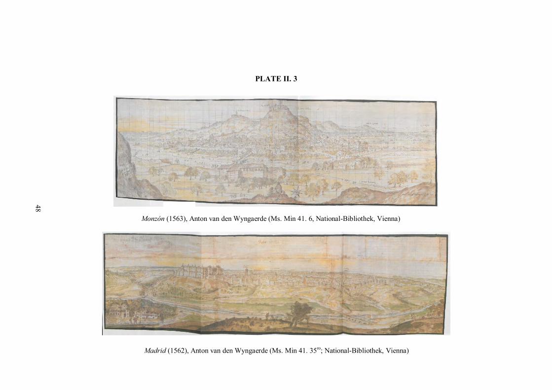
PLATE II. 3
Madrid (1562), Anton van den Wyngaerde (Ms. Min 41. 35ro; National-Bibliothek, Vienna)
Monzón (1563), Anton van den Wyngaerde (Ms. Min 41. 6, National-Bibliothek, Vienna)
48

49
The corpus of Wyngaerde’s finished views and preparatory sketches, though
large, has received little detailed scholarly attention.76 Recognised for their beauty and
historical significance, the reason these images were produced remains unclear.
Attempts to print a selection of Wyngaerde’s city views in the 1580s were a failure, and
it is possible that the works were not commissioned with publication in mind.77 It is
known that maps adorned the walls of the Alcalá and the Escorial during Philip II’s
reign and it is possible that Wyngaerde was producing views for decorative ends.
However, the case of Jacob van Deventer might indicate that Wyngaerde’s views were
intended to be informative as well as beautiful.
Jacob van Deventer was another Flemish cartographer who had been tasked to
map the towns and cities of the Low Countries by Philip II in the 1550s.78 The Dutch
Revolt cut short Deventer’s efforts, and following the cartographer’s death c. 1574
Philip expressed concern for the fate of the Deventer maps. The ‘three books of maps of
the Netherlands with the arms of the King of Spain’ were eventually delivered to
Brussels, where Philip requested they be sent securely to Madrid, as he was concerned
they could be of use to the rebels if discovered. There they remained for 300 years,
undiscovered and unused.79 In light of this occurrence, we must consider that, while
Wyngaerde’s maps may have been commissioned for their artistic merit or for
decorative purposes, their informative potential was not underestimated by Philip II.
(Plate II. 4)
The timing of Wyngaerde’s commission, c. 1561, places the project alongside
other cartographic and information gathering exercises being conducted in Spain and
Spanish domains overseas, indicating that it was one part of a broader scheme to
understand through text and image the vast geographical expanse of the Hispanic
Monarchy. The 1577 Relaciones geográficas questionnaire, which built on successful
aspects of the 1574 Relaciones histórico-topográficas of Castile, was another such
effort at learning more about Spanish domains overseas.
76 Egbert Haverkamp-Begemann, “The Spanish Views of Anton van den Wyngaerde”, Master Drawings Vol. 7 No. 4 (Winter, 1969), 375-339 & 438-450 and ed. Kagan, Spanish Cities of the Golden Age, (1989). 77 For further detail on efforts to print Wyngaerde’s work see: Haverkamp-Begemann, “The Spanish Views”, in Spanish Cities of the Golden Age, 63-65 and Haverkamp-Begemann, “The Spanish Views”, Master Drawings, 386-87. 78 Cornelis Koeman and J. Visser (eds.), De stadsplattegronden van Jacob van Deventer, Vols. 1-9. (Landsmeer: Robas, 1992). 79 Robert W. Karrow. Mapmakers of the Sixteenth Century and their Maps, (Chicago: Speculum Orbis Press, 1993), 151.

50
PLATE II. 4
Amsterdam, (c.1560) Jacob van Deventer. (inv.nr A (492.629.005) 73; Rijksarchief in Noord-Holland, Haarlem).
51
The Relaciones geográficas, a cosmographical survey first issued in 1577, was
managed by the first royal chronicler-cosmographer, Juan López de Velasco. The
project was initiated in the hope of gathering information which would support the
‘good governance’ of the Indies, though the specific intentions behind this statement are
unclear. The survey was broadly cosmographical; the fifty questions of the 1577 issue
requested information relating to geography, natural history, the indigenous population,
as well as history, agriculture, hydrography and the religious institutions present in
specific localities. The corpus is hugely diverse, with the most numerous responses
having been received from New Spain, a pattern which was repeated with later issues of
the survey.
The written responses offer a huge volume of information on a breadth of issues,
presenting an important picture of the physical environment, society and culture of the
Central and South American mainland only half a century after the first, full-scale
incursions into the region. Yet this was not simply a textual exercise; question 10 of the
1577 Relaciones requested that the respondent:
Make a plan in colour of the streets, plazas, and other significant features such as
monasteries, as well as can be sketched easily on paper, indicating which part of the
town faces south or north.80
The pinturas of the Relaciones geográficas, as the ‘plans’ were termed, adopted
various visual and structural approaches. The urban view was a popular mode of spatial
representation in the survey, alongside village or town plans and a small number of
other less common types, including circular cosmographies and hydrographical charts.
Unlike the Wyngaerde views, the pinturas often pictured more than one town or village
in the same image. While this was not expressly requested in the printed instructions,
these maps reflect the nature of urban life in New Spain; networks of connected
communities set within a rural landscape of controlled pasture and ‘barbarian’
wilderness.
80 Translation taken from Howard F. Cline “The Relaciones Geográficas of the Spanish Indies, 1577-1648”, Handbook of Middle American Indians, Vol. 12: Guide to the Ethnohistorical Sources, Part One, ed. Howard F. Cline (London: University of Texas Press, 1972), 235, Original text: ‘…disegno en pintura de las calles, y plaça, y otros lugares señalados d monasteries como quiera que se pue da rascuñar facilmente en un papel, en que se declare, que parte del pueblo mira al medio dia o al norte’ from Meztitlán relacion instruction (XXIV-12), Relaciones Geográficas of Mexico and Guatemala, 1577-1585, Benson Latin American Collection, General Libraries, The University of Texas at Austin.

52
The pintura of Meztitlán produced by the local alcalde mayor, the creole
Gabriel de Cháves, in 1579, presents some of these seemingly contradictory thoughts
about space. The town of Meztitlán occupies a strong central position in the image and
is dominated by the local church, with other towns and villages shown in the image
following this church-centric pattern. The importance of Catholicism in the process of
settlement in New Spain cannot be overestimated, with both the regular orders and
secular clergy involved in town building across the viceroyalty.81 Furthermore, religious
communities were often the face of Spanish expansion in frontier regions, a pattern
repeated in the Philippines where non-religious Spaniards were generally confined to
living within the main cities, predominantly Manila or Cebu.82 (Plate II. 5)
The association between urban life and evangelism was relatively well
developed by the early modern period, and Spain in particular had developed a tradition
of town establishment as a symbol of Christian faith, a legacy of practices from the
Reconquest period. The congregaciones or reducciones, towns where indigenous
groups were gathered together to ensure labour dues and taxes were collected
efficiently, were quickly supported by religious groups who saw congregated
populations as a ready audience for evangelism. Scattered rural populations were harder
to engage with, and there was always a sense that inaccessible or frontier regions
maintained a barbarous and idolatrous character. The impact of topography on
evangelism and civility was also a concern in the Philippines, where the highland
regions surrounding Manila cast a shadow over the ‘Rome of the East’ in the lowland
bay region.
In the Meztitlán pintura Cháves alludes to this frontier concern by picturing
Chichimec warriors near the top of the image.83 The forced perspective of the map
presents a landscape stretching horizontally for nearly 150km as a steady incline, and
thus the ‘crest’ of the image, marked by the warriors and the ‘fuerte de Xalpa’ actually
represent the limit of Spanish authority to the northeast. In contrast the heartland of
Meztitlán, occupying a central position, has a civilized rural hinterland marked by fields
reminiscent of pre-Columbian strip-farming patterns. This style of farming, seen in a
sixteenth-century cadastral map marking field dimensions and usage, survived into the
81 Kinsbruner, The colonial Spanish-American City, 28-29. 82 Irving, Colonial Counterpoint, (Oxford: Oxford University Press, 2010): 39-41; Colás, Empire, 60. 83 Mundy, The Mapping of New Spain, 39, 43.

53
Plate II. 5
Meztitlan (1579), Gabriel de Cháves (XXIV-12; NLB, Austin)
Detail of Meztitlan pintura: the town is dominated by its church and a Catholic shrine sits amongst ploughed fields following a common Mesoamerican strip farming approach.
Detail of Meztitlan pintura: Chichimec warriors can be seen on the ‘crest’ of the image, with the frontier fort of ‘Xalpa’ in the background.

54
post-Conquest era, visible in a land grant map of Izquyluca (1594). (Plate II. 6 and II.
7)
The Meztitlán image conforms to an urban view style, though it could equally be
said to adopt features of the itinerary map tradition, which retained some popularity in
Europe beyond its medieval heyday. While this style of mapping may seem simplistic to
modern observers, itinerary cartography reflects a particular experience of space – the
process of travelling from one place to another by a set route with specific markers.84
This monodimensional experience of space did not disappear, but the itinerary style of
mapping became less popular into the early modern period, as a two-dimensional
rendering of space became ever easier to achieve.
Itinerary maps
Itinerary maps represent the most common cartographic genre employed within the
Relaciones geográficas. This is no doubt partly a consequence of engaging non-
professionals in producing maps for the survey, but may also reflect the development of
a syncretic style of cartographic representation which included elements of pre-
Columbian indigenous visual traditions. Nahuatl cartographic traditions represented
regions without communicating the spaces between focal locations, lacking a
visualisation of ‘landscape’ as is captured in the Wyngaerde city views, where urban
centres are contextualised within the rural landscape. The pintura of Tetlistaca (1580)
has an evidently regional focus, like the map of Meztitlán, but leaves a plain
background on which streets, churches representing towns accompanied by their
glyphic names, and local flora are pictured. The pintura of Guaxtepec, however,
combines elements of the pre-Columbian itinerary style with a European landscape
background. (Plate II. 8)
The itinerary style of mapping, furthermore, emphasises a crucial aspect of the
process of Catholicisation; the conversion of the landscape. The substitution of the
Nahuatl tepec glyph, traditionally used to signal a town or village, with a church reflects
the success of the Spanish conquest and evangelisation as an essential aspect of
territorial expansion. The physical presence of churches within the landscape was
symbolic and, as such, carefully moderated. The Church adopted a politic approach in
their foundation of religious institutions, as the placing of churches or monastic
84 Padrón, “Mapping Plus Ultra”, 38.

55
PLATE II. 6
Sixteenth-century cadastral map from the Codice de las posesiones de Don Andrés (G24: García Collection; NLB, Austin). The map provides information on the size of fields, giving measurements in a pre-Columbian Nahuatl unit, the matl, which measures around two metres. For example, the yellow highlighted field reads: ‘20 matlacpoualli | 60 cempoualli tlaxomalco’ or ‘20 matl wide by 60 matl long to the corner’. The red highlighted field, which lies next to a road indicated by footprints, can graze 1200 sheep or ‘1200 hezontli’.

56
PLATE II. 7
Izquyluca (1594), Anonymous, (Tierras, vol. 279, exp. 1, f. 116; AGN, Mexico City). This regional view shows agricultural land, following a similar strip-farming pattern shown in the Meztitlan pintura and the sixteenth-century cadastral map (Plate II. 6).

57
PLATE II. 8
Tetlistaca (1581), Anonymous, (XXV-12; NLB, Austin). This itinerary-style production highlights specific places, landmarks and flora, though does not provide a ‘landscape’ view. Routes to Tetlistaca from satellite towns are marked, footprints indicating the direction of travel from periphery to centre.
Guaxtepec (1580), Anonymous, (XXIV-03; NLB, Austin). While conforming largely to the itinerary genre, the pintura of Guaxtepec also adopts a landscape background, a European-inspired innovation for indigenous cartographers. Although Spanish glosses persist throughout, the indigenous glyph for Guaxtepec can be seen below the central church.

58
foundations geographically was skilfully contrived to either create associations with
pre-Columbian places of worship or actively disassociate Christian sites with ‘pagan’
temples. The controversy over the miracle of Our Lady of Guadalupe, however,
emphasised the difficulties of this politic approach. A vision of the Virgin Mary by the
indigenous Juan Diego at a site associated with the pre-Columbian goddess Tonantzin
raised concerns that apparent devotion to Christ masked continued ‘heathen’ practices.85
These concerns were not resolved until the mid-eighteenth century, when the papacy
acknowledged the apparition as genuine, though it was not until 2002 that Juan Diego
was finally declared a saint.
Itinerary cartography, so often visually dominated by churches, reflected
successful efforts to create a Christian landscape, composed of a number of connected
sites of urbanised, Catholic civility. The monodimensionality of the itinerary tradition
presented a web of Christian sites, uninterrupted by a heathen, uncivilised hinterland or
an indeterminate frontier which an expansive landscape suggested. Importantly,
however, itinerary cartography most accurately captures an individual experience of and
perspective on the landscape of New Spain, showing the relationships between
neighbouring villages and towns which formed the urban foundation for the Monarchy
as a whole.
The Urban Plan
The urban plan reflects a ‘geographic’ rather than ‘chorographic’ style of representation,
almost exclusively adopting a bird’s eye view of towns or cities. Urban plans are more
commonly associated with the Americas and the Philippines, where rationalised,
planned rectilinear towns and cities predominated. In contrast, Old World cities had
grown organically from classical or medieval centres, resulting in a complex
combination of urban building patterns, making bird’s eye representations difficult to
produce.
As outlined in the previous chapter, the 1573 Laws of the Indies codified the
rectilinear urban structure already much in use across Spanish America. Influenced by
classical and Renaissance writings on urban form, as well as by Spanish precedents
including the military encampment of Santa Fe, on the outskirts of Granada, the town
planning ordinances outlined the expected pattern for founding and constructing towns.
85 Jacques Lafaye, Quetzalcóatl and Guadalupe (Chicago: Chicago University Press, 1976), 211-12.

59
The initial step of forming a civic council, or cabildo, before the settlement was even
constructed established the legal and administrative foundation for the town or city,
constituting a body of men which embodied the classical and medieval notions of
civitas, reimagined in Spanish society as policía. This important aspect of urban
development in the Indies is largely invisible in the cartography of New Spain or the
Philippines, though the cabildo house was often prominently pictured. Urban plans do,
however, show that patterns of urban settlement were present across much of New
Spain and the Philippines, which either predated the codification of these construction
norms in 1573 or followed the requirements once they were legally issued.
The pinturas accompanying the written responses to the Relaciones geográficas
survey regularly adopted an urban plan view, showing the settlement as if seen from the
air. These kinds of images often highlighted the specific features requested by the
survey, most commonly religious houses, and orientation was usually indicated.
Furthermore, many of the structural requirements codified in the Ordinances are
identifiable – the rectangular plaza, the position of religious and civic institutions within
it, and the presence of market facilities within this central zone.
The pintura produced in Quatlatlauca (1579) is a clear and basic example of this
kind of mapping style. The grid street structure is clearly visible, with corner
intersections marked with square buildings. The empty space in the centre of each solar,
or block, could indicate vacant space, garden or pasture space, though could be a
stylistic decision. That each solar is represented by four corner blocks is significant,
however, as blocks were traditionally divided into four, though later subdivisions could
see huge numbers of people sharing solar plots.86 Furthermore, the apparent uniformity
of building design, while perhaps a stylistic choice by the cartographer, may also reflect
the expectation that new towns follow a uniform architectural style. Uniformity in
building design ‘for the sake of the beauty of the town’ was certainly influenced by
classical and Renaissance writers, such as Vitruvius and Alberti.87 (Plate II. 9)
The central plaza in Quatlatlauca is a traditional rectangular shape, being nearly
twice as long as it is wide, as stipulated in section 112-13 of the Ordinances. The church
occupies a central position, while the ‘casas reales’ or royal council building adjoins the
plaza to the left. To the right of the plaza are the ‘celu[l]as’, which might be prison cells,
86 Kinsbruner, The colonial Spanish-American City, 25-26. 87 Ordinances, 1573: Article 134.

60
PLATE II. 9
Quatlatlauca (1579), Anonymous, (XXIV-16; NLB, Austin). The rectinlinear pattern of streets is clearly visible in this town plan, with the church occupying a central position in the rectangular plaza mayor. The casa reales are to the left of the church, while the celu[l]as are to the right.

61
though more likely represent monastic accommodation given the proximity to the
central church. The implied relationship between religious and civic institutions
encouraged by their physical proximity, as outlined in the Ordinances, is certainly
reflective of a desire to physically structure policía within urban settlements. The plaza
space is a manifestation of the nexus of public and private expectations that policía
embodies, encouraging individuals to support the Catholic-civic community to which
they belonged; a pattern similarly adopted in the map of Epazoyuca (1580). (Plate II.
10)
Many of these urban features, as well as representations of surrounding rural
regions, are shared by two early seventeenth-century maps produced as part of land-
grant legal cases. The 1602 map of Santa María Nativitas y San Antonio in present day
Hidalgo, and the 1606 map of Acacingo in Puebla, both clearly show grid plan towns
conforming to standard patterns of urban development. The Acacingo map clearly
presents agricultural production in the surrounding region, while the map of Santa
María y San Antonio shows how two towns have grown and become connected since
their initial foundation. A perhaps surprising feature of Spanish towns and cities in the
Americas is that they were rarely walled, lacking a definitive limit which allowed civic
conglomerations to form. Present day Mexico City includes many pre-Columbian towns
within its suburbs, such as Ixtapalapa and Culhuancan. Walled towns tended to be
fortified settlements, or presidios, in frontier zones or on the coast where they might be
open to attack from pirates or foreign enemies. Nascimientio in Chile represents a
prominent American example, while Manila in the Philippines was the main walled
Spanish settlement in Spain’s primary Asian domain. (Plate II. 11)
Pre-Columbian Central and South America had developed many urbanised
cultures, including the Aztec-Méxica and Inca. In contrast, before Spanish settlement in
the Philippines the islands had been a non-urban culture, with most indigenous groups
living in a barangay, or settlement of between 30 and 100 families. The development of
cities like Manila and Cebu therefore had a huge impact on the Philippines following
permanent Spanish settlement.One of the most striking and informative early modern
maps of Manila was produced by the Dominican Fr. Ignacio Muñoz in 1671 for the
Council of the Indies.88 An earthquake in 1645 had devastated large parts of the city,
though Muñoz’s map shows Manila and the surrounding suburbs reconstructed. The
88 MP-FILIPINAS, 10; AGI, Seville.

62
PLATE II. 10
Epazoyuca (1580),Anonymous, (XXV-11; NLB, Austin). The plaza mayor with its large central church dominates the plan of Epazoyuca. The arterial roads in and out of the town are marked with alternating foot and hoof prints; the introduction of the horse in Central and South America had important practical and social functions, with only Spaniards allowed to ride the animals in both the viceroyalties of New Spain and Peru.

PLATE II. 11
Above: Acacingo (1606), Anonymous, (Tierras, vol. 2676, exp. 14, f. 135, AGN, Mexico City).
Left: Santa María Nativitas y San Antonio (1602), Anonymous, (Tierras, vol. 183, exp. 2, f. 190, AGN, Mexico City).
63

64
walled section of the city conforms most clearly to the bird’s eye view style associated
with city plans, this being the area most likely to have been surveyed in detail by
Muñoz, a talented mathematician.89 Letters and numbers visible throughout the map
correspond to an accompanying key, highlighting royally appointed features including a
forge and trading warehouses, as well as military features including the barracks. Within
the intramuros region of the city, perhaps unsurprisingly for a member of the Order of
Preachers, Muñoz highlights the many religious buildings present in the city. Manila
was often called the ‘Rome of the East’, its dedication to the Roman Catholic faith
making it a haven of religious exiles from across Asia, as well as symbol of the hopes of
Spanish evangelism in that continent.90 (Plate II. 12)
Manila was the world’s first truly global city, with Spanish settlement in the
Philippines initiating the first global trade network circumnavigating the world.91 As
Flynn and Giráldez have argued, before the Spanish settlement of Manila, no direct
trade connection had been present between Asia and the Americas, leaving the world
market ‘not yet fully coherent or complete’.92 The implications of this global network
were not simply economic, but also artistic, cultural and, importantly, social. Muñoz’s
record of the ethnic and cultural divisions between districts of the city highlights the
social implications and challenges of this first truly global entrepôt.
The main Chinese settlement lay in the Parian (e), pictured to the east, while
over the Pasig River to the north the small settlement of Binondoc was home to Chinese
converts to Christianity. Various settlements to the south of the walled city and over the
river to the northeast were home to indigenous Filipinos and to the south of the Parian
lay the Japanese suburb of Dilao. While these ethnic divisions were far from
comprehensive or fixed they do highlight a desire for separation between both those of
European descent and Asians and between settler groups more generally. The Chinese
population was always large and tensions existed between the Iberoamerican population
and the Chinese, though efforts to expel the settled sangleys always failed as they were
a hugely important trading power in the city.93
89 Kagan highlights the association of bird’s eye or ichonographic views with mathematically proficient cartographers like military engineers in Kagan, Urban Images of the Hispanic World, 3. 90 Irving, Colonial Counterpoint, 27. 91 Irving, Colonial Counterpoint, 19. 92 Dennis O. Flynn and Arturo Giráldez, “Born with a “Silver Spoon”: The Origin of World Trade in 1571”, Journal of World History, Vol. 6, No. 2 (2005), 201. 93 Irving, Colonial Counterpoint, 36-38; Tremml, “The Global and the Local”, 570

PLATE II. 12
Descripción geométrica de la ciudad y circunvalación de Manila y sus arrabales… (1671), Fr. Ignacio Muñoz (MP-FILIPINAS, 10; AGI, Seville). Details provided clockwise from bottom left: the barracks of the Banderas (3), royal forge (9) and royal warehouses (10); Bindonoc (i); the Parian (I); Dilao (e).
65

66
The trading profile of Manila has dominated scholarly research of the
Philippines, with the galleon trade guiding much discussion of the role the islands
played within the Hispanic Monarchy. An anonymous map of Manila produced before
1645 is evidence of the way in which the galleons tied the Philippines to the Americas.
As a subsidiary domain of New Spain, the Philippines maintained a particular
relationship with the Viceroyalty which defied Spanish attempts at controlling contact
and exchange. The map, which is painted on the lid of a wooden chest now held in
Puebla, Mexico, shows the outline of Manila as mapped by Muñoz shared many
continuities with this pre-1645 layout. The artist of the chest map, however, adopts an
elevated viewpoint reminiscent of Wyngaerde’s cityscapes. (Plate II. 13)
The intramuros occupies a central position on this map, contrasting the larger
buildings of the Spanish city with the smaller, more crowded suburbs home to native
Filipinos, and Japanese and Chinese settlers. The ethnic diversity of the city and its
trade profile are highlighted in the diversity of vessels in the Pasig River (right) and Bay
of Manila (top) which include European galleons and Chinese junks. The Chinese
settlement of the Parian is not visible in the image; it is possible that the suburb did not
feature as the painter was positioned there looking over the city, though we cannot be
sure who painted the image or why.
That the chest is now in the Museo de Arte José Luis Bello y González, Puebla
may indicate that it travelled to Mexico as part of the galleon trade, whether as a
commercial item, souvenir, or storage box for a sailor making the long transpacific
journey to the Americas. Puebla was one of the markets trading goods from the Manila
galleons, the market in the city also being called the Parian, a word with Tagalog roots
which means ‘market’. The connection between Puebla and Asia was also expressed in
the city’s pottery industry. Puebla specialised in producing a majolica-style pottery with
a blue and white pattern mimicking Chinese porcelains which were becoming popular
in the Americas as well as in Europe.94
The Manila chest is illustrative of the many networks connecting the disparate
territories of the Hispanic Monarchy, and highlights the special position Manila held as
entrepôt of a world market connecting Asia with the Americas in a regular pattern of
transpacific trade. Yet, the Philippines, as a subsidiary territory of New Spain, retained a
94 Robin Farewell Gavin, Donna Pierce and Alfonso Pleguezuelo, Cerámica y Cultura: The Story of Spanish and Mexican Mayólica (Albuquerque: University of New Mexico Press, 2003), 9.

67
PLATE II. 13
Manila, (pre-1645), Anonymous, (Museo de Arte Jose Luis Bello, Puebla, Mexico). The image is painted on the interior face of the lid of a wooden chest.
Left: Large majolica jar (c. 1700), Puebla de los Angelos production, (Museo Franz Mayer, Mexico City). Right: Majolica basin (late 17th century), Puebla production, (Denver Art Museum, Denver). Both works mimic Chinese ceramics, adopting a blue and white colour scheme.

68
marginal character politically if not economically, and certainly failed to attract broad
cartographic attention. Instead the mapping projects which pictured and largely created
territories domestically and overseas in the sixteenth and seventeenth centuries were
focussed largely on Spain and New Spain.
Plan view-style urban cartography, in contrast, was generally confined to the
Americas and the Philippines, where the rationalised rectilinear town plan made a birds-
eye representation simpler to achieve. Nonetheless, there are also important examples of
plan views for Spanish cities. These generally emerged at the beginning of the
seventeenth century; Antonio Manceli’s plan of Valencia, produced in 1608, generally
being regarded as the first true plan view of a Spanish city. Manceli adopted
mathematical surveying techniques which had been increasingly refined in the Italian
city states and were now travelling to Iberia.95 His plan of Valencia, commissioned by
the city’s viceroy, the Marquis de Caracena, achieved a generally accurate, though
slightly distorted, view of the city, highlighting major landmarks in an accompanying
key. Manceli would go on to complete a similar plan of Madrid, the first ever produced
of that city.96 (Plate II. 14)
Manceli’s plan of Madrid would, however, be overshadowed by the plan
produced by the Portuguese cartographer, Pedro Texeira, which was published in
Antwerp in 1656. Texeira’s famous Topographia de la villa de Madrid was impressive
in its accuracy and mathematical execution, but achieved symbolic importance on
account of the message it presented. The map was entitled Mantua Carpe[n]tanorvm
sive Martitvm Urbs Regia, ‘Mantua of the Carpetana, or Madrid, Royal City’, a
statement of both the supposed classical origins of the city and its contemporary status
as seat of the Habsburg monarchs. This classical association was not simply an attempt
at historical contextualisation, it was a clear attempt to associate the glory of the Roman
Empire with that of the Monarquía Hispánica. Madrid is presented as the city of the
king, Philip IV, to whom the map is dedicated, ‘his city, and summation of the world
subject to him’.97 The global Monarchy is irresistibly drawn to the Royal City, and
95 Richard L. Kagan, “Urbs and Civitas in Sixteenth- and Seventeenth-Century Spain”, in Envisioning the City: Six Studies in Urban Cartography, ed. David Buisseret (Chicago & London: The University of Chicago Press, 1998), 85. 96 Kagan, “Urbs and Civitas”, 85. 97 Kagan, “Urbs and Civitas”, 86; Richard L. Kagan, “Arcana Imperii: Mapas, ciencia y poder en la corte de Felipe IV”, in El atlas del rey planeta: descripción de España y de las costas y puertos de sus reinos de Pedro Texeira (1634), eds. Felipe Pereda and Fernando Marías, (Hondarribia: Editorial Nerea, 2003): 70.

69
PLATE II. 14
Nobilis ac regia civitas Valentie in Hispania., (1608), Antonio Manceli (Private Collection, Valencia, Spain)Topographia de la villa de Madrid
Topographia de la villa de Madrid (1656), Pedro Texeira (INVENT/23233; BNE, Madrid)

70
Madrid is the centre of the world; there is no distinction as to whether this was
specifically the world of the Monarchy or the world as a whole, a powerful ambiguity.
Furthermore, the description of Philip IV as Regi Catholici | Forti et Pio, ‘Catholic
King | Strong and Pious’, emphasises the person of the king as an embodiment of the
religious ideals of the global Monarchy, and the necessarily urban setting for that faith-
culture.98 The apartments of the Buen Retiro, Philip’s new palace, are enlarged in the
map, aggrandising the physical home of the monarch and with it the Monarchy. Many
of the arterial streets around the city are also enlarged,99 lending an artificial sense of
rationality in this medieval city, a trick Wyngaerde also played in his view of Valencia.
The urban form of the city is important to the overall message and Texeira’s insistence
that the plan was so accurate that one could ‘count the doors and windows of each
building’100 emphasises once again the concept that the urban form was a physical
manifestation of the character of its inhabitants, a sum of individual details. Madrid, as
home to ‘El Rey Planeta’, must be seen as a kind of perfect city.
Texiera’s intentions, like those of Manceli, are not so difficult to discern as the
maps of the Relaciones geográficas or of the Philippine views during the early modern
period. Both cartographers sought to represent Spanish cities as appropriately grand for
urban centres at the heart of a Monarchy with truly global reach. Their apparent
rationality and the impossibility of their perspective do, however, mask the challenges
facing Spain during the early seventeenth century, as plague and famine created serious
political, economic and social challenges which affected these ‘perfect’ cities as much
as the rural hinterland.101 It is perhaps not surprising, therefore, that the geometrical plan
became an attractive mode of urban representation during this period, as reality could be
hidden behind mathematics.
Conclusion
The urban cartography of the Monarchy can be overwhelming in both its volume and
visual diversity, the range of mapping genres offering different perspectives. Diversity
can mask similarity, however, and many of these maps share common features across
genres. Predominantly these similarities are content-based, and urban cartography from
the early modern Monarchy possesses two broad visual preoccupations. Firstly, religion
98 Kagan, “Arcana Imperii”, 70. 99 Kagan, “Arcana Imperii”, 70. 100 Kagan, “Arcana Imperii”, 69; Kagan, “Urbs and Civitas”, 86. 101 John Lynch, Spain Under the Habsburgs, Volume II, 6-7, 10.

71
shapes many of the maps from this period. This does not result in the moral geographies
or Jerusalem-centred mappaemundi of the medieval period, but rather shows the central
position Christianity held physically and socially across the Monarchy. From
Wyngaerde’s Spanish city views to the relaciones of New Spain and beyond, to city
plans of Manila, churches and religious houses structure settlements and dominate the
landscape. Catholicism successfully drove the Monarchy’s continued expansion in the
Americas and Asia, providing a mission for continued growth and additional personnel
with which to achieve it.
Secondly, urbs, the physical form of urban space, was of interest to those
governing the Monarchy as well as to the cartographers mapping it. In Spain, urban
space was cartographically manipulated to achieve more ‘rational’ and ‘perfect’ results,
allowing cities which had grown during the medieval period to conform more closely to
Renaissance ideals of urban planning. An idealised approach to planning was codified
by the end of the sixteenth century in the Indies, and the success of efforts to impose
urban structure can be seen throughout American and Filipino cartography. If towns
were to function as the foundation of the Monarchy it was essential to ensure they were
the right kind of towns. The cartographers did not need to manipulate urban space to
present an idealised view, the ideal was physically present if not always theoretically
sound.
The vast number of urban maps available from the sixteenth and seventeenth
centuries emphasises the importance of urbanisation within the overall progress of the
Monarchy. Towns and cities remained the social foundations of this global network of
governance and retained their focal identity throughout the early modern period,
providing localised manifestations of political, economic, cultural and religious
networks which extended beyond civic limits or territorial boundaries. While the maps
can tell us much, they often conceal far more; we rarely know who produced each map
and, importantly, why such maps were produced in the first place. Provenance remains a
problematic mystery and one which may prove an insurmountable barrier to an accurate
appreciation of much urban cartography in this period. The intimate relationship
between form and function means without an understanding of why a map was
produced we cannot ever fully understand why it was made the way it was.
Nonetheless, urban maps provide an important, localised perspective of the
Monarchy produced by those living within it during a period of transition and rapid

72
transformation. The continuity of many urban features across the Monarchy’s vast
territories meant that urbanism achieved a kind of universality across the ‘mundo
hispánico’, evidenced by the vibrancy of the urban cartographic tradition of the early
modern period. The Monarchy’s civic-religious programme was a legacy of the
Reconquista, adapted for another world and urban cartography supported this new
urbanism, reporting its progress across the Monarquía Hispánica.

73
Chapter Three: Territorial cartography
The concept of ‘territory’ in much modern scholarship has been classically associated
with the development and survival of the ‘state’ or ‘nation’. How territory was
constructed, maintained and adapted within this state or national context has shaped
discussion and created a narrow chronological range within which the notion of
‘territory’ has operated. Territory is, however, not simply a modern, national concern,
and thinking territorially occurred in many pre-modern, pre-national contexts. The
Monarquía Hispánica was not composed of states or nations, but rather of kingdoms and
provinces, governorships and viceroyalties. Nonetheless, the concept of ‘territory’ as a
space with socio-cultural significance, when operating at this classical supra-regional
level, has influenced how the various domains, both domestic and overseas, were
managed and understood within the structure of the Monarchy.
While territory need not possess clear or defined boundaries, the political nature
of most territorial units makes the imposition and maintenance of boundaries preferable
and often necessary. These boundaries limit power exercised by groups or individuals to
specific areas and importantly demarcate the jurisdictional areas of one power group in
relation to others.102 The process of setting boundaries and more generally fashioning
space and employing it to anchor the conceptual framework on which territory relies are
important aspects of territorialisation as a broader project of constructing territory. This
practice can occur on the ground, physically placing markers in the landscape to
represent the boundaries between one group and another. It is perhaps more common,
however, for this process to occur cartographically.
Maps, in their most basic function, make space easier to see and at the scale of a
province or viceroyalty maps provide the only possible way of seeing territory as a
whole. As such maps offer the possibility of planning the process of territorialisation
before it has begun, or following its progress cartographically until it is deemed
complete or the plan has changed sufficiently to initiate a new one. The territory
contained within maps is far easier to manipulate than the physical landscape is in
reality, and the level of uniformity or diversity presented by the map can guide or
obscure the process of territorialisation. To take a modern example, the ‘Map’ view
offered by Google Maps does not differentiate between the type of landscape being
presented – the landscape is reduced to a grey background whether desert or rainforest. 102 Colás, Empire, 45.

74
Switching to the ‘Earth’ view, a satellite image of the world, the geographical diversity
of the landscape is revealed. The cartographical conventions adopted by cartographers
and the style of their presentation thus affect the way space is conceptualised and the
project of territorialisation presented.
As we saw in the first chapter, ‘territorialisation’ can be considered, at a basic
level, to be a process by which space, as a meaningless expanse, is transformed into
territory. This classic conceptualisation of territorialisation has been commonly
associated with colonial systems of rule, and can also be considered true of the process
of overseas expansion undertaken by the Monarquía Hispánica. Places like ‘New Spain’
and ‘the Philippines’ did not exist before the Spanish arrived in mainland Central
America or in the islands of Southeast Asia. They were created conceptually and
territorially through a multi-faceted process of territorialisation both in situ and,
importantly, on maps. This kind of territorialisation purports to create something out of
nothing, territory with significance from meaningless space.
This is clearly a highly ethnocentric process, as can be seen in the case of both
New Spain and the Philippines. The Spanish considered the lands of Central America to
be ‘space’ because they did not fit within their pre-existing understanding of global
geography, they were accommodated within this geographical framework while the
process of constructing ‘New Spain’ was underway. Yet, the Aztec-Méxica Empire,
which had flourished in the Valley of Mexico and beyond for centuries before the
arrival of the conquistadores, had possessed a clear territorial character and identity for
the indigenous Mesoamerican peoples who lived there. The sophistication of their
tribute collection systems and evidence of cadastral mapping practices only emphasise
further the territorial nature of pre-Columbian Central America. In the Philippines,
though the scale of territory was much smaller, the barangay acted as a territory defined
by familial relationships and remained an important foundation for society during the
period of Spanish rule and beyond. Nonetheless, these units were adapted and reformed
in the process of territorialisation undertaken by secular and religious agents of the
Monarchy.
In many respects the process of territorialisation is one of reformulation or
aggregation, where pre-existing territorial units are refashioned into new ones, or collate
to create larger territories operating within adjusted conceptual frameworks. This was
the character of territorialisation which Spain underwent in the sixteenth and

75
seventeenth centuries. The Iberian Peninsula had been a collection of kingdoms and
provinces during the Reconquest period, though a developing sense of unity between
kingdoms emerged during the reign of the Catholic Monarchs, Ferdinand of Aragon and
Isabella of Castile. This process continued throughout the reigns of the Spanish
Habsburgs, as the various peninsular kingdoms were encouraged to look to a Habsburg
king in Madrid as the source of royal power over ‘Spain’. Alongside this political
rendering of ‘Spain’ lay an emerging conceptual understanding of what it was to be
‘Spanish’, a notion growing in the Indies rather than the peninsula. Local identities and
allegiances became less important in the face of the indigenous ‘Other’. The imposition
of a religious-civic framework intended to spread the Catholic faith and urban civility
across the Indies helped to create a view of being ‘Spanish’ which was founded in
cultural norms shared across many kingdoms of the Iberian Peninsula.103
Maps of the sixteenth and seventeenth century show this process of territorial
construction occurring, and importantly adopt geometrical surveying techniques to
render many of these territorial representations. The reasons for this stylistic choice are
not entirely clear, though in a period where diplomacy hinged on unfixable lines of
demarcation, a technique which offered a spatial representation based on verifiable data
promised a level of accuracy and perhaps objectivity that was highly attractive.
Spain
The development in geometrically-informed cartography did not begin in the
Enlightenment, even if the approach achieved dominance during this period. The
sixteenth century saw rapid development in cartography employing geometrical
surveying principles. A number of European monarchs, including Duke Albrecht of
Bavaria and Elizabeth I of England, commissioned surveys of their lands during the
sixteenth century, though the survey of Philip II was perhaps the most successful project
undertaken in this period.104 The Escorial Atlas represents perhaps the greatest
cartographic achievement of the early modern period, and yet it remained hidden and
largely forgotten for centuries after it was first produced.
103 Tamar Herzog, “Can You Tell a Spaniard When You See One? “Us” and “Them” in the Early Modern Iberian Atlantic”, in Polycentric Monarchies: How did Early Modern Spain and Portugal Achieve and Maintain a Global Hegemony?, eds. Pedro Cardim et al. (Brighton: Sussex Academic Press, 2012), 148. 104 Sarah Tyacke and John Huddy, Christopher Saxton and Tudor Map-Making, (London: British Library, 1980): 24-25; Geoffrey Parker, “Maps and Ministers: The Spanish Habsburgs” in Monarchs, Ministers and Maps, ed. David Buisseret (Chicago & London: The University of Chicago Press, 1992), 130.

76
Ptolemaic maps of Spain had become popular from the late fifteenth century
after the Geographia was rediscovered and printed in Western Europe. By the mid-
1500s new maps were being produced which were more accurate in their representation
of the Iberian peninsula, such as Giacomo Gastaldi’s La Spaña, which was produced in
1554. Gastaldi’s map was followed a decade later by Geminus’ Nova descriptio
Hispaniae (1555), published in London under royal authority from Philip, who lived in
the city during his marriage to Mary Tudor. While both maps improved on the general
outline of the Iberian Peninsula, neither contained much detailed information regarding
Spain’s interior geography, falling back on graphic fillers, such as wooded regions, hills
or mountains to occupy empty space. Similar fillers can be observed in Zenoi’s
Hispaniae descriptio (1560), though here inland hydrography achieves a similar level of
accuracy to coastal features. This lack of detail most likely results from a lack of first
hand data, and it can be assumed that both Gastaldi, who produced his map in Venice,
and Geminus in London were working from second hand information.105 While
coastlines were generally accurate in this period on account of a well-developed
tradition of portolan chart production in Spain, and particularly in Portugal, maps
including inland detail were rare and such territorial views were a developing genre.
(Plate III. 1)
The survey of Bavaria produced by Philipp Apian between c. 1550 and 1560
was a genre-defining production. Covering c. 44,000 sq. km it was the most ambitious,
as well as the most detailed and accurate survey of its kind. Apian’s survey was also
significant because the mathematician turned cartographer employed data he had
collected first hand to produce his maps, and the impact this had on accuracy and
consistency in the final production was evident.106 Sadly Apian’s original map was
destroyed by fire in the mid-eighteenth century, though his masterpiece survived in
contemporary copies, including that by Abraham Ortelius. The Flemish cartographer
also published Seco’s map of Portugal, a similarly ambitious and accurate geographical
survey first published in Rome in 1561.107
It is within this context of innovation and ambition that the Escorial atlas must
be considered. It is generally agreed that a geographical survey of Spain expected to
employ geometrical surveying techniques was commissioned by Philip II between the
105 Parker, “Maps and Ministers”, 126. 106 Parker, “Maps and Ministers”, 130. 107 Parker, “Maps and Ministers”, 130.

77
PLATE III. 1
La Spaña (Venice, 1554), Giacomo Gastaldi.
Nova descriptio Hispaniae (London, 1555), Thomas Geminus.
Hispaniae descriptio (Venice, 1560), Domenico Zenoi.

78
mid-1550s and early 1560s; sadly documentary evidence which might date the
production more clearly has never been found.108 The project was led by Pedro
Esquivel, a mathematics professor at the University of Alcalá, and, following his death
in the early 1570s, was taken on by his assistant, Diego de Guevara.109 Guevara sadly
died only a few years after assuming control of the project and it was left unfinished.
This phase of the survey produced a twenty-one page, double-sided folio atlas,
containing twenty portion maps of Spain’s Iberian domains, commonly referred to as
the ‘Escorial Atlas’ as it has been stored in the palace library probably since its
production. Esquivel and Guevara seem to have produced the Atlas employing
geometrical approaches to surveying, including sixteenth-century triangulation
techniques.110 A fan diagram of Toledo found on the back of one of the folio pages
indicates that while gathering data for the Atlas the cartographers made use of natural
vantage points to take and verify measurements, in a similar way to Wyngaerde’s use of
an elevated vantage point to capture his city views.111 (Plate III. 2)
While the Atlas remained unfinished, an index map was produced, piecing
together the twenty portions into a whole map. An exact date for the index map has not
been determined, though the accuracy of the mapping of Portugal might indicate that the
index map was produced after the union of crowns in 1581. It has been suggested that
Juan López de Velasco, then royal chronicler-cosmographer, may have been involved in
the production of the index map, as his handwriting has been identified in the Atlas
providing corrections and additions. This is further supported by a recent study of the
Stockholm Codex, a collection of geographical data about Spain which features over
3,000 co-ordinates for places and features found in the Atlas.112 The handwriting of both
Velasco and João Baptista Lavanha, a celebrated cartographer of Portuguese ancestry,
has been identified in the Codex. Lavanha predominantly corrects co-ordinates while
Velasco offers astronomically determined detail, such as the latitude and longitude of
major cities including Madrid, Toledo and Seville.113 The Codex itself does not seem to
108 Antonio Crespo-Sanz offers an alternative chronology in his “Novel Reflections on the Atlas at El Escorial”, ICC Presentations (2005) and “Un mapa olvidado: el Atlas de El Escorial”, Catastro (2005) which would place the Atlas and index map within the reign of Charles V. 109 Goodman, Power and Penury, 66; Juan de Herrara has also been associated with completing the project following Esquivel’s death, see David Buisseret, “Spanish Peninsular Cartography, 1500-1700”, 1083. 110 For detail on surveying techniques and equipment see: Crespo-Sanz, “Novel Reflections”, 1-3. 111 Buisseret, “Spanish Peninsular Cartography, 1500-1700”, 1084. 112 Kungliga Bibliotheket, MS M.163. 113 Parker, “Maps and Ministers”, 131-32.

79
PLATE III. 2
Escorial Atlas, Portion 5 (c. 1560-1575) (MS. K.I.1, fols. 11v-12r; Patrimonio Nacional, Madrid)
Escorial Atlas, Portion 6 (c. 1560-1575) (MS. K.I.1, fols. 13v-14r; Patrimonio Nacional, Madrid)
80
have been employed to produce a new map of Spain, though may have supported the
correction of the original Atlas either during the production of the index map or after.
(Plate III. 3)
When considering the Atlas, index and Codex together the ambition of these
territorial mapping projects in Spain during the sixteenth-century can be appreciated.
While Apian’s survey covered 44,000 sq. km and Seco 89,000 sq. km in Portugal, the
Atlas covered 497,000 sq. km and achieved a level of accuracy regarding urban centres
which was extraordinary, only to be improved upon when the index map was
produced.114 The Atlas and index map are less visually imposing than other maps of
Spain produced during this period, yet both are accessible and usable in their simplicity.
The reason for their production is unknown, though it might be assumed that the Atlas
was intended to have administrative utility, which perhaps encouraged the production of
the functional index map.
The simplicity of the presentation seems to make the image of ‘Spain’, covering
the Iberian Peninsula as a whole, effortless; there are no internal divisions and the focus
is on urban centres and hydrographical features, not on political units or historical,
regional relationships. The success of the Escorial Atlas and the index map is in their
ability to present an image of ‘Spain’ as a unified whole and a geographical reality.
Whether the intention was to produce an Atlas with this goal in mind is unknown, but a
consequence of the scope and style of the project is that the domestic Monarchy is
visualised as a cohesive territory.
A project perhaps associated with the Escorial Atlas and worthy of mention in
its own right is the Descripción de España y de las costas y puertos de sus reynos,
produced in 1634 for Philip IV by Pedro Texeira.115 The atlas was the idea of the
Portuguese cosmographer Lavanha in the 1620s, but was undertaken by his compatriot
and apprentice Texeira, on account of Lavanha’s advanced age. The commissioning of
the atlas followed a practical halt in cartographic commissions under Philip III,
excepting an expedition to map the Strait of Magellan in which both Pedro Texeira and
his brother João were involved. Philip IV’s reign breathed new life into royal patronage
of mapping projects, and no doubt Lavanha’s position as mathematics tutor to the young
114 Parker, “Maps and Ministers”, 130. 115 NLV, Codex Miniatus 46.

PLATE III. 3
España (c. 1580-90) (MS. K.I.1, fols. 1v-2r; Patrimonio Nacional, Madrid). The ‘key’ or index map to the Escorial Atlas, thought to have been authored by Juan López de Velasco and João Baptista Lavanha.
81

82
king put his suggestion in a favourable position to receive royal authorisation. (Plate
III. 4)
The Descripción is a luxurious atlas, picturing the coastline and ports of Spain
alongside sectional views of the coastal portions of the peninsula. The work
successfully combines the topographic perspective offered by Wyngaerde’s views with
the geographic map portions of the Escorial atlas, moving with ease between the two
cartographic perspectives. Texeira’s atlas was so beautifully and carefully executed that
it is hard to imagine it serving a practical purpose, and yet it was commissioned to
provide much needed information about the defensive capabilities of Spain’s long
coastline. The author had spent much of his professional life travelling along the coasts
and northern border of Spain, providing advice about the state of existing defences and
providing future defensive solutions.116
The atlas is bracketed by two remarkable maps; the first is a Tabla general de
España, or view of the whole peninsula. Portugal, which was still under Spanish
sovereignty when the atlas was produced, does not stand out as an ‘addition’ to the
internal fabric of the peninsula, which is already a collage of kingdoms and provinces.
Instead, while visually subdivided into a multi-coloured patchwork of political units,
Texeira succeeds in presenting Spain as a cohesive whole. The sea surrounds the
peninsula and a blandly beige France to the north does little to detract from the mass of
labels and colours that is Spain. In the context of the Catalonian revolts and the practical
autonomy of kingdoms like Aragon, it is possible that Texeira’s map of Spain sought to
present an image of a unified peninsula, a task easier for Texeira to achieve
cartographically than for the Count Duke of Olivares to attempt in reality. (Plate III. 5)
The scientific credentials of the image are presented with the inclusion of a scale
in leagues, which corresponds to the latitude scale running on either side of the map.
The length of a degree of latitude is given at 17 leagues, somewhere between traditional
Spanish and Portuguese opinions on the length of a degree. Notably, longitude is not
represented, a method for its effective calculation being beyond contemporary
capabilities. The second map is an untitled world map, another beautifully-executed
image with remarkable coastal accuracy across the world, excepting the ‘island’ of
California and the great southern continent, which will be discussed in greater detail
below.
116 Pereda and Marías, “Introducción”, 14-15.

83
PLATE III. 4
Coastline south of Granada (1634) Pedro Texeira (Codex Miniatus 46; National-Bibliothek, Vienna)
Marbella (1634) Pedro Texeira (Codex Miniatus 46; National-Bibliothek, Vienna)

PLATE III. 5
Tabla general de España (1634) Pedro Texeira (Codex Miniatus 46; National-Bibliothek, Vienna)
84
85
This unique atlas is, however, unfinished; it lacks titles on some pages and
information is missing from some of its heavily decorated cartouches. It was
accompanied by a 79 folio text, one of three which survive, providing detail about the
content of the Atlas and about the regions shown. Comparative work on the three texts
has been completed which show that two, one held in the Biblioteca Nacional de
Madrid and the other in the British Library, are nearly exact copies of one another,
though the latter may have been copied by a foreign hand as linguistic inconsistencies
are present.117 The final copy, held with the atlas in the National Library of Vienna, is
different, containing shorter accompanying descriptions of the images in the Atlas in
favour of short sections on the history, territory and government of Spain.118 The
reasons for the diversity between texts is unknown, though it seems likely that the
Vienna text was originally intended to accompany the Atlas, while the purpose of the
other versions remains a mystery.
It is possible that the Stockholm Codex, to which Lavanha contributed, may
have been employed in the production of the 1634 Descripción. Should this be the case,
the relationship between these two Atlases, produced under Philip II and Philip IV, may
change our understanding of both projects and indicate that the seventeenth-century
‘edition’ sought to finish and improve upon a project initiated in the previous century.
New Spain
Similar surveying projects to those conducted in sixteenth-century Spain were also
carried out in Central and South America, from the Relaciones geográficas
questionnaire to the less famous Domínguez survey of New Spain. The cartographer
Francisco Domínguez was sent c. 1570 to New Spain to conduct a geographical survey
of the viceroyalty comparable to the Escorial Atlas project in its scope and
administrative potential. First draft sections were returned to Spain by Domínguez c.
1575 after five years of travelling across New Spain collecting survey data. The drafts,
which are now lost, were returned with a query relating to his salary which was five
years overdue.119 (Plate III. 6)
117 BNE, Ms. 1802 and BL, Add. 28497 [126 folios], Felipe Pereda, “Un atlas de costas y ciudades iluminado para Felipe IV: La ‹‹Decripción de España y de las costas y puertos de sus reynos›› de Pedro Texeira”, in El Atlas del Rey Planeta, eds. Felipe Pereda and Fernando Marías (Hondarribia: Editorial Nerea, 2002), 48. 118 NLV, Cod. Vin. 5707119, Pereda, “Un atlas de costas y ciudades iluminado para Felipe IV”, 48. 119 Goodman, Power and Penury, 66.

86
PLATE III. 6
Doce figuras ó planos de eclipse de luna observado en México el 17 de Noviembre de 1584, hechas por Jaime Juan, Cristóbal Gudiel, Francisco Domínguez y el Doctor Farfan conforme á las instrucciones de Su Majestad (1584), Francisco Domínguez (MP-MEXICO, 34 7R (top) 8R (bottom); AGI, Seville). Domínguez’s signature can be seen on both pages.

87
We have little detail about Domínguez’s life after this point, though we know he
assisted Jaime Juan in his 1584 astronomical survey, collecting information on lunar
eclipses in cities across New Spain, a project aiming to provide clearer longitudinal data
about Spain’s overseas domains.120 The physician, Dr Francisco Hernández and his
assistant Dr Farfan, who were conducting their own natural history expedition in New
Spain, are also recorded as providing further measurements of the eclipse, alongside
Domínguez, to verify Juan’s measurements.121 A decade later Domínguez was still in
New Spain, still waiting for his salary, now overdue by two decades; a petition
submitted in 1594 listing Domínguez’s ‘merits and services’ noted he was a ‘cronista, y
cosmographo [de] la Nueva Spaña, Philipinas y de la granchina […] y del Peru, y de
todas las […] tierras, de las Indias’; the petition met with a call for further
information.122 Ambitions stretching beyond New Spain indicated by the 1594 petition
were clearly never realised, and the New Spain survey was never completed. A legal
case from 1610 showed that the salary due Domínguez was still not received prior to his
death c. 1598, though the San Hipólito hospital in Mexico City continued the case into
the seventeenth-century – the outcome is unknown.123 The Domínguez survey, which
might have been one of the most significant achievements of Crown sponsored
cartography in the early modern period, instead stands as a reminder of some of the
fiscal and administrative failings of the world’s first truly global realm.124
The Indies
A brief mention should be made at this juncture of a series of manuscript maps
produced by Juan López de Velasco in the mid-1570s for his Geografía y descripción
universal de las Indias, a work which was commissioned by the Council of the Indies.
The maps contained in this work were later published by Juan de Herrara in his
Décadas at the turn of the seventeenth century. These maps, presenting a view of the
homogenous ‘Indies’ on both sides of the Pacific, came to embody the publically
available image of the Monarchy for over a century. Both versions of the maps are very
similar, comprising a series of maps of Spain’s American domains, though the printed 120 ‘Doce figuras ó planos del eclipse de luna observado en México el 17 de Noviembre de 1584, hechas por Jaime Juan, Cristóbal Gudiel, Francisco Dominguez y el Doctor Farfan conforme á las instrucciones de Su Majestad’ (17/11/1584): 7R, 8R. 121 Antonio Barrera, “Empire and Knowledge: Reporting from the New World”, Colonial Latin American Review, Vol. 15 No. 1 (June 2006), 48. 122 Méritos y servicios: Francisco Domínguez [AGI, PATRONATO,261,R,9: 4]. 123 Goodman, Power and Penury, 66-67. 124 Similar financial challenges seem to have been shared by Esquivel, see: Crespo-Sanz, “Novel Reflections”, 4.

88
versions also include an image of the ‘Indias del Poniente’, the Western Indies. (Plate
III. 7)
The map of New Spain, both in manuscript and printed format, is largely
unremarkable. Inland detail is rather limited, the emphasis instead being on highlighting
coastal towns and cities rather than detailing inland topography. Importantly, however,
the map does provide an impression of how New Spain was seen and understood at the
time of the unsuccessful Domínguez survey. Given the timing of the original production
of this map, it is a tantalising possibility that the preliminary survey maps created by
Domínguez may have informed Velasco’s work. Furthermore, the style of the maps is
reminiscent of the index map produced for the Escorial Atlas, and may provide further
evidence for Velasco’s involvement in producing that work.
The map of the ‘Indias del Poniente’ is, however, far more interesting. Firstly,
the very fact that a map which takes a broad view of mainland Asia and the Southeast
Asian and Pacific islands is entitled ‘A description of the Western Indies’ is indicative
of a clear piece of geopolitical manipulation. Asia had been traditionally conceived
within European geography as the Orient or the East, but within the Spanish zone of
jurisdiction as outlined by the Treaties of Tordesillas and Zaragoza, Asia fell within the
western portion of that zone. By claiming that this whole region could be considered the
‘Western Indies’ further highlights that the cartographer is seeking to make an
ambitious claim with regard to the extent of Spanish jurisdiction.
Furthermore, by placing the Philippines, Spain’s foothold in Asia, within its
geographical context it presents the importance of that gobierno as primarily strategic.
Financially the Philippines were hardly worth sustaining, but as a possible gateway to
Asia, with all its economic and evangelical potential, the islands were a valuable
territorial asset. Other contemporary images present the islands in a similar light – the
Philippines were a base from which to commence the conversion of mainland Asia and
acted as a hinge for trade between Asia and the Americas and Europe.
It is not known whether Velasco ever produced a manuscript version of the map
of the ‘Western Indies’, if so it has been lost as now only the printed version survives.
Regardless, these maps present an important picture of the American and Asian
possessions of the Monarchy, and hint at their ambitions to continue that expansion into
the western portion of their jurisdiction. They are also hugely important because they
were eventually published, and with so few maps in this period reaching the printing

89
PLATE III. 7
Descripcion de la Audiencia de Nueva España (1575) Juan López de Velasco, from Descripcion y Division de las Yndias (Codex Sp 7 / 1-SIZE, 17000-4; JCB, Providence).
Descripcion del Destricto del audiencia de Nueva Espana (1601) Juan López de Velasco and Antonio Herrara, in Historia General (B601 H564h /1-SIZE, 01808-009; JCB, Providence).
Descripcion de las Indias del Poniente (1601) Juan López de Velasco and Antonio Herrara, in Historia General (B601 H564h /1-SIZE, 01808-019; JCB, Providence).

90
press they are not simply interesting for their content but also the message they may
have sent to contemporary viewers across Europe and perhaps across the world.
The Philippines
After the Esquivel and Domínguez surveys one may have expected a similar surveying
project to have been undertaken in the Philippines, which were by the last decades of
the sixteenth-century an established subsidiary territory of the Viceroyalty of New
Spain. No such survey was, however, undertaken during the Habsburg period, and it
was not until 1733 that the Crown made a formal request for a Philippine survey. The
resulting map remained a blueprint for most maps of the Philippine archipelago for
almost a century and, as the Philippines moved towards independence, took on a new
role as a symbol of Filipino nationalism.
The Carta hydrographica y chorographica de las Islas Filipinas was published
in Manila in 1734, drawn by the Spanish Jesuit Fr. Pedro Murillo Velarde and engraved
and printed by the Tagalog Filipino Nicolás de la Cruz Bagay, with accompanying
images drawn by the artist Francisco Suarez, also a Tagalog Filipino. The speed of its
publication after the initial request would indicate that the map was already in
production before the request from Philip V was received. The Velarde map is not, as
has been claimed, the first ever image of the Philippines;125 many maps from the
sixteenth-century onwards depicted the islands in varied levels of detail, from a small
archipelago on the edge of a global map, to regional views of southeast Asia, or details
of specific islands. Furthermore, the Flemish cartographer Pieter van den Keere was the
first to picture the islands as a connected archipelago.126 What makes the Velarde map
special, however, is that the map, along with the accompanying vignettes, was arguably
the first map to successfully conceptualise ‘the Philippines’ as a territorial unit unto
themselves;127 Velarde chooses not to place the islands within a broader regional
context, excepting the inclusion of Borneo to the bottom left of the map. (Plate III. 8)
The Velarde map is remarkable for many reasons. It was the most accurate
rendering of the archipelago when it was produced, providing a detailed representation
of not only the large islands in the group, but also many of the smaller islands scattered
125 Padrón, “Las Indias olvidades: Filipinas y América en la cartografía imperial española.” 3° Simpósio Iberoamericano de História da Cartografia, Agendas para a História da Cartografia Iberoamericana, Universidade de São Paulo, São Paulo (April 2010): 2. 126 Quirino, Philippine Cartography, 35. 127 Padrón, “Las Indias olvidades”, 9.

PLATE III. 8
Carta hydrographica y chorographica de las Islas Filipinas (1734) F. Pedro Murillo Velarde; engraved and printed, Nicolás de la Cruz Bagay;
accompanying images, Francisco Suarez (MR/45/31; BNE, Madrid)
91

92
across the region. The 1734 edition provided information on shipping routes, and
included elements from the portolan mapping tradition, such as rhumb lines criss-
crossing the seas around the Philippines. From an ethnographic perspective the map
highlights the achievement of Filipino craftsmen in art, engraving and printing, a
tradition initiated by Tomás Pinpin, the first Filipino typographer.128 That Cruz Bagay
and Suarez are named is significant when considered against the usually anonymous
indigenous mappers of the Relaciones geográficas in New Spain. Furthermore, the
images drawn by Suarez capture the ethnic diversity of Manila and the Philippines more
widely in the first decades of the eighteenth century; his images picture not only
Spaniards, Chinese, Japanese or Filipinos, but also mestizos of New Spain, Persians,
black Africans, and a native of Malabar in India.129 The looming threat of barbarity,
paralleling the Chichimecs of Cháves’ Meztitlán, can be seen in the armed Aëtas, an
indigenous Filipino group occupying the upland regions surrounding Manila. (Plate III.
9a and III. 9b)
The incidental details within Suarez’s images offer a glimpse at daily life in the
islands, from the music played and danced to, to sports enjoyed such as cockfighting. It
also illustrates agriculture and rural pursuits, and highlights the flora and fauna of the
islands. Three plans of forts and cities are also provided; the fort of Cavite in Manila
Bay is shown surrounded by boats of various types and small coastal towns are
highlighted, the city of Manila itself, depicted in a similar way to the Muñoz map, and
the fort of Zamboanga, a detailed image of the Spanish settlement on Mindanao,
picturing the governor’s residence, barracks, chapel, store houses and the Jesuit house.
The Velarde map bridges the gap between an urban or local view and a
territorial perspective, including features of both to provide a map which nonetheless
communicates clearly to the viewer. While Quirino has argued that the illustrated panels
‘are not an integral part of the map’ as they occur on only one original copy, the two
elements work so effectively together to illustrate the Philippines it seems odd to think
that they are not intended to operate co-operatively. 130
128 Quirino, Philippine Cartography, 62. The book trade in the Philippines flourished, with over a thousand titles published in Manila before 1811, impressive when considered against Brazil which had no press until 1808; see: Irving, Colonial Counterpoint, 25-26. 129 The Persian is also labelled as an Armenian, see Quirino, Philippine Cartography, 64. 130 Quirino, Philippine Cartography, 62. The positioning of the images on either side of the map may indicate that other surviving original copies have had their side panels removed.

93
PLATE III. 9a
Accompanying vignettes from Carta Hydrographica y Chorographica de las Yslas Filipinas (1734), Francisco Suarez (MR/45/31; Biblioteca Nacional de España). Left column: Top: Sangleys, Centre: Cafres, Bottom: Mestizos (left) and Japanese (right). Right column: Top: Filipino flora and fauna, Centre: Plan of Samboangan, Bottom: Plan of Cavite.

94
PLATE III. 9b
Accompanying vignettes from Carta Hydrographica y Chorographica de las Yslas Filipinas (1734), Francisco Suarez (MR/45/31; Biblioteca Nacional de España). Left column: Top: Spaniard, black Creole, ‘Indios’ and native Aetas, Centre: Armenian or Persian, Mogol and Malabar Indian, Bottom: ‘Indio’ and ‘India’ on their way to church, others described as ‘Indios’. Right column: Top: Filipino agriculture and fauna, Centre: Desuajan island, Bottom: Plan of Manila.

95
It is possible to argue that the Velarde map has become historically significant
predominantly on account of its modern association with the Filipino independence
movement. This association does, however, highlight the important message that the
map seems to have originally communicated. The Philippines, as an archipelago, had
previously been territorialised within the context of Asia, one part of a swathe of islands
and mainland which were considered to fall within the Spanish hemisphere. Within this
broader Asian context the Philippines could be perceived as a failed attempt at
spreading Spanish-Catholic culture in this region, the gateway to Asia remained closed
except to traders of luxury goods. The Velarde map, however, changes the terms under
which the Philippines are to be understood, reterritorialising the archipelago. In the
1734 edition, the Philippines are shown to be urbanised, productive and, though
ethnically diverse, generally cohesive. Velarde releases the Philippines from an
association with a ‘failed’ past, demonstrating that the islands are a success as a locale
of interactions and encounters. This process of cartographic reterritorialisation sought to
adjust the socio-conceptual framework within which the territorial Philippines were
understood, and generally achieves this aim. It is perhaps for this reason that the
Velarde map became a symbol of Filipino independence, the eighteenth-century Jesuit
cartographer had created a territory which was a unit unto itself and reimagined under
its own terms.
Conclusion
The territorial cartography of the Monarchy succeeded in creating new spatial units
which, when rendering cartographically, appeared convincingly real. It is interesting,
however, that this creative process achieved the greatest level of success within the
Iberian Peninsula itself, the mapping of ‘Spain’ providing the most ambitious and
effective results for the sixteenth and seventeenth centuries. This is, seemingly, the
result of a number of factors. Firstly, the resources required to conduct a geographical
survey of the geometric variety increasingly favoured during this period were more
readily available in Europe than elsewhere; personnel and resources had to be
transported across oceans for comparable results to be achieved in the Americas and
Asia. While this was clearly viable in New Spain, where a survey was conducted if not
completed, the Philippines seems to have been a less practicable and appealing prospect.
In addition, territorial cartography most commonly sets limits on space, marking
boundaries between what is ‘ours’ and what is ‘theirs’. Throughout the sixteenth

96
century determining the edges of newly discovered lands was a challenge, with New
Spain eventually becoming a sprawling viceroyalty stretching from the Yucatan
peninsula to the Californian coast as new land continued to be added to existing
territorial units. The sheer number of islands which seemed to make up the Philippines
presented a different, though associated, set of challenges; even securing the shape and
location of the large islands of Luzon and Cebu proved extremely trying. The Iberian
Peninsula, however, was known through experience if not science, making a
reformulation of territory and boundaries a far simpler task.
Finally, it is important to consider the impact that efforts to create visual and
practical uniformity had on the successful creation of territorial cartography and on the
development of the territories themselves. The maps that survive of Spain from the
sixteenth and seventeenth centuries share many visual features and achieve a sense of
geographical homogeneity which makes them convincing territorially. Within Spain, the
cultural values and norms associated with ‘being Spanish’ were recognised as common
across the peninsula; a Catholic-civic culture which shared agricultural, economic,
social and political structures regardless of regional diversities of climate, language and
custom. These ‘Spanish’ features, it has been recently argued, emerged from an
American context rather than a European one; nonetheless they seem to have promoted
domestic cohesion in Iberia more readily than in New Spain. The similarity of
‘Spaniards’ emerged when individuals were placed in a location where feelings of
alterity were directed against an indigenous ‘other’. It was seemingly not until the
seventeenth century that a sense of cohesion began to emerge in New Spain, perhaps
fuelled by the increasing economic dominance of the viceroyalty within the
Monarchy.131 Gauging territorial identity in the Philippines is even more challenging, as
we might convincingly argue that Manila, as a cosmopolitan civic-community, was the
exception in the islands rather than the norm.
Nonetheless, the specific framing of cartography and use of particular
techniques supported the successful creation of territories in the Americas, Asia and in
Europe. The success of territorial cartography lay in its ability to achieve a sense of
spatial neutrality, making the geographical expanses mapped seem natural and real. The
manipulation of geometrically informed cartography to project a sense of spatial
objectivity ensured that territorial mapping is complex to challenge; the image of 131 David Brading, The First America: The Spanish Monarchy, Creole Patriots and the Liberal State 1492-1867, (Cambridge: Cambridge University Press, 1993).

97
‘Spain’ as a complete peninsular space or the ‘Philippines’ as a cohesive archipelago,
when presented in a geometrical format, creates spaces which, by their verisimilitude,
must be ‘real’ though they are entirely constructed.
98
Chapter Four: Global cartography
Mapping the world was very much a developing genre of cartography in the sixteenth
and seventeenth centuries. Though there had been world maps and globes during the
classical and medieval periods, the true scale of the world was only just emerging in the
sixteenth century as the dimensions of the Americas were better understood and the
Pacific was traversed for the first time. Furthermore, the development and refinement of
geometrical mapping techniques saw the nature of global cartography change, as by the
mid-sixteenth century cartographic projections were improving the accuracy and utility
of mapping at a global scale.
Global cartography within the Monarquía Hispánica was generally navigational
or diplomatic in character. This responded to two broad concerns created by the global
Monarchy, how to reduce risks when travelling between Spanish territories, and how to
maintain these territories against rival claimants. A recurrent theme of cartography with
a global outlook in this period is, therefore, the placing of the demarcation lines set by
the Treaties of Tordesillas (1494) and Zaragoza (1529), which had practical
implications for maritime travel as well as being diplomatically important. These needs
generated a range of global maps, from those which represented the world as a whole, to
those with a ‘world of the Monarchy’ outlook, showing the lands of the Monarquía as a
Spanish-Catholic world within the world.
The Padrón Real
The need for an updated global picture in the light of the discovery of the Americas was
recognised early on by the Spanish monarchy. In 1508 a request was made by King
Ferdinand for a world map to be created by cosmographers at the Casa de la
Contratación, which had been founded only five years previously. This map would be a
royal master chart or Padrón Real, which could be used to record the new geographical
discoveries, occurring regularly in the early sixteenth century. The Padrón Real is,
perhaps, the most famous and yet most mysterious map produced by order of the
Spanish Crown during the early modern period. An innovation following Portuguese
precedent, it was a global reference map from which authorised sectional copies could
be produced to be circulated amongst pilots undertaking voyages between the growing
number of the Monarchy’s extra-European territories. In turn, these pilots would

99
contribute up-to-date details relating to new discoveries which could be added to the
padrón or provide information for the correction of the master chart.132
While an ambitious and innovative idea, the padrón failed in practice. One of
the chief problems was that the Padrón was a portolan map, a cartographic method
incapable of accurately projecting transoceanic routes at a global scale.133 As such the
Padrón could not effectively support navigation, the primary purpose for which it was
intended. Furthermore, encouraging pilots to contribute to the map by turning in their
log-books proved ineffective. By 1575 Philip II had received complaints about
offending pilots, though the imposition of heavy fines for failing to return log-books did
not improve the situation.134 This may have been an active boycotting of the Padrón by
pilots who considered the charts produced by the master map to be unnecessary to
experienced pilots, or so inaccurate that they were viewed as a potential liability.
Another reason may have been that pilots, regardless of training requirements to the
contrary, were not sufficiently literate to maintain log-books to the standard expected by
the Casa and required by the cosmographers updating the Padrón.135
By the late sixteenth century maintaining the Padrón was increasingly seen as a
pointless endeavour, being inherently inaccurate on account of its production
methodology and continually out of date as information used to update the chart was
inconsistent and took time to reach Seville. It seems that by the early seventeenth
century the master chart of the Monarchy had fallen out of use. What is perhaps
surprising is that no new official world map was developed to replace it. A reluctance to
adopt a new projection-based cartography, pioneered in northern Europe by
cartographers like Mercator, was perhaps at the heart this decision.136 Another view is
that future Padrón-style projects became a victim of the general reduction in
cartographic output across the Monarchy during the seventeenth century. A further
possibility, though one which seems not to have been seriously considered by
cartographic historians, is that the cosmographers of the Casa had learned from the
mistakes of the Padrón. As such, it may simply have been acknowledged that
maintaining a master chart cost more in time and effort that it could possibly provide in 132 Barrera-Osorio, Experiencing Nature, 50; Goodman, Power and Penury, 77; Lamb, “Spanish Cosmographic Juntas”, 57-60; Turnbull, “Cartography and Science”, 9; 14. 133 Turnbull, “Cartography and Science”, 9; 14. 134 Lamb, “Spanish Cosmographic Juntas”, 57; Goodman, Power and Penury, 77. 135 Barrera-Osorio, Experiencing Nature, 50-51; Portuondo, “Cosmography in the Casa, Consejo and Corte”, 64. 136 Turnbull, “Cartography and Science”, 14.
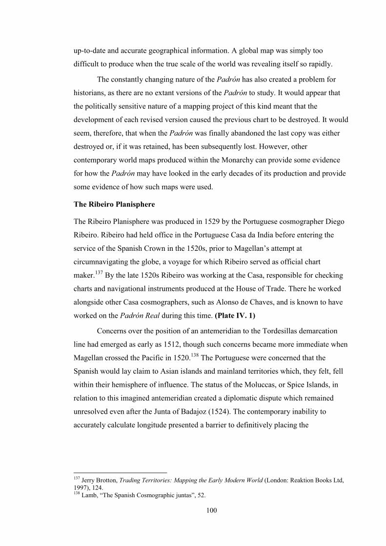
100
up-to-date and accurate geographical information. A global map was simply too
difficult to produce when the true scale of the world was revealing itself so rapidly.
The constantly changing nature of the Padrón has also created a problem for
historians, as there are no extant versions of the Padrón to study. It would appear that
the politically sensitive nature of a mapping project of this kind meant that the
development of each revised version caused the previous chart to be destroyed. It would
seem, therefore, that when the Padrón was finally abandoned the last copy was either
destroyed or, if it was retained, has been subsequently lost. However, other
contemporary world maps produced within the Monarchy can provide some evidence
for how the Padrón may have looked in the early decades of its production and provide
some evidence of how such maps were used.
The Ribeiro Planisphere
The Ribeiro Planisphere was produced in 1529 by the Portuguese cosmographer Diego
Ribeiro. Ribeiro had held office in the Portuguese Casa da India before entering the
service of the Spanish Crown in the 1520s, prior to Magellan’s attempt at
circumnavigating the globe, a voyage for which Ribeiro served as official chart
maker.137 By the late 1520s Ribeiro was working at the Casa, responsible for checking
charts and navigational instruments produced at the House of Trade. There he worked
alongside other Casa cosmographers, such as Alonso de Chaves, and is known to have
worked on the Padrón Real during this time. (Plate IV. 1)
Concerns over the position of an antemeridian to the Tordesillas demarcation
line had emerged as early as 1512, though such concerns became more immediate when
Magellan crossed the Pacific in 1520.138 The Portuguese were concerned that the
Spanish would lay claim to Asian islands and mainland territories which, they felt, fell
within their hemisphere of influence. The status of the Moluccas, or Spice Islands, in
relation to this imagined antemeridian created a diplomatic dispute which remained
unresolved even after the Junta of Badajoz (1524). The contemporary inability to
accurately calculate longitude presented a barrier to definitively placing the
137 Jerry Brotton, Trading Territories: Mapping the Early Modern World (London: Reaktion Books Ltd, 1997), 124. 138 Lamb, “The Spanish Cosmographic juntas”, 52.

PLATE IV. 1
Planisphere (1529), Diego (Diogo) Ribeiro (Carte Nautiche Borgiano III; Biblioteca Apostolica Vaticana, Vatican City).
101
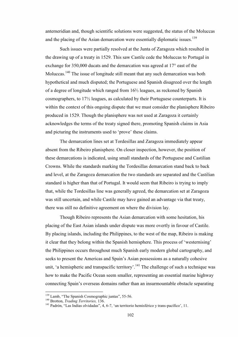
102
antemeridian and, though scientific solutions were suggested, the status of the Moluccas
and the placing of the Asian demarcation were essentially diplomatic issues.139
Such issues were partially resolved at the Junta of Zaragoza which resulted in
the drawing up of a treaty in 1529. This saw Castile cede the Moluccas to Portugal in
exchange for 350,000 ducats and the demarcation was agreed at 17° east of the
Moluccas.140 The issue of longitude still meant that any such demarcation was both
hypothetical and much disputed; the Portuguese and Spanish disagreed over the length
of a degree of longitude which ranged from 16⅔ leagues, as reckoned by Spanish
cosmographers, to 17½ leagues, as calculated by their Portuguese counterparts. It is
within the context of this ongoing dispute that we must consider the planisphere Ribeiro
produced in 1529. Though the planisphere was not used at Zaragoza it certainly
acknowledges the terms of the treaty signed there, promoting Spanish claims in Asia
and picturing the instruments used to ‘prove’ these claims.
The demarcation lines set at Tordesillas and Zaragoza immediately appear
absent from the Ribeiro planisphere. On closer inspection, however, the position of
these demarcations is indicated, using small standards of the Portuguese and Castilian
Crowns. While the standards marking the Tordesillas demarcation stand back to back
and level, at the Zaragoza demarcation the two standards are separated and the Castilian
standard is higher than that of Portugal. It would seem that Ribeiro is trying to imply
that, while the Tordesillas line was generally agreed, the demarcation set at Zaragoza
was still uncertain, and while Castile may have gained an advantage via that treaty,
there was still no definitive agreement on where the division lay.
Though Ribeiro represents the Asian demarcation with some hesitation, his
placing of the East Asian islands under dispute was more overtly in favour of Castile.
By placing islands, including the Philippines, to the west of the map, Ribeiro is making
it clear that they belong within the Spanish hemisphere. This process of ‘westernising’
the Philippines occurs throughout much Spanish early modern global cartography, and
seeks to present the Americas and Spain’s Asian possessions as a naturally cohesive
unit, ‘a hemispheric and transpacific territory’.141 The challenge of such a technique was
how to make the Pacific Ocean seem smaller, representing an essential marine highway
connecting Spain’s overseas domains rather than an insurmountable obstacle separating 139 Lamb, “The Spanish Cosmographic juntas”, 55-56. 140 Brotton, Trading Territories, 136. 141 Padrón, “Las Indias olvidadas”, 4, 6-7, ‘un territorio hemisférico y trans-pacífico’, 11.

103
them. In the planisphere, Ribeiro uses an elaborate declination table and informative
cartouche in an attempt to draw the viewer’s attention away from the vastness of the
Pacific Ocean, though fails to do so very convincingly.142
The use of images of navigational instruments in the Ribeiro planisphere is not
simply to fill space, but also to emphasise the navigational techniques preferred by the
Casa, the same techniques used to outline Spanish claims to the Moluccas. Surekha
Davies has shown that by showing instruments, such as the astrolabe and quadrant,
within the context of an ongoing diplomatic dispute, Ribeiro is picturing the techniques
employed to present a cosmographical solution to a diplomatic problem.143 This
institutional and royal allegiance is complemented by Ribeiro’s own personal
convictions as a cosmographer, most explicitly highlighted by his adoption of the
Portuguese reckoning of a degree of longitude, noting that each degree was 17½ leagues
in length.
Ribeiro’s planisphere provides a clear example of the role of global cartography
as a diplomatic aid, and marks a shift in how cartography was used and perceived, a
‘type of visual contract’ which could be drawn up and agreed to or refused.144 Though
the Ribeiro planisphere overtly promoted Castilian claims both in the Americas and
Asia it was widely accepted, being generally too accurate and pleasing too many people,
both diplomats and cosmographers, to be rejected for its geopolitical message.145 By
adopting a broad information base, combining contemporary Portuguese and Castilian
knowledge and opinion with classical learning, Ribeiro created a map which was not
simply a political artefact but also possessed practical cosmographical value.
A Demarcation and Division of the Indies
As the sixteenth century progressed, the desire to present the Indies as a coherent
territory continued, a process which received greater authority after a suitable return
route across the Pacific had been discovered in 1565. This effort to create a relationship
between Spain’s ‘western’ Asian Indies and her ‘eastern’ American domains intersected
with diplomatic efforts to secure Spanish claims in both regions, and also promoted the
142 Ricardo Padrón, “A Sea of Denial: The Early Modern Spanish Invention of the Pacific Rim”, Hispanic Review (Winter 2009), 13. 143 Surekha Davies, “The Navigational Iconography of Diogo Ribeiro's 1529 Vatican Planisphere” Imago Mundi, Vol. 55 (2003), 103-12. Lamb notes that such scientific solutions were often rejected as ‘kings were interested in advantage and not in fact’, see: “The Spanish Cosmographic juntas”, 55. 144 Brotton, Trading Territories, 137. 145 Brotton, Trading Territories, 146.

104
implementation of Spanish-Catholic geopolitical aims across the Monarchy. The
challenge came in promoting the position of the Philippines as part of a larger American
domain, one gobierno of the Viceroyalty of New Spain, a process which required it to
‘belong’ to the Americas rather than Asia. This mental repositioning of the Philippines
as an American, ‘western’ territory is seen in much of the global cartography of the
early modern Monarchy, as discussed above with regard to the Ribeiro planisphere. One
of the most explicit and successful attempts at westernising the Philippines and creating
a cohesive Asian-American ‘Indies’ can be found in Juan López de Velasco’s
Descripcion [sic] de las Indias Ocidentales, produced in manuscript form in 1575 and
later published in Herrara’s Décadas at the turn of the seventeenth century. (Plate IV.
2)
The 1575 manuscript version, drawn in black ink and tinted with a number of
coloured washes, presents a clear picture of the Indies as a cohesive unit. While the
Atlantic coasts of Europe and Africa are shown, the viewer’s attention is drawn to the
central portion of the map, covering the Americas, the Pacific Ocean and ‘western’
Asia. This focus is achieved by bounding the map with the ‘western’ demarcation line
in Asia, agreed by the Treaty of Zaragoza, and the ‘eastern’ demarcation, agreed at
Tordesillas. Furthermore, the Pacific is presented as much smaller than in reality,
drawing mainland China closer to North America, a trick which, in conjunction with
marking the transpacific sailing routes, makes the world’s largest ocean appear much
smaller and less problematic. In addition, the ghostly presence of a large southern
continent seems to hint at Spain’s hopes of further territorial gains within their
hemisphere.
By comparison the seventeenth-century printed version is quite different,
presenting an extended Pacific and doing away with the transoceanic trading routes.
Nonetheless, the clearly marked and labelled demarcation lines once again draw the
viewer’s attention to the central portion of the map, the ‘Indias Ocidentales’, which
seem naturally associated, stretching across the Pacific. There are a greater number of
labels marking important urban centres and island groups across the Monarchy, making
Spain’s domains seem ‘known’ to an extent not achieved in Velasco’s original
manuscript, which only marks three mainland cities: Mexico City, Lima and a Spanish
city which might be Toledo. The Philippines are also better represented, with Luzon a
complete island and ‘Manilla’ clearly labelled. Furthermore, the great southern

105
PLATE IV. 2
Demarcacion y nauegaciones de Yndias (1575), Juan López de Velasco, from Descripcion y Division de las Yndias (Codex Sp 7 / 1-SIZE, 17000-1; JCB, Providence).
Descripcion de las Yndias del ocidentales (1601) Juan López de Velasco and Antonio Herrara, in Historia General (B601 H564h /1-SIZE, 01808-006; JCB, Providence).

106
continent is gone, replaced instead by a cartouche which proudly states that all that seen
between the two marked demarcations belongs to Castile. The cartouche cleverly
bridges part of the Pacific which is not filled with islands, distracting the viewer again
from the vastness of the Pacific Ocean separating the Americas from the Asian Indies.
What these maps achieve in slightly different ways is to assert that the Indies are
a cohesive territorial entity, and that their relationship is natural rather than forced. The
return route across the Pacific certainly made this assertion far more practicable, though
the reality remained that the Philippines continued to be a lonely outpost of Spanish
ambitions in Asia, which was both an economic boon to the Americas and a drain on
New Spain’s resources. The manipulation of the demarcation lines, which so boldly
dissect both maps, ensures that the Indies are framed as a whole, a Castilian space
which by 1601 did not even need Castile to be visible, labelling Spanish Lisbon instead.
By cutting the Indies away from the heartland of the Monarchy in Europe the
Philippines can become associated with the Americas more easily, and Asia does not
need to compete for the attention of the Americas with Europe. Finally the Velasco
maps, in both manuscript and printed form, ambitiously seek to change culturally
embedded orientation inherent to European thought, that Asia represents the east, the
Orient; instead claiming that in this ‘New World Asia’ could be part of a ‘western’
domain.146 The traditional geographical rules do not apply within Velasco’s work, and
as such create a kind of micro-globe in which the Americas and Spanish Asia operate.
This is perhaps the great achievement of this series of maps, so important because they
were published; they assert Spanish claims over their ‘global’ Monarchy, even if that
globe was in reality only ever half a world.
Pedro Texeira’s Mapamundi
Texeira’s mapamundi acts as an epilogue to his Atlas of 1634, proclaiming the global
extent of the Monarquía Hispánica in the early decades of the seventeenth century.
Although dedicated to the Spanish king, Philip IV, the map is very much a Portuguese
production, reflecting the unity of the Iberian kingdoms during this period. The position
of the Philippines, and the Moluccas before them, in Iberian global cartography had
been, for nearly a century, a statement of jurisdiction; both the Ribeiro planisphere and
Velasco’s map of the Indies placed the islands on the western fringe of their world
views, positioning them firmly within the Spanish hemisphere. Texeira’s mapamundi,
146 Padrón, “Las Indias olvidadas”, 7.

107
however, places the Philippines to the east, keeping them within their Asian, oriental
context. As a result, the unity of the Spanish hemisphere is disrupted, yet the overall
impression is not one of fragmentation. No demarcation lines are marked on the map,
preventing a visual separation or division of global space, as is seen so boldly in
Velasco’s cartography. Throughout the Union of Crowns period the demarcation lines
were functionally honoured, though symbolically they had disappeared in Texeira’s
rendering of the world as an Iberian space; Philip IV could truly claim to be ‘El Rey
Planeta’. (Plate IV. 3)
The sumptuous decoration and detailed flourishes do not, however, detract from
the practical nature of the map. Texeira balances elegance with erudition, and the
mapamundi offers a generally accurate rendering of the world. Europe is,
unsurprisingly, well-formed and labelled, while Africa, the Americas and the southern
coast of Asia are also accurately drawn. The interior of Africa offers few named
locations or landmarks, while the central region of the Americas is precisely drawn; the
Caribbean islands, the Andes and hydrographical detail in Peru are all particularly
accurate, reflecting Texeira’s involvement in mapping these regions early in his career
and he makes use of first-hand knowledge.147 Asia, particularly well known to
Portuguese mariners, shows far more inland detail, though the northern coast is less
accurate and the Caspian Sea adopts a classically influenced shape. Some modern
observers would, no doubt, criticise Texeira’s use of classical knowledge, though this is
simply a reflection of seventeenth-century cosmography as a discipline which continued
to employ scholastic methodologies.
Although classical detail persists throughout, most overtly in the representation
of a great southern continent, Texeira can be seen to assimilate new geographical
information which was circulating amongst cosmographers during this period. One of
Europe’s earliest renderings of the Great Wall of China is seen in this map, and though
California was later proven not to be an island, contemporary reports ‘confirming’ the
region’s island status clearly influenced the Portuguese cartographer. Furthermore, a
northern protrusion of the great southern continent, seen in the lower right corner of
147 Agustín Hernando, “Poder, cartografía y política de sigilo en la España del siglo XVII”, in El Atlas del Rey Planeta, 95.

PLATE IV. 3
Mapamundi (1634) Pedro Texeira (Codex Miniatus 46; National-Bibliothek, Vienna).
108

109
Texeira’s map represents what is now known to be the northern coast of Australia.148
Terra Australis had been found, but not fully understood.
Texeira’s map is fascinating for its statement of global rule on Philip IV’s
behalf, presenting the world as a cohesive space under unified Iberian rule. Demarcation
lines do not disrupt the viewer’s gaze as they travel from west to east and back again,
and embedded European conceptions of orientation are not challenged within this
unified view. This cohesion and unity was, however, short lived. Within six years the
world would be divided once again, as Portugal reasserted its independence and, with
that, its rights to exclusive jurisdiction across half the globe. During the seventeenth-
century, as Spain underwent a period of economic and demographic crisis, its grip
began to loosen and New Spain began to command greater control across the
Monarchy.149 Nonetheless, the Texeira mapamundi represents a brief moment when a
European monarch could claim, with some authority, to be ‘King of the World’.
Conclusion
Global cartography demonstrates a greater functional change from the sixteenth into the
seventeenth century than is seen in the urban or territorial genres of the same period.
The world of the sixteenth-century was a diplomatic and mercantile space, traversable
and contestable. The seventeenth-century world, however, presents a far more unified
view, reflecting political changes in the Iberian Peninsula; the Union of Crowns
effectively connecting the Iberian hemispheres for over half a century. The late
seventeenth century signals yet another representational shift, this time one of absence.
Even global cartography was affected by the decrease in momentum seen in mapping
across the Monarchy, but also more generally across the cosmographical disciplines.
The global-scale maritime charts of the sixteenth-century also came to be replaced by
smaller, regionally focussed maps, which proved far more flexible and responsive to
changes and discoveries seen across the seventeenth century.
As the kingdom of Spain, nascent and changeable, fell victim to economic and
demographic crises it began to lose influence and, arguably, control over its American
and Pacific territories in favour of New Spain. The extent to which greater access to
Mexican archives may affect our understanding of global cartography is not clear at
148 Hernando, “Poder, cartografía y política de sigilo”, 95. 149 Lynch, Spain under the Habsburgs, Vol. II, 13.

110
present, though it does not appear that New Spain developed a great tradition for global
mapping as Spain’s presence within the Monarchy diminished.
It is extremely difficult to discern whether this decrease in global cartography
reflected a general feeling of decline amongst Spaniards who no longer felt at the head
of a global Monarchy; absence of evidence needs not be interpreted negatively.
Furthermore, as the newly independent Dutch Republic led Europe in the discipline of
world mapping it is not clear whether their prior relationship with Spain affected the
circulation of Dutch maps in the Iberian Peninsula. Considering how such Dutch
products were viewed and used, as well as how they circulated within seventeenth-
century Spain presents an interesting avenue for further research which may adjust our
understanding of how accessible world maps were in Spain during this period.
What is notable about both sixteenth and seventeenth-century official global
cartography, however, is that very little allusion is ever made to the twin projects of
Hispanisation and Catholicisation. Urban maps regularly highlight the essentially
Catholic nature of the Monarchy’s varied landscape, and territorial cartography which
promotes an impression of uniformity within territories and cohesion between them.
However, global cartography communicates less about its geopolitical efforts within its
hemisphere than in promoting and protecting its claims to rule within that hemisphere.
It is not clear whether such a global-scale representational programme was considered
inappropriate or whether this kind of visual assertion had never been considered
previously; whatever the answer, it is clear that no view of a Spanish-Catholic half-
world was ever produced in either the sixteenth or seventeenth centuries.

111
Chapter Five: Comparative Cartography and Integrated Geopolitics
The previous three chapters have considered specific genres of cartography in turn,
emphasising the particular messages conveyed by these genres with regard to the core
geopolitical programmes of the Monarquía Hispánica. This chapter will further develop
discussion to emphasise the ways in which individual maps or cartographic surveys
interacted, assessing the impact of this collaborative dimension. Though it seems few
cartographers were ever asked to specifically undertake integrated projects, it seems that
much of the cartography of the Monarchy was able to interact, presenting a view of
particular geographical subjects which offered greater depth and nuance, afforded by a
multi-scale approach.
This integrative approach to cartography reflected the interdependent nature of
the geopolitical efforts of the Monarchy through the sixteenth and seventeenth centuries.
Urbanisation, territorialisation and the global effort to achieve diplomatic and cultural
aims were seemingly independent, though in reality each process relied on the
successful continuation and achievement of the others. The interactive nature of the
Monarchy’s cartography hints at the necessarily collaborative nature of its geopolitical
outlook; maps allowed multiple strands of activity to come together to create a cohesive
view of the Monarquía.
Cartographic collaboration in the Monarquía Hispánica
Rarely do cartographic historians consider how cartography may have interacted or how
different maps may have been used in association with one another. Acknowledging our
own, multi-scale interactions with cartography highlights a need for different
approaches to representing space and gaining understandings of it which exceed
geometrically defined, aerial cartography. Modern engagement with cartography is now
most commonly via digitally available maps which offer zoom functions, to the point of
presenting street-eye views of particular locations, a multi-scale experience of space
which helps us rationalise and understand our surroundings. This way of representing
and comprehending space is not a modern innovation, however, and the multi-scale
cartography of the Monarquía Hispánica requires reassessment along these lines.
Spain and New Spain progressed through a period of cartographic development
almost in tandem, and their respective cartographic records offer many parallel features.
Both territories underwent localised mapping projects with a specifically urban focus, as

112
well as having geometrical surveys of their lands produced at almost the same time.
These parallel projects, encompassing urban mapping and territorial cartography,
certainly demonstrate a strong relationship with, and arguably reliance on, one another
to successfully produce a vision of either Spain or New Spain which is both
comprehensive and multi-faceted.
Supporting these urban and territorial perspectives were global maps, which
contextualised territories spatially and promoted specific understandings of and
approaches to political jurisdictions across the world. While global maps are not directly
integrated with urban and territorial images they do interact with them, providing a
further range of detail and context which supports a cohesive, though clearly
constructed, view of the Monarchy as a worldwide endeavour.
The Philippines present a diverse set of challenges for historians, as the range of
sources which have survived from the sixteenth and seventeenth centuries does not give
a clear view as to whether our source base is incomplete or simply limited. We have
very few localised or urban maps from this period, as most cartography presenting the
Philippines placed the islands within either a regional or global context. This
presentation is, however, instructive, emphasising both the strategic profile of the
islands and also the limited urban presence Spaniards had throughout the early modern
period. Furthermore, the placement of the Philippines on early modern world maps is a
significant statement of possession and highlights effort to refashion global space to
reflect these jurisdictional claims.
Judging the impact maps of Spain, New Spain and the Philippines may have had
on contemporary observers and users is very challenging, as few documents
contextualising specific productions exist. Furthermore, recapturing how these maps
may have been used is equally challenging, as there is little clear evidence in many
cases to suggest these maps were used at all. We can, however, look to chronological
patterns, production contexts and to the individuals or institutions commissioning these
works, when known, to gain a clearer impression of how maps may have been used and
what purpose they were intended to serve.
Spain: The Atlas and the city views
The specific dating of the Escorial Atlas presents some chronological ambiguity for
historians, as discussed in the third chapter. Nonetheless, convincing evidence which
would place the commission of the Atlas in the late 1550s or early 1560s means the

113
work was likely commissioned alongside the city views of Anton van den Wyngaerde,
commissioned c. 1561. The chronological proximity between these two projects seems
not to have been incidental. They have been commonly associated in historical
scholarship relating to Spain’s sixteenth-century cartographic efforts, and have been
considered twin projects, representing Spain in different, though complementary, ways.
This is, in many ways, true. The Escorial Atlas, and particularly its index map,
offer a level of overall detail which communicates sufficient information about the
Iberian Peninsula to be visually meaningful and, importantly, strategically useful. The
Wyngaerde views, meanwhile, present specific details about a range of, usually urban,
locations. Of the fifty-five locations mapped by Wyngaerde only thirty-two can be seen
on the Escorial index map. This is perhaps not surprising as the function of the index is
to provide a peninsular overview rather than great detail; some of the places Wyngaerde
maps are small villages, such as his rare sketch of Oxen (Ojén), near Marbella. The atlas
proper, however, does manage to capture many of those locales absent from the index
map; Ojén is mapped, as are Carmona and Antequera. (Plate V. 1 and V. 2)
Though the atlas could have substituted the Wyngaerde maps in terms of
coverage, the depth of information presented in the topographic views exceeds what is
possible on a geometrical map at the scale of the Escorial Atlas. In Zahara de los
Atunes, Wyngaerde pictures the various stages involved in the tuna industry, from the
capture of the fish in nets near the shore, the use of harpoons to kill the catch, and the
filleting and salting process in preparation for export. This, now abandoned, almadraba
is not named in the Escorial atlas or its index map, even though it was a wealthy fishing
town; residents could capture as many as 60,000 tuna in a season, making the duke
Spain’s richest grandee.150 Indeed, many of Wyngaerde’s maps provide the earliest
known view of particular locations, including Almansa, Chinchilla and, perhaps
surprisingly, Gibraltar.151 (Plate V. 3)
Though the Wyngaerde views offer detail, there is rarely any sense of relational
geography conveyed in the maps. In the views of Puerto de Santa María, Jerez de la
Frontera and Sanlucar de Barrameda there is no real indication that these three coastal
towns are close together; one of the two views of Santa María does make reference to
Cadíz, though this is absent from the second, tinted version. This broader geographical 150 Richard L. Kagan, “V. 11. Zahara de los Atunes”, in Spanish Cities of the Golden Age, 296. 151 Richard L. Kagan, “II. 14. Almansa”, “II. 15. Chinchilla de Montearagón”, and “V. 9. Gibraltar” in Spanish Cities of the Golden Age: 213, 214, 286.

PLATE V. 1
Escorial atlas, index map (c. 1580-1590). The details mark the locations shown on the index which were part of the Wyngaerde survey. Of the fifty-five villages, towns and cities mapped by Wyngaerde, thirty-two are marked on the Index.
114

115
PLATE V. 2
Oxen (Ojén) (1564), Anton van den Wyngaerde (Ms. Min 41. 22ro, National-Bibliothek, Vienna).
Escorial Atlas, Portion 2 (MS. K.I.1, fols. 5v-6r). To the right is a detail from the Portion 2 map, showing the village of Oxen (Ojén), overlooking Marbella.

PLATE V. 3
Zahara de los Atunes (c. 1564), sketch (top) final view (bottom), Anton van den Wyngaerde (Ms. Min 41. 33ro and 74). These images show an almadraba or fishing port on the Mediterranean coast.
116

117
context is what the atlas offers the viewer, presenting an aerial representation of whole
swathes of the peninsular mainland. (Plate V. 4)
It is this balance and interaction between localised, detailed presentations of
specific locations and broader regional or peninsular perspectives which emphasises the
need for both types of map. Without the Atlas or its index map Wyngaerde’s views lack
a frame of context; they are isolated images of specific locations without any sense of
how they relate to one another. However, without Wyngaerde’s views, the Atlas, and
particularly the index map, lack detail and specificity; there is no sense of the unique,
local character of any one location. The Escorial Atlas and the Wyngaerde city views,
therefore, seem like natural partners in the effort to present a cartographical rendering of
Spain as it was emerging in the sixteenth century.
The localised perspective offered by Wyngaerde’s views captures a specific
period of the 1560s; as Lestringant proposes, the local, large-scale image can capture a
level of immediate and transient detail which characterises such maps.152 This
perspective was updated through the issuing of another surveying project, this time a
written survey, the Relaciones historico-topográficas. Many of the towns and cities
shown at their apogee, or just before, by Wyngaerde were in decline by the late 1570s
when the questionnaire was issued. The Guadalajara of 1565 is shown by Wyngaerde as
prosperous, on the verge of initiating a project to widen the plaza mayor. Yet, by 1579,
the citizens were reporting mercantile and economic decline, causing many inhabitants
to leave.153 Yet much as Wyngaerde’s views capture a specific moment in each town’s
history, so too did the Relaciones survey; neither survey sought to offer contemporaries
an ongoing perspective. Furthermore, the changing fortunes of such places are not
communicated in the Atlas or the index map, perhaps produced in the 1590s, further
evidence of the ever transient nature of cartography, continuously out of date.
Nonetheless, without the Wyngaerde maps, and later the Relaciones responses, the
localised details presented by both works would be historically absent, as the Atlas and
index were produced to fulfil different, more generalised, objectives. (Plate V. 5)
The atlas and its accompanying index map were, and are, without doubt, a
remarkable achievement of early modern cosmographic endeavour. The modern
preference for geometrical cartography adopting an aerial viewpoint perhaps means we
152 Lestringant, Mapping the Renaissance World, 3. 153 Richard L. Kagan, “IV. 2. Guadalajara”, in Spanish Cities of the Golden Age: 238.
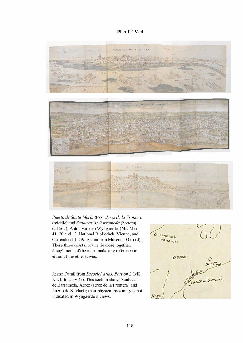
118
PLATE V. 4
Puerto de Santa María (top), Jerez de la Frontera (middle) and Sanlucar de Barrameda (bottom) (c.1567), Anton van den Wyngaerde, (Ms. Min 41. 20 and 13, National Bibliothek, Vienna, and Clarendon.III.259, Ashmolean Museum, Oxford). These three coastal towns lie close together, though none of the maps make any reference to either of the other towns.
Right: Detail from Escorial Atlas, Portion 2 (MS. K.I.1, fols. 5v-6r). This section shows Sanlucar de Barrameda, Xerez (Jerez de la Frontera) and Puerto de S. María; their physical proximity is not indicated in Wyngaerde’s views.

PLATE V. 5
Guadalajara (1565), Anton van den Wyngaerde (Ms. Min 41. 67, National-Bibliothek, Vienna).
119

120
are more comfortable considering the merits and accuracy of the Atlas over
Wyngaerde’s maps. However, without the topographic, or to speak contemporarily, the
chorographic view, we only possess one, overtly territorial, perspective on the
peninsula. By using the Atlas and Wyngaerde’s views, as well as the Relaciones, the
viewer possesses a multi-faceted perspective, presenting a variety of viewpoints and a
greater level of depth, which appears to have been, at least in part, the contemporary
purpose of these maps.
New Spain: The Relaciones geográficas and the absent survey
The Relaciones geográficas, issued in 1577, combined the written element of the
Relaciones historico-topográficas with the desire for visual representation of urban
locations seen in Wyngaerde’s work. The result was a rich corpus of written responses,
offering information on a huge range of themes and issues from the early decades of
New Spain’s existence, as well as a number of maps which were predominantly local in
focus and often specifically urban. When the questionnaires were returned to Spain both
the written and cartographic responses were archived under the supervision of Juan
López de Velasco, who had issued the survey. The fate of these responses, unpublished
and uncollated, has often been considered evidence that the project was deemed to have
failed; Mundy even reflects on how disappointed Velasco must have been when he
received the responses, particularly the accompanying pinturas, baffling in their lack of
uniformity.154 These maps could not have been used to create a complete map of the
viceroyalty, lacking scale and sufficient representational uniformity to be knitted
together, and were apparently culturally alien to an early modern Spanish observer.155
Taking a sample of 25 pinturas from the 1577 Relaciones corpus, we can see
this situation clearly. Nine of the Relaciones maps offer only local views, picturing a
particular town or village in detail. In the pintura of Texupa, the main focus of the map
is the town, its grid structure plainly presented in the centre of the map. Encircling this
urban core, topographical detail about the surrounding area, such as hills and rivers, is
shown, combining European and Mesoamerican artistic styles.156 The hills and rivers
form a landscape backdrop to the town, a European device, while the design of these
154 Mundy, The Mapping of New Spain, 13. 155 The extent to which Nahuatl-Mesoamerican cartographic styles were totally alien to Spanish observers is currently difficult to assess as no study of Spanish folk-cartography has been conducted. There is some evidence to suggest that similarities may exist between itinerary-style productions in particular; see: Buisseret, “Spanish Peninsular Cartography, 1500-1700”, 1072. 156 Mundy, The Mapping of New Spain, 79-80.

121
features makes use of Nahuatl-Mesoamerican naming and visual conventions. No other
towns are depicted and the overall impression is one of isolation. (Plate V. 6)
Sixteen pinturas from the sample, however, present a broader regional view.
These usually employ an itinerary style, showing the typical progress of an individual
between specific locations in the vicinity. The pintura from Muchitlan, a cabacera of
Minas de Zumpango, presents such an itinerary regional view. Each town is marked by
a Nahuatl place-name glyph, and population statistics are given for each location, with
Spanish glosses added to explain the data provided. The pintura of Zumpango also
provides population and tribute statistics, adopting an itinerary style, though with an
intermittent landscape backdrop. The Zumpango map does not, however, mark the
location of Muchitlan and there is no visual connection between these geographically
proximate maps. (Plate V. 7)
Of these 25 pinturas only five make reference to other places within the sample.
The map of Cempoala, for example, shows the town of Epazoyuca; there is even some
parallel between the visual representations of Epazoyuca’s church on both maps.
Furthermore, the twin maps of Ixcatlan reference Atlatlauca, which is pictured in the
bottom left of both Ixcatlan maps. In addition, the pinturas of Atlatlauca and
Teutenango reference one another, though the latter only names Atlatlauca, labelling the
road which leads there. These internal references may reflect strong social or political
relationships between these settlements, which often predated European arrival in the
Americas. Additionally, as these five towns are located in the heavily settled regions of
the Atlantic coast and along the central valley region, the internal references reflect the
concentration of settlements in these regions by the mid-sixteenth century. (Plates V. 8
– V. 11)
Though these five local views present geographical interactions which offer a
greater sense of dimensionality, they do not neatly connect to form a broader view of
these regions. The mixture of representational styles and lack of scale mean that, while
these pinturas interact, they do not interlock, forming a territorial map akin to the
Escorial index map. That the Relacion maps do not collectively depict a homogenous
territory has been given as evidence of their failure. What is rarely considered, however,
is whether these maps were, in fact, ever intended to offer such a territorial perspective.
If we return to the questionnaire itself, the point requesting the production of a ‘plan’
does not specify the style, scale or preferred format, but instead asks that specific

122
PLATE V. 6
Above: Texupa (1579) Anonymous (C-028-010; RAH, Madrid).
Below: A map showing the distribution of maps showing a single town view (blue) and those which include a broader, regional context (red).

123
PLATE V. 7
Top: Muchitlan-Zumpango (1582), Anonymous (XXV-13; NLB, Austin).
Bottom: Zumpango (1582), Anonymous (C-028-011; RAH, Madrid).
Neither pintura makes reference to the presence of the other town, though they were within the same district.

PLATE V. 8
Map showing pinturas which make internal reference to other locations. Those marked in green all reference one another, while those in blue are also linked to one another.
124

PLATE V. 9
Left: Cempoala (1580), Anonymous (XXV-10; NLB, Austin) including detail of Epazoyuca.
Right: Epazoyuca (1580), Anonymous (XXV-11; NLB, Austin). The map does not reference Cempoala, taking a specifically local view.
125

126
PLATE V. 10
Ixcatlan (1579) Anonymous (XXIV-07 I (top) and II (bottom); NLB, Austin). On both these pinturas, Atlatlauca is shown (see Plate III. 11).

PLATE V. 11
Left: Atlatlauca (1580) Anonymous (XXIII-13; NLB, Austin). Atlatlauca is referenced in the pinturas from Ixcatlan (Plate III. 10) and in turn references the town of Teutenango (right).
Right: Teutenango (1582) Anonymous (MP-MEXICO, 33; AGI, Seville). The pintura from Teutenango references Atlatlauca to the extreme left, labelling the road leading to the neighbouring town.
127

128
features of the settlement, such as the streets and monasteries, be represented. It seems
strange that, should Velasco have sought stylistic or methodological uniformity, he did
not specifically request it. We know from other cosmographical exercises initiated by
the royal chronicler-cosmographer, such as the requests for lunar eclipse data between
1577 and 1588, that Velasco was competent at providing clear, technical instructions
when required. Furthermore, on receiving the first responses from the Relaciones
geográficas c. 1581, had Velasco been disappointed by the results, why would he have
reissued the questionnaire in a format practically identical to the 1577 issue? In fact, the
request for a town plan in the 1584 issue is even less specific than that outlined seven
years previously, indicating that Velasco had little interest in uniformity as far as the
pinturas were concerned.157
While it is possible that this continued lack of specificity was an
acknowledgement of ‘failure’, it is perhaps more likely that Velasco never intended the
maps of the Relaciones to fulfil territorial aims. Before the questionnaire had even been
issued, Francisco Domínguez had been sent to New Spain to produce a territorial map
of the viceroyalty akin to the Escorial atlas.158 Only two years before the Relaciones
was issued, Domínguez appears to have returned his now lost preliminary maps, which
may have been similar to the portion maps of the Escorial atlas. With this in mind,
Velasco would not have felt the need for the pinturas to fulfil territorial ambitions being
met by Domínguez’s survey. Much as the Wyngaerde city views do not duplicate the
task of the atlas, the pinturas were not intended to duplicate Domínguez’s work; they
were intended to complement it.
The pinturas offer a localised, predominantly urban perspective on life in New
Spain, while the Domínguez maps would have reflected more general, and perhaps
strategic, territorial concerns. There is no record of the contemporary reaction to the
failure of the Domínguez project; it may have been greatly missed, though the repeated
failure to pay the cartographer, as detailed in Chapter Three, would suggest that the
project became a victim of changing priorities. How this may have affected
contemporary use or interest in the pinturas is impossible to gauge; it appears, however,
157 Question 10 in the 1584 issue reads: Describe the site upon which each town is established: whether it is on a height, or low-lying, or on a plain. Make a plan of each”. Translation taken from Cline, “Relaciones Geográficas of the Spanish Indies”, 235. 158 His ‘merits and services’ testimony (PATRONATO,261,R,9: 4; AGI, Seville) indicates that he may also have been intended to continue this territorial mapping project in Asia, though there is no evidence to suggest this was ever achieved.

129
that administrators at the Casa or Consejo did not really make use of the survey or its
accompanying maps. It is possible that, without the territorial survey to complement the
local views, the pinturas lacked relevance and context and were impossible to
conceptually place and thus utilise; the space these maps represented was unreadable.
A further explanation for why the pinturas and written responses to the
Relaciones geográficas lacked contemporary use is that there was not a clearly defined
group to use them. This is partly an effect of the strict policy of secrecy which
surrounded so much cosmographic endeavour across the Monarchy, and particularly in
Spain, throughout the sixteenth and seventeenth centuries. This prevented free access to
documents which, had they been taken up by a civic or public sphere, may have been
used beyond their original purpose in a diverse range of ways. As Paula Findlen
demonstrates within the context of Renaissance Italy, a ‘conversable space’ was
essential to the dissemination and development of natural historical knowledge,
specifically within the context of collecting.159 Furthermore, there was no civic or
public sphere at this time, another consequence of the strangling Crown-imposed
secrecy, as well as the lack of a bourgeois class in early modern Spain. The growth of a
‘collecting class’ within Renaissance Italy was founded in cultural expectations of an
educated, patrician class; civilitá demarcated knowledge spaces as well as providing
social order in public and private settings, a dual purpose policía seems to have
lacked.160 The knowledge-gathering institutions of Spain were pioneering in their
ambitions and many of their approaches, yet the strict limits imposed on the individuals
within these institutions prevented the full deployment of the information they gathered.
What can be confirmed is that, without the Domínguez survey, the historical
position of the Relaciones geográficas maps has been misinterpreted. A corpus of town
plans which was never intended to have a purely territorialising function, framing the
viceroyalty as a discrete entity, have been imbued with this purpose by modern scholars
seeking to gain an image of the emergence of ‘New Spain’. The inability of the pinturas
to fulfil these inappropriately assigned purposes has seen the Relaciones geográficas
survey, particularly its cartographic portion, labelled a failure. By returning these
pinturas to their contemporary context, however, they can reclaim their original
purpose. They were intended to show the progress of urbanism and with it
159 Paula Findlen, Possessing Nature, (Berkeley, Los Angeles & London: University of California Press,1996), 100. 160 Findlen, Possessing Nature, 98.

130
Hispanisation and the growth of Catholicism in the Americas, an agenda they address
with vibrancy and skill.
Spain and New Spain: A Global Setting
Acting as a backdrop to the territorial and urban images of Spain and New Spain was
the Padrón Real, the Monarchy's master chart of the world. This nautical chart was not,
however, intended for public use or display, instead fulfilling a practical need for an up-
to-date and accurate chart recording routes between Spain's global domains. Although
the Padrón has not survived and, therefore, we cannot be sure of its presentation or
appearance, other contemporary mappaemundi give us an impression of how the Padrón
may have looked.
As was noted in the previous chapter, Ribeiro's planisphere may be our closest
approximation of an early sixteenth-century Padrón; it adopts the same portolan style as
was used for the Monarchy's master chart. The planisphere, furthermore, provides a
contemporary layout for global mapping, a Eurocentric model of the world with the
Americas to the west and Asia to the east. This pattern is an early modern innovation;
previously Europe had been to the western edge of the world, with Asia to the east,
while in medieval cartography Asia had been at the top of a circular, Christian
cosmography, represented via the T-O map structure. It is important to bear in mind, as
a modern viewer, that while this early modern, Eurocentric geographic layout has
certainly supported claims of European dominance or supremacy, it was not developed
with this aim in mind, nor was it deployed by the Spanish for this purpose. It rather
reflects the additional nature of the Americas, tagged on to the western edge of the
known world, while Asia continued to occupy its traditional, oriental position.
It is noteworthy that, while a diplomatic document, Ribeiro's planisphere does
not mark Spain's domains distinctly on the map. British imperial cartography of later
centuries would mark all British territories in red; this kind of visual proclamation of
ownership is, however, absent from comparable early modern Spanish mapping. There
are two core reasons why this may be the case. The first is that, as a private, practical
map protected by a policy of state secrecy, the Padrón did not need to promote Spain's
territorial interests in this kind of overt, diplomatic way. The second is that, given the
hemispheric scope of the jurisdictional zones agreed under Tordesillas and Zaragoza,
there was no need to mark out specific territories as belonging to Spain; half the world
was in the possession of the Crown of Castile. As such, on the planisphere the coats of

131
arms of Castile and Portugal mark the demarcation lines, acting as badges of ownership
and promoting particular diplomatic claims.
The western position of the Americas in most world cartography of the early
modern period, though a symptom of western exploration from the Iberian peninsula,
does require brief analysis, for the most part on account of the effect this western
position had on the conceptualization and mapping of the Philippines. The Americas
were conceived as a western landmass from the moment of their discovery; it was
Columbus’ pursuit of a western route to the Indies which led Europeans to reach the
Caribbean. As such, a western placement on European maps seems appropriate,
particularly for Spaniards proclaiming their dominant jurisdiction in the New World.
For the Philippines, however, this western framing of the Americas had
consequences. As part of the Monarchy, formally engaged by the 1570s, they belonged
to a Spanish-western hemisphere. Yet, the Philippines were Asian, and thus traditionally
occupied an oriental position. This Asian character was the feature which made this
archipelago so strategically and symbolically useful; the Spanish were proclaiming the
extensive range of their dominions over the vast Pacific Ocean. A map of the Isla
Hermosa (Taiwan) north of Luzon, sent alongside a letter to the King from Hernando de
los Ríos Coronel, emphasised the importance of holding Hermosa and the Philippines in
relation to a proposed future expedition into China; an ambitious Asian campaign which
never occurred. (Plate V. 12)
Yet, the placement of the Philippines on the eastern edge of world maps
visualised the physical distance and sense of dislocation experienced by the Monarchy’s
prime oriental territory. The issues of proximity and belonging were not easily reduced
and efforts to westernise the Philippines in European mentalities often fell short of
success. As Padrón has shown in his excellent discussion, the weight of Asia exerted
centrifugal forces on the archipelago, which were not overcome simply by appending
the southeast Asian islands to the west of the map. Velasco’s map showing the
‘Division and demarcation of the Indies’ was, in essence, the most successful sixteenth
or seventeenth-century effort to fully accommodate the Philippines in the western
hemisphere. This he achieved by centring his map on the Americas, choosing not to
picture Africa, Europe or Asia, but rather to show the fringe of Spain to the East, and
the Philippines to the west, locked to the Americas by the embrace of the two
demarcation lines. It is, perhaps, significant that in this particular map Toledo, Spain’s

132
PLATE V. 12
Discrepción de la Isla Hermosa dirigida por Hernando de los Ríos Coronel al Rey con carta fecha en Manila a 27 de junio de 1597 (1597), Hernando de los Ríos Coronel (MP-FILIPINAS,6; AGI, Seville).

133
primal see, is marked rather than Madrid, representing the spiritual core of the Spanish-
Catholic global Monarchy.161
Wherever they were placed, whether to the east or to the west, the Philippines
remained a marginal location cartographically and seemingly also for those governing
the Monarchy from Spain. As a subsidiary territory of New Spain, primary
responsibility for the islands fell to the viceroy, not the Casa, Consejo or even the king.
As such, our cartographic knowledge of the Philippines during the sixteenth and
seventeenth centuries hardly parallels the depth of engagement seen in Spain or New
Spain, and our view of the archipelago is fragmentary throughout this period.
The Philippines
The picture of the Philippines presented in early modern cartography usually adopts a
regional or global perspective, lacking the detailed, localised views which survive for
Spain and New Spain. The urban images currently available are predominantly
concerned with coastal settlement on the island of Luzon, such as Manila and Cavite.
One of two surviving plans of Cavite shows the position of proposed defences for the
port-cum-garrison as part of a petition to the Junta de Guerra. Defence seemed to be a
common theme for mapping in the sixteenth and seventeenth-century Philippines; a map
of the valley of the Río Grande, or Cagayán River, to the far north of the island of
Luzon was also produced for defensive reasons. (Plate V. 13 and V. 14)
No localised or urban survey was commissioned under the Habsburg monarchs;
at the time of the late sixteenth-century cartographic projects in Spain and New Spain
the Philippines was only just settled by Spaniards and no return route across the Pacific
had yet been charted. At this time, therefore, it would not have been practicable to
pursue an inland survey of the archipelago when the Spanish hold on the islands was so
delicate. In addition, with so few Spaniards settled across the Philippines, the
cartography seems to reflect where Spanish presence was felt most keenly.162 The
Spanish were largely restricted to settling in coastal regions; there were laws relating to
Spanish presence beyond cities such as Manila and Cebu, effectively preventing the
161 By 1575, when this map was produced, the royal court had already moved to Madrid, making this city the political heart of Spain, though Toledo retained its religious primacy. 162 Vicente Rafael, Contracting Colonialism, (Ithaca & London: Cornell University Press, 1988): 18.

PLATE V. 13
Plano de la ensenada y plaza de Cavite con sus fortificaciones y las cercanías de la misma donde se localizan los pueblos de San Roque, Cavite el Viejo y la Estanjuela y las bocas de los ríos Binacaya, Bacoor y Cavite el Viejo (1663), Juan Somodevilla Tejada, (MP-FILIPINAS,8; AGI, Seville).
134

135
PLATE V. 14
Mapa de la Vega del Río Grande llamado Cagayán, hasta las provincias de Sifún, Yoga, Paniqui, Pangasinan, etc., en el que se señalan misiones y pueblos (1690), María Antonia Colomar Albajar, (MP-FILIPINAS,140; AGI, Seville).

136
widespread settlement of lay people beyond the coast.163 Such rules were intended to
protect the indigenous communities of the archipelago and support the Catholic mission
across the islands. The map of the Cagayán River, though a defensive tool primarily,
also shows this pattern of settlement; the landscape is dominated by Catholic missions
and indigenous pueblos.
Our fragmentary view of the Philippines at local, urban level may well result
from challenges of transporting maps back to Spain, a journey which, throughout the
early modern period, took years rather than months or days. As archives in the
Philippines and Mexico become more internationally accessible, through the
development of digital collections, it may be possible to add greater depth and detail to
our understanding of the sixteenth- and seventeenth-century Philippines, as it may be
assumed that some material intended to reach Spain remained in either location.
Furthermore, it is quite likely that, as a territory directly associated with New Spain, the
viceroyalty commissioned its own surveys and cartographic projects which were not
recorded in the archives of the Casa de la Contratación or the Consejo de Indias. This
type of investigation is, sadly, beyond the scope of the present study, though would
present a fascinating avenue for future research which could dramatically change our
current understanding of the Philippines before the eighteenth century.
Cartography and geopolitics
Cartography is a multi-scalar discipline. Maps at different scales offer a diversity of
information at varying levels of detail or quantity. As has been shown above, by
viewing a particular space through maps at a range of scales a perspective on that space
can be developed which is nuanced and multi-faceted, each different scale working
alongside another to contribute to an overall image of that space. This collaborative
approach to cartography, as was pioneered with mixed success in the early modern
Monarquía Hispánica, supports the legibility of maps, making the spaces they represent
readable within a broader context.
As cartography is a necessarily multi-scale disciple, so too is geopolitics.
Geopolitical activity is rarely, if ever, monoscalar, instead relying on a number of
processes operating at various scales to work alongside one another to achieve specific
or overarching goals. Yet, it is important to acknowledge that, in many contexts, these
processes are not simply integrated, they are interdependent; the success of certain 163 Nicholas P. Cushner, Spain in the Philippines, (Manila: Ateneo de Manila University, 1971): 105.

137
processes and activities relying on the successful outcome of others. This was most
certainly the case in the Monarquía Hispánica, its activities within Spain and across its
overseas domains being dominated by three processes: urbanisation, territorialisation
and a global programme of religio-cultural change shaped by diplomatically defined
realms of jurisdiction.
Urbanisation was the foundation of the Monarchy both in Spain and overseas, in
the Americas and later, with mixed success, in the Philippines. As town establishment
had proven a valuable method of securing land gained during the Reconquista, urban
foundations in the New World proved essential to successfully securing land acquired in
the name of the King. These settlements had many practical benefits; founding legally
defined, officially sanctioned settlements was a method of firmly securing newly
acquired territory and establishing the political and economic structures necessary to
make these towns and cities prosperous and ensure their continued survival.
Nonetheless, the physical structure of such settlements, most overtly in the legally
ordered towns and cities of the New World, was guided by ideological and theoretical
considerations which had broader implications. Urban settlements were considered
bastions of civility, a notion which affected town planning, as discussed in Chapter One,
affected civic architecture, with public buildings being arranged centrally, facing an
interior, community space: the central square. Furthermore, Christian influence
encouraged an association between urban living and faith; New World urbanism
revolved around the Church which was central ideologically and physically, being
placed in the central square of all newly erected towns. These classical and Christian
ideas were combined and further developed into the Spanish concept of policía, and it
was this idea of urbanised, Spanish-Catholicism which underpinned the global
ambitions of the Monarchy.
While the urban cartography of the Monarchy proclaims policía as a localised
phenomenon, the global ambitions of the Monarchy to forge a Spanish-Catholic
community across the globe fail to feature cartographically, whether through official or
unofficial channels. The prime focus of global mapping is diplomacy, rendering
diplomatically defined jurisdictional zones on maps to secure them visually in a way
they could never be practically implemented. Nonetheless, the diplomacy of division
was involved in this broader religious programme, as the authority of these global
divisions was founded in a matter of faith. The original dividing line, the Treaty of

138
Tordesillas, was instituted not by politicians or kings, but rather by the Pope, Alexander
VI. As such, all maps depicting the demarcation line dividing the Americas between
Spain and Portugal were statements of support for Catholic authority over global space.
Beyond what might be termed this ‘diplomacy of faith’, there are very few
cartographic clues demonstrating the Spanish commitment to spreading a Spanish-
Catholic culture at a global scale. World maps of the sixteenth century in particular
seem to adopt styles more commonly associated with maritime charts and are usually
highly functional in their presentation. Those of the seventeenth century follow a similar
pattern of functionality, though the volume of world maps produced, while never high
across the Monarquía , certainly seems to have dropped in this period, making
comparative study for the latter decades of the century challenging. While a modified
version of the medieval concept of universal rule certainly seems to have encouraged
Spanish Habsburg monarchs in their desire for continued territorial expansion, Philip IV
notably labelling himself ‘El Rey Planeta’, this further ideological underpinning of a
global strategy is never really articulated cartographically.
The global programme, though well developed and multi-faceted, was largely
invisible from the cartographic culture of the Monarchy. Yet, it is perhaps a realisation
that the global programme was realised through other processes, most clearly
urbanisation, though also through the ongoing process of territorialisation, which meant
that the world as a canvas for Spanish ambitions was illustrated, almost exclusively, in
practical and political ways. The process of evangelisation could not occur at a grand,
worldwide scale; rather individual villages and towns were the frontier of conversion.
Urban cartography highlights this fact, each town is constructed around its religious
institutions. In Spain too, while perhaps not physically the heart of each town and city,
Wyngaerde’s views show the Church to be the dominant force in civic life, adjusting the
perspective and orientation of his images to display these institutions in their best light.
Faith may have encouraged territorial expansion, but it was the political
institutions, the cabildos, gobiernos and viceroyalties, which governed and secured
these territories. Returning to Wyngaerde’s views, beyond labelling religious
landmarks, the institutions governing towns and cities are marked. From royal palaces
to buildings belonging to a regional corte, the viewer is reminded of the status and
importance of their temporal rulers as well as their spiritual leaders. Towns and cities
were also the foundation for governing the Monarchy, though a civic based political

139
structure was too fragmentary to be successful. Spain’s conciliar approach to
governance provided the blueprint for territorialisation in its overseas domains, and the
kingdom-based structure of rule was extended across the Atlantic.
The initial territorial programme in the Americas recognised the impossibility of
ruling a hemisphere from Madrid. Global governance necessarily had to be devolved to
in-situ governing bodies paralleling the peninsular councils, possessing sufficient
autonomy to reduce the impact of distance; the governing institutions of the Americas
could not be waiting on instruction from the king with regard to all matters. Thus, a
mid-scale programme of rule was imposed, bridging the gap between universal
ambitions and a localised, urban presence. The Viceroyalties of New Spain (1535) and
Peru (1542) built upon the foundation of early urban settlement in the American
mainland, in turn providing additional support and stability to this relatively small
network of towns. The viceroyalties, furthermore, took the Monarchy closer to a
universal style of rule, as the King in Madrid could now rule via handpicked
representatives invested with powers close to those of the king himself. The globalising
ambitions of the Monarchy had made territorialisation necessary overseas, but had also
been, arguably, realised by it.
The process of territorialisation was not limited to the Americas or even the
Philippines, which increasingly developed a status as a territorial base for
evangelisation and Hispanisation in Asia, a status which remained largely unfulfilled.
The Iberian kingdoms, including and excluding Portugal at different times, developed a
corporate identity, culturally and increasingly politically, over the later sixteenth
century, as the notion of ‘Spain’ born from the ‘Hispania’ of the classical world began
to emerge in reality. There is much to link the emergence of ‘Spain’, practically and
theoretically, to the growth of territorialisation in the Americas, as those Iberians
operating in New Spain, Peru and elsewhere across the central and southern portions of
the continent began to develop a sense of sharing a collective identity as ‘Spanish’.
Traditional identities, Castilian, Aragonese, lost relevance so far from their geographical
context and those ‘Spaniards’ living in the Americas began to appreciate their shared
culture more than their regional differences. This sense of connection was forged in
towns and cities which shared an economic, agricultural, political and religious culture
with so many peninsular settlements, as was intended to be the case in the Americas
particularly. ‘New Spain’ preceded ‘Spain’ as a formal entity, and it is possible to argue

140
that the new directly inspired the creation of the old, global expansion encouraging
territorial consolidation in the domestic context.
Conclusion
Integrated cartography has shown itself to be highly successful in creating a detailed
sense of place, by offering multi-scale representations of different locations and
territories, up to and including the world as a whole. This multi-scale approach allows
the viewer to contextualise each map in different ways; appreciating a territory as part
of a global space as well as being composed of localised networks of urban or pastoral
sites, or acknowledging the global significance of an individual city, such as Manila.
This process of cartographic contextualisation, furthermore, emphasises the many
connections between disparate places; allowing distant territories to be placed side by
side, overcoming physical distance in a way which would be impossible in reality.
Success lies in the diversity of approach, perspective and scale, and the same can be
seen in the geopolitical programme of the Monarchy.
The geopolitical legacy of the Monarquía Hispánica can be seen today; Latin
America and the Philippines remain highly urbanised, predominantly Catholic and most
commonly Spanish-speaking. The territorial units which the Habsburgs imposed on the
Americas and in Asia may not always survive entirely intact, but many follow the
general pattern imposed in the sixteenth-century; modern Mexico owes more to New
Spain than to the pre-Columbian geography of the Aztec-Méxica Empire. This legacy is
founded on the success of three, core geopolitical processes: urbanisation,
territorialisation and a global programme of imposing a Spanish-Catholic culture
worldwide. Although never a truly ‘global’ possibility, the Monarchy successfully
exerted its efforts over its traditional hemisphere of jurisdiction and, while Bourbon
reforms and independence movements changed, adapted and claimed these core
processes, they were initially imposed by the Habsburg Monarquía Hispánica.

141
Epilogue
Geopolitical activity across the Monarquía Hispánica demonstrated much continuity
between the sixteenth and seventeenth centuries, though the cartography which
visualised this activity highlighted the period as one of changing pace and priorities.
Cartographic perspectives on the geopolitical activity of the sixteenth century are
diverse and numerous, demonstrating the concerted strategy the Monarchy articulated
domestically and in its extended hemisphere of influence. This level of detail becomes
more limited in the seventeenth century, a result of the general reduction in cartographic
output during this period; in part a consequence of the loss of direct royal patronage
during the reign of the mentally diminished Charles II. Further domestic crises, from
demographic damage wrought by plague and famine to a lengthy period of economic
hyperinflation, saw the position of Spain within its own Monarchy begin to wane.164
This depressing picture need not project an entirely negative perspective however, as
the territories of Central and South America began to carve out increased autonomy as
peninsular Spain increasingly failed to command either influence or political dominance
in the region. Nonetheless, the seventeenth century saw geopolitical activity continue,
though in a more limited, localised fashion, concerned with undertaking daily tasks and
maintaining the achievements of the previous century more than innovating practically
or ideologically.
The advent of Bourbon rule, however, marked a change in geopolitical ideology.
Reforming activity was not swiftly initiated following the dynastic transition, though by
the middle decades of the century political and economic changes were certainly being
felt throughout Spain’s overseas domains. This reforming period saw the Monarchy
reconceptualised as an Empire, a change which required a new cartography. As such,
cartography and geographical surveying regained some of its sixteenth-century
dynamism; even the Relaciones geográficas surveys were reissued; the first Bourbon
version, of 1777, practically mirrored the 1577 edition.165
For many cartographic historians the 1775 map of South America, produced by
Juan de la Cruz Cano y Olmedilla for the Spanish Crown, has come to embody this
164 Lynch, Spain Under the Habsburgs, Volume II, 1-13. 165 Robert C. West, “The Relaciones Geográficas of Mexico and Central America, 1740-1792”, in The Handbook of Middle American Indians, Volume 12: Guide to the Ethnohistorical Sources, Part One, ed. Howard Cline, (Austin: University of Texas Press, 1972): 442-47.

142
new, imperial cartography. Geometrically accurate and boldly presented, measuring six
feet by eight feet, the map reflected recent diplomatic agreements to formally position a
boundary between Portuguese Brazil and the Viceroyalty of Peru. Although the map
was published, it was never intended for public consumption, being produced for
internal use within the institutions of governance; the tradition of recognising
geographical knowledge as politically useful and sensitive continued. Yet, it is another
pair of maps showing Spain’s Empire which seems to embody the changing priorities of
Bourbon global politics: Vicente de Memije’s maps of the Mundo Hispánico.
Vicente de Memije’s maps, as shown in the Introduction, present geographical
and allegorical views of the Spanish ‘world’, stretching from peninsular Spain across
the Atlantic to the Americas and beyond, across the Pacific, to the Philippines. The
geographic map has received little attention, though it offers an accurate and detailed
view of the Empire over a decade before Cruz Cano’s detail map of South America. The
allegorical map has received greater scholarly attention, though this has tended to
discount Memije’s view of the Body of the Empire as “delightfully quixotic”.166
Although seemingly the product of “bankrupt cartographic ideology”, the Memije map
is anything but; it is a firmly modern, eighteenth century view of Spanish territorial
domains.
Seen in isolation as a mid-eighteenth century production, the Aspecto Symbólico
seems to owe more to sixteenth-century cartographic ideology than to eighteenth
century rational mapping techniques. Yet, Memije accurately captures the contemporary
political situation within this map. Firstly, the lack of demarcation lines reflects their
effective revocation under the 1750 Treaty of Madrid; though the 1761 Treaty of El
Pardo technically reinstated these divisions, news of this agreement did not reach
Manila until after Memjie produced his maps.167 Secondly, Memije seeks to promote
the position of the Philippines within the Hispanic world, a territory presented as
essential to the continued prosperity and survival for the Empire as a whole. Renewed
interest in the islands grew in the Bourbon period, as the creation of plantations sought
to make the Philippines an economically viable and self-sustaining colony, encouraging
166 Ricardo Padrón, “From Abstraction to Allegory: The Imperial Cartography of Vicente de Memije” in Early American Cartographies, Martin Brückner (ed.), (Chapel Hill: The University of North Carolina Press, 2011): 38, quoting O. H. K. Spate, Monopolists and Freebooters (Minneapolis: University of Minnesota Press, 1983): 399. 167 Padrón, “From Abstraction to Allegory”, 49.

143
agriculture as a complement to the archipelago’s position as an entrepôt of international
maritime trade.168 The ships carrying goods across the oceans to the Americas and
Spain are still shown to be essential, forming the clothes and accessories to the Body of
Empire, recognising the increased focus on economic development under Bourbon rule.
The Americas, the centre of the Empire, are both essential and, seemingly, secondary
within the image; a mantle to the Body, the Americas are an adornment rather than a
physical part of the corpus. Finally, the head, Spain, is upturned, looking to the cherubs
and flaming Sword of Faith, enforcing Catholicism as an inspiration for expansion and a
social reality across the Empire.
Both the geographic and the symbolic maps show the Mundo Hispánico as a
cohesive whole, captured easily within one cartographic frame. The Aspecto Symbólico,
while perhaps unusual to modern eyes, is clearly innovative when seen in the context of
sixteenth and seventeenth century cartography, representing an overtly modern,
eighteenth-century viewpoint. Memije’s map emphasises the need to reconsider
Bourbon rule as a mixture of reform and continuity, rather than a clean break between
the monarchical Habsburg past and the imperial Bourbon future. By viewing Memije’s
work as one example of early modern cartography, a tradition stretching from the early-
sixteenth century to the late-eighteenth century, we can acknowledge continuity but
equally appreciate the specific transformations and innovations of Bourbon rule.
168 Russell K. Skowronek, “On the Fringes of New Spain: The Northern Borderlands and the Pacific”, in International Handbook of Historical Archaeology, eds. Teresita Majewski and David Gaimster, (New York: Springer, 2009): 479.
vi
Abbreviations
AGI Archivo General de Indias; Seville.
BNE Biblioteca Nacional de España, Madrid.
JCB The John Carter Brown Library; Providence, RI.
NLB Nettie Lee Benson Latin American Collection; The University of Texas at Austin, TX.
RAH Real Academia de la Historia; Madrid.

vii
Bibliography
Unpublished Primary Sources
Acacingo (1606) Anonymous. Tierras, vol. 2676, exp. 14, f. 135. Archivo General de la Nación, Mexico City.
Cadastral map (16th century) Anonymous. Codice de las posesiones de Don Andrés. G24: García Collection. Benson Latin American Collection, General Libraries, The University of Texas at Austin.
Discrepción de la Isla Hermosa dirigida por Hernando de los Ríos Coronel al Rey con carta fecha en Manila a 27 de junio de 1597 (1597) Hernando de los Ríos Coronel. MP-FILIPINAS,6: Archivo General de Indias, Seville.
Doce figuras ó planos de eclipse de luna observado en México el 17 de Noviembre de 1584, hechas por Jaime Juan, Cristóbal Gudiel, Francisco Domínguez y el Doctor Farfan conforme á las instrucciones de Su Majestad (1584) Francisco Dominguez. MP-MEXICO, 34 7R and 8R. Archivo General de Indias, Seville.
Epazoyuca (Nov. 1, 1580) Anonymous. XXV-11: Relaciones Geográficas of Mexico and Guatemala, 1577-1585. Benson Latin American Collection, General Libraries, The University of Texas at Austin.
Hispaniae descriptio (Venice, 1560), Domenico Zenoi. Novacco 4F 190 (PrCt): Franco Novacco Map Collection. Newberry Library, Chicago.
Izquyluca (1594) Anonymous.Tierras, vol. 279, exp. 1, f. 116: Archivo General de la Nación, Mexico City.
Nobilis ac regia civitas Valentie in Hispania. (1608) Antonio Manceli. Private Collection, Valencia.
Mapa de la Vega del Río Grande llamado Cagayán, hasta las provincias de Sifún, Yoga, Paniqui, Pangasinan, etc., en el que se señalan misiones y pueblos (1690) María Antonia Colomar Albajar. MP-FILIPINAS,140: Archivo General de Indias, Seville.
Quatlatlauca (1579) Anonymous. XXIV-16: Relaciones Geográficas of Mexico and Guatemala, 1577-1585. Benson Latin American Collection, General Libraries, The University of Texas at Austin.
Santa María Nativitas y San Antonio (1602) Anonymous. Tierras, vol. 183, exp. 2, f. 190: Archivo General de la Nación, Mexico City.
Published Primary Sources
Curiel, Gustavo. “Perception of the Other and the Language of “Chinese Mimicry” in the Decorative Arts of New Spain.” Asia & Spanish America: Trans-Pacific Artistic and Cultural Exchange, 1500-1850: Papers from the 2006 Mayer Center Symposium at the Denver Art Museum, edited by Donna Pierce & Ronald Otsuka: 19-36. Denver: Denver Art Museum, 2009.
Large majolica jar (c. 1700), Puebla de los Angelos production. Museo Franz Mayer, Mexico City.

viii
Davis, Surekha. “The Navigational Iconography of Diogo Ribeiro's 1529 Vatican Planisphere.” Imago Mundi, Vol. 55 (2003), 103-12.
Planisphere (1529), Diego (Diogo) Ribeiro. Carte Nautiche Borgiano III: Biblioteca Apostolica Vaticana, Vatican City.
El Mapa de Sigüenza (16th century) Anonymous. Instituto Nacional de Antropología y Historia, Mexico; World Digital Library: http://www.wdl.org/en/item/3247/ (last accessed: 06/09/2014).
Escorial Atlas, (c. 1560-1575) Pedro Esquivel and Diego de Guevara. MS. K.I.1, fols. 13v-14r: Patrimonio Nacional, Madrid; Andalucía: La imagen cartográfica de la antigüedad a nuestros días: http://www.bibliotecavirtualdeandalucia.es/catalogo/exposicion/expovirtual/expovirtual.swf (last accessed: 06/09/2014).
González, Julio (ed.), Planos de ciudades iberoamericanas y filipinas existentes en el Archivo de Indias, Volumes 1 and 2. Madrid: Instituto de administración local, 1951.
Plano de la ensenada y plaza de Cavite con sus fortificaciones y las cercanías de la misma donde se localizan los pueblos de San Roque, Cavite el Viejo y la Estanjuela y las bocas de los ríos Binacaya, Bacoor y Cavite el Viejo (1663), Juan Somodevilla Tejada. MP-FILIPINAS,8: Archivo General de Indias, Seville.
Descripción geométrica de la ciudad y circunvalación de Manila y sus arrabales… (1671), Fr. Ignacio Muñoz. MP-FILIPINAS, 10: Archivo General de Indias, Seville.
Kagan, Richard L. Spanish Cities of the Golden Age: the views of Anton van den Wyngaerde. Berkeley and London: University of California Press, 1989.
Barcelona (1563) Ms. Min 41. 12: National-Bibliothek, Vienna.
Cádiz (1567) Ms. Min 41. 75: National-Bibliothek, Vienna.
Cordoba (1567) Inventory no. 8455. 6: Victoria and Albert Museum, London.
Guadalajara (1565) Ms. Min 41. 67: National-Bibliothek, Vienna.
Jerez de la Frontera (1567) Ms. Min 41. 13: National-Bibliothek, Vienna.
Madrid (1562) Ms. Min 41. 35ro: National-Bibliothek, Vienna.
Monzón (1563) Ms. Min 41. 6: National-Bibliothek, Vienna.
Ojén (1564) Ms. Min 41. 22ro: National-Bibliothek, Vienna.
Puerto de Santa María (c. 1567) Ms. Min 41. 20: National-Bibliothek, Vienna.
Sanlúcar de Barrameda (c. 1567) Clarendon.III.259: Ashmolean Museum, Oxford.
Toledo (1563) Ms. Min 41. 19: National-Bibliothek, Vienna.
Valencia (1563) Ms. Min 41. 1: National-Bibliothek, Vienna.
Zahara de los Atunes, sketch (c. 1564), Ms. Min 41. 33vo: National-Bibliothek, Vienna.
Zahara de los Atunes (c. 1564) Ms. Min 41. 74: National-Bibliothek, Vienna.

ix
Koeman, Cornelis and J. Visser (eds.), De stadsplattegronden van Jacob van Deventer, Volumes 1-9. Landsmeer: Robas, 1992.
Amsterdam, (c.1560) Jacob van Deventer. inv.nr A (492.629.005) 73: Haarlem, Rijksarchief in Noord-Holland.
La Spaña (1554) Giacomo Gastaldi. MA00064411: Biblioteca Nacional de España, Madrid.
Leibsohn, Dana. “Made in China, Made in Mexico.” In At the Crossroads: The Arts of Spanish America & Early Global Trade, 1492-1850: Papers from the 2010 Mayer Center Symposium at the Denver Art Museum, edited by Donna Pierce and Ronald Y. Otsuka, 11-40. Denver: Denver Art Museum, 2012.
Majolica basin (late 17th century), Puebla production. Denver Art Museum, Denver.
Mundy, Barbara. The Mapping of New Spain. Chicago and London: University of Chicago Press, 2001 (paperback edition).
Atlatlauca (Sept. 17, 1580) Anonymous. XXIII-13: Relaciones Geográficas of Mexico and Guatemala, 1577-1585. Benson Latin American Collection, General Libraries, The University of Texas at Austin.
Cempoala (Nov. 1, 1580) Anonymous. XXIII-10: Relaciones Geográficas of Mexico and Guatemala, 1577-1585. Benson Latin American Collection, General Libraries, The University of Texas at Austin.
Cholula (1581) Anonymous. XXIV-1: Relaciones Geográficas of Mexico and Guatemala, 1577-1585. Benson Latin American Collection, General Libraries, The University of Texas at Austin..
Cuzcatlan (1580) Anonymous. XXIII-15: Relaciones Geográficas of Mexico and Guatemala, 1577-1585. Benson Latin American Collection, General Libraries, The University of Texas at Austin.
Guaxtepec (Sept. 24, 1580) Anonymous. XXIV-03: Relaciones Geográficas of Mexico and Guatemala, 1577-1585. Benson Latin American Collection, General Libraries, The University of Texas at Austin.
Ixcatlan (Santa María) I (Oct. 13, 1579) Gonzalo Velázquez de Lara (?). XXIV-07: Relaciones Geográficas of Mexico and Guatemala, 1577-1585. Benson Latin American Collection, General Libraries, The University of Texas at Austin.
Ixcatlan (Santa María) II (Oct. 13, 1579) Gonzalo Velázquez de Lara (?). XXIV-07: Relaciones Geográficas of Mexico and Guatemala, 1577-1585. Benson Latin American Collection, General Libraries, The University of Texas at Austin.
Meztitlan (Oct. 1, 1579) Gabriel de Cháves. XXIV-12: Relaciones Geográficas of Mexico and Guatemala, 1577-1585. Benson Latin American Collection, General Libraries, The University of Texas at Austin.
Muchitlan-Zumpango (Mar. 7, 1582) Anonymous. XXV-13: Relaciones Geográficas of Mexico and Guatemala, 1577-1585. Benson Latin American Collection, General Libraries, The University of Texas at Austin.

x
Tecuicuilco (1580) Anonymous. XXIV-19: Relaciones Geográficas of Mexico and Guatemala, 1577-1585. Benson Latin American Collection, General Libraries, The University of Texas at Austin.
Teozacoalco (1580) Anonymous. XXV-03: Relaciones Geográficas of Mexico and Guatemala, 1577-1585. Benson Latin American Collection, General Libraries, The University of Texas at Austin.
Tetlistaca (Nov. 15, 1581) Anonymous. XXV-12: Relaciones Geográficas of Mexico and Guatemala, 1577-1585. Benson Latin American Collection, General Libraries, The University of Texas at Austin.
Teutenango (Mar. 3, 1582) Anonymous. MP-MEXICO, 33: Archivo General de Indias, Seville.
Texupa (Oct. 20, 1579) Anonymous. C-028-010: Real Academia de la Historia, Madrid.
Zumpango, Minas (Mar. 10, 1582) Anonymous. C-028-011: Real Academia de la Historia, Madrid.
Padrón, Ricardo. “From Abstraction to Allegory: The Imperial Cartography of Vicente de Memije” in Early American Cartographies, edited by Martin Brückner, 35-65. Chapel Hill: The University of North Carolina Press, 2011.
Aspecto Symbólico del Mundo Hispanico (Manila, 1761), Vicente de Memije. Maps K.Top.118.19: British Library, London.
Aspecto Geográphico del Mundo Hispanico (Manila, 1761), Vicente de Memije. Maps K.Top.118.19: British Library, London.
Pereda, Felipe and Fernando Marías. El atlas del rey planeta: descripción de España y de las costas y puertos de sus reinos de Pedro Texeira (1634). Hondarribia: Editorial Nerea, 2003.
Coastline south of Granada (1634) Pedro Texeira (Codex Miniatus 46: National-Bibliothek, Vienna)
Marbella (1634) Pedro Texeira (Codex Miniatus 46: National-Bibliothek, Vienna)
Tabla general de España (1634) Pedro Texeira (Codex Miniatus 46: National-Bibliothek, Vienna)
Mapamundi (1634) Pedro Texeira (Codex Miniatus 46: National-Bibliothek, Vienna).
Topographia de la villa de Madrid (1656) Pedro Texeira (INVENT/23233: Biblioteca Nacional de España.
Quirino, Carlos. Philippine Cartography, 1320-1899. 3rd edition. Manila: Vibal Foundation, 2010.
Carta hydrographica y chorographica de las Islas Filipinas (1734) F. Pedro Murillo Velarde; engraved and printed, Nicolás de la Cruz Bagay; accompanying images, Francisco Suarez. MR/45/31: Biblioteca Nacional de España, Madrid.
Samson, Alexander. “Mapping the Marriage: Thomas Geminus’s “Britanniae Insulae Nova Descriptio” and “Nova Descriptio Hispaniae” (1555).” Renaissance and Reformation, Vol. 31, No. 1 (Winter 2008): 95-115.

xi
Nova descriptio Hispaniae (1555), Thomas Geminus. Bibliothèque National de France.
The John Carter Brown Library, Brown University: JCB Map Collection Online.
Descripcion de la Audiencia de Nueva España (1575) Juan López de Velasco, from Descripcion y Division de las Yndias. Codex Sp 7 / 1-SIZE, 17000-4. http://jcb.lunaimaging.com/luna/servlet/s/v9c97g (last accessed: 06/09/2014).
Demarcacion y nauegaciones de Yndias (1575), Juan López de Velasco, from Descripcion y Division de las Yndias. Codex Sp 7 / 1-SIZE, 17000-1. http://jcb.lunaimaging.com/luna/servlet/s/0o3716 (last accessed: 06/09/2014).
Vindel, Francisco (ed.). Mapas de América y Filipinas en los libros españoles de los siglos XVI al XVIII y Apendice a los de América, adición de los de Filipinas, two volumes. Madrid: Talleres Tipograficos de Gongora, 1959.
Descripcion de las Yndias del ocidentales (1601) Juan López de Velasco and Antonio Herrara, in Historia General. B601 H564h /1-SIZE, 01808-006.
Descripcion del Destricto del audiencia de Nueva Espana (1601) Juan López de Velasco and Antonio Herrara, in Historia General. B601 H564h /1-SIZE, 01808-009.
Descripcion de las Indias del Poniente (1601) Juan López de Velasco and Antonio Herrara, in Historia General. B601 H564h /1-SIZE, 01808-019.
Published Collections of Primary Sources
Colvin, Howard and Susan Foister (eds.). The panorama of London circa 1544 by Anthonis van den Wyngaerde. London: London Topographical Society, 1996.
Mundigo, Axel I. and Dora P. Crouch, “The City Planning Ordinances of the Laws of the Indies Revisited: Part I: Their Philosophy and Implications.” Town Planning Review, 48:3 (July 1977), 247-68; translations of selected Ordinances 249-59.
Published Secondary Sources
Agnew, John. Geopolitics: Revisioning World Politics. London and New York: Routledge, 1998.
Agnew, John. “The territorial trap: the geographical assumptions of international relations theory.” Review of International Political Economy, 1:1 (Spring 1994): 53-80.
Agnew, John and Stuart Corbridge. Mastering Space. London and New York: Routledge, 1995.
Akerman, James R. The Imperial Map. Chicago and London: The University of Chicago Press, 2009.
Barrera, Antonio. “Empire and Knowledge: Reporting from the New World.” Colonial Latin American Review, Vol. 15, no. 1 (June 2006): 39-54.
Barrera-Osorio, Antonio. Experiencing Nature. Austin: University of Texas Press, 2006.

xii
Benton, Lauren and Benjamin Straumann. “Acquiring Empire by Law: From Roman Doctrine to Early Modern European Practice.” Law and History Review Vol. 28, no. 1 (Feb. 2010): 1-38.
Bernal, Rafael. México en Filipinas: estudio de una transculturación. México, Universidad Nacional Autónoma de México, 1965.
Bjork, Katherine. “The Link That Kept the Philippines Spanish: Mexican Merchant Interests and the Manila Trade, 1571-1815.” Journal of World History, Vol. 9, no. 1 (Spring 1998): 25-50.
Brotton, Jerry. Trading Territories: Mapping the Early Modern World. London: Reaktion Books Ltd., 1997.
Buisseret, David. “Spanish Peninsular Cartography, 1500-1700.” In The History of Cartography, Volume Three, Part One: Cartography in the European Renaissance, edited by David Woodward, 1069-94. Chicago and London: The University of Chicago Press, 2007.
Cañeque, Alejandro. The King’s Living Image: The Culture of Politics and Viceregal Power in Colonial Mexico. London and New York: Routledge, 2004.
Cañizares-Esguerra, Jorge. Nature, Empire and Nation. Stanford: Stanford University Press, 2006.
Camino, Mercedes Maroto. Producing the pacific: maps and narratives of Spanish exploration (1567-1606). Amsterdam: Rodopi, 2005.
Chaunu, Pierre. Conquête et exploration des nouveaux mondes (XVI siècle). Paris: Presses universitaires de France, 1969.
Chias, Pilar and Tomas Abad. “Colonial Urban Planning and Land Structures in the Philippines, 1521-1898.” Journal of Asian Architecture and Building Engineering, Vol. 11, no. 1 (May 2012): 9-16.
Cline, Howard F. “The Relaciones Geográficas of the Spanish Indies, 1577-1648.” In The Handbook of Middle American Indians, Volume 12: Guide to the Ethnohistorical Sources, Part One, edited by Howard Cline, 183-242. Austin: University of Texas Press, 1972.
Colás, Alejandro. Empire. Cambridge: Polity Press, 2007.
Craib, Raymond B. “Cartography and Power in the Conquest and Creation of New Spain.” Latin American Research Review, Vol. 35, no. 1 (2000): 7-36.
Crespo-Sanz, Antonio. “Novel Reflections on the Atlas at El Escorial”, ICC Presentations (2005): http://www.google.co.uk/url?sa=t&rct=j&q=&esrc=s&source=web&cd=1&ved=0CCIQFjAA&url=http%3A%2F%2Ficaci.org%2Ffiles%2Fdocuments%2FICC_proceedings%2FICC2005%2Fhtm%2Fpdf%2Foral%2FTEMA16%2FSession%25205%2FANTONIO%2520CRESPO.pdf&ei=ZpnsU7-NE5Go0AWyk4CgBQ&usg=AFQjCNHhKf-pFM4fcvR-YIj_gDL2SKTEMQ&bvm=bv.72938740,d.d2k (last accessed: 14/08/2014).

xiii
Crespo-Sanz, Antonio. “Un mapa olividado: el Atlas de El Escorial.” Catastro (2005): 59-89.
Cushner, Nicholas P. Spain in the Philippines. Manila: Ateneo de Manila University, 1971.
Davis, Surekha. “The Navigational Iconography of Diogo Ribeiro's 1529 Vatican Planisphere.” Imago Mundi, Vol. 55 (2003), 103-12.
Edney, Matthew H. Mapping an Empire: The Geographical Construction of British India, 1765-1843. Chicago and London: The University of Chicago Press, 1997.
Elden, Stuart. “Land, terrain, territory.” Progress in Human Geography, Vol. 34, no. 6 (2010): 799-817.
Elliott, J. H. Imperial Spain, 1496-1716. London: Penguin Books, 2002.
Elliott, J. H. “A Europe of Composite Monarchies.” Past and Present, no. 137 (1992): 48-73.
Elliott, J. H. “Spain and America in the sixteenth and seventeenth centuries.” In The Cambridge History of Latin America, Volume I: Colonial Latin America, edited by Leslie Bethell, 287-340. Cambridge: Cambridge University Press, 2008.
Endfield, Georgina H. “‘Pinturas’, Land and Lawsuits: Maps in Colonial Mexican Legal Documents.” Imago Mundi Vol. 53 (2001): 7-27.
Escolar, Marcelo. “Exploration, cartography and the modernization of state power.” In State/Space: A Reader, edited by Neil Brenner, Bob Jessop, Martin Jones and Gordon Macleod, 29-52. Oxford: Blackwell, 2003.
Fernández-Armesto, Felipe. “Philip II’s Empire: A Decade at the Edge.” The Hakluyt Annual Lecture 1998. Beccles: Keely Print, 1999.
Findlen, Paula. Possessing Nature. Berkeley, Los Angeles and London: University of California Press, 1996.
Flynn, Dennis O. and Arturo Giráldez. “Born with a “Silver Spoon”: The Origin of World Trade in 1571.” Journal of World History, Vol. 6, no. 2 (2005): 201-21.
Gavin, Robin Farewell, Donna Pierce and Alfonso Pleguezuelo. Cerámica y Cultura: The Story of Spanish and Mexican Mayólica. Albuquerque: University of New Mexico Press, 2003.
Goodman, David M. Power and Penury. Cambridge: Cambridge University Press, 1988.
Gruzinski, Serge. Painting the Conquest: the Mexican Indians and the European Renaissance, translated by Deke Dusinberre. Paris: Unesco/Flammarion, 1992.
Gruzinski, Serge. Les quatre parties du monde: histoire d'une mondialisation. Paris: Martinière, 2004.
Harley, J. B. “Maps, Knowledge and Power.” In The Iconography of Landscape: Essays on the Symbolic Representation, Design and Use of Past Environments, edited by Denis
xiv
Cosgrove and Stephen Daniels, 277-312. Cambridge: Cambridge University Press, 1988.
Harley, J. B. “Silences and Secrecy: The Hidden Agenda of Cartography in Early Modern Europe.” Imago Mundi, Vol. 40 (1988): 57-76.
Haverkamp-Begemann, Egbert. “The Spanish Views of Anton van den Wyngaerde.” In Spanish Cities of the Golden Age: the views of Anton van den Wyngaerde, edited by Richard L. Kagan, 54-67. Berkeley and London: University of California Press, 1989.
Haverkamp-Begemann, Egbert. “The Spanish Views of Anton van den Wyngaerde.” Master Drawings, Vol. 7, no. 4 (Winter 1969): 375-99 and 438-50.
Headley, John M. “Spain’s Asian Presence, 1565-1590: Structures and Aspirations.” The Hispanic American Historical Review, Vol. 75, no. 4 (November 1995): 623-46.
Herzog, Tamar. “Can You Tell a Spaniard When You See One? “Us” and “Them” in the Early Modern Iberian Atlantic.” In Polycentric Monarchies: How did Early Modern Spain and Portugal Achieve and Maintain a Global Hegemony? edited by Pedro Cardim, Tamar Herzog, José Javier Ruiz Ibáñez and Gaetano Sabatini, 147-61. Brighton: Sussex Academic Press, 2012.
Irving, David R. M. Colonial Counterpoint. Oxford: Oxford University Press, 2010.
Kagan, Richard L. Urban Images of the Hispanic World. New Haven and London: Yale University Press, 2000.
Kagan, Richard L. Spanish Cities of the Golden Age: the views of Anton van den Wyngaerde. Berkeley and London: University of California Press, 1989.
Kagan, Richard L. “Urbs and Civitas in Sixteenth- and Seventeenth-Century Spain.” In Envisioning the City: Six Studies in Urban Cartography, edited by David Buisseret, 75-108. Chicago and London: The University of Chicago Press, 1998.
Kamen, Henry. Early Modern European Society. London and New York: Routledge, 2003.
Kamen, Henry. Spain’s Road to Empire. London: Penguin Books, 2002.
Karrow, Robert W. Mapmakers of the Sixteenth Century and their Maps. Chicago: Speculum Orbis Press, 1993.
Kinsbruner, Jay. The colonial Spanish-America City: urban life in the age of Atlantic capitalism. Austin: The University of Texas Press, 2005.
Lafaye, Jacques. Quetzalcóatl and Guadalupe. Chicago and London: The University of Chicago Press, 1976.
Lamb, Ursula S. “The Spanish Cosmographic juntas of the sixteenth century.” Terrae Inocgnitae Vol. 6, issue 01 (1974): 51-62.
Leibsohn, Dana. “Made in China, Made in Mexico.” In At the Crossroads: The Arts of Spanish America & Early Global Trade, 1492-1850: Papers from the 2010 Mayer Center Symposium at the Denver Art Museum, edited by Donna Pierce and Ronald Y. Otsuka, 11-40. Denver: Denver Art Museum, 2012.

xv
Lestringant, Frank. Mapping the Renaissance World. Translated by David Fausett. Cambridge: Polity Press, 1994.
Lynch, John. Spain under the Habsburgs, Volume II: Spain and America, 1598-1700. Oxford: Basil Blackwell, 1969.
Lynch, John. “The Institutional Framework of Colonial Spanish America.” In Government and Governance of European Empires, 1450-1800, An Expanding World, Volume 21, Part One, edited by A. J. R. Russell-Wood, 69-81. Aldershot: Ashgate, Variorum, 2000.
Lynch, John. The Spanish American Revolutions, 1808-1826. New York and London: Norton, 1986.
Mazín Gómez, Oscar (ed.). México en el mundo hispánico. Zamora: Colegio de Michoacán, 2000.
Mignolo, Walter. “Colonial Situations, Geographical Discourses and Territorial Representations: Towards a Diatopical Understanding of Colonial Semiosis.” Dispositio, Vol. XIV, no. 36-38 (1989): 93-140.
Morse, Richard M. “Urban Development.” In Colonial Spanish America, edited by Leslie Bethell, 165-202. Cambridge: Cambridge University Press, 1987.
Motyl, Alexander J. Revolutions, Nations, Empires. New York: Columbia University Press, 1999.
Mundy, Barbara. The Mapping of New Spain. Chicago and London: University of Chicago Press, 2001 (paperback edition).
Mundy, Barbara. “Mesoamerican Cartography.” In The History of Cartography, Volume Two, Book Three: Cartography in the Traditional African, American, Arctic, Australian, and Pacific Societies, edited by David Woodward and G. Malcolm Lewis, 183-256. Chicago and London: University of Chicago Press, 1998.
Naylor, Simon. “Introduction: Historical Geographies of Science: Places, Contexts, Cartographies.” The British Journal for the History of Science, Vol. 38, no. 1, Historical Geographies of Science (March 2005): 1-12.
Ó Tuathail, Gearóid. Critical Geopolitics. Minneapolis: University of Minnesota Press, 1996.
Ó Tuathail, Gearóid and John Agnew. “Geopolitics and Discourse: Practical Geopolitical Reasoning in American Foreign Policy.” In The Geopolitics Reader, edited by Simon Dalby, Paul Routledge and Gearóid Ó Tuathail, 78-92. London and New York: Routledge, 2003.
Ó Tuathail, Gearóid (Gerard Toal). “Spiritual Geopolitics: Fr. Edmund Walsh and Jesuit anti-communism.” In Geopolitical Traditions, edited by Klaus Dodds and David Atkinson, 187-210. London and New York: Routledge, 2000.
Ó Tuathail, Gearóid. “(Dis)placing geopolitics: writing on the maps of global politics.” Environment and Planning D: Society and Space, Vol. 12 (1994): 525-46.

xvi
Padrón, Ricardo. “Allegory and Empire.” In Mapping Latin America, edited by Jordana Dym and Karl Offen, 84-88. Chicago and London: The University of Chicago Press, 2011.
Padrón, Ricardo. “Mapping Plus Ultra: Cartography, Space, and Hispanic Modernity.” Representations, No. 79 (Summer 2002): 28-60.
Padrón, Ricardo. “From Abstraction to Allegory: The Imperial Cartography of Vicente de Memije” in Early American Cartographies, edited by Martin Brückner, 35-65. Chapel Hill: The University of North Carolina Press, 2011. Padrón, Ricardo. “Las Indias olvidades: Filipinas y América en la cartografía imperial española.” 3° Simpósio Iberoamericano de História da Cartografia, Agendas para a História da Cartografia Iberoamericana, Universidade de São Paulo, São Paulo (April 2010): http://www.google.co.uk/url?sa=t&rct=j&q=&esrc=s&source=web&cd=1&ved=0CCQQFjAA&url=http%3A%2F%2F3siahc.files.wordpress.com%2F2010%2F04%2Fricardo-padron-3siahc.pdf&ei=e57sU9DKOuWX1AXatIDIDg&usg=AFQjCNER-ORMg9VWmCB4bUsZumIbDnAGyQ&bvm=bv.72938740,d.d2k (last accessed: 14/08/2014)
Padrón, Ricardo. “A Sea of Denial: The Early Modern Spanish Invention of the Pacific Rim.” Hispanic Review, (Winter 2009): 1-27.
Pagden, Anthony. Lords of All the World. New Haven and London: Yale University Press, 1995.
Pagden, Anthony. Spanish Imperialism and the Political Imagination. New Haven and London: Yale University Press, 1990.
Parker, Geoffrey. “Maps and Ministers: The Spanish Habsburgs.” In Monarchs, Ministers and Maps, edited by David Buisseret, 124-52. Chicago and London: The University of Chicago Press, 1992.
Parker, Geoffrey. The Grand Strategy of Philip II. New Haven and London: Yale University Press, 1998.
Parry, J. H. The Age of Reconnaissance: Discovery, Exploration and Settlement, 1450-1650. London: Pheonix Press, 2000.
Parry, J. H. The Spanish seaborne empire. London: Hutchinson, 1967.
Pereda, Felipe and Fernando Marías. El atlas del rey planeta: descripción de España y de las costas y puertos de sus reinos de Pedro Texeira (1634). Hondarribia: Editorial Nerea, 2003.
Phelan, John L. “Authority and Flexibility in the Spanish Imperial Bureaucracy.” Administrative Science Quarterly, Vol. 5, issue 01 (1960): 47-65.
Phelan, John L. The Hispanization of the Philippines: Spanish Aims and Filipino Responses, 1565-1700. Madison: The University of Wisconsin Press, 1959.
Portuondo, María M. “Cosmography in the Casa, Consejo and Corte during the Century of Discovery.” In Science in the Spanish and Portuguese Empires, edited by Daniela

xvii
Bleichmar, Paula De Vos, Kristin Huffine and Kevin Sheehan, 57-77. Stanford: Stanford University Press, 2009.
Portuondo, María M. Secret Science: Spanish Cosmography and the New World. Chicago and London: The University of Chicago Press, 2009.
Quirino, Carlos. Philippine Cartography, 1320-1899. 3rd edition. Manila: Vibal Foundation, 2010.
Rafael, Vicente. Contracting Colonialism. Ithaca and London: Cornell University Press, 1988.
Robertson, “The pinturas (maps) of the Relaciones Geográficas Within a Catalog.” In The Handbook of Middle American Indians, Volume 12: Guide to the Ethnohistorical Sources, Part One, edited by Howard Cline, 243-78. Austin: University of Texas Press, 1972.
Sandman, Alison. “An Apologia for the Pilots’ Charts: Politics, Projections and Pilots’ Reports in Early Modern Spain.” Imago Mundi, Vol. 56, no. 1 (2004): 7-22.
Skowronek, Russell K. “The Spanish Philippines: Archaeological Perspectives on Colonial Economics and Society.” International Journal of Historical Archaeology, Vol. 2, no. 1 (1998): 45-71.
Skowronek, Russell K. “On the Fringes of New Spain: The Northern Borderlands and the Pacific”, in International Handbook of Historical Archaeology, edited by Teresita Majewski and David Gaimster, 470-505. New York: Springer, 2009.
Spate, O. H. K. The Spanish Lake. Canberra: Australian National University Press, 1979.
Storey, David. Territories: The claiming of space, 2nd edition. London and New York: Routledge, 2012.
Suárez, Thomas. Early Mapping of the Pacific: The Epic Story of Seafarers, Adventurers and Cartographers Who Mapped the Earth's Greatest Ocean. Singapore: Periplus Editions, 2004.
TePaske, John J. and Herbert Klein. “The Seventeenth-Century Crisis in New Spain: Myth or Reality?” Past and Present, Issue 90 (February 1981): 116-35.
Tremml, Birgit M. “The Global and the Local: Problematic Dynamics of the Triangular Trade in Early Modern Manila.” Journal of World History, Vol. 23, no. 3 (September 2012): 555-86.
Turnbull, David. “Cartography and Science in Early Modern Europe: Mapping the Construction of Knowledge Spaces.” Imago Mundi, Vol. 48 (1996): 5-24.
Tyacke, Sarah and John Huddy. Christopher Saxton and Tudor Map-Making. London: British Library, 1980.
Vassberg, David. Land and Society in Golden Age Castile. Cambridge: Cambridge University Press, 1984.

xviii
Valverde, Nuria and Antonio Lafuente. “Space Production and Spanish Imperial Geopolitics.” In Science in the Spanish and Portuguese Empires, edited by Daniela Bleichmar, Paula De Vos, Kristin Huffine and Kevin Sheehan, 198-218. Stanford: Stanford University Press, 2009.
West, Robert C. “The Relaciones Geográficas of Mexico and Central America, 1740-1792”, in The Handbook of Middle American Indians, Volume 12: Guide to the Ethnohistorical Sources, Part One, edited by Howard Cline, 442-47. Austin: University of Texas Press, 1972. Yamaguchi, Kiyoko. “The Architecture of the Spanish Philippines and the limits of Empire.” In Investing in the Early Modern Built Environment, edited by Carole Shammas, 119-38. Leiden: Brill, 2012.