enr 1. general rules and procedures enr 1.1 ... - … · air traffic services planning manual (doc...
TRANSCRIPT
AIP CANADA (ICAO) PART 2 – ENROUTE (ENR)
Publication Date: 13 NOV 14 ENR 1–1
ENR 1. GENERAL RULES AND PROCEDURES
ENR 1.1 General Rules
For information on the general rules applied within Canada, refer to Part VI – General Operating and Flight Rules on Transport Canada’s Canadian Aviation Regulations (CARs) website:
<http://www.tc.gc.ca/eng/acts-regulations/regulations-sor96-433.htm> Part VI – General Operating and Flight Rules Subpart 0 – General 600.01 – Interpretation
The air traffic rules and procedures applicable to air traffic in Canadian territory conform to Annex 2, “Rules of the Air,” and Annex 11, “Air Traffic Services,” to the Convention on International Civil Aviation and to those portions of the International Civil Aviation Organization’s (ICAO) Procedures for Air Navigation Services–Air Traffic Management (PANS–ATM, Doc 4444) and Air Traffic Services Planning Manual (Doc 9426) that are applicable to aircraft and to those portions of ICAO’s Regional Supplementary Procedures (Doc 7030) that are applicable to the Canadian region, except for the differences listed in GEN 1.7, “Differences from ICAO Standards, Recommended Practices and Procedures.”
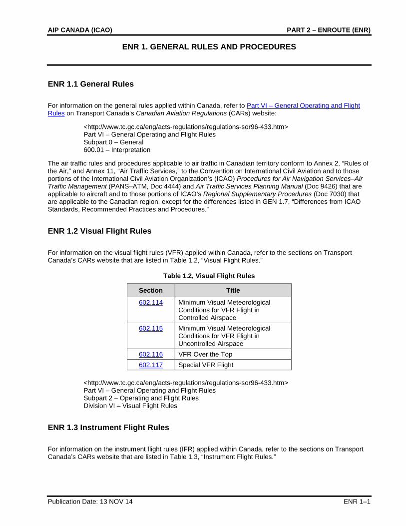
ENR 1.2 Visual Flight Rules
For information on the visual flight rules (VFR) applied within Canada, refer to the sections on Transport Canada’s CARs website that are listed in Table 1.2, “Visual Flight Rules.”
Table 1.2, Visual Flight Rules
Section Title
602.114 Minimum Visual Meteorological Conditions for VFR Flight in Controlled Airspace
602.115 Minimum Visual Meteorological Conditions for VFR Flight in Uncontrolled Airspace
602.116 VFR Over the Top 602.117 Special VFR Flight
<http://www.tc.gc.ca/eng/acts-regulations/regulations-sor96-433.htm> Part VI – General Operating and Flight Rules Subpart 2 – Operating and Flight Rules Division VI – Visual Flight Rules
ENR 1.3 Instrument Flight Rules
For information on the instrument flight rules (IFR) applied within Canada, refer to the sections on Transport Canada’s CARs website that are listed in Table 1.3, “Instrument Flight Rules.”

PART 2 – ENROUTE (ENR) NAV CANADA
ENR 1–2 Publication Date: 13 NOV 14
Table 1.3, Instrument Flight Rules
Section Title
602.121 General Requirements 602.122 Alternate Aerodrome Requirements 602.123 Alternate Aerodrome Weather Minima 602.124 Minimum Altitudes to Ensure Obstacle Clearance 602.125 Enroute IFR Position Reports 602.126 Takeoff Minima 602.127 Instrument Approaches 602.128 Landing Minima 602.129 700.10
Approach Ban – General Approach Bans – Non Precision, APV and CAT I Precision
602.130 700.11
Approach Ban – CAT III Precision Approach Bans – CAT II and CAT III Precision
<http://www.tc.gc.ca/eng/acts-regulations/regulations-sor96-433.htm> Part VI – General Operating and Flight Rules Subpart 2 – Operating and Flight Rules Division VII – Instrument Flight Rules
ENR 1.4 ATS Airspace Classification
Air traffic services (ATS) airspace classes in Canada conform to the ATS airspace classification table in Appendix 4 of Annex 11, “Air Traffic Services,” of the Convention on International Civil Aviation with the differences listed in GEN 1.7, “Differences from ICAO Standards, Recommended Practices and Procedures.”
ENR 1.5 Holding, Approach and Departure Procedures
1.5.1 General
The instrument procedures published in the Canada Air Pilot (CAP), Volumes 1–7, and Restricted Canada Air Pilot (RCAP) are considered to be public procedures. However, the instrument procedures contained in the RCAP do not meet Transport Canada Civil Aviation design criteria. Accordingly, the use of RCAP procedures is restricted to pilots-in-command operating aircraft pursuant to an air operator certificate or a private operator certificate, including the appropriate RCAP operations specification. Authorization is required from Transport Canada Civil Aviation prior to the use of any Restricted Canada Air Pilot procedure.
The intention of the global navigation satellite system (GNSS) overlay program is to allow the operator to use a global positioning system (GPS) navigation sensor to fly the conventional procedures. Therefore, only GPS area navigation (RNAV) compliant Aeronautical Radio, Incorporated (ARINC) 424 Path-Terminator leg types should be used to code any conventional instrument procedure including GNSS in the approach title, and course to fix (CF) legs will not be used.
For information concerning the criteria on which holding, approach, and departure procedures are established within Canada, refer to Transport Canada’s Criteria for the Development of Instrument Procedures (TP 308E).

AIP CANADA (ICAO) PART 2 – ENROUTE (ENR)
Publication Date: 07 DEC 17 ENR 1–3
1.5.2 Arriving Flights
For information on procedures for arriving flights, refer to the following publications:
Canada Air Pilot, Volumes 1–7, or Restricted Canada Air Pilot
Canada Flight Supplement or Water Aerodrome Supplement, Section B, “Aerodrome/Facility Directory – VFR Terminal Procedures Chart”
When ATC assigns a lower altitude on a STAR procedure, pilots shall descend on the STAR profile to the assigned altitude. Charted restrictions above the assigned altitude are mandatory.
When important information about an aerodrome cannot be described by the aerodrome sketch or the table, a VFR Terminal Procedures Chart is published. The chart contains information on conventional or area navigation procedures for arriving flights established on the basis of airspace organization at the aerodrome.
The table for each aerodrome in Canada Flight Supplement and Water Aerodrome Supplement, Section B, “Aerodrome/Facility Directory,” may also include the subheading PRO, which contains information on regulations applicable to the traffic at the aerodrome, including circuit patterns and heights, specific VFR routes within control zones, and other similar information.
1.5.3 Departing Flights
For information on procedures for departing flights, refer to the following publications:
Canada Air Pilot, Volumes 1–7, or Restricted Canada Air Pilot
Canada Flight Supplement or Water Aerodrome Supplement, Section B, “Aerodrome/Facility Directory – VFR Terminal Procedures Chart”
When ATC assigns a higher altitude on a SID procedure, pilots shall climb on the SID profile to the assigned altitude. Charted restrictions below the assigned altitude are mandatory.
When a VFR Terminal Procedures Chart is published for an aerodrome, it contains information on conventional or area navigation procedures for departing flights established on the basis of airspace organization at the aerodrome.
The table for each aerodrome in Canada Flight Supplement or Water Aerodrome Supplement, Section B, “Aerodrome/Facility Directory,” may also include the subheading PRO, which contains information on regulations applicable to the traffic at the aerodrome, including circuit patterns and heights, specific VFR routes within control zones, and other similar information.
ENR 1.6 ATS Surveillance Services and Procedures
ATS use surveillance to increase airspace use by reducing separation between aircrafts. In addition, surveillance permits an expansion of flight information services such as traffic information and navigation assistance.
The following types of surveillance systems are currently in use: primary surveillance radar (PSR), secondary surveillance radar (SSR), automatic dependent surveillance–broadcast (ADS-B), and multilateration (MLAT).

PART 2 – ENROUTE (ENR) NAV CANADA
ENR 1–4 Publication Date: 05 MAR 15
1.6.1 Primary Radar
Primary radar is used in the following applications:
1. Terminal Surveillance Radar
2. Precision Approach Radar
Civil aircraft approach limits are published in Canada Air Pilot and Restricted Canada Air Pilot, General Pages.
3. Airport Surface Detection Equipment
For information on radar and radio failure procedures, refer to the following publications:
Canada Air Pilot, Volumes 1–7, or Restricted Canada Air Pilot
Canada Flight Supplement, Section F, “Emergency” or Water Aerodrome Supplement, Section E, “Emergency”
For a map of primary radar coverage in Canada, see Figure 1.6.1, “Primary Radar Coverage.”
Figure 1.6.1, Primary Radar Coverage

AIP CANADA (ICAO) PART 2 – ENROUTE (ENR)
Publication Date: 05 MAR 15 ENR 1–5
1.6.2 Secondary Surveillance Radar
Secondary surveillance radar is used in the following applications:
1. Enroute Control
2. Terminal Control
For information on radio communications failure, unlawful interference procedures, and other emergency procedures, refer to the following publications:
Canada Air Pilot, Volumes 1–7, or Restricted Canada Air Pilot
Canada Flight Supplement, Section F, “Emergency” or Water Aerodrome Supplement, Section E, “Emergency”
In the Canada Flight Supplement and the Water Aerodrome Supplement, Section B, “Aerodrome/Facility Directory,” the table for an aerodrome may have a subheading PRO, which may contain information on the system of SSR code assignment established at the aerodrome.
For a map of SSR coverage in Canada, see Figure 1.6.2, “Secondary Surveillance Radar Coverage.”
Figure 1.6.2, Secondary Surveillance Radar Coverage

PART 2 – ENROUTE (ENR) NAV CANADA
ENR 1–6 Publication Date: 24 JUL 14
1.6.3 Automatic Dependant Surveillance–Broadcast
Automatic dependent surveillance-broadcast (ADS-B) utilizes global navigation satellite system (GNSS) and aircraft avionics to accurately relay flight information to air traffic services.
All aircraft that emit position information using a 1090 MHz extended squitter (1090ES) may be provided surveillance separation services, provided they meet the airworthiness compliance requirements defined in:
1. European Aviation Safety Agency (EASA) AMC 20-24; or
2. European Aviation Safety Agency (EASA) CS ACNS; or
3. Federal Aviation Administration (FAA) Title 14 Code of Federal Regulations (14 CFR) section 91.227 or AC No. 20-165A (or replacement) – Airworthiness Approval of ADS-B; or
4. Configuration standards reflected in Appendix XI of Civil Aviation Order 20.18 of the Civil Aviation Safety Authority of Australia.
ADS-B Out systems that are unable to meet the above requirements must disable ADS-B transmission unless:
1. the aircraft always transmits a value of 0 (zero) for one or more of the position quality indicators (NUCp, NIC, NAC or SIL); or
2. the operator has received an exemption from NAV CANADA.
For information on radio communications failure, unlawful interference procedures, and other emergency procedures, refer to the following publications:
Canada Air Pilot, Volumes 1–7, or Restricted Canada Air Pilot
Canada Flight Supplement, Section F, “Emergency” or Water Aerodrome Supplement, Section E, “Emergency”
A Flight ID that is an exact replica of the Aircraft Identification entered in field 7 of the ICAO Flight Plan must be programmed into the transponder or flight management system (FMS) in order to receive surveillance services. Airline aircraft will use the three-letter ICAO airline code, not the two-letter IATA code. In addition, field 10 should indicate ADS-B capability on the ICAO Flight Plan.
For a map of ADS-B coverage in Canada, see Figure 1.6.3, “Automatic Dependant Surveillance–Broadcast Coverage.”

AIP CANADA (ICAO) PART 2 – ENROUTE (ENR)
Publication Date: 31 MAR 16 ENR 1–7
Figure 1.6.3, Automatic Dependant Surveillance–Broadcast Coverage
1.6.4 Other relevant information and procedures
1.6.4.1 Multilateration
Multilateration (MLAT) increases ATS situational awareness of aircraft and vehicles on the ground allowing them to safely manage ground movements, including in low visibility operations, by providing full surveillance coverage of runways, taxiways and terminal apron areas. In the Canada Flight Supplement and the Water Aerodrome Supplement, Section B, “Aerodrome/Facility Directory,” the table for an aerodrome may have a subheading PRO, which may contain information on special procedures for code assignment established at the aerodrome. At these aerodromes, aircraft that have a technical limitation associated with the transmission of a transponder code (weight on wheels switch deactivation) must report this condition to ATS and obtain an approval request (APREQ) before commencing ground operations.
1.6.4.2 ADS-B Service in the Gander Oceanic Control Area
ADS-B has been used to provide flight level changes over southern Greenland in scenarios where the availability of ADS-B permits identified aircraft to climb or descend though the flight level of other ADS-B equipped aircraft. In addition, Gander area control centre (ACC) has been able to consider flight level requests that would result in eligible aircraft operating with in-trail spacing of 10 nautical miles.
Because of non-homogeneous aircraft surveillance equipage, all aircraft intending to transit the southern Greenland portion of the Gander oceanic control area (OCA) are expected to continue to flight plan in accordance with procedures outlined in NAT Doc 007, North Atlantic Operations and Airspace Manual in and above the NAT, high level airspace (HLA) published by the International Civil Aviation Organization (ICAO).

PART 2 – ENROUTE (ENR) NAV CANADA
ENR 1–8 Publication Date: 25 JUN 15
As always, flight crews are encouraged to request any changes, including flight level, to optimize their flight profile.
Where it is determined, following a request from the flight crew, that a flight level change can be approved because of the availability of ADS-B, the following steps can be expected:
• A very high frequency (VHF) control frequency will be assigned to the required flights by air traffic control (ATC), either directly via controller-pilot data link communications (CPDLC) or via high frequency (HF) voice through the Gander international flight service station (IFSS) (Gander Radio).
• Once VHF contact has been established, the flights involved will be informed by ATC that identification has been established.
• The requested climb or descent clearance will be issued by ATC either via CPDLC or through the assigned VHF control frequency.
For climb and descend through scenarios, after the flight level change has been completed and vertical separation re-established, flight crews will normally be informed by ATC that surveillance services are terminated and they will subsequently be returned to their previously assigned frequency.
Flight crews are advised that aircraft will not normally be informed of ADS-B identification unless a specific operational advantage, such as a flight level change, can be attained.
ENR 1.7 Altimeter-setting Procedures
The altimeter setting procedures in use are based on Criteria for the Development of Instrument Procedures (TP 308E), a document developed and produced by Transport Canada, Aerodromes and Air Navigation Branch.
For information on basic altimeter-setting procedures and for altimeter-setting procedures applicable to operators (including pilots) within Canada, refer to the sections on Transport Canada’s CARs website that are listed in Table 1.7, “Altimeter-setting Procedures.”
Table 1.7, Altimeter-setting Procedures
Section Title
602.35 Altimeter-setting and Operating Procedures in the Altimeter-Setting Region
602.36 Altimeter-setting and Operating Procedures in the Standard Pressure Region
602.37 Altimeter-setting and Operating Procedures in Transition between Regions
<http://www.tc.gc.ca/eng/acts-regulations/regulations-sor96-433.htm> Part VI – General Operating and Flight Rules Subpart 2 – Operating and Flight Rules Division I – General
The altimeter setting region is an airspace of defined dimensions below 18 000 feet above sea level (ASL). For a map of the altimeter-setting region, refer to the following publications:
Canada Flight Supplement or Water Aerodrome Supplement, Section C, “Planning – Altimeter Setting and Designated Mountainous Regions”

AIP CANADA (ICAO) PART 2 – ENROUTE (ENR)
Publication Date: 25 JUN 15 ENR 1–9
For a table of cruising levels, refer to the following publications:
Canada Flight Supplement or Water Aerodrome Supplement, Section C, “Planning – Characteristics of Airspace – Cruising Altitudes and Flight Levels Appropriate to Aircraft Track”
Cold dry air masses can produce barometric pressures in excess of 31.00 inches of mercury. Because barometric readings of 31.00 inches of mercury or higher rarely occur, most standard altimeters do not permit the setting of barometric pressures above that level and are not calibrated to indicate accurate aircraft altitude above 31.00 inches of mercury. As a result, most altimeters cannot be set to provide accurate altitude readouts to the pilot in these situations.
ATC will issue actual altimeter settings and will confirm with the pilot that 31.00 inches of mercury is set on the pilot’s altimeters for enroute operations below 18 000 feet ASL in the affected areas.
Aerodromes that are unable to accurately measure barometric pressures above 31.00 inches of mercury will report the barometric pressure as “in excess of 31.00 inches of mercury”. Flight operations to and from those aerodromes are restricted to VFR weather conditions.
When the barometric pressure exceeds 31.00 inches of mercury, the following procedures take effect:
Altimeters of all IFR, controlled VFR flight (CVFR) and VFR aircraft are to be set to 31.00 inches of mercury for enroute operations below 18 000 feet ASL. All pilots are to maintain this setting until beyond the area affected by the extreme high pressure or until reaching the final approach segment of an instrument approach for IFR aircraft or the final approach for VFR aircraft. At the beginning of the final approach segment, the current altimeter setting will be set by those aircraft capable of such a setting. Aircraft that are unable to set altimeter settings above 31.00 inches of mercury will retain a 31.00 inches of mercury setting throughout the entire approach. Aircraft on departure or missed approach will set 31.00 inches of mercury prior to reaching any mandatory or fix crossing altitude, or 1 500 feet above ground level (AGL), whichever is lower.
For aircraft operating IFR that are unable to set the current altimeter setting, the following restrictions apply:
To determine the suitability of departure alternate aerodromes, destination aerodromes and destination alternate aerodromes, increase the ceiling requirements by 100 feet and visibility requirements by 1/4 statute mile (SM) for each 1/10 inch of mercury, or any portion thereof, over 31.00 inches of mercury. These adjusted values are then applied in accordance with the requirements of the applicable operating regulations and operations specifications.
Example: Destination altimeter setting is 31.28 inches, instrument landing system (ILS) decision height (DH) is 250 feet (200-1/2). When flight planning, add 300-3/4 to the weather requirements, which would now become 500-1 1/4.
During the instrument approach, 31.00 inches of mercury will remain set. DH or Minimum Descent Altitude (MDA) will be deemed to have been reached when the published altitude is displayed on the altimeter.
Note: Although visibility is normally the limiting factor on an approach, pilots should be aware that when reaching DH, the aircraft will be higher than indicated by the altimeter, which in some cases could be as much as 300 feet higher.
Authorized CAT II and III ILS operations are not affected by the above restrictions.
Night VFR pilots are advised that under conditions of altimeter settings above 31.00 inches of mercury and aircraft altimeters not capable of setting above 31.00 inches of mercury, the aircraft’s true altitude will be higher than the indicated altitude; this must be taken into consideration. If an instrument approach procedures is to be flown, the night VFR pilot should follow the procedures described in the Transport Canada Aeronautical Information Manual (TC AIM) (14371E) Section RAC, “Rules of the Air and Air Traffic Services" 12.12.2(b)(ii).
For aircraft with the capability of setting the current altimeter setting and operating into aerodromes with the capability of measuring the current altimeter setting, no additional restrictions apply.

PART 2 – ENROUTE (ENR) NAV CANADA
ENR 1–10 Publication Date: 31 MAR 16
For aircraft operating VFR, no additional restrictions apply; however, extra diligence in flight planning and in operating in these conditions is essential.
ENR 1.8 Regional Supplementary Procedures
For information on regional supplementary procedures affecting the entire area of responsibility, refer to the following publications:
Canada Air Pilot, General, and Volumes 1–7, or Restricted Canada Air Pilot
In the Canada Flight Supplement and the Water Aerodrome Supplement, Section B, “Aerodrome/Facility Directory,” the table for an aerodrome may have a VFR Terminal Procedures Chart or a subheading PRO, or both, and these may contain information on the regional supplementary procedures affecting the entire area of responsibility.
For information on the use of English and French for aeronautical radio communications in Canada, refer to GEN 3.4.3, “Types of Service.”
1.8.1 Contingency Procedures for Oceanic Traffic in the Event of an Evacuation of Gander ACC
1. AIRCRAFT PROCEDURES – Westbound
1.1 Aircraft not in receipt of an oceanic clearance 1.1.1 In the event that Gander ACC must be evacuated, only aircraft with received and acknowledged
oceanic clearances will be permitted to transit the Gander OCA. 1.1.2 If unable to obtain or acknowledge an oceanic clearance, flights should plan to re-route around the
Gander OCA or to land at an appropriate aerodrome. Request the appropriate re-clearance on the current frequency. Frequency congestion is likely.
1.2 Aircraft In receipt of an acknowledged oceanic clearance 1.2.1 Aircraft operating with a received and acknowledged oceanic clearance should proceed in
accordance with the clearance. Flights should not request changes in altitude, speed or route except for reasons of flight safety.
1.2.2 Any flights involved in level changes should complete the manoeuvre as soon as possible in accordance with any restrictions provided with the clearance.
1.3 Contact Procedures 1.3.1 On receipt of an emergency evacuation message, pilots are requested to broadcast to other flights
on 121.5, 243.0 and 123.45. A listening watch on these frequencies and the current frequency should be maintained until the flight exits the Gander OCA and FIR.
1.3.2 All flights within the Gander OCA should transmit position reports on any available HF or VHF frequency to Shanwick Radio either directly or through another agency or flight.
1.3.3 Flights should establish communication with the next agency at the earliest opportunity stating current position, cleared flight level, next position and estimate, and subsequent position. This also applies to flights using automated position reports (ADS/FMC) because those reports may not have been received by the next agency.
1.3.4 Flights within the Gander OCA should initially establish contact with Shanwick Radio. Flights within the Gander FIR should contact Montreal Centre or Moncton Centre, depending on their oceanic exit point as described in 2.3.7. Flights about to exit the Gander OCA into the New York OCA, the Reykjavik Oceanic CTA, the Santa Maria OCA, or the Sondrestrom FIR should contact New York ARINC, Iceland Radio, Santa Maria Radio or Sondrestrom Radio as appropriate.

AIP CANADA (ICAO) PART 2 – ENROUTE (ENR)
Publication Date: 13 NOV 14 ENR 1–11
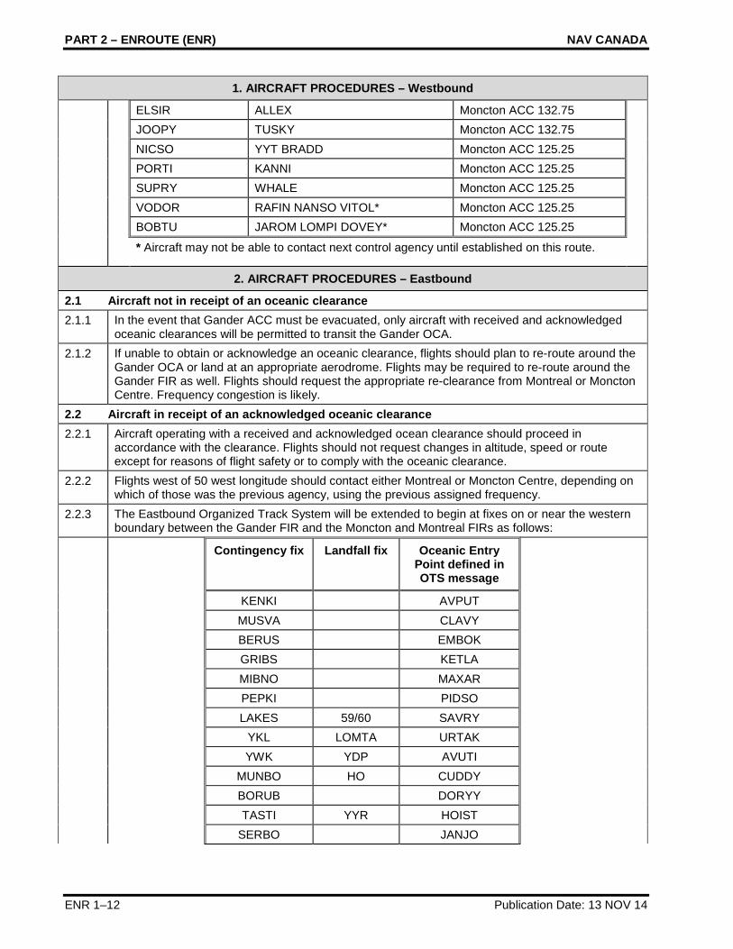
1. AIRCRAFT PROCEDURES – Westbound
1.3.5 If unable to establish radio contact, flights may use SATVOICE voice or satellite telephone to provide position reports.
Oceanic Centre Public Switched Telephone Network (PTSN) Number
Short Code
Gander Shift Manager
001 709 651 5207 N/A
1.3.6 Flights may request their flight dispatch offices to forward position reports, if sending position reports to multiple ATS Units or if otherwise unable to forward position reports.
1.3.7 Based on where they exit oceanic airspace, flights shall proceed in accordance with the following table, until communication is established with, and a re-clearance issued by the next agency. Note: the landfall fix is the fix after the oceanic exit point.
IF flight is routed over
The flight shall then proceed: Next control agency and frequency:
6500N 06000W or AVPUT
Via cleared route to the landfall fix or N700A
Montreal ACC 132.800
6400N 06000W or CLAVY
Via cleared route to the landfall fix or N690A
Montreal ACC 132.800
6300N 06000W or EMBOK
Via cleared route to the landfall fix or N680A
Montreal ACC 132.800
6200N 06000W or KETLA
Via cleared route to the landfall fix or N660A
Montreal ACC 134.800
6100N 06000W or MAXAR
Via cleared route to the landfall fix or N640A
Montreal ACC 134.800
6000N 06000W or PIDSO
Via cleared route to the landfall fix or N620A
Montreal ACC 135.800
5900N 06000W or SAVRY
Via cleared route to the landfall fix or N598A
Montreal ACC 132.450
URTAK or MOATT MOATT LOMTA TEALS VANSI Montreal ACC 132.45 AVUTI or PRAWN PRAWN YDP YKL ROUND Montreal ACC 132.45 CUDDY or PORGY PORGY HO YBC ANCER* Moncton ACC 132.95 or
Montreal ACC 132.90 @ 63W
DORYY BORUB YZV* Moncton ACC 132.95 or Montreal ACC 132.90@ 63W
HOIST YYR YRI* Moncton ACC 118.875 or Montreal ACC 132.90 @63W
JANJO QUBIS* Moncton ACC 132.52 or Montreal ACC 132.90 @ 63W
LOMSI TAFFY Moncton ACC 132.52 NEEKO MILLS Moncton ACC 132.52 RIKAL YAY DANOL Moncton ACC 133.55 TUDEP TOPPS Moncton ACC 133.55 ALLRY EBONY Moncton ACC 133.55
PART 2 – ENROUTE (ENR) NAV CANADA
ENR 1–12 Publication Date: 13 NOV 14
1. AIRCRAFT PROCEDURES – Westbound
ELSIR ALLEX Moncton ACC 132.75 JOOPY TUSKY Moncton ACC 132.75 NICSO YYT BRADD Moncton ACC 125.25 PORTI KANNI Moncton ACC 125.25 SUPRY WHALE Moncton ACC 125.25 VODOR RAFIN NANSO VITOL* Moncton ACC 125.25 BOBTU JAROM LOMPI DOVEY* Moncton ACC 125.25
* Aircraft may not be able to contact next control agency until established on this route.
2. AIRCRAFT PROCEDURES – Eastbound
2.1 Aircraft not in receipt of an oceanic clearance 2.1.1 In the event that Gander ACC must be evacuated, only aircraft with received and acknowledged
oceanic clearances will be permitted to transit the Gander OCA. 2.1.2 If unable to obtain or acknowledge an oceanic clearance, flights should plan to re-route around the
Gander OCA or land at an appropriate aerodrome. Flights may be required to re-route around the Gander FIR as well. Flights should request the appropriate re-clearance from Montreal or Moncton Centre. Frequency congestion is likely.
2.2 Aircraft in receipt of an acknowledged oceanic clearance 2.2.1 Aircraft operating with a received and acknowledged ocean clearance should proceed in
accordance with the clearance. Flights should not request changes in altitude, speed or route except for reasons of flight safety or to comply with the oceanic clearance.
2.2.2 Flights west of 50 west longitude should contact either Montreal or Moncton Centre, depending on which of those was the previous agency, using the previous assigned frequency.
2.2.3 The Eastbound Organized Track System will be extended to begin at fixes on or near the western boundary between the Gander FIR and the Moncton and Montreal FIRs as follows:
Contingency fix Landfall fix Oceanic Entry Point defined in OTS message
KENKI AVPUT MUSVA CLAVY BERUS EMBOK GRIBS KETLA MIBNO MAXAR PEPKI PIDSO LAKES 59/60 SAVRY YKL LOMTA URTAK YWK YDP AVUTI MUNBO HO CUDDY BORUB DORYY TASTI YYR HOIST SERBO JANJO

AIP CANADA (ICAO) PART 2 – ENROUTE (ENR)
Publication Date: 5 JUL 07 ENR 1–13
2. AIRCRAFT PROCEDURES – Eastbound
VERTU LOMSI PIKNA NEEKO NAPLO YAY RIKAL MIGLI TUDEP LOPRO ALLRY VINSI YQX ELSIR TAGRA JOOPY SUTKO YYT NICSO RUBDA PORTI PEPRA SUPRY NANSO RAFIN VODOR LOMPI JAROM TALGO
2.2.4 Flights at or east of 50 west longitude should initially contact Shanwick Radio. Flights about to exit the Gander OCA should contact New York ARINC, Santa Maria Radio, Iceland Radio or Sondrestrom Radio as appropriate. The following information should be provided.
(a) Call sign (b) Current position (c) Current flight level and cleared oceanic flight level (if different from the current level) (d) Assigned Mach or speed (e) Next waypoint and estimate (f) Subsequent waypoint
2.2.5 If a level change is required to comply with the oceanic clearance, the flight should request clearance from Montreal or Moncton Centre. If unable to obtain an ATC clearance, the flight should climb or descend so as to cross the oceanic entry point at the cleared oceanic flight level.
2.2.6 The following communications procedures have been developed in accordance with the Traffic Information Broadcast by Aircraft (TIBA) procedures recommended by ICAO (Annex 11 – Air Traffic Services, Attachment C). These procedures should be applied, unless otherwise instructed by Moncton or Montreal Centre when completing an altitude change to comply with the oceanic clearance.
At least 3 minutes prior to the commencement of a climb or descent the flight should broadcast on the last assigned frequency, 121.5, 243.0 and 123.45 the following:
ALL STATIONS (call sign) (direction) DIRECT FROM (landfall fix) TO (oceanic entry point) LEAVING FLIGHT LEVEL (number) FOR FLIGHT LEVEL (number) AT
(distance)(direction) FROM (oceanic entry point) AT (time) When the level change begins, the flight should make the following broadcast ALL STATIONS (call sign) (direction) DIRECT FROM (landfall fix) TO (oceanic entry point) LEAVING FLIGHT LEVEL (number) NOW FOR FLIGHT LEVEL (number)

PART 2 – ENROUTE (ENR) NAV CANADA
ENR 1–14 Publication Date: 25 JUN 15
2. AIRCRAFT PROCEDURES – Eastbound
When level, the flight should make the following broadcast ALL STATIONS (call sign) MAINTAINING FLIGHT LEVEL (number) 2.2.7 When ADS equipped flights are notified of a Gander evacuation they must revert to voice position
reporting until clear of Gander OCA, or notified otherwise. Pilots should note that they may be asked to log-on to EGGX when within the Gander OCA; they should not initiate this action until instructed to do so.
ENR 1.9 Air Traffic Flow Management
Air traffic flow management (ATFM) programs have been developed to ensure that national ATC systems are used to maximum capacity and that the need for excessive enroute airborne holding, especially at low altitude, is minimized. ATFM also distributes required delays more equitably among users.
ATFM initiatives in Canada include
• the publication in the Canada Air Pilot and the Restricted Canada Air Pilot of standard instrument departure (SID) and standard terminal arrival (STAR) procedures;
• the rerouting of aircraft because of sector overloading and weather avoidance;
• flow-control metering of arriving aircraft into terminal control areas (TCAs); and
• the implementation of flow-control restrictions whereby aircraft are more economically held on the ground at departure airports to partially absorb calculated arrival delays at a destination airport.
In the Canada Flight Supplement and the Water Aerodrome Supplement, Section B, “Aerodrome/Facility Directory,” the table for an aerodrome may have a subheading RESTRICTIONS that contains information affecting the flow of traffic at the aerodrome.
Additional information can be obtained by contacting NAV CANADA, National Operations Centre, at 1 866-651-9053 (Canada) or 1 866-651-9056 (US), or the shift manager or ATFM unit of the applicable area control center (ACC) through the telephone numbers provided in Table 1.9, “ACC Contact Numbers.”
Table 1.9, ACC Contact Numbers
ACC Telephone Number
Gander ACC +1 709-651-5207 Moncton ACC +1 506-867-7173 Montréal ACC +1 514-633-3028 or 3365 Toronto ACC 1-800-268-4831 (Canada)
1-800-387-3801 (US) +1 905-676-3528 or 4509
Winnipeg ACC +1 204-983-8338 Edmonton ACC +1 780-890-4714 Vancouver ACC +1 604-775-9673 or 9622

AIP CANADA (ICAO) PART 2 – ENROUTE (ENR)
Publication Date: 25 JUN 15 ENR 1–15
1.9.1 Flow Control Procedures
To minimize delays, air traffic management will use the least restrictive methods.
• Altitude
• Miles-in-trail/Minutes-in-trail
• Speed control
• Fix balancing
• Airborne holding
• Sequencing programs
Departure sequencing program assigns a departure time to achieve a constant flow of traffic over a common point. Runway and departure procedures are considered for accurate projections.
Enroute sequencing program assigns a departure time that will facilitate integration into an en-route stream. Runway configuration and departure procedures will be considered for accurate projections.
Arrival sequencing program assigns meter fix times to aircraft destined to the same airport.
Ground delay program is an air traffic management process administered by the flow manager whereby aircraft are held on the ground. The purpose of the program is to support the air traffic management mission and limit airborne holding. It is a flexible program and may be implemented in various forms depending on the needs of the air traffic system. Ground delay programs provide for equitable assignment of delays to all system users.
Ground stop is a process whereby an immediate constraint can be placed on system demand. The constraint can be total or partial. The ground stop may be used when an area, centre, sector, or airport experiences a significant reduction in capacity. The reduced capacity may be the result of weather, runway closures, major component failures, or any other event that would render a facility unable to continue providing ATS.
This list is not inclusive and does not preclude the innovation and application of other procedures that result in improved customer service.
1.9.2 Fuel Conservation High Level Airspace
The following points are brought to the attention of pilots operating in the high level airspace (HLA), to ensure that each aircraft is operated as close as possible to its optimum flight level and Mach number (M).
Pilots should request a change of flight level or M whenever this would improve the operating efficiency of the aircraft. However, in this regard, a request for a flight level not appropriate to the direction of flight will still be subject to the restrictions for use of altitudes inappropriate for direction of flight as detailed in the Transport Canada Aeronautical Information Manual (TC AIM) (TP14371E) Section RAC, “Rules of the Air and Air Traffic Services" 7.6.2, Note 1.
Where possible pilots should give advance warning of a request (e.g. if a westbound flight wishes to climb at 30˚W, it will assist the controller if the request is made with the position report at 20˚W).
When circumstances render this feasible, controllers will ask other aircraft to accept higher flight levels or changes of M in order to facilitate clearances for aircraft that would otherwise experience a significant penalty. In agreeing to such requests, pilots will contribute to the overall economy in fuel used.

PART 2 – ENROUTE (ENR) NAV CANADA
ENR 1–16 Publication Date: 13 NOV 14
ENR 1.10 Flight Planning
Amendment 1 to the 15th Edition of the Procedures for Air Navigation Services–Air Traffic Management, (PANS–ATM, Doc 4444), which became effective on 15 November 2012, updated the flight plan form established by the International Civil Aviation Organization (ICAO) to meet the needs of aircraft with advanced capabilities, as well as the developed requirements of the automated air traffic management (ATM) systems.
The new flight plan addresses functionalities and technologies of air navigation such as global navigation satellite system (GNSS), area navigation (RNAV), required navigation performance (RNP), performance-based navigation (PBN), data links, the automatic dependent surveillance-broadcast (ADS-B) and automatic dependent surveillance-contract (ADS-C). These changes are more substantially reflected in the content of fields 10 and 18 of the flight plan form.
Such data shall be considered by the ATM systems, in order to make the necessary air traffic planning information available for the air traffic controller. It also enables alerting, whenever there is a modification to reported data that may have an impact on control planned actions.
For information on restriction, limitation or advisory information related to flight planning within Canada, refer to the sections on Transport Canada’s CARs website that are listed in Table 1.10, “Flight Planning.”
Table 1.10, Flight Planning
Section Title
602.70 Interpretation 602.73 Requirement to File a Flight Plan or
a Flight Itinerary 602.74 Contents of a Flight Plan or a Flight
Itinerary 602.75 Filing of a Flight Plan or a Flight
Itinerary 602.76 Changes in the Flight Plan
<http://www.tc.gc.ca/eng/acts-regulations/regulations-sor96-433.htm> Part VI – General Operating and Flight Rules Subpart 2 – Operating and Flight Rules Division III – Flight Preparation, Flight Plans and Flight Itineraries
ENR 1.11 Addressing of Flight Plan Messages
Flight plans for aircraft flying under IFR in Canada are allocated according to flight information region (FIR) to the message addresses provided in Table 1.11, “Flight Plan Message Addresses.”

AIP CANADA (ICAO) PART 2 – ENROUTE (ENR)
Publication Date: 21 JUL 16 ENR 1–17
Table 1.11, Flight Plan Message Addresses
FIR Message Address
Gander CZQXZQZX Moncton CZQMZQZX Montréal CZULZQZX Toronto CZYZZQZX
Winnipeg CZWGZQZX Edmonton CZEGZQZX Vancouver CZVRZQZX
Flight plans for aircraft flying under VFR are accepted and processed by flight information centers (FICs) in Canada. In the Canada Flight Supplement and the Water Aerodrome Supplement, Section B, “Aerodrome/Facility Directory,” the table for each aerodrome has a subheading FLT PLN (Flight Planning) that may contain the appropriate FIC contact information under the entry FIC.
For more information about Canada’s FICs, refer to Airport Advisory and Flight Information Services on NAV CANADA’s website:
<www.navcanada.ca> About Us What We Do Airport Advisory and Flight Information
ENR 1.12 Interception of Civil Aircraft
For information on interception procedures and visual signals, refer to the following publications:
Canada Flight Supplement, Section F, “Emergency – Interception of Civil Aircraft,” and “Interception Signals,” or Water Aerodrome Supplement, Section E, “Emergency – Interception of Civil Aircraft,” and “Interception Signals”
ENR 1.13 Unlawful Interference
For information on unlawful interference, refer to the following publications:
Canada Flight Supplement, Section F, “Emergency – Interception of Civil Aircraft,” and “Unlawful Interference (HIJACK)” or Water Aerodrome Supplement, Section E, “Emergency – Interception of Civil Aircraft,” and “Unlawful Interference (HIJACK)”
ENR 1.14 Air Traffic Incidents
The Aviation Operations Centre (AOC) (formerly known as CACO) is part of the Transport Canada Situation Centre, Emergency Preparedness Branch. It is the focal point for providing services in the areas of operational response in support of the Civil Aviation emergency response mandate. In addition, it participates in or provides support to the aviation-related activities of NATO, the North American Aerospace Defence Command (NORAD), International Civil Aviation Organization’s (ICAO), the Federal Aviation Administration (FAA) and other foreign entities responsible for rocket launches.

PART 2 – ENROUTE (ENR) NAV CANADA
ENR 1–18 Publication Date: 21 JUL 16
The Aviation Operations Centre (AOC) monitors the national civil air transportation system (NCATS) 24 hours a day, and responds to NCATS emergencies that require the attention or co-ordination of concerned functional branches, including regional offices and other departments or agencies, as per contingency plans.
The AOC is the initial contact point for all aviation-related occurrences. It receives reports on accidents and any incidents that occur within the NCATS from various sources, including NAV CANADA, airport authorities, Public Safety Canada (PSC), law enforcement agencies, other government departments, foreign governments, and the general public. These reports are continuously monitored and then distributed to the appropriate functional areas of Transport Canada Civil Aviation for review, investigation (if necessary), and final inclusion in the Civil Aviation Daily Occurrence Reporting System (CADORS).
Reports requiring regional, modal, multi-modal, inter-departmental, or an outside agency’s attention are immediately forwarded to that agency for further action.
An aircraft incident, as defined in the CADORS manual (TP 4044), is any occurrence involving an aircraft where
1. An engine fails;
2. Smoke or fire occurs, other than an engine fire that is contained within the engine and does not result in engine failure or damage to other component parts of the aircraft;
3. Difficulties in controlling the aircraft in flight are encountered due to any aircraft system malfunction, weather phenomena, wake turbulence, operations outside the approved flight envelope or uncontrolled vibrations;
4. The aircraft fails to remain within the landing or takeoff area, lands with one or more landing gear retracted or drags a wing tip or engine pod;
5. Any crew member is unable to perform his or her flight duties as a result of incapacitation;
6. Decompression, explosive or otherwise, occurs that necessitates an emergency descent;
7. A fuel shortage occurs that necessitates a diversion or requires approach and landing priority at the destination of the aircraft;
8. The aircraft is refueled with the incorrect type of fuel or contaminated fuel;
9. A collision or risk of collision with any other aircraft or with any vehicle, terrain or obstacle occurs, including a collision or risk of collision that may be related to air traffic control procedures or equipment failures;
10. The aircraft receives a Traffic Alert and Collision Avoidance System (TCAS) Resolution Advisory;
11. A flight crew member declares an emergency or indicates any degree of emergency that requires priority handling by an air traffic control unit or the standing by of crash, firefighting or rescue services;
12. Toxic gases or corrosive materials leak from any area aboard the aircraft;
13. Unauthorized Incursion or operating irregularity involving vehicles, pedestrians or animals;
14. Failure of a navigational aid, approach aid, communications system, airport lighting, power failure or any other system breakdown which has an adverse effect upon flight safety or a major impact upon operations;
15. Criminal action – hijacking bomb threat, riot, sabotage, or a breach of aviation/airport security;
16. Unavailability of a runway due to snow, ice, flood, obstruction or foreign object that results in a major impact on airport operations;
17. Bird strikes, which result in aircraft damage or other operational impact;

AIP CANADA (ICAO) PART 2 – ENROUTE (ENR)
Publication Date: 21 JUL 16 ENR 1–19
18. Missing aircraft reports, Search and Rescue action (RCC launch and ELT activations);
19. Significant building and equipment fire or other major damage on airport property or TC remote sites;
20. Labour action affecting operational capability;
21. Item dropped from aircraft;
22. Regulatory infractions which have immediate safety implications, involve commercial carriers or may generate media attention;
23. Environment emergencies such as significant fuel spill, hazardous chemical or radioactive spill on airport property;
24. Accidental death or serious injury to employees or members of the public while on airport or TC property; or
25. Any occurrence which may generate a high degree of public interest or concern or could be of direct interest to specific foreign air authorities.
The Aviation Incident Report form is available on Transport Canada’s website:
<www.tc.gc.ca> Air Air Transportation Emergencies and Incident Reporting Report an aviation incident (CACO)
A pilot should proceed as follows regarding an incident in which he or she is or has been involved:
1. During flight, use the appropriate air-ground frequency for reporting an incident of major significance, particularly if it involves other aircraft, so as to permit the facts to be ascertained immediately; and
2. As promptly as possible after landing submit an Aviation Incident Report.
Aviation Incident Reports are used to keep senior Civil Aviation and Transport Canada management advised of critical or high-profile events on a timely basis.
To report an aircraft accident or incident, individuals can contact the AOC 24 hours a day by calling 1-877-992-6853 (toll-free) or 613-992-6853; sending a fax to 1-866-993-7768 (toll-free) or 613-993-7768; or via the website, at
<www.tc.gc.ca> Air Air Transportation Emergencies and Incident Reporting Report an aviation incident (CACO)
1.14.1 ATS Reports
Under current regulation, ATS units are required to report to the Minister of Transport any aviation occurrence that may contravene the CARs.
Any investigation of the circumstances or subsequent decision on whether a breach has taken place is the responsibility of Transport Canada. Any necessary follow-up action will be conducted by Transport Canada Civil Aviation regulatory authorities.
1.14.2 Pilot Reports
Pilots are requested to make the following reports in the interests of national security, meteorite research and forest fire and pollution control.

PART 2 – ENROUTE (ENR) NAV CANADA
ENR 1–20 Publication Date: 25 JUN 15
1.14.2.1 CIRVIS Reports – Vital Intelligence Sightings
Communication Instructions for Reporting Vital Intelligence Sightings (CIRVIS) reports should be made immediately upon a vital intelligence sighting of any airborne and ground objects or activities that appear to be hostile, suspicious, unidentified or engaged in possible illegal smuggling activity. Examples of events requiring CIRVIS reports are: unidentified flying objects, submarines, or surface warships identified as being non-Canadian or non-American; violent explosions; unexplained or unusual activity, including the presence of unidentified or suspicious ground parties in Polar regions, at abandoned airstrips or other remote, sparsely populated areas.
These reports should be made to the nearest Canadian or U.S. government FIC or ATC unit.
A report via air/ground communications should include the words “CIRVIS CIRVIS CIRVIS”, followed by:
• the identification of the reporting aircraft;
• a brief description of the sighting (number, size, shape, etc.);
• the position of the sighted object or activity;
• the date and time of sighting in UTC;
• the altitude of the object;
• the direction of movement of the object;
• the speed of the object; and
• any identification.
1.14.2.2 Reports of meteors
Reports of spectacular meteors (fireballs), which may be bright enough to cast shadows, that may be accompanied by a “sonic boom”, that may trail glowing particles, and that may explode with a burst of light and a loud sound several times in flight, should be reported by radio to the nearest ATS unit or to:
Meteorites and Impacts Advisory Committee (MIAC) <http://miac.uqac.ca>
Fax: 403-284-0074
1.14.2.3 Fire Detection – Northern Areas
The Department of Indian and Northern Affairs have requested the co-operation of all persons connected with aviation, in the prevention, detection and suppression of fires in the northern areas of Canada.
If smoke or other indications of fire are seen in any area, the local Forestry Warden, Game Management Officer, or member of the RCMP should be notified at once. If they are not available, the fire should be reported by collect telephone call to:
Superintendent of Forestry, Fort Smith, Northwest Territories, for fires in the Northwest Territories and Wood Buffalo National Park. [Tel. no. (867) 872-7700].
Superintendent of Forestry, Whitehorse, Yukon Territory, for fires in the Yukon Territory. [Tel. no. 1-888-798-FIRE (3473)].
Reports should give the size and location of the fire, and the name and address of the person making the report. This information will assist fire crews in getting to fires with minimum delay and with the right type of equipment.

AIP CANADA (ICAO) PART 2 – ENROUTE (ENR)
Publication Date: 25 JUN 15 ENR 1–21
1.14.2.4 Pollution Reports
Any aircraft in the airspace above Canadian waters, Fishing Zones or Arctic Shipping Control Zones should inform the nearest Canadian FIC upon sighting any vessel discharging pollutants (oil) in Canadian waters, Fishing Zones or Arctic Shipping Control Zones.
On the east and west coasts, the waters extend to approximately 200 nautical miles (NM) from the coast line. In the north, the area includes virtually all of the waters in the Canadian Arctic.
The FIC will relay any reported pollution incidents to the appropriate Coast Guard Centres.