environment report final - wordpress.com · neighbourhood development plan: ashtead environment...
TRANSCRIPT
Neighbourhood Development Plan: Ashtead Environment Report
Environment Report 12/9/2015 1
CONTENTS Page INTRODUCTION 2 SUMMARY CONCLUSION 2 1.0 MVDC’S POLICIES 3 2.0 THE CHARACTER OF ASHTEAD’S BUILT ENVIRONMENT 4 2.1 Listed Buildings and Designated Areas and Sites 4 2.1.1 Listed Buildings 4 2.1.2 Conservation Areas 4 2.1.3 Sites of Archaeological Importance & Ancient Monuments 5 2.1.4 Residential Areas of Special Character 5 2.1.5 Biodiversity in Gardens 5
2.2 Ashtead’s Views on the Built Environment 5 2.3 Conclusion 6
3.0 THE LANDSCAPE CHARACTER OF ASHTEAD 7 3.1 Formally Designated Sites 7 3.2 Biodiversity within the Green Belt Areas 7 3.3 Ashtead’s Views on the Green Belt Surrounding the Village 9 3.4 Conclusion 11
4.0 THE IMPROVEMENT OF LOCAL HABITATS 12 4.1 Examples of Habitat Improvement in Ashtead 12
4.1.1 Ashtead Common 12 4.1.2 Rye Brook and Meadows 12 4.1.3 Ashtead Pond 13 4.1.4 Ashtead Park 13
4.2 Conclusion 13
5.0 OPEN SPACES AND RECREATION FACILITIES WITHIN ASHTEAD 14 5.1 Open Spaces 14 5.2 Sports and Recreation Grounds 15 5.3 Outdoor Physical Activities and Facilities Available Within Ashtead 16 5.4 Playgrounds 17 5.5 Allotments 18 5.6 Amenity Green Space 18 5.7 Areas of Green Space for Communal Use 18 5.8 Conclusion 19 6.0 LAND CONTAMINATION 20
7.0 AIR QUALITY 20 7.1 Conclusion 21 APPENDICES: Appendix 1: Listed Buildings in Ashtead 22 Appendix 2: Map of Conservation Areas & Grade II and II* Listed Buildings 24 Appendix 3: Lists of Sites of Archaeological Importance and map of Sites and 25 Ancient Monuments Appendix 4: Areas of Green Space in Ashtead 27
Neighbourhood Development Plan: Ashtead Environment Report
Environment Report 12/9/2015 2
INTRODUCTION
This report has been prepared by the Environment sub-group of Ashtead Community Vision (ACV) to provide information regarding both the green and built environs of the village. A detailed Green Belt Boundary Review (GBBR) prepared by ACV has already been approved by the Forum and published and sent to Mole Valley District Council (MVDC) for moderation and incorporation into their work regarding the whole of the district. A précis of that report dealing with a description of each area is included in this report but with additional information regarding bio-diversity. The report also contains information showing the use, improvement and appreciation of the green spaces both within and around Ashtead based on official data taken from MVDC surveys and surveys undertaken by ACV. SUMMARY CONCLUSIONS · That the variety and character of the built environment should be retained. · Of those Green Belt areas not withdrawn from consideration for possible re-designation
in the GBBR,surveys have shown that Ashtead’s residents are in favour of retaining them all within the Green Belt.
· Valuable work is being undertaken by professionals and local volunteers to help preserve and improve the green spaces both surrounding and within Ashtead.
· There are insufficient playing areas for sport within Ashtead. There is also a lack of
provision for children and young people but various sports clubs are endeavouring to cope by using school sports facilities at weekends and by using facilities outside the village.
· Sports areas attached to each of the schools should be safeguarded because they are not only of benefit to the individual schools but to the whole community.
· Wherever possible, areas of amenity grass should be retained to maintain the environmental character of the village.
· Air Quality monitoring of Green Lane (Ermyn Way) should continue but other areas need to be considered within Ashtead such as the Grange Road/Ermyn Way crossroads on the A24 and the nearby schools.

Neighbourhood Development Plan: Ashtead Environment Report
Environment Report 12/9/2015 3
1.0 MVDC’S POLICIES
THE BUILT AND NATURAL ENVIRONMENT OF THE AREA
According to the MVDC Landscape Supplementary Planning Document (SPD) (July 2013):
The settlement of Ashtead has succeeded in retaining a strong village identity, even though its original village centre is now at the heart of much larger residential area. Ashtead ..….… remains remarkably well hidden in the wider landscape, as a result of undulating gradients and generous tree cover. Two of the aims and objectives stated in the MVDC Sustainability Appraisal / Strategic Environment Assessment Scoping Report 2013 “Cultural Heritage” sections are: · to recognise the importance of heritage and historical features, buildings and
environment and seek to protect them from insensitive development.
· to identify and recognise those areas designated as conservation areas, their special features and qualities and their contribution to the character of the area.
In the “Biodiversity and Nature Conservation” section it is stated that the quality and diversity of habitats in the District should continue to be protected and the quality of habitats should be improved, where possible to increase biodiversity. This needs to be balanced with the needs of leisure/recreation and wider development requirements and with the vulnerability of important areas of biodiversity.
AMENITY AND COMMUNITY FACILITIES
Regarding Amenity and Community Facilities, MVDC sees the main implications for plan-making being: · to allocate new open space, sports and recreation facilities and allotment sites
where necessary and safeguard existing facilities from alternative development
· that account should be taken of the accessibility of housing and employment sites to sports, physical activity facilities, play space and green infrastructure.
The same report recognises that
· Localised shortages of play space for children, amenity green space and allotment
plots need to be addressed.
Neighbourhood Development Plan: Ashtead Environment Report
Environment Report 12/9/2015 4
2.0 THE CHARACTER OF ASHTEAD’S BUILT ENVIRONMENT
The aims of MDVC’s Strategic Planning Policy are to safeguard and enhance the highly attractive and diverse natural, built and historic environment of the District. It is also their aim thatnew development will be accommodated to avoid prejudicing these attributes in a way that is sustainable, safe and accessible. The individual character of existing residential areas will be retained while accommodating some new development. The ecological footprint and contribution to climate change as a result of activity and development in the District will be reduced and new development will be located and designed with minimising flood risk in mind.
Settlement Hierarchy October 2008: Ashtead is a village covering 11.59 km2 (4.47 sq mi) with a population of 14,169 as at the last census in 2011. It is set within the Thames Basin Lowlands - Esher and Epsom Landscape Character Area which stretches between Bookham and Ashtead, excluding the valley of the River Mole. Much of the area is built-up but there are tracts of open undulating countryside and extensive wooded areas including Bookham Common and Ashtead Common. The gentle dip slope of the North Downs to the south of Bookham and Ashtead provides a broad undulating farming landscape composed of a patchwork of fields and occasional irregular blocks of woodland. Although close to the built-up areas, this area retains much of its rural agricultural landscape character. It provides a transition between the densely wooded landscape on top of the North Downs and the built-up areas.
2.1 Listed Buildings and Designated Areas and Sites 2.1.1 Listed Buildings, Park and Garden
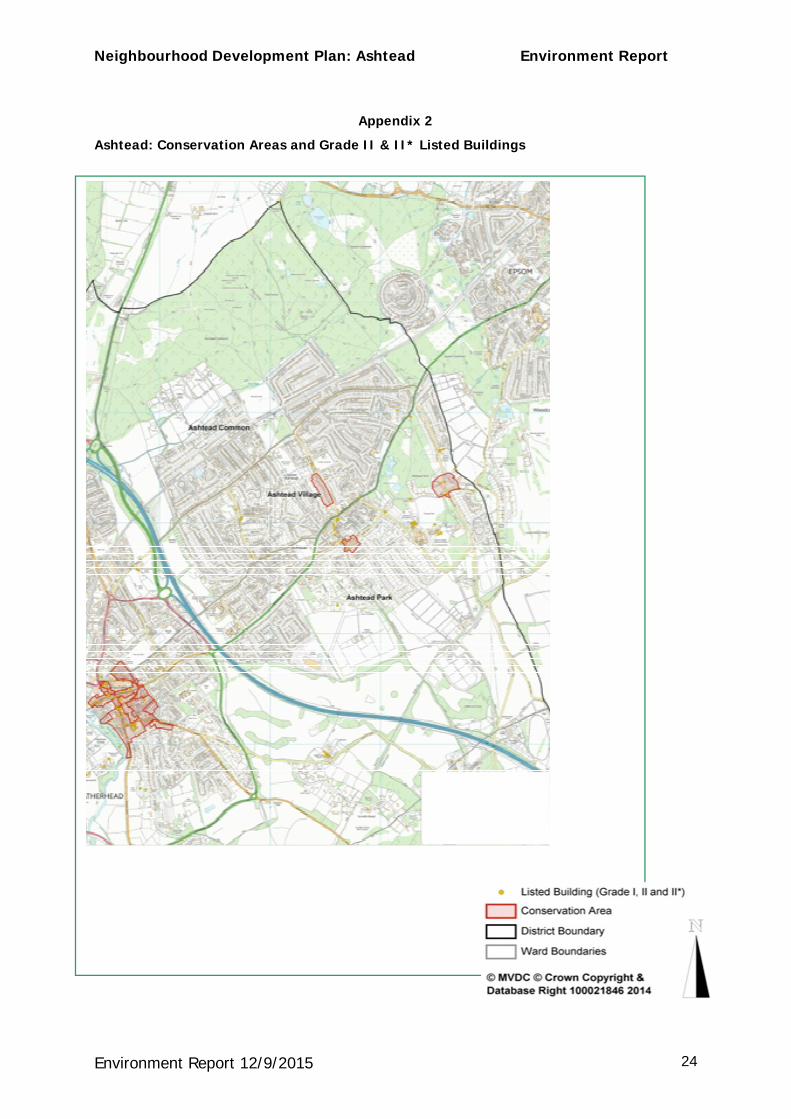
There are more than 40 Listed Buildings in Ashtead including three Grade II*: Ashtead Park House, Ashtead Park Farm House and St Giles’ Church. The majority of Listed Buildings are located around Ashtead Park and along Rectory Lane.Please refer to theschedule of listed buildingsin Appendix 1 and the map in Appendix 2 showing the location of the Grade II and II* buildings.
It is possible that there may be additional buildings that should be considered for inclusion in the list in Appendix 1.
Located east of the main built-up area of Ashtead is Ashtead Park Historic Park and Garden, which is a Grade II registered garden.
2.1.2 Conservation Areas (see map in Appendix 2)
Within Ashtead there are three Conservation Areas:
· The Woodfield Lane Conservation Area is a line of 14 Edwardian properties set in mature gardens. The special character of the area is provided by the large, varied and attractively detailed Edwardian properties and the large mature gardens in which they are set.
· The Dene Road Conservation Area consists of a small enclave of pleasing domestic properties surrounded by a modern estate. A key feature of the Conservation Area is the tight, narrow streets, reinforced by strong garden boundaries, particularly the brick walls.
Neighbourhood Development Plan: Ashtead Environment Report
Environment Report 12/9/2015 5
· The Ashtead House Conservation Area consists of the house and garden of Ashtead House and the 18th century Headmaster’s House and adjacent Lodge on Rookery Hill.
2.1.3 Archaeological Sites and Ancient Monuments Outside of the main built-up area there is one County Site of Archaeological Importance and three Scheduled Ancient Monuments.
One Ancient Scheduled Monument is located near to St. Giles’ Church east of Ashtead. The other two (a roman villa and a camp) are situated within Ashtead Common.
Also within Ashtead Common is a County Site of Archaeological Importance, which is a Romano-British clay pit.
World War II sites have yet to be assessed for inclusion.
A detailed investigation of the farmland south of the village has suggested that the hedges are Bronze Age, and these are currently without special protection.
Please refer to Appendix 3 for a list of the Sites of Archaeological Potential and a map showing their locations and those of Ancient Munuments.
2.1.4 Residential Areas of Special Character
Within Ashtead there are four Residential Areas of Special Character identified in the Local Plan (Policy ENV17).
The Warren, Park Lane, Rookery Hill and Highfields have all been designated as having distinctive and cohesive character.
2.1.5 Biodiversity in Gardens
A high proportion of the gardens in Ashtead are extensive with large numbers of trees, shrubs and other plants and therefore support a wide range of wild life. Animals such as badgers, hedgehogs, squirrels, deer and foxes may be seen as well as a wide variety of birds. In addition the flower borders benefit bees and other pollinating insects. This is an important aspect of the built village character and planning should have regard to this.
2.2 Ashtead’s Views on the Built Environment
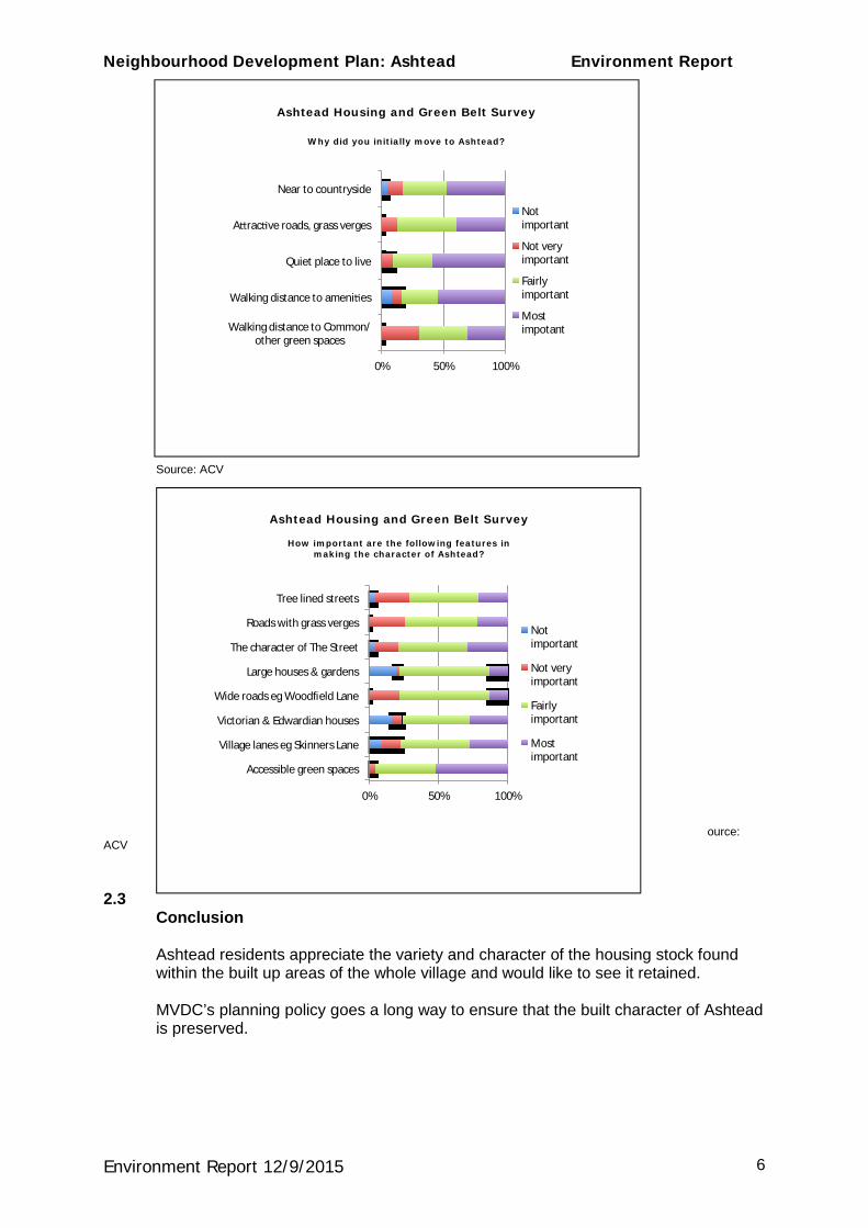
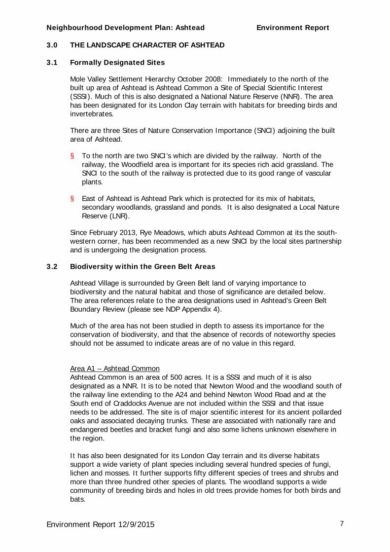
The charts below and overleaf show the results of 39 responses received to a Housing and Green Belt Survey conducted by ACV in March 2013.
Neighbourhood Development Plan: Ashtead Environment Report
Environment Report 12/9/2015 6
Source: ACV
ource: ACV 2.3 Conclusion
Ashtead residents appreciate the variety and character of the housing stock found within the built up areas of the whole village and would like to see it retained.
MVDC’s planning policy goes a long way to ensure that the built character of Ashtead is preserved.
Ashtead Housing and Green Belt Survey
How important are the following features in making the character of Ashtead?
0% 50% 100%
Accessible green spaces
Village lanes eg Skinners Lane
Victorian & Edwardian houses
Wide roads eg Woodfield Lane
Large houses & gardens
The character of The Street
Roads with grass verges
Tree lined streets
Not important
Not very important
Fairly important
Most important
Ashtead Housing and Green Belt Survey
Why did you initially move to Ashtead?
0% 50% 100%
Walking distance to Common/other green spaces
Walking distance to ameni es
Quiet place to live
A rac ve roads, grass verges
Near to countryside
Not important
Not very important
Fairly important
Most impotant
Neighbourhood Development Plan: Ashtead Environment Report
Environment Report 12/9/2015 7
3.0 THE LANDSCAPE CHARACTER OF ASHTEAD
3.1 Formally Designated Sites
Mole Valley Settlement Hierarchy October 2008: Immediately to the north of the built up area of Ashtead is Ashtead Common a Site of Special Scientific Interest (SSSI). Much of this is also designated a National Nature Reserve (NNR). The area has been designated for its London Clay terrain with habitats for breeding birds and invertebrates.
There are three Sites of Nature Conservation Importance (SNCI) adjoining the built area of Ashtead.
§ To the north are two SNCI’s which are divided by the railway. North of the railway, the Woodfield area is important for its species rich acid grassland. The SNCI to the south of the railway is protected due to its good range of vascular plants.
§ East of Ashtead is Ashtead Park which is protected for its mix of habitats, secondary woodlands, grassland and ponds. It is also designated a Local Nature Reserve (LNR).
Since February 2013, Rye Meadows, which abuts Ashtead Common at its the south-western corner, has been recommended as a new SNCI by the local sites partnership and is undergoing the designation process.
3.2 Biodiversity within the Green Belt Areas
Ashtead Village is surrounded by Green Belt land of varying importance to biodiversity and the natural habitat and those of significance are detailed below. The area references relate to the area designations used in Ashtead’s Green Belt Boundary Review (please see NDP Appendix 4).
Much of the area has not been studied in depth to assess its importance for the conservation of biodiversity, and that the absence of records of noteworthy species should not be assumed to indicate areas are of no value in this regard.
Area A1 – Ashtead Common Ashtead Common is an area of 500 acres. It is a SSSI and much of it is also designated as a NNR. It is to be noted that Newton Wood and the woodland south of the railway line extending to the A24 and behind Newton Wood Road and at the South end of Craddocks Avenue are not included within the SSSI and that issue needs to be addressed. The site is of major scientific interest for its ancient pollarded oaks and associated decaying trunks. These are associated with nationally rare and endangered beetles and bracket fungi and also some lichens unknown elsewhere in the region. It has also been designated for its London Clay terrain and its diverse habitats support a wide variety of plant species including several hundred species of fungi, lichen and mosses. It further supports fifty different species of trees and shrubs and more than three hundred other species of plants. The woodland supports a wide community of breeding birds and holes in old trees provide homes for both birds and bats.

Neighbourhood Development Plan: Ashtead Environment Report
Environment Report 12/9/2015 8
Area I 1-3 – The Rye Brook Area
The Rye Brook flows through the lowest part of the common and Rye Brook Marshes is an area subject to a flooding risk. Flood-plain meadows are a scarce habitat in the area of Ashtead and they are being developed as a wildlife area, which will in due course be open to the public.
Area A4 – Woodfield The two areas known as Woodfield are found to the north and south of the railway station and both are designated SNCI. The area to the north provides the setting for the NNR and is species-rich, acid grassland with some rare species. The section south of the railway line and station is protected due to its range of vascular plants.
Area B - Ashtead Park Ashtead Park lies on the eastern side of the village and is bordered by the A24 and Farm Lane. It is a SNCI and a LNR (designated 1995). It is leased to the Surrey Wildlife Trust (SWT) until 2057 and is also of value as a recreational area with a network of paths and fishing.
It is of particular importance for oak pollards and a mix of wildlife habitats including secondary woodland, grassland and ponds. There are some 378 plant species recorded including some designated nationally as vulnerable, scarce or threatened, notably frogbit, water soldier and the fringed water-lily. There are also several large specimen non-native trees. There are two large ponds, both of which are fished by a local club. The larger pond covers two and a half acres and the lower Rookery Pond as well as being stocked for fishing is also managed as a haven for wildlife. The ponds support Great Crested Newts (a protected species) and the site is particularly rich in dragonflies, damselflies and butterflies
Areas D and E - Farmland on the southern boundary of the village Areas D and E consist of Grade 3 Agricultural land with fields enclosed by hedges with mature hedgerows, shrubs and trees. Some of the boundaries are ancient with exceptional numbers of woody plants and trees in the hedges, which suggest they are probably one thousand or more years old. The area between Larch Fields and Farm Lane in D-2 provides a wildlife corridor into Ashtead Park. Parts of the meadows in Area E support a wide range of plants characteristic of chalk grassland, a habitat currently recognized as a UK Biodiversity Plan Priority Habitat by Natural England. In the areas south of The Warren local residents have reported the presence of owls and bats plus deer, badgers, rabbits and newts.
Area F - Ermyn Way Fields This area is bordered by the M25 to the south and Green Lane to the north.
The southern part of the site is designated as Grade 3 Agricultural Land. The northern boundary however is ancient and of considerable significance. It has many mature trees and shrubs and the associated unploughed field margin is particularly rich in plants. The angular wooded area near Quarry Gardens and the footbridge over the M25 includes several large ancient beech trees and is of nature conservation importance for these trees and associated organisms. There are two particularly ancient pollarded beech trees in the field close to south-eastern corner of the ExxonMobil property. The planting undertaken onthis site to help mitigate the noise from the motorway has been of non-native plants and cultivars however, although emphasis has been given to vegetation (mostly shrubs and trees), herbaceous plants, lichens and other fungi, insects, birds, mammals and all other animals, which contribute to species richness and overall biodiversity, depend on these tracts of vegetation.
Neighbourhood Development Plan: Ashtead Environment Report
Environment Report 12/9/2015 9
Area G - Ashtead West Fields (South) G-2 Barnett Wood Fields is the site of and includes remnants of the ancient and formerly more extensive Barnett Wood. Therefore it is possible that this area has some biodiversity and wildlife importance for species associated with ancient woodland, although many ancient trees are no longer there and a field survey has not yet been carried out.
Area H - Ashtead West Fields (North) This is an area of agricultural land used for grazing and hay to the south, with a central marshy area and further fields to the north. The bridleway on the east side, leading to Ashtead Common, is ancient with some massive trees, particularly ash. Hedgerows line the western boundary that adjoins the M25
Areas J2 and J3 - Ashtead East Area J2 is connected to further wooded areas and local residents report that it provides a passage for deer traveling through Ashtead and contains many species of animals including protected pipistrelles and tawny owls. The pond in J3 is in the grounds of the house called The Pines and feeds the Rye Brook, probably from springs arising from the chalk/clay boundary. Local residents report that it is favoured by wetland birds.
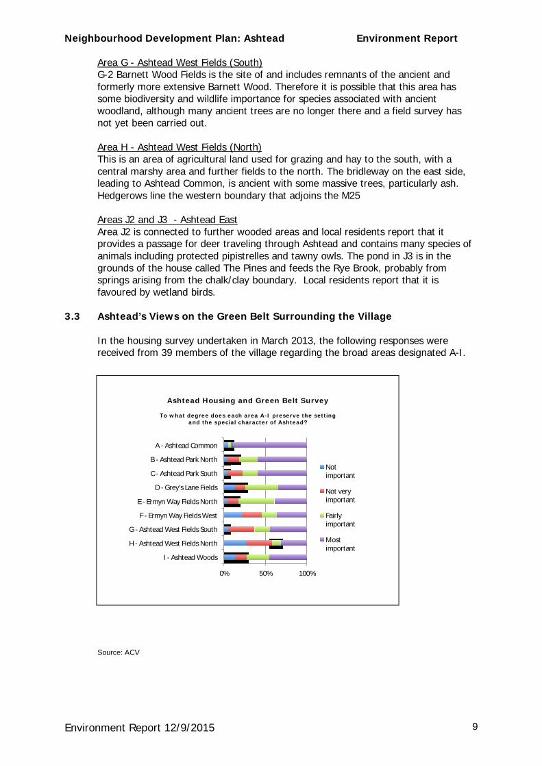
3.3 Ashtead’s Views on the Green Belt Surrounding the Village
In the housing survey undertaken in March 2013, the following responses were received from 39 members of the village regarding the broad areas designated A-I.
Source: ACV
Ashtead Housing and Green Belt Survey
To what degree does each area A-I preserve the setting and the special character of Ashtead?
0% 50% 100%
I - Ashtead Woods
H - Ashtead West Fields North
G - Ashtead West Fields South
F - Ermyn Way Fields West
E - Ermyn Way Fields North
D - Grey's Lane Fields
C - Ashtead Park South
B - Ashtead Park North
A - Ashtead Common
Not important
Not very important
Fairly important
Most important
Neighbourhood Development Plan: Ashtead Environment Report
Environment Report 12/9/2015 10
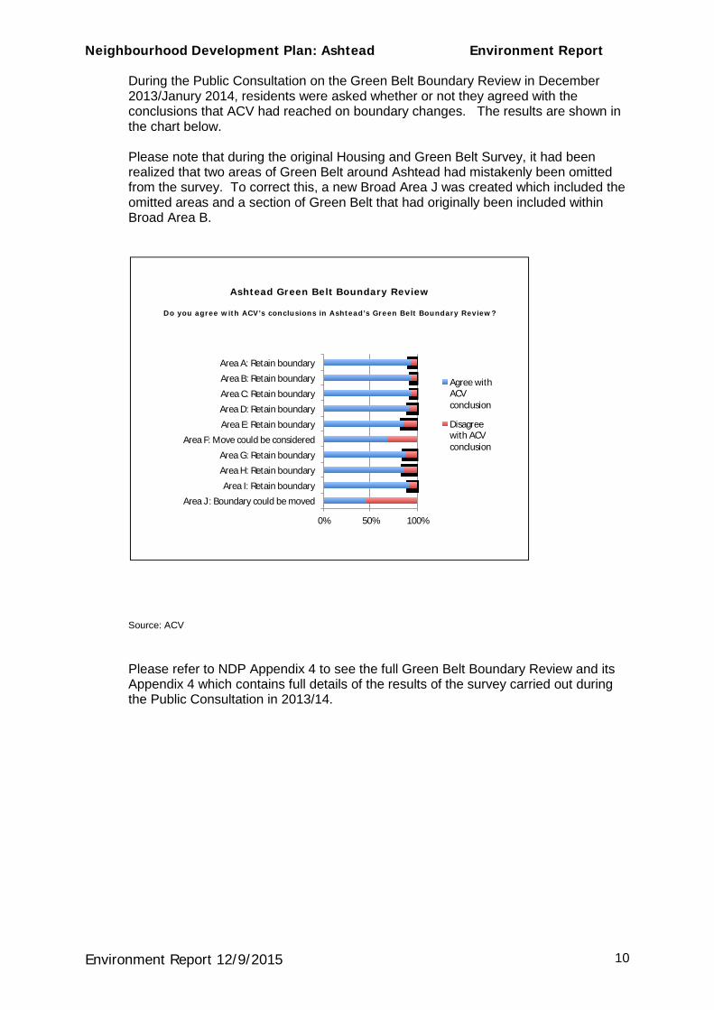
During the Public Consultation on the Green Belt Boundary Review in December 2013/Janury 2014, residents were asked whether or not they agreed with the conclusions that ACV had reached on boundary changes. The results are shown in the chart below. Please note that during the original Housing and Green Belt Survey, it had been realized that two areas of Green Belt around Ashtead had mistakenly been omitted from the survey. To correct this, a new Broad Area J was created which included the omitted areas and a section of Green Belt that had originally been included within Broad Area B.
Source: ACV Please refer to NDP Appendix 4 to see the full Green Belt Boundary Review and its Appendix 4 which contains full details of the results of the survey carried out during the Public Consultation in 2013/14.
Ashtead Green Belt Boundary Review
Do you agree with ACV’s conclusions in Ashtead’s Green Belt Boundary Review?
0% 50% 100%
Area J : Boundary could be moved
Area I: Retain boundary
Area H: Retain boundary
Area G: Retain boundary
Area F: Move could be considered
Area E: Retain boundary
Area D: Retain boundary
Area C: Retain boundary
Area B: Retain boundary
Area A: Retain boundary
Agree with ACV conclusion
Disagree with ACV conclusion
Neighbourhood Development Plan: Ashtead Environment Report
Environment Report 12/9/2015 11
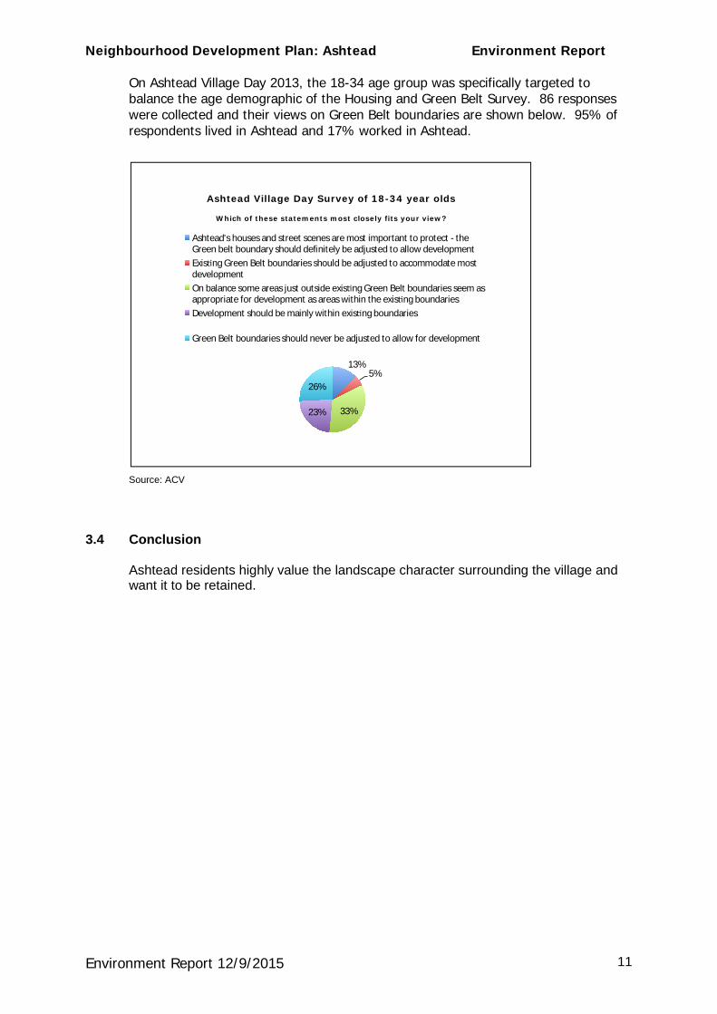
On Ashtead Village Day 2013, the 18-34 age group was specifically targeted to balance the age demographic of the Housing and Green Belt Survey. 86 responses were collected and their views on Green Belt boundaries are shown below. 95% of respondents lived in Ashtead and 17% worked in Ashtead.
Source: ACV
3.4 Conclusion
Ashtead residents highly value the landscape character surrounding the village and want it to be retained.
Ashtead Village Day Survey of 18-34 year olds
Which of these statements most closely fits your view?
13% 5%
33% 23%
26%
Ashtead's houses and street scenes are most important to protect - the Green belt boundary should definitely be adjusted to allow development Exis ng Green Belt boundaries should be adjusted to accommodate most development On balance some areas just outside exis ng Green Belt boundaries seem as appropriate for development as areas within the exis ng boundaries Development should be mainly within exis ng boundaries
Green Belt boundaries should never be adjusted to allow for development
Neighbourhood Development Plan: Ashtead Environment Report
Environment Report 12/9/2015 12
4.0 THE IMPROVEMENT OF LOCAL HABITATS
MVDC Core Strategy 2008 The Surrey Biodiversity Action Plan (BAP) identifies targets and actions for priority habitats and species in Surrey and delivers actions through partnership working. The aims of the Surrey BAP are to conserve and enhance the biological diversity of Surrey and contribute to conserving and enhancing both national and international biodiversity.
The Urban Biodiversity Action Plan (UBAP) for Surrey aims to safeguard and enhance the biodiversity found where people live and in doing so improve the quality of peoples’s lives through contact with, appreciation of and involvement in nature conservation. It aims to contribute towards making development more sustainable by reducing the imprint that urban areas make on the rest of the county.
4.1 Examples of habitat improvement in Ashtead 4.1.1 Ashtead Common
The City of London Corporation manages the common helped by the active involvement of local village volunteers. As an SSSI, work follows a management plan agreed with Natural England, and Ashtead is represented in the management committee by a member of the ARA and a local councillor.
The Rangers’ and volunteers’ continuing and challenging work is to maintain the special aspects of the common such as the ancient trees which involves detailed work and maintaining the right balance between the scrub and the grassland so that species particular to that type of area and the common can thrive.
Volunteers provide valuable help on the common. 5,018 volunteer hours were logged during 2013 – 14 with an average of 20 a week. As well as general members of the public, these volunteers can include those on work experience and from local corporate groups.
4.1.2 The Rye Brook and Meadows
The Rye Brook, a tributary of the River Mole, starts from a spring at the back of Farm Lane and then flows through Ashtead Common. Since the 1950s, flooding has increased due to housing development in a large part of its catchment area. In 2006, the City of London Corporation worked with Natural England, the Environment Agency and Ashtead Residents’ Association to reduce the associated risks. This work resulted in the removal of a long straight stretch of artificial channelling and the re-introduction of meanders to create a more natural watercourse. A flow control “wall” was also created to limit the flow of water downstream. Evidence has shown that this work has helped to offset local flooding and will in time help the problem of flooding in Leatherhead. The present restoration of the Rye Brook and Meadows is being undertaking by local volunteers in conjunction with the SWT, the Environment Agency, the Wild Trout Trust and the Woodland Trust. In 2012, a Jubilee Wood comprising 1,700 trees was planted on either side of the Rye Brook. At the beginning of 2015, 1,000 more trees were planted and a further 420 trees are to be planted in the Rye Meadows in March.
Neighbourhood Development Plan: Ashtead Environment Report
Environment Report 12/9/2015 13
Also as part of the restoration, Ashtead Rye Meadows is participating in SWT's RiverSearch and RiverFly initiatives. A Rye Meadows volunteer carries out quarterly RiverSearch surveys of the Rye Brook within Rye Meadows, mapping features which have the potential to create pollution or create obstructions and so increase risk of flooding and mapping evidence of non-native invasive species. Quarterly surveys sampling the invertebrates living in the stream at several points within the Rye Meadows are also undertaken to indicate how healthy the stream is.
The RiverSearch maps also track improvements made to the stream by the volunteers including opening up of bankside vegetation to improve the environment for wildlife, bank modifications to provide more diverse habits and increased stream capacity for flood control, and the removal of obstructions to facilitate movement of fish and other stream fauna upstream.
It is intended to offer local schools the opportunity to participate in the work, to help increase their appreciation of the environment around them.
A further objective of the project was to improve wildlife on the site and ecological surveys show that this aspect of the project has been a success. By enhancing habitats, new homes have been created for a variety of insects, amphibians, reptiles and breeding birds.
4.1.3 Ashtead Pond
Work was undertaken in 2014 to improve the water quality and appearance of the pond. Following its dredging,wetland plants were introduced designed to help filter the water entering it, as well as improve its general appearance and provide a better environment for fish, plants, birds and insects.
4.1.4 Ashtead Park
The two and half acre pond in the park, which had been neglected for 50 years, has been restored by The Leatherhead and District Angling Society.
4.2 Conclusion
Valuable work is being undertaken by professionals and local volunteers to help preserve and improve the green spaces both surrounding and within the village.

Neighbourhood Development Plan: Ashtead Environment Report
Environment Report 12/9/2015 14
5.0 OPEN SPACES AND RECREATION FACILITIES WITHIN ASHTEAD
MVDC Core Strategy Goal 6 - Recreation
To safeguard and provide provision of sufficient land and facilities for open space, sport and recreation to meet current and future requirements.
5.1 Open Spaces
Ashtead Common
The largest open space close to the village is Ashtead Common (231.66 ha), which links to Newton Wood (42.21 ha). The whole is an area of wooded common land managed by the City of London Corporation immediately north of the village and both provide an extensive network of paths and bridle ways suitable for walking, horse riding and cycling. Two livery stables situated on the edge of the Common offer riding tuition.
According to the MVDC Landscape Supplementary Planning Document (SPD) (July 2013) one of the Key issues (5.13) is the recreational pressure within popular and important public access land such as Ashtead Common.
In a meeting held with the Head Ranger of Ashtead Common in 2015 it was stated that the only real pressure that is experienced by the Corporation in Ashtead is the pressure to install or improve infrastructure to accommodate increased or changes in demand such as more horse riders or changes to school routes. The Greville Primary School takes children from the Wells Estate in Epsom, hence pressure to surface the path from Lady Howards Crossing to Craddocks Avenue. In the case of the riders, they would like a path with a prepared surface to lead them from their base to the north of Ashtead Woods Road towards the bridleways on the common. This surface would be like that on the bridleway which leads from the station on to the common over the Rye Bridge. It was explained that in cases like this the rangers have to balance the requests of local users against the need to maintain the common in its natural state. On many occasions they have to say no to protect the natural aspect.
Whereas cyclists might have been a problem in the past, this is far less so now because the rangers have produced a map to show where not to cycle. In order to maintain certain paths Concessionary Paths are closed to both cyclists and horse riders during the winter months.
Otherwise, visitor numbers would not suggest that there was pressure on the area. During the year 2011-2012 the common received 205,960 visitors, many of these being daily dog walkers. During 2013–2014, twenty-five activities were held on the common by the rangers with a total attendance of 364 visitors. In the years when there were Open Days for the archaeological dig, visitor numbers were higher. It is to be noted, however, that there is always high visitor satisfaction at the end of visits to the common.
Regarding plans to increase the awareness of the common, the rangers have agreed after consideration, that they would prefer to provide information and support for those wishing to visit the common rather than actively promote it. They are more than happy to talk to local groups and do so regularly but only at the request of that particular organization. The group however is using more modern ways to increase awareness and spread information about the common by using electronic means such as Facebook.
Neighbourhood Development Plan: Ashtead Environment Report
Environment Report 12/9/2015 15
The City of London Corporation does not get involved in concerns such as local development except to make representations in the case of planning applications likely to impact on the common land under their jurisdiction. At such times, such as the widening scheme in Woodfield Lane on the approach to the station, they will forward comments to the council because common land is involved.
The Woodfield ( 6.28ha) This is managed by the City of London Corporation, and lies just north of the station and railway line and it is an open common field of 6.28 ha. The grassed area to the south of the railway, which is also common land, is important as a large open public space and it has a network of footpaths across it giving access to the station.
Rye Meadows The Rye Meadows are part of a 46-acre parcel of privately owned land which is in the process of being restored for the future enjoyment of the village. The lower meadows, extending to some 14 acres, form a relatively narrow strip 800 metres long which is bisected by the Rye Brook, a tributary of the River Mole. It is on a designated flood plain and is ideal for creating a range of diverse habitats for wild life. Two public footpaths, which have been restored, cross the Rye Brook so that the planned enhancements will be visible to those using the footpaths.
Ashtead Park (23.76 ha) Ashtead Park lies to the south east of the village. It is a wooded area with walks and two large ponds, both of which are fished by a local club. The lower pond is also managed as a haven for wildlife by SWT.
Other open spaces and facilities
· There is a large pond within the village at the eastern end of Barnett Wood Lane, which MVDC restored in 2013/14.
· To the south of the village, Crampshaw Lane and Gray’s Lane give access to pathways leading to Headley and the surrounding countryside.
· A livery stable is based at Chace Farm to the south.
5.2 Sports and Recreation Grounds
In 2007, MVDC undertook an assessment of all open space, sports and recreation facilities in the District (known as a PPG17 Assessment) i.e. Planning Policy Guidance Note 17 (Planning for Open Space, Sports and Recreation.
Six areas have been designated as Strategic Open Space in the Built–Up Areas in Ashtead:
· Two sports and recreation grounds: Queen Elizabeth II Playing Field (formerly known as Ashtead Recreation Ground) and Ashtead Cricket Ground).
· Three school playing fields: Parsons Mead, The Greville Primary and West Ashtead Primary. Since this designation, Parsons Mead has ceased to be a school but the playing field remains. It is now in the care of Ashtead Cricket Club and Ashtead Football Club and is used as their junior ground.
Neighbourhood Development Plan: Ashtead Environment Report
Environment Report 12/9/2015 16
· The allotments south of Leatherhead Road.
MVDC’s Area Profile states there is a lack of provision of parks and gardens in Ashtead although there are large areas of natural and semi-natural green space in close proximity that may cater for many of the needs of the residents. There is also a lack of provision for children and young people.
5.3 Outdoor Physical Activities and Facilities Available Within Ashtead
Queen Elizabeth II Playing Field (Ashtead “Rec”)
The playing field is 3.12ha and the quality is deemed to be good but below the level of provision by –0.07ha per 1,000 people. It provides three football pitches, a children’s playground, a skate park, netball courts and tennis courts.
Ashtead Football Club
Ashtead Football Club, an FA "Charter Standard Community Club" is based on the playing field where it has its clubhouse, MUGA (Multi Use Games Area) and access to three pitches. Because of its large membership and the age-range of its members (see below) the club uses the playing fields of what was Parsons Mead School on Ottways Lane, The Greville and West Ashtead primary schools in Ashtead as well as Therfield Secondary School, Forty Foot Rec and Headley Court in Leatherhead.
Training is also undertaken at Downsend, Therfield and at City of London Freemen’s Schools. The Parsons Mead site, which is shared with Ashtead Cricket Club is used in the winter months for the younger under-7s, -8s, -9s and -10s every weekend.
Maintenance of Playing Areas · The club leases the three pitches from MVDC and maintains them so that they are
up to playing standard.
· The club finds the task of maintenance more difficult than it might be however, because the store at the southern-most end of the grounds, which also belongs to MVDC, is not deemed to be fireproof or sufficiently safe for the storage of ground maintenance equipment.
· The club also helps maintain all the grounds they use enabling a decent standard not just for their use but for the school pupils too.
Membership of the Club is as Follows: · There are over 600 playing (100 Adults and over 500 youth) members creating 33
teams in all.
· There are 4 Adult Teams including a Vet’s Team and a Sunday Team.
· 29 youth mixed gender teams also include teams for girls
· There are 170 members of the Mini Colts development squad (age 4 – 9) with a waiting list.
Neighbourhood Development Plan: Ashtead Environment Report
Environment Report 12/9/2015 17
· The club is also looking into providing blind football for the area.
It is to be noted that despite using every possible playing area in the village the club is physically unable to host all their teams within Ashtead.
Ashtead Tennis Players’ Club
There are four tennis courts within the Queen Elizabeth II Playing Field. Two of these are leased to Ashtead Tennis Players’ Club and the other two are available for public use, with fees collected by the tennis club. The club gives coaching lessons to all ages and aims to have six playing teams. Ashtead Squash and Tennis Club This club has two outdoor composite tennis courts as well as four heated squash courts.
Ashtead Cricket Ground
In 2014, Ashtead Cricket Club had 17 teams in all and a membership as follows:
· 297 Juniors (of which 43 Girls) – ages 8-18 · 23 Young Adults - ages 19-24 · 40 Adults – ages 25+
Due to the size of the club the ground at Parsons Mead is also used for training and matches for ages up to U12B, i.e. 135 mixed groups and 43 girls will play at this site.
Ashtead Bowling Club
Ashtead Bowling Club has a 7-rink green situated in the north-eastern corner of the cricket ground. It has a membership of 130 players.
Ashtead All Stars Junior Netball Club
The club has a membership of 100 for girls from Year 5 to Year 10. Training is held at Downsend School but League matches are played in Dorking or at Nonsuch.
5.4 Playgrounds
The village has two playgrounds for children.
§ The largest may be found within the Queen Elizabeth II Playing Fieldnext to the tennis courts (0.093ha) and it has recently been expanded and upgraded. It has a fenced toddler section including a sand pit and swings and an unfenced area including a zip wire, trampoline and large climbing unit for older children.
§ The Queen Elizabeth II Playing Field also has a skate park. The quality of this is deemed to be good but below the district standard of provision (-0.093ha per 1,000 people)
§ There is a new, smaller area for young children in the grounds of the Parsons Mead development in Ottways Lane.
Neighbourhood Development Plan: Ashtead Environment Report
Environment Report 12/9/2015 18
Other Outdoor Facilities
· The cycle path constructed in 2014 along the A24 is seen as an asset giving access to the Surrey Hills. Two local commercial businesses give regular lessons and guided cycle rides for groups ranging from beginners of any age to events for the highly proficient.
· Bridleways may be found on Ashtead Common and to the south of the village in the area of the Ermyn Way fields.
5.5 Allotments
There are 2.48ha of allotments south of the A24 between the grounds of Ashtead hospital and Stag Leys providing 88 plots. The Area Profile states that there is a small shortfall of allotments plus a waiting list, which shows that there may be a need to increase the provision in Ashtead.
5.6 Amenity Green Space.
An “Amenity Space” is an area of grass, possibly with seating which is managed by MVDC and may be used for play or for rest for the elderly.
§ Small areas of amenity green space may be found in the following places:
§ at the beginning of Greville Park Road, opposite Lime Tree Court (.012ha)
§ in Fountain Garden, the little garden with seats on the north side of the A24 as one leaves The Street (.015ha)
§ Ashtead Pond Amenity Space, the area of grass immediately around the pond (.440ha) adjacent to Barnett Wood Lane.
§ at the junction of Oakhill Road and Green Lane.
§ Municipal seats for public use:
§ by the Cricket Ground bus stop in Woodfield Lane
§ by the post box half way up Crampshaw Lane
§ Woodfield Lane on the approach to the station
§ At the entrance to Moat Court
§ Barnett Wood Lane at the Caen Road junction
5.7 Areas of Green Space for Communal Use
A number of developments within the village have been designed to include communal areas of grass for the use of the local residents. These include the development on the east side of Ermyn Way, in the area of Hatherwood, Parsons Mead, Moat Court and Westfield. Grass verges along the wider roads, tree-lined avenues and areas of grass at road junctions such as may be found along Bramley Way and Green Lane add to the green environment of Ashtead as well as the significant volume of mature trees to be found throughout the village.

Neighbourhood Development Plan: Ashtead Environment Report
Environment Report 12/9/2015 19
5.8 Conclusion
There are insufficient playing areas for sport within the village. There is also a lack of provision for children and young people but various sports clubs are endeavouring to overcome this by using school sports facilities at weekends and by using facilities outside the village.
Sports areas attached to each of the schools should be safeguarded because they are not only of benefit to the individual schools but to the whole community.
Wherever possible, areas of amenity grass and trees should be retained to maintain the environmental character of the village.
Neighbourhood Development Plan: Ashtead Environment Report
Environment Report 12/9/2015 20
6.0 LAND CONTAMINATION
All the areas of high, medium and low risk in Ashtead are listed in Appendix 3 of Ashtead’s Baseline Sustainability Appraisal (please see NDP Appendix xxx). Where possible the cause of the contamination has been identified and most sites have already been built on, with the exceptions of St Giles’ Church cemetery and the sites on Ashtead Common, all of which are categorised as low risk.
Ashtead no longer has the type of industry such as quarrying or engineering works as in the past but businesses creating contaminated land now are as follows:
§ the petrol station, 7 The Street, beside Lime Tree Court
§ car engineering works and body shops in Church Road, Grove Road, and the garage and works at the junction of Craddocks Avenue and Woodfield Lane.
§ The Forge in Woodfield Road.
§ Cranford Engineering, Craddocks Avenue
7.0 AIR QUALITY
One of the Aims and Objectives of the Policies, Plans, Programmes, Strategies and Initiatives strategy regarding Air Quality is as follows:
· Reduce the impact of transport / congestion and mitigate impact of development on air quality.
According to the MVDC Sustainability Scoping Report 2013:
“There are no Air Quality Management Areas in the District. Local monitoring has indicated that air quality in Mole Valley is within national limits. There is one location near the M25 (at Green Lane, Leatherhead) which is near the air quality limit”. Despite the address, Green Lane, is within the boundary of Ashtead and so is of concern to this report.
The report also states that “ Whilst at the present time air quality limits are not being breached there is the potential for this to happen as a result of congestion, new development and other factors”.
Congestion spreads back from the Knoll roundabout into the centre of the village, causing long queues of stationary traffic.The future development planned for St Peter’s Primary School in Grange Road is likely to place even further pressurex` in this area.
Congestion is also experienced in the areas of the schools in Ashtead especially Downsend, St Andrew’s and St Peter’s which are affected by the Grange Road / Ermyn Way cross road tailbacks and are close to the M25.
Lichen bioindicators suggest that nitrogenous pollutants occur in areas with the most traffic, notably along the A24, Barnet Wood Lane, and close to the M25. Critical levels for these pollutants are not as yet agreed by the EU, but some of these areas could be found to exceed them when they are set. Any major development plans therefore need to involve traffic mitigation.
The particulates in the air from wood-burning stoves are rich in potentially carcinogenic hydrocarbons, as are bonfires. This is not an issue of concern at present, but the situation should be monitored and bonfires discouraged.
Neighbourhood Development Plan: Ashtead Environment Report
Environment Report 12/9/2015 21
7.1 Conclusion
Air Quality monitoring of Green Lane (Ermyn Way) should continue but other areas need to be considered within Ashtead such as the Grange Road/Ermyn Way crossroads on the A24 and the nearby schools.

Neighbourhood Development Plan: Ashtead Environment Report
Environment Report 12/9/2015 22
Appendix 1 LISTED BUILDINGS IN ASHTEAD (Source: MVDC 2012)
All sites are Grade II listed unless marked II*
ASHTEAD (GENERAL) § Boundary Post at TQ 178 606 AGATES LANE § Nos.60 and 62 § Barn approx 10 metres s.e. of Murreys Court § Merry Hall § Forecourt wall and gates to Merry Hall ASHTEAD PARK § Grade II* Ashtead Park House and attached balustrades § Balustrade enclosing forecourt in front of Ashtead Park House § Sundial in centre of forecourt in front of Ashtead Park House I § Walls and balustrades to terrace garden of Ashtead Park House § Stable block approx 100m w. of Ashtead Park House § Headmaster’s House § Grade II* Church of St Giles plus various monuments and headstones § Bridge at Rookery Hill CRAMPSHAW LANE § The Old Bakery with barn and outhouse at south end EPSOM ROAD EPSOM ROAD § The Howard Memorial Fountain § Gate piers and gates beside North Lodge FARM LANE FARM LANE § Grade II* Ashtead Park Farm House § Garden wall with gateway and gate front Ashtead Park Farm House § Former farm building 2m e. of rear of Park Farm House § Ice house in grounds of Marsden Nurseries, n.e. Ashtead House § Gates to Ashtead Park: junction Farm Lane and Pleasure Pit § Ashtead House (Nos.1, 2 and 3) § Walls enclosing garden opposite Ashtead House OTTWAYS LANE § The Old Cottage PARK LANE § Gate piers: entrance to Rookery Hill and drive to St Giles Church PARKERS LANE § Ashtead Lodge, with attached screen walls and garden wall § Nos. 1 and 3 Howard Cottage and Ivy Cottage
Neighbourhood Development Plan: Ashtead Environment Report
Environment Report 12/9/2015 23
Appendix 1 cont’d RECTORY CLOSE § The Old Rectory RECTORY LANE § No.12 Fowler’s Cottage § Nos. 18 and 20 § No.24 Forge Cottage, § No.26 Wisteria Cottage THE STREET § Nos. 44 and 46 § The Leg of Mutton and Cauliflower Public House THE WARREN § Grey Wings (listed 7 Jan 2005) WOODFIELD LANE § No.33 § No.35 (The Cottage)
Neighbourhood Development Plan: Ashtead Environment Report
Environment Report 12/9/2015 24
Appendix 2
Ashtead: Conservation Areas and Grade II & II* Listed Buildings
Neighbourhood Development Plan: Ashtead Environment Report
Environment Report 12/9/2015 25
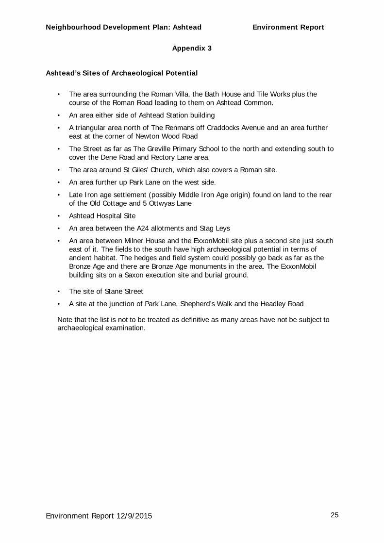
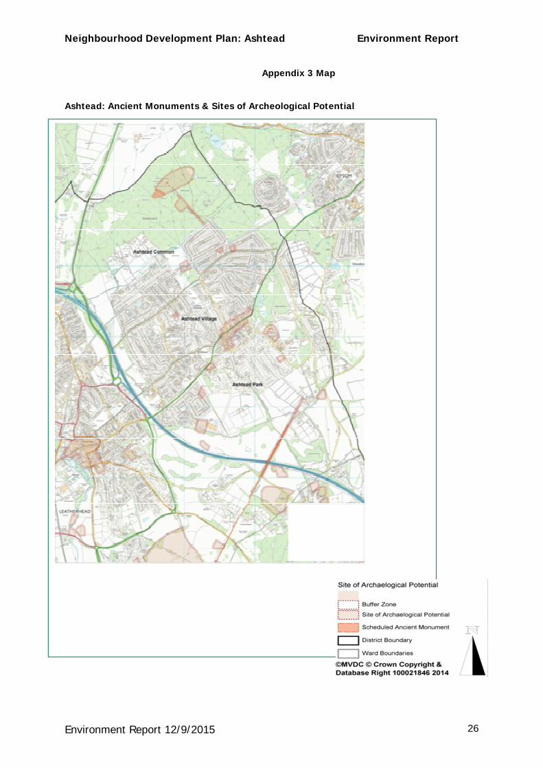
Appendix 3
Ashtead’s Sites of Archaeological Potential
· The area surrounding the Roman Villa, the Bath House and Tile Works plus the course of the Roman Road leading to them on Ashtead Common.
· An area either side of Ashtead Station building
· A triangular area north of The Renmans off Craddocks Avenue and an area further east at the corner of Newton Wood Road
· The Street as far as The Greville Primary School to the north and extending south to cover the Dene Road and Rectory Lane area.
· The area around St Giles’ Church, which also covers a Roman site.
· An area further up Park Lane on the west side.
· Late Iron age settlement (possibly Middle Iron Age origin) found on land to the rear of the Old Cottage and 5 Ottwyas Lane
· Ashtead Hospital Site
· An area between the A24 allotments and Stag Leys
· An area between Milner House and the ExxonMobil site plus a second site just south east of it. The fields to the south have high archaeological potential in terms of ancient habitat. The hedges and field system could possibly go back as far as the Bronze Age and there are Bronze Age monuments in the area. The ExxonMobil building sits on a Saxon execution site and burial ground.
· The site of Stane Street
· A site at the junction of Park Lane, Shepherd’s Walk and the Headley Road
Note that the list is not to be treated as definitive as many areas have not be subject to archaeological examination.
Neighbourhood Development Plan: Ashtead Environment Report
Environment Report 12/9/2015 26
Appendix 3 Map
Ashtead: Ancient Monuments & Sites of Archeological Potential
Neighbourhood Development Plan: Ashtead Environment Report
Environment Report 12/9/2015 27
Appendix 4
Ashtead’s Areas of Green Space
The numbered areas of sections A, B and C are protected.
A - Areas With-in the Green Belt
Areas 1-5 and 7 are all accessible to the general public
1. Ashtead Common a Site of Special Scientific Interest (SSSI). Much of this is also designated a National Nature Reserve (NNR).
2. Woodfield north of the railway is a SNCI 3. Woodfield south of the railway is a SNCI 4. The Rye Meadows to the north of the village are undergoing the SNCI designation
process. 5. Extensive fields to the south of the village small areas of which, such as hedge
boundaries, are designated as Special Areas of Conservation. 6. Fields to the west of the village consisting of playing fields for the local schools and
agricultural land and providing a boundary with Leatherhead.
Green Area With-in the Built-up Areas of the village
7. Ashtead Park is a SNCI and a LNR
B - Strategic Open Spaces The Strategic Open Land designation comes from the MVDC Local Plan and it was used for sites over 0.4ha within the built up areas with a high degree of public visibility.
Six areas have been designated as Strategic Open Spaces. Of these, Areas 1 and 2 are open to the public.
· Queen Elizabeth II Playing Field (formerly known as Ashtead Recreation Ground)
· Parsons Mead Ground – formerly part of the school playing field
· Ashtead Cricket Ground field
· The Greville Primary School Ground
· West Ashtead Primary Ground.
· The allotments south of Leatherhead Road.
The grounds of the City of London Freemen’s School and Downsend School are also made available to local sports clubs for training and matches.
C - Areas of Amenity Green Space as designated by MVDC:-
1. At the beginning of Greville Park Road, opposite Lime Tree Court (.012ha)

Neighbourhood Development Plan: Ashtead Environment Report
Environment Report 12/9/2015 28
2. Fountain Garden on the north side of the A24 as one leaves The Street (.015ha) 3. Ashtead Pond Amenity Space, the area of grass immediately around the pond
(.440ha) adjacent to Barnett Wood Lane. 4. At the junction of Oakhill Road and Green Lane.
D – Other Areas of Green Space
The following housing developments have landscaped green areas created within them for the use of the local residents
1. Hatherwood on the east side of Ermyn Way 2. Parsons Mead 3. Moat Court 4. Westfield
E – Green Islands, Hedgerows and Verges
There are further smaller areas of grass, trees and verges which bring the sense of a green environment and openness to the village and help to create a sense of well-being amongst the residents. They are an essential part of the character of the village.
1. An island at the junction of Bramley Way with Hillside Road
2. An island on the north side of Bramley Way just beyond the turning to Darcy Road
3. An island in the centre of Glebe Road
4. An island at the end of Oakhill Close
5. The avenues of trees along Woodfield Land
6. The hedgerows in The Lanes area
7. The hedgerows in the lanes leading to the southern boundaries of the village.
8. Wide verges in Farm Lane
9. Tree-lined roads eg A24