environmental and social management … plaza-thomas aquinas gully erosion intervention site, awka...
TRANSCRIPT

Nerose Plaza-Thomas Aquinas Gully Erosion Intervention Site, Awka
ENVIRONMENTAL AND SOCIAL MANAGEMENT PLAN (ESMP)
(Draft)
Draft Report
For
NEROSE PLAZA-THOMAS AQUINAS GULLY EROSION
INTERVENTION SITE, AWKA, ANAMBRA STATE
UNDER
THE NIGERIA EROSION & WATERSHED MANAGEMENT
PROJECT (NEWMAP)
WORLD BANK ASSISTED
By
ANAMBRA STATE -NIGERIA EROSION & WATERSHED
MANAGEMENT PROJECT (ANS-NEWMAP)
AWKA, ANAMBRA STATE
March, 2014
Pub
lic D
iscl
osur
e A
utho
rized
Pub
lic D
iscl
osur
e A
utho
rized
Pub
lic D
iscl
osur
e A
utho
rized
Pub
lic D
iscl
osur
e A
utho
rized
Pub
lic D
iscl
osur
e A
utho
rized
Pub
lic D
iscl
osur
e A
utho
rized
Pub
lic D
iscl
osur
e A
utho
rized
Pub
lic D
iscl
osur
e A
utho
rized

Nerose Plaza-Thomas Aquinas Gully Erosion Intervention Site, Awka
ii
Table of Contents Content Page
Cover Page Table of Contents i List of Tables ii
List of Figures iv List of Maps v List of Boxes v
List of Abbreviations/ Acronyms vi Definition of Terms viii Executive Summary x
SECTION 1: GENERAL INTRODUCTION 1 1.1 Background 1
1.2 The proposed Intervention Work 2 1.2.1 St Thomas Aquinas Gully Erosion intervention component 2 1.2.2 Neros Plaza Gully Erosion Intervention Component 2
1.3 Rational for ESMP for the Proposed Intervention Work 4 1.4 Objectives of this Environmental and Social Management Plan 4 1.5 Scope/Terms of Reference of the ESMP and Tasks 4
1.6 Approaches for Preparing the Environmental and Social Management Plan 4 1.6.1 Literature Review 4 1.6.2 Interactive Discussions/Consultations 4
1.6.3 Field Visits 4 1.6.4 Identification of Potential Impacts and Mitigation Measures 5
SECTION 2: INSTITUTIONAL AND LEGAL FRAMEWORK FOR ENVIRONMENTAL MANAGEMENT 6 2.1 Introduction 6
2.2 World Bank Safeguards Policies Triggered by NEWMAP and the Proposed Activity 7
2.3 Summary of Relevant Local and Federal Policy, Legal, regulatory and
Administrative Frameworks 7 2.3.1 State Legislations 7 2.3.2 Anambra State Ministry of Local Government Regulations 8
2.4 Making the ESMP Responsive to Good Practice 8 SECTION 3: BIOPHYSICAL ENVIRONMENT 9 3.0 Introduction 9
3.1 Location and Size 9 3.2 Description of the Proposed Intervention Site 9 3.2.1 The Watershed 9
3.3 Biophysical Environment 10 3.3.1 Hydrological Study 11 3.4 Geology 11
3.5 Soil Studies 11 3.6 Geotechnical Survey 12 3.7 Flora and Fauna 12
3.8 Water Resources and Quality Assessment 12 3.9 Climate and Meteorology of the Study Area 14 3.10 Noise Level Assessment 14
3.11 Air Quality Assessment 14 3.12 Land use in Awka 14 3.13 Ecological Hazards and Environmentally Sensitive Areas 15

Nerose Plaza-Thomas Aquinas Gully Erosion Intervention Site, Awka
iii
SECTION 4: SOCIO-ECONOMIC CHARACTERISTICS AND
CONSULTATION WITH STAKEHOLDERS 17 4.1 Introduction 17 4.2 The People and Religion 17
4.3 Occupation and Livelihood 17 4.4 Education 17 4.5 Population and settlement pattern 17
4.6 Economy 17 4.7 Poverty Index 17 4.8 Gender & Governance 18
4.9 Public Opinion- Response Survey Instrument (Questionnaire) 18 4.9.1 Age, Sex and Number of Children of Respondents 18 4.9.2 Religion and Level of Education 18
4.9.3 Occupation 19 4.9.4 Average Income of Respondents 19 4.9.5 Awareness of the Proposed Intervention Project 19
4.9.6 Respondents Important Valuables to be Protected 19 4.9.7 Perception of Service Delivery in the State 19 4.10 Health Status Assessment 19
4.10.1 Respondents Common Health Problems 19 4.10.2 Awareness of HIV/AIDS 20 4.10.3 Awareness of Malaria 20
4.10.4 Respondents Option on causes of health 20 4.10.5 Risk of Health Problem as a result of the intervention Work 20 4.10.6 Main Source of Water Supply to the Facility 20
4.10.7. Availability of Health Care Facility 21 4.10.8 Respondent Perception of Health Facility 21 4.11. Community Consultations 21
4.11.1 The Objectives of Community Consultations 21 4.11.2. The Stakeholders Consulted and their Concerns 21
SECTION 5: ASSESSMENT OF POTENTIAL ADVERSE IMPACTS AND ANALYSIS
OF ALTERNATIVES 23 5.1 Introduction 23 5.2 Impact Identification and Evaluation 23
5.3 Potential Environmental and Social Impacts of the Project 24 5.3.1 The Project Benefits 24 5.3.2 Negative Environmental and Social Impacts 24
5.3.2.1 Construction Phase 24 5.3.2.2 Operation Phase 25 5.3.2.3 Decommissioning Phase 25
5.3.3 Irreversible Environmental Changes 25 5.3.4 Cumulative/Secondary Impacts 25 5.3.5 Environmental Justice 25
5.4 Analysis of Project Alternatives 27 5.4.1 No Project Option 28 5.4.2 Delayed Project Option 28
5.4.3 Go Ahead Option 28 5.4.4 Gully Treatment Option 28

Nerose Plaza-Thomas Aquinas Gully Erosion Intervention Site, Awka
iv
SECTION 6: ENVIRONMENTAL AND SOCIAL MANAGEMENT PLAN 30 6.1 Introduction 30
6.2 Mitigation Measures 30 6.3 Residual Impacts after mitigation 30 6.4 Enhancement of Positive Impacts and Reduction/Avoidance of Negative Impacts 30
6.4.1 Waste Management Plan 37 6.4.2 Maintenance and Inspection of Treated Gully 37 6.5 Environmental Monitoring and Auditing 37
6.5.1 Site Inspection and Monitoring 38 6.5.2 Site Inspection and Maintenance 38 6.5.3 Site Inspection Frequency 38
6.5.4 Vegetation Establishment Monitoring 39 6.5.5 Maintenance Problems 39 6.5.6 Inspection and Maintenance Reports 39
6.6 Environmental Monitoring 39 6.7 Reporting Procedure 41 6.7.1 Complaints Register and Environmental Incidents 41
6.7.2 Record Keeping 41 6.7.3 Institutional Arrangements 41 6.8 Grievance Redress Mechanism 43
6.9 Disclosure and public consultation 44 6.10 Institutional Capacity Building & Training 45 6.11 Review and Revision of the ESMP 46
6.12 ESMP Budget and Schedule of Work 46 SECTION 7: SUMMARY AND RECOMMENDATIONS 47
REFERENCES 48
APPENDICES 49

Nerose Plaza-Thomas Aquinas Gully Erosion Intervention Site, Awka
v
LIST OF TABLES Table Page
2.1 Triggered Safeguard polices 6 3.1 St Thomas Aquinas Gully Discharges 11 3.2 Neros Plaza Discharges 11
3.3 Ambient Noise Levels at project Intervention Zone 14 3.4 Results of Air Quality Measurements Taken at the Proposed Intervention Zone 15 4.1: A Summary of the Outcome of the Consultation Meetings 21
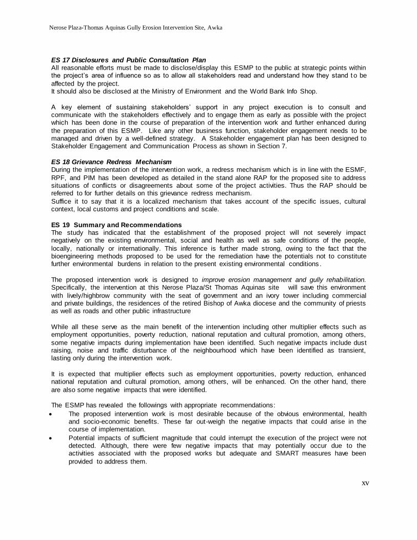
5.1: Consequence Severity, Likelihood Ranking & Risk Matrix Tables 23 5.2: Identified Potential Impacts 26 5.3: Gully Treatment Options 29
6.1: Environmental and Social Management Plan 31 6.2: Environmental Monitoring Plan Construction Phase 40
6.3: Institutional Responsibilities 42 6.4 Summary of the planned Stakeholder engagement Schedule 44 6.5: Training Modules on Environmental and Social Management 45
6.6: ESMP Budget and Implementation Schedule 46
LIST OF FIGURES Figure Page 1.1 Gully Erosion Location and Proposed Engineering Design 3
3.1: Average Relative Humidity in Study Area for the Period 2002-2012 14 4.1: Marital Status 18 4.2: No of Children Respondents 19
4.3: Age of Respondents 19 4.4: Respondents’ Occupation 19 4.5: Average Income of Respondents 19
4.6: Proposed Project Awareness among Respondents 19 4.7: Respondents Important Valuables to be Protected 20

Nerose Plaza-Thomas Aquinas Gully Erosion Intervention Site, Awka
vi
LIST OF PLATES Plate Page 1 Situation of the Proposed Intervention Gully Site 10
2 Some of the Stakeholders at the Meeting 2
LIST OF MAPS
Map Page 1 Proposed Project Site Erosion Intervention Component 2 2 Twin Gully Erosion Intervention Sites at St Aquinas/Neros Plaza 10
LIST OF BOXES
Box Page 1 Local Monkeys on the fence of a resident 12 2 Egrets suspended on the raffia trees 12
3 A summary of the Outcome of the Consultation Meetings 22
LIST OF APPENDICES
Appendix Page 1. Terms of Reference 49 2. Summary of World Bank Environmental and Social Safeguard Policies (10+2) 50
3. Environmental Quality Standards and Criteria -Permissible Levels 51 4. Description of the Components of the Project 52 5 The Proposed Site Area and Features 53
6. Erosion and Sediment Control Measures 54 7. General Environmental Management Conditions For Construction Contracts 57 8. Stakeholders met and summary of Meetings 59
9. Indicative Framework for Assessing and Mainstreaming Gender Concerns 60

Nerose Plaza-Thomas Aquinas Gully Erosion Intervention Site, Awka
vii
LIST OF ABBREVIATIONS AND ACRONYMS BOD Biochemical Oxygen Demand
BP Bank Policy CBO Community Based Organization CDD Community Driven Development
CSO Community Support Organizations DO Dissolved Oxygen DS Dissolved Solids
EA Environmental Assessment EAR Environmental Audit Report ESA Environmentally Sensitive Areas
ESIA Environmental& Social Impact Assessment EIA Environnemental Impact Assessment E(S)MP Environmental (and Social) Management Plan
ESMF Environmental and Social Management Framework FRDP Federal Roads Development Project FGN Federal Government of Nigeria
GIS Geographic Information System HSE Health Safety and Environment IDA International Development Association
IPM Integrated Pest Management LB Land Bureau LGA Local Government Area
LFN Laws of the Federation of Nigeria MDAs Ministries, Departments & Agencies MDG Millennium Development Goals
MIGA Multilateral Guarantee Agency MOE State Ministry of Environment MoH State Ministry of Housing
NGO Non-Governmental Organization NS Not Specified OD Operational Directives (of the World Bank)
NGO Non-governmental Organization NEEDS National Economic Empowerment & Development Strategy NIWA National Inland Waterways Authority
OP Operational Policy PPE Personal Protective Equipment RPF Resettlement Policy Framework
RRC Road Rehabilitation Contractor SEPA State Environmental Protection Agency SMENV State Ministry of Environment
SPM Suspended Particulate Matter TDS Total Dissolved Solids TOR Terms of Reference
TSP Total Suspended Particulate

Nerose Plaza-Thomas Aquinas Gully Erosion Intervention Site, Awka
viii
LIST OF ABBREVIATIONS AND ACRONYMS, Cont'd
UNITS OF MEASUREMENT CHEMICAL ELEMENTS AND COMPOUNDS
cfu/ml Colony forming unit per
milliliter cm Centimeter dBA Decibel
ft Feet g Gramme k Kilogramme
g/cm Gramme per Centimeter Km Kilometer m Meter
m3 Meter Cube meq Milliequivalent mg Milligramme
mg/Kg Milligramme per Kilogramme mg/l Milligramme per Litre
ml Millilitre mm Millimetre m/s Meter per Second
NTU Turbidity Unit o/oo Parts per thousand
oN Degree North
PH Hydrogen ion concentration ppb parts per billion
ppm parts per million ToC Temperature in degrees Celsius
g Microgramme
S micro Siemen
m micrometer
% Percentage
Al Aluminum
C Carbon Ca Calcium CaCO3 Calcium Carbonate
CCl4 Carbon Tetrachloride Cd Cadmium Cl Chloride
CO Carbon Monoxide CO2 Carbon Dioxide Cr Chromium
Cu Copper Fe Iron H Hydrogen
H2O water H2S Hydrogen Sulphide Hg Mercury
K Potassium Mg Magnesium Mn Manganese
N Nitrogen Na Sodium Na2PO4 Sodium phosphate
NaOH Sodium hydroxide NH3 Ammonia NH4
+ Ammonium ion
NH4F Ammonium flouride Ni Nickel NO2
- Nitrite ion
NO3- Nitrate ion
NOX Nitrogen Oxides O2 Oxygen
P Phosphorus Pb Lead PO4 Phosphate
SiO2 Silicate SO2 Sulphur dioxide SO4 Sulphate ion
V Vanadium Zn Zinc

Nerose Plaza-Thomas Aquinas Gully Erosion Intervention Site, Awka
ix

Nerose Plaza-Thomas Aquinas Gully Erosion Intervention Site, Awka
x
DEFINITION OF SOME TERMS
Chutes Formed by battering gully heads to an acceptable slope depending on the method used to stablise it in order to convey run-off safely to a lower level.
Drop structures Allow run-off to drop vertically to a lower level, where the energy is dissipated before flowing down the watercourse.
Erosion The action of water in which soil and rock material is loosened
and removed which could be geological (soil-forming as well as soil-removing) or man-made by clearing, grading, or otherwise altering the land which can greatly accelerate the natural erosion
process, including the breakdown of soil aggregates and the increased removal of organic and mineral particles. Erosion of soils that occurs at construction sites is man-made erosion.
Gully erosion Process whereby runoff water accumulates and often recurs in narrow channels and, over short periods, removes the soil from this narrow area to considerable depths.
Gully head Upper part of the gully (in topo-sequence) where the gully starts Gully offset Part of gully area which is located away from the gully
embankment and extended to the next land use type
Gully sidewall Part of the gully between the gully offset and gully bed characterized by high slope gradient, shallow soil depth, susceptible to erosion and mass movement, very dry in most of
the time due to less water holding capacity. Gully bed/floor Part of the gully on top of which the run off flows Gully Diversion Banks Diversion banks divert run-off from the gully head to a stable
outlet. Gully control dams Dam is situated so that they 'drown' the gully head when the
spillway is operating.
Gully floor stabilisation The long-term success of gully treatment with the establishment
of a good vegetative cover on the gully floor which prevents
further gullying and allows the gully floor to gradually silt up reducing the fall over the gully head.
Landslide A down slope movement of rock and soil along a slip surface.
Shale Fine-grained rocks that contain between 50 and 100% clay sized
particles with clay mineral constituting at least 25% of the total
rock volume. Structural practices Sediment and erosion control devices used to divert storm water
flows away from exposed areas, convey runoff, prevent
sediments from moving offsite, and can also reduce the erosive forces of runoff waters.

Nerose Plaza-Thomas Aquinas Gully Erosion Intervention Site, Awka
xi
EXECUTIVE SUMMARY
ES1 Introduction The Government of Nigeria is implementing the multi-sectoral Nigeria Erosion and Watershed
Management Project (NEWMAP), which is financed by the World Bank, Global Environment Facility, the Special Climate Change Fund, and the Government of Nigeria. NEWMAP finances activities implemented by States and activities implemented by the Federal government. The project currently
includes 7 states, namely Anambra, Abia, Cross River, Edo, Enugu, Ebonyi, and Imo. The lead agency at the Federal level is the Federal Ministry of Environment (FMENV), Department of
Erosion, Flood and Coastal Zone Management. State and local governments, local communities and CSOs are or will be involved in the project, given that the project is a multi-sector operation involving MDAs concerned with water resources management, public works, agriculture, regional and town
planning, earth and natural resources information, and disaster risk management. The development objective of NEWMAP is: to rehabilitate degraded lands and reduce longer-term
erosion vulnerability in targeted areas. The Anambra State Government as one of the participating States represented by the State Project
Management Unit (SPMU) has selected a twin gully head as one of the priority sites for NEWMAP intervention activities.
The two gullies heads are located at St Thomas Aquinas Catholic Church and Neros Shopping Plaza (named after the two landmarks, respectively) area adjacent to Ejeagwu Estate, GRA Awka, Anambra State. The site can be accessed through Aguleri Street before the government house on the right hand
side when approaching Awka from Enugu through the Enugu-Onitsha Expressway. The site lies between latitude 6° 14’ and 6° 18’ North of the Equator and longitude 7° 5’ and 7° 9’ East of the Greenwich Meridian.
ES 2 The Project Activities The components designed to cover the upstream of the gully to the downstream include the following:
Channel, Road, Drains, Culvert, Check dam (3no) and Rip-Rap At the St. Thomas Aquinas section of the gully, a 65m length of channel is designed from Ekwulobia road down to the beginning of the gully. A Road from Thomas Aquinas Cathedral meets the channel at the head of the gully, so the road is
designed with a reinforced concrete lined drain to convey storm water through the gully to the stream. At this intersection where the road meets the channel a culvert is designed to connect them and to help convey the storm water further down. Following the culvert are the check dams, three in number located
at an interval of 20m each. These are expected to help reduce the speed of water to the barest minimum as it travels down the slope. At the end of the check dams, there are rip-raps to protect the soil from further erosion. Beyond this point the soil is considered stable and the water guided to flow gently into
the stream. There is also a drain on the cliff of the erosion area to pre-empt further enlargement of the gully through proper channeling of the water to the network of drains. The same holds for the head at Neros Plaza.
ES 3 Rational and Objective of the ESMP By design, the proposed intervention works shall involve small-sized civil works and use of vegetation
for the gullies stabilization, reclamation, protection and reinforcement to stop scouring action of flow velocity due to exposed soil surface are expected to give rise to some adverse environmental and social impacts in the course of execution.

Nerose Plaza-Thomas Aquinas Gully Erosion Intervention Site, Awka
xii
To this end, the World Bank (WB)’ s Operational Policy, OP 4.01 on Environmental Assessment is triggered hence the need to develop a site specific, costed, measurable, and monitorable actions as
contained in this Environmental and Social Management Plan (ESMP). The ESMP consist mainly the mitigation, monitoring, and institutional measures to be undertaken during the implementation and maintenance of the intervention work in order to eliminate adverse environmental and social impacts,
offset them, or reduce them to acceptable levels. It should be noted that a Resettlement Action Plan (RAP) designed to identify and assess the
displacement of people and assets at the site in the course of work was prepared alongside this ESMP. ES 4 Institutional and Legal Framework for Environmental Management
The national and international environmental guidelines applicable to the operation of the NEWMAP have already been discussed in Chapter Two of the ESMF prepared for the overall project. Of the 10 + 2 World Bank Safeguard Policies, the intervention work at the proposed site triggers Environmental
Assessment (OP/BP 4.01) and Involuntary Resettlement (OP/BP 4.12) as indicated in Table 2.1 of Section 2.
ES 5 Biophysical Environment Gully erosion is a geomorphic process which occurs only when a threshold in terms of rainfall, topography, flow hydraulics, nature of vegetation, nature of soil and land use and capability has been
exceeded. These are reinforced by human activities leading to further degradation of the environment. Essentially, to this end, the relevant biophysical environmental and socio-economic baseline conditions were captured and described, as presented in Sections 3 & 4 of this ESMP. This provides the context
upon which the proposed intervention activities were related to the environment to identify the impacts and develop the necessary mitigation measures.
ES 6 Potential Adverse Environmental and Social Impacts & Mitigation Measures While the intervention work serves to rehabilitate degraded lands and reduce longer-term erosion vulnerability in the proposed project location, in the course of execution some negative adverse
environmental and social impacts have been identified to be fallouts as shown in Section 5, Table 5.2. The mitigation measures aimed at reducing the severity, avoiding or controlling of the project identified
impacts and where possible enhance environmental quality through the designed alternatives, and scheduling or other means have been developed. These measures are in the form of avoidance (alternative action taken to avoid impact), compensatory payment of money or replacement in kind for
losses or recreation of lost/damaged habitat. Table 6.1 provides is a summary of the potential impacts associated with the project, together with corresponding mitigation measures and other institutional responsibility.
ES 7 Stakeholders and their Concerns The key stakeholders identified and consulted in the area include leaders in the communities, individual
people who own properties that will be directly or indirectly affected, and business owners, etc. At the meeting, the overview of the proposed project and appreciation of ESMP were presented. Furthermore, the challenges that could impede the implementation of the project and the support needed from all
parties to ensure effective project and successful implementation were also discussed with the stakeholders. Below a summary of the Stakeholders meeting is presented: A summary of the Outcome of the Stakeholders Consultation
Issues/Comments Raised by Communities Response/How Addressed at the meetings or by the Project
We are very happy to see the project come out successful as we shall cooperate and support the successful execution of the project.
This erosion problem have been giving us nightmare For those of us who are very close to the road, what shall
SPMU is happy to have everyone’s support as the project is for the common good of everyone, especially those that are close to the gully corridors.
With the supervision of the World bank and even you the community members, the quality of work can be

Nerose Plaza-Thomas Aquinas Gully Erosion Intervention Site, Awka
xiii
happen to our assets?
Opinions of the people must be made to count by utilizing information/suggestion provided
Please, ensure that the quality of the rehabilitation is worthwhile so that we do not face reoccurrence again.
Aside the main gullies mentioned any other one to be worked on?
How soon will the project commence?
ensured.
The sites to work on are many, but this is one of the first to be given priority
Qualified persons shall be engaged by the contractors at the various sites on merit.
The project shall commence once all the necessary documentations are ready
ES 8 ESMP Implementation and Management The successful implementation of the ESMP depends on the commitment of the sector and related institutions, and the capacity within the institutions to apply or use this ESMP effectively, and the
appropriate and functional institutional arrangements, among others. Hence these key ESMP areas relevant to its successful implementation were included in the ESMP, namely: institutional arrangements, capacity building, environmental and social monitoring as contained in Section 7 of this
ESMP. It is noteworthy to say that a mechanism for enhancement of positive environmental and social impacts and/or reduction/avoidance of negative impacts in relation to the Project Concept and design,
Construction and Operation, Control of Earthworks and Erosion and Sediment Control Plan, Control of Water Quality, Waste Management , Control of Air and Noise Pollution, Environmental Code of Conduct for tender documents and Social Integration and Participation which includes women having as much as
60% of major activities to be performed in the watersheds and erosion control and management have been developed. In fact, for gender mainstreaming, Appendix 6 outlines some information that should be provided in an assessment of the challenges and opportunities for the gender concerns.
ES 10 Analysis of Project Alternatives In the context of this ESMP, analysis of project alternatives refers to the performance of the natural and
socio-economic resources with or without the project or with or without the implementation of the measures of this ESMP and/or other safeguard instrument considered appropriate. For this intervention work, a number of viable options that were considered include: the no project option; delayed project;
alternative site/location and project execution option. ES 11 Gender & Governance
The prevailing culture in the project area is based on the concept of patriarchy which believes in the superiority, supremacy and primacy of the men folk over the women relegating them as the weaker sex. Hence women had been discriminated against in many spheres of economic and social life.
However, women are key to ensuring the sensibility and sustainability of the overall project management at the watershed management levels, especially. To encourage the participation of women major activities to be performed by women and men in the watersheds and erosion control and management
should be at ratio of 60:40 as much as practically possible. ES 12 Environmental Monitoring Plan during Construction and Operation
In order to effectively and efficiently implement this ESMP, a system for monitoring and auditing has been built into the overall management plan. Monitoring and auditing assist in the examination of management, employee knowledge, programme responsibilities, records & effectiveness (Section 6,
Table 6.2) ES 13 Institutional Arrangements
Since one of the main purposes of ESMPs is to establish responsibility for the activities that have to be undertaken, arrangements and the roles and responsibilities of the various institutions in the implementation of the ESMP have been developed as outlined in Table 6.3.
ES 14 Institutional Capacity Building & Training Based on the field assessment, to enhance the respective roles and collaboration of the relevant
stakeholders, the following broad areas for capacity building have been identified as deserving of

Nerose Plaza-Thomas Aquinas Gully Erosion Intervention Site, Awka
xiv
attention for effective implementation of the ESMP. Specific areas for effective institutional capacity needs are given in Table 6.4.
ES 15 ESMP Budget and Schedule of Work To effectively implement the environmental and social management measures necessary budgetary
provisions has been made for this ESMP which includes the environmental management costs other than the good engineering practices, cost of environmental and resettlement monitoring. All administrative costs for implementing the ESMP shall be budgeted for as part of the project costing. The
cost of each measure has been included in the overall ESMP budget which is estimated at eleven Million, Fifty-five Thousand Naira only (Table a)
The key elements of the implementation schedule are also shown as provided in Table a. Table a: ESMP Budget and Implementation Schedule
S/N
Activity Description Responsible MONTH (Contruction) Operation Budget* (N)m
Gully Pre-Treatment
Gully Treatment Period Gully Treatment Maintenance
1 2 3 4 5 6
1. 1 Disclosure of ESMP Report PMU 0.50
2. 2 Allocating Budget for ESMP PMU 0.0 3. 3 Appointing Support Staff for
ESMP PMU 0.50
4. 4 Review and Approval of Contractor’s ESMP and Sediment, Waste & Safety Plan
PMU 0.10
5. 5 Finalisation of Engineering Designs
PMU/Contractor
0.0
6. 6 Mitigation Measures PMU/Contractor
5.60
7. 7 Supervising ESMP Implementation
PMU/Contractor
0.30
8 Follow-Up Monitoring after Treatment during the first year & min
Site Committee, Local people, Ministry and PMU
0.5
8. 9 Environmental Auditing PMU/FMENV/MoE/ Environmental Consultant
A year after construction
2.50
9. 10 Monitoring & Reporting on ESMP Implementation
PMU /Contractor
1.35
10. 11 Environmental and Social Training
Contractor/HSE Consultant
0.7
11. Total 11.55
Nerose Plaza-Thomas Aquinas Gully Erosion Intervention Site, Awka
xv
ES 17 Disclosures and Public Consultation Plan All reasonable efforts must be made to disclose/display this ESMP to the public at strategic points within the project’s area of influence so as to allow all stakeholders read and understand how they stand t o be
affected by the project. It should also be disclosed at the Ministry of Environment and the World Bank Info Shop.
A key element of sustaining stakeholders’ support in any project execution is to consult and communicate with the stakeholders effectively and to engage them as early as possible with the project which has been done in the course of preparation of the intervention work and further enhanced during
the preparation of this ESMP. Like any other business function, stakeholder engagement needs to be managed and driven by a well-defined strategy. A Stakeholder engagement plan has been designed to Stakeholder Engagement and Communication Process as shown in Section 7.
ES 18 Grievance Redress Mechanism During the implementation of the intervention work, a redress mechanism which is in line with the ESMF,
RPF, and PIM has been developed as detailed in the stand alone RAP for the proposed site to address situations of conflicts or disagreements about some of the project activities. Thus the RAP should be referred to for further details on this grievance redress mechanism.
Suffice it to say that it is a localized mechanism that takes account of the specific issues, cultural context, local customs and project conditions and scale.
ES 19 Summary and Recommendations The study has indicated that the establishment of the proposed project will not severely impact negatively on the existing environmental, social and health as well as safe conditions of the people,
locally, nationally or internationally. This inference is further made strong, owing to the fact that the bioengineering methods proposed to be used for the remediation have the potentials not to constitute further environmental burdens in relation to the present existing environmental conditions .
The proposed intervention work is designed to improve erosion management and gully rehabilitation. Specifically, the intervention at this Nerose Plaza/St Thomas Aquinas site will save this environment
with lively/highbrow community with the seat of government and an ivory tower including commercial and private buildings, the residences of the retired Bishop of Awka diocese and the community of priests as well as roads and other public infrastructure
While all these serve as the main benefit of the intervention including other multiplier effects such as employment opportunities, poverty reduction, national reputation and cultural promotion, among others,
some negative impacts during implementation have been identified. Such negative impacts include dust raising, noise and traffic disturbance of the neighbourhood which have been identified as transient, lasting only during the intervention work.
It is expected that multiplier effects such as employment opportunities, poverty reduction, enhanced national reputation and cultural promotion, among others, will be enhanced. On the other hand, there
are also some negative impacts that were identified. The ESMP has revealed the followings with appropriate recommendations:
The proposed intervention work is most desirable because of the obvious environmental, health and socio-economic benefits. These far out-weigh the negative impacts that could arise in the course of implementation.
Potential impacts of sufficient magnitude that could interrupt the execution of the project were not detected. Although, there were few negative impacts that may potentially occur due to the activities associated with the proposed works but adequate and SMART measures have been
provided to address them.

Nerose Plaza-Thomas Aquinas Gully Erosion Intervention Site, Awka
xvi
Mitigation measures and management plans have been suggested and developed for the negative impacts.
Appropriate institutional framework has been drawn up to implement the mitigation measures and environmental management plan while the proposed monitoring programmes shall be set in motion as soon as possible.

Nerose Plaza-Thomas Aquinas Gully Erosion Intervention Site, Awka
1
SECTION ONE: GENERAL INTRODUCTION
1.1 Background The Government of Nigeria is implementing the multi-sectoral Nigeria Erosion and Watershed Management Project (NEWMAP), which is financed by the World Bank, Global Environment Facility, the
Special Climate Change Fund, and the Government of Nigeria. NEWMAP finances activities implemented by States and activities implemented by the Federal government. The project currently includes 7 states, namely Anambra, Abia, Cross River, Edo, Enugu, Ebonyi, and Imo.
The lead agency at the Federal level is the Federal Ministry of Environment (FMENV), Department of Erosion, Flood and Coastal Zone Management. State and local governments, local communities and CSOs
are or will be involved in the project, given that the project is a multi-sector operation involving MDAs concerned with water resources management, public works, agriculture, regional and town planning, earth and natural resources information, and disaster risk management.
The development objective of NEWMAP is: to rehabilitate degraded lands and reduce longer-term erosion vulnerability in targeted areas.
The Anambra State Government as one of the participating States represented bythe State Project Management Unit (SPMU) has selected a twin gully heads as one of the priority sites to rehabilitate the
degraded land. The two gullies heads are located at St Thomas Aquinas Catholic Church and Neros Shopping Plaza
(named after the two landmarks, respectively) area adjacent to Ejeagwu Estate, GRA Awka, Anambra State. The site can be accessed through Aguleri Street before the government house on the right hand side when approaching Awka from Enugu through the Enugu-Onitsha Expressway. The site lies between
latitude 6° 14’ and 6° 18’ North of the Equator and longitude 7° 5’ and 7° 9’ East of the Greenwich Meridian.
1.2 The Proposed Intervention Work Essentially, the intervention work shall include the civil engineering designs and vegetative land management measures. The bio-engineering design seeks to provide a more holistic and permanent
solution to the gully erosion problem by recognizing three major contending variables, namely: man, earth and rain water.
The components of the intervention works which are contained in the site standalone Engineering Designs prepared by the SPMU are summarized below in relation to the twin gully corridors.
1.2.1 St. Thomas Aquinas Gully Erosion Intervention Component The components designed to cover the upstream of the gully to the downstream include the following: Channel, Road, Drains, Culvert, Check dam (3no) and Rip-Rap
At the St. Thomas Aquinas section of the gully, a 65m length of channel is designed from Ekwulobia road down to the beginning of the gully. A Road from Thomas Aquinas Cathedral meets the channel at the head
of the gully, so the road is designed with a reinforced concrete lined drain to convey storm water through the gully to the stream.
At this intersection where the road meets the channel a culvert is designed to connect them and to help convey the storm water further down. Following the culvert are the check dams, three in number located at an interval of 20m each. These are expected to help reduce the speed of water to the barest minimum as it
travels down the slope. At the end of the check dams, there are rip-raps to protect the soil from further erosion. Beyond this point the soil is considered stable and the water guided to flow gently into the stream. There is also a drain on
the cliff of the erosion area to pre-empt further enlargement of the gully through proper channeling of the water to the network of drains.

Nerose Plaza-Thomas Aquinas Gully Erosion Intervention Site, Awka
2
Map1.3LGAs in Anambra State
Field Work, 2014 Map 1.1: Proposed Project Site Location in the World
1.2.2 Neros Plaza Gully Erosion Intervention Component The components designed to cover the upstream of the gully to the downstream include the following:
Channel, Road, Drains, Culvert, Check dam (3no) and Rip-Rap From Ekwulobia road to about 50m along the Neros Plaza road a channel is designed to replace the old
and existing drain for lack of capacity and functionality. The channel is followed by a check dam of height 4.5m at the gully head. Immediately after the check dam is a chute that goes down a depth of 13m below its start point. The chute is connected to a stilling basin embedded into the ground at a depth of two
metres. Another check dam downstream follows the stilling basin towards the end of the gully. At this point, rip-raps are applied to forestall further erosion, the water then disperse further down into the stream.
The road also, along Neros Plaza is designed to have kerbstones and chutes since it slopes towards the gully to drain surface water into the gully up to 50m length. Due to the topography one side drain is provided from there down to the stream where the road diverges from the gully. There is also provision for
filling on some sections of the gully, shaping of slope, stone-pitching on the side of the slope and planting of approved grasses as bio measures of gully erosion control.
National Population Commission (2010)

Nerose Plaza-Thomas Aquinas Gully Erosion Intervention Site, Awka
3
St. THOMAS
NEROS PLAZA
Fig. 1.1: Gully Erosion Location and Proposed Engineering Design

Nerose Plaza-Thomas Aquinas Gully Erosion Intervention Site, Awka
4
1.3 Rational for ESMP for the Proposed Intervention Work The proposed intervention works shall involve small-sized civil works and use of vegetation for the gullies
stabilization, reclamation, protection and reinforcement to stop scouring action of flow velocity due to exposed soil surface. These activities are anticipated to trigger environmental and social impacts.
In the light of the anticipated impacts of the proposed intervention work activities, it was considered expedient and necessary to prepare a site specific Environmental and Social Management Plan (ESMP) for the proposed intervention work which is directed at protecting and minimizing any potential adverse
environmental and social impacts. At the preparatory stage of the NEWMAP, two national instruments a Resettlement Policy Framework
(RPF) and an Environmental and Social Management Framework (ESMF) were prepared which share the common aim of promoting sustainable development.
While the RPF addresses potential adverse social impacts that might stem from resettlement of people affected by the project, the ESMF addresses other possible harmful social and environmental effects of the project.
In order to translate the two national frameworks into specific costed, measurable, and monitorable actions for each specific intervention sites it became necessary to prepare the emanating instruments of an ARAP
and ESMP. The ARAP, a standalone report prepared alongside this ESMP, provides a link between the impacts identified and proposed mitigation measures to realize the objectives of involuntary resettlement of the intervention works.
The environmental and social management plan (ESMP) consists mitigation, monitoring, and institutional measures to be undertaken during implementation and maintenance of the intervention work to eliminate
adverse environmental and social impacts, offset them, or reduce them to acceptable levels. 1.4 Objectives of this Environmental and Social Management Plan
The overall aim of this ESMP is to document the actions necessary to prevent or minimize predicted negative impacts as well as provide a framework for systematic managing of the responsibilities associated with the proposed works.
1.5 Scope/Terms of Reference of the ESMP and Tasks The Terms of Reference is summarized in Appendix 2of this ESMP.
1.6 Approaches for Preparing the Environmental and Social Management Plan (ESMP)
The main approach for preparing the Environmental and Social Management Plan (ESMP) include the following:
1.6.1 Literature review
Review of the existing baseline information and literature material was undertaken. This assisted in gaining deeper understanding of the project and the environmental and social conditions that exist at the proposed
site. Among the documents that were reviewed in order to familiarize and deeply understand the project and the project area included: Nigeria’s National laws and/or regulations on environmental assessments, World Bank Operational Policies, Project Appraisal document, State and Local Government periodicals
and manuals and other relevant literature
1.6.2 Interactive Discussions/Consultations
As a way of initiating the process of continual consultation and involvement of the public in the project,
various discussions were held with some key relevant community groups/CDAs/CBOs and members of the public in the states. In addition, as part of the process of public consultat ion involvement a program for the disclosure of the ESMP to facilitate the work has been developed. Appendix 3 contains the stakeholders
met.

Nerose Plaza-Thomas Aquinas Gully Erosion Intervention Site, Awka
5
1.6.3 Field Visits
Field visits were made to the intervention site, and in particular the sub-watershed as delimited in the given gully stabilization design. Particular interest was paid to the proposed civil engineering designs, vegetative
land management measures and other activities aimed at reducing or managing runoff that would be carried out within the sub-watershed. With this in mind, the natural resources and infrastructure that could be potentially affected during project implementation and operation were identified and assessed. Based
on this, the management strategies needed to ensure that environmental risks are appropriately mitigated were designed for the intervention work.
The field work informed the preparation of the existing conditions and any anticipated changes before the
start of the sub-projects. Attention was paid to the physical environment (i.e. topography, geology, climate and meteorology, surface water hydrology); biological environment (i.e. flora types and diversity, rare and endangered species within or adjacent to projects intervention site, including wetlands, sensitive habitats);
and socio-economic and cultural environment, such as population, land use, planned development activities, community structure, employment and labour market, sources and distribution of income, cultural properties – such as historical and archaeological significant sites, indigenous people, and traditional tribal
lands and customs).
1.6.4 Identification of Potential Environmental and Social Impacts and Mitigation Measures The potential impacts were identified through generic and specific assessment of the sites for anticipated
changes that could result in the light of the socio-environmental conditions (project-environment interactions)
Mitigation measures have been proffered to either eliminate or minimize adverse environmental and social impacts of specific actions, projects or programs while also enhancing positive effects. The approach to mitigation has been primarily preventive principles of anticipated impacts based on well -known negative
outcomes of project-environment interactions.

Nerose Plaza-Thomas Aquinas Gully Erosion Intervention Site, Awka
6
SECTION TWO: INSTITUTIONAL AND LEGAL FRAMEWORK FOR ENVIRONMENTAL
2.1 Introduction This section presents a succinct discussion of the World Bank Safeguard policies triggered by NEWMAP and the proposed activity. It also provides a Summary of relevant local and federal policy, legal, regulatory,
and administrative frameworks. The national and international environmental guidelines applicable to the operation of the NEWMAP have
already been discussed in CHAPTER TWO of the ESMF prepared for the overall project. As may be needed, for more details, cross references should be made to the ESMF for the institutional and regulatory framework for this ESMP.
2.2 World Bank Safeguards Policies triggered by NEWMAP and the proposed activity The World Bank has 10+ 2 Environmental and Social Safeguard Policies to reduce or eliminate the
adverse effects of development projects, and improve decision making which are summarized in Appendix 2.1. Of these Safeguard Policies, the intervention work at the proposed site triggers Environmental Assessment (OP/BP 4.01) and Involuntary Resettlement (OP/BP 4.12) as indicated in Table 2.1.
Table 2.1: Triggered Safeguard Policies
*NA= Not Applicable
Safeguard Policies Triggered by
NEWMAP?
Triggered by Site-specific
Project?
Applicability to Project due to
How Project Address Policy Requirements
Yes No Yes No
Environmental Assessment (OP/BP 4.01)
[x] [ ] [x] [ ] Civil works with site-specific impacts
ESMF prepared for NEWMAP & site specific mitigation measures developed in this ESMP
Natural Habitats (OP/BP 4.04)
[x] [] [ ] [x] NA* NA
Pest Management (OP 4.09)
[x] [] [ ] [x] NA NA
Physical Cultural Resources (OP/BP
4.11)
[x] [] [ ] [X] NA NA
Involuntary
Resettlement (OP/BP 4.12)
[x] [ ] [x] [ ] Restriction of
access to sources of livelihoods.
RPF prepared for NEWMAP & a
standalone RAP spells out site specific issues to be addressed & how.
Indigenous Peoples (OP/BP 4.10)
[ ] [x] [ ] [x] NA NA
Forests (OP/BP 4.36)
[ x] [] [ ] [x] NA NA
Safety of Dams (OP/BP 4.37)
[x] [] [ ] [x] NA NA
Projects in Disputed Areas (OP/BP 7.60)
*
[ ] [x] [ ] [x] NA NA
Projects on International Waterways (OP/BP
7.50)
[x] [] [ ] [x] NA NA

Nerose Plaza-Thomas Aquinas Gully Erosion Intervention Site, Awka
7
2.3 Summary of relevant Local and Federal policy, legal, regulatory, and adm inistrative
frameworks.
Below, an outline of some of the relevant regulatory instruments to this ESMP is given as they relate to the State and Local Government.
2.3.1 State Legislations In consonance with Part lll of the FMENV Act and the need to protec t public health and safety, and to
restore and enhance environmental quality, and sustain economic vitality through effective and efficient implementation of environmental programmes, the State Government has set up State Ministry of Environment (MoE) that takes charge of Environment affairs in the State.
Inter alia, the Ministry is empowered to give direction to all issues concerning the environment, monitor and control pollution and the disposal of solid, gaseous and liquid wastes generated by various facilities in the
states. Some of the functions of the State Ministry of Environment include:
(i) Liaising with the Federal Ministry of Environment, FMENV to achieve a healthy or better
management of the environment via development of National Policy on Environment (ii) Co-operating with FMENV and other National Directorates/Agencies in the performance of
environmental functions including environmental education/awareness to the citizenry
(iii) Responsibility for monitoring waste management standards, (iv) Responsibility for general environmental matters in the State, and (v) Monitoring the implementation of EIA studies and other environmental studies for all
development projects in the State. Some of the regulations operational in the State include the following
1. Anambra State Policy on Environment (2010) This policy emphasizes state government efforts to sustainable management of the Anambra environment with regards to Erosion control. The state government commits to:
Seek the intervention of the Federal Government of Nigeria and relevant partner agencies in the control of Erosion, to compliment the effort of the state.
Sensitize communities on erosion control efforts.
Procure necessary refuse disposal equipment like trucks, pay loaders, giant bins e.t.c
Involve households, communities, local governments and states in the joint clearance of drainages.
Sensitization of households on waste disposal practices and management.
Sponsor relevant environmental bills to the state assembly for enactment.
Involve LGAs, communities, and civil society organizations (CSOs) in the enforcement of environmental laws.
Embark on aggressive afforestation programmes involving LGAs, communities and civil society
organizations (CSOs) in the state. 2. Anambra State Flood and Erosion Control and Soil Conservation (2010)
This policy is to promote sustainable land use management by minimizing soil erosion and flooding
hazards; achieving this through reducing soil exposure to rainstorms; reduction of surface run-offs and paved surfaces and restoration of degraded land mass.
3. Anambra State Flood Control and Water Conservation (2010)
This policy is to forecast, prevent, monitor and manage flooding.Optimal utilization of floodwater for agricultural and other purposes as well as management of floodplains.
4. Anambra Riverine Area Management Policy (2010)
This policy is to minimize riverine erosion and other forms of riverine degradation such as riverbank failures, landslides and alluvional deposits.
5. Anambra State Watershed Management Policy (2010)
This policy enables the commencement of co-ordinated/holistic/integrated management of natural resources: Land, water, vegetation, etc. on a watershed basis to ensure resource conservation through

Nerose Plaza-Thomas Aquinas Gully Erosion Intervention Site, Awka
8
the minimization of land and soil degradation and maintenance of water quali ty and yield for environmental sustainability.
6. Anambra State Flood and Erosion Control Management Support System (2010) This policy
aims at supporting a reliable up-to-date database and integrated management system as tools to support all erosion and control programs.
2.3.2 Anambra State Ministry of Local Government regulations The Ministry of Local Government is amongst others is charged with the responsibility of:
Co-ordinating the activities of Local Government Councils;
Resolving Local Government and Communal Boundary Disputes;
Maintenance of Law and Order in Local Government Areas in collaboration with Law Enforcement Agencies;
Collection of taxes and fees;
Establishment and maintenance of cemeteries, burial grounds and homes for the destitute or infirm
Establishment, maintenance and regulation of markets, motor parks and public conveniences;
Construction and maintenance of roads, streets, drains and other public highways, parks, and open spaces;
Naming of roads and streets and numbering of houses;
Provision and maintenance of public transportation and refuse disposal;
Registration of births, deaths and marriages;
2.4 Making the ESMP Responsive to Good Practice
In order to make the ESMP responsive to the objectives of good practice, the Nigeria’s EIA requirements and World Bank Environmental Assessment were harmonised as far as possible.
The principles inherent in the environmental and social standards of the World Bank Safeguard on Environmental Assessment are in tandem with the FMENV EIA procedures and processes. For instance, World Bank categorization of EA as A, B, & C corresponds in principle with the Nigeria EIA requirements of
Category I, II and III, which in actual practice is done with regard to the level of impacts associated with a given project.
However, in the event of divergence between the two the most beneficial, environmentally and socially speaking, shall take precedence in the execution of the intervention work and utilization of the ESMP instrument for project implementation

Nerose Plaza-Thomas Aquinas Gully Erosion Intervention Site, Awka
9
SECTION 3: BIOPHYSICAL ENVIRONMENT
3.0 Introduction This section provides an overview of the environmental characteristics of the project location and area of
influence, particularly those elements of the environment that may be impacted upon by the project and which should be included in the monitoring programme. The environment in this context includes the biophysical components.
3.1 The Location and Size Awka South Local Government Area (LGA) is made up of nine towns, namely, Amawbia, Awka, Ezinato,
Isiagu, Mbaukwu, Nibo, Nise, Okpuno and Umuawulu. In the past, the people of Awka South LGA were well known for blacksmithing. Today they are respected among the Igbo people of Nigeria for their technical and business skills.
Awka, in addition, to being the State Capital of Anambra State, is an important junction for various sorts of jobs and commercial activities in the eastern part of Nigeria. The Nigerian towns Umuahia, Owerri, Onitsha, and Enugu are some of the towns which are directly accessible from Awka by roadways.
AWKA SOUTH LGA, where the gully site is located, was created in 1989 from Awka local government area. The LGA is bounded in the north by Awka North local government area, in the east by Oji -River local
government area of Enugu State, in the south by Anaocha local government area and in the west by Njikoka local government area.
The intervention site location is known for hosting the government house which is at the right hand side when approaching Awka from Enugu through the Enugu Onitsha Express road. St. Thomas Aquinas/Neros Plaza has a common boundary with Ifite and is bordered by Amansea in the east.
3.2 Description of the proposed intervention The twin gully erosion site is located at St. Thomas Aquinas and Neros Plaza areas, respectively, in Awka,
Awka south Local Government Area of Anambra State. The gully Erosion site has two active heads: The first gully head (Gully 1) is about 2m away from the fence
of a residential building and the second gully head (Gully 2) is directly beside a fence of a residential building which has partly collapsed into the gully and some 3m away from the expanses premises of the Rev. Father’s house belonging to St. Thomas Aquinas Catholic Church. Both gullies were triggered by poor
drainage construction as observed at both heads due to abrupt termination of the drains on a highly susceptible and erodible soil.
The gully 1 starts from a concrete drainage from Ozubulu Street that terminated abruptly in front of Nerose Plaza. The gully 2 starts from drainage from the same drainage at Ozubulu Street which terminated abruptly on the road that connects St. Thomas Aquinas and Nerose Shopping plaza.
The Neros Plaza gully area has a length of 122m long, with an average width of 18m and a depth of 8m at the gully head. The St. Thomas Aquinas end has a length of 57m long, with an average width of 15m and
a depth of 12m at the gully head while These gullies which threaten the assets within the surrounding areas, especially the clergy premises and
other private homes empty into what appears to be a natural gorge/sink characterised with a habitat dominated by vegetation and monkeys.
Generally, the area hosts the government house which is at the right hand side when approaching Awka from Enugu through the Enugu Onitsha Express road. The area also hosts other government and private institutions and estates.

Nerose Plaza-Thomas Aquinas Gully Erosion Intervention Site, Awka
10
3.2.1 The Watershed The delineation of the catchment areas of the gully sites revealed that the head of each gul ly was calculated to be 0.145km
2 for St Thomas Aquinas and 0.183km
2 for Neros Plaza. The areas at the middle
of the gullies and at the end/outlet of the gullies(taking note of the midland flow and overflow) were calculated to be 0.259km
2 and 0.364km
2 for St Thomas Aquinas and 0.143km
2 and 0.459km
2 for Neros
Plaza, respectively.
Map 3: The Twin Gully Erosion Intervention Sites at St. Thomas Aquinas/Neros Plaza Areas, Awka
3.3 Biophysical Environment It is recognised that gully erosion is a geomorphic process which occurs only when a threshold in terms of
rainfall, topography, flow hydraulics, nature of vegetation, nature of soil and land use and capability has been exceeded. Essentially, to this end, the relevant biophysical environment components are given consideration in this baseline condition description.
3.3.1 Hydrological Study Hydrology deals with estimating flood magnitudes as the result of precipitation. This is fundamental to the
design of drainage facilities with regard to peak rate of runoff, volume of runoff, and time distribution of flow.
The rainfall characteristics such as intensity and distribution, as well as run-off are vital in analysis and design. Based on the empirical template adopted for NEWMAP at the Calabar Workshop Clinic in January 2012, a 24-hour duration rainfall intensities values were used to generate the IDF for the project site. The
rainfall intensity for the gully head of the project was derived as 280mm/hour while the rainfall intensity for the gully end of the project was derived as 240mm/hour (Graph 1). From the engineering report, the runoff coefficient for the watersheds was obtained 0.44. The time of concentration, at the gully heads was
calculated on the average to be 22.35minutes, and for a return period of 25years, the intensity was 210mm/hr. The discharges for the catchment areas are shown in Table 3.1

Nerose Plaza-Thomas Aquinas Gully Erosion Intervention Site, Awka
11
St Aquinas Road Cut into Two by the Gully
Gully used as Refuse Dump in Neros Plaza Side
Plate 1: Situation of the Proposed Intervention Gully site
TABLE 3.1 : ST. THOMAS AQUINAS GULLY DISCHARGES
Return Period 5-Year 10-Year 25-Year 50-Year 100-Year
Discharge (m3/s) at
Gully Head 5.87 5.91 7.61 8.19 9.06
Discharge (m3/s) at
Middle of Gully 9.65 9.71 12.30 13.60 15.21
Discharge (m3/s) at
Gully Outlet 12.29 12.38 15.93 17.75 20.02
TABLE 3.2: NEROS PLAZA DISCHARGES
Return Period 5-Year 10-Year 25-Year 50-Year 100-Year
Discharge (m3/s) at
Gully Head 5.65 5.68 7.32 7.88 8.71
Discharge (m3/s) at
Middle of Gully 9.28 9.34 11.83 13.08 14.63
Discharge (m3/s) at
Gully Outlet 11.82 11.91 15.32 17.07 19.26
3.4. GEOLOGY The major geological formation covering about 98% of the Anambra State is the Bende-Ameki formation. A narrow strip of Ajali formation exists in the northern area, while another narrow strip of Imo shale exists in
some parts of Awka and western Anambra towns swinging to the northern part through Nise near Awka. Bende-Ameki formation is seen overlying the Imo shale to the east of Anambra River. It extends far south
to areas just west of Okigwe town, thence to Abia and Cross River States. The Ameki formation is the

Nerose Plaza-Thomas Aquinas Gully Erosion Intervention Site, Awka
12
geological formation covering most of Anambra State and parts of Delta State, especially around Asaba, where it is referred to as the Ogwashi-Asaba Formation by some scholars.
The formation is made up of sandstones interbedded with shales and thin limestone. The lateral equivalent to the southeast is the Nanka Sands, best developed in Nanka and Nnobi areas, including parts of Awka, the project area. In the southwest and across the River Niger, the Nanka sands is overlain by lenticular
siltstones, clays and shale with subordinate sandstones and lignites known as the Ogwashi -Asaba formation. The sandstones of Ameki formation are generally very friable and permeable, giving r ise to frequent soil erosion when the vegetative cover is removed or when the soil is cut.
3.5 Soil Studies Generally, the State has three soil types, namely: Alluvial soil, Hydromorphic soil and Ferrallitic soil. The
alluvial soils are pale brown loamy soils. These are found in the low plain down south of Onitsha. They differ from the hydromorphic soils being relatively immature, having no well -developed horizons. They however, sustain continuous cropping longer than the other two types. Hydromorphic soi ls are developed
on the Mamu plain east of the cuesta, extending northward into the eastern part of Anambra River floodplain, where the underlying impervious clayey shales cause water logging of the soils during the raining season. The soils are fine loamy, with lower layers faintly mottled; while the subsoil layers are
strongly mottled and spotted, containing stiff grey clay. The field and laboratory results of the Nine samples were collected from the site using hand auger and trial pit method inside the gully between 0 and 3m deep based on CP 2001 and BS 5930 indicated that the
sand material is loosely cemented and largely unconsolidated, with some clay matrix which was low. Specifically, the laboratory tests carried out showed that Liquid Limit Tests ranged between 26 and 33%, averaging 29%, while Plastic Limit (PL %) ranged between 16 and 32%, averaging 27%. Plasticity Indices
(PI) ranged between 8 and 12%, averaging 10% while Percentage Passing Sieve 200 ranged between 26 and 32%, averaging 29%. OMC ranged between 10.1 and 10.8%, averaging 10.5% while MDD ranged between 2.01 and 2.03gm/m
3, averaging 2.02gm/m
3. For the tri-axial test, cohesion ranged between 15
and 50kPa, averaging 28kPa, while angle of internal friction ranged between 130 and 22
0, averaging 18
0,
and the bulk density ranged between 17.9 and 20.3 kN/m3, averaging 19.5kN/m
3.
The results of the soil samples analyzed for some heavy metal presented in Appendix 4.2 showed that the pH was between 5.65-6.81. Chloride (0.72-1.90%), Potassium (29.10-48.3meq/100g), Nickel (ND), Chromium (ND), Copper (0.07-3.23 mg/kg), Lead (0.00-3.70 mg/kg), Zinc (2.3-7.4 mg/kg), Cadmium (ND),
Vanadium (ND) and Arsenic (ND) are below the allowable limits. 3.6 Geotechnical Survey
The geotechnical investigations were made at the gully head and along the gully in order to identify and appreciate the soils quality and evaluate their geotechnical characteristics to aid the design of remedial measures for erosion control. The test results also provided that the material has good shearing strength
value and permeability of 1x10⁻³cm/s 3.7 Flora and Fauna
The predominant vegetation type in Anambra State is grassland with scattered forests and woodland areas as well as tropical rainforest which comprise tall trees with thick under growth and numerous climbers. The major characteristic of the vegetation of the intervention area is the abundant combination of varied plant
groups whose branches intertwine to form a continuous canopy of leaves within the gorge/basin, especially. The major plant and grass species include iroko, Palm trees (Elaesis-guineesis), locust bean, sheabutter, Elephant grass (pennisetumpurpureum ), etc.
The common fauna found in the area include giant rat (Cricetaomysgambianus), ground squirrel (Xeruserythropus), monkeys, lizards, etc. The monkey dominate the ticket of vegetation hence the area is
called Miri monkey

Nerose Plaza-Thomas Aquinas Gully Erosion Intervention Site, Awka
13
3.8 Water Resources and Quality Assessment Physical observation of the water shows that the water samples are clean and had no odour and not
coloured. The pH of the water samples were slightly acidic (6.3 and 5.9) at the up and the down the water body. The water samples at both the upstream and downstream had a Dissolved Oxygen higher than 2.0mg/l, The total dissolved solids , the total suspended solids , total hardness and the total Hydrocarbon
contents were within the FMEnv limits for surface water with value of 7,635 and 6410mg/l, 1,331 and 1,656mg/l, 1323 and 1,610mg/l and 3.3 and 3.4 at the upstream and downstream respectively. The baseline heavy metal contents in the surface water body were analysed both at the upstream and the
downstream. The values of the heavy metals detected were Calcium, 53.9mg/l at both ends of the stream; Iron 0.02 and 0.03mg/l; Lead, 0.04 at both end; Zinc, 0.03 and 0.06mg/l; Copper 0.04 and 0.07mg/l; Chromium 0.03 at both ends; Magnesium 63.30mg/l at both ends and potassium0.32 and 0.40 mg/l at both
ends. Chromium was not detected in the water body. The background levels of all the heavy metals in the water body were low when compared with the national and international standards (Table 7).
The results of the heterotrophic bacterial population in the water samples, incubated at 220C and 37
0C
were 1.1 x 10⁴cfu/ml both at the upstream and downstream. The results showed that the total bacterial
count marginally exceeded the maximum recommended limit of 100 colonies/ml at 220C and 20
colonies/ml at 370C. Overall, the water samples within the watershed are fit for potable use albeit with
treatment if required for drinking.
3.9 Climate and Meteorology of the Study Area Awka is in the tropical zone Nigeria and experience two distinct seasons brought about by the two predominant winds that rule the area: the south western monsoon winds from across the Sahara desert.
The monsoon winds from the Atlantic creates seven months of heavy tropical rains which occur between April and October which are then followed by five month of dryness (November-March). The harmattan also known as Ugulu in Igbo is particularly dry and dusty wind which enter Nigeria in late December or in
the early part of January and is characterized by a grey haze Limiting visibility and blocking the suns rays. Rainfall (i.e. amount and distribution) is the single most important element for defining the climatic seasons
in the tropics where the project corridor is located characterized by two dominant seasons; the wet and the dry seasons. Other significant climatic elements in the area are sunshine (hours), atmospheric pressure, wind (direction and speed), and relative humidity. The pattern of some of these elements for the past ten
years (2002 - 2011) is highlighted. Rainfall: Rain falls in many months of the year. However, the characteristics vary indirectly with latitudinal
location but directly with the location of the ITD and monsoon-initiated winds. Traditionally, onset of rains in
Box 2: Local monkeys on the fence of a residential
Box 3: Egrets suspended on the raffia trees

Nerose Plaza-Thomas Aquinas Gully Erosion Intervention Site, Awka
14
the project area actually starts around April, while cessation is about November. Although annual rainfall is high in Anambra State, ranging from 1,400mm in the north to 2,500mm in the south, it is concentrated in one season , with about four months of dry ness, November to February
Temperature: The temperature in Awka (Aroma) is generally a comfortable temperature of between 27-30
0C between June and December and rises to 32-34
0C between January and April with the last few
months for the dry season marked by intense heat. Wind Speed and Directions
The mean annual wind speed vary between a narrow range of 4.0 and 6.2m/s. Speeds are higher between July and August, the period of August break. Conversely, at the peak of the rainy season in September and October, wind speeds are lowest, measuring between 4.1and 4.2 m/s. From December, wind speeds
begin to rise steadily till March, just before the rains begins and later rises during the August break There are slightly lower speeds in October/February while high wind speeds are obtained from March to
September. The wind pattern follows the migratory ITD. According to the statistics available for the last ten years the prevalent wind directions is South-westerly. Often, the South-westerlies dominate the wetter period of the year in the area while North-easterlies dominate the drier season. Depending on the shifts in
the pressure belts in the neighbouring Gulf of Guinea, they are interspersed respectively by South-easterlies and North-westerlies
Humidity (RH) RH is usually in excess of 70%, especially during the peak of the wet season (Figure 7). This is understandable given the geographical location and the fact that rain falls almost all the year round.
Highest values of 78% occur in June to October and the lowest value of 57% was recorded in February.
Figure 3.1: Average Relative Humidity in Study area for the period 2001 – 2012
3.10 Noise Level Assessment The noise level was measured using a sound level meter called N09AQ Environment meter, which was calibrated before being used for the analysis. The noise levels were taken at three sampling points; within
the proposed site, 30m upwind and 30m downwind. The readings recorded from the digital meter were in decibels dB(A). The meter’s measurement range is between 35-100dB. A noise level smart sensor digital level meter measured at different points ranged from 40.1 to 52.1 ɖB(A).
The noise values fall within the Federal Ministry of Environment (FMnEv) limits of 50 to 60ɖB(A) for residential areas. The noise level at different points is shown on Table 4.5.

Nerose Plaza-Thomas Aquinas Gully Erosion Intervention Site, Awka
15
Table 3.3: Ambient Noise levels at project Intervention Zone
Station Location Noise Level (dB)
Northings Eastings
1 N05.75120 E007.82529 48.7
2 N05.75179 E007.82515 41.0
3 N05.75115 E007.82586 40.1
4 N05.75220 E007.82577 40.3
5 N05.75293 E007.82620 52.1
Control NO5.75193 E007.82529 41.4
FMENV LIMIT FOR RESIDENTIAL AREAS 50-60
Field work, 2014 3.11 Air Quality Assessment
The results of the baseline in situ ambient quality assessment were based on direct measurements using potable gas analyzers. The ambient air quality around the proposed project area was measured at three points around the project area. The air quality parameters were measured using the Multi Rae 11 digital
gas monitor. The levels of the air quality parameter measured are shown in Table 6. With the exception of hydrogen
sulphide, Ammonia and oxides of sulphur level in proposed intervention area which was Not Detected (ND), the level of Nitrogen and Carbon monoxide gasses in the area was within the Federal Ministry of Environment’s limit for the gaseous compoundin the proposed project area. The value for the Nitrogen
oxide gas was uniform across the three sampled stations, and carbon monoxide (0.5ppm) gas was only detected at the last sampled site (station 3). If these gasses exceed the above threshold levels, its major effects are respiratory problems. CO emission is usually caused by incomplete combustion of fuels.
The levels of suspended particulate matters range from 26 to 60µgm-3, and the values are below the
threshold limits set by the Federal ministry of Environment (FMEnv).
3.12 Land use in Awka Awka Territory covers 10 km, which is rapidly developing into a mass of urban areas growing to merge with each other. The areas not built upon has been due to certain natural barriers for development such as
several water/flood courses, erosion sites, ravines, deep valleys, shrines, religious forests and traditional sites. Land use is distributed over residential, industrial, commercial, administrative and agricultural
Housing is very dominant, but uses here a very mixed as commercial activities, informal activities are carried out within the curtillages of buildings, with every inch of the spaces around the homes, for air
circulation and ventilation almost built over. Table 3.4: Results of Air Quality measurements taken at the proposed intervention zone
Stations Location Parameter (µg/m3)
Northings Eastings NOx
(ppm)
SOx
(ppm)
CO
(ppm)
H2S
(ppm)
NH3
(ppm)
SPM
ug/m3
VOC
(CH4)
Station 1 N05.75120 E007.82529 0.50 <0.01 <0.01 ≤0.01 ≤0.01 26.00 10
Station 2 N05.75115 E007.82586 0.50 <0.01 <0.01 ≤0.01 ≤0.01 43.00 ≤0.01
Station 3 N05.75293 E007.82620 0.50 <0.01 0.5 ≤0.01 ≤0.01 60.00 25
Control NO5.75193 E007.82529 0.04 <0.01 0.1 ≤0.01 ≤0.01 51.00 <0.01
FMENV LIMIT 75.00 26.00 10.00 <0.01 0.20 250.00 160.00
Field Work, 2014 3.13 Ecological Hazards and Environmentally Sensitive Areas
The main ecological hazards in the state are accelerated gully erosion and flooding. Extensive forest clearing for different development such as drainage construction, especially in the urban areas and continuous cropping with little or no replenishment of soil nutrients, have resulted in the disruption of the
ecological equilibrium of the natural forest ecosystem. Such a situation in a region of loosely consolidated friable soils is prone to erosion, giving rise to extensive gully formation. In the low plains, heavy rains often

Nerose Plaza-Thomas Aquinas Gully Erosion Intervention Site, Awka
16
result in excessive flooding, such that the undulations or higher upland occupied by settlements are marooned for some months.
At the intervention site area, the Mmiri-Monkey appears to serve as a sink for runoffs from rainfall and even the gully. In addition, the area serves as a habitant for the black Monkeys that adorn the environment. Thus worrisome is Mmiri Monkey with its marshy wetland as well as rich species of monkeys that could lose their
habitat if adequate attention is not paid at the planning stage to preserve the ticket. The none intervention with the proposed work could also spell, is also of ecological concern due to siltation
of Mmiri monkey as eroded soil is transported by the action of rain supported by steep slope to marshy area.
In addition, some structures of Catholic such as Reverend Father’s house and other private homes are threatened as well with continued expanse of the gully.

Nerose Plaza-Thomas Aquinas Gully Erosion Intervention Site, Awka
17
SECTION FOUR: SOCIO-ECONOMIC CHARACTERISTICS AND COMMUNITY CONSULTATIONS 4.1 Introduction
This section focuses on the socio-economic characteristics condition of people living in the project site area. It also present the stakeholders’ consultation held with the stakeholders.
4.2 The People and Religion Predominantly, the race that is settled in Awka is the Igbo race. The people are predominantly Christians and mostly orthodox churches. 90% are Catholics, while the other 10% are other denominations or religion.
4.3 Occupation and Livelihood Ethnically, the people are widely known to be very resourceful, hardworking, sociable, friendly,
accommodating and peace loving. They are highly enterprising and are reputed for their business acumen. Skilled manpower resources are readily available in every field of human endeavour. In the past, the people of Awka South LGA were well known for blacksmithing. Today they are respected
among the Igbo people of Nigeria for their technical and business skills. thus Blacksmiths, farmers and businessmen. Awka town is known basically as the seat of indigenous technology and craft. Carving and iron works industry predominate the area.
It noteworthy National Bureau of Statistics (2012) noted that the unemployment rate in Anambra State is among the highest in the South East Zone, at 21.3% which is higher than the national average of 21.1%.
As at 2008, 57.4% of the people live below a dollar per day. A majority , 62.0% of the men and 67.2% of the women were noted to be self-employed
4.4 Education According to statistical data from the National Bureau of Statistics (2012), Anambra has only 0.4% of the men and 1.5% of the women in Anambra State have no formal education which is very low by national
standards The tertiary institutions in the state include a Federal university (NnamdiAzikiwe University, Awka), a state
university (Anambra State University, Awka), two private universities (Tansian University, Oba and Madonna University, Ihiala), one federal polytechnic (Federal Polytechnic, Oko), a college of education (Federal College of Education, Umunze) and a university of education (NwaforOrizu University of
Education – formerly the Nwafor Orizu College of Education). 4.5 Population and Settlement Pattern
Anambra state is one of the most densely populated states in Nigeria. The project location site is part of Awka South with a population of 189,654 based on the national census of 2006 with annual growth rate of 2.79% and occupies a land area of 180km
2
Analysis of population by sex shows a near even distribution between male (97,815) and female population (91,234) with population per household put at 4.70. The urban nature of the intervention site area has given rise to more compact residential buildings which in
4.6 Economy The project location site area, Awka, is the administrative headquarters of Anambra State. Civil servants
both State and Federal thus live and work here. The Nnamdi Azikiwe University and St. Paul’s University are two tertiary educational institutions located in Awka. Education and administration are thus significant sources of employment in the territory.
Contribution of industry and agriculture to the economy of the city is presently low. The informal sector, mainly petty traders, blacksmiths, roadside mechanics and others are very dominant and visible in the city’s landscape
4.7 Poverty Index According to statistical data from the earlier days of the town was essentially dispersed.National Bureau of
Statistics (2012), Anambra has a poverty index of 22.8%, the 3rd highest in the South East Zone. About

Nerose Plaza-Thomas Aquinas Gully Erosion Intervention Site, Awka
18
47.6% of the state’s population is core poor, 45.0% is moderately poor and only 7.4% is classified as non -poor, which means 92% of Anambra citizens are poor. However in a recent study by Adeola (2013), the Poverty Incidence in Awka south LGA showed that that
61.8% are none poor and 38.2% are poor based on 50th Percentile 4.8 Gender & Governance
The prevailing culture is based on the concept of patriarchy which believes in the superiority, supremacy and primacy of the men folk over the women relegating them as the weaker sex. Hence women had been discriminated against in many spheres of economic and social life.
4.9 Public Opinion - Responses Survey Instrument (Questionnaire) In order to create awareness and elicit comments on the proposed intervention work from the nearest
would-be affected persons and other stakeholders beyond the Focused Group Discussion that was held, an administration of structured questionnaires and oral interviews of persons found within a radius of 1000metres were carried out. A sample-size of 65 respondents was randomly selected to represent the
situation in the area.
4.9.1 Age, Sex and number of Children of Respondents Fig.4.9 depicts the age distribution of the respondents. It reveals that (30%) of the persons were within the age bracket of 18 to 35 years of age while (34%) were within the age bracket of 46 to 65 years broken into
46-55 years old, 17% and 56-65 years, 17%. 28% of the respondents were within the age bracket of 36 to 45 years of age. Underage (legal age) of less than 18 years old were 8% while there was none above 65 years of age.
Fig. 4.7 shows that majority of the respondents, 59%represented the males sampled while the remainder (41%) was males (Figure 4.1). About 78% were married while 22% were still single. Figure 4.8 reveals that 23% of the respondents have 3-4 children while 9% have 5-6 children, 11% of them have above six
children and 15% have 1-2 children while 2% have none.
Fig. 4.3: Age of respondents (years)
Fig. 4.1: Marital status
Fig. 4.2: No of children of respondents

Nerose Plaza-Thomas Aquinas Gully Erosion Intervention Site, Awka
19
4.9.2 Religion and Level of Education
Over half (86%) of the respondents were found to be Christians while the remaining 14% were Muslims
4.9.3 Occupation
Civil Servants dominate the respondents interviewed, making about 41% followed by Business people making about 21%. Others belong to other works of life.
Fig. 4.4: Respondents’ Occupations
4.9.4 Average income of respondents According to Figure 3.6, 31.58% of the respondents earning below 15,000, while 26.32% of them earn between 15,000 and 30,000.28.95% of the respondents are average income earners, earning between
30,001 and 60,000. The High income earners i.e. >60,000 are 13.16%.
Fig. 4.5: Average Income of Respondents
4.9.5 Awareness of the Proposed Intervention Project The response gotten from the respondents towards the awareness of the proposed intervention zone is significantly loud, which is achieved with the priority gully community stakeholders meeting 83% of the
respondents in the area agreed to the response of being aware of the proposed intervention site, while 17% of the respondents claimed not to have any idea on the intervention projects within their zone but all gave their view positively on the encouragement of the proposed intervention project.
Fig 4.6: Proposed project Awareness among Respondents

Nerose Plaza-Thomas Aquinas Gully Erosion Intervention Site, Awka
20
4.9.6 Respondents Important Valuables to be protected
Several community and private valuables were categorized for priority selection for protection. Fig 3.8 shows that the respondents most important valuable for protection are the people53% ( the language phrase the respondents used were “Nduka” meaning when there is life, there is hope) , followed by the
people’s property 27%, the church 15% then the water bodies 2%. No recorded response for shrine.
Fig 4.7: Respondents Important Valuables to be protected
4.9.7 Perception of Service Delivery in the State Communities in Anambra State have a stake in issues of service delivery. Of the 8 communities where the FGDs were conducted, only one respondent in a community (Men FGD, Ukwulu) expressed satisfaction
with service delivery. All other communities representing 99.6% of respondents expressed a high degree of dissatisfaction with the level of service delivery in the state.
4.10 HEALTH STATUS ASSESSMENT This sub-section presents the baseline health data of communities in the Territory. It is comprised mainly of
information (perception) generated from sampled groups around the project site and members of the communities.
4.10.1 Respondents Common Health Problems Majority of the respondents (45.7%) indicated that Malaria was the most prevailing health problems, followed by typhoid fever (24%). Other health problems noted by the respondents include pile (0.3%),
dysentery (0.9), ringworm (0.1%), measles (0.2%), asthma (2%), rheumatism (0.1%), tuberculosis (0.2%), cough 5% and others (0.5%).
4.10.2 Awareness of HIV/AIDS Overall 91.86% of respondents confirmed that they are aware of HIV/AIDS but only 1.77% admitted knowing persons living with HIV/AIDS. This implies the incidence of awareness is high however.
4.10.3 Awareness of Malaria
Many respondents had fever several times in the last one year. 24% of respondents had fever 4 times, 19% three times, 24% two times, 15% one time and 18% none. This demonstrates that there was a recurring high incidence of fever among respondents in the last one year.
4.10.4 Respondents Opinion on Causes of Health Health problems are commonly traced to the causes. The respondents identified lack of or poor basic
infrastructure (38%), bad weather condition (15%) and economic situation (45%) were the priority cause of their health problems.
4.10.5 Risk of Health Problem as a result of the Intervention Work Majority (98%) of the respondent are of the opinion that they are not at risk of any health problem as regards the intervention work. The remaining 2% are not sure or feels they are at risk of health problems

Nerose Plaza-Thomas Aquinas Gully Erosion Intervention Site, Awka
21
4.10.6 Main Source of Water Supply to the Facility The main source of water supply to most facilities is borehole with 51%, pipe water 20%, open well
15%, covered well 5% and others 9%.
4.10.7 Availability of Health Care Facility Majority of respondents 77.31% stated that there are health facilities in their communities while 22.69% confirmed the existence of no immediate health care facility in their communities. A further 6% are not so
sure. 4.10.8 Respondents Perception of Health Facility
For respondents who said that they have health facility in their communities, 54% of them said the facilities are functional and could readily attend to them, 40% said they are fairly functional because of the ways services are handled and 6% claimed they are not functional as they do not receive deserved attention
when needed. 4.11 Community Consultations
The consultation carried out in the course of the preparation of this ESMP dovetailed that already initiated and established by SPMU which, as the case may be, SPMU routinely carries out in the project zone.
It is recognised that one key factor that exists in all successful approaches to project development and implementation is participation by relevant stakeholders. The more direct involvement of the local level people in the planning and management processes, the greater the likelihood that resource use and
protection problems will be solved as well as the likelihood of development opportunities occurring in a balanced way and to the broad benefit of all communities in the project area.
Community Participation was considered in the entire process as a fundamental tool for: managing two-way communication between the SPMU and the public, building understanding and improving decision-making by actively involving relevant stakeholders, especially the project affected persons groups and
organizations with a stake and reducing the likelihood for conflict 4.11.1 The Objectives of Community Consultations
1. Canvass the inputs, views and concerns; and take account of the information and views of the public in the project design and in decision making.
2. Obtain local and traditional knowledge that may be useful for decision-making;
3. Facilitate consideration of alternatives, mitigation measures and tradeoffs and ensure that important impacts are not overlooked and benefits maximized;
4. Reduce conflict through the early identification of contentious issues;
5. Provide an opportunity for the public to influence the designs and implementation in a positive manner;
6. Improve transparency and accountability in decision-making; and Increase public confidence in the
project. 4.11.2 The Stakeholders Consulted and their Concerns
The key stakeholders identified and consulted in the area include leaders in the communities, individual people who own properties that will be directly or indirectly affected and business owners, etc. A list of those that had been met is shown in Appendix 7 and the issues discussed. Plate 4 shows Some Relevant
Stakeholders met during the consultations. At the meeting the overview of the proposed project and appreciation of ESMP were presented.
Furthermore, the challenges that could impede the implementation of the project and the support needed from all parties to ensure effective project and successful implementation were also told to the stakeholders.

Nerose Plaza-Thomas Aquinas Gully Erosion Intervention Site, Awka
22
A summary of the issues/comments raised by the various stakeholders and how the issues were/are addressed at the meetings or by the Project are highlighted in Box 5.1.
Plates 2: Some of the Stakeholders at the Meeting
Box 4.1: A summary of the Outcome of the Consultation Meetings
Issues/Comments Raised by Communities Response/How Addressed at the meetings or by the Project
We are very happy to see the project come out successful as we shall cooperate and support the successful execution of the project.
This erosion problem have been giving us nightmare
For those of us who are very close to the road, what shall happen to our assets?
Opinions of the people must be made to count by utilizing information/suggestion provided
Please, ensure that the quality of the rehabilitation is worthwhile so that we do not face reoccurrence again.
Aside the main gullies mentioned any other one to
be worked on?
How soon will the project commence?
SPMU is happy to have everyone’s support as the project is for the common good of everyone, especially those that are close to the gully corridors.
With the supervision of the World bank and even you
the community members, the quality of work can be ensured.
The sites to work on are many, but this is one of the
first to be given priority
Qualified persons shall be engaged by the contractors at the various sites on merit.
The project shall commence once all the necessary
documentations are ready

Nerose Plaza-Thomas Aquinas Gully Erosion Intervention Site, Awka
23
SECTION 5: ASSESSMENT OF POTENTIAL ENVIRONMENTAL AND SOCIAL ADVERSE IMPACTS AND ANALYSIS OF ALTERNATIVES
5.1 Introduction This Section contains a summary of the impacts that are likely to result from the intervention work as a result of the interaction between the project components and the environmental elements. The method
employed for impact identification and evaluation is also given in this Section. 5.2 Impact Identification and Evaluation
The identification and management of impacts associated with work activities were based on a risk assessment method which involves:
Identification of intervention activities that may interact with the site environment.
Implementing controls to reduce the risk of impacts.
Monitoring the effectiveness of the controls. The key activities of the proposed intervention work were identified and then interacted through the
pathways (or events) that may cause impacts on the environment. The associated potential impacts where then identified and listed. The risk of the impacts occurring was analysed by determining the consequenc e severity of the impacts and the likelihood of consequences occurring. The severity of the consequences
was determined using a Consequence Severity Table and the likelihood of an impact resulting from a pathway was determined with a Likelihood Ranking Table and then the level of risk was determined using a Risk Matrix (Table 5.1).
To prevent or minimise the impacts, controls were placed on the pathways in this order of priority:
Elimination of the activity.
Substitution with a lower risk activity.
Best solutions (engineering and administrative) to reduce the impact of the event and/or control the activity.
Clean up or remediation measures to mitigate impacts after an event.
Table 5.1: Consequence Severity, Likelihood Ranking & Risk Matrix Tables
Consequence Severity Table
Level Consequence
1 Insignificant No detectable impact to the existing environment
2 Minor Short term or localized impact
3 Moderate Prolonged but recoverable impact on the environment and commercial industries
4 Major Prolonged impact to the environment which may not be recoverable andthreatens an ecological community, the conservation of species or the sustainedviability of
commercial industries.
5 Catastrophic Non-recoverable change to existing environment leading to loss of endangeredspecies or creation of human health risk.
Likelihood Ranking Table
Level Likelihood
A Almost certain
The incident is expected to occur most of the time (i.e. every time).
B Likely The incident will probably occur in most circumstances (i.e. regularly, weekly)
C Moderate The incident should occur at some time (i.e. quarterly)
D Unlikely The incident could occur at some time during the life of the project.
E Rare The incident may occur only in exceptional circumstances and may never happen.
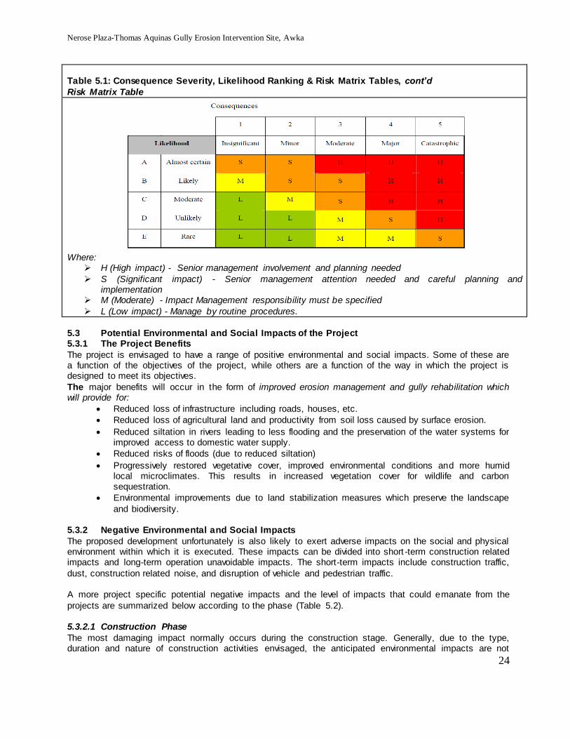
Nerose Plaza-Thomas Aquinas Gully Erosion Intervention Site, Awka
24
Table 5.1: Consequence Severity, Likelihood Ranking & Risk Matrix Tables, cont’d
Risk Matrix Table
Where:
H (High impact) - Senior management involvement and planning needed
S (Significant impact) - Senior management attention needed and careful planning and implementation
M (Moderate) - Impact Management responsibility must be specified
L (Low impact) - Manage by routine procedures.
5.3 Potential Environmental and Social Impacts of the Project 5.3.1 The Project Benefits
The project is envisaged to have a range of positive environmental and social impacts. Some of these are a function of the objectives of the project, while others are a function of the way in which the project is designed to meet its objectives.
The major benefits will occur in the form of improved erosion management and gully rehabilitation which will provide for:
Reduced loss of infrastructure including roads, houses, etc.
Reduced loss of agricultural land and productivity from soil loss caused by surface erosion.
Reduced siltation in rivers leading to less flooding and the preservation of the water systems for improved access to domestic water supply.
Reduced risks of floods (due to reduced siltation)
Progressively restored vegetative cover, improved environmental conditions and more humid local microclimates. This results in increased vegetation cover for wildlife and carbon sequestration.
Environmental improvements due to land stabilization measures which preserve the landscape
and biodiversity. 5.3.2 Negative Environmental and Social Impacts
The proposed development unfortunately is also likely to exert adverse impacts on the social and physical environment within which it is executed. These impacts can be divided into short -term construction related impacts and long-term operation unavoidable impacts. The short-term impacts include construction traffic,
dust, construction related noise, and disruption of vehicle and pedestrian traffic. A more project specific potential negative impacts and the level of impacts that could emanate from the
projects are summarized below according to the phase (Table 5.2). 5.3.2.1 Construction Phase
The most damaging impact normally occurs during the construction stage. Generally, due to the type, duration and nature of construction activities envisaged, the anticipated environmental impacts are not

Nerose Plaza-Thomas Aquinas Gully Erosion Intervention Site, Awka
25
expected to be significant. Construction activities are one time activities and not permanent, about six months - one year. Based on the duration of the construction activities, impacts associated with construction activities are rated “Low” on duration.
Nevertheless, unless good construction management practices are followed, the short-term construction-related impacts shall include impacts such as increased runoff, air quality, noise and vibration, drainage, flooding and solid wastes management. Social impacts are likely on land use, displacement/interference
with abutting asset, traffic congestion and health and safety.
5.3.2.2 Operation Phase
The operational Phase could be seen as the long-term, permanent activity and thus impacts under this as well as their management issues are considered recurring problems. Therefore the impacts are expected to be long-term operation and unavoidable impacts. These are likely to consist mainly of waste generation
due to the activities of the users, and also due to inspection, maintenance, etc. 5.3.2.3 Decommissioning Phase
In reality, an erosion control project is not expected to be decommissioned. In case this project is decommissioned, the likely impacts are as follows:
Soil erosion resulting from improper reinstatement of excavated soil, paved surface or
stabilised area with structures
Air quality degradation and noise generation in the course of excavation to remove/break down structures
Hazards/risks and accidents
Waste management problems 5.3.3 Irreversible Environmental Changes
The proposed project sites will neither consume nor alter significant land, environmental and socio-cultural resources except for structures within 15m of the set back. The proposed project will not generate other significant demands on natural resources of the immediate or surrounding area nor disturb archaeological
sites. Thus no long-term losses of significant resources are anticipated during the intervention works. 5.3.4 Cumulative /Secondary Environmental and Social Impacts
Cumulative impacts are changes to the environment that are caused by an activity in combination with other past, present and future human activities. The concept of cumulative effects is an important one. It holds that while impacts may be small individually,
the overall impact of all environmental changes affecting the receptors taken together can be significant. When a resource is nearing its tolerance threshold, a small change can push it over. The objective of the cumulative impact assessment is to identify the environmental and/or socio-economic aspects that may not
on their own constitute a significant impact but when combined with impacts from past, present or reasonable foreseeable future activities associated with this and/or other projects, result in a larger and more significant impacts.
The envisaged cumulative /secondary impacts arising from the intervention works is considered minimal. This is based on the fact that the project area is not located close to any environmental sensitive area or
human habitation; there is no known environmental degrading facility close to the project location. Most importantly, the project is an intervention work to rehabilitate devastated environment, per se. Thus, no environmentally disruptive impacts are associated cumulatively.
The project plan includes the planting of vegetation which are environmentally supportive. 5.3.5 Environmental justice
The intervention activity serves the entire public based on the location. Thus it is not meant for a particular section of the society. The neighborhood within which the intervention will take place will rather be enhanced and not affected negatively by the physical environmental impacts more than other areas.

Nerose Plaza-Thomas Aquinas Gully Erosion Intervention Site, Awka
26
Table 5.2: Identified Potential Environmental and Social Impacts
S/N Envisaged Activities Potential Impact +/-
Impact level
N L M H A Planning & Preparatory activities Civil Work Construction
1. Movement of Equipment & materials
Dust raising and noise generation
Increase in noise nuisance Accidents
X
2. Land acquisition for right of way
Displacement of asset X
B Construction C BIOPHYSICAL ISSUES
1. 1 Site clearing of set-back from edge of gully
Removal of Flora & fauna
Displacement of asset
X
2. Earthworks - Excavation, grading, compaction, filling and other civil works
Disturbance of the natural drainage of site Increase in the amount of disturbed soil and
could in turn increases the amount of erosion which can occur.
Increase sedimentation and runoff Risk of pollution to watercourses Destruction of visual scenery Damage to abutting land use construction sites
x
3. 2. Gully Treatement/ Stabilisation/Use of Vegetation as control & buffers Grass-lined Channel (Turf reinforcement mats)
Failure of lined drainage channels and energy dissipaters after major storms/runoffs enters the channel.
Debris/ sediment accumulation in outlets and points where concentrated flow enters the channels, bank instability, and scour holes developing
Failure due to poor integration between physical and biological measures.
Failure to complete the treatment works for any reason – tantamount to not getting the required protection and a waste of time and resources.
x
4. 3. Structural Erosion and Sediment Control Practices - Structural practices used in sediment and erosion control to divert storm water flows away from exposed areas, convey runoff, prevent sediments from moving offsite, and can also reduce the erosive forces
Drainage lines and ephemeral waterways may have areas that could be ‘erosion starters’.
Degrade water quality Alteration of local hydrology
Damage of valuable ecosystems and habitats The release of fine sediments and turbid water
into water body can adversely affect the health and biodiversity of aquatic life in water body downstream, increase in the concentration of nutrients and metals, reduce light penetration into the water
x
5. 4 Use of heavy Equipment on site and transport vehicles on the public roads
Vibration generate lateral waves to the surrounding structure and could lead to failure
Contaminate ground or surface water when hydraulic oil, motor oil or other harmful mechanical fluids are spilled
Noise generation and air quality degradation, especially dust
Sediment transport from the site onto public roads or adjacent properties via the wheels,
x

Nerose Plaza-Thomas Aquinas Gully Erosion Intervention Site, Awka
27
S/N Envisaged Activities Potential Impact +/-
Impact level
N L M H chassis and side of vehicles.
Disruption of visual scenery 6. 8
. Construction camp and crew
Soil contamination, Unhygienic work environment and disturbance of the neighbourhood
Dis-affection in the community
x
7. 9. Storing Materials/
Loss of the stockpiled material Damage to valuable ecosystems and habitats
Leaks of hazardous materials from equipment or storage
x
8. 1
0
Social Issues Poor social interaction between community members and workers (from another social setting).
9. 11 Waste/Spoil disposal High volume of waste/spoil
Spoil tipped away from designated areas
x
10. 13 Local culture and society Socio-cultural values may be altered and the
stability of communities adversely affected by presence of construction workers in the area
Exposure to rapid social change or tourism.
x
11. 14 Land use/Land take Displacement of assets or means of livelihood
x
12. 15 Utility Disruptions Construction activities and the need to realign
utility supply lines x
13. 16 Quarry for fill materials
Use of agricultural land
Exposure of other erosion prone sites
X
14. 17 Site Work – occupational &Public Safety and Health
Excavation exposes inhabitants and crew to risk of falls and injuries in excavation pits
Use of equipment and movement of vehicles includes accident rates/ traffic hazards.
Burrow Areas for fill materials could lead to accidents
Exposure to excessive and continuous noise and vibration from construction activities
x
D Operation and Maintenance
1 Maintenance
Poor maintenance create gullies and standing pools, Create mud-holes, potholes
Breed disease vectors in settling basins and retention ponds
x X
E Decommissioning
1 Break up old surface and soil, etc.
Cause soil erosion, Degrade water quality
Dust generation, Damage valuable ecosystems and habitat
Disruption of the secondary/ newly emerged flora
X
5.4 Analysis of Project Alternatives In the context of this ESMP, analysis of project alternatives refers to the performance of the natural and socio-economic resources with or without the project or with or without the implementation of the measures
of this ESMP and/or other safeguard instrument considered appropriate. The need for analysis of project alternatives is based on being able to judge the sustainability in time, as a
complement to the evaluation phase of the project, it is considered relevant to establish the behaviour of the environment into the future. For this purpose, some alternatives are analyzed to evaluate the character,

Nerose Plaza-Thomas Aquinas Gully Erosion Intervention Site, Awka
28
magnitude and time within which alterations are caused over each one of the environmental elements, considering or not the implementation of the ESMP for the project.
For intervention work of this nature, there are usually a number of viable options that can be considered. These alternatives include: the no project option; delayed project; alternative site/location and project execution option. For this project, analysis of the various alternatives is presented as follows:
5.4.1 No Project Option The no project option implies that the intervention work shall not be executed; hence there is no need to
carry out this study. This option is environmentally friendly as the site will remain in its current state and perhaps widen due to natural forces without even any interference from man. Nevertheless, this situation will worsen and put the activities of man and the environment into further jeopardy since the area is already
exposed to the forces of erosion. The intervention work is designed to stop these forces and mitigate any negative impacts that may arise.
Therefore, choosing the no project option will mean a loss of efforts made by all parties to ensure the erosive forces do not continue to pose risk to lives and the environment and even loss of job opportunity to Nigerians. The ‘no project option’ is therefore not considered a viable option.
5.4.2 Delayed Project Option This option implies that the planned intervention be delayed until a much later date. Such option is usually
taken when conditions are unfavourable to project implementation such as in heavy rainfall, war situation, or where the host community is deeply resentful to it. Also, if the prevailing economic climate is not quite favourable, then delayed option may be feasible. None of these conditions is applicable at present. Further
delay will mean the onset of heavy rainfall that is not favourable for the proposed treatment method. At present, both the economic and the political environment and natural environmental phenomena are most favourably disposed towards it. Therefore, the implication of delayed project option will mean that all the
preliminary work and associated efforts/ costs incurred would have come to nothing. Also, because of inflationary trends, such a delay may result in unanticipated increase in project costs, which may affect the final target from the project. These, and other related problems make adopting the delayed option
impracticable. 5.4.3 Go Ahead Option
This option means going ahead to implement the intervention work. This also entails incorporating professional advice on the most practicable option such as are spelt out in this ESMP and other relevant safeguard instruments and/or best practices relating to the execution of the intervention. This will definitely
reassure the public of their safety and the environment. It will also aid employment creation. The environmental threats from the gully erosion will be reduced drastically, if not totally solved in that area. This option is therefore considered the most viable and recommended for implementation.
However, in going ahead, appropriate measures for the gully treatment must be adopted and applied.
5.4.4 Gully Treatment Options Treatment of gullies depends on a range of factors including: the size of the gully, whether it is actively eroding or not, the soil type, the size and frequency of water flow, the gradient of the area and the desired
use of the land after rehabilitation. The situation of the proposed intervention area shows that the best option to be employed include the following as provided in the engineering designs:

Nerose Plaza-Thomas Aquinas Gully Erosion Intervention Site, Awka
29
To cover the upstream of the gully to the downstream include the following: Channel, Road, Drains, Culvert, Check dam (3no) and Rip-Rap:
o From Ekwulobia road to about 50m along the Neros Plaza road a channel is designed to
replace the old and existing drain for lack of capacity and functionality. The channel is followed by a check dam of height 4.5m at the gully head. Immediately after the check dam is a chute that goes down a depth of 13m below its start point. The chute is
connected to a stilling basin embedded into the ground at a depth of two metres. Another check dam downstream follows the stilling basin towards the end of the gully. At this point, rip-raps are applied to forestall further erosion, the water then disperse further down into
the stream. o The road also, along Neros Plaza is designed to have kerbstones and chutes since it
slopes towards the gully to drain surface water into the gully up to 50m length. Due to the
topography one side drain is provided from there down to the stream where the road diverges from the gully. There is also provision for filling on some sections of the gully, shaping of slope, stone-pitching on the side of the slope and planting of approved grasses
as bio measures of gully erosion control

Nerose Plaza-Thomas Aquinas Gully Erosion Intervention Site, Awka
30
SECTION 6 ENVIRONMENTAL AND SOCIAL MANAGEMENT PLAN 6.1 Introduction
In order to ensure that environmental and social management objectives and actions are integrated into the project planning and design based on identified impacts, this Section has been developed. It provides specific description of the impacts identified, mitigation measures as well as the institutional arrangements,
i.e. who is responsible for carrying out the mitigating and monitoring measures (for operation, supervision, enforcement, monitoring of implementation, remedial action, financing, reporting and staff training). The ESMP is implemented during the construction phase and, thereafter, throughout the project life-cycle up to,
and including, decommissioning. 6.2 Mitigation Measures
The mitigation measures are activities aimed at reducing the severity, avoiding or controlling project impacts and where possible enhance environmental quality through the designed alternatives, scheduling or other means. Mitigation may be in the form of avoidance (alternative action taken to avoid impact),
compensatory payment of money or replacement in kind for losses or recreation of lost/damaged habitat. The measures proposed are specific, measurable, achievable and relevant to the proposed and time
based (SMART). The measures also took into account the environmental laws in Nigeria, and internationally and the principles of sustainable development and best available technology.
Most of the likely impacts due to the proposed project have been considered in the design and selection of treatment options.
Table 6.1 outlines a summary of the potential impacts associated with the project, together with corresponding mitigation measures and other institutional responsibility.
Table 6.1: Environmental and Social Management Plan
S/N Activities Envisaged
Potential Impact Mitigation measures
Monitoring Indicators
Frequency Responsibility
Cost (N)m
A Moblisation/ Preparatory activities
1. Land acquisition for right of way
Displacement of asset Negative perception and discontent expressions by members of the community.
Compensation for any affected assets, Engage PAPs in meaningful consultations
Resettlement Action Plan (RAP) available, Harmonious relation with community
Before actual displacement
SPMU Cost of the RAP + mitigation measures
2. Movement of Equipment & Materials
Dust raising and Increase in noise nuisance
Raise public awareness of unusual activity Plan activities such that Regulatory limits are not exceeded Limit work hours, including use of equipment and vehicle, to daylight hours
Levels in relation to regulatory limits lower, Number or absence of public complaints
During Moblisation/actual movement to the site/staging
Contractor, SPMU Safeguard officer
0.05

Nerose Plaza-Thomas Aquinas Gully Erosion Intervention Site, Awka
31
Table 6.1: Environmental and Social Management Plan
S/N Activities Envisaged
Potential Impact Mitigation measures
Monitoring Indicators
Frequency Responsibility
Cost (N)m
3 Movement of Equipment & Materials
Reduction in air quality due to vehicular movement
Employ fuel efficient and well maintained haulage trucks with proper exhaust system to minimize emissions. All parked vehicles on the site shall have their engines turned off; Service vehicles as at when due and stick to manufacturers’ specifications in use Develop and follow a controlled fueling, maintenance and servicing protocol Ensure low speeds on unpaved ground” and “Wetting of dusty surfaces
Levels in relation to regulatory limits, Number or absence of public complaints
During Moblisation/actual movement
to the site/staging
Contractor, SPMU ESSO officer
0.05
4 Movement of Equipment & Materials - Health & Safety Issues -
Accidents - Movement of heavy equipment to worksite which may pose danger to public
Place visible warning signs on roads and vehicles Raise public awareness of unusual activity Ensure appropriate drivers training
Zero accident/No of accidents
During Moblisation/actual movement to the site/staging
Contractor, SPMU ESSO officer
0.1
Sub-total 0.2
B. Construction
BIOPHYSICAL ISSUES
1 Site clearing of set-back from edge of gully
Removal of Flora &fauna Displacement of asset
Perform clearance in stages Minimize area to be cleared, clearly mark area prior to clearing, monitor to ensure no extra clearing Develop compensation plan for displaced asset
Absence of land degradation due to avoidable vegetation clearance/no scar, absence of complaint from communities
Once during site clearance
Contractor, SPMU ESSO Officer, MoE
0.050
+
Payme
nt via
RAP
2. General Treatment of the gully erosion,
Failure due to poor integration between physical and biological measures. Failure to complete the treatment works for any reason –
Careful planning and attention to detail
Remove the cause of the gullying. Ensure quality work
Do gully filling only after the water flow
Absence of failure due to poor integration between physical and biological measures
During Construction
Cotractor, SPMU ESSO Officer, MoE
MoW, FPMU, World Bank
Part of
contracto
r cost

Nerose Plaza-Thomas Aquinas Gully Erosion Intervention Site, Awka
32
Table 6.1: Environmental and Social Management Plan
S/N Activities Envisaged
Potential Impact Mitigation measures
Monitoring Indicators
Frequency Responsibility
Cost (N)m
tantamount to not getting the required protection anda waste of time and resources.
that caused the gully has been controlled or diverted above the gully head. Otherwise fill placed in the gully is likely to be undermined and washed away.
Avoid filling gullies with rubbish, logs, rocks, car bodies and other foreign material that are not suitable.
Use earthen banks that divert runoff away from the gully head, and convert it to slower, less erosive flow away from the actively eroding area. (P&D) (C) (O&M)
3. Gully Stabilisation, Use of Vegetation as control & buffers - Grass-lined Channel (Turf reinforcement mats)
Accumulation of debris, sediment accumulation, died grasses, shrub/bush and tree planted, lack of integrity
Design structures so that the flow in the gully is reduced to a non-scouring velocity Plant vegetation between the structures and the gully stabilised Locations of the structures must be placed so that as much sediment is collected as possible, while still ensuring that the structures are stable. Sites should also be relatively smooth at the gully floor, and have a gentle slope between the gully floor and sides. Choose the right time to do it. From late Dry season to early onset of rainy season before heavy rains is generally a suitable time as there is less chance of high volumes of run-off, yet there is sufficient soil
Absence of debris accumulation No of debris remove and repairs made on outlets and points where concentrated flow enters channels, structures. No of inspection made on lined drainage channels and energy dissipaters after major storms/rainfall . Vegetation self-sustaining for [once in two months for two years]
During Construction, especially after heavy downpour of rain
Contractor, SPMU ESSO Officer, MoE MoW
Part of
contracto
r cost

Nerose Plaza-Thomas Aquinas Gully Erosion Intervention Site, Awka
33
Table 6.1: Environmental and Social Management Plan
S/N Activities Envisaged
Potential Impact Mitigation measures
Monitoring Indicators
Frequency Responsibility
Cost (N)m
moisture and warmth to promote the growth of vegetation. Monitor vegetation until self-sustaining Establish a vegetative barrier (e.g., bushes or trees) between the site and the nearest buildings and/or the roads, especially at Aquinas area
4. Earthworks - Excavation, grading, compaction, filling and other civil works
Disturb the natural drainage of site, Increase the amount of disturbed soil and could in turn increases the amount of erosion which can occur. Increase sedimentation and runoff Risk of pollution to watercourses
Develop a site plan that does not require a significant amount of grade changes–that fits into existing land contours. Site that will not be re-disturbed for a long period should be stabilized to reduce the erosion force These areas until they are disturbed again. E.g. if soil excavated from a temporary sediment Trap is stockpiled to be used later to backfill the trap (when the area is stabilized) then the stockpile Carry out earthworks operations such that surfaces have adequate falls, profiling and drainage to control run-off and prevent ponding and flooding. Control run-off through silt/sediment traps as appropriate to minimise the turbidity of water in outfall areas.
Number of drainage lines and ephemeral waterways that could be ‘erosion starters’. No of Complaint from the community due to poor water quality/sedimentation
During Construction, especially after heavy downpour of rain
Contractor, SPMU ESSO Officer, MoE MoW
Part of
contracto
r cost
5 Use of heavy
Vibration generate lateral waves to
As much as possible avoid use of heavy
Absence/number of oil
During Constructio
Contractor, SPMU

Nerose Plaza-Thomas Aquinas Gully Erosion Intervention Site, Awka
34
Table 6.1: Environmental and Social Management Plan
S/N Activities Envisaged
Potential Impact Mitigation measures
Monitoring Indicators
Frequency Responsibility
Cost (N)m
Equipment on site and transport vehicles on the public roads
the surrounding structure and could lead to failure Contaminate ground or surface water when hydraulic oil, motor oil or other harmful mechanical fluids are spilled or dumped Spills, leaks or injuries from any type of hazardous material (e.g. bitumen, cement, paint, explosives, fuels, lubricants)
duty equipment like bulldozers, pay loaders and trucks used in excavation and loading at the control site, Work schedule to minimize disturbance. Alert the public when loud noise will be generated Sound-proofed machines shall be employed Construction vehicle, machinery and equipment move or station always in the designated area only and do not carry activities beyond land hired/given
leakage/spill, absence of impact on structures/cracks/ Absence/number of damage to abutting construction site Absence/number of complaint due to noise & dust generation Absence of sediment transport from the site onto public roads or adjacent properties via the wheels, chassis and side of vehicles.
n, ESSO Officer, MoE MoW
0.1
6 General Equipment/vehicle movement and ground disturbance
Air Quality Degradation
Raise public awareness of unusual activity Plan activities such that Regulatory limits are not exceeded Limit work hours, including use of equipment and vehicle, to daylight hours Employ fuel efficient and well maintained haulage trucks with proper exhaust system to minimize emissions. All parked vehicles on the site shall have their engines turned off; Service vehicles as at when due and stick to manufacturers’ specifications in use Develop and follow a
Levels in relation to regulatory limits lower, Number or absence of public complaints
During Moblisation/actual movement to the site/staging
Contractor, SPMU Safeguard officer
0.1

Nerose Plaza-Thomas Aquinas Gully Erosion Intervention Site, Awka
35
Table 6.1: Environmental and Social Management Plan
S/N Activities Envisaged
Potential Impact Mitigation measures
Monitoring Indicators
Frequency Responsibility
Cost (N)m
controlled fueling, maintenance and servicing protocol Ensure low speeds on unpaved ground” and “Wetting of dusty surfaces
6. Construction camp and crew
Soil contamination, Unhygienic work environment and disturbance of the surrounding neighbourhood Dis-affection in the community Spread of communicable disease from imported workers
Identify suitable camp site in consultation with relevant authorities Regular collection and proper disposal of Solid Waste. Ensure and enforce good housekeeping Develop and enforce worker code of conduct Ensure works receive appropriate medical checks for entry into community
Wholesome environment Absence of conflict with community members
Daily/All through during Construction
Contractor, SPMU ESSO Officer, MoE MoW
0.05
7. Storing Materials/
loss of the stockpiled material Damage valuable ecosystems and habitats Leaks of hazardous materials from equipment or storage
Stockpiles should not be located within an overland flow path. In order to mitigate the flow of water away from stockpiled material, flow diversion banks can be constructed up-slope of the stockpile to divert run-off. install a sediment fence (or heightened bund wall) on the downhill side
Presence/absence of moved stored material by rain/wind Presence/absence of leaks from substance stored
Daily/All through during Construction
Contractor, SPMU ESSO Officer, MoE MoW
0.1
Social Issues
1 Waste/Spoil generation & management
Waste generation volume of waste/spoil Spoil tipped away from designated areas
As part of contract requirements, contractor will be required to develop, implement and maintain a Waste Management Plan during the construction works with emphasise to minimise waste and segregate waste Protection of neighborhood from debris due to construction
Volume of waste generated and disposal method. Good waste management plan in place-acceptable in light of best practice
Daily/All through during Construction
Contractor, SPMU ESSO Officer, MoE, Waste Management authority
0.2

Nerose Plaza-Thomas Aquinas Gully Erosion Intervention Site, Awka
36
Table 6.1: Environmental and Social Management Plan
S/N Activities Envisaged
Potential Impact Mitigation measures
Monitoring Indicators
Frequency Responsibility
Cost (N)m
Minimize spoil by balancing cut and fill wherever possible Safe tipping areas identified and enforced. Spoil traps constructed. Dispose in approved sites
2 Local people excluded from activities
Conflict Incorporate methods within the skills of local people. Contractors encouraged using local labour wherever possible.
Number of community members involved in construction
Twice during construction
Contractor, SPMU ESSO Officer, Local Government/Site Committee
Mgt cost
3 Quarry for fill materials
Use of agricultural land
Avoidance of agriculture lands as borrow areas and other sensitive areas Redevelopment of borrow areas Redevelopment of quarries in case new quarries are setup for the Project
Presence/absence of scouring, erosion, damage to property, water supply disruption. Complaints from local people
During construction
Contractor, SPMU ESSO Officer, Local Government/Site Committee, MoE, MoW
0.3
5 Site Work – occupational &Public Safety and Health Dust – water-sprays to control particulates.
Excavation - Expose inhabitants and crew to risk of falls and injuries in excavation pits excavation slope instability causing injury/death Use of equipment and movement of vehicles includes accident rates/ traffic hazards. excessive and continuous noise and vibration from construction activities Risk of water source pollution
Develop an Occupational Health and Safety Plan for workers at all sites with specifications and procedures on training, PPE, monitoring/reporting, etc.. Take safety precautions to protect being injured by flying or falling rock Poorly planned borrow pits and quarries pose threats, ranging from falls from quarry faces to drowning in quarry pits that have become standing water reservoirs Use equipment with low operating noise levels Restrict construction works to day time hours in location close to residence
Zero Accidents/incidents
Every day during construction
Contractor, SPMU ESSO Officer, Local Government/Site Committee, MoE, MoW
0.5

Nerose Plaza-Thomas Aquinas Gully Erosion Intervention Site, Awka
37
Table 6.1: Environmental and Social Management Plan
S/N Activities Envisaged
Potential Impact Mitigation measures
Monitoring Indicators
Frequency Responsibility
Cost (N)m
Introduce traffic/speed control devices Provide safety warning and instruction signboards Use of excavation dewatering, side-walls support, and slope gradient adjustments that eliminate or minimize the risk of collapse, entrapment, or drowning Provide safe means of ingress and egress from excavations, such as graded slopes, graded access route, or stairs and ladders a formal Occupational Health and Safety Plan for workers at all work sites that requires all the specified mitigation measures and more (training, PPE, monitoring/reporting, etc.).
Sub-total 3.00
C Operation and Maintenance Operation -
Maintenance and Utilization of Rehabilitated Gully
Collapse of structure/failure of measures
Monitor and maintain intervention work for continued stability and quality Shortcomings in the control structures should be corrected before they develop into serious problems. Any grass, shrub/bush and tree planted which dies should be replaced Treated gullies should be checked regularly and the healing process monitored closely. Structures built in
Number of failure of structure
Once in three months during dry periods and immediately after heavy down pour during rainy season
Community, Site committee, SPMU ESSO Officer, MoE MoW, FPMU, World Bank
0.5

Nerose Plaza-Thomas Aquinas Gully Erosion Intervention Site, Awka
38
Table 6.1: Environmental and Social Management Plan
S/N Activities Envisaged
Potential Impact Mitigation measures
Monitoring Indicators
Frequency Responsibility
Cost (N)m
the gully for stabilization purpose should be observed for damage especially during rainy seasons and after heavy storms. Damaged check-dams should be repaired immediately to avoid further damage and the eventual collapse. Conduct gender study to assess the challenges and opportunities for the mainstreaming of gender concerns in the use of, access to and maintenance of the gullies Avoid delay repair even in small damage or break of control structure
Operation - Maintenance and Utilization of Rehabilitated Gully
Unsustainable use of rehabilitated gully areas crossing different land uses owned by different land users/ Conflict Disharmony in
Identification of users and development of a use concept or management plan. Before treatment of gullies, the users should be identified and the boundaries should be clearly demarcated, the gully rehabilitation process should be objective oriented and responsibilities of owners in managing, maintaining and utilizing the gully should be agreed upon.
Number of agreement signed with Sustainable users of rehabilitated gully areas Presence/absence of land users/ Conflict Disharmony in
Once every six months
SPMU, FPMU, Community members, World Bank
0.5
Operation - Maintenance and Utilization of Rehabilitated Gully
Poor maintenance of vegetated area,
Establish a vegetative barrier (e.g., bushes or trees) between the site and the nearest buildings and/or the roads Effect repairs immediately there is exposure of the treated areas Maintain healthy
Presence/absence of Healthy vegetation
Once every six months
Community, Site committee, SPMU ESSO Officer, MoE MoW, FPMU, World Bank
0.5

Nerose Plaza-Thomas Aquinas Gully Erosion Intervention Site, Awka
39
Table 6.1: Environmental and Social Management Plan
S/N Activities Envisaged
Potential Impact Mitigation measures
Monitoring Indicators
Frequency Responsibility
Cost (N)m
pasture swards on slope to reduce bare ground. Minimum or no tillage techniques that protect soil structure as fine soil particles erode more readily Regular inspection. Monitor vegetation until self-sustaining
Sub-total 1.5
Decommissioning
Cause soil erosion, Degrade water quality, Dust generation, Damage valuable ecosystems and habitat
Break up old surface and soil. Remove and dispose of surfacing material if necessary and loosen soil of previous track to accelerate regeneration of vegetation Reshape eroded or culled surfaces with out-sloping, re-vegetate as needed.
Absence of soil erosion, water quality degradation and dust generation
All through the decommissioning and equipment/material period
Contractor, SPMU ESSO Officer, Local Government/Site Committee
0.5
Sub-total 0.5
5.6m
6.3 Residual Impacts after Mitigation
Residual Effects can be considered as those that remain significant following the application of mitigation measures, although they are likely to have been reduced in magnitude as a result of the mitigation measure implemented.
Overall, on balance, with the provision of the proposed mitigation measures as outlined in Table 6.1, the positive impacts of the scheme will considerably outweigh the negative impacts. The public as a whole will
benefit from the completion of the scheme. Once the mitigation measures outlined are implemented, the residual impact of construction and operation
on the different elements identified will not be significant. 6.4 Enhancement of Positive Impacts and Reduction/Avoidance of Negative Impacts.
A Mechanism for Enhancement of Positive Impacts and Reduction/Avoidance of Negative Impacts has been developed as shown in Appendix ….. in relation to the
Project Concept and design,
Construction and Operation,
Control of Earthworks and
Erosion and Sediment Control Plan,
Control of Water Quality, Waste Management ,
Control of Air and Noise Pollution
Environmental Code of Conduct for tender documents and

Nerose Plaza-Thomas Aquinas Gully Erosion Intervention Site, Awka
40
Social Integration and Participation All these management programmes have been developed as part of the ESMP to make it effective and
functional. 6.4.1 Waste Management Plan
During the construction and subsequent operation and maintenance phases, it is inevitable that discharges of materials to the environment will occur. If these are not controlled, they may act as a source of environmental disturbance or nuisance. The rehabilitation/construction activities could yield a variety of in
the form of construction materials, scrap metal, municipal wastes, etc .
For effective management, the waste management plan during construction and operation phases will
ensure that all the waste must be properly identified, minimized, segregated, properly stored, reused, tracked, monitored and audited.
All the wastes that cannot be re-used will be safely managed and disposed of in a manner that meets regulatory requirements.
Furthermore, awareness shall be created amongst community members not to dump waste in treated gully erosion channels.
6.4.2 Maintenance and Inspection of Treated Gully In order to be effecti1ve, the intervention work must be properly designed, implemented, inspected and maintained. To maintain the integrity of the intervention work (treated gully) the site check shall include
regular inspection. Maintenance generally shall focus on the following: •
Eroded areas repaired immediately.
Debris removed and repairs made where necessary from the channel.
Outlets and points where concentrated flow enters the channel.
Seeded slopes identified for signs of erosion, filling these areas slightly above original grade, then roughen, reseed, and mulch as soon as possible.
Lined drainage channels and energy dissipaters at regular intervals and after major storms.
Sediment accumulation, piping, bank instability, and scour holes, and repair promptly
Use of sandbags during rainfall events if extra height is needed on the ridges of contour
drains.
Repair or reinstate drains if destroyed by machinery movement or other forces.
Check dams cleaned after each significant storm event or when accumulated sediment reaches half the height of the check dam.
To this end, inspection system shall check:
Drains after rainfall or storms and outfall for erosion
Remove any accumulated sediment deposited in diversion channels where there is a risk of overtopping due to a lack of freeboard.
Vegetation is growing.
Check seeded slopes for signs of erosion.
Reseed areas to prevent sheet and rill erosion. Spot seed in small areas.
Lined drainage channels and energy dissipaters should be inspected at regular intervals and after major storms.
Check dams for undermining and/or short-circuiting and keyed into the channel banks a minimum of 18
inches to prevent flow around the dam

Nerose Plaza-Thomas Aquinas Gully Erosion Intervention Site, Awka
41
6.5 ENVIRONMENTAL MONITORING AND AUDITING
In order to effectively and efficiently implement this ESMP, a system for monitoring and auditing has been built into the overall management plan. Monitoring and auditing assist in the examination of management, employee knowledge, programme responsibilities, records & effectiveness
Specifically, this shall help to:
Improve environmental and social management practices;
Check the efficiency and quality of the environmental management processes;
Establish the scientific reliability and credibility of the ESMP for the project and
Provide the opportunity to report the results on safeguards and impacts and proposed mitigation measures implementation.
6.5.1 Site Inspection and Monitoring To continually achieve the benefits of the gully treatments, site inspection and monitoring program shall be ensured with the following objectives:
Ensure that the Gully Erosion Treatment and Control Plan (GETCP) is appropriate for the site and is being implemented effectively;
Ensure Gully Erosion Treatments are being appropriately maintained; and
Identify any works at the site that may be contributing to environmental harm.
6.5.2 Site Inspection and Maintenance Following the gully treatment/remediation work or installation of erosion and sediment control
measures, a walkthrough or site inspection should be conducted to ascertain that all measures have been implemented in the field, that erosion is being controlled, and that sediment and other pollutants are not being transported off-site or into critical areas on-site. Any improper installation or any repairs
necessary to complete the job should be noted at this time. Another purpose of the site walkthrough is to identify critical inspection locations and monitoring points where control measures will need to be routinely checked for performance and checked after storm events. These critical points must include:
• All disturbed areas of the site
• Material storage areas
• Locations where vehicles enter or exit the site
• All erosion and sediment control measures
• Discharge outfall visual monitoring points.
The control measures must be in good operating condition until the area they protect has been completely stabilized and the construction activity is completed. In the absence of significant runoff
events, all measures must be inspected by the contractor in accordance with any schedule required by the SPMU and Ministry of Works and before any predicted, significant rainfall.
During rainfall events, the contractor’s inspector must have the ability to call out work crews to immediately repair the erosion and sediment control measures. Appropriate materials and equipment should be kept on hand to enable a quick and rapid response.
6.5.3 Site Inspection Frequency It is recommended that during the gully erosion treatment inspection should be carried out in the
following manner:
At least daily during rainfall events;
At least weekly, even if the works are not being conducted;
Within 24 hours of a forecasted rainfall or storm event; and
Within 18 hours of a rainfall or storm event of sufficient intensity to cause run-off.
Furthermore, active sites must be inspected by the contractor daily during storm water runoff and within 24 hours after any storm event greater than 0.5 inches in a 24-hour period. Active sites must be
inspected at least every 7 days during periods of no runoff. Any site that is inactive for greater than 7 days must be inspected every two weeks.

Nerose Plaza-Thomas Aquinas Gully Erosion Intervention Site, Awka
42
Exposed areas must be stabilized and inspected before a site is left in an inactive state.
The inspector should record any damages or deficiencies in the control measures on an inspection report form. The damage or deficiencies should be corrected as soon as practicable after the inspection
but in no case later than 7 days after the inspection. Any changes that may be required to correct deficiencies should also be made as soon as practicable after the inspection but in no case later than 7 days after the inspection.
Inspections oversight should rest with the SPMU supported by the Ministry of Works with local knowledge, policies and procedures.
Inspections of erosion control works should be conducted by a person clearly identified as responsible for this role and may be the project manager, site supervisor or principal contractor representative etc.
All inspection details should be formally documented, filed and made available for inspection as required by PMU and relevant authorities.
6.5.4 Vegetation Establishment Monitoring Since vegetation typically is the primary form of permanent erosion control, it is important to ascertain how quickly and how well the vegetation is becoming established.
Monitoring for vegetation establishment should be conducted in accordance with local requirements.. Vegetation should be monitored monthly to evaluate the following:
• The type of vegetation that is growing (as compared to the type of vegetation that was
planted);
• The density of vegetation that is growing, including the percent of ground that is
covered; and
Based on regular evaluations of vegetation establishment, recommendations should be made as to whether the vegetation is establishing well, or whether additional measures should be taken, such as over seeding, fertilizing, erosion repair, or irrigation.
Vegetation monitoring should continue until the vegetation reaches maturity and is providing the anticipated erosion control effectiveness.
6.5.5 Maintenance Problems The most frequent cause of failure is lack of preventative practices and poor maintenance of treatments administered. Erosion prevention and sediment control must be inspected regularly and operated and
maintained using specific procedures to perform properly. Installation mistakes can also impair the performance of the measures. Inspectors should pay particular attention to maintenance problems and installation mistakes during inspections.
6.5.6 Inspection and Maintenance Reports Inspection reports should be prepared during each inspection conducted by the contractor or SPMU or
Ministry of Works for civil works and Ministry of Agriculture for vegetation aspect, as the case may be. Reports should include information on damages or deficiencies, maintenance or repair activities, monitoring information, and vegetation establishment.
Inspection reports should be kept for a period of three years after completion of final site stabilization.
6.6 Environmental Monitoring
The Environmental monitoring activities shall be based on direct or indirect indicators of emissions, effluents, and resource use applicable to the intervention works. Monitoring frequency shall be sufficient to provide representative data for the parameter being monitored. Monitoring shall be conducted by
trained individuals who can carry out the monitoring and record-keeping effectively using properly calibrated and maintained equipment.
Monitoring data shall be analyzed and reviewed at regular intervals and compared with the operating standards so that any necessary corrective actions can be taken. As part of monitoring programme, visual inspections and quality monitoring for light attenuation should be conducted daily, for instance.
A categorized mitigation measures and its implementation is given in Table 6.2. Table 6.2: Summary of Environmental Monitoring Plan during Construction and Operation
Component Parameters Method & Where Frequency Responsible* Cost

Nerose Plaza-Thomas Aquinas Gully Erosion Intervention Site, Awka
43
(Nm) Air quality Dust Visual
Observation at location of activities
Everyday during construction
SPMU/Contractor 0.05
Noise Level Disturbance/pinch Everyday during construction
Contractor 0.05
Erosion Top soil movement/ground cutting Control and retention of disturbed soil at earthwork
Visual assessment
Routinely during construction
Contractor 0.05
Treated Gully & further minor repairs
run-off, soil Exposure, breakage/ renewed gullying, stability,
Visual assessment, where signs are noticed
Routine: daily during rainfall events; weekly, even if the works are not being conducted; General follow-up over a period of several years until the sites are known to be fully stabilized and vegetation is self-sustaining.
SPMU/Contractor, community, supervised by MoW
0.2
Water Quality pH, TSS, turbidity, Total coliform bacteria, Temp, etc
Standard method of sampling and analyses at established instream
during and after rainfall events.
Contractor/ Consultant
0.050
Soil Quality Heavy Metals,
Sampling and analyses at designated locations, where soil is imported from other locations
•Before use at construction site
Contractor 0.05
Sediment retention pond
Sediment build-up Visual Assessment& decants/level spreaders/fore bay
After all rain. During heavy rain
Contractors/Site Committee members/SPMU
0.25
Vegetal Cover
Vegetation growing well & maintained
Visual assessment
Once in two weeks after treatment during the first six months and then routinely (once in two months) until the site known to be fully stabilized and vegetation is self-sustaining
Contractors/Site Committee members/SPMU
0.05
General Waste Management
Reduction, Segregation protocols, proper handling, storage, treatment, and transportation
Visual Assessment, General Aesthetics, hazard free environment along the corridor
Routinely, Daily Contractor/HSE Officer
0.1
Training
Responsible HSE behavior and culture worker training on the code of conduct
General HSE Awareness and specific training for workers
Routinely and as need arises
SPMU Contractor/HSE Officer, consultant, management
0.2
Socio-economics
Project benefit opinions, Lifestyle, no of livelihoods opportunities created, income, gender characteristics, no of women participating in watershed management
Questionnaires, direct observations and interviews.
monthly basis., Once in two years for the first six years
SPMU 0.2

Nerose Plaza-Thomas Aquinas Gully Erosion Intervention Site, Awka
44
programs, conflict with pastoralists, ratio of local vs imported workers, etc
Health & Safety
Incidents, worker training, use of personal protective equipment, safe work practices.
Hazard assessment, visual assessment .
Before Start of work and routinely/daily
Contractor/SPMU Management
0.1
Total* N1.35m
6.7 Reporting Procedure
The nature of issues to report and manner of reporting are outlined below:
6.7.1 Complaints Register and Environmental Incidents
Any environmental or social incidents shall be documented (Appendix 8). The report shall be transmitted to the relevant authority by the SPMU, where necessary/applicable. The reporting shall be with a view to taking appropriate mitigation measures.
All complaints received should be investigated and a response (even if pending further investigation) is to be given to the complainant within 5 days.
The following information must be provided:
• Time, date and nature of the incident/report;
• Type of communication (e.g. telephone, personal meeting);
• Name, house location and contact telephone number of person making the complaint. If this person wishes to remain anonymous then “not identified” is to be recorded;
• Details of response and investigation undertaken as a result of the incident/complaint;
• Name of person undertaking investigation of the incident/complaint;
• Corrective action taken as a result of the incident/complaint.
The report shall be rendered for both internal (in-house) uses all phases of the project for internal and
external (public) consumption through the regulators.
6.7.2 Record keeping
Good records are the paper trail that will prove that this ESMP is working as intended. Keeping records of inspection of maintenance programme for erosion control measures, training programme, etc will be useful to demonstrate that the ESMP is being complied with or not .The type of records from the
various management and monitoring programmes include:
• completed forms, checklists and maintenance logs
• identified problems and corrective actions undertaken
• monitoring data / results
Some other types of records will also be valuable for assisting with the implementation of the ESMP and/or ESMP Review such as:
• Incident forms (especially pollution incidents and response, accidents, etc.)
• Internal and external communications regarding the ESMP (e.g. with waste
management)
• Results of internal or external assessments and compliance visits.
6.8 Institutional Arrangements Since one of the main purposes of ESMPs is to establish responsibility for the activities that have to be undertaken, this sub-section details below, institutional arrangements and the roles and responsibilities
of the various institutions in the implementation of the ESMP as outlined in Table 6.3. Table 6.3: Institutional Responsibilities
S/No Category Roles & Responsibilities
SPMU
Implementing authority, has the mandate to:

Nerose Plaza-Thomas Aquinas Gully Erosion Intervention Site, Awka
45
Lead role adherence to this ESMP and applicable environmental and social standards Co-ordinate all policies, programmes and actions of all road construction across the States
Ensure the smooth and efficient implementation of the project’s various technical programmes
Cooperate through a Steering Committee that provides guidance to the technical aspects of all project activities;
Maintain and manage all funds effectively and efficiently for the projects
Take the lead in day-to-day inspections and compliance. State Ministries of
works, Site assessment and monitoring of works and engineering activities
State Ministry of Environment,
Support SPMU to ensure adherence to this ESMP and applicable standards, environmental and social liability investigations, Monitoring and evaluation process and criteria
Ministry of Lands, Survey and Urban
Compliance overseer at State Level, on matters of Land Acquisition and compensation and other resettlement issues,
Other MDAs Come in as and when relevant areas or resources under their jurisdiction or management are likely to be affected by or implicated projects such as utility.
World Bank Assess implementation Recommend additional measures for strengthening the management framework and
implementation performance.
Site Manager Ensure land disturbance activities are conducted in accordance with relevant legislation; Minimise on-site erosion and control sediment in accordance with the site Erosion and
Sediment Control Plan; Communicate the content of, and any changes to the site Erosion and Sediment Control Plan to all employees and contractors; Inspect the operation of erosion and sediment control devices and initiate repair or
maintenance as required; Instruct employees and contractors in the purpose and operation of erosion and sediment
control devices and the need to maintain these devices in proper working order at all times; Provide adequate onsite waste collection bins, ensure proper disposal, not to li tter and not
to create environmental nuisance; Contractor Compliance to BOQ specification in procurement of material and construction and
adherence to the ESMP and good practice Ensure day-to-day inspections and compliance.
Site Engineers/Supervisors
Provide oversight function during construction and decommissioning to ensure adherence to good practice and the ESMP
Site Committee Ensure compliance to BOQ and quality
Local government Support in monitoring project execution within their domains to ensure compliance with this ESMP and other relevant requirements
Local Community Promote environmental awareness Assist and Liaise with other stakeholders to ensure proper siting and provision of approval
for such sites Support with provision of necessary infrastructures and engage/ encourage carrying out
comprehensive and practical awareness campaign for the proposed projects, amongst the various relevant grass roots interest groups.
CDA/CDOs Ensure Community participation by mobilizing, sensitizing community members; Direct Stakeholders Abide by all arrangements to tackle the erosion problem
Support all efforts to ensure sustainable management of the watershed.
Nigerian Bottling Company
Abide by all arrangements to tackle the erosion problem Support all efforts to ensure sustainable management of the watershed Ensure no further degradation of the environment via discharges from facility after
remediation and treatment of gully Share cost of gully control and treatment implemented.
NGOs/CSOs Assisting in their respective ways to ensure effective response actions, Conducting scientific researches alongside government groups to evolve and devise sustainable environmental strategies and rehabilitation techniques, Organizing, coordinating and ensuring safe use of volunteers in a response action, and actually identifying where these volunteers can best render services effectively & Providing wide support assistance helpful in management planning, institutional/governance issues and other livelihood related matter, Project impacts and mitigation measure, Awareness campaigns
i Others/General Public
Identify issues that could derail the project
Support project impacts and mitigation measures, Awareness campaigns

Nerose Plaza-Thomas Aquinas Gully Erosion Intervention Site, Awka
46
6.9 Grievance Redress Mechanism
During the implementation of the intervention work, a redress mechanism which is in line with the ESMF, RPF, and PIM has been developed as detailed in the stand alone RAP for the proposed site to address situations of conflicts or disagreements about some of the project activities. Thus the RAP
should be referred to for further details on this grievance redress mechanism. Suffice it to say, however, that based on local situation the grievance mechanism that takes account the specific issues, cultural context, local customs and project conditions and scale has been developed(Fig. 6.1).
The community members and project affected persons have been helped to appreciate that there are provisions for addressing complaints or grievances that they could have. The grievance procedure will
further be made available to the affected person through project implementation and shall be strengthened in order to ensure that all comments, suggestions and objections received from the stakeholders especially from project affected persons are dealt with appropriately and in a timely
manner.
No Yes
Yes
Complaint / enquiry received by SPMU
Complaint / enquiry / feedback recorded in the
register RSDT Liason Officer
Receipt sent to complainant / enquirer
Investigation into the complaint and factors
influencing the issue by the Grievance Committee
Resolved?
Review
Resolved?

Nerose Plaza-Thomas Aquinas Gully Erosion Intervention Site, Awka
47
No
Fig. 6.1: Feedback and Complaints Procedure
6.10 Disclosures and Public Consultation Plan All reasonable efforts must be made to disclose/display this ESMP to the public at strategic points within the project’s area of influence so as to allow all stakeholders read and understand how they
stand to be affected by the project. It should also be disclosed at the Ministry of Environment and the World Bank Info Shop by the PMU.
A key element of sustaining stakeholders’ support in any project execution is to consult and communicate with the stakeholders effectively and to engage them as early as possible with the project which has been done in the course of preparation of the intervention work and further enhanced during
the preparation of this ESMP. Like any other business function, stakeholder engagement needs to be managed and driven by a well-defined strategy. Table 6.3 provides a Summary of the stakeholder engagement plan.
Table 6.4: Summary of the planned stakeholder engagement schedule Activity Stakeholders / Community Frequency / Timeline
Pre-Construction / Prior to Project Commencement Project email, postal address and contact details
All stakeholders Once-off establishment
Fact Sheet and FAQ sheets All stakeholders As required, subject to any updates on the Project
Briefings State Government , Local Government, Site committee, World Bank
As required, subject to the approvals process
Newsletters, Media and Advertising
All stakeholders As required, subject to any updates on the Project
Site tours Regulators, Site Committee, community, World Bank, etc
As required
Personal meetings Targeted stakeholders As required Community Sessions Residents of affected areas/ Community
and interest groups
As required, subject to approvals route and feedback from the community
Develop and disseminate Feedback and Complaints Mechanism and communications procedures
All stakeholders As required, subject to any updates on the Project
Briefings, Site Tours and Community Sessions - for development of the Rehabilitation and Closure Plan
Government authorities, Local communities, • Additional relevant stakeholders
Prior to Work Plan approval
Advertising / media release (update on milestones)
All stakeholders Regular
Project lunch All stakeholders Before civil works
Construction and operations Fact sheets and briefings possibly All stakeholders Monthly,
Respond to complainant / enquirer within 7 days
Complaint / enquiry is resolved and closed
Record result in register
Respond to complainant / enquirer within 7 days
Complaint unable to be resolved (give reasons)

Nerose Plaza-Thomas Aquinas Gully Erosion Intervention Site, Awka
48
with media releases if needed, with other “personal” updates in case of schedule variances or other deviations from the plan.
Ongoing community liaison Local community Ongoing Project updates
All stakeholders Monthly
Responding to issues and inquiries as per Feedback and Complaints Mechanism
All stakeholders Ongoing / as required
Personal meetings All stakeholders Ongoing / as required Report of activities and if remedial works are required after works are complete.
All stakeholders End of Construction/Treatment of gully
Reporting to present status of treated and maintained gully
All stakeholders Annually
* Budget to be determined based on profile of stakeholders, duration, location and size
6.11 Institutional Capacity Building & Training
Based on the field assessment, to enhance the respective roles and collaboration of the relevant stakeholders, the following broad areas for capacity building have been identified as deserving of attention for effective implementation of the ESMP. Specific areas for effective institutional capacity
needs are given in Table 6.5.
Table 6.5: Training Modules on Environment and Social Management
Programme Description Participants Form Of Training
Duration/Location
Training Conducting Agency
Cost (#)
Sensitization Workshop
Introduction to Environment: Basic Concept of Environment, Environmental Regulations and Statutory requirements as per Government and World bank
Engineers and Environmental/Safeguard Unit, Procurements & other relevant groups
Workshop ½ Working Day
Environmental & Social Specialists of Design Consultant/External Agency engaged for capacity building
50,000
Module I Introduction to Environment: Basic Concept of Environment, Environmental Regulations and Statutory requirements as per Government and World bank
Engineer/MoE Lecture ¼ Working Day
Environmental & Social Specialists of Design Consultant/External Agency engaged for capacity building
50,000
-Module II Environmental Considerations in projects Management: Environmental components affected by project, Environmental Management Good Practices gully erosion control, Stakeholder and Community project Participation
Engineers/MoE/ (Technical unit), Community leaders/CDOs/NGOs
Workshop 1 Working Day
Environmental & Social Specialists of Design Consultant/External Agency engaged for capacity building
200,000
Module III 9th Mile design - ESMP and
its integration into Designs: Methodology of Assessment of Pollution Monitoring, Methodology for site selection of waste disposal areas, e.t.c.
SPMU Engineer, Contractors/MOE, SPMU, Contractor, equipment operators, and work foremen and supervisors.
Lecture and Field Visit
½ Working Day
Environmental & Social Specialists of Design Consultant/External Agency engaged for capacity building
50,000
Module IV Improved Coordination with other MDAs: Overview of PMU Projects,
Officials of MoE and other line MDAs
Workshop 1day Environmental & Social Specialists of Design
100,000

Nerose Plaza-Thomas Aquinas Gully Erosion Intervention Site, Awka
49
Table 6.5: Training Modules on Environment and Social Management
Programme Description Participants Form Of
Training
Duration/L
ocation
Training Conducting
Agency
Cost (#)
Environmental & Social Impacts, Statutory Permissions – Procedural Requirements, Co-operation & Coordination with other Departments
Consultant/External Agency engaged for capacity building
Module VI Civil works and use of Vegetation for gully stabilization in environmental management practices: Roles and Responsibilities of officials/contractors/consultants towards protection of environment and Implementation Arrangements Monitoring mechanisms
Officials of MoE, and other line MDAs, SPMU, Engineer, Safeguard Unit, Contractors, community liaison personnel and local government staff
Workshop ½ day Environmental & Social Specialists of Design Consultant/External Agency engaged for capacity building
50,000
Module VII Monitoring and reporting system Community Participatory Monitoring and Evaluation
Engineers, MoE, & relevant MDAs, Community leaders/CDOs/NGOs
Workshop 1day Environmental & Social Specialists of Design Consultant/External Agency engaged for capacity building
100,000.00
Module VIII Alternative income generation program -income generating activities with [adequate] commercial potential in the agricultural and non-farm sectors. Agricultural methods and technology to increasing production on non-affected land and enhancing the treatment works at the gully site. Skill for off-farm work within or outside of the affected area
Community liaison and support professional, site committee members, local government staff, etc
hands-on Based on needs
Environmental & Social Specialists of Design Consultant/External Agency engaged for capacity building/World Bank
Seen as part of the normal
operation cost
Module IX Occupational health and safety plan, including job-specific hazards and protections
managers and workers
PEP talk, workshop
Daily,1day
SPMU, Contractor 100,000.00
Total 700,000.00
6.12 Review and Revision of the ESMP As the need arises, this ESMP may be reviewed and updated to reflect the current information about the site should changes that are considered significant, environmentally speaking, occur since this first
version. The changes could be in the project description or new requirements/legislation coming into effect in the course of the project execution.
Any changes to the ESMP need to be reflected in the information in the ESMP about the site, pollution controls and/or programmes and systems. Each of these will therefore also need to be updated. A copy of the revised version will be sent to relevant regulatory authorities as the case maybe.
6.13 ESMP Budget and Schedule of Work To effectively implement the environmental and social management measures necessary budgetary
provisions has been made for this ESMP which includes the environmental management costs other than the good engineering practices, cost of environmental and resettlement monitoring. All administrative costs for implementing the ESMP shall be budgeted for as part of the project costing.
The cost of each measure has been included in the overall ESMP budget which is estimated at eleven Million, Fifty-five Thousand Naira only (Table 6.6)

Nerose Plaza-Thomas Aquinas Gully Erosion Intervention Site, Awka
50
The key elements of the implementation schedule are also shown as provided in Table 6.6. Table 6.6: ESMP Budget and Implementation Schedule
S/N
Activity Description Responsible MONTH (Contruction) Operation Budget* (N)m
Gully Pre-Treatment
Gully Treatment Period
Gully Treatment Maintenance
1 2 3 4 5 6
12. 1 Disclosure of ESMP Report PMU 0.50
13. 2 Allocating Budget for ESMP PMU 0.0 14. 3 Appointing Support Staff for
ESMP PMU 0.50
15. 4 Review and Approval of Contractor’s ESMP and Sediment, Waste & Safety Plan
PMU 0.10
16. 5 Finalisation of Engineering Designs
PMU/Contractor
0.0
17. 6 Mitigation Measures PMU/Contractor
5.60
18. 7 Supervising ESMP Implementation
PMU/Contractor
0.30
8 Follow-Up Monitoring after Treatment during the first year & min
Site Committee, Local people, Ministry and PMU
0.5
19. 9 Environmental Auditing PMU/FMENV/MoE/ Environmental Consultant
A year after construction
2.50
20. 10 Monitoring & Reporting on ESMP Implementation
PMU /Contractor
1.35
21. 11 Environmental and Social Training
Contractor/HSE Consultant
0.7
22. Total 11.55

Nerose Plaza-Thomas Aquinas Gully Erosion Intervention Site, Awka
51
SECTION 7: SUMMARY AND RECOMMENDATIONS
The proposed intervention work is designed to improve erosion management and gully rehabilitation. Specifically, the intervention at this Nerose Plaza/St Thomas Aquinas site will save this environment
with lively/highbrow community with the seat of government and an ivory tower including commercial and private buildings, the residences of the retired Bishop of Awka diocese and the community of priests as well as roads and other public infrastructure
While all these serve as the main benefit of the intervention including other multiplier effects such as employment opportunities, poverty reduction, national reputation and cultural promotion, among others,
some negative impacts during implementation have been identified. Such negative impacts include dust raising, noise and traffic disturbance of the neighbourhood which have been identified as transient, lasting only during the intervention work.
To this end, this ESMP has revealed that:
The proposed intervention work is most desirable because of the obvious environmental, health and socio-economic benefits. These far out-weigh the negative impacts that could
arise in the course of implementation.
Potential impacts of sufficient magnitude that could interrupt the execution of the project were not detected. Although, there were few negative impacts that may potentially occur
due to the activities associated with the proposed works but adequate and SMART measures have been provided to address them.
Mitigation measures and management planshave been suggested and developed for the
negative impacts.
Appropriate institutional framework has been drawn up to implement the mitigation measures and environmental management plan while the proposed monitoring programmes shall be set in motion as soon as possible.
In conclusion, the study has indicated that the establishment of the proposed project will not severely impact negatively on the existing environmental, social and health as well as safe
conditions of the people, locally, nationally or internationally. This inference is further made strong, owing to the fact that a number of the equipment that would be used at the location would be modern equipment and technologies that have the potentials not to constitute further environmental
burdens in relation to the present existing environmental conditions.

Nerose Plaza-Thomas Aquinas Gully Erosion Intervention Site, Awka
52
References
Commonwealth of Australia (1999): National Water Quality Management Strategy, Effluent Management Guidelines for Intensive Piggeries in Australia
CSIR. 2002. Guidelines for standardised Environmental Management Plans for projects within
the water resource management component of the Department of Water Affairs and Forestry. CSIR Report ENV-P-C 2002-032. Prepared for DWAF, Directorate: Social and Ecological Services, Pretoria.
Department of Environmental Affairs & Tourism (DEAT). 2004b. Environmental Management Plans, Integrated Environmental Management Information Series 12. Department of Environmental Affairs and Tourism, Pretoria.
Hill R.C. (2000): Integrated Environmental Management Systems in the implementation of projects. South African Journal of Science 96: 50-54.
Lochner, P. (2005): Guideline for Environmental Management Plans. CSIR Report No ENV-S-
C 2005-053 H. Republic of South Africa, Provincial Government of the Western Cape, Department of Environmental Affairs & Development Planning, Cape Town.
Ministry Of Agriculture And Animal Resources (Minagri) (2010): Environmental Management
Plan (EMP) For Nyanza 23 Sub Project , Land Husbandry, Water Harvesting And Hillside Irrigation Project (LWH) Prepared by Green and Clean Solution Ltd
Multiple Development Services (MDS )(2010): Environmental Management Plan for
Infrastructure (a Multi-level Office Building Complex in Lekki, Lagos Ramsay , J. (2006): Compendium on Relevant Practices on Improved Decision-Making,
Planning and Management of Dams and their Alternatives, Key Issue – Environmental
Management Plans, Final Report , United Nations Environment Programme Dams and Development Project, November
UNEP (1988): Environmental Impact Assessment , Basic procedures for developing Countries.
World Bank (1999 ): Environmental Management Plan , OP 4.01 - Annex C January, po Federal Republic of Nigeria (1999): Summary of The Environmental and Social Impact
Assessment Study Second National Fadama Development Project (NFDP II) Federal Ministry of Agriculture and Water Resources (2003): Third National Fadama Development
Project (Fadama III), Rural Infrastructure, Manual No. 4, August Okpoko, E, Egboka
B., Anike, L & Okoro, E.(2013): Rainfall Harvesting as an Alternative Water
Supply in Water Stressed Communities in Aguata-Awka Area of Southeastern Nigeria in
Environ. Eng. Res. 2013 June,18(2) : 95-101 J. Poesena, J., Nachtergaelea, J., Verstraetena, G., & Valentinb, C (2002): Gully erosion and
environmental change: importance and research needs, Catena 50 (2003) 91–13,
www.elsevier.com/locate/catena LAKEW DESTA & BELAYNEH ADUGNA (2012): A Field Guide onGully Prevention and Control
A Field Guide on Gully Prevention and Control, Nile Basin Initiative Eastern Nile Subsidiary
Action Program (ENS AP) Umec Associates, a Consulting Civil, Structural and Water Resources Engineering firm, is one
of the consultants engaged by the Anambra State Ministry of Environment to study and design
appropriate erosion control structures for St. Thomas Aquinas/Neros Plaza gully gully erosion site,
Uzoije, A.P, onunkwo, A, A, Ibeneme, S.I and Obioha, E.Y (2014): Hydrogeology Of Nsukka
Southeast, – A Preliminary Approach To Water Resources Development, in American Journal of Engineering Research (AJER) e-ISSN : 2320-0847 p-ISSN : 2320-0936 Volume-03, Issue-01, pp-150-162
Civil Contractors Federation (,2011):ENVIRONMENTAL BEST MANAGEMENT PRACTICE GUIDELINEs EROSION & SEDIMENT CONTROL
Otti V. I., Ejikeme, I. R., Nwafor, A.U. (The Environmental Effects of the Drainage System and
Flood Control in Awka Urban City International Journal of Engineering and Technology Volume 3 No. 1, January, 2013 ISSN:
2049-3444 © 2013 – IJET Publications UK. All rights reserved. 28
Awogbemi, A. (2013): Project Baseline Assessment Voice to the People (V2P): Making Governance Work for Poor and Marginalised People, Prepared for Christian Aid Nigeria, October.
Nigerian Meteorological Agency. Nigeria climatic data: Awka. http://dx.doi.org/10.4491/eer.2013.18.2.095
Catchment & Creeks Pty Ltd, 2010: Gully Erosion - Part 2 Assessment of Treatment Options
www.nr.qld.gov.au

Nerose Plaza-Thomas Aquinas Gully Erosion Intervention Site, Awka
53
Appendices
Appendix 1 Terms of Reference for the ESMP Preparation
Preceding Background expunged since it has been used in the Background of this Report. 1.3 Objectives The ESMP is designed to achieve the follow ing objectives:
Compliance w ith relevant legislative requirements;
Achievement, enhancement and demonstration of sound environmental performance built around the principle of continuous improvement;
Provision of standards for overall planning, operation, audit and review ;
Encouragement and achievement of the highest environmental performance and response from individual employee
and contractors; Rationalizing and streamline environmental activities to add value in term of eff iciency and effectiveness;
Enabling management to establish environment priorities;
Integrating environment fully into the various activities of the proposed project and ensuring inclusion of environmental
requirements into tender documents, continuing management and evaluation of the environmental performance of the project.
Providing detailed design criteria for specif ic mitigation measures to be implemented.
Tracking to ensure the effectiveness of the mitigation measures at meeting the discharge standards.
Specifying appropriate roles and responsibilities, and outline the necessary reporting procedures, for managing and
monitoring environmental and social concerns related to projects. 1.4 Scope/Terms of Reference of the ESMP and Tasks
1.4.1 Scope The scope of the ESMP includes:
Work in close collaboration w ith the engineering design consultants and PMU Safeguard team.
Visit sites of the infrastructural development w ith those consultants as far as possible, assess natural res ources
potentially affected during project development, status, availability and restrictions for human interventions and identify the proposed management strategies to ensure the environment is appropriately protected and environmental issues
are appropriately mitigated. Develop generic ESMP as an integral part of the Roads and Drains construction in the overall planning, design, budget,
and implementation, vis-a-vis a template for managing and monitoring environmental concerns as they relate to the construction.
In actual operation/use/application of this ESMP for the construction, the peculiar environment or circumstances w ith
regard to biophysical, socio-economic and health components must be taken into context or consideration.
The plan provides a description of the likely impacts and corresponding individual mitigation and monitoring measures
and assignment of institutional responsibilities in the implementation of the various aspects of road construction operations.
1.4.2 Tasks
The specif ic Tasks of the ESMP include the follow ing: a) Describe the existing activity; b) Describe the receiving environment c) Identify the environmental and social issues/risks associated w ith the existing activity;
d) Address the relevant environmental and social factors for the exis ting development that interacts or has the potential to interact w ith the environment in consultation w ith the relevant public and government agencies.
e) Determination of Waste Streams, Sources, Management options on site and in relation to the community f) Description of a sustainable Plan of action, including measures for achieving objectives on infrastructural facility
generated w aste collection systems, b) w aste management facilities, c) responsibilities d) economy and f inancing g) Determination of time horizon for the plan h) Identif ies feasible and cost-effective measures that may reduce potentially signif icant adverse environmental and social
impacts to acceptable levels. i) provide the basis of the proponent’s environment and social management program, w hich shows that the environmental
and social impacts resulting from the existing activity, including cumulative impacts, can be acceptably managed; j) Identif ies monitoring objectives and specif ies the type of monitoring, w ith linkages to the impacts assessed and the
mitigation measures described in (a-e) above. k) Provides a specif ic description of institutional arrangements:-who is responsible for carrying out the mitigation and
monitoring measures (e.g., for operation, supervision, enforcement, monitoring of implementation, remedial action, f inancing, reporting, and staff training).
l) Provide for technical assistance programs that could strengthen environmental management capability in the agencies responsible for implementation.
m) provides an implementation schedule for measures that must be carried out as part of the project, show ing phasing and coordination w ith overall project implementation plans; and
n) provide the expected capital and recurrent cost estimates and sources of funds for implementing the ESMP

Nerose Plaza-Thomas Aquinas Gully Erosion Intervention Site, Awka
54
Appendix 2: Summary of World Bank Environmental and Social Safeguard Policies (10+2)
Use of Country Systems (OP 4.00). The Bank's environmental and social ("safeguard") policies are designed to avoid, mitigate, or minimize adverse environmental and social impacts of projects supported by the Bank. The Bank encourages its borrowing member countries to adopt and implement systems that meet these objectives
while ensuring that development resources are used transparently and efficiently to achieve desired outcomes..
Environmental Assessment (OP 4.01). Outlines Bank policy and procedure for the environmental assessment of Bank lending operations. The Bank undertakes environmental screening of each proposed project to
determine the appropriate extent and type of EA process. This environmental process will apply to all sub-projects to be funded by RAMP.
Natural Habitats (OP 4.04). The conservation of natural habitats, like other measures that protect and enhance
the environment, is essential for long-term sustainable development. The Bank does not support projects involving the significant conversion of natural habitats unless there are no feasible alternatives for the project and its siting, and comprehensive analysis demonstrates that overall benefits from the project substantially outweigh
the environmental costs.
Pest Management (OP 4.09). The policy supports safe, affective, and environmentally sound pest management. It promotes the use of biological and environmental control methods. An assessment is made of the capacity of the country’s regulatory framework and institutions to promote and support safe, effective, and environmentally
sound pest management.
Involuntary Resettlement (OP 4.12). This policy covers direct economic and social impacts that both result from Bank-assisted investment projects, and are caused by (a) the involuntary taking of land resulting in (i) relocation
or loss of shelter; (ii) loss of assets or access to assets, or (iii) loss of income sources or means of livelihood, whether or not the affected persons must move to another location; or (b) the involuntary restriction of access to legally designated parks and protected areas resulting in adverse impacts on the livelihoods of the displaced
persons. The ESMF and RPF reports discuss the applicability of this policy in detail.
Indigenous Peoples (OD 4.20). This directive provides guidance to ensure that indigenous peoples benefit from development projects, and to avoid or mitigate adverse effects of Bank-financed development projects on
indigenous peoples. Measures to address issues pertaining to indigenous peoples must be based on the informed participation of the indigenous people themselves.
Forests (OP 4.36). This policy applies to the following types of Bank-financed investment projects: (a) projects that have or may have impacts on the health and quality of forests; (b) projects that affect the rights and welfare of
people and their level of dependence upon or interaction with forests; and (c) projects that aim to bring about changes in the management, protection, or utilization of natural forests or plantations, whether they are publicly, privately or communally owned.
Physical Cultural Properties (OP 4.11). Assist in preserving physical cultural resources and avoiding their destruction or damage. PCR includes resources of archaeological, paleontological, historical, architectural, religious (including graveyards and burial sites), aesthetic, or other cultural significance.
Safety of Dams (OP 4.37). For the life of any dam, the owner is responsible for ensuring that appropriate measures are taken and sufficient resources provided for the safety to the dam, irrespective of its funding sources or construction status. The Bank distinguishes between small and large dams.
Projects on International Waterways (O 7.50). The Bank recognizes that the cooperation and good will of riparians is essential for the efficient utilization and protection of international waterways and attaches great importance to riparians making appropriate agreements or arrangement for the entire waterway or any part thereof.
Disputed Areas (OP/BP/GP 7.60). Project in disputed areas may occur the Bank and its member countries as well as between the borrower and one or more neighbouring countries.
Disclosure Policy (OP 17.50).Supports decision making by the Borrower and Bank by allowing the public access
to information on environmental and social aspects of projects. Mandated by six safeguard policies that have specific requirements for disclosure in country (Before project appraisal in local language and in English) and World Bank INFO-Shop (Before project appraisal in English). Documents can be in draft but must meet WB
standards).

Nerose Plaza-Thomas Aquinas Gully Erosion Intervention Site, Awka
55
Appendix 3: Environmental Quality Standards and Criteria - Permissible Levels Ambient Air Quality Standards
S/N Emissions and Ambient Air
Quality Indicators
Average Period World Bank
Guideline
NAAQS
1 Sulphur Dioxide (SO2) 24 hour 20 26
10 minutes 500
2 Nitrogen Dioxide (NO2) 1 y ear 40
24 hour 200 75
3 Particulate matter (PM10) 1 y ear 20
24 hour 50 250
4 Ozone 8 hour daily max 100 Nigeria National Ambient Air Quality Standards (NAAQS)
Air Pollutants Emission Limits
Particulates 250 (ug/m3)
SO2 0.1 (ppm)
Non-methane Hydrocarbon 160 (ug/m3)
CO 11 (ug/m3) or 10 (ppm)
NOX 0.04-0.06 (ppm)
Photochemical Oxidant 0.06 (ppm)
Noise Exposure Limits for Nigeria Maximum Permissible Noise Lev els for General Env ironment
COLUMN COLUMN 2
Maximum Permissible NOISE LIMITSdB (A) (Leq)
DAY NIGHT
A Any building used as hospital, conv alescence home, home for the aged, sanatorium and
institutes of higher learning, conference rooms, public library, env ironmental or recreational
sites.
45 35
B Residential buildings 50 35
C Mixed residential (with some commercial and entertainment) 55 45
D Residential + industry or small scale production + commerce 60 50
E Industrial (outside perimeter fence) 70 60
Above noise levels are weighed average in the facility over the hours defined for night and day below.
Time frame: use duration : Day - 6.00a.m – 10.00p.m, Night - 10.00p.m – 6.00a.m
The time frame takes into consideration human activ ity.
Maximum Permissible Noise Lev els (Continuous or Intermittent Noise) from a factory or Workshop
Column 1 Column 2 Column 3
Leq dB (A) Duration (Daily) Duration (Weekly)
85 8 hours 40 hours
88 4 hours 20 hours
91 2 hours 10 hours
94 1 hours 5 hours
97 30 minutes 2.5 hours
100 15 minutes 1.25 hours
106 7.5 minutes 37.5 minutes
109 1.875 minutes 9.375 minutes
Noise Lev els shall not exceed a Leq of: Factory/Workshops 85 dB (A), Offices 50 dB (A), Factory/Workshop Compound 75 dB (A).
World Bank Ambient Noise Standards*
Receptor One Hour LAeq (dBA)
Daytime 07:00 - 22:00 Nighttime 22:00 - 07:00
Residential; institutional; educational 55 45
Industrial; commercial 70 70 Comparative Figures of Limits for Substances Affecting the Acceptability of Water for Domestic Purposes
Substances WHO Limits International Limits European Limits USA Limits EEC Limits
Highest Desirable Maximum Permissible Guide Level Maximum Admissible
Phenolic compound (as
phenol)
0.001 0.001 0.001 0.001 - 0.001
Fluoride (as F) 1.0-1.7 - 0.2-1.7 0.7-1.5 - 0.7-1.5
Nitrate as (NO3) 50.100 - - 10 (as N) - 0.7-1.5
pH - 7.0-8.5 6.5-9.2 6.5-8.2 6.5-8.5 9.5
Copper(as Cu2+) 0.5 0.05 1.5 1.0 - 0.05 Iron(as Fe2+) 0.1 0.1 1.0 0.5 0.1 0.05
Manganese(as Mn2+) 0.05 0.05 0.5 0.1 0.02 0.5
Zinc (as Zn2+) 5.0 5.0 15 5.0 - 0.1
Magnesium(as Mg2+) 50.125 50-150 150 - 50 50 Sulphate(as SO4 2- 150 200 400 500 50 50
Hy drogen Sulphate (as H2S) 0.05 - - Sulphides - nil
Chloride (as Cl-) 200-600 200 600 350 5 200 Chlorine (f ree) - - - nil - -
Anionic detergent 0.2 0.2 1.0 - - 0.1
Ammonia(asNH4) 0.5 - - 2.0(as N) 0.05 0.5
Carbon dioxide (f ree) nil - - - - - Calcium (as Ca2+) - 75 200 - 100 -
Mineral oil - 0.01 0.5 0.5 - 0.01
Mineral oil with high Sulphur
content
- - 0.1 0.1 - -
Turbidity (units) - 5 25 1.5 5 10
Organics 0.2-0.5 - - -

Nerose Plaza-Thomas Aquinas Gully Erosion Intervention Site, Awka
56
Appendix 4 DESCRIPTION OF THE COMPONENTS OF THE PROJECT
ST THOMAS AQUINAS GULLY 6.1.1 CONCRETE CHANNEL There is a design for a concrete channel of 65 meters length and of dimension 2000mm w ide, 1500mm high and 225mm thick
w alls from Ekw ulobia Road to the beginning of the gully. The channel replaces an old existing drain of block w all that w as inadequate to convey the volume of f lood w ater coming into it from Ekw ulobia road dow n the gully. The old drain explained earlier w as the main cause of the erosion because of its inadequacy and abrupt termination, hence the need to re-design it.
Full details of the design calculation are show n in the appendices. 6.1.2 RECTANGULAR BOX CULVERT The Rectangular box culvert connects the drain described earlier at the beginning of the gully. At this junction w here the culvert connects the drain, the road connecting St Thomas Aquinas and Neros plaza has been cut off, hence the need to design the
culvert. The dimension of the culvert is 2000mm x 1500mm x 250mm. Both hydrological and structural calculations w ere carried out for the sizing of the culvert and for the reinforcement.
6.1.3 CHECK DAM Immediately follow ing the culvert are the check dams made of gabions. The gabions are made of hard rock packaged in gabion boxes of 2m x 1m x 1m each. There are three check dams along the gully dow nstream spanning 20m each. The height of the check dam is 4.5m, the height of w all is 1.4m, the height of w all of the spillw ay is 1.5m, the height of w ater is 2.5m and the length
of basin is 8m. The check dams are anchored into the sides of the gully w alls and below the base a minimum depth of 150mm. Betw een the soil and the gabion are geotextile materials to act as f ilters. The geotextile material allow s the passage of w ater but not the soil material, detachment of soil material is prevented. The check dam is also a kind of drop structure and w ould help reduce the energy of w ater as it gets dow n the slope. It is
effective and economically viable and that is w hy it is designed. 6.1.4 RIP-RAP. At the end of the check dams rip-raps are placed to protect the soil from further erosion. At this point it is expected that the
energy of w ater has come to its barest minimum and disperses into the already silted monkey river. The application of rip-rap is effective and economical as the source of boulders is at close proximity to the site. Betw een the rip-rap and the soil is the geotextile material to act as f ilter thereby preventing the soil from being eroded.
6.1.5 ROAD The St Thomas Aquinas Road, about 195m length w as designed. The road starts from Ekw ulobia road through St Thomas Aquinas Cathedral to the gully head. The road is highly affected and seriously w ashed out by erosion so that large volume of
w ater f lows through the road to the gully w henever it rains, as such anything done on the gully w ithout corresponding treatment on the road w ill be undermined. Consequently, it is recommended that the road should be designed for construction. Geometrical design w as carried out in w hich vertical and horizontal curves were designed using the survey data with appropriate formulas. Setting out tables w ere prepared, earthwork was also computed.
NEROS PLAZA GULLY
6.2.1 CONCRETE LINED CHANNEL Concrete line channel w as designed for the Neros Plaza gully erosion. The channel started from the beginning w hich is at Ekw ulobia road dow n to the gully head, a distance of 50m to take dow n flood w ater from that end to the gully head. The size of the channel is 2.25m x 1.5mx 0.15m.
This is designed to replace an existing drain of less capacity that abruptly w as terminated and w hich as explained earlier, triggered off the erosion. The channel is considered the best option as it is going to connect the existing drain along Ekw ulobia Street dow n the erosion channel. Also since the area in question is a residential area, aesthetically it appears better than using check dam up there, after
all the length involved is not much, so the cost of concrete channel w ill not be enormous. 6.2.2 CHECK DAM At the gully head just at the termination point of the channel is the check dam. It is 4.5m high and of 20m span, the w all height is 1.4m w hereas the spillw ay w all height is 1.5. the w ater height in the basin is 2.5m.
The depth of the stilling basin is 1.1m w hile the length of the basin is 8m. As a drop structure, it slow s dow n the speed of w ater as it reduces the energy at the jump.
6.2.3 CHUTE WITH STILLING BASIN The chute w ith stilling basin w as designed for a height difference of 13m. The w idth of the chute structure is 3m w ith a w all height of 1.7m. The w idth of the basin is 14m w hereas the total depth is 5m how ever, it is embedded a depth of 2m into the ear th so it can generate the hydraulic jump.
The stilling basin w ill help to slow dow n the energy of w ater before it drops w ith a smaller velocity dow n to the check dams. Finally, the Rip-Rap are placed at the low er end as in the case of St Thomas Aquinas to prevent further erosion. 6.2. ROAD
The Neros Plaza Road is 304m from Ekw ulobia road dow n the stream. Just like that of St Thomas Aquinas, the road has been seriously w ashed out by erosion and large volume of w ater rush down the slope w henever it rains because of the steep terrain. The essence of designing the roads is because any meaningful measure taken at treating the gully w ithout constructing the roads w ill still be undermined by erosion from the roads as in the case of
Thomas Aquinas. The design of the vertical and horizontal curves with the survey data obtained from the topographical survey using the design standards from highw ay manual w as carried out. Concrete line drain is also provided for the road to drain surface water into the
stream. There are also chutes conveying storm w ater from the road into the gully control structures. Kerbstones are placed on the verge 50m length from the beginning of the road.

Nerose Plaza-Thomas Aquinas Gully Erosion Intervention Site, Awka
57
Appendix 5: The Proposed Site Area and Features

58
Environmental Social Management Plan for Gully Erosion Intervention Works –
Appendix 6 EROSION AND SEDIMENT CONTROL MEASURES (ADAPTED FROM Fraser Thomas Ahuareka Trust No.2 Ltd (2012)) Required erosion and sediment control measures w ill be installed and maintained during the w orks in accordance w ith best
practice. This section summarises the proposed erosion and sediment control measures for the site during earthw orks. Staging Staging reduces the time exposed ground is prone to erosion and breaks dow n earthw orks into smaller w ork packages. This
reduces the area and time from stripping topsoil to permanent stabilisation. Proposed Sequencing
The expected sequence of bulk earthw orks and associated activities is summarised below : Install all silt/sediment control structures required for each stage for the main earthw orks, including silt fences,
f lume/pipe drop structure, decanting earth bunds, sediment retention ponds, diversion drains/bunds and construction entrance for machinery access to site, as appropriate. Obtain approval from Engineer prior to commencing w orks
Remove vegetation as required
Strip topsoil and unsuitable materials and stockpile (separately) on designated stockpile areas
Spread excess topsoil over eff luent disposal areas (after erosion and sediment control measures are installed)
Undertake earthw orks, f illing and compacting (w ith drying w hen required) all f ill areas w ith cut volumes. Any unsuitable
materials w ill be removed off -site as clean-fill (w ith approval) if unable to be disposed on-site.
Install essential services, w astew ater & storm-w ater infrastructure, sw ales and culverts etc Form inlet/outlet structures and diffuse discharge devices or energy dissipaters (detailed design to be completed)
Re-spread topsoil across cut/f ill and disturbed areas not designated for hard stand
Mulch, hydroseed or grass all batters and exposed surfaces, as appropriate. Mulching or hydroseeding w ill be done on
intermediate exposed surfaces, w hile grassing w ill be done on completed earthw orks areas. This w ill be done
progressively as different areas are completed and must be completed prior to 30 April, unless approval is obtained for “w inter w orks”.
Vegetation Removal/Plantation Vegetation tends to improve erosion and sediment control by binding of the soil via root systems of trees, grass and other vegetation, w hich provides mechanical reinforcement and resists erosion by surface water. It also reduces surface w ater f low s via increased seepage due to roots and by the evapotranspiration process. Vegetation strips also enhance the natural sediment f iltering
process. Vegetation removal w ithin the disturbance areas shall be postponed as much as practicable prior to commencement of the stage area. These areas shall be stabilised as soon as practicable.
Earthworks Trenchless methodology and mole plough installations w ill be encouraged as they generally cause less land disturbance. The majority of the below ground services can be installed by w ay of w ork packages that are no more than a couple of days long,
undertaking excavation, laying bedding & pipe and f inal inspections prior to starting the next length. We believe this methodology w ill signif icantly reduce the time disturbed ground is exposed and allow permanent stabilisation measures to be taken as soon as practicable. Contour Drains & Surface Roughening
Contour drains or excavated channels are constructed to convey w ater across sloping land on a minimal gradient, the purpose being to break overland f low dow n disturbed slopes by limiting slope length and thus the erosive pow er of runoff. Surface roughening can also be used to reduce runoff velocity and aid establishment of vegetative cover and assist in sediment trapping.
Contour drains w ill be diverted into the dirty w ater diversion drains and constructed according to the table on Temporary Diversion Drains/Bunds Diversion drains/bunds w ill be installed upgradient of earthw ork areas for the diversion of clean runoff f low s around disturbed or
exposed areas and discharged at appropriate locations follow ing energy dissipation and f low distribution structures. Temporary pipe drop structures or f lumes (constructed of w atertight materials) w ill be utilised to convey clean w ater through the w orks area w here required during stage overlaps or due to diversion hydraulics. These drop structures/f lumes w ill protect the
sediment removal devices from overloading due to upgradient runoff. Runoff collection drains/bunds w ill be used to collect dirty runoff from the topsoil stockpiles, access road, joint ow ned acc ess w ays, and bulk earthw orks areas and convey it to the sediment removal devices.
Proprietary Sediment Retention Plant Due to the steep topography in some locations of the proposed earthw ork areas and buffer zones, it may be necessary for the
contractor to employ proprietary sediment retention plant. This w ill reduce the additional earthw orks required to construct sediment retention ponds on steep grades and allow treatment at source rather than constructing extensive netw orks of diversion drains . It can also be utilised in conjunction w ith sediment ponds or decanting earth ponds for dew atering and maintenance.
Stockpile Areas During earthw orks, it is estimated that a total of approximately 40,000m3 of topsoil w ill be stripped from the bulk earthw ork areas. In addition it is expected there w ill be some material unsuitable for engineered f ill, imported material and material due to relocated as part of cut to f ill bulk earthw orks. All stockpiles w ill be located w ithin the bulk earthw ork areas or just outside, but w ith in the

59
Environmental Social Management Plan for Gully Erosion Intervention Works –
catchment of the erosion and sediment control devices. Diversion bunds w ill be provided around the stockpile areas and laid to drain to the sediment removal devices.
Dust Control Measures Appropriate dust control measures w ill be implemented at the site w here necessary, such as the use of w ater carts to dampen exposed areas, or mulching. Dust control measures w ill be implemented in accordance w ith health & safety requirements and conditions of consent.
Mulching, Temporary and Permanent Seeding The primary objective of erosion and sediment control is to minimise the time ground is exposed prior to permanent stabilisation. If
delays occur during the w orks or an intermediate form of stabilisation is required (such as on stockpiles or on subgrade prior to f inal grading), mulching or hydroseeding may be utilised. Permanent stabilisation can be achieved via the application of topsoil (100mm minimum), follow ed by seeding or planting. Permanent stabilisation is designed to permanently stabilise soil on disturbed areas to reduce sediment and runoff to dow nstream or off -site areas.
Culvert Installation Procedure The follow ing procedure applies to all culvert located in natural gullies and outlines culvert installation in terms of ESC:
a) Check all erosion and sediment controls and make necessary repairs.
b) Install perimeter controls – silt fences and diversion drains/bunds, including a 300mm diameter Siltsoxx or equivalent across the gully, below the w orks area.
c) Install a temporary bund across the gully at the upgradient end of the w orks, to capture and temporarily store any runoff f low ing through the w orks area while step 4 is undertaken. This shall remain until all civil w orks are complete. Steps 3 and
4 w ill only be done during f ine w eather, ideally after several days without rain, and should be completed w ithin one day. A 2m minimum w idth bund w ill be installed at an appropriate location comprising of a 1.0m nominal height of compacted earthern bund.
d) If required, runoff outf low flume w ill be by at least tw o 150mm diameter SN16 pipes installed through the bund at the base (1) and mid-w ay height (1) to provide further contingency, should these works continue beyond one day or an unexpected heavy rainfall event occur. These pipes w ill normally be capped. At night time or follow ing heavy rainfall, they shall be connected to 150mm diameter non-perforated draincoil, w hich w ill be run through the w orks area to discharge to the
natural stream channel below the low er Siltsoxx. If gravity f low is not possible, overland f lows may be pumped through the w orks area.
e) Undertake required w orks within the bunded area to the relevant engineering specif ication, clearing the w orks area of any accumulated silt/sediment on completion of the w orks (manual removal or off -site tankerage).
f) Grass, hydroseed or mulch w here applicable. The use of biodegradable geotextile soil blanket may be required for the stream reinstatement.
g) Remove any Siltsoxx temporary bunds at the upper and low er ends of the w orks. The follow ing measures will be undertaken during sw ale/culvert construction to minimise the potential for silt/sediment generation
and erosion: a) Completing the w orks as quickly as practical and after detailed planning of required w ork package inputs. b) Working in dry w eather to reduce the risk of runoff f low ing dow n the open channel system. c) Constructing the culvert crossing using high quality materials in accordance w ith the civil/geotechnical engineering
specif ications.
d) Monitoring of the silt fence at the dow nstream end of the w orks area following any signif icant rainfall event to ensure it is
effective and not allow ing silt/sediment to seep through it.
e) Integration w ith planting contractor to ensure planting as soon as practical.
MAINTENANCE The sediment control measures shall be regularly monitored during operations and after any signif icant rain event should this occur during construction. Maintenance of all structures including silt fences, decanting earth bunds, diversion drains and/or bunds shall be carried out throughout the course of site earthw orks and restoration. Exposed surfaces should be stabilised w ith grass by
hydroseeding or by geotextile fabric or mulching, and reinstated as soon as practicable after w orks. Maintenance shall be the responsibility of the contractor and shall be carried out daily -w eekly and subsequent to any storm event that produces runoff .
DECOMMISSIONING Sediment control w orks may only be decommissioned once it has been determined that all surface soils have been suitably
stabilized through consultation and inspection by the contractor, council and design engineer. Decommissioning shall be undertaken by light w eight equipment or manually w here possible and include the follow ing:
a. Respread any topsoil stockpiled and decommission the topsoil stockpiling area b. Backfill any temporary collection drains and/or remove any diversion bunds and turf or sow grass seed as
appropriate c. Removing all silt fences, and any accumulated silt/sediment and reinstating the ground surface in those areas
by turf ing, sow ing grass or planting as appropriate d. Remove the embankments, bunds and decant structure. Reinstate the areas by grassing
e. Remove the construction entrance once earthworks are complete and mulch or sow grass seed as appropriate f. Remove any temporary sediment control devices on stormw ater inlets g. Integration w ith w etland planting contractor.

60
Environmental Social Management Plan for Gully Erosion Intervention Works –
COMMUNICATION, INFORMATION AND MONITORING It is important that good relations be maintained w ith potentially affected neighbours and the local community throughout the duration of earthw orks.
Immediate neighbours w ill be informed of the intended scope and duration of earthw orks and associated activities at least one w eek in advance. They w ill be kept informed of any changes to earthw orks scheduling throughout the duration of the w orks.
All site contractors, including sub-contractors shall be made familiar w ith this plan prior to the commencement of any site w orks.. SEDIMENT AND EROSION
Sediment w ill be removed by the various sediment control measures proposed for this site, primarily silt fences, sediment retention ponds, decanting earth bunds and proprietary devices w ere required. Detailed design of these devices in accordance w ith best practice w ill be undertaken as part of a regional consent application.
RUNOFF CONTROL Runoff volumes are likely to increase during earthw orks due to a change in the ground surface from grass and vegetation to bare soil. Earthw orks will be monitored on site by the supervising engineer, w ho will review sediment control performance. Overall, given the application of the aforementioned measures, the associated potential negative environmental effects are considered
manageable. How ever additional mitigation measures for runoff control are able to be installed w here deemed necessary. NEIGHBOURHOOD EFFECTS The main neighbourhood effects associated with earthworks are noise and dust. Dust from site earthw orks and associated activities
is considered to be minor and w ill be minimised by a number of measures, including w etting and mulching, to mitigate potentia l negative effects on neighbours.
Noise w ill be produced by construction machinery and equipment during normal w orking hours over the earthw orks period. Construction noise shall meet the limits in and be measured and assessed in accordance w ith NESREA requirements. Work shall not continue on the site if compliance w ith the above standard is not achieved. Mitigation measures to reduce noise levels w ill be implemented, if required.
ECOSYSTEMS An assessment of ecological features, constraints and opportunities has been undertaken based on this report. Best practise site sediment controls to prevent degradation of the natural environment shall apply. Adequate measures shall be taken to minimise the
potential for silt/sediment to enter the dow nstream receiving environments, w hile the proposed maintenance regime w ill check that these measures are in place and functioning properly. Hence, it is considered that the potential negative effects of earthw orks on any ecosystems in the receiving environment w ill be avoided or mitigated by these means provided the measures are correctly constructed and maintained.

61
Environmental Social Management Plan for Gully Erosion Intervention Works –
Appendix 7: General Environmental Management Conditions For Construction Contracts
5.4.1 Project Concept Development schedule must be clearly defined and timing of construction spread evenly and according to phases. The innovative concept of design w ith nature, w ill not only minimize the impact of the project on the environment thus making it environmentally
acceptable but w ill also enhance the project visually. Some of the concepts that are impeded in the concept that must be promoted in the f inal stage include:
Making use of natural topography w here possible;
Exploiting natural features to merit and
Balancing cut and f ill.
5.4.2 Designing
The design needs to incorporate the f indings of this ESMP or any other studies conducted such as hydrological, geo-technical or soil erosion risk areas. Mitigating measures proposed to minimize environmental impact need to be incorporated into the project design. Design of silt ponds and retention ponds for example should be able to cope w ith the surface run-off during construction and the most adverse w eather conditions.
5.2.3 Construction and Operation During construction, earthw ork is the most critical stage and the problems of soil erosion need to be urgently addressed. Soil erosion
created a host of other associated problems including siltation, deterioration of w ater quality and f looding of areas dow nstream offsite. 5.4.4 Control of Earthworks Earthw orks contribute the highest impact if not carried out w ith proper environmental control.. There is a need to plan the earthw orks and
implement control measures at the earliest stage. Appropriate sediment control measures must be put in place before earthw orks commence. Earthw orks shall be scheduled to avoid rainy season and detailed earthw orks plan shall be prepared and endorsed by a professional engineer.
5.5.1 Environmental Code of Conduct- Integrating into project design and tender documents The mitigation measures and the general Environmental code of Conduct developed herew ith shall be integrated into the project design and tender documents. Using this approach, the mitigation measures and code of conduct w ill automatically become part of the project implementation. By including mitigation measures in the contract or in specif ic items in the Bill of Quantities, monitoring and supervision,
mitigation measure implementation shall be covered under the normal engineering supervision provisions of the contract. This is considered necessary in order to hold Contractors f inancially and in some cases criminally liable for adverse impact that result
from failure to implement contracted required mitigated measures and code of conduct. The levels at w hich these shall be incorporated are outlined below :
Project Design The mitigation measures should be integrated in the design of the project itself. Such a step w ill enhance the mitigation meas ures in terms of specif ic mitigation design, cost estimation of the mitigation measure, and specif ic implementation criteria. The mitigation measure integration in the design phase w ill also help in strengthening the benefits and sustainability of the project.
Project Contract The project contractor should be bound by the parameters identif ied in the environmental and social assessment pertaining to specif ic mitigation measures in the contract. The f inal acceptance of the completed w orks should not occur until the environmental clauses have been satisfactorily implemented.
Bill of Quantities The tender instruction to bidders should explicitly mention the site-specif ic mitigation measures to be performed, the materials to be
used, labor camp arrangements, and w aste disposal areas, as w ell other site specif ic environmental requirements. Such a definition w ould clearly exhibit the cost requirement to undertake mitigation measures, w hich otherw ise might be lost as the bidders in an attempt to be more competitive may not include the price realistic enough to fund mitigation measures and other protection measures.
Supervision and Monitoring The purpose of supervision is to make sure that specif ic mitigation parameters identif ied in the environmental and social ass essment and as bound by the contract is satisfactorily implemented. Likew ise, monitoring is necessary such that the mitigation measures are actually put into practice.
Social Integration and Participation As a matter of principles, Social inclusions or community participation in the site project execution shall be managed, in particular through the inclusion of clauses that involve the follow ing measures:
Community participation - Participation in decision- making built into the planning and implementation of the intervention w orks to
allow local people a voice in matters concerning them. Integration with host populations & promotion of social inclusion - Use existing local groups such as the site committees rather than
form new ones – Social Inclusion & Avoidance of elite Capture/ Vulnerable groups- Include special efforts (affirmative action) to fully integrate socially
marginalized people into the society
Gender issues- The empow erment of w omen is essential for public good, so ensure opportunities to involve at least 50% w omen
Implementation Arrangements- Include and ensure community participation and oversight of the intervention w ork
Accountability in the use of public funds - Ensure participatory planning, budgeting and monitoring and public information

62
Environmental Social Management Plan for Gully Erosion Intervention Works –
Appendix 7: General Environmental Management Conditions For Construction Contracts
dissemination on fund use Implementation schedule - Affected persons and site committee members/CDOs/CDAs should be abreast of the schedule
Project Monitoring - Ensure local communities play a role in the monitoring framew ork.
Erosion and Sediment Control Plan
Contractor should develop an Erosion and Sediment Control Plan w ith the objectives to: Minimize disturbance to areas w here erosion may occur, including steep slopes and exposed land Stage construction to minimize the area w orked on at any one time, to minimize the extent and duration of temporary
stockpiles and to ensure revegetation can occur in a staged manner, so as to reduce the risk of silt/sediment running off
the site and entering the dow nstream receiving environment Ensure exposed areas are stabilized as soon as practicable by sow ing or mulching to prevent erosion Install perimeter controls such as diversion drains, silt fences and a construction entrance to prevent sediment leaving the
site
Install temporary decanting earth bunds for silt/sediment removal from runoff. Install temporary sediment removal ponds for silt/sediment removal from runoff provide guidance in case of unforeseen
events including poor w eather ensure all control measures are inspected and repaired after storm events
Ensure that the site is rehabilitated prior to the removal of sediment control measures Mitigate dust emissions from the site during earthw orks so as not to adversely affect any nearby properties Minimize potential environmental effects.
Control of Water Quality Other than sediment that can cause deterioration of w ater quality, the discharge of untreated sew age and sullage especial ly form w orkers’ quarters can be another source of pollutants. Temporary sanitary facilities that comply w ith the requirements of Sew erage Services should be provided in the w orkers quarters.
Waste Management Plan Dispose overburden or earth spoils in designated spoil tips. Open burning of w aste, construction materials such as formw orks and bio-mass removed is strictly prohibited. These materials should be chipped and carted aw ay to appropriate location or used as fuel.
Create aw areness amongst community members not to dump w aste in the treated gully.
5.5.6 Control of Air and Noise Pollution As the need arises, w ater spraying facility shall be provided during earthw orks and w heels of vehicles or machinery used for transportation of construction materials shall be cleaned before leaving the construction site so as not to litter the roads w ith mud and soil.
Generally, noise in the boundary of the site shall be controlled w ith the use of manual machines that are equally effective as much as possible and noise level shall not exceed 55 dB(A) during the day as much as possible.
Example Format: EHS Incident Notification
EHS Incident Notification
Provide within 24 hrs to the Supervising Engineer Originators Reference No:.........................................................................................................
Date of Incident:................................................................. Time:........................
Location of incident:.............................................. ..................................................................... Name of Person(s) involved:.......................................................................................................
Employing Company:................................... .................................................................................
Type of Incident:............................................................................................................ ................ Description of Incident:
Where, when, what, how, who, operation in progress at the time (only factual) Immediate Action:
Immediate remedial action and actions taken to prevent reoccurrence or escalation Signature (Name, Title, Date):................................................... ..................................................
Contractor Representative

63
Environmental Social Management Plan for Gully Erosion Intervention Works –
Appendix 8: Stakeholders met
S/No Name Address PHONE NUMBER
1. MR. CHARLES OBIAJULU ILOEGBUNAM PLOT L/557 AGU AWKA LAYOUT
08054869842
2. OJEKWE CHINEDU A. 6 ALBERT OKOYE ST R.
07039455657
3. OKAFOR WILLIAMS ONYEKA PLOT L/528 AGU AWKA LAYOUT 08064103019
4. RV. FR. JOSEPH NDIBE ST THOMAS AQUINAS plot L/533, 532
5. ARC. ERIC ONYEKWENA PLOT L/530 (affected) also owns L/529, 527, 525. 08033368403
6. MR. EKENE AGUOLU PLOT L/540 AGU AWKA LAYOUT 08035419479
7.
ENGR. PATRICK NMUO
Not captured in the layout map. It is found right at the edge of the left side of the gully by Neros. 2
nd by that
edge.
08033913284
8. SIR. SUNNY N. OKOYE PLOT L/599 AGU AWKA LAYOUT 08069312415
9. MR SURE CHIBUZO OKAFOR PLOT L/ 08063681706
10.
BARR. IKECHUKWU ANIAGOR
Edge of the left side of the gully by Neros. 1st by that
edge
08036471197
11. BARR. CLEMS EZIKA Plot L/542, 541, 536 08036691802
12.
MR INNOCENT IGBOKA
Not captured in the layout map. It is found right at the
edge of the left side of the gully by Neros. 3RD
by that edge.
08163311144
13 OBIDIWE CHINWE PLOT L/540
14 IFUNANYA OKORO PLOT L/540
15 OJILE ANDY PLOT L/577
16 CHIZOBA NKPOJIDE PLOT L/577
17 JULIAN UMEH PLOT L/577
18 LOVE MADU PLOT L/577
19 OBIAJURU MADUABUCHI PLOT L/577
20 ANIGBOGU OGECHUKWU PLOT L/577
21 MARYANN GODWIN PLOT L/577
22 ALAGWU FRANCILIA PLOT L/530
23 ELEANYA CRESCENT PLOT L/530

64
Environmental Social Management Plan for Gully Erosion Intervention Works –
65
Environmental Social Management Plan for Gully Erosion Intervention Works –
Appendix 9 : Indicative Framework for Assessing and Mainstreaming Gender Concerns
Preamble Nigeria made several commitments to ensuring that gender issues are not only a part of the national discourse but also that they are integrated into policies and development programs. These
commitments are contained in frameworks such as the Vision 20:2020 Plan, the National gender Policy and the United Nations’ MDGs framework.
To this end and as part of project preparation, a gender study and consultations with communities should be conducted to assess the challenges and opportunities for the mainstreaming of gender concerns in the use of, access to and maintenance of roads.
Objective
1. Ascertain how to promote women’s participation in the project and in particular in
treated gully maintenance activities. 2. Determine under what conditions women could participate in the community -based
treated gully maintenance activities.
As part of project preparation, a gender study and consultations with communities should be conducted to assess the challenges and opportunities for the mainstreaming of gender concerns in
the use of, access to and maintenance of treated gully areas. Focus/Scope of the Study
In particular, the study should provide information on: - Women’s agricultural and income0generating needs: aims to assess women’s needs and
identify ways to address such needs, including during and after gully treatments.
- Women’s voice in community consultation: aims to identify mechanisms to ensure women’s preferences are reflected in community consultations in the course of project implementation
- Women’s participation in community-based maintenance : aims to identify context-specific entry points and mechanisms (e.g. quotas) for women’s participation in the maintenance of rehabilitated treated gully areas.
- Project impact on women’s livelihoods: recommend indicators or give indications on sex-disaggregation of existing indicators to reflect the project direct and indirect impact on women’s
livelihoods.