environmental assessment document - rajasthanruidp.rajasthan.gov.in/iee pdf/water supply project of...
TRANSCRIPT

The initial environmental examination is a document of the borrower. The views expressed herein do not necessarily represent those of ADB’s Board of Directors, Management, or staff, and may be preliminary in nature.
Initial Environmental Examination: Barmer Water Supply Subproject Project Number: 40031 November 2008
India: Rajasthan Urban Sector Development Investment Program
Prepared by Local Self Government Department
For the Government of Rajasthan Rajasthan Urban Infrastructure Development Project
Environmental Assessment Document

ABBREVIATION
ADB Asian Development Bank
CWR Clear Water Reservoir
DSC Design and Supervision Consultancy
EA Executing Agency
EAC Expert Appraisal Committee
FI Financial Intermediary
GLSR Ground Level Service Reservoir
GoI Government of India
GoR Government of Rajasthan
GSI Geological Survey of India
IA Implementing Agency
IEE Initial Environmental Examination
IPMC Investment Programme Management Consultancy
IPMU Investment Programme Management Unit
JNNURM Jawaharlal Nehru National Urban Renewal Mission
LPCD Litre Per Capita per Day
LPS Litre Per Second
LSGD Local Self-Government Department
MFF Multitranche Financing Facility
MLD Million litre Per day
MoEF Ministry of Environment and Forests
NAAQS National Ambient Air Quality Standards
OD Outer Diameter
OHSR Over Head Service Reservoir
OM Operations Manual
PHED Public Health Engineering Department
PMU Project Management Unit
RCC Reinforced Cement Concrete
ROW Right of Way
RPCB Rajasthan State Pollution Control Board
RSPM Respirable Suspended Particulate Matter
RUIDP Rajasthan Urban Infrastructure Development Project
RUSDIP Rajasthan Urban Sector Development Investment Program
SPM Suspended Particulate Matter
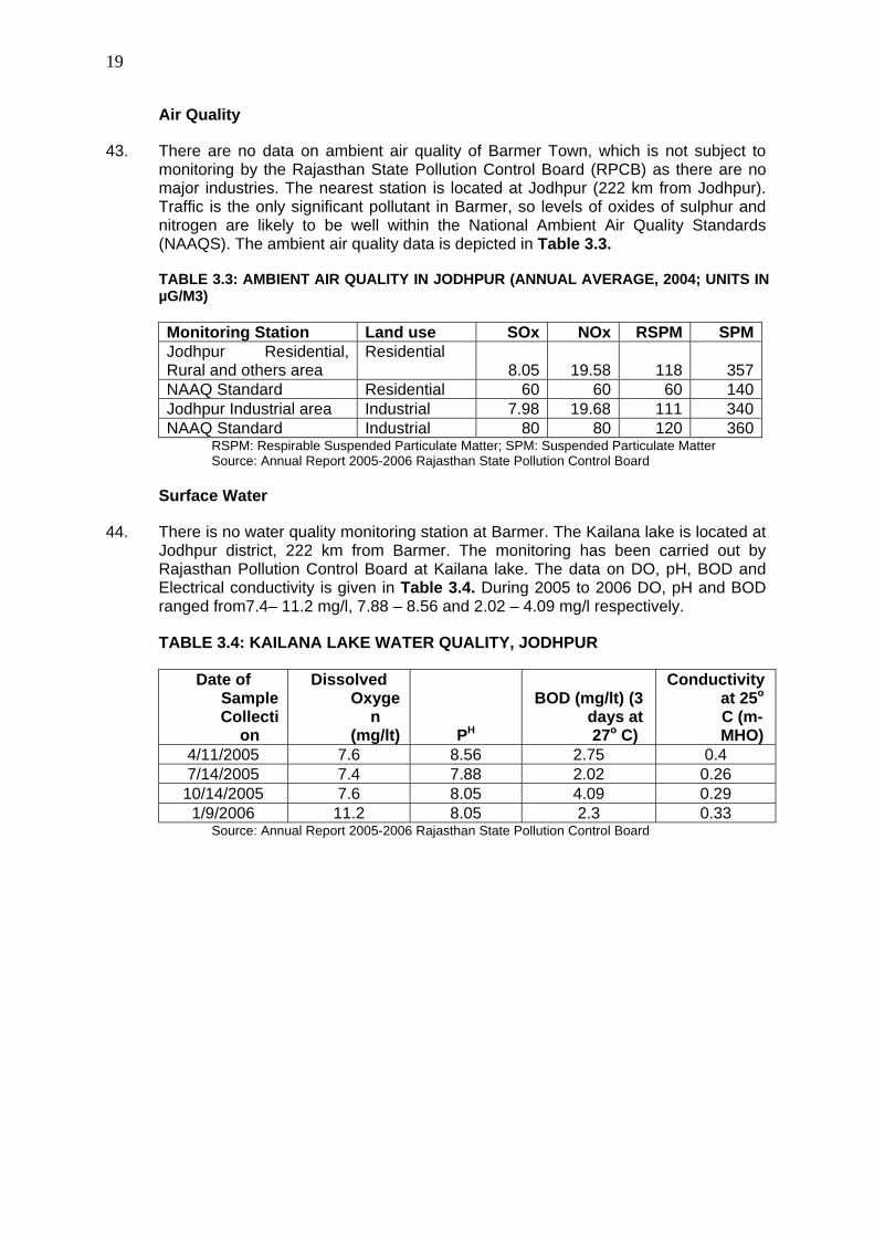
STP Sewerage Treatment Plant
ToR Terms of Reference
UA Urban Agglomeration
UIDSSMT Urban Infrastructure Development Scheme for Small and Medium Towns
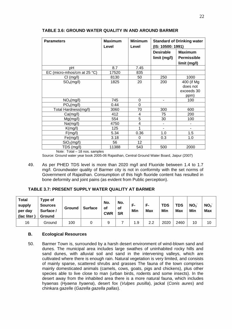
uPVC Unplasitized Poly Venyl Chloride
USEPA United States Environmental Protection Agency
WC Water Closets
WTP Water Treatment Plant

TABLE OF CONTANTS
I. INTRODUCTION 1
A. PURPOSE OF THE REPORT 1
B. EXTENT OF THE IEE STUDY 1
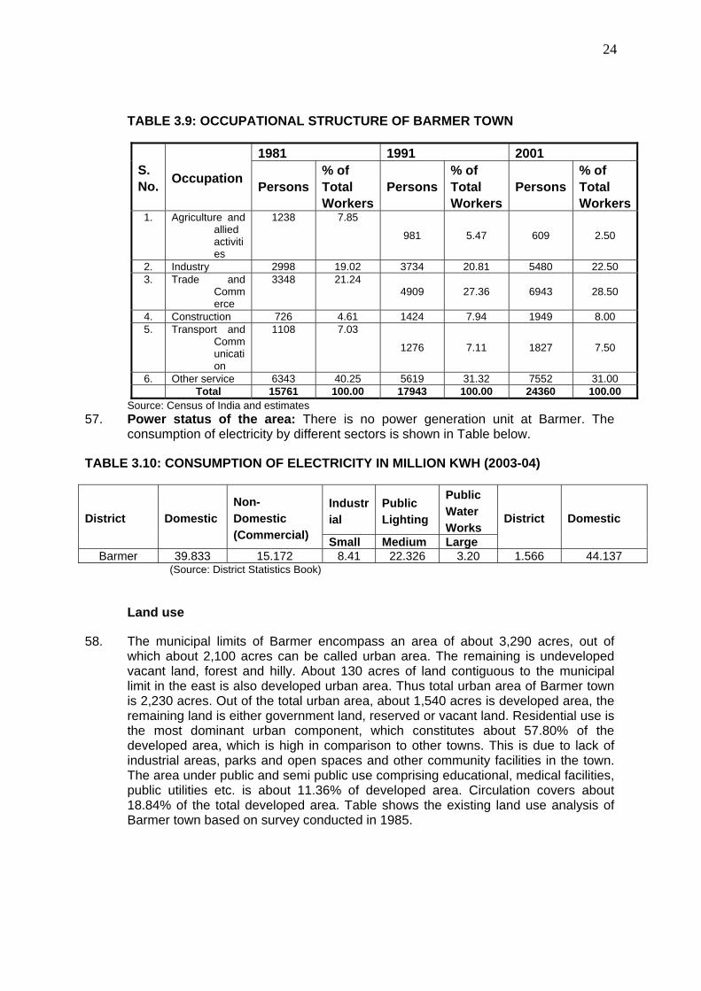
II. DESCRIPTION OF THE PROJECT 3
A. TYPE, CATEGORY AND NEED 3
B. LOCATION, SIZE AND IMPLEMENTATION SCHEDULE 3
C. DESCRIPTION OF THE SUB-PROJECT 4
III. DESCRIPTION OF THE ENVIRONMENT 12
A. PHYSICAL RESOURCES 12
B. Ecological Resources 22
C. Economic Development 23
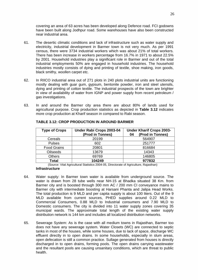
D. Social and Cultural Resources 29
IV. ENVIRONMENTAL IMPACTS AND MITIGATION MEASURES: LOCATION AND DESIGN 31
V. POTENTIAL ENVIRONMENTAL IMPACTS AND MITIGATION MEASURES: INFRASTRUCTURE CONSTRUCTION 31
A. Screening out areas of no significant impact 31
B. Source and supply augmentation 32
C. Network improvement 34
VI. POTENTIAL ENVIRONMENTAL IMPACTS AND MITIGATION MEASURES: OPERATION AND MAINTENANCE 41
A. Screening out areas of no significant impact 41
B. Operation and maintenance of the improved water supply system 41
C. Environmental impacts and benefits of the operating system 42
VII. INSTITUTIONAL REQUIREMENTS AND ENVIRONMENTAL MONITORING PLAN 44

A. Summary of environmental impacts and mitigation measures 44
. B. Institutional arrangements for project implementation 44
C. Environmental Monitoring Plan 50
D. Environmental management and monitoring costs 54
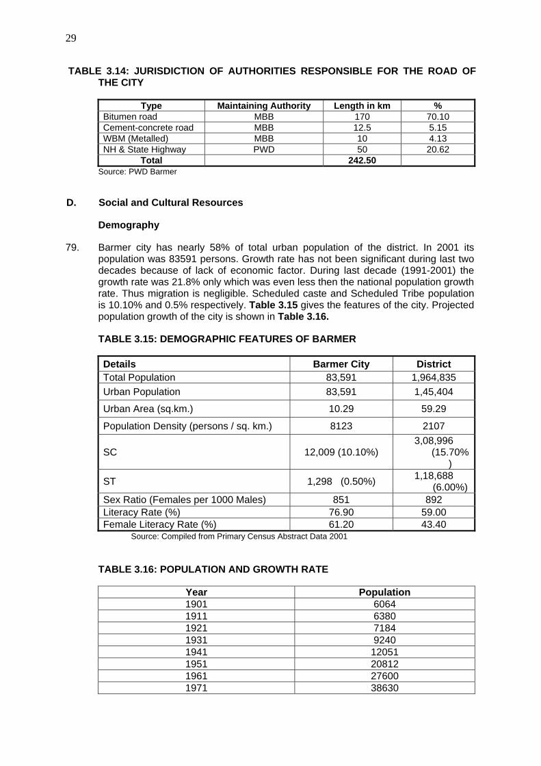
E. Associated Facilities 55
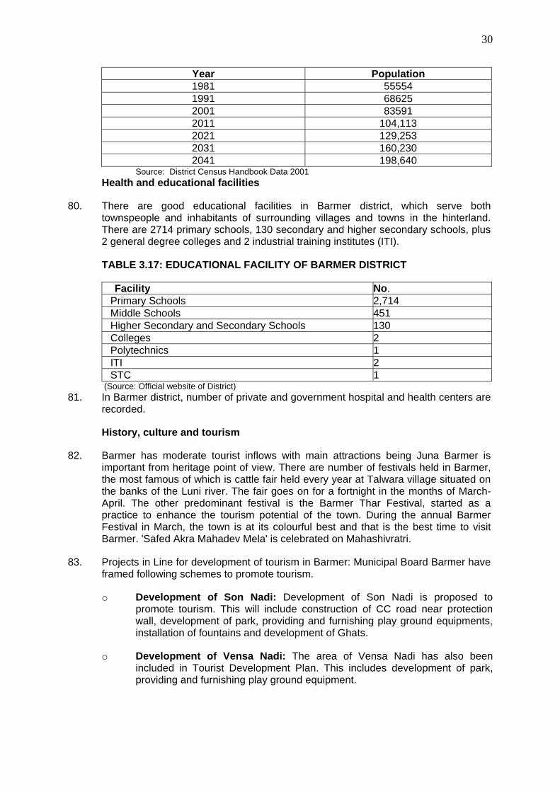
VIII. PUBLIC CONSULTATION AND INFORMATION DISCLOSURE 55
A. Project stakeholders 55
B. Consultation and disclosure to date 56
C. Future consultation and disclosure 57
IX. FINDINGS AND RECOMMENDATIONS 58
A. Findings 58
B. Recommendations 61
X. CONCLUSIONS 61
APPENDIX 1 PHOTO GALLERY 62
Appendix – 2 PHED Letter 643
Appendix – 3 REA Checklist 64
Appendix -4 Public Consultation 67

1
I. INTRODUCTION
A. Purpose of the report
1. Rajasthan Urban Sector Development Investment Program (RUSDIP) is intended to optimize social and economic development in 15 selected towns in the State, particularly district headquarters and towns with significant tourism potential. This will be achieved through investments in urban infrastructure (water supply; sewerage and sanitation; solid waste management; urban drainage; urban transport and roads), urban community upgrading (community infrastructure; livelihood promotion) and civic infrastructure (art, culture, heritage and tourism; medical services and health; fire services; and other services). RUSDIP will also provide policy reforms to strengthen urban governance, management, and support for urban infrastructure and services. The assistance will be based on the State-level framework for urban reforms, and institutional and governance reforms recommended by the Government of India (GoI) through the Jawaharlal Nehru National Urban Renewal Mission (JNNURM) and Urban Infrastructure Development Scheme for Small and Medium Towns (UIDSSMT).
2. RUSDIP Phase II to be implemented over a seven year period beginning in 2008, and will be funded by a loan via the Multitranche Financing Facility (MFF) of the ADB. The Executing Agency (EA) is the Local Self-Government Department (LSGD) of the Government of Rajasthan (GoR); and the Implementing Agency (IA) is the Project Management Unit (PMU) of the Rajasthan Urban Infrastructure Development Project (RUIDP), which is currently in the construction stage.
3. RUSDIP will improve infrastructure through the design and implementation of a series of subprojects, each providing improvements in a particular sector (water supply, sewerage, solid waste etc) in one town. RUSDIP has been classified by ADB as environmental assessment category B (some negative impacts but less significant than category A). The impacts of subprojects prepared according to ADB Environment Policy (2002) and Environmental Assessment Guidelines (2003).
B. Extent of the IEE study
4. Indian law and ADB policy require that the environmental impacts of development projects are identified and assessed as part of the planning and design process, and that action is taken to reduce those impacts to acceptable levels. This is done through the environmental assessment process, which has become an integral part of lending operations and project development and implementation worldwide.
ADB Policy
5. ADB’s Environment Policy requires the consideration of environmental issues in all aspects of the Bank’s operations, and the requirements for Environmental Assessment are described in Operations Manual (OM) 20: Environmental Considerations in ADB Operations. This states that ADB requires environmental assessment of all project loans, programme loans, sector loans, sector development programme loans, financial intermediation loans and private sector investment operations.
6. The nature of the assessment required for a project depends on the significance of its environmental impacts, which are related to the type and location of the project, the sensitivity, scale, nature and magnitude of its potential impacts, and the

2
availability of cost-effective mitigation measures. Projects are screened for their expected environmental impacts and are assigned to one of the following categories:
Category A: Projects that could have significant environmental impacts. An Environmental Impact Assessment (EIA) is required.
Category B: Projects that could have some adverse environmental impacts, but of less significance than those for category A. An Initial Environmental Examination (IEE) is required to determine whether significant impacts warranting an EIA are likely. If an EIA is not needed, the IEE is regarded as the final environmental assessment report.
Category C: Projects those are unlikely to have adverse environmental impacts. No EIA or IEE is required, although environmental implications are reviewed.
Category FI: Projects that involve a credit line through a financial intermediary (FI) or an equity investment in a FI. The FI must apply an environmental management system, unless all subprojects will result in insignificant impacts.
7. The Bank has categorised this program as Category B and following normal procedure for MFF loans has determined that one Environmental Examination will be conducted for each subproject, with a subproject being the infrastructure improvements in a particular sector (water supply, sewerage, etc) in one town.
National Law
8. The GoI EIA Notification of 2006 (replacing the EIA Notification of 1994), sets out the requirement for Environmental Assessment in India. This states that Environmental Clearance (EC) is required for specified activities/projects, and this must be obtained before any construction work or land preparation (except land acquisition) may commence. Projects are categorised as A or B depending on the scale of the project and the nature of its impacts.
9. Categories A projects require Environmental Clearance from the National Ministry of Environment and Forests (MoEF). The proponent is required to provide preliminary details of the project in the form of a Notification, after which an Expert Appraisal Committee (EAC) of the MoEF prepares comprehensive Terms of Reference (ToR) for the EIA study, which are finalized within 60 days. On completion of the study and review of the report by the EAC, MoEF considers the recommendation of the EAC and provides the EC if appropriate.
10. Category B projects require environmental clearance from the State Environment Impact Assessment Authority (SEIAA). The State level EAC categorises the project as either B1 (requiring EIA study) or B2 (no EIA study), and prepares TOR for B1 projects within 60 days. On completion of the study and review of the report by the EAC, the SEIAA issues the EC based on the EAC recommendation. The Notification also provides that any project or activity classified as category B will be treated as category A if it is located in whole or in part within 10 km from the boundary of protected areas, notified areas or inter-state or international boundaries.
11. The only type of infrastructure provided by the RUSDIP that is specified in the EIA Notification is solid waste management, where EC is required for all Common Municipal Solid Waste Management Facilities (facilities that are shared by more than
3
one town) 1. EC is thus not required for the water supply sub-project that is the subject of this Environmental Examination.
Review and Approval Procedure
12. For Category B projects the Draft Environmental Status report and its summary (SIEE) are reviewed by ADB’s Regional Department sector division and Environment and Social Safeguards Division, and by the Executing Agency, and additional comments may be sought from project affected people and other stakeholders. All comments are incorporated in preparing the final documents, which are reviewed by the Executing Agency and the national environmental protection agency (MoEF in this case). The EA then officially submits the IEE and SIEE reports to ADB for consideration by the Board of Directors. Completed reports are made available worldwide by ADB, via the depository library system and the ADB website.
Scope of Study
13. This is the IEE report for the Barmer water supply sector subproject. It discusses the generic environmental impacts and mitigation measures relating to the location, design, construction and operation of physical works proposed under this subproject.
II. DESCRIPTION OF THE PROJECT
A. Type, Category and Need
14. This is a water supply sub-project, and as explained above it has been classified by ADB as Category B, because it is not expected to have major negative environmental impacts. Under ADB procedures such projects require an IEE to identify and mitigate the impacts, and to determine whether further study or a more detailed EIA may be required. The sub-project is needed because the present water supply infrastructure in Barmer is inadequate for the needs of the growing population.
15. The provision is also unequal, with un-served areas being mainly the slums and newly-developed areas. This is one of a series of subprojects designed by the RUSDIP that are intended to raise the standards of the municipal infrastructure and services of Barmer and the other urban centres to those expected of modern Asian towns.
B. Location, Size and Implementation Schedule
16. The sub-project is located in Barmer, the headquarters town of Barmer District, in the western part of Rajasthan (Figure 2.1). Improvements in the distribution system will affect only certain parts of the town, such as slums and developing areas where a new network will be provided, and certain other locations where clear water reservoir and 8 overhead storage reservoirs will be built (Figure 2.2, 2.3). Other facilities like 26.17 km rising main and 134 km distribution main in developed area are also considered (Figure 2.2, 2.3).
1 According to the Rajasthan State Pollution Control Board, the MoEF intends to issue a clarification to the EIA Notification in due course, which will add all landfill facilities and Sewage Treatment Plants to the list of projects specified as requiring EC under the Notification. This has not yet been issued, so the text above indicates the correct legal position at the time of writing

4
Photographs of the project area are attached as Appendix 1
C. Description of the Sub-project
Service Delivery, existing water supply arrangement
17. The present water supply of Barmer is solely from the ground water sources, abstracted through 27 tube wells, located near NH-15 at Bhadkha, 38 km. away from Barmer town and is boosted through 300 mm AC / 200 mm CI conveyance mains to Barmer town with intermediate boosting at Harsani Phanta and Jalipa Head Works.
18. The current water production from the tube wells in total is 9 mld. The losses are reported to be high and in the order of 40%. Considering the present estimated production level, the present per capita water supply is estimated to be about 57 lpcd. In addition to the inadequate production, the system suffers from old and leaking distribution lines, inequitable pressure distribution, inadequate storage, lack of metering, etc. There are currently 9 service reservoirs of total capacity of 5.44 ML. There are 15,455 connections, out of which 15,071 connections are domestic. The rest are commercial and industrial. Most of the connections are metered. However, 3,768 of the total domestic meters are in a functional or working condition and 11,303 nos. are to be replaced/ repaired. At present water is being disinfected through application of bleaching powder, which is rudimentary and inefficient. The existing situation warrants urgent source augmentation, rehabilitation / improvement of the existing distribution system, increase in the storage capacity, provision of metering and provision of disinfection facilities.
19. Out of the 9 MLD available from current sources, PHED supplies around 0.22 MLD to Commercial Consumers, 0.88 MLD to Industrial consumers and 7.90 MLD to Domestic consumers.
20. This water is collected at CWRs (2 Nos.) of total capacity 420 KL at Laxmi Nagar pumping station and 900 KL at Mahaveer Nagar pumping station, which is further boosted to the existing service reservoir at different localities i.e. (i) Dola Doongri Hillock, (ii) Shastri Nagar, (iii) Mahaveer Nagar, (iv) RIICO, (v) Lilaria Dhora Lower Zone, (vi) Higher Zone, (vii) Indira Nagar, (viii) Hospital Campus of capacities varying from 200 KL to 1360 KL. From these SRs and by means of direct boosting, water is supplied at various parts of Barmer city (in 56 pockets) at an interval of 72 hours for 1 to 1½ Hours duration, under normal circumstances with a terminal pressure of 3 psi to 15 psi. There is no water treatment plant for present water system.
21. The city is divided into 11 water supply zones covering 35 municipal wards. The approximate total length of the existing water supply distribution network is 144 km and includes all localized distribution networks.
Sub-project description including detail scope
22. The Subproject will construct the downstream facilities and strengthen the existing water supply system for the town to receive and distribute the additional water supplied through the Barmer Lift Project implemented by PHED. The Subproject is also expected, inter alia, to reduce the unaccounted for water (UFW) by billing for the actual quantity of water supplied, since the house connections will be expanded to cover at least 90% of the town population, with either new water meters or a rehabilitated water meters. Disinfection facilities, in the form of chlorinator plants at CWRs and pump houses will also be provided and the distribution network will be expanded and strengthened to fully absorb the additional water supply from the
5
Barmer Lift Project. Detailed plan and commitment to guarantee the required water supply for Barmer is given in Appendix I.
23. Scope and components of the works consist of the construction of OHSRs, CWRs, main pump house behind Circuit house, providing and laying of rising main, distribution network expansion and rehabilitation, provision for chlorinator procurement and installation of household and bulk water meters, etc., detailed as follows:
i. Construction of pump house behind Circuit house with provision of pumps of 203 lps, 57 m head (1+1), 95 lps, 30 m head (1+1) including all electromechanical works.
ii. Construction of CWR of 1300 KL and pump house at Karali Nandi with
provision of pumps of 82 lps, 39 m head (1+1), 37 lps, 35 m head (1+1) including all electromechanical works
iii. Provision of pumps of 25.5 lps, 38 m head (1+1), 25.5 lps, 33 m head (1+1)
including all electromechanical works at existing pump house at Mahaveer Nagar pump house
iv. Provision of pumps of 58.79 lps, 55 m head (1+1), 36.28 lps, 44 m head
(1+1) including all electromechanical works at existing pump house at Laxmi Nagar pump house
v. Construction of OHSR at Baldev Nagar (500 KL), Lilariya Dora (1500 KL),
Reserve Forest (500 KL), Mohan Ji Crasher (500 KL), Jogiyon Ki Dadi (500 KL), Dola Doongri (1500 KL), Kalyanpura (1000 KL), Vishnu Colony (1000 KL)
vi. Provision of 7500 nos of new domestic connection with meter and
rehabilitation of 5300 nos existing connection vii. Provision of Chlorinator at Laxmi Nagar, Mahaveer Nagar and Karali Nandi
viii. Providing and laying of DI rising main of 26.17 km of 100 mm to 500 mm
dia.
ix. Provision of 134 km of uPVC distribution main of 110 mm to 315 mm dia including rehabilitation of old leaking line.
x. Provision for 42 nos Bulk flow meter
24. Through IGNP, water will be brought from the CWR of 17 ML near Circuit House, to be constructed by PHED, from which water will be further pumped to IPS at Karali Nandi through rising main of 500/450 mm dia. enroute of this feeder, one branch of 300 mm dia will feed to IPS at Mahaveer nagar from which water will further pumped to 1 no. proposed OHSRs and 5 nos. existing OHRSs through 2 nos. of feeder. From Pump house at Circuit house, another feeder of 400 mm dia will connect to the IPS at Laxmi Nagar. From this pump house, water will be further pumped to 2 nos. proposed OHSRs and 3 nos. existing OHSRs. From Karali Nandi IPS water will be further pumped to 5 nos. proposed OHSRs and 1 no. existing OHSR.

6
25. From the OHSRs water will be distributed to the households through the rehabilitated or newly constructed distribution network. 100 % consumer metering will be carried out for the design population of 2011. The bulk meters will be provided at all supply points to measure the quantity of water supply and to enable system monitoring. The change in pumping equipment will increase the efficiency of the system and reduce the proportionate O& M cost. The existing 27 tube wells will also be used in the system to meet the gap between the demand and the available surface water. Water from the tube wells yielding water with high Fluoride content will be blended with surface water to meet the potable water quality standard as per the Indian standards.
26. The proposed layout and schematic of the proposed water supply system are shown in Figures 2.2 and 2.3, respectively.
27. The Subproject is designed for a net water supply of 135 lpcd at the household end, for a design population of 2041, and with physical or system losses maintained at 20% after the completion of the project. All civil works and pipe sizing are designed to meet 2041 (projected population’s) needs, while all mechanical and electrical equipment are designed for 2026 (projected population’s) requirement.
28. Table 2.1 shows the nature and size of the various components of the subproject. There are three main elements: augmentation of the water source and supply; expansion/improvement of the distribution network; and reduction of non-revenue water (NRW). The descriptions shown in Table 2.1 are based on the present proposals, which are expected to be substantially correct, although certain details may change as development of the subproject progresses.

7
Figure 2.1: Location of Project Area

Rajasthan Urban Sector Development Investment Program
ADB TA 4814-IND
Barmer Regional Map
Govt of Rajasthan Asian Development Bank

8
Figure 2.2: Index plan of Barmer water supply scheme


9
Figure 2.3: Schematic water supply system- Barmer


10
Table 2.1: Improvements in water supply infrastructure proposed in Barmer
Infrastructure Function Description Location 1. Source and Supply Augmentation Rising Main To collect pure water from WTP/CWR to
the OHSR DI rising main 26.17 km of 100 mm to 500 mm dia
Various OHSRs at Barmer town
2. Expansion of Distribution Network Distribution mains Supply water to newly developed area
134 km of uPVC distribution main of 110 mm to 315 mm dia including rehabilitation of old leaking line
Beriyon Ka Bas, Sardarpura, Indira Nagar, Railway Kuwa No. 3, Fakiron Ka Tala, Joshiyon Ka Bas, Panghat Road, Mochiyon Ka Bas, Maliyon Ka Bas, Naiyon Ka Bas, Dhani Bazar, Meghwalon Ka bas, Kalyanpura, Hamirpura, Jatiyon Ka Purana Bas, Jatiyon Ka Naya Bas, Shastri Nagar, Gandhi Nagar, Vishnu Colony, Baldev Nagar, Nehru Nagar, Mahaveer Nagar, Laxmi Nagar, Laxmipura etc
Clear Water Reservoirs
Storage of Clean and treated water 1 no. Construction of CWR of 1300 KL and pump house at Karali Nandi with provision of pumps of 82 lps, 39 m head (1+1), 37 lps, 35 m head (1+1) including all electromechanical works
Overhead Reservoirs Increase water supply to regulate water supply
8 nos. Provisions are at Baldev Nagar (500 KL), Lilariya Dora (1500 KL), Reserve Forest (500 KL), Mohan Ji Crasher (500 KL), Jogiyon Ki Dadi (500 KL), Dola Doongri (1500 KL), Kalyanpura (1000 KL), Vishnu Colony (1000 KL)
Chlorination Plants To supply bacteria free water to customer
At 3 nos. at pumping stations Laxmi Nagar, Mahaveer Nagar and Karali Nandi
Pump replacement To maintain the water flow Replacement of pumps at Mahaveer Nagar with provision of pumps of 25.5 lps, 38 m head (1+1), 25.5 lps, 33 m head (1+1) including all electromechanical works at existing pump house at Mahaveer Nagar
Mahaveer Nagar Pump house Laxmi Nagar Pump house

11
Infrastructure Function Description Location pump house Replacement of pumps at Laxmi Nagar Pump house with provision of pumps of 58.79 lps, 55 m head (1+1), 36.28 lps, 44 m head (1+1) including all electromechanical works at existing pump house at Laxmi Nagar pump house
New Pump house To maintain the water flow Provision of pumps of 203 lps, 57 m head (1+1), 95 lps, 30 m head (1+1) including all electromechanical works.
Near Circuit House
New intermediate pump house
To maintain the water flow Provision of pumps of 82 lps, 39 m head (1+1), 37 lps, 35 m head (1+1) including all electromechanical works
At Karali Nandi
3. Meters and House Connections Repair and installation of household water meter
Repair leaks and increase the amount and pressure of water reaching consumers
Installation of 7,500 new household water meters, and rehabilitation of 5,300 existing household water meters
All over the city
Bulk flow meters Monitor water flow in the improved network
Provision for 42 nos. Bulk flow meter Location will be finalizes after detail survey
12
III. DESCRIPTION OF THE ENVIRONMENT
A. PHYSICAL RESOURCES
Location
29. The Urban Agglomeration (UA) of Barmer district is located about 565 km from Jaipur. Barmer district is situated in the western part of Rajasthan and forms part of the Thar desert. It is surrounded by Jaisalmer in the north, Jalore in the south, Pali and Jodhpur in the east and Pakistan in the west. It is about 887 kms from Delhi, 565 kms from Jaipur. The nearest Airport is at Jodhpur.
30. The total area of the city is 10.29 sq. km. Barmer city is the administrative headquarter of the district. The district is divided into two sub-divisions viz., Barmer and Balotra. The district has 3 municipalities, 8 panchayat samitis, 225 gram panchayats, 1,640 revenue villages and 853 inhabited villages. District map of Barmer is shown in Figure 3.1.
Topography, Natural hazard and Drought
31. Topography Barmer is the district headquarter. It is located at 25°45' North latitude and longitude 71°22' East longitude, at a height of about 250 meters above the mean sea level.
32. Natural Hazards- Earthquake: Barmer town lies in medium to high risk zone (III and IV). The area is prone to earthquakes as it is located on comparatively unstable geological plains based on evaluation of the available earthquake zone information. Figure 3.2 depicts the earthquake zones of Rajasthan. Figure 3.3 shows natural hazard zones of the Barmer district.
33. Drought: Low rainfall coupled with erratic behavior of the monsoon in the State makes Rajasthan the most vulnerable to drought. Based upon the discussion with PHED officials the water table in the City continuously decreases by 4-5 meter on an annual basis combined with significant drawdown conditions.

13
FIGURE 3.1: DISTRICT MAP OF BARMER
FIGURE 3.2: EARTHQUAKE ZONES OF RAJASTHAN

14
FIGURE 3.3: NATURAL HAZARD MAP OF BARMER (GSI RESOURCE MAP)
Geology, geomorphology, mineral resources and soil
34. Barmer district is situated in the western part of the state, bordering Pakistan. It occupies the area of 28,287 km2. Shiv, Baytu, Pachpadra, Barmer, Chauhtan, Siwana and Gudha Malani are the seven Tehsil in the district. The ephemeral Luni and Sukri rivers drains the eastern and southern part of the district. The district is having arid climate with average annual rainfall in the district is 27cm.
35. The district forming the part of the ‘Thar desert’ is mostly covered by Aeolian sand. The area however exposes a variety of rock types ranging in age from upper Proterozoic to Quaternary. The pre- Malani ligneous Suit comprise volcanic phase (rhyolite, agglomerate tuff), plutonic phase (granite) and dyke phase rhyolite, felsites, prophyrite,basalt). The Malani volcanic are dominated by acid volcanic flows. Three phases of acid volcanism, separated from each other by pyroclastic material, have been identified. The Birmania formation comprising limestone, chert, shale, sandstone, (Upper Proterzoic) overlite the Malani rocks the overlying Lathi formation (Jurassic) is represented by sandstone, siltstone, conglomerate and pockets of clay. Over most part of the area they are covered by Quaternary sediments and could be seen in dug well section. The Fategarh formation uncomfortably overlying the Lathi sandstone comprises sequences of conglomerate, gritty sandstone. phosphalic sandstone, siltstone and bentonite Outliers of the Fategarh Formation are also seen around Sarnu. The emplacement of alkaline suite of rocks (alkali olivine basalt, hawaiite, trachyte, trachyandesite. syenite) within the Malanis. in the area around Sarnu and Dandali marks another magnetic phase The Tertiary sequence, overlying the Fatehgarh Formation is represented by the Akli, the Mandai, and the Kapurdi Formations. The Akli Formation consisting of argrillaceous sandstone, lignite, bentonic clay grades upward

15
into the arenaceous Mandai Formation which includes conglomerate, sandstone, etc. The Kapurdi Formation (Eocene) consists mainly of Fuller's earth, variegated clay and ferruginous and gypseous concretions. The Bandah Formation consisting of friable and variegated sandstone and clay, seen in the western part of the district, is considered time equivalent of the Kapurdi Formation.
36. The Phalsund and Shumar Formation (Pleistocene age) comprising grit, conglomerate, iron stone, pebble spread etc occur in isolated patches at several places. Quaternary sediments of aeolian and fiuvial phases conceal the older formations and cover large part of the district.
37. Geomorphologically, the district is classified into seven geomorphic units, namely, alluvial plain, obstacle dune, complex / composite dune, parabolic dune, sand sheet, rocky desert and denudational hill Geohydrologically, the district is classified into three hydrological domains (unconsolidated alluvium and pebble; semi consolidated formations; and consolidated fissured formations) with ground water potential ranging from <10 to 100 LPS. Natural hazards include mainly wind erosion which is moderate to very severe.
38. Mineral resources: The district abounds in mineral resources of bentonite, China clay, fuller’s earth, glass sand, lignite phosphorus, salt, vermiculite and Kankar. Benotonitic clay deposits swelling and non – swelling type are reported from Akli, Amba Bari, Bisu Kalan, Gunga, Narguida, Khoral, Shiv, Thumbli, Sonri, Bhadres, Jalipa, and Mahabar, with the total of 7.15 million tones of proved reserves. China clay beds, up to 2.4 m in thickness occur near Gunga, Nimla and Botiya. Fuller’s earth deposits are located around Bharka, Kaprudi, Botiya. Gypsum occurrences are reported from. Talsar, mith ka Tala, Binjkasar, Mithrau, Uttarlai, Kawas and Shivkar. Glass sand is suitable for glass industries are reported from Shiv. Lignite occurrences (from Mandai Formation) are reported from Kapurdi, Jalipa, Thumbli and Bharka areas. Mineral Exploration Corporation Limited estimated reserves of about 200 million tones form Kapurdi – Jalipa area. Phosphorite horizon, 1 to 4 m thick, Comprising aeolite, pellet, replaced fossil shell, is traceable from Bhiyar to Dharavi Khurd with 5.25 % P2O5 contents. Salt deposits are found around Pachpadra. Vermiculite has been reported from (west of) Simaliya. Kankar occurrences are reported from Saro – ki – Dhani, Kashmir, Redwali, salariya etc. where they are locally used as road material. Malani granite and rhyolite are extensively quarried for use as construction material near Mokalsar, Pataudi, Dharimanna, etc. They also possess vast reserves of road metal and railway ballast.
39. Geology and mineral map of the district is shown in Figure 3,4 and geomorpholigal map of the district is depicted in Figure 3.5.

16
FIGURE 3.4: GEOLOGY AND MINERAL MAP OF BARMER DISTRICT (SOURCE: GSI RESOURCE MAP)

17
FIGURE 3.5: GEOMORPHOLOGY OF BARMER DISTRICT (SOURCE: GSI RESOURCE MAP)
40. Soil characteristics: Soil of the region falls within low rainfall zone of 200- 400 mm. The soil is generally desert type and sand dunes. Specifically soil is aeolian, coarse sand in texture and some places calcareous. Table 3.1 shows nutrient level in the Barmer soil including area coverage of sodic soil. The nutrient status of the Barmer soil is graded as very low to medium level.
TABLE 3.1: FERTILITY STATUS – MAJOR NUTRIENTS AND PROBLEMATIC SOILS OF BARMER DISTRICT
Nutrient Saline Soil(Ha
) Sodic or Alkali(Ha) N P K
Status VL M M - 1989
(Source: Vital Agricultural Statistics 2004-05, Directorate of Agriculture, Rajasthan)

18
Climate
41. The temperature of Barmer varies between minimum of 9 degrees celsius to the maximum of 45 degrees celsius. The normal rainfall is 27.75 cms. .
42. The rainfall over Barmer is scanty and is concentrated over four month i.e. from June to September. The rains are erratic and so is the distribution of the rainfall. However agriculture and the animal wealth are dependent on rains to large extent. Seasonal Rainfall data for the recent year (2005-2006) is shown in Table 3.2. Figure 3.6 shows yearly variation (1997-2007) of rainfall at Barmer.
TABLE 3.2: RAINFALL AT BARMER IN RECENT YEARS (2005-06)
Months Rainfall (mm) 1 June 12 2 July 20 3 August 42 4 September 38 5 October 0 6 November 0 7 December 0 8 January 0 9 February 0 10 March 44 11 April 1 12 May 0 13 Monsoon Rainfall 112 14 Non monsoon rainfall 45 15 Annual Rainfall 157
(Source: Irrigation Department, Govt. of Rajasthan)
FIGURE 3.6: RAINFALL AT BARMER DURING 1997 TO 2007.
Source: Deputy Director hydrology water resources ID and R, Jaipur
19
Air Quality
43. There are no data on ambient air quality of Barmer Town, which is not subject to monitoring by the Rajasthan State Pollution Control Board (RPCB) as there are no major industries. The nearest station is located at Jodhpur (222 km from Jodhpur). Traffic is the only significant pollutant in Barmer, so levels of oxides of sulphur and nitrogen are likely to be well within the National Ambient Air Quality Standards (NAAQS). The ambient air quality data is depicted in Table 3.3.
TABLE 3.3: AMBIENT AIR QUALITY IN JODHPUR (ANNUAL AVERAGE, 2004; UNITS IN µG/M3)
Monitoring Station Land use SOx NOx RSPM SPMJodhpur Residential, Rural and others area
Residential 8.05 19.58 118 357
NAAQ Standard Residential 60 60 60 140Jodhpur Industrial area Industrial 7.98 19.68 111 340NAAQ Standard Industrial 80 80 120 360
RSPM: Respirable Suspended Particulate Matter; SPM: Suspended Particulate Matter Source: Annual Report 2005-2006 Rajasthan State Pollution Control Board
Surface Water
44. There is no water quality monitoring station at Barmer. The Kailana lake is located at Jodhpur district, 222 km from Barmer. The monitoring has been carried out by Rajasthan Pollution Control Board at Kailana lake. The data on DO, pH, BOD and Electrical conductivity is given in Table 3.4. During 2005 to 2006 DO, pH and BOD ranged from7.4– 11.2 mg/l, 7.88 – 8.56 and 2.02 – 4.09 mg/l respectively.
TABLE 3.4: KAILANA LAKE WATER QUALITY, JODHPUR
Date of Sample Collecti
on
Dissolved Oxyge
n (mg/lt) PH
BOD (mg/lt) (3 days at 27o C)
Conductivity at 25o C (m-MHO)
4/11/2005 7.6 8.56 2.75 0.4 7/14/2005 7.4 7.88 2.02 0.26
10/14/2005 7.6 8.05 4.09 0.29 1/9/2006 11.2 8.05 2.3 0.33
Source: Annual Report 2005-2006 Rajasthan State Pollution Control Board

20
FIGURE 3.7: VARIATION OF WATER QUALITY PARAMETERS
Kailana Lake, Jodhpur
0
2
4
6
8
10
12
2/17/2005 4/8/2005 5/28/2005 7/17/2005 9/5/2005 10/25/2005
12/14/2005
2/2/2006
Date of Sample Collection
Con
cent
ratio
n in
mg/
lt ex
cept
pH
&
Con
duct
ivity Dissolved
Oxygen (mg/lt)
PH
Geohydrology and Groundwater
45. Geohydrological map of the Barmer district is shown in Figure 3.8. For broadly grouping geological formations from ground water occurrence and movement considerations, the various lithological units have been classified into three groups on the basis of their degree of consolidation and related parameters. These are,
• Unconsolidated porous, quaternary formation
• Semi consolidated porous formation
• Fissured formations – consolidated sedimentary rocks.
46. On an average 60-70 % of the district area (mostly south and eastern part of the district) covered with unconsolidated porous formations.

21
FIGURE 3.8: GEOHYDROLOGICAL MAP OF BARMER (SOURCE: GSI RESOURCE MAP)
47. There are number of National Hydrographic monitoring stations of Central Ground Water Board in and around Barmer. Fluctuation of ground water level is shown in Table 3.5. In most of the cases ground water table ranged between 20-60 m bgl.
TABLE 3.5: NUMBER AND PERCENTAGE OF NATIONAL HYDOGRAPH NETWORK STATION (BARMER) WITH WATER FLUCTUATION RANGE
Period
No of wells analysed
Range 0-2 m 2-5 m 5-10m 10-20m 20-60m >60 m Min Max N
o % N
o % N
o % N
o % N
o % N
o %
Jan-06 58 5.13 76.55 0 0 0 0 9 15.52 11 18.97 31 53.45 7 12.07 Nov-05 58 5.49 76.5 0 0 0 0 9 15.52 11 18.97 31 53.45 7 12.07 Aug-05 58 5.45 101.24 0 0 0 0 10 17.24 11 18.97 33 56.9 6 10.34 May-05 59 5.67 76.5 0 0 0 0 9 15.25 10 16.95 34 57.63 6 10.34
Source: Ground water year book 2005-06 Rajasthan, Central Ground Water Board, Jaipur (2007) 48. The Central Ground Water Board carried out chemical testing of tube well water
seasonally. The average concentrations of major constituents are shown in Table 3.6.
22
TABLE 3.6: GROUND WATER QUALITY IN AND AROUND BARMER
Parameters Maximum Level
Minimum Level
Standard of Drinking water (IS: 10500: 1991) Desirable limit (mg/l)
Maximum Permissible limit (mg/l)
pH 8.7 7.45 EC (micro-mhos/cm at 25 °C) 17520 835
Cl (mg/l) 8130 50 250 1000 SO4(mg/l) 1825 20 200 400 (if Mg
does not exceeds 30
ppm) NO3(mg/l) 745 0 - 100 PO4(mg/l) 0.44 0
Total Hardness(mg/l) 3060 70 300 600 Ca(mg/l) 412 4 75 200 Mg(mg/l) 554 5 30 100 Na(mg/l) 4750 4 - - K(mg/l) 125 1 - - F(mg/l) 5.34 0.36 1.0 1.5 Fe(mg/l) 3.18 0 0.3 1.0
SiO2(mg/l) 56 12 TDS (mg/l) 11388 543 500 2000
Note: Total – 18 nos. samples Source: Ground water year book 2005-06 Rajasthan, Central Ground Water Board, Jaipur (2007)
49. As per PHED TDS level is more than 2020 mg/l and Fluoride between 1.4 to 1.7 mg/l. Groundwater quality of Barmer city is not in conformity with the set norms of Government of Rajasthan. Consumption of this high fluoride content has resulted in bone deformity and joint pains (as evident from Public perception).
TABLE 3.7: PRESENT SUPPLY WATER QUALITY AT BARMER
Total supply per day (lac liter )
Type of Sources Surface / Ground
Ground Surface No. of CWR
No. of SR
F- Min
F- Max
TDS Min
TDS Max
NO3-
Min NO3
-
Max
16 Ground 100 0 9 7 1.9 2.2 2020 2460 10 10
B. Ecological Resources
50. Barmer Town is, surrounded by a harsh desert environment of wind-blown sand and dunes. The municipal area includes large swathes of uninhabited rocky hills and sand dunes, with alluvial soil and sand in the intervening valleys, which are cultivated where there is enough rain. Natural vegetation is very limited, and consists of mainly sparse, scattered shrubs and grasses The fauna of the town comprises mainly domesticated animals (camels, cows, goats, pigs and chickens), plus other species able to live close to man (urban birds, rodents and some insects). In the desert away from the inhabited area there is a more natural fauna, which includes hyaenas (Hyaena hyaena), desert fox (Vulpes pusilla), jackal (Conis aures) and chinkara gazelle (Gazella gazella pallas).

23
51. There is no forest area nearby the city. Therefore no endangered floral and faunal species are expected.
C. Economic Development
52. Barmer being a desert district generally faces famines & drought. The bulk of population depends upon agriculture & animal husbandry. Being district headquarter, Barmer town is the main regional centre for the entire district and is working as service centre for providing services like trade and commerce, transport, commercial and other higher level public facilities for the entire district.
53. The economic condition of people in Barmer is not satisfactory. As per information in 1998 about 28% population comprised of families below poverty line. These people are mostly labour class working in industries, shops, restaurant, construction, transport and certain other. This aspect has to be given due consideration while designing the housing projects.
54. Work force: In 1991 the total working force was 17,943, which was 26.15% of total population. In 2001 the total workers were 24,360, which was about 29.14% of total population. Out of the total workers 21,871 were main workers and 2560 marginal workers. The male workers participation rate was 48.41% while in the case of females 6.5% were workers.
55. The occupational structure as per 2001 census is assessed as follows:
TABLE 3.8: DISTRIBUTION OF WORK FORCE 2001
Category Numbers % of Total Main Workers Male 20,419 93.67 Female 1,381 6.33 Total 21,800 100.00 Marginal Workers Male 1452 56.72 Female 1108 43.28 Total 2,560 100.00 Total Workers Male 21,871 89.78 Female 2,489 10.22 Total
0
100.00
56. The occupational structure data for 2001 census has not been given in category
wise details. Therefore, 2001 occupational data are based on estimates of data for 1971 to 1991 census. The economic structure of the town is associated with the regional character. Being the seat of district administration, about 31% of the total workers are employed in other services category. Trade and commerce is the next important function where 28.5% workers are engaged. Barmer is also a centre of household and small industries like furniture making and dying and printing. About 21% workers are employed in various industrial units. It is also a transport terminus and 7.5% workers are engaged in this activity. The agriculture and allied activities also provide employment to about 4.5% workers. The following table and figure 3-5 shows the occupational structure of the total population in 1981 to 2001.
24
TABLE 3.9: OCCUPATIONAL STRUCTURE OF BARMER TOWN
S. No. Occupation
1981 1991 2001
Persons% of Total Workers
Persons% of Total Workers
Persons % of Total Workers
1. Agriculture and allied activities
1238 7.85
981 5.47 609 2.50
2. Industry 2998 19.02 3734 20.81 5480 22.50 3. Trade and
Commerce
3348 21.24 4909 27.36 6943 28.50
4. Construction 726 4.61 1424 7.94 1949 8.00 5. Transport and
Communication
1108 7.03
1276 7.11 1827 7.50
6. Other service 6343 40.25 5619 31.32 7552 31.00 Total 15761 100.00 17943 100.00 24360 100.00
Source: Census of India and estimates 57. Power status of the area: There is no power generation unit at Barmer. The
consumption of electricity by different sectors is shown in Table below.
TABLE 3.10: CONSUMPTION OF ELECTRICITY IN MILLION KWH (2003-04)
District Domestic Non- Domestic (Commercial)
Industrial
Public Lighting
Public Water Works
District Domestic
Small Medium Large Barmer 39.833 15.172 8.41 22.326 3.20 1.566 44.137
(Source: District Statistics Book)
Land use
58. The municipal limits of Barmer encompass an area of about 3,290 acres, out of which about 2,100 acres can be called urban area. The remaining is undeveloped vacant land, forest and hilly. About 130 acres of land contiguous to the municipal limit in the east is also developed urban area. Thus total urban area of Barmer town is 2,230 acres. Out of the total urban area, about 1,540 acres is developed area, the remaining land is either government land, reserved or vacant land. Residential use is the most dominant urban component, which constitutes about 57.80% of the developed area, which is high in comparison to other towns. This is due to lack of industrial areas, parks and open spaces and other community facilities in the town. The area under public and semi public use comprising educational, medical facilities, public utilities etc. is about 11.36% of developed area. Circulation covers about 18.84% of the total developed area. Table shows the existing land use analysis of Barmer town based on survey conducted in 1985.

25
TABLE 3.11: LAND USE OF BARMER CITY – 1985
S.No. Land use Area in acres % 1. Residential 890 57.792. Commercial 90 5.843. Industrial 40 2.604. Government Offices 20 1.305. Recreational 35 2.276. Public and Semi-public 175 11.367. Circulation 290 18.83 Total Developed Area 1540 100.00
8. Government Reserved 370 9. Other vacant un-developed land 320
Source: Town Planning Department
FIGURE 3.9: LAND USE PROPORTION FOR BARMER DEVELOPED AREA
Land use Barmer
58%
6%
3%
1%
2%
11%
19%ResidentialCommercialIndustrialGovernment OfficesRecreationalPublic and Semi-publicCirculation
59. It is noted that along the transmission areas the major land use is the commercial/ residential areas. There is no major impact anticipated on residential areas and religious places. Details are discussed in Social impact assessment report.
Commerce, Industry and Agriculture
60. Most of the business activities are carried out along roads namely station road, Chohtan road, Panghat road, Dhani Bazar, Laxmi Bazar, Sadar Bazar, Ratan Singh Bazar, Subhash Chowk, Gandhi Chowk, Hanumanji Ka Chowk and Pratapji Ki Pole. The business in cloth is generally carried out in Laxmi bazaar. Station road and Ahinsa Chowk constitute the main markets of the town where retail business in cloth, watches, books and stationary and general merchandise is carried out. A small shopping centre has been developed in Mahaveer Nagar residential scheme. Except this scheme new developments generally lack in organised shopping facilities. There is no shopping centre for the localities in the north. Due to this unauthorised construction of shops have taken place in scattered manner, mostly along main roads like NH-15, Defence road and Jodhpur road. A wholesale grain market
26
covering an area of 63 acres has been developed along Defence road. FCI godowns have been built along Jodhpur road. Some warehouses have also been constructed near industrial area.
61. The desertic climatic conditions and lack of infrastructure such as water supply and electricity, industrial development in Barmer town is not very much. As per 1991 census, there were 3734 industrial workers which was about 21% of total workers. There has been increase in workers percentage from 16.7% in 1971 to about 22.5% by 2001. Household industries play a significant role in Barmer and out of the total industrial employments 50% are engaged in household industries. The household industries mostly consists of dying and printing of textile, shoe making, iron goods, black smithy, woollen carpet etc.
62. In RIICO industrial area out of 271 plots in 240 plots industrial units are functioning mostly dealing with guar gum, gypsum, bentonite powder, iron and steel utensils, dying and printing of cotton textile. The industrial prospects of the town are brighter in view of availability of water from IGNP and power supply from recent petroleum / gas investigations.
63. In and around the Barmer city area there are about 80% of lands used for agricultural purpose. Crop production statistics as depicted in Table 3.12 indicates more crop production at Kharif season in compared to Rabi season.
TABLE 3.12: CROP PRODUCTION IN AROUND BARMER
Type of Crops Under Rabi Crops 2003-04 (Prod in Tonnes)
Under Kharif Crops 2003-04 (Prod in Tonnes)
Cereals 20199 564907 Pulses 602 251777
Food Grains 20801 816684 Oilseeds 13679 14343 Others 69769 146805 Total 104249 977832
(Source: Vital Agricultural Statistics 2004-05, Directorate of Agriculture, Rajasthan) Infrastructure
64. Water supply: In Barmer town water is available from underground source. The water is drawn from 28 tube wells near NH-15 at Bhadka situated 38 Km. from Barmer city and is boosted through 300 mm AC / 200 mm CI conveyance mains to Barmer city with intermediate boosting at Harsani Phanta and Jalipa Head Works. The total production is 9 MLD and per capita supply is about 100 liters. Out of the 9 MLD available from current sources, PHED supplies around 0.22 MLD to Commercial Consumers, 0.88 MLD to Industrial consumers and 7.90 MLD to Domestic consumers. The city is divided into 11 water supply zones covering 35 municipal wards. The approximate total length of the existing water supply distribution network is 144 km and includes all localized distribution networks.
65. Sewerage System: As is the case with all medium towns in Rajasthan, Barmer too does not have any sewerage system. Water Closets (WC) are connected to septic tanks in most of the houses, while some houses, due to lack of space, discharge WC effluent directly in to open drains. In some households, especially in slum areas, open defecation is still a common practice. Sullage generated from houses is directly discharged in to open drains, forming pools. The open drains carrying wastewater and the resultant pools are causing unsanitary conditions, which are threat to public health.

27
66. Scarcity of water, undulated topography and above all the lack of financial resources restrained planning of underground sewerage system. At present there is no plan for a sewerage system. It is necessary that feasibility and detailed project reports be prepared by experienced consulting agencies for the comprehensive scheme covering topographic survey, designing of conveyance system, treatment and disposal of treated effluent and its reuse. The city lies on both sides of railway track. The natural slope is from west to east. According to natural slope at present the sewerage of Northern Zone is flowing near Jodhpur road causing nuisance and ugly appearance. For southern zone outfall of sewer is likely to be behind Saint Paul's school at Shivkar road.
67. Sanitation: Only 50-60 % of the households reportedly has septic tanks and soaks well as the system of sewerage disposal. The remaining accounted for cases of open defecation which is an unacceptable and unhygienic practice. The raw settled sewage from septic tank is periodically flushed out by sanitary workers of the Municipal Board and discharge to open spaces, agricultural lands in an indiscriminate manner. Slum areas were also not equipped with requisite sanitation (LCS etc.) resulting in open defecation.
68. Drainage: The topography of Barmer city is cup shaped, the town being surrounded by sand dunes. Due to scanty rains in the region, natural drainage system has not been so far evolved. In fact there is no river/rivulet in the entire Barmer district. In Barmer town itself no natural drainage system exists to drain away the rainwater or wastewater from the town. Presently there exists a minimal network of storm water drains in the city. The existing network of (roadside) storm water drains in Barmer has been identified under three broad categories as follows: (i) open pucca (ii) closed pucca and, (iii) Kutchha
69. Industrial Effluents. Small industries exists in under RIICO, which is out side the city area and small amount of effluent disposed scattered in local nallahs. As reported by the local MC, the responsibility of effluent disposal is under RIICO’s own and could not be connected to the proposed sewer network. The individual industry should treat their effluent to bring it to the required standard before final disposal.
70. Solid Waste: MBB’s jurisdiction is spread over an area of 10.29 sq.km, which includes core old city area and some rural parts at the fringes. 30 tons of solid waste is collected daily. In addition to household (domestic) solid waste, the main waste generation sources in the town are vegetable and fruit markets, commercial and institutional establishments including hotels and eateries, construction activities, and other tourism related activities. MBB jurisdiction includes core old city area and slum area at fringes. The entire area is divided in to 35 wards.
71. Waste Collection - The MSW generated in the Barmer city (including slum area) mainly consist of domestic refuses, waste from Commercial Area, Vegetable-Fruit market, bio-medical waste, waste from Hotels and Restaurants, Industries etc. The waste collection system being followed is quite primitive, individual households/units throw the garbage on road side/open drains close to their houses and the sweepers collect the garbage in the form of small heaps on road sides. Similarly the open drains are also cleaned periodically and the sludge is heaped adjacent to the drain where it is left for 2-3 days to get dried and lifted. Tractor trolleys then lift these dumps the heaped garbage once or twice a day. In the process, part of the garbage gets dispersed on the road or finds it way into to the open drains or open low lying pits (Ginanis).

28
72. The Municipality owns five tractors, 3 taxis for door to door collection of solid waste. Capacity of five tractors is approximately 7 cum. The waste material is lifted by a loader and placed on trolleys for transportation to disposal site. Details of quantity of garbage collected and disposed off are not available. However based on the information gathered from the concerned engineer, an approximate quantity of MSW generated has been assessed as 25 tonnes / day. Estimated quantities of MSW generated from different sections of the town is given in the following table:
TABLE 3.13.WASTE GENERATION IN 2006
Type of waste generation Quantity of waste in TPD Residential Area (Domestic) 17 Commercial Area 4 Industrial 2 Bio-medical and Hospital 2
Total 25 73. This gives per capita generation of MSW as 300 gms/day, which is in line with
garbage generated in similar towns, e.g. Pushkar, in Rajasthan. 74. As regards quality of MSW, there is no data available. Physical inspection carried
out during the visits indicates very little presence of organic matter. Presence of plastic bags and wrappers of pan masala / tobacco pouches are source of nuisance around the points of garbage collection and along the roads and disposal sites. The garbage as such cannot be used for composting and is primarily being disposed off as landfill at a site near Somayon Ki Dhani.
Transportation
75. Road Transport: The district is linked by road with Jaisalmer, Jodhpur, Pali, Jalore, Jaipur, Ajmer and Ahmedabad. The total length of roads in the district was 5,109 kms as on 31 March 2000.
76. Rail Transport: The district is linked with neighbouring districts of Jodhpur, Jalore and Jaipur in the State and with Agra in UP and Munawa in Pakistan, by railway line. The total length of rail line in the district is 254 kms with 30 railway stations.
77. Important roads of the town are NH-15, State Highway No.-16 (Jodhpur road). The NH-15 runs in north-south direction making the eastern boundary of the town and is known as defence road. A number of developments have taken place on other side of the road such as RIICO area, dairy as well as katchi basties. These are creating problems on free movement of traffic on this important road. The station road, which is an important road connecting old town with railway station, is narrow on both sides and is subject to mixed traffic. All streets of old town are narrow ranging from 5' to 30'. The town does not have organised bus stand or truck stand. The bus stand is located near railway crossing, but it does not have adequate land for proper functioning. Trucks are parked by the side of the road on carriage way creating traffic congestion.
78. The Table 3.14 provides a breakdown of road surface composition in physical growth of the city has resulted in a corresponding increase in vehicular traffic greater than that of the city’s population growth due to improving economic status of the city.
29
TABLE 3.14: JURISDICTION OF AUTHORITIES RESPONSIBLE FOR THE ROAD OF THE CITY
Type Maintaining Authority Length in km % Bitumen road MBB 170 70.10Cement-concrete road MBB 12.5 5.15 WBM (Metalled) MBB 10 4.13 NH & State Highway PWD 50 20.62
Total 242.50 Source: PWD Barmer
D. Social and Cultural Resources
Demography
79. Barmer city has nearly 58% of total urban population of the district. In 2001 its population was 83591 persons. Growth rate has not been significant during last two decades because of lack of economic factor. During last decade (1991-2001) the growth rate was 21.8% only which was even less then the national population growth rate. Thus migration is negligible. Scheduled caste and Scheduled Tribe population is 10.10% and 0.5% respectively. Table 3.15 gives the features of the city. Projected population growth of the city is shown in Table 3.16.
TABLE 3.15: DEMOGRAPHIC FEATURES OF BARMER
Details Barmer City District Total Population 83,591 1,964,835 Urban Population 83,591 1,45,404
Urban Area (sq.km.) 10.29 59.29
Population Density (persons / sq. km.) 8123 2107
SC 12,009 (10.10%) 3,08,996
(15.70%)
ST 1,298 (0.50%) 1,18,688 (6.00%)
Sex Ratio (Females per 1000 Males) 851 892 Literacy Rate (%) 76.90 59.00 Female Literacy Rate (%) 61.20 43.40
Source: Compiled from Primary Census Abstract Data 2001
TABLE 3.16: POPULATION AND GROWTH RATE
Year Population 1901 6064 1911 6380 1921 7184 1931 9240 1941 12051 1951 20812 1961 27600 1971 38630
30
Year Population 1981 55554 1991 68625 2001 83591 2011 104,113 2021 129,253 2031 160,230 2041 198,640
Source: District Census Handbook Data 2001 Health and educational facilities
80. There are good educational facilities in Barmer district, which serve both townspeople and inhabitants of surrounding villages and towns in the hinterland. There are 2714 primary schools, 130 secondary and higher secondary schools, plus 2 general degree colleges and 2 industrial training institutes (ITI).
TABLE 3.17: EDUCATIONAL FACILITY OF BARMER DISTRICT
Facility No. Primary Schools 2,714 Middle Schools 451 Higher Secondary and Secondary Schools 130 Colleges 2 Polytechnics 1 ITI 2 STC 1
(Source: Official website of District) 81. In Barmer district, number of private and government hospital and health centers are
recorded.
History, culture and tourism
82. Barmer has moderate tourist inflows with main attractions being Juna Barmer is important from heritage point of view. There are number of festivals held in Barmer, the most famous of which is cattle fair held every year at Talwara village situated on the banks of the Luni river. The fair goes on for a fortnight in the months of March-April. The other predominant festival is the Barmer Thar Festival, started as a practice to enhance the tourism potential of the town. During the annual Barmer Festival in March, the town is at its colourful best and that is the best time to visit Barmer. 'Safed Akra Mahadev Mela' is celebrated on Mahashivratri.
83. Projects in Line for development of tourism in Barmer: Municipal Board Barmer have framed following schemes to promote tourism.
o Development of Son Nadi: Development of Son Nadi is proposed to promote tourism. This will include construction of CC road near protection wall, development of park, providing and furnishing play ground equipments, installation of fountains and development of Ghats.
o Development of Vensa Nadi: The area of Vensa Nadi has also been included in Tourist Development Plan. This includes development of park, providing and furnishing play ground equipment.

31
o Construction of Cement Concrete road from Peepla Devi Temple to Tourist Point: A cement concrete road is proposed from Peepla Devi Temple to Venasar and tourist point. This will facilitate easy transportation of tourist.
o Development of Kareli Nadi; Kareli Nadi area is proposed to be developed for tourists.
IV. ENVIRONMENTAL IMPACTS AND MITIGATION MEASURES: LOCATION AND DESIGN
84. ADB Environmental Assessment Guidelines require that an IEE should evaluate impacts due to the location, design, construction and operation of the project. Construction and operation are the two activities in which the project interacts physically with the environment, so they are the two activities during which the environmental impacts occur. In assessing the effects of these processes therefore, all potential impacts of the project are identified, and mitigation is devised for any negative impacts. This has been done in Sections V and VI below and no other impacts are expected.
85. In many environmental assessments there are certain effects that, although they will occur during either the construction or operation stage, should be considered as impacts primarily of the location or design of the project, as they would not occur if an alternative location or design was chosen.
86. However in the case of this subproject it is not considered that there are any impacts that are a result of the design or location. This is because:
o The project will be built at a single relatively small location and involves straightforward construction and low-maintenance operation, in an environment that is not especially sensitive, so it is unlikely that there will be major impacts;
o Most of the predicted impacts are associated with the construction process, and are produced because that processes that involve quite extensive groundwork. However the routine nature of the impacts means that most can be easily mitigated.
V. POTENTIAL ENVIRONMENTAL IMPACTS AND MITIGATION MEASURES: INFRASTRUCTURE CONSTRUCTION
A. Screening out areas of no significant impact
87. From the descriptions given in Section III, it is clear that implementation of the project will affect quite long tracts of land both inside and outside the town where the distribution main, transmission main and network extensions will be constructed, and also a series of specific locations (eg. storage reservoir sites), some of which are quite large (clear water reservoir).
88. However it is not expected that the construction work will cause major negative impacts. This is mainly because:

32
Pipelines will be mainly located on unused ground alongside existing roads and can be constructed without causing major disruption to road users and adjacent houses, shops and other businesses;
New facilities within and outside the town (clear water reservoir, ORs, etc) will be located on government-owned land that is not occupied or used for any other purpose;
Most pipeline construction will be conducted by small teams working on short lengths at a time so most impacts will be localised and short in duration;
The overall construction programme will be relatively short for a project of this nature, and is expected to be completed in 2 years.
89. As a result there are several aspects of the environment that are not expected to be affected by the construction process and these can be screened out of the assessment at this stage as required by ADB procedure. These are shown in Table 5.1, with an explanation of the reasoning in each case.
Table 5.1: Fields in which construction is not expected to have significant impacts
Field Rationale Climate Short-term production of dust is the only effect on
atmosphere Geology and seismology Excavation will not be large enough to affect these features Fisheries & aquatic biology No rivers or lakes will be affected by the construction work Wildlife and rare or endangered species
There is no wildlife or rare or endangered species in the town or on the government owned areas outside the town on which facilities will be built
Coastal resources Barmer is not located in a coastal area Population and communities Construction will not affect population numbers, location or
composition
90. These environmental factors have thus been screened out presently but will be assessed again before starting of the work.
91. Rapid Environmental Impact Assessment checklist is attached as Appendix 2.
B. Source and supply augmentation
1. Construction method
92. As explained above, augmentation of the water source and supply will involve construction of the following:
o Rising main of 26.17 km
2. Physical Resources
93. Excavation for rising main will generate waste soil and stone. There will therefore be little physical changes at the construction sites, and quantity of waste not be dumped without causing further physical impacts (on air quality, topography, soil quality, etc) at the point of disposal. The work will probably be conducted in the dry season, so there is also a lot of potential for the creation of dust.

33
94. Action will therefore be needed to reduce physical impacts at both the construction and disposal sites, by controlling dust and reducing the amount of material to be dumped. The Contractor should therefore be required to:
• Contact the town authorities to find beneficial uses for as much waste material as possible, in construction projects, to raise the level of land prior to construction of roads or buildings, or to fill previously excavated areas, such as brickworks;
• Prevent the generation of dust (which could affect surrounding agricultural land and crops) by removing waste material as soon as it is excavated (by loading directly onto trucks), and covering with tarpaulins to prevent dust during transportation.
95. Another physical impact that is often associated with large-scale excavation is the effect on drainage and the local water table if groundwater and surface water collect in the voids. However, this should not be a problem in this case, given the low rainfall and deep water table in this area, and the fact that the Contractor will almost certainly plan excavation work to avoid the monsoon season.
3. Ecological Resources
96. There are no protected areas or locations of any ecological interest at or near any of the sites affected by these works, so it is unlikely that the construction process will have any ecological impacts. The only concern would be if trees were removed unnecessarily. To avoid this, the Contractor should be required to plant and maintain three new trees for every one that is removed.
4. Economic Development
97. The rising main will be located on government owned land, so there should be no need to acquire land from private owners, which might affect the income and assets of owners and tenants. There should also be no effects on other features with economic implications (such as infrastructure, industry and commerce), as there are none of these facilities on these sites.
98. There could however be significant disruption of traffic, business and other activities, if trucks carrying waste material were allowed to enter Barmer town or other built-up areas. The transportation of waste will be implemented by the Contractor in liaison with the town authorities, and the following additional precautions should thus be adopted to avoid these impacts:
• Planning transportation routes so that heavy vehicles do not enter Barmer Town or other built-up areas and do not use narrow local roads, except near delivery sites;
• Scheduling the transportation of waste to avoid peak traffic periods.
5. Social and Cultural Resources
99. Rajasthan is an area with a rich and varied cultural heritage that includes many forts and palaces from the Rajput and Mughal periods, and large numbers of temples and other religious sites, so there is a risk that any work involving ground disturbance could uncover and damage archaeological and historical remains. Given that the locations proposed for these facilities are uninhabited and show no obvious signs of

34
having been used to any extent in the past, then it could be that there is a low risk of such impacts at these sites. Nevertheless this should be ascertained by consulting the appropriate authorities, and appropriate steps should be taken according to the nature of the risk. This should involve:
• Consulting historical and archaeological authorities at both national and state level to obtain an expert assessment of the archaeological potential of all proposed sites;
• Selecting alternative sites for any work proposed in areas of medium or high risk;
• Including state and local archaeological, cultural and historical authorities and interest groups in consultation forums as project stakeholders so that their expertise can be made available to the project;
• Developing a protocol for use by the Contractor in conducting any excavation work, to ensure that any chance finds are recognised and measures are taken to ensure they are protected and conserved. This should involve:
o Having excavation observed by a person with archaeological field training;
o Stopping work immediately to allow further investigation if any finds are suspected;
o Calling in the state archaeological authority if a find is suspected, and taking any action they require ensuring its removal or protection in situ.
100. There are no modern-day social and cultural resources (such as schools and hospitals) on or near these sites, and no areas that are used for religious or other purposes, so there is no risk of other impacts on such community assets.
101. Finally, there could be some short-term socio-economic benefits from the construction work if local people are able to gain employment in the construction workforce. To ensure that such gains are directed towards communities most directly affected by this part of the scheme, the Contractor should be required to employ at least 50% of this labour force from communities within a radius of say 2 km from each site, if sufficient people are available.
C. Network improvement
1. Construction method
102. Expansion of the distribution network will involve construction of:
Laying of distribution network
Construction of 8 overhead reservoirs
Construction of 1 clear water reservoir
Chlorination plant located beneath or alongside the storage reservoirs

35
Construction of new pump houses
103. Reduction of non-revenue water will involve:
Replacement of non-functional water meters
Installation of new water meters
New Bulk meters to be installed on rising main and distribution main from SR
104. These all involve the same kinds of construction and will produce similar effects on the environment, so their impacts are considered together.
105. It is expected that the distribution mains will be buried in trenches adjacent to roads, in the un-used area within the ROW, at the edge of the tarmac. However the distribution mains will be located in roads and streets in the town, where in some places this area is occupied by drains or the edges of shops and houses etc, so to avoid damage to property some trenches may be dug into the edge of the road.
106. Trenches will be dug using a backhoe digger, supplemented by manual digging where necessary. Excavated soil will be placed alongside, and the pipes (brought to site on trucks and stored on unused land nearby) will be placed in the trench by hand or using a small rig for the larger pipes. Pipes will be joined by hand, after which sand from local quarries will be shovelled into the trench beneath and around the pipe for support and protection. Soil will then be replaced manually on top of the pipe and compacted by a vibrating compressor. Where trenches are dug into an existing roadway, the bitumen or concrete surface will be broken by hand-held pneumatic drills, after which the trench will be excavated by backhoe, and the appropriate surface will be reapplied on completion.
107. Pipes are normally covered by 1.2 m of soil, and a clearance of 100 mm is left between the pipe and each side of the trench to allow backfilling. Trenches will be smaller for the distribution main (minimum of 1.4 m deep and 0.3 m wide). Old pipes will be replaced by new one after taken out old pipe by digging.
108. New pipes and connections to the distribution main will be provided to house connections, and these will run to individual dwellings in small hand-dug trenches, or on the surface. New consumer meters will be located outside houses, attached to a wall or set onto the ground. In slum areas water will be provided via communal taps from where people will collect their water.
109. Clear water overhead reservoirs will be built on government land at various locations in the town. The foundations for the overhead reservoirs (OR) will be excavated by backhoe, with soil being loaded onto trucks for disposal. Aggregate and concrete will be tipped into each void to create the foundations and floor, after which metal reinforcing rods will be added to create the outline of the walls of the GR and the vertical supporting pillars of the OR. Sections of reinforcing will then be encased in wooden shuttering and concrete will be poured in, and this process will be repeated to gradually create each structure from RCC, including the tank of the OR and the above-ground portion of the GR. Surfaces will be smoothed and finished where necessary by hand.
110. Small brick rooms will be built to house the chlorination plant, pump house. The foundation will be dug and aggregate and concrete poured in to create the floors, after which the brick walls and roof materials will be added by hand. Chlorine

36
cylinders and other equipment (including flow-meters) will be brought in on trucks and offloaded and attached by hand. A small cavity for the chlorination sump and trenches for pipe-work will also be dug, and the sump will constructed from concrete and brick.
2. Physical Resources
111. Although replacement of parts at the pump house should not have noticeable environmental effects, the remainder of this component involves some quite large-scale excavation, so physical impacts could be significant and will need to be mitigated.
112. This work is similar to the source augmentation component in that construction will involve quite extensive excavation, although in this case it will be spread over various locations, many of which are in the town, so the nature and significance of the impacts could be different.
113. If average trench dimension 1.25 x 0.6 m for the approx. 134 km distribution main, then trench construction will excavate around 100,500 m3 of material. After construction, approximately 5% of the trench will be occupied by the pipe, 10% by backfilled sand, and 85% by excavated soil replaced on top and side of the pipe. This means that around 10,050 m3 of sand will be brought to site, 85,425 m3 of soil will be retained for replacement in the trench, and 15,075 m3 of waste material will be left over. Additional smaller quantities of waste will be produced by the other excavation work, in particular the Clearwater storage reservoirs. It will thus be very important to limit physical impacts by finding beneficial uses for waste material as recommended above, and to apply additional precautions to limit the production and spread of dust. The Contractor should therefore be required to:
o Contact the town authorities to find beneficial uses for waste material, in construction projects, to raise the level of land prior to construction of roads or buildings, or to fill previously excavated areas, such as brickworks;
o Prevent the generation of dust by removing waste soil as soon as it is excavated;
o Plan the work carefully so that sand is only brought to site when it is needed;
o Cover or damp down sand and soil retained on site to reduce dust in windy weather;
o Use tarpaulins to cover loose material during transportation to and from the site.
114. The other important physical impact associated with excavation (effects on surface and groundwater drainage) should again be negated by the low rainfall and very low water table in this area, and the fact that the Contractor will almost certainly conduct the excavation work in the dry season.
115. Physical impacts will also be reduced by the method of working, whereby the network will probably be constructed by small teams working on short lengths at a time, so that impacts will be mainly localised and short in duration. Physical impacts are also mainly temporary as trenches will be refilled and compacted after pipes are installed, and any disturbed road surfaces will be repaired. Because of these factors

37
and the mitigation measures proposed above, impacts on the physical environment are not expected to be of major significance.
3. Ecological Resources
116. There are no significant ecological resources in the town (protected areas or rare or important species or habitats), so the network improvements should have no ecological impacts. Roadside trees should not be removed unnecessarily to build the trenches, and to mitigate any such losses the Contractor should be required to plant and maintain three new trees (of the same species) for each one that is removed.
4. Economic Development
117. Most of this work will be conducted on government owned land in the ROW of roads, where there is no need to acquire land from private owners. It may be necessary however to acquire small amounts of land in places along the rising main route to avoid bends in the road and allow the pipeline to follow a more direct path. If this is the case, the government will purchase land through the mechanism of the Land Acquisition Act (1894), where prices are established on the basis of recent transactions. ADB policy on Involuntary Resettlement requires that the owners and users of acquired land do not suffer economically as a result of the project, and a separate Resettlement Plan and Resettlement Framework have been prepared to examine these and related issues. This establishes that no more than 10% of the land of any owner or occupant should be acquired, and that in addition to the price of the land, farmers should be compensated for any standing crops or trees they lose.
118. Although most of the work will not require land acquisition it could still have economic impacts, if the presence of trenches, excavated material, workers and machinery discourage customers from visiting shops and businesses, which lose income as a result. These losses should be short in duration as most of the pipeline work should last for only a few days at any one site. Nevertheless, the loss of income could still be significant for small traders and other businesses that exist on low profit margins. These impacts should therefore be mitigated by:
o Compensating shopkeepers and other affected businesses for lost income;
o Leaving spaces for access between mounds of excavated soil, and providing footbridges so that pedestrians can cross open trenches;
o Increasing the workforce in these areas to ensure that work is completed quickly;
o Consulting affected businesspeople and informing them in advance when work will occur.
119. Excavation work could damage existing infrastructure located alongside roads, such as storm drains where present, and the sewer network inside the fort area. It will be particularly important to avoid damaging existing water pipes as these are mainly manufactured from Asbestos Cement (AC), which can be carcinogenic if inhaled, so there are serious health risks for both workers and citizens (see below). It will be important therefore to avoid these impacts by:
o Obtaining details from the Municipal Board of the nature and location of all infrastructure, and planning pipeline routes (in and outside the town) to avoid any conflict;

38
o Integrating construction of the various Barmer subprojects (in particular water supply and sewerage) so that:
Different infrastructure is located on opposite sides of the road where feasible;
Roads and inhabitants are not subject to repeated disturbance by trenching in the same area at different times for different purposes.
120. Transport is another type of infrastructure that will be affected by some of the work, particularly construction of pipelines in the narrower streets where there is not enough space for excavated soil to be piled off the road. The road itself may also be excavated in places where there is no available land to locate pipelines alongside. Traffic will therefore be disrupted, and in some very narrow streets the whole road may need to be closed for short periods. The Contractor should therefore plan this work in conjunction with the town authorities and the police force, so that work can be carried out during periods when traffic is known to be lighter, and alternative routes and diversions can be provided where necessary. The Contractor should also increase the workforce in areas such as this, so that the work is completed in the shortest possible time.
121. It is inevitable that there will be an increase in the number of heavy vehicles in the town (particularly trucks removing waste material for disposal), and this could disrupt traffic and other activities, as well as damage fragile buildings if vibration is excessive. These impacts will therefore need to be mitigated by:
o Careful planning of transportation routes with the municipal authorities to avoid sensitive areas as far as possible, including narrow streets, congested roads, important or fragile buildings and key sites of religious, cultural or tourism importance;
o Scheduling the transportation of waste to avoid peak traffic periods, the main tourism season, and other important times.
5. Social and Cultural Resources
122. As was the case for the source and supply augmentation works, there is a significant risk that the network improvements, which involve further extensive disturbance of the ground surface, could damage undiscovered remains, or even unknown sites. The risks are in fact very much higher in this case, as most of the work will be conducted in Barmer town, which has been inhabited for a long period, and where there is therefore a greater risk of artefacts being discovered. The preventative measures described in Section V will thus need to be employed and strictly enforced. These are:
o Consulting national and state historical and archaeological authorities to assess the archaeological potential of all construction sites;
o Selecting alternative routes or sites to avoid any areas of medium or high risk;
o Including state and local archaeological, cultural and historical authorities and interest groups as project stakeholders to benefit from their expertise;

39
o Developing a protocol for use in conducting all excavation, to recognise, protect and conserve any chance finds (see Section V.B.5 for details).
123. The network improvements will also disturb some more modern-day social and cultural resources, such as schools, hospitals, temples, and also sites that are of tourism importance. Impacts could include noise, dust, and interrupted access for pedestrians and vehicles, and if pneumatic drills are used to break the surface of roads, there could be a risk of damage from vibration. Given the historical importance of Barmer and particularly the historical evidence, any such damage or disruption could be highly significant, so very careful mitigation will be needed to protect these resources and to enable usage by local people and visitors to continue throughout the construction work. This will be achieved through several of the measures recommended above, including:
o Consulting the town authorities to identify any buildings at risk from vibration damage and avoiding any use of pneumatic drills or heavy vehicles in the vicinity;
o Limiting dust by removing waste soil quickly, bringing sand to site only when necessary, covering and watering stockpiles, and covering soil and sand when carried on trucks;
o Increasing the workforce in sensitive areas to complete the work quickly;
o Providing wooden bridges for pedestrians and metal sheets for vehicles to allow access across open trenches where required (including access to houses);
o Using modern vehicles and machinery with standard adaptations to reduce noise and exhaust emissions, and ensuring they are maintained to manufacturers’ specifications.
In addition the Executing Agency and Contractor should:
o Consult municipal authorities, custodians of important buildings, cultural and tourism authorities, and affected communities in advance of the work to identify and address key issues, and avoid working at sensitive times, such as religious and cultural festivals.
124. A different but no less significant impact is the effect on people and communities if water supplies are closed down for extended periods when work is conducted on the network. This would be inconvenient in the short term, and there could be health risks if the water supply was unavailable for several successive days or longer. It will therefore be important to take the necessary measures to avoid such a situation. This will require:
o Detailed planning of the construction program to keep the cessation of water supplies to the minimum possible (in both area and duration);
o Provision of alternative potable water to affected households and businesses for the duration of the shut-down;
o Liaison with affected persons to inform them of any cessation in advance, and to ensure that they are provided with an alternative supply.

40
125. There is invariably a safety risk when substantial construction such as this is conducted in an urban area, and precautions will thus be needed to ensure the safety of both workers and citizens. The Contractor will be required to produce and implement a site Health and Safety Plan, and this should include such measures as:
o Excluding the public from the site;
o Ensuring that all workers are provided with and use appropriate Personal Protective Equipment;
o Health and Safety Training for all site personnel;
o Documented procedures to be followed for all site activities;
o Accident reports and records; Etc.
126. An additional, particularly acute health risk presented by this work derives from the fact that, as mentioned above, the existing water supply system comprises mainly AC pipes, so there is a risk of contact with carcinogenic material if these pipes are uncovered in the course of the work. Precautions have already been introduced into the design of the project to avoid this, of which the most important are that:
o No work is proposed on those parts of the existing system that contains AC pipes (ring, carrier and distribution mains), and these will be left in situ undisturbed, so there will be no deliberate excavation of AC pipes;
o The locations of the new network will be planned to avoid all locations of existing AC pipes so AC pipes should also not be discovered accidentally.
127. Given the dangerous nature of this material for both workers and citizens, one additional measure should be taken to protect the health of all parties in the event (however unlikely) that AC pipes are encountered. This is that, during design of the water supply system, the design consultant should develop a protocol to be applied in any instance that AC pipes are found, to ensure that appropriate action is taken. This should be based on the approach recommended by the United States Environmental Protection Agency (USEPA)2, and amongst other things, should involve:
Training of all personnel (including manual labourers) to enable them to understand the dangers of AC pipes and to be able to recognise them in situ;
Reporting procedures to inform management immediately if AC pipes are encountered;
Development and application of a detailed H&S procedure to protect both workers and citizens. This should comply with national and international standards for dealing with asbestos, and should include:
o Removal of all persons to a safe distance;
2 In the USA, standards and approaches for handling asbestos are prescribed by the Occupational Health and Safety
Administration (OHSA) and the Environmental Protection Agency (EPA) and can be found at http://www.osha.gov/SLTC/asbestos

41
o Usage of appropriate breathing apparatus and protective equipment by persons delegated to deal with the AC material;
o Procedures for the safe removal and long-term disposal of all asbestos-containing material encountered.
128. There could again be some short-term socio-economic benefits from the construction work if local people gain employment in the workforce. To ensure that these benefits are directed to communities that are affected by the work, as suggested in Section V.B.5, the Contractor should be required to employ at least 50% of his labour force from communities in the vicinity of construction sites. Creating a workforce from mainly local people will bring additional benefits by avoiding problems that can occur if workers are imported; including social difficulties in the host community and issues of health and sanitation in poorly serviced temporary camps.
VI. POTENTIAL ENVIRONMENTAL IMPACTS AND MITIGATION MEASURES: OPERATION AND MAINTENANCE
A. Screening out areas of no significant impact
129. Because a water supply system should operate without the need for major repair and maintenance (see below), there are several environmental sectors which should be unaffected once the system begins to function. These are identified in Table 6.1 below, with an explanation of the reasoning in each case. These factors are thus screened out of the impact assessment and will not be mentioned further.
Table 6.1: Fields in which operation and maintenance of the completed water supply system is not expected to have significant impacts
Field Rationale Climate Extraction and use of water from river will not affect climate Fisheries & aquatic biology Intake of water do not support a significant aquatic flora or
fauna Wildlife, forests, rare species, protected areas
There are none of these features in or outside the town
Coastal resources Barmer is not located in a coastal area Industries The water supplied by the new system will not be for
industrial use B. Operation and maintenance of the improved water supply system
130. The new source augmentation works should operate with little maintenance beyond routine actions required to keep the pumps and other equipment in working order at the WR. This will be straightforward, involving regular checking and recording of performance for signs of deterioration, servicing and replacement of parts, etc. A small number of men will be employed to operate and maintain the WR site.
131. The main requirement for maintenance of the rising main and distribution system will be for the detection and repair of leaks. The generally flat topography and the usage of good quality DI and MDPE/UPVC pipes should mean that pipeline breaks are very rare, and that leaks are mainly limited to joints between pipes. The repair of household connections and the provision of new connections to slums and developing areas to increase the number of people supplied should reduce the incidence of illegal connections, which are often a major source of leaks.

42
132. The bulk meters installed at storage reservoirs and pumping stations will allow amounts of water flowing through individual parts of the network to be monitored, which will pinpoint areas where there are leaks, and/or where water is being taken from the system illegally. A small Leak Detection Team will then visit these areas with audio devices to locate individual leaks, which will then be repaired in essentially the same way that the pipes were installed. Trenches will be dug to reveal the leaking area and the faulty connection will be re-fitted, or the pipe will be removed and replaced if necessary. If illegal connections are found, these will be removed and the pipe will be re-sealed, or a new connection with a meter will be provided for the household.
133. There will also be some small scale maintenance required at the new OR and CWR sites, which will involve the same sort of checking of pumps and other equipment as conducted at the CWR, plus the regular replenishment of chlorination cylinders to maintain water treatment. Two or three men will be employed at each site for this purpose.
134. Proper disposal of solid sludge, chlorine cylinder from water treatment plan are most important
C. Environmental impacts and benefits of the operating system
1. Physical Resources
135. If trenches are dug to locate and repair leaks or remove and replace lengths of pipe or illegal connections, the work will follow the same procedure as occurred when the infrastructure was improved. In this case soil and backfilled sand will be removed to expose the leaking junction or pipe, and if necessary a new pipe will be brought to site and replaced. The trench will then be refilled and re-compacted. This work should be very infrequent, and will affect individual small locations for short periods only (an average of a few hours for most repairs). Physical impacts will therefore be negligible. Work will not be conducted during rainfall so there will be no effect on drainage, and the removed material will be replaced in the trench so there will be no waste. There should also be no need to cover excavated material to prevent dust as it will have been wetted by the leaking water.
136. One of the main risks of improving a water supply system through increased abstraction is that the source will be used unsustainably, at a rate that is above the level of natural replenishment, and that the source becomes depleted as a result. That should not be an issue in this case as the water will be extracted from river. There is downstream abstraction and some water is used by local farmers, this requires only a proportion of the volume available, and the Irrigation Department have granted approval for the abstraction for the municipal supply. It should also be noted that water conservation measures included in the subproject (in particular the replacement of leaking distribution mains and faulty house connections) should significantly reduce system losses, and thus limit the volume needed.
2. Ecological Resources
137. There are no significant ecological resources in or around the town, so any repairs or maintenance work can be conducted without ecological impacts. As there is no significant flora and fauna in or around project site, there should also not be any ecological impacts from the increase in abstraction.
3. Economic Development

43
138. Although network repairs could result in shops losing some business if the work means that access is difficult for customers, any losses will be small and short-lived and will probably be at the level of normal business fluctuations. It should therefore not be necessary to compensate for such losses. Nevertheless simple steps should be taken to reduce the inconvenience of the works, including:
o Informing all residents and businesses about the nature and duration of any work well in advance so that they can make preparations if necessary;
o Requiring contractors employed to conduct these works to provide wooden walkways across trenches for pedestrians and metal sheets where vehicle access is required;
o Consulting the local police regarding any such work so that it can be planned to avoid traffic disruption as far as possible, and road diversions can be organised if necessary.
139. The provision of an improved and expanded water supply system is not expected to have direct economic benefits for business or industry, as connections will only be provided to domestic users. However businesses will almost certainly benefit from the expected improvement in the health and wellbeing of their workforce (see below) as this should result in fewer days lost through illness, and overall increased productivity.
4. Social and Cultural Resources
140. Although there is a high risk of excavation in the town discovering material of historical or archaeological importance, there will be no need to take precautions to protect such material when areas are excavated to repair leaks in the network, as all work will be conducted in trenches that have already been disturbed when the infrastructure was installed.
141. Repair work could cause some temporary disruption of activities at locations of social and cultural importance such as schools, hospitals, temples, tourist sites etc, so the same precautions as employed during the construction period should be adopted. These include:
o Consulting the town authorities to identify any buildings at risk from vibration damage and avoiding any use of pneumatic drills or heavy vehicles in the vicinity;
o Completing work in these areas quickly;
o Providing wooden bridges for pedestrians and metal sheets for vehicles to allow access across open trenches where required;
o Consulting municipal authorities, custodians of important buildings, cultural and tourism authorities and local communities in advance of the work to identify and address key issues, and avoid working at sensitive times, such as religious and cultural festivals.
142. The responsible authorities will employ local contractors to conduct network repairs, and contractors should be required to operate the same kinds of Health and Safety procedures as used in the construction phase (see Section V.C.5) to protect workers and the public. This should include application of the asbestos protocol if any AC
44
pipes are encountered, and prohibition of the use of AC pipes for any repair or maintenance work.
143. The use of local contractors will provide economic benefits to the companies and the workers they employ. There is however little prospect of directing these benefits to persons affected by any maintenance or repair works as contractors will utilise their existing workforce. To provide at least some economic benefits to affected communities, persons employed to maintain the ORs and CWR should be residents of the neighbouring areas.
144. The citizens of the town will be the major beneficiaries of the improved water supply, as they will be provided with a constant supply of better quality water, piped into their homes. This should improve the social capital of the city, and individual and community health and well-being. Diseases of poor sanitation, such as diarrhoea and dysentery, should be reduced, so people should spend less on healthcare and lose fewer working days due to illness, so their economic status should also improve, as well as their overall health.
VII. INSTITUTIONAL REQUIREMENTS AND ENVIRONMENTAL MONITORING PLAN
A. Summary of environmental impacts and mitigation measures
145. Table 7.1 lists the potential adverse impacts of the Barmer water supply subproject as identified and discussed in Sections IV, V and VI, and the mitigation proposed to reduce these impacts to acceptable levels. The table also shows how the mitigation will be implemented, who will be responsible, and where and when the mitigation activities will take place. The mitigation programme is shown as the quarter of each year in which each activity will occur, which relates to the project programme described in Section II.B. The final column assesses whether the proposed action will successfully mitigate the impact (shown as 0), and indicates that some of the measures will provide an additional benefit (shown as +).
. B. Institutional arrangements for project implementation
146. The main agencies involved in managing and implementing the subproject are:
LSGD is the Executing Agency (EA) responsible for management, coordination and execution of all activities funded under the loan.
The Implementing Agency (IA) is the Project Management Unit of the ongoing RUIDP, which will be expanded to include a broader range of skills and representation from the Urban Local Bodies (ULB, the local government in each town). Assigned as the RUSDIP Investment Program Management Unit (IPMU), this body will coordinate construction of subprojects across all towns, and ensure consistency of approach and performance.
The IPMU will be assisted by Investment Program Management Consultants (IPMC) who will manage the program and assure technical quality of design and construction; and Design and Supervision Consultants (DSC), who will design the infrastructure, manage tendering of Contractors and supervise the construction process.
Investment Program Implementation Units (IPIU) will be established in seven zones across the State to manage implementation of subprojects in their area. IPIUs will be staffed by professionals seconded from government

45
departments (PHED, PWD), ULBs, and other agencies, and will be assisted by consultants from the IPMC and DSC as necessary.
The IPMU will appoint Construction Contractors (CC) to build elements of the infrastructure in a particular town. The CCs will be managed by the IPIU, and construction will be supervised by the DSC.
LSGD will be assisted by an inter-ministerial Empowered Committee (EC), to provide policy guidance and coordination across all towns and subprojects. The EC will be chaired by the Minister of Urban Development and LSG, and members will include Ministers, Directors and/or representatives of other relevant Government Ministries and Departments.
City Level Committees (CLCs) have also been established in each town, chaired by the District Collector, with members including officials of the ULB, local representatives of state government agencies, the IPIU, and local NGOs and CBOs. The CLCs will monitor project implementation in the town and provide recommendations to the IPIU where necessary.
147. Figure 7.1 shows institutional responsibility for implementation of environmental safeguard at different level.

46
Figure 7.1: Institutional Responsibly- RUSDIP
Ministry of Urban Development (MoUD), LSGD- EC
Government of Rajasthan
Rajasthan Urban Sector Development Investment Program (RUSDIP)
Project Implementation Authority (National Level)
Implementing Agency
-Investment Program Implementation Units (IA - IPMU)
Several Construction Packages for different tranche under
each IPIU
Design and Supervision Consultants
(DSC)
Construction Contractors (CC) Environmental Monitoring Specialist
(EMS) Provided by DSC
Independent Environmental Testing & Monitoring Agency (On need basis)
IMPLEMENTATION OF EMAP
ADB
Investment Program Management
Consultancy (IPMC) Appointed by RUSDIP
Environmental Expert of IPMC

47
Table 7.1: Environmental impacts and mitigation for the Barmer Water Supply Subproject (Black = continuous activity; Grey = intermittent)
Potential Negative Impacts Sig Dur Mitigation Activities and Method Responsibility
Location 2008 2009 Construction: Source Augmentation Works D D 3 4 1 2 3 Op 3 Excavation for rising main M P Find beneficial uses for waste soil in construction, land
raising and infilling of excavated areas Contractor All sites + Waste soil could create dust in windy weather M T Remove waste soil as soon as it is excavated
Contractor All sites 0
Use tarpaulins to cover dry soil when carried on trucks 0 Trees may be removed at WR site M P Plant and maintain three trees for every one removed Contractor All sites 0 Traffic and activities may be disrupted by trucks carrying waste soil
M T Plan routes to avoid Barmer Town and narrow roads Contractor From CWR
site 0
Schedule transportation to avoid peak traffic periods 0 Ground disturbance could damage archaeological and historical remains
S P Request state and local archaeological authorities to assess archaeological potential of all work sites DSC
All sites
0 Select alternatives if sites have medium-high potential DSC 0 Include state and town historical authorities as project stakeholders to benefit from their expertise LSGD 0 Develop and apply protocol to protect chance finds (excavation observed by archaeologist; stop work if finds are suspected; state authority to plan appropriate action)
DSC and Contractor
+
Economic benefits if local people are employed in Contractor’s workforce
M T Contractor should employ at least 50% of workforce from communities in vicinity of work sites Contractor All sites +
2008/2009 2010 Construction: Network Improvements D D 3 4 1 2 3 Op Trenching will produce additional amounts of waste soil M P As above: find beneficial uses in construction or infill Contractor All sites + Waste soil and imported sand may create dust M T As above: remove waste quickly, cover/spray stockpiles
Contractor Network sites
0 Only bring sand (for backfill) to site when needed 0 Cover soil and sand when transported on trucks 0
Trees may be removed along pipeline routes M P As above: avoid removing trees, plant 3 for every 1 cut Contractor Network 0 Some farm land may need to be acquired where route of transmission main diverges from alongside main road
M P *Purchase land as described in Resettlement Framework LSGD Where
necessary
0 *Avoid taking >10% of the land of any owner or tenant DSC 0 * Compensate farmers in cash for loss of crops and trees LSGD 0
Shops may lose income if customers’ access is impeded
M T *Compensate businesses for lost income LSGD Network
sites
0 Leave spaces for access between mounds of soil Contractor 0 Provide bridges to allow people & vehicles to cross trench Contractor 0
Sig = Significance of Impact (NS = Not Significant; M = Moderately Significant; S = Significant). Dur = Duration of Impact (T = Temporary; P = Permanent)
D = Detailed Design period; Op = Period when infrastructure is operating 3 This column shows impacts remaining after mitigation: 0 = zero impact (impact successfully mitigated); + = positive impact (mitigation provides a benefit)
* Mitigation of these impacts will be provided through a separate Resettlement Plan

48
Potential Negative Impacts Sig Dur Mitigation Activities and Method Responsibility
Location 2008 2009 Construction: Source Augmentation Works D D 3 4 1 2 3 Op 3
Increase workforce in these areas to finish work quickly Contractor 0 Inform shopkeepers of work in advance LSGD 0
Trenching could damage other infrastructure S P Confirm location of infrastructure and avoid these sites DSC Network sites
0 Locate water and sewer pipes on opposite sides of roads DSC 0
Roads/people may be disturbed by repeated trenching M T Integrate subprojects to conduct trenching at same time DSC/LGD Network 0 Traffic will be disrupted if lack of space means that dug soil is placed on road and/or water pipes have to be located in the road itself
M T Plan work with town authorities – work when traffic is light Contractor Network
sites
0 Ensure police provide traffic diversions when necessary 0 As above: increase workforce to finish this work quickly 0
Trucks removing waste could disrupt traffic and vibration could damage fragile buildings
M T Plan routes to avoid narrow streets, congested roads, important/fragile buildings, key religious & tourism sites Contractor Network
sites 0
Plan work to avoid peak traffic, main tourism season Contractor Network 0 Major risk that ground disturbance in town could damage archaeological and historical remains
S P As above: ask authorities to assess potential of all sites DSC
All sites
0 As above: alternative sites where risk is high/medium DSC 0 As above: include state/local authorities as stakeholders LSGD 0 As above: apply protocol to protect chance finds DSC/CC +
Sites of social/cultural importance (schools, hospitals, temples, tourism sites) may be disturbed by noise, dust, vibration and impeded access
M T Identify buildings at risk from vibration damage and avoid using pneumatic drills or heavy vehicles nearby
Contractor Network sites
0 As above: remove waste quickly, cover/spray stockpiles, imports and only when needed, cover soil/sand on trucks
0 As above: increase workforce to finish work quickly 0 As above: use bridges to allow access (people/vehicles) 0 Use modern vehicles/machinery & maintain as specified Contractor All sites 0 Consult relevant authorities, custodians of buildings, local people to address issues & avoid work at sensitive times Contractor Network
sites 0
People will be inconvenienced and their health may be at risk if water supply system is shut down for long period
M T Plan work programme to keep shutdown to minimum DSC Network
sites
0 Provide alternative water to affected residents LSGD 0 Inform communities of any shutdown in advance LSGD 0
Workers and the public are at risk from accidents on site
M T Prepare and implement a site Health and Safety Plan that includes measures to:
Contractor All sites
0 - Exclude the public from all construction sites; 0 - Ensure that workers use Personal Protective Equipment 0 - Provide Health & Safety Training (including process of transmission of HIV/AIDS) for all personnel;
0 - Follow documented procedures for all site activities; 0 - keep accident reports and records 0
Existing water supply system uses AC pipes, a material that can be carcinogenic if inhaled as dust particles
S T Design infrastructure to avoid known locations of AC pipes DSC All sites 0 Train construction personnel in dangers of asbestos and how to recognise AC pipes in situ Contractor All sites 0 Develop & apply protocol to protect workers and public if AC pipes are encountered. This should include:
DSC and Contractor Network
sites
0 - immediate reporting of any occurrence to management Contractor 0

49
Potential Negative Impacts Sig Dur Mitigation Activities and Method Responsibility
Location 2008 2009 Construction: Source Augmentation Works D D 3 4 1 2 3 Op 3
- removal of all persons to a safe distance 0 - use of appropriate breathing apparatus and protective suits by workers delegated to deal with AC material
0 - safe removal and long-term disposal of AC material +
Economic benefits for people employed in workforce S T As above: 50% of workforce from affected communities Contractor All sites + Operation and Maintenance Shops may lose small amounts of income if customers’ access is impeded by network repair works
NS T As before: inform shopkeepers of work in advance GA Network
sites
0 As before: provide walkways and bridges for vehicles OMC 0 As before: request police to divert traffic if necessary OMC 0
Sites of social/cultural importance may be disturbed by noise, dust, vibration, impeded access for short time during network repairs
NS T As before: avoid using drills/trucks near fragile buildings OMC
Network sites
0 As before: complete work quickly in sensitive areas OMC 0 As before: provide walkways/bridges for people/vehicles OMC 0 As before: consult authorities and communities, inform them of work in advance, avoid sensitive periods
GA 0 Health and safety of workers & the public could be at risk from repair work and AC pipes of old water supply system
S T Prepare and operate H&S Plan with same measures as used in construction phase
OMC All sites
0 Apply previously-developed protocol to protect all persons if AC pipes are encountered
0 Local people will benefit if employed by project S P Workers employed to maintain ORs and CWGR should be
residents of neighbouring communities GA All sites +
50
148. Resettlement issues will be coordinated centrally by a Resettlement Specialist within the IPMU/ IPMC, who will ensure consistency of approach between towns. A local Resettlement Specialist will also be appointed to IPIUs of zones in which there are resettlement impacts and they will prepare and implement local Resettlement Plans following the framework established in Tranche 1.
149. Environmental issues will be coordinated by an Environmental Specialist within the IPMU/ IPMC, who will ensure that all subprojects comply with environmental safeguards. An Environmental Monitoring Specialist (EMS) who is part of the DSC team will implement the Environmental Monitoring Plan from each IEE (see below), to ensure that mitigation measures are provided and protect the environment as intended. Domestic Environmental Consultants (DEC) will be appointed by each IPIU to update the existing IEEs in the detailed design stage, and to prepare IEEs or EIAs for new subprojects, where required to comply with national law and/or ADB procedure.
C. Environmental Monitoring Plan
150. Table 7.1 shows that most mitigation activities are the responsibility of the Construction Contractors (CC) employed to build the infrastructure during the construction stage, or the O&M Contractors employed to conduct maintenance or repair work when the system is operating. Responsibility for the relevant measures will be assigned to the Contractors via the contracts through which they are appointed (prepared by the DSC during the detailed design stage), so they will be legally required to take the necessary action. There are also some actions that need to be taken by LSGD in their role as project proponent, and some actions related to the design that will be implemented by the DSC.
151. A program of monitoring will be conducted to ensure that all parties take the specified action to provide the required mitigation, to assess whether the action has adequately protected the environment, and to determine whether any additional measures may be necessary. This will be conducted by a qualified Environmental Monitoring Specialist (EMS) from the DSC. The EMS will be responsible for all monitoring activities and reporting the results and conclusions to the IPMU, and will recommend remedial action if measures are not being provided or are not protecting the environment effectively. The EMS may be assisted by environmental specialists in particular technical fields, and junior or medium-level engineers who can make many of the routine observations on site. Post-construction monitoring will be conducted by the relevant Government Agency (GA) to whom responsibility for the infrastructure will pass once it begins to operate4.
152. Table 7.1 shows that most of the mitigation measures are fairly standard methods of minimising disturbance from building in urban areas (maintaining access, planning work to avoid sensitive times, finding uses for waste material, etc), and experienced Contractors should be familiar with most of the requirements. Monitoring of such measures normally involves making observations in the course of site visits, although some require more formal checking of records and other aspects. There will also be some surveys of residents, as most of the measures are aimed at preventing impacts on people and the human environment.
4 In the operational period some infrastructure will be the responsibility of the Municipal Boards/Councils, whilst others will be
the responsibility of the appropriate branch of the State government (such as PWD, PHED, etc)

51
153. Table 7.1 shows the proposed Environmental Monitoring Plan (EMP) for this subproject, which specifies the various monitoring activities to be conducted during all phases. Some of the measures shown in Table 7.1 have been consolidated to avoid repetition, and there has been some re-ordering to present together those measures that relate to the same activity or site. The EMP describes: (i) mitigation measures, (ii) location, (iii) measurement method, (iv) frequency of monitoring and (v) responsibility (for both mitigation and monitoring). It does not show specific parameters to be measured because as indicated above, most measures will be checked by simple observation, by checking of records, or by interviews with residents or workers.
154. Given the scale of the investment in providing the infrastructure, LSGD will also wish to conduct monitoring during the operational period to confirm the long-term benefits of the scheme. Table 7.2 shows that this will cover two elements, which will monitor:
o The chemical and bacteriological quality of water provided by the municipal system;
o The health of the population and the prevalence of diseases of poor sanitation.

52
Table 7.2: Environmental Monitoring Plan Mitigation Activities and Method Location Responsible
for Mitigation Monitoring Method Monitoring
FrequencyResponsib
le for Monitoring
CONSTRUCTION Find beneficial uses for waste soil (construction, land raising, infill) All sites Contractor Site observations; CC records Monthly EMS Remove waste soil as soon as it is excavated All sites Contractor Site observations Weekly EMS Use tarpaulins to cover dry soil and sand when carried on trucks All sites Contractor Observations on and off site Weekly EMS Cover or damp down soil and sand stockpiled on site Inhabited areas Contractor Site observations Weekly EMS Only bring sand (for backfill) to site when needed Inhabited areas Contractor Site observations; CC records Weekly EMS Leave spaces for access between mounds of soil Network sites Contractor Site observations Weekly EMS Plan truck routes to avoid Barmer Town, narrow or congested roads, important or fragile buildings, religious and tourist sites
All sites Contractor Observations off site; CC record Weekly EMS
Plan transport of waste to avoid peak traffic and tourist season All sites Contractor Observations on and off site Weekly EMS Plant and maintain three trees for every one removed All sites Contractor Observations on/off site; CC records Monthly EMS *Acquire land as described in Resettlement Framework Where required LSGD Landowner surveys; LSGD record As needed IMA5 *Avoid taking >10% of the land of any owner or tenant Where required DSC Owner/tenant surveys; DSC records As needed IMA * Compensate farmers in cash for loss of crops and trees Where required LSGD Farmer surveys; LSGD records As needed IMA *Compensate businesses for lost income Where required LSGD Shopkeeper survey; LSGD record As needed IMA Provide bridges to allow people & vehicles to cross trench Network sites Contractor Site observation; resident survey Weekly EMS Increase workforce in inhabited areas to finish work quickly Network sites Contractor Site observations; CC records Monthly EMS Inform shopkeepers and residents of work in advance Network sites LSGD Resident surveys; CC records Monthly EMS Consult town authority and avoid existing infrastructure All sites DSC Site observation; design reports Monthly EMS Locate water and sewer pipes on opposite sides of roads Network sites DSC Site observation; design reports Monthly EMS Integrate subprojects to conduct trenching at same time Network sites DSC/LSGD Site observation; design reports Monthly EMS Plan work with town authorities – work when traffic is light Network sites Contractor Site observations; CC records Monthly EMS Ensure police provide traffic diversions when necessary Network sites Contractor Site observations; CC records Monthly EMS Request archaeological authorities to assess potential of all sites All sites DSC DSC records; design reports As needed EMS Select alternatives if sites have medium or high potential All sites DSC DSC records; design reports As needed EMS Include state and town historical authorities as stakeholders All sites LSGD CC records; observations at meetings As needed EMS Develop and apply archaeological protocol to protect chance finds All sites DSC and CC DSC and CC records; site
observations Weekly EMS
Avoid using pneumatic drills near buildings at risk from vibration All sites Contractor Site observations; CC records Weekly EMS Use modern vehicles and machinery and maintain as specified All sites Contractor Site observations; CC records Monthly EMS Consult authorities, custodians of buildings, communities: address key issues, avoid working at sensitive times
Network sites Contractor Site observations; CC records; resident surveys
Monthly EMS
Plan work to minimise shutdown of water supply system All sites DSC Design reports; resident surveys Monthly EMS Provide alternative water to affected residents All sites LSGD Site observation; resident survey Weekly EMS
5 Resettlement issues (asterisked) will be monitored by an Independent Monitoring Agency (IMA) established under the Resettlement Framework

53
Mitigation Activities and Method Location Responsible for Mitigation
Monitoring Method Monitoring Frequency
Responsible for
Monitoring Inform communities of any shutdown in advance All sites LSGD Site observation; resident survey Weekly EMS Prepare and implement a site H&S Plan including personal protection from transmission of HIV/AIDS (safety of workers/public)
All sites Contractor Site observations; CC records Monthly EMS
Exclude public from the site All sites Contractor Site observations; CC records Monthly EMS Ensure that workers wear Personal Protective Equipment All sites Contractor Site observations; CC records Monthly EMS Provide Health and Safety training including process of transmission of HIV/AIDS for all personnel
All sites Contractor CC records; worker interviews Monthly EMS
Follow documented procedures for all site activities All sites Contractor Site observations; CC records Monthly EMS Keep accident reports and records All sites Contractor CC records Monthly EMS Design infrastructure to avoid known locations of AC pipes Network sites DSC DSC records; design reports As needed EMS Train all personnel in dangers and recognition of AC pipes All sites Contractor Site observations; CC records Monthly EMS Develop and apply protocol if AC pipes are encountered All sites DSC/CC DSC & CC records; site observations Weekly EMS If AC pipes are encountered, report to management immediately All sites Contractor Site observations; CC records Weekly EMS Remove all persons to safe distance All sites Contractor Site observations; CC records Weekly EMS Workers handling AC: wear breathing apparatus; protective suits All sites Contractor Site observations; CC records Weekly EMS All AC material must be removed and disposed of safely All sites Contractor Observations on and off site; CC
records As needed EMS
Employ at least 50% of workforce from communities near sites All sites Contractor CC records; worker interviews Monthly EMS OPERATION AND MAINTENANCE Inform shopkeepers and residents of work in advance Network sites GA Resident surveys Monthly Provide walkways and bridges for vehicles Network sites OM Contractor Site observation; resident survey Monthly Request police to divert traffic if necessary Network sites OM Contractor Site observations Monthly Avoid using drills or trucks near fragile buildings Network sites OM Contractor Site observations Monthly Complete work quickly in sensitive areas Network sites OM Contractor Site observations; OMC records Monthly Consult and inform authorities & people, avoid sensitive periods Network sites OM Contractor Site observation; resident survey Monthly Prepare and operate H&S plan to protect workers and citizens All sites OM Contractor Site observations; OMC records Monthly Apply AC protocol to protect all persons if AC pipes encountered All sites OM Contractor Site observations; OMC records Monthly Employ people who live nearby to maintain CWR, OR and GR All sites GA Employer record; worker survey Monthly LONG-TERM SURVEYS Survey of chemical and bacteriological quality of municipal water WTP and
Domestic sites LSGD Water quality sampling and analysis Annual for
5 years Consulting laboratory
Survey of public health and incidence of water borne disease Barmer Town LSGD Hospital records; resident surveys Annual for 5 years
Social studies
consultant

54
155. An accredited laboratory will be appointed to monitor the quality of water at the intake and at the point of supply to consumers (in houses and slums), and a domestic social studies consultant will be appointed to monitor public health and the incidence of disease. These surveys will be conducted annually over the first five years of operation of the system, and require the initial collection of baseline data on pre-project conditions, during the construction period.
D. Environmental management and monitoring costs
156. Most of the mitigation measures require the contractors to adopt good site practice, which should be part of their normal procedures already, so there are unlikely to be major costs associated with compliance. Regardless of this, any costs of mitigation by the contractors (those employed to construct the infrastructure or the local companies employed to conduct O&M when the system is operating) are included in the budgets for the civil works within the CTA and do not need to be estimated separately here. Mitigation that is the responsibility of LSGD will be provided as part of their management of the project, so this also does not need to be duplicated here. Costs of acquiring land and compensating shopkeepers and farmers for loss of income (Table 7.1) are calculated separately in the budgets for the Resettlement Framework and Resettlement Plans so are also excluded from this analysis.
157. The remaining actions in the Environmental Management Plan are:
o The environmental monitoring during construction, conducted by the EMS; and
o The long-term post-construction surveys that will be commissioned by LSGD.
158. These have not been budgeted elsewhere, and their costs are shown in Table 7.3, with details of the calculations shown in footnotes beneath the table. The figures show that the total cost of environmental management and monitoring for the subproject as a whole (covering design, 2 years of construction and the first five years of operation) is INR 2.57 million, ie US$ 59,767.
Table 7.3: Environmental management and monitoring costs (INR)
Item Quantity Unit Cost Total Cost Sub-total1. Implementation of EMP (2 years) Domestic Environmental Monitoring Specialist
1 x 3 month 130,0006 390,000
Survey Expenses Lump sum 120,000 120,000 5,10,000.00 2. Survey of municipal water quality (6 years)
Domestic Consultant 6 x ½ month 130,000 390,000 Sample Analysis 6 x 20 4,0007 480,000 Other Expenses Lump sum 200,000 200,000 10,70,000.00 3. Survey of public health (6 years) Domestic Consultant 6 x ½ month 130,000 390,000 Other Expenses Lump sum 250,000 250,000 6,40,000.00 4. Environmental mitigation measures including greenery development
Lump sum 3,50,000.00 3,50,000.00 3,50,000.00
TOTAL 25,70,000.00
6 Unit costs of domestic consultants include fee, travel, accommodation and subsistence 7 Cost of a standard suite of drinking water quality parameters (pH, turbidity, chlorinity, alkalinity, conductivity, TDS, DO, total and
faecal coliforms, and selected metals) per sample

55
E. Associated Facilities
159. Indira Gandhi Nahar Project (IGNP) is one of the most gigantic projects in the world aiming to de-desertify and transform desert waste land into agriculturally productive area. The project objectives include drought proofing, providing drinking water, improvement of environment, afforestation, employment, rehabilitation, development and projection of animal wealth and increasing agricultural produce. The project construction commenced in the year 1958. Indira Gandhi Nahar Project was designed to utilise 9,367 Mm3/yr of the total 10,608 Mm3/yr allocated to Rajasthan from the surplus waters of the Ravi and Beas rivers. This water from IGNP shall connect to the sub-project as stated in Section II.B.12.
160. The RUIDP and the project authorities shall, at the time of connecting to the downstream water resource points of the IGNP would determine if the water supply storage/treatment facilities put up to ADB funded water supply would connect are also compliant with Indian Environmental Laws. This measure is required to be ensured by RUIDP for all ADB assisted projects because the way these water source facilities are operated and maintained can greatly affect the health of the population, the quality of the environment, the benefits to the poor at the consumption point.
161. Environmentally safe, continuous and reliable water sources and adequate capacity for treatment, transmission, and distribution, as well as properly functioning pumps, reservoirs, and networks are a must for RUIDP to mandate a safe water supply service to the local population
VIII. PUBLIC CONSULTATION AND INFORMATION DISCLOSURE
A. Project stakeholders
162. Most of the main stakeholders have already been identified preliminary. If any other stakeholders that are identified during project implementation will be brought into the process in the future. Primary stakeholders are:
o Residents, shopkeepers and businesspeople who live and work alongside the roads in which network improvements will be provided and near sites where facilities will be built
o Owners and users of any land that is acquired along the transmission main route;
o Custodians and users of socially and culturally important buildings in affected areas;
o State and local authorities responsible for the protection and conservation of archaeological relics, historical sites and artefacts;
o State and local tourism authorities.
163. Secondary stakeholders are:
o LSGD as the Executing Agency;
o Other government institutions whose remit includes areas or issues affected by the project (state and local planning authorities, Department of Public Health Engineering, Local Government Dept, Ministry of Environment and Forests, Roads and Highways Division, etc);
56
o NGOs and CBOs working in the affected communities;
o Other community representatives (prominent citizens, religious leaders, elders, women’s groups);
o The beneficiary community in general; and
o The ADB, the Government of India, Ministry of Finance.
B. Consultation and disclosure to date
164. Some informal discussion was held with the local people during site visit. Issues discussed are
Awareness and extent of the project and development components
Benefits of Project for the economic and social Upliftment of Community
Labour availability in the Project area or requirement of outside labour involvement
Local disturbances due to Project Construction Work
Necessity of tree felling etc. at project sites
Water logging and drainage problem if any
Drinking water problem
Forest and sensitive area nearby the project site
Movement of wild animals etc.
165. Local populations are very much interested on the project and they will help project authorities in all aspects. Public consultation results specifically on environmental issues are shown in Appendix 3.
166. Major concerns were made on the necessity of adequate access road during the laying of pipe lines and the possible dust and noise problems during construction phase. Also some concerns made on the necessity of proper safety arrangements, traffic management etc. Hence necessary provisions shall be provided to avoid the traffic snarl (through application of traffic management plan) during the construction.
167. The public Consultation and group discussion meeting were conduct by RUIDP on Date 7 June, 2008 after advertising in Local NEWS papers. The objective of the meeting was to appraise the stakeholders about the environmental and social impacts of the proposed program and the safeguards provided in the program to mitigate the same. In the specific context of Barmer, the environmental and social impacts of the proposed subprojects under Tranche 2 in Barmer were discussed.
168. Meetings and individual interviews were held at potentially temporarily affected areas; and local informal interviews were conducted to determine the potential impacts of sub-project construction to prepare the sample Environmental Framework. A town-wise stakeholder consultation workshop was conducted which provided an overview of the Program and sub-projects to be undertaken in Barmer; and discussed the Government and ADB’s Environment policies acts and potential environment impacts of the sub-projects in Barmer. During the workshop, Hindi versions of the

57
Environmental Framework were provided to ensure participants understood the objectives, policy principles and procedures related to Environment, English and Hindi versions of the Environmental Framework have been placed in the Urban Local Body (ULB) office and Environmental Framework will be provided later on. The NGO to be engaged to implement the Mitigation Measures will continue consultations, information dissemination, and disclosure. The Environmental Framework will be made available in the ULB office, Investment Program Project Management Unit and Implementation Unit (IPMU and IPIU) offices, and the town library. The finalized IEE containing Mitigation Measures will also be disclosed in ADB’s website, the State Government website, the local government website, and the IPMU and IPIU websites. ADB review and approval of the RP is required prior to award of civil works contracts.
Major Issues discussed during Public consultation are
(i) Proposed water supply project should ensure enough supply of drinking water in all wards of city.
(ii) Executive agency should give preference to engage internationally reputed contractor like Gammon, HCC, etc as people do not faith about the local contractors in respect of quality of works as well as timely completion of work;
(iii) Efforts should be made by government to supply drinking water round the clock;
(iv) Livelihood affected households should be given assistance in the mode of cash compensation;
(v) Local people should be employed by the contractor during construction work;
(vi) Adequate safety measures should be taken during construction work;
(vii) Mobile kiosks/vendors/hawkers have shown willingness to shift in nearby places without taking any compensation and assistance from the Executing Agency;
(viii) Local people have appreciated the water supply proposal of the government and they have ensured that they will cooperate with the Executing Agency during project implementation.
C. Future consultation and disclosure
169. LSGD will extend and expand the consultation and disclosure process significantly during implementation of RUSDIP. They will appoint an experienced NGO to handle this key aspect of the programme, who will conduct a wide range of activities in relation to all subprojects in each town, to ensure that the needs and concerns of stakeholders are registered, and are addressed in project design, construction or operation where appropriate. The programme of activities will be developed during the detailed design stage, and is likely to include the following:
Consultation during detailed design:
o Focus-group discussions with affected persons and other stakeholders (including women’s groups, NGOs and CBOs) to hear their views and concerns, so that these can be addressed in subproject design where necessary;

58
o Structured consultation meetings with the institutional stakeholders (government bodies and NGOs) to discuss and approve key aspects of the project.
Consultation during construction:
o Public meetings with affected communities to discuss and plan work programmes and allow issues to be raised and addressed once construction has started;
o Smaller-scale meetings to discuss and plan construction work with individual communities to reduce disturbance and other impacts, and provide a mechanism through which stakeholders can participate in subproject monitoring and evaluation;
Project disclosure:
o Public information campaigns (via newspaper, TV and radio) to explain the project to the wider city population and prepare them for disruption they may experience once the construction programme is underway;
o Public disclosure meetings at key project stages to inform the public of progress and future plans, and to provide copies of summary documents in Hindi;
o Formal disclosure of completed project reports by making copies available at convenient locations in the study towns, informing the public of their availability, and providing a mechanism through which comments can be made.
IX. FINDINGS AND RECOMMENDATIONS
A. Findings
170. The Project is designed to improve the quality of life of small town residents and enhance the small towns' roles as market, services, and manufacturing centers. . It has a strong community development focus reinforced by integrated poverty reduction, health and hygiene improvement investment projects. The towns' economies will benefit from enhanced productivity as a result of health improvement, time savings in collecting water, as well as from increased urban efficiency arising from improved roads, bridges, drainage, drinking water and sanitation. Residents in towns will also benefit from savings in health care costs.
171. During project design, community meetings were held with beneficiaries to discuss sanitation, poverty, resettlement, affordability issues, and environmental concerns. Socioeconomic surveys obtained information and individual views on current situations and future preferences. Potential environmental impacts of urban infrastructure improvements are mainly short-term during the construction period and can be minimized by the proposed mitigating measures and environmentally sound engineering and construction practices.
172. The process described in this document has assessed the environmental impacts of all elements of the infrastructure proposed under the Barmer Water Supply Subproject. Potential negative impacts were identified in relation to both construction

59
and operation of the improved infrastructure, but no impacts were identified as being due to either the project design or location. Mitigation measures have been developed in generic way to reduce all negative impacts to acceptable levels. These were discussed with specialists responsible for the engineering aspects, and as a result some measures have already been included in the outline designs for the infrastructure.
173. This means that the number of impacts and their significance has already been reduced by amending the design.
174. Changes have also been made to the location of elements of the project to further reduce impacts. These include:
o Locating all facilities (OR, CWR) on government-owned land to avoid the need for land acquisition and relocation of people;
o Locating the distribution main in the ROW alongside a main road, to reduce the acquisition of agricultural land and impacts on livelihoods of farmers and workers.
175. Regardless of these and various other actions taken during the IEE process and in developing the project, there will still be impacts on the environment when the infrastructure is built and when it is operating. This is mainly because of the invasive nature of trenching and other excavation; because the distribution network is located in an ancient town where there are densely populated areas and sites of historical and tourism interest; and because Rajasthan is an area with a rich history, so there is a high risk that ground disturbance may uncover important remains. Because of these factors the most significant impacts are on the physical environment, the human environment, tourism, and the cultural heritage.
176. During the construction phase, impacts mainly arise from the need to dispose of large quantities of waste soil and import a similar amount of sand to support the pipes in the trenches; and from the disturbance of residents, businesses, traffic and important buildings by the construction work. These are common impacts of construction in urban areas, and there are well developed methods for their mitigation. These include:
o Finding beneficial uses for waste material;
o Covering soil and sand during transportation and when stored on site;
o Planning work to minimise disruption of traffic and communities;
o Providing temporary structures to maintain access across trenches where required.
177. There could also be a need to acquire small amounts of farm land along the route of the distribution main, where it is impracticable for the pipeline to follow bends in the road. Such impacts are also frequently encountered and are dealt with by a combination of the legal process and additional measures required by ADB policy on Involuntary Resettlement. Actions are discussed in a separate Resettlement Plan and Resettlement Framework, and include:
o Acquisition of land through the GOI Land Acquisition Act, through which the market value is paid, based on an analysis of recent transactions;

60
o Ensuring that no more than 10% of the land of a single owner or tenant is acquired;
o Providing additional compensation for loss of standing crops and productive trees.
178. One field in which impacts are much less routine is archaeology, and here a series of specific measures have been developed to avoid damaging important remains. These include:
o Assessing the archaeological potential of all proposed construction sites, and selecting alternative locations to avoid any areas of medium or high risk;
o Including archaeological, cultural and historical authorities and interest groups as project stakeholders to benefit from their expertise;
o Developing a protocol for use in conducting all excavation to ensure that any chance finds are recognised, protected and conserved.
179. The use of AC pipes in the existing water distribution network presents a particular problem, as workers and the public will need to be protected from inhalation of asbestos dust, which can be carcinogenic. This will be addressed by a number of measures, including:
o Limiting network improvements to expansion of the area covered, and leaving the existing AC system (ring, carrier and distribution mains) in situ undisturbed;
o Training staff and workers to raise awareness of the dangers of AC and enable early recognition of such pipes if encountered accidentally;
o Development of a protocol based on USEPA guidelines, to protect workers and the public if AC pipes are encountered (including evacuation of the immediate area, use of protective equipment by workers, and safe removal and disposal of AC material).
180. There were limited opportunities to provide environmental enhancements, but certain measures were included. For example it is proposed that the project will:
o Employ in the workforce people who live in the vicinity of construction sites to provide them with a short-term economic gain;
o Ensure that people employed in the longer term to maintain and operate the new facilities are residents of nearby communities.
181. These and the other mitigation and enhancement measures are summarised in Table 7.1, which also shows the location of the impact, the body responsible for the mitigation, and the program for its implementation.
182. Once the system is operating, most facilities (OR, CWGR) will operate with routine maintenance, which should not affect the environment. Leaks in the network will need to be repaired from time to time, but environmental impacts will be much less than those of the construction period as the work will be infrequent, affecting small areas only. It will also be conducted in areas that have already been excavated, so there will be no need to protect archaeological material.

61
183. The main impacts of the operating water supply system will be beneficial as the citizens of Barmer will be provided with a constant supply of water, which will serve a greater proportion of the population, including slum-dwellers. This will improve the quality of life of people as well as benefiting both individual and public health as the improvements in hygiene should reduce the incidence of disease associated with poor sanitation. This should lead to economic gains as people will be away from work less and will spend less on healthcare, so their incomes should increase.
184. Table 7.1 also assesses the effectiveness of each mitigation measure in reducing each impact to an acceptable level. This is shown as the level of significance of the residual impact (remaining after the mitigation is applied). This shows that all impacts will be rendered at least neutral (successfully mitigated), and that certain measures will produce a benefit (in addition to the major benefits provided by the operating schemes).
185. Mitigation will be assured by a programme of environmental monitoring conducted during both construction and operation to ensure that all measures are provided as intended, and to determine whether the environment is protected as envisaged. This will include observations on and off site, document checks, and interviews with workers and beneficiaries, and any requirements for remedial action will be reported to the IPMU. There will also be longer-term surveys to monitor the expected improvements in the quality of domestic water and the health of the population.
B. Recommendations
186. There are two straightforward but essential recommendations that need to be followed to ensure that the environmental impacts of the project are successfully mitigated. These are that LSGD should ensure that:
o All mitigation, compensation and enhancement measures proposed in this Status report (Table 7.1) and in the Resettlement Framework for the RUSDIP are implemented in full, as described in these two documents;
o The Environmental Monitoring Plan proposed in Section VII of this report and the internal and external monitoring proposed in the Resettlement Framework is also implemented in full.
X. CONCLUSIONS
187. The environmental status of the proposed improvements in water supply and distribution infrastructure in Barmer Town has been assessed. Issues related to Involuntary Resettlement were assessed by a parallel process of resettlement planning and will be compensated by measures set out in detail in the Resettlement Framework for the subproject.
188. The overall conclusion of above process is that provided the mitigation, compensation and enhancement measures are implemented in full, there should be no significant negative environmental impacts as a result of location, design, construction or operation of the subproject. There should in fact be some small benefits from recommended mitigation and enhancement measures, and major improvements in quality of life and individual and public health once the scheme is in operation.
189. There are no uncertainties in the analysis, and no further studies are required to comply with ADB procedure or national law

62
APPENDIX 1
Photo Gallery

Appendix 1
Photo gallery
Water Pipe line for Barmer Water Supply Drinking Water for Barmer Form IGNP
Lying of Pipeline Existing GLSR
Site for Intake Point For Barmer Water Supply
An existing Open well in Barmer

63
Appendix 2 - PHED Letter
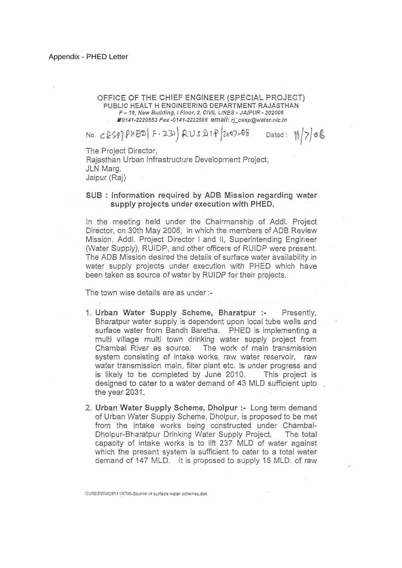
Appendix - PHED Letter

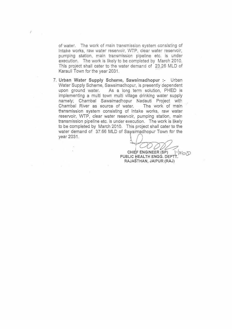

64
Appendix – 3
RAPID ENVIRONMENTAL ASSESSMENT (REA) CHECKLIST
Country/Project Title: India/Rajasthan (Barmer) Urban Sector Development Investment Programme (Tranche-II).
Sub-Project: Water Supply Project in Barmer.
SCREENING QUESTIONS Yes No REMARKS A. Project Siting Is The Project Area…
There is no protected/ sensitive area along the Water Supply line.
Densely Populated?
No
Heavy with Development Activities?
No
Adjacent To or Within Any Environmentally Sensitive Areas?
No
• Cultural Heritage Site
No
• Protected Area
No
• Wetland
No
• Mangrove
No
• Estuarine
No
• Buffer Zone of Protected Area
No
• Special Area for Protecting Biodiversity
No
• Bay
No
B. Potential Environmental Impacts Will The Project Cause…
Pollution of raw water supply from upstream wastewater discharge from communities industries, agriculture and soil erosion runoff
No No such impact is anticipated.

65
SCREENING QUESTIONS Yes No REMARKS Impairment of
historical/cultural/monuments/areas and loss/damage to these sites.
No There are no historical/cultural/monuments/ area falls within the project area.
Hazards of land subsidence caused by excessive ground water pumping.
No Indra Ghandi Canal is the source of water for this project and location of intake point is Mohangarh in Jaisalmer District.
Social conflicts arising from displacement of communities.
No No need of R& R for this project.
Conflicts in abstraction of raw water for water supply with other beneficial water uses for surface and ground waters?
No Not applicable as said above that source of water is Indira Gandhi canal in Jaisalmer District.
Unsatisfactory raw water supply (e.g excessive pathogens or mineral constituents)
No There will be treatment of raw water before distribution and regular water monitoring will be carried out by the line department (PHED)
Dilivery of unsafe water to distribution system.
No Raw water will be treated before distribution and this will be ensured by line department (PHED).
Inadequate protection of intake works or wells, leading to pollution of water supply.
No As said above that source of water is Indira Gandhi canal.
Over pumping of ground water, leading to salinaization and ground subsidence.
No No use of ground water as said above that source of intake water is Indira Gandhi canal at Mohangarh in Jaisalmer District.
Excessive alagae growth in storage reservoir.
No Water tanks will be covered and treated properly to avoid any algal growth.
Increase in production of sewrage beyond capabilities of community facility.
No No such impact is anticipated as new sewerage system has been proposed for this area based on projected waste water estimates.
Inadequate disposal of sludge from water treatment plants
No There will be proper sludge disposal from water treatment plant at pre-designated locations.
Inadequate buffer zone around pumping and treatment plants to alleviate noise and other possible nuisances and protect facilities.
Yes There are chances of increase in noise in the vicinity of pumping stations during operation stage. To minimize or reduce noise levels noise enclosures will be installed around noisy machine. Also Environmental Management Plan will be implemented during construction and operation stage properly.
Impairment associated with transmission lines and access roads.
Yes Temporary impairment with access roads is anticipated. This will be mitigated through alternative arrangements.
Health hazards arising from inadequate design of facilities for receiving storing and handling chlorine cylinders.
No New chlorination plant will be considered with proper storing arrangement
Health and safety hazards to workers from the management of chlorine used for disinfection and other contaminants
No During use of chlorine gas personal protective equipment will be used

66
SCREENING QUESTIONS Yes No REMARKS Resettlement problems in areas
requiring large plots of land. No No resettlement is required for
proposed project. Noise and dust from construction
activities.
Yes Little increase in noise levels and dust emission is anticipated from construction activities and shall be contained by taking proper mitigation measures as and when required.
Increased road traffic due to interference of construction activities.
Yes Proper traffic management and planning will be carried out during construction.
Continuing soil erosion/silt runoff from construction operations
No Trenches will be filled back and restored to its original conditions. However EMP will be implemented to ensure proper disposal of any surplus soil.
Delivery of unsafe water due to poor O&M treatment processes (especially mud accumulations in filters) and inadequate chlorination due to lack of adequate monitoring of chlorine residuals in distribution system.
No The line department will ensure safe water distribution. For this regular monitoring will be carried out by PHED.
Delivery of water to distribution system which is corrosive due to inadequate attention to feeding of corrective chemicals.
No The line department will ensure about non corrosiveness of distribution system before distributing this water. For this regular monitoring will be carried out by PHED.
Accidental leakage of chlorine gas. No Proper care will be taken up for storing of chlorine cylinder
Excessive abstraction of water affecting downstream water users.
No Water from Indira Gandhi canal will be used to meet the requirement of this project.
Competing uses of water. No No such competition is envisaged as sufficient water is available in IG canal downstream.
Increase sewerage flow due to increased water supply.
No New sewerage system has been proposed based on increased water supply estimates.
Increased volume of sewage sludge (wastewater from cooking and washing and sludge from wastewater treatment plant)
No New sewerage and drainage system has been proposed based on increased water supply and storm water.

67
Appendix -4
PUBLIC CONSULTATION- ENVIRONMENT
CWR Site (Water Supply) Barmer
Issues discussed
Awareness and extent of the project and development components
Benefits of Project for the economic and social Upliftment of Community
Labour availability in the Project area or requirement of outside labour involvement
Local disturbances due to Project Construction Work
Necessity of tree felling etc. at project sites
Water logging and drainage problem if any
Drinking water problem
Forest and sensitive area nearby the project site
Movement of wild animal etc.
1. Date & time of Consultation: 19.06.08 at 5.00 PM
2. Location: Agar Village back side of Circuit House
.Table: Issues of the Public Consultation- Design phase
Sr. No. Key Issues/Demands Perception of community
1 Awareness of the project – including coverage area
Only few people know about the project and its coverage area.
2 In what way they may associate with the project
People expect some employment opportunities from project.
3 Presence of any forest, wild life or any sensitive / unique environmental components nearby the project area
No forest area and no wildlife nearby the project area
4 Presence of historical/ cultural/ religious sites nearby
No such site exists in the area
5 Un favorable climatic condition
Few days during rainy season.
6 Occurrence of flood Occurrence of flood very rare
7 Drainage and sewerage problem
No as such problem in this area.

68
Sr. No. Key Issues/Demands Perception of community
facing
8 Present drinking water problem – quantity and quality
Both quantity and quality of water is a problem high TDS and fluoride level
9 Present solid waste collection and disposal problem
No such facility exists in this area.
10 Availability of labour during construction time
Surplus Labour available.
11 Access road to project site
Not very good accessibility.
12 Perception on tree felling and afforestation
No tree felling will be required for this project.
13 Dust and noise pollution and disturbances during construction work
No impact expected
14 Setting up worker camp site within the village/ project locality
People are agreed to provide land for labour camp.
15 Safety of residents during construction phase and plying of vehicle for construction activities
As discussed with local people.- safety of residents is not a problem at all – mitigation measures will be applied
16 Conflict among beneficiaries down stream users – water supply project using of river water
Not applicable.
17 Requirement of enhancement of other facilities
Yes people want other enhancement facility.
18 Whether local people agreed to sacrifice their lands (cultivable or not) for beneficial project after getting proper compensation
People are not agreed to sell their land. But project land belongs to Government.
NAME AND POSITION OF PERSONS CONSULTED
1. Mr. Bhakkhar Singh Mahecha. Sarpanch
2. Mr. Om Prakash Gram Sewak

69
3. Mr. Kesa Ram Teacher
4. Mr. Naval Kishore Ulawal Student
5. Mr. Diup Kumar Lahwa Student
6. Mr. Narayan Ram Job
7. Mr. Tejpal Singh Labour
8. Mr. Mula Ram Gram Sewak
9. Mr. Bhupendra Singh Jr. Engineer
10. Mr. Vijay Singh Contractor
11. Mr. Rawat Singh Teacher
PUBLIC CONSULTATION- ENVIRONMENT
CWR (Pumping Station) Barmer
1. Date & time of Consultation: 9.06.08 at 5.00 PM
2. Location : Near Karali Nandi
.Table: Issues of the Public Consultation- Design phase
Sr. No. Key Issues/Demands Perception of community
1 Awareness of the project – including coverage area
No one is aware about this Project and Coverage area
2 In what way they may associate with the project
People want employment and job during construction phase of project
3 Presence of any forest, wild life or any sensitive / unique environmental components nearby the project area
No project land and wildlife in the vicinity of area
4 Presence of historical/ cultural/ religious sites nearby
No historical / cultural / Religious site near project area. One Primary school is in the vicinity of site
5 Un favorable climatic condition
No, All climatic conditions are favourable
6 Occurrence of flood Very rare
7 Drainage and sewerage problem facing
There is no drainage and sewerage problem in this area
8 Present drinking water problem – quantity and quality
Water is available which fulfilled only needs of local people. TDS level is very high.
9 Present solid waste collection and disposal
No facility for Solid waste management. No landfill site

70
Sr. No. Key Issues/Demands Perception of community
problem in this area
10 Availability of labour during construction time
Surplus Labour is available in this area.
11 Access road to project site
Good accessibility
12 Perception on tree felling and afforestation
Only few bushes will be removed
13 Dust and noise pollution and disturbances during construction work
No dust and noise problem expected by local people
14 Setting up worker camp site within the village/ project locality
People will cooperate for setting up worker camp
15 Safety of residents during construction phase and plying of vehicle for construction activities
Within the area people think that there will be least chances of accidents during construction
16 Conflict among beneficiaries downstream users – water supply project using of river water
Not applicable.
17 Requirement of enhancement of other facilities
Providing water facility is priority in this area.
18 Whether local people agreed to sacrifice their lands (cultivable or not) for beneficial project after getting proper compensation
All land belongs to Govt. hence there is no need of sacrificing land by local people. But people agreed to sacrifice uncultivable land if required
NAME AND POSITION OF PERSONS CONSULTED
1. Mr. Devi Singh Carpenter
2. Mr. Kanu Student
3. Mr. Babu Singh Sub Contractor
4. Mr. Deravar Singh Shopkeeper
5. Mr. Umadh Singh Shopkeeper
6. Mr. Uma Ram Mali Shopkeeper
7. Mr. Ashish Makar Doctor
8. Mr. loon Singh Santhti Driver

71
9. Mr. Om Singh Driver
10. Mr. Neer Singh Govt. Employee
11. Mr. jetha Ram Worker
PUBLIC CONSULTATION- ENVIRONMENT
Pumping Station for water Project Barmer
1. Date & time of Consultation 3:00 PM on 19/06/08
2. Location: Ambedkar Circle barmer / or Chittorgarh crossing
.Table: Issues of the Public Consultation- Design phase
Sr. No. Key Issues/Demands Perception of community
1 Awareness of the project – including coverage area
People are not aware about this project and coverage of the area
2 In what way they may associate with the project
People agreed to associate the project as labour force
3 Presence of any forest, wild life or any sensitive / unique environmental components nearby the project area
Forest area is about 2 Km from proposed site. No wildlife near by area
4 Presence of historical/ cultural/ religious sites nearby
One old temple about 2 Km from proposed site.
5 Un favorable climatic condition
No unfavourable climatic condition.
6 Occurrence of flood Very Rare
7 Drainage and sewerage problem facing
No drainage and sewerage problem. Here is natural slope for drainage and sewerage.
8 Present drinking water problem – quantity and quality
Only raw ground water is available at a depth of atleast 250 ft. Quality of water is good as discussed with people
9 Present solid waste collection and disposal problem
There is no scientific landfill site. The area is used by Municipality as dumping ground
10 Availability of labour during construction time
Surplus Labour is available
11 Access road to project site
Good accessibility
12 Perception on tree felling and afforestation
No tree felling involved in project
13 Dust and noise pollution and disturbances during
Dust is major problem in this area, people are exposed high noise level and dust

72
Sr. No. Key Issues/Demands Perception of community
construction work pollution
14 Setting up worker camp site within the village/ project locality
People prefer that local labour should employ and there is no need of labour camp for local labour.
15 Safety of residents during construction phase and plying of vehicle for construction activities
People think that there is no safety problem during construction phase.
16 Conflict among beneficiaries down stream users – water supply project using of river water
Not applicable
17 Requirement of enhancement of other facilities
Kareli Nadi talab is located nearby the sub-project site. Presently condition of pond is very poor. People demanded renovation of the pond
18 Whether local people agreed to sacrifice their lands (cultivable or not) for beneficial project after getting proper compensation
People do not want to sacrifice cultivable land in project area.
NAME AND POSITION OF PERSONS CONSULTED
1. Mr Uggam Singh Police Constable
2. Mr. Rewa Singh Shopkeeper
3. Mr. Halwant Singh Job
4. Mr. Sawai Singh Farmer
5. Mr. Haduram Labur
6. Mr. Ismail Teacher
7. Mr. Aziz Farmer
8. Mr. Bhura Ram Agricultural labour
9. Mr. Ratan Lal Astrologist
10. Mr. Pushpendra Singh Farmer
PUBLIC CONSULTATION- ENVIRONMENT
Proposed OSHR site for water supply project
1. Date & time of Consultation: 6:30 PM on 20/06/08

73
2. Location Jogiyon Ki Dadi Barmer
.Table: Issues of the Public Consultation- Design phase
Sr. No.
Key Issues/Demands Perception of community
1 Awareness of the project – including coverage area
People are not aware about the project and coverage area
2 In what way they may associate with the project
People want to associate the project as project staff
3 Presence of any forest, wild life or any sensitive / unique environmental components nearby the project area
No wildlife and Forest area near project site
4 Presence of historical/ cultural/ religious sites nearby
No there is not any historical / cultural / religious sites nearby
5 Un favorable climatic condition Unfavourable condition exist in few of the days during monsoon
6 Occurrence of flood Very rare. Only last year in last 100 years there was flood.
7 Drainage and sewerage problem facing
No such problem in this area
8 Present drinking water problem – quantity and quality
Shortage of supply water. Only tanker water is used in this area. Quality of water is good
9 Present solid waste collection and disposal problem
There is no proper facility for solid waste disposal
10 Availability of labour during construction time
Surplus labour available in this area
11 Access road to project site Good access road available
12 Perception on tree felling and afforestation
No tree felling is involved
13 Dust and noise pollution and disturbances during construction work
Dust and Noise pollution is not a problem.
14 Setting up worker camp site within the project locality
People allowed setting up of labour camp in this area.
15 Safety of residents during construction phase and plying of vehicle for construction activities
No such risk is involved as discussed with people.
16 Conflict among beneficiaries down stream users – water supply project using of river water
Not applicable.
17 Requirement of enhancement of other facilities
Requirement of water is only priority in this area.
74
Sr. No.
Key Issues/Demands Perception of community
18 Whether local people agreed to sacrifice their lands (cultivable or not) for beneficial project after getting proper compensation
People agreed to sacrifice their land for the project.
NAME AND POSITION OF PERSONS CONSULTED
1. Mr. Narayan Driver
2. Mr. Bhairam Singh Truck owner
3. Mr. Lumba Ram Driver
4. Mr. Dewa Ram Driver
5. Mr. Bagga Ram Labour
6. Mr. Hanuman Driver
7. Mr. Lassa Ram Driver
8. Mr. Sura Ram Shopkeeper