environmental assessment report for the 109578 file swaziland eia report rev01.docx 1 april 2014...
TRANSCRIPT

Project 109578 File Swaziland EIA report rev01.docx 1 April 2014 Revision 1
Environmental Assessment Report for the Environmental Impact Assessment: The Proposed Upgrade and new Construction related to the Development of the Swaziland Rail Link Project, from the Sandlane border, through Sidvokodvo to the Lavumisa border.
Environmental Assessment Report for the Sandlane to Lavumisa section of the Swazi
Reference: 109578
Prepared for: Swaziland Railway
Revision: 1
1 April 2014


Project 109578 File Swaziland EIA report rev01.docx 1 April 2014 Revision 1
Environmental Assessment Report for the Environmental Impact Assessment: The Proposed Upgrade and new Construction related to the Development of the Swaziland Rail Link Project, from the Sandlane border, through Sidvokodvo to the Lavumisa border.
Date 1 April 2014
Reference 109578
Revision 1
Aurecon South Africa (Pty) Ltd
1977/003711/07
Aurecon Centre Lynnwood Bridge Office Park 4 Daventry Street Lynnwood Manor 0081
PO Box 74381 Lynnwood Ridge 0040 South Africa
T
F
E
W
+27 12 427 2000
+27 86 556 0521
aurecongroup.com

Project 109578 File Swaziland EIA report rev01.docx 1 April 2014 Revision 1
EXECUTIVE SUMMARY
INTRODUCTION
Aurecon South Africa (Pty) Ltd have been appointed by Transnet State Owned Company (SOC) Ltd (hereafter
referred to as Transnet) in collaboration with Swaziland Railway to undertake an Environmental Impact
Assessment process in an effort to obtain authorisation for the proposed Swaziland Railway Link and associated
upgrades project.
PROJECT BACKGROUND AND MOTIVATION
Transnet in collaboration with Swaziland Railway identified the construction and upgrade of the railway line
between Davel in Mpumalanga and Richards Bay in KwaZulu-Natal, connecting via the Swaziland Rail Network, as
a strategic project. The aim of the project is to unlock the potential of a multinational strategic rail corridor and divert
general freight traffic off the dedicated heavy haul Richards Bay Coal Line which runs from Ermelo through rural
KwaZulu-Natal to Richards Bay.
The project activities will consist of various works, including the upgrading of existing railway sections (including re-
building certain sections), construction of an entirely new rail link from Lothair in South Africa to Sidvokodvo in
Swaziland and construction of new rail yards.
The project holds significant advantages in relieving the general freight bound pressure on the Richards Bay Coal
Line. It provides a strategic link to congested South African export ports, as well as encouraging economic and rail
transport growth in Swaziland, thus in turn reducing the need for road transport and minimising damage to roads
from heavy vehicles.
ENVIRONMENTAL ASSESSMENT REQUIREMENTS
According to The Environmental Management Act no 5 of 2002, no person shall undertake any project that may
have an effect on the environment without the written approval of the Authority. The applicable Authority is the
Swaziland Environmental Authority (SEA).
Furthermore, any person proposing to undertake such a project shall submit a project brief to the Authority
containing sufficient information to enable the Authority to determine the potential impacts of the project on the
environment. Such a project brief was submitted to the SEA by Swaziland Railway. It was the SEA’s opinion that
the proposed project is likely to have more than a minimal or insignificant effect on the environment and Aurecon
was therefore required to conduct an environmental impact assessment (EIA).
This document outlines the EIA process followed, describes the proposed development and the context in which it
will take place, and identifies the potential environmental impacts. It presents the identification of key issues or
concerns as highlighted by the relevant authorities, Interested and/or Affected Parties (I&APs) and professional
judgement of the Environmental Assessment Practitioner (EAP). The results of the specialist studies, a full
assessment of the impacts and proposed alternatives form part of this EIA report.
PUBLIC PARTICIPATION AND STAKEHOLDER ENGAGEMENT
In order to afford the Interested and Affected Parties (I&APs) the opportunity to become involved and be part of the
process the public participation process as set out in Chapter 4 was followed. During the process I&APs have been
afforded the opportunity to raise issues of concern, which has been recorded and included in the Environmental
Assessment Report.

Project 109578 File Swaziland EIA report rev01.docx 1 April 2014 Revision 1
The public participation process was initiated by the placement of an advertisement, in the prescribed format, in the
following newspapers:
Bhunya (7 & 13 August 2013);
Luyengo (7 & 13 August 2013);
Siphofaneni (7 & 14 August 2013); and
Big Bend (7 & 14 August 2013).
The newspaper advertisements provided details of the activities proposed by Swaziland Railway, requested I&APs
to register and to become involved in the EIA process of the proposed project.
The following Scoping meetings were also held where Swaziland Railway presented the proposed project to all
I&APs present at the meeting:
Bhunya: 19 August 2013;
Luyengo: 21 August 2013;
Siphofaneni: 21 November 2013; and
Big Bend: 22 November 2013.
IDENTIFICATION OF KEY ENVIRONMENTAL ISSUES AND PLAN OF STUDY FOR THE EIR
A baseline description of the environment was gathered through visual inspections of the site and its surroundings,
desktop studies as well as specialist findings. This information was used to assess the potential areas of study, as
a result of the proposed development.
Construction phase impacts on the physical, biophysical and socio-economic environment that would occur during
the construction phase of the proposed project were assessed. They are inherently temporary in duration, but may
have longer lasting effects e.g. pollution of a wetland during construction could have effects that may last long after
construction is over. Construction phase impacts could potentially include the following:
Direct impacts:
o Visual impact of the infrastructure;
o Windblown dust from excavations and upgrade activities;
o Impact on ambient noise levels;
o Litter/waste production;
o Impact on terrestrial flora
o Impact on terrestrial fauna;
o Impact on aquatic ecosystems;
o Erosion;
o Sedimentation;
o Loss of topsoil;
o Traffic impacts;
o Deterioration of water quality; and
o Temporary employment opportunities.
Indirect impacts:
o Windblown dust from access roads;
o Disturbance to adjoining landowners;
o Security risks; and
o Social impact on local communities.

Project 109578 File Swaziland EIA report rev01.docx 1 April 2014 Revision 1
It should be noted that a Comprehensive Mitigation Plan (CMP) has been developed to regulate and minimise the
impacts during the construction phase and forms part of this report. The CMP is attached in Appendix E.
The potential positive and negative operational phase impacts that were identified in the Scoping Phase can be
divided into three categories; namely impacts on the biophysical environmental, impacts on the social, economic
and cultural environment as well as impacts on health and safety. The following potential impacts are investigated
in detail in Chapter 8.
Impacts on the biophysical environment:
o Ecological;
o Geohydrological; and
o Noise and vibration.
Impacts on the social, economic and cultural environment:
o Social;
o Economic and socio-economic; and
o Cultural, heritage and archaeological.
Impacts on health and safety:
o Health;
o Safety; and
o Security.
CONCLUSION
The EIR provides a description of the feasible alternatives and potential impacts identified during the Scoping and
Environmental Phases. It also contains additional information on the affected environment, mostly drawn from the
specialist studies conducted. There is a description and assessment of the potential impacts associated with the
various feasible alternatives as well as an indication of potential mitigation measures, conclusions and various
recommendations with regard to the way forward. A series of Appendices and Annexures containing relevant
information, including the various specialist studies is attached to this report.

Project 109578 File Swaziland EIA report rev01.docx 01 April 2014 Revision 1
Contents 1 INTRODUCTION 2
1.1 Details of the EAP 2
1.2 Introduction to the Project Team 3
1.3 Project background 4
1.4 Need for the project 8
1.5 Project description 9
1.6 Proposed alignment alternatives for the Swaziland Railway Link Project 13
1.7 Project location 17
2 LEGISLATIVE FRAMEWORK 18
2.1 The Constitution of the Kingdom of Swaziland Act 18
2.2 The Environmental Management Act No 5 of 2002 18
2.3 Other applicable legislation 20
2.4 Regulations 23
3 THE EIA PROCESS DESCRIPTION 25
3.1 The Swaziland Environmental Authority 25
3.2 EIA procedural framework in Swaziland for new projects 25
3.3 Assumptions and limitations 29
4 THE PUBLIC PARTICIPATION PROCESS (PPP) 30
4.1 Public review of the EIA and CMP reports 30
4.2 The Public Participation Process up to date 31
4.3 Predicted schedule for the EIA 31
5 BASELINE ENVIRONMENTAL DESCRIPTION 33
5.1 Physical environment 33
5.2 Biophysical environment 36
5.3 Social environment 40
6 ISSUES IDENTIFIED DURING THE SCOPING PHASE 46
6.1 Issues raised by the specialists 46
6.2 Issues raised during the Public Participation Process 48
6.3 Institutional and legal aspects raised during the scoping phase 49
7 ASSESSMENT METHODOLOGY 50
8 ASSESSMENT OF POTENTIAL IMPACTS AND PROPOSED MITIGATION MEASURES 55
8.1 Introduction 55

Project 109578 File Swaziland EIA report rev01.docx 01 April 2014 Revision 1
8.2 Impacts on the Biophysical Environment 55
8.3 Impacts on the Physical Environment 129
8.4 Impacts on the Social and Socio-economic Environment 137
9 CONCLUSIONS AND RECOMMENDATIONS 163
9.1 Recommendations 164
10 REFERENCES 166
Appendices
Appendix A
Curriculum Vitae of the Environmental Assessment Practitioners
Appendix B
Specialist input reports
Appendix C
Public Participation documents
Appendix D
Communication with SEA
Appendix E
Comprehensive Mitigation Plan
Appendix F
Waste Management Plan
Figures
Figure 1: General layout of the entire Swaziland Railway Link from Davel to Nsezi, The red (preferred)
and purple (second alternative) lines indicated the new link alternatives from Lothair to
Sidvokodvo. 7
Figure 2: Initial alternative routes identified for the Swaziland Railway Link alignment 14
Figure 3: Regions affected by the proposed development – the red line indicates the new link line
proposed to be constructed. The blue line indicates the proposed upgrading of the existing railway
line. 17
Figure 4: Aerial image indicating potential noise-sensitive developments 36
Figure 5: The Sandlane to Lavumisa proposed route 37
Figure 6: Preliminary Biodiversity and Tourism Corridors based on C-Plan irreplaceability scores
(Emery et al., 2001) with important areas with biodiversity and tourism value shown in red. 38
Figure 7: The project locality (red line) in relation to the respective quarternary catchments 40
Figure 8: Regions of Swaziland and their administrative centres 41
Figure 9: Population pyramid (IndexMundi, 2013) 42

Project 109578 File Swaziland EIA report rev01.docx 01 April 2014 Revision 1
Figure 10: Unemployment rate 44
Figure 11: Typical landscape within the western portion of the study area 56
Figure 12: The project near Bhunya, where the rail line will follow the southern banks Usutu River. 57
Figure 13: The proposed line will follow the course of the Usutu River towards Manzini with the relative
alignment shown by the red arrow 57
Figure 14: Vegetation Map for Swaziland (Mucina and Rutherford, 2005) 58
Figure 15: The project locality (red line) in relation to the respective quaternary catchments (Info
Source South African Department of Water Affairs & Google Earth).Error! Bookmark not defined.
Figure 16: The main-stem rivers found along the rail line alignment, with the inset showing the seep
wetland areas delineated during the study Error! Bookmark not defined.
Figure 17: Excess ballast falls into the culverts that creates berms, which then impedes flow.Error! Bookmark not defined.
Figure 18: Preliminary Biodiversity and Tourism Corridors based on C-Plan irreplaceability scores
(Emery et al., 2001) with important areas with biodiversity and tourism value shown in red.Error! Bookmark not defined.
Figure 19: Key Biodiversity Areas (KBA) mapped in the Maputoland-Pondoland Albany Hotspot
(MPAH) conservation plan, which intersect the railway alignment. Note that all these KBA are
incorporated into the MPAH corridors, apart from the KZN Coastal Belt W1 area between Mfolozi
and Richards Bay. Error! Bookmark not defined.
Figure 20: Important Corridors according to the Maputoland-Pondoland Albany Hotspot (MPAH)
conservation plan intersecting the railway alignment. The climate change corridors indicate those
areas most important for enhancing resilience to climate change impacts.Error! Bookmark not defined.
Figure 21: Important taxa (species) as point data, mapped according to species location in a Quarter
Degree Square (i.e. an area of ± 30 km X 30 km covered by one 1:50 000 topographical map) by
the Maputaland-Pondoland-Albany Biodiversity Hotspot conservation plan (SANBI, 2010) in
Swaziland. Error! Bookmark not defined.
Figure 22: An example of an elevated culvert that has raised the level of the riverbed resulting in a
form of habitat fragmentation. Error! Bookmark not defined.
Figure 23: Mean Annual Precipitation (mm) for all sections of the Transnet Swazi Rail LinkError! Bookmark not defined.
Figure 24: Runoff (mm) for all sections of the Transnet Swazi Rail Link Error! Bookmark not defined.
Figure 25: Soil types for all sections of the Transnet Swazi Rail Link Error! Bookmark not defined.
Figure 26: Geology for all sections of the Transnet Swazi Rail Link Error! Bookmark not defined.
Figure 27: Land cover for all sections of the Transnet Swazi Rail Link Error! Bookmark not defined.
Figure 28: Major river crossings for Sandlane to Lavumisa Error! Bookmark not defined.
Figure 29: Aerial view Msuzwaneni River crossing Error! Bookmark not defined.
Figure 30 | 2000 m upstream the river crossing Error! Bookmark not defined.
Figure 31: Aerial view Mhlofunga River crossing Error! Bookmark not defined.
Figure 32: Site view Error! Bookmark not defined.
Figure 33: View of Mhlofunga River crossing Error! Bookmark not defined.
Figure 34: Looking upstream Mhlofunga crossing Error! Bookmark not defined.
Figure 35: Looking downstream Mhlofunga crossing Error! Bookmark not defined.
Figure 36: Aerial view Ngwavuma River crossing Error! Bookmark not defined.
Figure 37: Site view Error! Bookmark not defined.
Figure 38: View of Ngwavuma River crossing Error! Bookmark not defined.
Figure 39: Looking upstream Ngwavuma crossing Error! Bookmark not defined.
Figure 40: Looking downstream Ngwavuma crossing Error! Bookmark not defined.
Figure 41: Aerial view crossing 18 Error! Bookmark not defined.
Figure 42: View of River crossing Error! Bookmark not defined.
Figure 43: Looking upstream Error! Bookmark not defined.
Figure 44: Looking downstream Error! Bookmark not defined.
Figure 45: Aerial view crossing 19 Error! Bookmark not defined.

Project 109578 File Swaziland EIA report rev01.docx 01 April 2014 Revision 1
Figure 46: View of river crossing Error! Bookmark not defined.
Figure 47: Looking upstream Error! Bookmark not defined.
Figure 48: Looking downstream Error! Bookmark not defined.
Figure 49: Aerial view Mhlatuze crossing Error! Bookmark not defined.
Figure 50: Rocky outcrop river bed 3000m downstream crossing Error! Bookmark not defined.
Figure 51: Aerial view USuthu River crossing Error! Bookmark not defined.
Figure 52: Irrigation water abstraction Error! Bookmark not defined.
Figure 53: View of USuthu river crossing Error! Bookmark not defined.
Figure 54: Looking upstream of uSuthu crossing Error! Bookmark not defined.
Figure 55: Looking downstream of uSuthu crossing Error! Bookmark not defined.
Figure 56: Aerial view Mzimneni River crossing Error! Bookmark not defined.
Figure 57: View of Mzimneni river crossing Error! Bookmark not defined.
Figure 58: Signs of erosion from fast flows and floods during rainy seasonError! Bookmark not defined.
Figure 59: Looking upstream of Mzimneni crossing Error! Bookmark not defined.
Figure 60: Looking downstream of Mzimneni crossing Error! Bookmark not defined.
Figure 61: Ariel view of Mhlamani crossing Error! Bookmark not defined.
Figure 62: Aerial view Sidvokodvo crossing Error! Bookmark not defined.
Figure 63: View of Sidvokodvo river crossing Error! Bookmark not defined.
Figure 64: Looking upstream of Sidvokodvo crossing Error! Bookmark not defined.
Figure 65: Looking downstream of Sidvokodvo crossing Error! Bookmark not defined.
Figure 66: Aerial view USuthu crossing Error! Bookmark not defined.
Figure 67: Irrigation water abstraction Error! Bookmark not defined.
Figure 68: Aerial view Umhlambahula crossing Error! Bookmark not defined.
Figure 69: Cross-section of Umhlambahula crossing Error! Bookmark not defined.
Figure 70: Looking upstream of Umhlambahula crossing Error! Bookmark not defined.
Figure 71: Looking downstream of Umhlambahula crossing Error! Bookmark not defined.
Figure 72: Aerial view USuthu crossing Error! Bookmark not defined.
Figure 73: Cross-section of USuthu crossing Error! Bookmark not defined.
Figure 74: Looking upstream of USuthu crossing Error! Bookmark not defined.
Figure 75: Looking downstream of USuthu crossing Error! Bookmark not defined.
Figure 76: Aerial view Mpuluzi crossing Error! Bookmark not defined.
Figure 77: Cross-section of Mpuluzi crossing Error! Bookmark not defined.
Figure 78: Looking upstream of Mpuluzi crossing Error! Bookmark not defined.
Figure 79: Looking downstream of Mpuluzi crossing Error! Bookmark not defined.
Figure 80: Ariel view of river crossing Error! Bookmark not defined.
Figure 81: Aerial view Mpuluzi crossing Error! Bookmark not defined.
Figure 82: Cross-section of Mpuluzi crossing Error! Bookmark not defined.
Figure 83: Looking upstream of Mpuluzi crossing Error! Bookmark not defined.
Figure 84: Looking downstream of Mpuluzi crossing Error! Bookmark not defined.
Figure 85: Ariel view of USuthu crossing Error! Bookmark not defined.
Figure 86: Phuzumoya Yard Error! Bookmark not defined.
Figure 87: Watercourse 300m from Phuzumoya Yard Error! Bookmark not defined.
Tables
Table 1: Train traction requirements 11
Table 2: PPP to date 31
Table 3: Public consultation for the EIA - proposed dates 31
Project 109578 File Swaziland EIA report rev01.docx 01 April 2014 Revision 1
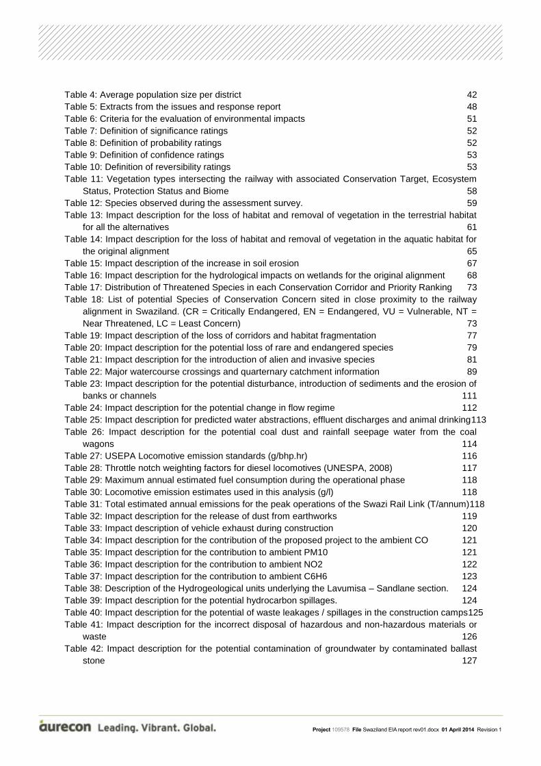
Table 4: Average population size per district 42
Table 5: Extracts from the issues and response report 48
Table 6: Criteria for the evaluation of environmental impacts 51
Table 7: Definition of significance ratings 52
Table 8: Definition of probability ratings 52
Table 9: Definition of confidence ratings 53
Table 10: Definition of reversibility ratings 53
Table 11: Vegetation types intersecting the railway with associated Conservation Target, Ecosystem
Status, Protection Status and Biome 58
Table 12: Species observed during the assessment survey. 59
Table 13: Impact description for the loss of habitat and removal of vegetation in the terrestrial habitat
for all the alternatives 61
Table 14: Impact description for the loss of habitat and removal of vegetation in the aquatic habitat for
the original alignment 65
Table 15: Impact description of the increase in soil erosion 67
Table 16: Impact description for the hydrological impacts on wetlands for the original alignment 68
Table 17: Distribution of Threatened Species in each Conservation Corridor and Priority Ranking 73
Table 18: List of potential Species of Conservation Concern sited in close proximity to the railway
alignment in Swaziland. (CR = Critically Endangered, EN = Endangered, VU = Vulnerable, NT =
Near Threatened, LC = Least Concern) 73
Table 19: Impact description of the loss of corridors and habitat fragmentation 77
Table 20: Impact description for the potential loss of rare and endangered species 79
Table 21: Impact description for the introduction of alien and invasive species 81
Table 22: Major watercourse crossings and quarternary catchment information 89
Table 23: Impact description for the potential disturbance, introduction of sediments and the erosion of
banks or channels 111
Table 24: Impact description for the potential change in flow regime 112
Table 25: Impact description for predicted water abstractions, effluent discharges and animal drinking113
Table 26: Impact description for the potential coal dust and rainfall seepage water from the coal
wagons 114
Table 27: USEPA Locomotive emission standards (g/bhp.hr) 116
Table 28: Throttle notch weighting factors for diesel locomotives (UNESPA, 2008) 117
Table 29: Maximum annual estimated fuel consumption during the operational phase 118
Table 30: Locomotive emission estimates used in this analysis (g/l) 118
Table 31: Total estimated annual emissions for the peak operations of the Swazi Rail Link (T/annum)118
Table 32: Impact description for the release of dust from earthworks 119
Table 33: Impact description of vehicle exhaust during construction 120
Table 34: Impact description for the contribution of the proposed project to the ambient CO 121
Table 35: Impact description for the contribution to ambient PM10 121
Table 36: Impact description for the contribution to ambient NO2 122
Table 37: Impact description for the contribution to ambient C6H6 123
Table 38: Description of the Hydrogeological units underlying the Lavumisa – Sandlane section. 124
Table 39: Impact description for the potential hydrocarbon spillages. 124
Table 40: Impact description for the potential of waste leakages / spillages in the construction camps125
Table 41: Impact description for the incorrect disposal of hazardous and non-hazardous materials or
waste 126
Table 42: Impact description for the potential contamination of groundwater by contaminated ballast
stone 127

Project 109578 File Swaziland EIA report rev01.docx 01 April 2014 Revision 1
Table 43: Impact description for potential spillages of hazardous materials resulting from accidents or
collisions 127
Table 44: Impact description for potential wind-blown material emanating from uncovered rail trucks128
Table 45: Impact description of the initial day and night scenario 129
Table 46: Impact description of the future day and night scenario 130
Table 47: Summary of identified heritage resources Error! Bookmark not defined.
Table 48: Impact description of the possible disturbance of cultural and heritage resources 135
Table 49: Impact description for the creation of employment opportunities 139
Table 50: Impact description for opportunities for local sourcing of goods and services 140
Table 51: Impact description for the improvement of road infrastructure 141
Table 52: Impact description for local and regional economic benefits 142
Table 53: Impact description for the increased support from government and/or project implementers143
Table 54: Impact description for possible social pathologies arising from population influx 145
Table 55: Impact description for the creation of informal settlements 147
Table 56: Impact description for the accommodation of construction staff 148
Table 57: Impact description for physical intrusion (construction phase) 150
Table 58: Impact description for physical intrusion (operational phase) 150
Table 59: Impact description for the displacement of people / households 151
Table 60: Impact description for the predicted community perceptions and responses 153
Table 61: Impact description for the creation and sustainment of employment opportunities 154
Table 62: CAPEX of work packages assigned to Mpumalanga, Swaziland and KwaZulu-Natal 157
Table 63: Estimated capital expenditure (CAPEX) project values and imports (Current 2013 prices,
Rand Million) 157
Table 64: Annual estimated total operational expenditure and capitalised operational expenditure
(Current 2013 prices, Rand Million) 158
Table 65: Macro-economic impact of CAPEX (Current 2013 prices, Rand Millions) 158
Table 66: Macro-economic impact of annual OPEX (Current 2013 prices, Rand Millions) 160
Table 67: Impact description for the regional macro-economic CAPEX 160
Table 68: Impact description for the local macro-economic CAPEX 161
Table 69: Impact description for the regional macro-economic OPEX 161

Project 109578 File Swaziland EIA report rev01.docx 01 April 2014 Revision 1
ABBREVIATIONS AND ACRONYMS
AIDS Acquired Immunodeficiency Syndrome
AQIA Air Quality Impact Assessment
BTC Biodiversity and Tourism Corridors
C6H6 Benzene
CAPEX Capital Expenditure
CMP Comprehensive Mitigation Plan
CO Carbon Monoxide
CV Curriculum Vitae
dBA Decibels
DP Distributed Power
DRC Democratic Republic of the Congo
EAARR The Environmental Audit, Assessment and Review Regulations of 2000
EAP Environmental Assessment Practitioner
ECC Environmental Compliance Certificate
ECO Environmental Control Officer
EHS Environmental, Health and Safety
EIA Environmental Impact Assessment
EIR Environmental Impact Report
EIS Ecological Importance and Sensitivity
EMA Environmental Management Act, 5 of 2002
ENIA Environmental Noise Impact Assessment
ERS Economic Recovery Strategy
FDI Foreign Direct Investment
FEL Front End Loading
GDP Gross Domestic Product
GFCF Gross Fixed Capital Formation
GIS Geographic Information System
GVA Gross Value Added
HC Hydrocarbon
HIA Heritage Impact Assessment
HIV Human Immunodeficiency Virus
ICT Information and Communications Technology
IEE Initial Environmental Evaluation
IFC International Finance Corporation
IRR Issues and Response Report
IUCN International Union for Conservation of Nature
I&APs Interested and Affected Parties
KBA Key Biodiversity Areas
Km Kilometre
Km/h Kilometres per hour
kV Kilo Volt
KZN KwaZulu-Natal
LSD Local Suppliers Development
LUSIP Lower Usuthu Smallholder Irrigation Project

Project 109578 File Swaziland EIA report rev01.docx 01 April 2014 Revision 1
MAP Mean Annual Rainfall
MDAC Ministry of Agriculture and Cooperatives
MEPD Ministry of Economic Planning and Development
Ml Mega Litre
MNRE Ministry of Natural Resources and Energy
MOAC Ministry of Agriculture and Co-operatives
MOU Memorandum of Understanding
MPAH Maputaland-Pondoland-Albany Hotspot
MSA Middle Stone Age
NHRA National Heritage Resources Act no 25 of 1999
NGO Non-Government Organisation
NOx Nitrogen Oxides
NRB Natural Reserves Board
NSD Noise Sensitive Development
OPEX Operational Expenditure
PES Present Ecological State
PM Particulate Matter
PP Public Participation
PPP Public Participation Process
PoSfEIA Plan of Study for Environmental Impact Assessment
RAP Relocation Action Plan
RSA Republic of South Africa
SAM Social Accounting Matrices
SANS South African National Standard
SEA Swaziland Environment Authority
SG Surveyor-General
SIA Social Impact Assessment
SMME Small, Medium and Micro Enterprises
SNA System of National Accounts
SNL Swazi Nation Land
SNTC Swaziland National Trust Commission
SO2 Sulphur Dioxide
SOC State-Owned Company
SR Scoping Report
Steercom Steering Committee
T/annum Tons per annum
TDL Title Deed Land
TFR Transnet Freight Rail
TRL Transportation Research Laboratory
UNICEF United Nations Children’s Fund
VOC Volatile Organic Compound
ZAR South African Rand

Project 109578 File Swaziland EIA report rev01.docx 01 April 2014 Revision 1 Page 1
GLOSSARY AND TERMS
Environment: means the whole or any component of -
Nature, including air, land, water, soils, minerals, energy other than noise, and living organisms other than humans;
The interaction between the components of nature and between those components and humans;
Physical, aesthetic and cultural qualities or conditions that affect the health and well-being of people; and
Unless the context otherwise requires, refers only to the environment within the territory of Swaziland or over which Swaziland exercises rights of sovereignty.
Environmental Impact: The direct effect of human activities and natural events on the components of the environment.
Environmental Impact Assessment (EIA):
The process of identifying, predicting, evaluating and mitigating the biophysical, social, and other relevant effects of a proposed activity on the environment and the surrounding community prior to major decisions being taken and commitments made.
Comprehensive Mitigation Plan (CMP):
A document containing a description of the mitigation measures to be implemented that would prevent, reduce or otherwise manage the environmental impacts of a project and done according to the reporting requirements in the Second Schedule of the Environmental Audit, Assessment and Review Regulations, 2000.
Feasible: Acceptable, capable of being used or implemented successfully, without unacceptably damaging the environment.
Pollution: Any change in the environment which has an adverse effect on human health or well-being or on the composition, resilience and productivity of natural or managed ecosystems, or on materials useful to people, or will have such an effect in the future.
Public Participation Process:
A process of involving the public in order to identify needs, address concerns, choose options, inform decision making, plan and monitor in terms of a proposed project, programme or development.
Risk: The scientific judgement of probability and significance of harm to the environment.

Project 109578 File Swaziland EIA report rev01.docx 01 April 2014 Revision 1 Page 2
1.1 Details of the EAP
The Environmental Assessment Practitioner for the project is Dr Pieter Botha. Dr Botha is assisted by
Mrs Candice Dürr (environmental scientist). A summary of their experience and roles in the project is
given below. Their full CVs can be found in Appendix A.
Dr Pieter Botha
Dr Pieter Botha holds a DSc from the North West University, Potchefstroom Campus (1981). He is a
registered professional natural scientist with the South African Council for Natural Scientific
Professions. Dr Botha is also registered as an Environmental Assessment Practitioner with the
International Institution for Impact Assessment (South Africa).
Dr Botha joined Aurecon's Environmental Department in May 2010 as a Senior Environmental
Practitioner, and has since been involved in various projects. These have included projects such as a
Front End Loading (FEL) 1 and 2 studies of the Sishen-Saldanha ore line expansion project, and an
Environmental Impact Assessment (EIA) for the Isundu-Mbewu power line project awarded to Aurecon
by Eskom and the FEL-1 and 2 studies for the expansion of the Port of Richards Bay.
Following a career of three decades in the public sector, he established his own consultancy with a
view to make a contribution in the area of natural resources management, environmental protection
and agriculture in respect of policy and legislation formulation and review, as well as the provision of
capacity building in the same areas. He has also undertaken and managed a variety of complex land
restitution projects for the Commission on Restitution of Land Rights in Mpumalanga and North West
Provinces.
Dr Botha has managed various sections and divisions during his tenure in the public sector, and has,
in this regard, been responsible for personnel management, financial management and strategic
leadership.
Research has formed a vital part of the projects he has been involved in. Dr Botha started his
research career as a range management research officer in the Karoo Region and learnt about the
dynamics of the arid areas of South Africa and, in particular, the agricultural systems applied in those
areas.
He has over three decades of experience in environmental research, policy development and
implementation in South Africa, as well as writing various environmental reports. He also has
1 INTRODUCTION

Project 109578 File Swaziland EIA report rev01.docx 01 April 2014 Revision 1 Page 3
knowledge and experience relating to biodiversity conservation and utilisation in the southern African
region. Dr Botha has also been involved in the development and drafting of policy and subsequent
legislation in various facets of the environmental field relating to biodiversity conservation, utilisation
and rural development.
An important component of his varied expertise is his involvement in the public participation process
as a principal element of his diverse projects, engaging with many, different and challenging
stakeholders at various different levels of engagement.
Dr Botha has led or been part of delegations in various international meetings and conferences on
behalf of South Africa. This required a comprehensive in-depth knowledge of relevant subjects and
policies, as well as good negotiation skills.
A copy of Dr Pieter Botha’s CV is attached in Appendix A (annexure A).
Mrs Candice Dürr
Assist in conducting and managing the Environmental Assessment Process. Compilation and
submission of the Final EIA and CMP to the relevant authority. Liaise with authorities, stakeholders
and specialists. Compilation of the water use licenses for the entire alignment.
Mrs Dürr’s main focus is on environmental management of related issues within a wide range of
infrastructure development which includes environmental impact assessments and environmental
management plans for listed activities under the various agencies' environmental legislation. To date
Mrs Dürr has gained experience on various projects located in South Africa, including the Eskom
Kusile Power Station Project. Mrs Dürr is a qualified Environmental specialist and obtained her
Bachelor of Science from the North West University (Potchefstroom Campus). She is currently
enrolled for the final year of her BSc Honours degree in environmental management at the University
of South Africa.
A copy of Mrs Candice Dürr’s CV is attached in Appendix A (annexure B).
1.2 Introduction to the Project Team
Role in Project Team Name Company
Project Director Mr Barend Smit Aurecon
Project Manager and lead EAP Dr Pieter Botha Aurecon
EAP Assistant Mrs Candice Dürr Aurecon
Public Participation Practitioner Ms Elise Vermeulen Aurecon

Project 109578 File Swaziland EIA report rev01.docx 01 April 2014 Revision 1 Page 4
Role in Project Team Name Company
Environmental practitioner – Swaziland counterpart
Mr Steve Mitchell Lang Mitchell Associates
Heritage Impact Assessor Mr Bob Forester Private
Ecological Impact Assessor Dr Brian Colloty Scherman Colloty & Associates
Air Quality Impact Assessor Mr Roelof Burger
Dr Martin van Nierop
Mrs Anja van Basten
Gondwana Environmental Solutions
Geohydrological Impact Assessor
Mr Louis Stroebel
Mr Marius Terblanche
Aurecon
Hydrological Impact Assessor Dr Nicolas Walker Aurecon
Noise and Vibration Impact Assessor
Mr Morne de Jager Enviro-Acoustic Research
Social Impact Assessor Mr Tebogo Sebego
Mrs Noeleen Greyling
Aurecon
Socio-economic Impact Assessor
Dr Stephan Jooste
Mr Eben Vos
Ms Justine Barnard
Aurecon
Ecological impact assessment reviewer
Ms Julian Mlangeni ESMS
Hydrological impact assessment reviewer
Ms Julian Mlangeni ESMS
Social impact assessment reviewer
Ms Julian Mlangeni ESMS
Socio-economic impact assessment reviewer
Ms Julian Mlangeni ESMS
1.3 Project background
Swaziland Railway and Transnet SOC Ltd identified the construction and upgrade of the railway line
between Davel in Mpumalanga and Richards Bay in KwaZulu-Natal, connecting via the Swaziland rail
network, as a strategic project. The aim of the project is to unlock the potential of a multinational
strategic rail corridor and divert general freight traffic off the dedicated heavy haul Richards Bay coal
line.
Swaziland Railway and Transnet commissioned a concept level study in 2011 to investigate the
provision of a rail link between Lothair (South Africa) and a suitable location along the existing
Swaziland railway network. The concept unlocks potential for a multinational strategic rail corridor,
while at the same time relieving pressure from the heavy haul Richards Bay coal line.
Regional support for this project was confirmed by the signing of the Inter-Governmental
Memorandum of Understanding (MOU) between South Africa and Swaziland governments on 2nd

Project 109578 File Swaziland EIA report rev01.docx 01 April 2014 Revision 1 Page 5
August 2012. The signing of the Inter Rail MOU by Transnet and Swaziland Railways on 23rd
November 2012 cemented the relationship at business and technical levels.
Swaziland Railway provides their vision and mission statement as follows:
VISION:
“To provide an efficient transport system that offer total logistics to our clients”.
MISSION:
“To be the total transportation service of choice for the Southern African community”
Through:
Maintaining a service that is responsive to customer needs
Ensuring safe and secure working conditions for employees and the general public, taking into
account our physical impact on our country’s environment
Improving profitability through cost-effective measures and increasing market share
Providing employees the opportunity for personal development and
Maintaining the integrity of our relationship with our suppliers
Swaziland Railway moves a wide diversity of traffic, including Swaziland's export commodities of
sugar, coal, canned fruit, wood pulp and timber, as well as imported goods such as petroleum
products and general goods. The Railway also operates a state of the art Dry Port which is a satellite
port for Durban Port.
The 300 km continuously welded Swaziland rail network with concrete sleepers cover the whole
network. The network extends east from Matsapha Industrial Site to Phuzumoya where it connects
with Northern rail link to access the South African ports of Durban and Richards Bay. The Mananga
link to the North provides access to northern countries such as Zimbabwe, Zambia, and DRC.
Swaziland Railway presently has a staff of 327 and moves on average 4 million tonnes a year. About
75% of the traffic is transit traffic which makes the small railway a bridge railway. The Railway has
capacity to move 80, 50 and 40 wagon trains which is unique in Africa.
In terms of Swaziland’s Environment Management Act, 5 of 2002 the proposed development triggers
activities which may significantly impact on the environment. As a result Swaziland Railway requires
Environmental Authorisation from the competent authority, the Swaziland Environmental Authority
(SEA) to commence with the development.
The “Equator Principles” established by the Equator Principles Financial Institutions are described for
applicability to the project. Visible compliance to this set of voluntary guidelines for the financing
industry in assessing environmental and social risks is a prerequisite for funding and investment
purposes.

Project 109578 File Swaziland EIA report rev01.docx 01 April 2014 Revision 1 Page 6
The project activities will consist of various works, including the upgrading of existing railway sections
(including re-building certain sections) from Sidvokodvo to Lavumisa, construction of an entirely new
rail link from Sandlane to Sidvokodvo and construction and upgrading of rail yards. These proposed
works trigger the need for a full environmental impact assessment (EIA) and comprehensive public
participation process to be conducted.
Transnet appointed Aurecon South Africa (Pty) Ltd to conduct the environmental authorisation process
for the entire environmental authorisation process for the proposed upgrade and new construction
related to the development of the Swaziland Rail Link project, from Davel (Mpumalanga) through
Swaziland to Nsezi (KwaZulu-Natal), (see Figure 1 below). Part of Aurecon’s appointment was to
subsequently appoint a Swaziland Environmental Consultancy firm to conduct the environmental
authorisation process in Swaziland. Aurecon’s tender evaluation process was followed and Aurecon
appointed Lang Mitchell Associates for this work. Thus, Lang Mitchell Associates will be
corresponding with the Swaziland Environmental Authority (SEA) in all issues relating to the
environmental authorisation process for this project. The CVs of Lang Mitchell Associates can be
found in Appendix A.

Project 109578 File Swaziland EIA report rev01.docx 1 April 2014 Revision 1 Page 7
Figure 1: General layout of the entire Swaziland Railway Link from Davel to Nsezi, The red (preferred) and purple (second alternative) lines indicated the new link alternatives from Lothair to Sidvokodvo.

Project 109578 File Swaziland EIA report rev01.docx 01 April 2014 Revision 1 Page 8
1.4 Need for the project
Swaziland Railway and Transnet commissioned a concept level study in 2011 to investigate the provision of a new
rail link between Lothair (Mpumalanga, South Africa) and a suitable tie-in location along the existing Swaziland
railway network. The concept unlocks the potential for a multinational strategic rail corridor, while at the same time
relieving pressure from the heavy haul Richards Bay Coal Line and the general freight Eastern Mainline to Maputo.
While the heavy haul Richards Bay Coal Line will mainly be used to transport all coal to Richards Bay, this
Swaziland Railway Link line may also be utilised as a coal line should the need arise. However, it will mainly be
utilised for the transportation of general freight.
Regional support for this project was confirmed by the signing of the Inter-Governmental Memorandum of
Understanding (MOU) between the South African and Swaziland governments on 2 August 2012. The signing of
the Inter Rail MOU by Transnet and Swaziland Railway on 23 November 2012 cemented the relationship at
business and technical levels.
A Memorandum of Understanding (MOU) at inter-Governmental level between South Africa (represented by the
Department of Public Enterprises) and the Kingdom of Swaziland (represented by the Ministry of Public Works and
Transport):
The MOU addresses the governance of a number of matters of commercial interest to both parties,
including the Swaziland Rail Link project.
Multinational governance is vested in an Executive Steering Committee (Steercom).
A Memorandum of Understanding at inter-Railway level between South Africa (Transnet) and the Kingdom
of Swaziland (Swaziland Railway).
The MOU cements the areas addressed in terms of the project structure, governance and accountability at
Management (policy, control and governance) levels as well as the functional and discipline-specific fields
described in terms of Project work streams.
Inter-railway governance is vested in an inter-railway Steercom.
Inter-Governmental and inter-Railway has been practiced in the development stage through:
Inter-government meeting and cooperation, culminating in the formal signing of the MOU on August 2012.
Media presentations in South Africa and Swaziland.
Inter-railway Steercom and joint Project Steercom meetings on a regular basis.
Inter-railway workshops and work stream technical collaboration meeting in South Africa as well as
Swaziland.
The creation of a strategic link between South Africa and the export ports of Richards Bay, and Maputo through
Swaziland has been found to be technically feasible, with certain risks attached.
The additional demand on parts of the network brought about by increases in traffic volume from sources other
than Mpumalanga and central Gauteng make upgrades of the network a critical planning driver. Network upgrades
required to achieve the full capacity potential of the project are critical, extensive and expensive.
The project holds significant advantages in relieving the general freight bound pressure on the Richards Bay coal
line. It provides a strategic link to congested South African export ports, as well as encouraging economic and rail

Project 109578 File Swaziland EIA report rev01.docx 01 April 2014 Revision 1 Page 9
transport growth in Swaziland, thus in turn reducing the need for road transport and minimising damage to roads
from heavy vehicles.
The Swaziland portion of this proposed railway line commences at the Sandlane border and travels through
Sidvokodvo to Phuzumoya and the Lavumisa border. This proposed route consists of an entirely new alignment
from Sandlane to Sidvokodvo and an upgrade of the existing line from Sidvokodvo to Lavumisa. This route also
has the following advantages:
The route reflects comparative savings in cost (capital as well as operational), construction, safety,
environmental and social disturbance when compared with alternatives;
It is possible to design and construct a route meeting compromise design criteria fully;
It allows the realisation of the full tonnage capacity planned for the Swaziland Rail Link.
Also, this route alternative creates the design base for the later establishment of a railway service to Ka Dake. It
creates the possibility to reinstate and upgrade the Ka Dake to Matsapha to Sidvokodvo sections respectively, as a
self-contained spur line, if and when commercial imperatives render this necessary.
With the proposed increase in train traffic, the risk to local residents having to cross the railway line in their daily
activities is also increased. It is therefore envisaged that, where possible, level crossings will be eliminated.
Traffic studies conducted found that many new producers plan to enter the market and use Transnet Freight Rail
(TFR) for rail transportation. The implications for the Swaziland Rail Link system is that when combined with
Western (new link) traffic, the estimated Limpopo traffic places severe capacity demands on the sections between
Phuzumoya and Nsezi.
1.5 Project description
The following information was made available to Aurecon by Transnet. Detailed information regarding the location
of construction roads, bridges, location and size of borrow pits etc. were not available at the time of the compilation
of this report.
The operation of trains is planned around a single railway line with crossing loops originally at 40 km apart. This
spacing is to be changed to 20 km apart when traffic increases warrant it. This arrangement will provide a practical
capacity, at 65% operating efficiency, of 8 and 16 trains per day respectively, assuming 336 operational days per
year will be achieved.
The Sidvokodvo to Phuzumoya upgrade is a relatively short (37 km) section of line adjoining the new line (Lothair
to Sidvokodvo), which in effect also requires a new line. It is envisaged that this section can be upgraded under
operational conditions, with extended and well planned tie-in line occupations.
The Phuzumoya to Lavumisa upgrade section comprises the construction of an entirely new 26 ton axle load line
between these two end points. This is due to poor geotechnical conditions rendering the existing line unsuitable for
anywhere near the projected traffic load for this section.

Project 109578 File Swaziland EIA report rev01.docx 01 April 2014 Revision 1 Page 10
The minimum width of the servitude/railway corridor to be acquired is 35 m, fenced in with standard TFR small
stock fencing. The final width is determined by the final earthworks footprint, with due allowances for parallel
services, drainage and a maintenance road.
The drainage works include box and pipe culverts, side ditches and protection works, as well as sub-surface
drainage in cuttings. Where possible, minimum size of pipe culverts will be Φ 900 mm, and for box culverts 900 mm
wide x 500 mm high.
1.5.1 Gradients
The aspirational ruling gradient of the system infrastructure in the predominantly loaded direction towards the ports
is 1:160, corresponding to that of the existing Coal Line. This gradient could not be accomplished throughout the
route during detail engineering design and a compromise gradient of 1:120 was eventually achieved.
The ruling gradient in the return direction against trains primarily conveying empty wagons is equal to that of the
Coal Line at 1:66. It was endeavoured to engineer the minimum length of all continuous up or down grade sections
to at least 1500 m. This is to allow for acceptable train handling practises by minimizing transitional longitudinal in-
train forces.
Minimum departure gradients achieved are 1:177 in the direction of the ports and 1:95 in the return direction. This
ensures the availability of sufficient locomotive adhesion whilst charging the train brake system as well as when
bringing trains into motion after having stopped at a crossing loop.
1.5.2 Curvature
The design of the horizontal alignment is based on achieving maximum curvature within practical constraints.
Inherent advantages include:
larger curve radii are less prone to wear and consequent maintenance; and
lateral forces in the rail as the result of high tractive and compressive in-train forces are reduced.
The minimum curve radius achieved is 300 m with the aspirational radius at 400 m achieved in many instances. It
is recommended that the aspirational minimum curvature for FEL-3 design must be 550 m.
1.5.3 Train speed
The system design is based on the following maximum permissible train speeds:
Speed in yards: 15 km/h;
Maximum line speed: 80 km/h;
Maximum train speed: 60 km/h and 80 km/h for loaded and empty trains respectively. Loaded trains can
reach maximum speeds of 80 km/h when using train momentum and when no other more restricting speed
is applicable;
Down grade speed: 40 km/h for loaded trains on 1:66 down gradients of 2 km and longer in length; and
Special speed restriction: 40 km/h on the environmentally sensitive section in the vicinity of Lavumisa to
Kingholm in order to reduce noise generation.

Project 109578 File Swaziland EIA report rev01.docx 01 April 2014 Revision 1 Page 11
1.5.4 Structures and tunnels
Concrete structures will be required for culverts, river crossings, services crossings, rail and road bridges. The
geometrical design of these structures will be carried out in terms of the relevant Authority requirements, or size
designs (TFR, Minister of Public Works and Transport, SEA, etc.).
Structures will be designed to carry the train axle loading allowed for of 26 ton per axle, or road loading in terms of
the TMH-7 design code, whichever is applicable.
All structures will allow for future 25kV AC electrification readiness.
Where tunnels are required, these will be designed in terms of TFR geometric standards for an electrified single
line. Structural design is implemented in accordance with best industry and professional practice.
All rail-over-river bridges on this line have steel superstructures comprising of steel plate girders or through girders,
or a combination of these. Whilst the condition of most of these structures is fair, there are nevertheless localised
elements in poor condition which will need to be strengthened or replaced.
At the river crossings the new track is generally at a higher level than the existing track because of gradient easing.
As a consequence, most of the existing river bridges will be abandoned. This is not of significant consequence as
many of the existing river bridges are of steel construction and are nearing the end of their economic lives in terms
of steel corrosion. Many of these structures are also of the “through-span” type which constitutes a risk to the rail
operation in the case of derailment owing to a high probability of the bridge being destroyed.
1.5.5 Traction
The mode of traction is diesel locomotives. Class 43 type diesel electric locomotives have been assumed for the
entire train service. The locomotive requirements for different train loads on selected gradients are given in the
table below.
Table 1: Train traction requirements
Mass per wagon in tons (Gross)
Number of wagons per train
Ruling gradient 1:
Number of locomotives required per train
Payload per train in tons
Train load in tons (Gross)
80 50 50 3 3000 4000
66 2 3000 4000
80 2 3000 4000
80 60 50 4 3600 4800
66 3 3600 4800
80 2 3600 4800
80 80 66 4 4800 6400
80 3 4800 6400
80 100 66 4 6000 8000

Project 109578 File Swaziland EIA report rev01.docx 01 April 2014 Revision 1 Page 12
80 4 6000 8000
80 120 80 4 7200 9600
1.5.6 Level crossings
The use of level crossings will be kept to an absolute minimum. All public roads crossings will be designed as
grade separation structures. Where grade separation structures are not feasible, road deviations or relocations will
rather be considered.
Level crossings will be used on non-public roads, where the Priority Rating P is such that a level crossing can be
allowed.
Operational designs (signage) will be provided in terms of the document “SA Road Traffic Signs Manual, Chapter
7, Signing of Railway Crossings” or other ruling documentation applicable in Swaziland.
1.5.7 Socio-economic benefit – labour component
A project of this extent will have significant direct socio-economic benefit during the construction and operational
phases. Construction related jobs for the entire Swazi Rail Link alignment (from Davel, through Swaziland to Nsezi)
created is estimated at 3 400 in RSA and 2 700 in Swaziland, attributable to all aspects of construction and
material supply. Jobs related to the operational phase of the project is estimated at 300 in Swaziland.
The estimated annual labour element in operations and maintenance in Swaziland accumulates to approximately
R34.5 million.
Potential receivers of socio-economic benefits are identified at a general level. Communities and specific service
providers will be identified and pursued during the later design stage.
1.5.8 Service roads
During construction as well as the operational phase, the project will endeavour to utilise existing service roads as
far as possible. However, it is very likely that new roads for construction purposes as well as maintenance
purposes will be constructed. Gravel maintenance roads will typically be 4 m wide, generally following the natural
ground level.
New roads to serve as access roads for neighbouring landowners may also be required, depending on the
conditions agreed upon between the landowners and Swaziland Railway during the land acquisition process.
Access roads will also be constructed as gravel roads at a 6 m width, with vertical curves based on design speed.
These roads will be constructed as far from sensitive areas as possible.

Project 109578 File Swaziland EIA report rev01.docx 01 April 2014 Revision 1 Page 13
1.5.9 Borrow pits
Swaziland Railway envisages the need of approximately thirty (30) borrow pits along the entire Swaziland Rail Link
alignment (i.e. from Davel in Mpumalanga to Nsezi in KwaZulu-Natal) for construction requirements. It is assumed
that borrow pits along the Sandlane to Lavumisa alignment will also be required to prevent the long haul of
materials needed for construction purposes. However, detail of the location and size of the borrow pits is not yet
known and will be determined during the later design stage. Once the detail has been made available, an
application for authorisation of borrow pits will be made to the Ministry of Natural Resources and Energy (MNRE). It
is recommended that a botanical survey as well as a brief hydrogeological and heritage impact study be
undertaken once these locations are known. All concerns, issues and mitigation measures identified by the
specialists during the impact assessments will be taken into consideration during the planning of the location and
operations of the borrow pits.
1.6 Proposed alignment alternatives for the Swaziland Railway Link
Project
Initial concept-level routes identified for a possible South Africa-Swaziland link as per the Transnet Group
Planning’s Swaziland Rail Link FEL-2 Study are provided in Figure 2. Due to the fact that the project will aim to stay
within the boundaries of the existing Swaziland Railway’s servitude from Sidvokodvo to Lavumisa, the alternative
routes being considered during the EIA are only for the envisaged new rail link from Lothair in South Africa with
the existing Swaziland railway network as seen in Figure 2. Therefore, the alternative routes under consideration at
concept level were the following four possible connections to the Swaziland Railway network:
New route option 1: Lothair to Ka Dake with the possibility of resuscitating the Ka Dake to Matsapha line
and upgrading of the section from Matsapha to Phuzumoya Junction
New route option 2: New line from Lothair to Matsapha and upgrading of the Matsapha to Phuzumoya
Junction
New route option 3: New line direct from Lothair to Phuzumoya Junction
New route option 4: New line direct from Lothair to Mpaka
Mpaka to Maputo was also considered, however Transnet in collaboration with Swaziland Railway decided that this
option would be revisited at a later stage and is thus not part of this project.

Project 109578 File Swaziland EIA report rev01.docx 01 April 2014 Revision 1 Page 14
Figure 2: Initial alternative routes identified for the Swaziland Railway Link alignment
The alternatives for the upgrading of existing lines from Sidvokodvo to the border were not considered due to the
fact that such upgrades are existing infrastructure and will be kept inside the Swaziland Rail reserves. However, as
a result of the increase in the axle tonnages to a 26 ton axle (i.e. a stronger railway line to accommodate a heavier
200 wagon train) which prevent the railway line from making steep turns, certain servitude boundaries (especially
around bends) will be exceeded at times. Note that while the entire route alternative is explained, this report only
pertains to the section from Sandlane border to the Lavumisa border. Sidvokodvo to the Lavumisa border will
consist of various upgrade construction activities, whilst Sandlane border to Sidvokodvo is envisaged as a new
railway line to be constructed (i.e. not in an existing servitude).
Therefore, the four “new route options” as set out above were considered as the alternatives for the entire
Swaziland Railway Link project.
Concept level assessments for the new rail link
To ascertain whether the above mentioned four new route alternatives would be feasible, the following approach
and methodology was adopted:
Approach
The study comprised a high-level investigation of available literature and data (including mapping) for the four
routes in order to identify environmental fatal flaws, considerations and possible constraints.

Project 109578 File Swaziland EIA report rev01.docx 01 April 2014 Revision 1 Page 15
Methodology
The four new route options for the possible connection of the Swaziland Railway network were overlaid on
available Geographic Information Systems (GIS) maps of South Africa and Swaziland including protected areas,
perennial rivers and inland water bodies, plantations, towns and urban and rural settlements. This information was
supplemented by satellite imagery. Additional information on proposed protected areas and vegetation types was
also utilised.
Apart from noting areas of concern as per the overlaid maps, available literature was researched with respect to
environmental sensitivities identified within the study area.
Where possible, the alignment was compared with any geo-referenced information available in the literature.
Conclusion
Utilising available information such as possible freight demand projections, land use, geological, topographical and
existing infrastructure maps, geotechnical investigations, land surveys, early pre-feasibility assessments conducted
by Transnet in collaboration with Swaziland Railway and the appointed engineering consultancy firms deemed new
route options 3 and 4 technically and financially unfeasible. As such, these two options were disregarded for further
assessment and will not be looked at during the EIA process.
On the basis of the above findings being included and approved in the feasibility level report, only the two potential
new route options 1 and 2 as mentioned below were taken forward for further study, namely:
New route option 1: A new line from Lothair to Ka Dake with the possibility of resuscitating the Ka Dake to
Matsapha section and the upgrade of the existing Matsapha to Phuzumoya line; or,
New route option 2: A new line from Lothair to Sidvokodvo (and the upgrade of the existing section to
Phuzumoya Junction).
To ensure all options were taken into account, possible variations to both of these two new route options were
considered as well.
Alternative option for new route 1
Route option 1A – Restore the status quo
A variant on route option 1, namely to merely reinstate the Ka Dake to Matsapha section to its former alignment
geometry and not carry out any upgrading between Matsapha and Sidvokodvo could be considered.
The consequences of such an option would be that the section would only carry 40 wagon trains or 40 % of the
potential traffic load. This in turn affects the viability of Route Option 1, since this ruling train length and load applies
to the whole corridor envisaged under Route Option 1. This constraint when viewed from a system perspective is
deemed to constitute a project variance of such significance as to constitute a fatal flaw in the option.

Project 109578 File Swaziland EIA report rev01.docx 01 April 2014 Revision 1 Page 16
Alternative option for new route 2
Route option 2A – New route with spur line from Sidvokodvo to Ka Dake
Coupled to route option 2 (new link between Lothair and Sidvokodvo), the possibility exists to reinstate and
upgrade the Ka Dake to Matsapha and Matsapha to Sidvokodvo sections respectively. This would serve as a self-
contained spur line, if and when commercial imperatives render this necessary. This implies restoring the status
quo and reverting to a shuttle service method of train operation and traffic planning practised previously when the
Ngwenya mine was in operation.
The work comprises reinstatement and upgrading work according to the existing alignment with no external
deviation or easing of curves and grades, in this sensitive environment. By implication:
The line operates as a spur (40 / 50 wagon trains) at 20 t / axle;
The lower capacity of the spur does not affect the capacity of the export corridors planned from Lothair to
Richards Bay or Maputo, since mainline standard traffic does not travel across it;
Sidvokodvo functions as a consolidation yard for Ka Dake traffic, roughly as in the past;
From Sidvokodvo, Ka Dake traffic could be consolidated into longer freight haul (maximum 100 wagon
consists) consigned to Maputo or Richards Bay. This economy of scale, albeit at a lighter axle load, was
not available previously on the existing, non – upgraded Sidvokodvo to Phuzumoya section linking to the
Swaziland Rail north – south line; and
Work associated with Route Option 2 in no way sterilises the potential implementation of Option 2A.
Network planning in and around Sidvokodvo can be readily adapted to cater for this eventuality.
Option 2A can be implemented if and when the commercial demand warrants the investment. However, the current
development does not include the further implementation of this option.
1.6.1 Alternatives taken forward
New route option 1: A new line from Lothair to Ka Dake with the possibility of resuscitating the Ka Dake to
Matsapha section and the upgrade of the existing Matsapha to Phuzumoya line; or,
New route option 2: A new line from Lothair to Sidvokodvo (and the upgrade of the existing section to
Phuzumoya Junction).
Due to the fact that new route option 1 (Lothair to Ka Dake) was found to traverse the Milwane Nature Reserve in
Swaziland, this option was considered to be fatally flawed and was therefore not assessed during the EIA phase
of the project.

Project 109578 File Swaziland EIA report rev01.docx 01 April 2014 Revision 1 Page 17
1.7 Project location
The project runs from the Sandlane border, through Swaziland to the Lavumisa border as in the options detailed
above. The study area in Swaziland relates to the areas within the railway line servitude and associated
infrastructure, and affects the Manzini, Shiselweni and Lubombo regions, as indicated in the figure below. Six
Tinkhundla in the Manzini Region, four Tinkhundla in the Lubombo Region and one Inkhundla in the Shiselweni
Region will be affected.
Figure 3: Regions affected by the proposed development – the red line indicates the new link line proposed to be constructed. The blue line indicates the proposed upgrading of the existing railway line.

Project 109578 File Swaziland EIA report rev01.docx 01 April 2014 Revision 1 Page 18
The management and mitigation of the environmental impacts experienced during construction is governed by
environmental legislation. It is of utmost importance that this project is constructed in compliance with all relevant
environmental legislation.
The environmental legislative framework and components for Swaziland can best be unpacked and summarised as
follows.
2.1 The Constitution of the Kingdom of Swaziland Act
The Constitution of the Kingdom of Swaziland Act, 2005 (Act No: 001 of 2005) in section 210 declares all land,
minerals and water as national resources. The section also obliges the State to in the interest of the present and
future generations, to protect and make rational use of its land, mineral and water resources as well as its fauna
and flora, and shall take appropriate measures to conserve and improve the environment.
In terms of section 216(1) every person has the responsibility to promote the protection of the environment and
section 216(3) obliges the State to ensure a holistic and comprehensive approach to environmental preservation
and shall put in place an appropriate environmental regulatory framework.
2.2 The Environmental Management Act No 5 of 2002
The stated purpose of the Environment Management Act, 5 of 2002 (s4) is to provide for and promote the
enhancement, protection and conservation of the environment and where appropriate, the sustainable
management of natural resources.
The Act goes further and establishes guiding environmental principles in section 5 and in section 6(1) obliges any
person or body exercising powers or functions or making decisions under this Act shall give effect to the purpose of
this Act and the principles. Section 6(2) obliges any Cabinet Minister, Government Officer or other person
exercising a public function that is likely to affect the protection, conservation or enhancement of the environment
or the sustainable management of natural resources to in the course of exercising that public function apply and
provide for these principles in exercising that public function.
In section 9 the Swaziland Environment Authority is established and its functions is listed in section 12(2) and
includes amongst others –
to administer licences issued under the Act in accordance with the provisions of the Act;
to review environmental impact assessment reports and strategic environmental assessments reports;
to facilitate public involvement in decision making concerning the environment including establishing procedures to facilitate the submission of comments on licence applications under this Act;
Section 32(1) states that no person shall undertake any project that may have an effect on the environment without
the written approval of the Authority, or in the case of a review, of the Minister, and except in accordance with any
conditions imposed in that approval.
2 LEGISLATIVE FRAMEWORK

Project 109578 File Swaziland EIA report rev01.docx 01 April 2014 Revision 1 Page 19
The various subsections of section 32 establish the process that needs to be followed in obtaining approval to
undertake a project which may have an impact on the environment. The section also prescribes the content of the
various reports required and the process that needs to be followed by the SEA in advising the Minister on such an
application.
Section 33 provides for the Minister responsible for environmental affairs to make regulations for the better
administration of amongst others environmental impact assessments and may prescribe inter alia –
categories of projects that may have an impact on the environment;
procedural requirements for public hearings;
information be included in environmental impact assessment reports and comprehensive mitigation plans;
administration fees for applications.
2.2.1 The Principles of the EMA
In achieving the purpose of this Act, the following principles shall be applied:
The environment is the common heritage of present and future generations;
Adverse effects should be prevented and minimised thorugh long term integrated planning and the
coordination, integration and co-operation of efforts, which consider the entire environment as a whole
entity;
The precautionary principle, which requires that where there is a risk of serious or irreversibvle adverse
effects occurring, a lack of scientific certainty should not prevent or impair the taking of precautionary
measures to protect the environment;
The polluter pays principle, which requires that those causing adverse effects shall be required to pay the
full social and environmental costs of avoiding, mitigating, and/or remedying those adverse effects;
The generation of waste should be minimised wherever practicable;
Waste should, in order of priority, be re-used, recycled, recovered and disposed of safely in a manner that
avouids creating adverse effects or if this is not practicable, is least likely to cause adverse effects;
Non-renewable natural resources should only be used prudently, taking into account the consequences for
the present and future generations; and
Renewable resources and ecosystems should only be used in a manner that is sustainable and does not
prejudice their viability and integrity.
An Environmental Compliance Certificate (ECC) is issued by the SEA when all the necessary environmental
documentation has been submitted and approved by the authority for a proposed project. The assumption
underlying the issuance of an ECC is that the proposed project is not likely to cause unacceptable environmental
impacts and that the proponent will manage the construction and operation of the project in accordance with an
approved comprehensive mitigation plan. In Swaziland, the term ‘project’ is defined as:
“a plan, operation, undertaking, construction, development, change in land use or other entity, or alteration which
may not be implemented without a permit, licence, consent or approval from an authorising agency.”
There are several other important permits and licences required in terms of other environmental legislation in
Swaziland relating to environmental issues.
Project 109578 File Swaziland EIA report rev01.docx 01 April 2014 Revision 1 Page 20
2.3 Other applicable legislation
2.3.1 The Natural Resources Act no 25 of 1968
A Natural Resources Board (NRB) was established by this Act. The Act provides for the conservation and
improvement of natural resources. The Act also covers matters related to health concerns and the prevention of
soil erosion during landscaping and excavation of site works, protection of water sources, public streams, disposal
and control of storm water, sewage and other bio-hazardous effluents. The NRB is empowered in terms of this Act
to order the conservation of natural resources, and such orders may relate to:
The construction and maintenance of soil conservation works;
The preservation and protection of the source, course or banks of rivers and streams;
The control of water including storm water; and
The control or prohibition of the burning of grass.
It is important, particularly because of the size of the project, that both the Minister responsible and the NRB pay
attention to the project at the design, construction and operation phases to see to it that provisions of the Act are
not violated.
2.3.2 Water Act of 2003
The Water Act provides for the protection and management of water resources. Section 34 stipulates that it shall
not be necessary for a person or community to obtain a permit for the use of water for primary purposes. As the
water likely to be used in construction, such as compacting and dust suppression is not a primary use the project
may be required to apply for a water permit. Section 81 stipulates that a person shall not alter or divert a water
course without permission from the Water Apportionment Board (or River Basin Authority where one is in place in
the river basin concerned). This is applicable to this project where any replacement of a river crossing will involve
diversion of the water course to enable construction.
As this Act is relevant to the project (mainly due to bridges which will be built to cross rivers and streams), a water
permit will be applied for, consisting of a management report providing the following:
Project description;
Project background;
Baseline environmental and Social aspects;
List of river and stream crossing impacted by the project (these include the co-ordinates and information
relevant for each crossing);
Technical design of crossing;
Motivation for the project;
Risk assessment and mitigation measures to prevent or reduce the impact; and
Rehabilitation plan.
Once the report is completed and finalised it will be submitted to the Swaziland National Water Authority for
approval.
2.3.3 The Flora Protection Act of 1958
This Act promotes the conservation and protection of certain plants, through the use of a Schedule, trees, shrubs
and vegetation and any living or dead portion of plants from destruction. If any protected flora exists in the project

Project 109578 File Swaziland EIA report rev01.docx 01 April 2014 Revision 1 Page 21
area and is likely to be cut or uprooted, this requires a permit from the Ministry of Agriculture and Co-operatives
(MOAC). Very few protected plants or trees will be affected by the project, and every measure should be
undertaken to protect these plants if possible.
2.3.4 The Forests Preservation Act no 28 of 1910
This Act protects indigenous timber land. The Minister of Agriculture has to grant permission for clearing and
cultivating any government or Swazi National Land within 30 yards of an area in which indigenous vegetation is
growing. Thus any person who recklessly sets fire to any indigenous or brushwood is deemed to be guilty of an
offence.
2.3.5 The Public Health Act of 1969
Swaziland Public Health concerns, and ways of dealing with them, have been expressed in the principal legislation:
the Public Health Act 5 of 1969. The Act defines the Authority for prescribing and enforcing preventative and
remedial measures for the protection of public health in Swaziland. However in recent years there has been
increasing concern expressed by the environmental health officials, health officers and others that the Act fails to
provide the back-up required to control risks to public health, and that it fails to meet the present day environmental
health needs.
2.3.6 The National Trust Commission Act of 1972
This Act provides for the operation of cultural institutions and the proclamation of national parks, monuments and
related matters. This Act grants the National Trust Commission powers to proclaim national parks and monuments.
It can acquire or alienate movable and immovable property subject to this Act with the approval of the Deputy
Prime Minister. Section 25 states that " The Minister may make recommendations in the national interest to
proclaim: as a national monument, any area of land having a distinctive or beautiful scenery or geological
formation, or any area of land containing rare or distinctive or beautiful flora or fauna or any area of land containing
objects of archaeological, historical, or scientific interest or valley or any waterfall, cave, grotto, avenue of trees, old
building, or another place or object whether natural or constructed by man of aesthetic, historical, archaeological,
sacred, or religious value or interest."
2.3.7 Human Settlements Authority Act of 1988
The act established the Human Settlements Authority and its objects and functions. It provides policy support to
Government and the orderly development of human settlements by allowing for and outlining procedures for the
establishment of Human Settlements. It also makes provision for the development of human settlement
development plans, the revocation or modification of development plans and finance mechanisms for the supply
and maintenance of improved shelter and infrastructure.
2.3.8 Town Planning Act of 1961
This act makes provision for the preparation and carrying out of town planning schemes in declared urban areas. It
establishes the Town Planning Board, its functions, powers and duties. It authorizes the preparation of town
planning schemes, the approval of schemes, variation of schemes, enforcement of schemes and compensation for
injurious affection.
Project 109578 File Swaziland EIA report rev01.docx 01 April 2014 Revision 1 Page 22
2.3.9 Urban Government Act of 1969
This Act provides the basis for the establishment of local authorities in Swaziland as a primary legal instrument
defining the parameters under which city councils conduct their affairs. The act outlines the duties and powers of
Councils; makes provision for meetings of Councils and Committees, Management Committees and staff;
designates towns, land, streets and public places; and the administration and audit of Council accounts.
2.3.10 Explosives Act of 1961
The Explosives Act and the accompanying Explosives Regulations control the use of explosives during
construction activities. While the use of explosives is not contemplated, should the eventuality arise these
regulations would come into play.
2.3.11 Factories, Machinery and Construction Works Act of 1972
The act deals with the regulation of working conditions and the use of machinery at factories and construction sites.
Section 19 requires the reporting of accidents in the workplace and therefore any accident during the project is to
be formally reported. Section 20 requires that safety devices not be interfered with, that employees shall use safety
equipment provided and that no persons shall do anything that places their own safety and that of others at risk.
2.3.12 Occupational Safety and Health Act of 2001
The Occupational Safety and Health Act provides for the safety and health of persons at work and at the
workplace, and for the protection of persons other than those at the workplace against hazards to safety and health
arising from work activities. Relevant aspects of this act are section 9 which stipulates the duties of the employer to
ensure safe and healthy working conditions, make employees aware of the hazards of the workplace, provide
personal protective equipment, provide training and supervision of employees, prevent exposure of non-employees
to hazards arising from the works; section 11 which stipulates the duties of the employee to cooperate and follow
the instructions of the employer, use equipment and safety devices provided by the employer, report accidents and
unsafe conditions to the employer; section 28 which requires the employer to record and report minor and major
accidents and dangerous occurrences to the Labour Inspector.
2.3.13 Plant Control Act of 1981
This act is concerned with the prevention of plant disease. It controls the import and export of plants. It also
controls the registration of nurseries and regulates the sale of plants through control of nurseries. The use of plants
for rehabilitation falls under these controls.
2.3.14 Workmen’s Compensation Act of 1983
The Act provides for the compensation and medical treatment of workmen who suffer injury or contract work-
related diseases in the course of their employment. Relevant to this project is section 25 which requires the
employer to be insured against liability for work-related injuries.

Project 109578 File Swaziland EIA report rev01.docx 01 April 2014 Revision 1 Page 23
2.4 Regulations
2.4.1 Building Operations Regulations of 1969
The regulations control building activities and the safety of buildings. Regulation 54 requires a person carrying out
building work to minimize any public nuisance such as noise, dust and unsightliness caused by the work. This is
relevant to the project in terms of potential noise and dust.
2.4.2 Environmental Audit, Assessment and Review Regulations of 2000
Under the SEA the Environmental Audit, Assessment and Review Regulations, 2000 have been issued which
regulate the EIA process and place requirements on reporting techniques. Three categories of project are assigned
by the Authority, having due regard to environmental sensitivity. Category 1 is the least impactive and requires little
study. Category 3 projects are deemed to have “.significant adverse impacts whose scale extent and significance
cannot be determined without in-depth study”. The project under review has been assigned a Category 2 in
accordance with these regulations. The depth of study and reporting format are in accordance with the regulations.
2.4.3 Factories, Machinery and Construction Works Regulations of 1974
The regulations control health and safety working conditions and the use of machinery at factories and construction
works. Regulation 9 requires that machinery be kept in good and safe working condition and used safely which is
relevant to construction vehicles and other equipment; Regulation15 requires the training and supervision of
inexperienced personnel using machinery which is relevant to the machine operators; Regulation 151 requires that
hearing protection be provided and used in noise zones which is relevant for operators of noisy machinery (above
85 decibels); Regulation 152 requires that no person under the influence of alcohol be permitted into the
workplace.
2.4.4 Standard Building Regulations of 1969
These regulations provide for the control of building activities and the safety of buildings. Relevant to this project is
Regulation 70 which stipulates that no lavatory or pit latrine shall be constructed within 30.5 m of any water source.
This is relevant with regard to temporary toilets for the construction camp site.
2.4.5 Swaziland Building (Grade II) Regulations of 1966
These regulations provide for the control of building activities and the safety of buildings. Of relevance to this
project is Regulation 11 which stipulates that no person shall dump or dispose of any debris or rubbish except at
such places and in such a manner as may be appointed by the local authority. This is relevant with respect to the
disposal of any rubble arising from the removal of existing structures such as culverts.
2.4.6 Waste Regulations of 2000
The Waste Regulations control the collection, transport, sorting, recovery, treatment, storage and disposal of waste
collection and disposal of waste. Waste generation is anticipated during this project and hence the relevance of
these Regulations.

Project 109578 File Swaziland EIA report rev01.docx 01 April 2014 Revision 1 Page 24
2.4.7 Water Pollution Control Regulations of 2010
The regulations control the discharge of effluents exceeding acceptable effluent standards for the preservation of
water quality. If any person intentionally or negligently discharges potentially polluting substances into a water body
above acceptable standards, that person will be guilty of an offence. Activities during establishment and operation
that may cause pollution will be subjected to these regulations. This is particularly pertinent given the potential
disposal of waterborne wastes.
2.4.8 Workmen’s Compensation Regulations of 1983
These Regulations control the reporting of workplace accidents and work-related diseases, the provision and
payment of medical treatment of injured employees and the compensation of such employees.

Project 109578 File Swaziland EIA report rev01.docx 01 April 2014 Revision 1 Page 25
The Government of Swaziland has formulated several policies, strategies and action plans aimed at achieving
sustainable development in the country. Among these are the National Development Strategy, the Economic and
Social Reform Agenda and the Poverty Reduction Strategy and Action Plan. The National Development Strategy
outlines the country’s development goals for 25 years, starting in 1997.
3.1 The Swaziland Environmental Authority
The key institutions involved in the management of environmental impact assessments (EIA) are the Swaziland
Environment Authority (SEA) and the Ministry of Economic Planning and Development (MEPD). The SEA, created
by an Act of Parliament in 1992, is directed by a management board that sets policy priorities. The format,
protocols and procedures of the authority are set out in detail in the First Schedule of the Act. The authority has
initiated a process by means of which it would become an autonomous body operating outside of government, but
would still largely depend on government funding. This process has been finalised with the enactment of the
Environmental Management Act No. 5 of 2002 which establishes SEA as a body corporate with perpetual
succession to be successor to the Swaziland Environment Authority established under the Swaziland Environment
Authority Act No. 15 of 1992.
The main functions of the SEA are to:
1. Establish standards and guidelines relating to the pollution of water, land and air as well as those relating
to noise and other forms of environmental pollution.
2. Develop, in cooperation with other government authorities, economic measures to encourage
environmentally sound and sustainable activities.
3. Promote training and education programmes in the field of the environment to create national awareness of
environmental issues.
4. Ensure the observance of proper safeguards in the planning and execution of all development projects,
including those already in existence, that are likely to interfere with the quality of the environment.
5. Initiate measures for the coordination and enforcement of environmental protection legislation.
3.2 EIA procedural framework in Swaziland for new projects
Screening: The First Schedule of the Environmental Audit, Assessment and Review Regulations (EAARR) contains lists of
projects divided into three categories, depending on the likely impact on the environment. It is up to the SEA to
determine whether a proposed project will have any significant impacts on the environment and to determine into
which category the project falls. This is known as a screening exercise.
When assigning projects to Category 1, 2 or 3, SEA will consider whether the proposed site is in or near an
environmentally sensitive area. Generally, proposed projects which are located in (completely or partially) or near
an environmentally sensitive area may merit more detailed environmental studies and review than might have been
the case if a location was elsewhere.
3 THE EIA PROCESS
DESCRIPTION

Project 109578 File Swaziland EIA report rev01.docx 01 April 2014 Revision 1 Page 26
Not all environmentally sensitive areas have statutory or non-statutory forms of designation and protection. Some
types of habitat, for example wetlands, may have no protection and be used as a resource by local people. Such
habitats should be considered environmentally sensitive because, inter alia, they are rare, unusual or endangered
and/or they provide a useful environmental service to local communities, and perhaps, the nation as a whole.
Examples of such environmentally sensitive areas are:
Indigenous forests
Wetlands
Semi-arid areas and zones prone to desertification
Areas/habitats which contain or support populations or rare or endangered species
Water catchments containing major sources of public water supply
Zones prone to flooding or other hazardous events
Zones with high incidences of natural or manmade erosion processes
Areas of historical and archaeological interest
Areas of cultural or religious significance (e.g. burial grounds, topographic features)
Degraded areas which are subject to existing or proposed rehabilitation measures
Areas used extensively for recreation and aesthetic reasons
Zones of high biological diversity.
In assigning a proposed project to Category 1, 2 or 3, designated and no designated environmentally sensitive
areas should be taken into account to the fullest extent possible.
Category 1 projects are those which are unlikely to cause any significant impact on the environment, and therefore
do not require an EIA. The types of projects which may be allocated to Category 1 include, for example, small scale
commercial buildings, small-scale social infrastructure projects such as rural clinics, and remote (non-intrusive)
prospecting for groundwater, minerals and hydrocarbons. If the SEA is satisfied that the project falls under
Category 1, an Environmental Compliance Certificate (ECC) will be issued and the project can proceed (see Figure
14.2).
Category 2 projects are those that could have some significant adverse environmental impacts, but whose scale
and magnitude is relatively easy to predict without having to do a detailed EIA. Such projects require an Initial
Environmental Evaluation (IEE) (not a full EIA) and a Comprehensive Mitigation Plan (CMP). The types of projects
which may be allocated to Category 2 include: medium-scale agro-industries, rural electrification projects,
renewable energy production, tourism infrastructure, rural water supply and sanitation.
Category 3 projects are those that are likely to have significant adverse impacts on the environment. A scoping
report and an in-depth EIA study is therefore required to adequately predict the scale and magnitude of the impacts
of these projects on the environment, together with an appropriate Comprehensive Mitigation Plan (CMP). Typical
Category 3 projects include dams and reservoirs, large scale irrigation and flood control schemes, mining projects,
resettlement schemes, thermal and hydropower schemes.
The proposed Swazi Rail Link project constitutes a Category 3 project. Therefore, as per the Swaziland
Environmental Management Act, a scoping report and an in-depth EIA study must be done. The EIA study
will be conducted as described in the plan of study for the EIA in Chapter 7.

Project 109578 File Swaziland EIA report rev01.docx 01 April 2014 Revision 1 Page 27
The contents of an EIA report are specified in the Second Schedule of the EAARR and are as follows:
Executive Summary: A brief account (no more than 10 pages) of the findings of the EIA with the emphasis on the
key issues for consideration by decision makers in the Swaziland Environment Authority, the authorising agencies
and members of the public.
Introduction: Purpose of the EIA. Boundary of the study area and time horizon for which the impacts will be
predicted (speculated future date or time).
Description of the Environment: An overall evaluation of the types and quality of the environment (bio-physical and
social components and processes) within the study area with specific information presented only when relevant to
the prediction and evaluation of impacts. Description of any expected changes to the "baseline" environmental
situation before implementation of the project subject to an EIA (the "no project" alternative).
Prediction and Evaluation of Impacts: For all alternatives:
Distinguish between significant, adverse and beneficial impacts;
Identify irreversible impacts;
Allocate significance against international and or national regulations, standards and quality objectives
governing:
o Health and safety;
o Protection of environmentally sensitive areas;
o Land use; and
o Ambient pollution levels.
Identify significant data deficiencies and assumptions made; and
Determine the spatial and temporal distribution of impacts.
Analysis of Alternatives and Selection of Preferred Option: Select preferred alternative on the basis of the
comparison of the environmental impacts of each option.
Impact Management Plan (for Preferred Alternative): Action to enhance benefits and prevent or reduce adverse
impacts.
Schedule for implementation: Technical and institutional requirements for successful implementation.
Consultations: Results of any consultation held with government agencies, NGOs and the public during EIA work.
Details of the CMP:
The EIA report must be accompanied by a Comprehensive Mitigation Plan (CMP), which should focus on the
significant impacts identified in the EIA report. The contents of the CMP are set out in the Second Schedule of the
Regulations and are listed below.
The CMP must contain details relating to:
Impacts to be prevented or reduced in severity;

Project 109578 File Swaziland EIA report rev01.docx 01 April 2014 Revision 1 Page 28
Benefits to be enhanced;
Mitigation measures to achieve the above;
Costs, institutional and training requirements;
Monitoring programmes to track project related impacts and implementation of mitigation measures; and
Community liaison procedures needed.
The plan must also contain:
Schedules for implementation/targets;
Reporting procedures;
Work programmes budget; and
Staffing and training requirements.
The proponent must submit the EIA and CMP to the authorising agency (if not SEA) or the MEPD which shall
forward the documents to the SEA within 10 days of receipt. The SEA then has 20 days to decide whether the IEE
report and the CMP conform to the prescribed reporting requirements or guidelines specified in the Second
Schedule of the EAARR, and whether these documents contain the necessary breadth, depth and types of analysis
to allow for informed decision-making. If the documents do not conform to the specified requirements, the project
proponent is requested to resubmit an amended set of documents for consideration by SEA.
Should the SEA decide that it is necessary to conduct a public hearing (as explained in the next chapter), the
following will apply:
Regulation 7 states that the SEA shall, within 20 days of receipt of the public hearing report or inquiry, or within 20
days after a public hearing or inquiry is judged not to be warranted, make a decision:
a) Allowing the proponent to proceed with the project and issue the proponent with an ECC; or
b) Disallowing the proponent from proceeding with the project as planned, if it would bring about unacceptable
environmental impacts, or that the mitigation measures are inadequate. In this instance, the proponent is
allowed to submit revised documents for the Authority’s consideration.
The Authority’s decision must be communicated as follows:
a) In writing to the authorising agency or the MEPD giving reasons, conditions and comments on its decision;
b) By publishing the decision in a medium to be decided by the Authority;
c) By publishing a detailed statement of the decision for public inspection by notification to all key
stakeholders and interested and affected parties, by display in public places and through the media; and
d) By sending a copy of the decision to any persons who have in writing submitted comments or lodged an
objection to the Authority in terms of the Regulations.

Project 109578 File Swaziland EIA report rev01.docx 01 April 2014 Revision 1 Page 29
3.3 Assumptions and limitations
In undertaking this investigation and compiling this EIA the following has been assumed or are limitations of the
study, unless otherwise indicated:
All information provided by Swaziland Railway and Transnet are correct and that Aurecon has received the
latest engineering information. Where adequate technical information has not been made available to
Aurecon, such is stated in this report.
Notwithstanding the aforementioned limitations, this study is consistent with the requirements of content of the EIA
report as stipulated in the EMA 2002 EIA requirements.
Project 109578 File Swaziland EIA report rev01.docx 01 April 2014 Revision 1 Page 30
Consultation with the public forms an integral component of the environmental authorisation process. The PP
Process in particular allows interested & affected stakeholders and other identified stakeholders to be informed
about potential decisions that may affect them, and it affords them the opportunity to influence those decisions.
Through effective Public Participation informed decision making by the SEA stakeholders is ensured, as the views
of all parties affected by a proposed activity has been considered.
4.1 Public review of the EIA and CMP reports
Immediately after the SEA has received the EIA and CMP, it is required (in terms of Regulation 11(7)) to:
a) Distribute copies of the documents to affected ministries, local authorities, parastatals, non-governmental
organisations and any other stakeholder;
b) Display conspicuously such copies in public places or such places in the vicinity of the site of the proposed
project; and
c) Place a notification:
i. In the Government Gazette;
ii. On the Swaziland Broadcasting Service; and
iii. In a newspaper circulating in Swaziland twice a week and for two consecutive weeks, specifying
the place and the times where copies may be available for inspection and the procedure for the
submission of comments and objections.
The public is allowed 20 days to submit comments on Category 3 projects, but this period can be extended by the
SEA for a period not exceeding 10 days if the project is considered to be sensitive. Where the SEA believes a
project is likely to have significant impacts on the environment of a neighbouring country or that country requests,
the Authority shall forward the relevant reports and documents to that country at the same time that the documents
are made available for public review in Swaziland.
Public Hearing:
Following the public review period, the SEA has 5 days to decide whether or not a public hearing is necessary. This
decision is usually based on one or both of the following:
a) If after examining the documents and the reports, the SEA is of the opinion that the project is of such a
sensitive nature that the public should have the opportunity to make submissions or comments at a public
hearing; or
b) If the public concern over the project is great and the number of written and substantiated objections
exceeds ten.
Notice of the public hearing is given by the SEA, which has to ensure that:
a) A notice is published at least once a week for two consecutive weeks, in a newspaper circulating in
Swaziland stating the date and place where the public hearing is to be held at least 15 days before the
public hearing is held and the expenses in respect of the publication of the notice shall be borne by the
proponent;
4 THE PUBLIC PARTICIPATION
PROCESS (PPP)

Project 109578 File Swaziland EIA report rev01.docx 01 April 2014 Revision 1 Page 31
b) All reports, documents, written comments and objections during and after the period of public review are
displayed and made available until the public hearing is finalised; and
c) Any party who has an interest in the outcome of the public hearing, including the project proponent, the
authorising agency, the commenting agency and any other person, must be called upon to attend the
public hearing or solicit in writing comments from other government agencies or offices with expertise or
regulatory power over the proposed project.
The public hearing will be presided over by persons nominated by SEA in terms of regulation 12. The chairperson
of the public hearing has to produce a report, approved by all the officers assigned to the hearing, within 15 days of
the public hearing. This report will also be made available for public inspection.
4.2 The Public Participation Process up to date
The following activities in relation to the PPP have been conducted to date:
Table 2: PPP to date
Activity Date
Identification of communities involved for the new link section from Sandlane to Sidvokodvo
3 May 2013 – 13 May 2013
Identification of communities involved for the upgrade section from Sidvokodvo to Lavumisa
13 August 2013
Community liaison (new link) 13 June 2013 – 1 August 2013
Community liaison (upgrade) 13 September 2013 – 31 October 2013
1st
Newspaper advertisement (Bhunya & Luyengo) 7 August 2013
2nd
Newspaper advertisement (Bhunya & Luyengo) 13 August 2013
Scoping meeting at Bhunya 19 August 2013
Scoping meeting at Luyengo 21 August 2013
1st
Newspaper advertisement (Siphofaneni & Big Bend)
7 November 2013
2nd
Newspaper advertisement (Siphofaneni & Big Bend)
14 November 2013
Scoping meeting at Siphofaneni 21 November 2013
Scoping meeting at Big Bend 22 November 2013
4.3 Predicted schedule for the EIA
Table 3: Public consultation for the EIA - proposed dates
Activity Date
Public and authority review of the EIA and CMP 7 April 2014 – 7 May 2014
Decision on public hearing 11 June 2014

Project 109578 File Swaziland EIA report rev01.docx 01 April 2014 Revision 1 Page 32
Notification of public hearing 12 June 2014 – 25 June 2014
Public hearing 26 June 2014
Findings on public hearing 27 June 2014 – 17 July 2014
Public review of findings 18 July 2014 – 14 August 2014
SEA decision period 18 August 2014 – 12 September 2014

Project 109578 File Swaziland EIA report rev01.docx 01 April 2014 Revision 1 Page 33
In order to determine the baseline (existing) environmental description the appointed specialists were requested to
supply the EAP with an input into the Scoping Report to ensure the baseline conditions are adequately described.
Such a description of both the physical and biophysical environment is contained in this chapter and can be
compared to the predicted impacts described in Chapter 8 of this report.
5.1 Physical environment
5.1.1 Climate
Mucina and Rutherford (2006) describe the climate in the four regional vegetation types present along the rail line
route, as follows:
5 BASELINE ENVIRONMENTAL
DESCRIPTION
KaNgwane Montane Grassland (Gm 16)
The Eastern Highveld Grasslands is classified as “GM 12” in Mucina and Rutherford (2006). The “GM” refers to the Mesic Highveld
Grassland units.
Climate
Early summer rainfall with a MAP of 910 mm. The frequency of frost varies between 3 and 20 days per annum. The area has a cool-
temperate pattern with a MAT ranging between 12.6 ºC and 16.7 ºC. Due to the high elevation frost is a common occurrence.
Geology and soils
Mostly on granite of the Mpuluzi Granite (Randian Erathem), Archaean gneiss giving rise to melanic soils, with intrusions of diabase. Land
types are Ac, Fa and Ba.
Vegetation and landscape features
Slightly to moderately undulating plains, including some low hills and pan depressions. The vegetation is short dense grassland dominated
by the usual Highveld grass composition (Aristida, Digitaria, Eragrostis, Themeda, Tristachya etc) with small, scattered rocky outcrops with
wiry, sour grasses and some woody species (Acacia caffra, Celtis Africana, Diospyros lycioides subs lycioides, Parinari capensis, Protea
caffra, P. welwitschii and Rhus magalismontanum).

Project 109578 File Swaziland EIA report rev01.docx 01 April 2014 Revision 1 Page 34
Swaziland Sour Bushveld (SVl 14):
The Swaziland Sour Bushveld is classified as “SVI 14” in Mucina and Rutherford (2006). This refers to the Savannah Biome as part of the
Lowveld region.
Climate
Summer raifall with dry winters. MAP about 700-1 350 mm. Frost infrequent to occasional at higher altitudes.
Geology and soils
Grey soils derived mostly from Randian granites (Mpuluzi and Mswati) and Swazian granites and gneisses (Usutu Suite and Ngwane
gness). The area reaches to the Onverwacht Group of the Barberton Greenstone Belt in the far north. Soils are dark, very clayey, of the
Sterkspruik, Valsrivier, Swartland soil forms. Land types were unclassified in Swaziland, but elsewhere they are mainly Fa, Fb and Ae.
Vegetation and landscape features
Open to closed, medium to tall tree layer with closed well-developed grass layer. Very hilly with moderate to steep slopes, positioned at
higher altitudes than the adjacent SVI 3 Granite Lowveld to the East.
Granite Lowveld (SVl 3):
The Granite Lowveld is classified as “SVl 3” in Mucina and Rutherford (2006). This refers to the Savannah Biome as part of the Lowveld
region.
Climate
Summer rainfall with dry winters. MAP from about 450mm on the eastern flats to about 900mm near the escarpment in the west. In a
north-south direction, MAP of the unit appears to peak in Swaziland. Generally a frost-free region. Mean monthly maximum and minimum
temperatures for Skukuza 39.5ºC and -0.1ºC for January and June, respectively. Corresponding values for Hoedspruit 38.0ºC and 3.7ºC
for January and July, respectively.
Geology and soils
From north to south, the Swazian Goudplaats Gneiss, Makhutswi Gneiss and Nelspruit Suite (granite gneiss and migmatite), and further
south still, the younger Mpuluzi Granite (Randian) form the major basement geology of the area. Archaean granite and gneiss weather into
sandy soils in the uplands and clayey soils with high sodium content in the lowlands.
Vegetation and landscape features
Tall shrubland with few trees to moderately dense low woodland on the deep sandy uplands with Terminalia sericiea, Combretum zeyheri
and C. apiculatum and ground layer including Pogonarthria squarrosa, Tricholaena monachne and Eragrostis rigidior. Dense thicket to
open savannah in the bottomlands with Acacia nigrescens, Dichrostachys cinerea, Grewia bicolor in the woody layer. The dense
herbaceous layer contains the dominant Digitaria eriantha, Panicum mazimum and Aristida congesta on fine-textured soils, while brackish
bottomlands support Sporobolus nitens, Urochloa mosambicensis and Chloris virgata. At seep lines, where convex topography changes to
concave, a dense fringe of Terminalia sericea occurs, with Eragrostis gummiflua in the undergrowth.

Project 109578 File Swaziland EIA report rev01.docx 01 April 2014 Revision 1 Page 35
5.1.2 Topography
The terrestrial topography can be described as irregular undulating plains and hills.
5.1.3 Noise and vibration
With regards to the baseline noise environment, it is important to identify existing contributors to noise in the
environment as well as sensitive noise receptors which could potentially be impacted on. The activities in
surrounding area ranges from commercial dryland cropping, forest plantations to cattle ranching. The most
important roads that the rail route current or is proposed to traverse are the MR4, MR8, MR9 and the MR19
National and public routes.
Ground conditions may vary depending on section of rail under investigation (rural or urban). It is assumed that
ground conditions could be classified as medium in terms of acoustics (slightly acoustically absorbent). This
specifically relates to the way that the ground surface influence the propagation of the sound from the development
as the fraction of sound that is reflected from the ground would be influenced as certain frequencies would be
absorbed by the ground surface. Ground conditions will be further investigated during the Environmental Noise
Impact Assessment (ENIA) phase.
Besides the mentioned roads there may be a few other significant contributors of noise in the study area of an
industrial nature. Other major ambient noise contributors will be identified and quantified during the ENIA phase.
Residential dwellings (also known as noise-sensitive developments, receptors or NSD’s) presented in Figure 4.
Zululand Lowveld (SVI 23):
The Zululand Lowveld is classified as “SVl 23” in Mucina and Rutherford (2006). This refers to the Savannah Biome as part of the Lowveld
region.
Climate
Summer rainfall with some rain in winter. MAP about 500-900mm (highest in the southeast). Generally a frost free area. Mean monthly
maximum and minimum temperatures for Mpila Camp (Hluhluwe-iMfolzi Park) 38.5ºC and 7.8ºC for February and June, respectively.
Geology and soils
Black-clay soils and duplex soils derived from a distinct variety of clastic sediments of Dwyka, Ecca, Beaufort and igneous rocks of the
Lebombo Groups (all of the Karoo Supergroup). Also well-drained soil forms occur especially on stony slopes. Land types Fb and Ea, with
some Db and Dc.
Vegetation and landscape features
Extensive flat or only slightly undulating landscapes supporting complex of various bushveld units ranging from dense thickets of
Dichrostachys cineria and Acacia species, through park-like savannah with flat-topped A. tortilis to tree-dominated woodland with broad-
leaved open bushveld with Sclerocarya birrea subsp. caffra and A. nigrescens. Tall grassveld types with sparsely scattered solitary trees
and shrubs form a mosaic with the typical savannah thornveld, bushveld and thicket patches.

Project 109578 File Swaziland EIA report rev01.docx 01 April 2014 Revision 1 Page 36
Based on the desktop study ambient sound levels could range from rural to urban in acoustical character
depending on the section of rail route under investigation. Measurements conducted during the ENIA phase would
ambient sound levels more accurately.
Figure 4: Aerial image indicating potential noise-sensitive developments
5.2 Biophysical environment
The present day land use around the route is characterised by rural urban development, rural informal
development, subsistence agriculture (cattle), large scale commercial crop production, commercial forestry and
areas containing waterbodies such as rivers as shown in Figure 5.

Project 109578 File Swaziland EIA report rev01.docx 01 April 2014 Revision 1 Page 37
Figure 5: The Sandlane to Lavumisa proposed route
The study area is dominated by a mixture of urban and rural housing, forestry and agriculture, with the associated
infrastructure such as roads, dams and the present rail network.
5.2.1 Biodiversity
Based on interactive conservation planning techniques, irreplaceability of certain sites based on the C-Plan
mapping process, several Biodiversity and Tourism Corridors (BTC) were identified (Figure 6).

Project 109578 File Swaziland EIA report rev01.docx 01 April 2014 Revision 1 Page 38
Figure 6: Preliminary Biodiversity and Tourism Corridors based on C-Plan irreplaceability scores (Emery et al., 2001) with important areas with biodiversity and tourism value shown in red.
5.2.2 Species of special concern
The Swaziland National Trust Commission (SNTC) is responsible for determining the status of various floral and
faunal species within Swaziland. They have adopted the IUCN Red Data criteria with regard to assessing the
conservation status of the various species found, within the country.
In this regard 24 plant species are considered Endangered, while 15 are regarded as Vulnerable. Most of these
species are associated with forested area in and near river valleys (e.g. Encephalartos spp and Streptocarpus
spp).

Project 109578 File Swaziland EIA report rev01.docx 01 April 2014 Revision 1 Page 39
Animal Species of Special Concern within the country are limited but particular care will be focused on establishing
the potential habitats of those species likely to occur listed as listed in the Ecological assessment report attached in
Appendix B, Annexure A.
The potential impacts on the biophysical environment predicted for this project are:
1. Destruction of natural habitat:
a. Loss of habitat and the removal of vegetation (terrestrial)
b. Loss of corridors especially with regard to the proposed BTCs and Trans Frontier National Parks
proposed on the south eastern borders of Swaziland
c. Loss of ecotones
2. Loss of Species of Special Concern
a. Loss of rare and endangered species
b. Introduction of alien and invasive species
3. Removal of topsoils and soil erosion
a. An increase in soil erosion
4. Introduction of alien vegetation
a. Introduction of alien or invasive plants.
5.2.3 Aquatic environment
Swaziland is drained by five major rivers: the Mlumati, Nkomazi, Mbuluzi, Lusutfu and Ngwavuma. Three of these
rivers originate in South Africa, while the remaining two (the Mbuluzi and Ngwavuma) originate within Swaziland
(Frenken & Mharapara, 2001). The rivers drain from west to east. Nearly all streams in the western portion of
Swaziland (Highveld) are perennial, as opposed to the Lowlands (eastern portion of the country) where most
streams (except for the large rivers) flow only after large local storms. Swaziland has riverine, lacustrine, and
palustrine wetland systems, with the riverine system being the most common (Frenken & Mharapara, 2001).
An estimated 20 perennial river crossings, as well as an estimated minimum of 250 drainage lines, non-perennial
rivers or potential wetlands are likely to be crossed by the proposed railway and the proposed 35 m wide railway
corridors. These watercourses form the basis for identifying potential wetland and riparian areas to be investigated
during field surveys. No locality data is as yet available for the footprints of access roads, crew camps, borrow pits
and refuelling yards. All waterbodies that lie within 500 m of the proposed development footprints will be
investigated during a dedicated field survey. Functional and Integrity assessments will be conducted based on the
outcomes of the field surveys.
Figure 7 illustrates the quaternary catchments delineated for the project.

Project 109578 File Swaziland EIA report rev01.docx 01 April 2014 Revision 1 Page 40
Figure 7: The project locality (red line) in relation to the respective quarternary catchments
5.3 Social environment
Social impact assessment (SIA) process focuses on evaluating the impacts development has on community social
and economic well-being. This analysis relies on both quantitative and qualitative measures of impacts. Assessing
proposed developments in a socio-economic context will help both the developer and affected community to
identify potential social equity issues, evaluate the adequacy of social services and determine whether the project
may adversely affect overall social well-being.
The scoping period of the SIA previously undertaken intended to gain an initial understanding of the socio-
economic environment of the proposed project area. Through scoping initial socio-economic issues that may
influence project decisions, such issues were then be considered during development of the terms of reference for
the impact assessment phase which ensured adequate impact assessment of the potential positive and negative
impacts on the social environment.
Swaziland is divided into four main administrative regions (Figure 8), namely:
Hhohho
Lubombo
Manzini
Shiselweni

Project 109578 File Swaziland EIA report rev01.docx 01 April 2014 Revision 1 Page 41
Figure 8: Regions of Swaziland and their administrative centres
Covering an area of 17,364 km² and situated between South Africa and Mozambique, Swaziland is a small
landlocked country with a population of around one million people of which about 70% lives in rural areas. The
political system in Swaziland is an evolving balance between modern institutions and a monarchy with
constitutional powers entrusted to the King. The new Constitution that became effective in January 2006 provides
for separation of powers between the executive, legislative and judicial arms of Government and stipulates various
individual rights.
The study area in Swaziland relates to the areas within the railway line servitude and associated infrastructure, and
affects the Manzini, Shiselweni and Lubombo regions, as indicated in Figure 3. Six Tinkhundla in the Manzini
Region, four Tinkhundla in the Lubombo Region and one Inkhundla in the Shiselweni Region will be affected.
5.3.1 Socio-economic profile
Population size is regarded as one of the most important determinants of the needs of the population. These needs
are expressed in the demand for infrastructural and social services as well as the potential on the extent of
involvement in economic activities. It also forms the basis from which all other calculations are made.
Swaziland’s population was estimated at approximately 1 020 000 people in 2007 according to the Central
Statistical Office (The World Bank, 2013).

Project 109578 File Swaziland EIA report rev01.docx 01 April 2014 Revision 1 Page 42
Table 4: Average population size per district
Region Estimated population
Average Household
Size
Hhohho 283 000 3.9
Lubombo 208 000 4.4
Manzini 320 000 4.3
Shiselweni 209 000 5.0
Total 1 020 000 5.4
The values indicated in the table above are however a generalisation with variation seen between urban and rural
housing characteristics and conditions. In a rapid survey done by UNICEF on household demographic
characteristics it was found that male-headed households had, in general higher sizes than female-headed
households (5 members compared to 4.75). Similarly it was found that the households in rural areas contained on
average 5.6 members, while urban households consisted of 4 members.
The effect of household size on welfare can be measured in two ways. A higher household size may result in
higher welfare owing to additional income that can be generated through the additional labour that is available, but
it may also have a decreasing effect on welfare since there are more people for which food, education and care
need to be provided.
A population pyramid graphically displays a population’s age and gender composition by showing numbers or
proportions of males and females in each age group; the pyramid provides a clear picture of a population’s
characteristics. The sum total of all the age-gender groups in the pyramid equals 100 per cent of the population.
Figure 9: Population pyramid (IndexMundi, 2013)
The population pyramid shows larger numbers in the younger age groups, this indicates rapid growth. There are
also a large number of people in the economically active age group (15-56 years) (Swaziland Vulnerability
Assessment Committee, 2012).
90 60 30 0 30 60 90
80+
75-79
70-74
65-69
60-64
55-59
50-54
45-49
40-44
35-39
30-34
25-29
20-24
15-19
10-14
5-9
0-4
Population (in thousands)
Female
Male

Project 109578 File Swaziland EIA report rev01.docx 01 April 2014 Revision 1 Page 43
5.3.1.1 Labour and Economic Analysis
In the analysis of the labour and employment situation in a defined area (such as a Tinkhundla), it is necessary to
focus attention on the size and spatial distribution of the labour force. The characteristics of the labour market
should be analysed.
Unemployment, and in a sense trans frontier commuting, provides an indication of the difference between supply
and demand and implies that equilibrium in the labour market necessitates both expansion of economic activity and
the curtailment of population growth.
Another issue that should be addressed is involvement in the peripheral (informal) sector, as not all potential
workers are active in the labour market. Finally, the quality of the labour force needs to be analysed as it provides
information on the employability of the workers.
The term labour force refers to those people who are available for employment.
The labour force has numerous contributors and can be extensively analysed. Within the report the data on the
labour force is limited owing to the lack of labour statistics in Swaziland.
In 2011 Swaziland experienced a fiscal crisis that had a negative effect on economic and social development.
Despite the country’s middle-income status, Swaziland has high levels of inequality, poverty, food insecurity and
unemployment.
In order to stimulate rapid and inclusive growth in Swaziland, the Cabinet approved the Economic Recovery
Strategy (ERS) in 2011, aimed at raising the annual economic growth to 5% and create 30,000 jobs by 2014. The
key sources identified for growth has been identified as Foreign Direct Investment (FDI), domestic investment,
trade, tourism, infrastructure, Information and Communications Technology (ICT), fiscal sector, agriculture, financial
sector, and human capital (African Economic Outlook, 2012).
The unemployment rate of Swaziland is high, especially among the youth. According to the 2010 labour force
survey, the unemployment rate reached 29% of the labour force and considered one of the highest among Sub
Sahara Africa’s middle income countries. Differences emerged across subgroups: at 64% of relevant labour force,
youth unemployment (ages 15 - 24) is three times higher compared with any other age groups. Unemployment is
also notably higher in rural areas (51.2%) than in urban areas (23.6%), among people without education and
among women.
Figure 10 indicates the high percentage of unemployment and the rise thereof from 1995 to 2010.

Project 109578 File Swaziland EIA report rev01.docx 01 April 2014 Revision 1 Page 44
Figure 10: Unemployment rate
Unemployment is notably higher in rural areas (51.2%) than in urban areas (23.6%). The global fiscal crisis that
also affected Swaziland further limited growth and job creation, causing poor prospects for new entrants into the
labour market that will have a negative impact on the country’s human capital and equitable economic growth
(African Economic Outlook, 2012).
Job creation is an urgent priority in Swaziland. Supporting policies currently employed include removing barriers to
competition and easing access to credit on the labour demand side while reforming tertiary education on the supply
side. Establishing labour exchange offices to improve the flow of information between employers and workers could
also help (African Economic Outlook, 2012).
5.3.2 Land use
Swaziland is a small, landlocked country of 17 364 km2 with a population of approximately 1 020 000 people. The
country has some natural mineral resources (coal, asbestos, iron-ore) but is a predominantly market economy
based largely on wholesale and retail trade, agriculture and light industries.
The major land uses are for settlements, agriculture, and wildlife. Swaziland has a dual system of land tenure,
namely communal – or Swazi Nation Land (SNL) and freehold or Title Deed Land (TDL). About 67% of the country
is used solely for grazing; but during the dry season, an additional 14% that is normally under cultivation is also
used for livestock. Arable agriculture is a major activity, especially on freehold land. Only about 4% of the land is
protected – which is below the recommended level of 10% (IUCN 1989). There are several protected areas owned
either by the State or privately (Keatimilwe, 2013).
The country is divided into six physiographic districts whose ecological characteristics have a profound influence on
land use. The regions run almost parallel in a north-south direction.
The Highveld, covering the western part of the country, is an upland area. Only about 3% of the region is
good arable land, while a further 10% is classified as having fair potential for crop production.
The Middleveld (both upper and lower), to the east of the Highveld, covers almost 28% of the total area.
The region is warmer and drier than the Highveld. Almost 20% of the upper “Middleveld” has good to fair
arable soils, while in the lower Middleveld the proportion is about 10%. The Middleveld is the most densely
populated part of the country in terms of both humans and livestock.
The Western and Eastern Lowveld is relatively flat and low-lying, with a marked drought hazard but with
good soils. Most of the irrigated sugar and citrus estates are located here.
0.0%
5.0%
10.0%
15.0%
20.0%
25.0%
30.0%
35.0%
1995 1997 2001 2007 2010
Unemployment (%)

Project 109578 File Swaziland EIA report rev01.docx 01 April 2014 Revision 1 Page 45
The Lubombo plateau rises abruptly from the Lowveld. About 12% of the region has good or fair arable
soils. The vegetation is mainly wooded bushvelds. (Keatimilwe, 2013)
The regions which will be directly impacted by the construction of the new rail line are the Manzini and Lubombo
Districts as the Transnet-Swazi Rail link will transverse through these districts.
5.3.3 Identified risks and benefits
Any development in the study area poses a threat to the existing natural environment. Considerable care should be
taken to ensure that the environment is not adversely affected.
Illegal vehicle and pedestrian movement across the line pose a safety risk. This is a result of inter-settlement
movements and movements towards better economic opportunities across the line. This essentially poses a noise
and air pollution risk for the inhabitants.
A section of the proposed Transnet-Swazi rail line will consist of newly constructed segments, however a large part
of the alignment is already existing. Manzini district will be most directly affected by the construction of the line as
the largest part of the newly constructed railway will be in this district. Caution should be taken as the new
additional segment will pass through a fairly untamed natural environment.
There is a moderate prevalence of areas within close proximity to the line and its reserve across the study area that
may be regarded as environmentally sensitive or conservation areas. Considerable efforts need to be taken to
safeguard protection of such areas. Other areas such as subsistence farming land, which have proven pivotal for
the growth of the local economies, should also be protected as far as possible.

Project 109578 File Swaziland EIA report rev01.docx 01 April 2014 Revision 1 Page 46
The proposed construction and upgrade of the Sandlane to Lavumisa section of the Swaziland Railway Link project
is anticipated to impact on a range of biophysical, social and economic aspects of the environment. One of the
main purposes of the EIA process is to understand the significance of these potential impacts and to identify
suitable mitigation measures, both positive and negative.
A summary of issues raised to date by both the specialists and the stakeholders are indicated below. The Plan of
Study for the EIA in Appendix B, Annexure I provides a detailed indication of how these issues were addressed
during the impact assessment phase.
The detail contained below has been sourced from the specialist assessment reports which can be found in
Appendix B, annexures A through I.
6.1 Issues raised by the specialists
6.1.1 Ecological issues raised during the scoping phase
With regard to plant species, 24 are considered Endangered, while 15 are regarded as Vulnerable. Most of these
species are associated with forested area in and near river valleys (e.g. Encephalartos spp and Streptocarpus
spp). As the proposed railway alignment is closely associated with river valleys, it can be expected that a number
of these species of special concern might be present in the area.
The preliminary results, based on the available information, show that the proposed Sandlane to Lavumisa line
could impact on a number of sensitive and/or important terrestrial habitats. However several of the metadata
sources (Emery et al., 2001) for the spatial data shown in this report also indicate that large areas of habitat at a
broad scale are degraded or transformed. This is also supported by the observed land use character shown in the
aerial images (Google Earth), thus a large proportion of time during the EIA site visit will be spent ground-truthing
the potential sensitive habitats while assessing the potential for associated conservation needy species know to
occur within the study region.
6.1.2 Geohydrological issues raised during the scoping phase
The potential for groundwater contamination is associated with uncontrolled spills of fuels and lubricants during the
construction phase, as well as any hazardous material transported during the operational phase. The extent and
impact of potential groundwater contamination is largely dependent on the nature of the subsurface soil, geological
and geohydrological conditions. This will be assessed during the EIA phase.
6 ISSUES IDENTIFIED DURING
THE SCOPING PHASE

Project 109578 File Swaziland EIA report rev01.docx 01 April 2014 Revision 1 Page 47
6.1.3 Noise and vibration issues raised during the scoping phase
During the public scoping meetings held (see chapter 5) the issue of a potential negative impact caused by noise
and vibration from the railway line was raised by the public. It is important to note that while noise is an expected
potential negative impact, actual vibration of the railway line is highly unlikely as the geology of the area is not
associated with the transmission of vibration over relatively long distances. Instead, it is usually the airborne
vibration resulting from the noise that can be felt when a train passes by. Therefore, actual vibration is not seen as
a potential impact and only noise will be assessed during the EIA phase. This applies to both construction and
operational phases of the project.
6.1.4 Social and socio-economic issues raised during the scoping phase
Negative Socio-economic Impacts
A loss of land and assets to the railway servitude or areas to be occupied by project-related surface
infrastructure;
A population influx (due to the presence of a construction and operational workforce, as well as an influx of
job-seekers into the area), with a possible concomitant increase in social pathologies and increased
pressure on existing infrastructure and services;
Disruption of access routes and daily movement patterns by the construction and/or permanent servitude;
Impacts on sense of place. Such impacts may arise as a result of the visual intrusion of project-related
infrastructure, as well as noise and traffic impacts during construction;
Dust caused by the construction works and from movement of heavy equipment. During the construction
phase, the local community and construction workers would be inconvenienced by the dust generated by
the construction works;
Noise and vibration due to the construction works and from movement of heavy equipment. Movement of
heavy machinery on existing local roads may be one of the core problems for the local community during
the construction phase. Vibration may also damage structures located nearby;
Socio-cultural differences and conflicts between migrant workers and the local community. Single men
predominately occupy the construction camps which could create social conflicts, usually as a result of
cultural differences, alcohol abuse or being away from their wives or girlfriends for extended periods of
time. A possible reason for conflict would be the perception among locals that the outsiders are taking up
jobs that could have gone to unemployed members of the local community. An influx of unemployed job
seekers could also add to the potential for conflict;
Diseases associated with the arrival of temporary labour in the area. Various social pathologies, such as
drug/alcohol misuse, abuse of woman and children and incidences of sexually transmitted diseases (STDs)
may increase with the influx of job-seekers into the area;
Crime. An inflow of construction workers and job seekers may also be accompanied by an increase in
crime. Even if specific instances of crime are not as a result of the newcomers, they may still be ascribed to
them by local communities; and
Informal settlements. Once construction is concluded and the camp is vacated, it may be illegally occupied
by unlawful tenant.
Positive Socio-economic Impacts
Local employment and job opportunities. The construction phase of the project will have a positive impact
on the local labour market. It is anticipated that the operational phase will also create permanent
employment opportunities for the local affected communities though some level of technical skills and
qualifications may be needed;

Project 109578 File Swaziland EIA report rev01.docx 01 April 2014 Revision 1 Page 48
Local economy opportunities and economic empowerment. The construction phase of the project will have
temporary positive impacts on the local economy; and
Establishment/ upgrading of services.
6.1.5 Cultural and heritage issues raised during the scoping phase
The cultural and heritage issues foreseen in this project include the following:
Ignorance as to the nature and distribution of heritage resources. There is very little information available
on heritage in the area. This can be overcome by a number of actions, e.g.
o A national system whereby members of the public can record the heritage sites in their
communities or on their properties should be established. This can be achieved, for example by
keeping a register at the local library.
o The authorities should make funds available for systematic surveys by which sites can be
documented
Heritage is not static. New heritage sites are continuously being created, due to events that take place, or,
simplistically seen, because existing features and structures become older with the passage of time and
all should be considered for their contribution to retelling the story of the past. The process of identifying
and documenting heritage features would therefore, in theory, never stop.
6.1.6 Safety and security aspects
An emergency response plan should be compiled and incorporated into the CMP for both the construction and
operational phases. Issues pertaining to regular inspections, monitoring mechanisms, maintenance and
emergency response will be incorporated into this CMP.
Safety requirements linked to the existing development footprint of the proposed construction site will be
investigated and reported in the legislative and institutional requirements of the EIA report. These aspects will
further be incorporated into the design and layout of the proposed facility. Where necessary, monitoring and
inspection mechanisms will be included in the construction and operational phases of the CMP.
6.2 Issues raised during the Public Participation Process
The following issues in Table 5 constitute an extract from the issues and response report (IRR) and the Minutes
captured at the community liaison and public meetings for the project. The IRR containing all the issues raised by
the public during the public participation meetings held can be found in Appendix C, Annexure D
.
Table 5: Extracts from the issues and response report
Issue raised Comment
Should one need to be relocated, would one have the option of building one’s own house or will it be constructed for you?
These are all issues that will be discussed during the negotiations with the land acquisition team in the future. The Relocation Action Plan (RAP) and policy framework will contain the guidelines which need to be followed to ensure all parties are treated fairly and equally.
The maps shown thus far in the process are not More detailed maps will be available once the surveys

Project 109578 File Swaziland EIA report rev01.docx 01 April 2014 Revision 1 Page 49
clear and exact, only a servitude area is indicated on aerial maps.
have been conducted.
The local SMME’s requested to meet with the contractors for possible opportunities.
It was explained that at this stage no contractors have been appointed as the project is only still conducting the EIA process to identify potential impacts.
How will individuals who refuse to move or cooperate with Swaziland Railway be handled?
It was explained that due to the fact that both Swaziland and South African governments have signed an MoU in support of the project as it is a strategic initiative. Mavela Vilane explained that the project cannot easily be stopped. Affected parties will be compensated fairly and are thus motivated to cooperate.
A concern regarding graves and other structures of heritage importance was raised.
A heritage specialist has been appointed to conduct a heritage impact assessment of the project.
The issue of losing access to water, homes and resources was raised should the railway line pass by a community.
These issues will all be looked at in detail and will form part of the RAP. The ideal is to ensure all persons have access to all resources utilised before the project commences.
Will the Scoping Report be available for public review?
No, only the EIA and CMP will be made available for public review later on.
6.3 Institutional and legal aspects raised during the scoping phase
6.3.1 Project lifecycle
The project is effectively in the preliminary design phase, and no detailed design is available as such. Where
applicable comment and suggestions made during the scoping phase will be incorporated into the design.
6.3.2 Alternatives to and need for the project
A detailed alternatives assessment was conducted in the EIA phase, based on alternatives identified during the
Scoping Phase (Chapter 6). These alternatives included evaluation of the no-go option; alternatives to site
selection; and alternatives to construction methodologies and site layout. The need for the project was also
evaluated and is presented in the EIA report.
6.3.3 Availability of specialist reports and information relevant to the application
All documentation relevant to this environmental application, particularly specialist reports and background
information used to compile the EIA is appended to the final reports.

Project 109578 File Swaziland EIA report rev01.docx 01 April 2014 Revision 1 Page 50
The purpose of this chapter is to describe the assessment methodology utilised in determining the significance of
the potential impacts of the proposed activities on the biophysical, social and economic environment. The
methodology was developed in 1995 and has been continually refined to date through the application of it to over
400 EIA processes.
7.1.1 Evaluation Methods in Environmental Assessments
7.1.1.1 Identification of environmental, social and economic attributes
Environmental, social and economic attributes are first identified for which impacts of the proposed activity will be
assessed. This is done through initial investigations by the EAP and then through public participation.
7.1.1.2 Collection of data and description of status quo situation
Baseline information is then required to establish the status quo for the environmental and social attributes to be
evaluated in the impact assessment. This is done through collection and collation of existing spatial information
(GIS, aerial photographs, planning databases etc.) which is then verified through specialist assessments.
7.1.1.3 Identification of environmental, social and economic impacts
The impact of activities to be conducted during various phases of the proposed project on the attributes identified
during scoping phase EIA is then evaluated by the EAP through input from the various specialists. The preferred
methodology to evaluation is a simple Impact – Activity Checklist.
7.1.1.4 Impact – Activity Checklist
This section outlines the methodology used to assess the significance of the potential environmental impacts
identified. For each impact, the EXTENT (spatial scale), INTENSITY (size or degree scale) and DURATION (time
scale) are described (Table 6). These criteria are used to ascertain the SIGNIFICANCE of the impact, firstly in the
case of no mitigation and then with the most effective mitigation measure(s) in place. The mitigation described in
the EIR represent the full range of plausible and pragmatic measures but does not necessarily imply that they
should or will all be implemented. The decision as to which mitigation measures to implement lies with Swaziland
Railway and ultimately with the SEA. The tables on the following pages show the scale used to assess these
variables, and defines each of the rating categories.
7 ASSESSMENT METHODOLOGY

Project 109578 File Swaziland EIA report rev01.docx 01 April 2014 Revision 1 Page 51
Table 6: Criteria for the evaluation of environmental impacts
CRITERIA CATEGORY DESCRIPTION
Extent or spatial
influence of
impact
Regional Beyond a 10 km radius of the proposed construction site.
Local Within a 10 km radius of the centre of the proposed
construction site.
Site specific On site or within 100 m of the proposed construction site.
Intensity of
impact (at the
indicated spatial
scale)
High Natural and/ or social functions and/ or processes are severely
altered.
Moderate Natural and / or social functions and/ or processes are notably
altered.
Low Natural and / or social functions and/ or processes are slightly
altered.
Very Low Natural and / or social functions and/ or processes are
negligibly altered.
Zero Natural and / or social functions and/ or processes remain
unaltered.
Duration of
impact
Short Term Up to 2 years.
Medium Term Up to 5 years after construction.
Long Term More than 5 years after construction.
The SIGNIFICANCE of an impact is derived by taking into account the temporal and spatial scales and intensity.
The means of arriving at the different significance ratings is explained in the table below.

Project 109578 File Swaziland EIA report rev01.docx 01 April 2014 Revision 1 Page 52
Table 7: Definition of significance ratings
SIGNIFICANCE
RATINGS
LEVEL OF CRITERIA REQUIRED
High High intensity with a regional extent and long term duration;
High intensity with either a regional extent and medium term duration or a
local extent and long term duration; and
Medium intensity with a regional extent and long term duration.
Medium High intensity with a local extent and medium term duration;
High intensity with a regional extent and construction period or a site specific
extent and long term duration;
High intensity with either a local extent and construction period duration or a
site specific extent and medium term duration;
Medium intensity with any combination of extent and duration except site
specific and construction period or regional and long term; and
Low intensity with a regional extent and long term duration.
Low High intensity with a site specific extent and construction period duration;
Medium intensity with a site specific extent and construction period duration;
Low intensity with any combination of extent and duration except site specific
and construction period or regional and long term; and
Very low intensity with a regional extent and long term duration.
Very low Low intensity with a site specific extent and construction period duration; and
Very low intensity with any combination of extent and duration except regional
and long term.
Neutral Zero intensity with any combination of extent and duration.
Once the significance of an impact has been determined, the PROBABILITY of this impact occurring as well as the
CONFIDENCE in the assessment of the impact would be determined using the rating systems outlined in Table 8
and Table 9 respectively. It is important to note that the significance of an impact should always be considered in
connection with the probability of that impact occurring. Lastly, the REVERSIBILITY of the impact is estimated
using the rating system outlined in Table 10.
Table 8: Definition of probability ratings
PROBABILITY
RATINGS
CRITERIA
Definite Estimated greater than 95% chance of the impact occurring.
Probable Estimated 5 to 95% chance of the impact occurring.
Unlikely Estimated less than 5% chance of the impact occurring.

Project 109578 File Swaziland EIA report rev01.docx 01 April 2014 Revision 1 Page 53
Table 9: Definition of confidence ratings
CONFIDENCE
RATINGS
CRITERIA
Certain Wealth of information on and sound understanding of the environmental factors
potentially influencing the impact.
Sure Reasonable amount of useful information on and relatively sound understanding of
the environmental factors potentially influencing the impact.
Unsure Limited useful information on and understanding of the environmental factors
potentially influencing this impact.
Table 10: Definition of reversibility ratings
REVERSIBILITY
RATINGS
CRITERIA
Irreversible The activity will lead to an impact that is permanent.
Reversible The impact is reversible, within a period of 10 years.
7.1.2 Subjectivity in Assigning Significance
Despite attempts at providing a completely objective and impartial assessment of the environmental implications of
development activities, EIA processes can never escape the subjectivity inherent in attempting to define
significance. The determination of the significance of an impact depends on both the context (spatial scale and
temporal duration) and intensity of that impact. Since the rationalisation of context and intensity will ultimately be
prejudiced by the observer, there can be no wholly objective measure by which to judge the components of
significance, let alone how they are integrated into a single comparable measure.
This notwithstanding, in order to facilitate informed decision-making, EIAs must endeavour to come to terms with
the significance of the potential environmental impacts associated with particular development activities.
Recognising this, we have attempted to address potential subjectivity in the current EIA process as follows:
Being explicit about the difficulty of being completely objective in the determination of significance, as
outlined above;
Developing an explicit methodology for assigning significance to impacts and outlining this methodology in
detail in the PoSfEIA and in this EIR. Having an explicit methodology not only forces the assessor to come
to terms with the various facets contributing towards the determination of significance, thereby avoiding
arbitrary assignment, but also provides the reader of the EIR with a clear summary of how the assessor
derived the assigned significance;
Wherever possible, differentiating between the likely significance of potential environmental impacts as
experienced by the various affected parties; and

Project 109578 File Swaziland EIA report rev01.docx 01 April 2014 Revision 1 Page 54
Utilising a team approach and internal review of the assessment to facilitate a more rigorous and
defendable system.
Although these measures may not totally eliminate subjectivity, they provide an explicit context within which to
review the assessment of impacts.

Project 109578 File Swaziland EIA report rev01.docx 01 April 2014 Revision 1 Page 55
8.1 Introduction
This chapter describes the potential impacts on the biophysical and social environments, which may occur due to
the proposed activities described in Chapter 1 as well as the impacts predicted during the scoping phase as
described in Chapter 6.
The potential impacts identified during the Scoping Phase of this project as assessed in detail in this report. The
significance of the impact determined in the following sections of this chapter is detailed as well. The methodology
used to assess the potential impacts is detailed in Chapter 7 of this report. The tems “No Mit” and “Mit” reflected in
the assessment tables in this chapter refer to the impact with no mitigation and with potential mitigation
respectively. Note that this does not imply that mitigation should or would be undertaken, but merely
indicates the extent to which mitigation could change the significance of the impact where it is to be
implemented.
8.2 Impacts on the Biophysical Environment
8.2.1 Ecological assessment
The following general methods were used in assessing the study area, which included the 35 m wide footprint of
the proposed rail line area and 500 m zone either side of the alignment with regards to wetlands:
Flora:
Provide a description of the general floristic species diversity and community composition;
Evaluating the occurrence of potential Red Data taxa;
Demarcating physiognomic units based on floristic relevès; and
Provide an indication on the ecological condition (successional stage) of the predetermined physiognomic units.
Fauna:
A detailed faunal assessment based on field observation;
An avifaunal assessment with particular reference towards the occurrence species sensitive to the placement of transmission lines; and
An evaluation of the occurrence of any of the listed conservation needy species.
Wetlands and rivers:
8 ASSESSMENT OF POTENTIAL
IMPACTS AND PROPOSED
MITIGATION MEASURES

Project 109578 File Swaziland EIA report rev01.docx 01 April 2014 Revision 1 Page 56
A large proportion of the available habitat related to sensitive or important taxa, are associated with the wetland /
riverine / moist habitats. The EIA phase thus focused on critical assessment of the wetland / riverine systems in the
following way:
Delineation of any important wetland and river boundaries using the requisite techniques based upon the latest Wetland Classification systems (SANBI, 2009);
Indicate suitable buffer zones as prescribed by the relevant provincial policies / conservation plans;
Assess the status of the observed faunal and floral populations observed; and
Assess the potential impacts on the functioning of these systems.
8.2.1.1 Terrestrial habitats
The study area is dominated by commercial crop production, forestry and secondary grasslands and wetlands
(Figure 11, Figure 12 and Figure 13). The secondary grasslands are important in maintaining ecological links
between the remaining areas the wetlands and rivers. This was highlighted by the fact the majority of the faunal,
mainly birds species observed were found within the grassland / rocky outcrop areas such as those observed south
of the Malkerns area.
Figure 11: Typical landscape within the western portion of the study area

Project 109578 File Swaziland EIA report rev01.docx 01 April 2014 Revision 1 Page 57
Figure 12: The project near Bhunya, where the rail line will follow the southern banks Usutu River.
Figure 13: The proposed line will follow the course of the Usutu River towards Manzini with the relative alignment shown by the red arrow

Project 109578 File Swaziland EIA report rev01.docx 01 April 2014 Revision 1 Page 58
As explained in Chapter 5, The Vegetation Map for South Africa, Lesotho and Swaziland (Mucina and Rutherford,
2006) was used to derive the habitats intersecting the railway through Swaziland Figure 14. All the vegetation units
are Threatened habitats i.e. Critically Endangered or Vulnerable (Table 11).
Figure 14: Vegetation Map for Swaziland (Mucina and Rutherford, 2006)
Table 11: Vegetation types intersecting the railway with associated Conservation Target, Ecosystem Status, Protection Status and Biome
Name Conservation
Target
Ecosystem
Status
Protection
Status
Biome
Granite Lowveld 19% Vulnerable Moderately
protected
Savanna
Biome
KaNgwane Montane
Grassland
24% Vulnerable Hardly
protected
Grassland
Biome
Swaziland Sour
Bushveld
19% Vulnerable Poorly
protected
Savanna
Biome
Delagoa Lowveld 19% Vulnerable Moderately
protected
Savanna
Biome
Zululand Lowveld 19% Vulnerable Poorly
protected
Savanna
Biome
Lowveld Riverine
Forest
100% Critically
Endangered
Well
protected
Forests

Project 109578 File Swaziland EIA report rev01.docx 01 April 2014 Revision 1 Page 59
Little of the natural vegetation remains within the study area, due to the impacts already listed (grazing, farming
and forestry). Thus not only has the environment been impacted upon (loss of species diversity) but a large degree
of habitat fragmentation has also occurred.
The following species were observed during the survey:
Table 12: Species observed during the assessment survey.
Species Common Name Conservation
Status
Solanum spp -
Themeda triandra Rooigras -
Aristida junciformis Ngongoni three
awn
-
Oenothera tetraptera Evening primrose -
Plantago lanceolata Ribwort -
Senecio spp - -
Hyparrhenia hirta Common Thatching
Grass
-
Cymbopogon plurinodes Narrow-leaved
turpentine grass
-
Digitaria eriantha Finger grass -
Acacia mearnsii Black wattle -
Eucalyptus spp Gum -
Aloe greatheadii Spotted Aloe -
Cynodon dactylon Kweek -
Imperata cylindrica Cottonwool grass -
Bulbostylis schoenoides Sedge -
Schoenoplectus spp
Aloe cooperi - -
Pteridium aquilinum Bracken fern -
Senna didimobtyra Peanut-butter Bush -
Pisdium guava Guava -
Strelitzia caudata Wild banana -
Ehrythrina lysistemons Common Coral
Tree
-
Cussonia zuluensis Kiepersol -
Rhoicissus tridentate Wild grape -

Project 109578 File Swaziland EIA report rev01.docx 01 April 2014 Revision 1 Page 60
Vepris lanceolata Ironwood -
Searsia chirindensis Red currant -
Ptaeroxylon obliquum Sneezewood -
Euphorbia triangularis River euphorbia -
Hypaene coriacea Lala palm -
Ficus abutifolia Large leave rock fig -
Sclerocarya birrea Marula -
Birds
Vanellus armatus Blacksmith lapwing -
Bostrychia hagedash Hadeda ibis -
Motacilla capensis Cape Wagtail -
Passer domesticus House sparrow -
Bubulcus ibis Western cattle
egret
-
Corvus capensis Cape Crow -
Ardea melanocephala Black-headed
heron
-
Lanius collaris Common Fiscal
Shrike
-
Scopus umbretta Hamerkop -
The plant and animal species observed were mostly associated with the intact riverine valleys and rocky outcrops.
This was probably due to the degradation found within the remaining areas which had been converted to
agricultural areas or had reverted to secondary grasslands areas. The most important habitats, with the highest
diversity and largely intact were associated with the Granite outcrop areas and for this study would be rated as
highly sensitive.
8.2.1.1.1 Terrestrial environment impact assessment – Loss of habitat and removal of vegetation
Nature of the impact
Due to the nature of the project, vegetation will be cleared and replaced with rail infrastructure, service roads and
stormwater management systems. This will have the greatest impact in areas where no lines are in place and
within the areas earmarked as biodiversity hotspots and associated with the Swaziland Lowveld and Granite
vegetation types and corridors as well as the Critically Endangered Lowveld Riverine Forest found near Matata.
Significance of impacts with mitigation
The construction phase would have the greatest impact on the surrounding vegetation. This will definitely result in
the disturbance of the vegetation and soils within the site especially when considering the linear aspects of the
project such as the rail lines and ancillary works mentioned above. Due to the site scale of disturbance in the

Project 109578 File Swaziland EIA report rev01.docx 01 April 2014 Revision 1 Page 61
construction period on the surrounding vegetation when compared to its current state, i.e. the magnitude would be
Medium, the overall significance of would be rated as Medium with mitigation (Table 13).
The operational phase of the project would have limited impact on the surrounding vegetation once the plants are
allowed to re-establish themselves in any remaining areas; thus the overall intensity would remain be Very Low as
the species assemblages would have altered from natural. It is also anticipated that the grazing and agricultural
pressure on the vegetation would also continue but would be equitable to the present state and thus similar to the
No-Go option.
The table below indicates the impact description as well as mitigation measures proposed.
Table 13: Impact description for the loss of habitat and removal of vegetation in the terrestrial habitat for all the alternatives
IMPACT DESCRIPTION: Loss of habitat and removal of vegetation - terrestrial
Predicted for project phase:
Pre-construction
Construction Operation Decommissioning
Dimension Rating Motivation
PRE-MITIGATION
Duration Short-term Equal to the duration of the construction phase
Consequence: Slightly
detrimental Significance: Low - negative
Extent Site-specific
Will result in the disturbance of the vegetation and soils within the sites
Intensity Moderate - negative
Due to the site scale of disturbance in the construction period on the surrounding vegetation when compared to its current state, i.e. the intensity would be low as these are located mostly within commercial forestry areas.
Probability Certain The activity will definitely lead to on site loss of habitat and vegetation
MITIGATION:
Clearing of vegetation should be kept to a minimum, keeping the width and length of the earth works to a minimum and the floodplain / wetlands habitats identified should be retained within the development footprint in its current state.
Construction activities should not exceed the proposed construction boundaries by more than 15 m to avoid the secondary impact of construction and increasing the areas that would require clearing and rehabilitation
A search and rescue operation for both plants and fauna (particularly reptiles) must be initiated prior to the commencement of any construction once the required permits are in place. Applications must be submitted to the applicable authority for the removal of any protected floral or faunal specie.
Re-vegetation as part of a rehabilitation plan is always advocated, however due the nature of the vegetation, this may not be practical. It is suggested that the shallow topsoil layer be stockpiled separately from the subsoil layers, should the excavation exceed 0.5 m. When the construction has been completed, then the topsoil layers, which contain seed and vegetative material, should be reinstated last thus allowing plants to rapidly re-colonise the bare soil areas.
Alien plant regrowth should also be monitored, and any such species should be removed during the construction phase.
POST-MITIGATION
Duration Short-term As for pre-mitigation Consequence: Negligible
Significance: Very low Extent Site-specific As for pre-mitigation

Project 109578 File Swaziland EIA report rev01.docx 01 April 2014 Revision 1 Page 62
Intensity Very low Mitigation will reduce the negative impact
Probability Certain The activity will definitely lead to on site loss of habitat and vegetation but will be reduced through appropriate mitigation measures
The mitigation measure in red text was found to be highly unfeasible to Transnet as 15 m either side of the centre
line will not allow the contractors sufficient space to carry out construction activities. Therefore the EAP proposes
the following as included in the CMP that the width of the construction footprint must be agreed upon by the
ECO and the Engineer and as far as possible must be kept to a minimum. The maximum width of the
construction footprint servitude will not exceed 75 m. Should additional space be needed for the temporary
storage of material, the ECO must advise on an appropriate area away from any sensitive areas.
8.2.1.2 Aquatic habitats
As described in Chapter 5, the study area for the most part falls within the Usutu (Usuthu) and Lebombo River
catchments (Figure 15). Not all of these have been classified in terms of their Present Ecological State, but in a
desktop assessment of these systems in 1999, by the South African Department of Water Affairs, most of the main
stem systems west of Bhunya were rated as having a Present Ecological State of C or Moderately Modified, while
those systems east of Bhunya, associated with the Usutu River and below the paper mill, were then rated as E-F,
i.e. largely unnatural (Nel et al., 2012).

Project 109578 File Swaziland EIA report rev01.docx 01 April 2014 Revision 1 Page 63
Figure 15: The project locality (red line) in relation to the respective quaternary catchments (Info Source South African Department of Water Affairs & Google Earth).
This study would be in agreement with these results due to the lack of riparian habitat, lack of riparian continuity,
sedimentation and erosion and general pollutants (soaps) observed in the majority of the catchments observed.
Agricultural return flows in the eastern half of the study area would further reduced the PES of these systems to D
(Largely Modified).
The Ecological Importance and Sensitivity (EIS) was rated as Moderate for all systems. The rationale for the
higher EIS scores is due to the importance of habitat these systems provide within an environment that has largely
been altered or modified for all the systems observed.
Only five wetland areas were observed within 50 m of the rail line and these would all be considered valley head
seeps associated with the Usutu River. The remainder of the line would not traverse or impact on any other
wetland area (Figure 16).

Project 109578 File Swaziland EIA report rev01.docx 01 April 2014 Revision 1 Page 64
Figure 16: The main-stem rivers found along the rail line alignment, with the inset showing the seep wetland areas delineated during the study
8.2.1.2.1 Aquatic environment impact assessment – loss of habitat and removal of vegetation
Nature of the impact
Due to the nature of the project, vegetation will be cleared and replaced with rail infrastructure, service roads and
stormwater management systems. The increase in rail footprint would have an impact on the valley head seeps
with regard physical loss of catchment, wetland area and changes to the local hydrology. However none of the
proposed areas will also impact on the proposed 50 m ecological buffer with regard the line upgrading and no loops
are proposed within these areas. However several impacts already occur within and adjacent to these systems
and the proposed layouts would seem to have little further impact considering the size of the footprints or the
current state or lack of connectivity within the sites.

Project 109578 File Swaziland EIA report rev01.docx 01 April 2014 Revision 1 Page 65
Significance of impacts with mitigation
The construction phase would have the greatest impact on the surrounding wetland and aquatic areas. This will
definitely result in the disturbance of the vegetation and soils within the site. Due to the site scale of disturbance in
the construction period on the surrounding vegetation when compared to its current state, i.e. the magnitude would
be moderate, the overall significance of would be rated as Low, with mitigation (Table 14).
The operational phase of the project would have limited impact on the surrounding wetland areas once the plants
are allowed to re-establish themselves in any remaining areas; thus the overall intensity would remain be Low as
the species assemblages would have altered from natural. It is also anticipated that the grazing pressure on the
vegetation would also continue but would be equitable to the present state and thus similar to the No-Go option.
The tables below indicate the impact description as well as mitigation measures proposed for the three route
alternatives.
Table 14: Impact description for the loss of habitat and removal of vegetation in the aquatic habitat for the original alignment
IMPACT DESCRIPTION: Loss of habitat and removal of vegetation - wetland and waterbodies
Predicted for project phase:
Pre-construction
Construction Operation Decommissioning
Dimension Rating Motivation
PRE-MITIGATION
Duration Short-term Equal to the duration of the construction phase
Consequence: Slightly
detrimental Significance: Low - negative
Extent Site-specific
The increase in rail footprint would have an impact on the observed pans and valley head seeps with regard physical loss of catchment, wetland area and changes to the local hydrology
Intensity Moderate - negative
Several impacts already occur within and adjacent to these systems and the proposed layouts would seem to have little further impact considering the size of the footprints or the current state or lack of connectivity within the sites
Probability Certain The activity will definitely lead to on site loss of habitat and vegetation
MITIGATION:

Project 109578 File Swaziland EIA report rev01.docx 01 April 2014 Revision 1 Page 66
All designs should include means to protect or maintain the current hydrological regime, thus maintaining and not impeding or diverting any surface water flows.
Stormwater management systems should include energy dissipation structures to minimise the potential impact of erosion and sedimentation.
Clearing of vegetation should be kept to a minimum, keeping the width and length of the earth works to a minimum and the floodplain / wetlands habitats identified should be retained within the development footprint in its current state.
Construction activities should not exceed the proposed construction boundaries by more than 15 m to avoid the secondary impact of construction and increasing the areas that would require clearing and rehabilitation
A search and rescue operation for both plants and fauna (particularly reptiles) must be initiated prior to the commencement of any construction once the required permits are in place. Applications must be submitted to the applicable department for the removal of any protected floral or faunal specie.
Re-vegetation as part of a rehabilitation plan is always advocated, however due the nature of the vegetation, this may not be practical. It is suggested that the shallow topsoil layer be stockpiled separately from the subsoil layers, should the excavation exceed 0.5 m. When the construction has been completed, then the topsoil layers, which contain seed and vegetative material, should be reinstated last thus allowing plants to rapidly re-colonise the bare soil areas.
Alien plant regrowth should also be monitored, and any such species should be removed during the construction phase.
POST-MITIGATION
Duration Short-term As for pre-mitigation
Consequence: Negligible
Significance: Low - negative
Extent Site-specific As for pre-mitigation
Intensity Low - negative Mitigation will reduce the negative impact
Probability Certain The activity will definitely lead to on site loss of habitat and vegetation in the aquatic environment
The mitigation measure in red text was found to be highly unfeasible to Transnet as 15 m either side of the centre
line will not allow the contractors sufficient space to carry out construction activities. Therefore the EAP proposes
the following as included in the CMP that the width of the construction footprint must be agreed upon by the
ECO and the Engineer and as far as possible must be kept to a minimum. The maximum width of the
construction footprint servitude will not exceed 75 m. Should additional space be needed for the temporary
storage of material, the ECO must advise on an appropriate area away from any sensitive areas.
8.2.1.2.2 Aquatic environment impact assessment – Increase in sedimentation and erosion
Nature of the impact
This impact would be also categorised as a cumulative impact, as it would impact on the region with regard
potential changes to downstream habitat quality. The increase in any surface water flow velocities within the site
would then increase the risk of soil erosion and later downstream sedimentation. Should sediments eventually
reach the downstream systems, this could have impacts on sediments loads, but also smother benthic habitats
(plants and invertebrates).
Significance of impact with mitigation
The intensity of this impact would however be Low due to the site scale of the operations in the construction phase
as well as during the operational phase. Should surface water run-off be managed, by way of mitigation, using a

Project 109578 File Swaziland EIA report rev01.docx 01 April 2014 Revision 1 Page 67
stormwater management plan, then overall significance would be Very Low for the construction and operations
phase (Table 15).
The table below indicates the impact description as well as mitigation measures proposed, representative of all
three route alternatives.
Table 15: Impact description of the increase in soil erosion
IMPACT DESCRIPTION: An increase in soil erosion
Predicted for project phase:
Pre-construction
Construction Operation Decommissioning
Dimension Rating Motivation
PRE-MITIGATION
Duration Short-term
During construction denuded and bare areas should be monitored and managed to reduce the surface water felocity and downstream deposit of sediment
Consequence: Negligible Significance:
Very low Extent Site-specific
Erosion could occur on denuded soil although it could have a downstream impact by way of sediment depositing
Intensity Low - negative
Due to the site scale of the operations in the construction phase as well as during the operational phase
Probability Fairly likely Due to the type of activity the potential exist for erosion on denuded soil
MITIGATION:
During construction, erosion should be monitored while areas of vegetation are being cleared.
Hard engineered surfaces that increase surface water run-off should be limited and a stormwater management plan should be created for the development for the operations phase.
POST-MITIGATION
Duration Short-term As for pre-mitigation
Consequence: Negligible Significance:
Very low
Extent Site-specific As for pre-mitigation
Intensity Very low Mitigation measures will decrease the intensity of erosion
Probability Fairly likely Mitigation will decrease probability of erosion on cleared areas
8.2.1.2.3 Aquatic environment impact assessment – Changes to the hydrological regime within the
wetland environment
Nature of the impact
Due to the nature of the proposed project this would be an operational phase impact, limited to when the rail and
water course crossing features and any erosion protection structures have been constructed. These structures

Project 109578 File Swaziland EIA report rev01.docx 01 April 2014 Revision 1 Page 68
could interfere with natural run-off patterns, either diverting flows or increasing the velocity of surface water flows.
This has the potential to increase or decrease surface water flows into riparian areas.
Proposed mitigation
Surface water management features such as the crossing of drainage lines, should be placed in manner that flows remain unaltered in terms of direction, velocity and volume, thus the natural base flows, i.e. hydrological regime within these systems is maintained.
It is also important that during construction and operations that excess ballast is not allowed to enter any water course areas or culverts., which if so doing alter these systems by forming impoundments as shown in Figure 17.
Figure 17: Excess ballast falls into the culverts that creates berms, which then impedes flow.
Significance of impact with mitigation:
Although permanent changes to the local hydrological regime are probable, the intensity of the impact in the
operational phase would be Moderate but on a site wide scale in the long-term, thus the overall significance of this
impact would be Low with mitigation (Table 16).
The tables below indicate the impact description as well as mitigation measures proposed for each of the three
alternative route alignments respectively.
Table 16: Impact description for the hydrological impacts on wetlands for the original alignment
IMPACT DESCRIPTION: Hydrological impacts on wetlands
Predicted for project phase:
Pre-construction
Construction Operation Decommissioning
Dimension Rating Motivation

Project 109578 File Swaziland EIA report rev01.docx 01 April 2014 Revision 1 Page 69
PRE-MITIGATION
Duration Long-term
Structures could interfere with natural run-off patterns, either diverting flows or increasing the velocity of surface water flows and has the potential to increase or decrease surface water flows into wetland areas
Consequence: Moderately detrimental Significance:
Low - negative
Extent Site-specific Impact will generally be confined to specific areas
Intensity Moderate - negative
Permanent changes to the local hydrological regime are probable, the intensity of the impact in the operational phase would be moderate but on a site wide scale in the long-term
Probability Fairly likely Due to the type of activity the potential exist for erosion on denuded soil
MITIGATION:
Surface water management features such as the crossing of drainage lines, should be placed in manner that flows remain unaltered in terms of direction, velocity and volume, thus the natural base flows, i.e. hydrological regime within these systems is maintained.
It is also important that during construction and operations that excess ballast is not allowed to enter any water course areas, culverts etc., which if so doing alter these systems by forming impoundments.
POST-MITIGATION
Duration Long-term Mitigation can reduce the risk of lasting negative effects
Consequence: Slightly
detrimental Significance: Low - negative
Extent Site-specific As for pre-mitigation
Intensity Low - negative Mitigation measures should be effective in reducing severity of impacts
Probability Fairly likely Mitigation measures would reduce probability of impacts occurring to the extent predicted
8.2.1.3 Biodiversity conservation
Based on interactive conservation planning techniques, irreplaceability of certain sites based on the C-Plan
mapping process, several Biodiversity and Tourism Corridors (BTC) were identified (Figure 18).

Project 109578 File Swaziland EIA report rev01.docx 01 April 2014 Revision 1 Page 70
Figure 18: Preliminary Biodiversity and Tourism Corridors based on C-Plan irreplaceability scores (Emery et al., 2001) with important areas with biodiversity and tourism value shown in red.
Maputaland-Pondoland-Albany Biodiversity Hotspot Conservation Plan (2010):
The Maputaland-Pondoland-Albany Hotspot (MPAH) spans parts of South Africa, Swaziland and Mozambique. In
southern Africa, it is second to the Cape Floristic Region in floristic diversity. A systematic conservation plan was
implemented for the Maputaland-Pondoland-Albany Hotspot in order to identify priority areas for conservation. The
biodiversity map delineates 72 key biodiversity areas (KBA) and 12 conservation corridors. Of the 72 key
biodiversity areas, several fall along the railway route, three of which lie within Swaziland (Figure 19).
Three of the 12 conservation corridors are positioned across the railway route, which encompass all the key
biodiversity areas. The three corridors comprise the Swaziland Lowveld Corridor, the Lebombo Transfrontier
Corridor and the Zululand Corridor. Although the KwaZulu-Natal Coastal Belt Corridor does not lie adjacent to or
across the railway route, the climate change resilience corridor extends between Mfolozi River to Richards Bay
(Figure 19), which also represents one of the key biodiversity areas, delineated as ‘’KwaZulu Coastal Belt W1’’
(Figure 20). Both the Zululand Corridor and the KwaZulu-Natal Coastal Belt Corridor are covered by the KwaZulu-
Natal (KZN) Terrestrial Conservation Plan.

Project 109578 File Swaziland EIA report rev01.docx 01 April 2014 Revision 1 Page 71
Figure 19: Key Biodiversity Areas (KBA) mapped in the Maputoland-Pondoland Albany Hotspot (MPAH) conservation plan, which intersect the railway alignment. Note that all these KBA are incorporated into the MPAH corridors, apart from the KZN Coastal Belt W1 area between Mfolozi and Richards Bay.

Project 109578 File Swaziland EIA report rev01.docx 01 April 2014 Revision 1 Page 72
Figure 20: Important Corridors according to the Maputoland-Pondoland Albany Hotspot (MPAH) conservation plan intersecting the railway alignment. The climate change corridors indicate those areas most important for enhancing resilience to climate change impacts.
Swaziland Lowveld Corridor
The Swaziland Lowveld Corridor is situated in Swaziland and supports, for the most part, Savannah habitat (98%).
A small area of Critically Endangered Lowveld Riverine Forest occurs proximate to the railway. Delagoa Lowveld,
Swaziland Sour Bushveld, Zululand Lowveld and Granite Lowveld, all Vulnerable habitats, traverse the railway
within this corridor.
Lebombo Transfrontier Corridor
The Lebombo Transfrontier Corridor extends across parts of Swaziland and KwaZulu-Natal, as well as
Mozambique, encompassing the Lubombo Mountains and the Maputaland Centre of Endemism. It is comprised
almost exclusively of Savannah. The Licuati Forests and Eastern Swazi Lebombo Protected Areas contain
endemic sand forests, containing the highest diversity compared with any other temperate forest in the world.
Approximately 10% of the Lubombo Transfrontier is Threatened habitat. Zululand lowveld is the only Vulnerable
habitat associated with the portion of the Corridor proximate to or traversing the railway. The Vulnerable Lubombo
girdled lizard (Cordylus warreni) and the Endangered fish, Sihouettea sibayi, represent Threatened species
inhabiting the corridor.
Zululand Corridor

Project 109578 File Swaziland EIA report rev01.docx 01 April 2014 Revision 1 Page 73
The Zululand Corridor is situated in KwaZulu-Natal extending from the Swaziland and Mozambique borders to St
Lucia in the south. Most of the corridor is covered with Savannah. The Vulnerable Zululand Lowveld habitat spans
the majority of this corridor along the railway line, while the Critically Endangered Lowveld Riverine Forest occurs
as small patches near the southern end of the railway, as well as the Endangered Maputaland Coastal Belt.
Critically Endangered species such as Black Rhino and elephant inhabit this area.
Table 17: Distribution of Threatened Species in each Conservation Corridor and Priority Ranking
Corridor Critically Endangered
Endangered Vulnerable Total species
% of hotspot
Total Summary Priority Ranking (out of the 12 corridors)
Swaziland Lowveld 11 22 36 69 11 Medium 12
Lebombo Transfrontier
9 16 32 57 9 Medium 7
Zululand 3 18 45 66 11 Medium 9
Species of conservation concern (Threatened and/or protected):
Species of Conservation Concern refer to taxa that are Threatened and Protected. Species are ‘’Threatened’’ if
classified by the IUCN (International Union for Conservation of Nature) Red List of Threatened Species as Rare,
Critically Endangered, Endangered, Vulnerable or Near Threatened.
Protected species refer to those taxa that are protected by Swaziland legislation (Appendix 3 of the specialist report
(Appendix B, Annexure A)).
A list of potential Species of Conservation Concern was derived from the Maputaland-Pondoland-Albany
Biodiversity Hotspot conservation plan (SANBI, 2010), which incorporate Threatened species and species listed
under Swaziland legislation(Table 18). Species were mapped according to their location in a Quarter Degree
Square (i.e. an area of approximately 30 km by 30 km covered by one 1:50 000 topographical map). Those quarter
degree squares that overlapped the railway route were selected to generate a list of potential Species of
Conservation Concern along the railway alignment (Figure 21).
None of these species were observed during the site visit in areas that were accessible, however this does not
preclude their presence due the lack of rainfall prior to the survey period.
Table 18: List of potential Species of Conservation Concern sited in close proximity to the railway alignment in Swaziland. (CR = Critically Endangered, EN = Endangered, VU = Vulnerable, NT = Near Threatened, LC = Least Concern)
Species (Taxa) Common Name Red Data Listing
Birds
Geronticus calvus Southern Bald Ibis VU
Hirundo atrocaerulea Blue Swallow VU
Gyps coprotheres Cape Vulture VU
Torgos tracheliotus Lappet-faced Vulture VU
Falco naumanni Lesser Kestrel VU
Gyps africanus White-backed Vulture NT

Project 109578 File Swaziland EIA report rev01.docx 01 April 2014 Revision 1 Page 74
Species (Taxa) Common Name Red Data Listing
Aegypius occipitalis White-headed Vulture VU
Martial Eagle Martial Eagle LC
Invertebrates
Edouardia conulus
Not Listed
Ingwavuma slender spined millipede Ingwavuma slender spined millipede Not Listed
Maputaland cannibal snail Maputaland cannibal snail Not Listed
Peter's flat backed millipede Peter's flat backed millipede Not Listed
Zinophora laminata
Not Listed
Mammals
Acinonyx jubatus Cheetah VU
Hippopotamus amphibius Hippopotamus VU
Ourebia ourebi Oribi LC
Cercopithecus mitis Samango Monkey LC
Cloeotis percivali Short-Eared Trident Bat LC
Lycaon pictus Wild Dog EN
Plants
Adenium swazicum
CR
Alepidea amatymbica
VU
Allophylus chaunostachys
VU
Aloe ecklonis
VU
Aloe integra
VU
Aloe kniphofioides
VU
Asclepias eminens
VU
Celtis gomphophylla
EN
Ceropegia cimiciodora
VU
Dierama elatum
CR
Duvernoia aconitiflora
EN
Encephalartos lebomboensis
EN
Encephalartos ngoyanus
VU
Encephalartos senticosus
VU
Eulophia chlorantha
EN
Euphorbia keithii
CR
Gardenia thunbergia
CR
Haemanthus pauculifolius
VU
Heywoodia lucens
EN
Kniphofia tysonii lebomboensis
CR
Curtisia dentata
NT
Elaeodendron croceum
NT
Elaeodendron zeyheri
NT
Melanospermum swazicum
EN
Oxyanthus pyriformis pyriformis
EN

Project 109578 File Swaziland EIA report rev01.docx 01 April 2014 Revision 1 Page 75
Species (Taxa) Common Name Red Data Listing
Pachycarpus stelliceps
CR
Protea comptonii
EN
Prunus africana
VU
Raphia australis
VU
Siphonochilus aethiopicus
CR
Streptocarpus daviesii
EN
Streptocarpus davyi
VU
Streptocarpus wilmsii
VU
Syncolostemon comptonii
CR
Olinia emarginata
NT
Pachycarpus lebomboensis
Rare
Streptocarpus occultus
VU
Teclea natalensis
NT
Reptiles
Leptotyphlops incognitus
Not Listed
Lycophidion pygmaeum
Not Listed
Pachydactylus maculatus
Not Listed
Platysaurus lebomboensis
Not Listed
Pygmy wolf snake Pygmy wolf snake Not Listed
Trachylepis margaritifera
Not Listed
Trachylepis varia
Not Listed
Warren's girdled lizard Warren's girdled lizard Not Listed
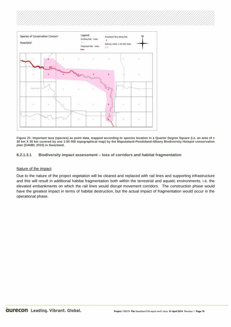
Project 109578 File Swaziland EIA report rev01.docx 01 April 2014 Revision 1 Page 76
Figure 21: Important taxa (species) as point data, mapped according to species location in a Quarter Degree Square (i.e. an area of ± 30 km X 30 km covered by one 1:50 000 topographical map) by the Maputaland-Pondoland-Albany Biodiversity Hotspot conservation plan (SANBI, 2010) in Swaziland.
8.2.1.3.1 Biodiversity impact assessment – loss of corridors and habitat fragmentation
Nature of the impact
Due to the nature of the project vegetation will be cleared and replaced with rail lines and supporting infrastructure
and this will result in additional habitat fragmentation both within the terrestrial and aquatic environments, i.e. the
elevated embankments on which the rail lines would disrupt movement corridors. The construction phase would
have the greatest impact in terms of habitat destruction, but the actual impact of fragmentation would occur in the
operational phase.

Project 109578 File Swaziland EIA report rev01.docx 01 April 2014 Revision 1 Page 77
Figure 22: An example of an elevated culvert that has raised the level of the riverbed resulting in a form of habitat fragmentation.
Significance of impact with mitigation
With the mitigation measures in place as listed below, the definite impact on the fragmentation would remain within
the Local area, resulting in a long-term impact of Moderate intensity for the operational phase, resulting in a
Moderate (with mitigation) significance (Table 19). This is assuming that the proposed infrastructure will allow for
culverts in suitable areas to maintain links within the aquatic and terrestrial environment.
The table below describes the impact of the potential loss of corridors and habitat fragmentation and the proposed
mitigation measures, representative of all three route alignments.
Table 19: Impact description of the loss of corridors and habitat fragmentation
IMPACT DESCRIPTION: Loss of corridors and habitat fragmentation
Predicted for project phase:
Pre-construction
Construction Operation Decommissioning
Dimension Rating Motivation
PRE-MITIGATION
Duration Long-term
The construction phase would have the greatest impact in terms of habitat destruction, but the actual impact of fragmentation would occur in the operational phase.
Consequence: Moderately detrimental
Significance: High - negative

Project 109578 File Swaziland EIA report rev01.docx 01 April 2014 Revision 1 Page 78
Extent Local
Vegetation will be cleared and replaced with rail lines and supporting infrastructure and this will result in additional habitat fragmentation both within the terrestrial and aquatic environments
Intensity Moderate - negative
Several impacts already occur within and adjacent to these systems and the proposed layouts would seem to have little further impact considering the size of the footprints or the current state or lack of connectivity within the sites.
Probability Certain Due to the nature of the activity it will have a definate impact on the corridors of movement resulting in fragmentation
MITIGATION:
Wetland and floodline areas must be excluded from development as far as possible, i.e. designs should include means to span these areas thus maintain open ecological networks.
Where culverts are installed across drainage lines and watercourses, the proposed designs should ensure that natural ground levels are maintained, i.e. the culvert base does pose as an obstacle for the movement of aquatic organisms.
Construction activities should not exceed the proposed construction boundaries by more than 15 m to avoid the secondary impact of construction and increasing the areas that would require clearing and rehabilitation
Re-vegetation as part of a rehabilitation plan is always advocated, however due the nature of the vegetation, this may not be practical. It is suggested that the shallow topsoil layer be stockpiled separately from the subsoil layers, should the excavation exceed 0.5 m. When the construction has been completed, then the topsoil layers, which contain seed and vegetative material, should be reinstated last thus allowing plants to rapidly re-colonise the bare soil areas.
Alien plant regrowth should also be monitored, and any such species should be removed during the construction phase.
POST-MITIGATION
Duration Long-term As for pre-mitigation
Consequence: Moderately detrimental Significance:
Moderate - negative
Extent Local
With the implementation of the proposed mitigating measures the impact on fragmentation would remain in the local sphere
Intensity Low - negative The proposed mitigation will reduce impacts to some extent
Probability Certain Mitigation will reduce the risk of these impacts to some extent
The mitigation measure in red text was found to be highly unfeasible to the proponent as 15 m either side of the
centre line will not allow the contractors sufficient space to carry out construction activities. Therefore the EAP
proposes the following as included in the CMP that the width of the construction footprint must be agreed
upon by the ECO and the Engineer and as far as possible must be kept to a minimum. The maximum width
of the construction footprint servitude will not exceed 75 m. Should additional space be needed for the
temporary storage of material, the ECO must advise on an appropriate area away from any sensitive areas.

Project 109578 File Swaziland EIA report rev01.docx 01 April 2014 Revision 1 Page 79
8.2.1.3.2 Biodiversity impact assessment: Loss of species of special concern
Nature of impact
Any loss of systems could possibly result in the loss of species of special concern within the habitats as a result of
their destruction during the construction phase.
However, no flora and fauna species of special concern were evident during the study within the wetland or water
course areas, as well as the terrestrial habitats, possibly due to the intensity of farming, housing and rail
infrastructure already found in the study area. The lack of any rainfall also seemed to precluded the early growth or
appearance of species known to occur in the area (Appendix 3 of the Ecological specialist report) so as
precautionary step, it is important that all riparian areas are retained and allowed to function, as a number of
protected species listed (Appendix 3 of the Ecological specialist report) do occur within the region.
Significance of impact with mitigation
The impact would be rated as a regional impact due to the species under consideration and the lack of potential
habitat still remaining. The impact would persist into the long-term however in view of the unlikely probability of
finding such species the intensity of the impact would be Moderate (Table 20). The impact would be rated as
Moderate without mitigation due to confidence in this assessment based in the reasons listed above.
The table below describes the impact of the potential loss of rare and endangered species and the proposed
mitigation measures.
Table 20: Impact description for the potential loss of rare and endangered species
IMPACT DESCRIPTION: Loss of rare and endangered species
Predicted for project phase:
Pre-construction
Construction Operation Decommissioning
Dimension Rating Motivation
PRE-MITIGATION
Duration Long-term
Any loss of systems could possibly result in the loss of species of special concern within the habitats as a result of their destruction during the construction phase but could persist into the long term.
Consequence: Highly detrimental
Significance: Moderate - negative
Extent Regional
The impact would be rated as a regional impact due to the species under consideration and the lack of potential habitat still remaining.
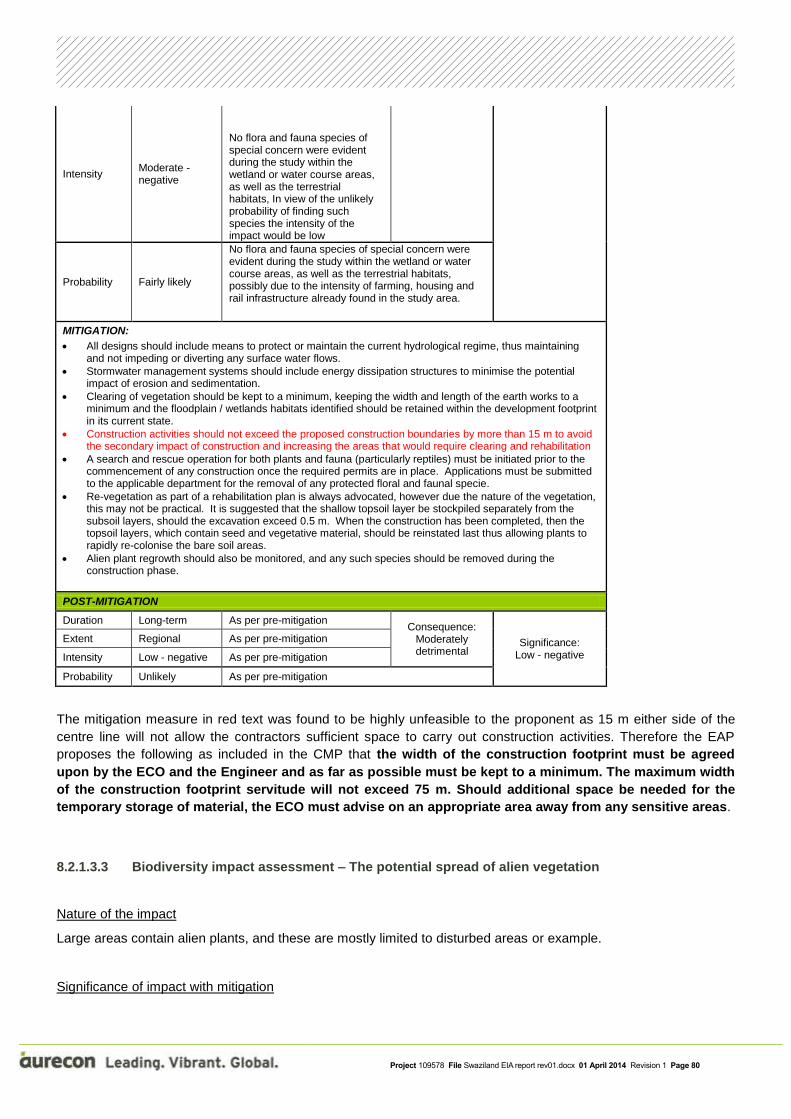
Project 109578 File Swaziland EIA report rev01.docx 01 April 2014 Revision 1 Page 80
Intensity Moderate - negative
No flora and fauna species of special concern were evident during the study within the wetland or water course areas, as well as the terrestrial habitats, In view of the unlikely probability of finding such species the intensity of the impact would be low
Probability Fairly likely
No flora and fauna species of special concern were evident during the study within the wetland or water course areas, as well as the terrestrial habitats, possibly due to the intensity of farming, housing and rail infrastructure already found in the study area.
MITIGATION:
All designs should include means to protect or maintain the current hydrological regime, thus maintaining and not impeding or diverting any surface water flows.
Stormwater management systems should include energy dissipation structures to minimise the potential impact of erosion and sedimentation.
Clearing of vegetation should be kept to a minimum, keeping the width and length of the earth works to a minimum and the floodplain / wetlands habitats identified should be retained within the development footprint in its current state.
Construction activities should not exceed the proposed construction boundaries by more than 15 m to avoid the secondary impact of construction and increasing the areas that would require clearing and rehabilitation
A search and rescue operation for both plants and fauna (particularly reptiles) must be initiated prior to the commencement of any construction once the required permits are in place. Applications must be submitted to the applicable department for the removal of any protected floral and faunal specie.
Re-vegetation as part of a rehabilitation plan is always advocated, however due the nature of the vegetation, this may not be practical. It is suggested that the shallow topsoil layer be stockpiled separately from the subsoil layers, should the excavation exceed 0.5 m. When the construction has been completed, then the topsoil layers, which contain seed and vegetative material, should be reinstated last thus allowing plants to rapidly re-colonise the bare soil areas.
Alien plant regrowth should also be monitored, and any such species should be removed during the construction phase.
POST-MITIGATION
Duration Long-term As per pre-mitigation Consequence:
Moderately detrimental
Significance: Low - negative
Extent Regional As per pre-mitigation
Intensity Low - negative As per pre-mitigation
Probability Unlikely As per pre-mitigation
The mitigation measure in red text was found to be highly unfeasible to the proponent as 15 m either side of the
centre line will not allow the contractors sufficient space to carry out construction activities. Therefore the EAP
proposes the following as included in the CMP that the width of the construction footprint must be agreed
upon by the ECO and the Engineer and as far as possible must be kept to a minimum. The maximum width
of the construction footprint servitude will not exceed 75 m. Should additional space be needed for the
temporary storage of material, the ECO must advise on an appropriate area away from any sensitive areas.
8.2.1.3.3 Biodiversity impact assessment – The potential spread of alien vegetation
Nature of the impact
Large areas contain alien plants, and these are mostly limited to disturbed areas or example.
Significance of impact with mitigation

Project 109578 File Swaziland EIA report rev01.docx 01 April 2014 Revision 1 Page 81
With the above mitigation measures in place, the impact on the vegetation would remain within the site, with natural
re-vegetation happening within a short time period, resulting in a Very Low impact significance with mitigation
(Table 21). This is also based on the fact that during the operational phase on-going clearing and maintenance
practices will be employed by Swaziland Railway.
The table below describes the potential impact of the introduction of alien vegetation and the proposed mitigation
measures.
Table 21: Impact description for the introduction of alien and invasive species
IMPACT DESCRIPTION: Introduction of alien and invasive species
Predicted for project phase:
Pre-construction
Construction Operation Decommissioning
Dimension Rating Motivation
PRE-MITIGATION
Duration Medium-term Will be limited to construction phase.
Consequence: Slightly
detrimental Significance:
Low - negative
Extent Site-specific Potential for spread of alien species in newly cleared areas
Intensity Low - negative A large area of the project is already disturbed and planted with alien species.
Probability Fairly likely
The disturbance of vegetation can easily lead to the establishment of new colonies of alien and invasive species
MITIGATION:
Clearing of vegetation should be kept to a minimum, keeping the width and length of the earth works to a minimum.
Re-vegetation as part of a rehabilitation plan is always advocated, however to the low annual rainfall (normal conditions), this may not be practical. It is suggested that the shallow topsoil layer be stockpiled separately from the subsoil layers, should the excavation exceed 0.5 m. When the construction has been completed, then the topsoil layers, which contain seed and vegetative material, should be reinstated last thus allowing plants to rapidly re-colonise the bare soil areas.
Alien plant regrowth should also be monitored, and any such species should be removed during the construction phase.
POST-MITIGATION
Duration Long-term As for pre-mitigation
Consequence: Negligible
Significance: Very low
Extent Site-specific As for pre-mitigation
Intensity Very low
Mitigation measures will reduce the potential spread of alien species and natural re-vegetation can take place
Probability Fairly likely
Mitigation measures will reduce likelihood of spread of alien species and clearing of the sites during operational phase will further reduce the possible negative impacts.
8.2.1.4 Conclusions and recommendations of the ecological assessment undertaken
The results, based on the available information and the site investigations, show that the proposed line could
impact on a number of sensitive and/or important terrestrial and aquatic habitats. However several of the metadata

Project 109578 File Swaziland EIA report rev01.docx 01 April 2014 Revision 1 Page 82
sources for the spatial data shown in this report also indicate that large areas of habitat at a broad scale are
degraded or transformed. This is also supported by the observed land use character shown in the aerial images
(Google Earth). This was confirmed during the site visit.
It would therefore seem that, based on the site visit and the type of habitats observed, the proposed extension of
rail lines and yard would have a limited impact on both the terrestrial aquatic environment if the mitigations and
recommendations are upheld:
Compilation and implementation of a Comprehensive Mitigation Plan (CMP), that provides specifications with
regards to:
Rehabilitation with indigenous plants species. (i.e. a Rehabilitation Plan).
Plant removal within the construction footprint only.
Alien vegetation clearing and management within the development footprint / construction area.
Detailed storm-water management and erosion control plan.
Waste management: (i) to prevent accidental leakage of pollutants e.g. oil, fuel, cement, (ii) to identify procedures for solid waste disposal (e.g. bins, no littering or burning policy and the
maintenance of ablution facilities, including the disposal of liquid and hazardous waste at a licensed waste disposal site,
(iii) to ensure that no re-fuelling of construction vehicles or maintenance activities occur proximate to the non-perennial stream (drainage area) to the west of the sites; and
(iv) to designate an area for the construction camp (which includes ablution facilities, storage of hazardous wastes, maintenance stations etc.) at least 100 m away from the non-perennial stream (drainage area) to the west of the sites
Other generic mitigation measures associated with construction.
Employment of an Environmental Control Officer to oversee the implementation of the CMP and the conditions contained in the Environmental Approval.

Project 109578 File Swaziland EIA report rev01.docx 01 April 2014 Revision 1 Page 83
8.2.2 Hydrology assessment
This section of the project (Sandlane to Lavumisa) is located in part on the watershed of the Olifants and the Vaal
catchments which limits the river crossings. The section crosses the Vaal River once and is close to a series of
pans.
The Usuthu River flows eastwards through Swaziland to Mozambique and then on to Indian Ocean. The new rail
alignment for the most part runs close to Usuthu River crossing it five times along with several of its tributaries. The
catchments in the study area are situated in a mid-summer rainfall region. During the Tropical Storm Demonia a
flood peak of 13500 m3/s was recorded in January 1984 on the Usuthu River close to Big Bend (Kovacs, 1988).
The mean annual precipitation (MAP) is within a range of 400 to 1200 mm (Figure 23) and catchment runoff is
between 20 and 300 mm. The higher altitudes and higher MAP occurs in the west and the lower altitudes and lower
MAP in the east.
The main soil types are sandy loam, sand clay loam and sandy clay (Figure 25) with the predominate geology
being basalt, shale, granite, dolerite and ultramafic formations Figure 26). The main land uses include commercial
irrigated sugarcane, game farms, subsistence agriculture, natural veld and pine plantations (Figure 27).
Figure 23: Mean Annual Precipitation (mm) for all sections of the Swazi Rail Link

Project 109578 File Swaziland EIA report rev01.docx 01 April 2014 Revision 1 Page 84
Figure 24: Runoff (mm) for all sections of the Swazi Rail Link

Project 109578 File Swaziland EIA report rev01.docx 01 April 2014 Revision 1 Page 85
Figure 25: Soil types for all sections of the Swazi Rail Link
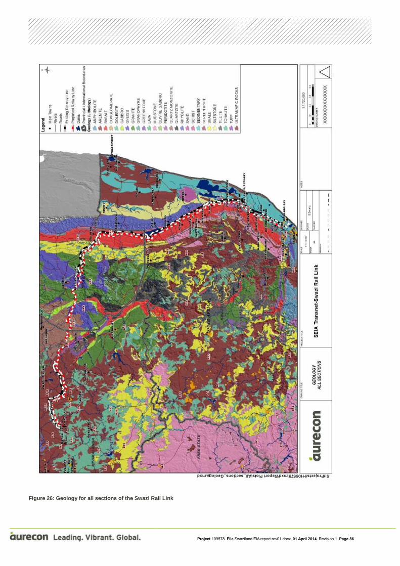
Project 109578 File Swaziland EIA report rev01.docx 01 April 2014 Revision 1 Page 86
Figure 26: Geology for all sections of the Swazi Rail Link

Project 109578 File Swaziland EIA report rev01.docx 01 April 2014 Revision 1 Page 87
Figure 27: Land cover for all sections of the Swazi Rail Link

Project 109578 File Swaziland EIA report rev01.docx 01 April 2014 Revision 1 Page 88
8.2.2.1 Water quality impact assessment
In terms of water quality impacts of the railway line, there are three concerns. The impact descriptions can be found
at the end of Chapter 8.2.2:
1. The first is the accumulation of coal dust along the railway line and the impacts this may have on water
quality in local streams and rivers. The water quality impacts may include an increase in the amount of
dissolved salts in wash-off from the affected area, and a possible change in the pH of the water. However,
it is estimated that these impacts would probably be minor and would only be manifested during the rainy
season and rainfall events that generate runoff. There might be first flush effect at the onset of the rainfall
season but there would probably be sufficient dilution during that time to minimise any water quality
impacts. Coal dust in small quantities is relatively innocuous when mixed in water. Impurities in the coal
such as sulphides may become mobilised when mixed with water and chemical reactions may create
sulphates that are readily soluble in water. Particularly high volumes of sulphates need to enter the rivers
to raise sulphate concentrations to levels where it can be harmful to humans, livestock and aquatic life.
Golder Associates undertook an environmental impact assessment of transporting coal by rail to a power
station in South Africa (Golder Associates, 2004). As part of the study they investigated the water quality
impacts of the Richards Bay Coal Transport Line that transports coal from the Highveld coalfields to the
coal export harbour at Richards Bay, South Africa. This line has been in operation since 1976. On this line
coal is transported using both sealed wagons and bottom dumping wagons. Golder found no obvious
signs of coal dust pollution, land owners confirmed that there did not appear to be any detrimental impacts
as a result of coal dust, and an examination of soil and vegetation samples near the railway line did not
show signs of coal dust pollution. Golder also investigated the impacts of coal falling from wagons and
found minor evidence of coal falling on the area adjacent to the ballast. It was concluded that this coal fell
from side-dumping wagons that did not seal well resulting in small pieces of coal falling through the small
openings between the flaps. A comparison of water quality in farm dams upstream and downstream of the
railway line found no difference in water quality and it was concluded that the railway line had a negligible
effect on water quality (Golder Associates, 2004).
2. The second concern is seepage of rain water from uncovered wagons during the rainfall season. The
limited contact time between the rainwater and the coal could lead to a minor increase in dissolved salts in
the seepage water. However, there would probably be sufficient rainfall runoff and dilution in the
surrounding area during such events to minimise any water quality impacts. It is also a linear impact, that
is, the impact is distributed linearly along the length of the railway line.
3. The third concern is smothering of in-stream aquatic habitats with coal dust. In this case aquatic habitat
refers to the substrate where aquatic biota occurs and it includes the mosaic of bedrock, cobbles,
vegetation, sand, gravel and mud that make up a stream habitat. Large volumes of coal dust have the
potential of smothering aquatic habitats, impacting negatively on the biota. However, no evidence of
habitat smothering was found along the Richards Bay coal transport line.
8.2.2.2 Hydrological impact assessment and mitigation
8.2.2.2.1 Watercourse crossings
The major crossing that were identified as potential sites of concern and requiring a field assessment are presented
Figure 28 and listed in Table 22 along with information relating to the Quaternary Catchment in which the crossing

Project 109578 File Swaziland EIA report rev01.docx 01 April 2014 Revision 1 Page 89
is located. This section includes the field assessment and impact rating for the watercourse crossings and for
Phuzumoya Yard.
Figure 28: Major river crossings for Sandlane to Lavumisa
Table 22: Major watercourse crossings and quarternary catchment information
Crossing
No
Lat Long River Name Quat
number
Quat
MAP
(mm)
Quat
Runoff
(mm)
15 27°16'06.24" S 31°53'43.35" E Msuzwaneni W44E 581 15
16 27°14'29.78" S 31°54'07.46" E Mhlofunga W44E 581 15
17 27°01'36.89" S 31°55'59.94" E Ngwavuma W43E 588 6
18 26°59'14.71" S 31°54'29.35" E W57J 628 16
19 26°51'51.17" S 31°54'33.64" E W57J 628 16
20 26°51'14.38" S 31°49'50.41" E Mhlatuze W57E 701 19

Project 109578 File Swaziland EIA report rev01.docx 01 April 2014 Revision 1 Page 90
21 26°44'06.34" S 31°44'33.62" E Mhlathuzane W57E 701 19
22 26°42'48.89" S 31°44'50.70" E Usuthu W57E 701 19
23 26°41'02.25" S 31°38'48.76" E Mzimmeni W57A 824 106
24 26°40'05.37" S 31°30'38.45" E Usuthu W57A 824 106
25 26°37'43.27" S 31°26'27.91" E Sidvokodvo W57A 824 106
26 26°39'24.76" S 31°22'33.26" E Usuthu W54G 947 64
27 26°34'58.31" S 31°04'56.11" E Umhlambahula W54F 998 71
28 26°31'44.63" S 30°55'20.12" E Usuthu W54E 963 26
29 26°31'09.25" S 30°55'18.01" E Mpuluzi W55E 933 20
30 26°29'57.48" S 30°55'05.39" E Malangeni W55E 933 20
31 26°30'21.13" S 30°54'04.48" E Mpuluzi W55E 933 20
32 26°32'30.62" S 30°53'49.41" E Usuthu W54E 963 26
Impacts on surface waters will occur during rail construction. Pollution from mobilised suspended solids is the major
concern particularly where there are water abstractions close to the watercourse crossing as well at those
crossings that are upstream of nature reserves or dams. Sediment mobilisation can be prevented in the most part
in the construction phase by the use of silt traps. These silt traps would need to be cleaned regularly. If best
practice is followed in bridge and culvert design then erosion and sediment mobilisation in the long term will have a
limited impact. Good practice would include upstream downstream and downstream erosion protection.
It is not anticipated that there would be major hydraulic related impacts during high flows at the crossings of the
major water courses. This assumption is based on Swaziland Rail Link FEl-2 (Mott MacDonald, 2013) study, where
the drawings of major drainage structures show the height of the structure openings to be well above the 1:100
year flood level. For the minor crossing where culverts maybe constructed, the flow velocity downstream of the
culvert should not be greater than pre-construction velocity. In order to mitigate an increase in flow velocity, a
structure to dissipate the energy maybe required.
The alignment runs for long sections in the Usuthu river valley, the alignment will however be placed outside of the
1:100 year floodline (Mott MacDonald 2013). In addition to this cross drainage structures will need to be
constructed at appropriate locations.
Another impact during the construction phase is the accidental spillage of fuels and hydraulic fluids from
construction plant. Therefore, storage of fuel, oils and chemicals should be on an impermeable base, away from
drains and watercourses.
The longer term impacts for crossings 15 to 25 (the upgrade sections) will be similar to those of the existing
bridges. Impacts during the construction phase include the introduction of sediment and erosion of banks.

Project 109578 File Swaziland EIA report rev01.docx 01 April 2014 Revision 1 Page 91
Accumulation of coal dust along the railway line and seepage of rain water from uncovered wagons during the
rainfall season may have impacts on water quality in local streams and rivers.
Impacts associated with crossings 26 to 32 (the new link) will mainly result from disturbance and changes in the
flow regime. Impacts during the construction phase include the mobilisation of sediment and erosion of banks.
Accumulation of coal dust along the railway line and seepage of rain water from uncovered wagons during the
rainfall season may have impacts on water quality in local streams and rivers.
The crossings listed in Table 22 will be discussed in more detail below.
Crossing 15: Msuzwaneni River, Lavumisa:
Figure 29: Aerial view Msuzwaneni River crossing
Figure 30 | 2000 m upstream the river crossing
The Msuzwaneni crossing is 6 km north of Golela border, the railway line crosses a region with land use being a
mixture of agriculture and game farm. The Msuzwaneni River is an ephemeral watercourse and ultimately it flows
into the Pongola Dam. Flow channel and banks ill-defined, obstructed with vegetation and eroded by floods (see
Figure 30). There are signs of erosion caused by high flows.
Crossing 16: Mhlofunga River, Lavumisa:

Project 109578 File Swaziland EIA report rev01.docx 01 April 2014 Revision 1 Page 92
Figure 31: Aerial view Mhlofunga River crossing
Figure 32: Site view
Figure 33: View of Mhlofunga River crossing
Figure 34: Looking upstream Mhlofunga crossing
Figure 35: Looking downstream Mhlofunga crossing
The Mhlofunga crossing is 9 km north of Golela border, the railway line crosses a region with land use being a
mixture of agriculture and game farms. The existing crossing is a series of large culverts. The Mhlofunga River is

Project 109578 File Swaziland EIA report rev01.docx 01 April 2014 Revision 1 Page 93
an ephemeral watercourse and ultimately it flows into the Pongola Dam. Flow channel and banks ill-defined,
obstructed with vegetation and eroded by floods (see Figure 34 and Figure 35).
Crossing 17: Ngwavuma River, Nsoko:
The Ngwavuma River crossing is close to the Nsoko settlement (Figure 36). The new crossing is 250 m upstream
of the existing rail bridge with the major land use in the area being irrigated sugarcane (Figure 37).
Figure 36: Aerial view Ngwavuma River crossing
Figure 37: Site view
Figure 38: View of Ngwavuma River crossing
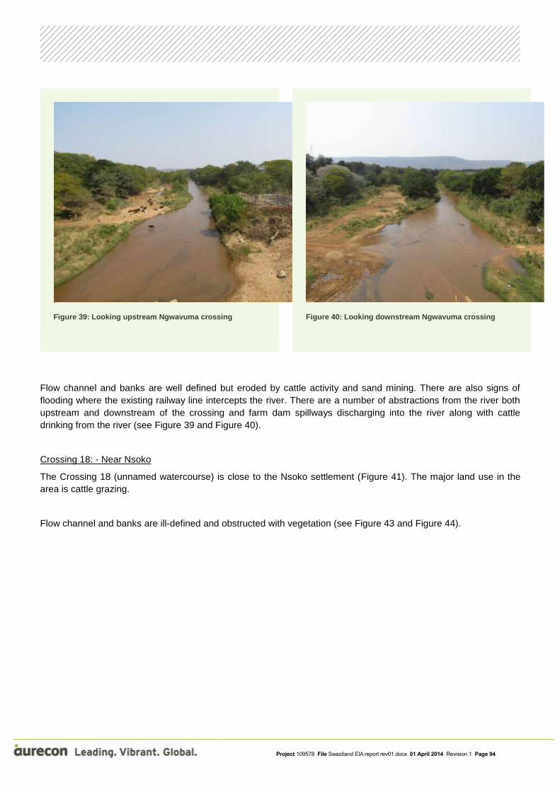
Project 109578 File Swaziland EIA report rev01.docx 01 April 2014 Revision 1 Page 94
Figure 39: Looking upstream Ngwavuma crossing
Figure 40: Looking downstream Ngwavuma crossing
Flow channel and banks are well defined but eroded by cattle activity and sand mining. There are also signs of
flooding where the existing railway line intercepts the river. There are a number of abstractions from the river both
upstream and downstream of the crossing and farm dam spillways discharging into the river along with cattle
drinking from the river (see Figure 39 and Figure 40).
Crossing 18: - Near Nsoko
The Crossing 18 (unnamed watercourse) is close to the Nsoko settlement (Figure 41). The major land use in the
area is cattle grazing.
Flow channel and banks are ill-defined and obstructed with vegetation (see Figure 43 and Figure 44).

Project 109578 File Swaziland EIA report rev01.docx 01 April 2014 Revision 1 Page 95
Figure 41: Aerial view crossing 18
Figure 42: View of River crossing
Figure 43: Looking upstream
Figure 44: Looking downstream
Crossing 19 – Usuthu tributary near to Matata
Crossing 19 is over a tributary of the Usuthu River and is close to the Matata settlement (Figure 45). The land use
is a mixture of subsistence agriculture and commercial irrigated agriculture.

Project 109578 File Swaziland EIA report rev01.docx 01 April 2014 Revision 1 Page 96
Figure 45: Aerial view crossing 19
Figure 46: View of river crossing
Figure 47: Looking upstream
Figure 48: Looking downstream
The tributary is an ephemeral river with a clear channel and eroded unstable banks. (see Figure 47 and Figure 48).
Crossing 20: Mhlatuze River, Matata
The Mhlatuze River crossing is close to the Matata settlement (Figure 49). The land use is a mixture of subsistence
agriculture and commercial irrigated agriculture.

Project 109578 File Swaziland EIA report rev01.docx 01 April 2014 Revision 1 Page 97
Figure 49: Aerial view Mhlatuze crossing
Figure 50: Rocky outcrop river bed 3000m downstream crossing
.
The Mhlatuze River crossing is close to the Matata settlement (Figure 49). The land use is a mixture of subsistence
agriculture and commercial irrigated agriculture.
The Mhlatuze is a perennial river with high flows in summer months. At the crossing the banks appear relatively
stable due to bedrock presence along sections of the reach (Figure 50) and there are existing instream pools and
riffles.
Crossing 22: Usuthu River, Siphofaneni
The Usuthu River crossing is close to the Siphofaneni settlement (Figure 51). The land use is a mixture of
subsistence agriculture and commercial irrigated agriculture.

Project 109578 File Swaziland EIA report rev01.docx 01 April 2014 Revision 1 Page 98
Figure 51: Aerial view Usuthu River crossing
Figure 52: Irrigation water abstraction
Figure 53: View of Usuthu river crossing
Figure 54: Looking upstream of Usuthu crossing
Figure 55: Looking downstream of Usuthu crossing
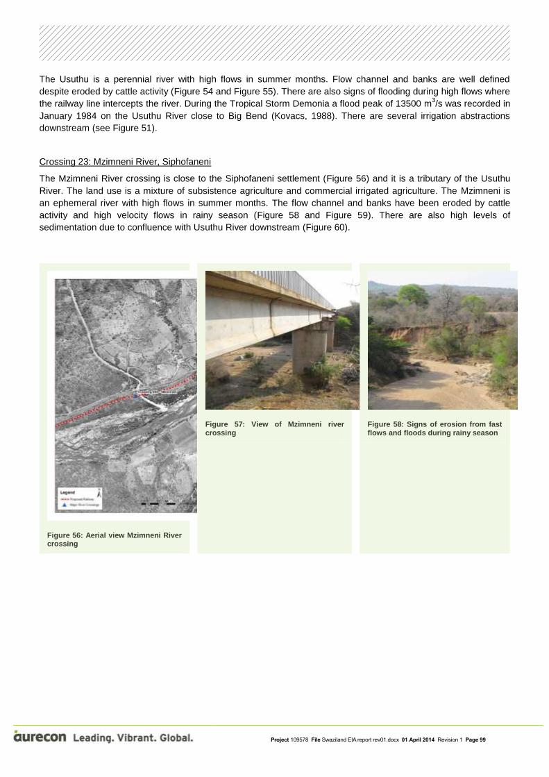
Project 109578 File Swaziland EIA report rev01.docx 01 April 2014 Revision 1 Page 99
The Usuthu is a perennial river with high flows in summer months. Flow channel and banks are well defined
despite eroded by cattle activity (Figure 54 and Figure 55). There are also signs of flooding during high flows where
the railway line intercepts the river. During the Tropical Storm Demonia a flood peak of 13500 m3/s was recorded in
January 1984 on the Usuthu River close to Big Bend (Kovacs, 1988). There are several irrigation abstractions
downstream (see Figure 51).
Crossing 23: Mzimneni River, Siphofaneni
The Mzimneni River crossing is close to the Siphofaneni settlement (Figure 56) and it is a tributary of the Usuthu
River. The land use is a mixture of subsistence agriculture and commercial irrigated agriculture. The Mzimneni is
an ephemeral river with high flows in summer months. The flow channel and banks have been eroded by cattle
activity and high velocity flows in rainy season (Figure 58 and Figure 59). There are also high levels of
sedimentation due to confluence with Usuthu River downstream (Figure 60).
Figure 56: Aerial view Mzimneni River crossing
Figure 57: View of Mzimneni river crossing
Figure 58: Signs of erosion from fast flows and floods during rainy season

Project 109578 File Swaziland EIA report rev01.docx 01 April 2014 Revision 1 Page 100
Figure 59: Looking upstream of Mzimneni crossing
Figure 60: Looking downstream of Mzimneni crossing
Crossing 24: Mhlamani River, Sidvokodvo
The Mzimneni River crossing is 8 km from the Sidvokodvo settlement (Figure 61) and it is a tributary of the Usuthu
River. The land use is a mixture of subsistence agriculture and commercial irrigated agriculture. The Mzimneni is
an ephemeral river with high flows in summer months. The flow channel and banks have been eroded by cattle
activity and high velocity flows in rainy season. There are also high levels of sedimentation due to confluence with
Usuthu River downstream.
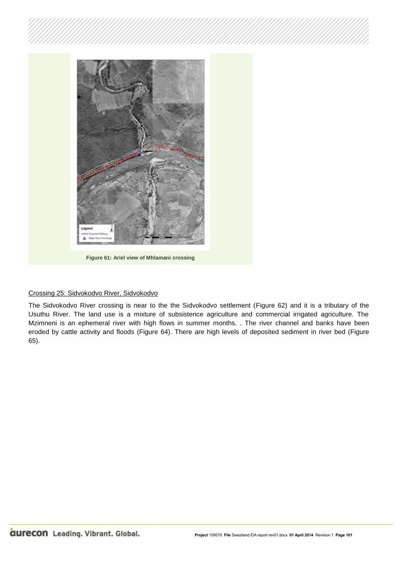
Project 109578 File Swaziland EIA report rev01.docx 01 April 2014 Revision 1 Page 101
Figure 61: Ariel view of Mhlamani crossing
Crossing 25: Sidvokodvo River, Sidvokodvo
The Sidvokodvo River crossing is near to the the Sidvokodvo settlement (Figure 62) and it is a tributary of the
Usuthu River. The land use is a mixture of subsistence agriculture and commercial irrigated agriculture. The
Mzimneni is an ephemeral river with high flows in summer months. . The river channel and banks have been
eroded by cattle activity and floods (Figure 64). There are high levels of deposited sediment in river bed (Figure
65).
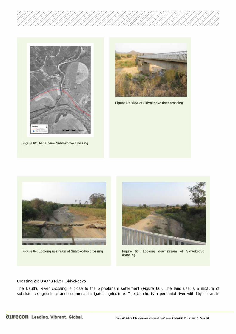
Project 109578 File Swaziland EIA report rev01.docx 01 April 2014 Revision 1 Page 102
Figure 62: Aerial view Sidvokodvo crossing
Figure 63: View of Sidvokodvo river crossing
Figure 64: Looking upstream of Sidvokodvo crossing
Figure 65: Looking downstream of Sidvokodvo crossing
Crossing 26: Usuthu River, Sidvokodvo
The Usuthu River crossing is close to the Siphofaneni settlement (Figure 66). The land use is a mixture of
subsistence agriculture and commercial irrigated agriculture. The Usuthu is a perennial river with high flows in

Project 109578 File Swaziland EIA report rev01.docx 01 April 2014 Revision 1 Page 103
summer months. The river banks are relatively stable due to bedrock outcrop in the river bed. There is a rock weir
for irrigation water abstraction just 100 m downstream crossing section (see Figure 67).
Figure 66: Aerial view Usuthu crossing
Figure 67: Irrigation water abstraction
Crossing 27: Umhlambahula River, Bhunya
The Umhlambahula River crossing is close to the Bhunya settlement (Figure 68) and is a tributary of the Usuthu
River. The crossing occurs just before a major meander. The land use is a mixture of subsistence agriculture and
semi-commercial agriculture. The Umhlambahula is a perennial river with high flows in summer months. The river
banks are relatively stable due to bedrock outcrop in the river bed with significant loads of settled sedimentation
(Figure 70 and Figure 71).

Project 109578 File Swaziland EIA report rev01.docx 01 April 2014 Revision 1 Page 104
Figure 68: Aerial view Umhlambahula crossing
Figure 69: Cross-section of Umhlambahula crossing
Figure 70: Looking upstream of Umhlambahula crossing
Figure 71: Looking downstream of Umhlambahula crossing
Crossing 28: Usuthu River, Bhunya
The Usuthu River crossing is close to the Bhunya settlement (Figure 72) and is just above the confluence with the
Mpuluzi River. The land use is a mixture of subsistence agriculture and semi-commercial agriculture. The Usuthu is

Project 109578 File Swaziland EIA report rev01.docx 01 April 2014 Revision 1 Page 105
a perennial river with high flows in summer months. The channel has a sinuous pattern with a bedrock pavement
(Figure 74 and Figure 75).
Figure 72: Aerial view Usuthu crossing
Figure 73: Cross-section of Usuthu crossing
Figure 74: Looking upstream of Usuthu crossing
Figure 75: Looking downstream of Usuthu crossing
Crossing 29: Mpuluzi River, Bhunya

Project 109578 File Swaziland EIA report rev01.docx 01 April 2014 Revision 1 Page 106
The Mpuluzi River crossing is close to the Bhunya settlement (Figure 76) and is a tributary of the Usuthu River. The
crossing occurs just after a meander. The land use is a mixture of subsistence agriculture and semi-commercial
agriculture. The Mpuluzi is a perennial river with high flows in summer months. The river banks are relatively stable
due to bedrock outcrop in the river bed (Figure 79) and there a number of bedrock pools in the low flow months.
Figure 76: Aerial view Mpuluzi crossing
Figure 77: Cross-section of Mpuluzi crossing

Project 109578 File Swaziland EIA report rev01.docx 01 April 2014 Revision 1 Page 107
Figure 78: Looking upstream of Mpuluzi crossing
Figure 79: Looking downstream of Mpuluzi crossing
Crossing 30: Malangeni River, Bhunya
The Malangeni River crossing is close to the Bhunya settlement (Figure 80) and is a tributary of the Mpuluzi River.
The crossing occurs just above the confluence with Mpuluzi River. The land use is a mixture of subsistence
agriculture and semi-commercial agriculture. The Malangeni is a perennial river with high flows in summer months.
The river banks are relatively stable due to bedrock outcrop in the river bed and there a number of bedrock pools in
the low flow months.

Project 109578 File Swaziland EIA report rev01.docx 01 April 2014 Revision 1 Page 108
Figure 80: Ariel view of river crossing
Crossing 31: Mpuluzi River, Bhunya
The Mpuluzi River crossing is close to the Bhunya settlement (Figure 81) and is a tributary of the Usuthu River. The
land use is a mixture of subsistence agriculture and semi-commercial agriculture. The Mpuluzi is a perennial river
with high flows in summer months. The channel is well-defined and has significant loads of settled sediment
(Figure 82, Figure 83 and Figure 84) in the form of lateral bars and mid-channel bars.

Project 109578 File Swaziland EIA report rev01.docx 01 April 2014 Revision 1 Page 109
Figure 81: Aerial view Mpuluzi crossing
Figure 82: Cross-section of Mpuluzi crossing
Figure 83: Looking upstream of Mpuluzi crossing
Figure 84: Looking downstream of Mpuluzi crossing

Project 109578 File Swaziland EIA report rev01.docx 01 April 2014 Revision 1 Page 110
Crossing 32: Usuthu River, Bhunya
The Usuthu River crossing is close to the Bhunya settlement (Figure 85) and is just aboue the confluence with the
Mpuluzi River. The land use is a mixture of subsistence agriculture and semi-commercial agriculture. The Usuthu is
a perennial river with high flows in summer months. The channel has a sinuous pattern with a bedrock pavement
Figure 85: Ariel view of Usuthu crossing
Upgrade of Phuzumoya Yard

Project 109578 File Swaziland EIA report rev01.docx 01 April 2014 Revision 1 Page 111
Figure 86: Phuzumoya Yard
Figure 87: Watercourse 300m from Phuzumoya Yard
Potential sources of surface water pollution at the rail yard include:
wastewater from kitchen and ablution facilities
wash bays and workshops
fuelling facilities
coal dust and rainfall seepage from the wagons.
It is recommended that monitoring be undertaken of any effluent that is discharged from the Phuzumoya Yard into
a surface watercourse such as shown in Figure 87. Any effluent must comply with the Water Pollution Control
Regulations of 2010 issued under section 37 of the Swaziland Environment Manangement Act of 2002. In
Schedule 2 of the regulations effluent standards are specified. The regulations do not prescribe a sampling
frequency and it is therefore recommended that sampling be undertaken at a monthly frequency. The regulations
require the Yard Operator to report the monitoring results to the SEA within two weeks of the results being released
by the water testing laboratory. The regulations also specify that exceedence of the effluent standards be reported
and that the discharger has an obligation to mitigate any harm done to the receiving water bodies and to take
remedial action to ensure that the effluent standards are met.
The following tables describe the potential impacts as predicted by the Hydrology specialist.
Table 23: Impact description for the potential disturbance, introduction of sediments and the erosion of banks or channels
IMPACT DESCRIPTION: Disturbance, introduction of sediments or erosion of banks or channel
Predicted for project phase:
Pre-construction
Construction Operation Decommissioning
Dimension Rating Motivation
PRE-MITIGATION
Project 109578 File Swaziland EIA report rev01.docx 01 April 2014 Revision 1 Page 112
Duration Medium-term
Mobilised suspended solids released as a result of the construction activities will settle once construction is finalised. Erosion to banks is possible during construction and will naturally stabilise with time
Consequence: Slightly
detrimental Significance:
Low - negative
Extent Local
Impact on water quality where there water abstractions close to the watercourse crossing as well at those crossings that are upstream of nature reserves or dams
Intensity Low – negative
As the existing conditions show signs of high erosion and sedimentation the additional impact significance associated with the construction of bridges and culverts are predicted to be low without mitigation.
Probability Fairly likely Due to the construction activity the probabilty of this impact is fairly likely
MITIGATION:
Sediment mobilisation can be prevented in the most part in the construction phase by the use of silt traps. Regular cleaning of the silt traps.
Best practice culvert and bridge design practices to be followed to provide good drainage and prevent erosion and sediment mobilisation.
Upstream downstream and downstream erosion protection
In order to mitigate an increase in flow velocity, a structure to dissipate the energy maybe required.
Attention needs to be given to the prevention of bank erosion and sediment input into the stream both during construction and as a result of storm water during the operational phase.
POST-MITIGATION
Duration Short-term
The implementation of the proposed mitigation measures will result in the decrease of suspended solids and erosion of stream banks
Consequence: Negligible
Significance: Very low Extent Site-specific
Will be contained through the implementation of the proposed mitigation measures
Intensity Very low Improved housing will constitute a significant benefit
Probability Fairly likely Due to the construction activity the probability of this impact is fairly likely, however, the potential impact will be reduced by the mitigation measures
Table 24: Impact description for the potential change in flow regime
IMPACT DESCRIPTION: Change in flow regime
Predicted for project phase:
Pre-construction
Construction Operation Decommissioning
Dimension Rating Motivation

Project 109578 File Swaziland EIA report rev01.docx 01 April 2014 Revision 1 Page 113
PRE-MITIGATION
Duration Long-term As permanent structures will be placed in watercourses, the duration is seen as long term.
Consequence: Moderately detrimental Significance:
Low - negative
Extent Local
The structures are immobile and will not likely change once they have been installed, thus the extent is local.
Intensity Low – negative
Once the construction activities have been completed, the flow regime will settle around the bridge and culvert structures resulting in a low intensity.
Probability Fairly likely
MITIGATION:
In order to mitigate an increase in flow velocity, a structure to dissipate the energy maybe required.
Best practice culvert and bridge design practices to be followed to provide good drainage and prevent erosion and sediment mobilisation.
Natural weirs and small lakes must be preserved.
POST-MITIGATION
Duration Long-term As for pre-mitigation
Consequence: Negligible
Significance: Very low
Extent Site-specific
With the suggested mitigation measures the extent of the impact will be reduced to site specific.
Intensity Very low
With the suggested mitigation measures the probability of the intensity of the impact will be reduced.
Probability Unlikely With the suggested mitigation measures the probability of impact on the flow regime will be unlikely.
Table 25: Impact description for predicted water abstractions, effluent discharges and animal drinking
IMPACT DESCRIPTION: Water abstractions, effluent discharges, animal drinking.
Predicted for project phase:
Pre-construction
Construction Operation Decommissioning
Dimension Rating Motivation
PRE-MITIGATION
Duration Short-term Suspended solids in the water might cause reduction in water quality during construction
Consequence: Slightly
detrimental
Significance: Low - negative

Project 109578 File Swaziland EIA report rev01.docx 01 April 2014 Revision 1 Page 114
Extent Local Water abstraction points downstream of construction will be affected
Intensity Moderate – negative
Concentration of suspended solids may impact on water quality for man and beast
Probability Fairly likely Due to the construction activity the probability of this impact is fairly likely
MITIGATION:
Best practice culvert and bridge design practices to be followed to provide good drainage and prevent erosion and sediment mobilisation.
Upstream downstream and downstream erosion protection
POST-MITIGATION
Duration Short-term As for pre-mitigation
Consequence: Negligible
Significance: Very low
Extent Site-specific As for pre-mitigation
Intensity Low – negative Concentration of suspended solids will be reduced as a result of the mitigation measures
Probability Fairly likely Due to the construction activity the probabilty of this impact is fairly likely, however, the potential impact will be reduced by the mitigation measures
Table 26: Impact description for the potential coal dust and rainfall seepage water from the coal wagons
IMPACT DESCRIPTION: Coal dust and rainfall seepage water from the coal wagons.
Predicted for project phase:
Pre-construction
Construction Operation Decommissioning
Dimension Rating Motivation
PRE-MITIGATION
Duration Long-term
Accumulation of coal dust along the railway line and seepage of rain water from uncovered wagons will occur throughout the lifecycle of the project
Consequence: Moderately detrimental Significance:
Low - negative Extent Local
Accumulation of coal dust along the railway line and seepage of rain water from uncovered wagons during the rainfall season may have impacts on water quality in local streams and rivers
Intensity Low – negative Through natural dilution the impact of such contamination will be low
Probability Fairly likely Due to the nature of the project coal dust will be produced and will be washed into streams

Project 109578 File Swaziland EIA report rev01.docx 01 April 2014 Revision 1 Page 115
MITIGATION:
• Coal should be transported using both sealed wagons and bottom dumping wagons
POST-MITIGATION
Duration Long-term As for pre-mitigation
Consequence: Negligible
Significance: Very low
Extent Site-specific
The accumulation of coal dust will be reduced through the implementation of the proposed mitigation measures
Intensity Very low As for pre-mitigation, but at a reduced level
Probability Fairly likely The implementation of the proposed mitigation measures will contribute towards reducing the potential intensity of the impact
The mitigation measure in red text was found to be highly unfeasible to Transnet. This would require major
operational variations to their current operational system. The time and cost required to implement this requirement
would lead to a major delay in turnaround times of trains together with the subsequent economic impacts which
would follow. It is the EAP’s view that as the significance of the impact is determined by the specialist to be low, the
implementation of such an extravagant mitigation measure is unjustifiable. Therefore, no mitigation
measures are proposed for this impact. The significance of this impact will thus remain low.
8.2.3 Air quality assessment
The objectives of the air quality impact assessment (AQIA) are to:
Assess qualitatively the potential air quality impacts of emissions during the construction phase of the
railway line and associated infrastructure.
Assess quantitatively the potential air quality impacts of pollutants from the combustion of diesel fuel from
locomotives.
Propose mitigation measure for each phase to prevent or reduce any adverse air quality impacts on the
receiving environment.
The complete air quality impact assessment report can be found in Appendix B, Annexure E.
8.2.3.1 Emissions characterisation
Emission estimates are typically the biggest uncertainty in an AQIA. Since the overall objective of any AQIA is to
protect human and environmental health, it is important to understand that conservative estimates will be made at
every step of emissions estimation. Two operational scenarios are considered. First the construction phase of the
proposed project, thereafter the operational phase.
8.2.3.1.1 Construction phase of the project
The construction phase will mainly result in nuisance impacts in the form of dust. Large uncertainties are
associated with emission estimates for these types of activities, resulting mostly in fugitive emissions. These factors

Project 109578 File Swaziland EIA report rev01.docx 01 April 2014 Revision 1 Page 116
therefore do not justify a full modelling assessment for the construction phase of this project. However, the
nuisance and other possible impacts should still be managed. Best practise and possible mitigation strategies are
therefore recommended for the construction activities.
It will include emissions from on-site heavy-duty off-road vehicles, other light-duty vehicles and dust emissions as a
result of the construction activities. The most important emissions will be 𝑁𝑂𝑥 from the vehicles and dust from the
earthworks. It will also result in mainly nuisance impacts in the form of dust.
8.2.3.1.2 Operational phase of the project
Combustion of diesel results in the following emissions:
volatile organic compounds (VOCs) and other hydrocarbons (HC);
carbon monoxide (CO);
nitrogen oxides (NOx);
particulate matter with an aerodynamic diameter smaller than 10 𝜇𝑔 (PM10);
particulate matter with an aerodynamic diameter smaller than 2.5 𝜇𝑔 (PM2.5); and
sulphur dioxide (SO2).
The pollutants of most concern and for which there exist ambient standards in South Africa include CO, nitrogen
dioxide (NO2), PM10 and benzene (C6H6) (one of the HCs). Although SO2 is a pollutant of concern, the emission
factors strongly depend of the fuel characteristics, which is not known, and furthermore, the contribution is likely not
significant. Emissions for diesel locomotives have been quantified by the USEPA (1989). Emissions factors for
different duty cycle diesel locomotives are shown in Table 27. The different duty cycles correspond to the age of
the technology (as shown in brackets). Separate emissions standards are given for line-haul and switch mode of
operation.
Table 27: USEPA Locomotive emission standards (g/bhp.hr)
Duty Cycle 𝐻𝐶 𝐶𝑂 𝑁𝑂𝑥 𝑃𝑀10
Tier 0 (1973-1992)
Line-haul 1.00 5.0 8.0 0.22
Switch 2.10 8.0 11.8 0.26
Tier 1 (1993-2004)
Line-haul 0.55 2.2 7.4 0.22
Switch 1.20 2.5 11.0 0.26
Tier 2 (2005 – 2011)
Line-haul 0.30 1.5 5.5 0.10
Switch 0.60 2.4 8.1 0.13
Tier 3 (2012-2014)
Line-haul 0.30 1.5 5.5 0.10
Switch 0.60 2.4 5.0 0.10
Tier 4 (2015 or later)
Line-haul 0.14 1.5 1.3 0.03
Switch 0.14 2.4 1.3 0.03

Project 109578 File Swaziland EIA report rev01.docx 01 April 2014 Revision 1 Page 117
To calculate the total annual emissions from the diesel locomotives, the information on the number of locomotives,
the annual fuel consumption rates of diesel for each train types and line types, and the mode of the locomotives
operation (line-haul or switch modes) is required. The speed of operation (throttle notch), as well as the idle
characteristics also have an impact on emissions.
A detailed analysis of the proposed design capacity was done in the pre-feasibility stage. The track design allows
for a train length of 2562 m, or 200 wagons for coal and 160 wagons for general freight. Class 43 (or equivalent)
type diesel electric locomotives have been assumed for the entire train service. Traction is provided by up to 6
Class 43 equivalent diesel locomotives positioned at the front, the centre and the rear of the train in Distributed
Power (DP) mode.
Three terminals will be used for operations. These include Davel, Nsezi and Phuzamoya. Nsezi in Richards Bay will
be the base of operations. Activities at Nsezi will include traction changes, load consolidation/distributions and
fuelling. Davel will be the secondary terminal. Activities at Davel include traction changes, load
consolidation/distributions and secondary fuelling. A junction terminal will be located in Phuzamoya in Swaziland.
Activities at Phuzamoya will include junction and secondary fuelling.
Table 28: Throttle notch weighting factors for diesel locomotives (UNESPA, 2008)
Throttle notch Line-haul Switch
Idle 38.0 59.8
Dynamic brake 12.5 0.0
Notch 1 6.5 12.4
Notch 2 6.5 12.3
Notch 3 5.2 5.8
Notch 4 4.4 3.6
Notch 5 3.8 3.6
Notch 6 3.9 1.5
Notch 7 3.0 0.2
Notch 8 16.2 0.8
Trains start off in 50 wagon lengths at 20 ton axle loads during 2017. By 2020 almost all possible combinations with
current wagon types are performed and 25% of coal trains run at 26 ton axle loads. By 2030 approximately 50% of
all wagons are high capacity wagons running at 20 ton axle loads whilst some coal runs at 26 tons. At 2040 the
majority of bulk trains run in 200 wagon lengths at 26 ton axle loads. All general freight trains then run at maximum
lengths.
Coal from other areas will probably be transported in light-loaded jumbo wagons and 100 wagon blocks initially.
The train axle loading and length will evolve to the maximum permissible axle loading and length over time.
A worst case scenario at full capacity is assumed for the purpose of an AQIA. The maximum particle design
capacity estimated scenario is shown in Table 29. Slight differences in train frequencies exist between the Davel to

Project 109578 File Swaziland EIA report rev01.docx 01 April 2014 Revision 1 Page 118
Phuzamoya and the Phuzamoya to Nsezi sections. For this AQIA, the maximum of the two are used. A
conservative estimate of 150 Ml of diesel per annum is assumed. This includes haul-line and switch mode
operations.
Table 29: Maximum annual estimated fuel consumption during the operational phase
Train composition Trains/direction/day Litre diesel/train Litre diesel/day Mega litre diesel/annum
100w/20 tal 1 15 010 15 010
150 160w/20 tal 7 24 141 144 846
200w/26 tal 8 35 089 280 712
8.2.3.2 Proposed emissions included in the assessment
The locomotive fleet is likely older and the maintenance might not be to the same standard as those used in for
testing. It is also not certain what the exact specification of the locomotives used on this rail line will be. For the
purpose of the AQIA, conservative estimates of operations, as well as emission factors should account for these
uncertainties. The AQIA therefore models two scenarios: scenario A assumes old, badly maintained tier 0
locomotives and scenario B assumes new locomotives with the best available emission control technology, or tier
4. This approach provides the absolute worst possible impact as well as the benefits obtainable from using best
available technology. The final set of emission factors used for modelling the two scenarios are shown in Table 30.
It is further assumed that 15% of fuel is spent on switch mode operations an 85% for line haul. Combining the
emission factors in Table 30 with the fuel estimates in Table 29 leads to total estimated annual emissions for the
peak of operations (Table 31). Annual contributions of 13307 T/annum NOx, 336 T/annum PM10, 673 T/annum
hydro carbons and 4394 T/annum CO makes up a significant portion of the national budget for the worst case
scenario.
Table 30: Locomotive emission estimates used in this analysis (g/l)
Duty Cycle NOx PM10 HC CO
Scenario A (worst case)
Line-haul 83.5 2.1 4.1 27.5
Switch 95.6 2.4 5.5 32.1
Scenario B (mitigated)
Line-haul 0.14 1.5 1.3 0.03
Switch 0.14 2.4 1.3 0.03
Table 31: Total estimated annual emissions for the peak operations of the Swazi Rail Link (T/annum)
Scenario NOx PM10 HC CO
A: Worst-case 13 307 336 673 4394
B: Mitigated 1 070 24 116 1318

Project 109578 File Swaziland EIA report rev01.docx 01 April 2014 Revision 1 Page 119
8.2.3.3 Baseline air quality assessment
This section aims to present baseline ambient concentrations for pollutants using available monitoring data. Very
few datasets exist in South Africa that is suitable for this objective. The rail line runs through rural Swaziland. No air
quality data is available for this area. Data from Kwadela (near Davel in Mpumalanga, South Africa) was therefore
used in order to ensure adequate representation as these measurements are representative of the air quality
around low income households. It therefore provides a perfect baseline for the current impact assessment.
Domestic burning is the most common source of air pollution in rural areas. As the railway line passes by many
settlements and homesteads, an estimate of air quality in these areas are needed. Several monitoring sites are
found in the area. However, very few datasets are available that characterize air quality in settlements where
domestic burning of coal is prevalent. A recent study were conducted in Davel/Kwadela during the 2013 months
with the worst dispersion potential as presented by Piketh et al. (2013)). These measurements can be seen as
representative of the air quality around low income households. It therefore provides a good baseline for the
current AIA.
Typical diurnal patterns driven by domestic cooking and heating are visible in the diurnal distribution. Isolated high
peaks in CO and SO2 suggest an impact for industry and biomass burning in the area. CO values are relatively low
and below the national guidelines. Particulate matter (PM) (PM10 and PM2.5), NOx and SO2 are especially high
during times of domestic burning.
It is evident that the ambient concentrations of pollutants in low income areas are poor. Even isolated villages are
expected to have high PM values. Any contribution to ambient PM and NOx would therefore be significant.
The following tables indicate the impact description together with the proposed mitigation measures for the impacts
relative to air quality for the railway line.
Table 32: Impact description for the release of dust from earthworks
IMPACT DESCRIPTION: Dust releases from earthworks
Predicted for project phase:
Pre-construction
Construction Operation Decommissioning
Dimension Rating Motivation
PRE-MITIGATION
Duration
Short-term Particulate matter will be produced during the construction phase
Consequence: Moderately detrimental Significance:
Low - negative
Extent Local Be restricted to the immediate vicinity of the site
Intensity High - negative Dust emissions as a result of the construction activities which will mainly be as nuisance impacts
Probability Fairly likely Due to the activities associated with construction dust will be generated
MITIGATION:

Project 109578 File Swaziland EIA report rev01.docx 01 April 2014 Revision 1 Page 120
Standard mitigation measures are recommended for the construction phase. These include:
Use of enclosures, screens and sheeting to contain dust
Use of paved / surfaced and cleaned haul routes
Use of water suppression and wheel washing
Choice of location and facilities for site storage where required
Location of dust generating activities
Transport route selection and location
No burning on site and close to settlements
Conduct any slash burning (glossary term) in compliance with open burning permit requirements
Minimize the amount of disturbance and areas cleared of vegetation
Re-vegetate disturbed areas as soon as possible after disturbance
Use dust abatement techniques on unpaved, un-vegetated surfaces
Enact fugitive dust and vehicle emission controls
Establish and enforce speed limits to reduce airborne fugitive dust
When feasible, shut down idling construction equipment
Keep soil moist while loading into dump trucks to minimize fugitive dust
Keep soil loads below the freeboard of the truck to minimize fugitive dust
Minimize drop heights when loaders dump soil into trucks
Tighten gate seals on dump trucks
Cover dump trucks before traveling on public roads
When possible, schedule construction activities during periods of low winds to reduce fugitive dust
POST-MITIGATION
Duration Short-term As per pre-mitigation
Consequence: Slightly
detrimental Significance: Very low
Extent Local As per pre-mitigation
Intensity Low - negative Mitigation measures will reduce the intensity
Probability Unlikely The implementation of the proposed mitigation measures will reduce the probability of the impact
Table 33: Impact description of vehicle exhaust during construction
IMPACT DESCRIPTION: Construction vehicle exhaust
Predicted for project phase:
Pre-construction
Construction Operation Decommissioning
Dimension Rating Motivation
PRE-MITIGATION
Duration
Short-term
Emissions of mainly NO2 from on-site heavy-duty off-road vehicles and other light-duty vehicles will occur during the construction phase Consequence:
Moderately detrimental
Significance: Low - negative
Extent Local Emissions will be restricted to the immediate vicinity of the construction activities
Intensity High - negative The emissions will have a nuisance value
Probability Fairly likely Due to the activities associated with construction exhaust emissions will be generated
MITIGATION:
Standard mitigation measures are recommended for the construction phase. These include:
Use of enclosures, screens and sheeting to contain dust
Use of paved / surfaced and cleaned haul routes
Use of water suppression and wheel washing
Choice of location and facilities for site storage where required
Location of dust generating activities
Transport route selection and location
No burning on site and close to settlements

Project 109578 File Swaziland EIA report rev01.docx 01 April 2014 Revision 1 Page 121
Conduct any slash burning (glossary term) in compliance with open burning permit requirements
Minimize the amount of disturbance and areas cleared of vegetation
Re-vegetate disturbed areas as soon as possible after disturbance
Use dust abatement techniques on unpaved, un-vegetated surfaces
Enact fugitive dust and vehicle emission controls
Establish and enforce speed limits to reduce airborne fugitive dust
When feasible, shut down idling construction equipment
Keep soil moist while loading into dump trucks to minimize fugitive dust
Keep soil loads below the freeboard of the truck to minimize fugitive dust
Minimize drop heights when loaders dump soil into trucks
Tighten gate seals on dump trucks
Cover dump trucks before traveling on public roads
When possible, schedule construction activities during periods of low winds to reduce fugitive dust
POST-MITIGATION
Duration Short-term As per pre-mitigation
Consequence: Negligible Significance:
Very low
Extent Local As per pre-mitigation
Intensity Very low Mitigation will reduce the intensity of the impact
Probability Fairly likely Due to the activities associated with construction exhaust emissions will be generated
Table 34: Impact description for the contribution of the proposed project to the ambient CO
IMPACT DESCRIPTION: Contribution to ambient CO
Predicted for project phase:
Pre-construction
Construction Operation Decommissioning
Dimension Rating Motivation
PRE-MITIGATION
Duration Medium-term
Combustion of diesel will result in release of carbon monoxide
Consequence: Moderately detrimental
Significance: Moderate - negative
Extent Local Impact will be localised
Intensity Moderate - negative
Calculated release is well below ambient standard
Probability Very likely Combustion of diesel will result in release of carbon monoxide
MITIGATION:
Huge reduction in emissions from diesel locomotives can be achieved by upgrading the engines
Maintenance of the locomotives
POST-MITIGATION
Duration Medium-term As per pre-mitigation
Consequence: Negligible
Significance: Very low
Extent Local As per pre-mitigation
Intensity Very low Implementation of the mitigation measures will reduce the release of carbon monoxide
Probability Very unlikely Implementation of mitigation measures will greatly reduce the probability of the impact
Table 35: Impact description for the contribution to ambient PM10
IMPACT DESCRIPTION: Contribution to ambient PM10

Project 109578 File Swaziland EIA report rev01.docx 01 April 2014 Revision 1 Page 122
Predicted for project phase:
Pre-construction
Construction Operation Decommissioning
Dimension Rating Motivation
PRE-MITIGATION
Duration Medium-term
Combustion of diesel will result in release of particulate matter
Consequence: Moderately detrimental Significance:
Moderate - negative
Extent Local Impact will be localised
Intensity High - negative
Ambient concentration of PM in low income areas are poor and even isolated villages will have a high PM. Release of particulate matter will contribute to this will have a significant impact at local level
Probability Very likely Combustion of diesel will result in release of particulate matter
MITIGATION:
Huge reduction in emissions from diesel locomotives can be achieved by upgrading the engines
Maintenance of the locomotives
POST-MITIGATION
Duration Short-term Mitigation will reduce the duration of the impact
Consequence: Negligible Significance:
Very low
Extent Local As per pre-mitigation
Intensity Very low
Release of particulate matter will be reduced to almost zero through the implementation of appropriate mitigation measures
Probability Unlikely Release of particulate matter will be reduced
Table 36: Impact description for the contribution to ambient NO2
IMPACT DESCRIPTION: Contribution to ambient NO2
Predicted for project phase:
Pre-construction
Construction Operation Decommissioning
Dimension Rating Motivation
PRE-MITIGATION
Duration Long-term
Combustion of diesel will result in release of nitrogen oxides
Consequence: Highly detrimental
Significance: High - negative
Extent Regional Distribution of the plume could result in a regional impact
Intensity High - negative Nitrogen oxide pollution have an impact on human health
Probability Very likely Combustion of diesel results in the release of nitrogen oxides
MITIGATION:
Huge reduction in emissions from diesel locomotives can be achieved by upgrading the engines
Maintenance of the locomotives
POST-MITIGATION
Duration Short-term Combustion of diesel will result in release of nitrogen oxides
Consequence: Negligible
Significance: Very low

Project 109578 File Swaziland EIA report rev01.docx 01 April 2014 Revision 1 Page 123
Extent Local Distribution of the plume could result in a regional impact
Intensity Very low Implementation of appropriate mitigation measures will reduce the level of nitrogen oxides
Probability Unlikely Combustion of diesel results in the release of nitrogen oxides albeit at a much reduced level
Table 37: Impact description for the contribution to ambient C6H6
IMPACT DESCRIPTION: Contribution to ambient C6H6
Predicted for project phase:
Pre-construction
Construction Operation Decommissioning
Dimension Rating Motivation
PRE-MITIGATION
Duration Medium-term
Combustion of diesel will result in release of hydro carbons
Consequence: Moderately detrimental Significance:
Moderate - negative
Extent Local Impact will be localised
Intensity Moderate - negative
Hydro carbon pollution could have an impact on human health
Probability Very likely Combustion of diesel will result in release of hydro carbons
MITIGATION:
Huge reduction in emissions from diesel locomotives can be achieved by upgrading the engines
Maintenance of the locomotives
POST-MITIGATION
Duration Short-term Combustion of diesel will result in release of hydro carbons
Consequence: Negligible Significance:
Very low
Extent Local Impact will be localised
Intensity Very low The release of hydro carbons will be reduced to below the ambient standard
Probability Unlikely Combustion of diesel will result in release of hydro carbons
8.2.4 Geohydrological assessment
As part of the project, the existing Sidvokodvo to Lavumisa Rail Line will be upgraded which will include amongst
other, the construction of the “Phuzumoya West Yard”.
Only a geohydrological desk study for this portion was required. This document outlines the approach and
methodology to describe the baseline conditions in order to quantify potential impacts, and ultimately develop a
groundwater management framework to mitigate identified potential impacts.
The tasks consisted of the following:
1. Reconnaissance Trip & Desk study,
2. Reporting.

Project 109578 File Swaziland EIA report rev01.docx 01 April 2014 Revision 1 Page 124
For the purpose of this study, the Sandlane to Lavumisa section of the Transnet Swazi Rail Link is divided into
eleven sections according to the geohydrological boundaries as described in the 1: 250 000 Hydrogeological Map
(Swaziland) underlying the route. The physical attributes hereof are described in Table 38 below according to this
arrangement.
Table 38: Description of the Hydrogeological units underlying the Lavumisa – Sandlane section.
Chainage (km) Hydrogeological Unit
Geological Description
160 – 186; 197.5 - 199 (Portion 1) G3 Lochiel Granite (AG3)
186 – 197.5; 199 – 209; 232 – 262 (Portion 2) GW Ngwane Gneiss
209 – 215; 267 – 277 (Portion 3) G5 Maswati Granite (AG5)
215 – 232; 277 – 287 (Portion 4) GD Granodiorite (Usutu Suite)
262 – 264; 270 – 270.5 (Portion 5) MY Mylonite
287 – 290; 297 - 306 (Portion 6) DO Diabase/Dolerite
292 – 297 (Portion 7) KN Nkondola Group Karoo Sediments
306 – 314 (Portion 8) KD Dwyka Group Sediments
314 – 324 (Portion 9) BA/WE Weathered Basalt
340 – 371 (Portion 10) BA Massive Basalt
324 - 340; 371 - Lavumisa (Portion 11) BD Dyke Swarm Basalt
The site locations, topography, drainage, climate, geohydrology and water use are described in detail in the
specialist report. Please refer to Appendix B, Annexure B for more information regarding each chainage portion
assessed.
The summary of the impact assessment findings are discussed below.
From the outcome of the specialist assessment it can be seen that the construction and operational phases of the
Sandlane to Lavumisa section will have a “very low” impact on the investigated geohydrological environment, given
that sound environmental infrastructure and management procedures are put in place. All of the identified impacts
could be countered by appropriate mitigation. The impact description and accompanying mitigation measures can
be found in the following tables:
Table 39: Impact description for the potential hydrocarbon spillages.
IMPACT DESCRIPTION: Potential hydrocarbon spillages from equipment, machinery and vehicle storage may lead to contamination of groundwater.
Predicted for project phase:
Pre-construction
Construction Operation Decommissioning
Dimension Rating Motivation
PRE-MITIGATION
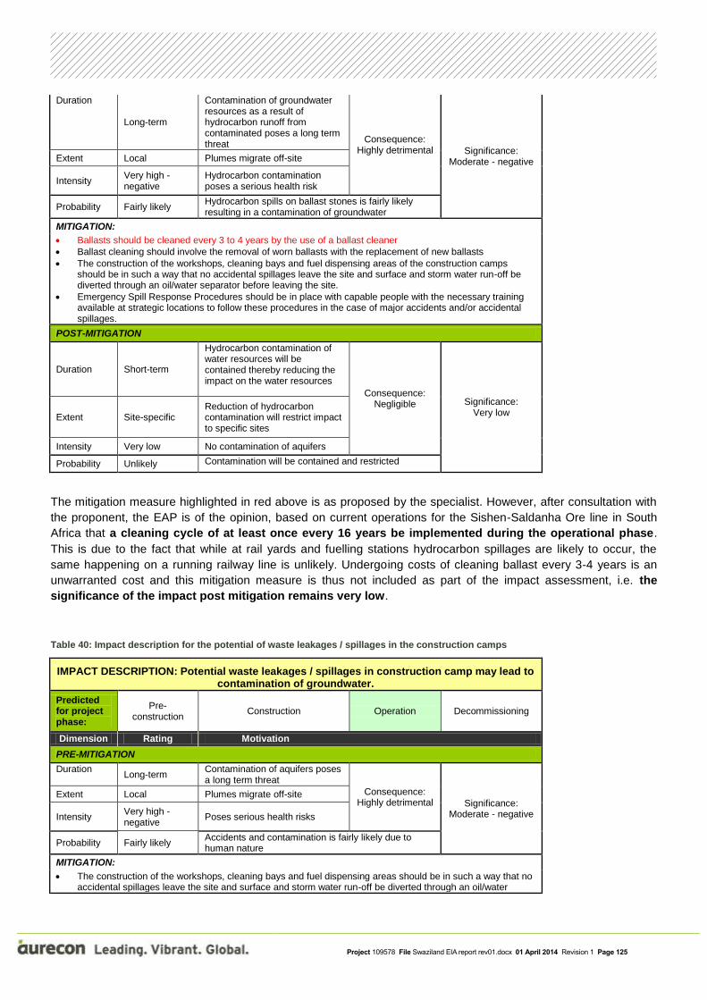
Project 109578 File Swaziland EIA report rev01.docx 01 April 2014 Revision 1 Page 125
Duration
Long-term
Contamination of groundwater resources as a result of hydrocarbon runoff from contaminated poses a long term threat
Consequence: Highly detrimental Significance:
Moderate - negative Extent Local Plumes migrate off-site
Intensity Very high - negative
Hydrocarbon contamination poses a serious health risk
Probability Fairly likely Hydrocarbon spills on ballast stones is fairly likely resulting in a contamination of groundwater
MITIGATION:
Ballasts should be cleaned every 3 to 4 years by the use of a ballast cleaner
Ballast cleaning should involve the removal of worn ballasts with the replacement of new ballasts
The construction of the workshops, cleaning bays and fuel dispensing areas of the construction camps should be in such a way that no accidental spillages leave the site and surface and storm water run-off be diverted through an oil/water separator before leaving the site.
Emergency Spill Response Procedures should be in place with capable people with the necessary training available at strategic locations to follow these procedures in the case of major accidents and/or accidental spillages.
POST-MITIGATION
Duration Short-term
Hydrocarbon contamination of water resources will be contained thereby reducing the impact on the water resources
Consequence: Negligible Significance:
Very low Extent Site-specific
Reduction of hydrocarbon contamination will restrict impact to specific sites
Intensity Very low No contamination of aquifers
Probability Unlikely Contamination will be contained and restricted
The mitigation measure highlighted in red above is as proposed by the specialist. However, after consultation with
the proponent, the EAP is of the opinion, based on current operations for the Sishen-Saldanha Ore line in South
Africa that a cleaning cycle of at least once every 16 years be implemented during the operational phase.
This is due to the fact that while at rail yards and fuelling stations hydrocarbon spillages are likely to occur, the
same happening on a running railway line is unlikely. Undergoing costs of cleaning ballast every 3-4 years is an
unwarranted cost and this mitigation measure is thus not included as part of the impact assessment, i.e. the
significance of the impact post mitigation remains very low.
Table 40: Impact description for the potential of waste leakages / spillages in the construction camps
IMPACT DESCRIPTION: Potential waste leakages / spillages in construction camp may lead to contamination of groundwater.
Predicted for project phase:
Pre-construction
Construction Operation Decommissioning
Dimension Rating Motivation
PRE-MITIGATION
Duration Long-term
Contamination of aquifers poses a long term threat
Consequence: Highly detrimental Significance:
Moderate - negative
Extent Local Plumes migrate off-site
Intensity Very high - negative
Poses serious health risks
Probability Fairly likely Accidents and contamination is fairly likely due to human nature
MITIGATION:
The construction of the workshops, cleaning bays and fuel dispensing areas should be in such a way that no accidental spillages leave the site and surface and storm water run-off be diverted through an oil/water

Project 109578 File Swaziland EIA report rev01.docx 01 April 2014 Revision 1 Page 126
separator before leaving the site.
Emergency spill kits should always be present at strategic locations with capable people with the necessary training available to use it in the case of accidental spillages.
POST-MITIGATION
Duration Short-term Spillages are contained and threat will be short term
Consequence: Negligible Significance:
Very low
Extent Site-specific Spillages will be contained
Intensity Very low No contamination of aquifers
Probability Unlikely Spillages will be contained and contamination restricted
Table 41: Impact description for the incorrect disposal of hazardous and non-hazardous materials or waste
IMPACT DESCRIPTION: Incorrect disposal of hazardous and non-hazardous materials or waste could contaminate groundwater.
Predicted for project phase:
Pre-construction
Construction Operation Decommissioning
Dimension Rating Motivation
PRE-MITIGATION
Duration
Long-term
Contamination of aquifers poses a long term threat
Consequence: Highly detrimental
Significance: Moderate - negative
Extent Local Local water resources may be contaminated resulting in contamination of aquifers
Intensity Very high - negative
Contamination of water resources with hazardous material could lead to health risks
Probability Fairly likely Contamination of water resources by the incorrect disposal of materials is fairly likely due to the nature of the material being transported
MITIGATION:
An adequate waste management plan should be implemented to prevent incorrect disposal of materials.
POST-MITIGATION
Duration Short-term
Contamination of water resources will be prevented therefore restricting the potential impact of contamination
Consequence: Negligible
Significance: Very low
Extent Site-specific Potential impacts will be contained at will only have an impact at site level
Intensity Very low
Contamination of water resources will be contained therefore restricting the potential impact of contamination
Probability Unlikely Implementation of appropriate mitigating measures will severely reduce the potential of contamination of water resources

Project 109578 File Swaziland EIA report rev01.docx 01 April 2014 Revision 1 Page 127
Table 42: Impact description for the potential contamination of groundwater by contaminated ballast stone
IMPACT DESCRIPTION: Contaminated ballast stone may lead to contamination of groundwater.
Predicted for project phase:
Pre-construction
Construction Operation Decommissioning
Dimension Rating Motivation
PRE-MITIGATION
Duration Long-term
Contamination of water resources could pose a long term health risk
Consequence: Highly detrimental
Significance: Moderate - negative
Extent Long-term Plumes migrate off-site
Intensity Long-term Poses a serious health risk
Probability Long-term Contamination is fairly likely due to human error
MITIGATION:
Ballasts should be cleaned every 3 to 4 years by the use of a ballast cleaner
Ballast cleaning should involve the removal of worn ballasts with the replacement of new ballasts
POST-MITIGATION
Duration Short-term Aquifers will not be contaminated
Consequence: Negligible
Significance: Very low
Extent Site-specific Spillages will be contained
Intensity Very low No contamination of aquifers
Probability Unlikely Mitigation will reduce the potential for spillages and contamination
The mitigation measure highlighted in red above is as proposed by the specialist. However, after consultation with
the proponent, the EAP is of the opinion, based on current operations for the Sishen-Saldanha Ore line in South
Africa that a cleaning cycle of at least once every 16 years be implemented during the operational phase.
This is due to the fact that while at rail yards and fuelling stations hydrocarbon spillages are likely to occur, the
same happening on a running railway line is unlikely. Undergoing costs of cleaning ballast every 3-4 years is an
unwarranted cost and this mitigation measure is thus not included as part of the impact assessment, i.e. the
significance of the impact post mitigation remains very low.
Table 43: Impact description for potential spillages of hazardous materials resulting from accidents or collisions
IMPACT DESCRIPTION: Spillages of hazardous materials resulting from accidents or collisions may result in contamination of groundwater.
Predicted for project phase:
Pre-construction
Construction Operation Decommissioning
Dimension Rating Motivation
PRE-MITIGATION
Duration
Medium-term Contamination of surface water resources could have a long term impact on groundwater
Consequence: Moderately detrimental
Significance: Low - negative
Extent Medium-term Will be restricted to local impact

Project 109578 File Swaziland EIA report rev01.docx 01 April 2014 Revision 1 Page 128
Intensity Medium-term Contaminated groundwater could pose a serious health risk
Probability Medium-term Contamination is likely due to human error
MITIGATION:
Emergency spill response procedures should be in place with capable people with the necessary training available at strategic locations to follow these procedures in the case of major accidents and/or accidental spillages.
POST-MITIGATION
Duration Short-term Contamination of water resources will be contained before aquifers are affected
Consequence: Negligible Significance:
Very low Extent Site-specific Contamination will be contained
Intensity Very low Contamination will be contained resulting in low impact
Probability Unlikely Mitigation will greatly reduce the impact of waste and spillage contamination of water resources
Table 44: Impact description for potential wind-blown material emanating from uncovered rail trucks
IMPACT DESCRIPTION: Wind-blown material emanating from uncovered rail trucks may result in contamination of groundwater.
Predicted for project phase:
Pre-construction
Construction Operation Decommissioning
Dimension Rating Motivation
PRE-MITIGATION
Duration
Long-term Contamination of surface water resources could have a long term impact on groundwater Consequence:
Moderately detrimental Significance:
Low - negative
Extent Local Will be restricted to local impact
Intensity Moderate - negative
Contaminated groundwater could pose a serious health risk
Probability Fairly likely Contamination of water resources by material emanating from uncovered wagons is fairly likely due to the nature of the material being transported
MITIGATION:
Transnet should consider covering rail trucks when transporting hazardous materials.
POST-MITIGATION
Duration Short-term Contamination of water resources will be contained before aquifers are affected
Consequence: Negligible
Significance: Very low
Extent Site-specific Contamination will be contained
Intensity Very low Contamination will be contained resulting in low impact
Probability Unlikely Mitigation will greatly reduce the impact of waste and spillage contamination of water resources

Project 109578 File Swaziland EIA report rev01.docx 01 April 2014 Revision 1 Page 129
8.3 Impacts on the Physical Environment
8.3.1 Noise and vibration assessment
Measurements and site investigation were conducted from the 10th
September till the 13th
September 2013.
Potentially sensitive receptors, also known as noise-sensitive developments (NSDs) were identified up to 200 m
from the railway line. Receptors locations were identified using tools such as Google Earth®
and other available
internet resources and information. Potential receptors around the development were classified between NSD04 to
NSD121. The following rating levels are proposed for receptors in the study area:
The noise guidelines as prepared by the International Finance Corporation (IFC) in its Environmental,
Health and Safety Guidelines (EHS) – General EHS Guidelines: Environmental Noise Management (2007)
with a 55 and 45 dBA day/night time rating level for receptors.
Four operational scenarios were assessed as the project functions, namely:
The projected daytime initial peak hour assessment (worst case) when the railway initially starts
operations;
The projected night-time initial peak hour assessment (worst case) when the railway initially starts
operations;
The projected daytime future peak hour assessment (worst case) when the railway operates at
maximum capacity; and
The projected night-time future peak hour assessment (worst case) when the railway operates at
maximum capacity.
There is no standard or guideline in Swaziland or South Africa stipulating the requirements to calculate or model
the potential noise impacts from a railway operation. Various International propagation models do exist. The
European Transportation Research Laboratory (TRL) has recommended the British model “Calculation of Railway
Noise, 1995” as the most technical sound of the available models. For this reason assessment calculations were
done in accordance with the sound propagation model described by British CRN (Railway Noise) model.
Assessment indicated a potential sound environment where the IFC guidelines would be exceeded by the initial
and future day and night-time operation sound levels during peak traffic periods at houses directly adjacent or
bordering the train line. This is mostly due to the proximity of the proposed railway line in relation to certain
receptors.
The two tables below describe the impacts of the Initial day and night scenario and the future day and night
scenario respectively as well as their proposed mitigation measures.
Table 45: Impact description of the initial day and night scenario
IMPACT DESCRIPTION: Initial day and night scenario Predicted for project phase:
Pre-construction
Construction Operation Decommissioning
Dimension Rating Motivation
PRE-MITIGATION

Project 109578 File Swaziland EIA report rev01.docx 01 April 2014 Revision 1 Page 130
Duration Long-term Will continue after construction is complete
Consequence: Extremely detrimental Significance:
Very high - negative
Extent Regional Will affect surrounding communities
Intensity Very high - negative
Equivalent noise levels will exceed the IFC guidelines during day and night-time hours
Probability Certain The nature of the project will result in noise and vibration becoming a nuisance
MITIGATION:
Programmes to manage rail and wheel roughness
Lowering of speed limits near sensitive areas
Screening of line of sight from receptors
Relocate receptors
Continuous public participation
Establishment of a help line and noise complaint logging
Environmental acoustical programme
Identifying of special receptors such as religious, health and educational facilities
POST-MITIGATION
Duration Long-term Will continue after construction is complete
Consequence: Highly detrimental
Significance: High - negative
Extent Regional Will affect surrounding communities
Intensity Moderate - negative
Equivalent noise levels will exceed the IFC guidelines during day and night-time hours
Probability Certain
The implementation of the proposed mitigation measures will reduce the potential negative impact and the potential positive economic impacts of the project might create a positive attitude towards the project
Table 46: Impact description of the future day and night scenario
IMPACT DESCRIPTION: Future day and night scenario
Predicted for project phase:
Pre-construction
Construction Operation Decommissioning
Dimension Rating Motivation
PRE-MITIGATION
Duration Long-term Will continue after construction is complete
Consequence: Extremely detrimental Significance:
Very high - negative
Extent Regional Will affect surrounding communities
Intensity Very high - negative
Equivalent noise levels will exceed the IFC guidelines during day and night-time hours
Probability Certain The nature of the project will result in noise and vibration becoming a nuisance
MITIGATION:

Project 109578 File Swaziland EIA report rev01.docx 01 April 2014 Revision 1 Page 131
Programmes to manage rail and wheel roughness
Lowering of speed limits near sensitive areas
Screening of line of sight from receptors
Relocate receptors
Continuous public participation
Establishment of a help line and noise complaint logging
Environmental acoustical programme
Identifying of special receptors such as religious, health and educational facilities
POST-MITIGATION
Duration Long-term Will continue after construction is complete
Consequence: Highly detrimental
Significance: High - negative
Extent Regional Will affect surrounding communities
Intensity Moderate - negative
Equivalent noise levels will exceed the IFC guidelines during day and night-time hours
Probability Certain
The implementation of the proposed mitigation measures will reduce the potential negative impact and the potential positive economic impacts of the project might create a positive attitude towards the project
It must be noted that commercial railway line activities are exempted from certain requirements of Government
Notice R154 of 1992 (Noise Control Regulations) – Regulation 2.(c) - “Provided that the provisions of this
paragraph (in reference to noise emanating from a development) shall not apply in respect of a disturbing noise or
noise nuisance caused by rail vehicles or aircraft which are not used as recreational vehicles”. Furthermore the
locomotive horns is exempted from the Government Notice R154 of 1992 (Noise Control Regulations) – Clause
7.(1) – “the emission of sound is for the purposes of warning people of a dangerous situation”.
With a risk of a noise impact developing during the night-time hours being of a potential high significance,
mitigation options could be considered by the proponent. The mitigation of noise from railway lines is difficult and
potentially expensive to implement. Mitigation discussed below is optional and not mandatory for the developer
due to the exemptions mentioned above. Mitigation options should be considered at receptors where a medium to
high potential for a noise impact has been identified (refer to Appendices in document) receptors that are near
where trains have to brake and/or receptors that border or are adjacent to the railway line. Mitigation options should
also be considered at potential sensitive areas such as places of worship (religious), at educational and health
care facilities and at business that cater for hospitality (game lodges).
Mitigation Options: Mitigation of Noise Source – Railway Line
Possibly the best mitigation options when considering acoustics is the design and specifications of railway lines
and operations. These include:
1. Minimise train operations during the night-times (22:00 – 06:00, SANS 10103:2008) - The potential
important times for a noise annoyance to occur would be during the night-time hours when a quiet
environment is desired (at night for sleeping etc.). It is highly likely that maximum noise levels due to single
noise events outdoor at houses (directly adjacent to the train) could exceed 80 dBA. This would be also
relevant during religious worship, at educational and health care facilities and at business that cater for
hospitality (e.g. pray times at the Mosque or Sunday church services and at game lodges).The developer
should consider identifying such sensitive areas as mentioned above and discussing the findings of this
report with them. However, as the railway line is a 24 hour operation, this mitigation measure is

Project 109578 File Swaziland EIA report rev01.docx 01 April 2014 Revision 1 Page 132
considered impractical and unfeasible and will therefore not be implemented by Swaziland Railway
and Transnet. ;
2. Programmes to manage rail and wheel roughness – The developer can consider the implementation of
composite material (or similar) brake shoes (“K or LL Blocks”) as cast-iron brakes cause wheel roughness
(and more friction and noise). These wheel dampers will produce the lowest peak noise levels, but may not
prevent tyre squeal fully. The LL brake block system has the potential to reduce rolling and braking noises
over cast iron brakes as well as K blocks. LL block systems does not require the adaption of cast-iron
brake systems and also damage the train wheels far less than a conventional cast-iron brake. The
developer should consider ensuring that rail head grinding and rail head maintenance is conducted
regularly to ensure that the correct rail head profile is maintained. The developer could consider rail
dampers on the rail line at sections of rail near receptors dwellings;
3. Consideration of 40 km/h train speeds near sensitive areas – If the developer operates at slower speeds
(not maximum) near sensitive areas, this would minimise a potential noise annoyance near places of
religious worship, at educational and health care facilities and at business that cater for hospitality (game
lodges);
4. Screen the line of sight from receptors to the rail loops and railway lines – The developer can consider
berms, barriers and design of the rail loop infrastructure (placement of buildings at rail loops) in order to
screen the railway line operations to a receptors dwellings. From a technical perspective it would seem
easiest to consider a berm or single/double brick wall. A less feasible option (from a technical perspective)
is to design the railway loops and railway line to be at a lower elevation than a receptors dwelling (sufficient
height difference to obscure line of sight). Advancement in barriers designed specifically for sound
insulation has improved drastically over the years. Although a more expensive option than single/double
brick/concrete wall or an aggregate berm, acoustic barriers are specifically designed as a buffer for noises.
Such barriers could be implemented along the railway line where there is a potential for a high noise impact
or at sensitive areas. If the developer decides to implement a double brick wall or berm, the following
factors should be implemented to ensure an effective noise boundary wall/barrier:
It is recommended that the barrier be built as close as possible to the footprint of the railway line (noise
source) or residents (receptor) as is feasible as possible. The barrier design needs to consider
diffraction, and should have no aperture or gaps;
It is recommended that the height of the berms/barriers be at least 1 m higher than the line of sight to
the highest noise source from the railway line to a receptors dwelling. Barriers must also be sufficiently
dense (at least 20 kilograms/square meter surface density) and sufficient in thickness. A brick wall
provides a surface density of 244 kilograms/square m at thickness of 150 mm1and is considered as a
typically good acoustical barrier. Certain metrological conditions (particularly during night-times) can
see refraction of noise over the barrier due to the various temperature inversion layers. This means
that noise levels from a railway line may propagate back down to the ground at a receptors dwelling
due to the curvature of sound in the warmer upper night-time atmosphere. Barrier height cannot effect
this propagation; and
The barrier should be sufficiently long.
Mitigation Options: Mitigation at Receptors
The following optional possibility can be considered by the developer:
1. Relocate receptor – An option for the developer to consider relocating receptors directly adjacent to the
proposed railway line.
Mitigation Options: Management Mitigation

Project 109578 File Swaziland EIA report rev01.docx 01 April 2014 Revision 1 Page 133
Public relations are important throughout the entire planning, construction and development of the project. The
developer could consider the following:
1. Public participation – A developer representative could discuss the calculated noise levels in this document
with receptors. The developer representative should indicate other positive aspects of the project (job and
infrastructure enhancement in the area);
2. Help line and noise complaint logging - The developer could consider a line of communication (e.g. a help line
where complaints could be lodged). All potential sensitive receptors should be made aware of these contact
numbers. Sporadic and legitimate noise complaints could develop. For example, sudden and sharp increases
in sound levels could result from poorly maintained tracks. Noise complaints can be logged and supplied to
railway maintenance staff to further investigate (rail roughness);
3. Environmental Acoustical Measurement Programme – The developer could implement a noise measurements
programme and reporting conducted on an annual basis and preferably linked to a noise propagation model to
illustrate the extent of the noise impact from the railway. This may enable the developer to identify and potential
problems relating to noise from the development at that stage of the project operations; and
4. Religious, health, educational buildings and hospitality facilities – The developer could consider identifying
these facilities near the railway line and co-ordinating any operational times that may be sensitive to these
receptors.
As it is unsure of which (if any) mitigation options the developer may implement, identifying the potential impacts
with mitigation options implemented cannot be assessed.
The findings of this report should be made available to all identified potentially noise-sensitive developments in the
area with the contents explained to them to ensure that they understand all the potential risks that the development
may have on them their families or their business.
It must also be noted that it is unfair to expect the noises from the development to be inaudible under all
circumstances (even mitigated noise) as this is an unrealistic expectation that is not required or expected from any
other agricultural, commercial, industrial or transportation related noise source. Care must be taken to ensure that
the sound produced by the proposed development is at a reasonable level in relation to the existing ambient sound
levels.

Project 109578 File Swaziland EIA report rev01.docx 01 April 2014 Revision 1 Page 134
8.3.2 Cultural and heritage resources assessment
In Swaziland heritage protection falls under the Swaziland National Trust Commission (SNTC). This body is
empowered by the SNTC Act of 1972 which was amended in 1973. Forty years ago, when the act was written
heritage, cultural and archaeological surveys were not envisaged, nor was there any attempt at a systematic
national assessment of assets, therefore there is no heritage ranking system in Swaziland.
Instead nature conservation was prioritised within the act. The act does allow for the creation of national
monuments, however in forty years three national monuments have been declared, none of these in the past thirty
five years. A list of twelve proposed new national monuments submitted by the SNTC has never been gazetted.
Comprehensive new legislation has been drafted to update the legal framework of the SNTC, however when it was
presented to parliament it was sent back for revision and awaits resubmission.
In the absence of existing legal guidelines in Swaziland the South African triple tier heritage grading system has
been used in this scoping survey. It is compatible with the South African component of the Davel to Richards Bay
rail ink heritage survey.
The South African National Heritage Resources Act No 25 of 1999 (NHRA) has been relied upon for the
assessment criteria and grading of archaeological sites. The following categories are distinguished in Section 7 of
the Act (known as the triple tier heritage grading system):
Grade I: Heritage resources with qualities so exceptional that they are of special national significance;
Grade II: Heritage resources which, although forming part of the national estate, can be considered to have
special qualities which make them significant within the context of a province or a region; and
Grade III: Other heritage resources worthy of conservation on a local authority level.
The occurrence of sites with a Grade I significance will demand that the development activities be drastically
altered in order to retain these sites in their original state. For Grade II and Grade III sites, the applicable of
mitigation measures would allow the development activities to continue.
Sites regarded as having low significance is viewed as recorded in full after identification and would require no
further mitigation. Impact from the development would be judged to be low. Sites with a medium to high
significance would require mitigation. Mitigation, in most cases the excavation of a site, is in essence destructive
and therefore the impact can be viewed as high and as permanent.
8.3.2.1 ARCHAEOLOGICAL, CUTURAL AND HISTORICAL ASSETS ON THE SURVEY ROUTE
Grade 1:
No heritage assets were recorded.
Grade 2:
Two heritage assets were recorded, namely:
1. A refuge cave at 260 35’ 51.183” S and 310 09’ 20.27 E. The rail line passes within a hundred meters of
the site, care should be taken not to enter or disturb the caves, no further action is required.

Project 109578 File Swaziland EIA report rev01.docx 01 April 2014 Revision 1 Page 135
2. A reed collection site for the Umhlanga ceremony, 260 38’ 27.42” S and 310 25’ 13.52 E. This is between
the Sidvokodvo siding and the Usutu River, mostly on the river banks. The reeds are an essential
component for the Umhlanga or Reed Dance ceremony, one of two major national ceremonies - along with
the Incwala - in Swaziland. Reed areas are threatened countrywide by changing land use. The reed growth
area should be avoided if the siding is enlarged, no further action is needed.
Grade 3:
No heritage assets were recorded.
The light scatters of MSA stone tools and isolated hand axes found are unlikely to provide further information and
are not sites. Excavation is not needed.
Graves:
Numerous graves were recorded on the route, in all cases these are associated with occupied homesteads.
Projects like Maguga Dam and LUSIP exhumed the graves and reburied them under the supervision of the project
sociologist. It is assumed that this project will be similar.
Further action
The route from the border to Sidvokodvo should be periodically monitored when the rail line is constructed and
earthworks occur. By its very nature many archaeological remains are buried and are only uncovered when the
surface is disturbed. The line from Sidvokodvo to Lavumisa will follow the existing route, little disturbance is
expected and no further monitoring of this section is recommended. However where sidings are enlarged this will
cause soil disturbance and these operations should be monitored.
Stone hand axes were found on the lowvelt rail sidings, these indicate that there may well be further material. In
addition some of the sidings, like Matata, lie below Border Cave in South Africa which is clearly visible from it.
Construction and extension of these sidings should be monitored as Border Cave is of Grade 1 significance and
there may be associated material uncovered during line construction or from other periods.
8.3.2.2 Impact assessment
Impact analysis of cultural heritage resources under threat of the proposed development, are based on the present understanding of the development.
The table below describes the impact predicted by the heritage impact assessment, as well as the proposed
mitigation measures.
Table 47: Impact description of the possible disturbance of cultural and heritage resources
IMPACT DESCRIPTION: Disturbance of cultural and heritage resources
Predicted for project phase:
Pre-construction
Construction Operation Decommissioning
Dimension Rating Motivation
PRE-MITIGATION

Project 109578 File Swaziland EIA report rev01.docx 01 April 2014 Revision 1 Page 136
Duration Long-term Displacement of graves/ spiritual sites will be permanent
Consequence: Highly detrimental
Significance: Moderate - negative
Extent Regional Will affect graves/ spiritual sites in right-of-way
Intensity High - negative
Loss of graves/ spiritual sites will constitute a negative social impact and may precipitate opposition to the project
Probability Fairly likely Presence of cultural resources in right-of-way was not established as part of this assignment
MITIGATION:
Where possible, narrow the right-of-way to avoid graves/ spiritual site.
Relocation of graves/ spiritual sites to be executed in culturally appropriate manner
Accidental discovery of graves/ archaeological sites to be reported and dealt with according to relevant legislation and cultural norms
POST-MITIGATION
Duration Long-term As for pre-mitigation
Consequence: Highly detrimental
Significance: Moderate - negative
Extent Regional As for pre-mitigation
Intensity Moderate - negative
Number of affected graves/ spiritual sites may be reduced by narrowing parts of the right-of-way
Probability Fairly likely Culturally appropriate relocation will reduce the likelihood of this constituting a negative social impact

Project 109578 File Swaziland EIA report rev01.docx 01 April 2014 Revision 1 Page 137
8.4 Impacts on the Social and Socio-economic Environment
8.4.1 Social impact assessment
The SIA formed an important component of the EIA and was aimed at assessing and estimating, in advance, the
social consequences that are likely to follow the implementation of the proposed project.
The SIA sought to provide a framework for prioritising, gathering, analysing, and incorporating social information
and participation into the design and delivery of the project. Furthermore, the SIA ensured that the proposed project
is informed and took into account the key relevant social issues.
The methodology took into account the distinction between social change processes and social impacts. A change
process refers to a change that takes place within the receiving environment as a result of a direct or indirect
intervention. An impact follows as a result of the change process. Impacts are those changes that are physically felt
and emotionally experienced, positively and negatively. However, a change process can only result in an impact
once it is experienced as such by individual persons, by groups of people and households, a community or society
as a whole, social organisations and institutions individual/community on a physical and/or cognitive level.
The social impacts identified during the specialist assessments can be classified into the following broad
categories:
8.4.1.1 Objective social impacts
These are impacts that can be quantified and verified by independent observers, such as changes in population
size or composition, in employment patterns, in standard of living or in health and safety.
8.4.1.2 Subjective social impacts
These are impacts that occur “in the imagination” or emotions of people, such as negative public attitudes,
psychological stress or reduced quality of life. This kind of impact is much more difficult to identify and describe, as
one cannot readily quantify perceptions or emotions.
For the purpose of this SIA the following categories were investigated:
Social well-being;
Quality of the living environment;
Economic impacts and material well-being;
Family and community impacts;
Institutional impacts, and
Gender impacts.
The general criteria for selecting significant social impacts included the following:
Probability of the event occurring;
Number of people that will be affected;
Duration of the impact;
Value of benefits or costs to the impacted group;
Extent to which identified social impacts are reversible or can be mitigated;
Likelihood that an identified impact will lead to secondary or cumulative impacts; and
Uncertainty over possible effects.

Project 109578 File Swaziland EIA report rev01.docx 01 April 2014 Revision 1 Page 138
Positive impacts associated with the project include:
The creation of temporary employment opportunities and social benefits;
Opportunities for local sourcing of goods and services;
Improved road infrastructure associated with development project;
Local and regional economic benefits; and
Increased development aid/investment from government and/or project investors.
Negative impacts that may be associated with this phase include:
Social and cultural disruption and conflict due to population influx;
Creation of spontaneous and informal settlements;
Possible social pathologies arising from the population influx (such as crime, HIV/AIDS, prostitution etc);
The need to secure accommodation for construction staff;
Disturbance impacts related to physical intrusion (i.e. the impacts of dust, noise, traffic and pollution on
sense of place);
Land use impacts and impacts on common property resources;
Displacement; and
Community perceptions and responses.
The following impact descriptions represent the potential positive impacts which may occur due to the proposed
development:
8.4.1.3 Impact assessment: Creation of temporary employment opportunities and social benefits
The results of the socio-economic survey indicate that the surrounding environment of the project are characterised
by poverty and underdevelopment. Notable socio-economic statistics include:
A very high unemployment rate – 24 percent of the surveyed population is unemployed;
There is a significant dependency ratio in these areas, with 1 or 2 employed household members often
having to provide for households with an average of 8 household members; and
From these figures, it is clear that the households in the project area face significant socio-economic challenges.
The creation of employment opportunities can therefore be seen as a significant positive impact on the surrounding
communities, even if these opportunities are only of a temporary nature.
During the household survey, the issue regarding creation of employment opportunities was most frequently
mentioned in the area. There is a widespread high expectation that Swaziland Railway and Transnet should
provide employment opportunities to the residents in the local area. With increased income-earning capacity the
individuals and communities will be empowered.
Construction activities on the proposed railway project will create a number of permanent and temporary
employment opportunities. The magnitude of this impact is related to the number of construction workers to be
employed, either by Swaziland Railway itself or by contractors. It is recommended that local labour must be used
as much as possible.
Sourcing of construction workers from the local labour pool is likely to be limited to unskilled and semi-skilled
workers. This could have some economic benefits for surrounding communities, although mostly of a temporary

Project 109578 File Swaziland EIA report rev01.docx 01 April 2014 Revision 1 Page 139
nature. It is recommended that recruitment for new positions be undertaken through the Employment Forum (or
any other relevant Forum) that would have been established by the local community /chief or Inkhundla.
Marginalised and vulnerable groups are particularly sensitive to social and economic changes in their local area,
special care should be taken to incorporate these vulnerable groups and in so doing minimising the potential
negative impacts of the project on them and create positive economic opportunities for them.
In addition to creating job opportunities for construction workers, the project may also lead to indirect employment
creation in the informal sector, for instance in terms of food stalls for the convenience of construction workers.
Additionally, more informal employment opportunities may be created through a multiplier effect from the project’s
activities.
The table below describes the impact associated with the creation of employment opportunities.
Table 48: Impact description for the creation of employment opportunities
IMPACT DESCRIPTION: Creation of employment opportunities Predicted for project phase:
Pre-construction
Construction Operation Decommissioning
Dimension Rating Motivation
PRE-MITIGATION
Duration Short-term Construction activities will create a number of temporary jobs
Consequence: Moderately beneficial
Significance: Low - positive
Extent Local
Sourcing of construction workers from the local labour pool is likely to be limited to unskilled and semi-skilled workers
Intensity High - positive
In addition to creating job opportunities for construction workers, the project may also lead to indirect employment creation in the informal sector
Probability Fairly likely Semi-skilled and unskilled jobs will be created
MITIGATION:
Make use of local labour as far as possible.
Liaise with local community structures to identify local labour pool.
POST-MITIGATION
Duration Medium-term As for pre-mitigation
Consequence: Moderately beneficial
Significance: High - positive
Extent Local As for pre-mitigation
Intensity High - positive By implementing the mitigation measures the local labour pool will benefit
Probability Certain The use of the local labour force will be enhanced
8.4.1.4 Impact assessment: Opportunities for local sourcing of goods and services
Local communities often have high expectations about participating in new opportunities in their area. Local
procurement of goods and services are a manner that these communities can successfully partake in the

Project 109578 File Swaziland EIA report rev01.docx 01 April 2014 Revision 1 Page 140
development project. Local procurement can provide a fundamental linkage between the project implementers and
the local communities.
Community contracting describes a number of different methods to implement infrastructure projects at a
community level. These range from what is effectively direct implementation by project developers and contractors
using community labour to structures where independent community-based organisations act as contractors on a
similar basis to a private sector contractor.
Creating a platform where Local suppliers development (LSD) can take place would not only benefit the local
micro, small and medium enterprises as they would be in a better position to win contracts, but the project
implementer as well as they would have a bigger and more experienced pool of enterprises to choose from.
The table below describes the impact for the opportunities for local sourcing of goods and services as well as
recommended mitigation (or maximisation) measures.
Table 49: Impact description for opportunities for local sourcing of goods and services
IMPACT DESCRIPTION: Local sourcing of goods and services Predicted for project phase:
Pre-construction
Construction Operation Decommissioning
Dimension Rating Motivation
PRE-MITIGATION
Duration Short-term
Procurement of goods and services required for the construction phase of the project from companies owned by historically disadvantaged South Africans
Consequence: Slightly beneficial
Significance: Low - positive
Extent Local Will benefit the local economy
Intensity Moderate – positive
Depends on the implementation of the Transnet procurement policy
Probability Fairly likely
Depends on the implementation of the Transnet procurement policy towards achieving their procurement targets
MITIGATION:
Include conditions in construction contract to involve and train emerging entrepreneurs.
POST-MITIGATION
Duration Short-term
By implementing the mitigation measures the duration of the impact could continue during the operational phase, albeit at a lower intensity
Consequence: Moderately beneficial
Significance: Moderate - positive
Extent Regional As for pre-mitigation

Project 109578 File Swaziland EIA report rev01.docx 01 April 2014 Revision 1 Page 141
Intensity Moderate – positive
Implementation of the mitigation measures will enhance the use of local service providers and goods
Probability Certain Mitigation will increase the use of appropriate service providers and goods
8.4.1.5 Impact assessment: Improved road infrastructure associated with development project
As mentioned earlier the needs analysis revealed that respondents felt that bad roads and associated transport
problems has a negative impact on the quality of their life. Projects like construction of new railway lines cannot
take place without creating access points and routes to the areas where the project is to take place, and this
infrastructure can have countless positive consequences for the local communities. The current road infrastructure
that has been classified by the local residents as bad will have to be upgraded, making it easier for the local
communities to travel on and transport goods from and to places previously unreachable. Better road infrastructure
and transport linkages can provide opportunities for catalysing local economic opportunities.
The table below describes the impact rating for the improvement of road infrastructure.
Table 50: Impact description for the improvement of road infrastructure
IMPACT DESCRIPTION: Improved road infrastructure Predicted for project phase:
Pre-construction
Construction Operation Decommissioning
Dimension Rating Motivation
PRE-MITIGATION
Duration Long-term
Trained workers would become more marketable elsewhere after the completion of this project thereby adding to the migrant labour force
Consequence: Moderately beneficial Significance:
Low – positive
Extent Local Will affect local communities
Intensity Moderate - positive
Outflow of trained workers could have a negative impact but would also create opportunities for other workers and will potentially increase the economic inflow to the community.
Probability Fairly likely Job opportunities for trained workers outside the study area is likely to happen
MITIGATION:
Construction of road infrastructure.
Upgrading current road infrastructure.
Maintain newly constructed and upgraded road infrastructure.
POST-MITIGATION
Duration Long-term
Implementation of mitigation measures could alleviate the need for trained workers to leave the area
Consequence: Highly beneficial
Significance: Moderate - positive

Project 109578 File Swaziland EIA report rev01.docx 01 April 2014 Revision 1 Page 142
Extent Regional As for pre-mitigation
Intensity Moderate - positive
Mitigation will reduce the need for trained workers to leave the area
Probability Fairly likely Mitigation could reduce the outflow of trained workers from the area
8.4.1.6 Impact assessment: Local and regional economic benefits
In addition to the economic benefits derived from employment, the proposed development will also contribute to the
local and regional economy in other ways. For instance, local expenditure by employees will have multiplier effects
in various sectors of the economy, thereby stimulating business activity and further employment creation.
Changes in the local economy structure such as opening of new markets for products and services, increased
demand for consumer goods and inflation of local prices can all have some positive outcomes on the local and
regional economy for example profits that will be injected into the local and regional markets.
The project could also have fiscal impacts – in other words, an impact on government revenues and expenditures.
In particular, payment of business and personal tax could contribute to government revenue at a national level,
while rates and payment for services could strengthen the income base of the area.
The table below describes the impact for the local and regional economic benefits as well as recommended
mitigation (or maximisation) measures.
Table 51: Impact description for local and regional economic benefits
IMPACT DESCRIPTION: Local and regional economic benefits (operational phase)
Predicted for project phase:
Pre-construction
Construction Operation Decommissioning
Dimension Rating Motivation
PRE-MITIGATION
Duration Long-term
Creating employment will increase the spending regime in the area. Long term jobs will persist for the life span of the project
Consequence: Moderately beneficial
Significance: High - positive
Extent Local
The project could also have fiscal impacts. Payment of business and personal tax could contribute to government revenue at a national level, while rates and payment for services could strengthen the income base of the district and local municipalities

Project 109578 File Swaziland EIA report rev01.docx 01 April 2014 Revision 1 Page 143
Intensity Moderate - positive
Local expenditure by employees will have multiplier effects in various sectors of the economy, thereby stimulating business activity and further employment creation
Probability Certain Increased employment levels will contribute to the economy
MITIGATION:
• Maximise local employment opportunities through training and capacity building.
POST-MITIGATION
Duration Long-term increased levels of employment will persist for the duration of the project
Consequence: Moderately beneficial
Significance: High - positive
Extent Local As per pre-mitigation
Intensity Moderate - positive
As per pre-mitigation
Probability Certain As per pre-mitigation
8.4.1.7 Impact assessment: Increased support from government and/or project implementers
In many cases the project will be located in remote rural areas where the population is engaged in subsistence
production that provide limited opportunities for development and economic growth. Low levels of skills and literacy
can restrict communities in their ability to realise opportunities associated with the project.
Human Capital Development investments have both short and long term returns. In the short term, training and
skills development can provide a basis for new augmented sources of income for the local population. In the long
term, some projects may provide human development in the area through support for education, training and skills
development.
The table below describes the impact for the potential increased support from government and/or project
implementers as well as recommended mitigation (or maximisation) measures.
Table 52: Impact description for the increased support from government and/or project implementers
IMPACT DESCRIPTION: Increased support from government and/or project implementers Predicted for project phase:
Pre-construction
Construction Operation Decommissioning
Dimension Rating Motivation
PRE-MITIGATION
Duration Long-term Influx of workers and job seekers could result in an increase in crime
Consequence: Moderately beneficial
Significance: Low - positive Extent Local
Local communities will be affected
Intensity Moderate - positive

Project 109578 File Swaziland EIA report rev01.docx 01 April 2014 Revision 1 Page 144
Probability Fairly likely
Increase in population numbers and low levels of employment in confined areas could potentially lead to an increase in crime
MITIGATION:
Capacity building and skills development projects and initiatives should be implemented.
POST-MITIGATION
Duration Long-term Mitigation could reduce the time span of potential impact
Consequence: Highly beneficial Significance:
Moderate - positive
Extent Regional Impact will be contained at local level
Intensity Moderate - positive
Mitigation will lower the crime levels
Probability Fairly likely Mitigation will have a positive impact on the lowering of the crime levels
The following impact descriptions represent the potential negative impacts which may occur due to the proposed
development:
8.4.1.8 Impact assessment: Social and cultural disruption and conflict and social pathologies arising
due to population influx
As news regarding the proposed project spreads, expectations regarding possible employment opportunities may
also take root. Consequently, the area surrounding the site / construction areas may experience an influx of job
seekers.
The magnitude of this impact depends on the severity of unemployment in surrounding areas. It could be expected
that migrant labours will flock to the area. Furthermore, poverty is believed to be a widespread problem in
Swaziland, with an unemployment rate of more than 40 percent. Given these figures, it is likely that a large enough
number of job seekers will flock into the area to have fairly significant population impact on the immediate social
environment. This population increase may impact on the area in terms of additional demand for services and
infrastructure.
An influx of newcomers seeking opportunities associated with the project could also create various social problems.
Tension or conflict can be created as a result of religious or ethnic rivalries.
It is assumed that the biggest percentage of the construction workforce for the Swaziland Railway Link will be
locals, while the remainder will have to be housed reasonably close to the construction site. It is possible that
conflict might arise between the newcomers and local residents. One possible reason for such conflict would be the
perception among locals that the outsiders are taking up jobs that could have gone to unemployed members of the
local community. An influx of unemployed job seekers (which was discussed in the preceding sections) could add
to the potential for conflict.
One of the potential social pathologies that may arise from a rapid increase in population numbers in an existing
underdeveloped area is an increase in crime levels. The extra strain that the influx of job seekers will place on
limited employment opportunities in the area will potentially increase the unemployment rate, which will increase

Project 109578 File Swaziland EIA report rev01.docx 01 April 2014 Revision 1 Page 145
the crime rate. Even if particular instances of crime are not as a result of the newcomers, they may still be
attributed to them by local communities.
Another possibility is that a population influx will contribute to alcoholism, drug abuse, prostitution and the spread of
sexually transmitted diseases in the local population. An influx of newcomers can overburden the health services
and infrastructure, inadequate sewage and waste management and can increase some health risks.
The table below describes the impact which could arise due to possible social and cultural disruption and conflict
due to population influx as well as recommended mitigation (or maximisation) measures.
Table 53: Impact description for possible social pathologies arising from population influx
IMPACT DESCRIPTION: Social pathologies arising from population influx Predicted for project phase:
Pre-construction
Construction Operation Decommissioning
Dimension Rating Motivation
PRE-MITIGATION
Duration Short-term
Influx of job seekers during the construction phase could lead to conflict between locals and newcomers Consequence:
Slightly detrimental Significance:
Low - negative Extent Site-specific Will affect local communities
Intensity Moderate - negative
Conflict between locals and newcomers could occur.
Probability Fairly likely
Local communities frequently, rightly or wrongly, associate newcomers with social problems
MITIGATION:
Additional security must be provided during this period by the contractors, which should be integrated with existing farm /community security systems
Implement HIV/AIDS and alcohol abuse campaigns in the communities
Align awareness campaigns with those of other organisations in the area (i.e. the Local Municipality, Farmers etc.)
As far as possible, make use of local labour.
Liaise with local community structures / chiefs to identify mutually acceptable means of controlling the influx of job seekers or, if this is not possible, to mitigate the negative effects of such an influx
Recruitment is to be conducted via the Employment Forum / appropriate forum and not within the project area itself
POST-MITIGATION
Duration Short-term Management of the issue could reduce the impact to a short term impact
Consequence: Negligible Significance:
Very low
Extent Site-specific Impact could be reduced
Intensity Very low
Occurrence of the impact could be reduced by mitigation process
Probability Fairly likely Even with mitigation potential still exists, albeit at a lower intensity

Project 109578 File Swaziland EIA report rev01.docx 01 April 2014 Revision 1 Page 146
8.4.1.9 Impact assessment: Creation of spontaneous and informal settlements
One of the contributors to the development and expansion of informal settlements is the influx of job seekers into
the area, as these job seekers tend to settle in the informal settlements. However, many other factors are also
responsible for the growth of informal settlements, which cannot all be attributed to the proposed railway line
project. Therefore, this establishment of informal settlements is the result of many cumulative impacts, such as
influences of other projects and factories in the area, current socio-economic conditions in the country and region
and so forth.
Many impacts also arise from the expansion of informal settlements, especially an increase in associated social
pathologies. The informal settlements are highly underdeveloped in terms of infrastructure. Most houses have no
electricity supply, no safe drinking water and have no refuse disposal systems. These informal settlers are also
mostly unemployed as they are job seekers who migrate to the area.
In most instances the local communities would claim that the informal settlements are contributing directly to a
number of problems. In particular, the community believes that these settlements lead to a higher crime rate in the
area.
It is therefore clear that there is a cumulative impact of various preceding factors that influence the extent of this
impact. It is possible that an influx of job-seekers moving into the area because of the project will cause informal
settlements to expand even more, and thereby exacerbate the social problems mentioned above.
Measures to mitigate or control the expansion of informal settlements will have to be implemented with
considerable sensitivity so as not to infringe on people’s constitutionally guaranteed right to freedom of movement.
To this end, it is recommended that Swaziland Railway facilitate the establishment of a “Community Safety
Committee” with the aim of monitoring and controlling illegal squatting. The suggested membership of such a
committee would include:
The Community Relations / Stakeholder Engagement Departments of Swaziland Railway;
Respective local Chief;
Respective Inkhundla;
Local landowners; and
Representatives of local community.
The functions of this committee would include:
Frequent monitoring of the area to detect the establishment of new informal settlements. (It is foreseen
that this function could be carried out by Community Relations / Stakeholder Engagement Departments of
Swaziland Railway in cooperation with the local Chiefs, as well as other stakeholders in the area);
The establishment of a “hotline” at a local police station or at the local authority / chieftainship for reporting
of illegal squatting. The number of this hotline should be widely disseminated among local communities
and landowners to ensure that the erection of new informal settlements is reported as soon as possible,
thereby allowing for timeous response ; and
The formulation, in consultation with all relevant stakeholders, of an appropriate plan for responding to
illegal squatting.
The table below describes the impact which could arise due to possible creation of informal settlements as well as
recommended mitigation (or maximisation) measures.

Project 109578 File Swaziland EIA report rev01.docx 01 April 2014 Revision 1 Page 147
Table 54: Impact description for the creation of informal settlements
IMPACT DESCRIPTION: Creation of informal settlements Predicted for project phase:
Pre-construction
Construction Operation Decommissioning
Dimension Rating Motivation
PRE-MITIGATION
Duration Short-term
The establishment of informal settlements by caused by the influx of workers could occur during the construction phase
Consequence: Slightly
detrimental
Significance: Low - negative
Extent Local
Informal settlements are usually associated with an increase in social pathologies which could manifest itself on a wider regional scale
Intensity Low - negative Informal settlements are often associated with negative social problems
Probability Fairly likely
The expected influx of job seekers, the high unemployment rate and lack of sufficient housing will in all probability lead to the establishment of informal settlements
MITIGATION:
Facilitate the establishment of a “Community Safety Committee” to monitor and control illegal squatting.
Committee to consist of:
- The Community Relations / Stakeholder Engagement Departments of Swaziland Railway;
- Its counterparts at other projects in the area
- The local Chiefs;
- The Local Inkhundla;
- Local landowners;
- Representatives of local community structures; and
- Local police.
Align social investment strategies with local development
Include a requirement in the Conditions of Service of construction contractors that construction workers must be vacated from the area once construction is completed.
POST-MITIGATION
Duration Short-term
The implementation of the mitigation measures will reduce and manage the establishment of informal settlements
Consequence: Negligible Significance:
Very low Extent Local Mitigation could contain the impact to the local level
Intensity Very low Mitigation could reduce severity of impact
Probability Fairly likely Mitigation could reduce likelihood of impact occurring to the intensity predicted
8.4.1.10 Impact assessment: Accommodation for construction staff
It may be necessary to find accommodation for a number of construction workers in the vicinity of the proposed
developments. One option would be to house them in a construction village. The other option will be to house
them in nearby settlements. This may require that Swaziland Railway invest in the construction of additional
housing units.

Project 109578 File Swaziland EIA report rev01.docx 01 April 2014 Revision 1 Page 148
A major concern for communities in the area relates to the management of housing for the construction workers
who are employed by the contractors. Construction contractors also reportedly do not construct adequate housing
facilities for their workers, resulting in the expansion of informal settlements and other social pathologies, such as
increased crime levels.
The construction of additional housing units for construction workers will increase the pressure on the service
infrastructure. In addition, there is an existing perception among community members that construction workers
from contractors move into the area and stay there even after construction activities have completed. The
construction of additional housing units for construction workers might reinforce this perception and cause
resentment.
Therefore, it is recommended that a construction village be used as housing for the construction workers. It is
recommended that one construction village be used to house construction workers of the project components to
minimise the extent of pressure the additional housing will exert on social and municipal infrastructure. Since the
construction timeline of the proposed project components is sequential with some overlapping time periods, it is
necessary to ensure that the construction village is large enough to accommodate the maximum number of
construction workers that will be employed at any given time.
Furthermore, it would be preferable if sufficient entertainment facilities could be included in the construction camp.
Entertainment facilities could comprise a lounge with pool table, television, vending machines for soft drinks, etc.
By providing entertainment facilities, the workers’ motivational levels may increase and the risk to social
pathologies will decrease. If entertainment facilities cannot be included in the camp layout, attendance of
alternative entertainment facilities must be encouraged.
Once construction of the project components is completed, the construction camp should be demolished
completely to avoid settling of informal residents. As an alternative, the construction contractor may negotiate with
the Inkhundla about possibly selling or donating the construction camp to them for use as formal housing in the
area.
The table below describes the impact which could arise due to the need to accommodate construction staff as well
as recommended mitigation (or maximisation) measures.
Table 55: Impact description for the accommodation of construction staff
IMPACT DESCRIPTION: Accommodation for construction staff
Predicted for project phase:
Pre-construction
Construction Operation Decommissioning
Dimension Rating Motivation
PRE-MITIGATION
Duration Short-term
Negative impacts associated with the accomodation of construction staff will be limited to the construction period
Consequence: Slightly
detrimental
Significance: Low - negative
Extent Local Impacts will affect local communities

Project 109578 File Swaziland EIA report rev01.docx 01 April 2014 Revision 1 Page 149
Intensity Low - negative
Providing accomodation for construction workers will have very little impact on the local communities
Probability Very likely Additional housing will increase the pressure on local infrastructure
MITIGATION:
Housing of construction workers in a construction village site
Maximisation of the proportion of job opportunities allocated to locals, thus reducing the need for outsiders
Provision of sufficient entertainment facilities (e.g. lounge with TV, pool table, etc.)
Demolishing construction village after construction activities have finished, or donating the construction camp to the local municipality for formal housing, or alternatively convert the construction camp to permanent housing for labourers during the operational phase.
POST-MITIGATION
Duration Short-term As per pre-mitigation
Consequence: Negligible Significance:
Very low
Extent Local As per pre-mitigation
Intensity Very low Mitigation will alleviate the pressure on local housing
Probability Fairly likely Mitigation will reduce the intensity of the impact
8.4.1.11 Impact assessment: Physical intrusion
Impacts related to noise, visual aspects, air quality and the like are discussed under this heading, as all these
impacts are related to the physical presence of project-related infrastructure and the intrusion this imposes on
surrounding communities. Such intrusion could impinge on the lives of surrounding communities by affecting the
area’s sense of place.
Several factors have to be borne in mind when assessing the potential magnitude of such an impacts. One of
these factors is the current state of the landscape in which the development is situated. The landscape for the
upgrade section already bears the marks of development and as such sense of place will not be such a major
issue. However, for the new link, visual impact assessment may be needed to provide professional opinion and
recommendation.
Another factor to take into account when assessing the impact on sense of place is the meanings that people who
live or work in an area attach to the anticipated changes. If a development promises to offer tangible benefits to
surrounding communities (in terms of, amongst others, job creation.), it is unlikely that its impact on the character of
the landscape will be perceived in a negative light – even if that impact is substantial from an aesthetic point of
view.
Dust generated by construction activities, and by vehicles moving on access roads during construction could affect
air quality in the area. The air quality specialist study reports on the potential impacts on air quality in the area.
Construction activities may also increase noise pollution in the area.
As indicated above, the impact of a development on the character of the landscape may not be experienced as
negative if that development offers tangible benefits. To the extent that the project benefits local communities, it is
therefore unlikely that they will experience it as a significant negative impact on the area’s sense of place.

Project 109578 File Swaziland EIA report rev01.docx 01 April 2014 Revision 1 Page 150
The two tables below describe the impact due to the physical intrusion as well as recommended mitigation (or
maximisation) measures for both the construction as well as operational phases of the project.
Table 56: Impact description for physical intrusion (construction phase)
IMPACT DESCRIPTION: Physical intrusion (Construction phase)
Predicted for project phase:
Pre-construction
Construction Operation Decommissioning
Dimension Rating Motivation
PRE-MITIGATION
Duration Short-term
Impacts related to noise, visual aspects, air quality and the like are related to the physical presence of project-related infrastructure and the intrusion this imposes on surrounding communities.
Consequence: Slightly
detrimental Significance:
Low - negative
Extent Site-specific Localised impact
Intensity Moderate - negative
Such intrusion could impinge on the lives of surrounding communities by affecting the area’s sense of place
Probability Certain Due to the type of project it will result in an impact on the community
MITIGATION:
Implement mitigation measures recommended in separate specialist reports on noise impacts and air quality.
Do not engage in construction activities during church gatherings or at night.
Liaise with local communities as to activities scheduled and avoid construction during these times, if possible.
Continuous communication with the affected communities
POST-MITIGATION
Duration Short-term Will be limited to the construction phase
Consequence: Slightly
detrimental Significance:
Low - negative
Extent Site-specific Localised impact
Intensity Moderate - negative
Mitigation will reduce the impact
Probability Certain Although the impact will persist mitigation will reduce the intensity of the impact on the local communities
Table 57: Impact description for physical intrusion (operational phase)
IMPACT DESCRIPTION: Physical intrusion (operational phase)
Predicted for project phase:
Pre-construction
Construction Operation Decommissioning
Dimension Rating Motivation
PRE-MITIGATION

Project 109578 File Swaziland EIA report rev01.docx 01 April 2014 Revision 1 Page 151
Duration Long-term
Impacts related to noise, visual aspects, air quality and the like are related to the physical presence of project-related infrastructure and the intrusion this imposes on surrounding communities will continue for the life span of the project.
Consequence: Moderately detrimental Significance:
Moderate - negative Extent Site-specific Localised impact
Intensity Moderate - negative
Such intrusion could impinge on the lives of surrounding communities by affecting the area’s sense of place
Probability Certain
Due to the type of project it will result in an impact on the community
MITIGATION:
• Implement mitigation measures recommended in separate specialist reports on noise impacts and air quality. • Do not engage in construction activities during church gatherings or at night. • Liaise with local communities as to activities scheduled and avoid construction during these times, if possible. • Continuous communication with the affected communities.
POST-MITIGATION
Duration Long-term The impact will continue throughout the life span of the project Consequence:
Slightly detrimental
Significance: Moderate - negative
Extent Site-specific Localised impact
Intensity Low - negative Mitigation will reduce the impact on the local communities
Probability Certain Although the impact will persist mitigation will reduce the intensity of the impact on the local communities
8.4.1.12 Impact assessment: Displacement
Historically development induced displacement in Swaziland has been negatively perceived by the population as
previous projects relocated project affected persons without proper consultation and compensation. This left the
people affected scared and others wary of development projects and the consequences they have. There should
be proper mechanisms for addressing the relocated person’s grievances to restore their livelihoods and prevent
them from feeling helpless or powerless.
There will be a permanent loss of life-long social and emotional investment as well as livelihood resources for the
households that need to be relocated. Special care should be taken, as far as possible, to relocate the affected
households back into their own communities through using the infill method.
The table below describes the impact due to the possible displacement of people as well as recommended
mitigation (or maximisation) measures.
Table 58: Impact description for the displacement of people / households
IMPACT DESCRIPTION: Displacement of people/households

Project 109578 File Swaziland EIA report rev01.docx 01 April 2014 Revision 1 Page 152
Predicted for project phase:
Pre-construction
Construction Operation Decommissioning
Dimension Rating Motivation
PRE-MITIGATION
Duration Medium-term
Relocations and displacement will only occur during the construction phase.
Consequence: Moderately detrimental
Significance: High - negative
Extent Local Displacement will only occur where the railway line impacts on dwellings.
Intensity High - negative
There will be a permanent loss of life-long social and emotional investment as well as livelihood resources for the households that need to be relocated.
Probability Certain It has been established that the proposed routes will require displacement should the project be authorised.
MITIGATION:
Adequate compensation
Proper grievances measures
Suitable Relocation Action Plan
POST-MITIGATION
Duration Medium-term As per pre-mitigation
Consequence: Moderately detrimental
Significance: Moderate - negative
Extent Local As per pre-mitigation
Intensity Moderate - negative
The implementation of the mitigation measures will lessen the impact.
Probability Very likely As per pre-mitigation
8.4.1.13 Impact assessment: Community / farmer perceptions and responses
The communities in the area generally have no major problems with the proposed railway line, as they expect it will
create employment opportunities and other social benefits in the area. However, significant concerns have also
been raised about the possible negative impacts of the project. In particular, influx of construction workers and job
seekers and concomitant social effects associated with the two.
While the potential impacts related to these effects were discussed earlier, they are mentioned here due to the fact
that community perceptions and concerns regarding these effects may in themselves constitute a significant social
impact. If community members believe that the project will have a negative effect on their lives – regardless of
whether or not this perception is justified – they are likely to be extremely resistant to the proposed developments.
This constitutes a source of social risk to the project, which should be addressed by allaying unjustified community
fears regarding the project, and instituting appropriate mitigation measures to address realistic concerns.
The table below describes the impact regarding community / farmer perceptions and responses as well as
recommended mitigation (or maximisation) measures.

Project 109578 File Swaziland EIA report rev01.docx 01 April 2014 Revision 1 Page 153
Table 59: Impact description for the predicted community perceptions and responses
IMPACT DESCRIPTION: Community perceptions and responses
Predicted for project phase:
Pre-construction
Construction Operation Decommissioning
Dimension Rating Motivation
PRE-MITIGATION
Duration Short-term
Negative perceptions of the impacts of the project by the local communities will develop prior to and during the construction phase
Consequence: Slightly
detrimental
Significance: Moderate - negative
Extent Local Localised impact
Intensity Moderate - negative
• Generally no major problems with the proposed upgrade, as communities expect it will create employment opportunities in the area • Concerns have been raised about the possible negative impacts of the project, in particular, influx of construction workers and job seekers and concomitant social effects, including air quality due to dust during construction
Probability Certain
If community members and farmers believe that the project will have a negative effect on their lives – regardless of whether or not this perception is justified – they are likely to be resistant to the proposed developments
MITIGATION:
• Involve communities and farmers continuously in the construction process • Continued communication • Implement mitigation measures that have been promised • Maintain a transparent approach to the EIA process • Provide for local employment
POST-MITIGATION
Duration Short-term Mitigation measures will allay the fears of the communities
Consequence: Slightly
detrimental Significance: Low - negative
Extent Local Localised impact
Intensity Low - negative
Allaying unjustified community / farmer fears regarding the project will reduce the potential resistance to the project
Probability Fairly likely Effective implementation of the mitigation measures will contribute to the change in attitude of the communities towards the project
8.4.1.14 Impact assessment: Land use impacts and impacts on common property resources
There is a probability that the project will result in impacts on traditional land rights, occupations and production
systems, it can as well result in increased and unsustainable utilisation of local natural resources. There may be a
loss or reduction in existing land use, potential land use, access to or quality of natural resources on which
communities / land owners depend now or in the future.

Project 109578 File Swaziland EIA report rev01.docx 01 April 2014 Revision 1 Page 154
In the above sections it was indicated that 28 percent of households’ main source of water is the rivers, and with a
linear project like this it is bound to happen that some of the households will lose access to their primary water
source. Furthermore it was earlier established that 95 percent of households had land under cultivation and when
rural subsistence farmers are cut off from their livelihood it poses a big and complicated problem. Special
investigations should be done to identify affected land owners, create access points and compensate affected
parties appropriately.
Access to common property resources may be at risk with a linear project like this, access to water, grazing,
hunting and fishing areas, timber and fuel wood, medicinal and herbal plants, craft materials and seasonal uses
may be at threat. It is not just access to and availability of these communal resources that could be threatened but
the construction phase may further pose an imminent risk to the quality of these resources especially water
resources.
The table below describes the impact on land use and common property resources as well as recommended
mitigation (or maximisation) measures.
Table 60: Impact description for the creation and sustainment of employment opportunities
IMPACT DESCRIPTION: Land use impacts and impacts on common property resources
Predicted for project phase:
Pre-construction
Construction Operation Decommissioning
Dimension Rating Motivation
PRE-MITIGATION
Duration Long-term
Generation and sustaining of employment opportunities is the main concern for the communities surrounding the project area which will have long term downstream impacts on the economic activity of the area.
Consequence: Moderately detrimental
Significance: Moderate - negative Extent Local Localised impact
Intensity Low - negative Salary and wages earned will mostly be spent in the vicinity of the affected area
Probability Certain The project will generate jobs which will persit after the construction phase
MITIGATION:
See that the consumption of natural resources in construction phase is minimised.
Construct enough access points
Appropriately compensate of affected land owners.
Put necessary measures in place to minimise or eliminate any pollution by project.
POST-MITIGATION
Duration Medium-term Using local employment for permanent jobs will contribute to the local economy
Consequence: Slightly
detrimental
Significance: Low - negative

Project 109578 File Swaziland EIA report rev01.docx 01 April 2014 Revision 1 Page 155
Extent Local Localised impact
Intensity Low - negative Increased employment levels will increase local economy
Probability Very likely Mitigation will further enhance the positive impacts of the project
8.4.1.15 Summary of the predicted SIA impacts and recommendations
Based on the discussion presented in the previous sections, it can be concluded that many of the significant socio-
economic impacts of the proposed Swaziland Railway Link project will occur during their construction phase.
Positive impacts include temporary and permanent creation of employment opportunities as well as associated
economic benefits and possible creation of opportunities for local communities, sourcing of goods and services as
well as anticipated positive impacts on local micro, small and medium enterprises.
Negative impacts include the potential influx of job seekers, creation of informal settlements, possible social
pathologies arising from the influx of construction workers and job seekers, as well as increased traffic, damage to
roads and impacts related to physical intrusion (dust, noise and vibration). Loss of access to communal resources
such as water, grazing and fuel wood and displacement are other negative impacts related to the project.
The proposed Swaziland Railway Link project poses a number of potential positive and negative social impacts.
The preceding tables show that a total of 13 socio-economic impacts were identified for the project, of these 5 are
positive and 8 likely negative. With appropriate measures, the negative impacts can be reduced to acceptable
levels or eliminated while the positive impacts can be maximised to provide significant benefits to the local
communities, land owners and region. It will therefore be very important that all the mitigation measures are
implemented according to the recommendations given, and to this end, it is anticipated that the probability of most
negative impacts will be reduced. This is particularly relevant where construction activities phase could affect the
quality of life of adjacent households in terms of access, noise, dust, safety and security.
In conclusion, procedures must also be put in place to monitor and evaluate implementation of these mitigation
measures and to take corrective action where necessary.
8.4.2 Socio-economic assessment
Due to the nature of assessing the socio-economic impact the project might have on the environment, it is
necessary to view the impact holistically. Therefore, the findings presented in this chapter are representative of the
entire Swaziland Railway Link project, and not only for that of the Sandlane to Lavumisa railway line section. The
complete specialist report can be found in Appendix B, Annexure H.
The capital investment in rail infrastructure for this project will boost the transport and export sectors in the
respective economies. However, it will also have an immediate direct and indirect positive impact on the growth
and development of South Africa and Swaziland. The economic impact analysis reveals a positive impact on major
macro-economic variables such as Output, Gross Value Added (GVA), income and employment on the provinces
of Mpumalanga and KwaZulu-Natal as well as Swaziland.

Project 109578 File Swaziland EIA report rev01.docx 01 April 2014 Revision 1 Page 156
The impact evaluation uses economic multipliers from Social Accounting Matrices (SAMs). A SAM is a widely used
tool to assess the macro-economic impact of changes in final demand induced by events such as large scale
developments or shifts in policy.
In addition to the short-run implications of a large scale capital investment injection, the on-going operational
expenditure effect on the provincial economies and Swaziland is estimated.
The static framework of the SAM will not be able to capture the structural changes occurring in subsequent years
due to the construction of the rail link. The model only takes into account one particular shock to the system, while
everything else is assumed to remain constant. Therefore the magnitude and direction of the response variables
could have been cushioned or increased by other changes in the economy.
The CAPEX or investment is estimated at approximately ZAR19 billion. The terms CAPEX and investment are
used interchangeably in this report but are identical. In order to understand how this shock will affect and filter
through the respective economies it is important to understand how investments are recorded in the system of
national accounts (SNA).
8.4.2.1 Capital investment expenditure
Investment in capital goods is the same as the concept of gross capital formation (GCF) in the SNA which includes
produced capital goods (machinery, buildings, roads etc.). Gross capital formation measures the additions to the
capital stock or the capacity to produce more goods and income in the future and is subdivided into gross fixed
capital formation (GFCF) and changes in inventories.
GFCF includes all goods and services that can be used repeatedly for more than one year to produce other goods
and services while changes in inventories include materials and supplies, work-in-progress, finished goods and
goods for resale. Gross capital formation or capital investment is financed through savings by households, firms,
government and foreign investment.
8.4.2.2 Gross domestic product
An economic impact is typically measured in terms of changes in labour income; employment; gross domestic
product (GDP) or gross value added (GVA). Both GDP and GVA are measurements of final goods and services
(output) produced within a region in a given period of time, serving as a measure of the size of a region’s economy.
GVA equals GDP plus taxes on products minus subsidies on products and is typically used for measuring gross
regional domestic product of entities smaller than a whole economy.
GDP can be determined in three ways, all of which should, in principle, give the same result. They are the
production approach, the income approach, and the expenditure approach. This study will use the production
approach which calculates GDP as follows:
𝑥 𝑃
Capital projects create additional demands for labour, materials, technology etc. and increase production, both
during construction phase as well as the operations. A macro-economic impact analysis evaluates and quantifies
the effect of a capital project on the economy of a given area.
Imports of capital goods are excluded from the CAPEX estimates used in this study in order to isolate the effects
on the local economy.

Project 109578 File Swaziland EIA report rev01.docx 01 April 2014 Revision 1 Page 157
Economic multipliers from SAMs were used to estimate the effects of the capital project. Economic effects in terms
of output, GVA, employment and income are calculated annually for the duration of the project period based on
preliminary cash flow estimates. These annual estimates are then aggregated to give a lump-sum economic effect
of the capital expansion for the duration of the project’s construction phase as well as effects due to annual OPEX.
The estimated effects are based on the CAPEX and OPEX numbers, estimated at current 2013 prices, as reported
in the FEL-2 study.
OPEX estimates used are the average cost of repairs and maintenance over the 24 analysis period for both rail
and rolling stock.
8.4.2.3 Results of the assessment undertaken
The following sub-sections present and expand upon the applications and results of the analysis conducted. A
separate analysis was done for each province, Mpumalanga and KwaZulu-Natal and for Swaziland. The CAPEX
values were assigned to Mpumalanga, KwaZulu-Natal and Swaziland according to the three sections of the
Swaziland Railway Link project, namely Mpumalanga, Swaziland and KwaZulu-Natal. Table 61 presents the
CAPEX breakdown by work packages and regions.
Table 61 and Table 62 reflect the changes in final demand and were used as inputs for determining the macro-
economic impact of CAPEX and OPEX.
CAPEX was apportioned to the respective provinces and Swaziland according to the cost breakdown per work
package. Railway repair and maintenance (OPEX) were apportioned to the ratio of the rail track distances in the
respective regions. Repairs and maintenance to rolling stock, locomotives and wagons, were apportioned to
Mpumalanga and KwaZulu-Natal as no such activities are currently being performed in or planned for Swaziland.
Table 61: CAPEX of work packages assigned to Mpumalanga, Swaziland and KwaZulu-Natal
Location Work Package Description/ Start Location
Description/End Location
Primary Purpose
Mpumalanga WP1A Lothair Nerston New Link line
WP2 Davel Yard and Connections
New Terminal, network links
WP3 Davel Yard Lothair Line upgrade
Swaziland WP1B Nerston Sidvokodvo New Link line
WP4 Sidvokodvo Phuzamoya Line upgrade (new line)
WP5 Phuzamoya Golela Line upgrade (new line)
KwaZulu-Natal WP6 Golela Nsezi Line upgrade (new line)
Table 62: Estimated capital expenditure (CAPEX) project values and imports (Current 2013 prices, Rand Million)
Mpumalanga Swaziland KwaZulu-Natal Total
Estimated Total Project Value 4,965 7,850 6,344 19,159

Project 109578 File Swaziland EIA report rev01.docx 01 April 2014 Revision 1 Page 158
Domestic 4,491 1,453 5,824 11,767
Building & Construction 2,850 1,008 3,956 7,813
Mining & Quarrying 250 66 298 614
Manufactured goods 541 111 493 1,146
Wholesale & Retail Trade 9 1 - 10
Real Estate 71 43 183 297
Business Services 769 223 894 1,886
Imported Goods & Services 474 6,397 520 7,392
The loss of biological assets, forestry plantations and natural vegetation, due to expropriation and reclamation of
land as well as the loss of production from such assets could be included in the CAPEX and OPEX changes in final
demand, respectively. Such effects would reflect in negative changes in final demand due to reduced economic
output.
Due to the lack of sufficient information regarding the quantum and value of the likely loss of biological assets, the
effect was omitted from the analysis. Such reductions in final demand would lead to a marginal reduction in
economic output and other metrics. It is possible to estimate the effects using the SAM multipliers.
8.4.2.3.1 Macro-economic impact results
The effects on total output associated with the total CAPEX as well as the annual effect of OPEX are summarised
in and Table 63.
The output multiplier combines all direct, indirect and induced effects and shows the final increase in gross output
of all the production activities. The output CAPEX ratio falls between 2.1 and 2.7 for both the provinces and
Swaziland. Thus, for every one ZAR increase in CAPEX, output increases between 2.1 and 2.7 ZAR.
Table 63 represents the changes in GVA, in response to the projected capital expenditures. Similar to total output,
KwaZulu-Natal experiences a greater effect on GVA than Mpumalanga and Swaziland. The gross value added is
significantly lower than total output as it does not include all the intermediate consumption, inputs which are used in
the production of final goods and services.
In addition, the gross value added portion in the form of factor payments to labour can be disaggregated by skills
level. Representing the estimated effects as follow gives a sense of which skill groups are most likely to benefit
from this capital project.
Table 63: Annual estimated total operational expenditure and capitalised operational expenditure (Current 2013 prices, Rand Million)
Mpumalanga Swaziland KwaZulu-Natal Total
Estimated total OPEX 174 47 190 411
Table 64: Macro-economic impact of CAPEX (Current 2013 prices, Rand Millions)
Mpumalanga Swaziland KwaZulu-Natal Total
Domestic CAPEX 4,491 1,453 5,824 11,767
Output 9,443 3,938 15,622 29,003
Gross Value Added 2,199 1,024 4,064 7,287

Project 109578 File Swaziland EIA report rev01.docx 01 April 2014 Revision 1 Page 159
Labour 1,015 466 1,847 3,328
Skilled 300 187 740 1,227
Semi-Skilled 319 171 676 1,166
Unskilled 396 109 431 936
Capital 1,185 558 2,217 3,959
Income 1,395 771 3,059 5,226
Enterprises 450 225 894 1,569
Households 945 546 2,166 3,657
Low income 192 40 159 391
Middle income 232 120 477 829
High income 279 386 1,530 2,194
Employment creation 14,910 9,415 16,513 40,838
Unskilled and semi-skilled workers in all the regions will receive more than half of the increase in factor payments in
the form of wages, to the equivalent of ZAR715 million in Mpumalanga, ZAR279 million in Swaziland and ZAR1.1
billion in KwaZulu-Natal. Factor payments to skilled workers will increase by ZAR300 million in the Mpumalanga,
ZAR187 million in Swaziland and ZAR740 million in KwaZulu-Natal.
Annual employment effects during the construction period were estimated by using the assumed cash flows
adjusted for imports. Retention of labour in subsequent years is incorporated. As labour demand increases with
increased capital expenditure, it is assumed that 80 per cent of the previous year’s labour would be retained.
Employment created during a period is the difference between the total demand for labour and the retained labour
from the previous period. More than 40 000 jobs could be created across all three regions during the construction
phase of the project. This is not a reflection of permanent employment changes for the permanent residents but
merely reflects the increases employment needed for the rail component construction located in each region. In
addition, labour demand does not solely pertain to the unemployed but also includes people moving from one
sector to the next. Employment at all levels is an increasing function of the total project value. KwaZulu-Natal
experiences the greatest effects on employment.
The income effect focuses on the factor payments that are destined for Mpumalanga, Swaziland and KwaZulu-
Natal households and enterprises, permanently based in the respective provinces. The income multiplier measures
the additional income generated by households and institutions due to additional direct and indirect production
activity. The size of the multiplier effect will depend on the structural features of the economy such as the
component of domestically produced goods and the share of tradable and non-tradable goods in the consumption
basket as well as the share of factor income actually received by households. The greater the import component of
domestic consumption the greater the sum of funds not spent in the local economy. This is referred to as an import
leakage which will decrease the multiplier effect
The income effect is much smaller than the gross valued added effect as a large portion of the wages and capital
payments are accrued by enterprises and individuals residing outside of the provinces reflecting there leakages
towards other provinces and abroad. Potential import leakages for the regions can be quite significant as the
factors of production namely labour may not reside or spend their income in the province of interest. In addition,
taxes and savings will decrease household disposable income and ability to purchase locally produced goods.
Income can be disaggregated by income group which gives a sense of which income groups are most likely to
benefit from this capital project. High income earners in KwaZulu-Natal stand to gain much more relative to the
other income groups. In Mpumalanga and Swaziland the income effect seems to be more balanced.
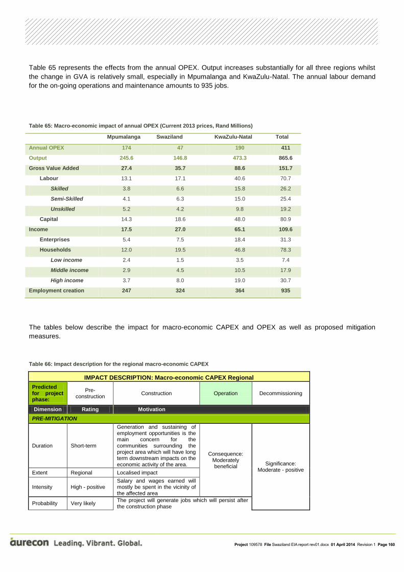
Project 109578 File Swaziland EIA report rev01.docx 01 April 2014 Revision 1 Page 160
Table 65 represents the effects from the annual OPEX. Output increases substantially for all three regions whilst
the change in GVA is relatively small, especially in Mpumalanga and KwaZulu-Natal. The annual labour demand
for the on-going operations and maintenance amounts to 935 jobs.
Table 65: Macro-economic impact of annual OPEX (Current 2013 prices, Rand Millions)
Mpumalanga Swaziland KwaZulu-Natal Total
Annual OPEX 174 47 190 411
Output 245.6 146.8 473.3 865.6
Gross Value Added 27.4 35.7 88.6 151.7
Labour 13.1 17.1 40.6 70.7
Skilled 3.8 6.6 15.8 26.2
Semi-Skilled 4.1 6.3 15.0 25.4
Unskilled 5.2 4.2 9.8 19.2
Capital 14.3 18.6 48.0 80.9
Income 17.5 27.0 65.1 109.6
Enterprises 5.4 7.5 18.4 31.3
Households 12.0 19.5 46.8 78.3
Low income 2.4 1.5 3.5 7.4
Middle income 2.9 4.5 10.5 17.9
High income 3.7 8.0 19.0 30.7
Employment creation 247 324 364 935
The tables below describe the impact for macro-economic CAPEX and OPEX as well as proposed mitigation
measures.
Table 66: Impact description for the regional macro-economic CAPEX
IMPACT DESCRIPTION: Macro-economic CAPEX Regional
Predicted for project phase:
Pre-construction
Construction Operation Decommissioning
Dimension Rating Motivation
PRE-MITIGATION
Duration Short-term
Generation and sustaining of employment opportunities is the main concern for the communities surrounding the project area which will have long term downstream impacts on the economic activity of the area.
Consequence: Moderately beneficial
Significance: Moderate - positive
Extent Regional Localised impact
Intensity High - positive Salary and wages earned will mostly be spent in the vicinity of the affected area
Probability Very likely The project will generate jobs which will persist after the construction phase

Project 109578 File Swaziland EIA report rev01.docx 01 April 2014 Revision 1 Page 161
MITIGATION:
Maximise local employment opportunities through training and capacity building.
POST-MITIGATION
Duration Short-term Using local employment for permanent jobs will contribute to the local economy Consequence:
Negligible Significance: N/A
Extent Site-specific Localised impact
Intensity Very low Increased employment levels will increase local economy
Probability Very unlikely Mitigation will further enhance the positive impacts of the project
Table 67: Impact description for the local macro-economic CAPEX
IMPACT DESCRIPTION: Macro-economic CAPEX Local
Predicted for project phase:
Pre-construction
Construction Operation Decommissioning
Dimension Rating Motivation
PRE-MITIGATION
Duration Short-term
Creating employment will increase the spending regime in the area. Long term jobs will persist for the life span of the project
Consequence: Moderately beneficial
Significance: Moderate - positive
Extent Local
The project could also have fiscal impacts. Payment of business and personal tax could contribute to government revenue at a national level, while rates and payment for services could strengthen the income base of the district and local municipalities
Intensity High - positive
Local expenditure by employees will have multiplier effects in various sectors of the economy, thereby stimulating business activity and further employment creation
Probability Very likely Increased employment levels will contribute to the economy
MITIGATION:
N/A
POST-MITIGATION
Duration Short-term Increased levels of employment will persist for the duration of the project Consequence:
Negligible Significance: N/A Extent Site-specific As per pre-mitigation
Intensity Very low As per pre-mitigation
Probability Very unlikely As per pre-mitigation
Table 68: Impact description for the regional macro-economic OPEX
IMPACT DESCRIPTION: Macro-economic OPEX Regional
Predicted for project phase:
Pre-construction
Construction Operation Decommissioning
Dimension Rating Motivation

Project 109578 File Swaziland EIA report rev01.docx 01 April 2014 Revision 1 Page 162
PRE-MITIGATION
Duration Long-term
Creating employment will increase the spending regime in the area. Long term jobs will persist for the life span of the project
Consequence: Moderately beneficial
Significance: Moderate - positive
Extent Regional
The project could also have fiscal impacts. Payment of business and personal tax could contribute to government revenue at a national level, while rates and payment for services could strengthen the income base of the district and local municipalities
Intensity Low - positive
Local expenditure by employees will have multiplier effects in various sectors of the economy, thereby stimulating business activity and further employment creation
Probability Very likely Increased employment levels will contribute to the economy
MITIGATION:
N/A
POST-MITIGATION
Duration Short-term increased levels of employment will persist for the duration of the project Consequence:
Negligible Significance: N/A Extent Site-specific As per pre-mitigation
Intensity Very low As per pre-mitigation
Probability Very unlikely As per pre-mitigation

Project 109578 File Swaziland EIA report rev01.docx 01 April 2014 Revision 1 Page 163
The project is currently fast-tracked to an aggressive completion programme. By virtue of its international nature,
cohesive and wide-ranging inter-governmental co-operation remains one of the key pillars to success. The creation
of a strategic link between South Africa and the export Ports of Richards Bay and Maputo, through Swaziland, has
been found to be technically feasible, with certain risks attached.
Two possible corridors are proposed and the potential impact of the construction of the railway line on the
environment needs to be assessed in terms of the process prescribed by the Environmental Management Act, 5 of
2002.
Network upgrades
The additional demand on parts of the network brought about by increase in traffic volume from sources other than
Mpumalanga and central Gauteng in South Africa make upgrades of the network a critical planning driver.
Expected Limpopo (RSA) traffic is a major contributor to demand capacity on the southern section of the corridor.
This refers particularly to the Phuzumoya-Nsezi section which has the addition of growing North-South line traffic to
deal with. This fact should not be permitted to cloud or delay the original strategic intent, namely, to create a new
rail link between Swaziland and South Africa.
In summary:
The project is an international venture and therefore includes activities within both Swaziland and South
Africa.
The upgrade of the existing rail network from Davel to Lothair and from Sidvokodvo to Nsezi is key to the
project feasibility, reflected in the viability of the new link section;
Certain network upgrade activities equal or even surpass the new link in length and scope of civil works
required. This is particularly true in respect of the section Sidvokodvo-Phuzumoya to Nsezi;
Critical infrastructural elements are introduced under route upgrades, including:
o Davel Yard. Penultimate Work Package, due to long term nature of load consolidation, but will be
required for 200 wagon functionality;
o New line between Breyten and Buhrmanskop, including links for existing and future traffic access
and major level crossing elimination benefit;
o New junctions at Lothair and Phuzumoya; and
o New line between Sidvokodvo and Nsezi, (excluding Pongola River bridge and Mtubatuba tunnel)
creating bypass lines at the towns of Golela, Mtubatuba and Hluhluwe.
Public level crossings will be eliminated where possible;
Upgrades can be achieved with minimum disruption to current operations; and
The line between Buhrmanskop and Lothair will need to be closed for the commodities originating from
Lothair will need to be transported by road to Buhrmanskop.
9 CONCLUSIONS AND
RECOMMENDATIONS

Project 109578 File Swaziland EIA report rev01.docx 01 April 2014 Revision 1 Page 164
The above, notwithstanding that there are many planning and construction aspects (activities) and many areas of
environmental concern attached to the project.
These arise by virtue of:
The topography of the area, linked to stringent route geometry factors required to meet the design criteria
for heavy haul operations as planned.
The magnitude of earthworks required (high banks and deep cuttings) as well as the number and size of
structures involved.
The rural nature of large sections of the route, environmentally sensitive land use (forestry, subsistence
farming) and long linear impact on riverine / floodplain farming and land use.
Point-type areas of impact.
The impact on human settlement, particularly the rural settlement patterns prevailing in the Swaziland
section of the new link line.
The successful conclusion of the EIA process, culminating in Authorisations valid in each of the Partner
States is critical to the viability of the Project, timeous commencement of the Works and commencement of
train operations according to the agreed programme in the 2nd Quarter of 2017.
The EIA process will be complex from management and technical perspectives and exhaustive in extent by
virtue of:
o The multinational nature of the project;
o Complexities inherent in differing legal and governance requirements per Partner State; and
o The sensitive bio-physical and social setting of the project.
Other permitting processes must not be overlooked in the need to obtain environmental approval under the
respective country regulations. Factors such as the need for water use or borrow pit licences need to be clarified as
soon as possible, since these processes can be extensive.
At this stage the direct labour force could reach 2 180 units, with a potential value of ZAR 2 080 million. This
comprises labour components of both construction activities as well as material supply. The Swaziland / RSA split
is estimated at approximately 45% / 54%. Viewed as an on-going project, the estimated annual labour budget to
operate the corridor amounts to ZAR 115 million. This comprises direct personnel in the fields of Movement, Train
Control and Yard functions, as well as Rolling Stock and Infrastructure maintenance.
The “Equator Principles” established by the Equator Principles Financial Institutions are described for applicability
to the project. Visible compliance to this set of voluntary guidelines for the financing industry in assessing
environmental and social risks is a prerequisite for funding and investment purposes.
9.1 Recommendations
Taking into account the mitigation measures proposed by the specialist as well as those contained in the CMP, the
EAP is of the opinion that the potential impacts posed by the proposed development can be adequately mitigated
to alleviate possible detrimental impacts to the environment. The Authority is reminded that, as described in
Chapter 8, many of the mitigation measures proposed by the specialists in their various reports were found
to be totally unfeasible to implement and were therefore out-motivated in Chapter 8. The feasible mitigation
measures as well as alternative mitigation measures are captured in the CMP.

Project 109578 File Swaziland EIA report rev01.docx 01 April 2014 Revision 1 Page 165
It is therefore recommended that the SEA considers the Environmental Assessment Report and issues an
Environmental Certificate to Swaziland Railway to proceed with the construction of the railway line and associated
infrastructure.

Project 109578 File Swaziland EIA report rev01.docx 01 April 2014 Revision 1 Page 166
African Economic Outlook. (2012). Swaziland 2012.
Emery A.J., Benn G.A., de Beer G. and Fischer, A. (2001) Draft Swaziland Biodiversity Conservation and
participatory Development Project, GEF PPG TF027768 REPORT BCPD-02. EnviroNET Solutions.
Frenken, K. and Mharapara, I. (2001). Wetland Development and Management in SADC Countries. Proceedings of
a sub-regional workshop 19-23 November in Harare, Zimbabwe. Food and Agriculture Organisation of the United
Nations.
Golder Associates (2004). EIA for the long-term coal supply to Eskom’s Majuba Power Station in Mpumalanga –
Surface water impacts specialists report. Report No. 5528/6181/14/W. Report prepared for Eskom Holdings Ltd,
Megawatt Park.
Keatimilwe, K. M. (2013). South African Institution for Environmental Assessment. Retrieved July 31 , 2013, from
http://www.saiea.com/saiea-book/Swaziland1.pdf.
Kovaćs, Z.P. (1988). Regional maximum flood peaks in Southern Africa. TR 137, Department of Water Affairs,
Pretoria.
Mucina, L. and Rutherford, M.C. (2006). The Vegetation of South African, Lesotho and Swaziland. South African
National Biodiversity Institute
Piketh, S., Burger, R. and Pauw, C., (2013): Indoor household air pollution measurements from solid fuel (coal)
combusion in Mpumalanga, South Africa: in ‘16th IUAPPA World Clean Air Congress’.
SANBI (2009). Further Development of a Proposed National Wetland Classification System for South Africa.
Primary Project Report. Prepared by the Freshwater Consulting Group (FCG) for the South African National
Biodiversity Institute (SANBI).
SANBI, (2010). Ecosystem Profile. Maputaland-Pondoland-Albany Biodiversity Hotspot. Critical Ecosystem
Partnership Fund (CEPF). Prepared by Conservation International Southern African Hotspots Programme. South
African National Biodiversity Institute.
The World Bank Group. (2013). The World Bank Database. Retrieved July 24, 2013, from The World Bank:
http://databank.worldbank.org/data/home.aspx
USEPA, (1989): Emission Standards for Locomotives and Locomotive Engines, US Federal Register 63(73),
18978–19084. URL: http://www.epa.state.oh.us/portals/32/pdf/FRwebpage forCorrectionsClarificationrule3-
2010.inter2.pdf
10 REFERENCES

Project 109578 File Swaziland EIA report rev01.docx 01 April 2014 Revision 1 Page 167

Project 109578 File Swaziland EIA report rev01.docx 01 April 2014 Revision 1 Page 168
Aurecon South Africa (Pty) Ltd
1977/003711/07
Aurecon Centre Lynnwood Bridge Office Park 4 Daventry Street Lynnwood Manor 0081
PO Box 74381 Lynnwood Ridge 0040 South Africa
T +27 12 427 2000
F +27 86 556 0521
W aurecongroup.com
Aurecon offices are located in: Angola, Australia, Botswana, China, Ethiopia, Ghana, Hong Kong, Indonesia, Lesotho, Libya, Malawi, Mozambique, Namibia, New Zealand, Nigeria, Philippines, Qatar, Singapore, South Africa, Swaziland, Tanzania, Thailand, Uganda, United Arab Emirates, Vietnam.


Appendix A Curriculum Vitae of the Environmental Assessment Practitioners
Addendum A: Dr Pieter Botha
Addendum B: Candice Dürr
Addendum C: Steve Mitchell
Appendix B Specialist input reports
Annexure A: Ecological report
Annexure B: Geohydrological report
Annexure C: Hydrological report
Annexure D: Social Impact Assessment
Annexure E: Air Quality report
Annexure F: Noise and vibration report
Annexure G: Cultural / Archaeological report
Annexure H: Socio-economic assessment
Annexure I: Plan of Study for EIA

Appendix C Public Participation documents
Annexure A: Scoping meeting Bhunya
Annexure B: Scoping meeting Luyengu
Annexure C: Scoping meetings Siphofaneni & Nkilongo
Annexure D: Issues and Response Report

Appendix D Communication with SEA
Annexure A: SEA approval of the Scoping Report

Appendix E Comprehensive Mitigation Plan

Appendix F Waste Management Plan