environmental | flood | ground stability | energy
TRANSCRIPT
Premium Plus PlanningEnvironmental | Flood | Ground Stability | Energy & Infrastructure | Planning
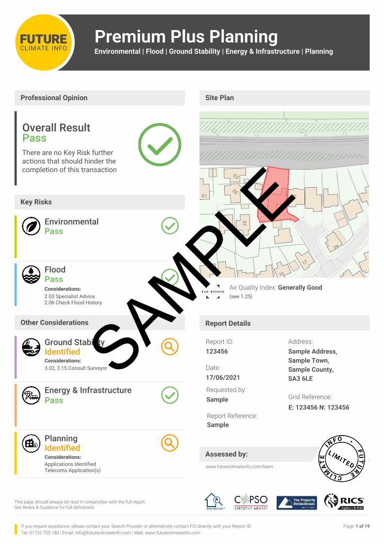
Site Plan
Requested by:Sample Grid Reference:
E: 123456 N: 123456
Date:17/06/2021
Report Reference:Sample
Report ID:123456
Address:Sample Address, Sample Town,Sample County,SA3 6LE
Report Details
www.futureclimateinfo.com/team
If you require assistance, please contact your Search Provider or alternatively contact FCI directly with your Report ID.Tel: 01732 755 180 | Email: [email protected] | Web: www.futureclimateinfo.com
Assessed by:
This page should always be read in conjunction with the full report. See Notes & Guidance for full definitions.
Professional Opinion
(see 1.25)Air Quality Index: Generally Good
Page: 1 of 19
Key Risks
Other Considerations
Energy & InfrastructurePass
PlanningIdentified Considerations:Applications Identified Telecoms Application(s)
FloodPassConsiderations: 2.03 Specialist Advice2.06 Check Flood History
Overall Result PassThere are no Key Risk further actions that should hinder the completion of this transaction
EnvironmentalPass
Ground StabilityIdentified Considerations:3.02, 3.15 Consult Surveyor SAMPLE
ENVIRONMENTAL (INC. CONTAMINATED LAND)
Premium Plus PlanningEnvironmental | Flood | Ground Stability | Energy & Infrastructure | Planning
Request by: Sample Report Reference: Sample ID Grid Reference: E: 123456 N: 123456 Date: 17/06/2021 Page: 2 of 19Tel: 01732 755 180 | Email: [email protected] | Web: www.futureclimateinfo.com
1.02 Remediation Warranty YES
1.03 Official Contaminated Land | Register Entries & Notices PASS
East Hertfordshire District Council data indicates that the property is not within 25 metres of an area of land that has been designated Contaminated Land under Part 2A of the Environmental Protection Act 1990.
1.18 Past Industrial Land Uses PASS
In the Professional Opinion of the FCI Risk Team the property is not on or within 25 metres of any former industrial land uses depicted on historic Ordnance Survey maps from which the level of environmental risk is likely to result in the land beneath the property being determined Contaminated Land within the meaning of Part 2A of the Environmental Protection Act 1990.
1.21 Radon Gas PASS
Data provided by the British Geological Survey (BGS) indicates that the property is not in a Radon Affected Area.
This is because the property is in a Lower probability radon area (less than 1% of homes are estimated to be at or above the Action Level of 200 Bq m-3), therefore no protective measures are required.
1.24 Air Quality Management Area NOTE
Although information on air quality is not included within the Environmental risk assessment in this report we are able to provide information from DEFRA.
Data provided by DEFRA indicates that the property is not in or within 100 metres of an Air Quality Management Area (AQMA). An AQMA is declared where the air pollutants occur above EU and Government targets, and where the council is required to create and follow an Air Quality Action Plan (AQAP) to improve air quality.
Please note that though this property is not within an Air Quality Management Area, this does not necessarily guarantee good air quality. For more information on air quality please visit https://uk-air.defra.gov.uk/air-pollution/.
Unless Contaminated Land Insurance has been requested at the time of purchase, this report has the benefit of a warranty from FCI providing cover of up to £100,000 for 6 years from the date of purchase in the event that the Local Authority serves a Part 2A Remediation Notice and remediation costs have to be borne by the property owner. http://futureclimateinfo.com/fci-terms-and-conditions-v010920/
If the client and/or the lender requires cover in the form of Contaminated Land Insurance, a successor policy offering enhanced protection of up to £1,000,000 for a term of 25 years is available for £50 inclusive of Insurance Premium Tax (for properties up to 0.4 ha). To purchase Contaminated Land Insurance, please visit CLS at www.clsl.co.uk, call 01732 753 910 or purchase via your reseller. More details on this policy are available at http://futureclimateinfo.com/how-we-can-help/residential/contaminated-land-insurances/
SAMPLE
Premium Plus PlanningEnvironmental | Flood | Ground Stability | Energy & Infrastructure | Planning
Request by: Sample Report Reference: Sample ID Grid Reference: E: 123456 N: 123456 Date: 17/06/2021 Page: 3 of 19Tel: 01732 755 180 | Email: [email protected] | Web: www.futureclimateinfo.com
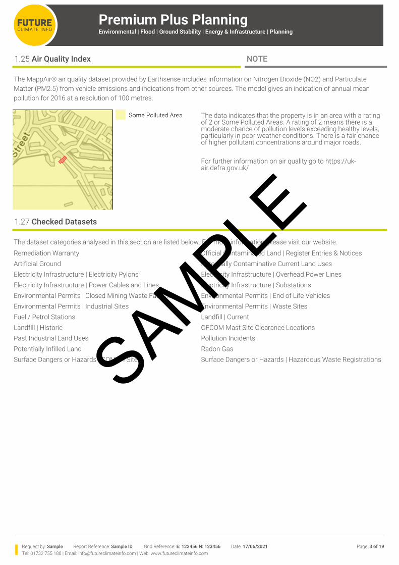
1.25 Air Quality Index NOTE
The MappAir® air quality dataset provided by Earthsense includes information on Nitrogen Dioxide (NO2) and ParticulateMatter (PM2.5) from vehicle emissions and indications from other sources. The model gives an indication of annual meanpollution for 2016 at a resolution of 100 metres.
The data indicates that the property is in an area with a rating of 2 or Some Polluted Areas. A rating of 2 means there is a moderate chance of pollution levels exceeding healthy levels, particularly in poor weather conditions. There is a fair chance of higher pollutant concentrations around major roads.
For further information on air quality go to https://uk-air.defra.gov.uk/
1.27 Checked Datasets
The dataset categories analysed in this section are listed below. For more information, please visit our website.Remediation Warranty Official Contaminated Land | Register Entries & NoticesArtificial Ground Potentially Contaminative Current Land UsesElectricity Infrastructure | Electricity Pylons Electricity Infrastructure | Overhead Power LinesElectricity Infrastructure | Power Cables and Lines Electricity Infrastructure | SubstationsEnvironmental Permits | Closed Mining Waste Facilities Environmental Permits | End of Life VehiclesEnvironmental Permits | Industrial Sites Environmental Permits | Waste SitesFuel / Petrol Stations Landfill | CurrentLandfill | Historic OFCOM Mast Site Clearance LocationsPast Industrial Land Uses Pollution IncidentsPotentially Infilled Land Radon GasSurface Dangers or Hazards | COMAH Sites Surface Dangers or Hazards | Hazardous Waste RegistrationsSAMPLE
Premium Plus PlanningEnvironmental | Flood | Ground Stability | Energy & Infrastructure | Planning
Request by: Sample Report Reference: Sample ID Grid Reference: E: 123456 N: 123456 Date: 17/06/2021 Page: 4 of 19Tel: 01732 755 180 | Email: [email protected] | Web: www.futureclimateinfo.com
FLOOD (INC. JBA FLOODABILITY RATING)
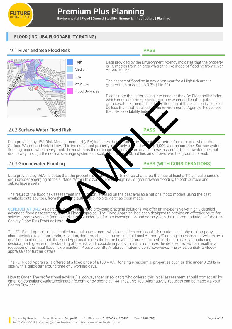
2.01 River and Sea Flood Risk PASS
Data provided by the Environment Agency indicates that the property is 18 metres from an area where the likelihood of flooding from River or Sea is High.
The chance of flooding in any given year for a High risk area is greater than or equal to 3.3% (1 in 30).
Please note that, after taking into account the JBA Floodability index, which considers river, coastal, surface water and chalk aquifer groundwater elements, the risk of flooding at this location is likely to be less than that reported by the Environmental Agency. Please see the JBA Floodability Index result.
2.02 Surface Water Flood Risk PASS
Data provided by JBA Risk Management Ltd (JBA) indicates that the property is located 4 metres from an area where the Surface Water flood risk is Low. This indicates that property is unlikely to flood within a 1,000 year occurrence. Surface water flooding occurs when heavy rainfall overwhelms the drainage capacity of an area. In these instances, the rainwater does not drain away through the normal drainage systems or soak into the ground, but lies on or flows over the ground instead.
2.03 Groundwater Flooding PASS (WITH CONSIDERATIONS)
Data provided by JBA indicates that the property is located within 5 metres of an area that has at least a 1% annual chance of groundwater emerging at the surface. Within this zone there is a high risk of groundwater flooding to both surface and subsurface assets.
The result of the flood risk assessment in this report is based on the best available national flood models using the best available data sources, from the leading authorities, no site visit has been made.
CONSIDERATIONS: As part of our commitment to providing practical solutions, we offer an inexpensive yet highly-detailed advanced flood assessment, the FCI Flood Appraisal. The Flood Appraisal has been designed to provide an effective route for solicitors/conveyancers (and their clients) to undertake further investigation and comply with the recommendations of the Law Society Flood Risk Practice Note.
The FCI Flood Appraisal is a detailed manual assessment, which considers additional information such physical property characteristics (e.g. floor-levels, elevation, door thresholds etc.) and useful Local Authority/Planning assessments. Written by a qualified flood consultant, the Flood Appraisal places the home-buyer in a more informed position to make a purchasing decision, with greater understanding of the risk, and possible impacts. In many instances the detailed review can result in a reduction of the initial flood risk prediction. Please see http://futureclimateinfo.com/how-we-can-help/residential/fci-flood-appraisal/ for further details.
The FCI Flood Appraisal is offered at a fixed price of £150 + VAT for single residential properties such as this under 0.25Ha in size, with a quick turnaround time of 3 working days.
How to Order: The professional advisor (i.e. conveyancer or solicitor) who ordered this initial assessment should contact us by email on [email protected], or by phone at +44 1732 755 180. Alternatively, requests can be made via your Search Provider.
SAMPLE
Premium Plus PlanningEnvironmental | Flood | Ground Stability | Energy & Infrastructure | Planning
Request by: Sample Report Reference: Sample ID Grid Reference: E: 123456 N: 123456 Date: 17/06/2021 Page: 5 of 19Tel: 01732 755 180 | Email: [email protected] | Web: www.futureclimateinfo.com
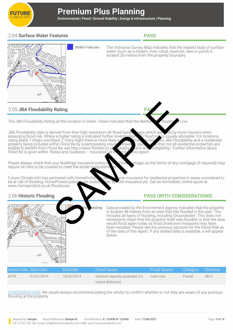
2.04 Surface Water Features PASS
The Ordnance Survey Map indicates that the nearest body of surface water (such as a stream, river, canal, reservoir, lake or pond) is located 26 metres from the property boundary.
2.05 JBA Floodability Rating PASS
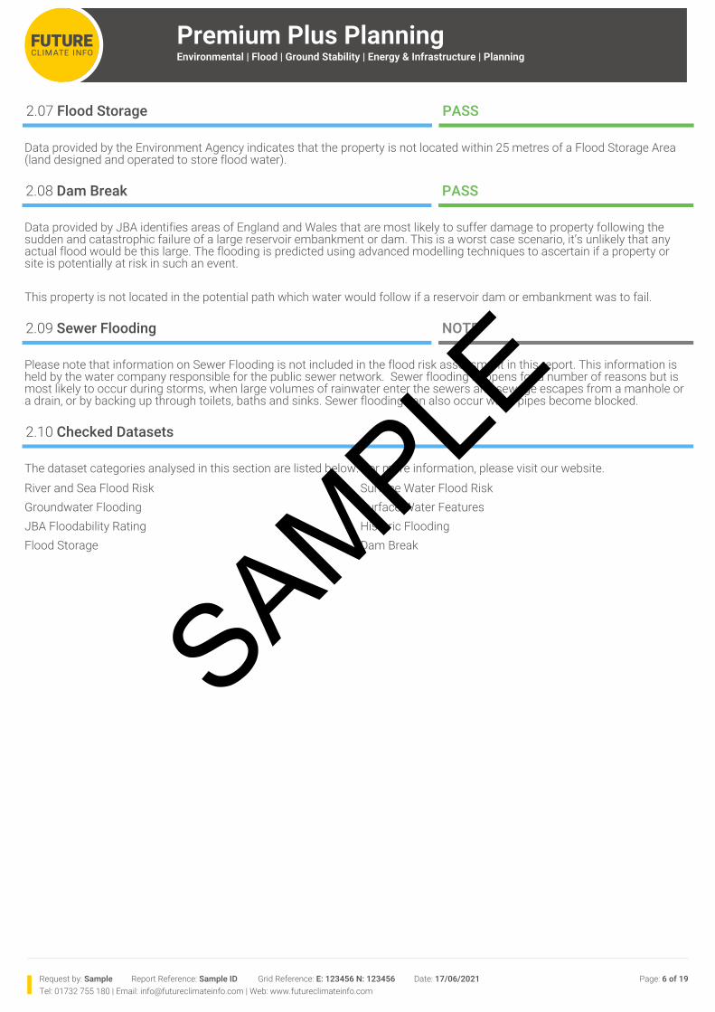
2.06 Historic Flooding PASS (WITH CONSIDERATIONS)
Data provided by the Environment Agency indicates that the property is located 48 metres from an area that has flooded in the past. This includes all types of flooding, including Groundwater. This does not necessarily mean that the property itself was flooded, or that the area would flood again today as flood protection measures may have been installed. Please see the previous sections for the Flood Risk as of the date of this report. If any related data is available, it will appear below.
Event Code Start Date End Date Flood Cause Flood Source Category Distance4078 31/01/2014 18/02/2014 channel capacity exceeded (no
raised defences)main river Fluvial 48 m
CONSIDERATIONS: We would always recommend asking the vendor to confirm whether or not they are aware of any previous flooding at the property.
The JBA Floodability Rating at this location is Green. Green indicates that the likelihood of flooding is Low.
JBA Floodability data is derived from their high resolution UK flood hazard maps which are used by most insurers when assessing flood risk. Where a higher rating is indicated further investigation into flood risk is usually advisable. For locations rating Black 1 (High) and Black 2 (Very High) there is more likely to be a correlation between JBA Floodability and a residential property being included within Flood Re by a participating insurer. However, please note that not all residential properties are eligible to benefit from Flood Re, see http://www.floodre.co.uk/industry/how-it-works/eligibility/. Further information about Flood Re is given within “Notes and Guidance – Insurance” at the end of this report.
Please always check that your Buildings Insurance policy covers Flood Damage, as the terms of any mortgage (if required) may require all risks to be covered to meet the lender's requirements.
Future Climate Info has partnered with HomeProtect to deliver home insurance for residential properties in areas considered to be at risk of flooding. HomeProtect policies are underwritten by AXA Insurance plc. Get an immediate, online quote at www.homeprotect.co.uk/floodcover.
SAMPLE
Premium Plus PlanningEnvironmental | Flood | Ground Stability | Energy & Infrastructure | Planning
Request by: Sample Report Reference: Sample ID Grid Reference: E: 123456 N: 123456 Date: 17/06/2021 Page: 6 of 19Tel: 01732 755 180 | Email: [email protected] | Web: www.futureclimateinfo.com
2.07 Flood Storage PASS
Data provided by the Environment Agency indicates that the property is not located within 25 metres of a Flood Storage Area (land designed and operated to store flood water).
2.08 Dam Break PASS
Data provided by JBA identifies areas of England and Wales that are most likely to suffer damage to property following the sudden and catastrophic failure of a large reservoir embankment or dam. This is a worst case scenario, it’s unlikely that any actual flood would be this large. The flooding is predicted using advanced modelling techniques to ascertain if a property or site is potentially at risk in such an event.
This property is not located in the potential path which water would follow if a reservoir dam or embankment was to fail.
2.09 Sewer Flooding NOTE
Please note that information on Sewer Flooding is not included in the flood risk assessment in this report. This information is held by the water company responsible for the public sewer network. Sewer flooding happens for a number of reasons but is most likely to occur during storms, when large volumes of rainwater enter the sewers and sewage escapes from a manhole or a drain, or by backing up through toilets, baths and sinks. Sewer flooding can also occur when pipes become blocked.
2.10 Checked Datasets
The dataset categories analysed in this section are listed below. For more information, please visit our website.River and Sea Flood Risk Surface Water Flood RiskGroundwater Flooding Surface Water FeaturesJBA Floodability Rating Historic FloodingFlood Storage Dam Break
SAMPLE
Premium Plus PlanningEnvironmental | Flood | Ground Stability | Energy & Infrastructure | Planning
Request by: Sample Report Reference: Sample ID Grid Reference: E: 123456 N: 123456 Date: 17/06/2021 Page: 7 of 19Tel: 01732 755 180 | Email: [email protected] | Web: www.futureclimateinfo.com
GROUND STABILITY
3.01 Professional Advice
For professional advice and guidance relating to the impact of any ground stability issues on your property please contact a Chartered Building Surveyor. For help on any specialist services that may be needed please go to www.subsidencesupport.co.uk
3.02 Property Subsidence Assessment - Clay Shrink-Swell PASS (WITH CONSIDERATIONS)
The predominant cause of subsidence in the UK is soil shrinkage; accounting for approximately 75% of all subsidence. Soils Shrinkage occurs as a result of changes in the moisture content of cohesive soils, such as clay and silt. Clay is particularly prone to shrink/swell and is found extensively across England and Wales. The reason for this is because clay rich soils can absorb large quantities of water which causes them to expand (swell) and they can also become very hard when dry causing them to contract (shrink) and crack.
Whether a property is likely to be affected by Shrink-Swell is dependent on a number of factors, such as the distribution of shink-swell prone soils, as well as the depth of foundations, drainage and proximity to trees.
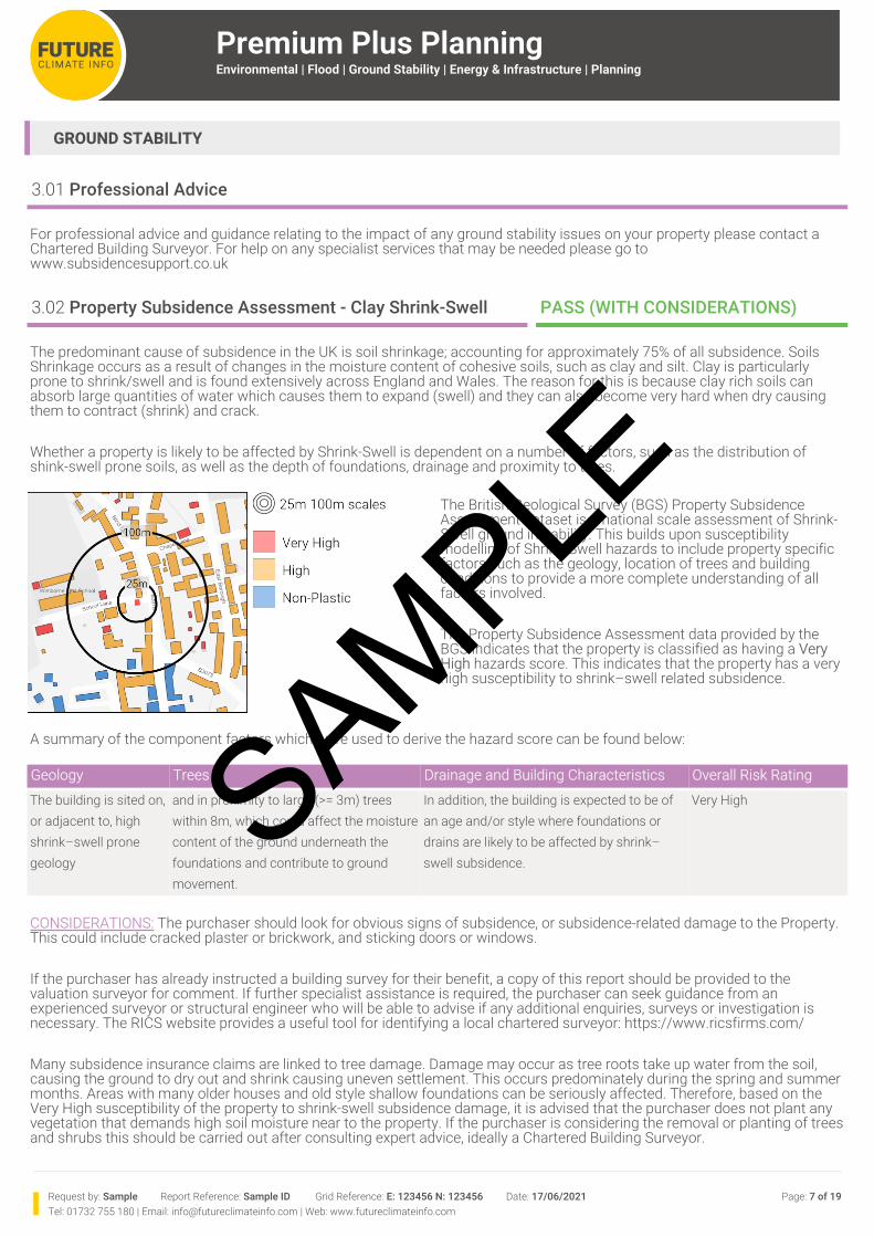
The British Geological Survey (BGS) Property Subsidence Assessment dataset is a national scale assessment of Shrink-Swell ground instability. This builds upon susceptibility modelling of Shrink-Swell hazards to include property specific factors such as the geology, location of trees and building conditions to provide a more complete understanding of all factors involved.
The Property Subsidence Assessment data provided by the BGS indicates that the property is classified as having a Very High hazards score. This indicates that the property has a very high susceptibility to shrink–swell related subsidence.
A summary of the component factors which were used to derive the hazard score can be found below:
Geology Trees Drainage and Building Characteristics Overall Risk RatingThe building is sited on, or adjacent to, high shrink–swell prone geology
and in proximity to large (>= 3m) trees within 8m, which could affect the moisture content of the ground underneath the foundations and contribute to ground movement.
In addition, the building is expected to be of an age and/or style where foundations or drains are likely to be affected by shrink–swell subsidence.
Very High
CONSIDERATIONS: The purchaser should look for obvious signs of subsidence, or subsidence-related damage to the Property. This could include cracked plaster or brickwork, and sticking doors or windows.
If the purchaser has already instructed a building survey for their benefit, a copy of this report should be provided to the valuation surveyor for comment. If further specialist assistance is required, the purchaser can seek guidance from an experienced surveyor or structural engineer who will be able to advise if any additional enquiries, surveys or investigation is necessary. The RICS website provides a useful tool for identifying a local chartered surveyor: https://www.ricsfirms.com/
Many subsidence insurance claims are linked to tree damage. Damage may occur as tree roots take up water from the soil, causing the ground to dry out and shrink causing uneven settlement. This occurs predominately during the spring and summer months. Areas with many older houses and old style shallow foundations can be seriously affected. Therefore, based on the Very High susceptibility of the property to shrink-swell subsidence damage, it is advised that the purchaser does not plant any vegetation that demands high soil moisture near to the property. If the purchaser is considering the removal or planting of trees and shrubs this should be carried out after consulting expert advice, ideally a Chartered Building Surveyor.
SAMPLE
Request by: Sample Report Reference: Sample ID Grid Reference: E: 123456 N: 123456 Date: 17/06/2021 Page: 8 of 19Tel: 01732 755 180 | Email: [email protected] | Web: www.futureclimateinfo.com
Premium Plus PlanningEnvironmental | Flood | Ground Stability | Energy & Infrastructure | Planning
Mining | Cheshire Brine Compensation AreaMining | Mining Cavities (Non-Coal)Modified Ground | Artificial DepositsNatural Cavities & Soluble Rocks
3.05 Geohazards | Running Sand PASS
The British Geological Survey indicates that the property is within 50 metres of an area where there is a very low potential for running sand problems if water table rises or if sandy strata are exposed to water. No special actions required to avoid problems due to running sand.
3.12 Mining | Hazards (Non-Coal) PASS
3.15 Natural Cavities & Soluble Rocks PASS (WITH CONSIDERATIONS)
The British Geological Survey indicates that the property is within 50 metres of an area where soluble rocks are present within the ground. Some dissolution features may be present. Potential for difficult ground conditions are at a level where they may be considered, localised subsidence need not be considered except in exceptional circumstances.
CONSIDERATIONS: There is a possible increase in insurance risk due to significant soluble rocks being present. There is a low possibility of naturally occurring localised subsidence, however this may be possible in adverse conditions such as high surface or sub-surface water flow.
Some possibility of potential liability due to groundwater pollution may be present.
3.16 Checked Datasets
The dataset categories analysed in this section are listed below. For more information, please visit our website.Property Subsidence AssessmentGeohazards | Compressible Ground Geohazards | Shrink-Swell Landslips/slides | Slope Instability
Mining | Coal MiningMining | Hazards (Non-Coal)
Modified Ground | Historical Analysis
Geohazards | Collapsible DepositsGeohazards | Running SandMapped Landslides
The British Geological Survey indicates that the property is located within 50 metres of an area where sporadic underground mining of restricted extent may have occurred. potential for difficult ground conditions are unlikely and localised and are at a level where they need not be considered.
The Presence of past underground mining is not known to have occurred. Areas are categorized on the basis that the rock type present are known to have been worked in other areas. Areas therefore have the potential for underground mining but there is little or not evidence of mining activity. It should be noted, however, that there is always the possibility of the existence of other sub-surface excavations, such as wells, cess pits, follies, air raid shelters/bunkers and other military structures etc. that could affect surface ground stability but which are outside the scope of this dataset.
SAMPLE
Request by: Sample Report Reference: Sample ID Grid Reference: E: 123456 N: 123456 Date: 17/06/2021 Page: 9 of 19Tel: 01732 755 180 | Email: [email protected] | Web: www.futureclimateinfo.com
Premium Plus PlanningEnvironmental | Flood | Ground Stability | Energy & Infrastructure | Planning
ENERGY & INFRASTRUCTURE
4.15 Oil and Gas | Licensed Areas (inc. Shale Gas) PASS
4.23 Checked Datasets
The dataset categories analysed in this section are listed below. For more information, please visit our website.Carbon Capture & Storage Electrical Infrastructure | Electricity PylonsElectrical Infrastructure | Overhead Power Lines Electrical Infrastructure | Power Cables and LinesElectrical Infrastructure | Substations Hydropower | ExistingHydropower | Potential Major Energy Infrastructure | Gas PipeMajor Energy Infrastructure | Gas Site Major Infrastructure Projects | CrossrailMajor Infrastructure Projects | HS2 Major Infrastructure Projects | Thames Tideway TunnelOil and Gas | Licensed Areas (inc. Shale Gas) Oil and Gas | Current and Historic SitesOil and Gas | Underground Coal Gasification Power StationsPower Stations | Nuclear Power RailwaysSolar Farms Wind Farms
Data provided by the Department for Business, Energy & Industrial Strategy (BEIS) indicates that the property is not within 100 metres of an area that is licensed for onshore Petroleum Exploration and Development (which includes shale gas extraction, or ‘fracking’). As a result, currently it should not be feasible for Oil or Gas exploration to occur on, adjacent or within the immediate vicinity of the property.
It should be noted that PEDLs can cover extremely large areas and the presence of a PEDL on its own does not necessarily suggest that any operational activity (such as drilling) has/will occur, as numerous other permissions and consents must first be obtained. As such, we do not report the presence of PEDLs beyond the immediate vicinity of the property to avoid consistently capturing information which is unlikely to impact the Property. However, if PEDLs have been issued on neighbouring or nearby application areas, and the subsequent permissions/consents have been obtained to make a drilling/well site operational at a specific location within 5km, these current or former active sites will appear further down in the ‘Oil and Gas | Current and Historic Sites’ section of this report.
SAMPLE
Premium Plus PlanningEnvironmental | Flood | Ground Stability | Energy & Infrastructure | Planning
Request by: Sample Report Reference: Sample ID Grid Reference: E: 123456 N: 123456 Date: 17/06/2021 Page: 10 of 19Tel: 01732 755 180 | Email: [email protected] | Web: www.futureclimateinfo.com
PLANNING
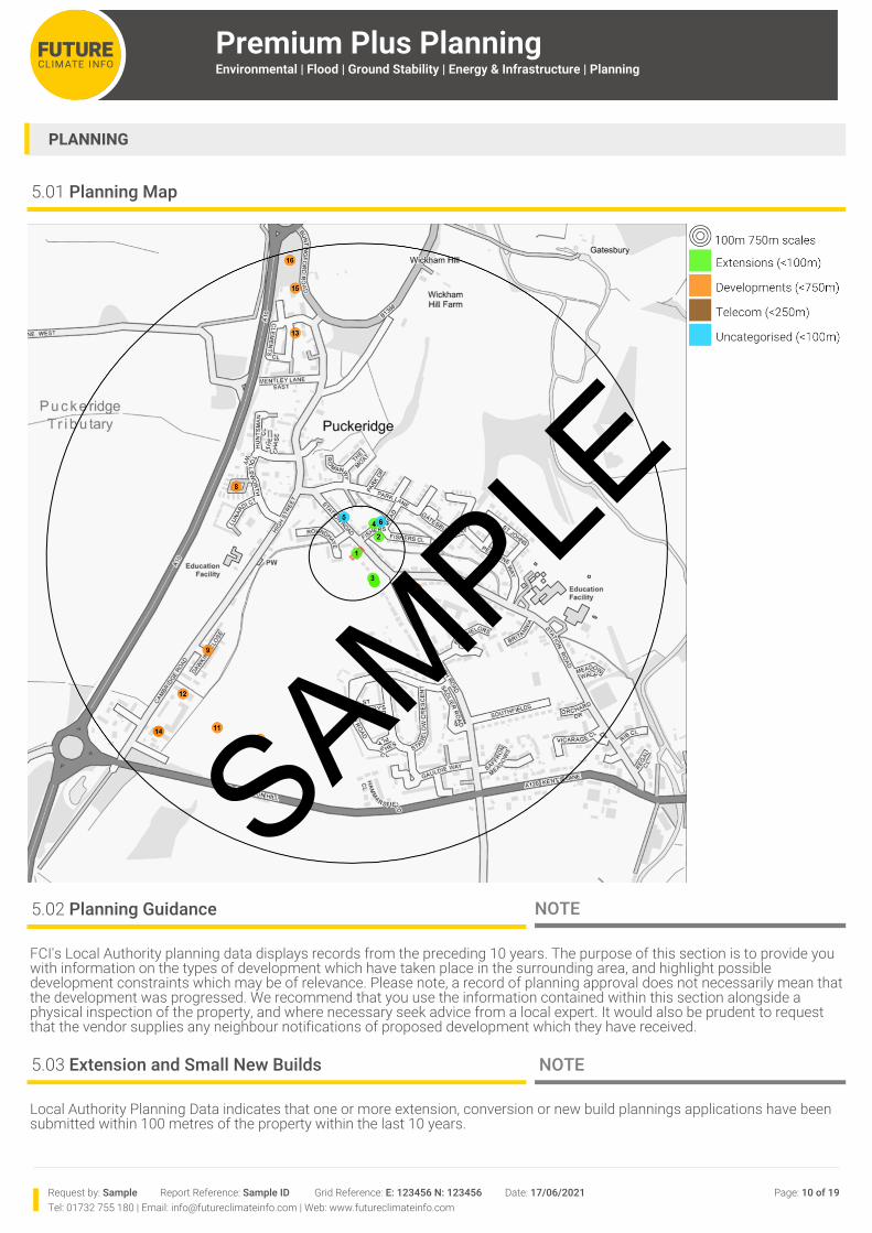
5.01 Planning Map
5.02 Planning Guidance NOTE
5.03 Extension and Small New Builds NOTE
Local Authority Planning Data indicates that one or more extension, conversion or new build plannings applications have been submitted within 100 metres of the property within the last 10 years.
FCI's Local Authority planning data displays records from the preceding 10 years. The purpose of this section is to provide you with information on the types of development which have taken place in the surrounding area, and highlight possible development constraints which may be of relevance. Please note, a record of planning approval does not necessarily mean that the development was progressed. We recommend that you use the information contained within this section alongside a physical inspection of the property, and where necessary seek advice from a local expert. It would also be prudent to request that the vendor supplies any neighbour notifications of proposed development which they have received.
SAMPLE
Request by: Sample Report Reference: Sample ID Grid Reference: E: 123456 N: 123456 Date: 17/06/2021 Page: 11 of 19Tel: 01732 755 180 | Email: [email protected] | Web: www.futureclimateinfo.com
Premium Plus PlanningEnvironmental | Flood | Ground Stability | Energy & Infrastructure | Planning
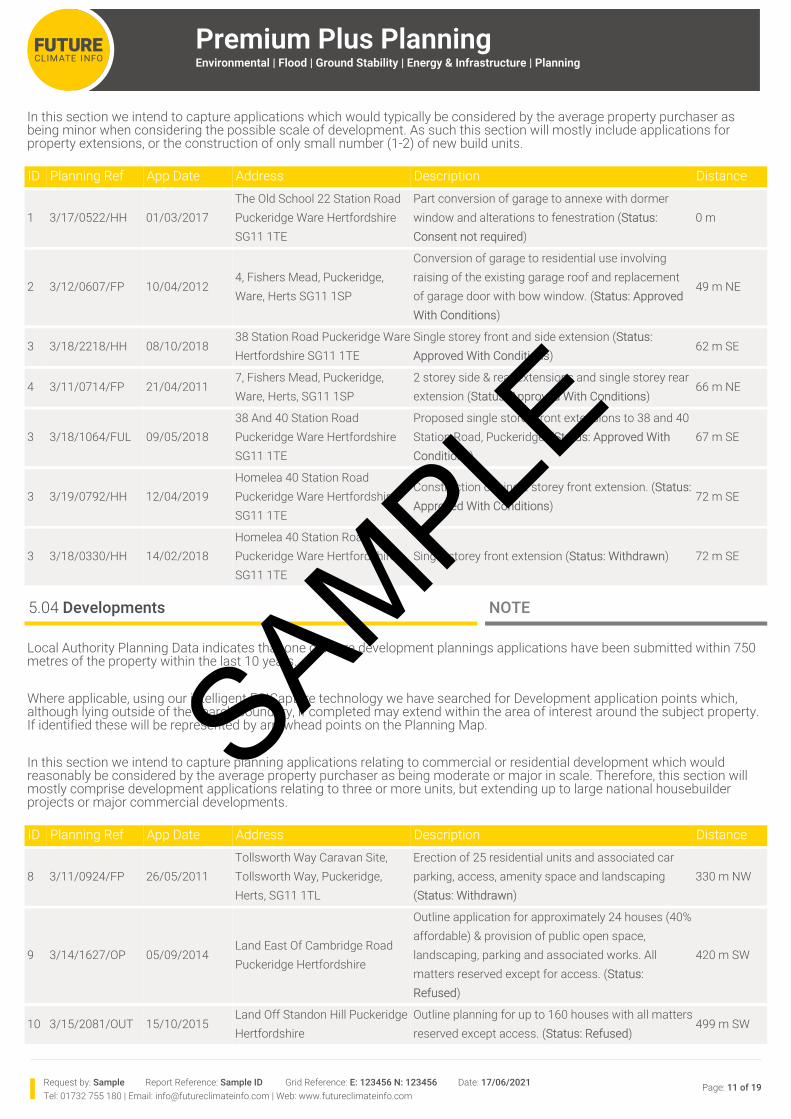
In this section we intend to capture applications which would typically be considered by the average property purchaser as being minor when considering the possible scale of development. As such this section will mostly include applications for property extensions, or the construction of only small number (1-2) of new build units.
ID Planning Ref App Date Address Description Distance
1 3/17/0522/HH 01/03/2017The Old School 22 Station Road Puckeridge Ware Hertfordshire SG11 1TE
Part conversion of garage to annexe with dormer window and alterations to fenestration (Status: Consent not required)
0 m
2 3/12/0607/FP 10/04/20124, Fishers Mead, Puckeridge, Ware, Herts SG11 1SP
Conversion of garage to residential use involving raising of the existing garage roof and replacement of garage door with bow window. (Status: Approved With Conditions)
49 m NE
3 3/18/2218/HH 08/10/201838 Station Road Puckeridge Ware Hertfordshire SG11 1TE
Single storey front and side extension (Status: Approved With Conditions)
62 m SE
4 3/11/0714/FP 21/04/20117, Fishers Mead, Puckeridge, Ware, Herts, SG11 1SP
2 storey side & rear extensions and single storey rear extension (Status: Approved With Conditions)
66 m NE
3 3/18/1064/FUL 09/05/201838 And 40 Station Road Puckeridge Ware Hertfordshire SG11 1TE
Proposed single storey front extensions to 38 and 40 Station Road, Puckeridge. (Status: Approved With Conditions)
67 m SE
3 3/19/0792/HH 12/04/2019Homelea 40 Station Road Puckeridge Ware Hertfordshire SG11 1TE
Construction of single storey front extension. (Status: Approved With Conditions)
72 m SE
3 3/18/0330/HH 14/02/2018Homelea 40 Station Road Puckeridge Ware Hertfordshire SG11 1TE
Single storey front extension (Status: Withdrawn) 72 m SE
5.04 Developments NOTE
ID Planning Ref App Date Address Description Distance
8 3/11/0924/FP 26/05/2011Tollsworth Way Caravan Site, Tollsworth Way, Puckeridge, Herts, SG11 1TL
Erection of 25 residential units and associated car parking, access, amenity space and landscaping (Status: Withdrawn)
330 m NW
9 3/14/1627/OP 05/09/2014Land East Of Cambridge Road Puckeridge Hertfordshire
Outline application for approximately 24 houses (40% affordable) & provision of public open space, landscaping, parking and associated works. All matters reserved except for access. (Status: Refused)
420 m SW
10 3/15/2081/OUT 15/10/2015Land Off Standon Hill Puckeridge Hertfordshire
Outline planning for up to 160 houses with all matters reserved except access. (Status: Refused)
499 m SW
Local Authority Planning Data indicates that one or more development plannings applications have been submitted within 750 metres of the property within the last 10 years.
Where applicable, using our intelligent FCICapture technology we have searched for Development application points which, although lying outside of the search boundary, if completed may extend within the area of interest around the subject property. If identified these will be represented by arrowhead points on the Planning Map.
In this section we intend to capture planning applications relating to commercial or residential development which would reasonably be considered by the average property purchaser as being moderate or major in scale. Therefore, this section will mostly comprise development applications relating to three or more units, but extending up to large national housebuilder projects or major commercial developments.
SAMPLE
Premium Plus PlanningEnvironmental | Flood | Ground Stability | Energy & Infrastructure | Planning
Request by: Sample Report Reference: Sample ID Grid Reference: E: 123456 N: 123456 Date: 17/06/2021 Page: 12 of 19Tel: 01732 755 180 | Email: [email protected] | Web: www.futureclimateinfo.com
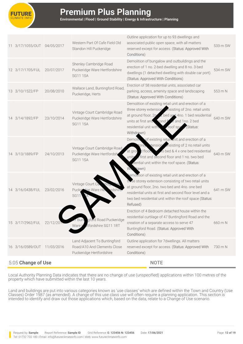
11 3/17/1055/OUT 04/05/2017Western Part Of Cafe Field Old Standon Hill Puckeridge
Outline application for up to 93 dwellings and associated public open space, with all matters reserved except for access. (Status: Approved With Conditions)
533 m SW
12 3/17/1705/FUL 20/07/2017Shenley Cambridge Road Puckeridge Ware Hertfordshire SG11 1SA
Demolition of bungalow and outbuildings and the erection of 1 no. 2-bed dwelling and 8 no. 3-bed dwellings (1 detached dwelling with double car port). (Status: Approved With Conditions)
534 m SW
13 3/10/1522/FP 20/08/2010Wallace Land, Buntingford Road, Puckeridge, Herts
Erection of 58 residential units, associated car parking, access, amenity space and landscaping (Status: Approved With Conditions)
553 m N
14 3/14/1892/FP 23/10/2014Vintage Court Cambridge Road Puckeridge Ware Hertfordshire SG11 1SA
Demolition of existing retail unit and erection of a three storey extension consisting of 2no. retail units at ground floor, 2no. 2 bed and 4no. 1 bed residential units at first and second floor and 1no. 2 bed residential unit within the roof space (Status: Withdrawn)
640 m SW
14 3/13/1889/FP 24/10/2013Vintage Court Cambridge Road Puckeridge Ware Hertfordshire SG11 1SA
Demolition of existing retail unit and erection of a three storey extension consisting of 2 no.retail units at ground floor, 2 x two bed & 4 x one bed residential units at first and second floor and 1 no. two bed residential unit within the roof space. (Status: Withdrawn)
640 m SW
14 3/16/0438/FUL 23/02/2016Vintage Court Cambridge Road Puckeridge Ware Hertfordshire SG11 1SA
Demolition of existing retail unit and erection of a three storey extension consisting of two retail units at ground floor, 2no. two bed and 4no. one bed residential units at first and second floor level and a two bed residential unit within the roof space (Status: Refused)
641 m SW
15 3/17/2962/FUL 22/12/201747 Buntingford Road Puckeridge Ware Hertfordshire SG11 1RT
Erection of 4 Bedroom detached house within the residential curtilage of 47 Buntingford Road and the creation of a separate access to serve 47 Buntingford Road. (Status: Approved With Conditions)
660 m N
16 3/16/0589/OUT 11/03/2016Land Adjacent To Buntingford Road/A10 And Clements Close Puckeridge Hertfordshire
Outline application for 7dwellings. All matters reserved except for access. (Status: Approved With Conditions)
730 m N
5.05 Change of Use NOTE
Local Authority Planning Data indicates that there are no change of use (unspecified) applications within 100 metres of the property which have submitted within the last 10 years.
Land and buildings are put into various categories known as ‘use classes’ which are defined within the Town and Country (Use Classes) Order 1987 (as amended). A change of this use class use will often require a planning application. This section is intended to identify and draw out those applications which, based on the data, relate to a Change of Use scenario.
SAMPLE
Request by: Sample Report Reference: Sample ID Grid Reference: E: 123456 N: 123456 Date: 17/06/2021 Page: 13 of 19Tel: 01732 755 180 | Email: [email protected] | Web: www.futureclimateinfo.com
Premium Plus PlanningEnvironmental | Flood | Ground Stability | Energy & Infrastructure | Planning
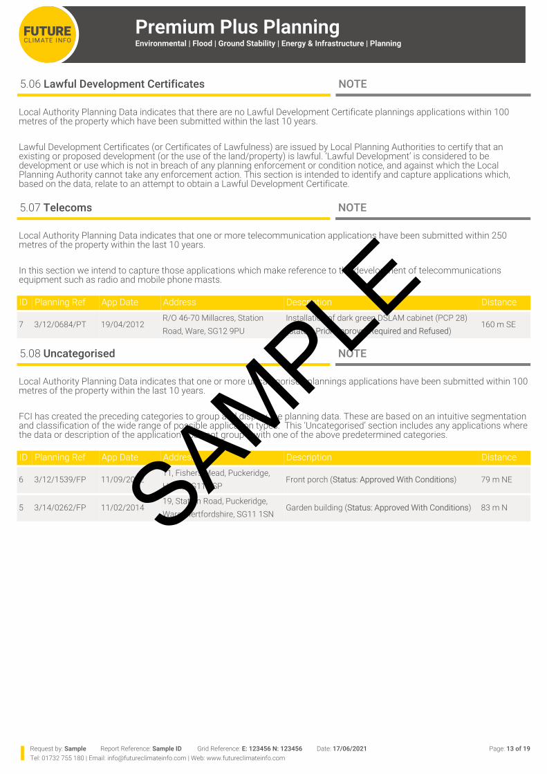
5.06 Lawful Development Certificates NOTE
Local Authority Planning Data indicates that there are no Lawful Development Certificate plannings applications within 100 metres of the property which have been submitted within the last 10 years.
Lawful Development Certificates (or Certificates of Lawfulness) are issued by Local Planning Authorities to certify that an existing or proposed development (or the use of the land/property) is lawful. ‘Lawful Development’ is considered to be development or use which is not in breach of any planning enforcement or condition notice, and against which the Local Planning Authority cannot take any enforcement action. This section is intended to identify and capture applications which, based on the data, relate to an attempt to obtain a Lawful Development Certificate.
5.07 Telecoms NOTE
Local Authority Planning Data indicates that one or more telecommunication applications have been submitted within 250 metres of the property within the last 10 years.
In this section we intend to capture those applications which make reference to the development of telecommunications equipment such as radio and mobile phone masts.
ID Planning Ref App Date Address Description Distance
7 3/12/0684/PT 19/04/2012R/O 46-70 Millacres, Station Road, Ware, SG12 9PU
Installation of dark green DSLAM cabinet (PCP 28) (Status: Prior Approval Required and Refused)
160 m SE
5.08 Uncategorised NOTE
ID Planning Ref App Date Address Description Distance
6 3/12/1539/FP 11/09/201211, Fishers Mead, Puckeridge, Herts, SG11 1SP
Front porch (Status: Approved With Conditions) 79 m NE
5 3/14/0262/FP 11/02/201419, Station Road, Puckeridge, Ware, Hertfordshire, SG11 1SN
Garden building (Status: Approved With Conditions) 83 m N
Local Authority Planning Data indicates that one or more uncategorised plannings applications have been submitted within 100 metres of the property within the last 10 years.
FCI has created the preceding categories to group and display the planning data. These are based on an intuitive segmentation and classification of the wide range of possible application types. This ‘Uncategorised’ section includes any applications where the data or description of the application does not group it with one of the above predetermined categories.
SAMPLE
Premium Plus PlanningEnvironmental | Flood | Ground Stability | Energy & Infrastructure | Planning
Request by: Sample Report Reference: Sample ID Grid Reference: E: 123456 N: 123456 Date: 17/06/2021 Page: 14 of 19Tel: 01732 755 180 | Email: [email protected] | Web: www.futureclimateinfo.com
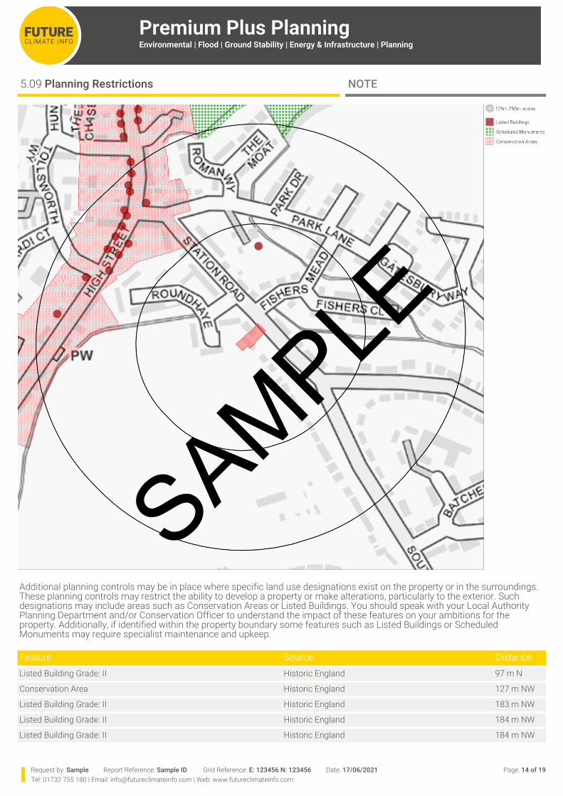
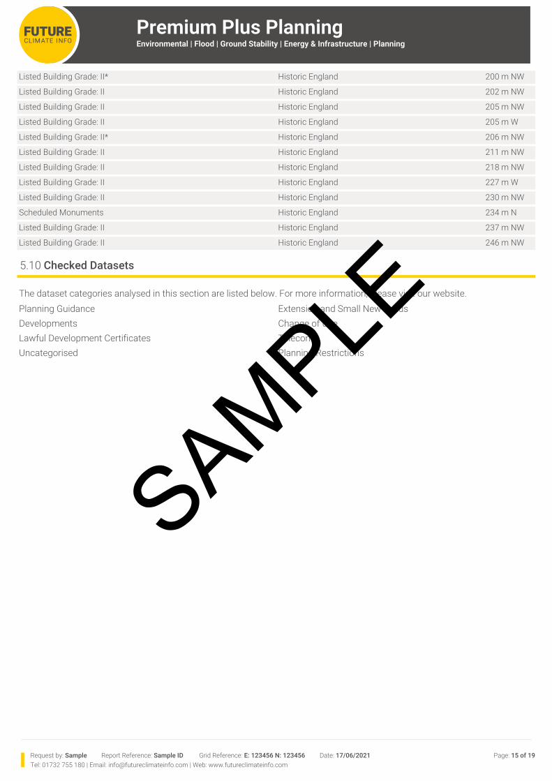
5.09 Planning Restrictions NOTE
Additional planning controls may be in place where specific land use designations exist on the property or in the surroundings. These planning controls may restrict the ability to develop a property or make alterations, particularly to the exterior. Such designations may include areas such as Conservation Areas or Listed Buildings. You should speak with your Local Authority Planning Department and/or Conservation Officer to understand the impact of these features on your ambitions for the property. Additionally, if identified within the property boundary some features such as Listed Buildings or Scheduled Monuments may require specialist maintenance and upkeep.
Feature Source DistanceListed Building Grade: II Historic England 97 m N
Conservation Area Historic England 127 m NW
Listed Building Grade: II Historic England 183 m NW
Listed Building Grade: II Historic England 184 m NW
Listed Building Grade: II Historic England 184 m NW
SAMPLE
Request by: Sample Report Reference: Sample ID Grid Reference: E: 123456 N: 123456 Date: 17/06/2021 Page: 15 of 19Tel: 01732 755 180 | Email: [email protected] | Web: www.futureclimateinfo.com
Premium Plus PlanningEnvironmental | Flood | Ground Stability | Energy & Infrastructure | Planning
Listed Building Grade: II* Historic England 200 m NW
Listed Building Grade: II Historic England 202 m NW
Listed Building Grade: II Historic England 205 m NW
Listed Building Grade: II Historic England 205 m W
Listed Building Grade: II* Historic England 206 m NW
Listed Building Grade: II Historic England 211 m NW
Listed Building Grade: II Historic England 218 m NW
Listed Building Grade: II Historic England 227 m W
Listed Building Grade: II Historic England 230 m NW
Scheduled Monuments Historic England 234 m N
Listed Building Grade: II Historic England 237 m NW
Listed Building Grade: II Historic England 246 m NW
5.10 Checked Datasets
The dataset categories analysed in this section are listed below. For more information, please visit our website.Planning Guidance Extension and Small New BuildsDevelopments Change of UseLawful Development Certificates TelecomsUncategorised Planning Restrictions
SAMPLE
Request by: Sample Report Reference: Sample ID Grid Reference: E: 123456 N: 123456 Date: 17/06/2021 Page: 16 of 19Tel: 01732 755 180 | Email: [email protected] | Web: www.futureclimateinfo.com
Premium Plus PlanningEnvironmental | Flood | Ground Stability | Energy & Infrastructure | Planning
6.02 Report Notes METHODOLOGY
6.03 Contaminated Land METHODOLOGY
6.04 Flood Insurance METHODOLOGY
This report is a desk study risk assessment, and no site or ground inspection or physical investigation has been carried out. The impacts of the risks addressed in this report are normally measured in terms of quiet enjoyment, saleability, mortgageability, and the value of the property; the risk assessment in this report is provided by FCI who are regulated by RICS.
The answers given on the availability of flood insurance reflect the flood re - insurance scheme, known as Flood Re, which was launched 1st April 2016. Flood Re has been set up to help those households who live in a flood risk area find affordable home insurance. Flood Re should make no difference to purchasing home insurance, whether that’s through a price comparison site, directly from an insurer or through a broker. There is no need to contact Flood Re directly. Flood Re is intended to give peace of mind that, even after a flood claim, flood insurance should still be available with affordable premiums and excesses. Not every residential property is eligible to benefit from Flood Re, for full information about the scheme, including eligibility, see http://www.floodre.co.uk/.
An overall ‘JBA Floodability Rating’ is given in this report based solely on JBA Floodability data. This shows the combined flood hazard, in 5 metre grid cells, from multiple sources i.e. river, sea and surface water flooding. Over 85% of insurers use JBA data when assessing flood risk. The JBA Floodability Rating is represented by colour indicators (black, red, amber, green or clear). For locations rating Black 1 (High) and Black 2 (Very High) there is more likely to be a correlation between JBA Floodability and a residential property being included within Flood Re by a participating insurer. These indicators however provide no assurance or guarantee that insurance / insurance covering flood risk will or will not be available, no reliance should be placed upon the colour indicators, and appropriate additional enquiries should be made as to the actual availability (or not) of insurance / insurance covering flood risk. Every insurance application is unique, so other perils, risks or a previous claims history may mean that insurance is not available in any event.
Future Climate Info has partnered with HomeProtect to deliver home insurance for residential properties in areas considered to be at risk of flooding. HomeProtect policies are underwritten by AXA Insurance plc. Get an immediate, online quote at http://www.homeprotect.co.uk/floodcover.
The contaminated land risk assessment used in this report takes account of statutory Contaminated Land as well as information on the various land uses or processes which may have the potential to create Contaminated Land. These include, for example, relevant former industrial land uses shown on historical maps, current industrial land uses, and relevant industrial processes. Risks such as waste sites, licensed discharge consents, radioactive substances, pollution prevention and control licences, explosives, and dangerous substance inventory, Control of Major Accidents and Hazards (COMAH), and Notification of Installations Handling Hazardous Substances (NIHHS), and Planning Hazardous Substance sites are all very highly regulated and as such are excluded from the Contaminated Land risk assessment. Such features at or nearby the property are features that may be considered in the survey or valuation.
NOTES & GUIDANCE
6.01 Cover Page Definitions METHODOLOGY
The cover page of this report should always be read in conjunction with the full report. The Professional Opinion indicates the potential risks and any other potential issues associated with the property. The results should be disclosed to client and/or lender and/or insurer as appropriate.
A ‘Pass’ is given if no potential property specific risk has been identified.
A ‘Pass with Considerations’ is given where there are potential hazards in the locality to bear in mind, or if there are features nearby which some clients might consider could affect them.
A ‘Further Action’ is given if there is a potential property specific risk and a further action is advised.
In the event of a request to review the Professional Opinion based on additional information, or if there are any technical queries, the professional advisor who ordered the report should contact us at [email protected], or call us on 01732 755 180.
SAMPLE
Premium Plus PlanningEnvironmental | Flood | Ground Stability | Energy & Infrastructure | Planning
Request by: Sample Report Reference: Sample ID Grid Reference: E: 123456 N: 123456 Date: 17/06/2021 Page: 17 of 19Tel: 01732 755 180 | Email: [email protected] | Web: www.futureclimateinfo.com
6.06 Flood Planning, Flood Warning and Reporting, and Flood Resistance and Resilience Measures METHODOLOGY
Detailed advice on flooding and resistance and resilience measures, flood risk planning and costs, and flood warning and reporting systems, is available from the following websites:
Government: https://www.gov.uk/prepare-for-a-flood/find-out-if-youre-at-riskInsurance Industry: https://www.abi.org.uk/Insurance-and-savings/Topics-and-issues/FloodingRICS: www.rics.org/uk/knowledge/consumer-guides/guide-to-flooding
6.07 Planning Data Limitations METHODOLOGY
6.08 Standard T&Cs, QUERIES & COMPLAINTS
The flood risk assessment in this report is based on the best available historic, river, sea, and surface water flooding data. This includes data supplied by the Environment Agency and JBA. A flood risk assessment using these data sources, however, should not be regarded as definitive. Because the flood risk assessment is based on theoretical risk models, there is always the possibility that exceptional weather conditions and/or failure of flood defences can cause flooding that was not anticipated. No site visit has taken place.
The Professional Opinion on flood risk given in this report is based on a flood risk assessment of River, Sea and Surface Water flooding, using Environment Agency and JBA data. If there is a history of flooding it is reported but it is not included in the flood risk assessment because circumstances can change, for example the provision of flood defences, causing the flood conditions to be different today. Susceptibility to groundwater flooding is reported but is also not included in the flood risk assessment; this is because the data identifies geological conditions which could enable groundwater flooding to occur, but does not model the risk of such an occurrence.
RICS advises that flood risk does reduce the value of a property, compared with a similar property without such a risk. This depends on the particular circumstances of the property, any history of flooding, and the provision of flood defences. For some ‘at risk’ property, for example, the reduction in value may be offset by an increase due to the property’s amenity value close to a river, stream or coast.
Standards of collection, the method of recording, and the availability of planning application data vary widely between local planning authorities. In addition, the available planning applications data available from suppliers is normally geographically located using a single point, not the actual application site boundary. As such no complete data set of applications data with accurate boundary locations collected from these sources is currently available. We have tested several datasets and we believe the data supplied by LandTech used within this report to be one of the best readily available datasets for this type of search. Although these data give a good representation of the planning application history on and around the subject property the user should be aware that the results may not always be complete or accurate, and applications may not always be identified or correctly reported in terms of proximity to the subject property. FCI has made every effort to reduce the likelihood of applications relevant to the subject property going unreported. To this end, FCI has incorporated a dynamic search buffer when reporting planning applications identified and categorised as ‘Developments’, as these are likely to be of the greatest scale and significance to the report consumer. The reporting radius is extended from 250m to 750m depending on whether the subject site is in an area categorised as being City, Town or Rural, respectively. This method has been adopted to provide the most suitable balance between increasing the likelihood of capturing relevant applications relating to large developments which have the potential to impact the subject property, and not reporting unmanageable volumes of data. In addition, planning applications which are identified as having been refused may have been subsequently granted upon appeal, and may not appear in this report. As such, if planning applications (refused or otherwise) identified in proximity to the subject property are a particular concern, it is recommended to visit the appropriate local authority planning office or website and consult with a local planning expert or property solicitor before proceeding with a transaction. Similarly if a planning application in proximity to the subject property was anticipated from local knowledge or other sources but does not appear in this report, then the above steps should be followed. We have excluded certain aspects of the available data from this report which may otherwise create numerous duplications of reference to the same application, or are considered erroneous to the purpose of the report. This includes data relating to applications for the discharge of planning conditions, reserved matters applications, planning application amendments and applications relating to advertisements. FCI shall not be liable for any losses or damages incurred by the client or beneficiary that arise as a result of any error, omission or inaccuracy which is based on any Third Party Content or any reasonable interpretation of Third Party Content.
This report is supplied by Future Climate Info Limited subject to Terms and Conditions of Business, available at http://futureclimateinfo.com/fci-terms-and-conditions-v010920/. In the event of product and content queries please contact [email protected]. Our formal complaints procedure can be found at http://www.futureclimateinfo.com/complaints.
6.05 Flood Risk and Impact on Value METHODOLOGY
SAMPLE
Premium Plus PlanningEnvironmental | Flood | Ground Stability | Energy & Infrastructure | Planning
Request by: Sample Report Reference: Sample ID Grid Reference: E: 123456 N: 123456 Date: 17/06/2021 Page: 18 of 19Tel: 01732 755 180 | Email: [email protected] | Web: www.futureclimateinfo.com
Provides protection for homebuyers, sellers, estate agents, conveyancers and mortgage lenders who rely on the informationincluded in property search reports undertaken by subscribers on residential and commercial property within the UnitedKingdom.
Sets out minimum standards which firms compiling and selling search reports have to meet. Promotes the best practice and quality standards within the industry for the benefit of consumers and property
professionals. Enables consumers and property professionals to have confidence in firms which subscribe to the code, their products and
services.
By giving you this information, the search firm is confirming that they keep to the principles of the Code. This provides important protection for you.
The Code’s core principles
Firms which subscribe to the Search Code will:
display the Search Code logo prominently on their search reports. act with integrity and carry out work with due skill, care and diligence at all times maintain adequate and appropriate insurance to protect consumers conduct business in an honest, fair and professional manner handle complaints speedily and fairly ensure that products and services comply with industry registration rules and standards and relevant laws monitor their compliance with the Code
Complaints
If you have a query or complaint about your search, you should raise it directly with the search firm, and if appropriate ask for any complaint to be considered under their formal internal complaints procedure. If you remain dissatisfied with the firm’s final response, after your complaint has been formally considered, or if the firm has exceeded the response timescales, you may refer your complaint for consideration under The Property Ombudsman scheme (TPOs). The Ombudsman can award compensation of up to £5,000 to you if the Ombudsman finds that you have suffered actual financial loss and/or aggravation, distress or inconvenience as a result of your search provider failing to keep to the Code.
Please note that all queries or complaints regarding your search should be directed to your search provider in the first instance, not to TPOs or to the PCCB.
TPOs Contact Details:
The Property Ombudsman scheme, Milford House, 43-55 Milford Street, Salisbury, Wiltshire SP1 2BPTel: 01722 333306, Fax: 01722 332296, Email: [email protected], Web: https://www.tpos.co.uk/You can get more information about the PCCB from www.propertycodes.org.uk
PLEASE ASK YOUR SEARCH PROVIDER IF YOU WOULD LIKE A COPY OF THE SEARCH CODE
6.10 Report Licensing METHODOLOGY
6.09 Search Code CONSUMER INFORMATION
IMPORTANT CONSUMER PROTECTION INFORMATION
This search has been produced by Future Climate Info Ltd, 17 Kings Hill Avenue, Kings Hill, West Malling, Kent, ME19 4UA, Telephone 01732 755 180, Email: [email protected], which is registered with the Property Codes Compliance Board (PCCB) as a subscriber to the Search Code. The PCCB independently monitors how registered search firms maintain compliance with the Code.
The Search Code:
SAMPLE
Premium Plus PlanningEnvironmental | Flood | Ground Stability | Energy & Infrastructure | Planning
Request by: Sample Report Reference: Sample ID Grid Reference: E: 123456 N: 123456 Date: 17/06/2021 Page: 19 of 19Tel: 01732 755 180 | Email: [email protected] | Web: www.futureclimateinfo.com
Email:
020 7654 8000https://www.gov.uk/government/organisations/[email protected]
The Coal Authority Property Search Services | 200 Lichfield Lane, Berry Hill, Mansfield, Nottinghamshire. NG18 4RGTel:Visit:Email:
0845 762 [email protected]
The British Geological Survey | Environmental Research Centre, Keyworth, Nottingham, NG12 5GGTel:Visit:Email:
0115 936 3143http://www.bgs.ac.uk/[email protected]
Ordnance Survey | Customer Services Ordnance Survey Adanac Drive Southampton SO16 0ASTel: 08456 05 05 05Visit: www.ordnancesurvey.co.uk/
Department for Business, Energy & Industrial Strategy | 1 Victoria Street London SW1H 0ETTel: 020 7215 5000Email: [email protected]
Local Authority : Wychavon District CouncilTel:Visit:
01386 565 000http://www.wychavon.gov.uk/
Environment Agency | l North Lutra House, Dodd Way, Off Seedlee Road, Bamber Bridge, Preston. PR5 8BXTel:Visit:Email:
08708 506 506www.environment-agency.gov.ukenquiries@environment-agency.gov.uk
JBA Risk Management Ltd | 1 Broughton Park, Old Lane North, Broughton, Skipton, North Yorkshire. BD23 3FDTel: 01756 799919
Public Health England | Wellington House, 133-155 Waterloo Road, London. SE1 8UGTel:Visit:
USEFUL CONTACTS
SAMPLE