environmental impact analysis of high-rise buildings for
TRANSCRIPT
Scientia Iranica A (2020) 27(4), 1843{1857
Sharif University of TechnologyScientia Iranica
Transactions A: Civil Engineeringhttp://scientiairanica.sharif.edu
Environmental impact analysis of high-rise buildings forresilient urban development
H. Vafaia, P. Parivarb, S. Sehat Kashanic, A. Farshforoush Imanid, F. Vakilie,and G. Ahmadif;�
a. Department of Civil Engineering and Engineering Mechanics, The University of Arizona, Tucson, Arizona, USA.b. Department of Environment Science, School of Natural Resources and Desert Studies, Yazd University, Yazd, Iran.c. Atmospheric Science and Meteorological Research Center (ASEMRC), Tehran, P.O. Box 14977-16385, Iran.d. School of Mechanical Engineering, Sharif University of Technology, Tehran, Iran.e. Faculty of Environment, University of Tehran, Tehran, Iran.f. Department of Mechanical and Aeronautical Engineering, Clarkson University, Potsdam, New York, USA.
Received 2 December 2019; accepted 6 June 2020
KEYWORDSEnvironmentalimpacts;Resilience mindset;High-rise buildings;Urban structure;Urban function.
Abstract. In recent years, the construction of high-rise buildings as an urban developmentstrategy has been accepted in many megacities. High-rise buildings have positive as well asnegative impacts on urban environments. Therefore, the environmental impact assessmentof high-rise buildings for establishing strategies to ensure sustainable and resilient urbandevelopment is essential. In this study, the environmental impact of high-rise buildings witha resilient development mindset was assessed. Resilience mindset provides an approach forincluding the uncertainties and interdependence of systems and processes for planningnew sustainable developments and assessment methods. The corresponding environmentalimpact assessment was performed by monitoring the structural changes and their impactson the function of ecosystem and environmental services. Here, the positive and negativeimpacts of high-rise buildings were evaluated. Protection of impervious surfaces as apositive impact and changing the natural pattern of urban wind ow as a negative impactwere considered. The transparency of the results and the reduction of uncertainty arethe advantages of using the resilience mindset in the environmental impact assessment.The results of this study suggest that the resilient development mindset can improve theenvironmental assessment through the adoption of appropriate indicators on multiple scalesand di�erentiating between the primary and secondary e�ects.© 2020 Sharif University of Technology. All rights reserved.
1. Introduction
History of Environmental Impact Assessment (EIA) in
*. Corresponding author.E-mail addresses: [email protected] (H. Vafai);[email protected] (P. Parivar);[email protected] (S. Sehat Kashani);farshforoush [email protected] (A. FarshforoushImani); [email protected] (Farane Vakili);[email protected] (G. Ahmadi)
doi: 10.24200/sci.2020.21908
the western countries began in 1969 with the adoptionof the National Environmental Policy Act of Congressof the United States. EIA was then implementedby many studies in both developed and developingcountries [1,2]. EIA is a multi-step process in which awide range of issues are taken into account to determineunder which environmental constraints a project shouldbe undertaken. The e�ectiveness of the EIA system de-pends on the speci�c steps involved in reviewing projectproposals. In general, the major steps in the EIAprocess include screening, scoping, the examination ofalternatives, impact identi�cation and analysis, impact
1844 H. Vafai et al./Scientia Iranica, Transactions A: Civil Engineering 27 (2020) 1843{1857
mitigation and management, evaluation of signi�cance,Environmental Impact Statements (EIS), and review ofEIS [3].
Conventional EIA methods such as matrix, check-list, and experimental methods, especially in relationto urban development plans, are subject to certainshortcomings that are given below:
� Failure to consider temporal and spatial scale e�ectsin urban development plans;
� Absence of appropriate indicators with an e�ectivescale for urban development plans;
� Lack of systematic consideration of the environmen-tal e�ects;
� Absence of transparent and e�ective output forurban decision-makers;
� Failure to recognize the type of environmental im-pacts (primary and secondary e�ects) and, conse-quently, the inability of developing corrective mea-sures [4{10].
The possibility of conducting EIA based on theresilient development mindset was proposed in the In-ternational Association for Impact Assessment (IAIA)
conference held in Puebla, Mexico, 2010 [11,12]. \Re-silience" is the capacity of an ecosystem to recover toits natural state in the face of changes and/or human-led exploitation [13]. An alternative de�nition of\resilience" is the capacity of socio-ecological systemsto absorb disturbances while maintaining the inherentsystem functions, structures, and performances [14].
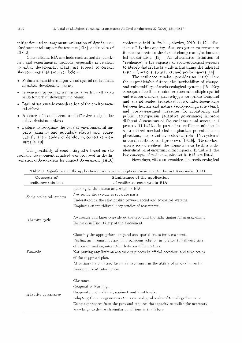
The resilience mindset provides an insight intothe unpredictable future, the inevitability of change,and vulnerability of socio-ecological systems [15]. Keyconcepts of resilience mindset such as multiple spatialand temporal scales (panarchy), appropriate temporaland spatial scales (adaptive cycle), interdependencebetween human and nature (socio-ecological system),and post-assessment measures for monitoring andpublic participation (adaptive governance) improvedi�erent dimensions of the environmental assessmentprocess [11,12,16]. In particular, resilience mindset isa structured method that emphasizes potential com-plications, uncertainties, ecological risks [15], systems'internal relations, and processes [13,16]. These char-acteristics of resilient development can facilitate theidenti�cation of environmental impacts. In Table 1, thekey concepts of resilience mindset in EIA are listed.
Nowadays, cities are considered as socio-ecological
Table 1. Signi�cance of the application of resilience concepts in Environmental Impact Assessment (EIA).
Concepts ofresilience mindset
Signi�cance of the applicationof resilience concepts in EIA
Socio-ecological systems
Looking at the system as a whole in EIA.Not seeing the system as separate parts.Understanding the relationship between social and ecological systems.Emphasis on multidisciplinary studies of assessment.
Adaptive cycleAwareness and knowledge about the type and the right timing for management.Decrease in Uncertainty of the assessment.
Panarchy
Choosing the appropriate temporal and spatial scales for assessment.Finding an incongruous and heterogeneous solution in relation to di�erent tiersof decision-making interaction between di�erent tiers.Not putting any limit on assessment process in o�cial occasions and time scalesof the suggested plan.Attention to trends and future threats concerns the ability of prediction on thebasis of current information.
Adaptive governance
Clearance.Cooperative learning.Cooperation at national, regional, and local levels.Adapting the management sections on ecological scales of the alleged sources.Using experiences from the past and requires the capacity to utilize the necessaryknowledge to deal with similar conditions in the future.

H. Vafai et al./Scientia Iranica, Transactions A: Civil Engineering 27 (2020) 1843{1857 1845
systems [17,18]. Urban environments are facing in-creasing environmental, economic, and social problemsthat endanger their resilience and sustainability aswell as the comfort of their residents [19]. Citiesare in uenced by human activities on di�erent tem-poral and spatial scales. Assessing the environmen-tal impacts of urban development policies under theresilience mindset and understanding the interactionsbetween urban structural changes and functions areimportant [17,19{23]. Urban resilience has �ve maindimensions: natural, economic, social, physical, andinstitutional. Urban resilience also pursues the fol-lowing four goals: resisting, recovering, adapting, andtransforming [24,25]. Therefore, the resilience mindsetcan be used to enhance EIA, especially in urbanprojects.
In the last decades, high-rise construction hasbeen accepted as an urban development strategy inmany megacities due to the scarcity of land. High-rise buildings impose positive and negative impactson urban environments by reducing land occupationand urban impervious surfaces, as well as changing thenatural pattern of wind ow. Protection of pervioussurfaces in urban areas is important for decreasingthe storm ow and ood frequency. In addition, theenvironmental impact of high-rise buildings on wind ow patterns is essential for establishing strategies toensure sustainable urban development.
In recent years, many studies related to simulationof air ow around buildings have been performed. Theresults of these studies showed the signi�cant impact ofhigh-rise buildings on the air ow patterns and, also, theaccumulation of air pollutants around buildings [24{27]. In a study conducted by Yuan et al., therelationship between e�ective factors in urban builtenvironments with high-density high-rise building areasand noise pollution was examined. Based on the resultsof this study, controlling the spatial distribution ofresidential buildings, the larger proportion of buildingscoverage, and the complex shape of buildings weree�ective factors in reducing noise pollution levels and,thus, maintaining the sustainability of the urban en-vironment [28]. In another study, the e�ects of high-rise buildings in Moscow were evaluated. In this study,the e�ects of high-rise buildings and the height of thebuildings on local climate (variations in temperatureand wind speeds) were investigated. Furthermore, thispaper emphasized that high-rise buildings played animportant role in creating urban heat islands. The den-sity of buildings also exacerbates air pollution and localclimate change [29]. Due to these important impacts,in the planning and design of high-rise buildings, thecon�gurations and locations of tall buildings must beconsidered.
In the current study, an example of environmentalimpact with the resilient development mindset is pre-
sented. According to the meteorological station reportin 2015, the speeds of westerly and northerly windshave been on the decline in Tehran over the past 60years [30]. This report argued that one of the causes ofreduced wind speed was the inappropriate placementof high-rise buildings. In recent years, District 22 innorthwest Tehran has experienced signi�cant growthin the construction of high-rise buildings. Consideringthat District 22 is located at the inlet air corridor ofTehran stretching along the dominant wind direction,studying the e�ects of high-rise buildings on the wind ow pattern is important and needs to be assessed.In the present study, the resilience mindset is used toexamine two important environmental e�ects of high-rise buildings, namely changing the natural pattern ofwind ow and protecting the urban pervious surface inDistrict 22 of Tehran.
2. Method and analysis
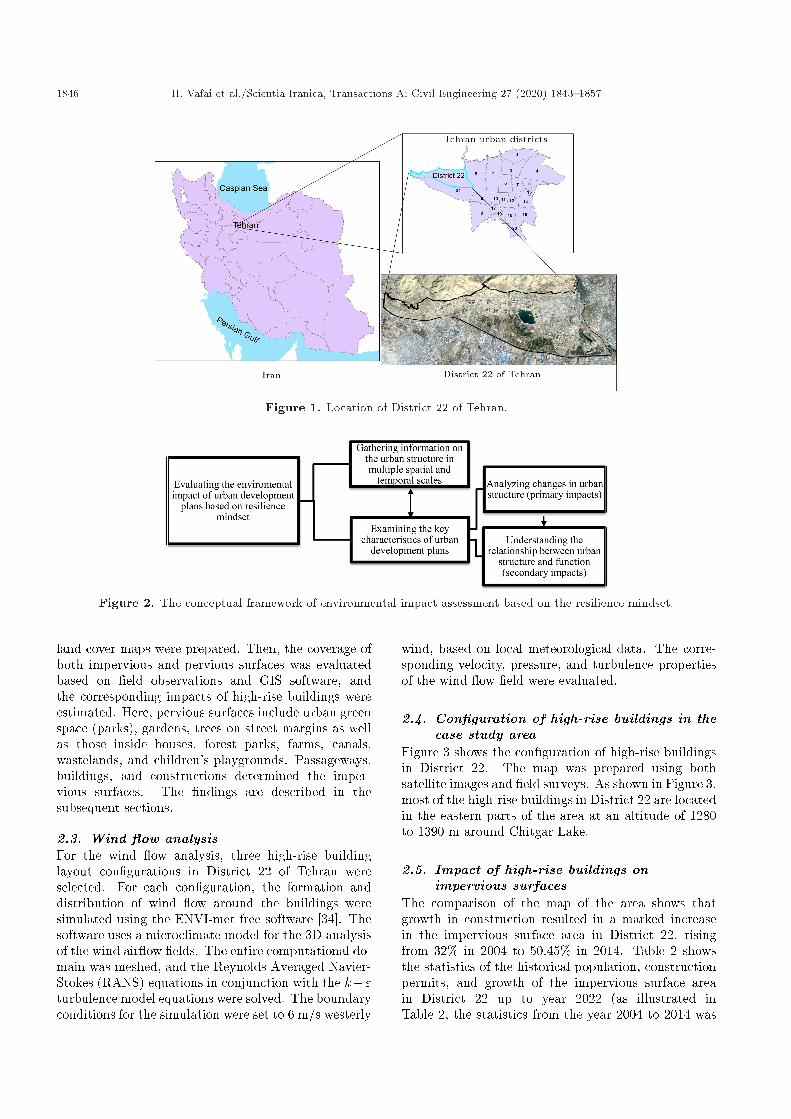
2.1. Data collection and processingThe case study region is District 22 of Tehran, Iran,which is located in the northwest part of the city, asshown in Figure 1.
The population of the city of Tehran was 8.6million in 2016 and sustained an average annual growthrate of 1.29% [31]. It is important to note that 2.02% ofthe population of Tehran inhabits in District 22. Basedon the Statistics and Informatics Report of the Plan-ning Department of Tehran Municipality O�ce, theconstruction trend of high-rise buildings in District 22increased by 103% over the years 2004{2014 [32].
In this study, the environmental assessment ofhigh-rise buildings is conducted based on the resiliencemindset. Figure 2 shows the conceptual framework ofEIA developed in this research. The resilience mindsetis focused on the relationship between structure andfunction in the focal system. Accordingly, structuraland physical changes over the course of a lifetime ofhigh-rise buildings are important. Changes in theecosystem structure alter ecological function. There-fore, to determine the environmental impacts of high-rise buildings, this study must respond to the followingquestions:
� What changes in land cover are caused by theconstruction of a high-rise building?
� Which of the ecological functions of the city isa�ected by changes in an urban land cover?
� What are the primary and secondary e�ects of thechanges in urban ecological functions?
2.2. Impervious surfaces analysisIn order to evaluate the changes in impervious sur-faces, Google Earth Landsat satellite images [33] ofDistrict 22 for the period 2004{2014 were used, and the
1846 H. Vafai et al./Scientia Iranica, Transactions A: Civil Engineering 27 (2020) 1843{1857
Figure 1. Location of District 22 of Tehran.
Figure 2. The conceptual framework of environmental impact assessment based on the resilience mindset.
land cover maps were prepared. Then, the coverage ofboth impervious and pervious surfaces was evaluatedbased on �eld observations and GIS software, andthe corresponding impacts of high-rise buildings wereestimated. Here, pervious surfaces include urban greenspace (parks), gardens, trees on street margins as wellas those inside houses, forest parks, farms, canals,wastelands, and children's playgrounds. Passageways,buildings, and constructions determined the imper-vious surfaces. The �ndings are described in thesubsequent sections.
2.3. Wind ow analysisFor the wind ow analysis, three high-rise buildinglayout con�gurations in District 22 of Tehran wereselected. For each con�guration, the formation anddistribution of wind ow around the buildings weresimulated using the ENVI-met free software [34]. Thesoftware uses a microclimate model for the 3D analysisof the wind air ow �elds. The entire computational do-main was meshed, and the Reynolds Averaged Navier-Stokes (RANS) equations in conjunction with the k�"turbulence model equations were solved. The boundaryconditions for the simulation were set to 6 m/s westerly
wind, based on local meteorological data. The corre-sponding velocity, pressure, and turbulence propertiesof the wind ow �eld were evaluated.
2.4. Con�guration of high-rise buildings in thecase study area
Figure 3 shows the con�guration of high-rise buildingsin District 22. The map was prepared using bothsatellite images and �eld surveys. As shown in Figure 3,most of the high-rise buildings in District 22 are locatedin the eastern parts of the area at an altitude of 1280to 1390 m around Chitgar Lake.
2.5. Impact of high-rise buildings onimpervious surfaces
The comparison of the map of the area shows thatgrowth in construction resulted in a marked increasein the impervious surface area in District 22, risingfrom 32% in 2004 to 50.45% in 2014. Table 2 showsthe statistics of the historical population, constructionpermits, and growth of the impervious surface areain District 22 up to year 2022 (as illustrated inTable 2, the statistics from the year 2004 to 2014 was

H. Vafai et al./Scientia Iranica, Transactions A: Civil Engineering 27 (2020) 1843{1857 1847
Figure 3. Con�guration of high-rise buildings in the case study area.
Table 2. Population, construction permits, and impervious surface variations in District 22 for the period 2004{2020.
Year2004 2006 2008 2010 2012 2014 2016 2018 2020 2022
Population 98303 108674 112369 120140 128958 138095 147411 157730 168771 180584
Total number ofbuilding permits
306 157 410 448 626 593 1200 1578 2014 2514
The number ofless-than 10-storybuilding permits
280 138 380 413 582 540 1123 1479 1889 2360
The number ofmore-than 10-storybuilding permits
26 19 30 35 44 53 77 99 125 154
Impervious surfacearea (ha)
1989 2015 2134 2415 2805 3128 3974 4748 5652 6682
o�cially published by the municipality of Tehran andthe statistics from the year 2016 to 2022 is projected).
By determining the number of construction per-mits for high-rise and low-rise buildings along with thecorresponding areas of impervious surfaces, the rateof their changes was estimated using Trend AnalysisMethod. In order to study the trend of the growthof impervious surfaces with constructions, the numberof permits for high-rise and low-rise buildings is plot-ted versus the percentages of impervious surfaces inDistrict 22 in Figure 4 using the Mini Tab software.It should be pointed out that District 22 is relativelynew and historical data on population and building andimpervious area growth are quite limited. In addition,the Mini Tab Software was used for generating the dataon impervious surface coverage more than 50%.
Table 2 and Figure 4 show that there are marked
increases in construction and impervious surface areasin District 22. In particular, sharper increases wereseen between 2006 and 2014, that are predicted tocontinue in the future due to the construction ofrecreational centers in the district, including the majorconstruction of a lake (Shohadaye Khalij Fars (Chitgar)Lake). It is also seen that as the number of buildingpermits increases, the number of both high-rise andlow-rise buildings grows (until 2022). In the years whenthe construction increase is more rapid, the rate ofincrease of impervious surface growth is equally moreintense. In general, there is a positive correlationcoe�cient of 0.95 between the number of high-risebuilding permits and the impervious surfaces as wellas between the number of permits for buildings withless than 10 oors and impervious surfaces.
Figure 5 shows the relationships between high-

1848 H. Vafai et al./Scientia Iranica, Transactions A: Civil Engineering 27 (2020) 1843{1857
Figure 4. Variations of the percentage of impervious surfaces with the number of permits for high-rise and low-risebuildings.
Figure 5. Relationship between high-rise and low-risebuildings with urban pervious and impervious surfaces.
rise and low-rise buildings and urban pervious andimpervious surfaces. According to the Tehran com-prehensive plan, building codes, the occupied areas bybuildings with less than 10 oors, are up to 65% of theland; in addition, for buildings that have more than 10stories, the maximum coverage is 35%. According tothe estimated population growth rate, by 2022, therewill be a need for additional 22089 residential units inDistrict 22. If these residential units are constructed inbuildings that have less than 10 oors (assuming thatall buildings have 5 oors), then 2209 buildings mustbe constructed that occupy 941 hectares of District 22.If the constructed buildings have more than 10 oors(assuming all are of 15 oors), then 736 buildingsoccupying 568 hectares of the region are needed. Ac-cording to these estimates, the construction of high-risebuildings would preserve the urban pervious surfacesby 373 hectares.
2.6. Impact of high-rise buildings on windair ow
In this section, three combinations of high-rise buildingcon�gurations in District 22 of Tehran are studied.
Figure 6. Schematic of the 3D solution domain and theassociated boundary conditions (Ref: www.envi-met.net).
For each group, the distributions of wind ow aroundthe buildings are simulated. The wind velocity con-tours are evaluated to show wind ow patterns andthe formation of recirculating regions downstream ofbuildings. Instead of showing the velocity vectors orstreamlines, uid particle locations at the consecutivetime are shown as black dots. Thus, these black dotsare aggregated in regions with low wind speeds andspread out in the high wind speed areas. Alignedparticles show the uid particle path through theregion. The continuous trajectories are not plotted toavoid crowding the �gures.
To simulate microclimate models, it is necessaryto consider a wide solution domain to provide anaccurate and realistic condition for ow around themodels. However, since the domain is already quitelarge, the use of a wider region was not possible. In thispaper, a 3D computation domain, shown schematicallyin Figure 6, was used and all model variables at thein ow boundary were speci�ed.
For the simulation study, the vertical pro�les ofmean ow velocity, turbulence kinetic energy k, and
H. Vafai et al./Scientia Iranica, Transactions A: Civil Engineering 27 (2020) 1843{1857 1849
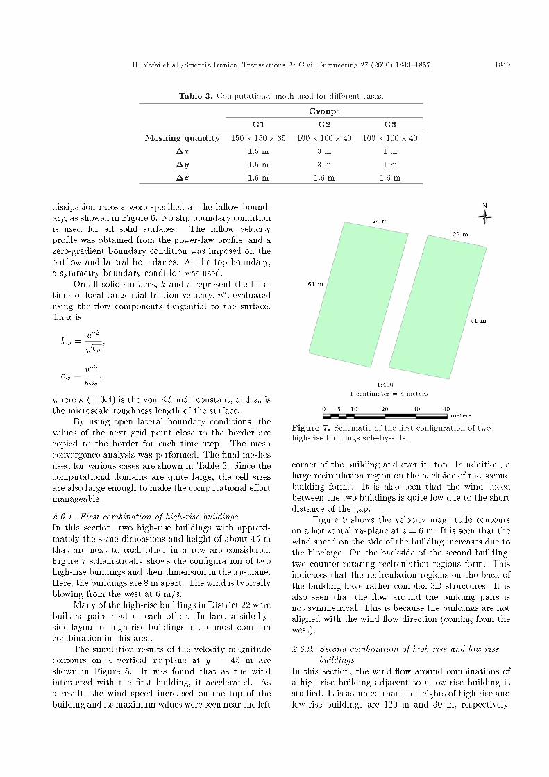
Table 3. Computational mesh used for di�erent cases.
GroupsG1 G2 G3
Meshing quantity 150� 150� 35 100� 100� 40 100� 100� 40�x 1.5 m 3 m 1 m�y 1.5 m 3 m 1 m�z 1.6 m 1.6 m 1.6 m
dissipation rates " were speci�ed at the in ow bound-ary, as showed in Figure 6. No-slip boundary conditionis used for all solid surfaces. The in ow velocitypro�le was obtained from the power-law pro�le, and azero-gradient boundary condition was imposed on theout ow and lateral boundaries. At the top boundary,a symmetry boundary condition was used.
On all solid surfaces, k and " represent the func-tions of local tangential friction velocity, u�, evaluatedusing the ow components tangential to the surface.That is:
kw =u�2pc� ;
"w =u�3�zo
;
where � (= 0:4) is the von K�arm�an constant, and zo isthe microscale roughness length of the surface.
By using open lateral boundary conditions, thevalues of the next grid point close to the border arecopied to the border for each time step. The meshconvergence analysis was performed. The �nal meshesused for various cases are shown in Table 3. Since thecomputational domains are quite large, the cell sizesare also large enough to make the computational e�ortmanageable.
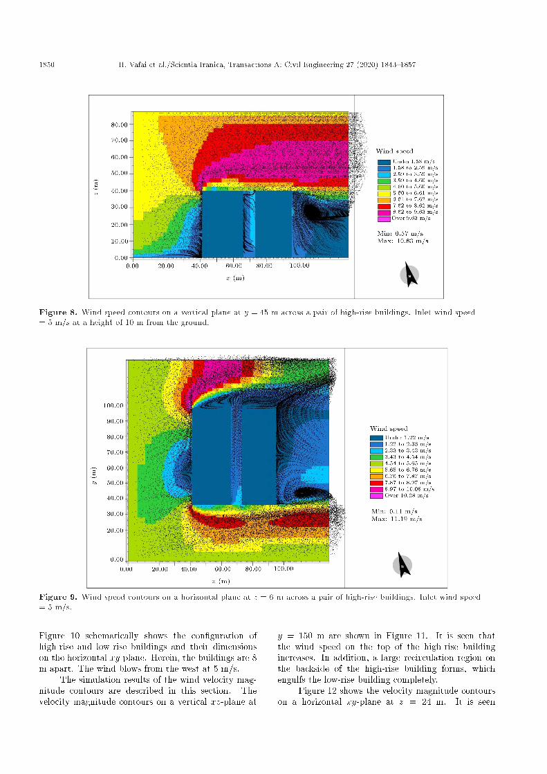
2.6.1. First combination of high-rise buildingsIn this section, two high-rise buildings with approxi-mately the same dimensions and height of about 45 mthat are next to each other in a row are considered.Figure 7 schematically shows the con�guration of twohigh-rise buildings and their dimension in the xy-plane.Here, the buildings are 8 m apart. The wind is typicallyblowing from the west at 6 m/s.
Many of the high-rise buildings in District 22 werebuilt as pairs next to each other. In fact, a side-by-side layout of high-rise buildings is the most commoncombination in this area.
The simulation results of the velocity magnitudecontours on a vertical xz-plane at y = 45 m areshown in Figure 8. It was found that as the windinteracted with the �rst building, it accelerated. Asa result, the wind speed increased on the top of thebuilding and its maximum values were seen near the left
Figure 7. Schematic of the �rst con�guration of twohigh-rise buildings side-by-side.
corner of the building and over its top. In addition, alarge recirculation region on the backside of the secondbuilding forms. It is also seen that the wind speedbetween the two buildings is quite low due to the shortdistance of the gap.
Figure 9 shows the velocity magnitude contourson a horizontal xy-plane at z = 6 m. It is seen that thewind speed on the side of the building increases due tothe blockage. On the backside of the second building,two counter-rotating recirculation regions form. Thisindicates that the recirculation regions on the back ofthe building have rather complex 3D structures. It isalso seen that the ow around the building pairs isnot symmetrical. This is because the buildings are notaligned with the wind ow direction (coming from thewest).
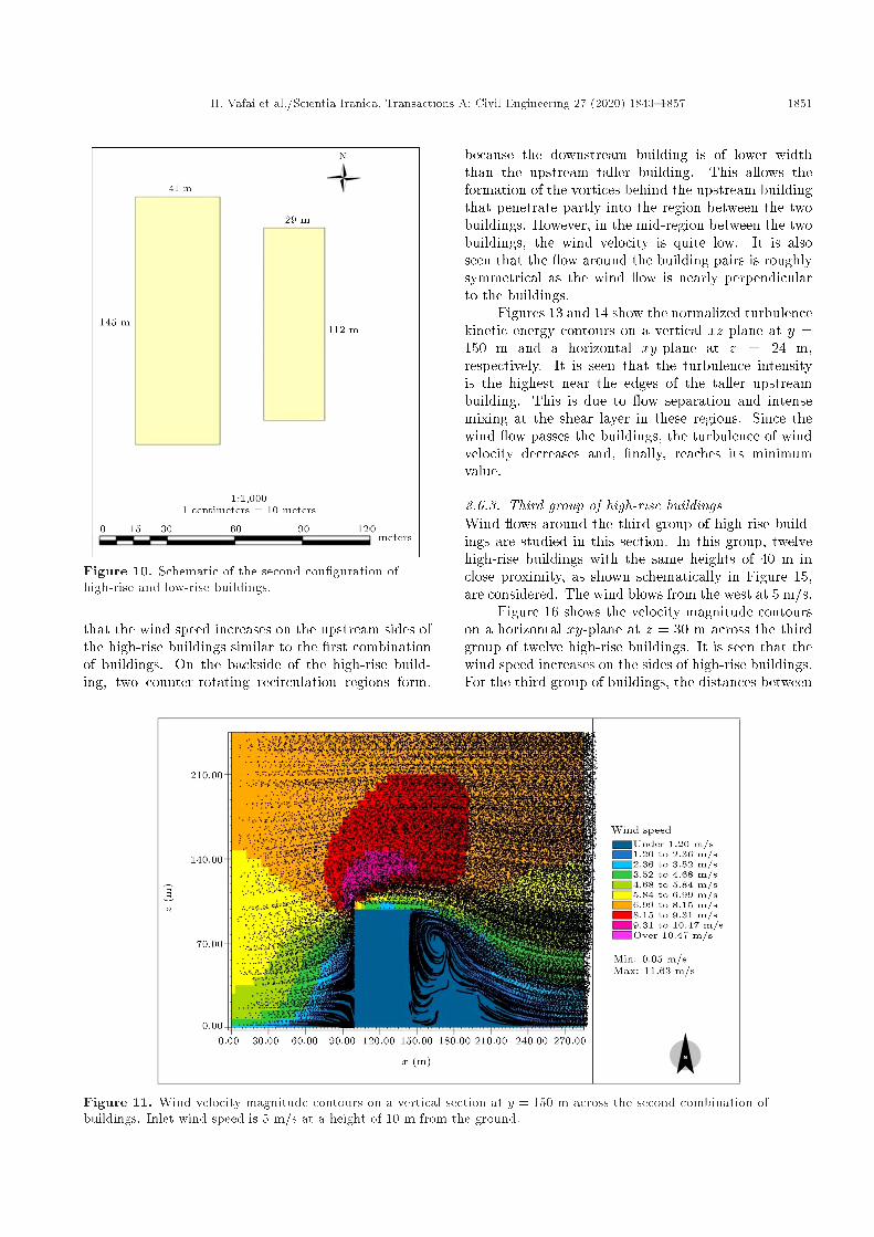
2.6.2. Second combination of high-rise and low-risebuildings
In this section, the wind ow around combinations ofa high-rise building adjacent to a low-rise building isstudied. It is assumed that the heights of high-rise andlow-rise buildings are 120 m and 30 m, respectively.
1850 H. Vafai et al./Scientia Iranica, Transactions A: Civil Engineering 27 (2020) 1843{1857
Figure 8. Wind speed contours on a vertical plane at y = 45 m across a pair of high-rise buildings. Inlet wind speed= 5 m/s at a height of 10 m from the ground.
Figure 9. Wind speed contours on a horizontal plane at z = 6 m across a pair of high-rise buildings. Inlet wind speed= 5 m/s.
Figure 10 schematically shows the con�guration ofhigh-rise and low-rise buildings and their dimensionson the horizontal xy-plane. Herein, the buildings are 8m apart. The wind blows from the west at 5 m/s.
The simulation results of the wind velocity mag-nitude contours are described in this section. Thevelocity magnitude contours on a vertical xz-plane at
y = 150 m are shown in Figure 11. It is seen thatthe wind speed on the top of the high-rise buildingincreases. In addition, a large recirculation region onthe backside of the high-rise building forms, whichengulfs the low-rise building completely.
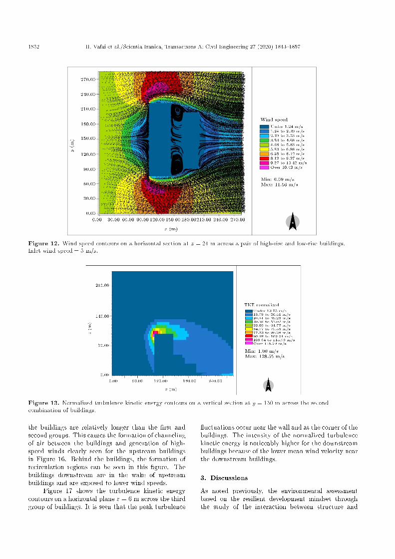
Figure 12 shows the velocity magnitude contourson a horizontal xy-plane at z = 24 m. It is seen
H. Vafai et al./Scientia Iranica, Transactions A: Civil Engineering 27 (2020) 1843{1857 1851
Figure 10. Schematic of the second con�guration ofhigh-rise and low-rise buildings.
that the wind speed increases on the upstream sides ofthe high-rise buildings similar to the �rst combinationof buildings. On the backside of the high-rise build-ing, two counter-rotating recirculation regions form,
because the downstream building is of lower widththan the upstream taller building. This allows theformation of the vortices behind the upstream buildingthat penetrate partly into the region between the twobuildings. However, in the mid-region between the twobuildings, the wind velocity is quite low. It is alsoseen that the ow around the building pairs is roughlysymmetrical as the wind ow is nearly perpendicularto the buildings.
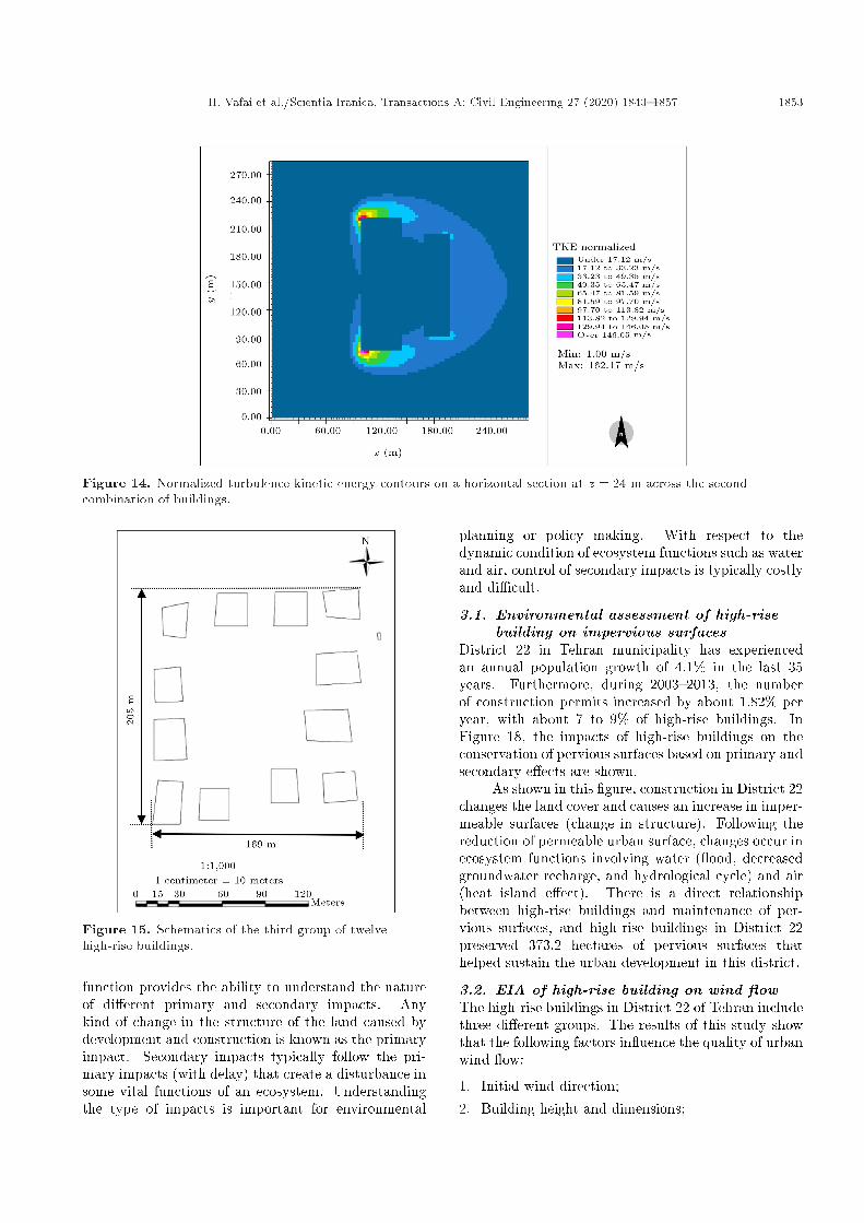
Figures 13 and 14 show the normalized turbulencekinetic energy contours on a vertical xz-plane at y =150 m and a horizontal xy-plane at z = 24 m,respectively. It is seen that the turbulence intensityis the highest near the edges of the taller upstreambuilding. This is due to ow separation and intensemixing at the shear layer in these regions. Since thewind ow passes the buildings, the turbulence of windvelocity decreases and, �nally, reaches its minimumvalue.
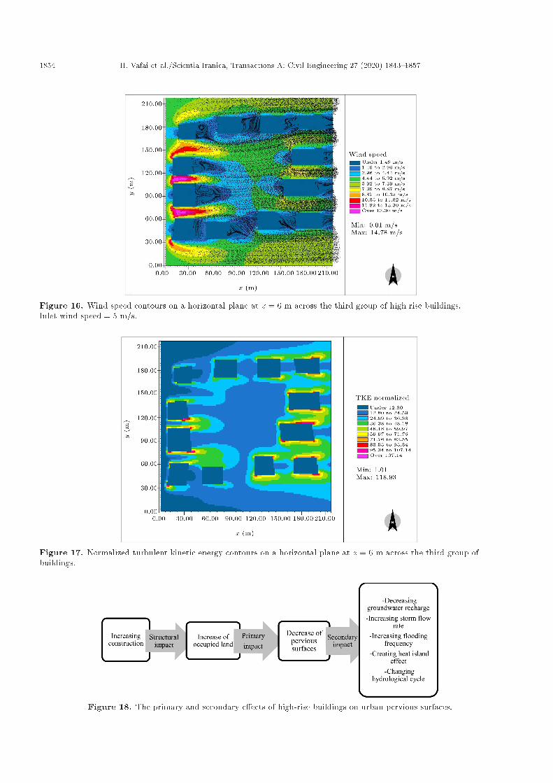
2.6.3. Third group of high-rise buildingsWind ows around the third group of high-rise build-ings are studied in this section. In this group, twelvehigh-rise buildings with the same heights of 40 m inclose proximity, as shown schematically in Figure 15,are considered. The wind blows from the west at 5 m/s.
Figure 16 shows the velocity magnitude contourson a horizontal xy-plane at z = 30 m across the thirdgroup of twelve high-rise buildings. It is seen that thewind speed increases on the sides of high-rise buildings.For the third group of buildings, the distances between
Figure 11. Wind velocity magnitude contours on a vertical section at y = 150 m across the second combination ofbuildings. Inlet wind speed is 5 m/s at a height of 10 m from the ground.
1852 H. Vafai et al./Scientia Iranica, Transactions A: Civil Engineering 27 (2020) 1843{1857
Figure 12. Wind speed contours on a horizontal section at z = 24 m across a pair of high-rise and low-rise buildings.Inlet wind speed = 5 m/s.
Figure 13. Normalized turbulence kinetic energy contours on a vertical section at y = 150 m across the secondcombination of buildings.
the buildings are relatively longer than the �rst andsecond groups. This causes the formation of channelingof air between the buildings and generation of high-speed winds clearly seen for the upstream buildingsin Figure 16. Behind the buildings, the formation ofrecirculation regions can be seen in this �gure. Thebuildings downstream are in the wake of upstreambuildings and are exposed to lower wind speeds.
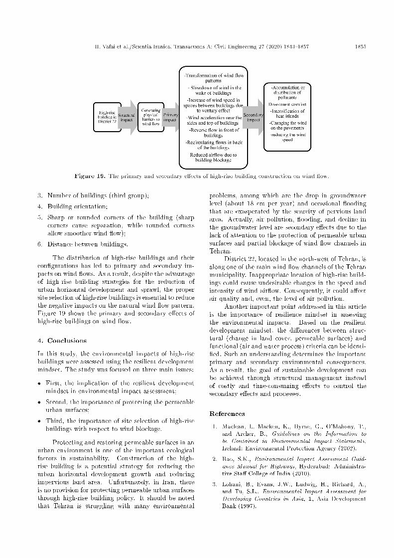
Figure 17 shows the turbulence kinetic energycontours on a horizontal plane z = 6 m across the thirdgroup of buildings. It is seen that the peak turbulence
uctuations occur near the wall and at the corner of thebuildings. The intensity of the normalized turbulencekinetic energy is noticeably higher for the downstreambuildings because of the lower mean wind velocity nearthe downstream buildings.
3. Discussions
As noted previously, the environmental assessmentbased on the resilient development mindset throughthe study of the interaction between structure and
H. Vafai et al./Scientia Iranica, Transactions A: Civil Engineering 27 (2020) 1843{1857 1853
Figure 14. Normalized turbulence kinetic energy contours on a horizontal section at z = 24 m across the secondcombination of buildings.
Figure 15. Schematics of the third group of twelvehigh-rise buildings.
function provides the ability to understand the natureof di�erent primary and secondary impacts. Anykind of change in the structure of the land caused bydevelopment and construction is known as the primaryimpact. Secondary impacts typically follow the pri-mary impacts (with delay) that create a disturbance insome vital functions of an ecosystem. Understandingthe type of impacts is important for environmental
planning or policy making. With respect to thedynamic condition of ecosystem functions such as waterand air, control of secondary impacts is typically costlyand di�cult.
3.1. Environmental assessment of high-risebuilding on impervious surfaces
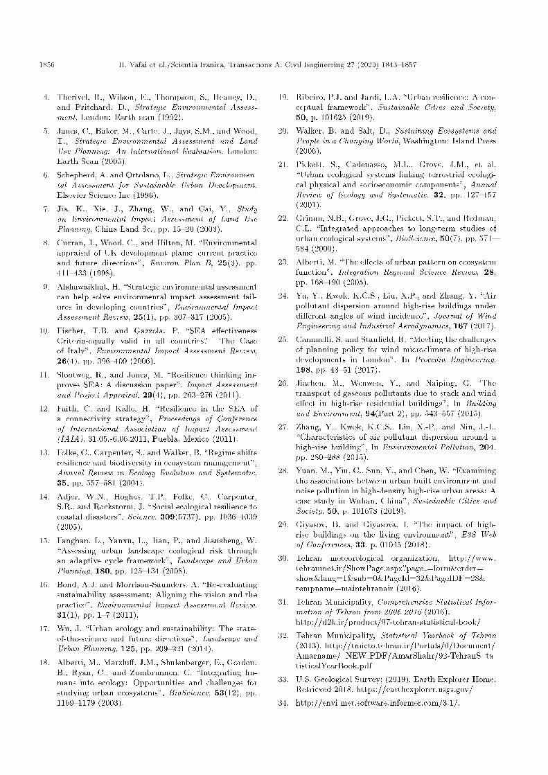
District 22 in Tehran municipality has experiencedan annual population growth of 4.1% in the last 35years. Furthermore, during 2003{2013, the numberof construction permits increased by about 1.82% peryear, with about 7 to 9% of high-rise buildings. InFigure 18, the impacts of high-rise buildings on theconservation of pervious surfaces based on primary andsecondary e�ects are shown.
As shown in this �gure, construction in District 22changes the land cover and causes an increase in imper-meable surfaces (change in structure). Following thereduction of permeable urban surface, changes occur inecosystem functions involving water ( ood, decreasedgroundwater recharge, and hydrological cycle) and air(heat island e�ect). There is a direct relationshipbetween high-rise buildings and maintenance of per-vious surfaces, and high-rise buildings in District 22preserved 373.2 hectares of pervious surfaces thathelped sustain the urban development in this district.
3.2. EIA of high-rise building on wind owThe high-rise buildings in District 22 of Tehran includethree di�erent groups. The results of this study showthat the following factors in uence the quality of urbanwind ow:
1. Initial wind direction;2. Building height and dimensions;
1854 H. Vafai et al./Scientia Iranica, Transactions A: Civil Engineering 27 (2020) 1843{1857
Figure 16. Wind speed contours on a horizontal plane at z = 6 m across the third group of high-rise buildings.Inlet wind speed = 5 m/s.
Figure 17. Normalized turbulent kinetic energy contours on a horizontal plane at z = 6 m across the third group ofbuildings.
Figure 18. The primary and secondary e�ects of high-rise buildings on urban pervious surfaces.
H. Vafai et al./Scientia Iranica, Transactions A: Civil Engineering 27 (2020) 1843{1857 1855
Figure 19. The primary and secondary e�ects of high-rise building construction on wind ow.
3. Number of buildings (third group);
4. Building orientation;
5. Sharp or rounded corners of the building (sharpcorners cause separation, while rounded cornersallow smoother wind ow);
6. Distance between buildings.
The distribution of high-rise buildings and theircon�gurations has led to primary and secondary im-pacts on wind ows. As a result, despite the advantageof high-rise building strategies for the reduction ofurban horizontal development and sprawl, the propersite selection of high-rise buildings is essential to reducethe negative impacts on the natural wind ow pattern.Figure 19 shows the primary and secondary e�ects ofhigh-rise buildings on wind ow.
4. Conclusions
In this study, the environmental impacts of high-risebuildings were assessed using the resilient developmentmindset. The study was focused on three main issues:
� First, the implication of the resilient developmentmindset in environmental impact assessment;
� Second, the importance of protecting the permeableurban surfaces;
� Third, the importance of site selection of high-risebuildings with respect to wind blockage.
Protecting and restoring permeable surfaces in anurban environment is one of the important ecologicalfactors in sustainability. Construction of the high-rise building is a potential strategy for reducing theurban horizontal development growth and reducingimpervious land area. Unfortunately, in Iran, thereis no provision for protecting permeable urban surfacesthrough high-rise building policy. It should be notedthat Tehran is struggling with many environmental
problems, among which are the drop in groundwaterlevel (about 18 cm per year) and occasional oodingthat are exasperated by the scarcity of pervious landarea. Actually, air pollution, ooding, and decline inthe groundwater level are secondary e�ects due to thelack of attention to the protection of permeable urbansurfaces and partial blockage of wind ow channels inTehran.
District 22, located in the north-west of Tehran, isalong one of the main wind ow channels of the Tehranmunicipality. Inappropriate location of high-rise build-ings could cause undesirable changes in the speed andintensity of wind air ow. Consequently, it could a�ectair quality and, even, the level of air pollution.
Another important point addressed in this articleis the importance of resilience mindset in assessingthe environmental impacts. Based on the resilientdevelopment mindset, the di�erences between struc-tural (change in land cover, permeable surfaces) andfunctional (air and water process) criteria can be identi-�ed. Such an understanding determines the importantprimary and secondary environmental consequences.As a result, the goal of sustainable development canbe achieved through structural management insteadof costly and time-consuming e�orts to control thesecondary e�ects and processes.
References
1. Maclean, I., Macken, K., Byrne, G., O'Mahony, T.,and Archer, B., Guidelines on the Information tobe Contained in Environmental Impact Statements,Ireland: Environmental Protection Agency (2002).
2. Rao, S.K., Environmental Impact Assessment Guid-ance Manual for Highways, Hyderabad: Administra-tive Sta� College of India (2010).
3. Lohani, B., Evans, J.W., Ludwig, H., Richard, A.,and Tu, S.L., Environmental Impact Assessment forDeveloping Countries in Asia, 1, Asia DevelopmentBank (1997).
1856 H. Vafai et al./Scientia Iranica, Transactions A: Civil Engineering 27 (2020) 1843{1857
4. Therivel, R., Wilson, E., Thompson, S., Heaney, D.,and Pritchard, D., Strategic Environmental Assess-ment, London: Earth scan (1992).
5. Janes, C., Baker, M., Carte, J., Jays, S.M., and Wood,T., Strategic Environmental Assessment and LandUse Planning: An International Evaluation, London:Earth Scan (2005).
6. Schepherd, A. and Ortolano, L., Strategic Environmen-tal Assessment for Sustainable Urban Development,Elsevier Science Inc (1996).
7. Jia, K., Xie, J., Zhang, W., and Cai, Y., Studyon Environmental Impact Assessment of Land UsePlanning, China Land Sc., pp. 15{20 (2003).
8. Curran, J., Wood, C., and Hilton, M. \Environmentalappraisal of UK development plans: current practiceand future directions", Environ Plan B, 25(3), pp.411{433 (1998).
9. Alshawaikhat, H. \Strategic environmental assessmentcan help solve environmental impact assessment fail-ures in developing countries", Environmental ImpactAssessment Review, 25(1), pp. 307{317 (2005).
10. Fischer, T.B. and Gazzola, P. \SEA e�ectivenessCriteria-equally valid in all countries? The Caseof Italy", Environmental Impact Assessment Review,26(4), pp. 396{409 (2006).
11. Slootweg, R., and Jones, M. \Resilience thinking im-proves SEA: A discussion paper", Impact Assessmentand Project Appraisal, 29(4), pp. 263{276 (2011).
12. Faith, C. and Kalle, H. \Resilience in the SEA ofa connectivity strategy", Proceedings of Conferenceof International Association of Impact Assessment(IAIA), 31.05.-6.06.2011, Puebla, Mexico (2011).
13. Folke, C., Carpenter, S., and Walker, B. \Regime shiftsresilience and biodiversity in ecosystem management",Annual Review in Ecology Evolution and Systematic,35, pp. 557{581 (2004).
14. Adjer, W.N., Hoghes, T.P., Folke, C., Carpenter,S.R., and Rockstorm, J. \Social ecological resilience tocoastal disasters", Science, 309(5737), pp. 1036{1039(2005).
15. Fanghan, L., Yanxu, L., Jian, P., and Jiansheng, W.\Assessing urban landscape ecological risk throughan adaptive cycle framework", Landscape and UrbanPlanning, 180, pp. 125{134 (2008).
16. Bond, A.J. and Morrison-Saunders, A. \Re-evaluatingsustainability assessment: Aligning the vision and thepractice", Environmental Impact Assessment Review,31(1), pp. 1{7 (2011).
17. Wu, J. \Urban ecology and sustainability: The state-of-the-science and future directions", Landscape andUrban Planning, 125, pp. 209{221 (2014).
18. Alberti, M., Marzlu�, J.M., Shulenberger, E., Gordon,B., Ryan, C., and Zumbrunnen, C. \Integrating hu-mans into ecology: Opportunities and challenges forstudying urban ecosystems", BioScience, 53(12), pp.1169{1179 (2003).
19. Ribeiro, P.J. and Jardi, L.A. \Urban resilience: A con-ceptual framework", Sustainable Cities and Society,50, p. 101625 (2019).
20. Walker, B. and Salt, D., Sustaining Ecosystems andPeople in a Changing World, Washington: Island Press(2006).
21. Pickett, S., Cadenasso, M.L., Grove, J.M., et al.\Urban ecological systems linking terrestrial ecologi-cal physical and socioeconomic components", AnnualReview of Ecology and Systematic, 32, pp. 127{157(2001).
22. Grimm, N.B., Grove, J.G., Pickett, S.T., and Redman,C.L. \Integrated approaches to long-term studies ofurban ecological systems", BioScience, 50(7), pp. 571{584 (2000).
23. Alberti, M. \The e�ects of urban pattern on ecosystemfunction", Integration Regional Science Review, 28,pp. 168{190 (2005).
24. Yu, Y., Kwok, K.C.S., Liu, X.P., and Zhang, Y. \Airpollutant dispersion around high-rise buildings underdi�erent angles of wind incidence", Journal of WindEngineering and Industrial Aerodynamics, 167 (2017).
25. Cammelli, S. and Stan�eld, R. \Meeting the challengesof planning policy for wind microclimate of high-risedevelopments in London", In Procedia Engineering,198, pp. 43{51 (2017).
26. Jiachen, M., Wenwen, Y., and Naiping, G. \Thetransport of gaseous pollutants due to stack and winde�ect in high-rise residential buildings", In Buildingand Environment, 94(Part 2), pp. 543{557 (2015).
27. Zhang, Y., Kwok, K.C.S., Liu, X.-P., and Niu, J.-L.\Characteristics of air pollutant dispersion around ahigh-rise building", In Environmental Pollution, 204,pp. 280{288 (2015).
28. Yuan, M., Yin, C., Sun, Y., and Chen, W. \Examiningthe associations between urban built environment andnoise pollution in high-density high-rise urban areas: Acase study in Wuhan, China", Sustainable Cities andSociety, 50, p. 101678 (2019).
29. Giyasov, B. and Giyasova, I. \The impact of high-rise buildings on the living environment", E3S Webof Conferences, 33, p. 01045 (2018).
30. Tehran meteorological organization, http://www.tehranmet.ir/ShowPage.aspx?page =form&order=show&lang=1&sub=0&PageId=32&PageIDF=28&tempname=maintehranair (2016).
31. Tehran Municipality, Comprehensive Statistical Infor-mation of Tehran from 2006-2016 (2016).http://d2k.ir/product/97-tehran-statistical-book/
32. Tehran Municipality, Statistical Yearbook of Tehran(2013). http://tmicto.tehran.ir/Portals/0/Document/Amarname/ NEW PDF/AmarShahr/92-TehranS ta-tisticalYearBook.pdf
33. U.S. Geological Survey; (2019). Earth Explorer-Home.Retrieved 2018, https://earthexplorer.usgs.gov/
34. http://envi-met.software.informer.com/3.1/.

H. Vafai et al./Scientia Iranica, Transactions A: Civil Engineering 27 (2020) 1843{1857 1857
Biographies
Hassan Vafai is an Emeritus Professor of Civil Engi-neering at Sharif University of Technology. In addition,he has held position of professorship in engineeringat di�erent universities including Washington StateUniversity, and University of Arizona. He has au-thored/coauthored numerous papers in the �eld ofengineering including applied mechanics, biomechanicsand structural engineering (steel, concrete, timber, ando�shore structures). He was founder and editor-in-chief of Scientia, international journal of science andtechnology. Throughout his careers, he has receivednumerous awards for his contribution to the promotionof science and technology worldwide including beingelected \Eternal Spirit in Science," the highest honorby the National Academy of Sciences of Iran conferredon outstanding scientists; an honorary doctorate bythe Senatus Academicus of Moscow Region State In-stitution of Higher Education; and the \Order of PalmAcademicques" awarded by the Ministry of Education,Research and Technology of France.
Parastoo Parivar is a Researcher and Lecturer in the�eld of environmental planning. She received her PhDdegree in Environmental Planning from the Universityof Tehran in 2013. She is currently an AssistantProfessor at the Department of Environmental En-gineering in Yazd University. Her research interestsinclude urban ecological planning, urban resiliency,landscape ecology, environmental impact assessment ofdevelopment projects, and ecological impacts of climatechange.
Saviz Sehat Kashani is a faculty member of At-mospheric Science and Meteorological Research Center(ASMERC), Tehran, Iran. As a meteorologist, herresearch interests and publications include dust clima-tology as well as dust observation, monitoring, andnearcasting using remote sensing techniques. She hasthe honor of being the director of World Meteorolog-ical Organization (WMO), Regional Training Center(RTC) in Tehran, Iran, is a member of the steeringcommittee of WMO Sand and Dust Storm WarningAdvisory and Assessment System (SDS-WAS), and isas an expert in the Task Team on the Use of RemoteSensing Data for Climate Monitoring (TTURSDCM)of WMO.
Amir Farshforoush Imani is a Researcher in the�eld of uid dynamics and Fluid-Structure Interaction(FSI). He is currently a PhD candidate in OceanEngineering from Sharif University of Technology. Hisresearch interests include energy harvesting from windand wave resources, meteorological investigation, o�-shore platforms engineering, micro- and micro-climatesimulation.
Farane Vakili has a master degree from Universityof Tehran in the �eld of Environmental Planning.In addition, she works in the �eld of environmentaleducation at schools. Her research interests includepublic participation, landscape ecology, environmentalimpact assessment.
Goodarz Ahmadi is a Clarkson Distinguished Pro-fessor and Robert R. Hill Professor of Mechanical andAeronautical Engineering at Clarkson University. Hehas obtained his BS degree from Tehran University andhis MS and PhD degrees from Purdue University. He isa Fellow of ASME, ASFTE, ISME, and ISCE. Amonghis many awards, he was the recipient of the 2016ASME Freeman Scholar Award in Fluid Mechanics.He was also elected as the \Chehreh Mandegar" (Ever-lasting �gure) in Mechanical Engineering in 2003. Heis an honorary member of Academic of Science of Iran.He has four patents and authored three books and over700 publications in archival journals. He also has mademore than 1250 presentations including 20 plenaryand keynotes in national and international technicalconferences and has given more than 190 invited talksand short courses at other institutions. His researchinterests include multiphase ows, particle transportand deposition, turbulent ow control, granular ows,air pollution, ow through porous and fractured media,random vibrations, and structural mechanics. Hisresearch has been supported by the National ScienceFoundation, the Environmental Protection Agency,Department of Energy, NASA, AFOSR, NYSTAR, GE,Corning, IBM, Xerox, Kodak, and Dura Pharmaceu-tical. He has held many administrative positions atClarkson University including the MAE DepartmentChair 1992�1995, the Associate Dean of Engineering2003�2005, the Interim Vice Provost for Research2004�2005, and the Dean of Engineering 2005�2015.Earlier, he served as the Dean of Engineering of ShirazUniversity.