environmental implications of a hydrogeochemical survey for drinking water in kirsehir region
TRANSCRIPT

ISSN 0016�7029, Geochemistry International, 2011, Vol. 49, No. 11, pp. 1145–1153. © Pleiades Publishing, Ltd., 2011.
1145
1 INTRODUCTION
Unpolluted groundwater may contain all naturally�occurring chemical elements at widely varying concen�trations [1–4]. Dental and skeletal fluorosis and heavymetal poisoning are ailments that can be attributable tohigh fluoride and heavy metal content in waterresources especially groundwater. Cases of endemic flu�orosis have been reported from many regions world�wide, especially in East Africa, India and China wheremillions of people are affected. In East Africa (Rift Val�ley area) and India, it is mainly related to high F con�centrations in natural groundwater, in conjunction witha high water intake [5, 6]. In their study in Indonesia[7], observed dental fluorosis among residents servedwith water with as low as 0.5 mg/L fluoride content,which is well below the World Health Organization(WHO) guideline value of 1.5 mg/L F for drinkingwater [8]. This guideline value has also been adopted bythe Turkish government as the national drinking waterstandard. A study by [9] showed that, based on the totaldaily intake, the lowest F concentration in drinkingwater that poses a risk of developing fluorosis is approx�imately 0.5 mg/L for dental fluorosis and 1.1 mg/L forskeletal fluorosis.
Chronic exposure to even low F can cause variousadverse effects such as discoloration of teeth (earlystages) as these become porous and brittle (dental fluo�rosis). Further, skeletal fluorosis can be seen with
1 The article is published in the original.
chronic joint pain and osteosclerosis. [10] describes thecrippling skeletal fluorosis as the most severe type asso�ciated with symptoms such as restricted movement ofthe joints and skeletal deformities. The LowestObserved Adverse Effect Level (LOAEL) for dentalfluorosis among children is 0.1 mg/kg body weightper day [11]. Concerning skeletal fluorosis amongadults, WHO concluded that the first adverse effectsmay occur at 6 mg/day [10].
The aim of this study was to assess environmentalimplications of the characteristics of drinking waterresources through a geochemical and hydrogeochemi�cal in the rural Kirsehir region of Turkey. To date, thetotal daily fluoride intake and the potential risks of skel�etal fluorosis for residents in the rural Kirsehir regionhave not been assessed.
MATERIALS AND METHODS
Geology of the Study Area
Fluoride is a natural element which constitutesapproximately 0.032% of the earth generally existing inthe metamorphic and magmatic rocks and clay layerrarely seen in sandstone and limestone [12]. The centralAnatolian massif contains a significant portion of thefluoride resources in Turkey, one of which is Pohrenk(Kirsehir). This region is one of the top fluoride reser�voirs. The majority of the natural water resources dis�solve minerals from the rock formations they reside inresulting in different chemical characteristics [13]. The
Environmental Implications of a Hydrogeochemical Surveyfor Drinking Water in Kirsehir RegionYusuf Urasa, Cagatayhan Bekir Ersub, and Fevzi Onerc
a Kahramanmaras Sutcu Imam University, Geology Engineering Department, Kahramanmaras, Turkeyb Cukurova University, Environmental Engineering Department, Adana, Turkey
c Mersin University, Geology Engineering Department, Mersin, Turkeye�mail: [email protected]
Received November 29, 2009
Abstract—A hydrogeochemical survey of springs was carried out in Kirsehir, Turkey and fluoride, heavy met�als, and mineral contents were analyzed. The highest fluoride levels were detected in Mahmutlu with 2.1 ppm.The fluoride content of Pohrenk was, on average, 1.1 ppm. Consequently, dental fluorosis and dental stainswere observed in both villages. Although the fluoride concentrations were within the suggested limits, dentalstains and fluorosis were commonly observed among the villagers especially kids. The fluoride concentrationsof 0.7–1.0 ppm were the lowest in Cevirme, which is to the northwest of fluoride ore. The heavy metal con�centrations of resources around the three villages were compared with and were found lower than WHO’s pro�visional guideline values. However, the Fe, Zn, and Cr concentrations in hot springs were much higher thancold springs with as much as 100 ppb for Fe, 50 ppb for Zn, and 15 ppb for Cr.
Keywords: Fluoride, fluorosis, piper, heavy metals, water quality.
DOI: 10.1134/S0016702911090072
1146
GEOCHEMISTRY INTERNATIONAL Vol. 49 No. 11 2011
URAS et al.
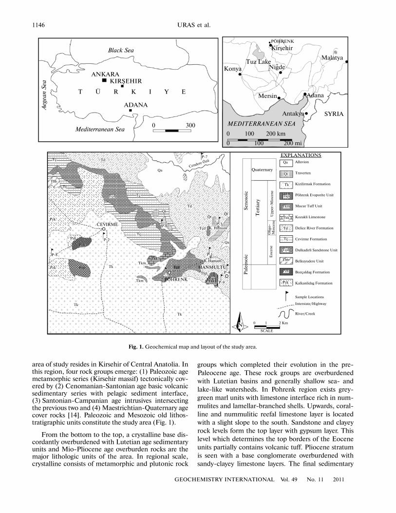
area of study resides in Kirsehir of Central Anatolia. Inthis region, four rock groups emerge: (1) Paleozoic agemetamorphic series (Kirsehir massif) tectonically cov�ered by (2) Cenomanian�Santonian age basic volcanicsedimentary series with pelagic sediment interface,(3) Santonian�Campanian age intrusives intersectingthe previous two and (4) Maestrichtian�Quaternary agecover rocks [14]. Paleozoic and Mesozoic old lithos�tratigraphic units constitute the study area (Fig. 1).
From the bottom to the top, a crystalline base dis�cordantly overburdened with Lutetian age sedimentaryunits and Mio�Pliocene age overburden rocks are themajor lithologic units of the area. In regional scale,crystalline consists of metamorphic and plutonic rock
groups which completed their evolution in the pre�Paleocene age. These rock groups are overburdenedwith Lutetian basins and generally shallow sea� andlake�like watersheds. In Pohrenk region exists grey�green marl units with limestone interface rich in num�mulites and lamellar�branched shells. Upwards, coral�line and nummulitic reefal limestone layer is locatedwith a slight slope to the south. Sandstone and clayeyrock levels form the top layer with gypsum layer. Thislevel which determines the top borders of the Eoceneunits partially contains volcanic tuff. Pliocene stratumis seen with a base conglomerate overburdened withsandy�clayey limestone layers. The final sedimentary
Black Sea
ANKARA
T Ü R K I Y E
KIRSEHIR
Mediterranean Sea
Aeg
ean
Sea
ADANA
0 300 MEDITERRANEAN SEA
PÖHRENK
Malatya
Adana
SYRIAAntakya
Mersin
KonyaTuz Lake
Kirsehir @
0 100 200 km
0 100 200 mi
Pal
eoso
icS
enos
oic
Quaternary
Ter
tiar
y
Eo
cen
eO
ligo
�M
ioce
ne
Up
per
�Mio
cen
e
EXPLANATIONSQa
Qt
Tk
Tkp
Tkm
Tkk
Td
Tç
Tçd
Tbb
Pzb
Pzk
Alluvion
Traverten
Kizilirmak Formation
Pöhrenk Evaporite Unit
Mucur Tuff Unit
Kozakli Limestone
Delice River Formation
Cevirme Formation
Dulkadirli Sandstone Unit
Belkuyudere Unit
Bozçaldag Formation
Kalkanlidag Formation
Sample Locations
Interstate/Highway
River/Creek
0 1 2 Km
SCALE
PÖHRENK
CEVIRME
MANMULTU
Tçd
Tç Td
QaCendere Özü
P�7
Td
Qt
P�3K. Hamam
P�1
B. Hamam
Tkp
Tkk P�9
P�4P�5
Tk
Pzh
Nigde
Qt
Qa
Tçd
Tçd
Pzk
PzhPzk Tk
Tk
Tç
Tç
Tç
Qt
Tkk
Pzk
Tbb
Tkm
P�2
P�8
Tkm
P�6
N
Fig. 1. Geochemical map and layout of the study area.
GEOCHEMISTRY INTERNATIONAL Vol. 49 No. 11 2011
ENVIRONMENTAL IMPLICATIONS OF A HYDROGEOCHEMICAL SURVEY 1147
imbricates of the region is Quaternary age alluvion andtravertine strata [15].
The two fault lines between Pohrenk creek andMahmutlu with northwest direction caused the block�ing of the Lutetian units. Hot springs and fluorite oresresides within the limestone and marl that demonstratessilicification along the fault lines. Fluorite ores are seenas thin bunches of veins or void fillings with epigeneticcharacter.
Research Methodology
Fluoride concentrations were evaluated in thegroundwater of three villages in Kirsehir region. Abroader aim of this study was to evaluate the geochemi�cal characteristics of the groundwater of the region. Therelationship between the geochemical and hydro�geochemical characteristics of the ground water con�sumed and the dental problems of the residents in theregion was also established. Sampling points were deter�mined for hot springs as well as cold springs and artesianwells. A total of eight sampling points were determinedwith two of which were at hot springs and one which wasat an artesian well while the others were at the coldsprings in the village.
P1—Mamhutlu hot spring I; P2—Cevirme watersupply I; P3—Mahmutlu hot spring II; P4—Mah�mutlu water supply; P5—Pohrenk water supply; P6—Cevirme farm artesian well; P7—Cemilin water sup�ply located in alluvionic area; P8—Cevirme watersupply II.
50–mL water samples were taken from the samplingpoints in the study area and tested according toICP/MS method in ACME laboratories (Vancouver,Canada). Based on the fluoride and other mineral con�centrations observed in the initial samples, Pohrenk(Kirsehir) village is selected as the area of study. Fluo�ride was detected in both hot and cold springs. Pohrenkfluoride beds are different from the other fluorideresources around the world based on origin, rare soilminerals, and their distribution [16].
RESULTS AND DISCUSSION
Evaluation of Surface Water Quality in the Region
The anionic and cationic quality of the surface watersamples gathered from Pohrenk, Cevirme, and Mah�mutlu villages is summarized. Through assessing thesevalues, the interaction between the water resources andthe elements as well as the suitability of the water forpublic use was evaluated.
The ionic concentrations of surface water aroundthe three villages are tabulated in Table 1. The highesttotal ionic content was seen in P1 and P3 hot springs.When listed from the highest to the lowest concentra�tions for anions and cations, Na+ + K+ > Ca2+ > Mg2+
(sodium + potassium > calcium > magnesium) for the
cations and Cl– > S >HC (chloride > sulfate >bicarbonate) are determined (see Table. 3). The highestdetected ionic concentration was seen in P3 with Naand Ca concentrations of 1.118 and 337 mg/L. The rea�son for Na detection at high concentrations is that thegeological formation of P3 highly contained gypsumand salt. P1 and P3 resources generally contained Na+,
Cl–, and S (from the lowest to the highest) indicat�ing that, after evaporation in Pohrenk, region ground�water flow happens in deeper ground and therefore
contains high concentrations of Na+, Cl–, and Sdue to natural ion exchange process.
The order for anion and cation concentrations(high—low) in P2, P5, P6, and P8 cold springs were
Ca2+ > Mg2+ > Na+ + K+ and HC > Cl– > S (seeTable 3). These locations differ from the previous twolocations based on the anion�cation order. This differ�ence can be attributed to variation in the lithologicstructure of the main rock the water flows through. Thefact that the majority of the region contained calcium
carbonate (CaCO3) results in strong Ca2+ and HCcontent.
The anion�cation order for P4 and P7 cold springs is
Na+ + K+ > Ca2+ > Mg2+ and S > HC > Cl–. Theanion�cation order for P4 is similar to those of hot
O42– O3
–
O42–
O42–
O3– O4
2–
O3–
O42– O3
–
Table 1. Anion and cation analysis results for surface waters of Pohrenk, Cevirme, and Mahmutlu villages (as ppb)
Refource Na+ K+ Ca2+ Mg2+ HCO3– Cl– S × 10–3
P�1 1070 31.9 316.0 51.3 0.338 1.32 0.117
P�2 20.7 4.5 97.4 17.8 0.273 0.022 0.0024
P�3 1118 34.2 336.7 52.6 0.318 1.44 0.124
P�4 278.6 3.18 109.1 22.4 0.428 0.114 0.061
P�5 53.4 0.58 101.6 25.2 0.363 0.037 0.015
P�6 30.3 32.5 79.9 12.9 0.233 0.038 0.0058
P�7 119.0 0.845 56.4 11.7 0.223 0.041 0.0020
P�8 11.2 2.5 73.5 15.1 0.218 0.006 0.0014
O32–

1148
GEOCHEMISTRY INTERNATIONAL Vol. 49 No. 11 2011
URAS et al.
springs due to that the location of P4 is close to hotsprings.
Physical Characteristics and Fluoride Content of Surface Waters in the Region
The analytical results of pH, temperature (T°C),electrical conductivity (EC), and fluoride (Fl) for sur�face waters around the three villages are summarized inTable 2. Based on the results, the resources with thehighest temperature values are P1 and P3 hot springs.The temperature for P1 and P3 varies between 61.5—60.5°. These temperature values vary seasonally. Forexample, Yaman (1989) reported 70°C for P1 and 64°Cfor P3 while the flow rates were 30 L/s and 1.6 L/s forP1 and P3, respectively. The fluoride content of thesesprings were 5.5 mg/L for P1 and 5.7 mg/L for P3, bothof which were about 5 mg/L higher than the recom�mended fluoride limit set by International Associationof Hydrogeologists [17]. High fluoride concentrationsin both water resources pose a risk to human life. Simi�larly, the fluoride content of P4 cold spring is over therecommended limit with 2.6 mg/L. The remainingsprings are within normal limits for both temperatureand fluoride.
pH values recorded for P1 and P3 hot springs werelower than those of the others. However, the electricalconductivity of both springs were higher than the othersindicating acidic character. The pH of P2, P4, P5, P6,P7, and P8 cold springs were higher than 7 with lowerelectrical conductivity indicating basic character.
Impact of Fluoride in Water Resources of Pohrenk, Cevirme, and Mahmutlu Villages on Residents
Based on World Health Organization [8] standards,up to 1.5 mg/L fluoride concentration is permissible forwater supply purposes and fluoride concentrationshigher than that may cause fluoride poisoning. In this
study, the highest fluoride concentrations were observedin the surfaced springs in the environs of Mahmutluwith 2.1 mg/L. Among the residents of Mahmutlu andits environs, dental spots and fluorosis were observed aswell as skeletal deformation.
The fluoride concentration is, on average, 1.1 mg/L(below the recommended limit) in the water resourcesof Pohrenk village which resides to the south of the flu�oride massif. Despite that the fluoride concentrationswere within allowable limits, dental spots and fluorosiswere observed especially in kids.
Cevirme village is located to the northwest of the flu�oride massif and had the lowest fluoride concentrationsobserved varying between 0.65 and 0.95 mg/L.
Pohrenk is located to the north of Kirsehir in CentralAnatolian Region with fluoride deposits to the north�west. During the activities for fluoride mining in theregion, gangue containing fluoride ore fragments wasaccumulated in the environment posing environmentalrisk for pollution. As a natural process, fluoride mineralcontaminated the soil resulting in the transfer of excessfluoride to plants and crops, water resources, animals,and more importantly humans.
Heavy Metal Content in Water Resources of Pohrenk, Cevirme, and Mahmutlu Villages
The heavy metal concentrations of water resourcesaround the three villages are tabulated in Table 3. Basedon the test results compared with World Health Organi�zation [8] water quality criteria, the Fe concentration inP1 and P3 hot water springs were close to the upperlimit whereas it was lower than the limit for the othersources. The highest Fe concentration was observed as100 ppb for P1 and P3 hot springs. The Zn concentra�tion of P3 hot spring only was considerably high withapprox. 50 ppb. The chromium concentration in P2,P3, P6, and P7 was considerably higher than the othersbut were still below the guideline value as the remaining
Table 2. pH, T°C, electrical conductivity, and fluoride content of water samples from Pohrenk, Cevirme, and Mahmutluvillages
Resource Fluoride (mg/L) pH T(°C) Salinity Electrical Conductivity (EC) (mS/cm)
P�1 5.50 6.30 61.5 3.0 539
P�2 0.71 8.06 12.1 0.0 483
P�3 5.70 6.67 60.5 3.3 583
P�4 2.60 7.70 15.6 0.9 203
P�5 1.07 7.70 14.3 0.8 201
P�6 0.63 7.65 14.4 0.0 471
P�7 0.95 8.20 14.0 0.2 425
P�8 0.76 8.04 11.9 0.0 485
WHO* 1.50
* World Health Organization health�based provisional guideline value as mg/L (WHO, 1993).Values in bold indicate values higher than WHO’s recommended limit.
GEOCHEMISTRY INTERNATIONAL Vol. 49 No. 11 2011
ENVIRONMENTAL IMPLICATIONS OF A HYDROGEOCHEMICAL SURVEY 1149
resources. The highest Cr concentration was 15 ppb.The concentrations for manganese (Mn), cadmium(Cd), silicon (Si), copper (Cu), lead (Pb), and cobalt(Co) for all samples were much below the limits.
Hydrochemistry of Surface Waters in Pohrenk, Cevirme, and Mahmutlu Villages
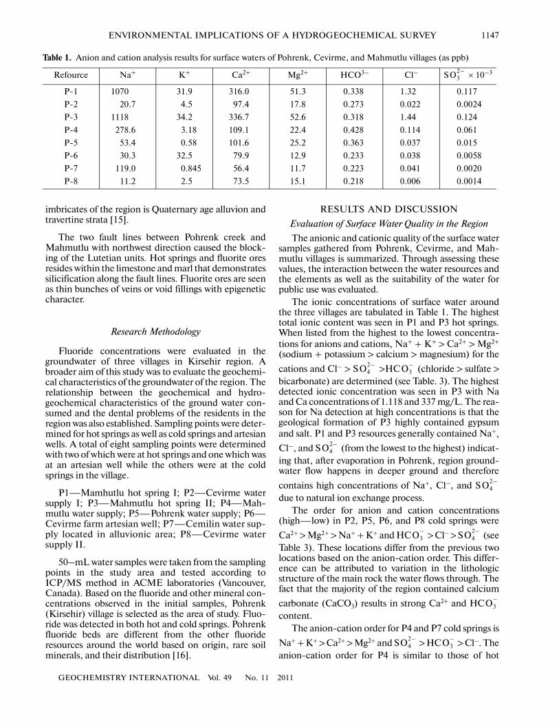
The hydrochemistry of water samples taken inPohrenk, Cevirme, and Mahmutlu villages were evalu�ated through various diagrams [18] indicated thatPohrenk hot springs (P1 and P3) were meteoric charac�ter based on isotopic evaluation.
Major ions are Na+, Ca2+, Mg2+, K+, Cl–, HC
and S ions which constitutes more than 90% of thetotal ionic content in natural waters. Ions, which can befound as traces in natural waters, are considered minor
O3–
O42–
ions. Heavy metals except Fe exist in waters with lessthan 1 mg/L [19]. Major ions content of the water sam�ples taken in the study area are tabulated in Table 4.
Piper, semi�logarithmic (Schoeller), and circulardiagrams were used to assess the analytical results of thewater samples taken in the study area (Figs. 2–4).
Piper Classification
P2, P5, P6, and P8 samples fall into category 5where carbonate alkalinity is higher than 50%,Ca2+ +
Mg2+ > Na+ + K+, and water is rich in Ca(HC )2
(Fig. 2). This character is due to that water is in contactwith CaCO3 formations. For P1 and P3 hot springs aswell as P and P7 cold springs, the water is in category 7with higher than 50% non�carbonate alkalinity due toalkaline NaCI, KCI, and Na2SO4 and strong acids. P4
O3–
P1P2P3P4P5P6P7P8
80
60
40
20
Ca +
Mg
SO4
+ C
l
80
60
40
20
80
60
40
20
80
60
40
20
12
3
45
67
8
Na +
K HC
O3
+ C
O3
80
60
40
20 80
60
40
20
SO4
SO4
HCO3 + CO3
20 40 60 80ClCl
80
60
40
20 80
60
40
20
20406080Na + K
Mg
Ca
Mg
Ca
CATIONS ANIONS% meq/l
Fig. 2. Piper Diagram for Water Resources in Pohrenk, Cevirme, and Mahmutlu Villages.

1150
GEOCHEMISTRY INTERNATIONAL Vol. 49 No. 11 2011
URAS et al.
100
10
1
0.1
0.01SO4ClMgCaKNa HCO3
log[
Co
ns.
, m
eq/L
]
Constituents
P1
P2
P3
p4
P5
p6
P7
P8
Fig. 3. Schoeller Diagram for Water Resources in Pohrenk, Cevirme, and Mahmutlu Villages.
P1 P3
10 20 30 meq/L
P2 P4 P5
P6 P7 P8
5 10 15 meq/L
Na
K
Ca
Mg
Cl
HCO3
SO4
Fig. 4. Circular Diagrams for Water Resources in Pohrenk, Cevirme, and Mahmutlu Villages.
GEOCHEMISTRY INTERNATIONAL Vol. 49 No. 11 2011
ENVIRONMENTAL IMPLICATIONS OF A HYDROGEOCHEMICAL SURVEY 1151
and P7 resources fall into Na–S facies whereas P1and P3 are in Na–CI facies (Fig. 2), The samples withCaCO3 point out contact with limestone.
The presence of Na+, Cl–, and S ions in waterindicate contact with evaporitic rock layers such ashalite (NaCI) and gypsum (CaSO4 ⋅ 2H2O).
Schoeller Classification
Data obtained from the analyses of water samplesfrom cold and hot springs were put into semi�logarith�mic Schoeller diagram and the following deductionswere made.
Based on the semi�logarithmic plot, there are twotypes of water in the region. Both electrical conductivity
O42–
O42–
and temperature values of the water samples suggestthat there are two different groundwater types with vary�ing circulation and mixing. The first circulation groupconsists of P1 and P3 hot springs represented by NaCIfacies while the others (P2, P4, P6, P7, and P8) fall intothe second group. The second group water resources are
enriched for Na+, Cl–, and S ions through contactwith halite and gypsum. The following conclusions weremade based on the chemical classification of Schoeller(Fig. 3):
1. P1 and P3 hot springs are;
a. oligochloride based on chloride concentration,
b. regular sulfated based on sulfate concentration.These waters are under�saturated for sulfate meaning
O42–
Table 3. Heavy metal content of surface water resources around Pohrenk, Cevirme, and Mahmutlu villages (as ppb)
Resource Fe Mn Cd Zn Si Ni Cu Al Pb Co Cr
P�1 100 5.78 0.5 9.9 28.64 2 7.3 17 1.9 0.29 5
P�2 10 0.05 0.05 7.3 15.93 0.2 0.8 1 0.1 0.14 10.2
P�3 100 9.05 0.5 49.4 30.582 2 8.7 10 1 2.96 11.9
P�4 10 0.05 0.05 1.4 11.02 0.2 3.8 1 0.1 0.17 13
P�5 10 0.05 0.05 0.5 12.43 0.2 1 1 0.1 0.11 15
P�6 10 0.11 0.05 2.8 14.04 0.2 1 2 0.1 0.12 9.8
P�7 10 0.05 0.05 2.6 13.24 0.2 1.8 1 0.1 0.6 14.7
P�8 10 0.05 0.05 1.1 10.74 0.2 0.6 1 0.1 0.11 8.1
WHO* NDA 500 3 NDA NDA 20 200 NDA 10 NDA 50
* World Health Organization health�based provisional guideline value (WHO, 1993); NDA – data available.
Table 4. Ionic order for water resources in study area
Resource Cation Order Anion Order
P�1 Na+ + K+ > Ca2+ > Mg2+Cl– > S > HC
P�2 Ca2+ > Mg2+ > Na+ + K+HC > Cl– > S
P�3 Na+ > K+ > Ca2+ > Mg2+Cl– > S > HC
P�4 Na+ + K+ > Ca2+ > Mg2+S > HC > Cl–
P�5 Ca2+ > Na+ > K+ > Mg2+HC > S > Cl–
P�6 Ca2+ > Na+ + K+ > Mg2+HC > S > Cl–
P�7 Na+ + K+ > Ca2+ > Mg2+S > HC > Cl–
P�8 Ca2+ > Mg2+ > Na+ + K+HC > S > Cl–
The highilighted rows indicate the hot springs.
O42–
O3–
O3–
O42–
O42–
O3–
O42–
O3–
O3–
O42–
O3–
O42–
O42–
O3–
O3–
O42–

1152
GEOCHEMISTRY INTERNATIONAL Vol. 49 No. 11 2011
URAS et al.
that [(r�S ) (r�Ca2+)]*0.5 < 70 meq/L and r–S <
r–Ca2+.c. Regular carbonated based on carbonate�bicar�
bonate classification.2. P2, P4, P5, P6, P7 and P8 cold springs are;a. regular chlorinated based on chloride concentra�
tion,b. regular sulfated based on sulfate concentration.
These waters are under�saturated for sulfate meaning
that [(r�S ) (r�Ca2+)]*0.5 < 70 meq/L and r–S <
r–Ca2+.c. regular carbonated based on carbonate�bicarbon�
ate classification.
Circular Diagrams (Pie Charts) for Dissolved Matter
P1 and P3 samples had the highest dissolved matterconcentration as can be seen in the circular diagramsshown in Fig. 4. These samples represent deep circula�tion as the temperature for both samples was 61.5°C.Temperature is one of the major factors for high totaldissolved matter concentrations in these two samples ascompared to the others. Higher total dissolved matterconcentration results in higher electrical conductivityvalues for the two samples. Cold springs (P2, P4, P6,P7, and P8 where is P5) had lower total dissolved matterconcentration and thus represent shallow circulation.Among the cold springs, P4 had the highest total dis�solved matter concentration and temperature. As in hotsprings, Na+ content in P4 was higher than other cat�ions indicating a possible mixing of P4 with hot springs.
CONCLUSIONS
This study evaluated hot and cold springs inPohrenk, Mahmutlu, and Cevirme villages of Kirsehirin Central Anatolian region in terms of hydrogeochem�ical and medical geological characteristics (fluorinecontent). A total of 8 water sampling points were deter�mined with two hot springs, one artesian well, and fivedrinking water taps.
According to WHO, it is admissible for drinkingwater to contain up to 1.5 mg/L fluoride and higherconcentrations may have poisonous effects on humans.In this study, the highest fluorine concentration wasobserved in the surfacing springs of Mahmutlu villagewith 2.07 mg/L. Among the residents of Mahmutlu vil�lage, dental spots and fluorosis were observed especiallyin the kids. The surfacing springs in Cevirme village hadthe lowest fluorine concentrations between 0.65–0.95 mg/L. Signs of fluorosis were seen in Cevirme aswell. The drinking water needs of these two locationsshould be supplied elsewhere. As a result of the fluoridemining activities in the region, gangue with fluoridefragments accumulated in the area posing additionalrisk for the environment and the living things throughfood chain.
O42– O4
2–
O42– O4
2–
The heavy metal concentrations of water resourcesaround the three villages were compared with WorldHealth Organization [8] water quality criteria and werefound all were lower than the provisional guideline val�ues. However, the Fe, Zn, and Cr concentrations in hotsprings were much higher then those of cold springswith as much as 100 ppb for Fe, 50 ppb for Zn, and15 ppb for Cr.
The highest total anionic content was observed in P1and P3 hot springs where cationic order was Na+ +
K+ > Ca2+ > Mg2+ and anionic order was Cl– > S >
HC . High sodium content was due to salt and gyp�sum layers in the location. Because of evaporation inPohrenk, the groundwater levels go deeper and contain
high Na+ – C– – S after natural ion exchange pro�
cess. The orders for P2, P5, P6, and P8 were Ca2+ >
Mg2+ > Na+ + K+ for cations and HC > Cl– > Sfor anions, both of which are quite different than thoseof P1 and P3. For P4 and P7 cold springs, however, thecation order was Na+ + K+ > Ca2+ > Mg2+ and anion
order was S > HC > Cl–. The orders for P4 weresimilar to those of hot springs since the location of P4was close to hot springs.
pH values for water samples taken from P1 and P3were lower than those of others indicating acidic char�acter while the electrical conductivity levels were higher.For P2, P4, P5, P6, P7 ve P8, pH was higher than 7 withbasic character and the electrical conductivity levelswere low.
ACKNOWLEDGMENTS
This study was funded and supported by ScientificResearch Support Fund of Cukurova University.
REFERENCES
1. D. Banks, B. Frengstad, A. K. Midtgard, et al., “Thechemistry of Norwegian Groundwaters: I. The Distribu�tion of Radon, Major and Minor Elements in 1604 Crys�talline Bedrock Groundwaters,” Sci. Total Environ. 222,71–91 (1998).
2. C. Reimann and P. de Caritat, Chemical Elements in theEnvironment�Factsheets for the Geochemist and Environ�mental Scientist (Springer�Verlag, Berlin, 1998).
3. B. Frengstad, A. K. Midtgard, D. Banks, et al., “TheChemistry of Norwegian Groundwaters. III. The Distri�bution of Trace Elements in 476 Crystalline BedrockGroundwaters as Analysed by ICP�MS Techniques,”Sci. Total Environ. 246, 21–40 (2000).
4. C. Reimann and D. Banks, Setting Action Levels forDrinking Water: Are We Protecting our Health or OurEconomy (or our Backs!)?” Sci. Total Environ. 332 (1–3), 13–21 (2004).
5. S. L. Choubisa, “Chronic Fluoride Intoxication (Fluo�rosis) in Tribes and their Domestic Animals,” Int. J.Environ. Stud. 36, 703–716 (1999).
O42–
O3–
O42–
O3– O4
2–
O42– O3
–

GEOCHEMISTRY INTERNATIONAL Vol. 49 No. 11 2011
ENVIRONMENTAL IMPLICATIONS OF A HYDROGEOCHEMICAL SURVEY 1153
6. C. Reimann, K. Bjorvatn, B. Frengstad, et al., “Drink�ing Water Quality in the Ethiopian Section of the EastAfrican Rift Valley I�Data and Health Aspects,” Sci.Total Environ. 311, 65–80 (2003).
7. E. S. Budipramana, A. Hapsoro, E. S. Irmawati, andS. Kuntari, “Dental Fluorosis and Caries Prevalence inthe Fluorosis Endemic Area of Asembagus, Indonesia,”Int. J. Paediatr. Dent. 12, 415–422 (2002).
8. WHO, Guidelines for Drinking�Water Quality, (WorldHealth Organization, Geneva, 1996).
9. A. Heikens, S. Sumarti, M. V. Bergen, et al., “TheImpact of the Hyperacid Ijen Crater Lake: Risks ofExcess Fluoride to Human Health,” Sci. Total Environ.346, 56–69 (2005).
10. WHO, Fluorides (Environmental Health Criteria), (WorldHealth Organization, Geneva, 2002)
11. WHO, Fluorine and Fluorides (Environmental HealthCriteria), (World Health Organization, Geneva, 1984)
12. E. Atabey, T bbi Jeoloji Kitab TMMOB. JMO (Yay n�lar , Ankara, 2005).
13. S. Yaman, “Bay nd r (Kaman) Florit Filonlar n nTermo Optik Analizi, Yerbilimleri 11, 23–30 (1984).
14. “MTA 1/100000 ölçekli aç nsama Nitelikli,” Türkiye.Jeol. Harit. Ser. 47, K r ehir. G18 (1991).
15. S. Yaman, “Pohrenk (Kirsehir) Fluorit Mineralle mesi
ve Kökenine Ba l S v lar n Fizikokimyasal Özel�likleri,” Do a 13, 257–265 (1989).
16. Y. Uras, F. Oner, and S. Yaman, (, 2003.17. IAH (International Association of Hydrogeologists),
Map of Mineral and Thermal Water of Europe Scale:1 : 500.000, (IAH, 1979).
18. A. Ünsal and M. Af in, “Hydrochemical and IsotopicProperties of the Mahmutlu and Bagdatoglu MineralizedThermal Springs, Kirsehir,” Turk. Hydrogeol. J. 7, 540–545 (1999).
19. R. A. Freeze and J. A. Cherry, Groundwater, (PrenticeHall, Englewood Cliffs, 1979).
I I I
I
I I I I
I
I s,s,
g
^
I I I I
g
^
s,