environmental management of groundwater from the … · · 2017-08-21environmental management of...
TRANSCRIPT

Environmental management of groundwater from the Gnangara Mound Annual compliance report to the Office of the Environmental Protection Authority July 2015 – June 2016
Securing Western Australia’s water future
Department of Water June 2017

Department of Water 168 St Georges Terrace Perth Western Australia 6000 Telephone +61 8 6364 7600 Facsimile +61 8 6364 7601 National Relay Service 13 36 77 www.water.wa.gov.au © Government of Western Australia June 2017 This work is copyright. You may download, display, print and reproduce this material in unaltered form only (retaining this notice) for your personal, non-commercial use or use within your organisation. Apart from any use as permitted under the Copyright Act 1968, all other rights are reserved. Requests and inquiries concerning reproduction and rights should be addressed to the Department of Water.
ISBN 978-1-925524-12-3 (online) Acknowledgements This document was prepared by the Water Allocation Planning Branch with assistance from the Regulation, Water Resource Assessment and Water Information and Modelling branches; and regional operations officers of the Swan–Avon Region (Welshpool office). For more information about this report, contact: Ben Drew, Manager Water Allocation Planning. Disclaimer This document has been published by the Department of Water. Any representation, statement, opinion or advice expressed or implied in this publication is made in good faith and on the basis that the Department of Water and its employees are not liable for any damage or loss whatsoever which may occur as a result of action taken or not taken, as the case may be in respect of any representation, statement, opinion or advice referred to herein. Professional advice should be obtained before applying the information contained in this document to particular circumstances. This publication is available at our website <www.water.wa.gov.au> or for those with special needs it can be made available in alternative formats such as audio, large print, or Braille.
Environmental management of groundwater from the Gnangara Mound – annual compliance report
Department of Water iii
Contents 1 Summary ............................................................................................................... 1
2 Background ........................................................................................................... 2
2.1 Ministerial statement no. 819 ......................................................................................... 2 2.2 Allocation limits and licensing ........................................................................................ 2 2.3 The Gnangara groundwater system .............................................................................. 4
3 Rainfall .................................................................................................................. 5
4 Groundwater use ................................................................................................... 6
4.1 Public water supply ........................................................................................................ 6 4.2 Private licensed use ....................................................................................................... 6 4.3 Use that is exempt from licensing .................................................................................. 7
5 Compliance ........................................................................................................... 9
5.1 Compliance with water level criteria ............................................................................... 9
6 Environmental monitoring, management, research and consultation .................. 11
6.1 Environmental monitoring ............................................................................................ 11 6.1.1 Wetland vegetation ............................................................................................................... 11 6.1.2 Wetland macroinvertebrates and water quality ..................................................................... 12 6.1.3 Mound spring macroinvertebrates and water quality ............................................................ 12 6.1.4 Wetland frogs ........................................................................................................................ 12
6.2 Management actions ................................................................................................... 13 6.2.1 Managing public water supply use ........................................................................................ 13 6.2.2 Managing private licensed use ............................................................................................. 14 6.2.3 Managing groundwater use exempt from licensing ............................................................... 15 6.2.4 Updating the 2009 Gnangara areas groundwater allocation plan ......................................... 15 6.2.5 Perth and Peel Green Growth Plan for 3.5 million ................................................................ 15
6.3 Research initiatives ...................................................................................................... 16 6.3.1 Perth Regional Aquifer Modelling System............................................................................. 16 6.3.2 Future climate tool ................................................................................................................ 16 6.3.3 Perth Regional Confined Aquifer Capacity project ................................................................ 16
6.4 Consultation ................................................................................................................. 17
Appendices ................................................................................................................ 18
References ................................................................................................................ 40
Appendices
Appendix A — Water level monitoring results for Ministerial sites on the Gnangara Mound for 2005–2016 ......................................................................................... 19
Appendix B — Audit tables: Environmental conditions, procedures and commitments for the Gnangara groundwater resources ............................................................ 25
Appendix C — History of Ministerial statements for the Gnangara Mound ................ 37
Appendix D — Review of environmental monitoring program (819: P 6 3) ................ 38
Appendix E — Map information and disclaimer ......................................................... 39
Environmental management of groundwater from the Gnangara Mound – annual compliance report
iv Department of Water
Figures
Figure 1 Location of Gnangara Ministerial sites, public water supply production bores, and private licensed drawpoints .................................................. 3
Figure 2 Annual and average water-year rainfall at Perth Airport (BoM site no. 9021) ................................................................................................ 5
Tables
Table 1 Rainfall, licensing totals from all aquifers and compliance summary ...... 1 Table 2 Licensed and garden bore water use from all aquifers in the Gnangara
groundwater system, comparing 2014–15 and 2015–16 ........................ 7 Table 3 Licensed entitlements from the Superficial aquifer in subareas of the
Gnangara groundwater areas allocation plan ......................................... 8 Table 4 Summary of non-compliance with Ministerial criteria for the Gnangara
Mound .................................................................................................. 10

Environmental management of groundwater from the Gnangara Mound – annual compliance report
Department of Water 1
1 Summary This report describes the Department of Water’s compliance with Ministerial conditions and commitments for the Gnangara Mound for the period 1 July 2015 – 30 June 2016. These conditions and commitments, including water level criteria, were set by the Minister for Environment in Ministerial statement no. 819 (Government of Western Australia 2009a). Over the 2015–16 reporting period, the number of sites that were non-compliant with absolute minimum or peak water level criteria increased from 16 sites in 2014–15 to 18 sites (see section 5). The two sites that became non-compliant were a wetland site in the Ellenbrook area called Lexia 86 (GNM16), and a terrestrial vegetation site in Whiteman Park called MM55B (Figure 1). This was the first year that levels at Lexia 86 have been non-compliant with absolute minimum criteria, while levels at MM55B have been commonly non-compliant since the 1990s. A combination of well-below average rainfall and an increase in the volume abstracted for public water supply contributed to lower Superficial aquifer levels and the additional non-compliance in 2015–16. This report presents total licensed groundwater entitlements covered by the Gnangara groundwater areas allocation plan (DoW 2009a) from all aquifers of the Gnangara system (Figure 1; tables 1, 2 and 3). Public water supply entitlements increased in 2015–16 because 10 GL of temporary groundwater licences was approved for the Integrated Water Supply Scheme under exceptional circumstances conditions (Table 1). The temporary volume was required to secure supply to the scheme after very low inflows to our dams by the end of winter in 2015, exacerbated by a hot, dry spring that saw higher than normal scheme water use. This report also outlines the environmental monitoring, management, research and consultation the department is doing to improve sustainable management of the Gnangara groundwater system. In response to this year’s and previous non-compliance, we are implementing strategies to reduce abstraction towards a sustainable level and reduce impacts on environmentally important sites (section 6.2). We initiated many of these strategies through the Gnangara groundwater areas allocation plan (DoW 2009a), which has been a key step in reducing groundwater use in the context of a drier climate. The department is currently working on the next Gnangara groundwater allocation plan, which will include new strategies to return the system to balance by setting levels of abstraction that match the drying climate.
Table 1 Rainfall, licensing totals from all aquifers and compliance summary 2014–15 2015–16
Rainfall 652.8 mm 602.0 mm Public water supply entitlements 110.81 GL 121.31 GL Private licensed entitlements 128.11GL 127.16 GL Estimated garden bore use1 36 GL 36 GL No. of non-compliant sites 16 out of 30 18 out of 30
1 Domestic garden bore use is estimated using data collected through surveys, data from the Australian Bureau of Statistics and records of household use from the Water Corporation. We last reviewed domestic garden bore use in 2014.
Environmental management of groundwater from the Gnangara Mound – annual compliance report
2 Department of Water
2 Background
2.1 Ministerial statement no. 819
Ministerial statement no. 819 sets environmental water provisions in the form of water level criteria at 30 sites across the Gnangara Mound – 14 wetland sites and 16 terrestrial phreatophytic vegetation sites (Figure 1). Phreatophytic vegetation is vegetation that uses groundwater to meet at least part of its water needs. Ministerial conditions and commitments were established in 1986 to manage how groundwater was abstracted for public water supply and manage the expected growth in private licensed use at the time. Since then, the conditions and commitments have been revised several times to remove sites where environmental values have been lost due to causes other than abstraction (Appendix C). These causes include the drying climate, land clearing and disturbance related to changing land use. The most recent revision in 2008 removed seven sites and amended the water level criteria at three sites. The water level criteria at the current sites represent contemporary environmental water provisions, suitable for protecting significant environmental values of groundwater-dependent ecosystems supported by the Gnangara Mound.
2.2 Allocation limits and licensing
The department uses allocation limits, licensing of groundwater abstraction, and monitoring as the main mechanisms to manage groundwater resources. An allocation limit is the annual volume of water set aside for consumptive use from a water resource. This usually includes:
• water that is available for licensing
• water we account for that is exempt from licensing, including water used by domestic garden bores
• water we set aside for future public water supply. Water for the environment is not included in the allocation limit. This is because it is left in the system and considered a non-consumptive use. Allocation limits are set considering recharge estimates, modelling, environmental objectives and benefits of groundwater use. The limits guide water availability for individual licence assessments. The department guides the appropriate use of domestic garden bores through sprinkler restrictions and identifying the areas that are unsuitable for the installation of new bores. The department reviewed allocation limits for the Gnangara groundwater areas in 2007 and these were finalised in the Gnangara groundwater areas allocation plan (DoW 2009a). We reviewed allocation limits again in 2011 to account for reduced rainfall and recharge, and in 2014 finalised a review of allocation limits for subareas in the North West Urban Growth Corridor. The current allocation limits for Superficial aquifer resources are shown in Table 3.

Environmental management of groundwater from the Gnangara Mound – annual compliance report
Department of Water 3
Figure 1 Location of Gnangara Ministerial sites, public water supply production
bores, and private licensed drawpoints
Environmental management of groundwater from the Gnangara Mound – annual compliance report
4 Department of Water
2.3 The Gnangara groundwater system
The Gnangara groundwater system is located on the Swan Coastal Plain, extending from the Swan River in the south to Moore River and Gingin Brook in the north, covering an area of about 2200 km2. The system comprises four main aquifers:
• the shallow, unconfined Superficial (watertable) aquifer known as the Gnangara Mound
• the shallow, semi-confined Mirrabooka aquifer
• the deep, partially-confined Leederville aquifer
• the deep, mostly-confined Yarragadee aquifer. Environmental impacts from abstraction and reduced recharge occur where ecosystems are directly supported by the Superficial aquifer. Impacts can occur from abstraction within the Superficial aquifer itself or through abstraction from deeper aquifers where they are directly or indirectly connected to the Superficial aquifer, such as in the northern half of the Gnangara plan area. Many parts of the Gnangara system are currently over-allocated and water levels in the system have generally declined over the last 40 years because of:
• groundwater abstraction for public water supply and private use
• the drying climate (less rainfall and recharge)
• pine plantations limiting recharge to groundwater. These declines have meant that important wetlands and other groundwater-dependent ecosystems on Gnangara are under significant pressure and, in many cases, on a pathway to further decline in health and ecological function.

Environmental management of groundwater from the Gnangara Mound – annual compliance report
Department of Water 5
3 Rainfall Groundwater levels in the Superficial aquifer depend on recharge from rainfall. Across south-west Western Australia there has been a general trend of declining annual rainfall since the mid 1970s. CSIRO’s investigation of climate change (Bates et al. 2010), as well as relevant global climate change models, predict continued rainfall reduction in the region. Over the 2015–16 reporting period, rainfall at the Bureau of Meteorology’s (BoM) Perth Airport station was 602 mm – well below the long-term average (764 mm) and also below the short-term, 10-year average (662 mm) (Figure 2).
Figure 2 Annual and average water-year rainfall at Perth Airport (BoM site
no. 9021)
Environmental management of groundwater from the Gnangara Mound – annual compliance report
6 Department of Water
4 Groundwater use The Gnangara groundwater system is Perth’s largest source of good quality, fresh water. It provides almost half of Perth’s public water supply as well as water for public open spaces, an extensive area of local agriculture, and our gardens.
4.1 Public water supply
The Department of Water licenses the Water Corporation to take groundwater from the Gnangara and Jandakot groundwater systems for Perth’s public water supply. Groundwater from these systems forms a crucial component of Perth’s Integrated Water Supply Scheme. Within the Gnangara system, there is also a small volume of groundwater licensed for the Woodridge town water supply. This volume does not form part of the Integrated Water Supply Scheme. The volumes of groundwater licensed for public water supply from all aquifers increased from 110.81 GL in 2014–15 to 121.31 GL in 2015–16 (Table 2). The increase is because of an additional 10 GL of temporary groundwater licences for public water supply. This volume was required to secure supply to the scheme because of very low inflows into our dams by the end of winter in 2015, exacerbated by a hot, dry spring that saw higher than normal scheme water use. Suburbs that are serviced at least in part by the northern dams (Mundaring, Canning and Wungong) were at risk of not being supplied with safe drinking water. The decision to allocate additional volumes for public water supply was a contingency action after the Water Corporation also:
• increased production from desalination plants
• used low dam storage
• invested in stronger demand management including their “Drop 2” media campaign
• brought forward investment in the next stage of groundwater replenishment and investigations into the next water source options.
Licensed entitlements for public water supply are further divided into groundwater subareas for the Superficial aquifer in Table 2 (section 4.3).
4.2 Private licensed use
Groundwater licensed for private use from the Gnangara system mostly comes from the Superficial aquifer and mainly includes groundwater for agriculture and for irrigation of public open space, such as parks and sporting grounds. Over the 2015–16 reporting period, private licensed entitlements remained similar to the previous year across all aquifers. Private licensed entitlements have remained steady since we’ve implemented the Gnangara groundwater areas allocation plan (DoW 2009a) (Table 2, section 4.3).
Environmental management of groundwater from the Gnangara Mound – annual compliance report
Department of Water 7
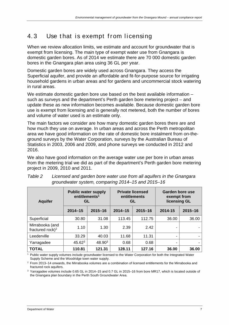
4.3 Use that is exempt from licensing
When we review allocation limits, we estimate and account for groundwater that is exempt from licensing. The main type of exempt water use from Gnangara is domestic garden bores. As of 2014 we estimate there are 70 000 domestic garden bores in the Gnangara plan area using 36 GL per year. Domestic garden bores are widely used across Gnangara. They access the Superficial aquifer, and provide an affordable and fit-for-purpose source for irrigating household gardens in urban areas and for gardens and uncommercial stock watering in rural areas. We estimate domestic garden bore use based on the best available information – such as surveys and the department’s Perth garden bore metering project – and update these as new information becomes available. Because domestic garden bore use is exempt from licensing and is generally not metered, both the number of bores and volume of water used is an estimate only. The main factors we consider are how many domestic garden bores there are and how much they use on average. In urban areas and across the Perth metropolitan area we have good information on the rate of domestic bore instalment from on-the-ground surveys by the Water Corporation, surveys by the Australian Bureau of Statistics in 2003, 2006 and 2009, and phone surveys we conducted in 2012 and 2016. We also have good information on the average water use per bore in urban areas from the metering trial we did as part of the department’s Perth garden bore metering project in 2009, 2010 and 2011.
Table 2 Licensed and garden bore water use from all aquifers in the Gnangara groundwater system, comparing 2014–15 and 2015–16
Aquifer
Public water supply entitlements1
GL
Private licensed entitlements
GL
Garden bore use exempt from licensing GL
2014–15 2015–16 2014–15 2015–16 2014-15 2015–16
Superficial 30.80 31.08 113.45 112.75 36.00 36.00 Mirrabooka (and fractured rock)2 1.10 1.30 2.39 2.42 - -
Leederville 33.29 40.03 11.68 11.31 - - Yarragadee 45.623 48.903 0.68 0.68 - - TOTAL 110.81 121.31 128.11 127.16 36.00 36.00
1 Public water supply volumes include groundwater licensed to the Water Corporation for both the Integrated Water Supply Scheme and the Woodridge town water supply.
2 From 2013–14 onwards, the Mirrabooka volumes are a combination of licensed entitlements for the Mirrabooka and fractured rock aquifers.
3 Yarragadee volumes include 0.65 GL in 2014–15 and 0.7 GL in 2015–16 from bore MR17, which is located outside of the Gnangara plan boundary in the Perth South Groundwater Area.
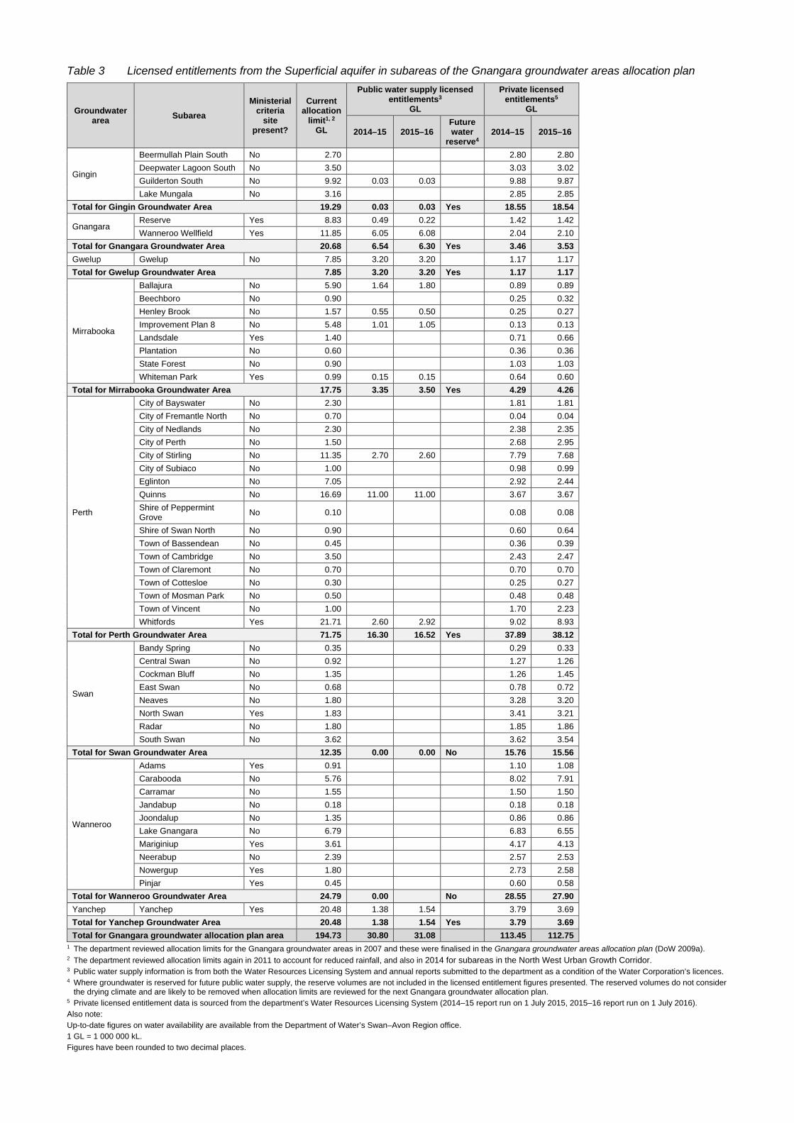
Table 3 Licensed entitlements from the Superficial aquifer in subareas of the Gnangara groundwater areas allocation plan
Groundwater area Subarea
Ministerial criteria
site present?
Current allocation
limit1, 2 GL
Public water supply licensed entitlements3
GL
Private licensed entitlements5
GL
2014–15 2015–16 Future water
reserve4 2014–15 2015–16
Gingin
Beermullah Plain South No 2.70 2.80 2.80 Deepwater Lagoon South No 3.50 3.03 3.02 Guilderton South No 9.92 0.03 0.03 9.88 9.87 Lake Mungala No 3.16 2.85 2.85
Total for Gingin Groundwater Area 19.29 0.03 0.03 Yes 18.55 18.54
Gnangara Reserve Yes 8.83 0.49 0.22 1.42 1.42 Wanneroo Wellfield Yes 11.85 6.05 6.08 2.04 2.10
Total for Gnangara Groundwater Area 20.68 6.54 6.30 Yes 3.46 3.53 Gwelup Gwelup No 7.85 3.20 3.20 1.17 1.17 Total for Gwelup Groundwater Area 7.85 3.20 3.20 Yes 1.17 1.17
Mirrabooka
Ballajura No 5.90 1.64 1.80 0.89 0.89 Beechboro No 0.90 0.25 0.32 Henley Brook No 1.57 0.55 0.50 0.25 0.27 Improvement Plan 8 No 5.48 1.01 1.05 0.13 0.13 Landsdale Yes 1.40 0.71 0.66 Plantation No 0.60 0.36 0.36 State Forest No 0.90 1.03 1.03 Whiteman Park Yes 0.99 0.15 0.15 0.64 0.60
Total for Mirrabooka Groundwater Area 17.75 3.35 3.50 Yes 4.29 4.26
Perth
City of Bayswater No 2.30 1.81 1.81 City of Fremantle North No 0.70 0.04 0.04 City of Nedlands No 2.30 2.38 2.35 City of Perth No 1.50 2.68 2.95 City of Stirling No 11.35 2.70 2.60 7.79 7.68 City of Subiaco No 1.00 0.98 0.99 Eglinton No 7.05 2.92 2.44 Quinns No 16.69 11.00 11.00 3.67 3.67 Shire of Peppermint Grove No 0.10 0.08 0.08
Shire of Swan North No 0.90 0.60 0.64 Town of Bassendean No 0.45 0.36 0.39 Town of Cambridge No 3.50 2.43 2.47 Town of Claremont No 0.70 0.70 0.70 Town of Cottesloe No 0.30 0.25 0.27 Town of Mosman Park No 0.50 0.48 0.48 Town of Vincent No 1.00 1.70 2.23 Whitfords Yes 21.71 2.60 2.92 9.02 8.93
Total for Perth Groundwater Area 71.75 16.30 16.52 Yes 37.89 38.12
Swan
Bandy Spring No 0.35 0.29 0.33 Central Swan No 0.92 1.27 1.26 Cockman Bluff No 1.35 1.26 1.45 East Swan No 0.68 0.78 0.72 Neaves No 1.80 3.28 3.20 North Swan Yes 1.83 3.41 3.21 Radar No 1.80 1.85 1.86 South Swan No 3.62 3.62 3.54
Total for Swan Groundwater Area 12.35 0.00 0.00 No 15.76 15.56
Wanneroo
Adams Yes 0.91 1.10 1.08 Carabooda No 5.76 8.02 7.91 Carramar No 1.55 1.50 1.50 Jandabup No 0.18 0.18 0.18 Joondalup No 1.35 0.86 0.86 Lake Gnangara No 6.79 6.83 6.55 Mariginiup Yes 3.61 4.17 4.13 Neerabup No 2.39 2.57 2.53 Nowergup Yes 1.80 2.73 2.58 Pinjar Yes 0.45 0.60 0.58
Total for Wanneroo Groundwater Area 24.79 0.00 No 28.55 27.90 Yanchep Yanchep Yes 20.48 1.38 1.54 3.79 3.69 Total for Yanchep Groundwater Area 20.48 1.38 1.54 Yes 3.79 3.69 Total for Gnangara groundwater allocation plan area 194.73 30.80 31.08 113.45 112.75
1 The department reviewed allocation limits for the Gnangara groundwater areas in 2007 and these were finalised in the Gnangara groundwater areas allocation plan (DoW 2009a). 2 The department reviewed allocation limits again in 2011 to account for reduced rainfall, and also in 2014 for subareas in the North West Urban Growth Corridor. 3 Public water supply information is from both the Water Resources Licensing System and annual reports submitted to the department as a condition of the Water Corporation’s licences. 4 Where groundwater is reserved for future public water supply, the reserve volumes are not included in the licensed entitlement figures presented. The reserved volumes do not consider
the drying climate and are likely to be removed when allocation limits are reviewed for the next Gnangara groundwater allocation plan. 5 Private licensed entitlement data is sourced from the department’s Water Resources Licensing System (2014–15 report run on 1 July 2015, 2015–16 report run on 1 July 2016). Also note: Up-to-date figures on water availability are available from the Department of Water’s Swan–Avon Region office. 1 GL = 1 000 000 kL. Figures have been rounded to two decimal places.

Environmental management of groundwater from the Gnangara Mound – annual compliance report
Department of Water 9
5 Compliance The conditions and commitments that the Department of Water is required to comply with from Ministerial statement no. 819 are outlined in Appendices A and B (the ‘audit tables’).
5.1 Compliance with water level criteria
Ministerial statement no. 819 sets water level criteria at 30 sites across the Gnangara Mound (Figure 1). Some sites have more than one water level criterion and can be non-compliant with multiple criteria. Water level criteria include:
• absolute minimum levels and peak water levels – these are used as the main indicator for compliance from year to year
• levels allowed to fall between a preferred minimum and the absolute minimum in two out of six years to replicate natural drying cycles – these are referred to as ‘other’ water level criteria in this report and provide information on water level trends.
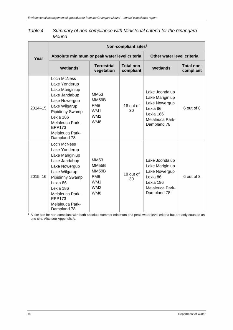
The number of sites non-compliant with absolute minimum or peak water level criteria increased from 16 sites in 2014–15 to 18 sites in 2015–16 due to levels at Lexia 86 and MM55B falling below the absolute minimum set for these sites (Table 4). While levels at MM55B have been commonly non-compliant since the 1990s, 2015–16 was the first year that levels at Lexia 86 have been non-compliant with the absolute minimum criteria. The combination of well-below average rainfall and an increase in the volume abstracted for public water supply contributed to lower Superficial levels and the additional non-compliance in 2015–16. Our management and mitigation actions in response to non-compliance are described in Section 6. Details for individual sites can be found in the ‘audit tables’ in Appendix A.
Environmental management of groundwater from the Gnangara Mound – annual compliance report
10 Department of Water
Table 4 Summary of non-compliance with Ministerial criteria for the Gnangara Mound
Year
Non-compliant sites1
Absolute minimum or peak water level criteria Other water level criteria
Wetlands Terrestrial vegetation
Total non-compliant Wetlands Total non-
compliant
2014–15
Loch McNess Lake Yonderup Lake Mariginiup Lake Jandabup Lake Nowergup Lake Wilgarup Pipidinny Swamp Lexia 186 Melaleuca Park-EPP173 Melaleuca Park-Dampland 78
MM53 MM59B PM9 WM1 WM2 WM8
16 out of 30
Lake Joondalup Lake Mariginiup Lake Nowergup Lexia 86 Lexia 186 Melaleuca Park-Dampland 78
6 out of 8
2015–16
Loch McNess Lake Yonderup Lake Mariginiup Lake Jandabup Lake Nowergup Lake Wilgarup Pipidinny Swamp Lexia 86 Lexia 186 Melaleuca Park-EPP173 Melaleuca Park-Dampland 78
MM53 MM55B MM59B PM9 WM1 WM2 WM8
18 out of 30
Lake Joondalup Lake Mariginiup Lake Nowergup Lexia 86 Lexia 186 Melaleuca Park-Dampland 78
6 out of 8
1 A site can be non-compliant with both absolute summer minimum and peak water level criteria but are only counted as one site. Also see Appendix A.

Environmental management of groundwater from the Gnangara Mound – annual compliance report
Department of Water 11
6 Environmental monitoring, management, research and consultation
6.1 Environmental monitoring
Expert environmental consultants undertake environmental monitoring for the department in line with the commitments in Ministerial statement no. 819. The department reviewed the monitoring program in 2009 and 2013 to improve cost effectiveness and efficiency (see Appendix D). The program includes monitoring of:
• wetland vegetation
• wetland macroinvertebrates and water quality
• mound spring macroinvertebrates and water quality
• wetland frogs. Ecological condition is affected by a number of factors that influence water levels, such as groundwater abstraction, fire, disease, and disturbance from changing land use. We use environmental monitoring to continually improve our understanding of the relationship between water levels and ecological condition. We also use the information to manage abstraction at priority locations, where reduced abstraction is likely to improve ecological condition.
6.1.1 Wetland vegetation
In 2015–16 the condition of wetland vegetation was monitored in spring at the following Ministerial sites: Lake Jandabup, Lake Mariginiup, Loch McNess, Lake Yonderup, Lake Nowergup, Lake Joondalup, Melaleuca Park EPP173, and Lexia 86. Other sites across the northern part of Gnangara system in environmentally important areas not covered by Ministerial sites, such as the Yeal Nature Reserve, were also monitored. Details of this monitoring can be found in Buller et al. (2016). Although groundwater levels declined at most sites since last year, only minor changes in mean canopy condition occurred in the same period. Over the longer term most monitored wetlands show general declines in canopy condition and species similarity, and a general increase in exotic species cover-abundance. There are several wetlands of concern where monitoring shows declining groundwater levels have contributed to declines in canopy condition of overstorey species, and/or the disappearance or decline in condition and abundance of some key wetland species. These wetlands include:
• Lake Nowergup – prolonged declines in maximum water levels have led to declining health and deaths of mature trees.
• Lake Yonderup – water level declines have contributed to declining condition of Melaleuca rhaphiophylla and recent deaths of mature trees.
Environmental management of groundwater from the Gnangara Mound – annual compliance report
12 Department of Water
• Lake Mariginiup – water level declines since 1997 have contributed to it being one of the poorest sites in terms of vegetation health.
• Melaleuca Park EPP173 – groundwater declines since the mid-2000s have contributed to the wetland species of Baumea articulata and Pericalymma ellipticum disappearing from the transect.
• Loch McNess – declines in groundwater levels since 2004 have contributed to the recent loss of the key wetland macrophyte, Baumea articulata.
6.1.2 Wetland macroinvertebrates and water quality
In 2015–16 the following sites were surveyed for aquatic macroinvertebrates: Lake Jandabup, Loch McNess South, Melaleuca Park EPP173, and Yeal Lake. Water quality was measured at these wetlands as well as at Lake Gnangara, Lake Mariginiup, Lake Yonderup, Lake Goollelal, Lake Gwelup, Lake Joondalup, and Lake Bambun. For details refer to Judd and Horwitz (2016). The monitoring in 2015–16 identified that critically low water levels at Loch McNess, Lake Nowergup, Lake Yonderup, Lake Mariginiup, Lake Jandabup, and Melaleuca Park EPP173 were contributing to:
• high risk of acidification at Lake Jandabup and Lake Nowergup
• degradation and loss of aquatic habitat at Loch McNess, Lake Nowergup, Lake Yonderup and Melaleuca Park EPP173
• changes in macroninvertebrate assemblages and loss of key taxa at Loch McNess and Lake Nowergup
• localised extinction of the native fish Galaxiella nigrostriata from Melaleuca Park EPP173.
6.1.3 Mound spring macroinvertebrates and water quality
In 2015–16 Edgecombe Spring was sampled for the first time since 2009 and there was sufficient flow to collect aquatic invertebrates. Flow at Egerton and Sue’s springs remained relatively constant suggesting groundwater levels are currently adequate to maintain these ecosystems. Surface water expression at Gaston Road Spring was again low, with little flow at the site. At all sites except for Edgecombe Spring pH was low, and Glaston Road remained strongly acidic (WRM 2016). Edgecombe Spring was found to be supporting a diverse array of groundwater-dependent species, including aquatic mites, the crayfish C. quinquecarinatus, and a number of microcrustaceans. Several rare, endemic and/or novel taxa were recorded at the monitored springs, including a number of undescribed species (WRM 2016).
6.1.4 Wetland frogs
Frog populations were monitored using trapping and aural surveys of calling males. Though many of the monitored wetlands still support rich frog fauna, falling groundwater levels have contributed to declines in frogs at some wetlands where they now call in small numbers or not at all (Bamford 2016).

Environmental management of groundwater from the Gnangara Mound – annual compliance report
Department of Water 13
Since 2002 some frogs species may have disappeared from some sites:
• the Squelching Frog from Lexia 86, Lexia 186, Melaleuca Park Dampland 78, and Lake Yakine
• Glauert’s Frog from Melaleuca Park Dampland 78 and Lake Yakine
• Gunther’s Frog from Lexia 186 and Lexia 94
• the Quacking Frog from Lake Yakine. Frog assemblages remain intact at some of the urban wetlands, such as Lake Joondalup and Lake Goollelal, where groundwater levels have been relatively stable (Bamford 2016). The monitoring suggests that current groundwater regimes are not sufficient to maintain frog distributions and, unless groundwater levels rise, it is likely that the local distribution of some frog species will contract in the short term (3–5 years), with the greatest declines in the middle and north of the Gnangara area (Bamford 2016).
6.2 Management actions
In response to the level of non-compliance identified in this and previous reports, the department is implementing strategies to reduce abstraction towards a sustainable level and reduce impacts on environmentally important sites. Many of these strategies are outlined in the Gnangara groundwater areas allocation plan (DoW 2009a), which has been a key step in adjusting groundwater management in the context of a drier climate. By implementing the Gnangara plan, we have:
• significantly reduced abstraction for public water supply
• increased licensing compliance and enforcement activities
• effectively capped abstraction for private licensed water supply. We have identified and implemented other strategies through evaluating the plan (DoW 2013b and DoW 2015a). We will also use the evaluation findings to develop the next Gnangara groundwater allocation plan, which will include new strategies to return the system to balance and aim to set levels of abstraction that match the drying climate by 2030.
6.2.1 Managing public water supply use
As outlined in the Gnangara groundwater areas allocation plan, the addition of the Southern Seawater Desalination Plant to the Integrated Water Supply Scheme triggered a change in how groundwater for public water supply is allocated. In line with the plan, the department reduced the Water Corporation’s groundwater allocations for the scheme from 145 GL to 120 GL per year from existing infrastructure from the Gnangara and Jandakot systems. As part of the reduced allocation, the licensed volume from the Superficial and other aquifers was reduced in areas that most benefit water levels and ecological condition at non-compliant Ministerial sites.

Environmental management of groundwater from the Gnangara Mound – annual compliance report
14 Department of Water
Every water year we review how to distribute the Water Corporation’s entitlements based on compliance and water level trends. This aims to further reduce the impacts of abstraction on Ministerial sites where water levels are or may become non-compliant with water level criteria.
Groundwater replenishment scheme
Increased recycling of Perth’s wastewater resources is a critical strategy to meet increasing demands for water in our growing city without negatively impacting on groundwater levels. The Beenyup Groundwater Replenishment Scheme is due to come on line by the end of 2016. It will be able to supply 7 GL of water to the end of June 2017, and 14 GL per year thereafter. In response to the poor winter in 2015, the Water Corporation have brought forward planning for the next 14 GL expansion. This second stage of the scheme will bring production up to 28 GL per year.
6.2.2 Managing private licensed use
The department monitors private licensed use through on-ground compliance inspections, meter audits, and water use surveys. We use this work to check that groundwater use is within licensed entitlements and that site activities are authorised. Over the reporting period the department conducted 985 compliance monitoring events on licences taking water from the Gnangara groundwater system. A total of 66 incidents of alleged non-compliance were detected, with 45 of these relating to alleged exceedance of annual water entitlements. The department’s response to these alleged non-compliances ranged from educational letters and warning notices, to statutory direction and infringement notices. We have prioritised our licence compliance and enforcement activities to consider the conditions and commitments set in Ministerial statement no. 819. This included expanding the scope of our licensing compliance plan to focus on areas potentially affecting non-compliant Ministerial sites. The department also manages groundwater used by private licensees in other ways:
• The department continues to work with local governments, urban developers, and other licensees that use large volumes, to improve water use efficiency, reduce demand for groundwater, and assess water needs and supply options.
• The department and Water Corporation led Waterwise Council program began in 2009 and continues to grow. Eleven of the 16 councils that abstract Gnangara groundwater are accredited Waterwise councils and three are working towards endorsement.
• The department continues to work with peak bodies, as well as directly with horticulturalists in the Carabooda and Wanneroo areas, to focus on water use efficiency, compliance with licence conditions, and options to reduce total water use in the future.
• The department maintains a web-based register of licensees to facilitate water trades as a way to optimise water use.

Environmental management of groundwater from the Gnangara Mound – annual compliance report
Department of Water 15
6.2.3 Managing groundwater use exempt from licensing
Responsible and efficient use of domestic garden bores as a fit-for-purpose source of water helps reduce use of highly treated, valuable scheme water for irrigation of lawns and gardens. It not only reduces pressure on the scheme, but spreads and minimises the impacts of water abstraction that would otherwise come from scheme bore fields. Domestic garden bores are managed through permanent sprinkler restrictions including a three-day-week roster, a daytime sprinkler ban, and a total winter sprinkler ban. In addition to enforcing sprinkler restrictions, the Department of Water guides where new bores can be installed without increasing the risk of impacting on groundwater quality or on environmentally sensitive areas such as wetlands. Further information on garden bore suitability can be found on the Perth Groundwater Map on the departments’ website.
6.2.4 Updating the 2009 Gnangara areas groundwater allocation plan
We are now preparing the next allocation plan which will include new allocation limits. The plan will focus on achieving a productive and sustainable groundwater supply and a healthy environment under a continuing drying climate. To develop the plan we are working with water users to identify a sustainable balance and groundwater recovery pathways that are staged to minimise impacts on people and businesses. Our key stakeholders have been working with us for many years to face the challenge of adapting water use to a drier climate and growing population. Over the last year we have significantly increased our engagement with key water use sectors to work towards developing a pathway to recovery. The stakeholders that we have been working with include the Water Corporation, the horticultural industry including peak representative bodies, environmental groups, and a number of local and state government agencies. We expect to have the next Gnangara groundwater allocation plan ready for public comment by the end of 2017.
6.2.5 Perth and Peel Green Growth Plan for 3.5 million
As part of the Perth and Peel Green Growth Plan for 3.5 million (GGP) currently underway, we are working with GGP agencies to refine post-pine harvest land use to make sure we are maximising both water and conservation outcomes. The Western Australian Planning Commission’s Draft Perth and [email protected] (WAPC 2015) and sub-regional planning frameworks detail how we will accommodate 3.5 million people in the Perth and Peel regions. Finalisation of the draft GGP will complement this by streamlining the environmental approvals needed for future urban, industrial, and infrastructure development, and significantly reduce the costs of this development. A significant component and driver for the GGP is balancing the positive impact that harvesting the remaining pines will have on recharge to the Gnangara Mound against the negative impact on food sources for Carnaby’s Black Cockatoo, an endangered species with protections under the Environmental Protection and Biodiversity Conservation Act 1999.

Environmental management of groundwater from the Gnangara Mound – annual compliance report
16 Department of Water
The draft GGP suggested replanting 5000 hectares of pines in the Yanchep plantation as an important conservation measure for Carnaby’s Black Cockatoo, and prioritising the remaining areas for recharge by maintaining these as grassland or low water use vegetation. However, following community input through the public comment period and considering our most up-to-date science, including the newly updated Perth Regional Aquifer Modelling System, the post-harvest land use is being refined to better balance maximising recharge against conservation objectives.
6.3 Research initiatives
The department, together with research partners, is completing a number of major projects that will help us develop the next Gnangara groundwater allocation plan, and help focus management effort on the areas that will show the most benefit from changes to abstraction.
6.3.1 Perth Regional Aquifer Modelling System
The department is using the recently updated Perth Regional Aquifer Modelling System (PRAMS) to examine the interactions between climate, land use, and groundwater abstraction for the next Gnangara allocation plan. The current focus of modelling is examining how different abstraction and land use scenarios will effect water levels, water users, and environmental values over the period to 2030.
6.3.2 Future climate tool
The department has developed a future climate tool that helps us better predict rainfall in our drying climate. The peer-reviewed tool was built using global climate models that perform well in Western Australia. It provides robust, up-to-date, and defensible climate science for our decision making. A report outlining how we developed the climate tool is available on the department’s website – Selection of future climate projections for Western Australia (DoW 2015b). We are using the climate tool in PRAMS modelling to develop the next Gnangara allocation plan.
6.3.3 Perth Regional Confined Aquifer Capacity project
The department began the four-year Perth Regional Confined Aquifer Capacity (PRCAC) project in 2012. The on-ground component of this project has been completed and we are currently considering the results. The project is investigating the best locations and depth for sustainable abstraction from the Leederville and Yarragadee aquifers and for Water Corporation’s groundwater replenishment scheme/s. The $7 million project will inform decisions based on robust, transparent science about abstraction from the deep aquifers. As part of PRCAC, we initiated a study to improve understanding of the relative influence of different types of groundwater abstraction (public water supply, private, and supplementation) on declining lake and groundwater levels at Lake Nowergup. The study found that local, private licensed groundwater abstraction from the Superficial aquifer as well as public water supply abstraction from the Superficial and Leederville aquifers were the main causes of declining lake levels (Global Groundwater 2015). The findings of this work will inform how we manage local

Environmental management of groundwater from the Gnangara Mound – annual compliance report
Department of Water 17
abstraction over the next decade and will be incorporated in the next Gnangara allocation plan.
6.4 Consultation
The department regularly engages with the community through public seminars, conferences, workshops, and community meetings. We also work with peak bodies and horticulturalists in the Carabooda and Wanneroo areas on water use efficiency and licensing. To minimise the impacts on groundwater-dependent ecosystems, the department provides advice to local and state government agencies on water supply, including water for public open space, and on development proposals as required. For example during the reporting period, the department has provided significant input to the Perth and Peel Green Growth Plan for 3.5 million currently being finalised. The department also uses the framework described in Better urban water management (WAPC 2008) to provide advice to local government authorities and other land development agencies on water management in urban areas to minimise the effects of drainage and stormwater on shallow groundwater in the plan area. The framework sets out how water resources should be considered at each planning stage by identifying the various actions and investigations required to support decisions at each level of planning. Our level of engagement has significantly increased in the 2015–16 period as we move forward with developing the next Gnangara allocation plan.

Environmental management of groundwater from the Gnangara Mound – annual compliance report
18 Department of Water
Appendices
Appendix A — Water level monitoring results for Ministerial sites on the Gnangara Mound for 2005–2016
Bold text refers to compliance with water level criteria and other criteria, with black bold text for compliant sites and red bold text for non-compliant sites.
Table A 1 Wetland sites
Wetland AWRC reference number
Water level criteria (mAHD)
Water level (mAHD) Comments on compliance during the reporting period (1 July 2015 – 30 June 2016)
Spring peak End of summer minimum
Pref Abs Pref Abs 2005–06
2006–07
2007–08
2008–09
2009–10
2010–11
2011–12
2012–13
2013–14
2014–15
2015–16
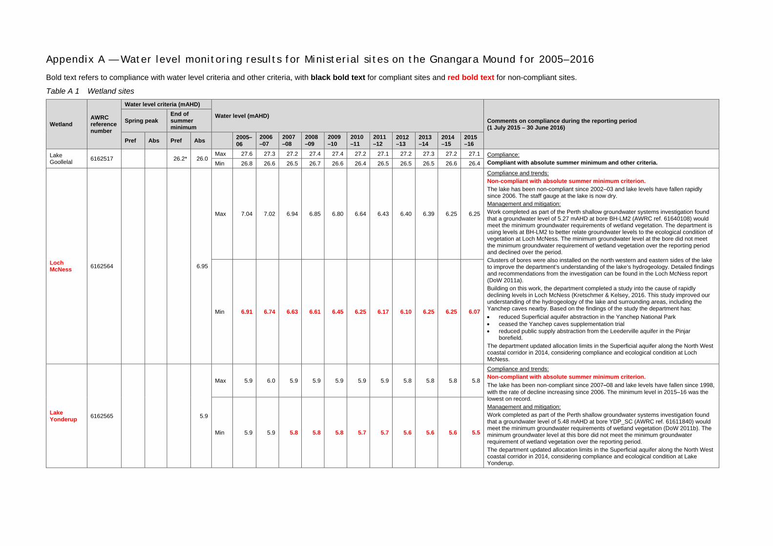
Lake Goollelal 6162517 26.2* 26.0
Max 27.6 27.3 27.2 27.4 27.4 27.2 27.1 27.2 27.3 27.2 27.1 Compliance: Compliant with absolute summer minimum and other criteria. Min 26.8 26.6 26.5 26.7 26.6 26.4 26.5 26.5 26.5 26.6 26.4
Loch McNess 6162564 6.95
Max 7.04 7.02 6.94 6.85 6.80 6.64 6.43 6.40 6.39 6.25 6.25
Compliance and trends: Non-compliant with absolute summer minimum criterion. The lake has been non-compliant since 2002–03 and lake levels have fallen rapidly since 2006. The staff gauge at the lake is now dry. Management and mitigation: Work completed as part of the Perth shallow groundwater systems investigation found that a groundwater level of 5.27 mAHD at bore BH-LM2 (AWRC ref. 61640108) would meet the minimum groundwater requirements of wetland vegetation. The department is using levels at BH-LM2 to better relate groundwater levels to the ecological condition of vegetation at Loch McNess. The minimum groundwater level at the bore did not meet the minimum groundwater requirement of wetland vegetation over the reporting period and declined over the period. Clusters of bores were also installed on the north western and eastern sides of the lake to improve the department’s understanding of the lake’s hydrogeology. Detailed findings and recommendations from the investigation can be found in the Loch McNess report (DoW 2011a). Building on this work, the department completed a study into the cause of rapidly declining levels in Loch McNess (Kretschmer & Kelsey, 2016. This study improved our understanding of the hydrogeology of the lake and surrounding areas, including the Yanchep caves nearby. Based on the findings of the study the department has: • reduced Superficial aquifer abstraction in the Yanchep National Park • ceased the Yanchep caves supplementation trial • reduced public supply abstraction from the Leederville aquifer in the Pinjar
borefield. The department updated allocation limits in the Superficial aquifer along the North West coastal corridor in 2014, considering compliance and ecological condition at Loch McNess.
Min 6.91 6.74 6.63 6.61 6.45 6.25 6.17 6.10 6.25 6.25 6.07
Lake Yonderup 6162565 5.9
Max 5.9 6.0 5.9 5.9 5.9 5.9 5.9 5.8 5.8 5.8 5.8
Compliance and trends: Non-compliant with absolute summer minimum criterion. The lake has been non-compliant since 2007–08 and lake levels have fallen since 1998, with the rate of decline increasing since 2006. The minimum level in 2015–16 was the lowest on record. Management and mitigation: Work completed as part of the Perth shallow groundwater systems investigation found that a groundwater level of 5.48 mAHD at bore YDP_SC (AWRC ref. 61611840) would meet the minimum groundwater requirements of wetland vegetation (DoW 2011b). The minimum groundwater level at this bore did not meet the minimum groundwater requirement of wetland vegetation over the reporting period. The department updated allocation limits in the Superficial aquifer along the North West coastal corridor in 2014, considering compliance and ecological condition at Lake Yonderup.
Min 5.9 5.9 5.8 5.8 5.8 5.7 5.7 5.6 5.6 5.6 5.5

Wetland AWRC reference number
Water level criteria (mAHD)
Water level (mAHD) Comments on compliance during the reporting period (1 July 2015 – 30 June 2016)
Spring peak End of summer minimum
Pref Abs Pref Abs 2005–06
2006–07
2007–08
2008–09
2009–10
2010–11
2011–12
2012–13
2013–14
2014–15
2015–16
Lake Joondalup
6162572 (Staff 8281)
16.2* 15.8
Max 17.1 16.9 16.8 17.0 17.0 16.8 16.8 16.8 17.1 17.0 16.9
Compliance and trends: Compliant with absolute summer minimum criterion. Non-compliant with other criterion. The lake has been non-compliant since 1998–99. Lake levels have been relatively stable since 1998 and the minimum level in 2014–15 was above the preferred minimum for the first time since 2005–06. The staff gauge dries at around 16.0 mAHD and cannot be used to determine compliance with the absolute summer minimum criteria when lake levels fall below this level. The monitoring bore, which is located 100 m upgradient of the lake, may also be inappropriate for determining compliance with criteria levels. Management and mitigation: Work completed as part of the Perth shallow groundwater systems investigation found that groundwater levels at bore JP20C (AWRC ref. 61610629) more closely reflect trends in lake levels than the current criteria bore and that this bore should be used to measure water level criteria. The minimum groundwater level at this bore increased over the reporting period. The department will consult with the OEPA as part of the development of the next Gnangara allocation plan on amending the bore used to measure the water level criteria at this site to JP20C.
Min 16.4
4/6 yr 16.0
4/6 yr 16.0
4/6 yr 16.2
4/6 yr 16.2
4/6 yr 16.0
4/6 yr 16.0
4/6 yr 16.0
4/6 yr 16.2
4/6 yr 16.3
4/6yr 16.1
4/6yr
61610661 (Bore 8281)
Max 18.8 18.5 18.5 18.7 18.9 18.7 18.6 18.6 19.0 18.9 18.7
Min 18.1 17.8 17.9 18.1 18.3 17.9 18.0 18.0 18.2 18.3 18.1
Lake Mariginiup
6162577 (Staff 1943)
42.1* 41.5
Max 41.7 41.4 41.4 41.5 41.5 41.3 41.2 41.1 41.3 41.3 41.1
Compliance and trends: Non-compliant with absolute spring peak criterion. Water levels have not reached the preferred spring peak since 1994 and have not reached the absolute minimum spring peak since 2005. Non-compliant with other criterion. Management and mitigation: Work completed as part of the Perth shallow groundwater systems investigation found that: • bore MS10 (AWRC ref. 61610685) should be used to measure water level criteria
when the lake is dry using a revised level of 41.1 mAHD • the newly installed bore MGP_C (AWRC ref. 61611440) should be used to relate
changes in the watertable to wetland vegetation condition. Detailed findings and recommendations from the investigation can be found in Searle et al. (2010). We are using MGP_C to better relate groundwater levels to the condition of wetland vegetation. Minimum levels at bores MS10 and MGP_C improved marginally in 2013–14 and 2014–15. As part of developing the next Gnangara allocation plan, the department will consult with the OEPA to amend the water level criteria at this site by considering findings from Searle et al. (2010a).
Min 41.3
4/6 yr 41.3
4/6 yr 41.2
4/6 yr 41.2
4/6 yr 41.3
4/6 yr 41.1
4/6 yr 41.0
4/6 yr 41.0
4/6 yr 41.0
4/6 yr 41.0
4/6 yr 41.0
4/6 yr
61610685 (Bore MS10)
Max 41.3 41.1 41.0 41.3 41.1 40.8 40.9 40.8 41.0 41.2 40.8
Min 40.4 40.0 40.2 40.2 40.2 40.0 40.1 40.1 40.1 40.2 40.0
Lake Jandabup
6162578 (Staff 1944)
44.7* 44.2 44.3
Max 45.0 44.6 44.7 44.8 44.8 44.5 44.7 44.6 44.7 44.7 44.6
Compliance and trends: Compliant with absolute spring peak criterion. Non-compliant with absolute summer minimum criterion. The Water Corporation supplements lake levels aim to meet the absolute spring peak water level criterion and to prevent the lake from acidifying. Although non-compliant since 2009–10, levels have been relatively stable and the supplementation has been relatively successful in preventing it from acidifying. Management and mitigation: Work completed as part of the Perth shallow groundwater systems investigation found that bore JB12B (61610764) should be used to relate groundwater levels to the ecological condition of vegetation on the transect. The minimum level at JB12B remained relatively stable over the reporting period.
Min 44.4 44.2 44.1 44.3 44.2 44.1 44.2 44.1 44.2 44.2 44.1

Wetland AWRC reference number
Water level criteria (mAHD)
Water level (mAHD) Comments on compliance during the reporting period (1 July 2015 – 30 June 2016)
Spring peak End of summer minimum
Pref Abs Pref Abs 2005–06
2006–07
2007–08
2008–09
2009–10
2010–11
2011–12
2012–13
2013–14
2014–15
2015–16
Lake Nowergup
6162567 (Staff) 17.0* 16.8
Max 16.7
4/6 yr 16.8
4/6 yr 17.2
4/6 yr 16.5
4/6 yr 16.5
4/6 yr 16.2
4/6 yr 16.1
4/6 yr 16.0
4/6 yr 16.0
4/6yr 16.0
4/6yr 16.0
4/6yr
Compliance and trends: Non-compliant with absolute spring peak criterion. Lake levels have been non-compliant in most years since 1996 despite the lake being supplemented by the department. Non-compliant with other criterion. Management and mitigation: From work completed as part of the Perth shallow groundwater systems investigation, Searle, Hammond and Bathols (2010) recommends to: • continue the supplementation regime • revise the spring peak criteria to 16.2 mAHD, which should done gradually from the
2009 peak of 16.5 mAHD • use groundwater levels at bore LN2-89 (AWRC ref. 61611247) to relate changes in
the watertable to wetland vegetation condition. Despite continued supplementation, lake levels have fallen in recent years. In response, we reviewed how the Water Corporation’s licences for 2013–14 and 2014–15 are distributed and made changes that aim to further reduce abstraction impacts at the site. As part of developing the next Gnangara allocation plan, the department will consult with the OEPA to amend water level criteria at this site. We are using bore LN2-89 to better relate groundwater levels to condition of wetland vegetation. Minimum levels at bore LN2-89 have been declining since 2009 but stabilised over the reporting period. We updated allocation limits in the Superficial aquifer along the North West coastal corridor in 2014, considering compliance and ecological condition at Lake Nowergup.
Min 16.3 16.1 16.5 16.2 16.0 16.0 15.9 16.0 16.0 16.0 16.0
Lake Wilgarup
6162623 (Staff)
6.10 5.65 4.8 4.5
Max 6.00 6.00 6.00 6.00 6.00 6.00 6.00 6.00 6.00 6.00 6.00 Compliance and trends: Non-compliant with absolute spring peak criterion. The lake has been dry since 1998. Non-compliant with absolute summer minimum criterion. Groundwater levels have declined since 1998 and have been non-compliant with the absolute minimum criteria since 2006–07. Management and mitigation: We updated allocation limits in the Superficial aquifer along the North West coastal corridor in 2014, considering compliance and ecological condition at Lake Wilgarup.
Min
61618500 (Bore)
Max 5.32 4.88 4.77 4.77 4.64 4.47 4.38 4.31 4.41 4.29 4.21
Min 4.62 4.34 4.18 4.08 4.02 3.80 3.84 3.83 3.82 3.79 3.66
Pipidinny Swamp
6162624 (Staff) 2.70 2.40 1.6
Max 2.9 2.3 2.1 2.1 2.0 2.0 1.6 1.8 2.2 1.9 1.6
Compliance and trends: Non-compliant with absolute summer minimum criterion. We could not confirm compliance with the absolute summer minimum criteria from 2004 to 2010 because levels below 2.0 mAHD could not be measured at the staff gauge at the swamp. In 2010, we fixed an extra staff gauge plate to measure to 1.0 mAHD and any non-compliance. The swamp was incorrectly reported as compliant in 2009–10 and 2010–11 in previous compliance reports because of this issue. The department has notified the OEPA of this error. Non-compliant with absolute spring peak criterion. Spring peak levels have been non-compliant since 2005–06. Management and mitigation: A new bore – PIP_C (AWRC ref. 61610764) – was installed as part of the Perth shallow groundwater system investigation (Searle 2009). Levels at this bore are well correlated with the staff gauge and can be used to measure compliance with absolute summer minimum criteria when the staff gauge dries. Levels have been relatively stable at the bore since it was installed in 2009. We updated allocation limits in the Superficial aquifer along the North West coastal corridor in 2014, considering compliance and ecological condition at the swamp.
Min 2.0 2.0 2.0 2.0 1.3 1.0 1.0 1.0 1.0 1.0 1.0
Lexia 86 (GNM16) 61613215 47.3* 47.0
Max 48.6 48.1 48.2 48.4 48.2 47.7 47.9 47.6 47.8 47.7 47.3 Compliance and trends: Non-compliant with absolute summer minimum. 2015–16 is the first year that the site has been non-compliant with absolute summer minimum water levels. Non-compliant with other criterion.
Min 47.6 47.4 47.4 47.3 47.3 47.1 47.2 47.0 47.0
4/6yr 47.0
4/6yr 46.9
4/6yr
Wetland AWRC reference number
Water level criteria (mAHD)
Water level (mAHD) Comments on compliance during the reporting period (1 July 2015 – 30 June 2016)
Spring peak End of summer minimum
Pref Abs Pref Abs 2005–06
2006–07
2007–08
2008–09
2009–10
2010–11
2011–12
2012–13
2013–14
2014–15
2015–16
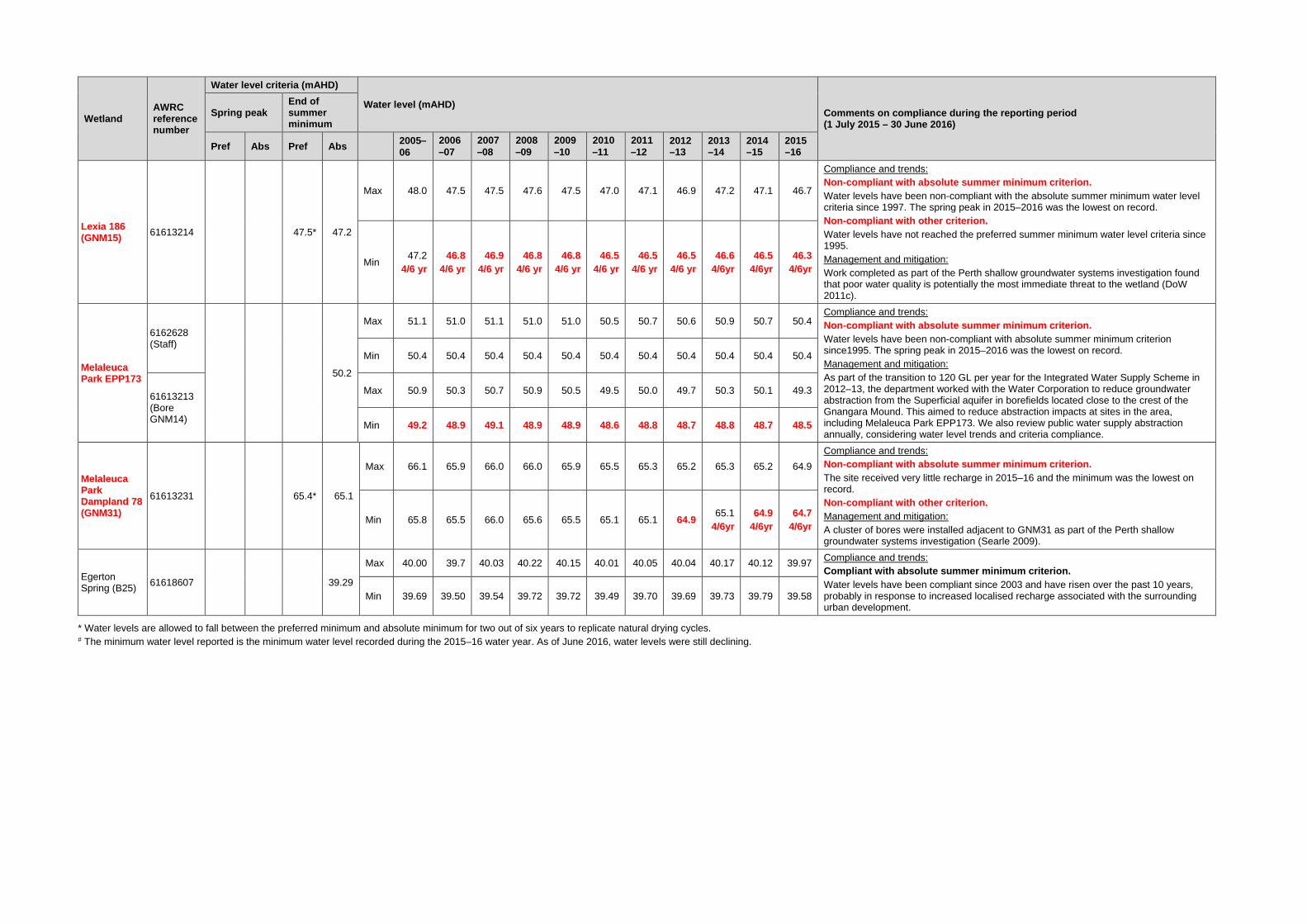
Lexia 186 (GNM15) 61613214 47.5* 47.2
Max 48.0 47.5 47.5 47.6 47.5 47.0 47.1 46.9 47.2 47.1 46.7
Compliance and trends: Non-compliant with absolute summer minimum criterion. Water levels have been non-compliant with the absolute summer minimum water level criteria since 1997. The spring peak in 2015–2016 was the lowest on record. Non-compliant with other criterion. Water levels have not reached the preferred summer minimum water level criteria since 1995. Management and mitigation: Work completed as part of the Perth shallow groundwater systems investigation found that poor water quality is potentially the most immediate threat to the wetland (DoW 2011c).
Min 47.2
4/6 yr 46.8
4/6 yr 46.9
4/6 yr 46.8
4/6 yr 46.8
4/6 yr 46.5
4/6 yr 46.5
4/6 yr 46.5
4/6 yr 46.6
4/6yr 46.5
4/6yr 46.3
4/6yr
Melaleuca Park EPP173
6162628 (Staff)
50.2
Max 51.1 51.0 51.1 51.0 51.0 50.5 50.7 50.6 50.9 50.7 50.4 Compliance and trends: Non-compliant with absolute summer minimum criterion. Water levels have been non-compliant with absolute summer minimum criterion since1995. The spring peak in 2015–2016 was the lowest on record. Management and mitigation: As part of the transition to 120 GL per year for the Integrated Water Supply Scheme in 2012–13, the department worked with the Water Corporation to reduce groundwater abstraction from the Superficial aquifer in borefields located close to the crest of the Gnangara Mound. This aimed to reduce abstraction impacts at sites in the area, including Melaleuca Park EPP173. We also review public water supply abstraction annually, considering water level trends and criteria compliance.
Min 50.4 50.4 50.4 50.4 50.4 50.4 50.4 50.4 50.4 50.4 50.4
61613213 (Bore GNM14)
Max 50.9 50.3 50.7 50.9 50.5 49.5 50.0 49.7 50.3 50.1 49.3
Min 49.2 48.9 49.1 48.9 48.9 48.6 48.8 48.7 48.8 48.7 48.5
Melaleuca Park Dampland 78 (GNM31)
61613231 65.4* 65.1
Max 66.1 65.9 66.0 66.0 65.9 65.5 65.3 65.2 65.3 65.2 64.9 Compliance and trends: Non-compliant with absolute summer minimum criterion. The site received very little recharge in 2015–16 and the minimum was the lowest on record. Non-compliant with other criterion. Management and mitigation: A cluster of bores were installed adjacent to GNM31 as part of the Perth shallow groundwater systems investigation (Searle 2009).
Min 65.8 65.5 66.0 65.6 65.5 65.1 65.1 64.9 65.1 4/6yr
64.9 4/6yr
64.7 4/6yr
Egerton Spring (B25) 61618607 39.29
Max 40.00 39.7 40.03 40.22 40.15 40.01 40.05 40.04 40.17 40.12 39.97 Compliance and trends: Compliant with absolute summer minimum criterion. Water levels have been compliant since 2003 and have risen over the past 10 years, probably in response to increased localised recharge associated with the surrounding urban development.
Min 39.69 39.50 39.54 39.72 39.72 39.49 39.70 39.69 39.73 39.79 39.58
* Water levels are allowed to fall between the preferred minimum and absolute minimum for two out of six years to replicate natural drying cycles. # The minimum water level reported is the minimum water level recorded during the 2015–16 water year. As of June 2016, water levels were still declining.

Table A 2 Terrestrial phreatophytic vegetation sites
Groundwater monitoring bore
AWRC reference number
End of summer absolute minimum (mAHD)
Water levels (mAHD) Comments on compliance during the reporting period (1 July 2015 – 30 June 2016)
2005–06
2006–07
2007–08
2008–09
2009–10
2010–11
2011–12
2012–13
2013–14
2014–15
2015–16
MM16 61610835 38.8 Max 40.2 39.4 39.4 39.8 39.9 39.4 39.6 39.6 40.1 40.2 40.1 Compliance:
Compliant with absolute summer minimum criterion. Min 39.0 38.6 38.8 39.0 39.0 38.6 38.9 39.0 39.2 39.5 39.3
MM18 61610918 38.6 Max 40.0 39.4 39.3 40.0 39.8 39.3 39.5 39.6 39.9 40.0 39.6 Compliance:
Compliant with absolute summer minimum criterion. Water levels have shown a rising trend since 2011. Min 39.1 38.6 38.8 39.0 39.0 38.7 38.9 39.0 38.6 39.2 39.1
MM53 61610493 33.3
Max 34.4 33.8 33.9 34.1 33.9 33.3 33.8 33.6 34.0 34.0 33.5
Compliance and trends: Non-compliant with absolute summer minimum criterion. Minimum levels have generally declined since 2005 but have stabilised since 2011. Management and mitigation: As part of the transition to 120 GL per year allocation for the Integrated Water Supply Scheme in 2012–13, the department worked with the Water Corporation to reduce groundwater abstraction from the Superficial aquifer from bores located close to Whiteman Park. This aimed to reduce abstraction impacts at sites in the area, including MM53. We also review public water supply abstraction annually, considering water level trends and criteria compliance.
Min 33.3 33.1 33.2 33.1 33.0 32.8 33.0 33.0 32.8 33.1 32.9
MM55B 61610559 29.5 Max 30.9 30.3 30.6 31.0 30.8 30.1 30.3 30.3 30.5 30.5 30.3 Compliance and trends:
Non-compliant with absolute summer minimum criterion. Minimum levels have stabilised since 2011. Min 29.5 29.4 29.4 29.4 29.3 29.0 29.3 29.2 29.2 29.7 29.2
MM59B 61611025 36.3
Max 37.0 36.2 36.4 36.8 36.6 36.0 36.1 36.2 36.3 36.3 36.0
Compliance and trends: Non-compliant with absolute summer minimum criterion. Water levels have generally declined since 2000 but seem to have stabilised since 2011. Water levels were still declining as of June 2016. Management and mitigation: As part of the transition to 120 GL per year allocation for the Integrated Water Supply Scheme in 2012–13, the department worked with the Water Corporation to reduce groundwater abstraction from the Superficial aquifer from bores located close to Whiteman Park. This aimed to reduce abstraction impacts at sites in the area, including MM59B. We also review public water supply abstraction annually, considering water level trends and criteria compliance.
Min 35.8 35.6 35.8 35.8 35.7 35.3 35.5 35.5 35.5 35.6 35.4
MT3S 61610745 43.0 Max 45.4 44.6 44.7 44.9 44.8 44.3 44.4 44.2 44.6 44.5 44.3 Compliance and trends:
Compliant with absolute summer minimum criterion. Water levels have generally declined since 1992 but seem to have stabilised since 2011. Min 44.2 43.7 43.9 44.0 43.9 43.5 43.6 43.5 43.7 43.7 43.6
NR6C 61610982 58.5 Max 60.2 59.7 59.7 60.0 60.1 59.9 59.7 59.3 59.7 59.5 59.1 Compliance:
Compliant with absolute summer minimum criterion. Water levels have generally declined since 1992 and the peak and minimum levels in 2015–16 were the lowest on record. Min 59.4 59.1 59.1 59.2 59.4 58.9 59.0 58.7 58.9 59.0 58.7
PM9 61610804 56.3
Max 57.0 56.4 56.3 56.1 55.9 55.9 55.0 54.8 55.0 54.7
Compliance and trends: Non-compliant with absolute summer minimum criterion. Water levels have declined since 1996 and were first non-compliant in 2006–07. In 2013–14 recharge occurred at this site for the first time in two years. Water levels were still declining as of June 2016. The bore is not currently being monitoring due to safety issues associated with its location in a rifle range. We are looking to resolve this issue by installing a logger at the bore and monitoring it remotely. Maintenance in 2016 also impacted on water levels recorded at the site. Management and mitigation: As part of the transition to 120 GL per year allocation for the Integrated Water Supply Scheme in 2012–13, the department worked with the Water Corporation to reduce groundwater abstraction from the Superficial aquifer in borefields located close to the crest of the Gnangara Mound. This aimed to reduce abstraction impacts at sites in the area, including PM9. We also review public water supply abstraction annually, considering water level trends and criteria compliance.
Min 56.3 56.0 55.8 55.6 55.4 54.9 54.8 54.4 54.3 54.1# 51.8

Groundwater monitoring bore
AWRC reference number
End of summer absolute minimum (mAHD)
Water levels (mAHD) Comments on compliance during the reporting period (1 July 2015 – 30 June 2016)
2005–06
2006–07
2007–08
2008–09
2009–10
2010–11
2011–12
2012–13
2013–14
2014–15
2015–16
PM24 61610697 40.5 Max 43.1 42.4 42.7 43.0 42.5 42.1 42.4 42.0 42.1 42.3 42.1 Compliance:
Compliant with absolute summer minimum criterion. Water levels have generally declined since 1998 but have stabilised since 2011. Min 41.4 41.2 41.3 41.2 41.2 41.0 41.1 41.1 41.1 41.3 41.0
WM1 61610833 55.7
Max 56.5 55.6 55.6 55.7 55.4 54.8 54.8 54.4 54.7 54.4 54.5
Compliance and trends: Non-compliant with absolute summer minimum criterion. Water levels have been non-compliant since 2001–02 and have declined since 2005. Water levels were still declining as of June 2016. Management and mitigation: As part of the transition to 120 GL per year allocation for the Integrated Water Supply Scheme in 2012–13, the department worked with the Water Corporation to reduce groundwater abstraction from the Superficial aquifer in borefields located close to the crest of the Gnangara Mound. This aimed to reduce abstraction impacts at sites in the area, including WM1. We also review public water supply abstraction annually, considering water level trends and criteria compliance.
Min 55.4 55.0 55.0 54.9 54.8 54.4 54.3 54.1 54.2 54.1 # 54.1
WM2 61610908 66.5
Max 68.2 67.6 67.5 67.6 67.5 66.9 66.8 66.4 66.7 66.5 66.6
Compliance and trends: Non-compliant with absolute summer minimum criterion. The site has been non-compliant with water level criteria since 2011–12. In 2013–14 recharge occurred at this site for the first time in two years. Water levels were still declining as of June 2016. Management and mitigation: As part of the transition to 120 GL per year allocation for the Integrated Water Supply Scheme in 2012–13, the department worked with the Water Corporation to reduce groundwater abstraction from the Superficial aquifer in borefields located close to the crest of the Gnangara Mound. This aimed to reduce abstraction impacts at sites in the area, including WM2. We also review public water supply abstraction annually, considering water level trends and criteria compliance.
Min 67.5 67.1 67.0 66.9 66.9 66.5 66.4 66.1 66.2 66.1 # 66.3
WM8 61610983 64.8
Max 66.0 65.5 65.4 65.5 65.4 65.5 64.9 64.7 65.0 64.8 64.3
Compliance and trends: Non-compliant with absolute summer minimum criterion. Water levels have declined since 2005 and were non-compliant for the first time in 2010–11. This site recorded no recharge in 2015–16. Water levels were still declining as of June 2016. Management and mitigation: As part of the transition to 120 GL per year allocation for the Integrated Water Supply Scheme in 2012–13, the department worked with the Water Corporation to reduce groundwater abstraction from the Superficial aquifer in borefields located close to the crest of the Gnangara Mound. This aimed to reduce abstraction impacts at sites in the area, including WM8. We also review public water supply abstraction annually, considering water level trends and criteria compliance.
Min 65.5 65.1 65.1 65.1 65.1 64.7 64.7 64.4 64.7 64.3 # 64.1
MM12 61610989 42 Max 44 43 43 43 43 43 43 43 43 43 43 Compliance and trends:
Compliant with absolute summer minimum criterion. Levels have risen since 2011. Min 43 42 42 43 43 42 42 43 43 43 43
L30C 61611010 47.2 Max 49.5 48.4 48.6 48.7 48.9 48.1 48.2 47.8 47.9 48.0 47.7 Compliance:
Compliant with absolute summer minimum criterion. Levels have generally fallen since 2005. The site received very little recharge in 2015–16. Water levels were still declining as of June 2016 and are approaching the minimum criteria. Min 48.4 48.0 48.0 48.2 48.1 48.0 47.7 47.5 47.5 47.7 # 47.3
L110C 61611011 55.7
Max 58.5 57.8 57.7 57.8 57.7 57.4 57.6 57.4 Compliance: Compliant with absolute summer minimum criterion. Levels have generally fallen since 1999. Minimum levels could not be measured at the Ministerial criteria bore between March 2010 and July 2013 because of a blockage. Water levels were still declining as of June 2016.
Min 57.7 57.3 57.2 57.5 57.5 57.1 57.3 57.1
L220C 61611018 52.2 Max 54.2 53.7 53.7 53.5 53.6 52.8 53.2 52.8 53.1 53.9 53.4 Compliance:
Compliant with absolute summer minimum criterion. Levels have generally fallen since 1991 and the 2015–16 was the lowest on record. Min 52.8 53.1 52.7 52.6 52.6 52.3 52.4 52.1 52.3 53.1 52.8
# The minimum water level reported is the minimum water level recorded during the 2015–16 water year. As of June 2016, water levels were still declining.
Note: Observed water levels have been rounded to the same number of decimal places as shown in Table 1 and 2 on Ministerial Statement No. 819.

Appendix B — Audit tables: Environmental conditions, procedures and commitments for the Gnangara groundwater resources
Proponent: Department of Water Period: 1 July 2015 to 30 June 2016
Table B 1 Ministerial conditions and procedures Audit code Subject Action How Evidence Require-
ment of On advice from Phase When/
Where Status
819: M 1-1
Implementation The proponent shall implement the proposals as documented in ”Section 46 Review of Environmental Conditions on Management of the Gnangara and Jandakot Mounds – Stage 1 Proposal for Changes to Conditions” (August 2004), as modified and documented in Environmental Protection Authority Bulletin 1155.
Implement proposals given in EPA Bulletin 1155 and Ministerial Statement No. 819.
Compliance report Minister for the Environment
Overall Partly compliant. Partly compliant with most Ministerial conditions – refer to the ‘status’ column of this table. Further amendments are likely to be proposed in the next Gnangara groundwater allocation plan.
819: M 2-1
Proponent commitments
The proponent shall implement the environmental management commitments, as revised in May 2009, and documented in schedule 1 of Statement No. 819, to the requirements of the Minister for the Environment on advice of the Environmental Protection Authority (EPA).
Implement commitments given in Schedule 1 of EPA Bulletin 1324 and Ministerial Statement No. 819.
Compliance report Minister for the Environment
EPA Overall Partly compliant. Compliant with most proponent commitments – refer to the ‘status’ column of this table.
819: M 3-1
Proponent nomination and contact details
The proponent for the time being nominated by the Minister for the Environment under section 38(6) or (7) of the Environmental Protection Act 1986 is responsible for the implementation of the proposal until such time as the Minister for the Environment has exercised the Minister’s power under section 38(7) of the Act to revoke the nomination of that proponent and nominate another person as the proponent for the proposal.
Adhere to conditions, procedures and commitments given in EPA Bulletin 1324 and Ministerial Statement No. 819. Maintain responsibility for implementation of proposal.
Letter notifying the Chief Executive Officer of the Office of the Environmental Protection Authority (OEPA) of any change in proponent details. Compliance report.
Minister for the Environment
EPA Overall N/A at this time.
819: M 3-2
Proponent nomination and contact details
If the proponent wishes to relinquish the nomination, the proponent shall apply for the transfer of proponent and provide a letter with a copy of this statement endorsed by the proposed replacement proponent that the proposal will be carried out in accordance with this statement. Contact details and appropriate documentation on the capability of the proposed replacement proponent to carry out the proposal shall also be provided.
Follow procedure given in ‘action’.
Letter notifying the Chief Executive Officer of the OEPA of any change in proponent details.
Minister for the Environment
Overall N/A at this time.
819: M 3-3
Proponent nomination and contact details
The nominated proponent shall notify the Chief Executive Officer of the OEPA of any change of contact name and address within 60 days of such change.
Follow procedure given in ‘action’.
Letter notifying the Chief Executive Officer of the OEPA of any change in proponent details.
CEO Overall 60 days of change
N/A at this time.

Audit code Subject Action How Evidence Require-
ment of On advice from Phase When/
Where Status
819: M 4-1 1
Compliance audit and performance review
The proponent shall prepare an audit program and submit compliance reports to the Chief Executive Officer of the OEPA which address:
evidence of compliance with the conditions and commitments.
Detail in annual/triennial reports. Compliance report will include:
evidence of compliance with the conditions and commitments.
Audit program CEO Overall Annually Compliant. Summarised in sections 5 and 6 of this report and the ‘status’ column of this table.
819: M 4-1 2
Compliance audit and performance review
The proponent shall prepare an audit program and submit compliance reports to the Chief Executive Officer of the OEPA which address:
the performance of the environmental management plans and programs.
Detail in annual/triennial reports. Compliance report will include:
the performance of the environmental management plans and programs.
Compliance report CEO Annually Compliant. Environmental management plans and programs are ongoing and include: 1. The final Gnangara groundwater areas allocation plan was
released in November 2009 (DoW 2009a). The plan will be evaluated regularly to assess whether objectives are being achieved. The second evaluation statement was recently completed (DoW 2015a). The statement evaluates the department’s management of Gnangara groundwater resources and against the Gnangara plan objectives between 2011–2014. The evaluation statement is available on the department’s website.
2. Work has started on the next Gnangara groundwater allocation plan which will include new strategies to work towards meeting the following objectives:
• reduce the total volume of water abstracted from the Gnangara system towards a level that better reflects the recharge from rainfall under the drying climate
• protect groundwater-dependent ecosystems from impacts associated with abstraction.
819: M 4-2 1
Compliance audit and performance review
The proponent shall submit a performance review report by 1 December each year and more detailed reports by 1 February every three years, to the requirements of the Chief Executive Officer of the OEPA, which address:
compliance with the conditions.
The performance review will address:
compliance with the conditions.
Compliance report CEO Overall By 1 December each year and more detailed reports by 1 February every three years.
Compliant. Refer to 819: M 4-1 2. Compliance with conditions can found in the ‘status’ column of this table.
819: M 4-2 2
Compliance audit and performance review
The proponent shall submit a performance review report by 1 December each year and more detailed reports by 1 February every three years, to the requirements of the Chief Executive Officer of the OEPA, which address:
the achievement of environmental objectives set for the proposal.
The performance review will address:
the achievement of environmental objectives set for the proposal.
Compliance report CEO Overall By 1 December each year and more detailed reports by 1 February every three years.
Compliant. Evidence of achievement of the objectives is given by the ‘evidence’ and ‘status’ columns of this table.
819: M 4-2 3
Compliance audit and performance review
The proponent shall submit a performance review report by 1 December each year and more detailed reports by 1 February every three years, to the requirements of the Chief Executive Officer of the OEPA, which address:
stakeholder and community consultation about environmental performance and the outcomes of that consultation, including a report of any on-going concerns being expressed.
The performance review will address:
stakeholder and community consultation about environmental performance and the outcomes of that consultation, including a report of any on-going concerns being expressed.
Compliance report CEO Overall By 1 December each year and more detailed reports by 1 February every three years.
Compliant The final Gnangara groundwater areas allocation plan was released in November 2009. The accompanying Gnangara groundwater areas allocation plan: statement of response (DoW 2009b) sets out how we responded to issues raised by the public to finalise the plan and how we are working towards managing these issues in implementing the plan. Gnangara plan evaluation statements were completed in 2013 and 2015 (DoW 2013b; DoW 2015a). These statements evaluate the department’s management of Gnangara groundwater resources against the Gnangara plan objectives since its release. The evaluation statements are available on the department’s website.

Audit code Subject Action How Evidence Require-
ment of On advice from Phase When/
Where Status
819: M 4-2 4
Compliance audit and performance review
The proponent shall submit a performance review report by 1 December each year and more detailed reports by 1 February every three years, to the requirements of the Chief Executive Officer of the OEPA, which address:
proposed environmental management over the next three years to comply with conditions and environmental objectives set for the proposal.
The performance review will address:
proposed environmental management over the next three years to comply with conditions and environmental objectives set for the proposal.
Compliance report CEO Overall By 1 December each year and more detailed reports by 1 February every three years.
Compliant. Sections 6.2 and 6.3 describes the management actions and research initiatives the department is doing to limit impacts of abstraction on groundwater-dependent ecosystems.
819: M 4-3
Compliance audit and performance review
The proponent shall make the reports required by condition 4-2 publicly available, to the requirements of the Chief Executive Officer of the OEPA.
Available on Department of Water’s website.
Reports made available on the Department of Water’s website.
CEO Overall After OEPA acknowledg-ement letter being received. Department of Water website.
Compliant. The following Gnangara compliance reports have been formally audited or commented on by DEC or the OEPA and can be found on the department’s website: • 2003–06 triennial (DoW 2007) • 2006–07 annual (DoW 2008a) • 2006–09 triennial (DoW 2010a). The following Gnangara compliance reports haven’t been formally audited or commented on but can also be found on the department’s website: • 2007–08 annual (DoW 2009c) • 2009–10 annual (DoW 2010b) • 2010–11 annual (DoW 2011d) • 2009–12 triennial (DoW 2013a) • 2012–13 annual (DoW 2014a) • 2013–14 annual (DoW 2014b) • 2012–15 triennial (DoW 2016).
819: M 4-4
Compliance audit and performance review
The proponent shall report any breach or anticipated breach of the environmental criteria set out in tables 1 and 2 or environmental objectives to the Chief Executive Officer of the OEPA immediately it becomes evident to the proponent.
Report in regular summaries sent to the Chief Executive Officer of the OEPA.
Letter to the Chief Executive Officer of the OEPA reporting non compliances with water level and other criteria as required. Compliance report.
CEO Overall Immediately as it becomes evident.
Compliant. The department reports regularly to the OEPA on non-compliance with criteria water levels and other criteria.
819: M 5-1
Management of the water resource
The proponent shall base decisions affecting the management of groundwater resources of the Gnangara Mound on the concept of sustainable yield of resources and maintenance of ecological systems in accordance with the objectives of the State Conservation Strategy (1987).
Base decision on the concept of sustainable yield of resources and maintenance of ecological systems in accordance with the State Conservation Strategy (1987). Present relevant material in annual/triennial compliance reports.
Compliance report Minister for the Environment
Overall Compliant. The department used the concept of sustainable yield and PRAMS modelling to calculate allocation limits for the Gnangara groundwater areas allocation plan (DoW 2009a). This plan provides the basis for water management decisions on the Gnangara Mound. The department recognises that sustainable yield has diminished because recharge has decreased since the plan was released. We will reassess allocation limits for Gnangara resources as part of the next Gnangara groundwater allocation plan.
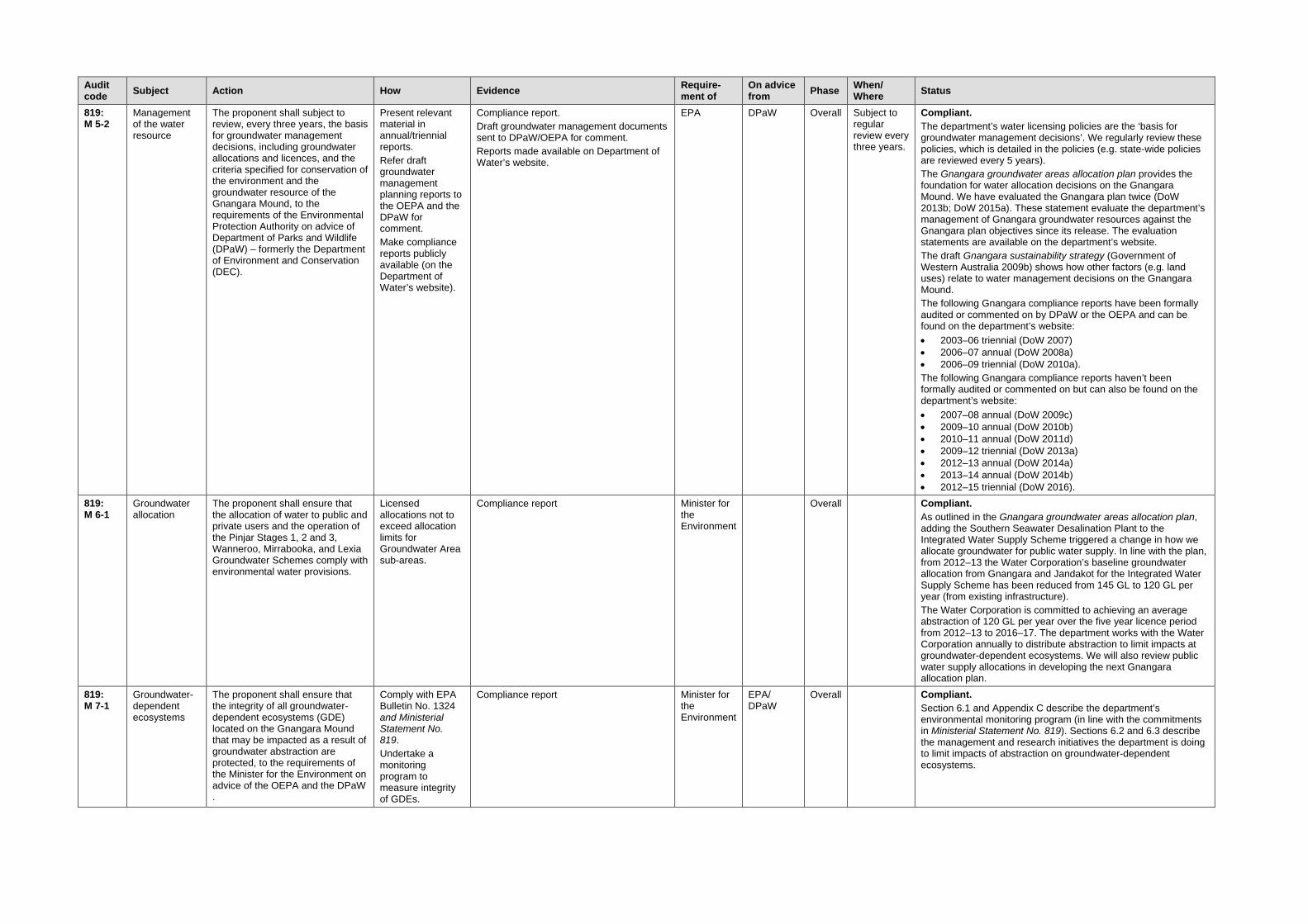
Audit code Subject Action How Evidence Require-
ment of On advice from Phase When/
Where Status
819: M 5-2
Management of the water resource
The proponent shall subject to review, every three years, the basis for groundwater management decisions, including groundwater allocations and licences, and the criteria specified for conservation of the environment and the groundwater resource of the Gnangara Mound, to the requirements of the Environmental Protection Authority on advice of Department of Parks and Wildlife (DPaW) – formerly the Department of Environment and Conservation (DEC).
Present relevant material in annual/triennial reports. Refer draft groundwater management planning reports to the OEPA and the DPaW for comment. Make compliance reports publicly available (on the Department of Water’s website).
Compliance report. Draft groundwater management documents sent to DPaW/OEPA for comment. Reports made available on Department of Water’s website.
EPA DPaW Overall Subject to regular review every three years.
Compliant. The department’s water licensing policies are the ‘basis for groundwater management decisions’. We regularly review these policies, which is detailed in the policies (e.g. state-wide policies are reviewed every 5 years). The Gnangara groundwater areas allocation plan provides the foundation for water allocation decisions on the Gnangara Mound. We have evaluated the Gnangara plan twice (DoW 2013b; DoW 2015a). These statement evaluate the department’s management of Gnangara groundwater resources against the Gnangara plan objectives since its release. The evaluation statements are available on the department’s website. The draft Gnangara sustainability strategy (Government of Western Australia 2009b) shows how other factors (e.g. land uses) relate to water management decisions on the Gnangara Mound. The following Gnangara compliance reports have been formally audited or commented on by DPaW or the OEPA and can be found on the department’s website: • 2003–06 triennial (DoW 2007) • 2006–07 annual (DoW 2008a) • 2006–09 triennial (DoW 2010a). The following Gnangara compliance reports haven’t been formally audited or commented on but can also be found on the department’s website: • 2007–08 annual (DoW 2009c) • 2009–10 annual (DoW 2010b) • 2010–11 annual (DoW 2011d) • 2009–12 triennial (DoW 2013a) • 2012–13 annual (DoW 2014a) • 2013–14 annual (DoW 2014b) • 2012–15 triennial (DoW 2016).
819: M 6-1
Groundwater allocation
The proponent shall ensure that the allocation of water to public and private users and the operation of the Pinjar Stages 1, 2 and 3, Wanneroo, Mirrabooka, and Lexia Groundwater Schemes comply with environmental water provisions.
Licensed allocations not to exceed allocation limits for Groundwater Area sub-areas.
Compliance report Minister for the Environment
Overall Compliant. As outlined in the Gnangara groundwater areas allocation plan, adding the Southern Seawater Desalination Plant to the Integrated Water Supply Scheme triggered a change in how we allocate groundwater for public water supply. In line with the plan, from 2012–13 the Water Corporation’s baseline groundwater allocation from Gnangara and Jandakot for the Integrated Water Supply Scheme has been reduced from 145 GL to 120 GL per year (from existing infrastructure). The Water Corporation is committed to achieving an average abstraction of 120 GL per year over the five year licence period from 2012–13 to 2016–17. The department works with the Water Corporation annually to distribute abstraction to limit impacts at groundwater-dependent ecosystems. We will also review public water supply allocations in developing the next Gnangara allocation plan.
819: M 7-1
Groundwater-dependent ecosystems
The proponent shall ensure that the integrity of all groundwater-dependent ecosystems (GDE) located on the Gnangara Mound that may be impacted as a result of groundwater abstraction are protected, to the requirements of the Minister for the Environment on advice of the OEPA and the DPaW .
Comply with EPA Bulletin No. 1324 and Ministerial Statement No. 819. Undertake a monitoring program to measure integrity of GDEs.
Compliance report Minister for the Environment
EPA/ DPaW
Overall Compliant. Section 6.1 and Appendix C describe the department’s environmental monitoring program (in line with the commitments in Ministerial Statement No. 819). Sections 6.2 and 6.3 describe the management and research initiatives the department is doing to limit impacts of abstraction on groundwater-dependent ecosystems.

Audit code Subject Action How Evidence Require-
ment of On advice from Phase When/
Where Status
819: M 8-1
Groundwater availability
The proponent shall widely publish by the end of October each year the limits on groundwater availability for the Gnangara Mound.
Detail limits on availability on the Department of Water’s website.
Allocation limits made available on the Department of Water’s website. Current water availability figures can be obtained from Swan Avon regional office or through the department’s water register: <www.water.wa.gov.au/ags/WaterRegister>
Minister for the Environment
Overall End of October each year
Compliant. Current water availability figures are constantly changing. Up-to-date figures are available by contacting the Swan Avon regional office or through the department’s water register: <www.water.wa.gov.au/maps-and-data/maps/water-register>
819: M 8-2
Groundwater availability
The proponent shall update annually the figures published according to the requirements of condition 8-1, with the emphasis on those areas of high allocation relative to sustainable yield of the groundwater resource so that limits to use and development can be clearly seen by all interested parties. The updated figures shall also be widely published.
Detail limits on availability relative to sustainable yield (allocation limits) published on the Department of Water’s website.
Allocation limits made available on the Department of Water’s website. Current water availability figures can be obtained from Swan Avon regional office or through the department’s water register: <www.water.wa.gov.au/ags/WaterRegister>
Minister for the Environment
Overall End of October each year
Compliant. Current water availability figures are constantly changing. Up-to-date figures are available by contacting the Swan Avon regional office or through the department’s water register: <www.water.wa.gov.au/maps-and-data/maps/water-register>
819: M 9-1
Water conservation
The proponent shall actively encourage further reduction in public and private water demand in accordance with the State Water Strategy (2003) and other water conservation initiatives.
Engage in activity that supports water conservation.
Compliance report Minister for the Environment
Overall Compliant. Consistent with the State Water Plan (Department of Premier and Cabinet 2007), and after extensively consulting with the mining and irrigation industries and local government, the department developed and implements Operational policy no. 1.2 – ‘Policy on water conservation and efficiency plans‘ (DoW 2009d). The department’s Water Recycling and Efficiency staff do projects to reduce water demand and achieve water conservation initiatives. These include implementing Operational policy no. 1.2 – ‘Policy on water conservation and efficiency plans‘ (in particular by local government authorities), implementing the permanent winter sprinkler ban and implementing metering programs. In 2013–14 the department finalised work with the City of Wanneroo and developers to reduce planned water use in the North West Urban Growth Corridor and develop a water supply strategy (DoW 2014c). Section 6.2 discusses the department’s approach to allocating groundwater for public water supply and other initiatives that aim to reduce demand on the Gnangara groundwater resources and increase water use efficiency.
819: M 10-1 1
Research and monitoring
The proponent shall participate in and undertake research and monitoring on the Gnangara Mound which includes:
clarification of the relationship between groundwater level and rainfall under conditions of declining long-term rainfall to the requirements of the Minister for the Environment on advice of the OEPA and the DPaW.
Engage in research projects to address this issue, which includes:
clarification of the relationship between groundwater level and rainfall under conditions of declining long-term rainfall.
Compliance report Minister for the Environment
EPA/ DPaW
Overall Compliant. The department is using PRAMS modelling to examine the relationship between rainfall and groundwater levels in a drying climate. We have run a number of scenarios using future climate datasets (developed using the department’s future climate tool), to examine the impact of the drying climate on groundwater levels. This work will inform our review of allocation limits as part of the next Gnangara allocation plan.

Audit code Subject Action How Evidence Require-
ment of On advice from Phase When/
Where Status
819: M 10-1 2
Research and monitoring
The proponent shall participate in and undertake research and monitoring on the Gnangara Mound which includes:
improvement in the understanding of the relationship between groundwater levels and vegetation, including plantations to the requirements of the Minister for the Environment on advice of the EPA and the DPaW.
Engage in research projects to address this issue, which includes:
improvement in the understanding of the relationship between groundwater levels and vegetation, including plantations.
Compliance report Minister for the Environment
EPA/ DPaW
Overall Compliant. As part of the Strategic Assessment for the Perth-Peel regions, the department has used the Perth Regional Aquifer Modelling System to simulate groundwater levels under various pines, land use and climate scenarios. The results informed the Draft Strategic Conservation Action Plan released for public comment in 2016. Through the Perth shallow groundwater system investigations we have improved our understanding of the interrelationships between wetlands and the Superficial aquifer and the complex, superimposed impacts of climate change, land use and abstraction. We are using the investigation’s outcomes to better relate water levels to ecological condition at groundwater-dependent ecosystems. The department commissioned Dr Bea Sommer and Professor Ray Froend of Edith Cowan University to develop a model for determining ecological risk to groundwater-dependent vegetation on the Gnangara Mound in a drying climate. The model is based on 30 years of ecological and hydrological monitoring data. It will be an important management tool for assessing the impact of future land and water use scenarios and for revising allocation limits for the next Gnangara allocation plan. Several other studies have improved our understanding of the relationships between groundwater levels and vegetation, including: • fire regimes on the Gnangara Mound – potential for water
gain and impacts on biodiversity • options and implications of continuing plantation forestry on
the Gnangara Mound • biodiversity values on the Gnangara Mound. For further information, see sections 4.1.2 and 4.1.3 of the draft Gnangara sustainability strategy and the department’s website.
819: M 10-1 3
Research and monitoring
The proponent shall participate in and undertake research and monitoring on the Gnangara Mound which includes:
improvement in the understanding of the relationship between groundwater level and abstraction from unconfined and confined aquifers of the Gnangara Mound to the requirements of the Minister for the Environment on advice of the EPA and the DPaW.
Engage in research projects to address this issue, which includes:
improvement in the understanding of the relationship between groundwater level and abstraction from unconfined and confined aquifers of the Gnangara Mound.
Compliance report Minister for the Environment
EPA/ DPaW
Overall Compliant. The department is using PRAMS modelling to improve the understanding of the relationship between groundwater level and abstraction from unconfined and confined aquifers of the Gnangara system. Reductions to both public and private abstraction are being modelled to evaluate storage gains in the Superficial aquifer at 2030. These scenarios will inform an allocation limit review as part of the next Gnangara allocation plan. The department began the four-year Perth Regional Confined Aquifer Capacity project in 2012. The project is investigating the best locations and depth for sustainable abstraction from the Leederville and Yarragadee aquifers and for groundwater replenishment (or managed aquifer recharge). Perth shallow groundwater system investigations have improved the department’s understanding of the interrelationships between wetlands and the Superficial aquifer and the complex, superimposed impacts of climate change, land use and abstraction. The department is using the investigation’s outcomes to limit abstraction impacts on groundwater-dependent ecosystems.

Audit code Subject Action How Evidence Require-
ment of On advice from Phase When/
Where Status
819: M 10-1 4
Research and monitoring
The proponent shall participate in and undertake research and monitoring on the Gnangara Mound which includes:
clarification of the relationship between groundwater level and wetland water levels and wetland water quality to the requirements of the Minister for the Environment on advice of the EPA and the DPaW.
Engage in research projects to address this issue, which includes:
clarification of the relationship between groundwater level and wetland water levels and wetland water quality.
Compliance report Minister for the Environment
EPA/ DPaW
Overall Compliant. The department has studies hydrogeology at a number of sites across the Gnangara Mound as part of the Perth shallow groundwater systems investigation. To date, ten reports have been completed and are available on the department’s website. These reports examine relationships between wetland hydrogeology, chemistry and ecosystem function to provide a basis for improved management strategies that limit abstraction impacts. Local area groundwater flow models have been constructed and used for scenario modelling for the following areas: • East Wanneroo integrated groundwater-lake flow modelling:
Predictive scenario modelling to support the draft Gnangara Sustainability Strategy (Bourke 2009)
• Local area model of groundwater flows and lake interactions: Lakes Mariginiup and Jandabup (RPS 2009)
• Development of local area groundwater models – Gnangara Mound, Lake Nowergup (SKM 2009a)
• Development of local area groundwater models – Gnangara Mound, Lexia Wetlands (SKM 2009b).
These reports are available on the department’s website. 819: M 10-1 5
Research and monitoring
The proponent shall participate in and undertake research and monitoring on the Gnangara Mound which includes:
improvement in the understanding of the relationship between groundwater level and water levels in the Yanchep caves to the requirements of the Minister for the Environment on advice of the EPA and the DPaW.
Engage in research projects to address this issue, which includes:
improvement in the understanding of the relationship between groundwater level and water levels in the Yanchep caves.
Compliance report Minister for the Environment
EPA/ DPaW
Overall Partly compliant. Water quality and macroinvertebrate monitoring in the Yanchep caves ceased in 2013–14 because of low water levels. Building on the work of the shallow groundwater system investigation, the department recently completed a study on the cause of rapidly declining levels in Loch McNess in Yanchep National Park (Kretschmer and Kelsey 2016). This study improved our understanding of the hydrogeology of Loch McNess and surrounding areas, including the nearby caves. We continue to monitor groundwater levels in relation to cave levels and have made management changes that aim to improve levels in the caves (see section 6).
819: M 10-1 6
Research and monitoring
The proponent shall participate in and undertake research and monitoring on the Gnangara Mound which includes:
improvement in understanding of the conservation value of wetland and other groundwater-dependent ecosystems on the Gnangara Mound to the requirements of the Minister for the Environment on advice of the EPA the DPaW.
Engage in research projects to address this issue, which includes:
improvement in understanding of the conservation value of wetland and other groundwater-dependent ecosystems on the Gnangara Mound.
Compliance report Minister for the Environment
EPA/ DPaW
Overall Compliant. The conservation value of wetlands is a prime responsibility of the DPAW. The department does research and monitoring to determine how conservation values are supported by groundwater and how abstraction can be managed to limit impacts on these values.
819: M Proced-ure 1
Where a condition states “to the requirements of the Minister for the Environment on advice of the EPA”, the EPA will prepare the written notice to the proponent.
The EPA to provide written notice to the proponent (Department of Water).
Minister for the Environment
Overall Not the responsibility of the Proponent (Department of Water).
819: M Proced-ure 2
The EPA may seek advice from other agencies or organisations, as required, in order to provide its advice.
The EPA to seek advice as required.
EPA Other agencies as required.
Overall Not the responsibility of the Proponent (Department of Water).

Audit code Subject Action How Evidence Require-
ment of On advice from Phase When/
Where Status
819: M Proced-ure 3
Where a condition lists advisory bodies, it is expected that the proponent will obtain the advice of those listed as part of its compliance reporting to the Chief Executive Officer of the OEPA.
Department of Water liaises with advisory body as required.
Liaison with advisory body in compliance report.
EPA Agencies listed as part of compliance reporting.
Overall Compliant. Refer to commitments: • 2,4,6,8,21 = CALM/DPaW • 21 = FPC. Although specific feedback was not sought on each separate condition, advice on relevant issues was obtained as part of the comprehensive, interagency network that formed part of the draft Gnangara Sustainability Strategy. Also, both the DEC and FPC made public submissions to the Gnangara groundwater areas water management plan: draft for public comment (DoW 2008b), which dealt with similar issues as the conditions.

Table B 2 The proponent’s (Department of Water’s) environmental management conditions Audit code Subject Objective Action How Evidence Require-
ment of On advice from Phase When/
Where Status
819: P 1
Gnangara Mound allocations
Sustainable use of groundwater from the Gnangara Mound (Superficial aquifer).
Manage public and private groundwater abstraction to meet objectives and Environmental Water Provisions (EWP) criteria presented in tables 1 and 2 (Ministerial Statement No. 819).
Meet objectives and EWPs criteria presented in tables 1 and 2 (Ministerial Statement No. 819).
Compliance report
Minister for the Environment
Overall Partly compliant. Refer to the results given in Appendix A – water level monitoring results for Ministerial sites on the Gnangara Mound, 2000–2015.
819: P 2
Management objectives and Criteria
To provide for ongoing adaptive management.
Management objectives, criteria and water allocation limits will be regularly reviewed and amended as information becomes available to provide for ongoing adaptive management.
Regularly review management objectives, criteria and water allocation limits. Best examined in triennial reports, which also review long-term trends (most recent triennial for Gnangara: 2006-09).
Compliance report
Minister for the Environment
DEC Overall Compliant. Gnangara plan evaluation statements were completed in 2013 and 2015 (DoW 2013b; DoW 2015a). These statement evaluate the department’s management of Gnangara groundwater resources against the Gnangara plan objectives since its release. The evaluation statements are available on the department’s website. The most recent review of Ministerial conditions and commitments for the Gnangara mound are outlined in the 2007 Review of Ministerial Conditions on the groundwater resources of the Gnangara Mound (DoW 2008b) and confirmed in Ministerial Statement No. 819. The department will review allocation limits of Gnangara resources for the next Gnangara allocation plan.
819: P 3
Yanchep caves To minimise environmental and/or significant impact.
Continue to develop catchment strategies to minimise change in hydrological regime within the caves of Yanchep National Park. Monitor water levels and cave fauna.
Interact with state and local agencies to coordinate land and water development activity to promote objective. Incorporate water level and fauna monitoring of caves in Department of Water Gnangara Mound monitoring program.
Compliance report
Minister for the Environment
DEC Overall Partly compliant. Water levels in Yanchep Caves have been declining for a number of years and most caves are now dry. Also, we can no longer gain access to a number of the caves above because of safety concerns. This informed the decision to discontinue macroinvertebrate and water quality monitoring at Yanchep caves. Monitoring of surrounding Superficial aquifer groundwater bores is ongoing. Building on the work of the shallow groundwater system investigation, the department recently completed study on the cause of rapidly declining levels in Loch McNess in Yanchep National Park (Kretschmer and Kelsey 2016). Working with DPAW, the department has reduced local abstraction in the Yanchep National Park and has also made changes to public water supply abstraction to limit impacts on the caves (see section 6).
819: P 4
Strategic drainage plans
To minimise environmental and/or significant impact.
Prepare strategic drainage plans for the study area including options for management of higher water levels in lakes Joondalup, Goollelal, Mariginiup, and Jandabup.
Prepare strategic drainage plans for the study area.
Compliance report
Minister for the Environment
Overall Compliant. In 2009 the department finalised the Swan Urban Growth Corridor drainage and water management plan (DoW 2009e), which provide guidance on drainage management in the area. See the department’s website for more information.
Audit code Subject Objective Action How Evidence Require-
ment of On advice from Phase When/
Where Status
819: P 5 1
Research and investigation program
Improving understanding of:
groundwater-environmental relationships on the Swan Coastal Plain;
the associated management requirements, and
potential management techniques.
Prepare a research and investigation program for submission to the EPA for review and subsequent finalisation of the program to the satisfaction of the EPA. The research and investigation program will be prepared with the objective of improving understanding of:
groundwater – environmental relationships on the Swan coastal plain;
the associated management requirements, and
potential management techniques; and will incorporate all relevant aspects of research and investigation work currently committed to under Ministerial statements 438 and 496.
Prepare a research and investigation program.
Submit research and investigation program to the EPA for approval. Compliance report.
EPA DEC Overall Within four months of a revised statement being issued following the 2004 Stage 1 section 46 review
Compliant. The department, together with research partners, is focussing management effort on the areas that will show the most benefit from changes to abstraction. This work will inform the next Gnangara allocation plan. • The department has updated the Perth Regional Aquifer Modelling
System. • The department began the four-year Perth Regional Confined
Aquifer Capacity project in 2012. The project is investigating the best locations and depth for sustainable abstraction from the Leederville and Yarragadee aquifers and for groundwater replenishment (or managed aquifer recharge).
• The Perth shallow groundwater system investigation is complete with reports available on the department’s website. These studies improved our understanding of the interrelationships between wetlands and the Superficial aquifer and the complex, superimposed impacts of climate change, land use and abstraction.
• For the next Gnangara allocation plan, we will use a tool developed by Edith Cowan University to assess the risk of impacts to groundwater-dependent vegetation under different water, land use and climate scenarios.
A previous research and investigation program was produced and submitted to the EPA on 21 December 2005. It was detailed in Appendix 7 of Gnangara Triennial report 2003–06 (DoW 2007). The audit of 2003–06 and 2006–07 compliance reports agreed that the commitment could be ‘cleared’ upon confirmation from the DEC.
819: P 5 2
Research and investigation program
Administrative Implement the research and investigation program to the satisfaction of the EPA.
Make part of annual Departmental work program.
Compliance report
EPA DEC Overall Compliant. The department uses outcomes from the research and investigation program to develop management strategies based on scientific data, to promote the sustainable use of the groundwater resources of the Gnangara system.
819: P 5 3
Research and investigation program
To provide for ongoing up-to-date adaptive management.
Review and revise the program every six years (coinciding with triennial reports), to the satisfaction of the EPA.
Incorporate review in Triennial reporting in 6 year intervals.
Triennial compliance report
EPA DEC Overall Every six years (coincide with triennial reports)
Compliant. The department’s research and investigation program is constantly evolving. The current program includes modelling of climate, land use and abstraction scenarios using the Perth Regional Aquifer Modelling System and the Perth Regional Confined Aquifer Capacity project.
819: P 6 1
Environmental monitoring program
To enable evaluation of the environmental impact of groundwater abstraction from the Gnangara Mound (Superficial aquifer).
Prepare an environmental monitoring program for submission to the EPA for review and subsequent finalisation of the program to the satisfaction of the EPA. The monitoring program will include:
monitoring of groundwater levels in all relevant aquifer systems;
relevant wetland water levels and water quality;
condition of vegetation and fauna associated with groundwater-dependent ecosystems
cave water levels.
Prepare an environmental monitoring program.
Submit monitoring program to the EPA for approval. Compliance report.
EPA DEC Overall Within four months of a revised statement being issued following the 2004 Stage 1 section 46 review
Compliant. A letter was sent to the Director General of the DEC in December 2009, seeking advice and input on amendments to the monitoring program. To date, no response has been received. The previous environmental monitoring program was produced and submitted to the EPA on 21 December 2005. It was detailed in Appendix 7 of the Gnangara triennial report 2003–06 (DoW 2007). The audit of 2006–07 compliance report agreed commitment could be ‘cleared’ upon confirmation from the DEC. Although this requirement has been satisfied technically (the monitoring program was prepared), the department does not seek a ‘clearance’ of this commitment as the program is constantly evolving and being modified.
819: P 6 2
Environmental monitoring program
Administrative Implement the approved environmental monitoring plan to the satisfaction of the EPA.
Make part of annual departmental work program.
Compliance report
EPA DEC Overall Compliant. (see P 6 1)
Audit code Subject Objective Action How Evidence Require-
ment of On advice from Phase When/
Where Status
819: P 6 3
Environmental monitoring program
To provide for ongoing up-to-date adaptive management.
Review and revise the program every six years (coinciding with triennial reports), to the satisfaction of the EPA.
Incorporate review in Triennial reporting in 6 year intervals.
Triennial compliance report
EPA DEC Overall Every six years (coincide with triennial report)
Compliant. A review of the environmental monitoring program was completed in June 2009 with the ecologists who do the monitoring. We made a number of amendments. A letter was sent to the Director General of the DEC in December 2009, seeking advice and input on the amendments. To date, no response has been received. Although the action states that a review must be compiled in triennial reports every 6 years, the ecological monitoring program undergoes regular revisions as required. Recent revisions were made in 2010 and 2013 – see Appendix D. The department will review environmental objectives and monitoring as part of developing the next Gnangara allocation plan.
819: P 7
Development advice
Integrated land and water resource planning for enhanced water resource management.
Continue to provide advice to the City of Wanneroo, the Department for Planning and Infrastructure, DEC and other relevant agencies on the impact of land use on groundwater resources.
Liaise with the City of Wanneroo, the Department for Planning and Infrastructure, DEC and other relevant agencies.
Compliance report
Minister for the Environment
City of Wanneroo, Department for Planning, DEC and other relevant agencies
Overall Compliant. The department assesses land use proposals with potential water resource issues that are referred to it from local and state government agencies.
819: P 8
Gnangara inter-agency technical advisory group
Integrated land and water resource planning for enhanced water resource management.
Convene and provide ongoing executive support for an inter-agency technical advisory group for water resources planning and management issues on the Gnangara Mound. The group will consider planning and management issues in the context of recommendations of the Select Committee on Metropolitan Development and Groundwater Supplies.
Provide executive duties for the Gnangara Coordinating Committee. Provide executive duties for the Gnangara Consultative Committee (see P 9).
Compliance report. See P 9.
Minister for the Environment
Overall Compliant. (See P 9)
819: P 9
Community consultation
Useful forum for information exchange and advice.
Continue to chair and provide support for the Gnangara Consultative Committee as an ongoing forum for information exchange and advice.
Chair and provide support for the Gnangara Consultative Committee.
Compliance report
Minister for the Environment
Overall Partly compliant. While there is no formal Gnangara Consultative Committee, the department continues to consult with a range of stakeholders on Gnangara as required. To develop the next Gnangara allocation plan, we’ve begun discussing with water users how to adjust to a drier climate, with the aim to rebalance the groundwater system by 2030.
819: P 10
Vegetation protection
Limit environmental impact – tree deaths.
Limit potential for tree deaths around production wells to 100 metres radius for normal (average) climate conditions and within 200 metres to extreme conditions.
Considered in the Water Corporation operating strategy.
Compliance report
Minister for the Environment
Overall Compliant. The department has classified the sensitivity of each public water supply bore based on proximity to environmentally sensitive areas. We use these classifications to distribute public supply abstraction to limit impacts at groundwater-dependent ecosystems. In 2012–13 the department reviewed the classifications of each bore and amended bore quotas to limit the impacts of abstraction on groundwater-dependent vegetation.
819: P 11
Lake Nowergup supplementation
Protect environmental values.
Should EWPs in Lake Nowergup not be met by November, artificial supplementation will be used until the EWP is reached.
Operate Lake Nowergup artificial maintenance facility if EWPs not met by end of November until EWP is reached.
Compliance report
Minister for the Environment
Overall Non-compliant. Supplementation occurs at Lake Nowergup but water levels continue to be non-compliant (see Table 8).
819: P 12
Reporting Assessment of environmental impact(s) from groundwater abstraction for public water supply.
Require the Water Corporation to submit yearly production plans as part of the operating strategy and to report on compliance with environmental commitments made in the operating strategy.
Water Corporation to submit annual production summary and report on compliance with environmental commitments defined in operating strategy.
Compliance report
Minister for the Environment
Overall Compliant. The department requires and review annual bore abstraction plans from the Water Corporation to ensure that abstraction was distributed to limit impacts on groundwater-dependent ecosystems. The Water Corporation also submits annual water monitoring summaries that report on compliance with environmental commitments made in the operating strategy.

Audit code Subject Objective Action How Evidence Require-
ment of On advice from Phase When/
Where Status
819: P 13
Vegetation protection
To minimise environmental and/or significant impact.
Establish additional monitoring wells in those areas where suitable wells do not exist to monitor groundwater levels under phreatophytic vegetation.
Review monitoring program and recommend construction of additional monitoring wells as required.
Compliance report
Minister for the Environment
Overall Cleared. A similar commitment from previous statement 438: P 2 was stated as ‘cleared’ by the former Department of Environmental Protection’s Environmental Audit Branch on 28/10/1997 (refer to Appendix 7 of the Gnangara 2000–03 triennial compliance report). However, the department is continuing work in this area. The department completed a management area review (McHugh and Bourke 2007) that summarised the current monitoring and management issues facing particular wetlands on the Gnangara and Jandakot groundwater mounds and identified the information and data required to address these issues. The review recommended sites to be included in the Perth shallow groundwater systems investigation, prioritised based on ecological significance, management issues and geomorphic setting. As part of the investigation, we redesigned and upgraded existing monitoring infrastructure and installed new monitoring networks at ecologically important sites.
819: P 14
East Gnangara wetlands
Offset environmental impact with environmental benefit.
Require the Water Corporation to implement its 2001 wetland mitigation strategy and subsequent approved revision and report to the DoW on implementation.
Require information in the Water Corporation annual production summary and report on compliance with environmental commitments defined in operating strategy.
Compliance report
Minister for the Environment
Overall Prior to the commiss-ioning of the Lexia scheme
Partly compliant. The department has discussed this issue with the Water Corporation. Consistent with the study on biodiversity values on the Mound (as part of the draft Gnangara sustainability strategy) and other investigations outlined in the status against commitment 819: P 5 1, the department and the Water Corporation have agreed to review and develop an environmental benefit program to offset the impacts seen on wetlands in the next phase of planning for the Gnangara Mound.
Environmental management of groundwater from the Gnangara Mound – annual compliance report
Department of Water 37
Appendix C — History of Ministerial statements for the Gnangara Mound
The importance of managing abstraction from the Gnangara Mound to protect groundwater-dependent ecosystems was formally recognised in the late 1980s. The Environmental Protection Authority (EPA) set the first conditions on Gnangara groundwater abstraction in 1986 when the Gnangara Mound water resources environmental review and management program was released (WAWA 1986). The conditions included Ministerial water level criteria based on environmental knowledge at the time. These were considered reasonable by the former Water Authority of WA to maintain key elements of the environment. These Ministerial criteria accounted for expected groundwater abstraction for the region, expected land use changes, and historical rainfall variations. In 1995, the WAWA reviewed Ministerial water level criteria (WAWA 1995). The review highlighted that climate was an important factor affecting groundwater levels, and the difficulty of predicting future groundwater levels given the uncertainty of future climatic conditions. In 2001, in response to land-use changes and lower rainfall, the EPA endorsed a two-stage approach to review the Ministerial conditions and commitments for the Gnangara and Jandakot mounds under section 46 of the Environmental Protection Act 1986. The first stage was for the Department of Water (former Department of Environment) to review Ministerial conditions and commitments on Gnangara and Jandakot based on existing knowledge (DoE 2005). This review led to Statement No.687 for Gnangara (Government of Western Australia 2005a) and Statement No. 688 for Jandakot (Government of Western Australia 2005b). In 2007, the Department of Water conducted a further review of Ministerial conditions and commitments on Gnangara (DoW 2008c). The purpose of this review was to refine Ministerial criteria to the sites with significant ecological value and where abstraction is the main factor influencing groundwater levels. This review led to the EPA Bulletin 1324 in May 2009, with recommendations to the Minister for Environment on the proposed changes. Statement No.819 for Gnangara (Government of Western Australia 2009a) was released later that year containing the consolidated and refined conditions and commitments. The second stage of the Section 46 review was proposed as a more comprehensive review to improve management of public and private abstraction and to incorporate ecological information from work underway at the time. This work has been overtaken by more recent investigations into the shallow groundwater systems and ecological responses to climate. We will use this work to focus management effort on areas that will show the most benefit from changes to abstraction. The intent of the stage two review will be covered by the next Gnangara groundwater allocation plan, which is expected to be released for public comment in 2017.

Environmental management of groundwater from the Gnangara Mound – annual compliance report
38 Department of Water
Appendix D — Review of environmental monitoring program (819: P 6 3)
In mid 2009, the department started a series of workshops to review monitoring in collaboration with our consultant ecologists. The workshops aimed to improve both the effectiveness and efficiency of the monitoring program. Our review of the monitoring program:
• refocused the program on the relationships between groundwater levels, ecological condition, and abstraction
• improved efficiency by reducing the monitoring frequency from annually to every three years, unless annual monitoring is warranted on a management or information-needs basis
• improved the presentation and communication of monitoring data. In a second review workshop, held in late April 2010, we considered two key issues:
• how monitoring results could be presented spatially to represent short-term and long-term trends across an entire groundwater management area
• how modelling results could be used to make sure the monitoring effort is focussed on the correct areas in the long-term.
There were three main outcomes and recommendations of this second workshop:
• Future monitoring programs should include sites where ecological health and compliance can be improved through managing abstraction (based on modelling).
• The department can make a difference to important areas on the Gnangara Mound by managing abstraction – even minor benefits to groundwater levels can be significant for certain groundwater-dependent ecosystems.
• Where possible, abstraction should be reduced in areas where it would benefit wetlands that still retain some of their key environmental values.
Another review was held in 2013 to further refine the frequency of the monitoring program. The monitoring program will be reviewed again as part of the next Gnangara groundwater allocation plan.

Environmental management of groundwater from the Gnangara Mound – annual compliance report
Department of Water 39
Appendix E — Map information and disclaimer
Datum and projection information Vertical datum: Australian Height Datum (AHD) Horizontal datum: Geocentric Datum of Australia 94 Projection: MGA 94 Zone 50 Spheroid: Australian National Spheroid Project information Client: R. Rowling Map Author: S. Edgar Task ID: 0012 Filepath: J:\gisprojects\Project\C_series\ C2207\0004\141118 Filename: C2207 Compilation date: November 2014 Disclaimer This map is a product of the Department of Water, Water Allocation Planning Branch and was printed in November 2014. While the Department of Water has made all reasonable efforts to ensure the accuracy of this data, the department accepts no responsibility for any inaccuracies and persons relying on this data do so at their own risk. Sources The Department of Water acknowledges the following datasets and their custodians in the production of this map: Western Australia Towns – DLI – 12/07/2001 WA Coastline, WRC (Poly) – DoW – 13/10/2000 Hydrography, Linear (Hierarchy) – DoW – 05/11/2007 RIWI Act, Groundwater Areas – DoW – 06/03/2008 WIN Groundwater Sites – Water Corporation – DoW – 10/2009 WIN Sites – Ministerial Criteria Sites (2005) – DoW – 10/2009 Water Allocation Plans – DoW – 10/06/2009

Environmental management of groundwater from the Gnangara Mound – annual compliance report
40 Department of Water
References Bamford M, 2016 Frog Monitoring on the Gnangara Mound: 2003 – 2015, Prepared
for the Department of Water, MJ & AR Bamford, Consulting Ecologists, Kingsley, Western Australia.
Bates BC, Chandler RE, Charles SP and Campbell EP 2010, Assessment of apparent nonstationarity in time series of annual inflow, daily precipitation, and atmospheric circulation indices: A case study from southwest Western Australia, Water Resources Research, vol. 46, W00H02, doi:10.1029/2010WR009509.
Bourke SA 2009, East Wanneroo integrated groundwater-lake flow modelling: Predictive scenario modelling to support the Gnangara Sustainability Strategy, Western Australia Department of Water, Hydrogeological record series HG 35
Buller G, Hamilton S & Froend R 2016, Wetland Vegetation Monitoring 2015 Survey of Gnangara Wetlands, Report No. CEM 2016 – 01, Prepared for the Department of Water, Centre for Ecosystem Management, Edith Cowan University, Joondalup.
Department of Environment 2005, Section 46 review of environmental conditions on management of the Gnangara and Jandakot Mounds: Section 46 progress report – State of the Gnangara Mound, Department of Environment, Government of Western Australia, Perth.
DoE – see Department of Environment
Department of Premier and Cabinet 2007, State Water Plan 2007, Department of the Premier and Cabinet, Government of Western Australia, Perth.
Department of Water 2007, Environmental management of groundwater allocation from Gnangara groundwater mound – triennial compliance report to the Environmental Protection Authority, July 2003–June 2006, Department of Water, Government of Western Australia, Perth.
——2008a, Environmental management of groundwater allocation from Gnangara groundwater mound – annual compliance report to the Environmental Protection Authority, July 2006–June 2007, Department of Water, Government of Western Australia, Perth.
——2008b, Gnangara groundwater areas allocation plan: for public comment, Department of Water, Government of Western Australia, Perth.
——2008c, Review of Ministerial conditions on the groundwater resources of the Gnangara Mound, Department of Water, Government of Western Australia, Perth.
——2009a, Gnangara groundwater areas allocation plan, Department of Water, Government of Western Australia, Perth.
——2009b, Gnangara groundwater areas allocation plan: Statement of response, Department of Water, Government of Western Australia, Perth.

Environmental management of groundwater from the Gnangara Mound – annual compliance report
Department of Water 41
——2009c, Environmental management of groundwater allocation from Gnangara groundwater mound – annual compliance report to the Environmental Protection Authority, July 2007–June 2008, Department of Water, Government of Western Australia, Perth.
——2009d, Operational policy no. 1.2 – Policy on water conservation and efficiency plans: Achieving water use efficiency gains through water licensing, Department of Water, Government of Western Australia, Perth.
——2009e, Swan urban growth corridor drainage and water management plan, Department of Water, Government of Western Australia, Perth.
——2010a, Environmental management of groundwater allocation from Gnangara groundwater mound – triennial compliance report to the Environmental Protection Authority, July 2006–June 2009, Department of Water, Government of Western Australia, Perth.
——2010b, Environmental management of groundwater allocation from the Gnangara and Jandakot Mound – annual compliance report to the Office of Environmental Protection Authority, July 2009–June 2010, Department of Water, Government of Western Australia, Perth.
——2011a, Perth Shallow Groundwater Systems Investigation: Loch McNess, Hydrogeological Record no. HG 43, Department of Water, Government of Western Australia, Perth.
——2011b, Perth Shallow Groundwater Systems Investigation: Lake Yonderup, Hydrogeological Record no. HG 51, Department of Water, Government of Western Australia, Perth.
——2011c, Perth Shallow Groundwater Systems Investigation: Lexia Wetlands, Hydrogeological Record no. HG 44, Department of Water, Government of Western Australia, Perth.
——2011d, Environmental management of groundwater allocation from the Gnangara and Jandakot Mound – annual compliance report to the Office of Environmental Protection Authority, July 2010–June 2011, Department of Water, Government of Western Australia, Perth.
——2011e, Operational policy 5.17 – Metropolitan domestic garden bores, DWPF 5.17, Department of Water, Perth.
——2013a, Environmental management of groundwater allocation from the Gnangara Mound – triennial compliance report to the Office of Environmental Protection Authority, July 2009–June 2012, Department of Water, Government of Western Australia, Perth.
——2013b, Gnangara groundwater areas allocation plan: Evaluation statement 2009–2011, Department of Water, Government of Western Australia, Perth.
——2014a, Environmental management of groundwater allocation from the Gnangara and Jandakot mound – annual compliance report to the Office of
Environmental management of groundwater from the Gnangara Mound – annual compliance report
42 Department of Water
Environmental Protection Authority, July 2012–June 2013, Department of Water, Government of Western Australia, Perth.
——2014b, Environmental management of groundwater allocation from the Gnangara Mound – annual compliance report to the Office of Environmental Protection Authority, July 2013–June 2014, Department of Water, Government of Western Australia, Perth.
——2014c, North West corridor water supply strategy, Department of Water, Government of Western Australia, Perth.
——2015a, Gnangara groundwater areas allocation plan: Evaluation statement 2011–2014, Department of Water, Government of Western Australia, Perth.
——2015b (unpublished), Selection of future climate projections for Western Australia, Water Science Technical Series, report no. 72, Department of Water, Western Australia.
——2016, Environmental management of groundwater allocation from the Gnangara Mound – triennial compliance report to the Office of Environmental Protection Authority, July 2012–June 2015, Department of Water, Government of Western Australia, Perth.
DoW – see Department of Water
Global Groundwater 2015, Lake Nowergup – Factors in declining lake and groundwater levels, report for the Department of Water, Government of Western Australia November 2015.
Government of Western Australia 2005a, Statement to amend conditions applying to proposals – Gnangara Mound groundwater resources, Ministerial Statement 687, Minister for Environment, Government of Western Australia, Perth.
——2005b, Statement to amend conditions applying to proposals – Jandakot Mound groundwater resources, Ministerial Statement 688 Minister for Environment, Government of Western Australia, Perth.
——2009a, Statement to amend conditions applying to proposals – Gnangara Mound groundwater resources, Ministerial statement 819, Minister for Environment, Government of Western Australia, Perth.
——2009b, Gnangara Sustainability Strategy – draft for public comment, Government of Western Australia, Perth.
Judd S and Horwitz P, 2016 Annual Report for the Gnangara Mound Environmental Monitoring Programme - Macroinvertebrate and Water Quality Wetland Monitoring for Spring 2015. Report No. CEM2016-4, Centre for Ecosystem Management, Edith Cowan University, Joondalup.
Kretschmer, P & Kelsey, P 2016, Loch McNess hydrogeology and causes of water level decline, Hydrogeological record series, HG60, Department of Water, Western Australia.

Environmental management of groundwater from the Gnangara Mound – annual compliance report
Department of Water 43
McHugh SL and Bourke SA 2007, Management area review: shallow groundwater systems on Gnangara and Jandakot mounds, HG25, Department of Water, Government of Western Australia.
RPS 2009, Local area model of groundwater flows and lake interactions: Lakes Mariginiup and Jandabup, report prepared for the Department of Water and Cedar Woods Properties Ltd, Western Australia.
Searle JA 2009, Bore completion report for Perth shallow groundwater systems: investigation – stage 2, Hydrogeology Report no. HR 276, Department of Water, Government of Western Australia, Perth.
Searle JA, Hammond MJ and Bathols G 2010, Perth Shallow Groundwater Systems Investigation: Lake Nowergup, Hydrogeological Record no. HG 40, Department of Water, Government of Western Australia, Perth.
Searle JA, McHugh SL, Paton AC and Bathols GR 2010, Perth shallow groundwater systems investigation: Lake Mariginiup, Hydrogeological Record no. HG 36, Department of Water, Government of Western Australia, Perth.
Sinclair Knight Merz 2009a, Development of Local Area Groundwater Models – Gnangara Mound, Lake Nowergup, Report prepared for the Department of Water, Government of Western Australia, Perth.
——2009b, Development of Local Area Groundwater Models – Gnangara Mound, Lexia Wetlands, Report prepared for the Department of Water, Government of Western Australia, Perth.
SKM – see Sinclair Knight Merz
Water Authority of Western Australia 1986, Gnangara Mound groundwater resources – environmental review and management, Water Authority of Western Australia, Government of Western Australia, Perth.
——1995, Review of proposed changes to environmental conditions, Gnangara Mound groundwater resources (Section 46), Water Authority of Western Australia, Government of Western Australia, Perth.
WAWA – see Water Authority of Western Australia
WAPC – see Western Australian Planning Commission
Western Australian Planning Commission 2008, Better urban water management, Western Australian Planning Commission, Government of Western Australia, Perth.
——2015, Draft Perth and [email protected], Western Australian Planning Commission, Government of Western Australia, Perth.
WRM 2016, East Gnangara Springs: Invertebrate monitoring, spring 2015 survey, Unpublished report by Wetland Research and Management to Department of Water.