environmental management plan - tanilba northern dune
TRANSCRIPT

Environmental Management Plan Tanilba Northern Dune
May 2018
1
Contents
1 Introduction .................................................................................................................... 5
2 Environmental Policy ..................................................................................................... 5
3 Existing Operations ........................................................................................................ 6
4 Existing Environment ..................................................................................................... 8
4.1 Local Meteorology................................................................................................... 8
4.2 Landform, Geology and Soils .................................................................................. 8
4.3 Surface Water ......................................................................................................... 9
4.4 Groundwater ......................................................................................................... 10
4.5 Existing Flora ........................................................................................................ 11
4.6 Existing Fauna ...................................................................................................... 12
4.7 Groundwater Dependent Ecosystems ................................................................... 13
4.8 Local Heritage ....................................................................................................... 13
4.9 Local Community .................................................................................................. 14
5 Extractive Operations ................................................................................................... 15
5.1 Mine Plan Development ........................................................................................ 15
5.2 Site Access ........................................................................................................... 16
5.3 Survey of Extraction Areas .................................................................................... 16
5.4 Pre-Clearance Operations .................................................................................... 17
5.5 Vegetation Clearance ........................................................................................... 17
5.6 Equipment Mobilisation ......................................................................................... 18
5.7 Topsoil Removal ................................................................................................... 19
5.8 Sand Extraction .................................................................................................... 19
5.9 Sand Transport ..................................................................................................... 20
5.10 Landform Rehabilitation ........................................................................................ 20
5.11 Vegetation Rehabilitation ...................................................................................... 20

Environmental Management Plan Tanilba Northern Dune
May 2018
2
6 Planning ....................................................................................................................... 21
6.1 Land Tenure ......................................................................................................... 21
6.2 Environmental Risk ............................................................................................... 21
6.2.1 Flora and Fauna ............................................................................................ 22
6.2.2 Aboriginal Heritage ........................................................................................ 22
6.2.3 Noise Management ........................................................................................ 23
6.2.4 Land Management ......................................................................................... 23
6.2.5 Air Quality ...................................................................................................... 23
6.2.6 Water Management ....................................................................................... 24
6.2.7 Waste Management ....................................................................................... 24
6.2.8 Public Safety .................................................................................................. 24
6.2.9 Visual Impact ................................................................................................. 24
6.3 Legal and Other Requirements ............................................................................. 24
6.4 Objectives and Targets ......................................................................................... 26
7 Roles and Responsibilities ........................................................................................... 30
7.1 Regional Manager................................................................................................. 30
7.2 Operations Manager ............................................................................................. 30
7.3 Safety and Environment Co-ordinator ................................................................... 30
7.4 Rehabilitation Personnel ....................................................................................... 30
7.5 Operators .............................................................................................................. 30
7.6 Hydrogeologist ...................................................................................................... 31
7.7 NSW Environment Advisor .................................................................................... 31
8 Training and Awareness .............................................................................................. 31
9 Communication ............................................................................................................ 31
9.1 Communication with Government Agencies .......................................................... 32
9.2 Communication with the Community ..................................................................... 32

Environmental Management Plan Tanilba Northern Dune
May 2018
3
9.3 Communication with Aboriginal Stakeholders ....................................................... 33
9.4 Communication via the Website ............................................................................ 33
10 Emergency Management ............................................................................................. 34
11 Monitoring and Measurement....................................................................................... 34
12 Non-Conformance and Incident Management .............................................................. 35
12.1 Non-Compliance ................................................................................................... 35
12.2 Incidents ............................................................................................................... 36
12.3 Complaints ............................................................................................................ 36
12.4 Dispute Resolution ................................................................................................ 36
13 Document and Record Control ..................................................................................... 37
13.1 EMP Reference Documents .................................................................................. 38
13.2 EMP Review ......................................................................................................... 39
14 Audits ........................................................................................................................... 39
Figures
Figure 1: Land Tenure ........................................................................................................... 5
Figure 2: Organisation Chart ................................................................................................. 7
Figure 3: Extractive Operations Flowchart ........................................................................... 15
Figure 4: Dispute Resolution Process ................................................................................. 37
Tables
Table 1 - Groundwater Dependent Ecosystems .................................................................. 13
Table 2 - Noise Sensitive Residents .................................................................................... 14
Table 3 - Land Tenure ......................................................................................................... 21
Table 4 - Objectives and Targets ........................................................................................ 26
Table 5 - Communications Table ........................................................................................ 31

Environmental Management Plan Tanilba Northern Dune
May 2018
4
Table 6 - Monitoring Requirements ..................................................................................... 34
Table 7 - Record Requirements .......................................................................................... 37
Table 8 - Audit Requirements .............................................................................................. 39
Appendices
Appendix A - Environment and Sustainability Policy ........................................................... 40
Appendix B - Soil and Water Management Plan .................................................................. 41
Appendix C - Groundwater Management Plan .................................................................... 45
Appendix D - Landscape Management Plan ....................................................................... 46
Appendix E - Biodiversity Management Plan ....................................................................... 47
Appendix F - Noise Monitoring Program.............................................................................. 48
Appendix G - Aboriginal Cultural Heritage Management Plan ............................................. 52
Appendix H - Northern Dune Traffic Management Plan ....................................................... 60
Appendix I - Risk Register ................................................................................................... 68
Appendix J - Dust Monitoring Program ................................................................................ 69

Environmental Management Plan Tanilba Northern Dune
May 2018
5
1 Introduction
This Environmental Management Plan (EMP) has been written to outline the framework of environmental management for the Northern Dune sand extraction project. This project was the subject of planning approval MP 09_0091 in March 2013. A condition of consent was for an environmental strategy to be developed for the project. This EMP provides that strategy and combines all environmental consent, approval and licence requirements in one document.
The EMP has been developed to be consistent with the requirements of AS/NZS ISO 14001:2004 Environmental management systems – Requirements with guidance for use.
The EMP has also been developed to be consistent with the Sibelco Australia Limited (Sibelco) Business Management System (BMS), which is compliant with and certified to AS/NZS ISO 9001:2008 Quality management systems – Requirements. This system sets up the framework for how Sibelco conducts its operations, including environmental requirements.
The general format of the BMS is provided below.
Figure 1: Land Tenure
Reference will be made throughout the EMP to relevant procedures that apply to the project and SOPs that have been developed specific to the project.
The EMP is intended as a working document with which all operational staff will be familiar.
2 Environmental Policy
Sibelco operate under a corporate Environment and Sustainability Policy that applies across all Sibelco sites and operations.

Environmental Management Plan Tanilba Northern Dune
May 2018
6
The current Policy can be found in Appendix A.
It is noted that this Policy is reviewed annually and subject to change.
3 Existing Operations
The site is situated on the eastern side of Oyster Cove Road, on an elevated sand dune known as the Tanilba Northern Dune, Oyster Cove in the Shire of Port Stephens, on the central coast of New South Wales.
Prior to 2003 no mining activities had been conducted on the subject site. An adjacent area to the west of the site has in the past been subject to sand mining activities and is currently undergoing rehabilitation by Sibelco.
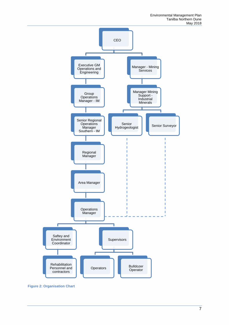
The Northern Dune site is part of the Sibelco New South Wales Glass Operations. Sand from the site is processed at the Salt Ash plant, which is managed by the Site Superintendent. An organisation chart showing key personnel who have environmental responsibilities on the Northern Dune Site is shown overleaf.
Environmental Management Plan Tanilba Northern Dune
May 2018
7
Figure 2: Organisation Chart
CEO
Executive GM Operations and
Engineering
Group Operations
Manager - IM
Senior Regional Operations Manager
Southern - IM
Regional Manager
Area Manager
Operations Manager
Saftey and Environment Coordinator
Rehabilitation Personnel and
contractors
Supervisors
Operators Bulldozer Operator
Manager - Mining Services
Manager Mining Support -Industrial Minerals
Senior Hydrogeologist Senior Surveyor

Environmental Management Plan Tanilba Northern Dune
May 2018
8
Previous operations, located to the south and east of the project site commenced in November 2003. This operation was undertaken in zones, with four zones extracted in total. Progressive rehabilitation has been undertaken on all non-active areas.
4 Existing Environment
The existing environment was outlined in detailing the Tanilba Northern Dune Sand Extraction Extension Environmental Assessment Report, which supported the development application. This document can be consulted for full detail of the existing environmental conditions.
A brief summary of the conditions, as drawn from the Environmental Assessment Report, can be found below.
4.1 Local Meteorology
The nearest Bureau of Meteorology weather station is located at Williamtown RAAF Base, approximately 25 km south of the site.
On average, January is the warmest month in Williamtown with a mean daily average of 27.9◦C. the coolest month is July with a mean daily maximum temperature of 6.4◦C.
The mean annual rainfall at Williamtown is 1120.0 mm. The mean number of annual rain days over this period is 85.1 days. On average, March is the wettest month with a mean monthly rainfall of 122.7 mm while September is the driest month, with an average of 59.4 mm.
Full climate data for the Williamtown RAAF base, over the period 1942 – 2008, can be found in the Environmental Assessment Report (Section 9.4).
Wind speed and direction data was collected from the DECCW Beresfield monitoring station. Seasonal variation in winds can be summarised as follows:
• During summer, predominant winds are from the south and southeast, with smaller contributions from the east;
• During autumn, predominant winds are from the northwest, with smaller contributions from the southeast;
• During winter, predominant winds are from the northwest; and • During spring, predominant winds are from the northwest, with smaller contributions
from the southeast and south.
Windrose diagrams can be found in the Environmental Assessment Report (Appendix J).
4.2 Landform, Geology and Soils
The Tanilba Northern Dune lies on the Tilligerry Peninsula which is a relatively low-lying coastal area characterised by extensive unconsolidated sand dunes and estuarine deposits.

Environmental Management Plan Tanilba Northern Dune
May 2018
9
The Tanilba Northern Dune is located in the northeast corner of the Tomago-Stockton sand beds. The sand beds are east-northeast trending sand ridges comprised of two barriers: the inner Barrier (Tomago Sand Beds) and the Outer Barrier (Stockton Sand Beds). The site is located on the Inner Barrier, which extends from East of Tomago to the Tilligerry Peninsula.
The stratigraphy of the Tomago sand beds is described as:
• Upper light sand composed of medium dense light brown, medium grained sand, varying between 2 and 5 m thick;
• Dark sand composed of dense dark brown or black medium grained cemented sand, varying between 2 and 20 m thick;
• Lower light sand composed of medium dense light brown to fine to medium grained sand, varying between 2 and 8 m thick; and
• Grey sand composed of medium dense light grey fine to medium grained sand with silt, approximately 3 to 10 m thick.
The economic sand unit being extracted comprises the upper white silica sand.
There are two soil types located at the site, namely the Shoal Bay Soil Landscape and the Tea Gardens Soil Landscape.
The Shoal Bay Soil Landscape is present on the elevated areas of the sand dune. Generally, soil materials consist of 10-40 cm of brownish grey loose sand, overlying 60->270cm of bleached loose sand, overlying >150 cm of coherent organic and iron impregnated sand. The bleached loose sand is the material targeted for extraction, being clean, white silica sand.
The remaining lower parts of the site comprise the Tea Gardens Soil Landscape. On rises soil materials consist of up to 35 cm of brownish black or brownish grey loamy sand, overlying up to 130 cm of bleached loose sand, overlying 15-1000 cm of massive organic pan. Underlying this is coarse, smelly mottled saturated sand.
Typically, the Shoal Bay and Tea Gardens Soil Landscapes are highly permeable, strongly acidic, highly erodible, being particularly prone to wind erosion. They have low fertility and low water-holding capacity and have minimal potential for cultivation and grazing. The landscape is subject to permanent and seasonal high watertables and groundwater pollution hazard is relatively high as a result. The potential for potential acid sulphate soils across this landscape is low.
4.3 Surface Water
The site lies above the 1 in 100 year flood level on an elevated sand dune system. There are no streams, lakes or other permanent surface water bodies within the site. The nearest natural surface waters are Big Swan Bay approximately 300 m north of the site; Twelve Mile Creek and Saltwater Creek approximately 3.0 km west of the site; and Tilligerry Creek approximately 3.0 km south of the site. An artificially formed shallow depression or wetland known as ‘Mirror Lake’ is located approximately 400 m southwest of the site and was formed as a result of previous sand extraction operations.

Environmental Management Plan Tanilba Northern Dune
May 2018
10
The site contains ephemeral soaks and drainage ditches in low lying areas which support habitat for a variety of amphibians. These generally exist for short periods following significant rainfall events.
4.4 Groundwater
The Tilligerry Peninsular contains substantial reserves of low salinity, high yield groundwater utilised by Hunter Water Corporation for potable water supplies Newcastle and the Hunter Valley. Water is also extracted for local use by a series of licensed bores.
The Tomago Stockton Sand Beds are comprised of two major units which form relatively homogenous, unconsolidated, unconfined aquifers, partially separated by the Tilligerry Mud member. The total sand thickness of between 20 and 40 m and the saturated thickness on site ranges between 14 to 16 m.
Hydrogeology calculations performed by AECOM indicate the following:
• Transmissivity ranges from 80-923 m2/day. • Hydraulic conductivity is in the 3–89 m/day range, with vertical hydraulic conductivity
in the upper sand layer estimated to be 10–15 m/day. • Transmissivity in the upper sand layer is 150-225 m2/day when applying a saturated
aquifer thickness of 15 m. • Vertical movement through the underlying coffee rock horizons is likely to be much
slower and was estimated to be 0.1-1.5 m/day.
Groundwater levels beneath the Tanilba Northern Dune tend to reflect the surface level of the dune system, ranging between 1-2 m below the surface at the base of the dune system, to more than 10m in elevated places, usually below a layer of Waterloo Rock. Fluctuations in the water table occur over an annual and greater period due to changes in the rainfall regime. A methodology has been developed to determine the predicted maximum groundwater elevation. This can be found in Appendix C.
The groundwater within the Tomago Sand Beds is of low salinity and generally meets potable water standards. Historical groundwater monitoring indicates that electrical conductivity is typically between 80 and 240 µS/cm and the dominant ions are sodium and chloride.
The pH of groundwater in the sand beds is typically acidic, nominally ranging between pH 4.5 and 6.7. It is assumed that in the aquifer’s aerobic zone beneath recharge areas, low pH values reflect the presence of dissolved carbon dioxide, derived primarily from root-zone respiration.
Pyrite (iron sulphide) and other metal sulphides are present in both the basal sands and coffee rock strata below the permitted vertical limit of extraction. Mobilisation of iron and other metals (manganese, arsenic and to a lesser extent, chromium, cobalt and zinc) has been observed in connection with sand mining from these areas and also in association with heavy pumping from Hunter Water Corporation abstraction bores. Historical information from

Environmental Management Plan Tanilba Northern Dune
May 2018
11
the existing sand extraction operation indicates that iron levels up to 8.2 mg/L have been identified post-mining.
To assist with the monitoring of groundwater quality due to extraction operations, a water quality trigger level protocol has been developed. This can be found in Appendix B.
There are currently 19 bores located within the existing extraction area (ACI 1 – ACI 19), which are used for groundwater level monitoring and water quality determination. Three Hunter Water Corporation bores are also used for depth measurement (SK3525, SK3530 and SK284). Two monitoring bores have been located within the new extraction area (SAL4 and SAL5) and will be used for groundwater monitoring.
The location of bores can be found in the Soil and Water Management Plan in Appendix B.
4.5 Existing Flora
Flora studies of the site indicated that 175 species were identified, consisting of 139 native species and 36 exotic species. The majority of exotic species were identified in areas of the site that have been cleared or disturbed, with weed infestation noted. Three species listed under the Noxious Weeds Act 1993 were identified, Lantana, Crofton Weed and Bitou Bush.
No threatened flora species or Rare and Threatened Australian Plants (ROTAP) listed species were identified.
One species of local conservation significance was recorded, namely Gompholobium virgatum var. virgatum. This species is at the southern limit of its known distribution in the Port Stephens area.
Three vegetation communities were mapped on site:
• Coastal Sand Apple – Blackbutt Forest • Coastal Sand Wallum Woodland – Heath; and • Exotic Grassland/ Weed Infestations in Cleared Areas
The Coastal Sand Wallum Woodland Heath community is recognised as regionally significant. No threatened ecological communities as listed under the Environment Protection and Biodiversity Conservation Act 1999 or the Threatened Species Conservation Act 1995 were identified on site.
A revised search of the NSW Wildlife Atlas Database was undertaken to determine if protected species were present within a 10 km radius of the site. This search found that nine threatened flora species had potential habitat on site. These species were the subject of a targeted survey. None of the species were identified on site.
The full flora, fauna and threatened species survey undertaken by Ecobiological can be found in the Environmental Assessment Report (Appendix M).
Further details of species located on site can be found in the Landscape Management Plan in Appendix D.
Environmental Management Plan Tanilba Northern Dune
May 2018
12
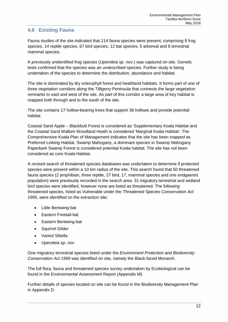
4.6 Existing Fauna
Fauna studies of the site indicated that 114 fauna species were present, comprising 8 frog species, 14 reptile species, 67 bird species, 12 bat species, 5 arboreal and 8 terrestrial mammal species.
A previously unidentified frog species (Uperoleia sp. nov.) was captured on site. Genetic tests confirmed that the species was an undescribed species. Further study is being undertaken of the species to determine the distribution, abundance and habitat.
The site is dominated by dry sclerophyll forest and heathland habitats. It forms part of one of three vegetation corridors along the Tilligerry Peninsula that connects the large vegetation remnants to east and west of the site. As part of this corridor a large area of key habitat is mapped both through and to the south of the site.
The site contains 17 hollow-bearing trees that support 38 hollows and provide potential habitat.
Coastal Sand Apple – Blackbutt Forest is considered as ‘Supplementary Koala Habitat and the Coastal Sand Wallum Woodland Heath is considered ‘Marginal Koala Habitat’. The Comprehensive Koala Plan of Management indicates that the site has been mapped as Preferred Linking Habitat. Swamp Mahogany, a dominant species in Swamp Mahogany Paperbark Swamp Forest is considered potential Koala habitat. The site has not been considered as core Koala Habitat.
A revised search of threatened species databases was undertaken to determine if protected species were present within a 10 km radius of the site. This search found that 50 threatened fauna species (2 amphibian, three reptile, 27 bird, 17, mammal species and one endgaered population) were previously recorded in the search area. 31 migratory terrestrial and wetland bird species were identified, however none are listed as threatened. The following threatened species, listed as Vulnerable under the Threatened Species Conservation Act 1995, were identified on the extraction site:
• Little Bentwing-bat • Eastern Freetail-bat • Eastern Bentwing-bat • Squirrel Glider • Varied Sittella • Uperoleia sp. nov
One migratory terrestrial species listed under the Environment Protection and Biodiversity Conservation Act 1999 was identified on site, namely the Black-faced Monarch.
The full flora, fauna and threatened species survey undertaken by Ecobiological can be found in the Environmental Assessment Report (Appendix M).
Further details of species located on site can be found in the Biodiversity Management Plan in Appendix D.
Environmental Management Plan Tanilba Northern Dune
May 2018
13
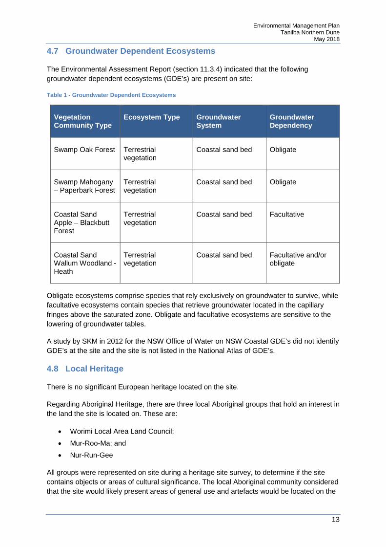
4.7 Groundwater Dependent Ecosystems
The Environmental Assessment Report (section 11.3.4) indicated that the following groundwater dependent ecosystems (GDE’s) are present on site:
Table 1 - Groundwater Dependent Ecosystems
Vegetation Community Type
Ecosystem Type Groundwater System
Groundwater Dependency
Swamp Oak Forest Terrestrial vegetation
Coastal sand bed Obligate
Swamp Mahogany – Paperbark Forest
Terrestrial vegetation
Coastal sand bed Obligate
Coastal Sand Apple – Blackbutt Forest
Terrestrial vegetation
Coastal sand bed Facultative
Coastal Sand Wallum Woodland - Heath
Terrestrial vegetation
Coastal sand bed Facultative and/or obligate
Obligate ecosystems comprise species that rely exclusively on groundwater to survive, while facultative ecosystems contain species that retrieve groundwater located in the capillary fringes above the saturated zone. Obligate and facultative ecosystems are sensitive to the lowering of groundwater tables.
A study by SKM in 2012 for the NSW Office of Water on NSW Coastal GDE’s did not identify GDE’s at the site and the site is not listed in the National Atlas of GDE’s.
4.8 Local Heritage
There is no significant European heritage located on the site.
Regarding Aboriginal Heritage, there are three local Aboriginal groups that hold an interest in the land the site is located on. These are:
• Worimi Local Area Land Council; • Mur-Roo-Ma; and • Nur-Run-Gee
All groups were represented on site during a heritage site survey, to determine if the site contains objects or areas of cultural significance. The local Aboriginal community considered that the site would likely present areas of general use and artefacts would be located on the

Environmental Management Plan Tanilba Northern Dune
May 2018
14
surface. As the site is largely forested with very limited visibility of the ground, no artefacts or items of heritage significance were identified. However, the potential for items to be present was considered possible and further archaeological work is required.
Small archaeological sites that may be present are likely to contain middens or stone artefact scatters. The nearest recorded midden to the site is located 80 m away.
Further details of the Heritage Assessment can be found in the Environmental Assessment Report (Appendix N).
4.9 Local Community
The sand extraction site is located to the south east of Oyster Cove and to the east of Oyster Cove Road.
There are three sensitive residences that have been identified, which are the closest to operations and the most likely to be impacted by operations. These residences are outlined below.
Table 2 - Noise Sensitive Residents
Receiver ID Location
Residence 1 18 Oyster Cove Road
Residence 2 16 Rutile Road
Residence 3 2 Oyster Cove Road
The location of the above residences can be found in the Noise Monitoring Program in Appendix E.

Environmental Management Plan Tanilba Northern Dune
May 2018
15
5 Extractive Operations
The general process for sand extraction at the Northern Dune site is outlined in the flow chart below. Sections following provide the detail of each step.
Figure 3: Extractive Operations Flowchart
5.1 Mine Plan Development
Plans produced to meet regulatory requirements include the following:
• Pre-extraction landform plan • Post extraction landform plan • Final landform plan
Mining Services will prepare a Mine (Extraction) Plan detailing the areas for clearing, sand extraction and rehabilitation. In addition, detail will be provided covering all environmental controls and any associated extractive activities including road access, protection of existing infrastructure etc.
The Mine Plan will be prepared in consultation with the Area Manager, Operations Manager and Safety & Environment Coordinator. This Environmental Management Plan will be consulted to determine the minimum requirements for operation. At a minimum it will include:
• A maximum land disturbance area of three hectares at any one time • Extraction of not more than 150,000 tonnes per calendar year • Scheduling within the approved hours of operation, being:
4.1 •Mine plan developed
4.2 •Survey of extraction areas
4.3 •Pre-clearance operations
4.5 •Equipment mobilisation
4.6 •Vegetation cleared
4.7 •Topsoil removed
4.8 •Sand extracted
4.9 •Sand transported
4.10 •Landform rehabilitated
4.11 •Vegetation rehablitated

Environmental Management Plan Tanilba Northern Dune
May 2018
16
a) Between 7:00 am and 6:00 pm EST, Monday to Friday; b) Between 7:00 am and 7:00 pm DST, Monday to Friday; and c) At no time on Saturday, Sunday or public holidays
• Extraction moving from the south to north to enable topography to shield sensitive receptors
• Restrict disturbance areas to the minimum required • Rehabilitation requirements for the relevant period
The finalised Mine Plan will be sent to the Operations Manager – Salt Ash for implementation.
5.2 Site Access
Site access is via Oyster Cove Road. Designated routes of travel between the Salt Ash Plant and the Northern Dune site are contained in the Traffic Management Plan.
Internal access roads within operational or extraction areas will be constructed as required to meet operational requirements. Roads will be constructed to traverse areas available for extraction only, ensuring that vegetation to be retained is not disturbed.
Any roads not required for future use by the Office of Water, Hunter Water Corporation or State Emergency Services will be rehabilitated in accordance with the Landscape Management Plan. This can be found in Appendix D.
5.3 Survey of Extraction Areas
Prior to extraction commencing, the approved limits of extraction are to be surveyed by a registered surveyor and the boundaries clearly marked in a permanent manner. The land surface must also be surveyed to produce a Pre-Extraction Landform Plan. The following items shall also be surveyed and included on a relevant plan:
• Survey control points • Operational area within the approved extraction zone • HWC monitoring bores and associated infrastructure • Hollow bearing trees to be retained • Areas of natural vegetation for retention • Sand haulage and vehicular access • Mobile equipment laydown area
Mining services will be responsible for establishing adequate survey control points surrounding the extraction area. These marks will be posted and made visible. Care must be taken not to damage or obstruct these marks.
The Site Superintendent will determine the requirement and frequency of survey, taking into consideration the current machinery operating depth or level. As a minimum the area should

Environmental Management Plan Tanilba Northern Dune
May 2018
17
be surveyed once every 3 months. More intensive surveying will be conducted when near the extraction limits.
The Site Superintendent will ensure that all measurements, as detailed in the below SOPs, are undertaken by a surveyor or geologist with training in surveying techniques, or a person who has been adequately trained for that purpose by such a person.
The person undertaking the survey will inform the operator of the present level in relation to the Post Extraction Landform Plan RL and place indicator pegs in close proximity to the extraction but clear of mining operations. The results of the survey will be recorded and reported to the Site Superintendent.
The operator will use the indicator pegs to gauge his position whilst operating the loader or other sand extraction equipment to ensure the depth of extraction does not exceed the depth as specified on the Post Extraction Landform Plan.
Surveying operations to be undertaken using Standard Operating Procedures (SOP) for Surveying at Northern Dune and Placing Level Markers at Designated RLs at Northern Dune.
5.4 Pre-Clearance Operations
Pre-clearance inspections will be undertaken prior to any clearing. Inspections will include the following:
• A survey of habitat trees to determine if they are currently in use by local fauna • A survey to determine if Koalas are present in the proposed clearing area • Inspection of sites by Aboriginal stakeholders to provide greater certainty as to the
presence of Aboriginal archaeological sites (done once prior to commencement of operations)
Preclearance inspections will be organised by Sibelco staff, but will generally be conducted by external persons. Flora monitoring will be conducted by an appropriate consultant. The Aboriginal inspections will be conducted by Aboriginal stakeholders.
The process for flora preclearance inspections can be found in Appendix D.
The process for Aboriginal heritage inspections can be found in Appendix G.
Records of all inspections are to be maintained at the Salt Ash office.
5.5 Vegetation Clearance
An area of two hectares will initially be cleared of vegetation to provide an adequate area cleared in advance of the mining face to permit sand extraction. This area, as defined on the Mining Plan, will form the operational area and will be marked out by survey.
The survey will, prior to vegetation clearing,
Environmental Management Plan Tanilba Northern Dune
May 2018
18
• Clearly mark all hollow-bearing trees to be retained • Clearly mark areas of vegetation to be retained • Define the topography of the existing surface prior to topsoil removal
Clearing will be undertaken by bulldozer in accordance with the Landscape Management Plan and may be conducted in conjunction with topsoil removal. Soft felling of trees will be undertaken to minimise the impact of clearing of any fauna present. This process is outlined in the Landscape Management Plan.
Clearing activities will be supervised by an experienced fauna ecologist. This will ensure that any fauna displaced during clearing can be relocated. The process for relocating fauna is outlined in the Landscape Management Plan.
Clearing of additional areas will be subject to availability of exhausted areas for rehabilitation so that the maximum area undergoing clearing, sand extraction and rehabilitation at any one time is no more than three hectares.
Clearing will not be undertaken in adverse weather conditions, such as high winds, to minimise airborne dust.
The Biodiversity Management Plan can be found in Appendix D.
5.6 Equipment Mobilisation
The following types of mobile plant, equipment and vehicles will be used during operations:
• Bulldozer • Front end loader • Sand haulage trucks – typically 3 semi trailer tippers, nominal capacity of 28 tonne • Utility service vehicle • Light vehicles (supervisor, contractors, environmental specialists etc) • Graders – used as required for road maintenance • Water truck – used as required to prevent dust
Plant and equipment used at the site is to be maintained and operated in a proper and efficient manner. Maintenance shall be as per manufacturer requirements.
Any plant and equipment that is fitted with noise suppression equipment shall have that equipment maintained on a regular basis to ensure it is effective. Any defective equipment shall be removed from survey until the defect is rectified.
At the end of each day’s operation, machinery used in extractive operations will be removed from the approved operational area and parked in the nominated mobile plant laydown area.
Before any mining machinery (other than trucks which transport sand) enters the Extraction Area it will be cleaned to remove all soil and plant material and sprayed with fungicide to limit the introduction and spread of soil pathogens on the Extraction Area.
Environmental Management Plan Tanilba Northern Dune
May 2018
19
Any truck which transports sand which has soil or plant material on it from any place other than the Extraction Area will be similarly cleaned and sprayed before entering the Extraction Area.
Cleaning and spraying of mining machinery and sand transporting trucks will be conducted at the nominated mobile plant laydown area.
Fuel, oil and grease will not be stored on site and re-fuelling of plant and equipment will not be conducted within the Tomago Sandbeds Catchment Area.
A Hydrocarbon Spill Procedure has been developed and is included in the Northern Dune Pollution Incident Response Management Plan. This plan provides an emergency response strategy to effectively manage all hydrocarbon spills on the sand dunes that may occur during site operations.
All re-fuelling of plant and equipment will be conducted at the nominated mobile plant laydown area.
All equipment shall be operated in strict accordance with the Traffic Management Plan for the site. This includes conditions on the point of access, leaving the site and site speed limits.
5.7 Topsoil Removal
The initial removal of topsoil may involve the stripping of approximately 30 cm of material from an area of two hectares placing some 7,000 tonnes in stockpiles parallel to the mining path.
For subsequent areas alongside the initial cleared area, vegetation and topsoil can be stripped by bulldozer and placed directly over exhausted areas available for landform rehabilitation. Areas cleared and stripped in advance of the existing mine face will require the loading and hauling of topsoil to exhausted areas for spreading.
Topsoil removal and management will be undertaken in accordance with the Landscape Management Plan, found in Appendix D.
5.8 Sand Extraction
Extraction will not be undertaken in adverse weather conditions, such as high winds, to minimise airborne dust.
The permitted depth for sand extraction at any given point is determined from the Post Extraction Landform Plan, that incorporates extraction buffers (depth above applicable predicted maximum groundwater elevation), geological and quality limitations. The predicted maximum groundwater elevation is described in further detail in the Groundwater Management Plan in Appendix C. The Post Extraction Landform Plan may be altered from time to time by the Office of Water or Hunter Water Corporation.
Environmental Management Plan Tanilba Northern Dune
May 2018
20
Prior to sand extraction from an area cleared of topsoil a survey will be undertaken to determine the depth of sand available for mining and to quantify the quantity of topsoil available to re-instate the 1 metre Total Extraction Buffer.
Where the depth of sand is adequate, a working floor approximately 1 metre above the limit of extraction (Post-Extraction Landform Plan) will be utilised by the front-end loader to ensure that the sand mining depth is not exceeded.
Survey controls will be established in accordance with Section 4.3 – Survey of Extraction Areas.
Once the depth of sand remaining to be extracted approaches to within 1 metre above the limiting RL of the Post-Extraction Landform Plan the bulldozer and front-end loader will work in unison providing closer control at the limit of extraction.
In addition adequate depth monitoring by survey will be provided by the Site Superintendent – Salt Ash and effectively communicated between survey and operating personnel, as described in Section 4.3.
Approximately 2,000 tonnes of sand per week will be excavated using a combination of front-end loader and bulldozer, but varied to meet market requirements.
All extraction operations shall be conducted in accordance with the Traffic Management Plan.
5.9 Sand Transport
Normally, sand excavated will be loaded directly into sand haulage trucks for despatch to the Salt Ash Sand Processing Plant located 11 kilometres away by road to the south. Temporary, sand product stockpiles will be established by the bulldozer, as required, when dozing sand to feed the front-end loader.
All sand transport operations shall be conducted in accordance with the Traffic Management Plan. This includes a requirement that all material extracted is delivered to the Sibelco Salt Ash Processing Plant, by a predetermined route.
5.10 Landform Rehabilitation
The landform shall be rehabilitated to at least 1 m above the predicted maximum groundwater elevation. Requirements on rehabilitation can be found in the Landscape Management Plan in Appendix D.
5.11 Vegetation Rehabilitation
Requirements for rehabilitation can be found in the Landscape Management Plan in Appendix D.
Environmental Management Plan Tanilba Northern Dune
May 2018
21
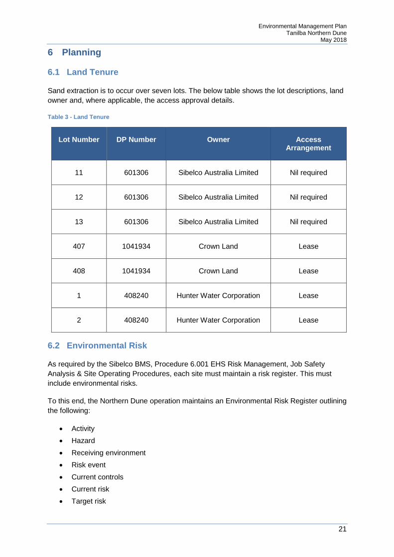
6 Planning
6.1 Land Tenure
Sand extraction is to occur over seven lots. The below table shows the lot descriptions, land owner and, where applicable, the access approval details.
Table 3 - Land Tenure
Lot Number DP Number Owner Access Arrangement
11 601306 Sibelco Australia Limited Nil required
12 601306 Sibelco Australia Limited Nil required
13 601306 Sibelco Australia Limited Nil required
407 1041934 Crown Land Lease
408 1041934 Crown Land Lease
1 408240 Hunter Water Corporation Lease
2 408240 Hunter Water Corporation Lease
6.2 Environmental Risk
As required by the Sibelco BMS, Procedure 6.001 EHS Risk Management, Job Safety Analysis & Site Operating Procedures, each site must maintain a risk register. This must include environmental risks.
To this end, the Northern Dune operation maintains an Environmental Risk Register outlining the following:
• Activity • Hazard • Receiving environment • Risk event • Current controls • Current risk • Target risk

Environmental Management Plan Tanilba Northern Dune
May 2018
22
• Additional controls • Residual risk • Monitoring of controls • Date reviewed
The register is required to be reviewed and updated, as required. At a minimum this will occur on an annual basis or when operations or operating conditions change.
The risk register for the existing operation was reviewed for applicability to the new project area. The revised risk register can be found in Appendix H. It is noted that the register will be reviewed regularly and may change over time. The risk register includes hazards associated with ongoing operations and hazards for post-extraction land use.
The risk assessment specifies a number of controls that will be implemented to reduce or control hazards. This has resulted in the majority of risks being classified as low. Some medium risks are present. No high risks were identified.
Of the risks identified, the following controls have been identified for implementation.
6.2.1 Flora and Fauna • Preclearance inspections will be conducted prior to clearing to minimise impact to
fauna utilising the area • Nesting boxes will be installed as per the Environmental Assessment to replace
habitat removed by clearing. Nesting boxes will be monitored • Where possible, seeds will be harvested prior to clearing to allow local provenance
rehabilitation • Green waste generated during clearing operation shall be reused on site during
rehabilitation activities • Grass trees are trimmed and watered when planted to maximise survival rates • Rehabilitation procedures are in place to minimise the risk of rehabilitation failing • Rehabilitation is conducted progressively • Impacts to specific threatened species, specifically the wallum froglet will be
monitored.
6.2.2 Aboriginal Heritage • Preclearance inspections will be undertaken with local Aboriginal groups to
determine if heritage items or sites are present below the existing leaf litter and vegetation
• The Aboriginal Heritage Management Plan provides for the management of discovered heritage items or sites
• All staff and contractors will be inducted to be made aware of potential Aboriginal heritage issues at the site
• The offset management plan specifically addresses protection of the known heritage location (site 38-4-0318)

Environmental Management Plan Tanilba Northern Dune
May 2018
23
6.2.3 Noise Management • Operations are only to be conducted during daylight and approved hours • Plant and equipment is to be maintained on a regular basis to minimise equipment
noise • Extraction will occur in a south to north direction, to allow topography to shield nearby
residents • A traffic management plan, including requirements on operational noise, will be
implemented to control plant, equipment and truck movements both on and off site • Induction of trucking contractors shall be undertaken to make them aware of noise
issues
6.2.4 Land Management • Plant and equipment shall be maintained on a regular basis to minimise the risk of
hydraulic oil leaks • Pre-start checks are to occur on plant and equipment to identify any hydraulic oil
leaks prior to work starting • Equipment will not be stored on site overnight to prevent oil or fuel leaks • Refuelling is not to occur at the extraction site. All refuelling will occur at the Salt Ash
plant or the Oyster Cove boat yard • A SOP is in place for refuelling operations • A spill kit is maintained in the refuelling ute • No chemicals are to be stored on site. All chemicals will be removed to Salt Ash at
the end of each day • No toilets are to be provided on site. All personnel will return to the Salt Ash site to
prevent wastewater being discharged to land • Weeds are sprayed on a campaign basis to prevent spread • Weed spraying is conducted by trained personnel, following a SOP • Weed spray is dyed to show where it has been applied • Weed spray chemicals are strapped into the ute to prevent damage to the container
and subsequent leaks • Visual inspections of the weed spraying ute are conducted to determine if weed
spray mixture has leaked (looking for pink dyed liquid)
6.2.5 Air Quality • A maximum of three hectares will be stripped at any one time, to minimise the area
that may generate wind-blown dust • Avoid vegetation clearing and extraction during adverse weather conditions • A water cart will be available to prevent dust • A traffic management plan, including requirements on dust production, will be
implemented to control plant, equipment and truck movements both on and off site • Induction of trucking contractors shall be undertaken to make them aware of dust
issues
Environmental Management Plan Tanilba Northern Dune
May 2018
24
• Topsoil shall not be stored on site for more than three months, to prevent stockpiles being a source of dust
• Product stockpiles shall not be stored for more than seven days, to prevent them being a source of dust
• Vehicles transporting material less than 7 mm in size must have their tailgates securely fixed and be covered at all times after loading and before unloading to prevent wind-blown dust or spillage
• Extraction will not occur during days of excessive wind which will increase the likelihood of windblown dust leaving site
6.2.6 Water Management • Limits on extraction have been set to ensure that the groundwater table is not
intercepted • A response plan is in place to manage groundwater issues • Ongoing monitoring is in place to provide accurate data regarding groundwater levels
and quality • Landform rehabilitation requirements have been set to protect groundwater
resources
6.2.7 Waste Management • All waste generated on site, with the exception of green waste, shall be removed to
Salt Ash for disposal • Any identified illegal dumping sites shall be reported to allow removal
6.2.8 Public Safety • Signs are installed to prevent unauthorised activity • Equipment is not stored on site overnight to prevent vandalism and possible injury to
the public • Extraction faces are not sufficiently high, steep or unstable to cause serious injury • All vehicle movements on public roads must meet the requirements of the Traffic
Management Plan and all applicable road rules
6.2.9 Visual Impact • Buffer zones will be maintained around the extraction to minimise the visual impact of
operations
6.3 Legal and Other Requirements
As required by the Sibelco BMS, Procedure 1.106 EHS Legal Compliance Obligations, each site must identify and keep a record of the legal compliance obligations and standards that govern their operations.
To this end, the Northern Dune operation maintains a Compliance Register outlining the following:
• Jurisdiction
Environmental Management Plan Tanilba Northern Dune
May 2018
25
• Act/Instrument • Section • Issue • Requirement • Trigger • Evidence of compliance • Improvement actions • Documentary evidence of compliance • Review date
The register is required to be reviewed and updated, as required. At a minimum this will occur on an annual basis or when operations or operating conditions change.
The register is to include all site specific requirements, including planning approvals, site leases and environment protection licence.
Site specific instruments that have compliance obligations, as outlined in the compliance register, include:
• Planning Approval MP 09_0091 • Approval under clause 10(1) of the Hunter Water Regulation 2010 • Environment Protection Licence 11633 • Leases with the Crown and Hunter Water Corporation

Environmental Management Plan Tanilba Northern Dune
May 2018
26
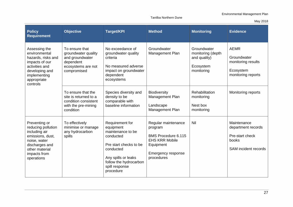
6.4 Objectives and Targets
The following table outlines the objectives and targets of the project, as well as the method of achieving the target, monitoring to demonstrate the effectiveness of the method and evidence maintained.
Table 4 - Objectives and Targets
Policy Requirement
Objective Target/KPI Method Monitoring Evidence
Complying with all applicable legal and other requirements governing our activities
Ensure compliance with the DA
Have this EMP and meet review requirements
Review of requirements
Training
Annual review
Annual audit
Training records
AEMR
Audit reports
Training records
Assessing the environmental hazards, risks and impacts of our activities and developing and implementing appropriate controls
To effectively and efficiently manage operations to minimise the environmental impacts of extraction activities
No exceedance of a prescribed limit
No community complaints
Dust monitoring program
Noise monitoring program
Groundwater Management Plan
Complaints process
Dust monitoring
Noise monitoring
Groundwater monitoring
Annual review
AEMR
Dust monitoring results
Noise monitoring results
Groundwater monitoring results
Community complaint incident records
Environmental Management Plan Tanilba Northern Dune
May 2018
27
Policy Requirement
Objective Target/KPI Method Monitoring Evidence
Assessing the environmental hazards, risks and impacts of our activities and developing and implementing appropriate controls
To ensure that groundwater quality and groundwater dependent ecosystems are not compromised
No exceedance of groundwater quality criteria
No measured adverse impact on groundwater dependent ecosystems
Groundwater Management Plan
Groundwater monitoring (depth and quality)
Ecosystem monitoring
AEMR
Groundwater monitoring results
Ecosystem monitoring reports
To ensure that the site is returned to a condition consistent with the pre-mining condition
Species diversity and density to be comparable with baseline information
Biodiversity Management Plan
Landscape Management Plan
Rehabilitation monitoring
Nest box monitoring
Monitoring reports
Preventing or reducing pollution including air emissions, dust, noise, water discharges and other material impacts from operations
To effectively minimise or manage any hydrocarbon spills
Requirement for equipment maintenance to be conducted
Pre start checks to be conducted
Any spills or leaks follow the hydrocarbon spill response procedure
Regular maintenance program
BMS Procedure 6.115 EHS KRR Mobile Equipment
Emergency response procedures
Nil Maintenance department records
Pre-start check books
SAM incident records
Environmental Management Plan Tanilba Northern Dune
May 2018
28
Policy Requirement
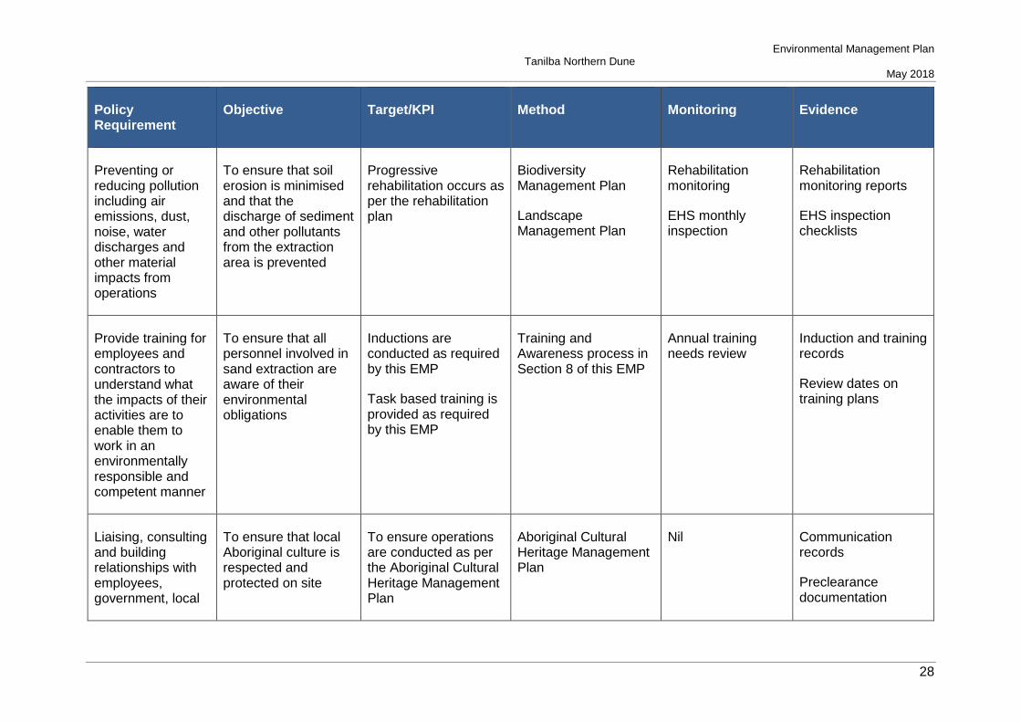
Objective Target/KPI Method Monitoring Evidence
Preventing or reducing pollution including air emissions, dust, noise, water discharges and other material impacts from operations
To ensure that soil erosion is minimised and that the discharge of sediment and other pollutants from the extraction area is prevented
Progressive rehabilitation occurs as per the rehabilitation plan
Biodiversity Management Plan
Landscape Management Plan
Rehabilitation monitoring
EHS monthly inspection
Rehabilitation monitoring reports
EHS inspection checklists
Provide training for employees and contractors to understand what the impacts of their activities are to enable them to work in an environmentally responsible and competent manner
To ensure that all personnel involved in sand extraction are aware of their environmental obligations
Inductions are conducted as required by this EMP
Task based training is provided as required by this EMP
Training and Awareness process in Section 8 of this EMP
Annual training needs review
Induction and training records
Review dates on training plans
Liaising, consulting and building relationships with employees, government, local
To ensure that local Aboriginal culture is respected and protected on site
To ensure operations are conducted as per the Aboriginal Cultural Heritage Management Plan
Aboriginal Cultural Heritage Management Plan
Nil Communication records
Preclearance documentation
Environmental Management Plan Tanilba Northern Dune
May 2018
29
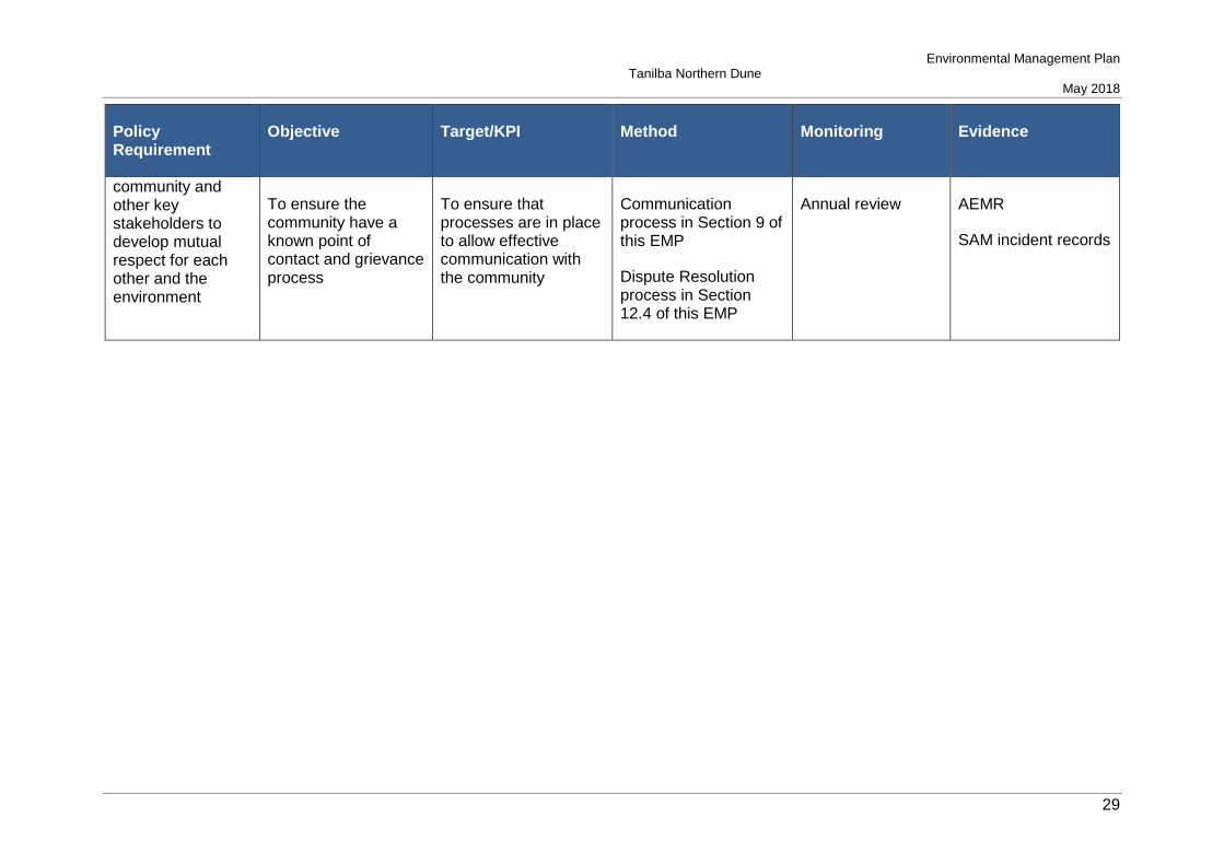
Policy Requirement
Objective Target/KPI Method Monitoring Evidence
community and other key stakeholders to develop mutual respect for each other and the environment
To ensure the community have a known point of contact and grievance process
To ensure that processes are in place to allow effective communication with the community
Communication process in Section 9 of this EMP
Dispute Resolution process in Section 12.4 of this EMP
Annual review AEMR
SAM incident records

Environmental Management Plan Tanilba Northern Dune
May 2018
30
7 Roles and Responsibilities
The following sections outline specific roles and responsibilities relating to the Northern Dune operation. It is noted that the roles and responsibilities have been limited to internal Sibelco personnel. The responsibilities of external contractors will be outlined in the service agreement used to engage them.
7.1 Regional Manager
• Ensure performance targets specified in this plan are being met; • Participate in the annual review of the Plan where required; • Consult with State Environmental Advisor regarding communication with government
agencies; and • Participate in incident investigations, as required, including all community complaints.
7.2 Operations Manager
• Ensure the implementation of all control, monitoring and reporting measures as specified in this Plan;
• Ensure compliance with Conditions of Approval; • Participate in the annual review of the Plan; • Approve amendments to the Plan; • Consult with State Environmental Advisor regarding communication with government
agencies; and • Provide the first point of contact with community members and other stakeholders.
7.3 Safety and Environment Co-ordinator
• Put systems in place to implement the controls, monitoring and reporting measures specified in this Plan;
• Conduct inspections, monitoring and reporting as per this Plan; and • Participate in the annual review of the Plan.
7.4 Rehabilitation Personnel
• Comply with relevant control measures as specified in this Plan; and • Undergo training required by this Plan, as required.
7.5 Operators
• Comply with relevant control measures as specified in this Plan; and • Undergo training required by this Plan, as required.
Environmental Management Plan Tanilba Northern Dune
May 2018
31
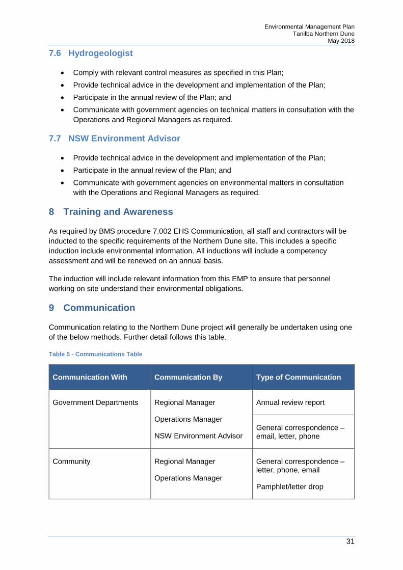
7.6 Hydrogeologist
• Comply with relevant control measures as specified in this Plan; • Provide technical advice in the development and implementation of the Plan; • Participate in the annual review of the Plan; and • Communicate with government agencies on technical matters in consultation with the
Operations and Regional Managers as required.
7.7 NSW Environment Advisor
• Provide technical advice in the development and implementation of the Plan; • Participate in the annual review of the Plan; and • Communicate with government agencies on environmental matters in consultation
with the Operations and Regional Managers as required.
8 Training and Awareness
As required by BMS procedure 7.002 EHS Communication, all staff and contractors will be inducted to the specific requirements of the Northern Dune site. This includes a specific induction include environmental information. All inductions will include a competency assessment and will be renewed on an annual basis.
The induction will include relevant information from this EMP to ensure that personnel working on site understand their environmental obligations.
9 Communication
Communication relating to the Northern Dune project will generally be undertaken using one of the below methods. Further detail follows this table.
Table 5 - Communications Table
Communication With Communication By Type of Communication
Government Departments Regional Manager
Operations Manager
NSW Environment Advisor
Annual review report
General correspondence – email, letter, phone
Community Regional Manager
Operations Manager
General correspondence – letter, phone, email
Pamphlet/letter drop

Environmental Management Plan Tanilba Northern Dune
May 2018
32
Communication With Communication By Type of Communication
Aboriginal Stakeholders Regional Manager
Operations Manager
General correspondence – email, letter, phone
General Public Sibelco Website content
9.1 Communication with Government Agencies
Communication with government agencies will be conducted by the Regional Manager, Operations Manager or NSW Environment Advisor, with some technical information provided by the Hydrogeologist.
For communication methods other than phone conversations, all records of communication will be retained. As appropriate, file notes will be taken of phone conversations.
The annual review will comprise a significant communication to government agencies of the performance of the operation. This review will include:
• A description of work (including rehabilitation) conducted over the previous 12 months
• A description of works to be conducted in the following year • A comprehensive review of monitoring results and complaints records over the past
year, including a comparison of results against: o The relevant statutory requirements, limits or performance measures/criteria o The monitoring results of previous years; and o Relevant predictions in the EA
• Identify any non-compliance over the past year, describe what actions were (or are being) taken to ensure compliance;
• Identify trends in the monitoring data over the life of the project • Identify any discrepancies between predicted and actual impacts of the project and
analyse the potential cause of any significant discrepancies; and • Describe what measures will be implemented over the next year to improve the
environmental performance of the project.
The review will occur annually, on the anniversary date of the commencement of operations.
9.2 Communication with the Community
Communication with the community may be undertaken in any of the following methods:
• Open letter • Letter with specific neighbours

Environmental Management Plan Tanilba Northern Dune
May 2018
33
• Pamphlet letter box drop • Community engagement meeting
Communication with the community will be undertaken by the Operations Manager or Regional Manager. Contact details shall be provided on signage at the entrance to site to allow community members to provide comment or direct their complaints.
9.3 Communication with Aboriginal Stakeholders
Communication with Aboriginal Stakeholders shall be undertaken by the Operations Manager or Regional Manager. It will generally comprise written communication, although general information may be provided by telephone call.
Where operations may affect Aboriginal heritage, all relevant Aboriginal groups shall be contacted. The groups linked with the land at Northern Dune are:
• Worimi Local Area Land Council (LALC) • Mur-Roo-Ma; and • Nur-Run-Gee.
9.4 Communication via the Website
Condition of approval schedule 5, condition 9 requires the following information to be publicly available on the company website:
• A copy of all approved strategies, plans and programs; • A summary of all monitoring results of the project, which have been reported in
accordance with the various plans and programs approved under the conditions of this approval, updated on a quarterly basis;
• A complaints register, updated on a quarterly basis; • Copies of Annual Reviews; • Copies of any Independent Environmental Audit, and the Proponent’s response to
the recommendations in any audit; • Copies of the development consent and approved management plans for the existing
adjacent quarrying operations; and • Any other matter required by the Director-General.
The above information is required to be kept up to date. The Operations Manager is responsible for ensuring that information is updated on the website. The NSW Environment Advisor will provide assistance with this action.
Northern Dune information can be found at the following website:
https://www.sibelco.com/aus-nz-reporting-nsw/

Environmental Management Plan Tanilba Northern Dune
May 2018
34
10 Emergency Management
Emergency situations have been identified from the Risk Register, as risk events that pose an imminent threat to the environment. Specific emergencies that have been identified are:
• Hydrocarbon spills; and • Pesticide spills
Response procedures for the above emergencies can be found in the Northern Dune Emergency Response Plan.
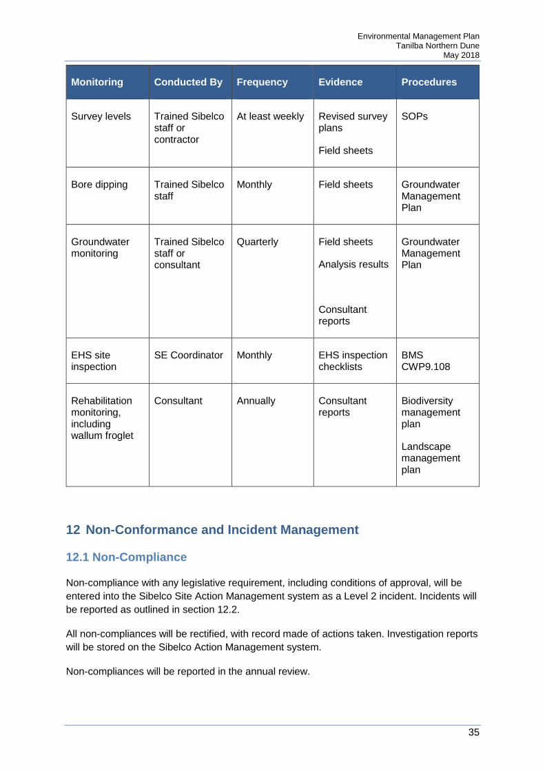
11 Monitoring and Measurement
The below table outlines the monitoring required in this EMP:
Table 6 - Monitoring Requirements
Monitoring Conducted By Frequency Evidence Procedures
Preclearance check for fauna
Consultant Prior to clearing Preclearance report
In Biodiversity Management Plan
Nest box monitoring
Consultant Annually Monitoring report
In Biodiversity Management Plan
Preclearance checklist for heritage
Site and Aboriginal stakeholders
Prior to clearing Preclearance checklist
In Aboriginal Cultural Heritage Management Plan
Noise monitoring
Trained Sibelco staff
Quarterly for first two years
Noise monitoring field sheets
Annual review report
Noise monitoring program
Dust monitoring Trained Sibelco staff
Monthly Dust monitoring field sheets
Analysis results
Annual review report
Dust monitoring program
Environmental Management Plan Tanilba Northern Dune
May 2018
35
Monitoring Conducted By Frequency Evidence Procedures
Survey levels Trained Sibelco staff or contractor
At least weekly Revised survey plans
Field sheets
SOPs
Bore dipping Trained Sibelco staff
Monthly Field sheets
Groundwater Management Plan
Groundwater monitoring
Trained Sibelco staff or consultant
Quarterly Field sheets
Analysis results
Consultant reports
Groundwater Management Plan
EHS site inspection
SE Coordinator Monthly EHS inspection checklists
BMS CWP9.108
Rehabilitation monitoring, including wallum froglet
Consultant Annually Consultant reports
Biodiversity management plan
Landscape management plan
12 Non-Conformance and Incident Management
12.1 Non-Compliance
Non-compliance with any legislative requirement, including conditions of approval, will be entered into the Sibelco Site Action Management system as a Level 2 incident. Incidents will be reported as outlined in section 12.2.
All non-compliances will be rectified, with record made of actions taken. Investigation reports will be stored on the Sibelco Action Management system.
Non-compliances will be reported in the annual review.

Environmental Management Plan Tanilba Northern Dune
May 2018
36
12.2 Incidents
Incidents will be addressed as outlined in BMS Procedure 10.202 EHS Incident Notification and Investigation. All incidents will be entered into the Sibelco Site Action Management system.
All incidents will be rectified, with record made of actions taken. Investigation reports will be stored on the Sibelco Action Management system.
Incidents will be reported in the annual review.
Notifications that may be required following an incident shall be made as outlined in the Northern Dune Pollution Incident Response Management Plan.
12.3 Complaints
Community complaints will be addressed as outlined in BMS Procedure Managing Community Complaints. All incidents will be entered into the Sibelco Site Action Management system.
All community complaints will be investigated, with record made of actions taken. Investigation reports will be stored on the Sibelco Action Management system.
Community complaints will be reported in the annual review.
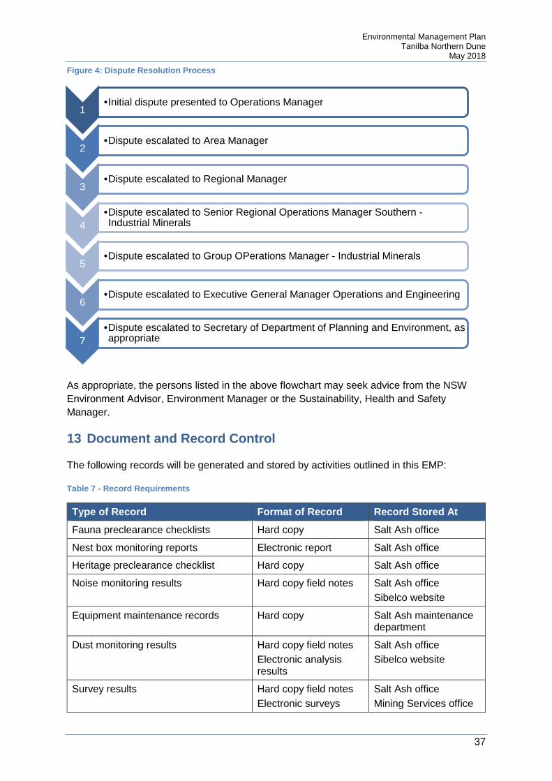
12.4 Dispute Resolution
The following parties may require dispute resolution with Sibelco:
• The community; • Regulators; • Land owners (where land is leased); • Approved consultants; and • Aboriginal groups.
The general process for all disputes is shown in the below flow chart.
Environmental Management Plan Tanilba Northern Dune
May 2018
37
Figure 4: Dispute Resolution Process
As appropriate, the persons listed in the above flowchart may seek advice from the NSW Environment Advisor, Environment Manager or the Sustainability, Health and Safety Manager.
13 Document and Record Control
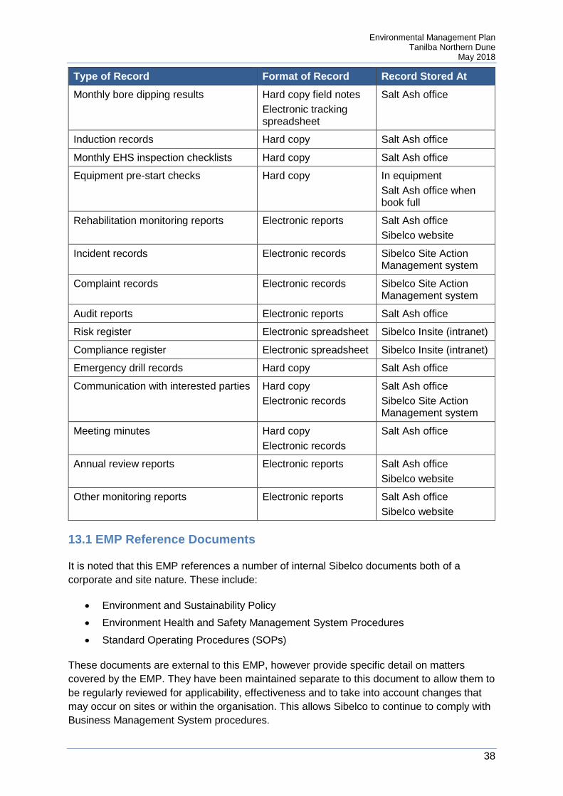
The following records will be generated and stored by activities outlined in this EMP:
Table 7 - Record Requirements
Type of Record Format of Record Record Stored At
Fauna preclearance checklists Hard copy Salt Ash office
Nest box monitoring reports Electronic report Salt Ash office
Heritage preclearance checklist Hard copy Salt Ash office
Noise monitoring results Hard copy field notes Salt Ash office Sibelco website
Equipment maintenance records Hard copy Salt Ash maintenance department
Dust monitoring results Hard copy field notes Electronic analysis results
Salt Ash office Sibelco website
Survey results Hard copy field notes Electronic surveys
Salt Ash office Mining Services office
1•Initial dispute presented to Operations Manager
2•Dispute escalated to Area Manager
3•Dispute escalated to Regional Manager
4•Dispute escalated to Senior Regional Operations Manager Southern -Industrial Minerals
5•Dispute escalated to Group OPerations Manager - Industrial Minerals
6•Dispute escalated to Executive General Manager Operations and Engineering
7•Dispute escalated to Secretary of Department of Planning and Environment, as appropriate
Environmental Management Plan Tanilba Northern Dune
May 2018
38
Type of Record Format of Record Record Stored At
Monthly bore dipping results Hard copy field notes Electronic tracking spreadsheet
Salt Ash office
Induction records Hard copy Salt Ash office
Monthly EHS inspection checklists Hard copy Salt Ash office
Equipment pre-start checks Hard copy In equipment Salt Ash office when book full
Rehabilitation monitoring reports Electronic reports Salt Ash office Sibelco website
Incident records Electronic records Sibelco Site Action Management system
Complaint records Electronic records Sibelco Site Action Management system
Audit reports Electronic reports Salt Ash office
Risk register Electronic spreadsheet Sibelco Insite (intranet)
Compliance register Electronic spreadsheet Sibelco Insite (intranet)
Emergency drill records Hard copy Salt Ash office
Communication with interested parties Hard copy Electronic records
Salt Ash office Sibelco Site Action Management system
Meeting minutes Hard copy Electronic records
Salt Ash office
Annual review reports Electronic reports Salt Ash office Sibelco website
Other monitoring reports Electronic reports Salt Ash office Sibelco website
13.1 EMP Reference Documents
It is noted that this EMP references a number of internal Sibelco documents both of a corporate and site nature. These include:
• Environment and Sustainability Policy • Environment Health and Safety Management System Procedures • Standard Operating Procedures (SOPs)
These documents are external to this EMP, however provide specific detail on matters covered by the EMP. They have been maintained separate to this document to allow them to be regularly reviewed for applicability, effectiveness and to take into account changes that may occur on sites or within the organisation. This allows Sibelco to continue to comply with Business Management System procedures.

Environmental Management Plan Tanilba Northern Dune
May 2018
39
As such, Sibelco do not seek for these to be documents approved by the Department of Planning and Environment. However Sibelco understand that the methods being employed for operations are a specific concern for the Department. To this effect, the version of the abovementioned documents current at the time of initial approval has been provided. Sibelco will continue its internal review of these documents and may make changes, as required. Where a change is not considered significant, the change will not be communicated for re-approval by the Department. However if the change results in any of the following, the revised document will be provided to the Department:
• Changes to role responsibilities • Changes to the method of operation • Changes not consistent with the Environmental Assessment Report • Changes resulting in an altered risk assessment result
13.2 EMP Review
This EMP and supporting documents will be reviewed at a minimum after the following:
• Following an annual review or audit or receipt of comments from Planning • Following an incident • Following any modification to the planning approval
The above reviews will occur within three months of the event occurring.
14 Audits
Internal and external audits are conducted to assess the effectiveness of the Environmental Management Plan to meet the objectives of the plan and legislative requirements. The following audits are required to be conducted:
Table 8 - Audit Requirements
Audit Type Scope Auditor Frequency
Post Mining
Assess the performance of the project and assess whether it is complying with the relevant requirements in the planning approval and any relevant Environment Protection Licence (EPL) (including any assessment, plan or program required under these approvals)
Review the adequacy of strategies, plans or programs required under the planning approval or EPL
Independent Auditor, approved by Director General
Once, within one month of the completion of mining and within two months of Director General approval of auditor

Environmental Management Plan Tanilba Northern Dune
May 2018
40
Appendix A - Environment and Sustainability Policy

Environmental Management Plan Tanilba Northern Dune
May 2018
41
Appendix B - Soil and Water Management Plan Erosion and sediment control plan
B.1 Soil Characteristics
Soils within the project area are sandy podzols and are characterised by distinctive soil horizons. A summary of the typical soil strata is as follows:
Table B1 – Soil Horizon Description
Thickness/ Depth (m) Description
0 – 13M Grey organic sandy topsoil
0.2 – 9.4m Fine grained clean white sand
0 – 10.4m Waterloo rock
Assessment of the soils at the Northern Dune site indicate that they are Class 1, as described in Managing Urban Stormwater, Soils and Construction, Volume 1 (Landcom 2004). This indicates that the erosion hazard is low, calculated to be lower than 150 tonnes per hectare per year.
Based on this soil loss class, the risk of erosion is considered to be low, which is consistent with previous experience on adjacent land. Due to this, erosion control methods generally concentrated on silt traps.
B.2 Activities that may cause soil erosion or generate sediment
Based on the risk register for the project (contained in Appendix H) the following activities have been assessed:
• Erosion or sedimentation of exposed or rehabilitation areas – assessed as a low risk • Sedimentation of drainage lines – assessed as a low risk
The above risk events have been derived from general land management hazards and reflect the primary conduit of soil movement being water. The risks have been assessed as low due to the high infiltration rates within the sand dune structure.
Environmental Management Plan Tanilba Northern Dune
May 2018
42
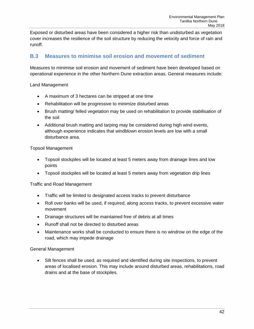
Exposed or disturbed areas have been considered a higher risk than undisturbed as vegetation cover increases the resilience of the soil structure by reducing the velocity and force of rain and runoff.
B.3 Measures to minimise soil erosion and movement of sediment
Measures to minimise soil erosion and movement of sediment have been developed based on operational experience in the other Northern Dune extraction areas. General measures include:
Land Management
• A maximum of 3 hectares can be stripped at one time • Rehabilitation will be progressive to minimize disturbed areas • Brush matting/ felled vegetation may be used on rehabilitation to provide stabilisation of
the soil • Additional brush matting and tarping may be considered during high wind events,
although experience indicates that windblown erosion levels are low with a small disturbance area.
Topsoil Management
• Topsoil stockpiles will be located at least 5 meters away from drainage lines and low points
• Topsoil stockpiles will be located at least 5 meters away from vegetation drip lines
Traffic and Road Management
• Traffic will be limited to designated access tracks to prevent disturbance • Roll over banks will be used, if required, along access tracks, to prevent excessive water
movement • Drainage structures will be maintained free of debris at all times • Runoff shall not be directed to disturbed areas • Maintenance works shall be conducted to ensure there is no windrow on the edge of the
road, which may impede drainage
General Management
• Silt fences shall be used, as required and identified during site inspections, to prevent areas of localised erosion. This may include around disturbed areas, rehabilitations, road drains and at the base of stockpiles.

Environmental Management Plan Tanilba Northern Dune
May 2018
43
B.4 Erosion and sediment control structures
As required, sediment fences may be employed where areas of localised erosion occur, or if unusual weather conditions are expected that may lead to erosion or sedimentation. Sediment fences will follow the general construction outlined in Managing Urban Stormwater, Soils and Construction, Volume 1 (Landcom 2004). The construction drawing for sediment fences can be found at the end of this appendix.
B.5 Maintenance of measures
A monthly EHS site inspection shall be conducted that will include the following items:
• Condition of roadside drainage; • Condition of extraction faces; • Condition of rehabilitation areas; • Condition of stockpiles and their surrounds, particularly the toe of stockpiles.
Any area of erosion identified shall be entered into the Sibelco Site Action Management System for rectification. As required, additional measures shall be utilised to prevent further erosion, such as sediment fences.
Where sediment fences are installed they shall be inspected following rain events to ensure they have not become silted and ineffective.
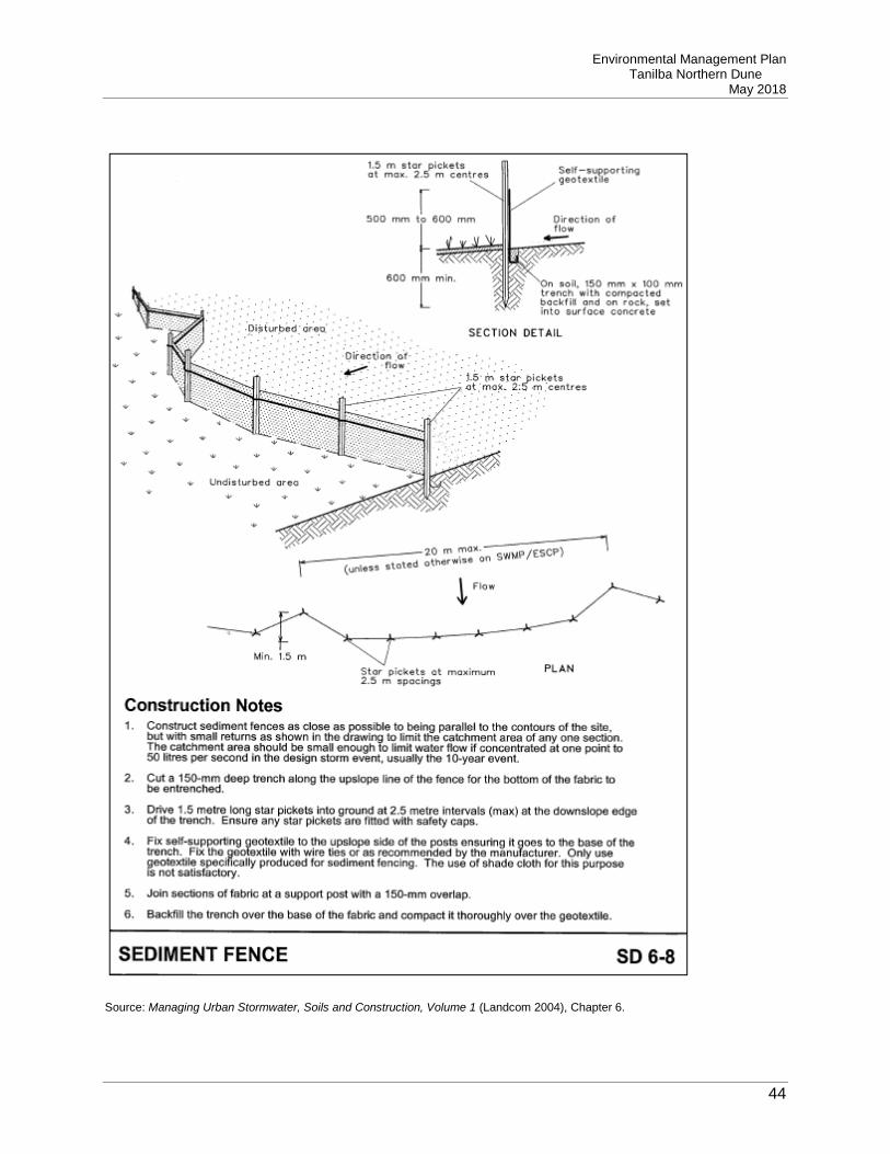
Environmental Management Plan Tanilba Northern Dune
May 2018
44
Source: Managing Urban Stormwater, Soils and Construction, Volume 1 (Landcom 2004), Chapter 6.

Environmental Management Plan Tanilba Northern Dune
May 2018
45
Appendix C - Groundwater Management Plan

Environmental Management Plan Tanilba Northern Dune
May 2018
46
Appendix D - Landscape Management Plan

Environmental Management Plan Tanilba Northern Dune
May 2018
47
Appendix E - Biodiversity Management Plan

Environmental Management Plan Tanilba Northern Dune
May 2018
48
Appendix F - Noise Monitoring Program F.1 Introduction
This noise monitoring program has been developed to provide a program of monitoring to demonstrate that operations at Sibelco’s Northern Dune site do not exceed noise criteria and create adverse impacts on local residents.
F.2 Noise Criteria
Noise criteria have been provided for the project in the Development Approval. This is contained in Schedule 3, condition 2. The condition requires that operational noise generated by the project does not exceed the noise impact assessment criteria in the below table, at any residence on privately-owned land.
Table E1 – Noise criteria
Receiver LAeq (15 min) dB(A)
R1, R2, R3 and all residences in Oyster Cove
37
All other receivers 35
F.3 Noise Monitoring
The noise monitoring program has been written to comply with the NSW Industrial Noise Policy.
F.3.1 Monitoring program
Monitoring will be conducted as per the below schedule:

Environmental Management Plan Tanilba Northern Dune
May 2018
49
Table E2 – Monitoring Program
Location Monitoring Frequency
Resident R1 – 18 Oyster Cove Road
Attended noise monitoring At least once prior to operation commencing
Quarterly for first two years
Resident R2 – 16 Rutile Road
Attended noise monitoring At least once prior to operation commencing
Quarterly for first two years
Resident R3 – 2 Oyster Cove Road
Attended noise monitoring At least once prior to operation commencing
Quarterly for first two years
Noise monitoring will be undertaken at the locations nominated in Figure E1 at the end of this program. Locations have been located so provide no intrusion on the resident properties. Background monitoring will be used as a benchmark for noise generated by the operation, as well as the goals provided in Table E1.
Following the first two year period, and provided monitoring results show compliance with the criteria, monitoring will be conducted only following a complaint relating to noise from operations.
F.3.2 Monitoring conditions
Monitoring will be conducted during normal operating hours and must be conducted on a day where at least 30 truck movements are scheduled.
Monitoring will not occur in the following situations:
• If it is raining • If wind speeds are over 5 m/s (18km/hr) • If extraneous noise sources are present (ie noise not typical to the area)
Environmental Management Plan Tanilba Northern Dune
May 2018
50
F.3.3 Monitoring equipment
Sound level meters used for monitoring must meet the specifications of a precision (Type 0 or 1) or general purpose (Type 2) sound level meter, as outlined in AS 1259 and referenced in the NSW Industrial Noise Policy.
It is noted that AS 1259 has been superseded by AS IEC 61672.1:2004.
For the purposes of noise monitoring at Northern Dune, a Type 2/ Class 1 or 2 sound level meter is required. This type of meter is suitable for general field applications.
Noise meters should be supplied with a current laboratory calibration certificate in accordance with AS IEC 61672.1:2004.
F.3.4 Monitoring personnel
Monitoring can be conducted by Sibelco personnel, provided they have had suitable training. Training will consist of a short course in environmental noise.
If suitably trained Sibelco personnel are not available, an appropriate consultant can be used.
F.3.5 Monitoring procedures
Sibelco personnel will conduct noise monitoring as outlined in the SOP and will be recorded on field sheets.
Consultants that may be used for noise monitoring will ensure monitoring complies with the NSW Industrial Noise Policy and relevant Australian Standards.
F.4 Comparison of Results
Following the noise monitoring, results will be entered into a monitoring spreadsheet. Results will be compared with the criteria provided in section E.2. Results will be deemed compliant where the monitored result is less than or equal to the noise level stated in Table E1.
F.5 Non-Compliance
All non-compliances in noise monitoring will be entered into SAM as the relevant incident. SAM will be used to track the investigation into the non-compliance and to record corrective actions and any notifications to regulatory authorities.
Any noise related community complaint will be deemed an incident, also entered into SAM. Noise monitoring will be conducted as part of the investigation, to determine if noise generated by operations exceeds the criteria.

Environmental Management Plan Tanilba Northern Dune
May 2018
51
Figure F1 – Noise Monitoring Locations
Legend
- Location for noise monitoring R1
R2
R3

Environmental Management Plan Tanilba Northern Dune
May 2018
52
Appendix G - Aboriginal Cultural Heritage Management Plan G.1 Introduction
This plan has been prepared to ensure that Aboriginal cultural heritage items and places are adequately protected throughout site operation and relevant Aboriginal communities are consulted on an ongoing basis.
This plan is specific requirement of the Notice of Approval (MP 09_0091), which requires the following information:
• Measures for the protection and management of site 38-4-0318 within Lot 13 DP 601306;
• A program to complete prospective pre-clearance surveys of the extraction area in consultation with Aboriginal stakeholders;
• Measures for ongoing consultation with local Aboriginal communities and the involvement of these communities in pre-clearance surveys and the ongoing management of any Aboriginal cultural heritage values identified within the site;
• An Aboriginal cultural heritage education program for the induction of personnel and contractors involved in quarrying operations; and
• A description of the measures that would be implemented if any new Aboriginal objects or skeletal remains are discovered during the project.
G.1.1 Registered Aboriginal Groups
Three Registered Aboriginal Groups, shown in Table F1, were identified during the Environmental Assessment process to gain approval for the project. These groups will be notified for any Aboriginal heritage issues.

Environmental Management Plan Tanilba Northern Dune
May 2018
53
Table F1 – Registered Aboriginal Groups
Group Contact Person Contact Details
Worimi Local Area Land Council
Kyle Finlay
Project Coordinator
PO Box 56
Tanilba Bay NSW 2319
Phone: 02 4965 1500
Email: [email protected]
Mur-Roo-Ma Inc Anthony Anderson
CEO
Email: [email protected]
Nur-Run-Gee Pty Ltd Lennie and Leanne Anderson
Directors
22 Popplewell Road
Fern Bay NSW 2295
Phone: 02 4920 1578
Mobile: 0408 618 874 (Leanne)
Mobile: 0431 334 365 (Lennie)
Email: [email protected]
G.2 Responsibilities
G.2.1 Responsibilities of Sibelco • To implement this Aboriginal Cultural Heritage Management Plan and to ensure
compliance with Planning approval conditions • Ensure that land to be disturbed is further assessed to determine the likelihood of the
presence of heritage items, in conjunction with the registered Aboriginal groups • Ensure that representatives of the registered Aboriginal Groups are inducted prior to
access on site • Engage the services of an archaeologist to provide specialist advice as required • Ensure that its employees and contractors complete the environmental induction, which
incorporates heritage awareness and specific issues relating to the site
G.2.2 Responsibilities of the Registered Aboriginal Groups • To provide a representative to be available for pre-clearance inspections

Environmental Management Plan Tanilba Northern Dune
May 2018
54
• To review heritage documentation, as required, to ensure content is appropriate for the protection of Aboriginal heritage
• To provide advice, as required, on the significance of any heritage identified
G.3 Existing Aboriginal Cultural Sites
There are no registered sites of Aboriginal cultural heritage located within the approved extraction area.
There is a registered site located on the northern part of Lot 13 DP 601306, referenced by the National Parks and Wildlife Service as site 38-4-0318. This site is located within a part of Lot 13 that has been designated as biodiversity offset.
There is currently no protection surrounding the site and no advertisement regarding the location of the site. No disturbance of this area is planned and protection is not deemed warranted under current conditions.
Sibelco will extract only within the approved extraction area, and will follow the requirements of the internal Sibelco Mine Plan.
Rehabilitation of the biodiversity offset area is required, particularly to manage weeds. However the Swamp Mahogany Swamp Forest located at the northern portion of Lot 13, where site 38-4-0318 is located, is considered to be in moderate to good condition. It is not likely that this area will need to be disturbed. If this area is scheduled for active rehabilitation the following process shall be followed:
• The local Aboriginal communities shall be consulted to assist in determining the exact location of the site;
• Advice shall be obtained from the local Aboriginal communities on the best method to protect the site. It is considered that a physical barrier, such as a fence, would afford the best protection, however advice will determine if access is required by local Aboriginal people or if structures may cause undue damage to the site;
• Advice will be sought on the duration protection of the site should remain in place (eg, perpetual or for the duration of rehabilitation activities)
• The recommended protection shall be installed and maintained • All works conducted in the vicinity of the site shall be conducted using a Permit to Work,
as described in BMS Procedure 6.118 EHS KRR Permit to Work
The location of site 38-4-0318 shall be marked on all relevant plans for management of the biodiversity offset area. Information on the presence and restrictions for the site shall be included the site induction.

Environmental Management Plan Tanilba Northern Dune
May 2018
55
G.4 Pre-Clearance Surveys
Pre-clearance surveys will be conducted prior to initial clearing being conducted. The process for this is as follows:
• Registered Aboriginal Groups will be contacted at least three weeks prior to the pre-clearance survey and invited to attend
• A suitable archaeologist is to be engaged to run the preclearance field work • Clearing equipment will be made available on site for the proposed day. This is to
include a dozer • The Registered Aboriginal Groups and archaeologist will be inducted prior to work
commencing on site • An initial meeting will be held to determine the location of 6 to 10 quadrats of 10 m by 10
m • The location of the quadrats should be in landform areas most likely to contain
Aboriginal archaeological sites • The quadrats should be pegged out during this initial meeting, marked on a plan • Following agreement of the sites and the priority order, clearing is to commence. Scrub
is to be removed, however larger trees are to remain in place • Following removal of scrub the team (Registered Aboriginal Groups, archaeologist and
Sibelco staff) is to inspect the cleared area for artifacts or sites • The findings of each inspection are to be recorded, with photographs of each area • If no artefacts are identified, the quadrat is to be signed off as containing no Aboriginal
heritage sites
If the pre-clearance survey did not identify any Aboriginal sites, the Registered Aboriginal Groups will be invited to attend the clearing of the first stage of operation. If during this clearing a site or artefact is identified, the Discovery of Aboriginal Heritage process, in section F.7, shall be implemented. Registered Aboriginal Groups shall be notified of the date of clearing at least three weeks prior to commencement, and will be invited to attend. Their acceptance or denial of attending the clearing shall be appended to this EMP.
In the event that heritage items are identified, the process outlined below shall be followed:
• The sites will be recorded to determine significance and a site card will be created for each site identified. Details will be forwarded to Office of Environment and Heritage and required under the National Parks and Wildlife Act 1974
• The extent (length and width) of the surface site will be determined within the limits of the clearing maximums
• Artefacts will be individually recorded if less than 30 are present or if more than 30 present, a representative sample of the artefacts will be sampled and described to assist an assessment of significance (note that 30 artefacts is intended arbitrarily to be the

Environmental Management Plan Tanilba Northern Dune
May 2018
56
maximum number of individual artefacts that could be properly described during the prospective clearing program based on the timing allotted and practicalities in the field)
• A methodology for subsurface testing of the site will be developed to determine if the site contains a subsurface expression. The methodology for the testing will be in line with the Code of Practice for Archaeological Investigation of Aboriginal Objects in New South Wales (DECCW, 2010) and will be workshopped on site with the Registered Aboriginal Groups on the day the site is identified. Requirements for test excavation will be further outlined and appended to this EMP
• An email outlining the results of the prospective clearing and the proposed test excavation methodology will be provided to the Registered Aboriginal Groups and once agreed will be forwarded to OEH for their records
• Further management of the site will be determined based on the significance of the sites identified. If the site is considered significant the area of the identified site will be protected and further management determined in consultation with the Registered Aboriginal Groups, OEH, Sibelco and the site archaeologist
The results of all fieldwork and any testing will be documented and appended to this EMP.
G.5 Communication with Aboriginal Groups
Sibelco will initiate the communication outlined in Table F2.
Table F2 – Communication Process
Issue Recipient Information Provided Method Timeframes
Preclearance operations
Registered Aboriginal Groups
Proposed date of field work and invitation to attend
Email and phone
At least three weeks before work
Archaeologist Proposed date of field work and request to engage their services
Email and phone
At least three weeks before work
Operations Commence
Registered Aboriginal Groups
Proposed date of start and invitation to attend
Email and phone
At least three weeks before work
Discovery of heritage item
Archaeologist Engaged to conduct assessment
Email and phone
As required

Environmental Management Plan Tanilba Northern Dune
May 2018
57
Issue Recipient Information Provided Method Timeframes
Registered Aboriginal Groups
Invitation to attend site and provide information
Email and phone
As required
OEH Information provided when known
Email and phone
As required
Operations may impact identified site
Archaeologist Engaged to provide advice on protection
Email and phone
As required
Registered Aboriginal Groups
Engaged to provide advice on protection
Email and phone
As required
OEH Information provided when known
Email and phone
As required
Discovery of skeletal remains
Police Basic information on find and request to investigate
Phone As required
Requests for information from other parties to Sibelco will be addressed on a case by case basis.
Should any disputes arise between Sibelco and a Registered Aboriginal Group, escalation will initially be within the Sibelco Operations line management (ie, from Operations Manager, to Area Manager, to Regional Manager). Should management be unable to resolve the issue, Sibelco will offer to provide a third party to mediate the dispute. Initially this shall be either the archaeologist or the Office of Environment and Heritage, provided they are willing to participate. Should mediation not achieve a result, the dispute will be escalated to the Secretary of the Department of Planning and Environment.
G.6 Aboriginal Cultural Education
The site induction shall include specific details on Aboriginal heritage associated with the site, including the location of the known site on Lot 13. The induction shall also include the process required if Aboriginal heritage items are discovered on site during works, with a brief outline of the types of Aboriginal heritage items that may be encountered.

Environmental Management Plan Tanilba Northern Dune
May 2018
58
Induction shall be provided to all SIbelco staff, contractors and visitors that conduct work at the site.

Environmental Management Plan Tanilba Northern Dune
May 2018
59
G.7 Discovery of Aboriginal Heritage
The process in Figure F1 shall be undertaken in the event of an unexpected heritage find:
Potential heritage item or site identified
Stop work within 10 metres of the find
Notify the Operations ManagerNotify Aboriginal groups.
If skeletal remains, notify Police
Notify the Environment Advisor and heritage consultant
Notify OEH
Record find, conduct assessment of heritage significance, determine
management options
Is destruction or removal of the find the only available option
Consult with OEH and Aboriginal groups to determine appropriate
management measures
Define works to protect the find
Works conducted in accordance with best practice, management actions
and approval requirements
Archaeological/protective works are documented and reported to
relevant stakeholders
Extraction works recommence
Environment Advisor and heritage consultant completes reporting
Report submitted to OEH asnd Aboriginal groups
Yes
No
Figure G1 – Discovery of a Heritage Item

Environmental Management Plan Tanilba Northern Dune
May 2018
60
Appendix H - Northern Dune Traffic Management Plan H.1 Site Description
The Northern Dune site is located near the township of Oyster Cove, off Oyster Cove Road. This is an elevated dunal area covered with natural vegetation ranging from a low dense scrub and heath land to a low to medium woodland with dense shrub cover. There is no threatened or rare flora or fauna located within the mining area. There are no permanent watercourses or natural drainage lines in the sites, though there are ephemeral swamps (i.e. swamps that completely dry out) between the low dunes.
Three roads bound the Tanilba Bay site and there are numerous other motorbike and 4 wheeled drive tracks, made by trespassers.
The closest settlement is Oyster Cove, which contains dwellings associated with the oyster industry.
The site lies over the Tomago Sandbeds. This groundwater system has a high yield and has low salinity. This water provides the potable requirements of the general locality.
H.2 Responsibilities
Development and maintenance of this Document QSE Coordinator
Implementation of this Document Operations Manger
Monitoring and ensuring compliance with this Document
Site Management
Complying with this Document All persons entering the site
H.3 Development Approval conditions
The hours of haulage are to be limited to:
• Between 7am- 6pm EST, Monday to Friday

Environmental Management Plan Tanilba Northern Dune
May 2018
61
• Between 7am – 7pm DST, Monday to Friday; and • At no time on Saturday, Sunday or public holidays.
H.4 Vehicles
Vehicles on site can include:
• Front End Loaders – Contractor and Sibelco operated • Bulldozers – Sibelco Operated • Tipping trucks – Contractor operated • Light Vehicles – Operated by Sibelco, Contractor, visitor and regulatory authorities
Front End loaders and Bulldozers are required to have functional flashing lights and UHF radios
Trucks are required to carry UHF Radios and drive with their headlights on.
Light vehicles must display a flag and flashing light, carry a UHF radio and drive with their headlights on
H.5 Exclusions and Separations
• All off road areas are off limits to trucks and non- 4 wheel drive vehicles. • All vehicles must give way when re-entering Oyster Cove Rd
H.6 Speed limits
• All vehicles are required to observe a strict 25km/h speed limit
H.7 Parking
• There are no permanent parking areas on the Northern Dune site • Light vehicles may park on site roads if they have contacted and received approval from
the Front End Loader or Bulldozer Operator (If on site).
H.8 Communication
• All site communication is via channel 20 • All vehicles are required to tune into this frequency when onsite • Mobile phones are NOT to be used while operating any vehicle
H.9 Right of way
• All vehicles must obey road rules as dictated by state and federal law.
Environmental Management Plan Tanilba Northern Dune
May 2018
62
• However if in doubt, give way to Front End Loaders.
H.10 Overtaking
• Overtaking is not to occur on the Sibelco Northern Dune site for any reason.
H.11 Seat Belts
• It is a condition of entry that seat belts be fitted to all vehicles and worn by all persons entering the Northern Dune site.
H.12 Breakdown and Recovery
• In the event of a breakdown or bogged vehicle, contact the Sibelco Salt Ash Operations Manager on 4982 6399, who will arrange for corrective actions to be undertaken.
• A JSA will need to be completed BEFORE any vehicle can be recovered.
H.13 Power lines
• No power lines are evident in the Northern Dune area.
H.14 Loading areas, tipping areas and stockpiles
• Site loading areas are variable depending on the mining location • Contact shall be made with the Front End Loader driver to determine the appropriate
loading location
H.15 Security of loads
• All loads leaving the Northern Dune site will be compliant with state, federal and Sibelco load restraint guidelines
• Vehicles carrying raw materials shall have their loads covered • All haulage contractors are to have been issued and have agreed to abide by Sibelco
Chain of Responsibility requirements • Vehicles leaving the site shall ensure that they are not carrying sand or other materials
that may fall in the road, prior to leaving site
H.16 Road Maintenance
• Roads are to be formally inspected for condition on a quarterly basis, during the scheduled site inspection.
• It is expected that roadways will be inspected by persons conducting work in the area as part of their job start check.
Environmental Management Plan Tanilba Northern Dune
May 2018
63
H.17 General Traffic Flow at Northern Dune
The route provided in the attached plan shows the normal haul route at the Northern Dune site. The length of the haul route will alter as extraction progresses.
H.18 Approved Route to Salt Ash
The route provided in the attached plan is the only route to be used for transport of material between the Northern Dune site and the Salt Ash processing plant.
H.19 Refuelling and Lay Down Area
No refuelling or storage of plant and equipment is to be undertaken at the Northern Dune site. The attached plan provides the location of the refuelling and lay down area.
H.20 Code of Conduct for Truck Drivers
All drivers will follow the following Code of Conduct. Compliance with the Code of Conducts will be ensured by conducting observation contracts and regular contractor review.
Observation contacts will be logged into the SAM system and will involve observing truck drivers to ensure that aspects of the Code of Conduct are being followed at the time of observation.

Environmental Management Plan Tanilba Northern Dune
May 2018
64
BE PROFESSIONAL – IT’S YOUR JOB!
DO NOT Use engine brakes to reduce speed at any point through Oyster Cove or Salt Ash (Except in an Emergency)
DO NOT Exceed the posted speed limit signs.
DO NOT Travel between Salt Ash and Northern Dune Monday to Friday between the hours of 6pm and 7am.
DO NOT Travel between Salt Ash and Northern Dune on a Saturday, Sunday or public holiday.
DO Follow the routes to the main road network.
DO Follow the defined heavy vehicle route to Salt Ash.
DO Drive carefully to limit all impacts upon local residents.
DO Drive cautiously and safely and show full consideration to other motorists, cyclists and pedestrians.
DO Ensure all loads are fully tarped and secured to prevent any material falling from trucks.
DO Ensure tailgates are fully closed and secure before loading.
DO Ensure no loose sand is present on the truck or trailer before leaving site.
DO Ensure your truck body is clean of any contaminants before arriving on site.
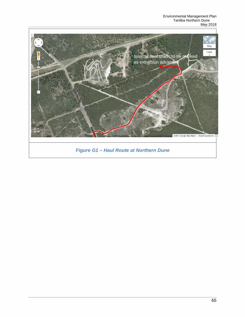
Environmental Management Plan Tanilba Northern Dune
May 2018
65
Figure G1 – Haul Route at Northern Dune
Internal haul roads to be marked as extraction advances

Environmental Management Plan Tanilba Northern Dune
May 2018
66
Figure G2 – Haul Route from Northern Dune to Salt Ash
Oyster Cove Road
Lemon Tree Passage Road

Environmental Management Plan Tanilba Northern Dune
May 2018
67
Figure G3 – Refuelling and Lay Down Area Location
Extraction Area
Laydown Area

Environmental Management Plan Tanilba Northern Dune
May 2018
68
Appendix I - Risk Register

Environmental Management Plan Tanilba Northern Dune
May 2018
69
Appendix J - Dust Monitoring Program J.1 Introduction
This dust monitoring program has been developed to provide a program of monitoring to demonstrate that operations at Sibelco’s Northern Dune site do not exceed air quality criteria and create adverse impacts on local residents at any privately-owned land.
J.2 Dust Management Criteria
Air Quality criteria have been provided for the project in the Development Approval (Ref 09_0091) issued by Minister for Planning and Infrastructure dated 8 March 2013. This is contained in Schedule 3, Condition 6. The condition requires the following:
The Proponent shall ensure that all reasonable and feasible avoidance and mitigation measures are employed so that particulate matter emissions generated by the project do not exceed the criteria listed in Tables 2 to 4 at any privately-owned land. Tables 2, 3 and 4 are referenced below as Table J1, J2 and J3 respectively. Sibelco undertakes all reasonable and feasible dust avoidance and mitigation measures for this project which are described in section 6.2.5 of the EMP. Sibelco will monitor the effectiveness of these measures by undertaking a dust monitoring program as described in section J3 below.
Table J1 – Long term criteria for particulate matter
Pollutant Averaging Period Criterion d
Total suspended particulate (TSP) matter
Annual 90 µg/m3 a
Particulate matter < 10µm (PM10) Annual 30 µg/m3 a
Table J2 – Short term criterion for particulate matter
Pollutant Averaging Period Criterion d
Particulate matter < 10µm (PM10) 24 hour 50 µg/m3 a

Environmental Management Plan Tanilba Northern Dune
May 2018
70
Table J3 – Long term criteria for deposited dust
Pollutant Averaging Period Maximum increase in deposited dust
level
Maximum total deposited dust
level
Deposited dust c Annual 2 g/m2/month b 4 g/m2/month a
Notes:
a – Total impact (i.e. incremental increase in concentrations due to the projects plus background concentrations due to all other sources)
b – Incremental impact (i.e. incremental increase in concentrations due to the projects on their own)
c – Deposited dust is to be assessed as insoluble solids as defined by Standards Australia AS/NZS 3580.10.1:2003 Methods for sampling and analysis of ambient air – Determination of particulate matter – Deposited matter – Gravimetric method
d – Excludes extraordinary events such as bushfires, prescribed burning, dust storms, sea fog, fire incidents, illegal activities or any other activity agreed by the Director General in consultation with DECCW
J.3 Dust Monitoring
J.3.1 Monitoring program
Dust deposition gauges shall be located at the two nearest privately-owned residences, as shown in Figure J1 at the end of this program.
D5 is located to the north-west of the extraction area at the entry to Oyster Cove. D5 will be located off of Oyster Cove Road in Lot 5, in an area representative of the nearest privately-owned residences in Oyster Cove. D3 is located to the north-east of the extraction area on land owned by local resident Mark Scandrett. Consultation with Mark on site has determined the best location for the installation of the depositional dust gauge. These locations can be seen below as Dust Monitoring Locations (Compliance).Furthermore, two comparative depositional dust gauges are located on the south-western and north-eastern boundary of Lots 11-13.Gauges have been placed in these locations to determine the amount of air borne dust exiting the operation at the points of the property closest to residents. These locations monitor the effectiveness of the site’s dust avoidance and mitigation measures, not a measure of compliance against the Project Development Approval. This data will be used as a comparison for findings at privately-owned land.All gauges shall be analysed on a monthly basis. They shall be installed and monitoring commenced prior to operations commencing, in order to obtain background results.

Environmental Management Plan Tanilba Northern Dune
May 2018
71
J.3.2 Monitoring conditions
The placement of dust gauges shall be continuous, however the following will be noted:
• Incidence of any fires, including bushfires, in the local area; • Any extraordinary wind events that have resulted in large dust movement
Sampling results will be void in the following situations:
• If the flagon or funnel break; • In the event of litter, bird droppings or any tampering being placed in the flagon.
J.3.3 Monitoring equipment
Dust gauges will be installed as per the requirements contained in AS/NZS 3580.10.1:2003 Methods for sampling and analysis of ambient air – Determination of particulate matter – Deposited matter – Gravimetric method.
Specifically, information regarding the dust deposition gauge and stand are shown below, as reproduced from AS/NZS 3580.10.1:2003.

Environmental Management Plan Tanilba Northern Dune
May 2018
72
Where total suspended particulates and PM10 are required to be monitored, monitoring will comply with the Approved methods for the Sampling and Analysis of Air Pollutants in New South Wales, DEC, 2007. Specifically this will follow one of the following methods:
Table J4 – Analysis Methods
Method No.
Parameter Measured Method
AM-15 Particulate matter – TSP – high volume sampler method AS 2724.3-1984
AM-18 Particulate matter – PM10 – high volume sampler with size selective inlet
AS 3580.9.6-1990
AM-22 Particulate matter – PM10 - TEOM AS 3580.9.8-2001
J.3.4 Analysis of Samples
Samples will be analysed in accordance with the relevant Australian Standard, as outlined in the previous section.
Environmental Management Plan Tanilba Northern Dune
May 2018
73
All laboratory analysed samples will be sent to a NATA accredited laboratory for analysis.
J.3.5 Monitoring personnel
Sibelco personnel will conduct dust gauge monitoring, training in the requirements of the relevant Standard Operating Procedure (SOP) will demonstrate competence.
TSP and PM10 monitoring will be conducted by an appropriate consultant if deemed necessary as part of an investigation.
J.3.6 Monitoring procedures
Sibelco personnel will conduct dust gauge monitoring as outlined in the SOP and record information on the field sheets. Sibelco staff undertaking the monitoring will be specifically trained in the SOP prior to commencing works.
Any abnormal circumstances or signs of tampering will be recorded during the monthly inspections, which will take place during the gauge collection. Photographs of the bottles will be taken during collection.
J.4 Reporting
J.5 The results from the two Compliance gauges will be compiled and reported to the Department in the AEMR. Exceedances will be calculated using a rolling 12-month average. If the month-by-month average exceeds the criteria outlined in the tables above, the data will be reported to the Department, as outlined in the DMP and recorded annually in the AEMR. An investigation into the exceedance will follow and be submitted to the Department within seven days.Investigation
If an exceedance of criteria is found to have occurred at privately-owned land, then data from the comparative gauges will be used as a part of the investigation to determine if the operations have released a non-compliant level of dust. In this instance, comparative data will also be reported in the AEMR. These gauges can be seen below as D4 and D6.
J.6 Comparison of Results
Due to the placement of the gauges being between 350m to 500m away from the extractive operation, there is a likelihood that non-operational dust could be received in the flagon. If high readings are found at private-residences, but not on the boundary of the operations, it is likely that the exceedance was due to environmental dust and not the result of operations. This theory would be presented in exceedance investigations submitted to the Department.
Comparison of results will be compiled and an analysis completed as a part of and ICAM investigation to determine the root cause of any exceedance found to have occurred at Compliance monitoring locations.
Environmental Management Plan Tanilba Northern Dune
May 2018
74
J.7 Non-Compliance
All exceedances in dust monitoring will be entered into the Site Action Management System (SAM) as the relevant incident. SAM will be used to track the investigation into the exceedance and to record corrective actions and any notifications to regulatory authorities.
It will be recorded as a Level 2 incident and an ICAM investigation to determine the root cause of the exceedance will be undertaken and provided to all relevant regulators within one week of notification.
Dust control monitoring at the site boundary will not be recorded as a exceedance against the criteria shown above and will only be recorded as comparative results used in investigations. Results which trigger an exceedance of criteria will result in the following management response:
• Recording as a Level 2 incident which will be recorded in SAM • A local site based investigation conducted to evaluate the effectiveness of dust
mitigation controls; and • Identify corrective actions to improve the effectiveness of dust mitigation controls to
ensure all reasonable and practical measures are in place for the operation.
J.8 Dust Suppression
• Current methods to suppress the release of operational dust are described in section 6.2.5 of the EMP.

Environmental Management Plan Tanilba Northern Dune
May 2018
75

Environmental Management Plan Tanilba Northern Dune
May 2018
76
Figure J1 – Northern Dune Dust Monitoring Locations