environmental management strategy for dredging final finalreview committees, and approved by the...
TRANSCRIPT
FINAL Approved January 2006
1
Environmental Management Strategy for Dredging in the Fraser River Estuary
It has been several years since the Fraser River Estuary Management Program (FREMP) provided a review of navigation and dredging activities in the Fraser River estuary. The last review, conducted in 1991, resulted in a FREMP report entitled Navigation, Dredging and Environment in the Fraser River Estuary (FREMP, 1991). Since this report, several significant changes have occurred with respect to navigation and dredging in the estuary. With the new Canada Marine Act in 1998, the federal government no longer dredged the lower river, and in the interests of their tenants and business operations, the Ports began dredging the main navigation channel. The Ports have since pursued funding to allow a long-term dredging program in the lower Fraser River. In 1998, FREMP developed a Sediment Budget to ensure sustainable sediment removal for the lower river, and annually reports on dredging activities and sediment removals. In 2001, FREMP produced Dredge Management Guidelines for dredging proponents, and in 2002 the Sediment Budget model was reviewed and confirmed as an appropriate sediment management tool. Trends in navigation include increasing container traffic through Greater Vancouver ports and marine terminals are expanding at Roberts Bank, Port North Fraser, and in the Fraser River Port to accommodate that growth. Ships are also becoming much bigger, and the main navigation channel in the Fraser has been deepened to accommodate their access upriver to key port facilities. Use of the river is becoming more intensive, diverse and valued, including an increasing population’s demand for riverfront residential and recreational areas. Consolidation of industrial operations, such as in the forest sector, has led to land uses changes along the river, in some cases with new residential developments replacing former sawmills. More parks have been established in the estuary, along the water or in park reserves like Douglas Island. The focus has moved from preserving industrial lands along the river to focusing on critical strategic nodes for intermodal movements and short-sea shipping. Fewer on-land dredge disposal sites mean that most sediment dredged from the river goes to ocean disposal. For those remaining on-land disposal sites, sediment dredged from the river has to be moved longer distances to reach the disposal sites. Navigation, Dredging and the Environment The lower Fraser River provides a waterway for the transport of over 50 million tonnes of coastal and deep sea cargo annually. It also supports as many as 650 million young

FINAL Approved January 2006
2
salmon migrating downstream and up to 10 million spawning salmon every year as well as other important fish species such as eulachon and white sturgeon. The estuary is a major stopping point for migrating birds on the Pacific flyway including the largest population of wintering waterfowl in Canada. River uses and marine transportation generate demands for development and maintenance of navigation channels. The dredging program varies depending on annual sedimentation and navigation requirements. Dredging activities are also currently managed to avoid conflict with fisheries resources and aquatic habitat, mainly by limiting dredging to specific locations and through the use of scheduling and timing restrictions. The interdependencies between these components of the management system require a continual balancing of objectives, which the FREMP partners try to achieve through their policy coordination and project review functions. Estuary Management Plan The Estuary Management Plan for the Fraser River was updated in 2003 and includes a Navigation & Dredging Action Program with two objectives:
1. To develop and maintain a functional navigation system that support water-dependent development in a manner that protects environmental quality; and
2. To manage the removal of sediment from the river in a manner that balances with all components of the sediment budget of the river system.
One of the actions in the Estuary Management Plan is to develop a comprehensive dredge management strategy for the estuary that will provide a contextual framework regarding the navigation system’s relationship with the environment, review existing studies relating to dredging impacts, and recommend areas in the estuary requiring further study. This document is intended to fulfil this action, and provide a means to help manage the dredging system in the estuary. In 2004, FREMP completed a review of data needs with respect to the biological impacts of dredging in the estuary. The findings of this work have been incorporated into the Environmental Management Strategy for Dredging in the Fraser River Estuary, which outlines recommendations for further study in each reach and thereby provides a policy framework to end uncertainties associated with site-by-site requirements for habitat studies. The Strategy will help proponents understand their responsibilities when applying for approval of dredging projects, facilitate the FREMP Environmental Review Committee evaluation of dredging applications, and ultimately, ensure that dredging in the estuary proceeds in an environmentally sustainable manner. The approach taken recognizes the differences between annual maintenance dredging, periodic dredging and new dredging applications. The Strategy is a companion document to the FREMP Dredge Management Guidelines (Revised 2005), which describe the Fraser River Sediment Budget and are a resource for proponents preparing dredging applications for review through the FREMP Environmental Review Committee. This document forms part of an overall consideration

FINAL Approved January 2006
3
of dredging activities in the Fraser River estuary, focusing on the environmental component. It does not address issues such as physical changes in the river, trends in navigation, and the beneficial use of dredgeate. Acknowledgements The Report is a joint effort of a FREMP Water and Land Use Committee working group comprised of staff with dredging knowledge and expertise, including:
• Environment Canada • Fisheries and Oceans Canada • Canadian Coast Guard, Waterways Development • Fraser River Port Authority • North Fraser Port Authority • Ministry of Environment
This document was drafted by FREMP dredging working group members with support from FREMP staff, reviewed by the FREMP Water and Land Use and Environmental Review Committees, and approved by the BIEAP-FREMP Management Committee in January 2006. Report Structure The Environmental Management Strategy for Dredging is an assessment of the river by channel segment. For the nine segments, the Strategy identifies major natural features, port activities and industrial uses, the status of environmental knowledge about dredging impacts, and data gaps. Appendices contain background information including an overview of the estuary, port operations, dredging and environmental issues.

FINAL Approved January 2006
4
PART 1 - Dredging Strategy for Each Channel Segment The FREMP area of interest includes the land and water outside the dikes and between Kanaka Creek and the outlet of Pitt Lake in the East, the estuary drop-off in the West, Point Grey to the North, and the international boundary to the South, including Boundary Bay and Semiahmoo Bay. For purposes of this dredging strategy, the estuary is divided into nine channel segments as noted on the following page, extending from the Sand Heads Lighthouse upstream to the eastern end of Barnston Island. These segments are based on channel morphology, water quality, tidal influence, and the effect of major channel-training works. Each section that follows includes the following information:
• An overview of the channel segment including major functions and industry type and water lots;
• A review of Port and dredging activities within the channel;
• The status of our environmental knowledge vis-à-vis biological impacts of
dredging in that channel, including data gaps, mitigation measures, ongoing studies and environmental sensitivities.
In terms of the environmental management approach to dredging, in all channel segments dredging is managed in a way that avoids or minimizes adverse impacts to the environment. Timing restrictions are applied to hydraulic suction dredging and large clamshell dredging projects to avoid entrainment of juvenile salmonids and eulachon. Dredging is also required to be conducted in a manner that minimizes the release of suspended sediments in the water column and in a manner that does not disturb intertidal vegetation. These requirements are set out in the FREMP Dredge Management Guidelines (2005) and through the Coordinated Project Review process through FREMP.

FINAL Approved January 2006
5

FINAL Approved January 2006
6
1. NORTH ARM TIDAL
Channel Segment Overview The North Arm segment is split around Sea Island (Vancouver International Airport). The majority of flow is carried in the north branch (about 10% of total Fraser River flow) and the water is brackish in quality. This segment is channelized but not heavily industrialized, with much of the shoreline park, golf courses or included in the Sea Island Conservation Area on the north side of Sea Island. Highly productive shoreline is present, especially in the river mouth and estuary where Iona Island (north branch) and Swishwash Island (middle branch) are found. A channel is maintained by direction of flow on the north side of the North Arm Jetty, but substantial deposition still occurs at the river mouth. Salmonid fish utilization within the segment is largely confined to adult holding and migration in the fall and downstream juvenile migration and rearing in the spring to mid-summer periods. The North Arm Tidal also supports several other species of fish including an annual upstream eulachon spawning migration in the spring, surf smelt spawning, and white sturgeon. The eulachon run and surf smelt spawning attracts marine mammals including seals and sea lions. Information on fish species utilization of the Segment can be found in Appendix 2.

FINAL Approved January 2006
7
Waterfowl utilization (e.g. roosting and feeding) is most concentrated in intertidal marshes and mudflats along the shoreline, although some diving ducks utilize deeper water for foraging for fish. Port Activities within the Channel Segment Within the North Arm, log booms are transported from coastal harvest areas into the estuary (for processing at lumber and paper manufacture mills) and lumber, pulp chips and wood by-products (e.g. sawdust and hog fuel) are transported out for use at other locations. The North Arm is the main transport route for log booms, being a shorter distance to up-river mills. Cement and aggregates, fish distribution and processing, and general freight are also important but in much less tonnage than forestry related cargo. The Middle Arm provides concentrated pleasure craft moorage. Commercial fishing also occurs within the port, particularly by the Musqueam First Nation. Dredging Activities Dredging is not carried out regularly in this segment. Infrequent maintenance dredging occurs at the upstream end of Sea Island and the North Arm Jetty; this includes maintaining boat access to channels on both sides of Sea Island and supporting log storage leases and tugboat access to the Point Grey log booming grounds, a long term storage area providing freshwater storage for the forestry sector to prevent marine borers from ruining the logs. Once every five years or more, maintenance dredging also takes place at barge load/unloading facilities, sawmill sites, and so forth. Status of Environmental Knowledge A dredging data needs study through FREMP identified several feasible data needs for the North Arm Tidal segment. The data needs identified included:
• An assessment of the impacts of dredging on the abundance and distribution of resident demersal fish in bar habitat where dredging of bar habitat is proposed.
• An assessment of the impacts of dredging on the abundance and distribution of benthic invertebrates.
Data has not been compiled for this segment, however a study has been conducted in the Sand Heads segment (Taylor and Perrin, 2005). The Sand Heads segment may be sufficiently similar to the North Arm Tidal segment in which case results from the study could be extrapolated to the North Arm Tidal segment (see Section 3). While the study in the Sand Heads segment only includes an assessment of the impacts of dredging on the abundance and distribution of benthic invertebrates (i.e. abundance and distribution of resident demersal fish in bar habitat is not being addressed), it should be noted that bar habitat, as well as the need to dredge bar habitat, in the North Arm Tidal segment is relatively rare. Should any large scale dredging projects that may need to be undertaken on a frequent basis involving bar habitat be proposed, further information to address the above data need should be collected and/or assessed.

FINAL Approved January 2006
8
2. NORTH ARM MESO-TIDAL
Channel Segment Overview The North Arm Meso-Tidal channel segment extends from New Westminster Quay to the eastern end of Sea Island. Historically, it conveyed less than 10% of total Fraser River discharge, but installation of training structures that started in the 1930s have increased the flow to 10-15 %. This has increased channel flow and reduced sediment deposition. This segment flows through the heavily urbanized areas of Burnaby, Vancouver, New Westminster, and Richmond, and receives discharges from industrial and municipal sources. Historically, there were several major industrial discharges which have since have been discontinued due to closing of industrial operations or installation of improved waste water processing. It is assumed that the lower water quality has improved over historical conditions, but there has not been extensive water quality monitoring to show current conditions. Because of the heavy urbanization, productive fish and wildlife habitat is limited to narrow areas of riparian vegetation and intertidal marsh along the shoreline including the North Fraser Port Authority's Fish Habitat Compensation Bank. A large area of highly productive fish and wildlife habitat in the Segment can be found in the City of Burnaby's Terminus Park in the Big Bend area of the River.

FINAL Approved January 2006
9
Salmonid fish utilization within the segment is largely confined to upstream adult migration in the fall and downstream juvenile migration and rearing in the spring to mid-summer periods. The Segment also supports several other species of fish including an annual upstream eulachon spawning migration in the spring and white sturgeon. The eulachon run attracts marine mammals (e.g. seals and sea lions). Information on fish species utilization of the Segment can be found in Appendix 2. Waterfowl utilization (e.g. roosting and feeding) is mostly concentrated in intertidal marshes and mudflats along the shoreline, although some diving ducks utilize deeper water for foraging for fish. Port Activities within the Channel Segment Log booms are transported from coastal harvest areas into the estuary (for processing at lumber and paper manufacture mills) and lumber, pulp chips and wood by-products (e.g. sawdust and hog fuel) are transported out for use at other locations. The North Arm is the main transport route for log booms, being a shorter distance to up-river mills. Cement and aggregates, fish distribution and processing, and general freight are also important but in much less tonnage than forestry related cargo. Commercial fishing also occurs within the North Fraser Port, particularly by the Musqueam First Nation. Dredging Activities This segment is characterized by infrequent navigational channel dredging, but dredging is vital for port operations, and has been a maintenance activity since the port began in 1913. The main channel extends along the North Arm upriver from the mouth, south of Mitchell Island upstream to 22nd Avenue past the Queensborough Bridge in New Westminster, where it joins the Fraser Port-administered channel. Main channel maintenance dredging is required periodically at critical points in the harbour (e.g. upstream of Mitchell Island). These points must be maintained but they generally do not result in large volumes of dredged material. Maintenance dredging for barge load/unloading facilities, sawmill sites, terminals, recreational docks and so forth, usually occur on a greater than five year cycle. There is infrequent operation of one transfer pit located at the Big Bend (see below). Infrequent and localized clamshell dredging takes place in association with industrial sites to maintain access for industrial boat traffic. Another important dredging activity is forestry industry support, which includes dredging to support log handling areas at sawmills and access for tugs. A transfer pit at Burnaby Big Bend was established in 1990 and was again used in 2003-2004 to transfer sand from St. Mungo’s Bend in the South Arm to a property in south Burnaby. This project may be ongoing and involve the transfer of 100,000–150,000 m3 of sand pumped upland each year for several years. The pit will be backfilled by hopper dredge using sand from Annieville Channel and St Mungo’s Bend in the South Arm Meso-Tidal segment. Immediately upstream was the site of Caisson dredging that was completed in 2003 to remove contaminated sediment. Maintenance dredging typically occurs upstream of Poplar Island and in the vicinity of Mitchell Island.

FINAL Approved January 2006
10
Status of Environmental Knowledge A dredging data needs study through FREMP identified several feasible data needs for the North Arm Meso-Tidal segment. The data needs identified included:
• An assessment of the impacts of dredging on the abundance and distribution of resident demersal fish in deep thalweg habitat.
• An assessment of the impacts of dredging on the abundance and distribution of resident demersal fish in bar habitat where dredging of bar habitat is proposed.
• An assessment of the impacts of dredging on the abundance and distribution of benthic invertebrates.
An assessment of dredging impacts on benthic communities to address some of the above data needs is ongoing in the North Arm Meso-Tidal segment. This study, funded by Fraser River Pile & Dredge, is associated with the operation of a transfer pit at Big Bend. Sampling took place in November 2003 and in May 2004 following dredging in January 2004. To date, researchers have found a decline in catchable fish in relation to site disturbance, and the site appears to be remaining in disturbance three months after dredging occurred. The apparent dredging effect may be due to less mobility of fish into and outside of the dredging area that may cause slow recruitment back into the dredge site after disturbance. However, the data also suggests that resident fish re-colonized the transfer pit within four months after dredging. While the above study will address a number of data gaps for the North Arm Meso-Tidal segment, a remaining feasible data need is:
• An assessment of the impacts of dredging on the abundance and distribution of resident demersal fish in bar habitat where dredging of bar habitat is proposed.
However, bar habitat, as well as the need to dredge bar habitat, in the North Arm Meso-Tidal Segment is relatively rare. Should any large scale dredging projects that may need to be undertaken on a frequent basis involving bar habitat be proposed, further information to address the above data need should be collected.

FINAL Approved January 2006
11
3. SAND HEADS
Channel Segment Overview The Sand Heads channel segment extends west of Steveston to the end of the Steveston Jetty and provides the main access into the Fraser River for large ships. Being at the mouth of the Fraser River, it has a much more marine environment than the upstream channel segments. The Steveston North Jetty is a 8.8-km long rock mound training dyke that extends to the Sand Heads light house and assists in maintaining an outflow channel, however dredging is still required on a regular basis to maintain channel depth. Past dredging that resulted in removal of 400,000 m3/year was costly and lead to modification of the Jetty to improve sand transport by river flow. A wall was constructed along the inside curve of the Steveston Jetty to maintain current velocity and encourage scouring. However, the deflection simply moved sand deposition further downstream, and annual dredging is still required. The channel in the Sand Heads Segment is being deepened in 2004 through 2006 to facilitate an increase in vessel draft from 10.7 m to 11.5 m. Because the Segment is bounded laterally by training structures, fish and wildlife habitat in the Segment is limited. Salmonid fish utilization within the Segment is largely

FINAL Approved January 2006
12
confined to adult holding and upstream migration in the fall and downstream juvenile migration in the spring to mid-summer periods. The Segment also supports several other species of fish including various marine fish species, an annual upstream eulachon spawning migration in the spring, sandlance which are an important forage fish, and white sturgeon. The eulachon run attracts marine mammals including seals and sea lions. Information on fish species utilization of the Segment can be found in Appendix 2. Waterfowl utilization is limited given the limited present of intertidal marshes and mudflats along the shoreline. Some diving ducks may utilize deeper water for foraging for fish. Port Activities within the Channel Segment The Sand Heads segment is the entry into Fraser Port, and is characterized by dense and varied marine traffic including deep-sea ships, commercial fishing boats, barges and tugs. Dredging Activities This segment is characterized by frequent main channel dredging of more than once a year, with use of a hopper dredge and ocean disposal of material. The deep-sea ships entering the navigation channel require a draft of 11.5 m to reach the upstream end of the shipping channel 36kms later at New Westminster. Infrequent use of a cutter suction dredge also takes place with ocean disposal of material. Status of Environmental Knowledge A dredging data needs study through FREMP identified several feasible data needs for the Sand Heads Segment. The data needs identified included:
• An assessment of the impacts of dredging on the abundance and distribution of resident demersal fish in deep thalweg habitat.
• An assessment of the impacts of dredging on the abundance and distribution of resident demersal fish in bar habitat where dredging of bar habitat is proposed.
• An assessment of the impacts of dredging on the abundance and distribution of benthic invertebrates.
• An assessment of fish (Sandlance) entrainment during dredging. In 2004, a study was undertaken by the FRPA to address some of the above data gaps at Sand Heads (Taylor and Perrin, 2005). Sampling took place in February and April 2004, with dredging in March 2004. Results showed no consistent difference between control and dredge sites with regards to changes in the catch rate of sandlance, other fish species or density of benthic invertebrates between February (before dredging) and April (after dredging). The results therefore indicate that any effect on benthic fish and benthic invertebrates is very short term, with rapid recruitment into the dredged sites after disturbance. While the above study addresses a number of data gaps for the Sand Heads segment, a remaining feasible data need is:
FINAL Approved January 2006
13
• An assessment of the impacts of dredging on the abundance and distribution of resident demersal fish in bar habitat where dredging of bar habitat is proposed.
However, bar habitat, as well as the need to dredge bar habitat, in the Sand Heads segment is relatively rare. Should any large scale dredging projects that may need to be undertaken on a frequent basis involving bar habitat be proposed, further information to address the above data need should be collected.
FINAL Approved January 2006
14
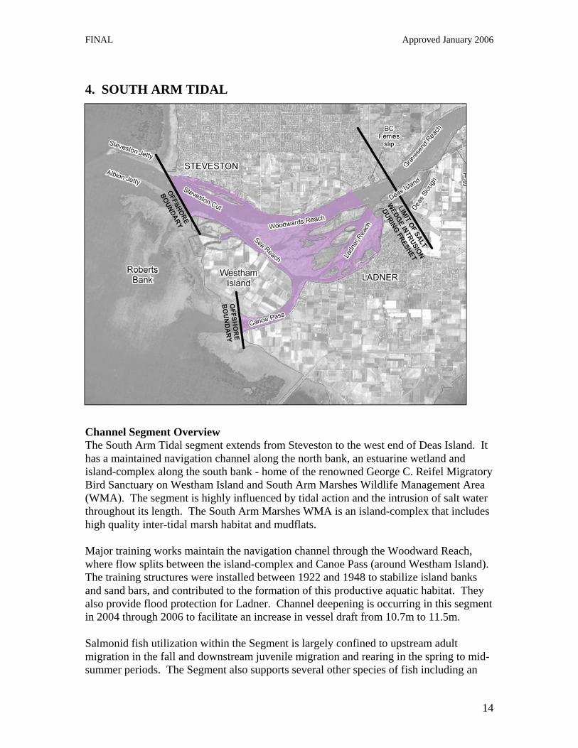
4. SOUTH ARM TIDAL
Channel Segment Overview The South Arm Tidal segment extends from Steveston to the west end of Deas Island. It has a maintained navigation channel along the north bank, an estuarine wetland and island-complex along the south bank - home of the renowned George C. Reifel Migratory Bird Sanctuary on Westham Island and South Arm Marshes Wildlife Management Area (WMA). The segment is highly influenced by tidal action and the intrusion of salt water throughout its length. The South Arm Marshes WMA is an island-complex that includes high quality inter-tidal marsh habitat and mudflats. Major training works maintain the navigation channel through the Woodward Reach, where flow splits between the island-complex and Canoe Pass (around Westham Island). The training structures were installed between 1922 and 1948 to stabilize island banks and sand bars, and contributed to the formation of this productive aquatic habitat. They also provide flood protection for Ladner. Channel deepening is occurring in this segment in 2004 through 2006 to facilitate an increase in vessel draft from 10.7m to 11.5m. Salmonid fish utilization within the Segment is largely confined to upstream adult migration in the fall and downstream juvenile migration and rearing in the spring to mid-summer periods. The Segment also supports several other species of fish including an

FINAL Approved January 2006
15
annual upstream eulachon spawning migration in the spring and white sturgeon. The eulachon run attracts marine mammals (e.g. seals and sea lions). Information on fish species utilization of the Segment can be found in Appendix 2. Waterfowl utilization (e.g. roosting and feeding) is mostly concentrated in intertidal marshes and mudflats along the shoreline, although some diving ducks utilize deeper water for foraging for fish. Port Activities within the Channel Segment Key activities in the South Arm Tidal segment are deep sea shipping in the navigation channel, commercial fishing hubs located in Steveston and Ladner harbours, fish processing facilities and marinas. Commercial, First Nations and recreational fishing takes place throughout this segment, including areas in and around the West Arm Marshes and Canoe Pass between Westham Island and Delta. Dredging Activities Very frequent maintenance dredging of the navigation channel occurs, primarily by hopper dredge, especially in Steveston Cut. The hopper delivers sand to the Sand Heads ocean disposal site or to transfer pits located upstream. There is also infrequent and localized clamshell dredging to maintain boat access to moorage in small craft harbours, mainly in areas of Ladner and Steveston. Infrequent clam shell/cutter suction dredging of secondary channels takes place in Ladner Reach and Sea Reach to maintain navigation for small vessels; proponents dredging their water lots to maintain access. Status of Environmental Knowledge Studies in the South Arm Tidal segment include a study of the environmental effects of harbour construction activities at Steveston, BC (Anderson et al., 1981). The study found that the subtidal silt benthic invertebrate community repopulated a small dredged area within one month after dredging stopped. A dredging data needs study through FREMP identified a feasible data need for the South Arm Tidal segment as:
• An assessment of the impacts of dredging on the abundance and distribution of resident demersal fish in bar habitat where dredging of bar habitat is proposed.
However, the need to dredge bar habitat in the South Arm Tidal segment is relatively rare. Should any large scale dredging projects that may need to be undertaken on a frequent basis involving bar habitat be proposed, further information to address the above data need should be collected.

FINAL Approved January 2006
16
5. SOUTH ARM MESO-TIDAL
Channel Segment Overview The South Arm Meso-Tidal segment is a channel confined by bank protection and training structures. This segment conveys approximately 80 to 85% of total Fraser River discharge downstream of the trifurcation. The segment includes Deas Slough, a centre of recreational boating activity, as well as Gunderson Slough and Tilbury Slough in Delta which are both characterized by shallow bars at their mouth. The main navigation channel moves from Gravesend Reach through St Mungo’s Bend on the south side of Annacis Island, and upriver through Annieville Channel. Much of the reach is industrialized activity along the shoreline, as reflected in the relatively higher percentage of FREMP green-coded shoreline. The South Arm Meso-Tidal also contains the New West Trifurcation training structure, which splits the flow down multiple channels and serves to decrease sedimentation, thus reducing dredging requirements. Fish and wildlife habitat in the main channel primarily consists of a narrow band of riparian and intertidal marsh vegetation along the shore. Productive habitat is present is sloughs such as Deas Slough and Tilbury Slough. Salmonid fish utilization within the segment is largely confined to upstream adult migration in the fall and downstream juvenile migration and rearing in the spring to mid-summer periods. The segment also supports several other species of fish including an

FINAL Approved January 2006
17
annual upstream eulachon spawning migration in the spring and white sturgeon. The eulachon run attracts marine mammals (e.g. seals and sea lions). Information on fish species utilization of the segment can be found in Appendix 2. Waterfowl utilization (e.g. roosting and feeding) is mostly concentrated in intertidal marshes and mudflats along the shoreline, although some diving ducks utilize deeper water for foraging for fish. Port Activities within the Channel Segment This segment contains three deep-sea terminals: Fraser Wharves has one berth, Annacis Auto Terminals has two berths for automobiles, and Fraser Surrey Docks has three container berths, three general cargo berths and one side-loading berth (from river to ship, or vice versa). FRPA Richmond Properties at the foot of Broad Street is an industrial park containing marine related facilities, with a large portion of waterfront property slated for deep sea terminal. Several other industries are located at or adjacent to the Surrey Properties including a lumber mill, steel processor, and distribution centres for specialty grains, forest products and rolled paper. BC Ferries has a ferry maintenance slip in Deas Basin on the north side of the river in Richmond. Dredging Activities Annual maintenance dredging with the hopper and cutter suction dredge occurs at several locations within the segment. Sand is delivered to transfer pits located throughout the estuary for disposal at sea or upland. St. Mungo’s Bend and Annieville Channel near Fraser-Surrey Docks are two sites where regular dredging is necessary to allow access by large ship traffic. Two transfer pits are present within the lower segment in the vicinity of Tilbury Island. Frequent operation of these transfer pits occurs, from which sand is pumped to upland sites for market sales using a cutter suction dredge. Infrequent and localized (no more than once every five years) clamshell dredging takes place to maintain boat access to small craft harbours (e.g. Gunderson Slough) and for boat and barge access (e.g. Burr Landing near the mouth of Tilbury Slough which was dredged in the late 1990s) and moorage (Seaspan Coastal Intermodal, BC Ferries Deas Basin, Delta Cedar, and Bella Coola Fisheries). The mouths of Tilbury and Gunderson Sloughs or adjacent areas have been dredged in the past for vessel access to moorage and will likely require ongoing dredging in the future. Status of Environmental Knowledge A dredging data needs study through FREMP identified several feasible data needs for the South Arm Meso-Tidal segment. The data needs identified included:
• An assessment of the impacts of dredging on the abundance and distribution of resident demersal fish in bar habitat where dredging of bar habitat is proposed

FINAL Approved January 2006
18
• An assessment of the impacts of dredging on the abundance and distribution of benthic invertebrates.
Studies in the South Arm Meso-Tidal segment include an assessment of sturgeon habitat at Fraser Surrey Docks by ECL-Envirowest for Berth 10 (ECL Envirowest Consultants Ltd., 2001). However, the assessment did not include an assessment of environmental effects of dredging as part of Berth 10 construction. Another study conducted in the Segment includes a pre and post dredge benthic assessment of Deas Basin (Prime Eight Consulting, 2001). The study found impacts to benthic invertebrate and benthic fish after dredging but the study did not continue to determine if impacts continued over the long term. A study has also been completed in the Barnston segment (Perrin et al., 2003 and Perrin and Rempel, 2000), and the Barnston segment may be sufficiently similar to the South Arm Meso-Tidal segment in which case results from the study could be extrapolated to the South Arm Meso-Tidal segment. Of the above two data needs, the study in the Barnston channel segment only included an assessment of the impacts of dredging on the abundance and distribution of benthic invertebrates. While the study included a review of resident fish for that segment, it did not include an assessment of the impacts of dredging on the abundance and distribution of resident demersal fish in bar habitat where dredging of bar habitat is proposed (since Barnston is not characterized by bar habitat). It should be noted that, while bar habitat in the South Arm Meso-Tidal segment is relatively rare, bar habitat does exist at the entrance to Gunderson Slough and Tilbury Slough (Burr Landing) where dredging may need to occur in the future. In the past, dredging at these two sites has occurred on an infrequent basis and involved relatively low volumes of dredge material. Should any large scale dredging projects that may need to be undertaken on a frequent basis involving bar habitat be proposed, further information to address the above data need should be collected.

FINAL Approved January 2006
19
6. ANNACIS CHANNEL
Channel Segment Overview Annacis channel extends from the upstream end of Annacis Island (Shoal Point) downstream to Lafarge Canada west of Lion Island and conveys approximately 5 to 10% (design conveyance) of total Fraser River discharge downstream of the New Westminster trifurcation. Annacis Channel flows for 7 km on the north side of Annacis Island and is approximately 60 – 100 m wide. This channel is very different from Annieville Channel and St. Mungo’s Bend south of Annacis Island, in that Annieville Channel and St. Mungo's Bend has extensive “picket fence” and “continuous fence” training works that maintain velocities and minimize dredging needs. Annacis Channel has no training works. The bed sediment has a finer grain size than main channel, possibly the result of the New Westminster trifurcation upstream. The Annacis Channel Segment includes Lion and Don Island park reserves, which have been protected through an intergovernmental purchase and provide critical habitat for fish and wildlife. Log booms are present over shallow mud-bottom habitat along the south shore. About 55% of the segment shoreline is red-coded with high biological values based on the presence of riparian trees, intertidal marsh and mudflat habitat. This red-coded area encompasses Patrick Island Foreshore Reserve on the north side of Annacis Island.

FINAL Approved January 2006
20
Salmonid fish utilization within the segment is largely confined to upstream adult migration in the fall and downstream juvenile migration and rearing in the spring to mid-summer periods. The segment also supports several other species of fish including an annual upstream eulachon spawning migration in the spring. The eulachon run attracts marine mammals (e.g. seals and sea lions). Information on fish species utilization of the segment can be found in Appendix 2. Waterfowl utilization (e.g. roosting and feeding) is mostly concentrated in intertidal marshes and mudflats along the shoreline, although some diving ducks utilize deeper water for foraging for fish. Port Activities within the Channel Segment Annacis Channel is home to a number of industrial and commercial businesses as well as floathomes. Marine traffic in the segment is varied: recreational and fishing vessels, tugs, barges and log storage as well as mills. Dredging Activities The channel thalweg is 9–15 m deep with velocities up to 9 knots during freshet, which appears to maintain channel depth. Little or no channel dredging is required on an annual basis. Channel dredging was last active in 1995, but some areas are filling in and may require dredging in the future. Log booms currently ground at low tide and it has been suggested that, if the log cannot be relocated to deep water, dredging be undertaken to allow tug access and log boom transport at all tides. Very frequent clam shell dredging (at least once per year and probably more) is used at localized areas along the south shore to prevent grounding of barges and allow small tug access to booming areas. There is a main channel in-river disposal site just off Lion and Don Islands, which is in a scour zone. Status of Environmental Knowledge A dredging data needs study through FREMP identified several feasible data needs for the Annacis Channel segment. The data needs identified included:
• An assessment of the impacts of dredging on the abundance and distribution of resident demersal fish in thalweg habitat where dredging of thalweg habitat is proposed.
• An assessment of the impacts of dredging on the abundance and distribution of resident demersal fish in bar habitat where dredging of bar habitat is proposed.
The Annacis Channel segment may be quite different from the adjacent South Arm Meso-Tidal segment - because dredging is infrequent and the effects of disturbance may be large, with long time periods for recovery between disturbance events. The finer sediments in the Annacis Channel segment may also lead to different effects from

FINAL Approved January 2006
21
dredging compared to that found in the main stem Fraser River. In this channel segment a better understanding of the impacts of dredging on the abundance and distribution of resident demersal fish in thalweg habitat and in bar habitat is needed. Should any large scale dredging projects that may need to be undertaken on a frequent basis be proposed in the Annacis Channel Segment, further information to address the above data needs should be collected.
FINAL Approved January 2006
22
7. SAPPERTON
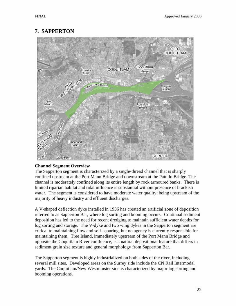
Channel Segment Overview The Sapperton segment is characterized by a single-thread channel that is sharply confined upstream at the Port Mann Bridge and downstream at the Patullo Bridge. The channel is moderately confined along its entire length by rock armoured banks. There is limited riparian habitat and tidal influence is substantial without presence of brackish water. The segment is considered to have moderate water quality, being upstream of the majority of heavy industry and effluent discharges. A V-shaped deflection dyke installed in 1936 has created an artificial zone of deposition referred to as Sapperton Bar, where log sorting and booming occurs. Continual sediment deposition has led to the need for recent dredging to maintain sufficient water depths for log sorting and storage. The V-dyke and two wing dykes in the Sapperton segment are critical to maintaining flow and self-scouring, but no agency is currently responsible for maintaining them. Tree Island, immediately upstream of the Port Mann Bridge and opposite the Coquitlam River confluence, is a natural depositional feature that differs in sediment grain size texture and general morphology from Sapperton Bar. The Sapperton segment is highly industrialized on both sides of the river, including several mill sites. Developed areas on the Surrey side include the CN Rail Intermodal yards. The Coquitlam/New Westminster side is characterized by major log sorting and booming operations.

FINAL Approved January 2006
23
Sapperton Bar in the segment provides important habitat for fish and wildlife. Salmonid fish utilization within the segment is largely confined to upstream adult migration in the fall and downstream juvenile migration and rearing in the spring to mid-summer periods. The segment also supports several other species of fish including an annual upstream eulachon spawning migration in the spring. The eulachon run attracts marine mammals (e.g. seals and sea lions). Information on fish species utilization of the segment can be found in Appendix 2. Waterfowl utilization (e.g. roosting and feeding) is mostly concentrated in intertidal marshes and mudflats along the shoreline, although some diving ducks utilize deeper water for foraging for fish. Resident and migratory birds utilize river and upland habitat for feeding, nesting and raising young. Of particular importance is the heronry at the Coquitlam River Wildlife Management Area, with over 100 active nests. The Coquitlam floodplain forest forms a part of the remaining natural corridor connecting the Coquitlam River, Colony Farm, Douglas Island and Surrey Bend. The combination of varied habitat along the corridor supports a high diversity of birds and wildlife. The Sapperton segment has the highest proportion of green-coded (low productivity) shoreline in the estuary. Port Activities Sapperton Bar is a key log sorting and booming area on the river. Moorage exists for tugs and barges, and marine traffic includes recreational and fishing vessels, tugs and a variety of barges and scows (break bulk, bulk, container and log). Mill activity is prominent, and a number of barge ramps are in place. Dredging Activities This segment is characterized by infrequent navigational channel dredging. There has been channel maintenance dredging in the north channel, along with infrequent log-sort and maintenance dredging. Cutter-suction dredging/scalping of shallow bars and access channels - to allow access by small tugs for moving and sorting log booms - occurs on a very infrequent basis, no more than once every ten years. The north side of the Sapperton segment may be dredged in the future. Proposed dredging at the outflow of the Coquitlam River is on hold due to outstanding unresolved issues over a historical site. Status of Environmental Knowledge With respect to dredging of shallow bar habitat (cutter suction dredging), the Sapperton segment is sufficiently understood. A dredging impact assessment funded by Fraser River Port Authority has recently been completed at Sapperton Bar in the channel segment. The project involved assessments of:

FINAL Approved January 2006
24
• the impacts of dredging on the abundance and distribution of resident demersal fish in bar habitat,
• the impacts of dredging on the abundance and distribution of benthic invertebrates.
The project involved sampling in 2002 and 2003 followed by laboratory and data analyses in 2004, and included the collection of benthic invertebrates, turbidity observations and fish data collection in the area both before and after dredging. Detailed study results are presented in Taylor et al., 2004. However, in summary, the study found that:
• no impacts of dredging were detected on the benthic invertebrate or resident fish communities at Sapperton Bar. Their findings suggested that the biological communities were highly resilient, with recovery through re-colonization completed in less than 3.5 months after dredging was completed.
• eulachon may swim through the Sapperton Bar area enroute to spawning sites upstream and would not be affected by modified substrate depths caused by dredging events several months earlier.
• the distinctive community structure, diversity and abundance of benthic invertebrates and fish at Sapperton Bar appears resilient to dredging at the scale that was tested in the project, and that this feature of the site seems due to the geomorphological attributes of bar habitat.
For large scale dredging projects proposed in the Sapperton channel segment, no further information is required to be collected.

FINAL Approved January 2006
25
8. LOWER PITT RIVER
Channel Segment Overview The Lower Pitt River is a tributary to the Fraser River that drains Pitt Lake - the largest freshwater tidal lake in North America - and its upper watershed. The channel segment begins north of Douglas Island, at the confluence of the Pitt and Fraser Rivers, and continues north to the mouth of Pitt Lake. Differences between the Pitt River and Fraser River in water quality, suspended sediment load, organic matter content, bed substrate, and flow regime are expected but unconfirmed. Although there is low sediment transport from the Pitt River, a “reverse delta” does occur due to tidal backwater effects in the area just upstream of the Pitt’s confluence with the Fraser River. As witnessed by the high proportion of FREMP red-coded shoreline habitat, highly productive wetland and riparian habitats are present on both sides of the Pitt River, particularly in the upper part of the channel segment around the Pitt-Addington Marsh Wildlife Management Area and in the lower reach on the eastern bank in Pitt Meadows. The segment is home to a large number of resident bird species such as herons, hawks, passerines and waterfowl, and is an important stopover point on the Pacific Flyway for migratory birds. Waterfowl utilization (e.g. roosting and feeding) is most concentrated in

FINAL Approved January 2006
26
intertidal marshes along the shoreline, although some diving ducks utilize deeper water for foraging for fish. The Pitt segment also supports runs of sockeye, coho, pink, chum, and chinook salmon. Salmonid fish utilization within the segment is largely confined to upstream adult salmonid migration in the fall and downstream juvenile migration and rearing in the spring to mid-summer periods. The channel also supports several species of non-game fish, including eulachon which use the lower Pitt River for spawning and white sturgeon. Seas and sea lions migrate to the area during the spring eulachon migration. Information on fish species utilization of the segment can be found in Appendix 2. More information is also available in the Pitt River Reach Overview on the FREMP website. Port Activities within the Channel Segment Some industrial development occurs in the Lower Pitt River and it is a log boom staging area, particularly in the area below the rail and highway bridges. The channel segment is occupied by small vessel and float home marinas, boat and barge moorage, mill sites, barge ramps, aggregate supplies as well as log storage and dewatering sites. Boat traffic consists of pleasure boats, water sports, tug boats, log tows and rock scows. The deeper tugs and scows that operate in this reach require 4.5m of depth to operate safely. The Fraser-Pitt corridor is an important navigation route for tug and vessel traffic, including transport of log booms to processing mills. Two major towing operations, Harken Towing and Forrest Marine, are located along the Lower Pitt River. Water-related commercial and residential development occurs in Port Coquitlam along the river, and new residential development is planned on the former Genstar lands in Pitt Meadows. Log booms are located along much of the shoreline. Dredging Activities Dredging is not carried out regularly in this segment. While significant dredging took place in the Pitt River segment between 1970 and 1996, the Lower Pitt River is now characterized by infrequent navigational channel dredging. Maintenance of barge load/unloading facilities, marinas and so forth occurs approximately on a five year cycle or longer. There is infrequent clamshell dredging (more than every 5 years) to maintain moorage depths for boats using the Alouette Marina and Pitt River Boat Club and for vessels using barge loading ramps associated with a gravel pit operation run by Lehigh on the western bank of the Pitt River in Coquitlam, and the Pitt River Quarries (Warren Paving and Materials) facility on the east side in Pitt Meadows. A transfer pit has been identified in the Lower Pitt River but is not in use at present and was last used in 1997. There is potential to use it again if demand arises, as the pit was backfilled with high quality sand. Status of Environmental Knowledge A dredging data needs study through FREMP identified several feasible data needs for the Lower Pitt River segment. The data needs identified included:

FINAL Approved January 2006
27
• Abundance and distribution of eulachon
• An assessment of the impacts of dredging on the abundance and distribution of resident demersal fish in bar habitat where dredging of bar habitat is proposed.
• An assessment of the impacts of dredging on the abundance and distribution of benthic invertebrates.
Under high frequency stress, a system has less opportunity to recover fully so each successive event changes the system less. The Lower Pitt River segment may be quite different from the Fraser River - because dredging is infrequent and the effects of disturbance may be large, with long time periods for recovery between disturbance events. The low natural turbidity in the Lower Pitt River segment may also lead to larger effects from turbidity and suspended sediment generated during dredging compared to that found in the main stem Fraser River. In this channel segment a better understanding of the impacts of dredging on the abundance and distribution of eulachon, resident demersal fish in bar habitat, and benthic invertebrates is needed. Should any large scale dredging projects be proposed in the Lower Pitt River segment, further information to address the above data needs should be collected.

FINAL Approved January 2006
28
9. BARNSTON
Channel Segment Overview The Barnston channel segment begins in the east where Kanaka Creek meets the Fraser River, continuing around both sides of Barnston Island to encompass the west side of Douglas Island park reserve. The segment is characterized by an irregular meandering morphology with major islands and associated side channels. Vegetated riverbanks and islands provide riparian habitat although riprap occurs along many sections of the shoreline. Water quality is generally good and industrial activity is relatively low. Tidal influence on flow and water depth is present but diminishes at the upstream end. Channel narrowing at the Port Mann Bridge causes a backwater effect extending upstream, which favours deposition of sand and silt. The segment is characterized by small industrial operations including sawmills, in Parson’s Channel between Surrey and Barnston Island. Halo Sawmills and Fraser River Log Salvage are the two main industrial operations on the Pitt Meadows side, along with the Pitt Meadows Airport. On the south bank, the CN Intermodal yard extends from the Port Mann Bridge to Surrey Bend Regional Park. A major CP Intermodal yard is located in Pitt Meadows near the confluence of the Fraser and Pitt Rivers. Agricultural operations exist on Barnston Island and Pitt Meadows where adjacent land use within the dykes includes berry framing and hay crops.

FINAL Approved January 2006
29
Shoreline and adjacent upland habitat include large undeveloped forested areas at Douglas Island - a regional park reserve - and Surrey Bend Regional Park. Intertidal marsh and unvegetated mudflat and sandflat occur along much of the shoreline, and provide important fish and wildlife habitat. Resident and migratory birds utilize river and upland habitat for feeding, nesting and raising young. The Segment supports large runs of Pacific salmon and smaller but ecologically important runs of eulachon. Indeed, eulachon spawning and presence of white sturgeon has been confirmed in the Barnston segment (Perrin et al, 2003). These anadromous fish runs attract marine mammals and birds, as well as support commercial and First Nation fisheries. Information on fish species utilization of the Segment can be found in Appendix 2. Port Activities within the Channel Segment The Fraser River in the Barnston segment provides an important navigation route for forestry, aggregate, pleasure craft and commercial and First Nation fishing activities. Log booms occur along most of the shoreline. Tug and vessel traffic includes the transport of log booms to processing mills in Parson’s Channel and on the Pitt Meadows side. Dredging Activities Very infrequent navigational dredging of the main channel occurs in the Barnston segment. Infrequent clamshell dredging (no more than once every five years) takes place in shoreline areas near sawmills to support tug and barge access and moorage. Two transfer pits are located in the main channel in the vicinity of Barnston Island, one at the east end and one at the west end of the channel north of Barnston Island (described by Perrin et al. 2003). Frequent use occurs of the two transfer pits using cutter suction dredging for delivery of sand to upland markets. The hopper dredge is also used for backfilling using sand dredged from downstream navigation channels. Status of Environmental Knowledge With respect to transfer pit operations (cutter suction dredging), the Barnston segment is sufficiently well understood. In 2000, the Fraser River Port Authority contracted Limnotek Research & Development Inc. (Limnotek) to conduct a three-year study to assess the possible impact that dredging may have on the aquatic community in the Fraser River near Barnston Island. The project mainly involved assessments of:
• riverbed substrate
• the abundance and distribution of spawning eulachon,
• the impacts of dredging on the abundance and distribution of resident demersal fish in thalweg habitat,
• the impacts of dredging on the abundance and distribution of benthic invertebrates.

FINAL Approved January 2006
30
The study area covered a portion of the Fraser River upstream of the Port Mann Bridge near Barnston Island adjacent to the main navigation channel. The project at Barnston Island was structured into two assessments: one at the lower end of Barnston Island and the other at the upper end of Barnston Island, adjacent to the Katzie First Nation dock. Dredging occurred at the lower transfer pit in March 2000 and at the upper transfer pit between November 2001 and January 2002. Limnotek compiled data sets from the two sites with a dredge study conducted in the Fraser River near Mission, BC into one report for FRPA. Detailed results from the study are presented in Perrin et al., 2003 and Perrin and Rempel, 2000. However, in summary, the study found that:
• dredging removed coarse sand and pebble sized particles which were replaced (by backfilling of the transfer pits) with a homogeneous mixture of medium and fine sand that remained during the 10 months of observations after dredging.
• eulachon embryos and larvae originated mostly from spawning upstream of Barnston Island, and recommended that future dredging should avoid sites meeting certain criteria (including water depths, velocities and temperatures) to ensure no disturbance of substrates that appear to be selected by spawning eulachon.
• recolonization of the benthic community (composed of mainly chironomid species: genera Chemovskiia, Robackia, and Beckidia) occurred within 6 to 9 months after dredging.
• white sturgeon are suggested to use the dredge sites as mainly a transit corridor and would not directly be affected by dredging.
• prickly sculpin (Cottus asper) were the most common fish collected during the study. However, the very low relative abundance of fish at the dredge sites suggest that very few fish were likely to be entrained by dredging or otherwise indirectly affected.
While the above study addressed a number of previously identified data gaps for the Barnston segment, the FREMP dredging data needs study in 2004 identified a remaining feasible data need as:
• An assessment of the impacts of dredging on the abundance and distribution of resident demersal fish in bar habitat where dredging of bar habitat is proposed.
However, bar habitat, as well as the need to dredge bar habitat, in the Barnston segment is relatively rare. Should any large scale dredging projects that may need to be undertaken on a frequent basis involving bar habitat be proposed, further information to address the above data need should be collected.

FINAL Approved January 2006
31
SUMMARY The Environmental Management Strategy for Dredging in the Fraser River Estuary provides a contextual framework regarding the navigation system’s relationship with the environment, reviews existing studies relating to dredging impacts, and recommends priorities for further study in each channel segment as the need arises. The overall goal of the Strategy is to give proponents a clearer sense of data requirements for their dredging applications, and facilitate the reviews provided by the FREMP Environmental Review Committee. In doing so, this document contributes to maintaining a functional navigation system and to sustainable sediment removal from the river. The FREMP secretariat will compile information on existing biological impact studies related to dredging in the estuary, and will continue to update this information as proponents and partners complete new studies. In an iterative approach, the FREMP partners - particularly DFO - will assess the results of completed studies and determine what findings can be applied to other parts of the estuary so that the knowledge base can be expanded over time. These discussions will take place at the FREMP Water & Land Use Committee and with dredging expertise from the relevant partners. It should be noted that the Environmental Management Strategy for Dredging does not address all issues with respect to dredging, including the long-term funding of dredging activities, sediment disposal issues, physical changes in the river, trends in navigation, and the beneficial use of dredgeate. These broader issues will continue to be explored by the FREMP partners, including the Fraser River Port Authority and Environment Canada’s Disposal at Sea group.

FINAL Approved January 2006
32
References Anderson, E.P., I.K. Birtwell, S.C. Byers, A.V. Hincks, and G.W. O’Connell. Environmental effects of harbour construction activities at Steveston, British Columbia. Part 1. Main report. Can. Tech. Rept. Fish. Aquat. Sci. No. 1070, 1981. BC Ministry of Environment, Water Management Branch. Water Quality Assessment & Objectives for the Fraser River from Hope to Sturgeon and Roberts Banks, 1998. ECL Envirowest Consultants Ltd. Fraser Surrey Docks Berth 10 sturgeon habitat assessment. Letter to Fraser River Port Authority dated May 17, 2001. Environment Canada. Hinterland Who’s Who: Estuaries, Habitat for Wildlife, 1993. (Text: R.W. Butler, with assistance from N.K. Dawe, A. Reed, J. Sirois, and H. Blokpoel). FREMP. A Living, Working River: the Estuary Management Plan for the Fraser River, 2003. FREMP. Dredge Management Guidelines (Revised), 2005. FREMP. Navigation, Dredging and Environment in the Fraser River Estuary, 1991. Northwest Hydraulic Consultants Ltd. Lower Fraser River Sediment Budget Analysis Final Report (Report to FREMP), 1999. Northwest Hydraulic Consultants Ltd. Review of the Lower Fraser River Sediment Budget Final Report (Report to FREMP), 2002. Perrin, C.J. and L.L. Rempel. Eulachon (Thaleichthys pacificus) spawning activity in the Fraser River at Barnston Island, 2000. Perrin, C.J., J.L. Taylor and T.B. Stables. Effects of dredging and transfer pit operations on the aquatic community in the lower Fraser River near Barnston Island, 2003. Perrin et al. Data Needs for Assessing the Impact of Dredging Activities on Aquatic Communities in the Fraser River Estuary (Draft final report to FREMP), 2004. Taylor, J.L. and C.J. Perrin. The impact of channel deepening on the benthic community in the Steveston and Sand Heads reaches of the Fraser River estuary, 2005. Taylor, J.L., C.J. Perrin and T.B. Stables. Effects of dredging on the aquatic community in the Lower Fraser River at Sapperton Bar, 2004.

FINAL Approved January 2006
33
APPENDIX 1 BACKGROUND Hydrology and Sedimentation The Fraser River has a pronounced seasonal snowmelt runoff or “freshet” between April and July, which produces an almost ten-fold increase in river discharge from winter low flow. The freshet brings with it millions of tonnes of material that is transported downstream. Sorting of sediment occurs in the lower Fraser, with larger particles (e.g. gravel) deposited first. Gravels are deposited in the Agassiz-Mission reaches, and coarser sand sorted below Mission. Between Port Mann Bridge and Steveston major sorting is completed, with finer materials located further downstream. Sediment deposited within the channel is responsible for creating habitat features such as sand bars, islands, and beaches that serve as rearing and spawning habitat for fish, as well as feeding areas for various birds and waterfowl (FREMP, 1991). Sand deposition also creates shoals and high spots that can be hazardous to navigation and needs to be removed to ensure sufficient depth for ships. The sediment load of the Fraser River may be transported as bed material load (material coarser than 0.177mm moving in contact with the riverbed) or wash load (finer material held in suspension) (NHC, 2002). Bed material load represents the portion of the sediment load that is derived from entrainment and erosion of the sediment making up the main channel of the river. However, the bed material load only accounts for only a small fraction of the total load in the lower Fraser River. Most transported sediment is fine “wash load” derived from erosion in the upper reaches of the watershed and flushed through the river system without affecting the morphology of the main channel (NHC, 2002). The sediment outflow at Sand Heads is estimated at about 30%, which means 70% of the sediment load is deposited in the main channel or other distributary branches. Sediment processes in the estuary are complicated by the tidal influences and salinity intrusion (FREMP, 1991). Tidal influences affect river velocity such that deposition occurs on a rising tide and at slack water, with retrainment on the ebb. The associated salt wedge also influences sediment transport processes. The salt wedge penetrates to Annacis Island during winter low flow and during freshet, up to Sea Island in the North Arm and Deas Island in the main stem remaining within the outer 10km of the estuary (BC Ministry of Environment, 1998). Ecological Overview Estuaries, where fresh water from rivers meets and mingles with salt water from oceans, are among the most biologically productive ecosystems on Earth. Studies have shown that primary production is higher in estuaries than in grasslands, forests, and even areas of intensive agriculture. Primary production is the biological process in which plants convert the sun’s energy by photosynthesis into food that animals can use. In estuaries, most of the primary production occurs in the intertidal foreshore where marshes and bottom-dwelling algae grow in abundance.

FINAL Approved January 2006
34
In estuaries, only a few animals graze directly on the living plant material produced each year. All dead plant material accumulating at the end of the growing season forms detritus. Detritus consists of microscopic fungi, bacteria, protozoa, and other micro organisms along with the dead plant material. Small benthic or bottom dwelling invertebrates thrive on this detritus. The millions of small invertebrates living in the riverbed sediments of the estuary are eaten by fish. Small fish are in turn eaten by larger fish, birds and mammals.
Source: Environment Canada, 1993 The Fraser River estuary supports valuable fish and wildlife populations. The estuary supports the largest wintering concentrations of migratory birds in Canada. The estuary is also important to migratory fish species such as salmon and eulachon and to resident (e.g. non-anadromous) fish species. The estuary plays an essential role in the life history of many fish species, and provides important rearing and feeding habitats for juvenile salmon and other fish species. The brackish water of the estuary also gives juvenile salmon time to gradually adjust to saltwater conditions before they migrate to the ocean. Other fish species also spawn in the estuary. For example, eulachon spawn in gravel areas near Barnston Island. A list of fish species documented in the Fraser River estuary is provided in Appendix 2. River Use & Port Facilities The Fraser River estuary supports various shipping and river-oriented industries, major commercial, recreational and First Nation fisheries, significant wildlife populations, and growing recreational land and water uses. Marine transportation on the lower river consists of deep sea vessels in the South Arm, coastal vessels (e.g. tugs and barges) in the North Arm, log storage areas, commercial fishing boats and recreational boats. A number of marinas are also located along the estuary, from which commercial and recreational boaters launch or moor their boats. The North Fraser Port Authority (NFPA) administers Port North Fraser, a shallow draft harbour with a required depth of 4.5 m for coastal traffic, which includes the North and Middle Arms of the Fraser River. It has 29 kilometres of tidal-influenced waterway and a long established port and industrial infrastructure. The Port is of vital importance to navigation, particularly related to the forestry sector.

FINAL Approved January 2006
35
The Fraser River Port Authority (FRPA) administers Fraser Port, a major deep-sea port located on the main arm of the Fraser River, with a purpose of facilitating economic development and trade. The Fraser Port’s jurisdiction extends along the first 60 km of the Fraser River from Kanaka Creek to Sand Heads, encompassing 270 km of shoreline, and includes navigable water within the harbour boundaries as well as certain upland sites, foreshore and waterlots owned by the provincial and federal governments. The Port has two marine terminals at Fraser-Surrey docks and Annacis Auto Terminals, and is developing properties in Richmond and Delta. The Port is of vital importance to navigation and the local economy. Major export and import cargo movements through the Fraser Port ranges from logs and lumber, steel, automobiles, general cargo and cement, to pulp. Cargo throughput reached a record 35.9 million metric tonnes in 2003, with Port activity-related employment of over 12,000 direct jobs. Navigation Channel Ships have navigated the lower Fraser River since the mid-1800s as a major access corridor for freight and passengers of British Columbia. The maximum draft for ships at this time was less than 6m, and only 2.7m at low water (FREMP, 1991). As the population increased, the federal government began dredging the river to improve conditions for ship navigation. A reliable navigation channel was established in the late 1800s and maintained by the federal government, which undertook dredging in the lower Fraser River until 1998. The Fraser River delta comprises three main channels: the South Arm which carries up to 85% of the river flow below New Westminster; the North Arm (15%), and the Middle Arm (which carries 1/3 of the North Arm flow). Within these river channels, there are designated navigation channels including both main and secondary navigation channels and approach channels from various port facilities. Channels are maintained by dredging and the natural scouring created with river training structures. Jetties at the river mouth and other river training structures are engineering works that were built to stabilize the river and align the navigation channel to the river’s natural flow. River training works were built in strategic places. In certain areas this was done by either splitting the flow down multiple channels (New West Trifurcation) or down a single reach of the river (Annieville). In some cases the training works increased velocity, which decreased sedimentation thus reducing dredging requirements (Trifurcation, Albion Wall and Steveston Jetty). Some training works also included designs to help protect valuable marsh area (Kirkland Island.) and prevent bank erosion (Sapperton V-Dyke). A side benefit of the training structures is flood control. As of 1991, training structures in the lower Fraser River totalled approximately 38.5 km in linear length. The Canada Coast Guard, Fraser River Port Authority, and North Fraser Port Authority are all involved in river training structures and/or dredging operations in the estuary. Shipping and navigational needs are continually changing and expanding. Shipping trends have evolved toward larger deep sea vessels. Cargo ships destined for the Fraser

FINAL Approved January 2006
36
Port must utilize the additional water depth generated by the daily high tides to traverse the river upstream to New Westminster. The South Arm main navigation channel has been designed to make maximum use of the tidal cycle. Consequently, the maintenance and improvement of navigation channels on the river through dredging, river training and marine navigation services require careful consideration of a wide range of river uses and values. The maximum draft for ships using the South Arm Channel is determined by the depth of water available at high tide, less an underkeel clearance of the ship’s draft. Vessels are generally limited to those belonging to the PANAMAX class. The maximum draft for vessels is being increased to 11.5m with a FRPA channel deepening project occurring along the Steveston Jetty, Steveston Cut, and Woodward Reach in 2004 through 2006. The maintained width of the Fraser River deep-sea shipping channel is between 200-250m within a total wetted river width of over 650m. The North Arm channel width is 60m with a nominal dredge grade of 4.5m below local low water. Hydrographic charts and depth soundings are developed and updated annually through the Port Authorities, Canadian Coast Guard and Public Works & Government Services Canada. Dredging Operations Sediment removal is accomplished through dredging. Dredging in the estuary is mainly associated with navigation channel maintenance, but also includes maintenance of marinas, fishing harbours, moorages and berths, and log handling areas. With the change in policy by the federal government in 1998, the Port Authorities in the interests of their business operations and tenants opted to dredge the navigation channels. As noted above, the Port undertakes, on a relatively rare basis, capital dredging to deepen the navigation channel to permit larger ships to enter the river. On an annual basis, dredging is generally limited to navigation channel maintenance dredging by the Ports and maintenance dredging (e.g. at marinas) by Port tenants. The dredging program varies depending on annual sedimentation and navigation requirements, among other factors. Dredging activities are also restricted by requirements to avoid conflict with fisheries resources and aquatic habitat. Dredging Methods A variety of dredging methods have been used to effectively dredge sand to meet socio-economic and environmental objectives. In the Fraser River Port Authority main navigation channel, a trailing arm hopper dredge (“Titan”) “vacuums” sand off the riverbed and stores it in a hopper on-board the vessel. The sand may be moved and deposited by the Titan to an approved transfer pit, from where a cutter-suction dredge is used to pump material from the pit to an upland storage site. Alternatively, the Titan may transport sand to an approved ocean disposal site, typically located offshore of the Sand Heads Lighthouse. Where pumping distances are relatively short (e.g. <2 km), a cutter-suction dredge may also be used to directly dredge navigation channels and pump material through a floating or submersed pipeline to an adjacent upland storage site (e.g. channel segment close to Fraser Surrey Docks). A benefit of this method is that the material is moved hydraulically to its final destination without the cost of re-handling.

FINAL Approved January 2006
37
The need for maintenance dredging is highly variable along the channel, with some sites persistently accumulating sediment on an annual basis and other areas requiring dredging every 4 or 5 years. Some sites may require dredging even less frequently, depending on the use for the site and natural patterns of sediment transport. In confined areas, such as harbours and alongside berths, a clamshell dredge is mainly used. This is a mechanical excavator dredge that uses a single bucket attached to the dredge crane with cables. The material is brought up to the surface and emptied into a nearby disposal site or barge for transportation to a disposal facility. The clamshell dredge allows for relatively precise removal of sand but in small volumes. While not currently authorized within the FREMP area by the regulatory environmental agencies, propeller wash dredging is known to occur at some sites, usually associated with small craft marinas. For this approach, a tug boat is secured in position in shallow water and uses wash from its propeller turning under high throttle to move sediment into deeper flowing water, thus clearing shallows for boat moorage. FREMP Sediment Budget The goal has been to maintain safe river access for commercial shipping year-round while minimizing changes to the morphology of the channel. To ensure that the amount of sand removed from the river is in balance with the incoming sediment each year, FREMP developed a Sediment Budget in 1997. The Sediment Budget for the Fraser River estuary is a measure of the net change in sediment stored in the river as a function of total inflow of sediment at Mission minus the outflow into Georgia Strait (NHC, 1999). The objective of the budget is to manage removal of sand from the River on a sustainable basis. That means that it will be managed to ensure that annual removals will not result, on average, in a net change (degradation or aggradation) to the shape of the river bed. The FREMP Sediment Budget measures deposits and removals of coarse sand. Coarse sand - often referred to simply as sand and sometimes referred to as sediment - is material that has a grain size between 0.177 and 2.00mm. Material smaller than this size do not generally deposit in the FREMP area in large quantities; material larger than 2.00mm (usually referred to as gravel) generally deposits upstream of the FREMP area of interest and is thus not covered by FREMP work. The Sediment Budget is calculated based on the amount of coarse sand entering and depositing in the Fraser River below Mission. In 2002, the Sediment Budget was reviewed and consultants confirmed that the model remains a valid tool for monitoring sustainable sediment removal from the river, and that the long-term view should be the focus of management (i.e. 10 years) rather than year-to-year variations in volumes (NHC, 2002). Between 1997 and 2004, the Sediment Budget shows that 10.53 million m3 was removed from the river through dredging, and a net infill of 0.81 million m3 of sand has occurred in the main arm of the lower Fraser River.

FINAL Approved January 2006
38
FREMP Dredge Management Guidelines FREMP developed Dredge Management Guidelines in 2001 to provide the dredging industry and others with information on the FREMP Sediment Budget and the existing guidelines for dredging in the Fraser River. The report reflected a consensus among the regulatory agencies regarding the general approach to dredging within the estuary. The Guidelines were revised in 2005. The Sediment Budget process, when coupled with the Dredge Management Guidelines, are intended to move the FREMP partners a significant step towards the goal of balancing sand removals with the river’s sediment budget. The Guidelines are a technical resource for proponents preparing applications for dredging that will be reviewed by the FREMP Environmental Review Committee. Dredge Material Disposal Generally, dredge material is disposed of at four types of sites:
1. on-land development sites, where dredge material is used for pre-load and fill;
2. on-land stockpile sites, where material is sold for commercial purposes;
3. disposal at sea and in-river disposal sites, where material is disposed of at approved sites at Point Grey or Sand Heads or in the river.
4. in-river transfer pits, where material is temporarily stored prior to pumping ashore to development or stockpile sites; and
Upland Disposal Material to be disposed upland must comply with the BC Environmental Management Act and its regulations, such as the Contaminated Sites and Hazardous Waste regulations and also comply with applicable municipal bylaws. Ocean Disposal The disposal of dredge material in the area of the river subject to tidal influence requires approval from Environment Canada under the Disposal at Sea Regulations of the Canadian Environmental Protection Act (CEPA). Interim Contaminant Testing Guidelines for Ocean Disposal were also developed in 2000. Disposal at Sea sites are at Point Grey and Sand Heads. An in-river disposal site is located along the Annacis Training Wall with other in-river disposal sites used on an infrequent basis. Transfer Pits Upland disposal of the dredge spoil usually is handled with the intermediary use of transfer pits. These pits typically hold 100,000 – 150,000 m3 of sand although larger volumes are possible. Areal dimensions can be 100m x 600m and the pits are dredged to a depth of 2 to 4 m. A total of seven transfer pits are located within the lower Fraser River estuary. Three pits are located within the South Arm of the river, two have been operated at Barnston Island (one temporary and one permanent), one is located in the Lower Pitt River (currently inactive) and one is located in the North Arm at “Big Bend”.

FINAL Approved January 2006
39
Sand disposal at any upland site that is adjacent to a transfer pit can be sold for use in the construction industry, providing a source of revenue to the FRPA to offset maintenance dredging costs. In the transfer process, sand from the pit is suction-dredged, pumped to shore in a floating or submerged pipeline and discharged to land within a diked enclosure to contain the discharge slurry. Supernatant water is pumped or flows back to the river. After dredging, the transfer pit is backfilled to nominal bed grade using sand delivered to the site in a trailing arm hopper dredge (Titan) that collects sand from maintenance dredging sites downstream of the Patullo Bridge. Backfilling of the site is necessary to prevent headward migration of the pit and to ensure a consistent supply of high quality material from the same location during subsequent dredging events. A single cycle of dredging and backfilling a complete transfer pit typically requires 10 – 14 days of continuous activity unless delays are encountered. Often several cycles of pumping and backfilling a transfer pit are used to supply a single upland project. It should be noted that the need for transfer pits could be eliminated by use of a hopper dredge having “pump to shore” capability. Biological Impacts of Dredging and Mitigation of Impacts It is important that dredging operations be managed in a way that avoids or minimizes adverse impacts on the environment. Most of the negative impacts on fisheries can be avoided through consideration of dredge methodology and operation, the timing of migration of different fish species, and avoidance of productive habitat areas. The coordinated environmental review of dredging applications by the FREMP Environmental Review Committee (ERC) includes reference to best management practices for dredging that have been in place for a number of years to minimize the impact of dredging activities. FREMP undertook a data needs study (Perrin et al., 2004) to identify and review critical data gaps with respect to the biological impacts of dredging in the estuary. The consulting report included a literature review on dredging effects, and focused on the five stressors that may affect biological communities using river habitat: (1) entrainment; (2) increase in turbidity and suspended sediment; (3) change in bed sediment texture and mobility; (4) change in channel morphology and geometry; and (5) introduction of contaminants. Specific stressors vis-à-vis fish and benthic communities in the estuary include: Entrainment Fish and benthic invertebrates can be directly impacted through entrainment by dredging equipment. For example, it has been well documented that hydraulic suction dredge equipment can entrain small fish into its dredge intake.

FINAL Approved January 2006
40
Each spring on an annual basis millions of juvenile salmon migrate downstream in the Fraser River while adult eulachon migrate upstream from the ocean to spawn in the estuary. In order to avoid the entrainment of juvenile salmon and eulachon, hydraulic suction dredging and large scale clamshell dredging undertaken in the Fraser River estuary is restricted so that there is no dredging conducted from March 1 to June 15 of any given year. In areas downstream of the George Massey Tunnel and Oak Street Bridge a further restriction is applied for water less than 5.0m deep where there is no dredging conducted from June 15 to July 15 of any given year. Note that these timing windows only address entrainment of salmon and eulachon and do not address entrainment of other fish species. An assessment of the entrainment by dredging of sand lance in the Sand Heads and South Arm Tidal Segments has been identified as a data gap (see Dredging Impact Data Gaps section below). Turbidity and Suspended Sediment Elevated turbidity and elevated concentrations of suspended sediments can impact fish in a number of ways as follows:
• Elevated turbidity and suspended sediments decreases the penetration of light into the water which can adversely affect fish feeding and lead to reduced survival.
• Suspended sediment in high concentrations can irritate the gills of fish and/or destroy the protective mucous covering of fish which can lead to increased susceptibility to infection and disease or even death.
• Settling of suspended sediment can bury and suffocate benthic invertebrates, which are a source of food for fish, and can bury and smother fish eggs.
Dredging impacts resulting from induced turbidity and/or elevated suspended sediment are addressed by requiring that dredging be conducted in a manner that minimizes the release of suspended sediments into the water column. For example, in the case of upland placement of dredged material from hydraulic suction dredging, ponds are required on the upland to settle suspended sediments prior to the return water being discharged to the Fraser River. While impacts can be minimized, it is not possible to entirely eliminate induced turbidity and/or elevated suspended sediment resulting from dredging activities. However, the resulting impacts from induced turbidity and/or elevated suspended sediment are usually temporary and transient and impacts to juvenile salmon and eulachon are addressed through timing restrictions. Intertidal vegetation Dredging can directly impact intertidal vegetation present along the margins or shoreline of the river. Intertidal vegetation is important as it indirectly provides a food source for benthic invertebrates which, in turn, are a food source for fish. However, dredging rarely impacts intertidal vegetation, as dredging is usually required to be conducted in a manner that does not disturb intertidal vegetation. Riverbed Disturbance

FINAL Approved January 2006
41
Dredging directly disturbs the riverbed which can impact areas where benthic invertebrates live and are produced and where fish (e.g. eulachon) spawn. Dredging will deepen the riverbed and can also result in changes to the sediment texture of the riverbed. These changes may affect the re-establishment of benthic invertebrate communities and use of the area by fish for spawning. An assessment of dredging in the Fraser River estuary with respect to riverbed disturbance and possible impacts to the abundance and distribution of benthic invertebrates and resident demersal fish, and to eulachon spawning areas has been identified as a data gap in some channel segments of the river. Dredging Impact Data Gaps The dredging data needs study in 2004 helped FREMP focus on what issues need attention in the estuary. Three potential areas of concern that the FREMP partners plan to address are:
• Basic descriptions of demersal and migratory fish distribution and abundance in thalweg habitat and in shallow near-shore and mud flat bar habitat.
• Degree of entrainment of sand lance and time course change in sand lance density due to hopper dredging.
• Links between dredging actions and physical drivers that may change benthic invertebrate abundance and composition over time.
These gaps in our understanding of the biological impacts of dredging, and the ongoing studies to address them, are noted within each section on channel segments.

FINAL Approved January 2006
42
APPENDIX 2 Fish Species in FREMP area The salinity of the Fraser River Estuary ranges from marine conditions nears it mouth, to brackish and to freshwater as one goes farther upstream. This variation in salinities leads to a range of fish species present in the estuary from those that can tolerate only marine water, only freshwater or both. The following list is divided into those that are migratory (present in the mainstem river only for relatively short-periods during some stages of their life cycle), semi-resident (periodically move along the length of the lower river or even out of it temporarily), and resident (usually complete their life cycle entirely within the estuary and associated waters without extensive movements along its length). Whether a fish species is likely to be present in water that is Marine (Outer Estuary) = M, Brackish (Inner Estuary) = B, or Freshwater (River) = F is also indicated. Marine (Outer Estuary) areas include the following Segments:
• North Arm Tidal • Sand Heads
Brackish (Inner Estuary) areas include the following Segments: • North Arm Meso-Tidal • South Arm Tidal • South Arm Meso-Tidal • Annacis Channel
Freshwater (River) areas include the following Segments: • Sapperton • Barnston • Lower Pitt River

FINAL Approved January 2006
43
Migratory Fish Species Family Petromyzonidae 1. Pacific Lamprey (Lampetra tridentata) B F Family Clupeidae 2. American Shad (Alosa sapidissima) M B Family Osmeridae 3. Eulachon (Thaleichthys pacificus) M B F 4. Longfin smelt (Spirinchus thaleichthys) M B F 5. Surf Smelt (Hypomesus pretiosus) M Family Salmonidae 6. Cutthroat trout (Oncorhynchus clarki) M B F 7. Rainbow trout (Oncorhynchus mykiss) M B F 8. Pink salmon (Oncorhynchus gorbuscha) M B F 9. Coho salmon (Oncorhychus kisutch) M B F 10. Chinook salmon (Oncorhynchus tshawytcha) M B F 11. Chum salmon (Oncorhynchus keta) M B F 12. Sockeye salmon (Oncorhynchus nerka) M B F Family Gasterosteidae 13. Threespine stickleback (Gasterosteus aculeatus) M B F
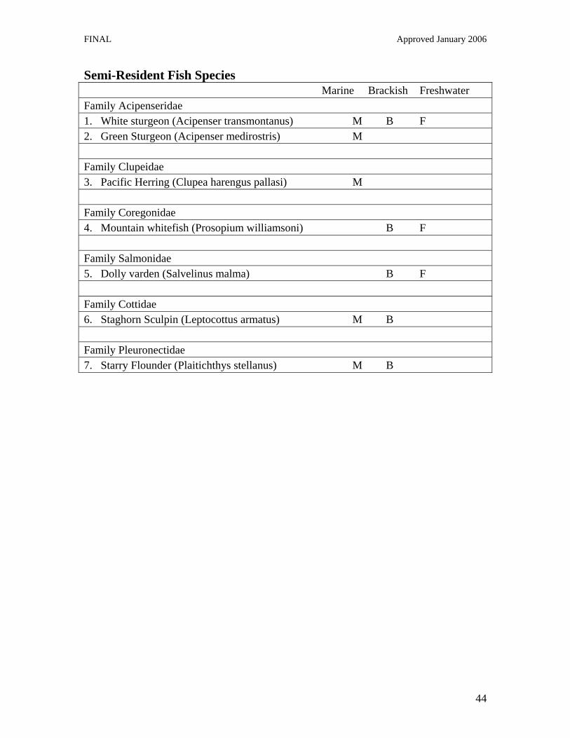
FINAL Approved January 2006
44
Semi-Resident Fish Species Marine Brackish Freshwater Family Acipenseridae 1. White sturgeon (Acipenser transmontanus) M B F 2. Green Sturgeon (Acipenser medirostris) M Family Clupeidae 3. Pacific Herring (Clupea harengus pallasi) M Family Coregonidae 4. Mountain whitefish (Prosopium williamsoni) B F Family Salmonidae 5. Dolly varden (Salvelinus malma) B F Family Cottidae 6. Staghorn Sculpin (Leptocottus armatus) M B Family Pleuronectidae 7. Starry Flounder (Plaitichthys stellanus) M B

FINAL Approved January 2006
45
Resident Fish Species Family Petromyzonidae 1. Western Brook Lamprey (Lampetra richardsoni) F Family Squalidae 2. Pacific Dogfish (Squalus acanthias) M Family Catostomidae 3. Bridgelip Sucker (Catostomus columbianus) B F 4. Largescale sucker (Catostomus macrocheilus) B F 5. Northern Mountain Sucker (Catomstomus platyrhynchus) F 6. Longnose Sucker (Catostomus catostomus) B F Family Osmeridae 7. Capelin (Mallotus villosus) M Family Ammodytidae 8. Pacific Sandlance (Ammodytes hexapterus) M Family Gadidae 9. Pacific Tomcod (Microgadus proximus) M Family Cyprinidae 10. Carp (Cyprinus carpio) B F 11. Redside Shiner (Richardsonius balteatus) B F 12. Pikeminnow (Ptychocheilus oregonensis) B F 13. Peamouth Chub (Mylocheilus caurinus) B F 14. Longnose Dace (Rhinichthys cataractae) B F 15. Brassy minnow (Hybognathus hankinsoni) F Family Ictaluridae 16. Brown Bullhead (Ictalurus nebulosus) B F Family Syngnathidae 17. Bay Pipefish (Syngnathus grisealineatus) M Family Centrarchidae 18. Black Crappie (Poxomis nigromaculatus) B F

FINAL Approved January 2006
46
Family Embiotocidae 19. Striped Seaperch (Embiotoca lateralis) M 20. Shiner Perch (Cymatogaster aggregata) M 21. Pile Perch (Rhacochilus vacca) M Family Gobiidae 22. Arrow Goby (Clevelandia ios) M Family Stichaeidae 23. Pacific Snake Prickleback (Lumpenus sagitta) M 24. Slender Cockscomb (Anoplarchus insignis) M 25. High Cockscomb (Anoplarchus purpurescens) M Family Pholidae 26. Penpoint Gunnel (Apodichthys flavidus) M 27. Crescent Gunnel (Pholis laeta) M 28. Saddleback Gunnel (Pholis ornata) M Family Hexagrammidae 29. Kelp Greenling (Hexagrammos decagrammus) M 30. Whitespotted Greenling (Hexagrammos steeleri) M 31. Masked Greenling (Hexagrammos octogrammus) M Family Cottidae 32. Padded Sculpin (Artedius fenestralis) M 33. Smoothhead Sculpin (Artedius lateralis) M 34. Rosylip Sculpin (Ascelichthys rhodorus) M 35. Spinynose Sculpin (Asemichthys taylori) M 36. Silverspotted Sculpin (Blepsias cirrhosus) M 37. Sharpnose Sculpin (Clinocottus acuticeps) M 38. Mosshead Sculpin (Clinocottus globiceps) M 39. Aleutian Sculpin (Cottus aleuticus) M B F 40. Prickly Sculpin (Cottus asper) M B F 41. Buffalo Sculpin (Enophrys bison) M 42. Great Sculpin (Myoxocephalus polyacanthrocephalus) M 43. Tidepool Sculpin (Oligocottus maculosus) M 44. Saddleback Sculpin (Oligocottus rimensis) M 45. Tadpole Sculpin (Psychrolutes paradoxus) M 46. Manacled Sculpin (Synchirus gilli) M
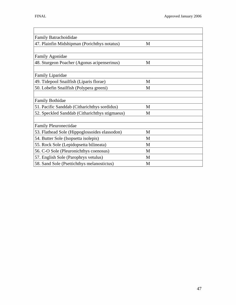
FINAL Approved January 2006
47
Family Batrachoididae 47. Plainfin Midshipman (Porichthys notatus) M Family Agonidae 48. Sturgeon Poacher (Agonus acipenserinus) M Family Liparidae 49. Tidepool Snailfish (Liparis florae) M 50. Lobefin Snailfish (Polypera greeni) M Family Bothidae 51. Pacific Sanddab (Citharichthys sordidus) M 52. Speckled Sanddab (Citharichthys stigmaeus) M Family Pleuronectidae 53. Flathead Sole (Hippoglossoides elassodon) M 54. Butter Sole (Isopsetta isolepis) M 55. Rock Sole (Lepidopsetta bilineata) M 56. C-O Sole (Pleuronichthys coenosus) M 57. English Sole (Parophrys vetulus) M 58. Sand Sole (Psettichthys melanostictus) M