environmental minor project refinement form
TRANSCRIPT

Environmental Minor Project Refinement Form
Request Prepared By: Sylvia Granados
Variance Request No.: 8
Project Name: West of Devers Upgrade Project
Date Approval Required: 3/1/2018
Date Submitted: 2/26/2018 Location: Pole 4140225E on Pettit Street in Moreno Valley and M4‐T3 and M4‐T2 Towers on the Valley ‐ Mayberry ‐ Moreno ‐ Vista 115‐kV line.
Landowner: SCE Easement in Moreno Valley and SCE ROW in Loma Linda.
Current Vegetative Cover/Land Use: Developed/Disturbed
Existing Sensitive Resource? NO YES Specify:
Modifying (check as many as apply): MITIGATION MEASURE PLAN/PROCEDURE SPECIFICATION DRAWING PERMIT CONDITION OTHER
Specify Source (e.g., Mitigation Measure B.5): Modifications to NTP #3 Telecom and NTP #4 Segment 2.
Description of Change and Justification (Attach additional sheets if needed.)
Attachments: CONSTRUCTION DRAWING ADDITIONAL ENVIRONMENTAL ANALYSIS CORRESPONDENCE OTHER:
New Splice Location for NTP #3
One overhead fiber optic cable splice, on Pole 4140225E, on Pettit Street, in Moreno Valley is required for the Vista‐Moreno tap to El Casco. The cable crew will drive to existing Pole 4140225E, park on along the paved street curb and walk along the shoulder of the road to access the existing splice box located on the pole. The work area will be approximately 40‐ feet in each direction from the pole parallel with the pole line, from the edge of pavement to approximately 10‐feet past the pole line. See Figure 1.
New Pole Installation for NTP #4
One 80‐foot light weight steel pole will be installed west of the existing Valley ‐ Mayberry ‐ Moreno ‐ Vista 115 kV‐line line, between Towers M4‐T3 and M4‐T2. The existing wire between those two towers will be dead ended into the new steel pole to relocate the wire to a lower elevation, to maintain proper clearances between the 115‐kV line and the new 220‐kV lines that will be installed overhead. Existing conductor will be reused for this work, and new conductor will be spliced in, to maintain adequate tension between the new pole and the existing towers on each side. See Figure 2.
Biological Resources:
New Splice Location for NTP #3
Prior to conducting a preconstruction survey (FRED number: 000022‐R1), a desktop analysis of publicly available data and relevant project data was conducted to determine the potential for special‐status species to occur. The conclusions of the desktop analysis were confirmed in the field during the preconstruction survey.
The pole and associated work area are located on the shoulder of an existing paved road adjacent to agricultural land regularly disked by the landowner. Adjacent land uses include residential and agricultural. Habitat suitability was determined as follows:
Burrowing Owl – Due to regular disturbances within the work area, burrowing owl burrows are not expected in the work area. However, burrowing owls often inhabit the margins along agricultural fields and development. Therefore, burrowing owls have the potential to occur near the work location. However, no burrowing owl or burrowing owl sign were observed within 500’ of the work area. Additional nesting bird surveys, if needed, monitoring, and nest management, if needed, will be conducted according to the Nesting Bird Management Plan.
Special‐status Plants – The work area does not include suitable habitat for special‐status plants.

Regulated Trees – No trees are located in the work area.
Nesting Birds – Suitable substrates for nesting birds, including trees, shrubs, man‐made structures, and the ground surface, are located in the vicinity of the work area. However, no active bird nests or breeding behaviors were observed.
Desert Tortoise – The work location is not located within the range of the species.
Listed Riparian Birds – The work area is not located within 500 feet of habitats for the listed riparian birds.
Stephens’ Kangaroo Rat – The species is known to occur in suitable habitats in the Moreno Valley. Suitable habitats include grassland/forbland and scrub habitats on the margins of the grassland/forbland areas. Due to development of the roadway and regular disking of the agricultural land adjacent to the work area, however, kangaroo rats are not expected. No burrows or sign of SKR were observed.
Coastal California Gnatcatcher – The work area is not located within 500 feet of suitable habitat for the species.
Golden Eagle – Habitat marginally suitable for golden eagle nesting is located within 2 miles of the work location, to the northwest. However, no suitable nesting habitat is located within 1 mile of the work location. While golden eagles may forage in the vicinity of the work location, no impacts are anticipated.
Special‐status Terrestrial Herpetofauna – Due to the level of disturbance, the work area does not include habitat supporting special‐status herpetofauna.
Special‐status Small Mammals – Due to the level of disturbance no special‐status small mammals are expected to occur. Furthermore, due to the nature of the construction activities no impacts would be expected. No burrows or sign of small mammals were observed.
American Badger, Desert Kit Fox, Ringtail – No suitable habitat is present in the work area or vicinity.
Jurisdictional Waters
No impacts to jurisdictional waters are required.
New Pole Installation for NTP #4
A desktop analysis of publicly available data and relevant project data was conducted to determine the potential for special‐status species to occur at the work location. Since included in early iterations of project design, this location was included in the study area for previous habitat assessments and focused/protocol surveys.
Burrowing Owl –Burrowing owls occur in a variety of habitats, but most typically sparsely vegetated grasslands and scrub habitats that are relatively flat and open, with adjacent forage land. The work location is situated within relatively dense coastal sage scrub and disturbed/developed land at the bottom of a slope within the San Timoteo Badlands. Due to lack of habitat suitability, no burrowing owls are expected. However, a preconstruction survey prior to construction will be conducted to rule out presence.
Special‐status Plants – Because the structure is located adjacent to an existing road and a large portion of the work are is located on the road, impacts to native soils and vegetation that may support special‐status plants will be limited. No special‐status plants were observed during project surveys. Therefore, no impacts to special‐status plants are anticipated.
Regulated Trees – No trees are located in the work area. Therefore, no permits are required for tree trimming or removal.
Nesting Birds – Suitable substrates for nesting birds, including trees, shrubs, man‐made structures, and the ground surface, are located in the vicinity of the work area.
Desert Tortoise – The work location is not located within the range of the species. Therefore, no impacts are anticipated.
Listed Riparian Birds – The work area is not located within 500 feet of habitats for the listed riparian birds. Therefore, no impacts to listed riparian birds are anticipated.
Stephens’ Kangaroo Rat – The work area is not located within 100 feet of suitable Stephens’ kangaroo rat habitat. Therefore, no impacts are anticipated.
Coastal California Gnatcatcher – The work area is situated within suitable habitat for the Coastal California Gnatcatcher. No gnatcatchers were detected during protocol surveys conducted in 2015, 2016, and 2017. In accordance with the Biological Opinion Conservation Measure 19, “a Qualified Biologist will conduct preconstruction clearance surveys within

10 days prior to the start of construction at Project sites during the defined breeding season.” Gnatcatchers are not expected to occur at this location.
Golden Eagle – Habitat marginally suitable for golden eagle nesting is located within 2 miles of the work location. However, no golden eagle nests were identified within 2 miles of the work location during protocol aerial surveys conducted in 2016 and 2017. While golden eagles may forage in the vicinity of the work location, no impacts are anticipated.
Special‐status Terrestrial Herpetofauna – The work area does not include habitat supporting special‐status herpetofauna.
Special‐status Small Mammals – Due to lack of habitat suitability, no special‐status small mammals such as pocket mice are anticipated. However a preconstruction survey focusing on burrows and sign of special‐status small mammals will be conducted prior to the start of construction.
American Badger, Desert Kit Fox, Ringtail – Due to range and habitat limitations, no kit fox or ringtail are anticipated. Badgers inhabitat a variety of habitats. Due to the local topography and hydrology, it is unlikely that a badger would den in the vicinity of this work location. However, a preconstruction clearance survey will be conducted prior to the start of construction.
Jurisdictional Waters – A jurisdictional feature runs adjacent to the existing access road opposite the structure location. The feature is located within the work area; however, impacts (alteration and dredge/fill) activities will be avoided.
Cultural Resources:
New Splice Location for NTP #3 ‐ The new telecom splice site is located outside of any previous WOD cultural resources inventories and thus required cultural survey. An intensive pedestrian survey of the splice site footprint and the 30‐m buffer, which constituted the APE was conducted by PanGIS archaeologist Annemarie Cox on February 21, 2018. The record search and survey for the new splice site were negative for cultural resources. Cultural Resources Survey of a Splice Site on the Vista‐Moreno Fiber‐Optic Cable for Southern California Edison (SCE) Company’s West of Devers (WOD) Project, Morena Valley, Riverside County, California. 2016. Cox
New Pole Installation for NTP #4 ‐ The new pole installation and associated work areas in Segment 2 are located within the WOD APE and were covered within the record search data that was conducted during previous WOD surveys and studies. The record search and survey for the new pole site were negative for cultural resources. Cultural Resources Management Plan for Southern California Edison Company’s West of Devers Transmission Line Upgrade Project, Riverside and San Bernardino Counties, California. 2016. Rosemead, CA: Southern California Edison.
Resources:
Biological NO SENSITIVE RESOURCES PRESENT SENSITIVE RESOURCES PRESENT N/A
New Survey Report Attached: YES NO
If No, Previous Biological Survey Reference:
New preconstruction surveys will be conducted 7‐days prior to construction.
Cultural NO RESOURCES PRESENT RESOURCES PRESENT WITH PROJECT APE: YES NO
(PAVED/GRAVEL AREA AND NO GROUND DISTURBANCE)
If in APE, Previous Cultural Survey Reference: The Project specific Cultural Resources Management Plan:
New Splice Location for NTP #3 ‐ The new telecom splice site is located outside of any previous WOD cultural resources inventories and thus required cultural survey. An intensive pedestrian survey of the splice site footprint and the 30‐m buffer, which constituted the APE was conducted by PanGIS archaeologist Annemarie Cox on February 21, 2018. The record search and survey were negative for cultural resources. Cultural Resources Survey of a Splice Site on the Vista‐Moreno Fiber‐Optic Cable for Southern California Edison Company’s West of Devers Project, Morena Valley, Riverside County, California. 2016. Cox
New Pole Installation for NTP #4 ‐ The new pole installation and associated work areas in Segment 2 are located within the WOD APE and were covered within the record search data that was conducted during previous WOD surveys and studies. The record search and survey were negative for cultural resources. Cultural Resources Management Plan for Southern California Edison Company’s West of Devers Transmission Line Upgrade Project, Riverside and San Bernardino Counties, California. 2016. Rosemead, CA: Southern California Edison. See survey attached.


SCE, Bing Imagery\\galt\Proj\SoCalEDISON\493461\MapFiles\Plans\MPR_8_2018-02-14\MPR_8_Fig1_FiberOptic_Splicing_2018-02-14.mxd (2/14/2018)
FIGURE 1
0 30 60
FEET
LEGEND! Splice Pole 4140225E
Work SpaceWestern Riverside County MSHCPCity Limits
Sheet Index
San Bernardino CountyRiverside County
MPR #8 -Vista-Moreno Tap to El Casco
Fiber Optic Cable Splicing
Southern California EdisonWest of Devers Upgrade Project

SCE, ESRI World Street Map, Bing Imagery\\galt\Proj\SoCalEDISON\493461\MapFiles\Plans\NTPR_Transmission_2017-05-06\Fig2-1_WOD_NTPR_Transmission_SubTrans_2018-02-23.mxd (2/23/2018)
FIGURE 2
0 100 200FEET
LEGEND!( Proposed OH Pole (Subtransmission)") Transmission Structure (Existing)
Existing 115kVProposed 115kVProposed Subtransmission Work Area
Non-wetland WatersNon-wetland Waters (CDFW)Non-wetland Waters (USACE, RWQCB)
Morongo ReservationU.S. Bureau of Land ManagementWestern Riverside County MSHCPCoachella Valley MSHCPCity Limits Sheet Index
San Bernardino CountyRiverside County
NTPR Transmission
Southern California EdisonWest of Devers Upgrade Project
Page 15 of 195Segment 2
Subtransmission Disturbance Area
Proposed SubtransmissionWork Area
Proposed SubtransmissionWork Area
Proposed 115kV Line
Existing 115kV Line

6353 El Camino Real, Suite B
Carlsbad, California 92009
Phone: 760.683.8335 Fax: 760.884.3763
February 22, 2018
Ms. Audry Williams
SCE Natural and Cultural Resources
2244 Walnut Grove Ave.
Rosemead, California 91770
RE: Cultural Resources Survey of a Splice Site on the Vista-Moreno Fiber-Optic Cable for Southern
California Edison (SCE) Company’s West of Devers (WOD) Project, Morena Valley, Riverside County,
California
Dear Ms. Williams:
Introduction This report documents the results of a cultural resources inventory conducted for a proposed splice site on the
Vista-Moreno fiber-optic cable, added to the West of Devers Project (WOD) for the Southern California
Edison Company (SCE) in Riverside County, California. This report extends the WOD Area of Potential
Effect (APE) to include the footprint of this additional splice site and a 30-meter (m) buffer around it. It is
located outside of any previous WOD cultural resources inventories and thus required a cultural resources
record search and survey. As such, this inventory and report will complement the current WOD Cultural
Resources Management Plan (Williams 2016). In summary, no new cultural resources were identified.
The splice site documented in this report is located in Moreno Valley, Riverside County. Approximately 1.19
acres of land were surveyed for this inventory. The surveyed area can be seen on the Sunnymead 7.5-
minute United States Geological Survey (USGS) quadrangle (Figure 1).
Previous Cultural Resource Studies Throughout the WOD project, all documentation generated through archival research has been uploaded to
the WOD Geographic Information System (GIS) project file. The GIS project file includes all record search
data that has been conducted during previous WOD studies. Record search data has been collected for all
areas within a half mile of the proposed WOD Area of Potential Effect (APE).
The GIS project file indicated that the splice site fell outside of previous record search areas. PanGIS
archaeologist Annemarie Cox conducted a search of the California Historical Resources Information System
(CHRIS) at the Eastern Information Center (EIC) on February 21, 2018. Materials consulted at the EIC
Ms. Audry Williams Correspondence
SCE Natural and Cultural Resources
February 22, 2018
Page 2
included prehistoric and historic archaeological resource and report databases, OHP Historic Properties
Directory, National Register of Historic Places, California Register of Historic Resources, California Historic
Landmarks, California Historical Points of Interest, California Inventory of Historic Resources, historic maps of
Riverside County, and local historical registers. Seven previous studies were present in the area, the most
recent conducted in 2012, but no previously-recorded cultural resources were within a half-mile of the APE.
Methods and Results The area addressed in this report is located outside of any previous WOD cultural resources inventories and
thus required cultural survey. According to the CHRIS record search, no cultural resources exist within the
vicinity of the splice site APE.
An intensive pedestrian survey of the splice site footprint and the 30 m buffer which constituted the APE was
conducted by PanGIS archaeologist Annemarie Cox on February 21, 2018. Utility pole P4140225E
formed the central point of the splice site footprint, which measured 80 feet north to south, and 20 feet east
to west. The full APE expansion area was intensively surveyed in 10 m intervals (Figure 2). A GPS device
running ArcGIS Collector software was used to ensure that accurate project boundaries were recognized
and that the entire APE was completely surveyed.
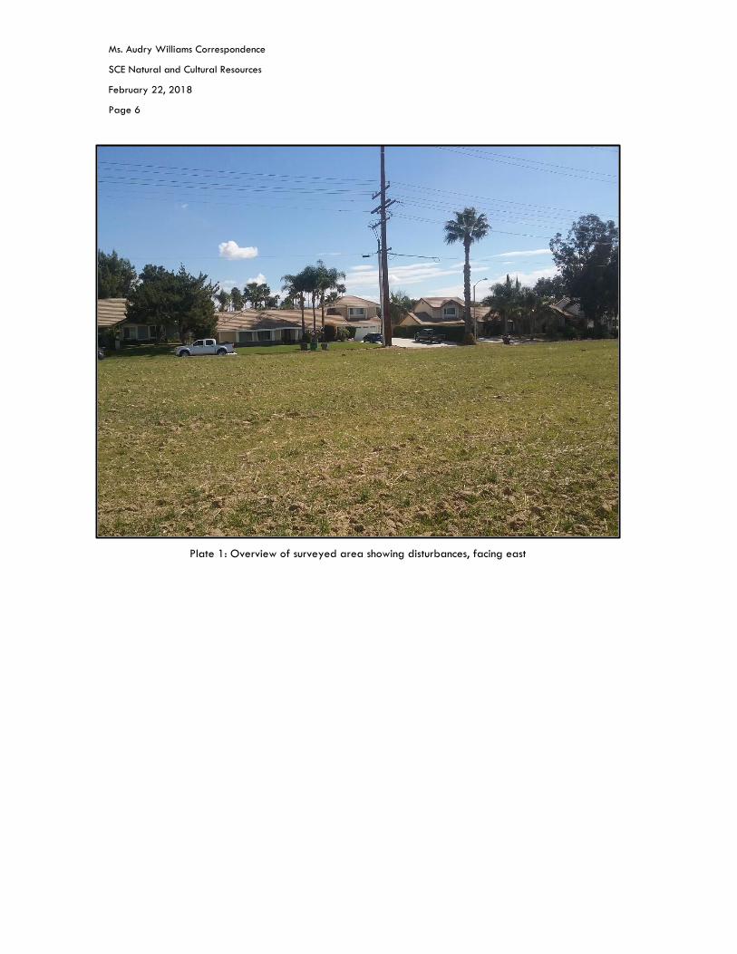
Survey Results No cultural resources were discovered during the survey of the splice site APE. The area was found to be
heavily disturbed by residential development and agricultural activities. Homes and paved roads covered
the eastern portion of the APE, while the splice site footprint and the western portion of the APE were on a
recently plowed field (Plate 1). Table 1 lists the results of the surveys and the recommendations resulting
from it.
Disturbance Type Cultural Resources Site Number Recommendations
Splice Site None None None
TABLE 1. RESULTS AND RECOMMENDATIONS OF SITE SURVEYS
Summary In summary, no existing cultural resources are located within or near the Vista-Moreno fiber-optic cable
splice site and no new cultural resources were observed during the intensive pedestrian survey. No further
cultural resources work is required in this area, unless project parameters change.
If you have any questions or require further clarification of any of the above information in this letter report,
please do not hesitate to contact me at (858) 762-2661 or at [email protected].
Regards,
Alberto Bello Foglia, M.A., RPA
Senior Archaeologist
PanGIS, Inc.

Ms. Audry Williams Correspondence
SCE Natural and Cultural Resources
February 22, 2018
Page 3
Attachments: Figure 1: Survey location map
Figure 2: Survey area map
Plate 1: Overview of surveyed area showing disturbances, facing east
References Williams, A.
2016 Cultural Resources Management Plan for Southern California Edison Company’s West of
Devers Transmission Line Upgrade Project, Riverside and San Bernardino Counties,
California. Rosemead, CA: Southern California Edison.

Ms. Audry Williams Correspondence
SCE Natural and Cultural Resources
February 22, 2018
Page 4
Figure 1: Survey Location Map

Ms. Audry Williams Correspondence
SCE Natural and Cultural Resources
February 22, 2018
Page 5
Figure 2: Survey Area Map
Ms. Audry Williams Correspondence
SCE Natural and Cultural Resources
February 22, 2018
Page 6
Plate 1: Overview of surveyed area showing disturbances, facing east