environmental & resource agency coordination meeting...
TRANSCRIPT

Environmental & Resource Agency
Coordination Meeting November 21, 2013
1:00 – 3:00 p.m. PST, 2:00 – 4:00 p.m. MST
The Arizona and Nevada departments of transportation are working together on the two-year Interstate 11 (I-11) and Intermountain West Corridor Study (Corridor) that includes detailed corridor planning of a possible high priority Interstate link between Phoenix and Las Vegas (the I-11 portion), and high-level visioning for potentially extending the Corridor north to Canada and south to Mexico. Congress recognized the importance of the portion of the Corridor between Phoenix and Las Vegas and designated it as future I-11 in the recent transportation authorization bill, Moving Ahead for Progress in the 21st Century Act (MAP-21). As part of the study, interested public agencies, non-profit organizations and private interests groups are invited to participate in a Stakeholder Partners group that will be asked to provide data and other input, and to share their opinions and ideas on decision points throughout the process. On November 21, 2013, meetings were held with resource agency, environmental, and Tribal Stakeholder Partners to request assistance in identifying environmental resource information needed for the Level 2 evaluation. Meetings were conducted simultaneously in three locations: Regional Transportation Commission of Southern Nevada (RTC), Las Vegas, Nevada; Nevada Department of Transportation (NDOT), Carson City, Nevada; and Maricopa Association of Governments (MAG), Phoenix, Arizona. A total of 42 participants signed in. The following report summarizes the results of this focus group. The meeting was initiated by a presentation viewed at all locations via a video conference link. NDOT Project Manager Sondra Rosenberg provided a brief review of the project and results of the Level 1 screening. Team member Dan Andersen presented the evaluation process and criteria for Level 2. Thor Anderson, ADOT Planning and Environmental Linkages Program Manager presented an overview of the purpose and process for Planning and Environmental Linkages, and introduced the discussion questions and input the study team requested from the participants. At the completion of the presentation, breakout session discussions were facilitated. A summary of the discussion at each location follows. The list of attendees and presentation are included at the end of this meeting summary. The comments presented in this report represent input from Stakeholder Partners that participated and will be reviewed and considered by the study team.

November 21, 2013 Environmental & Resource Agency Coordination Meeting Summary
Interstate 11 and Intermountain West Corridor Study Page 2
Nevada Meeting Summary Report Regional Transportation Commission RTC Room 127 600 S Grand Central Pkwy Las Vegas, NV
Nevada Department of Transportation Director’s Conference Room 1263 S. Stewart St. Carson City, NV
Meeting Feedback Participants in Las Vegas and Carson City, Nevada, held a joint discussion via video conference and were asked to comment on the evaluation criteria and to identify sensitive areas, potential mitigation strategies and potential opportunities. Are there changes to or additional evaluation criteria that should be considered during Level 2, and if so, what are available data sources? Faye Streier, U.S. Bureau of Reclamation, Lower Colorado Regional Office, proposed adding the criteria listed below. A discussion of each is also recorded.
Cultural resource sites
o Available data from SHPO, USBR, Moapa Tribe and NDOT
o Abdelmoez Abdalla, Federal Highway Administration, Nevada Division, noted that the I-515 study has a lot of environmental data, including cultural resource sites.
Visual impacts
Noise impacts
Recreation impacts
o Available data for visual, noise and recreation can be found in the following:
City of Henderson Open Space Plan
BLM Las Vegas Resource Management Plan (BLM updating now)
Multiple Species Habitat Plan
SNRPC Policy Plan
Southern Nevada Strong (won’t be completed until late 2014)
o Sondra Rosenberg commented that we will do our best to gather what we can but that we have a short time frame available for this analysis and it is not a NEPA level study. All requested data will be documented in the PEL report and noted whether it was evaluated or not.
o Dan Andersen asked for help identifying specific sections of these plans that can help with the evaluation. The more help that can be provided, the better the analysis will be.
o Abdelmoez Abdalla, Federal Highway Administration, Nevada Division, commented that noise and recreation might be a bit beyond the scope of this study, but that a high level cultural resource site analysis might be possible and helpful.

November 21, 2013 Environmental & Resource Agency Coordination Meeting Summary
Interstate 11 and Intermountain West Corridor Study Page 3
Access (for recreation and maintenance)—this might be covered under the Land Use category
Flood and erosion potential
Compatibility with existing infrastructure
Identify sensitive areas (will inform the environmental screening criteria ratings)
John Hiatt, Friends of Nevada Wilderness, noted the Bear Poppy habitat that would be impacted by Alternative BB-QQ, and also noted the problems from sheet flooding in this area exacerbated by roadways. He added that the Nevada Natural Database is a good resource.
Bruce Nyhuis and Mike Boyles from the National Park Service (NPS) noted that NPS is opposed to Alternative BB-QQ because it would be contrary to the mission of the Park, in addition to 4f and other concerns.
Other comments specific to BB-QQ included:
Does not go through developable land, so why consider it?
o Sondra Rosenberg said that it is being considered because of the benefits it provides as a freight corridor that bypasses the most congested freeways through Las Vegas.
Neighborhoods in Eastern Henderson abut this corridor and would likely be strongly opposed.
There are others in the Cities of Las Vegas and North Las Vegas that are supportive because of the connectivity it provides to future developments, especially land uses that are transportation dependent.
The cost would be high
The cost of improving existing freeways would also be high and have significant impacts to the neighborhoods surrounding them.
Rodney Langston, Clark County Department of Air Quality, noted that the negative impacts to air quality of the through-town options would be far greater than BB-QQ. Additional traffic and congestion on existing freeways could put the Valley into non-attainment. Congestion produces more pollutants and is exaggerated by construction.
Consider the location and impacts to SNWA and City of Henderson water lines and facilities.
Darren Daboda, Moapa Band of Paiutes, commented that his Tribe is discussing addition land disposal with BLM for solar energy production, and does not support BB-QQ. He also noted that the Las Vegas Paiute Colony is seeking additional BLM land along US 95 north of Las Vegas.
Greg Novak, Federal Highway Administration, Nevada Division, suggested we map school sites in relation to the alternatives as they are sensitive areas. He also suggested we might want to consider interchange locations, noting that in rural areas is they should not be any closer than 3 miles apart.
Abdelmoez Abdalla asked that we consider Environmental Justice populations that could be affected. He stated that this data is available in the RTC RTP

November 21, 2013 Environmental & Resource Agency Coordination Meeting Summary
Interstate 11 and Intermountain West Corridor Study Page 4
Identify potential mitigation strategies (will be documented for consideration by future NEPA practitioners)
John Hiatt suggested possible time restrictions to truck traffic could mitigate some of the congestion and air quality impacts to the through-town alternatives.
Rodney Langston commented that it would be nearly impossible to enforce.
John Hiatt noted that truck drivers will want to avoid the most congested times of day, and that ITS messaging signs might help alert them and manage traffic.
Identify potential opportunities (will be documented for consideration by future NEPA practitioners)
Raymond Hess, RTC, noted that Outside Las Vegas has been seeking a Valley Rim Trail, and that alternative BB-QQ could provide an opportunity helping to construct the trail within the corridor (separated from traffic).
There might be opportunities for noise compatible land uses and redevelopment (industrial, commercial) along an I-11 corridor.

November 21, 2013 Environmental & Resource Agency Coordination Meeting Summary
Interstate 11 and Intermountain West Corridor Study Page 5
Arizona Meeting Summary Report Maricopa Association of Governments Chaparral Conference Room 302 North 1st Avenue Phoenix, AZ
Meeting Feedback Participants were asked to identify sensitive areas, potential mitigation strategies and potential opportunities relative to the Level 2 alternatives of this study. Early in the meeting, many agencies requested the ability to have access to GIS shapefiles of the alternatives to take this information back to their offices and provide more detailed and relevant feedback. Therefore, the discussion included a series of clarification and information-seeking questions instead of specific feedback on the three topic areas identified. Tice Suppler of Audubon Arizona raised a concern related to the alignments in Southern Arizona, wondering why they are not being considered in Level 2 analysis. There may be critical environmental features/areas along alignments in Southern Arizona that may get ignored during the Level 2 analysis, but may eventually be impacted if a recommended alternative in Phoenix metropolitan area connects to a specific alignment in Southern Arizona. Marcos Robles from The Nature Conservancy mentioned that even though existing corridors are being considered for I-11 alignment in some places, the multimodal component of the corridor may warrant widening of the existing right-of-way to accommodate other modes/utilities resulting in impacts to the adjacent environment. ADOT Environmental Planning staff noted that the existing roadway connection (US-93) between Wickenburg and Wikieup is a scenic road, and it would make most sense to look at an alternative alignment for I-11. Regulations regarding improvements to designated “scenic byways” should be conferred. The Nature Conservancy (TNC) and the Arizona Game and Fish Department (AGFD) are teaming up to provide detailed input on sensitive areas, mitigation techniques, and opportunities. While it is difficult to quantify direct, indirect, and cumulative impacts for a corridor that might change alignments in the future, they will provide input based on the alternatives, as they stand today, and will also provide a narrative that speaks to the larger context of constructing a transportation corridor within the areas of influence under study. Tiffany Sprague from the Sierra Club asked whether all alternatives that are being considered for Level 2 analysis will be taken forward for NEPA process, or a narrowed-down set of alternatives move forward. It was explained that the reasonable range of alternatives will be carried forward. If additional fatal flaws are identified during this Level 2 analysis, corridor alternatives may be eliminated. It is too early to tell if one or multiple corridors will be recommended for further study. All stakeholders have access to a wider range of knowledge and data specific to their agency/interest and therefore should provide the Project Team with as detailed feedback as they are comfortable with.

November 21, 2013 Environmental & Resource Agency Coordination Meeting Summary
Interstate 11 and Intermountain West Corridor Study Page 6
It was also asked whether a separate set of passenger and freight rail alternatives are being considered. The approach to multimodal/multi-use considerations was further elaborated on. Ian Dowdy noted that a 1,000-foot wide corridor may not be enough to accommodate a multimodal corridor that includes utilities, since power companies alone use a two-mile wide corridor for planning power lines to ensure flexibility. Marcos Robles mentioned that TNC is using multiple buffers (of varying widths) along the alternative alignments to capture wider environmental impacts. It was mentioned that the analysis should also account for habitat fragmentation and loss. Diane Arnst from the Arizona Department of Air Quality (ADEQ) asked if shoulders along the future I-11 corridor will be paved throughout the length of the corridor? Thor Anderson clarified that normally shoulders would be paved in within urban areas only. ADEQ noted that paved shoulders are very important to maintain acceptable air quality standards. They will provide further comments in writing. The National Freight Plan is currently being drafted, and various freight corridors are being considered. How does the I-11 corridor fit into that plan? Thor Anderson informed that freight demand along I-11 will be evaluated as part of this study, and will be independent of the National Freight Plan. Esther Corbett from the InterTribal Council of Arizona (ITCA) raised a concern regarding the impact of the future I-11 corridor on the Tohono O’Odham Nation. Does the I-11 alignment follow I-19 from Tucson to Nogales, and would that impact Tohono O’Odham? The group was informed that corridor alternatives in Southern Arizona focused on connections between the Phoenix metropolitan and Mexico – determining the best border port of entry to for an international trade corridor to access (Nogales). The actual connection may represent a conceptual swath as wide as 50-miles, and may or may not follow an existing roadway facility. Tiffany Sprague asked if a corridor alternative is currently undergoing NEPA analysis and if the Record of Decision (ROD) rejects implementation of such a corridor, how will that impact this study? Thor Anderson responded that it depends on the scenario and reasons for rejection, but likely that corridor would be eliminated for consideration. That is why a reasonable range of alternatives will be sought in this study. Diane Arnst asked where “safety” fit into the overall evaluation criteria. Ed Stillings of FHWA explained that an evaluation of safety measures is a very detailed process and would be conducted during the NEPA level of study. Alternatives in this phase are still too broad. Alida Montiel of the ITCA commented on how the state continues to invest in new transportation corridors, but resources for maintenance of those corridors seem to be missing.

November 21, 2013 Environmental & Resource Agency Coordination Meeting Summary
Interstate 11 and Intermountain West Corridor Study Page 7
List of Attendees by Agency
Organization First Name Last Name Meeting Location
ADOT Thor Anderson MAG
ADOT Kris Gade MAG
ADOT Carlos Lopez MAG
AECOM Jaclyn Kuechenmeister MAG
AECOM VJ Rajvanshi MAG
Arizona Department of Environmental Quality Diane Arnst MAG
Arizona Game and Fish Department Bill Knowles MAG
Arizona Game and Fish Department Dana Warnecke MAG
Arizona Wildlife Federation Loyd Barnett MAG
Audubon Arizona Tice Supplee MAG
Bureau of Land Management, Phoenix District Leah Baker MAG
Bureau of Land Management, Southern Nevada Joe Varner RTC
CH2M HILL Dan Andersen RTC
CH2M HILL Bardia Nezhati RTC
Clark County Department of Air Quality Rodney Langston RTC
Clark County Department of Air Quality Dawn Leaper RTC
Federal Highway Administration, Arizona Division Alan Hansen MAG
Federal Highway Administration, Arizona Division Ed Stillings MAG
Federal Highway Administration, Arizona Division Tremaine Wilson MAG
Federal Highway Administration, Nevada Division Abdelmoez Abdalla NDOT
Federal Highway Administration, Nevada Division Greg Novak NDOT
Friends of Nevada Wilderness John Hiatt RTC
Inter Tribal Council of Arizona Esther Corbett MAG
Inter Tribal Council of Arizona Alida Montiel MAG
Intertribal Council of Nevada Elwood Lowery NDOT
Maricopa Association of Governments Bob Hazlett MAG
Maricopa Association of Governments Tim Strow MAG
Moapa Band of Paiutes Darren Daboda RTC
National Park Service Mike Boyles RTC
National Park Service Bruce Nyhuis RTC
NDOT Steve Cooke NDOT
NDOT Sondra Rosenberg NDOT
NDOT Kevin Verre NDOT
Nevada Department of Wildlife Tracy Kipke RTC
Regional Transportation Commission of Southern Nevada Raymond Hess RTC
Sierra Club Tiffany Sprague MAG
Sonoran Audubon Society Haylie Hewitt MAG
Sonoran Institute Ian Dowdy MAG

November 21, 2013 Environmental & Resource Agency Coordination Meeting Summary
Interstate 11 and Intermountain West Corridor Study Page 8
The Nature Conservancy Marcos Robles MAG
U.S. Army Corps of Engineers Kathleen Tucker MAG
U.S. Bureau of Reclamation, Lower Colorado Regional Office Faye Streier RTC
U.S. Fish and Wildlife, Pacific Southwest Region Dan Rolince RTC

November 21, 2013 Environmental & Resource Agency Coordination Meeting Summary
Interstate 11 and Intermountain West Corridor Study Page 9
PowerPoint Presentation

I-11 and Intermountain West Corridor Study: Environmental & Resource Agency Coordination
11/21/2013
1
In partnership with
I-11 & Intermountain West Corridor StudyI-11 & Intermountain West Corridor Study
November 21, 2013
Environmental & Resource Agency CoordinationEnvironmental & Resource Agency CoordinationLevel 2 Evaluation ProcessLevel 2 Evaluation Process
AgendaAgenda
• Project overview
• Planning and Environmental Linkages overview
• Meeting goals and objectives
– Identify sensitive areas
– Identify potential mitigation strategies
– Identify potential opportunities
• Breakout discussion sessions

I-11 and Intermountain West Corridor Study: Environmental & Resource Agency Coordination
11/21/2013
2
Project OverviewProject Overview
What Does this Study Entail?What Does this Study Entail?
• Two levels of investigation:– Detailed corridor planning
between Las Vegas and Phoenix
– High-level visioning from Las Vegas to Canada, and from Phoenix to Mexico
• Multimodal consideration:– Interstate/highway, freight rail,
passenger rail, and public transportation
– Power, telecommunication, etc.
4

I-11 and Intermountain West Corridor Study: Environmental & Resource Agency Coordination
11/21/2013
3
Progress UpdateProgress Update
5
Level 1 Evaluation Process and CriteriaLevel 1 Evaluation Process and Criteria
6
Evaluation Process
I-11 and Intermountain West Corridor Study: Environmental & Resource Agency Coordination
11/21/2013
4
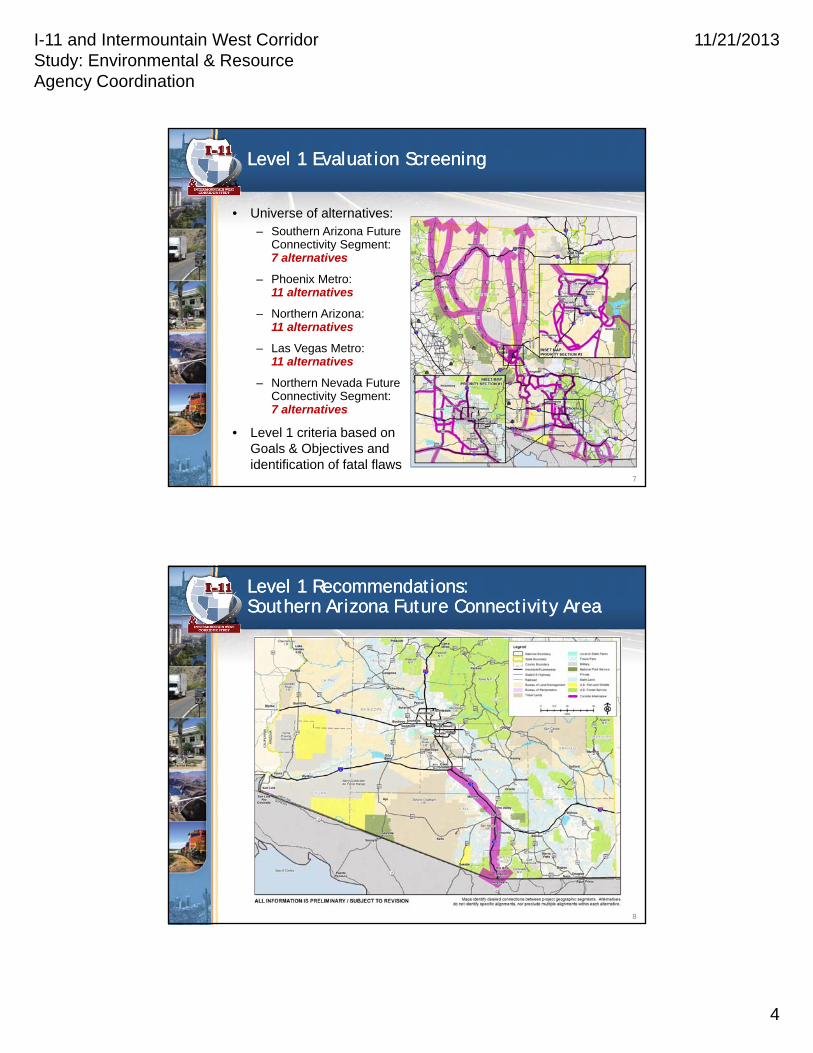
Level 1 Evaluation ScreeningLevel 1 Evaluation Screening
7
• Universe of alternatives:– Southern Arizona Future
Connectivity Segment: 7 alternatives
– Phoenix Metro: 11 alternatives
– Northern Arizona: 11 alternatives
– Las Vegas Metro: 11 alternatives
– Northern Nevada Future Connectivity Segment: 7 alternatives
• Level 1 criteria based on Goals & Objectives and identification of fatal flaws
Level 1 Recommendations:Southern Arizona Future Connectivity AreaLevel 1 Recommendations:Southern Arizona Future Connectivity Area
8

I-11 and Intermountain West Corridor Study: Environmental & Resource Agency Coordination
11/21/2013
5
Level 1 Recommendations:Priority Sections 1 & 2Level 1 Recommendations:Priority Sections 1 & 2
9
Level 1 Recommendations:Priority Section 3 & Northern NV ConnectivityLevel 1 Recommendations:Priority Section 3 & Northern NV Connectivity
10

I-11 and Intermountain West Corridor Study: Environmental & Resource Agency Coordination
11/21/2013
6
Level 2 Evaluation Process and CriteriaLevel 2 Evaluation Process and Criteria
11
Evaluation Process
Level 2 AlternativesLevel 2 Alternatives
12
• Interim screening conducted to eliminate alternatives that did not connect to adjacent segment recommendations
• Level 2 alternatives:– Phoenix Metro:
5 alternatives
– Northern Arizona: 2 alternatives
– Las Vegas Metro: 3 alternatives
• Recommendations from Level 2 still subject to further screening in NEPA

I-11 and Intermountain West Corridor Study: Environmental & Resource Agency Coordination
11/21/2013
7
Multimodal ConsiderationsMultimodal Considerations
13
• Three-step evaluation process:
1. Identify if multiple modes can be accommodated within current alignment alternative
2. If not, identify alternate rail corridors that will meet the same need for future modal implementation
3. Identify implications of each multimodal corridor option
Planning and Environmental LinkagesPlanning and Environmental Linkages

I-11 and Intermountain West Corridor Study: Environmental & Resource Agency Coordination
11/21/2013
8
PEL ProcessPEL Process
The Planning and Environmental Linkages (PEL) process links long-range planning to studies performed under the
National Environmental Policy Act (NEPA) by incorporating NEPA-compliant practices into the planning study.
PEL ComponentsPEL Components
• Project purpose and need including planning goals
• Public and stakeholder involvement
• A description of the environmental setting
• Identification of general travel modes
Data and analysis tools
Interagency coordination
Decision process changes
Purpose & Need
• Identification of a reasonable range of alternatives
• Preliminary screening of alternatives
• Recommendations for future studies
Pla
nn
ing
En
viron
men
t

I-11 and Intermountain West Corridor Study: Environmental & Resource Agency Coordination
11/21/2013
9
Differences Between PEL and NEPADifferences Between PEL and NEPA
• The level of effort can vary widely in PEL
• Findings in PEL are preliminary and subject to re-evaluation in NEPA
• Goals and objectives play a big role in defining the purpose and need in PEL
• PEL does a high-level environmental review
• PEL identifies corridors not alignments
• PEL carries forward a reasonable range of corridor alternatives, even if a preferred is identified
Discussion SessionDiscussion Session

I-11 and Intermountain West Corridor Study: Environmental & Resource Agency Coordination
11/21/2013
10
DiscussionDiscussion
• Identify sensitive areas
– Will inform the environmental screening criteria ratings
• Identify potential mitigation strategies
– Will be documented for consideration by future NEPA practitioners
• Identify potential opportunities
– Will be documented for consideration by future NEPA practitioners
• Please provide any feedback that would help inform the environmental screening ratings by identifying:
– Sensitive areas
– Reference applicable sections of relevant management plans
– Potential mitigation strategies
– Potential opportunities
• Provide information to Dan Andersen by Friday, December 6, 2013: [email protected]
Level 2 Screening FeedbackLevel 2 Screening Feedback
20

I-11 and Intermountain West Corridor Study: Environmental & Resource Agency Coordination
11/21/2013
11
• Priority Segment Alternatives
– Conduct Level 2 evaluation in:
• Priority Section #1: Phoenix metropolitan area
• Priority Section #2 Northern Arizona/Southern Nevada
• Priority Section #3: Las Vegas metropolitan area
– Prepare Corridor Concept Report
• Future Connectivity Segments
– Prepare Feasibility Assessment Report for the Southern Arizona and Northern Nevada future connectivity segments only
– Identify potential future studies
• Public Meeting (estimated for June 2014)
– Review draft Corridor Concept Report
Next StepsNext Steps
21
Project Contacts:Project Contacts:

I-11 and Intermountain West Corridor Study: Environmental & Resource Agency Coordination
11/21/2013
12
Priority Section #1: Phoenix Metropolitan Area (South)Priority Section #1: Phoenix Metropolitan Area (South)
Priority Section #1: Phoenix Metropolitan Area (North)Priority Section #1: Phoenix Metropolitan Area (North)

I-11 and Intermountain West Corridor Study: Environmental & Resource Agency Coordination
11/21/2013
13
Priority Section #2: Northern AZ/Southern NV (South)Priority Section #2: Northern AZ/Southern NV (South)
Priority Section #2: Northern AZ/Southern NV (North)Priority Section #2: Northern AZ/Southern NV (North)

I-11 and Intermountain West Corridor Study: Environmental & Resource Agency Coordination
11/21/2013
14
Priority Section #3: Las Vegas Metropolitan AreaPriority Section #3: Las Vegas Metropolitan Area
27