environmental review update checklist form for projects ... · pdf fileenvironmental review...
TRANSCRIPT

March 11, 2016
Environmental Review Update Checklist Form For projects with Previously Approved Environmental Documents
FOR PURPOSES OF CONSIDERATION OF
EAST OTAY MESA BUSINESS PARK SPECIFIC PLAN AMENDMENT – OTAY 250 PDS2015-SPA-15-001; PDS2015-GPA-15-008; PDS2015-TM-5607; PSD2015-REZ-15-007;
PDS2015-ER-15-98-190-13G
The California Environmental Quality Act (CEQA) Guidelines Sections 15162 through 15164 set forth the criteria for determining the appropriate additional environmental documentation, if any, to be completed when there is a previously adopted Negative Declaration (ND) or a previously certified environmental impact report (EIR) covering the project for which a subsequent discretionary action is required. This Environmental Review Update Checklist Form has been prepared in accordance with CEQA Guidelines Section 15164(e) to explain the rationale for determining whether any additional environmental documentation is needed for the subject discretionary action. 1. Background on the previously certified EIR, Supplemental EIR, and Addendum pertaining
to the proposed project:
EAST OTAY MESA BUSINESS PARK SPECIFIC PLAN EIR (1994 EIR) An EIR for the East Otay Mesa Business Park Specific Plan (SP 93-004, Log No. 93-19-006) was certified by the San Diego County Board of Supervisors on July 17, 1994. The certified EIR found significant and mitigated effects to Land Use, Landform Alteration/Visual Quality, Cultural Resources, Geology and Soils, Hydrology and Water Quality, Transportation and Circulation, Air Quality, Health and Safety, Public Services and Utilities, and Population/Housing/Employment. These effects were determined to be mitigated or avoided to a level below significance. Additionally, the certified EIR found significant and unmitigable impacts to Biological Resources and Noise, requiring a Statement of Overriding Considerations. In the years since certification of the original EIR, several addenda and one Supplemental EIR (Sunroad Centrum Tech Center) have been processed and approved by the County for projects located within the East Otay Mesa Business Park Specific Plan area. Table 1, Prior Environmental Documents Prepared for the East Otay Mesa Business Park Specific Plan, provides a comprehensive list of the various environmental documents. Of those, the ones that have specific application to the proposed project as they pertain to the project site
MARK WARDLAW DIRECTOR
PHONE (858) 694-2962 FAX (858) 694-2555
PLANNING & DEVELOPMENT SERVICES
5510 OVERLAND AVENUE, SUITE 310, SAN DIEGO, CA 92123
www.sdcounty.ca.gov/pds
DARREN GRETLER ASSISTANT DIRECTOR PHONE (858) 694-2962
FAX (858) 694-2555
OTAY 250 - 2 - Date PDS2015-SPA-15-001
and/or the evaluation of environmental impacts associated with the proposed Project are describe below. SUNROAD OTAY INDUSTRIAL SUBDIVISION / SUNROAD CENTRUM SUPPLEMENTAL EIR (2000 SEIR)
A Supplemental EIR for Sunroad Otay Industrial Subdivision, TM 5139RPL6, ER 98-19-013 was certified by the County Planning Commission On December 15, 2000. The certified SEIR found that the project would cause significant effects to Land Use, Biological Resources, Cultural Resources, Transportation/Circulation, and Air Quality. Impacts to Traffic and Air Quality required a Statement of Overriding Considerations for significant and unmitigable impacts. The other effects were avoided or mitigated to a level below significance.
SUNROAD TECH CENTRE REVISED TENTATIVE MAP(2003 ADDENDUM) An Addendum to the previously certified EIR for the East Otay Mesa Business Park Specific Plan and Supplemental EIR for the East Otay Mesa Business Park Specific Plan Sunroad Centrum was approved by the Planning Commission for the Revised Sunroad Otay Project, TM5139RPL6R2, ER 98-19-103A, on April 11, 2003. A Specific Plan Amendment was processed to update the land use plan and permit processing requirements, affecting approximately 2,017 acres. Land use changes included:
Change 241 cares previously identified as Hillside Residential to Conservation/Limited Use.
Change 947 acres previously identified as Commercial and Mixed Industrial uses to Technology Business Park.
Change 699 acres previously designated Mixed Industrial to 410 acres of Light Industrial and 289 acres of Heavy Industrial.
Replace Regional and District Commercial uses with a Commercial Center Overlay (underlying Technology Business Park land use designation) not to exceed 40 acres located.
Additionally, a Minor Amendment to the Multiple Species Conservation Program was processed. No new significant effects were identified, although biological mitigation measures were modified due to change in circumstances associated with the Minor Amendment and the requirement that future projects adhere to the Biological Mitigation Ordinance, both of which were not in effect at the time of the 1994 EIR.
OTAY 250 - 3 - Date PDS2015-SPA-15-001
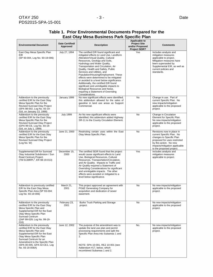
Table 1. Prior Environmental Documents Prepared for the East Otay Mesa Business Park Specific Plan
Environmental Document Date Certified/
Approved Description
Applicable to Project Site
and/or Proposed Project SEIR?
Comments
East Otay Mesa Specific Plan EIR (SP 93-004, Log No. 93-19-006)
July 27, 1994 The certified EIR found significant and mitigated effects to Land Use, Landform Alteration/Visual Quality, Cultural Resources, Geology and Soils, Hydrology and Water Quality, Transportation and Circulation, Air Quality, Health and Safety, Public Services and Utilities, and Population/Housing/Employment. These effects were determined to be mitigated or avoided to a level below significance. Additionally, the certified EIR found significant and unmitigable impacts to Biological Resources and Noise, requiring a Statement of Overriding Considerations.
Yes Includes analysis and mitigation measures applicable to project. Mitigation measures have been superseded by Supplemental EIR, as well as current policies and standards.
Addendum to the previously certified EIR for the East Otay Mesa Specific Plan for the Revised Sunroad Otay Project (SPA 98-002, Log No. 93-19-016, on January 13, 1999)
January 1999 No new significant effects were identified; this addendum allowed for the sales of gasoline in land use areas as Support Commercial.
No Change in use. Part of current Specific Plan. No new impacts/mitigation applicable to the proposed project.
Addendum to the previously certified EIR for the East Otay Mesa Specific Plan for the Revised Sunroad Otay Project (GPA 99-CE, Log No. 93-19-016, on July 1, 1999)
July 1999 An No new significant effects were identified; this addendum added Highway SR-11 to the County Circulation Element.
No Change in Circulation Element for Specific Plan. No new impacts/mitigation applicable to the proposed project.
Addendum to the previously certified EIR for the East Otay Mesa Specific Plan for the Revised Sunroad Otay Project (Log No. W)
June 21, 2000 Restricting certain uses within the East Otay Mesa Specific Plan.
No Revisions now in place in current Specific Plan. No changes to Specific Plan proposed for uses restricted by this action. No new impacts/mitigation applicable to the proposed project.
Supplemental EIR for Sunroad Otay Industrial Subdivision / Sun Road Centrum Project. (TM 5139RPL
6, ER 98-19-013)
December 15, 2000
The certified SEIR found that the project would cause significant effects to Land Use, Biological Resources, Cultural Resources, Transportation/Circulation, and Air Quality. Impacts to Traffic and Air Quality required a Statement of Overriding Considerations for significant and unmitigable impacts. The other effects were avoided or mitigated to a level below significance.
Yes Includes analysis and mitigation measures applicable to project.
Addendum to previously certified EIR for the East Otay Mesa Specific Plan Area (SP 93-004; Log No. 93-19-006)
March 21, 2001
This project approved an agreement with PG&E Generating Company for acquisition and dedication of sewer easement.
No No new impacts/mitigation applicable to the proposed project.
Addendum to the previously certified EIR for the East Otay Mesa Specific Plan and Supplemental EIR for the East Otay Mesa Specific Plan Sunroad Centrum (ZAP 99-029; Log No. 99-19-016)
February 23, 2001
Burke Truck Parking and Storage project.
No No new impacts/mitigation applicable to the proposed project.
Addendum to the previously certified EIR for the East Otay Mesa Specific Plan and Supplemental EIR for the East Otay Mesa Specific Plan Sunroad Centrum for an Amendment to the Specific Plan (SPA 00-005, GPA 02-CE1, Log No. 93-19-006A)
June 12, 2002 The purpose of the amendment was to update the land use plan and permit processing requirements and split the Specific Plan Area into Subareas 1 and 2.
NOTE: SPA 10-001, REZ 10-001 (see Addendum #17, below, which recombined Subareas 1 and 2.
No. No new impacts/mitigation applicable to the proposed project.
OTAY 250 - 4 - Date PDS2015-SPA-15-001
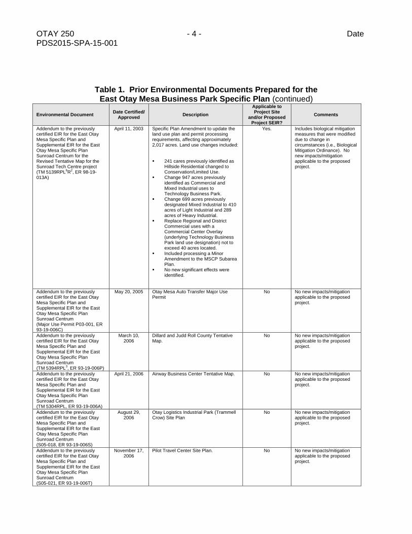
Table 1. Prior Environmental Documents Prepared for the East Otay Mesa Business Park Specific Plan (continued)
Environmental Document Date Certified/
Approved Description
Applicable to Project Site
and/or Proposed Project SEIR?
Comments
Addendum to the previously certified EIR for the East Otay Mesa Specific Plan and Supplemental EIR for the East Otay Mesa Specific Plan Sunroad Centrum for the Revised Tentative Map for the Sunroad Tech Centre project (TM 5139RPL
6R
2, ER 98-19-
013A)
April 11, 2003 Specific Plan Amendment to update the land use plan and permit processing requirements, affecting approximately 2,017 acres. Land use changes included:
241 cares previously identified as Hillside Residential changed to Conservation/Limited Use.
Change 947 acres previously identified as Commercial and Mixed Industrial uses to Technology Business Park.
Change 699 acres previously designated Mixed Industrial to 410 acres of Light Industrial and 289 acres of Heavy Industrial.
Replace Regional and District Commercial uses with a Commercial Center Overlay (underlying Technology Business Park land use designation) not to exceed 40 acres located.
Included processing a Minor Amendment to the MSCP Subarea Plan.
No new significant effects were identified.
Yes. Includes biological mitigation measures that were modified due to change in circumstances (i.e., Biological Mitigation Ordinance). No new impacts/mitigation applicable to the proposed project.
Addendum to the previously certified EIR for the East Otay Mesa Specific Plan and Supplemental EIR for the East Otay Mesa Specific Plan Sunroad Centrum (Major Use Permit P03-001, ER 93-19-006C)
May 20, 2005 Otay Mesa Auto Transfer Major Use Permit
No No new impacts/mitigation applicable to the proposed project.
Addendum to the previously certified EIR for the East Otay Mesa Specific Plan and Supplemental EIR for the East Otay Mesa Specific Plan Sunroad Centrum (TM 5394RPL
3, ER 93-19-006P)
March 10, 2006
Dillard and Judd Roll County Tentative Map.
No No new impacts/mitigation applicable to the proposed project.
Addendum to the previously certified EIR for the East Otay Mesa Specific Plan and Supplemental EIR for the East Otay Mesa Specific Plan Sunroad Centrum (TM 5304RPL, ER 93-19-006A)
April 21, 2006 Airway Business Center Tentative Map. No No new impacts/mitigation applicable to the proposed project.
Addendum to the previously certified EIR for the East Otay Mesa Specific Plan and Supplemental EIR for the East Otay Mesa Specific Plan Sunroad Centrum (S05-018, ER 93-19-006S)
August 29, 2006
Otay Logistics Industrial Park (Trammell Crow) Site Plan
No No new impacts/mitigation applicable to the proposed project.
Addendum to the previously certified EIR for the East Otay Mesa Specific Plan and Supplemental EIR for the East Otay Mesa Specific Plan Sunroad Centrum (S05-021, ER 93-19-006T)
November 17, 2006
Pilot Travel Center Site Plan. No No new impacts/mitigation applicable to the proposed project.
OTAY 250 - 5 - Date PDS2015-SPA-15-001
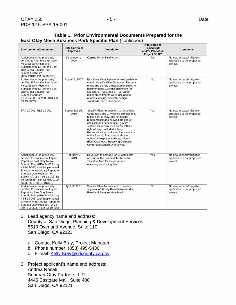
Table 1. Prior Environmental Documents Prepared for the East Otay Mesa Business Park Specific Plan (continued)
Environmental Document Date Certified/
Approved Description
Applicable to Project Site
and/or Proposed Project SEIR?
Comments
Addendum to the previously certified EIR for the East Otay Mesa Specific Plan and Supplemental EIR for the East Otay Mesa Specific Plan Sunroad Centrum (TPM 21012, ER 00-19-27B)
December 1, 2006
Calpine Minor Subdivision. No No new impacts/mitigation applicable to the proposed project.
Addendum to the previously certified EIR for the East Otay Mesa Specific Plan and Supplemental EIR for the East Otay Mesa Specific Plan Sunroad Centrum (SPA 06-003, GPA 06-013, ER 93-19-006Y)
August 1, 2007 East Otay Mesa Update to re-align/delete certain Specific Plan/Circulation Element roads and bicycle transportation paths to accommodate Caltrans’ alignment for SR-125, SR-905, and SR-11. Other minor amendments were included to address fencing, sidewalk design standards, noise, and parks.
No. No new impacts/mitigation applicable to the proposed project.
SPA 10-001, REZ 10-001 September 15, 2010
Specific Plan Amendment to recombine Subareas 1 and 2; modified streetscape, public right-of-way, and landscape requirements; and allowed the use of chainlink and decomposed granite surface for interim uses on the SR-11 right-of-way. Included a Zone Reclassification modifying the boundary of the Specific Plan area and other actions in response to Proposition A (East Otay Mesa Recycling Collection Center and Landfill Ordinance).
Yes. No new impacts/mitigation applicable to the proposed project.
Addendum to the previously certified Environmental Impact Report for East Otay Mesa Specific Plan (GPA 94-002, Log # 93-19-006) and Supplemental Environmental Impact Report for Sunroad Otay Project (TM 5139RPL
6, Log # 98-19-013) for
the Sunroad Tech Centre, 3100 5538 (TM). (98-19-013B)
February 6, 2013
Reversion to acreage for 54 acres that are part of the Sunroad Tech Centre Tentative Map for the purpose of releasing an existing lien.
Yes.
No new impacts/mitigation applicable to the proposed project.
Addendum to the previously certified Environmental Impact Report for East Otay Mesa Specific Plan (GPA 94-002, Log # 93-19-006) and Supplemental Environmental Impact Report for Sunroad Otay Project GPA-14-004, TM-5505R, ER-93-19-006)
April 22, 2015 Specific Plan Amendment to delete a segment of Airway Road between Alta Road and Siempre Viva Road.
No. No new impacts/mitigation applicable to the proposed project.
2. Lead agency name and address: County of San Diego, Planning & Development Services 5510 Overland Avenue, Suite 110 San Diego, CA 92123
a. Contact Kelly Bray, Project Manager b. Phone number: (858) 495-5430 c. E-mail: [email protected]
3. Project applicant’s name and address:
Andrea Rosati Sunroad Otay Partners, L.P. 4445 Eastgate Mall, Suite 400 San Diego, CA 92121
OTAY 250 - 6 - Date PDS2015-SPA-15-001 4. Summary of the activities authorized by present permit/entitlement application(s):
The Project Area is located in the East Otay Mesa Business Park Specific Plan area within the Otay Subregional Plan and is designated in the General Plan as Specific Plan Area. The Project Area is zoned S-88 (Specific Plan). Figure 1, Vicinity Map, shows the location of the Project Area. Figure 2, Aerial Photograph, provides an aerial photograph of the project site. Figure 3, East Otay Mesa Approved Specific Plan Land Use Map, shows the location of the Project site within the Specific Plan area. A Tentative Map (TM 5538) was approved for the Project Area in March 2012. The Tentative Map resulted in subdividing the 253.1-gross acre Project Area into 55 lots: 52 technology business park lots ranging in size from 1.8 to 5.3 acres, one lot for a sewer pump station, one storm water detention lot, and a 51.3-acre dedicated open space lot. The Tentative Map is organized into five separate units for purposes of grading and map recordation. The East Otay Mesa Business Park Specific Plan sets forth a comprehensive vision for development of the Plan Area, within unincorporated San Diego County. The Specific Plan contains approximately 3,013 acres of land. Approximately 2,110 acres of the Specific Plan is planned as a modern industrial and business center while about 552 acres is set aside for conservation or very low-density residential use. Specifically, within the industrial and business center, the Specific Plan provides for approximately 11 acres of District Commercial, 292 acres of Heavy Industrial, 629.9 acres of Mixed Industrial, 363 acres of Light Industrial, 814 acres of Technology Business Park. The low intensity use includes 311.3 acres of Rural Residential and 241 acres of Conservation/Limited Use. Additionally, the Specific Plan provides for 350.4 acres of Circulation Corridors and a maximum of 84 acres of Overlay in the form of Activity Node Overlay (28 acres maximum) and Commercial Center Overlay (56 acres maximum). The approved Tentative Map/Project Area is located in the northwest portion of the Specific Plan (see Figure 3). All lots created by the Tentative Map are designated for Technology Business Park use; Lots 1 through 5 (Unit 1, totaling 28 acres) also has a Commercial Overlay subject to the regulations defined in the Specific Plan.
5. Does the project for which a subsequent discretionary action is now proposed differ in any
way from the previously approved project?
YES NO X
The proposed Project involves an Amendment to the East Otay Mesa Business Park Specific Plan and a new Tentative Map. The Specific Plan area was originally envisioned as a major employment center in southern San Diego County. The plan was originally developed in 1994; however, limited development has occurred since that time and most of the Specific Plan area remains vacant. Since the time of certification of the EIR in 1994 and approval of the Specific Plan, the County General Plan was comprehensively updated and adopted in 2011. The General Plan identifies the Project area as a Village. The proposed
OTAY 250 - 7 - Date PDS2015-SPA-15-001
Specific Plan Amendment is intended to bring the project site into conformance with the General Plan. The East Otay Specific Plan is located within the Otay Subregional Plan area. The Subregional Plan is silent on residential uses. Therefore, the Project includes an Amendment to the Otay Subregional Plan to bring the Subregional Plan into conformance with the General Plan. The Project Area is located in the northwest portion of the Specific Plan. The proposed Tentative Map (Figure 4, Proposed Tentative Map) would subdivide the Project Area into 30 lots. The Amendment to the Specific Plan would necessitate an Amendment to the Otay Mesa Subregional Plan to allow for the Project site to developed as envisioned by the General Plan. The Specific Plan Amendment proposes 13 planning areas (PAs), as illustrated in Figure 5, Specific Plan Amendment Proposed Conceptual Land Use and Circulation Plan. Nine of the Planning Areas are proposed for mixed-use development (PAs A through J). One Planning Area (PA L) is part of the same ownership but is not a part of the proposed Specific Plan Amendment. Planning Areas I and K would retain the Technology Business Park designation shown in the current Specific Plan, and Planning Area M would remain designated as Open Space. The nine mixed-use planning areas (PAs A through J) are organized into three districts: Mixed-Use Retail Emphasis (PA E), Mixed-Use Employment Emphasis (PAs A, F, and J), and Mixed-Use Residential Emphasis (PAs B, C, D, G, and H). The Specific Plan Amendment proposes to add three new Land Use Designations (Mixed-Use Residential Emphasis, Mixed Use Employment Emphasis, and Mixed Use Retail Emphasis) that allow for a mix of residential, employment, and retail uses for the approximately 253 acre Project area of the 3,012.7-acre Specific Plan area. Table 2, Land Use Summary, below provides a summary of the mixed land use type and area associated with each of those land uses.
TABLE 2
LAND USE SUMMARY
PROPOSED PROJECT AREA (acres)
Mixed-Use Land Use Designation
Mixed-Use Employment Emphasis 61.0
Mixed-Use Retail Emphasis 10.33
Mixed-Use Residential Emphasis 87.74
Technology Business Park 7.72
Circulation Element Roads/Right-of-Way Area 35.01
Open Space Easement 51.34
TOTAL PROJECT AREA 253.1
The Specific Plan Designations would include a range of densities and a mix of uses across the Project area. Uses that would be allowed in the Project Area include a variety of residential, technology , business park, civic, and commercial uses. The mix of these uses would vary depending on the emphasis of the Mixed-Use Designation.
OTAY 250 - 8 - Date PDS2015-SPA-15-001
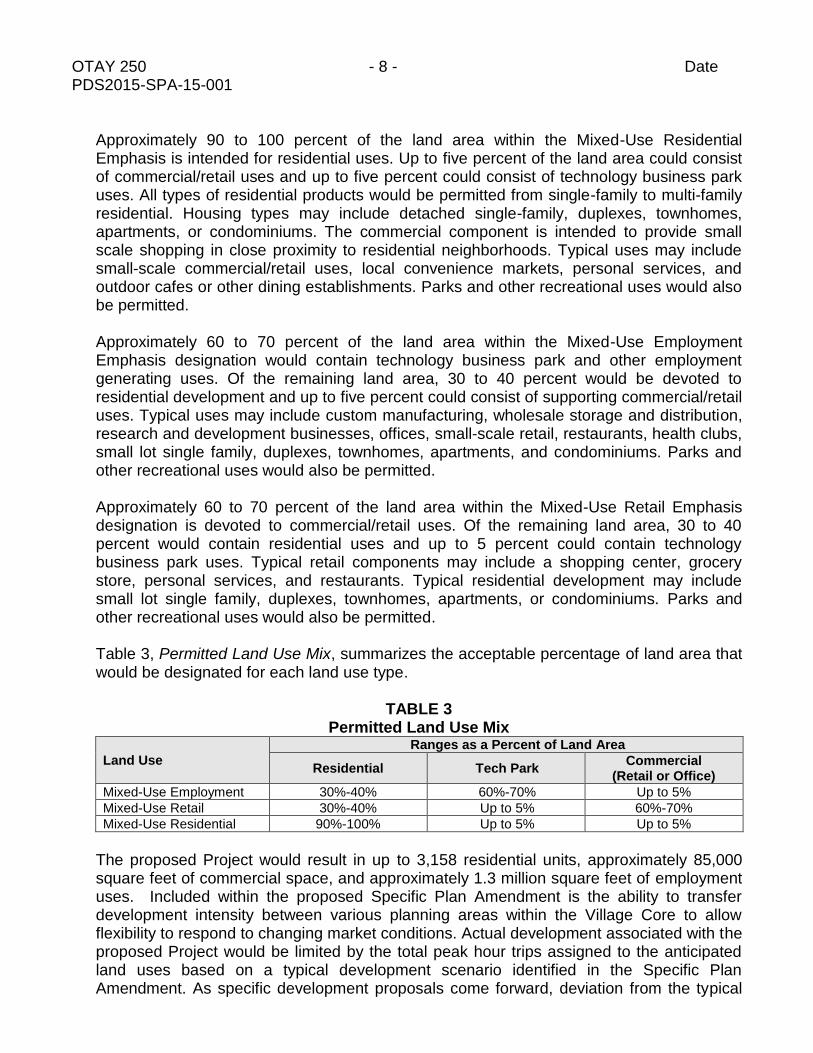
Approximately 90 to 100 percent of the land area within the Mixed-Use Residential Emphasis is intended for residential uses. Up to five percent of the land area could consist of commercial/retail uses and up to five percent could consist of technology business park uses. All types of residential products would be permitted from single-family to multi-family residential. Housing types may include detached single-family, duplexes, townhomes, apartments, or condominiums. The commercial component is intended to provide small scale shopping in close proximity to residential neighborhoods. Typical uses may include small-scale commercial/retail uses, local convenience markets, personal services, and outdoor cafes or other dining establishments. Parks and other recreational uses would also be permitted. Approximately 60 to 70 percent of the land area within the Mixed-Use Employment Emphasis designation would contain technology business park and other employment generating uses. Of the remaining land area, 30 to 40 percent would be devoted to residential development and up to five percent could consist of supporting commercial/retail uses. Typical uses may include custom manufacturing, wholesale storage and distribution, research and development businesses, offices, small-scale retail, restaurants, health clubs, small lot single family, duplexes, townhomes, apartments, and condominiums. Parks and other recreational uses would also be permitted. Approximately 60 to 70 percent of the land area within the Mixed-Use Retail Emphasis designation is devoted to commercial/retail uses. Of the remaining land area, 30 to 40 percent would contain residential uses and up to 5 percent could contain technology business park uses. Typical retail components may include a shopping center, grocery store, personal services, and restaurants. Typical residential development may include small lot single family, duplexes, townhomes, apartments, or condominiums. Parks and other recreational uses would also be permitted. Table 3, Permitted Land Use Mix, summarizes the acceptable percentage of land area that would be designated for each land use type.
TABLE 3
Permitted Land Use Mix
Land Use
Ranges as a Percent of Land Area
Residential Tech Park Commercial
(Retail or Office)
Mixed-Use Employment 30%-40% 60%-70% Up to 5%
Mixed-Use Retail 30%-40% Up to 5% 60%-70%
Mixed-Use Residential 90%-100% Up to 5% Up to 5%
The proposed Project would result in up to 3,158 residential units, approximately 85,000 square feet of commercial space, and approximately 1.3 million square feet of employment uses. Included within the proposed Specific Plan Amendment is the ability to transfer development intensity between various planning areas within the Village Core to allow flexibility to respond to changing market conditions. Actual development associated with the proposed Project would be limited by the total peak hour trips assigned to the anticipated land uses based on a typical development scenario identified in the Specific Plan Amendment. As specific development proposals come forward, deviation from the typical

OTAY 250 - 9 - Date PDS2015-SPA-15-001
development scenario would be allowed provided that the total peak hour traffic volumes are not exceeded. This approach allows flexibility to respond to changing market conditions over the expected 10-15 year period for build-out within the Specific Plan Amendment area.
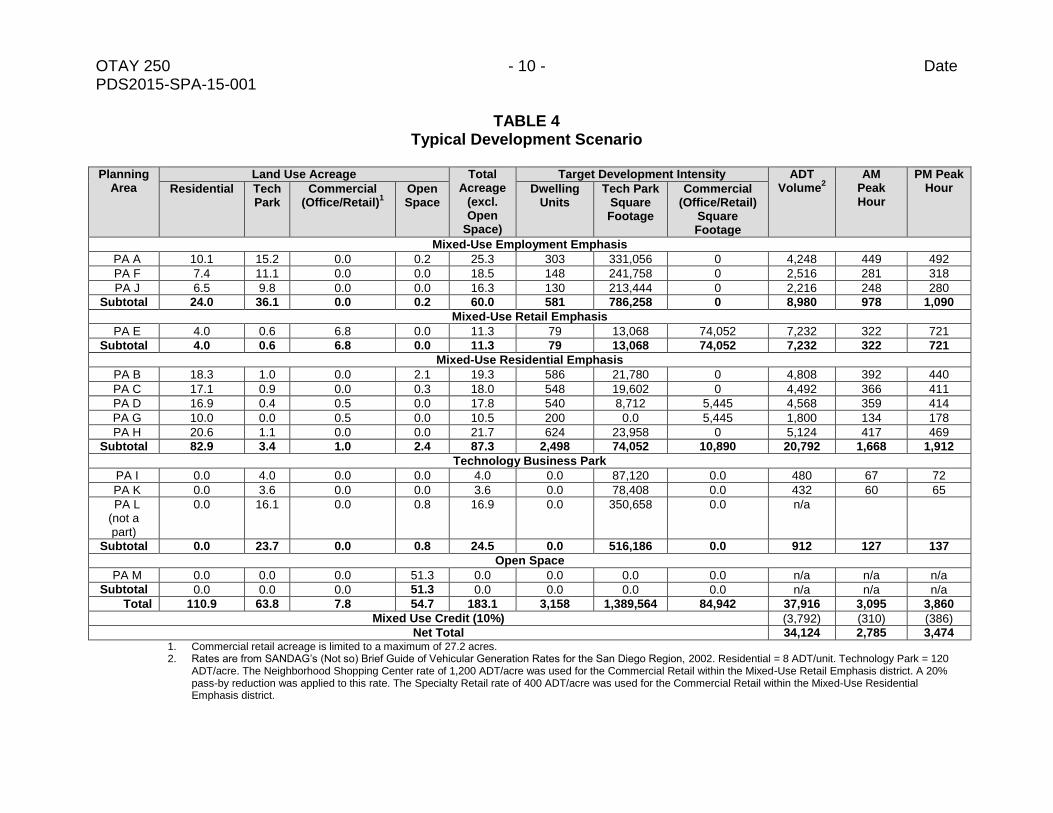
The Specific Plan Amendment includes a typical development scenario based on “target” development intensities such that the maximum peak hour traffic volumes associated with build-out of the area does not generate more than 2,785 AM peak-hour trips and not more than 3,474 PM peak-hour trips. (See Table 4, Typical Development Scenario.) These are the peak hour trips associated with the current approved Tentative Map for the project area. In order to track the allocation of trips within the project area, a Tracking Table would be submitted with each Site Plan development proposal. Because ultimate build-out of the project is limited by the restrictions contained in the traffic analysis, the Supplemental EIR will evaluate worst case impacts based on development which could occur within those limitations. Should future development be proposed that is in excess of the constraints set by the traffic analysis, subsequent traffic analysis and environmental review would be necessary.
The proposed Project would include construction of public streets within the Project area that are shown on the previously approved Tentative Map, including Sunroad Boulevard, Sunroad View Drive, Alejandro Drive, and extensions of Harvest Road and David Ridge Drive. The proposed Project would also construct off-site, but within the Specific Plan, half-width improvements for Vann Center Boulevard from Otay Mesa Road to just south of Lone Star Road, Zinser Road from west of Sunroad Boulevard to Alejandro Drive, Lone Star Road where it traverses the northeast corner of the project site, and Harvest Road along the southwest project border. All circulation element roadways would include Class 2 bike lanes.
Sewer lines would be provided within all Project area roadways (Sunroad Boulevard, Harvest Road, Alejandro Drive, Sunroad View Drive, and David Ridge Drive), as well as the portions of off-site roadways within the Specific Plan (Zinser Road, Lone Star Road, Vann Center Road, and Otay Mesa Road). The main southerly point of connection, at the intersection of Harvest Road and Otay Mesa Road, would be to an existing 12-inch sewer main. The main northerly sewer point of connection would extend a 12-inch sewer westerly within Zinzer Road approximately 1,800 linear feet from the westerly Project area boundary and connect to an existing 18-inch sewer main constructed under and passing State Route (SR) 125.
The main water supply connection exists in Otay Mesa Road in the form of a 24- inch main line, along the Project areas southern boundary. Water supply will be provided throughout the project via a 12-inch conveyance system. There are no water infrastructure connections off-site from the Project area.
Electric lines would be provided within all project roadways (Sunroad Boulevard, Harvest Road, Alejandro Drive, Sunroad View Drive, and David Ridge Drive), as well as off-site, but within the Specific Plan area roadways (Zinser Road, Lone Star Road, Vann Center Road, and Otay Mesa Road). Connection is anticipated to be within the existing SDG&E easement that runs north and south through the project site near Harvest Road.
OTAY 250 - 10 - Date PDS2015-SPA-15-001
TABLE 4 Typical Development Scenario
Planning
Area Land Use Acreage Total
Acreage (excl. Open
Space)
Target Development Intensity ADT Volume
2
AM Peak Hour
PM Peak Hour Residential Tech
Park Commercial
(Office/Retail)1
Open Space
Dwelling Units
Tech Park Square Footage
Commercial (Office/Retail)
Square Footage
Mixed-Use Employment Emphasis
PA A 10.1 15.2 0.0 0.2 25.3 303 331,056 0 4,248 449 492
PA F 7.4 11.1 0.0 0.0 18.5 148 241,758 0 2,516 281 318
PA J 6.5 9.8 0.0 0.0 16.3 130 213,444 0 2,216 248 280
Subtotal 24.0 36.1 0.0 0.2 60.0 581 786,258 0 8,980 978 1,090
Mixed-Use Retail Emphasis
PA E 4.0 0.6 6.8 0.0 11.3 79 13,068 74,052 7,232 322 721
Subtotal 4.0 0.6 6.8 0.0 11.3 79 13,068 74,052 7,232 322 721
Mixed-Use Residential Emphasis
PA B 18.3 1.0 0.0 2.1 19.3 586 21,780 0 4,808 392 440
PA C 17.1 0.9 0.0 0.3 18.0 548 19,602 0 4,492 366 411
PA D 16.9 0.4 0.5 0.0 17.8 540 8,712 5,445 4,568 359 414
PA G 10.0 0.0 0.5 0.0 10.5 200 0.0 5,445 1,800 134 178
PA H 20.6 1.1 0.0 0.0 21.7 624 23,958 0 5,124 417 469
Subtotal 82.9 3.4 1.0 2.4 87.3 2,498 74,052 10,890 20,792 1,668 1,912
Technology Business Park
PA I 0.0 4.0 0.0 0.0 4.0 0.0 87,120 0.0 480 67 72
PA K 0.0 3.6 0.0 0.0 3.6 0.0 78,408 0.0 432 60 65
PA L (not a part)
0.0 16.1 0.0 0.8 16.9 0.0 350,658 0.0 n/a
Subtotal 0.0 23.7 0.0 0.8 24.5 0.0 516,186 0.0 912 127 137
Open Space
PA M 0.0 0.0 0.0 51.3 0.0 0.0 0.0 0.0 n/a n/a n/a
Subtotal 0.0 0.0 0.0 51.3 0.0 0.0 0.0 0.0 n/a n/a n/a
Total 110.9 63.8 7.8 54.7 183.1 3,158 1,389,564 84,942 37,916 3,095 3,860
Mixed Use Credit (10%) (3,792) (310) (386)
Net Total 34,124 2,785 3,474 1. Commercial retail acreage is limited to a maximum of 27.2 acres. 2. Rates are from SANDAG’s (Not so) Brief Guide of Vehicular Generation Rates for the San Diego Region, 2002. Residential = 8 ADT/unit. Technology Park = 120
ADT/acre. The Neighborhood Shopping Center rate of 1,200 ADT/acre was used for the Commercial Retail within the Mixed-Use Retail Emphasis district. A 20% pass-by reduction was applied to this rate. The Specialty Retail rate of 400 ADT/acre was used for the Commercial Retail within the Mixed-Use Residential Emphasis district.
OTAY 250 - 11 - Date PDS2015-SPA-15-001
Natural gas lines would be provided within all project roadways (Sunroad Boulevard, Harvest Road, Alejandro Drive, Sunroad View Drive, and David Ridge Drive), as well off-site, but within the Specific Plan area roadways (Zinser Road, Lone Star Road, Vann Center Road). Connection is anticipated to be within Otay Mesa Road.
No off-site improvements would be required relative to stormwater conveyance. Relative to storm drains, the main point of concentration/collection is located immediately west of proposed Sunroad Boulevard. Two 60-inch reinforced concrete pipes (RCPs) cross Otay Mesa Road in this location, which is where the connection would occur. Storm drain discharge occurs at the northerly property boundary within future Zinser Road right-of-way where the flow continues on the surface west as it does in the existing condition and eventually collects in an existing system within the SR-125 freeway.
The proposed Project includes two trail segments. One trail segment provided as a trail easement within an open space easement would provide pedestrian connectivity from the eastern terminus of Zinser Road to the open space located in the northeastern portion of the Project area.
An off-site trail within a utility easement would be located in the western portion of the project site. The trail would begin roughly at the southern terminus of Harvest Road at Sunroad Boulevard. This trail would extend on-site to Zinser Road. Crossing Zinser Road, this trail would continue off-site to Lone Star Road and beyond.
6. SUBJECT AREAS DETERMINED TO HAVE NEW OR SUBSTANTIALLY MORE SEVERE SIGNIFICANT ENVIRONMENTAL EFFECTS COMPARED TO THOSE IDENTIFIED IN THE PREVIOUS ND OR EIR. The subject areas checked below were determined to be new significant environmental effects or to be previously identified effects that have a substantial increase in severity either due to a change in project, change in circumstances or new information of substantial importance, as indicated by the checklist and discussion on the following pages.
NONE
X Aesthetics Agriculture and Forest Resources
X Air Quality
X Biological Resources Cultural Resources Geology & Soils
X Greenhouse Gas Emissions
X Hazards & Haz Materials Hydrology & Water Quality
X Land Use & Planning Mineral Resources X Noise
Population & Housing Public Services Recreation
X Transportation/Traffic Utilities & Service Systems
X Mandatory Findings of Significance
OTAY 250 - 12 - Date PDS2015-SPA-15-001 DETERMINATION: On the basis of this analysis, Planning & Development Services has determined that:
No substantial changes are proposed in the project and there are no substantial changes in the circumstances under which the project will be undertaken that will require major revisions to the previous EIR or ND due to the involvement of significant new environmental effects or a substantial increase in the severity of previously identified significant effects. Also, there is no "new information of substantial importance" as that term is used in CEQA Guidelines Section 15162(a)(3). Therefore, the previously adopted ND or previously certified EIR is adequate without modification and/or upon completion of an ADDENDUM.
No substantial changes are proposed in the project and there are no substantial changes in the circumstances under which the project will be undertaken that will require major revisions to the previous EIR or ND due to the involvement of significant new environmental effects or a substantial increase in the severity of previously identified significant effects. Also, there is no "new information of substantial importance" as that term is used in CEQA Guidelines Section 15162(a)(3). Therefore, because the project is a residential project in conformance with, and pursuant to, a Specific Plan with a EIR completed after January 1, 1980, the project is exempt pursuant to CEQA Guidelines Section 15182.
Substantial changes are proposed in the project or there are substantial changes in the circumstances under which the project will be undertaken that will require major revisions to the previous ND due to the involvement of significant new environmental effects or a substantial increase in the severity of previously identified significant effects. Or, there is "new information of substantial importance," as that term is used in CEQA Guidelines Section 15162(a)(3). However all new significant environmental effects or a substantial increase in severity of previously identified significant effects are clearly avoidable through the incorporation of mitigation measures agreed to by the project applicant. Therefore, a SUBSEQUENT ND is required.
X Substantial changes are proposed in the project or there are substantial changes in the circumstances under which the project will be undertaken that will require major revisions to the previous ND or EIR due to the involvement of significant new environmental effects or a substantial increase in the severity of previously identified significant effects. Or, there is "new information of substantial importance," as that term is used in CEQA Guidelines Section 15162(a)(3). Therefore, a SUBSEQUENT or SUPPLEMENTAL EIR is required.
Signature Date
Kelly Bray
Project Manager
Printed Name Title
OTAY 250 - 13 - Date PDS2015-SPA-15-001
INTRODUCTION
CEQA Guidelines Sections 15162 through 15164 set forth the criteria for determining the appropriate additional environmental documentation, if any, to be completed when there is a previously adopted ND or a previously certified EIR for the project. CEQA Guidelines, Section 15162(a) and 15163 state that when an ND has been adopted or an EIR certified for a project, no Subsequent or Supplemental EIR or Subsequent Negative Declaration shall be prepared for that project unless the lead agency determines, on the basis of substantial evidence in light of the whole public record, one or more of the following: 1. Substantial changes are proposed in the project which will require major revisions of the
previous EIR or Negative Declaration due to the involvement of new significant environmental effects or a substantial increase in the severity of previously identified significant effects.
2. Substantial changes occur with respect to the circumstances under which the project is
undertaken which will require major revisions of the previous EIR or Negative Declaration due to the involvement of new significant environmental effects or a substantial increase in the severity of previously identified significant effects.
3. New information of substantial importance, which was not known and could not have been
known with the exercise of reasonable diligence at the time the previous EIR was certified as complete or the Negative Declaration was adopted, shows any of the following:
a. The project will have one or more significant effects not discussed in the previous EIR or Negative Declaration; or
b. Significant effects previously examined will be substantially more severe than shown in the previously adopted Negative Declaration or previously certified EIR; or
c. Mitigation measures or alternatives previously found not to be feasible would in fact be feasible, and would substantially reduce one or more significant effects of the project, but the project proponents decline to adopt the mitigation measure or alternative; or
d. Mitigation measures or alternatives which are considerably different from those analyzed in the previous Negative Declaration or EIR would substantially reduce one or more significant effects on the environment, but the project proponents decline to adopt the mitigation measure or alternative.
CEQA Guidelines, Section 15164(a) states that an Addendum to a previously certified EIR may be prepared if some changes or additions are necessary but none of the conditions described in Section 15162 calling for preparation of a Subsequent or Supplemental EIR have occurred. CEQA Guidelines, Section 15164(b) states that an Addendum to a previously adopted Negative Declaration may be prepared if only minor technical changes or additions are necessary.

OTAY 250 - 14 - Date PDS2015-SPA-15-001 If the factors listed in CEQA Guidelines Sections 15162, 15163, or 15164 have not occurred or are not met, no changes to the previously certified EIR or previously adopted ND are necessary. The following responses detail any changes in the project, changes in circumstances under which the project is undertaken and/or "new information of substantial importance" that may cause one or more effects to environmental resources. The responses support the “Determination,” above, as to the type of environmental documentation required, if any.
ENVIRONMENTAL REVIEW UPDATE CHECKLIST
I. AESTHETICS – Since the previous EIR was certified or previous ND was adopted, are there any changes in the project, changes in circumstances under which the project is undertaken and/or "new information of substantial importance" that cause one or more effects to aesthetic resources including: scenic vistas; scenic resources including, but not limited to, trees, rock outcroppings, or historic buildings within a state scenic highway; existing visual character or quality of the site and its surroundings; or day or nighttime views in the area?
YES NO
The East Otay Mesa Business Park Specific Plan EIR identified potential impacts to Landform Alteration/Visual Quality associated with locating single-family homes on steep slopes and the potential for impacts to Johnson Canyon. The certified EIR also stated that, because alignments for SR-125 and SR-905 were not known at the time, impacts could occur to travelers on these highways. Portions of the Project area may be visible from nearby roadways, including SR 125; the portion of SR 125 visible from the Project area is not a designated State scenic highway. The closest State designated scenic highway is a portion of SR 125 from SR 94 to I-8, more than 16 miles north of the Project area. Therefore, the proposed Project will not have any substantial adverse effect on a scenic resource within a State scenic highway viewshed. The proposed Project would result in future developments that would change the Project area from being undeveloped fields to a developed urban landscape. The Project area does not have any unique visual characteristics that would be substantially altered. Grading within the limits of the Project area would create relatively level pads and circulation roadways to accommodate future development, and the vacant site would be replaced with structures of varying heights and sizes. Project grading would alter the existing landform and future development would change the site’s existing visual qualities. The proposed Project will use outdoor lighting and is located within Zone B as identified by the San Diego County Light Pollution Code, approximately 60 miles from the Mount Laguna Observatory. However, it will not adversely affect nighttime views or astronomical observations, because the project will conform to the Light Pollution Code, specifically the standards related to lands located within Zone B.
OTAY 250 - 15 - Date PDS2015-SPA-15-001 Although future development within the Project area would change the visual character from vacant, previously disturbed land to a mix of urban uses, there are no designated scenic vistas near the Project area. In addition, development within the Project area is not anticipated to substantially obstruct or interrupt views from a valued focal or panoramic vista along highways and/or roads in the local area. A Visual Impact Analysis will be conducted and the results will be included in the Supplemental EIR to evaluate potential environmental impacts associated with future development within the Project area. II. AGRICULTURE AND FORESTRY RESOURCES -- Since the previous EIR was certified or previous ND was adopted, are there any changes in the project, changes in circumstances under which the project is undertaken and/or "new information of substantial importance" that cause one or more effects to agriculture or forestry resources including: conversion of Prime Farmland, Unique Farmland, or Farmland of Statewide Importance to a non-agricultural use, conflicts with existing zoning for agricultural use or Williamson Act contract, or conversion of forest land [as defined in Public Resources Code section 12220(g)], timberland (as defined by Public Resources Code section 4526), or timberland zoned Timberland Production [as defined by Government Code section 51104(g)]?
YES NO
During approval of the Specific Plan, the County determined the Specific Plan area is not a location for agricultural uses. Additionally, the Project area is not under a Williamson Act Contract. The proposed Project, including off-site improvements, does not contain forest lands or timberland. The proposed Project would not affect Prime Farmland, Unique Farmland, or Farmland of Statewide or Local Importance (Important Farmland). Therefore, no Prime Farmland, Unique Farmland, Farmland of Statewide or Local Importance, or active agricultural operations will be converted to a non-agricultural use. Agricultural and forestry resources will not be impacted by the proposed Project. III. AIR QUALITY -- Since the previous EIR was certified or previous ND was adopted, are there any changes in the project, changes in circumstances under which the project is undertaken and/or "new information of substantial importance" that cause one or more effects to air quality including: conflicts with or obstruction of implementation of the San Diego Regional Air Quality Strategy (RAQS) or applicable portions of the State Implementation Plan (SIP); violation of any air quality standard or substantial contribution to an existing or projected air quality violation; a cumulatively considerable net increase of any criteria pollutant for which the project region is non-attainment under an applicable federal or state ambient air quality standard; exposure of sensitive receptors to substantial pollutant concentrations; or creation of objectionable odors affecting a substantial number of people?
YES NO
The proposed Project would result in changed land uses from those anticipated with the approved Specific Plan.
OTAY 250 - 16 - Date PDS2015-SPA-15-001 Construction emissions would include emissions associated with Carbon Monoxide (CO), VOCs, NOx, Sulfur Oxide (SOx), PM10, and PM2.5 from fugitive dust, heavy construction
equipment, and construction workers commuting to and from the site. Operational emissions would include emissions associated with CO, VOCs, NOx, SOx, PM10, and PM2.5 generated
by the proposed Project, associated with traffic accessing the project site and with area sources such as fireplaces, landscaping, and energy use for the residential and commercial uses.
The proposed Project would introduce new “sensitive receptors” into the Project area through the construction and occupancy of residential structures which were not analyzed in the Specific Plan EIR because residential uses were not contemplated.
During construction, diesel equipment may generate some nuisance odors. The proposed Project is a residential and commercial development that could produce objectionable odors but only in trace amounts and localized to the immediate surrounding area. The project would comply with the County of San Diego Zoning Ordinance Section 6318, which requires all commercial and industrial uses to be operated so as not to emit matter causing unpleasant odors which are perceptible by the average person at the project site boundary.
An Air Quality Technical Report, as well as a Health Risk Assessment, will be conducted and the results will be included in the Supplemental EIR to evaluate potential environmental impacts associated with future development within the Project area.
IV. BIOLOGICAL RESOURCES -- Since the previous EIR was certified or previous ND was adopted, are there any changes in the project, changes in circumstances under which the project is undertaken and/or "new information of substantial importance" that cause one or more effects to biological resources including: adverse effects on any sensitive natural community (including riparian habitat) or species identified as a candidate, sensitive, or special status species in a local or regional plan, policy, or regulation, or by the California Department of Fish and Wildlife or U.S. Fish and Wildlife Service; adverse effects to federally protected wetlands as defined by Section 404 of the Clean Water Act; interference with the movement of any native resident or migratory fish or wildlife species or with wildlife corridors, or impeding the use of native wildlife nursery sites; and/or conflicts with the provisions of any adopted Habitat Conservation Plan, Natural Communities Conservation Plan, or other approved local, regional or state habitat conservation plan, policies or ordinances?
YES NO
A variety of vegetation communities have been mapped within the Project area and include disturbed wetland, non-native riparian, native grassland, non-native grassland, and disturbed habitat. Non-native grassland is the predominant habitat type on the project site. Non-native grasslands serve as important foraging habitats for raptors and other open-field birds. The original EIR certified on July 17, 1994, prepared for the Specific Plan identified potentially significant impacts to sensitive biological resources and required mitigation. The EIR determined the following habitat types would be significantly impacted: Diegan coastal sage scrub, grassland, southern interior cypress forest, wetlands, vernal pools, and rock
OTAY 250 - 17 - Date PDS2015-SPA-15-001 outcrop/bedrock. Significant impacts to vernal pools and coastal sage scrub that contain sensitive species would be unmitigable. In addition, the project would potentially impact wildlife corridors include O’Neal Canyon and Otay River Valley. Sensitive plant and animal species would be potentially impacted by implementation of the Specific Plan. Impacts to 11 plant species and six animal species would be significant and unmitigable. A Biological Resources Report will be prepared and the results will be included in the Supplemental EIR to evaluate potential environmental impacts associated with future development within the Project area. V. CULTURAL RESOURCES -- Since the previous EIR was certified or previous ND was adopted, are there any changes in the project, changes in circumstances under which the project is undertaken and/or "new information of substantial importance" that cause one or more effects to cultural resources including: causing a change in the significance of a historical or archaeological resource as defined in State CEQA Guidelines Section 15064.5; destroying a unique paleontological resource or site or unique geologic feature; and/or disturbing any human remains, including those interred outside of formal cemeteries?
YES NO Cultural resource surveys have been conducted for the Specific Plan and subsequently for Tentative Map 5538. The surveys and research provided a cultural resources record search, literature review, and field surveys that covered the entire Project area. Three pre-contact cultural resources and one historic structure have been identified within the Project area.
The Supplemental EIR will document the previous research and field surveys conducted within the Project area including off-site improvements and will include mitigation measures as previously required to avoid potential direct and indirect impacts to cultural resources. Additionally, mitigation measures may be required to address unknown resources potentially discovered during grading and/or ground disturbing activities.
The site does not contain any unique geologic features that have been listed in the County’s Guidelines for Determining Significance for Unique Geology Resources nor does the site support any known geologic characteristics that have the potential to support unique geologic features. The project site is underlain by geologic formations that potentially contain unique paleontological resources; specifically, Old Terrace Deposits and Otay Formation. Old Terrace Deposits are identified as having moderate potential for containing unique paleontological resources; and Otay Formation is identified as having a high potential for containing such resources. Excavating into undisturbed ground beneath the soil horizons may cause a significant impact if unique paleontological resources are encountered. Paleontological resources would be addressed in the Supplemental EIR. A Geology/Geotechnical Evaluation Report will be prepared and the results will be included in the Supplemental EIR to evaluate potential environmental impacts associated with future development within the Project area.
OTAY 250 - 18 - Date PDS2015-SPA-15-001 VI. GEOLOGY AND SOILS -- Since the previous EIR was certified or previous ND was adopted, are there any changes in the project, changes in circumstances under which the project is undertaken and/or "new information of substantial importance" that result in one or more effects from geology and soils including: exposure of people or structures to potential substantial adverse effects, including the risk of loss, injury, or death involving rupture of a known earthquake fault, seismic-related ground failure, including liquefaction, strong seismic ground shaking, or landslides; result in substantial soil erosion or the loss of topsoil; produce unstable geological conditions that will result in adverse impacts resulting from landslides, lateral spreading, subsidence, liquefaction or collapse; being located on expansive soil creating substantial risks to life or property; and/or having soils incapable of adequately supporting the use of septic tanks or alternative wastewater disposal systems where sewers are not available for the disposal of wastewater?
YES NO To ensure the structural integrity of all buildings and structures, the project must conform to the Seismic Requirements as outlined within the California Building Code. The County Code requires a soils compaction report with proposed foundation recommendations to be approved before the issuance of a building permit. Therefore, compliance with the California Building Code and the County Code ensures the proposed Project will not result in a potentially significant impact from the exposure of people or structures to potential adverse effects from strong seismic ground shaking. The Project area is not within a “Potential Liquefaction Area” as identified in the County Guidelines for Determining Significance for Geologic Hazards. In addition, the site is not underlain by poor artificial fill or located within a floodplain. Therefore, there will be a less than significant impact from the exposure of people or structures to adverse effects from a known area susceptible to ground failure, including liquefaction. In addition, since liquefaction potential within the Project area is low, earthquake-induced lateral spreading is not considered to be a seismic hazard and impacts would be less than significant. The Project area is not within a “Landslide Susceptibility Area" as identified in the County Guidelines for Determining Significance for Geologic Hazards. Since the Project area is not located within an identified Landslide Susceptibility Area and the geologic environment has a low probability to become unstable, the proposed Project would have a less than significant impact from the exposure of people or structures to potential adverse effects from landslides. Soils within the Project area are identified as Diablo Clay – 2 to 9 percent slopes, and Diablo Clay – 9 to 15 percent slopes. The soil erodibility rating for Project area soils is slight to severe. However, the proposed Project will not result in unprotected erodible soils; is not located in a floodplain, wetland, or significant drainage feature; and will not develop steep slopes. The propose Project will be required to prepare a Storm Water Management Plan. The Plan will include Best Management Practices to ensure sediment does not erode from the Project area. Although the proposed Project would involve grading, it would be required to comply with the San Diego County Code of Regulations, Title 8, Zoning and Land Use Regulations, Division 7, Sections 87.414 (DRAINAGE - EROSION PREVENTION) and 87.417

OTAY 250 - 19 - Date PDS2015-SPA-15-001 (PLANTING). Compliance with these regulations minimizes the potential for water and wind erosion. VII. GREENHOUSE GAS EMISSIONS -- Since the previous EIR was certified or previous ND was adopted, are there any changes in the project, changes in circumstances under which the project is undertaken and/or "new information of substantial importance" that result in one or more effects related to environmental effects associated with greenhouse gas emissions or compliance with applicable plans, policies or regulations adopted for the purpose of reducing greenhouse gas emissions?
YES NO The State CEQA Guidelines were amended (March 2010) to require that the potential environmental effects of greenhouse gas emissions be addressed in CEQA documents. In 2006, the State passed the Global Warming Solutions Act of 2006, commonly referred to as AB 32, which set the greenhouse gas emissions reduction goal for the State of California into law. Executive Order S-3-05, signed by Governor Arnold Schwarzenegger in 2005, preceded the adoption of AB 32. The Order established total GHG emission targets for the state. Specifically, emissions are to be reduced to the 2000 level by 2010, the 1990 level by 2020, and to 80 percent below the 1990 level by 2050. On April 20, 2015 Governor Edmund G. Brown Jr. signed Executive Order B-30-15 to establish a California GHG reduction target of 40 percent below 1990 levels by 2030. A Climate Change Report which quantifies the proposed Projects potential GHG emissions and their relation to the statewide reduction targets and compliance with AB 32 will be prepared and the results will be included in the Supplemental EIR to evaluate potential environmental impacts associated with future development within the Project area. This section of the Supplemental EIR will also address energy use. VIII. HAZARDS AND HAZARDOUS MATERIALS -- Since the previous EIR was certified or previous ND was adopted, are there any changes in the project, changes in circumstances under which the project is undertaken and/or "new information of substantial importance" that result in one or more effects from hazards and hazardous materials including: creation of a significant hazard to the public or the environment through the routine transport, storage, use, or disposal of hazardous materials or wastes; creation of a significant hazard to the public or the environment through reasonably foreseeable upset and accident conditions involving the release of hazardous materials into the environment; production of hazardous emissions or handling hazardous or acutely hazardous materials, substances, or waste within one-quarter mile of an existing or proposed school; location on a site which is included on a list of hazardous materials sites compiled pursuant to Government Code Section 65962.5 creating a hazard to the public or the environment; location within an airport land use plan or, where such a plan has not been adopted, within two miles of a public airport or public use airport; within the vicinity of a private airstrip resulting in a safety hazard for people residing or working in the project area; impair implementation of or physically interfere with an adopted emergency response plan or emergency evacuation plan; and/or exposure of people or structures to a significant risk of loss, injury or death
OTAY 250 - 20 - Date PDS2015-SPA-15-001 involving wildland fires, including where wildlands are adjacent to urbanized areas or where residences are intermixed with wildlands?
YES NO Future uses could involve the temporary and permanent use and storage of hazardous materials. Petroleum products, such as vehicle equipment fuel, may be transported and stored within the Project area during construction, and chemicals, oil, paint, and solvents would be used during construction and operation of the proposed Project. Herbicides may be used prior to grading and during operation of the proposed Project to clear and maintain vegetation and fertilizers may also be used to maintain vegetation and landscaping. All storage, handling, transport, emission and disposal of hazardous substances would be in full compliance with local, State, and Federal regulations. California Government Code § 65850.2 requires that no final certificate of occupancy or its substantial equivalent be issued unless there is verification that the owner or authorized agent has met, or is meeting, the applicable requirements of the Health and Safety Code, Division 20, Chapter 6.95, Article 2, Section 25500-25520.
Previous agricultural operations on the project site may contain hazardous residue from pesticides. The potential presence of these hazardous materials could adversely affect future residents through exposure and could result in the accidental release of organochlorine into the environment during the removal of structures or grading during construction. This would result in a potentially significant impact. Additionally, it is possible that unknown contamination or buried hazardous materials could be encountered during site grading.
A Phase I and Phase II Environmental Site Assessment will be prepared and the results will be included in the Supplemental EIR to evaluate potential environmental impacts associated with future development within the Project area
IX. HYDROLOGY AND WATER QUALITY -- Since the previous EIR was certified or previous ND was adopted, are there any changes in the project, changes in circumstances under which the project is undertaken and/or "new information of substantial importance" that cause one or more effects to hydrology and water quality including: violation of any waste discharge requirements; an increase in any listed pollutant to an impaired water body listed under section 303(d) of the Clean Water Act ; cause or contribute to an exceedance of applicable surface or groundwater receiving water quality objectives or degradation of beneficial uses; substantially deplete groundwater supplies or interfere substantially with groundwater recharge such that there would be a net deficit in aquifer volume or a lowering of the local groundwater table level; substantially alter the existing drainage pattern of the site or area in a manner which would result in substantial erosion, siltation or flooding on- or off-site; create or contribute runoff water which would exceed the capacity of existing or planned storm water drainage systems; provide substantial additional sources of polluted runoff; place housing or other structures which would impede or redirect flood flows within a 100-year flood hazard area as mapped on a federal Flood Hazard Boundary or Flood Insurance Rate Map or other flood hazard delineation map, including County Floodplain Maps; expose people or structures to a significant risk of loss, injury or death involving flooding, including flooding as a result of the failure of a levee or dam; and/or inundation by seiche, tsunami, or mudflow?
YES NO

OTAY 250 - 21 - Date PDS2015-SPA-15-001 The proposed Project would incorporate erosion- and sediment-control design considerations, including construction and post-construction best management practices (BMPs) pursuant to the County of San Diego’s Storm Watershed Protection Ordinance, and other measures required as part of the County Grading Permit. The project may require a National Pollutant Discharge Elimination System (NPDES) Permit for Discharges of Storm Water Associated with Construction Activities as the project would grade more than one acre in area. The project proposes and would be required to implement site design measures and/or source control BMPs and/or treatment control BMPs to reduce potential pollutants to the maximum extent practicable from entering storm water runoff. These measures would enable the project to meet waste discharge requirements as required by the Land-Use Planning for New Development and Redevelopment Component of the San Diego Municipal Permit (SDRWQCB Order No. R9-2007-0001), as implemented by the San Diego County Jurisdictional Urban Runoff Management Program (JURMP) and Standard Urban Storm Water Mitigation Plan (SUSMP). Compliance with these regulations relating to waste discharge will be analyzed within the context of the Supplemental EIR and supporting technical documents. X. LAND USE AND PLANNING -- Since the previous EIR was certified or previous ND was adopted, are there any changes in the project, changes in circumstances under which the project is undertaken and/or "new information of substantial importance" that cause one or more effects to land use and planning including: physically dividing an established community; and/or conflicts with any applicable land use plan, policy, or regulation of an agency with jurisdiction over the project adopted for the purpose of avoiding or mitigating an environmental effect?
YES NO The Specific Plan area was originally envisioned as a major employment center in southern San Diego County. The plan was originally developed in 1994; however, limited development has occurred since that time and most of the Specific Plan area remains vacant. Since the time of certification of the EIR in 1994 and approval of the Specific Plan, the County General Plan was comprehensively updated and adopted in 2011. The General Plan identifies the Project area as a Village. The Subregional Plan is silent on residential uses and therefore the Project will include an Amendment to the Otay Subregional Plan to bring the Subregional Plan into conformance with the General Plan.
Currently, the Specific Plan allows for low-density rural residential uses in the northeastern and southeastern corners of the Specific Plan area and outside the Specific Plan Amendment Area of the proposed Project. The proposed amendment to the Specific Plan would establish a Mixed-Use Village Core that would permit a variety of residential uses at densities higher than currently allowed (up to approximately 40 dwelling units per acre). The proposed Specific Plan Amendment would include a mixture of uses, compatible with each other and with the County’s Village land use designation, including high density residential, commercial/retail, and office/business park uses. New growth would be concentrated in compact, mixed-use environments that are pedestrian oriented, close to urban
OTAY 250 - 22 - Date PDS2015-SPA-15-001 amenities and jobs, and linked to the regional transit system. Within the Mixed-Use Village Core, a diverse mix of single family and multi-family housing types would be permitted and linked together by a network of pedestrian and bicycle pathways. Residents would be able to reduce their dependency on automobiles, engage in more physical activity, and enjoy a higher quality of life. The Supplemental EIR will address Land Use and Planning and evaluate potential impacts resulting in the change in land use. XI. MINERAL RESOURCES -- Since the previous EIR was certified or previous ND was adopted, are there any changes in the project, changes in circumstances under which the project is undertaken and/or "new information of substantial importance" that cause one or more effects to mineral resources including: the loss of availability of a known mineral resource that would be of value to the region and the residents of the state; and/or loss of locally-important mineral resource recovery site delineated on a local general plan, specific plan or other land use plan?
YES NO The project would not result in the permanent loss of availability of a known mineral resource that would be of value to the region and its residents or the State. The Project area is not designated as a location of mineral resources or potential location for mining and quarries. Furthermore, there is an existing approved Tentative Map (TM 5538) in effect on the Project area, which would allow light industrial development to occur. The Specific Plan area, project site, and surrounding areas are not classified as MRZ-2. With approval of the Specific Plan, along with the Project area’s S-88 zoning which allows development of the Specific Plan area, the County has determined the Specific Plan area is not a location for mineral extraction. The Specific Plan prohibits mining extraction in the Project area. Accordingly, implementation of the proposed Project would not affect mineral resources or require the need for further analysis of mineral resources. XII. NOISE -- Since the previous EIR was certified or previous ND was adopted, are there any changes in the project, changes in circumstances under which the project is undertaken and/or "new information of substantial importance" that result in one or more effects from noise including: exposure of persons to or generation of noise levels in excess of standards established in the local general plan or noise ordinance, or applicable standards of other agencies; exposure of persons to or generation of excessive groundborne vibration or groundborne noise levels; a substantial permanent increase in ambient noise levels in the project vicinity above levels existing without the project; a substantial temporary or periodic increase in ambient noise levels in the project vicinity above levels existing without the project; for projects located within an airport land use plan or, where such a plan has not been adopted, within two miles of a public airport or public use airport, or for projects within the vicinity of a private airstrip, would the project expose people residing or working in the project area to excessive noise levels?
YES NO
OTAY 250 - 23 - Date PDS2015-SPA-15-001 The East Otay Mesa Business Park Specific Plan EIR certified in 1994 identified significant noise impacts associated with future development in the Specific Plan area, requiring mitigation measures to reduce impacts to below a level of significance. The proposed Project would establish new mixed-use land-use categories within the Project area, including new noise-sensitive uses (residential). For locations inside the Project area within the 60 dBA CNEL contour of an adjacent or project roadway, any proposed uses including noise-sensitive receptors must be evaluated with a site-specific analysis to determine if additional mitigation measures than those identified in the 1994 EIR are necessary to reduce the noise level to 60 dBA CNEL or below. General construction noise is not expected to exceed the construction noise limits of the County of San Diego Noise Ordinance (Section 36.409), which are derived from State regulations to address human health and quality of life concerns. Construction operations will occur only during permitted hours of operation pursuant to Section 36-410. Also, it is not anticipated that the project will operate construction equipment in excess of 75 dB for more than an 8 hours during a 24-hour period. Therefore, the project would not result in a substantial temporary or periodic increase in existing ambient noise levels in the project vicinity. Potential noise impacts from all sources will be evaluated in a noise study and be analyzed in the Supplemental EIR. XIII. POPULATION AND HOUSING -- Since the previous EIR was certified or previous ND was adopted, are there any changes in the project, changes in circumstances under which the project is undertaken and/or "new information of substantial importance" that result in one or more effects to population and housing including displacing substantial numbers of existing housing or people, necessitating the construction of replacement housing elsewhere?
YES NO The Specific Plan Amendment would establish a Mixed-Use Village Core that would include high density residential uses, commercial/retail, technology business-park, and office/professional uses. Additional retail, office, industrial, and technology business-park uses are planned within the remaining areas of the Specific Plan to accommodate major employment opportunities. East Otay Mesa has long been envisioned as a major job center, and introducing residential uses to the area will help to promote jobs/housing balance. The proposed Mixed-Use Village Core designation will complement the employment center uses established in the Specific Plan by permitting a greater amount of residential uses that can serve future employees within the Specific Plan area. The proposed Specific Plan Amendment would not result in negative impacts related to population and housing. Instead, the Specific Plan Amendment would create a mixture of residential, retail, and office/professional uses that implement the community development model described in the County’s General Plan. The Specific Plan Amendment allows for a diverse mix of residential, retail, technology business-park, and office/ professional uses. Additionally, the introduction of additional housing to the Specific Plan area promotes other

OTAY 250 - 24 - Date PDS2015-SPA-15-001 public health and sustainability objectives of the General Plan by reducing long vehicular commutes and facilitating pedestrian and bicycle circulation. XIV. PUBLIC SERVICES -- Since the previous EIR was certified or previous ND was adopted, are there any changes in the project, changes in circumstances under which the project is undertaken and/or "new information of substantial importance" that result in one or more substantial adverse physical impacts associated with the provision of new or physically altered governmental facilities or the need for new or physically altered governmental facilities, the construction of which could cause significant environmental impacts, in order to maintain acceptable service ratios, response times or other performance objectives for any of the following public services: fire protection, police protection, schools, parks, or other public facilities?
YES NO The Specific Plan EIR certified in 1994 did not identify significant impacts associated with Public Services. Similarly, based on the service availability forms, the proposed Project will not result in the need for significantly altered services or facilities with the exception of Fire Protection services. No new and/or physically altered governmental facilities would be needed as a part of the proposed Project for any other public services in order to maintain acceptable service ratios, or other performance service ratios or objectives for public services. The proposed Specific Plan Amendment may result in the need for increased Fire Protection services within the Specific Plan area in order to reduce travel times consistent with County goals. The ability for Fire Protection services to meet the travel time objectives, as well as a validation of all public services, will be analyzed in the Supplemental EIR. XV. RECREATION -- Since the previous EIR was certified or previous ND was adopted, are there any changes in the project, changes in circumstances under which the project is undertaken and/or "new information of substantial importance" that result in an increase in the use of existing neighborhood and regional parks or other recreational facilities such that substantial physical deterioration of the facility would occur or be accelerated; or that include recreational facilities or require the construction or expansion of recreational facilities which might have an adverse physical effect on the environment?
YES NO The project involves development of up to 3,158 new residences that will generate the need for recreational facilities to serve the Specific Plan area. The proposed Project will be required to pay fees or dedicate land for local parks to the County pursuant to the Park Land Dedication Ordinance (PLDO). The PLDO is the mechanism that enables the funding or dedication of local parkland in the County. The PLDO establishes several methods by which developers may satisfy their park requirements. Due to the substantial increase in proposed residential uses, the need for recreation facilities and the potential degradation of existing recreation facilities caused by overuse will be evaluated in the Supplemental EIR.

OTAY 250 - 25 - Date PDS2015-SPA-15-001 XVI. TRANSPORTATION/TRAFFIC -- Since the previous EIR was certified or previous ND was adopted, are there any changes in the project, changes in circumstances under which the project is undertaken and/or "new information of substantial importance" that cause effects to transportation/traffic including: an increase in traffic which is substantial in relation to the existing traffic load and capacity of the street system; exceedance, either individually or cumulatively, of a level of service standard established by the county congestion management agency for designated roads or highways; a change in air traffic patterns, including either an increase in traffic levels or a change in location that results in substantial safety risks; substantial increase in hazards due to a design feature (e.g., sharp curves or dangerous intersections) or incompatible uses (e.g., farm equipment); inadequate emergency access; inadequate parking capacity; and/or a conflict with adopted policies, plans, or programs supporting alternative transportation (e.g., bus turnouts, bicycle racks)?
YES NO The Specific Plan EIR certified in 1994 identified significant impacts to Transportation/Circulation relative to the inconsistencies in future roadway designations between the County and adjacent cities (San Diego and Chula Vista) requiring that the County work with adjacent jurisdictions to resolve inconsistencies. Since the time of the previous EIR certified in 1994, local and regional roadway improvements have been completed or are planned for construction, improving travel in the project area. The proposed Project is projected to generate 34,125 average daily trips, 2,785 AM peak hour trips, and 3,474 PM peak hour trips. Although the overall level of traffic for the proposed Project is consistent with the Supplemental EIR certified in 2000, based on the County of San Diego significance criteria for transportation, the proposed Project may result in direct and cumulative transportation impacts. A project-specific Traffic Impact Analysis will be conducted and evaluated in the Supplemental EIR.
XVII. UTILITIES AND SERVICE SYSTEMS -- Since the previous EIR was certified or previous ND was adopted, are there any changes in the project, changes in circumstances under which the project is undertaken and/or "new information of substantial importance" that cause effects to utilities and service systems including: exceedance of wastewater treatment requirements of the applicable Regional Water Quality Control Board; require or result in the construction of new water or wastewater treatment facilities, new storm water drainage facilities or expansion of existing facilities, the construction of which could cause significant environmental effects; require new or expanded entitlements to water supplies or new water resources to serve the project; result in a determination by the wastewater treatment provider, which serves or may serve the project that it has adequate capacity to serve the project’s projected demand in addition to the provider’s existing commitments; be served by a landfill with sufficient permitted capacity to accommodate the project’s solid waste disposal needs; and/or noncompliance with federal, state, and local statutes and regulations related to solid waste?
YES NO
OTAY 250 - 26 - Date PDS2015-SPA-15-001 The project proposes to discharge domestic waste to a community sewer system that is permitted to operate by the Regional Water Quality Control Board (RWQCB). A project facility availability form has been received from Otay Water District that indicates the district will serve the project. Therefore, because the project will be discharging wastewater to a RWQCB permitted community sewer system and will be required to satisfy conditions required by the Otay Water District for service, the project is consistent with the wastewater treatment requirements of the RWQCB, including the Regional Basin Plan. Based on the service availability forms received, the proposed Project will not require construction of new or expanded water or wastewater treatment facilities. Service availability forms have been provided which indicate adequate water and wastewater treatment facilities are available for the proposed Project from the Otay Water District. Therefore, the project will not require any construction of new or expanded facilities, which could cause significant environmental effects. The project involves new storm water drainage facilities within the Project area and connections to existing and/or planned storm water facilities. The new facilities will be located within streets proposed as part of future development and would not result in adverse physical effects on the environment beyond that which would occur as part of grading operations. Implementation of the project will generate solid waste. All solid waste facilities, including landfills require solid waste facility permits to operate. In San Diego County, the County Department of Environmental Health, Local Enforcement Agency issues solid waste facility permits with concurrence from the California Integrated Waste Management Board (CIWMB) under the authority of the Public Resources Code (Sections 44001-44018) and California Code of Regulations Title 27, Division 2, Subdivision 1, Chapter 4 (Section 21440 et seq.). There are five, permitted active landfills in San Diego County with remaining capacity. Therefore, there is sufficient existing permitted solid waste capacity to accommodate the project’s solid waste disposal needs. XVIII. MANDATORY FINDINGS OF SIGNIFICANCE: Since the previous EIR was certified or previous ND was adopted, are there any changes in the project, changes in circumstances under which the project is undertaken and/or "new information of substantial importance" that result in any mandatory finding of significance listed below?
Does the project degrade the quality of the environment, substantially reduce the habitat of a fish or wildlife species, cause a fish or wildlife population to drop below self-sustaining levels, threaten to eliminate a plant or animal community, reduce the number or restrict the range of a rare or endangered plant or animal or eliminate important examples of the major periods of California history or prehistory? Does the project have impacts that are individually limited, but cumulatively considerable? (“Cumulatively considerable” means that the incremental effects of a project are considerable when viewed in connection with the effects of past projects, the effects of other current projects, and the effects of probable future projects)? Does the project have environmental effects, which will cause substantial adverse effects on human beings, either directly or indirectly?

OTAY 250 - 27 - Date PDS2015-SPA-15-001
YES NO
The potential to degrade the quality of the environment, substantially reduce the habitat of a fish or wildlife species, cause a fish or wildlife population to drop below self-sustaining levels, threaten to eliminate a plant or animal community, reduce the number or restrict the range of a rare or endangered plant or animal or eliminate important examples of the major periods of California history or prehistory have been considered. Resources that have been evaluated as significant would be potentially impacted by the project, particularly cultural resources, paleontological resources, and biological resources. An analysis of the project’s impact on these resources will be included in the Supplemental EIR. If required, mitigation will be presented that reduces these effects to a level below significance. The potential for adverse direct or indirect impacts to human beings were considered in the response to certain questions in sections I. Aesthetics, III. Air Quality, VI. Geology and Soils, VIII. Hazards and Hazardous Materials, IX Hydrology and Water Quality XII. Noise, XIII. Population and Housing, and XVI. Transportation and Traffic. As a result of this evaluation, there were determined to be potentially significant effects related to the following: I. Aesthetics, III. Air Quality, IV. Biological Resources, V. Cultural Resources, VII. Greenhouse Gas Emissions, VIII. Hazards and Hazardous Materials, IX. Land Use and Planning, XI. Noise, XII. Public Services, XIII. Recreation and XVI. Transportation and Traffic. An analysis of the proposed Project’s impacts on these issue areas will be included in the Supplemental EIR, and mitigation will be presented, as necessary, that clearly reduces these effects to a level below significance.
XIX. REFERENCES USED IN THE COMPLETION OF THE INITIAL STUDY CHECKLIST All references to Federal, State and local regulation are available on the Internet. For Federal regulation refer to http://www4.law.cornell.edu/uscode/. For State regulation refer to www.leginfo.ca.gov. For County regulation refer to www.amlegal.com. All other references are available upon request.
AESTHETICS
California Scenic Highway Program, California Streets and Highways Code, Section 260-283. (http://www.dot.ca.gov/hq/LandArch/scenic/scpr.htm)
County of San Diego, Planning & Development Services. The Zoning Ordinance of San Diego County. Sections 5200-5299; 5700-5799; 5900-5910, 6322-6326. ((www.co.san-diego.ca.us)
County of San Diego Light Pollution Code, Title 5, Division 9 (Sections 59.101-59.115 of the County Code of Regulatory Ordinances) as added by Ordinance No 6900, effective January 18, 1985, and amended July 17, 1986 by Ordinance No. 7155. (www.amlegal.com)
AGRICULTURE RESOURCES
California Department of Conservation, Farmland Mapping and Monitoring Program, “A Guide to the Farmland Mapping and Monitoring Program,” November 1994. (www.consrv.ca.gov)
California Department of Conservation, Office of Land Conversion, “California Agricultural Land Evaluation and Site
Assessment Model Instruction Manual,” 1997. (www.consrv.ca.gov)
California Farmland Conservancy Program, 1996. (www.consrv.ca.gov)
California Land Conservation (Williamson) Act, 1965. (www.ceres.ca.gov, www.consrv.ca.gov)
United States Department of Agriculture, Soil Survey for the San Diego Area, California. 1973. (soils.usda.gov)
AIR QUALITY
CEQA Air Quality Analysis Guidance Handbook, South Coast Air Quality Management District, Revised November 1993. (www.aqmd.gov)
County of San Diego Air Pollution Control District’s Rules and Regulations, updated August 2003. (www.co.san-diego.ca.us)
Federal Clean Air Act US Code; Title 42; Chapter 85 Subchapter 1. (www4.law.cornell.edu)

OTAY 250 - 28 - Date PDS2015-SPA-15-001 BIOLOGY
California Department of Fish and Wildlife (CDFW). Southern California Coastal Sage Scrub Natural Community Conservation Planning Process Guidelines. CDFW and California Resources Agency, Sacramento, California. 1993. (www.dfg.ca.gov)
County of San Diego, Multiple Species Conservation Program,
CULTURAL RESOURCES
Cultural Resources Survey for the Otay Tech Centre Project, Gallegos & Associates, September 2008
GEOLOGY & SOILS
California Department of Conservation, Division of Mines and Geology, California Alquist-Priolo Earthquake Fault Zoning Act, Special Publication 42, Revised 1997. (www.consrv.ca.gov)
California Department of Conservation, Division of Mines and Geology, Fault-Rupture Hazard Zones in California, Special Publication 42, revised 1997. (www.consrv.ca.gov)
United States Department of Agriculture, Soil Survey for the San Diego Area, California. 1973. (soils.usda.gov)
HYDROLOGY & WATER QUALITY
California State Water Resources Control Board, NPDES General Permit Nos. CAS000001 INDUSTRIAL ACTIVITIES (97-03-DWQ) and CAS000002 Construction Activities (No. 99-08-DWQ) (www.swrcb.ca.gov)
Colorado River Basin Regional Water Quality Control Board, Region 7, Water Quality Control Plan. (www.swrcb.ca.gov)
San Diego Regional Water Quality Control Board, NPDES Permit No. CAS0108758. (www.swrcb.ca.gov)
San Diego Regional Water Quality Control Board, Water Quality Control Plan for the San Diego Basin. (www.swrcb.ca.gov)
LAND USE & PLANNING
California Department of Conservation Division of Mines and Geology, Open File Report 96-04, Update of Mineral Land Classification: Aggregate Materials in the Western San Diego County Production Consumption Region, 1996. (www.consrv.ca.gov)
California Environmental Quality Act, Public Resources Code 21000-21178; California Code of Regulations, Guidelines for Implementation of CEQA, Appendix G, Title 14, Chapter 3, §15000-15387. (www.leginfo.ca.gov)
California State Mining and Geology Board, SP 51, California Surface Mining and Reclamation Policies and Procedures, January 2000. (www.consrv.ca.gov)
County of San Diego, East Otay Mesa Business Park Specific Plan (SP 93-004) and EIR, July 17, 1994.
County of San Diego, East Otay Mesa Business Park Specific Plan and Supplemental EIR for East Otay Mesa Business Park Specific Plan Sunroad Centrum, TM5139Rpl, December 15, 2001.
County of San Diego, General Plan as adopted August 3, 2011. (ceres.ca.gov)
MINERAL RESOURCES
U.S. Geologic Survey, Causey, J. Douglas, 1998, MAS/MILS Mineral Location Database.
U.S. Geologic Survey, Frank, David G., 1999, (MRDS) Mineral Resource Data System.
NOISE
California State Building Code, Part 2, Title 24, CCR, Appendix Chapter 3, Sound Transmission Control, 1988. . (www.buildersbook.com)
County of San Diego Code of Regulatory Ordinances, Title 3, Div 6, Chapter 4, Noise Abatement and Control, effective February 4, 1982. (www.amlegal.com)
County of San Diego General Plan, Noise Element, effective August 3, 2011. (ceres.ca.gov)
Federal Aviation Administration, Federal Aviation Regulations, Part 150 Airport Noise Compatibility Planning (revised January 18, 1985). (http://www.access.gpo.gov/)
POPULATION & HOUSING
San Diego Association of Governments Population and Housing Estimates, November 2000. (www.sandag.org)
TRANSPORTATION/TRAFFIC
San Diego County Regional Airport Authority ALUCP’S http://www.san.org/sdcraa/airport_initiatives/land_use/adopted_docs.aspx
US Code of Federal Regulations, Federal Aviation Regulations (FAR), Objects Affecting Navigable Airspace, Title 14, Chapter 1, Part 77. (www.gpoaccess.gov)
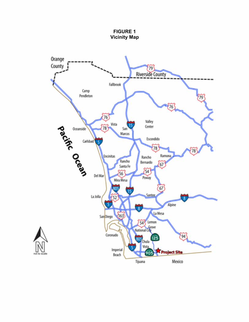
FIGURE 1 Vicinity Map

OTAY 250 - 30 - Date PDS2015-SPA-15-001
FIGURE 2 Aerial Photograph
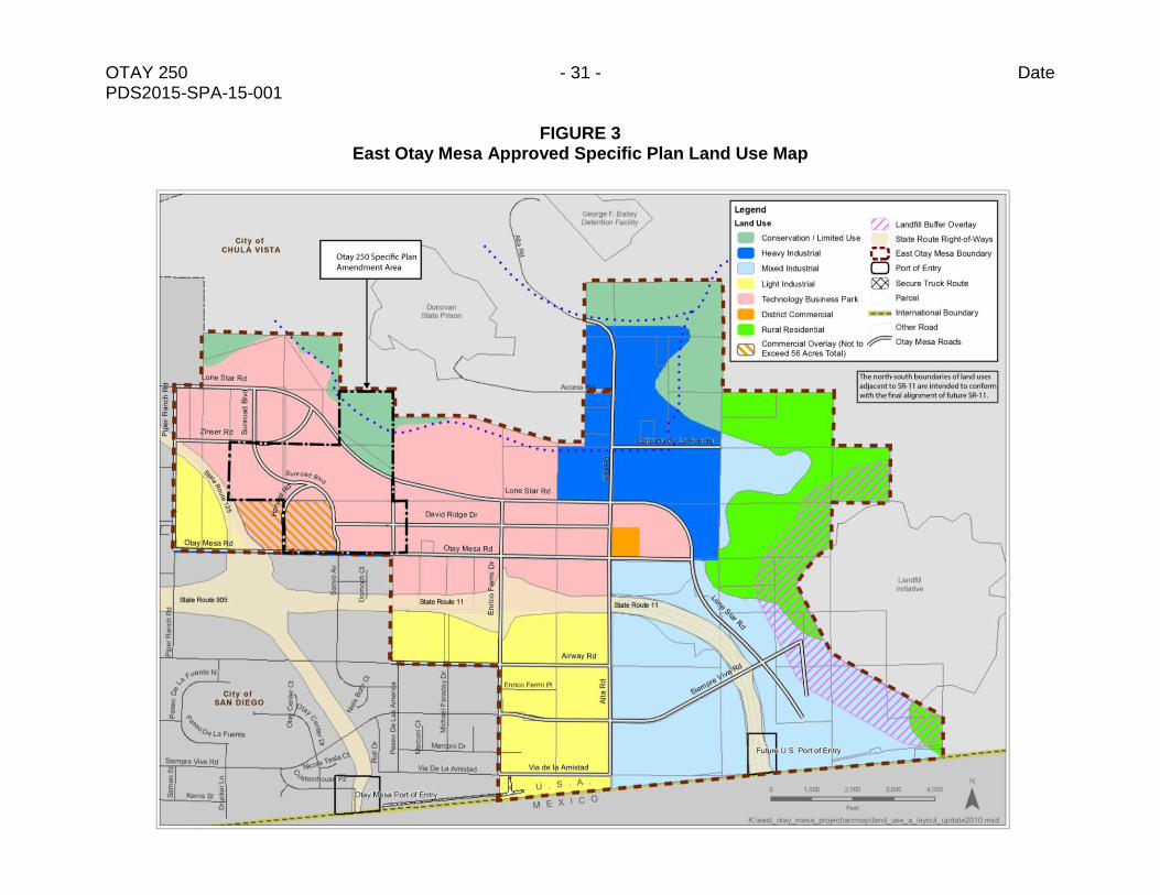
OTAY 250 - 31 - Date PDS2015-SPA-15-001
FIGURE 3 East Otay Mesa Approved Specific Plan Land Use Map
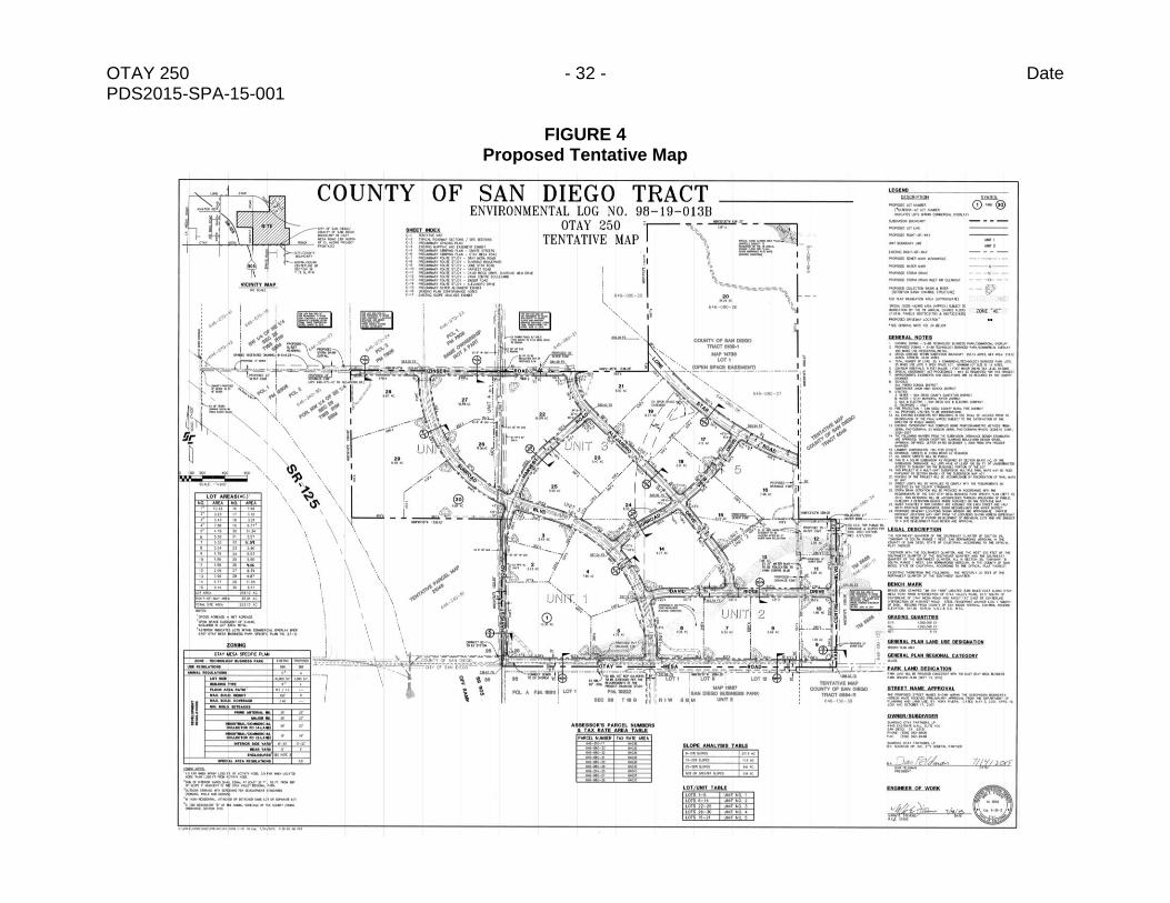
OTAY 250 - 32 - Date PDS2015-SPA-15-001
FIGURE 4 Proposed Tentative Map

OTAY 250 - 33 - Date PDS2015-SPA-15-001
FIGURE 5 Specific Plan Amendment Proposed Conceptual Land Use and Circulation Plan