environmental sensitivity atlas for the albertine...
TRANSCRIPT

1
THE REPUBLIC OF UGANDA
for a living planet*
ROYAL NORWEGIAN EMBASSY
National Environment Management AuthorityENSUR ING
SU STA INABL E DEVELO
PMENTy
Environmental Sensitivity Atlasfor the Albertine Graben

© 2009 NATIONAL ENVIRONMENT MANAGEMENT AUTHORITY (NEMA)NEMA House Plot 17/19/21 Jinja RoadP.O. Box 22255 Kampala UgandaTel: 256-41-251064/5/8 Fax: 256-41-257521 E-mail:[email protected] http://www.nemaug.org
ISBN 978-9970-881-01-7
Printed by New Era Printers, Publishers and Stationers Ltd.P.O Box 3485 Kampala UgandaTel. 256-414-220713E-mail:[email protected]
Environmental Sensitivity Atlasfor the Albertine Graben


Technical Team
Kitutu K. Mary Goretti NEMAEugene Muramira NEMAFiripo Mpabulungi NEMAFestus Bagoora NEMAGeorge Lubega NEMAArnold Waiswa Ayazika NEMAElizabeth Mutayanjulwa NEMAAlex Lugadiru UNEPGrace Nangendo WCSSarah Prinsloo WCSKasande Robert PEPDNjabire Nurudin PEPDAventino Bakunda Department of Fisheries ResourcesJohn Diisi National Forestry AuthoritySsekamuli Benjamin Directorate of Water Resources ManagementLwasa James National Agricultural Research LaboratoriesBright Kimuli Uganda Bureau of StatisticsJustine Namara Uganda Wildlife AuthorityOmute Paul Wetlands Management DepartmentGaliwango Hamza Physical Planning DepartmentEdema Maurice Moyo District Environmrnt OfficeMfutimukiza David MUIENR, Makerere UniversityIsaiah Owiunji WWFKundu Lawrence Intern-NEMADenis Kimera Intern-NEMA
Institutions that contributed Data
Directorate of Water Resources ManagementNational Fisheries Resources Research InstituteDepartment of Fisheries ResourcesPetroleum Exploration and Production DepartmentNational Forestry AuthorityUganda Wildlife AuthorityNational Agricultural Research Laboratories - Kawanda (NARL)Uganda MuseumsUganda Bureau of StatisticsPhysical Planning Department, Ministry of Lands, Housing and Urban DevelopmentUnited Nations Environment Programme (UNEP)Wildlife Conservation Society Makerere University Institute of Environment and Natural Resources (MUIENR)Tullow Oil
Technical Coordinator: Kitutu K. Mary GorettiCopy Editor: Khainza Loyce AnnetDesign and layout: Elizabeth Mutayanjulwa

Table of ContentsForeword ......................................................................................................................... iv
Acknowledgement ........................................................................................................ v
List of Acronyms ........................................................................................................... vi
List of Maps ................................................................................................................... vii
List of Plates .................................................................................................................. viii
List of Tables ............................................................................................................... ix
Chapter 1: Introduction ............................................................................................... 11.1 Background to Oil Exploration in the Albertine Graben ...............................1 11.2 Objective of the Sensitivity Atlas ................................................................. 21.3 Geology of the Albertine Graben ................................................................ 31.4 Climate ................................................................................................................ 5 1.4.1 Rainfall .................................................................................................... 5 1.4.2 Temperature and Humidity................................................................. 6 1.4.3 Wind ........................................................................................................ 71.5 Surface and Ground Water............................................................................. 8 1.5.1 Drainage.................................................................................................... 91.6 Minerals and Energy Resources ...................................................................... 11 1.6.1 Mineral Resources ................................................................................. 11 1.6.2 Energy Resources.................................................................................... 11 1.6.2.1 Energy potential......................................................................... 11 1.6.2.2 Energy use .................................................................................. 121.7 Land use ................................................................................................................121.8 Protected Areas.................................................................................................... 121.9 Agriculture ......................................................................................................... 131.10 Human Settlements.............................................................................................. 151.11 Tourism................................................................................................................ 151.12 Fisheries............................................................................................................... 151.13 Ecosystems and Biodiversity ........................................................................... 17 1.13.1 Vegetation ............................................................................................... 19 1.13.2 Fauna ...................................................................................................... 20 1.13.3 Avifauna ................................................................................................. 21 1.13.4 Biodiversity outside protected areas ................................................ 221.14 National Heritage .............................................................................................. 22 1.14.1 Archaeological sites .............................................................................. 22 1.14.2 Historic and cultural sites..................................................................... 24
i

Chapter 2: Biological sensitivity................................................................................. 272.1 Biological sensitivity ......................................................................................... 27 2.1.1 Species biodiversity ............................................................................... 27 2.1.2 Wildlife distribution along the Albertine Rift .................................... 27 2.1.3 Fish breeding or spawning areas ......................................................... 28 2.1.4 Woody plants species and forest bird species diversity................... 29 2.1.5 Species of special importance ................................................................ 29 2.1.6 Combining variables ............................................................................... 29 2.1.7 Highlights of the species richness map ................................................ 31 2.1.8 Highlights of the species of spacial importance map ........................ 32 2.1.9 Conseravation status ............................................................................... 33 2.1.10 Highlights of the conservation status map .......................................... 34 2.1.11 Overall biodiversity ................................................................................ 35 2.1.12 Highlights of the overall bidiversity map ............................................ 362.2 Socio Economic data in the Albertine Graben region .................................... 36 2.2.1 Infrastructure........................................................................................................ 36 2.2.1.1 Road classes ................................................................................ 36 2.2.1.2 Railway lines ............................................................................. 36 2.2.1.3 Airfields ...................................................................................... 37 2.2.2 Human settlements.................................................................................. 37 2.2.2.1 Fishing landing sites ................................................................... 37 2.2.2.2 Hotels amd lodges ....................................................................... 38 2.2.2.3 District boundaries ...................................................................... 382.3 Geology Map ........................................................................................................ 38 2.3.1 Morphology of Albitine Graben ............................................................ 38 2.3.2 Geology of the Albertine Graben........................................................... 38 2.3.2.1 Sediments ..................................................................................... 39 2.3.2.2 Rift flank basement ...................................................................... 402.4 Land cover sensitivity ......................................................................................... 412.5 Sensitivity of soils in the Albertine Graben ..................................................... 43 2.5.1 Soil permeability ...................................................................................... 43 2.5.2 Soil erosion ............................................................................................... 38 2.5.2.1 Development of the Erosion Sensitivity map for the Albertine Graben............................................................................... 452.6 Sensitivity of Ground water in the Albertine Graben ................................... 52 2.6.1 Static water level .................................................................................................. 52 2.6.2 Depth to Bedrock ..................................................................................... 54 2.6.3 Definition of depth classes...................................................................... 54
Chapter 3: Sensitivity of the Lake Albert shoreline and the Bathometry of the lake ............................................................ 573.1 Sensitivity of the Lake Albert shoreline and the Bathometry of the lake .... 57
ii

iii

iv
ForewordOil exploration has been ongoing in the Albertine Graben since the 1920’s. Currently there is confirmation of commercially viable oil deposits in this area with early production scheduled to begin 2009. Oil spills can have severe and long term ecological and socio-economic adverse impacts if not properly planned for and addressed. While it is not possible to predict the impacts of an oil spill with certainty it is possible to evaluate the vulnerability of an area to a defined spill scenario based on the environmental resources present in the area.
An environmental oil spill sensitivity atlas has been prepared to provide environmental planners with tools to identify resources at risk, establish protection priorities and identify timely appropriate response and clean-up strategies. The atlas enables oil companies and authorities to incorporate environmental consideration into exploration and contingency plans. It also provides an overview of such aspects as the occurrence of biological resources, human resource use (fishing and hunting) and archaeological sites that are particularly sensitive to oil spill. Furthermore it contains information regarding the physical environment, lake shore and bathymetry of Lake Albert and the climate of the area.
The Albertine Graben is known for its high biodiversity spots at the same time it is now an oil rich region. Oil is a non-renewable resource meaning that at one time it will be exhausted. Therefore, care has to be taken to ensure that exploitation of oil resources is done without compromising the quality and quantity of environmental resources. The oil for development strategy should improve services such as conservation of natural resources, infrastructure, energy, education etc.
I hope the information in this atlas will be used effectively during all decision making processes connected to oil and planning of all activities in oil for development.
Hon. Maria MutagambaMINISTER OF WATER AND ENVIRONMENT
Acknowledgement
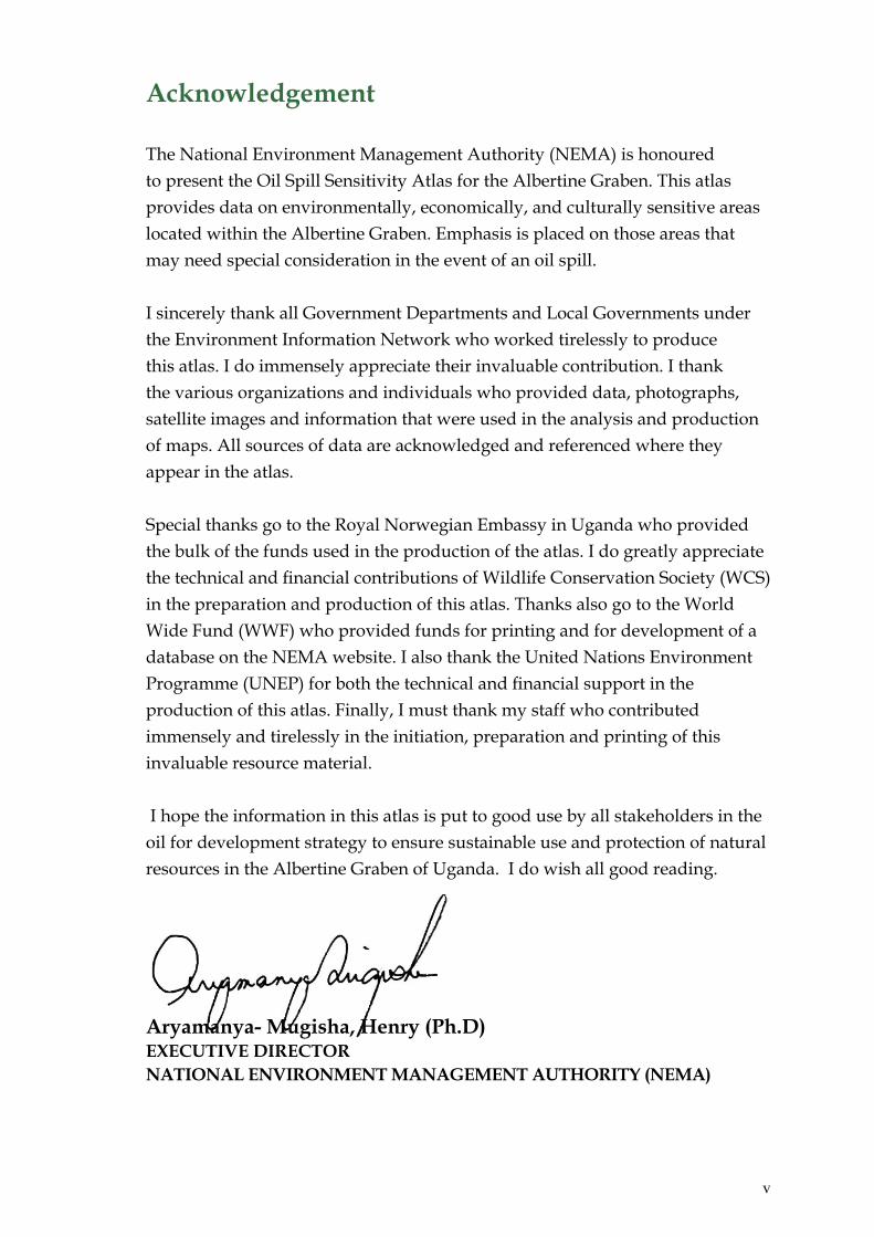
The National Environment Management Authority (NEMA) is honoured to present the Oil Spill Sensitivity Atlas for the Albertine Graben. This atlas provides data on environmentally, economically, and culturally sensitive areas located within the Albertine Graben. Emphasis is placed on those areas that may need special consideration in the event of an oil spill.
I sincerely thank all Government Departments and Local Governments under the Environment Information Network who worked tirelessly to produce this atlas. I do immensely appreciate their invaluable contribution. I thank the various organizations and individuals who provided data, photographs, satellite images and information that were used in the analysis and production of maps. All sources of data are acknowledged and referenced where they appear in the atlas.
Special thanks go to the Royal Norwegian Embassy in Uganda who provided the bulk of the funds used in the production of the atlas. I do greatly appreciate the technical and financial contributions of Wildlife Conservation Society (WCS) in the preparation and production of this atlas. Thanks also go to the World Wide Fund (WWF) who provided funds for printing and for development of a database on the NEMA website. I also thank the United Nations Environment Programme (UNEP) for both the technical and financial support in the production of this atlas. Finally, I must thank my staff who contributed immensely and tirelessly in the initiation, preparation and printing of this invaluable resource material.
I hope the information in this atlas is put to good use by all stakeholders in the oil for development strategy to ensure sustainable use and protection of natural resources in the Albertine Graben of Uganda. I do wish all good reading.
Aryamanya- Mugisha, Henry (Ph.D)EXECUTIVE DIRECTORNATIONAL ENVIRONMENT MANAGEMENT AUTHORITY (NEMA)
v

vi
List of Acronyms% - Percentage ºC - Degrees Celsiustons - Tonnesm - MetresCAS - Catch Assessment SurveysCFCs - ChlorofloralcarbonsDEM - Digital Elevation ModelDFR - Department of Fisheries ResourcesDRC - Democratic Republic of CongoDWRM - Directorate of Water Resources ManagementEAMD - East African Metrological DepartmentEARS - East African Rift SystemHFO - Heavy Fuel OilsIBA’s - Important Bird AreasITCZ - Inter-tropical Convergence Zone Km - KilometreKv - KilovoltsMFCA - Murchison Falls Conservation AreasMFNP - Murchison Falls National ParkMIST - Management Information System TechnologyMUIENR - Makerere University Institute of Environment and Natural ResourcesMW - Mega Watts NFRRL - National Fisheries Resources Research InstituteNEMA - National Environment Management AuthorityNFA - National Forestry AuthorityNP - National ParkNFRRI - National Fisheries Resources Research InstitutePAs - Protected AreasPEPD - Petroleum Exploration and Production DepartmentPPD - Physical Planning Department (Ministry of Lands, Housing and Urban DevelopmentQECA - Queen Elizabeth Conservation AreasQENP - Queen Elizabeth National ParkSRTM - Shuttle Radar Topographic ModelSWL - Static Water LevelUBOS - Uganda Bureau of StatisticsUM - Uganda MuseumsUNEP - United Nations Environment Management ProgrammeUWA - Uganda Wildlife AuthorityWCS - Wildlife Conservation SocietyWMD - Wetlands Management DepartmentWWF - World Wide Fund

vii
List of Maps
Map 1: Albertine Graben Rainfall (mini-annual)...................................................................6Map 2: Albertine Graben Rainfall (minimum) ......................................................................7Map 3: Albertine Graben Drainage........................................................................................10Map 4: Albertine Graben Archaeological Sites ....................................................................23Map 5�Map 6: Species of special importance ...................................................................................32M�Ma�Map 9: Geology of Albertine Graben ...................................................................................39Map 10: Albertine Graben Land Cover Sensitivity..............................................................42Map 11: Albertine Graben Soil Permeability ........................................................................44Map 12: Base Map - Graded Rainfall zones in the Albertine Graben ...............................46Map 13: Base Map - Graded Soil classes in the Albertine Graben ....................................47Map 14: Base Map - Generalized and Graded Slope Map of the Albertine Graben ......48Map 15: Base Map - Graded Map of the Land cover classes in the Albertine Graben...49Map 16: Erosion Sensitivity Map for the Albertine Graben ..............................................50Map 17: Albertine Graben Depth to Bedrock.......................................................................53 Sensitivity of the Lake Albert shoreline and the Bathymetry of the lake ..........58 Map 18: Sensitivity Atlas Map 1..........................................................................58-59 Map 19: Sensitivity Atlas Map 2 .........................................................................60-61 Map 20: Sensitivity Atlas Map 2A ......................................................................62-63 Map 21: Sensitivity Atlas Map 2B .......................................................................64-65 Map 22: Sensitivity Atlas Map 3 ........................................................................ 66-67 Map 23: Sensitivity Atlas Map 4 ..........................................................................68-69 The Bathymetry of Lake Albert..................................................................................70

List of Plates
Oil testing at Mpuuta-3 in EA2...................................................................................... xAn Exploration site at Butiaba Runga village, Kapapi parish , Hoima District...... 1A concrete lined waste mud and cuttings pit at Kingfisher in Bugoma, EA 3A.. .. 2Butiaba-Wanseko Rift valley........................................................................................... 4Kabwoya Game Reserve.................................................................................................16An elephant in Queen Elizabeth National park..........................................................17Sempaya Hot Springs in Semliki National Park.........................................................18Climbing Lions in Ishasha ............................................................................................19Pelikans in Queen Elizabeth National Park ...............................................................20The Delta in Murchison Falls National Park ..............................................................21Mparo Cultural tomb and antiques..............................................................................25Inspection of an oil well at Mpuuta village, Hoima District, July 2008 .................26Oil te�Looking North up the escarpment along Lake Albert faultline ..............................57
viii

ix
List of Tables
Table 1: Conservation areas along the Albertine Graben............................. 33Table 2: Land cover sensitivity......................................................................... 42Table 3: Soil permeability: erosion sesitivity ranking based on texture......43Table 4: Soil erosion: Erosion sensitivity ranking of land cover classes..... 43Table 5: Rainfall contribution to soil erosion..................................................43Table 6: Rainfall contribution to soil erosion..................................................45Table 7: Soil erosion sensitivity ranking based on texture............................47Table 8: Slope sensitivity to soil erosion .........................................................48Table 9: Land cover sensitivity to soil erosion ...............................................49Table 10: Static water level...................................................................................52Table 11: Depth of Bedrock..................................................................................54

Petr
oleu
m E
xplo
ratio
n an
d Pr
oduc
tion
Dep
artm
ent (
PEPD
) 200
8
x
Oil testing at Mpuuta-3 in EA2Source: Petroleum Exploration and Production Department (PEPD) 2007

Chapter 1 I n t r o d u c t i o n
1
1.1 Background to Oil Exploration in the Albertine Graben
In 1925, the petroleum potential of Uganda was documented by A.J. Wayland based on oil seepages he mapped at that time. The first well, Waki-B1 was drilled in the Butiaba area in 1938. The Albertine Graben, the area with potential for petroleum accumulation has since been subdivided into nine Exploration Areas.
These areas include Exploration Areas 1, 2, 3A, 4B and 5. Five out of the nine Exploration Areas are licensed to oil companies for exploration, development and production. The first phase of the sensitivity mapping exercise will focus on Exploration Areas 1, 2 and 3A. In these Areas, following acquisition of seismic data and exploration, drilling, oil and gas discoveries have been made. This implies that activities of ertaken more intensely in the three Areas than in the other two.greed on an Early Production Scheme to produce 4,000 barrels of oil per day starting in the first quarter of 2010.
An Exploration site at Butiaba Runga village, Kapapi parish , Hoima District.Source: Petroleum Exploration and Production Department (PEPD) 2008
2
The oil will be processed to produce gas, naphtha, kerosene, diesel and Heavy Fuel Oil (HFO). The HFO will be used to produce thermal electricity at the Mputa area in Kaiso-Tonya flats. Considering the discoveries that continue to be made, a fully fledged utilisation plan of another and bigger refinery and/or a pipeline is not far fetched.
1.2 Objective of the Sensitivity Atlas
The stakeholders involved in the sensitivity atlas preliminary meetings agreed that the atlas would seek to fulfil the following objective:“the atlas will display, identify and provide the ability to analyse the relative sensitivities (environmental, biological, geographical, and socio-economic) to oil spill and oil development within the exploration areas in the Albertine Graben region of western Uganda”.
Detailed objectives which form the basis for modelling of the data layers have been extrapolated from this overall objective as follows:
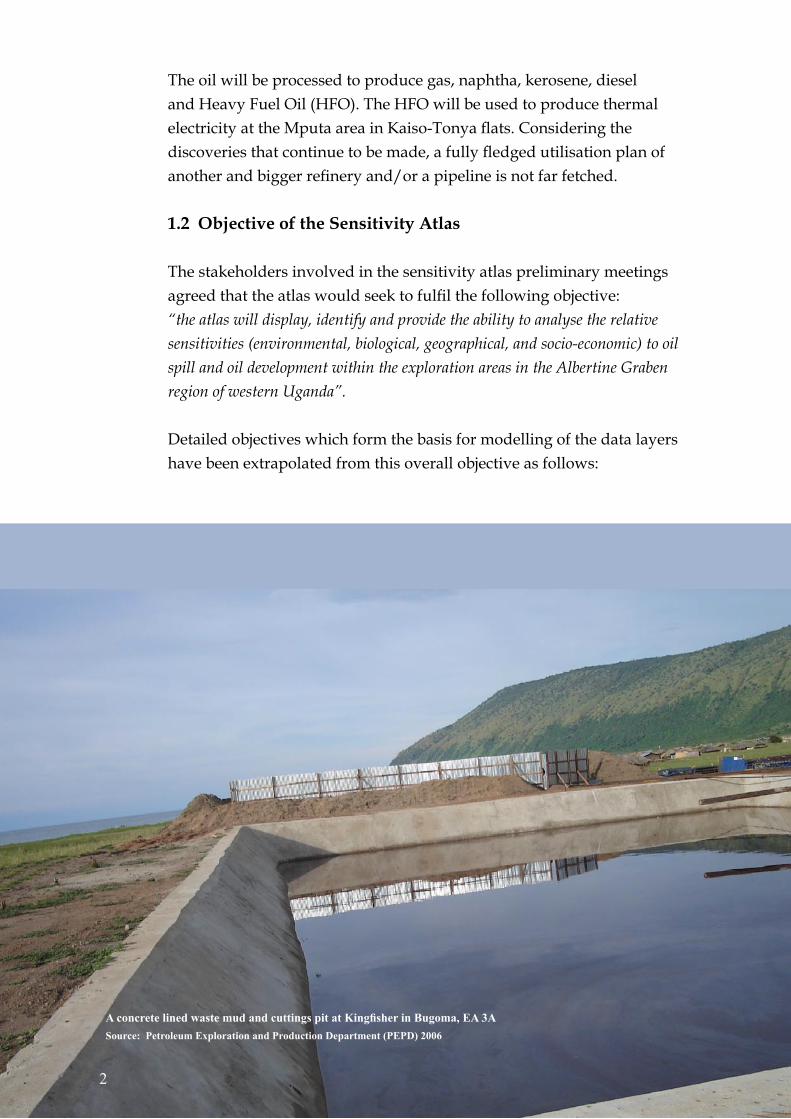
A concrete lined waste mud and cuttings pit at Kingfisher in Bugoma, EA 3ASource: Petroleum Exploration and Production Department (PEPD) 2006

(a) To identify and protect: (i) fragile habitats (land cover types) (ii) designated protected areas (iii) endemic and threatened species (iv) areas of high biodiversity (v) cultural, religious and historical sites (vi) economic activities that could be negatively impacted by oil activities (vii) water courses
(b) To identify and avoid: (i) clearance of vegetation areas susceptible to erosion (ii) oil contaminating risks on permeable soils or areas with high ground water table and shallow aquifers (iii) major construction such as pipelines on fault lines like oil spill risk on lakes shorelines
1.3 Geology of the Albertine Graben
The Albertine Graben forms the Northern - most part of the Western arm of the East African Rift System (EARS). It stretches from the border between Uganda and Sudan in the north to Lake Edward in the south, a total distance of over 500 km with a variable width of 45 km (including the Democratic Republic of Congo). The Albertine Graben is a Cenozoic rift basin formed and developed on the Precambrian orogenic belts of the African Craton. Rifting was initiated during the late Oligocene or Early Miocene.
The Albertine Graben was initiated by either reactivating pre-Cambrian lineaments or creating new normal faults by an extensional regime during the Cretaceous prior to initiation of the East African Rift System. This was followed by a compressive regime and this regime could have persisted into late Oligocene or even Early Miocene as evident from seismic data. The earliest dated sediments from Semliki basin indicate an age of Early Miocene. The Graben trends in a NE-SW direction through most of its length. Each of the rift basins in the Albertine Graben is bounded by steep border faults and broad uplifted flanks (escarpments) that are predominantly pre-cambrian basement composed of metamorphic rocks such as gneisses, quartzite, schist and varying amounts of mafic intrusions.
3

The available geological and geophysical data suggest that the Albertine Graben has undergone substantial tectonic movements and thick sediments (approximately 6 km) have been deposited in fluvial deltaic and lacustrine environments. Surface geological mapping undertaken by the Petroleum Exploration and Production Department and the wells drilled by the Licensees so far indicate these sediments to be predominantly sandstones, siltstones, claystones and shales. The sandstones and siltstones are mostly of high porosity and permeability.
Butiaba - Wanseko Rift valleySource: Wildlife Conservation Society (WCS) 2008
4

1.4 Climate
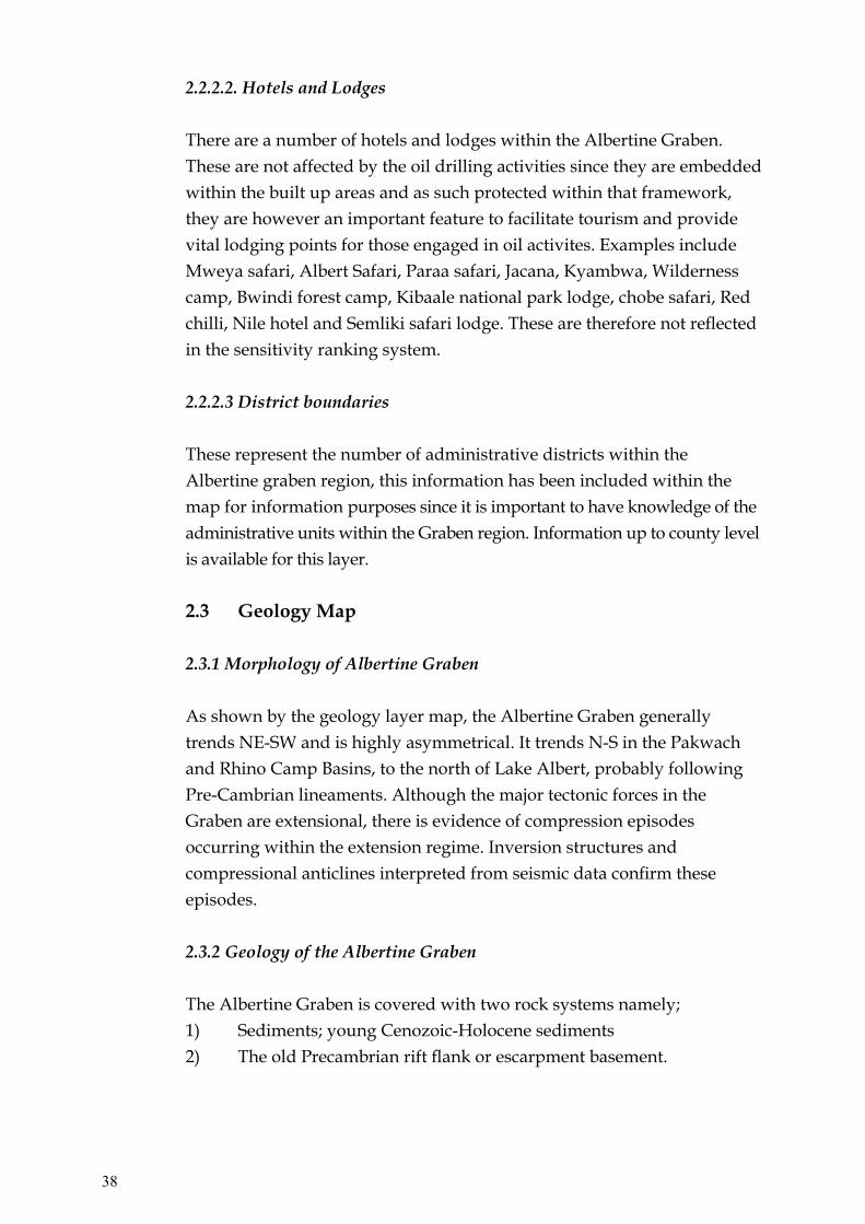
1.4.1 Rainfall
There is a sharp variation in rainfall amount in the region, mainly due to the variations in landscape that consist of rift escarpment, the rift valley and the Rwenzori mountains that rise to a great height of over 5,000m above sea level.
The rift valley itself is in a rain shadow of the highland area comprising the escarpment to the east and the mountains in the central west part of the graben. It receives relatively low mean annual rainfall, with most parts receiving less than 875mm; for example, Butiaba receives 750mm although Kasese receives a slightly higher mean rainfall of 970mm. On the highland areas of the rift escarpment, rainfall averages increase, largely due to orographic influence. For example, Masindi receives an annual average rainfall of 1,359mm, while Hoima receives 1435mm.
On the Rwenzori mountain slopes, rainfall increases even higher, in some cases to over 1500mm. There is however, a serious lack of coverage of climatic measuring instrumentation, which is a common problem in mountainous regions worldwide and, therefore, information on the spatial distribution of rainfall in the Rwenzori mountains remains scanty. There is also, significant seasonal variation in the rainfall pattern, mainly as a result of variation in factors influencing rainfall, especially the periodic shifting of the Inter-Tropical Convergence Zone (ITCZ) and the wind blows from the Atlantic Ocean through the Congo basin in central Africa. In the northern part of the region, there are two seasons of high rainfall, associated with the passing of the Inter-Tropical Convergence Zone (ITCZ) over the region. Rain occurs in all months, but with two peaks occurring from between April and May, and August through to October, with two relatively drier spells around January and June.in the rainfall pattern.
In the northern part of the region, there are two seasons of high rainfall, associated with the passing of the Inter-Tropical Convergence Zone (ITCZ) over the region. Rain occurs in all months, but with two peaks occurring from between April and May, and August through to October, with two relatively drier spells around January and June.
5

1.4.2 Temperature and Humidity
The Albertine Graben region lies astride the equator. The region experiences small annual variation in air temperatures; and the climate may be described generally as hot and humid, with average monthly temperatures varying between 27°C and 31°C, with maximums consistently above 30°C and sometimes reaching 38°C. Average minimum temperatures are relatively consistent and vary between 16°C and 18°C. The average monthly humidity is between 60 and 80percent. The high air temperatures result in high evaporation rates causing some parts to have a negative hydrological balance.
Map 1: Albertine Graben Rainfall (mini-annual)Source: Meteorology Department
6
Albertine Graben Rainfall (maximum)
E
S
W
N
mini-annual)

1.4.3 Wind
Wind speed and direction records indicate a high percentage of occurrences, especially in the rift valley, where prevailing winds commonly blow along the valley floor in a north-east to south-west direction or vice versa, as well as traverse the rift valley in an east to west direction. On the escarpment and mountain slopes, prevailing winds blow largely mult-directionally. The long-term wind speed records from the East African Meteorological Department (1975) indicate average annual wind speeds of 4 knots and 6 knots at 0600 hours and 1200 hours, respectively for Butiaba, 3 knots and 5 knots, respectively for Hoima and 2 knots and 6 knots, respectively for Kasese.
7
Map 2: Albertine Graben Rainfall (minimum)Source: Department of Meteorology
Albertine Graben Rainfall (minimum)
E
S
W
N

The wind speed values indicated, therefore, represent conditions of moderate to strong or turbulent conditions. The average number of calms experienced in the area, are indicated to be experienced for 41days at 0600 hours and 14 days at 1200 hours, respectively at Butiaba; 99 days and 27 days, respectively for Hoima; 181 days and 44 days, respectively for Kasese; and 99 days and 27 days, respectively for Masindi.
The main conclusion from these climatic figures is that for most of the year, the area experiences moderate to stron and gusty winds, increasing in the afternoon. Both wind speed and direction have important implications on the dispersion potential for pollutants arising from oil production activities.
1.5 Surface and Ground Water
The Kaiso-Tonya area is drained by two perennial rivers, the Hohwa River and the Wambabya River and other seasonal streams. The rivers/streams originate on the high elevated areas of the escarpment, flow down the escarpment into the valley and drain into Lake Albert. A series of erosion valleys and gullies cut the escarpment and discharge runoff from the escarpment to the valley.
The seasonal streams and rivers are flooded by runoff from the catchment areas after a heavy rainfall event. The water drains quickly into Lake Albert and the discharge in the run-off channels ceases. Seasonal rivers include Sebugoro, Kabyosi, Warwire and Nyamasoga. The perennial rivers (Hohwa and Wambabya) flow continuously with peak flow during the rainy season.
In the Butiaba – Wanseko area, a number of rivers such as Waki, Waiga, Sonso and Waisoke and numerous streams descend the rift scarps, traverse the rift valley, draining into Lake Albert. Consequently the rivers and streams have incised into the scarps leading to a topographic pattern of narrow river valleys and sometimes gorge-like features. Due to limited catchment size characterised by rift scarps and, therefore, limited hydrological potential, some of the scarps are drained by ephemeral flows to the extent that some of the river valleys are dry most of the time.
Running east-west through Murchison Falls National Park for 80 km is the Victoria Nile. From Chobe to Paraa the Nile drops 350 m through
8

9
stretches of white water rapids and cascades. The most dramatic feature along this reach is Murchison Falls, where the river has cut back through the Rift escarpment plunging 45m below with huge convulsions through a cleft only 6 m wide. Below Murchison Falls, the river flows out of the gorge to become calmer and wider, finally entering Lake Albert as a delta (now a Ramsar Site). While Victoria Nile is responsible for most of the surface drainage in the protected area, smaller watersheds divert drainage into Waiga and Waisoke rivers which discharge into Lake Albert south of Buliisa. The Albert Nile drains in Lake Albert to the north.
Further south-west, the Rwenzori Mountains become the most important water catchment with numerous rivers descending the high rainfall and snow-capped mountain to the rift valley floor and into lakes George and Edward, for example, rivers Mubuku and Nyamwamba. On the other hand numerous rivers and streams drain from the escarpment and highland areas beyond to the riff valley zone, and also often end up in the lakes. Ground water aquifers exist in a number of locations, the hydrology of which is undoubtedly influenced by a number of environmental conditions including geology, rainfall and the existence of rift valley lakes. Ground water is harnessed in many areas, largely to provide for water needs of local communities. Evidence from many boreholes and shallow wells indicate relatively high water table conditions in many places. Such conditions imply high sensitivity of the water resources to oil exploration and development activities, which could lead to serious problems of pollution of the shallow aquifers, if not well handled.
1.5.1 Drainage
All of Uganda drains to the Nile. In the Albertine Graben, there are three main lakes; Lake Albert, Lake Edward, and Lake George and there are a number of streams. In the blocks under consideration, there major lake is Lake Albert (Africa’s seventh largest lake) whose principal affluent streams are the Semliki, which comes from Lake Edward through the western edge of the great Ituri rain forest in DR Congo and the Victoria Nile, which enters in Uganda very close to the northern end. Both rivers have built deltas into the lake, that of the Semliki is the larger and 90% of it is in Uganda. Although the Nile carries more water than the Semliki, it has little influence on the ecology of the lake, other than to maintain water levels. There are other numerous small streams entering the Lake from both Uganda and DR Congo, some of which are highly seasonal and of only minor importance to the hydrology of the lake.

Map 3: Albertine Graben DrainageSource: DEM - from UNEP Drainage - from the Directorate of Water Resources Management, Entebbe.
10
Its outlet, at the northernmost tip of the lake, is the Albert Nile, which becomes known as the Mountain Nile when it enters Sudan. Sensitivity of the rivers is in regard to their proximity to the oil wells, the closer the wells are to the river, the more sensitive the river is and vice versa. Several classes are therefore formed based on the proximity of the wells to the rivers as indicated:

1.6 Minerals and Energy resources
1.6.1 Mineral resources The Albertine Graben is a host of a number of economic mineral resources, although there is not much detailed and accurate information about location and extent of deposits. In the southern part of the Albertine Graben in the Lakes George-Edward basin, copper has been mined in the past from Kilembe mines in the Nyamwamba river valley near Kasese town, and although mining activity stopped in 1970s, there is still significant mineral reserves awaiting exploitation. Furthermore, the copper ore is richly associated with cobalt mineral; and currently the mineral is being extracted from the copper tailings accumulations from past copper ore processing by Kasese Cobalt Company Ltd.
At Hima, Dura and Muhokya areas, limestone deposits exist and are extracted for the manufacture of cement and lime. Gypsum has been mined in the Kibuku area near Sempaya in Semliki.
Gold has been reported in Maramagambo forest south of Lake Edward, while to the extreme south-west, deposits of iron-ore exist; and possibly tin and other related minerals might be found when the ongoing assessment minerals resources is completed.
Another mineral of socio-economic significance is salt. Salt mining has been undertaken for decades at Lake Katwe north of Lake Edward and to a very low scale at Kibiro near the shores of Lake Albert north of Kaiso-Tonya, to meet domestic needs; but potential for export also exist and in the past, attempts have been made to establish a complex salt factory at Katwe.Existence of minerals has important implications and, potential for their exploitation could be accelerated by the ongoing petroleum development activities in the region.
1.6.2 Energy resources
1.6.2.1 Energy potential
The Albertine Graben area has hydropower energy resources and potential for geothermal resources. At Mubuku River near Kasese,
11

hydropower is being generated by both Kilembe Mines Ltd and Kasese Cobalt Company Ltd. New mini hydropower sites have been initiated on rivers Wambabya in Kaiso Tonya and on River Muzizi. Hydropower potential also exists at river Waki and at Murchison Falls on Victoria Nile.
Solar energy use is also becoming more relevant especially given the lack of grid electricity. The costs of accessories involved are, however, still relatively high and unaffordable to the majority of the households in the region. Potential for geothermal energy exists at several known sites in the region, although not yet explored. Potential sites include the hot springs at Katwe near Lake Edward, at Buranga in the Semliki flats in Bundibugyo District at Kibiro on the shores of Lake Albert and in the Virunga area to the extreme south-west rift. The total estimated potential from the 4 sites is 450 MW. The Katwe site is considered the most promising due to the presence of sub-surface steam at 2300C and its location 35km from the 132kv transmission line in Kasese, making it easy to connect the power produced to the National grid (NEMA, 2004/2005).
1.6.2.2 Energy use
Majority of the population in the Albertine Graben uses wood fuel as the most dominant source of energy. Kerosene or paraffin is used for lighting and less than 3% of all households have access to electricity supply. However, firewood has become scarce and most people have resorted to using charcoal which is very expensive. At the moment, most of the rift valley area is not connected to the electricity grid although the individual companies involved in all exploration have generators that provide electric power to their employees. For many areas in the basin, the possibility of grid electricity is remote.
1.7 Land Use
There are three main types of land use in the Albertine Graben namely, protected areas (national parks, wildlife reserves and forest reserves), agriculture (crops and livestock) and human settlements.
1.8 Protected Areas
There are 39 wildlife protected areas including national parks, wildlife reserves, community wildlife areas, and sanctuaries in Uganda. Twenty
12

two (22) out of the total of 39 protected areas are national parks and wildlife reserves, and 10 out of these are found in the Albertine region. The National Parks in the Albertine Rift include Murchison Falls, Queen Elizabeth, the Rwenzori Mountains, Kibale, Semliki, Bwindi and Mgahinga.
The Wildlife Reserves include the Ajai and East Madi located in the extreme north-east of this region; Bugungu and Karuma Wildlife Reserves in Buliisa and Masindi Districts, respectively which are located in the immediate south; The Tooro-Semliki, Kabwoya and Kyambura located mid-way in the region; while to the extreme south-west, is the Kigezi Wildlife Reserve. There are also, a number of important Forest Reserves in the region, for example, Bugoma and Budongo Forest Reserves. The Albertine Graben is therefore, a significant wildlife conservation area, and home to a diversity of wildlife species; and as a result, the area has a high tourism potential, besides being vitally important for the conservation of the wildlife and their habitats.
The location of 10 out of the total 22 national parks and wildlife reserves in Uganda within the oil rich Albertine Graben presents a land use challenge. Oil development could disrupt conservation if not well planned. Yet these National Parks and Forest Reserves, along with other protected areas inside and outside the Graben, form a relatively continuous protected areas system and are generally linked by wildlife corridors. These corridors facilitate the movement of wildlife between habitats that are increasingly being fragmented by farmed and urban ecosystems. They promote the exchange of genes, allow animal interactions, and act as dispersal routes and increase species diversity. In western Uganda these corridors not only link individual protected areas to one another, they also link Uganda’s protected area system to the Democratic Republic of Congo.
1.9 Agriculture
The Albertine graben area comprises of different physical landscapes, climatic conditions and soils which, in turn, have significantly influenced land use systems in the area. Because of its location in the rain shadow, the rift valley zone is mostly dry and hot and; except for clay soils in the river Semliki flats, soils on the rift valley floor are dominantly sandy, making the area to suffer from moisture deficiency. Moisture deficiency makes
13

the area unsuitable for agriculture. The clay soils in the Semliki flats suffer from saline conditions which limits their agricultural potential. Therefore, the largest proportion of the rift valley area is of low agricultural potential, which partly explains its current major use as a conservation area. However, to the south-west in Kasese District, moderately productive soils occur in areas flanking the foothills of the Rwenzori mountains, and with moderate rainfall received this area supports significant agricultural activities based on maize, cotton and beans. In the same area, utilization of water from river Mubuku supports irrigation agriculture in the Mubuku irrigation scheme. Shallow sandy soils dominate on the rift escarpment slopes to the east and the mountain slopes to the west. These areas receive moderate to high rainfall, largely due to the orographic effect, increasing with altitude on the Rwenzori mountain slopes on the west. Agriculture in these areas is dominated by peasant small holders, based on crops like bananas, cassava, maize, legumes and coffee as a cash crop. The shallow sandy soils factor, coupled with the dominantly steep slopes landscape and peasant crop agriculture dominated by annual crops, makes the area very prone to soil erosion and mass wasting (landslides, soil slips and rockfalls). Therefore, these areas are of marginal agricultural productivity and high sensitivity to degradation. Consequently, soil erosion and rapid decline in land productivity is a major environmental problem in this area, while soil erosion from these high land areas is the major cause of sedimentation of the rivers and lakes in the rift valley.
Livestock is another important agricultural activity, especially by the Batuku tribe on the Semliki flats in Ntoroko county, Bundibugyo District and the Basongora in Busongora County in Kasese District. The Batuku are psychologically attached to their cows. Rwebisengo market is one of the largest cattle markets in the country, where the sales are exported to urban areas for supply of meat. Because of the cash earnings from livestock sales, the Batuku families have higher incomes compared to their neighbours on the escarpment and mountain slopes with a crop-based economy. Grazing land is communal and, this coupled with increasing population of both human and livestock, land availability is becoming limited, which has led to overgrazing. The Basongora communities rely heavily on their livestock for their livelihood, both as a source food and for cash sale income.
14

The development of oil production activities is likely to have a significant effect on the agricultural economy. On one hand, it may lead to increased demand for crop and livestock products, which may trigger increased competition for land use and subsequently, to pressure on the land resources; while on the other hand, emerging economic activities arising from oil production may lead to a transformation in the socio-economic activities of the local communities, that, in turn, will have implications on the environment and natural resources in the area.
1.10 Human Settlements
Because of the dominantly hot and dry conditions, the rift valley area is generally considered unattractive for human settlement. The main settlements are therefore sparse and rural. The majority of the inhabitants in the area are indigenous pastoral communities whose livelihoods depend on cattle. They include the Batuku in the Semliki flats and Basongora in Kasese to the south-west. A number of people also live in fishing villages on the shores of lakes Albert, Edward and George. The main towns in the area include Masindi, Hoima, Fort Portal, Hima and Kasese-Kilembe. There is also a spiral of urbanization processes taking place along the road system in the region. This process is likely to intensify due to oil production activities in the region, which may pose new challenges of environmental management and development.
1.11 Tourism
There are a total of 22 wildlife protected areas (national parks and wildlife reserves) in Uganda are managed by the Uganda Wildlife Authority (UWA). Uganda’s tourism is nature based whereby 80% of tourists come to look at wildlife and scenery. A high number of the protected areas are in the Albertine Rift and specifically in the area around Lake Albert. The most popular destinations are the QENP and MFNP with 65 – 70% of the 82,000 to 130,000 visitors who went to the national parks between 2003 and 2006 going to these two parks.
1.12 Fisheries
Fisheries activities provide an important source of livelihoods of the people in the Albertine Graben. The region contributes 18.7% of the total national fish catch, which is quite significant and of this, 15% is contributed by Lake
15

Albert alone. Fish processing has become an important activity on the lake, both at artisanal and industrial. At Butiaba landinding site, there is a wild catch fish processing factory processing between 40 to 50 tons of Nile Perch per day and employing a labour force of 150 people.
The most important sources of fish in the region are Lake Albert, Lake Edward, Lake George and rivers especially the Albert Nile, Waki, Wambabya, Semliki and Kazinga Channel. Lake Albert is the richest of the lakes in the region, in terms of the fish biodiversity, having about 53 fish species, about ten of which are endemic, for example, Alestes baremose (angara), Hydrocynus forsnkkahlii (ngasia) and Lates macropthalmus. Of the endemic species of Lake Albert, Lates macropthalmus is threatened. In general most the commercial fish species are under threat of heavy fishing pressure which could lead to over-exploitation.
Studies conducted in the Albert area have shown that the Angara lagoon in the delta and lower floodplain zone of the Hohwa River Valley supports many species of fish, indicating possible use of the river by upriver migrant or andromous fish (fish that spawn upriver).
Kabwoya Game Reserve 2007Source: Uganda Wildlife Authority (UWA)
16

Elephants in QENP
The Delta in MFNP
wetlands in the area. Unfortunately very little scientific information has been documented on the ecology and dynamics of the fisheries of these key habitats.
The currently worrying status of fisheries resources in the region would be greatly exacerbated by oil spills or pollution resulting from oil development activities.
1.13 Ecosystems and Biodiversity
The western arm of the East African Rift System is one of the most important locations for the conservation of mammals, birds, and freshwater fish in Africa. This region extends from the northern end of Lake Albert to the southern end of Lake Tanganyika, and encompassing the land on either side of the western rift valley. The region straddles several countries: Democratic Republic of Congo (DRC), Uganda, Rwanda, Burundi, and Tanzania.
Elephant in Queen Elizabeth National ParkSource: Uganda Wildlife Authority (UWA)
17

Sempaya Hotspring in Semulki National Park
Climbing lions in Ishasha
The Albertine rift comprises unique geographical features which include escarpments, dissected relief and cliffs, undulating hills, rift valley flats, rivers and lakes. The area is also a transitional zone for three of Africa’s bio-geographical regions (Sudano-Sahelian, Guinea-Congolian and Zambezian).
The variety in geographical and biological features combines to produce a region of complex ecosystems and high biological diversity, as well as magnificent scenery. For this reason, it is one of the richest biodiversity areas in Uganda; and this is well reflected in the many protected areas congregated in this region. The rift area is one of the biodiversity hotspots in the country and is the most important area for bird endemism in Africa.
The World significance of the Albertine region, therefore, is unquestionable. The region is home to many plant and animal species that are endemic to the region. These include the mountain gorilla, mountain monkey, golden monkey and 42 species of birds as well as many reptiles, amphibians and fish.
Sempaya Hot Springs in Semliki National ParkSource: Uganda Wildlife Authority (UWA)
18

33
Sempaya Hotspring in Semulki National Park
Climbing lions in Ishasha
The mountains and forests in this region are important watersheds for the supply of regular and clean water to both surrounding and distant communities. The lakes in the Albertine Rift are some of the most productive in Africa. The region is also a key attraction for ecotourists.
The Murchison Falls National Park which borders the northern end of Lake Albert at the Nile delta, is the largest National Park in Uganda and is an important tourist destination. This park has a high ecological importance for a number of globally and regionally threatened species of mammals and birds, among others.
1.13.1 Vegetation
A wide variety of vegetation ecosystems and species are known to exist in the region; on the mountain and escarpment slopes and in the valleys and flats. The main vegetation ecosystems include montane forests, tropical forests (including riverine and swamp forests), savannah woodlands and grassland mosaics, papyrus and grassland swamps.
Climbing lions in IshashaSource: Uganda Wildlife Authority (UWA)
19

Pelicans in QENP
1.13.2 Fauna
The rich and varied flora of the region provide habits for an equally wide diversity of animal communities and species. The short and medium grassland savannah is preferred by animals like the Uganda Kob, often in association with piaepiacs which feed on ticks on Kobs. The grasslands have great potential to support a high biomass of wild animals. It is common to find distinct ecosystems being a preference to certain animals. For instance, the phoenix reclanata swamp forest ecosystems are frequented by elephants and buffaloes, the Capparis tomentosa scrub woodland around the lakes are places frequented by the bushbuck, while tall grasses in depressions are often a favourite refuge for the buffaloes.
The extensive network of Celtis-Chrysophylum and riverine forest associated with the numerous rivers that flow from the mountains and highlands on either side of the National Parks and Wildlife Reserves normally draining into the lakes, provide important habitats for chimpanzees, monkeys such as black and white colobus monkeys, and red tailed and blue tailed monkeys, while vervet monkeys and herds of baboons range throughout these conservation areas.
20
Pelikans in Queen Elizabeth National ParkSource: Uganda Wildlife Authority (UWA)
Elephants in QENP
The Delta in MFNP
The wildlife areas are also a habitat to lions, leopards, bohor reedbuck, the giant forest hog and warthog, hippopotamus, waterbuck, the African jackal and several other animal species. Open waters provide a unique ecosystem for animal life. Mammals such as hippopotamus, crocodiles and sitatunga commonly occur in the estuarine and delta swamps, and other wetlands flanking open waters. In particular, crocodiles inhabit the shores of Lake Albert and River Wasa (Wango area).
1.13.3.Avifauna
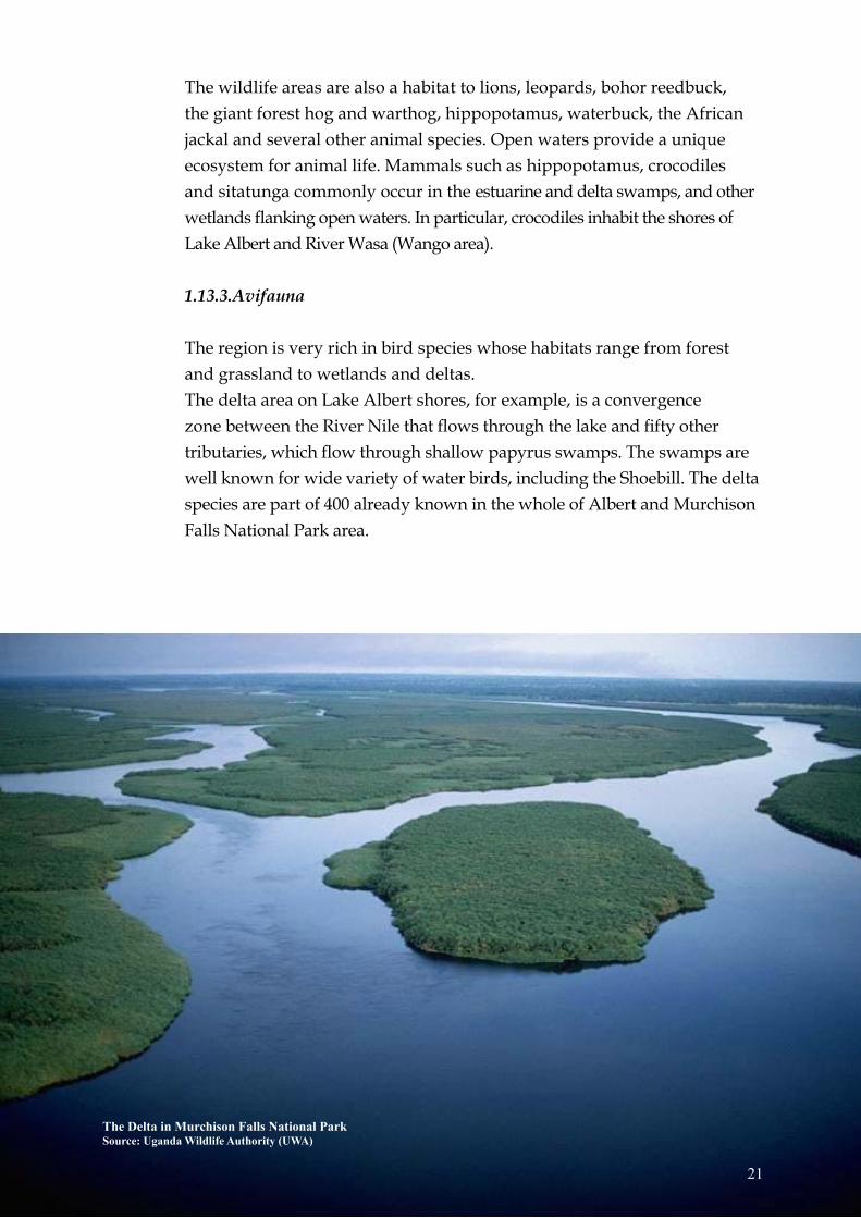
The region is very rich in bird species whose habitats range from forest and grassland to wetlands and deltas.The delta area on Lake Albert shores, for example, is a convergence zone between the River Nile that flows through the lake and fifty other tributaries, which flow through shallow papyrus swamps. The swamps are well known for wide variety of water birds, including the Shoebill. The delta species are part of 400 already known in the whole of Albert and Murchison Falls National Park area.
21
The Delta in Murchison Falls National ParkSource: Uganda Wildlife Authority (UWA)

1.13.4 Biodiversity outside protected areas
There is also a wealth of biodiversity outside protected areas. Unfortunately, the bulk of this is either already disturbed or threatened while some of it is already extinct.
1.14 National Heritage
Uganda does not possess examples of human archaeological remains of enormous antiquity value. There is, nevertheless, a rich assemblage of artefacts from stone axes, pottery, earthworks, rock-paintings, royal tombs and shrines and forts (Langlands 1975, Uganda Museum 2008). Therefore the Albertine graben has a number of archaeological and historic sites of national heritage importance, besides the unique physical resources of the rift valley, Rwenzori mountains, national parks and lakes, all of which are of great tourist attraction.
1.14.1 Archaeological sites
The oldest human bones found in this area are only 8000 to 10,000 years BP (before present), from Kikorongo crater near Lake George. Early Stone Age sites with Acheulian hand axes occur at Mweya Peninsula and at Paraa and are dated from 50,000 years BP, while Middle Stone Age sites occur at Chobe.
The Nkondo and Kaiso palaeontological sites on the eastern shores of Lake Albert form another category of heritage sites, particularly due to their 5.4 to 2.5 million years old mammalian fossils which are important for palaeontological research. Others occur near Kibiro salt processing areas. Most of the Stone Age localities are lacustrine, and are particularly associated with strand flats, terraces and caves from formerly more extensive lakes.
22

23
Map 4: Albertine Graben Archaeological sitesSource: Uganda Museum and NEMA (2009)

24
1.14.2 Historic and cultural sites
The caves in Nyakasura near Fort Portal are a result of weathering of a limestone (calcium carbonate) rock to form stalactites and stalagmites within the cave that are like drooping human breasts and locally named Amabere ga Nyinamwiru (Nyinamwiru’s breasts). These features in the caves together with local waterfalls have become a tourist attraction site. The site is also of cultural importance whereby the local tribe of Batooro still believe that the place has the powers of the Bachwezi, the rulers of the past Empire of Kitara.
The Katasiha Fort and Cave located 3 km from Hoima on the Hoima-Butiaba Road are surrounded by a defensive trench established in 1894 by a British Colonel Colvile, when he led an expedition against Kabalega, the then Omukama of Bunyoro; while the cave was used by Kabalega to fight off the colonial invasion of the kingdom. The site is of tourism importance and is currently used for recreation.
Fort Kitana a former British Fort situated on the Kigorobya-Kibiro track is a potential tourist site.
The Kibiro traditional sites, including a salt processing village are located approximately 1 kilometre down the escarpment, or 9 kilometres from Kigorobya town council, or 22 kilometres from Hoima Municipal town. This is a stone-age site, situated along the Eastern shore of Lake Albert.
Other sites of national heritage are the burial grounds for the former kings of Bunyoro and Tooro kingdoms. The Mparo tombs for former Bunyoro are located 2km from Hoima town on Hoima-Masindi road while Karambi tombs for deceased Tooro kings are located 6km on Fort Portal-Kasese road. These sites are of high cultural and heritage importance for tourism and historical research. The same kingdoms had palaces – the Kabarole Palace located on Kabarole hill within Fort Portal Municipal Town for the King of Tooro and, the Hoima Palace known as Karuzika for the King of Bunyoro Kitara located within Hoima Municipal town are all of historical, cultural and tourism values.
The relatively rich archaeological and historic sites mentioned, are likely to be significantly affected by petroleum exploration and development activities, both positively and negatively. Positively, by increasing tourism

25
activities by the growing population associated with the petroleum development activities and, negatively by likely risk of interference with and demise of the various sites. A sustainable development strategy is necessary that will safeguard the integrity and continued existence of these sites.
Mparo cultural tomb (above) and antiques inside the tomb (below) in Hoima District.Source: National State of Environment Report for Uganda (NSOER) 2006

Minister of Water and Environment, Hon. Maria Mutagamba (middle), Executive Director NEMA, Dr. Aryamanya-Mugisha (third from left), and tehnical staff inspect an oil well at Mpuuta Village, prior to the Public Hearing on “Hoima Oil Early Production” that was held on 29th July 2008 in Hoima District.Source: NEMA 2008
26

27
Chapter 2 B i o l o g i c a l S e n s i t i v i t y
2.1 Biological sensitivity
2.1.1 Species biodiversity
This layer is a showcase of the species biodiversity in the Albertine graben. All data that could be accessed and was collected in a scientifically acceptable manner has been used in the atlas. The variables used include large mammals, birds, plants and fish. Data on endemic and threatened species has also been incorporated. It was desired that data from both protected areas and outside protected areas be used but most of the data so far obtained is of protected areas. The protection status value of every protected area has also been calculated. Whereas some protected areas may have one protection status e.g. Forest Reserve, others have several protection statuses. Details of the protection status ranking are described below.
In this section, details of how the values from the individual variables were combined to come up with the maps shown in the atlas are given in the respective sections.
2.1.2 Wildlife distribution along the Albertine Rift
The albertine rift contains protected areas (PAs) which are of national and international importance including the Ramsar sites, Important Bird Areas (IBAs), World Heritage sites and biosphere reserves. Generally the animals occur in protected areas though some are found outside the protected areas.
Large mammal data that has been used for the atlas includes mainly that collected from protected areas. There is scanty wildlife data for the areas outside PAs. The aerial survey data was used for QECA and MFCA. For Kabwoya–Kaiso-tonya area and for Bwindi NP, systematic ground data was used. The data collected by rangers and entered into Management Information System (MIST) for analysis was used for the rest of the PAs.

28
Although the mammals occur throughout the Pas, some areas are shown not to have any animals. This does not imply that there are no animals in such areas but rather that the populations may be very low. On the other hand, there are areas which have higher animal concentrations than others. Therefore these areas should be avoided to keep them pristine. For example the delta in MFNP which is also a Ramsar site has high concentrations of mammals. Other areas e.g. the Ishasha sector of QENP and Bwindi NP may have fewer mammals but these mammals are either of unique character or are highly restricted. Such areas attract the highest number of tourists to the region. The data does not categorize the endemic, rare and threatened mammals. This remains a gap that will need to be filled. Also the breeding areas and watering points have not been considered due to lack of data.
2.1.3 Fish breeding or spawning areas
Different fish species and genera occupy different habitats and niches in a lake. Such sites are the most suitable for the specific species’ essential biological processes including breeding. Unfortunately, there is incomplete information regarding fish species in relation to their specific habitats and breeding areas.
Catch assessment survey (CAS) data collected by NaFIRRI indicated that there was predominance of fish juveniles and brood stock (female egg bearing fishes) in several areas in Lake Albert including shallow inshore line waters, sheltered areas (lagoons and bays), shoreline, riverine wetlands, river mouths and rocky areas. This was further confirmed by traditional knowledge of fishermen who indeed said that fish breed in particular parts of the lake while others migrate to breed upstream. This knowledge has over time been used by fishermen to over exploit migrant fishes like the Barbus spp and the Clarias spp, which they catch while in transit to and from the breeding areas.
Existence of fish breeding areas is due to the fact that the early life stages of most fish species are spent in shallow inshore sheltered or rocky areas where there is sufficient food for the young fish, minimal wave action, and refugia from predation by large fish. Some fish species come purposely to such areas to spawn their eggs because the survival rate for the hatched lava and growth into big fish is high. On the other hand, some fish species breed and spawn in the open deep waters but their juveniles swim to the
shallow, sheltered, food-rich and less predation prone areas.To identify precise fish breeding and spawning areas, it requires regular CAS data collection to document fish breeding behavior over time. The species breeding areas indicated on the map are based on the limited available data. These areas should be regarded as critical fish habitants and should be carefully managed to avoid any scenario unfavorable for fish breeding e.g. oil spill that would compromise the sustainability of the renewable fish resources of the Albertine graben.
2.1.4 Woody plants species and bird species diversity
For indication of biodiversity in the forested areas, total tree species and total birds species numbers were obtained. Each of the forests was divided into blocks and data was collected along several transects in each block. The average number of species for each block was then calculated. These average numbers are the ones presented in this report. Other bird data for some parts of the National Parks and areas outside protected areas were obtained from MUEINR biodiversity data bank.
2.1.5 Species of special importance
Data on endemic birds and plants, and threatened birds was obtained for forested areas (National parks and Forest reserves). Whereas data has not yet been obtained for some areas, there also exist areas that do not have endemic or threatened bird species. No endemic birds were encountered in Kashoha-Kitomi FR, Kibale NP, Semliki NP, Bugoma FR and Budongo FR, and no threatened birds were encountered in Echuya FR, Kashoha-Kitomi FR, Kibale NP, most parts of Semluki NP, the southern part of Rwenzori NP, the northern part of Budongo FR.
2.1.6 Combining of variables
The data obtained for each of the layers was point data. In order to present it as a polygon output in which all data is represented using a few colors, a grid system was employed. With the grid, all data for a specific variable e.g. plants was combined and then grouped into five classes; 1 to 5 with 1 designating the lowest number of species and 5 the highest number of species. A sixth class (Value = 0) was added to designate all the areas where no data was obtained, areas where the species value is zero and areas that are outside the area of interest. In the final map, such areas have
29

been made transparent so that they do not unnecessarily obscure visibility of species variation in areas where data was obtained. They all the same exist in the map grid and can be updated once the data becomes available.
After all variables had been mapped, they were divided into two categories i.e. Species Richness and Species of Special Importance. The total large mammals, birds, plants and fish constituted the Species Richness category while the endemic birds and plants, and threatened birds constituted the Species of special Importance category.
A sum total was calculated for each category and it was divided by the frequency of occurrence of the variables in that category. The resultant value then denoted the final class of the category, that is, Species Richness or Species of Special Importance.
30

31
Very lowLow
Medium
High
Very high
2.1.7 Highlights of the species richness map
Bugoma and Budongo FR stand out as having high species richness. These are followed by the northern sector of Murchison Falls NP. Kashoha Kitomi, Kalinzu and Bwindi NP also show high species richness values. For the fish species of Lake Albert, the southern tip of the lake, the lake shores around Kabwoya and Kaiso-Tonya and the Nile delt area in Murchison Falls NP had the highest species.
Map 5: Speices richnessSource: Uganda Wildlife Authority (UWA)

2.1.8 Highlights of the species of special importance map
With the available data, the south of Bugoma FR and Mgahinga NP show the highest values followed by Kibale National Park, Bwindi NP and Rwenzori Mountains NP. The northern and south-most parts of Budongo FR also show high values.
Very low
Low
Medium
High
Very high
32
Map 6: Special importanceSource: Uganda Wildlife Authority (UWA)

Conservation NP FR WR WCA WHS BR RS IBA Total/Class Area Mt. Otze 6 6 Mt. Kei 6 6 Ajai WR 5 1 6 MFNP 9 3 1 13 Bugungu WR 5 5 Karuma WR 5 5 Kabwoya WR 5 5 Kaiso-Tonya WCA 3 3 Semliki NP 9 1 10 Semliki WR 5 1 6 Mt. Rwenzori NP 9 3 3 18 Kibale NP 9 1 10 QENP 9 3 3 1 16 Bwindi NP 9 5 1 15 Lake Mburo NP 9 9 Mgahinga NP 9 1 10 Budongo FR 6 1 7 Bugoma FR 6 6 Kashoha-Kitomi FR 6 6 Kalinzu FR 6 6 Maramagambo FR 6 6 Katonga WR 5 5 Kigezi WR 5 5
2.1.9 Conservation Status
In addition to the overall biodiversity map, a conservation status map was also generated. All conservation areas along the Albertine graben were recoded and scored against conservation categories (see table below). The highest value obtained when the scores for each conservation area were totaled was 5 and the values ranged from 1 to 5. This is the same range that was used to rank the biodiversity component. A map of conservation status, with 1 as the area with the lowest conservation value and 5 as the area with the highest conservation status, was generated. It needs to be noted that for conservation areas that had Ramsar sites, this value was only reflected for the actual part of the conservation area that is designated as a Ramsar site.
NP-National Park, BR-Biosphere Reserve, WHS-World Heritage Site, RS-Ramsar Site, IBA-Important Bird Area, FR-Forest Reserve and WR/WCA-Wildlife Reserve/Wildlife Community AreaSource: Uganda Wildlife Authority (UWA)
33
Conservation designation
Table 1: Conservation areas along the Albertine Graben

2.1.10 Highlights of the conservation status map
Rwenzori has the highest conservation status value followed by Bwindi NP, and Queen Elizabeth NP. The delta region of Murchison Falls NP also stands out as of higher conservation status than the rest of the park.
34
Map 6: Special importanceSource: Uganda Wildlife Authority (UWA)
Map 7: Conservation statusSource: Uganda Wildlife Authority (UWA)

2.1.11 Overall biodiversity
To generate the overall biodiversity map, the species richness value, species of special importance (endemic and threatened species) value and the conservation status value were added. The resultant map is shown below.
35
Very low
Low
Medium
High
Very high
Map 8: Overall biodivesitySource: Uganda Wildlife Authority (UWA)

36
2.1.12 Highlights of the overall biodiversity map
Bwindi and Rwenzori Mountains National parks stand out as having the highest overall biodiversity followed by Kibale NP, Mgahinga NP and the area north of Queen Elizabeth NP. Within Murchison Falls NP, the delta areas stands out as having higher overall biodiversity than the rest of the park. Of the Forest Reserves, Bugoma and Budongo forests show higher overall biodiversity.
2.2 Socio Economic data in the Albertine Graben region
Different attributes have been compiled to represent the socio economic data within the Albertine Graben region and the different attributes that represent this layer include:1. Roads2. Oil reserves and prospects3. Mineral areas4. Major towns and villages5. Fishing villages6. Boat landing sites7. Water reservoirs8. Utility power stations
2.2.1 Infrastructure
2.2.1.1 Road classes
The roads have been sub classified into primary all weather and secondary murram roads. The primary roads transect between cities whereas the secondary roads are within the district boundaries. In terms of sensitivity to oil spillage, roads only facilitate the process of oil drilling and transportation of heavy machinery but may not be substantially affected by any oil spills. Layout pipes can however be sited within the road reserves of primary roads which are wide enough (30m width).
2.2.1.2 Railway lines
Railway lines have also been identified within the Graben region and these include the western line also popularly known as the Kasese line and the light density Pakwach line. Today the railway sector is largely limited

37
to the transportation of goods such as imports from abroad and also to transport export goods from Uganda. Oil drilling companies can therefore utilize these existent lines for those purposes. The railway lines have no rank in terms of sensitivity ranking
2.2.1.3 Airfields
There are three airstrips located within the Graben region that can facilitate the movement of goods and personnel within the region. The airstrips are of substantial economic and security importance within the region. They however are not also very vulnerable to oil spillage except that drilling activities have to be controlled within their precincts for the threats that such activities may pose to the airstrips.
2.2.2 Human settlements
These are areas which are built up and comprise of a conglomerate of urban activities such as commercial, residential, industrial and agricultural and any other activities typical of the urban fabric. Human settlements are synonymous with the built environment in both urban and rural areas hence they are designated as areas where humans live with their associated infrastructure and facilities intended to facilitate human life.
The settlements have been classified into the major towns such as Hoima town council, Masindi town council and Fortportal town council and the smaller human settlement areas that basically consist of small trading activities and residential land uses. The towns are more sensitive to oil spillage since there is a high concentrate of built up activities while the rural trading centres may have open areas used for agricultural purposes that are not so densely populated.
2.2.2.1 Fishing landing sites
These are mainly located along the shoreline of Lake Albert and are the most fragile in terms of sensitivity to oil drilling activities. An overlay with the oil prospect areas indicates that a number of the landing sites are located within the oil prospect areas and may have to relocate once the oil drilling activities commence.
2.2.2.2. Hotels and Lodges
There are a number of hotels and lodges within the Albertine Graben. These are not affected by the oil drilling activities since they are embedded within the built up areas and as such protected within that framework, they are however an important feature to facilitate tourism and provide vital lodging points for those engaged in oil activites. Examples include Mweya safari, Albert Safari, Paraa safari, Jacana, Kyambwa, Wilderness camp, Bwindi forest camp, Kibaale national park lodge, chobe safari, Red chilli, Nile hotel and Semliki safari lodge. These are therefore not reflected in the sensitivity ranking system.
2.2.2.3 District boundaries
These represent the number of administrative districts within the Albertine graben region, this information has been included within the map for information purposes since it is important to have knowledge of the administrative units within the Graben region. Information up to county level is available for this layer.
2.3 Geology Map
2.3.1 Morphology of Albertine Graben
As shown by the geology layer map, the Albertine Graben generally trends NE-SW and is highly asymmetrical. It trends N-S in the Pakwach and Rhino Camp Basins, to the north of Lake Albert, probably following Pre-Cambrian lineaments. Although the major tectonic forces in the Graben are extensional, there is evidence of compression episodes occurring within the extension regime. Inversion structures and compressional anticlines interpreted from seismic data confirm these episodes.
2.3.2 Geology of the Albertine Graben
The Albertine Graben is covered with two rock systems namely;1) Sediments; young Cenozoic-Holocene sediments2) The old Precambrian rift flank or escarpment basement.
38

2.3.2.1 Sediments
The rift floor is covered with Tertiary sediments, weathering products of the basement complex of Uganda. In order to create the rift floor sediment space, a complex tectonic history took place on the cratons of Africa and the basement complex of Uganda in particular. Of these tectonic forces, the tertiary rifting forces are so important for the evolution of Albertine Graben.
39
Map 9: Geology of Lake AlbertSource: Petroleum Exploration and Production Department (PEPD)
Geology of Lake Albert

40
This rifting started affecting the area during the Tertiary resulting in the commencement of a depression and deposition. Since this time, rift movements became very important in the western rift valley as it formed and filled with sediments. The sediments that make up the rift floor include; thick sequences of sandstones, claystones and shales derived from basement gneisses and schists. These sediments have been interpreted to be mainly fluvial and lacustrine deposits.
The later stages in the formation of the rift gave rise to renewed volcanic activity in the south-western parts of the country. Such tectonic forces being described are evident from the pattern of orogenic fold belts and shear zones in the Precambrian, the formation of the rift valley, the distribution of later volcanic centres and Pleistocene warping. 2.3.2.2 Rift flank basement
Like the rest of Uganda, the rift flank of Albertine Graben is underlain by some of the world’s oldest rocks, some of which were formed as long ago as 3 billion years. Among others, the major rock composition of the Albertine Graben’s rift flank/escarpment include granitic gneisses, granites, diorites, dykes, marphic intrusions, quartzites, quartz veins, schists, and phyllites.
A large part of these rocks were modified by deep seated mountain-building movements, which extended throughout the Precambrian to the beginning of Cambrian time approximately 500 million years ago. At this time, the mountain building movements apparently ceased and the area became a continental environment largely escaping marine incursions, which led to the deposition of the fossiliferous series extending from the Cambrian to recent times, in other parts of the World.

41
2.4 Land cover sensitivity
Ranking of classes has been based on their importance and difficulty of replacement once destroyed or affected by an oil spill.
Sensitivity 1Bare Rocks and Soil have the least sensitivity. There isn’t much that would be destroyed and cleaning would be easy. Built up areas to have a lot of bare ground and paved areas.
Sensitivity 3Grasslands and herbaceous crops are simple ecosystems where plants can grow to maturity in one season.
Sensitivity 5This one consists of perennial but not complex plants. It includes shrub land and shrub crops. They normally take two to five years to establish.
Sensitivity 7This consists of woodlands. Woodlands are complex ecosystems that include trees shrubs, climbers forbs and grasses. They are also a habitat for many animals and birds.
Sensitivity 9This one includes high forests, wetlands and open water. Forests are very complex ecosystems that take decades to establish and would be very difficult to restore once destroyed. Wetlands and open water to are delicate ecosystems and oil spreads easily and fast in case of a spill.

42
Land cover Class SensitivityBare Rock 1Bare Soil 1Built up Area 1Grassland 3Herbaceous Continuous Small Scale Farmland 3Herbaceous Scattered Small scale farmland 3Large-Medium Herbaceous Crops 3Closed Shrub land 5Large-Medium Shrub Crops 5Open Shrub land 5Shrub Continuous Small Scale Farmland 5Shrub Scattered Small scale farmland 5Very Open Shrub land 5Wooded grassland 5Closed Woodland 7Open Woodland 7Very Open Woodland 7Multilayered Closed Forest 9Multilayered Open Forest 9Open Water 9Permanent Wetland 9Plantation Forest 9
Table 2: Land cover sensitivity
Map 10: Albertine Graben Land cover sensitivitySource: National Forestry Authority (NFA)

2.5 Sensitivity of soils in the Albertine Graben
2.5.1 Soil permeability
Soil permeability/erosion sensitivity ranking based on texture
Soil Classes Permeability Rank
Pure clays, rock, moraine Very low 1
Silts, clay loams Low 2
Sandy clays, Silt loams Medium 3
Loams, Sandy loams,
Sandy clay loams High 4
Pure sands, peat, gravel Very High 5
Erosion sensitivity ranking of land cover classes
Land cover Classes Susceptibility Rank
Plantation forest, tropical forests Very low High
(high and low stocked)
Woodland, bush and Low 2
thicket
Grassland Medium 3
Farm lands (small and
large scale)
Built up and open areas Very High 5
2.5.2 Soil erosion
Rainfall contribution to soil erosion
Rainfall (mm) Permeability Rank
500 - Very low 1
Low 2
Medium 3
High 4
>2000mm/yr Very High 5
Table 3: Soil permeability/erosion sensitivity ranking based on texture
Table 4: Erosion sensitivity ranking of land cover classes
Table 5: Rainfall contribution to soil erosion
43

44
Soil Map of Lake Albert-UGANDA
Map 11: Albertine Graben Land cover sensitivitySource: National Agricultural Research Laboratories (NARL) and Directorate of Water Resources Management (DWRM)

2.5.2.1 Development of the Erosion Sensitivity map for the Albertine Graben
Principle
The Revised Universal Soil Loss Equation (A=R*K*LS*C*P), abbreviated
RUSLE was the basis for the derivation of this map; where,
A = estimated average soil loss in tons per acre per year
R = rainfall-runoff erosivity factor
K = soil erodibility factor
L = slope length factor
S = slope steepness factor
C = cover-management factor
P = support practice factor
The derivation was not based on absolute values, but a grading system
was adopted for some of the above factors as follows;
R = rainfall-runoff erosivity factor
This was assumed to be a factor of the Mean Annual Rainfall to come up with the following grading.
Rainfall contribution to soil erosion
Rainfall (mm) Contribution Rank
500- 900 Very low 1
900-1300 Low 2
1300-1500 Medium 3
1500-1700 High 4
>1700mm/yr Very High 5
Table 6: Rainfall contribution to soil erosion
45
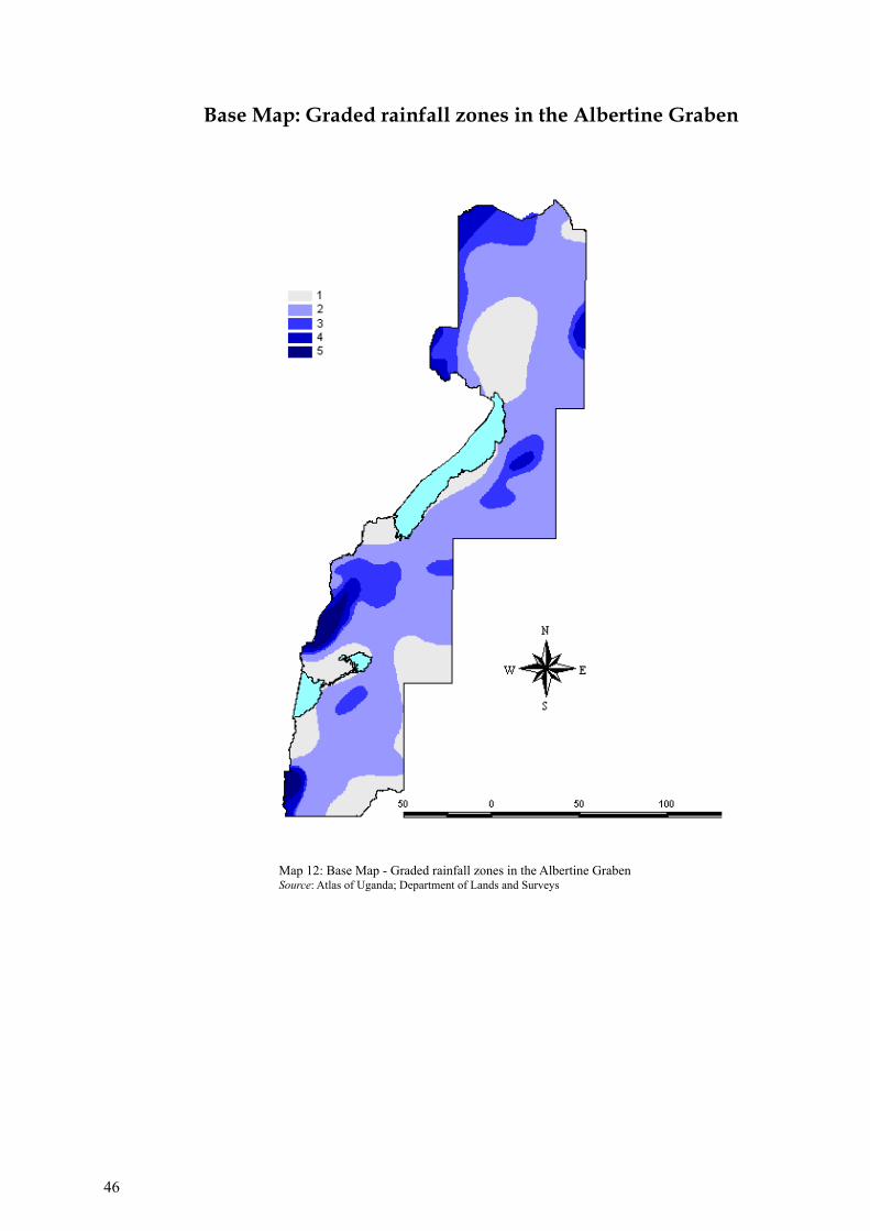
Base Map: Graded rainfall zones in the Albertine Graben
46
Map 12: Base Map - Graded rainfall zones in the Albertine GrabenSource: Atlas of Uganda; Department of Lands and Surveys

K = soil erodibility factor
This was assumed to be a factor of the soil texture, to come up with the fol-lowing grading. (see map below)
Base Map: Graded soil classes in the Albertine Graben
Soil erosion sensitivity ranking based on texture
Soil Classes Sensitivity Rank
Pure clays, rock Very low 1
Silts, clay loams Low 2
Sandy clays, Silt loams Medium 3
Loams, Sandy loams, Sandy clay loams High 4
Pure sands, peat, gravel Very High 5
Table 7: Soil erosion sensitivity ranking based on texture
47
Map 13: Base Map - Graded soil classes in the Albertine Graben Source: Soil survey map of Uganda (1960), National Agricultural Research Laboratories (NARL)

S = slope steepness factor
This was assumed to be a factor of slope. Values used in the grading were derived from a slope map generated from the Digital Terrain Model (SRTM) of Uganda (see map).
Base Map: Generalized and graded slope map of the Albertine Graben
Map 14: Base Map - Generalized and graded slope map of the Albertine GrabenSource: Digital Terraine Model of Uganda (90M)
Slope sensitivity to soil erosion
Slope (%) Sensitivity Rank
0-10 Very low 1
10-25 Low 2
25-50 Medium 3
50-100 High 4
>100 Very High 5
Table 8: Slope sensitivity to soil erosion
48

C = cover-management factor
Ranks were assigned based on observed sensitivity of the various classes to erosion, to come up with the grades below (see map).
Base Map: Graded map of the land cover classes in the Albertine Graben
Land cover sensitivity to soil erosion
Class Sensitivity Rank
Open water - 0
Plantation forest, tropical high forests Very low 1
(high and low stocked), wetlands
Woodland, bush and thicket Low 2
Grassland Medium 3
Farm lands (small and large scale) High 4
Built up and open areas Very High 5
Map 15: Base Map - Graded map of the land cover classes in the Albertine GrabenSource: Prepared by National Forestry Authority (NFA)
Table 9: Land cover sensitivity to soil erosion
49

Map 16: Erosion sensitivity map for the Albertine GrabenSource: National Agricultural Research Laboratories (NARL)
50
Erosion sensitivity map for the Albertine Graben

P = support practice factor
The RUSLE P-factor reflects the impact of support practices on the average annual erosion rate. Since there was no quick way of ascertaining this in the graben area, it was assumed to be uniform throughout the graben area.
L = slope length factor
This was fixed at 90m, since the slope map was derived from a Digital Elevation Model (DEM) of 90M pixel size.
The above two factors combined constituted an un quantified constant, to give the overall final equationA= Constant (PL) * R * K * S * C
Interpreted in simple terms, A, which represents the overall erosion risk or sensitivity, is proportional to the multiple of the four factors R, K, S and C, represented by the rankings of Rainfall, Erodibility, Slope, and Land cover respectively.
The erosion sensitivity map presented below is therefore a map of A, derived from crossing (multiplying) four maps of Rainfall, Erodibility, Slope, and Land cover. (see map below).
51

2.6 Sensitivity of Ground water in the Albertine Graben
2.6.1 Static Water Level
Wise management of ground-water resources requires knowledge of the distribution and characteristics of water-bearing rocks and sediments. Evaluating and dealing with these threats of ground-water contamination require improved knowledge of the occurrence and manner of movement of ground water in the subsurface.
The static water level (SWL) which is the depth below ground level or the level of the water table in a well when there is no operational pump, varies over the entire Albertine graben with levels ranging from 1m to over 70m. SWL gives an indication on how easily ground water can be contaminated; the shallower it is, the more susceptible it is and vice versa. Therefore shallower ground water is highly sensitive than deeper water. The following classes in terms of sensitivity to contamination are presented:
The description of sensitivity of Static Water Level is divided into five classes. From the analysis, 45.21% of the area has very high sensitivity, 26.95% indicates high sensitivity, 19.52% is moderately sensitive, 7.61% has low sensitivity, and 0.72% has very low sensitivity. The ranks are given to the respective classes in terms of sensitivity, the higher the sensitivity, the more vulnerable the source is to contamination, therefore, the higher the rank.
Static Water Level (m) Description of Sensitivity Rank
Below 10 Very High 5
10-20 High 4
20-35 Moderate 3
35-60 Low 2
Above 60 Very low 1
52
Table 10: Static Water Level

53
Map 17: Erosion sensitivity map for the Albertine GrabenSource: Directorate of Water Development (DWD)
ALBERTINE GRABEN Depth to Bedrock

2.6.2 Depth to Bedrock
The Depth to Bedrock is the thickness of the unconsolidated material overlying consolidated rock. The boundary between bedrock and overlying unconsolidated material affects the soil’s available water and vulnerability to upward migration of coarse fragments as a result of human action.
Depth to bedrock is virtually homogeneous in this area, with only 14.50% of the soils being deep and only 60.48% of them very shallow.
The sensitivity of an aquifer can vary greatly, depending on geologic conditions. Fractured or faulted terrain tends to conduct recharge much more quickly than unfractured rock because fractures act as conduits for fluid flow. Hence, faulted or fractured bedrock aquifers tend to be highly sensitive. Since the Albertine Graben is a faulted zone, then sensitivity is very high especially in shallow aquifers, thus, the shallower the depth to bedrock, the more sensitive the aquifer is.
2.6.3 Definition of depth classes
Ground water within a depth of 35m is considered as shallow water whereas beyond 35m, deep waters are found. Shallow waters are more susceptible to contamination and are therefore given a higher rank than deep waters.
Depth to Bedrock (m) Definition Area (%) Rank
Less than 20 Very Shallow 60.48 4
20 - 35 Shallow 24.60 3
35 - 100 Deep 14.50 2
Over 100 Very Deep 0.41 1
54
Table 11: Depth to Bedrock

Oil prospecting: 3-D Seimic acquisition, cable laying in Kaiso-Tonya, EA 2Source: Prepared by Petroleum Exploration and Production Department (PEPD) 2007
55

56
Oil testing

3.1 Sensitivity of the Lake Albert shoreline and the Bathymetry of the lake
Chapter 3 S e n s i t i v i t y o f L a k e A l b e r t s h o r e l i n ea n d t h e B a t h y m e t r y o f t h e l a k e
Looking North up the escarpment along Lake Albert faultlineSource: Petroleum Exploration and Production Department (PEPD) 2008
57

58 Map 18: Sensitivity Atlas Map 1

59

60 Map 19: Sensitivity Atlas Map 2

61

62 Map 20: Sensitivity Atlas Map 2A

63

64 Map 21: Sensitivity Atlas Map 2B

65

66 Map 22: Sensitivity Atlas Map 3
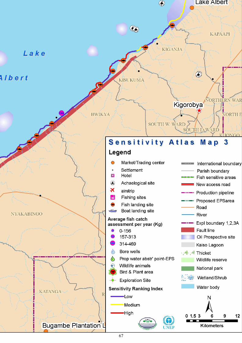
67
68Map 23: Sensitivity Atlas Map 4

69

70
The Bathymetry of Lake AlbertThe southern part of Lake Albert is shallower (2 to 24m) and the central is deeper (31 – 50m). The southern part is more sensitive because they are used as breeding grounds for fish (Department of Fisheries). Other sensitive areas are in the eastern shores which are used as fishing grounds and landing sites.
Bathymetry Map, Lake Albert
Map 24: The Bathymetry of Lake Albert

71