environmental status report and guidelines for development · environmental status report and...
TRANSCRIPT

Environmental Status Report
and Guidelines for Development
Prepared for the
UNDP - Physical Planning Project - St. Lucia
•••••••••••••••••••••••••••••••••••••••••••••••••••••••••••••••••••••••••••••••••••••••••••••••••
ISLAND RESOl~RCES FOCNDATION
1974
Antigua Barbuda British Virgin Islands Cay man Islands Dominica Montserrat St. Kitts and Nevis St. Lucia St. Vincent Turks and Caicos

ISLAND RESOURCES FOUNDATION Caribbean Headquarters
RED HOOK BOX 33. ST. THOMAS
U.S. VIRGIN ISLANDS 00802
(809) 775-6225
Washington, D. C. Office 1718 P STREET. N.W .. SUITE T4
WASHINGTON. D.C. 20036
(202) 265-971 2
ENVIRONMENTAL SURVEY AND STATUS REPORT
OF SELECTED CARIBBEAN ISLANDS
1974
Final Draft Repart UNDP-Contract 133/73

PREFACE
With only sixty man days to visit eight island states or territories, embracing twenty major islands, it was physically and fiscally impossible for the teams of environmental specialists to carry out either a detailed inventory or undertake elaborate, site specific evaluations of major development activity (except in only rare cases and on request from the UNDP/PPP Project Director).
Rather, the objective was to rely on the extensive experience of the staff professionals in Caribbean tropical insular systems to selectively focus on specific types of environmental problems in any given island and to identify key problem areas for primary study in the limited time available.
Hence, there is considerable variation, from island to island, on what has been the nature of our emphasis. Also, the same time constraints have required our heavy reliance on local expertise in the matter of species check lists, and suggested preserves, parks, natural areas, wildlife habitats. etc. It was. of course. impossible to visit all sites having potential either as problem zones, environmentally speaking, (given any projected development activity) or as special land or sea areas requiring protection and special resource management constraints.
The fol:towing report is in part a recommended plan of action in the environmental sector. If the actions recommended herein are 'not taken expeditiously, and the environmental principles and guidelines not integrated into the planning process, the slow insidious deterioration of these island environments will accelerate beyond all imagination in the decade ahead.
It is not a question of development or environmental quality. It is a matter of development and environmental quality. And this is largely a function of development planning methodology.
Therefore. emphasis has been placed on zones of resource use conflict. heavy pollution, and environmental problems shared by all of the project islands. The "Guidelines" are designed to add a stronger environmental dimension to resource management and development planning.

PART I
la.
lb.
2.
3.
4.
5.
6.
7.
8.
9.
PART II
Sections 1.
2.
3.
4.
5.
6.
7.
Table of Contents
UNDP /ppp ISLAND SELECTIONS
Antigua ...................................... .
Barbuda .................. II •••••••••••••••••••.
British Virgin Islands ••••••••••••••••••••••••••
Cayman Islands .............................. .
Dominica .................................... .
Mont serrat .................................. .
St. Kitts-Nevis ............................... .
St. Lucia .................................... .
St. Vincent and St. Vincent Grenadines ••.••••••• 0
Turks and Caicos ............................. .
GENERAL GUIDELINES FOR ISLAND ENVIRONMENTAL MANAGEMENT
Tourism ..................................... .
Amenity and Aesthetic Resources •••.••.••••••••.
Cultural Resources ........................... .
Conservation of Natural Areas •••••••••••••••.••
Oil Pollutiqn .................................. .
Soil Disturbance ............................... .
Dredging ..................................... .

Sections
8. Wetland Drainage and Fill ••.•••••••••.••.•••••.••..•.
9. Marinas ........................................... .
10. Waste Disposal .................................... .
11. Conservation of the Lobster ••....••.....•.•• ...•• •.•.
12. Conclusion .. II •••••••••••••••••••••••••••••••••••••••
ANNEXES
A. Information Needs of Government When Judging Permit Applications for Projects That Would Alter or Modify Shorelines or Submerged Lands.
B. Some Effects of Dredging on Water Quality and Coral Beef Ecology.
C. Proposed Guidelines for Establishment of Marine National Parks.
D. List of Participants.

I-I ANTIGUA
I. INTRODUCTION ....................................... .
1. 1 Fieldwork Scheduling and Contract Terms of Reference
II. DEVELOPMENT AND ADVERSE ENVIRONMENTAL IMPACTS .•
2. 1 Existing Development Impacts
2.2 Potential Development Impacts
2. 3 Other Impacts
III. CAUTIONARY GUIDELINES FOR DEVELOPMENT PROJECTS •••
3. 1 Guidelines
3.2 Priorities for Supplementary Detailed Investigations of Environmentally Critical Areas
IV. POSITIVE ENVIRONMENTAL INITIATIVES •••..•.•••.•.•.••••••
4. 1 Projects with Potential to Confer Environmental Benefits
4. 2 Local Contacts in the Environmental and Development Fields
.~"

"l .. _~ ..,. M""'N£ PAI\~ hNc. (') tAT CJ
6;J t{;J 6J ~ t::::'
SC~l&-of mu .. s
ANTIGUA
00t;;:>
"
t--<
I N
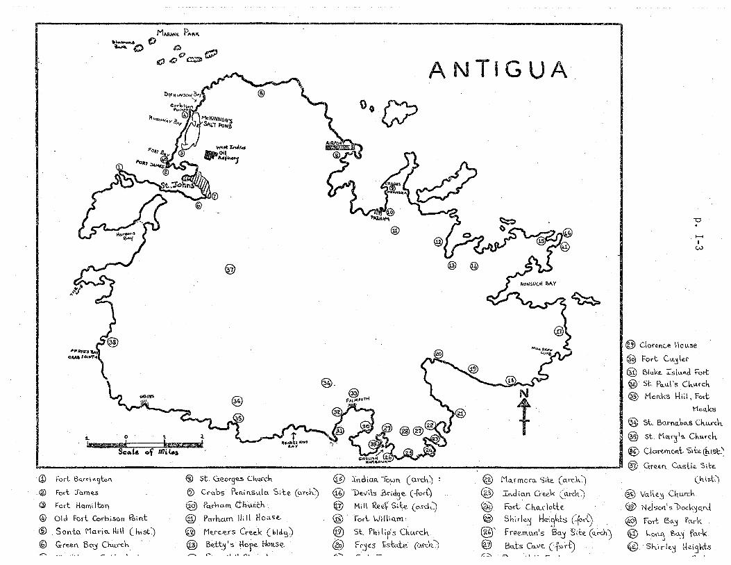
" • ..-- IP> M"'NNI: P""I( ~ 0 "" $)J
o t{';JO~r:P
0°0
1. 0 'I. ~
.. ¥mI hwmrw_ Sca.t& of nnt..s
ANTIGUA
-0
>--I
I W
@ Claren<:,~ I-\(Jllse
@ Fort Cu.J\er-
@ Blake. Ts[""d Fort
@ St. Po..\l.\ 's Cku.rcl-t
@> MCln.KS \-IiI!, Fort
t1c l'\.ks
@ st. Barl'\.(Lbe>-.s ch.u..rth @ st. MClr~l~ Ch.u...-ch.
@ Cjo.«.rnont- 'Sibt ChtSt:~
!. . _J ® G:re"-I"\, Ca.'St\e. '5i\;e.
(iJ Forl B"Hi ,,~tcn ® st. GeOt9= ChU'Ch
@ Fo<t :rarn~s ® Crabs Pectin.su.lCl Site (arch)
Ql Fort Harni Itcn @ Pq,rMarn C.~:I.l~ch
® Olel Fort Corbison Point @ Porn-elm fli II H ou.'ie-
® Sonto \'1CLriu. 1-1;1\ (hiSt) @ Me . .f'c..e-rs Cre.ek (bid':))
® Green Bc~ Chu..ch @ Be.-c.t'J 's !-lore Hoi.t..S€.. -, _.
® Indian 10;-:>1), (a.rch0 ~
@ "De",i\s Bridge- (-fori:)
@ Hi 1\ Ree~ Si le. (o-I"C\-,,) @' Fort. \Jil\iQ.IYl'
® S~, 1'1,,'1 l if's Ch.lArch.
@ FrjeS £skte. (Gtr-dc) .-:;--,
@ Mo..rmoru. Si\::e.. (o'rch~
@ In.di.un Cree.k (a.t-&t) @ Fort Ch.Q.r\o-t-te.
@ Shirk.':! t-/eisl.ts C-fort) (§f Free.m.ull's BaJ' Site (Q.rek) @ Bub Cu.ve- C fert) ~..r.. .1 " _ 1
(h.ist:)
® VGl.lle~ Oturch
@ Nelsol'\'s Dod<jC\."-cI ® fort Bctj i'cl,t'K
@ \...o~ ~Uj f~rk
@ Sh.irkj 1~e.[3hts

I-4.
Antigua
1. INTRODUCTION
1. 1 Field work Scheduling and Contract Terms of Reference
The Island Resources Foundation survey team visited Antigua/
Barbuda November 12-16. 1973. with a subsequent effort December 10-12.
focussing on McKinnon's Salt Pond. Antigua. The McKinnon's Salt Pond
report appears as an Annex. As with the other study islands. field work
in Antigua considered the areas specified under section 3.01 of the UNDP-
IRF contract. With reference to this specific island. investigations
focussed on physical development projects in association with beaches.
mangroves and other wetland areas. and on park planning. As the WHO /
PAHO Liquid and Solid Waste Management Study will commenee within a
few months. the Island Resources Foundation team did not review coastal
water quality problems except as they relate to the McKinnon's Pond
coastal area referred to above.
II. DEVELOPMENT. AND ADVERSE ENVIRONMENTAL IMPACTS>
2. 1 Existing Development Impacts
Sand mining with government approval is taking place at Ffryes
Beach. (See guideline on "Soil Disturbance". Part II. Section 6).
2.2 Potential Development Impacts
Potential ~severe environmental impacts are associated with marina.
oil refinery and tourism development projects.

~
I-5 Antigua
2.21 Nonsti«ch Bay:
There are plans to fill the mangrove area at the hea d of AYl;'es
Creek (the westernmost extremity of Nonsuch Bay). Also in a part of
Nonsuch Bay, a marina has been proposed for Brown's Bay. This marina
would involve the possible blasting of a channel through the Nonsuch reef
system. Extreme caution is recommended.
2.22 Oil Refinery at Rendezvous Bay: One potential site for a proposed
new oil refinery has been noted at Rendezvous Bay, located southwest of
Falmouth. Our concern does not rest with the location chosen, but the
fact that no prior ecological survey was made at this suggest~d site.
2.23 Hotel and Condominium Development: With the expansion of hotel
and condominium construction along the "golden tourist mile" (north of
McKinnon's Pond), attention must be paid to coastal water quality. This
is especially true, given the government attitude of lowering or waiving
environmental protection requirements. It is recommended that the WHO!
PAHO study pay close attention to the sewage treatment facilities that
these projects plan to emplace.
Condominiums, beginning at 60 units, are to be constructed by
Heyl and Patterson. These will be between the Anchorage Hotel and

1-6
Antigua
Buccaneer Cove Hotel on Dickinson Bay.
The Caribbean Development Bank is funding a project at the Fort
Bay. The plan calls for a beach bar, tennis courts, and water sport
facilities. This public resort area is specifically designed to attract
cruise ship tourists. A potential social conflict lies in the fact that
residents of St. John's have traditionally used the Fort Bay beach for re-
creational purposes.
2.3 Other Impacts
A problem not uncommon to other eastern shores of Caribbean
islands is that of oil arriving on the high seas. In the case of the Mill
Reef Club, they have experienced on pollution on their beaches at various
times during the year.
III. CAUTIONARY GUIDELINES FOR DEVELOPMENT PROJECTS
3. 1 Guidelines
The guidelines of relevance to Antigua are found in Part II of the
report as they also relate to other eastern Caribbean islands in the study
area. Reference should be made to the guidelines on IIWetlandsll (Section 8),
"Marinas" (Section 9), If Natural Area Conservation" (Section 4) and IISoil
Disturbance" (Section 6).

I-7 Antigua
3.2 Priorities for Supplementary Detailed Investigations of Environmentally Critical Areas.
The following suggested investigations do not represent an overall
recommendation of what is necessary. Judgment of the environmental
aspects of Antiguan development would require access to Antigua's five-
year development ,plan recently unveiled. We only had indirect access
to this document and therefore cannot judge the environmental aspects of
the' .many development projects that this 5-year development plan proposes.
3. 21 Wetland Investigations: The first priority is to carry out a detailed.
inventory, including an ecological description of Antigua's wetlands. (This
was mentioned in context of the McKinnon's Salt Pond report, an example
where an adverse use of wetland has had an irreversible impact). The
major mangrove wetlands to be investigated are located at Hanson's Bay,
The Cove (north of St. John's Harbour), Crabbs Peninsula (east of Parham),
and the small mangrove area at Urlins.
3.22 Sewage Plant: Investigations should be carried out into the sewage
treatment plant siting for St. John's. Emphasis would have to be on the
offshore current circulation throughout the year as a guideline for emplacing
the ocean outfall. This is particularly critical given the tourist use of
the nearby beaches at James Bay, Runaway Bay and Dickinson Bay. Pre-
sumably, this investigatory work will be undertaken by the WHO/PAHO
study team.

1-8
Antigua
IV. POSITIVE ENVIRONMENTAL INITIATIVES
4. 1 Projects with Potential to Confer Environmental Benefits
The team visited Diamond Reef and was favourably impressed by
the site, and the efforts that have been made in establishing this park by
the Honourable Robert Hall, Deputy Premier and Minister of Agriculture,
Lands and Fisheries, in association with Mr. Dave Ferneding, of Marine
Development Company, Ltd. In contrast to the proposed park off the south
coast of Barbuda (see Barbuda report, Section 4.1) we are in general agree
ment with the plans for Diamond Reef National Park.
The size of the Diamond Reef Park is approximately 2, 000 hectares.
This more than meets the minimum 1,000 hectares required for inclusion
in the United Nations list of National Parks and Equivalent Reserves.
Given the limited resources at the disposal of the Ministry of Agriculture,
Lands and Fisheries, we suggest that the operational and management
budget be concentrated on the Diamond Reef Park and not be spread to
include the Palaster Reef Park. Furthermore, it is suggested that initially
some funds be set aside for the purpose of producing a master plan for
Diamond Reef. This would include operational and management details,
interpretive programs, and a plan for making a detailed inventory of
marine floral and faunal resources, including underwater mapping. The
use of water penetration film, . such as the experimental Kodak SO- 224
(currently being used by the Folmdation) would be of great utility in
carrying out such a survey.

I-9
Antigua
A further aspect of the park plan would be to set aside the land
area, which would be the headquarters of the park administration, and,
as interpretive programs are developed, which would also house a museum.
In addition, it is not unreasonable to have a fee schedule to charge park
visitors. This could be scaled in such a way that locals would not be ex
cluded from participation. In Mexico, archaeological sites and national
park areas have a fee schedule instituted on weekdays which tend, to be
the days favoured by tourists, and a relaxation of fees on the weekends
to enable locals to visit the area without cost or at a reduced schedule of
user fees.
In the event that a budget is allocated for operation of Diamond Reef
Park, concession contracts could be made with local licensed dive operators
to offer services in the area. Specific attention should be paid to the fee
schedules, so that locals would not have to pay international diving rates.
For example, throughout the eastern Caribbean, international diving
tourist rates are $17 to $20 for a one tank, half day dive. Clearly, few
Antiguans could afford this kind of expenditure. In a section of the contract,
group rates could be specified. Revenues derived could be used for policing,
management, regulations, waste collection, etc.
A master plan for the park should be prepared specifically covering
management objectives, resource: use, physical development, and inter
pretive programs. Also, of particular significance are questions of
.i,·h

1-10
Antigua
marine access, related on-shore visitor facilities, and regional factors
which may influence park management.
Management responsibilities of the park would include an annual
report that would include operational statistics, necessary for proper park
management, and especially, for future planning. Statistics required are
visitors' statistics, and park income and expenditures. With regard to
visitor management, relevant aspects are:
(1) Mooring points for boats
(2) The question of an underwater trail within the park
(3) Feasibility of operating glass-bottomed boats
(4) The response to anticipated solid waste and litter problems
(5) The frequency of marine patrols
(6) Penalties for infractions.
4.2 Local Contacts in the Environmental and Develop~ent Fields
Mr. C. J. Blackstone c/o Friends of English Harbours P. O. Box 159 St. John's
Mr. Haji Dawood (An amateur archaeologist and historian, Mr. Thompson at Public Works has his address)
. .ID:a~;Fo~rneding Marine Development, Ltd. P.O. Box 422 St. John's

..
1-11
Antigua
Mr. MacKay Parliamentary Secretary Ministry of Education, Health and Culture
Mr. D. V. Nicholson Curator of the Museum of English Harbour
Mr. F red Olsen (Archaeologist) The Mill Reef Club
Mr. Nigel Peacock (Marine Biologist) Department of Fisheries Antigua Government
Mr. Barney D. Thompson Director of Public Works and Vice President, Caribbean Conservation Association St. John's

1-12
BARBUDA
I. INTRODUCTION ............................................ .
1. 1 Field work Scheduling and Contract Terms of Reference
II. DEVELOPMENT AND ADVERSE ENVIRONMENTAL IMPACTS •••
2. 1 Potential Development Impacts
III. CAUTIONARY GUIDELINES FOR DEVELOPMENT PROJECTS ••.•
3. 1 Guidelines
3.2 Priorities for Supplementary Detailed Investigations of Environmentally Critical Areas
IV POSITIVE ENVmONMENT AL INITIATIVES •••...••••..••••.••..
4. 1 Projects with Potential to Confer Environmental Benefits
4.2 Opportunities to Enhance Environmental Assets
Page

~()TEL ~.
CON~MIil/JUN\
Cc)Ml'l..£'t
1-13
BARBUDA
SC.ALIt. I! JOO,OOO o 5 3 1/ $ " . _____ L-__ ~~----~t~,.---~----rL'----~' k"', I i ~~ o ~ S

f-14
Barbuda
1. INTRODUCTION
1. 1 Field Work Scheduling and Contract Terms of Reference
Antigua/Barbuda was initially visited November 12-16 by three of
the field team for a total of thirteen man-days with six man-days spent in
Barbuda~ The areas examined in Barbuda included: Palaster Reef;
inshore reefs of Gravenor Bay; the Martello Tower at The River; the
Codrington Lagoon; the Creek mangrove association and frigate bird
rookery at Cuffy Creek; and the southern patch reefs off Goat Reef.
Given the short time at our disposal and the specific nature of
Barbuda, we concentrated our efforts on faunal resources of the Cod-
rington Lagoon area, the Creek mangrove association, and park and
preserves priorities.
II. DEVELOPMENT AND ADVERSE ENVIRONMENTAL IMPACTS
2. 1 Potential Development Impacts
Our investigations were focussed on the potential environmental
impacts of a planned offshore oil facility and the planned hotel and con-
dominium complex on the western coast.
2. 11 Offshore Oil Facility: A consortium of European and Arabian oil

1-15
Barbuda
firms are planning to build an offshore oil facility. The attractiveness of
the Barbuda site for an underwater oil storage depot rests with the fact
that the Barbudian banks extend out for a distance of at least 10 miles from
the western part of the island for a depth of under 15 fathoms. The extensive
plans at present call for emplacement of large concrete storage tanks which
would be constructed ashore then towed on site and subsequently sunk in
place. Oil, presumably from West Africa ana the Middle East, would be
brought in large supertankers, discharged into the submarine tank facilities
and stored, before being loaded onto smaller vessels for transshipment to
the American gulf ports and the Northeast. The construction and emplace
ment of the transshipment facilities represent phase I of the project;
phase 2 would consist of a shore-based refinery.
A potential adverse impact from this development would be the
possibility of a massive oil spill at sea. The oceanic currents trend from
the southeast to the northwest making the islands of St. Barth~lemy, St.
Martin, and Anguilla vulnerable to oil pollution on their eastern and
southeastern shores.
Other potential adverse impacts are (1) the impact resulting from
the supporting shore facility servicing the offshore oil transshipment depot,
and (2) any subsequent refinery development emplaced on the island. It is
likely that one of the key attributes of a Barbudian site for the oil related
facilities would be the absence of stringent environment regulations. As
is indicated in section HT Ilpositive Environmental Initiatives ll, our

1-16
',. Barbuda
greatest concern lies with the maintenance of the Codrington Lagoon
ecosystem.
2.12 Hotel and Condominium Complex; The second development which
could spawn adverse impacts is the planned hotel and condominium complex,
which is slated for construction on the western coast of Barbuda by the
Anchorage Hotel interests of Antigua. Initial plans call for this to be con-
structed on the beach berm area that defines the western boundary of
Codrington Lagoon. There are two potential impacts associated with this
development~' (1) the negative effects that this development could have
on the frigate bird rookery at the north end of Codrington Lagoon, and (2)
the aesthetic disfigurement of the Barqudan landscape by poorly designed
and inappropriately styled stJructures. Details of the frigate bird rookery
and the mangrove association appear under Section 4.2, "Opportunities
to Enhance Environmental Assets".
III. CAUTIONARY GUIDELINES FOR DEVELOPMENT PROJECTS
3. 1 Guidelines
General guidelines relating to the proposed hotel complex, the
offshore oil transshipment center, the jetty to be built at the River, and the
lobster fishery are presented in Part II of the report, for these same guide-
line areas have relevance for other eastern Caribbean islands.

1-17
Barbuda
3.2 Priorities for Supplementary Detailed Investigations of Environmentally Critical Areas
Detailed investigations should be directed at:
(1) Offshore current patterns regarding the oil transfer port,
with shore-based investigations concerning the ecological
impact of the shore facHities;
(2) An ecological impact study of the hotel and its operational
characteristics on the frigate bird colony, with special
attention being paid to the nesting season;
(3) The proposed jetty to be built at The River. Here a clam
shell dredge would be used to deepen the channel to provide
uesass to v.essels making a landfall at The River.
IV. POSITI\%E ENVIRONMENTAL INITIATIVES
4. 1 Projects with Potential to Confer Environmental Be.nefits
In the last year, there has been a legislative initiative to create
national marine parks in both Antigua and Barbuda (see Annex C). In the
case of Barbuda, the park area would encompass Palaster Reef, which we
dived as part of our terms of reference to examine reef areas, and to
indicate park and preserve priorities. The "Palaster Reef Marine Reserve"
is located two miles south of Gravenor Bay off the southeast tip of Barbuda
(see :. map ). It is a shallow reef, between one and two fathoms in depth,

1-18
Barbuda
dominated by.Acropora palmata. The area, as presently demarcated in the
legislation, measures under 500 hectares.
Inasmuch as the national park movement is laudatory from a con-
servation standpoint, it does not follow that creation of parks will automatically
confer protection on floral and faunal species and their habitats. There is
now ample evidence to show that it is far easier to create a park on paper
through legislation, than to create and manage one effectively year in and
year out. Regarding the status of Palaster Reef, it is apparent that the
"Park", as presently envisioned, would not meet the criteria for inclusion
on the U. N. List of National Parks and Equivalent Reserves, as it is well
below the defined minimum size of 1, 000 hectares, and it is not adequately
staffed or budgeted to provide for management, maintenance and protection.
Accordingly, in terms of the most recent International Union for Conserva
tion of Nature and Natural Resources (IUCN) System of Classifications,
Palaster Reef should be categorized as a "Strict Natural Area". The pur
pose of such an area is "to protect nature in an undistrubed state in order
to have it available for scientific study, aesthetic interest, or for the con
tribution it can make to the value of other areas. In such an area natural
processes are allowed to take place in the absense of a direct human
interference ll• Reserve status is thus more feasible in practical terms
and certainly no less effective in conservation terms.

1-19
,.) Barbuda
4.2 Opportunities to Enhance Environmental Assets
4.21 The Codrington Mangrove Association: An opportunity to enhance
the environmental assets of Barbuda would be to secure the Mangrove
Association at the north end of the Codrington Lagoon against development
impacts. This mangrove forest, bordered to the east by Goat Island, is
the only one in Barbuda and covers some 800 acres (325 hectares). It
has now been clearly established elsewhere in the Caribbean and in the
State of Florida that mangroves play an essetrrial ecologic role in the life
histories of coastal and off-shore fish. The abundance of fish and spiny
lobster (Panulirus argus) in Barbuda is directly linked to the existence
of this mangrove nursery area. Studies in Florida show that at least
30 species of the most popular commercial and sports fish use the mangrove
as a nursery area (Robas, 1970). The detritus from the mangrove trees
contributes a major energy input into the fisheries ecosystem
4.22 The Martello Tower: One opportunity to enhance the cultural heritage
of Barbuda is to partially restore the inner workings of the Martello Tower,
located at ['he River. Martello Towers were military structures built for
coastal defense, commonly 30 to 40 feet high, with thick walls, and with
restricted access by way of a ladder to the second story. Guns were
emplaced on a platform, while a powder magazine, and living quarters
for troops were located in the base of the tower. The photo (Figure 2)
shows the overall aspect of the structure as it appears presently.

1-20
., Barbuda
This site is in excellent condition and is worthy of being included
on the Barbuda tourist itinerary. To make the site meaningful, however,
an interpretative program (at the minimum, a descriptive flyer) would have
to be derived that would tell visitors 'lNhat the Martello Tower is, how
it was used, and the historical circumstances surrounding its being
established in Barbuda at The River. From the standpoint of the UNDP
Planner, an exploratory survey should be ·made with regards to integrating
this preservation use with the proposed new jetty to be built at The River.

I-21
BRITISH VIRG IN ISLANDS
I. INTR,ODUCTION .................................... .
1. 1 Fieldwork Scheduling and Contract Terms of Reference
II. DEVELOPMENT AND ADVERSE ENVIRONMENTAL IMPACTS ••••
2. 1 Historical Impacts
2.2 Exis1iing'· Development Impacts
2. 3 Potential Development Impacts
III. CAUTIONARY GUIDELINES FOR DEVELOPMENT PROJECTS ••••
3. 1 Guidelines
3.2 Priorities for Supplementary Detailed Investigations of Environmentally Critical Areas
IV. POSITIVE ENVIRORMENTAL INITIATIVE
4.1 Projects with Potential to Confer Environmental Benefits

~ <J Itll: 10 B l\ 60'S
'/", 0
MII.lt'D
~ L liT!..\!. JO'SI
• 1'-'
5AND.., CA'1 i ~ ~ ) .J("I
~ GREA'T THAtC.H
,N
/ ~
PEW~N!S~
N~ ~.
~E.Te.R. Is.
~D EA1> Ul/!'.ST ~/~
~rtck~~ of tI..(R.k~ SP-I..T Is.
2.
BRITISH VIRGIN 'I '5 LANDS
(SOUTH ERN SECTlON)
MA.t<.lNt\S @ E)ti.st.\o.~
NATIONA\.. PAR,\<S : ~ P; \,...
(2.) Fa.1t e 0. J e.nA.:S ~I (.tI\
(4) S?,ri'(\~ B~j
<") \Jes~U0c:t
[f\} P \ Cl.1J M.d
(1) SQ.~~ t1ou.ntOo\n
(3') 'De-vi\' s B~
ts) C.oC"~a. ?(.c.k
(7'\ S~'o~ ~ Cpri"o.:kl~ fro\-d~)
R,lH.Ol1I1ENl):E]) PR.OTEC'TE.l> AftEA'S ~~
A~cl-\'&"eOL..OGICA.1.. S\'TE.<5 A
S\TE."S •
J(_ c._ocr,.
W ~''''''OE GREAT ...,.
WE'ST ))()~~.i ~
c.f'.~i)~
o E:)(cQ,va..\:.e.d; • Nck &CIU>at-ed
1. fOl"t Re.c.o\1e.rj
2. Ike. 'j)14.1l~eon 3. For\; Ch.a.rloHe 4. Ce.'j\'\.c .. trj 'i. Fort S~it\e.~
(,. '5\7. Ph.llip's Chu.rch
l..iU\~ Mou.ntQ.ln House
COll'fe.r Mine
"£OR.GE 1)oGt
t10'S\:t01To 'IS.
-0
...... I
N N
~~ '-l'® ~ NeCKA~
~ Coo'E~ Ts. (4)p I
FAu..E.N .. \ .J GING-E.R:ts. "J'eRJJS~,,!~
~ ~p)C ~ ~~)' ~"4 '''~VJl'l> RoCK
n~ ~
Ur~'EK.L.,) ;'/P£AR
~ % CP."VAI.. ~C.1( ~ ~

1-23
BHITISH VIHGIN ISLANDS
I. INTHODUC TION
1. 1 Fieldwork Scheduling and Contract Terms of Heference
As a consequence of their proximity and easy access, the British
Virgin Islands were visited by project staff members on a regular basis
between August, 1973 and March, 1974 for a total of 10 man days in
Anegada, 4 in Virgin Gorda, 10 in Tortola, plus 6 days of effort, at the
special request of the BVI government, to carry out a survey of marine
habitats for a proposed system of marine parks. As this latter study
is still underway, it is not included as part of this report.
II. DEVELOPMENT AND ADVEHSE ENVIRONMENTAL IMPACTS
2.1 Historical Impacts
2.11 At least three decades of exporting sand removed from selected
beaches, in response to the recurring construction sand shortages in
the U. S. Virgin Islands, has impoverished a number of beaches in var-
ious locations.
2.12 The waters of the British Virgin islands have traditionally been
open to the extensive cruising sail boat fleet based in St. Thomas, and a
major industry of several hundred boats has grwon up utilizing
the island/beach/aquatic resources of the Britfsh Virgin Islands.

1-24
British Virgin Islands
2.13 The collapse of the Bates-Anegada development scheme was and
still is an important factor in how local persons perceive the development
process and its implication. There is a tendency to "weigh" new proposed
projects against the historical "standard" of the Bates plan or experience.
In general, this is a most unsatisfactory critericnfor a variety of reasons.
2.14 The historical inter-relationship of the U. S. and the British Virgin
Islands has been weal documented elsewhere and does not need be treated
here, but it is apparent that there is a significant increase of interest and
development activity coming from the U. S. Virgin Islands.
2.2 Existing Development Impacts
Principal development pressures are currently derived from sand
mining schemes, hotel and marina development and charter yacht act ivity.
Virgin Gorda Sound is the focal point for a significant portion of this
development act ivity and warrants close observation as an "environmentally
critical" area along with the Anegada Reef area.
2.3
2.31
Potential Development Impacts
Sand mining, black~.coral harvesting, salt pond dredging, mangrove
removal and excessive lobstering, if present growth continues, will all
result in environmental damage or an economic disbenefit. Each deserves
special planning considerations.

1-25
British Virgin Islands
2.32 Additional impacts can be expected from solid waste discarded
by cruising yachts and damage to coral from repeated anchoring activities
by large numbers of yachts. Hoad Harbour, in particular, required spec-
ial attention. In addition to the existing marinas, two more presently are
being constructed and one other envisaged. Because of the Harbour's
location in relation to prevailing currents and winds, it has little natural
flushing capacity and the active use of waste pumping Bock facilities should
be enforced rigorously.
2.33 Fortunately, most of the current and potential impacts are well
understood by the resident UNDP / PPP Planner in the British Virgin
Islands, and his record there has been a true credit to the United Nations.
His Hoad Town and Territorial Master plans both offer some real protec-
tion against environmentally damaging schemes.
III. CAUTIONAHY GUIDELINES FOH DEVELOPMENT PHOJECTS
3.1 Guidelines
3.11 General Guidelines: Specific detailed guidelines for dredging
(similar to Annex A) have ah'eady been provided at the request of the
government. Similarly, guidelines on ecological aspects of the Inter-
bank proposal for Anegada were 'also, upon request provided directly
to the government.

1-26
British Virgin Islands
3.12 One of the more serious existing environmental impacts in the
British Virgin Islands stems from the lack of an operative solid waste
manggement plan; as elsewhere, salt ponds are often used as dumps ~le;."g.
Duff's Bottom, Tortola) and scattered litter and private road-side IItrash:' "
disposal ll areas can be seen everywhere. Junk cars are an increasing eye-
sore. (See guidelines on Waste Disposal, Part II, Section 7).
3.2 Priorities for Supplementary Detailed Investigations of Environmentally Critical Areas
The following environmental projects should be undertaken: (a)
Inventory of existing sand resources, with consideration in mind for the
protection of good beaches and offshore reefs, (b) An environmental plan
for Virgin Gorda Sound, to maintain its~present intrinsic terrestrial and
marine quality~ (c) A solid waste management plan, both for urban areas
and harbours, (d) An historic site inventory and protection plan. Within
Tortola, historic ruins have been built. upon for private residences and
hotels, as well as crudely IIrenovated" - to the detriment of the building
(e. go Fort Hecovery). In general, however, no heed as to the conserv-
ation of historic sites is taken. A particularly striking instance is that
of the Copper Mine, in Virgin Gorda, which is falling rapidly into an ad-
vanced stage of decay. (e):A marine park master plan. One of the out-
standing assets of the Territory, and which should be preserved with care,
is its marine environment. Non-enforcement of spear fishing and general
marine biota collecting already has resulted in the impoverishment of cer-

1-27
British Virgin Islands
tain reefs. In the two adjoining maps for the Territory, eight areas have
been recommended for protection, either for the excellence of their reefs
(e. g., Horse Shoe'::! Reef and Virgin and Gorda Sounds), or for their his
toric value (wreck of the Rhone). Other sites not mentioned - including
mangrove areas - should be considered for such protection. (f) yacht; and
marine areas control ordinances.
IV. POSITIVE ENVIRONMENTAL INITIATIVE
4. 1 Projects with Potential to Confer Environmental Benefits
4.11 Little Dix Hotel, operated by Rockresorts, continues to set a high
standard of environmental compatibility with the surrounding landscape
and biological systems.
4.12 Properly managed and controlled, the sand exporting business
could not only provide a new 1fcash crop1f but can probably be carried
forward with a minimum of environmental effect as long as the dredging
activity is kept offshore away from the reefs and beaches, and prior en
vironmental impact studies are undertaken.

f • em 7TTT.;mili:'~~7ri'iFF'1ill5Vi?-i;;ar·~tsF':W"Wt·'i"'ti5ifi~~""7lf..fJ'f2'it': .... Pii"Ji5"t;:::"EW'~';'~~'$tW;1:!m·~~~W.1_~
~
~ i
I
N
/
VIRGIN GORDA -- TOURIST ACCOMMODATIONS
HOTELS
1. Guavaberry Spring Bay 2. Lord Nelson Inn 3 • Ocean View Hotel 4. Fischers Cove Beach 5. Little Dix Bay Hotel 6. aIde Yard Inn 7. Drakes Anchorage 8. Biras Creek 9. Bitter End Yacht Club
TOTl"L:
BEDS
20 10 24 16
132 18 24 60 18
322
<'--~ ~£
c '-" D
D
~ I ,; ; I Ii/;· '<
i t: i
• i ~
I I i I ~ ij ~~ ~
I~ ~. j
,~ I
MARINAS BERTHS
A. Virgin Gorda Yacht Harbour 60 B. Leverick Bay Estates 20 C. Drakes Anchorage 20 D. Biras Creek 25+ E. Bitter End Yacht Club 20?
TOTAL: 140+
TOTAL BEDS AND BERTHS; 462+
lIi ~ ~ i I i
I ~
~ I ~ ~ r ~
... ~e lJ,,",'· ''''''l' I .. kg:.r ..... 'f" - ~.' .. "N..J ... ~ ... '~ ... ~

I-29
t c( .. -u
0 ~ 0
.s « ~
" <It ~ ~
LJ 1: ~
Z 0 ~
« .1 '" I/l 01 -'
Z .. )

1-30
DOMINICA
I. INTRODUCTION .......................................... .
1. 1 Fieldwork Scheduling and Contract Terms of Reference
II. DEVELOP~ENT AND ADVERSE ENVIRONMENTAL IMPACTS ••
2. 1 Historical :qeveJopment Impacys
2.2 Existing Development Impact
2.3 Potential Development Impacts
2. 4 Other Impacts
III. CAUTIONARY GUIDELINES FOR DEVELOPMENT PROJECTS ..
3. 1 Guidelines
3. 2 Priorities for Supplementary Detailed Investigations of Environmentally Critical Areas
IV. POSITIVE ENVIRONMENTAL INITIATIVES ••......•.•••••••••
4.1 Opportunities to Enhance Environmental Assets
4.2 Local Contacts in the Environmental and Development Fields

Gu a a e lou pee han n e I
~\I~ Morne. aux - --~ -~/I\~
Prince Rupert Cabrit III \ Point Indion R
Diables - 2826 ft
Prince Rupert .... ~~ Bay
Morn_~ Diablot
0
c (f)
c 0-
• .D .D
'" 0
. Morrie 0
ROllau
.Mo/ne Anglais ,-
,Morne Plat Pays -. 2
Martinique Chann.'
p.I-31
Pogua Bay
DOMINICA N ~i
t 'I o 3 mil ..
Middl.ham Eltat.
••••• Propoaed park boundary
c: a ~
()
0
()
... c: 0 .. <t

1-32
.Dominica
1. INTRODUCTION
. . . ~. .... ". ..... .. "
1. 1 Field Work Scheduling and Contract Terms of Reference
The field work for Dominica took place between October 1-3
inclusive for a total of eight man-days. Section 3.01 of the UNDP-IRF
contract encompasses the topics of lfScenic Amenities, Historic Sites,
and Monuments1f (Item 6), and "Park and Preserve Priorities and Planning"
(Item 9). Field work in Dominica focussed on these topics in response
to high gevernmental interest.
II. DEVE LOPMENT AND ADVERSE ENVIRONMENTAL IMPACTS
.' .. . , ." .. ' ... ,. , .
2. 1 Historical Development Impact
2. 11 Logging: The most recent development impact occurred as a
result of the timbering operations of Dom-Can Timbers Ltd. The final
chapter of the Dom-Can lumbering operation concluded the end of March.
1973, when logging and mill equipment was sold at auction to the highest
bidder. The original contract. let in 1967 to a Canadian firm. had a 21-
year exclusive concession on 150,000 acres. The forst site was unique
in that relatively pure stands existed in the concession area. The contract
specified practices favoring masimum exploitation over a short period of
time and provided for the reforestation of crown lands by Dom-Can lIaccord-

I-33
Dominica
ing to the best Canadian practices lf• The contract terms of reference were
inimical to the interest of Dominica in three respects:
(1) Clear cutting occurred throughout large areas.
(2) Access roads to the forest area were built in a haphazard
way so that they scarred the hillside permitting massive
erosion in this high rainfall area(exceeding 200 inches
per year).
(3) It is doubtful that Canadian refore station practices would
be applicable to tropical forests, and it is unlikely that
Dom -Can had any commercial interest in reforestation and
the long-term viability of Dominica's forest resources. In
sum, the expected economic return to the Government for
the sale of the trees, and 'for the employment benefitffl to
the economy proved small compared to the universal loss
of a unique natural forest.
2.2 Existing Development Impact
2.21 Solid Waste: Compared with previous visits in 1970 and 1971 by
one of the field team, Dominica appears to be losing ground in the problem
of accommodating solid waste. Both rivers and shorelines have become
common dumping grounds. The Roseau Rivermouth is an obvious example.
Photo "5'1 shows a small dump located next to the eastern approach of the
Cabrit.

I-34 Dominica
2.3 Potential Development Impacts
2.31 Agricultural Development on Forest Slopes: In an address on
September 29, 1973, to the Caribbean Conservation Association meeting,
the Minister for Agriculture, Trade and Natural Resources, Mr. Thomas
Etienne, mentioned the movement among farmers towards utilizing steeper
slopes for the cultivation of citrus and other orchard crops. There is a
continuing heavy demand for crown lands in areas which are inaccessible and
and of difficult terrain. These areas are mostly at higher altitudes, fall
within the heavy rainfall belt of the island, and come close to overlapping
portions of the mountain forest which conservationists and the Government
seek to allocate for national park use. In this context, the value of re
straint is the benefit gained from guarding against needless foreclosures
of future options and misallocations, through spontaneous unplanned
development. The secondary effects are soil erosion and deterioration
of water supplies due to accellerated run -off and compaction.
2.32 Tourism Development in the Cabrits Area:
Recently an agreement was signed between the Government of
Dominica and Val-Ha-La Limited to undertake joint tourist and industrial
development projects in the Cabrits area and in other parts of the island.
The project slated for the Cabrits area is estimated to cost u. S.
$10 million and would include a yacht marina, an international hotel, and
a golf course.

1-35 Dominica
Val-Ha-La Ltd. is comprised of Hamner Enterprises, located in
St. Croix, and Valiant Enterprises which is based in the United States.
The company's agreement with the Government of Dominica is said to
include infrastructural investments for improvement of the airport and the
construction of various access roads.
The ffiF field survey preceded t he announcement of this project,
and so we were unable to pass judgment on the environmental ramifications
of this development. However, our greatest concern centers on the poten-
tial for this development to detract from the cultural integrity of the Cabrit
at Prince Rupert Point.
III. CAUTIONARY GUIDELINES FOR DEVELOPMENT PROJECTS
3. 1 Guidelines
General guidelines with relevancy to development projects in
Dominica, appear in Part II of this report.
3.2 Priorities for Supplementary Detailed Ilwestigations of Environmentally Critical Areas
Within the context of Val-Ha-La's development plans. the Cabrit
and the wetlands to the east are important areas for supplementary studies.

1-36
Dominica
IV. POSITIVE ENVIRONMENTAL INITIATIVES
4. 1 Opportunities to Enhance Environ:mEmtal Assets
4. 11 The Cabrits: The Buisseret and Clark Report (1971) states that the
Cabrits has a Caribbean significance comparable with that of English
Harbour in Antigua or Brimstone Hill in St. Kitts. Their recommendation,
and we concur with it, is that the whole of the Cabrits should be set aside as
a national historic site.
The Cabrits is a massive series of fortifications constructed between
1780 and 1790. The fortification consists of gun platforms, barracks, a
citadel which was known as Fort Shirley, and the landing stage on the south
side of the peninsula, which then had a paved ramp leading up to a gateway
lying somewhat northeast of the headquarters buildings.
The Buisseret Report mentions that the restoration problems of
this site are immense, a first task being to halt the structural deterioration
due to damage by encroachment of large trees growing over the site. Photo
"6" illustrates one of the headquarters buildings partially damaged. The
concern of the Foundation is not this ongoing damage but rather the potential
threat resulting from the recently.:launched Val-Ha-La Development nearby.
The importance of the Cabrit is its role in a series of maritime wars
between England and France from the date of its construction until 1805.

1-37
Dominica
Mr. EtiennE) in his speech before the Caribbean Conservation
Association suggested :the possibility that the Cabrits be placed within
the national parks system.
4.12 Other Cultural Assets: Mr. Chris Maximea, Chief Forest Officer
points out that there are other assets in Dominica in addition to the national
park area presently being designed, which merit inclusion within a national
park system such as historical areas. national monuments. and military
monuments; examples being the Cabrits. Scottshead. and Morne Pais
Bouche. Also mentioned were recreational areas where specific indi-
vidual assets are worthy of preservation.
Although the park feasibility survey is now well in hand. further
efforts are required to bring other assets into the park system. It is felt
that f or these other cultural considerations, such as national monuments
and battlefields. additional Caribbean expertise would be of value to the
park system development.
4.2 Local Contacts inthe Environ~Emtal and DevelopmentFields
Mr. Graham Bell Forestry Division Department of Agricultune

I-38
Dominica
Mr. Cuthbert R. Julian The Forestry Division Department of Agriculture Roseau, Dominica
Mr. Chris Maximea Forestry Officer Forestry Division Department of Agriculture Roseau
Mr. Peter Mallalieu Archbald Plantation P. O. Box 21 Roseau
Mr. J. A. Robinson Chief surveyor Land and Survey Department Roseau
Mr. Rory Walsh Department of Geogr apby Cambridge University
'. .... ~ :ft, .. '.;(
:r', - . t'
.. 4", '" t -"t
Telephone, Office: 3074
(Mr. Walsh is currently working in Britain on an ecologic~l study of Dominica and will return in the future~ ), .
~ .',

1-39
MONTSERRAT
I. INTRODUCTION ................................... .
1. 1 Fieldwork Scheduling and Contract :Jre:rms of Reference .......................... ......... .
II. DEVELOPMENT AND ADVERSE ENVIRONMENTAL IMPACTS
2. 1 Existing Development Impacts ••.•••••••••...•.
III. CAUTIONARY GUIDELINES FOR DEVELOPMENT PROJECTS
3. 1 Guidelines .................................. .
3.2 Priorities for Supplementary Detailed Investigations of Environmentally Critical Areas •••.••••.
IV. POSITNE ENVIRONMENTAL INITIATIVES
4. 1 Projects with Potential to Confer Environmental Benefits .................................... .
4.2 Opportunities to Enhance Environmental Assets .•
4.3 Local Contacts in the Environmental and Development Fields .......................... .

1 ... o I
~ I
I-40
~"'''': ~" ,,";: "-~'~ h II" ~"'j:-""~~."'--
.-
;,1 ) ~ ll;
-' ' , ':. ~ .. ~ I'/I/,f
l "'! t " .. '
_:\,,/\111:.,,/'
.. ,:,'
-"". II'"
Montserrat
,-
;: .. ;~, '" I'" II I ",.,~ ;
- .... ,. """ 1", .. - .. :: .~
"""""'"

1-41 Montserrat
I. INTRODUCTION
1. 1 Field Work Scheduling and Contract Terms of Reference
Two members\of the survey team visited Montserrat October 4-6
for a total of six man days. Contacts in Montserrat included Govern-
ment Officials and members of the Montserrat National Trust. Historic
sites and monuments, and park and preserve priorities and planning
represented the prime focus of the fieldwork.
II. DEVELOPMENT AND ADVERSE ENVIRONMENTAL IMPACTS
2.1 Existing DevelopmEmt Impacts
Impacts occurring in Montserrat pertain more to the natural de-
terioration of existing historical structures than to the threat from
development pressures. In the context of nature preservation, the habitat
under greatest stress are the few wetlands along the coast of the island.
2. 11 Wetlands: Montserrat is fortunate in that conservation areas were
formally established in five parts of the state. These conservation areas,
having their boundaries at the fifteen hundred foot contour, were set aside
as watersheds. No such protection was afforded the state's few_wetlands,
however. These areas are under greatest stress for ·the reason that flat,
coastal land is in high demand for tourist developments, both hotels and
resort homes.

1-42 Montserrat
The wetland at Fox's Bay is under strong development pres sure
as it is surrounded by a new real-estate project. Other wetlands occur
further north along the west coast between Little Bay and Carr's Bay.
2. 12 Silver Hill: An existing development impact affecting the conserva-
tion area at Silver Hill is the uncontrolled grazing by goats and sheep. A
reforestation scheme will be necessary to return this area to its former
state prior to the phase of cotton cropping. The concern for the conserva-
tion area at Silver Hill rests with the fact that privately owned animals
graze the one hundred and fifty acres of river and bottom land.
III. CAUTIONARY GUIDELINES FOR DEVELOPMENT PROJECTS
3. 1 Guidelines
As the guideline areas apply to other study islands, general
guidelines with relevance to Montserrat appear in Part II of the report.
3.2 Priorities for Supplementary Detailed Investigations of Environmentally Critical Areas
Supplementary investigations should be undertaken in the following
areas:
(1) A study of Montserrat's existing wetlands
(2) An inventory of Montserrat's cultural artifacts and
national monuments.

1-43 Montserrat
(3) A feasibility study for establishment of Montserrat's first
national park at Upper Gal:vcay-! s Estate. _' (reference to
section 4.1, Ilprojects with Potential to Confer Environ-
mental Benefits. 11)
IV. POSITIVE ENVIRONMENTAL INITIATIVES
4. 1 Projects with Potential to Confer Environmental Benefits
4. 11 The Proposed National Park at GaiwayJs Estate: ' The Island
Resources Foundation feels that the area for conservation focus should
be the Sourfriere Mill area, crown land above the fifteen hundred foot
contour and the area of GaI{\(;'~Ryl's Soufriere which is an active and accessible
geothermal area of high natural interest. This site also has additional
artifacts of interest, particularly the ruined towers at Upper Galway' s
Estate, the church, and the natural Great Alp falls which lie south of
the ruined towers. The private contribution of the property of Eva Lee
on which is located an exceptional sugar mill (see photos 117" and "8 ")
could be used to spur a crown land donation for a national park.
As part of the feasibility study, an interpretative program could
be developed which would effectively treat all these different assets.
Although no single asset by itself would justify a national park or national
monument status, the fact that three or four of these assets occur in
proximity, favor this site for Montserrat's first national park.

I-44
Montserrat
The Montserrat National Trust could supervise the interpretation
and maintenance of the cultural monuments. Reference should be made
in Part II to the guidelines on conservation of natural areas (Sections 4
and 8), and cultural resources (Section 3).
4.2 Opportunities to Enhance the Environmental Aspects
Given below is a list of possible areas to be included within a
national park system, and a list of suggested national monuments. In
the case of each of these suggested sites, opportunities do exist for further
conservation measures. First on the agenda would be to rank these sites
so that the limited funds available could be directed to those places most
worthy of inclusion within the national park system or preservation within
national monuments.
4.21 Areas Suggested for National Park Preserves and National Monuments
(1) Galway's Area - including the forest, Galway's Soufriere
and the Great Alp Waterfall.
(2) Chance Mountain and Castle Peak which is part of the
Soufriere Hills.
(3) Paradise Mountain and Spring.
(4) Bugby Hole - this is an area that potentially can be rehabi
litated or re-forested. The valley bottomlands are currently
owned by Dannebord Farm but the upper heights of the hill-

I-45 Montserrat
sides could be utilized for watersheds conservation.
(5) Historic sites and buildings of Plymouth.
(6) Windmill tower at Upper .Salway's Estate.
(7) Waterwork sugar mill
(8) Windmill tower at Lower Galway sugar mill.
(9) Trants Estate area and Pelham Valley area (Carib or Arawak
settlement ).
(10) The Old Depot
(11) Fort George
(12) Carr's Bay Fort
(13) Kinsole Fort
(14) Bransby Point Fort
(15) Magazine of 1664 of the Prison
4.3 Local Contacts in the Environmental and Development Fields
Marva Jackman Secretary Montserrat Tourist Board P. O. Box 7 Plymouth
Mr. George R. E. Cabey Premanent Secretary
Telephone: 2230
Ministry ,of Communications and Works P. O. Box 344 Plymouth Telephone: 2522 or 2521

Mr. J. E. Sturge P. O. Box 291
1-46
Montserrat
(Posseses early historical documents of Montserrat)
Mr. Norman Griffin P. O. Box 212 Richmond Hill Telephone: 2505 (A consecutor to the Montserrat National Trust)
Mr. Ted Lucas Senior Surveyor c/o Ministry of Agriculture Plymouth
Mr. Randy Rhodes Forestry Division Department of Agriculture Box 272 Plymouth
Mrs. S. P. McChesney Secretary Montserrat National Trust
Mr. John Stanley Weekes President Montserrat National Trust P. O. Box 277 Plymouth
Mr. Jim Bass Permanent Secretary Department of Agriculture
Miss Sybil Taylor Public Library Plymouth

1-47
ST. KITTS-NEVIS
I. INTRODUCTION ...................................... .
1. 1 Fieldwork Scheduling and Contract Terms of Reference
II. DEVELOPMENT AND ADVERSE ENVIRONMENTAL IMPACTS ............................................. .
2. 1 Existing Development Impacts
2. 2 Potential Development Impacts
2. 3 Other Impacts
III. CAUTIONARY GUIDELINES FOR DEVELOPMENT PROJECTS
3. 1 Guidelines
IV. POSITIVE ENVIRONMENTAL INITIATIVES .•••••..••••••••.
4. 1 Projects with Potential to Confer Environmental Benefits ' •........................................
4.2 Opp ortunities to Enhance Environmental Assets
4.3 Local Contacts in the Environmental and Development Fields

1-48
St. Kitts - Nevis
1. INTRODUCTION
1. 1 Fieldwork Scheduling and Contract Terms of Reference
Field investigations of St. Kitts were carried out by the Island
Resources Foundation team from March 19 to 22, for a total of 5 man-
days. Nevis had been visited previously on January 30th by one member
of the team.
Tle work in St. Kitts-Nevis centered on physical development pro ...
jects associated with reefs, salt ponds, beaches, ports and marinas,
park and preserve priorities and planning, and scenic amenities, historic
sites and monuments, in accordance with the UNDP- IRF con'tTact.
II. DEVELOPMENT AND ADVERSE ENVIRONMENTAL IMPACTS
2. 1 Existing Development Impacts
The most serious existing environmental impact in St. Kitts ann
Nevis stems from the lack of any overall waste management plan. As
we found in the other study islands, wetlands are increasingly used as
depositories for garbage. Scattered dumps exist around both islands
have developed spontaneously as a matter of convenience rather than as
the result of any planning effort. In many areas, open sewers empty
across beaches into the ocean. The problem will be magnified as develop-

1-49 St. Kitts-Nevis
ment pressures increase, necessitating a comprehensive, systematic
planning approach to waste management (see guideline on "Waste Disposal!!,
(Section 10).
Environmentally critical areas in St. Kitts are Limekiln Bay and
C,onaree Dump. At Limekiln Bay, an open sewerage outfall from the
hospital and the nearby residential area flows across the beach. The result
is that the water quality of the Bay has seriously deteriorated through con-
tamination. As St. Kitts has a dearth of good beaches, especially near
Basseterre and its hotels, the deterioration of this Bay is a good example
of an unnecessary loss of a resource through lack of foresight and planning.
garbage is scattered, open burning takes place, and a strong odor is
present. Dumping occurs in the wetland area surrounding Greatheeds
Pond. Some of the garbage finds its way toward Conaree Beach, where
tourist cabins are located.
2.2 Potential Development Impacts
Our interest in potential environmental effects of development
projects extends to impacts associated with the Frigate Bay Development,
the industrial areas, and the proposed deep water harbour.

I-50
St. Kitts-Nevis
2.31 Frigate _ Bay Dev.:elop:ment: The major potential adverse impacts
of the Frigate Bay Development would be problems associated with.,
sewerage systems, marina construction and the drainage system of the
surrounding hills.
The proposed hotel development plots are in 'environmentally cri
tical areas on the Atlantic coast side. The reefs on this side, among the
island's best, represent a major tourist attraction for the development by
offering good swimming, snorkeling and diving. The sewerage plan
should be designed to protect these values. It would be feasible for an
initial hotel to employ a septic system, but as the capacity of the environ
ment to absorb waste is limited, additional hotels would require some
form of treatment plant. Tfuis added capital expense would be justified
by the number of visitors generated.
On the Caribbean side is a small salt pond which is scheduled to
be developed as a small boat marina. Steps to insure adequate flushing
should be taken (see guideline on "Marinas", Section 9).
The runoff from the hills to the west and east flows into the area
currently being developed asa golf course. Management of this drainage
system should be considered in the planning of the hillside residential
area to avoid flooding of the golf course.

I-51
St. Kitts-Nevis
2.32 Industrial Area: Both industrial areas, Bird Rock and Ponds
Pasture, are situated up-wind and at times, up-current of Basseterre.
This fact requires that careful attention be paid to any industry with
potential to alter the environmentalqt:tality of Basseterre through in
creased air and water pollution. Of particular importance would be the
impact of a proposed rum distillery at Bird Rock.
2.33 Deep Water Harbour: Potential impacts of the proposed deep
water harbour relate to the environmental conditions of Basseterre Bay
and the surrounding terrestrial areas, the project construction and opera
tions, socio-cultural factors, health impacts, and future development proj
jects relating to the harbor.
Planners should be alerted to the potential impact of port construc
tion on the pre-development coastal sedimentation and current patterns,
as well as to consider the source of landfill and rock materials needed for
construction. Also important is the determination of to what extent dredg
ing operations will be necessary and how the dredging spoils will be dis
posed of (see "Dredging", Part II, Section 7, and Annex A and B)
2. 4 Other Impacts
Certain exogenous environmental impacts were noticed. Three
major beaches visited on the Atlantic coast of St. Kitts, Conaree, Frigate

I-52
St. Kitts-Nevis
Bay and Sand Bank Bay all showed signs of oil contamination and litter
washed up from the ocean.
2.5 Priorities for Supplementary Detailed Investigations
In St. Kitts-Nevis, detailed investigations should be focussed on
(1) The existing adverse environmental impact of sewage on
Limekiln Beach,
(2) The potential impacts of the Frigate Bay Development on
the reef, beach and drainage systems,
(3) The effects of dumping at Conaree Dump on the surrounding
wetlands, and
(4) if a distillery is planned at Bird Rock, an environmental
impact study should be carried out.
Planning solutions would be explored to determine a set of specific
recommendations, including technical feasibility and cost data.
III. CAUTIONARY GUIDELINES FOR DEVELOPMENT PROJECTS
3. 1 Guidelines
A few general guidelines relate to the development activities
mentioned in Part II, covering waste management and harbour construc-

I-53
St. Kitts- Nevis
tion. Other, more seecific guidelines, appear in latter portions of ~;. :::; '; ~ . ,,\.- "";
Part n.; ~'Ylong others, those most pertinent to St. Kitts- Nevis, are
those guidelines on "Dre~ging" (Section 7), "Wetlands" (Secti~n 8~,
"Marinas" (Section 9), and "Waste Disposal" (Section 10).
3. 11 Deep Water Harbour: In this case, offshore currents should be
examined in light of seasonal variations for the effect that these currents
will have on transporting suspended silt.
3. 12 Limekiln Bay: It is suggested the feasibility of re-routing the sewage,
which now flows across Limekiln Beach, toward Basseterre Bay be examined.
An alternative would be to extend an outfall pipe into the sea a distance,
depending upon offshore current patterns. It must be recognized, however,
that these recommendations are not a solution to the problem, but only
stopgap measures. Coastal areas of islands are not suitable for the dis-
posal of untreated sewage, particularly from a hospital. Strict main-
tenance of water quality standards requires that sewage be treated or
discharged into environmentally "safel! areas offshore.
3. 13 Conaree Dump: It is recommended that Conaree Dump consolidate
its waste disposal practices into a strictly managed sanitary landfill opera-
tion. Prohibitions against open burning and random dumping are desirable.
Until environmentally safe methods of oceanic disposal are devised--deep

I-54
St. Kitts-Nevis
ocean dumping of baled refuse may prove feasible in the future- -sanitary
landfill is a simple and effective method.
IV. POSITIVE ENVIRONMENTAL INITIATIVES
4. 1 Projects with Potential to Confer Environmental Benefits
An ongoing survey of buildings of historical interest (in downtown
Basseterre) is being conducted by Peter Lind Jans, the UNDP/PPP Planner.
This project ms:b:een supported by photographic documentation.
This project is an important extension of the survey of historic
landmarks of St. Kitts and Nevis carried out by George and Carolyn
Tyson, Island Resources Foundation Research Associates. (This report
appears as Annex F).
4.2 Opportunities to Enhance Environmental Benefits
Opportunities exist within St. Kitts-Nevis for UNDP/PPP personnel
to aid and abet in projects designed to enhance environmental and historical
assets.
4.21 Basseterre Historic District: Visitors to St. Kitts during the
recent National Trust Cruise for Conservation and Preservation singled
out Basseterre as a unique opportunity to establish a historic district

I-55
St. Kitts- Nevis
in the downtown area. This opinion is based on the fact that Basseterre
was destroyed by fire in 1867 and by flood in 1880 and since then has re
tained its unique late 19th century architectural characteristics on a broad
scale. The establishment of a historic district in conjunction with a museum
and additional small gardens such as that opposite the Custom House. would
significantly enhance the environment of Basseterre and increase its'
attractiveness to tourists.
4. 22 Park and Preserve Potential: With 10.000 acres of forest reserve
and 2.500 acres of specially protected ecosystems. the Government of
St. Kitts-Nevis has requested the assistance of the Caribbean Conservation
Association in developing a master conservation plan for the islands. One
aspect of the study involves recommendations for terrestrial and marine
parks. reserves. and a management plan for wildlife and habitat protec
tion. Potential park areas would include the mountain forests of Nevis
and St. Kitts and the southeast peninsula of St. Kitts. Of special interest
are the colonies of green monkeys. the turtle nesting beaches of the
peninsula. bird habitat. scenic natural amenities, and the reefs on the
Atlantic coasts of the islands.
Recreational opportunities that exist in these areas include water
sports, hiking, riding. wildlife viewing and nature walks. A priority
would be the development of existing mountain paths, one to the crater

I-56
St. Kitts-Nevis
on Mt. Misery and the second (the Old English Military Road) across St.
Kitts from Old Road Town to Nichola Town. Though the Government must be
commended for its interest in a natural resources survey and conservation
plan for the State, it is unlikely that it can be done thoroughly without out-
side assistance.
" -' . . ..... , .. "",. , .. ,. ",. ",. - .
4. 3 Local Contacts in the Environmental Development Fields
Dr. and Mrs. Ervin Behaviour Science Foundation (Green Monkey)
Evelyn Campbell (Forestry, Flora, Fauna
Morris Friesner Henry Goinhas Liamuiga Aquatic & Development (Watersports, diving) c/o Holiday Inn
George R. Gear (Agricultural Advisor-CIDA) c/o Department of Agriculture Basseterre
A. L. Lam President, St, Kitts-Nevis Hotel (Tourism-History)
Capt. Jack Wigley (Fauna)

I-57
St. Kitts-Nevis
Kit Wigley (Agriculture)
Rosemary Wigley Architecture. Archaeology)
Douglas Yearwood (Sugar)
R. Yearwood (Flora)
Telephone:: 2151

ST. JOHN
NEVIS
/ /
LIME.KIkN
I-58
/
/ ~TMAi\Y 23.
c.AYON
-:ii(
Site numbers refer to numbered text.
iT. CH R I ST OP J.1EP.
"ND
NEVIS S" .. fc. of ",;\a
r.. 0 >. I « !
N
N EVI$
• J

I-59
St. Kitts - Nevis
Numbered text for site numbers on preceeding map.
1. Fort Tyson 2. Fort Smith 3. Archives Office, Government Headquarters 4. St. George Anglican Church 5. Fort Thomas 6. Fairview Inn 7. Palmetto Point Fort B. Palmetto Point Methodist Church 9. Willits Gut (Palmetto Bay) 10. Bloddy Point 11. Stone Fort 12. Old Road Town 13. St. Thomas Anglican Church 14. Wingfield Estate Petroglyphs 15. New Guinea Estate 16. Brimstone Hill 17. Charles Fort lB. St. Anne Anglican Church 19. Sandy point Town 20. Fig Tree Fort 21. Gibson's Pasture 22. Sandy Bay 23. St. Mary Anglican Church 24. Greenhill Estate 25. "The Fountain" (De Poincy's Chateau) 26. "The Glen" 27. St. Peter Catholic Church 2B. Stapleton Estate 29. Hamilton House 30. Jewish Cemetery 31. Jewish Synagogue 32. Fort Charles 33. The Baths 34. Fig Tree Church 35. Morningstar Nelson Museum 36. Montpelier Estate 37. New River Estate 3B. Eden Brown Estate 39. Cottle Church Ruins 40. Fort Ashby 41. St. Thomas Anglican Church

1-60
ST. LUCIA
I. INTRODUCTION ........................................... .
1.1 Fieldwork Scheduling and Contract Terms of Reference
II. DEVELOPMENT AND ADVERSE ENVIRONMENTAL IMPACTS •••
2. 1 Existing Development Impacts
2.2 Potential Development Impacts
2.3 Other Impacts
III. CAUTIONARY GUIDELINES FOR DEVELOPMENT PROJECTS •••
3.1 General Guidelines
3.2 Priorities for Supplementary Detailed Investigations of Environmentally Critical Areas
IV. POSITIVE ENVmONMENT AL INITIATIVES •••••••.•••••••.••••
4. 1 Opportunities to Enhance Environmental Assets
4. 2 Under thE;l ausp~~es of the St. Lucia Archa~91ogical a.nd Historical Society, Mr. Robert Devaux of St. Lucia has p:r~pal'ed a detailed and comprehensive list of natural areas and historic sites worthy of preservation and requiring special protection against adverse development impacts. The list is as follows:
4.21 Natural Areas in St. Lucia Worthy of Preservation
4.22 Suggested List of Archaeological Sites, Historical Buildings and Monuments in St. Lucia Worthy of Preservation
4.3 Local Contacts in the Environmental and Development Field

I-61
St. Lucia
1. INTRODUCTION
1. 1 Fieldwork scheduling and Contract Terms of Reference
The Island Resources Foundation survey team visited St. Lucia
from September 24 to 28 for a total of 7 man-days. Field investigations
were carried out into the areas specified by the UNDP- IRF contract, with
an emphasis on extractive processes, the impact of physical development
projects on the coastal zone, and natural area preservation.
II. DEVELOPMENT AND ADVERSE ENVIRONMENTAL IMPACTS
2. 1 Existing Development Impacts
Existing development impacts in St. Lucia relate to the adverse
environmental effects of the causeway constructed to Pigeon Island at
Rodney Bay, the indiscriminate mining of sand from beaches, the impacts
of certain fishing methods and marina construction (Photo 9).
2. 11 Pigeon Island Causeway: The causeway at Pigeon Island represents
a misguided, continental plan applied to an island, without sympathy to one of
St. Lucia!~ most significant historical sites., Adverse environmental effects
of the causeway construction have been (1) rapid erosion of the beach on
the southeast coast of Pigeon Island (the beach has retreated :,20 feet in

1-62
St. Lucia
the space of six months), (2) the obliteration of the conch and lobster fishery
in Rodney Bay (with direct economic loss to fishermen in Gros Islet, as
the result of habitat destruction due to the dredging of Rodney Bay for cause
way material), (3) the destruction of a historic shipwreck in Rodney Bay by
the dredge, and (4) an apparent increase in rate of erosion of the southern
portion of DeGrasse Beach. (The impact of the interruption of the littoral
current by the causeway construction and its relationship to beach dynamics
of Rodney Bay is not understood. )
2.12. Beach Mining and Erosion: The widespread, indiscriminate mining
of sand from the island's beaches has greatly diminished their recreational
value and has upset the physical stability of the coastline resulting in severe
localized erosion and shoreline retreat. With sand currently selling for
$3/ cubic yard plus transport, there is an act ive trade in excavating this
material, notwithstanding a government permit system which has failed
to protect the public interest. Vigie and Choc beaches are classic examples
of a mismanaged resource, for these beaches (especially Vigie) have been
prime recreational sites for the inhabitants of Castries. Photo 10 shows
the site of beach sand mining at the north end of Choc Beach. Beaches
used for sand mining are, on the east coast - Choc Beach, Vigie Beach,
and L' Anse La Rae Beach, and on the west coast - Anse La Chaloupe
Beach, Fond D'or Beach, and Grande Anse Beach.

1-63
St. Lucia
A detailed analysis of beach erosion problems in St. Lucia and
several other islands will be found in the four-volume study, Eastern
Caribbean Coastal Investigations, by Deane, Thom, and Edmunds (British
Development Division, 1970-1973).
2.13 Coastal Fishing: Another adverse impact is associated with St.
Lucia's fishing industry. Use of dynamite, a small mesh size for nets
and pots, and trammel nets have all contributed to d~fdetion .ort;t." ,"LuciaJ s
coastal fishing populations. Dynamite is used directly on the reefs or can
be used amidst baitfish at the surface. In the latter case, the floating
schools of dead fish attract other fish which, in turn, are dynamited •
. Dynamite is particularly wasteful of the resource as it destroys habitat,
and precludes sustained yields.
Nets and pots are made with 3/4 inch size mesh, although fish of
commercial importance could be caught with I ~ inch mesh. Trammel nets,
used widely by Martinique fishermen who fish St. Lucia'S waters, are
similarly wasteful of the fish resource. These nets also catch indiscrimi
nately, and when emplaced beyond a six-hour period, lead to spoiling of
the initial catch. In theory, properly fished trammel nets should be set
at 6:00 P. M., lifted at midnight, then reset and lifted again at 6:00 A. M.

1-64
St. Lucia
2.2 Potential Development Impacts
, , , ...... , .. , .. , " .
2.21 The Marina at Rodney Bay: The potential impact of the marina at
Rodney Bay stems from the fact that its entrance is constricted, which
reduces flushing. It is likely that water in the marina will be overloaded
by land and boat generated wastes. For a discussion of the relevant aspects,
see the guideline sections on 11Dredgingll (Section 7) and "Marinas" (Section 8).
2. 22 Maria Island: Maria Island (Photo 11), lying one and one half miles
east of Vieux Fort and measuring t mile x 1/8 mile, provides testimony
to the fact that islands are unique, fragile systems, which often have an
environmental importance extending far beyond their physical dimensions.
The island is a refuge for two endemic species of ground lizard (one of
which is unique in global terms) and one species of snakes. The animals
are endangered because their isolation may soon be transgressed. In
St. Lucia, mongoose, cats and dogs have lead to the extinction of these
species, while the isolation of Maria Island has conferred protection from
tln-ese predators.
The potential impacts relate to anticipated use of Maria Island by
weekend groups from the Halcyon Hotel, and to the possible importation
of dogs to the area. Goats are now left to graze on Maria Island. These
activities, in conjunction with man's traditional use of fire to spur vegetative
regrowth, could easily cause the demise of the ground lizards and snakes.

1-65
St. Lucia
In this context, planners should avoid building causeways to coastal islands
in the name of improved access.
2. 3 Other Impacts
The International Union for Conservation of Nature and Natural
Resources (IUCN: Morges, Switzerland) has listed four species of St.
Lucia birds on the global list of "Rare and Endangered Species": St. Lucia
Parrot, St. Lucia Wren, St. Lucia Wlite Breasted Thrasher, and Semper's
Warbler. Of these, the wren and warbler could now be extinct. Two
species of mammals, the Manicou and Agouti, are also under pressure
and in need of protection.
III. CAUTIONARY GUIDELINES FOR DEVELOPMENT PROJECTS
3. 1 General Guidelines
The discussion of the guideline' areas which relate to St. Lucia appears
in Part II of the report. Among others, those particularly pertinent to St.
Lucia are the sections on "Dredging" (Section 7), Marinas (Section 9),
"Waste Disposal" (Section 10), lIConservation of Natural Areas" (Section 4),
and "Cultural Resources" (Section 3).
3. 2 Priorities for 'Supplementary Detailed Investigations of Environmentally Critical Areas
Specific detailed planning studies should concentrate on mapping
out a strategy for natural areas and cultural resources preservation. High

1-66
St. Lucia
on the list would be Maria Island and other areas supporting the IUCN
list of endangered species. With modification, Section 4.1 can. form
the basis for an overall plan for the environmental sector. A list
of historic sites has been compiled by Robert Devaux of the St. Lucia
Archaeological and Historical Society. It is further suggested that close
liaison be established with the St. Lucia National Trust and their conserva
tion program.
IV. POSITIVE ENVIR.ONMENTAL INITIATIVES
4.1 Opportunities to Enhance Environmental Assets
Annex G covers the Pigeon Island National Park development plan,
which is no less valid today than it was at the time of the Caribbean Con
servation Association's survey in 1971. Pigeon Island will form a basic
cornerstone in St. Lucia's efforts to preserve her cultural heritage.
4.2 Under the auspices of the St. Lucia Archaeological and Historical
Society. Mr. R.obert Devaux of St. Lucia has prepared a detailed
and comprehensive list of natural areas and historic sites worthy
of preservation and requiring special protection against adverse
development impacts. The list is as follows:

I-67
St. Lucia
4.21 Natural Areas in St. Lucia Worthy of Preservation
Beaches
Cemeteries
Canyons
Craters
Forests
Historic Sites
Islands
Marshes
Mountains
Vigie Strip Anse de Sable Cocodan Anse des Pitons Pigeon Island
Hiverside Military Military
River Doree
Extinct Belfond Sulphur Springs
Heserve at Mt. Cimie Heserve at La Sorciere Heserve at Bar do L'Isle Heserve at Mt. Grand Magazine
Pigeon Island The Morne La Toc Vigie
Hat Maria Scorpion Praslin Dennery Houche Hamier Lapins
Aux Coin Bois D10range Savannes
The Pitons . Mt. Souf Mt. Gimie Massif
(Castries) (Vieux Fort) (Vieux Fort) (Soufriere) (Gros Islet)
(Castries) (Morne) (Pigeon Island)
(Choiseul)
(Soufriere) (Soufriere)
(Gros Islet) (Castries) (Castries) (Castries)
(Cashdes) (VieuxF ort) (Micoud) (Micoud) (Dennery) (Dennery) (Dennery) (Gros Islet)
(Gros Islet) (Gros Islet) (Vieux Fort)
(Soufriere) (Soufriere)

4. 21 (cont. )
Open Spaces
Parks
I-68
St. Lucia
Causeway Choc Cemetery Bois D10range Bridge Pigeon Island Vigie Light House Tapion Rock Point Sable Coco Dan Vierge Point Moules Chique Point
Columbus Square George V Pigeon Island
(Gros Islet) (Castries) (Gros Islet) (Gros Islet) (Castries) (Castries) (Vieux Fort) (Vieux Fort) (Micoud) (Vieux Fort)
(Castries) (Castries) (Gros Islet)

1-69
St. Lucia
4.22 Suggested List of Archaeological Sites, Historical Buildings, and Monuments in St. Lucia Worthy of Preservation
Gros Islet District
Pigeon Island
Cap
Dauphin
Paix Bouche
Esperance
Lavoutte
Grand Anse
Comorrette
Reduit
Morne Giraud
Dennery District
Louvet
La Caye
Micoud District
Patience
Praslin
Vierge Pt.
Micoud Bay
Rodney's Lookout, numerous ruins of barracks and gun emplacements, tomb stones, Amerindian sites.
Ruins of old Estate House, out buildings and slave cell.
Foundations of pre-Revolution Church, petroglyphs and rock basins.
Ruins of Tascher de la Pageria House.
Site of old fort and guns, A~ rindian site.
Amerindian site.
Amerindian sites.
Middens.
Middens.
Old Cane windmill
Old estate buildings, Carib sites.
Old mill and other ruins.
Middens.
Ruins of pre-Revolutionary Church, old oven, slave cell.
Amerindian site.
Middens.

4.22 (cont. )
Troumassee
Anse Capitaine
Mascare
Anse Ger
Canelles
Vieux Borg
Vieux Fort District
Pointe de C aille
St. Aubain
Beane Field
Point Sable
Moule-a-Chique
Laborie District
Banse
Mont Lezard
Certrine
Black Bay
Laborie
Choiseul District
Des Gatiere
Morne Le zard
R.avine Chute
Choiseul
I-70
St. Lucia
R.uins of old factory, Amerindian site.
R.ock cut basins.
Middens.
R.ock cut basins and pot holes
Amerindian site.
R.uiris of old building, Amerindian site.
Amerindian site.
Middens.
R.uins of old sugar factory. Middens.
Old estate house, Am-er'indian site.
Light House.
R.ock cut basins.
Amerindian site.
R.ock Cut basins.
Middens.
Old home of Chief Justice OIR.iley (Sir Lennox)
R.uins of estate house and slave cell.
Amerindian site.
Amerindian Site.
Old mills, petroglyphs, rock cut basins.

4.22 (cont. )
Point Caribe
Park Estate
Soufriere District
Diamant
Anse Mamin
Union Vale
Canaries District
Anse La Raye District
Anse Galet
Anse Massacre
Roseau
Castries District
Choc Bay
Rat Island
Morne Dudon
Ciceron
Morne Fortune
La Toc
1-71
St. Lucia
Middens
Ruins of old buildings.
Sulpher Sprints (Qualibou)
Old baths, sulphur mine.
Remains of old baths Old mills and sugar factories, old estate houses
Ruins of water mill, old estate house.
Old mill and water wheel, old estate house.
Old factory near village.
Old buildings and water sheel.
Amerindian site.
Stave cells.
Mideens. ruins of old factory.
Amerindian site.
Rock cut basins.
Old fort.
Military cemetery, powder magazine, cells and guard room, ruins of Government House, iron barracks, apostles battery, abutments of old railway (some only), Inn'iskilling Monument and environs.
Huge gun at Ridgeway, Half Moon Battery and shot oven.

I-72
St. Lucia
4. 22 (cont. )
Tapion Hock (Old fort) Amerindian site.
Castries Columbus Square. Police Headquarters and prisons.
Vigie Mr. J. Q. Charles' House (200 years old). forts. gun sites (3). St. Mary's COllege building. Married wormen's quarters (Goddard). Light house and envir:-ons. Government House and environs. Hiveflside; Cemetery (very old).
4.3 Local Contacts in the Environmental and Development Field
David J. Moore Forest Supervisor Ministry of Trade, Industry. Agriculture and Tourism Castries. St. Lucia
Mr. Cadet Fishery Officer. Department of Agriculture Ministry of Trade. Industry. Agriculture and Tourism Castries. St. Lucia

1-73
St. Lucia
Helmut Scheider Associate Planner Town and Country Planning P. O. Box 749 Castries, St. Lucia
Mr. Charles Cadet Permanent Secretary Ministry of Development and Planning
Mr. William G. Lang Former Chief Forestry Officer c/o Mrs. Lang Barclay's Bank Bridge St. Castries, St. Lucia
Mr. Martin Elwin Permanent Secretary Ministry of Trade
John Standley Amateur ornithologist (Telephone Directory)
Sir Allan Lewis Chairman National Development Corporation Castries, St. Lucia
Mr. Ian McKee Chief Technical Officer Town and Country Planning Department P. O. Box 709 Castries, St. Lucia

Mr. Leo St. Helene Technical Officer
1-74
St. Lucia
Town and Country Planning Department
Robert J. Devaux General Secretary St. Lucia Archaeological and Historical Society P. O. Box 525 Castries
Mr. Julian Hunte Box 64 Castries, St. Lucia

150u:rrl'Anrs 'AtllIMl# .. _.~~~
::>1.7072
p.I-75
Vigio ~trip l'v::we d.e ;:lftblo Coet.,Klell j\j,se (loa Pi tOllS
l'ige-oo IsI::';'!l,l
r..:1.veraide 1~5.1:i tfiry' kIili..lGa!'y
!~'Xtinct BCilfon.d Sul:pllUl'> ~3:prlne'13
Re.ae:t'V19 If
tt
tf
at 11
'It
I!f
Et. Cirlli~ V'!, 8~i'cicre 11tll" do LI Isl~ ut. Gttilld }J&.{,,~~inE)
:tigoon Iol.fl1ld l).'h@ Forne I,a 'Ioo Vieie
litll"i& ~;cOl'pioil l~rar:jlin --Do!me.:ry Rouo1161 l:{<?J~Cl"
11£l.1)ins
},tl1! Coin 130'is 2)' 01"l;i.:Ul(~
Gn,W-!"..110a
1Zl:19 Pi. to:n"og l!t. SUD':'!?
iclt·o G:.tr;:uo l~'~aHsit
(;f;tusetorny C1100 GCtXytory' 1:10i8 :)t (;:!:D:l·}~ E171dfi~e
PiC:'oon I t;1~u'lt1 Vir;:io J.i.Cht .:;OUG~ f]o]}ion. l~cck h:JiJlt '<fib1e Goco va:n. Vierge l'oint Houle ,a Chiquo: rotnt
Col"tll'JI.J'UiJ ;JqUEJ.l'."O GO(.)l:~0'O V Pi£rcon IDl;.,:n~l
(Castries) (Vioux 'fort) (Vioox port) (~;(Txfrlel'e) (Gres I:Jlat)
!CVfJtrles) licn"".!1a) i?i.$oon Island)
(Choistrul)
(Oro.'& !sl<:tt) {,Gro.s It.,'lotl (Vieux Fort)
( r;(''lLlf':Flc:t''O) (srn,l:f'riol~a )
Pl"Clrml:'ed by-: }~ 0 borl ,]. })(l·\f(~l.lX Hi.::-J to"J:i.ct?J. ;;oo:cott.1"Y.
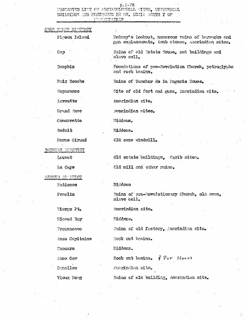
p.I-76 ;;;JG0I~;lTE::O T.,!.'~T f\?:,~ i:ECRA'X'I,cYmJAl, ':JTB::l, IfI:;~l'OHIaA!.
})D'IJJJ)niQ~) }J1'D lICJ'n:.tr;;;;:JT;~ IH ~;fr.. LUC! It. ·.WR'l'l! Y OF
Dauphin
neduit
Hicoud Day
1(O(11J.oy' G I.ookout, nU1110:r-OUS l."'!:Li..ns of btu·l't~ka Bl1ll. gun mpl8,comeri'l::a. tanb stono3jt j.~\Jerlmti~il'l 3itea.
Rll;Ul$ or ol(l. T::."Stn.to Hou."':1E!<. out build.intJs a.'ld Hlt-l.w call.
1"oundn.tions of rn:G-Revolution Cw.x.."'Ch. potrozlyPhs ~>.nd l"ock h-::.sins.
R:l.:dm of J)rt.I..ooRGvolut'1oo!u"Y Clrurcllll old oven" slu.w cell.

1-77
VIurx F'OHT DT~T?ICT --Pointe de Cf'..1.11<.t
Point ;:leblo
CHO!;j F'i.U.. T~T ':1TP! C'll ~~CIIII;r9'''~~~~
Choiseul
DiD.1llro1t ~cmnin:J or. old bc!ths Old l:Iulls und sug~lr fnctorl.es. old ~$tatG hou.setl&
C.i\ rr;~ r~I E~~~ 1)1 .~!r}rtICT _"'MIf't::o:al::.",.."*_",*,~"",,,,~'I'I"'l\t¢ "l~,>tlIiOIli14l
o A t.i:~··:.rr (t~1 n:r~~~,:rTa err ~~~~~.

C r~ ~f~!ntl;~,'~ DI::~!~'~rrCT ~~'''''''''''_''III1'''~
(cont. )
Cicoron
~'a:pion Rock
1-78
Old fort.
I'1ili tlU':'Y CCi::lotOI""j' f p01;l'{ler mage,z1no, calls trod g"Qara l:'cc.m, l.'~u:tllS of Gov()~cnt 11011130, :trOll lKil.·rt.clt£}, apoctl00, b:),ttorYtt nl1'l.ltmentl'3 cl' old r~lil .. f n:y ($c!tl.e o"nly j, 111rd$3Idl1il\:r TAouu.'1len t a.l1a (IDVirol'H::l.
lillG'O gun at Itld;"}l~WBY. Hall' Boon Battery L,!!,..d
shot oven.

I-79
ST. VINCENT
I. INTRODUCTION ....... CIiI ••••••••••••••••••••••••••••••
1. 1 Fieldwork Scheduling and Contract Terms of Reference
II. DEVELOPMENT AND ADVERSE ENVIRONMENTAL IMPACTS ........................................... .
2. 1 Existing Development Impacts
2. 2 Potential Development Impacts
III. CAUTIONARY GUIDELINES FOR DEVELOPMENT PROJECTS .......................................... .
3. 1 Guidelines (As the guideline reference applies to two or more of the study islands, general guidelines will appear in Part II)
3.2 Priorities for Supplementary Detailed Investigations of Environmentally Critical Areas
IV. POSITIVE ENVIRONMENTAL INITIATIVES .•.••.•..••••••
4. 1 Projects with Potential to Confer Environmental Benefits
4.2 Local Contacts in the Environmental and Development Fields


GRSNAQfHES
N J ct
M"ST/Q"~V
o
~
'='
~CANOUAN
f'l Q... TOBAGO MAYREAU
V 0" o CAYS
~ PALM
~NO
P.s.v.
S. GLOS':.}' "lAY
p.I-81
CANOVAN
o·
-:-l:.'l 1-1
I
00

1-82
ST. VINCENT
I. INTRODUCTION
1. 1 Fieldwork Scheduling and Contract Terms of Reference
The fieldwork consisted of a visit between February 18-21, 1974,
in addition to several prior visits. As St. Vincent has experienced little
of the development that has affected other islands of the Eastern Carib-
bean, fieldwork focussed on faunal resource depletion, beaches and beach
access, and marina developments. Other areas investigated in St.
Vincent were historic sights and monuments, and priorities for park and
preserve planning. Coastal water quality has been omitted as llihi,s
being handled within the context of the WHO /PAHO survey of selected
Caribbean islands.
II. DEVELOPMENT AND ADVERSE ENVIRONMENTAL IMPACTS
2. 1 Existing Development Impacts
Our survey of existing development impacts centered on beach
access, mining of sand and coral, the lobster fishery and marinas. The
sewage problem of Kingstown was omitted due to the fact that the WHO /
PAHO study will cover St. Vincent in addition to Antigua, Dominica, and
St. Lucia in the context of a liquid and solid waste management project.

1-83
St. Vincent
2. 11 Beach Access: Limited access to beaches is a problem that is
increasing in St. Vincent. According to the Planner, Oswald Sergire, of
64 beaches, 32 have access blocked by private holdings. The following
are examples of beaches having limited or no access:
1. Griffith Beach, north of Georgetown, on the east coast.
2. Grand Sable Beach, just south of Georgetown.
3. The beaches at North Union Bay and South Union Bay;
4. On the west coast, the be aches at Anse Bonaventure and
Byahaut.
2. 12 Sand and Coral Mining: Another impact encountered in St. Vincent
is sand mining of the beaches for construction aggregate. Sand is mined
on various beaches on the island, particularly in the south-eastern part
at Brighton Bay. There is no legislation prohibiting sand mining of
beaches, but it is widely felt that legislation, if it existed, would not be
enforced anyway. Private landowners who control access to the beach,
which is a public resource, commonly charge an access fee to those who
wish to mine sand and transport it through I).d!l(tir property.
The beach that fronts Camden Park Bay used to be an excellent
swimming beach. Now, however, as the result of sand mining and
possibly natural erosion, the beach has virtually disappeared.

I-84
St. Vincent
In the Brighton Bay area, large sand dunes form the berm of the
beach. This area of sand mining also extends south beyond Milligan Cay
around to Prospect.
Another dimension of this has been the mining of live coral. A
year ago, an extensive area of staghorn reefs was mined north of the
Young's Island in front of the Mariner's Inn. Mining of the coral directly
conflicted with use of the offshore reefs by the Mariner's Inn for scuba
diving and snorkling. According to the dive master, Hugh Ettles, extensive
destruction was sustained. Mariner's Inn, as a result of this, has noticed
two impacts beyond the aesthetic loss of the reef itself. First, the shore
area experiences greater swells especially during the summer, which
formerly had been broken up on these reefs. Secondly, there has been
some erosion of the beach on the adjacent property of Mrs. Dun.
2. 13 Depletion of Spiny Lobster: The Grenadines in the Grenadines
shelf is a favored area for spiny lobster ~arv:esting. Currently the market
for lobster is booming and production is at a very high level in St. Vincent
and in the St. Vincent Grenadines. Increased catches of undersized lobsters
suggest over-exploitation of the lobster, which will lead to rapid depletion
of the resource and reduction of sustained yield in total pounds. Currently,
there is a complete lack of management of the lobster fishery. There are
no export statistics, for, as the law reads, total lobster catches under
5001bs. need not be registered. The reason for concern is that local

1-85
St. Vincent
fishermen have now taken to scuba diving which dramatically increases
their dive time and range. The fishermen using scuba are entirely self
sufficient as they have portable compressors on board. Current prices
for lobster are $2.50 E. C. per lb., while five years ago it was sixty-five
cents E. C. per lb. ) Lobsters within the Granadines are taken to Palm
Island where they are flown out to destinations including Martinique,
Barbados and St. Lucia. An aspect for future concern is the possibility
of their resorting to night diving with lights, an activity which is strictly
illegal in other organized lobster fisheries.
2. 14 Marinas: Presently, a marina is under construction at the
Careenage in Calliagua Bay. This marina is being built by Caribbean
Sailing Yachts and, to date, has only involved the minor clam' shell dredg
ing for dockage facilities in the bay. There has been no adverse impact
from the dredging on surrounding reefs or waters. Another project in
Calliagua Bay is the Johnson Point jetty which mayor may not be realized.
It is suggested that planners keep an eye on the construction aspects of
this jetty.
A possible marina site is north of Johnson Point near the Ottley
Hall ruins.

I-86
St. Vincent
2.2 Potential Development Impacts
Canouan Island has been slated for extensive tourism development
with most tourist facilities being placed on the eastward coast. The Britmh
Development Division is responsible for the infrastructure, roads, a jetty
which would be on the west coast of Grand Bay, and the airport now under
construction on the peninsula of the southwestern end of the island. A
potential concern is the possibility of an oil transshipment facility to be
built by General Crude by the airport. General Crude Company is presently
exploring, using seismic instruments throughout the Grenadines area. A
possibYe, marina may be constructed on the east coast in Canouan.
Another area of potential concern is the Camden Industrial Park
site on the western coast of St. Vincent. This twenty-five acre industrial
park is given over to secondary manufacturing and as yet, no comprehensive
waste treatment facility is planned. Given the slow growth probability of
the industrial park, it is feasible at the moment to consider sewage treat
ment by a septic system on a development basis rather than in a com
prehensive fashion.
III. CAUTIONARY GUIDELINES FOR DEVELOPING PROJECTS
3. 1 Guidelines
fn St. Vin~nt)- where very little development activity is under way,
general guidelines are given in Part II. Of particular relevance are those

I-87
St. Vincent
sections on: "Dredgingll (Section 7), lISoil Disturbance'! (Section 6), as it
relates to the mining of sand, lfMarinas'l (Section 9), l1Conservation of
Lobsterlf (Section 11), and l~enity and Aesthetic Resources ff (Section 2).
3. 2 Priorities for Supplementary Detailed Investigations of Environmentally Critical Areas
Supplementary investigations in St. Vincent and the St. Vincent
Grenadines should focus on the possible adverse impacts of development
activities on Canouan Island.
IV. POSITIVE ENVIRONMENTAL INITIATIVES
4. 1 Projects with Potential to Confer Environmental Benefits
A list of scenic amenities and park and preserve priot'ities is being
compiled by Dr. Earle Kirby for the UNDP/PPP office.
4.2 Local Contacts in the Environmental and Development Fields
Mr. Tim Burgess Bequia, St. Vincent
Mr. John Caldwell, concerning the Palm Island Development
Mr. Dalrymple Department of Public Works. He is involved with sewage treatment.

1-88
St. Vincent
Mr. Hugh Ettles St. Vincent Marina Yacht Company, Ltd. Box 346 Kingstown, St. Vincent Telephone: 84388
Mr. A. Eustace Secretary of the St. Vincent Development Corporation P. O. Box 841 Kingstown, St. Vincent
Mr.·OswaldA. Fereira
Dr. Earle Kirby Department of Agriculture Kingstown, St. Vincent
Mr. Stoeken Resident Manager Caribbean Sailing Yachts Blue Lagoon
Mr. P. M. Velox Permanent Secretary
Telephone: 71358
Telephone: 84308
Department of Trade, Agriculture, and Grenadine Affairs

I-89
TURKS AND CAICOS
I. INTRODUCTION .......................................•.....
1:. 1 Fieldwork Scheduling and Contract Terms of Reference
II. DEVELOPMENT AND ADVERSE ENVIRONMENTAL IMPACTS ••••
2. 1 Historical Impacts (where applicable)
2.2 Existing Development Impacts
2. 3 Potential Development Impacts
2.4 Other Impacts
2.5 Priorities for Supplementary Detailed Investigations of Environmental Critical Areas
III. CAUTIONARY GUIDELINES FOR DEVELOPMENT PROJECTS •••.•
3. 1 Guidelines
IV. POSITIVE ENVIRONMENTAL INITIATIVES ••.••••.••.•••.•••••••
4. 1 Projects with Potential to Confer Environmental Benefits
4.2 Opportunities to Enhance Environmental Assets
4.3 Local Contacts in the Environmental and Development Fields

1-90
TURKS AND CAICOS ISLANDS
1. INTRODUCTION
1. 1 Fieldwork Scheduling
Field investigations were carried out by John McEachern,
resource planner of the Foundation, over a six day period
from January 23 to 28 inclusive, with departure from the islands
on the following day.
The islands visited were: Grand Turk, South Caicos, North
Caicos, and Providenciales. Salt Key was' indirectly surveyed
by aerial reconnaissance coupled with firsthand interviews of
Salt Key residents.
1. 2 Contract Terms of Reference
The work in Turks and Caicos concentrated on physical develop
ment projects associated with reefs and salt ponds, mangroves,
port and marinas, and park and preserve priorities and planning.
These subject areas are outlined in section 3. 01 of the basic
UNDP - IRF contract, "Contractor Investigations".

II. DEVELOPMENT AND ADVERSE ENVIRONMENTAL IMPACTS
2. 1 Historical Impacts
The terrestrial fauna of Turks and Caicos is impoverished in
both species and numbers. This is mainly due to the extensive
habitat changes that occurred because of the island's salt industry.
Historically. from the colonial peri od into the 20th century, Turks'
island salt had an important place in American commerce, its
popularity based on its use in food processing. In order to
abet evaporation, and reduce rainfall (or so it was believed), the
woodlands were systematically felled. Vestiges of the original
fauna probably exist on East and Middle Caicos, and on the cays,
extending SSE of Grand Turk: East Cay, Pear Cay, Long Cay,
and Gibb's Cay. These Cays are noted for their iguana populations
and nesting birds. No visit was made to these islets to inventory
the fauna, however.
The cultural artifacts of Turks and C aicos are similarly of little
interest in comparison to those found elsewhere in the Eastern
Caribbean. The few monuments, which might be of interest are in
an advanced state of deterioration. These are listed in Carleton
Ray's report and will not be discussed here.·

I-92
2.2 Existing Development Impacts
Most of the development impacts that have occurred in recent
years in the Eastern Caribbean have not as yet affected Turks
and Caicos. Two minor environmental problems which are in
evidence, however, are (a) litter, and (b) a miasma which rises
off the salt ponds, or Thwn Salinas, during periods of
still air.
The litter problem is at its worst in Grand Turk, particularly
the area adjacent to and east of Cockburn Town. Litter also
occurs in the salt pans below the catchment at the south end of
Town Pond, along the berm of White Sand Beach ( the only beach
located at the southern tip of the island) and by the mangrove.s
at The Sound. Solid waste collection and disposal on Grand Turk
is haphazard and ineffectual for much evidence exists of wetlands,
salt ponds, and mangrove areas being used as solid waste duxnps.
There appears to be no organized pickup and disposal service,
nor is there evidence of outdoor collecting points for garbage and
litter.
The miasma rising off the salt ponds owes its origin to the fact
that water impounded in the salt pans becomes stagnant and at

1-93
certain times of the year, results in the formation of hydrogen
sulphide, as the organic debris begins to decay. The solution to
this problem would involve either (1) landfilling the salt pond, or
(2) improving the water mass exchange sufficiently to preclude
formation of stagnant water.
2.3 Potential Development Impacts
Three development activities are of concern to us: First, potential
adverse impacts of causeway construction; secone, the plan to
build a harbor in South Caicos; and finally, marina constr,uction
projects associated with resort developments. Turks and Caicos
Islands currently undeveloped should: not be completely ignored
for in future they may be selected as candidate areas. There is
a rumor - based more on wishful thinking than on substance - of
a possible associated territorial status with Canada. Although
this will not come to pass, there is nevertheless awakening out-
side interest in Turks and Caicos. The 50% appreciation in land
values over the last two years reflects this interest.
2.31 Proposed Causeways - At various times, causeways have been
proposed to link the Caicos Islands. The most recent articulation
of this notion appeared in the Shankland & Cox Outline Development
Plan. They state that one of two future objectives for the roads
program sp.ould be the creation of an island spine road connecting
South to North Caicos. The report fails to consider any

I-94
undesirable environmental consequences that could follow from
such a road-building program.
The southern portion of the causeway program calls for the inter-
connection of the three cays lying between East and
South Caicos: Nigger Cay, Middle Creek Cay, and Plandon
Cay. An optional route, proposed by a Canadian developer (in
return for a free hand in developing East Caicos). would conjoin
East and South Caicos via Sail Rock Island. In all these schemes,
no mention is made of the impact of a causeway on the marine
flora and fauna of the environs.
The area to be trafersed by the causeway is shallow water (4 feet)
and lays claim to being among the most productive bone fishing
areas in th~ Caribbean. As bone fishiJig is potentially an important
tourist asset~ alteration of this habitat is of more than biological
interest. The bonefish Albula vUlpus , grows to more than 12 /
pounds, but on the average, weighs less than 5. It is a bottom \
feeder, concentrating on mollusks (especially clams and crabs)
and is considered to be a great sporting fish on light tackle. It
should be noted, that the exclusive Southern Cross Club resort on
Little Cayman Island owes its founding to the unsurpassed bone
fishing of the adjacent waters.

1-95
In the case of the southern causeway, it is desirable to main
tain scoured tidal cuts of Plandon and Middle Cays leading to
the Stake Bank shallows, as they are obviously interrelated
and crucial to ecologic stability of the bank. If the causeway
were to impede or block the water flow through these cuts, the
life of the bank would be dramatically altered. Faunal
impoverishment through reduced food supply can be expected
by such a blockade. These cuts provide the channels through
which tides equalize waterflow between the Turks Island
Passage to the east and the shallow Stake Bank area to the west.
The aesthetic value of these cuts has been described by Ray
(1971, p. 15).
The causeway development most likely to materialize is the one
that would link North and Middle Caicos Islands. The plan, as
it exists in the Department of Public Works, calls for a short
causeway to be built across the salt pond lying one-half mile
east of Readymoney Settlement. The major construction, however,
is represented by the 3700' section traversing Homer Channel,
between North and Middle Caicos. The plan calls for two culverts,
the main culvert being wide enough to allow boat traffic. This
culvert will be located 400 feet from the western terminus of
the causeway, and will be 25 feet wide and. bridged. A subsidiary

,I '
1-96
culvert will consist of three side-by-side, 6 feet diameter tubes,
located 2,300 feet from the eastern causeway terminus. The
design deficiency of this project rests with the fact that in 4, 700
feet of causeway, a mere 43 feet will be open to tide-water flow.
This is less than 1% of the total length. The result will be to
effectively block the north~south water exchange through Homer
Channel. It is essential that. prior to construction, some drift/
tide studies be made with particular attention being paid to the
ecology of Bottle Creek Channel. and its dependence upon tidal
exchange.
As suggested above, the habitat of the bonefish is protected
shallow banks. Availability of food is related to unimpeded water
flow for the organisms on which bonefish feed arrive on the flood
tide. The entire sublittoral zone along the southern margins of
North, Middle and East Caicos. including their myriad channels.
provide an ideal habitat for this fish.
2.32 The Harbor Plan - This development is tentatively scheduled to
begin mid-summer. 1974. and will be located in South Bay. South,
Caicos. The island is economically depressed. with few development
prospects for the future. The new harbour would be the single
exception and. at the moment. has not advanced beyond the dis
cussion st.age. The site of the deepwater harbour is 500 feet
east of the Admiral Ar ms Hotel. the only resort now operating in

1-97
South Caicos. If approved by the British Development Division,
the project would involve dredging of the bay in addition to jetty ..
construction. Our concern lies with the potential adverse impacts
of sediment loading of the surrounding water during the dredging
• phase, and the effect this could have on the hotel's diving business.
SCUBA is a recreational activity offered by the hotel, and requires
clear water and the presence of healthy, well-developed reefs.
Briefly, bucket and clamshell dredging causes turbidity of the
water due to the "fines" of particulate matter that goes into sus-
pension. Turbidity not only reduces light penetration, which ad-
versely affects the algaesymbionts of coral, but physically can
smother it where the silt drops out of suspension and blankets
the living coral polyps. Further discussion of the potential hazards
of dredging, appears in the dredging guideline (p. ).
At the Admiral Arms, the prevailing ocean currents pass between Long
Cay and South Caicos flowing so utheast to northwest around Dove
Cay .. According to the hotel dive master, superior dive localities
exist in three areas on the north end of Long Cay and on the north
and south sides of South Cay. Looking beyond the needs of the hotel
itself, it is fair to say that degradation of the marine enviro nment
is not 'to be accepted ligbtly, as South Caicos has few of the tourist

I-98
assets of her sister Caribbean islands. Water quality is perhaps
the unique marine asset. Diving in the waters of South Caicos
and in the rest of Turks and Caicos is excellent, characterized
by pellucid water with visibility frequently exceeding 100 feet.
Of added interest is the presence of an oceanic dropoff where the
sublittoral bottom plunges from 10 to I, 000 fathoms in the space of
4 miles. This oceanic dropoff can be found on the west coasts
of Grand Turk and Salt Cay, and off the south coast of South Caicos
in front of the hotel.
It is to be noted, that the Admiral Arms Hotel advocates and
supports the original Ca rleton Ray proposal (See Parks and Con-
servation in the Turks and Caicos Islands) to make the reef systems
associated with Long Cay and Dove Cay part of a Marine National
Park systern.
2. 33 Marinas - As yet it is premature to judge if these protected marinas
, I , will incur adverse environmental impacts. However, with the con-
struction of more resorts it is probable tha t some of these new
marinas will fail from the standpoint of water quality maintenance.
, Marina developments are now underway, or are proposed in asso-
ciation with future resort developments, on the islands of Provi·-
denciales, North Caicos, and Salt Cay.

1-99
The most ambitious marina development is the Turtle Cove'Develop-
, ment of Provident Ltd. This company has on the drawing boards ,three
large residential projects slated for Providenciales at: (i) Turtle Cove,
(ii) Long Bay Hills, and (iii) Grace Bay. Ano1iher development on the
isla;nd,independent of Provident Ltd., is known as "Leeward-Going
Throughll and is backed by Bill Kemp of Bermuda.
, Taken together, the three Provident Ltd. developments consist of
4, 000 acres and 4,500 house lots. At Turtle Cove, the most advanced
of the three projects, 35 private homes have been built to date while
some 1,100 lots have been sold. Of environmental interest, is the plan
to extensively dredge existing salt ponds and channel areas at Turtle
Cove. To date, only a few test channels have been dredged. It is too
soon to determine if the marinas will, in fact, be built and if so the
degree to which they will prove to be sumps for contaminated ground
water and boat-generated oil and sewage pollution.
The potential danger of septic field overflow from the Turtle Cove
development remains an unknown. As presently designed, the housing
density will be one house per acre, but without knowledge of the soil
infiltration rate a judgement cannot be made as to the suitability of
relying on septic tanks for all housing units.

1-100
A marina development which is further along in the construction
stage is the one associated with the Seven Keys Development at the
north tip of North Caicos Island. At present. the Seven Keys
Development consists of the Prospect of Whitby Hotel sited at the
northwestern end of Whitby Salina. A dredge cut has been nR de
here through to the sea. and plans call for the construction of a
marina by dredging the rest of the Whitby Salina in a phased ex
pansion program. The salt pond. in its natural configuration. is
cut off from the sea and is several feet deep. As demand for
marina space escalates. first a quarter. then a half. then the
entire salt pond would be dredged to accommodate additional
slips and boats. Given t he fact that the neck of land between the
salina and the ocean has been set aside for dense residential
housing. ' there is always the possibility of septic tank effluent
contamination of the salt pond marina to the south or the ocean
shoreline to the north.
Salt Cay may also host. marina development. There appears to be
preliminary interest by the developers Jack Gold and Jim Pepperdine
who proposed a three-phase development plan for the Cay. The ·first
p~a.se involves a N:>rth Bay property consisting of an 8000 foot
coastal strip. 400 feet deep. A 50 room hotel and 40 houses are
to be built along the ridge line. with plans for a waste treatment

I I
1-101
plant, a desal plant for producing fresh water. and a power plant. The
. second phase of their development program would be at South Point
where 20 high income houses are planned. The proposed marina would
be the final phase, to be built in South Creek which is a lagoon along
the southeastern coast of the Cay. The concern over the proposed I
marina in Salt Cay rests with dredging impacts that might affect the
nearby reef systems located along the south and southeast coasts.
No development activity is programmed for Big Sand Cay lying
south of Salt Cay, and Cotton Cay located 3 miles northeast of Salt
Cay. The former Cay has a substantial beach on the west coast which
is frequented by hawksbill turtles (Eretmoche1ys imbricata). Offshore.
in the Turks Island Passage. are to be found seasonal migrations of
sperm and humpba<:!k whales. Cotton Cay is owned by TIMCO (Turks
Islands Merchants Company). A small mangrove stand occurs here
which is worth keeping intact. Both Big Sand and Cotton Cays are best
viewed within the context of natural preservation use.
Another potential development impact in Turks and Caicos is oil
pollution associated with a refinery or oil transshipment facility. At
one time Sal t Cay was proposed as a candidate refinery site. This
choice has been supplanted by the West Caicos project a move to be
applauded on environmental grounds.

I-102
Esso Interamerica has development option on West Caicos until
1976. In terms of the direction prevailing oceanic currents, the
latter site is preferred over Salt Cay, for any oil spills would be
carried in a northwesterly direction away from the Turks and
Caicos.
2.4. Other Impacts
Oil is already a problem although no refineries have yet been built.
The relative isolation of the cays has not given them immunity from
this impact. The eastern shores of the Turks Islands (Sand Cay, Salt
Cay, and Grand Turk), South Caicos Island, and East Caicos have
all received oil slicks at one time or another. Oil which is dumped at
sea by tankers cleaning their bildges, drifts in through the Turks
Island Passage from the Atlantic and blankets large portions of
the coastline. To a lesser degree some of the islands' northward-
facing beaches (such as at the Prospect of Whitby Hotel) also suffer frorr:
oil contamination. There is seldom an oil problem further east on
Providenciales as the island lies in the lee of the prevailing easterly
winds· and currents.
2.5 Priorities for Supplementary Detail ed Investigations of Environ -
mentally Critical Areas
Within Turks and Caicos, detailed investigations should focus on
(1) the pot~ntial adverse impact resulting from the causeway project;
(2) the deep-water harbor project and associated dredging in South

1-103
Caicos; (3) a close look at the marina developments, particularly at
Turtle Cove, Providenciales Island. Finally, (4) if the Exxon option
to build a refinery on west Caicos Island is exercised, an environ
mental impact study of the development is called for.
III. CAUTIONARY GUIDELINES FOR DEVELOPMENT PROJECTS
3. 1 Guidelines
A few specific guidelines are mentioned here in addition to three
general guidelines appearing in the conclusion of the report.
These latter guidelines relate to development activities that
occur in two or more of the study islands. For example, develop
ment guidelines appropriate to Turks and Caicos and to other
study islands are: "Dredging", "Marinas ", and "Oil".
Specific guidelines concern the causeway program, harbor
project, and several of the marinas.
3. 10 Causeways
Prior to construction, baseline data on physical and biological
characteristics of the site are needed so that impacts of proposed
causeway construction can be anticipated through reference to the
engineering plans. Topics of interest would include circulation
patterns, wave activity, coastal geomorphology, (sand transport,
etc.), and an inventory of biota and their habitats.

1-104
3. 11 Harbor: The same recommendation holds true in relation to the
South Caicos deepwater harbor. In this case the focus on offshore
current circulation should be examined in light of the effect that
these currents will have on transporting suspended silt, arising from the
dredging operation, westward of coral reefs located in front of the
Admiral Arms Hotel.
3.12 Marinas: It is suggested till t the Seven Keys Development Co. ,
explore the feasibility of excavating a channel at the northeast end
of Whitby Salina through to the sea, in addition to the southwest
channel now being dredged. The opening up of both ends of the
salina will induce a drift of water from NE to SW in response to
prevailing easterly winds.
Concerning the proposed Marina development at Turtle Cove, it is
recommended that the UNDP Planner monitor the evolution of the pro
ject preferably on a quarterly basis. The Island Resources Founda
tion has strong reservations about the adequacy of the water ex
change in this marina development, for it is unlikely that the ex
pected p(Jllution load will assimilate or disperse within the confines
of the area as it is now projected. Regardless of the outcome of
this large-scale, multi-channel. development, it can provide a case
example of an elaborately engineered development based on a pre-

1-105
existing lagoonal area.
IV. POSITIVE ENVIRONMENTAL INITIATIVES
4. 1 Projects with Potential to Confer Environmental Benefits.
It has come to the attention of the survey team that certain projects
underway, or planned for the future, have potential to bring environ-
mental benefits to the residents of the Turks and Caicos. These
projects are listed to alert UNDP planners to envrionemtnal useful
projects, and if monitored can provide models for other developing
Caribbean islands.
4.11 Windmills and Salt.pan: The salt industry historical artifacts.
Salt. Cay is the last remaining island within the Turks and Caicos which
has an operating salt industry, located in the southern end of the Salinas
east of the town. The TISCO (Turks Isla.nd Salt Company) operation
is all that remains of a once flourishing nineteenth century salt
industry throughout Turks and Caicos. Without Government sub-

1-106
sidy, the TISCO operation would have disappeared some years ago.
The developers Gold and Pepperdine have discussed plans to maintain
a skeleton salt industry, including the wood windmills which are
still used as a means of paddling water along the channels between
join the salt pans. Preservation of this industrial activity (a form
of industrial archaeology) would not only be a prime tourist attrac
tion, but also of historical and cultural relevance to the islanders
themselves.
4. 12 Mariculture: Another development activity which may occur on Salt
Cay and worth monitoring is the proposed Mariculture Project for
Pilchard Hole Salina. The consultant of this project is John T. Hughes
of the Massachusetts Research Station, Marthas Vineyard, Massa
chusetts, U. S. A. The idea is to commercially raise the brine
shrimp (Artemia) for human consumption. This project has the
backing of Stewart Beck of Mineola, Westchester County, Ne..v York.
4.2 Opportunities to Enhance Environmental Assets
Opportunities exist within the survey islands for UNDP /PPP
personnel to enhance .environmentally the environment, in addition
to rationalizing specific project plans. The example below,

1-107
to aid and abet establishment of National Parks in Turks and
Caicos, is a case in point.
4.21 National Parks Creation: Several years ago Major John Wainwright who
was then head of the National Park Committee, was instrumental in
bringing Carleton Ray and Alexander Sprunt to the Turks and Caicos
to report on the ecology of the_ islands with particular emphasis
on the impact of development on the natural environments. Their
report on Parks and Conservation in the Islands received wide
support from individuals representing both the development and
conservation sectors.
Upon submission of the report, the National Parks Commission and the
Legislature of the Turks and Caicos accepted the conclusions and
the National Park boundrie s demarcated within it. Since then nothing
has been accomplished, although interest for these conservation
measures remains widewpread. The step which is holding up acc'eptancE
of the National Parks program is drafting of the legislature. This
is entrusted in the overworked hands of Mr. Ernest Howard in
drafting who is the legal advisor to States Council. In the Turks
and Caicos the administration submits all bills and their legal
advisor must draft them. The opportunity exists for the UNDP
physical planner Lars Ibsen to assist Mr. Howard in drafting the
necessary legislation. With this objective in mind, model marine
park legislation is included in as A,ppendix B of the report. Further.

1-108
information on the parks can be obtained from those previous
government and private individuals composing the National Parks
Committee. Among these were Liam Maguire, Norman S;W.nders
and John Wainwright. Furthermore, almost all persons listed in
Appendix A under "Local contacts" expressed the hope that Naitonal
Parks would be created.
4.22 Natural Area Preservation: Areas not falling with national parks
are also of interest. It would be .. useful for the UNDP planner to
inventory existing mangrove associations with a view to placing
them in a preservation status. The guideline on "Mangroves,r
(v. Conclusion) describes their importance in both ecologic
and economic terms to Caribbean islands. In Grand Turks,
mangrove is found along the shores of South Creek, on both sides
of the Sound, and on the neck of land between them. In Providenciales
an excellent mangrove stand exists to the south of the Well Creek
Fishing camp and further south around Frenchmans Creek. The
excellent fishing in this part of the island doubtless is due to the
interdependency between offshore waters and the mangrove associations.
Of similar importance is the red mangrove (Rhizophora mangle)
fringe along the southwest shore of East Caicos, couples with ex
tensive areas of black mangrove (Avicennia sp. ). As the Ray (1971)
report has bdicated, the littoral and sublittoral zones of East Caicos .

1-109
are as near as any area within the Caribbean to a natural state.
Although the Island was formerly inhabited - prior to 1911 sisal
and cotton were grown - there is now only wild cattle, secondary scrub.
marine habitats which have remained"as pristine as they have always bee]
The limits to development in East Caicos have been lack of infra
structure and the severe mosquito problem. This lack of prior
development presents planners with an option largely foreclosed in
other parts of the Caribbean. Park Planning and establishment of
Marine Sanctuaries has traditionally occurred in the Caribbean in
response to the imminent threat of development. Park boundaries
as a result have largely been circumscribed by what has already
been developed, rather than by ecologically sound criteria. The
undeveloped nature of East Caicos allows the planner the luxury
to demarcate ecologically viable areas for preservation use.
Accordingly, we suggest a close look at the coastal and offshore
assets of East Caicos with a view to preserving an extensive re
presentative portion of this landscape in its naturaE state.

1-110 4.3 Local Contacts:: .
A.list t)f local individuals concerned with the environment is pro-
vided. in order to assist UNDP PPP planning efforts. These
individuals represent both the conservation and dyvelopment consti-
tuencies. This list appears as Appendix A.
GRAND TURK
Mr. Charles Been - Government development officer.
Mr. Ivan Buch.anan - Public Health Officer; his domain includes
sewage, and litter.
Mr. and Mrs. Dough Gordon - The Salt Raker' Inn, P. O. Box I, Grand
Turk. Dough Gordon is also Secretary of the Turks and Caicos
Hotel Association. The TCHA arose from the CHA meeting held
in Turks and Caicos, January 7-9, 1974.
Mr. Davi.d Hill - building supervisor, Department of Public Works.
Mr. John Housman - Editor of the Conch News.
Mr. Ernest_ Howard - Legal Advisor to State Council.
Mr. Bill Hutton - Chief Secretary of Turks and Caicos.
Mrs. Daphne James - Turks and Caicos Tourist Board, Grand Turk.
Also runs Turks Head Inn.
Mr. David Keith - Chief Engineer of Public Works.
Mr. A. G. Mitchell - Governor of the Tut-ks and Caicos,
appointed from Britain.

1-111
Mr. Phil Pruss - Owner of Grand Turk Scuba Dive Business.
Mr. Peter Smith - he is in charge of roads and marine developments
for Public Works Department.
NOETH CAlC OS
Mr. Derrick Hawkins - Manager of Prospect of Whitby Hotel. This
hotel is a development of Seven Keys Limited, Churchill Building,
P. o. Box 21, Gra nd Turk.
Mr. Charles Misick - State Council representative for North Caicos;
and an agent for TCA.
Mr. Peter Proutings - "The Prospect of Whitby Hotel. "
Mr. Colin Tomlins - Seven Keys development, in'"charge of rm rketing.
Resident in Grand Turk.
'I ' I
Major John M. E. Wainwright, project manger - manager of Seven Keys
Development Ltd, Box 11, Grand Turk. Formerly head of the
National Parks Committee. H~ was instrumental in bri nging
Carleton Ray to the Turks and Caicos.
Mr. Tom Whitting, - Managing Director, The Seven Keys Development.

1-112
PROVIDENCIALES
Mr. Kip Dupont, Turtle Cove Development
Mr. Bill Ken p - Turtle Cove Development
Mr. Fritz LUddington, Turtle Cove Development
Mr. Tim Nicholl - Ex-government fisheries officer.
Ms. Vicki Ringer - Owner of the Provo Trading Post near the airport.
Mr. Jim Sautelle
Mr. Bengt Soderquiest - Land Supervisor for Provident Ltd.
Ms. Donna Wolfe - Manager. Third Turtle Inn, Providenciales.
SOUTH CAICOS
Mr. Tony Forrest - Dive Instructor for Admiral Arms Hotel.
Mr. A. G. Malcolm - the District Commissioner for South Caicos.
Mr. Rony Rae - the rEurks and Caicos Government Fisheries Advisor.
Mr. NOI1man Saunders - Chairman, the Turks and Caicos Tourist Board.
State Council representative for South Caicos.
Mr. Richard Stevens - Fisheries Officer and marine biologist.

I-113
SALT CAY
Mr. A. S. (Sandy) Leggatt - Resident Manager, I1The Brown House".
Mr. James Morgan - General Manger, TISCO (Turks Islands Salt Company).
PARROT CAY
Ms. Helen C zernin
Mr. Tommy Coleman
PINE CAY
Mr. Liam Maguire, The Meridian Club.
/ !

""j' WEST CAICOS
D 5 10 15" 20 miles
t " , i' j o (0 10 30 k;/o",,,~rt,
IV
I
NORTH CAI(OS 0",
[JU 0.0 •
~l:t • .!
?OSSI"BLE J-MIilBOUR.-
.. <>
~~
TURKS &.. CAICOS
EAST Ci\lco:;
SOUTH Cf.\ICOS
CAO~E.WAY
GP,Akb Tu~1<,
I "'0
.. ","'"g. I ~ -• II? •
R.'t Cay

r ~22" i
I ·1
II
7~O ----------.--------:r D H' ----.---r I I A T LA ,'4 TIC 0 C E A N 1 U,,~S I AND CAk .. OS I"
I cree¥- IS_G~NDS i
Sandy p . :'~/(6:--. . --i.l-··-o\.~~ 'NORTH Sca:le of f-1ile~ II Parrot o~l;>t :;J.- ~"~C"AIC"O" 10 5 0 10 20 I I
D !.Z · Cor,;!) , .... ,' l~::> t R e H hi EJ ! -.......:.. ... ~ II G . I e IS C .- , V"" . f' ~v I., Pine C !D~':> .d 1\, \ \\ ':. "" 'Oar il Tracks ----- I
'l'...V I '''ilt iI;- \ \ . (,\' barr '-,':r. ':.:'.~i-I!> ~(> "'r S,,';:d Kew \. c..) ••••.••.• Jo.t:.o. .. <Q'¢((\.' ". Shallow water with much "
o~ PD"V1!""\\,:,i\'r, ''-.' c.t". o.;~~~ .. 1s>W·-1'" :/':' "', ..... ~-{ ....... ...,_~~.: partly subme<ge<lcoral .. ' ...... ,.
72°30'
I NOR T H
I' ,I I I
" f"U (5~,·~.··' ..... , .... :'-.: '\;" ~~ J 9~~~;~~~OU9h.~ ".(, \,6t!~~~:onviJle 1
(::? '1'/ -;:'1'- \ rt:f. .... VOlnt 1 o ....., <J.."'!.J .. 'f -=::;11 \. "o. ')~"'" I
§ 1'(7"/ Five Cays MIDD~~~~~ .... J".<:J\ :tt.:;illiPS Reef I : ,WEST - ~U C·' AICO(" I : . CAICOS I .:o.' .) 0<':'- .. I
I 0 i :-,~ . ..-:.: II I
I 1°' ~ ..... I
! L!···· ........ C A leo 5 BAN K 'K ~A~~TO~ «' ... ~~(7:f.·;~c. I I ~ ~ 21"30" r /:- 1'- ..) )'''{,: '21030'1 i ~ I French Cil9"~"""'" Six Hill Caybo ~ Cockburn S) cockbur~:;~ GRl\ND 11 I, ~ . : 1/.,' Harbour ~ Town : j "-URK 'I II ( Long Cay,.· . ,~ ': "I '. . I L:__ -- / . B' Pennis fO~ COy" Loni/'C~y.... I, I r \ ' ' .. r:- West ~and Fish C3YS8" : Cotton Cay 0 .. CPear C~y ". ' Ii') .... ..: f NOR T HI.... SpIt I ~. V, .iJ ~ast Cay : I II c,; ~,~,-S- A T LAN TIC '. I A be . C fit. . \ ~ 'IF ......: I I LFLORlpA " .,'~"" ~-? 0 C E AN .. ··· m '9
f1S ~ V: g .... .., Salt C~y.'·'· . .... i
i ! '.~ :; Q':'c, ~ /,r .•..• I ~ I--. ..•. I I, / .• , ( .1 . "! ' ! 1
/,- "." •... -.. 'il .. !)-? 1-- l- :. : II Gt. Sand Cay r.f- ,
I ,..... ~ -..... '\.~ <> •••• Seal Cays . . oS : c.t>-V"' I
i . ". /' ~ !t>"_ J' CAICOS II ··· .. ~hitc Cay@'lIOc···9tlBus·h.Cay/....t<..SJ I ~ "~~ : '? "'" IS. . .... ~ r' I
. " C~·' '. '" .~ ~ TURKS ". ". .... I ;::' ~ndJmion Rock ~ I i ~- U B .-II .' IS I: "1' : ~O i' ~ <-" I .'. ~ i" ' .___. . . ....... ~~ ~wimmers : .. : (]
I i C4~~/8 ••••• ~~;>~c: \. I Fig~re L ..... .:.... . ........... j: Rock i1 I~' I' 8.: • HAITI,/! I ...... ' . .:t ~ ! "'" .• -'i iV S E ~ (~.""""--11' I I I 21" ', .. '! 4 ~J I I I ' , ' JAf>'IAICA ~ . I' I I I ~ I ~, 720 71°30' 71" I a L.___ I! I ! -.J L~·~~,..."!~.<t)P,~~~~~~~~ GlIW!.~itil;!ZS;l=~.~."'~~"'lI!£~~~&! .. _ ~'!!'~~~ Dr3'-"" by Oirectorate of Overseas Surveys 19570.0.5. 301 5C00f2/6l/~;o 2 SFCIA!RI
-0
....... I
f-' f-' CJ1

r,
~~=U"~~~~~ __ ~CM .. __ ~ ________ ~.a~um~~ ____ ~ ____ ~~~~~~ __ ~~ __ ~ ad • nw-ex _
Thr(J~ Marys Cays Sanctuary
\ .......... .
'
Ft. Gtflorge{;:!.~~.~~ ".
yJ ~.t\. :'. ..' :/) 1) ....... .' .... .. D ~~ .. :~ ...... :'" . "I : ••••• f'>~,'"
: ~. 0 .............. ~ IJP.....,. Chuhi,. Hall
: I Five Cays
ll."~/.' Saond CaY' Conch Bar Cav(Js
'. ............ I')
0: e·
./.' '. French Cay·· .. •· .••• Sanctuary •
J.: Six Hill CaYG~ /~ •.
.. ' Long Cay;'
. ' ~ ..
........
.. " .. .. .. - ... ." .... : ...
e'
:'D" .: ! ~ Gi/)b Cay
": .. / Round Cqy . ........... • '-I •••. .. : .. ~ . ~ GI
'. ......... ... .... .. ' ~
~@ ..
Penniston Cay /f'J .............. . :t:T ...
". ~ ..' ..... . ' .....
• .... .: o •• ~ ~ ....... ; .. iii o
...... :
I;' .................. e:
" ........ .. .....
Figure 2. Parks and SonctuQri~s Designated by th~ National Parks Committee.
I
I I
~ .. ?Z't'W B' $!Ilt?TP'!"'TR ::as iRS' ~.;y;;:r 0lI'~
'C
I--i
I I-' I-' 0'>

r- I i Flamingo Ponds Sanctuary i
I I I
.. ' ...... ~'~
Chalk Sound, Sillsy Cay
Booby necks Park
I __ \' TIJf'lIe Pond,Jo~ Grantsflguano and
, - "/. Flamingo Cr(Jftlr Park
. ..... . ~ (fJWEST
FivtJ Cays Park ....
.'
® RESERVE
OPARK
i~CAICOS ................... " ...
...... ..........
Figure 3. Additional
....... ()
..... .: .. :. '.
::. f \~
' . ............
Suggestions
Sancfuaries
cP
Fish Cays Res(J~'IItJ -...........~ ~
~~ig Ambflrgris Park
•••• $11(1/ Coys ". '., ,~h IItJ Cay eJI to '" -"9
'. '. 98u." Cay
ReflervtPs
.........
co'· ........................ ~ ...
.:' 4J G';. Sond Cay P.rk : .:....;.----.:.: J
.. . .. ... .... :. : : : .....
for Parks, R~HH~rv~s and Sanctuaries.
i r
l_,_m"' ______________________ = _________________ ~
""0
1-1
I I-' I-' -...J

PART II.
GENERAL GUIDELINES FOR ISLAND ENVIRONMENTAL MANAGEMENT
(to minimize adverse development impacts and protect certain resources)
ISLAND RESOURCES FOUNDATION U. N. D. P. ENVIRONMENTAL
SURVEY Contract 133/73

PART II. GENERAL GUIDELINES FOR ISLAND ENVIRONMENTAL MANAGEMENT (to minimize adverse development impacts and protect certain resources)
Sections Page
1. Tourism ........................................ . II-3
2. Amenity and Aesthetic Resources ••••.•••••••.••••• II-6
3. Cultural Resources .............................. . II-9
4. Conservation of Natural Areas .•.•••••••.•••..•.••• II-II
5. Oil Pollution .................................... . II-16
6. Soil Disturb anc e ................................ . II-21
7. Dredging ....................................... . II-23
8. Wetland Drainage and Fill ......••••.•....•••••••. II-26
9. Marinas ....................................... . II-31
10. Waste Disposal ................................. .
11. Conservation of the Lobster .••...••••.•..•...•••. II-38
12. Conclusion ..................................... . II-4I

II. GENERAL GUIDELINES FOR ISLAND ENVIRONMENTAL MANAGEMENT (to minimize adverse development impacts and protect certain resources)
In keeping with the objectives of the status survey, the aim of
Part II of the report is to assist the UNDP!PPP and government planning
units in establishing a sound set of environmental guidelines for use in
its planning activities in each territory or island (cf. Contract,
Sect. 3.04c). As we have seen, the impacts under consideration are
caused by a fairly standardized range of physical activities that then to
be replicated in most of the study islands. In general, the guidelines
which emerge are justified by the need to redress imbalances that arise
from economically viable, but environmentally damaging, aspects of
these activities. The price of progress in one sector may have to be
declining quality of life in another sector, but the purpose of guidelines
is to ensure that gains and losses are correctly evaluated and that de-
cisions leading to net adverse balance-sheet are avoided.
Guidelines can help this purpose by alerting decision-makers to
problem areas. They also provide a basis for broadening the criteria
of project analysis to include environmental impact considerations, which
was called for by Recommendation 63 of the U. N. Conference on the
Human Environment (Stockholm, 1972).

II-2
The scope of our study is severely limited in that 60 contracted
man-days of work had to be allocated between some 20 islands. If one
follows the customary practice of spending half the time in the field, and
half in data analysis, evaluation, literature search and report preparation,
then an average of 1 ~ days of fieldtime for each island is what the con
tract specified.
It is important, therefore, to appreciate from the outset that
within the limited scope of our study it has proved imp'ossible to develop
prescriptive and detailed site-specific guidelines covering all develop
ment projects and activities. For example, ~o translate the guiding
principles referred to under one of the headings discussed below, namely
'Amenity and Aesthetic Resources", into specific measures for a given
coastal development such as the proposed Val-Ha-La Ltd. project in
Dominica, a complete subset of standards and procedural guidelines
would have to be devised to cover all the tasks and responsibilities in
volved. These might include caveats on shoreline structures, their height,
location and density; land uses compatible with the aesthetic, ecological
and cultural values of Prince Rupert Bay and the Cabrit and, where
necessary, the areas that should be reserved because of their special
suitability for maintaining these values; any other zoning or land-use
regulations required; and fl.ppropriate policies for the promotion and

II-3
guaranty of public use rights to coastal resources (fishing and beach
access). Field work alone would require several weeks of effort.
However, the most that can reasonably be attempted within the
compass of the contract is to give more general guidance, based on the
problems that have been identified as being generic to the various island
systems, and only where possible make reference to specific develop
ments if they promise to be especially disruptive of the environment.
1. Tourism
Because of its multi-dimensional character and overlap or inter
action with many of the other land-use activities commonly pursued in
islands under development, the planning and promotion of tourism should
be undertaken at the highest governmental levels and viewed as a com
ponent part of an integrated, comprehensive, insular resource manage
ment spurred on by venture capital and private interest "planning" that
may ultimately bring more vexations than visitors and more problems
than profits.
The infrastructure of the tourist industry, unless very carefully
designed, involves a high risk of diminishing and eventually destroying
the natural balance of island resources. This has not yet happened in
the study islands, but is taking place in other parts of the Caribbean.

II-4
Guidelines would stress the need for forethought about the precise kind
of tourism desired and the strategy to be employed in fostering its growth.
Does one pursue mass tourism? Or a blend of unconventional tourism,
cruiseship tourism, or hotel, condominiums, or local "cottage" or guest
house tourism? These questions are prerequisite to assessing the in
dustry's impact on environmental values, on alternative resource develop
ments, and in mounting an anticipatory planning strategy. In islands,
tourism has too often evolved out of a series of unrelated, single project
allocation decisions, made by outsiders insensitive to an island's dis
tinctive characteristics. These projects individually and collectively
may ill-serve the basic needs of society.
Experience in the Eastern Caribbean shows that the tourist industry
is rarely charged the true and full cost of the additional public services
its development entails. The growth of tourism always generates in -
creased loading of essential public services such as water supply,
sewage and s~lid waste disposal, power generation, transport and com
munications, and may also lead to over-loading of public recreational
facilities. As a further guideline it can therefore be stated that a com
mensurate expansion of basic services should be mandatory where ex
pansion of the tourist sector is planned. Otherwise, residents may
expect a quantitative and qualitative decline in shared services and a

II-5
precipitous increase in their cost. In this context, a policy on infra-
structural cost allocation should be created for those services which
clearly benefit the tourist industry but are subsidized by government.
According to a recent study, the Caribbean tourism income multiplier is
much lower than has been traditionally assumed - say in the order of
"< . 6 to .8:'
Reverting to the matter of planning and design it can further be
stated that it is almost always desirable, especially in smaller islands,
to lay down the standards for both small- and large-scale resort develop-
ments. These standards would cover the usual impact of structures,
(style, location, density and height) and the extent to which encroachment
on other assets is permitted (i. e. cultural, in the case of Rodney Bay
and the village of Gros Ilet). Other standards would logically cover the
treatment of sewage and the control of litter, the preservation of open
space s, and as a specific measure, the promotion of public use and
access to beaches. Resort or large residential projects (i. e. Turtle
Cove, Providenciales Is. ) likely to affect the marine environment would
require special permits.in which conditions for use are based on the con-
tribution of the development to total impact on the resources concerned.
There is a clear need for governments in the study islands to view tourist
developments within a regional context.
>:'Bryden, John M., Tourism and Development, A Case Study of the Commonwealth Caribbean. Cambridge: 1973, p. set. req.

II-6
There are countless examples of impacts of one activity spilling
over to adversely affect other activities. The discharge of untreated
sewage from town sites directly into coastal embayments 'JS!;~~d for recrea
tional activities is a common situation (v. St. Kitts). Finally, an intrinsic
weakness in most island tourism development plans has been the lack of
an explicit statement, included as an integral feature of the plan, of the
level at which further growth of tourism would be limited and how this
would be done. Preservation of the 11quality of life 11 in any small island
or within an insular region requires the fixing of carrying capacity ceilings.
The lack of this type of limit to development on P rovidenciale s Island
promises to dramatically alter the island to an irreversible degree.
Examples of single purpose controls do exist elsewhere (i. e. Bermuda) -
which limit the number of cruiseships allowed to call per day and the size
and number of motor vehicles allowed to be imported; but adequate controls
have not yet been extended to include density restrictions on residential
housing, resort hotel or cDndominium units. It is doubtful is ;such piece
meal regulations can be of much real value in the long run, however, in
the absence of overall tourist density controls, which an appropriate guide
line would certainly advocate.
2. Amenity and Aesthetic Resources
In previous sections of this report with particular reference to the
growing impact of tourism, it has been stated that the study islands are

II-7
exceptionally well endowed with aesthetic and recreational assets, which
are just as susceptible and vulnerable to excessive pressure as the
physical and biological resources with which they are often closely
related. Guidelines for their protection, which because of their ex
ceptional value is clearly a public interest and responsibility, may there
fore recommend the promulgation of permitted land uses in specific areas,
encouragement of buffer zones in which land use is reasonably compatible
with that of the more closely controlled zones they are designed to pro
tect, and even outright proscription of certain uses that cannot be re
conciled with aesthetic values or are bound to foreclose recreational
opportunities. Fortunately, the majority of land-use activities which
seriously conflict with this category of values are not site specific to the
extent that suitable alternative sites could not be found elsewhere.
Methods to be employed by island planners to maintain aesthetic
values range from tax concessions and the purchase of access rights and
scenic easements to zoning and, as suggested in the ~ection discussing
the selection of conservation areas, emphasizing criteria, such as the
values here under consideration, which cannot easily be quantified in
monetary terms. Other regulations, which can be applied individually or
together, govern the height of buildings and the distance they must be set
back from the beach or waterfront, residential density, and outdoor ad
vertising. In the Seychelles, for example, the design of seaside hotels is

II-8
controlled and their height limited to that of the surrounding trees, which
should to some extent ensure that they blend aesthetically with the environ
ment. The original plans for raising a hotel row on the Pigeon Island
causeway showed only a superficial respect for the environs. The former
island would have been badly outscaled.
There seems to be a considerable possibility that the demand for
recreational facilities in islands will exceed current projections based on
population growth. This makes it even more important to forestall a
situation in which overloaded and badly sited facilities may lead to a
deterioration of the values they are intended to support, as in the case of
St. Thomas, U. S. Virgin Islands. A minor example of the kind of guide
line this suggests would relate to the car parking facilities for a coastal
resort and insist on their location well outside the beach zone. A more
fundamental recommendation would require that any public or private
development projects which appear to involve a significant risk of destroy
ing or degrading amenity and aesthetic resources should always be
accompanied at the planning stage by detailed and specific environmental
impact assessments. Finally, close attention should be paid by planners
to the recreational needs of local islanders, who for reasons of convenience
favor recreational sites close to town. These may also be areas in high
demand by the hotel industry. The presence of hotels can actually curtail
local opportunities by the imposition of a fee schedule or simply through
«l'V'~r~r~wding •

II-9
3. Cultural Resources
St. Kitts, Dominica, Antigua, and St. Lucia have had an historical
role as stepping stones for migrant peoples, trade and exploration, and are
rich in cultural records, the loss of which would result in social and
artistic impoveriSbment. As a first step towards conservation and restora-
tion of historic monuments and protection of archaeological sites, ter-
restrial or marine, the place of cultural resources within the overall
development strategy needs to be established. The guideline should be
based on the contribution these assets could make to inculcating in island
peoples a sense of identify, a better understanding of their place in
history and relationship with their environment. It should also evaluate
the resource as a tourist attraction and as a reference point for all
students of the evolution of man's artistic heritage. >:< El ements of a more
detailed management program would include:
(a) Inventory of cultural resources and a priority rating for
their conservation; marine wrecksites are a necessary
addition to the customary list of cultural resources.
(b) Estimation of financial and legal implications.
>:'This may sound like a difficult task, but the survey team was immensely impressed by the cultural heritage of the study islands consisting of such diverse sites, buildings, and monuments as Amerindian sites (St. Lucia); Forts (Charlotte in Antigua; the Cabrits in Dominica) sugar-mills (Lower Galway in Montserrat); distinctive vernacular architecture (Basseterre, St. Kitts), and even a lone Martello Tower in Barbuda. (d. f. Buisseret, 1971).

II-IO
(c) Enactment of conservation legislation and initial budgetary
provisions;
(d) Setting up an appropriate governmental or non-govern
mental body (e. g. National Trust, Museum Boards, Arts
Councils) to advise upon or manage the resource.
(e) Establishment or expansion of museum facilities to house
collections which cannot be suitably maintained or dis
played on site, and to promote the relevant artistic and
historical research.
(f) Preparation and publication bf interpretative materials
(history and guidebooks, reproductions, etc.) and recruit
ment and training of interpretative staff.
It is worth underlining the suggestion contained in item (e) above
that wherever possible the physical integrity of a monument or site and
its artifacts should be safeguarded. There is no doubt that this can
greatly enhance the enjoyment and hence beneficial impact of cultural
values, although admittedly more expensive and possibly less convenient
for research than the removal of artifacts to a central repository. The
management of cultural assets within the context of their physical environ
ment does, of course, also call for additional vigilance to ensure that, as
in the case of a seaside parking lot, ancillary or competing land-use

II-ll
activities (i. e. a beach home or restaurant), are not allowed to detract
from that environment and ipso facto from the cultural assets themselves.
Until a management program can be devised, however, the two
essential guidelines applicable to the UNDP /ppp region are:
(a) The inventory-mapping of historical and archaeological sites
mentioned above under "(a)", so that cultural assets will not
be razed or obliterated through a simple lack of prior know
ledge, and
(b) the subsequent development of a permit system, applicable
to areas of historic and archaeological worth, that would pro
vide for site inspection during the construction phase to ensure
that artifacts were properly salvaged or assets preserved
intact.
4. Conservation of Natural Areas
Conservation of natural areas is one of several ways of enhancing
island resources. The elements of any systematic program for conserving,
that is to say making sustainable use of, natural areas can be considered
under the three headings of inventory, selection and management.
(a) Inventory -Identifica.tionof the na.tllNl.i.~sse=ts :or. ani:slanil .. '
may be accomplished as part of a general natural resources

II-12
inventory, or conducted as a single purpose program. The
former approach is preferable as it enables subsequent alloca-
tion decisions to be made within the framework of competing
resource demands (agriculture, fishing, mining, scientific
research, recreation, education, etc.). The survey, which
may well be partly presented in map form, should of course
include islets, reefs, shoals, inshore waters and the marine
periphery to at least the ].g ___ fathom line. A complete natural
area survey of the study islands is needed. Such a task was
beyond the scope of this study given the short time allotted
for each island. The scope of such an inventory should include
geomorphic features, terrestrial and marine biota, details of
the range, movement and abundance of species, and in addi-
tion, all natural assets of high aesthetic and recreational
significance. Fortunately, the necessary groundwork for, and
models of the kind of inventory required, have been completed
in connection with the World Heritage Convention (l)and the
Check-Sheet Survey of the International Biological Program's
Section on Conservation of Terrestrial Communities (IBP / CT).(2)
(1) Aspects of the Convention are discussed in IUCN Bulletin, Vol. 4, No.2, February, 1973.
(2)G. F. Peterson. Guide to the Check Sheet for IBP Areas. IBP Handbook No.4, Blackwell Scientific Publications, Oxford, 1970.

II-13
These are references to be consulted by planners: wishing
to make broad -based and environmental inventories.
(b) Selection - Once natural assets have been identified, catalogued
and mapped, the way is open not only for soundly-based develop
ment planning and resource allocation, but also for the selection
of areas which in the light of recognized criteria deserve special
protection and management. The criteria will of course vary
with the immediate objective, whether it be habitat preserva
tion, wildlife protection, the provision of recreational are as
for an island conurbation, or any other conservation purposes
locally defined.
However, two points may be emphasized in this context:
first. the criteria should not be limited to those that can
be quantified in purely economic terms; and secondly, in the
process of evaluation, local as well as international expertise
should always be consulted. Both these provisos reflect the
subjective element in selection, which is particularly asso
ciated with aesthetic values, but is also a factor in the
estimation of cultural and ecological values. Inhabitants of
the study islands may have their own preferences or scale
values which need to be taken fully into consideration, even

II-14
though they may be modified. in making the final selection.
by outsiders' advice on the degree to which particular island.
assets are unique, rare or endangered in global terms.
(c) lVIanggement - The basis for effective conservation and manage
ment of natural areas. as Dasmann (1973) has persuasively
argued. rests with the design of a flexible and relevant program
addressed to the specific conservation tasks at hand. As already
noted in discussing "Selection" criteria. the task or objective
:Gran vary enormously. at its simplest. perhaps. merely calling
for the protection of a single endemic species. But it is
important to appreciate that even that will undoubtedly require
the protection of the nesting. breeding or growing place. which
in turn can only be secured by the maintenance of the habitat,
or entire biotic community of which the species is part.
examples being the unique iguana (Cyclura pinguis) on Anegada,
and the booby and frigate bird rookery on Little Cayman.
Habitat destruction has been the direct cause of the extinction
of a high proportion of Caribbean island species.
Attention to the point just mentioned is far more important in
management guidelines than. for example. attempting to set
lower limits on the size of conservation areas; witness the

II-15
survival of the globally unique lizard on tiny Maria Island,
off St. Lucia, which owes its existence in part to man's lack
of occupance and the fact that the mongoose has never been
introduced there. In short, allocation of land for conservation
should be determined by the specific project requirements and
ignore preconceived ideas about minimum acceptable size. A
national park is an exception to this rule as their purpose is
so far beyond preservation of a single species (c. f. Barbuda
discussion). Flexibility should also extend to the management
of the resources of the ocean. Thus, ideally a marine park
contiguous to the coastal zone should be backed up by a
terrestrial sector, extending from the shoreline to the proximate
watershed. As we have stated, erosion caused by a variety of
coastal and upland activities can be just as destructive to
marine biota as the direct effects of dredging itself. There
are potential problems. however, in fixing the seaward bounda
ries of a marine conservation area. Carleton Ray (1972) has
pointed out, that management should if possible be Go-extensive
with the entire ecosystem concerned. The difficulty, as he
goes on to explain, is that marine ecosystems are often inter
national in extent, and one has little control over the actions
of one's neighbors. St. Barthelemy (France) would have

II-16
difficulty in protecting her east coast from oil spills in the
event that an accident occurred at the marine oil trans
shipment facility that may be built on the Barbuda shelf.
If follows that success or failure to conserve marine areas
may, in some cases, hinge on the degree of cooperation that
can be mustered between islands of the Eastern Caribbean
(See Annex C, marine park/ reserve guidelines).
50 Oil Pollution
The ecological principles involved are implicit in the observed
mortality of seabirds, marine mammals and other marine organisms, the
aesthetic losses represented by beach, port and marina contamination,
and, most importantly, in the inadquately understood repercussions on
ecosystems as indicated by major alteration of habitats and various food
chain disruptions. One reason what the study islandsstand"i¢l ~]l),~cial need of
guidelines in this matter, apart from their obvious vulnerability to sea-
borne pollution, is that they are seldom technologically well-equipped or
in a stcong position to meet or prevent the hazards accompanying the
production, storage and shipment of oil. Also, the absence of an environ
mental constituency and legislated controls makes them attractive to multi
national oil corporations which must comply with strict performance
standards in North America.

II-17
The magnitude and extent of an oil pollution incident is determined
by the massiveness of the spill, the toxicity of the distillate, the sensitivity
of the biota, and the rate of oil removal either by human intervention or
through natural means. Problems may be aggravated by the use of deter
gents (emulsifiers) in cleaning up oilslicks in coastal areas and these may
prove ecologically more hazardous than the slick itself. The incidence of
oil pollution is greatest at islands with shore-based oil installations, as
we discovered on a small scale in McKinnon's Salt Pond, located by the
w. 1. O. C. Refinery in Antigua. Although deliberate spills from tanker
cleaning are still globally more pervasive (c. f. Turks and Caicos Islands),
despite the fact that the 'load-on-top' technique has shown them to be
totally avoidable, they are invariably eclipsed locally by repeated mishaps
occurring in the process of oil transfer, storage and refining. Shipwrecks
do contribute their share of spilled oil, however. In the past few years,
the Caribbean has seen large spills in the Bahamas and Puerto Rico.
(Bahamas, 1968, 1, 260, 000 gals .• General Colocotronis; Puerto Rico,
1968, 3,400. 000 gals •• Ocean Eagle, and again in 1973, 2 million gals.
from the grounding of the Zoe Colocotronis).
The study islands conveniently located in relation to high demand
markets are likely to experience an increased risk of pollution due to a
transformation now underway in the oil industry. This stems from the
gradual replacement of 70, 000 ton or smaller tankers by VLCCs (Very

II-IS
Large Crude Carriers) of gO-foot draught and 150 million gallon capacity.
Offloading of these supertankers always has an element of risk in shallow
continental shelf areas and therefore tends to be switched to ports or
SPMs (Single Point Moorings) with direct access to deep water. Islands
located near continental markets but on the edge of or beyond the shelf,
have obvious advantages from this point of view: the incoming oil from
major production areas, having been refined and stored, can readily be
shuttled in smaller tankers when and where required. There has been
in the Caribbean area, for example, increasing pressure to acquire
insular sites for this purpose, aggravated by soaring demand for oil
(only for the first time partially brought to its senses by the current
energy crisis, and the emerging environmental resistance to coastal
oil development projects in the United States. For three reasons there is
great interest for locating an oil transshipment base on the Antigua
Barbuda platform and one is already being built in Bonaire. Other new
or expanded facilities have thus been proposed or scheduled for the
Caymans, Turks and Caicos, Mona Island and others.
The response to this situation and the consequential guidelines which
may be appropriate could range anywhere from blanket rejection of ex
ploration, storage or refining activities within an island group, to a pro
posal or recommendation that all such facilities should be concentrated in
a particular island in the calculated belief that the economic benefits will

II -19
outweigh associated costs. In the latter case, the location of offshore
SPMs (Single Point Moorings) storage terminals, refineries and dockside
loading terminals should be very carefully selected to insure minimal dis
turbance of environmental values, and the necessary structures equally
carefully designed. In order to formulate more specific guidelines, a
wide range of experts suc.has meteorologists, oceanographers, marine and
terrestrial biologists, industrial designers and of course oilmen: them
selves, will need to be consulted for specific projects. As a general
principle, however, guidelines should:
(a) Prohibit installations in areas of high natural biological
productivity, such as estuaries, mangroves, coral reefs
and oceanic upwells.
(b) Provide for the strict operational regulations, inspections
and enforcement, coupled with contingency planning, which
can do much to reduce the risk of oil leaks or spills.
Elements to be included in such planning, which should be supported
by a governmental policy statement and organizational directlives, are:
(a) Discovery and notification procedures of oil spills;
{h) Methods for containing or enclosing a spill (by prompt place
ment of booms, etc.);
(c) Cleanup and disposal of oil, or destruction through burning
where salvage is impracticable;

II-20
(d) Restoration of damaged sites or biota, whether above
or below water; and
(e) Enforcement.
In the last-'mentioned connection, guidance should be given, where
possible, as to methods of assigning liability and recovering costs of
damage, control and cleanup operations. Even if it is impossible to
include details of the legal means available, the relevant program should
certainly put a high priority on the investigation of this aspect and, if
necessary, on the enactment by island authorities of new or better legis
lation. For example, the latter could provide for:
(a) The Jricensing of operat0r's
(b) Proof of financial responsibility and capability of reimburs
ing aggrieved parties in the event of a spill (such proof may
be required to be supported by the posting of a bond, in the
light of the poor accident record of vessels sailing under
certain so-called flags of convenience (c. f. previously cited
Puerto Rican shipwrecks) as compared with those operated
by well-managed and more adequately capitalized multi
national companies); and
(c) Everything else necessary for the recognition and enforce
ment of strict liability.

II-21
Whether covered by legislation or otherwise guaranteed by inter
national agreement, it is recommended that an that an insurance fund be
established. This could be financ ed from oil revenues, on a national" or
ultimately a Caribbean-wide basis, and act as a revolving fund to underwrite
the prevention, detection and cure of oil pollution, and the assessment
and restoration of lost or diminished environmental assets.
6. Soil Disturbance
Guidelines on development activities involving large scale excava
tion and earth moving should be designed to guard against soil loss,
erosion, sedimentation and silting .. the ecological effects of which are
the equivalent at the terrestrial level of those which occur as the result
of dredging in the marine environment. The essence of any guideline
must be to assess and prescribe land-use limits based on the geophysical
character of the area - soil type, slope, rainfall, nature of vegetation.
One method of helping to ensure that the limits recommended are observed
would be provisions, such as those which have been applied in St. Thomas,
U. S. Virgin Islands, for regulating earth moving by permits which specify
conditions. These would focus on where the activity is carried out, how
it is done, and the time period in which it must be completed. For further
amplification on standards and specifications for soil erosion and sediment
control practices and water conservation measures, the UNDP/PPP is

II-22
,. "" ~ . , ," .' . ..
advised to consult the Environmental Protection Handbook of the Virgin
Islands Soil and Water Conservation District. >:<
Among the specialized environments that stand to benefit most from
guidelines relating to soil disturbance are coral reefs and wetlands. This
is because they react badly to erosion and instability brought about by such
activities as road construction, residential site development, and logging.
In the case of logging, as in Dominica several years ago, wasteful forms
of deforestation accompanied by road construction, is very liable to lead
to wetland and reef destruction through erosion, silting and interference
with the natural flow and quality of water. Appropriate guidelines would
therefore be fully justified in insisting that re- establishment of the
vegetative cover in such cases should be mandatory and should always
be included in the direct costs of a project and budgeted for accordingly.
Mining of beach and marine sand deposits, usually for the purpose
of mixing with cement, also merits special guidance, since such sand is
often, for practical purposes, a non-renewable resource, the nouri.sh-
ment rate closely balanced by natural attrition. Mining sand from beaches
and inshore banks usually should be prohibited because of the risk of
>:<Available from United S31es Department of Agriculture, Federal Experiment Station, Box 131, King shill, St. Croix, U.S. V. I. 00850. This Handbook gives specific details on erosion and sediment control practices related to land cleaning, protective shade trees, land grading, retaining walls, permanent vegetative cover for critical areas, diversions, sediment basins, slope protection structures, etc.

II-23
erosion, and destruction of protective functions and of amenity and bio-
logical values (e. g. as turtle-nesting ground). There are ample cases of
beach erosion and attrition in St. Lucia, St. John, Antigua and elsewhere.
The alternative of off-shore excavation, which is the approach under study
in the B. V. 1., is always worth investigation, since, if it can be achieved
without serious ecological disruption, it will compensate for and help to
secure the aforementioned problems. >:<
7. Dredging
As noted in the discussion of ecological impacts of certain activities
in the Caymans, the British Virgin Islands and elsewhere, dredging opera-
tions are frequently associated with housing estat,es, harbor construction,
marina development, and submarine mining of sand to be used in the con-
struction industry. Because of their comparatively closed and fragile
ecosystems, islands are likely to suffer from adverse consequences of
these operations. The basic ecological principle involved is that unless
planned and controlled with the greatest care, dredging, together with
such aggravations as underwater blasting, can result not only in direct
physical damage to coral reefs and other productive or protective marine
communities, but also indirectly, through turbidity, silting and inter-
ference with water flow and natural sedimentation, and can extend the
>:<See Compton, Deane, et at. Eastern Caribbean Coastal Investigation, 1970 ;.. 1973,·5 Vol. British Development Division in the Caribbean, 1973.

11-24
harmful effects over a far wider area. One immediate consequence may
be to reduce the primary production of nutrients on which other economically
desirable marine life depends.
Guidelines aimed at mitigating such impacts might be expected to
begin with a general prescription on dredging, but while this may on
occasion be warranted, it will usually be unrealistic andmfeuforneatblE?,.
However, at the least, it can be recommended that all operations beyond
the l5-fathom line and any within that limit which are more than of a very
minor nature, should be preceded by an environmental impact statement,
permit regulation and environmental monitoring. General points to be
considered are:
(a) Inventory of offshore sand resources, including a
review of past insular supply and demand in order to
assess alternative sites and to anticipate future needs.
(b) Consideration of dredging methods and selection of
the one likely to cause the least environmental dis
turbance (e. g. hydraulic suction may be preferable
to the use of draglines, bucket ladders or cutterheads.)
(c) Evaluation of excavation sites prior to dredging, which
as Thompson (1973) has pointed out, should properly

II-25
include: investigation of substrate composition, dis
tribution, stability and relationship to the overlying
water column in terms of nutrient exchange, elements
and minerals; data on currents and tide; benthic geo
morphology; and a study of the composition and inter
relationships with one another and with the total environ
ment of the existing biotic communities.
(d) Monitoring of the dredging activity prior to, during, and
after the completion of operations. In the latter phase, this
will be directed to such problems as the levelling of ex
cavated areas (where the dredging is not concerned with
the opening up of channels) and the rehabilitation of biota.
(e) Where dredging involves the disposal of unwanted spoil,
appropriate provision for placing and containing this in
such a way as to minimize damage to ecological and
aesthetic values.
(f) The possibility of helping to finance monitoring, research
and effective planning and control of coastal development
by charging royalties not only on products or materials
dredged out for consumptive purposes, but also at a flat

II-26
rate per unit volume on dumped spoil which cannot be
shown to confer a positive and quantifiable benefit.
The foregoing points represent a general strategy towards offshore
dredging. Annexes A and B describe a more detailed management approach
and suggest minimum procedural standards, constraints, and monitoring
requirements.
8. Wetland Drainage or Landfill
Insular wetlands, including their marine equivalents, have a crucial
role to play in maintaining physical stability and productivity of the land/
sea interface. They frequently accommodate the most biologically pro
ductive communities, and are represented by a wide variety of habitats:
lagoons, depressions and salt ponds behind the seaward banks, mangroves
and, less commonly, freshwater marsh and estuarine flats. Loss of these
areas eliminates fish breeding and nursery areas, and decreases nutrients
production and reef fish populations. An overall reduction of bird popula
tion results from elimination of or encroachment upon nesting and feeding
areas.
The ecological principles involved call for guidelines whenever
development activities threaten to interfere with the natural water regime
flow rates, waterbody and water volume ex:rnange, and water quality.
These alterations can be expected to result in imbalance in the geomor-

II-27
phological features of the coastal zone and to have adverse secondary
repercussions on shallow water communities.
Wetlands and tidal lands have traditionally had a high development
priority o..ving to their suitability for certain types of use (e. g. estuaries,
salt ponds and lagoons for harbours and yacht anchorages), low cost of
land preparation, and their proximity to existing development which has
usually been concentrated along the coast. An underlying feature con
tributing to development pressure is the prevailing belief, reflected in
the market place, that marshes, mangroves and other wetlands are of
low value. In the Caribbean, more than elsewhere, pressure is
exacerbated by the omission of environmental accounting from the in
vestment analysis of projects. Accordingly, private and public enter'
prise. has long tended to utilize wetland areas, with little or no concern
for possible adverse impacts on the environment. In effect, wetland
"development" starting with its total drainage, has had an artificially
low price attached to it. A ramification of this situation worth noting
is that sites are chosen in response to cheap land rather than on an
evaluation of physical and natural attributes and biological requirements
of the site, an extreme case being the extensive disposal of solid waste
in wetlands which we found in Antigua, Turks and Caieos, and St. Kitts.
Nevertheless, the fact that so much of the coastal zone is taken up for
these random "non-dependent" purposes has the result of increasing
demand to use any areas that are still untouched - often mangroves or

II-28
other difficult ground - for activities which do depend on access to the
coast: harbours, marinas, bea ch recreational facilities, and in future,
such necessary activities as desalinization, etc. As scarcity drives
the price of coastal land up sufficiently to exclude non-dependent uses,
little land may remain undeveloped and, to make matters, worse, land
previously developed may have been so irreversibly changed as to make
it unsuitable for redevelopment for more appropriate uses or for re
version to its original productive status.
It is for these reasons that a suitable guidelines would call for
the reservation of wetlands of high productivity (mangroves and estuaries)
at least on a temporary basis, until the relative merits and potential
economic benefits of alternative uses have been fully explored and
assessed, and until any large bays or inlets clearly suited to the
development of fish or shellfish resources or other forms of mariculture
or marine recreation have been reserved. A rider to such a guideline
would recommend that where, as in areas of low productivity potential,
it is finally decided that infilling could be of greater benefit, great care
must be taken to choose materials and to design enclosing bulkheads in
such a way as to exclude damage to neighboring biota through turbidity
and sedimentation. The obliteration of biologically outstanding Krause
Mangrove Lagoon, St. Croix, occurred because no such care was exercised.
Control of wetlands and tidal areas will require regulatory legis-

II-29
lation and a system of use permits to allow for pre-evaluation by decision
makers of anticipated development impacts. It has been the common ex
perience in the Caribbean as in continental areas that the value of wetlands
has only been realized after their disappearance (c. f. the reducation of
coastal fishing in St. Croix due to the destruction of Krause Lagoon)9 and
the loss incurred from a major reduction in the length of coastline has
only been appreciated after the completion of the infilling and drainage of
a bay or lagoon. An example of the latter case is the demise of fisliing in
Rodney Bay as a result of the Pigeon Island causeway. The points on
which planners and decision-makers need guidance are how to ensure that
any user, whose losses exceed his gains, can be adequately compensated
and, more important, how to employ resource inventory, mapping, and
other ecological evaluation techniques, before making development commit
ments, in such a way as to exclude or greatly reduce the risk of un
pleasant surprises and unforeseen economic disbenefits.
In sum, a program of wetland management will include:
(a) Mapping and inventorying the island's wetlands, lagoons,
mangroves, salt ponds, swamps, lying below the mean high
watermark.
(b) Determining those wetlands of special worth warranting
permanent preservation status.

II-3~
(c) Creating a wetlands policy that declares the importance of
the selected wetlands to the nation's economic and social
(recreational, aesthetic) wellbeing.
(d) Securing their preservation against future despoilation
through legislative protection and appropriate land use
zoning tools.
(e) Placing a temporary moratorium on all wetland development
to allow time for
(i) an impact analysis to be carried out, and
(ii) if damaging, to allow for exploration of alternate
development planning approaches more compatible
with wetland preservation.
And, where it is deemed desirable to landfill a coastal area - having
evaluated all other alternatives - the following guidelines are suggested:':<
(a) Landfills in the coastal zone should be located and designed
so that there will be no significant damage to ecological values
or natural resources, and so as not to alter local currents in
*Adopted from Guidelines for the Coastal Zone: Coastal Plains Center for Marine Development Services; North Carolina; July 1973; p. 10.

II-31
such a way that they will create a hazard to adjacent life,
property, and natural resource systems.
(b) All perimeters of fills should be provided with vegetation,
retaining wall... or other mechanisms for erosion prevention.
(c) Fill materials should be of such quality as not to cause water
quality problems. Shoreline areas should not be considered
for sanitary landfills or the disposal of solid waste.
(d) Priority should be given to landfills for water-dependent uses
and for public uses. In evaluating fill projects and in:
designating areas appropriate for fill, such factors as total
water surface reduction, navigation, restriction, impediment
to water flow and circulation, reduction of water quality, and
destruction of habitat should be considered.
9. Marinas
Marinas can be large complexes comprising an assortment of land
use activities: repair and maintenance shops, marine and hardware
supply stores, launching facilities, fuel stations, car parking, restaurants,
hotels, and sewage treatment facilities.

II-32
The principal impacts relate to deterioration in water quality due
to pollution loading by sewage, oil, metallic toxins, and boat-activated
turbidity. If allowed to go unchecked, these impacts can have adverse
biological and aesthetic consequences which may directly depress the
marina business itself. One example, experienced elsewhere, is the
situation where noxious hydrogen sulfide is released from organic matter
that builds up in an anaerobic layer on the bottom. (The by-product of
anaerobic respiration is hydrogen sulfide). This happens if high bacterial
activity, fueled by rich organic matter, lowers the dissolved oxygen level
of the water.
Marina Guidelines relate to the selection of the site and to control
of pollution.
(a) Site Selection
(0 In planning for public marinas, sites that are near high"-i
use or potentially high-use areas should be considered.
Both island-wide and local requirements should be taken
into account in selecting a location.
(ii) Shallow-water embayments, semi-enclosed mangrove
lagoons, and dredged salt ponds with poor flushing
action should not be developed for mooring facilities
upon the natural systems.

II-33
(iii) Where adequate flushing exists in biol,ogically valuable
areas slated for marina development, the environmental
and economic cost of destroying these areas should be
taken into account in the project capital budget.
(iv) Marinas should be designed to be aesthetically compatible
with adjacent areas and suitable regulatory procedures
should be devised and enforced.
(v) Coastal areas characterized by a high natural rate of
accretion of sand or silt should be avoided as marina
sites, for the continuous dredging that will be necessary
to maintain channel and basin depth can be environmentally
damaging and expensive.
(b) Pollution Control:
(i) Attention should be given to the design and development
of operational procedures for fuel handling and storage
to minimize accidental spillage and to provide cleanup
capability if a spill occurs.
(ii) To reduce toxic metal (esp. copper) contamination of
the ecosystem arising from marine anti-fouling paints,
provision should be made for containing wastes within

II-34
a shore area set aside for scrapping and cleaning of
boat hulls.
(iii) Solid waste management requires a collecting and
disposal system on shore.
(iv) Sewage pollution within the marina can be controlled
by either (a) a no discharge standard applied to all boats;
and/ or (b) the requirement that boats be equipped with
marine sanitation devices that as a minimum provide
primary treatment and desinfection of the effluent.
Solution "(a)1I is preferable. Wh ere people live aboard
boats in areas of low flushing. it is essential that a no
discharge standard be applied.
(v) Pumpout facilities for the vessels' holding tanks are
needed ashore. in addition to adequate sewage treatment
facilitie s. >:<
10. Waste Disposal
Experience in the Caribbean indicates that traditional laissez-faire
methods of disposing of solid wastes tends to be outmoded; in the study
>:<Maintenance of water quality by use of marine sanitation devices fitted to each vessel is considered to be impractical because of high cost. unreliability of the units. and lack of maintenance know-how by boatsmen.

II-35
islands the problem has increased dramatically as a function of population
(tourist and resident), rising incomes, substitution of non-biodegradable
synthetic goods and materials for organic, packaging technology and the
trend towards urbanized living. Guidelines must therefore be mainly con'"
cerned with recommending ways of safeguarding environmental quality be
a much less casual and disruptive approach to the management problems
involved in waste disposal.
The essential elements in systematic management are:
(a) Preliminary inventory of solid waste generation, including
long-term projections of volume and point sources based
on all the relevant factors (population, incomes, etc).
(b) Investigation of public and private disposal practices.
(c) Definition of criteria for disposal sites and their selection.
(d) The creation of a comprehensive solid waste disposal plan.
Compatibility with environmental values is a function of disposal
methods and site location. In particular, the coastal wetlands of islands,
which as previously stressed are often the areas of maximum biological
productivity and by no means 'wastelands', are not at all suitable as
dumping sites.

II-36
An effort must be made to find solutions appropriate to the island 's
circumstance. One of these is the identification of alternative sites where
emplacement of consolidated wastes may be beneficial, such as badly
eroded areas and worked out quarries. Once located, they must be
guaranteed against reallocation for other purposes until the landfill is
completed.
Another possibility arises from the fact that the study islands are
beginning to feel the impact of litter accumulation and abandonment of
derelict vehicles which cannot economically be recycled as scrap material.
Methods of meeting the problem which are worth considering include anti-
litter legislation and proscription of disposable beverage containers;
incorporation by statute, or agreement with the companies concerned, of
a disposal fee in the purchase price of a motor vehicle, refundable at
least in part when the vehicle is surrendered at the end of its operating
life; and the use of such derelicts under careful contrq1 for the construc-
tion of breakwaters and artificial reefs at suitable sites. In the later con-
text, the UNDP / PPP may find the recent Artificial Reefs Conference of
interest, the proceedings of which will be published in the near future. >:<
Caribbean islands have the option of using both land and sea as the
final repository for waste. But until environmentally safe methods of
:1<Artificial Reefs Conference, March 20-22, 1974, Houston, Texas, to be available from Artificial Reef Task Group, National Marine Fisheries Service, Beaufort, North Carolina, U. S. A.

II-37
oceanic disposal are devised, the selective use of terrestrial sites,
that is. with strict avoidance of the areas of high biological productivity
or aesthetic value. as advocated above. is certainly to be preferred. If
ocean disposal is required, the area should be diked or enclosed by sheet
piling and backfilled, rather than dumping directly into the sea.
_ ,!,urnitlg ~o_sev\Ta~_ or liquid waste discharge, the ecological principles
that have been recognized, focus mainly on interference with water quality
through contamination. eutrophication and oxygen depletion. It follows
that guidelines should primarily require that sewage be treated. Prohibi
tion of the discharge of raw or partially treated effluent into sublittoral
zones is usually essential if coastal environmental quality is to be main
tained. Housing. hotels and urban areas must therefore be designed with
appropriate facilities for treatment. Most of the study islands offer
examples of recreational beaches located in proximity to outfalls.
Septic tank location should be related to soil conditions to prevent
overflow and contamination of groundwater. A solution sometimes ad
vocated is to install an ocean outfall that will transport sewage effluent
and the waste water from desalinization. power and industrial plants.
to areas far offshore where favorable current patterns are calculated to
be capable of dispersing any haline, thermal or toxic pollutants. Where
this has been done in the study islands. there is a conspicious lack of
public monitoring or information on the impacts of these outfalls (e. g.

II-38
the outfall from the W. 1. O. C. refinery in Antigua is just one of many
examples). The efficacy of this approach and the extent to which it may
be accepted as a guideline must, however, depend entirely on the initial
treatment. Primary treatment is only a stop-gap measure; secondary
treatment is preferred. There can be no substitute for the removal of
potentially harmful substances or toxic materials prior to ocean dumping ..
Even when this is assured, the utmost care needs to be taken with the
preliminary oceanographic and ecological investigations in order to con
firm that calculations as to the dispersal and impact of the effluent are
well founded.
11. Conservation of Lobster
Several general guidelines which should be supplemented by
detailed local data or scientific expertise follow:
(a) Maintain recores of catches and fishing effort through extension
of pre-existing institutions. Customs records should dis
tinguish exported fishery product by type of animal (lobster,
fish, turtle), product type (frozen tails, or whole live lobsters)
and net poundage. Procedures for licensing boats can be used
to gather sample data on fishery methods, catch per unit
effort, and geographical distribution of the fishery. Long term
information of this sort is essential for identifying seasonal

II -39
and long-term changes in the resource.
(b) Generally the capture of very small lobsters wastes the economic
and biological potential of the resource. Minimum size limits
are one route to reducing this catch, but involve fairly complex
regulatory procedures. Often in the Caribbean, small lobsters
are most abundant in quiet mangrove-fringed lagoonal areas,
and prohibiting the fishery in these limited habitats may be a
more feasible approach.
(c) Because lagoons are important settlement habitats for post
larval lobsters, and serve as nurseries: for many other com
mercially important species, any coastal development (includ
ing effluent discharge) plan which affects these biologically
productive areas should carefully weigh short-term economic
yields against less evident long-term losses from damage to
fisheries.
(d) Spiny lobsters (predominantly Panulirus argus) are one of the
commercially important inshore fishery resources of Caribbean
islands because of their high value per -pound on the local or
export market. Increases in lobster catches in the islands have
generally come in response to access to new markets without
radical changes in traditional low-capital fishery methods.

II-40
As the investment and economic dependence on this fishery
in various islands grow, there is increasing concern about
the stability and survival of the resource. Generally there is no
management policy, and more critically no catch statistics,
but ~i~~eI'Lmen almost universally report declining catches
with increasing fishing effort.
(e) The biology of spiny lobsters provides the basis for some prac-
tical guidelines, but local variables are so important (areas
of various submarine habitat types, fishery methods, size and
structure of lobster population, patterns of seasonal migration,
market trends, and the extent and character of a coastal develop-
ment) that on- site studies are essential for establishment of any
rational local management policy. Peacock (1974)(1) and Allsopp
(19'68)C2~erve as examples of practical studies designed to reshape
a fishery for long-term economic health. Studies conducted
in the Virgin Islands(3) have yielded basic data on the lobster
ecology from which more site-specific work can proceed.
(l)Peacock, N. 1974. A study of the spiny lobster fishery of Antigua and Barbuda. Proc. Gulf and Carib. Fish. Inst. 26:117-130.
(2)Allsopp, W. H. L. 1968. Investigations into the marine fishery management, research, and development policy for spiny lobster fisheries. Report to the government of British Honduras. Rept. FAO, TA248l, 86 p.
(3)Herrnkind, W. and D. Olsen. 1971. Ecological study for the development of lobster management techniques. Caribbean Research Inst. , St. Thomas, U. S. Vo 1. 51 p.

II-41
12. Conclusion
The very selective treatment of activity categories imposed by the
confines of this study may leave the impression that maintenance of environ
mental quality can be achieved by piecemeal treatment of each problem area.
In fact, such an approach may buy time but is unlikely to confer a full spectrum
of lasting benefits. If the environmental values of the islands are to be
effectively maintained, planners must:
(a) Deal with land-use activities comprehensively;
(b) Make the environment an integral part of overall development
planning; and,
(c) Polt'tray the natural environment in a more effective manner by
adding ecosystem mapping to the customary single purpose
resource maps used as planning inputs. Floral and faunal
habitats, marine and terrestrial are imperfectly represented
by overlaying individual maps depicting soils, geology, forest,
etc., because the nature of an ecosystem lies in its integrated
whole. The pioneering environmental maps of the Texas and
Florida coastal zone management groups provide a superb
example of the type of mapping that realistically represents the
natural environment.

A-I
ISLAND RESOURCES FOUNDATION U.N.D.P. ENVIRONMENTAL
SURVEY Cont ract 133/73
ANNEX A - INFORMATION ~EDS OF GOVERNMENT WHEN JUDGING PERMIT APPLICATIONS FOR PROJECTS THAT WOULD ALTER OR MODIFY SHORELINES OR SUBMERGED LANDS.
A. The following information is required with the application. For minor projects, the Government could waive one or more of these:
1. A written report of an investigation of the site and adjacent properties. The investigations will be conducted by competent professional personnel who will investigate and report on the prevailing environmental conditions, ecology, hydrogeology, and water mass transports. The report wIll predict probabfi effects of the work.
2. A complete and exact written description of the proposed site, including charts, maps, photographs, topographic charts, submerged land contours, and sub-surface profiles as required by the scope and complexity of the work at the site.
3. A complete and exact written description of the proposed work for which the permit is sought, defining the modifications, alterations, or construction and their methods. This description must include details of supervisory and control procedures and the credentials of the personnel responsible of this function.
4~ A written description of the mechanism to be employed for preparation, and the submission of,a final completion report to be furnished by the ~ppl icant within six months after termination of the work. The report will d eta i 1 act u a 1 wo r k a c com p lis h ed, des c rib e fin a lsi t e geometry and the movement of materials, as well as the environmental conditions of the site and adjacent properties after the work is terminated.
B. These guidelines are presented to the applicant as an aid in the preparation of the permit application:
1. The Government will approve the granting of a permit only in those cases clearly serving the public good.

A-2
ANNEX A - cont.
2. The appl icant must clearly demonstrate that the construction, modifications, or alterations will result in the enhancement of the existing environment.
3. The applicant must demonstrate that the work proposed wi 11 be adequately supervised and controlled in order to reasonably effect B.2. above and control pollution or damages to adjacent areas.
4. The Government will evaluate the reports and data presented and wi I I approve only those applications which are complete in detai 1 and are prepared by professionals whose competence is acceptable to the Government. Evidence must be presented to adequately support conclusions presented. Selection of qualified experts with particular kno~ledge of the marine biology, geology, and hydro~geology of the islands' coastline is recommended.
5. As a general rule, omly land disposal of spoil from dredging operations will be permitted and must be accompl ished with adequate provision for the settl ing of suspended material and return to the sea of clear effluent.
6. The applicant is fully liable for all costs of the appl ication and data preparation and envi ronmental e val u a t ion 0 f the sit e, a s we I 1 a s a I I dam age s r e -suIting from the work.
7. The applicant will continue to monitor and measure the work and will suspend operations if there is deviation from the permit terms or if there is environmental damage or water qual ity degradation unacceptable to the Government.
8. The permit awarded is allowed in the public interest and is not a property right, and may be terminated by the Government after hearings in the public interest at any time.
9. Special fees may be levied on the appl icant for the evaluation of the appl ication in the case where data and reports are inadequate or additional studies are required in the opinion of the Government.

8-1
ANNEX B. SOME EFFECTS OF DREDGING ON WATER QUALITY AND CORAL REEF ECOLOGY
Nature has a finite ability to tolerate changes and to maintain desirable conditions. This ability can be overtaxed and when individual organisms or whole systems are stressed beyond their tolerance limits disaster results. From this we can gain perhaps a better understanding of the word pollutant. A pollutant may be defined as any material which causes a change in the environment which is either too great to be tolerated by the system or by some individual species or which results in modifications which are undesirable. Sediment caused by dredging in the sea can be a pollutant. The purpose of this paper is to discuss some of the effects of this type of pollution resulting from uncontrolled dredging of sand from near or off-shore waters.
Coral Reefs
Living coral reefs, because of their particular sensitivities, their intimate relationships with sand production, and their general importance to Caribbean economy deserve our concerned interest. Reefs are not only scenic, but are structurally and economically important. West Indian fishing is centered largely around reef complexes.
The reef and its associated flora and fauna provide food and shelter for the young and adults of most of the regional seafood species. Sea sand, produced primarily by reef-building organisms, is in demand for making concrete, especially on smaller islands which lack terrigenous sand deposits. With increasing development in the Caribbean the demand for sand increases, but we have no reason to believe that its production in the se:1 is increasing. Many reefs, by their location, afford considerable protection to leeward coastal features by abating oncoming oceanic waves.
Sea sand is largely CaC03
, although there are regional variations in its content of weathered silicate rock and volcanic ash in nearshore deposits. This CaC03 is precipitated from sea water by various marine organisms as part of their natural processes to make skeletal material. When such organisms are brOken, eroded, or die, the skeletal parts break down to form sand grains.
Corals, of course, are the greatest source of this material, especially in the tropics where large reef-forming stony corals abound. Calcareous algae also contribute greatly to sand deposits and in some areas extremely large volumes of coarse algal fragments have accumulated over the years.

8-2
Sand production depends on a very closely knit complex. The major contributors, corals, also provide the habitat .for many of the minor contributors, including those which carryon the erosive processes. These are animals which bore into the coral to make their homes and those which eat it or other calcareous organisms. It has been estimated that fishes alone, by browsing on calcareous organisms are excreting the undigestible sand particles, contribute approximately 2.5 tons/ acre/ yr. of sand.
Sand therefore, is a renewable natural resource. Further, we cannot disregard the fact that it is economically valuable and can be harvested to good advantage. The problems associated with mining of sea-sand are, in away, similar to those of logging trees, catching fish, or trawling shrimp. The rate of harvesting must not exceed the rate of production and the source of production must not be destroyed.
In the Caribbean we have had many instances of marine resources destruction caused by such operations, but only recently have begun to investigate these effects and make an effort to describe the results, mostly qualitatively, but increasingly in quantitative terms. Dredging has often been uncontrolled and not always in the best public interest. In some areas there are several miles of dead reefs and bays with impoverished fauna and flora as a result of ill-planned and ill-managed dredging operations. In these areas water quality and benthic communities have not recovered quickly because of local conditions which we do not understand. Many areas destroyed by chronic turbidity and siltation show no signs of improvement, some eyen after many years.
EFFECTS OF DREDGING
Turbidity
Possibly the most damaging effect of dredging in most cases is clouding of the water by very fine suspended particles diSTurbed by the dredging operation. Most of this suspended material will usually be CaC03 sand _ .... fines, but depending on local sedimentological history, beds of other materials, (e. g. terrigenous clay deposits) if present, will also be disturbed by the dredge. In all operations which we have observed, enough of these fine materials remain in suspension to noticeably reduce submarine visibility for up to 2 years after the finish of dredging.
The primary effect of chronic turbidity is to cut down the amount of light which reaches plants on the bottom. Plants are the primary producers of food. In addition to food, they provide refuge for many species of

B-3
animals. Without some minimum amount of light (the amount varies with the kind of plant), plants die and then th.e whole associated community is destroyed because of the loss of food and refuge. Of particular importance in these waters, however, is the effect of light loss on corals and other related reef organisms. Corals are animals, but the survival of reef building forms particularly, depends on the survival of symbiotic unicellular algae (zooxanthellae) which live within the coral tissues. There is a poorly understood nutrient relationship between the plant and animal, but it is known that when these corals lose their zooxanthellae they become unhealthy and die.
Turbidity due to fine sand sediment is usually not repulsive to the average swimmer, water skier and the like. These people are more tolerant of the chalky color than they are of the brown which results from mud caused by erosion and run-off. However, this turbid, chalky water is completely unattractive to snorkelers and SCUBA divers because one cannot see much and frequently there is nothing left to see.
The persistence of such turbidity depends on the interaction or'several factors, the net result of which is surely different in each case. The settling time is primarily dependent on the size and shape of the particles and on the movement of the water which may either be slow enough to promote settling or strong enough to keep the particles in suspension and frequently continue suspending additional material from exposed beds of fines. Currents often transport plumes of such fines for great distances where they can seriously damage marine life far removed from the actual dredge site.
Siltation
Siltation is closely related to turbidity, being caused by solid particles. A great deal of siltation occurs during most dredging operations as heavier particles fall back to the bottom. Finer particles settle more slowly and siltation therefore can continue for some time after dredging and may occur at far removed sites. Its effects can be catastrophic for sessile organisms. If the rate of fallout is too great many sedentary organisms, particularly corals, are literally smothered because of their inability to cleanse themselves.
Beyond this,' the coating of the substrate by silt size particles is disadvantageous to the settling of most invertebrate larvae and so recolonization is obstructed. Such surfaces are favored by some species of algae which give the advantage of stabilizing the bottom, but also effectively exclude the establishment of reef -builders. In fact, such alteration of the environment has been known to banish corals forever from an area

8-4
where they were formerly well developed.
Change in Sediment Dynamics
Until very recently, dredging elicited alarm only when it resulted in undesirable and unexpected mass transport of sand from beaches. The most often encountered case is that of a beach adjacent to a dredge hole being denuded because its sand cover has slipped out to sea and into the hole created by the dredge. Geologists have long recognized that beaches are dynamic systems constantly undergoing changes in profile especially marked on a seasonal basis. If for any reason the nearby submarine topography is changed, currents and wave action will reshuffle the surrounding bottom to reach a new dynamic equilibrium. The result could be the redistribution of sand within an entire bay.
Release of Toxins from the Sediments
Very significant harm can be done by disrupting chemically unstable deposits. This problem is usually encountered during dredging in quiet lagoons, salt ponds, swamps, or the placid headwaters of some bays. In many such places, because strong water movement does not aerate the sediment to promote rapid decomposition of detritus, the bottom sediments are largely dark, organic-rich deposits, which have a characteristic foul, sulfide odor when disturbed. Undisturbed as they usually are, however, these sediments pose no great problems and, in fact, such habitats have a rich infauna which feeds basically on the detritus. Being only partially decomposed, however, these sediments are strongly reducing, that is, they require and will remove from the water when they are dispersed, a great deal of oxygen. Suspension of such sediments, therefore, in addition to problems of turbidity and siltation, will produce dirtier water, noxious odors and significantly decrease the dissolved oxygen in the water and the results can be severe for fish and other very active animals.
Effects on Associated Fauna
Although the destructive effects of ill-managed dredging operations can be observed directly only by underwater inspection, fishermen can frequently infer such changes from lowered catches of certain formerly abundant species. While the unfavorable effects of dredging do not usually cause direct harm to motile organisms, those which are closely associated with the reef will either migrate as their food and shelter are reduced or they will starve. Demersal fish and lobster are included here.

8-5
Deep Offshore Dredging
The chances are greater offshore of encountering large expanses of sand or gravel which is largely barren of attached macroorganisms, but benthic communities, including coral reefs, do exist on island shelf areas in the depth range for the offshore dredging project (20 -30 meters, or 66 - 99 feet). We must recognize that organisms (parts of a benthic community) on such a dredge site will undoubtedly be destroyed.
Coral Reefs, the Platform, and Sand
In the West Indies, the zone of vigorous growth of reef corals extends down to about 25 meters. Many corals extend no deeper than about 30 meters, although reef communities (in which reef corals are present but not dominant) extend to 70 meters or more in the Caribbean. The factor which limits coral growth at depth is light. In deeper waters, coral maximize their light uptake by building horizontal thin, flat colonies instead of more rounded massive types. Near the lower limit of their depth range many species (if not most) are constructed in horizontal colonies spread over large areas. Although these colonies are mechanically more vulnerable to breakage and probably more vulnerable to sedimentation (which collects more readily on a flat surface), these are apparently not significant constraints in their natural, undisturbed environment. However, these colonies may be significantly more sensitive than their shallow water counterparts to the major results of dredging, sedimentation and turbidity.
Since the lower depth limits for many species of stony corals is within the proposed dredging depth range, it is reasonable to consider the possibility that a unit decrease in light intensity or increase in sedimentation resulting from dredging may have more marked effects on deep water reefs than on shallower ones. Other reef organisms which carry symbiotic algae in their tissues may be similarly affected by light intensity decreases. It is also possible that attached deeper water organisms in general which exist in a relatively low energy, lowsediment-load environment will be less able to rid themselves of sediment resulting from dredging.
Although it is common now to think of inshore sand as a renewable resource derived principally from the coral reef community, this concept may have to be modified for the open shelf of the Virgin Islands. Garrison (1971) found that surface sand from the shelf south of St. Thomas and

B-6
st. John away from terrestrial influences was composed of mollusc shell fragments, forams, and other car1?onate fragments presumed to be derived from the breakdown of the algal carbonate nodules. Thus, at least the surface sand offshore is being produced by organisms in sifu (at some currently unknown rate) and is not transported by water fro~ more distant shallow reef. It remains to be seen whether the same is true for the sands on other open shelf areas like Anegada, Barbuda, and Turks and Caicos Islands. Also, the rate of carbonate secretion, and ultimately sand production, of the open shelf community maybe less rapid than that of the coral reef.
Living reefs are often only a thin veneer of regrowth on more massive reef structures built many thousands of years ago when the sea stood at a different level. It is likely that some of the large valuable deposits of sand which probably exist on shelf zones today were produced at earlier times of more active reef growth .and (1) may be largely concealed so that they will be revealed only by sub-bottom profiling and coring and (2) are non-renewable in the sense that current reef growth is less than in former times so that sand production is reduced and is occurring in different localities.
Comments on Dredging Procedures
Regarding the type of dredging, it is often assumed that suction dredging is the least likely to cause any significant direct or indirect biological effect and hopper dredging minimizes the extent of spOil-water contact, therefore the intensity of short-term effects may be high, but the duration relatively small (Boyd ~ al., 1972). While it is true that the mechanical damage resulting from cutterhead dredging is greater than that from suction dredging, it seems likely that these statements are more applicable to continental shores where increases in turbidity do not seriously endanger benthic communities.
vVhether using a cutterhead or the suction method, any dredging operation piping into a series of large settling ponds (low energy Jevel, long residence or settling time) is going to have less suspended sediment in the final overflow to the sea than a dredge pumping into a series of small hoppers or barges (high energy level, brief residence time). This is probably commercially advantageous in that for land fill operations any grain size will do (more or less), but for construction sand a smaller proportion of the very fine sediment is desirable. Thus, if the sediment being excavated into hoppers offshore contains a significant amount of fines, a very turbid effluent will be produced with its potential unfortunate

8-7
biological consequences. It may be that currents over the shelf are sufficiently rapid so that turbidity will not persist long in one area, but we really know nothing of the effects of various time versus intensity of turbidity combinations on various marine organisms, and it would be best to err on the conservative side and set relatively stringent effluent requirements or, more practically, define the grain size distribution of sands which could be extracted (in effect, prelimiting the effluent since the dredger's engineers should have a clear idea of what grain sizes do and do not remain in the hoppers at various pumping rates).
RECOMMENDATIONS
The relationships of progress (in terms of shoreline development) to conservation are assessments which must be made locally. However, the importance of conservative management of marine resources to insular economics, especially when tourism is a large component, should not be underestimated.
Since a continuous sand supply is required for concrete production, land fill and beach reconstruction, which needs cannot be adequately met by maintenance and improvement of port facilities, we proposed, and have begun, a program of prospecting for mineable sand deposits offshore and in areas where ecological damage would be minimal.
In addition, there are several precautions which can be taken before and during any dredge operation. Such precautions can uncover problems likely to occur and minimize undesirable effects during operation.
Each person who desires permission to dredge (and dredging should not be allowed at a developer ' s whim) should ideally be required to submit to appropriate local authority sufficient justification for the operation, indicating how it would be in the public welfare. Specific boundaries of the proposed dredge area must be given and an evaluation made by competent professionals of the nature of the site, its suitability for such an operation and the probable effects of the dredging on the local and surrounding environments. A fee for each cubic yard of sand taken should be paid to the local government, and it is therefore desirable to have some sort of topographic survey of the dredge or spoil areas, or both, in order to determine the volume of material removed.
During the period of work, it is necessary to have some monitoring and control of conditions and methods to ensure compliance with requirements.

B-8
Several precautions can be taken in the actual operation. These include:
1. Proper diking to prevent runoff of suspended fines and to allow settling.
2. Controlling leaks in piping to prevent spilling of fines.
3. Dumping all spoils on land or barges.
4. Limiting the steepness and depth of the cut to avoid slumping of nearby sand into the hole.
5. Avoiding, where possible, direct reef removal.
6. Consideration of tides and currents where these may extend damage to nearby reef areas.
SUMMARY
Reef communities, especially their dominant and characteristic components, the corals, are extremely sensitive to prolonged turbidity and siltation. As individuals interested in the continued existence of both healthy, attractive environment, and continued economic growth (the latter being undeniably dependent to a great and increasing degree on the for mer) we must apply to environmental manipUlations, conservative policies and procedures which are based on available knowledge and which are designed to minimize undesirable eCOlogical damages and so achieve the most good for all considerations. We must also strive to increase our knowledge of environmental processes so that as stresses and demands on the environment increase, as they surely will, we can more effectively avoid disasters.
NOTE: This Annex is adapted and enlarged from Caribbean Conservation Association Environmental Newsletter, Vol. I, No.2, October, 1970.

C-l
ISLAND RESOURCES FOUNDATION U.N.D.P. ENVIRONMENTAL
SURVEY Contract 133/73
ANNEX C - PROPOSED GUIDELINES FOR ESTABLISHMENT OF MARINE NATIONAL PARKS.
Considering that Island governments should give attention initially to three major aspects of conservation of marine environments:
I. To promote the establishment of a system for protection of important marine ecosy~tem~.
2. To prepare an fnventory of sites with potential for establishment as marine protected areas.
3. To prepare a list of areas particularly adaptable to marine recreation and warranting protection against intrusive uses and pollution.
In developing the inventory, the following principles apply:
.1. Scjenti,flc 8a~is: for protectto'n [s.tabl i,shment of marine national parks should be based on s. 0 u n dec 0 log i. c Cl 1 stu die s: and I n t e r dis c I p 1 ina rye val u a t ion of potential values of the area.
2. Location The park Is to be of easy access to the pub! Ic unless I, Is viewed as strictly a nClture preserve.
3. SIze This i,s not of major i,mportance as i:n the terrestrial parks, but for practical reasons, it is suggested that a marine park covers several hundred hectares.
4. Seaward Limits Such linits are not usually of major importance but 15 fathoms may be the I imit for significant interest. This measure would, however, depend on local circumstances.
5. Water Quality Pollution should be avoided and the status of the water qual ity should be monitored, both within the park and in a buffer zone outside the park (water qual ity management a re a) .

C-2
6. Legal Protection The protected area should fall under the jurisdiction of the highest competent aut~ority. Total protection is desirable, although some short~term tolerance of traditional fishing might be permitted.
7. Use Marine national parks should be established for multipurpose use including nature, scenic beauty, and tourism. Restricted navigation maybe tolerable within the area. Careful consideration should, however, be given to the impact of anchoring, especially on coral reefs.
Such activities as mining, oil exploration and exploitation, nuclear power plants, commercial fishing, and such disturbing activities as spear fishing as weI I as the collection of species for commercial purposes should be avoided. In the short term, 1 rntted traditional fishing within the park should take place.
8. Zoning If the marine national park is big enough, zones could be established within the area to allow for different kinds of, :'us:e.\ ,
9. Management The management should be under the national parks authority, with properly trained staff and adequate budget.

0-1
ISLAND RESOURCES FOUNDATION U. N. D. P. ENVIRONMENTAL
SURVEY Contract 133/73
ANNEX D - List of participants
Professional:
1. Edward Towle, Ph. D. - environmental planner
2. John McEachern, M. S. - resource planner / geographer
3. Robert Johannes, Ph. D. - bio-chemist/pollution specialist
4. Mary Lou Pressick, Ph. D. - marine biologist
5. Richard Dewey, M. S. - biologist/naturalist
6. Mahamed Ranif - wildlife specialist
7. Jonathan Blum - resource economist
8. William Hainey - zoologist/ecologist
9. Judith Fechner - historian
Supporting Technical and Clerical Staff:
1. Charlotte Blum - photograph technician
2. Karin Fiederer - secretary
3. Kathy Kappelman - administrative assistant
4. Christopher Howell - geographer / cartographer