environmental thematic user needs position...
TRANSCRIPT
INSPIRE Infrastructure for Spatial Information in Europe
Environmental Thematic User Needs Position paper
Title Environmental thematic user needs - Position Paper, Version 2
Creator INSPIRE Environmental Thematic Coordination Group. Editor Arvid Lillethun
Date 2002-10-02
Subject INSPIRE ETC Position Paper
Status Final
Publisher EEA, European Environmental Agency
Description INSPIRE ETC Position Paper. This is the Final Position Paper of the Environmental Thematic Coordination Group. The paper describes the user needs in the environmental sector and defines possible environmental data components to be defined in the INSPIRE legislation. Together with the Position papers of the other working groups, it eventually contributes to the creation of the INSPIRE legislative framework. The paper is based on the ETC Orientation Paper. Comments on the 1. Draft Position Paper indicates that the first draft position paper had a too low level of detail on policy and data components descriptions, only focusing on major processes to harmonise data and populate the infrastructure. The new version is more closely linked with the policy needs, document the references, describe essential data components and example data sets, and come up with clear targets for INSPIRE in this field. Many individuals, WG’s and institutions have been consulted in the development of the paper. Valuable comments have been given by representatives from the INSPIRE Expert Group (representatives from European countries and international organisations), from the INSPIRE working groups, from the INSPIRE secretariat in DG Environment, from different units in DG Environment, from EIONET and from the GIS team, different topic teams and topic centres under EEA.
Contributor Arvid Lillethun, Jean-Louis Weber, Chris Steenmans
Format MS Word 95/2000 (doc)
Rights INSPIRE working group members.
Identifier INSPIRE ETC PP v2-3 en
Language En
Coverage Project duration These are Dublin Core metadata elements. See for more details and examples http://www.dublincore.org/.

Infrastructure for Spatial Information in Europe Reference: INSPIRE%20ETC%20PP%20v2-3%20en.doc
ETC Position paper environmental thematic user needs Thursday, 03 October 2002 Page 2 of 154
Version history: Version number Date Modified by Comments 1.1e 2002-06-24 Arvid Lillethun Draft 2.0 2002-9-15 Arvid Lillethun, 2. Draft 2.3 2002-10-02 Arvid Lillethun, Jean Louis
Weber, Chris Steenmans Final

Infrastructure for Spatial Information in Europe Reference: INSPIRE%20ETC%20PP%20v2-3%20en.doc
ETC Position paper environmental thematic user needs Thursday, 03 October 2002 Page 3 of 154
Contents Executive summary ...............................................................................................................................5 1. Introduction ........................................................................................................................................7
1.1 What is the INSPIRE initiative and why is it needed?....................................................................7 1.2 Context and vision..........................................................................................................................8 1.3 Stepwise approach.........................................................................................................................9 1.4 Users, Producers and other stakeholders....................................................................................11
2. The Environmental sector needs Position Paper.........................................................................13 2.1 Assessing needs in environmental policy areas ..........................................................................13 2.2 Environmental policy areas: providers and users of spatial data.................................................15 2.3 Policies and linked legislation direct cross-thematic actions .......................................................16 2.4 Which kinds of data are we looking for? ......................................................................................16 2.5 Methodological approach – collecting user requirements............................................................18
3. Spatial data needs assessment – environmental sector.............................................................20 3.1 High level needs - in policy development and evaluation ............................................................21 3.2 Local level needs – examples of land use planning, emergency operations, EIA.......................22 3.3 Environmental sector and the other sector ..................................................................................25 3.4 Characteristics of spatial data needs at local and regional levels ...............................................26 3.5 Summary of needs by environmental issue .................................................................................27
4. Merging needs - categorisation into spatial data components .................................................28 4.1 The process of merging the data needs of the environmental issues .........................................28 4.2 The thematic structure .................................................................................................................29 4.3 Brief presentation of major spatial data components...................................................................34 4.4 Spatial data component by environmental issue .........................................................................45
5. Priorities of data and actions - cross-cutting needs....................................................................47 5.1 Environmental legislation and spatial data...................................................................................47 5.2 From the monitoring of local data to reporting and assessment..................................................49 5.3 A two track approach ...................................................................................................................53 5.4 Prioritising spatial data components and spatial data sets ..........................................................53
6 Recommendations on infrastructure data content ......................................................................57 6.1 Prerequisites for building harmonised environmental and reference data...................................58 6.2 General - reference to INSPIRE in future policy/sector legislation ..............................................58 6.3 General recommendations - links ................................................................................................59 6.4 Organisation and coordination .....................................................................................................59 6.5 Standards and guidelines for data and metadata production ......................................................60 6.6 Catalogue services & data repositories - technical installations ..................................................61 6.7 Metadata content in the infrastructure - environmental data .......................................................62 6.8 Expectations on actions to populate the infrastructure ................................................................62 6.9 Population of the infrastructure - general....................................................................................65 6.10 Establishment and maintenance of reference data....................................................................66 6.11 Establishment and maintenance of core thematic data .............................................................70 6.12 INSPIRE follow-up of priority environmental spatial data ..........................................................72 6.13 INSPIRE follow-up of priority sector data for environmental users............................................75 6.14 Establish links to statistics and attribute information..................................................................77 6.15 Expectations on access and dissemination of data ...................................................................77
References............................................................................................................................................78 Appendices...........................................................................................................................................79
Appendix 1: Spatial data components – extended descriptions ........................................................79 Appendix 2: Spatial data needs by environmental issue .................................................................127 A 2.1 Water - inland water and marine (coastal) environment.........................................................127 A 2.2 Air and climate change ...........................................................................................................130

Infrastructure for Spatial Information in Europe Reference: INSPIRE%20ETC%20PP%20v2-3%20en.doc
ETC Position paper environmental thematic user needs Thursday, 03 October 2002 Page 4 of 154
A 2.3 Soil (soil and land related issues) ...........................................................................................132 A 2.4 Nature protection and biodiversity ..........................................................................................135 A 2.5 Waste......................................................................................................................................138 A 2.6 Noise.......................................................................................................................................142 A 2.7 Natural and technological hazards .........................................................................................144 A 2.8 Local and regional planning and management -integrated …................................................148 A 2.9 Transport and environment.....................................................................................................152 A 2.10 Other themes ........................................................................................................................153 Appendix 3: EEA Indicator screening results...................................................................................154

Infrastructure for Spatial Information in Europe Reference: INSPIRE%20ETC%20PP%20v2-3%20en.doc
ETC Position paper environmental thematic user needs Thursday, 03 October 2002 Page 5 of 154
• • •
•
Executive summary The assessment of thematic user needs for spatial data carried out by the Environmental Thematic Coordination Group is based on:
a review of policy documents including existing and planned environmental legislation; a review of papers available from existing formal and informal working groups; consultation with stakeholders in different environmental policy areas with the aim of identifying how policies are at present addressing the use of maps, spatial data or geo-referencing of data in general, and environmental data in particular expert judgement based on the experience of EEA staff and EIONET, who have been working since 1993 on streamlining data-flow for environmental monitoring, assessment and reporting in Europe
The main recommendations from the INSPIRE Environmental Thematic Coordination Group are: • The INSPIRE initiative for the development of a European Spatial Data Infrastructure should
take into account experiences from national SDIs and other international or regional initiatives on environmental data infrastructures.
• The establishment of the requirements and specifications for harmonised spatial datasets
should be co-ordinated with the review of the environmental reporting obligations, in order to ensure that the work under INSPIRE also covers the requirements established under the forthcoming reporting framework.
• A stepwise implementation of the population of the infrastructure, where simple and/or un-
harmonised data and metadata are brought into the infrastructure first, later the harmonised and complex data.
• Set up a time schedule for when the EU member countries or other participants to INSPIRE are
to have transformed their data to comply with the data set specifications, or make access to data of a quality making such transformations possible.
• The infrastructure should as a minimum contain the following common reference data both at
low-resolution for use at European scale and high resolution for use at national, regional and local scale:
- Administrative boundaries - Elevation and bathymetry, including
coastline - Hydrography, e.g. rivers, lakes
- Transport networks - Geographical names - Geodetic reference data - Ortho-images incl satellite images
• The infrastructure should contain the following environmental common thematic data:
- Soil - River catchments - Ecological regions - Land cover, including settlements - Location of utilities
- Location of facilities - Protected areas - Land use plans/area regulation - Demographic data - Standard European grids

Infrastructure for Spatial Information in Europe Reference: INSPIRE%20ETC%20PP%20v2-3%20en.doc
ETC Position paper environmental thematic user needs 2002-10-03 Page 6 of 154 • In addition some specific environmental data of special importance to the environmental sector
should be considered to be included as part of the infrastructure: - Monitoring sites - Groundwater bodies - Management and reporting units - Satellite multipurpose data - Natural risk vulnerability zone.
- Technological risk vulnerability zone - Local contaminated sites - Economic data - Environment sector regulation
• Different kinds of sector information, e.g. documentation of existing natural resources and their
use, is not being included in the priority lists of spatial data now, but should be considered at later phases of INSPIRE.
INSPIRE should:
• Coordinate the development of agreed rules, standards and specifications on formats, data
models and data sets in order to facilitate harmonisation processes and ease the access to environmental spatial information.
• interact with thematic legislation, providing the necessary agreed general rules and standards
on spatial data, making harmonised approaches in thematic legislations possible. • Provide for the necessary authority and co-ordinating mechanisms to facilitate this
harmonisation process
Future environmental legislation implying generation, flow and use of spatial data should:
• As long as INSPIRE is not yet adopted by Council and EP, establish explicit requirements from MS to harmonise and make available spatial data needed for the implementation and monitoring of the legislation according to common rules to be established by comitology under the relevant legislative act.
• When INSPIRE is adopted by Council and EP, establish explicit requirements to harmonise
and make available spatial data needed for the implementation and monitoring of the legislation in accordance with the standards and rules set forward by the INSPIRE framework.
Infrastructure for Spatial Information in Europe Reference: INSPIRE%20ETC%20PP%20v2-3%20en.doc
ETC Position paper environmental thematic user needs 2002-10-03 Page 7 of 154
1. Introduction (Chapter developed by the INSPIRE secretariate/ WG leaders)
1.1 What is the INSPIRE initiative and why is it needed? Good policy relies on quality information. The increasing complexity and interconnectedness of issues that affect the quality of life today is recognized by the policy-makers and influences the way new policies are being prepared today. The Sixth Environmental Action Programme1 for instance emphasises the need to base environmental policy-making on sound knowledge and participation, principles that will influence the Union environmental policy-making for the next decade. INSPIRE is an initiative currently being prepared by the Commission to support the availability of spatial information for the formulation, implementation and evaluation of Union policies. It intends to set the legal framework for the gradual creation of a spatial information infrastructure. INSPIRE will initially focus on environmental policy needs but, being a cross-sectoral initiative, will gradually be extended to other sectors (e.g. agriculture, transport, …) as other interested Commission services participate.
What is a spatial information infrastructure?
The INSPIRE initiative intends to trigger the creation of a European spatial information infrastructure that delivers to the users integrated spatial information services. These services should allow the users to identify and access spatial or geographical information from a wide range of sources, from the local level to the global level, in an inter-operable way for a variety of uses. The target users of INSPIRE include policy-makers, planners and managers at European, national and local level and the citizens and their organisations. Possible services are the visualisation of information layers, overlay of information from different sources, spatial and temporal analysis, etc.
The spatial information infrastructure addresses both technical and non-technical issues, ranging from technical standards and protocols, organisational issues, data policy issues including data access policy and the creation and maintenance of geographical information for a wide range of themes, starting with the environmental sector.
The INSPIRE initiative recognises the fact that most of the quality spatial information is available at local and regional level, but that this information is difficult to exploit in a broader context for a variety of reasons. The situation on spatial information in Europe is one of fragmentation, gaps in availability of geographical information2, duplication of information collection and problems of identifying, accessing or using data that is available. As a result of these problems, effective Union policy actions suffer because of lack of monitoring and assessment capabilities that take into account the spatial dimension3. Fortunately, awareness is growing at national and at EU level about the need of quality geo-referenced information for understanding the complexity and consequently for containing the negative 1 http://europa.eu.int/comm/environment/newprg/index.htm 2 For example, only a few pan-European geographical information layers exist, often designed for specific purposes that limit the possibilities of their wider use e.g. CORINE Land Cover and the SABE dataset (Seamless Administrative Boundaries of Europe) from EuroGeographics. 3 For example: insufficient monitoring capabilities are key obstacles to the further development of a range of priority themes of the 6th Environmental action programme, such as soil, bio-diversity, health and environment and marine policy.

Infrastructure for Spatial Information in Europe Reference: INSPIRE%20ETC%20PP%20v2-3%20en.doc
ETC Position paper environmental thematic user needs 2002-10-03 Page 8 of 154 impacts of the ever-increasing human activity on the EU territory. Many regional and national initiatives are being taken4 and numerous stakeholders both in the Member States and candidate countries collaborate with the Commission services for the preparation of the INSPIRE initiative. Successful implementation of the INSPIRE initiative would contribute to reach the objectives set out in the Commission’s White Paper on European Governance5. It would help the Commission to establish more coherence in its policies by better integrating the common territorial dimension. This will also help to improve policy co-ordination, an issue that is identified by the Community Sustainable Development Strategy6 as part of a new approach to policy-making. It will allow better participation by presenting information in a clear, understandable way at national and local level. Finally, it will help to make European governance more effective by supporting the evaluation of future impact and past experience for EU policies.
1.2 Context and vision Recent global advances in moving from paper to digital data and information has created hitherto undreamed of opportunities to revolutionise access to data, communication of information and for informed decision-making at all levels of society. This move from back room to open door access to information presents new challenges for those acquiring, handling, and providing access to electronic data and information. The data are often of unsatisfactory or undefined quality, based on proprietary geographic information systems and not accessible to the public or other users at local, regional, national and international level. Therefore, projects that combine data coming from various sources to provide policy-relevant information and tools are often time consuming and costly. Policies need to be put in place to reduce the duplication in collection, harmonisation efforts and to facilitate and promote wide dissemination of the data. These policies should free funds to be invested in improving the availability and quality of spatial information. The increased availability of data will in turn stimulate innovation among data and information providers in the commercial sector.
INSPIRE Principles
The INSPIRE initiative intends to improve the current situation by triggering the creation of a European Spatial Data Infrastructure for the access and use of spatial information built on the basis of the following principles:
√ Data should be collected once and maintained at the level where this can be done most effectively
√ It must be possible to combine seamlessly spatial information from different sources across Europe and share it between many users and applications
√ It must be possible for information collected at one level to be shared between all the different levels, e.g. detailed for detailed investigations, general for strategic purposes
√ Geographic information needed for good governance at all levels should be abundant and widely available under conditions that do not restrain its extensive use
√ It must be easy to discover which geographic information is available, fits the needs for a particular use and under what conditions it can be acquired and used
√ Geographic data must become easy to understand and interpret because it can be visualised within the appropriate context and selected in a user-friendly way.
4 See Examples of regional and national initiatives to create a spatial information infrastructure in GE, UK, PT on the Internet http://www.ec-gis.org/inspire/ 5 COM(2001)428 – European Governance - a White Paper . The White Paper refers to five principles of good governance: openness, participation, accountability, effectiveness and coherence 6 Presidency Conclusions – Göteborg European Council, 15 and 16 June 2001

Infrastructure for Spatial Information in Europe Reference: INSPIRE%20ETC%20PP%20v2-3%20en.doc
ETC Position paper environmental thematic user needs 2002-10-03 Page 9 of 154 The INSPIRE policy vision is to make harmonised and high quality geographic information readily available for formulating, implementing, monitoring and evaluating Community policy and for the citizen to access spatial information, whether local, regional, national or international7. This vision is illustrated in the diagram at Figure 1.
HarmonisedData policy
Collaborativeagreements
ISONational and Sub-
national SDI
Commercial & Professional Users
Citizens
Utility & PublicServices
NGOs and not-for-profit orgs
Government & Administrations
ResearchEuropean Data
National and Sub-national SDI
National and Sub-national SDI
Local data
Local data
European Data
Discovery Service
Technical Integration/harmonisation
Data resourcesINSPIRE specifications
UsersINSPIRE Information Flow
request for information services
delivery of information services
SDI – Spatial Data Infrastructure Figure 1.1: Diagrammatic View of the INSPIRE Vision
1.3 Stepwise approach The INSPIRE implementation will follow a step-wise approach, starting with unlocking the potential of existing spatial data and spatial data infrastructures and then gradually harmonising data and information services allowing eventually the seamless integration of systems and datasets at different levels into a coherent European spatial data infrastructure. Achieving this objective will require the establishment of appropriate coordination mechanisms and common rules for data policies. Where relevant, synergies with the GMES initiative will be sought in order to ensure coherence between INSPIRE and GMES 8. The first step will focus on harmonisation of documenting existing datasets (metadata) and on the necessary tools to make this documentation accessible. The second step will primarily aim at providing common ways to access the spatial data sets themselves allowing uncomplicated analysis of data on different themes coming from different
7 The INSPIRE initiative will link with relevant initiatives at the global level such as the work to develop the Global Spatial Data Infrastructure (GSDI). 8 Sec(2001) 993 of 16/06/2001 Commission Staff Working Paper – Joint document from Commission services and European Space Agency

Infrastructure for Spatial Information in Europe Reference: INSPIRE%20ETC%20PP%20v2-3%20en.doc
ETC Position paper environmental thematic user needs 2002-10-03 Page 10 of 154 sources. An example of such analysis is visual inspection of spatial relations between phenomena by overlay of datasets. The third step will target the establishment of common models of the objects in the environment for which spatial data is collected, such as transport networks, forests, … This will allow to map existing datasets to a common set of models, the start of the creation of a really harmonised spatial data infrastructure that will facilitate the combination of information of various sources and more advanced analysis work. The fourth and last step will build upon the previous steps and concentrate on completing the common models and on providing the services to fully integrated data from various sources and various levels, from the local to the European level into coherent seamless datasets supporting the same standards and protocols. This step will allow real time access to up-to-date data across the whole of Europe. These steps will partly be carried out in parallel, depending on user needs and degree of availability and harmonisation of existing information. All these steps involve actions of standardisation, of harmonisation and integration of data and services.
Towards an Infrastructure for Spatial Information
Standardisation Harmonisation Integration
From discoveryFrom discovery to Full Interoperabilityto Full Interoperability
• Geodetic Framework
• Seamless data• Quality insurance• Certification• Data model• …
• Metadata• Discovery
Service• Data Policies• Licensing
Framework• Coordinating
structures• …
• Catalog Services• View Service• Query Service• Object Access
Service• Generalisation
Services• Geo-Processing
services• …
Figure 1.2: Towards an Infrastructure for Spatial Information INSPIRE is conceived as a cross-sectoral initiative covering the main Community sectors with a spatial impact such as transport, energy, agriculture, … but will target initially information needed to support environmental policy. Indeed the 6th Environmental Action Programme highlights the need for better knowledge and sound science in environmental policy-making and geographical information will therefore be increasingly required to achieve this. Therefore, a horizontal framework is needed in order to ensure a coherent approach to information collection and distribution. Moreover, the requirement by the Treaty for all policy sectors to integrate environment concerns will provide a first link from environmental policy to other policy sectors that can be further extended at later stages.

Infrastructure for Spatial Information in Europe Reference: INSPIRE%20ETC%20PP%20v2-3%20en.doc
ETC Position paper environmental thematic user needs 2002-10-03 Page 11 of 154
1.4 Users, Producers and other stakeholders
Users Environmental users are many and various, and include users who need spatial data for planning, management, assessment, monitoring and reporting. Hence the user community is very broad and diverse and includes:
• Governments & Administrations - EU - National - Regional - Local
• Utility and Public Services, including - Transport - Health - Emergency services - Utilities (e.g. water, telecommunications, gas, electricity).
• Research and development - Universities - Public and Private Institutes - Application Developers for IT Systems
• Commercial & Professional End Users - Tourism - Value Added Resellers - Surveyors - Property Developers - Insurance
• Non Governmental Organisations (NGOs) and not-for-profit organizations • Citizens
Different user categories must be considered because their requirements in terms of data access can vary significantly.
Producers The producers of spatial information within the public sector include national environmental protection agencies, mapping agencies, national geological surveys, national maritime administrations, cadastral, land registration and other land administration organisations, local authorities and utilities. It should also be noted that, under certain circumstances, private data producers may offer production capacity to public bodies, or possibly sell data directly onto the market themselves. In some Member States there is a thriving private sector geographic information industry supplying data and services directly to the commercial market. Most spatially organised data and information are either used internally by public bodies, or are supplied to other public sector organisations under various types of agreement. A relatively small but growing number of government departments or agencies conduct commercial business with the private sector or with the general public. It is in the area of data use that it is important to recognise the difference between sharing data and trading data. The simplified diagram at Figure 3 clearly shows this distinction in the context of three transaction streams which can be combined in varying proportions by any public sector body developing an overall information sharing and trading strategy, subject to common rules defined under INSPIRE.

Infrastructure for Spatial Information in Europe Reference: INSPIRE%20ETC%20PP%20v2-3%20en.doc
ETC Position paper environmental thematic user needs 2002-10-03 Page 12 of 154
DATA
INTERNAL USE9 PUBLIC COMMERCIAL (single/multiple body) ACCESS10 EXPLOITATION11
Regulation Freedom of Information Internal Use & and Policy and Public Interest External Use Objectives Requirements
RETAINING SHARING TRADING
Figure 1.3: Simplified Diagram Illustrating Public Sector Data Uses
Other Stakeholders The delivery of INSPIRE, like initiatives such as eEurope and eGovernment, is dependent on information technology. It will have a profound impact on a variety of disciplines and professions, affecting many individuals and organizations that cannot be categorised as users or producers. Conversely, this group of other stakeholders will also have an important role in the process of shaping the infrastructure. Examples of other stakeholders are:
• The Information and Communication Technology (ITC) sector, and in particular product providers who offer software, hardware, and related systems, and service providers who offer system development, database development operations support, and consulting services;
• Standardisation bodies like ISO, CEN, and national standardization organizations; • Co-ordinators and regulators, including European and national associations.
9 Internal Use means spatial information used exclusively within the originating public body, or shared among any public body at local, regional, national or international level. 10 Public access means spatial information provided by public bodies free of charge or marginal cost of supply free of charge or marginal cost of supply for viewing or use by citizens of the European Union (including NGOs, academia, and research institutes). 11 Commercial exploitation means the utilisation of public sector spatial information in commercial information products.

Infrastructure for Spatial Information in Europe Reference: INSPIRE%20ETC%20PP%20v2-3%20en.doc
ETC Position paper environmental thematic user needs 2002-10-03 Page 13 of 154
2. The Environmental sector needs Position Paper This is the Position Paper of the Environmental Thematic Co-ordination (ETC) working group within the European Commission INSPIRE initiative. Together with the Position Papers covering other issues and developed by other working groups, it contributes to the creation of the INSPIRE legislative framework and to its implementation. The Paper should be read together with general information on the concept of INSPIRE, such as the Environmental European Spatial Data Infrastructure (E-ESDI) (2001) INSPIRE (ESDI) Organisation and E-ESDI Action Plan (Dec 2001), the European Commissioners’ INSPIRE MoU with its appendix (April 2002). Readers who want more information on other aspects of INSPIRE should consult the separate position papers on Standards and Architecture, Data Policy and Legal Issues, Implementation Structures and Funding, Reference Data and Metadata, and Impact Analysis. It is the aim of the Paper to highlight the common spatial data components needed in different environmental policy areas, looking both at the high level needs connected to policy evaluation, and the needs in implementation of policies, including the management needs at local and regional levels. The Paper is arranged in the following sections
• • • • • •
Introduction and methodology Spatial data needs assessment – the environmental sector Merging needs - categorisation and description of spatial data components Priorities of data and actions – cross-cutting needs Recommendations on infrastructure data content Appendices
2.1 Assessing needs in environmental policy areas The policy areas/environmental topics referred to in this Paper are all important parts of the general environmental and sector policies promoting sustainable development, and the Sixth Environmental Action Programme (6EAP) in particular. The 6EAP establishes a programme of Community action on the environment which sets out priority objectives to be attained (COM (2001) 31 final) and covers the period 2001–2010. Special attention is given to four priority areas for action:
• tackling climate change • nature and biodiversity (including use of land, protection and sustainable development of
forests, protection of soil, marine environment) • environment and health (including chemicals, pesticides, use of water resources, air pollution,
noise pollution) • sustainable use of natural resources and management of wastes
Within these priority areas, there are seven Thematic Strategies in the 6EAP to tackle key environmental issues which require a holistic approach and have a specific definition:
• soil protection • protection and conservation of the marine environment • sustainable use of pesticides • air pollution • urban environment • sustainable use and management of resources • waste recycling
This Paper not only addresses the needs of the 6EAP but also takes into account the requirements from existing environmental legislation and reporting procedures.

Infrastructure for Spatial Information in Europe Reference: INSPIRE%20ETC%20PP%20v2-3%20en.doc
ETC Position paper environmental thematic user needs 2002-10-03 Page 14 of 154 The analysis is structured by sub-policy/environmental issue. At this stage it has not been possible to assess all of the environmental sub-sectors, but the thematic issues addressed in this Paper are:
• Water: Inland water and marine environment • Air and climate change • Biodiversity and nature protection • Soil • Land • Waste • Noise • Health • Natural and technological hazards • Sectors and environment - transport, agriculture….. • Environmental impact assessment and integrated spatial management • Urban and local/regional planning and management
The nature of the policy areas varies. Some focus on media (air, soil…), some on sector or actor (transport, agriculture…), others on the processes (Environmental impact assessment) and still others on the regional dimension, focusing on a particular area or territory (e.g. coastal zone sea/land). The division of policy areas is also inconsistent. Some policy areas may at times be treated in isolation, but at other times they are incorporated into other policy areas (e.g. chemicals/ health/ industry). Environmental policy divisions are based partly on physical media, partly on sector divisions and partly on regions The environmental themes, the sectors and the regional foci are heavily interlinked, meaning that in many cases data needs (and therefore policy interests) are partly overlapping.
Water Air Soil & land
Biota
Transport
Agriculture
Fisheries
Environmental/physical components
Sectors
Region, e.g.
coast,
river basin,
urban
Figure 2.1: The physical media of water, air, soil/land and biotic components (living material) are assessed concerning their environmental situation. Sectors and sector assessment such as transport, agriculture and fisheries use physical media in different ways and represent pressures on the physical components. Population may be seen as a biotic component, and people's health is dependant on pressure by sectors. On the other hand, the population in itself can also be seen as a consumer and represented through the sectors. In planning and environmental analysis, there is an increasing interest in handling all issues together. Typical approaches include carrying out integrated assessment or integrated management of regions, e.g. coastal zones, river basins, and urban or rural areas. Inventory of spatial data needs in the environmental sector should cover all these approaches.

Infrastructure for Spatial Information in Europe Reference: INSPIRE%20ETC%20PP%20v2-3%20en.doc
ETC Position paper environmental thematic user needs 2002-10-03 Page 15 of 154
2.2 Environmental policy areas: providers and users of spatial data The environmental sector and its thematic areas, just as other sectors and sub-sectors, are both data providers and users. The users carry out different tasks • reporting, evaluation of policies, monitoring of environment • implementation and management It is especially important to describe categories of data which have been defined in legislation, through conventions, or where there are other agreements on the use and flow of information. Important legislation affecting spatial data user needs in the environmental sector is listed in appendix Table 2.1. The use of geographical information in analysis and management operations is increasing rapidly, moving into uses which are being steadily more demanding. In such a situation INSPIRE is important in setting out rules and guidelines for how to communicate and disseminate, and thus acting as a catalyst in the development of e-Government. The sub-sectors commonly produce spatial data including attribute information to fulfil their own needs. Parts of the production are of internal interest only. However, it is common to find that the sub-sectors under-estimate the external need for data produced within the sector. The assessment, therefore, has aimed at identifying important centres of production of spatial data within each policy area.
Policy/Sub-sectorneeds
Reporting/management
Spatial data in
Core multi-purposereference data
Spatial data supplyto fulfil sub-sector needs
Core multi-purposethematic data
Other sector/sub-sector data
Sector-internal data
Spatial data out
Spatial data generatedby the sector
Sector-internal data
Data of interest toother sectors
Figure 2.2: Each sector and sub-sector or policy/management area is both a consumer of data and a producer of data. Some parts of the spatial data being produced are valuable to others. INSPIRE aims at organising data flow to and from the sector, where it is of interest also within each of the sub-sector. This implies an aim to ensure that the data needs for each of the sub-sectors or policy areas are met with spatial data at a quality acceptable by the users. Each policy area has a role to play, both in defining their needs and in supplying valuable data outside its own sector.

Infrastructure for Spatial Information in Europe Reference: INSPIRE%20ETC%20PP%20v2-3%20en.doc
ETC Position paper environmental thematic user needs 2002-10-03 Page 16 of 154
2.3 Policies and linked legislation direct cross-thematic actions The table below gives an overview of the main EU directives, policies and international conventions related to reporting, policy development, policy evaluation and the design and offer of measures for action. It maps the cross-linking between different environmental issues, listing some major environmental policies which require the use of spatial data. It should be stressed that this list of policies (rows) as well as the list of environmental issues (columns) is not yet complete. It is important to note that some of the policies also recommend explicitly how management actions should be implemented at the local level.
2.4 Which kinds of data are we looking for? Different types of spatial data are used for a variety of purposes and at different levels. There are several different terms applied to describe environmental spatial data: geo-referenced environmental data, environmental data layers and local environmental objects, all in general terms referred to as “geographical data, GI (Geographical information) data or GIS (Geographical Information System) data”. Spatial data are data with a geographical reference providing information about a specific region, site or object. Objects are represented as points, lines, polygons or grids in databases. Maps (either digital or analogue) are a means of visualising a combined set of spatial data at a certain scale and in a certain layout. The uses of spatial data are manifold, e.g. in reporting on the status or performance of a certain activity, on formal work on legal measures, or in day to day planning, managing and implementation. The needs of geo-referenced environmental data are very diverse: some users need accurate data, others need rough overviews, some are more interested in up to date data with rough resolution whilst others need very accurate boundaries. Some data are long-lasting, representing stable phenomena, such as bedrock geology, others are less stable or highly variable, e.g. air quality. Assessing information needs in the environmental sector and in environmental management within the economic sectors should not be limited to environmental or thematic data, but should also include data commonly categorised as “reference data”. The result of the inventory will lead to information about cross-cutting needs. Reference data is a selection of the most valuable data for multi-purpose use, which can be part of any thematic category. While identifying thematic needs within each of the policy areas it has been helpful to use some checklists in order to have comparable approaches between policies, as different representatives from the policy areas have been involved in the identification. Existing thematic lists categorising spatial information have been used in the process (ISO 19115). The follow chapters provide more details on the major spatial data components and Appendix 1 gives details also about important data sets.

Infrastructure for Spatial Information in Europe Reference: INSPIRE%20ETC%20PP%20v2-3%20en.doc
ETC Position paper environmental thematic user needs 2002-10-03 Page 17 of 154
WATER AIR LAND/SOIL NATURE HAZARD Inland Marine emissions quality Climate
change Land use
Soil Bio-diversity
Forest Natural hazard
Environmental policies/ 6EAP:
Water Framework directive
x x x x x x x x
Habitats directive x x x x x x Forest protection from Atmospheric pollution
x x x x x
Nitrate directive x x x Landfill directive x x x Sewage sludge directive
x x
Waste framework directive
x x
Incineration directive x x SEVESOII directive x x x x x IPPC/ EPER x x x x Air quality directive /CAFÉ
x x x x
Bathing water directive
x x
SEA directive x x x x x x x x x x EIA directive x x x x x x x x x Strategy ICZM x x x x x x Sustainable Developm. Strategy
x x x x x x x x
Soil protection strategy (draft)
x x x x x
Environment and health strategy (draft)
x x x x x x
Forest regulation – draft
x x x x x
Communication on planning & Environment
x x x x x x
Communication on health
x x x x x
Conventions: UN Climate Change x x x x x x x x UNEP Regional Seas x x UN Desertification x x x x x UN Biological diversity
x x x x x
UN Basel Convention x x x x Aarhus Convention x x x European landscapes x x x Other sectoral policies:
C. Agriculture Policy x x x x C. Structural Policies x x C. Transport policy x x x x x Enlargement x x x x x x x x x x Research FP Env,SD x x x x x x x x x x
Table 2.1 Overview of the main EU directives, policies and international conventions related to reporting, policy development, policy evaluation, cross-linked to different environmental issues.

Infrastructure for Spatial Information in Europe Reference: INSPIRE%20ETC%20PP%20v2-3%20en.doc
ETC Position paper environmental thematic user needs 2002-10-03 Page 18 of 154
2.5 Methodological approach – collecting user requirements The assessment of thematic data needs can be structured into four steps:
1. Spatial data needs assessment – the environmental sector divided into environmental issues 2. Merging needs – thematic categorisation and description of spatial data components 3. Discussion, priorities of data and actions – cross-cutting needs 4. Recommendations on infrastructure data content, targets, actions.
Within the limited time available for this user needs assessment, an attempt was made:
• to review policy documents including existing and planned environmental legislation; • to review papers available from existing formal and informal working groups; • to consult with members of these groups with the aim of identifying how policies are at present
addressing the use of maps, spatial data or geo-referencing of data in general, and environmental data in particular
• to carry out an expert judgement based on the experience of EEA staff and EIONET, who have been working since 1993 on streamlining data-flow for environmental monitoring, assessment and reporting in Europe
Water
Air +CC
Soil
Land
Biodiv
Urban
Coastal
Waste
Noise
Hazards
........
Identify spatial dataneeds by environmental
issue
Merge dataneeds
Structured list of spatialdata needs, grouped
thematically
Elevation
Physicalenvironm.Bioligicalenvironm
Land cover
Naturalresources
Production/economy
Constructions
Transport
Administrative units
ArearegulationRisk zones
Pollutedsites
1
3
2Priority
Prioritising needs, basedon obligations, sectoruser value and cross-
cutting needs
Utilities
Society andculture
Geograhiclocation
Recommendationsto INSPIRE
Targets, actions,projects
Organisation,coordination, bodies
Guidelines, standards,specifications
Data projectsimportant env. sector
Data projects core national to local
Data projectscore data European level
Technical tools forimplementation
Other data harmonisationprojects
Env. data provision oninfrastructure
Metadata provision oninfrastructure
How to fulfiluser needs?
......
Mai
n e
nviro
nmen
tal p
olic
y ar
eas
- 6EA
P
Chapter 3 Chapter 4 Chapter 5 Chapter 6
Figure 2.3: The figure shows the four major parts of the report.

Infrastructure for Spatial Information in Europe Reference: INSPIRE%20ETC%20PP%20v2-3%20en.doc
ETC Position paper environmental thematic user needs 2002-10-03 Page 19 of 154 Environmental reporting cycles together with the review of policies are a major contributor of useful information on data needs. The existing database on Reporting Obligations (ROD) as well as the ongoing review of the reporting directive are used as a first entry point for this user needs assessment. The information on water, air, nature, waste, land and soil related issues for this position paper is mainly been based on the knowledge of EEA staff and the European Topic Centres, who are participating in several of the existing INSPIRE working groups and assisting Member States and the European Commission through their reporting activities. Some working groups address environmental topics not yet regulated at European level, but for which legislation is in the pipeline. Regarding consultation with the working groups, the following steps have been carried out: • identify working groups and contact persons • identify which data should be collected on a geographical basis and to what extent the use of
GI/GIS is already covered by the mandate of the working group. For this Position Paper it has only been possible to screen a selection of main policy documents. The ongoing work by the Commission, EEA and EIONET to define a core set of indicators to monitor and evaluate European environmental policies has proved to be a valuable anchor point to screen spatial data needs for several environmental issues. In defining indicators, reference is made to the policy with which it is linked and the statistical and spatial data needed to create results. The reade should bear in mind that, due to limited time for the assessment one sector reporting mechanism was assessed in detail (Transport and environment). In order to get a full and consolidated picture of user needs, it will be necessary to extend the assessment of policies and review mechanisms. Special attention should be made to broaden its scope in order to cover all the review mechanisms (Energy, Tourism etc.), and later expand the assessment to identify cross-cutting needs with other Directorates. All in all, however, this assessment fulfils the need at this stage of the development of the European spatial data infrastructure, and gives direction to further work within INSPIRE in respect of fulfilling the environmental sector's needs for spatial data.

Infrastructure for Spatial Information in Europe Reference: INSPIRE%20ETC%20PP%20v2-3%20en.doc
ETC Position paper environmental thematic user needs 2002-10-03 Page 20 of 154
3. Spatial data needs assessment – environmental sector The assessment of thematic user needs is based on a review of EU policies on the environment, and the 6EAP in particular. This has included a study of policy documents, policy assessment information, reporting obligations, directives and guideline documents together with additional case studies. Due to limited time for the assessment only certain review mechanisms from DG Environment where assessed.
Water
Air +CC
Soil
Land
Biodiv
Urban
Coastal
Waste
Noise
Hazards
........
Identify spatial dataneeds by environmental
issue
Merge dataneeds
Structured list of spatialdata needs, grouped
thematically
Elevation
Physicalenvironm.Bioligicalenvironm
Land cover
Naturalresources
Production/economy
Constructions
Transport
Administrative units
Arearegulation
Risk zonesPolluted
sites
1
3
2Priority
Prioritising needs, basedon obligations, sectoruser value and cross-
cutting needs
Utilities
Society andculture
Geograhiclocation
Recommendationsto INSPIRE
Targets, actions,projects
Organisation,coordination, bodies
Guidelines, standards,specifications
Data projectsimportant env. sector
Data projects core national to local
Data projectscore data European level
Technical tools forimplementation
Other data harmonisationprojects
Env. data provision oninfrastructure
Metadata provision oninfrastructure
How to fulfiluser needs?
......
Mai
n e
nviro
nmen
tal p
olic
y ar
eas
- 6EA
P
Chapter 3 Chapter 4 Chapter 5 Chapter 6
Figure 3.1: Focus on assessment of environmental issues – important elements of environmental policies. The analysis is structured by sub-policy/environmental issue. At this stage it has not been possible to assess all of the environmental sub-sectors. Therefore the thematic issues which have been addressed in this Position paper are:
• Water: Inland water and marine environment • Air and climate change • Biodiversity and nature protection (incl. forest) • Soil and land • Waste • Noise • Health • Natural and technological hazards • Coast – example of integrated regional approach • Urban and local planning, environmental impact assessment • Transport and environment

Infrastructure for Spatial Information in Europe Reference: INSPIRE%20ETC%20PP%20v2-3%20en.doc
ETC Position paper environmental thematic user needs 2002-10-03 Page 21 of 154 In this section a general overview of data needs is given, covering two levels of use
• the policy evaluation, monitoring, indicator level, both obligatory and by voluntary agreement, the assessments focusing on driving forces, pressures, impact, state, and responses.
• the implementation and management level, such as environmental management of water, air, soil, water and biota, land use planning, regional planning, actions on social security, risks, hazards.
A more extensive description of user needs, presented for each of the environmental policy issues listed above, is covered in Appendix 2. A list of user needs by environmental policy issue is presented in Table 4.2.
3.1 High level needs - in policy development and evaluation The assessment has in a relatively detailed way mapped and identified aspects and issues relevant to the different environmental policy areas. The result of this screening has identified several hundred issues that are currently monitored and evaluated. Organisations in various countries and European institutions are heavily involved in organising the work and reporting of results. With regard to spatial data needs, most requests at present are linked to small scale data – data of low resolution. Different kinds of generalisation occur, and overall figures are reported from individual countries. Agencies like EEA have in addition a flow of more detailed data, usually consisting of point locations or data referring to different zoning systems, administrative units (NUTS). Figure 3.2: Example of assessment at medium to high level. Important data sets include land cover data, settlement boundaries. By the use of historical analysis it is possible to identify which kinds of land categories are under pressure. Typical characteristics of data needed at the high level as identified through the assessment include:
• very small scale data for the visualisation of statistical information • small scale data, e.g. in 1: 1 million, for overall assessments and modelling • full coverage of data at small scales and detailed data for case studies • the access to spatial data is difficult at present, also concerning data at small scales. • historical data and updates are necessary • resolution is commonly of lower interest, but some aspects need special attention concerning
resolution • products derived from data analysis are based on generalised maps of the temporal and
spatial distribution of phenomena or on information based models where several data are joined together.

Infrastructure for Spatial Information in Europe Reference: INSPIRE%20ETC%20PP%20v2-3%20en.doc
ETC Position paper environmental thematic user needs 2002-10-03 Page 22 of 154 The list of data needs within each of the environmental issues assessed is presented in Appendix 2. The merging of data needs into groups, termed spatial data components, is explained in detail in chapter 4, where the list of needs by sector is also presented. The issue of needs in assessment at higher levels is further discussed in chapter 5.
3.2 Local level needs – examples of land use planning, emergency operations, EIA The regional or territorial approach brings together physical and environmental resources and values with the needs and pressures by different users - grouped together in sectors. Integrated assessment and management is carried out in order to utilise knowledge about interactions between the physical environment and the sectors in the context of management. The aim of integrated management is
• to bring different users and planning agencies at different levels together • to visualise their interests and to reveal conflicts early in planning processes • to protect the most valuable environmental zones and resources • to resource exploitation to sustainable levels • to make planning processes and implementation of development more effective.
Integrated regional management can be carried out in any geographical region, administratively or physically defined. Common integrated regional approaches are:
• coastal zone integrated management • river basin management • urban areas • rural areas
Examples of different integrated management approaches in land use/ urban planning, environmental impact assessment and management of natural and technological risks are given below.
3.2.1 Land use/ urban planning Many of the management and planning activities at local level require detailed data. Proper location, the geographical position, is important. The level of accuracy needed in location varies, the need for (and will to produce) accurate data being higher in urban or built-up areas and lower in rural and natural/semi-natural environments. Similarly, interest in frequent updating decreases with distance from central areas. The detailed area planning is carried out both at land and in coastal areas. Several policies and strategies give highlight the value of regional approachs with integrated land/area management, such as the Integrated Coastal Zone Management, Communication on planning and environment, Water Framework Directive and the Communication on risk prevention.
3.2.2 Needs in environmental impact assessment Environmental Impact Assessments (EIAs) for projects and Strategic Environmental Assessment (SEAs) for policies, plans and programmes ensure that significant environmental impacts are identified, assessed and taken into account in decision-making process to which the public can participate. Assessments are mostly related to local or regional level, linked to large construction projects, change in land use and the setting-up or development of production/ treatment facilities. The EIA and SEA Directives directs determine the actions to be taken action on such assessments and prescribe a series of issues to be covered.
Infrastructure for Spatial Information in Europe Reference: INSPIRE%20ETC%20PP%20v2-3%20en.doc
ETC Position paper environmental thematic user needs 2002-10-03 Page 23 of 154
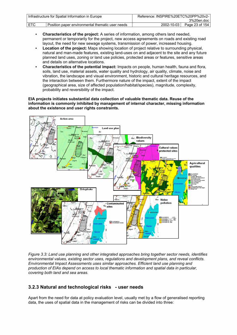
• Characteristics of the project: A series of information, among others land needed, permanent or temporarily for the project, new access agreements on roads and existing road layout, the need for new sewage systems, transmission of power, increased housing.
• Location of the project: Maps showing location of project relative to surrounding physical, natural and man-made features, existing land-uses on and adjacent to the site and any future planned land uses, zoning or land use policies, protected areas or features, sensitive areas and details on alternative locations.
• Characteristics of the potential impact: Impacts on people, human health, fauna and flora, soils, land use, material assets, water quality and hydrology, air quality, climate, noise and vibration, the landscape and visual environment, historic and cultural heritage resources, and the interaction between them. Furthermore nature of the impact, extent of the impact (geographical area, size of affected population/habitat/species), magnitude, complexity, probability and reversibility of the impact.
EIA projects initiates substantial data collection of valuable thematic data. Reuse of the information is commonly inhibited by management of internal character, missing information about the existence and user rights constraints.
Figure 3.3: Land use planning and other integrated approaches bring together sector needs, identifies environmental values, existing sector uses, regulations and development plans, and reveal conflicts. Environmental Impact Assessments uses similar approaches. Efficient land use planning and production of EIAs depend on access to local thematic information and spatial data in particular, covering both land and sea areas.
3.2.3 Natural and technological risks - user needs Apart from the need for data at policy evaluation level, usually met by a flow of generalised reporting data, the uses of spatial data in the management of risks can be divided into three:

Infrastructure for Spatial Information in Europe Reference: INSPIRE%20ETC%20PP%20v2-3%20en.doc
ETC Position paper environmental thematic user needs 2002-10-03 Page 24 of 154
• Susceptibility analysis, mapping and prediction: In data sets describing natural
phenomena causing hazards, commonly detailed data with a high level of accuracy is needed. Examples incude measuring stations, detailed thematic mapping through fieldwork (such as specific aspects of soil and land cover), air photo interpretation or remote sensing, analysis of detailed elevation models, water level and flow data, meteorological data, seismic activity etc. Work is carried out by local authorities, national mapping agencies, and national and international thematic agencies.
• Physical and sector disaster-prevention planning: Making disaster-resistant communities
through long term physical and sector planning, is usually carried out at local and regional level. The mapping carried out by thematic agencies as described above is used and transformed into simplified data sets and planning documents showing areas of high risk and restriction zones at or around high risk areas. The exact delimitation of the restriction zones would need population data, land use plans etc. The Seveso-directive requires location of facilities and production sites for hazardous substances. For details, see Appendix 2,7.
• Emergency operations/disaster response: Emergency operations for both natural and
technological hazards need more or less the same kinds of data. In order to make emergency management a faster and more accurate means of reducing effects, data are needed in several parts of the operation;
o Monitoring; continuous or real time situation reports, giving information on trends, direction etc. Using GPS linked to detailed topographic map data can give higher accuracy.
o Overview and identification of qualities at land and sea; persons (demography, address), property, production activities (e.g. agriculture), infrastructure and environmental qualities (e.g. protected sites or groundwater resources), that can be affected by the hazard/ disaster.
o Location of operational resources: infrastructure, road and rail capacity, water supply points, depot for emergency equipment, operational areas and competent authorities.
Figure 3.4: Planning for the protection of citizens from natural and technological hazards is a major concern in European environmental policies. Flood risk zones show the areas vulnerable to floods. The data sets indicate maximum probable height levels of flooding and lowlying areas vulnerable to flood, deriving from data on water flow, elevation and other topographical conditions. Probability estimates are given, e.g. 100 year flood likelihood. In long term planning it is essential to have access to flood zone vulnerability data, in order to adjust land use to the risk. If a flood actually occurs, it is essential to have available information on the road network, building locations, population etc. A geographical information system allows the user to locate houses or services within the affected area.

Infrastructure for Spatial Information in Europe Reference: INSPIRE%20ETC%20PP%20v2-3%20en.doc
ETC Position paper environmental thematic user needs 2002-10-03 Page 25 of 154
3.3 Environmental sector and the other sector The environmental sector is producing a series of spatial data. These data are steadily becoming more and more valuable to other sectors. The environmental sector needs to cover not only to describe its own needs for information, but also identify which data are valuable to other sector. A brief overview of the needs of property handling bodies is given below.
3.3.1 Environmental sector using other sectors in dissemination The management and trade of property carried out by municipalities and property agents use a series of data sets in their day to day handling. General map backgrounds with place names, rivers/lakes, roads and house location are used together with property boundaries/property unit information. Property prices and users potential vary with location. Thematic spatial data covering a variety of fields are commonly being used and integrated with property information, and the tendency is that new kinds of information will be requested. Owners are interested in governmental services such as distance to public transport facilities, schools, shops etc. Selected environmental information has become increasingly recognised as valuable when linked to land registry and cadastre. The citizen, as property owner and user, is interested both in environmental regulations and in environmental qualities valid for the property and the surrounding area. Restrictions could be general land use regulations on legal activities, rights and regulation on construction or activities, emission rights, whether a natural protection or cultural heritage site or its buffer zone is part of or neighbouring the property, whether properties are part of water catchments under certain regulations and wether the property is part of a green belt regulation zone. Existing and new owners are also interested to know if a property or neighbourhood is located in zones susceptible to natural and technological hazards (floods, slides etc), soil contamination, air pollution and noise.
Property or neighbourhood
Environmental stress:
noise, contaminated soil, air pollution…
Risks:susceptibility for
natural and technological hazards: flood, land-slide, explosions…
Restrictions: Conservation – cultural
heritage site, nature reserve, drinking water catchment area,
Land use regulation: Existing land use plan, future land use plans
Rights: Construction, natural resource extraction,
emission,
Figure 3.5: Citizen requirements for information about properties and their neighbourhoods is a major user need. Core information is developed outside the environmental sector. But secondary information, which it will be important for the environmental sector to bring forward, can and will be integrated in service systems directed towards the public.
Infrastructure for Spatial Information in Europe Reference: INSPIRE%20ETC%20PP%20v2-3%20en.doc
ETC Position paper environmental thematic user needs 2002-10-03 Page 26 of 154 Thematic information joined with cadastral information does give additional value to the citizen, sellers, owners and users of property. Furthermore, linking environmental information to legal documents can be an effective channel for dissemination of core governmental policy decisions at the local level. Strategies could go further and define certain environmental aspects to be reflected in the Land Register, and several countries have such information published. Whether legally defined or not, merging property data with property information requires interactions with a range of data producers, and the quality and updating of information obtained from them is important. INSPIRE could facilitate such flows.
3.3.2 The needs of other sectors For the purpose of a cross-cutting assessment and the justification of decisions on prioritising data it is of interest also to try indicate needs outside the environmental sector. The starting point of the analysis of data needs in the environmental sector is the identified components. Each sector will have additional data sets which are not of major importance to the environmental sector, and thus they have not been identified in this screening of data requirements. Other sectors
• Agricultural sector • Forestry sector • Mining and geological industry • Fishery • Transport sector • Utilities • Construction • Property agents • Health • Government
3.4 Characteristics of spatial data needs at local and regional levels Very many spatial data sets are relevant and important at local and regional levels where implementation of the environmental and sectoral policies take place. In the examples of land use planning, environmental impact assessment and citizen needs to for living area/ property–related information there is mentioned a series of thematic data. These are described in more detail in appendices 1 and 2, and comprise some broad groups of data
• General topographical features, e.g, river, elevation, transport network • Physical feature/area data: e.g. climate, biological regions, geology, soils, vegetation • Socio-economic and cultural data, such as demographic data, settlements, amenities,
recreation, health, cultural and social conditions, society service functions- schools, hospitals, health services, business districts.
• Risk and civil protection: e.g. (technological risk zone, accidents, action resources) • Properties, buildings and addresses: • Production and utility services: physical location of industry, energy, water supply, waste,
transport • Management areas and reporting units: Operating areas for e.g. police, ambulance, coast
guard. Also management areas within the environmental sector, e.g. water supply regions, WFD river basin districts and oil spill regional management units. Data sets on management/ reporting areas for other sectors are important to bring statistical information forward to the environmental sector, fishery units and health care units. Many of the management areas can also be used as reporting units, e.g. OSPAR regions for the seas).
• Land regulation/ area restriction zones: The group contain data such as general legal land restrictions as found in agreed land use plans, protected sites, areas and features (national

Infrastructure for Spatial Information in Europe Reference: INSPIRE%20ETC%20PP%20v2-3%20en.doc
ETC Position paper environmental thematic user needs 2002-10-03 Page 27 of 154
parks, cultural heritage sites), sector regulation areas such activity restriction zones next to hazardous industrial plants or area restrictions in water catchment where extraction of drinking water occurs, but also regulation on permission, e.g. the OSPAR waste dumping sites at sea.
• Monitoring and registration location: Locations of monitoring or registration sites, are commonly point locations, but may also be transects, along linear features or areas. At the local level there are very detailed networks of monitoring sites on all major environmental issues, and also self-reporting in industries etc. Examples: forest crown density measurement site, measurement of actual soil erosion.
• Thematic modelling;, Data resulting from analysis and modelling, commonly where several data sets have been combined, e.g. coastal zone erosion, wilderness quality, heavy metal mobility in catchment areas.
• Additional attribute/statistical data: (population, socio-economic, agric production, etc)
Other characteristics of local level spatial data needs Apart from the variation in needs for different themes, the quality of data, management and access to data should be commented upon
• Data coverage: There is a severe lack of coverage for a variety of data, both reference data and thematic spatial data.
• Access: At present there are serious problems in accessing information both across sectors and within sectors, and even within a single municipal authority. Access problems are caused by technical issues, lack of knowledge, restrictions on access and costs. When proper data is not available the certaintd for getting to environmentally sound solutions is limited. Difficult access may delay development and construction. Access problems to existing spatial data can in many cases also lead to new data capture programmes, thus wasting resources on parallell mapping programmes.
• Classification systems: The variability of information and classification systems for these thematic fields is very high. Different classification systems serve local needs. Some kind of harmonisation of data exists, but it is only for a very few local level data sets that users and producers request harmonised data over country boundaries.
• Pre-processed data: Users at the local and regional levels often only get access to "raw" data, while the same data could get a much wider use with some pre-processing before being dissiminated to users.
• Scale/accuracy: Many spatial data are at a detailed scale, e.g. 1: 25.000 and better resolutions. In urban areas technical map data are down to 1:500. At low resolutions user potential becomes significantly reduced.
• Updating: Some spatial data on are updated frequently, even daily, but a large amount of technical information and land use regulations are updated irregularly and at low frequencies. Topographical features on maps have a low updating frequency, although it is higher in urban than in rural areas.
• Process information: It is important to see that both planning authorities’ and the citizen’s needs are met, not only through access to formal decision information, but also through assessment results and information on proposals under review.
• Data capture and data management. The thecnology of data capture and storage systems is rapidly changing. However, the information material is extensive and still only a small proportion of information is available in digital form and at levels acceptable for public access. Valuable environmental data, e.g. from consulting firms producing material for EIA and construction applications, is not brought to official environmental authorities for inclusion into thematic databases/registers. It is common that data flow agreements and systems are missing, thus data captured through project work (e.g. groundwater bodies, species, habitats, amenities, cultural heritage) are not brought forward to central/ regional responsible institution.
3.5 Summary of needs by environmental issue The assessment has revealed that each sector has as series of needs. For the in-depth description of needs by environmental policy issue, see appendix 2. The table 4.2 summaries these needs, partly by

Infrastructure for Spatial Information in Europe Reference: INSPIRE%20ETC%20PP%20v2-3%20en.doc
ETC Position paper environmental thematic user needs 2002-10-03 Page 28 of 154 categorising the needs into themes and partly by showing the relationship between the specific kind of spatial data and the environmental policy issue in question. For more information about the description of the data, see an overview in chapter 4 and appendix 1.
4. Merging needs - categorisation into spatial data components
4.1 The process of merging the data needs of the environmental issues Each of the environmental policy areas are directing and implying the use of different kinds of data. In the first section of the paper important environmental (policy) issues under 6EAP have been identified. In order to get an overall picture of the data needs identified it is necessary to bring the interests of the policies together.
Water
Air +CC
Soil
Land
Biodiv
Urban
Coastal
Waste
Noise
Hazards
........
Identify spatial dataneeds by environmental
issue
Merge dataneeds
Structured list of spatialdata needs, grouped
thematically
Elevation
Physicalenvironm.Bioligicalenvironm
Land cover
Naturalresources
Production/economy
Constructions
Transport
Administrative units
Arearegulation
Risk zonesPolluted
sites
1
3
2Priority
Prioritising needs, basedon obligations, sectoruser value and cross-
cutting needs
Utilities
Society andculture
Geograhiclocation
Recommendationsto INSPIRE
Targets, actions,projects
Organisation,coordination, bodies
Guidelines, standards,specifications
Data projectsimportant env. sector
Data projects core national to local
Data projectscore data European level
Technical tools forimplementation
Other data harmonisationprojects
Env. data provision oninfrastructure
Metadata provision oninfrastructure
How to fulfiluser needs?
......
Mai
n e
nviro
nmen
tal p
olic
y ar
eas
- 6EA
P
Chapter 3 Chapter 4 Chapter 5 Chapter 6
Figure 4.1: This section merges together the data needs identified in the assessment of individual environmental policy areas. The result is a description of major spatial data components and a prioritisation of needs. 1) The first step was to develop a list of all mentioned data sets, bringing together the results form the screening of needs by each of the environmental policy issues. Chapter 3 gave a brief overview of the assessment results and appendix 2 a broader presentation of the data sets needed by environmental issue. This resulted in a list of 150 data sets of variable definition and structure. The list has not been brought forward in the paper, since it had an internal character.

Infrastructure for Spatial Information in Europe Reference: INSPIRE%20ETC%20PP%20v2-3%20en.doc
ETC Position paper environmental thematic user needs 2002-10-03 Page 29 of 154 2) The second step has been to organise the identified data in a logical structure. It has been developed as a thematic structure with about 20 spatial data themes with a sub-grouping into spatial data components, about 60 in total. These spatial data components are broad thematic groups containing one or several data sets, sometimes more than 20 data sets. The kind of spatial data grouped into one spatial data component are conceptually related, giving emphasis to common characteristics of the geometric feature together with their thematic focus. Each spatial data component is defined. This chapter presents the results of the initial modelling into themes and spatial data components.
4.2 The thematic structure Ideally, the structure of spatial data presented here would reflect the high-level categorisation of real world spatial objects that are logically related. However, the process of organising or modelling the real word objects is a long term process and should be treated as separate projects within different working groups under INSPIRE. Therefore, a pragmatic approach has been adopted here by categorising data into spatial data themes, subdivided into spatial data components for which a number of spatial datasets are described. This structuring will be the first step towards a future more stable categorisation, based on object-oriented modelling and will allow stakeholder to better understand the overall approach to data structuring that is advocated for INSPIRE.
4.2.1 Hierarchical organisation - spatial data themes, spatial data components, spatial data sets The thematic structure should be hierarchical, allowing several levels. However, to simpliy the presentation here we have chosen only to allow two (three) levels. The themes are as far as possible grouped according to objects and not according to sector or environmental policy. However, where groups of data components are difficult to place in other thematic groups have been given separate headings. The structure has is not intention to be complete. It serves as an attempt to describe some of the important components and data sets needed to be present in the European Spatial Infrastructure in order to illustrate the anticipated effects described in the INSPIRE vision.
Spatial data theme
Spatial data component Spatial data component Spatial data component
Spatial data sets Spatial data sets Spatial data sets
Spatial data theme
Spatial data component Spatial data component Spatial data component
Spatial data sets Spatial data sets Spatial data sets
Figure 4.2: The figure shows the use of a hierarchical structure to group spatial data. High level thematic categories termed spatial data themes and the possibility of making sub-categories termed

Infrastructure for Spatial Information in Europe Reference: INSPIRE%20ETC%20PP%20v2-3%20en.doc
ETC Position paper environmental thematic user needs 2002-10-03 Page 30 of 154 spatial data components. A spatial data component comprises a group of spatial data with similar characteristics irrespective of scale. At the lowest level of this conceptual framework we find spatial data sets containing real data with defined content and accuracy/scale. It is advised that the thematic modelling is organised by INSPIRE and that different groups both carry out data modelling and develop data set specifications. The presented structure underneath is used as an interim solution to be used in the initial phases of INSPIRE.
4.2.2 Rationale behind the thematic grouping The grouping the spatial elements in the infrastructure could be done in different ways - by (environmental) issue/sector - by spatial data object The way to organise as described above is based on an object-oriented approach. More details on the rationale behind the thematic grouping are given below. The object oriented grouping: When carrying out data modelling it is important to bring together in the same data models that are linked together to the same kind of real world objects. This is important as it will ensure that data that treat the same kinds of information have the same structure and thus can be handled and managed efficiently. An example on the data component land regulation data: protection areas, land regulation plans, land use plans, waste dumping restriction areas etc refer to the same kind of real world object, the land regulation area. Different sectors, both environmental, agricultural and energy sectors would define data according to this common structure. Their qualities are different, and information about their differences is given by attributes. These data will be produced by a variety of custodians from the different sectors. For some aspects the object-oriented approach would reveal that several sector are referring to the same piece, the same object. In such cases it is essential that there is one common source for the geometry, and that each custodian adds attribute information based on unique identifiers or other methods. This may, for instance account for water catchment data being used by the energy sector for calculation of hydropower resources, and the water catchments used by the environmental sector for estimates on erosion or pollution pressure. Grouping by policy issue or sector: This approach is viewing the needs and uses of data in a sector or within a topic area and it is important to be able to see and describe the data topic by topic. Some topics contain data of more multi-purpose aspects, other contain sector-specific data. This will make it easier to see the link towards the policy areas. Chosen data structure: At this stage we have seen a value in being more object-oriented in the structure of the data components. This is partly due to the interest in finding common multi-purpose data components/data sets, and partly because of it’s value in showing how data could be related in the modelling process that has to be organised by INSPIRE. The practical approach taken has been to make a screening of data needs per policy issue, but then to regroup the data according to spatial data themes, prefiguring the future spatial data object classes to be defined in the context of the INSPIRE initiative. In order to facilitate the reading of the document by those interested in specific policy issues, the linkage between the policy issues and the spatial data themes have been made explicit in the document (see section 4.4 and Appendix 2)
4.2.3 The high levels of the thematic structure

Infrastructure for Spatial Information in Europe Reference: INSPIRE%20ETC%20PP%20v2-3%20en.doc
ETC Position paper environmental thematic user needs 2002-10-03 Page 31 of 154 In the preparation of this paper different sources of thematic classifications have been assessed, including ISO 19115, GISCO thematic structure, EEA's topic classification, the GISCO database structure and others. As all of them have different weaknesses, it has been necessary to describe a structure based on the referred sources. The thematic structure is divided into 20 main thematic areas, and these are further split into about 60 spatial data components, being broad categories of related data. The actual data sets can be identified under each of these spatial data components. Each data set is only placed within one of the spatial data components. The list comprises data termed as reference data, thematic data, sector data and environmental data, the latter being a sub-category of sector data being of specific interest to INSPIRE. The thematic structure is not fixed - new categories can be added at all levels. However, the thematic structure and the defined set of spatial data components defined here is based on a broad assessment, and the structure and results can serve as a basis in the initial development phase of INSPIRE. A review of the structure should be carried out after the initial phase of INSPIRE implementation, e.g. 3 years, based on the conclusions from spatial data modelling work. The thematic structure comprises 20 themes.
• Geographical location • Administrative units • Properties, buildings and addresses • Elevation • Geophysical environment (geology, soils, terrain) • Climate • Hydrography • Ocean and seas • Biota/biodiversity • Land surface / land cover • Natural resources (soil/land for agriculture, forestry, fishery, geological, energy) • Transport • Utilities • Facilities • Economy • Area regulations • Natural and technological risks • Polluted sites/areas under anthropogenic stress • Society/demography/culture • Health
The overall presentation of data components and datasets here gives an overview of important data sets. It does not intend to give a full overview of all the possible data sets, and there may also be many data sets and data components missing that are regarded as important, either as multi-sector data or within one sector. The INSPIRE administrative set-up has two working groups focused on description of the content of the infrastructure, Reference Data and Metadata WG (RDM) and Environmental Data WG (ETC). In the mapping and assessment of environmental sector user needs ETC has been looking at the full range of needs, including both reference data and other sector/ environmental data. Thus the reference data is not reflected as a specific group of data in the thematic structure. As we will see in chapter 5, different categories of data can be grouped according to their importance or role in the infrastructure. Parts of these data are reference data mainly produced or organised by national mapping agencies. Most other parts are primarily used and produced by the environmental sector, although some derive from other sectors. Many of the data components containing multi-purpose data have been termed core thematic data. The four data categories are the following
• reference data (REF)

Infrastructure for Spatial Information in Europe Reference: INSPIRE%20ETC%20PP%20v2-3%20en.doc
ETC Position paper environmental thematic user needs 2002-10-03 Page 32 of 154
• core thematic data (TC) • environmental sector data (ENV) • other sectors data (S)

Infrastructure for Spatial Information in Europe Reference: INSPIRE%20ETC%20PP%20v2-3%20en.doc
ETC Position paper environmental thematic user needs 2002-10-03 Page 33 of 154
4.2.4 Spatial data components list The list below presents the spatial data themes with a sub-level termed spatial data components. Data sets themselves are not mentioned here, but are reffered to in the tabular presentations on the following pages. Further details can be found in appendix 1. Geographical location Geodetic reference system Geographical grids Monitoring sites Geographical names Administrative units Official administrative units Blocks and census districts
General government management units Sector management & reporting units Properties, buildings and addresses Properties Buildings Addresses Elevation Elevation
Bathymetry Coastline
Geo-physical environment Bedrock geology Geo-morphology Soil Climate Climate zones Hydrography Hydrography Water catchments Groundwater bodies/aquifers Ocean and seas Sea regions Biota/biodiversity Biomes/ Bio-ecological regions
Vegetation Habitats and biotopes Species distribution Land surface Land cover Ortho-images Unclassified satellite data
Natural resource Water resources Agricultural land and soil resources
Forest resources Fishery resources Geological resources Renewable energy resources Transport Transport networks Transport facilities Utilities
Transmission lines Facilities Environmental protection facilities
Production facilities, industry Agricultural facilities
Economy Economic statistics Area regulation Land regulation/land use plan Protected sites Sector regulation Natural and technological risks Natural risk vulnerability zones Technological risk vulnerability zones Technological accidents and natural disasters Polluted areas/areas under anthropogenic stress Local contaminated areas Diffuse contamination Noise zones Society Demography
Settlement Green urban areas Derelict urban land Cultural heritage Natural amenities Health Epidemiology Health services

Infrastructure for Spatial Information in Europe Reference: INSPIRE%20ETC%20PP%20v2-3%20en.doc
ETC Position paper environmental thematic user needs 2002-10-03 Page 34 of 154
4.3 Brief presentation of major spatial data components The table underneath is divided into the broad thematic categories outlined above. The columns include information on title of the spatial data component, description of data component and comments on important spatial data sets, relevance use and initiatives. Spatial data component – title and description (Grouped into spatial data themes marked in green)
Relevance, use, initiatives
GEOGRAPHICAL LOCATION
Geodetic reference system: Geodetic referece areas should include levelling benchmarks, permanent satellite observation stations, tide gauges, arker id, access information, coordinates and system for definition and transformation data of the reference system.
All users of GIS-data need geodetic reference data to be in place. National Mapping agencies are commonly in charge of establishement and setup of the geodetic reference systems.
Geographical grids: Geographical grids is an agreed, defined and harmonised grid net for Pan-Europe with standardised location and size of grid cells. The grid is used to refer certain environmental and social qualities of the grid cells. Different resolutions, example of cell sizes could be 10x10 m, 100x100 m, 1x1 km, 16x16 km. At present different institution use different grids. Some initiatives to standardise reference grids, but other new initiatives are sector solutions. It is essential to have a stable and harmonised system in Europe.
Such data is used for reference of a long range of environmental and sector information. It allows for spatial analysis in time-series of statistics without the burden of changes in statistical units as often is the case for administrative units. In many cases it is possible to handle fairly detailed information without compromising the individual rights of privacy.
Registration/ monitoring sites: Monitoring sites are locations were monitoring of physical, biological or other aspects occurs. The monitoring sites may be permanently located at a site or can be temporal, only used once. Commonly monitoring sites are defined as points, but may also be large or small plots, transects, grid cells.
Many different conventions, directives and other agreements direct monitoring and the flow of monitoring information linked to the monitoring sites. At present different institution use different data models and definitions. WFD has started to model an more general model of monitoring sites. - surface monitoring stations - groundwater monitoring stations

Infrastructure for Spatial Information in Europe Reference: INSPIRE%20ETC%20PP%20v2-3%20en.doc
ETC Position paper environmental thematic user needs 2002-10-03 Page 35 of 154 Geographical names Develop and maintain a European harmonised geographical place name spatial database, to be used at different scales. National databases exists, together with some at the European level. Geographical names at scale 250.000 exists on map series and databases throughout Europe, possibly also at lower scales. European geographical name data exists, e.g. GISCO.
Used for search and overview, location at all layers and as a basis layer on maps. Important part of reference data. Important for effective operations at local level. Different sector use different sets of names, e.g. mapping and transport sectors. Commonly produced by mapping agencies and local authorities.
ADMINISTRATIVE UNITS
Official national administrative units: Each national territory is divided into administrative units. The administrative units are divided by administrative boundaries. On the national level, data sets of administrative boundaries are available in most European countries. The national data sets differ with respect to resolution, data model and geometry of international boundaries.
Is a key dataset for any kind of spatial data handling. Important in operations and management, showing competent authorities, in referencing of information and statistics, as a basis for generation of statistical map showing economic phenomena, demography etc. Used as reference for correct location of objects and “cutting” or databases.
Blocks and census districts: The component include blocks in urban areas commonly used for statistical information
Used in urban and rural planning, demographic studies of regional development, estimates on exposure to pressures and availability of services.
Main governmental management areas: These include major common operational spatial units, such as fire, police, ambulance, coastguard etc
Of very high value both in the sectors own operations and in cross-sector emergency operations, e.g. at occasions of natural and technological hazards, accidents where health, economy or ecology is affected.
Thematic management/reporting areas: These are sector/ thematic management areas or reporting areas. A wide range of management areas are relevant both at European, national, regional and local levels. Here only a few examples are given.
Being used primarily by the sector itself, but is usually also relevant for other sectors. o WFD River Basin Districts, not strictly
being defined of subsets of water catchments, needs to be defined as a separate management area.
o OSPAR reporting units at sea. o Coastal zone management areas
PROPERTIES, BUILDINGS AND ADDRESSES
Parcels/ units of property rights: Only relevant with registration at highest accuracy. Parcel information in Europe is very un-homogenous. It should be taken steps to develop harmonised data set specifications and identification system, free to be used, but no data harmonisation target should be set.
Of highest important in local planning and emergency operations, property agents, the construction sector, taxation, agriculture, forestry.
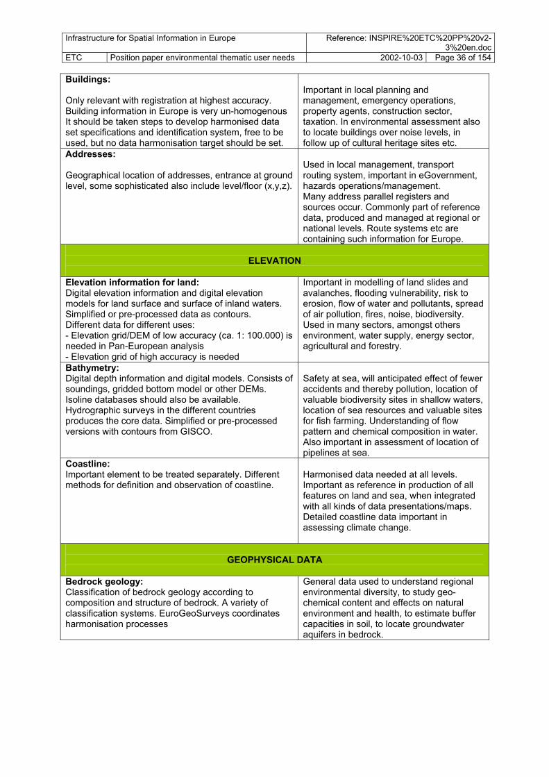
Infrastructure for Spatial Information in Europe Reference: INSPIRE%20ETC%20PP%20v2-3%20en.doc
ETC Position paper environmental thematic user needs 2002-10-03 Page 36 of 154 Buildings: Only relevant with registration at highest accuracy. Building information in Europe is very un-homogenous It should be taken steps to develop harmonised data set specifications and identification system, free to be used, but no data harmonisation target should be set.
Important in local planning and management, emergency operations, property agents, construction sector, taxation. In environmental assessment also to locate buildings over noise levels, in follow up of cultural heritage sites etc.
Addresses: Geographical location of addresses, entrance at ground level, some sophisticated also include level/floor (x,y,z).
Used in local management, transport routing system, important in eGovernment, hazards operations/management. Many address parallel registers and sources occur. Commonly part of reference data, produced and managed at regional or national levels. Route systems etc are containing such information for Europe.
ELEVATION
Elevation information for land: Digital elevation information and digital elevation models for land surface and surface of inland waters. Simplified or pre-processed data as contours. Different data for different uses: - Elevation grid/DEM of low accuracy (ca. 1: 100.000) is needed in Pan-European analysis - Elevation grid of high accuracy is needed
Important in modelling of land slides and avalanches, flooding vulnerability, risk to erosion, flow of water and pollutants, spread of air pollution, fires, noise, biodiversity. Used in many sectors, amongst others environment, water supply, energy sector, agricultural and forestry.
Bathymetry: Digital depth information and digital models. Consists of soundings, gridded bottom model or other DEMs. Isoline databases should also be available. Hydrographic surveys in the different countries produces the core data. Simplified or pre-processed versions with contours from GISCO.
Safety at sea, will anticipated effect of fewer accidents and thereby pollution, location of valuable biodiversity sites in shallow waters, location of sea resources and valuable sites for fish farming. Understanding of flow pattern and chemical composition in water. Also important in assessment of location of pipelines at sea.
Coastline: Important element to be treated separately. Different methods for definition and observation of coastline.
Harmonised data needed at all levels. Important as reference in production of all features on land and sea, when integrated with all kinds of data presentations/maps. Detailed coastline data important in assessing climate change.
GEOPHYSICAL DATA
Bedrock geology: Classification of bedrock geology according to composition and structure of bedrock. A variety of classification systems. EuroGeoSurveys coordinates harmonisation processes
General data used to understand regional environmental diversity, to study geo-chemical content and effects on natural environment and health, to estimate buffer capacities in soil, to locate groundwater aquifers in bedrock.

Infrastructure for Spatial Information in Europe Reference: INSPIRE%20ETC%20PP%20v2-3%20en.doc
ETC Position paper environmental thematic user needs 2002-10-03 Page 37 of 154 Soil Categorisation of soils and subsoil according to depth, texture, structure and content of particles and organic material, stoniness, sometimes mean slope and anticipated water storage capacity. FAO nomenclature is widely used, with 350 soil classes, Existing dataset in small scale. CORINE soils, later developed by JRC to soil type database for Europe: A digital map, 1: 1 mill, European coverage.Large scale data common in agricultural land.
Important in assessment and mangement of soil as a resource for agriculture and forestry, including also special effects such as erosion, salinisation, desertification. Aslo used in location of areas for gravel and peat extraction, groundwater resources, as a habitat.
Geomorphology Geomorphological processes and results of processes, commonly monitored both as landscape changes and as potential risks. Important also in loss of land and gain of land.
Example: coastal erosion and progradation land rise, natural hazards – land slide probability assessments.
Erosion: Land, slopes and coast are evolutionary and changing over time due to erosion. Erosion is accelerated by human intervention. Erosion risk data for land and coast represent a reference data towards assessment of general trends and anthropogenic pressures.
Relevant in agriculture, forestry, in coastal management, and in actions to combat desertification. Can be divided into - monitoring of actual soil erosion - modelling erosion risk
CLIMATE
Climatic regions: Categorisation of past, present and future climatic conditions, focusing on temperature, humidity. Data have a relatively simple nature, based on recordings at monitoring sites or analysis/ modelling.
Used in assessment of climate change, biodiversity, modelling of erosion and natural hazards. Is also important in agricultural and forestry planning and in adaptation to climatic changes.
HYDRORAPHY
Hydrographical network: rivers, lakes Representation of all main hydrographic elements, both natural and artificial: Rivers, lakes, transitional waters, reservoirs, channels. Is one of the basic components for cartographic presentation and used by nearly all GIS users at all levels. Links to WFD classes: surface fresh water bodies, rivers lakes.
Is being used in environmental assessment and monitoring in estimation of water resources, pollution monitoring, wastewater cleaning estimation, species migration and biodiversity assessment, the hydrological elements being habitats. Inland fisheries management. Hazardous waste disposal sites. Land use planning/ management, recreation planning and management, transport routes. Assessment of flow patters of particles and pollutants must be based on high quality hydrographical networks.
Water catchments: Synonymous with river basins. As defined in WFD: art 2, annex I, ii): River basin means the area of land from which all surface run-off flows through a sequence of streams, rivers and, possibly, lakes into the sea at a single river mouth, estuary or delta. Sub-basin means the area of land from which all surface run-off flows through a series of streams, rivers and, possibly, lakes to a particular point in a water course (normally a lake or a river confluence)
Is used in assessment of water flow and flooding, flow of contaminants, erosion monitoring. Catchments are used to create WFD River Basin Management Districts, but does not have full correspondence in boundaries.

Infrastructure for Spatial Information in Europe Reference: INSPIRE%20ETC%20PP%20v2-3%20en.doc
ETC Position paper environmental thematic user needs 2002-10-03 Page 38 of 154 Groundwater bodies/aquifers: Groundwater aquifers are areas with significant amounts of groundwater, for human consumption or anthropogenic production. Knowledge about groundwater aquifers is essential when managing areas of multi-purpose, use and where pollution/hazards, in order to secure quality water sources.
WFD is requesting data and reporting about groundwater body situation (impact/pressure) (WFD attributes: annex V – 2.5, VII – 4.2 Member States shall provide in the river basin management plan a map showing for each groundwater body or groups of groundwater bodies….)
OCEAN AND SEAS
Sea regions: Seas and saline water bodies divided into regions and sub-regions. Each region with common characteristics, concerning water flow/ circulation, adjacent river catchments, bio-chemical or temperature of water. Detailed region at regional level. Based on scientific criteria.
The WFD classes of surface saline water bodies, transitional waters, coastal waters to some extent coincide with sea regions, but have boundaries based on administrative/ reporting criteria, not scientific definitions.
BIOTA/ BIOLOGICAL DIVERSITY
Bio-geographical region: Bio-geographical regions show the extent of areas with common characteristics, usually based on climatic, topographic and geo-botanical information. Thus the bio-geographical regions show areas with relatively homogeneous ecological conditions. Commonly potential vegetation data is used as a basis for the classificaitons.
The data are used for comparisons and assessments of biodiversity and conservation. Includes both data termed bio-geographical regions and ecological regions. WFD is referring to the use of ecological regions, Natura 2000 to bio-geographical regions. DEMEER: Potential vegetation: Harmonised pan-European data exists.
Vegetation: The determination of structure and composition of the natural or near-natural vegetation. The classification of natural vegetation can be used to interpret ecological/ edaphic/ temperature conditions, environmental pressure and biodiversity modelling.
Used in assessment at European or regiona/ local level, on natural production suitability, ecology, changes. Scattered data with a variety of classification systems exist at lower levels
Habitats and biotopes: Description of living areas for any kind of biota, usually used as a term for describing areas used by zoo-biota. Habitats commonly follow bio-geographical regions/ vegetation types, but habitats can also be described at more detailed levels. Includes small features of the rural landscale - hedgerows, creeks etc.
Linked to Habitats directive. The habitats designated to the directive are mentioned in the "area regulation" data component.
Species distribution: Species distribution, species by species or grouped to family etc. Often species distribution is being recorded by grid cells. Pan-European mapping initiatives, e.g. for birds, insects, mammals, evertebrats
In biodiversity assessment it is essential to have information on species distribution, quantities, development through time. Needed for Natura 2000
LAND SURFACE/ LAND COVER

Infrastructure for Spatial Information in Europe Reference: INSPIRE%20ETC%20PP%20v2-3%20en.doc
ETC Position paper environmental thematic user needs 2002-10-03 Page 39 of 154 Land cover: Land cover represents the physical and biological land cover. Different resolutions and classification systems are relevant for different uses. Corine Land Cover : The CORINE land cover database provides Pan-European data of biophysical land cover (44 class nomenclature). It is made available on 100 and 250m grid database and original vector formats in 1:100 000. CLC 1990 is currently updated - CLC 2000.
Used as a source for a wide range of Pan-European environmental assessments, e.g. defined in EEA indicators. Review of land use changes requires repetitive mapping. Special needs for assessment and follow up in certain geographical areas produces needs for higher frequency and higher resolution Their methodology is harmonised at European level for the purpose of comparison: coastal assessment - LACOAST , cities - MOLAND. Relevant for designated sites.
Ortho-images: Pre-processed "picture" data. Source either satellite or air-borne sensors. Different data exists for Pan-Europe, e.g. Landsat, SPOT. The use is refrained due to high costs. Image2000 will constitute the first European wide free access ortho-image database.
Small-scale data for Pan-European overview and analysis. Large-scale data for local and regional needs. Commonly used in environmental and land use management, environmental impact assessment, forestry, agriculture.
Unclassified multipurpose data: Unclassified spatial coverage of the earth surface. This could be based on recordings of visible light, infra-red bands, radar or other sensors. It is essential in broad environmental assessments and has a high potential also in sector management.
Different data exists for Pan-Europe, e.g. Landsat, SPOT. The use is refrained due to high costs.
Landscape: Landscape can be divided into homogenous areas or certain important visible features may be mapped. Landscape data are used in different kinds of environmental analysis and management.
Mostly local and regional level data exists. National examples based on different criteria/ nomenclature
NATURAL RESOURCES
Water resources: Features presenting the water resources for consumption, processes, energy or other uses. Usually linked to water features already documented in the data component "hydrography" and "groundwater bodies"
Information about resources should be linked to the hydrography data by id's. Used in water and energy supply management, risk and hazards management, agriculture sustainability assessments.
Agricultural resources: Agricultural inventories, with mapping of existing and potential land for cultivation. Description of quality, production potential, suitable farming systems and crops, limiting factors under natural conditions. Land use by agriculture Includes categories such as irrigated areas and organic farming areas.
Usually agricultural inventories are coordinated by national agricultural bodies. Important statistics should be available. Used in agriculture, in assessment of pressures – impact and responses to erosion, salinisation, desertification.
Forestry resources: Mapping of forest resources, areas potential production at detailed levels also forest stand quality. Information on sustainable exploitation levels. Forest resources is usually mapped at regional and local levels, coordinated by national inventory mapping bodies.
Used for management for sustainable exploitation of forest, planning for multi-purpose use of forest areas. Environmental assessment of erosion, biodiversity, water flow.

Infrastructure for Spatial Information in Europe Reference: INSPIRE%20ETC%20PP%20v2-3%20en.doc
ETC Position paper environmental thematic user needs 2002-10-03 Page 40 of 154 Fishery resources/use: Overall fishery resource description, by mapping the stock distribution (breeding, migration, and living areas). Information on carrying capacity/sustainable catch levels.
Fishery institutions at national and regional levels. Fishery data is used for adjusting exploitation to carrying capacity levels, assessment of sustainability in the fishery sector and effects on other sectors and resources, biodiversity in particular.
Geological resources: Geological resources, such as minerals, stone resources and deposits (sands/gravel), including hydrocarbons (oil, gas).
European level mapping of geological resources. Local level resource estimates. Important for assessment material flows, exploitation of definite resources, climate change, biodiversity.
Renewable energy resources: Energy resources excluding hydrocarbons: hydropower, bioenergy, solar, wind etc. For some data relevant with depth/height information on the extent of the resource, e.g oil/gas and wind.
Of major importance to the sectors. In environmental assessments and planning used to view trends in extent and effect on other land cover or natural values, effect on sustainability or over-exploitation on resource use.
TRANSPORT
Transport infrastructure: The transport component should comprise an integrated transport network, and related features, that are seamless within each national border. Transportation data includes topographic features related to transport by road, rail, water, and air. It is important that the features form networks where appropriate, and that links between different networks are established.
At European level of prime importance to have access to an updated version of the road network in 1: 1 mill or 1: 250.000, one version per year. Additional information on transport network segments on kind of traffic, frequency, speed etc. At national level the same data should be available, and in addition names and numbering - addresses. Accuracy should be 1 meter or better.
UTILITIES
Transmission lines/pipelines: Physical construction for transport of defined products: These may include pipelines for transport of oil, gas, water, sewage or other pipelines, Transmission lines may include electrical, phone, cable-TV or other networks. Rough pipeline databases exist at European level. Data within countries is in-homogenous.
Used on construction industry - examples of national portals warning on construction, distributing maps/data on location of pipelines. Relevant for environmental sector e.g. on land use, urban and rural planning, risk and hazards management, assessment of material flows.
FACILITIES
Environmental protection facilities: Treatment, storage sites of production industry/mines and utilities/services: Concerning utilities, they may include sewage, waste, energy facilities/production sites. Linked to official statistics
National databases probably existing. Environmental protection facilities as listed in the SERIEE (Classification of environmental protection facilities) (Eurostat 1994)

Infrastructure for Spatial Information in Europe Reference: INSPIRE%20ETC%20PP%20v2-3%20en.doc
ETC Position paper environmental thematic user needs 2002-10-03 Page 41 of 154 Production facilities: Sites for production, industry/mines: chemical, hydrocarbons (oil/gas), mines or any other industry. Includes water abstraction facilities and energy industry. Overall dataset in GISCO. National databases probably exist. Facilities can be classified according to the NACE1.1 used in official statistics when relevant.
Important in handling of emissions, production flows and risks. Identification important in connection to the IPPC/EPER Register, the Seveso Directive, the Large combustion plants Directive, as well as Inventory of Contaminated sites, Emissions to water, Nuclear reporting.
Agricultural production facilities: Farming production facilities. Incl. Farming equipments/facilities (irrigation systems, greenhouses, stables…)
Important in local land use planning and agricultural and water management.
ECONOMY
Economic activities/ local statistics: Economic activities including production, consumption, stocks, income, employment: statistics referred to administrative units, grids, facilities, networks, addresses, monetary and physical units. Economic data on transport and traffic are classified here.
Economic activities are described according to the NACE rev.1.1. The NACE is the official classification of economic activities in the European Union and covers all industries.
AREA REGULATION
Land regulation/land use plans: Land regulation is the general spatial planning tool at regional and local levels. The land use plans regulate actual and future use of areas. The land use plans commonly have significant textual regulations to each area/ land category.
Diverse situation in Europe. No known harmonisation. Each country has its own system. The documents are frequently seen as legal documents, and the categories remain for decades as rights directing use of property.
Protected areas: Areas with certain protection as defined by sectors. Many of the categories refer to conservation of nature, but could also refer to other objects, cultural heritage sites, cultural landscape sites.
Several databases are based on areas designated through international conventions, EU legislation, national legislation e.g. Natural 2000, Habitat directive sites, Birds directive sites, Ramsar sites, nationally designated sites.
Sector area regulations: Different sectors have different regulations of areas. Examples: defined dumping sites, restricted areas around drink water sources. The data is most relevant at medium to low scale levels.
In cooperation and follow up of the sectors concerning environmental performance the environmental sector needs overview of sector management regions and reporting areas. A wide range of sector regulations . Examples: The nitrate vulnerable zones, regulated fairways at sea or large inland waters, areas for dumping of waste (OSPAR) , noise restriction zones, prospecting and mining permit areas.
NATURAL AND TECHNOLOGICAL RISKS

Infrastructure for Spatial Information in Europe Reference: INSPIRE%20ETC%20PP%20v2-3%20en.doc
ETC Position paper environmental thematic user needs 2002-10-03 Page 42 of 154 Natural risk zones: Categorisation of land according to estimated/ registered anticipated risk for natural hazards; floods, landslides, avalanches, forest fires etc. Methods for assessing risk zones is based on a variety of data. Important data include physical data about terrain, vegetation, climate, geology.
European projects on natural risks, forest fires etc. Only high-level harmonisation. The data are risk susceptibility zones. Example data sets
• Flooding • Land slides • Snow slide-avalanches: • Forest, bush, grassland • Earthquakes: • Volcano eruptions
Technological risk zones: Categorising areas according to their vicinity to locations producing, storing, transporting potential artificial/ technological hazards, chemical industry, nuclear power plants etc.
Seveso II Directive describes certain kinds of technological risks. Extension of fields covered by the Directive is proposed. Used in land use planning to decrease population exposed to risks.
Technological and natural disasters : Location of actual events, site of occurrence, cause, effects, e.g. the European forest fire mapping projec t.
Important in disaster operations, assessment of risks and climate change, and follow up actions in areas affected.
POLLUTED/ STRESS AREAS
Local contamination: Local contaminated sites, often sites near or at large industrial sites or at places of dumping of waste, mines and mine dump sites. Both land and sea.
Terrestrial local contamination areas are used for different purposes, but use is restricted. Clean-up actions or other measures need to be undertaken before use. Sea: Submission of data for the Annual OSPAR Report on Dumping of Wastes at Sea from OSPAR Convention for the protection of the marine environment of the north-east Atlantic
Diffuse soil contamination: Contamination usually by long-range transport of pollutants. Can be mapped by monitoring and further modelling. Example of moss sampling has been done in Northern Europe.
Several projects, e.g. initiatives under UNECE- convention on long range transboundary air pollution (e.g. critical loads map for heavy metals. Relevant for agriculture, health, food and water supply.
Noise zones: Areas affected by noise. Commonly these appear as zones with different levels of noise disturbance due to distance from source. Common noise producing elements being used in calculation of noise zones are roads, rail, airports, ports. Could also be: Air routes, sailing lanes/fairways, rifle course, motorcross course, military training courses.
Objective of 6EAP describes that there should be focus on actions at the local level to reduce noise levels. One action mentioned is to produce noise maps.
SOCIETY

Infrastructure for Spatial Information in Europe Reference: INSPIRE%20ETC%20PP%20v2-3%20en.doc
ETC Position paper environmental thematic user needs 2002-10-03 Page 43 of 154 Demography : Population commonly aggregated, by municipalities by blocks of houses or in grids. Population can also for internal purposes be handled at individual level by address.
Important in regional and urban planning, planning of facilities, utilities, social services, transport infrastructure. Also important for estimates on exposure to pollution or hazards, and for the use in disaster operations.
Settlement : The category includes the physical distribution of the cities, towns and settlements, including also industrial sites and other built-up areas.
Information on settlement structure and spatial extent is important for urban planning in general and land use planning in particular. Time-series makes it possible to assess policies directed towards urban sprawl and new settlement and land use patterns.
Green urban areas: Green urban areas is the broad spectrum of natural, semi-natural and cultural landscapes covered by vegetation. The source could be specific kinds of land cover classifications, based on air photo interpretation, satellite images or field registration. Frequent updating is necessary. Information on vegetation structure is important, together with the kind of use within the areas. It is necessary to evaluate the situation, by identifying the remaining green areas within urban centres, register their qualities, and prioritise according to their actual and potential value.
Green areas are important for outdoor activities and health, are positive landscape elements, and are habitats for urban animals and plants. The green urban areas in cities and other settlements are under change; fragmentation, reduction in coverage and other structure and content of the green areas. The grey areas, e.g. roads and parking, are increasing at the expense of the green areas. Transport and expansion of urban land are pushing factor in the deterioration of the green structures.
Derelict land: Shows abandoned urban and industrial sites, shipyards and other built-up areas not being utilized. The areas are commonly contaminated sites, with large constructions being abandoned as waste.
Knowledge on location, extent, characterisation, actions and possible uses of these areas are important knowledge in follow-up actions and re-use strategies towards derelicted land.
Cultural heritage: Databases on cultural heritage will show areas or objects with cultural values, some being protected, others not. The objects can be remnants of ancient and medieval civilizations, religious objects, catch pitfalls, grave sites, or objects from more recent cultures such as valuable buildings, industrial constructions. Includes objects at both land and sea.
Important in managing the cultural heritage. Cultural protected sites are commonly also including buffer zones and valuable landscapes. Relevant for land use planning, citizen and land owner information, also in planning of nature conservation areas.
Natural amenities: The spatial data component includes data on free services/ natural qualities of areas and landscapes, used in recreation other activities. Includes bathing sites, local recreation sites, viewpoints, track and viewpoints, hunting areas and areas for use of other non-commercial resources in forests.
Important aspects for land use planning, regional planning, health management, also important aspects in multi-purpose use of forests, agricultural regions, habitat conservation.
HEALTH
Epidemiology: in particular for the diseases directly (air pollution, chemicals, depletion of the ozone layer, noise…) and indirectly (food, gene-modified organisms, stress…)
Important aspects on health in the 6EAP, followed by the health communication. High concern for the citizen

Infrastructure for Spatial Information in Europe Reference: INSPIRE%20ETC%20PP%20v2-3%20en.doc
ETC Position paper environmental thematic user needs 2002-10-03 Page 44 of 154 linked to the quality of the environment. Health services
Important to citizens, also in large disaster operations.
Table 4.1 Brief description of the spatial data components. For further details, see Appendix 1.

Infrastructure for Spatial Information in Europe Reference: INSPIRE%20ETC%20PP%20v2-3%20en.doc
ETC Position paper environmental thematic user needs 2002-10-03 Page 45 of 154
4.4 Spatial data component by environmental issue The list below shows how users in the different environmental policy view the needs for the different spatial data components within their field, and the other way around – the cross-cutting needs for data.
Spatial data component
Environmental issue
Wat
er –
inla
nd, s
ea
Air a
nd c
limat
e ch
ange
Nat
ure/
biod
iver
sity
Soil
Land
Was
te
Noi
se
Hea
lth
Haz
ards
/risk
s
Tran
spor
t and
env
ironm
.
Agric
ultu
re/fo
rest
ry
Ener
gy
Coa
st (l
and/
sea)
Urb
an/lo
cal p
lann
ing,
EIA
Geographical location Geodetic reference system x x x x x x x x x x x x x x Geographical grids x x x x x x x x x x x x x x Monitoring sites x x x x x x x x x x x x x x Geographical names x x x x x x x x x x x x x x Administrative units Official administrative units x x x x x x x x x x x x x x Blocks and census districts x x x x x General government management units x x x x x Sector management & reporting units x x x x x x x x x x x x x x Properties, buildings and addresses Properties x ? x Buildings x x Addresses x x Elevation Elevation x x x x x x x x Bathymetry x x x x x x Coastline x x x x x Geo-physical environment Bedrock geology x x x x x x Geo-morphology x x x x Soil x x x x x x x x x Climate Climate zones/data x x x x x x x x x Hydrography Hydrography x x x x x x x x x x x x Water catchments x x x x x x x x x x x Groundwater bodies/aquifers x x x x x x x x x x Ocean and seas Sea regions x x x x x x Biota/biodiversity Biomes/ Bio-ecological regions x x x x x x Vegetation x x x x x x Habitats and biotopes x x x x x x Species distribution x x x x Land surface Land cover x x x x x x x x x x x Ortho-images x x x x x x x x x Unclassified satellite data x x x x x x x x x x x x

Infrastructure for Spatial Information in Europe Reference: INSPIRE%20ETC%20PP%20v2-3%20en.doc
ETC Position paper environmental thematic user needs 2002-10-03 Page 46 of 154
Spatial data component
Environmental issue
Wat
er -
inla
nd, s
ea
Air a
nd c
limat
e ch
ange
Nat
ure/
biod
iver
sity
Soil
Land
Was
te
Noi
se
Hea
lth
Haz
ards
/risk
s
Tran
spor
t and
env
ironm
Agric
ultu
re/fo
rest
ry
Ener
gy
Coa
st (l
and/
sea)
Urb
an/lo
cal p
lann
ing,
EIA
Natural resource Water resources x x x x x x Agricultural land and soil resources x x x x x x x x x x Forest resources x x x x x x x x x x Fishery resources x x x Geological resources x x x x x x Renewable energy resources x x x x x x x x x Transport Transport networks x x x x x x x x x x x x x Transport facilities x x x x x x x x x Utilities Transmission lines x x x x x x x x x x x Facilities Environmental protection facilities, inciner+ x x x x x x x x x x x x Production facilities: industry+ x x x x x x x x x x x x Agricultural facilities, stores, tanks, dams+ x x x x x x x x x x Economy Economic statistics/local statistics x x x x x x x x x x x x x x Area regulation Land regulation/land use plan x x x x x x x x x x x x x Protected sites x x x x x x x x Sector regulation (env. sector/ other sector) x x x x x x x x x x x x x Natural and technological risks Natural risk vulnerability zones x x x x x x x x Technological risk vulnerability zones x x x x x x x x x x Technological accidents/ natural disasters x x x x x x x x Polluted areas/areas under anthropogenic stress Local contaminated areas x x x x x x x x x x Diffuse contamination x x x x x x x x x x x x Noise zones x x x x x Society Demography x x x x x x x x x x x x x Settlement Green urban areas x x x x x x Derelicted urban land x x x x x x x x Cultural heritage x x x x Natural amenities x x x x x x x x x x x Health Epidemiology x x x x x x x Heath services x x x x x Table 4.2 : Spatial data components needs by environmental policy issue. Not covered (yet): all assessments/spatial analysis, e.g. widerness, waste dumping sites-non regulated, food catch restriction zones at sea/near-coast/fjords) Radon-problem-areas, details on monitoring sites, restriction zones, management & reporting areas, oil spill sites, fish farms?, fish regulated catch zones, meteorological stations, district of competent authority - regional seas, sea weed extraction areas, sub-categories of nature protection areas, potential soil erosion?, soil sealing, organic matter in soil, bog/mire, tidal zone, sand extraction zones, flood control constructions - inland/sea/coast, regulated achoring grounds, regulated sea/traffic routes, transmission lines sub-divisions, water, oil, gas, sewage, electricity, tv/high-speed communication cable

Infrastructure for Spatial Information in Europe Reference: INSPIRE%20ETC%20PP%20v2-3%20en.doc
ETC Position paper environmental thematic user needs 2002-10-03 Page 47 of 154
5. Priorities of data and actions - cross-cutting needs INSPIRE aims at developing the infrastructure for spatial information in Europe. The initial phase of INSPIRE focuses on the environmental sector’s needs. In both government and the private sector the use of spatial data and GIS is increasing, also in fields that are not yet regulated by legislation or policies. GIS data have proved to be indispensable for integrated environmental assessment of several issues, where there is a need to see the different kinds of use and users together. Efficiency is dependent on high quality data, sufficient coverage and well-organised services for access and dissemination. Harmonisation and standardisation are key issues in this respect. In order to develop means to facilitate this development and to populate the infrastructure with spatial data fulfilling the needs of the environmental sector, a priority of content and actions is needed. The assessment of user needs has shown that the needs for spatial data are very diverse, concerning both data themes and data quality. The chapter discusses how to cope with the diverse user needs, defines some major uses, and outlines a two-track strategy for the population of the infrastructure. This strategy would fulfil the needs for data at local and higher administrative levels. This chapter furthermore presents priority thematic needs, implying a ranking of spatial data components and specific spatial data sets. High priority is given to data covering multiple needs among users implementing the environmental policies and using its services. Data needed in implementation of directives/ legislation or fulfilling needs described in conventions and other international agreements also are given a higher priority. Other data of more sector-internal character, falling outside the above groups, produced and used in the environmental sector, are given less priority. User needs in the environmental sector are broad, and cover multi-purpose data components also of high value in other sectors. Many data needs are similar, and implementation of INSPIRE will thus cover the major basic needs in all other sectors. The sectors, on the other hand, are important producers of spatial data needed in the environmental sector. It is essential that INSPIRE also give focus to some of the most important multi-purpose data created in the sectors. The conclusion on needs and actions as outlined below is used in the development of action recommendations and targets for population of the infrastructure, elaborated in chapter 6.
5.1 Environmental legislation and spatial data There are several European environmental policies and legislative frameworks referring to geo-referenced thematic data and addressing cross-cutting issues which strengthen the need for streamlining content, management and access to spatial data. Some observations:
• Legislation and guidelines describe actions to be carried out at local and regional levels. Commonly actions are mentioned, without viewing the needs for spatial information to fulfill the obligations or objectives put forward in the directives. It seems it is taken for granted that general spatial data are available for management of environmental issues at the local level as well as assessment at higher levels. This in contrast to reality of the situation - where there is a serious difficulty in obtaining relevant spatial data.

Infrastructure for Spatial Information in Europe Reference: INSPIRE%20ETC%20PP%20v2-3%20en.doc
ETC Position paper environmental thematic user needs 2002-10-03 Page 48 of 154
• For most of the existing legal documents, there can be found references to and statements on obligations to supply maps, but without an explicit mention of the spatial data needed for making the map. Different interpretation of the statements by MS and implementers of the strategies leads to a variety of data and deliverables. For this position paper, expert judgments were made on how to translate a specific request for thematic maps or information into a description of the geo-referenced data layers which are needed to compile the requested information listed in the legal document. The reference to 'mapping' can sometimes also be misinterpreted as simply identifying the issue in a logical framework, but not as a cartographic representation (e.g. in Noise actions described in 6EAP)
• Some directives state a requirement for spatial data, e.g. the Habitats directive regarding
NATURA2000 boundary data, and the WFD regarding river catchments. Commonly data models and data specifications are limited and not harmonised with agreed and desired standardisation initiatives for spatial data in Europe. As an example, the new Water Framework Directive addresses specific spatial data needs related to water as well as soil, land and biodiversity data. The same can be stated for several legal instruments falling under the Community Biodiversity Strategy such as for example the Habitats Directive, which besides biodiversity data also refers to land, water and other geo-referenced data. In other cases the policy documents prepare future directives, such as the new communication on soil protection.
• The different policy documents do not usually use the same terminology concerning spatial
data. As an example, ecological regions are referred to in both the Water Framework Directive as well as in the Habitats directive, but they might represent different territorial units, since the geographical location and definition is vague.
The assessment leads us to some important findings for INSPIRE:
• In general, environmental policies and legislation direct and affect the use of spatial data in different ways, but there are no standardized approaches for describing or handling spatial data deliveries or geographical information handling in general.
• The common needs for spatial data are not covered under these policies. However there is a need for a legislation bringing these general needs forward. The INSPIRE legislation would aim at facilitating and regulating actions in this field, and as such close the gap of the missing legislation on general spatial data.
• Within the frame of the 6EAP, it is expected that INSPIRE will significantly contribute to streamlining spatial data flow. The table below lists for some selected policy areas a number of (tentative) milestones that should be considered when drafting the INSPIRE framework legislation.
Examples of policy developments
Year Expected milestones
IPPC/EPER 2003/2004 First EPER reporting and publishing on web site 2005/2006 Proposed time for definition of spatial characterization of
emission sources. Consideration in revision of EPER (including the provisions of UNECE Protocol on Pollutant Release and Transfer Registers) and revision of EPER Guidance Document.
Water Framework Directive
2003-2004 Identification river basin district boundaries, boundaries protected areas, groundwater bodies
2004 First pressure and impact analysis Daughter directive on specific emissions
2006 WFD monitoring network 2009 River basin management plans 2013 Second pressure and impact analysis Seveso directive 2005-2010 Streamlining data management requirements Urban Thematic Strategy
2005-2010 Sustainable urban transport, urban management and urban design and construction
Soil Thematic 2004-2005 Legislation on soil monitoring, including soil erosion,
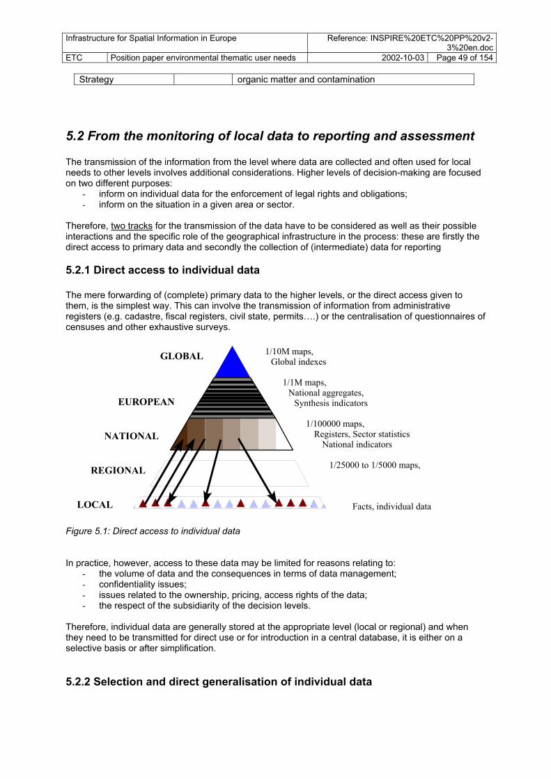
Infrastructure for Spatial Information in Europe Reference: INSPIRE%20ETC%20PP%20v2-3%20en.doc
ETC Position paper environmental thematic user needs 2002-10-03 Page 49 of 154
Strategy organic matter and contamination
5.2 From the monitoring of local data to reporting and assessment The transmission of the information from the level where data are collected and often used for local needs to other levels involves additional considerations. Higher levels of decision-making are focused on two different purposes:
- inform on individual data for the enforcement of legal rights and obligations; - inform on the situation in a given area or sector.
Therefore, two tracks for the transmission of the data have to be considered as well as their possible interactions and the specific role of the geographical infrastructure in the process: these are firstly the direct access to primary data and secondly the collection of (intermediate) data for reporting
5.2.1 Direct access to individual data The mere forwarding of (complete) primary data to the higher levels, or the direct access given to them, is the simplest way. This can involve the transmission of information from administrative registers (e.g. cadastre, fiscal registers, civil state, permits….) or the centralisation of questionnaires of censuses and other exhaustive surveys.
1/10M maps, Global indexes
1/1M maps, National aggregates,
Synthesis indicators
1/100000 maps, Registers, Sector statistics
National indicators
1/25000 to 1/5000 maps,
Facts, individual data
GLOBAL
EUROPEAN
NATIONAL
REGIONAL
LOCAL
Figure 5.1: Direct access to individual data In practice, however, access to these data may be limited for reasons relating to:
- the volume of data and the consequences in terms of data management; - confidentiality issues; - issues related to the ownership, pricing, access rights of the data; - the respect of the subsidiarity of the decision levels.
Therefore, individual data are generally stored at the appropriate level (local or regional) and when they need to be transmitted for direct use or for introduction in a central database, it is either on a selective basis or after simplification.
5.2.2 Selection and direct generalisation of individual data

Infrastructure for Spatial Information in Europe Reference: INSPIRE%20ETC%20PP%20v2-3%20en.doc
ETC Position paper environmental thematic user needs 2002-10-03 Page 50 of 154 Selection takes place for example when priority is given to the data that have to be reported centrally in relation to legal obligations such as the compliance with some maximum standards of pollution. Hotspots of pollution, high value natural or cultural sites and rare objects, in general, are reported upon individually. Information related to projects (environmental impacts, costs and financing) is also of interest for the policy debate. In most cases, the direct access given to databases such as cadastre or other registers is only used on a case per case basis.12 From this perspective, harmonisation of the data is not a pre-requisite as such to a wide range of uses. However, when the users, at the local level as well as at higher levels of decision, need to compare or integrate various sets of data, harmonisation starts to be crucial. In addition, harmonisation is essential in the perspective of a re-use of the local data for producing more aggregated maps or statistics.
1/10M maps, Global indexes
1/1M maps, National aggregates,
Synthesis indicators
1/100000 maps, Sector statistics
National indicators
1/25000 to 1/5000 maps, Regional statistics
Facts, individual data
GLOBAL
EUROPEAN
NATIONAL
REGIONAL
LOCAL
Figure 5.2: Selection Generalisation/aggregation of individual data When the higher or central decision levels require a broader vision, embracing the full scope, some simplification has to be introduced to the individual data set. In this case, geographers speak of generalisation when statisticians refer to aggregation or consolidation. Geographers wipe out the small objects and details which may impair the reading of their maps; statisticians calculate totals, mean values, percentiles. This is done in order to express the composition or the state of a population of reference, be it people or a population in the statistical sense, made of any type of observation units. In this case, the availability of geographic and statistic information depends on a comprehensive process where consistency and comparability of the individual datasets matter, as well as on the technical and economic ability to achieve periodic updating of the primary observations and data.
5.2.3 Sampling and modelling In many cases, operational information requires details and freshness. At the local level there are possibilities of linking directly to individual data or simplified versions of these. Commonly the user needs drives the production of such information. But the higher levels depend on a more intensive process of data collection, generalised maps, exhaustive inventories or censuses, that may supply insufficient or out of date information to the policy makers. To overcome this difficulty, thorough collections of data focus on particular zones (e.g. urban zones, risk management zones), or on particular issues surveyed on a sampling basis. In both cases, the process is based on the modelling
12 A particular case of integral transmission of primary data with an exhaustive coverage of the territory is remote sensing. Although some problems of volume of data still remain, end users at the various levels can have a full access to this information.

Infrastructure for Spatial Information in Europe Reference: INSPIRE%20ETC%20PP%20v2-3%20en.doc
ETC Position paper environmental thematic user needs 2002-10-03 Page 51 of 154 of a territory (choice of the size of a grid or zoning and assignment of a given type) and/or on the modelling of a population of reference (stratification of the sampling pattern). Area frame surveys are examples of the combination of spatial and statistical modelling. In an ideal situation, the monitoring networks should be designed according to sampling principles. In the case of sampling, the individual data collected cease to have a meaning per se; instead, their informative content is strictly linked to the geographical and statistical pattern to which they refer. From this perspective, the availability at a reasonable scale of geographic reference data in the strict sense as well as of the a selected set of core thematic data taking stock of the main characteristics of the territory is of high importance for :
- defining the typology of relevant zones and locating them on an objective basis, which is necessary for an equitable definition, implementation and assessment of policies;
- producing a sound base for extrapolating the results of surveys by sampling; - providing the local players with the possibility of comparing their own situation with the
conditions of zones of similar types in their region, country or in general in Europe.
1/10M maps, Global indexes
1/1M maps, National aggregates,
Synthesis indicators
1/100000 maps, Registers, Sector statistics
National indicators
1/25000 to 1/5000 maps, Samples, detailled statistics
Facts, individual data
GLOBAL
EUROPEAN
NATIONAL
REGIONAL
LOCAL
Figure 5.3: Spatial modelling and data collection by sampling Here, reasonable scale refers more to the quantity of information usually included than to the geometry. For example, there are no small rivers and streams (which are essential in an ecological perspective) in a 1 Million scale map, some at the scale of 100 000 and most of them at the scale of 50 000. Large scales will provide a more accurate picture of the rivers but will not increase significantly the coverage. According to the specific granularity of the issues, the optimal range of scales of the reference and thematic maps and databases necessary for the stratification of sampling patterns and spatial modelling ranges from 250 000 to 50 000.
5.2.4 Data needs in high level assessments The demands of geographic infrastructure also fits the needs of the development of a large number of indicators which, in a DPSIR perspective, should to some extent be integrated in a causal chain and have, accordingly, some common reference. Assessment in general and indicators in particular are based on a regular flow of data collected for different purposes and with different methodologies. Data from monitoring are reported by the Member States as evidence of their compliance with the regulations and conventions that they have adopted. Other monitoring data are supplied on a voluntary basis, e.g. via EIONET. Statistical data collection,

Infrastructure for Spatial Information in Europe Reference: INSPIRE%20ETC%20PP%20v2-3%20en.doc
ETC Position paper environmental thematic user needs 2002-10-03 Page 52 of 154 based on surveys by questionnaires, are collected either on the basis of statistical regulations (mainly in the economic domain, e.g. for the calculation of VAT or GDP) or, as it is in general the case for the environment, on a voluntary basis (with a possible exception for the future “waste statistics regulation”). These data are analysed and interpreted in order to extract useful information for policy making, where possible by reference to scientific models that illuminate and quantify causal relations and the impacts of human activities on the environment. Some of these models requires the consideration of the geographic dimension when the pressure and impacts are distributed unevenly over the European territory. From this point of view, the implementation of INSPIRE will structure and streamline the whole environmental information system.
Geographical reference data(geometry, topography, administrative limits…)
Core thematic maps(geology, climate, soil,
hydrography, land cover, vegetation, infrastructures,
population, land regulation…)
Regular data collection• Statistical surveys•Administrative registers•Monitoring networks
Analysis, modelling(critical loads, emission to the air, non-
point emissions to water, carbon uptake, soil erosion risk, landscape
wilderness, urban areas, coastal areas…)
Legal reporting
Compliance data
Legal reportingLegal reporting
Compliance data
Assessment, indicators
Nationalstatistics
Regional &local statistics
Voluntary reporting
Figure 5.4: Spatial data needs in reporting and assessment
5.2.5 The link to statistical sources Regional and local statistics are of high importance for geographical analysis as well as for informing the regional and local policy makers. They permit the integration of environmental, social and economic concerns in a sustainable development perspective. According to the statistical methods used, results can be presented at different levels of aggregation. When zonal disaggregation is possible, statistics are commonly presented according to administrative units (e.g., a level of the NUTS classification) to segments (e.g. the traffic on highways) or to geometric grid. Demographic and economic statistics are regularly produced according to well accepted methodologies and classifications. It is therefore important that, the statistical attributes of the geographical objects described by INSPIRE refer to the same rules. It is proposed, as a general identification of the production units to refer to the classification in use at Eurostat, the NACE rev.1.1, which is the official classification of the European Community. In parallel, Eurostat has developed a special statistical system for the environmental accounting of protection expenditure, activities and facilities (SERIEE). The SERIEE is

Infrastructure for Spatial Information in Europe Reference: INSPIRE%20ETC%20PP%20v2-3%20en.doc
ETC Position paper environmental thematic user needs 2002-10-03 Page 53 of 154 compatible with the NACE, to which it supplies additional details when the environmental activities of the companies and organisations are not explicit. It presents a standard classification of environmental protection activities as well as a classification the corresponding facilities. The classifications relates to different spatial data components, mainly "facilities" and "utilities". (See appendix 1).
5.3 A two track approach The ETC working group has identified the need for a two-track approach for fulfilling user needs in the environmental sector and the needs following the implementation of environmental policies.
• For data components used at the local and regional level there is a need for high-resolution data which should be covered by the production of data at the local level, with a possible generalisation of data to also fulfil needs at the higher levels. However, generalisation based on harmonised local level data can only be achieved in the long run given the diversity of data and systems at the local level.
• INSPIRE should also facilitate production of national and European-scale data. For data
components used at the national and European levels, needs for more general data should, until harmonised data comes available at local and regional level, rely on production at this scale. Commonly, data production organised at national levels fulfils these needs. Data from national levels should be generalised into European-level data wherever feasible, but existing European-scale data should be maintained separately as long as fully automated generalisation is not feasible. Direct harmonisation of classification systems and generalisation from local level data will for many data not be necessary. However, where the cost/benefit-ratio is high, a more direct generalisation from lower levels should be facilitated as a long-term strategy.
To allow for Pan-European general data will give the opportunity to gain experience in handling of data and make the European Community organisations active in the implementation in the first phase of INSPIRE.
5.4 Prioritising spatial data components and spatial data sets The environmental topics chosen to be listed and specified in the INSPIRE framework directive should cover the needs defined in different kinds of legislation, in conventions and major policies. The process ahead of the agreement should bring together representatives from different kinds of users, different countries, different administrative levels and different providers of data on the topics in question. It is not realistic nor possible at this stage to define all the data sets that are to be defined as mentioned above. If the specification of data sets is to be accepted, there is a need for a broad involvement of different users and scientists/experts. The work can probably be done through different working groups, most of them existing. This process will probably take years, even though work for certain issues might be agreed upon more quickly. This was one of the main conclusions at the Madrid meeting of the INSPIRE Expert Group, where it was suggested that a list of topics and sub-topics should be defined so that the INSPIRE framework can trigger the process of defining these datasets. It is anticipated that this list will need to be revised after some years in order to take into account evolving information needs. In the process of prioritising environmental data set important priorities should be linked to - European legislation and international legal obligations - Environmental policy focus - European Agreements on environmental analysis (indicator) - Health and social security/risk management - local level - Needs in local planning, EIA, integrated management - local level

Infrastructure for Spatial Information in Europe Reference: INSPIRE%20ETC%20PP%20v2-3%20en.doc
ETC Position paper environmental thematic user needs 2002-10-03 Page 54 of 154 - Multi-sectoral needs - important in other sectors

Infrastructure for Spatial Information in Europe Reference: INSPIRE%20ETC%20PP%20v2-3%20en.doc
ETC Position paper environmental thematic user needs 2002-10-03 Page 55 of 154 En
v. le
gisl
atio
n -g
eo-
Env.
pol
icy
focu
s, E
AP
Env.
ass
essm
ent/
ind.
Env.
hea
th-s
ecur
ity
Loca
l pla
nnin
g/m
anag
.
Mul
ti-se
ctor
- im
porta
nt
Ref
eren
ce/ c
omm
ents
INSP
IRE
cate
gory
*
INSP
IRE
prio
rity
**
Geographical location Geodetic reference system x x x x basic info for all REF H Geographical grids x TC H Monitoring sites x x x x x WFD,CAFÉ, ++ ENV H Geographical names REF H Administrative units Official administrative units x x x x x x REF H Blocks and census districts x x x REF M General government management units x x x x S H Sector management & reporting units x x x N2000,wfd,++ E/S H Properties, buildings and addresses Properties ? x x REF L Buildings x x x REF L Addresses x x x REF H Elevation Elevation x x x x WFD REF H Bathymetry x x x REF H Coastline x x x WFD REF H Geo-physical environment Bedrock geology x TC L Geo-morphology x ? L Soil x x TC H Climate Climate zones x ENV L Hydrography Hydrography, river, lake…. x x x x x WFD REF H Water catchments x x x x x WFD TC H Groundwater bodies/aquifers x x x x x WFD ENV H Ocean and seas Sea regions x ENV L Biota/biodiversity Biomes/ Bio-ecological regions x x N2000 TC H Vegetation x x TC L Habitats and biotopes x x N2000 ENV M Species distribution x x N2000 ENV M Land surface Land cover x x x x x TC H Ortho-images x x x x EEA REF H Unclassified satellite data x x TC M Natural resource Water resources x x x x E/S M Agricultural land and soil resources x x x S H Forest resources x x x S H Fishery resources x x x x S M Geological resources x x x S M Renewable energy resources x x x S M Transport Transport networks x x x x x all sector need REF H Transport facilities x REF L Utilities Transmission lines x TC M * Categories : REF = reference, TC = Core thematic, ENV = Environmental sector, S = Other sector ** INSPIRE Priority : H = high, M = medium, L = low

Infrastructure for Spatial Information in Europe Reference: INSPIRE%20ETC%20PP%20v2-3%20en.doc
ETC Position paper environmental thematic user needs 2002-10-03 Page 56 of 154 En
v. le
gisl
atio
n -g
eo-
Env.
pol
icy
focu
s,EA
P
Env.
ass
essm
ent/
ind.
Env.
hea
th-s
ecur
ity
Loca
l pla
nnin
g/m
anag
.
Mul
ti-se
ctor
- im
porta
nt
Ref
eren
ce/ c
omm
ents
INSP
IRE
cate
gory
*
INSP
IRE
prio
rity
**
Facilities Environmental protection facilities, inciner+ ? x x x WFD, landfill dir TC M Production facilities: industry+ ? x x x WFD, TC M Agricultural facilities, stores, tanks, dams+ ? x x x WFD, S M Economy Economic statistics/local statistics x E/S H Area regulation Land regulation/land use plan x x x x x 6EAP, coast,urb TC H Protected sites x x x x Natura2000 TC H Sector regulation (env. sector/ other sector) x x x x x E/S H Natural and technological risks Natural risk vulnerability zones x x x x x 6EAP ENV H Technological risk vulnerability zones x x x x x x 6EAP ENV H Technological accidents/ natural disasters x x x x ENV L Polluted areas/areas under anthropogenic stress Local contaminated areas x x x x WFD, ENV H Diffuse contamination x EEA ENV M Noise zones x x 6EAP ENV L Society Demography x x x x TC H Green urban areas x x 6EAP, urban ENV M Derelicted urban land x x urban ENV M Cultural heritage x x ENV L Natural amenities x x x WFD, bathing ENV L Health Epidemiology x x 6EAP S L Heath services x x x S L Table 5.1: The table gives an overview of the needs in the environmental sector. It is clear that many important data (reference data and core thematic data) not are being defined explicitly in environmental sector policies, and possibly the supply of data at suitable quality is taken for granted. In the process of describing targets for each of the data components, the lowest accuracy INSPIRE is intending to promote should be defined, and if there are additional levels/scales that should be produced, this should be noted. The ETC working group has identified some possible actions in a step-wise approach for populating the infrastructure.
1. Identify and make available existing data relevant to the spatial data themes identified in the ETC position paper through catalogue services and web mapping services. This would be mandatory for regional data and optionally for local data, although the establishment of the structures to accept local data should be put in place as an obligation
2. Establish data models /specifications covering national, regional and local data needs for environmental, core thematic and reference data
3. Establish requirements for policy-specific data under the relevant environmental legislation at all levels (national, regional and local)
4. Establish requirements with target delivery dates for reference and core thematic data at the regional and national level, talking into account the priorities agreed with DG ENV.
5. Review the results of the above process has delivered, for instance after 4-5 years, with a view to promote the availability of harmonised spatial data including at the local level.

Infrastructure for Spatial Information in Europe Reference: INSPIRE%20ETC%20PP%20v2-3%20en.doc
ETC Position paper environmental thematic user needs 2002-10-03 Page 57 of 154
6 Recommendations on infrastructure data content All the recommendations expected to be brought forward from the different INSPIRE Working Groups wil affect the environmental data handling by INSPIRE. Thus it is not necessary to repeat them here. The recommendations below, however, focus on important elements specific to environmental data: elements that need to be in place before or regulations that need to be followed in order to populate the infrastructure with quality environmental data fulfilling the needs for priority users. The recommended actions may be divided into two main categories
• Infrastructure services and conditions, facilitating the flow of data, primarily the focus of other INSPIRE working groups
• Content of the infrastructure, focusing on the generation and maintenance of a selected set of defined core data receiving special attention and funding by EC and MS.
The recommendations in this Paper focus on the latter.
Water
Air +CC
Soil
Land
Biodiv
Urban
Coastal
Waste
Noise
Hazards
........
Identify spatial dataneeds by environmental
issue
Merge dataneeds
Structured list of spatialdata needs, grouped
thematically
Elevation
Physicalenvironm.Bioligicalenvironm
Land cover
Naturalresources
Production/economy
Constructions
Transport
Administrative units
Arearegulation
Risk zonesPolluted
sites
1
3
2Priority
Prioritising needs, basedon obligations, sectoruser value and cross-
cutting needs
Utilities
Society andculture
Geograhiclocation
Recommendationsto INSPIRE
Targets, actions,projects
Organisation,coordination, bodies
Guidelines, standards,specifications
Data projectsimportant env. sector
Data projects core national to local
Data projectscore data European level
Technical tools forimplementation
Other data harmonisationprojects
Env. data provision oninfrastructure
Metadata provision oninfrastructure
How to fulfiluser needs?
......
Mai
n e
nviro
nmen
tal p
olic
y ar
eas
- 6EA
P
Chapter 3 Chapter 4 Chapter 5 Chapter 6 Figure 6.1: The focus in this chapter is on recommendations for the fulfilment of priority needs for data in the environmental sector.

Infrastructure for Spatial Information in Europe Reference: INSPIRE%20ETC%20PP%20v2-3%20en.doc
ETC Position paper environmental thematic user needs 2002-10-03 Page 58 of 154
6.1 Prerequisites for building harmonised environmental and reference data Solutions on certain technical issues are prerequisites for the population of the infrastructure, both for spatial data providers and data users. An important part of the infrastructure is the agreement on
• common exchange formats for data • standardised ways to make data available - define the technical minimum performance and
standard of data repositories • common ways to specify datasets, including data models, • common ways to document metadata, ownership, conditions and user rights
When these issues have been agreed upon, the information amy be disseminated, leading to a better understanding of the issues. Templates, implementation help systems and transformation tools should be developed and provided. Then the time will be ready for developing data following the agreed form or at a form making it possible to transform national data into data following the European specifications. The population of the infrastructure will not be limited to harmonised data. In the initial phases of INSPIRE the percentage of harmonised data will be low. However, in later phases it is an aim to have harmonised data for important reference and core thematic data.
6.2 General - reference to INSPIRE in future policy/sector legislation European environmental legislation commonly refers to different kinds of actions implying the use of spatial data, including monitoring networks, data collection methods, spatial analysis tools and mapping for reporting. So far, most of the existing environmental legislative documents only include some specifications related to maps as end products for reporting, without considering the implications for the spatial data needed to produce, use and maintain these maps in a Geographic Information System (GIS). In order to have a standardised way of defining spatial data, and in order to generate and use data and facilitate flow and access, future European environmental legislation should contribute to building the INSPIRE infrastructure. The ETC group recommends Future European environmental legislation should actively contribute to establishing the sound knowledge on which the future policy should be based, in line with the 6EAP. Therefore, future environmental legislation implying generation, flow and use of spatial data should
• As long as INSPIRE is not yet adopted by Council and EP, establish explicit requirements fro MS to harmonise and make available spatial data needed for the implementation and monitoring of the legislation according to common rules to be established by comitology under the relevant legislative act.
• When INSPIRE is adopted by Council and EP, establish explicit requirements to harmonise and make available spatial data needed for the implementation and monitoring of the legislation in accordance with the standards and rules set forward by the INSPIRE framework
• Provide for the necessary co-ordinating mechanisms to facilitate this harmonisation process

Infrastructure for Spatial Information in Europe Reference: INSPIRE%20ETC%20PP%20v2-3%20en.doc
ETC Position paper environmental thematic user needs 2002-10-03 Page 59 of 154
6.3 General recommendations - links The assessment of environmental sector needs has brought up several important issues that should be given as recommendations to the INSPIRE infrastructure development. The ETC group recommends Linking to other initiatives
• INSPIRE's work on a European Spatial Data Infrastructure should take into account other initiatives on European and environmental data infrastructures, in particular to EEA’s and EIONET’s Reportnet, GBIF,
• INSPIRE’s work on Metadata cataloguing should take into account other European initiatives • INSPIRE’s work on Data modelling, data specifications and data dictionaries should take into
account other major European initiatives.
Co-ordination with review of reporting obligations • The establishment of the requirements and specifications for harmonised spatial datasets
should be co-ordinated with the review of the reporting obligations, in order to ensure that the work under INSPIRE covers the requirements established under the forthcoming reporting framework
6.4 Organisation and coordination
At European level there is a need for a central body under the European Commission with the role to coordinate the general development and maintenance of INSPIRE. The body should be neutral, not being linked to any of the sectors. The organising body should aim at bringing the different sectors together, as they all are depending on each other, both as suppliers of data and users with knowledge of data needs. The environmental sector has a special responsibility to define its needs, be partner in development of data covering cross-sector needs, facilitate for harmonisation and flow of data generated within the sector, including data needed within the sector and data needed in other sectors. The ETC group recommends
• A central body for co-ordination and organisation of INSPIRE activities should be established under the European Commission. This body should be established by 2005.
• The central body should as much as possible link and use existing organisations and their thematic and technical expertise
• The central European body should secure the implementation of INSPIRE, with the necessary authority to find harmonised ways to agree on standards, technical layout, data harmonisation, data establishment and maintenance, definition of metadata, definition of legal issues (ownership, user rights, prices), and to organise funding for some selected activities needed. The central body should also co-ordinate contact with and between countries, both to support implementation at national level and to monitor and evaluate developments.
• A co-ordination committee or co-ordination body within each of the Member States should be assigned by 2005. The Member States should also develop information material, guidelines, templates and other tools/facilities intended to help implementation, development and population of the infrastructure.

Infrastructure for Spatial Information in Europe Reference: INSPIRE%20ETC%20PP%20v2-3%20en.doc
ETC Position paper environmental thematic user needs 2002-10-03 Page 60 of 154
6.5 Standards and guidelines for data and metadata production In order to develop harmonised spatial data at the European scale it is essential that INSPIRE co-ordinates a set of activities related to standards, specifications and guidelines that covers the topic of data production. General rules on data modelling are defined in standards, but guidance material and education is needed in order to enable large groups of stakeholders to define data according to these frameworks. For certain kinds of specifications it is necessary that also software tools and examples become available. INSPIRE is to reflect the broad needs and the structure used should not be linked to a specific policy or document. The thematic structure should be an agreed structure for categorising real world objects, based on data modelling. It is foreseen that this work will be carried out as a result of the actions undertaken by INSPIRE. The ETC group recommends
• To establish data models /specifications covering European, national, regional and local data needs for environmental, core thematic and reference data
• That INSPIRE organises data modelling with the aim of developing harmonised definitions
of real world objects relevant to needs in the environmental sector, and later also covering other sector needs. An over-arching data model should be developed by 2004. Data models for major spatial data components and objects should be ready by 2006.
• The data models should as far as possible be based on existing models developed by ISO
or other internationally accepted data models. Both objects and their attributes should be defined.
• Establish a feature catalogue (data dictionary) for all legal objects, attributes, explanation
texts, values/predefined codes etc for common reference data and environmental, later also covering other sector needs. The data dictionary should be operative by 2005 and contain definitions of all legal objects and their attributes by 2008.
• Establish and maintain specifications for important data sets. The specifications for priority
data sets covering the needs of the thematic policies under 6 EAP should be established by 2006.
• Necessary measures and procedures for data modelling, selection of priority data sets
and specification of these. The measures should be defined by 2005.
• To establish instruments and organisations for working on environmental data modelling and specification and harmonisation. The work could be organised by the set-up of environmental/ thematic standardisation committees and sub-committees for different topics and sub-topics, e.g. linked to the different thematic policies under 6EAP. The instruments should be harmonised with other existing working groups on data specification, e.g under the EEA Reportnet initiative. The working groups should be operative by early 2005
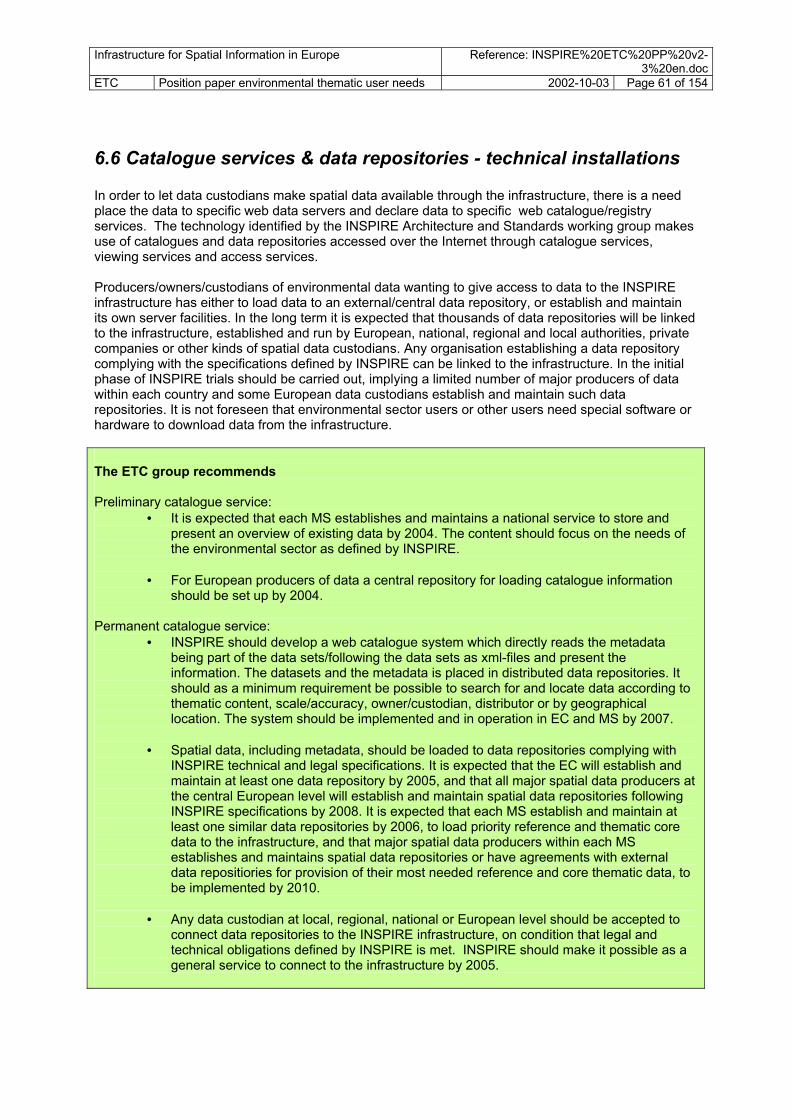
Infrastructure for Spatial Information in Europe Reference: INSPIRE%20ETC%20PP%20v2-3%20en.doc
ETC Position paper environmental thematic user needs 2002-10-03 Page 61 of 154
6.6 Catalogue services & data repositories - technical installations In order to let data custodians make spatial data available through the infrastructure, there is a need place the data to specific web data servers and declare data to specific web catalogue/registry services. The technology identified by the INSPIRE Architecture and Standards working group makes use of catalogues and data repositories accessed over the Internet through catalogue services, viewing services and access services. Producers/owners/custodians of environmental data wanting to give access to data to the INSPIRE infrastructure has either to load data to an external/central data repository, or establish and maintain its own server facilities. In the long term it is expected that thousands of data repositories will be linked to the infrastructure, established and run by European, national, regional and local authorities, private companies or other kinds of spatial data custodians. Any organisation establishing a data repository complying with the specifications defined by INSPIRE can be linked to the infrastructure. In the initial phase of INSPIRE trials should be carried out, implying a limited number of major producers of data within each country and some European data custodians establish and maintain such data repositories. It is not foreseen that environmental sector users or other users need special software or hardware to download data from the infrastructure. The ETC group recommends Preliminary catalogue service:
• It is expected that each MS establishes and maintains a national service to store and present an overview of existing data by 2004. The content should focus on the needs of the environmental sector as defined by INSPIRE.
• For European producers of data a central repository for loading catalogue information
should be set up by 2004. Permanent catalogue service:
• INSPIRE should develop a web catalogue system which directly reads the metadata being part of the data sets/following the data sets as xml-files and present the information. The datasets and the metadata is placed in distributed data repositories. It should as a minimum requirement be possible to search for and locate data according to thematic content, scale/accuracy, owner/custodian, distributor or by geographical location. The system should be implemented and in operation in EC and MS by 2007.
• Spatial data, including metadata, should be loaded to data repositories complying with
INSPIRE technical and legal specifications. It is expected that the EC will establish and maintain at least one data repository by 2005, and that all major spatial data producers at the central European level will establish and maintain spatial data repositories following INSPIRE specifications by 2008. It is expected that each MS establish and maintain at least one similar data repositories by 2006, to load priority reference and thematic core data to the infrastructure, and that major spatial data producers within each MS establishes and maintains spatial data repositories or have agreements with external data repositiories for provision of their most needed reference and core thematic data, to be implemented by 2010.
• Any data custodian at local, regional, national or European level should be accepted to
connect data repositories to the INSPIRE infrastructure, on condition that legal and technical obligations defined by INSPIRE is met. INSPIRE should make it possible as a general service to connect to the infrastructure by 2005.

Infrastructure for Spatial Information in Europe Reference: INSPIRE%20ETC%20PP%20v2-3%20en.doc
ETC Position paper environmental thematic user needs 2002-10-03 Page 62 of 154
6.7 Metadata content in the infrastructure - environmental data Metadata about existing spatial data and attribute (tabular) information needed by the environmental sector should be made available by all who is loading spatial data to the infrastructure. A condition is that environmental data producers follow the policy objectives and general regulations defined by INSPIRE. The ETC group recommends
• Each MS and the EC is to develop an overview of existing spatial data within the country on the spatial data components specified in table 5.1. The documentation should be made available to all through the INSPIRE infrastructure (catalogue service) at the latest by 1.1. 2005 and should be maintained thereafter.
• Each custodian should, when loading data sets to one of the INSPIRE accepted data
repositories, ensure that the level of detail of the metadata being loaded by data custodians complies with minimum requirements defined by INSPIRE, being a sub-set of the INSPIRE profile of ISO 19115 metadata.
6.8 Expectations on actions to populate the infrastructure
6.8.1 Different expectations through time - stepwise implementation The measures designed to populate the infrastructure should be based on the idea of a stepwise implementation. For separate environmental topics and data sets the actions can come at different time schedules, involving different action, processes, partners. The steps of developing standards, specifications and guidelines has been defined in chapter 6.6 and 6.7. Some actions or targets on the actual population of the infrastructure are outlined below:
• MS and European Commission to make available references of existing data covering defined spatial data components in a catalogue service
• Decide when which of the defined data sets (at certain accuracy) are to be available from
countries or separate EU institutions. This will be an intermediate step where it is accepted any data of the spatial data themes defined in the INSPIRE list, but where it is not mandatory to have restructured national data bases to fit the INSPIRE specification.
• The next step would be to accept data of a somewhat higher quality; firstly a minimum set of
metadata organised according to the INSPIRE profile for metadata, and secondly that the data should hold a certain quality making them able to be transformed through standard interfaces to standard format as defined by INSPIRE.
• Implement according to a time schedule within which the EC member countries or partners of
INSPIRE are to have MS data (high level, medium level, local data) at a quality and structure making them able to be transformed through standard interfaces to comply with data set specifications defined or accepted by INSPIRE. This should be data sets with a quality content following the specification for each separate data set, and other technical requirements defined by INSPIRE.

Infrastructure for Spatial Information in Europe Reference: INSPIRE%20ETC%20PP%20v2-3%20en.doc
ETC Position paper environmental thematic user needs 2002-10-03 Page 63 of 154 The INSPIRE framework directive should define to which level of fulfilment it aims at in respect of different kinds of data. Action/target short term medium
term long term
Define a hierarchy of topics and sub-topics ■
Agree upon a set of common data sets ■
Agree upon an over-aching data model ■
Establish a data dictionary for commonly used legal objects, attributes, explanation texts, values etc for priority data sets (reference data, core thematic & environmental data)
■
Countries/ agencies to load available data in catalogue ■ ■ Countries/ agencies to load preliminary data not necessarily complying with standard
■ ■ Make data set specifications for each dataset
■ ■ Countries/agencies to load simple data following standard & data set specifications
■ ■ ■ Countries/agencies to load complex data following standard & data set specifications
■
Figure 6.2: The stepwise actions to populate the infrastructure, an outline for each data component or data set. Firstly, data models have to be developed and specific data sets to have be defined concerning content and quality. Metadata on existing data can be loaded early. Steadily better harmonisation and data quality is achieved, following defined targets for each thematic data component. Proposals for the two first actions/deliverables are contained in this document.

Infrastructure for Spatial Information in Europe Reference: INSPIRE%20ETC%20PP%20v2-3%20en.doc
ETC Position paper environmental thematic user needs 2002-10-03 Page 64 of 154
6.8.2 Different expectations with different categories of data (accuracies)
Comply with Inspire data set specifications (content/quality)
Comply with specific Inspire data models
Comply with data model standard
Comply with standard spatial data format
Comply with Metadata standard
Data mentioned in national/INSPIRE catalogue services
Seamless European data following standard
Pan-European Reference data
Pan-European Thematic core data
European level environmental modellingdata
Regional & local level reference data
Regional & local level data theamtic core data
Data in INSPIREinitial phase
2004 2015
Figure 6.3: Figure illustrating how products having different status in INSPIRE will fulfil different levels of harmonisation and quality when they are to be loaded on data repositories in the INSPIRE infrastructure. The figure shows that INSPIRE foresees and prescribes different level of harmonisation, harmonisation differign both with different categories of data and the administrative level in which they are to be used. In initial phases of INSPIRE it is expected that only existing data are shown in INSPIRE web catalogues, and that other kinds of harmonisation are not expected. If data custodians are ready to load better harmonised data earlier than 2015, this is of course of great interest to users. The ETC group recommends
• A stepwise implementation of the population of the infrastructure, where simple and/or un-harmonised data and metadata are brought into the infrastructure first, the harmonised and complex data later.

Infrastructure for Spatial Information in Europe Reference: INSPIRE%20ETC%20PP%20v2-3%20en.doc
ETC Position paper environmental thematic user needs 2002-10-03 Page 65 of 154
6.9 Population of the infrastructure - general The following general recommendations are made concerning strategies for populating the infrastructure. The ETC group recommends
• The population of the infrastructure should in the first phase focus on data needs for policy implementation, reporting and evaluation, meeting needs defined by legal obligations and for the agreed production of environmental indicators.
• In order to populate the infrastructure with data needed in the environmental sector, INSPIRE
should o rely on the provision of data from producers/stakeholders o make the provision of certain data sets mandatory o make agreements with countries for reporting or provision for other data sets
• Identify and make available existing data relevant to the spatial data themes identified in the
ETC position paper through catalogue services and web mapping services. This would be mandatory for regional data and optionally for local data, although the establishment of the structures to accept local data should be put in place as an obligation
• Establish requirements for policy-specific data under the relevant environmental legislation at
all levels (national, regional and local) • Establish requirements towards MS and EC with target dates for access to reference and core
thematic data at the regional and national level, talking into account the priorities agreed with DG ENV.
• Set up a time schedule for when the EC member countries or partners of INSPIRE are to have
data (high level data, medium, local data) at qualities and structures making it possible to, through standard INSPIRE interfaces, to be transformed to comply with the data set specifications.
• INSPIRE should run projects to cover the common needs for environmental, core thematic
and reference spatial data within the environmental sector o Environmental reporting - obligation o Environmental reporting - voluntary/ agreement o Environmental assessment of physical-biotic media (quality/pollution/ trends of air,
soil, water) o Environmental assessment - performance of sectors o Environmental management o Land use and regional planning, including coastal and urban planning o Social security/ risks/ hazards management
• Review the results of the above process has delivered, for instance after 4-5 years, with a
view to promote the availability of harmonised spatial data including at the local level.

Infrastructure for Spatial Information in Europe Reference: INSPIRE%20ETC%20PP%20v2-3%20en.doc
ETC Position paper environmental thematic user needs 2002-10-03 Page 66 of 154
6.10 Establishment and maintenance of reference data One major group of data of prime importance to environmental users is basic features, commonly termed reference data. The availability of reference data to environmental users is crucial as they are used in combination with thematic data, as a basis for environmental analysis and map presentation. Reference data are also important in the production processes of environmental data, in terms of both the geometry being used to cut and join environmental objects or areas, and the reference of environmental status and action to components in the reference data. For the purpose of describing actions for populating the infrastructure it has been found valuable to separate actions between the broad levels of use.
• Small-scale data for overall used at national, cross-national and European level • Medium to large-scale data to be used at regional and local levels.
Targets, actions, organisation and cost related to the work and products vary significantly, and are therefore treated in two different sub-chapters below.
6.10.1 Small-scale multi-purpose seamless European Reference data There is a very high need for data at small scales, 1:1 million or smaller in accuracy. A full range of topics, acceptable updating frequencies, homogenous data and user-friendly products are needed and will be a very important for use at the European scale, in cross-country actions and at the national level in MS in the following ways.
• As a reference in quality control of location, cutting of data, use of ID's etc needed in environmental and other sector data generation
• Different kinds of overall assessments, spatial-statistical analysis, modelling to be used as input in environmental policy evaluation
• General input to administration tools in eGovernment • Background map for screen and print presentations
A present, EUROSTAT/GISCO is producing a set of small scale data for such purposes. The data base has a series of layers. Primarily the data consists of several versions of the data components/ layers in different scales (e.g. 1: 1 mill, 1: 3 mill, 1: 10 mill). Only a few data sets are presented with higher accuracy. There are major weaknesses in the database today, primarily due to important elements not being present, elements being outdated or updated at low frequencies. Costs also limit the use of some of the data. EUROSTAT/GISCO has a valuable role in bringing together European data to seamless data sets on small scales. For reporting, analysis, management and overall planning at a Pan-European scale it is important to have access such a seamless database of acceptable content and quality.
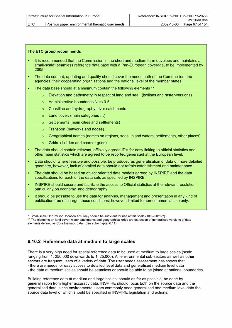
Infrastructure for Spatial Information in Europe Reference: INSPIRE%20ETC%20PP%20v2-3%20en.doc
ETC Position paper environmental thematic user needs 2002-10-03 Page 67 of 154 The ETC group recommends • It is recommended that the Commission in the short and medium term develops and maintains a
small-scale* seamless reference data base with a Pan-European coverage, to be implemented by 2005.
• The data content, updating and quality should cover the needs both of the Commission, the agencies, their cooperating organisations and the national level of the member states.
• The data base should at a minimum contain the following elements **
o Elevation and bathymetry in respect of land and sea,. (isolines and raster-versions)
o Administrative boundaries Nuts 0-5
o Coastline and hydrography, river catchments
o Land cover. (main categories …)
o Settlements (main cities and settlements)
o Transport (networks and nodes)
o Geographical names (names on regions, seas, inland waters, settlements, other places)
o Grids (1x1 km and coarser grids)
• The data should contain relevant, officially agreed ID's for easy linking to official statistics and other main statistics which are agreed to be reported/generated at the European level.
• Data should, where feasible and possible, be produced as generalisation of data of more detailed geometry, however, lack of detailed data should not refrain establishment and maintenance.
• The data should be based on object oriented data models agreed by INSPIRE and the data specifications for each of the data sets as specified by INSPIRE.
• INSPIRE should secure and facilitate the access to Official statistics at the relevant resolution, particularly on economy and demography.
• It should be possible to use the data for analysis, management and presentation in any kind of publication free of charge, these conditions, however, limited to non-commercial use only.
* Small-scale: 1: 1 million, location accuracy should be sufficient for use at this scale (100-250m??). ** The elements on land cover, water catchments and geographical grids are extraction of generalised versions of data elements defined as Core thematic data. (See sub-chapter 6.11)
6.10.2 Reference data at medium to large scales There is a very high need for spatial reference data to be used at medium to large scales (scale ranging from 1: 250.000 downwards to 1: 25.000). All environmental sub-sectors as well as other sectors are frequent users of a variety of data. The user needs assessment has shown that - there are needs for easy access to detailed level data and generalised medium level data - the data at medium scales should be seamless or should be able to be joined at national boundaries. Building reference data at medium and large scales, should as far as possible, be done by generalisation from higher accuracy data. INSPIRE should focus both on the source data and the generalised data, since environmental users commonly need generalised and medium level data the source data level of which should be specified in INSPIRE legislation and actions.

Infrastructure for Spatial Information in Europe Reference: INSPIRE%20ETC%20PP%20v2-3%20en.doc
ETC Position paper environmental thematic user needs 2002-10-03 Page 68 of 154 Very large scale data (commonly termed technical data) at even higher geometrical accuracy (1:5000-1:500) could also be considered as constituent parts of INSPIRE. But European initiated harmonisation targets will be far less demanding than on smaller scales, as the data are not primarily being exchanged outside the national level, and in many cases not even outside the regional level. The ETC group recommends • Medium scale data
• INSPIRE should facilitate development and maintenance of medium-scale spatial data at accuracies needed for use in scale ca. 1: 250.000 (1: 100.000-500.000).
• The content and targets for the year of fulfilment/completion for each component is defined below.
• The data should, if possible and feasible, be based on the generalisation of data at lower levels.
• The data should have a Pan-European coverage (MS). • Large-scale data
• INSPIRE should facilitate development and maintenance of large-scale data at accuracies needed for use in scales 1: 50.000 (1: 100.000-25.000). The data will commonly be the source level for data production at national level.
• Each member state should have a full territorial coverage of reference data at a minimum of 1: 50.000.
• Very large scale data
• INSPIRE should facilitate development and maintenance of very large-scale data at accuracies needed for use in scales 1: 10.000 (1: 15-5.000).The data will commonly be the source level for production of data at local level/technical level.
• The target for minimum area coverage should be defined by INSPIRE, and should as a minimum cover urban areas and areas under particular stress (e.g. industrial sites, coastal tourist areas, agricultural areas)
• The data content, updating and quality should cover the needs of the environmental sector and other major sectors, such as transport, agriculture, forestry, industry, utilities, government planning and services.
• The data components that should be available to base should at a minimum contain the following elements: geodetic reference system, geographical grid, geographical names, administrative units, parcels, buildings, addresses, elevation, hydrography, transport network and ortho-imagery, according to specification in annex 1.
• The data should contain relevant, officially agreed standardised ID's for easy linkage to official statistics and other main statistics agreed be reported/generated at the European level.
• Data should, where feasible and possible, be produced as a generalisation of data of more detailed geometry. However, lack of detailed data should not constrain establishment and maintenance.
• INSPIRE should secure and facilitate access to Official statistics at the relevant resolution, particularly in the areas of demography and economy.
The target dates are the latest for fulfilling the defined infrastructure content to be available on the INSPIRE infrastructure. Countries or European agencies responsible for the fulfilment of the targets can, where necessary, upload data earlier than latest target dates.

Infrastructure for Spatial Information in Europe Reference: INSPIRE%20ETC%20PP%20v2-3%20en.doc
ETC Position paper environmental thematic user needs 2002-10-03 Page 69 of 154 Geographical reference data Spatial data component Description/ comments
(description of each component in appendix 1)
Priority within refere.data H,M,L
medium scale 250.000
large scale 50.000
very large scale highest accuracy 10.000
Geodetic reference systems
* refer to RDM H
Geographical names Develop and maintain a European harmonised geographical place name spatial database, to be used at different scales. Geographical names at scale 250.000 exists on map series and databases throughout Europe, possibly also at lower scales. European geographical name data exists, e.g. GISCO.
H 2006 2015
Administrative units Official administrative units, according to the administrative levels used within each country, e.g. municipalities, counties. Nuts 1-5 covers EU. High priority, should be free of charge at all levels.
H 2006 2010 2015
Parcels (property rights) Only relevant with registration at highest accuracy. Parcel information in Europe is very un-homogenous. It should be taken steps to develop harmonised data set specifications and identification system, free to be used, but no data harmonisation target should be set.
L (2015)
Buildings Only relevant with registration at highest accuracy. Building information in Europe is very un-homogenous It should be taken steps to develop harmonised data set specifications and identification system, free to be used, but no data harmonisation target should be set.
L (2015)
Addresses Only relevant with registration at highest accuracy. Electronic address systems are developing and route planners are using different kinds of sources for addresses. A harmonised European address database with location of each address as point should be developed.
H 2015
Elevation Elevation - land. High-accuracy data is needed, especially for relatively flat areas. For land surfaces the model employs elevation matrix. Isoline databases should also be available.
H 2008 2015 2015
Coastline. Important element to be treated separately. Different methods for definition and observation of coastline. Harmonised data needed at all levels.
H 2008 2015 2015
Bathymetry. Framework consits of soundings and a gridded bottom model. Isoline databases should also be available.
H 2010 2015
Hydrography Hydrographic network of rivers, lakes, channels, reservoirs, …
H 2006 2008 2015
Transport Network of road, rail, air and sea transport systems. Includes both line network and nodes- facilities at ports, airports, junctions etc. At lowest level including service function nodes for local transport.
H 2005 2010 2015
Ortho-imagery Pre-processed "picture" data. Source either satellite or air-borne sensors.
H 2005 2015

Infrastructure for Spatial Information in Europe Reference: INSPIRE%20ETC%20PP%20v2-3%20en.doc
ETC Position paper environmental thematic user needs 2002-10-03 Page 70 of 154 Reference data as defined by the RDM working group does not include any kind of general land cover classification except for objects of hydrography and transport. It is common in an infrastructure to include generalised land cover information, at least showing forest and agriculture as general features. The list does nor include water catchments, as these can be derived from height and hydrography information. As production of harmonised and accurate water catchment data is a timely process, these should be available to environmental users. Both kinds of data are included in the core thematic definition below.
6.11 Establishment and maintenance of core thematic data The assessment of user needs in the environmental sector has shown that there are many datasets needed as a follow-up to the implementation of major environmental policies, the 6EAP in particular. Because different directives and conventions define important data to be reported and used in the evaluation of policies and in work on monitoring the state of environment, INSPIRE should give priority to these data with a suitable content and accuracy. For more details on the process of identifying priority data, see chapter 5. The following data components should be treated by INSPIRE, and a selected number of data sets under each component should be made available through INSPIRE, both low-resolution data for European use and large-scale data for regional and local use.
• 10 major themes of special importance to environmental users have been identified. • Included in these themes there are identified 25 core thematic data components of major
importance to environmental users • For some of the data components it has been possible to relate needs more specifically to
spatial data sets, being data following certain data product specifications. Some 20 existing or proposed spatial data sets have been identified.
The described key components are essential in reporting mechanisms, environmental assessment, environmental and land use planning or in environmental sector planning. Not all components are relevant at all geographical levels. The table underneath is a short version of appendix 1, which describes both reference and core environmental data in a common thematic structure. The list underneath only presents description at data component level, and does not present specific data sets. Appendix 1 present further information about some data sets within each of the data components.

Infrastructure for Spatial Information in Europe Reference: INSPIRE%20ETC%20PP%20v2-3%20en.doc
ETC Position paper environmental thematic user needs 2002-10-03 Page 71 of 154 The ETC group recommends
• The spatial data components termed core thematic data are mainly presentation of measurable basic physical features and data that should be treated by INSPIRE are. bedrock geology, soil, climatic regions/data, water catchments, vegetation, land cover, unclassified satellite data, location of facilities, location of utilities, land regulation and land use plans, protected areas, further attribute information on demography and economy, all according to specification of the spatial data components in appendix 1.
• Medium scale data
• INSPIRE should facilitate development and maintenance of medium-scale spatial data at accuracies needed for use in scale ca. 1: 250.000 (1: 100.000-500.000).
• The content and targets on year of fulfilment/completion for each component is defined below.
• The data should, if possible and feasible, be based on generalisation of data at lower levels.
• The data should, where exceptions not are mentioned, have a Pan-European coverage (MS).
• Large-scale data
• INSPIRE should facilitate development and maintenance of large-scale data at accuracies needed for use in scales 1: 50.000 (1: 100.000-25.000). The data will commonly be the source level for production of data at national level.
• Each member state should have a full territorial coverage of reference data in minimum 1: 50.000.
• Very large scale data
• INSPIRE should facilitate development and maintenance of very large-scale data at accuracies needed for use in scales 1: 10.000 (1: 15-5.000).The data will commonly be the source level for production of data at local level/technical level.
• The target for minimum area coverage should be defined by INSPIRE, and should as a minimum cover urban areas and economically important areas (e.g. industrial sites, coastal tourist areas, agricultural areas)
• The data content, updating and quality should cover the needs of the environmental sector and other major sectors, such as transport, agriculture, forestry, industry, utilities, government planning and services.
•
• The data should contain relevant, agreed standardised id's for easy link to official statistics and other major sources for attribute data/information reported/generated at the European level.
• Data should, where feasible and possible, be produced as generalisation of data of more detailed geometry, however, lack of detailed data should not refrain establishment and maintenance.

Infrastructure for Spatial Information in Europe Reference: INSPIRE%20ETC%20PP%20v2-3%20en.doc
ETC Position paper environmental thematic user needs 2002-10-03 Page 72 of 154 Core thematic data Spatial data component Description/ comments
(description of each data component in appendix 1)
Priority within core thematic data H,M,L
Small scale 1 1 mill
medium scale 250.000
large scale 50.000
Very large scale, highest accuracy 10.000
Bedrock geology L 2008 2015 Soil H 2006 2010 2015? Climatic regions/data L 2006 2007 Water catchments River Runoff areas H 2006 2005 2010 Groundwater bodies H 2006 2005 2010 Bio-ecological regions Bio-geographical zoning, mainly
focusing on ecological situation. (Ecological regions/ potential vegetation regions)
H 2006 2005
Vegetation Actual vegetation cover L 2009 ? ? Land cover Land cover at different levels, rough
versions for overall presentations, detailed for analysis and management at local, regional, national levels
H 2006 2009 2015 2015?
Unclassified satellite data Unclassified data for multi-purpose use. Data
M 2006 2006 2010 2015
Location of utilities Transmission lines energy, water, gas, pipelines etc
M 2006 2007 2009
Location of facilities Industry locations and other production facilities, public service facilities (sewage, waste, water, etc)
M 2006 2007 2009
Land regulation/use plans Local and regional land use plans and land regulations, at lowest level very complex data.
H 2015
Protected areas Legally protected/ designated sites/areas
H 2006 2006 2015
Demographic data Attribute info to be used together with reference data components, nuts5+grid 100x100m.
H
2006
Geographical grid One harmonised grid cell system for Europe. The grid location (corners) and their references to be decided upon by 2005.
H 2006 2006 2006 2006
6.12 INSPIRE follow-up of priority environmental spatial data The infrastructure content of INSPIRE will contain a large series of reference data, core thematic data, priority environmental data, sector data and other kinds of data falling outside these categories. Different policies will direct establishment and maintenance of data and the provision of data to the INSPIRE infrastructure. The INSPIRE framework legislation will give focus to establishment, maintenance and infrastructure provisions for some multi-purpose data with a wide user-sphere, while other sector legislations will direct similar actions to spatial data components and spatial data sets of more sector-specific character. Priority environmental data are mainly produced within the environmental data, covering needs by broad interest groups within the environmental sector, but at the same time often being important outside the environmental sector. Different existing policies, existing and planned legislation or other

Infrastructure for Spatial Information in Europe Reference: INSPIRE%20ETC%20PP%20v2-3%20en.doc
ETC Position paper environmental thematic user needs 2002-10-03 Page 73 of 154 agreements on data generation and reporting already controls or will control the generation of the data. Even though of high importance to the environmental sector, it is seen as problematic to recommend inclusion of priority environmental spatial data in the INSPIRE framework legislation. The regulation of environmental data is usually covered by other legislation and conventions, and will be covered by forthcoming legislation. User needs should be met by relying on thematic legislation and policies. The issue should, though, be reviewed in order to see if there is a need for INSPIRE daughter legislation in this field. However, the INSPIRE framework directive should put in place processes and provide services for harmonisation in respect of populating the infrastructure with priority environmental spatial data. Issues, among others, could be the harmonisation of formats, coordinate reference systems, contents, conditions for access, processes for capturing user needs and processes to adjust data according to needs outside the primary needs of the policy. The ETC group recommends
• The spatial data components termed priority environmental data have been identified by INSPIRE ETC to be data of special importance to environmental users, being data outside the categories of geographical reference data, core thematic data and sector data.
• The INSPIRE infrastructure content should contain priority environmental spatial data produced within the environmental sector.
• The INSPIRE framework directive should not explicitly mention priority environmental spatial data components in targets to populate the infrastructure.
• INSPIRE should rely on other environmental sector policies for the provision of priority environmental spatial data.
• INSPIRE should work towards inclusion of statements in sector policy documents on data generation and data flow (environmental policy legislation and defined data reporting and data flow mechanisms) on aspects such as: o data should follow the recommended formats and geodetic reference systems o following INSPIRE guidelines on data modelling and data product specifications. o establishing and maintaining data according to the data product specifications. o data should contain relevant, agreed standardised ID's for easy link to official statistics
and other major sources for attribute data/information reported/generated at the European, national, regional and local levels.
o data specification should say that the geographical reference data and core thematic data as defined and provided by INSPIRE should be the framework source for integrating data sets at borders (e.g. clipping), so that efficient modification procedures for borders following normal maintenance procedures can be developed.
o data should, where feasible and possible, be produced as generalisation of data of more detailed geometry, however, lack of detailed data should not inhibit establishment and maintenance.
o making it obligatory to provide the data to the INSPIRE infrastructure o open access to data of this kind, free of charge for non-commercial use.

Infrastructure for Spatial Information in Europe Reference: INSPIRE%20ETC%20PP%20v2-3%20en.doc
ETC Position paper environmental thematic user needs 2002-10-03 Page 74 of 154 An example list of important data components and spatial data sets treated by environmental thematic policies is found below. The spatial data components are described in Annex 1. Priority environmental data Spatial data component Example of data sets/ comments Policy/legislation Monitoring sites locations were monitoring of physical, biological or
other aspects occurs. Permanent/temporal. Sites not covered by other geogr. object, e.g. facilities
Inland water A series of categories WFD, EEA Sea/transitional waters A series of categories WFD, EEA Groundwater A series of categories WFD, EEA Air quality CAFÉ, EEA Soil erosion 6EAP, Soil communication Bathing sites 6EAP Cryosphere (glaciers, permafrost…) ….. Erosion risk, agricultural Agric policies Coastal erosion 6EAP Habitats (not the same as protected habitats) Natura2000 Species distribution Natura2000 Landscape Thematic management/ reporting areas
Bio-geographical regions Natura2000
WFD River basin districts WFD Ospar/ Helcom sea regions Ospar/Helcom Sector regulations Nitrate vulnerable zones Nitrates directive Areas regulated for dumping of waste at sea Ospar Natural hazards restriction areas, e.g. 6EAP Technological hazards restriction areas. 6EAP Land use/water use restriction at groundwater sources WFD Land use/water use restriction at groundwater sources WFD Natural risk zones Flooding vulnerable zone 6EAP, Land slide vulnerable zone 6EAP, Snow slide vulnerable zone 6EAP, Forest fire vulnerable zone 6EAP, Earthquake vulnerable zones 6EAP, ……. Technological risk zones Chemical industry vulnerable zones 6EAP, Seveso II, Nuclear vulnerable zones. 6EAP, Seveso II, Dam brake flooding zone Noise level zones 6EAP, for local planning Local area contamination 6EAP, soil, EEA, Diffuse area contamination 6EAP, EEA Economic data Attribute info to be used with reference or facility
components
In addition to the priority environmental spatial data comes other kinds of environmental data resulting from spatial modelling, e.g. critical loads of heavy metals, emissions to air, non-point emissions to water, carbon uptake in water, soil and vegetative cover, soil erosion risk, landscape, wilderness, urban areas. These are data of more ad-hoc and internal character to be used mainly within the environmental sector. The data are not treated explicitly by INSPIRE.

Infrastructure for Spatial Information in Europe Reference: INSPIRE%20ETC%20PP%20v2-3%20en.doc
ETC Position paper environmental thematic user needs 2002-10-03 Page 75 of 154
6.13 INSPIRE follow-up of priority sector data for environmental users INSPIRE aims at bringing in data from the sectors. It is not the objective of INSPIRE to describe the sectors’ own general spatial data needs in this paper. The interest here is limited to the environmental dimension: to describe how the sectors use the physical media and the environment in different ways and how the sectors are representing pressures on the physical components. Furthermore, attention should be paid to data needs in reducing environmental stress and the localisation and development of environmentally sound practices and products. The needs for data is mutual;
• The environmental sector needs data in order to review performance in the different sectors and carry out management in the field of environment.
• The sectors are large users of data, needing reference data, core thematic data, priority environmental data and also on an ad-hoc basis data resulting from environmental spatial analysis, in order to carry out ordinary tasks within the sector and reach targets on environmentally sound management.
The assessment of user needs in the environmental sector has shown that there is a need for a wide variety of sector data not already being included in the spatial data categories of geographic reference data and core thematic data. It is the aim to have access to these data through the INSPIRE infrastructure. Even though of high priority within the environmental sector, it does not seem realistic to define targets and actions for sector data in the INSPIRE framework legislation unless the sector has become an active partner in INSPIRE. At the moment no sector except for the environment is proposed as a part of INSPIRE. Only more general objectives can be defined as a response to environmental sector needs for the data. This may be data in a wide range of sectors or major service areas which are generators/producers of spatial data
• Agricultural sector • Forestry sector • Mining and geological industry • Fishery • Tourism • Transport sector • Utilities • Construction • Property agents • Health • Government • Defence
The ETC group recommends
• The spatial data components termed priority sector data have been identified by INSPIRE ETC to be data of special importance to environmental users, being data outside the categories of geographical reference data, core thematic data and priority environmental data.
• The INSPIRE infrastructure content should contain priority sector-generated spatial data. • The INSPIRE framework directive should not explicitly mention the priority environmental
spatial data components in targets to populate the infrastructure. • INSPIRE should rely on the sector policies and sector legislation for the provision of the
priority environmental spatial data.

Infrastructure for Spatial Information in Europe Reference: INSPIRE%20ETC%20PP%20v2-3%20en.doc
ETC Position paper environmental thematic user needs 2002-10-03 Page 76 of 154
• INSPIRE should work towards inclusion of statements in sector policy documents on data generation and data flow (environmental policy legislation and defined data reporting and data flow mechanisms) on aspects such as: o data should follow the recommended formats and geodetic reference systems o following INSPIRE guidelines on data modelling and data product specifications. o establishing and maintaining data according to the data product specifications. o data should contain relevant, agreed standardised id's for easy link to official statistics and
other major sources for attribute data/information reported/generated at the European, national, regional and local levels.
o data specification should define that the geographical reference data and core thematic data as defined and provided by INSPIRE be the framework source for integrating data sets at borders (e.g. clipping), so that efficient modifications procedures of borders following normal maintenance procedures could be obtained.
o data should, where feasible and possible, be produced as generalisation of data of more detailed geometry, however, lack of detailed data should not refrain establishment and maintenance.
o making it obligatory to provide the data to the INSPIRE infrastructure o open access to data of this kind, free of charge for non-commercial use.
The assessment of environmental sector spatial data needs has identified a series of data being generated as sector data, but being of major importance also to the environmental sector. Examples of some data components and data sets are given below. The list does not contain multi-purpose sector spatial data components covered under geographical reference data and core thematic data, such as transport, utilities, facilities. Priority sector data for environmental users Spatial data component Description data/ comments Need within Policy/legislation Sector monitoring sites Different kinds of sector resources may be relevant to
the environmental sector
Water resources Inventories on water resources Agriculture land and soil resources
Inventories on land and soil for agricultural production
Forestry resources Forest inventories Fishery resources Inventories of fishery resources Geological resources Inventories of geological resources, minerals,
hydrocarbons,
Renewable energy resources
Main governmental management areas
Major operational units, such as fire, policy, ambolance, coastguard, etc.
Sector management & reporting areas
In cooperation and follow up of the sectors concerning environmental performance the environmental sector needs overview of sector management regions and reporting areas.
Sector regulations Of prime importance in land use planning and environmental management at local level, some needs also at higher levels, WFD, Seveso II
Sea fairways, regulated line or zone for sea traffic. Prospecting and mining permit areas Regulation zones for transmission lines. Low flight restriction zones

Infrastructure for Spatial Information in Europe Reference: INSPIRE%20ETC%20PP%20v2-3%20en.doc
ETC Position paper environmental thematic user needs 2002-10-03 Page 77 of 154 6.14 Establish links to statistics and attribute information The demand for local statistics has increased over time. For example, the national statistical offices commonly disseminate statistics by municipalities, blocks of houses or grids. The uses of local statistics are many, from the local, regional and national management of public services (education, health, environment, urban planning…) to the consulting companies in domains such as public works or market studies and the research in the socio-economic domain. Data themes of major importance are demography, production, economy, natural resources, but also a variety of environmental themes. As long as INSPIRE will boost the use of geographical information, the demand for local statistics will increase accordingly. The ETC group recommends
• It is important that INSPIRE should have a prominent role directing how the link should be between spatial data and attribute information.
• INSPIRE should establish links with the major European providers of statistical information, and the MS should, with their national spatial data coordinating bodies, work for integrating the flow of spatial and statistical information at all levels.
• The statistical offices and the other producers of statistics should incorporate the INSPIRE standards in the design of their surveys and be prepared for a broader dissemination of these data.
• INSPIRE should facilitate the development of agreements and technical flow of information between important environmental data providers in Europe and the MS, such as EIONET, in order to make local statistical and attribute information available for the priority users.
6.15 Expectations on access and dissemination of data Environmental users expect to have free access to all small scale data as well as free access to a limited number of specific reference data sets at detailed level, e.g. administrative boundaries and coastline. There is an acknowledged risk that not making the such common reference data available for free might inhibit its extensive use, and limit the diffusion of standards and harmonisation ideas brought foreward by INSPIRE. Furthermore, difficult access to reference causes inefficient construction and management of data, where environmental data producers start using second-hand data. Oppositly, the frequent use of reference data easily available turns these reference data into a standard even without a specific enforcement. This is currently the policy for a number of environmental spatial data providers today. There is a potential conflict in the environmental users and the public on the one hand, and the engineering industry on the other. The ETC group recommends
• INSPIRE should consider that data sets should be categorised according to the access rights and pricing.
• Viewing should be enabled of all data contained in the INSPIRE infrastructure free of charge.
• Small scale reference and thematic data at European level: The data should be possible to use for analysis, management and presentation in any kind of publication free of charge, these conditions, however, in some cases limited to non-commercial use only.
• Specific reference data and thematic data at detailed level commonly needed or being a prerequisite for developing harmonised data should be free of charge.

Infrastructure for Spatial Information in Europe Reference: INSPIRE%20ETC%20PP%20v2-3%20en.doc
ETC Position paper environmental thematic user needs 2002-10-03 Page 78 of 154
References Convention on access to information, public participation in decision-making and access to Justice in environmental matters.
Aarhus, Denmark 1998 EEA 1999: Environment in the European Union at the turn of the century. Environmental assessment report No 2, 1999.
Copenhagen EEA 2001: Environmental signals 2001. EEA Regular indicator report. Environmental assessment report. No 8. Copenhagen. EEA 2002: Draft core set of indicators European commission/ Eurostat 2002: SERIEE: European System for the collection of economic information on the
environment. Methods and nomenclature. INSPIRE 2001
Environmental European Spatial Data Infrastructure (E-ESDI) ESDI Organisation and E-ESDI Action Plan
INSPIRE 2002
Minutes of Understanding, and appendix INSPIRE Position paper on Architecture and standards INSPIRE Position paper on Data policy and Legal Issues INSPIRE Position paper Implementing structures and Funding INSPIRE Position paper on Reference data and Metadata INSPIRE ETC Orientation Paper: Environmental Thematic User Needs v.1-8.
ISO/TC 211 Secretariate 2001: CD 1995 Geographic information Metadata. Draft International standards.
Nixon, S 2002: Core Set of Water Indicators - overview of framework and linkage to policy objectives and data flows. ETC/WTR. PowerPoint presentation
Smits, P 2001. Standards in geospatial metadata. recommendations and practical guidelines. JRC. WWF 2001: Element s of good practice in integrated river basin management. A practical resource for implementing the EU
Water Framework Directive. World Wide Fund for Nature. Brussels.

Infrastructure for Spatial Information in Europe Reference: INSPIRE%20ETC%20PP%20v2-3%20en.doc
ETC Position paper environmental thematic user needs 2002-10-03 Page 79 of 154
Appendices
Appendix 1: Spatial data components – extended descriptions The thematic structure is divided into 20 main thematic areas, and these are further split in about 60 core spatial data components, being broad categories of related data. The actual data sets can be identified under each of these spatial data components. Each data set is only placed within one of the spatial data components. The list comprises data both termed as reference data, thematic data, sector data and other kinds of data. The thematic structure is not fixed - new categories can be added at all levels. However, the thematic structure and the defined set of spatial data components defined here is based on a broad assessment, and the structure and results can serve as a basis in the initial development phase of INSPIRE. A review of the structure should be carried out after the initial phase of INSPIRE implementation, e.g. 3 years, based on the conclusion from spatial data modelling work. (Not all spatial data components are described, descriptions in appendix = x) Geographical location Geodetic reference system (x) Geographical grids (x) Monitoring sites (x) Geographical names (x) Administrative units Official administrative units (x) Blocks and census districts
General government management units Sector management & reporting units (x) Properties, buildings and addresses Properties (x) Buildings (x) Addresses (x) Elevation Elevation (x)
Bathymetry (x) Coastline (x)
Geo-physical environment Bedrock geology (x) Geo-morphology Soil (x) Climate Climate zones Hydrography Hydrography (x) Water catchments (x) Groundwater bodies/aquifers (x) Ocean and seas Sea regions Biota/biodiversity Bio-ecological regions (x)
Vegetation (x) Habitats and biotopes (x) Species distribution (x) Land surface Land cover (x) Orthophotos (x) Unclassified satellite data
Natural resource Water resources (x) Agricultural land and soil resources (x)
Forest resources (x) Fishery resources (x) Geological resources (x) Renewable energy resources (x) Transport Transport networks (x) Transport facilities Utilities
Transmission lines (x) Facilities Environmental protection facilities (x)
Production facilities (x) Agricultural facilities (x)
Economy Economic statistics (x) Area regulation Land regulation/land use plan (x) Protected sites (x) Sector regulation (x) Natural and technological risks Natural risk vulnerability zones (x) Technological risk vulnerability zones (x) Technological accidents and natural disasters Polluted areas/areas under anthropogenic stress Local contaminated areas (x) Diffuse contamination (x) Noise zones (x) Society Demography (X)
Settlement Green urban areas Derelict urban land Cultural heritage Natural amenities Health Epidemiology Health services

Infrastructure for Spatial Information in Europe Reference: INSPIRE%20ETC%20PP%20v2-3%20en.doc
ETC Position paper environmental thematic user needs 2002-10-03 Page 80 of 154
Each spatial data component is described concerning the following aspects: ´
o Spatial data theme o Spatial datacomponent title o Data component description o User needs o Reference to policies o Initiatives o Coverage needed o Accuracy needed o Updating frequency needed o Comments on cost o Category Reference, Core Thematic, Environmental Sector, Other Sector o INSPIRE priority level o INSPIRE proposed actions o Spatial data sets – examples of important data sets being part of the data component

Infrastructure for Spatial Information in Europe Reference: INSPIRE%20ETC%20PP%20v2-3%20en.doc
ETC Position paper environmental thematic user needs 2002-10-03 Page 81 of 154
Spatial data component description Spatial data theme: Geographical location Data component title: Geodetic reference system Data component description:
Geodetic reference areas should include levelling benchmarks, permanent satellite observation stations, tide gauges, marker id, access information, coordinates and system for definition and transformation data of the reference system. A common European Coordinate Reference system has been agreed upon: ETRS89.
User needs: All users of spatial data needs a geodetic reference system, the needs increasing with increased accuracy. Establishment of Pan-European data at detailed level needs special agreements on coordinate reference system (and projections) The use of GPS for accurate mapping needs special services – permanent reference stations.
Reference to policies: Initiatives: National Mapping agencies are commonly in charge of establishment
and the set-up of the geodetic reference systems. ETEMI, Eurogi has taken steps for Pan European. Services with a network of permanent reference stations in some countries. Galileo: Pan-European initiative to create a global positioning system (GPS).
Coverage (existing and desired)
Pan-European
Accuracy mm precision . Updating frequency Once established, updating frequency is low for control points. GPS
services needs continuous updating. Cost: High cost INSPIRE component category :
Reference Core thematic Environment Sector X
INSPIRE priority level: High (1) Medium (2) Low (3) X
INSPIRE proposed action:
Develop and maintain geodetic reference systems for use at local to international levels.
Spatial data set example list Data sets title Data set description (incl. info on quality, accuracy, attributes) PriControl points 1 Reference stations 1

Infrastructure for Spatial Information in Europe Reference: INSPIRE%20ETC%20PP%20v2-3%20en.doc
ETC Position paper environmental thematic user needs 2002-10-03 Page 82 of 154
Spatial data component description Spatial data theme: Geographical location Data component title: Geographical grid Data component description:
Geographical grids is an agreed, defined and harmonised grid net for Pan-Europe with standardised and stable location and size of grid cells. Different resolutions, example of cell sizes could be 100x100 m, 1x1 km, 16x16 km. Existing grid systems in common use should also be available, e.g. EMEP 50 and EMEP 150
User needs: Such data can be used for reference of a long range of environmental and sector information. It is essential to have a stable and harmonised system in Europe for spatial and temporal analysis. The grid is used to refer certain environmental and social qualities of the grid cells.
Reference to policies: Initiatives: At present different institution use different grids. Some countries have
standardised grids. Recent initiatives from Eurostat/National Statistics ……. to agree on and develop a Pan-European system.
Coverage (existing and desired)
Pan-European
Accuracy 1 m accuracy or better. Updating frequency Once agreed and established there is no need for further investment. Cost: Very low cost INSPIRE component category :
Reference Core thematic Environment Sector X X
INSPIRE priority level: High (1) Medium (2) Low (3) X
INSPIRE proposed action:
Carry out a process to agree on a system for development and maintenance of stable and harmonised geographical grids, different data sets with different cell size.
Spatial data set example list Data sets title Data set description (incl. info on quality, accuracy, attributes) Pri Pan-European grid Agreed Pan-European standard geographical grid cells system at
certain resolutions, standard grid cell sizes (e.g. 100x100m, 250x250m,1000x1000m, 10x10km, 50x50km), standard location of corners/boundaries of grid cells and standard cell reference id system
CT1
EMEP grid EMEP 50 and EMEP 150 is being used in analysis and reporting of air quality.
E1

Infrastructure for Spatial Information in Europe Reference: INSPIRE%20ETC%20PP%20v2-3%20en.doc
ETC Position paper environmental thematic user needs 2002-10-03 Page 83 of 154
Spatial data component description Spatial data theme: Geographical location Data component title: Monitoring/ registration site Data component description:
Monitoring sites are locations were monitoring of physical, biological or other aspects occurs. The monitoring sites may be permanently located at a site or can be temporal, only used once. Usually monitoring sites are defined as points, and thus simple to report and generate.
User needs: Many different conventions, directives and other agreements direct monitoring and the flow of monitoring information linked to the monitoring sites. At present different institution use different data models and definitions. INSPIRE has started to model an more general model of monitoring sites.
Reference to policies: Diverse component, see data sets
Initiatives: Diverse component, see data sets
Coverage (existing and desired)
Diverse component, see data sets
Accuracy Most data medium accuracy data, 1: 50.000 or better. Updating frequency Medium frequent. The data have to be updated at certain intervals (once
a year) or by administrative means: The generation could be automated as several of the most hazardous substances is reported to governments.
Cost: Medium cost to produce valuable data for local and regional planning and management. Low cost to produce national (medium) level data
INSPIRE component category :
Reference Core thematic Environment Sector X
INSPIRE priority level: High (1) Medium (2) Low (3) X
INSPIRE proposed action:
Develop regional level data for all major sources of noise

Infrastructure for Spatial Information in Europe Reference: INSPIRE%20ETC%20PP%20v2-3%20en.doc
ETC Position paper environmental thematic user needs 2002-10-03 Page 84 of 154
Spatial data set example list : Monitoring sites Data sets title Data set description (incl. info on quality, accuracy, attributes) Priweather stations Meteorological stations with simple information on precipitation,
temperature, but also stations with additional info on snow cover, humidity etc. Important in many kinds of environmental assessment. INSPIRE Climate: Point location of meteorological station. Long-term mean monthly and mean annual values of ca. 19 meteorological attributes for up to 4773 stations, General attributes and additional on max/min monthly temp/precipitation, wind speed, solar radiation, atmospheric pressure relative humidity, potential evapotranspiration, cloud cover. Includes ca. 10.000 stations for the more common variables (rainfall, temp.)
2
air quality monitoring stations
Site location of monitoring site and stations for registration of air quality, hazardous substances (ozone), other pollutants. INSPIRE/ CAFE
2
water monitoring stations
The INSPIRE directive is presenting different kinds of monitoring sites. surface monitoring stations dinking water abstraction investigative station operational station groundwater monitoring stations Groundwater Level Station OperationalGWstation SurveillanceGWstation INSPIRE: annex V – 1.3, VII – 4: surface water monitoring network in the river basin management plan
2
biotic registration site 3 Marine environment monitoring stations
HELCOM reporting obligation: Monitoring sites in the Baltic Sea, on eutrophication, pollution by metals, pollution by toxic substances, water quality and water pollution. Different frequencies. Coverage: Denmark, Estonia, Finland, Germany, Latvia, Lithuania, Poland, Russian Federation, Sweden. See HELCOM reporting obligation from Convention on the Protection of the Marine Environment of the Baltic Sea Area, 1992 (Helsinki Convention, revised in 1992).
3
soil/unstable terrain monitoring site
3
snow monitoring site 3 bathing site Compliance to the Bathing Water Quality Directive 76/160/EEC:
Coastal and Fresh Water Zones Data reported are on the quality of bathing waters (coastal and freshwater zones) as per Directive 76/160/EEC on Bathing Water Quality. Parameters for which compliance is calculated include: total coliforms, faecal coliforms, mineral oils, surface-active substances and phenols. The information is submitted to the Commission by the Member Countries and is made available as country reports on the web site of DG Environment. Source: DG Environment.
3
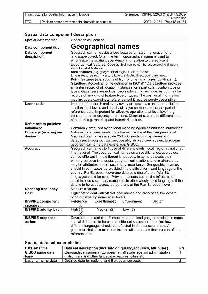
Infrastructure for Spatial Information in Europe Reference: INSPIRE%20ETC%20PP%20v2-3%20en.doc
ETC Position paper environmental thematic user needs 2002-10-03 Page 85 of 154
Spatial data component description Spatial data theme: Geographical location Data component title: Geographical names Data component description:
Geographical names describes features on Earc – a location or a landscape object. Often the term topographical name is used to emphasize the spatial dependency and relation to the adjacent topographical features. Geographical names can be associated to different kind of spatial features: Areal features (e.g. geographical regions, lakes, forests…). Linear features (e.g. rivers, railways, shipping lines, boundary lines…). Point features (e.g. spot heights, monuments, villages, buildings…). Gazetteer: According to the definition in ISO19112 a gazetteer provides a master record of all location instances for a particular location type or types. Gazetteers are not just geographical names’ indexes but may be records of any kind of feature type or types. The positional information may include a coordinate reference, but it may be purely descriptive.
User needs: Important for search and overview by professionals and the public for location at all levels and as a basis layer on maps. Important part of reference data. Important for effective operations, at local level, e.g transport and emergency operations. Different sector use different sets of names, e.g. mapping and transport sectors.
Reference to policies: Initiatives: Commonly produced by national mapping agencies and local authorities. Coverage (existing and desired)
National databases exists, together with some at the European level. Geographical names at scale 250.000 exists on map series and databases throughout Europe, possibly also at lower scales. European geographical name data exists, e.g. GISCO.
Accuracy Geographical names to fit use at different levels, local, regional, national, international. The geographical names on a specific landscape object can be different in the different languages. In some datasets their primary purpose is to depict geographical locations and in others they may be attributes, and of secondary importance. Geographical names should in both cases be provided in the official form and language of the country. For European coverage data sets one of the official EU languages could be used. Providers of data sets to the infrastructure could include secondary name sets in other widely used languages if the data is to be used across borders and at the Pan-European level.
Updating frequency Medium frequent. Cost: High cost to deal with official local names and processes, low cost to
bring out existing name at all levels. INSPIRE component category :
Reference Core thematic Environment Sector X
INSPIRE priority level: High (1) Medium (2) Low (3) X
INSPIRE proposed action:
Develop and maintain a European harmonised geographical place name spatial database, to be used at different scales and to define how different languages should be reflected in databases and use. A gazetteer shall as a minimum include all the names that are part of the reference data.
Spatial data set example list Data sets title Data set description (incl. info on quality, accuracy, attributes) PriGISCO name data base
Geographical names at European small scale level on administrative units, rivers and other landscape features, cities etc
1
National name data Detailed data for national and European purposes 2

Infrastructure for Spatial Information in Europe Reference: INSPIRE%20ETC%20PP%20v2-3%20en.doc
ETC Position paper environmental thematic user needs 2002-10-03 Page 86 of 154
Spatial data component description Spatial data theme: Administrative units Data component title: Official administrative units Data component description:
Each national territory is divided into administrative units. The administrative units are divided by administrative boundaries. Common data
User needs: The administrative division forms an indirect spatial reference system. The reference to an administrative unit provides a spatial dimension to data without using coordinates. Administrative boundaries are the key to horizontal interoperability between the products of national data custodians. Neighbours should agree on international boundaries with shared geometry at the best possible resolution.
Reference to policies: Initiatives: SABE: Seamless Administative Data base Coverage (existing and desired)
Pan-European coverage needed, not only MS.
Accuracy Most data medium accuracy data, 1: 50.000 or better. Generalised versions exist, e.g. GISCO, 1: 1 mill.
Updating frequency Medium frequent. The data have to be updated at certain intervals (once a year) by administrative means.
Cost: Medium cost for production of administrative units at high accuracy. Low cost to produce national (medium) level data
INSPIRE component category :
Reference Core thematic Environment Sector X
INSPIRE priority level: High (1) Medium (2) Low (3) X
INSPIRE proposed action:
Develop Pan-European data at all levels
Spatial data set example list Data sets title Data set description (incl. info on quality, accuracy, attributes) PriNUTS 0-5 Administative units in EU, and other European countries according to
nuts classification 1
Administative units 1 outside EU, according to national classifications

Infrastructure for Spatial Information in Europe Reference: INSPIRE%20ETC%20PP%20v2-3%20en.doc
ETC Position paper environmental thematic user needs 2002-10-03 Page 87 of 154 Spatial data component description Spatial data theme: Administrative units Data component title: Sector management/reporting
areas: Data component description:
These are major sector or thematic management areas being used primarily by the sector itself. A wide range of management areas are relevant both at European, national, regional and local levels. Here only a few examples are given.
User needs: INSPIRE and other institutions intends to estimate noise exposure in policy evaluation. At regional and local level needs for data in environmental assessment, land use planning, location of service facilities, property agents.
Reference to policies: 6EAP. Objective of 6EAP describes that there should be focus on actions at the local level to reduce noise levels. One action mentioned is to produce noise maps.
Initiatives: No know initiatives at European level Coverage (existing and desired)
High-level data are not interesting. Medium to low level data with higher accuracy valuable. High-level analytical data exists??. Else fragmented data.
Accuracy Most data medium accuracy data, 1: 50.000 or better. Updating frequency Medium frequent. The data have to be updated at certain intervals (once
a year) or by administrative means: The generation could be automated as several of the most hazardous substances is reported to governments.
Cost: Medium cost to produce valuable data for local and regional planning and management. Low cost to produce national (medium) level data
INSPIRE component category :
Reference Core thematic Environment Sector X X
INSPIRE priority level: High (1) Medium (2) Low (3) X
INSPIRE proposed action:
Secure the flow of main sector management/ reporting units at the European level.
Spatial data set example list Data sets title Data set description (incl. info on quality,
accuracy, attributes) Anticipated source institution
Pri
INSPIRE River Basin Districts,
Management area for INSPIRE, not strictly being defined of subsets of water catchments, needs to be defined as a separate management area. INSPIRE: art 2, annex I, ii): River basin district means the area of land and sea, made up of one or more neighbouring river basins together with their associated groundwater and coastal waters, which is identified under Article 3(1) as the main unit for management of river basins.
Environmental / hydrological institutions
INSPIRE: nnex I, ii): Geographical coverage of the river basin district- the names of the main rivers within the river basin district together with a precise description of the boundaries of the river basin district
Mandatory reporting from MC
2
OSPAR reporting units at sea
General micro-scale data of management units at sea. Only a few region areas in Pan-Europe
OSPAR 2
Bio-geographic regions
Biogeographical regions Europe is divided into eleven broad biogeographical zones. The data is a polygon data set with the major biogeographical regions. The boundaries should be considered to be ambiguous as they are generalisations that have been fit with political boundaries. Scale 1: 10 mill
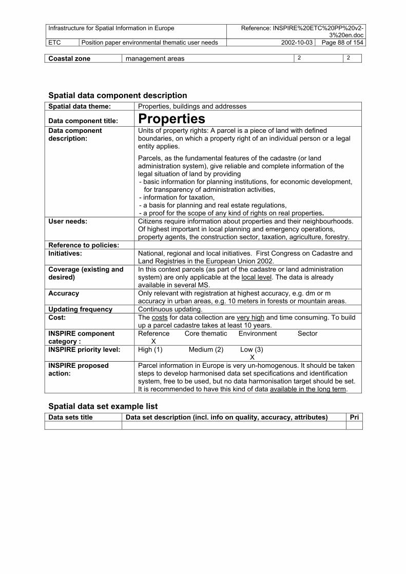
Infrastructure for Spatial Information in Europe Reference: INSPIRE%20ETC%20PP%20v2-3%20en.doc
ETC Position paper environmental thematic user needs 2002-10-03 Page 88 of 154 Coastal zone management areas 2 2
Spatial data component description Spatial data theme: Properties, buildings and addresses Data component title: Properties Data component description:
- a basis for planning and real estate regulations,
Units of property rights: A parcel is a piece of land with defined boundaries, on which a property right of an individual person or a legal entity applies.
Parcels, as the fundamental features of the cadastre (or land administration system), give reliable and complete information of the legal situation of land by providing - basic information for planning institutions, for economic development,
for transparency of administration activities, - information for taxation,
- a proof for the scope of any kind of rights on real properties. User needs: Citizens require information about properties and their neighbourhoods.
Of highest important in local planning and emergency operations, property agents, the construction sector, taxation, agriculture, forestry.
Reference to policies: Initiatives: National, regional and local initiatives. First Congress on Cadastre and
Land Registries in the European Union 2002. Coverage (existing and desired)
In this context parcels (as part of the cadastre or land administration system) are only applicable at the local level. The data is already available in several MS.
Accuracy Only relevant with registration at highest accuracy, e.g. dm or m accuracy in urban areas, e.g. 10 meters in forests or mountain areas.
Updating frequency Continuous updating. Cost: The costs for data collection are very high and time consuming. To build
up a parcel cadastre takes at least 10 years. INSPIRE component category :
Reference Core thematic Environment Sector X
INSPIRE priority level: High (1) Medium (2) Low (3) X
INSPIRE proposed action:
Parcel information in Europe is very un-homogenous. It should be taken steps to develop harmonised data set specifications and identification system, free to be used, but no data harmonisation target should be set. It is recommended to have this kind of data available in the long term.
Spatial data set example list Data sets title Data set description (incl. info on quality, accuracy, attributes) Pri

Infrastructure for Spatial Information in Europe Reference: INSPIRE%20ETC%20PP%20v2-3%20en.doc
ETC Position paper environmental thematic user needs 2002-10-03 Page 89 of 154
Spatial data component description Spatial data theme: Properties, buildings and addresses Data component title: Buildings Data component description:
Database with information on location of buildings, as points or with the actual basic form of the building. Relevant to couple with information on e.g. ownership, size, height. A building is a covered facility, usable for the protection of humans, animals, things or the production of economic goods.
User needs: Important in local planning and management, emergency operations, property agents, construction sector, taxation. In environmental assessment also to locate buildings over noise levels, in follow up of cultural heritage sites etc.
Reference to policies: Initiatives: Coverage (existing and desired)
Local, regional.
Accuracy Only relevant with registration at highest accuracy. Updating frequency Once agreed and established there is a need for a 10 year updating
frequency. Cost: High INSPIRE component category :
Reference Core thematic Environment Sector X
INSPIRE priority level: High (1) Medium (2) Low (3) X
INSPIRE proposed action:
Building information in Europe is very un-homogenous It should be taken steps to develop harmonised data set specifications and identification system, free to be used, but no data harmonisation target should be set. Scale(s)/resolution(s) are different in the MS with respect to the source (cadastre/national mapping). Therefore it is recommended to have this kind of data available in the medium term.
Spatial data set example list Data sets title Data set description (incl. info on quality, accuracy, attributes) Pri

Infrastructure for Spatial Information in Europe Reference: INSPIRE%20ETC%20PP%20v2-3%20en.doc
ETC Position paper environmental thematic user needs 2002-10-03 Page 90 of 154
Spatial data theme: Spatial data component description
Properties, buildings and addresses Data component title: Addresses Data component description:
An address is the local or officially determined designation of the position of buildings and/or parcels, which consists of a defined (unique) georeferenced location. This unique location is generally realised through the postal address (house number, street and city) and is related to coordinates. Geographical location of addresses is commonly located to entrance at ground level, some sophisticated also include level/floor (x,y,z).
User needs: The address is the fundamental navigation instrument to find a location. Used in local management, transport routing system, important in eGovernment, hazards operations/management.
It could be used to connect information of other non geometrical data sets, e.g. owners, land value, taxation. Addresses will be very important for future Location Based Services (LBS) applications.
Many address parallel registers and sources occur. Commonly part of reference data, produced and managed at regional or national levels.
Reference to policies: Initiatives: Route systems etc are containing such information for Europe. Coverage (existing and desired)
Pan-European
Accuracy 1 m accuracy or better. Updating frequency Continuous Cost: High INSPIRE component category :
Reference Core thematic Environment Sector X
INSPIRE priority level: High (1) Medium (2) Low (3) X
INSPIRE proposed action:
It is recommended to have this kind of data available in the medium term.
Spatial data set example list Data sets title Data set description (incl. info on quality, accuracy, attributes) Pri

Infrastructure for Spatial Information in Europe Reference: INSPIRE%20ETC%20PP%20v2-3%20en.doc
ETC Position paper environmental thematic user needs 2002-10-03 Page 91 of 154
Spatial data theme: Spatial data component description
Elevation Data component title: Elevation – land Data component description:
Digital elevation information and digital elevation models for land surface and surface of inland waters. Points, raster versions or simplified or pre-processed data as contours.
User needs: Very important in modelling of land slides and avalanches, flooding vulnerability, risk to erosion, flow of water and pollutants, spread of air pollution, fires, noise, biodiversity. Used in many sectors, amongst others environment, water supply, energy sector, agricultural and forestry.
Reference to policies: INSPIRE, Risks Initiatives: Exist in MS, Different initiatives for developing elevation models at
European level, e.g. by JRC. Coverage (existing and desired)
Pan-European
Accuracy Resolution small scale 100 m pixels, 10 m height accuracy Resolution for large scale better accuracy.
Updating frequency Once agreed and established there is no need for further investment. Cost: Very low cost INSPIRE component category :
Reference Core thematic Environment Sector X
INSPIRE priority level: High (1) Medium (2) Low (3) X
INSPIRE proposed action:
Carry out a process to agree on a system for development and maintenance of stable and harmonised geographical grids, different data sets with different cell size.
Spatial data set example list Data sets title Data set description (incl. info on quality, accuracy, attributes) PriEuropean dem Elevation grid/DEM of low accuracy (ca. 1: 100.000) is needed in Pan-
European analysis
Local dem Elevation grid of high accuracy is needed in local assessments and planning

Infrastructure for Spatial Information in Europe Reference: INSPIRE%20ETC%20PP%20v2-3%20en.doc
ETC Position paper environmental thematic user needs 2002-10-03 Page 92 of 154
Spatial data component description Spatial data theme: Elevation Data component title: Bathymetry – seabed depth Data component description:
Digital depth information for sea areas, also including large inland waters (?). Could be represented in spatial data as digital models or as isolines.
User needs: Hydrographic surveys in the different countries produces the core data: soundings and a gridded bottom model. Simplified or pre-processed versions with contours. Both are of interest to environmental sector users. Modelling of water quality, water flow, spread of pollutants in water, identification of shallow areas of special importance to biodiversity, planning of placement of pipelines at sea, placement of transmission lines at sea, extraction of sand and sediments, safety at sea, avoid environmental hazards from ship accidents/shipwrecks.
Reference to policies: Initiatives: Soundings for mapping or bathymetric screening by the use of
laser/radar Coverage (existing and desired)
Pan-European
Accuracy 1 m accuracy or better. Updating frequency Once agreed and established there is no need for further investment. Cost: Very low cost INSPIRE component category :
Reference Core thematic Environment Sector X
INSPIRE priority level: High (1) Medium (2) Low (3) X
INSPIRE proposed action:
Secure the production of bathymetric/ seabed data, with special focus on shallow waters.
Spatial data set example list Data sets title Data set description (incl. info on quality,
accuracy, attributes) Anticipated source institution
Pri
Seabed mapping –sounding points/data
From about 50 years ago the eco-sounders (first single-beam/later multi-beam) was introduced and data from these technologies are now replacing older data. Old sources for soundings consists of lead-line soundings still exists for large areas. Sea surveying by the use of acoustic methods is very time-consuming- especially in shallow waters. New technology with air born lasers have proven to be very efficient for mapping of shallow waters.
National mapping agencies/ Hydrographic surveys
1
Bathymetric/ depth data model – low resolution
Important element in the production of sea charts, and used as an input to digital decision support systems that contribute to enhanced safety at sea. Deep bathymetry should be available for all coasts and seas.
GISCO 1
Bathymetric/ dept data model – high resolution
For shallow areas, e.g. down to 30 meters, focus on coastal areas. Detailed information for coastal areas is important for assessment and management of coastal erosion, sea level rise, coastal biotopes, risk linked with marine transport.
National mapping agencies/ Hydrographic surveys
1
Simplified isolines Based on bathymetric models there can be generated iso-lines at certain depth intervals. The information is easy to use as background to presentations (screen/paper) and for data modelling
GISCO 1

Infrastructure for Spatial Information in Europe Reference: INSPIRE%20ETC%20PP%20v2-3%20en.doc
ETC Position paper environmental thematic user needs 2002-10-03 Page 93 of 154
Spatial data theme:
Spatial data component description Elevation
Data component title: Coastline Data component description:
Location of an agreed coastline. Important element to be treated separately in connection with height and bathymetry, is also important for the definition of land, and of boundaries of administrative units. Different methods for definition and observation of coastline.
User needs: Harmonised data needed at all levels. Different definitions of coastline, depending if focus is on sea or land. Geometry of coastline differs. The existence and use of many different coastlines as reference in counties is causing inefficiency and analytical and practical problems. Harmonisation of definitions is needed. Important as reference in production of many features on land and sea, when integrated with all kinds of data presentations/maps, physical and socio-economic regionalisation, harmonisation between sectors, products. Detailed coastline data important in assessing climate change.
Reference to policies: 6EAP, climate change, erosion, Initiatives: SABE Coverage (existing and desired)
Pan-European
Accuracy 1 m accuracy or better. Updating frequency Once agreed and established there is a need for a 10 year updating
frequency. Cost: Medium cost to produce accurate data, low cost to produce generalised
data. INSPIRE component category :
Reference Core thematic Environment Sector X
INSPIRE priority level: X High (1) Medium (2) Low (3)
INSPIRE proposed action:
Agree upon common coastline definitions and common data for land and sea applications, different agreed accuracies and generalisation for different scales. A common reference coastline should be available in different scales/accuracies.
Spatial data set example list Data set description (incl. info on quality, accuracy, attributes) Data sets title Pri
Coastline small-scale SABE, 1: 1 million. 1 Coastline – large-scale
1
……..

Infrastructure for Spatial Information in Europe Reference: INSPIRE%20ETC%20PP%20v2-3%20en.doc
ETC Position paper environmental thematic user needs 2002-10-03 Page 94 of 154
Spatial data component description Spatial data theme: Geo-physical environment Data component title: Bedrock geology Data component description:
Classification of bedrock geology according to composition and structure of bedrock. A variety of classification systems. EuroGeoSurveys coordinates harmonisation processes
User needs: General data used to understand regional environmental diversity, to study geo-chemical content and effects on natural environment and health, to estimate buffer capacities in soil, to locate groundwater aquifers in bedrock.
Reference to policies: Initiatives: EuroGeoSurveys Coverage (existing and desired)
Pan-European
Accuracy 10-50 m accuracy Updating frequency Once established there is no need for further updating. Cost: High cost to develop detailed dsata INSPIRE component category :
Reference Core thematic Environment Sector X
INSPIRE priority level: High (1) Medium (2) Low (3) X
INSPIRE proposed action:
Spatial data set example list Data sets title Data set description (incl. info on quality, accuracy, attributes) PriBedrock types – small-scale
2
Bedrock types – large-scale
3
Structural elements 3 large-scale

Infrastructure for Spatial Information in Europe Reference: INSPIRE%20ETC%20PP%20v2-3%20en.doc
ETC Position paper environmental thematic user needs 2002-10-03 Page 95 of 154
Spatial data component description Spatial data theme: Geo-physical environment Data component title: Soil Data component description:
Categorisation of soils and subsoil according to depth, texture, structure and content of particles and organic material, stoniness, sometimes mean slope and anticipated water storage capacity. FAO nomenclature is widely used, with 350 soil classes. Other relevant attributes: mean slope angle, description of soil class, including parent material, soil texture, depth, stoniness.
User needs: Important in assessment and mangement of soil as a resource for agriculture and forestry, including also special effects such as erosion, salinisation, desertification. Aslo used in location of areas for gravel and peat extraction, groundwater resources, as a habitat.
Reference to policies: 6EAP. Soil protection strategy, desertification, erosion Initiatives: Existing dataset in small scale. Large scale data common in agricultural
land. Coverage (existing and desired)
Pan-European
Accuracy 10-50 m accuracy. Updating frequency Low updating frequency Cost: High cost INSPIRE component category :
Reference Core thematic Environment Sector X
INSPIRE priority level: High (1) Medium (2) Low (3) X
INSPIRE proposed action:
Develop harmonised data for Europe, starting with 1: 1mill, then 1: 250.000. Also cover local level needs at implementation level
Spatial data set example list Data sets title Data set description (incl. info on quality, accuracy, attributes) PriSoil : small scale INSPIRE soils, later developed by JRC to soil type database for
Europe: A digital map, 1: 1 mill, European coverage. 1
Soils- agricultural areas
Local soil maps covering agricultural areas

Infrastructure for Spatial Information in Europe Reference: INSPIRE%20ETC%20PP%20v2-3%20en.doc
ETC Position paper environmental thematic user needs 2002-10-03 Page 96 of 154
Spatial data component description Spatial data theme: Hydrography Data component title: Hydrography – river, lake… Data component description:
Representation of all main hydrographic elements, both natural and artificial: Rivers, lakes, transitional waters, reservoirs, channels.
User needs: Is one of the basic components for cartographic presentation and used by nearly all GIS users at all levels. Is being used in environmental assessment and monitoring in estimation of water resources, pollution monitoring, wastewater cleaning estimation, biodiversity assessment, the hydrological elements being habitats. Inland fisheries management. Hazardous waste disposal sites. Land use planning/ land management, recreation planning and management, transport routes. Assessment of flow patters of particles and pollutants must be based on high quality hydrographic networks.
Reference to policies: 6EAP. INSPIRE, Transport policies assessment, ….. Initiatives: Micro and small-scale data with Pan-European coverage exists, 1: 1 mill
and smaller (GISCO). Eurogeographics is developing 1: 250.000 data, but data is still not available/ready.
Coverage (existing and desired)
Pan-European, seamless data at smaller and medium scales. High accuracy data coverage at local level, at least for populated areas and economically active areas and protected sites.
Accuracy Should exist as data sets at different scales for different use. Data needs at European level 1: 250.000. INSPIRE directs water management plans, needs for more detailed versions, probably 1: 50.000. Land use planning/ coastal/ urban planning needs 1: 50.000 or better.
Updating frequency Medium frequent. The data have to be updated at certain intervals (once a year) or by administrative means: The generation could be automated as several of the most hazardous substances is reported to governments.
Cost: Low cost to produce national (medium) level data Medium´to high cost to produce valuable data for local/ regional planning and management. Network data at local level more costly.
INSPIRE component category :
Reference Core thematic Environment Sector X
INSPIRE priority level: High (1) Medium (2) Low (3) X
INSPIRE proposed action:
Develop data with simple topology at all scales, network data at regional, national and international levels.
Spatial data set example list Data sets title Data set description (incl. info on quality, accuracy, attributes) PriHydrography – Pan-European
Main hydrographic elements, both natural and artificial: Rivers, lakes, transitional waters, reservoirs, channels. Should it also include glaciers?
1
Hydrography – accurate
All main hydrographic elements, both natural and artificial: Rivers, lakes, transitional waters, reservoirs, channels. Should it also include glaciers and bogs/ mires. In areas where bogs are frequent, in the northern countries, bogs are often included as hydrographic features on map data. Springs?
1
Hydrographic network
Rivers, lakes and other hydrographic features are connected into a network, making flow analysis possible. Data are with higher level of topology, network topology.
2

Infrastructure for Spatial Information in Europe Reference: INSPIRE%20ETC%20PP%20v2-3%20en.doc
ETC Position paper environmental thematic user needs 2002-10-03 Page 97 of 154
Spatial data component description Spatial data theme: Hydrography Data component title: Water catchments Data component description:
Synonymous with river basins. As defined in INSPIRE: art 2, annex I, ii): River basin means the area of land from which all surface run-off flows through a sequence of streams, rivers and, possibly, lakes into the sea at a single river mouth, estuary or delta. Sub-basin means the area of land from which all surface run-off flows through a series of streams, rivers and, possibly, lakes to a particular point in a water course (normally a lake or a river confluence)
User needs: Catchments are used to create INSPIRE River Basin Management Districts, but does not have full correspondence in boundaries.
Management of risk and actual pollution in water for consumption.
Water catchment data is used in flood hazard estimation and management.
Flood management. Erosion estimation and management at local level.
Reference to policies: 6EAP. INSPIRE (INSPIRE: art 2, annex I, ii), Natural hazards, Erosion. Initiatives: Existing harmonised data at 1: 1 mill and lower, and harmonised
production at JRC on 1: 250.000 is still on-going. Data within countries at more detailed levels.
Coverage (existing and desired)
Pan-European for both small-scale and large scale data.
Accuracy Micro and small-scale data with Pan-European coverage exists, 1: 1 mill and smaller (GISCO). JRC is developing 1: 250.000 data, but data is still not available/ready. Even higher accuracies is needed; e.g. 1: 50.000 accuracy. In order to create boundaries in the flat areas high resolution data is needed, based on high resolution DEM.
Updating frequency Low frequency. Once produced the data will be relatively stable. Cost: Low cost to produce national (medium) level data
Medium cost to produce valuable data for local/ regional planning and management.
INSPIRE component category :
Reference Core thematic Environment Sector X
INSPIRE priority level: High (1) Medium (2) Low (3) X
INSPIRE proposed action:
Develop harmonised Pan-European small scale data and regional level data within each country for water catchments and sub-catchments.
Spatial data set example list Data sets title Data set description (incl. info on quality, accuracy, attributes) PriWater catchments- Pan European
Resolution with main river basins, water catchments and sub-catchments, division as needed in the scale 1: 250.000 or higher. Important attribute: ID
1
Water catchments – detailed
Mapping at scale 1: 150.000 or higher. Height accuracy important Important attribute: ID
2
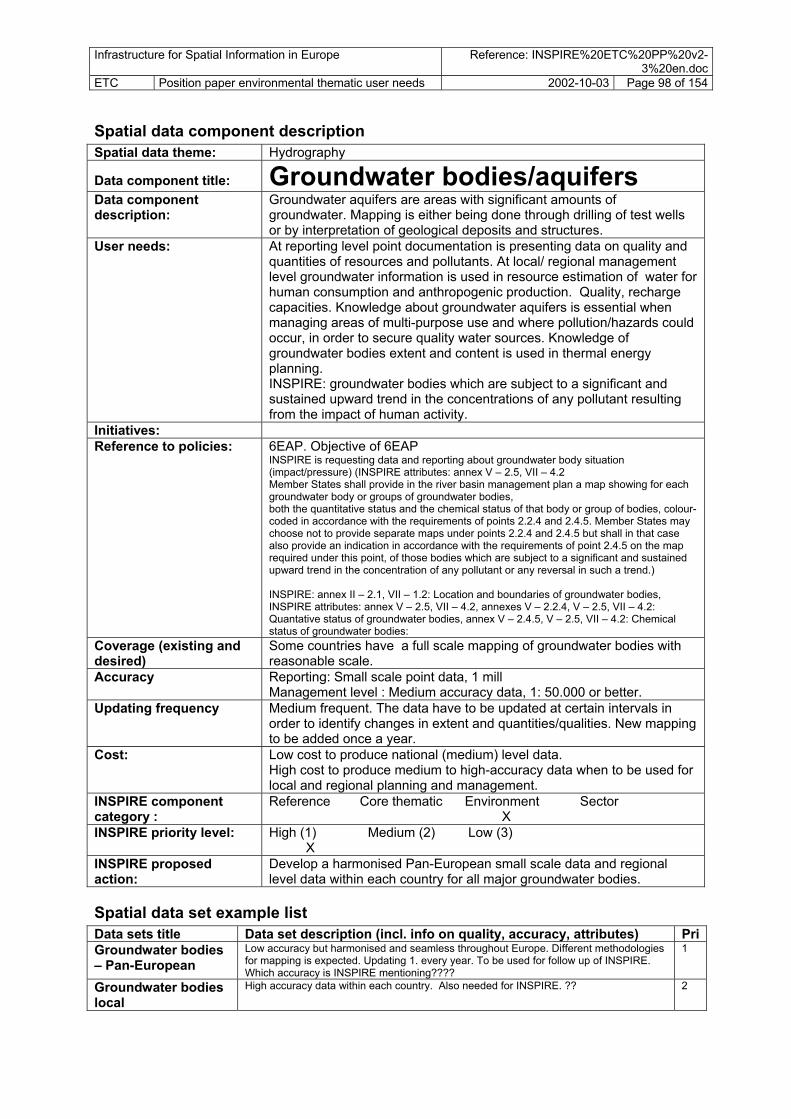
Infrastructure for Spatial Information in Europe Reference: INSPIRE%20ETC%20PP%20v2-3%20en.doc
ETC Position paper environmental thematic user needs 2002-10-03 Page 98 of 154
Spatial data component description Hydrography Spatial data theme:
Groundwater bodies/aquifers Data component title: Data component description:
Groundwater aquifers are areas with significant amounts of groundwater. Mapping is either being done through drilling of test wells or by interpretation of geological deposits and structures.
User needs: At reporting level point documentation is presenting data on quality and quantities of resources and pollutants. At local/ regional management level groundwater information is used in resource estimation of water for human consumption and anthropogenic production. Quality, recharge capacities. Knowledge about groundwater aquifers is essential when managing areas of multi-purpose use and where pollution/hazards could occur, in order to secure quality water sources. Knowledge of groundwater bodies extent and content is used in thermal energy planning. INSPIRE: groundwater bodies which are subject to a significant and sustained upward trend in the concentrations of any pollutant resulting from the impact of human activity.
Initiatives: Reference to policies: 6EAP. Objective of 6EAP
INSPIRE is requesting data and reporting about groundwater body situation (impact/pressure) (INSPIRE attributes: annex V – 2.5, VII – 4.2 Member States shall provide in the river basin management plan a map showing for each groundwater body or groups of groundwater bodies, both the quantitative status and the chemical status of that body or group of bodies, colour-coded in accordance with the requirements of points 2.2.4 and 2.4.5. Member States may choose not to provide separate maps under points 2.2.4 and 2.4.5 but shall in that case also provide an indication in accordance with the requirements of point 2.4.5 on the map required under this point, of those bodies which are subject to a significant and sustained upward trend in the concentration of any pollutant or any reversal in such a trend.) INSPIRE: annex II – 2.1, VII – 1.2: Location and boundaries of groundwater bodies, INSPIRE attributes: annex V – 2.5, VII – 4.2, annexes V – 2.2.4, V – 2.5, VII – 4.2: Quantative status of groundwater bodies, annex V – 2.4.5, V – 2.5, VII – 4.2: Chemical status of groundwater bodies:
Coverage (existing and desired)
Some countries have a full scale mapping of groundwater bodies with reasonable scale.
Accuracy Reporting: Small scale point data, 1 mill Management level : Medium accuracy data, 1: 50.000 or better.
Updating frequency Medium frequent. The data have to be updated at certain intervals in order to identify changes in extent and quantities/qualities. New mapping to be added once a year.
Cost: Low cost to produce national (medium) level data. High cost to produce medium to high-accuracy data when to be used for local and regional planning and management.
INSPIRE component category :
Reference Core thematic Environment Sector X
INSPIRE priority level: X High (1) Medium (2) Low (3)
INSPIRE proposed action:
Develop a harmonised Pan-European small scale data and regional level data within each country for all major groundwater bodies.
Spatial data set example list Data sets title Data set description (incl. info on quality, accuracy, attributes) PriGroundwater bodies – Pan-European
Low accuracy but harmonised and seamless throughout Europe. Different methodologies for mapping is expected. Updating 1. every year. To be used for follow up of INSPIRE. Which accuracy is INSPIRE mentioning????
1
Groundwater bodies local
High accuracy data within each country. Also needed for INSPIRE. ?? 2
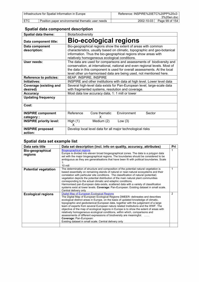
Infrastructure for Spatial Information in Europe Reference: INSPIRE%20ETC%20PP%20v2-3%20en.doc
ETC Position paper environmental thematic user needs 2002-10-03 Page 99 of 154
Spatial data theme: Spatial data component description
Biota/biodiversity Data component title: Bio-ecological regions Data component description:
Bio-geographical regions show the extent of areas with common characteristics, usually based on climatic, topographic and geo-botanical information. Thus the bio-geographical regions show areas with relatively homogeneous ecological conditions.
User needs: The data are used for comparisons and assessments of biodiversity and conservation, at international, national and even regional levels. Most of the data in this component is used for overall assessments. At the local level other un-harmonised data are being used, not mentioned here.
Reference to policies: 6EAP. INSPIRE, INSPIRE Initiatives: INSPIRE and other institutions with data at high level. Lower level data Coverage (existing and desired)
Several high-level data exists for Pan-European level, large-scale data with fragmented systems, resolution and coverage.
Accuracy Most data low accuracy data, 1: 1 mill or lower Updating frequency
Cost:
INSPIRE component category :
Reference Core thematic Environment Sector X
INSPIRE priority level: High (1) Medium (2) Low (3) X
INSPIRE proposed action:
Develop local level data for all major technological risks
Spatial data set example list PriData sets title Data set description (incl. info on quality, accuracy, attributes)
Bio-geographical regions
Biogeographical regions Europe is divided into eleven broad biogeographical zones. The data is a polygon data set with the major biogeographical regions. The boundaries should be considered to be ambiguous as they are generalisations that have been fit with political boundaries. Scale 1: 10 mill
1
Potential vegetation The determination of structure and composition of the potential natural vegetation is based essentially on remaining stands of natural or near-natural ecosystems and their correlation with particular site conditions. The classification of natural (potential) vegetation depicts the potential distribution of the main natural plant communities corresponding to the actual climatic and edaphic conditions. Harmonised pan-European data exists, scattered data with a variety of classification systems exist at lower levels. Coverage: Pan-European: Existing dataset in small scale. Central delivery only
1
Ecological regions Digital Map of European Ecological Regions The Digital Map of European Ecological Regions DMEER- delineates and describes ecological distinct areas in Europe, on the basis of updated knowledge of climatic, topographic and geobotanical European data, together with the judgement of a large team of experts from several European nature related Institutions and the WWF. The objective of the map of ecological regions in Europe is to show the extent of areas with relatively homogeneous ecological conditions, within which, comparisons and assessments of different expressions of biodiversity are meaningful. …… Coverage: Pan-European: Existing dataset in small scale. Central delivery only
2

Infrastructure for Spatial Information in Europe Reference: INSPIRE%20ETC%20PP%20v2-3%20en.doc
ETC Position paper environmental thematic user needs 2002-10-03 Page 100 of 154
Spatial data component description Spatial data theme: Biota/biodiversity Data component title: Vegetation Data component description:
The determination of structure and composition of the vegetation is based essentially on stands of ecosystems and their correlation with particular site conditions. Vegetation can be mapped both as existing vegetation and potential vegetation. The classification of potential vegetation depicts the potential distribution of the main natural plant communities. The mapping is based essentially on remaining stands of natural or near-natural ecosystems corresponding to the actual climatic and edaphic conditions.
User needs: Used in assessment at regional/ local level, on natural production suitability, ecology, changes.
Reference to policies: Initiatives: Harmonisation processes in nomenclature, see potential vegetation
under bio-ecological regions. Practical harmonisation, no known harmonisation except for land cover initiatives.
Coverage (existing and desired)
Local coverage, pachy
Accuracy At local level medium accuracy data, 1: 50.000 or better. Common scales used are 1:25.000 and 1: 10.000.
Updating frequency Once produced, the potential vegetation maps are stable and regarded as reference data/maps. Mapping of existing vegetation at local level needs to be updated to depict changes in vegetation. Anticipated need –every 10 years.
Cost: High cost to produce valuable data for local and regional planning and management.
INSPIRE component category :
Reference Core thematic Environment Sector X
INSPIRE priority level: High (1) Medium (2) Low (3) X
INSPIRE proposed action:
No action
Spatial data set example list Data sets title PriData set description (incl. info on quality, accuracy, attributes) Actual vegetation Local data 3

Infrastructure for Spatial Information in Europe Reference: INSPIRE%20ETC%20PP%20v2-3%20en.doc
ETC Position paper environmental thematic user needs 2002-10-03 Page 101 of 154
Spatial data theme: Spatial data component description
Biota/biodiversity Data component title: Habitats and biotopes Data component description:
Habitats and biotopes and their boundaries. Description of living areas for any kind of biota, usually used as a term for describing areas used by zoo-biota. Habitats commonly follow bio-geographical regions/ vegetation types, but habitats can also be described at more detailed levels. Includes small features of the rural landscale – hedgerows, creeks etc.
In rough terms land cover classes and vegetation classes represent terrestrial habitats. Shallow areas, and differences in sediments may inicate different habitats at sea.
A selection of valuable habitats have been designated according to the Habitats and Birds Directtives. (See “Protected areas”)
User needs:
Assessment of changes in landscape and effects of wildlife and plant life. Linked to Habitats directive. The habitats designated to the directive are mentioned in the “area regulation” data component.
Reference to policies:
6EAP, CAP
Initiatives:
NATURA2000, The RAMSAR database, CORINE biotopes and others
Coverage (existing and desired)
European wide, also local
Accuracy
Low, e.g. 1: 50.000
Updating frequency
Low. Monitoring of the coverage every 5 year. Monitoring of the species in the habitats according to specific programmes.
Cost:
High
INSPIRE component category :
Reference Core thematic Environment Sector X
INSPIRE priority level: X High (1) Medium (2) Low (3)
INSPIRE proposed action:
Spatial data set example list Data sets title Data set description (incl. info on quality, accuracy, attributes) PriBiotope sites Areas of ecological/ biodiversity interest areas, recorded under the
INSPIRE programme. Sites of special ecological interest in Nature conservation recorded whether protected or not. Attributes: site surface statistics, habitat data, mammals, birds, amphibians, fish, invertebrate, plant, Site designation status Coverage: EU Countries and Phare Countries, Finish date collection 1995. Updates?

Infrastructure for Spatial Information in Europe Reference: INSPIRE%20ETC%20PP%20v2-3%20en.doc
ETC Position paper environmental thematic user needs 2002-10-03 Page 102 of 154
Spatial data component description Spatial data theme: Biota/ biodiversity Data component title: Species distribution Data component description:
User needs: Aim to provide distribution maps for European vascular plants, birds, mammals, amphibians and reptiles and other species. Digital data sets scan be used for conservation and statistical analysis, as the base of research in ecology and biodiversity, applied to the conservation and management of nature. Times series used to
Reference to policies: Initiatives: Coverage (existing and desired)
Accuracy Updating frequency Cost: INSPIRE component category :
Reference Core thematic Environment Sector X
INSPIRE priority level: High (1) Medium (2) Low (3) X
INSPIRE proposed action:
Facilitate a full coverage of up to date species distribution data at a Pan-European scale, for a major set of mammals, birds, mammals and reptiles, vascular plants, together with similar data for a selection of other organisms important as indicators on environmental quality of air, inland waters, sea, soil, habitats.
Spatial data set example list Data sets title Data set description (incl. info on quality, accuracy, attributes) PriBird species distribution data
Distribution of species by grid. Data sets on 440 different breeding birds in Europe have been compiled. Each breeding bird is classified according to its breeding status within 50 km grid squares. European Ornithological Atlas Committee. Mapping the breeding distribution of those European species, obtained through field work. Attribute information: presence and absence of each species, possible/probable/conformed/breeding, estimate of number of pairs in square, census period, square identity, survey completeness, altitude, observers, comments. Coverage: Pan-European
2
Plant species distribution data
A data set containing information upon the presence of plant species in grid squares across Europe. Attribute: species found in each 50 km square, native occurrence, introduction, status unknown, probably extinct, record uncertain Coverage: Pan-European. It has taken 25 years to map 20 % of European Vascular plants By 1999 there were plans of how to speed up the process.
2
Amphibian and reptile species distribution
Species distribution in 50 km grid squares. Attributes: coded latin name, date of sightings, regular presence of siting, the presence of the species, Coverage: Pan-European. Complete for western Europe, incomplete for Eastern Europe (??)
2
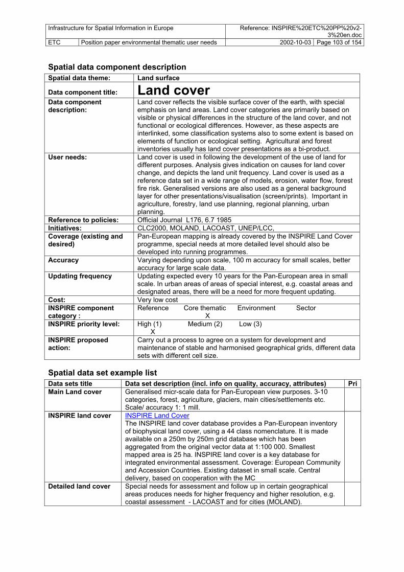
Infrastructure for Spatial Information in Europe Reference: INSPIRE%20ETC%20PP%20v2-3%20en.doc
ETC Position paper environmental thematic user needs 2002-10-03 Page 103 of 154
Spatial data component description Spatial data theme: Land surface Data component title: Land cover Data component description:
Land cover reflects the visible surface cover of the earth, with special emphasis on land areas. Land cover categories are primarily based on visible or physical differences in the structure of the land cover, and not functional or ecological differences. However, as these aspects are interlinked, some classification systems also to some extent is based on elements of function or ecological setting. Agricultural and forest inventories usually has land cover presentations as a bi-product.
User needs: Land cover is used in following the development of the use of land for different purposes. Analysis gives indication on causes for land cover change, and depicts the land unit frequency. Land cover is used as a reference data set in a wide range of models, erosion, water flow, forest fire risk. Generalised versions are also used as a general background layer for other presentations/visualisation (screen/prints). Important in agriculture, forestry, land use planning, regional planning, urban planning.
Reference to policies: Official Journal L176, 6.7 1985 Initiatives: CLC2000, MOLAND, LACOAST, UNEP/LCC, Coverage (existing and desired)
Pan-European mapping is already covered by the INSPIRE Land Cover programme, special needs at more detailed level should also be developed into running programmes.
Accuracy Varying depending upon scale, 100 m accuracy for small scales, better accuracy for large scale data.
Updating frequency Updating expected every 10 years for the Pan-European area in small scale. In urban areas of areas of special interest, e.g. coastal areas and designated areas, there will be a need for more frequent updating.
Cost: Very low cost INSPIRE component category :
Reference Core thematic Environment Sector X
INSPIRE priority level: High (1) Medium (2) Low (3) X
INSPIRE proposed action:
Carry out a process to agree on a system for development and maintenance of stable and harmonised geographical grids, different data sets with different cell size.
Spatial data set example list Data sets title Data set description (incl. info on quality, accuracy, attributes) PriMain Land cover Generalised micr-scale data for Pan-European view purposes. 3-10
categories, forest, agriculture, glaciers, main cities/settlements etc. Scale/ accuracy 1: 1 mill.
INSPIRE land cover INSPIRE Land Cover The INSPIRE land cover database provides a Pan-European inventory of biophysical land cover, using a 44 class nomenclature. It is made available on a 250m by 250m grid database which has been aggregated from the original vector data at 1:100 000. Smallest mapped area is 25 ha. INSPIRE land cover is a key database for integrated environmental assessment. Coverage: European Community and Accession Countries. Existing dataset in small scale. Central delivery, based on cooperation with the MC
Detailed land cover Special needs for assessment and follow up in certain geographical areas produces needs for higher frequency and higher resolution, e.g. coastal assessment - LACOAST and for cities (MOLAND).

Infrastructure for Spatial Information in Europe Reference: INSPIRE%20ETC%20PP%20v2-3%20en.doc
ETC Position paper environmental thematic user needs 2002-10-03 Page 104 of 154
Spatial data component description Spatial data theme: Land surface Data component title: Ortho-images Data component description: Pre-processed “picture” data. Ortho-imagery
is airborne or spaceborne image data of the surface of the earth is rectified to fit to a defined coordinate reference and cartographic
projection system at a defined accuracy should be presented in digital format at a defined pixel resolution
should allow for multi-temporal analysis, implying the supply of images with different acquisition dates
should be acquired by optical sensors with different spectral characteristics, i.e. panchromatic, true-colour, infrared
can be used to extract reference data components
User needs: Small-scale data for Pan-European overview and analysis. Large-scale
data for local and regional needs. Commonly used in environmental and land use management, environmental impact assessment, forestry, agriculture. Important as a background layer. The pictures have proven to be very effective in getting citizens to locate areas and understand more technical presentations. Ortho-imagery is playing an important role in change detection and updating for reference and thematic data.
Reference to policies: 6EAP Initiatives:
Different data exists for Pan-Europe, e.g. Landsat, SPOT. The remote sensing requirements on resolution, accuracy, and spectral characteristics – specifically for environmental monitoring users – are currently tackled specifically by the GMES initiative. This activity might contribute for example to the differentiation between common reference layer, common thematic layer or thematic layer. There is in all the Member States a strong operational use of digital aerial photography and intense activities in the production of orthophotographs.
Coverage (existing and desired)
Pan-European for low resolution data, urban areas and other areas of interest for detailed data
Accuracy
Remote sensing imagery is available at different resolutions: with low and medium resolution to be used in applications at regional, national and European level and very high resolution being generally more adapted for local use. Remote sensing imagery is available with different spectral bands (including e.g. infrared), each of which may have its importance for specific environmental application fields.
Updating frequency
Depend on location, generally more frequent in urban areas and areas where major land use changes occur than in remote areas.
Cost: Medium to high INSPIRE component category :
Reference Core thematic Environment Sector X
INSPIRE priority level: High (1) Medium (2) Low (3) X
INSPIRE proposed action:
Supply of existing data. Link with GMES, present user needs.
Spatial data set example list Data sets title Data set description (incl. info on quality, accuracy, attributes) PriImage 2000 The use is refrained due to high costs. Image2000 will constitute the
first European wide free access ortho-image database. 1

Infrastructure for Spatial Information in Europe Reference: INSPIRE%20ETC%20PP%20v2-3%20en.doc
ETC Position paper environmental thematic user needs 2002-10-03 Page 105 of 154
Spatial data component description Natural resources Spatial data theme:
Data component title: Water resources Data component description:
Features presenting the water resources for consumption, processes, energy or other uses. Usually linked to water features already documented in the data component “hydrography” and “groundwater bodies”
User needs: Information about resources should be linked to the hydrography data by id’s. Used in water and energy supply management, risk and hazards management, agriculture sustainability assessments.
Reference to policies: Water Framework Directive Initiatives: Issue addressed by EuroWaternet Coverage (existing and desired)
European, National and regional levels. Uneven distribution. Transfers of water between basins. Local level in specific areas.
Accuracy At the level of the river basin districts and catchments of average size circa 10 000km². Special focus for coastal zones (risks of saltwater intrusion when overuse).
Updating frequency Cost: INSPIRE component category : X X
Reference Core thematic Environment Sector
INSPIRE priority level: High (1) Medium (2) Low (3) X
INSPIRE proposed action:
Supply reference and core thematic data to the water agencies.
Spatial data set example list Data sets title Data set description (incl. info on quality,
accuracy, attributes) Anticipated source institution
Pri

Infrastructure for Spatial Information in Europe Reference: INSPIRE%20ETC%20PP%20v2-3%20en.doc
ETC Position paper environmental thematic user needs 2002-10-03 Page 106 of 154
Spatial data component description Spatial data theme: Natural resources Data component title: Agricultural resources (soil/land) Data component description:
Agricultural inventories, with mapping of existing and potential land for cultivation. Description of quality, production potential, suitable farming systems and crops, limiting factors under natural conditions. Land use by agriculture Includes categories such as irrigated areas and organic farming areas.
User needs: Usually agricultural inventories are coordinated by national agricultural bodies. Important statistics should be available. Used in agriculture, in assessment of pressures – impact and responses to erosion, salinisation, desertification.
Reference to policies: CAP, Strategy for Soil protection (COM(2002) 179 final) Initiatives: Eurostat : Agriculture statistics, LUCAS, JRC : MARS, Soil map Coverage (existing and desired)
National and European statistics on crops. Impacts of agriculture on soil surveyed by research programmes at the local level. Modelling of the impacts on erosion, carbon sequestration, content in organic matter.
Accuracy Geo-referencing of monitoring sites. Modelling at 1:100 000. Statistics at the regional level
Updating frequency Cost: INSPIRE component category :
Reference Core thematic Environment Sector X
INSPIRE priority level: High (1) Medium (2) Low (3) X
INSPIRE proposed action:
Supply reference and core thematic data to the users and the collectors of data
Spatial data set example list Data sets title Data set description (incl. info on quality,
accuracy, attributes) Anticipated source institution
Pri

Infrastructure for Spatial Information in Europe Reference: INSPIRE%20ETC%20PP%20v2-3%20en.doc
ETC Position paper environmental thematic user needs 2002-10-03 Page 107 of 154
Spatial data component description Spatial data theme: Natural resources Data component title: Forestry resources Data component description:
Mapping of forest resources, areas potential production at detailed levels also forest stand quality. Information on sustainable exploitation levels. Forest resources is usually mapped at regional and local levels, coordinated by national inventory mapping bodies.
User needs: Used for management for sustainable exploitation of forest, planning for multi-purpose use of forest areas. Environmental assessment of erosion, biodiversity, water flow.
Reference to policies: Initiatives: Monitoring of the health of forests; national monitoring systems of health,
inventories of the timber resource. Forest map at the JRC. Coverage (existing and desired)
European, national and regional maps.
Accuracy Geo-referencing of monitoring sites and plots. Maps from 1:25 000 (national surveys) to 1:100 000
Updating frequency Cost: INSPIRE component category :
Reference Core thematic Environment Sector X
INSPIRE priority level: High (1) Medium (2) Low (3) X
INSPIRE proposed action:
Supply reference and core thematic data to the users and the collectors of data
Spatial data set example list Data sets title Data set description (incl. info on quality,
accuracy, attributes) Anticipated source institution
Pri

Infrastructure for Spatial Information in Europe Reference: INSPIRE%20ETC%20PP%20v2-3%20en.doc
ETC Position paper environmental thematic user needs 2002-10-03 Page 108 of 154
Spatial data component description Spatial data theme: Natural resources Data component title: Fishery resources and use Data component description:
Localisation of the most important breeding, living and migration areas for economically important fish species, prawns and other economically important marine organisms. Data sets for each species, with information on time during year, also categorisation of when the risk towards selected risks/ pollution will be most destructive. Does not include constructions/production facilities, treated elsewhere.
User needs: Monitoring of the depletion of the fish stocks. Reference to policies: Initiatives: Coverage (existing and desired)
Pan-European
Accuracy 1 m accuracy or better. Updating frequency Once agreed and established there is no need for further investment. Cost: Very low cost INSPIRE component category :
Reference Core thematic Environment Sector X
INSPIRE priority level: High (1) Medium (2) Low (3) X
INSPIRE proposed action:
Carry out a process to agree on a system for development and maintenance of stable and harmonised geographical grids, different data sets with different cell size.
Spatial data set example list Data sets title Data set description (incl. info on quality,
accuracy, attributes) Anticipated source institution
Pri
Suitability of coastal marine areas to fish breeding
2
Sea weed extraction areas; information about economically interesting sea weed areas.
3

Infrastructure for Spatial Information in Europe Reference: INSPIRE%20ETC%20PP%20v2-3%20en.doc
ETC Position paper environmental thematic user needs 2002-10-03 Page 109 of 154
Spatial data component description Spatial data theme: Natural resources Data component title: Geological resources Data component description:
Geological resources, such as minerals, stone resources and deposits (sands/gravel), including hydrocarbons (oil, gas).
User needs: European level mapping of geological resources. Local level resource estimates. Important for assessment material flows, exploitation of definite resources, climate change, biodiversity.
Reference to policies: Initiatives: Coordination of the national geological surveys in EuroGeosurvey Coverage (existing and desired)
Pan-European
Accuracy European level: 1:500 000. National level: 1:50 000 Updating frequency 10 years Cost: INSPIRE component category :
Reference Core thematic Environment Sector X
INSPIRE priority level: High (1) Medium (2) Low (3) X
INSPIRE proposed action:
Develop maps/data
Spatial data set example list Data sets title Data set description (incl. info on quality,
accuracy, attributes) source institution
Anticipated Pri

Infrastructure for Spatial Information in Europe Reference: INSPIRE%20ETC%20PP%20v2-3%20en.doc
ETC Position paper environmental thematic user needs 2002-10-03 Page 110 of 154
Spatial data component description Spatial data theme: Natural resources Data component title: Renewable energy resources Data component description:
Energy resources excluding hydrocarbons: hydropower, bioenergy, solar, wind etc. For some data relevant with depth/height information on the extent of the resource, e.g wind.
User needs: Of major importance to the sectors. In environmental assessments and planning used to view trends in extent and effect on other land cover or natural values, effect on sustainability or over-exploitation on resource use. Many of the renewable energy sources are interesting for local exploitation and use, reducing the need for transfer/ transport of energy and this the side-effects of transport. Information of local energy sources are and can be actively used in development of residential and commercial areas.
Reference to policies: 6EAP, Urban strategy Initiatives: Coverage (existing and desired)
National data, local sites
Accuracy Low Updating frequency Cost: INSPIRE component category :
Reference Core thematic Environment Sector X
INSPIRE priority level: High (1) Medium (2) Low (3) X
INSPIRE proposed action:
Supply references, describe examples.
Spatial data set example list Data sets title Data set description (incl. info on quality,
accuracy, attributes) Anticipated source institution
Pri
Hydropower Water resources especially mapped according to energy potential. Commonly undertaken in the MS, carried out by governmental bodies or private firms.
2
Bio-energy resources
Forest resources, “scrap” forest, cereals or agricultural residues can be used for energy purposes. The supply is sometimes being estimated and mapped.
2
Wind energy Country inventories of wind energy is being done in areas where wind is being utilised or planned utilised. Estimated by wind measurement together with topographical information. http://www.nve.no/vindatlas/
3
Thermal water sources
Natural thermal water is of high interest to be utilised in energy supply the mapping of such sources is used at local and regional levels.
3
Energy sources for heat pumps
The energy sources for heat pumpes is only of interest at the very local level, at the community or individual level. Residential and commercial areas can be planned for using local energy sources such as subsoil/deposits, groundwater, rivers, sea, air.
3
Solar power and resources
In order to reduce the need for extra heating solar conditions at local sites are important to bring into accout in local planning. National, regional and local inventories on solar energy conditions is needed, relating to heating needs.
3

Infrastructure for Spatial Information in Europe Reference: INSPIRE%20ETC%20PP%20v2-3%20en.doc
ETC Position paper environmental thematic user needs 2002-10-03 Page 111 of 154 Spatial data component description Spatial data theme: Transport Data component title: Transport network Data component description:
Transportation data includes topographic features related to transport by road, rail, water, and air. The transport component should comprise an integrated transport network, and related features, that are seamless within each national border.
User needs: Transport planning. Land use planning. Risk planning/ management. It is important that the features form networks where appropriate, and that links between different networks are established i.e. multi-modal nodes, especially at the local level, in order to satisfy the requirements for intelligent transport systems such as location based services (LBS) and telematics. The transport network should also reflect the transport flow to enable our navigation services. Current INSPIRE spatial transport/environment assessments include accessibility of services, people and goods, land take by transport infrastructure and fragmentation of land and of forests by transport infrastructure, proximity of transport infrastructure to designated nature areas, expose of population to noise from transport.
Reference to policies: Initiatives: GISCO database. At national level commonly responsibility of transport
authorities or mapping agencies. At local and regional level the responsibility of transport can also be among government offices or different operators/ firms. RDM
Coverage (existing and desired)
Rough pipeline databases exist at European level. Data within countries in-homogenous. Examples of national portals warning on construction, distributing maps/data on location of pipelines.
Accuracy With GALILEO now under development, future investment in transport reference data should aspire to 1m accuracy.
Updating frequency Cost: Low cost to produce national (medium) level data
Medium to high cost to produce valuable data for local and regional planning and management.
INSPIRE component category :
Reference Core thematic Environment Sector X (X)
INSPIRE priority level: High (1) Medium (2) Low (3) X
INSPIRE proposed action:
Maintain small-scale data in 1: 1 mill and 1: 250.000 scales as pan-European seamless data. Where possible supply with more accurate data.
Spatial data set example list Data sets title Data set description (incl. info on quality, accuracy, attributes) PriRoads Capacity of existing and planned transport infrastructure. Vehicle and
services density (cars, buses, bus stops, stations, etc per capita) (roads, rail, airports).
1
Rail 1 Air 1 Sea Sea transport lines or 1

Infrastructure for Spatial Information in Europe Reference: INSPIRE%20ETC%20PP%20v2-3%20en.doc
ETC Position paper environmental thematic user needs 2002-10-03 Page 112 of 154
Utilities
Spatial data component description Spatial data theme: Data component title: Utilities – transmission lines Data component description:
Physical construction for transport of defined products: These may include pipelines for transport of oil, gas, water, sewage or other pipelines, Transmission lines may include electrical, phone, cable-TV or other networks. Transmission lines for both land and at sea/water (bottom) is important. Rough pipeline databases exist at European level. Data within countries in-homogenous. Examples of national portals warning on construction, distributing maps/data on location of pipelines.
User needs: Land use planning. Risk planning/ management. Foreseen development of Seveso II Directive to treat transmission lines as possible technological hazards, the Seveso Directive is of major importance in regulating management of risk. Environmental impact assessment should be carried out when planning of larger transmission lines for electricity or pipelines. Existing and planning transmission lines should be available for general land use planning. Detailed network data needed in construction.
Reference to policies: Initiatives: GISCO database. At local and regional level the responsibility of
government offices or different operators/ firms. Coverage (existing and desired)
Rough pipeline databases exist at European level. Data within countries in-homogenous. Examples of national portals warning on construction, distributing maps/data on location of pipelines.
Accuracy Updating frequency Cost: Low cost to produce national (medium) level data
Medium to high cost to produce valuable data for local and regional planning and management.
INSPIRE component category :
Reference Core thematic Environment Sector X X
INSPIRE priority level: High (1) Medium (2) Low (3) X
INSPIRE proposed action:
Maintain small-scale data in 1: 1 mill and 1: 250.000 scales as pan-European seamless data. Where possible supply with more accurate data.
Spatial data set example list Data sets title Data set description (incl. info on quality,
accuracy, attributes) Anticipated source institution
Pri
Oil and gas pipelines Major lines from oil and gas fields/extraction areas and storage sites.
GISCO, Energy/ industry authori. Companies
2
Water pipelines Location of water pipelines – large and local network Large transmission lines of interest here. Linked to production facilities for water for consumption/processes. Irrigation lines treated separately under agricultural facilities.
Water supply institutions, Utilities/ health
2
Sewage pipelines Sewage network, linked to sewage facilities. Major lines of interest here.
Utilities 2
Transmission lines- electrical
Data set showing larger transmission lines for electricity, both at land and sea. The location of lines is important knowledge for the energy sector itself, land use planners, construction, fisheries for sea cables. Parts of the information important in low flight hindrance databases.
Large: national energy/industry institutions Local author. Companies
3
Transmission lines-phone/ data/cable-TV
Location of phone/ data: Rough data needed in land planning (1: 50.000) The cables placement can conflict other natural resource utilization activities, e.g. fisheries. Technical data accuracy for local level
Companies 3

Infrastructure for Spatial Information in Europe Reference: INSPIRE%20ETC%20PP%20v2-3%20en.doc
ETC Position paper environmental thematic user needs 2002-10-03 Page 113 of 154
Spatial data component description Spatial data theme: Facilities Data component title: Environm. protection facilities Data component description:
Environmental protection facilities include a series communal or private facilities of sewage/ wastewater treatment sites, waste treatment facilities (e.g. incineration , landfills), anti-noise constructions facilities, protection facilities against natural hazards (slide walls, flood walls etc). It is important to identify the environmental protection facilities with unique identifiers. The data component category coincides with economic/statistical categories (NACE/SERIEE). Location by geographical point, by address or in some cases as area.
User needs: Valuable in evaluation of policies, indicator development and generally on reporting of environmental issues. Statistics linked to the protection facilities can be linked to a location. There is a need for such information if spatial analysis of anthropogenic pressure on river basins. At local level important in land use planning, management of water, coastal areas, natural and technological risks.
Reference to policies: 6EAP. INSPIRE Initiatives: No know initiatives at European level. Request for overview of the
situation by INSPIRE. Coverage (existing and desired)
National databases are probably existing.
Accuracy Most data medium accuracy data, 1: 50.000 or better. Updating frequency Medium frequent. The data have to be updated at certain intervals (once
a year), by administrative means. Cost: Low cost to produce valuable data for local and regional planning and
management. Low cost to produce national (medium) level data
INSPIRE component category :
Reference Core thematic Environment Sector X
INSPIRE priority level: High (1) Medium (2) Low (3) X
INSPIRE proposed action:
Develop national and regional overview with location of facilites for waste treatment and disposal, sewage/ wastewater treatment, natural hazards facilities.
Spatial data set example list Data sets title Data set description (incl. info on quality,
accuracy, attributes) Anticipated source institution
Pri
Waste treatment and disposal site - hazardous waste
Waste water treatment plants location for hazardous waste. Major distinction between hazardous and non-hazardous waste. Distinction between thermal treatment, landfills and other treatment for hazardous waste (chemical/ radioactive), . incineration, landfills and other treatment for non-hazardous waste. Information about kind of treatment, kind of substances treated, capacity (and potential risks).
SEVESO II INSPIRE MS to DGEnv
2
Sewage/ wastewater treatment site
Wastewater treatment facilities, Information on capacity, kind of treatment, category of recipient. Sewage networks treated under the data component: utilities.
INSPIRE MS to DGenv local authori.
2
Natural hazards protection facilities
Any kind of facilities or constructions protecting against natural hazards, e.g land slide walls, flood walls etc).
Hydrographic services, civil security, local authori.
3
Anti-noise constructions
Constructions/walls or other facilities for limiting the spread of noise from road, rail and air traffic, industrial or other noise. For industrial includes modification at the source. Workplace protection excluded.
6EAP 4

Infrastructure for Spatial Information in Europe Reference: INSPIRE%20ETC%20PP%20v2-3%20en.doc
ETC Position paper environmental thematic user needs 2002-10-03 Page 114 of 154
Spatial data component description Theme: Facilities Data component title: Production facilities Data component description:
Facility location of production industry, mines and energy production facilities. Concerning industry these may be chemical, hydrocarbons (oil-gas), mines or any other industry. The categories should as far as possible follow the NACE and SERIEE classifications for such facilities
User needs: Needed in modelling and assessment of pressures on the environment, in land use planning, in risk and hazards management. Needed at all levels.
Reference to policies: 6EAP. Initiatives: No know initiatives at European level Coverage (existing and desired)
Overall dataset for some of the objects in GISCO National databases are probably existing within sector ministries. Local information in companies and regional and local authorities.
Accuracy Most data medium accuracy data, 1: 50.000 or better. Updating frequency Medium frequent. The data have to be updated at certain intervals (once
a year) or by administrative means: Cost: Medium cost to produce valuable data for local and regional planning
and management. Low cost to produce national (medium) level data
INSPIRE component category :
Reference Core thematic Environment Sector X
INSPIRE priority level: High (1) Medium (2) Low (3) X
INSPIRE proposed action:
Develop regional level data for all major sources of noise
Spatial data set example list Data sets title Data set description (incl. info on quality,
accuracy, attributes) Anticipated source institution
Pri
Industrial sites Agglomerations and individual localisation of major industry, including chemical, hydrocarbon refineries, forestry, fisheries etc. Id on firm/site.
SEVESO II 2
Nuclear installation location
Will be used as a reference point for discharges from Nuclear Installations. Reporting on each production unit: Submission of data for the Annual Report on Liquid Discharges from Nuclear Installations from OSPAR Convention for the protection of the marine environment of the North-East Atlantic Ocean. This is a legal obligation for the following nations: Belgium, Denmark, France, Germany, Norway, Portugal, Spain, Sweden, Switzerland, the Netherlands, United Kingdom. Not necessarily reporting on geographical location, but unit name/address or other id could link information to a geographical location.
OSPAR/ HELCOM
2
Energy resource extraction and production site
Localisation of energy production sites for production of heat, electricity, oil and gas. The sites may include extraction sites, e.g. for oil and gas (platforms), hydropower stations, nuclear power plants, The sites also includes the distribution facilities for energy, storage sites, but not the network (See data component utilities).
3
Mines Individual localisation of mines or generalised mining areas, including storage sites, landfills, sedimentation dams etc.
2

Infrastructure for Spatial Information in Europe Reference: INSPIRE%20ETC%20PP%20v2-3%20en.doc
ETC Position paper environmental thematic user needs 2002-10-03 Page 115 of 154
Spatial data component description Spatial data theme: Economy Data component title: Economic activities/local statistics Data component description:
Economic activities including production, consumption, stocks, income, employment: statistics referred to administrative units, grids, facilities, networks, addresses, monetary and physical units. Economic data on transport and traffic are classified here. In general, economic activities are described according to the NACE rev.1.1. The NACE is the official classification of economic activities in the European Union and covers all industries.
User needs: Of major importance to integrated analysis for sectors or regions. All geographical levels interested.
Reference to policies: Initiatives: Development of regional statistics at Eurostat; Coverage (existing and desired)
European and National data, Regional and Local breakdowns.
Accuracy By administrative units, from the NUTS5 level. Updating frequency Annual Cost: INSPIRE component category :
Reference Core thematic Environment Sector X X X
INSPIRE priority level: High (1) Medium (2) Low (3) X
INSPIRE proposed action:
Foster the development of local and regional statistics at the EU level.
Spatial data set example list Data sets title Data set description (incl. info on quality,
accuracy, attributes) Anticipated source institution
Pri
Statistics on environmental protection facilities and activities 37.10 Recycling of metal waste and scrap
Some NACE items relates directly to the protection of the environment; e.g. 23.30 (part) Processing of nuclear fuel
37.20 Recycling of non-metal waste and scrap 41.00 Collection, purification and distribution of water 51.57 Wholesale of waste and scrap 90.01 Collection and treatment of sewage 90.02 Collection and treatment of other waste90.03 Sanitation, remediation and similar activities In other industries, Environmental protection activities and expenditure need additional data, as it is presented in the SERIEE handbook (CEPA), Eurostat 1994 (Version 2002).
EUROSTAT 1

Infrastructure for Spatial Information in Europe Reference: INSPIRE%20ETC%20PP%20v2-3%20en.doc
ETC Position paper environmental thematic user needs 2002-10-03 Page 116 of 154
Spatial data component description Spatial data theme: Area regulation Data component title: Land regulation/land use plans Data component description:
Land regulation is the general spatial planning tool at regional and local levels. The land use plans regulate actual and future use of areas. The land use plans commonly have significant textual regulations to each area/ land category.
User needs: Many of the management and planning activities at local level require detailed data. Proper location, the geographical position, is important. The level of accuracy needed in location varies, the need for (and will to produce) accurate data being higher in urban or built-up areas and lower in rural and natural/semi-natural environments. Similarly, interest in frequent updating decreases with distance from central areas. The detailed area planning covers both at land and in coastal areas.
Reference to policies: 6EAP, EIA guidelines Several policies and strategies give highlight the value of regional approachs with integrated land/area management, such as the Integrated Coastal Zone Management, Communication on planning and environment, Water Framework Directive and the Communication on risk prevention. Environmental Impact Assessments (EIAs) for projects and Strategic Environmental Assessment (SEAs) for policies, plans and programmes ensure that significant environmental impacts are identified, assessed and taken into account in decision-making process to which the public can participate.
Initiatives: Diverse situation in Europe. No known harmonisation. Each country has its own system. The documents are frequently seen as legal documents, and the categories remain for decades as rights directing use of property.
Coverage (existing and desired)
Municipal land use plans, detailed regulation plans for blocks or smaller areas within urban areas.
Accuracy Not interesting at small scales. Municipal data at 1: 25-1: 50.000, detailed regulation plans at e.g 1: 5000
Updating frequency High. Also plans not officially being accepted should be disseminated for the process of public participation
Cost: High cost to produce valuable data for local planning and management. INSPIRE component category :
Reference Core thematic Environment Sector X
INSPIRE priority level: High (1) Medium (2) Low (3) X
INSPIRE proposed action:
Raster versions of existing plans should be supplied. Long term development of vector versions.
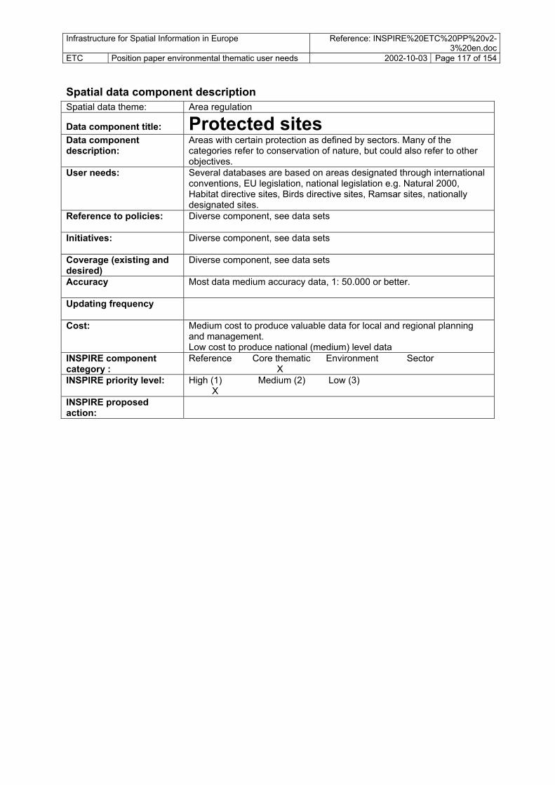
Infrastructure for Spatial Information in Europe Reference: INSPIRE%20ETC%20PP%20v2-3%20en.doc
ETC Position paper environmental thematic user needs 2002-10-03 Page 117 of 154
Spatial data component description Spatial data theme: Area regulation Data component title: Protected sites Data component description:
Areas with certain protection as defined by sectors. Many of the categories refer to conservation of nature, but could also refer to other objectives.
User needs: Several databases are based on areas designated through international conventions, EU legislation, national legislation e.g. Natural 2000, Habitat directive sites, Birds directive sites, Ramsar sites, nationally designated sites.
Reference to policies: Diverse component, see data sets
Initiatives: Diverse component, see data sets
Coverage (existing and desired)
Diverse component, see data sets
Accuracy Most data medium accuracy data, 1: 50.000 or better.
Updating frequency
Cost: Medium cost to produce valuable data for local and regional planning and management. Low cost to produce national (medium) level data
INSPIRE component category :
Reference Core thematic Environment Sector X
INSPIRE priority level: High (1) Medium (2) Low (3) X
INSPIRE proposed action:

Infrastructure for Spatial Information in Europe Reference: INSPIRE%20ETC%20PP%20v2-3%20en.doc
ETC Position paper environmental thematic user needs 2002-10-03 Page 118 of 154
Spatial data set example list – protected sites Data sets title Data set description (incl. info on quality,
accuracy, attributes) Anticipated source institution
Pri
Natural 2000 2 1
Habitat directive sites
Sites designated under the Habitat directive (1992) (Directive 92/43/EEC) most sites registered as points. Coverage: All EU countries. Natural 2000-programme. Requested also by INSPIRE: “areas designated for the protection of habitats or species where the maintenance or improvement of the status of water is an important factor in their protection, including relevant Natura 2000 sites designated under Directive 92/43/EEC (habitats).
Environmental authorities. MS DGEnv INSPIRE
1
Birds directive sites Sites designated under the bird directive (1979), most sites registered as points. Coverage: All EU countries. Natura 2000-programme. Also requested by INSPIRE: areas designated for the protection of habitats or species where the maintenance or improvement of the status of water is an important factor in their protection, including relevant Natura 2000 sites designated under …… and Directive 79/409/EEC (Birds).
Environmental authorities. MS DGEnv INSPIRE
1
Other internationally designated sites
Internationally designated areas A survey of all the sites within Europe that are under international designation. All locations are represented by points except for the Ramsar, World Heritage and Biosphere areas that have digitised boundaries. It is an aim that all sites are to be digitised with real boundaries/ polygons. Scale: 1: 180.000 The following designations are included: Biogenetic Reserves European Diploma Biosphere Reserves World Heritage Sites Ramsar Convention Sites Barcelona Convention Sites Helsinki Convention Sites The data on international designations is part of a common initiative between the INSPIRE, Council of Europe and the World Conservation Monitoring Centre to set up a single data base on designations in the responsibility of the different secretariats of the different conventions and regulations. The quality of the data is considered to be the responsibility of the secretariats of the different designations. In order to point out any overlapping that occurs between the various designations and to spot any gaps. Use: Allows overview in mangement, and assessment regarding effectiveness of international programmes
Environmental authorities Ratifying countries The different conventions DGEnv
1
Nationally designated sites
Nationally designated areas The dataset contains the geographic location and size of the nationally designated areas. The inventory of nationally designated areas began under the INSPIRE �reas�mme. It is now maintained for INSPIRE by the European Topic Centre on Nature Protection and Biodiversity and is being updated through INSPIRE. Pan-European.
Environmental authorities. MS INSPIRE members INSPIRE
1
Protected cultural heritage – land and sea
Protected objects or sites, kind of object, reference to law/directive, protection date. The protected sites is only a small proportion of the full occurrence of localities of ancient old houses, mid-evil sites/ constructions, ship wrecks or other cultural values at sea. In order to see the conservation and management of valuable natural sites in relation to the cultural heritage value sites
Cultural heritage authorities/ environmental authorities
1

Infrastructure for Spatial Information in Europe Reference: INSPIRE%20ETC%20PP%20v2-3%20en.doc
ETC Position paper environmental thematic user needs 2002-10-03 Page 119 of 154
Spatial data component description Area regulation Spatial data theme:
Data component title: Sector area regulations
(area regulation/ permit areas/ restriction zones) Data component description:
The data component group is containing all land, resource and action restrictions that can be defined to specific locations. Each sector has a wide variety of detailed regulations. The group does not contain general land regulations, land use plans and conservation areas. Examples: defined dumping sites, restricted areas around drink water sources. The data is most relevant at medium to low scale levels. A very wide range of sector regulations can be identified.
User needs: Different sectors have different regulations of areas. General land/area regulation is found in local/regional land use plans (see above). There exist separate management routines for each of the data sets or groups of data sets within a sector. The flow of such information from the sectors, including the environmental sector, is usually not streamlined, even if several other sectors are identified as major potential users of the data. Each sector gives input to such general land management / area plan .
Reference to policies: 6EAP. Sector policies. OSPAR. Initiatives: No know initiatives at European level. Sectors are important.. Data
usually not produced and managed by national mapping agencies. Coverage (existing and desired)
As very diverse group of data, difficult to answer. High-level data are not of high importance. Medium to low level data with higher accuracy valuable.
Accuracy Most data medium accuracy data, 1: 50.000 or better. Updating frequency As very diverse group of data, difficult to answer. Cost: As very diverse group of data, difficult to answer. INSPIRE component category :
Reference Core thematic Environment Sector X X
INSPIRE priority level: High (1) Medium (2) Low (3) X
INSPIRE proposed action:
Develop small-scale data through reporting obligations. Develop regional level data for sector regulations being important to environmental and land use planning and management .
Spatial data set example list Data sets title
Data set description (incl. info on quality, accuracy, attributes)
Anticipated source institution
Pri
The nitrate vulnerable zones.
The pollution of surface and groundwater by excess nutrients from agricultural sources is a major cause for concern in Europe. The NVZ designated to date correspond relatively closely to areas with a high nitrogen surplus: Mapped according to The Nitrates Directive (91/676/EEC). Also requested by INSPIRE: (iv) nutrient-sensitive areas, including areas designated as vulnerable zones under Directive 91/676/EEC (Nitrates Directive) and areas designated as sensitive areas under Directive 91/271/EEC (Urban Waste Water Treatment Directive)
Agricultural authorities/ environmental
1
Regulated (official) fairways
Line of area which is reserved as fairway at sea or inland waters. Based on national/ international regulations. Important in security of fairways and assessment and management of area conflicts at sea. Important input to area planning in coastal �reas.
Sea transport/ marine authorities
1

Infrastructure for Spatial Information in Europe Reference: INSPIRE%20ETC%20PP%20v2-3%20en.doc
ETC Position paper environmental thematic user needs 2002-10-03 Page 120 of 154 Regulated areas for dumping of waste at sea
Areas at sea for dumping of waste. OSPAR Permits on marine dumping. Reporting per contracting party and site (?) waste category, number of permits issued, tonnes licensed and contracting party Important in environmental management and management of biological resources at sea. Submission of data for the Annual OSPAR Report on Dumping of Wastes at Sea from OSPAR Convention for the protection of the marine environment of the north-east Atlantic
sea management/ marine/ waste/ environmental authorities
1
OSPAR
Regulated noise restriction zones:
Zones with certain administrative regulations or restrictions to noise are enforced – e.g. over and around fur-bearing animal farms, certain hospitals, maybe also residential areas. (6EAP: Requirement to produce maps. The kind of noise maps is not defined. Could be included in the Proposed Community Directive on Noise.)
health/agriculture authorities National, regional and/ or local level authorities.
3
Prospecting and mining permit areas
3 National bodies are giving land permits for prospecting and mining. Depth information of area could be considered for the data.
industry/energy authorities
Permit areas for sand extraction
Areas under regulation for sand extraction – at land, in riverbeds, at sea bottom. Information on limitations in amounts to be extracted, restrictions in time throughout the year extraction can take place
marine, fishery, coastal, land use industrial or geological authorities
3
Fishing zones
Regulated fishing zones at regional and local levels, including fish net placement localities
fishery authorities 1
Fishery catch storage sites
Areas regulated for storage of catches, commonly located in fjords and weather/wave-protected sites
fishery authorities 3
Economically significant aquatic species protection areas (shellfish)
Requsted by INSPIRE: (ii) areas designated for the protection of economically significant aquatic species;
1
fishery authorities
Regulated fish farm zones
Regulated fish farm zones (plans) with information on accepted capacities and sites
fishery authorities 2
Polluted areas food restriction zones
Restriction zones to utilization and consumption of fish and other organisms in polluted sites, fjords and sea areas. Details on which species, commercial or private consumption, time of year
environmental authorities/fishery authorities
1
Drinking water protection areas
Requested by INSPIRE: (i) areas designated for the abstraction of water intended for human consumption under Article 7; Important in water management, land use planning and hazards/pollution/ risk management.
water utilities/ health authorities?
1
Fish water protection areas
Fish water protection areas ??? Requested by INSPIRE 2
Recreational waters
Requested by INSPIRE: (iii) bodies of water designated as recreational waters, including areas designated as bathing waters under Directive 76/160/EEC
1

Infrastructure for Spatial Information in Europe Reference: INSPIRE%20ETC%20PP%20v2-3%20en.doc
ETC Position paper environmental thematic user needs 2002-10-03 Page 121 of 154
Spatial data component description Spatial data theme: Natural and technological risks Data component title: Natural risk source and zone Data component description: Categorisation of land according to estimated/ registered
anticipated risk for natural hazards; floods, landslides, avalanches, forest fires etc. Physical mapping of areas susceptible to natural hazards commonly divided into zones with different susceptibility classes. Methods for assessing risk zones is based on a variety of data. Important data include physical data about terrain, vegetation, climate, geology.
User needs: Needed for local land use planning, settlement development, road and rail constructions. Needed in emergency operation at hazardous event.
Reference to policies: 6EAP Initiatives: European projects on natural risks, forest fires etc. Only high-
level harmonisation Coverage (existing and desired)
Only fragmented at present, high level screening of susceptible areas is important, together with local mapping at risky areas
Accuracy Medium, 1: 50.000 or better Updating frequency Most of the data sets are stable and have low updating
frequency. Cost: High cost to produce valuable data for local and regional
planning and management. INSPIRE component category :
Reference Core thematic Environment Sector X
INSPIRE priority level: High (1) Medium (2) Low (3) X
INSPIRE proposed action: Develop local level data for all major natural risks
Spatial data set example list Data sets title Data set description (incl. info on quality, accuracy,
attributes) Pri
Flood susceptibility zones
Areas prone to flooding by inland waters and lakes, by spring tide or exceptional sea level rise.
1
Land slides: Mud slides, land slides and quick (saline leached) clay soils slides area s of unstable terrain, risk areas for mountain blocks slides and stone slides: Slide area divided into zones of different susceptibility classes
1
Snow slides – avalanches:
Areas where snow is released and affected areas downhill. In areas with snow cover, susceptibility zones often cover the same areas as rock slide risk areas.
2
Forest fire susceptibility zone:
Areas susceptible to forest, bush and grassland fires 2
Earthquakes: Geographical point presentation of seismic activity/ epi-centers, including information the strength of the earthquake; depth in km, value on Richter scale.
2
Volcano eruptions: Location of sites and anticipated flow areas 3

Infrastructure for Spatial Information in Europe Reference: INSPIRE%20ETC%20PP%20v2-3%20en.doc
ETC Position paper environmental thematic user needs 2002-10-03 Page 122 of 154
Spatial data component description Spatial data theme: Natural and technological risks Data component title: Technological risk zone Data component description:
Technological risk zones: Categorising areas according to their vicinity to locations producing, storing, transporting potential artificial/ technological hazards, chemical industry, nuclear power plants, dams etc. Risk zone generation is depending on other data components, e.g. roads, industrial location, terrain, meteorological data.
User needs: Needed for local land use planning, settlement development, road and rail constructions. Needed in emergency operation at hazardous event.
Reference to policies: 6EAP, Seveso II Directive. describes certain kinds of technological risks. Extension of fields covered by the Directive is proposed, to cover pipelines etc.
Initiatives: European projects on technological risks. Only high-level harmonisation. Coverage (existing and desired)
Only fragmented at present, high level screening of susceptible areas is important, together with local mapping at risky areas
Accuracy Medium to high accuracy data, 1: 50.000 or better Updating frequency Medium frequent. The data have to be updated at certain intervals (once
a year) or by administrative means: The generation could be automated as several of the most hazardous substances is reported to governments.
Cost: Medium cost to produce valuable data for local and regional planning and management. Low cost to produce high-level data
INSPIRE component category :
Reference Core thematic Environment Sector X
INSPIRE priority level: High (1) Medium (2) Low (3) X
INSPIRE proposed action:
Develop local level data for all major technological risks
Spatial data set example list Data sets title Data set description (incl. info on quality, accuracy, attributes) PriRisk zones from nuclear production, storage, treatment
Risk zones at production, storage, treatment and transport of nuclear components. Usually represented by buffer zones around facilities, and information on risk probability. To be produced by nuclear industry.
1
Risk zones from chemical industry
Risk zones at production, storage, treatment and transport of nuclear components. Usually represented by buffer zones around facilities, and information on risk probability.
1
Dam break flood zone
In extreme cases dams break. Areas downstream dams are categorised as flood risk zones due to sudden happenings.
2

Infrastructure for Spatial Information in Europe Reference: INSPIRE%20ETC%20PP%20v2-3%20en.doc
ETC Position paper environmental thematic user needs 2002-10-03 Page 123 of 154
Spatial data component description Spatial data theme: Pollution and anthropogenic stress Data component title: Local soil/land contamination Data component description:
Local contaminated sites, often sites near or at large industrial sites or at places of dumping of waste, mines and mine dump sites.
User needs: In order to manage local contamination it is a need to have data on of areas or regions where intensive industrial activities, inadequate waste disposal, mining, military activities or accidents pose a special stress to soil. Important in regional and local planning for use of soil, land and water, groundwater resources for drinking in particular. Reporting needs within countries exists, and is under development at European level. It is necessary to get information in management and clean-up activities.
Reference to policies: 6EAP. Soil strategy. Soil communication, INSPIRE, Groundwater Directive, OSPAR
Existing coverage and initiatives
At the European level a rough geographical location of contaminated sites have been developed, based on knowledge that contaminated sites usually are located nearby the heavy industry areas. There is no European-wide monitoring of contaminated sites. Monitoring exist only on a country-by-country basis. Countries are at different levels of progress and apply different methodologies and definitions. Many countries have legislation and special inventory on contaminated sites. However, data on the number of contaminated sites based on national inventories is currently not comparable, since it is based on different national approaches. It has been a problem that material on contaminated sites is not made public.
Desired coverage Pan-European Accuracy Point-location with accuracy 100 m.
For local management, data with area coverage, better accuracy. Updating frequency Medium frequent. The data have to be updated at certain intervals (once
a year) or by administrative means – reported to/from governments. Cost: Medium cost to produce valuable data for local and regional planning
and management. Low cost to produce national (medium) level data INSPIRE component category :
Reference Core thematic Environment Sector X
INSPIRE priority level: High (1) Medium (2) Low (3) X
INSPIRE proposed action:
Develop Pan-European local contamination spatial database locating the areas, 100 m accuracy, land and sea.
Spatial data set example list Data sets title PriData set description (incl. info on quality, accuracy, attributes) Local land contamination
Local contamination – land and inland waters. Database for joint reporting and management needs, Harmonised definition of sites and attributes. Information on amount, substances, cause (classes such as heavy industry, waste disposal, military etc), measures taken for clean-up operations or other actions. Special information should be given to those sites receiving funds from the European Regional Development Fund. Point locations, 100 m accuracy
2
Local land contamination – detailed data
Local contamination – land and inland waters- detailed data Area database, being important in local management and planning. Attributes as above and additions for local use.
3
Sea waste disposal Areas of local contamination in marine environment. Can be based on conventions like Atlantic Submission of data for the Annual OSPAR Report on Dumping of Wastes at Sea from OSPAR Convention for the protection of the marine environment of the north-east Atlantic
3

Infrastructure for Spatial Information in Europe Reference: INSPIRE%20ETC%20PP%20v2-3%20en.doc
ETC Position paper environmental thematic user needs 2002-10-03 Page 124 of 154 Spatial data component description Spatial data theme: Pollution and anthropogenic stress Data component title: Diffuse soil contamination Data component description:
Contamination of soils distributed throughout the surface, based on screening of large areas. Shows long-range transport and local sources.
User needs: Monitor the situation of diffuse soil contamination, and in cases of high levels or adverse developments direct measures towards emission sources or other measure at local and regional levels. It is important to know the location of areas most heavily affected of diffuse soil contamination, The fifth Environmental Action Programme (5EAP 1996) contain targets, measures, instruments for soil protection/management.
Reference to policies: 6EAP. Soil strategy. Soil communication, Groundwater Directive. Directive on soil monitoring has been discussed, and Community policy is being developed. There are no legal reporting obligations towards the MC. Groundwater Directive is instrument linked especially to contamination of soil and groundwater. Other European policy measures addressing soil protection are, among others EU directive on Integrated Pollution Prevention and Control, EU Landfill Directive (draft), Protection of Groundwater from Hazardous substances Discharges, Directive on Hazardous waste, Nitrate Directive and Sewage Sludge Directive.
Existing coverage and initiatives
Some databases exist for certain areas, such as heavy metal database for Northern Europe. INSPIRE is developing indicators based on spatial analysis in order to describe and monitor the situation.
Desired coverage Pan-European Accuracy Rough overviews at 1 km accuracy or less. Monitoring sites used in
generation of overviews high accuracy. Updating frequency Low frequency of updating, every 5 or 10 years. Cost: Low cost to produce data for European overview if based on rough GIS
assessments, if based on fieldwork at monitoring stations medium cost. INSPIRE component category :
Reference Core thematic Environment Sector X
INSPIRE priority level: High (1) Medium (2) Low (3) X
INSPIRE proposed action:
No action by INSPIRE, rely on other legislation, European agreed assessment actions (INSPIRE). INSPIRE technical standards recommended
Spatial data set example list Data sets title Data set description (incl. info on quality, accuracy, attributes) PriAcidification in soils Acidification is an important widespread diffuse pollution of Europe’s
soil. Enhanced levels by human emission of sulphur and nitrogen compounds from combustion of fossil fuels from industry, subject to long-range transboundary dispersion. Acidification may also be cause by fertilizers and soil drainage. Soil acidification causes release of iron, aluminium, calcium and heavy metals. Database on acidification situation and sensitivity to acidification of European (forest) soils based on sensitivity estimates or measurements on site.
3
Radionucleid contamination
Contamination of soil with artificial radionuclides has given rise to much public concern since the Chernobyl accidents. Radionuclides in the upper layers of soil may expose plants and animals to radiation.
3
Heavy metals Heavy metals may also contaminate the soil by atmospheric deposition. A monitoring project, as for the Northern Europe, to show patterns of distribution is due to both long-range transport and local sources.
3
Soil pollution by nitrates and phosphorus.
Different kinds of spatial analysis, nitrate and phosphorus in agricultural areas, of special interest is situation in ´nitrate vulnerable zones. Estimation of e.g. nitrogen/ phosphorus surplus by administrative region.
3

Infrastructure for Spatial Information in Europe Reference: INSPIRE%20ETC%20PP%20v2-3%20en.doc
ETC Position paper environmental thematic user needs 2002-10-03 Page 125 of 154 Spatial data component description Spatial data theme: Pollution and anthropogenic stress Noise level zones Data component title: Data component description:
Areas affected by noise. Commonly these appear as zones with different levels of noise disturbance due to distance from source. Common noise producing elements being used in calculation of noise zones are roads, rail, airports, ports. Could also be: Air routes, sailing lanes/fairways, rifle course, motorcross course, military training courses.
User needs: INSPIRE and other institutions intends to estimate noise exposure in policy evaluation. At regional and local level needs for data in environmental assessment, land use planning, location of service facilities, property agents.
Reference to policies: 6EAP. Objective of 6EAP describes that there should be focus on actions at the local level to reduce noise levels. One action mentioned is to produce noise maps.
Initiatives: No know initiatives at European level Coverage (existing and desired)
High-level data are not interesting. Medium to low level data with higher accuracy valuable. High-level analytical data exists??. Else fragmented data. The source institutions may be different for the different kinds of data: roads departments, rail agencies or companies, airport agencies, industry or pollution control institutions.
Accuracy Most data medium accuracy data, 1: 50.000 or better. Updating frequency Medium frequent. The data have to be updated at certain intervals (once
a year) or by administrative means: The generation could be automated as several of the most hazardous substances is reported to governments.
Cost: Medium cost to produce valuable data for local and regional planning and management. Low cost to produce national (medium) level data
INSPIRE component category :
Reference Core thematic Environment Sector X
INSPIRE priority level: High (1) Medium (2) Low (3) X
INSPIRE proposed action:
Develop regional level data for all major sources of noise
Spatial data set example list Data sets title Data set description (incl. info on quality, accuracy, attributes) PriNoise zone – roads: 3 Buffer zones along the lines, where the width of the buffer reflects the
intensity of the noise. Zones are created by using buffer analysis or more sophisticated methods using also including building, terrain and even meteorological information. The simple dataset can be divided into zones with threshold levels of e.g. 50, 55 and 64 dB(A).
Noise zone - rail: Buffer zones along the lines, where the width of the buffer reflects the intensity of the noise. Zones are created by using buffer analysis or more sophisticated methods using also including building, terrain and meteorological information, or even based on field measurements. The simple dataset can be divided into zones with threshold levels of 50, 55 and 64 dB(A), which are agreed levels
3
Noise zone - airport: From airport centre line(s) of runway(s) within an airport: make rough noise buffer zones more accurate than with points or based on real measures of noise at certain threshold levels.
3
Noise zone – industry:
The most noisy types of industry commonly need to apply to regional or national authorities for permission to run. Zones on affected neighbourhood can be created. Data needs. Buffer based on point location of industry (coordinate/address)
3

Infrastructure for Spatial Information in Europe Reference: INSPIRE%20ETC%20PP%20v2-3%20en.doc
ETC Position paper environmental thematic user needs 2002-10-03 Page 126 of 154 Spatial data component description Spatial data theme: Society Data component title: Demography Data component description:
Demographic data on population increase, gender, age, mortality, life expectancy, migration. Resolution to administrative units or grids.
User needs: Needed for local to national government, settlement development, health and education planning, risks assessment… Existing statistics covering long time series make demographic statistics an essential information.
Reference to policies: 6EAP, and all the policies in which the exposure of the population to a risk or harm is a concern as well as whose where population increase or migration is a key driver.
Initiatives: There is a long tradition in collecting demographic statistics. These last decades, the statistical offices have started collecting demographic statistics in large urban areas with a reference to blocks of houses and to process these data with a GIS. In some countries, the methodology chosen refers to the location of the households on a grid (1x1 km or 0.1x0.1 km).
Coverage (existing and desired)
Exhaustive coverage.
Accuracy Medium to high accuracy data, 1: 100000 to 1:25000 or better when considering the municipal and infra-municipal levels.
Updating frequency Population censuses take place with a periodicity of 7 to 10 years. In between, administrative registers of civil state supply a regular flow of data used generally for presenting annual statistics. New trends in statistics will probably lead to abandon the national censuses of large countries for a rotating system based on regional censuses supplemented by a broader collection of data from administrative registers.
Cost: Cost currently in the budgets of the Statistical offices. INSPIRE component category :
Reference Core thematic Environment Sector X
INSPIRE priority level: High (1) Medium (2) Low (3) X
INSPIRE proposed action:
Associate the statistical offices to the standardisation of local reference data (blocks, grids)
Spatial data set example list Data sets title Data set description (incl. info on quality, accuracy, attributes) Pri

Infrastructure for Spatial Information in Europe Reference: INSPIRE%20ETC%20PP%20v2-3%20en.doc
ETC Position paper environmental thematic user needs 2002-10-03 Page 127 of 154
Appendix 2: Spatial data needs by environmental issue Appendix 2 is the main document assessing the spatial data needs within the different environmental issues identified by INSPIRE. These are closely related to policy questions addressed in the 6EAP by the European Commission.
Two levels are being considered;
A series of working groups develop guidelines on the implementation of the Water Framework Directive. The work has e.g. lead to draft definitions on needs of spatial data and definitions of data flow and reporting. The material has been a source for the presentation underneath.
Needs at implementation and management level (IM)
The Water Framework Directive is aimed also at giving guidelines and certain regulations on how to carry out management of water bodies and catchments at implementation level, usually regional and local levels. The data needs described include some data needed to perform planning and management at local level in order to show user needs also at this level.
Data sets needs – a brief overview (sub-topic by sub-topic)
• the policy evaluation, monitoring, indicator level • the implementation and management level
A 2.1 Water - inland water and marine (coastal) environment
Introduction, definitions
At European level, various policy responses have been taken to address water stress and prevent deterioration of water quality. Sustainable use of water is among the key objectives of the EU's Fifth Environmental Action Programme (5EAP), and is the subject for policy initiatives including the Groundwater Action Programme and Directives on Urban Waste-water treatment, Nitrate, Drinking water and Bathing Waters. The Water framework directive is a broad directive with many measures on water management of water catchments, rivers, lakes, groundwater and coastal waters. The Water Framework Directive is not only focused on the water issue, but is heavily focused on integrated approaches bringing in other activities/sectors within river basins. The 6th EAP Marine Strategy as outlined in the Communications addresses all relevant ecosystem issues and actions on the related drivers.
Needs in policy development, reporting and indicator work (PR)
Rivers and lakes - surface water bodies The state of inland surface water bodies is monitored at sampling sites (points) at these locations there are many observations such as water flow, chemical and biological quality. These observations can then be related to a river stretch (line); a whole river catchment area/river basin (area) or to a lake, or basin of a lake (area). Further on state of inland waters can be aggregated at administrative level such as nuts02/03 or national level. For example, 20% for a regions rivers has a good quality; 30% a fair quality and the remaining 50% are of poor quality. In a river catchment there is pressures such as point source discharges (waste water treatment, industry etc.) diffuse sources such as run-off of pollutants from agriculture; water abstractions;
Infrastructure for Spatial Information in Europe Reference: INSPIRE%20ETC%20PP%20v2-3%20en.doc
ETC Position paper environmental thematic user needs 2002-10-03 Page 128 of 154
• River network. Segments of rivers divided by catchment boundaries, identified by catchment ID’s. Networks make it possible to carry out flow and sedimentation analysis. Separate attention to flow pattern in lakes linked to rivers. Should also include artificial and heavily modified water bodies (e.g. channels, reservoirs).
• Lakes. Dams. Reservoirs, including classification of artificial/heavily modified
• Information aggregated at catchment level (such as percentage of river of fair and good quality or the sum of point source discharges, or the average precipitation. Wetlands including bogs/ mires. In the northern Europe bogs are typical, being physically different from marsh and swamp. They are commonly included as a basic feature of hydrology in map databases. Should therefore be included as a hydrography feature.
• Bathing sites as points with measurement data as attributes, e.g. values on microbiological level, under, on or over microbiological standards.
• Site for hazardous substances, e.g. dumping sites for industrial, military waste and other waste, classified according to the kind of waste which has been dumped, e.g. chemical or radioactive waste, military equipment, ships, oil drilling platforms.
• Location and boundary of legally defined dumping sites, which kinds of waste that is intended to be dumped, amounts etc
hydromorphology changes (e.g. dams) to all these pressures there may be particular characteristics /observations (e.g. annual discharge of a pollutant). Observations can be related to a point (e.g. the discharge point, location of a dam) but can also be aggregated for a catchment or an administrative region such as the sum of all urban waste water treatment discharges in a river catchment area.
Geographic data needs for handling such information are:
• Water quality measurement points for rivers and lakes, giving information on biological and physico-chemical situation
Groundwater The state of groundwater is monitored at sampling sites/wells (points – including information on depth). At these locations there are many observations such as water level, chemical quality. These observations are aggregated for several wells to characterize a groundwater body.
• groundwater bodies, points or where possible, polygon data • groundwater consumption water wells, process industry wells
• catchment areas of aquifer
Different pressures such as land use and agricultural activities or water abstractions affect a groundwater body. This information may also be related to administrative regions such as water abstractions for a municipality. Geographic data needs for handling such assessments include:
• groundwater monitoring network/ sample wells
Catchments and land use Important environmental issues include:
• Surface area of irrigated land
• Point source discharges of pollutants (urban waste water treatment plants; industry; fish farms; scattered dwellings)
• Nitrate vulnerable zones • Use of pesticides • Livestock density (in livestock units)
• Population growth and population density
• Atmospheric deposition of pollutants • Tourism intensity • Agricultural use of nitrogen and phosphorus: Nitrogen and phosphorus balance and surplus
for agricultural soils, the use of fertilizers and use per unit area of agricultural land • Human populations/industry: Discharge of nitrogen and phosphorus from urban waste water
treatment plants in countries with available data • Source apportionment of pollutant discharges by catchments
Infrastructure for Spatial Information in Europe Reference: INSPIRE%20ETC%20PP%20v2-3%20en.doc
ETC Position paper environmental thematic user needs 2002-10-03 Page 129 of 154
• administrative regions (NUTS5)
• protected areas
• irrigated land
Data needs include:
• catchment areas
• population information • Location of discharge of point sources. • nitrate vulnerable zones/sensitive areas in relation to urban waste water treatment directive
• elevation
• water abstractions by sector
Transitional, coastal and marine waters: Important indicators include:
• Fish farms: Life stock density tons of fish produced) per coastal unit / transitional water body type.
• Bathymetry regional seas and coastal waters
• Concentrations of nitrate and phosphate, and the nitrogen:phosphorus ratio by regional sea and by water body type.
• Concentrations of hazardous substances in water • Concentrations of hazardous substances in marine organisms • Concentration of hazardous substances in sediment • Summer average and peak concentrations of chlorophyll a in surface water • Occurrence of nuisance algae; species composition; and, diversity of plankton. • Community species diversity, community structure and function of the benthic invertebrate
fauna, and organic carbon content of the sediment surface • Composition and abundance of other aquatic flora as defined by the WFD • Habitats, surface versus potential surface • Biological and physico-chemical classification of transitional and coastal zones less than
‘good' quality in national classifications • Loads (riverine, direct, dredged spoil, landfills) of hazardous substances/heavy metals to
coastal waters • Loads (riverine and direct) of nutrients/nitrogen and phosphorus to coastal waters • Atmospheric deposition to marine and coastal waters, and emissions to air of NOx, NH3, total
nitrogen heavy metals and persistent organic pollutants (POPs) • Oil industry: Accidental oil spills; illegal oil discharges; and, discharges from
platforms/refineries.
Spatial data needed in the work on transitional, coastal and marine waters are outlined underneath See also the integrated coastal zone management needs described in Appendix 1_7.
• Administrative boundaries (NUTS 5) and territorial boundaries at sea • District of marine conventions - regional seas and competent authorities at regional/local level • Borders regional seas and major sea catchment areas • Fishing regions, fishing boxes (protected) • Marine economic zones • Coastline • Boundaries of transitional waters + coastal waterbodies
• Elevation • Water catchments • Water masses/ layers • Polar area features - pack ice. The limit of pack ice affects transport and the environmental
situation in the north. • Prevailing and actual wind direction • Fish farm localities, permanent and alternating sites • Anthropogenic pressures on surface water bodies • Settlements

Infrastructure for Spatial Information in Europe Reference: INSPIRE%20ETC%20PP%20v2-3%20en.doc
ETC Position paper environmental thematic user needs 2002-10-03 Page 130 of 154
• Permanent oil installations, by location point and identifier, to be used to report oil spills • Sea cables, pipelines, offshore in
• Marine Biogeographic regions
• Transport infrastructure, including major shipping routes and ports • Land-based pressures (riverine inputs, direct discharges, emissions) • Sites for hazardous substances (waste dumping, municipal dumping) • Oil spill sites, accidental and illegal - oil spills from ships and mobile installations, location
point and identifier to link with attributes on kind of oil, amount.
• Major sensitive areas • Monitoring sites (at European level Eurowaternet)
• Protected areas (location, size) • CORINE land cover (proxy pressure to water) • Habitat locations, (including deep sea corals, mussel beds) actual and potential coverage • Ecological regions • Wetlands, mudflats • Satellite data on chlorophyll occurrence • Sea surface information (algal blooms, chlorophyll a, plankton communities) • Sea bottom information (sediment, benthic communities, benthic habitats)
A 2.2 Air and climate change
Introduction Air is one of the most important natural resources on which all life depends. However, the atmosphere is also in the front line for receiving environmental pollution. Polluted air will affect human health, ecosystems and materials in a variety of ways. The atmosphere can act as a means of transporting local pollution emissions to other locations, even long distances. EU policy measures reflect a multi-pollutant approach. The Air Quality Framework Directive, agreed in 1996 (96/62/EC), established a framework under which the EU has set limit values for specific pollutants. Member states must monitor air quality, and, where limit values are being exceeded, devise abatement programmes and report on their implementation. Particulates and ozone followed by nitrogen oxides and benzene are the current priority pollutants. The National Emissions Ceiling Directive (NECD) is intended to address the pollutant-specific ambient air quality problems as well as ground level ozone, acidification and eutrophication simultaneously. The Directive sets national emissions ceilings to be achieved by 2010 onwards for sulphur dioxide, nitrogen oxides, ammonia and volatile organic compounds. This is supported by legislation on emissions for specific sectors such as those aimed at large combustion plants, sulphur content of vehicle fuels and the reduction of non-methane volatile organic compounds (NMVOCs) from solvents. Policy evaluation and new policy development takes place through the Clean Air for Europe (CAFE) programme, which should lead to the adoption of a thematic strategy under the Sixth Environmental Action Plan (6EAP) in 2005. Working groups work on specific matters, e.g. Particulate Matter Group. Climate change, and avoiding its potential consequences, is addressed by the United Nations Framework Convention on Climate Change (UNFCCC). Achieving “sustainable” atmospheric greenhouse gas concentrations would require substantial (50 to 70%) global reductions in greenhouse gas emissions far beyond those set at Kyoto, which are a 5% reduction of developed countries’ emissions from 1990 levels by 2008-2012. For the EU, the Kyoto Protocol sets a target of a reduction of 8% for this period for the basket of six greenhouse gases. In June 1998, EU Member States agreed a system of ‘burden sharing’ or ‘target sharing’. The European Community reaffirmed these targets for Member States in the Commission’s proposal for ratification of the Kyoto Protocol (European Commission, 2001a).

Infrastructure for Spatial Information in Europe Reference: INSPIRE%20ETC%20PP%20v2-3%20en.doc
ETC Position paper environmental thematic user needs 2002-10-03 Page 131 of 154
• Controlling emission reduction contributions across sectors: Emissions of greenhouse gases by sector and gas
• Maintaining average temperatures below provisional “sustainable targets”: Global and European mean temperature
•
Various Members States have developed national policies and measures complementary to EU policies and measures.
Needs in policy development, reporting and indicator work (PR) Some of the most important environmental issues on air pollution are
• Urban air quality exceedances for ground-level ozone • Urban air quality exceedances for particulates • Urban air quality exceedances for sulphur dioxide • Urban air quality exceedances for nitrogen dioxide • Are Europeans effectively protected against exposure to ground level ozone • Protecting the environment against exposure to ozone: Exposure of agricultural crops and
forests to ozone • Achieving the emissions policy targets - Aggregated emissions of acidifying substances • Achieving the emissions policy targets - Aggregated emissions of ground-level ozone
precursors • Reducing emission levels - Particle emissions
Some of the most important policy issues in the field of climate change are;
• Achieving the Kyoto Protocol targets: Total emissions of greenhouse gases
Needs at implementation and management level (IM)
Local air emissions, primarily in urbanised regions, needs to be managed at local and regional levels. Transboundary pollution may cause impacts needed to be met by counter-measures at the local level. Climate change effects and greenhouse gas emissions are not specifically dealt with at local and regional levels in this paper.
Data sets needed – a brief overview (sub-topic by sub-topic) The geographic data needs in reporting and development on air and climate change is limited.
• meteorological stations and meteorological information • monitoring sites for sea level • monitoring sites for local air pollution, e.g., urban background stations, hotspot stations,
ground ozone stations • Administrative boundaries • Population data detailed grid of following NUTS5 and better resolutions • Buffer capacity of soil/water (exposed to acidifying pollutants) • Localisation of emitting industry/activity including statistics • Carbon content of soil
Statistical information on reporting unit or monitoring sites
• deposition of acidifying and eutrophing substances • emission of CO2, methane (CH4), N20, NH3, NOx, SO2, VOC; trends and sectors • land cover • elevation • soil types • climate zones
water catchments

Infrastructure for Spatial Information in Europe Reference: INSPIRE%20ETC%20PP%20v2-3%20en.doc
ETC Position paper environmental thematic user needs 2002-10-03 Page 132 of 154
Data sets needed – a brief overview (sub-topic by sub-topic)
A 2.3 Soil (soil and land related issues)
Introduction Soil is a physical media being important for both physical and biological processes. Soil is a resource for both agriculture, forestry, and have important functions in ecosystems. The pressure on soil resources is high, leading to lower soil quality. The main environmental issues addressed in European policies under the heading sustainable soil management, are - soil erosion - soil organic content - soil contamination at specific sites - soil contamination due to diffuse pollution - soil sealing: changes in land use leading to covering of soil - soil salinisation - desertification/drought
Needs in policy development, reporting and indicator work (PR) Strategies for soil protection, and systems for the monitoring of soil, are not adequately developed at European or national level, compared with air and water, for which monitoring, assessment and policy frameworks are already in place. In the EU, policies are currently exist to prevent an increase in soil contamination. The fifth Environmental Action Programme (5EAP 1996) contains a series of objectives, targets, measures and instruments for soil protection and sustainable management. A Directive on soil monitoring has been discussed, and there is work being done to develop a community policy on soil. There are no legal reporting obligations towards the Member Statens and related countries at present. WFD and the Groundwater Directives are instruments linked especially to contamination of soil and thereby groundwater. Other European policy measures addressing soil protection are, among others EU directive on Integrated Pollution Prevention and Control, EU Landfill Directive (draft), Protection of Groundwater from Hazardous substances Discharges, Directive on Hazardous Waste, Nitrate Directive and Sewage Sludge Directive. DG ENV, EEA and JRC, studies are carried out through the use of environmental indicators. Both in evaluation of policies at the high administrative levels and in implementation actions at the local level spatial data are actively used. Additional user needs exists, but the current needs are not met.
The fields indicated above will be briefly described below, focusing on geographic data needs in policy evaluation reporting and policy development/ evaluation. The indicators focus both on driving forces, status description, pressures, impacts and on responses to the different policy questions/ environmental soil related problems.
Soil erosion Soil, climatic and relief conditions cannot be changed by human activities, at least not in the short-term. Ground cover measures could be used to combat soil erosion. Consequently the long-term approach concerning soil erosion takes into account potential soil erosion risk and focuses on the ground cover due to vegetation and other protection measures. The pre-condition is a map of potential soil erosion risk in Europe. Together with periodical monitoring by remote sensing and ground validations in test areas a valid state indicator might be created. Especially with regard to agricultural land this approach means: the higher the share of crops which increase the risk of soil erosion (“row

Infrastructure for Spatial Information in Europe Reference: INSPIRE%20ETC%20PP%20v2-3%20en.doc
ETC Position paper environmental thematic user needs 2002-10-03 Page 133 of 154 crops”, e.g. corn, sugar beet, potatoes) of total arable land in areas with a high potential soil erosion risk, the higher the actual soil losses due to soil erosion, unless accompanying protection measures are applied.
• Agricultural production over time,
• Responses such as % of land by administrative unit under permanent vegetation cover, agroforestry practices, mulching practices, terraces,
Soil erosion occurs mainly where land is over-intensified, and the resulting losses are irreversible of time-scales of tens or hundreds of years. Soil erosion is increasing in Europe. Soil erosion and soil organic matter are considered politically relevant as they are very much linked to agri-environment measures and use of structural funds. Organic matter is also linked to the review of the Sewage Sludge Directive.
• Soil type maps are essential is soil erosion analysis, and relatively detailed data are needed for reliable estimates: The Agricultural Information Systems Unit (also known as the MARS project) in the Institute for Remote Sensing Applications of the C.E.C.'s Joint Research Centre has been working in cooperation with DGs VI and XI to provide a database of soils. In the early stages, a basic paper map of soil units was digitised at a scale of 1:1.000.000 and introduced into a GIS. To this was added information from archives of national soils information and the results have been submitted to experts for each of the member countries for verification and harmonisation of cross-border soil classifications. In order to make the database useful for a broader range of applications, it is also being expanded to add a representative profile to the basic definition of each of the more common soil types. A more recent version of the soils of the European Union already exists at the European Soils Bureau in Ispra. This data includes improvement of the spatial accuracy of the data set as well as expansion of its coverage into Central and Eastern Europe. Dataset version is 2. There have been problems in getting access to the data set for institutions within the EU, probably due to user right restrictions imposed by countries offering data.
• Actual and potential soil erosion, based on four factors: soil, climate, slopes and vegetation. Prediction of future situations. Methodology adjusted to regional conditions.
• Measuring points for soil loss, giving information of loss of top soil, organic content, at areas with different kinds of land use, agricultural land, forest etc.
• Wind erosion risk. Distribution of soil with high wind erosion vulnerability. Prevailing wind and wind speed
• Water basin • Flow of sediments/ soil content in rivers • Land cover, kind of vegetation, density of vegetative cover and the changes in soil being open. • Digital elevation mode (DEM) to estimate erosion
• estimation of water erosion risk and prediction of water erosion risk.
Soil organic content and sustained soil production capacity Soil organic content, soil compaction and soil flora and fauna are major issues addressed in assessments on soil for farming and forestry. Different strategies and measures are put in place to restore and maintain organic content in the soil on farmed land, e.g. organic farming practices with denser plant cover, use of permanent crops, agroforestry, mulching and use of organic manure. Organic content is also important in storing carbon - thus being a carbon sink of vital importance in the context of climate change. Local contamination - Contaminated sites Local contamination is a characteristic of regions where intensive industrial activities, inadequate waste disposal, mining, military activities or accidents pose a special stress to soil. At the European level a rough geographical location of contaminated sites have been developed, based on knowledge that contaminated sites are usually located near heavy industry areas. There is no European-wide monitoring of contaminated sites. Monitoring exists only on a country-by-country basis. Countries are at different levels of progress and apply different methodologies and definitions. Many countries have legislation and special inventory on contaminated sites. However, data on the number of contaminated

Infrastructure for Spatial Information in Europe Reference: INSPIRE%20ETC%20PP%20v2-3%20en.doc
ETC Position paper environmental thematic user needs 2002-10-03 Page 134 of 154
• database on local contaminated sites; point data , with additional data on amount, substances, cause (classes such as heavy industry, waste disposal, military etc) , measures taken for clean-up operations or other actions. Special information should be given to those sites receiving funds from the European Regional Development Fund
• groundwater bodies and water supply wells/ extraction points • conservation/ restriction zones around groundwater bodies
sites based on national inventories is currently not comparable, since it is based on different national approaches. It has been a problem that material on contaminated sites is not made public.
• land fill database placing land fills, both regulated and illegal land fills
Diffuse contamination of soils
• Acidification. Soil acidification is a natural process, but it has enhanced recently by human action through the emission of sulphur and nitrogen compounds from the combustion of fossil fuels from industrial processes, subject to long-range transboundary dispersion. Acidification may also be cause by fertilizers and soil drainage. Soil acidification is an important trigger for releasing substances such as iron, aluminium, calcium and heavy metals. Except for acidification, there is no widespread diffuse pollution of Europe’s soil. Database on sensitivity to acidification of European forest soils are based on sensitivity estimates or actual measurements on site
• Contamination of soil with artificial radionuclides has given rise to much public concern since the Chernobyl accident. Radionuclides in the upper layers of soil may expose plants and animals to radiation. Soil pollution by nitrates and phosphorus.
• Heavy metals may also contaminate the soil by atmospheric deposition. A monitoring project in the Northern Europe, showed that patterns of distribution is due to both long-range transport and local sources.
• nitrate in agricultural areas and nitrate vulnerable zones • phosphorus surplus by administrative region • surplus of sewage sludge
Soil sealing Over the last 20 years the built up area in a selection of major Western European countries has increased by some 20%. This is a much greater rate of growth than has been seen for say the population of the EU over the same period of time. Concerning soil sealing, an approach is proposed which takes into account a periodical monitoring by remote sensing combined with ground validations in test areas. Data are required to obtain spatial information on the one hand (map of land cover in Europe) and information about the portion of the “real sealed” land by build up areas and traffic routes on the other hand. The main message would be: the higher the portion of “artificial surfaces” obtained by CORINE land cover the higher the portion of sealed soil. Salinisation Salinisation arises in a number of ways; by irrigation with improper drainage, intrusion of salt water from the sea or from saline fossil sources, and through evapotranspiration of saline soil moisture. It has a direct negative effect on soil biology and crop productivity, and indirect effects leading to loss of soil stability through changes in soil structure (alkalinisation). In Europe, the surface area affected by salinisation is estimated to be 3.8 million ha (EEA 1995). Salinisation is most strongly tied to site-specific soil properties and climatic conditions and therefore its distribution is restricted to South-Eastern Europe where semi-arid conditions prevail, that is on semi-arid and salt-affected soils. The irrigation of the Hungarian plain, for instance, has caused salinisation and akalinisation of more than 20% of the region. Similar examples account for other countries. Salinisation is reversible, but reclamation of saline/ alkali soils is expensive, as it requires complex amelioration techniques. Data sets include:
• soil data on salinity and alkalinity in soil, point samples and generalised version with actual area coverage.
• climatic information for estimates on susceptibility for salinisation • localisation of irrigation practices

Infrastructure for Spatial Information in Europe Reference: INSPIRE%20ETC%20PP%20v2-3%20en.doc
ETC Position paper environmental thematic user needs 2002-10-03 Page 135 of 154 Desertification The United Nations Convention to Combat Desertification (UNCCD) was signed in Paris, on 17 June 1994 and entered into force on 26 December 1996. It provides the innovative framework for the sustainable development in arid, semi-arid, dry sub-humid areas, of an appropriate implementation mechanism to combat desertification and the effects of drought. As of 1 January 2000, 160 countries have ratified/acceded to the Convention. Desertification problems are heavily linked to climate, soil properties and management practices. Major problems are located to the Mediterranean countries and semi-arid areas in South-Eastern Europe. EU has taken initiatives on improving the capacity of national administrations of Mediterranean countries to effectively program measures and policies to combat desertification and the effects of drought.
Concerning data needs, the aspects on soil erosion, salinisation and sustained production potential are fully describing the needs. No supplementary needs are identified on desertification and drought, concerning spatial data.
Floods and land slides Being dealt with in appendix 1, chapter 5. Joint needs for reference data used in analysis/reporting Different kinds of topographical data and reference data are needed to perform reporting and carry out analysis. Additionaly, elements representing important pressures or stress factors are required.
• urban regions
• Monitoring sites for soil components, pollution and hazardous substances
• elevation • land use • catchments basins • administrative boundaries • settlements
Needs at implementation and management level (IM) Soil information at local and regional levels is needed partly to assess and manage the available resources, and partly to monitor changes in the status of the resources. Typical uses include agriculture, forestry, resource extraction, evaluation of ground for constructions purposes. Typical data sets are:
• Soil maps/databases with detailed information on soil type, fraction and chemical components. Specific needs for accuracy and details are found within the agricultural sector.
• Soil data making it possible to predict/ estimate a series of information products that either can be attributes within the original soil data set or be created as separate data sets. Examples are water storing capacity, erosiveness, natural production potential., natural buffer capacity towards acids, needs for supplementary fertilizers, soil suitable for spread of sewage sludge, material with potential as construction material or industrial extraction (sand, clay), ground suitable for construction of e.g. roads and buildings.
• Urban sprawl – land use data and changes • Distribution of brownfields – derelict land (contaminated)
A 2.4 Nature protection and biodiversity
Introduction
It is expected that around 10% of the EU’s land area will be designated under the future Natura 2000 Network. In addition, significant marine areas will also be designated. This will exert great influence on

Infrastructure for Spatial Information in Europe Reference: INSPIRE%20ETC%20PP%20v2-3%20en.doc
ETC Position paper environmental thematic user needs 2002-10-03 Page 136 of 154
Evaluation of policies and their measures in the field of biodiversity and nature conservation is heavily linked to use of geographical information. DGEnv, EEA and other institutions are addressing this partly by using indicators.
Fragmentation and changes - general • Infrastructure density and trends (length and area per year) • Road density and trends (length and area per year) • Number of fauna passages per infrastructure length unit • Change in surface area of floodplains • Percentage of canalised watercourses of total length
• Distance to designated areas
Protected and designated areas
• Under EU Directives (e.g. SPA’s)
• Land-Cover/EUNIS in and around designated areas
Forest and forest quality
land development and spatial management policies not only in core areas, but also in the surroundings of the sites, to avoid the damaging effects of pressures on the site.
The designation of Special Protection Areas (SPAs) relates to 182 bird species and sub-species listed in Annex 1 of the Birds Directive, as well as migratory species, while the designation of Species Areas of Conservation (SAC) relates to 230 other animal species, 483 plant species (listed in Annex II) and 198 habitat-types (listed in Annex I) of the Habitats Directive. There are reporting obligations on all Designated sites, at present only referring to spatial data at point level, but projects are running also on data capture and establishment of a central polygon database.
Needs in policy development, reporting and indicator work (PR)
Reporting is linked to a set of reporting units. Geographical information about biodiversity and protected areas should be given for units such as countries, watersheds for seas and major rivers, bio-geographic regions, soil regions, geographical areas such as island and mountain areas. Examples of environmental issues related to Nature and biodiversity referring to geo-referenced data include:
• Degree of river fragmentation • Drainage/drainage stops of wetlands including forests
• Trends in dam construction Habitats
• Surface area of main habitat-type • Distribution area of main habitat-types • Change in distribution area of main habitat-type • Proportion (in surface area) of Annex I habitat-type included in NATURA 2000 network/
extension of habitat • Area of habitat restored • Fragmentation of main habitat/ecosystem/land cover
• Area and change in area of protected land by IUCN category • Under international conventions and initiatives (e.g Ramsar)
• Under national legislation (e.g. national parks, nature reserves)
• Distance of designated area to big cities (remoteness) • Distribution and area of sites such as Important Bird Areas, Important plant Areas, areas of • Infrastructure proximity to designated areas (distance to roads, rail..) • Distance to designated areas
• Forest area, change (total and by main type conifers, mixed, deciduous, plantations, natural) • Area of plantations with introduced tree species
Infrastructure for Spatial Information in Europe Reference: INSPIRE%20ETC%20PP%20v2-3%20en.doc
ETC Position paper environmental thematic user needs 2002-10-03 Page 137 of 154
• Undisturbed and ancient semi-natural managed forest • Protected forest area for biodiversity purposes (see section conservation)
• Wind and snow break (area per year)
Agricultural land and quality
• Broad habitat diversity (index 10 km x 10 km)
• Agricultural area by crops (cereal, oil crops, forage etc…)
• Urban green area (green lines/corridors, cemeteries, industrial fallow-land etc…)
• Conversion from high nature valued ecosystem to areas for carbon sink purpose
• Change in migration routes (birds, butterflies, fish) • Change in extension/population of wintering, breeding, migration areas (birds)
The focus of the indicators on biodiversity is relatively detailed and the needs of data outlined also to a great extent fulfils the needs of implementers and managers at local/regional levels. Better scale/accuracy on localisation and polygon data for designated areas in stead of point data will be needs to be addressed at the local level.
Transport
• rail • airports
• Wildlife data, living areas and migratory routes
• Conservation and management of genetic diversity • Indigenous and introduced tree species • Forest fire (area per year)
• Forest fragmentation by internal roads
• High nature value in farming systems
• Habitat patterns/ Corridors • Fragmentation index
• Agricultural area (intensively farmed, extensively farmed, under abandonment, uncultivated, organic farming)
• Loss of linear features ( length, area, composition) and small biotopes
Urban • Urban forest increase
Carbon sinks
• Contribution of ecosystems to CO2 sequestration
Other
• Change in altitude migration (butterflies)
Needs at implementation and management level (IM)
Data sets needed – a brief overview ( sub-topic by sub-topic)
• roads
• sea and channel transport lines
Biodiversity and nature protection
• Bio-geographic regions • Distribution area of main habitat-types • CORINE Land Cover • Ecological regions • CORINE biotopes • Protected sites, both based on international or national legislation • Natura2000- forest sampling 16x16 km and land use sampling 18x18 km (LUCAS)

Infrastructure for Spatial Information in Europe Reference: INSPIRE%20ETC%20PP%20v2-3%20en.doc
ETC Position paper environmental thematic user needs 2002-10-03 Page 138 of 154
• green areas/corridors
Natural resources
• agricultural land, details on biodiversity
• elevation
A 2.5 Waste
Introduction
Urban
• forest stand data, details on biodiversity in commercial forests
• wildlife hunting information by region
Water features • rivers, lakes, transitional waters, sea. level of anthropogenic impact • river catchments and sea catchments • bathymetry
Ground features and landscape
• soil regions
• coastal units • CORINE land cover (including changes)
Administrative, population and economic activity
• administrative boundaries • settlements and urban regions • population density reallocated to land cover
Current situation
According to the report "Environment in the European Union at the turn of the century (EEA 1999) total waste generation within EU and the European Free Trade Area increased by nearly 10% between 1990 and 1995, while economic growth was about 6,75% in constant prices. Half the waste comes from the manufacturing industry and construction and demolition activities, while municipal waste, mining and waste from other sources each contribute about one sixth of the total. In the Accession countries amounts of industrial waste per capita are higher, while volumes of municipal waste are currently lower than the EU average. Most waste streams will probably increase over the next decade. In 2010 the generation of paper, cardboard, glass and plastic waste will increase by around 40% to 60% compared to 1990 levels. The number of scrapped cars should increase less, around 35% compared to 1990 levels. Today waste is also produced as a result of society's attempt to solve other environmental problems such as water and air pollution. Some of these increasing amounts of waste give rise to new problems, such as sewage sludge and residues from cleaning of flue gases.
In most EU countries landfilling is still the most common treatment route for waste and a major change is needed to implement the EU strategy on waste.
Waste policies

Infrastructure for Spatial Information in Europe Reference: INSPIRE%20ETC%20PP%20v2-3%20en.doc
ETC Position paper environmental thematic user needs 2002-10-03 Page 139 of 154
Waste management is linked to two issues: preventing waste generation and sustainable management of waste: re-use and recovery (recycling), optimisation of final disposal and regulation of transport. The 6EAP gives a high priority to waste prevention, and to achieving a de-coupling of resource use from economic growth through significantly improved resource efficiency, dematerialisation of the economy and waste prevention. Other policy areas are linked to waste policies, e.g. policies on climate change, air, urban, soil and water (WFD).
• the majority of wastes are either reintroduced into the economic cycle, especially by recycling, or are returned to the environment in a useful (e.g. composting) or harmless form
• actual treatment of waste categories • quality of waste facilities, treatment capacities etc
• status of recycling initiatives and waste management plans in countries and regions
• Waste collection statistics at municipal or county/region level: At national levels this could mean reported statistics at municipal and regional level
Needs at implementation and management level (IM)
A community Strategy for Waste Management was initially adopted by the European Commission in 1989 followed by the 1996 Review of the Community Strategy for Waste Management. The 6 Environmental Action plan is the latest document from the Community, with expected developments on “Thematic strategy on the Sustainable Use of Natural Resources”.
Due to the effects of carrying out this strategy, a reduction in waste generation, and especially of the generation of hazardous waste is expected. For the waste that is unavoidably generated there are a set of objectives:
• the wastes are non-hazardous or at least present only very low risks to the environment and health
Needs in policy development, reporting and indicator work (PR)
Many kinds of evaluation links waste generation with economic activities. The evaluation of policies is mainly based on reported values on different aspects about waste management, often figures ant municipal, regional or national levels. Policy actions on reducing waste is assessed by
• amount generated of waste categories, such as waste from construction, manufacturing, municipal waste and hazardous waste.
• transport of waste between regions or countries
Spatial data sets needed in the assessments are generally few
• Official administrative units being the most important. • In some cases it is relevant to have information of location of large producers of waste • or specific sites for treatment, e.g. of hazardous waste.
Concerning case studies of environmental aspects and other policy evaluation, see underneath.
The spatial dimension is linked to the sustainable waste management strategies, not the strategies for prevention of waste generation, the latter not treated further here. Waste operations include collection, transport, treatment and storage of waste. The waste sector manages these operations, and are also responsible to secure sustainable practices where adverse environmental effects are minimised.
The waste sector is and can be a user of a variety of spatial data, being reference data from mapping agencies and common thematic data coming from natural resource inventories or other sources. The waste sector is also producing spatial data of interest to other sectors, and should be responsible for bringing these data up to a quality where they can be available in geographical infrastructures (INSPIRE) and be combined in GIS and management systems for more effective planning and management, and in addition be used by the environmental, agricultural and health sectors together with property agents, land use planners and others.

Infrastructure for Spatial Information in Europe Reference: INSPIRE%20ETC%20PP%20v2-3%20en.doc
ETC Position paper environmental thematic user needs 2002-10-03 Page 140 of 154 Generation, Collection and transport of waste: The system of waste collection for ordinary waste varies from country to country. The aim is to collect a high percentage of the generated waste e.g. more than 90% or all waste. Waste collection services should be available to most residents. Examples show that such services in some countries only are available to about 60% of the residents and as a result waste is dumped in forests, along roadsides, besides water bodies and other illegal sites. At the country and regional level it is important to have access to geographical coverage information. The system of waste collection on hazardous waste is different. Some kinds of hazardous waste is treated at the location of production, some kinds of waste is treated by regional facilities, still others are being sent to central facilities, at national level or even outside the country. If collection regions exist, these should be known to planners and other sectors. Relevant data in such activities, including administration of operations in urban and rural areas, include organisation of vehicle fleet. Planning and evaluation of waste transport patterns.
• Location of waste generation: Of high interest is the location of major producers of waste; industry, other production facilities, construction etc. The location of industry, e.g. producers of hazardous waste, is information reported according to the Seveso II and IPPC Directives. The data could be produced as a geographical point location or as referred by an address or a property or as the register of polluting industry.
• Waste collection regions: (waste sector own data) can be categorised as a kind of sector management area. Treated as a separate spatial data set, as it commonly do not coincide with official administrative units, and within municipalities is split into sub-regions.
• Transport network: Roads, rail, being a reference data, is important in transport needs assessment and fleet management.
• Addresses: To be used in general management, planning operations, information to citizens, which citizens are treating own waste (self-composting) etc.
• Population: It is relevant information at all levels, from country, region and municipal levels, local level needs including information on block/property/address.
Waste treatment facilities and waste storage: It is important to identify the environmental protection facilities with unique identifiers. The data component category coincides with economic/statistical categories (NACE/SERIEE). Location by geographical point, by address or in some cases as area.
• Controlled waste treatment sites for non-hazardous waste at land: geographical location
of official or regulated facilities for waste treatment and storage; Included in the spatial component category "environmental protection facilities"
o storage sites at land - landfills o incinerators o other treatment facilities
Information on kind of treatment, kind of substances treated, capacity, percentage biodegradable waste, energy recovery from incinerators and landfills
• Controlled waste treatment facilities for hazardous waste at land: geographical location of official or regulated facilities for treatment and storage of hazardous waste; Included in the spatial component category "environmental protection facilities". Reported according to SEVESO II Directive. Distinction between
o thermal treatment, o landfills o nuclear waste treatment and storage o and other treatment for hazardous waste (e.g. chemical), o other treatment facilities
Information about kind of treatment, kind of substances treated, capacity (and potential risks).

Infrastructure for Spatial Information in Europe Reference: INSPIRE%20ETC%20PP%20v2-3%20en.doc
ETC Position paper environmental thematic user needs 2002-10-03 Page 141 of 154
• Regulated areas for dumping of waste at sea: Areas at sea for dumping of waste, e.g. ships, oil drilling platforms, industrial waste, military waste. OSPAR Permits on marine dumping. Reporting per contracting party and site (?) waste category, number of permits issued, tonnes licensed and contracting party. Important in environmental management and management of biological resources at sea. Submission of data for the Annual OSPAR Report on Dumping of Wastes at Sea from OSPAR Convention for the protection of the marine environment of the north-east Atlantic. The anticipated delivery authorities could be sea management/ marine/ waste/ environmental authorities, OSPAR. Included in the spatial data component "area regulation".
o Waste restriction zone: areas with certain regulations where waste is not to be placed or treated. Most areas have restrictions in waste dumping.
Does also include nuclear waste. Example is Russian dumping sites: Official sources states a total of 0.45 PBq of liquid radioactive material has been dumped in the Barents Sea and 0.32 PBq in the Kara Sea. Most of the solid radioactive waste has been dumped along the east coast of Novaja Zemlya and the open Kara Sea. Some material on existing sites and amounts are available.
• Area restrictions and land use plans In order to treat waste in an environmentally acceptable way, different measures are taken to direct and control the location of waste treatment. In geographical terms, one can identify two major kinds:
o Waste permission zones - land and sea: areas where dumping is allowed. There are restrictions on kind of waste to be dumped. For sea areas, see above. For land areas, categories of land use for waste treatment in found in land use plans and land regulation maps/ databases.
• Illegal or non-controlled dumping of waste - sea and land. Illegal landfills/"wildfills" on land areas are common, but policies are directed to reduce the number of such storage of waste. It is important in local waste management and pollution control to locate such illegal land fills, in order to carry out targeted actions. Non-controlled areas at sea where waste is recorded is also important, this can be shipwrecks, industrial waste, military waste, cars. OSPAR Permits on marine dumping.
• Mining waste: Mining waste is a special kind of waste. The residues from mining can contain
a low content of metals or minerals not being economically extractable, but leaching can cause contamination of soil and water. The tailings of mining activities are usually located near the site of extraction. In management and assessment of mining waste there are needs for spatial data such as location of mines and tailings, water catchments, river network, water and sea, soil.
• Sewage sludge: generation, sewage pipelines network and sewage treatment facilities:
Is treated as a group here: o Sewage/wastewater treatment facilities, Information on capacity, kind of treatment,
category of recipient. o Sewage networks treated under the data component: utilities. o Sewage sludge spread to agricultural lands - regulated "permission zones" o Sewage sludge spread - agricultural lands and soil deposits suitability mapping
Environmental effect of waste management Managing waste causes a number of pressures on environment and health, and monitoring of these effects should be the responsibility of the waste sector. Pressures include.
• soil and water contamination - leaching of nutrients, heavy metals and other toxic compounds from landfills - links to data on local contaminated sites
• use of land for landfills • unpleasant neighbourhood and smell. Landfills can cause adverse conditions for neighbouring
population, e.g. concerning traffic, smell, noise, birds. • emission of greenhouse gases

Infrastructure for Spatial Information in Europe Reference: INSPIRE%20ETC%20PP%20v2-3%20en.doc
ETC Position paper environmental thematic user needs 2002-10-03 Page 142 of 154
• land cover (e.g Corine Land Cover)
• standardised grids
A 2.6 Noise
Introduction
Needs in policy development, reporting and indicator work (PR)
Actions to combat noise at the local and regional levels are commonly linked to land use planning in urban areas. A contemporary trend is to direct through traffic to ring-roads and away from already congested urban areas. Many ring-road system and urban highways have noise barriers and tunnels; such measures are also promoted by the EU environmental impact assessment procedure.
Data sets needed – a brief overview sub-topic by sub-topic
• air pollution and toxic by-products from incinerators • air and water pollution and secondary waste steams from recycling plants • increased transport with due to larger amounts and centralised treatment • soil contamination from sewage sludge
Different kinds of data are needed in analysing and managing such pressures/ environmental problems. Apart from data being generated through the waste sector itself there is a need for spatial data such as
• water catchments • hydrographic network : rivers, lakes, dams, channels… • population data (by administrative units and grids) • official administrative units
• air quality, soil, water monitoring sites and registrations • agricultural land (?)
Noise remains a serious environmental problem: it is estimated that about 32% of the EU population (about 120 million of the EU population is exposed to road noise levels over 55 Ldn dB(A) on house facades; this is despite reductions in vehicle noise limits by 85% for cars and 90% for lorries since 1970. Estimates of noise-related costs range from 0,2 to 2.0% of GDP. Aircraft and rail noise levels also cause annoyance although the aircraft noise footprint for modern jets around an airport has been dramatically reduced by a factor of nine compared with aircraft from 1970. It is estimated that about 3 million people in Europe are exposed to aircraft noise over Ldn 55 dB(A) (EEA 1999).
The EU strategy for noise policy is to establish a coherent system of directives consisting of a framework directive for environmental noise and directives on noise emissions: this could provide a coordinated approach. The Framework directive on Noise has been developed but is still not into force. Working groups have been dealing with the issues needed to be clarified and harmonise throughout Europe, such as indicators, measurements, noise maps, emission control methods and targets. Noise emission from cars, trains and aircrafts by technological development are covered by other measures as well.
Noise - road traffic The problems caused by noise from roads depends on kind of freight, car/vehicle density, time for peak traffic etc. User needs in reporting and implementation/ management levels are
• Noise load/production - road traffic: The data set shows the roads as lines divided into segments, containing information on kind of freight, speed, frequency, peak of traffic
• Noise zone - roads: Buffer zones along the lines, where the width of the buffer reflects the intensity of the noise. Zones are created by using buffer analysis or more sophisticated

Infrastructure for Spatial Information in Europe Reference: INSPIRE%20ETC%20PP%20v2-3%20en.doc
ETC Position paper environmental thematic user needs 2002-10-03 Page 143 of 154
methods using also including building, terrain and even meteorological information. The simple dataset can be divided into zones with threshold levels of e.g. 50, 55 and 64 dB(A).
Noise - railway The problems caused by noise from rail will depend on noise isolation of trains, kind of freight, frequency of trains, length of trains, time throughout the day etc. User needs in reporting and implementation/ management levels are
•
• Noise load/production - railway: The data set shows the railway lines divided into segments, and contain information on kind of freight, speed, frequency of trains, length of trains, time throughout the day etc. The data set will usually be supplied by railway or transport authorities at regional, national and European level, However, the data set may also be based on the official railway line data sets from national mapping agencies or EU bodies, where attribute information is loaded to line segments through the use if standardised id's. Simple noise zone - rail: Buffer zones along the lines, where the width of the buffer reflects the intensity of the noise. Zones are created by using buffer analysis or more sophisticated methods using also including building, terrain and meteorological information, or even based on field measurements. The simple dataset can be divided into zones with threshold levels of 50, 55 and 64 dB(A), which are agreed levels
Noise - airports Agencies and companies running airports for civil aviation are usually obliged to create maps showing noise zones, estimate population numbers exposed to noise at certain levels, and develop management systems and constructions limiting the spread of noise. Important geographic data about airports are
• Airport, point localisation / id. • Airport centre line(s) of runway(s) within an airport , making it possible to create rough noise
buffer zones more accurate than with points. • Noise zones database based on real measures of noise at certain threshold levels
Noise - industry The most noisy types of industry commonly need to apply to regional or national authorities for permission to run. Zones on affected neighbourhood can be created. Data needs
• Industry, point localisation / address. Noise - other transport This may be ship traffic/ ferry routes, construction traffic, recreation boats, snow scooters. The data sets are developed due to local needs. Attribute information on user period throughout the year and frequency.
• Ports with noisy ferry/cargo ships and loading
Data sets of joint interest in noise management
• Additional data sets needed for advanced noise zone mapping:
o Constructions and walls: kinds of material etc
o Vegetation information: Kind, details on layers and density
• Noise restriction zones: Zones with certain administrative regulations or restrictions to noise are enforced - e.g. over and around fur-bearing animal farms
o Terrain information: Elevation models, need for detailed elevation data. o Buildings: Location, height, exterior finish
o Noise reducing measures/ technical installations: In order to carry out an advanced calculation of noise zones, it is a need to know about the location and kind of noise reducing measures.
o Meteorological information, e.g. wind information • Data sets needed to assess affected population, activities and services: In order to
produce buffer zones and estimate who and which kinds of activities that are affected by noise, the following data sets may be needed.
o population data at lowest administrative level,

Infrastructure for Spatial Information in Europe Reference: INSPIRE%20ETC%20PP%20v2-3%20en.doc
ETC Position paper environmental thematic user needs 2002-10-03 Page 144 of 154
o population redistributed as by CLC 100x100 meters resolution
o land use plans covering areas where the noise is produced (road, rail, airport, port industry) is located
Introduction
It is an aim to minimizing risks by making the society more resistant to hazards, either by minimizing threats or by regulation of land use and production activities susceptible to the hazards. Some areas are more prone to natural hazards than others. It is important to identify these areas and build up regulations for long term land and production management. Maps and spatial databases are being used actively to carry out such management. Risk analysis is the basis for all work on planning and living with natural and technological hazards. All areas may in some way or other be affected by natural hazards, and areas with certain kinds of human activity may be hit by technological hazards. Recent local and trans-national disasters have demonstrated to the European Commission and the Member States of the European Union the paramount importance of efficient risk management. Every year European citizens experience the negative consequences of natural disasters caused by flooding, forest fires etc. This was one of the reasons why "Safety of the Citizen" has been selected as one of the main topics for future EU research and development activities within the
o population data by enumeration area o property information o address information with inhabitants o information on location of residential areas, service institutions, e.g. hospitals,
kindergartens, homes of the elders
o recreational areas
A 2.7 Natural and technological hazards
Hazards may here be defined as sudden phenomena causing damage on people, economy, production and the environment. The natural hazards may be because of adverse climate, steep slopes, geological activity etc. Technological hazards are sudden failure of a construction or a process causing significant damage. Natural hazards have the potential to precipitate technological hazards. Continuous pollution are not to be seen as hazards. However, repeated emissions might be called hazards, e.g. large scale chemical , radiation or oil spills. Continuous pollution and other environmental problems may have an adverse effect also on the size and frequency of some kinds of natural hazards.
JRC during the Fifth Framework Program. The enhanced 'risk and hazard' monitoring and coordination responsibilities of EU services Environment DG and Research DG underpin this trend. In addition European policies covering different thematic domains, planned or already in place are directly linked to Natural Hazards problems e.g. Agriculture and Forestry domain - Agriculture DG, Spatial planning domain - Regional Policy DG. Concerning technological hazards, the Seveso Directive is of major importance in regulating management of risk.
• disaster response and emergency operations
The different kinds of users for handling hazards may be grouped into four:
• reporting, trends and overall policy development , commonly at national and international level • assessment of natural and technological risks – mapping of areas prone to be hit by hazards • planning phase for securing public safety- long term regulation and management of land and
activities
In order to perform these activities certain kinds of data are needed. It is essential with a well organised supply system. The different kinds of data to be used and handled in these kinds of actions can be
• satellite images and air photographs as ortohophotos

Infrastructure for Spatial Information in Europe Reference: INSPIRE%20ETC%20PP%20v2-3%20en.doc
ETC Position paper environmental thematic user needs 2002-10-03 Page 145 of 154
• simple point information tables
Four different uses a rough outline of their spatial data needs;
• Reporting, indicators, trends, overall policy development: The needs for spatial data by this use is limited. Usually one will need reporting units such as countries, NUTS regions, or catchment areas. There will be some use of generalised versions of data sets to be used under the other use categories. Overall trends in frequency of natural hazards is for some of the phenomena linked to the environmental situation – climate change in particular and land cover changes in particular. Data needed for analysing links and dependencies are needed.
o Monitoring; continuous or real time situation reports, giving information on trends, direction etc. Using GPS linked to detailed topographic map data,
Underneath an identification of important natural hazards, with information on occurrence: location and frequency and with some information on the datasets, coverage etc.
• vector data sets with polygons and lines
• address information system handled in GIS data bases The issues will be further elaborated underneath.
Overview of user needs in natural and technological hazards
• Susceptibility analysis, mapping and prediction: Data sets describing and analysing the natural phenomena causing hazards, commonly detailed data with high accuracy is needed, such as measuring stations, detailed thematic mapping through fieldwork (e.g. specific aspects of soil and land cover) , air photo interpretation or remote sensing, analysis of detailed elevation models, water flow data linked to the river and lake network, meteorological and climate data, seismic activity mapping etc. Work is seen to be carried out by both local authorities, national mapping agencies, national thematic agencies or international organisations.
• Physical and sector disaster-prevention planning: Making disaster-resistant communities by long term physical and sector planning, usually carried out at local and regional level. The mapping carries of by thematic agencies as described over will is used and transformed into simplified data sets and planning documents showing areas of high risk and restriction zones at or around high risk areas. The delimitation of the restriction zones would need population data, land use plans etc.
• Emergency operations/disaster response: The emergency operations for both natural and technological hazards needs more or less the same kinds of data. In order to make emergency management a faster and more accurate means to reduce effects, data are needed in several parts of the operation;
o Overview and identification of qualities at land and sea; persons, property, production activities, infrastructure and environmental qualities that can be affected by the hazard/ disaster. It is essential to access the extensiveness of the anticipated damage caused by natural and technological hazards. There is a need to know about population information at the lowest possible level, property information making it possible to identify owners of individual properties, address register for information purposes and identification, mapping of areas/ infrastructure affected, such as roads, rail, telecommunication lines, water, gas pipe lines, oil installation at sea, storage areas for hazardous substances, resources such as important groundwater bodies, other extraction points for water or other resources, land use, location of high value environmental areas (biodiversity, recreation, cultural heritage sites etc)
o Location of resources needed to perform the operation; Infrastructure, road and rail capacity, water supply points, depot for emergency equipment (oil spill extraction boats, vehicles etc) location and capacity of hospitals, information to see vehicle information on location, allocating resources, deploying personnel. Included here is also the administrative boundaries for responsibility areas of different bodies involved in the operation.
Specification of natural hazards and important spatial data sets

Infrastructure for Spatial Information in Europe Reference: INSPIRE%20ETC%20PP%20v2-3%20en.doc
ETC Position paper environmental thematic user needs 2002-10-03 Page 146 of 154 Areas prone to flooding by inland waters and lakes:
Areas flooded due to exceptional raise of water table in rivers and lakes, affecting adjacent land or areas further away being at the same altitude or lower than the flooding water. Affecting housing and industrial sites, agricultural land, transport network, sewage systems, dams etc : Occurrence: Flat river plains, delta areas, valley bottoms and shorelines.
• Areas with certain regulations/ restrictions for different land use/ resource use linked to flooding risk.
• Data set on restriction zones on land use/ building/ activities downstream reservoirs in case of reservoir brake-down
• Physical mapping of areas susceptible to flooding, line for highest recorded level, also division into zones with different susceptibility classes. Data needs: detailed elevation model and measurements in the field
• Constructions for flood control
• Drainage capacity of ground and soil sealing areas with low drainage capacity
Areas prone to flooding by spring tide/ exceptional sea level rise Areas prone to flooding due to exceptional raise of water table the sea and backwaters, affecting adjacent land or areas further away being at the same altitude or lower than the flooding water. Affecting housing and industrial sites, agricultural land, transport network, sewage systems, dams etc : Occurrence: Flat coastal areas, areas lower than original sea level. Commonly harbours, trade areas etc. Frequency: Floods, as storms, are among the most common natural disasters in Europe- thus also being the most costly in terms of economy and insurance. • Physical mapping of areas susceptible to flooding, line for highest recorded level, also division
into zones with different susceptibility classes. Data needs: detailed elevation model and/or measurements in the field.
- measures by radar satellites or air born equipment to measure water level - field measurement
• Areas with certain regulations/ restrictions for different land use/ resource use linked to flooding risk.
• Constructions for flood control
Earthquakes Earthquakes are widespread in the EU and other European Countries. The most destructive events have occurred in the Mediterranean countries, particularly Greece and Italy, which are in the collision zone between the Eurasian and African crustal plates. Through the last three decades several thousand persons have died and injured, several hundred thousand became homeless in events in Greece and Italy. Data needed for getting overview and handling the hazard:
• Geographical point presentation of seismic activity/ epi-centers, including information the strength of the earthquake; depth in km, value on Richter scale.
• Data needed for emergency/ rescue operations Volcano eruptions
A few active volcanoes exist in the EU and other European Countries. The activity is low and generally the threats are minimal compared to other natural hazards. Some destructive events have occurred in the Mediterranean countries, such as Italy over the past decades. Actions are usually coped with at the local level.
• It is difficult to outline important spatial data sets linked to volcano activities. There might exist maps on expected lava flow channels and restriction areas for certain activities.
Mud slides, land slides and quick (saline leached) clay soils slides • area s of unstable terrain, slide area divided into zones of different susceptibility classes
• affected area if area is "falling dawn - areas where slide is "falling down and the downstream areas where soil is floating.
•
• borehole locations with further information on the salt content etc
Areas with activity restrictions – which kinds of operations are allowed in order to prevent slides and which areas are not to be built on. Different countries have different threshold levels
Infrastructure for Spatial Information in Europe Reference: INSPIRE%20ETC%20PP%20v2-3%20en.doc
ETC Position paper environmental thematic user needs 2002-10-03 Page 147 of 154
e.g. concerning slope degree on land used for buildings, the values depending on the ground condition (soil, clay, bedrock)
Areas prone to mountain blocks slides and stone slides: Occurrence : Mountain block slides mostly in alpine environment with "young landscapes" where frost and water erosion is active, stone slides areas with steep slopes and loose material. Problems occur where land use includes settlements, infrastructure etc.
• Physical mapping of areas susceptible to stone slides divided into zones with different susceptibility classes. Further info on kind of material. A rough assessment can be based on analysis of slope angle, slope length and rock stability.
• Physical mapping of areas susceptible to land block slides divided into zones with different susceptibility classes. Based on mapping of bedrock structures.
• Anticipated affected areas followed by a land block slide; the stone masses themselves and following flooded areas.
• Areas with certain regulations/ restrictions for different land use/ resource use linked to land block slide risk and stone slide risk.
• Constructions for directing stone slides
Areas prone to snow slides - avalanches: Occurrence: In areas with significant snow cover combined with steep slopes. Wind will affect the creation of snowdrifts. • Physical mapping of areas susceptible to snow slides divided into zones with different
susceptibility classes
• Constructions for directing slides
• Areas with certain regulations/ restrictions for different land use/ resource use linked to snow slide risk.
Areas susceptible to forest, bush and grassland fires Areas susceptible to forest, bush and grassland fires can be analysed by using • Satellite images • Vegetation cover, composition and strata
• Meteorological data, Precipitation, temperature, winds,
• Elevation data
Areas of installations prone to storms/ wind damage Occurrence: Unclear picture; seas, coastal areas and narrow valleys, but also other areas within the continent. also Storms, as floods, are among the most common natural disasters in Europe – thus also being the most costly in terms of economy and insurance.
• Data sets. Areas with recorded extreme wind
Technological hazards and important spatial data sets
The most significant EU Directive to help protect people and the environment from major accident hazards is the Seveso II Directive. The Directive applies to those industries that use significant amounts of materials that are hazardous to people and the environment. Operators must demonstrate that they have a policy for the prevention of major accidents (safety management systems), that they have assessed the risk and are managing these, and that they have adequate response plans in case of emergency. The coming Pipeline Directive also addresses the issues of how pipelines may represent technological risks.
Sound information on current natural and technological hazards is essential. Important questions include: Which hazards area connected with chronic changes to the environment, such as global warming and sea level rise? Are human activities increasing the risk from various hazards. The general aims of the Seveso II Directive is

Infrastructure for Spatial Information in Europe Reference: INSPIRE%20ETC%20PP%20v2-3%20en.doc
ETC Position paper environmental thematic user needs 2002-10-03 Page 148 of 154
Underneath is given some information on two kinds of technological hazards not treated elsewhere in the document, others, like oil spills and breakdown of dams causing damaging floods are treated in other chapters/sub-chapters. The most common general data needed in emergency operations/ disaster response have been elaborated in the introduction of chapter 7 in Appendix 1 above.
• to limit major accidents which involve hazardous substances • to limit the consequences of major accidents to humans and the environment • to ensure high levels of protection throughout the European Community in a consistent and
effective manner. (European Community 1997a)
Chemical hazards Europe is one of the largest chemical-producing regions in the world, supplying 38% of the global turnover. Since 1993 the chemical intensity of EU GDP has been rising, both for all chemicals and for hazardous chemical substances. There are 20 to 70 thousand substances, or groups of substances, on the European market, many being derived from chlorine-based organic chemistry. Little is known about the toxicities, eco-toxicities or risks from most of these substances.
Technological hazards being sudden technological failure due to accidents in transport, explosions, fire, breakdown of cooling systems or even terror may lead to the release of hazardous substances of all kinds. Explosions or fire may not only be destructive at the industrial site, but may also affect the neighbourhood. Emissions to air, soil, inland water, groundwater or sea can effect populations and biological resources.
• pipelines of gas, oil
In planning for avoiding technological hazards and managing technological hazards once they occur, some data are essential
• location of the producers and knowledge about their production • routes for freight and handling of hazardous chemicals, (roads, ports etc) • restriction zones around production and storage sites directing the use of neighbouring areas • land use plans giving information about which areas where production of hazardous
substances in prohibited. • weather conditions at the specific moment and time of the hazard
Nuclear release/ pollution – radiation accidents Lack of sufficient detailed, comparable information on the risk posed by certain types of nuclear facilities, including the treatment of waste, means that the overall risk to the European environment from accidental releases of radio-nuclides, even if small, cannot be quantified. However, a gradual improvement in the overall risk of accidents is expected. A complicating factor is the increasing deterioration of older plants in Eastern Europe. According to official Russian sources a total of 0.45 PBq of liquid radioactive material has been dumped in the Barents Sea and 0.32 PBq in the Kara Sea. Most of the solid radioactive waste has been dumped along the east coast of Novaja Zemlya and the open Kara Sea. Some material on existing sites and amounts are available. Spatiall data needs linked to assessment of risk and integrated management practices include ;
• nuclear power plants - localisation, reactor type, • nuclear waste treatment facilities- localisation • localisation of areas susceptible to natural hazards, e.g. earthquakes for risk assessments and
development of zones with restriction on constructing nuclear power plants
A 2.8 Local and regional planning and management -integrated …

Infrastructure for Spatial Information in Europe Reference: INSPIRE%20ETC%20PP%20v2-3%20en.doc
ETC Position paper environmental thematic user needs 2002-10-03 Page 149 of 154 The regional or territorial approach brings together the physical and environmental resources and values with the needs and pressure by different users - grouped together in sectors. Integrated assessment and management is carried out in order to use knowledge about interactions between the physical environment and the sectors in management. The aim of integrated management is
• to bring the different users and planning agencies at different levels together
• to protect the most valuable environmental zones and resources
• to make planning processes and implementation of development more effective.
Integrating sectors are important, as different sectors have different sector based legislation and measures and activities not being harmonised. Conflicts arise mainly due to pressure on land and sea resources. Integrated regional management can be carried out in any region, administratively or physically defined. Common integrated regional approaches are
• river basin management
• to visualise their interests and to reveal conflicts early in planning processes
• to resource exploitation to sustainable levels
• coastal zone integrated management
• urban areas • rural areas
Integrated coastal zone management (ICZM) is selected as an example of integrated regional approaches. Data needs cover issues both at land and sea. The needs between the different sectors, and governmental institutions are overlapping, as different activities and production is heavily interlinked. The ICZM is a central environmental policy issue, treated in the EU Strategy on ICZM (Communication 2000)
The example of Integrated Coastal Zone Management - focus and policies Coastal zones are considered to be areas where land and sea influence, meet and interact. The coastal band varies depending on the nature of the environment, the interactions of the marine and the terrestrial coastal processes and the management needs. Improvements in economic conditions are a priority for coastal regions of Europe. They are amongst the least economically developed regions of the EU. Coastal zones occupy less than 15% of the Earth's surface, yet they accommodate more than 60% of the worlds population. Assessment of Europe's Coastal regions have received substantial assistance - mainly from EU Structural and Cohesion funds. The coastal zones contain irreplacable ecological, cultural and economic resources; maintenance of these resources depends on protection of the fragile equilibrium among the dynamic systems (human or natural) of the coastal zone. The whole of the marine resources depend on the quality of the coastal zones, a relationship recognised in the 5 EAP. EU has developed an integrated strategy for coastal zone management,. Key areas of action for Integrated Coastal Zone Management (ICZM) are environmental impact assessment, coastal land planning, habitat management and pollution control. The results of the EU ICZM Demonstration Programme and Water Framework Directive should provide concrete examples of how to tackle coastal zone management issues as they occur. However, although the EU could lead and co-ordinate the approaches to ICZM, decisions on management and implementation should be made at appropriate levels within Member States. Many countries have well-working planning and management based on the integrated management approach.
Identified environmental issues at management and implementation level
The environmental issues are complex and diverse, different from county to county and region to region within a country. Examples of typical conflicts to be revealed through an ICZM approach are

Infrastructure for Spatial Information in Europe Reference: INSPIRE%20ETC%20PP%20v2-3%20en.doc
ETC Position paper environmental thematic user needs 2002-10-03 Page 150 of 154
• Building in the coastal zone, due to tourism, both heavy influx of tourists in cities and new development of tourist facilities, apartments or summer houses. Transport network is also develop, promoted by sector Directorate at EU level.
• Tourism causes a pressure on water resources, both surface and groundwater, leading to exploitation above sustainable levels
• Privatisation of coastal areas making public assess difficult for recreational activities • Traditional fisheries are in conflict with fish farm development • Bathing waters conflict with fish farm development and urban as well as industrial waste
water discharge. • Natural ecosystems, habitats and landscapes are under heavy pressure, fragmentation and
destruction occurs. • Traditional land use is changing due to heavy pressure by other land users • Natural and semi-natural processes of erosion and • All kinds of use at land and sea leads to pollution and deposition of hazardous substances of
the regional seas. Pollution may come from catchments and rivers far away. Water quality and resources are affected, and leads to eutrophication and deterioration of marine resources. Monitoring of the situation is necessary, both concerning water quality and sediment quality, in-flow development, sea current development, the situation of economically important fish species and other non-economic marine species. Measurement of chemical substances, temperature, sea current speed and direction etc.
• sea level rise • coast protection conflicts with wetland protection
Spatial data needs in management and implementation, marine environment Integrated management of regions and integrated assessments commonly need detailed and accurate data on a series of topics. Implementation level is usually located by hierarchy to the local or regional administrative levels. The list contains primary data sets. GIS-analysis combining data will produce additional data, such as habitat fragmentation, conflict maps etc. Fisheries
• Localisation of the most important breeding, living and migration areas for economically fish species, shellfish, prawns and other economically important marine organisms. Data sets for each species, with information on time during year, also categorisation of when the risk towards selected risks/ pollution will be most destructive
• Regulated fishing zones at regional • Fishing reporting blocks, subdivision of the regional seas • Fish receiving ports and fish treatment industry
Transport
• Ports, treated transport, capacity, traffic density, kind and amount of cargo discharge • Regulated anchoring grounds, divided into sites for use of different importance and kinds of
ships, tankers, ships with explosives, etc • Regulated ship routes/fairway at sea, different categories for different kinds of ships.
Information on restrictions within buffer zones from the route. Line with estimated buffer or exact restriction area boundaries
Tourism
• Beaches • Tourist density, regional and local
Fish farming
• Suitability of coastal marine areas to fish breeding • Regulated fish farm zones (plans) with information on accepted capacities and sites • Fish farm localities, permanent and alternating sites, information about registered
owner/company Geological resources in sea sediments/ bedrock

Infrastructure for Spatial Information in Europe Reference: INSPIRE%20ETC%20PP%20v2-3%20en.doc
ETC Position paper environmental thematic user needs 2002-10-03 Page 151 of 154
Biodiversity and nature protection
• Protected areas at sea, linked either to biological, geological or other conditions. It should be possible to identify protection categories such as Ramsar sites., law/directive, protection date
Cultural heritage and culture protection
• Localities of ancient ship wrecks or other cultural values.
• Restriction zones to utilization and consumption of fish and other organisms in polluted sites, fjords and sea areas. Details on which species, commercial or private consumption, time of year
Pipelines, cables and transmission lines • Gas pipelines, oil pipelines, domestic water pipelines, location as line data in sea and at land • Cables as electricity transmission lines to islands crossing shallow areas, data and telephone
cables • Regulated/planned locations for cables and gas pipelines, including restrictions on area use
by other sectors/users
• Territorial boundaries at sea
• Extraction areas for sand or other sediments (tonnes/year) • Regulated areas for sand extraction, limitations on amount, restrictions on time throughout
year extraction can take place • Oil drilling sites, information about registered owner/company
Other resource exploitation
• Sea weed extraction areas; information about economically interesting sea weed areas.
• Localities of breeding, living and migration species, marine mammals, birds, and other marine organisms. Special attention to endangered species and habitats, e.g. coral reefs. Data sets for selected species, with information on time during year.
• Protected objects or sites, kind of object, reference to law/directive, protection date
Other restrictions
Waste, waste water and pollution
• Waste-water treatment plants location and treatment capacity • Untreated sewage emissions, location, amount, kind • Dumping sites for • Sites for monitoring concentrations of hazardous substances in water, marine organisms and
sediments Sea /natural physical conditions
• Sea coverage with regional area divisions linked to catchments at land • Sea level • Temperature and contents of physical components, salt content • Tidal zones • Bathymetry, grids or bathymetric lines, more detailed near the coast and in shallow waters • Coast type and bottom type, coverage • Coastal erosion. For coast segments erosion susceptibility or information about registered
erosion should be given Administrative data
Spatial data needs in management and implementation, terrestrial environment
• Land cover, high resolution, frequent updates
The content here should cover all aspects of natural resources/qualities, anthropogenic structures and pressures.
• Urban area coverage
Infrastructure for Spatial Information in Europe Reference: INSPIRE%20ETC%20PP%20v2-3%20en.doc
ETC Position paper environmental thematic user needs 2002-10-03 Page 152 of 154
• Waste landfill • Coastal morphology • Coastal erosion
Human activities is commonly grouped in different sector, partly economic sectors, partly grouping service functions or other activities. Sectors are found at all levels form international to local –examples are roads, rail, construction, agriculture, fisheries, health, defence and energy. Each sector has planning governmental agencies and companies. The sectors are large users of spatial data, e.g. the transport sector, the construction sector, the agricultural and forestry sectors.
The example of the transport sector – environmental performance
Needs in policy development, reporting and indicator work (PR)
• Coverage of tourism facilities, e.g. golf courses • Transport network • Waste water production/ discharge (direct to sea/ sewage/treatment)
A 2.9 Transport and environment
It is not the intention to describe the sectors’ own general spatial data needs in this paper. The interest here is limited to the environmental dimension: to describe how the sectors use the physical media and the environment in different ways and how the sectors are representing pressures on the physical components. Furthermore, attention should be paid to data needs in reducing environmental stress and the localisation and development of environmentally sound practices. The transport sector selected as an example. Broader assessment on data needs in both transport and the other major sector should be carried out.
Transport is a crossing issue being incorporated and commonly being a driving force creating environmental stress on water, air, soil and land. Although transport is treated as an element in the other topic assessments, it is relevant also to look at the specific needs for data related to transport/environment analysis. The performance and environmentally related service functions of the transport sector, for instance, are aspects not being dealt with in other topics.
Central issues to be addressed when evaluating transport/environment relations are:
• Proximity of transport infrastructure to designated nature areas • Land take by transport infrastructure and fragmentation of land and of forests by transport
infrastructure • Accessibility of services, people and goods • Capacity of existing and planned transport infrastructure. Vehicle and services density (cars,
buses, bus stops, stations, etc per capita) • Expose of population to noise from transport (roads, rail, airports). See noise issues in chap
A2_6 EEA has assessed the GIS data needs to support the development of transport-environment indicators. Generally there are requirements on data to be delivered as time series where possible, that data should allow assessment at regional and national level, and that data allow assessment to distinguish between TEN/TINA network (existing and plans for 2010) and of other networks. The following needs may high-light the user needs for indicator work.

Infrastructure for Spatial Information in Europe Reference: INSPIRE%20ETC%20PP%20v2-3%20en.doc
ETC Position paper environmental thematic user needs 2002-10-03 Page 153 of 154
• Population in detailed grids
• Rail network, information on categories, TEN/TINA, number of tracks, speed and use (frequency and type of cargo) , electrified or not, also including localisation of stations,
• Airports, categories and use, number of take offs/landing runs, total surface, connections with rail/road
A 2.10 Other themes
• amount (kilometers) of infrastructure that will need to be constructed completely new (i.e. it was not there before) and the amount (kilometers) of infrastructure that the will be constructed by upgrading existing connections.
• info for motorways, conventional rail, high-speed rail (and possibly also for airports, international seaports and inland ports). Recently revised TEN-T guidelines should be taken into account, i.e. including the 5+1 new priority projects (+1 since the sixth is the Galileo radio navigation satellite system with no land-use consequences).
• figures on proportion (kilometers) of the TEN-T that was planned in 1994 has been realised by now (for each mode).
Data sets needed to perform the analyses are
• Population data at low level, NUS 5 (attribute data to NUTS 5 administrative)
• GDP per capita at low level, NUTS5 (attribute data to NUTS 5 administrative) • Roads network, categories, TEN/TINA, number of lanes, use, attributes also on bus
availability and bus stops
• Ports, categories and use, ship and container handling capacity, number of ship movements, connection to rail, road, iww
• Navigable inland waterways, category, TEN/TINA, width, inland ports.
There are several themes left of the assessment/ inventory of user needs in the environmental sector. Furthermore, there are additional user needs in all other sectors, among others, agriculture, forestry, transport, energy, defence, health care and property dealers. It is an intention of INSPIRE to develop step by step and include other sectors to come up with their user needs. This will not only be valuable for the sectors themselves, but will make access to standardised data in other fields opening up possibilities for a wider range of environmentally focused analyses.

Infrastructure for Spatial Information in Europe Reference: INSPIRE%20ETC%20PP%20v2-3%20en.doc
ETC Position paper environmental thematic user needs 2002-10-03 Page 154 of 154
Appendix 3: EEA Indicator screening results
(Available from European Environment Agency on request)