eo data today and application fields. denise petala, v.vozikis.pdf · eo data today and application...
TRANSCRIPT
EO Data Today and Application Fields
Denise Petala

EO Data Today and Application Fields EO Data Today and Application Fields EO Data Today and Application Fields
! IGD GROUP AE"Infotop SA, Geomet Ltd., Dynatools Ltd.
"Equipment and know how in many application fields, from surveying till EO data and RS.# Leica, Pentax, DSNP, Quante Baulaster, Moba controls,
Damalini, etc.# LH Systems, DVP, etc.# ERDAS, OTT, etc.# SPOT IMAGE, EURIMAGE, EUROMAP, ISTAR, etc.
"Total solutions, combining “new” and “classic” technology.

EO Data Today and Application Fields EO Data Today and Application Fields EO Data Today and Application Fields
! Presentation phases"Categories of Satellite Data"Available Satellite Data
# Optical Sensors # High Resolution & Russian Data# Radar Sensors
"Prospective Satellite Data"Geographical Data"Remote Sensing Data received by Aeroplanes -
Helicopters

EO Data Today and Application Fields EO Data Today and Application Fields EO Data Today and Application Fields
! Method of acquisition of Satellite data" Digital sensors with thousands tiny detectors that are
measuring the reflected electro-magnetic energy (spectral measurements).
" The spectral measurements are transferred to Earth as numbers and then translated as color or shade through PC, for the creation of an image.
" Depending on the designed sensitivity of the detectors, the sensors are measuring the reflected energy in different and pre-fixed areas of the spectrum.

EO Data Today and Application Fields EO Data Today and Application Fields EO Data Today and Application Fields
! Categories of Satellite Data
"Optical Data# Panchromatic Data# Multispectral Data
"Radar Data

EO Data Today and Application Fields EO Data Today and Application Fields EO Data Today and Application Fields
! Categories of Satellite Data" Optical Data
# Passive sensors# Measurements of elecromagnetic
energy, coming primarily from the Sun and bounches off the Earth surface
" Radar Data (SAR)#Active sensors# Transmition of radar signal (microwave)
and measurements of the strength and other characteristicsof the return signal after its reflection off the Earth’s surface
#No impact of clouds, fog, haze & darkness

EO Data Today and Application Fields EO Data Today and Application Fields EO Data Today and Application Fields
! Categories of Satellite Data" Panchromatic Data
#One band (visible - near infrared part of the spectrum)
#Β/W#Better resolution
" Multispectral Data#Usually 3-7 bands, in various patrs
of the spectrum#Colored#Band combinations in the visible
and infrared parts of the spectrum
EO Data Today and Application Fields EO Data Today and Application Fields EO Data Today and Application Fields
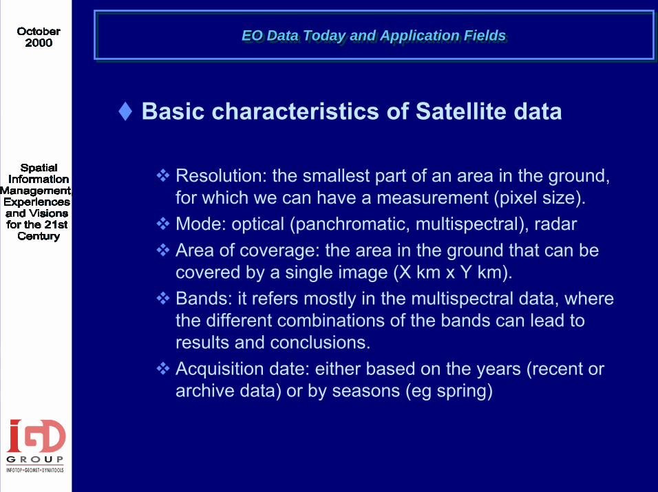
! Basic characteristics of Satellite data
" Resolution: the smallest part of an area in the ground, for which we can have a measurement (pixel size).
" Mode: optical (panchromatic, multispectral), radar" Area of coverage: the area in the ground that can be
covered by a single image (X km x Y km)." Bands: it refers mostly in the multispectral data, where
the different combinations of the bands can lead to results and conclusions.
" Acquisition date: either based on the years (recent or archive data) or by seasons (eg spring)

EO Data Today and Application Fields EO Data Today and Application Fields EO Data Today and Application Fields
! Main advantages of Satellite data
" Digital" Updated" Fast delivered" Cost effective (especially for large scale projects)" World wide coverage without restrictions" Synoptic (a single image has technical and
environmental information, morphology, land use etc.)" Accurate" Flexible

EO Data Today and Application Fields EO Data Today and Application Fields EO Data Today and Application Fields
! Satellite data providers
"SPOT Ιmage (exclusive distributors)"EURIMAGE"EUROMAP"Space Imaging Europe"Earthwatch (through EURIMAGE) – Q4/2000 "Orbimage (through SPOT Image) – Q2/2001

EO Data Today and Application Fields EO Data Today and Application Fields EO Data Today and Application Fields
! SPOT IMAGE - Data
Data Mode Resolution Area Acq. from
SPOT P panchromatic 10 m 60 km x 60 km 1986 SPOT XS multispectral (3 bands) 20 m 60 km x 60 km 1986 SPOT Xi multispectral (4 bands) 20 m 60 km x 60 km 1998 SPOT Vegetation multispectral (4 bands) 1 km 2,250kmx2,250km 1998
Processing in many different level, from raw till ortho.Programmation and stereoscopic acquisition available.
EO Data Today and Application Fields EO Data Today and Application Fields EO Data Today and Application Fields
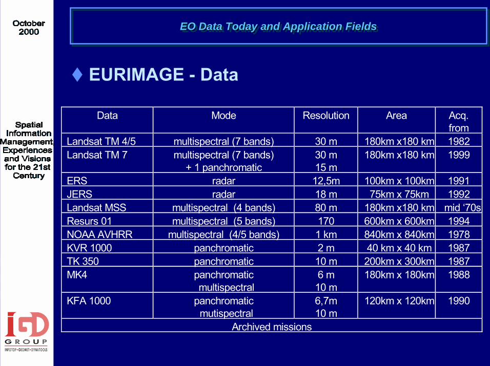
! ΕURIMAGE - Data
Data Mode Resolution Area Acq. from
Landsat TM 4/5 multispectral (7 bands) 30 m 180km x180 km 1982 Landsat TM 7 multispectral (7 bands)
+ 1 panchromatic 30 m 15 m
180km x180 km 1999
ERS radar 12,5m 100km x 100km 1991 JERS radar 18 m 75km x 75km 1992 Landsat MSS multispectral (4 bands) 80 m 180km x180 km mid ‘70s Resurs 01 multispectral (5 bands) 170 600km x 600km 1994 NOAA AVHRR multispectral (4/5 bands) 1 km 840km x 840km 1978 KVR 1000 panchromatic 2 m 40 km x 40 km 1987 TK 350 panchromatic 10 m 200km x 300km 1987 MK4 panchromatic
multispectral 6 m 10 m
180km x 180km 1988
KFA 1000 panchromatic mutispectral
6,7m 10 m
120km x 120km 1990
Archived missions

EO Data Today and Application Fields EO Data Today and Application Fields EO Data Today and Application Fields
! ΕUROMAP - Data
Data Mode Resolution Area Acq. from
IRS-1C/D Pan panchromatic 5,8 m 70km x 70 km 1996 IRS-1C/D Liss III multispectral (4 bands) 25 m 141km x141 km 1996 IRS-1C/D WifS Multispectral (2 bands) 188 m 804km x 804km 1996

EO Data Today and Application Fields EO Data Today and Application Fields EO Data Today and Application Fields
! High Resolution Satellite Data
Data Mode Resolution Area Acq. from
Ikonos (SIE) panchromatic 1 m 11 km x 11 km 1999 multispectral (4 bands) 4 m 11 km x 11 km 1999 Quick Bird panchromatic 1 m 22 km x 22 km 2000 multispectral (4 bands) 4 m 22 km x 22 km 2000 Orbview 3 panhromatic 1 m 8 km x18 km 2001 multispectral (4 bands) 4 m 8 km x 8 km 2001 Orbview 4 panchromatic 1 m 8 km x 8 km 2001 multispectral (4 bands) 4 m 8 km x 8 km 2001 hyperstpectral (200 bands) 20 m 5 km x 5 km 2001 SPOT 5 panchromatic 2,5 m – 5 m 60 km x 60 km 2002 multispectral (4 bands) 10 m 60 km x 60 km 2002

EO Data Today and Application Fields EO Data Today and Application Fields EO Data Today and Application Fields
!Application fields & project examples"Geographical data production: DEM, Ortho, Land
use maps, vector"Controls of set-aside"SISMOSAT: Creation of seismic hazard maps"Athens from Space: multimedia tourist guide"Environment management and monitoring" Change detection, etc.

EO Data Today and Application Fields EO Data Today and Application Fields EO Data Today and Application Fields
! Geographical Data
"DEM
"Clutter 5-class or 15-class
"Ortho panchromatic or multispectral
"Vectors 7-class

EO Data Today and Application Fields EO Data Today and Application Fields EO Data Today and Application Fields
! Geographical Data
Data Type Resolution Area Accuracy DEM from SPOT P raster 20 m Whole Greece 25-30 m Ortho SPOT P raster 10 m Whole Greece 20 m Ortho SPOT XS raster 20 m Many areas of Greece 25-30 m Ortho Landsat 5 raster 30 m Whole Greece 30-45 m Clutter - 5class thematic 20 m Whole Greece 25-30 m Clutter - 15class thematic 20 m Cities 25-30 m Linear data-7 class vector Whole Greece
For the production of all the above, knowledge and techniques ofRemote Sensing, Photo-interpretation, Digital Image processing, Cartography, Surveying and GPS were combined.
EO Data Today and Application Fields EO Data Today and Application Fields EO Data Today and Application Fields
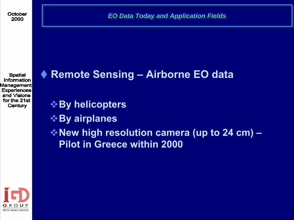
! Remote Sensing – Airborne EO data
"By helicopters"By airplanes"New high resolution camera (up to 24 cm) –
Pilot in Greece within 2000
EO Data Today and Application Fields EO Data Today and Application Fields EO Data Today and Application Fields
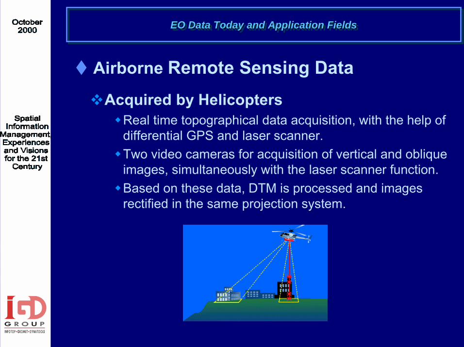
! Airborne Remote Sensing Data"Acquired by Helicopters
#Real time topographical data acquisition, with the help ofdifferential GPS and laser scanner.
#Two video cameras for acquisition of vertical and oblique images, simultaneously with the laser scanner function.
#Based on these data, DTM is processed and images rectified in the same projection system.

EO Data Today and Application Fields EO Data Today and Application Fields EO Data Today and Application Fields
! Airborne Remote Sensing Data
"Acquired by Aeroplanes #Real time data acquisition, using
radar systems.#Processing, projection of the SAR
data and DTM production, simultaneously with the data acquisition.
#Production of data and accessional processing of the data and the DTM, depending on the demands of the end user.

EO Data Today and Application Fields EO Data Today and Application Fields EO Data Today and Application Fields
! Airborne Remote Sensing Data
"New high resolution camera# 3 strips (forward, nadir, backward) # each point is captured 26 times# true ortho#Resolution: 24 cm in 6,000 m#RMS: Χ/Υ 20 cm, Z 30 cm in 6,000 m#Pilot in Greece within 2000