eops 2015 2_17
TRANSCRIPT

Surface Conditions Report, February 17, 2015
Eyes Over Puget Sound Field log Climate Water column Aerial photos Ferry and Satellite Moorings
Publication No. 15-03-071
Start here
Up-to-date observations of visible water quality conditions in Puget Sound and the Strait of Juan de Fuca
Picture credit: Joe Leatherman
Guest: South Sound Estuary Association

Personal field log p. 4 Why do I love Puget Sound? Climate conditions p. 6 The air temperatures and ocean conditions remain warm. Rivers are above normal except at the coast (Chehalis). The past week has generally been sunny and dry across the region. Water column p. 7 Puget Sound is a lot warmer at the end of 2014 with new maximum temperatures observed throughout the Sound! The higher dissolved oxygen and cold temperature anomalies in Hood Canal are disappearing. Moorings p. 37 Compared to past years, 2015 starts with warmer water and lower salinity at Mukilteo. Dissolved oxygen is rebounding. Aerial photography p. 10 Patches of jellyfish persist in finger inlets of South Sound. First signs of growing phytoplankton are seen where water is turning green. Otherwise, the surface waters are nice shades of blue and green and, as expected, carry sediment near rivers. Ferry and satellite p. 36 Victoria Clipper is in the shipyard
LO
NG
-T
ER
M
MA
RIN
E
MO
NIT
OR
ING
U
NIT
Mya Keyzers Laura Hermanson
Joe Leatherman
Skip Albertson
Dr. Christopher Krembs
Guest: Dr. Brandon Sackmann,
Integral
Julia Bos Suzan Pool
Editorial assistance provided by: Suzan Pool, Carol Maloy
Marine conditions from 2-17-2015 at a g lance Field log Climate Water column Aerial photos Ferry and Satellite Moorings
Please give us feedback

Expanded services and programs A larger location at 309 State Ave. NE hosts classes, citizen science projects, interpretive displays, and larger aquariums. The Estuarium is more visible this summer; a new mural on the east-facing wall, and new eye-catching art at the entrance. Learn about the fundraising concert featuring blues pianist Scott Cossu on May 1st, and other exciting events.
South Sound Estuary Association in Olympia Field log Climate Water column Aerial photos Ferry and Satellite Moorings
A larger location this summer
Visit us on the web at: http://www.sseacenter.org

I Puget Sound
Charismatic marine mammals
Sunrise Over the Water
Islands and hidden bays Wondrous marine life
What do you love the most about Puget Sound?
People that are curious and care
Personal Field Impression Field log Weather Water column Aerial photos Ferry and Satellite Moorings
Personal Field Impression Field log Climate Water column Aerial photos Ferry and Satellite Moorings
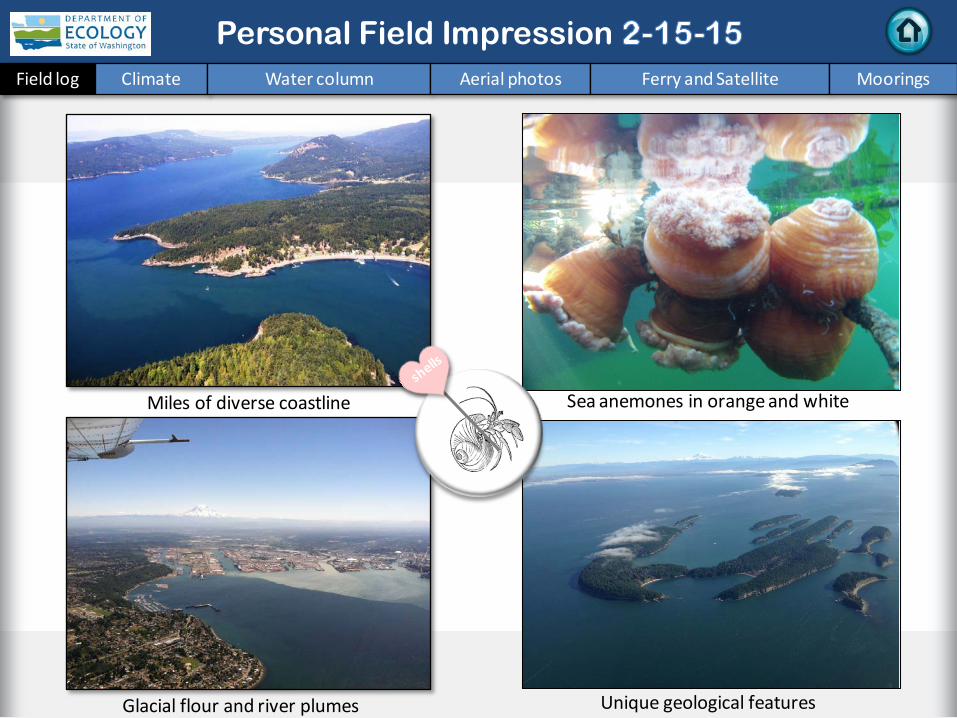
Sea anemones in orange and white
Unique geological features Glacial flour and river plumes
Miles of diverse coastline
Personal Field Impression Field log Climate Water column Aerial photos Ferry and Satellite Moorings

Field log Climate Water column Aerial photos Ferry and Satellite Moorings
Climate and natural influences before 2-17-2015
Summary: Air temperatures remain above normal, continuing a 10-month trend. Precipitation has been below normal for the past week and month in the Central Puget Sound region. Sunshine has been abundant for the past five days and above normal for the winter. River flows are above normal across the Puget Sound region, but below normal at the coast (Chehalis River). PDO remains in the warm phase, and upwelling is below normal.
lower higher expected No data
New section! Climate and natural influences are conditions that influence our marine waters, including weather, rivers, and the adjacent ocean (previously called Weather). For an explanation of the figure, see: http://www.ecy.wa.gov/programs/eap/mar_wat/weather.html, page 26.

We use a chartered float plane to access our monthly monitoring stations. We communicate data and environmental marine conditions using: 1. Marine Water
Condition Index (MWCI)
2. Eyes Over Puget Sound (EOPS)
3. Anomalies and source data
Field log Weather Water column Aerial photos Ferry and Satellite Moorings
Our long-term marine monitoring stations in Washington
Start here
Isl.
.

Physical conditions tracked in statistically historic context Field log Weather Water column Aerial photos Ferry and Satellite Moorings
Nov. 2014: Higher Temperature! Lower Oxygen except HC Lower Salinity in Central S.
Red boxes show that the water measured in fall 2014 is warmer than any of our measurements since 1999 Explore profiles at all stations
Month
In 2014, conditions were dominated by warm water during summer and fall, associated with the NE Pacific Ocean warm surface anomaly. In October and November, temperatures were the highest on our record since 1989. In 2014, salinity was higher and later, waters south of Admiralty Reach became fresher. Oxygen was mostly lower except in Hood Canal where a high anomaly persisted into the fall.

a) Pacific Decadal Oscillation Index (PDO, temperature) (explanation) b) Upwelling Index (anomalies) (Upwelling, low oxygen) (explanation) c) North Pacific Gyre Oscillation Index (NPGO, productivity) (explanation)
Field log Weather Water column Aerial photos Ferry and Satellite Moorings
The ocean affects water quality: Ocean Climate Indices N
PGO
(x10) PD
O/U
pwel
ling I
ndex
Three-year running average of PDO, Upwelling, and NPGO indices scores
.
-25 -20 -15 -10 -5 0 5 10 15 20 25
-1.5
-1
-0.5
0
0.5
1
1.5
1945 1950 1955 1960 1965 1970 1975 1980 1985 1990 1995 2000 2005 2010 2015
Ocean boundary conditions are no longer favorable for water quality in Puget Sound: (a) water is warming (PDO), (b) upwelling of low oxygen and high nutrient ocean water is again increasing (Upwelling Index), and (c) higher surface productivity along the coast (NPGO) is falling. Where are we heading next?
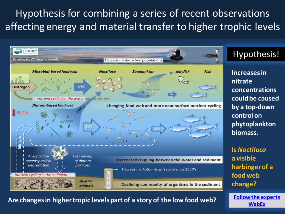
Is the food web changing in Puget Sound?
Follow the experts WebEx
Hypothesis! Increases in nitrate concentrations could be caused by a top-down control on phytoplankton biomass. Is Noctiluca a visible harbinger of a food web change?
Hypothesis for combining a series of recent observations affecting energy and material transfer to higher trophic levels
Are changes in higher tropic levels part of a story of the low food web?

Summary: Aerial photography 2-17-2015
Patches of jellyfish persist in finger inlets of South Sound. First signs of growing phytoplankton appear where water is turning green. Otherwise, the surface waters are in nice shades of blue and green and, as expected, carry sediment near rivers. High tides are mobilizing driftwood.
Field log Weather Water column Aerial photos Ferry and Satellite Moorings
Start here Mixing and Fronts: Tidal fronts and a high tide mobilizing driftwood. Several sizable tidal eddies as a result of strong tides.
Debris: Large lines and patches of organic debris in South Sound (Budd and Totten Inlets).
Visible blooms: Green-brown: First signs of growing phytoplankton biomass in response to sunny weather across the Sound. No blooms.
Jellyfish: Jellyfish patches still persist in southern inlets of South Sound (Totten, Eld, and Budd Inlets).
Bloo
m
Debr
is
Fron
t Suspended sediment: Large suspended sediment plume confined to region around Rosario Strait. How does this work?
Plum
e
Reflections on the propeller of the plane
1 2
4 5 9 17
Big sea anemones growing on flotsam
Picture credit: Joe Leatherman
1 3 5 6 9 11 12 13 14 15 19
3
20 19 18 11 12
1 2 3 5 6 11 12 13 14 15 19 18

Strait of Juan de Fuca
San Juan Islands Padilla Bay
Main Basin
Hood Canal
South Sound
Whidbey Basin
Field log Climate Water column Aerial photos Ferry and Satellite Moorings
Observation Maps:
Afternoon flight, photos 13-20 Sunny, high visibility, winds
Flight Information:
Morning flight, photos 1-12 Sunny, cold, high visibility
8
11 10
Aerial photography and navigation guide
6
Central and North Sound
South Sound
7
12
5 Flight route and fueling stop
17
9 18
3 2 1
4
13 14
19
16
Tides Feet (Seattle) 4:08 AM 11.65 H 9:38 AM 6.05 L 2:54 PM 11.31 H 9:43 PM -1.56 L
15
20

Jellyfish patches and strong organic debris lines. Location: Off Burfoot Park, Budd Inlet (South Sound), 9:32 AM.
1 Aerial photography 2-17-2015 Navigate
Field log Climate Water column Aerial photos Ferry and Satellite Moorings
jellyfish
jellyfish
Debr
is
Debr
is

2 Navigate Aerial photography 2-17-2015 Field log Climate Water column Aerial photos Ferry and Satellite Moorings
Numerous jellyfish patches lasting through the warm winter. Location: Near Young Cove, Budd Inlet (South Sound), 9:34 AM.
jellyfish jellyfish
jellyfish jellyfish
jellyfish
jellyfish
Debr
is
Debr
is
boat

3 Navigate Aerial photography 2-17-2015
Long organic debris line along front. Location: Off Baron Point, Totten Inlet (South Sound), 9:51 AM.
Field log Climate Water column Aerial photos Ferry and Satellite Moorings
jellyfish De
bris
boat

4 Navigate
Field log Climate Water column Aerial photos Ferry and Satellite Moorings
Aerial photography 2-17-2015
Skokomish River plume entering Hood Canal between tidally submerged flats. Location: Off Union (Hood Canal), 11:18 AM.
suspended sediment
5 Navigate Aerial photography 2-17-2015 Field log Climate Water column Aerial photos Ferry and Satellite Moorings
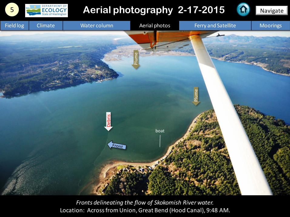
Fronts delineating the flow of Skokomish River water. Location: Across from Union, Great Bend (Hood Canal), 9:48 AM.
Plum
e
Plum
e
Debr
is
boat

Long front and organic debris line at entrance to Dabob Bay. Location: Across from Seabeck (Hood Canal), 10:03 AM.
6 Navigate Aerial photography 2-17-2015 Field log Climate Water column Aerial photos Ferry and Satellite Moorings
Debr
is
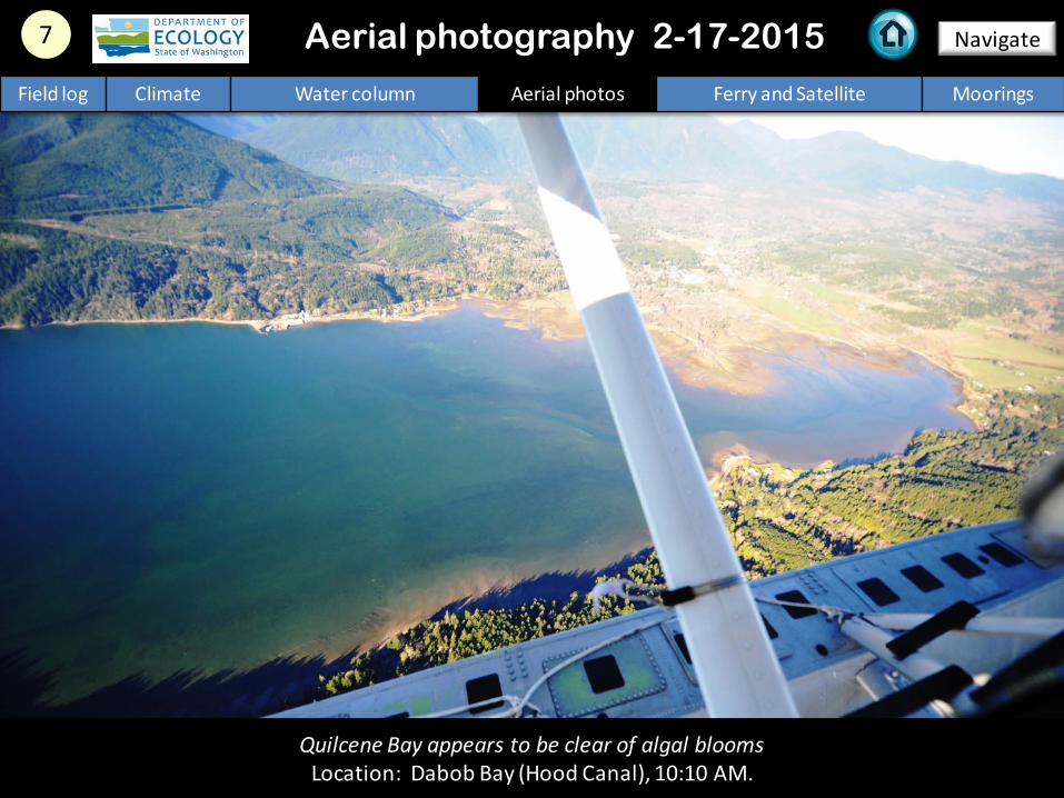
Quilcene Bay appears to be clear of algal blooms Location: Dabob Bay (Hood Canal), 10:10 AM.
7 Navigate Aerial photography 2-17-2015 Field log Climate Water column Aerial photos Ferry and Satellite Moorings

Tidal eddies form as water flows southward through Portage Canal. Location: Indian Island (North Sound), 10:22 AM.
8 Navigate Aerial photography 2-17-2015 Field log Climate Water column Aerial photos Ferry and Satellite Moorings
tidal eddy
tidal eddy
boat

Strong tidal currents (flood) and fine suspended sediments show structures of turbulence and shear. Location: Fort Worden State Park (North Sound), 11:04 AM.
9 Navigate Aerial photography 2-17-2015 Field log Climate Water column Aerial photos Ferry and Satellite Moorings
suspended sediment
boat

10 Navigate Aerial photography 2-17-2015
Panorama shot of Fort Ebey State Park and Penn Cove. Location: Strait of Juan de Fuca (North Sound), 11:07 AM.
Field log Climate Water column Aerial photos Ferry and Satellite Moorings

11 Navigate Aerial photography 2-17-2015
Strong front with debris line retaining sediment-rich surface water in Rosario Strait. Location: Entrance to Obstruction Pass (San Juan Islands), 11:22 AM.
Field log Climate Water column Aerial photos Ferry and Satellite Moorings
Fron
t
suspended sediment
suspended sediment
Debr
is
boat

Strong front with debris line retaining sediment-rich surface water in Rosario Strait. Location: Entrance to Obstruction Pass (San Juan Islands), 11:58 AM.
12 Navigate
Field log Climate Water column Aerial photos Ferry and Satellite Moorings
Aerial photography 2-17-2015
suspended sediment De
bris
Debr
is

Strong front with debris line with sediment-rich surface water to the east. Location: Across from San Juan Islands National Wildlife Refuge (San Juan Islands), 12:03 PM.
13 Navigate Aerial photography 2-17-2015 Field log Climate Water column Aerial photos Ferry and Satellite Moorings
Fron
t
Fron
t
Fron
t
suspended sediment
Debr
is

A. B.
Very structured surface water with fronts and debris lines. Location: A. Eastsound, B. San Juan Islands National Wildlife Refuge (Orcas Island), 12:04 PM.
14 Navigate
Field log Climate Water column Aerial photos Ferry and Satellite Moorings
Aerial photography 2-17-2015
Fron
t
Debr
is
Debr
is

B.
A.
15 Navigate
Field log Climate Water column Aerial photos Ferry and Satellite Moorings
Front with near-surface phytoplankton-rich layer and debris lines. Location: A. Tumbo Island looking across US-Canada border, B. Ship wake (Georgia Basin), 12:08 PM.
Aerial photography 2-17-2015
Debr
is
Debr
is
Debr
is
ship

16 Navigate
South Padilla Bay during high tide. Location: North entrance of Swinomish Channel (North Sound), 1:47 PM.
Aerial photography 2-17-2015 Field log Climate Water column Aerial photos Ferry and Satellite Moorings

17 Navigate
Field log Climate Water column Aerial photos Ferry and Satellite Moorings
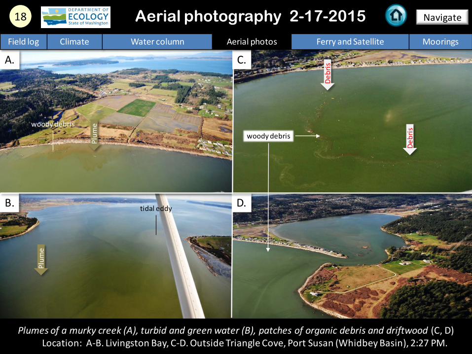
Suspended sediment of the Skagit River carrying woody debris into Skagit Bay. Location: Near La Conner, Skagit Bay (Whidbey Basin), 1:50 PM.
Aerial photography 2-17-2015
Plum
e
B. D.
Plumes of a murky creek (A), turbid and green water (B), patches of organic debris and driftwood (C, D) Location: A-B. Livingston Bay, C-D. Outside Triangle Cove, Port Susan (Whidbey Basin), 2:27 PM.
Plum
e
tidal eddy
Plum
e
woody debris woody debris
Debr
is
Debr
is
A. C.
18 Navigate
Field log Climate Water column Aerial photos Ferry and Satellite Moorings
Aerial photography 2-17-2015

A. B.
C. D.
19 Navigate
Field log Climate Water column Aerial photos Ferry and Satellite Moorings
Smaller bays prone to water quality issues are appearing relatively clear (A-B, D). Small eddy (C). Location: A-C. Holmes Harbor (Whidbey Basin), D. Port Gamble (Hood Canal), 3:50 PM.
Aerial photography 2-17-2015
suspended sediment
suspended sediment
Plum
e
tidal eddy
Debr
is
boat
boat
boat

20 Navigate
Ongoing suspended sediment from human activity. Location: Northeastern bay of Harstine Island, Case Inlet (South Sound), 4:27 PM.
Aerial photography 2-17-2015 Field log Climate Water column Aerial photos Ferry and Satellite Moorings
suspended sediment
boat
boat
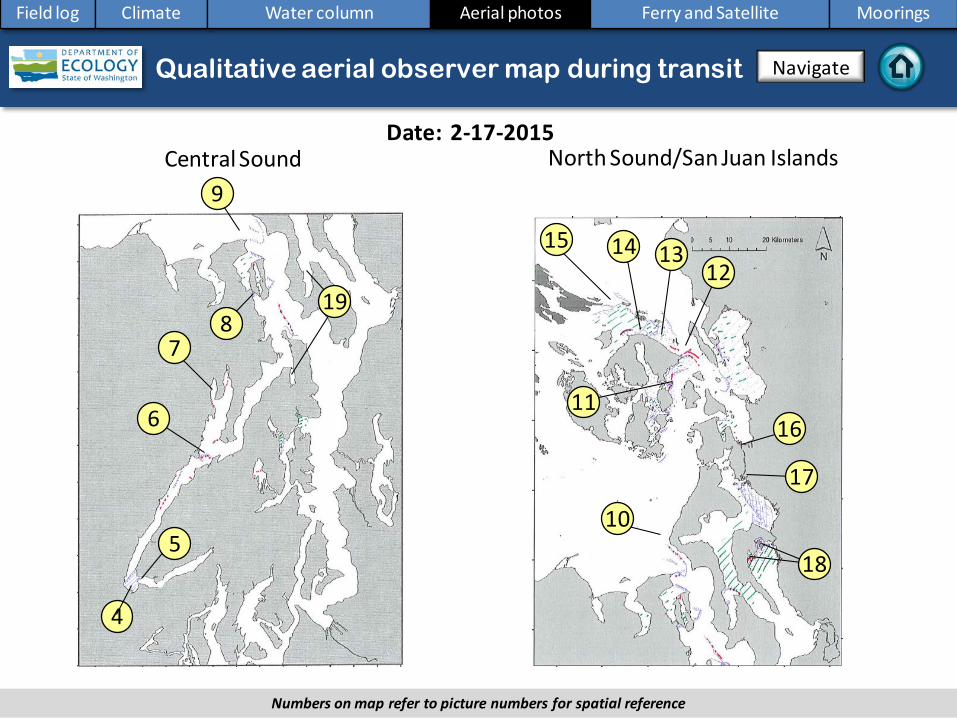
North Sound/San Juan Islands Date: 2-17-2015
Central Sound
Aerial photography observations in Central Sound Qualitative aerial observer map during transit Navigate
Field log Climate Water column Aerial photos Ferry and Satellite Moorings
5
6
10
9
11
12
4
7 8
13 15
16
17
14
18
19
Numbers on map refer to picture numbers for spatial reference

Date: 2-17-2015
Qualitative aerial observer map during transit
Numbers on map refer to picture numbers for spatial reference
Navigate
Field log Climate Water column Aerial photos Ferry and Satellite Moorings
South Sound
1
2
3 20

Legend to map annotations
Comments: Maps are produced by observers during and after flights. They are intended to give an approximate reconstruction of the surface conditions on scales that connect to and overlap with satellite images in the section that follows. Debris: Debris can be distinguished into natural and anthropogenic debris floating at the surface sensu Moore and Allen (2000). The majority of organic debris in Puget Sound is natural and mixed with discarded man-made pieces of plastic, wood, etc. From the plane, we cannot differentiate the quality of debris at the surface and therefore, call it for reasons of practicality just “debris”. S.L. Moore, M. J. Allen. 2000. Distribution of Anthropogenic and Natural Debris on the Mainland Shelf of the Southern California Bight. Marine Pollution Bulletin, 40(1): 83–88.
Navigate
Field log Climate Water column Aerial photos Ferry and Satellite Moorings

Current Conditions: Victoria Clipper in the shipyard this month. No data.
Brandon Sackmann Contact: [email protected]
Field log Climate Water column Aerial photos Ferry and Satellite Moorings
Ferry and satellite observations 2-17-2015
Start here
16 November 2014 16 November 2014 The Victoria Clipper IV carries sensors in its sea chest. The sensors allow us to get surface transects of temperature, chlorophyll, salinity, and other bio-optical measurements between Seattle and Victoria, BC twice per day.

Mooring observations and trends 02-04-2015 to 02-17-2015
Field log Climate Water column Aerial photos Ferry and Satellite Moorings
At Mukilteo, recent observations indicate continuation of decreasing water temperature and increasing dissolved oxygen. In the upper mooring, water mixing appears influenced by tides. In early February, the deeper mooring detected decreasing salinity and increasing temperature that coincides with river flows.
These plots show the probability of observations over the past two-week period. High probability shown in warm colors. Left Panels: Density is defined by salinity and temperature. Right Panel: Dissolved oxygen concentration in relation to salinity.
2-6 m depth
Dissolved oxygen not measured
12-16 m depth

Mooring observations and trends 01-18-2015 to 02-17-2015
Field log Climate Water column Aerial photos Ferry and Satellite Moorings
Our mooring station in Mukilteo is located in Whidbey Basin near Everett. It is also located at the transition between Possession and Central Sounds at a depth that is influenced by the Skagit and Snohomish river discharges, prevailing winds, and tidal mixing. As the largest regional contributor of freshwater to Puget Sound, understanding the timing and magnitude of the Skagit River flow is important. We present data of daily means for the past 31 days. Data are plotted in Pacific Standard Time. Wind data are from Paine Field in Everett. River flow data are from USGS.
Click on icon to view real-time data of the moorings
2.02.53.03.54.04.5
Daily
Tid
al R
ange
(d
b)
Near-bottom sensor and associated environmental data at Mukilteo
-10-505
101520
Mea
n Da
ily W
ind
Spee
d (k
ts)
NortherlySoutherly
0
500
1000
1500
2000
18-Ja
n19
-Jan
20-Ja
n21
-Jan
22-Ja
n23
-Jan
24-Ja
n25
-Jan
26-Ja
n27
-Jan
28-Ja
n29
-Jan
30-Ja
n31
-Jan
1-Fe
b2-
Feb
3-Fe
b4-
Feb
5-Fe
b6-
Feb
7-Fe
b8-
Feb
9-Fe
b10
-Feb
11-F
eb12
-Feb
13-F
eb14
-Feb
15-F
eb16
-Feb
17-F
eb
Mea
n Da
ily R
iver
Di
scha
rge
(m3 /
sec) Skagit River
Snohomish River
27.0
28.0
29.0
30.0
9.6
9.7
9.8
9.9
10.0
10.1
Mean Daily
Salinity (psu)
Mea
n Da
ily W
ater
Te
mpe
ratu
re (°
C) TemperatureSalinity

Mooring observations and trends Mukilteo 2010 to 2015
Field log Climate Water column Aerial photos Ferry and Satellite Moorings
At the Mukilteo mooring, we use the near-bottom sensor (12-16 m deep) to measure significant inter-annual variability in temperature, salinity, and dissolved oxygen. Inter-annual variability is shown over a 5-year period. All three variables show strong seasonality. As compared to past years, the start of 2015 is showing that water temperature is warmer and salinity is lower. Dissolved oxygen is roughly similar to 2010, 2011, and 2013. Seasonally, there is an increase in water temperature, decrease in salinity, and little change in dissolved oxygen.
Please note that data are provisional. Data are in GMT.

Access mooring data:
ftp://www.ecy.wa.gov/eap/Mooring_Raw/Puget_S
ound/
Ferry and satellite : [email protected]
Get data from Ecology’s Marine Monitoring Programs
Long–Term Monitoring Network
Real–Time Sensor Network
Access core monitoring data: http://www.ecy.wa.gov/apps/eap/marinewq/mwda
taset.asp
Ecology’s long-term marine monitoring stations
Ferry track
Field log Climate Water column Aerial photos Ferry and Satellite Moorings
River and Stream Water Quality Monitoring
http://www.ecy.wa.gov/programs/eap/fw_riv/rv_main.html
Discontinued (funding cuts)
You may subscribe or unsubscribe to the Eyes Over Puget Sound email listserv by going to: http://listserv.wa.gov/cgi-bin/wa?A0=ECOLOGY-EYES-OVER-PUGET-SOUND
Many thanks to our business partners: Clipper Navigations, Swantown Marina, and Kenmore Air.
We are looking for feedback to improve our products.
Dr. Christopher Krembs
Marine Monitoring Unit Environmental Assessment Program
WA Department of Ecology
Field log Climate Water column Aerial photos Ferry and Satellite Moorings