ep 1110-2-11 - publications.usace.army.mil · approved for public release ... prevent future...
TRANSCRIPT
CECW-EH
Engineer Pamphlet1110-2-11
Department of the ArmyU.S. Army Corps of Engineers
Washington, DC 20314-1000
EP 1110-2-11
30 November 1994
Engineering and Design
ICE JAM FLOODING:CAUSES AND POSSIBLE SOLUTIONS
Distribution Restriction StatementApproved for public release; distribution is
unlimited.
DEPARTMENT OF THE ARMY EP 1110-2-11U.S. Army Corps of Engineers
CECW-EH Washington, DC 20314-1000
PamphletNo. 1110-2-11 30 November 1994
Engineering and DesignICE JAM FLOODING:
CAUSES AND POSSIBLE SOLUTIONS
1. Purpose
This pamphlet disseminates the results of researchconducted by the U.S. Army Corps of EngineersCold Regions Research and Engineering Laboratoryon the causes and possible solutions to ice jamflooding problems.
2. Applicability
This pamphlet applies to all HQUSACE elements,major subordinate commands, districts, laboratories,and field operating activities having civil worksresponsibilities concerning ice.
3. References
(See Appendix A.)
4. General
In spite of significant annual damages, ice jamflooding has received little public attention. Thisdocument brings together the diverse technical andnontechnical information that comprises the state ofthe art in ice jam mitigation. These concepts,which are based on the extensive experience, shouldbe considered for new or rehabilitation projectswhere applicable.
FOR THE COMMANDER:

DEPARTMENT OF THE ARMY EP 1110-2-11U.S. Army Corps of Engineers
CECW-EH Washington, DC 20314-1000
PamphletNo. 1110-2-11 30 November 1994
Engineering and DesignICE JAM FLOODING:
CAUSES AND POSSIBLE SOLUTIONS
Table of Contents
Subject Paragraph Page
Chapter 1IntroductionPurpose . . . . . . . . . . . . . . . . . . . . . . . . . . . . . . . . . . . . . . . . . . . . . . . . . . . . . . . . . . . . . . . 1-1 1-1Applicability . . . . . . . . . . . . . . . . . . . . . . . . . . . . . . . . . . . . . . . . . . . . . . . . . . . . . . . . . . . . 1-2 1-1References . . . . . . . . . . . . . . . . . . . . . . . . . . . . . . . . . . . . . . . . . . . . . . . . . . . . . . . . . . . . . 1-3 1-1Audience . . . . . . . . . . . . . . . . . . . . . . . . . . . . . . . . . . . . . . . . . . . . . . . . . . . . . . . . . . . . . . 1-4 1-1Explanation of Terms. . . . . . . . . . . . . . . . . . . . . . . . . . . . . . . . . . . . . . . . . . . . . . . . . . . . . . 1-5 1-1
Chapter 2ProblemFlooding in the United States. . . . . . . . . . . . . . . . . . . . . . . . . . . . . . . . . . . . . . . . . . . . . . . . 2-1 2-1Ice Jam Flooding. . . . . . . . . . . . . . . . . . . . . . . . . . . . . . . . . . . . . . . . . . . . . . . . . . . . . . . . . 2-2 2-1Ice Jam Flood Losses. . . . . . . . . . . . . . . . . . . . . . . . . . . . . . . . . . . . . . . . . . . . . . . . . . . . . . 2-3 2-2
Chapter 3BackgroundTypes of Ice . . . . . . . . . . . . . . . . . . . . . . . . . . . . . . . . . . . . . . . . . . . . . . . . . . . . . . . . . . . . 3-1 3-1Types of Ice Jams. . . . . . . . . . . . . . . . . . . . . . . . . . . . . . . . . . . . . . . . . . . . . . . . . . . . . . . . 3-2 3-1Causes of Ice Jams. . . . . . . . . . . . . . . . . . . . . . . . . . . . . . . . . . . . . . . . . . . . . . . . . . . . . . . 3-3 3-4
Chapter 4Ice Jam Mitigation TechniquesIce Jam Flood Control. . . . . . . . . . . . . . . . . . . . . . . . . . . . . . . . . . . . . . . . . . . . . . . . . . . . . 4-1 4-1Permanent Measures. . . . . . . . . . . . . . . . . . . . . . . . . . . . . . . . . . . . . . . . . . . . . . . . . . . . . . . 4-2 4-3Advance Measures. . . . . . . . . . . . . . . . . . . . . . . . . . . . . . . . . . . . . . . . . . . . . . . . . . . . . . . . 4-3 4-9Emergency Measures. . . . . . . . . . . . . . . . . . . . . . . . . . . . . . . . . . . . . . . . . . . . . . . . . . . . . . 4-4 4-13
Chapter 5Ice Jam Mitigation Case StudiesKankakee River, IL - Thermal Control. . . . . . . . . . . . . . . . . . . . . . . . . . . . . . . . . . . . . . . . . . 5-1 5-1Hardwick, VT - Improved Natural Storage, Ice Retention, Mechanical Removal. . . . . . . . . . . . . 5-2 5-1Oil City, PA - Floating Ice Boom, Revised Operational Procedures, Ice Control Dam. . . . . . . . . 5-3 5-1Lancaster, NH - Weir, Ice Retention, Storage. . . . . . . . . . . . . . . . . . . . . . . . . . . . . . . . . . . . . 5-4 5-4Idaho Falls, ID - Land Acquisition. . . . . . . . . . . . . . . . . . . . . . . . . . . . . . . . . . . . . . . . . . . . . 5-5 5-4Platte River, NE - Dusting. . . . . . . . . . . . . . . . . . . . . . . . . . . . . . . . . . . . . . . . . . . . . . . . . . 5-6 5-4Allagash, ME - Floodproofing, Relocation. . . . . . . . . . . . . . . . . . . . . . . . . . . . . . . . . . . . . . . 5-7 5-6
i

EM 1110-2-1130 Nov 94
Subject Paragraph Page
Chapter 6Ice Jam Mitigation AssistanceU.S. Army Corps of Engineers. . . . . . . . . . . . . . . . . . . . . . . . . . . . . . . . . . . . . . . . . . . . . . . 6-1 6-1Cold Regions Research and Engineering Laboratory. . . . . . . . . . . . . . . . . . . . . . . . . . . . . . . . . 6-2 6-1Ice Jam Database. . . . . . . . . . . . . . . . . . . . . . . . . . . . . . . . . . . . . . . . . . . . . . . . . . . . . . . . . 6-3 6-1
Appendix AReferences
Appendix BGlossary
ii

EP 1110-2-1130 Nov 94
Chapter 1Introduction
1-1. Purpose
This pamphlet provides the diverse technical and nontechnical information that comprises the state of the art in ice jammitigation.
1-2. Applicability
This pamphlet is applicable to all HQUSACE elements, major subordinate commands, districts, laboratories, and fieldoperating activities located in the freezing zone with responsibility for design, construction, and operation.
1-3. References
A list of references is included as Appendix A.
1-4. Audience
The information is intended to be helpful to hydraulic engineering specialists and emergency operations personnel as wellas state and local officials who are responsible for rapid, effective response to ice jam emergencies.
1-5. Explanation of Terms
See Appendix B for a glossary of terms.
1-1

EP 1110-2-1130 Nov 94
Chapter 2Problem
2-1. Flooding in the United States
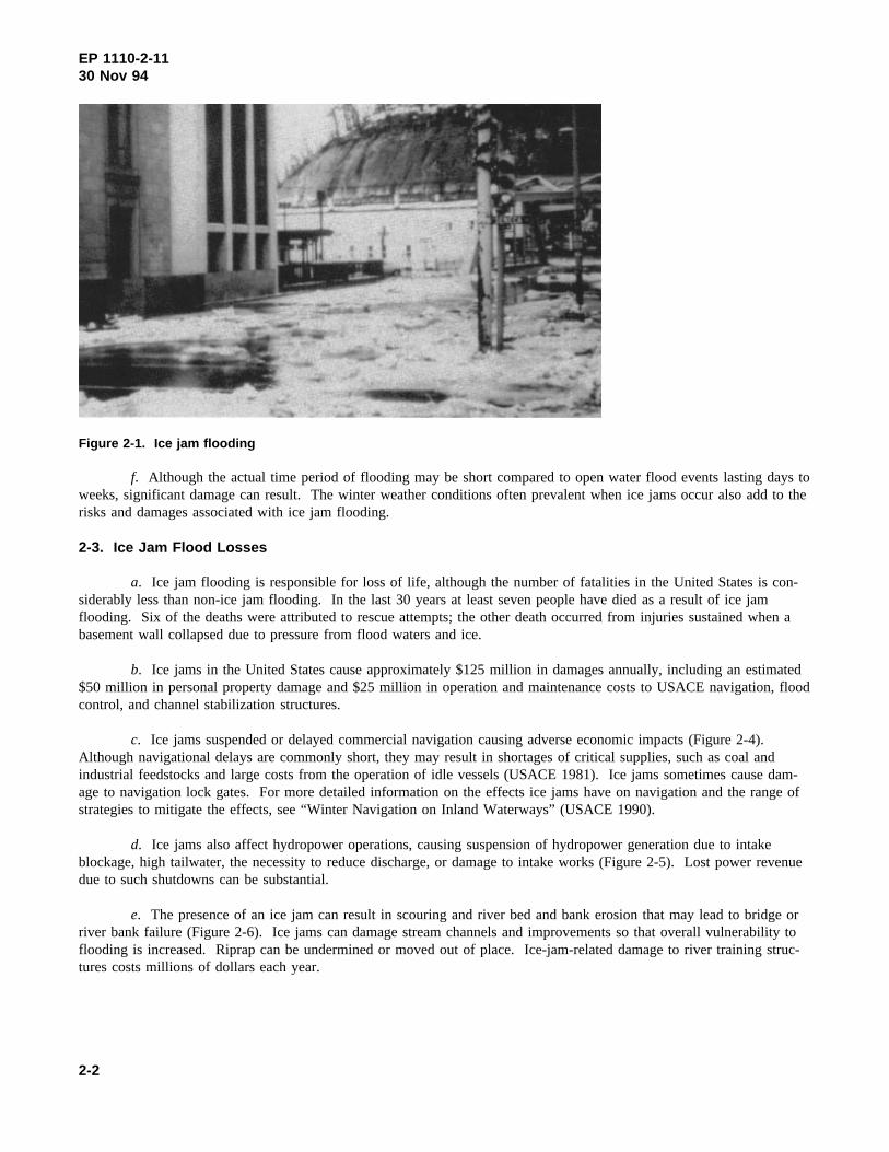
a. Flooding and flood-related events cause greater damage and more fatalities than any other natural disaster.About 80 percent of all presidential disaster declarations are the result of flooding (Federal Emergency ManagementAgency (FEMA) 1992a). Flood damages averaged $3.3 billion and flood-related fatalities averaged about 100 annuallyover the past 10 years (USACE 1993, 1994). The most common type of flood occurs as a result of a major rainfall orsnowmelt. A second type of flood occurs suddenly, as in the case of dam failures or intense rainfall that generates aflash flood. A third category of flood results from an ice or debris jam. Flood stages during an ice jam (Figure 2-1) canincrease more rapidly and attain higher levels than those associated with open water conditions. Ice jam flooding mayoccur outside the regulatory floodplain, often when the river flow would not otherwise cause problems.
b. Many laws and regulations have been developed to reduce national vulnerability to flooding. Most Americancommunities have floodplain regulations designed to prevent future development in areas subject to conventional openwater flooding. Some communities are protected by structural controls such as dikes, levees, and flood control dams.Mitigation measures specifically designed to protect against ice jam flooding are used less commonly.
2-2. Ice Jam Flooding
a. In many northern regions ice covers the rivers and lakes annually. The annual freezeup and breakup com-monly occur without major flooding. However, some communities face serious ice jam threats every year, while othersexperience ice-jam-induced flooding at random intervals. The former often have developed emergency plans to deal withice jam problems, but the latter are often ill-prepared to cope with a jam event when it occurs.
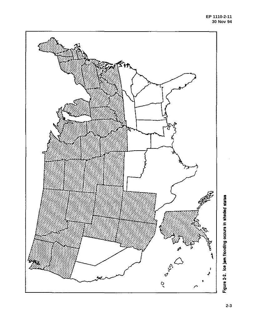
b. Ice jams take place in 30 states, primarily in the northern tier of the United States (Figure 2-2). Even moun-tainous regions as far south as New Mexico and Arizona experience river ice. Ice jams affect the major navigable inlandwaterways of the United States including the Great Lakes. A study conducted in Maine, New Hampshire, and Vermontidentified over 200 small towns and cities that reported ice jam flooding over a 10-year period (USACE 1980). In March1992 alone, 62 towns in New Hampshire and Vermont reported ice jam flooding problems after two rainfall events.Table 2-1 lists some of the major ice jams recently recorded.
c. In a l992 survey, USACE offices reported ice jam problems within 36 states. Of the 36 states, 63 percentreported that ice jams occur frequently, and 75 percent rated ice jams as being serious to very serious (White 1992).
d. Because ice jam events are less common and more poorly documented than open water events, it is moredifficult to characterize these events than open water flooding. In addition, due to the complex processes involved in theformation and progression of ice jams and the highly site-specific nature of these jams, these events are more difficult topredict than open water flooding.
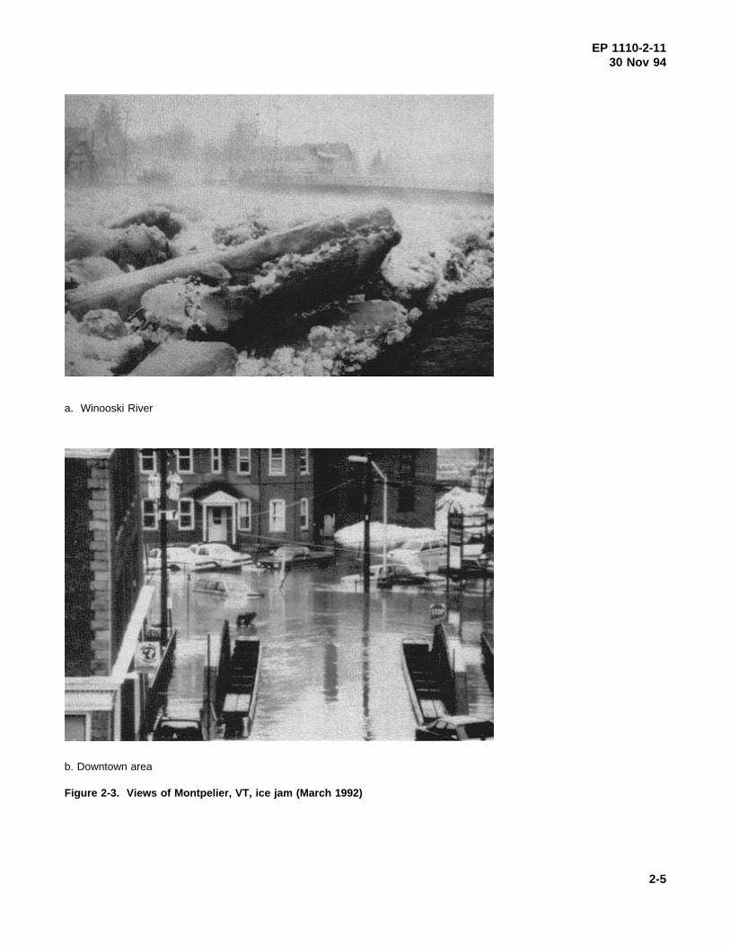
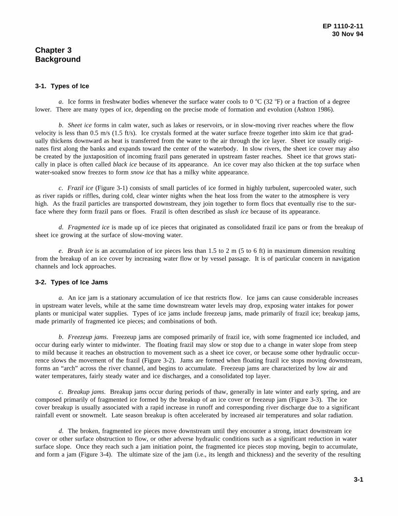
e. The rates of water level rise can vary from feet per minute to feet per hour during ice jam flooding. In someinstances, communities have many hours of lead time between the time an ice jam forms and the start of flooding. Inother cases, the lead time is a little as one hour. For example, in March 1992, an ice jam developed at 7:00 a.m. inMontpelier, VT. By 8:00 a.m. the downtown area was flooded (Figure 2-3). During the next 11 hours, the businessdistrict was covered with an average of 1.2 to 1.5 m (4 to 5 ft) of water. The event occurred so quickly that there wasnot sufficient time to warn residents so they could protect their goods. Even after water levels dropped, damage relatedto the flooding continued as cold temperatures caused freezeup of wet objects. Damages of less than one day were esti-mated at $5 million (FEMA 1992b).
2-1
EP 1110-2-1130 Nov 94
Figure 2-1. Ice jam flooding
f. Although the actual time period of flooding may be short compared to open water flood events lasting days toweeks, significant damage can result. The winter weather conditions often prevalent when ice jams occur also add to therisks and damages associated with ice jam flooding.
2-3. Ice Jam Flood Losses
a. Ice jam flooding is responsible for loss of life, although the number of fatalities in the United States is con-siderably less than non-ice jam flooding. In the last 30 years at least seven people have died as a result of ice jamflooding. Six of the deaths were attributed to rescue attempts; the other death occurred from injuries sustained when abasement wall collapsed due to pressure from flood waters and ice.
b. Ice jams in the United States cause approximately $125 million in damages annually, including an estimated$50 million in personal property damage and $25 million in operation and maintenance costs to USACE navigation, floodcontrol, and channel stabilization structures.
c. Ice jams suspended or delayed commercial navigation causing adverse economic impacts (Figure 2-4).Although navigational delays are commonly short, they may result in shortages of critical supplies, such as coal andindustrial feedstocks and large costs from the operation of idle vessels (USACE 1981). Ice jams sometimes cause dam-age to navigation lock gates. For more detailed information on the effects ice jams have on navigation and the range ofstrategies to mitigate the effects, see “Winter Navigation on Inland Waterways” (USACE 1990).
d. Ice jams also affect hydropower operations, causing suspension of hydropower generation due to intakeblockage, high tailwater, the necessity to reduce discharge, or damage to intake works (Figure 2-5). Lost power revenuedue to such shutdowns can be substantial.
e. The presence of an ice jam can result in scouring and river bed and bank erosion that may lead to bridge orriver bank failure (Figure 2-6). Ice jams can damage stream channels and improvements so that overall vulnerability toflooding is increased. Riprap can be undermined or moved out of place. Ice-jam-related damage to river training struc-tures costs millions of dollars each year.
2-2
EP 1110-2-1130 Nov 94
2-3

EP 1110-2-1130 Nov 94
Table 2-1Recent Major Ice Jams in the United States
Place Date Type (Damages)
Montpelier, VT March 1992 Breakup ($5M)
Allagash, ME April 1991 Breakup ($14M)
Salmon, ID February 1984 Freezeup ($1.8M)
Port Jervis, NYMatamoras, PA
February 1981 Breakup ($14.5M)
Mississippi/MissouriRivers confluence
December 1989 Breakup (>$20M)
f. Indirect costs associated with ice jams include loss of fish and wildlife and their habitat. Scour and erosionassociated with ice jams may destroy habitat, such as eagle roosting trees, and mobilize toxic materials buried in sedi-ment. Some scouring may, however, be beneficial to wildlife habitat as well. Shallow, vegetation-choked wetlands maybecome open, allowing for fish and waterfowl spawning and brood habitat.
2-4
EP 1110-2-1130 Nov 94
a. Winooski River
b. Downtown area
Figure 2-3. Views of Montpelier, VT, ice jam (March 1992)
2-5

EP 1110-2-1130 Nov 94
Figure 2-4. Towboats and barges in ice
Figure 2-5. Jam immediately downstream of power plant, Fox River, IL
2-6

EP 1110-2-1130 Nov 94
Figure 2-6. Bank scour due to a breakup jam, St. John River, MN, nearAllagash
2-7
EP 1110-2-1130 Nov 94
Chapter 3Background
3-1. Types of Ice
a. Ice forms in freshwater bodies whenever the surface water cools to 0oC (32 oF) or a fraction of a degreelower. There are many types of ice, depending on the precise mode of formation and evolution (Ashton 1986).
b. Sheet iceforms in calm water, such as lakes or reservoirs, or in slow-moving river reaches where the flowvelocity is less than 0.5 m/s (1.5 ft/s). Ice crystals formed at the water surface freeze together into skim ice that grad-ually thickens downward as heat is transferred from the water to the air through the ice layer. Sheet ice usually origi-nates first along the banks and expands toward the center of the waterbody. In slow rivers, the sheet ice cover may alsobe created by the juxtaposition of incoming frazil pans generated in upstream faster reaches. Sheet ice that grows stati-cally in place is often calledblack icebecause of its appearance. An ice cover may also thicken at the top surface whenwater-soaked snow freezes to formsnow icethat has a milky white appearance.
c. Frazil ice (Figure 3-1) consists of small particles of ice formed in highly turbulent, supercooled water, suchas river rapids or riffles, during cold, clear winter nights when the heat loss from the water to the atmosphere is veryhigh. As the frazil particles are transported downstream, they join together to form flocs that eventually rise to the sur-face where they form frazil pans or floes. Frazil is often described asslush icebecause of its appearance.
d. Fragmented iceis made up of ice pieces that originated as consolidated frazil ice pans or from the breakup ofsheet ice growing at the surface of slow-moving water.
e. Brash iceis an accumulation of ice pieces less than 1.5 to 2 m (5 to 6 ft) inmaximum dimension resultingfrom the breakup of an ice cover by increasing water flow or by vessel passage. It is of particular concern in navigationchannels and lock approaches.
3-2. Types of Ice Jams
a. An ice jam is a stationary accumulation of ice that restricts flow. Ice jams can cause considerable increasesin upstream water levels, while at the same time downstream water levels may drop, exposing water intakes for powerplants or municipal water supplies. Types of ice jams include freezeup jams, made primarily of frazil ice; breakup jams,made primarily of fragmented ice pieces; and combinations of both.
b. Freezeup jams. Freezeup jams are composed primarily of frazil ice, with some fragmented ice included, andoccur during early winter to midwinter. The floating frazil may slow or stop due to a change in water slope from steepto mild because it reaches an obstruction to movement such as a sheet ice cover, or because some other hydraulic occur-rence slows the movement of the frazil (Figure 3-2). Jams are formed when floating frazil ice stops moving downstream,forms an “arch” across the river channel, and begins to accumulate. Freezeup jams are characterized by low air andwater temperatures, fairly steady water and ice discharges, and a consolidated top layer.
c. Breakup jams. Breakup jams occur during periods of thaw, generally in late winter and early spring, and arecomposed primarily of fragmented ice formed by the breakup of an ice cover or freezeup jam (Figure 3-3). The icecover breakup is usually associated with a rapid increase in runoff and corresponding river discharge due to a significantrainfall event or snowmelt. Late season breakup is often accelerated by increased air temperatures and solar radiation.
d. The broken, fragmented ice pieces move downstream until they encounter a strong, intact downstream icecover or other surface obstruction to flow, or other adverse hydraulic conditions such as a significant reduction in watersurface slope. Once they reach such a jam initiation point, the fragmented ice pieces stop moving, begin to accumulate,and form a jam (Figure 3-4). The ultimate size of the jam (i.e., its length and thickness) and the severity of the resulting
3-1

EP 1110-2-1130 Nov 94
Figure 3-1. Frazil ice and frazil pans (Salmon River, ID)
Figure 3-2. Frazil pans slowing down, being compressed, and breaking off in archshape. They will eventually stop (flow is from left to right)
3-2

EP 1110-2-1130 Nov 94
Figure 3-3. Initial breakup of sheet ice
Figure 3-4. Breakup jam
3-3

EP 1110-2-1130 Nov 94
flooding depend on the flow conditions, the available ice supply from the upstream reaches of the river, and the strengthand size of the ice pieces.
e. Midwinter thaw periods marked by flow increases may cause a minor breakup jam. As cold weatherresumes, the river flow subsides to normal winter level and the jammed ice drops with the water level. The jam maybecome grounded as well as consolidated or frozen in place. During normal spring breakup, this location is likely to bethe site of a severe jam.
f. Combination jams. Combination jams involve both freezeup and breakup jams. For example, a smallfreezeup jam forms in a location that causes no immediate damage. Before the thaw, the jam may provide a collectingpoint for fragmented ice that floats downstream. On the other hand, it could break up at the same time as the remainderof the river. Since the jam is usually much thicker than sheet ice, it significantly increases the volume of ice available tojam downstream.
g. In some rivers, frazil ice does not cause freezeup jams; instead, it deposits beneath sheet ice in reaches ofslow water velocities. These frazil ice deposits, called hanging dams, are many times thicker than the surrounding sheetice growth and will tend to break up more slowly than thinner ice. Such a frazil deposit could also provide an initiationpoint for a later breakup jam, as well as increase the volume of ice available to jam downstream.
3-3. Causes of Ice Jams
a. River geometries, weather characteristics, and floodplain land-use practices contribute to the ice jam floodingthreat at a particular location.
b. Ice jams initiate at a location in the river where the ice transport capacity or ice conveyance of the river isexceeded by the ice transported to that location by the river’s flow. The most common location is in an area where theriver slope changes from relatively steep to mild. Since gravity is the driving force for an ice run, when the ice reachesthe milder slope it loses its impetus and can stall or arch across the river and initiate an ice jam. Water levels in reser-voirs often affect the locations of ice jams upstream as a result of a change in water slope where reservoir water backs upinto the river. Islands, sandbars, and gravel deposits often form at a change in water slope for the same reasons that icetends to slow and stop. Because such deposits form in areas propitious to ice jamming, they are often mistakenly identi-fied as the cause of ice jams. While these deposits may affect the river hydraulics enough to cause or exacerbate an icejam, the presence of gravel deposits is usually an indication that the transport capacity of the river is reduced for both iceand sediment. Ice jams located near gravel deposits should be carefully studied to determine whether the gravel depositis the cause of the jam or a symptom of the actual cause.
c. Ice jams also commonly form where a tributary stream enters a larger river, lake, or reservoir. Smaller riversnormally respond to increased runoff more quickly than larger rivers, and their ice covers may break up sooner as a resultof more rapid increases in water stage. Ice covers on smaller rivers will typically break up and run until the broken icereaches the strong, intact ice cover on the larger river or lake, where the slope is generally milder. The ice run stalls atthe confluence, forming a jam and backing up water and ice on the tributary stream.
d. River bends are also frequently cited as ice jam instigators. While river bends may contribute to jamming byforcing the moving ice to change its direction and by causing the ice to impact the outer shoreline, water slope is often afactor in these jams as well (Wuebben, Gagnon, and Deck 1992, Urroz and Ettema 1994).
e. Obstructions to ice movement can cause ice jams, for example closely spaced bridge or dam piers. In highrunoff situations, a partially submerged bridge superstructure obstructs ice movement and may initiate a jam. In smallerrivers trees along the bank sometimes fall across the river causing an ice jam.
f. Some structural or operational changes in reservoir regulation may lead to ice jams. For example, changes inhydropower operations can inadvertently cause ice jam flooding. Sudden releases of water such as those characteristic of
3-4

EP 1110-2-1130 Nov 94
peaking plants may initiate ice breakup and subsequent jamming. On the other hand, wise reservoir regulation duringfreezeup or breakup periods can reduce ice jam flood risks.
g. Removing or building a dam may cause problems. In many parts of the country, small dams that oncefunctioned for hydropower have fallen into disrepair. Communities may remove them as part of a beautification schemeor to improve fish habitat. However, the effects of an existing dam on ice conditions should be considered before remov-ing or substantially altering an existing dam. It is possible that the old dams provide ice control by delaying ice breakupor providing storage for ice debris. Dam construction can also affect ice conditions in a river by creating a jam initiationpoint. On the other hand, the presence of a dam and its pool may be beneficial if frazil ice production and transportdecrease as a result of ice cover growth on the pool.
3-5

EP 1110-2-1130 Nov 94
Chapter 5Ice Jam Mitigation Case Studies
5-1. Kankakee River, IL - Thermal Control
a. The upstream end of the backwater from the Dresden Island Lock and Dam on the Illinois River extends to aboutRiver Mile 3.5 on the Kankakee River near Wilmington, IL. Frazil ice floes form a stable ice cover on the pool, whichthickens as frazil ice then deposits beneath the ice cover. The thick frazil ice deposit requires more force to break upthan the thinner upstream ice and provides an obstruction to the passage of upstream river ice, which breaks up prior tothis thick ice deposit. An ice jam often forms at the upper end of the deposit and progresses upstream, flooding the cityof Wilmington and surrounding areas. The ice jam flood in 1982, which caused more than $8 million in damages, wasfollowed by other ice jam events in 1984 ($500K) and 1985 ($1M). Several alternative ice jam mitigation measures wereconsidered. Because of the proximity of the cooling pond for the Dresden nuclear power plant, thermal ice controlappeared feasible. The intent of the thermal control was to thin or melt the thick frazil deposits that resist breakup, thusallowing the fragmented ice from upstream to pass unobstructed.
b. In a demonstration project, 20 °C (68oF) water from the cooling ponds adjacent to the Kankakee River near Wil-mington was siphoned in three 0.76-m-diam (30-in.-diam) pipes into the river upstream of the ice cover for 2 weeks priorto the anticipated breakup in 1988 (Figure 5-1). The maximum siphon flow is 4.25 cu m/s (150 cfs) compared with theexpected river flow of approximately 113.2 cu m/s (4,000 cfs). The measured rise in water temperature was less than 1o.The warm water input melted the existing ice so that ice floes passed unhindered during the natural breakup period andflooding was averted (Figure 5-2).
c. This $450,000 system worked successfully for 2 consecutive years. There were no reported negative environmen-tal impacts.
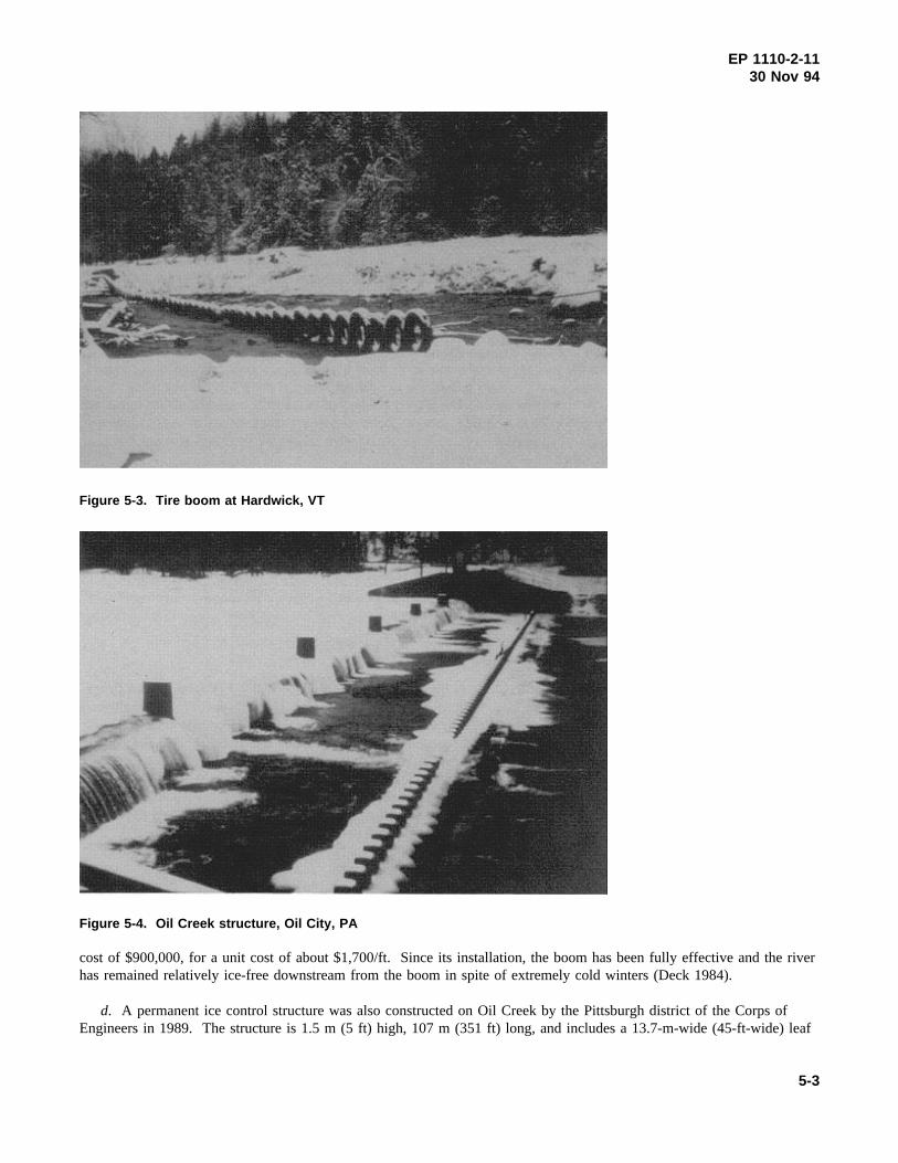
5-2. Hardwick, VT - Improved Natural Storage, Ice Retention, Mechanical Removal
a. Relatively frequent breakup ice jams have caused serious damage in this small Vermont town. A combination oftechniques is used to reduce flooding impacts.
b. To slow the movement of broken ice, two booms were constructed (Figure 5-3). The vertically oriented tirebooms, which are suspended from shore, collect broken ice during breakup, some of which is stored on the overbanks.The booms delay the downstream passage of ice while ice removal is performed in town. Since the winter of l983-84,these booms have been placed upstream from town annually. Although the booms occasionally fail, they do provide iceretention.
c. An ice storage area downstream of the town accommodates some of the ice that jams and thereby provides addedprotection. In addition, when local officials first begin to notice serious ice jams developing, the town road crew mechan-ically breaks up and removes the ice to keep the river open.
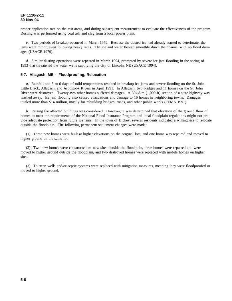
5-3. Oil City, PA - Floating Ice Boom, Revised Operational Procedures, Ice Control Dam
a. Oil City is located in northwestern Pennsylvania. The city suffered chronic ice jam flooding from the mid-1880sto the mid-1980s. In February 1982, ice jam flooding caused more than $4 million in damages in downtown Oil City.
b. Research indicates that the ice jam flooding was caused in part by a massive deposit of frazil ice naturally occur-ring in a long, deep pool in the Allegheny River downstream of Oil City and extending upstream past the confluence withOil Creek. Large quantities of frazil generated in the creek were also deposited in the river and backwater at the mouthof the creek. The ice on Oil Creek typically broke up and moved downstream before the ice cover on the AlleghenyRiver. The tributary ice ran unimpeded to the river until it met the stable ice at the confluence with the Allegheny Riverand formed an ice jam.
5-1

EP 1110-2-1130 Nov 94
Figure 5-1. Schematic of siphon system, Kankakee River, IL
Figure 5-2. Map of meltout
c. An environmentally and economically beneficial floating structure (Figure 5-4) was designed and installedupstream of the city on the Allegheny River to quickly form a stable ice cover to suppress further frazil generation andminimize excessive deposition in the trouble area. Discharge at an upstream dam was decreased during freezeup to allowthe rapid formation of a stable ice cover at the boom. The floating boom was installed during the 1982-83 winter at a
5-2
EP 1110-2-1130 Nov 94
Figure 5-3. Tire boom at Hardwick, VT
Figure 5-4. Oil Creek structure, Oil City, PA
cost of $900,000, for a unit cost of about $1,700/ft. Since its installation, the boom has been fully effective and the riverhas remained relatively ice-free downstream from the boom in spite of extremely cold winters (Deck 1984).
d. A permanent ice control structure was also constructed on Oil Creek by the Pittsburgh district of the Corps ofEngineers in 1989. The structure is 1.5 m (5 ft) high, 107 m (351 ft) long, and includes a 13.7-m-wide (45-ft-wide) leaf
5-3

EP 1110-2-1130 Nov 94
gate, which allows for sediment and fish passage as well as recreational use by canoeists and fishermen. Two low-flowpipes also provide fish passage. Levees were constructed on both upstream banks to contain the Standard Project Flood.The project cost was $2.2 million for a unit cost of approximately $6,300/ft (Wuebben, Gagnon, and Deck 1992). Nodamaging ice jam has occurred in Oil City since the Allegheny River ice boom and Oil Creek ice control structure wereput into use.
5-4. Lancaster, NH - Weir, Ice Retention, Storage
a. Lancaster experienced ice jams every year due to breakup of the ice cover on the Israel River. Broken ice passageis impeded by a natural frazil deposit that forms at the change in slope, which occurs at the upper end of the backwaterformed by the confluence with the Connecticut River. Few ice jams were reported prior to 1936, probably because fourdams that have been removed since that time decreased frazil production, provided frazil ice storage, decreased the down-stream transport of frazil ice, and delayed the downstream passage of broken ice.
b. The Corps’ New England Division and Cold Regions Research and Engineering Laboratory (CRREL) designedand built an ice control project to reduce the production and transport of frazil ice and decrease the volume of ice avail-able to ice jams downstream. Environmental and financial constraints limited the scope of the project, which ideallywould have provided the same protection as the four dams. The project consists of two parts: a submarine net to capturesurface ice and a 36.6-m-long by 2.7-m-high (120-ft-long by 9-ft-high) permanent weir located several miles downstream(Figure 5-5). The submarine net is a form of suspended ice retention structure that allows water to flow through but cap-tures floating ice pieces, which are then stored in overbank flood plains.
c. The ice control weir includes four 1.2-m-wide by 2.4-m-deep (4-ft-wide by 8-ft-deep) sluiceways for fish passage.During the winter, stop logs or metal bar racks are placed in the sluiceways to develop an ice retention pool. The poolforms an ice cover, and frazil ice generated upstream deposits beneath the ice cover. After the ice cover has formed, twoof the gates are opened, allowing the pool level to drop. This creates additional water storage in the pool area, providesadditional discharge capacity through the weir, and slightly delays the breakup and movement of ice through the pool aswell. The project, which cost $300,000 (approximately $1,800/ft) was completed in 1982. Although costs constrainedthe size of the project to less than ideal, no major flooding has occurred since this relatively inexpensive, innovativeproject was constructed (Axelson 1991).
5-5. Idaho Falls, ID - Land Acquisition
In 1982, two hydroelectric dams were removed and rebuilt on the Snake River near Idaho Falls. Freezeup ice jam floodson the Snake River affected Bear Island homeowners during the winters of 1982-83 and 1984-85. Ice jam floods alsothreatened two houses on the west bank of the river. The homeowners associated their flooding problems with the rebuiltdams located 9.6 km (6 miles) downstream. As a result, they requested help from the city of Idaho Falls, the FederalEnergy Regulatory Commission, and elected officials. Field data collection and hydraulic analyses indicated that ice jamswere caused by frazil produced in turbulent open water sections of the Snake River. The results showed that the changesin reservoir levels and the dams had no direct effect on ice jam flood levels in one area, although two properties wereaffected by changes in reservoir levels. Based on CRREL’s recommendations, the City of Idaho Falls decided to pur-chase the two properties affected by the Upper Power Project (Zufelt, Earickson, and Cunningham 1990).
5-6. Platte River, NE - Dusting
a. In February 1978, disastrous ice jam flooding took place on the Platte River in Nebraska, causing millions of dol-lars in damages. Record cold temperatures in January 1979 produced both extremely thick ice on the Platte River and itstributaries and a consequent threat of similar ice jams during spring breakup. Ice dusting, approximately 3 weeks beforebreakup, was recommended for alleviating ice jam floods.
b. The Nebraska Civil Defense agency decided to try dusting selected areas with technical assistance from the Corps.The Corps assisted with advance preparation for the ice dusting operation during the actual dusting procedures to ensure a
5-4

EP 1110-2-1130 Nov 94
a. Installing racks in sluiceways
b. View of structure in early spring
Figure 5-5. Lancaster, NH, weir
5-5
EP 1110-2-1130 Nov 94
proper application rate on the test areas, and during subsequent measurement to evaluate the effectiveness of the program.Dusting was performed using coal ash and slag from a local power plant.
c. Two periods of breakup occurred in March 1979. Because the dusted ice had already started to deteriorate, thejams were minor, even following heavy rains. The ice and water flowed smoothly down the channel with no flood dam-ages (USACE 1979).
d. Similar dusting operations were repeated in March 1994, prompted by severe ice jam flooding in the spring of1993 that threatened the water wells supplying the city of Lincoln, NE (USACE 1994).
5-7. Allagash, ME - Floodproofing, Relocation
a. Rainfall and 5 to 6 days of mild temperatures resulted in breakup ice jams and severe flooding on the St. John,Little Black, Allagash, and Aroostook Rivers in April 1991. In Allagash, two bridges and 11 homes on the St. JohnRiver were destroyed. Twenty-two other homes suffered damages. A 304.8-m (1,000-ft) section of a state highway waswashed away. Ice jam flooding also caused evacuations and damage to 16 homes in neighboring towns. Damagestotaled more than $14 million, mostly for rebuilding bridges, roads, and other public works (FEMA 1991).
b. Raising the affected buildings was considered. However, it was determined that elevation of the ground floor ofhomes to meet the requirements of the National Flood Insurance Program and local floodplain regulations might not pro-vide adequate protection from future ice jams. In the town of Dickey, several residents indicated a willingness to relocateoutside the floodplain. The following permanent settlement changes were made:
(1) Three new homes were built at higher elevations on the original lots, and one home was repaired and moved tohigher ground on the same lot.
(2) Two new homes were constructed on new sites outside the floodplain, three homes were repaired and weremoved to higher ground outside the floodplain, and two destroyed homes were replaced with mobile homes on highersites.
(3) Thirteen wells and/or septic systems were replaced with mitigation measures, meaning they were floodproofed ormoved to higher ground.
5-6

EP 1110-2-1130 Nov 94
Chapter 6Ice Jam Mitigation Assistance
a. In most instances, the lead agency in ice jam mitigation is the U.S. Army Corps of Engineers. Other Federalagencies involved in ice jam mitigation include FEMA, the U.S. Geological Survey, and the Bureau of Reclamation.
b. At the state level, many agencies play important roles in helping to reduce the threat of, prepare for, or clean upafter flooding, including environmental conservation agencies, disaster services agencies, and/or transportationdepartments.
c. At the local level, county and city governments, as well as schools, utility companies, private relief organizations,private businesses, and individuals all participate in ice jam mitigation efforts.
d. An excellent overview of emergency management techniques has been prepared by the International City Manage-ment Association.Emergency Management: Principles and Practice for Local Governments(Drake and Hoetmer 1991)provides an accessible foundation in the principles of emergency management that would be useful for ice jam mitigationas well as other natural hazards. Other free public awareness, preparedness, mitigation, and floodproofing materials canbe found in the reference list.
6-1. U.S. Army Corps of Engineers
As the agency responsible for most of the nation’s river management, USACE plays a major role in ice jam mitigationefforts. In cooperation with local authorities, the Corps has designed and built levees, flood control dams, and ice controlstructures, as well as participated in emergency response to ice jams. A recent survey (White 1992) shows that Corpsdistricts have implemented a wide variety of effective strategies in rivers around the country, including ice jam removal,evacuation, sand bagging, and technical advice.
6-2. Cold Regions Research and Engineering Laboratory
a. One of four research laboratories operated by USACE, CRREL specializes in problems associated with coldregions. The CRREL Ice Engineering Research Branch is involved in research that increases knowledge of the causes ofice jams and methods that can be used effectively to reduce the occurrence and effects of ice jams.
b. Any Corps district office can contact CRREL to monitor and study an ice jam problem area or help develop aninnovative project to reduce ice jam flooding potential.
6-3. Ice Jam Database
a. With the help of individuals and agencies involved in ice jam mitigation, CRREL has developed an ice jam data-base. More than 7,000 ice jam events are included. The database includes existing knowledge of the strategies used bythe Corps district offices and others to deal with ice jams around the country (Figure 6-1).
b. Specifically, the database informs an emergency manager whether or not a particular river has ice jam potential, orwhich measures have been used successfully to reduce damages in previous ice jam situations. The database covers:
• River name.
• Date of ice jam(s).
• Nearest towns and state.
• Type of ice jam(s).
6-1

EP 1110-2-1130 Nov 94
Figure 6-1. Emergency response measures reported by districts (White 1992)
• Extent of damages.
• Points of contacts.
• Publications (if available).
• Information, if available, on whether the ice jam can be classified as a freezeup, midwinter, breakup, or combina-tion jam.
• The range of ice jam mitigation design measures attempted.
• The efficacy of any emergency response methods used in the past.
c. The database is available to PC users on either 3.5-in. or 5.25-in. floppy disks and allows users to browse; sort byriver, state, or year of event; and print database entries.
d. For more information on the ice jam database, contact the Ice Engineering Research Branch at CRREL by phoneat (603) 646-4378 or fax (603) 646-4477.
6-2
EP 1110-2-1130 Nov 94
Appendix AReferences
Ashton, G., ed. (1986).River and lake ice engineering, Water Resources Publica-tions, Littleton, CO.
Axelson, K. D. (1991). “Israel River ice control structure.”Inspiration: Come to theHeadwaters. Proceedings of the Association of State Floodplain Managers,10-14 June, Denver, CO.
Deck, D. (1984). “Controlling river ice to alleviate ice jam flooding.”Proceedingsof the Conference on Water for Resource Development. HY Div/ASCE, 14-17August, Coeur d’Alene, ID.
Drabek, T. E., and Hoetmer, G. J., eds. (1991).Emergency management: Principlesand practice for local governments. International City Management Association,Washington, DC.
Elhadi, N. E., and Lockhart, J. G., eds. (1989).New Brunswick river ice manual,New Brunswick Subcommittee on River Ice, Environment Canada Inland WatersDirectorate, Fredericton, New Brunswick.
Federal Emergency Management Agency. (1989).Flood studies and surveys; Histori-cal statistics(as of September 30, 1989). Unpublished.
Federal Emergency Management Agency. (1991).Hazard mitigation survey hazardteam report, Maine, FEMA-901-DR-ME, Boston, MA.
Federal Emergency Management Agency. (1992a).Floodplain management in theUnited States: An assessment report, FIA-18, Boston, MA.
Federal Emergency Management Agency. (1992b).Interagency hazard mitigationteam report (Montpelier, VT), FRMA-938-DR-VT, Boston, MA.
International Association for Hydraulic Research. (1986). “River ice jams: A state-of-the-art report.” Proceedings, IAHR Symposium on Ice, Iowa City, IA, 561-594.
Mellor, M. (1982). “Breaking ice with explosives,” Report 82-40, U.S. Army ColdRegions Research and Engineering Laboratory, Hanover, NH.
Moor, J. H., and Watson, C. H. (1971). “Field tests of ice prevention techniques,”Journal of the Hydraulics Division, American Society of Civil Engineers92(HY6),777-789.
Urroz, G. E., and Ettema, R. (1994). “Application of two-layer hypothesis to fullydeveloped flow in ice-covered curved channels,”Canadian J. of Civil Engineering21(1), 101-110.
U.S. Army Corps of Engineers. (1981).RIM - River Ice Management, U.S. ArmyCold Regions Research and Engineering Laboratory, Hanover, NH.
A-1

EP 1110-2-1130 Nov 94
U.S. Army Corps of Engineers. (1982). “Ice engineering,” Engineer Manual 1110-2-1612, Washington, DC.
U.S. Army Corps of Engineers. (1990). “Winter navigation on inland waterways,”Engineer Manual 1110-8-1(FR), Washington, DC.
U.S. Army Corps of Engineers. (1991).Flood proofing techniques, programs andreferences, Report of the National Flood Proofing Committee, prepared byDewberry and Davis with French and Associates, Ltd.
U.S. Army Corps of Engineers. (1993, 1994).Annual flood damage report to Con-gress, Washington, DC.
U.S. Army Engineer District, Omaha. (1979).Ice dusting of the Platte River, 1979.Omaha, NE.
U.S. Army Engineer District, Omaha. (1994). “Lower Platte River ice floodinginterim report,” Section 22, Omaha, NE.
U.S. Army Engineer Division, New England. (1980).Section 206: Flood plain man-agement assistance historical ice jam flooding in Maine, New Hampshire and Ver-mont. Waltham, MA.
White, K. D. (1992). “Ice jam statistics recorded on data base,” Ice EngineeringBulletin Note No. 2, U.S. Army Cold Regions Research and Engineering Labora-tory, Hanover, NH.
White, K. D., and Zufelt, J. E. (1994). “Ice jam data collection,” Special Report 94-7, U.S. Army Cold Regions Research and Engineering Laboratory, Hanover, NH.
Wuebben, J. L., Gagnon, J. J., and Deck, D. S. (1992). “Ice jam flood assessment forthe Buford-Trenton Irrigation District and vicinity, Williston, North Dakota,” Proj-ect Report, U.S. Army Cold Regions Research and Engineering Laboratory,Hanover, NH.
Zufelt, J. E. (1993). “Ice motion detector system,” Ice Engineering Bulletin No. 4,U.S. Army Cold Regions Research and Engineering Laboratory, Hanover, NH.
Zufelt, J. E, Earickson, J. A., and Cunningham, L. (1990). “Ice jam analysis at IdahoFalls, Snake River, Idaho,” Special Report 90-43, U.S. Army Cold RegionsResearch and Engineering Laboratory, Hanover, NH.
A-2

EP 1110-2-1130 Nov 94
Appendix BGlossary
[Extracted from the U.S. Army Corps of Engineers (1990) and International Association for Hydraulic Research (1986).]
Anchor ice. Frazil ice attached or anchored to the river bottom, irrespective of the nature of its formation.
Beginning of breakup. Date of definite breaking, movement, or melting of ice cover or significant rise of water level.
Beginning of freezeup. Date on which ice forming a stable winter ice cover is first observed on the water surface.
Border ice. An ice sheet in the form of a long border attached to the bank or shore; shore ice.
Breakup. Disintegration of ice cover.
Breakup date. Date on which a body of water is first observed to be entirely clear of ice and remains clear thereafter.
Breakup jam. Ice jam that occurs as a result of the accumulation of broken ice pieces.
Breakup period. Period of disintegration of an ice cover.
cfs. Cubic feet per second, a measure of flow.
Channelization. Modification of a natural river channel; may include deepening, widening, or straightening.
Conveyance. A measure of the carrying capacity of the river channel.
Floc. A cluster of frazil particles.
Floe. An accumulation of frazil flocs (also known as a “pan”) or a single piece of broken ice.
Floodplain. Land area adjoining a water body that is not normally submerged but may be submerged during floodconditions.
Frazil. Fine spicules, plates, or discoids of ice suspended in water. In rivers and lakes, frazil is formed in supercooled,turbulent water.
Frazil slush. An agglomerate of loosely packed frazil that floats or accumulates under an ice cover.
Freezeup date. Date on which the water body was first observed to be completely frozen over.
Freezeup jam. Ice jam formed as frazil ice accumulates and thickens.
Gorge. In the past, ice jams were sometimes referred to as “ice gorges.”
Grounded ice. Ice that has run aground or is in contact with ground underneath it.
Hanging (ice) dam. A mass of ice composed mainly of frazil or broken ice deposited underneath an ice cover in a regionof low flow velocity.
Hummock. A hillock of broken ice that has been forced up by pressure.
B-1

EP 1110-2-1130 Nov 94
Ice arch. Frazil or fragmented ice that has stopped moving and bridges across a river channel; also called an “icebridge.”
Ice jam. A stationary accumulation of fragmented ice or frazil that restricts or blocks a stream channel. The term “icegorge” is also used in some areas.
Overbank flow. Flow that exceeds the level of the river's banks and extends into the floodplain.
Riprap. Rocks strategically placed against riverbanks or beds to prevent erosion of underlying material.
Sheet ice. A smooth, continuous ice cover formed by in situ freezing (lake ice) or by the arrest and juxtaposition of icefloes in a single layer.
Supercooled water. Water whose temperature is slightly below the freezing point (32oF or 0 oC).
Thalweg. Deepest portion of the river channel; the line of major flow.
Water slope. Change in water surface elevation per unit distance.
Water stage. The water surface elevation above the bottom of the river channel.
Weir. Barrier placed in a river to raise water elevation.
B-2